planning & zoning department
TRANSCRIPT

781 Blakely Road, P.O. Box 55 Colchester, VT 05446
www.colchestervt.gov
MMMEEEMMMOOORRRAAANNNDDDUUUMMM TO: VT Department of Housing and Community Affairs FROM: Sarah Hadd, Director of Planning & Zoning DATE: June 18, 2014 RE: Planning Commission Reporting Form for Municipal Bylaw Amendment Continuation Sheet Pursuant to Title 24 VSA, Chapter 117, the Colchester Planning Commission will hold a public hearing on Tuesday, July 15, 2013 at 7 P.M. at the Colchester Police Department Community Room at 835 Blakely Road for the purpose of considering amendments of the Colchester Zoning Regulations:
1. Amend Section 2.02C Official Map to update parks, roads, facilities, parcels, proposed roads in the vicinity of Severance Corners, and existing and proposed separated paths.
2. Strike Section 2.04F that currently requires a certificate of appropriateness for development on pre-existing lots without public road frontage.
3. Amend Section 2.18 to allow feather signs, increase the size of permanent signs at Water Tower Hill, and allow temporary signs to increase from 10 feet to 12 feet in height.
4. Amend Section 8.09B to create a cumulative limit for administrative amendments of five years.
5. Amend Section 8.09C to deleted Development Review Coordinator and replace with Administrative Officer.
6. Amend Section 10.14 to allow the waiver of septic integrity reports and septic replacement areas.
7. Amend Section 12.02 definition for Bar to allow entertainment and recreational activities.
8. Amend Section 12.02 definition for Gross Floor Area to be measured from exterior walls and include all appurtenances.
9. Amend Section 12.02 definition for Nightclub to define as a Bar that charges for entertainment.
10. Amend Appendix A-2 to define DU as dwelling unit.
11. Amend Zoning Map to rezone parcels as codified in Appendix F herein: 03-031003 GD3 to R3 03-030003 GD3 to R3 1. Conforms with or furthers the goals and policies contained in the municipal plan,
including the effect of the proposal on the availability of safe and affordable housing: The proposed changes clarify the existing regulations and do not impact density or other housing related issues.
Select Board
Nadine Scibek
Herbert Downing
Marc Landry
Thomas Mulcahy
Kathrine Niquette
Town Manager
Dawn Francis
264-5501
Director of Planning &
Zoning
Sarah Hadd
264-5602
Zoning Administrator
Lisa Riddle
264-5604
Assistant Zoning
Administrator
Jane Dion
264-5603
Building Inspector
Derek Shepardson
264-5607
Administrative Assistant
Traci Paquette
264-5606
Wastewater Official
Denise Johnson-Terk
264-5601
Fax Number
(802) 264-5503
Planning & Zoning Department

781 Blakely Road, P.O. Box 55 Colchester, VT 05446
www.colchestervt.gov
2. Is compatible with the proposed future land uses and densities of the municipal plan: The proposed changes to the Zoning Map are limited to rezoning two parcels from GD3 to R3. This change was instigated as part of the Town’s State Growth Center designation that excluded these two parcels from the Growth Center (GD3 designation).
3. Carries out, as applicable, any specific proposals for any planned community facilities. The proposed changes to the Zoning Regulations will update the existing community facilities enumerated on the Town’s Official Map.

781 Blakely Road, P.O. Box 55 Colchester, VT 05446
www.colchestervt.gov
TO: Chair of Planning Commission
Milton Burlington Essex Town Essex Junction Winooski Westford South Hero South Burlington Charles Baker, Executive Director, CCRPC Department of Housing and Community Affairs FROM: Sarah H. Hadd, Director of Planning & Zoning DATE: June 18, 2014 RE: Proposed Zoning Bylaw Revisions - Supplement # 35 Pursuant to Title 24 VSA, Chapter 117, the Colchester Planning Commission will hold a public hearing on Tuesday, July 15th at 7 P.M. at the Colchester Police Department Community Room at 835 Blakely Road for the purpose of considering amendments of the Colchester Zoning Regulations.
1. Amend Section 2.02C Official Map to update parks, roads, facilities, parcels, proposed roads in the vicinity of Severance Corners, and existing and proposed separated paths.
2. Strike Section 2.04F that currently requires a certificate of appropriateness for development on pre-existing lots without public road frontage.
3. Amend Section 2.18 to allow feather signs, increase the size of permanent signs at Water Tower Hill, and allow temporary signs to increase from 10 feet to 12 feet in height.
4. Amend Section 8.09B to create a cumulative limit for administrative amendments of five years.
5. Amend Section 8.09C to deleted Development Review Coordinator and replace with Administrative Officer.
6. Amend Section 10.14 to allow the waiver of septic integrity reports and septic replacement areas.
7. Amend Section 12.02 definition for Bar to allow entertainment and recreational activities.
8. Amend Section 12.02 definition for Gross Floor Area to be measured from exterior walls and include all appurtenances.
9. Amend Section 12.02 definition for Nightclub to define as a Bar that charges for
Select Board
Nadine Scibek
Herbert Downing
Marc Landry
Thomas Mulcahy
Kathrine Niquette
Town Manager
Dawn Francis
264-5501
Director of Planning &
Zoning
Sarah Hadd
264-5602
Zoning Administrator
Lisa Riddle
264-5604
Assistant Zoning
Administrator
Jane Dion
264-5603
Building Inspector
Derek Shepardson
264-5607
Administrative Assistant
Traci Paquette
264-5606
Wastewater Official
Denise Johnson-Terk
264-5601
Fax Number
(802) 264-5503
Planning & Zoning Department

781 Blakely Road, P.O. Box 55 Colchester, VT 05446
www.colchestervt.gov
entertainment. 10. Amend Appendix A-2 to define DU as dwelling unit.
11. Amend Zoning Map to rezone parcels as codified in Appendix F herein: 03-031003 GD3 to R3 03-030003 GD3 to R3
These are a summary of the proposed changes. The existing and proposed regulations can be found at the Town Offices at 781 Blakely Road and may also be reviewed on-line at http://www.colchestervt.gov.

COLCHESTER ZONING REGULATIONS DRAFT SUPPLEMENT 35
failed system or failed supply as defined in 10 V.S.A. Chapter 64.
2. For any lot shown on a plat approved by the Planning Commission and recorded in Colchester Land Records, the requirements of individual and separate and non-affiliated ownership shall not apply and the lots shall not be deemed merged.
F. Preexisting Lots with No Road Frontage. 1. No land development may be permitted on preexisting lots which do not h1we frontage on a public road except as pmvided below. Specifically exempted from this prooess are: 1) repairs and maintenance of existing uses, 2) the construction of acoessory struotl:lres, 3) alterations to existing dwelling units that do not increase the number of dwelling units, the number of bedrooms or increase the square footage of the dwelling by more than fifty percent. 2. The D~lelopment Reviev1 Board may, through the site plan application process, apf>rove development of preexisting lots with no frontage on a public street, as long as access to such a street by a permanent easement or right of ·:1ay at least twenty (20) feet in width is provided. In approving a site plan application the DRB shall consider:
(a) Safe Passage. The access may be required to be brought up to Town standards per Colehester Code of Ordinances Chapter 14 or as close thereto as is practicable in the judgment of the Development REwie\v Board. The Development Revie\v Board may also impose conditions to insure the maintenance and permanency of a private right of way and to insure that a right of way will not plaoe a burden on municipal services. (b) For a lot with no frontage, the property line that abuts or is closest to the priYate right of ·11ay shall be construed as the front lot line and shall determine the front yard. (c) The Development Review Board shall find that the proposed de:velopment does not adversely effect:
2.05 Setbacks and Buffer
(1) The capacity of existing or planned community facilities including but not limited to water supply, Se\vage per Chapter 8 of the Colohester Code of Ordinances, fire fighting capability per Chapter 7 of the Colchester Code of Ordinanoes, and school bus servioe;
(2) The character of the area; (3) Traffic on roads and highways in the '+1icinity; (4) The Town's Municipal Plan and Bylaws and other
Ordinanoes or Regulations in effect;
Article Two - Page 6

COLCHESTER ZONING REGULATIONS DRAFT SUPPLEMENT 35
are temporary or non-permanent. 11. Signs that contain obscene, indecent or lewd content as defined within 13 V.S.A. §2801. 12. Pennants and balloons (excludes feather signs).
D. Signs in Residential Districts. Signs within Residential Districts and the Mobile Home Park District shall be limited to the following:
1. One (1) sign, not in excess of eight (8) square feet in area, located on a lot on which a lawful non-residential use exists. 2. One (1) sign, not in excess of four (4) square feet in area, located on a lot on which a valid home occupation or business exists. 3. One (1) free-standing or monument sign at each entrance of an approved subdivision or multi-family dwelling provided that the sign is non-illuminated, less than 20 square feet in area, and less than six (6) feet in height above the ground.
E. Hazards. No sign shall be designed or located to impair public safety, traffic flow or road visibility, specifically:
1. Any sign or advertising structure as defined in these regulations shall be designed and constructed to withstand wind pressures and receive dead loads as required by recognized engineering and construction practices in the Town of Colchester. 2. All signs, and any structure such as standards and posts supporting them, shall be of substantial and sturdy construction. Break-away standards and posts are permitted if of substantial and sturdy construction. 3. No sign shall prevent free ingress to or egress from, any door, window or fire escape. No sign shall be attached to a stand pipe or fire escape. 4. No sign may be erected that imitates or resembles any official traffic control sign, signal, or device or as to direct the movement of traffic. 5. No sign shall be located in a way that prevents drivers from having a clear and unobstructed view of traffic control signs, and approaching or merging traffic. No sign shall obstruct free and clear vision, or distract the attention of the driver of any vehicle by reason of its position, shape or color. No sign shall restrict clear vision between the sidewalk and road. 6. No sign shall be designed so that it could be confused with any traffic sign or signal. Accordingly, no sign or other advertising structure shall make use of the words "Stop", "Go", "Look", "Slow", "Danger", or any other similar phrase, symbol, or character, or apply any color in a manner to wholly distract, mislead, or confuse traffic. 7. No sign shall in its construction employ any mirror or mirror-like surface, nor any reflective, day-glowing or other fluorescent paint or pigment. 8. No luminous sign, indirectly illuminated sign or lighting device shall be placed or aimed so as to direct beams of light or cause glare upon any road, sidewalk or adjacent premises in a manner that may constitute a traffic hazard or nuisance.
Article Two - Page 24

COLCHESTER ZONING REGULATIONS DRAFT SUPPLEMENT 35
I. Freestanding and Monument Signs. The following shaH apply to freestanding an d t . monumen signs:
Commercial District Other Non-Residential GD-3 & GD-4 Districts located 011 West Districts View Rtl., Water
Tower Circle, a11d Upper
Mountainview Dr.
Lot <40,000 Lot40,000+ Lot I Lot sf sf <40,000 sf 40,000+ sf
Numeric and Dimensional Standards
1 per lot Willi l
a. Number of additional sig11 I per mad access provided that the entry qualifying for a
Signs permiltedfor thos·e sign is not located closer than 300 feet to any other entry
properties located 011 qualifying for a sign. West View Road
32 sf+ additio11al 25 32 sf+ b. Total Sign sf per story above 2
32 sf additional
32 sf Area storie.f 1101 to exceed area as per
IlOsl Table* No sig11 di111e11sim1 No sign dimension shall No sign dimension shall
c. Ratio shall exceed the other exceed the other by more exceed the other by more by more tha11 5 times. than 5 times. than 4 times.
d. Height 20/1. I 0 ft for signs up to 32 sf in area. 12 ft for signs greater than 32 sf in area.
Placement and Design Standards
e. Freestanding and monument signs shall be self-supporting without the need for guy wires, cables, chains lines, or other similar ancillary supports. f. Freestanding nnd monument signs and the premises surrounding same shall be landscaped in an aesthetically pleasing or appropriate manner with hardy plant materials, groundcover, lawn or hard surfaces that will remain attrnctive throughout the vear and be maintained by the owner thereof clear of rubbish and weed. g. Freestanding or monument signs shall be located in close proximity to road entrances. The signs shall be visible to vehicles passing road entrances. For properties located 011 West View Road, offsite sig11age .1·hull be allowed along Up11er Mou11tainview Drive with permanent easeme11ts. Table *: Additional Sign Area Multiple Businesses on Road Building Size Additional Sign the Lot OR Frontage OR = Area
6 200- <300 ft 25,000 sf- +2sf <50,000 sf
7 300- <400 ft 50,000 sf- +4sf <75.000 sf
8 or more 400 ft or more 75,000 sf or +8 sf . more
Approval of additional sign area shall be subject to the requirement that the lot on which the sign is located together with the building(s) thereon shall continue to meet the standards on which approval was granted. In the event of reduction of the size of the lot or the amount offrontnge or the size of the building the owner shall apply the reduced size from that point forward in calculating signage under regulations then in effect, and, if such regulations require a sign with reduced sign area, the property owner shall install a sign meeting such reduced sign area requirement within three (3) months.
Article Two - Page 27

COLCHESTER ZONING REGULATIONS DRAFT SUPPLEMENT 35
include but are not limited to: "restrooms'', "self-service", "turn off engine", or "unleaded". Notwithstanding, any sign including the name and/or logo of the business to which it is attached shall count as wall signage and shall be subject to the applicable provisions of these regulations.
0. Temporary Signs. Temporary signs may be permitted in accordance with the following:
1. One (1) unlit, portable, A-frame, banner, or sandwich board sign not to exceed ten (10) square feet in area or four (4) feet in height, which advertises daily specials, menu items or the like. The sign shall only be placed outside when the business is open. If the business is housed in building that abuts the sidewalk, such a sign shall be placed five (5) feet from the sidewalk. Such signs shall be weighted or secured as appropriate to prevent them from being blown or knocked over and creating a hazard. 2. One (1) unlit temporary sign or temporary feather sign not to exceed 32 square feet in area or 120 feet in height, which advertises a short-tenn sale, special event, seasonal product or the like. Such signs shall not be actionable or animated, or include any moving or flattering parts. Such a sign shall not be located within any public rights-of-way. Such signs shall be weighted or secured as appropriate to prevent them from being blown or knocked over and creating a hazard. 3. No permanent footings, posts or similar structures shall be installed to support a temporary sign. Temporary signs that are not readily moveable shall be considered a permanent sign subject to all provisions of this section. 4. Temporary signs may be displayed for the period(s) specified by the temporary sign permit issued by the town. A license holders found to be in violation shall have their permit suspended for the remainder of the year and shall not be eligible to apply for a permit for the following calendar
_ ermits shall be as follows:
Duration of Display
Not to exceed 5 days in any month eriod Annual ermit for dail use
A-Frame, Banner, or Sandwich
Board 10 sf max
permitted
ermitted
Other Temporary Sign up to 32 sf max
permitted
not ermitted
2.19 Compliance with Chapter 14 and 18 of the Colchester Code of Ordinances
Article Two - Page 31
COLCHESTER ZONING REGULATIONS DRAFT SUPPLEMENT 35
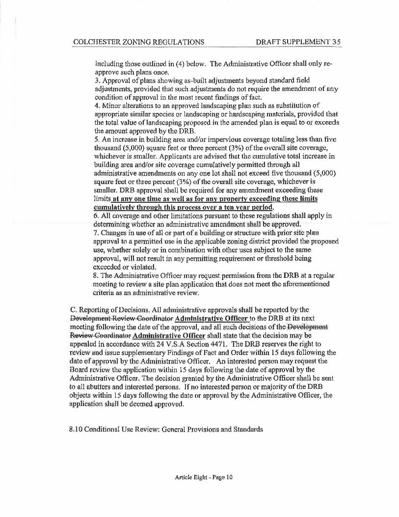
including those outlined in (4) below. The Administrative Officer shall only reapprove such plans once. 3. Approval of plans showing as-built adjustments beyond standard field adjustments, provided that such adjustments do not require the amendment of any condition of approval in the most recent findings of fact. 4. Minor alterations to an approved landscaping plan such as substitution of appropriate similar species or landscaping or hardscaping materials, provided that the total value of landscaping proposed in the amended plan is equal to or exceeds the amount approved by the DRB. 5. An increase in building area and/or impervious coverage totaling less than five thousand (5,000) square feet or three percent (3%) of the overall site coverage, whichever is smaller. Applicants are advised that the cumulative total increase in building area and/or site coverage cumulatively permitted through all administrative amendments on any one lot shall not exceed five thousand (5,000) square feet or three percent (3%) of the overall site coverage, whichever is smaller. DRB approval shall be required for any amendment exceeding these limits at any one time as well as for any property exceeding these limits cumulatively through this process over a ten year period. 6. All coverage and other limitations pursuant to these regulations shall apply in determining whether an administrative amendment shall be approved. 7. Changes in use of all or part of a building or structure with prior site plan approval to a permitted use in the applicable zoning district provided the proposed use, whether solely or in combination with other uses subject to the same approval, will not result in any permitting requirement or threshold being exceeded or violated. 8. The Administrative Officer may request permission from the DRB at a regular meeting to review a site plan application that does not meet the aforementioned criteria as an administrative review.
C. Reporting of Decisions. All administrative approvals shall be reported by the De>1elopment Reviev1 Coordinator Administrative Officer to the DRB at its next meeting following the date of the approval, and all such decisions of the ~&plfieM R-e-1iew Coordinator Administrative Officer shall state that the decision may be appealed in accordance with 24 V.S.A Section 4471. The DRB reserves the right to review and issue supplementary Findings of Fact and Order within 15 days following the date of approval by the Administrative Officer. An interested person may request the Board review the application within 15 days following the date of approval by the Administrative Officer. The decision granted by the Administrative Officer shall be sent to all abutters and interested persons. If no interested person or majority of the DRB objects within 15 days following the date or approval by the Administrative Officer, the application shall be deemed approved.
8.10 Conditional Use Review: General Provisions and Standards
Article Eight - Page 10

COLCHESTER ZONING REGULATIONS DRAFT SUPPLEMENT 35
including those outlined in (4) below. The Administrative Officer shall only reapprove such plans once. 3. Approval of plans showing as-built adjustments beyond standard field adjustments, provided that such adjustments do not require the amendment of any condition of approval in the most recent findings of fact. 4. Minor alterations to an approved landscaping plan such as substitution of appropriate similar species or landscaping or hardscaping materials, provided that the total value of landscaping proposed in the amended plan is equal to or exceeds the amount approved by the DRB. 5. An increase in building area and/or impervious coverage totaling less than five thousand (5,000) square feet or three percent (3%) of the overall site coverage, whichever is smaller. Applicants are advised that the cumulative total increase in building area and/or site coverage cumulatively permitted through all administrative amendments on any one lot shall not exceed five thousand (5,000) square feet or three percent (3%) of the overall site coverage, whichever is smaller. DRB approval shall be required for any amendment exceeding these limits at any one time as well as for any property exceeding these limits cumulatively through this process over a five year period. 6. All coverage and other limitations pursuant to these regulations shall apply in determining whether an administrative amendment shall be approved. 7. Changes in use of all or part of a building or structure with prior site plan approval to a permitted use in the applicable zoning district provided the proposed use, whether solely or in combination with other uses subject to the same approval, will not result in any permitting requirement or threshold being exceeded or violated. 8. The Administrative Officer may request permission from the DRB at a regular meeting to review a site plan application that does not meet the aforementioned criteria as an administrative review.
C. Reporting of Decisions. All administrative approvals shall be reported by the De¥elopment Re11iew CoorEiiHtttor Administrative Officer to the DRB at its next meeting following the date of the approval, and all such decisions of the De¥elopmeHt Review CooffiiRtttor Administrative Officer: shall state that the decision may be appealed in accordance with 24 V.S.A Section 4471. The DRB reserves the right to review and issue supplementary Findings of Fact and Order within 15 days following the date of approval by the Administrative Officer. An interested person may request the Board review the application within 15 days following the date of approval by the Administrative Officer. The decision granted by the Administrative Officer shall be sent to all abutters and interested persons. If no interested person or majority of the DRB objects within 15 days following the date or approval by the Administrative Officer, the application shall be deemed approved.
8.10 Conditional Use Review: General Provisions and Standards
Article Eight - Page 10

COLCHESTER ZONING REGULATIONS DRAFT SUPPLEMENT 35
automated teller machines may be provided within or outside the building. No drive-up facilities are allowed.
BANK, DRIVE-UP: A depository institution in which the majority of business conducted on-premise is related to walk-in or drive-up customers (e.g., banks, credit unions, savings and loans). Walk-up or drive-up automated teller machines may be provided within or outside the building. Drive-up facilities are customary.
BANNERS: shall mean signs affixed to poles, wires or ropes, such as banners, pennants, streamers, wind operated propellers, string lighting or other similar advertising media, but not to include displayed flags of town, state or country or Prisoners of War flag attached to a building or pole.
BAR: An establishment for the sale or dispensing of alcohol by the drink for on-site consumption, where food may be available for consumption on the premises as accessory to the principal use, and where alcoholic beverages are available after 11 :00 p.m. To differentiate a bar from a restaurant, bars are also classified as any establishment selling or dispensing alcohol after 11 :00 p.m. A bar does aot may have live music, karaoke, dancing, Q! recreational amenities; or entertaiament.
BASE FLOOD: The flood having a one percent chance of being equaled or exceeded in any given year.
BASE FLOOD ELEVATION (BFE): The height of the base flood, usually in feet, in relation to the National Geodetic Vertical Datum of 1929, the North American Vertical Datum of 1988, or other datum referenced in the Flood Insurance Study report, or average depth of the base flood, usually in feet, above the ground surface.
BASEMENT: A story in a building, the structural ceiling level of which is four (4) feet or more above the average level of finished grade where such grade abuts that exterior wall of such building which fronts on any street, and the floor level of which is below finished grade at any point on the periphery of the building. (See diagram, Appendix B)
BASIC AMENITIES (for detennining a seasonal dwelling unit)- Shall consist of a sewage system and water supply in full conformance with the Regulations for a yearround system, toilet, shower or bathtub, wall and ceiling insulation, year-round heating source, refrigerator and stove.
BED AND BREAKFAST: A dwelling unit, or portion thereof, with five or fewer guestrooms, where short-term lodging rooms and meals are provided for overnight guests. The operator of the bed and breakfast shall live on the premises. For the purposes of this definition, short-term shall mean up to one (1) week.
BEDROOM: Any room with a window and a closet, and which is physically separated from other rooms.
Article Twelve - Page 5

COLCHESTER ZONING REGULA TIO NS DRAFT SUPPLEMENT 35
FLOOR AREA, GROSS: The gross area of all floors of all principal and accessory buildings on a lot, measured from the exterior iRterior face of the exterior walls, or in the case of a common wall separating two buildings, from the center line of such common walls. Gross floor area shall include such features as porches, balconies, breezeways, walkways, and raised platforms, if eaeh is enslosed.
FRONTAGE: That boundary of a lot which abuts on a public street or way. The Interstate and Circumferential Highway rights-of-way and public waters sha11 not be considered frontage.
FLORESCENT COLORS: shall mean colors that reflect not only their own color, but also convert the shorter wave lengths into radiant energy causing them to appear 3 to 4 times as bright as ordinary color. These colors do not reflect light toward its source in the intense manner that reflectorized materials do, but rather in an amount similar to a white painted surface.
FREE-STANDING SIGN: shall mean a sign detached from any building.
FUNERAL HOME: An establishment for the preparation of the deceased for burial and the display of the deceased and rituals connected therewith before burial or cremation.
GARAGE, AUTOMOBILE PARKING: This use may be a structured parking garage or a parking lot that is publicly or privately operated. Parking shall be open to the general public for parking with or without an associated fee. Parking may not necessarily be located on a lot on which there is another principal use to which the parking is related.
GARAGE, PRIVATE: An accessory structure for parking or storage of not more than that number of vehicles as may be required in connection with the permitted use of the principal building or structure.
GARAGE, PUBLIC: A structure owned or operated by a local or state government used primarily for the parking, storing, and servicing of vehicles. Vehicle servicing within a fully enclosed building and gasoline storage and dispensing are customary. Storage of sand, salt, and materials employed in municipal or state maintenance of infrastructure and municipal services is customary.
GASOLINE SALES: An estabJishment engaged in selling or dispensing motor fuels directly to users of motor vehicles. This use does not customarily have outside storage.
GROOMING FACILITY: An establishment in which more than four (4) dogs, cats, or other domesticated animals are groomed, washed, or otherwise cleaned for a fee or compensation a day.
HALFWAY HOUSE: An estabJishment intended to provide for transitional group living arrangements for persons discharged from hospitals, prison mental institutions or other
Article Twelve - Page 14

COLCHESTER ZONING REGULATIONS DRAFT SUPPLEMENT 35
includes any subsequent improvements to such structures. This definition shall only pertain to Section 6.03, Flood Plain District, herein.
NEW MANUFACTURED HOME PARK OR NEW MANUFACTURED HOME SUBDIVISION: A manufactured home park or manufactured home subdivision for which the construction is completed after the effective date of the floodplain management regulations as herein adopted in Section 6.03. This definition shall only pertain to Section 6.03, Flood Plain District, herein. This definition shall also include Land Development as defined herein.
NIGHT CLUB: A bar or restaurant that charges for admission for 't'lith live music, karaoke, daneing, t=eoreati-0nal ameaities, er entertainment.
NONCONFORMING LOT: A lot or parcel that does not conform to the present bylaws covering dimensional requirements but were in conformance with all applicable laws, ordinances, and regulations prior to the enactment of the present bylaws; including a lot or parcel improperly authorized as a result of error by the Zoning Administrator.
NONCONFORMING SIGN: shall mean a sign which does not comply with this Ordinance as amended, but did comply with all applicable laws, ordinances, and regulations prior to the enactment of the sign ordinance, or if applicable, an amendment of said Ordinance.
NONCONFORMING STRUCTURE: A structure or a part of a structure that does not conform to the present bylaws but was in conformance with all applicable laws, ordinances, and regulations prior to the enactment of the present bylaws; including a structure improperly authorized as n result of error by the administrative officer.
NONCONFORMING USE: A use ofland that does not conform to the present bylaws but did conform to all applicable laws, ordinances, and regulations prior to the enactment of the present bylaws; including a use improperly authorized as a result of error by the Zoning Administrator.
NUDITY: Full or partial revelation of a person's breast or genitals. Partial revelation shall be as so as to be distinguishable to the eye.
NURSING CARE HOME: An establishment providing skilled nursing care and medical supervision at a lower level than that available in a hospital to not more than five persons.
NURSING CARE INSTITUTION: An establishment that provides licensed, skilled, fulltime nursing care and related services for patients who require medical, nursing, and/or rehabilitative services. The institution shall provide extended and/or intermediate care for those who by reason of advanced age, illness, infirmity, or mental impairments need acute, chronic, or convalescent care. Such institution shall also be known as a nursing home, convalescent facility, or long-term care facility.
Article Twelve - Page 22

COLCHESTER ZONING REGULATIONS DRAFT SUPPLEMENT 35
District Density Minimum Frontage Primary Primary Primary ~cc. Acc. Acc. Total Lot !Primary Building k\cc. Building Lot Size Front Yard Side Yard Rear Yard !Front Side Yard Rear Coverage IHeightMax IHeightMax
Setback Setback Setback [Yard Setback Yard Max Setback Setback
R3 l DU/10,000 sf I0,000 sf I du.II 00 feet 30 ft 15 ft 25 ft 130 ft IO ft 10 ft 130% 140 ft ridge 125 ft ridge Class I 135 ft flat !20 ft flat R3 1 DU/15,000 sf 15,000 sf 1 du./100 feet 30 ft 15 ft 25 ft 30 ft IO ft IO ft 30% 40 ft ridge 125 ft ridge Class II 35 ft flat 20 ft flat
R2 1 DU/15,000 sf 15,000 sf 1 du./125 feet 30 ft 15 ft 25 ft 130 ft IO ft IO ft 30% 40 ft ridge 25 ft ridge Class I 35 ft flat 20 ft flat
R2 1 DU/20,000sf 120,000 sf I du./125 feet 30 ft 15 ft 25 ft 130 ft IO ft 10 ft 30% 40 ft ridge 125 ft ridge Class II 35 ft flat 120 ft flat
Rl 1 DU/30,000 sf 30,000 sf 1 du./150 ft 30 ft 15 ft 25 ft 30 ft IO ft 10 ft 30% f40 ft ridge 125 ft ridge Class I 135 ft flat 120 ft flat
iRI 1 DU/40,000sf f'l.0 ,000 sf 1 du./150 ft 30 ft 15 ft 25 ft 130 ft IO ft 10 ft 30% 40 ft ridge 125 ft ridge Class II 35 ft flat 20 ft flat
iR5 I DU/5 acres 140,000 sf 1 du./300 ft 175 ft 50 ft 100 ft 75 ft 150 ft 100 ft 120% 40 ft ridge 35 ft ridge 35 ft flat 30 ft flat
RIO 1 DU/10 acres 40,000 sf 1 du./300 ft 75 ft 50 ft 100 ft 75 ft 50 ft 100 ft 120% 140 ft ridge 35 ft ridge 135 ft flat 30 ft flat
KTDl 1 DU/I0,000 sf 10,000 sf I du./IOO ft 130 ft IO ft 30 ft 30 ft 10 ft 30 ft 60% 140 ft ridge 30 ft ridge [Class I 35 ft flat 25 ft flat
KJDl 1 DU/20,000sf 20,000 sf 1 du./IOO ft 130 ft IO ft 130 ft 30 ft IO ft 30 ft 60% 140 ft ridge 30 ft ridge [Class II 135 ft flat 25 ft flat GD2 (MU) 20,000 sf 1 du./100 ft 30 ft 15 ft 30 ft 145 ft 15 ft 30 ft 170 % 140 ft ridge 40 ft ridge Class I 1 DU/ 4,356 sf 135 ft flat 135 ft flat
GD2 (MU) 120,000 sf 1 du./100 ft 30 ft 15 ft 30 ft 145 ft 15 ft 30 ft 70% 40 ftridge 140 ft ridge Class II 1 DU/ 10,890 sf 35 ft flat 135 ft flat
KJD4 1 DU/10,000sf 10,000 sf 1 du./IOO ft 30 15 ft 125 ft 145 ft 15 ft 130 ft 60% 20 ft eave 20 ft eave 34 ft ridge 134 ft ridge 24 flat rooflines 24 flat rooflines
Table A-2:Dimensional Standards - Page 1

COLCHESTER ZONING REGULATIONS DRAFT SUPPLEMENT 35
District Density Minimum Frontage Primary Primary Primary Acc. Acc. Acc. Total Lot Lot Size Front Side Rear Front Side Rear Coverage
Yard Yard Yard Yard Yard Yard Max Setback Setback Setback Setback Setback Setback
BD 10,000 sf 100 ft 25 ft. 15 ft. 25 ft. 25 ft. 15 ft. 25 ft. 80%
COM 20,000 sf 100 ft 45 ft 15 ft 30 ft 45 ft 15 ft 30 ft Class I 70% Class II 60%
IND 40,000 sf 150 ft 45 ft 20 ft 25 ft 45 ft 15 ft 15 ft 80%
AGR 1 DU/25 acres 40,000 sf 1 du./300 ft 75 ft 50 ft 100 ft 75 ft 50 ft 100 ft 20%
MHP 1 DU/15,000sf 15,000 sf 1 du./100 ft 15 ft 10 ft 10 ft 15 ft 10 ft 10 ft 20%
FP 40,000 sf 300 ft 200 ft 200 ft 200 ft 200 ft 200 ft 200 ft 10%
AMU 1 DU/40,000sf 40,000 sf 150 ft 30 ft 15 ft 25 ft 30 ft 10 ft 10 ft 30%
Additional Considerations (1) =In all districts, total front yard coverage shall not exceed 30%. (2) = 45 foot front yard setback required for primary and accessory structures on highways (see Article 2.05 Setbacks & Buffers) (3) =Minimum lot size and setbacks may be reduced when approved in accordance with Article Nine, Planned Unit Developments (4) =In the Agricultural District, silos and grain elevators shall be excluded from height restrictions. (5) = The height of buildings may be increased in accordance with Article Two Section Seven. (6) = Multi-family = MU and Dwelling Unit= DU (7) Please consult associated Article and Section in Zoning Regulations for additional considerations and requirements.
Primary Building Height Max
40 ft ridge 35 ft flat 40 ft ridge 35 ft flat
40 ft ridge 35 ft flat 40 ft ridge 35 ft flat 40 ft ridge 35 ft flat 40 ft ridge 35 ft flat 40 ft ridge 35 ft flat
(8) In accordance with Section 2.06E herein accessory structure heights may be increased up to up to thirty (30) feet in height or the height of the primary structure whichever is less.
Acc. Building Height Max
40 ft ridge 35 ft flat 40 ft ridge 35 ft flat
40 ft ridge 35 ft flat 40 ft ridge 35 ft flat 25 ft ridge 20 ft flat 25 ft ridge 20 ft flat 25 ft ridge 20 ft flat
(9) The AMU District has a minimum .5 acre lot size and maximum 1 acre lot size for residential lots. Lot coverage in the AMU District may be increased in accordance with Section 6.04E. (10) The dimensional standards for the GD3 District can be found in Section 4. 03 of the Zoning Regulations.
Class I= Municipal water and either municipal sewer or community septic Class II =Individual on-site septic
Table A-2:Dimensional Standards - Page 2
COLCHESTER ZONING REGULATIONS
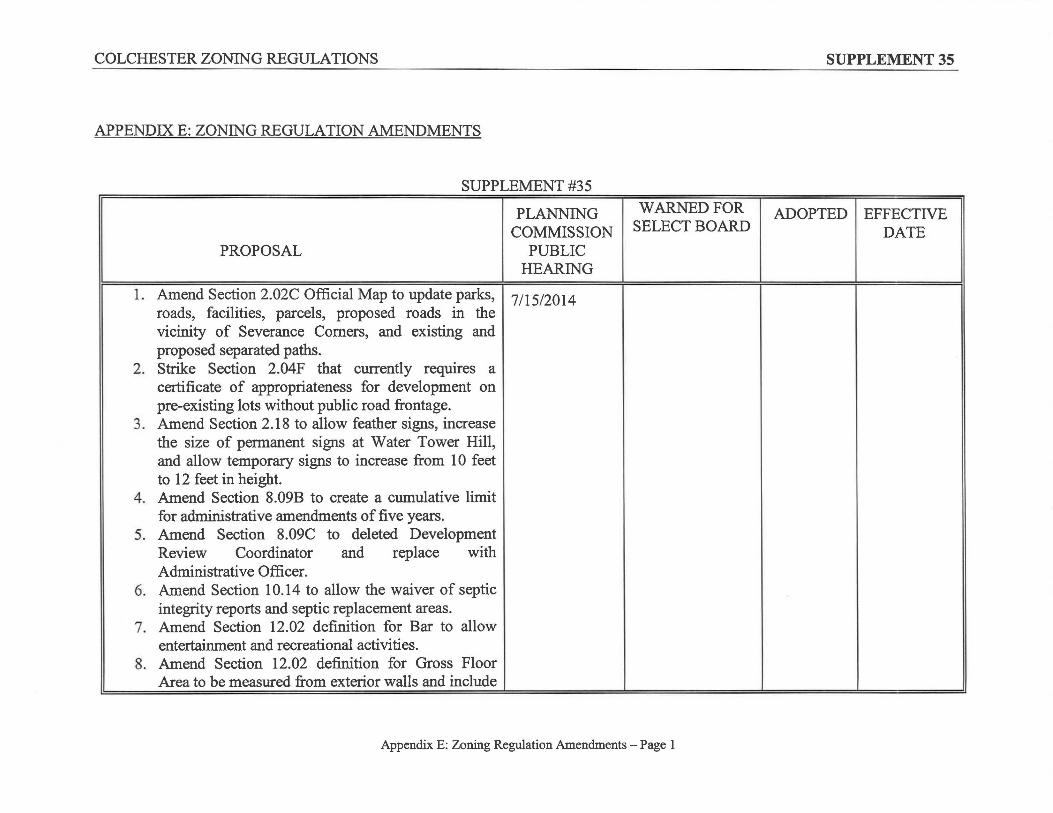
APPENDIX E: ZONING REGULATION AMENDMENTS
SUPPLEMENT #35
PROPOSAL
PLANNING COMMISSION
PUBLIC HEARING
1. Amend Section 2.02C Official Map to update parks, I 7/15/2014 roads, facilities, parcels, proposed roads in the vicinity of Severance Comers, and existing and proposed separated paths.
2. Strike Section 2.04F that currently requires a certificate of appropriateness for development on pre-existing lots without public road frontage.
3. Amend Section 2.18 to allow feather signs, increase the size of permanent signs at Water Tower Hill, and allow temporary signs to increase from 10 feet to 12 feet in height.
4. Amend Section 8.09B to create a cumulative limit for administrative amendments of five years.
5. Amend Section 8.09C to deleted Development Review Coordinator and replace with Administrative Officer.
6. Amend Section 10.14 to allow the waiver of septic integrity reports and septic replacement areas.
7. Amend Section 12.02 definition for Bar to allow entertainment and recreational activities.
8. Amend Section 12.02 definition for Gross Floor Area to be measured from exterior walls and include
WARNED FOR SELECT BOARD
Appendix E: Zoning Regulation Amendments - Page 1
SUPPLEMENT 35
ADOPTED I EFFECTIVE DATE

COLCHESTER ZONING REGULATIONS
all appurtenances. 9. Amend Section 12.02 definition for Nightclub to
define as a Bar that charges for entertainment. 10. Amend Appendix A-2 to define DU as dwelling
unit.
11. Amend Zoning Map to rezone parcels as codified in Appendix F herein: 03-031003 GD3 to R3 03-030003 GD3 to R3
SUPPLEMENT #34
PLANNING COMMISSION
PROPOSAL PUBLIC HEARING
12. Amend Zoning Map to rezone parcels as codified in Appendix F herein:
40-006002 COM to GDl
40-007002 COM to GD 1
40-061002 and all subnumbers R2 to R3
WARNED FOR SELECT BOARD
11/21/13
Appendix E: Zoning Regulation Amendments - Page 2
SUPPLEMENT 35
ADOPTED EFFECTIVE DATE
12/10/13 1/1/14
COLCHESTER ZONING REGULATIONS DRAFf SUPPLEMENT 35
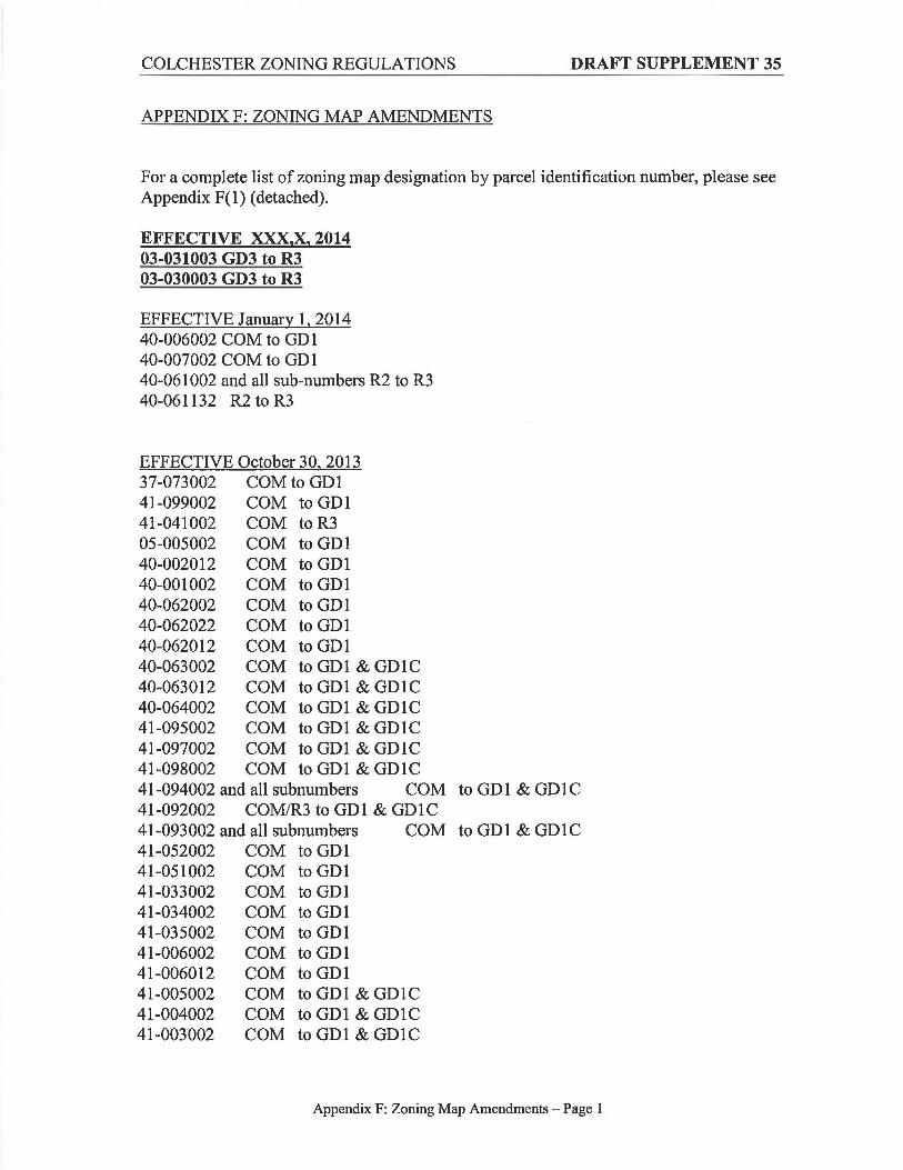
APPENDIX F: ZONING MAP AMENDMENTS
For a complete list of zoning map designation by parcel identification number, please see Appendix F(l) (detached).
EFFECTIVE :XXX,X, 2014 03-031003 GD3 to R3 03-030003 GD3 to R3
EFFECTIVE January 1, 2014 40-006002 COM to GD 1 40-007002 COM to GD 1 40-061002 and all sub-numbers R2 to R3 40-061132 R2 to R3
EFFECTIVE October 30, 2013 37-073002 COM to GDl 41-099002 COM to GDl 41-041002 COM to R3 05-005002 COM to GDl 40-002012 COM to GDl 40-001002 COM to GDl 40-062002 COM to GDl 40-062022 COM to GD 1 40-062012 COM to GDl 40-063002 COM to GDl & GDlC 40-063012 COM to GDl & GDlC 40-064002 COM to GDl & GDlC 41-095002 COM to GDl & GDlC 41-097002 COM to GDl & GDlC 41-098002 COM to GDl & GDlC 41-094002 and all subnumbers COM to GDl & GDlC 41-092002 COM/R3 to GDl & GDlC 41-093002 and all subnumbers COM to GDl & GDlC 41-052002 COM to GDl 41-051002 COM to GDl 41-033002 COM to GDl 41-034002 COM to GD 1 41-035002 COM to GDl 41-006002 COM to GD 1 41-006012 COM to GDl 41-005002 COM to GDl & GDlC 41-004002 COM to GDl & GDlC 41-003002 COM to GDl & GDlC
Appendix F: Zoning Map Amendments - Page I

Legend
TYPE
CEMETERY
¥B¤ COLLEGE
FIRE
HGGARAGE
"'HOSPITAL
Æc LIBRARY
POLICE STATI
POST_OFFICE
RESCUE
SCHOOL
3 SCHOOL BLD
TOWN BLD
TOWN_HALL
Shared Use
Proposed Seperated Paths
Public Roads
Private Roads
%UExisting
$ZProposed
Proposed Roads
TYPE
Emergency Access
Public
Lakeshore Boulevard Bypass
Parcels
Airport Park
Bayside Park
Bonanza Park
Causeway Park & Rec Path
Colchester Pond
Delta Park
Flag Lot at Bayside Park
Fort Ethan Allen Parade Grounds (Park)
Half Moon Cove
Heineberg Fishing Access / Billado Park
Heritage Park
Law Island
Macrae Meadows
Malletts Bay Boat Launch
Malletts Creek Wetlands
Munson Flats Natural Area
Niquette Bay State Park
Porter Natural Area
Rosetti Nature Area
St. Gelais Park
Sunny Hollow Natural Area
UVM Bog
Valleyfield Park
Village Park
Windemere Fishing Access
4
Purpose:The purpose of the Colchester Official Map is to help guide future development of certain public improvements that are likely to be needed to protect the health, safety and general welfare of the citizens of Colchester. Public improvements shown on the map include rights-of-way for streets, proposed separated paths, and other public facilities. This Official Map is authorized pursuant to 24 V.S.A., Section 4421.
Notes: a)The location of the proposed public facilities (including roads and paths) as shown on this map are approximate. The exact location of the proposed public facilities will be determined at a later date based on survey and other more accurate information.
b)Parcel line data is provided for informational purposed only. The Town reserves the right to update the Official Map with new parcel data as it becomes available.
c)All proposed roads, including the Lakeshore Boulevard Bypass, shall be as per the Town of Colchester Public Works Specifications and Standards as amended from time to time.
d)All public and private roads, both proposed and existing, require sidewalks per the Town of Colchester Public Works Specifications and Standards as amended from time to time. Pedestrian connections between cul-de-sacs and otherwise isolated neighborhoods are also required. Some exceptions may be made for limited access highways.
e)Parks depicted on the Official Map include parks owned and/or maintained by entities other than the Town of Colchester (i.e. State of Vermont and Winooski Valley Park District parks).
Sources: From 2014 Colchester parcel maps.All date in NAD83, Vermont State Plane coordinate system.Production by the Town of Colchester Department of Planning & Zoning,P.O. Box 55, Colchester, VT 05446. PH: 802-264-5600.Dated: 6/12/14
Disclaimer:The accuracy of information presented is determined by its sources: errors and omissions may exist. The Town of Colchester is not responsible for these. Questions of on the ground location can only be resolved by site inspections, and/or surveys by a registered surveyor. Hence this map is not sufficient for delineation of features on the ground. This map identifies the presence of features, and may indicate relationships between features, but is not responsible for surveyed information or engineering studies.
Adopted February 24, 2004Effective March 16, 2004Last Amended XXX, XX, 2014
DRAFT Official MapColchester, Vermont