pioneernnounces ,000mc … 1 - pioneernnounces ,000mc rillingrogrammet ts pioneer ome ithiumro ct,...
TRANSCRIPT
- 1 -
PIONEER ANNOUNCES A 5,000M RC DRILLING PROGRAMME AT ITS
PIONEER DOME LITHIUM PROJECT, WA
LITHIUM GEOCHEMISTRY CONFIRMS 14KM PROSPECTIVE PEGMATITE CORRIDOR
Perth Western Australia, 27 July 2016: Pioneer Resources Limited ("Company" or "Pioneer") (ASX: PIO)
is pleased to provide an exploration update for its 100%-held Pioneer Dome Project, located mid-way between Kalgoorlie and the Port of Esperance, and 75km south of the Mt Marion Lithium Mine, in Western Australia.
• Geochemistry confirms a 14 kilometre long, lithium-prospective Pegmatite Corridor,
covering 13 mapped pegmatite clusters, along the eastern Pioneer Dome.
• Approximately 50% of the Pegmatite Corridor has been soil sampled. Three priority lithium
anomalies are evident to date, at PEG001, PEG002 and PEG008. These are drill-ready.
• An initial 5,000m RC drill program to test these priority targets for spodumene
mineralisation is planned for September, subject to regulatory approvals for drilling.
• Geochemistry and airborne geophysical imagery has generated additional anomalies
associated with ‘blind pegmatites’ – those that don’t outcrop.
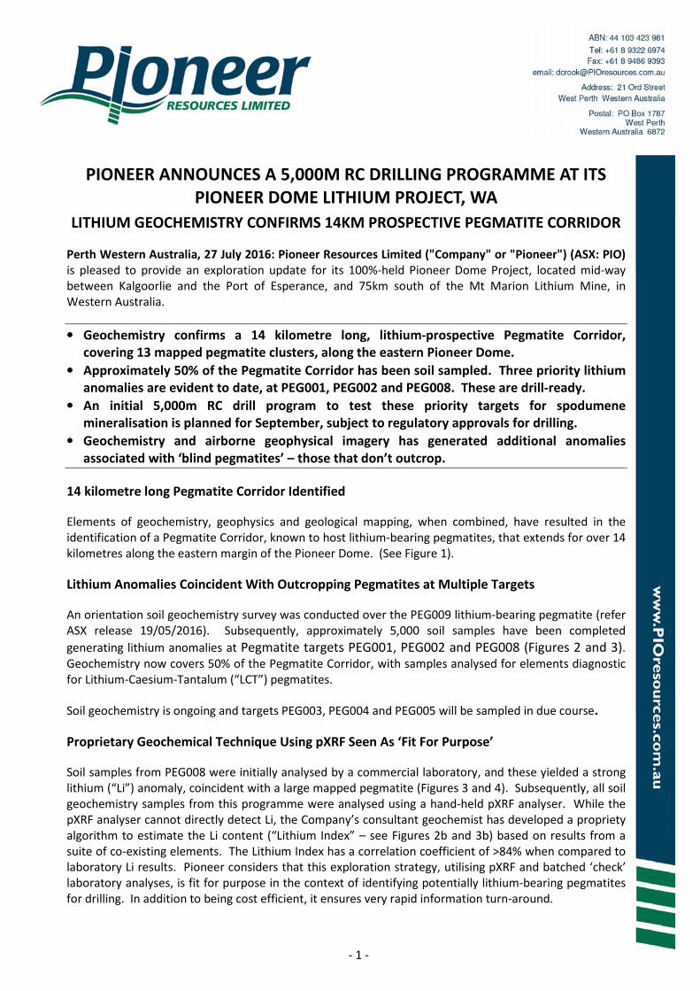
14 kilometre long Pegmatite Corridor Identified
Elements of geochemistry, geophysics and geological mapping, when combined, have resulted in the identification of a Pegmatite Corridor, known to host lithium-bearing pegmatites, that extends for over 14 kilometres along the eastern margin of the Pioneer Dome. (See Figure 1).
Lithium Anomalies Coincident With Outcropping Pegmatites at Multiple Targets
An orientation soil geochemistry survey was conducted over the PEG009 lithium-bearing pegmatite (refer ASX release 19/05/2016). Subsequently, approximately 5,000 soil samples have been completed
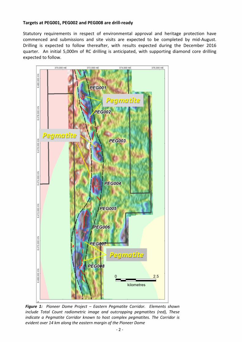
generating lithium anomalies at Pegmatite targets PEG001, PEG002 and PEG008 (Figures 2 and 3). Geochemistry now covers 50% of the Pegmatite Corridor, with samples analysed for elements diagnostic for Lithium-Caesium-Tantalum (“LCT”) pegmatites.
Soil geochemistry is ongoing and targets PEG003, PEG004 and PEG005 will be sampled in due course.
Proprietary Geochemical Technique Using pXRF Seen As ‘Fit For Purpose’
Soil samples from PEG008 were initially analysed by a commercial laboratory, and these yielded a strong lithium (“Li”) anomaly, coincident with a large mapped pegmatite (Figures 3 and 4). Subsequently, all soil geochemistry samples from this programme were analysed using a hand-held pXRF analyser. While the pXRF analyser cannot directly detect Li, the Company’s consultant geochemist has developed a propriety algorithm to estimate the Li content (“Lithium Index” – see Figures 2b and 3b) based on results from a suite of co-existing elements. The Lithium Index has a correlation coefficient of >84% when compared to laboratory Li results. Pioneer considers that this exploration strategy, utilising pXRF and batched ‘check’ laboratory analyses, is fit for purpose in the context of identifying potentially lithium-bearing pegmatites for drilling. In addition to being cost efficient, it ensures very rapid information turn-around.
- 2 -
Targets at PEG001, PEG002 and PEG008 are drill-ready
Statutory requirements in respect of environmental approval and heritage protection have commenced and submissions and site visits are expected to be completed by mid-August. Drilling is expected to follow thereafter, with results expected during the December 2016 quarter. An initial 5,000m of RC drilling is anticipated, with supporting diamond core drilling expected to follow.
Figure 1: Pioneer Dome Project – Eastern Pegmatite Corridor. Elements shown
include Total Count radiometric image and outcropping pegmatites (red), These
indicate a Pegmatite Corridor known to host complex pegmatites. The Corridor is
evident over 14 km along the eastern margin of the Pioneer Dome
- 3 -
Figure 2a: PEG001 and PEG002 Targets showing
potassium/thorium radiometric data imagery overlain
with mapped-in-outcrop and interpreted pegmatites.
PEG001 and PEG002 lithium targets are interpreted as
a series of stacked pegmatites, evident in mapping and
soil geochemistry. The anomaly is over 3 km long.
Figure 2b: Image of a proprietary Lithium Index based
on elements associated with lithium-caesium-tantalum
(LCT) pegmatites, below.
Figure 3a: PEG008 Target showing potassium/thorium
radiometric data imagery with mapped-in-outcrop and
interpreted pegmatites.
PEG008 lithium target is interpreted as tabular
pegmatite, evident in mapping with secondary splays
and offsets. The overall anomaly is approximately
1.7km long.
Figure 3b: Image of a proprietary lithium index based
on elements associated with lithium-caesium-tantalum
(LCT) pegmatites, below.
Mapped
Pegmatite
Mapped
Pegmatite
Mapped
Pegmatite
Mapped
Pegmatite

- 4 -
Figure 4: Detail of Lithium PEG008 Target.
Li (Laboratory) soil geochemistry. Mapped
pegmatite overlaying image of lithium assays,
showing a coincident anomaly that is 750m long.
The sampling covers a large mapped pegmatite
body and indicates that this has potential to be a
fertile rare-metal (LCT) pegmatite.
Additional geochemical results by pXRF, that are
consistent with the presence of rare-metal
pegmatites, extend beyond the mapped pegmatite
for another 900m.
Drilling is the next step.
PROJECT OUTLOOK
• Priority lithium anomalies have been identified at PEG001, PEG002 and PEG008. These are drill-ready and statutory approvals for drilling have been sought. Assuming a timely approval process, drilling is expected commence during September 2016. Initially drill holes will be collared on an 80x80m pattern, infilling as necessary to 40x40m.
• Soil geochemistry sampling was halted when a persistent rain event effected sample quality. PEG003, PEG004 and PEG005 will be sampled when soil conditions improve.
ABOUT THE PIONEER DOME LITHIUM PROJECT
The Pioneer Dome was recognised as having potential for lithium mineralisation following a review of historic exploration reports which recorded that numerous pegmatites were intersected in nickel or gold-focussed drilling undertaken since the 1960s. The prospectivity model was further enhanced by colloquial records of lithium and tantalum mineralisation and tourmaline in prospector scale workings, which are some of the characteristic minerals of a zoned rare-metal pegmatite complex.
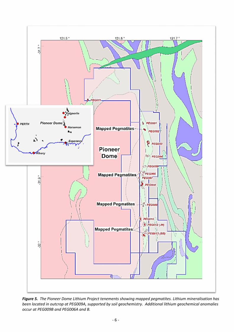
The Project comprises 1 granted exploration licence and 4 exploration licence applications, with a total area of 284 sq km, extending over approximately a 45 km strike length and a 20 km width.
The Company had, in 2005, commissioned a detailed geological interpretation of the Pioneer Dome (Jones M.G. (Lithofire), 2005), and this has been supplemented by MERIWA granitoid mapping, (Whittaker and Cassidy, 2002). Together, these maps show at least thirteen clusters of pegmatites occurring along a 14 km strike length of the eastern margin of the Pioneer Dome (see Figure 5). This extends for a further 20km (34 km strike) when other peripheral pegmatite clusters are included.
The Project is well located being approximately 130km south of Kalgoorlie, and 200km north of the Port of Esperance. Access is excellent with the Goldfields Highway and Esperance railway, and water and gas pipelines passing through the Project.
Mapped
Pegmatite

- 5 -
ABOUT PIONEER RESOURCES LIMITED
Pioneer is an active exploration company focused on key global demand-driven commodities. This includes a portfolio of strategically located gold, nickel and other commodity projects in mining regions in Western Australia, plus a portfolio of high quality lithium assets, in Canada and WA.
The Company is focused on delivering shareholder value by actively strengthening its project portfolio through acquiring, pegging and reviewing new opportunities, and targeted exploration programs to enable the discovery and commercialisation of high value mineral resources.
Lithium has been classed as a ‘critical metal’ meaning it has a number of important uses across various parts of the modern, globalised economy including communication, electronic, digital, mobile and battery technologies; and transportation, particularly aerospace and automotive emissions reduction. Critical metals seem likely to play an important role in the nascent green economy, particularly solar and wind power; electric vehicle and rechargeable batteries; and energy-efficient lighting.
-ENDS-
Managing Director Pioneer Resources Limited
For further information please contact:
David Crook James Moses
Pioneer Resources Limited Media and Investor Relations
T: +61 8 9322 6974 M: +61 420 991 574
- 6 -
Figure 5. The Pioneer Dome Lithium Project tenements showing mapped pegmatites. Lithium mineralisation has
been located in outcrop at PEG009A, supported by soil geochemistry. Additional lithium geochemical anomalies
occur at PEG009B and PEG006A and B.

- 7 -
REFERENCES
Company announcement to ASX 19 May, 2016.
Jones, M.G., 2005: The Surface Geology of the Pioneer Dome Area, Yilgarn Craton, W.A
Whitaker, A.J. and Cassidy, K.F., 2002: MERIWA Report 222, Characterisation and metallogenic significance of Archaean granitoids of the Yilgarn Craton, Western Australia.
GLOSSARY
“Li2O” means Lithia, or Lithium Oxide, and is the elemental metal quantity converted to its oxide (in percent (%)), which is a form of reporting used for lithium in scientific literature. The conversion factor for Li to Li2O is 2.152.
“Spodumene” is a lithium aluminosilicate (pyroxene) found in certain rare-element pegmatites, with the formula LiAlSi2O6. Spodumene is the principal lithium mineral sourced from pegmatites and is the preferred source for high purity lithium products. Spodumene is known to form megacrystals, has a distinctive hardness and cleavage, and may fluoresce under ultraviolet light.
“Be” means beryllium, “B” boron, “Cs” caesium, “Li” Lithium, “Nb” niobium, “Rb” rubidium, “Sb” antimony, “Sn” tin, “Ta” tantalum, “Tl” thallium.
“Pegmatite” is a common plutonic rock of variable texture and coarseness that is composed of interlocking crystals of widely different sizes. They are formed by fractional crystallization of an incompatible element-enriched granitic melt. Several factors control whether or not barren granite will fractionate to produce a fertile granite melt (Černý 1991; Breaks 2003):
• presence of trapped volatiles: fertile granites crystallize from a volatile-rich melt.
• composition of melt: fertile granites are derived from an aluminium-rich melt.
• source of magma: barren granites are usually derived from the partial melting of an igneous source (I-type), whereas fertile granites are derived from partial melting of a peraluminous sedimentary source (S-type).
• degree of partial melting: fertile granites require a high degree of partial melting of the source rock that produced the magma.
Initially, fractional crystallization of a granitic melt will form barren granite consisting of common rock forming minerals such as quartz, potassium feldspar, plagioclase and mica. Because incompatible rare elements, such as Be, Li, Nb, Ta, Cs, B, which do not easily fit into the crystal of these common rock-forming minerals, become increasingly concentrated in the granitic melt as common rock forming minerals continue to crystallize and separate from the melt.

- 8 -
COMPETENT PERSON
The information in this report that relates to Exploration Results is based on information supplied to and compiled by Mr David Crook and Dr Nigel Brand. Mr Crook is a full time employee of Pioneer Resources Limited and a member of The Australasian Institute of Mining and Metallurgy (member 105893) and the Australian Institute of Geoscientists (member 6034). Mr Crook has sufficient experience which is relevant to the exploration processes undertaken to qualify as a Competent Person as defined in the 2012 Editions of the ‘Australasian Code for Reporting of Exploration Results, Mineral Resources and Ore Reserves’.
Dr Brand is the principal of geochemical consultancy Geochemical Services Pty Ltd, and is a Competent Person as defined in the 2012 Editions of the ‘Australasian Code for Reporting of Exploration Results, Mineral Resources and Ore Reserves’
Mr Crook and Dr Brand consent to the inclusion of the matters presented in the announcement in the form and context in which they appear.
CAUTION REGARDING FORWARD LOOKING INFORMATION
This document contains certain statements that may be deemed "forward-looking statements.” All statements in this announcement, other than statements of historical facts, that address future market developments, government actions and events, are forward-looking statements.
Forward-looking statements are not statements of historical fact and actual events and results may differ materially from those described in the forward looking statements as a result of a variety of risks, uncertainties and other factors. Forward-looking statements are inherently subject to business, economic, competitive, political and social uncertainties and contingencies. Many factors could cause the Company’s actual results to differ materially from those expressed or implied in any forward-looking information provided by the Company, or on behalf of, the Company. Such factors include, among other things, risks relating to additional funding requirements, metal prices, exploration, development and operating risks, competition, production risks, regulatory restrictions, including environmental regulation and liability and potential title disputes.
Forward looking statements in this document are based generally on the Company’s beliefs, opinions and estimates as of the dates the forward looking statements that are made, and no obligation is assumed to update forward looking statements if these beliefs, opinions and estimates should change or to reflect other future developments.
Although Pioneer believes the outcomes expressed in such forward-looking statements are based on reasonable assumptions, such statements are not guarantees of future performance and actual results or developments may differ materially from those in forward-looking statements. Factors that could cause actual results to differ materially from those in forward-looking statements include new rare earth applications, the development of economic rare earth substitutes and general economic, market or business conditions.
While, Pioneer has made every reasonable effort to ensure the veracity of the information presented they cannot expressly guarantee the accuracy and reliability of the estimates, forecasts and conclusions contained herein. Accordingly, the statements in the presentation should be used for general guidance only.

- 9 -
APPENDIX 1. Soil Geochemistry Programme Summary
PEG NO Grid From To n Target Commodity Purpose
PEG001 100x50m 79980 80180 201 LCT pegmatiites Drill target generation
PEG002 100x50m 79369 79979 611 LCT pegmatiites Drill target generation
PEG008 100x50m 76163 73161 161 LCT pegmatiites Drill target generation
- 10 -
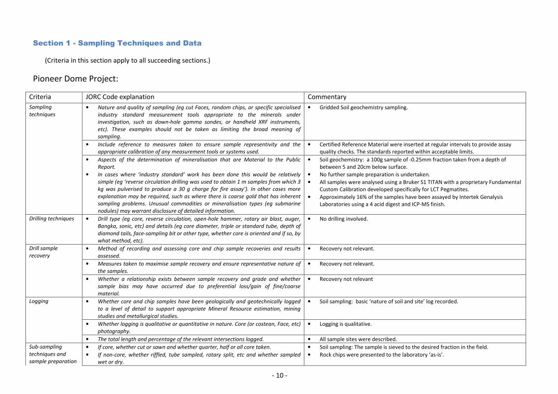
Section 1 - Sampling Techniques and Data
(Criteria in this section apply to all succeeding sections.)
Pioneer Dome Project:
Criteria JORC Code explanation Commentary
Sampling
techniques
• Nature and quality of sampling (eg cut Faces, random chips, or specific specialised
industry standard measurement tools appropriate to the minerals under
investigation, such as down-hole gamma sondes, or handheld XRF instruments,
etc). These examples should not be taken as limiting the broad meaning of
sampling.
• Gridded Soil geochemistry sampling.
• Include reference to measures taken to ensure sample representivity and the
appropriate calibration of any measurement tools or systems used.
• Certified Reference Material were inserted at regular intervals to provide assay quality checks. The standards reported within acceptable limits.
• Aspects of the determination of mineralisation that are Material to the Public
Report.
• In cases where ‘industry standard’ work has been done this would be relatively
simple (eg ‘reverse circulation drilling was used to obtain 1 m samples from which 3
kg was pulverised to produce a 30 g charge for fire assay’). In other cases more
explanation may be required, such as where there is coarse gold that has inherent
sampling problems. Unusual commodities or mineralisation types (eg submarine
nodules) may warrant disclosure of detailed information.
• Soil geochemistry: a 100g sample of -0.25mm fraction taken from a depth of between 5 and 20cm below surface.
• No further sample preparation is undertaken.
• All samples were analysed using a Bruker S1 TITAN with a proprietary Fundamental Custom Calibration developed specifically for LCT Pegmatites.
• Approximately 16% of the samples have been assayed by Intertek Genalysis Laboratories using a 4 acid digest and ICP-MS finish.
Drilling techniques • Drill type (eg core, reverse circulation, open-hole hammer, rotary air blast, auger,
Bangka, sonic, etc) and details (eg core diameter, triple or standard tube, depth of
diamond tails, face-sampling bit or other type, whether core is oriented and if so, by
what method, etc).
• No drilling involved.
Drill sample
recovery
• Method of recording and assessing core and chip sample recoveries and results
assessed.
• Recovery not relevant.
• Measures taken to maximise sample recovery and ensure representative nature of
the samples.
• Recovery not relevant.
• Whether a relationship exists between sample recovery and grade and whether
sample bias may have occurred due to preferential loss/gain of fine/coarse
material.
• Recovery not relevant
Logging • Whether core and chip samples have been geologically and geotechnically logged
to a level of detail to support appropriate Mineral Resource estimation, mining
studies and metallurgical studies.
• Soil sampling: basic ‘nature of soil and site’ log recorded.
• Whether logging is qualitative or quantitative in nature. Core (or costean, Face, etc)
photography.
• Logging is qualitative.
• The total length and percentage of the relevant intersections logged. • All sample sites were described.
Sub-sampling
techniques and
sample preparation
• If core, whether cut or sawn and whether quarter, half or all core taken.
• If non-core, whether riffled, tube sampled, rotary split, etc and whether sampled
wet or dry.
• Soil sampling: The sample is sieved to the desired fraction in the field.
• Rock chips were presented to the laboratory ‘as-is’.
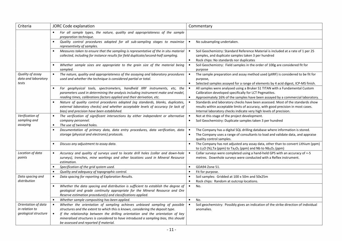
- 11 -
Criteria JORC Code explanation Commentary
• For all sample types, the nature, quality and appropriateness of the sample
preparation technique.
• Quality control procedures adopted for all sub-sampling stages to maximise
representivity of samples.
• No subsampling undertaken.
• Measures taken to ensure that the sampling is representative of the in situ material
collected, including for instance results for field duplicate/second-half sampling.
• Soil Geochemistry: Standard Reference Material is included at a rate of 1 per 25 samples, and duplicate samples taken 3 per hundred
• Rock chips: No standards nor duplicates
• Whether sample sizes are appropriate to the grain size of the material being
sampled.
• Soil Geochemistry: Field samples in the order of 100g are considered fit for purpose
Quality of assay
data and laboratory
tests
• The nature, quality and appropriateness of the assaying and laboratory procedures
used and whether the technique is considered partial or total.
• The sample preparation and assay method used (pXRF) is considered to be fit for purpose,
• Selected samples assayed for a range of elements by 4 acid digest, ICP-MS finish.
• For geophysical tools, spectrometers, handheld XRF instruments, etc, the
parameters used in determining the analysis including instrument make and model,
reading times, calibrations factors applied and their derivation, etc.
• All samples were analysed using a Bruker S1 TITAN with a Fundamental Custom Calibration developed specifically for LCT Pegmatites.
• Approximately 16% of the samples have been assayed by a commercial laboratory.
• Nature of quality control procedures adopted (eg standards, blanks, duplicates,
external laboratory checks) and whether acceptable levels of accuracy (ie lack of
bias) and precision have been established.
• Standards and laboratory checks have been assessed. Most of the standards show results within acceptable limits of accuracy, with good precision in most cases. Internal laboratory checks indicate very high levels of precision.
Verification of
sampling and
assaying
• The verification of significant intersections by either independent or alternative
company personnel.
• The use of twinned holes.
• Not at this stage of the project development.
• Soil Geochemistry: Duplicate samples taken 3 per hundred
• Documentation of primary data, data entry procedures, data verification, data
storage (physical and electronic) protocols.
• The Company has a digital SQL drilling database where information is stored.
• The Company uses a range of consultants to load and validate data, and appraise quality control samples.
• Discuss any adjustment to assay data. • The Company has not adjusted any assay data, other than to convert Lithium (ppm) to Li2O (%),Ta (ppm) to Ta2O5 (ppm) and Nb to Nb2O5 (ppm)
Location of data
points
• Accuracy and quality of surveys used to locate drill holes (collar and down-hole
surveys), trenches, mine workings and other locations used in Mineral Resource
estimation.
• Collar surveys were completed using a hand-held GPS with an accuracy of +-5 metres. Downhole surveys were conducted with a Reflex instrument.
• Specification of the grid system used. • GDA94 Zone 51.
• Quality and adequacy of topographic control. • Fit for purpose.
Data spacing and
distribution
• Data spacing for reporting of Exploration Results. • Soil samples: Gridded at 100 x 50m and 50x25m
• Rock chips: Random at outcrop locations.
• Whether the data spacing and distribution is sufficient to establish the degree of
geological and grade continuity appropriate for the Mineral Resource and Ore
Reserve estimation procedure(s) and classifications applied.
• No.
• Whether sample compositing has been applied. • No.
Orientation of data
in relation to
geological structure
• Whether the orientation of sampling achieves unbiased sampling of possible
structures and the extent to which this is known, considering the deposit type.
• If the relationship between the drilling orientation and the orientation of key
mineralised structures is considered to have introduced a sampling bias, this should
be assessed and reported if material.
• Soil geochemistry: Possibly gives an indication of the strike direction of individual anomalies.

- 12 -
Criteria JORC Code explanation Commentary
Sample security • The measures taken to ensure sample security. • The Company uses standard industry practices when collecting, transporting and storing samples for analysis.
• Soil samples are disposed of after analysis.
Audits or reviews • The results of any audits or reviews of sampling techniques and data. • Sampling techniques for soil geochemistry has been developed by Pioneer’s retained geochemist, Dr NW Brand, of Geochemical Services, Perth. The system has not been specifically audited but is similar to common practice methods in the Australian exploration industry.
Section 2 - Reporting of Exploration Results
(Criteria listed in the preceding section also apply to this section.)
Criteria JORC Code explanation Commentary
Mineral tenement
and land tenure
status
• Type, reference name/number, location and ownership including agreements or
material issues with third parties such as joint ventures, partnerships, overriding
royalties, native title interests, historical sites
• The sampling reported herein is within E63/1669, which is a granted exploration licence.
• The tenements are located approximately 130km S of Kalgoorlie, WA.
• Title is currently registered in the name of Pindan Resources Pty Ltd (80%) and Pioneer Resources Limited (20%); however Pioneer holds a 100% beneficial interest in the tenement.
• The exploration licence is within an area of land determined as having non-exclusive Native Title in favour of the Ngadju People.
• The security of the tenure held at the time of reporting along with any known
impediments to obtaining a licence to operate in the area. • At the time of this Statement the exploration licence is in Good Standing. To the
best of the Company’s knowledge, other than industry standard permits to operate there are no impediments to Pioneer’s operations within the tenement.
Exploration done by
other parties
• Acknowledgment and appraisal of exploration by other parties. • This report refers to data generated by Pioneer Resources Limited.
Geology • Deposit type, geological setting and style of mineralisation. • Zoned pegmatites that are prospective for lithium and tantalum.
Drill hole
Information
• A summary of all information material to the understanding of the exploration results
including a tabulation of the following information for all Material drill holes,
including easting and northing of the drill hole collar, elevation or RL (Reduced Level –
elevation above sea level in metres) of the drill hole collar, dip and azimuth of the
hole, down hole length and interception depth plus hole length.
• If the exclusion of this information is justified on the basis that the information is not
Material and this exclusion does not detract from the understanding of the report,
the Competent Person should clearly explain why this is the case.
• Refer to Table 1 of this announcement.
Data aggregation
methods
• In reporting Exploration Results, weighting averaging techniques, maximum and/or
minimum grade truncations (eg cutting of high grades) and cut-off grades are usually
Material and should be stated.
• Where aggregate intercepts incorporate short lengths of high grade results and
longer lengths of low grade results, the procedure used for such aggregation should
be stated and some typical examples of such aggregations should be shown in detail.
• Soil geochemistry results. No individual assay results are provided as anomalies are often poly-metallic, and require multivariate analysis. Thresholds are relative to ‘background’.
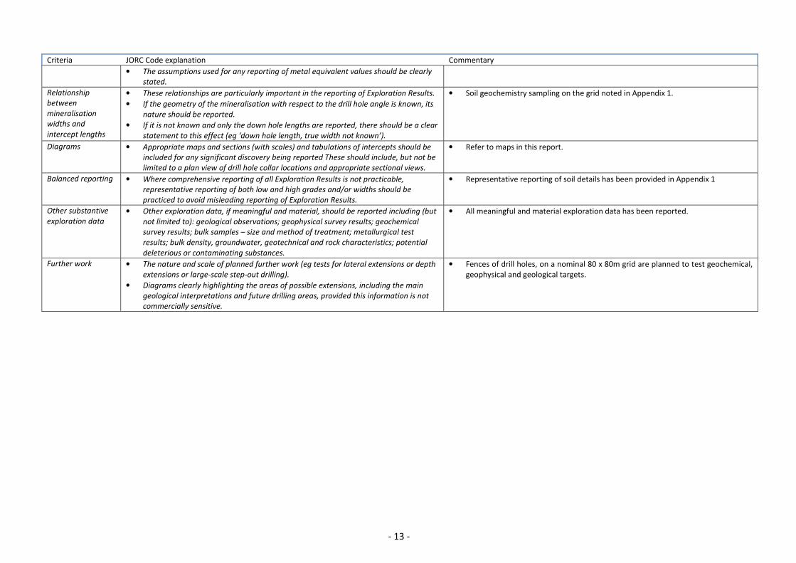
- 13 -
Criteria JORC Code explanation Commentary
• The assumptions used for any reporting of metal equivalent values should be clearly
stated.
Relationship
between
mineralisation
widths and
intercept lengths
• These relationships are particularly important in the reporting of Exploration Results.
• If the geometry of the mineralisation with respect to the drill hole angle is known, its
nature should be reported.
• If it is not known and only the down hole lengths are reported, there should be a clear
statement to this effect (eg ‘down hole length, true width not known’).
• Soil geochemistry sampling on the grid noted in Appendix 1.
Diagrams • Appropriate maps and sections (with scales) and tabulations of intercepts should be
included for any significant discovery being reported These should include, but not be
limited to a plan view of drill hole collar locations and appropriate sectional views.
• Refer to maps in this report.
Balanced reporting • Where comprehensive reporting of all Exploration Results is not practicable,
representative reporting of both low and high grades and/or widths should be
practiced to avoid misleading reporting of Exploration Results.
• Representative reporting of soil details has been provided in Appendix 1
Other substantive
exploration data
• Other exploration data, if meaningful and material, should be reported including (but
not limited to): geological observations; geophysical survey results; geochemical
survey results; bulk samples – size and method of treatment; metallurgical test
results; bulk density, groundwater, geotechnical and rock characteristics; potential
deleterious or contaminating substances.
• All meaningful and material exploration data has been reported.
Further work • The nature and scale of planned further work (eg tests for lateral extensions or depth
extensions or large-scale step-out drilling).
• Diagrams clearly highlighting the areas of possible extensions, including the main
geological interpretations and future drilling areas, provided this information is not
commercially sensitive.
• Fences of drill holes, on a nominal 80 x 80m grid are planned to test geochemical, geophysical and geological targets.