pilbara bulk ore transportation system project o… · report reference: env -ts-rp-0049_revc api...
TRANSCRIPT
Report Reference: ENV-TS-RP-0049_RevC API Environmental Review Document
Pilbara Bulk Ore Transportation System Project
ASSESSMENT ON PROPONENT INFORMATION – ENVIRONMENTAL REVIEW DOCUMENT
Proponent: Mineral Resources Limited
Address: 1 Sleat Road, Applecross, Western Australia
Postal Address: 1 Sleat Road, Applecross, Western Australia
Corporate Contact: James Hesford
Phone: 9329 3719
Email: [email protected]
8 August 2016
Pilbara Bulk Ore Transportation System Project | API Environmental Review Document
ENV-TS-RP-0049_RevB API Environmental Review Document Page | i
Revision History
Revision Number
Issue Date Prepared By Approved By Signature
A 26/05/2016 R. Sharp/S. Grein J. Hesford
B 27/06/2016 S. Grein J. Hesford
C 08/08/2016 S. Grein J. Hesford
Pilbara Bulk Ore Transportation System Project | API Environmental Review Document
ENV-TS-RP-0049_RevC API Environmental Review Document Page | ii
EXECUTIVE SUMMARY
Mineral Resources Limited (MRL) is Australia’s leading integrated mining services company. MRL is Australia’s fifth-largest iron ore producer, exporting 10 million tonnes of iron ore in FY2015 from its operations in the Yilgarn (Carina mine site) and Pilbara (Iron Valley mine site) regions of Western Australia.
The Proposal
To support the proposed expansion of the Iron Valley mine site, MRL proposes to construct and operate the Bulk Ore Transportation System (BOTS) between the mine and Port Hedland. This Proposal is for the construction and operation of the BOTS within a designated corridor (Proposal Area) extending from Iron Valley to the Port Hedland Port Authority boundary. The key characteristics of the Proposal are provided in Table ES1.
TABLE ES1: KEY CHARACTERISTICS OF THE PROPOSAL
Summary of the Proposal
Proposal Title Pilbara Bulk Ore Transportation System Project
Proponent Name Mineral Resources Limited
Short Description The Pilbara Bulk Ore Transport System Project proposes to develop an elevated, autonomous logistics solution, designed to deliver iron ore mined from the Iron Valley mine site to the Port Hedland Inner Harbour for overseas export. This system proposes to replace the road haulage transport solution currently in operation for the Iron Valley mine site.
• maintenance tracks;
• geotechnical investigation areas;
• borrow pits;
• laydown areas;
• communication towers;
• trenching;
• temporary workshops;
• groundwater abstraction bores (for construction);
• temporary construction camps; and
• ancillary infrastructure.
Physical Elements
Element Location Proposed Extent
BOTS Line and associated infrastructure
Proposal Area, as shown on Figure 1
Clearing of no more than 3,000 ha within a 29,796 ha Proposal Area.
The purpose of this Assessment on Proponent Information (API) Environmental Review Document has been prepared to provide detailed information regarding the Proposal to enable assessment of the potential environmental impacts that may result from the implementation of the Proposal.

Pilbara Bulk Ore Transportation System Project | API Environmental Review Document
ENV-TS-RP-0049_RevC API Environmental Review Document Page | iii
Environmental Impact Assessment
In accordance with the Scoping Guideline prepared by the Environmental Protection Authority (EPA), the Environmental Impact Assessment of the Proposal considers three key environmental factors, two integrating factors and two other environmental factors.
Preliminary Key Environmental Factor: Flora and Vegetation
The Proposal incorporates clearing of up to 3,000 ha of native vegetation. Thirteen conservation significant flora taxa and two Priority Ecological Communities (PECs) are known to occur in the Proposal Area:
• P1 taxa Abutilon sp. Pritzelianum (S. van Leeuwen 5095), Eremophila spongiocarpa, Heliotropium muticum, Josephinia ?sp. Marandoo (ME Trudgen 1554) and Tephrosia rosea var. Port Hedland (A.S. George 1114)
• P2 taxa Euphorbia clementii and Paspalidium retiglume
• P3 taxa Goodenia sp. East Pilbara (A.A. Mitchell PRP 727), Gymnanthera cunninghamii, Rhagodia sp. Hamersley (M. Trudgen 17794), Themeda sp. Hamersley Station (M.E. Trudgen 11431)
• P4 taxa Bulbostylis burbidgeae and Goodenia nuda
• P1 PEC Fortescue Marsh (Marsh Land System)
• P3 PEC Vegetation of Sand Dunes of the Hamersley Range/Fortescue Valley.
The Proposal also intersects the Fortescue Marsh Management Area/ Fortescue Marsh Ecologically Significant Area (ESA), which contains regionally significant Mulga and Samphire vegetation types.
Disturbance associated with the Proposal is not expected to result in significant impact to flora and vegetation at the species, population or community level, and thus is consistent with the EPA’s objective for this environmental factor.
Preliminary Key Environmental Factor: Terrestrial Fauna
The Proposal involves the disturbance of 3,000 ha of native vegetation (fauna habitat).
Nine species of conservation significant fauna are known to occur in the Proposal Area:
• Northern Quoll (Dasyurus hallucatus) (Endangered)
• Greater Bilby and Pilbara Leaf-nosed Bat (Vulnerable)
• Ghost Bat (Macroderma gigas) (Schedule 3, Vulnerable)
• Black-lined Ctenotus (Ctenotus nigrilineatus) (P1)
• Brush-tailed Mulgara (Dasycercus blythi), Western Pebble-mound Mouse (Pseudomys chapmani) (P4)
• Fork-tailed Swift (Apus pacificus) and Rainbow Bee-eater (Merops ornatus) (Migratory).
Although critical habitat which supports the Northern Quoll has been identified in the Proposal Area, the BOTS alignment itself avoids this habitat in the great majority of cases. Construction and operation of the Proposal is not expected to result in significant impact to terrestrial fauna at the species, population or community level and thus is consistent with the EPA’s objective for this environmental factor.
Preliminary Key Environmental Factor: Hydrological Process
The elevated design of the BOTS will result in minimal impact to surface water flows, both within major and minor watercourse crossings, and within sheetflow areas. While the Proposal Area does intersect the Fortescue Marsh ESA, impacts to the Fortescue Marsh have been minimised by selecting a corridor in the narrowest section of the Marsh, generally corresponding with the footprints of other infrastructure corridors that have been previously approved and/or developed.
Pilbara Bulk Ore Transportation System Project | API Environmental Review Document
ENV-TS-RP-0049_RevC API Environmental Review Document Page | iv
It is expected that the Proposal will utilise approximately 2,000 – 3,000 kL per day of groundwater during the construction phase. Ongoing water supply for operation of the BOTS will not be required, with the exception of ad-hoc maintenance activities. As such, no large scale or long term groundwater drawdown will occur.
Considering the design of the BOTS and the minimal groundwater requirements, the hydrological regimes of groundwater and surface water will be maintained for the protection of existing and potential uses.
Integrating Factor: Rehabilitation and Decommissioning
A large proportion of the disturbance associated with the Proposal will be temporary. MRL proposes to rehabilitate areas of temporary disturbance following the completion of construction activities. Operational infrastructure will be decommissioned and rehabilitated when the BOTS formation is no longer required.
The key likely long-term outcomes for closure are:
• above-ground infrastructure and equipment will be removed
• disturbed areas will be stable and will resemble pre-disturbance and surrounding topography
• disturbed areas will be covered by vegetation re-established from respread topsoil and/or seed of local provenance.
The management measures to appropriately decommission, decontaminate and rehabilitate disturbed areas are in place to mitigate the potential risks associated with closure, in accordance with the EPA’s closure objective.
Integrating Factor: Offsets
The Proposal will result in some residual environmental impacts. An assessment of these impacts has been conducted in accordance with the WA Environmental Offsets Policy and Guidelines. It is anticipated that the negotiation of offsets with the EPA and DPaW will result in the application of a $/hectare offset rate for actual disturbance resulting from land clearing. It is proposed that offset funding be contributed to the proposed Pilbara Strategic Conservation Initiative. This offset will act to counterbalance the significant residual environmental impacts identified for the Proposal and allow the EPA objective for Offsets to be met.
Other Environmental Factors: Heritage and Amenity (Noise)
The Proposal has the potential to impact heritage. These impacts will be managed using the application of industry-standard management methodologies, in accordance with relevant legislation (the Aboriginal Heritage Act 1972 and Environmental Protection (Noise) Regulations 1997). Noise modelling predicted no exceedances at all noise sensitive receptors assessed.
Summary
In developing the Proposal, consideration has been given to the principles of environmental protection. In particular, the Proposal has been designed to predominantly utilise existing, previously EPA-assessed rail infrastructure corridors, including existing supporting infrastructure such as rail maintenance tracks, camps and water abstraction bores thereby avoiding and minimising impacts to the preliminary key environmental factors in line with the mitigation hierarchy.
MRL considers that the information and assessment presented in this Environmental Review Document adequately identifies and addresses environmental aspects and issues relevant to the Proposal and is suitable for the EPA to undertake assessment under Part IV of the Environmental Protection Act 1986 (WA).

Pilbara Bulk Ore Transportation System Project | API Environmental Review Document
ENV-TS-RP-0049_RevC API Environmental Review Document Page | v
[This page has been left blank intentionally]
Pilbara Bulk Ore Transportation System Project | API Environmental Review Document
ENV-TS-RP-0049_RevC API Environmental Review Document Page | vi
CONTENTS
EXECUTIVE SUMMARY ....................................................................................................................................... II
1. INTRODUCTION ....................................................................................................................................... 1
1.1. Project Background ....................................................................................................................... 1
1.2. Purpose of this Document ............................................................................................................ 1
1.3. Level of Assessment Criteria – API Category A ............................................................................. 2
1.4. Policy and Guidance Applicable to the Proposal .......................................................................... 2
2. PROPONENT AND KEY PROPOSAL CHARACTERISTICS ........................................................................... 11
2.1. Proponent Details ....................................................................................................................... 11
2.2. Key Characteristics ...................................................................................................................... 11
3. PROPOSAL DESCRIPTION ....................................................................................................................... 14
3.1. Location ....................................................................................................................................... 14
3.2. Land Use ...................................................................................................................................... 14
3.3. Tenure ......................................................................................................................................... 14
3.4. Project Facilities and Activities ................................................................................................... 20
3.4.1. Proposed Disturbance ...................................................................................................... 20
3.4.2. Bulk Ore Transport System ............................................................................................... 20
3.4.3. Other Infrastructure ......................................................................................................... 24
3.4.4. Water Requirements ........................................................................................................ 24
3.4.5. Clearing Activities ............................................................................................................. 24
3.4.6. Rehabilitation Activities .................................................................................................... 25
3.5. Alternatives Considered .............................................................................................................. 25
3.6. Approval and Development Timeframes .................................................................................... 25
4. STAKEHOLDER CONSULTATION ............................................................................................................. 27
5. RELEVANT STUDIES ............................................................................................................................... 30
5.1. Proposed Studies ........................................................................................................................ 36
6. ASSESSMENT OF PRELIMINARY KEY ENVIRONMENTAL FACTORS ........................................................ 37
6.1. Identification of Preliminary Key Environmental Factors ........................................................... 37
6.2. Flora and Vegetation ................................................................................................................... 54
6.2.1. Context ............................................................................................................................. 54
6.2.2. Potential Significant Impacts without Mitigation ............................................................. 57
6.2.3. Proposed Management (Mitigation) ................................................................................ 66
6.2.4. Regulation ......................................................................................................................... 75
6.2.5. Outcome and Assessment against EPA Objective ............................................................ 75
Pilbara Bulk Ore Transportation System Project | API Environmental Review Document
ENV-TS-RP-0049_RevC API Environmental Review Document Page | vii
6.3. Terrestrial Fauna ......................................................................................................................... 75
6.3.1. Context ............................................................................................................................. 75
6.3.2. Potential Significant Impacts without Mitigation ............................................................. 76
6.3.3. Proposed Management (Mitigation) ................................................................................ 84
6.3.4. Regulation ......................................................................................................................... 94
6.3.5. Outcome and Assessment against EPA Objective ............................................................ 94
6.4. Hydrological Processes................................................................................................................ 94
6.4.1. Context ............................................................................................................................. 94
6.4.2. Potential Significant Impacts without Mitigation ............................................................. 95
6.4.3. Proposed Management (Mitigation) .............................................................................. 101
6.4.4. Regulation ....................................................................................................................... 108
6.4.5. Outcome and Assessment against EPA Objective .......................................................... 108
6.5. Rehabilitation and Decommissioning (Integrating Factor) ....................................................... 108
6.5.1. Context ........................................................................................................................... 108
6.5.2. Potential Significant Impacts without Mitigation ........................................................... 109
6.5.3. Rehabilitation and Decommissioning Strategy ............................................................... 110
6.5.4. Regulation ....................................................................................................................... 111
6.5.5. Outcome and Assessment against EPA Objective .......................................................... 111
6.6. Offsets (Integrating Factor) ....................................................................................................... 112
6.6.1. Context ........................................................................................................................... 112
6.6.2. Residual Impact Significance Assessment ...................................................................... 113
6.6.3. Outcome and Assessment against EPA Objective .......................................................... 113
7. OTHER ENVIRONMENTAL FACTORS .................................................................................................... 120
7.1. Impact Assessment ................................................................................................................... 120
7.2. Expected Environmental Outcomes ......................................................................................... 120
8. PRINCIPLES OF THE EP ACT AND BIOLOGICAL DIVERSITY ................................................................... 124
9. CONCLUSION ....................................................................................................................................... 128
10. REFERENCES ........................................................................................................................................ 129

Pilbara Bulk Ore Transportation System Project | API Environmental Review Document
ENV-TS-RP-0049_RevC API Environmental Review Document Page | viii
TABLES
TABLE 1: OVERVIEW OF POLICY AND GUIDANCE DOCUMENTATION ............................................................... 3
TABLE 2: PROPONENT CONTACT DETAILS ....................................................................................................... 11
TABLE 3: KEY CHARACTERISTICS OF THE PROPOSAL ....................................................................................... 12
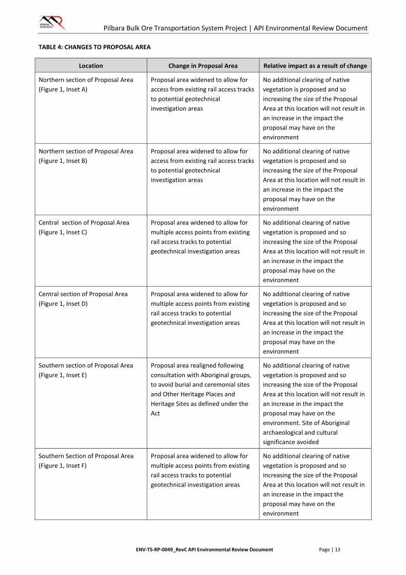
TABLE 4: CHANGES TO PROPOSAL AREA ......................................................................................................... 13
TABLE 5: TARGET ASSESSMENT TIMEFRAMES ................................................................................................ 26
TABLE 6: SUMMARY OF STAKEHOLDER CONSULTATION ................................................................................ 27
TABLE 7: SUMMARY OF ENVIRONMENTAL STUDIES ....................................................................................... 31
TABLE 8: PRELIMINARY ENVIRONMENTAL FACTORS ...................................................................................... 38
TABLE 9: SPECIFIC INFORMATION REQUIRED FOR KEY ENIVRONMENTAL FACTORS ..................................... 52
TABLE 10: BEARD VEGETATION ASSOCIATIONS .............................................................................................. 55
TABLE 11: VEGETATION CONDITION ............................................................................................................... 56
TABLE 12: POTENTIAL IMPACTS TO FORTESCUE MARSH MANAGEMENT AREAS – FLORA AND VEGETATION ......................................................................................................................................................................... 58
TABLE 13: MITIGATION STRATEGIES FOR FORTESCUE MARSH MANAGEMENT AREAS – FLORA AND VEGETATION .................................................................................................................................................... 68
TABLE 14: POTENTIAL IMPACTS TO FORTESCUE MARSH MANAGEMENT AREAS – TERRESTRIAL FAUNA ..... 77
TABLE 15: MITIGATION STRATEGIES FOR FORTESCUE MARSH MANAGEMENT AREAS – TERRESTRIAL FAUNA ......................................................................................................................................................................... 86
TABLE 16: POTENTIAL IMPACTS TO FORTESCUE MARSH MANAGEMENT AREAS – HYDROLOGICAL PROCESSES ....................................................................................................................................................... 96
TABLE 17: MITIGATION STRATEGIES FOR FORTESCUE MARSH MANAGEMENT AREAS – HYDROLOGICAL PROCESSES ..................................................................................................................................................... 103
TABLE 18: EPA ENVIRONMENTAL OFFSETS REPORTING FORM .................................................................... 115
TABLE 19: OTHER ENVIRONMENTAL FACTORS ............................................................................................. 120
TABLE 20: ASSESSMENT OF OTHER ENVIRONMENTAL FACTORS.................................................................. 122
TABLE 21: PRINCIPLES OF THE EP ACT ........................................................................................................... 124
TABLE 22: CONSIDERATION OF THE PROPOSAL IN REFERENCE TO THE 8 ELEMENTS OF BIOLOGICAL DIVERSITY ...................................................................................................................................................... 126
Pilbara Bulk Ore Transportation System Project | API Environmental Review Document
ENV-TS-RP-0049_RevC API Environmental Review Document Page | ix
FIGURES
FIGURE 1: REGIONAL LOCATION ..................................................................................................................... 10
FIGURE 2: RAIL ALIGNMENTS AND SURVEYS - NORTH .................................................................................... 15
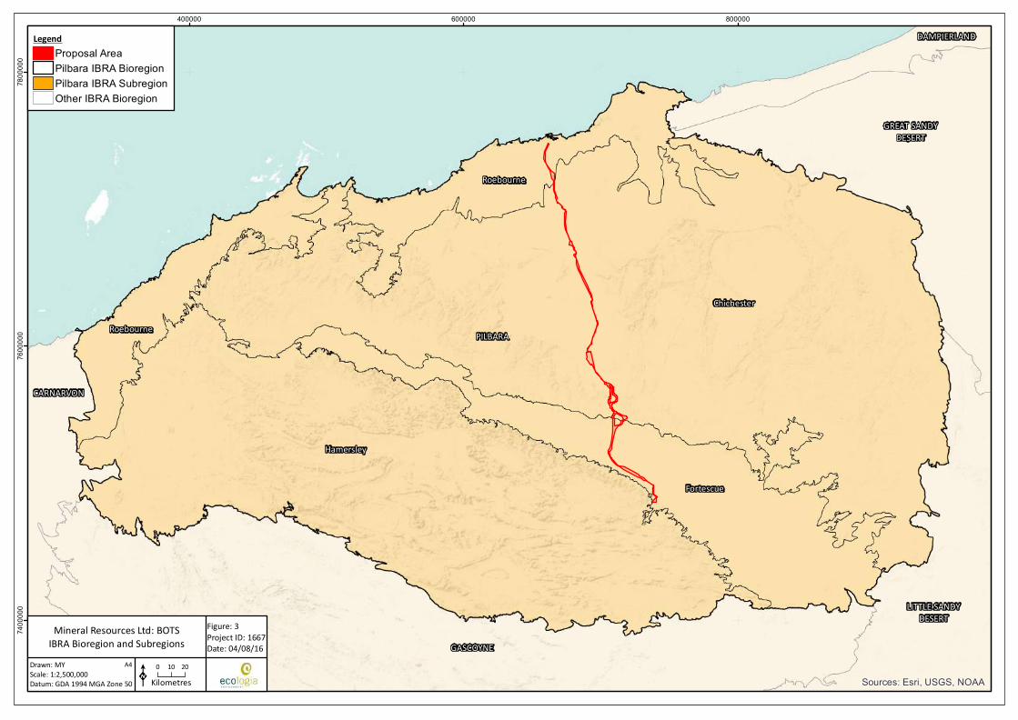
FIGURE 3: IBRA REGIONS ................................................................................................................................. 17
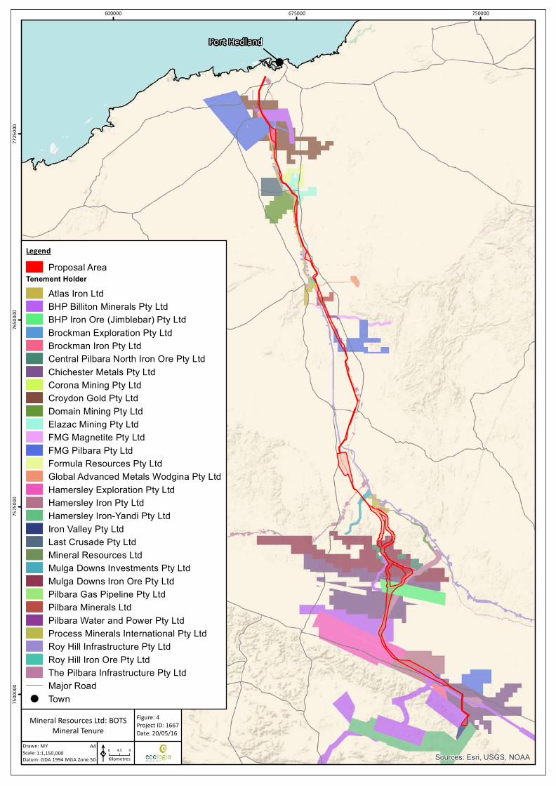
FIGURE 4: MINERAL TENURE ........................................................................................................................... 18
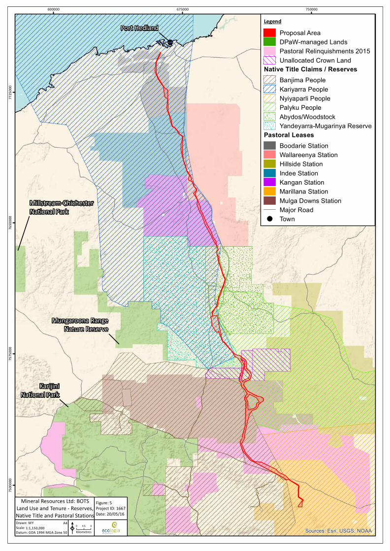
FIGURE 5: LAND USE AND TENURE – NATIVE TITLE, RESERVES AND PASTORAL STATIONS ........................... 19
FIGURE 6: FLORA AND VEGETATION ............................................................................................................... 61
FIGURE 7: FORTESCUE MARSH MANAGEMENT AREA ZONES ......................................................................... 64
FIGURE 8: FORTESCUE MARSH MANAGEMENT AREA ENVIRONMENTAL VALUES – FLORA AND VEGETATION ......................................................................................................................................................................... 65
FIGURE 9: TERRESTRIAL FAUNA....................................................................................................................... 80
FIGURE 10: FORTESCUE MARSH MANAGEMENT AREA ENVIRONMENTAL VALUES – TERRESTRIAL FAUNA .. 83
FIGURE 11: HYDROLOGY .................................................................................................................................. 97
FIGURE 12: FORTESCUE MARSH MANAGEMENT AREA ENVIRONMENTAL VALUES – HYDROLOGICAL PROCESSES ..................................................................................................................................................... 100
APPENDICES
APPENDIX 1 ENVIRONMENTAL SCOPING GUIDELINE
APPENDIX 2 SUPPORTING DOCUMENTATION
Pilbara Bulk Ore Transportation System Project | API Environmental Review Document
ENV-TS-RP-0049_RevC API Environmental Review Document Page | 1
1. INTRODUCTION
1.1. Project Background
Mineral Resources Limited (MRL) is Australia’s leading integrated mining services company. MRL’s market leading brands comprise Crushing Services International, PIHA, and Process Minerals International. These divisions have all established a reputation for delivering high quality services in the specialist fields of contract crushing, construction, operation and maintenance of world class mineral processing plants, pipe-laying and pipe fittings manufacture as well as mine ownership, development and operation. MRL is also Australia’s fifth-largest iron ore producer, exporting 10 million tonnes of iron ore in FY2015 from its operations in the Yilgarn (Carina mine site) and Pilbara (Iron Valley mine site) regions of Western Australia.
The Iron Valley mine site is located in the Central Pilbara region of Western Australia, approximately 90 kilometres (km) north-west of Newman (Figure 1). The existing mining operation transports saleable ore product via on-highway road trains, a distance of 344 km between mine and Port Hedland. Iron Valley operates under existing Ministerial Statement 933.
To support the proposed expansion of Iron Valley, MRL proposes to construct and operate a new, innovative logistics solution, namely the Bulk Ore Transportation System (BOTS) between the mine and Port Hedland. Once operational, the BOTS will eliminate the requirement for the existing road haulage solution. This Proposal is for the construction and operation of the BOTS within a designated Development Envelope (Proposal Area) extending from Iron Valley to the Port Hedland Port Authority boundary.
MRL has been working with the Department of State Development (DSD) and the Pilbara Port Authority (PPA) to identify potential BOTS multi-user port solutions within the Port Hedland inner harbour. A key outstanding action that currently constrains the momentum of some project activities is the State’s allocation of an inner harbour port location to MRL in Port Hedland.
MRL will continue to progress this project within the constraint of completing the work in this area. It is anticipated that a preferred port solution will be finalised once all data gathering and engineering development works are completed, in mid-2016. The final port solution will either be covered by existing Part IV approvals under the Environmental Protection Act 1986 (WA) (EP Act), or variations as required. The mine and port components do not form part of this Proposal.
1.2. Purpose of this Document
The purpose of this Assessment on Proponent Information (API) Environmental Review Document is to provide detailed information on the Proposal to enable assessment of the potential environmental impacts that may result from the Proposal’s implementation. This document considers the key characteristics required for the construction and operation of the Proposal, as defined in the Environmental Protection Authority’s (EPA)-prepared Scoping Guideline (EPA 2016; Appendix 1). The assessment will be completed by the Western Australian Office of the Environmental Protection Authority (OEPA) under the provisions of the EP Act.
This document has been prepared in accordance with the EPA’s Environmental Assessment Guideline (EAG) 14 – Preparation of an API-A Environmental Review Document, January 2015 (EPA 2015a).
This Proposal was also referred to the Commonwealth Department of the Environment (DotE) under the Environmental Protection and Biodiversity Protection Act 1999 (Cwth) (EPBC Act). The DotE determined that the Proposal was a not Controlled Action under the EPBC Act (EPBC 2016/7637) on 5 April 2016. As such, no further assessment under the EPBC Act is required.
It should be noted that this Proposal will be constructed and operated under a State Agreement currently being negotiated with the Department of State Development (DSD), who are the Lead Agency for the
Pilbara Bulk Ore Transportation System Project | API Environmental Review Document
ENV-TS-RP-0049_RevC API Environmental Review Document Page | 2
Project. Consequently, there is no requirement for any regulatory approvals under the Mining Act 1978 through the Department of Mines and Petroleum (DMP).
1.3. Level of Assessment Criteria – API Category A
This Proposal was referred to the EPA on 13 November 2015 for assessment under Part IV of the EP Act. It was determined on 22 January 2016 that the Proposal required assessment at the level of API Category A. The EPA based their decision on the following points:
• the Proposal raises a limited number of preliminary key environmental factors that can be readily managed, and for which there is an established condition setting framework
• the environmental impact assessment process appears consistent with established EPA policies and guidelines
• MRL have conducted appropriate stakeholder consultation
• there is only limited or local concern about the likely effect of the Proposal on the environment.
Following this decision, MRL were required to prepare an API document for submission to the OEPA that addresses the requirements of the EPA’s Scoping Guideline (EPA 2016; Appendix 1). The Scoping Guideline identified the following factors relevant to the Proposal for consideration and assessment in the API document.
• Preliminary Key Environmental Factors:
o Flora and Vegetation
o Terrestrial Fauna
o Hydrological Processes
• Integrating Factors:
o Rehabilitation and Decommissioning
o Offsets
• Other Environmental Factors:
o Heritage
o Amenity (noise).
Each factor is discussed in further detail in the relevant chapters of this API document (Sections 6 and 7).
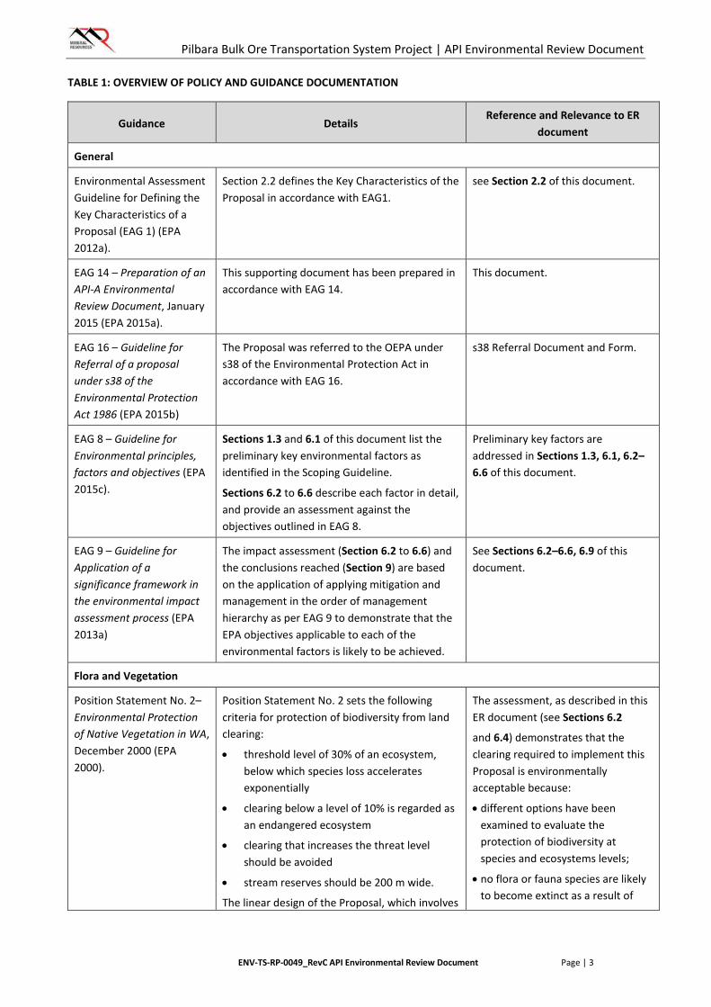
1.4. Policy and Guidance Applicable to the Proposal
Policy and guidance applicable to this project are presented in Table 1. Study-specific guidelines and policies that have been followed are presented as Policy Context, at the beginning of the impact assessments sections for each environmental factor, in Section 6 of this document.
Other policies and guidelines prepared by the EPA were considered but were determined not to be relevant to this Proposal.
Pilbara Bulk Ore Transportation System Project | API Environmental Review Document
ENV-TS-RP-0049_RevC API Environmental Review Document Page | 3
TABLE 1: OVERVIEW OF POLICY AND GUIDANCE DOCUMENTATION
Guidance Details Reference and Relevance to ER
document
General
Environmental Assessment Guideline for Defining the Key Characteristics of a Proposal (EAG 1) (EPA 2012a).
Section 2.2 defines the Key Characteristics of the Proposal in accordance with EAG1.
see Section 2.2 of this document.
EAG 14 – Preparation of an API-A Environmental Review Document, January 2015 (EPA 2015a).
This supporting document has been prepared in accordance with EAG 14.
This document.
EAG 16 – Guideline for Referral of a proposal under s38 of the Environmental Protection Act 1986 (EPA 2015b)
The Proposal was referred to the OEPA under s38 of the Environmental Protection Act in accordance with EAG 16.
s38 Referral Document and Form.
EAG 8 – Guideline for Environmental principles, factors and objectives (EPA 2015c).
Sections 1.3 and 6.1 of this document list the preliminary key environmental factors as identified in the Scoping Guideline.
Sections 6.2 to 6.6 describe each factor in detail, and provide an assessment against the objectives outlined in EAG 8.
Preliminary key factors are addressed in Sections 1.3, 6.1, 6.2–6.6 of this document.
EAG 9 – Guideline for Application of a significance framework in the environmental impact assessment process (EPA 2013a)
The impact assessment (Section 6.2 to 6.6) and the conclusions reached (Section 9) are based on the application of applying mitigation and management in the order of management hierarchy as per EAG 9 to demonstrate that the EPA objectives applicable to each of the environmental factors is likely to be achieved.
See Sections 6.2–6.6, 6.9 of this document.
Flora and Vegetation
Position Statement No. 2– Environmental Protection of Native Vegetation in WA, December 2000 (EPA 2000).
Position Statement No. 2 sets the following criteria for protection of biodiversity from land clearing:
• threshold level of 30% of an ecosystem, below which species loss accelerates exponentially
• clearing below a level of 10% is regarded as an endangered ecosystem
• clearing that increases the threat level should be avoided
• stream reserves should be 200 m wide.
The linear design of the Proposal, which involves
The assessment, as described in this ER document (see Sections 6.2
and 6.4) demonstrates that the clearing required to implement this Proposal is environmentally acceptable because:
• different options have been examined to evaluate the protection of biodiversity at species and ecosystems levels;
• no flora or fauna species are likely to become extinct as a result of
Pilbara Bulk Ore Transportation System Project | API Environmental Review Document
ENV-TS-RP-0049_RevC API Environmental Review Document Page | 4
Guidance Details Reference and Relevance to ER
document
significantly less land clearing than conventional railways, does not result in large scale disturbance of native vegetation in a concentrated area.
Clearing for linear infrastructure is less likely to result in the depletion of a vegetation type below the 30% or 10% thresholds outlined in the guidance.
The design of the BOTS allows for minimisation of clearing and disturbance around watercourses.
Assessment of impacts to flora and vegetation is provided in Section 6.2 and assessment of impacts to hydrological processes is provided in Section 6.4.
implementing the Proposal;
• no community of native flora or fauna is likely to cease to exist as a result of implementing the proposal; and
• vegetation removal resulting from the implementation of this proposal will not exceed the threshold level of 30% of the pre-European extent of any vegetation type.
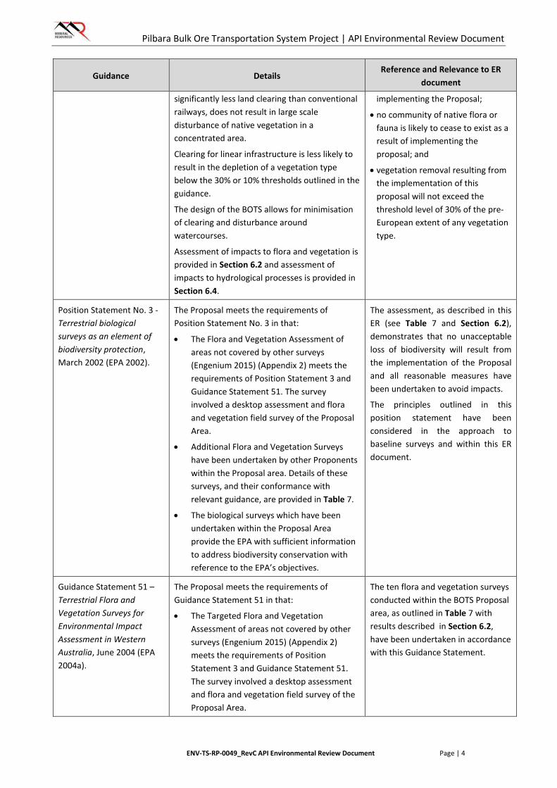
Position Statement No. 3 - Terrestrial biological surveys as an element of biodiversity protection, March 2002 (EPA 2002).
The Proposal meets the requirements of Position Statement No. 3 in that:
• The Flora and Vegetation Assessment of areas not covered by other surveys (Engenium 2015) (Appendix 2) meets the requirements of Position Statement 3 and Guidance Statement 51. The survey involved a desktop assessment and flora and vegetation field survey of the Proposal Area.
• Additional Flora and Vegetation Surveys have been undertaken by other Proponents within the Proposal area. Details of these surveys, and their conformance with relevant guidance, are provided in Table 7.
• The biological surveys which have been undertaken within the Proposal Area provide the EPA with sufficient information to address biodiversity conservation with reference to the EPA’s objectives.
The assessment, as described in this ER (see Table 7 and Section 6.2), demonstrates that no unacceptable loss of biodiversity will result from the implementation of the Proposal and all reasonable measures have been undertaken to avoid impacts.
The principles outlined in this position statement have been considered in the approach to baseline surveys and within this ER document.
Guidance Statement 51 – Terrestrial Flora and Vegetation Surveys for Environmental Impact Assessment in Western Australia, June 2004 (EPA 2004a).
The Proposal meets the requirements of Guidance Statement 51 in that:
• The Targeted Flora and Vegetation Assessment of areas not covered by other surveys (Engenium 2015) (Appendix 2) meets the requirements of Position Statement 3 and Guidance Statement 51. The survey involved a desktop assessment and flora and vegetation field survey of the Proposal Area.
The ten flora and vegetation surveys conducted within the BOTS Proposal area, as outlined in Table 7 with results described in Section 6.2, have been undertaken in accordance with this Guidance Statement.

Pilbara Bulk Ore Transportation System Project | API Environmental Review Document
ENV-TS-RP-0049_RevC API Environmental Review Document Page | 5
Guidance Details Reference and Relevance to ER
document
• The level and intensity of survey is appropriate for the ecological setting and the scale of the project.
• The survey was led by experienced and qualified botanists and team members were well versed in the botany of the Pilbara.
• The survey was undertaken within the optimal season to ensure plants could be correctly identified.
• Additional Flora and Vegetation Surveys have been undertaken by other Proponents within the Proposal area. Details of these surveys, and their conformance with relevant guidance, are provided in Table 7.
EPA Report 1484, Environmental and Water assessments relating to mining and mining-related activities in the Fortescue Marsh management area (EPA 2013b)
A portion of the Proposal Area falls within the Fortescue Marsh Management Area as defined within the Guidance. The implementation of the Guidance in relation to Flora and Vegetation is presented in detail in Section 6.2 in Table 12 and Table 13.
The implementation of the guidance in relation to Flora and Vegetation impacts in the Fortescue Management Area Zones is presented in Section 6.2, Table 12 and Table 13 and Figure 7 of this ER document.
Technical Guide – Flora and Vegetation Surveys for Environmental Impact Assessment, December 2015.
This Guidance has been recently released, subsequent to the referral of this Proposal to the EPA. While not designed specifically in accordance with the requirements of this Guidance, the surveys undertaken prior to its release date were generally undertaken in accordance with it. Proposed future surveys, as outlined in Section 5.1, will be undertaken in accordance with this Guidance.
The ten Flora and Vegetation surveys conducted within the BOTS Proposal area, as outlined in Table 7 (and proposed in Section 5.1) with results described in Section 6.2, have been generally undertaken in accordance with this Technical Guide.
Terrestrial Fauna
Guidance Statement No. 56 – Terrestrial fauna surveys for Environmental Impact assessment in WA, June 2004 (EPA 2004b)
The terrestrial fauna survey undertaken meets the requirements of the Guidance in that:
• The Targeted Terrestrial Fauna Assessment of areas not covered by other surveys (Engenium 2015 (Appendix 2) meets the requirements of Guidance Statement 56, Position Statement No. 3 and the Technical Guide.
• The survey was conducted at intensity appropriate for the ecological setting and the size and scale of the Proposal.
• Standard fauna survey techniques were used (observations, visual inspections,
The nine terrestrial fauna surveys conducted within the BOTS Proposal area, as outlined in Table 7 with results described in Section 6.3, have been undertaken in accordance with this Guidance Statement.
Pilbara Bulk Ore Transportation System Project | API Environmental Review Document
ENV-TS-RP-0049_RevC API Environmental Review Document Page | 6
Guidance Details Reference and Relevance to ER
document
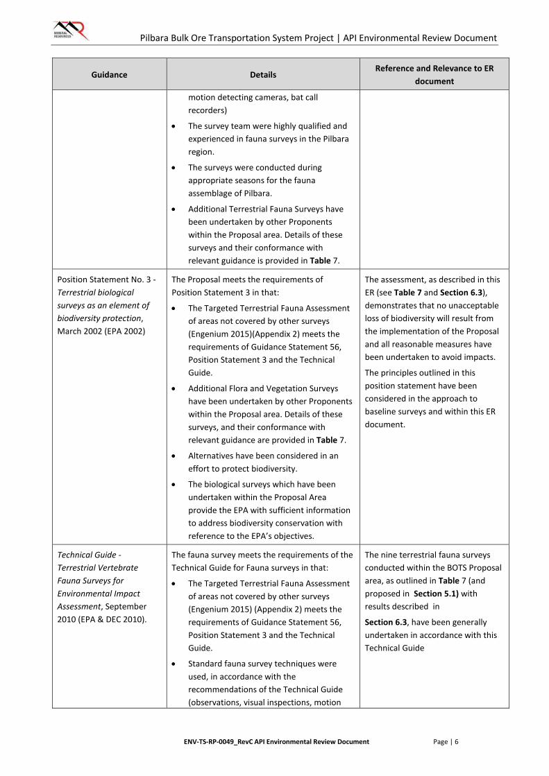
motion detecting cameras, bat call recorders)
• The survey team were highly qualified and experienced in fauna surveys in the Pilbara region.
• The surveys were conducted during appropriate seasons for the fauna assemblage of Pilbara.
• Additional Terrestrial Fauna Surveys have been undertaken by other Proponents within the Proposal area. Details of these surveys and their conformance with relevant guidance is provided in Table 7.
Position Statement No. 3 - Terrestrial biological surveys as an element of biodiversity protection, March 2002 (EPA 2002)
The Proposal meets the requirements of Position Statement 3 in that:
• The Targeted Terrestrial Fauna Assessment of areas not covered by other surveys (Engenium 2015)(Appendix 2) meets the requirements of Guidance Statement 56, Position Statement 3 and the Technical Guide.
• Additional Flora and Vegetation Surveys have been undertaken by other Proponents within the Proposal area. Details of these surveys, and their conformance with relevant guidance are provided in Table 7.
• Alternatives have been considered in an effort to protect biodiversity.
• The biological surveys which have been undertaken within the Proposal Area provide the EPA with sufficient information to address biodiversity conservation with reference to the EPA’s objectives.
The assessment, as described in this ER (see Table 7 and Section 6.3), demonstrates that no unacceptable loss of biodiversity will result from the implementation of the Proposal and all reasonable measures have been undertaken to avoid impacts.
The principles outlined in this position statement have been considered in the approach to baseline surveys and within this ER document.
Technical Guide - Terrestrial Vertebrate Fauna Surveys for Environmental Impact Assessment, September 2010 (EPA & DEC 2010).
The fauna survey meets the requirements of the Technical Guide for Fauna surveys in that:
• The Targeted Terrestrial Fauna Assessment of areas not covered by other surveys (Engenium 2015) (Appendix 2) meets the requirements of Guidance Statement 56, Position Statement 3 and the Technical Guide.
• Standard fauna survey techniques were used, in accordance with the recommendations of the Technical Guide (observations, visual inspections, motion
The nine terrestrial fauna surveys conducted within the BOTS Proposal area, as outlined in Table 7 (and proposed in Section 5.1) with results described in
Section 6.3, have been generally undertaken in accordance with this Technical Guide

Pilbara Bulk Ore Transportation System Project | API Environmental Review Document
ENV-TS-RP-0049_RevC API Environmental Review Document Page | 7
Guidance Details Reference and Relevance to ER
document
detecting cameras, bat call recorders)
• The consultants were licensed by DPaW and survey methodology was cognisant of ethical considerations.
EPA Report 1484, Environmental and Water assessments relating to mining and mining-related activities in the Fortescue Marsh management area (EPA 2013b)
A portion of the Proposal Area falls within the Fortescue Marsh Management Area as defined within the Guidance. The implementation of the Guidance in relation to Terrestrial Fauna is presented in detail in Section 6.3 in Table 14 and Table 15.
The implementation of the guidance in relation to terrestrial fauna impacts in the Fortescue Management Area Zones is presented Section 6.3 and Table 14 and Table 15
Hydrological Processes
Position Statement No. 4 – Environmental Protection of Wetlands, November 2004 (EPA 2004c)
This Position Statement contains principles to enable the restoration, maintenance or enhancement of the environmental values and beneficial uses of wetland ecosystems within the context of an overall goal of no net loss of wetland values and functions. Significant values and functions recognised by the Position Statement include:
• Primary production
• Recreational and landscape amenity
• Hydrological balance
• Water quality protection
• Wildlife habitat.
Whilst the Proposal does intersect the Fortescue Marsh Environmentally Sensitive Area (ESA), impacts to the Marsh itself have been minimised by selecting a corridor in the narrowest section of the Marsh, in a similar area to other infrastructure corridors which have already been developed. Land clearing has also been minimised through the design of the Proposal. As outlined in Section 6.4, the Proposal is consistent with the objectives of the Position Statement and does not result in significant impacts to the values and functions of the wetland.
The hydrological processes assessment described in Section 6.4 of this document is consistent with the broad principles outlined in this Position Statement
EPA Report 1484, Environmental and Water assessments relating to mining and mining-related activities in the Fortescue Marsh management area
A portion of the Proposal Area falls within the Fortescue Marsh Management Area as defined within the Guidance. The implementation of the Guidance in relation to Terrestrial Fauna is presented in detail in Section 6.4 in Table 16 and Table 17.
The potential impacts of the hydrological processes associated this Proposal on the Fortescue Marsh Management Area Zones are discussed in Section 6.4 and Table 16 and Table 17 of this
Pilbara Bulk Ore Transportation System Project | API Environmental Review Document
ENV-TS-RP-0049_RevC API Environmental Review Document Page | 8
Guidance Details Reference and Relevance to ER
document
(EPA 2013b) document.
Rehabilitation and Closure
Guidelines for Preparing Mine Closure Plans (DMP & EPA 2015).
Section 6.5 of this document addresses Closure and Rehabilitation of the Proposal. This section includes information on Post Closure Land Use and identifies closure domains and objectives in accordance with the Guidance. A detailed Closure Plan in accordance with the Guidelines is not required at this stage of the Proposal Life. MRL commits to preparing a detailed Closure Plan within 5 years of anticipated closure.
These guidelines have informed MRL rehabilitation and decommissioning approach that has been described in Section 6.5 of this document. The approach described is consistent with the Guidelines.
Guidance Statement 6 - Rehabilitation of Terrestrial Ecosystems, June 2006 (EPA 2006).
The closure objectives in Section 6.5 include:
• Establish a safe, stable non-polluting land surface which is generally consistent with pre-disturbance topography.
• Establish a land surface which can support vegetation growth of local provenance species and the long-term development of a self-sustaining ecosystem.
These objectives align with the key aims of rehabilitation according to the Guidance: to ensure long term stability of soils, landforms and hydrology required for sustainability of sites and to partially or fully repair the capacity of the ecosystems to provide habitat for biota and services for people.
Section 6.5 also outlines specific completion criteria in accordance with the Guidance.
Definitions in the Guidance for rehabilitation of natural ecosystems are consistent with MRL’s approach and understanding of the environmental management of these factors. The rehabilitation and decommissioning assessment for this Proposal is detailed in Section 6.5
Cumulative environmental impacts of development in the Pilbara Region, Advice of the EPA to the Minister for Environment under Section 16(e) of the Environmental Protection Act 1986. August 2014 (EPA 2014a).
This Advice has been considered in the design of the BOTS Proposal, in order to minimise clearing of native vegetation. Other aspects of the Advice relevant to the Proposal include rehabilitation of cleared areas and management of weeds and feral animals. It is proposed that progressive rehabilitation will be conducted, with construction pads and tracks, camps and associated utilities to be rehabilitated at the completion of construction activities (Section 6.5). Management measures to control weeds and feral animals are also included in Sections 6.2.3 and 6.3.3 respectively.
In an effort to minimise clearing of native vegetation along with strategies for the rehabilitation of cleared areas and management of weeds and feral animals, this Advice has been considered in Section 6.5, Section 6.2.3 and Section 6.3.3
Offsets
Environmental Protection Bulletin No. 1 –
The principles of avoid, minimise and rehabilitate have been implemented for the
This Bulletin has informed MRL’s offset approach for this Proposal,

Pilbara Bulk Ore Transportation System Project | API Environmental Review Document
ENV-TS-RP-0049_RevC API Environmental Review Document Page | 9
Guidance Details Reference and Relevance to ER
document
Environmental Offsets – Biodiversity EPA (2014)
Proposal. It is acknowledged that offsets are required where significant residual impacts remain, after implementing all other measures. Section 6.6 outlines how significant residual impacts have been identified and proposes contributions to the Pilbara Strategic Conservation Initiative (PSCI). The PSCI meets the requirements of the EPA’s bulletin.
which is detailed in Section 6.6 and Table 17. MRL’s offsets approach is consistent with the Bulletin in that:
• Offsets are a last resort and are considered only where, after application of mitigation hierarchy, residual impacts remain.
• The minimum requirements required by the Bulletin are addressed in Section 6.6 and Table 16 of this Proposal.
WA Environmental Offsets Policy Govt of WA (2011)
The contributions to the PSCI will meet the Offset Policy as this will achieve long term outcomes that build on existing conservation initiatives and objectives.
This Policy has informed MRL’s offset approach for this Proposal, which is detailed in Section 6.6 and Table 17.
WA Environmental Offsets Guidelines Govt of WA (2014)
The PSCI meets the requirements of the Environmental Offsets Guidelines by contributing to on-ground management and research initiatives that will increase remove threats and increase the State’s biodiversity knowledge base. The application of a dollar per hectare value for offsets is proportional to the residual impact. The PSCI meets the Guidelines objectives for a strategic approach to implementing offsets across a range of tenure types.
These Guidelines have informed MRL’s offset approach for this Proposal, which is detailed in Section 6.6 and Table 17.
WA Environmental Offsets Template
The WA Offsets Template has been completed and is presented in Section 6.6 (Table 17).
The extent of residual environmental impacts resulting from the implementation of the Proposal are presented in Section 6.6 (Table 17)
Tom Price
Mungaroona RangeNature Reserve
KarijiniNational Park
PortHedland
675000 750000 82500075
0000
075
7500
076
5000
077
2500
0
Drawn: MYScale:Datum: GDA 1994 MGA Zone 50
Figure: 1Project ID: 1667Date: 20/06/16
0 4.5 9Kilometres
Mineral Resources Ltd: BOTSRegional Location
1:1,250,000A4
K
LegendProposal AreaEPA Referred Area (2015)DPaW-managed LandsMajor Road
[i Iron Valley Project!( Town
!(
!(
!(
Perth
Newman
Port Hedland
A
A
B
B
C
C D
D
E
E
F
F
Pilbara Bulk Ore Transportation System Project | API Environmental Review Document
ENV-TS-RP-0049_RevC API Environmental Review Document Page | 11
2. PROPONENT AND KEY PROPOSAL CHARACTERISTICS
2.1. Proponent Details
MRL is a publically listed company (ASX: MIN, ABN 33 118 549 910) and is the proponent for this Proposal. Contact details for the proponent are provided in Table 2.
TABLE 2: PROPONENT CONTACT DETAILS
Contact Detail
Name James Hesford
Company Mineral Resources Limited
Position Manager Environment
Postal Address Locked Bag 3
Canning Bridge LPO
Applecross, WA 6153
Phone (08) 9329 3719
Email [email protected]
It should be noted that MRL has a mine gate sale agreement in place with BC Iron Limited (BCI), the tenement holders for the Iron Valley mine site, which will be the initial source of iron ore product to be hauled on the BOTS.
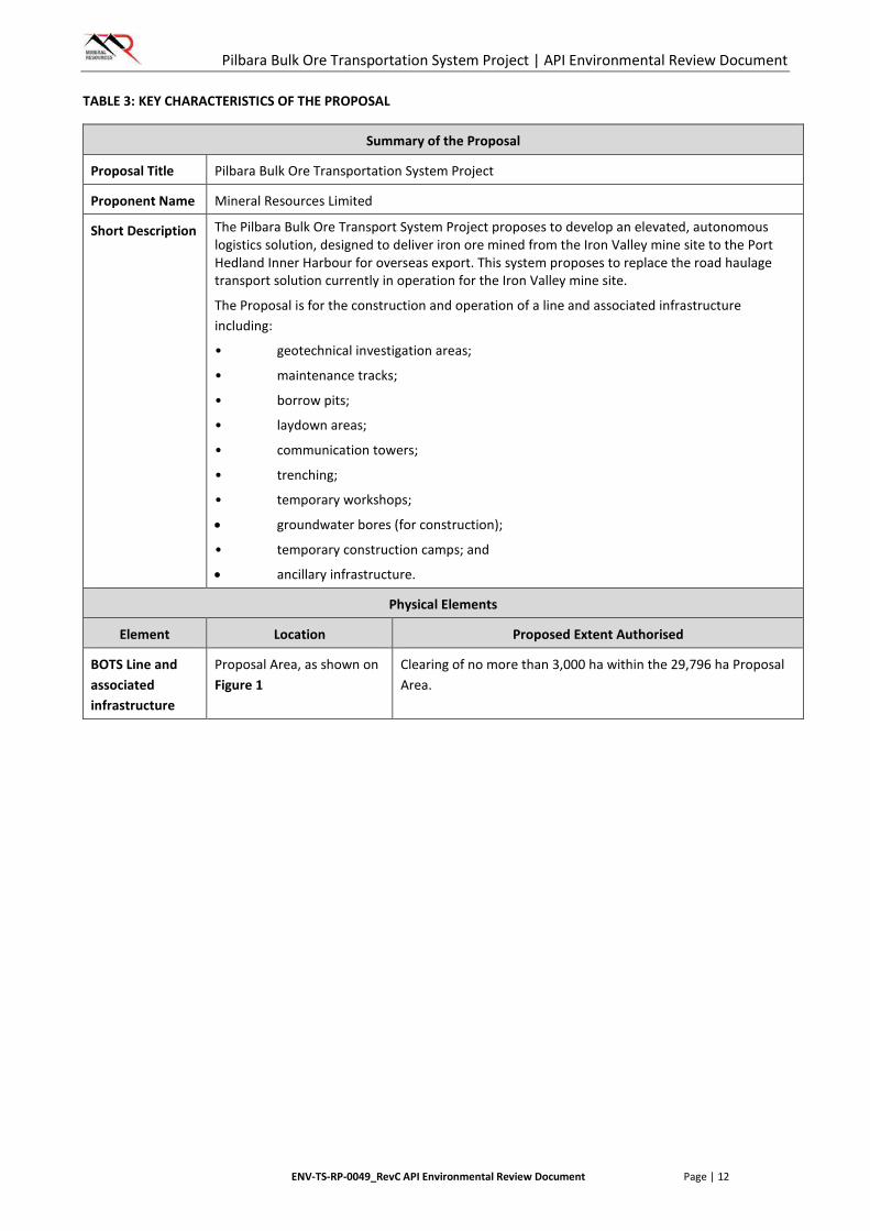
2.2. Key Characteristics
The Key Characteristics of the Proposal have been identified in accordance with the EPA’s Environmental Assessment Guidelines 1: Defining the Key Characteristics of a Proposal (EPA 2012a) and are described in Table 3.
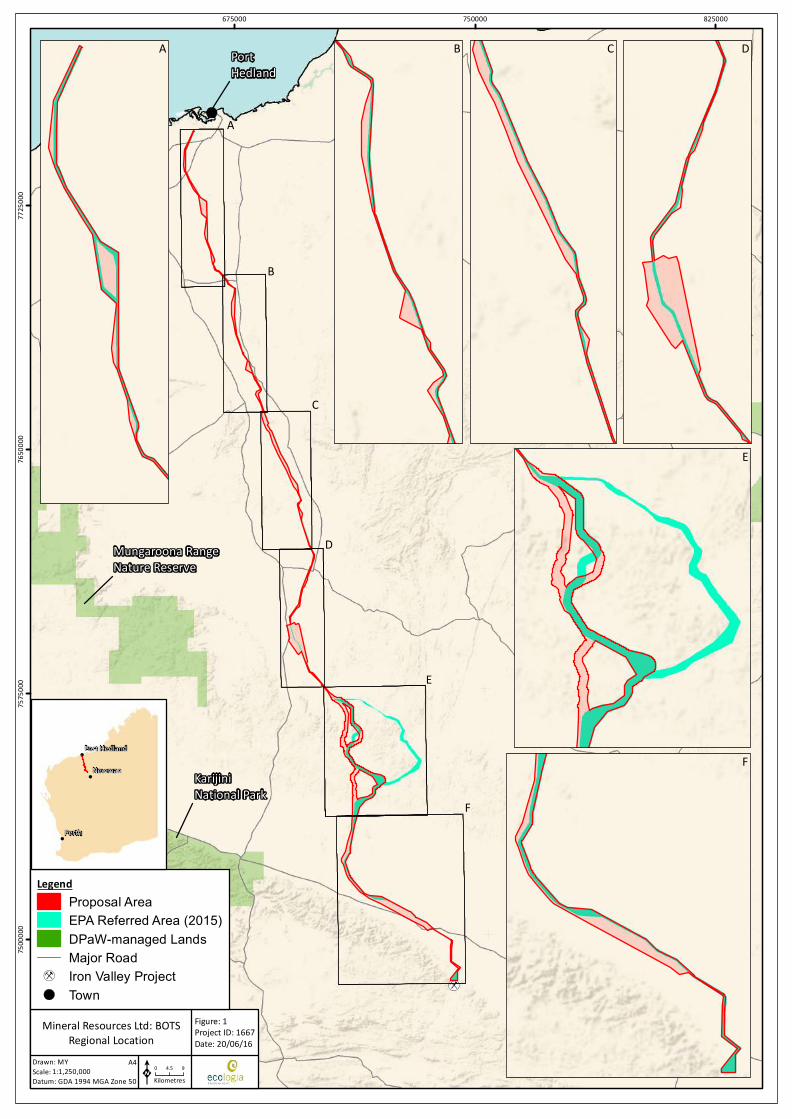
Following the submission of the Proposal’s Referral in November 2014, MRL have implemented some changes to the Proposal (see Table 4). The majority of these changes are due to adjustments to the alignment to reduce impacts to environmental and other factors, including heritage and social factors (Figure 1). As a result of these changes the Proposal Area has increased from 16,731 ha to 29,796 ha. The total area to be cleared within the Proposal Area remains unchanged at 3,000 ha, as per the Referral.
Pilbara Bulk Ore Transportation System Project | API Environmental Review Document
ENV-TS-RP-0049_RevC API Environmental Review Document Page | 12
TABLE 3: KEY CHARACTERISTICS OF THE PROPOSAL
Summary of the Proposal
Proposal Title Pilbara Bulk Ore Transportation System Project
Proponent Name Mineral Resources Limited
Short Description The Pilbara Bulk Ore Transport System Project proposes to develop an elevated, autonomous logistics solution, designed to deliver iron ore mined from the Iron Valley mine site to the Port Hedland Inner Harbour for overseas export. This system proposes to replace the road haulage transport solution currently in operation for the Iron Valley mine site.
The Proposal is for the construction and operation of a line and associated infrastructure including:
• geotechnical investigation areas;
• maintenance tracks;
• borrow pits;
• laydown areas;
• communication towers;
• trenching;
• temporary workshops;
• groundwater bores (for construction);
• temporary construction camps; and
• ancillary infrastructure.
Physical Elements
Element Location Proposed Extent Authorised
BOTS Line and associated infrastructure
Proposal Area, as shown on Figure 1
Clearing of no more than 3,000 ha within the 29,796 ha Proposal Area.
Pilbara Bulk Ore Transportation System Project | API Environmental Review Document
ENV-TS-RP-0049_RevC API Environmental Review Document Page | 13
TABLE 4: CHANGES TO PROPOSAL AREA
Location Change in Proposal Area Relative impact as a result of change
Northern section of Proposal Area (Figure 1, Inset A)
Proposal area widened to allow for access from existing rail access tracks to potential geotechnical investigation areas
No additional clearing of native vegetation is proposed and so increasing the size of the Proposal Area at this location will not result in an increase in the impact the proposal may have on the environment
Northern section of Proposal Area (Figure 1, Inset B)
Proposal area widened to allow for access from existing rail access tracks to potential geotechnical investigation areas
No additional clearing of native vegetation is proposed and so increasing the size of the Proposal Area at this location will not result in an increase in the impact the proposal may have on the environment
Central section of Proposal Area (Figure 1, Inset C)
Proposal area widened to allow for multiple access points from existing rail access tracks to potential geotechnical investigation areas
No additional clearing of native vegetation is proposed and so increasing the size of the Proposal Area at this location will not result in an increase in the impact the proposal may have on the environment
Central section of Proposal Area (Figure 1, Inset D)
Proposal area widened to allow for multiple access points from existing rail access tracks to potential geotechnical investigation areas
No additional clearing of native vegetation is proposed and so increasing the size of the Proposal Area at this location will not result in an increase in the impact the proposal may have on the environment
Southern section of Proposal Area (Figure 1, Inset E)
Proposal area realigned following consultation with Aboriginal groups, to avoid burial and ceremonial sites and Other Heritage Places and Heritage Sites as defined under the Act
No additional clearing of native vegetation is proposed and so increasing the size of the Proposal Area at this location will not result in an increase in the impact the proposal may have on the environment. Site of Aboriginal archaeological and cultural significance avoided
Southern Section of Proposal Area (Figure 1, Inset F)
Proposal area widened to allow for multiple access points from existing rail access tracks to potential geotechnical investigation areas
No additional clearing of native vegetation is proposed and so increasing the size of the Proposal Area at this location will not result in an increase in the impact the proposal may have on the environment
Pilbara Bulk Ore Transportation System Project | API Environmental Review Document
ENV-TS-RP-0049_RevC API Environmental Review Document Page | 14
3. PROPOSAL DESCRIPTION
3.1. Location
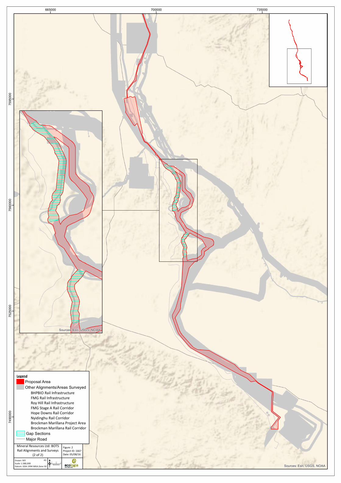
The Iron Valley mine site is located in the Pilbara region of Western Australia, approximately 5 km west of Rio Tinto’s Yandicoogina mine site and approximately 90 km north-west of Newman. The proposed BOTS will originate from Iron Valley and extend in a north-north-west direction to Port Hedland Port precinct and generally aligns with four previously approved rail corridors, three of which are currently being used by other proponents (Figure 2).
This Proposal includes the assessment of the entire BOTS corridor, known as the Proposal Area, within which the BOTS and associated infrastructure will be constructed.
3.2. Land Use
The Proposal is located across three local government areas – the shires of Port Hedland, East Pilbara and Ashburton.
The Proposal has been designed to predominantly utilise existing, previously EPA-assessed rail infrastructure corridors and existing supporting infrastructure including rail maintenance tracks, thereby avoiding and/or minimising impacts to the preliminary key environmental factors where practicable.
These include:
• Fortescue Metals Group (FMG) – Stage A and Mainline Duplication projects
• BHP Billiton Iron Ore (BHPIO) – Newman operations
• Roy Hill – Roy Hill Mine
• Hope Downs Railway Joint Venture.
The locations of these alignments in relation to the Proposal Area are shown on Figure 2. A large number of other mining and exploration tenements underlie the Proposal Area; these are shown on Figure 4.
Aside from the existing mining and rail land uses in the area, the area also supports pastoral activities. Six pastoral stations coincide with portions of the Proposal Area; Boodarie, Hillside, Indee, Jangan, Marillana and Mulga Downs.
There are no conservation areas located within the Proposal Area. The nearest conservation area is the Karijini National Park, located approximately 25 km to the west of the southern extent of the Proposal Area.
Four Native Title Claims areas exist over portions of the Proposal Area, including the claims for the Banjima People, Kariyarra People, Nyiyaparli People and the Palyku People. Two Native Reserves intersect the Proposal Area, the Abydos/Woodstock and Yandeyarra Reserves. These areas in relation to the Proposal are shown on Figure 5.
3.3. Tenure
MRL have been invited by the Minister for State Development to negotiate a State Agreement with the Department of State Development (DSD) for the Proposal Area. A miscellaneous licence L45/373 was applied for in November 2014 and was subsequently withdrawn in April 2016 because the proposed definition and alignment were captured within File Notation Area (FNA) 12672. MRL are in consultation with stakeholders of overlapping land uses (including tenement holders, pastoral leases holders and Traditional Owner Groups) to secure land access agreements.
Sources: Esri, USGS, NOAA
630000 665000 70000076
3000
076
6500
077
0000
077
3500
0
Figure: 2Project ID: 1667Date: 05/08/16
Mineral Resources Ltd: BOTSRail Alignments and Surveys
(1 of 2)Drawn: MYScale:Datum: GDA 1994 MGA Zone 50
1:380,000A3
0 1.5 3KilometresK
Major Road
LegendProposal AreaOther Alignments/Areas Surveyed
BHPBIO Rail InfrastructureFMG Rail InfrastructureRoy Hill Rail InfrastructurePort Hedland Regional SurveyPort Hedland Outer Harbour SurveyFMG Stage A Rail CorridorHope Downs Rail CorridorEngenium (2015) Survey
Sources: Esri, USGS, NOAA
665000 700000 73500074
9000
075
2500
075
6000
075
9500
0
Figure: 2Project ID: 1667Date: 05/08/16
Mineral Resources Ltd: BOTSRail Alignments and Surveys
(2 of 2)Drawn: MYScale:Datum: GDA 1994 MGA Zone 50
1:380,000A3
0 1.5 3KilometresK
Gap SectionsMajor Road
LegendProposal AreaOther Alignments/Areas Surveyed
BHPBIO Rail InfrastructureFMG Rail InfrastructureRoy Hill Rail InfrastructureFMG Stage A Rail CorridorHope Downs Rail CorridorNyidinghu Rail CorridorBrockman Marillana Project AreaBrockman Marillana Rail Corridor
Sources: Esri, USGS, NOAA
PILBARA
Chichester
Hamersley
Fortescue
Roebourne
Roebourne
GASCOYNE
GREAT SANDYDESERT
CARNARVON
DAMPIERLAND
LITTLE SANDYDESERT
Sources: Esri, USGS, NOAA
400000 600000 80000074
0000
076
0000
078
0000
0
Drawn: MYScale:Datum: GDA 1994 MGA Zone 50
Figure: 3Project ID: 1667Date: 04/08/16
K0 10 20
Kilometres
Mineral Resources Ltd: BOTSIBRA Bioregion and Subregions
1:2,500,000A4
LegendProposal AreaPilbara IBRA BioregionPilbara IBRA SubregionOther IBRA Bioregion
Tom Price
Millstream-ChichesterNational Park
Millstream Chichester National Park
Port Hedland
Sources: Esri, USGS, NOAA
600000 675000 75000075
0000
075
7500
076
5000
077
2500
0
Drawn: MYScale:Datum: GDA 1994 MGA Zone 50
Figure: 4Project ID: 1667Date: 20/05/16
0 4.5 9Kilometres
Mineral Resources Ltd: BOTSMineral Tenure
1:1,150,000A4
K
LegendProposal Area
Tenement HolderAtlas Iron LtdBHP Billiton Minerals Pty LtdBHP Iron Ore (Jimblebar) Pty LtdBrockman Exploration Pty LtdBrockman Iron Pty LtdCentral Pilbara North Iron Ore Pty LtdChichester Metals Pty LtdCorona Mining Pty LtdCroydon Gold Pty LtdDomain Mining Pty LtdElazac Mining Pty LtdFMG Magnetite Pty LtdFMG Pilbara Pty LtdFormula Resources Pty LtdGlobal Advanced Metals Wodgina Pty LtdHamersley Exploration Pty LtdHamersley Iron Pty LtdHamersley Iron-Yandi Pty LtdIron Valley Pty LtdLast Crusade Pty LtdMineral Resources LtdMulga Downs Investments Pty LtdMulga Downs Iron Ore Pty LtdPilbara Gas Pipeline Pty LtdPilbara Minerals LtdPilbara Water and Power Pty LtdProcess Minerals International Pty LtdRoy Hill Infrastructure Pty LtdRoy Hill Iron Ore Pty LtdThe Pilbara Infrastructure Pty LtdMajor Road
!( Town
Millstream-ChichesterNational Park
KarijiniNational Park
Mungaroona RangeNature Reserve
Port Hedland
Sources: Esri, USGS, NOAA
600000 675000 75000075
0000
075
7500
076
5000
077
2500
0
Drawn: MYScale:Datum: GDA 1994 MGA Zone 50
Figure: 5Project ID: 1667Date: 20/05/16
0 4.5 9Kilometres
Mineral Resources Ltd: BOTSLand Use and Tenure - Reserves,Native Title and Pastoral Stations
1:1,150,000A4
K
LegendProposal AreaDPaW-managed LandsPastoral Relinquishments 2015Unallocated Crown Land
Native Title Claims / ReservesBanjima PeopleKariyarra PeopleNyiyaparli PeoplePalyku PeopleAbydos/WoodstockYandeyarra-Mugarinya Reserve
Pastoral LeasesBoodarie StationWallareenya StationHillside StationIndee StationKangan StationMarillana StationMulga Downs StationMajor Road
!( Town

Pilbara Bulk Ore Transportation System Project | API Environmental Review Document
ENV-TS-RP-0049_RevC API Environmental Review Document Page | 20
3.4. Project Facilities and Activities
3.4.1. Proposed Disturbance
The Proposal Area is approximately 330 km in length and generally between one and two kilometres in width, totalling approximately 29,796 hectares (ha). The total disturbance within the Proposal Area is up to a maximum of 3,000 ha. This comprises a construction corridor, generally up to 60 metres (m) in width, for the BOTS line, sidings and associated construction and maintenance access tracks, plus provisions for communications infrastructure, and temporary facilities including geotechnical investigation areas, construction camps, offices, utilities, laydown areas and top soil, subsoil and vegetation stockpile areas.
The total estimated disturbance is considered conservative and through the use of an elevated structure that largely follows the existing ground contours (explained further in Section 3.4.2), the actual disturbance for the BOTS will be significantly less than typical road or rail infrastructure. Traditional railway systems (and associated their infrastructure) recently assessed by the EPA in the Pilbara region typically involved disturbances in the order of 15-19 ha/km. The estimated disturbance associated with the Proposal is significantly less at approximately 6 ha/km.
3.4.2. Bulk Ore Transport System
The Proposal has been designed to provide a safe, low capital, relocatable and autonomous operation that minimises impact to the environment (minimal clearing, cut and fill). The BOTS design is a simple, elevated structure comprising of a rolling surface that is mounted onto precast concrete beams, spanned between precast concrete substructures (Plate 1).
The elevated, below-rail structure comprises three key designs (low, mid and high level modules), dependent on ground clearance requirements to satisfy track geometry, hydrology, topography, and grade separation needs. This not only minimises the cut and fill activities required during construction, but also results in less disturbance to natural landscapes, such as surface water features and fauna habitat, and infrastructure, such as existing road and rail. These attributes are shown in the artistic impressions included in Plate 2 and Plate 3.
The three modules are classed as low, medium and high allowing for heights up to two metres, up to six metres and more than six metres, respectively. Approximately 80% of the alignment will be of the low class of module, to minimise costs. Generally the alignment alternates between low and medium/high alignments regularly allowing ease of crossing by stock. There have, however, been eleven segments to date identified of more than 5 km of continuous low module construction that will impede the movement of stock. Water flows and native fauna movements will be unimpeded over the entire length of the BOTS.
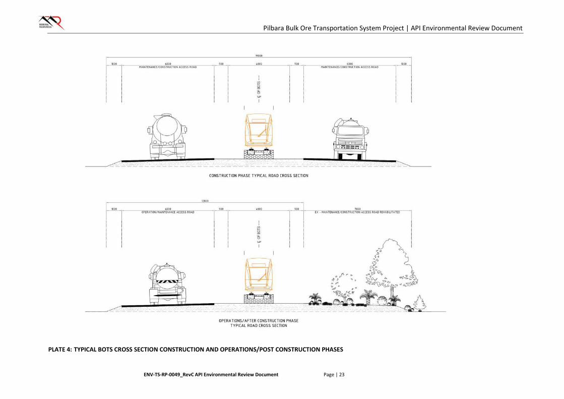
Due to its elevated structure, the BOTS is designed to minimise ground disturbance by passing over all existing features, including natural landscapes (surface water bodies, landforms) and man-made infrastructure (road and rail), resulting in significantly less disturbance when compared to a traditional rail system. For crossing existing roads, rivers or rail lines, the standard modules will be replaced with purpose built structures to provide greater spans over existing infrastructure. An indication of how BOTS will appear over natural features is shown in Plate 2 and Plate 3. A typical cross-section of BOTS alignment, with both construction and operations phase views is shown in Plate 4.
For the installation of the low level modules, a narrow continuous clearance corridor will be required, which will then be formed and compacted, enabling the precast concrete pads and beam structures to be installed. The design of the low level modules negates the need for in ground piling infrastructure, and can be readily removed and/or relocated. For mid and high level modules, a construction pad will also be cleared and levelled to cater for the column to be installed every 12 m. The size of the construction pads will be dependent on the geotechnical conditions at each site along with the required ground clearance. It is anticipated that construction pads will be no more than 10 m by 10 m at each site. Following successful installation of in ground and substructure elements, construction pads will be rehabilitated, leaving only

Pilbara Bulk Ore Transportation System Project | API Environmental Review Document
ENV-TS-RP-0049_RevC API Environmental Review Document Page | 21
the in ground piles as permanent infrastructure. Rehabilitation activities for the Project are described below.
Unlike a traditional rail system, BOTS is an autonomous and unmanned system that will utilise purpose designed and built power cars and wagons, with the power cars interspersed throughout the consist (ie. rolling stock exclusive of locomotive), and utilising a dual fuel (diesel & gas) generation system. MRL propose a nominal payload of approximately 42 tonnes (t) per wagon and a total payload of approximately 4,600 t per consist. The whole system will be autonomously monitored from a remote control centre.
PLATE 1: ARTISTIC RENDERING OF THE BOTS
PLATE 2: ARTISTIC RENDERING OF THE BOTS AT A RIVER CROSSING
Pilbara Bulk Ore Transportation System Project | API Environmental Review Document
ENV-TS-RP-0049_RevC API Environmental Review Document Page | 22
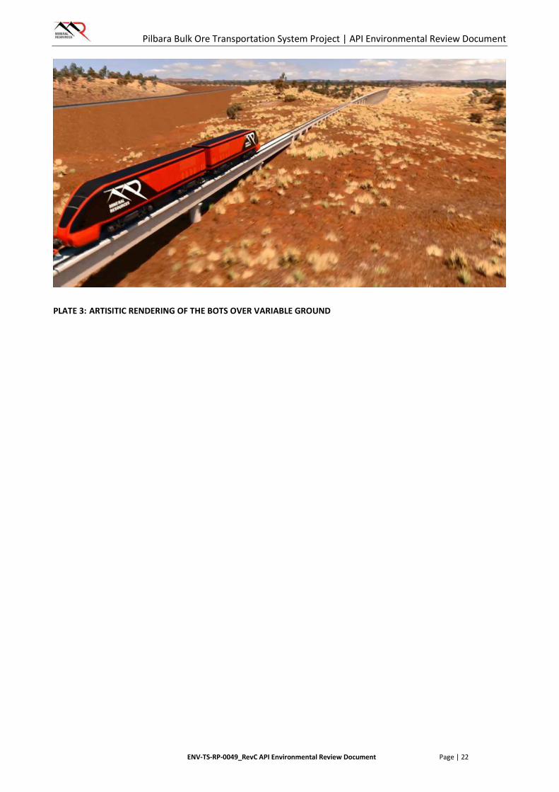
PLATE 3: ARTISITIC RENDERING OF THE BOTS OVER VARIABLE GROUND
Pilbara Bulk Ore Transportation System Project | API Environmental Review Document
ENV-TS-RP-0049_RevC API Environmental Review Document Page | 23
PLATE 4: TYPICAL BOTS CROSS SECTION CONSTRUCTION AND OPERATIONS/POST CONSTRUCTION PHASES

Pilbara Bulk Ore Transportation System Project | API Environmental Review Document
ENV-TS-RP-0049_RevC API Environmental Review Document Page | 24
3.4.3. Other Infrastructure
Geotechnical investigations will be carried out within the preferred corridor to support the final design process of the BOTS. These investigations will require clearing for drill pads and access tracks within the Proposal Area and is included within the proposed 3000 hectare disturbance.
MRL will construct a maintenance track alongside the BOTS that will be used during construction and be retained for the life of the Proposal for maintenance purposes. However, where possible, MRL will seek to access existing tracks constructed to service rail infrastructure utilised by other proponents within the corridor to minimise disturbance.
Communication facilities will be required along the length of the BOTS. A total of 12 communication towers will be required, all of which will be constructed in the Proposal Area, ideally within 1 km of the BOTS line. Minor trenching activities will be required to install underground services to each of the towers.
Construction camps will be required along the length of the track during the construction phase of the Proposal. Similarly, as for the access tracks MRL will seek to utilise other proponent’s camps. If new camps are required, they will be constructed within the Proposal Area in locations that require minimal groundworks, avoiding surface water features and significant fauna and flora habitat. Unless otherwise required, it is proposed that each camp will be fully decommissioned upon completion of construction activities and rehabilitated.
Temporary workshops and laydown areas will be required along the length of the Proposal Area. As with the construction camps, MRL will seek to utilise existing laydown areas where possible. If new areas are required, they will be constructed within the Proposal Area in locations that require minimal groundworks, avoiding surface water features and significant fauna and flora habitat. These areas will be used for minor servicing of vehicles and equipment, parking, refuelling, power generation and storage. Minor quantities of fuel and other hazardous and dangerous goods required during construction activities will be stored and used in compliance with relevant legislation and standards, and in such a manner that prevents and/or minimises any impacts to the surrounding environment.
All waste generated during construction activities will be temporarily stored within the camp and workshop and laydown areas utilised along the length of the Proposal Area. Upon cessation of activities at each area, all waste will be removed and disposed of at either the Iron Valley Site or registered waste facilities as required.
3.4.4. Water Requirements
Water will be required during construction activities for the Proposal. It is expected that the Proposal will utilise approximately 2,000 – 3,000 kL per day of groundwater during the construction phase. Ongoing water supply for operation of the BOTS will not be required, with the exception of ad-hoc maintenance activities.
Where possible, MRL will seek to utilise existing bore water infrastructure within proximity to the corridor, however if required, new bore infrastructure will be installed in accordance with the RIWI Act 1914 to meet construction demand, and any subsequent operational needs. For construction works within close proximity to the Iron Valley mine, water will be obtained from the Iron Valley area and carted by a water truck.
3.4.5. Clearing Activities
All vegetation and soils (topsoil and subsoil) associated with areas of disturbance will be cleared and stockpiled.
Stockpiles will be located along up-gradient edges of the construction pads/tracks or other cleared areas (where possible), to prevent accidental contamination (i.e. minor oil spills) or sedimentation from onsite

Pilbara Bulk Ore Transportation System Project | API Environmental Review Document
ENV-TS-RP-0049_RevC API Environmental Review Document Page | 25
activities (i.e. run-off from cleared area). Small bunds may also be constructed down-gradient of stockpiles in sloped areas to prevent run-off of soils in heavy rainfall events.
3.4.6. Rehabilitation Activities
Any disturbances not required for ongoing operations of BOTS will be progressively rehabilitated throughout the construction and operations phases. When the BOTS line is no longer required, the system will be decommissioned, dismantled and removed. Substructures (excluding sub-surface) and all other infrastructure will be removed and reused, recycled or disposed of offsite. Progressive rehabilitation of construction sites (i.e. pads and camps) will be completed at the end of the construction phase. Rehabilitation activities of disturbed lands will include removal of all equipment and waste, including any evidence of contamination such as minor oil spills. Land surfaces will be scarified and reworked as close to their natural contours as possible. Stockpiled vegetation and soils will be replaced over disturbed areas and ripped to promote natural revegetation. Local provenance seed will be collected and broadcast if required.
3.5. Alternatives Considered
This Proposal was designed to meet the increased export demands resulting from planned future expansions of the Iron Valley mine. The existing alternative to this Proposal is the current road transport system, which delivers saleable ore from Iron Valley to Port Hedland using up to 130 quad trailer road trains over a distance of 344 km. BOTS provides for a safer and more cost effective alternative that eliminates the requirement for road trains hauling on Great Northern Highway and entering the Port Hedland area.
The following aspects of the BOTS outline the benefits of the proposed system, over a traditional rail line typical of the region:
• Reduced environmental footprint – elevated design, does not require a permanent earthen embankment or continuous clearance corridor for all medium and high module sections
• Minimised environmental impact – elevated design allows system to pass over natural features (rivers, landforms) and for native fauna to pass below
• Safer operations – unmanned, autonomous operation, remotely controlled from Perth
• Prime location – within existing rail corridor, has potential to accommodate additional proponents in the future
• Cost effective operation.
Several alignments of the BOTS have been developed during the planning phases. Careful consideration of a number of factors has allowed the alignment to be optimised in order to prevent and/or minimise impacts to significant environmental, heritage and social values of the area. These factors include, but are not limited to:
• Biological – locations of Priority Ecological Communities, Priority flora, habitats that support Threatened and Priority Fauna
• Landform – significant water bodies, sand dunes, hills / ranges
• Heritage – Registered Heritage sites, native title areas
• Social – pastoral stations, existing rail lines and infrastructure, mining and exploration activities.
3.6. Approval and Development Timeframes
Table 5 outlines the anticipated timeframes for the assessment of the BOTS Proposal. Pending receipt of approvals, the initial phases of the project are scheduled to commence in November 2016.

Pilbara Bulk Ore Transportation System Project | API Environmental Review Document
ENV-TS-RP-0049_RevC API Environmental Review Document Page | 26
TABLE 5: TARGET ASSESSMENT TIMEFRAMES
Key Stage of Assessment Agreed Completion Date
Level of Assessment set as API 25 January 2016
API Scoping Guideline issued 2 May 2016
Proponent submits draft environmental review 30 June 2016
OEPA provides comments and advice on draft ER 30 July 2016
Proponent submits final environmental review 15 August 2016
EPA considers draft report (within 7 weeks from receipt of acceptable information) 30 September 2016
EPA finalises report for Minister (including consultations on conditions) (4 weeks)* 30 October 2016
Appeal period closes (2 weeks) 15 November 2016
* Should the EPA require additional information, the report would be finalised four weeks from receipt of that information.

Pilbara Bulk Ore Transportation System Project | API Environmental Review Document
ENV-TS-RP-0049_RevC API Environmental Review Document Page | 27
4. STAKEHOLDER CONSULTATION
MRL has actively engaged with relevant stakeholders throughout the planning phase of the Proposal, including relevant government bodies and regulators, Native Title holders, Pastoral Lease holders and mineral tenement holders. In accordance with the EPA’s EAG 14 (EPA 2015a), a summary of stakeholder consultation conducted to date and responses and outcomes of this consultation are provided in Table 6.
TABLE 6: SUMMARY OF STAKEHOLDER CONSULTATION
Stakeholder Date / Meeting Description
Topics / Issues Response / Outcomes
EPA/OEPA 17 February 2015
Initial discussion
• Introduction of the Proposal
• Identification of Key Environmental Factors/Impacts
• Presentation of the desktop “gap assessment” (Astron 2015).
• Support of MRL’s proposed “gap assessment” methodologies.
10 September 2015
Pre-referral Meeting
• Review of the Proposal
• Confirmation of Preliminary Environmental Factors/Impacts.
• Support of Preliminary Environmental Factors.
8 January 2016
Referral update
• General update and approvals Timeline
• EPBC Act process
• Decision made to refer under the EPBC Act
• Requirements to meet Bilateral assessment were advised
15 January 2016
EPA Board presentation
• Presentation of the BOTS proposal • Project scope and lack of significant environmental effects well understood
29 July 2016
ER Document review
• Items for inclusion or clarification in the Environmental Review document prior to EPA Board review
• Environmental Review document updated to account for OEPA comments
DPAW 9 March 2015 • Seeking endorsement of proposed strategy and methodology for assessing flora and fauna constraints associated with the project.
• DPAW advised that it endorsed MRL’s approach and had no comments to make on the proposed methodologies.
31 May 2016 • Invite to discuss BOTS and Fortescue Marsh prior to ER submission
• DPaW advised they will wait to review the ER document and then undertake further consultation as required.
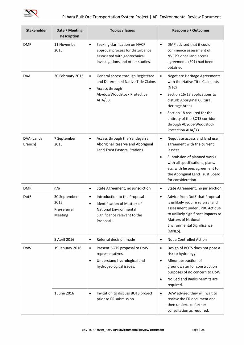
Pilbara Bulk Ore Transportation System Project | API Environmental Review Document
ENV-TS-RP-0049_RevC API Environmental Review Document Page | 28
Stakeholder Date / Meeting Description
Topics / Issues Response / Outcomes
DMP 11 November 2015
• Seeking clarification on NVCP approval process for disturbance associated with geotechnical investigations and other studies.
• DMP advised that it could commence assessment of NVCP’s once land access agreements (S91) had been obtained
DAA 20 February 2015 • General access through Registered and Determined Native Title Claims
• Access through Abydos/Woodstock Protective AHA/33.
• Negotiate Heritage Agreements with the Native Title Claimants (NTC)
• Section 16/18 applications to disturb Aboriginal Cultural Heritage Areas
• Section 18 required for the entirety of the BOTS corridor through Abydos-Woodstock Protection AHA/33.
DAA (Lands Branch)
7 September 2015
• Access through the Yandeyarra Aboriginal Reserve and Aboriginal Land Trust Pastoral Stations.
• Negotiate access and land use agreement with the current lessees.
• Submission of planned works with all specifications, plans, etc. with lessees agreement to the Aboriginal Land Trust Board for consideration.
DMP n/a • State Agreement, no jurisdiction • State Agreement, no jurisdiction
DotE 30 September 2015
Pre-referral Meeting
• Introduction to the Proposal
• Identification of Matters of National Environmental Significance relevant to the Proposal.
• Advice from DotE that Proposal is unlikely require referral and assessment under EPBC Act due to unlikely significant impacts to Matters of National Environmental Significance (MNES).
5 April 2016 • Referral decision made • Not a Controlled Action
DoW
19 January 2016 • Present BOTS proposal to DoW representatives.
• Understand hydrological and hydrogeological issues.
• Design of BOTS does not pose a risk to hydrology.
• Minor abstraction of groundwater for construction purposes of no concern to DoW.
• No Bed and Banks permits are required.
1 June 2016 • Invitation to discuss BOTS project prior to ER submission.
• DoW advised they will wait to review the ER document and then undertake further consultation as required.

Pilbara Bulk Ore Transportation System Project | API Environmental Review Document
ENV-TS-RP-0049_RevC API Environmental Review Document Page | 29
Stakeholder Date / Meeting Description
Topics / Issues Response / Outcomes
Mugarinya Community Association Inc.
14 September 2015
• Introduction and discussion of BOTS project.
• Negotiating agreement.
Palyku Traditional Owner Group
17 September 2015
• Access through Native Title Claims, Yandeyarra Aboriginal Reserve.
• Negotiating agreement
Kariyarra Traditional Owner Group
27 October 2015 • Introduction to the BOTS concept. • Negotiating agreement.
Banjima Traditional Owner Group
9 December 2015 • Introduction to the BOTS concept. • Negotiating agreement.
Other tenure holders e.g. FMG, BHP, Roy Hill
Numerous during October and November 2015
• Section 91 Land Administration Act tenure access applications.
• General access for geotechnical investigations.
• Consultation ongoing, favourable supportive engagement to date.
Pastoral Lease owners
As at October 2015, meetings have been sought but are yet to be completed
• Introduction to the BOTS concept
• Land access.
• Meetings scheduled throughout 2016.
Pilbara Bulk Ore Transportation System Project | API Environmental Review Document
ENV-TS-RP-0049_RevC API Environmental Review Document Page | 30
5. RELEVANT STUDIES
The Proposal Area is predominantly located within existing rail corridors that are currently being used by four other operators for mining infrastructure projects. Each of the projects using the corridor has been previously assessed by the EPA under Part IV of the EP Act. As such, a number of publically available biological surveys have already been completed in support of these assessments.
Where the boundaries of these surveys coincide with portions of the Proposal Area, MRL have used these data so as to avoid unnecessary survey duplication. Where the Proposal Area falls outside of areas previously assessed by the EPA, MRL has conducted additional targeted surveys to address gaps in baseline information. As a result of amendments to the alignment since the Proposal was referred, some gaps in baseline biological information still exist, however these gaps will be surveyed prior to ground disturbance. Figure 2 shows the location of the MRL Proposal Area in relation to the previously assessed project areas.
A comprehensive list of all biological surveys relevant to the Proposal is provided in Table 7. Table 7 also provides information on the survey standards and applicable Guidance for each survey. Information on the application of Guidance materials and survey limitations is provided in line with statements by the authors of each study.

Pilbara Bulk Ore Transportation System Project | API Environmental Review Document
ENV-TS-RP-0049_RevC API Environmental Review Document Page | 31
TABLE 7: SUMMARY OF ENVIRONMENTAL STUDIES
Consultant Report Title / Date Study Area, Type and Timing Study Standards / Guidance and Limitations
FLORA AND VEGETATION SURVEYS
Biota Environmental Sciences
Vegetation and Flora Survey of the Proposed FMG Stage A Rail Corridor
August 2004
Study Area: FMG Stage A Rail Corridor
Type: Level 2 Survey – single phase
Timing: Mar & Apr 2004
Survey Standards / Guidance:
• Guidance Statement No. 51 (EPA 2004a)
Limitations: Some sites were unable to be accessed due to time and/or access limitations. Dual phase survey may identify additional species.
Mattiske Consulting
Flora and Vegetation on the Cloud Break and White Knight Leases
June 2005
Study Area: Cloudbreak and White Knight mining leases associated with the proposed iron ore mine area and access roads (located adjacent to Proposal Area, included for regional context).
Type: Level 2 Survey – single phase
Timing: Oct 2004
Survey Standards / Guidance: Not referenced.
Limitations: Does not intersect Proposal area.
ecologia Environment
North Star Vegetation and Flora Assessment
July 2012
Study Area: FMG North Star Project area
Type: Level 2 Survey – two phases
Timing: Apr, Jun, Jul & Aug 2011, Sep 2011
Survey Standards / Guidance:
• Guidance Statement No. 51 (EPA 2004a),
• Position Statement No. 3 (EPA 2002)
Limitations: None.
ecologia Environment
North Star Access Corridor – Flora, Vegetation, Vertebrate Fauna and Fauna Habitat Assessment
September 2012
Study Area: FMG North Star Project – Access Corridor
Type: Level 2 Survey – single phase
Timing: May 2012
Survey Standards / Guidance:
• Guidance Statement No. 51 (EPA 2004a),
• Position Statement No. 3 (EPA 2002)
Limitations: None.
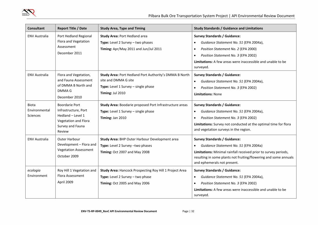
Pilbara Bulk Ore Transportation System Project | API Environmental Review Document
ENV-TS-RP-0049_RevC API Environmental Review Document Page | 32
Consultant Report Title / Date Study Area, Type and Timing Study Standards / Guidance and Limitations
ENV Australia Port Hedland Regional Flora and Vegetation Assessment
December 2011
Study Area: Port Hedland area
Type: Level 2 Survey – two phases
Timing: Apr/May 2011 and Jun/Jul 2011
Survey Standards / Guidance:
• Guidance Statement No. 51 (EPA 2004a),
• Position Statement No. 2 (EPA 2000)
• Position Statement No. 3 (EPA 2002)
Limitations: A few areas were inaccessible and unable to be surveyed.
ENV Australia Flora and Vegetation, and Fauna Assessment of DMMA B North and DMMA G
December 2010
Study Area: Port Hedland Port Authority’s DMMA B North site and DMMA G site
Type: Level 1 Survey – single phase
Timing: Jul 2010
Survey Standards / Guidance:
• Guidance Statement No. 51 (EPA 2004a),
• Position Statement No. 3 (EPA 2002)
Limitations: None
Biota Environmental Sciences
Boordarie Port Infrastructure, Port Hedland – Level 1 Vegetation and Flora Survey and Fauna Review
Study Area: Boodarie proposed Port Infrastructure areas
Type: Level 1 Survey – single phase
Timing: Jan 2010
Survey Standards / Guidance:
• Guidance Statement No. 51 (EPA 2004a),
• Position Statement No. 3 (EPA 2002)
Limitations: Survey not conducted at the optimal time for flora and vegetation surveys in the region.
ENV Australia Outer Harbour Development – Flora and Vegetation Assessment
October 2009
Study Area: BHP Outer Harbour Development area
Type: Level 2 Survey –two phases
Timing: Oct 2007 and May 2008
Survey Standards / Guidance:
• Guidance Statement No. 51 (EPA 2004a)
Limitations: Minimal rainfall received prior to survey periods, resulting in some plants not fruiting/flowering and some annuals and ephemerals not present.
ecologia Environment
Roy Hill 1 Vegetation and Flora Assessment
April 2009
Study Area: Hancock Prospecting Roy Hill 1 Project Area
Type: Level 2 Survey – two phase
Timing: Oct 2005 and May 2006
Survey Standards / Guidance:
• Guidance Statement No. 51 (EPA 2004a),
• Position Statement No. 3 (EPA 2002)
Limitations: A few areas were inaccessible and unable to be surveyed.
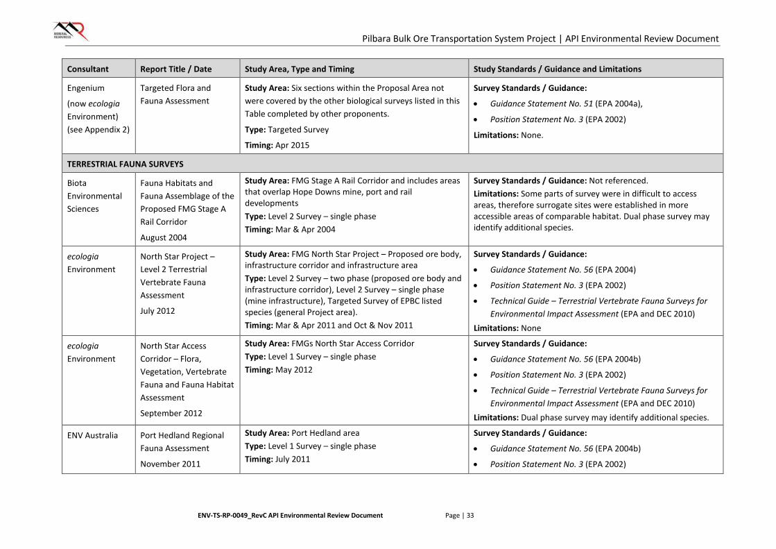
Pilbara Bulk Ore Transportation System Project | API Environmental Review Document
ENV-TS-RP-0049_RevC API Environmental Review Document Page | 33
Consultant Report Title / Date Study Area, Type and Timing Study Standards / Guidance and Limitations
Engenium
(now ecologia Environment) (see Appendix 2)
Targeted Flora and Fauna Assessment
Study Area: Six sections within the Proposal Area not were covered by the other biological surveys listed in this Table completed by other proponents.
Type: Targeted Survey
Timing: Apr 2015
Survey Standards / Guidance:
• Guidance Statement No. 51 (EPA 2004a),
• Position Statement No. 3 (EPA 2002)
Limitations: None.
TERRESTRIAL FAUNA SURVEYS
Biota Environmental Sciences
Fauna Habitats and Fauna Assemblage of the Proposed FMG Stage A Rail Corridor
August 2004
Study Area: FMG Stage A Rail Corridor and includes areas that overlap Hope Downs mine, port and rail developments Type: Level 2 Survey – single phase Timing: Mar & Apr 2004
Survey Standards / Guidance: Not referenced. Limitations: Some parts of survey were in difficult to access areas, therefore surrogate sites were established in more accessible areas of comparable habitat. Dual phase survey may identify additional species.
ecologia Environment
North Star Project – Level 2 Terrestrial Vertebrate Fauna Assessment
July 2012
Study Area: FMG North Star Project – Proposed ore body, infrastructure corridor and infrastructure area Type: Level 2 Survey – two phase (proposed ore body and infrastructure corridor), Level 2 Survey – single phase (mine infrastructure), Targeted Survey of EPBC listed species (general Project area). Timing: Mar & Apr 2011 and Oct & Nov 2011
Survey Standards / Guidance:
• Guidance Statement No. 56 (EPA 2004)
• Position Statement No. 3 (EPA 2002)
• Technical Guide – Terrestrial Vertebrate Fauna Surveys for Environmental Impact Assessment (EPA and DEC 2010)
Limitations: None
ecologia Environment
North Star Access Corridor – Flora, Vegetation, Vertebrate Fauna and Fauna Habitat Assessment
September 2012
Study Area: FMGs North Star Access Corridor Type: Level 1 Survey – single phase Timing: May 2012
Survey Standards / Guidance:
• Guidance Statement No. 56 (EPA 2004b)
• Position Statement No. 3 (EPA 2002)
• Technical Guide – Terrestrial Vertebrate Fauna Surveys for Environmental Impact Assessment (EPA and DEC 2010)
Limitations: Dual phase survey may identify additional species.
ENV Australia Port Hedland Regional Fauna Assessment
November 2011
Study Area: Port Hedland area Type: Level 1 Survey – single phase Timing: July 2011
Survey Standards / Guidance:
• Guidance Statement No. 56 (EPA 2004b)
• Position Statement No. 3 (EPA 2002)
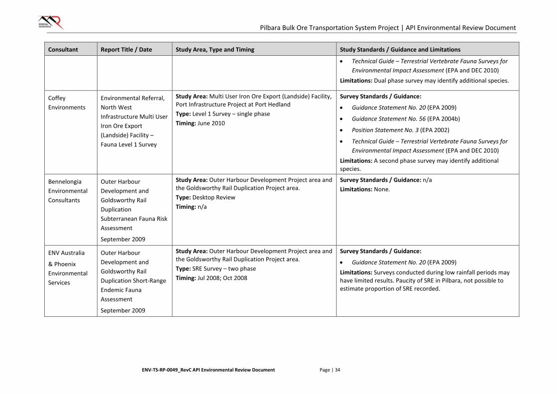
Pilbara Bulk Ore Transportation System Project | API Environmental Review Document
ENV-TS-RP-0049_RevC API Environmental Review Document Page | 34
Consultant Report Title / Date Study Area, Type and Timing Study Standards / Guidance and Limitations
• Technical Guide – Terrestrial Vertebrate Fauna Surveys for Environmental Impact Assessment (EPA and DEC 2010)
Limitations: Dual phase survey may identify additional species.
Coffey Environments
Environmental Referral, North West Infrastructure Multi User Iron Ore Export (Landside) Facility – Fauna Level 1 Survey
Study Area: Multi User Iron Ore Export (Landside) Facility, Port Infrastructure Project at Port Hedland Type: Level 1 Survey – single phase Timing: June 2010
Survey Standards / Guidance:
• Guidance Statement No. 20 (EPA 2009)
• Guidance Statement No. 56 (EPA 2004b)
• Position Statement No. 3 (EPA 2002)
• Technical Guide – Terrestrial Vertebrate Fauna Surveys for Environmental Impact Assessment (EPA and DEC 2010)
Limitations: A second phase survey may identify additional species.
Bennelongia Environmental Consultants
Outer Harbour Development and Goldsworthy Rail Duplication Subterranean Fauna Risk Assessment
September 2009
Study Area: Outer Harbour Development Project area and the Goldsworthy Rail Duplication Project area. Type: Desktop Review Timing: n/a
Survey Standards / Guidance: n/a Limitations: None.
ENV Australia
& Phoenix Environmental Services
Outer Harbour Development and Goldsworthy Rail Duplication Short-Range Endemic Fauna Assessment
September 2009
Study Area: Outer Harbour Development Project area and the Goldsworthy Rail Duplication Project area. Type: SRE Survey – two phase Timing: Jul 2008; Oct 2008
Survey Standards / Guidance:
• Guidance Statement No. 20 (EPA 2009) Limitations: Surveys conducted during low rainfall periods may have limited results. Paucity of SRE in Pilbara, not possible to estimate proportion of SRE recorded.
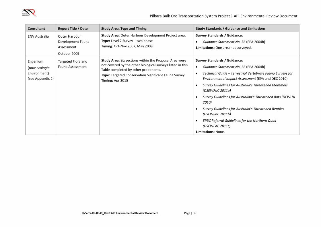
Pilbara Bulk Ore Transportation System Project | API Environmental Review Document
ENV-TS-RP-0049_RevC API Environmental Review Document Page | 35
Consultant Report Title / Date Study Area, Type and Timing Study Standards / Guidance and Limitations
ENV Australia Outer Harbour Development Fauna Assessment
October 2009
Study Area: Outer Harbour Development Project area. Type: Level 2 Survey – two phase Timing: Oct-Nov 2007; May 2008
Survey Standards / Guidance:
• Guidance Statement No. 56 (EPA 2004b) Limitations: One area not surveyed.
Engenium
(now ecologia Environment) (see Appendix 2)
Targeted Flora and Fauna Assessment
Study Area: Six sections within the Proposal Area were not covered by the other biological surveys listed in this Table completed by other proponents. Type: Targeted Conservation Significant Fauna Survey Timing: Apr 2015
Survey Standards / Guidance:
• Guidance Statement No. 56 (EPA 2004b)
• Technical Guide – Terrestrial Vertebrate Fauna Surveys for Environmental Impact Assessment (EPA and DEC 2010)
• Survey Guidelines for Australia’s Threatened Mammals (DSEWPaC 2011a)
• Survey Guidelines for Australian’s Threatened Bats (DEWHA 2010)
• Survey Guidelines for Australia’s Threatened Reptiles (DSEWPaC 2011b)
• EPBC Referral Guidelines for the Northern Quoll (DSEWPaC 2011c)
Limitations: None.
Pilbara Bulk Ore Transportation System Project | API Environmental Review Document
ENV-TS-RP-0049_RevC API Environmental Review Document Page | 36
5.1. Proposed Studies
Due to several changes to the BOTS alignment during the planning process (as discussed in Section 3.5), a number of sections of the Proposal Area are no longer within areas previously covered by the biological surveys listed in Table 7. While there is a low risk of any significant environmental values being associated with these areas, in order to address these gaps in baseline biological survey information (Figure 2), MRL is committed to conducting surveys of these areas prior to the commencement of construction. The proposed gap survey sections are shown in Figure 2.
Surveys will be undertaken prior to the commencement of construction activities associated with this Proposal, at a time when conditions are optimal for the identification of flora and fauna species in the Pilbara. Surveys will incorporate targeted surveys of gap areas to identify threatened and priority flora and significant vegetation (corresponding to a TEC/PEC or of other significance), targeted vertebrate fauna traverses and searches, use of bat echolocation recorders and deployment of motion-sensitive cameras.
The surveys will also comply with methodologies previously agreed with DPaW, and where relevant, all necessary State and Federal guidelines, including:
• EPA Guidance Statement No. 51, Terrestrial Flora and Vegetation Surveys for Environmental Impact Assessment in Western Australia
• EPA Guidance Statement 56, Terrestrial Fauna Surveys for Environmental Impact Assessment in Western Australia
• EPA Position Statement No. 2, Environmental Protection of Native Vegetation in Western Australia: Clearing of Native Vegetation with Particular Reference to Agricultural Areas
• EPA Position Statement No. 3, Terrestrial Biological Surveys as an Element of Biodiversity Protection
• Technical Guide for Flora and Vegetation Surveys (EPA and DPaW 2015)
• Technical Guide for Vertebrate Fauna Surveys (EPA and DEC 2010)
• Survey Guidelines for Australia’s Threatened Mammals (DSEWPaC 2011)
• EPBC Referral Guidelines for the Northern Quoll (DSEWPaC 2011)
• Survey Guidelines for Australia’s Threatened Reptiles (DSEWPaC 2011)
• Survey Guidelines for Australia’s Threatened Bats (DEWHA 2010).
Pilbara Bulk Ore Transportation System Project | API Environmental Review Document
ENV-TS-RP-0049_RevC API Environmental Review Document Page | 37
6. ASSESSMENT OF PRELIMINARY KEY ENVIRONMENTAL FACTORS
6.1. Identification of Preliminary Key Environmental Factors
Preliminary Key Environmental Factors are those that may be significantly impacted by the implementation of the Proposal. Each of these factors is discussed within this document, in order to determine whether the Proposal can be adequately managed to meet the EPA’s objectives for each factor.
The Preliminary Key Environmental Factors relevant to the Proposal were outlined by the EPA in the Environmental Scoping Guideline (Appendix 1). Table 8 provides an assessment of Preliminary Key Environmental Factors and Integrating Factors for the Proposal.
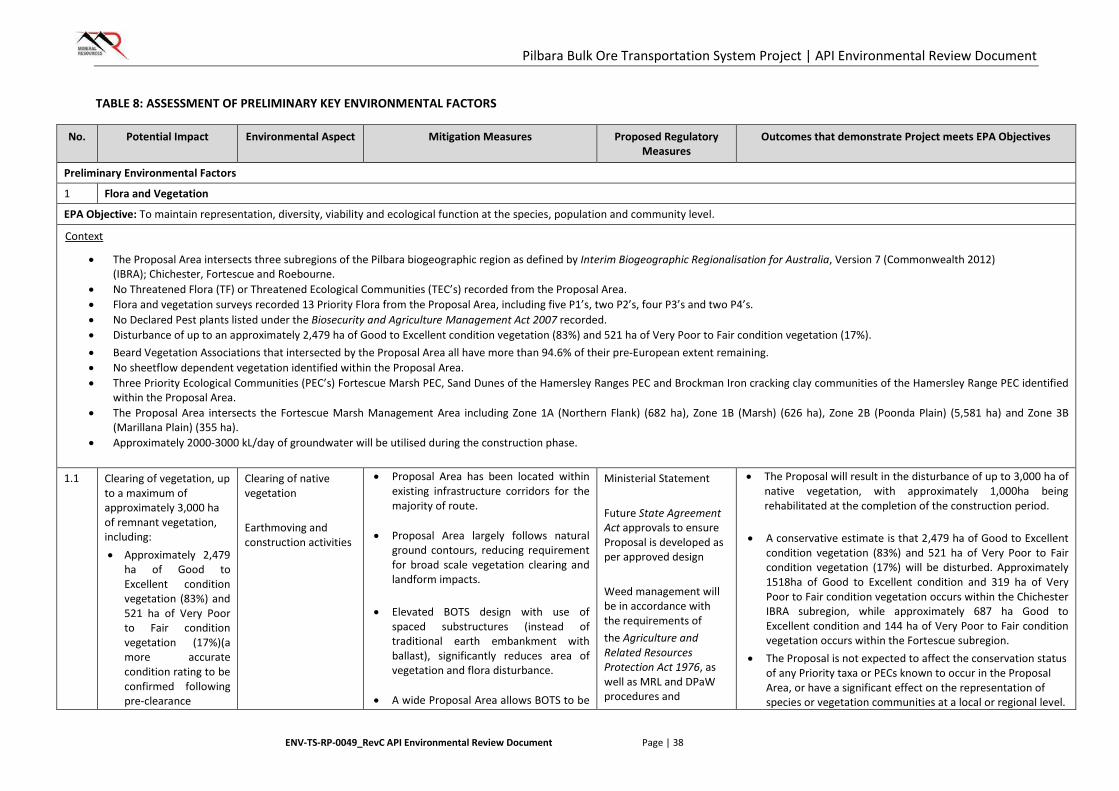
Pilbara Bulk Ore Transportation System Project | API Environmental Review Document
ENV-TS-RP-0049_RevC API Environmental Review Document Page | 38
TABLE 8: ASSESSMENT OF PRELIMINARY KEY ENVIRONMENTAL FACTORS
No. Potential Impact Environmental Aspect Mitigation Measures Proposed Regulatory Measures
Outcomes that demonstrate Project meets EPA Objectives
Preliminary Environmental Factors
1 Flora and Vegetation
EPA Objective: To maintain representation, diversity, viability and ecological function at the species, population and community level.
Context
• The Proposal Area intersects three subregions of the Pilbara biogeographic region as defined by Interim Biogeographic Regionalisation for Australia, Version 7 (Commonwealth 2012) (IBRA); Chichester, Fortescue and Roebourne.
• No Threatened Flora (TF) or Threatened Ecological Communities (TEC’s) recorded from the Proposal Area. • Flora and vegetation surveys recorded 13 Priority Flora from the Proposal Area, including five P1’s, two P2’s, four P3’s and two P4’s. • No Declared Pest plants listed under the Biosecurity and Agriculture Management Act 2007 recorded. • Disturbance of up to an approximately 2,479 ha of Good to Excellent condition vegetation (83%) and 521 ha of Very Poor to Fair condition vegetation (17%). • Beard Vegetation Associations that intersected by the Proposal Area all have more than 94.6% of their pre-European extent remaining. • No sheetflow dependent vegetation identified within the Proposal Area. • Three Priority Ecological Communities (PEC’s) Fortescue Marsh PEC, Sand Dunes of the Hamersley Ranges PEC and Brockman Iron cracking clay communities of the Hamersley Range PEC identified
within the Proposal Area. • The Proposal Area intersects the Fortescue Marsh Management Area including Zone 1A (Northern Flank) (682 ha), Zone 1B (Marsh) (626 ha), Zone 2B (Poonda Plain) (5,581 ha) and Zone 3B
(Marillana Plain) (355 ha). • Approximately 2000-3000 kL/day of groundwater will be utilised during the construction phase.
1.1 Clearing of vegetation, up
to a maximum of approximately 3,000 ha of remnant vegetation, including: • Approximately 2,479
ha of Good to Excellent condition vegetation (83%) and 521 ha of Very Poor to Fair condition vegetation (17%)(a more accurate condition rating to be confirmed following pre-clearance
Clearing of native vegetation Earthmoving and construction activities
• Proposal Area has been located within existing infrastructure corridors for the majority of route.
• Proposal Area largely follows natural ground contours, reducing requirement for broad scale vegetation clearing and landform impacts.
• Elevated BOTS design with use of
spaced substructures (instead of traditional earth embankment with ballast), significantly reduces area of vegetation and flora disturbance.
• A wide Proposal Area allows BOTS to be
Ministerial Statement Future State Agreement Act approvals to ensure Proposal is developed as per approved design Weed management will be in accordance with the requirements of the Agriculture and Related Resources Protection Act 1976, as well as MRL and DPaW procedures and
• The Proposal will result in the disturbance of up to 3,000 ha of native vegetation, with approximately 1,000ha being rehabilitated at the completion of the construction period.
• A conservative estimate is that 2,479 ha of Good to Excellent condition vegetation (83%) and 521 ha of Very Poor to Fair condition vegetation (17%) will be disturbed. Approximately 1518ha of Good to Excellent condition and 319 ha of Very Poor to Fair condition vegetation occurs within the Chichester IBRA subregion, while approximately 687 ha Good to Excellent condition and 144 ha of Very Poor to Fair condition vegetation occurs within the Fortescue subregion.
• The Proposal is not expected to affect the conservation status of any Priority taxa or PECs known to occur in the Proposal Area, or have a significant effect on the representation of species or vegetation communities at a local or regional level.
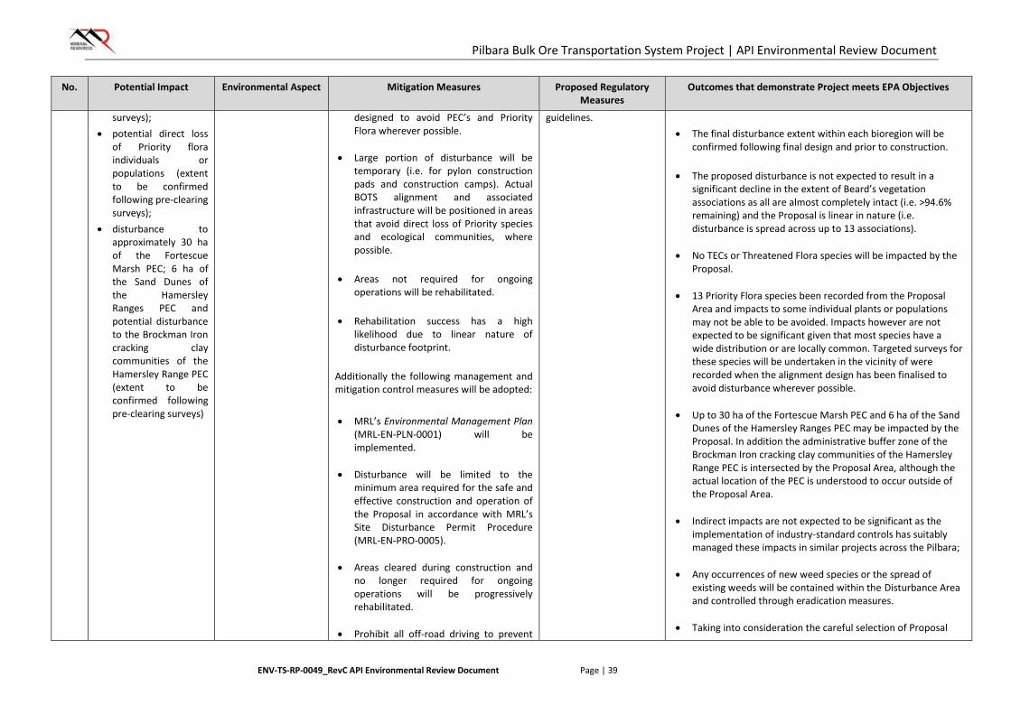
Pilbara Bulk Ore Transportation System Project | API Environmental Review Document
ENV-TS-RP-0049_RevC API Environmental Review Document Page | 39
No. Potential Impact Environmental Aspect Mitigation Measures Proposed Regulatory Measures
Outcomes that demonstrate Project meets EPA Objectives
surveys); • potential direct loss
of Priority flora individuals or populations (extent to be confirmed following pre-clearing surveys);
• disturbance to approximately 30 ha of the Fortescue Marsh PEC; 6 ha of the Sand Dunes of the Hamersley Ranges PEC and potential disturbance to the Brockman Iron cracking clay communities of the Hamersley Range PEC (extent to be confirmed following pre-clearing surveys)
designed to avoid PEC’s and Priority Flora wherever possible.
• Large portion of disturbance will be temporary (i.e. for pylon construction pads and construction camps). Actual BOTS alignment and associated infrastructure will be positioned in areas that avoid direct loss of Priority species and ecological communities, where possible.
• Areas not required for ongoing
operations will be rehabilitated.
• Rehabilitation success has a high likelihood due to linear nature of disturbance footprint.
Additionally the following management and mitigation control measures will be adopted: • MRL’s Environmental Management Plan
(MRL-EN-PLN-0001) will be implemented.
• Disturbance will be limited to the minimum area required for the safe and effective construction and operation of the Proposal in accordance with MRL’s Site Disturbance Permit Procedure (MRL-EN-PRO-0005).
• Areas cleared during construction and no longer required for ongoing operations will be progressively rehabilitated.
• Prohibit all off-road driving to prevent
guidelines. • The final disturbance extent within each bioregion will be
confirmed following final design and prior to construction.
• The proposed disturbance is not expected to result in a significant decline in the extent of Beard’s vegetation associations as all are almost completely intact (i.e. >94.6% remaining) and the Proposal is linear in nature (i.e. disturbance is spread across up to 13 associations).
• No TECs or Threatened Flora species will be impacted by the
Proposal. • 13 Priority Flora species been recorded from the Proposal
Area and impacts to some individual plants or populations may not be able to be avoided. Impacts however are not expected to be significant given that most species have a wide distribution or are locally common. Targeted surveys for these species will be undertaken in the vicinity of were recorded when the alignment design has been finalised to avoid disturbance wherever possible.
• Up to 30 ha of the Fortescue Marsh PEC and 6 ha of the Sand
Dunes of the Hamersley Ranges PEC may be impacted by the Proposal. In addition the administrative buffer zone of the Brockman Iron cracking clay communities of the Hamersley Range PEC is intersected by the Proposal Area, although the actual location of the PEC is understood to occur outside of the Proposal Area.
• Indirect impacts are not expected to be significant as the
implementation of industry-standard controls has suitably managed these impacts in similar projects across the Pilbara;
• Any occurrences of new weed species or the spread of
existing weeds will be contained within the Disturbance Area and controlled through eradication measures.
• Taking into consideration the careful selection of Proposal
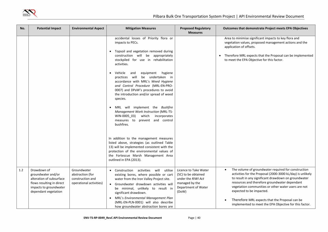
Pilbara Bulk Ore Transportation System Project | API Environmental Review Document
ENV-TS-RP-0049_RevC API Environmental Review Document Page | 40
No. Potential Impact Environmental Aspect Mitigation Measures Proposed Regulatory Measures
Outcomes that demonstrate Project meets EPA Objectives
accidental losses of Priority flora or impacts to PECs.
• Topsoil and vegetation removed during
construction will be appropriately stockpiled for use in rehabilitation activities.
• Vehicle and equipment hygiene
practices will be undertaken in accordance with MRL’s Weed Hygiene and Control Procedure (MRL-EN-PRO-0007) and DPaW’s procedures to avoid the introduction and/or spread of weed species.
• MRL will implement the Bushfire
Management Work Instruction (MRL-TS-WIN-0005_03) which incorporates measures to prevent and control bushfires.
In addition to the management measures listed above, strategies (as outlined Table 13) will be implemented consistent with the protection of the environmental values of the Fortescue Marsh Management Area outlined in EPA (2013).
Area to minimise significant impacts to key flora and vegetation values, proposed management actions and the application of offsets.
• Therefore MRL expects that the Proposal can be implemented
to meet the EPA Objective for this factor.
1.2 Drawdown of groundwater and/or alteration of subsurface flows resulting in direct impacts to groundwater dependant vegetation
Groundwater abstraction (for construction and operational activities)
• Construction activities will utilise existing bores, where possible or cart water from the Iron Valley Project site.
• Groundwater drawdown activities will be minimal, unlikely to result in significant drawdown.
• MRL’s Environmental Management Plan (MRL-EN-PLN-0001) will also describe how groundwater abstraction bores are
Licence to Take Water (5C) to be obtained under the RIWI Act managed by the Department of Water (DoW)
• The volume of groundwater required for construction activities for the Proposal (2000-3000 kL/day) is unlikely to result in any significant drawdown on groundwater resources and therefore groundwater dependant vegetation communities or other water users are not expected to be impacted.
• Therefore MRL expects that the Proposal can be implemented to meet the EPA Objective for this factor.
Pilbara Bulk Ore Transportation System Project | API Environmental Review Document
ENV-TS-RP-0049_RevC API Environmental Review Document Page | 41
No. Potential Impact Environmental Aspect Mitigation Measures Proposed Regulatory Measures
Outcomes that demonstrate Project meets EPA Objectives
to be located and operated such that groundwater drawdown is minimised.
In addition to the management measures listed above, strategies (as outlined Table 13) will be implemented consistent with the protection of the environmental values of the Fortescue Marsh Management Area outlined in EPA (2013).
1.3 Modification of surface water flows resulting in direct impacts to vegetation communities
Physical presence of BOTS alignment and associated infrastructure
• The elevated design of the Proposal will result in minimal permanent disturbance to natural surface water flows.
• The four groundwater dependant vegetation communities are narrow in shape and permanent infrastructure will avoid disturbance to these where possible.
• All BOTS associated infrastructure (i.e. construction camps, construction pads) will be located off drainage lines and flood prone areas, where possible.
In addition to the management measures listed above, strategies (as outlined Table 13) will be implemented consistent with the protection of the environmental values of the Fortescue Marsh Management Area outlined in EPA (2013).
Future State Agreement Act, approvals to ensure watercourse crossings are developed as per approved design. Interference with watercourses will be regulated through s17 (Licence to interfere with Bed and Banks) approvals under the RIWI Act 1914
• Based on the elevated nature of the Proposal, minimal permanent modifications to existing surface water flows is expected and as such, vegetation communities relying on local surface water flows are not expected to be impacted.
• Therefore MRL expects that the Proposal can be implemented to meet the EPA Objective for this factor.
2 Terrestrial Fauna
EPA Objective: To maintain representation, diversity, viability and ecological function at the species, population and assemblage level
Context
Four Threatened fauna taxa listed under the WC Act and EPBC Act have been recorded from the Proposal Area:
• Northern Quoll (Dasyurus hallucatus) – Schedule 1 and Endangered • Greater Bilby (Macrotis lagotis)- Schedule 1 and Vulnerable • Pilbara Leaf-nosed Bat (Rhinonicteris aurantia) - Schedule 1 and Vulnerable

Pilbara Bulk Ore Transportation System Project | API Environmental Review Document
ENV-TS-RP-0049_RevC API Environmental Review Document Page | 42
No. Potential Impact Environmental Aspect Mitigation Measures Proposed Regulatory Measures
Outcomes that demonstrate Project meets EPA Objectives
• Ghost Bat (Macroderma gigas) - Schedule 3 and Vulnerable
Two Priority fauna species listed by DPAW have been recorded from the Proposal Area:
• Black-lined Ctenotus (Ctenotus nigrilineatus) – P1 • Brush-tailed Mulgara (Dasycercus blythi) – P4 • Western Pebble-mound Mouse (Pseudomys chapmani) – P4
Two Migratory species listed under the EPBC Act have been recorded from the Proposal Area:
• Rainbow Bee-eater (Merops ornatus) • Fork-tailed Swift (Apus pacificus)
Five significant fauna habitats have been identified within the vicinity of the Proposal Area:
• Fortescue Marsh • Linear sand dunes habitats adjacent to Weeli Wolli Creek • Cracking clay habitat units associated with the Chichester Range • Granite rockpiles scattered on the Abydos plain • Major drainage systems.
It should be noted that no significant fauna species or habitats are restricted to the Proposal Area. Up to 3,000 ha of general fauna habitat disturbance will be required during operations. The balance between the habitat disturbed during construction and what is required during operations will be rehabilitated once the areas are no longer required.
2.1 Removal of fauna habitat through clearing of native vegetation (up to 3,000 ha), potential fragmentation of fauna habitat, changes in quality of fauna habitat, vehicle strike causing injury or death; introduction of pests, increase fire ignition risk and trenching impacts
Ground disturbance – clearing of potential fauna habitat
• The Proposal Area is located within an established and operational infrastructure corridor for the majority of its route.
• A wide Proposal Area has been selected to avoid areas of significant fauna habitat during the selection of a final alignment.
• The elevated design of the Proposal with use of spaced substructures, significantly reduces area of ground disturbance minimising the removal of fauna habitat.
• A Proposal Area alignment has been
Ministerial Statement; and Future State Agreement Act approvals to ensure proposal is developed as per approved design.
• The Proposal will result in the disturbance of up to 3,000 ha of fauna habitat, with approximately 1,000ha being rehabilitated at the completion of the construction period. Broad fauna habitat in the surrounding area remains almost completely intact and therefore the Proposal is not expected to have a significant effect on the representation of broad fauna habitat at a local or regional level.
• After the implementation of mitigation measures, an area of up to only 3 ha of the critical habitat for the Northern Quoll may be required to be disturbed out of a total of 39.08ha critical habitat identified within the Proposal Area. This equates to a disturbance to critical habitat within the Proposal Area of less than 8%. All of
Pilbara Bulk Ore Transportation System Project | API Environmental Review Document
ENV-TS-RP-0049_RevC API Environmental Review Document Page | 43
No. Potential Impact Environmental Aspect Mitigation Measures Proposed Regulatory Measures
Outcomes that demonstrate Project meets EPA Objectives
optimised to minimise impacts to scattered patches of critical Northern Quoll habitat present in the northern portion of the Proposal Area. As a result a maximum of approximately 3 ha may be potentially impacted.
• Disturbance within significant fauna habitats will be restricted to the Proposal Area, maintenance tracks and construction pads. All other associated infrastructure (i.e. construction camps) will be located outside of these significant habitats, where possible.
• Areas not required for ongoing operations will be rehabilitated.
• Rehabilitation success has a high likelihood due to linear nature of disturbance footprint.
Additionally the following management and mitigation control measures will be adopted: • Implement management actions
detailed in Flora and Vegetation section above. The majority of these actions also manage impacts to fauna habitat.
In addition to the management measures listed above, strategies (as outlined Table 15) will be implemented consistent with the protection of the environmental values of the Fortescue Marsh Management Area outlined in EPA (2013).
the land systems containing suitable habitat are well represented in the surrounding areas. MRL is confident that habitat disturbance has been avoided and minimised as much as possible. The Proposal is therefore not expected to result in a significant residual impact to this species.
• The Proposal is not expected to affect the conservation status of any Threatened or Priority fauna habitats known to occur in the Proposal Area, or have a significant effect on the representation of species or habitats at a local or regional level.
• Therefore MRL expects that the Proposal can be implemented to meet the EPA Objective for this factor.
2.2 Construction of linear infrastructure, resulting in habitat barriers to local fauna
Physical presence of Proposal formation and associated infrastructure
• In excess of 20% of the elevated BOTS alignment will be over 2m in height above existing ground levels.
• Water flows and small native fauna movements will be unimpeded over the entire length of the Proposal.
As above • Due to the elevated nature of the BOTS formation, the Proposal will not act as a habitat barrier to local terrestrial fauna. There have however been 11 segments to date identified of more than 5km of continuous low module construction that will impede the movement of stock and larger fauna.
Pilbara Bulk Ore Transportation System Project | API Environmental Review Document
ENV-TS-RP-0049_RevC API Environmental Review Document Page | 44
No. Potential Impact Environmental Aspect Mitigation Measures Proposed Regulatory Measures
Outcomes that demonstrate Project meets EPA Objectives
• Generally the Proposal Area alternates between low and medium/high alignments regularly allowing ease of crossing under the BOTS structure by stock and local fauna.
• Develop borrow pits such that they are free-draining (where practicable).
• Control measures introduced fauna around camps and other work areas.
• Internal reporting of all incidents resulting in fauna injury or death.
• Set and enforce vehicle speed limits. In addition to the management measures listed above, strategies (as outlined Table 15) will be implemented consistent with the protection of the environmental values of the Fortescue Marsh Management Area outlined in EPA (2013)
• Some temporary displacement of fauna may occur during construction activities but impacts are not expected to affect the conservation status of any fauna taxa known to occur in the Proposal Area, or have a significant effect on the representation of any species at a local or regional level.
• MRL anticipates that the Proposal can be implemented
to meet the EPA Objective for this factor.
2.3 Increased artificial lighting may impact fauna sensitive to light
Physical presence of BOTS formation and associated infrastructure
• Lighting will be directed only upon construction areas and camp sites.
• Lighting will only be used as necessary to provide a safe environment for construction workers.
• Any short term maintenance activities to the track structure during the Operational phase will be conducted during daylight hours where possible to minimise impact.
• The Proposal will be operated autonomously, monitored remotely from a Perth based location, reducing requirements for lighting along the length of the formation.
n/a • The Proposal is not located in areas known to inhabit fauna that are significantly sensitive to light. As such, the use of artificial light during construction and operation of the Proposal is not expected to have any significant impact to local fauna.
• MRL anticipates that the Proposal can be implemented to meet the EPA Objective for this factor.
Pilbara Bulk Ore Transportation System Project | API Environmental Review Document
ENV-TS-RP-0049_RevC API Environmental Review Document Page | 45
No. Potential Impact Environmental Aspect Mitigation Measures Proposed Regulatory Measures
Outcomes that demonstrate Project meets EPA Objectives
3 Hydrological Processes
EPA Objective: To maintain the hydrological regimes of groundwater and surface water so that existing and potential users, including ecosystem maintenance, are protected
Context
One Environmentally Sensitive Area listed under the WC Act and the EPBC Act is recorded in the Proposal Area:
• Fortescue Marsh – Nationally Important Wetland (<0.03% of total area proposed to be disturbed)
The Proposal Area also intersects at least six other major surface water bodies including:
• Turner River
• Turner River East
• Yule River
• Coonarrie Creek
• Western Shaw River
• Weeli Wolli Creek.
3.1 Impacts to groundwater
regime Groundwater abstraction associated with construction activities for the BOTS and associated infrastructure
• The Proposal Area is located within an established and operational infrastructure corridor for the majority of its route.
• Construction activities will utilise existing bores, where possible or cart water short distances from the Iron Valley Project site.
• Groundwater abstraction activities for construction purposes will be minimal (2000-3000kL/day) and are unlikely to result in significant drawdown.
Additionally the following management and mitigation, and control measures will be adopted: • MRL’s Environmental Management Plan
Licence to construct a bore (if required)(26D) and Licence to Take Water (5C) to be obtained under the RIWI Act managed by the DOW
• The minor groundwater abstraction required for construction activities for the Proposal (2000-3000kL/day) is unlikely to result in any significant drawdown on groundwater resources. It is expected that the existing hydrological regime of groundwater Proposal Area will be maintained.
• MRL anticipates that the Proposal can be implemented to meet the EPA Objective for this factor.
Pilbara Bulk Ore Transportation System Project | API Environmental Review Document
ENV-TS-RP-0049_RevC API Environmental Review Document Page | 46
No. Potential Impact Environmental Aspect Mitigation Measures Proposed Regulatory Measures
Outcomes that demonstrate Project meets EPA Objectives
(MRL-EN-PLN-0001) will also describe how groundwater abstraction bores are to be located and operated such that groundwater drawdown is minimised.
• Chemicals and hydrocarbons required on site will be stored in accordance with Dangerous Goods Safety Act 2004 and the Storage and Handling of Dangerous Goods Code of Practice (DMP 2010) to minimise risks of groundwater contamination.
In addition to the management measures listed above, strategies (as outlined in Table 17) will be implemented consistent with the protection of the environmental values of the Fortescue Marsh Management Area outlined in EPA (2013)
3.2 Impacts to surface water regime
Physical presence of BOTS formation and associated infrastructure
• The Proposal Area is located within an established and operational infrastructure corridor for the majority of its route.
• Elevated design of BOTS formation will result in minimal permanent disturbance to natural surface water flows.
• Temporary associated infrastructure (i.e. construction camps, construction pads, soil and vegetation stockpiles) will be located away from drainage lines, where possible.
• If new bores are required, areas of high environmental significance (ie PECs and potential groundwater-dependent vegetation communities) will be avoided where possible.
Additionally the following management and
Licence to interfere with the Bed and Banks of a Watercourse (S17 Licence) to be obtained under the RIWI Act managed by the DoW
• Based on the elevated nature of the Proposal, minimal permanent modifications to existing surface water flows is expected and as such, the existing hydrological regime of groundwater resources in the Proposal Area will be maintained.
• MRL anticipates that the Proposal can be implemented to meet the EPA Objective for this factor.

Pilbara Bulk Ore Transportation System Project | API Environmental Review Document
ENV-TS-RP-0049_RevC API Environmental Review Document Page | 47
No. Potential Impact Environmental Aspect Mitigation Measures Proposed Regulatory Measures
Outcomes that demonstrate Project meets EPA Objectives
mitigation control measures will be adopted: • MRL’s Environmental Management Plan
(MRL-EN-PLN-0001) will also describe how groundwater abstraction bores are to be located and operated such that groundwater drawdown is minimised.
• Chemicals and hydrocarbons required on site will be stored in accordance with Dangerous Goods Safety Act 2004 and the Storage and Handling of Dangerous Goods Code of Practice (DMP 2010) to minimise risks of surface water contamination.
In addition to the management measures listed above, strategies (as outlined in Table 17) will be implemented consistent with the protection of the environmental values of the Fortescue Marsh Management Area outlined in EPA (2013).
Integrating Factors
1 Rehabilitation and Decommissioning
EPA Objective: To ensure that premises are closed, decommissioned and rehabilitated in an ecologically sustainable manner
Context
• Mine closure is jointly regulated in Western Australia by the EPA under the EP Act and the Department of Mines and Petroleum under the Mining Act 1978. The EPA issued the Environmental Protection Bulletin No. 19: EPA Involvement in Mine Closure in early 2015 (EPA 2015d) to outline the responsibilities of each agency in assessment of mine closure impacts for various approvals scenarios. Although this Proposal is not subject to the Mining Act 1978, there will be a condition on the State Agreement Act requiring a Closure Plan which DSD will default to DMP to review.
• As a significant portion of the proposed disturbance footprint will only be required for construction purposes it will be available for progressive rehabilitation on the completion of construction activities in that area.
• Disturbance of up to approximately 2,479 ha of Good to Excellent condition vegetation (83%) and 521 ha of Very Poor to Fair condition vegetation (17%).
Pilbara Bulk Ore Transportation System Project | API Environmental Review Document
ENV-TS-RP-0049_RevC API Environmental Review Document Page | 48
No. Potential Impact Environmental Aspect Mitigation Measures Proposed Regulatory Measures
Outcomes that demonstrate Project meets EPA Objectives
• The Study Area intersects with three sub-regions of the Pilbara biogeographic region as defined in the IBRA (DotE, 2011); Chichester, Fortescue Plains and Roebourne.
• Three Priority Ecological Communities (PEC’s) Fortescue Marsh PEC, Sand Dunes of the Hamersley Ranges PEC and Brockman Iron cracking clay communities of the Hamersley Range PEC identified within the Proposal Area.
• The Proposal Area intersects The Fortescue Marsh Management Area including Zone 1A Northern Flank (682 ha), Zone 1B Marsh (626 ha), Zone 2B Poonda Plain (5,581 ha) and Zone 3B Marillana Plan (355 ha).
• The majority of the Development Envelope is currently used for pastoral activities, with a portion remaining as UCL.
• Up to 3,000 ha of general fauna habitat disturbance will be required during construction. Up to 2,000 ha of disturbance will be required during operation. The balance will be rehabilitated once the areas are no longer required.
1.1 Construction –related temporary disturbance including construction camps and associated utilities
Progressive rehabilitation of areas not required for ongoing operations during and following construction
• Topsoil, subsoil and bulk vegetation will be stockpiled during land clearing for use in rehabilitation purposes.
• Topsoil will be stored for the shortest time period possible to maintain viability of the seed bank and soil fertility.
• Construction support infrastructure areas, including camps and laydown areas, will be progressively rehabilitated following the completion of construction activities.
• stockpiled soils and vegetation will be replaced over disturbed areas and deep ripped to promote revegetation.
• local provenance seed will be collected and used in rehabilitation. Where local provenance seed collection is not possible due to seasonal constraints, seed consistent with species found at the local scale will be source from registered seed suppliers.
• A Rehabilitation Procedure will be developed for the Proposal in
Ministerial Statement
Contaminated Sites Act 2003
Future State Agreement Act, approvals to ensure proposal is developed as per approved design
Closure requirements specified by a Closure Plan per future State Agreement Act requirements
• Any areas cleared for construction purposes that are not required during operations (construction camps, borrow pits, access tracks etc.) will be rehabilitated, either progressively or at the completion of construction.
• Rehabilitation of the rail structure itself will be subject to
discussions with the WA State Government as railway lines are generally retained as a state asset.
• MRL anticipates that the Proposal can be implemented
to meet the EPA Objective for this factor.
Pilbara Bulk Ore Transportation System Project | API Environmental Review Document
ENV-TS-RP-0049_RevC API Environmental Review Document Page | 49
No. Potential Impact Environmental Aspect Mitigation Measures Proposed Regulatory Measures
Outcomes that demonstrate Project meets EPA Objectives
accordance with EPA Guidance Statement No. 6 Rehabilitation of Terrestrial Ecosystems (EPA 2006), which sets out the general expectations about re-establishing biodiversity values where a site is to be rehabilitated back to previous land use.
• For areas on UCL, mining tenure and
Aboriginal Reserves, all access tracks, geotechnical investigation areas, laydowns areas and temporary camps, all infrastructure and footings will be removed, unusable inert material will be buried on site (or in landfill facility if nearby), stripped topsoil and vegetation will be respread, scarified and monitored. If no significant regrowth is detected during monitoring over the subsequent 12 months, local provenance seed will be collected and the area seeded. For areas occurring on pastoral leases, land will be returned to a pastoral land use, namely low intensity livestock grazing.
• For borrow pits and other excavations,
rehabilitation will be undertaken in accordance with MRL’s Borrow Pits Works Instruction (MRL-EN-WIN-0013), with pit walls battered to 180 or to a 3:1 slope. Stripped topsoil and vegetation will be respread, scarified and monitored. If no significant regrowth is detected during monitoring over the subsequent 12 months, local provenance seed will be collected and the area seeded.
1.2 Permanent Disturbance Rehabilitation • Above-ground infrastructure and Ministerial Statement • Rehabilitation of the rail structure itself will be subject to discussions with the WA State Government as railway

Pilbara Bulk Ore Transportation System Project | API Environmental Review Document
ENV-TS-RP-0049_RevC API Environmental Review Document Page | 50
No. Potential Impact Environmental Aspect Mitigation Measures Proposed Regulatory Measures
Outcomes that demonstrate Project meets EPA Objectives
following operations including the removal, disposal and potential relocation pf infrastructure during closure and decommissioning
equipment will be removed. • Disturbed areas will be made safe and
stable and will resemble pre-disturbance and surrounding topography.
• Disturbed areas will be covered by vegetation re-established from respread topsoil and/or seed of local provenance.
• A Closure Plan will be developed for the Proposal in accordance with EPA Guidance Statement No. 6 Rehabilitation of Terrestrial Ecosystems (EPA 2006), which sets out the general expectations about re-establishing biodiversity values where a site is to be rehabilitated back to native vegetation.
Contaminated Sites Act 2003 Future State Agreement Act, approvals to ensure proposal is developed as per approved design
line are generally retained as a state asset.
• MRL anticipates that the Proposal can be implemented to meet the EPA Objective for this factor.
2 Offsets
EPA Objective: To counterbalance any significant residual environmental impacts or uncertainty through the application of offsets.
Context • The Proposal is expected to impact approximately 2,479 ha of Good to Excellent condition vegetation (83%) and 521 ha of Very Poor to Fair condition vegetation (17%). Approximately 1518ha
of Good to Excellent condition and 319 ha of Very Poor to Fair condition vegetation occurs within the Chichester IBRA subregion, while approximately 687 ha Good to Excellent condition and 144 ha of Very Poor to Fair condition vegetation occurs within the Fortescue subregion.
• The Proposal Area intersects three subregions of the Pilbara biogeographic region as defined by Interim Biogeographic Regionalisation for Australia, Version 7 (Commonwealth 2012) (IBRA); Chichester, Fortescue and Roebourne. • No Threatened Flora (TF) or Threatened Ecological Communities (TEC’s) recorded from the Proposal Area. • Up to 3 ha of the critical habitat for the Northern Quoll may be disturbed out of a total of 39.08ha critical habitat identified within the Proposal Area.
• Flora and vegetation surveys recorded 13 Priority Flora recorded from the Proposal Area, including five P1’s, two P2’s, four P3’s and two P4’s.
• No Declared Pest plants listed under the Biosecurity and Agriculture Management Act 2007 recorded. • Beard Vegetation Associations that are intersected by the Proposal Area all have more than 94.6% of their pre-European extent remaining.
Pilbara Bulk Ore Transportation System Project | API Environmental Review Document
ENV-TS-RP-0049_RevC API Environmental Review Document Page | 51
No. Potential Impact Environmental Aspect Mitigation Measures Proposed Regulatory Measures
Outcomes that demonstrate Project meets EPA Objectives
• No sheetflow dependent vegetation identified within the Proposal Area. • Three Priority Ecological Communities (PEC’s) Fortescue Marsh PEC, Sand Dunes of the Hamersley Ranges PEC and Brockman Iron cracking clay communities of the Hamersley Range PEC
identified within the Proposal Area. • The Proposal Area intersects The Fortescue Marsh Management Area including Zone 1A Northern Flank (682 ha), Zone 1B Marsh (626 ha), Zone 2B Poonda Plain (5,581 ha) and Zone 3B
Marillana Plan (355 ha).
2.1 • Direct loss of mostly Very Good to Excellent condition vegetation (83%);
• Direct loss of vegetation (~ up to 831 ha within the Fortescue IBRA subregion and up to 1836 ha within the Chichester IBRA subregion)
• Direct loss of confirmed and potential PEC vegetation;
• Direct loss of Priority Flora species;
• Direct loss of conservation significant fauna habitat;
• Potential indirect impacts as a result of noise, dust, weeds, fire or alterations of surface water flow characteristics.
Ground disturbance such as direct clearing and earthmoving activities relating to impacts on flora and vegetation, fauna, hydrological processes and rehabilitation and decommissioning
• The Proposal Area alignment has been optimised to minimise impacts to scattered patches of critical Northern Quoll habitat present in the northern portion of the Proposal Area. As a result a maximum of approximately 3 ha may be potentially impacted.
• A Development Plan will be developed
and submitted to OEPA for approval prior to the commencement of construction. The Plan will finalise the required disturbance to key environmental features, including PEC’s and Priority flora, and will include the results of pre-clearing surveys.
• Clearing of up to 3,000 ha of Very Good
to Excellent condition vegetation (of which ~ 1000ha will be rehabilitated) and Priority Ecological Communities will be offset, based on the results of the Development Plan and Impact Reconciliation Procedure.
• Ministerial Statement
• It is anticipated that the negotiation of offsets with the EPA and DPaW will result in the application of a $/hectare offset rate for actual disturbance resulting from land clearing, based on both the quality of vegetation impacted and the IBRA subregion in which the clearing occurs. It is proposed that offset funding be contributed to the Pilbara Strategic Conservation Fund. Offsets are proposed to counterbalance the significant residual environmental impacts or uncertainty associated with the Proposal as identified in Table 18.
• MRL anticipates that the Proposal can be implemented to meet the EPA Objective for this factor.
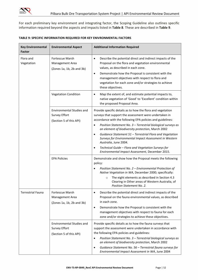
Pilbara Bulk Ore Transportation System Project | API Environmental Review Document
ENV-TS-RP-0049_RevC API Environmental Review Document Page | 52
For each preliminary key environment and integrating factor, the Scoping Guideline also outlines specific information required beyond the aspects and impacts listed in Table 8. These are described in Table 9.
TABLE 9: SPECIFIC INFORMATION REQUIRED FOR KEY ENIVRONMENTAL FACTORS
Key Environmental Factor
Environmental Aspect Additional Information Required
Flora and Vegetation
Fortescue Marsh Management Area
(Zones 1a, 1b, 2b and 3b)
• Describe the potential direct and indirect impacts of the Proposal on the flora and vegetation environmental values, as described in each zone.
• Demonstrate how the Proposal is consistent with the management objectives with respect to flora and vegetation for each zone and/or strategies to achieve these objectives.
Vegetation Condition • Map the extent of, and estimate potential impacts to, native vegetation of ‘Good’ to ‘Excellent’ condition within the proposed Proposal Area.
Environmental Studies and Survey Effort
(Section 5 of this API)
Provide specific details as to how the flora and vegetation surveys that support the assessment were undertaken in accordance with the following EPA policies and guidelines:
• Position Statement No. 3 – Terrestrial biological surveys as an element of biodiversity protection, March 2002
• Guidance Statement 51 – Terrestrial Flora and Vegetation Surveys for Environmental Impact Assessment in Western Australia, June 2004.
• Technical Guide – Flora and Vegetation Surveys for Environmental Impact Assessment, December 2015.
EPA Policies Demonstrate and show how the Proposal meets the following policy:
• Position Statement No. 2 – Environmental Protection of Native Vegetation in WA, December 2000; specifically:
o The eight elements as described in Section 4.3 Clearing in Other areas of Western Australia, of Position Statement No. 2.
Terrestrial Fauna Fortescue Marsh Management Area
(Zones 1a, 1b, 2b and 3b)
• Describe the potential direct and indirect impacts of the Proposal on the fauna environmental values, as described in each zone.
• Demonstrate how the Proposal is consistent with the management objectives with respect to fauna for each zone and/or strategies to achieve these objectives.
Environmental Studies and Survey Effort
(Section 5 of this API)
Provide specific details as to how the fauna surveys that support the assessment were undertaken in accordance with the following EPA policies and guidelines:
• Position Statement No. 3 – Terrestrial biological surveys as an element of biodiversity protection, March 2002
• Guidance Statement No. 56 – Terrestrial fauna surveys for Environmental Impact Assessment in WA, June 2004
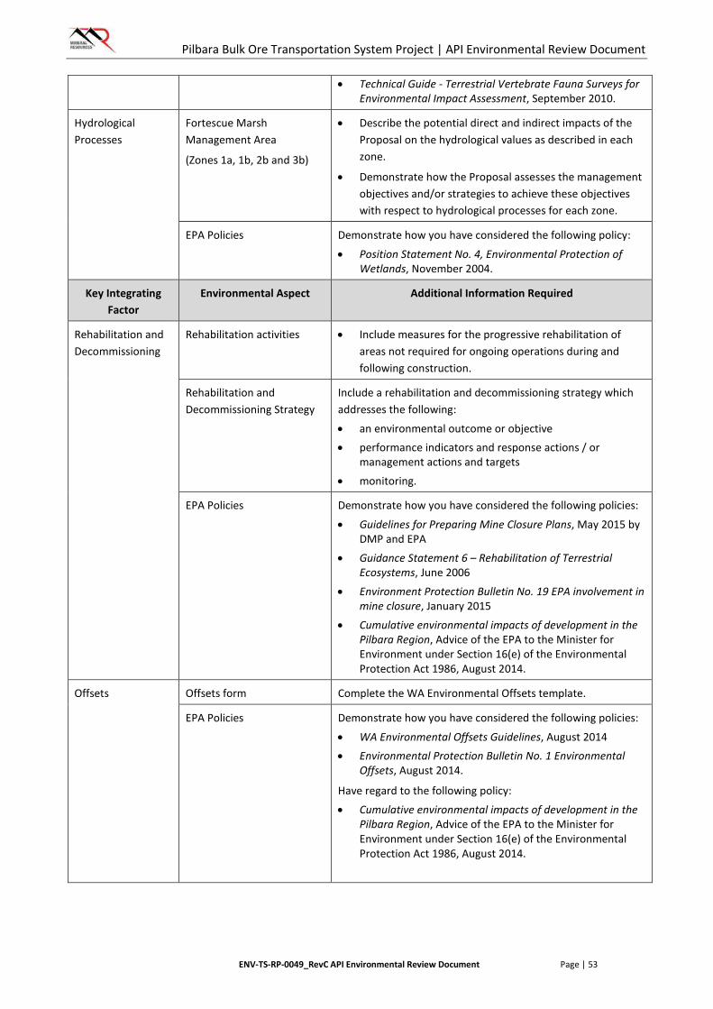
Pilbara Bulk Ore Transportation System Project | API Environmental Review Document
ENV-TS-RP-0049_RevC API Environmental Review Document Page | 53
• Technical Guide - Terrestrial Vertebrate Fauna Surveys for Environmental Impact Assessment, September 2010.
Hydrological Processes
Fortescue Marsh Management Area
(Zones 1a, 1b, 2b and 3b)
• Describe the potential direct and indirect impacts of the Proposal on the hydrological values as described in each zone.
• Demonstrate how the Proposal assesses the management objectives and/or strategies to achieve these objectives with respect to hydrological processes for each zone.
EPA Policies Demonstrate how you have considered the following policy:
• Position Statement No. 4, Environmental Protection of Wetlands, November 2004.
Key Integrating Factor
Environmental Aspect Additional Information Required
Rehabilitation and Decommissioning
Rehabilitation activities • Include measures for the progressive rehabilitation of areas not required for ongoing operations during and following construction.
Rehabilitation and Decommissioning Strategy
Include a rehabilitation and decommissioning strategy which addresses the following:
• an environmental outcome or objective • performance indicators and response actions / or
management actions and targets
• monitoring.
EPA Policies Demonstrate how you have considered the following policies:
• Guidelines for Preparing Mine Closure Plans, May 2015 by DMP and EPA
• Guidance Statement 6 – Rehabilitation of Terrestrial Ecosystems, June 2006
• Environment Protection Bulletin No. 19 EPA involvement in mine closure, January 2015
• Cumulative environmental impacts of development in the Pilbara Region, Advice of the EPA to the Minister for Environment under Section 16(e) of the Environmental Protection Act 1986, August 2014.
Offsets Offsets form Complete the WA Environmental Offsets template.
EPA Policies Demonstrate how you have considered the following policies:
• WA Environmental Offsets Guidelines, August 2014 • Environmental Protection Bulletin No. 1 Environmental
Offsets, August 2014.
Have regard to the following policy:
• Cumulative environmental impacts of development in the Pilbara Region, Advice of the EPA to the Minister for Environment under Section 16(e) of the Environmental Protection Act 1986, August 2014.
Pilbara Bulk Ore Transportation System Project | API Environmental Review Document
ENV-TS-RP-0049_RevC API Environmental Review Document Page | 54
6.2. Flora and Vegetation
6.2.1. Context
EPA Objective
The EPA’s environmental objective for flora and vegetation is:
To maintain representation, diversity, viability and ecological function at the species, population and community level.
Policy Context
The BOTS Proposal Area intersects the Fortescue Marsh Management Area. Avoidance of this area was considered during project planning but was found not to be feasible. Management of this area is undertaken in accordance with EPA Report 1484, Environmental and Water assessments relating to mining and mining-related activities in the Fortescue Marsh management area (EPA 2013b). In addition to this guideline, the following policy and guidance documents are relevant to the assessment of impacts to flora and vegetation as a result of the BOTS Proposal:
• EAG 14 – Preparation of an API-A Environmental Review Document, January 2015 (EPA 2015a).
• Position Statement No. 3 - Terrestrial biological surveys as an element of biodiversity protection, March 2002 (EPA 2002).
• Guidance Statement 51 – Terrestrial Flora and Vegetation Surveys for Environmental Impact Assessment in Western Australia, June 2004 (EPA 2004a).
• Position Statement No. 2– Environmental Protection of Native Vegetation in WA, December 2000 (EPA 2000).
• Technical Guide – Flora and Vegetation Surveys for Environmental Impact Assessment, December 2015.
Relevant Baseline Information
Ten flora and vegetation surveys have been conducted within the BOTS Proposal area (Table 7). These surveys cover the majority of the BOTS Proposal Area. The outcomes and results of these surveys are summarised below.
Flora
• One Threatened species (Thryptomene wittweri) was identified in database searches as having the potential to occur within the vicinity of the BOTS Proposal Area; however it has not been recorded within the BOTS Proposal Area, nor is it considered likely to occur due to the absence of suitable habitat for the species.
• Desktop and database searches identified 91 Priority listed species with the potential to occur within the vicinity of the BOTS Proposal Area.
• Flora and Vegetation surveys recorded 13 Priority species occurring within the BOTS Proposal Area (Figure 6)
o P1 taxa Abutilon sp. Pritzelianum (S. van Leeuwen 5095), Eremophila spongiocarpa, Heliotropium muticum, Josephinia ?sp. Marandoo (ME Trudgen 1554) and Tephrosia rosea var. Port Hedland (A.S. George 1114)
o P2 taxa Euphorbia clementii and Paspalidium retiglume
o P3 taxa Goodenia sp. East Pilbara (A.A. Mitchell PRP 727), Gymnanthera cunninghamii, Rhagodia sp. Hamersley (M. Trudgen 17794), Themeda sp. Hamersley Station (M.E. Trudgen 11431)
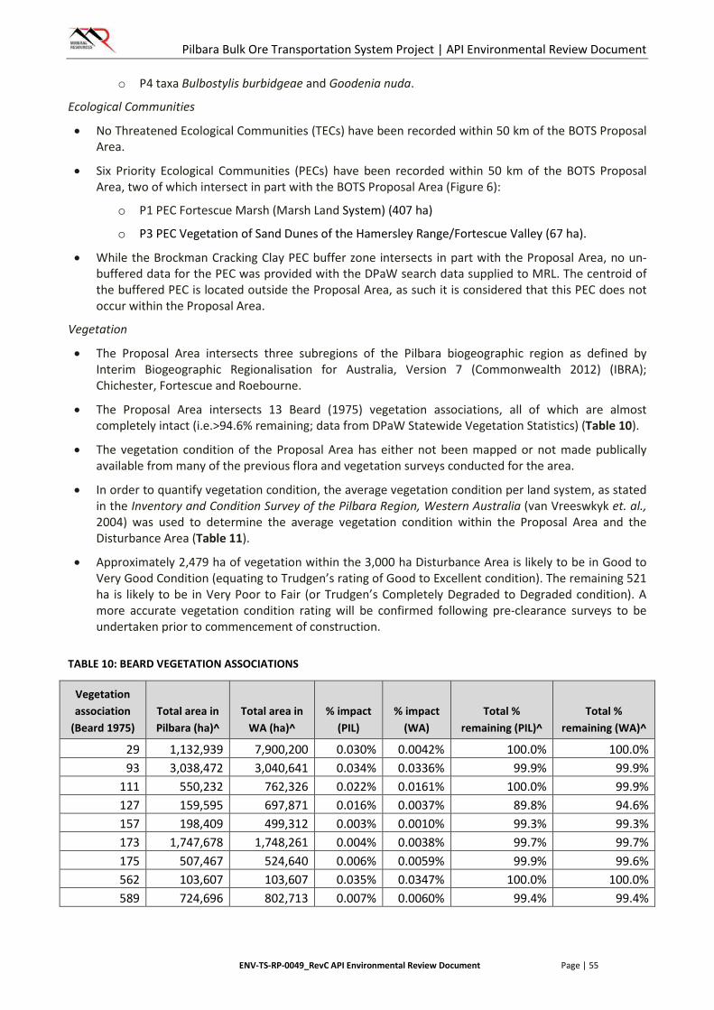
Pilbara Bulk Ore Transportation System Project | API Environmental Review Document
ENV-TS-RP-0049_RevC API Environmental Review Document Page | 55
o P4 taxa Bulbostylis burbidgeae and Goodenia nuda.
Ecological Communities
• No Threatened Ecological Communities (TECs) have been recorded within 50 km of the BOTS Proposal Area.
• Six Priority Ecological Communities (PECs) have been recorded within 50 km of the BOTS Proposal Area, two of which intersect in part with the BOTS Proposal Area (Figure 6):
o P1 PEC Fortescue Marsh (Marsh Land System) (407 ha)
o P3 PEC Vegetation of Sand Dunes of the Hamersley Range/Fortescue Valley (67 ha).
• While the Brockman Cracking Clay PEC buffer zone intersects in part with the Proposal Area, no un-buffered data for the PEC was provided with the DPaW search data supplied to MRL. The centroid of the buffered PEC is located outside the Proposal Area, as such it is considered that this PEC does not occur within the Proposal Area.
Vegetation
• The Proposal Area intersects three subregions of the Pilbara biogeographic region as defined by Interim Biogeographic Regionalisation for Australia, Version 7 (Commonwealth 2012) (IBRA); Chichester, Fortescue and Roebourne.
• The Proposal Area intersects 13 Beard (1975) vegetation associations, all of which are almost completely intact (i.e.>94.6% remaining; data from DPaW Statewide Vegetation Statistics) (Table 10).
• The vegetation condition of the Proposal Area has either not been mapped or not made publically available from many of the previous flora and vegetation surveys conducted for the area.
• In order to quantify vegetation condition, the average vegetation condition per land system, as stated in the Inventory and Condition Survey of the Pilbara Region, Western Australia (van Vreeswkyk et. al., 2004) was used to determine the average vegetation condition within the Proposal Area and the Disturbance Area (Table 11).
• Approximately 2,479 ha of vegetation within the 3,000 ha Disturbance Area is likely to be in Good to Very Good Condition (equating to Trudgen’s rating of Good to Excellent condition). The remaining 521 ha is likely to be in Very Poor to Fair (or Trudgen’s Completely Degraded to Degraded condition). A more accurate vegetation condition rating will be confirmed following pre-clearance surveys to be undertaken prior to commencement of construction.
TABLE 10: BEARD VEGETATION ASSOCIATIONS
Vegetation association
(Beard 1975) Total area in Pilbara (ha)^
Total area in WA (ha)^
% impact (PIL)
% impact (WA)
Total % remaining (PIL)^
Total % remaining (WA)^
29 1,132,939 7,900,200 0.030% 0.0042% 100.0% 100.0% 93 3,038,472 3,040,641 0.034% 0.0336% 99.9% 99.9%
111 550,232 762,326 0.022% 0.0161% 100.0% 99.9% 127 159,595 697,871 0.016% 0.0037% 89.8% 94.6% 157 198,409 499,312 0.003% 0.0010% 99.3% 99.3% 173 1,747,678 1,748,261 0.004% 0.0038% 99.7% 99.7% 175 507,467 524,640 0.006% 0.0059% 99.9% 99.6% 562 103,607 103,607 0.035% 0.0347% 100.0% 100.0% 589 724,696 802,713 0.007% 0.0060% 99.4% 99.4%
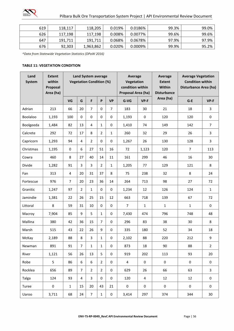
Pilbara Bulk Ore Transportation System Project | API Environmental Review Document
ENV-TS-RP-0049_RevC API Environmental Review Document Page | 56
619 118,117 118,205 0.019% 0.0186% 99.3% 99.0% 626 117,198 117,198 0.008% 0.0077% 99.6% 99.6% 647 191,711 191,711 0.068% 0.0678% 97.9% 97.9% 676 92,303 1,963,862 0.020% 0.0009% 99.9% 95.2%
^Data from Statewide Vegetation Statistics (DPaW 2016)
TABLE 11: VEGETATION CONDITION
Land System
Extent within
Proposal Area (ha)
Land System average Vegetation Condition (%)
Average Vegetation
condition within Proposal Area (ha)
Average Extent Within
Disturbance Area (ha)
Average Vegetation Condition within
Disturbance Area (ha)
VG G F P VP G-VG VP-F G-E VP-F
Adrian 213 66 20 7 0 7 183 30 21 18 3
Boolaloo 1,193 100 0 0 0 0 1,193 0 120 120 0
Boolgeeda 1,484 82 13 4 1 0 1,410 74 149 142 7
Calcrete 292 72 17 8 2 1 260 32 29 26 3
Capricorn 1,293 94 4 2 0 0 1,267 26 130 128 3
Christmas 1,195 0 6 27 51 16 72 1,123 120 7 113
Cowra 460 8 27 40 14 11 161 299 46 16 30
Divide 1,282 91 3 3 2 1 1,205 77 129 121 8
Fan 313 4 20 31 37 8 75 238 32 8 24
Fortescue 976 7 20 23 36 14 264 713 98 27 72
Granitic 1,247 97 2 1 0 0 1,234 12 126 124 1
Jamindie 1,381 22 26 25 15 12 663 718 139 67 72
Littoral 8 59 31 10 0 0 7 1 1 1 0
Macroy 7,904 85 9 5 1 0 7,430 474 796 748 48
Mallina 380 42 36 15 7 0 296 83 38 30 8
Marsh 515 43 22 26 9 0 335 180 52 34 18
McKay 2,189 88 8 3 1 0 2,102 88 220 212 9
Newman 891 91 7 1 1 0 873 18 90 88 2
River 1,121 56 26 13 5 0 919 202 113 93 20
Robe 5 86 6 6 2 0 4 0 0 0 0
Rocklea 656 89 7 2 2 0 629 26 66 63 3
Talga 124 93 4 3 0 0 120 4 12 12 0
Turee 0 1 15 20 43 21 0 0 0 0 0
Uaroo 3,711 68 24 7 1 0 3,414 297 374 344 30
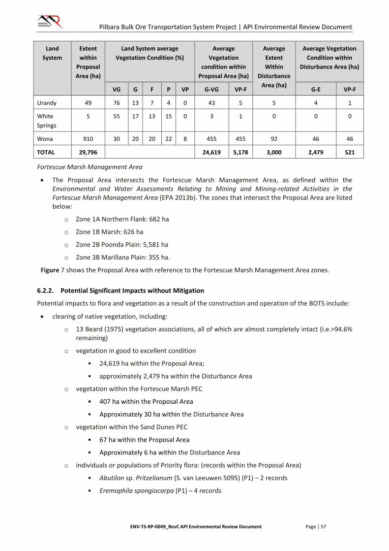
Pilbara Bulk Ore Transportation System Project | API Environmental Review Document
ENV-TS-RP-0049_RevC API Environmental Review Document Page | 57
Land System
Extent within
Proposal Area (ha)
Land System average Vegetation Condition (%)
Average Vegetation
condition within Proposal Area (ha)
Average Extent Within
Disturbance Area (ha)
Average Vegetation Condition within
Disturbance Area (ha)
VG G F P VP G-VG VP-F G-E VP-F
Urandy 49 76 13 7 4 0 43 5 5 4 1
White Springs
5 55 17 13 15 0 3 1 0 0 0
Wona 910 30 20 20 22 8 455 455 92 46 46
TOTAL 29,796 24,619 5,178 3,000 2,479 521
Fortescue Marsh Management Area
• The Proposal Area intersects the Fortescue Marsh Management Area, as defined within the Environmental and Water Assessments Relating to Mining and Mining-related Activities in the Fortescue Marsh Management Area (EPA 2013b). The zones that intersect the Proposal Area are listed below:
o Zone 1A Northern Flank: 682 ha
o Zone 1B Marsh: 626 ha
o Zone 2B Poonda Plain: 5,581 ha
o Zone 3B Marillana Plain: 355 ha.
Figure 7 shows the Proposal Area with reference to the Fortescue Marsh Management Area zones.
6.2.2. Potential Significant Impacts without Mitigation
Potential impacts to flora and vegetation as a result of the construction and operation of the BOTS include:
• clearing of native vegetation, including:
o 13 Beard (1975) vegetation associations, all of which are almost completely intact (i.e.>94.6% remaining)
o vegetation in good to excellent condition
• 24,619 ha within the Proposal Area;
• approximately 2,479 ha within the Disturbance Area
o vegetation within the Fortescue Marsh PEC
• 407 ha within the Proposal Area
• Approximately 30 ha within the Disturbance Area
o vegetation within the Sand Dunes PEC
• 67 ha within the Proposal Area
• Approximately 6 ha within the Disturbance Area
o individuals or populations of Priority flora: (records within the Proposal Area)
• Abutilon sp. Pritzelianum (S. van Leeuwen 5095) (P1) – 2 records
• Eremophila spongiocarpa (P1) – 4 records
Pilbara Bulk Ore Transportation System Project | API Environmental Review Document
ENV-TS-RP-0049_RevC API Environmental Review Document Page | 58
• Heliotropium muticum (P1) – 12 records
• Josephinia sp. Marandoo (ME Trudgen 1554) (P1) – 1 record
• Tephrosia rosea var. Port Hedland (A.S. George 1114) (P1) – 1 record
• Euphorbia clementii (P2) – 4 records
• Paspalidium retiglume (P2) – 2 records
• Goodenia sp. East Pilbara (A.A. Mitchell PRP 727) (P3) – 2 records
• Gymnanthera cunninghamii (P3) – 7 records
• Rhagodia sp. Hamersley (M. Trudgen 17794) (P3) – 1 record
• Themeda sp. Hamersley Station (M.E. Trudgen 11431) (P3) – 5 records
• Bulbostylis burbidgeae (P4) – 2 records
• Goodenia nuda (P4) – 13 records.
• introduction of weeds and diseases
• increased risk of fire ignition
• potential fragmentation of communities and habitats.
In addition to the potential impacts listed above, potential impacts specifically relating to the flora and vegetation environmental values of the Fortescue Marsh Management Area are summarised in Table 12. Figure 8 provides a spatial representation of relevant environmental values in the Fortescue Marsh Management Area zones.
TABLE 12: POTENTIAL IMPACTS TO FORTESCUE MARSH MANAGEMENT AREAS – FLORA AND VEGETATION
Fortescue Marsh Management Zone
Relevant Values Potential Impacts
1A Northern Flank Mulga woodlands (Mosaics of Acacia aneura, A. distans, A. xiphophylla, A. catenulata subsp. occidentalis and A. citrinoviridis)
Mulga woodland vegetation is characterised by the following vegetation types which occur within the Fortescue Marsh Management Zones (Figure 8):
• AaAsEs1
• Fa1-Fa7, Fa9, Fh12
• Mulga-dominated vegetation3.
As the spatial data detailing the occurrence of vegetation communities is not publically available, the location and extent of Mulga Vegetation within the Proposal Area has been determined by digitising data presented in the figures of publically available reports. This digitisation is limited to the extent of the Fortescue Marsh Management Area.
Approximately 3,434 ha of Mulga woodland vegetation within the FMMAs exists in the Proposal Area, with approximately 220 ha likely to be disturbed.
EPA-identified species of conservation significance (Goodenia nuda P4, Eremophila youngii subsp.
Goodenia nuda has been recorded 13 times within the Proposal Area (Figure 8). None of these records were within the Fortescue Marsh Management Area. This species has the potential to be directly impacted by clearing activities outside

Pilbara Bulk Ore Transportation System Project | API Environmental Review Document
ENV-TS-RP-0049_RevC API Environmental Review Document Page | 59
Fortescue Marsh Management Zone
Relevant Values Potential Impacts
lepidota P4) the Fortescue Marsh Management Area.
Eremophila youngii subsp. lepidota has not been recorded within the Proposal Area and as such, no impacts to this species are expected.
Land systems (Cowra, Christmas)
The Proposal Area intersects 460 ha of the Cowra Land System (Figure 8). Likely disturbance associated with the Proposal is approximately 46 ha. This represents less than 1% of the recorded extent of this Land System (203 km2).
The Proposal Area intersects 1,195 ha of the Christmas Land System (Figure 8). It is noted that the majority of this intersect lies within the Poonda Plain Zone. Likely disturbance associated with the Proposal is approximately 120 ha. This represents less than 1% of the recorded extent of this Land System (232 km2).
1B Marsh EPA-identified species of conservation significance (Atriplex flabelliformis P3, Eleocharis papillosa P3, Eremophila spongiocarpa P1, Eremophila youngii subsp. lepidota P4, Nicotiana heterantha P1, Peplidium sp. Fortescue Marsh (S. van Leeuwen 4865), Tecticornia sp. Christmas Creek (K.A. Shepherd et al. KS 1063) P1, Tecticornia globulifera P1, Tecticornia medusa P3).
Eremophila spongiocarpa has been recorded four times in the Proposal Area (Figure 8), and has the potential to be directly impacted by clearing activities.
Atriplex flabelliformis, Eleocharis papillosa, Eremophila youngii subsp. lepidota, Nicotiana heterantha, Tecticornia sp. Christmas Creek, T. globulifera and T. medusa have not been recorded within the Proposal Area and as such, no impacts to this species are expected.
The taxon Peplidium sp. Fortescue Marsh (S. van Leeuwen 4865 has recently been renamed Peplidium sp. E Evol. Fl. Fauna Arid Aust. (A.S. Weston 12768) and is no longer a Priority listed taxon (WAH 2016).
Samphire vegetation community (Eremophila spongiocarpa, Tecticornia globulifera, Tecticornia medusa, undescribed Tecticornia species)
Samphire vegetation is characterised by the following vegetation type which occurs within the Proposal Area (Figure 8):
• Fx92
As the spatial data detailing the occurrence of vegetation communities is not publically available, the location and extent of samphire vegetation within the Proposal area has been determined by digitising data presented in the figures of publically available reports. This digitisation is limited to the extent of the Fortescue Marsh Management Area.
Approximately 344 ha of Samphire vegetation exists within the Proposal Area, approximately 20 ha of which is likely to be disturbed.
2B Poonda Plain Sand dune community (PEC) The Proposal Area intersects 67 ha of the Sand Dune Community PEC (Figure 8). Likely disturbance associated with
Pilbara Bulk Ore Transportation System Project | API Environmental Review Document
ENV-TS-RP-0049_RevC API Environmental Review Document Page | 60
Fortescue Marsh Management Zone
Relevant Values Potential Impacts
the Proposal is approximately 6 ha. This represents less than 6% of the recorded extent of this PEC within 20 km of the Proposal Area (110 ha).
EPA-identified species of conservation significance (Themeda sp. Hamersley Station (M.E. Trudgen 11431 P3)
Themeda sp. Hamersley Station has been recorded five times in the Proposal Area (Figure 8), and has the potential to be directly impacted by clearing activities.
3B Marillana Plain Land systems (Marillana) The Proposal Area does not intersect the Marillana land system (Figure 8) and as such, no impacts to this land system are expected.
Mulga woodlands (mostly degraded in this zone)
Mulga woodland vegetation occurs within the Proposal Area (Figure 8).
Approximately 3,434 ha of Mulga woodland vegetation exists within the Proposal Area, with approximately 220 ha likely to be disturbed.
EPA-identified species of conservation significance (Atriplex flabelliformis P3, Calocephalus beardii, Goodenia nuda P4)
Goodenia nuda has been recorded 13 times in the Proposal Area (Figure 8). None of these records were within the Fortescue Marsh Management Area. This species has the potential to be directly impacted by clearing activities outside the Fortescue Marsh Management Area.
Atriplex flabelliformis has not been recorded within the Proposal Area and as such, no impacts to this species are expected.
The species Calocephalus beardii is no longer listed as threatened (WAH 2016).
1 Cardno (2012) 2 Biota (2004) 3 ecologia (2012e)
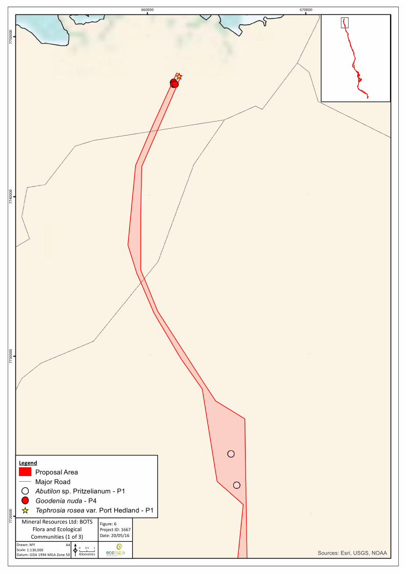
Sources: Esri, USGS, NOAA
660000 67000077
2000
077
3000
077
4000
077
5000
0
Drawn: MYScale:Datum: GDA 1994 MGA Zone 50
Figure: 6Project ID: 1667Date: 20/05/16
0 0.5 1Kilometres
Mineral Resources Ltd: BOTSFlora and Ecological
Communities (1 of 3)1:130,000
A4
K
LegendProposal AreaMajor RoadAbutilon sp. Pritzelianum - P1Goodenia nuda - P4
_̂ Tephrosia rosea var. Port Hedland - P1
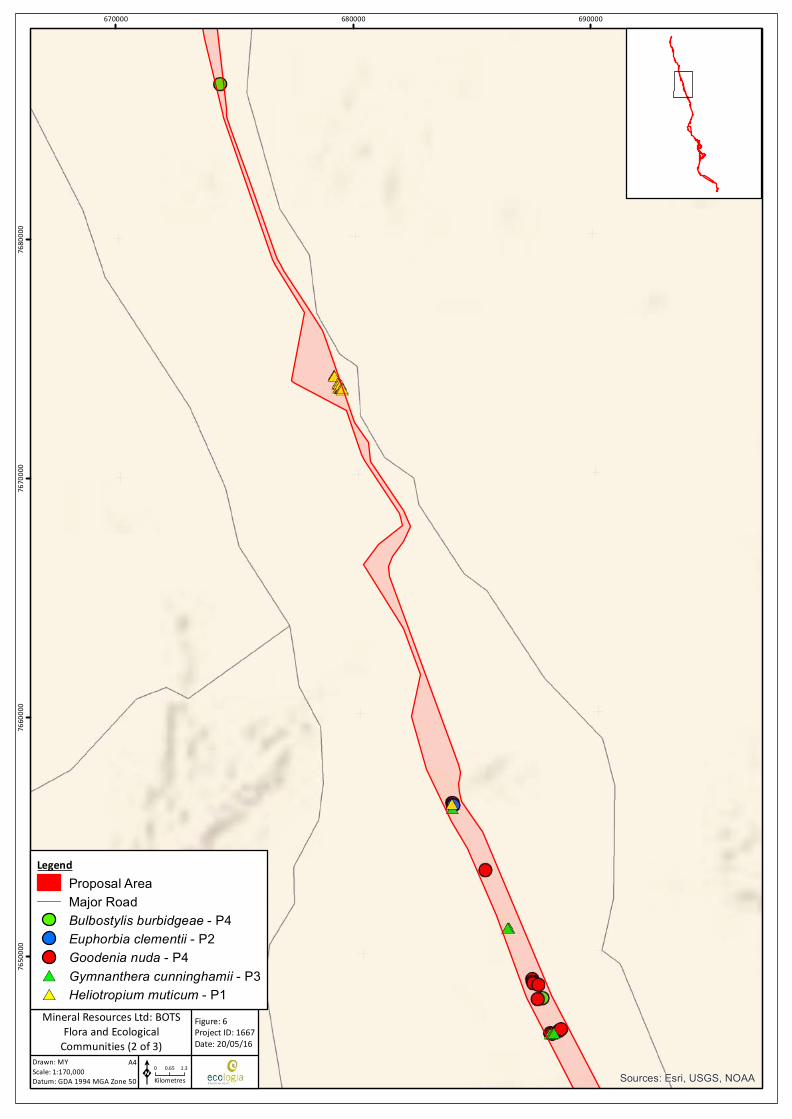
Sources: Esri, USGS, NOAA
670000 680000 69000076
5000
076
6000
076
7000
076
8000
0
Drawn: MYScale:Datum: GDA 1994 MGA Zone 50
Figure: 6Project ID: 1667Date: 20/05/16
0 0.65 1.3Kilometres
Mineral Resources Ltd: BOTSFlora and Ecological
Communities (2 of 3)1:170,000
A4
K
LegendProposal AreaMajor RoadBulbostylis burbidgeae - P4Euphorbia clementii - P2Goodenia nuda - P4
#* Gymnanthera cunninghamii - P3#* Heliotropium muticum - P1
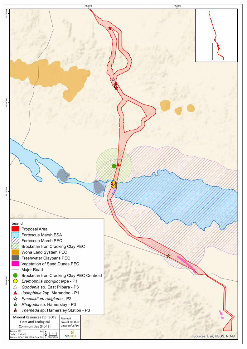
Sources: Esri, USGS, NOAA
700000 72500075
0000
075
2500
075
5000
075
7500
0
Drawn: MYScale:Datum: GDA 1994 MGA Zone 50
Figure: 6Project ID: 1667Date: 20/05/16
0 1 2Kilometres
Mineral Resources Ltd: BOTSFlora and Ecological
Communities (3 of 3)1:330,000
A4
K
LegendProposal AreaFortescue Marsh ESAFortescue Marsh PECBrockman Iron Cracking Clay PECWona Land System PECFreshwater Claypans PECVegetation of Sand Dunes PECMajor RoadBrockman Iron Cracking Clay PEC CentroidEremophila spongiocarpa - P1
#* Goodenia sp. East Pilbara - P3#* Josephinia ?sp. Marandoo - P1_̂ Paspalidium retiglume - P2_̂ Rhagodia sp. Hamersley - P3_̂ Themeda sp. Hamersley Station - P3
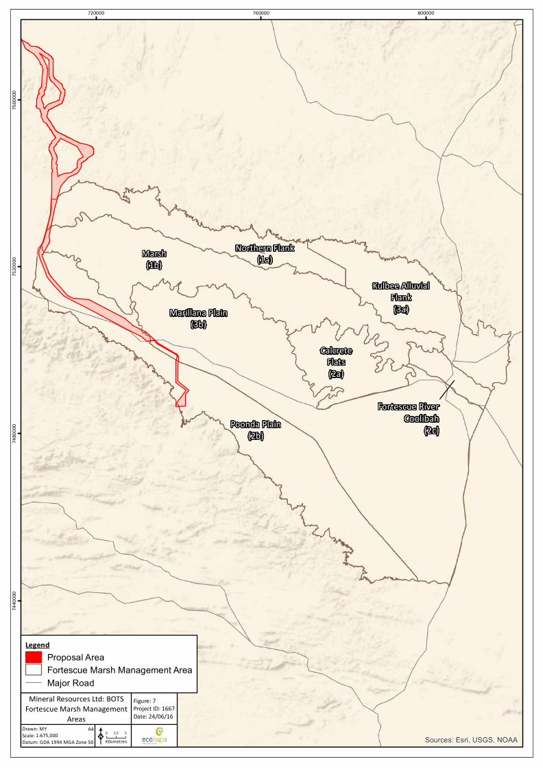
Marsh(1b)
Marillana Plain(3b)
Poonda Plain(2b)
Northern Flank(1a)
Kulbee AlluvialFlank(3a)
CalcreteFlats(2a)
Fortescue RiverCoolibah
(2c)
Sources: Esri, USGS, NOAA
720000 760000 80000074
4000
074
8000
075
2000
075
6000
0
Drawn: MYScale:Datum: GDA 1994 MGA Zone 50
Figure: 7Project ID: 1667Date: 24/06/16
0 2.5 5Kilometres
Mineral Resources Ltd: BOTSFortescue Marsh Management
Areas1:675,000
A4
K
LegendProposal AreaFortescue Marsh Management AreaMajor Road
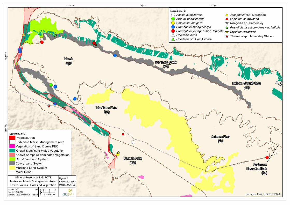
Marsh(1b)
Marillana Plain(3b)
Poonda Plain(2b)
Northern Flank(1a)
Kulbee Alluvial Flank(3a)
Calcrete Flats(2a)
FortescueRiver Coolibah
(2c)
Sources: Esri, USGS, NOAA
725000 750000 77500075
0000
075
2500
0
Drawn: MYScale:Datum: GDA 1994 MGA Zone 50
Figure: 8Project ID: 1667Date: 24/06/16
K0 2 4Kilometres
Mineral Resources Ltd: BOTSFortescue Marsh Management AreasEnviro. Values - Flora and Vegetation
1:340,000A4
Legend (1 of 2)Proposal AreaFortescue Marsh Management AreaVegetation of Sand Dunes PECKnown Significant Mulga VegetationKnown Samphire-dominated VegetationChristmas Land SystemCowra Land SystemMarillana Land SystemMajor Road
Legend (2 of 2)!( Acacia subtiliformis!( Atriplex flabelliformis!( Calotis squamigera!( Eremophila spongiocarpa!( Eremophila youngii subsp. lepidota#* Goodenia nuda#* Goodenia sp. East Pilbara
#* Josephinia ?sp. Marandoo#* Lepidium catapycnon_̂ Rhagodia sp. Hamersley_̂ Rostellularia adscendens var. latifolia_̂ Stylidium weeliwolli_̂ Themeda sp. Hamersley Station
Pilbara Bulk Ore Transportation System Project | Environmental Review Document
ENV-TS-RP-0049_RevB API Environmental Review Document Page | 66
6.2.3. Proposed Management (Mitigation)
Design Considerations
The design of the BOTS Proposal and infrastructure allows for avoidance of impacts to flora and vegetation. The following design considerations are relevant to this environmental factor:
• The Proposal Area is located within an established infrastructure corridor for the majority of the route.
• The BOTS infrastructure largely follows natural ground contours, reducing the need for broad-scale clearing and landform impacts to undertake levelling works that would normally be required for other types of linear infrastructure.
• Traditional railway systems typically involve disturbances in the order of 15-19 ha/km. The disturbance associated with the BOTS Proposal is significantly less at approximately 6 ha/km.
• A relatively wide Proposal Area has been selected in order to allow MRL to avoid both technically unsuitable areas and areas of significant environmental value during the selection of the final alignment.
• The elevated structures have minimal interference on surface water flows. This protects sheet-flow dependent vegetation from sheet-flow shadowing effects commonly experienced with the development of traditional linear infrastructure.
Management Measures
MRL will adopt the following mitigation and management measures to minimise impacts to flora and vegetation:
• MRL’s Environmental Management Plan (MRL-EN-PLN-0001) will be implemented. Specific management measures relating to minimising impacts of the Proposal on flora and vegetation include:
o MRL will only remove flora and vegetation where it has approval to do so;
o MRL will also adhere to any conditions placed on approvals to clear, including special protection for plants with high conservation values;
o MRL will prevent the introduction and / or spread of weeds in areas in which it operates by using a Weed Hygiene system to prevent transfer of weed seeds through movement of earthmoving equipment or weed-affected soils;
o MRL will manage to prevent potential indirect impacts on flora and vegetation, such as dust on foliage or saline water spills that affect vegetation
• Disturbance will be limited to the minimum area required for the safe and effective construction and operation of the Proposal.
• Disturbance will be undertaken in accordance with MRL’s Site Disturbance Permit Procedure (MRL-EN-PRO-0005) to prevent unauthorised clearing.
• Off-road driving will be prohibited.
• Areas cleared during construction and not required for ongoing operation of the BOTS will be rehabilitated.
• Groundwater abstraction will be minimised and existing bores will be used where possible. If new bores are required, areas of high environmental significance (ie PECs and potential groundwater-dependent vegetation communities) will be avoided where possible.
• Topsoil and bulk vegetation removed during construction will be appropriately stockpiled for use in rehabilitation activities.
Pilbara Bulk Ore Transportation System Project | Environmental Review Document
ENV-TS-RP-0049_RevB API Environmental Review Document Page | 67
• Vehicle and equipment hygiene practices will be undertaken in accordance with MRL’s Weed Hygiene and Control Procedure (MRL-EN-PRO-0007) and DPaW’s procedures to avoid the introduction and/or spread of weed species. Specific management measures relating to minimising the impacts of the Proposal from weeds on flora and vegetation include:
o A requirement for all employees and contractors to participate in the site induction, which will provide an awareness of weeds, including risk species, and an overview of the weed hygiene process;
o Employees and contractors who are involved in movement or operation of earthworks equipment, off road vehicles, and land clearing will be specifically trained in weed hygiene procedures and documentation;
o Training or technical assistance for site personnel to be able to recognise locally-occurring weed species; and
o Tool box talks will be presented from time to time to refresh employees and contractors on weed hygiene procedures.
• MRL will implement the Bushfire Management Work Instruction (MRL-TS-WIN-0005) which incorporates measures to prevent and control bushfires, including:
o All vehicles will carry firefighting equipment
o Smoking will be restricted to approved areas only
o Vehicles will be parked on cleared areas as to prevent possible ignition of vegetation.
In addition to the management measures listed above, strategies will be implemented consistent with the protection of the environmental values of the Fortescue Marsh Management Area outlined in EPA (2013) (Table 13).
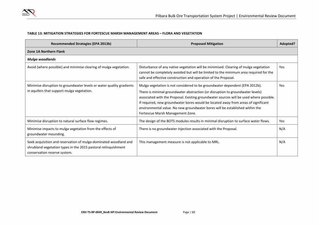
Pilbara Bulk Ore Transportation System Project | Environmental Review Document
ENV-TS-RP-0049_RevB API Environmental Review Document Page | 68
TABLE 13: MITIGATION STRATEGIES FOR FORTESCUE MARSH MANAGEMENT AREAS – FLORA AND VEGETATION
Recommended Strategies (EPA 2013b) Proposed Mitigation Adopted?
Zone 1A Northern Flank
Mulga woodlands
Avoid (where possible) and minimise clearing of mulga vegetation. Disturbance of any native vegetation will be minimised. Clearing of mulga vegetation cannot be completely avoided but will be limited to the minimum area required for the safe and effective construction and operation of the Proposal.
Yes
Minimise disruption to groundwater levels or water quality gradients in aquifers that support mulga vegetation.
Mulga vegetation is not considered to be groundwater dependent (EPA 2012b).
There is minimal groundwater abstraction (or disruption to groundwater levels) associated with the Proposal. Existing groundwater sources will be used where possible. If required, new groundwater bores would be located away from areas of significant environmental value. No new groundwater bores will be established within the Fortescue Marsh Management Zone.
Yes
Minimise disruption to natural surface flow regimes. The design of the BOTS modules results in minimal disruption to surface water flows. Yes
Minimise impacts to mulga vegetation from the effects of groundwater mounding.
There is no groundwater injection associated with the Proposal. N/A
Seek acquisition and reservation of mulga-dominated woodland and shrubland vegetation types in the 2015 pastoral relinquishment conservation reserve system.
This management measure is not applicable to MRL. N/A
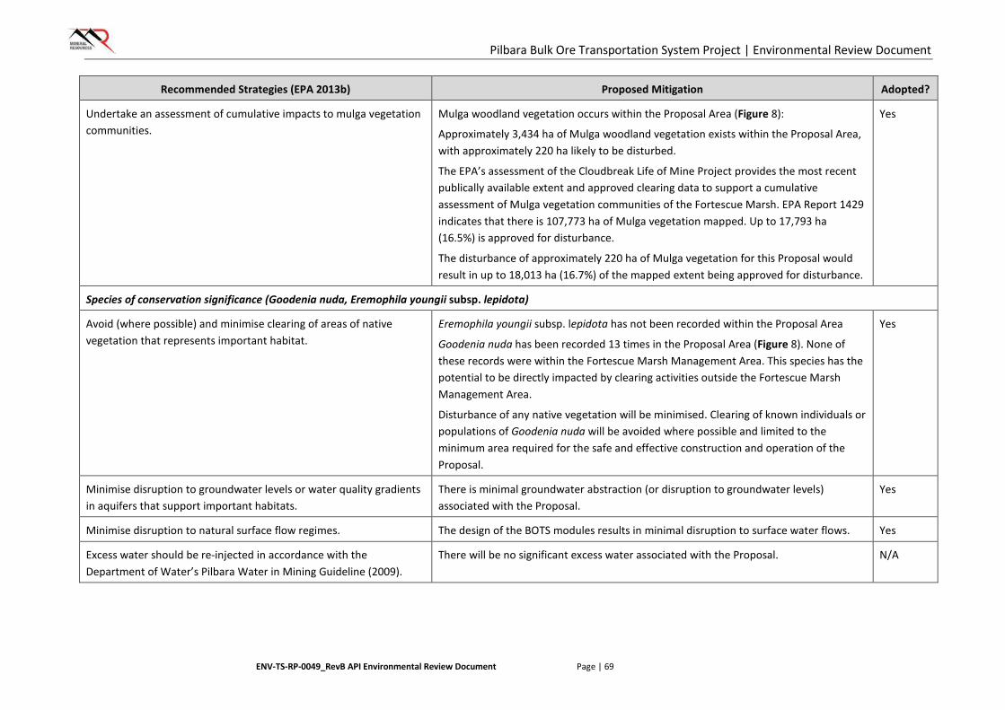
Pilbara Bulk Ore Transportation System Project | Environmental Review Document
ENV-TS-RP-0049_RevB API Environmental Review Document Page | 69
Recommended Strategies (EPA 2013b) Proposed Mitigation Adopted?
Undertake an assessment of cumulative impacts to mulga vegetation communities.
Mulga woodland vegetation occurs within the Proposal Area (Figure 8):
Approximately 3,434 ha of Mulga woodland vegetation exists within the Proposal Area, with approximately 220 ha likely to be disturbed.
The EPA’s assessment of the Cloudbreak Life of Mine Project provides the most recent publically available extent and approved clearing data to support a cumulative assessment of Mulga vegetation communities of the Fortescue Marsh. EPA Report 1429 indicates that there is 107,773 ha of Mulga vegetation mapped. Up to 17,793 ha (16.5%) is approved for disturbance.
The disturbance of approximately 220 ha of Mulga vegetation for this Proposal would result in up to 18,013 ha (16.7%) of the mapped extent being approved for disturbance.
Yes
Species of conservation significance (Goodenia nuda, Eremophila youngii subsp. lepidota)
Avoid (where possible) and minimise clearing of areas of native vegetation that represents important habitat.
Eremophila youngii subsp. lepidota has not been recorded within the Proposal Area
Goodenia nuda has been recorded 13 times in the Proposal Area (Figure 8). None of these records were within the Fortescue Marsh Management Area. This species has the potential to be directly impacted by clearing activities outside the Fortescue Marsh Management Area.
Disturbance of any native vegetation will be minimised. Clearing of known individuals or populations of Goodenia nuda will be avoided where possible and limited to the minimum area required for the safe and effective construction and operation of the Proposal.
Yes
Minimise disruption to groundwater levels or water quality gradients in aquifers that support important habitats.
There is minimal groundwater abstraction (or disruption to groundwater levels) associated with the Proposal.
Yes
Minimise disruption to natural surface flow regimes. The design of the BOTS modules results in minimal disruption to surface water flows. Yes
Excess water should be re-injected in accordance with the Department of Water’s Pilbara Water in Mining Guideline (2009).
There will be no significant excess water associated with the Proposal. N/A

Pilbara Bulk Ore Transportation System Project | Environmental Review Document
ENV-TS-RP-0049_RevB API Environmental Review Document Page | 70
Recommended Strategies (EPA 2013b) Proposed Mitigation Adopted?
Apply an independent peer review of hydrological models to support water and environmental assessments. The review should be consistent with National Water Commission’s Australian Groundwater Modelling Guidelines (2012).
No groundwater modelling has been undertaken as the Proposal does not involve significant abstraction or injection of groundwater.
N/A
Undertake surveys to identify and map distributions of conservation significant species.
As outlined in Section 5, extensive surveys have been undertaken over the Proposal Area. Conservation significant species have been mapped on
Figure 6. Goodenia nuda is the only conservation significant species associated with this zone (EPA 2013b) to be recorded in the Proposal Area, however none of these records were from within the Fortescue Marsh Management Area.
Yes
Land systems
Reinstate natural landforms following mining where possible in accordance with the EPA/DMP’s Guidelines for Mine Closure Plans.
There is no mining associated with the Proposal. N/A
Avoid (where possible) and minimise clearing of native vegetation. Disturbance will be limited to the minimum area required for the safe and effective construction and operation of the Proposal. If required, any clearing in the Cowra and Christmas land systems will be limited to the minimum area required for the safe and effective construction and operation of the Proposal.
Yes
Minimise disruption to natural surface flow regimes through the appropriate placement of infrastructure.
The design of the BOTS modules will result in minimal disruption to surface water flows. Yes
Minimise disruption to groundwater levels or water quality gradients in aquifers that support groundwater dependant ecosystems and riparian vegetation.
There is minimal groundwater abstraction (or disruption to groundwater levels) associated with the Proposal.
Yes
Excess water should be reinjected in accordance with the Department of Water’s Pilbara Water in Mining Guideline (2009).
There will be no significant excess water associated with the Proposal. N/A
Restrict to campaign discharges and manage surface discharge of extracted water in riparian habitats.
There will be no significant excess water associated with the Proposal. N/A
Add areas supporting Cowra and Christmas land systems to the conservation reserve system.
This management measure is not applicable to MRL. N/A
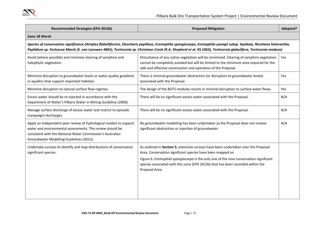
Pilbara Bulk Ore Transportation System Project | Environmental Review Document
ENV-TS-RP-0049_RevB API Environmental Review Document Page | 71
Recommended Strategies (EPA 2013b) Proposed Mitigation Adopted?
Zone 1B Marsh
Species of conservation significance (Atriplex flabelliformis, Eleocharis papillosa, Eremophila spongiocarpa, Eremophila youngii subsp. lepidota, Nicotiana heterantha, Peplidium sp. Fortescue Marsh (S. van Leeuwen 4865), Tecticornia sp. Christmas Creek (K.A. Shepherd et al. KS 1063), Tecticornia globulifera, Tecticornia medusa)
Avoid (where possible) and minimise clearing of samphire and halophytic vegetation.
Disturbance of any native vegetation will be minimised. Clearing of samphire vegetation cannot be completely avoided but will be limited to the minimum area required for the safe and effective construction and operation of the Proposal.
Yes
Minimise disruption to groundwater levels or water quality gradients in aquifers that support important habitats.
There is minimal groundwater abstraction (or disruption to groundwater levels) associated with the Proposal.
Yes
Minimise disruption to natural surface flow regimes. The design of the BOTS modules results in minimal disruption to surface water flows. Yes
Excess water should be re-injected in accordance with the Department of Water’s Pilbara Water in Mining Guideline (2009).
There will be no significant excess water associated with the Proposal. N/A
Manage surface discharge of excess water and restrict to episodic (campaign) discharges.
There will be no significant excess water associated with the Proposal. N/A
Apply an independent peer review of hydrological models to support water and environmental assessments. The review should be consistent with the National Water Commission’s Australian Groundwater Modelling Guidelines (2012).
No groundwater modelling has been undertaken as the Proposal does not involve significant abstraction or injection of groundwater.
N/A
Undertake surveys to identify and map distributions of conservation significant species.
As outlined in Section 5, extensive surveys have been undertaken over the Proposal Area. Conservation significant species have been mapped on
Figure 6. Eremophila spongiocarpa is the only one of the nine conservation significant species associated with this zone (EPA 2013b) that has been recorded within the Proposal Area.
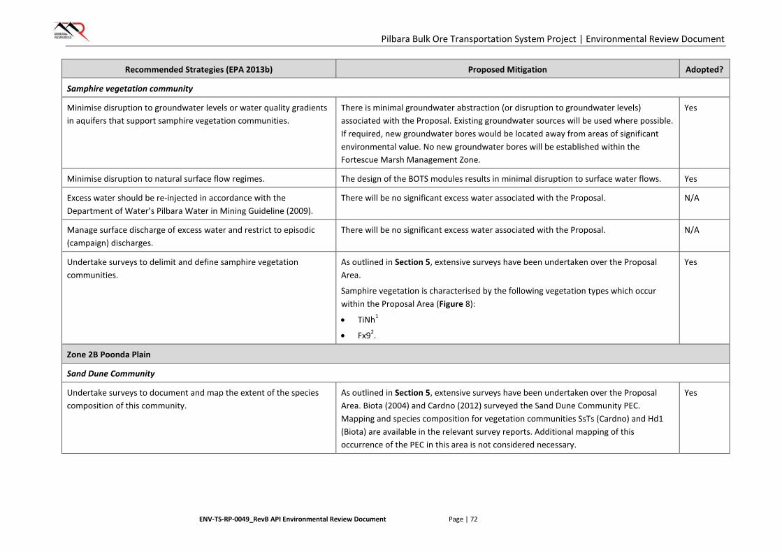
Pilbara Bulk Ore Transportation System Project | Environmental Review Document
ENV-TS-RP-0049_RevB API Environmental Review Document Page | 72
Recommended Strategies (EPA 2013b) Proposed Mitigation Adopted?
Samphire vegetation community
Minimise disruption to groundwater levels or water quality gradients in aquifers that support samphire vegetation communities.
There is minimal groundwater abstraction (or disruption to groundwater levels) associated with the Proposal. Existing groundwater sources will be used where possible. If required, new groundwater bores would be located away from areas of significant environmental value. No new groundwater bores will be established within the Fortescue Marsh Management Zone.
Yes
Minimise disruption to natural surface flow regimes. The design of the BOTS modules results in minimal disruption to surface water flows. Yes
Excess water should be re-injected in accordance with the Department of Water’s Pilbara Water in Mining Guideline (2009).
There will be no significant excess water associated with the Proposal. N/A
Manage surface discharge of excess water and restrict to episodic (campaign) discharges.
There will be no significant excess water associated with the Proposal. N/A
Undertake surveys to delimit and define samphire vegetation communities.
As outlined in Section 5, extensive surveys have been undertaken over the Proposal Area.
Samphire vegetation is characterised by the following vegetation types which occur within the Proposal Area (Figure 8):
• TiNh1
• Fx92.
Yes
Zone 2B Poonda Plain
Sand Dune Community
Undertake surveys to document and map the extent of the species composition of this community.
As outlined in Section 5, extensive surveys have been undertaken over the Proposal Area. Biota (2004) and Cardno (2012) surveyed the Sand Dune Community PEC. Mapping and species composition for vegetation communities SsTs (Cardno) and Hd1 (Biota) are available in the relevant survey reports. Additional mapping of this occurrence of the PEC in this area is not considered necessary.
Yes

Pilbara Bulk Ore Transportation System Project | Environmental Review Document
ENV-TS-RP-0049_RevB API Environmental Review Document Page | 73
Recommended Strategies (EPA 2013b) Proposed Mitigation Adopted?
Minimise ground disturbance activities to limit opportunities for weed invasion.
Clearing in and adjacent to the Sand Dune Community PEC will be avoided where possible. If required, any such clearing will be limited to the minimum area required for the safe and effective construction and operation of the Proposal.
Weed hygiene practices will be undertaken to prevent the introduction or spread of weed species.
Yes
Minimise clearing of native vegetation and abstraction of basic raw material (sand) for construction purposes.
Clearing in and adjacent to the Sand Dune Community PEC will be avoided where possible. If required, any such clearing will be limited to the minimum area required for the safe and effective construction and operation of the Proposal.
Limited raw material is required to support the construction of the BOTS infrastructure, due to the design of the modules.
Yes
Minimise the discharge of surface water to the Poonda Plain that supports sand dune communities.
There will be no significant excess water associated with the Proposal. N/A
Species of conservation significance (Themeda sp. Hamersley Station (M.E. Trudgen 11431)
Manage surface discharge of excess water to riparian communities and restrict to episodic (campaign) discharges.
There will be no significant excess water associated with the Proposal. N/A
Minimise clearing of native vegetation. Disturbance of any native vegetation will be minimised. Yes
Minimise disturbance to habitats supporting conservation significant species.
Themeda sp. Hamersley Station has been recorded five times in the Proposal Area.
Disturbance of any native vegetation will be minimised. Clearing of known individuals or populations of Themeda sp. Hamersley Station will be avoided where possible and limited to the minimum area required for the safe and effective construction and operation of the Proposal.
Yes
Excess water should be re-injected in accordance with the Department of Water’s Pilbara Water in Mining Guideline (2009).
There will be no significant excess water associated with the Proposal. N/A
Apply an independent peer review of hydrological models to support water and environmental assessments. The review should be consistent with the National Water Commission’s Australian Groundwater Modelling Guidelines (2012).
No groundwater modelling has been undertaken as the Proposal does not involve significant abstraction or injection of groundwater.
N/A
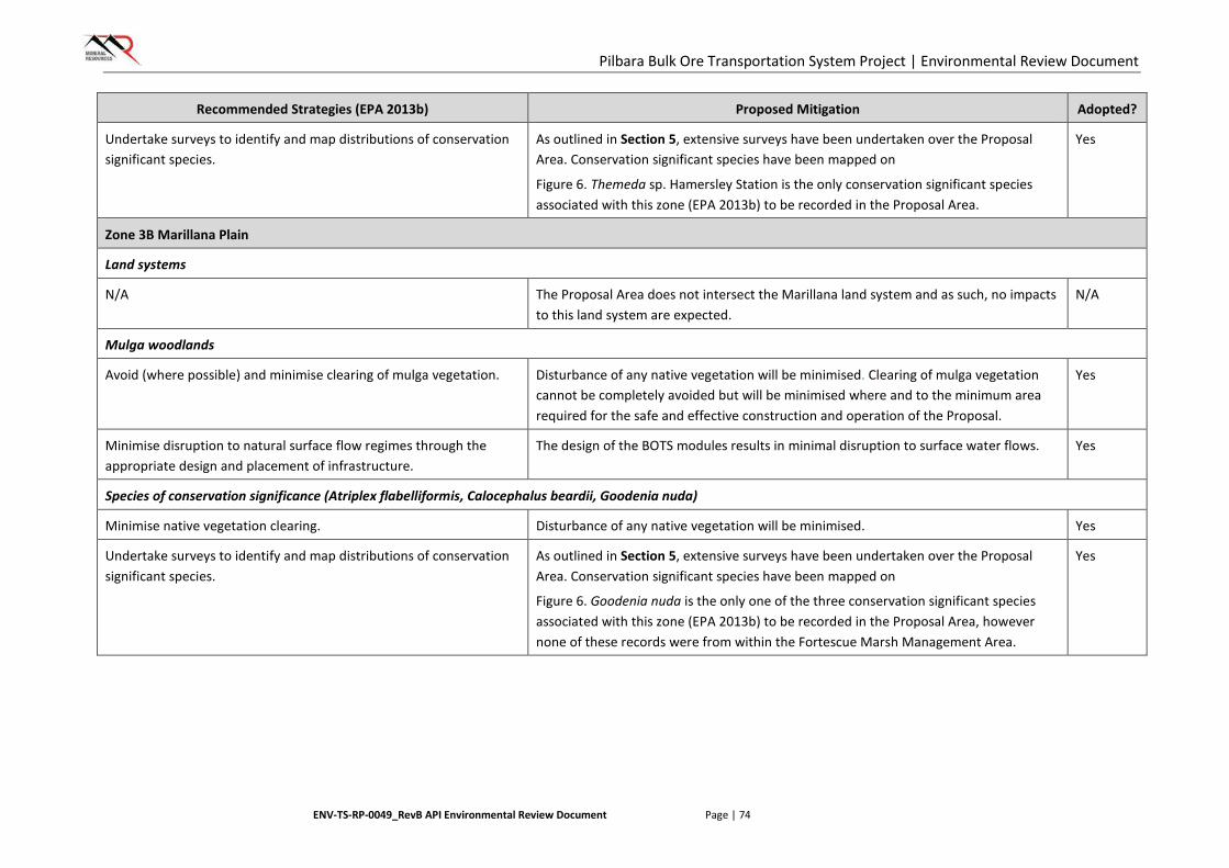
Pilbara Bulk Ore Transportation System Project | Environmental Review Document
ENV-TS-RP-0049_RevB API Environmental Review Document Page | 74
Recommended Strategies (EPA 2013b) Proposed Mitigation Adopted?
Undertake surveys to identify and map distributions of conservation significant species.
As outlined in Section 5, extensive surveys have been undertaken over the Proposal Area. Conservation significant species have been mapped on
Figure 6. Themeda sp. Hamersley Station is the only conservation significant species associated with this zone (EPA 2013b) to be recorded in the Proposal Area.
Yes
Zone 3B Marillana Plain
Land systems
N/A The Proposal Area does not intersect the Marillana land system and as such, no impacts to this land system are expected.
N/A
Mulga woodlands
Avoid (where possible) and minimise clearing of mulga vegetation. Disturbance of any native vegetation will be minimised. Clearing of mulga vegetation cannot be completely avoided but will be minimised where and to the minimum area required for the safe and effective construction and operation of the Proposal.
Yes
Minimise disruption to natural surface flow regimes through the appropriate design and placement of infrastructure.
The design of the BOTS modules results in minimal disruption to surface water flows. Yes
Species of conservation significance (Atriplex flabelliformis, Calocephalus beardii, Goodenia nuda)
Minimise native vegetation clearing. Disturbance of any native vegetation will be minimised. Yes
Undertake surveys to identify and map distributions of conservation significant species.
As outlined in Section 5, extensive surveys have been undertaken over the Proposal Area. Conservation significant species have been mapped on
Figure 6. Goodenia nuda is the only one of the three conservation significant species associated with this zone (EPA 2013b) to be recorded in the Proposal Area, however none of these records were from within the Fortescue Marsh Management Area.
Yes
Pilbara Bulk Ore Transportation System Project | Environmental Review Document
ENV-TS-RP-0049_RevB API Environmental Review Document Page | 75
6.2.4. Regulation
Primary regulation of impacts to flora and vegetation will be undertaken through the Ministerial Statement issued for the Proposal under Part IV of the EP Act. The Ministerial Statement will likely incorporate a limit of ground disturbance for the Proposal (ha), to be undertaken within the Proposal Area. Limits on disturbance within PECs may also apply. Offsets are expected to be required for clearing of vegetation in Good to Excellent condition.
Part V of the EP Act and the Environmental Protection (Unauthorised Clearing) Regulations 2004 provide regulation for any unauthorised clearing that may occur outside of the approved areas.
Groundwater abstraction will be regulated through 26D (Licence to Construct a Well) and 5C (Licence to take Water) approvals under the Rights in Water and Irrigation Act 1914, managed by the Department of Water. Interference with watercourses will be regulated through s17 (Licence to interfere with Bed and Banks) approvals under the Rights in Water and Irrigation Act 1914, managed by the Department of Water.
6.2.5. Outcome and Assessment against EPA Objective
The outcomes presented in this section have been determined using the best information available. As it is intended that the Proposal will allow some flexibility through the design phase, these outcomes have allowed for a degree of conservatism where impacts cannot be accurately defined.
After the application of management measures, the proposal is expected to result in the removal of up to 3000 ha of native vegetation of which approximately 1000 ha will be progressively rehabilitated during construction. The Proposal is not expected to alter the conservation status or viability of any Priority taxa or PECs known to occur in the Proposal Area, or have a significant effect on the representation of species or vegetation communities at a local or regional level. No TEC’s or Threatened (DRF) flora will be affected by the Proposal as none are located within the Development Envelope. A conservative estimate is that up to 82.6% of vegetation in Good to Excellent condition within the Development Envelope will disturbed as a result of the Proposal. Up to 30 ha of the Fortescue Marsh PEC and 6 ha of vegetation representative of the Sand Dunes PEC are expected to be impacted.
Thirteen Priority listed Flora have been recorded within the Proposal Area and despite the implementation of the listed management measures it may not be possible to avoid impacts to all plants or populations. It may be assumed that there will be other Priority Flora individuals or populations within the Development Envelope that have not yet been located given that it is not possible to locate every plant over such a large area., however prior to the commencement of construction activities, a targeted flora and vegetation survey of the final Disturbance Envelope alignment will be conducted. The Proposal is however not expected to significantly impact or alter the conservation status of any Priority Flora species.
The residual, unavoidable impact to up to 2,479 ha of Good to Excellent vegetation will be addressed via the provision of an offsets in accordance with EPA requirements and as outlined in Section 6.6. Taking into consideration the application of these offsets however, MRL expects that the Proposal can be implemented to meet the EPA objective for this factor.
6.3. Terrestrial Fauna
6.3.1. Context
EPA Objective
The EPA’s environmental objective for terrestrial fauna is:
To maintain representation, diversity, viability and ecological function at the species, population and assemblage level.
Pilbara Bulk Ore Transportation System Project | Environmental Review Document
ENV-TS-RP-0049_RevB API Environmental Review Document Page | 76
Policy Context
The BOTS Proposal Area intersects the Fortescue Marsh Management Area. Avoidance of this area was considered during project planning but was found not to be feasible. Management of this area is undertaken in accordance with EPA Report 1484, Environmental and Water assessments relating to mining and mining-related activities in the Fortescue Marsh management area (EPA 2013b). In addition to this guideline, the following policy and guidance documents are relevant to the assessment of impacts to terrestrial fauna as a result of the BOTS Proposal:
• EAG 14 – Preparation of an API-A Environmental Review Document, January 2015 (EPA 2015a)
• Position Statement No. 3 - Terrestrial biological surveys as an element of biodiversity protection, March 2002 (EPA 2002)
• Guidance Statement No. 56 – Terrestrial fauna surveys for Environmental Impact assessment in WA, June 2004 (EPA 2004b)
• Technical Guide – Terrestrial Vertebrate Fauna Surveys for Environmental Impact Assessment, September 2010 (EPA & DEC 2010).
Relevant Baseline Information
Nine terrestrial fauna surveys have been conducted within the BOTS Proposal area (Table 7). These surveys cover the majority of the BOTS Proposal Area. The outcomes and results of these surveys are summarised below.
• Database searches identified a total of 60 conservation significant taxa that have been previously recorded within the vicinity of the Proposal Area, including ten Threatened species.
• Terrestrial fauna surveys recorded three terrestrial fauna species listed as Threatened under the EPBC Act within the BOTS Proposal Area (Figure 9):
o Northern Quoll (Dasyurus hallucatus) (Endangered)
o Greater Bilby (Vulnerable)
o Pilbara Leaf-nosed Bat (Vulnerable).
• Terrestrial fauna surveys recorded four species listed as conservation significant under the WC Act within the BOTS Proposal Area (Figure 9):
o the Schedule 3 taxon Ghost Bat (Macroderma gigas) (Vulnerable)
o the P1 species Black-lined Ctenotus (Ctenotus nigrilineatus)
o P4 species Brush-tailed Mulgara (Dasycercus blythi) and Western Pebble-mound Mouse (Pseudomys chapmani).
• Two listed Migratory species were recorded within the Proposal Area (Figure 9):
o Fork-tailed Swift (Apus pacificus)
o Rainbow Bee-eater (Merops ornatus).
• A small amount of critical habitat for the Northern Quoll, comprising granite boulder fields and outcrops, is present in the northern portions of the Proposal Area.
6.3.2. Potential Significant Impacts without Mitigation
Potential impacts to terrestrial fauna as a result of the construction and operation of the BOTS include:
• clearing of up to 3,000 ha of native vegetation (fauna habitat)
• potential fragmentation of fauna habitats

Pilbara Bulk Ore Transportation System Project | Environmental Review Document
ENV-TS-RP-0049_RevB API Environmental Review Document Page | 77
• changes to quality of fauna habitats
• fauna mortality from vehicle collisions
• physical presence of infrastructure blocking fauna movement
• introduction of pests
• increased risk of fire ignition
• trenching.
In addition to the potential impacts listed above, potential impacts specifically relating to the terrestrial fauna environmental values of the Fortescue Marsh Management Area are summarised in Table 14. Figure 10 provides a spatial representation of relevant environmental values in the Fortescue Marsh Management Area zones.
TABLE 14: POTENTIAL IMPACTS TO FORTESCUE MARSH MANAGEMENT AREAS – TERRESTRIAL FAUNA
Fortescue Marsh Management Zone
Relevant Values Potential Impacts
1A Northern Flank Species of conservation significance (Night Parrot EN/S1, Northern Quoll EN/S2, Bilby VU/S3, Peregrine Falcon S7, Australian Bustard, Bush Stone-curlew)
Please refer to specific information below regarding the Night Parrot and Northern Quoll.
The Bilby has been recorded once within the Proposal Area (Figure 10) and has the potential to be directly or indirectly impacted by the construction and operation of the BOTS.
The Peregrine Falcon has not been recorded within the Proposal Area. Due to its widespread distribution, high mobility and a lack of preferred breeding habitat (cliff lines) in the Proposal Area, no impacts to this species are expected.
The Australian Bustard and Bush Stone-curlew are no longer listed as conservation significant species (DPaW 2016).
Night Parrot and habitat The Night Parrot was recorded on a single occasion in the Fortescue Marsh area more than eleven years ago, in April 2005 at Minga Well. Despite significant effort in subsequent survey work, neither the species, nor evidence of its presence, has been recorded since. It has never been recorded within the Proposal Area or its immediate vicinity, and the BOTS Proposal Area within the FMMAs follows existing infrastructure corridors previously approved and currently operational. The presence of this species in the Proposal Area is therefore considered highly unlikely, and as such no significant impacts to this species are expected to occur within the Fortescue Marsh Management Area.
Northern Quoll and habitat The Northern Quoll has been recorded on nine occasions during surveys within the Proposal Area (Figure 9). None of these records were from within the Fortescue Marsh Management Area (Figure 10). Critical habitat for this species is considered to be rocky escarpments, gorges and breakaways. These habitat types do not occur within the Proposal Area within the Fortescue Marsh Management
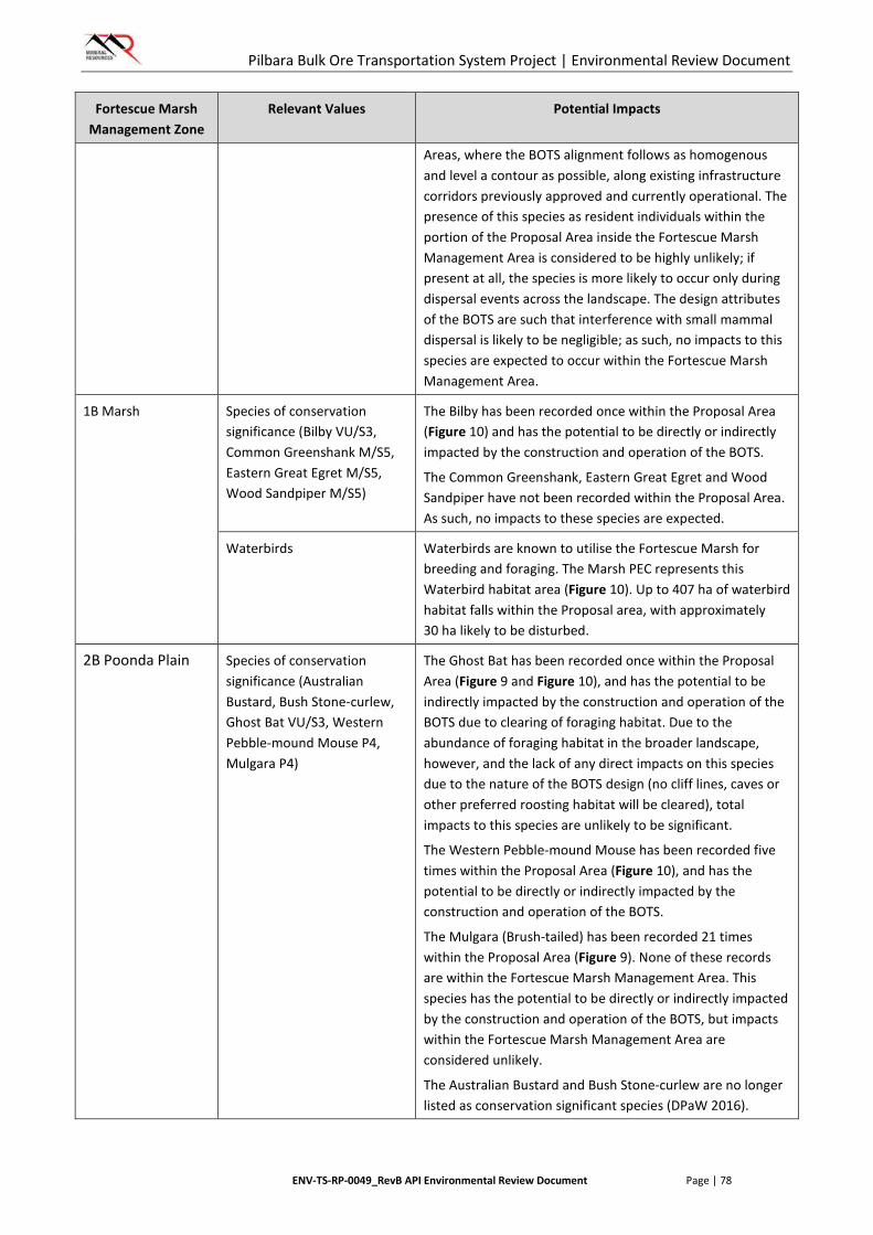
Pilbara Bulk Ore Transportation System Project | Environmental Review Document
ENV-TS-RP-0049_RevB API Environmental Review Document Page | 78
Fortescue Marsh Management Zone
Relevant Values Potential Impacts
Areas, where the BOTS alignment follows as homogenous and level a contour as possible, along existing infrastructure corridors previously approved and currently operational. The presence of this species as resident individuals within the portion of the Proposal Area inside the Fortescue Marsh Management Area is considered to be highly unlikely; if present at all, the species is more likely to occur only during dispersal events across the landscape. The design attributes of the BOTS are such that interference with small mammal dispersal is likely to be negligible; as such, no impacts to this species are expected to occur within the Fortescue Marsh Management Area.
1B Marsh Species of conservation significance (Bilby VU/S3, Common Greenshank M/S5, Eastern Great Egret M/S5, Wood Sandpiper M/S5)
The Bilby has been recorded once within the Proposal Area (Figure 10) and has the potential to be directly or indirectly impacted by the construction and operation of the BOTS.
The Common Greenshank, Eastern Great Egret and Wood Sandpiper have not been recorded within the Proposal Area. As such, no impacts to these species are expected.
Waterbirds Waterbirds are known to utilise the Fortescue Marsh for breeding and foraging. The Marsh PEC represents this Waterbird habitat area (Figure 10). Up to 407 ha of waterbird habitat falls within the Proposal area, with approximately 30 ha likely to be disturbed.
2B Poonda Plain Species of conservation significance (Australian Bustard, Bush Stone-curlew, Ghost Bat VU/S3, Western Pebble-mound Mouse P4, Mulgara P4)
The Ghost Bat has been recorded once within the Proposal Area (Figure 9 and Figure 10), and has the potential to be indirectly impacted by the construction and operation of the BOTS due to clearing of foraging habitat. Due to the abundance of foraging habitat in the broader landscape, however, and the lack of any direct impacts on this species due to the nature of the BOTS design (no cliff lines, caves or other preferred roosting habitat will be cleared), total impacts to this species are unlikely to be significant.
The Western Pebble-mound Mouse has been recorded five times within the Proposal Area (Figure 10), and has the potential to be directly or indirectly impacted by the construction and operation of the BOTS.
The Mulgara (Brush-tailed) has been recorded 21 times within the Proposal Area (Figure 9). None of these records are within the Fortescue Marsh Management Area. This species has the potential to be directly or indirectly impacted by the construction and operation of the BOTS, but impacts within the Fortescue Marsh Management Area are considered unlikely.
The Australian Bustard and Bush Stone-curlew are no longer listed as conservation significant species (DPaW 2016).
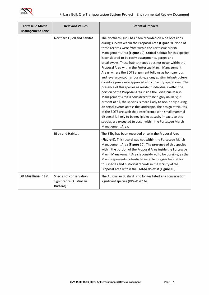
Pilbara Bulk Ore Transportation System Project | Environmental Review Document
ENV-TS-RP-0049_RevB API Environmental Review Document Page | 79
Fortescue Marsh Management Zone
Relevant Values Potential Impacts
Northern Quoll and habitat The Northern Quoll has been recorded on nine occasions during surveys within the Proposal Area (Figure 9). None of these records were from within the Fortescue Marsh Management Area (Figure 10). Critical habitat for this species is considered to be rocky escarpments, gorges and breakaways. These habitat types does not occur within the Proposal Area within the Fortescue Marsh Management Areas, where the BOTS alignment follows as homogenous and level a contour as possible, along existing infrastructure corridors previously approved and currently operational. The presence of this species as resident individuals within the portion of the Proposal Area inside the Fortescue Marsh Management Area is considered to be highly unlikely; if present at all, the species is more likely to occur only during dispersal events across the landscape. The design attributes of the BOTS are such that interference with small mammal dispersal is likely to be negligible; as such, impacts to this species are expected to occur within the Fortescue Marsh Management Area.
Bilby and Habitat The Bilby has been recorded once in the Proposal Area.
(Figure 9). This record was not within the Fortescue Marsh Management Area (Figure 10). The presence of this species within the portion of the Proposal Area inside the Fortescue Marsh Management Area is considered to be possible, as the Marsh represents potentially suitable foraging habitat for this species and historical records in the vicinity of the Proposal Area within the FMMA do exist (Figure 10).
3B Marillana Plain Species of conservation significance (Australian Bustard)
The Australian Bustard is no longer listed as a conservation significant species (DPaW 2016).
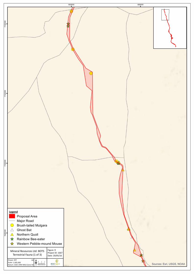
Sources: Esri, USGS, NOAA
660000 68000076
8000
077
0000
077
2000
077
4000
0
Drawn: MYScale:Datum: GDA 1994 MGA Zone 50
Figure: 9Project ID: 1667Date: 20/05/16
0 1 2Kilometres
Mineral Resources Ltd: BOTSTerrestrial Fauna (1 of 3)
1:285,000A4
K
LegendProposal AreaMajor Road
!( Brush-tailed Mulgara#* Ghost Bat#* Northern Quoll_̂ Rainbow Bee-eater_̂ Western Pebble-mound Mouse

Sources: Esri, USGS, NOAA
675000 690000 70500076
0500
076
2000
076
3500
076
5000
0
Drawn: MYScale:Datum: GDA 1994 MGA Zone 50
Figure: 9Project ID: 1667Date: 20/05/16
0 0.95 1.9Kilometres
Mineral Resources Ltd: BOTSTerrestrial Fauna (2 of 3)
1:230,000A4
K
LegendProposal AreaMajor Road
!( Black-lined Ctenotus!( Brush-tailed Mulgara#* Greater Bilby#* Northern Quoll_̂ Pilbara Leaf-nosed Bat_̂ Rainbow Bee-eater

Sources: Esri, USGS, NOAA
700000 720000 74000075
0000
075
2000
075
4000
075
6000
0
Drawn: MYScale:Datum: GDA 1994 MGA Zone 50
Figure: 9Project ID: 1667Date: 20/05/16
0 1 2Kilometres
Mineral Resources Ltd: BOTSTerrestrial Fauna (3 of 3)
1:295,000A4
K
LegendProposal AreaMajor Road
!( Fork-tailed Swift#* Northern Quoll_̂ Rainbow Bee-eater_̂ Western Pebble-mound Mouse
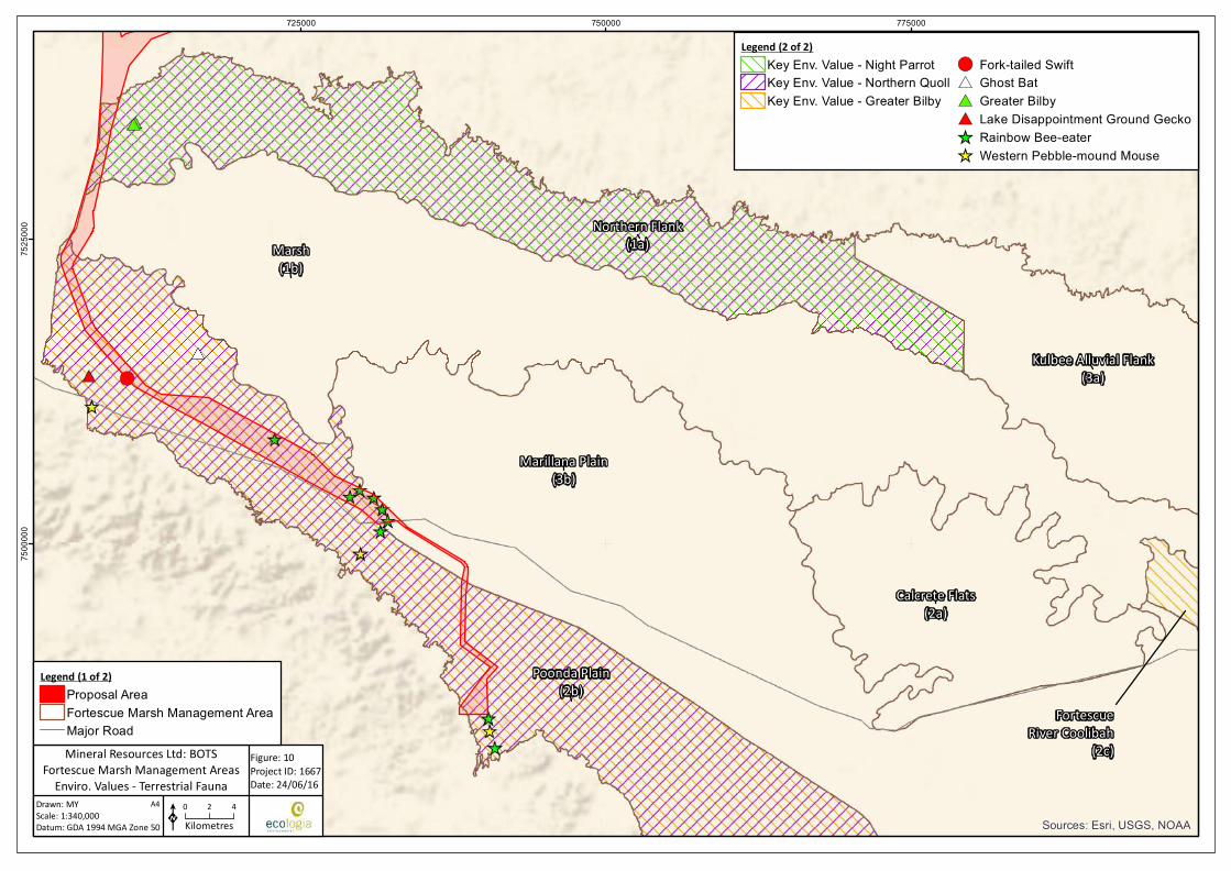
Marsh(1b)
Marillana Plain(3b)
Poonda Plain(2b)
Northern Flank(1a)
Kulbee Alluvial Flank(3a)
Calcrete Flats(2a)
FortescueRiver Coolibah
(2c)
Sources: Esri, USGS, NOAA
725000 750000 77500075
0000
075
2500
0
Drawn: MYScale:Datum: GDA 1994 MGA Zone 50
Figure: 10Project ID: 1667Date: 24/06/16
K0 2 4Kilometres
Mineral Resources Ltd: BOTSFortescue Marsh Management Areas
Enviro. Values - Terrestrial Fauna1:340,000
A4
Legend (1 of 2)Proposal AreaFortescue Marsh Management AreaMajor Road
Legend (2 of 2)Key Env. Value - Night ParrotKey Env. Value - Northern QuollKey Env. Value - Greater Bilby
!( Fork-tailed Swift#* Ghost Bat#* Greater Bilby#* Lake Disappointment Ground Gecko_̂ Rainbow Bee-eater_̂ Western Pebble-mound Mouse
Pilbara Bulk Ore Transportation System Project | Environmental Review Document
ENV-TS-RP-0049_RevB API Environmental Review Document Page | 84
6.3.3. Proposed Management (Mitigation)
Design Considerations
The design of the BOTS and associated infrastructure allows for avoidance of impacts to terrestrial fauna. The following design considerations are relevant to this environmental factor:
• The Proposal Area is located within an established, operational infrastructure corridor for the majority of the route.
• The BOTS infrastructure largely follows natural ground contours, reducing the need for broad-scale clearing to undertake levelling works that would normally be required for other types of linear infrastructure. Furthermore, the BOTS Proposal Area typically follows a homogenous, level route wherever possible, and avoids rugged, complex landscapes typically associated with higher species richness and greater presence of conservation significant species (e.g. outcrops, hills, clifflines, gorges and complex drainage systems).
• The elevated BOTS design with use of spaced substructures significantly reduces area of ground disturbance (ie removal of fauna habitat).
• Traditional railway systems typically involve disturbances in the order of 15-19 ha/km. The disturbance associated with the BOTS Proposal is significantly less at approximately 6 ha/km.
• A relatively wide Proposal Area has been selected in order to allow MRL to avoid both technically unsuitable areas and areas of significant environmental value during the selection of the final alignment.
• The elevated structures do not result in a physical barrier to the movement of most fauna species. This prevents social and genetic isolation of fauna and fragmentation of fauna habitats, which can be experienced with the development of traditional linear infrastructure.
Management Measures
MRL will adopt the following mitigation and management measures to minimise impacts to terrestrial fauna:
• MRL’s Environmental Management Plan (MRL-EN-PLN-0001) will be implemented. Specific management measures relating to minimising impacts of the Proposal on fauna include:
o MRL will only remove fauna habitat where it has approval to do so;
o MRL will also adhere to any conditions placed on approvals to clear, including protection of animals with high conservation values;
o MRL personnel and contractors will not feed or otherwise encourage feral animals and potential food sources, such as landfills, will be managed to ensure they cannot be utilised by feral animals; and
o MRL will manage fauna interaction with open trenches.
• MRL’s Fauna Management Procedure (MRL-EN-PRO-0001) will be implemented. Specific management measures relating to minimising impacts of the Proposal on fauna include:
o Where a risk to native fauna from trenching is identified, develop and implement a plan to manage potential impacts on fauna. Management measures include regular trench inspections and removal of animals, inspections immediately prior to backfill, ramps at either end of the trench and at points along the length of the trench, and deployment of relocatable temporary shelters for small animals;

Pilbara Bulk Ore Transportation System Project | Environmental Review Document
ENV-TS-RP-0049_RevB API Environmental Review Document Page | 85
• Disturbance will be limited to the minimum area required for the safe and effective construction and operation of the Proposal.
• Disturbance will be undertaken in accordance with MRL’s Site Disturbance Permit Procedure (MRL-EN-PRO-0005) to prevent unauthorised clearing. Specific management measures relating to minimising impacts of the Proposal on fauna include:
o Prior to site disturbance identifying environmental constraints including important habitat trees, important wildlife corridors and fauna habitat.
• While a small amount of critical habitat for the Northern Quoll, comprising granite boulder fields and outcrops, is present in the northern portions of the Proposal Area the BOTS alignment will be optimised to avoid or reduce impacts to identified areas of critical habitat for the Northern Quoll, comprising granite boulder fields and outcrops. Less than 3 ha of disturbance in critical habitat areas is expected to occur.
• Off-road driving will be prohibited.
• Speed limits will be enforced.
• Reduced speed limits will be enforced at dawn and dusk.
• Lighting will be directed only upon construction areas and camp sites.
• Lighting will only be used as necessary to provide a safe environment for construction workers.
• Areas cleared during construction and not required for ongoing operation of the BOTS will be rehabilitated.
• Food scraps and other waste will be appropriately stored and disposed of to discourage feral animals or introduced fauna.
• Where trenching is required, sections of trench left open overnight will be minimised. Any trench left open overnight will have fauna egress ramps installed and the open trench will be physically inspected within two hours of dawn the following day to allow for the safe removal of any trapped fauna.
• MRL will implement the Bushfire Management Work Instruction (MRL-TS-WIN-0005) which incorporates measures to prevent and control bushfires, including:
o All vehicles will carry firefighting equipment
o Smoking will be restricted to approved areas only
o Vehicles will be parked on cleared areas as to prevent possible ignition of vegetation.
In addition to the management measures listed above, strategies will be implemented consistent with the protection of the environmental values of the Fortescue Marsh Management Area outlined in EPA (2013) (Table 15).

Pilbara Bulk Ore Transportation System Project | Environmental Review Document
ENV-TS-RP-0049_RevB API Environmental Review Document Page | 86
TABLE 15: MITIGATION STRATEGIES FOR FORTESCUE MARSH MANAGEMENT AREAS – TERRESTRIAL FAUNA
Recommended Strategies (EPA 2013b) Proposed Mitigation Adopted?
Zone 1A Northern Flank
Species of conservation significance (Night Parrot, Northern Quoll, Bilby, Peregrine Falcon, Australian Bustard, Bush Stone-curlew)
Avoid (where possible) and minimise clearing of areas of native vegetation that represents important habitat.
Potential impacts to the Night Parrot and Northern Quoll are addressed in detail below.
The Peregrine Falcon has not been recorded within the Proposal Area. Due to its widespread distribution, high mobility and a lack of preferred breeding habitat (cliff lines) in the Proposal Area, no impacts to this species are expected. The Australian Bustard and Bush Stone-curlew are no longer listed as conservation significant species (DPaW 2016).
The Bilby has been recorded once within the Proposal Area. It has not been recorded inside the portion of the Proposal Area that intersects the Fortescue Marsh Management Area. The Fortescue Marsh PEC represents potential foraging habitat for this species. Clearing within the Fortescue Marsh PEC cannot be completely avoided but will be minimised where possible.
Disturbance of any native vegetation will be minimised.
Yes
Minimise disruption to groundwater levels or water quality gradients in aquifers that support important habitats.
There is minimal groundwater abstraction (or disruption to groundwater levels) associated with the Proposal.
Yes
Minimise disruption to natural surface flow regimes. The design of the BOTS modules results in minimal disruption to surface water flows. Yes
Excess water should be re-injected in accordance with the Department of Water’s Pilbara Water in Mining Guideline (2009).
There will be no significant excess water associated with the Proposal. N/A
Apply an independent peer review of hydrological models to support water and environmental assessments. The review should be consistent with National Water Commission’s Australian Groundwater Modelling Guidelines (2012).
No groundwater modelling has been undertaken as the Proposal does not involve significant abstraction or injection of groundwater.
N/A
Undertake surveys to identify and map distributions of conservation significant species.
As outlined in Section 5, extensive surveys have been undertaken over the Proposal Area. Conservation significant species recorded in the Proposal Area have been mapped in Figure 9. Of the six conservation significant species identified by the EPA for this Zone (EPA
Yes
Pilbara Bulk Ore Transportation System Project | Environmental Review Document
ENV-TS-RP-0049_RevB API Environmental Review Document Page | 87
Recommended Strategies (EPA 2013b) Proposed Mitigation Adopted?
2013b), only the Northern Quoll and Bilby have been recorded in the Proposal Area, neither of which was recorded in the portion of the Proposal Area that intersects the FMMAs. Additional detail is provided for both these species in subsequent sections of this table.
Night Parrot and Habitat
Undertake targeted surveys and identify suitable habitat for the Night Parrot.
As outlined in Section 5, extensive surveys have been undertaken over the Proposal Area. Targeted surveys for the Night Parrot have also been undertaken at the nearby Cloudbreak and Christmas Creek mine sites. Since an initial sighting was made at Minga Well in 2005, there have been no confirmed records of this species in the local or regional area. Recent research into the preferred habitat of the Night Parrot (S Murphy, unpub. data) indicates that it is likely to prefer old, long unburnt patches of spinifex. Additional targeted surveying for Night Parrot is not considered necessary for this Project.
As a result of the paucity of confirmed sightings and population data for the species, the identification of suitable habitat is difficult.
Potential habitat is thought to consist of:
• Long unburnt Triodia grasslands in sandy or stony environments
• Samphire or chenopod shrublands
• Floodplains and claypans
• Margins of saltlakes, creeks or other sources of water.
Part
Avoid (where possible) and minimise clearing of areas of native vegetation where critical habitat has been identified.
Clearing of all native vegetation will be minimised.
There are insufficient records within the local area to justify any areas within the Proposal Area as being critical habitat for the Night Parrot.
Yes
Seek acquisition and reservation of suitable Night Parrot habitat in the 2015 pastoral relinquishment conservation reserve system.
This management measure is not applicable to MRL. N/A
Undertake feral predator control measures. Feral animals are managed through waste management and housekeeping measures as outlined above. Additional controls for feral animals are not considered necessary for this Proposal, which does not involve the operation of a mine site or the management of large areas of land.
Yes
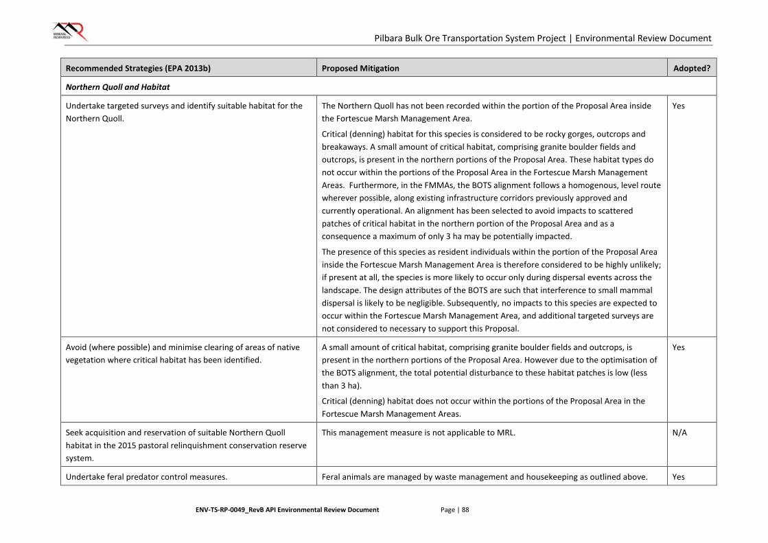
Pilbara Bulk Ore Transportation System Project | Environmental Review Document
ENV-TS-RP-0049_RevB API Environmental Review Document Page | 88
Recommended Strategies (EPA 2013b) Proposed Mitigation Adopted?
Northern Quoll and Habitat
Undertake targeted surveys and identify suitable habitat for the Northern Quoll.
The Northern Quoll has not been recorded within the portion of the Proposal Area inside the Fortescue Marsh Management Area.
Critical (denning) habitat for this species is considered to be rocky gorges, outcrops and breakaways. A small amount of critical habitat, comprising granite boulder fields and outcrops, is present in the northern portions of the Proposal Area. These habitat types do not occur within the portions of the Proposal Area in the Fortescue Marsh Management Areas. Furthermore, in the FMMAs, the BOTS alignment follows a homogenous, level route wherever possible, along existing infrastructure corridors previously approved and currently operational. An alignment has been selected to avoid impacts to scattered patches of critical habitat in the northern portion of the Proposal Area and as a consequence a maximum of only 3 ha may be potentially impacted.
The presence of this species as resident individuals within the portion of the Proposal Area inside the Fortescue Marsh Management Area is therefore considered to be highly unlikely; if present at all, the species is more likely to occur only during dispersal events across the landscape. The design attributes of the BOTS are such that interference to small mammal dispersal is likely to be negligible. Subsequently, no impacts to this species are expected to occur within the Fortescue Marsh Management Area, and additional targeted surveys are not considered to necessary to support this Proposal.
Yes
Avoid (where possible) and minimise clearing of areas of native vegetation where critical habitat has been identified.
A small amount of critical habitat, comprising granite boulder fields and outcrops, is present in the northern portions of the Proposal Area. However due to the optimisation of the BOTS alignment, the total potential disturbance to these habitat patches is low (less than 3 ha).
Critical (denning) habitat does not occur within the portions of the Proposal Area in the Fortescue Marsh Management Areas.
Yes
Seek acquisition and reservation of suitable Northern Quoll habitat in the 2015 pastoral relinquishment conservation reserve system.
This management measure is not applicable to MRL. N/A
Undertake feral predator control measures. Feral animals are managed by waste management and housekeeping as outlined above. Yes
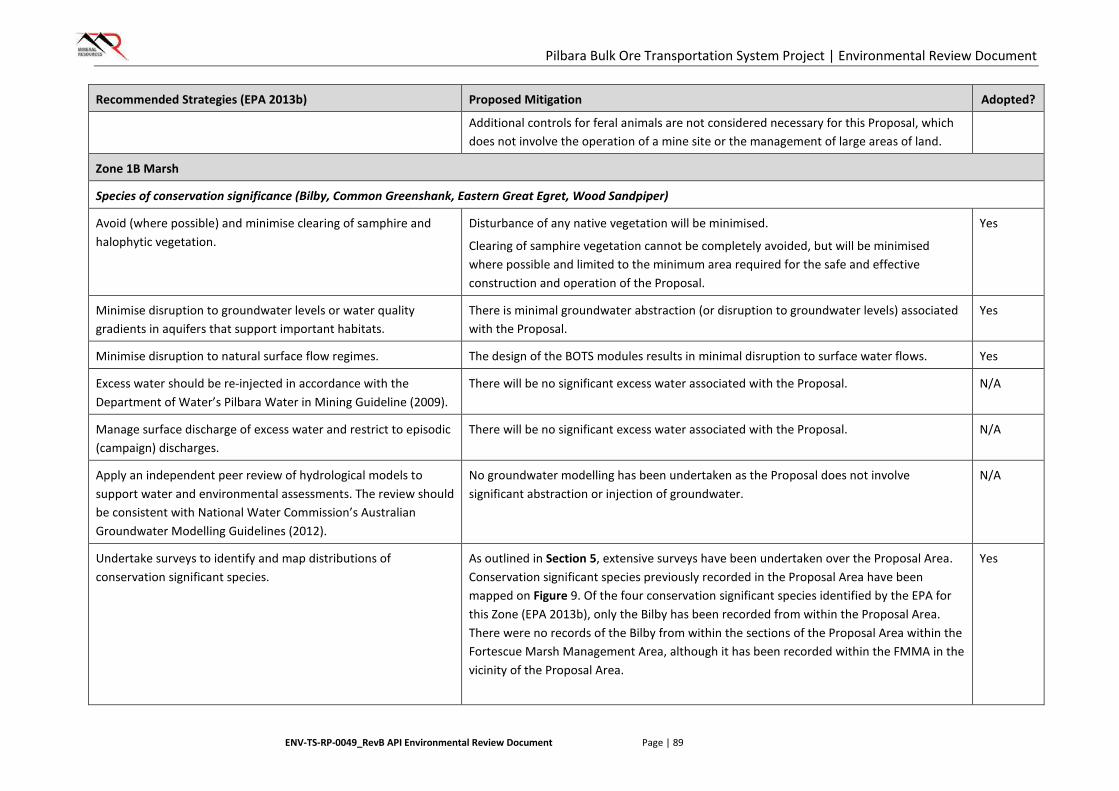
Pilbara Bulk Ore Transportation System Project | Environmental Review Document
ENV-TS-RP-0049_RevB API Environmental Review Document Page | 89
Recommended Strategies (EPA 2013b) Proposed Mitigation Adopted?
Additional controls for feral animals are not considered necessary for this Proposal, which does not involve the operation of a mine site or the management of large areas of land.
Zone 1B Marsh
Species of conservation significance (Bilby, Common Greenshank, Eastern Great Egret, Wood Sandpiper)
Avoid (where possible) and minimise clearing of samphire and halophytic vegetation.
Disturbance of any native vegetation will be minimised.
Clearing of samphire vegetation cannot be completely avoided, but will be minimised where possible and limited to the minimum area required for the safe and effective construction and operation of the Proposal.
Yes
Minimise disruption to groundwater levels or water quality gradients in aquifers that support important habitats.
There is minimal groundwater abstraction (or disruption to groundwater levels) associated with the Proposal.
Yes
Minimise disruption to natural surface flow regimes. The design of the BOTS modules results in minimal disruption to surface water flows. Yes
Excess water should be re-injected in accordance with the Department of Water’s Pilbara Water in Mining Guideline (2009).
There will be no significant excess water associated with the Proposal. N/A
Manage surface discharge of excess water and restrict to episodic (campaign) discharges.
There will be no significant excess water associated with the Proposal. N/A
Apply an independent peer review of hydrological models to support water and environmental assessments. The review should be consistent with National Water Commission’s Australian Groundwater Modelling Guidelines (2012).
No groundwater modelling has been undertaken as the Proposal does not involve significant abstraction or injection of groundwater.
N/A
Undertake surveys to identify and map distributions of conservation significant species.
As outlined in Section 5, extensive surveys have been undertaken over the Proposal Area. Conservation significant species previously recorded in the Proposal Area have been mapped on Figure 9. Of the four conservation significant species identified by the EPA for this Zone (EPA 2013b), only the Bilby has been recorded from within the Proposal Area. There were no records of the Bilby from within the sections of the Proposal Area within the Fortescue Marsh Management Area, although it has been recorded within the FMMA in the vicinity of the Proposal Area.
Yes
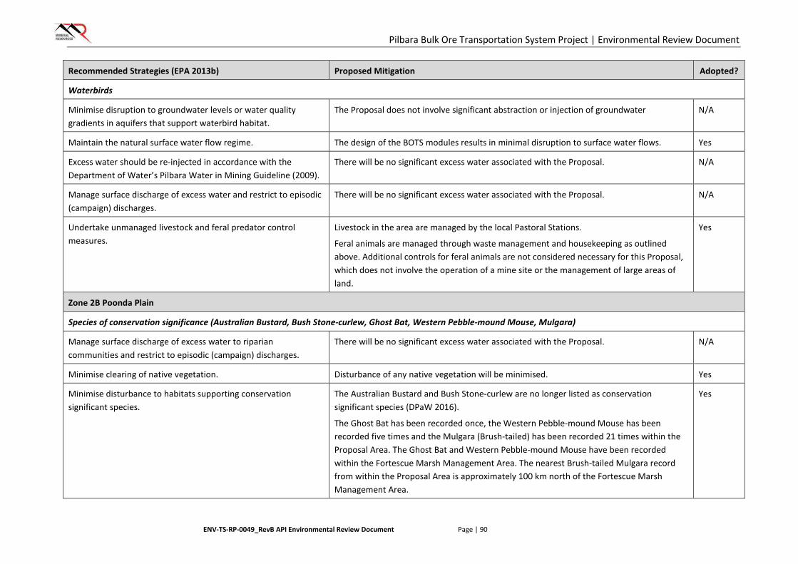
Pilbara Bulk Ore Transportation System Project | Environmental Review Document
ENV-TS-RP-0049_RevB API Environmental Review Document Page | 90
Recommended Strategies (EPA 2013b) Proposed Mitigation Adopted?
Waterbirds
Minimise disruption to groundwater levels or water quality gradients in aquifers that support waterbird habitat.
The Proposal does not involve significant abstraction or injection of groundwater N/A
Maintain the natural surface water flow regime. The design of the BOTS modules results in minimal disruption to surface water flows. Yes
Excess water should be re-injected in accordance with the Department of Water’s Pilbara Water in Mining Guideline (2009).
There will be no significant excess water associated with the Proposal. N/A
Manage surface discharge of excess water and restrict to episodic (campaign) discharges.
There will be no significant excess water associated with the Proposal. N/A
Undertake unmanaged livestock and feral predator control measures.
Livestock in the area are managed by the local Pastoral Stations.
Feral animals are managed through waste management and housekeeping as outlined above. Additional controls for feral animals are not considered necessary for this Proposal, which does not involve the operation of a mine site or the management of large areas of land.
Yes
Zone 2B Poonda Plain
Species of conservation significance (Australian Bustard, Bush Stone-curlew, Ghost Bat, Western Pebble-mound Mouse, Mulgara)
Manage surface discharge of excess water to riparian communities and restrict to episodic (campaign) discharges.
There will be no significant excess water associated with the Proposal. N/A
Minimise clearing of native vegetation. Disturbance of any native vegetation will be minimised. Yes
Minimise disturbance to habitats supporting conservation significant species.
The Australian Bustard and Bush Stone-curlew are no longer listed as conservation significant species (DPaW 2016).
The Ghost Bat has been recorded once, the Western Pebble-mound Mouse has been recorded five times and the Mulgara (Brush-tailed) has been recorded 21 times within the Proposal Area. The Ghost Bat and Western Pebble-mound Mouse have been recorded within the Fortescue Marsh Management Area. The nearest Brush-tailed Mulgara record from within the Proposal Area is approximately 100 km north of the Fortescue Marsh Management Area.
Yes
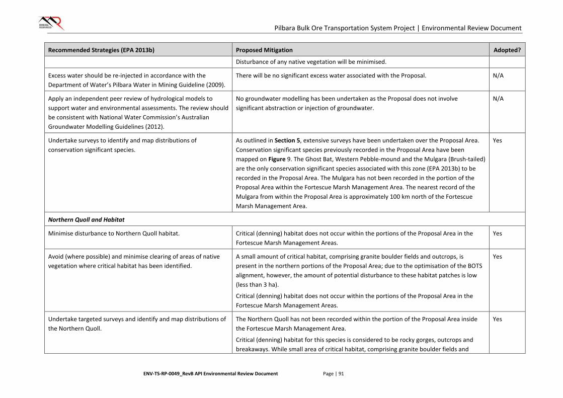
Pilbara Bulk Ore Transportation System Project | Environmental Review Document
ENV-TS-RP-0049_RevB API Environmental Review Document Page | 91
Recommended Strategies (EPA 2013b) Proposed Mitigation Adopted?
Disturbance of any native vegetation will be minimised.
Excess water should be re-injected in accordance with the Department of Water’s Pilbara Water in Mining Guideline (2009).
There will be no significant excess water associated with the Proposal. N/A
Apply an independent peer review of hydrological models to support water and environmental assessments. The review should be consistent with National Water Commission’s Australian Groundwater Modelling Guidelines (2012).
No groundwater modelling has been undertaken as the Proposal does not involve significant abstraction or injection of groundwater.
N/A
Undertake surveys to identify and map distributions of conservation significant species.
As outlined in Section 5, extensive surveys have been undertaken over the Proposal Area. Conservation significant species previously recorded in the Proposal Area have been mapped on Figure 9. The Ghost Bat, Western Pebble-mound and the Mulgara (Brush-tailed) are the only conservation significant species associated with this zone (EPA 2013b) to be recorded in the Proposal Area. The Mulgara has not been recorded in the portion of the Proposal Area within the Fortescue Marsh Management Area. The nearest record of the Mulgara from within the Proposal Area is approximately 100 km north of the Fortescue Marsh Management Area.
Yes
Northern Quoll and Habitat
Minimise disturbance to Northern Quoll habitat. Critical (denning) habitat does not occur within the portions of the Proposal Area in the Fortescue Marsh Management Areas.
Yes
Avoid (where possible) and minimise clearing of areas of native vegetation where critical habitat has been identified.
A small amount of critical habitat, comprising granite boulder fields and outcrops, is present in the northern portions of the Proposal Area; due to the optimisation of the BOTS alignment, however, the amount of potential disturbance to these habitat patches is low (less than 3 ha).
Critical (denning) habitat does not occur within the portions of the Proposal Area in the Fortescue Marsh Management Areas.
Yes
Undertake targeted surveys and identify and map distributions of the Northern Quoll.
The Northern Quoll has not been recorded within the portion of the Proposal Area inside the Fortescue Marsh Management Area.
Critical (denning) habitat for this species is considered to be rocky gorges, outcrops and breakaways. While small area of critical habitat, comprising granite boulder fields and
Yes
Pilbara Bulk Ore Transportation System Project | Environmental Review Document
ENV-TS-RP-0049_RevB API Environmental Review Document Page | 92
Recommended Strategies (EPA 2013b) Proposed Mitigation Adopted?
outcrops is present in the northern portion of the Proposal Area, these habitat types do not occur within the Fortescue Marsh Management Areas portions of the Proposal Area. Furthermore, in the FMMAs, the BOTS alignment follows as homogenous and level a contour as possible, along existing infrastructure corridors previously approved and currently operational.
The presence of this species as resident individuals within the portion of the Proposal Area inside the Fortescue Marsh Management Area is therefore considered to be highly unlikely; if present at all, the species is more likely to occur only during dispersal events across the landscape. The design attributes of the BOTS are such that interference with small mammal dispersal is likely to be negligible; as such, no impacts to this species are expected to occur within the Fortescue Marsh Management Area, and additional targeted surveys are consequently not considered to be required to support this Proposal.
Undertake feral predator control measures. Feral animals are managed through waste management and housekeeping as outlined above. Additional controls for feral animals are not considered necessary for this Proposal, which does not involve the operation of a mine site or the management of large areas of land.
Yes
Bilby and Habitat
Minimise disturbance to Bilby habitats. The Bilby has been recorded once in the Proposal Area. It has not been recorded inside the portion of the Proposal Area within Fortescue Marsh Management Area.
Disturbance of any native vegetation will be minimised. The Fortescue Marsh PEC represents potential foraging habitat for this species. Clearing within the Fortescue Marsh PEC cannot be completely avoided but will be minimised where possible and limited to the minimum area required for the safe and effective construction and operation of the Proposal.
Yes
Avoid (where possible) disturbance to extant Bilby burrows and minimise clearing of native vegetation where critical habitat has been identified.
The Bilby has been recorded once in the Proposal Area. It has not been recorded inside the portion of the Proposal Area within Fortescue Marsh Management Area and there are no known burrows in this area. Pre-clearance surveys will be undertaken to identify any active Bilby burrows and where identified, wherever possible, disturbance to these burrows will be avoided.
Yes
Pilbara Bulk Ore Transportation System Project | Environmental Review Document
ENV-TS-RP-0049_RevB API Environmental Review Document Page | 93
Recommended Strategies (EPA 2013b) Proposed Mitigation Adopted?
The Fortescue Marsh PEC represents potential foraging habitat for this species. Clearing within the Fortescue Marsh PEC cannot be completely avoided but will be minimised where possible.
Undertake targeted surveys to determine persistence, extent and habitat preference of Bilbies.
As outlined in Section 5, extensive surveys have been undertaken over the Proposal Area. Conservation significant species have been mapped on Figure 9. Additional, targeted surveys for the Bilby in the Fortescue Marsh Management Area are not considered to be required for this Proposal.
Yes
Undertake feral predator control measures. Feral animals are managed through waste management and housekeeping as outlined above. Additional controls for feral animals are not considered necessary for this Proposal, which does not involve the operation of a mine site or the management of large areas of land.
Yes
Zone 3B Marillana Plain
Species of conservation significance (Australian Bustard)
N/A One conservation significant species has been identified by the EPA as being associated with this zone. The Australian Bustard is no longer listed as a conservation significant species (DPaW 2016).
N/A
Pilbara Bulk Ore Transportation System Project | Environmental Review Document
ENV-TS-RP-0049_RevB API Environmental Review Document Page | 94
6.3.4. Regulation
Primary regulation of impacts to terrestrial fauna will be undertaken through the Ministerial Statement issued for the Proposal under Part IV of the EP Act. The Ministerial Statement will likely incorporate a limit of ground disturbance for the Proposal (ha), to be undertaken within the Proposal Area.
The Wildlife Conservation Act 1950 regulates interaction with native and introduced fauna species.
6.3.5. Outcome and Assessment against EPA Objective
The proposed BOTS Project was developed to optimise operational costs and balance the need to avoid or limit the impact to potential significant fauna values.
After application of the described design considerations along with management and mitigation measures, the Proposal is expected to result in the removal of up to 3000 ha of fauna habitat. As the broad fauna habitat in the surrounding area remains almost completely intact the Proposal is not expected to affect the conservation status of any Threatened or Priority listed taxa or critical fauna habitats known to occur in the Proposal Area, or have a significant effect on the representation of species or habitats at a local or regional level.
Some temporary displacement of fauna may also occur during construction activities, however these impacts are not expected to affect the conservation status of any fauna taxa known to occur in the Proposal Area, or have a significant effect on the representation of any species at a local or regional level.
6.4. Hydrological Processes
6.4.1. Context
EPA Objective
The EPA’s environmental objective for hydrological processes is:
To maintain the hydrological regimes of groundwater and surface water so that existing and potential uses, including ecosystem maintenance, are protected.
Policy Context
The BOTS Proposal Area intersects the Fortescue Marsh Management Area. Avoidance of this area was considered during project planning but was not possible. Management of this area is undertaken in accordance with EPA Report 1484, Environmental and Water assessments relating to mining and mining-related activities in the Fortescue Marsh management area (EPA 2013b).
EPA’s Position Statement No. 4, Environmental Protection of Wetlands (EPA 2004c), has also been considered. This Statement contains principles to enable the restoration, maintenance or enhancement of the environmental values and beneficial uses of wetland ecosystems within the context of an overall goal of no net loss of wetland values and functions.
Although the Proposal Area intersects the Fortescue Marsh Ecologically Significant Area (ESA), impacts to the Marsh itself have been minimised by selecting a corridor in the narrowest section of the Marsh, in a similar area to other infrastructure corridors which have already been developed. Land clearing has also been minimised through the design of the Proposal.
In addition to these guidelines, the following policy and guidance documents are relevant to the assessment of impacts to hydrological processes as a result of the BOTS Proposal:
• EAG 14 – Preparation of an API-A Environmental Review Document, January 2015 (EPA 2015a)
• Pilbara Water in Mining Guideline. Report No 34 (DoW 2009)
Pilbara Bulk Ore Transportation System Project | Environmental Review Document
ENV-TS-RP-0049_RevB API Environmental Review Document Page | 95
• Western Australian Water in Mining Guideline Report No 12 (DoW 2013)
• Pilbara Regional Water Plan (DoW 2010)
• Pilbara Groundwater Allocation Plan. Water resource allocation and planning report series. Report No. 55 October 2013. (DoW 2013)
Relevant Baseline Information
• The Proposal Area intersects a small portion of the Fortescue Marsh. The Fortescue Marsh is classified as an Environmentally Sensitive Area (ESA) and is listed as a Nationally Important Wetland under the EPBC Act. The Fortescue Marsh is an intermittently inundated wetland, covering an area of approximately 108,622 ha.
• The Proposal Area intersects 268 ha of the Fortescue Marsh ESA (Figure 11).
• The Proposal Area intersects the following major surface water systems (Figure 11):
o Turner River
o Turner River East
o Yule River
o Coonarrie Creek
o Western Shaw River
o Weeli Wolli Creek.
• A Surface Hydrology study has been undertaken for the Proposal Area to determine peak flows and flow velocities for a range of annual recurrence intervals (ARIs) (SoilWater 2015). This data has been used to assist in the design of BOTS structures. Predicted peak flows were greater than 4 m within major watercourses for an ARI of 1:100. Predicted peak flow velocities for an ARI of 1:100 range from 0.4 to 2.8 m/s.
6.4.2. Potential Significant Impacts without Mitigation
Potential impacts to hydrological processes as a result of the construction and operation of the BOTS include:
• Impacts to the surface water regime:
o disturbance of surface water features
o physical presence of the infrastructure causing a barrier to surface flows.
• Impacts to the groundwater regime:
o groundwater abstraction.
In addition to the potential impacts listed above, potential impacts specifically relating to the hydrological processes environmental values of the Fortescue Marsh Management Area are summarised in Table 16. Figure 12 shows known hydrological values in the Fortescue Marsh Management Area zones.
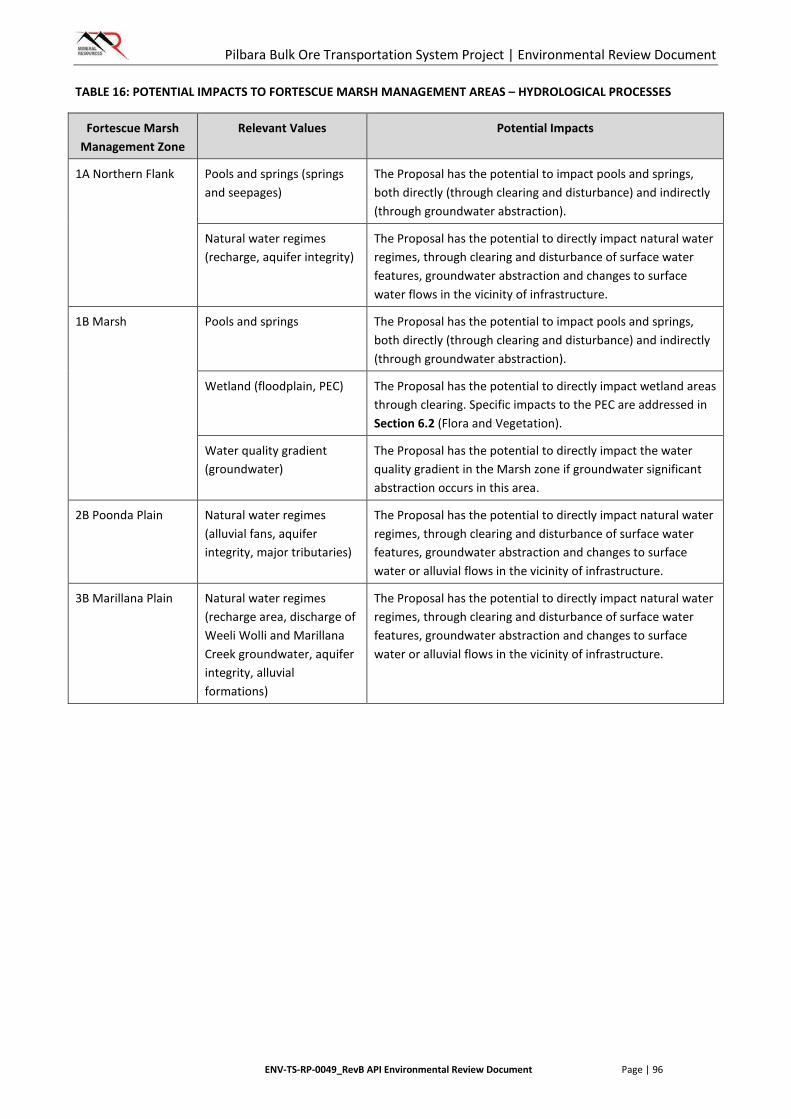
Pilbara Bulk Ore Transportation System Project | Environmental Review Document
ENV-TS-RP-0049_RevB API Environmental Review Document Page | 96
TABLE 16: POTENTIAL IMPACTS TO FORTESCUE MARSH MANAGEMENT AREAS – HYDROLOGICAL PROCESSES
Fortescue Marsh Management Zone
Relevant Values Potential Impacts
1A Northern Flank Pools and springs (springs and seepages)
The Proposal has the potential to impact pools and springs, both directly (through clearing and disturbance) and indirectly (through groundwater abstraction).
Natural water regimes (recharge, aquifer integrity)
The Proposal has the potential to directly impact natural water regimes, through clearing and disturbance of surface water features, groundwater abstraction and changes to surface water flows in the vicinity of infrastructure.
1B Marsh Pools and springs The Proposal has the potential to impact pools and springs, both directly (through clearing and disturbance) and indirectly (through groundwater abstraction).
Wetland (floodplain, PEC) The Proposal has the potential to directly impact wetland areas through clearing. Specific impacts to the PEC are addressed in Section 6.2 (Flora and Vegetation).
Water quality gradient (groundwater)
The Proposal has the potential to directly impact the water quality gradient in the Marsh zone if groundwater significant abstraction occurs in this area.
2B Poonda Plain Natural water regimes (alluvial fans, aquifer integrity, major tributaries)
The Proposal has the potential to directly impact natural water regimes, through clearing and disturbance of surface water features, groundwater abstraction and changes to surface water or alluvial flows in the vicinity of infrastructure.
3B Marillana Plain Natural water regimes (recharge area, discharge of Weeli Wolli and Marillana Creek groundwater, aquifer integrity, alluvial formations)
The Proposal has the potential to directly impact natural water regimes, through clearing and disturbance of surface water features, groundwater abstraction and changes to surface water or alluvial flows in the vicinity of infrastructure.

Sources: Esri, USGS, NOAA
640000 660000 68000076
8000
077
0000
077
2000
077
4000
0
Drawn: MYScale:Datum: GDA 1994 MGA Zone 50
Figure: 11Project ID: 1667Date: 20/05/16
0 1 2Kilometres
Mineral Resources Ltd: BOTSHydrology (1 of 3)
1:350,000A4
K
LegendProposal AreaDrainageMajor Road
Tu rner River East
Yule River
TurnerR iver
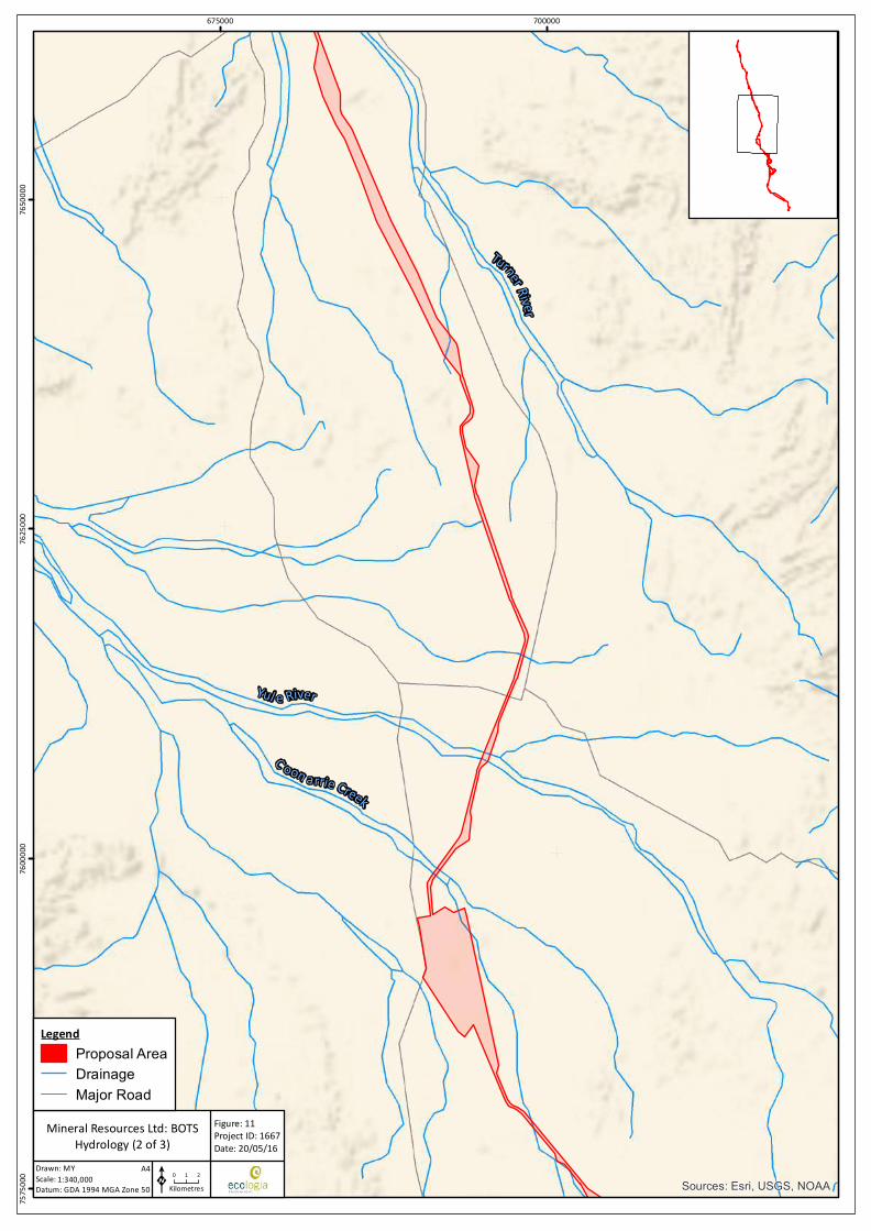
Sources: Esri, USGS, NOAA
675000 70000075
7500
076
0000
076
2500
076
5000
0
Drawn: MYScale:Datum: GDA 1994 MGA Zone 50
Figure: 11Project ID: 1667Date: 20/05/16
0 1 2Kilometres
Mineral Resources Ltd: BOTSHydrology (2 of 3)
1:340,000A4
K
LegendProposal AreaDrainageMajor Road
TurnerRiver
Yul e River
C oon arrie Creek
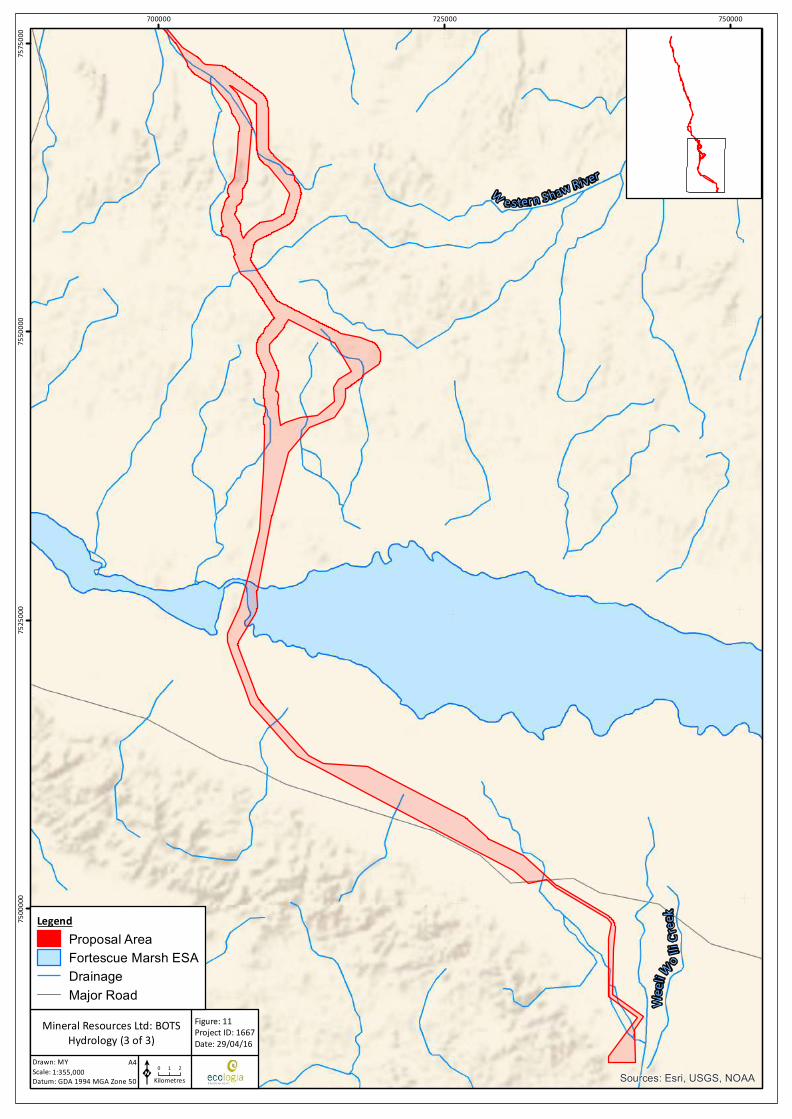
Sources: Esri, USGS, NOAA
700000 725000 75000075
0000
075
2500
075
5000
075
7500
0
Drawn: MYScale:Datum: GDA 1994 MGA Zone 50
Figure: 11Project ID: 1667Date: 29/04/16
0 1 2Kilometres
Mineral Resources Ltd: BOTSHydrology (3 of 3)
1:355,000A4
K
LegendProposal AreaFortescue Marsh ESADrainageMajor Road We
eli
W o lliC
reek
W estern Shaw River
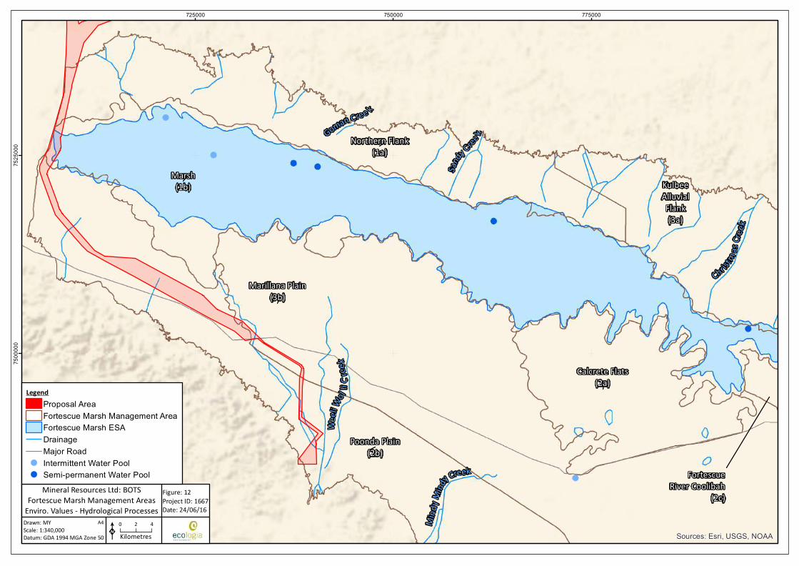
Marsh(1b)
Marillana Plain(3b)
Poonda Plain(2b)
Northern Flank(1a)
KulbeeAlluvialFlank(3a)
Calcrete Flats(2a)
FortescueRiver Coolibah
(2c)
Sources: Esri, USGS, NOAA
725000 750000 77500075
0000
075
2500
0
Drawn: MYScale:Datum: GDA 1994 MGA Zone 50
Figure: 12Project ID: 1667Date: 24/06/16
K0 2 4Kilometres
Mineral Resources Ltd: BOTSFortescue Marsh Management Areas
Enviro. Values - Hydrological Processes1:340,000
A4
LegendProposal AreaFortescue Marsh Management AreaFortescue Marsh ESADrainageMajor Road
!( Intermittent Water Pool!( Semi-permanent Water Pool
Goman Cree k
Sandy Cree k
Christm as
Creek
Mind
yMind
y Creek
Weeli
Wolli C
reek
Pilbara Bulk Ore Transportation System Project | API Environmental Review Document
ENV-TS-RP-0049_RevC API Environmental Review Document Page | 101
6.4.3. Proposed Management (Mitigation)
Design Considerations
The design of the BOTS Proposal and infrastructure allows for avoidance of impacts to hydrological processes. The following design considerations are relevant to this environmental factor:
• The Proposal Area is located within an established infrastructure corridor for the majority of the route.
• The BOTS infrastructure largely follows natural ground contours, reducing the need for broad-scale clearing to undertake levelling works that would normally be required for other types of linear infrastructure.
• A relatively wide Proposal Area has been selected in order to allow MRL to avoid both technically unsuitable areas and areas of significant environmental value during the selection of the final alignment.
• Medium – high type modules will be used for crossings over major watercourses. The use of these structures avoids major impacts to the alignment and flow velocities of the watercourse.
• The elevated BOTS structures have minimal interference on surface water flows. This avoids impacts to sheet-flow areas where sheet-flow shadowing effects are commonly experienced with the development of traditional linear infrastructure.
Management Measures
MRL will adopt the following mitigation and management measures to minimise impacts to hydrological processes:
• MRL’s Environmental Management Plan (MRL-EN-PLN-0001_02) will be implemented. Specific management measures relating to minimising impacts of the Proposal on hydrological processes include:
o MRL will only extract groundwater under licence from the statutory authority; and
o MRL will not interfere with water flows in creeks and streams, except where it has approval to do so.
• Disturbance will be limited to the minimum area required for the safe and effective construction and operation of the Proposal.
• Chemicals and hydrocarbons required on site will be stored in accordance with Dangerous Goods Safety Act 2004 and the Storage and Handling of Dangerous Goods Code of Practice (DMP 2010) to minimise risks of surface water or groundwater contamination.
• Erosion minimisation strategies and control structures will be used in areas where a risk of erosion is identified.
• Groundwater abstraction will be minimised.
• Existing bores will be used where possible.
• If new bores are required, areas of high environmental significance (ie PECs and potential groundwater-dependent vegetation communities) will be avoided where possible.
• Areas cleared during construction and not required for ongoing operation of the BOTS will be rehabilitated.
• Temporary infrastructure (i.e. construction camps, construction pads and soil/vegetation stockpiles) will not be located within drainage lines, where possible.
Pilbara Bulk Ore Transportation System Project | API Environmental Review Document
ENV-TS-RP-0049_RevC API Environmental Review Document Page | 102
In addition to the management measures listed above, strategies will be implemented consistent with the protection of the environmental values of the Fortescue Marsh Management Area outlined in EPA (2013) (Table 17).
Pilbara Bulk Ore Transportation System Project | API Environmental Review Document
ENV-TS-RP-0049_RevC API Environmental Review Document Page | 103
TABLE 17: MITIGATION STRATEGIES FOR FORTESCUE MARSH MANAGEMENT AREAS – HYDROLOGICAL PROCESSES
Recommended Strategies (EPA 2013b) Proposed Mitigation Adopted?
Zone 1A Northern Flank
Pools and Springs
Minimise disruption to natural surface flow regimes. The design of the BOTS modules results in minimal disruption to surface water flows.
Yes
Excess water should be re-injected in accordance with the Department of Water’s Pilbara Water in Mining Guideline (2009).
There will be no significant excess water associated with the Proposal. N/A
Minimise impacts to natural spring flows and water quality from groundwater mounding.
There will be no groundwater injection or other activities which could result in groundwater mounding associated with the Proposal.
N/A
Manage surface discharge of excess water in the vicinity of springs and restrict to episodic (campaign) discharges. .
There will be no significant excess water associated with the Proposal. N/A
Apply an independent peer review of hydrological models to support water and environmental assessments. The review should be consistent with National Water Commission’s Australian Groundwater Modelling Guidelines (2012).
No groundwater modelling has been undertaken as the Proposal does not involve significant abstraction or injection of groundwater.
N/A
Natural Water Regimes
Excess water should be re-injected in accordance with the Department of Water’s Pilbara Water in Mining Guideline (2009).
There will be no significant excess water associated with the Proposal. N/A
Apply an independent peer review of hydrological models to support water and environmental assessments. The review should be consistent with National Water Commission’s Australian Groundwater Modelling Guidelines (2012).
No groundwater modelling has been undertaken as the Proposal does not involve significant abstraction or injection of groundwater.
N/A
Avoid locating infrastructure on or in close proximity to major Marsh tributaries.
Disturbance will be minimised in close proximity to watercourses. Yes

Pilbara Bulk Ore Transportation System Project | API Environmental Review Document
ENV-TS-RP-0049_RevC API Environmental Review Document Page | 104
Recommended Strategies (EPA 2013b) Proposed Mitigation Adopted?
Manage groundwater drawdown so that riparian vegetation along major tributaries is not significantly impacted.
There is minimal groundwater abstraction (or disruption to groundwater levels) associated with the Proposal. Existing groundwater sources will be used where possible. If required, new groundwater bores would be located away from areas of significant environmental value, such as riparian vegetation. No new groundwater bores will be established within the Fortescue Marsh Management Zone.
Yes
Minimise disruption to surface flows through the appropriate design and placement of infrastructure.
The design of the BOTS modules results in minimal disruption to surface water flows.
Yes
Undertake research and monitoring to determine the extent of cumulative hydrological impacts on the Marsh.
The Proposal is not anticipated to result in significant hydrological impacts to the Marsh. As such, no cumulative impact assessment is required.
N/A
Zone 1B Marsh
Pools and Springs
Apply an independent peer review of hydrological models to support water and environmental assessments. The review should be consistent with National Water Commission’s Australian Groundwater Modelling Guidelines (2012).
No groundwater modelling has been undertaken as the Proposal does not involve significant abstraction or injection of groundwater.
N/A
Prevent discharge of excess water directly to the wetland or indirectly via industry-induced surface expression of saline or fresh water. If discharge is proposed it should be in accordance with an approved management and monitoring plan and ideally be of an episodic nature (campaign discharge) to coincide with natural flooding/inundation events.
There will be no significant excess water associated with the Proposal. N/A
Wetland
Prevent discharge of excess water directly to the wetland or indirectly via industry-induced surface expression of saline or fresh water. If discharge is proposed it should be in accordance with an approved management and monitoring plan and ideally be of an episodic nature (campaign discharge) to coincide with natural flooding/inundation events.
There will be no significant excess water associated with the Proposal. N/A
Pilbara Bulk Ore Transportation System Project | API Environmental Review Document
ENV-TS-RP-0049_RevC API Environmental Review Document Page | 105
Recommended Strategies (EPA 2013b) Proposed Mitigation Adopted?
Installation of bores that penetrate multiple aquifers will require a minimum standard of an ADIA Class 2 driller or have equivalent Water Drilling certification approved by the Department of Water.
There is minimal groundwater abstraction (or disruption to groundwater levels) associated with the Proposal. Existing groundwater sources will be used where possible. No new groundwater bores will be established within the Fortescue Marsh Management Zone.
Yes
Apply an independent peer review of hydrological models to support water and environmental assessments. The review should be consistent with the National Water Commission’s Australian Groundwater Modelling Guidelines (2012).
No groundwater modelling has been undertaken as the Proposal does not involve significant abstraction or injection of groundwater.
N/A
Avoid (where possible) and minimise clearing of samphire vegetation or halophytic vegetation.
Disturbance of any native vegetation will be minimised. Clearing of samphire vegetation cannot be completely avoided, but will be minimised where possible.
Yes
Minimise disturbance activities with a preference to use previously disturbed areas for new disturbance footprints, e.g. existing dilapidated fence lines and corridors for vehicle movements.
MRL has selected a Proposal Area which is located within a number of existing infrastructure corridors. This allows disturbance to be avoided where existing access can be used, and allows the extent of disturbance within the area to be concentrated and minimised.
Where possible, MRL will seek access to existing tracks constructed to service rail infrastructure utilised by other proponents within the corridor to minimise disturbance.
Yes
Any ground disturbing activity within the proposed 2015 conservation estate should be undertaken in a manner consistent with DEC conservation estate management guidelines (where available). Prior to the availability of these guidelines, consultation with the DEC is considered essential.
The proposed conservation estate described in this strategy was excised from Pastoral lease areas in 2015 (Figure 5). It has not yet been formally gazetted as conservation estate.
The Proposal Area traverses approximately 20 km of excised Pastoral Lease areas, in the vicinity of the Fortescue Marsh.
MRL has undertaken preliminary consultation with DPaW for the Proposal (Table 6) and will continue to consult with the Regulator regarding environmental management in this area.
Yes
Implement best practice impact mitigation and management techniques. MRL will undertake mitigation and management techniques to avoid and minimise impacts to hydrological processes as described within this document.
Yes
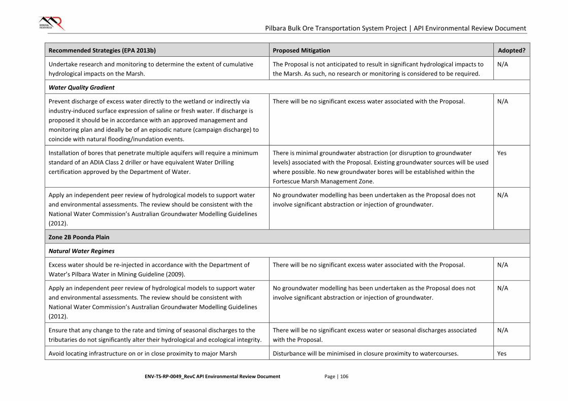
Pilbara Bulk Ore Transportation System Project | API Environmental Review Document
ENV-TS-RP-0049_RevC API Environmental Review Document Page | 106
Recommended Strategies (EPA 2013b) Proposed Mitigation Adopted?
Undertake research and monitoring to determine the extent of cumulative hydrological impacts on the Marsh.
The Proposal is not anticipated to result in significant hydrological impacts to the Marsh. As such, no research or monitoring is considered to be required.
N/A
Water Quality Gradient
Prevent discharge of excess water directly to the wetland or indirectly via industry-induced surface expression of saline or fresh water. If discharge is proposed it should be in accordance with an approved management and monitoring plan and ideally be of an episodic nature (campaign discharge) to coincide with natural flooding/inundation events.
There will be no significant excess water associated with the Proposal. N/A
Installation of bores that penetrate multiple aquifers will require a minimum standard of an ADIA Class 2 driller or have equivalent Water Drilling certification approved by the Department of Water.
There is minimal groundwater abstraction (or disruption to groundwater levels) associated with the Proposal. Existing groundwater sources will be used where possible. No new groundwater bores will be established within the Fortescue Marsh Management Zone.
Yes
Apply an independent peer review of hydrological models to support water and environmental assessments. The review should be consistent with the National Water Commission’s Australian Groundwater Modelling Guidelines (2012).
No groundwater modelling has been undertaken as the Proposal does not involve significant abstraction or injection of groundwater.
N/A
Zone 2B Poonda Plain
Natural Water Regimes
Excess water should be re-injected in accordance with the Department of Water’s Pilbara Water in Mining Guideline (2009).
There will be no significant excess water associated with the Proposal. N/A
Apply an independent peer review of hydrological models to support water and environmental assessments. The review should be consistent with National Water Commission’s Australian Groundwater Modelling Guidelines (2012).
No groundwater modelling has been undertaken as the Proposal does not involve significant abstraction or injection of groundwater.
N/A
Ensure that any change to the rate and timing of seasonal discharges to the tributaries do not significantly alter their hydrological and ecological integrity.
There will be no significant excess water or seasonal discharges associated with the Proposal.
N/A
Avoid locating infrastructure on or in close proximity to major Marsh Disturbance will be minimised in closure proximity to watercourses. Yes
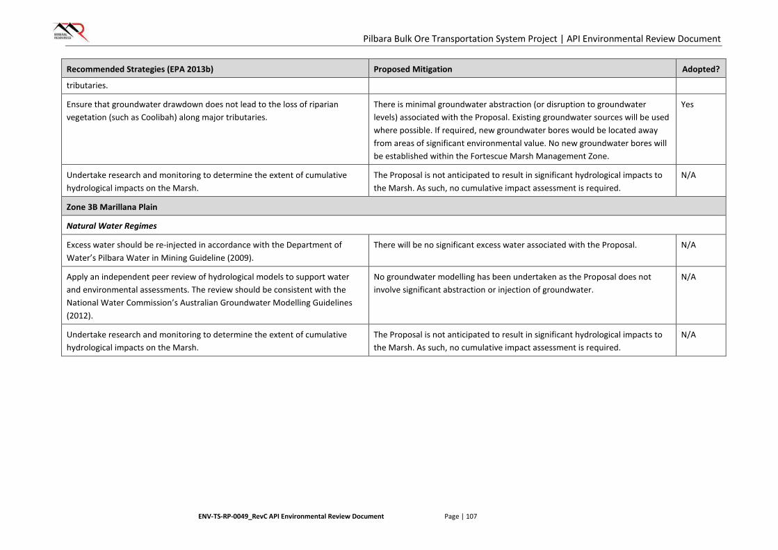
Pilbara Bulk Ore Transportation System Project | API Environmental Review Document
ENV-TS-RP-0049_RevC API Environmental Review Document Page | 107
Recommended Strategies (EPA 2013b) Proposed Mitigation Adopted?
tributaries.
Ensure that groundwater drawdown does not lead to the loss of riparian vegetation (such as Coolibah) along major tributaries.
There is minimal groundwater abstraction (or disruption to groundwater levels) associated with the Proposal. Existing groundwater sources will be used where possible. If required, new groundwater bores would be located away from areas of significant environmental value. No new groundwater bores will be established within the Fortescue Marsh Management Zone.
Yes
Undertake research and monitoring to determine the extent of cumulative hydrological impacts on the Marsh.
The Proposal is not anticipated to result in significant hydrological impacts to the Marsh. As such, no cumulative impact assessment is required.
N/A
Zone 3B Marillana Plain
Natural Water Regimes
Excess water should be re-injected in accordance with the Department of Water’s Pilbara Water in Mining Guideline (2009).
There will be no significant excess water associated with the Proposal. N/A
Apply an independent peer review of hydrological models to support water and environmental assessments. The review should be consistent with the National Water Commission’s Australian Groundwater Modelling Guidelines (2012).
No groundwater modelling has been undertaken as the Proposal does not involve significant abstraction or injection of groundwater.
N/A
Undertake research and monitoring to determine the extent of cumulative hydrological impacts on the Marsh.
The Proposal is not anticipated to result in significant hydrological impacts to the Marsh. As such, no cumulative impact assessment is required.
N/A
Pilbara Bulk Ore Transportation System Project | API Environmental Review Document
ENV-TS-RP-0049_RevC API Environmental Review Document Page | 108
6.4.4. Regulation
Primary regulation of impacts to hydrological processes will be undertaken through the Ministerial Statement issued for the Proposal under Part IV of the EP Act. The Ministerial Statement will likely incorporate a limit to ground disturbance for the Proposal (ha), to be undertaken within the Proposal Area.
The Rights in Water and Irrigation Act 1914 will provide regulation for the construction of groundwater bores, abstraction of groundwater and disturbance of watercourses through the following licences:
• 26D: Licence to construct a well
• 5C: Licence to abstract groundwater
• S17 Licence to interfere with the Bed and Banks of a Watercourse.
6.4.5. Outcome and Assessment against EPA Objective
The design of the Proposal and infrastructure allows for the avoidance of impacts to hydrological processes and the minor groundwater abstraction required for construction activities for the Proposal is unlikely to result in any significant drawdown on groundwater resources and therefore groundwater dependant vegetation communities or other water users are not expected to be impacted. There is no significant excess water generated by the Proposal and existing surface water regimes will be largely unaffected by the BOTS infrastructure.
Due to the minimal impacts associated with the Proposal, MRL considers that the hydrological regimes of groundwater and surface water will be maintained and the Proposal is consistent with the EPA objective for hydrological processes.
6.5. Rehabilitation and Decommissioning (Integrating Factor)
6.5.1. Context
EPA Objective
The EPA’s environmental objective for rehabilitation and decommissioning is:
To ensure that premises are decommissioned and rehabilitated in an ecologically sustainable manner.
Policy Context
Mine closure is jointly regulated in Western Australia by the EPA under the EP Act and the Department of Mines and Petroleum under the Mining Act 1978. The EPA issued the Environmental Protection Bulletin No. 19: EPA Involvement in Mine Closure in early 2015 (EPA 2015d) to outline the responsibilities of each agency in assessment of mine closure impacts for various approvals scenarios. As this Proposal is not subject to the Mining Act 1978, the EPA will be the only regulatory agency to assess the decommissioning and rehabilitation activities associated with this Proposal.
As a significant portion of the proposed disturbance footprint will only be required for construction purposes it will be available for progressive rehabilitation on the completion of construction activities in that area.
The following guidance, guideline, bulletin and advice have been considered in the assessment of decommissioning and rehabilitation, including post closure land use, closure domains and objectives, closure management and mitigation measures, monitoring maintenance and reporting and the development of performance criteria (and addressed in the Rehabilitation and Decommissioning Strategy in Section 6.5.3) of the BOTS Proposal:
Pilbara Bulk Ore Transportation System Project | API Environmental Review Document
ENV-TS-RP-0049_RevC API Environmental Review Document Page | 109
• Guidelines for Preparing Mine Closure Plans (DMP & EPA 2015).
• Guidance Statement 6 - Rehabilitation of Terrestrial Ecosystems, June 2006 (EPA 2006).
• Environmental Protection Bulletin No. 19 - EPA involvement in mine closure, January 2015
• Cumulative environmental impacts of development in the Pilbara Region, Advice of the EPA to the Minister for Environment under Section 16(e) of the Environmental Protection Act 1986. August 2014 (EPA 2014a).
Relevant Baseline Information
Temporary Disturbance
A significant portion of the disturbance footprint is required for construction purposes only, and will be available for progressive rehabilitation on the completion of construction activities in that area. As described in Section 3.4.2, construction pads of various sizes are required for the different module types being installed:
• Low level modules require only a narrow construction corridor.
• Mid and high level modules require a construction pad to be cleared every 12 m, centred at the location of each column. The size of the construction pads will vary according to the site-specific requirements, but will be no larger than 10 m x 10 m.
Construction camps and associated utilities will be decommissioned and rehabilitated following the completion of construction activities.
Permanent Disturbance
Infrastructure which will be in place for the life of the Proposal includes:
• BOTS:
o rolling surface
o precast concrete columns/pylons
o precast concrete substructures
• maintenance tracks (where other proponents existing tracks cannot be utilised)
• offices
• communication towers
• utilities
• laydown areas
• topsoil, subsoil and vegetation stockpiles.
When the BOTS line is no longer required for operational purposes, the system will be decommissioned, dismantled and removed from site. Substructures (excluding sub-surface) and all other infrastructure will be removed, reused, recycled or disposed offsite.
6.5.2. Potential Significant Impacts without Mitigation
Potential impacts to the receiving environment as a result of inadequate closure planning, decommissioning and rehabilitation practices include:
• unauthorised vegetation disturbance

Pilbara Bulk Ore Transportation System Project | API Environmental Review Document
ENV-TS-RP-0049_RevC API Environmental Review Document Page | 110
• poor return of native vegetation and flora species
• depletion of topsoil resources
• the introduction of weeds to rehabilitated areas
• contamination.
6.5.3. Rehabilitation and Decommissioning Strategy
Post Closure Land Use
The Proposal is located primarily on Pastoral Leases. Closure activities will aim to return the land to its pre-disturbance land use. Areas within Pastoral Lease boundaries will be returned to a pastoral land use, namely low intensity livestock grazing. Areas outside Pastoral Lease boundaries will be returned to their pre-existing land use.
Closure Domains
The following closure domains have been identified for the Proposal:
• BOTS Formation
• Construction Support Infrastructure
• Operational Support Infrastructure.
This document provides an overview of closure, decommissioning and rehabilitation objectives, management and mitigation measures, monitoring and performance indicators. Prescriptive Work Instructions will be prepared for progressive rehabilitation within each domain. Additionally, a detailed Closure Plan will be developed within five years of the planned completion of the BOTS Proposal.
Closure Objectives
A number of closure objectives have been developed to assist in ensuring that disturbed areas are closed in a manner consistent with the identified post-closure land use:
• Remove infrastructure which is not required to support the post-closure land use.
• Establish a safe, stable, non-polluting land surface which is generally consistent with pre-disturbance topography.
• Establish a land surface which can support vegetation growth of local provenance species and the long-term development of a self-sustaining ecosystem.
Closure Management and Mitigation Measures
MRL will adopt the following mitigation and management measures to facilitate successful decommissioning and rehabilitation:
• Topsoil, subsoil and bulk vegetation will be stockpiled during land clearing for use in rehabilitation purposes.
• Construction support infrastructure areas will be progressively decommissioned and rehabilitated following the completion of construction activities.
• All above-ground equipment and infrastructure will be removed and disposed of or recycled as appropriate.
• All waste materials will be removed and safely disposed of.
• Any contaminated soil will be removed or remediated as appropriate.
Pilbara Bulk Ore Transportation System Project | API Environmental Review Document
ENV-TS-RP-0049_RevC API Environmental Review Document Page | 111
• Land surfaces will be scarified (ripped) and pre-disturbance topography will be mimicked as closely as possible.
• Stockpiled soils and vegetation will be replaced over disturbed areas and deep ripped to promote revegetation.
• Local-provenance seed will be collected and broadcast if required. Where local provenance seed collection is not possible due to seasonal constraints, seed consistent with species found at the local scale will be source from registered seed suppliers.
• MRL’s Land Rehabilitation Procedure (MRL-EN-PRO-0009) will be implemented. Specific management measures relating to facilitating successful decommissioning and rehabilitation following implementation of the Proposal include:
o Undertake rehabilitation progressively and in accordance with the Rehabilitation Plan;
o Monitor and report on the progress of rehabilitation;
o Undertake remedial work, where monitoring identifies a risk to achieving the objectives of the Closure Plan; and
o Record and archive accurate spatial data and other records of all work undertaken.
Monitoring Maintenance and Reporting
Progressive rehabilitation of construction support infrastructure areas will allow MRL to monitor the effectiveness of the rehabilitation strategies outlined above prior to full closure.
Monitoring of geotechnical stability, erosion and rehabilitation performance will be undertaken. Monitoring will take place until it can be demonstrated that the closure objectives outlined above have been satisfied.
Performance Indicators/Completion Criteria
In accordance with EPA (2006), the following completion criteria have been developed for the Proposal:
• The land surface is safe, stable and suitable for the post-closure land use.
• No major pollution or contamination is present.
• Relevant regulator guidelines have been met.
• Rehabilitation monitoring has been undertaken and reports are available.
6.5.4. Regulation
Pollution which may be associated with the closure and decommissioning of infrastructure is regulated under the general principles of the EP Act, the Contaminated Sites Act 2003 and provisions for a Closure Plan reviewed and endorsed by DMP under a State Agreement Act
6.5.5. Outcome and Assessment against EPA Objective
Any areas cleared for construction purposes that are not required during operations (including borrow pits, temporary camps, laydown areas, access tracks etc.) will be rehabilitated, either progressively or at the completion of construction. Once the management measures outlined above are implemented, MRL considers that the BOTS Proposal will not result in significant environmental impact following closure.
The key likely outcomes for progressive rehabilitation are:
• For all access tracks, geotechnical investigation areas, laydowns areas and temporary camps, all infrastructure and footings will be removed, unusable inert material will be buried on site (or in landfill facility if nearby), stripped topsoil and vegetation will be respread, scarified and monitored.
Pilbara Bulk Ore Transportation System Project | API Environmental Review Document
ENV-TS-RP-0049_RevC API Environmental Review Document Page | 112
If no significant regrowth is detected during monitoring over the subsequent 12 months, local provenance seed will be collected and the area seeded.
• For borrow pits and other excavations, rehabilitation will be undertaken in accordance with MRL’s Borrow Pits Works Instruction (MRL-EN-WIN-0013), with pit walls battered to 180 or to a 3:1 slope. Stripped topsoil and vegetation will be respread, scarified and monitored. If no significant regrowth is detected during monitoring over the subsequent 12 months, local provenance seed will be collected and the area seeded.
The key likely long-term outcomes for final decommissioning are:
• above-ground infrastructure and equipment will be removed
• disturbed areas will be stable and will resemble pre-disturbance and surrounding topography
• disturbed areas will be covered by vegetation re-established from respread topsoil and/or seed of local provenance.
The management measures to appropriately decommission, decontaminate and rehabilitate disturbed areas are in place to mitigate the potential risks associated with closure, in accordance with the EPA’s closure objectives. A Closure Plan for final decommissioning will be prepared in accordance with State Agreement conditions and provided to DMP for review and approval prior to decommissioning and closure.
A Closure Plan will be developed for the Proposal in accordance with EPA Guidance Statement No. 6 Rehabilitation of Terrestrial Ecosystems (EPA 2006), which sets out the general expectations about re-establishing biodiversity values where a site is to be rehabilitated back to native vegetation.
Therefore rehabilitation and decommissioning are not expected to be significant issues for the Proposal and therefore the Proposal can meet the EPA objective.
6.6. Offsets (Integrating Factor)
6.6.1. Context
EPA Objective
The EPA’s environmental objective for environmental offsets is:
To counterbalance any significant residual environmental impacts or uncertainty through the application of offsets.
Policy Context
The Environmental Protection Bulletin No. 1 – Environmental Offsets – Biodiversity EPA (2014) outlines the principles of environmental offsets in Western Australia. It also lists the minimum requirements to be addressed in environmental review documentation:
• description of all potential impacts and identification of actions that will be applied to avoid, minimise or rehabilitate the impacts;
• description of all residual impacts; and
• analysis of impacts to identify and detail which of these residual impacts are significant.
The management and mitigation measures for potential environmental impacts of the Proposal have been designed to take the mitigation hierarchy into account. Application of the mitigation hierarchy, description of impacts and analysis of impacts is outlined for each environmental factor in Sections 6.2 to 6.4.
The WA Environmental Offsets Policy and Guidelines outline the Residual Impact Significance Model, which is used to identify significant residual impacts to which an offset may be applicable.
Pilbara Bulk Ore Transportation System Project | API Environmental Review Document
ENV-TS-RP-0049_RevC API Environmental Review Document Page | 113
Relevant Baseline Information
The key environmental aspects relating to this factor are the aspects from Flora and Vegetation, Fauna, Hydrological Processes and Rehabilitation and Decommissioning.
6.6.2. Residual Impact Significance Assessment
An assessment of residual impact significance has been undertaken for the Proposal and is summarised in Table 18. This has been compiled in accordance with the template presented in the WA Environmental Offsets Policy and Guidelines.
6.6.3. Outcome and Assessment against EPA Objective
It is anticipated that the negotiation of offsets with the EPA and DPaW will result in the application of a $/hectare offset rate for actual disturbance resulting from land clearing, based on both the quality of vegetation impacted and the IBRA subregion in which the clearing occurs. It is proposed that offset funding be contributed to the proposed Pilbara Strategic Conservation Initiative. This offset will act to counterbalance the significant residual environmental impacts or uncertainty identified in Table 18 and allow the EPA objective for Offsets to be met.
Pilbara Bulk Ore Transportation System Project | API Environmental Review Document
ENV-TS-RP-0049_RevC API Environmental Review Document Page | 114
[This page has been left blank intentionally]
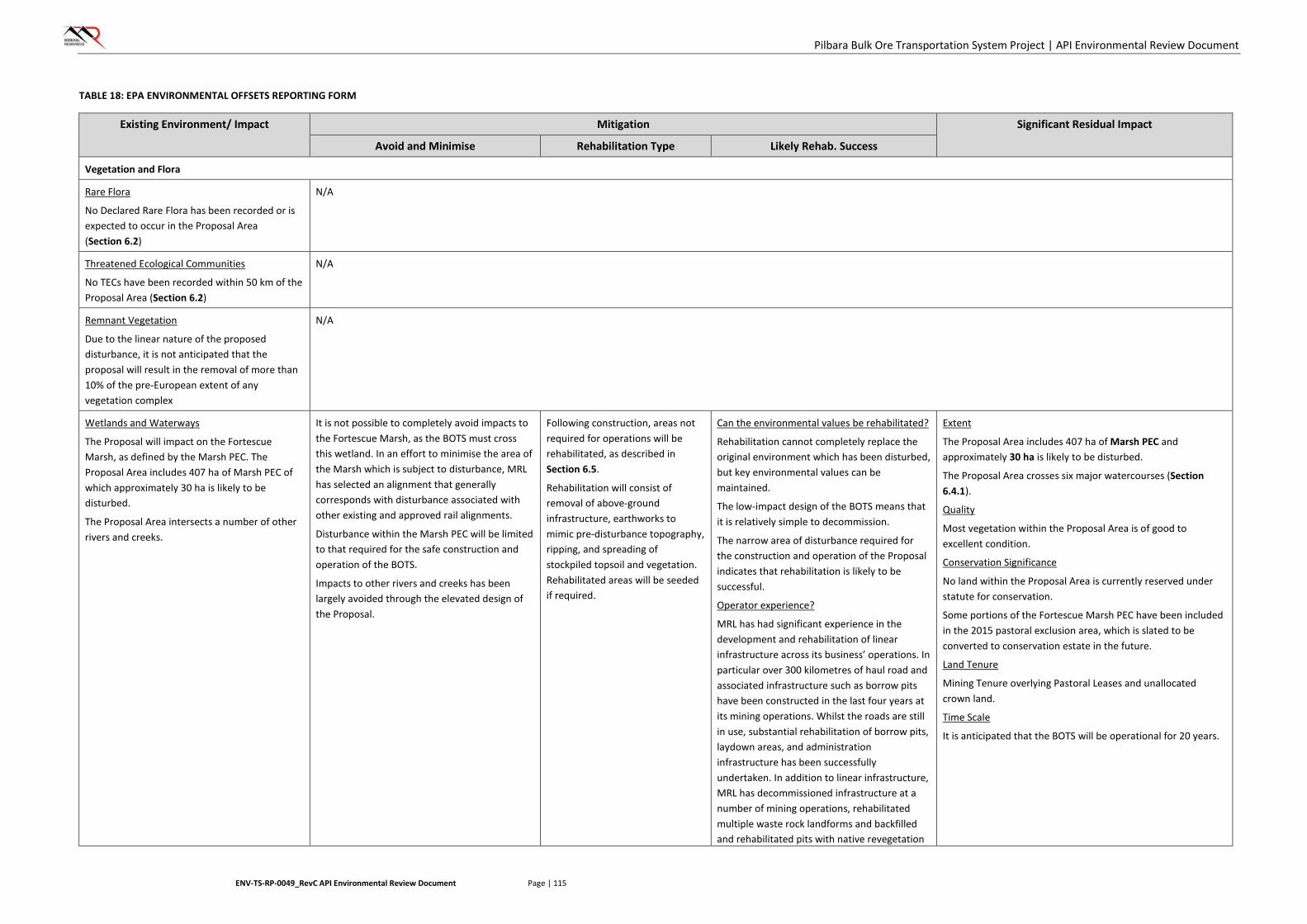
Pilbara Bulk Ore Transportation System Project | API Environmental Review Document
ENV-TS-RP-0049_RevC API Environmental Review Document Page | 115
TABLE 18: EPA ENVIRONMENTAL OFFSETS REPORTING FORM
Existing Environment/ Impact Mitigation Significant Residual Impact
Avoid and Minimise Rehabilitation Type Likely Rehab. Success
Vegetation and Flora
Rare Flora
No Declared Rare Flora has been recorded or is expected to occur in the Proposal Area (Section 6.2)
N/A
Threatened Ecological Communities
No TECs have been recorded within 50 km of the Proposal Area (Section 6.2)
N/A
Remnant Vegetation
Due to the linear nature of the proposed disturbance, it is not anticipated that the proposal will result in the removal of more than 10% of the pre-European extent of any vegetation complex
N/A
Wetlands and Waterways
The Proposal will impact on the Fortescue Marsh, as defined by the Marsh PEC. The Proposal Area includes 407 ha of Marsh PEC of which approximately 30 ha is likely to be disturbed.
The Proposal Area intersects a number of other rivers and creeks.
It is not possible to completely avoid impacts to the Fortescue Marsh, as the BOTS must cross this wetland. In an effort to minimise the area of the Marsh which is subject to disturbance, MRL has selected an alignment that generally corresponds with disturbance associated with other existing and approved rail alignments.
Disturbance within the Marsh PEC will be limited to that required for the safe construction and operation of the BOTS.
Impacts to other rivers and creeks has been largely avoided through the elevated design of the Proposal.
Following construction, areas not required for operations will be rehabilitated, as described in Section 6.5.
Rehabilitation will consist of removal of above-ground infrastructure, earthworks to mimic pre-disturbance topography, ripping, and spreading of stockpiled topsoil and vegetation. Rehabilitated areas will be seeded if required.
Can the environmental values be rehabilitated?
Rehabilitation cannot completely replace the original environment which has been disturbed, but key environmental values can be maintained.
The low-impact design of the BOTS means that it is relatively simple to decommission.
The narrow area of disturbance required for the construction and operation of the Proposal indicates that rehabilitation is likely to be successful.
Operator experience?
MRL has had significant experience in the development and rehabilitation of linear infrastructure across its business’ operations. In particular over 300 kilometres of haul road and associated infrastructure such as borrow pits have been constructed in the last four years at its mining operations. Whilst the roads are still in use, substantial rehabilitation of borrow pits, laydown areas, and administration infrastructure has been successfully undertaken. In addition to linear infrastructure, MRL has decommissioned infrastructure at a number of mining operations, rehabilitated multiple waste rock landforms and backfilled and rehabilitated pits with native revegetation
Extent
The Proposal Area includes 407 ha of Marsh PEC and approximately 30 ha is likely to be disturbed.
The Proposal Area crosses six major watercourses (Section 6.4.1).
Quality
Most vegetation within the Proposal Area is of good to excellent condition.
Conservation Significance
No land within the Proposal Area is currently reserved under statute for conservation.
Some portions of the Fortescue Marsh PEC have been included in the 2015 pastoral exclusion area, which is slated to be converted to conservation estate in the future.
Land Tenure
Mining Tenure overlying Pastoral Leases and unallocated crown land.
Time Scale
It is anticipated that the BOTS will be operational for 20 years.
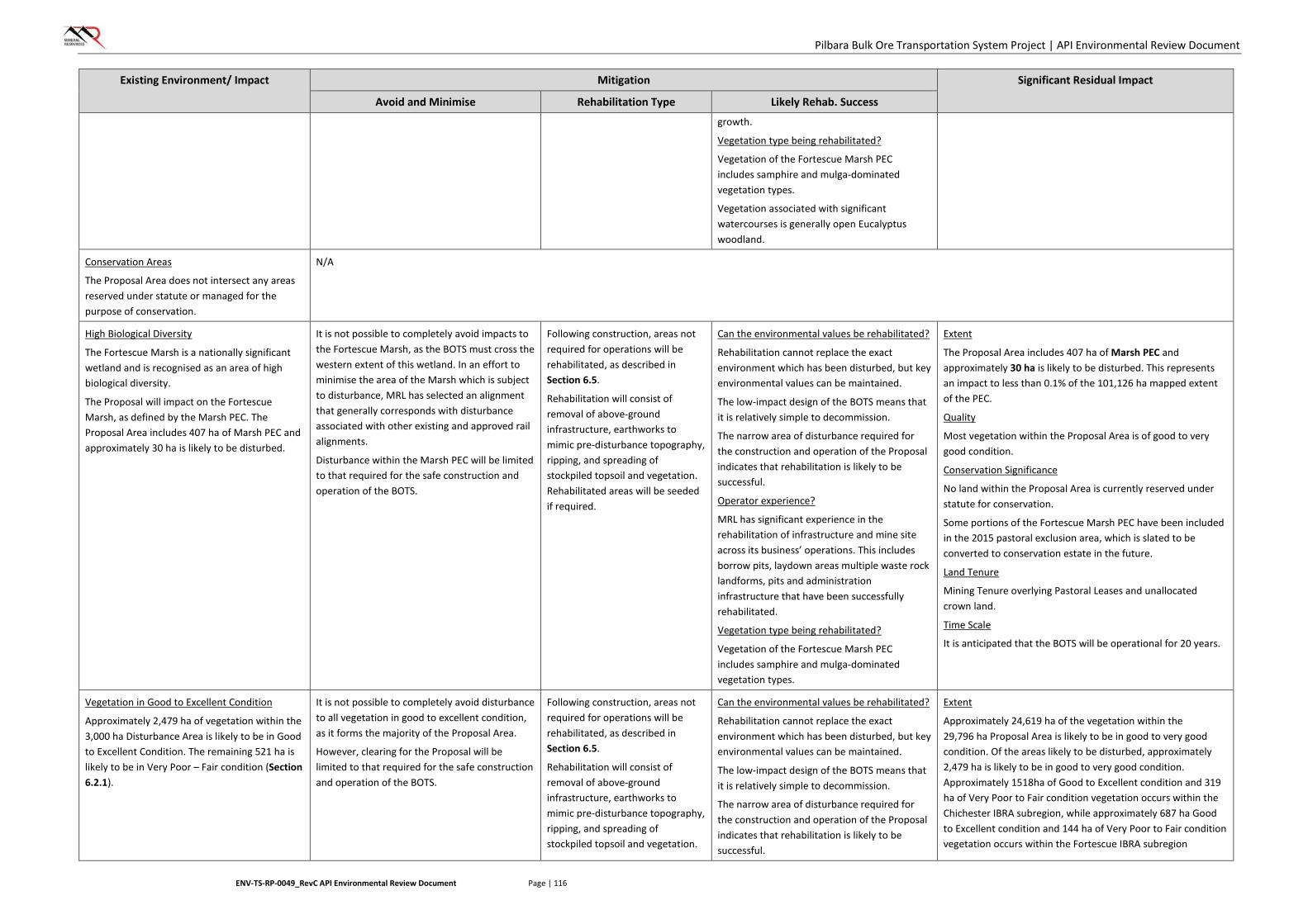
Pilbara Bulk Ore Transportation System Project | API Environmental Review Document
ENV-TS-RP-0049_RevC API Environmental Review Document Page | 116
Existing Environment/ Impact Mitigation Significant Residual Impact
Avoid and Minimise Rehabilitation Type Likely Rehab. Success
growth.
Vegetation type being rehabilitated?
Vegetation of the Fortescue Marsh PEC includes samphire and mulga-dominated vegetation types.
Vegetation associated with significant watercourses is generally open Eucalyptus woodland.
Conservation Areas
The Proposal Area does not intersect any areas reserved under statute or managed for the purpose of conservation.
N/A
High Biological Diversity
The Fortescue Marsh is a nationally significant wetland and is recognised as an area of high biological diversity.
The Proposal will impact on the Fortescue Marsh, as defined by the Marsh PEC. The Proposal Area includes 407 ha of Marsh PEC and approximately 30 ha is likely to be disturbed.
It is not possible to completely avoid impacts to the Fortescue Marsh, as the BOTS must cross the western extent of this wetland. In an effort to minimise the area of the Marsh which is subject to disturbance, MRL has selected an alignment that generally corresponds with disturbance associated with other existing and approved rail alignments.
Disturbance within the Marsh PEC will be limited to that required for the safe construction and operation of the BOTS.
Following construction, areas not required for operations will be rehabilitated, as described in Section 6.5.
Rehabilitation will consist of removal of above-ground infrastructure, earthworks to mimic pre-disturbance topography, ripping, and spreading of stockpiled topsoil and vegetation. Rehabilitated areas will be seeded if required.
Can the environmental values be rehabilitated?
Rehabilitation cannot replace the exact environment which has been disturbed, but key environmental values can be maintained.
The low-impact design of the BOTS means that it is relatively simple to decommission.
The narrow area of disturbance required for the construction and operation of the Proposal indicates that rehabilitation is likely to be successful.
Operator experience?
MRL has significant experience in the rehabilitation of infrastructure and mine site across its business’ operations. This includes borrow pits, laydown areas multiple waste rock landforms, pits and administration infrastructure that have been successfully rehabilitated.
Vegetation type being rehabilitated?
Vegetation of the Fortescue Marsh PEC includes samphire and mulga-dominated vegetation types.
Extent
The Proposal Area includes 407 ha of Marsh PEC and approximately 30 ha is likely to be disturbed. This represents an impact to less than 0.1% of the 101,126 ha mapped extent of the PEC.
Quality
Most vegetation within the Proposal Area is of good to very good condition.
Conservation Significance
No land within the Proposal Area is currently reserved under statute for conservation.
Some portions of the Fortescue Marsh PEC have been included in the 2015 pastoral exclusion area, which is slated to be converted to conservation estate in the future.
Land Tenure
Mining Tenure overlying Pastoral Leases and unallocated crown land.
Time Scale
It is anticipated that the BOTS will be operational for 20 years.
Vegetation in Good to Excellent Condition
Approximately 2,479 ha of vegetation within the 3,000 ha Disturbance Area is likely to be in Good to Excellent Condition. The remaining 521 ha is likely to be in Very Poor – Fair condition (Section 6.2.1).
It is not possible to completely avoid disturbance to all vegetation in good to excellent condition, as it forms the majority of the Proposal Area.
However, clearing for the Proposal will be limited to that required for the safe construction and operation of the BOTS.
Following construction, areas not required for operations will be rehabilitated, as described in Section 6.5.
Rehabilitation will consist of removal of above-ground infrastructure, earthworks to mimic pre-disturbance topography, ripping, and spreading of stockpiled topsoil and vegetation.
Can the environmental values be rehabilitated?
Rehabilitation cannot replace the exact environment which has been disturbed, but key environmental values can be maintained.
The low-impact design of the BOTS means that it is relatively simple to decommission.
The narrow area of disturbance required for the construction and operation of the Proposal indicates that rehabilitation is likely to be successful.
Extent
Approximately 24,619 ha of the vegetation within the 29,796 ha Proposal Area is likely to be in good to very good condition. Of the areas likely to be disturbed, approximately 2,479 ha is likely to be in good to very good condition. Approximately 1518ha of Good to Excellent condition and 319 ha of Very Poor to Fair condition vegetation occurs within the Chichester IBRA subregion, while approximately 687 ha Good to Excellent condition and 144 ha of Very Poor to Fair condition vegetation occurs within the Fortescue IBRA subregion

Pilbara Bulk Ore Transportation System Project | API Environmental Review Document
ENV-TS-RP-0049_RevC API Environmental Review Document Page | 117
Existing Environment/ Impact Mitigation Significant Residual Impact
Avoid and Minimise Rehabilitation Type Likely Rehab. Success
Rehabilitated areas will be seeded if required.
Operator experience?
MRL has significant experience in the rehabilitation of infrastructure and mine site across its business’ operations. This includes borrow pits, laydown areas multiple waste rock landforms, pits and administration infrastructure that have been successfully rehabilitated.
Vegetation type being rehabilitated?
Vegetation composition is variable along the length of the Proposal Area. It varies from of coastal Mangrove vegetation in the north to the samphire and mulga-dominated vegetation types associated with the Fortescue Marsh in the south.
Note; the likely vegetation condition has been determined using average vegetation condition of each land system as described in Section 6.2.1.
Quality
Most vegetation within the Proposal Area is of good to very good condition.
Conservation Significance
No land within the Proposal Area is currently reserved under statute for conservation.
Land Tenure
Mining Tenure overlying Pastoral Leases and unallocated crown land.
Time Scale
It is anticipated that the BOTS will be operational for 20 years.
Terrestrial Fauna
Wetlands and Waterways
The Fortescue Marsh is a nationally significant wetland and provides habitat for a number of migratory bird species.
The Proposal will impact on the Fortescue Marsh, as defined by the Marsh PEC. The Proposal Area includes 407 ha of Marsh PEC and approximately 30 ha is likely to be disturbed.
The Proposal Area intersects a number of other rivers and creeks, which provide habitat for several species of conservation significance.
It is not possible to completely avoid impacts to the Fortescue Marsh, as the BOTS must cross this wetland. MRL has selected an alignment that is similar to other existing and approved rail alignments, in order to minimise the area of the Marsh which is subject to disturbance. Disturbance within the Marsh PEC will be limited to that required for the safe construction and operation of the BOTS.
It is not possible to avoid crossing major watercourses. Impacts to these areas will be minimised through the design of the BOTS (Plate 2), which allows unimpeded flow of water and does not require large-scale land disturbance.
Impacts to fauna have also been minimised through the design of the BOTS. The structure does not act as a barrier to most fauna species and avoids fragmentation impacts which can result from conventional linear infrastructure.
Following construction, areas not required for operations will be rehabilitated, as described in Section 6.5.
Rehabilitation will consist of removal of above-ground infrastructure, earthworks to mimic pre-disturbance topography, ripping, and spreading of stockpiled topsoil and vegetation. Rehabilitated areas will be seeded if required.
Can the environmental values be rehabilitated?
Rehabilitation cannot replace the exact environment which has been disturbed, but key environmental values can be maintained.
The low-impact design of the BOTS means that it is relatively simple to decommission.
The narrow area of disturbance required for the construction and operation of the Proposal indicates that rehabilitation is likely to be successful.
Operator experience?
MRL has significant experience in the rehabilitation of infrastructure and mine site across its business’ operations. This includes borrow pits, laydown areas multiple waste rock landforms, pits and administration infrastructure that have been successfully rehabilitated.
Vegetation type being rehabilitated?
Vegetation of the Fortescue Marsh PEC includes samphire and mulga-dominated vegetation types.
Vegetation associated with significant watercourses is generally open Eucalyptus woodland.
Extent
The Proposal Area includes 407 ha of Marsh PEC and approximately 30 ha is likely to be disturbed. This represents an impact to less than 0.1% of the 101,126 ha mapped extent of the PEC.
The Proposal Area intersects six major rivers.
Quality
Most vegetation within the Proposal Area is of good to very good condition.
Conservation Significance
No land within the Proposal Area is currently reserved under statute for conservation.
Some portions of the Fortescue Marsh PEC have been included in the 2015 pastoral exclusion area, which is slated to be converted to conservation estate in the future.
Land Tenure
Mining Tenure overlying Pastoral Leases and unallocated crown land.
Time Scale
It is anticipated that the BOTS will be operational for 20 years.
Conservation Areas
The Proposal Area does not intersect any areas reserved under statute or managed for the
N/A
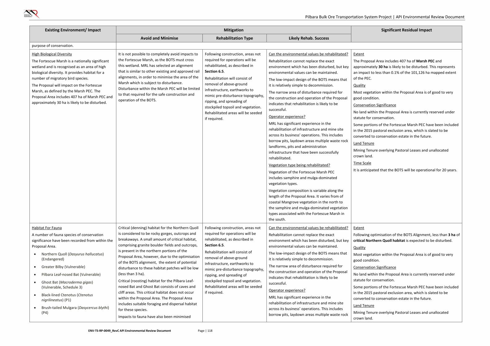
Pilbara Bulk Ore Transportation System Project | API Environmental Review Document
ENV-TS-RP-0049_RevC API Environmental Review Document Page | 118
Existing Environment/ Impact Mitigation Significant Residual Impact
Avoid and Minimise Rehabilitation Type Likely Rehab. Success
purpose of conservation.
High Biological Diversity
The Fortescue Marsh is a nationally significant wetland and is recognised as an area of high biological diversity. It provides habitat for a number of migratory bird species.
The Proposal will impact on the Fortescue Marsh, as defined by the Marsh PEC. The Proposal Area includes 407 ha of Marsh PEC and approximately 30 ha is likely to be disturbed.
It is not possible to completely avoid impacts to the Fortescue Marsh, as the BOTS must cross this wetland. MRL has selected an alignment that is similar to other existing and approved rail alignments, in order to minimise the area of the Marsh which is subject to disturbance. Disturbance within the Marsh PEC will be limited to that required for the safe construction and operation of the BOTS.
Following construction, areas not required for operations will be rehabilitated, as described in Section 6.5.
Rehabilitation will consist of removal of above-ground infrastructure, earthworks to mimic pre-disturbance topography, ripping, and spreading of stockpiled topsoil and vegetation. Rehabilitated areas will be seeded if required.
Can the environmental values be rehabilitated?
Rehabilitation cannot replace the exact environment which has been disturbed, but key environmental values can be maintained.
The low-impact design of the BOTS means that it is relatively simple to decommission.
The narrow area of disturbance required for the construction and operation of the Proposal indicates that rehabilitation is likely to be successful.
Operator experience?
MRL has significant experience in the rehabilitation of infrastructure and mine site across its business’ operations. This includes borrow pits, laydown areas multiple waste rock landforms, pits and administration infrastructure that have been successfully rehabilitated.
Vegetation type being rehabilitated?
Vegetation of the Fortescue Marsh PEC includes samphire and mulga-dominated vegetation types.
Vegetation composition is variable along the length of the Proposal Area. It varies from of coastal Mangrove vegetation in the north to the samphire and mulga-dominated vegetation types associated with the Fortescue Marsh in the south.
Extent
The Proposal Area includes 407 ha of Marsh PEC and approximately 30 ha is likely to be disturbed. This represents an impact to less than 0.1% of the 101,126 ha mapped extent of the PEC.
Quality
Most vegetation within the Proposal Area is of good to very good condition.
Conservation Significance
No land within the Proposal Area is currently reserved under statute for conservation.
Some portions of the Fortescue Marsh PEC have been included in the 2015 pastoral exclusion area, which is slated to be converted to conservation estate in the future.
Land Tenure
Mining Tenure overlying Pastoral Leases and unallocated crown land.
Time Scale
It is anticipated that the BOTS will be operational for 20 years.
Habitat For Fauna
A number of fauna species of conservation significance have been recorded from within the Proposal Area.
• Northern Quoll (Dasyurus hallucatus) (Endangered)
• Greater Bilby (Vulnerable)
• Pilbara Leaf-nosed Bat (Vulnerable)
• Ghost Bat (Macroderma gigas) (Vulnerable, Schedule 3)
• Black-lined Ctenotus (Ctenotus nigrilineatus) (P1)
• Brush-tailed Mulgara (Dasycercus blythi) (P4)
Critical (denning) habitat for the Northern Quoll is considered to be rocky gorges, outcrops and breakaways. A small amount of critical habitat, comprising granite boulder fields and outcrops, is present in the northern portions of the Proposal Area, however, due to the optimisation of the BOTS alignment, the extent of potential disturbance to these habitat patches will be low (less than 3 ha).
Critical (roosting) habitat for the Pilbara Leaf-nosed Bat and Ghost Bat consists of caves and cliff areas. This critical habitat does not occur within the Proposal Area. The Proposal Area includes suitable foraging and dispersal habitat for these species.
Impacts to fauna have also been minimised
Following construction, areas not required for operations will be rehabilitated, as described in Section 6.5.
Rehabilitation will consist of removal of above-ground infrastructure, earthworks to mimic pre-disturbance topography, ripping, and spreading of stockpiled topsoil and vegetation. Rehabilitated areas will be seeded if required.
Can the environmental values be rehabilitated?
Rehabilitation cannot replace the exact environment which has been disturbed, but key environmental values can be maintained.
The low-impact design of the BOTS means that it is relatively simple to decommission.
The narrow area of disturbance required for the construction and operation of the Proposal indicates that rehabilitation is likely to be successful.
Operator experience?
MRL has significant experience in the rehabilitation of infrastructure and mine site across its business’ operations. This includes borrow pits, laydown areas multiple waste rock
Extent
Following optimisation of the BOTS Alignment, less than 3 ha of critical Northern Quoll habitat is expected to be disturbed.
Quality
Most vegetation within the Proposal Area is of good to very good condition.
Conservation Significance
No land within the Proposal Area is currently reserved under statute for conservation.
Some portions of the Fortescue Marsh PEC have been included in the 2015 pastoral exclusion area, which is slated to be converted to conservation estate in the future.
Land Tenure
Mining Tenure overlying Pastoral Leases and unallocated crown land.

Pilbara Bulk Ore Transportation System Project | API Environmental Review Document
ENV-TS-RP-0049_RevC API Environmental Review Document Page | 119
Existing Environment/ Impact Mitigation Significant Residual Impact
Avoid and Minimise Rehabilitation Type Likely Rehab. Success • Western Pebble-mound Mouse
(Pseudomys chapmani) (P4)
• Fork-tailed Swift (Apus pacificus) (Migratory)
• Rainbow Bee-eater (Merops ornatus) (Migratory)
through the design of the BOTS. The structure does not act as a barrier to most fauna species and avoids fragmentation impacts which can result from conventional linear infrastructure.
landforms, pits and administration infrastructure that have been successfully rehabilitated.
Vegetation type being rehabilitated?
Vegetation of the Fortescue Marsh PEC includes samphire and mulga-dominated vegetation types.
Vegetation composition is variable along the length of the Proposal Area. It varies from of coastal Mangrove vegetation in the north to the samphire and mulga-dominated vegetation types associated with the Fortescue Marsh in the south.
Time Scale
It is anticipated that the BOTS will be operational for 20 years.
Hydrological Processes
Addressed under Vegetation and Flora and Terrestrial Fauna

Pilbara Bulk Ore Transportation System Project | API Environmental Review Document
ENV-TS-RP-0049_RevC API Environmental Review Document Page | 120
7. OTHER ENVIRONMENTAL FACTORS
Other Environmental Factors includes those factors that are not considered to be preliminary key factors which require further evaluation within this API. However, these factors still relate to the Proposal and may be managed under other regulatory processes (i.e. Part V of the EP Act), legislation (i.e. Aboriginal Heritage Act 1972) and through implementation of standard industry practices. These factors are discussed briefly in the following sections.
The Other Environmental Factors relevant to the Proposal were outlined by the EPA within the Scoping Guideline (Appendix 1). Table 19 summarises each of the Other Environmental Factors for the Proposal.
TABLE 19: OTHER ENVIRONMENTAL FACTORS
Other Environmental
Factor
Environmental Aspect
Information Required
Heritage EPA Policies Demonstrate and show how the Proposal meets the following policy: • Guidance Statement No. 41 – Assessment of Aboriginal Heritage,
April 2004
Amenity (noise) EPA Policies Demonstrate and show how the Proposal meets the following policy: • Environmental Assessment Guidelines 13 – Consideration of
environmental impacts from noise, September 2014
7.1. Impact Assessment
An assessment of each Other Environmental Factor has been conducted to identify the potential impacts (if any) posed by the implementation of the Proposal, and to outline the mitigation measures designed to prevent and/or minimise any residual impacts to each factor. A summary of this assessment is provided in Table 20.
7.2. Expected Environmental Outcomes
MRL is aware of its responsibilities under the Aboriginal Heritage Act 1972, and is currently working with the relevant Aboriginal groups to ensure impacts to Aboriginal Heritage sites are minimised. Aboriginal heritage management associated with the Proposal will also be undertaken in accordance with MRL’s Heritage Management Procedure (MRL-EN-PRO-0015) which describes the process for management of Aboriginal and European heritage sites, and places of cultural significance that may be encountered on MRL tenure and the tenure of its subsidiaries.
The Proposal alignment has already been amended (see Figure 1, Inset E) to avoid Aboriginal Heritage sites (burial and ceremonial sites) identified by Aboriginal groups along with other heritage places and heritage sites defined under the Act. Once an alignment and infrastructure footprint has been finalised, heritage consultants will undertake a site assessment to ensure impacts to any sites of Aboriginal heritage significance are avoided wherever possible. Where sites are unable to be avoided, disturbance will be negotiated with traditional owner groups and through Section 18 applications. MRL will cooperate with Aboriginal groups to ensure access to any Heritage sites used for traditional purposes aren’t restricted. Additionally an Aboriginal Cultural Heritage Management Plan will be prepared to manage cultural and heritage sites during the construction and operation of the Proposal. The Plan will include strategies for limiting disturbance to heritage-cleared areas, protocols for clearing work, Aboriginal monitors for initial ground disturbance, demarcation and signage of heritage places and sites, compulsory inductions for all MRL personnel connected to the project, and involve cultural awareness training for MRL and contracting
Pilbara Bulk Ore Transportation System Project | API Environmental Review Document
ENV-TS-RP-0049_RevC API Environmental Review Document Page | 121
personnel. The potential for impacts on this factor can be appropriately managed through existing legislation.
A noise impact assessment, including noise modelling, of BOTS undertaken to quantify the transportation noise impacts of the BOTS system on noise sensitive receptors concluded noise levels are compliant with SPP 5.4 transportation noise criteria at all noise sensitive receptors assessed and no additional noise mitigation is considered necessary.
The Proposal is expected to meet the EPA objectives for Heritage and Amenity (noise):
• To ensure that historical and cultural associations, and natural heritage are not adversely affected
• To ensure that impacts to amenity are reduced as low as reasonably practicable.
Both of these aspects are regulated under specific legislation to avoid and minimise impacts.
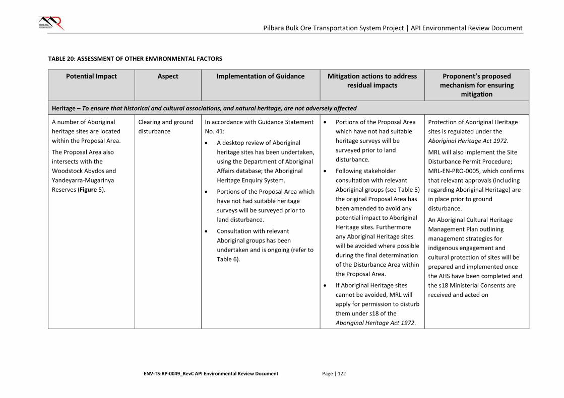
Pilbara Bulk Ore Transportation System Project | API Environmental Review Document
ENV-TS-RP-0049_RevC API Environmental Review Document Page | 122
TABLE 20: ASSESSMENT OF OTHER ENVIRONMENTAL FACTORS
Potential Impact Aspect Implementation of Guidance Mitigation actions to address residual impacts
Proponent’s proposed mechanism for ensuring
mitigation
Heritage – To ensure that historical and cultural associations, and natural heritage, are not adversely affected
A number of Aboriginal heritage sites are located within the Proposal Area.
The Proposal Area also intersects with the Woodstock Abydos and Yandeyarra-Mugarinya Reserves (Figure 5).
Clearing and ground disturbance
In accordance with Guidance Statement No. 41:
• A desktop review of Aboriginal heritage sites has been undertaken, using the Department of Aboriginal Affairs database; the Aboriginal Heritage Enquiry System.
• Portions of the Proposal Area which have not had suitable heritage surveys will be surveyed prior to land disturbance.
• Consultation with relevant Aboriginal groups has been undertaken and is ongoing (refer to Table 6).
• Portions of the Proposal Area which have not had suitable heritage surveys will be surveyed prior to land disturbance.
• Following stakeholder consultation with relevant Aboriginal groups (see Table 5) the original Proposal Area has been amended to avoid any potential impact to Aboriginal Heritage sites. Furthermore any Aboriginal Heritage sites will be avoided where possible during the final determination of the Disturbance Area within the Proposal Area.
• If Aboriginal Heritage sites cannot be avoided, MRL will apply for permission to disturb them under s18 of the Aboriginal Heritage Act 1972.
Protection of Aboriginal Heritage sites is regulated under the Aboriginal Heritage Act 1972.
MRL will also implement the Site Disturbance Permit Procedure; MRL-EN-PRO-0005, which confirms that relevant approvals (including regarding Aboriginal Heritage) are in place prior to ground disturbance.
An Aboriginal Cultural Heritage Management Plan outlining management strategies for indigenous engagement and cultural protection of sites will be prepared and implemented once the AHS have been completed and the s18 Ministerial Consents are received and acted on
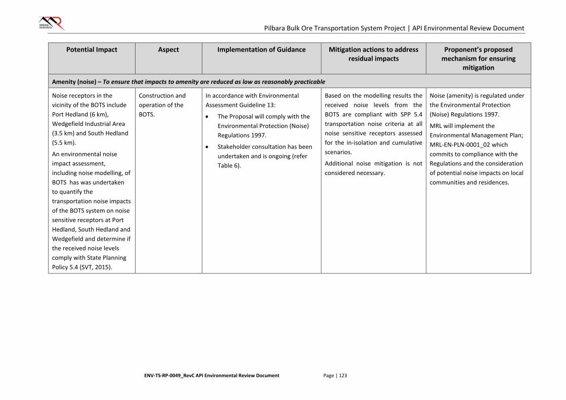
Pilbara Bulk Ore Transportation System Project | API Environmental Review Document
ENV-TS-RP-0049_RevC API Environmental Review Document Page | 123
Potential Impact Aspect Implementation of Guidance Mitigation actions to address residual impacts
Proponent’s proposed mechanism for ensuring
mitigation
Amenity (noise) – To ensure that impacts to amenity are reduced as low as reasonably practicable
Noise receptors in the vicinity of the BOTS include Port Hedland (6 km), Wedgefield Industrial Area (3.5 km) and South Hedland (5.5 km).
An environmental noise impact assessment, including noise modelling, of BOTS has was undertaken to quantify the transportation noise impacts of the BOTS system on noise sensitive receptors at Port Hedland, South Hedland and Wedgefield and determine if the received noise levels comply with State Planning Policy 5.4 (SVT, 2015).
Construction and operation of the BOTS.
In accordance with Environmental Assessment Guideline 13:
• The Proposal will comply with the Environmental Protection (Noise) Regulations 1997.
• Stakeholder consultation has been undertaken and is ongoing (refer Table 6).
Based on the modelling results the received noise levels from the BOTS are compliant with SPP 5.4 transportation noise criteria at all noise sensitive receptors assessed for the in-isolation and cumulative scenarios.
Additional noise mitigation is not considered necessary.
Noise (amenity) is regulated under the Environmental Protection (Noise) Regulations 1997.
MRL will implement the Environmental Management Plan; MRL-EN-PLN-0001_02 which commits to compliance with the Regulations and the consideration of potential noise impacts on local communities and residences.
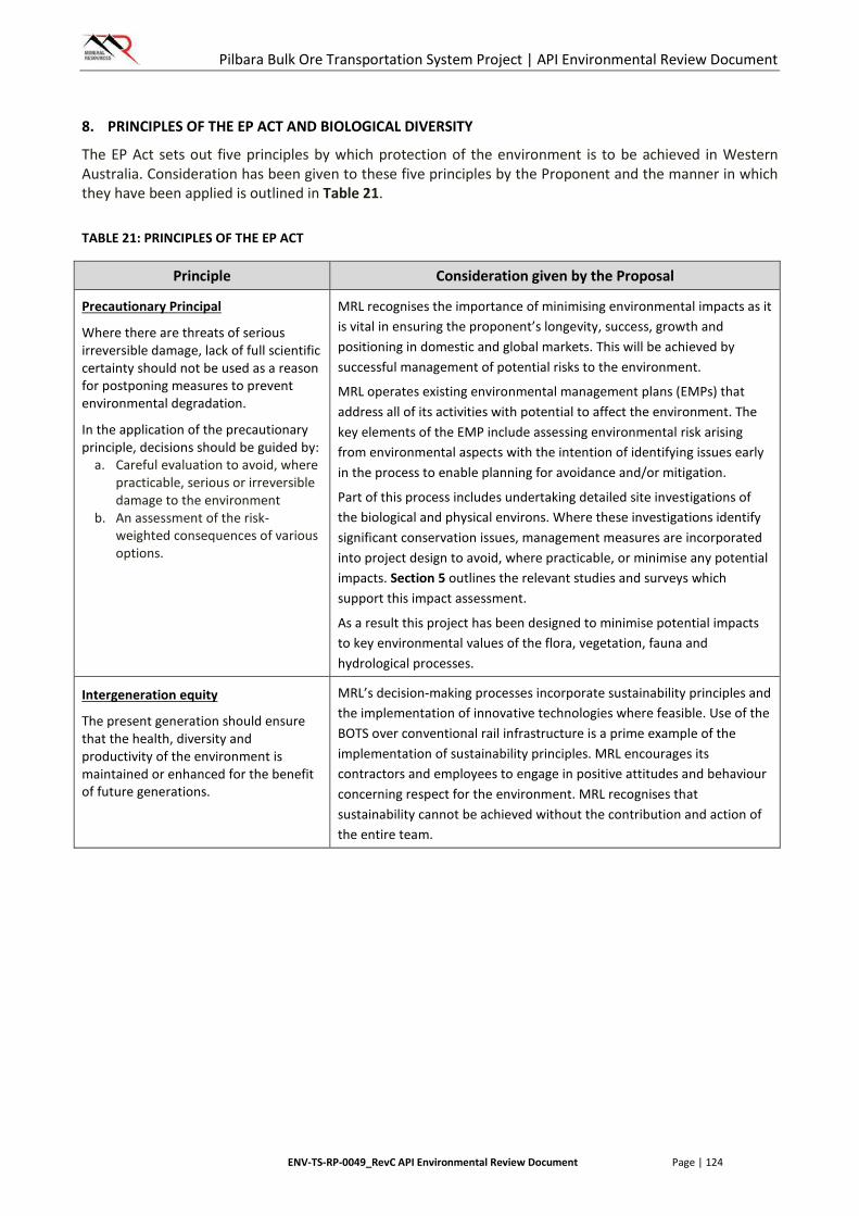
Pilbara Bulk Ore Transportation System Project | API Environmental Review Document
ENV-TS-RP-0049_RevC API Environmental Review Document Page | 124
8. PRINCIPLES OF THE EP ACT AND BIOLOGICAL DIVERSITY
The EP Act sets out five principles by which protection of the environment is to be achieved in Western Australia. Consideration has been given to these five principles by the Proponent and the manner in which they have been applied is outlined in Table 21.
TABLE 21: PRINCIPLES OF THE EP ACT
Principle Consideration given by the Proposal
Precautionary Principal
Where there are threats of serious irreversible damage, lack of full scientific certainty should not be used as a reason for postponing measures to prevent environmental degradation.
In the application of the precautionary principle, decisions should be guided by:
a. Careful evaluation to avoid, where practicable, serious or irreversible damage to the environment
b. An assessment of the risk-weighted consequences of various options.
MRL recognises the importance of minimising environmental impacts as it is vital in ensuring the proponent’s longevity, success, growth and positioning in domestic and global markets. This will be achieved by successful management of potential risks to the environment.
MRL operates existing environmental management plans (EMPs) that address all of its activities with potential to affect the environment. The key elements of the EMP include assessing environmental risk arising from environmental aspects with the intention of identifying issues early in the process to enable planning for avoidance and/or mitigation.
Part of this process includes undertaking detailed site investigations of the biological and physical environs. Where these investigations identify significant conservation issues, management measures are incorporated into project design to avoid, where practicable, or minimise any potential impacts. Section 5 outlines the relevant studies and surveys which support this impact assessment.
As a result this project has been designed to minimise potential impacts to key environmental values of the flora, vegetation, fauna and hydrological processes.
Intergeneration equity
The present generation should ensure that the health, diversity and productivity of the environment is maintained or enhanced for the benefit of future generations.
MRL’s decision-making processes incorporate sustainability principles and the implementation of innovative technologies where feasible. Use of the BOTS over conventional rail infrastructure is a prime example of the implementation of sustainability principles. MRL encourages its contractors and employees to engage in positive attitudes and behaviour concerning respect for the environment. MRL recognises that sustainability cannot be achieved without the contribution and action of the entire team.
Pilbara Bulk Ore Transportation System Project | API Environmental Review Document
ENV-TS-RP-0049_RevC API Environmental Review Document Page | 125
Principle Consideration given by the Proposal
Conservation of biological diversity and ecological integrity
Conservation of biological diversity and ecological integration should be a fundamental consideration.
Conservation of biological diversity and ecological integrity is fundamental to MRL’s approach to environmental management and is a major environmental consideration for the Proposal. Biological investigations of the corridor covering the majority of Proposal area have been previously undertaken by other proponents utilising infrastructure within the corridor. Surveys of the majority of the “gap” sections were completed early in the project planning process (May 2015) to identify values of environmental conservation significance required to be protected from disturbance. Based on the number of previous surveys conducted in the vicinity of an unsurveyed ~10 km “gap” section in the northern portion of the Proposal area, there is a low risk of any significant environmental values being associated with this area. However MRL commits to conducting flora and fauna assessments of the gap area prior to any proposed ground disturbance associated with the Proposal.
This Proposal has been designed to minimise potential impacts to the key environmental values of the surrounding flora and vegetation and significant fauna species.
An assessment of the Proposal in relation to biological diversity is also provided in Table 22 below.
Improved valuation, pricing and incentive mechanisms:
a. Environmental factors should be included in the valuation of assets and services
b. The polluter pays principle – those who generate pollution and waste should bear the cost of containment, avoidance or abatement
c. The users of goods and services should pay prices based on the full life cycle costs of providing goods and services, including the use of natural resources and assets and the ultimate disposal of any waste
d. Environmental goals, having been established, should be pursues in the most cost effective way, by establishing incentive structures, including market mechanisms, which benefit and/or minimise costs to develop their own solutions and responses to environmental problems
MRL acknowledges the need for improved valuation, pricing and incentive mechanisms and endeavours to pursue these principles when and wherever possible. For example:
• Environmental factors have significantly influenced project design so as to minimise impacts to those environmental factors
• The Proponent has put in place procedures that will ensure that pollution-type impacts are minimised as far as practicable.
Waste Minimisation
All reasonable and practicable measures should be taken to minimise the generation of waste and its discharge into the environment.
The Proponent’s approach to waste management is, in order of priority:
• Avoid and reduce at source
• Reuse and recycle
• Treat and/or dispose.
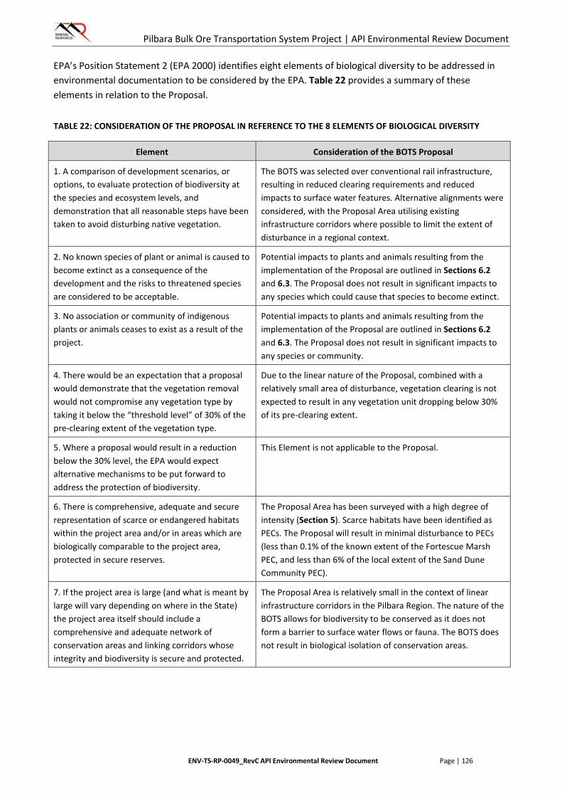
Pilbara Bulk Ore Transportation System Project | API Environmental Review Document
ENV-TS-RP-0049_RevC API Environmental Review Document Page | 126
EPA’s Position Statement 2 (EPA 2000) identifies eight elements of biological diversity to be addressed in environmental documentation to be considered by the EPA. Table 22 provides a summary of these elements in relation to the Proposal.
TABLE 22: CONSIDERATION OF THE PROPOSAL IN REFERENCE TO THE 8 ELEMENTS OF BIOLOGICAL DIVERSITY
Element Consideration of the BOTS Proposal
1. A comparison of development scenarios, or options, to evaluate protection of biodiversity at the species and ecosystem levels, and demonstration that all reasonable steps have been taken to avoid disturbing native vegetation.
The BOTS was selected over conventional rail infrastructure, resulting in reduced clearing requirements and reduced impacts to surface water features. Alternative alignments were considered, with the Proposal Area utilising existing infrastructure corridors where possible to limit the extent of disturbance in a regional context.
2. No known species of plant or animal is caused to become extinct as a consequence of the development and the risks to threatened species are considered to be acceptable.
Potential impacts to plants and animals resulting from the implementation of the Proposal are outlined in Sections 6.2 and 6.3. The Proposal does not result in significant impacts to any species which could cause that species to become extinct.
3. No association or community of indigenous plants or animals ceases to exist as a result of the project.
Potential impacts to plants and animals resulting from the implementation of the Proposal are outlined in Sections 6.2 and 6.3. The Proposal does not result in significant impacts to any species or community.
4. There would be an expectation that a proposal would demonstrate that the vegetation removal would not compromise any vegetation type by taking it below the “threshold level” of 30% of the pre-clearing extent of the vegetation type.
Due to the linear nature of the Proposal, combined with a relatively small area of disturbance, vegetation clearing is not expected to result in any vegetation unit dropping below 30% of its pre-clearing extent.
5. Where a proposal would result in a reduction below the 30% level, the EPA would expect alternative mechanisms to be put forward to address the protection of biodiversity.
This Element is not applicable to the Proposal.
6. There is comprehensive, adequate and secure representation of scarce or endangered habitats within the project area and/or in areas which are biologically comparable to the project area, protected in secure reserves.
The Proposal Area has been surveyed with a high degree of intensity (Section 5). Scarce habitats have been identified as PECs. The Proposal will result in minimal disturbance to PECs (less than 0.1% of the known extent of the Fortescue Marsh PEC, and less than 6% of the local extent of the Sand Dune Community PEC).
7. If the project area is large (and what is meant by large will vary depending on where in the State) the project area itself should include a comprehensive and adequate network of conservation areas and linking corridors whose integrity and biodiversity is secure and protected.
The Proposal Area is relatively small in the context of linear infrastructure corridors in the Pilbara Region. The nature of the BOTS allows for biodiversity to be conserved as it does not form a barrier to surface water flows or fauna. The BOTS does not result in biological isolation of conservation areas.
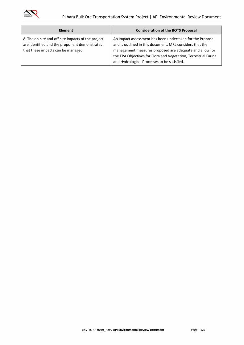
Pilbara Bulk Ore Transportation System Project | API Environmental Review Document
ENV-TS-RP-0049_RevC API Environmental Review Document Page | 127
Element Consideration of the BOTS Proposal
8. The on-site and off-site impacts of the project are identified and the proponent demonstrates that these impacts can be managed.
An impact assessment has been undertaken for the Proposal and is outlined in this document. MRL considers that the management measures proposed are adequate and allow for the EPA Objectives for Flora and Vegetation, Terrestrial Fauna and Hydrological Processes to be satisfied.
Pilbara Bulk Ore Transportation System Project | API Environmental Review Document
ENV-TS-RP-0049_RevC API Environmental Review Document Page | 128
9. CONCLUSION
This Environmental Review Document has provided supporting information in accordance with the requirements of the Scoping Guideline. This document has provided information about the existing environment and potential impacts of implementation of the Proposal and defines MRL’s approach of managing potential impacts for each of the EPA’s environmental factors.
The Proposal has been designed to predominantly utilise existing previously EPA assessed rail infrastructure corridors, including existing supporting infrastructure such as rail maintenance tracks, thereby avoiding and minimising impacts to the preliminary key environmental factors in line with the mitigation hierarchy.
MRL considers that the information and assessment presented in this Environmental Review Document adequately identifies and addresses environmental aspects and issues relevant to the Proposal and is suitable for the EPA to undertake assessment under Part IV of the EP Act.
Pilbara Bulk Ore Transportation System Project | API Environmental Review Document
ENV-TS-RP-0049_RevC API Environmental Review Document Page | 129
10. REFERENCES
Bennelongia 2009. Outer Harbour Development and Goldsworthy Rail Duplication Subterranean Fauna Risk Assessment, Report prepared for BHP Billiton Iron Ore. September 2009.
Biota Environmental Sciences (Biota) 2004a. Vegetation and Flora Survey of the Proposed FMG Stage A Rail Corridor. Report prepared for Fortescue Metals Group, August 2004.
Biota 2004b. Fauna Habitats and Fauna Assemblage of the Proposed FMG Stage A Rail Corridor. Report prepared for Fortescue Metals Group, August 2004.
Biota 2010. Boordarie Port Infrastructure, Port Hedland – Level 1 Vegetation and Flora Survey and Fauna Review. Report prepared for BHP Billiton Iron Ore.
Cardno 2012. Flora and Vegetation Assessment of the Nyidinghu Rail Corridor. Report prepared for Fortescue Metals Group Limited.
Coffey Environments (Coffey) 2010. Environmental Referral, North West Infrastructure Multi User Iron Ore Export (Landside) Facility – Fauna Level 1 Survey.
Department of the Environment (DotE) 2013. An Agreement between the Commonwealth Government of Australia and the State of Western Australia relating to Environmental Impact Assessment.
Department of Parks and Wildlife (DPaW) 2016. Threatened and Priority Fauna Rankings, Friday 20 November 2015.
Department of Mines and Petroleum (DMP) and EPA 2015. Guidelines for Preparing Mine Closure Plans. May 2015.
Department of Sustainability, Environment, Water, Population and Communities (DSEWPaC) 2011a. Survey guidelines for Australia's threatened mammals: Guidelines for detecting mammals listed as threatened under the EPBC Act. EPBC Act Policy Statement.
DSEWPaC 2011b. EPBC Act – Referral guidelines for the Northern Quoll, Dasyurus hallucatus. EPBC Act Policy Statement 3.25.
DSEWPaC 2011c. Survey guidelines for Australia's threatened reptiles: Guidelines for detecting reptiles listed as threatened under the EPBC Act. EPBC Act Policy Statement.
Department of the Environment, Water, Heritage and the Arts (DEWHA) 2010. Survey guidelines for Australia's threatened bats: Guidelines for detecting bats listed as threatened under the EPBC Act. EPBC Act Policy Statement.
Department of Water (DoW) 2010. Pilbara Regional Water Plan.
DoW 2013. Western Australian Water in Mining Guideline.
ecologia Environment (ecologia) 2012a. North Star Vegetation and Flora Assessment. Report prepared for Fortescue Metals Group, July 2012.
Pilbara Bulk Ore Transportation System Project | API Environmental Review Document
ENV-TS-RP-0049_RevC API Environmental Review Document Page | 130
ecologia 2012b. North Star Access Corridor – Flora, Vegetation, Vertebrate Fauna and Fauna Habitat Assessment. Report prepared for Fortescue Metals Group, September 2012.
ecologia 2012c. North Star Project – Level 2 Terrestrial Vertebrate Fauna Assessment. Report prepared for Fortescue Metals Group, July 2012.
ecologia 2012d. North Star Access Corridor – Flora, Vegetation, Vertebrate Fauna and Fauna Habitat Assessment. Report prepared for Fortescue Metals Group, September 2012.
ecologia 2012e. Brockman Railway Infrastructure Project – Rail Development Vegetation and Flora Survey. Report prepared for Brockman Iron Pty Ltd.
Engenium 2015. Targeted Flora and Fauna Assessment. Report prepared for MRL.
ENV Australia (ENV) 2009a. Roy Hill 1 Vegetation and Flora Assessment. Report prepared for Roy Hill Iron Ore, April 2009.
ENV 2009b. Outer Harbour Development Fauna Assessment. Report prepared for BHP Billiton Iron Ore, October 2009.
ENV 2011a. Port Hedland Regional Flora and Vegetation Assessment, December 2011.
ENV 2011b. Port Hedland Regional Fauna Assessment, November 2011.
ENV Australia & Phoenix Environmental Services 2009. Outer Harbour Development and Goldsworthy Rail Duplication Short-Range Endemic Fauna Assessment. Report prepared for BHP Billiton Iron Ore, September 2009.
EPA (Environmental Protection Authority) 2000. EPA Position Statement No. 2: Environmental Protection of Native Vegetation in Western Australia - Clearing of Native Vegetation, with particular reference to the Agricultural Area.
EPA 2002. EPA Position Statement No. 3: Terrestrial Biological Surveys as an Element of Biodiversity Protection.
EPA 2004a. EPA Guidance Statement No. 51: Terrestrial Flora and Vegetation Surveys for Environmental Impact Assessment in Western Australia.
EPA 2004b. Guidance Statement No. 56 - Terrestrial Fauna Surveys for Environmental Impact Assessment in Western Australia.
EPA 2004c. Position Statement No. 4, Environmental Protection of Wetlands, November 2004.
EPA 2006. Guidance Statement No. 6 – Rehabilitation of Terrestrial Ecosystems, June 2006.
EPA 2009. EPA Guidance Statement No. 20: Sampling of Short Range Endemic Invertebrate Fauna for Environmental Impact Assessment in Western Australia.
EPA 2012a. Environmental Assessment Guideline 1 - Defining the Key Characteristics of a Proposal.
EPA 2012b. Report and Recommendations of the Environmental Protection Authority: Cloudbreak Life of Mine Project, Fortescue Metals Group. Report 1429, February 2012.

Pilbara Bulk Ore Transportation System Project | API Environmental Review Document
ENV-TS-RP-0049_RevC API Environmental Review Document Page | 131
EPA 2013a. Environmental Assessment Guideline 9 – Guideline for Application of a significance framework in the environmental impact assessment process.
EPA 2013b. Environment and Water Assessments Relating to Mining and Mining-Related Activities in the Fortescue Marsh Management Area. Advice of the EPA to the Minister for Environment under Section 16(e) of the EP Act. July 2013.
EPA 2014a. Cumulative environmental impacts of development in the Pilbara Region, Advice of the EPA to the Minister for Environment under Section 16(e) of the Environmental Protection Act 1986, August 2014.
EPA 2014b. Environmental Protection Bulletin No. 1: Environmental Offsets. Revised August 2014.
EPA 2015a. Environmental Assessment Guideline 14 – Preparation of an API-A Environmental Review Document, January 2015.
EPA 2015b Environmental Assessment Guideline 16 – Guideline for Referral of a proposal under s38 of the Environmental Protection Act 1986
EPA 2015c Environmental Assessment Guideline 8 – Guideline for Environmental principles, factors and objectives.
EPA 2015d Environment Protection Bulletin No. 19 EPA involvement in mine closure, January 2015.
EPA 2016. EPA Prepared Scoping Guideline: Bulk Iron Ore Transport System (BOTS). Assessment No. 2075, March 2016.
EPA and DEC 2010. Technical Guide - Terrestrial Vertebrate Fauna Surveys for Environmental Impact Assessment (eds B.M. Hyder, J. Dell and M.A Cowan). Perth, Western Australia.
Government of Western Australia 2014, WA Environmental Offsets Guidelines, Government of Western Australia, Perth, August 2014.
Mattiske 2005. Flora and Vegetation on the Cloud Break and White Knight Leases. Report prepared for Fortescue Metals Group, June 2005
van Vreeswyk, A M, Leighton, K A, Payne, A L, and Hennig, P. (2004), An inventory and condition survey of the Pilbara region, Western Australia. Department of Agriculture and Food, Western Australia. Technical Bulletin 92, 424p.
Western Australian Herbarium (WAH) 2016. FloraBase—the Western Australian Flora. Department of Parks and Wildlife. https://florabase.dpaw.wa.gov.au/. Accessed March 2016.
Pilbara Bulk Ore Transportation System Project | API Environmental Review Document
ENV-TS-RP-0049_RevC API Environmental Review Document Page | 132
APPENDIX 1
ENVIRONMENTAL SCOPING GUIDELINE
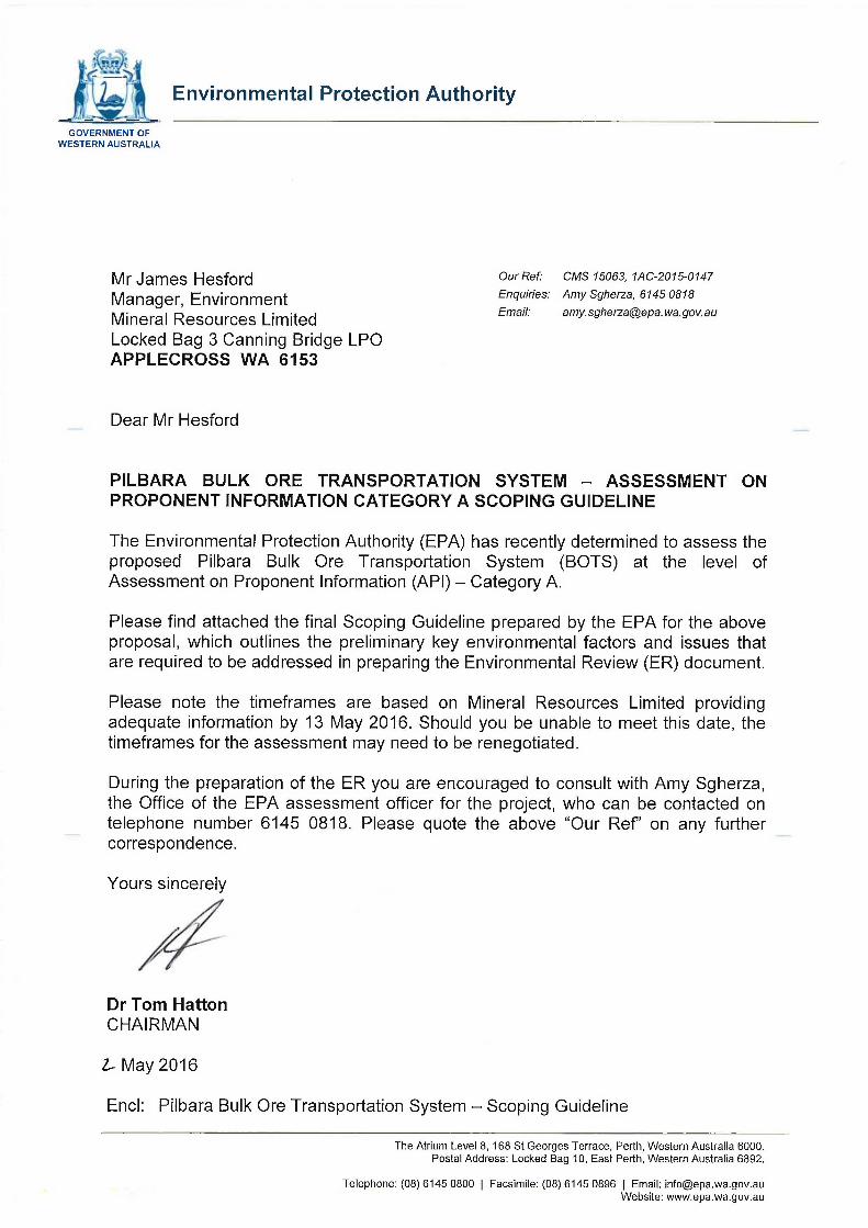
Environmental Protection Authority
GOVERNMENT OF WESTERN AUSTRALIA
Mr James Hesford Manager, Environment Mineral Resources Limited
OurRef: CMS 15063, 1AC-2015-0147 Enquiries: Amy Sgherza, 6145 0818 Email: amy.sgherza@epa. wa.gov.au
Locked Bag 3 Canning Bridge LPO APPLECROSS WA 6153
Dear Mr Hesford
PILBARA BULK ORE TRANSPORTATION SYSTEM - ASSESSMENT ON PROPONENT INFORMATION CATEGORY A SCOPING GUIDELINE
The Environmental Protection Authority (ERA) has recently determined to assess the proposed Pilbara Bulk Ore Transportation System (BOTS) at the level of Assessment on Proponent Information (API) - Category A.
Please find attached the final Scoping Guideline prepared by the EPA for the above proposal, which outlines the preliminary key environmental factors and issues that are required to be addressed in preparing the Environmental Review (ER) document.
Please note the timeframes are based on Mineral Resources Limited providing adequate information by 13 May 2016. Should you be unable to meet this date, the timeframes for the assessment may need to be renegotiated.
During the preparation of the ER you are encouraged to consult with Amy Sgherza, the Office of the EPA assessment officer for the project, who can be contacted on telephone number 6145 0818. Please quote the above "Our Ref on any further correspondence.
Yours sincerely
Dr Tom Hatton CHAIRMAN
V May 2016
End: Pilbara Bulk Ore Transportation System - Scoping Guideline
The Atrium Level 8, 168 St Georges Terrace, Perth, Western Australia 6000. Postal Address: Locked Bag 10, East Perth, Western Australia 6892.
Telephone: (08) 6145 0800 | Facsimile: (08) 6145 0896 | Email: [email protected] Website: www.epa.wa.gov.au

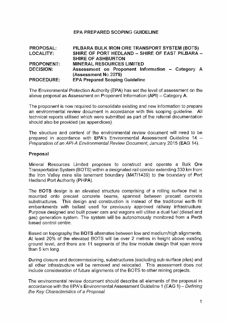
EPA PREPARED SCOPING GUIDELINE
PROPONENT: DECISION:
PROPOSAL: LOCALITY:
PILBARA BULK IRON ORE TRANSPORT SYSTEM (BOTS) SHIRE OF PORT HEDLAND - SHIRE OF EAST PILBARA -SHIRE OF ASHBURTON MINERAL RESOURCES LIMITED
PROCEDURE:
Assessment on Proponent Information - Category A (Assessment No 2075) EPA Prepared Scoping Guideline
The Environmental Protection Authority (EPA) has set the level of assessment on the above proposal as Assessment on Proponent Information (API) - Category A.
The proponent is now required to consolidate existing and new information to prepare an environmental review document in accordance with this scoping guideline. All technical reports utilised which were submitted as part of the referral documentation should also be provided (as appendices).
The structure and content of the environmental review document will need to be prepared in accordance with EPA's Environmental Assessment Guideline 14 -Preparation of an API-A Environmental Review Document, January 2015 (EAG 14).
Mineral Resources Limited proposes to construct and operate a Bulk Ore Transportation System (BOTS) within a designated rail corridor extending 330 km from the Iron Valley mine site tenement boundary (M47/1439) to the boundary of Port Hedland Port Authority (PHPA).
The BOTS design is an elevated structure comprising of a rolling surface that is mounted onto precast concrete beams, spanned between precast concrete substructures. This design and construction is instead of the traditional earth fill embankments with ballast used for previously approved railway infrastructure. Purpose designed and built power cars and wagons will utilise a dual fuel (diesel and gas) generation system. The system will be autonomously monitored from a Perth based control centre.
Based on topography the BOTS alternates between low and medium/high alignments. At least 20% of the elevated BOTS will be over 2 metres in height above existing ground level, and there are 11 segments of the low module design that span more than 5 km long.
During closure and decommissioning, substructures (excluding sub-surface piles) and all other infrastructure will be removed and relocated. This assessment does not include consideration of future alignments of the BOTS to other mining projects.
The environmental review document should describe all elements of the proposal in accordance with the EPA's Environmental Assessment Guideline 1 (EAG 1) - Defining the Key Characteristics of a Proposal.
Proposal
1

Preliminary Key Environmental Factors
The EPA has identified the following preliminary key environmental factors that should be addressed. In addition, the environmental principles from EPA's Environmental Assessment Guideline 8 - Environmental Principles, Factors and Objectives will also need to be addressed in the environmental review document.
Where an EPA policy and/or guideline is listed under each factor, the EPA requires that you explicitly show and document how the relevant considerations in the policies have been given due consideration in the environmental assessment. This is best set out in a subsection of 'Section 5 - Assessment' of the Table of Contents in the environmental review document, in EAG 14.
1. Flora and Vegetation
The EPA's environmental objective for this factor is:
• To maintain representation, diversity, viability and ecological function at the species, population and community level.
The key aspects with regard to this environmental factor are clearing of native vegetation and the activities associated with the construction of the transport infrastructure. Following construction, there are ongoing operational and maintenance activities relevant to the operations phase. Potential effects from construction and operational aspects include the introduction of weeds and diseases, risk of fire ignition and potential fragmentation of communities and habitats.
In addition to preparing an Environmental Review Document in accordance with EAG 14 the following specific information is required:
• The proposal transverses the Fortescue Marsh Management Area, specifically Zones 1a, 1b, 2b and 3b, as described in EPA Report 1484, Environmental and Water assessments relating to mining and mining-related activities in the Fortescue Marsh management area (July 2013).
o Describe the potential direct and indirect impacts of the proposal on the flora and vegetation environmental values as described in each zone.
o Demonstrate how the proposal is consistent with the management objectives with respect to flora and vegetation for each zone and/or strategies to achieve these objectives.
• Map the extent of, and estimate potential impacts to, native vegetation of 'Good' to 'Excellent' condition within the proposed development envelope.
• In completing Section 4 Environmental Studies and Survey Effort of the environmental review document, provide specific information as to how the flora and vegetation surveys that support the assessment were undertaken in accordance with the following EPA policy and guidance:
o Position Statement No. 3 - Terrestrial biological surveys as an element of biodiversity protection, March 2002.
2
o Guidance Statement 51 - Terrestrial Flora and Vegetation Surveys for Environmental Impact Assessment in Western Australia, June 2004.
o Technical Guide Flora and Vegetation Surveys for Environmental Impact Assessment, December 2015.
• Demonstrate and show how the proposal meets the 8 elements as described in Section 4.3 Clearing in Other areas of Western Australia, of Position Statement No. 2- Environmental Protection of Native Vegetation in WA, December 2000.
2. Terrestrial Fauna
The EPA's environmental objective for this factor is:
• To maintain representation, diversity, viability and ecological function at the species, population and assemblage level.
The key aspects with regard to this environmental factor are clearing of native vegetation and the activities associated with the construction of the transport infrastructure, such as trenching. During operations, there are ongoing operational and maintenance activities such as vehicle movements and also from the physical presence of the transport infrastructure. Potential effects from construction and operational aspects include the introduction of pests, risk of fire ignition, potential fragmentation of fauna habitats, changes to quality fauna habitats and fauna mortality from vehicle collisions.
In addition to preparing an Environmental Review Document in accordance with EAG 14 the following specific information is required:
• The proposal transverses the Fortescue Marsh Management Area, specifically Zones 1a, 1b, 2b and 3b, as described in EPA report 1484, Environmental and Water assessments relating to mining and mining-related activities in the Fortescue Marsh management area (July 2013).
o Describe the potential direct and indirect impacts of the proposal on the fauna environmental values as described in each zone.
o Demonstrate how the proposal is consistent with the management objectives with respect to fauna for each zone and/or strategies to achieve these objectives.
• In completing Section 4 Environmental Studies and Survey Effort of the Environmental Review document, please provide specific details as to how the fauna surveys that support the assessment were undertaken in accordance with the following EPA policy and guidance:
o Position Statement No. 3 - Terrestrial biological surveys as an element of biodiversity protection, March 2002.
o Guidance Statement No. 56 - Terrestrial fauna surveys for Environmental Impact assessment in WA, June 2004.
o Technical Guide on Terrestrial Vertebrate Fauna Surveys for Environmental Impact Assessment, September 2010.
3

3. Hydrological Processes
The EPA's environmental objective for this factor is:
• To maintain the hydrological regimes of groundwater and surface water so that existing and potential uses, including ecosystem maintenance, are protected.
The key aspects with regard to this environmental factor are the construction of the transport infrastructure and groundwater abstraction. During operations aspects include ongoing water requirements and also the physical presence of the transport infrastructure. Potential effects from construction and operational aspects include the impacts to, and alteration of, groundwater and surface water regimes.
In addition to preparing an Environmental Review Document in accordance with EAG 14 the following specific information is required:
• The proposal transverses the Fortescue Marsh Management Area, specifically Zones 1a, 1b, 2b and 3b, as described in EPA Report 1484, Environmental and Water assessments relating to mining and mining-related activities in the Fortescue Marsh management area (July 2013).
o Describe the potential direct and indirect impacts of the proposal on the hydrological values as described in each zone.
o Demonstrate how the proposal addresses the management objectives and/or strategies to achieve these objectives with respect to hydrological processes for each zone.
• Demonstrate how you have considered the following EPA policy:
o Position Statement No. 4, Environmental Protection of Wetlands, November 2004.
4. Rehabilitation and Decommissioning (an integrating factor)
The EPA's environmental objective for this factor is:
• To ensure that premises are decommissioned and rehabilitated in an ecologically sustainable manner.
The key aspects relating to this factor are rehabilitation of temporary disturbance and infrastructure required during construction, and following operations, the removal, disposal and potential relocation of infrastructure during closure and decommissioning.
Specific information required:
• Include measures for the progressive rehabilitation of areas not required for ongoing operations during and following construction.
• Include a rehabilitation and decommissioning strategy which addresses the following:
4
o an environmental outcome or objective; o performance indicators and response actions/ or management actions and
targets; and o monitoring.
• Demonstrate how you have considered the following EPA policy and guidance:
o Guidelines for Preparing Mine Closure Plans. May 2015. Department of Mines and Petroleum and Environmental Protection Authority,
o Guidance Statement 6 - Rehabilitation of Terrestrial Ecosystems, June 2006. o Environmental Protection Bulletin No. 19 - EPA involvement in mine closure,
January 2015. • In addition to the above, have regard to:
o Cumulative environmental impacts of development in the Pilbara Region, Advice of the EPA to the Minister for Environment under Section 16(e) of the Environmental Protection Act 1986, August 2014.
5. Offsets (an integrating factor)
The EPA's environmental objective for this factor is:
• To counterbalance any significant residual environmental impacts or uncertainty through the application of offsets.
The key environmental aspects relating to this factor are the aspects from Flora and Vegetation, Fauna and Rehabilitation and Decommissioning.
Specific information required:
• Complete the WA environmental offsets template. • Following the completion of the environmental offsets template above,
demonstrate how you have considered the following policy and guidance:
o WA Environmental Offsets Guidelines. August 2014. Government of Western Australia.
o Environmental Protection Bulletin No. 1 - Environmental Offsets. August 2014.
• In addition to the above, have regard to:
o Cumulative environmental impacts of development in the Pilbara Region, Advice of the EPA to the Minister for Environment under Section 16(e) of the Environmental Protection Act 1986, August 2014.
5
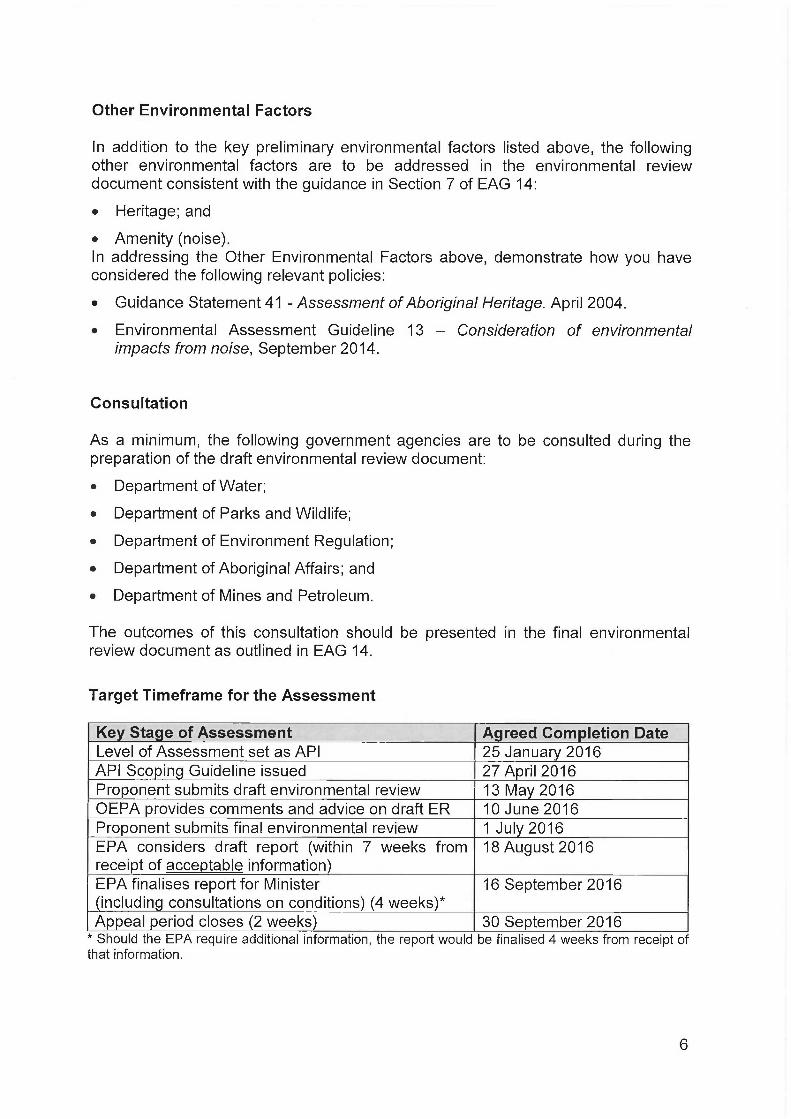
Other Environmental Factors
In addition to the key preliminary environmental factors listed above, the following other environmental factors are to be addressed in the environmental review document consistent with the guidance in Section 7 of EAG 14:
• Heritage; and
• Amenity (noise). In addressing the Other Environmental Factors above, demonstrate considered the following relevant policies:
• Guidance Statement 41 - Assessment of Aboriginal Heritage. April
• Environmental Assessment Guideline 13 - Consideration of impacts from noise, September 2014.
Consultation
As a minimum, the following government agencies are to be consulted during the preparation of the draft environmental review document:
• Department of Water;
• Department of Parks and Wildlife;
• Department of Environment Regulation;
• Department of Aboriginal Affairs; and
• Department of Mines and Petroleum.
The outcomes of this consultation should be presented in the final environmental review document as outlined in EAG 14.
Target Timeframe for the Assessment
Key Stage of Assessment Agreed Completion Date Level of Assessment set as API 25 January 2016 API Scoping Guideline issued 27 April 2016 Proponent submits draft environmental review 13 May 2016 OEPA provides comments and advice on draft ER 10 June 2016 Proponent submits final environmental review 1 July 2016 EPA considers draft report (within 7 weeks from receipt of acceptable information)
18 August 2016
EPA finalises report for Minister (including consultations on conditions) (4 weeks)*
16 September 2016
Appeal period closes (2 weeks) 30 September 2016 * Should the EPA require additional information, the report would be finalised 4 weeks from receipt of that information.
how you have
2004.
environmental
6
If at any stage during the assessment, the agreed timeline is not met or inadequate information is submitted by the proponent, the timing for the completion of subsequent stages of the process will be revised. Equally, where the EPA is unable to meet an agreed completion date in the timelines, the proponent will be advised and the timeline revised accordingly.
The proponent should refer to the EPA's Environmental Assessment Guideline 6 -Timelines for environmental assessment of proposals for information regarding the responsibilities of proponents and the EPA for achieving timely and effective assessment of proposals.
7

Pilbara Bulk Ore Transportation System Project | API Environmental Review Document
ENV-TS-RP-0049_RevC API Environmental Review Document Page | 133
APPENDIX 2
SUPPORTING DOCUMENTATION
Environmental Management Plan
ENVIRONMENTAL MANAGEMENT PLAN
MRL-EN-PLN-0001
Revision
Number Issue Date Prepared By Approved By
GM
Signature
00 2/12/2015 G. Barrett S. Gregory
01 29/01/2016 G. Barrett S. Gregory
02 9/02/2016 G. Barrett S. Gregory
03 23/05/2016 E. Tomich J. Hesford

Environmental Management Plan
Issue Date: 23/05/2016 MRL-EN-PLN-0001_03 Page 2 of 26
Printed copies of this document are not controlled. Please ensure that this is the latest available version before use.
TABLE OF CONTENTS
1. PURPOSE ............................................................................................................................... 4
2. SCOPE .................................................................................................................................... 5
3. DEFINITIONS AND ABBREVIATIONS .................................................................................... 5
3.1 Definitions ....................................................................................................................... 5
3.2 Abbreviations .................................................................................................................. 6
4. POLICY .................................................................................................................................... 6
5. PLANNING .............................................................................................................................. 6
5.1 Legal and other requirements ......................................................................................... 6
5.2 Risk Management ........................................................................................................... 9
5.3 Objectives and targets .................................................................................................. 10
6. IMPLEMENTATION ............................................................................................................... 10
6.1 Responsibility and accountability .................................................................................. 10
6.2 Competence, training and awareness ........................................................................... 11
7. COMMUNICATION AND CONSULTATION ........................................................................... 12
7.1 Consultation .................................................................................................................. 12
7.2 Communication of this EMP .......................................................................................... 13
7.3 Meetings ....................................................................................................................... 13
7.4 Noticeboards ................................................................................................................. 13
7.5 Environmental Management Performance Reporting .................................................... 14
8. OPERATIONAL CONTROL ................................................................................................... 14
8.1 Overview ....................................................................................................................... 14
8.2 Land clearing and access ............................................................................................. 14
8.3 Flora and vegetation ..................................................................................................... 15
8.4 Fauna ........................................................................................................................... 15
8.5 Soils .............................................................................................................................. 15
8.6 Water ............................................................................................................................ 15
8.7 Land rehabilitation ......................................................................................................... 16
8.8 Heritage ........................................................................................................................ 16
8.9 Air quality ...................................................................................................................... 16
8.10 Greenhouse gases ........................................................................................................ 16
8.11 Noise and vibration ....................................................................................................... 16
8.12 Waste rock .................................................................................................................... 17
8.13 Fuels and oils ................................................................................................................ 17
8.14 Other wastes ................................................................................................................. 17
Environmental Management Plan
Issue Date: 23/05/2016 MRL-EN-PLN-0001_03 Page 3 of 26
Printed copies of this document are not controlled. Please ensure that this is the latest available version before use.
8.15 Chemicals ..................................................................................................................... 17
9. INCIDENT MANAGEMENT .................................................................................................... 17
10. CRISIS AND EMERGENCY MANAGEMENT ........................................................................ 18
11. COMPLIANCE MONITORING ............................................................................................... 18
11.1 Legal Compliance ......................................................................................................... 18
11.2 Environmental Monitoring ............................................................................................. 19
11.3 Targeted Workplace Inspections ................................................................................... 19
11.4 Audits ............................................................................................................................ 19
12. DOCUMENTS AND RECORDS MANAGEMENT .................................................................. 20
12.1 Document Control ......................................................................................................... 20
12.2 Records Management ................................................................................................... 20
13. ASSESSMENT AND IMPROVEMENT ................................................................................... 20
13.1 Management System Review ........................................................................................ 20
13.2 Leadership Trend / Performance Review ...................................................................... 20
14. REFERENCES ...................................................................................................................... 21
APPENDIX 1 - RESPONSIBILITIES AND ACCOUNTABILITIES .................................................. 22
Environmental Management Plan
Issue Date: 23/05/2016 MRL-EN-PLN-0001_03 Page 4 of 26
Printed copies of this document are not controlled. Please ensure that this is the latest available version before use.
1. PURPOSE
Mineral Resources Limited (MRL), through its mining and associated activities, will have impacts on the environment. MRL is implementing an Environmental Management System (EMS) to manage these impacts, identify and manage compliance, and address risks.
This Environment Management Plan (EMP) is a key element of the EMS. The EMP outlines the programme for MRL to effectively manage environmental factors in all its activities and to meet its legal obligations across all operations. As well as managing the risk of unintended or unnecessary environmental impact, this plan also seeks to reduce or eliminate the business risk associated with poor environmental outcomes at its operations.
To address the diversity across the Business Units, this EMP needs to be read in conjunction with the project-specific approvals and management plans together with any appropriate procedures and work instructions. Considered as a whole, these documents will set the minimum standards required to manage environmental aspects.
The EMS is aligned with the international standard for environmental management systems - ISO 14001:2015. The EMS is available on the “O” drive (O:\Forms & Documents\EN - Environmental), shall be continuously updated and amended to ensure:
• MRL’s objectives and targets are defined;
• Legal obligations are understood and adhered to;
• Our environmental management activities are controlled; and
• A commitment to driving environmental management is demonstrated.
The following figure outlines the main features of the EMS. Environmental improvement is driven using the Plan-Do-Check-Act (PDCA) model.
Environmental Management Plan
Issue Date: 23/05/2016 MRL-EN-PLN-0001_03 Page 5 of 26
Printed copies of this document are not controlled. Please ensure that this is the latest available version before use.
The PDCA model can be described as follows, as it applies to MRL:
Leadership • Take accountability for effectiveness of EMS.
• Integrate EMS into MRL's business processes.
• Ensure the resources needed for the EMS are available.
• Promote continual improvement.
Plan • Establish environmental objectives, KPIs and processes necessary to deliver results in accordance with the MRL's policy.
• Identify legal obligations.
Do • Develop and implement an EMP.
• Develop and implement systems and operational procedures, and work instructions.
• Identify and meet training needs.
• Identify responsibilities and accountabilities.
• Emergency preparedness and response.
Check • Measure progress against KPIs.
• Environmental monitoring programs.
• Auditing and inspection.
• Records control.
Act • Consider performance and take actions to continually improve.
2. SCOPE
This EMP is specific to MRL, its subsidiaries and operations across Australia and has been developed in line with all applicable legislation.
Compliance to this document, appendices and other referenced documents is mandatory and indicates the minimum compliance requirement for all Business Units, Projects and Contracts.
Contractors working on MRL projects and mobilised using their own Management Systems must meet the requirements and expectations set by MRL in this area.
3. DEFINITIONS AND ABBREVIATIONS
3.1 Definitions
Business MRL
Environmental Management Management of environmental aspects across MRL
projects
Corporate Environmental
Team
Chief Operating Officer, General Manager Technical
Services, Manager Environment, corporate
environmental advisors, site managers, operations
environmental personnel, Group Document Controller.
Environmental aspect An aspect of the environment which is likely to be
impacted by a particular project or operation.

Environmental Management Plan
Issue Date: 23/05/2016 MRL-EN-PLN-0001_03 Page 6 of 26
Printed copies of this document are not controlled. Please ensure that this is the latest available version before use.
Key environmental aspect An aspect of the environment which is likely to be
impacted by a particular project or operation and which
is a primary consideration in the development of an
environmental management program.
High Potential Incident Any incident rated with a consequence of 4 or 5 in
accordance with the MRL Risk Matrix (see MRL-OHM-
PRO-0007).
Project All MRL and Business Units work locations such as
Corporate Offices, Construction Sites, Operational
Mines, Processing Facilities, Fabrication Areas and
Workshops
Project Management Team Members of the individual project teams
Our People Permanent and casual employees, contracting and
subcontracting employees, service providers, people
on secondment and visitors
Risk Assessment A detailed systematic examination of any activity,
location or operational system to identify risks,
understand the likelihood and potential consequences
of the risks and to review the current or planned
approaches to controlling the risk.
STEMS MRL's web-based management tool primarily used for
managing safety performance.
3.2 Abbreviations
EMS Environmental Management System
EMP Environmental Management Plan
MRL Mineral Resource Limited and subsidiary companies
OHM Occupational Hazard Management
ICAM Incident Cause Analysis Method
4. POLICY
The MRL Environment and Community Policy is available from the “O” drive (O:\Forms & Documents\EN - Environmental\POL - Policies). The Policy will be communicated to our people during Induction, and shall be posted on noticeboards located at MRL's head offices and at each project.
5. PLANNING
5.1 Legal and other requirements
The following legislation provides the broad framework for which this EMP must operate and with which all Western Australian MRL operations need to comply.
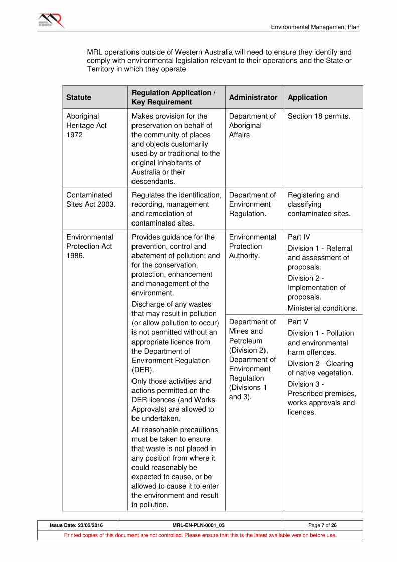
Environmental Management Plan
Issue Date: 23/05/2016 MRL-EN-PLN-0001_03 Page 7 of 26
Printed copies of this document are not controlled. Please ensure that this is the latest available version before use.
MRL operations outside of Western Australia will need to ensure they identify and comply with environmental legislation relevant to their operations and the State or Territory in which they operate.
Statute Regulation Application /
Key Requirement Administrator Application
Aboriginal
Heritage Act
1972
Makes provision for the
preservation on behalf of
the community of places
and objects customarily
used by or traditional to the
original inhabitants of
Australia or their
descendants.
Department of
Aboriginal
Affairs
Section 18 permits.
Contaminated
Sites Act 2003.
Regulates the identification,
recording, management
and remediation of
contaminated sites.
Department of
Environment
Regulation.
Registering and
classifying
contaminated sites.
Environmental
Protection Act
1986.
Provides guidance for the
prevention, control and
abatement of pollution; and
for the conservation,
protection, enhancement
and management of the
environment.
Discharge of any wastes
that may result in pollution
(or allow pollution to occur)
is not permitted without an
appropriate licence from
the Department of
Environment Regulation
(DER).
Only those activities and
actions permitted on the
DER licences (and Works
Approvals) are allowed to
be undertaken.
All reasonable precautions
must be taken to ensure
that waste is not placed in
any position from where it
could reasonably be
expected to cause, or be
allowed to cause it to enter
the environment and result
in pollution.
Environmental
Protection
Authority.
Part IV
Division 1 - Referral
and assessment of
proposals.
Division 2 -
Implementation of
proposals.
Ministerial conditions.
Department of
Mines and
Petroleum
(Division 2),
Department of
Environment
Regulation
(Divisions 1
and 3).
Part V
Division 1 - Pollution
and environmental
harm offences.
Division 2 - Clearing
of native vegetation.
Division 3 -
Prescribed premises,
works approvals and
licences.
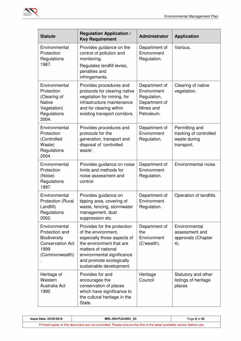
Environmental Management Plan
Issue Date: 23/05/2016 MRL-EN-PLN-0001_03 Page 8 of 26
Printed copies of this document are not controlled. Please ensure that this is the latest available version before use.
Statute Regulation Application /
Key Requirement Administrator Application
Environmental
Protection
Regulations
1987.
Provides guidance on the
control of pollution and
monitoring.
Regulates landfill levies,
penalties and
infringements.
Department of
Environment
Regulation.
Various.
Environmental
Protection
(Clearing of
Native
Vegetation)
Regulations
2004.
Provides procedures and
protocols for clearing native
vegetation for mining, for
infrastructure maintenance
and for clearing within
existing transport corridors.
Department of
Environment
Regulation,
Department of
Mines and
Petroleum.
Clearing of native
vegetation.
Environmental
Protection
(Controlled
Waste)
Regulations
2004.
Provides procedures and
protocols for the
generation, transport and
disposal of ‘controlled
waste’.
Department of
Environment
Regulation.
Permitting and
tracking of controlled
waste during
transport.
Environmental
Protection
(Noise)
Regulations
1997.
Provides guidance on noise
limits and methods for
noise assessment and
control.
Department of
Environment
Regulation.
Environmental noise.
Environmental
Protection (Rural
Landfill)
Regulations
2002.
Provides guidance on
tipping area, covering of
waste, fencing, stormwater
management, dust
suppression etc.
Department of
Environment
Regulation.
Operation of landfills.
Environmental
Protection and
Biodiversity
Conservation Act
1999
(Commonwealth)
.
Provides for the protection
of the environment,
especially those aspects of
the environment that are
matters of national
environmental significance
and promote ecologically
sustainable development.
Department of
the
Environment
(C'wealth).
Environmental
assessment and
approvals (Chapter
4).
Heritage of
Western
Australia Act
1990
Provides for and
encourages the
conservation of places
which have significance to
the cultural heritage in the
State.
Heritage
Council
Statutory and other
listings of heritage
places
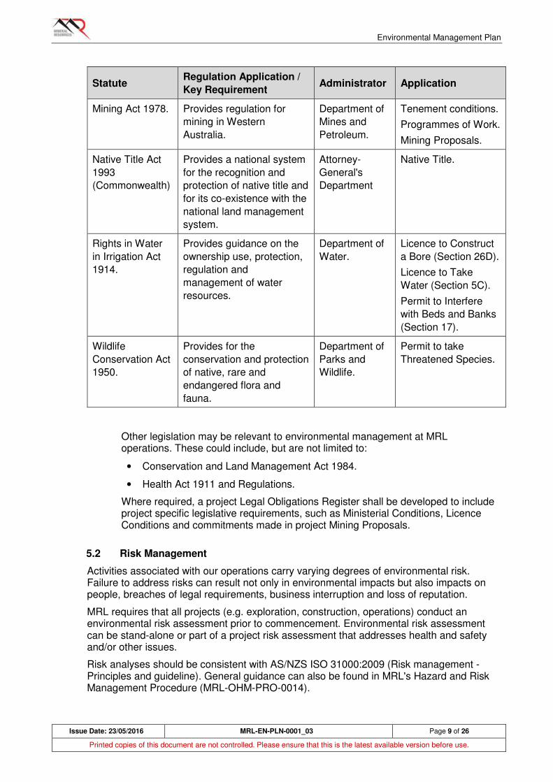
Environmental Management Plan
Issue Date: 23/05/2016 MRL-EN-PLN-0001_03 Page 9 of 26
Printed copies of this document are not controlled. Please ensure that this is the latest available version before use.
Statute Regulation Application /
Key Requirement Administrator Application
Mining Act 1978. Provides regulation for
mining in Western
Australia.
Department of
Mines and
Petroleum.
Tenement conditions.
Programmes of Work.
Mining Proposals.
Native Title Act
1993
(Commonwealth)
Provides a national system
for the recognition and
protection of native title and
for its co-existence with the
national land management
system.
Attorney-
General's
Department
Native Title.
Rights in Water
in Irrigation Act
1914.
Provides guidance on the
ownership use, protection,
regulation and
management of water
resources.
Department of
Water.
Licence to Construct
a Bore (Section 26D).
Licence to Take
Water (Section 5C).
Permit to Interfere
with Beds and Banks
(Section 17).
Wildlife
Conservation Act
1950.
Provides for the
conservation and protection
of native, rare and
endangered flora and
fauna.
Department of
Parks and
Wildlife.
Permit to take
Threatened Species.
Other legislation may be relevant to environmental management at MRL operations. These could include, but are not limited to:
• Conservation and Land Management Act 1984.
• Health Act 1911 and Regulations.
Where required, a project Legal Obligations Register shall be developed to include project specific legislative requirements, such as Ministerial Conditions, Licence Conditions and commitments made in project Mining Proposals.
5.2 Risk Management
Activities associated with our operations carry varying degrees of environmental risk. Failure to address risks can result not only in environmental impacts but also impacts on people, breaches of legal requirements, business interruption and loss of reputation.
MRL requires that all projects (e.g. exploration, construction, operations) conduct an environmental risk assessment prior to commencement. Environmental risk assessment can be stand-alone or part of a project risk assessment that addresses health and safety and/or other issues.
Risk analyses should be consistent with AS/NZS ISO 31000:2009 (Risk management - Principles and guideline). General guidance can also be found in MRL's Hazard and Risk Management Procedure (MRL-OHM-PRO-0014).
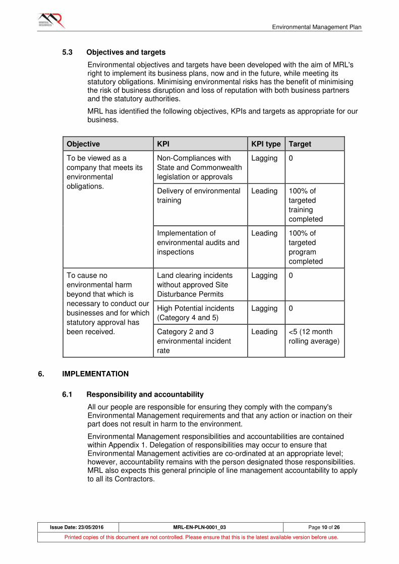
Environmental Management Plan
Issue Date: 23/05/2016 MRL-EN-PLN-0001_03 Page 10 of 26
Printed copies of this document are not controlled. Please ensure that this is the latest available version before use.
5.3 Objectives and targets
Environmental objectives and targets have been developed with the aim of MRL's right to implement its business plans, now and in the future, while meeting its statutory obligations. Minimising environmental risks has the benefit of minimising the risk of business disruption and loss of reputation with both business partners and the statutory authorities.
MRL has identified the following objectives, KPIs and targets as appropriate for our business.
Objective KPI KPI type Target
To be viewed as a
company that meets its
environmental
obligations.
Non-Compliances with
State and Commonwealth
legislation or approvals
Lagging 0
Delivery of environmental
training
Leading 100% of
targeted
training
completed
Implementation of
environmental audits and
inspections
Leading 100% of
targeted
program
completed
To cause no
environmental harm
beyond that which is
necessary to conduct our
businesses and for which
statutory approval has
been received.
Land clearing incidents
without approved Site
Disturbance Permits
Lagging 0
High Potential incidents
(Category 4 and 5)
Lagging 0
Category 2 and 3
environmental incident
rate
Leading <5 (12 month
rolling average)
6. IMPLEMENTATION
6.1 Responsibility and accountability
All our people are responsible for ensuring they comply with the company's Environmental Management requirements and that any action or inaction on their part does not result in harm to the environment.
Environmental Management responsibilities and accountabilities are contained within Appendix 1. Delegation of responsibilities may occur to ensure that Environmental Management activities are co-ordinated at an appropriate level; however, accountability remains with the person designated those responsibilities. MRL also expects this general principle of line management accountability to apply to all its Contractors.
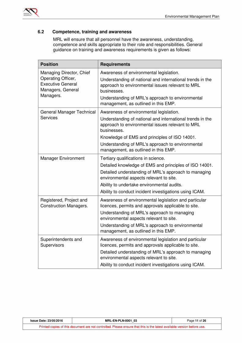
Environmental Management Plan
Issue Date: 23/05/2016 MRL-EN-PLN-0001_03 Page 11 of 26
Printed copies of this document are not controlled. Please ensure that this is the latest available version before use.
6.2 Competence, training and awareness
MRL will ensure that all personnel have the awareness, understanding, competence and skills appropriate to their role and responsibilities. General guidance on training and awareness requirements is given as follows:
Position Requirements
Managing Director, Chief
Operating Officer,
Executive General
Managers, General
Managers.
Awareness of environmental legislation.
Understanding of national and international trends in the
approach to environmental issues relevant to MRL
businesses.
Understanding of MRL's approach to environmental
management, as outlined in this EMP.
General Manager Technical
Services
Awareness of environmental legislation.
Understanding of national and international trends in the
approach to environmental issues relevant to MRL
businesses.
Knowledge of EMS and principles of ISO 14001.
Understanding of MRL's approach to environmental
management, as outlined in this EMP.
Manager Environment Tertiary qualifications in science.
Detailed knowledge of EMS and principles of ISO 14001.
Detailed understanding of MRL's approach to managing
environmental aspects relevant to site.
Ability to undertake environmental audits.
Ability to conduct incident investigations using ICAM.
Registered, Project and
Construction Managers.
Awareness of environmental legislation and particular
licences, permits and approvals applicable to site.
Understanding of MRL's approach to managing
environmental aspects relevant to site.
Understanding of MRL's approach to environmental
management, as outlined in this EMP.
Superintendents and
Supervisors
Awareness of environmental legislation and particular
licences, permits and approvals applicable to site.
Detailed understanding of MRL's approach to managing
environmental aspects relevant to site.
Ability to conduct incident investigations using ICAM.

Environmental Management Plan
Issue Date: 23/05/2016 MRL-EN-PLN-0001_03 Page 12 of 26
Printed copies of this document are not controlled. Please ensure that this is the latest available version before use.
Position Requirements
Environmental Advisors Tertiary qualifications in science.
Working knowledge of EMS and principles of ISO 14001.
Detailed understanding of MRL's approach to managing
environmental aspects relevant to site.
Ability to undertake environmental audits.
Ability to conduct incident investigations using ICAM.
Specialist training (e.g. land rehabilitation techniques, fauna
handling, water sampling and testing) appropriate to site.
Our People Awareness of MRL's approach to environmental
management.
Awareness of environmental aspects relevant to site and
their management.
Specialist training (e.g. spill management) appropriate to
site.
As a minimum, training comprises the corporate and site inductions, both of which contain an environmental component. Other training and awareness can be delivered through toolbox meetings, presentations and refreshers.
An annual program of environmental training requirements must be developed and implemented.
All training records for the Business shall be maintained in STEMS. Contractors shall maintain their own records, and where requested, shall make these available to MRL and Business Units.
Training records shall be made accessible to the individual and relevant departments such as Human Resources and Environment as appropriate.
As a minimum, training records should include details on who has been trained, what the training course covered, what competencies or qualifications were achieved or obtained, the identification of the provider and training duration.
7. COMMUNICATION AND CONSULTATION
Continuous improvement in environmental management performance will be driven by improved communication and consultation at all levels across the business. This is achieved by increasing our people’s, engagement and participation in environmental management, through the mechanisms outlined in this section.
7.1 Consultation
Consultation is an important process and requires effective two-way communication to ensure the transfer of information within organisations.
As a minimum, our people shall be consulted on environmental management matters where:
• Changes that may affect the environmental management of the Project is proposed, including changes to systems or methods of work, such as land clearing procedures;
• Decisions are being made to introduce new procedures; and

Environmental Management Plan
Issue Date: 23/05/2016 MRL-EN-PLN-0001_03 Page 13 of 26
Printed copies of this document are not controlled. Please ensure that this is the latest available version before use.
• Our people’s input into control methods is required.
Consultation with our people on environmental management matters shall be through the various communication arrangements that apply for each Project. These are detailed below.
7.2 Communication of this EMP
Details of this EMP shall be communicated to our people during the MRL induction. Reinforcement of key elements contained within the EMP shall be communicated as per the communication and consultation mechanisms outlined in section 7.
In addition, current copies of this EMP and related Policies, Procedures, Forms and other documents shall be available to our people via the MRL’s “O” Drive.
7.3 Meetings
The following meetings will have an environmental component:
Meeting Purpose Who Frequency Records
Pre-shift Management of
site environmental
factors (brief).
Workgroup, Project
Managers, Site
Supervisors,
Environmental
personnel.
Daily Nil
Toolbox Management of
site environmental
factors (detail).
Workgroup, Project
Managers, Site
Supervisors,
Environmental
personnel.
Weekly Attendance
records
Contractor
Progress
Environmental
performance.
Review of
management
procedures.
Project Management
Team, Contractor's
representative.
Weekly Minutes
Site
Management
Environmental
performance.
Site environmental
strategy.
Project Management
Team.
Weekly Minutes
Senior
Management
Environmental
performance.
Company
environmental
strategy.
Managing Director,
Executive and
General Managers.
Weekly Minutes
7.4 Noticeboards
Projects will utilise noticeboards placed in prominent positions to provide information on environmental management, including:
Environmental Management Plan
Issue Date: 23/05/2016 MRL-EN-PLN-0001_03 Page 14 of 26
Printed copies of this document are not controlled. Please ensure that this is the latest available version before use.
• Environment and Community Policy;
• Environmental Management Alerts;
• Statistics and Performance Reports;
• General Environmental Management Information; and
• Emergency communication contacts.
Environmental personnel shall ensure the noticeboards contain up to date information.
7.5 Environmental Management Performance Reporting
Projects shall compile a report against the established Key Performance Indicators, inclusive of contractor results, on a monthly basis to be submitted to the Manager Environment or his delegate for compilation and further distribution.
Reports shall be submitted on the appropriate monthly report template and within the required timeframe, ensuring that the following information is reported on:
• Key performance indicators;
• Environmental Incidents
• Achievements;
• Key activities; and
• Challenges.
8. OPERATIONAL CONTROL
8.1 Overview
Project works shall be conducted in line with existing MRL standards and procedures. This section outlines the standards to which MRL will manage environmental factors at its operations. MRL procedures outline management of these factors in more detail. Where these procedures are deemed insufficient or inapplicable, project-specific procedures or work instructions shall be developed to ensure works are conducted in accordance with legislative requirements, contractual obligations and with minimal environmental harm.
8.2 Land clearing and access
Land clearing for exploration and to establish mines and infrastructure is the most significant environmental impact MRL is likely to have. No land clearing should occur without first undertaking checks to ensure the relevant approvals are in place and to consider the potential impacts. Mine and infrastructure sites must use a Site Disturbance Permit system or equivalent to ensure these checks are done. Note that a Site Disturbance Permit may also be required for land previously disturbed by others and where MRL is seeking to commence activities. Site Disturbance Permits and land clearing are covered by MRL-EN-PRO-0005 and MRL-EN-PRO-0004 respectively.
The permit may have conditions attached to it relevant to the area to be cleared. Failure to meet the requirements of the Permit will require an Incident Report and may be an externally Reportable Incident (see Section 9).
Environmental Management Plan
Issue Date: 23/05/2016 MRL-EN-PLN-0001_03 Page 15 of 26
Printed copies of this document are not controlled. Please ensure that this is the latest available version before use.
8.3 Flora and vegetation
Flora (individual plants, including rare species) and vegetation (whole plant communities) are protected under State and Commonwealth laws. MRL conducts flora surveys over areas for which clearing is proposed. Once surveys are completed, MRL will seek approval to clear those areas. If approval is received, it may be conditional where particular plant species or communities are avoided or otherwise protected. MRL will only remove flora and vegetation where it has approval to do so. MRL will also adhere to any conditions placed on approvals to clear, including special protection for plants with high conservation values.
MRL will prevent the introduction and / or spread of weeds in areas in which it operates. MRL will do this by using a Weed Hygiene system to prevent transfer of weed seeds through movement of earthmoving equipment or weed-affected soils (see MRL-EN-PRO-0007).
MRL will also manage to prevent potential indirect impacts on flora and vegetation, such as dust on foliage or saline water spills that affect vegetation.
8.4 Fauna
Fauna (vertebrate and some invertebrate species) are protected under State and Commonwealth laws. MRL conducts fauna surveys over areas for which clearing is proposed. Approvals, if received, may be conditional whereby mining can proceed provided particular habitats or species are protected. MRL will only remove fauna habitat where it has approval to do so. MRL will also adhere to any conditions placed on approvals to clear, including protection of animals with high conservation values.
MRL will ensure they do not inadvertently assist feral animals to establish or increase local populations. MRL personnel and contractors will not feed or otherwise encourage feral animals and potential food sources, such as landfills, will be managed to ensure they cannot be utilised by feral animals. Under some circumstances, control programs may be required.
Special attention will be paid to trenching operations. Open trenches can trap nocturnal animals. Small mammals and reptiles can subsequently die from exposure or predation. MRL will have procedures to manage fauna interaction with open trenches.
For more information on fauna management see MRL-EN-PRO-0001.
8.5 Soils
Soil is a critical resource for plants and animals. When conducting land clearing (see MRL-EN-PRO-0004), MRL will preserve topsoil for future rehabilitation work. MRL will also protect soils from unnecessary disturbance or degradation through vehicle movements, weeds, and saline water or fuel spillages.
8.6 Water
MRL uses water for mineral processing, dust suppression and domestic (village) purposes. These requirements are usually met by extracting groundwater. MRL will only extract groundwater under licence from the statutory authority.
MRL will manage process water, especially saline water, so it does not cause adverse impacts on the environment. This will usually involve spill protection measures and regular inspection of saline water infrastructure.
Environmental Management Plan
Issue Date: 23/05/2016 MRL-EN-PLN-0001_03 Page 16 of 26
Printed copies of this document are not controlled. Please ensure that this is the latest available version before use.
MRL will not interfere with water flows in creeks and streams, except where it has approval to do so (see MRL-EN-PRO-0003).
8.7 Land rehabilitation
When exploration, mining or related uses are complete, MRL will rehabilitate all disturbed areas to stable, safe and self-sustaining landforms (see MRL-EN-PRO-0009). An exception can occur where a facility can be used under agreement with a subsequent land manager, for example, a road that can be used by a pastoralist for future grazing operations.
MRL will include consideration of land rehabilitation within the mine plan to ensure that final landforms and rehabilitation are achieved with the minimum post-mining liability to MRL.
MRL will conduct rehabilitation progressively wherever possible to minimise:
• financial obligations under the Mine Rehabilitation Fund (MRF),
• financial liability upon mine closure;
• holding costs associated with maintaining tenure awaiting relinquishment.
8.8 Heritage
MRL's operations have to potential to disturb or otherwise affect sites of heritage significance, Aboriginal and European.
MRL will ensure that heritage is considered in planning and conducting its activities, and that it acts in accordance with the relevant laws and regulations (see MR MRL-EN-PRO-0015). MRL recognises the Traditional Owners of the land it operates in and will negotiate in good faith for land access.
8.9 Air quality
MRL's operations will generate emissions to air. These emissions will include dust and may include combustion emissions such as nitrous oxides. MRL will manage these emissions in accordance with the relevant standards. In the case of dust, visible dust generated from vehicle movements, blasting, crushing or other activities will be controlled wherever possible. For some activities, such as topsoil stripping, dust suppression may not be viable. More information can be found in MRL-EN-PRO-0012.
This plan does not address air quality within the work environment and any occupational health implications that might apply.
8.10 Greenhouse gases
Greenhouse gases are produced through combustion of fuel. In MRL's operations, this will usually involve combustion of diesel although gas-fired power stations may be operated.
MRL will meet any government reporting requirements in respect of greenhouse gases and will consider energy efficiency when designing projects.
8.11 Noise and vibration
MRL's operations will generate noise through vehicle movements, blasting and other activities. MRL will consider the potential impacts on local communities and

Environmental Management Plan
Issue Date: 23/05/2016 MRL-EN-PLN-0001_03 Page 17 of 26
Printed copies of this document are not controlled. Please ensure that this is the latest available version before use.
residences, and develop and implement management measures to ensure legal obligations in respect to environmental noise are met.
This plan does not address noise within the work environment and any occupational health implications that might apply.
8.12 Waste rock
MRL's mining operations will produce large quantities of waste rock to access ore. Prior to mining, MRL will test waste rock to identify any adverse characteristics, such as acid generation. MRL will plan and implement management measures for any problematic materials to avoid environmental impacts.
8.13 Fuels and oils
MRL stores and uses large amounts of diesel fuel and other hydrocarbons for its operations. MRL will manage fuels and oils to minimise the potential for spills or leaks. Spill kits will be available in workshops and employees will be trained in their use. All oily wastes will be disposed of using a licensed contractor. More information can be found in MRL-EN-PRO-0002).
8.14 Other wastes
In the course of its operations, MRL will produce waste materials such as food wastes, sewage sludge, inert materials (such as building and construction materials), brine from reverse osmosis plants, tyres and other materials. Landfills and waste water treatment plants will be constructed and operated in accordance with licence conditions and guidelines. MRL will use a licensed contractor or other approved method to dispose of wastes not suitable for landfill. The principle of waste minimisation - reduce, reuse and recycle - should be applied to the extent possible within the constraints of the site. More information can be found in MRL-EN-PRO-0011).
8.15 Chemicals
MRL will always use, store and dispose of chemicals in accordance with sound industry practice and its legal requirements - see MRL-EN-PRO-0002.
9. INCIDENT MANAGEMENT
Events that either cause, or have the potential to cause harm or contamination of the environment will be reported and investigated as stipulated in the Incident Classification and Reporting Procedure (MRL-OHM-PRO-0007). The MRL Incident Report Form (MRL-OHM-FRM-0002) shall be used to report all incidents occurring on the Project to the MRL system.
In addition, Projects may also be required to, either by contract or by client requirements, to complete and submit a client report form.
Projects are required to maintain a register of all incidents in the MRL Incident Management Systems STEMS, which include:
Environmental Management Plan
Issue Date: 23/05/2016 MRL-EN-PLN-0001_03 Page 18 of 26
Printed copies of this document are not controlled. Please ensure that this is the latest available version before use.
• Initial Incidents are logged in STEMS within 24 hours;
• All relevant documents and photos are uploaded with the report; and
• Incidents are monitored, updated and closed out within the required timeframes.
Incidents are classified with a potential consequence ranking between 1 (minor) and 5 (major). For incidents with a potential consequence ranking of 3 or greater, a Formal Root Cause ICAM Investigation shall be undertaken in accordance with the standard ICAM methodology and shall be led by a trained and competent ICAM facilitator.
Corrective and preventative actions arising from an incident investigation shall be recorded within the incident record on STEMS for monitoring to closeout. For high potential events, a review of all corrective actions associated with high potential events will be followed up within three (3) months of the incident date to ensure the risks have been effectively controlled.
All regulatory reporting for the Project shall be undertaken by the Client, the Registered Manager, or a person having control of a workplace or delegate.
10. CRISIS AND EMERGENCY MANAGEMENT
MRL has a detailed plan in place for crisis and emergency management with defined roles, responsibilities and arrangements to activate a rapid and organised response to an emergency or crisis situation that has the potential to impact MRL at the highest level.
Crisis and emergency situations can be defined as civil unrest, security issues, fatalities, significant environmental harm, kidnap, accidents, community outrage, prosecutions and suspension of licences. Further detail can be found within the Crisis and Emergency Management Plan (MRL-OHM-PLN-0001).
All projects shall have a documented system to plan and respond to identified types of emergency situations. The Plan shall outline the roles, responsibilities, training requirements, resources, communication protocols, and processes for emergency management and response, on the Project.
Projects shall have a structured program of simulations, drills and exercises for various types of emergencies relevant to the project with the frequency to be defined by the risk ranking.
Projects that are located in areas subject to cyclonic events shall have a documented Cyclone Management Procedure which outlines the Project’s overall coordination and preparation to enable a timely and effective response to cyclones.
11. COMPLIANCE MONITORING
11.1 Legal Compliance
Where required, a project Legal Obligations Register (LOR) shall be developed by the Corporate Environmental Team or delegate to include project specific legislative requirements, such as Ministerial Conditions, Licence Conditions and commitments made in project Mining Proposals. The register will track reporting requirements. The LOR shall be reviewed and currency maintained by the operations Environmental and HSE personnel. For more information on managing compliance see MRL-EN-PRO-0006.
Environmental Management Plan
Issue Date: 23/05/2016 MRL-EN-PLN-0001_03 Page 19 of 26
Printed copies of this document are not controlled. Please ensure that this is the latest available version before use.
11.2 Environmental Monitoring
Monitoring will be conducted where required for legal compliance and in accordance with best practice, to determine the effectiveness of controls, and to meet reporting requirements. A project Monitoring Schedule shall be developed where required by the Project Management Team to ensure compliance with legal and other requirements.
All monitoring documentation, records and data is to be maintained and controlled for internal and external reporting purposes.
Monitoring and calibration records are to be collected and maintained for all monitoring works conducted.
Failure to complete required monitoring is to be reported as an environmental non-compliance incident. Monitoring results that fall outside targeted thresholds shall also be reported as an incident.
Monitoring data is to be validated and regularly reviewed to assess any non-conformances or trends. Identified trends are to be addressed and remedial or improvement actions identified as appropriate.
11.3 Targeted Workplace Inspections
Targeted workplace inspections are aimed at preventing incidents relating to high risk work areas or tasks.
Targeted workplace inspections shall be conducted at least weekly by a member of the Project Management Team and/or a member of the Project Management Team with the aim of inspecting all risk areas each month.
11.4 Audits
A Schedule of Audits shall be developed by the Manager Environment to monitor compliance against this Plan (see MRL-EN-PRO-0008). Audits will comprise assessment of one or all of the following:
• Compliance with this EMP.
• Compliance with conditions of site-specific licences, permits and other approvals.
• Compliance with targeted aspects of operations e.g. land clearing and use of Site Disturbance Permits.
Our people conducting audits shall be trained and competent in the audit tool, hold qualifications in Auditing, and have expertise in the area being audited.
From time to time, external third party auditing of the Projects may take place. This may include, but not be limited to Client audits, Management Systems Certification audits and Regulatory inspections.
The Project Management Team shall make itself available to participate in such audits as requested.
Environmental Management Plan
Issue Date: 23/05/2016 MRL-EN-PLN-0001_03 Page 20 of 26
Printed copies of this document are not controlled. Please ensure that this is the latest available version before use.
12. DOCUMENTS AND RECORDS MANAGEMENT
12.1 Document Control
All Company documents shall be controlled in accordance with the Document Control Procedure (MRL-DC-PRO-0001).
12.2 Records Management
All Project records shall be retained in accordance with the Document Control Procedure (MRL-DC-PRO-0001).
Access to these records will be restricted in accordance with the type of record and information contained within, and controlled to prevent unauthorised access.
13. ASSESSMENT AND IMPROVEMENT
13.1 Management System Review
On an annual basis, a formal review of the EMS and this Plan shall be conducted by the Corporate Environment team. In instances where the review identifies an opportunity for improvement, the Plan shall be updated and the changes communicated to the Projects. The review and all changes shall be noted in the review minutes.
13.2 Leadership Trend / Performance Review
On an annual basis, the Corporate Environmental Team shall conduct a formal review of the Company’s environmental performance with the objective of ensuring the completeness, accuracy and relevancy of current activities in the context of the Company’s Project’s risk profile. The review will focus on the following key areas:
• Status of achievement of objectives and actions. In the event that these objectives and targets are not being met, improvement opportunities to meet objectives and targets;
• Key performance indicators;
• Incident trends;
• Audit results;
• Key activities and associated risks in the upcoming quarter; and
• Upcoming environmental management activities.
In instances where the review identifies an opportunity for improvement, this shall be incorporated in the Projects Environmental Team’s schedule of activities and reflected in subsequent reviews of this Plan.
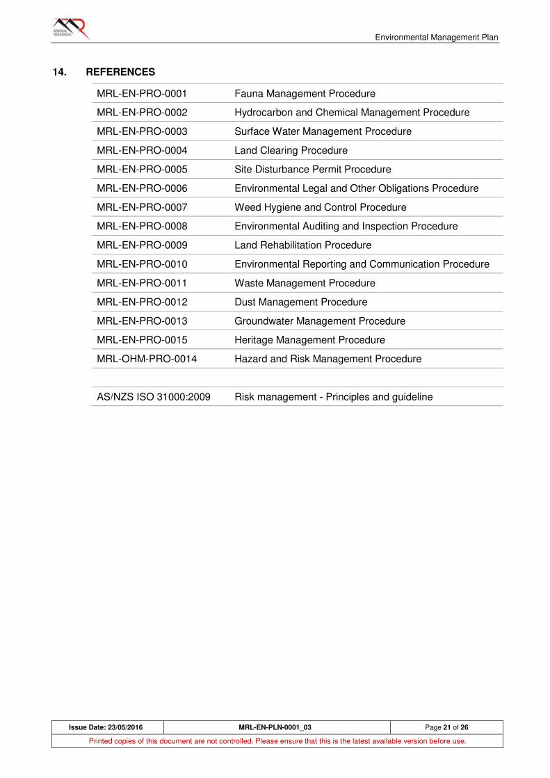
Environmental Management Plan
Issue Date: 23/05/2016 MRL-EN-PLN-0001_03 Page 21 of 26
Printed copies of this document are not controlled. Please ensure that this is the latest available version before use.
14. REFERENCES
MRL-EN-PRO-0001 Fauna Management Procedure
MRL-EN-PRO-0002 Hydrocarbon and Chemical Management Procedure
MRL-EN-PRO-0003 Surface Water Management Procedure
MRL-EN-PRO-0004 Land Clearing Procedure
MRL-EN-PRO-0005 Site Disturbance Permit Procedure
MRL-EN-PRO-0006 Environmental Legal and Other Obligations Procedure
MRL-EN-PRO-0007 Weed Hygiene and Control Procedure
MRL-EN-PRO-0008 Environmental Auditing and Inspection Procedure
MRL-EN-PRO-0009 Land Rehabilitation Procedure
MRL-EN-PRO-0010 Environmental Reporting and Communication Procedure
MRL-EN-PRO-0011 Waste Management Procedure
MRL-EN-PRO-0012 Dust Management Procedure
MRL-EN-PRO-0013 Groundwater Management Procedure
MRL-EN-PRO-0015 Heritage Management Procedure
MRL-OHM-PRO-0014 Hazard and Risk Management Procedure
AS/NZS ISO 31000:2009 Risk management - Principles and guideline
Environmental Management Plan
Issue Date: 23/05/2016 MRL-EN-PLN-0001_03 Page 22 of 26
Printed copies of this document are not controlled. Please ensure that this is the latest available version before use.
APPENDIX 1 - RESPONSIBILITIES AND ACCOUNTABILITIES
Role: Responsibility:
Managing Director and
Chief Operating Officer
The Managing Director and Chief Operating Officer are
responsible for:
• Demonstrating leadership and commitment to achieve the Company’s Environmental Management objectives;
• Maintain an understanding of the key environmental aspects within the business and that controls and management processes are effective;
• Ensuring sufficient resources are available for the effective implementation of this plan;
• Reviewing Environmental Management performance of the Company and driving continual improvement where required;
• Actively promoting Environmental Management excellence and in doing so create a strong supporting culture for the management of hazards;
• Ensuring direct reports remain accountable for delivering and performing in accordance with the requirements of this Plan;
• Ensuring MRL expectations and objectives are communicated and filtered through the Project; and
• Interfacing with the Board and providing feedback to inform them of the company’s environmental management performance.
Executive General
Managers
The Executive General Managers are responsible for:
• Demonstrating leadership and commitment to the achievement of Environmental Management objectives and initiatives;
• Conduct regular reviews of the management processes for environmental factors;
• Maintaining an understanding of key environmental factors with the Business Units and that controls are effective and communicated;
• Reviewing Environmental Management performance of the Business Unit and driving continual improvement where required;
• Actively promoting Environmental Management excellence so create a strong culture of sound environmental management;
• Ensuring direct reports remain accountable for delivering and performing in accordance with the requirements of this Plan; and
• Ensuring MRL expectations and objectives are communicated and filtered through the Project.
Environmental Management Plan
Issue Date: 23/05/2016 MRL-EN-PLN-0001_03 Page 23 of 26
Printed copies of this document are not controlled. Please ensure that this is the latest available version before use.
General Managers
(excluding General
Manager Technical
Services)
The General Managers are responsible for:
• Demonstrating leadership and commitment to the achievement of Environmental Management objectives and initiatives;
• Ensuring Systems for identifying and controlling key environmental aspects within the Projects are implemented and reviewed to ensure they remain effective;
• Reviewing Environmental Management performance of the Business Unit and driving continual improvement where required;
• Ensuring that all incidents in his/her area of responsibility are reported and investigated in accordance with corporate requirements;
• Implementing corrective actions within their area of responsibility within the timeframe specified; and
• Ensuring compliance with applicable legislation for the project.
General Manager
Technical Services
The General Manager Technical Services is responsible for:
• Demonstrating leadership and commitment to the achievement of Environmental Management objectives and initiatives;
• Overseeing the implementation of the corporate EMP and the maintenance of EMS outputs;
• Communication of environmental performance to senior management;
• Coordination of Project approvals in conjunction with the Approvals team;
• Ensuring planned audits and inspections are conducted in accordance with the audit schedule;
• Maintain and disseminate knowledge of current governing regulations, codes and practices, and inform the management team whenever revisions to this Plan are required.
Manager Environment The Manager Environment is responsible for:
• Demonstrating leadership and commitment to the achievement of Environmental Management objectives and initiatives;
• Overseeing the implementation of the corporate EMP and the maintenance of EMS outputs;
• Coordination of Project approvals in conjunction with the Approvals team;
• Undertaking audits / inspections in accordance with the audit schedule to ensure compliance with the EMP and legal and other requirements;
• Maintain and disseminate knowledge of current governing regulations, codes and practices, and inform the management team whenever revisions to this Plan are required.
Environmental Management Plan
Issue Date: 23/05/2016 MRL-EN-PLN-0001_03 Page 24 of 26
Printed copies of this document are not controlled. Please ensure that this is the latest available version before use.
Registered, Project
and Construction
Manager
These Managers are responsible for:
• Demonstrating leadership and commitment to the achievement of Environmental Management objectives and initiatives;
• Actively monitor and review the management of key environmental aspects on site;
• Carrying out inspections of work areas and reporting and / or correcting conditions in their area of responsibility;
• Ensuring that all personnel comply with their responsibilities to provide information, instruction and training to work in an environmentally-responsible manner;
• Ensuring that all incidents in his / her area of responsibility are reported and investigated in accordance with corporate requirements;
• Implementing corrective actions within their area of responsibility within the timeframe specified;
• Ensuring compliance with applicable legislation for the site;
• Ensuring that all personnel under his / her responsibility have been trained, assessed and are competent for the tasks they are performing and are supervised in the performance of their work;
• Ensuring compliance with policies, procedures and programs;
• Ensuring that their Contractors comply with the requirements outlined in this (and their own) Environmental Management Plan, and its accompanying processes; and
• Conducting inspections of his/her Contractor’s work areas to ensure the workplace is maintained in accordance with MRL’s requirements.
• The Registered Manager can delegate these responsibilities through appointments; however the legal accountability remains with the Registered Manager.
Environmental Management Plan
Issue Date: 23/05/2016 MRL-EN-PLN-0001_03 Page 25 of 26
Printed copies of this document are not controlled. Please ensure that this is the latest available version before use.
Superintendents and
Supervisors
Supervisors are responsible for:
• Coordination of Project approvals in conjunction with the Approvals team;
• Providing environmental support to the Project Managers and Site Environmental Advisors as required;
• Assessing tasks for key environmental aspects and ensure controls are applied and effective;
• Ensuring that all incidents in his / her area of responsibility are reported and investigated in accordance with corporate requirements;
• Ensuring that only competent persons who are fit and capable of doing the work are assigned do so;
• Ensuring hazards identified are addressed accordingly;
• Ensuring appropriate work methods are being applied;
• Ensuring Environmental Management processes are complied with, including the development and review of risk assessments, hazard reporting, incident and investigation processes;
• Communicating and consulting with team members on changes and / or initiatives that have the potential to affect Environmental Management;
• Implementing correction actions within their area of responsibility within the timeframe specified;
• Carrying out daily workplace inspections and reporting and/or correcting unsafe conditions in your area of responsibility;
• Being the liaison point for Contractor Management Teams and the Project Management Team;
• Monitoring Contractor performance in relation to their scope of work; and
• Conducting inspections of his / her Contractor’s work areas to ensure the workplace is maintained in accordance with MRL’s requirements.
Environmental Management Plan
Issue Date: 23/05/2016 MRL-EN-PLN-0001_03 Page 26 of 26
Printed copies of this document are not controlled. Please ensure that this is the latest available version before use.
Environmental
Superintendent /
Advisors
The Environment team is responsible for:
• Overseeing the implementation of the project EMP and the maintenance of EMS outputs;
• Coordination of Project approvals in conjunction with the Approvals team;
• Developing and reviewing key project environmental documentation as required. Assisting the Resident Manager in ensuring the requirements of EMP are met in all aspects of construction and operation activities;
• Undertaking audits / inspections in accordance with the audit schedule to ensure compliance with the EMP and legal and other requirements;
• Providing environmental inductions/training in accordance with the Training Matrix;
• Preparation of Environmental Reports as required;
• Ensure that required environmental monitoring is undertaken;
• Investigate and report environmental incidents as required; and
• Maintaining knowledge of current governing regulations, codes and practices, and inform the management team whenever revisions to this Plan is required.
Our People All personnel are responsible for:
• Understanding and applying Project Environmental Management requirements;
• Have an understanding of the Critical Hazards involved in the tasks being performed and ensure the controls are implemented and effective;
• Utilising the resources provided and the processes in place for the achievement of Environmental Management objectives;
• Participating in the compiling of risk assessments (JHA, Take Time);
• Actively participating in the implementation of all Project Environmental Management initiatives including hazard reporting and elimination;
• Challenging behaviour and correct inappropriate Environmental Management performance; and
• Reporting to their Supervisor, all environmental incidents and near misses at the time of their occurrence.
Site Disturbance Permit Procedure
SITE DISTURBANCE PERMIT PROCEDURE
MRL-EN-PRO-0005
Revision
Number Issue Date Prepared By Approved By
ME
Signature
00 8/02/2016 G Barrett J. Hesford
01 23/05/2016 E. Tomich J. Hesford
Site Disturbance Permit Procedure
Issue Date: 23/05/2016 MRL-EN-PRO-0005_01 Page 2 of 8
Printed copies of this document are not controlled. Please ensure that this is the latest available version before use.
TABLE OF CONTENTS
1. PURPOSE ............................................................................................................................... 3
2. SCOPE .................................................................................................................................... 3
3. DEFINITIONS AND ABBREVIATIONS .................................................................................... 3
4. RESPONSIBILITIES ................................................................................................................ 4
4.1 Permit Applicant .............................................................................................................. 4
4.2 Environment Department (ED) ........................................................................................ 4
4.3 Site Managers / Resident Managers ............................................................................... 4
5. PROCESS FLOWCHART ........................................................................................................ 5
6. PROCEDURE(S) ..................................................................................................................... 6
6.1 Site Disturbance Permit application (Section 1) ............................................................... 6
6.2 Site Disturbance Permit application (Section 2) ............................................................... 6
6.3 Site Disturbance Permit application (Section 3) ............................................................... 7
6.4 Complying with approved SDPs (Sections 4 and 5) ........................................................ 7
6.5 Auditing and record keeping ............................................................................................ 7
7. RECORDS ............................................................................................................................... 8
8. REFERENCES ........................................................................................................................ 8
9. LIST OF STANDARD CONDITIONS FOR SITE DISTURBANCE PERMIT APPLICATIONS ... 8
Site Disturbance Permit Procedure
Issue Date: 23/05/2016 MRL-EN-PRO-0005_01 Page 3 of 8
Printed copies of this document are not controlled. Please ensure that this is the latest available version before use.
1. PURPOSE
Land clearing for exploration and to establish mines and infrastructure is the most significant environmental impact MRL is likely to have. No land clearing should occur without first undertaking checks to ensure the relevant approvals are in place and to consider the potential impacts.
Even proposed activities on previously cleared land need to be checked to ensure the relevant approvals are in place.
Mine and infrastructure sites must use a Site Disturbance Permit to ensure these checks are done.
This procedure outlines the steps involved in:
• Completing the Site Disturbance Permit application form (MRL-EN-FRM-0003),
• Assessing Site Disturbance Permit applications,
• Complying with approved Site Disturbance Permit applications, and
• Auditing and record keeping.
2. SCOPE
This procedure applies to all Mineral Resources Limited (MRL) companies, its subsidiary company activities and all joint venture operations where MRL has substantial participation and/or management control.
Specifically, this procedure applies to all managers who are seeking to clear or disturb ground for any purpose. It also applies where an area has already been cleared but is being used by MRL for the first time e.g. at a site MRL has acquired.
3. DEFINITIONS AND ABBREVIATIONS
Disturbance Ground disturbance, usually involving clearing of vegetation, but also
including undertaking an activity, such as construction of infrastructure,
on previously disturbed ground when disturbance by MRL or its
subsidiaries is occurring for the first time.
ED Environment Department
MRL Mineral Resources Limited
NVCP Native Vegetation Clearing Permit
PoW Program of Works
SDP Site Disturbance Permit
Supervisor The Permit Applicant or a delegate.

Site Disturbance Permit Procedure
Issue Date: 23/05/2016 MRL-EN-PRO-0005_01 Page 4 of 8
Printed copies of this document are not controlled. Please ensure that this is the latest available version before use.
4. RESPONSIBILITIES
4.1 Permit Applicant
The Permit Applicant (a Supervisor, Project Manager or their delegate) is responsible for:
• Ensuring accurate information is provided on all proposals to disturb ground.
• Ensuring all personnel implementing the permit are aware of the permit conditions.
• Ensuring all conditions applied to approved permits are met;
4.2 Environment Department (ED)
The Environment Department (ED) is responsible for:
• Ensuring the proposed disturbance is assessed against all relevant approvals and legal obligations
• Communicating with the Permit Applicant about any inconsistencies or matters to be addressed
• Applying suitable standard conditions (see Section 9) and special conditions to permit applications that meet all approvals and other legal obligations
• Assisting with the resolution of queries and the general passage of permit applications through the approval process.
• Conducting audits and keeping records of all activities.
• Ensuring the requirements of this procedure are well understood.
4.3 Site Managers / Resident Managers
Site Managers and Resident Managers are responsible for:
• Ensuring any activity involving site disturbance is not conducted without an approved SDP;
• Providing a review of the SDP approval process and ensuring that it is meeting the requirements of the site and the requirements of all approvals and other legal obligations
• Approving SDP applications that meet all requirements.
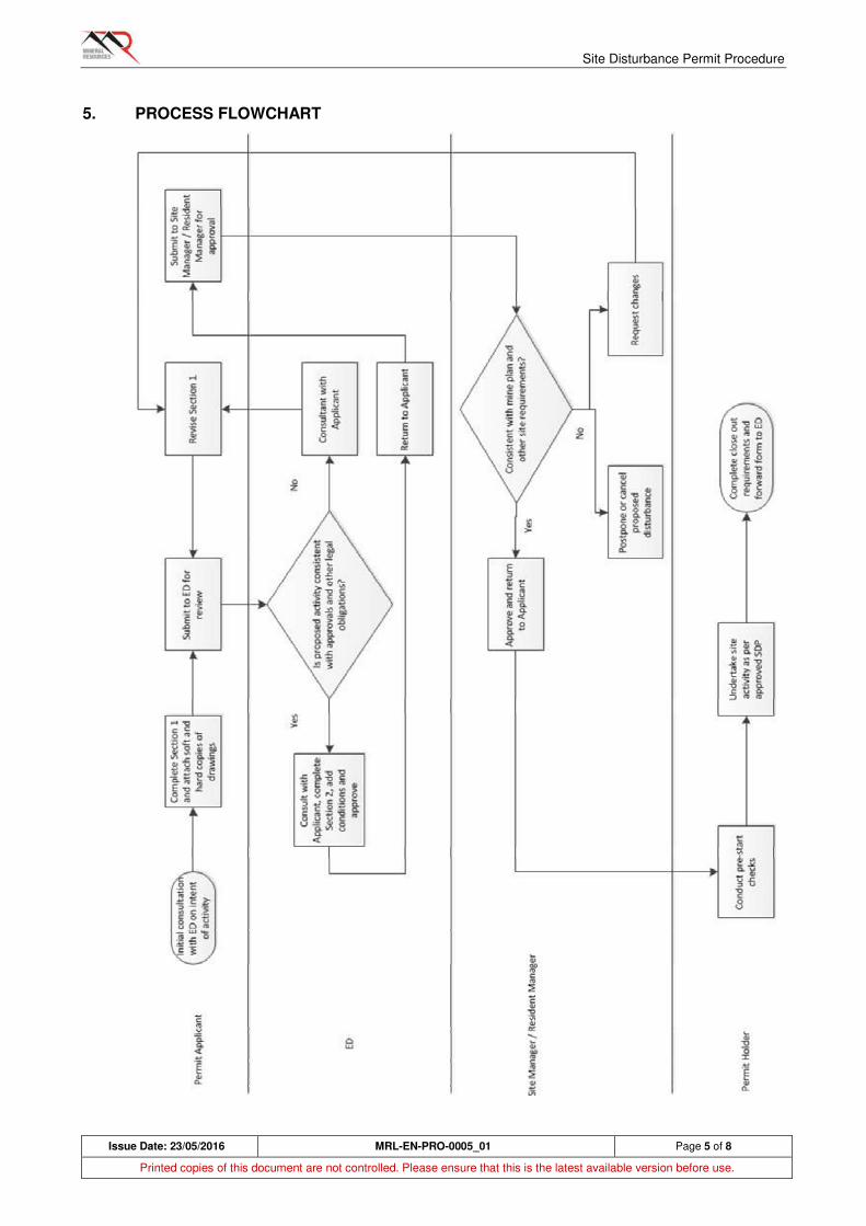
Site Disturbance Permit Procedure
Issue Date: 23/05/2016 MRL-EN-PRO-0005_01 Page 5 of 8
Printed copies of this document are not controlled. Please ensure that this is the latest available version before use.
5. PROCESS FLOWCHART
Site Disturbance Permit Procedure
Issue Date: 23/05/2016 MRL-EN-PRO-0005_01 Page 6 of 8
Printed copies of this document are not controlled. Please ensure that this is the latest available version before use.
6. PROCEDURE(S)
6.1 Site Disturbance Permit application (Section 1)
1. Applicant to consult with ED prior to completing form to ensure there is no obvious impediment to site disturbance proceeding.
2. SDP number and revision number to be added by ED during assessment.
3. Add company's name and applicant's name. Applicant to be a Superintendent, Project Manager, or their delegate.
4. Add all relevant tenement numbers.
5. Provide a comprehensive description of the proposed activity.
6. Include a drawing or drawings showing the location of all proposed disturbance. Drawings to be in hard copy and soft copy (*.dxf).
7. Add the total area to be disturbed (ha), the volume of topsoil to be recovered and stockpiled (cubic metres), and the machinery to be used for the activity.
8. Ensure there is provision for areas to stockpile topsoil and woody debris, and for access tracks to reach areas that are not contiguous.
9. Note that this application does not cover the potential to disturb underground services (i.e. it is not a 'dig permit').
10. Submit to ED. Allow 72 hours for assessment.
6.2 Site Disturbance Permit application (Section 2)
1. ED to add SDP number and revision number and record on Site Disturbance Register.
2. Check that the proposed activity is covered by the required approvals which could include but is not limited to:
a) Environmental Protection Act 1986 Part IV (Ministerial Statements)
b) Environmental Protection Act 1986 Part V (Works Approval)
c) Environmental Protection Act 1986 Part IV (NVCP)
d) Mining Act 1972 (tenement, conditions, PoW, Mining Proposal)
e) Aboriginal Heritage Act 1972 (Section 18)
f) Rights in Water and Irrigation Act 1914 (Section 11, 17 and 21A - 'beds and banks')
g) Third party agreements.
3. Identify any other environmental constraints to be considered. These may include important habitat trees, significant weed populations, vegetation buffers, important wildlife corridors and fauna habitat.
4. Check that sufficient buffer has been allowed between the proposed activity and site boundaries. If necessary, modify *.dxf files to allow for additional buffer (in consultation with Applicant).
5. Apply standard conditions appropriate to the proposed activity.
6. Apply any additional conditions appropriate to the proposed disturbance.
7. ED to sign and return SDP application to applicant.
Site Disturbance Permit Procedure
Issue Date: 23/05/2016 MRL-EN-PRO-0005_01 Page 7 of 8
Printed copies of this document are not controlled. Please ensure that this is the latest available version before use.
6.3 Site Disturbance Permit application (Section 3)
1. Applicant to review conditions, sign and forward to Site Manager or Resident Manager.
2. Site Manager or Resident Manager to review application for consistency with project plan and site requirements.
3. Approve and return SDP application to Applicant with a copy to ED. If application cannot be approved, consult with Applicant.
6.4 Complying with approved SDPs (Sections 4 and 5)
1. Supervisor implementing ground disturbance must retain a copy of the approved SDP with conditions at all times.
2. Supervisor must meet the pre-start requirements prior to commencement of work.
3. The supervisor must ensure full compliance with the Land Clearing procedure (MRL-EN-PRO-0004) which includes requirements not limited to:
a) Marking of boundaries
b) Pre-start checks with all operators
c) Requirements for observers or monitors
d) Dealing with environmental weeds (see MRL-EN-PRO-0007)
e) Soil handing
f) Special sites to be protected or avoided
4. Upon completion of ground disturbance, supervisor to arrange for arrange for survey to pick up site boundaries (as constructed), topsoil stockpiles (location, areal extent and volume) and other information required in Section 5. Forward information to ED.
5. Non-compliance with SDP conditions requires an incident report (MRL-OHM-PRO-0007).
6. ED to ensure requirements of this procedure are well understood.
6.5 Auditing and record keeping
1. ED to maintain records of all site disturbance and related information, such as location and volume of topsoil stockpiles, on a Site Disturbance Register (MRL-EN-REG-0004).
2. ED to conduct inspections of site disturbance operations as required.
3. Non-compliance with SDP conditions requires an incident report (MRL-OHM-PRO-0007).
Site Disturbance Permit Procedure
Issue Date: 23/05/2016 MRL-EN-PRO-0005_01 Page 8 of 8
Printed copies of this document are not controlled. Please ensure that this is the latest available version before use.
7. RECORDS
All records will be maintained by the ED and will include:
• Copies of all approved SDPs
• A Site Disturbance Register detailing the dates, locations and eventual use of disturbed ground.
• Records of inspections and audits.
• Training records.
8. REFERENCES
MRL-EN-PRO-0015 Heritage Management Procedure
MRL-OHM-PRO-0007 Incident Reporting and Classification Procedure
MRL-EN-PRO-0004 Land Clearing Procedure
MRL-EN-PRO-0007 Weed Hygiene and Control Procedure
MRL-EN-FRM-0003 Site Disturbance Permit application form
MRL-EN-REG-0004 Site Disturbance Register
9. LIST OF STANDARD CONDITIONS FOR SITE DISTURBANCE PERMIT APPLICATIONS
The following are standard conditions that can be directly applied or adapted for SDP applications:
• The supervisor must retain a copy of the approved SDP with conditions at all times.
• All site disturbance must comply with the Land Clearing procedure (MRL-EN-PRO-0004), including marking of boundaries and pre-start checks.
• All activities must comply with the Weed Hygiene and Control procedure (MRL-EN-PRO-0007), including ensuring that earthmoving equipment is free of weed seed and that existing weed populations are not inadvertently spread.
• Non-compliance with any conditions will require an incident report.

Weed Hygiene and Control
WEED HYGIENE AND CONTROL
MRL-EN-PRO-0007
Revision
Number Issue Date Prepared By Approved By
ME
Signature
00 17/02/2016 G Barrett / J Matthews J. Hesford
Weed Hygiene and Control
Issue Date: 17/02/2016 MRL-EN-PRO-0007_00 Page 2 of 10
Printed copies of this document are not controlled. Please ensure that this is the latest available version before use.
TABLE OF CONTENTS
1. PURPOSE ............................................................................................................................... 3
2. SCOPE .................................................................................................................................... 3
3. LEGISLATIVE CONTEXT ........................................................................................................ 3
4. DEFINITIONS .......................................................................................................................... 4
5. RESPONSIBILITIES ................................................................................................................ 5
5.1 Site/Project Manager....................................................................................................... 5
5.2 Supervisor ....................................................................................................................... 5
5.3 Environmental Advisors or delegates (ED) ...................................................................... 5
5.4 All MRL personnel and contractors ................................................................................. 5
6. SOURCES OF WEEDS ........................................................................................................... 6
7. PROCEDURE(S) ..................................................................................................................... 7
7.1 Induction and awareness training .................................................................................... 7
7.2 When a Weed Hygiene Certificate is required ................................................................. 7
7.3 Use of Weed Hygiene Certificates ................................................................................... 8
7.4 Weed control ................................................................................................................. 10
8. RECORDS ............................................................................................................................. 10
9. MONITORING ........................................................................................................................ 10
10. REFERENCES ...................................................................................................................... 10
Weed Hygiene and Control
Issue Date: 17/02/2016 MRL-EN-PRO-0007_00 Page 3 of 10
Printed copies of this document are not controlled. Please ensure that this is the latest available version before use.
1. PURPOSE
The purpose of this procedure is to ensure that no new species of weed (including both declared weeds and environmental weeds) are introduced into the project area and that the cover of weeds in adjacent undisturbed areas does not exceed the weed cover present prior to commencement of the project.
2. SCOPE
This procedure applies to all Mineral Resources Limited (MRL) companies, its subsidiary company activities and all joint venture operations where MRL has substantial participation and/or management control.
This procedure is to be followed by all employees involved in the movement of ground-engaging plant, equipment and off road vehicles between sites, personnel who are likely to carry out weed control, and personnel with specific environmental management responsibilities who will give advice to others.
Some sites may have particular problematic weed species present or high value vegetation communities requiring protection. In these cases, tailored management plans additional to this procedure may be developed.
3. LEGISLATIVE CONTEXT
The following legislation contains or may contain provisions relating to weeds and weed control:
Wildlife Conservation Act 1950 (WA) (WC Act)
Environmental Protection Act 1986 (WA) (EP Act)
Biosecurity and Agriculture Management Act 2007 (WA) (BAM Act)
Environment Protection and Biodiversity Conservation Act 1999 (Commonwealth) (EPBC Act)

Weed Hygiene and Control
Issue Date: 17/02/2016 MRL-EN-PRO-0007_00 Page 4 of 10
Printed copies of this document are not controlled. Please ensure that this is the latest available version before use.
4. DEFINITIONS
Declared plants Plants declared under the Biosecurity and Agriculture
Management Act 2007. Declared pests are placed in one of three
categories, namely:
C1 (exclusion - not established in Western Australia and must be kept out),
C2 (eradication - present in Western Australia but in sufficiently small quantities that eradication is feasible) or
C3 (management - established in Western Australia but feasible to control to limit potential spread).
Pest plants Plants prescribed under the Biosecurity and Agriculture
Management Act 2007 by local government authorities, to be a
pest plant (cannot be a declared plant).
Environmental
weeds
Exotic species that, if established, could result in changes to the
structure, species composition, fire frequency and abundance of
native plant communities.
Weed hygiene Prevention of the introduction or spread of weeds through
movement of earthmoving machinery, vehicles or soil containing
weed seed.
WHC Weed Hygiene Certificate.
Earthmoving and
ground-engaging
equipment
Equipment may include but is not limited to dump trucks, loaders,
dozers, graders, pipe laying equipment and drill rigs.

Weed Hygiene and Control
Issue Date: 17/02/2016 MRL-EN-PRO-0007_00 Page 5 of 10
Printed copies of this document are not controlled. Please ensure that this is the latest available version before use.
5. RESPONSIBILITIES
5.1 Site/Project Manager
The Manager is responsible for:
a) Ensuring full compliance with the requirements of this procedure
b) Ensuring training in weed hygiene requirements is provided to personnel responsible for the transfer of earthmoving equipment and vehicles between sites.
c) Ensuring the required resources are allocated to fulfil the requirements of this procedure
5.2 Supervisor
The Supervisor is responsible for:
a) Ensuring any vehicles or earthmoving equipment leaving a mine is cleaned down so that it is free of vegetation or dirt, and, following an inspection, a Weed Hygiene Certificate (WHC) is issued.
b) Ensuring that personnel involved in vehicle or equipment transfers are aware of this procedure and can competently meet their responsibilities.
5.3 Environmental Advisors or delegates (ED)
Environmental Advisors or their delegates are responsible for:
a) Providing advice to others about weed hygiene procedures and about the identification of plants that may be weeds.
b) Undertaking or commission weed control activities.
c) Undertaking site inspections for weeds
d) Keeping records of weed management - weed hygiene certificates, GIS data recording the location and extent of weed populations, control methods used etc.
e) Presenting ongoing weed management and control awareness training
5.4 All MRL personnel and contractors
All MRL personnel and contractors must:
a) Understand and meet the obligations of this procedure
b) Report potential weed occurrences and poorly cleaned machinery
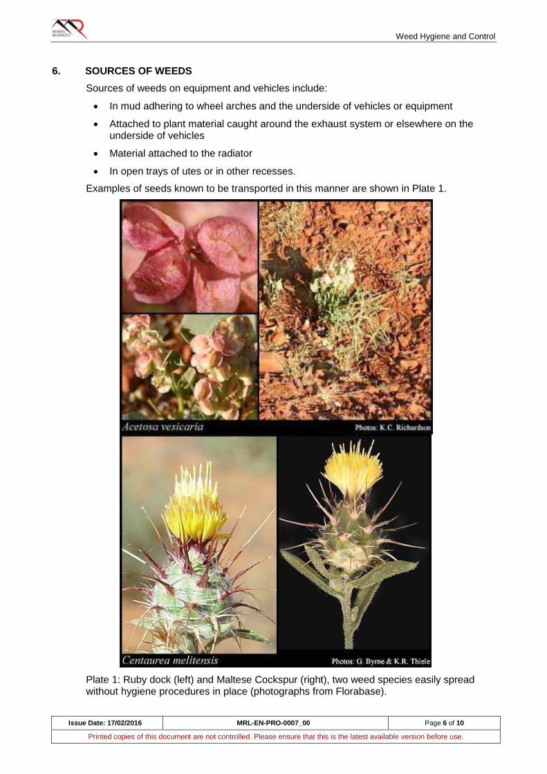
Weed Hygiene and Control
Issue Date: 17/02/2016 MRL-EN-PRO-0007_00 Page 6 of 10
Printed copies of this document are not controlled. Please ensure that this is the latest available version before use.
6. SOURCES OF WEEDS
Sources of weeds on equipment and vehicles include:
In mud adhering to wheel arches and the underside of vehicles or equipment
Attached to plant material caught around the exhaust system or elsewhere on the underside of vehicles
Material attached to the radiator
In open trays of utes or in other recesses.
Examples of seeds known to be transported in this manner are shown in Plate 1.
Plate 1: Ruby dock (left) and Maltese Cockspur (right), two weed species easily spread without hygiene procedures in place (photographs from Florabase).

Weed Hygiene and Control
Issue Date: 17/02/2016 MRL-EN-PRO-0007_00 Page 7 of 10
Printed copies of this document are not controlled. Please ensure that this is the latest available version before use.
7. PROCEDURE(S)
7.1 Induction and awareness training
All employees and contractors are required to participate in the site induction, which will provide an awareness of weeds, including risk species, and an overview of the weed hygiene process.
Employees and contractors who are involved in movement or operation of earthworks equipment, off road vehicles, and land clearing will be specifically trained in weed hygiene procedures and documentation. This includes but is not limited to, exploration personnel, surveyors, environmental survey consultants, workshop and logistics personnel;
Training or technical assistance may be required for site personnel to be able to recognise locally-occurring weed species.
Specialist training (chemical handling, personal protection etc.) may be required if site personnel are involved in chemical methods of weed control
Tool box talks will be presented from time to time to refresh employees and contractors on weed hygiene procedures.
7.2 When a Weed Hygiene Certificate is required
The movement of earthmoving equipment and vehicles may require use of a Weed Hygiene Certificate (WHC). This procedure cannot cover every situation but a WHC would generally be required when there is a medium to high risk. Medium to high risk situations include:
Movement of equipment that has been operating in borrow pits or in topsoil stockpiling or recovery operations.
Light vehicles and drill rigs operating in an area with known weed occurrences.
Any off road earthmoving or heavy equipment moving from one mine site to another.
WHCs are generally not required for low risk situations. Low risk situations include:
Light vehicles and support vehicles remaining on established roads.
Excavators and dump trucks operating within multiple pits at one mine site.
Drill rigs operating on overburden or ore within multiple pits after topsoil has been removed.
Graders operating at one mine site (although regular clean down is recommended).
Weed Hygiene and Control
Issue Date: 17/02/2016 MRL-EN-PRO-0007_00 Page 8 of 10
Printed copies of this document are not controlled. Please ensure that this is the latest available version before use.
7.3 Use of Weed Hygiene Certificates
If a WHC is required:
The earthmoving equipment or vehicle must be cleaned to remove any seeds, plant material or mud that could contain seeds.
Cleaning can be undertaken using wet or dry methods.
Ensure any material cleaned from equipment and containing weed seed does not itself become a source of weeds. Disposal to landfill or other suitable alternative is required.
Once the cleaning process has been completed and the Supervisor is satisfied the equipment or vehicle is clean, a WHC can be completed.
The WHC remains with the equipment until its arrival at its destination.
At this point, a further inspection is conducted by the ED or delegate to verify the Certificate is accurate, 'sign off' on the Certificate and free the equipment for use at the new location.
Movement of vehicles or earthmoving equipment that does not comply with this procedure must be reported as an incident.
This procedure is outlined in the following process flow chart:
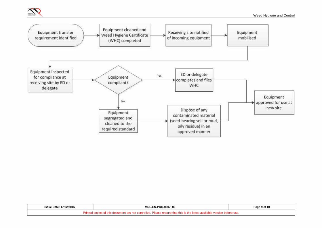
Weed Hygiene and Control
Issue Date: 17/02/2016 MRL-EN-PRO-0007_00 Page 9 of 10
Printed copies of this document are not controlled. Please ensure that this is the latest available version before use.
Weed Hygiene and Control
Issue Date: 17/02/2016 MRL-EN-PRO-0007_00 Page 10 of 10
Printed copies of this document are not controlled. Please ensure that this is the latest available version before use.
7.4 Weed control
If populations of declared or pest plants occur on site, control should be undertaken in consultation with the Department of Agriculture and Food.
If populations of environmental weeds occur on site, control should be undertaken where it is practical to do so. Some environmental weeds are so well established that control is not warranted.
This procedure does not require control of other introduced species but control methods may be used in particular circumstances.
Control methods may include spraying with herbicide or physical removal.
Herbicide use will only be undertaken in accordance with the manufacturer's instructions. Users must consider their personal safety, the safety of others (e.g. people potentially exposed to herbicide through wind drift) and sensitive non-target plant species that occur nearby. If the target area is on a pastoral property, liaison with the pastoralist is required.
Weeds that are physically removed should be disposed of to a landfill or waste rock landform and buried.
Soil or material movement from areas that have or may have weeds should be done in consultation with ED. Areas of risk include topsoil recovery or re-use and recovery of material from borrow pits.
8. RECORDS
The following records should be maintained:
A copy of all WHCs are to be given to the ED for hard copy and electronic records
Details of weed control - location, methods used, date and time, target species, extent of population treated, treatment success (through subsequent inspection).
9. MONITORING
Monitoring to be conducted by the ED to record changes in target weeds populations (their location and extent, and the effect of any control methods).
10. REFERENCES
MRL-EN-FRM-0004 Weed Hygiene Certificate

Bushfire Management Work Instruction
Issue Date: 23/05/2016 MRL-EN-WIN_0005_00 Page 1 of 2
Printed copies of this document are not controlled. Please ensure that this is the latest available version before use.
1. OBJECTIVES
To minimise bushfire risk; and
Educate employees in fire prevention and response procedures.
2. MANAGEMENT
2.1 Prevention
All employees and contractors are required to participate in the site induction, which will provide an awareness of fire hazards and required management measures.
Select site personnel will undergo training in fire prevention and suppression to form the basis of an emergency response team.
Appropriate vehicles will carry firefighting equipment and staff will be trained in its use.
Hot work permits will be required for work that has the potential to create ignition sources.
Fire safety and housekeeping inspections of plant and equipment will be undertaken.
Local Government restricted fire periods and total fire bans will be adhered to.
2.2 Control
Smoking will be restricted to approved locations only and cigarette butts must be disposed of into allocated container.
Fire breaks will be constructed to protect site infrastructure.
Camp fires are to be restricted to designated areas at the camp and subject to seasonal conditions (refer to DFES fire danger rating).
Vehicles, mobile plant/equipment will be parked on cleared area as to prevent possible ignition of vegetation.
Appropriately trained personnel to take immediate response to bushfire control.
In the event a bushfire cannot be controlled and threatens mining infrastructure and personnel safety, the Resident Manager or Senior Geologist will initiate the bushfire contingency and emergency response plan.
All vehicles will contain a fire extinguisher.
3. MONITORING
Regular housekeeping inspections and routine maintenance of firefighting equipment and all equipment that may cause bushfires will be undertaken.
4. REPORTING
All personnel are responsible for reporting potential fire hazards to their supervisor.
Any fire event is to be immediately reported to a MRL representative and reported to the Department of Mines and Petroleum and Department of Parks and Wildlife within 24 hours.
Any fire event needs to be reported as an incident within 24 hours using an incident report form.

Bushfire Management Work Instruction
Issue Date: 23/05/2016 MRL-EN-WIN_0005_00 Page 2 of 2
Printed copies of this document are not controlled. Please ensure that this is the latest available version before use.
5. REFERENCES
MRL-OHM-FRM-0002 Incident Report Form
MRL-EN-PRO-0004 Land Clearing Procedure
MRL-EN-PRO-0011 Waste Management Procedure

Fauna Management Procedure
FAUNA MANAGEMENT PROCEDURE
MRL-EN-PRO-0001
Revision
Number Issue Date Prepared By Approved By
ME
Signature
00 8/02/2016 G. Barrett J. Hesford
01 23/05/2016 E. Tomich J. Hesford
Fauna Management Procedure
Issue Date: 23/05/2016 MRL-EN-PRO-0001_01 Page 2 of 7
Printed copies of this document are not controlled. Please ensure that this is the latest available version before use.
TABLE OF CONTENTS
1. PURPOSE ............................................................................................................................... 3
2. SCOPE .................................................................................................................................... 3
3. LEGISLATIVE CONTEXT ........................................................................................................ 3
4. DEFINITIONS .......................................................................................................................... 3
5. RESPONSIBILITIES ................................................................................................................ 4
5.1 Site/Project Manager....................................................................................................... 4
5.2 Construction Manager ..................................................................................................... 4
5.3 Environmental Advisors / Consultant Zoologists .............................................................. 4
5.4 Exploration personnel ..................................................................................................... 4
5.5 Workers (including Contractors) ...................................................................................... 4
6. PROCEDURE(S) ..................................................................................................................... 5
6.1 Induction and training ...................................................................................................... 5
6.2 General requirements ..................................................................................................... 5
6.3 Driving ............................................................................................................................ 5
6.4 Trenching operations ...................................................................................................... 5
6.5 Dams and 'turkey nests' .................................................................................................. 6
6.6 Exploration ...................................................................................................................... 6
6.7 Threatened fauna ............................................................................................................ 6
6.8 Injured animals................................................................................................................ 6
6.9 RECORDS ...................................................................................................................... 6
7. MONITORING .......................................................................................................................... 6
8. REFERENCES ........................................................................................................................ 7

Fauna Management Procedure
Issue Date: 23/05/2016 MRL-EN-PRO-0001_01 Page 3 of 7
Printed copies of this document are not controlled. Please ensure that this is the latest available version before use.
1. PURPOSE
The purpose of this procedure is to provide a framework for the management of native fauna in order to minimise adverse impacts on local populations and individual animals, and to promote compliance with legislative requirements.
2. SCOPE
This procedure applies to all Mineral Resources Limited (MRL) companies, its subsidiary company activities and all joint venture operations where MRL has substantial participation and/or management control.
This procedure is to be followed primarily by employees with specific environmental management responsibilities who will carry out the steps required and give advice to others. Some aspects of the procedure have broad application across the site workforce.
Some sites may have particular species present that require tailored management plans additional to this procedure.
3. LEGISLATIVE CONTEXT
The following legislation contains or may contain provisions protecting native fauna generally or particular species specifically:
• Wildlife Conservation Act 1950 (WA) (WC Act)
• Environmental Protection Act 1986 (WA)
• Environment Protection and Biodiversity Conservation Act 1999 (Commonwealth) (EPBC Act)
4. DEFINITIONS
Native fauna Species occurring locally and recognised as native to
the area.
Conservation-significant fauna Any species which is considered threatened or
potentially threatened.
Threatened fauna Any species published as Specially Protected under the
WC Act and listed under Schedules 1 to 4 of the Wildlife
Conservation (Specially Protected Fauna) Notice for
Threatened Fauna. Also, any species listed under the
EPBC Act.
Priority fauna Potentially threatened fauna for which further survey
data is required before listing as Threatened can be
considered under the WC Act.
Feral fauna Any introduced animal occurring in the local area with
the potential to impact on local ecosystems through
competition with, or direct predation of, native animals.
HDPE High-density polyethylene.
Fauna Management Procedure
Issue Date: 23/05/2016 MRL-EN-PRO-0001_01 Page 4 of 7
Printed copies of this document are not controlled. Please ensure that this is the latest available version before use.
5. RESPONSIBILITIES
5.1 Site/Project Manager
The Manager is responsible for:
a) Ensuring full compliance with the requirements of this procedure
b) Ensuring training is provided to personnel handling potentially dangerous animals.
c) Ensuring the required resources are allocated to fulfil the requirements of this procedure.
d) Ensuring any statutory reporting of incidents relating to fauna is undertaken.
5.2 Construction Manager
The Construction Manager is responsible for:
a) Ensuring trenching operations are conducted in accordance with this procedure.
b) Ensuring supervisors are aware of their responsibilities.
5.3 Environmental Advisors / Consultant Zoologists
Environmental Advisors and consultant zoologists are responsible for:
a) Ensuring they obtain and maintain the necessary permits to handle fauna.
b) Auditing and monitoring compliance with this procedure and with the requirements of any approvals specific to fauna, and report performance to Manager.
c) Ensuring the content on fauna within the site induction is relevant and up to date
d) Presenting tool box talks on relevant fauna issues
e) Providing advice to site managers
f) Relocating fauna where it is viable to do so.
g) Managing sick or injured fauna.
h) Maintaining records of fauna interactions and sightings
5.4 Exploration personnel
Exploration personnel are responsible for:
a) Capping all drill holes after use.
b) Meeting the general and driving requirements of this procedure.
c) Reporting sightings of threatened fauna or any injuries of deaths of feral or native fauna.
5.5 Workers (including Contractors)
All Workers are responsible for:
a) Meeting the general and driving requirements of this procedure
b) Reporting sightings of threatened fauna or any injuries of deaths of feral or native fauna.
Fauna Management Procedure
Issue Date: 23/05/2016 MRL-EN-PRO-0001_01 Page 5 of 7
Printed copies of this document are not controlled. Please ensure that this is the latest available version before use.
6. PROCEDURE(S)
6.1 Induction and training
• All employees and contractors are required to participate in the site induction which will cover general and site-specific fauna issues, including information about legal obligations to protect fauna and significant species occurring locally.
• Employees and contractors who are nominated to handle fauna - for example, for the removal of snakes from work areas - will require suitable training and permits. In Western Australia, permits for handling fauna are issued under the WC Act.
• Tool box talks will be presented from time to time on topics relevant to fauna present in the local area.
6.2 General requirements
• Firearms and pets are prohibited at all sites.
• Native fauna will not be captured or intentionally handled except by personnel or consultants qualified to do so.
• Do not feed or otherwise encourage native or feral animals and ensure foodstuffs are stored and disposed of appropriately to avoid scavenging.
• Manage landfills so that they do not become a food source for animals, especially feral animals.
6.3 Driving
• Vehicles are prohibited to leave the designated project area footprint without an approved Site Disturbance Permit.
• All personnel must drive to conditions and adhere to speed limits applied to mine roads and tracks.
• Road kills must be removed from the road to a minimum distance of 10 m into the vegetation to avoid further impacts on fauna, such as birds of prey, feeding on carcasses.
6.4 Trenching operations
• Open trenches for laying of pipelines and other services can 'trap' native animals which are often active nocturnally. Small mammals and reptiles falling into trenches at night can die during the following day from exposure or predation.
• Risk factors include the length and depth of open trench and proximity to native vegetation. Long sections (> 500 m) of open trench adjacent to native vegetation are high risk. Short sections of open trench within an already cleared area are low risk.
Fauna Management Procedure
Issue Date: 23/05/2016 MRL-EN-PRO-0001_01 Page 6 of 7
Printed copies of this document are not controlled. Please ensure that this is the latest available version before use.
• Where a risk to native fauna from trenching is identified, develop and implement a plan to manage potential impacts on fauna. Management measures include regular trench inspections and removal of animals, inspections immediately prior to backfill, ramps at either end of the trench and at points along the length of the trench, and deployment of relocatable temporary shelters for small animals.
6.5 Dams and 'turkey nests'
• All HDPE-lined dams must be fenced and have fauna egress matting installed. Fauna which fall or slip into dams lined with HDPE cannot escape due to the slippery surface of the liner. Fauna egress matting provides a gripping surface that animals can use to escape the pond.
• Unlined turkey nest dams should also be fenced.
6.6 Exploration
• Exploration drill holes must be capped immediately with a concrete conical plug once drilling has ceased, to avoid native fauna falling into or becoming trapped down drill holes.
6.7 Threatened fauna
• Maintain compliance with any threatened fauna management plans prepared under site approvals. Incidents relating to threatened species may be required to be reported to government.
6.8 Injured animals
• If an injured animal is encountered on site, it can be sent to a wildlife caring organisation for treatment and recovery. Seek advice from the nearest suitable organisation.
• From time to time, it may be necessary to euthanize an animal that is seriously injured and has no prospect of recovery. As for injured animals, seek advice as to the most suitable option.
6.9 RECORDS
The following records should be maintained:
• Incident reports
• Inspection records
• Fauna Interaction Register
• Licences and permits
7. MONITORING
Monitoring of populations of local fauna may be required as a condition of approval or to manage a risk.
Fauna Management Procedure
Issue Date: 23/05/2016 MRL-EN-PRO-0001_01 Page 7 of 7
Printed copies of this document are not controlled. Please ensure that this is the latest available version before use.
8. REFERENCES
Department of Mines and
Petroleum (WA)
Fauna Egress Matting and Ramps, Environmental Notes
on Mining, updated March 2012
MRL-EN-REG-0001 Fauna Interaction Register
MRL-OHM-PRO-0007 Incident Classification and Reporting Procedure
MRL-EN-PRO-0004 Land Clearing Procedure
MRL-EN-WIN-0007 Malleefowl Conservation Work Instruction
MRL-TS-FRM-0001 Training Record Form
MRL-EN-PRO-0011 Waste Management Procedure

Land Rehabilitation Procedure
LAND REHABILITATION PROCEDURE
MRL-EN-PRO-0009
Revision
Number Issue Date Prepared By Approved By
GM
Signature
00 2/05/2016 G Barrett J. Hesford
Land Rehabilitation Procedure
Issue Date: 2/05/2016 MRL-EN-PRO-0009_00 Page 2 of 9
Printed copies of this document are not controlled. Please ensure that this is the latest available version before use.
TABLE OF CONTENTS
1. PURPOSE ............................................................................................................................... 3
2. SCOPE .................................................................................................................................... 3
3. DEFINITIONS AND ABBREVIATIONS .................................................................................... 4
4. RESPONSIBILITIES ................................................................................................................ 5
4.1 Site Manager / Registered Manager ................................................................................ 5
4.2 Mining Manager .............................................................................................................. 5
4.3 Environment Department (ED) ........................................................................................ 5
5. PROCEDURE(S) ..................................................................................................................... 6
5.1 Planning .......................................................................................................................... 6
5.2 Implementation ............................................................................................................... 7
5.3 Inspection and monitoring ............................................................................................... 7
5.4 Maintenance ................................................................................................................... 8
5.5 Continuous Improvement ................................................................................................ 8
6. RECORDS ............................................................................................................................... 9
7. REFERENCES ........................................................................................................................ 9
Land Rehabilitation Procedure
Issue Date: 2/05/2016 MRL-EN-PRO-0009_00 Page 3 of 9
Printed copies of this document are not controlled. Please ensure that this is the latest available version before use.
1. PURPOSE
Land disturbance and clearing is necessary to establish and operate mines and associated infrastructure. Land rehabilitation should form part of day-to-day management at mine sites whereby areas where activities are complete are progressively rehabilitated.
The purpose of this procedure is to encourage incorporation of mine rehabilitation in routine mining activities and to promote achievement of timely and successful rehabilitation.
The advantages of achieving a successful progressive rehabilitation program are often understated. These advantages include:
• Cost savings through:
• Avoidance of double handling of materials;
• Utilisation of equipment already mobilised onsite;
• Refining rehabilitation techniques to avoid future rework;
• Earlier relinquishment of tenements and fulfilment of obligations to the Mine Rehabilitation Fund (MRF); and
• Minimisation of future monitoring and maintenance requirements.
• Reduced risk of regulatory non-compliance and legacy issues.
• Improved Government and community receptivity to future mining proposals and an enhanced public image and reputation.
2. SCOPE
This procedure applies to all Mineral Resources Limited (MRL) companies, its subsidiary company activities and all joint venture operations where MRL has substantial participation and/or management control.
Specifically, this procedure applies to all managers, supervisors or environmental specialists whose roles include rehabilitation of disturbed land at operating or closed mine sites. The procedure addresses the considerations for MRL employees when planning, implementing and monitoring rehabilitation works associated with mining operations.
The procedure does not provide technical guidance for rehabilitation which will vary from site to site.

Land Rehabilitation Procedure
Issue Date: 2/05/2016 MRL-EN-PRO-0009_00 Page 4 of 9
Printed copies of this document are not controlled. Please ensure that this is the latest available version before use.
3. DEFINITIONS AND ABBREVIATIONS
AER Annual Environmental Report
ED Environment Department
Environmental weeds Introduced flora species identified as weeds within the
local context. They are sufficiently vigorous to reduce
the diversity and/or abundance of native species or
adversely affect the function of natural ecosystems.
DMP Department of Mines and Petroleum
Mine Plan A plan or schedule for the mining of ore and waste rock.
Rehabilitation Plan A site-specific plan that identifies the specifications for
rehabilitation of each domain within the mine site.
Seed bank Seed occurring at or immediately below the soil surface.
Subsoil Soil layer immediately below topsoil. May have organic
matter and some of the other biological characteristics
of topsoil. Recovery depth usually ranges from 0.2 m to
1.0 m.
Topsoil Surface soil containing organic matter, fungi and
microorganisms and seed bank. Important for re-
establishing vegetation on rehabilitated areas. Recovery
depth usually ranges from surface to 0.2-0.5 m.
Weed hygiene Management measures used to prevent the introduction
or spread of weed species.
Woody debris Cleared vegetation excluding any large timber.
MRF Mine Rehabilitation Fund
Land Rehabilitation Procedure
Issue Date: 2/05/2016 MRL-EN-PRO-0009_00 Page 5 of 9
Printed copies of this document are not controlled. Please ensure that this is the latest available version before use.
4. RESPONSIBILITIES
4.1 Site Manager / Registered Manager
The Site Manager or Registered Manager is responsible for:
• Ensuring that mine rehabilitation forms part of the mine planning process.
• Ensuring that mine rehabilitation is progressively implemented as per the Rehabilitation Plan and, to the maximum extent possible, to minimise MRL's MRF obligations and its rehabilitation liability on the balance sheet.
• Ensuring works are conducted to a good standard that minimises any requirement for re-work and aims to meet the DMP's requirement for "safe, stable and non-erodible" landforms, the objectives of the Rehabilitation Plan and any specific criteria applicable to the site.
4.2 Mining Manager
The Mining Manager is responsible for:
• Considering rehabilitation requirements when developing, implementing or revising the Mine Plan.
• Assisting in development of a Rehabilitation Plan that can be used in conjunction with the Mine Plan to guide day-to-day activities.
• Identifying and acting upon opportunities to progressively undertake rehabilitation.
• Exploring opportunities for backfilling of waste rock to pit voids to avoid or minimise the construction of free-standing waste rock landforms.
• Ensuring any hostile materials representing a risk to the environment or human health are encapsulated or otherwise contained.
• Seeking continuous improvement in rehabilitation outcomes.
4.3 Environment Department (ED)
The ED is responsible for:
• Preparing and submitting Mine Closure Plans to the DMP, with input from the Mining Manager and other personnel as required.
• Providing technical advice to the Mining Manager on planning and implementation of mine rehabilitation.
• Developing a Rehabilitation Plan, consistent with commitments in Mining Proposals, the statutory Mine Closure Plan and best practice guidelines, to be used in conjunction with the Mine Plan
• Identifying and sourcing seed or tubestock.
• Managing topsoil and subsoil resources (where present) to ensure they are utilised efficiently, and to promote vegetation growth and reduce contamination, destruction, resource loss or weed presence.
• Identifying and sourcing soil amendments - fertiliser, gypsum etc.
• Making provision for and advise on any special requirements - use of woody debris, special measures to encourage fauna colonisation etc.
Land Rehabilitation Procedure
Issue Date: 2/05/2016 MRL-EN-PRO-0009_00 Page 6 of 9
Printed copies of this document are not controlled. Please ensure that this is the latest available version before use.
• Where required, obtaining specialist advice on matters related to rehabilitation and mine closure. These matters may include characterisation of materials, erosion control designs, techniques for establishment of vegetation or any other matter relevant to the successful completion of rehabilitation works.
• Auditing performance of rehabilitation earth works against the requirements of the Rehabilitation Plan.
• Monitoring rehabilitation (and associated analogue sites) and assessing against agreed criteria in approval documents.
• Reporting progress of rehabilitation work in Annual Environmental Reports (AERs), Mine Rehabilitation Fund (MRF) submissions and any other statutory reports required.
• Providing advice to the Mining Manager about the success of existing rehabilitation and any requirement for remedial work.
• Seeking continuous improvement in rehabilitation outcomes.
5. PROCEDURE(S)
5.1 Planning
Planning for rehabilitation works should be included from the project outset. Maximising planning reduces site disturbance, and ensures that materials such as waste rock and topsoil are placed close to their final location.
Key elements of planning for rehabilitation will include:
• Legal requirements (e.g. tenement conditions, Mining Proposal commitments, Mine Closure Plan requirements, Ministerial Statement conditions) and government guidelines.
• Development of achievable rehabilitation outcomes.
• Maximising mine planning and operations during active mine life for efficient resource extraction and post-mining land use (i.e. reduction of double-handling for waste materials and topsoil, and reduced areas of land disturbance).
• Material characterisation to identify future risks or opportunities for positive rehabilitation outcomes. Managing topsoil and subsoil resources efficiently, and identifying any potential deficits that would affect rehabilitation outcomes.
• Material scheduling, including topsoil, subsoil, competent rock placement, hostile materials (such as sulphidic waste rock or asbestiform materials) and opportunities for backfilling.
• Landform design, including location on the site, provision for drainage, erosion control, encapsulation of hostile materials, cover systems, final slope angle, lift height and berm width on landforms and type and depth of surface material (e.g. topsoil, rock armouring etc.).
• Surface treatments, including deep ripping of compacted areas, contour ripping of slopes, scarification etc.
• Species selection for seeding (assuming topsoil is either not used or cannot provide sufficient seed to achieve the desired outcome).
• Soil amendment requirements (e.g. gypsum, fertiliser, organic matter), if required.

Land Rehabilitation Procedure
Issue Date: 2/05/2016 MRL-EN-PRO-0009_00 Page 7 of 9
Printed copies of this document are not controlled. Please ensure that this is the latest available version before use.
• Consideration of site water balance and salt budget and potential effects on future rehabilitation or post-mining land uses.
• Any special requirements (e.g. measures to encourage fauna return, measures to establish particular plant species or ensuring heritage sites remain accessible).
• Research requirements - if established industry standards are not suitable for site conditions, it may be necessary to trial different techniques to assess their effectiveness, and to then consider the outcome of those trials in future rehabilitation work.
• Remedial work on unsuccessful historical rehabilitation and legacy sites which may be inherited from prior tenement/land owners.
5.2 Implementation
• Undertake rehabilitation progressively and in accordance with the Rehabilitation Plan.
• Monitor and report on the progress of rehabilitation.
• Audit site practices and compliance to the Rehabilitation Plan.
• Undertake remedial work, where monitoring identifies a risk to achieving the objectives of the Rehabilitation Plan.
• Record and archive accurate spatial data and other records of all work undertaken (see Section 6).
5.3 Inspection and monitoring
Inspections of rehabilitated areas must be conducted by ED to identify any instances where progress of the rehabilitation works is not satisfactory. These instances could include:
• Unforeseen safety issues.
• Erosion damage, especially as a result of significant rainfall events.
• Leaching of hostile materials and/or surface exposures of salts or other contaminated materials.
• Poor establishment of vegetation and/or loss of topsoil.
• Excessive grazing by stock or native animals.
• Excessive weed establishment.
Inspections should be conducted as rehabilitation works are being carried out and completed, and after rainfall events until such time as sale or relinquishment of the tenement is achieved. All inspections should be documented.
Most mine sites will be required to undertake some formalised monitoring. This may include monitoring the success or otherwise of trials and test work using different rehabilitation techniques. For more routine works, monitoring may include species presence and species cover, plant density, weed cover, erosion assessments and the effectiveness of surface water controls. In some circumstances, it could include fauna and water quality monitoring. At each site the ED must develop and implement a monitoring program based on:
Land Rehabilitation Procedure
Issue Date: 2/05/2016 MRL-EN-PRO-0009_00 Page 8 of 9
Printed copies of this document are not controlled. Please ensure that this is the latest available version before use.
• Obligations within tenement conditions, Mining Proposal commitments and industry guidelines.
• Completion criteria identified with the Mine Closure Plan.
Regular auditing of site practices to ensure they are compliant to the Rehabilitation Plan and that all opportunities to undertake progressive rehabilitation are being pursued.
5.4 Maintenance
The inspection and monitoring process may identify unsatisfactory aspects of rehabilitation works, as outlined above. Maintenance could extend to:
• Remedial earthworks to repair erosion damage or related failures.
• Reseeding where establishment of vegetation has been poor.
• Weed control.
• Feral animal control.
• Fencing to exclude animals or vehicles.
Remedial earthworks and reseeding should not be conducted without an understanding of the reasons why failure occurred and a reasonable expectation that further works undertaken will be successful. Specialist advice may be required.
5.5 Continuous Improvement
Across the industry, the outcome of land rehabilitation work is often unpredictable and there would be significant benefit in obtaining better, more consistent results. At every operation where land rehabilitation is a requirement, the Mining Manager and ED should:
• Explore opportunities to gain knowledge from others through attendance at rehabilitation conferences or workshops, or inspection of successfully completed works at other locations.
• Design and implementation of rehabilitation trials to address aspects of rehabilitation that have posed or are likely to pose difficulties in achieving the desired completion criteria.
• Entering into partnerships with research organisations to help achieve the most beneficial and cost effective rehabilitation outcomes for the business.
Land Rehabilitation Procedure
Issue Date: 2/05/2016 MRL-EN-PRO-0009_00 Page 9 of 9
Printed copies of this document are not controlled. Please ensure that this is the latest available version before use.
6. RECORDS
The following records and data should be maintained:
• Spatial (GIS) data relating to the location of planned or actual rehabilitation works, including the location of any encapsulated or hostile materials.
• Topsoil and subsoil inventories.
• Dates and details of rehabilitation works. Recorded information should include:
• Equipment utilised (including tools and attachments), operating hours, volume of materials moved (i.e. waste rock, topsoil etc) and area rehabilitated (including type, i.e. slopes, batter etc)
• Soil testing results;
• Topsoil (and subsoil) resources used, including respread depths and methods of respread;
• Seed mix used;
• Seeding rate and extent of seeding;
• Fertiliser or other soil amendments - type, application rate, extent of application;
• Application of woody debris - rate and extent;
• Physical works (e.g. depth of ripping).
• Inspections and monitoring data.
• Overall data requirements for AER and MRF submissions.
7. REFERENCES
Department of Industry
Tourism and Resources
Mine Rehabilitation. Leading Practice Sustainable
Development Program for the Mining Industry (2006).
Department of Industry and
Resources
Safety Bund Walls around Abandoned Open Pit Mines -
Guideline (1997).
Department of Mines and
Petroleum, Environmental
Protection Authority
Guidelines for Preparing Mine Closure Plans (2015).
Department of Mines and
Petroleum
Guidelines for Mining Proposals in Western Australia
(2006).
MRL-EN-PRO-0004 Land Clearing Procedure.

Borrow Pits Work Instruction
Issue Date: 23/05/2016 MRL-EN-WIN_0013_00 Page 1 of 2
Printed copies of this document are not controlled. Please ensure that this is the latest available version before use.
1. OBJECTIVES
Minimise environmental impacts from the construction and operation of borrow pits; and
Successfully rehabilitate decommissioned borrow pits.
2. MANAGEMENT
2.1 Planning, Construction and Operation
The Site Disturbance Permit Form shall be utilised prior to clearing any vegetation.
Construction plans detailing the location and design of borrow pits and costeans shall be approved by the Resident Manager Operations (RMO), Exploration Manager (EM) and the Environmental Department (ED).
Costeans dug to determine quality and volume of borrow material shall be kept to no more than 3 m wide and 5 m in length and backfilled.
Borrow pits shall be situated behind physical terrain and/or vegetation belts where possible.
Trees and heavy stands of vegetation shall be avoided where possible.
Access to borrow pits shall be from a single ingress and single egress track only.
The distance of undisturbed ground between borrow pits shall be no less than 20 m.
Borrow pits shall not exceed 3 ha in surface area unless approved by the ED.
The disturbance area of the borrow pit must allow for stockpiles of vegetation and topsoil.
A minimum 100 mm of topsoil shall be recovered and stockpiled on the outer edges of the borrow pit.
Topsoil and vegetation stockpiles shall not disturb fringing vegetation outside of the clearing limits.
Borrow pits should be designed to allowing for self-drainage to avoid ponding of water.
Diversion drains and upslope windrows shall be utilised to divert surface water flow from entering the pit causing ponding and erosion.
2.2 Rehabilitation
Rehabilitation shall be undertaken progressively or as soon as possible after pit closure.
All rubbish shall be removed from areas of the borrow pits.
The sides of the pits shall be battered to a maximum slope of 3 H: 1 V.
Where practicable, topsoil/vegetation shall be spread evenly over the pit floor/edges and access track and then scarified to a minimum depth of 300 mm using “S” ripping to slow water flow.
Local provenance seed shall be broadcast for revegetation if necessary.
3. MONITORING
Borrow pits will be inspected every six months by the ED utilising the Borrow Pit Checklist; and
Photo monitoring of rehabilitation progress of decommissioned pits shall be undertaken annually.
Borrow Pits Work Instruction
Issue Date: 23/05/2016 MRL-EN-WIN_0013_00 Page 2 of 2
Printed copies of this document are not controlled. Please ensure that this is the latest available version before use.
4. REPORTING
The status of borrow pits will be reported in the biannual performance review; and
The areas cleared, areas rehabilitated and the success of rehabilitation shall be reported annually within the Department of Mines and Petroleum Annual Environment Report.
5. REFERENCES
MRL-EN-FRM-0007 Borrow Pit Inspection Checklist
MRL-EN-PRO-0004 Land Clearing Procedure
MRL-EN-PRO-0009 Land Rehabilitation Procedure
MRL-EN-REG-0004 Site Disturbance Register
MRL-EN-REG-0005 Rehabilitation Register
MRL-EN-WIN-0008 Rehabilitation Work Instruction
Heritage Management Procedure
HERITAGE MANAGEMENT PROCEDURE
MRL-EN-PRO-0015
Revision
Number Issue Date Prepared By Approved By
EM
Signature
00 3/08/2016 E Tomich J. Hesford

Heritage Management Procedure
Issue Date: 3/08/2016 MRL-EN-PRO-0015_00 Page 2 of 20
Printed copies of this document are not controlled. Please ensure that this is the latest available version before use.
TABLE OF CONTENTS
1. PURPOSE ............................................................................................................................... 4
2. SCOPE .................................................................................................................................... 4
3. LEGISLATIVE CONTEXT ........................................................................................................ 4
4. DEFINITIONS AND ABBREVIATIONS .................................................................................... 5
5. RESPONSIBILITIES ................................................................................................................ 6
5.1 Site Manager / Registered Manager / Project Manager ................................................... 6
5.2 Mining Manager .............................................................................................................. 6
5.3 Heritage Management Team .......................................................................................... 7
5.4 Environment Department ................................................................................................ 7
5.5 All MRL personnel and contractors ................................................................................. 7
6. PROCEDURE(S) ..................................................................................................................... 8
6.1 Managing Areas of Known Aboriginal Heritage Significance ........................................... 8
6.1.1 Aboriginal Heritage Surveys ................................................................................ 8
6.1.2 Identifying Sites of Aboriginal Heritage Significance ............................................ 8
6.1.3 Disturbance to Sites of Aboriginal Heritage Significance ...................................... 9
6.2 Recognising and Managing Sites of Possible Aboriginal Heritage Significance ............. 10
6.2.1 Burials and Skeletal Material ............................................................................. 11
6.3 European Heritage ........................................................................................................ 11
6.3.1 European Heritage Databases in Western Australia .......................................... 11
6.4 Other Heritage Listings ................................................................................................. 11
7. Native Title & Aboriginal Heritage Agreements ....................................................................... 12
7.1 Native Title .................................................................................................................... 12
7.2 Aboriginal Heritage Agreements ................................................................................... 12
8. MONITORING ........................................................................................................................ 13
9. RECORDS AND REPORTING............................................................................................... 13
9.1 Register of Heritage Sites ............................................................................................. 13
9.2 Storage of Aboriginal Artefacts (Safe Keeping Place) ................................................... 13
9.3 Reporting ...................................................................................................................... 13
10. TRAINING .............................................................................................................................. 13
10.1 Induction and Cultural Awareness Training ................................................................... 13
11. RECOGNITION OF TRADITIONAL OWNERS ....................................................................... 14
11.1 Mechanisms to Recognise Traditional Owners.............................................................. 14
11.1.1 Welcome to Country .......................................................................................... 14
11.1.2 Acknowledgement of Country ............................................................................ 14
Heritage Management Procedure
Issue Date: 3/08/2016 MRL-EN-PRO-0015_00 Page 3 of 20
Printed copies of this document are not controlled. Please ensure that this is the latest available version before use.
12. REFERENCES ...................................................................................................................... 15
FIGURE 1. EXAMPLES OF DEMARCATION OF ABORIGINAL HERITAGE SITES AT MRL
PROJECTS (A - FLAGGING TAPE; B - POSTS; C - SIGNAGE). ................................................... 9
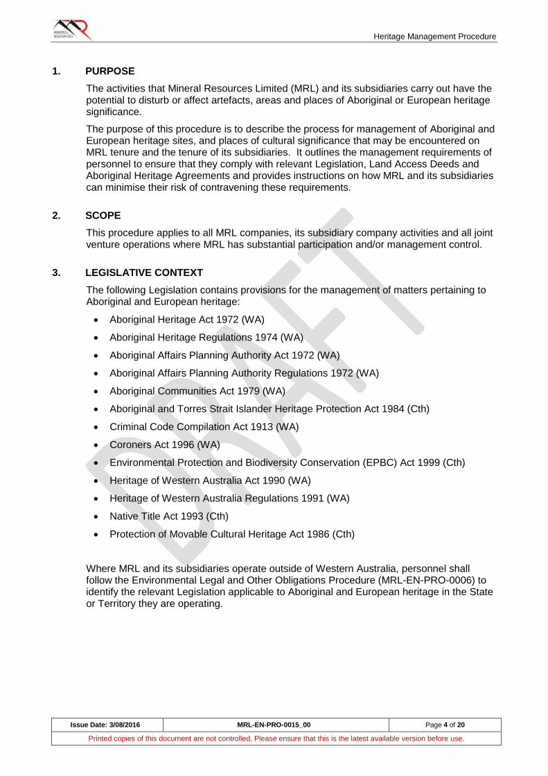
Heritage Management Procedure
Issue Date: 3/08/2016 MRL-EN-PRO-0015_00 Page 4 of 20
Printed copies of this document are not controlled. Please ensure that this is the latest available version before use.
1. PURPOSE
The activities that Mineral Resources Limited (MRL) and its subsidiaries carry out have the potential to disturb or affect artefacts, areas and places of Aboriginal or European heritage significance.
The purpose of this procedure is to describe the process for management of Aboriginal and European heritage sites, and places of cultural significance that may be encountered on MRL tenure and the tenure of its subsidiaries. It outlines the management requirements of personnel to ensure that they comply with relevant Legislation, Land Access Deeds and Aboriginal Heritage Agreements and provides instructions on how MRL and its subsidiaries can minimise their risk of contravening these requirements.
2. SCOPE
This procedure applies to all MRL companies, its subsidiary company activities and all joint venture operations where MRL has substantial participation and/or management control.
3. LEGISLATIVE CONTEXT
The following Legislation contains provisions for the management of matters pertaining to Aboriginal and European heritage:
Aboriginal Heritage Act 1972 (WA)
Aboriginal Heritage Regulations 1974 (WA)
Aboriginal Affairs Planning Authority Act 1972 (WA)
Aboriginal Affairs Planning Authority Regulations 1972 (WA)
Aboriginal Communities Act 1979 (WA)
Aboriginal and Torres Strait Islander Heritage Protection Act 1984 (Cth)
Criminal Code Compilation Act 1913 (WA)
Coroners Act 1996 (WA)
Environmental Protection and Biodiversity Conservation (EPBC) Act 1999 (Cth)
Heritage of Western Australia Act 1990 (WA)
Heritage of Western Australia Regulations 1991 (WA)
Native Title Act 1993 (Cth)
Protection of Movable Cultural Heritage Act 1986 (Cth)
Where MRL and its subsidiaries operate outside of Western Australia, personnel shall follow the Environmental Legal and Other Obligations Procedure (MRL-EN-PRO-0006) to identify the relevant Legislation applicable to Aboriginal and European heritage in the State or Territory they are operating.
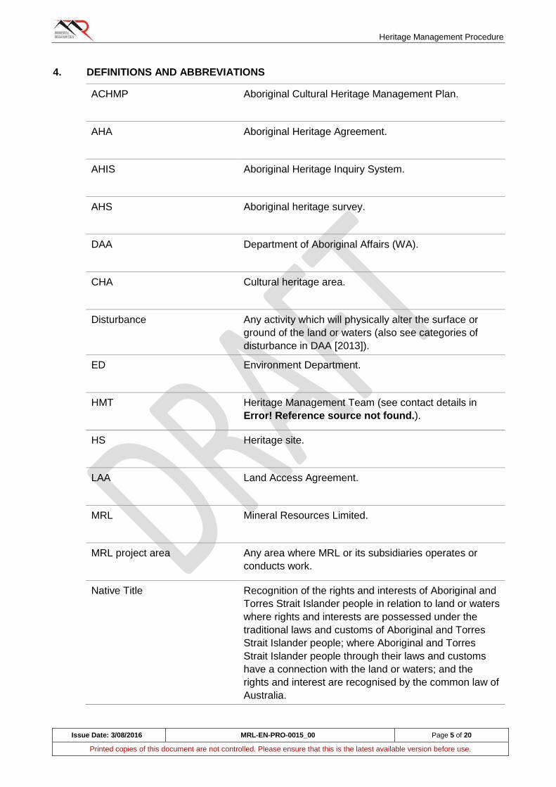
Heritage Management Procedure
Issue Date: 3/08/2016 MRL-EN-PRO-0015_00 Page 5 of 20
Printed copies of this document are not controlled. Please ensure that this is the latest available version before use.
4. DEFINITIONS AND ABBREVIATIONS
ACHMP Aboriginal Cultural Heritage Management Plan.
AHA Aboriginal Heritage Agreement.
AHIS Aboriginal Heritage Inquiry System.
AHS Aboriginal heritage survey.
DAA Department of Aboriginal Affairs (WA).
CHA Cultural heritage area.
Disturbance Any activity which will physically alter the surface or
ground of the land or waters (also see categories of
disturbance in DAA [2013]).
ED Environment Department.
HMT Heritage Management Team (see contact details in
Error! Reference source not found.).
HS Heritage site.
LAA Land Access Agreement.
MRL Mineral Resources Limited.
MRL project area Any area where MRL or its subsidiaries operates or
conducts work.
Native Title Recognition of the rights and interests of Aboriginal and
Torres Strait Islander people in relation to land or waters
where rights and interests are possessed under the
traditional laws and customs of Aboriginal and Torres
Strait Islander people; where Aboriginal and Torres
Strait Islander people through their laws and customs
have a connection with the land or waters; and the
rights and interest are recognised by the common law of
Australia.
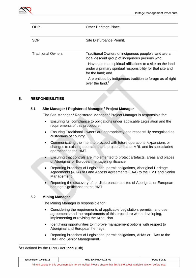
Heritage Management Procedure
Issue Date: 3/08/2016 MRL-EN-PRO-0015_00 Page 6 of 20
Printed copies of this document are not controlled. Please ensure that this is the latest available version before use.
OHP Other Heritage Place.
SDP Site Disturbance Permit.
Traditional Owners
Traditional Owners of indigenous people’s land are a
local descent group of indigenous persons who:
- Have common spiritual affiliations to a site on the land
under a primary spiritual responsibility for that site and
for the land; and
- Are entitled by indigenous tradition to forage as of right
over the land.1
5. RESPONSIBILITIES
5.1 Site Manager / Registered Manager / Project Manager
The Site Manager / Registered Manager / Project Manager is responsible for:
Ensuring full compliance to obligations under applicable Legislation and the requirements of this procedure.
Ensuring Traditional Owners are appropriately and respectfully recognised as custodians of country.
Communicating the intent to proceed with future operations, expansions or changes to existing operations and project areas at MRL and its subsidiaries operations to the HMT.
Ensuring that controls are implemented to protect artefacts, areas and places of Aboriginal or European heritage significance.
Reporting breaches of Legislation, permit obligations, Aboriginal Heritage Agreements (AHA) or Land Access Agreements (LAA) to the HMT and Senior Management.
Reporting the discovery of, or disturbance to, sites of Aboriginal or European heritage significance to the HMT.
5.2 Mining Manager
The Mining Manager is responsible for:
Considering the requirements of applicable Legislation, permits, land use agreements and the requirements of this procedure when developing, implementing or revising the Mine Plan.
Identifying opportunities to improve management options with respect to Aboriginal and European heritage.
Reporting breaches of Legislation, permit obligations, AHAs or LAAs to the HMT and Senior Management.
1As defined by the EPBC Act 1999 (Cth)
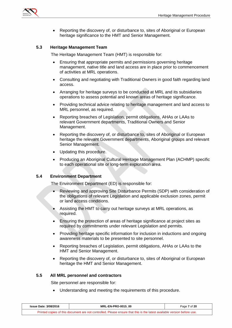
Heritage Management Procedure
Issue Date: 3/08/2016 MRL-EN-PRO-0015_00 Page 7 of 20
Printed copies of this document are not controlled. Please ensure that this is the latest available version before use.
Reporting the discovery of, or disturbance to, sites of Aboriginal or European heritage significance to the HMT and Senior Management.
5.3 Heritage Management Team
The Heritage Management Team (HMT) is responsible for:
Ensuring that appropriate permits and permissions governing heritage management, native title and land access are in place prior to commencement of activities at MRL operations.
Consulting and negotiating with Traditional Owners in good faith regarding land access.
Arranging for heritage surveys to be conducted at MRL and its subsidiaries operations to assess potential and known areas of heritage significance.
Providing technical advice relating to heritage management and land access to MRL personnel, as required.
Reporting breaches of Legislation, permit obligations, AHAs or LAAs to relevant Government departments, Traditional Owners and Senior Management.
Reporting the discovery of, or disturbance to, sites of Aboriginal or European heritage the relevant Government departments, Aboriginal groups and relevant Senior Management.
Updating this procedure.
Producing an Aboriginal Cultural Heritage Management Plan (ACHMP) specific to each operational site or long-term exploration area.
5.4 Environment Department
The Environment Department (ED) is responsible for:
Reviewing and approving Site Disturbance Permits (SDP) with consideration of the obligations of relevant Legislation and applicable exclusion zones, permit or land access conditions.
Assisting the HMT to carry out heritage surveys at MRL operations, as required.
Ensuring the protection of areas of heritage significance at project sites as required by commitments under relevant Legislation and permits.
Providing heritage specific information for inclusion in inductions and ongoing awareness materials to be presented to site personnel.
Reporting breaches of Legislation, permit obligations, AHAs or LAAs to the HMT and Senior Management.
Reporting the discovery of, or disturbance to, sites of Aboriginal or European heritage the HMT and Senior Management.
5.5 All MRL personnel and contractors
Site personnel are responsible for:
Understanding and meeting the requirements of this procedure.
Heritage Management Procedure
Issue Date: 3/08/2016 MRL-EN-PRO-0015_00 Page 8 of 20
Printed copies of this document are not controlled. Please ensure that this is the latest available version before use.
Reporting the discovery of, or disturbance to, sites of Aboriginal or European heritage the supervision.
6. PROCEDURE(S)
6.1 Managing Areas of Known Aboriginal Heritage Significance
6.1.1 Aboriginal Heritage Surveys
Before any activities commence within any MRL project areas, an Aboriginal heritage survey (AHS) shall be conducted by the HMT. Surveys should in the first instance include a review of the Department of Aboriginal Affairs (DAA) Aboriginal Heritage Inquiry System (AHIS). This will define whether or not there are Aboriginal Heritage Sites (HS) or Other Heritage Places (OHP) in the project area/s. Where required, the HMT will consult with Traditional Owners and utilise heritage consultants to conduct field surveys within the project area/s.
Surveys shall be conducted in accordance with the DAA Guidelines for Preparing Aboriginal Heritage Survey Reports (DAA, 2016) and the Aboriginal Heritage Due Diligence Guidelines (DAA, 2013).
6.1.2 Identifying Sites of Aboriginal Heritage Significance
Any sites of Aboriginal heritage significance identified through the AHIS or, Cultural Heritage Areas (CHA) through Aboriginal Heritage Surveys (AHS), shall not be disturbed. These sites shall be marked in the field, and the locations included on site plans and within the ACHMP.
The HMT will assess the proposed disturbance to Aboriginal HS, OHP and CHA and notify the Traditional Owners and the DAA (see Section 6.2 below)
Demarcation of sites (including the appropriate buffer area applicable to the site) shall use heritage demarcation tape (black / pink stripes), black or black / white posts and appropriate signage.
Personnel shall treat any heritage boundary outlines on maps like a physical boundary as these areas may have spiritual significance or contain physical objects of importance. It is important that personnel do not:
Enter the site without prior approval.
Make any changes to the landscape and/or vegetation within the site.
Make any modification to the demarcation of the site (unless prior approval has been sort from the HMT).
Take any material from within the demarcated site.

Heritage Management Procedure
Issue Date: 3/08/2016 MRL-EN-PRO-0015_00 Page 9 of 20
Printed copies of this document are not controlled. Please ensure that this is the latest available version before use.
FIGURE 1. EXAMPLES OF DEMARCATION OF ABORIGINAL HERITAGE SITES AT MRL PROJECTS (A - FLAGGING TAPE; B - POSTS; C - SIGNAGE).
6.1.3 Disturbance to Sites of Aboriginal Heritage Significance
Wherever practicable, AHS, OHP, and CHA shall be avoided; however should any disturbance be necessary, approval shall be sought under Section 18 of the Aboriginal Heritage Act 1972 (or other applicable Legislation where MRL operations exist outside of Western Australia).
Note: the Section 18 process can take up to five months, therefore early consultation with the HMT during the initial planning phase for future MRL projects, or where expansion or changes to existing operations and project areas are required or proposed, is recommended to eliminate potential for delays.
If accidental disturbance to an AHS, OHP, and CHA does occur, the following steps shall be taken to ensure the incident is managed correctly:
(C)
Heritage Management Procedure
Issue Date: 3/08/2016 MRL-EN-PRO-0015_00 Page 10 of 20
Printed copies of this document are not controlled. Please ensure that this is the latest available version before use.
All work in the area is to stop immediately. Personnel shall notify supervision immediately and the Project Supervisor shall contact the HMT as soon as possible to notify them of the disturbance.
The HMT will advise the Project Supervisor of the next actions to be taken. If possible, a GPS location of the disturbed area should be recorded and the type of Aboriginal HS, OHP or CHA (i.e. artefacts scatter, scar tree etc) communicated to the HMT. This information will help the HMT decide on the best course of action (Note: out of respect for Aboriginal customs, photographs of an Aboriginal HS, OHP or CHA shall not be taken unless consultation with the HMT has occurred prior and permission has been granted).
Complete an incident report form (MRL-OHM-FRM-0002) outlining how/what disturbance has occurred.
Work is not to re-commence until the HMT have assessed the disturbance and advised that work can continue with / without any restrictions or further controls to limit potential for future disturbance.
The HMT will advise on the requirement to report site disturbance to the DAA.
Where the cause of disturbance to an Aboriginal HS, OHP or CHA is not known, or where disturbance is thought to be malicious or intentional, personnel shall report the incident immediately to supervision and the HRT so that the DAA and / or police can be notified.
6.2 Recognising and Managing Sites of Possible Aboriginal Heritage Significance
A HERITAGE SURVEY OF A PROJECT AREA DOES NOT ALWAYS GUARANTEE SITES OF ABORIGINAL HERITAGE SIGNIFICANCE. AT TIMES, GROUND DISTURBING REVEAL OBJECTS OR SITES THAT WERE NOT PREVIOUSLY KNOWN TO THE HMT OR ARE NOT REGISTERED WITH THE DAA. APPENDIX 1 - HERITAGE MANAGEMENT TEAM CONTACT DETAILS
Name Position Phone Email
Derrick Kettlewell Principal Geologist (D) +61 8 9329
3715
(M) +61437 188
657
James Keillor Heritage Advisor (D) +61 8 9329
3733
(M) +61 427 871
885
Heritage Management Procedure
Issue Date: 3/08/2016 MRL-EN-PRO-0015_00 Page 11 of 20
Printed copies of this document are not controlled. Please ensure that this is the latest available version before use.
APPENDIX 2 provides a summary of the various types of Aboriginal sites that may be encountered in Western Australia.
If personnel locate an area or object which is suspected to be of Aboriginal heritage significance, the following steps must be taken:
All work in the area is to stop immediately. Personnel shall notify supervision immediately and the Project Supervisor shall contact the HMT as soon as possible to notify them of the discovery.
The HMT will advise the Project Supervisor of the next actions to be taken. If possible, a GPS location of the discovery should be recorded and the type of Aboriginal HS, OHP or CHA (i.e. artefacts, scar tree, etc) communicated to the HMT. This information will help the HMT decide on the best course of action. Photographs shall not be taken unless consultation with the HMT has occurred prior and permission has been granted.
Complete an incident report form (MRL-OHM-FRM-0002) outlining how / what discovery has been made.
Work is not to commence until the HMT have assessed the discovery and advised that work can continue with / without any restrictions or further controls to limit potential for future disturbance to the discovery.
The HMT will advise on the requirement to report the discovery to the DAA. Reports can be made via the DAA Heritage Information Submission Form available on the DAA website.
6.2.1 Burials and Skeletal Material
Burials and skeletal remains are of particular significance to Aboriginal people and must be treated with the utmost respect. In some areas of Australia, Aboriginal groups sometimes buried their dead in rock shelters or caves which were then sealed off with rock walls. As such, personnel shall not interfere with any rock walls or rock fills within caves and shelters.
Federal and State Legislation also specifies that any location in which human remains are discovered is immediately classified as a crime scene and must not to be disturbed. If human remains or suspected human remains are found the following steps must be followed:
Immediately stop all work within 50 m of the discovery location.
Section off the area with black or black / white posts or black / pink tape and inform supervision of the discovery. Do not re-enter the area.
Supervisor shall contact the Project Manager and the HMT immediately and communicate details relating to the discovery (i.e. location, description). In these cases, photographs must not be taken as the area is a designated as a crime scene until directed further by the Police. The HMT will contact the local Police and DAA to arrange an inspection of the area.
Police will take over control of the area, and all further activities at the area shall be managed through directions from the Police to Senior Management and the HRT.
Heritage Management Procedure
Issue Date: 3/08/2016 MRL-EN-PRO-0015_00 Page 12 of 20
Printed copies of this document are not controlled. Please ensure that this is the latest available version before use.
6.3 European Heritage
European heritage in Australia includes buildings, industrial sites, townscapes, cemeteries, landscapes, monuments, heritage gardens, national parks and urban bushlands in addition to documents and records, art, personal objects, uniforms and other items which relate to European history in Australia.
MRL operations may at times impact on matters of European heritage significance and areas protected under State and / or Federal Legislation. Before any activities commence within any MRL project areas, the HMT shall be consulted and if required, a European heritage survey shall be conducted by the HMT.
6.3.1 European Heritage Databases in Western Australia
Listings of heritage places in Western Australia can be obtained via the Heritage Council State Heritage Office online search tool 'inHerit' at: http://inherit.stateheritage.wa.gov.au/public
For MRL operations outside of Western Australia, a listing of heritage organisations in Australian States and Territories can be found on the Department of Environment website: http://www.environment.gov.au/heritage/organisations
6.4 Other Heritage Listings
Other heritage sites which may be affected by MRL operations include natural, historic and Indigenous heritage places in Australia identified on the following lists:
UNESCO World Heritage List.
Australian National Heritage List.
Australian Commonwealth Heritage List.
Australian National Shipwreck Database.
Register of National Estate.
7. Native Title & Aboriginal Heritage Agreements
There are various State and Federal Laws and government policies concerning Native Title, Aboriginal heritage and land access planning for exploration, mining, and development across Western Australia. As such, the HMT should always be consulted during the initial planning phase for future MRL operations, or where expansion or changes to existing operations and project areas are required or proposed.
Native Title and land access negotiations can be a lengthy process so projects with sensitive timelines will benefit from early consultation periods between the HMT and Traditional Owners.
7.1 Native Title
Native Title is the set of rights and interests over land and waters in Australia and its Territories that have been established through traditional Aboriginal law and custom. It can be recognised under Australian law (Native Title Act 1993 [Cth]) balanced with other rights and interests in the area in question.
Native Title rights and interests may include rights to:
Decide who can access land.
Heritage Management Procedure
Issue Date: 3/08/2016 MRL-EN-PRO-0015_00 Page 13 of 20
Printed copies of this document are not controlled. Please ensure that this is the latest available version before use.
Access an area for traditional purposes, like camping or ceremonies.
Visit and protect important places and sites.
Hunt, fish and gather food or traditional resources like water, wood and ochre.
Teach law and custom on country.
Australian law recognises that Native Title exists where Aboriginal people have maintained a traditional connection to their land and waters, since sovereignty and where acts of government have not extinguished it.
More information relating the Native Title Act process on mining leases in Western Australia can be found on the Department of Mines and Petroleum website (see: http://www.dmp.wa.gov.au/Minerals/Native-Title-Act-Process-5548.aspx).
7.2 Aboriginal Heritage Agreements
An Aboriginal Heritage Agreement (AHA) or Land Access Agreement (LAA) is a voluntary agreement between two or more parties relating to the management or protection of Aboriginal cultural heritage.
An AHA can deal with a variety of matters which include but are not limited to:
The protection, maintenance or use of land containing an Aboriginal place or object.
The right for Aboriginal people to access, or use Aboriginal places or objects.
Provision for the rehabilitation of Aboriginal places or objects.
8. MONITORING
During clearing activities, personnel supervising the works and the ED (where present on a project site) shall ensure that the clearing remains within the design area.
In some instances, under the AHA, the Traditional Owners may require Aboriginal monitors to be present during the initial clearing to make sure known cultural heritage is not damaged. The monitors also guard against possible unknown cultural areas also being disturbed.
Routine monitoring of known Aboriginal HS, OHP and CHA shall be undertaken by the HMT (or designee) to ensure disturbance to known heritage sites has not occurred.
9. RECORDS AND REPORTING
9.1 Register of Heritage Sites
The HRT (or designee) will maintain a register of Aboriginal HS, OHP and CHA for MRL and its subsidiary's projects. Records shall be available and communicated to site personnel (except where the location of these sites must remain confidential).
Records shall include:
Site GPS location (and / or applicable buffer) in MGA 94; map coordinates or distance and direction from a known landmark.
Site description.
Site condition.
Digital photographs (if permitted).
Heritage Management Procedure
Issue Date: 3/08/2016 MRL-EN-PRO-0015_00 Page 14 of 20
Printed copies of this document are not controlled. Please ensure that this is the latest available version before use.
Recommendations regarding impact avoidance.
9.2 Storage of Aboriginal Artefacts (Safe Keeping Place)
Aboriginal artefacts that may be salvaged from within an MRL (or its subsidiaries) project area are of primary interest to the Aboriginal stakeholders. All objects salvaged shall be curated, stored and / or displayed by the HMT (or designee) in an appropriate manner, in consultation with the applicable Aboriginal stakeholders for the project.
9.3 Reporting
As outlined in Sections 6.1 and 6.2 above, reporting to the DAA may be required. All reporting to Government shall be made through the HMT.
10. TRAINING
10.1 Induction and Cultural Awareness Training
Before commencing work on an MRL (or subsidiary) site, all personnel will complete a formal mandatory site induction, which will contain information specifically related to Aboriginal heritage, and where present, European heritage. The induction will include information relating to artefacts, areas and/or places of specific heritage significance within the project area and the project's region and any specific requirements or obligations of personnel under applicable heritage Legislation.
11. RECOGNITION OF TRADITIONAL OWNERS
11.1 Mechanisms to Recognise Traditional Owners
Use of the Aboriginal flag, displayed at MRL and its subsidiaries projects, is a mechanism that can be used to recognise Traditional Owners and Aboriginal culture. Permission is not required to fly the Australian Aboriginal Flag. See more information at: https://www.itsanhonour.gov.au/symbols/otherflag.cfm.
Incorporating welcoming and acknowledgement protocols into official meetings and events recognises Aboriginal and Torres Strait Islander peoples as the First Australians and custodians of their land. It promotes an awareness of the past and ongoing connection to place of Aboriginal and Torres Strait Islander Australians. Depending on the occasion, a 'Welcome to Country' and / or an 'Acknowledgement of Country' is appropriate (see below).
11.1.1 Welcome to Country
A Welcome to Country is a ceremony performed by Aboriginal or Torres Strait Islander people who welcome visitors to their traditional land. It can take many forms, depending on the particular culture of the Traditional Owners and can include: singing, dancing, smoking ceremonies or a speech in traditional language or English. A Welcome to Country is usually performed at larger events or formal occasions.
To arrange a Welcome to Country, the HMT will contact local Elders in the area where the event is to occur. If an Elder cannot attend the event

Heritage Management Procedure
Issue Date: 3/08/2016 MRL-EN-PRO-0015_00 Page 15 of 20
Printed copies of this document are not controlled. Please ensure that this is the latest available version before use.
or the event is small in nature, an Acknowledgement of Country may be suitable (see Section 11.1.2 below).
11.1.2 Acknowledgement of Country
An Acknowledgement of Country is a way to show awareness of, and respect for, the Traditional Owners of the land where a meeting or event is being held, and of recognising the continuing connection of Aboriginal and Torres Strait Islander peoples to their country.
An Acknowledgement of Country can be informal or formal, and usually involves an acknowledgment at the start of a meeting, speech or formal occasion being delivered by the speaker. Unlike the Welcome to Country it can be performed by a non-indigenous person.
There are no set protocols or wording for an Acknowledgement of Country, although the following statement can be used:
‘I would like to acknowledge that this meeting is being held on the traditional lands of the <insert traditional area name> people, and pay my respect to elders both past and present.’
OR
‘I am honoured to be on the ancestral lands of the <insert traditional area name> people. I acknowledge the First Australians as the traditional custodians of the continent, whose cultures are among the oldest living cultures in human history. I pay respect to the elders of the community and extend my recognition to their descendants who are present.’
Heritage Management Procedure
Issue Date: 3/08/2016 MRL-EN-PRO-0015_00 Page 16 of 20
Printed copies of this document are not controlled. Please ensure that this is the latest available version before use.
12. REFERENCES
Department of Aboriginal
Affairs (2016)
Guidelines for Preparing Aboriginal Heritage Survey
Reports. East Perth: WA Government, p. 1. Available at:
http://www.daa.wa.gov.au/globalassets/pdf-files/heritage-
pdfs/aboriginal-heritage-surveys---guidelines.pdf
[Accessed on 3 May 2016].
Department of Aboriginal
Affairs (2013)
Aboriginal Heritage Due Diligence Guidelines - v3. East
Perth: WA Government, p.17-18. Available at:
http://www.daa.wa.gov.au/globalassets/pdf-files/ddg
[Accessed 2 May 2016].
Aboriginal Heritage Inquiry
System
Web Address: http://maps.dia.wa.gov.au/AHIS2/
Heritage Information
Submission Form
Web Address:
https://forms.business.gov.au/smartforms/wa-daa-
hcb/heritage-information-submission/
inHerit Heritage Inquiry
System
Web Address: http://inherit.stateheritage.wa.gov.au/Public/
MRL-EN-PRO-0006 Environment - Legal and Other Requirements
MRL-EN-PRO-0009 Site Disturbance Permit Procedure
MRL-EN-FRM-0003 Site Disturbance Permit Form
MRL-OHM-FRM-0002 Incident Report Form
Heritage Management Procedure
Issue Date: 3/08/2016 MRL-EN-PRO-0015_00 Page 17 of 20
Printed copies of this document are not controlled. Please ensure that this is the latest available version before use.
APPENDIX 1 - HERITAGE MANAGEMENT TEAM CONTACT DETAILS
Name Position Phone Email
Derrick Kettlewell Principal Geologist (D) +61 8 9329
3715
(M) +61437 188
657
James Keillor Heritage Advisor (D) +61 8 9329
3733
(M) +61 427 871
885
Heritage Management Procedure
Issue Date: 3/08/2016 MRL-EN-PRO-0015_00 Page 18 of 20
Printed copies of this document are not controlled. Please ensure that this is the latest available version before use.
APPENDIX 2 - ABORIGINAL HERITAGE SITES
Section 5 of the Aboriginal Heritage Act 1972 (WA) defines an Aboriginal site as:
a) Any place of importance and significance where persons of Aboriginal descent have, or appear to have, left any object, natural or artificial, used for, or made or adapted for use for, any purpose connected with the traditional cultural life of the Aboriginal people, past or present;
b) Any sacred, ritual or ceremonial site, which is of importance and special significance to persons of Aboriginal descent;
c) Any place, which in the opinion of the Committee, is or was associated with the Aboriginal people and which is of historical, anthropological or ethnographical interest and should be preserved because of its importance and significance to the cultural heritage of the state; and
d) Any place where objects to which this Act applied are traditionally stored, or to which, under the provisions of this Act, such objects have been taken or removed.
The various types of Aboriginal sites that may be encountered in Western Australia are summarised below:2:
2 Descriptions of Aboriginal site types are taken from 'Department of Aboriginal Affairs (2013).
Aboriginal Heritage Due Diligence Guidelines - v3. East Perth: WA Government, p.17-18.
Available at: http://www.daa.wa.gov.au/globalassets/pdf-files/ddg [Accessed 2 May 2016].
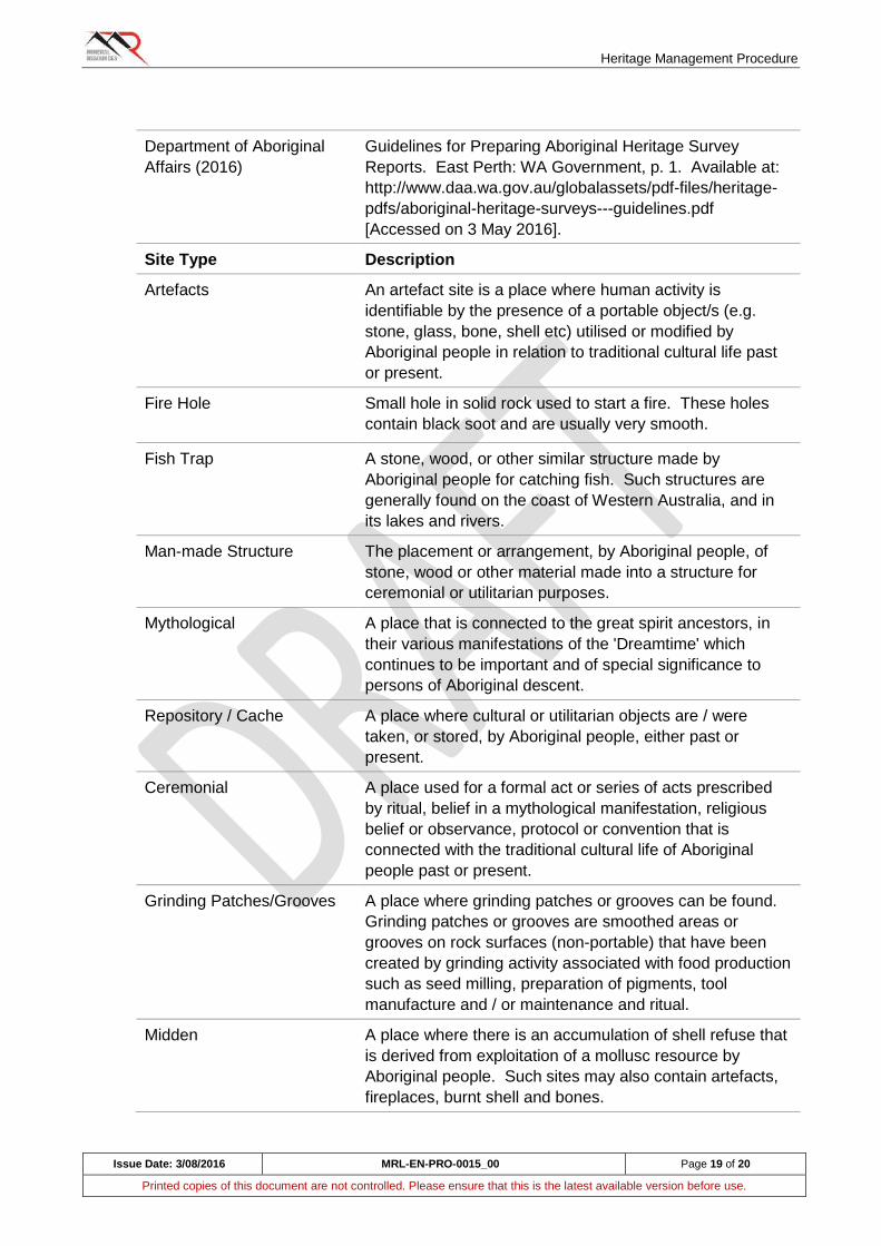
Heritage Management Procedure
Issue Date: 3/08/2016 MRL-EN-PRO-0015_00 Page 19 of 20
Printed copies of this document are not controlled. Please ensure that this is the latest available version before use.
Department of Aboriginal
Affairs (2016)
Guidelines for Preparing Aboriginal Heritage Survey
Reports. East Perth: WA Government, p. 1. Available at:
http://www.daa.wa.gov.au/globalassets/pdf-files/heritage-
pdfs/aboriginal-heritage-surveys---guidelines.pdf
[Accessed on 3 May 2016].
Site Type Description
Artefacts An artefact site is a place where human activity is
identifiable by the presence of a portable object/s (e.g.
stone, glass, bone, shell etc) utilised or modified by
Aboriginal people in relation to traditional cultural life past
or present.
Fire Hole
Small hole in solid rock used to start a fire. These holes
contain black soot and are usually very smooth.
Fish Trap A stone, wood, or other similar structure made by
Aboriginal people for catching fish. Such structures are
generally found on the coast of Western Australia, and in
its lakes and rivers.
Man-made Structure The placement or arrangement, by Aboriginal people, of
stone, wood or other material made into a structure for
ceremonial or utilitarian purposes.
Mythological A place that is connected to the great spirit ancestors, in
their various manifestations of the 'Dreamtime' which
continues to be important and of special significance to
persons of Aboriginal descent.
Repository / Cache A place where cultural or utilitarian objects are / were
taken, or stored, by Aboriginal people, either past or
present.
Ceremonial A place used for a formal act or series of acts prescribed
by ritual, belief in a mythological manifestation, religious
belief or observance, protocol or convention that is
connected with the traditional cultural life of Aboriginal
people past or present.
Grinding Patches/Grooves A place where grinding patches or grooves can be found.
Grinding patches or grooves are smoothed areas or
grooves on rock surfaces (non-portable) that have been
created by grinding activity associated with food production
such as seed milling, preparation of pigments, tool
manufacture and / or maintenance and ritual.
Midden A place where there is an accumulation of shell refuse that
is derived from exploitation of a mollusc resource by
Aboriginal people. Such sites may also contain artefacts,
fireplaces, burnt shell and bones.
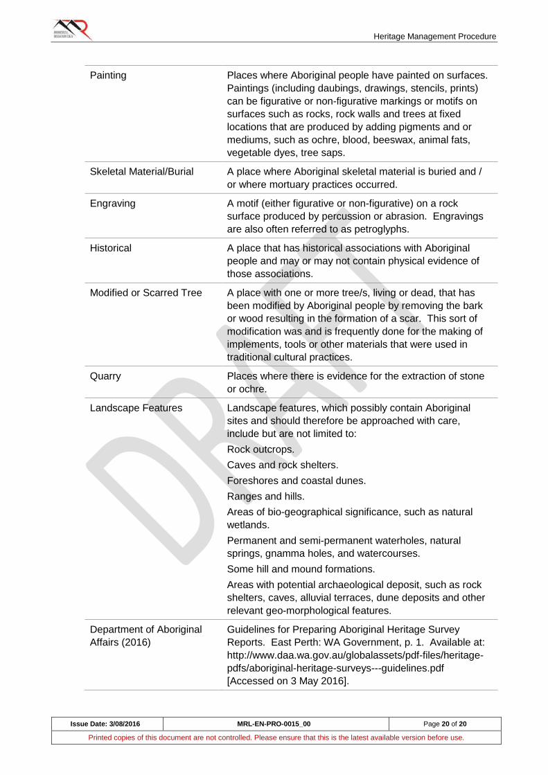
Heritage Management Procedure
Issue Date: 3/08/2016 MRL-EN-PRO-0015_00 Page 20 of 20
Printed copies of this document are not controlled. Please ensure that this is the latest available version before use.
Painting Places where Aboriginal people have painted on surfaces.
Paintings (including daubings, drawings, stencils, prints)
can be figurative or non-figurative markings or motifs on
surfaces such as rocks, rock walls and trees at fixed
locations that are produced by adding pigments and or
mediums, such as ochre, blood, beeswax, animal fats,
vegetable dyes, tree saps.
Skeletal Material/Burial A place where Aboriginal skeletal material is buried and /
or where mortuary practices occurred.
Engraving A motif (either figurative or non-figurative) on a rock
surface produced by percussion or abrasion. Engravings
are also often referred to as petroglyphs.
Historical A place that has historical associations with Aboriginal
people and may or may not contain physical evidence of
those associations.
Modified or Scarred Tree A place with one or more tree/s, living or dead, that has
been modified by Aboriginal people by removing the bark
or wood resulting in the formation of a scar. This sort of
modification was and is frequently done for the making of
implements, tools or other materials that were used in
traditional cultural practices.
Quarry Places where there is evidence for the extraction of stone
or ochre.
Landscape Features Landscape features, which possibly contain Aboriginal
sites and should therefore be approached with care,
include but are not limited to:
Rock outcrops.
Caves and rock shelters.
Foreshores and coastal dunes.
Ranges and hills.
Areas of bio-geographical significance, such as natural
wetlands.
Permanent and semi-permanent waterholes, natural
springs, gnamma holes, and watercourses.
Some hill and mound formations.
Areas with potential archaeological deposit, such as rock
shelters, caves, alluvial terraces, dune deposits and other
relevant geo-morphological features.
Department of Aboriginal
Affairs (2016)
Guidelines for Preparing Aboriginal Heritage Survey
Reports. East Perth: WA Government, p. 1. Available at:
http://www.daa.wa.gov.au/globalassets/pdf-files/heritage-
pdfs/aboriginal-heritage-surveys---guidelines.pdf
[Accessed on 3 May 2016].