increase to pilbara ore reserves and mineral resources … · increase to pilbara ore reserves and...
TRANSCRIPT

Media release
Page 1 of 42
INCREASE TO PILBARA ORE RESERVES AND MINERAL RESOURCES 6 March 2015 To support the annual Mineral Resources and Ore Reserves review process detailed in Rio Tinto’s 2014 Annual report released today, Rio Tinto Iron Ore has declared an increase of its managed Mineral Resources and Ore Reserves in the Pilbara, Western Australia, resulting from the completion of studies and evaluations. The update is reported under the Australasian Code for Reporting of Exploration Results, Mineral Resources and Ore Reserves, 2012 (JORC Code) and ASX Listing Rules, and provides a summary of information and Table 1 appendices to support the Mineral Resource Estimates and Ore Reserves for the material updates completed. Increases in Mineral Resources are reported as follows.
1. Hamersley Iron Brockman (increased by 681 million tonnes (Mt) to 2,998 Mt and Brockman process ore (increased by 324 Mt to 1,137 Mt) The increase represents minor changes across multiple deposits and the first inclusion of the Yandicoogina Braid deposit into the Mineral Resources, which was discovered by the Rio Tinto Exploration group during 2014. The Yandicoogina Braid deposit is classified as Inferred Mineral Resources and comprises:
• 488 Mt at 61.7 per cent Fe Brockman Ore; • 238 Mt at 57.7 per cent Fe Brockman Process Ore; and • 62 Mt at 56.9 per cent Fe Channel Iron Deposit.
2. Robe Joint-Venture Channel Iron deposit
This reflects an addition of 677 Mt of Inferred Mineral Resources at 53.1 per cent Fe of Channel Iron deposit mineralisation at the Jimmawurrada deposit, following metallurgical assessments of drill core.
Increases in the Ore Reserves relates to the Koodaideri deposit where Ore Reserves have increased by 49 Mt to 467 Mt.

Page 2 of 42
Summary of Information to Support Mineral Resource Estimates: Yandicoogina Braid Deposit Mineral Resource Estimates of the Yandicoogina Braid deposit are supported by JORC Table 1 provided in Appendix 1 of this media release and located at www.riotinto.com/JORC. The following summary of information for Mineral Resource Estimates is provided in accordance with Chapter 5.8 of ASX Listing Rules. Geology and geological interpretation The Yandicoogina Braid deposit is located within the Hamersley Basin of Western Australia the host to the some of the most significant iron ore deposits in the world. Mineralisation at the Yandicoogina Braid deposit occurs as bedded mineralisation within the Brockman Formation and as pisolitic ores within the channel iron formations overlying the Brockman Formation ores. Geologic interpretations are supported by surface mapping of outcrops, and by a reverse circulation drilling carried which saw 41 holes for 6,944 m drilled in the project area during 2014. Drilling techniques Drilling at the Yandicoogina Braid deposit was carried out by using reverse circulation drilling rigs. Geophysical logging was completed for all drill holes employing a suite of down hole tools to obtain calliper and gamma data to assist in the interpretation of the stratigraphy. Sampling, sub-sampling method and sample analysis method Sub-sampling at the drill rig was carried out using rotary splitters. The sample is then sent to independent and certified laboratories for analysis. At the laboratory, the sample is oven dried at 105 degrees Celsius for a minimum of 24 hours. The sample is then crushed to approximately 3 mm using a Jaw Crusher and split to produce a 500 g sub-sample. The sub-sample is pulverised to 95 per cent of weight passing 150 µm. Fe, SiO2, Al2O3, P, Mn, MgO, TiO2, CaO and S are assayed using industry standard lithium metaborate fusion and X-Ray Fluorescence (XRF) analysis. Criteria used for classification Appropriate drill hole spacing criteria for classifying Resources within the Pilbara is based on an understanding of the geological and grade variability, and reconciliation of operating mines across the Pilbara area. Yandicoogina Braid is drilled at approximately 400 m x 400 m which is suitable for the classification of an Inferred Mineral Resource. Estimation methodology Modelling was completed using the Rio Tinto Iron Ore Pilbara geological modelling and estimation standards. Inverse Distance estimation methods were used.
Page 3 of 42
Reasonable prospects for eventual economic extraction The Yandicoogina Braid deposit is located approximately 15 km to the north west of the current Yandicoogina mine operation and infrastructure. The channel iron deposit is the downstream extension of the previously reported channel iron deposit of Yandicoogina. Pit optimisation runs have been carried out using existing operating and capital cost. Long term price forecasts for each iron ore product have been used. The pit optimisation results are used to derive a strategic business model which is valued using net present value techniques. The result of this analysis indicates that there are reasonable grounds for potential economic extraction.
Page 4 of 42
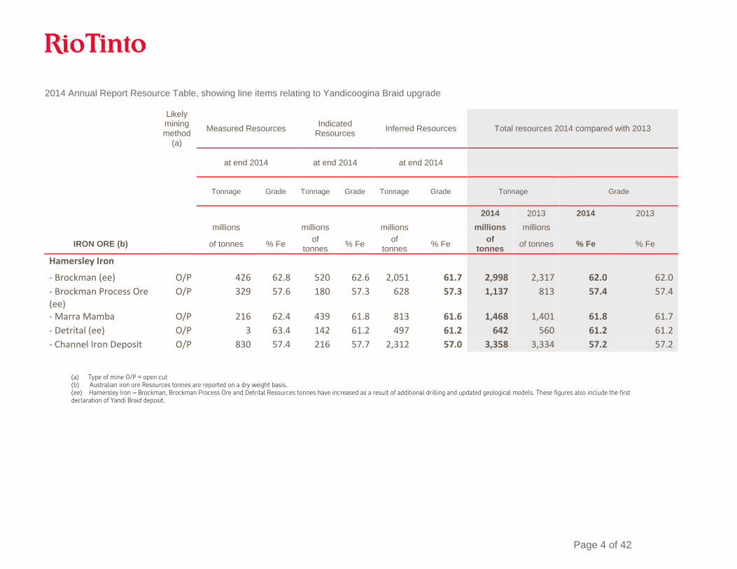
2014 Annual Report Resource Table, showing line items relating to Yandicoogina Braid upgrade
Likely mining method
(a)
Measured Resources Indicated Resources Inferred Resources Total resources 2014 compared with 2013
at end 2014 at end 2014 at end 2014
Tonnage Grade Tonnage Grade Tonnage Grade Tonnage Grade
2014 2013 2014 2013
millions millions millions millions millions IRON ORE (b) of tonnes % Fe of
tonnes % Fe of tonnes % Fe of
tonnes of tonnes % Fe % Fe
Hamersley Iron
- Brockman (ee) O/P 426 62.8 520 62.6 2,051 61.7 2,998 2,317 62.0 62.0 - Brockman Process Ore (ee)
O/P 329 57.6 180 57.3 628 57.3 1,137 813 57.4 57.4
- Marra Mamba O/P 216 62.4 439 61.8 813 61.6 1,468 1,401 61.8 61.7 - Detrital (ee) O/P 3 63.4 142 61.2 497 61.2 642 560 61.2 61.2 - Channel Iron Deposit O/P 830 57.4 216 57.7 2,312 57.0 3,358 3,334 57.2 57.2
(a) Type of mine O/P = open cut (b) Australian iron ore Resources tonnes are reported on a dry weight basis. (ee) Hamersley Iron --- Brockman, Brockman Process Ore and Detrital Resources tonnes have increased as a result of additional drilling and updated geological models. These figures also include the first declaration of Yandi Braid deposit.
Page 5 of 42
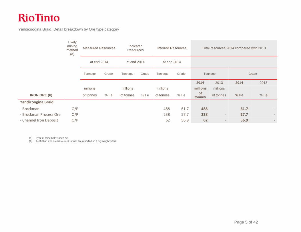
Yandicoogina Braid, Detail breakdown by Ore type category
Likely mining method
(a)
Measured Resources Indicated Resources Inferred Resources Total resources 2014 compared with 2013
at end 2014 at end 2014 at end 2014
Tonnage Grade Tonnage Grade Tonnage Grade Tonnage Grade
2014 2013 2014 2013
millions millions millions millions millions IRON ORE (b) of tonnes % Fe of tonnes % Fe of tonnes % Fe of
tonnes of tonnes % Fe % Fe
Yandicoogina Braid
- Brockman O/P 488 61.7 488 - 61.7 - - Brockman Process Ore O/P 238 57.7 238 - 27.7 - - Channel Iron Deposit O/P 62 56.9 62 - 56.9 -
(a) Type of mine O/P = open cut (b) Australian iron ore Resources tonnes are reported on a dry weight basis.
Page 6 of 42
Jimmawurrada Mineral Resource Estimates of the Jimmawurrada deposit is are supported by JORC Table 1 provided in Appendix 2 of this media release and located at www.riotinto.com/JORC. The following summary of information for Mineral Resource Estimates is provided in accordance with Chapter 5.8 of ASX Listing Rules. Geology and geological interpretation The Jimmawurrada deposit is located within the Hamersley Basin of Western Australia the host to the some of the most Ste iron ore deposits in the world. Mineralisation at the Jimmawurrada deposit occurs as pisolitic ores within the channel iron formations. The deposit is located immediately to the south of the Mesa J mining operation, a currently producing mining operation selling pisolite ores. Geologic interpretations are supported by surface mapping of outcrops, and by a reverse circulation drilling carried out over a number of years and totals 608 holes for 35,884 m. In addition to this 180 duel rotatory / diamond drill holes for 7,977 m has been drilled to provide samples for metallurgical test work. Drilling techniques Drilling at the Jimmawurrada deposit was carried out by using reverse circulation drilling rigs and duel rotary diamond drill rigs. Geophysical logging was completed for all drill holes employing a suite of down hole tools to obtain calliper and gamma and down hole density. Sampling, sub-sampling method and sample analysis method Sub-sampling at the drill rig was carried out using rotary splitters. The sample is then sent to independent and certified laboratories for analysis. At the laboratory, the sample is oven dried at 105 degrees Celsius for a minimum of 24 hours. The sample is then crushed to approximately 3 mm using a Jaw Crusher and split to produce a 500 g sub-sample. The sub-sample is pulverised to 95 per cent of weight passing 150 µm. Fe, SiO2, Al2O3, P, Mn, MgO, TiO2, CaO and S are assayed using industry standard lithium metaborate fusion and X-Ray Fluorescence (XRF) analysis. Criteria used for classification Appropriate drill hole spacing criteria for classifying Resources within the Pilbara is based on an understanding of the geological and grade variability, and reconciliation of operating mines across the Pilbara area. Jimmawurrada is drilled at approximately 200 m x 100 m to 400 m x 200 m which is suitable for the classification of an Inferred Mineral Resource. Estimation methodology Modelling was completed using the Rio Tinto Iron Ore Pilbara geological modelling and estimation standards. Ordinary kriging methods were used for the grade estimates,

Page 7 of 42
Reasonable prospects for eventual economic extraction The Jimmawurrada deposit has undergone an Order of Magnitude study during 2014. This study investigated mining, ground and surface water management, metallurgical methods and recoveries, capital and operating costs and heritage and environmental approval processes. The study concluded that the deposit could be mined economically. This study included the mining and process of low grade pisolites, which require additional processing to upgrade the ore to a saleable product.

Page 8 of 42
2014 Annual Report Resource Table, showing line items relating to Jimmawurrada upgrade
Likely mining method
(a)
Measured Resources Indicated Resources Inferred Resources Total resources 2014 compared with 2013
at end 2014 at end 2014 at end 2014
Tonnage Grade Tonnage Grade Tonnage Grade Tonnage Grade
2014 2013 2014 2013
millions millions millions millions millions IRON ORE (b) of tonnes % Fe of
tonnes % Fe of tonnes % Fe of
tonnes of tonnes % Fe % Fe
Robe JV (Australia)
Channel Iron Deposit (jj)
O/P 213 56.7 1,740 58.4 2,320 55.7 4,273 3,757 56.8 57.4
(a) Type of mine O/P = open cut (b) Australian iron ore Resources tonnes are reported on a dry weight basis. (ii) Robe JV --- Channel Iron Deposit Resources tonnes have increased as a result of additional drilling, updated geological models and technical studies at Jimmawurrada and other deposits

Page 9 of 42
Jimmawurrada, Detail breakdown by Ore type category
Likely mining method
(a)
Measured Resources Indicated Resources Inferred Resources Total resources 2014 compared with 2013
at end 2014 at end 2014 at end 2014
Tonnage Grade Tonnage Grade Tonnage Grade Tonnage Grade
2014 2013 2014 2013
millions millions millions millions millions IRON ORE (b) of tonnes % Fe of
tonnes % Fe of tonnes % Fe of
tonnes of tonnes % Fe % Fe
Jimmawurrada
- Channel Iron Deposit O/P 1360 54.6 1360 683 54.6 56.1
(a) Type of mine O/P = open cut (b) Australian iron ore Resources tonnes are reported on a dry weight basis.

Page 10 of 42
Summary of Information to the Ore Reserves Koodaideri Ore Reserve Estimate upgrades for the Koodaideri deposit supported by JORC Table 1 (Section 4) documents provided in Appendix 3 of this media release and located at www.riotinto.com/JORC. The following summary of information for Ore Reserve Estimates is provided in accordance with Chapter 5.9 of ASX Listing Rules. Geology and Mineral Resources: The Koodaideri deposit is located within the Hamersley Basin of Western Australia the host to the some of the most significant iron ore deposits in the world. Mineralisation at the Koodaideri deposit occurs as bedded mineralisation within the Brockman Formation. Geological interpretations are supported by surface mapping of outcrops, and by a reverse circulation drilling carried out between 2002 and 2013 which total 4,632 holes for 290 534 m. Drilling through the area that defines the Ore Reserves is at 50 m x 50 m grid spacing or 100 m x 50 m grid spacing for the Proved and Probable Reserves respectively. In addition to the RC drilling 111 diamond drill holes for 5,955 m has been carried out to provide metallurgical test cores and bulk density measurements. Reverse circulation holes have been sub-sampled using rotary splitters. Samples are then sent for analysis by independent assay laboratories. At the laboratory the sample is dried at 105 degrees Celsius for a minimum of 24 hours. The sample is then crushed to approximately 3 mm using a Jaw Crusher and riffle split to produce a 500 g sub-sample. The sub-sample is pulverised to 95% of weight passing 150 µm. Fe, SiO2, Al2O3, P, Mn, MgO, TiO2, CaO and S are assayed using industry standard lithium metaborate fusion and X-Ray Fluorescence (XRF) analysis. Modelling was completed using the Rio Tinto Iron Ore Pilbara geological modelling and estimation standards. Ordinary kriging methods were used for the grade estimates. Economic assumptions Rio Tinto applies a common process to the generation of commodity prices across the group. This involves generation of long-term price curves based on current sales contracts, industry capacity analysis, global commodity consumption and economic growth trends. In this process, a price curve rather than a single price point is used to develop estimates of mine returns over the life of the project. The detail of this process and of the price point curves is commercially sensitive and is not disclosed. Criteria used for classification The stated Proved and Probable Ore Reserves directly coincide with the Measured and Indicated Mineral Resources, respectively. There are no Inferred or Unclassified resources included in the stated reserve numbers.

Page 11 of 42
Mining and recovery factors The Mineral Resource model was regularised to a block size which was determined to be the selective mining unit following an analysis of a range of selective mining units. Dilution and mining recovery were modelled by applying the regularisation process to the sub-block geological model. Metallurgical models were applied to the regularised model in order to model products tonnage, grades and yields. Pit optimisations utilising the Lerchs-Grosmann algorithm with industry standard software were undertaken. This optimisation utilised the regularised Mineral Resource model together with cost, revenue, and geotechnical inputs. The resultant pit shells were used to develop detailed pit designs with due consideration of geotechnical, geometric and access constraints. These pit designs were used as the basis for production scheduling and economic evaluation. Conventional mining methods (truck and shovel) similar to other Rio Tinto Iron Ore mines were selected. The mine has been designed to utilise in-pit crushing and conveying to transport ore to a central processing facility. The geotechnical parameters have been applied based on geotechnical studies informed by assessments of 50 drill holes drilled during the 2011, 2012 & 2013 drilling programmes, specifically drilled for geotechnical purposes on the surrounding host rock. The resultant inter ramp slope angles vary between 16 and 35 degrees depending on the local rock mass and structural geological conditions.
Cut-off grades The cut-off grade for high-grade Brockman ore is greater than or equal to 60% Fe. Processing The Koodaideri mine has been designed with a dry crush and screen processing facility similar to processing facilities at other Rio Tinto Iron Ore mining operations. Studies into alternative processing technologies continue, however this has been excluded from this ore reserve declaration. The proposed metallurgical process is a well-tested and proven processing methodology, having been utilised at Rio Tinto Iron Ore mining operations for decades. Modifying factors The Koodaideri deposits are located within existing tenure Mining Lease (ML)252SA, which was granted under the Iron Ore (Mount Bruce) Agreement Act 1972 (Mount Bruce SA). Additional tenure is required to connect the mine with the existing Rio Tinto Iron Ore rail network, as well as for roads, power, water and camp locations located outside of the Mining Lease. Rio Tinto Iron Ore is currently in the process of negotiating third party consent to facilitate the grant of tenure for rail and ancillary infrastructure corridors. The infrastructure requirements for Koodaideri were assessed in detail by a Pre-feasibility study.

Page 12 of 42
Ore will be railed to Rio Tinto’s ports at Dampier and Cape Lambert. Upon completion of current and planned/approved construction projects, the port and railway networks will have sufficient capacity to accommodate ore supply from Koodaideri. A central hub for all non-process support facilities, will be located close the existing Munjina-Roy Hill road for ease of access. It is located central to the mine, processing plant and accommodation precinct. Electric power will be supplied to Koodaideri from the Rio Tinto transmission network via linking into an existing Rio Tinto 220 kV transmission line between Juna Downs and Yandicoogina. Water for Koodaideri will be initially sourced from bores located to the east of Koodaideri together with other surrounding bores at Koodaideri. These bores will support the early works and construction activities water demands.
Page 13 of 42
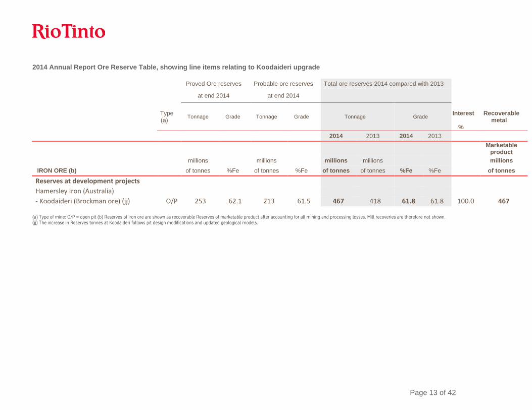
2014 Annual Report Ore Reserve Table, showing line items relating to Koodaideri upgrade Proved Ore reserves Probable ore reserves Total ore reserves 2014 compared with 2013 at end 2014 at end 2014
Type (a) Tonnage Grade Tonnage Grade Tonnage Grade
Interest
%
Recoverable metal
2014 2013 2014 2013
Marketable product
millions millions millions millions millions
IRON ORE (b) of tonnes %Fe of tonnes %Fe of tonnes of tonnes %Fe %Fe of tonnes
Reserves at development projects Hamersley Iron (Australia) - Koodaideri (Brockman ore) (jj) O/P 253 62.1 213 61.5 467 418 61.8 61.8 100.0 467
(a) Type of mine: O/P = open pit (b) Reserves of iron ore are shown as recoverable Reserves of marketable product after accounting for all mining and processing losses. Mill recoveries are therefore not shown. (jj) The increase in Reserves tonnes at Koodaideri follows pit design modifications and updated geological models.
Page 14 of 42
Competent Persons Statement The information in this report that relates to Mineral Resources is based on information compiled by Bruce Sommerville a Competent Person who is a Fellow of The Australasian Institute of Mining and Metallurgy. The information in this report that relates to Ore Reserves is based on information compiled by Mr Leon Fouché, a Competent Person who is a Member of The Australasian Institute of Mining and Metallurgy. Mr Sommerville and Mr Fouché are full-time employees of the company. Mr Sommerville and Mr Fouché have sufficient experience that is relevant to the style of mineralisation and type of deposit under consideration and to the activity being undertaken to qualify as Competent Persons as defined in the 2012 Edition of the ‘Australasian Code for Reporting of Exploration Results, Mineral Resources and Ore Reserves’. Mr Sommerville and Mr Fouché consent to the inclusion in the report of the matters based on the information in the form and context in which it appears.

Page 15 of 42
Contacts [email protected] www.riotinto.com
Follow @RioTinto on Twitter Media Relations, EMEA/Americas Illtud Harri T +44 20 7781 1152 M +44 7920 503 600 David Outhwaite T +44 20 7781 1623 M +44 7787 597 493 David Luff T + 44 20 7781 7781 M +44 7780 226 422 Investor Relations, EMEA/Americas John Smelt T +44 20 7781 1654 M +44 7879 642 675 David Ovington T +44 20 7781 2051 M +44 7920 010 978 Grant Donald T +44 20 7781 1262 M +44 7920 587 805
Media Relations, Australia/Asia Ben Mitchell T +61 3 9283 3620 M +61 419 850 212 Bruce Tobin T +61 3 9283 3612 M +61 419 103 454 Matthew Klar T +61 7 3625 4244 M +61 457 525 578 Investor Relations, Australia/Asia Rachel Storrs T +61 3 9283 3628 M +61 417 401 018 Galina Rogova T +852 2839 9208 M +852 6978 3011
Rio Tinto plc 2 Eastbourne Terrace London W2 6LG United Kingdom T +44 20 7781 2000 Registered in England No. 719885
Rio Tinto Limited 120 Collins Street Melbourne 3000 Australia T +61 3 9283 3333 Registered in Australia ABN 96 004 458 404
Page 16 of 42
Appendix 1 Yandicoogina Braid Table 1 6 March 2015
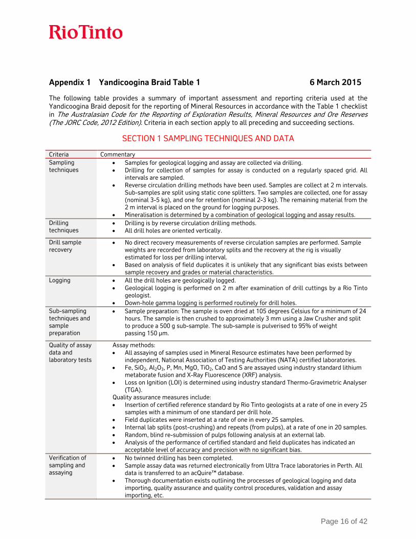
The following table provides a summary of important assessment and reporting criteria used at the Yandicoogina Braid deposit for the reporting of Mineral Resources in accordance with the Table 1 checklist in The Australasian Code for the Reporting of Exploration Results, Mineral Resources and Ore Reserves (The JORC Code, 2012 Edition). Criteria in each section apply to all preceding and succeeding sections.
SECTION 1 SAMPLING TECHNIQUES AND DATA
Criteria Commentary Sampling techniques
• Samples for geological logging and assay are collected via drilling. • Drilling for collection of samples for assay is conducted on a regularly spaced grid. All
intervals are sampled. • Reverse circulation drilling methods have been used. Samples are collect at 2 m intervals.
Sub-samples are split using static cone splitters. Two samples are collected, one for assay (nominal 3-5 kg), and one for retention (nominal 2-3 kg). The remaining material from the 2 m interval is placed on the ground for logging purposes.
• Mineralisation is determined by a combination of geological logging and assay results. Drilling techniques
• Drilling is by reverse circulation drilling methods. • All drill holes are oriented vertically.
Drill sample recovery
• No direct recovery measurements of reverse circulation samples are performed. Sample weights are recorded from laboratory splits and the recovery at the rig is visually estimated for loss per drilling interval.
• Based on analysis of field duplicates it is unlikely that any significant bias exists between sample recovery and grades or material characteristics.
Logging • All the drill holes are geologically logged. • Geological logging is performed on 2 m after examination of drill cuttings by a Rio Tinto
geologist. • Down-hole gamma logging is performed routinely for drill holes.
Sub-sampling techniques and sample preparation
• Sample preparation: The sample is oven dried at 105 degrees Celsius for a minimum of 24 hours. The sample is then crushed to approximately 3 mm using a Jaw Crusher and split to produce a 500 g sub-sample. The sub-sample is pulverised to 95% of weight passing 150 µm.
Quality of assay data and laboratory tests
Assay methods: • All assaying of samples used in Mineral Resource estimates have been performed by
independent, National Association of Testing Authorities (NATA) certified laboratories. • Fe, SiO2, Al2O3, P, Mn, MgO, TiO2, CaO and S are assayed using industry standard lithium
metaborate fusion and X-Ray Fluorescence (XRF) analysis. • Loss on Ignition (LOI) is determined using industry standard Thermo-Gravimetric Analyser
(TGA). Quality assurance measures include: • Insertion of certified reference standard by Rio Tinto geologists at a rate of one in every 25
samples with a minimum of one standard per drill hole. • Field duplicates were inserted at a rate of one in every 25 samples. • Internal lab splits (post-crushing) and repeats (from pulps), at a rate of one in 20 samples. • Random, blind re-submission of pulps following analysis at an external lab. • Analysis of the performance of certified standard and field duplicates has indicated an
acceptable level of accuracy and precision with no significant bias. Verification of sampling and assaying
• No twinned drilling has been completed. • Sample assay data was returned electronically from Ultra Trace laboratories in Perth. All
data is transferred to an acQuire™ database. • Thorough documentation exists outlining the processes of geological logging and data
importing, quality assurance and quality control procedures, validation and assay importing, etc.

Page 17 of 42
Location of data points
• All drill hole collar locations at the Yandicoogina Braid deposit are surveyed using Geocentric Datum of Australia 1994 (GDA94) and Map Grid of Australia 1994 (MGA94) zone 50 using a Trimble RTK Global Positioning System survey equipment. The accuracy of this system is to within two to 10 cm.
• All drilling was vertical and no down-hole surveys were conducted. Down-hole samples are located on traces assumed to be vertical.
• A surface triangulation was generated using the Light Detecting and Ranging (LiDAR) survey data. This data was filtered to a 3 m x 3 m cell size resolution.
Data spacing and distribution
• Drill spacing of approximately 400 m x 400 m on the Main Channel Area was considered adequate to establish both geological and grade continuity for definition of an Inferred Mineral Resource.
• Samples were not composited. Orientation of data in relation to geological structure
• The drilling is approximately perpendicular to local scale folding and structure, and to the strike of the flatly dipping mineralisation. The risk of sample bias is considered to be low.
Sample security • Laboratory samples (A splits) are collected by field assistants, placed onto steel sample racks, and transported to Ultra Trace Laboratories in Perth, Western Australia for analyses. Retention samples (B splits) are collected and stored in drums.
• Assay pulps are retained indefinitely at Rio Tinto Iron Ore facilities located at either Pannawonica or Dampier.
Audits or reviews
• No sampling audits have been performed.
SECTION 2 REPORTING OF EXPLORATION RESULTS
Criteria Commentary Mineral tenement and land tenure status
• 100% owned by Hamersley Iron-Yandi Pty Limited (HIY), 100% Rio Tinto Limited, held under Mining Lease (ML) 274SA.
Exploration done by other parties
• There was no exploration completed on this ground by other parties.
Geology • The deposit is a combination of bedded and channel iron deposits hosted in the Dales Gorge Member of the Archean Brockman Iron Formation. More than 85% of the mineralisation occurs in the Joffre Member. Mineralised Dales Gorge has also been intercepted in the northern sections.
• The bedded mineralisation is generally overlain by a variable thickness zone of Tertiary alluvium/colluvium.
Drill hole Information
• Drilling data summary:
Year Reverse Circulation
# Holes Metres
2013 41 6,944
Data aggregation methods
• No data aggregation. All reverse circulation samples collected at 2 m intervals. • No grade truncations are performed.
Page 18 of 42
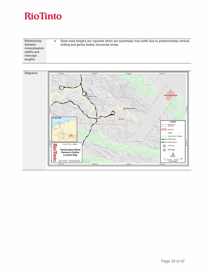
Relationship between mineralisation widths and intercept lengths
• Down-hole lengths are reported which are essentially true width due to predominantly vertical drilling and gently folded, horizontal strata.
Diagrams

Page 19 of 42
Note the water table is approximately 40 m below the ground surface. Approximately 95% of the Mineral Resource is below the Water Table.
Page 20 of 42
Balanced reporting
• Not applicable as Rio Tinto has not specifically released exploration results for this deposit.
Other substantive exploration data
• The Yandicoogina Braid area was mapped on 1:10,000 scale by Rio Tinto Exploration geologists in 2012.
• Electromagnetic (EM) and gravity geophysical surveys have been completed by Rio Tinto. • The water table is approximately 40 m below the ground surface. Approximately 95% of the
Mineral Resource lies below the water table. Further work • Further infill reverse circulation and diamond core drilling is planned.
SECTION 3 ESTIMATION AND REPORTING OF MINERAL RESOURCES
Criteria Commentary Database integrity
All drilling data is securely stored in an acQuire™ geoscientific information management system managed by a dedicated team within Rio Tinto. The system is backed up nightly on servers located in Perth, Western Australia. The backup system has been successfully tested in 2014.
• The drilling database used for Mineral Resource estimation has been internally validated by Rio Tinto Iron Ore personnel by/for:
o acQuire™ scripts for relational integrity, duplicates, total assay and missing / blank assay values;
o Grade ranges in each domain; o Domain names and tags; o Null and negative grade values; o Missing or overlapping intervals; o Duplicate data.
• Drill hole data is also validated through comparison of the assigned domain to the geological model.
Site visits • The Competent Person visited Yandi Braid in 2014. There were no outcomes as a result of this visit.
Geological interpretation
• Geological modelling was undertaken by Rio Tinto geologists. The method involves interpretation of down-hole stratigraphy using surface geologic mapping, lithological logging data, down-hole gamma data, EM and gravity geophysical data, and assay data.
• Cross-sectional interpretation of each stratigraphic unit is performed followed by interpretation of mineralisation and hydration boundaries. Three-dimensional wireframes of the sectional interpretations are created to produce the geological model.
• The geological model is subdivided into hard-boundary estimation domains based on lithology and mineralisation.
• In the Competent Person’s opinion the continuity of mineralisation is reasonable. Mineralisation at Yandicoogina Braid is affected by stratigraphy, structure and weathering. The drill hole spacing is sufficient to capture grade and geology changes at a broad scale.
Dimensions • The Yandicoogina Braid deposit extends for approximately 2,600 m in a north-east - south-west direction and 3,500 m in a north-west – south-east direction. The mineralisation extends from surface to a depth of approximately 300 m.
Estimation and modelling techniques
• The Yandicoogina Braid deposit is domained based on mineralisation and stratigraphy, with all estimation domains applied as hard boundaries.
• Statistical analysis was carried out on data from all domains. High grade cuts were not applied as low coefficients of variation (CV) were observed.
• The geological model was subdivided into domains and both the composites and model blocks are coded with these domains. Model domains are estimated using composites from the same domain.
• Inverse distance squared (ID2) was used to estimate block grades using Vulcan software. • Grades are extrapolated to a maximum distance of approximately 500 m from data points. • Validation was conducted on all mineralised domains by elevation and easting. Validation
plots showed good correlation between the composite grades and the block model

Page 21 of 42
grades. • A block size of 200 m × 200 m × 10 m was used for parent blocks. Parent blocks are sub-
celled to the geological boundaries to preserve volume. Moisture • All Mineral Resource tonnages are estimated and reported on a dry basis.
Cut-off parameters
Cut-off grades for Bedded Mineralisation: • High-Grade (HG) is greater than or equal to 60% Fe. • Brockman Process Ore (BPO) is material 50% ≤ Fe < 60% and ≥ 3% Al2O3 < 6% (geology
domain must be Dales Gorge, Joffre or Footwall Zone)
Cut-off grades for Channel Iron Mineralisation: • Fe ≥ 50% within the channel domain.
Mining factors or assumptions
• Development of this Mineral Resource assumes mining using standard Rio Tinto Iron Ore equipment and methods similar to other Pilbara iron ore mines. The assumed mining method is conventional truck and shovel open pit mining at an appropriate bench height. Mining practices will include grade control utilising blast hole data.
Metallurgical factors or assumptions
• It is assumed that a mixture of dry and wet crush and screening processes used by Rio Tinto Iron Ore will be applicable for the processing of the Yandicoogina Braid deposit.
Environmental factors or assumptions
• Rio Tinto Iron Ore has an extensive environmental and heritage approval process. A detailed review of these requirements has not been undertaken as yet. Future project development will include detailed assessment of environmental impacts.
Bulk density • Bulk density values are assigned in the model based on estimation domain. Average density values were derived from measurements from other Rio Tinto Iron Ore sites and applied to the Yandicoogina Braid deposit.
Classification • A portion of the CID and the HG and BPO Brockman Iron Formation mineralisation have been classified as Inferred Mineral Resource based on the number of drill holes and the assumed continuity. The north-western areas of the deposit and the detritals in the main channel have not been classified due to lack of data (wide space drilling). This reflects the Competent Person(s) view of the deposit.
Audits or reviews
• All stages of Mineral Resource estimation have undergone a documented internal peer review process. The Mineral Resource estimate has been accepted by the Competent Person.
Discussion of relative accuracy/ confidence
• The spacing and amount of data at this stage only supports an Inferred Resource. The deposit has a reasonable degree of geological complexity and further drilling is needed to better define the geology. There is uncertainty around density, as no data has been gathered, and hole location at depth due to lack of down-hole surveys. There is uncertainty around geotechnical and metallurgical properties of the rock as no data has been gathered.
• The accuracy and confidence of the Mineral Resource estimate is consistent with the current level of study (Conceptual).

Page 22 of 42
Appendix 2 Jimmawurrada Table 1 6 March 2015
The following table provides a summary of important assessment and reporting criteria used at the Jimmawurrada deposit for the reporting of Mineral Resources and Ore Reserves in accordance with the Table 1 checklist in The Australasian Code for the Reporting of Exploration Results, Mineral Resources and Ore Reserves (The JORC Code, 2012 Edition). Criteria in each section apply to all preceding and succeeding sections.
SECTION 1 SAMPLING TECHNIQUES AND DATA
Criteria Commentary Sampling techniques
• Samples for geological logging, assay, metallurgical and density test work are collected via drilling.
• Drilling for collection of samples for assay is conducted on a regularly spaced grid. For drilling prior to 2011, all mineralised intervals (> 50% Fe) are sampled and waste intervals (< 50% Fe) are sampled for several intervals when adjacent to mineralised intervals. From 2011 onwards, the entire drill hole is sampled.
• Mineralisation is determined by a combination of geological logging and assay results. Drilling techniques
• Drilling is predominantly by reverse circulation with a lesser proportion of percussion and diamond drill core. Diamond core drilling up until the year 2000 used dual rotary drilling to get through the alluvial cover, with the diamond section being a ‘tail’ section of each hole (Refer to Section 2, Drill Hole Information, for a detailed breakdown of drilling by method and year).
• All diamond drill core uses wireline triple tube to retrieve the core. • Diamond drill core was not oriented.
Drill sample recovery
• No direct recovery measurements of reverse circulation samples are performed. Sample weights are recorded from laboratory splits and the recovery at the rig is visually estimated for loss per drilling interval.
• Diamond drill hole core recovery is recorded using standard recovery measurements, with all cavities and core loss captured in the logging database.
• Based on analysis of field duplicates and twinned reverse circulation/diamond drill core holes, it is unlikely that any significant bias exists between sample recovery and grades or material characteristics.
Logging • 100% of reverse circulation and diamond drill holes are geologically logged. • Geological and material type logging is performed on each interval for all reverse
circulation drilling and at either 1 m or 2 m intervals for all diamond core drilling. • All diamond drill core is photographed. • All reverse circulation drill holes from 2011 onwards are logged using down-hole
geophysical tools for gamma trace, calliper, gamma density, resistivity, magnetic susceptibility and magnetic deviation.
Sub-sampling techniques and sample preparation
• 2011 – 2012 reverse circulation drilling sampled at 2 m intervals utilising a rotary cone splitter to produce two sub-samples representing 6.25% of the total sample. Diamond core crushed over 1 m or 2 m intervals and samples split with a rotary splitting device to produce 2-3 kg samples.
• 1988-2000 – Reverse circulation drilling sampled at 1.5 m or 2 m intervals, and split with riffle splitter to produce two 2-3 kg samples. Diamond drill core sampled at various intervals, crushed on-site and split with riffle splitter. Dual rotary samples were collected in 20 l plastic buckets at 1 m intervals after being passed through a chisel splitter. Once dry the samples were composited according to geology, at 4-10 m intervals by spear sampling. Waste intervals commonly not sampled.
• 1975-1981 – 2 m samples collected in a 20 l plastic bucket. Samples dried and then riffle split.

Page 23 of 42
Quality of assay data and laboratory tests
• 1991-2012: Analysis of samples by thermo-gravimetric analyser (TGA) and X-ray fluorescence (XRF) for a 24 analyte suite yielded total assay values of ~100% and accounts for virtually all elements present in the samples.
Quality is assured by the following measures: • Standards are inserted randomly by the rig geologist into the sample sequence at the
time of drilling as the reverse circulation samples are being prepared, or immediately after completing a drill hole. Check standards are inserted at a rate of one per hole. Check standards contain a trace of strontium carbonate that is added at the time of preparation.
• Field duplicates are collected at the same time as parent samples at a rate of one duplicate every 20 samples. This process is overseen by the rig geologist. Trace zinc is included in the duplicate sample for later identification.
• Internal laboratory splits (after crushing) and sample repeats (from pulps) are performed at a rate of 1 in 20 samples.
• Internal laboratory standards and blanks (not available for pre-1988 data). • No duplicate or standard data is available for 1975-1991 drilling data. • 1988-2000 drilling campaigns utilised the internal Cape Lambert laboratory for a nine
analyte suite by XRF. • 1975-1981 drilling campaigns utilised Australian Iron and Steel Laboratories for a 16
analyte suite by XRF. • Quality control analysis indicates acceptable quality of precision and accuracy between
1991 and 2012. Analyses of the duplicate dataset do not detect any bias in the field duplicate data.
Verification of sampling and assaying
• Comparison of reverse circulation and twinned diamond drill core assay data distributions show that the drilling methods have similar grade distributions verifying the suitability of reverse circulation samples in the Mineral Resource estimate.
• Twinned diamond drill holes have been completed throughout the deposit for the purpose of metallurgical assessment.
• Written procedures outline the processes of geological logging and data importing, QA/QC validation and assay importing, etc. A robust, restricted-access database is in place to ensure that any requests to modify existing data go through appropriate channels and approvals, and that changes are tracked by date, time, and user.
Location of data points
• From 1988 onwards, all drill hole collar locations at the Jimmawurrada deposit are surveyed to Geocentric Datum of Australia 1994 (GDA94) grid by qualified surveyors using Differential Global Positioning System survey equipment.
• Prior to 1988, all drill hole collar locations are approximate and no survey was conducted. • No down-hole surveys were completed due to shallow drilling with an average depth of 57
m. Data spacing and distribution
• The Jimmawurrada deposit has a strike length of 19 km northwest - southeast. The northern 4km of this strike length is drilled at 200 m × 100 m spacing and the remainder is drilled at 400 m × 200 m.
• The drill spacing is deemed appropriate for sufficient deposit knowledge by the Competent Person for the Mineral Resource classification applied.
• Samples were composited to a 2 m length. Orientation of data in relation to geological structure
• Reserve circulation drilling is completed along northeast-southwest trending lines perpendicular to the deposit strike.
• All drill holes are vertical.
Sample security For samples collected from 2011 onwards: • Laboratory samples (A splits) are collected by field assistants and transported to Ultra
Trace Laboratories in Perth, Western Australia for analysis. Retention samples (B splits) are collected and stored in drums for two years at the Rio Tinto Iron Ore Resource Evaluation camp located on-site.
• Assay pulps are retained indefinitely at Rio Tinto Iron Ore facilities located at either Pannawonica or Dampier, Western Australia.

Page 24 of 42
Audits or reviews
• No external audits have been performed. • Internal Rio Tinto Iron Ore peer review processes and internal Rio Tinto technical reviews
have been completed. These reviews concluded that the fundamental data collection techniques are appropriate.
SECTION 2 REPORTING OF EXPLORATION RESULTS
Criteria Commentary Mineral tenement and land tenure status
• 100% owned by Robe River Mining Ltd (53% Rio Tinto Limited), held under Mining Lease (ML) 248SA.
Exploration done by other parties
• The Jimmawurrada deposit was granted to Broken Hill Propriety Company Limited (BHP) in 1962 as Temporary Reserve 2348H. The area was converted to ML 254SA Section 4 in 1976.
• BHP carried out mapping and completed the first drilling campaign targeting pisolite mineralisation in 1972.
Geology • The Jimmawurrada deposit is classified as a Channel Iron Deposit with mineralisation between 15 m and 70 m thick overlain by unconsolidated alluvium that is between 0 m and 50 m thick.
• The deposit is subdivided into stratigraphic domains based on the abundance of clay. A unit of predominantly clay grades downwards into a unit of mixed clay and Fe-rich pisolite. This is typically underlain by a predominantly hard, competent pisolite unit.
• Drilling has demonstrated that basement rocks are dolomite and shale of the Wittenoom Formation.
Drill hole Information
• Drilling data summary:
Year Dual Rotary/Diamond Reverse Circulation
# Holes Metres # Holes Metres
1975-1981 32 1,745
1988-1991 56(HQ) 2,135
1999-2000 85(HQ) 3,573
2011 39(PQ) 2,269 450 26,645
2012 126 7,494
Total 180 7,977 608 35,884
Data aggregation methods
• Sample data has been composited to 2 m for Mineral Resource estimation. • No maximum or minimum grade truncations were performed.
Relationship between mineralisation widths and intercept lengths
• Down-hole interval lengths reported are essentially true width due to vertical drilling and gently dipping or horizontal strata.

Page 25 of 42
Diagrams
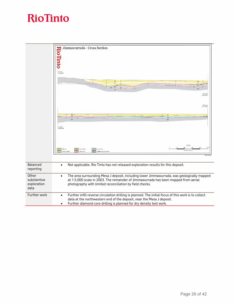
Page 26 of 42
Balanced reporting
• Not applicable. Rio Tinto has not released exploration results for this deposit.
Other substantive exploration data
• The area surrounding Mesa J deposit, including lower Jimmawurrada, was geologically mapped at 1:5,000 scale in 2003. The remainder of Jimmawurrada has been mapped from aerial photography with limited reconciliation by field checks.
Further work • Further infill reverse circulation drilling is planned. The initial focus of this work is to collect data at the northwestern end of the deposit, near the Mesa J deposit.
• Further diamond core drilling is planned for dry density test work.

Page 27 of 42
SECTION 3 ESTIMATION AND REPORTING OF MINERAL RESOURCES
Criteria Commentary Database integrity
• All drilling data is securely stored in an acQuire™ geoscientific information management system managed by a dedicated team within Rio Tinto Iron Ore. The system is backed up nightly on servers located in Perth, Western Australia. The backup system has been tested in 2014, demonstrating that it is effective.
• The drilling database used for Mineral Resource estimation has been internally validated by Rio Tinto Iron Ore personnel. Data is validated using acQuire™ scripts for relational integrity, duplicates, total assay and missing / blank assay values.
• Data was exported from the acQuire™ database and imported into a Vulcan database. • The drill hole database is validated by/for:
o acQuire™ scripts for relational integrity, duplicates, total assay and missing / blank assay values;
o Grade ranges in each domain; o Domain names and tags; o Survey data down-hole consistency; o Null and negative grade values; o Missing or overlapping intervals; o Duplicate data.
• Drill hole data is validated visually by domain compared to the geological model. Site visits • The Competent Person visited Jimmawurrada in 2013.
Geological interpretation
• Overall the Competent Person’s confidence in the geological interpretation of the area is good, based on the quantity and quality of data available, and the continuity and nature of the mineralisation.
• Geological modelling is undertaken by Rio Tinto Iron Ore geologists. The method involves interpretation of down-hole stratigraphy using surface geological mapping, lithological logging data, down-hole gamma data, and assay data.
• Cross-sectional interpretation of each stratigraphic unit is performed followed by interpretation of mineralisation boundaries. Three-dimensional wireframes of the sectional interpretations are created to produce the geological model.
• The geological model is subdivided into domains and the composites are coded with these domains.
• In the Competent Person’s opinion the continuity of mineralisation is generally good. Mineralisation at Jimmawurrada is affected by stratigraphy, structure and weathering. The drill hole spacing is sufficient to capture grade and geology changes at a broad scale.
Dimensions • The mineralisation extends 18,000 m, is approximately 3,000 m wide, and is typically 15-
70 m thick. Estimation and modelling techniques
• Mineralised domains are estimated by ordinary kriging and non-mineralised domains are estimated by inverse distance weighting to the first power. These methods are deemed appropriate by the Competent Person for estimating the tonnes and grade of the reported Mineral Resources.
• The estimation process was completed using Isatis and Vulcan computer software. • Grades are extrapolated to a maximum distance of approximately 500 m from data points. • The block model was rotated to align with the strike orientation of the deposit. • No grade capping or cutting was used, as analysis of the grade distributions of the
attributes demonstrated it was not required. • The estimated model was validated using a combination of visual, statistical and
multivariate global change of support techniques in the absence of any production data. • The block size used was 100 m (X) × 50 m (Y) × 4 m (Z) for parent blocks.
Moisture • All Mineral Resource tonnages are reported on a dry basis.
Cut-off parameters
• The criteria for Mineral Resources were that geology must be either mixed clay and pisolite or hard competent pisolite.

Page 28 of 42
Mining factors or assumptions
• Development of this Mineral Resource estimate assumes future mining using standard Rio Tinto Iron Ore equipment. The assumed mining method is conventional truck and shovel open pit mining at an appropriate bench height. Mining practices will include grade control utilising blast hole data.
Metallurgical factors or assumptions
• Metallurgical testing was completed in 2014 that concluded the mixed clay and pisolite will process favourably, thus this geological domain is included as Mineral Resources.
• It is assumed that standard crushing and screening processes used by Rio Tinto Iron Ore will be applicable for the processing of the Jimmawurrada deposit.
Environmental factors or assumptions
• Rio Tinto Iron Ore has an extensive environmental and heritage approval process. A detailed review of these requirements has been undertaken in a recent Pre-Feasibility Study. No issues were identified that would impact on the Mineral Resource estimate.
Bulk density • Dry bulk density was estimated using PQ3 diamond drillcore density measurements. • Bulk density was assigned to mineralised blocks based on an average density for
mineralised material. Classification • The Mineral Resource classification is 100% Inferred.
• The Competent Person is satisfied that the stated Mineral Resource classification reflects the geological controls interpreted and the estimation constraints of the deposits.
Audits or reviews
• All stages of Mineral Resource estimation have undergone an internal peer review process, which has documented all phases of the process. The Mineral Resource estimate has been accepted by the Competent Person.
Discussion of relative accuracy/ confidence
• The spacing of data at this stage only supports an Inferred Resource. • Further density data needs to be collected to improve confidence in the estimated bulk
density. • The accuracy and confidence of Mineral Resource estimation is consistent with the
current level of study (Order of Magnitude).

Page 29 of 42
Appendix 3 Koodaideri Table 1 6 March 2015 The following table provides a summary of important assessment and reporting criteria used at the Koodaideri deposits for the reporting of Mineral Resources and Ore Reserves in accordance with the Table 1 checklist in The Australasian Code for the Reporting of Exploration Results, Mineral Resources and Ore Reserves (The JORC Code, 2012 Edition). Criteria in each section apply to all preceding and succeeding sections.
SECTION 1 SAMPLING TECHNIQUES AND DATA
Criteria Commentary Sampling techniques
• Samples for geological logging, assay, geotechnical information, and metallurgical and density test work are collected via drilling.
• All reverse circulation drilling utilises a rotating cone splitter beneath a cyclone return system for sample collection. Samples typically weighed 4-5 kg.
• Geotechnical samples are collected via diamond core drilling of HQ (61 mm inside diameter). Samples are recovered using a triple-tube wireline system.
• Metallurgical sampling is performed by wide diameter diamond core drilling of 203 mm (recovery via pulling the entire rod string or PQ (85 mm diameter) using a triple-tube wireline system).
• Drilling is conducted on regularly spaced grids across the deposit. All intervals are sampled.
• Mineralisation is determined by a combination of geological logging and assay results.
Drilling techniques
• Drilling is predominantly by reverse circulation (Refer to Section 2, Drill Hole Information, for a detailed breakdown of drilling by method and year).
• The majority of drilling is oriented vertically. • Geotechnical diamond core was oriented using the ACE orientation tool, which marks the
bottom of core at the end of each run. Acoustic and optical televiewer images were used in specific reverse circulation and diamond drill core holes throughout the deposit to acquire additional structural orientation data.
• All diamond drill core used triple tubes to hold/retrieve samples; HQ (61 mm) and PQ (83 mm) core was retrieved using a wire line on the sample tube, while Wide Diameter (203 mm) required conventional methods, due to weight.
Drill sample recovery
• No direct recovery measurements of reverse circulation samples are performed. Sample weights are recorded from laboratory splits and the recovery at the rig is visually estimated for loss per drilling interval.
• Core recovery is recorded using rock quality designation (RQD) measurements with all cavities and core loss recorded by the driller. Overall recovery from diamond drill core exceeds 95% at the Koodaideri deposits.
• Based on analysis of field duplicate performance and overall grade distribution, it is unlikely that any significant bias exists between sample recovery and grades or material characteristics.
Logging • All drill samples are geologically logged. • HQ diamond core is logged geotechnically. • All diamond drill core is photographed digitally and files stored on Rio Tinto network
servers. • All drill holes are logged using down-hole geophysical tools for gamma trace, calliper,
gamma density, resistivity, magnetic susceptibility, and magnetic deviation. • Open-hole, acoustic and optical televiewer data are collected at select drill hole locations
for structural analyses.
Page 30 of 42
Sub-sampling techniques and sample preparation
Reverse circulation and percussion samples : • The sample is oven dried at 105 degrees Celsius for a minimum of 24 hours. The sample is
then crushed to approximately 3 mm using a Jaw Crusher and riffle split to produce a 500 g sub-sample. The sub-sample is pulverised to 95% of weight passing 150 µm.
Diamond drill core samples: • Diamond drill core samples were crushed completely (full core sample) if they were to be
assayed.
Quality of assay data and laboratory tests
Assay methods: • All assaying of samples used in Mineral Resource estimates have been performed by
independent, National Association of Testing Authorities (NATA) certified laboratories. • Fe, SiO2, Al2O3, P, Mn, MgO, TiO2, CaO and S are assayed using industry standard lithium
metaborate fusion and X-Ray Fluorescence (XRF) analysis. • Loss on Ignition (LOI) is determined using industry standard Thermo-Gravimetric Analyser
(TGA).
Quality assurance measures include: • Insertion of certified reference standard by Rio Tinto geologists at a rate of one in every 25
samples with a minimum of one standard per drill hole. • Field duplicates were inserted at a rate of one in 20 samples. • Internal lab splits (post-crushing) and repeats (from pulps), at a rate of one in 20 samples. • Random, blind re-submission of pulps following analysis at an external lab. • Analysis of the performance of certified standard and field duplicates has indicated an
acceptable level of accuracy and precision with no significant bias.
Verification of sampling and assaying
• Drill hole core hole twins (twinning reverse circulation holes) have been completed throughout the deposit.
• Comparison of reverse circulation and twinned diamond drill core assay data distributions show that the drilling methods have similar grade distributions verifying the suitability of reverse circulation samples in the Mineral Resource estimate.
• Thorough documentation exists outlining the processes of geological logging and data importing, quality assurance and quality control procedures, validation, and assay importing, etc.
Location of data points
• All drill hole collar locations at the Koodaideri deposits are surveyed using Geocentric Datum of Australia 1994 (GDA94) and Map Grid of Australia 1994 (MGA94) zone 50 by Rio Tinto surveyors using Differential Global Positioning System (DGPS) survey equipment.
• Drill hole collar reduced level (RL) data is compared to detailed topographic maps and show that the collar survey data is accurate. The topographic surface is based on 10 m grid sampling of the 2012 Light Detecting and Ranging (LiDAR) survey, including spot heights from DGPS drilling collars and is considered robust.
• Down-hole surveys were conducted on nearly every hole, with the exception of collapsed or otherwise hazardous holes; any significant, unexpected deviations were investigated and validated. Holes greater than 100 metres depth were generally surveyed with an in-rod gyro tool.
• A comparison of drill hole collar coordinates versus the LiDAR-based topographic surface found that all points matched within a two metre tolerance.
Data spacing and distribution
• Koodaideri 75W and 58W: drill hole spacing is predominately 50 m × 50 m with some areas at 100 m × 50 m and 200 m × 50 m. Geotechnical diamond core drilling has been completed to intersect planned final pit walls.
• Koodaideri 38W and 21W: average drilling spacing is 400 m × 50 m.
Page 31 of 42
Orientation of data in relation to geological structure
• Drill lines lie north-northeast to south-southwest (NNE-SSW) along MGA94 grid and perpendicular to the deposit strike.
• Reserve circulation drilling is predominantly vertical and intersects the gently undulating stratigraphy at right angles.
• Metallurgical holes were also vertical. • Geotechnical diamond drill holes are angled with a maximum dip of -85 degrees.
Sample security • Laboratory samples (A splits) are collected by field assistants, placed onto steel sample racks, and transported to laboratories in Perth, Western Australia for analyses. Retention samples (B splits) are collected and stored in drums for two years at on-site facilities.
• Assay pulps are retained indefinitely at Rio Tinto facilities located at two sites, Pannawonica or Dampier.
Audits or reviews
• No external audits have been performed. • Internal Rio Tinto Iron Ore peer review processes and internal Rio Tinto technical reviews
have been completed. These reviews concluded that the fundamental data collection techniques are appropriate.
Page 32 of 42
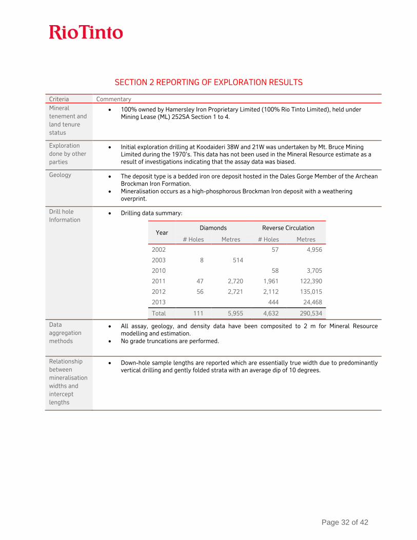
SECTION 2 REPORTING OF EXPLORATION RESULTS
Criteria Commentary Mineral tenement and land tenure status
• 100% owned by Hamersley Iron Proprietary Limited (100% Rio Tinto Limited), held under Mining Lease (ML) 252SA Section 1 to 4.
Exploration done by other parties
• Initial exploration drilling at Koodaideri 38W and 21W was undertaken by Mt. Bruce Mining Limited during the 1970’s. This data has not been used in the Mineral Resource estimate as a result of investigations indicating that the assay data was biased.
Geology • The deposit type is a bedded iron ore deposit hosted in the Dales Gorge Member of the Archean Brockman Iron Formation.
• Mineralisation occurs as a high-phosphorous Brockman Iron deposit with a weathering overprint.
Drill hole Information
• Drilling data summary:
Year Diamonds Reverse Circulation
# Holes Metres # Holes Metres
2002 57 4,956
2003 8 514
2010 58 3,705
2011 47 2,720 1,961 122,390
2012 56 2,721 2,112 135,015
2013 444 24,468
Total 111 5,955 4,632 290,534
Data aggregation methods
• All assay, geology, and density data have been composited to 2 m for Mineral Resource modelling and estimation.
• No grade truncations are performed.
Relationship between mineralisation widths and intercept lengths
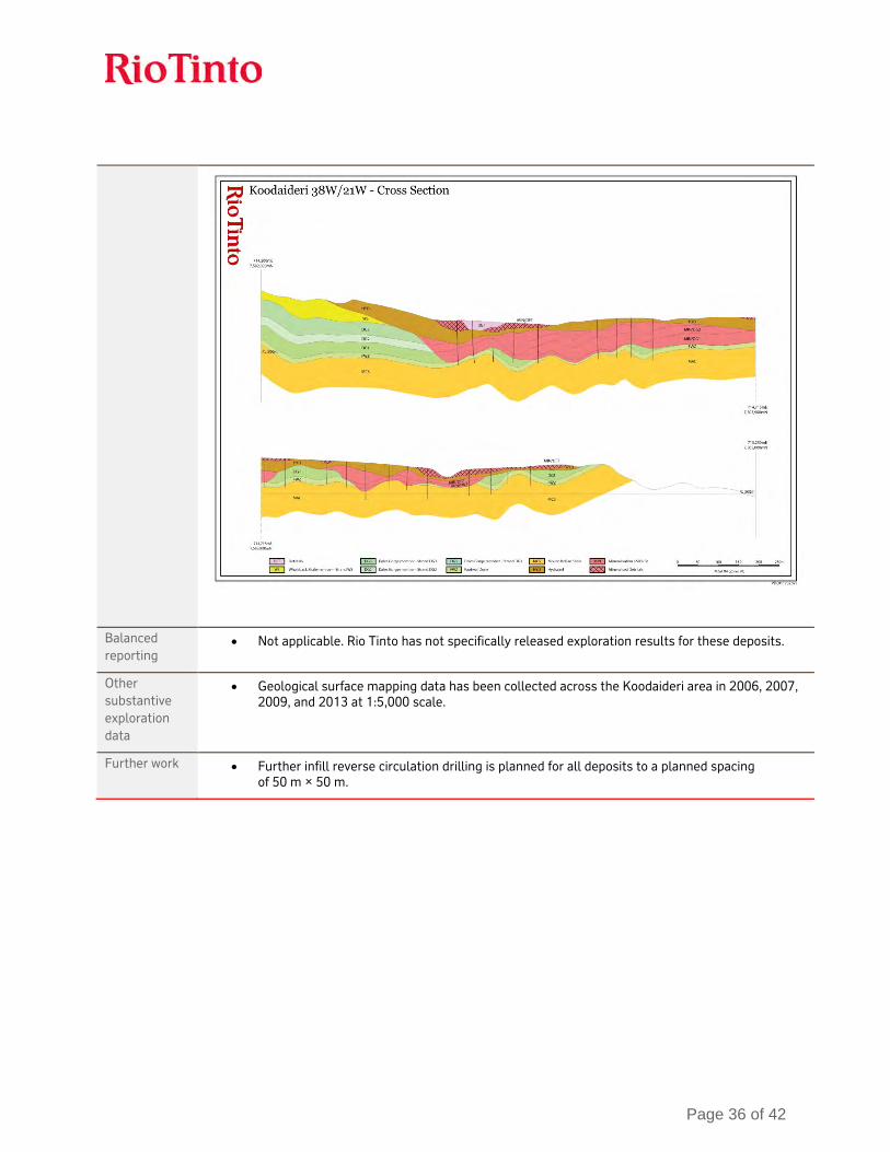
• Down-hole sample lengths are reported which are essentially true width due to predominantly vertical drilling and gently folded strata with an average dip of 10 degrees.
Page 33 of 42
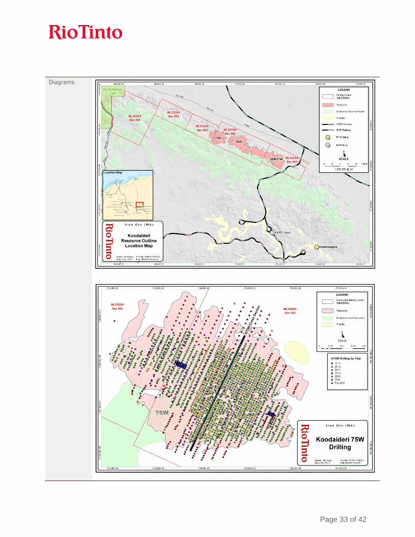
Diagrams
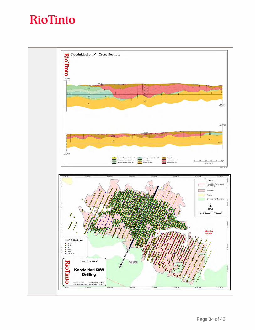
Page 34 of 42

Page 35 of 42
Page 36 of 42
Balanced reporting
• Not applicable. Rio Tinto has not specifically released exploration results for these deposits.
Other substantive exploration data
• Geological surface mapping data has been collected across the Koodaideri area in 2006, 2007, 2009, and 2013 at 1:5,000 scale.
Further work • Further infill reverse circulation drilling is planned for all deposits to a planned spacing of 50 m × 50 m.

Page 37 of 42
SECTION 3 ESTIMATION AND REPORTING OF MINERAL RESOURCES
Criteria Commentary Database integrity
• All drilling data is securely stored in an acQuire™ geoscientific information management system managed by a dedicated team within Rio Tinto Iron Ore. The system is backed up nightly on servers located in Perth, Western Australia. The backup system has been tested in 2014, demonstrating that the system is effective.
• The drilling database used for Mineral Resource estimation has been internally validated by Rio Tinto Iron Ore personnel using acQuire™ scripts for relational integrity, duplicates, total assay and missing and blank assays.
• Additional drill hole assay data are validated by:
o Grade ranges in each domain o Domain names and tags o Survey data down-hole consistency o Null and negative grade values o Missing or overlapping intervals o Duplicate data.
Site visits • The Competent Person visited Koodaideri in 2013. There were no outcomes as a result of this visit.
Geological interpretation
• Overall confidence in the geological interpretation of the area is good, based on quantity and quality of data available.
• Geological modelling is undertaken by Rio Tinto geologists. The method involves interpretation of down-hole stratigraphy using surface geological mapping, lithological logging data, down-hole gamma data, and assay data.
• Cross-sectional interpretation of each stratigraphic unit is performed followed by interpretation of mineralisation and hydration boundaries. Three-dimensional wireframes of the sectional interpretations are created to produce the geological model.
• The geological model is subdivided into domains and both the composites and model blocks are coded with these domains. Blocks in domains are estimated using composites from the same domain.
• Mineralisation is continuous. It is effected by stratigraphy, structure and weathering. The drill hole spacing is sufficient to capture grade and geology changes at a large scale.
Dimensions • The mineralisation extends 4.5 km (58W and 75W) or 8.6 km (38W/21W) along strike in a west-northwest to east-southeast (WNW-ESE) direction, up to 2.5 km (58W and 75W) or 2.8 km (38W/21W) across strike in a north-northeast to south-southwest (NNE-SSW) direction and to a maximum depth of 100 m below the current topographical surface (averaging 75 m in depth).
• The hardcap (weathering) overprint extends across the deposits, varying in depth from 2 m to 40 m below the current topographical surface (averaging 20 m in depth).
Estimation and modelling techniques
• Mineralised domains are estimated by ordinary kriging and non-mineralised domains are estimated by inverse distance weighting to the first power. These methods are appropriate for estimating the tonnes and grade of the reported Mineral Resources.
• The geological model is used to construct hard-boundary domains used for estimation. • The estimation process was completed using Isatis and Vulcan computer software. • Grades are extrapolated to a maximum distance of approximately 400 m from data points. • Block models are rotated to align with the orientation of the deposits. • A ‘high yield limit’ or grade dependent restriction on a sample’s range of influence was
used for manganese. The limits differed for different domains and were selected based on histograms and spatial distribution of manganese data.
• No other grade capping or cutting was applicable. • The estimated model was validated using a combination of visual, statistical and global

Page 38 of 42
change of support techniques as there are no production data for reconciliation. • Koodaideri 75W & 58W: block size of 25 m E (Easting) × 25 m N (Northing) × 5 m RL
(elevation) for parent blocks. Parent blocks are sub-celled to the geological boundaries to preserve volume.
• Koodaideri 38W and 21W: Block sizes are 100 m E × 25 m N × 5 m RL for parent blocks. Parent blocks are sub-celled to the geological boundaries to preserve volume.
Moisture • All Mineral Resource tonnages are reported on a dry basis.
Cut-off parameters
• The cut-off grade for High-Grade ore is greater than or equal to 60% Fe. • The cut-off for Brockman Process Ore is material 50% ≤ Fe < 60% and ≥ 3% Al2O3 < 6%
(geology domain must be Dales Gorge, Joffre or Footwall Zone).
Mining factors or assumptions
• Development of this Mineral Resource assumes mining using standard Rio Tinto Iron Ore equipment and methods similar to other Pilbara iron ore mines. The assumed mining method is conventional truck and shovel open pit mining at an appropriate bench height. Mining practices will include grade control utilising blast hole data.
Metallurgical factors or assumptions
• It is assumed that standard dry crush and screening processes used by Rio Tinto Iron Ore will be applicable for the processing of the Koodaideri deposit.
Environmental factors or assumptions
• Rio Tinto Iron Ore has an extensive environmental and heritage approval process. A detailed review of these requirements has been undertaken in a recent Pre-Feasibility Study. No issues were identified that would impact on the Mineral Resource estimate.
Bulk density • Koodaideri 75W and 58W: Dry bulk density is derived from accepted gamma-density data collected at 10 cm intervals from down-hole geophysical sondes. Accepted gamma-density data is corrected for moisture using diamond drill core specifically drilled throughout the deposit.
• Dry core densities are generated via the following process. The core volume is measured in the split and the mass of the core is measured and recorded. Wet core densities are calculated by the split and by the tray. The maximum length of sample for each density measurement is 1.5 m. Core recovery, core loss and core gain are all recorded and accounted for. The core is then dried and dry core masses are measured and recorded. Dry core densities are then calculated.
• Koodaideri 38W and 21W: No dry core density data is available. Density values are assigned to each mineralised domain using data from the adjacent Koodaideri 58W deposit.
• Bulk density was estimated using ordinary kriging in mineralised zones and inverse distance weighted to the first power in non-mineralised zones.
Classification • The Mineral Resource includes the classifications: Measured, Indicated, and Inferred with additional material (greater than 50% Fe) set as unclassified.
• Koodaideri 75W and 58W are predominantly Measured Mineral Resources while the wider drill spacing at Koodaideri 38W and 21W results in these deposits being predominantly Inferred Mineral Resources.
• The Competent Person is satisfied that the stated Mineral Resource classification reflects the data spacing, data quality, level of geological continuity and the estimation constraints of the deposits.
Audits or reviews
• All stages of Mineral Resource estimation have undergone a documented internal peer review process. The Mineral Resource estimate has been accepted by the Competent Person.
Discussion of relative accuracy/
• Rio Tinto Iron Ore operate multiple mines in the Pilbara region of Western Australia. The Mineral Resource data collection and estimation techniques used for Koodaideri are consistent with those applied at other deposits which are being mine. Reconciliation of

Page 39 of 42
confidence actual production with the Mineral Resource estimates for individual deposits is generally accurate to within ten percent for tonnes on an annual basis. This result is indicative of a robust process.
• The accuracy and confidence of the Mineral Resource estimate is consistent with the current level of study (Pre-Feasibility Study).
SECTION 4 ESTIMATION AND REPORTING OF ORE RESERVES
Criteria Commentary Mineral Resource estimate for conversion to Ore Reserves
• Initial generation of the modifying factors for this Ore Reserve estimate were based on a Mineral Resource estimate completed in April 2012. Subsequent to the completion of the Pre-Feasibility Study an updated Mineral Resource estimate was completed (incorporating more recent drilling information) in 2014 which formed the basis for a redesign of the open pits. The most recent Mineral Resource estimate together with the latest update of pit designs were used for reporting Ore Reserves.
• The declared Ore Reserves are for the Koodaideri 58 west and 75 west deposits. • Mineral Resources are reported additional to Ore Reserves.
Site visits • The Competent Person visited Koodaideri in 2013.
Study status • A Pre-Feasibility Study was completed in 2013. A Feasibility Study is in progress.
Cut-off parameters
• The cut-off grade for high-grade Brockman ore is greater than or equal to 60% Fe.
Mining factors or assumptions
• The Mineral Resource model was regularised to a block size of 25 m E × 25 m N × 10 m RL which was determined to be the selective mining unit following an analysis of a range of selective mining units. Dilution and mining recovery were modelled by applying the regularisation process to the sub-block geological model.
• Metallurgical models were applied to the regularised model in order to model products tonnage, grades and yields.
• Pit optimisations utilising the Lerchs-Grosmann algorithm with industry standard software were undertaken. This optimisation utilised the regularised Mineral Resource model together with cost, revenue, and geotechnical inputs. The resultant pit shells were used to develop detailed pit designs with due consideration of geotechnical, geometric and access constraints. These pit designs were used as the basis for production scheduling and economic evaluation.
• Conventional mining methods (truck and shovel) similar to other Rio Tinto Iron Ore mines were selected. The mine has been designed to utilise in-pit crushing and conveying to transport ore to a central processing facility.
• The geotechnical parameters have been applied based on geotechnical studies informed by assessments of 50 drill holes drilled during the 2011, 2012 & 2013 drilling programmes, specifically drilled for geotechnical purposes on the surrounding host rock. The resultant inter ramp slope angles vary between 16 and 35 degrees depending on the local rock mass and structural geological conditions.
• During the above process, Inferred Mineral Resources were excluded from mine schedules and economic valuations utilised to validate the economic viability of the Ore Reserves.
• The Pre-Feasibility Study considered the infrastructure requirements associated with the conventional truck and shovel mining operation including crushing and conveying systems, dump & stockpile locations, maintenance facilities, access routes, explosive storage, water, and power.
Metallurgical factors or assumptions
• The Koodaideri mine has been designed with a dry crush and screen processing facility similar to processing facilities at other Rio Tinto Iron Ore mining operations. Studies into alternative processing technologies continue, however this has been excluded from this ore reserve declaration.
Page 40 of 42
• The proposed metallurgical process is a well-tested and proven processing methodology, having been utilised at Rio Tinto Iron Ore mining operations for decades.
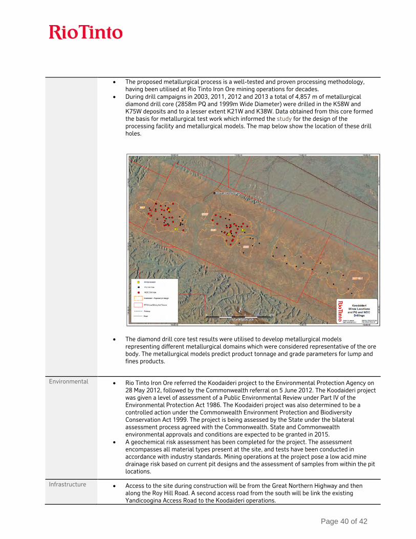
• During drill campaigns in 2003, 2011, 2012 and 2013 a total of 4,857 m of metallurgical diamond drill core (2858m PQ and 1999m Wide Diameter) were drilled in the K58W and K75W deposits and to a lesser extent K21W and K38W. Data obtained from this core formed the basis for metallurgical test work which informed the study for the design of the processing facility and metallurgical models. The map below show the location of these drill holes.
• The diamond drill core test results were utilised to develop metallurgical models representing different metallurgical domains which were considered representative of the ore body. The metallurgical models predict product tonnage and grade parameters for lump and fines products.
Environmental • Rio Tinto Iron Ore referred the Koodaideri project to the Environmental Protection Agency on 28 May 2012, followed by the Commonwealth referral on 5 June 2012. The Koodaideri project was given a level of assessment of a Public Environmental Review under Part IV of the Environmental Protection Act 1986. The Koodaideri project was also determined to be a controlled action under the Commonwealth Environment Protection and Biodiversity Conservation Act 1999. The project is being assessed by the State under the bilateral assessment process agreed with the Commonwealth. State and Commonwealth environmental approvals and conditions are expected to be granted in 2015.
• A geochemical risk assessment has been completed for the project. The assessment encompasses all material types present at the site, and tests have been conducted in accordance with industry standards. Mining operations at the project pose a low acid mine drainage risk based on current pit designs and the assessment of samples from within the pit locations.
Infrastructure • Access to the site during construction will be from the Great Northern Highway and then along the Roy Hill Road. A second access road from the south will be link the existing Yandicoogina Access Road to the Koodaideri operations.
Page 41 of 42
• Ore will be railed to Rio Tinto’s ports at Dampier and Cape Lambert. Upon completion of current and planned/approved construction projects, the port and railway networks will have sufficient capacity to accommodate ore supply from Koodaideri.
• Main fuel freight and supply for ammonium nitrate and fuel oil (ANFO) will access Koodaideri via the Roy Hill Road. Fly-in, Fly-out (FIFO) personnel access will be via the southern corridor access road from Barimunya Airport.
• Designs for buildings, explosives storage, workshops and related facilities proposed for the Koodaideri project have been modelled on existing Rio Tinto Iron Ore facilities, with changes included as a result of operating experience.
• A central hub for all non-process support facilities, will be located close the existing Munjina-Roy Hill road for ease of access. It is located central to the mine, processing plant and accommodation precinct.
• The Koodaideri Explosive Facility is located south of the K58W pit and will be similar to ones constructed at recent Rio Tinto Iron ore projects in the Pilbara, Western Australia.
• Electric power will be supplied to Koodaideri from the Rio Tinto transmission network via linking into an existing Rio Tinto 220 kV transmission line between Juna Downs and Yandicoogina.
• Water for Koodaideri will be initially sourced from bores located to the east of Koodaideri together with other surrounding bores at Koodaideri. These bores will support the early works and construction activities water demands.
Costs • The capital costs are based on a Preliminary Engineering Study utilising experience from the construction of existing similar Rio Tinto Iron Ore projects in the Pilbara, Western Australia.
• Operating costs were benchmarked with similar operating Rio Tinto Iron Ore mine sites. • Exchange rates were forecast by analysing and forecasting macro-economic trends in the
Australian and World economy. • Transportation costs were based on existing operating experience at Rio Tinto Iron Ore mine
sites in the Pilbara, Western Australia. • Allowances have been made for royalties to the Western Australian government and other
private stakeholders.
Revenue factors • Rio Tinto applies a common process to the generation of commodity prices across the group. This involves generation of long-term price curves based on current sales contracts, industry capacity analysis, global commodity consumption and economic growth trends. In this process, a price curve rather than a single price point is used to develop estimates of mine returns over the life of the project. The detail of this process and of the price point curves is commercially sensitive and is not disclosed.
Market assessment
• The supply and demand situation for iron ore is affected by a wide range of factors, and as iron and steel consumption changes with economic development and circumstances. Rio Tinto Iron Ore delivers products aligned with its Mineral Resources and Ore Reserves, these products have changed over time and successfully competed with iron ore products supplied by other companies.
Economic • Economic inputs such as foreign exchange rates, carbon pricing, and inflation rates are also generated internally at Rio Tinto. The detail of this process is commercially sensitive and is not disclosed.
• Sensitivity testing of the Koodaideri Ore Reserves using both Rio Tinto long-term prices and a range of published benchmark prices demonstrates a positive net present value for the project sufficient to meet Rio Tinto Limited investment criteria.
Social • The Koodaideri deposits are located within existing tenure Mining Lease (ML)252SA, which was granted under the Iron Ore (Mount Bruce) Agreement Act 1972 (Mount Bruce SA).
• Additional tenure is required to connect the mine with the existing Rio Tinto Iron Ore rail network, as well as for roads, power, water and camp locations located outside of the Mining Lease. Rio Tinto Iron Ore is currently in the process of negotiating third party consent to facilitate the grant of tenure for rail and ancillary infrastructure corridors.

Page 42 of 42
• The Koodaideri mine and most of the proposed associated infrastructure falls within the area of the Banjima group’s registered native title claim. The north-west rail option route lies within the Yindjibarndi group which has both determined native title and a registered native title claim.
• The Koodaideri project is located in the Hamersley Range, which has a deep and rich history of Aboriginal occupation. In total, six ethnographic surveys and 24 archaeological surveys have been completed to date in which a total of 316 heritage sites have been identified. The locations of these sites were considered during mine planning and engineering activities.
• Rio Tinto Iron Ore has undertaken environmental surveys across the project area to support the development of the Koodaideri project including flora and vegetation and vertebrate fauna surveys, troglofauna sampling and an assessment of bat colonies and aquatic habitats.
• A number of native vegetation clearing permits have been granted by the Western Australian Department of Mines and Petroleum (DMP) to allow for preliminary works such as sterilization drilling, geotechnical investigations, mineral exploration, a construction camp, and associated activities.
• The Koodaideri deposits and associated infrastructure are located within the Shire of Ashburton and the Shire of East Pilbara. Rio Tinto Iron Ore has established engagement frameworks with the Shire of Ashburton and the Shire of East Pilbara which includes scheduled meetings and project updates. Engagement with both Shires on Koodaideri has been established and will be ongoing throughout the project.
Other • Semi-quantitative risk assessments have been undertaken throughout the Koodaideri study phases, no material naturally occurring risks have been identified through the above mentioned risk management processes.
• The mine and associated rail routes require additional tenure. Negotiations are ongoing with third parties and are generally progressing satisfactorily.
Classification • The Ore Reserves consist of 54% Proved Reserves and 46% Probable Reserves. • The Competent Person is satisfied that the stated Ore Reserve classification reflects the
outcome of technical and economic studies.
Audits or reviews
• No external audits have been performed. • Internal Rio Tinto Iron Ore peer review processes and internal Rio Tinto technical reviews
have been completed. These reviews concluded that the fundamental data collection techniques are appropriate.
Discussion of relative accuracy/ confidence
• Rio Tinto Iron Ore operates multiple mines in the Pilbara region of Western Australia. The Ore Reserve estimation techniques utilised for the Koodaideri deposits are consistent with those applied at the existing operations. Reconciliation of actual production with the Ore Reserve estimate for individual deposits is generally within 10 percent for tonnes on an annual basis. This result is indicative of a robust Ore Reserve estimation process.
• Accuracy and confidence of modifying factors are generally consistent with the current level of study (Pre-Feasibility Study). It is anticipated that the modifying factors will be further refined during the Feasibility Study which is currently under way.