philippines: typhoons sarika (karen) and haima (lawin)...
TRANSCRIPT
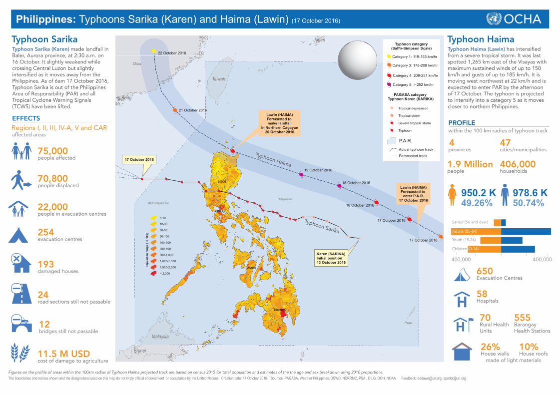
Philippines: Typhoons Sarika (Karen) and Haima (Lawin) (17 October 2016)
Typhoon Sarika (Karen) made landfall in Baler, Aurora province, at 2:30 a.m. on 16 October. It slightly weakend while crossing Central Luzon but slightly intensified as it moves away from the Philippines. As of 6am 17 October 2016, Typhoon Sarika is out of the Philippines Area of Responsibility (PAR) and all Tropical Cyclone Warning Signals (TCWS) have been lifted.
EFFECTS
75,000people affected
Regions I, II, III, IV-A, V and CARaffected areas
70,800people displaced
22,000people in evacuation centres
254evacuation centres
193damaged houses
Typhoon Haima (Lawin) has intensified from a severe tropical storm. It was last spotted 1,265 km east of the Visayas with maximum sustained winds of up to 150 km/h and gusts of up to 185 km/h. It is moving west northwest at 22 km/h and is expected to enter PAR by the afternoon of 17 October. The typhoon is projected to intensify into a category 5 as it moves closer to northern Philippines.
The boundaries and names shown and the designations used on this map do not imply official endorsement or acceptance by the United Nations Creation date: 17 October 2016 Sources: PAGASA, Weather Philippines, DSWD, NDRRMC, PSA , DILG, DOH, NOAA Feedback: [email protected] [email protected]
1.9 Millionpeople
within the 100 km radius of typhoon trackPROFILE
4provinces
47cities/municipalities
406,000households
950.2 K49.26%
978.6 K50.74%
400,000400,000
Senior (56 and over)
Youth (15-24)
Children (0-14)
Adults (25-64)
24road sections still not passable
12bridges still not passable
11.5 M USDcost of damage to agriculture
Palau
Philippine seaWest Philippine Sea
MANILA
LUZON
VISAYAS
MINDANAO
China
Malaysia
Taiwan
Japan
Brunei
Hong KongMacao
Karen (SARIKA)Initial position13 October 2016
17 October 2016
Lawin (HAIMA)Forecasted to make landfall
in Northern Cagayan20 October 2016
Lawin (HAIMA)Forecasted to
enter P.A.R.17 October 2016
17 October 2016
17 October 2016
18 October 2016
18 October 2016
19 October 2016
21 October 2016
22 October 2016
< 10
10-30
30-50
50-100
100-300
300-500
500-1,000
1,000-1,500
1,500-2,000
> 2,000
Popu
latio
n ra
nge
( in
'000
)
Typhoon category(Saffir-Simpson Scale)
Category 1: 119-153 km/hr
P.A.R.
Category 3: 178-208 km/hr
Category 4: 209-251 km/hr
Category 5: > 252 km/hr
PAGASA category Typhoon Karen (SARIKA)
Tropical depression
Tropical storm
Severe tropical storm
Typhoon
Actual typhoon track
Forecasted track
Typhoon HaimaTyphoon Sarika
650Evacuation Centres
58Hospitals
70Rural Health Units
555Barangay Health Stations
Typhoon Haima
Typhoon Sarika
26%House walls
10%House roofs
made of light materials
Figures on the profile of areas within the 100km radius of Typhoon Haima projected track are based on census 2015 for total population and estimates of the the age and sex breakdown using 2010 proportions.