perth’s waterfront and urban planning 1954–93: the …soac.fbe.unsw.edu.au/2009/pdf/gregory...
TRANSCRIPT

Perth’s Waterfront and Urban Planning 1954–93:
the Narrows Scheme and the Perth City Foreshore Project

2
Perth’s Waterfront and Urban Planning 1954–93:
the Narrows Scheme and the Perth City Foreshore Project
Jenny Gregory
University of Western Australia
School of Humanities
University of Western Australia
Crawley, WA 6009
word count: 5,190
Running head: Perth’s Waterfront and Urban Planning 1954–93
Key words: history, urban planning, Perth, waterfront, modernism, civil society
3
Abstract
In recent years, despite boom times, the people of Perth have been noted for their apparent
unwillingness to accept change. Large projects designed to invigorate the city of Perth have been
rejected and a number of proposals to develop the city’s Swan River waterfront have failed to
materialise, adding ammunition to popular media criticism that Perth is a city that always says ‘no’.
In this paper historical evidence is used to examine two of the waterfront schemes and their
results. The first, the Narrows Scheme, was part of the Stephenson-Hepburn Plan of 1955 and was
implemented during the years 1954 to 1973. The second, the Perth City Foreshore Project, was
initiated by a major study in 1983 and resulted in the Carr, Lynch, Hack and Sandell design concept of
1991. The former was implemented, but had unanticipated consequences. The latter foundered, like
subsequent plans for the waterfront.
Why was one implemented while the other failed to materialise? The paper analyses aspects
of the two schemes and their reception and then speculates on the impact of the re-emergence of the
notion of civil society and its corollary, pluralism in public administration, on urban planning.
4
Perth’s Waterfront and Urban Planning 1954–93:
the Narrows Scheme and the Perth City Foreshore Project
Introduction
In the last fifty years there have been a number of plans for Perth’s Swan River waterfront, most of
which have not come to fruition. This paper examines two of these schemes — the Narrows Scheme
and the Perth City Foreshore Project. Most attention is paid to the Narrows Scheme and its context as
it is the only scheme among many that has come to fruition in the past fifty years.
The Narrows Scheme was an integral element of the Stephenson-Hepburn Plan for the
Metropolitan Area, Perth and Fremantle, published in 1955. Perth people of the 1950s generally
welcomed the progressive tendencies of the plan as a whole, with its grand modernist vision for the
metropolitan region. But the plan also had a major impact on the Perth’s Swan River waterfront and
once people became aware of this, they were less enthusiastic. The Narrows Scheme involved the
reclamation of the wide Mounts Bay, the western section of the foreshore, in order to build the
Narrows Bridge and its associated road works that linked it to the Freeway.
Another scheme, the Perth City Foreshore Project, was initiated by the Perth Central
Foreshore Study of 1983 and led to the Carr, Lynch, Hack and Sandell design concept of 1991. Of
the various plans put forward since the 1970s it is especially worthy of examination as it came closest
to fruition, although it was never implemented.
The Stephenson–Hepburn Plan 1955
Not a great deal has been written on the post WWII era in Australian cities or the impact of modernist
planning on the city. Yet the decades of the 1950s and 1960s witnessed major urban expansion. This
was caused by population growth, a long economic boom, and an optimistic mood in which society
was committed to major post war reconstruction. It was the heyday of large engineering projects in
both Australia and the United States. And it was in these decades that Australia adopted the United
States as its cultural model as Lees and Senyard (1987) have pointed out. Australia, as Ian Alexander
(2000:99) has observed seemed to be on the brink of ‘big things’.
One of the ‘big things’ imported to Australia from the United States was the freeway system
with its associated ‘spaghetti junction’ interchanges. By the 1950s a number of freeways, some of
which had complex interchanges, existed in the United States and Germany. Graeme Davison (2004,
170, 175) cites a 1955 article in the Melbourne Herald describing an event at which Melbourne’s city
decision-makers ‘watched wonderingly and sighed at times as colour films unrolled magic carpets of
American super-highways, flyovers, underpasses [and] double-decked bridges’, to demonstrate that
the idea of the freeway took ‘a powerful hold on imagination of the postwar Australian motoring
public’.i Perth’s decision makers and its motoring public were no exception to this trend and hence
there was little or no objection when freeways and interchanges were proposed for the city.

5
Town planning legislation had been enacted in Perth back in 1929, but was woefully
inadequate to meet the challenges of urban expansion (Gregory, 2009, in press). There had been an
attempt to amend the act in 1951 and, although this failed, it ultimately led to the decision to bring in
an overseas expert to prepare a plan for the metropolitan area. When Professor Gordon Stephenson,
Lever Professor of Civic Design at the University of Liverpool, arrived in Perth in 1953 to join Alastair
Hepburn, who had been appointed Town Planning Commissioner, to begin work on the plan, he was
treated like a celebrity. An archetypal modernist planner, in the immediate post war years he prepared
the Greater London Plan as deputy to the doyen of town planners Sir Patrick Abercrombie and during
a stellar career he later advised governments, designed projects and held university posts in Britain,
Australia, Canada, and New Zealand (Stephenson, 1992).
The cultural cringe was strong in 1950’s Australia. Stephenson later recalled his
embarrassment at the welcome he received. He described the formal reception, attended by ‘all the
important people in town’, in a letter to his wife, who was still in England
…The Lord Mayor got up and started to talk about the terrific honour I was doing
Perth, by coming to solve all the regional problems…he tried to make out that I was
the only chap on the globe that could help the poor, struggling West Australians.
(Stephenson, 1992, 135-136)
Stephenson was fortunate to have such support and continued to gain assistance at every turn. As he
noted later, governments and councils, heads of government departments and the business
community were all ‘in the mood to make far –reaching plans’, as were ‘those citizens able to look
beyond the day after tomorrow’. As well, the bureaucratic structure of government administration was
much more centralised than today and ‘every department concerned with development was most
cooperative’ (Stephenson 1992, 138).
Stephenson believed that it was ‘a waste of time’ to prepare plans that were not politically
acceptable’ and his was a top down approach. He and Hepburn consulted extensively with men of
influence, but there was no community consultation in the preparation of the plan. Instead they went
out of their way to develop good relations with both newspaper and radio, recognising the influence of
the media in shaping public opinion (Stephenson 1955, 2–5; 1992, 149-50).
There had been no previous plan for the metropolitan area, so they were free to set the basic
parameters. The basic outline of the plan was to create ‘centres of growth’ on the outskirts of the
metropolitan area, a huge area roughly 110 by fifty kilometres. Freeway development was integral to
providing access between these centres of growth and, although he consulted all the leading
bureaucrats of the time, he was most heavily influenced by road engineers. The result was that, above
all, the hand of Main Roads is obvious in the Stephenson–Hepburn Report and that the plan, as
George Seddon has concluded, ‘had the virtues and defects of the planning ideology of the day, which
was to give primacy to the private automobile’ (Seddon and Ravine, 1986, 187-188).
Some of their recommendations relating to the CBD were immediately adopted by the City
Council well before the release of the report. Their complete report went to government in 1955,
providing the basis for the Metropolitan Region Town Planning Scheme Act (1963). But as aspects of
6
the plan were rolled out and implemented it also became obvious that there was no panacea for
Perth’s planning problems. Before gains could be made, sacrifices would have to be made.
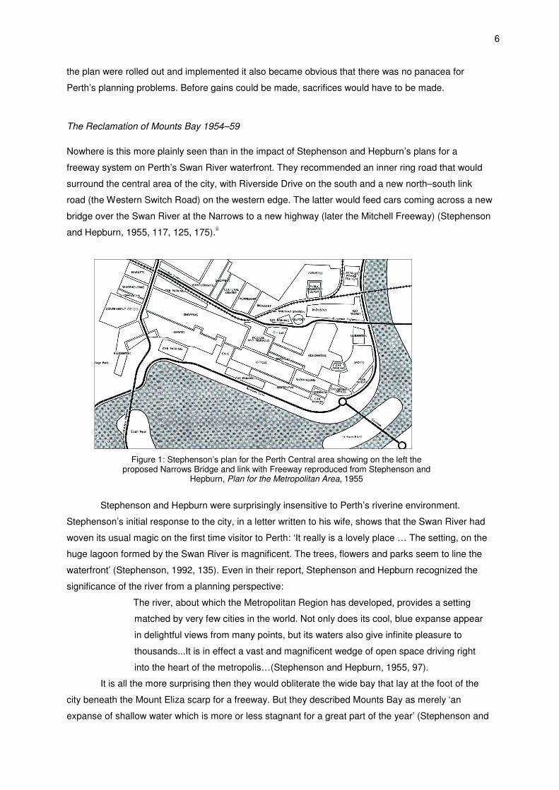
The Reclamation of Mounts Bay 1954–59
Nowhere is this more plainly seen than in the impact of Stephenson and Hepburn’s plans for a
freeway system on Perth’s Swan River waterfront. They recommended an inner ring road that would
surround the central area of the city, with Riverside Drive on the south and a new north–south link
road (the Western Switch Road) on the western edge. The latter would feed cars coming across a new
bridge over the Swan River at the Narrows to a new highway (later the Mitchell Freeway) (Stephenson
and Hepburn, 1955, 117, 125, 175).ii
Figure 1: Stephenson’s plan for the Perth Central area showing on the left the
proposed Narrows Bridge and link with Freeway reproduced from Stephenson and Hepburn, Plan for the Metropolitan Area, 1955
Stephenson and Hepburn were surprisingly insensitive to Perth’s riverine environment.
Stephenson’s initial response to the city, in a letter written to his wife, shows that the Swan River had
woven its usual magic on the first time visitor to Perth: ‘It really is a lovely place … The setting, on the
huge lagoon formed by the Swan River is magnificent. The trees, flowers and parks seem to line the
waterfront’ (Stephenson, 1992, 135). Even in their report, Stephenson and Hepburn recognized the
significance of the river from a planning perspective:
The river, about which the Metropolitan Region has developed, provides a setting
matched by very few cities in the world. Not only does its cool, blue expanse appear
in delightful views from many points, but its waters also give infinite pleasure to
thousands...It is in effect a vast and magnificent wedge of open space driving right
into the heart of the metropolis…(Stephenson and Hepburn, 1955, 97).
It is all the more surprising then they would obliterate the wide bay that lay at the foot of the
city beneath the Mount Eliza scarp for a freeway. But they described Mounts Bay as merely ‘an
expanse of shallow water which is more or less stagnant for a great part of the year’ (Stephenson and
7
Hepburn, 1955, 117). In their report they also featured a full-page photograph of a road interchange
system at an approach to New York City that should have given more than a clue to their intentions
(Stephenson and Hepburn, 1955, 112).
Mounts Bay would soon be sacrificed to the needs of the motorist. There are two aspects to
the sacrifice of Mounts Bay that are interlinked: firstly the works associated with the building of the
Narrows Bridge including reclamation of Mounts Bay for the bridge approach (1954-1959); and
secondly planning and work on the Narrows Interchange (1954-73) which involved more river
reclamation.
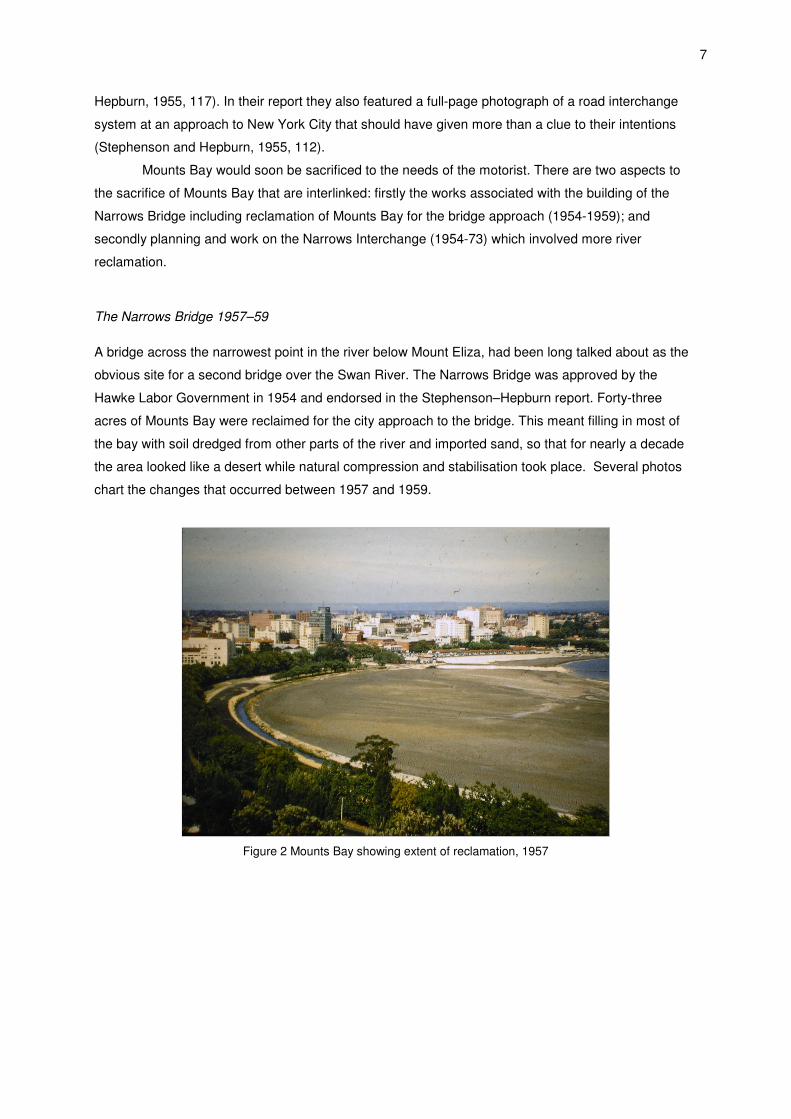
The Narrows Bridge 1957–59
A bridge across the narrowest point in the river below Mount Eliza, had been long talked about as the
obvious site for a second bridge over the Swan River. The Narrows Bridge was approved by the
Hawke Labor Government in 1954 and endorsed in the Stephenson–Hepburn report. Forty-three
acres of Mounts Bay were reclaimed for the city approach to the bridge. This meant filling in most of
the bay with soil dredged from other parts of the river and imported sand, so that for nearly a decade
the area looked like a desert while natural compression and stabilisation took place. Several photos
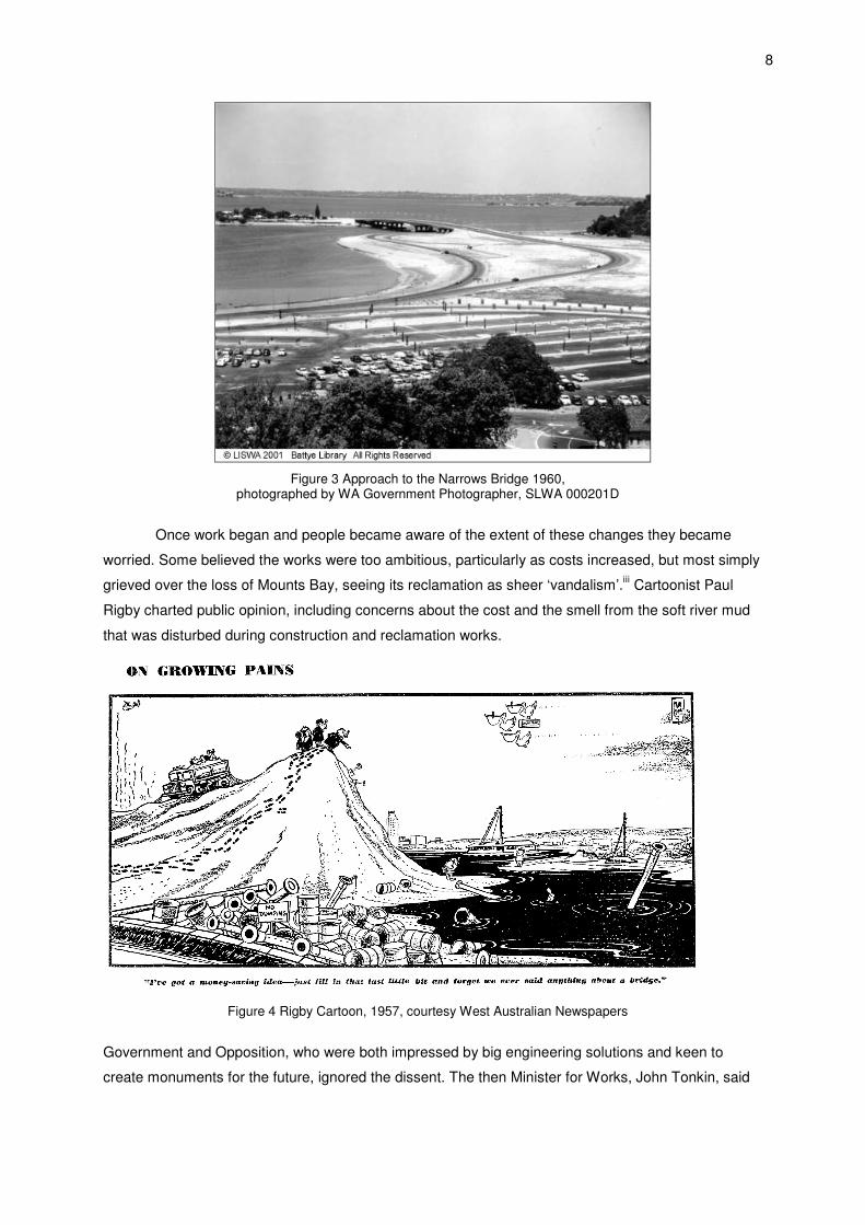
chart the changes that occurred between 1957 and 1959.
Figure 2 Mounts Bay showing extent of reclamation, 1957
8
Figure 3 Approach to the Narrows Bridge 1960,
photographed by WA Government Photographer, SLWA 000201D
Once work began and people became aware of the extent of these changes they became
worried. Some believed the works were too ambitious, particularly as costs increased, but most simply
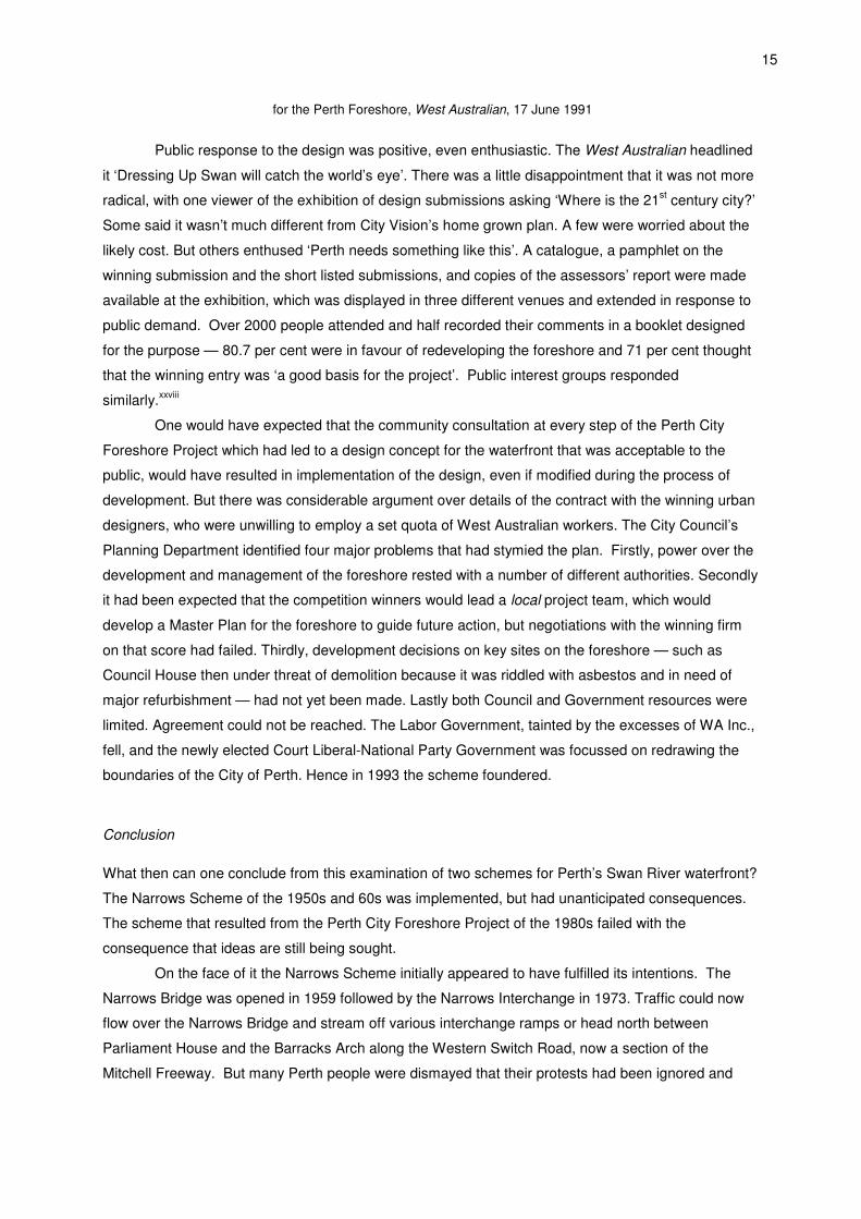
grieved over the loss of Mounts Bay, seeing its reclamation as sheer ‘vandalism’.iii Cartoonist Paul
Rigby charted public opinion, including concerns about the cost and the smell from the soft river mud
that was disturbed during construction and reclamation works.
Figure 4 Rigby Cartoon, 1957, courtesy West Australian Newspapers
Government and Opposition, who were both impressed by big engineering solutions and keen to
create monuments for the future, ignored the dissent. The then Minister for Works, John Tonkin, said

9
that Perth needed a new bridge, the Narrows was the best place for it and, although he regretted it,
the increase in cars demanded ‘some encroachment upon natural conditions’.iv
Public opinion did, however, have some impact. In February 1959 the Hawke Labor
Government announced that the bridge would be named ‘the Golden West Bridge’ to capitalise on the
state’s reputation for producing gold, golden fleece and golden grain and to parallel San Francisco’s
Golden Gate Bridge.v But the natural tendency of many West Australians was mild disparagement,
not the boosterism of Californians. Columnist Kirwan Ward thought that the name better suited ‘a
lemonade bottle label, or a macaroni box’, but decided that it didn’t matter what the bridge was called,
‘so long as we got on with the job with all possible speed and got all this depressing mess of mud
cleared away from the city’s front doorstep’.vi With the election of the Brand Liberal-Country Party two
months later, the name was quietly dropped. But for a time it had diverted attention from the mud and
sand until the Narrows Bridge was opened by the Governor Sir Charles Gairdner with much fanfare on
13 November 1959.vii
The Narrows Interchange 1961–73
Planning for the Narrows Interchange which would link the Narrows Bridge to the Western Switch
Road commenced in 1961 with the appointment of Chicago engineering consultants De Leuw Cather
& Co. They prepared a new design for the whole of Stephenson’s inner-ring road system sending
some key engineering staff from Chicago to Perth to train Main Roads staff, who did not have the
experience or expertise to design and build the complex freeway interchange. In the resulting plan the
northern leg of the inner-ring road system was pushed considerably further north and the southern leg
on the riverfront became a six-lane freeway. De Leuw Cather and the Main Roads traffic engineers, to
quote geographer Martyn Webb, ‘turned Stephenson’s English Road system into a California Freeway
system’.viii
Figure 5 Plan showing De Leuw Cather & Co’s inner ring freeway,
reproduced from Perth Metropolitan Region Inner Ring Freeway Study, 1963

10
Figure 6 Plan showing the Narrows Bridge and Narrows Interchange
on the left as built
Controversy surrounded every leg of the new proposed inner-ring road system, but especially
the southern and western legs. The City Council raised concern about the impact of the southern leg,
but at that time neither they nor and other authority made any formal objection and the scheme was
approved in 1962 (Main Roads, 1965, 57-62). Further discussion took place during 1964 and again
Council raised no objections.
Concern about the route of the western leg—the Western Switch Road—had surfaced in the
context of concern about the fate of the Barracks. They had been built in 1866 as accommodation for
the Pensioner Guards, who had accompanied the convicts to Western Australia, and had been turned
into government offices in the late 1890s. Stephenson and Hepburn recommended their removal to
make way for the Western Switch Road and to ‘provide a clear vista to Parliament House along the
length of St George’s Terrace’ (Stephenson and Hepburn, 1955, 175). Many West Australians were
vehemently opposed to this and the long running controversy over the fate of the Barracks, which
lasted until 1968, has been well documented (Bolton, 1991; Gregory, 2003, 117-124; 485; Clark, 2009,
121; Witcomb and Gregory, 2009). The end result was the demolition of the wings of the Barracks, the
retention of the Archway, with the Western Switch Road a deep cavern between the Archway and
Parliament House.
In the midst of this, in early 1964 details of the Narrows Interchange project were announced.
A protest meeting was held.ix But the government ignored protesters, announcing that work on
reclaiming a further nineteen acres of the Swan River was to begin, ‘by dumping 80,000 cubic yards of
sand to form part of the future shoreline between Union Jack Square, at the foot of Barrack Street, and
the Narrows’.x Some of the area was to be used for a car park. The public response in letters to the
Editor of the West Australian in 1964 was mixed;
All too soon our lovely views of the river will be obscured by a monstrous
embankment, enclosing the city from the river like a prison wall. When visitors come
from far away, we will have to hang our heads in shame for what has been done to
our lovely river in the name of progress. No doubt in time the fine embankment will be

11
embellished with a row of box trees, though I think weeping willows would be more
appropriate’.xi
...one gets weary of fighting a losing battle. How many have voiced their opinions
about the Swan River only to be completely ignored?xii
The Premier...prefers to follow the advice of ‘world-renowned experts’ rather than that
of Perth people. But has it occurred to him that these imported and ephemeral
experts, may not know, as Perth people do, that the Swan River is the soul of the city,
something of inestimable aesthetic value that should not be blotted out by a squalid
engineering scheme of questionable efficiency.
Another, with considerable prescience, complained
The Premier and his supporters are being very high-handed in refusing to discuss
alternatives to the reclamation of the river. Most certainly the public [will] have to
make much greater use of public transport so why make provision for the parking of
hundreds of cars—mostly with one person to one car?... [People] do not want the river
filled in. Why should it be done against the will of the people.xiii
A few defended the government.
A considerable amount of criticism is being levelled at the Government for its attempt
to solve our traffic problems. This controversy was originated by a small group known
as ‘Hands off our Heritage’… To preserve the river’s foreshore in its original state and
solve this tremendous problem of traffic is impossible. The Government’s decision has
been based on exhaustive research done by overseas experts who solved similar
problems throughout the world. The Government made a courageous and difficult
decision to solve this growing traffic problem...for at least the next 25 years.xiv
Then the indomitable feminist and activist Bessie Rischbieth, aged 89, took a strong stand.
After a further protest meeting on river reclamation, she was photographed standing barefoot at the
edge of the Swan river directly in the path of a tip truck dumping sand.xv The photograph has become
an icon of protest in Perth. But her protest was to no avail.
Figure 7 Bessie Rischbieth, protesting against river reclamation, Daily News, 21 April 1964

There was an attempt to improve and soften the aesthetics of the freeway interchange on the
western side of the Narrows Bridge, to appease public outrage. Main Roads set up a committee,
chaired by Stephenson, in 1964 to review plans prepared by landscape architect John Oldham, who
successfully ‘pleaded’ to create a landscaped area between the interchange roads.xvi Information
gleaned from engineer Harold Clough later indicated that landscape architecture was seen as ‘a
sweetener for the impact of engineering’ (Saniga, 2006, 151).
Work on the Narrows Interchange site began in September 1964. It presented complex
engineering challenges. Because the land had been reclaimed it was mainly soft mud and could not
support major works. To create a firm foundation 43,000 ‘sand drains [were made] deep into the
reclaimed area, so that, as sand was loaded on top, its weight would press down on the mud, and the
water could escape up the drains’, as Edmonds (1997, 189) explains. About four million yards of sand
was carted in and spread over the site. After six years much of the sand was carted away and
construction work on the Interchange on the newly consolidated foundations began in 1970.
Figure 8 Photograph of Perth Foreshore showing the extent of reclamation, 1966
In 1967, when Main Roads had released a further stage of the De Leuw Cather plan, people
seem to have woken up to the fact that, as indicated in their 1964 plan, Riverside Drive Freeway had
become a six-lane freeway. As well as being severed from the river, Perth was to lose the Supreme
Court Gardens and the playing fields of Langley Park. The City Council went into battle to stop the
freeway, with architects, planners and the Chamber of Commerce also taking a stand (Campbell et al,
1967). As a result Main Roads put out a new version of the De Leuw Cather plan recommending that
the whole inner freeway be postponed until at least 1980. The Riverside Drive Freeway was still
considered to be an essential element, but at least it had been delayed.xvii
The Narrows Interchange was opened by Premier John Tonkin on 30 November 1973, but the
status of Riverside Drive continued as a bone of contention over the next decade. In 1973 Stephenson
was commissioned to prepare a report on the Central City Area. In this, he agreed with Main Roads
that Riverside Drive should be at least a six-lane highway. Hence, despite an appeal from the City of

13
Perth, in 1975 the Metropolitan Regional Planning Authority amended the Town Planning Scheme to
change the status of Riverside Drive and reserved land so that it could be developed as a major dual
carriage highway.xviii This then was the situation when the City Council initiated a study of its
waterfront.
The Perth City Foreshore Project 1983-91
In November 1983, in the context of preparations for the 1987 America’s Cup, the Central Perth
Foreshore Study began. This was a joint study by the City Council, the Metropolitan Region Planning
Authority and the Swan River Management Trust, covering the area between the Narrows and the
Causeway, and was to provide the basis for a management policy. The results were slow and
incremental. Each report went through a draft stage, with opportunity for the public to submit
comments, before final recommendations were made. The formal inclusion of community consultation
appears to have been new to Perth, marking a significant change in the planning process.
Community participation had emerged in the 1970s in the United States following a raft of
legislative changes, including the Freedom of Information Act (1966).xix This legislation expanded
citizen access to government information and decision-making. It was integral to the concept of
pluralism, that developed alongside the re-emergence of the notion of civil society, and became the
dominant paradigm of administrative decision-making, with, as Beirele and Cayford (2002, 4) suggest,
the public good debated and arrived at by negotiation.xx Australia was slow to follow, with Freedom of
Information legislation not enacted until 1982, and a Privacy Act following in 1988. Western Australia
was even slower, it was another ten years before its FOI Act was enacted in 1992.
Nevertheless the concept of pluralism filtered into public policy and was utilised in planning in
Perth in 1983. The draft report of the Central Perth Foreshore Study was released in 1985 together
with the results of a questionnaire sent out to 2000 people, which had elicited 350 responses from
both individuals and organizations. A number of key points emerged from these public comments.
Most people believed that traffic on Riverside Drive and Barrack Street separated the city from its
river, had a detrimental effect on the foreshore, and restricted the ways in which the foreshore could
be used. People wanted the river and foreshore to be developed as an integral part of the city. They
did not want any further building on Perth’s Swan River waterfront, but were generally in favour of the
upgrading of Barrack Square and its existing buildings with a maritime/riverside theme.xxi Three years
later a Swan River Management Strategy was released.xxii This picked up on a number of ideas
generated by the draft foreshore study and included the development of Barrack Square and the jetty
area; reconstruction of the historic WA Rowing Club building; development of the bike and walking
path around the river as a tourism and recreation precinct; and preparation of an overall landscape
plan for Perth Water. The possibility of relocating Riverside Drive away from the waterfront was to be
reviewed.xxiii
In 1989 the final report of the Central Area Foreshore Study was released and an urban
design competition for improving the foreshore, jointly funded by the City and the State, was
announced. It was partly prompted by members of CityVision who, concerned by the vacillations of the
City, had already produced a development concept. Professor George Seddon was appointed

14
Competition Adviser to lead a project team with representatives from the State Government, the City
and the Swan River Trust, and Bill Warnock, head of CityVision, representing the public. The
competition was advertised internationally, with prize money of $50,000 for the winning design—153
submissions were received.xxiv
During 1990 two seminars were held to discuss the foreshore. The first involved
representatives from the planning and architectural profession, the arts, the tourism industry and the
City, and was designed to produce ideas. There was a strong call to incorporate performing arts
venues into any development on the foreshore. Innovative examples from other cities in the world
were discussed, and some called for the inclusion of artists and designers in the City’s planning
process.xxv At the second seminar later that year, CityVision discussed their development concept that
included an amphitheatre, marina and pedestrian promenades along an informal river’s edge. The
proposal included realigning Riverside Drive as a meandering, serpentine road, and constructing an
exhibition, conference and performing arts building adjacent to the Concert Hall that would bridge
Riverside Drive to the river’s edge.xxvi
The Judging Panel was led by overseas experts John de Monshaux, Dean of the School of
Architecture and Planning at Massachusetts Institute of Technology and Anne Beer, Professor of
Landscape Architecture at Sheffield University and included Len Stevens, Professor of Engineering at
the University of Melbourne and, from the local scene, Tony Ednie-Brown, Perth Architect, Geraldine
Mellett, ABC television journalist and Ruth Reid, wife of the former Governor, representing the
community. On 16 June 1991 Premier Carmen Lawrence announced that the world’s leading
specialist in foreshore design, the award-winning Massachusetts firm Carr, Lynch, Hack and Sandell
was the winner of the competition. Their design stretched from the Causeway to Mount Eliza. There
was to be a spectacular fountain marking the entry to the city at the Causeway. Riverside Drive would
then sweep alongside a canal separating it from Langley Park where a performing arts complex was to
be located. At Barrack Square there were to be shops, restaurants and a small marina. A crescent-
shaped boardwalk re-creating the original shape of Mounts Bay, would then sweep around to a point
below Mount Eliza where people could take an aerial tramway up to Kings Park.xxvii
Figure 9 The Carr, Lynch, Hack and Sandell Design Concept
15
for the Perth Foreshore, West Australian, 17 June 1991
Public response to the design was positive, even enthusiastic. The West Australian headlined
it ‘Dressing Up Swan will catch the world’s eye’. There was a little disappointment that it was not more
radical, with one viewer of the exhibition of design submissions asking ‘Where is the 21st century city?’
Some said it wasn’t much different from City Vision’s home grown plan. A few were worried about the
likely cost. But others enthused ‘Perth needs something like this’. A catalogue, a pamphlet on the
winning submission and the short listed submissions, and copies of the assessors’ report were made
available at the exhibition, which was displayed in three different venues and extended in response to
public demand. Over 2000 people attended and half recorded their comments in a booklet designed
for the purpose — 80.7 per cent were in favour of redeveloping the foreshore and 71 per cent thought
that the winning entry was ‘a good basis for the project’. Public interest groups responded
similarly.xxviii
One would have expected that the community consultation at every step of the Perth City
Foreshore Project which had led to a design concept for the waterfront that was acceptable to the
public, would have resulted in implementation of the design, even if modified during the process of
development. But there was considerable argument over details of the contract with the winning urban
designers, who were unwilling to employ a set quota of West Australian workers. The City Council’s
Planning Department identified four major problems that had stymied the plan. Firstly, power over the
development and management of the foreshore rested with a number of different authorities. Secondly
it had been expected that the competition winners would lead a local project team, which would
develop a Master Plan for the foreshore to guide future action, but negotiations with the winning firm
on that score had failed. Thirdly, development decisions on key sites on the foreshore — such as
Council House then under threat of demolition because it was riddled with asbestos and in need of
major refurbishment — had not yet been made. Lastly both Council and Government resources were
limited. Agreement could not be reached. The Labor Government, tainted by the excesses of WA Inc.,
fell, and the newly elected Court Liberal-National Party Government was focussed on redrawing the
boundaries of the City of Perth. Hence in 1993 the scheme foundered.
Conclusion
What then can one conclude from this examination of two schemes for Perth’s Swan River waterfront?
The Narrows Scheme of the 1950s and 60s was implemented, but had unanticipated consequences.
The scheme that resulted from the Perth City Foreshore Project of the 1980s failed with the
consequence that ideas are still being sought.
On the face of it the Narrows Scheme initially appeared to have fulfilled its intentions. The
Narrows Bridge was opened in 1959 followed by the Narrows Interchange in 1973. Traffic could now
flow over the Narrows Bridge and stream off various interchange ramps or head north between
Parliament House and the Barracks Arch along the Western Switch Road, now a section of the
Mitchell Freeway. But many Perth people were dismayed that their protests had been ignored and
16
that Mounts Bay now lay beneath thousands of tonnes of sand, concrete and bitumen. Within a
decade or so it would be largely forgotten.
But Perth’s dependence on cars had been encouraged. Ironically, just a month before the
opening of the Narrows Interchange the OPEC oil embargo of October 1973 was declared and the oil
crisis began. Yet the number of vehicles on Perth’s roads, which had already doubled in the decade
to 1970, continued to increase reaching 552,325 in 1980 (Newman and Kenworthy: 1989, 244). As
Alexander has argued, in the 1950s and 60s Australia’s metropolitan areas were in the grip of
‘automania’: ‘Little or no thought was given to…the ‘environmental footprint’ of these [freeway]
engineering projects, which do not tread lightly on people or on the earth. (Alexander 2000:99).
Moreover, the car and the road systems on which they depend, especially freeways, have restricted
communication and human contact, as many writers including Charles Landry (Landry 2000: 72-73),
have pointed out.
There was no attempt at community consultation in the 1960s. Stephenson was well aware
where power lay and it was not with the public, but with men of influence. He also cultivated the
media, recognising its influence in shaping public opinion. Key journalists became close friends, which
may account for the lack of coverage of protest in the West Australian (Stephenson 1992, 138, 149-
50). And at any rate community protest was largely ignored by government.
The Perth Central Area Foreshore Study of the 1980s resulted in an award-winning design
concept for Perth’s Swan River waterfront. The Study was marked by considerable public consultation
and the Carr, Lynch, Hack and Sandell design concept, which picked up on many local ideas, was
acceptable to the public. Yet, in a missed opportunity for Perth, it failed for industrial, economic, and
political reasons. Other plans have since come and gone, but the long term result is that the search is
still on for a plan that both enlivens Perth’s Swan River waterfront and links it with the city.
Yet if we ignore the ultimate failure of the Carr, Lynch, Hack and Sandell design concept,
there are lessons to be learnt from the two schemes. According to Webb (1999, 3) government
property and environmental management powers in the 1960s were centralised providing Stephenson
with ‘a heaven-sent opportunity’, and this was something that Stephenson recognised. By the 1980s
and 90s Perth had developed what Landry (2007, 25) describes as ‘a rules and regulations clutter and
a maze of laws and by-laws at every level… [with] overlapping jurisdictions,… turf wars … and no
streamlining or clarity.’
With the turn towards a pluralist civil society it has become essential that the three sectors of
society are considered – the political, the economic and the public. The Narrows Scheme had support
from the long running Brand Liberal-Country Party Government, and was implemented in the context
of favourable post war economic conditions, but paid scant regard to public sentiment. The Perth City
Foreshore Project paid regard to community views, but the resulting design concept foundered during
a period of political change and economic uncertainty.
ENDNOTES

17
i Herald, 22 May 1955, cited in Davison (2004, 75) ii The Metropolitan Region Planning Authority (1962, 32). Metropolitan Region Scheme Report,
refers to ‘the first section of the Ring Highway from the Narrows Bridge to the vicinity of Charles
Street, known as the Western Switch Road...’ iii quoted in Western Roads, November 1984 iv West Australian, 9 April 1955. The Narrows Bridge is on the permanent Register of Heritage
Places, HCWA.) v West Australian, 11 February 1959 vi Daily News, 11 February 1959 vii ‘The Narrows Bridge Opens Today’, West Australian, 13 November 1959 viii Martyn Webb, interview with author, 2003. ix Referred to in letter to the editor from Mrs E. Shepperson Wilson, West Perth, ‘Reclamation
Protest’, West Australian, 15 April 1964. The West Australian did not report the protest. x ‘Work On The River To Start Next Week’, West Australian, 16 April 1964 xi K. Elkington, Subiaco, ‘Embankment’, West Australian, 17 April 1964 xii E.M Cameron, Mt Pleasant, ‘Losing Battle’, West Australian, 19 April 1964 xiii Miss J. Webber, Mosman Park, ‘Suggestions on the Freeway, West Australian, 19 April 1964 xiv G. Barton, Floreat Park, ‘Criticism over Traffic Plan’, West Australian, 24 April 1964 xv Daily News, 21 April 1964 xvi Jan and Tish Oldham, personal communication, 2008 xvii De Leuw, Cather Report, pp.1-2. An unlikely alternative that created a stir at the time was a
bridge at Point Resolution linked to another freeway that would cut a swathe through the conservative
heartland of Dalkeith, Nedlands and Claremont. xviii City of Perth, Annual Report, 1974–75, p.14; 1975–76, p. 6; 1976–77, p.9 xix This included the US Freedom of Information Act (1966), the Privacy Act (1974) and major
environmental statutes of the 1970s. At the same time the United Nations undertook a major research
programme into popular participation in its development programmes and the idea, according to
Midgley (1986, 21-22) was picked up during the International Women’s Year Conference of 1975, then
by the World Health Organisation, gradually filtering into other areas, including urban planning. xx This was the theory, the concept has not been without its critics, even as early as 1976
commentators such as Rosenbaum (1976, 355) noted that attempts to bring citizens into policy
planning and to encourage greater agency sensitivity to their interests were not working. xxi PCC Minutes, 16 September 1985, 17 February 1986. xxii PCC Minutes, 21 April, 18 August, 20 October 1986; Central Perth Foreshore Study, Draft
Final Report, June 1987. xxiii Management Strategy Task Force, ‘Swan River Management Strategy’, 1988. xxiv PCC Minutes, 21 September 1987, 20 February 1989, 5 December 1990. xxv Max Hipkins, Chair, ‘Perth’s Foreshore: A Creative Challenge’, proceedings of a seminar held
at Perth Concert Hall, 24 November 1990, Australian Institute of Urban Studies (WA), Department for

18
the Arts, City of Perth, Perth Theatre Trust and City Vision, Perth, 1990, p.32; West Australian, 28
January 1990. xxvi Perth’s Foreshore Seminar, pp.1-2. xxvii West Australian, 10 December 1990 and 17 June 1991 xxviii This and discussion in the following paragraph is drawn from PCC Minutes, 19 August 1991,
13 April, 20 July, 19 November, 7, 14 December, 1992, 19 July and 18 October 1993, 26 April 1994.
REFERENCES
Alexander, Ian (2000). The Post-war City. In Stephen Hamnett and Robert Freestone (eds), The
Australian Metropolis: a Planning History, St Leonards NSW, Allen & Unwin, 98–112
Beierle, Thomas C. and Cayford, Jerry (2002). Democracy in practice: public participation in environmental decisions, Washington, RFF Press
Bolton, Geoffrey (1991). The Good Name of Parliament. In David Black (ed.), The House on the Hill,
Perth, Western Australian Parliamentary History Project.
Campbell, G., Grigg, P., Johnson, R., Middleton, P., Taylor, R., Tomlinson, B., & White, J. (1967).
Perth Water Regained: A Call for the Elimination of the Riverside Section of the Freeway Ring; and
Perth Water Not Yet Regained: Do We Need that Ring?, Perth: self-published.
Clark, Keryn (2009). Barracks Arch. In Jenny Gregory and Jan Gothard (eds), Historical Encyclopedia
of Western Australia (pp.121-122), Crawley, UWA Press.
Davison, Graeme (2004), Car Wars: how the car won our hearts and conquered our cities, Crow’s
Nest NSW: Allen & Unwin.
Stephenson, Gordon (1992). On a Human Scale: a Life in City Design. Fremantle: Fremantle Arts
Centre Press.
Edmonds, Leigh (1997). The Vital Link: a history of Main Roads Western Australia 1926-1996.
Nedlands: UWA Press.
Gregory, Jenny (2003). City of Light: a history of Perth since the 1950s. Perth: City of Perth.
19
Gregory, Jenny (in press, 2009). Visions of the City: Town planning and community activism in post-
war Perth. In Robert Freestone (ed.), Cities, Citizens and Environmental Reform: Histories of
Australian Town Planning Associations, Sydney: Sydney University Press, 234-259.
Landry, Charles (2007). Perth: Town or City?, Perth: FORM.
Main Roads Department (1965). Implications of Change to the Inner Ring Freeway System. In De
Leuw, Cather & Co (1967, 57-62). Report on Perth Metropolitan Region Inner Ring Freeway Study,
Phase 11, Geometric Design Studies, Perth.
Metropolitan Region Planning Authority (1962). Metropolitan Region Scheme Report.
Midgley, James (1986). Community participation: history, concepts and controversies. In James
Midgley, Anthony Hall, Margaret Hardiman and Dhanpaul Narine, Community Participation, Social
Development and the State, London, Menthuen, 12-44.
Rosenbaum, Walter A. (1976). The Paradoxes of Public Participation. Administration & Society, 8 (3),
355-383
Sanders, Dorothy Lucie (1961). Monday in Summer. London: Hodder and Stoughton, London.
Saniga, Andrew (2006), Eternally teething? Environmental protection and the landscape architect in
Australia. The Landscape Architect: Papers of the International Federation of Landscape Architects,
Eastern Region Conference, 145-155.
Seddon, George, and David Ravine (1986). A City and its Setting: Images of Perth, Western Australia.
Fremantle: Fremantle Arts Centre Press.
Stephenson, Gordon and J. A. Hepburn (1955). Plan for the Metropolitan Region Perth and Fremantle
Western Australia, Report. Perth: Government Printing Office.
Webb, Martyn (1999), If you seek his memorial — look around you. Stephenson Memorial Lecture.
Western Planner, 15 (5), 1-7