pennsylvania geological survey - dcnr homepage · table 1. faunal list for the catskill formation...
TRANSCRIPT

PENNSYLVANIA GEOLOGICAL SURVEY VOL. 20/6

.. COMMONWEALTH OF PENNSYLVANIA · · :: . . · Robert P. Casey, Governor·~-::·:<- '
. o·EPA.RTMENT OF ENVIRONMENTAL.~R~,S9U~C~S · . .· · · ' : · ·. Arthur A. Davis, Secretary . · · · :/.1
': · · : ·
< OFFICE OF RESOURCES MANAGEMENT . : . . -· .. J_ame·s.~R. Gra~e, Deputy Secretary
- TOPOGRAPHIC AND GEOLOGIC SURVEY Donald M. Hoskins, Director
CONTENTS \
Developing a,National Energy ·St~ategy· ... ~ ~-. ,·.......... 1 Fossil fish locality in tne C(ltski'i Formation (Upper Devo-
nian) near Port Matilda, Qentre ,County, Pennsylvania... 2 Newly disc'overed mineral named for ~~nnsyiVE;lnia geologist 8 Earth science teachers' corner ·<· •• J .... /. :;~.... . . . . . . . 9 New publications ........ ·· ... ··~ .·: ... /:> ... ~ ... :·. . . . . . . . . . . . 10
Map of radiu·m .in groundwater .in~q~theastern Pennsylvania 10 Groundwatei:"resources of t_ne·bllemung Ri~er basin . . . 11 Groundwater data for Chester County,; ................. 12 New staff of the.Penn~ylyania ~eological Survey ...... 12 Index to volume 20·::~~ ... :<:~:~ ·~-·. / . .' ~·. -.: ....... ·.· ........... 13
; 1 .•
':'
ON.THE COV.ER: Stack of Franklin Anthracite Steam Furn~ce on· · \ :'•:-. --< .. '. . . <. . • • .• • . • . ••
Old. Furnac~/Road, about 1 mile west of Mausdale, Valley Township; · Mon~~::u.lf;¢9un.ty.' ·Erected in 1846 during the early days of· the·; anthra<}ft~;;ifo'i:flndu·stry, Franklin was one of many furnaces in the North/B·(~.ng~.S~squehanna River region that made cast iron bars and implemerits.uslng:"Ciinton fossil-ore" from Montour Ridge, "hard coal" from the Northern Anthracite field, and local Silurian-Devonian limestone. Photograph by J. D. lnners.
PENNSYLVANIA GEOLOGY is published bimonthly by the Bureau of Topograp~l~,and-~~q)pgic Survey, Pennsylvania De·p~rtmentof Envlronmen·
·:·tai.Resources~ P;·,o~~·aox- 2357, Harrisburg, Pennsylvania 17·105.· · ..... · · ~ ' , ··. \, ... , ::.I •;' , - ··,.v .·. ,.,, ' . . ' . . • . .
_ ::_::, E~i,tors,;p~ri~t~~~ M.-Dodge~and Donald M.: Hoskins. . ~ ,_.· , •" . . . ·:· A~'c!es,-roay .. be· rt3Prlntea;~Jrom this magazine if credit.' Js _gfyen .to the·. : Jqpo9r~PJ;1~~,·~119/$e.~logic ,§~rvey. · · ·; · , · · · ·~: ,··, .. · · . . ... ~!voi ... ·2o"-::r~o~:·;,-:-:,:·,. ·· ·· ·· ·· ol:cENiaER t9a9 ·:;.~:.~~~~·~··:'·~.:rg~?~ f::<,{::> t, ~ ·_,: ,~

Developing a National Energy Strategy
Our nation is again engaged in developing a National Energy Strategy. The U.S. Department of Energy is seeking to identify the major issues and is seeking recommended solutions to current and anticipated problems of providing energy for our industrial needs and our rapidly growing population. This strategy will take into account many of the known and recently recognized environmental effects that may be occurring throughout our nation. Contributing to some of these changes is the use of Pennsylvania's abundant fossil-fuel (coal , natural gas, and petroleum) resources.
No strategy will be successful unless it is supported by hard facts-basic data on energy resources. The National Energy Strategy will undoubtedly contain recommendations for " frontier" scientific research , including the understanding of the geology of fossil fuels. Yet, regardless of how sophisticated such research is, it is data driven.
In 1988 the Pennsylvania Energy Office published its " Energy Policy for Pennsylvania, " which indicates that the Commonwealth has a demonstrated reserve base of 20 billion tons of bituminous coal. A recently issued report by the U.S. Geological Survey, published in cooperation with the Geological Surveys of Kentucky, Virginia, and West Virginia, shows that newly developed criteria including land use and other technical restrictions may reduce earlier estimates of coal availability by up to 40 percent! This vast improvement in the accuracy of resource estimates was only possible through the analysis of sufficient site-specific geologic data (coupled with accurate geologic mapping) collected by these Surveys.
In any national energy policy, the data needed to substantiate solutions concerning the use of fossil fuels start with the resource itself-its geographical location and its physical and geochemical characteristics. The collection and analysis of geologic and geochemical data on fossil fuels are not regarded as " frontier" science activities, but, though mundane, such work must continue and must be duly accommodated in the National Energy Strategy. Failure to support the growing need to collect and analyze basic data on fossil fuels will severely reduce the effectiveness of the forthcoming National Energy Strategy and its recommended solutions.
Donald M. Hoskins State Geologist
Fossil Fisb Locali-cy in -cbe Ca-cskiJJ For<ma-cion (Upper<
Devonian) near< Por<t: Mat:iJoa7
Cent:r<e Coant:y7 Pennsylvania
by Albert J. Robb Ill and Clifford A. Guffey 412 Deike Building Pennsylvania State University University Park, PA 16802
INTRODUCTION
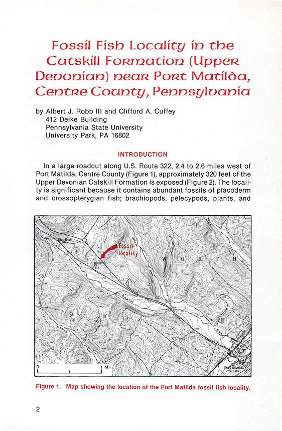
In a large roadcut along U.S. Route 322, 2.4 to 2.6 miles west of Port Matilda, Centre County (Figure 1), approximately 320 feet of the Upper Devonian Catskill Formation is exposed (Figure 2). The locality is significant because it contains abundant fossils of placoderm and crossopterygian fish; brachiopods, pelecypods, plants, and
Figure 1. Map showing the location of the Port Matilda fossil fish locality.
2
trace fossils are also present (Table 1). Easy and profitable collecting can be accomplished by examining rubble at the bottom of the vertical face. Extreme caution should be observed at this locality due to highway traffic and falling rock.
STRATIGRAPHY AND PALEOENVIRONMENTS
Overall , the Catskill Formation exposed at the Port Matilda roadcut is part of a large delta complex built westward into the Appalachian seaway during the Late Devonian (Williams, 1985; Williams and Slingerland, 1985). Within the section are three distinct lithofacies representing deposition in four distinct paleoenvironments, each having a unique fossil assemblage. The most abundant lithofacies at this roadcut is red mudstone containing thin sandstone interbeds. This lithofacies was deposited in three distinct paleoenvironments. First, some beds contain fossils of lingulid brachiopods, pelecypods, and indeterminate burrows. Based on comparison with similar layers described by Gordon and Knox (1989) from New York State, the authors conclude that these rocks were deposited under brackish water in a very nearshore setting. Second, other beds contain plant root casts and impressions of plant foliage, implying deposition in marshes (Williams and Slingerland, 1985). Third, additional beds contain fossils of fish known to inhabit freshwater environments (Denison, 1951), indicating deposition in streams and lakes.
Interbedded with the red mudstones and thin sandstones are two other lithofacies. One consists of greenish-gray to tannish-gray mudstone and sandstone; rocks of this lithofacies contain lingulid brachiopods and indeterminate burrows. They were probably deposited under brackish water in a very nearshore setting such as that described by Gordon and Knox (1989) for similar layers in New York State. The other lithofacies, composed of thick red sandstone exhibiting crossbedding, represents channel deposits that formed in estuarine and fluvial environments (Williams and Slingerland, 1985).
PALEONTOLOGY
All of the fossils found at the Port Matilda roadcut (Table 1) occur in several thin layers scattered throughout the section (Figure 2). The fish remains are concentrated in rich coquinoid layers within the red mudstone and thin interbedded sandstone lithofacies, both in the mudstone and the sandstone layers. Here, the plates, scales, and teeth are mostly preserved as bone, but some molds are present. Rarely, fish remains occur as isolated, poorly preserved fragments in other lithofacies. The brachiopod Lingula and the pelecypod Parallelodon occur either together or separately, in thin layers, where
3

FOSSIL STRATIGRAPHY
HORIZONS
~
k=> z K::> 0 0
k=> 1-
< ~ ~
rth a:
0
rth LL.
...J
tl:ll ...J
~ ~ 0 D (/)
1- 0 a < u
t>C>
0 Lingulids r/n Pl ant s
(:::) Pe lec ypods ~ Bu rrow s
K=:> Fish
Red muds10ne
and thin sandstone
~Th1ck red
~sandstone
.r:;
~ .r:; !!! .r:; "' ~
"' 2 ~ 0
~ "' ~ u.. ::; CD
(/)
1-z w :::!: z 0 a: ->
r _:-_:-_~ ~ z w 0 w ...J
< a..
SCALE
FT 40
20
0
M 12
6
0
Green / tan / g ray
mudst one and sand s ton e
Figure 2. Stratigraphic column illustrating the rocks exposed and the fossil horizons present at the Port Matilda fossil fish locality.
4

Table 1. Faunal List for the Catskill Formation at the Port Matilda Roadcut
VERTEBRATA Placodermi
Bothriolepis ct. B. nitida (Leidy) Head shield indeterminate
Chondrichthyes(?) Spines indeterminate
Osteichthyes (Crossopterygii) Litoptychius sp.
INVERTEBRATA Brachiopoda
Lingula ligea Hall L. spatulata Vanuxem
INVERTEBRATA (continued) Pelecypod a
Para/lelodon chemungensis (Hall) Indeterminate fragments
PLANTAE Root casts Foliage
ICHNOFOSSILS Burrows indeterminate
they are abundant and in some places associated with indeterminate burrows. Most commonly, they are preserved as molds; however, some specimens of Lingula still retain the original shell material. Plant remains are scattered throughout the section, principally as isolated roots or foliage. The most significant types of fossils are illustrated in Figure 3.
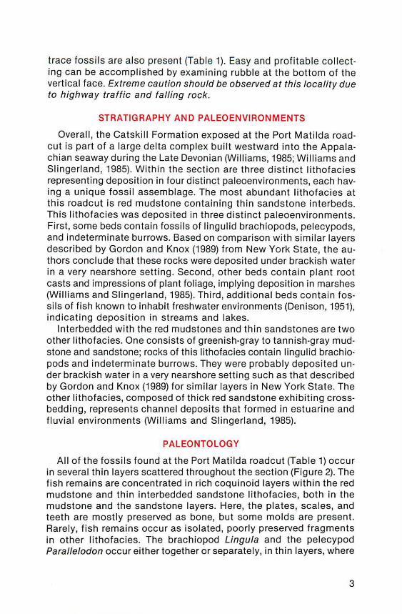
The most abundant fish remains are thin (2 to 5 mm) fragments of the headshields and armored pectoral fins of the placoderm Bothrio/epis ct. B. nitida (leidy) (Figure 4). This placoderm possessed a dorsoventrally flattened (vertically compressed) headshield, which armored the anterior portion of the fish's body; the pectoral fins were attached to the headshield. The exterior of the bony armor of the headshield exhibits two distinct types of ornamentation. Some portions have tubercles arranged in a reticulate pattern, giving the surfaces a netlike appearance; other portions are ornamented with a sinuous vermiculating pattern , giving the surfaces a winding furrowed appearance. The interior of the bony armor is virtually smooth. The remaining portions of the fish Bothrio/epis are known to have little or no armor or scales, and thus are not preserved at this locality.
Also found at this locality, though much rarer, are the teeth and scales of the crossopterygian fish Litoptychius sp. The teeth taper, are oval in cross section, and range from 10 to 35 mm in length. Their basal portion exhibits longitudinal furrows, whereas their upper halves are smooth. The scales of Litoptychius sp. are cycloidal (subcircular); the internal sides of the scales are nearly smooth, whereas the external sides are ornamented with fine tubercles arranged in fanlike patterned rows. These scales average 20 mm in diameter and can be as thick as 3 mm.
5

I I
I
' I -
Figure 3. Brachial valve of Lingula Jigea. B. Left valve of Parallelodon chemungensis. C. Root cast. D. Exterior surface of Bothriolepis ct. B. nitida bony headshield armor; sinuous vermiculating ornament (winding furrowed appearance). E. Exterior surface of Bothriolepis ct. B. nitida bony headshield armor; reticulate ornament (netlike appearance). F. Interior surface of Bothrio/epis ct. B. nitida bony headshield armor. G. Small·sized tooth of Litoptychius sp. H. Large-sized tooth of Litoptychius sp. I. In· ternal surface of Litoptychius sp. scale. J . Indeterminate spine fragment; Class Chondrichthyes. All scale bars are 5 mm in length.
6
Figure 4. Reconstruction of Bothriolepis (adapted from Stensio, 1969). In life, the fish was approximately 50 em long.
Several indeterminate spines have also been recovered, which are tentatively assigned to the class Chondrichthyes. Furthermore, fragments of a very large and thick-boned (30 mm) headshield have been collected; they are tentatively assigned to the class Placodermi. Finally, unidentifiable fish bone fragments are commonly recovered. Certainly, many of these are portions of Bothriolepis and Litoptychius, but some may belong to other fish taxa as well.
FISH PALEOECOLOGY
As described by Denison (1951), Bothriolepis inhabited fresh water. It followed a nektobenthonic (i.e., a free-swimming but near-bottom) lifestyle. A freshwater environment is consistent with the data collected from Port Matilda; specifically, the fish do not occur in the same beds with the brackish-water invertebrates. Furthermore, nearby occurrences of Bothriolepis (in other layers within the Catskill Formation) are in rocks interpreted by Williams and Slingerland (1985) as fluvial, and thus are freshwater deposits. Because the remains of Litoptychius are found in the Bothriolepis-bearing beds, the authors conclude that it also inhabited fresh water. The coquina layers probably represent accumulations of large numbers of fish in small, localized areas either in fluvial or lacustrine environments. Some scattered, poorly preserved fish remains that occur at other horizons probably represent isolated individuals preserved in the same freshwater environment, whereas other remains suggest that isolated individuals were washed downstream into brackish-water environments.
We thank William J. DiBrino of Tampa, Florida, and Jennifer J. Criss of Bethel Park, Pennsylvania, for their help in conducting the field work for this paper, and Paul D. Zell of State College, Pennsylvania, for his help in preparing the specimens for photographing. Helpful review comments by Jon D. lnners and John A. Harper of the Pennsylvania Geological Survey improved the manuscript.
7
REFERENCES
Denison, R. H. (1951), Late Devonian fresh-water fishes from the western United States, Fieldiana: Geology, v. 11, no. 5, p. 221-261.
Gordon, E. A., and Knox, L. W. (1989), New evidence indicating brackish environments in alluvial to marine margin deposits, Devonian Catskill magnafacies, New York, Geological Society of America Abstracts with Programs, v. 21, no. 2, p. 18.
Stensio, E. A. (1969), Elasmobrachiomorphi; Placodermata; Arthrodires, in Piveteau, Jean, ed., Traite de Paleontologie, Masson, Paris, v. 4, no. 2, p. 7·1-692.
Williams, E. G. (1985), Catskill sedimentation in central Pennsylvania, in Gold, D.P., and others, Central Pennsylvania geology revisited, Annual Field Conference of Penn· sylvania Geologists, 50th, State College, Pa., Guidebook, p. 20-32.
Williams, E. G., and Slingerland , Rudy (1985), Field guide-Catskill sedimentation in central Pennsylvania, In Gold, D. P., and others, Central Pennsylvania geology revisited, Annual Field Conference of Pennsylvania Geologists, 50th, State College, Pa., Guidebook, p. 45- 62.
8
Newly Discovered Mineral Named for
Pennsylvania Geologist Charles B. Sclar, professor of geological sciences at
Lehigh University in Bethlehem, has recently received the honor of having a mineral , sclarite, named for him. This mineral was found in one of the handful of districts that have names instantly recognizable to many mineralogists world· wide-Franklin and Sterling Hill, New Jersey. The area is in the northern part of that state, about 30 miles east-northeast of the Delaware Water Gap. Professor Sclar received the honor in recognition of his research on the origin of the zinc ores in that district.
Sclarite, a carbonate of zinc having the chemical formula Zn/ C03h(OH)10, was described and named by Pete J. Dunn of the Smithsonian Institution National Museum of Natural History in Washington, D. C., and Joel Grice of the National Museum of Natural Science in Ottawa, Canada. It is reported to be structurally similar to loseyite, (Mn,Znh(C03)2(0H)10,
another mineral that was discovered at Franklin 60 years earlier.

lEAR TH SCCITIENCCIE
TIEACHlER§' CORNIER
by William E. Kochanov
The Eart h Has a History Imagine trying to explain the concept of geologic time to junior
and senior high school students. What sort of examples cou ld an instructor use?
An excel lent f ilm, emphasizing the concept of geologic time, has been prepared by the Geological Society of America. In the f ilm, a modern stream environment is used as an example to explain two principles that demonstrate geologic history. The first is original horizontality (sedimentary layers accumulate horizontally), and the second is superposition (the layer of rocks on the bottom had to be deposited first, and therefore is the oldest layer). This film characterizes the seq uential layering of sediments and illustrates how one may view the layers in a three-dimensional framework. The film demonstrates how a student can decipher the major features of the geologic history of an area. By using a combination of a modern-day example from South Boulder Creek, outcrop examples from the Flatiron Mountains (both located in Colorado), and graphic representations of the depositional sequences, the student is kept geographically oriented while, at the same time, key concepts are reinforced.
The examples used in the f i lm may be appl ied to simi lar streams and bedrock occurrences in Pennsylvania. Most of the rocks exposed in Pennsylvania are sed imentary rocks. The sandstone, shale, and limestone layers provide a sequential record of events that have occurred in Pennsylvania over a specific peri od of time. The way in which layers of rbcks are arranged tells a story of ancient environments and forces that have acted upon those environments. By examining and recording the sed imentary features within a rock sequence, it is possible to decipher the hidden story within the rocks and to better understand the geologic formation and evolution of our state.
9

Educators may use the film to help students, in a 20-minute period, understand how changes of the earth's surface occur over a period of time. The film also introduces the student to earth processes that are continually at work.
The film, entitled " The Earth Has a History," was deve loped by Dr. Allison R. Palmer. The c lear and easy-to-understand manner of presentation makes the film ideal for incorporation into the beginning phase of an earth sc ience curriculum or for a biology section on the record of li fe on the earth. The film is available on VHS video or 16-mm film . It may be purchased from the Geological Society of America, P. 0. Box 9140, Boulder, CO 80301 , at a cost of $25.00 for the VHS video (order EVS001) or $200.00 for the 16-mm film (order EFS001). A limited number of the VHS video films are available for loan through the Pennsy lvania Geological Survey library, P. 0 . Box 2357, Harrisburg, PA 17105, telephone 717-783-8077.
NEW PUBLICATIONS
MAP OF RADIUM IN GROUNDWATER IN SOUTHEASTERN PENNSYLVANIA
In response to public-hea lth concerns raised several years ago by the discovery of elevated levels of radium in three public water supplies that utilize groundwater from the Chickies Formation of southeastern Pennsy lvania, the U.S. Geological Survey (USGS) has published a map that shows the location of that formation and the initi al results of a study that the USGS conducted in cooperation with the Pennsylvan ia Geological Survey. This map, at a scale of 1:250,000, was first made publ ic in 1987 but, until recent ly, has been avai lable only by inspecti on at the Malve rn office of the USGS. Of 56 wells tested, 24 contained radium in excess of the maximum level of 5 pCi/L (picocuries per liter) set by the U.S. Environmental Protect ion Agency for pub lic water supplies. These are indicated by di fferent symbols on the map, which shows the locations of al l 56 wells.
The Chickies Formation, a quartzite, is found in a discontinuous belt that extends from west of Morrisville, Bucks County, to east of New Oxford, Adams County. Most of the wells iden ti f ied as having leve ls above 5 pCi/L are in Chester and eastern Lancaster Counties.
10

The map, entitled Map Showing Radium Concentrations in Ground Water of the Chickies Formation, Southeastern Pennsylvania, 1986-87, by L. DeWayne Cecil , may be obtained by requesting Open-File Report 87-232 from the U.S. Geological Survey, Books and Open-File Reports Section, Federal Center, Box 25425, Denver, CO 80225; enclose $2.25 for paper copy or $1.50 for microfiche, payable to Department of the Interior-USGS.
A complete report of the continuing investigation, including detailed chemical and radiological analyses, will be published in the near future.
-J. H. Barnes
GROUNDWATER RESOURCES OF THE CHEMUNG RIVER BASIN
The Susquehanna River Basin Commission has recently issued Publication 115, entitled Groundwater Resources of the Chemung River Basin, New York and Pennsylvania, by Larry E. Taylor. This report contains a discussion of groundwater quality, quantity, use, and flow systems in the Chemung River basin. The basin is located within the northern portions of Bradford, Tioga, and Potter Counties in Pennsylvania. The effects of glaciation are an important factor in the hydrogeology of the area. The most productive and important aquifers in the area are composed of stratified drift. The median yield for municipal and industrial wells in these unconsolidated glacial deposits is 300 gallons per minute. However, the same factors that make these rocks productive aquifers also make them susceptible to contamination.
High concentrations of iron and manganese are the most widespread naturally occurring water-quality problems. High barium concentrations are not as widespread, but do occur in about 7 percent of the wells sampled in the Chemung River basin. Most of these occur in bedrock wells in or near large valleys. The author surmises that the high barium concentrations are the result of dilution of brines, which are present at shal low depths in the large valleys. The shallow depths of these brines are thought to be the result of glacial erosion of the valley bottoms.
For further information concerning this publication, contact the Susquehanna River Basin Commission, 1721 North Front Street, Harri sburg, PA 17102, telephone 717- 238-0422.
- 0. Yannacci
11

GROUNDWATER DATA FOR CHESTER COUNTY
The U.S. Geological Survey (USGS) has published an open-file report containing basic groundwater data for Chester County. This report, entitled Selected Ground-Water Data, Chester County, Pennsylvania, was prepared in cooperation with the Chester County Water Resources Authority and is authored by Ronald A. Sloto of the USGS, Water Resources Division. Open-File Report 87-217 contains general construction, production, and location information for 3,010 wells and 32 springs in the county. Water-level records for 48 observation wells and the results of chemical analyses for water from several hundred wells and springs were also compiled for this report. The information is presented in numerous tables; a geologic map (scale 1:50,000) showing well and spring locations is also included.
The report may be purchased from the U.S. Geological Survey, Books and Open-File Reports Section, Federal Center, Box 25425, Denver, CO 80225; enclose $39.75 for paper copy and $5.50 for microfiche. Please make checks payable to Department of the InteriorUSGS. The report may also be examined in the library of the Pennsylvania Geological Survey, Room 916, Executive House, 101 South Second Street, Harrisburg; in the USGS subdistrict office, 111 Great Valley Parkway, Malvern; and in the offices of the Chester County Water Resources Authority, 3rd Floor, Dague Building, West Chester.
- 0 . Yannacci
New Staff of the Pennsylvania Geological Survey
Jody R. Sm_ith Jody Smith joined the staff of the Survey in May 1989. In her posi
tion as Clerk Typist, Jody performs secretarial duties for the Geologic Mapping Division and the Mineral Resources Division. Jody transferred to the Department of Environmental Resources after 5 years as a Data Recording Machine Operator in the Bureau of Data Reduction in the Department of Revenue. Prior to that, she spent 2% years as an office clerk at Rite-Aid Corporation in Shiremanstown.
A native of central Pennsylvania, Jody graduated from Cumberland Valley High School in 1976, and she earned a B.A. in Christian Education from Messiah College in 1981 . Jody presently resides in Boiling Springs with her husband, Michael.
12

Patricia F. Duis Pat Buis joined the Coal Section of the Geologic Mapping Division
of the Survey as a geologist in May 1989. She has been assigned to phase two of the National Coal Resources Data System (NCRDS), a computer data system developed by the U.S. Geological Survey to faci litate coal-resource calculations for the nation. Pat w il l study the chemistry of bituminous coa ls in Pennsylvania; she wi ll supplement avai lable data, run statistical analyses, and produce tables and maps of coal characteristics.
Pat has a strong geochemistry background. From 1988 to 1989, she worked for Pennrun Corporation in Pittsburgh, performing chemical analyses of toxic metals. In 1987, Pat received a Ph.D. in geology from the University of Pittsburgh. Her dissertation was on the geochemistry of the carbonate country rock around the Sterling Hil l ore deposit in Ogdensburg, New Jersey. While at the un iversity, Pat worked as a microcomputer laboratory assistant and as a teaching assistant in Mineralogy, Economic Geology, and Geochemistry laboratories. Pat obtained her M.A. in geology in 1983 from Queens College, City University of New York. She studied fluorite bands in the Sterling Hill ore deposit fo r her thesis work and was an adjunct lecturer in Physical Geology and Structural Geology laboratories. Pat also attended Rutgers Un iversity in New Jersey, where she earned a B.A. in geology in 1976.
INDEX TO VOLUME 20
SUBJECT INDEX
Subject
Aggregate-Construction, air·cooled blast·furnace slag, Dunbar Slag Com pany, Mercer County
Allegheny County- Fossil locality, Ames marine zone, diverse fauna
Ames marine zone- Allegheny County, fossil locality, diverse fauna
Atlas of Pennsylvania- New publication Awards and honors
Cozart, Cheryl L. Crawford, Maria Luisa Sclar, Charles B.
Catskill Formation- Centre County, fossil locality, fi sh Centre County-Fossil locality, Catskill Formation, fish Chemung River basin- New publication, groundwater resources Chester County- New pub lication, groundwater data (USGS
OF 87- 217)
Volume and
number
20/3
20/1
20/1
20/5
20/2 20/2 20/6 20/6 20/6 20/6 20/6
Page{s)
2-5
10- 15
10-15
15- 16
15 16 8
2-8 2-8 11 12
13

Subject
Cumberland County-Open-file report , sinkholes and karstrelated features
Dauphin County-Open-file report, sinkholes and karst-related features
Dunbar Slag Company-aggregate, construction, air-cooled blast-furnace slag, Mercer County
Earthquake hazard-New publication, Pennsylvan ia (ES 10) Earth science education
Geolog ical Society of America film on geologic history of the earth
New Educational Series report on earthquake hazard in Penn-sylvania (ES 10)
New resource book on industrial minerals Satellite image map of south-central Pennsylvania USGS map set of physiograph ic features
Erie County-New publication, groundwater resources 0N 62) Fayette County-New publication, groundwater resources
0N 60) Fossil localities
Allegheny County, Ames marine zone, diverse fauna Centre County, Catskill Format ion, fish Perry County, Mahantango Format ion, diverse fauna
Geochips-Berg, Thomas M. Geological reports published, 1989 Geological research in Pennsylvania, 1989 Geomorphology
Exotically sculptured diabase, Lancaster County Exotically sculptured diabase- an addendum
Greene County-New publication, water resources and effects of coal mining 0N 63)
Groundwater-New publications Pennsylvania Geological Survey
Erie County, resources 0N 62) Fayette County, resources 0N 60) Greene County, resources 0N 63)
Susquehanna River Basin Commission-Chemung River basin, resources (Publication 11 5)
U.S. Geological Survey Chester County, data (OF 87- 217) Radium, southeastern Pennsylvania (OF 87- 232) Rural homeowner
History New publ ication, State Geological Surveys Petersburg mine, military geology
Lancaster County-Geomorphology Exotically sculptured diabase Exotically scu lptured diabase-an addendum
Luzerne County-Structural geology, whalebacks, Eckley Mahantango Formation-Perry County, fossil local ity, diverse
fauna
14
Volume and
number Page(s)
20/3 14-15
20/3 14-15
20/3 2- 5
20/3 8
20/6 9-1 0
20/3 8
20/5 13-15 20/3 6-8 20/1 8-9 20/5 12-13 20/5 11- 12
20/1 10- 15 20/6 2- 8 20/3 9- 12 20/1 16 20/4 19- 32 20/4 2-18
20/1 2-7 20/3 5 20/3 13- 14
20/5 12- 13 20/5 11-12 20/3 13-14 20/6 11
20/6 12 20/6 10-11 20/3 6
20/2 10 20/5 3-10
20/1 2-7 20/3 5 20/2 3- 9 20/3 9-12
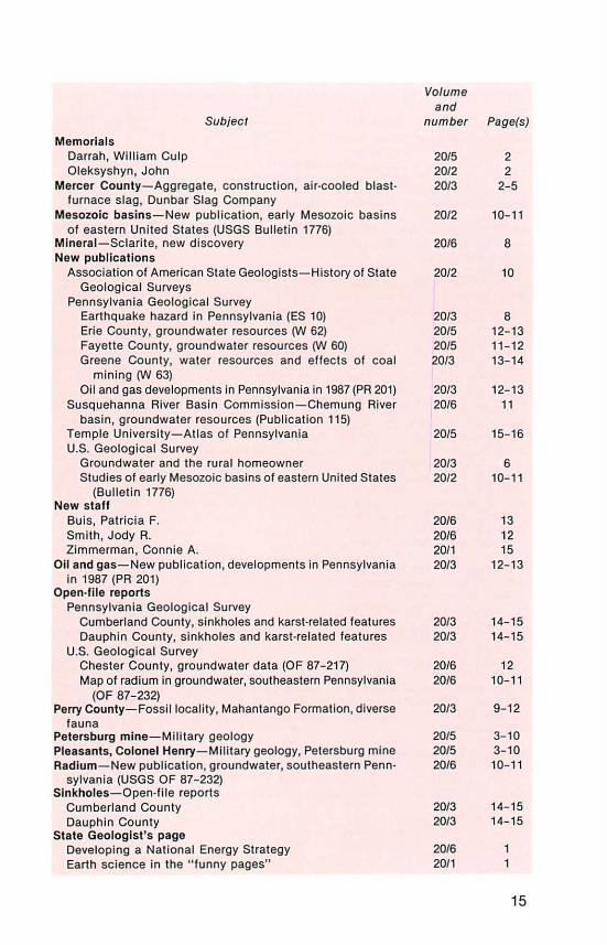
Memorials Darrah, William Gulp Oleksyshyn, John
Subject
Mercer County-Aggregate, construc tion, air-cooled blastfurnace slag, Dunbar Slag Company
Mesozoic basins-New publication, early Mesozoic basins of eastern United States (USGS Bulletin 1776)
Mlnerai-Sclarite, new discovery New publ ications
Association of American State Geologists-History of State Geological Surveys
Pennsylvania Geological Survey Earthquake hazard in Pennsylvania (ES 10) Erie County, groundwater resources fY'J 62) Fayette County, groundwater resources fY'J 60) Greene County, water resources and effects of coal
mining fY'J 63) Oil and gas developments in Pennsylvania in 1987 (PR 201)
Susquehanna River Basin Commission-Chemung River basin, groundwater resources (Publication 115)
Temple University-Atlas of Pennsylvania U.S. Geological Survey
Groundwater and the rural homeowner Studies of early Mesozoic basins of eastern United States
(Bulletin 1776) New staff
Buis, Patricia F. Smith, Jody R. Zimmerman , Conni e A.
011 and gas-New publication, developments in Pennsylvania in 1987 (PR 201)
Open-file reports Pennsylvania Geological Survey
Cumberland County, sinkholes and karst-related features Dauphin County, sinkholes and karst-related features
U.S. Geological Survey Chester County, groundwater data (OF 87-217) Map of radium in groundwater, southeastern Pennsylvania
(OF 87- 232) Perry County-Fossil locality, Mahantango Formation, diverse
fauna Petersburg mine-Mili tary geology Pleasants, Colonel Henry- Military geology, Petersburg mine Radium- New publication, groundwater, southeastern Penn·
sylvania (USGS OF 87-232) Sinkholes-Open-file reports
Cumberland County Dauphin County
State Geologist's page Developing a National Energy Strategy Earth science in the "funny pages"
Volume and
number Page(s)
20/5 2 20/2 2 20/3 2-5
20/2 10-11
20/6 8
20/2 10
20/3 8 20/5 12-13 20/5 11-12 20/3 13-14
20/3 12-13 20/6 11
20/5 15- 16
20/3 6 20/2 10-11
20/6 13 20/6 12 20/1 15 20/3 12-13
20/3 14-15 20/3 14-15
20/6 12 20/6 10-11
20/3 9-12
20/5 3-10 20/5 3-1 0 20/6 10-11
20/3 14-15 20/3 14-15
20/6 20/1
15

Subject
State Geologist's page (continued) Geology, art, and vandalism Groundwater-quality protec tion-the priori ty issue The future of critical mi nerals The lessons of the Conemaugh
Structural geology-Whalebacks, Eckley, Luzerne County Topographic maps
Comments requested on USGS plans fo r symbols change County series (1 :50,000 scale) now complete New index available
Transition Berg, Thomas M., new State Geologist of Ohio
Water resources (a/so see Groundwater)-New publication, Greene County, water resources and effec ts of coal mining
AUTHOR INDEX
Author and subjec t
Berkheiser, Samuel W., Jr.- Aggregate, construction, air-cooled blast-furnace slag, Dunbar Slag Company, Mercer County
Blust, Sandra D. - Earth science education, USGS map set of physiographic features
Cuffey, C. A.-Fossil locality, Centre County, Catski ll Formation, fi sh
Harper, John A.-Fossil locality, Allegheny County, Ames marine zone, diverse fauna
Hoskins, Donald M. Developing a Nat ional Energy Strategy Earth science in the "funny pages" Geology, art, and vandalism Groundwater-quality protection- the priority issue The fu ture of c ri tical minerals The lessons of the Conemaugh
lnners, Jon D. Colonel Henry Pleasants and mili tary geology of Petersburg
mine Fossil locality, Perry County, Mahantango Formation, di
verse fauna Structural geology, whalebacks, Eckley, Luzerne County
Kochanov, William A.-Earth science education, Geological Society o f America film on geological history of the earth
Lentz, Leonard J.- Structura l geology, whalebacks, Eckley, Luzerne County
Mouse, Schoolhouse-Earth science education, new resource book on industrial minerals
O'Neil, Caron (compiler)-Geologlcal reports published, 1989 Robb, A. J., Ill - Fossil local ity, Centre County, Catski ll For
mation, fish Sevon, W. D.-Geomorphology
Exotically sculptured diabase, Lancaster County Exotically sculptured diabase-an addendum
Smith, Robert C., 11 -Aggregate, construction, air-cooled blastfurnace slag, Dunbar Slag Company, Mercer County
16
Volume and
number Page(s)
20/4 1 20/5 1 20/2 1, 16 20/3 1 20/1 3-9
20/3 15-16 20/2 12-13 20/1 9
20/2 14-15 20/3 13-14
Volume and
number Page(s)
20/3 2-5
20/1 8- 9
20/6 2- 8
20/1 10-15
20/6 1 20/1 1 20/4 1 20/5 1 20/2 1, 16 20/3 1
20/5 3-10
20/3 9- 12
20/2 3- 9 20/6 9- 10
20/2 3- 9
20/5 13-15
20/4 19-32 20/6 2-8
20/1 2-7 20/3 5 20/3 2- 5

PENNSYLVANIA GEOLOGICAL SURVEY STAFF
Donald M. Hoskins, Bureau Director
DIRECTOR'S OFFICE
Administrative Services and Library Shirley J. Barner, Clerical Supervisor Sandra D. Blust, Librarian Janet L. Wotring, Administrative
Assistant Connie A. Zimmerman, Clerk Typist
717-787-2169
Editing Section Christine M. Dodge, Section Chief James H. Dolimpio, Cartographic Draftsman John G. Kuchinski, Cartographic Supervisor Francis W. Nanna, Cartographic Draftsman Caron O'Neil, Geologist
ENVIRONMENTAL GEOLOGY DIVISION 717-787-5828
John P. Wilshusen, Division Chief
Mari G. Barnhart, Clerk Helen L. Delano, Geologist William E. Kochanov, Geologist Garry L. Price, Geologist Loretta Rossum, Clerk Typist Donna M. Snyder, Administrative Officer
Groundwater Geology Section Michael E. Moore, Section Chief Thomas A. McElroy, Hydrogeo/oglst Dawna Yannacci, Hydrogeologlst
GEOLOGIC MAPPING DIVISION 717-787-6029
Jon D. lnners, Division Chief
Rodger T. Faill, Geologist David B. Maclachlan, Geologist William D. Sevon, Geologist Jody R. Smith, Clerk Typist David W. Valentino, Geologist
Coal Section Albert D. Glover, Section Chief Patricia F. Buls, Geologist Clifford H. Dodge, Geologist leonard J. Lentz, Geologist James R. Shaulis, Geologist Viktoras W. Skema, Geologist
MINERAL RESOURCES DIVISION 717-787-5897
Robert C. Smith, II, Division Chief
John H. Barnes, Geologist Leslie T. Chubb, Laboratory Technician Samuel W. Berkhelser, Jr., Geologist
OIL AND GAS GEOLOGY DIVISION 7th Floor, Highland Building 121 South Highland Avenue Pittsburgh, PA 15206-3988
412-645-7057 John A. Harper, Division Chief
Lajos J. Balogh, Cartographic Draftsman Antonette K. Markowski, Geologist Cheryl L. Cozart, Descriptive Statistician (Harrisburg Office} Joseph E. Kunz, Clerk Typist John Petro, Cartographic Draftsman Christopher D. Laughrey, Geologist
IN COOPERATION WITH THE U.S. GEOLOGICAL SURVEY
TOPOGRAPHIC MAPPING GROUNDWATER-RESOURCE MAPPING

0 • Above Below
last year last year
Observation well
GROUNDWATER LEVELS FOR
NOVEMBER 1989
EXPLANATION
6. • Above Below
last year fast year
Observation well equipped wi th
data-collection platform
X
No data
Bureau of Topographic and Geologic Survey Departme.nt of Environmental Resources P. 0 . Box 2357 Harri sburg, PA 171 05
Address Corrections Requested
High Normal range
Low
Bulk Rate U.S. Postage
PAID Harrisburg, PA Permit No. 601
DER 1103- 12/89