parkway forest context plan - toronto · c. linkage diagram d. building height diagram ... the...
TRANSCRIPT
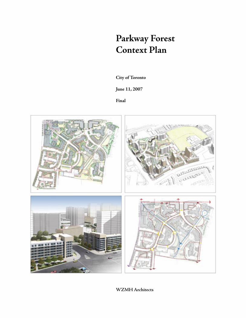
Parkway ForestContext Plan
City of Toronto
June 11, 2007
Final
WZMH Architects

Parkway Forest Context Plan
Urban Design Guidelines 1
Table of Contents:
1.0 Introduction and Background 1.1 Location 1.2 Context Plan Area 1.3 Surrounding Features 1.4 Existing Public Realm
2.0 Urban Design Ideas
2.1 Vision Statement/ Goals 2.2 Public Realm Principles 2.3 Built Form Principles
3.0 Development Framework 3.1. General Outline A. Block Diagram B. Structure Plan C. Linkage Diagram D. Building Height Diagram
3.2. Streets • Existing Streets • New Public Streets • New Driveways/Private Streets
3.3. Open Space • Parks and Public Space • Private Space 3.4. Building Typologies • Grade Related Buildings • Mid-Rise Buildings • Taller Buildings
3.5. Community Facilities • Community Centre and Daycare • Community Organization Space
3.6. Commercial • Existing • Proposed
3.7. Parking and Servicing
3.8. Traffic Infiltration
3.9. Transport Demand Management
3.10. Implementation & Phasing

Parkway Forest Context Plan
Urban Design Guidelines2
Development in the Parkway Forest Area will be consistent with the following urban design guide-lines. They will provide a framework for development in the area and are to be read in conjunction with the urban design policies in the Official Plan.
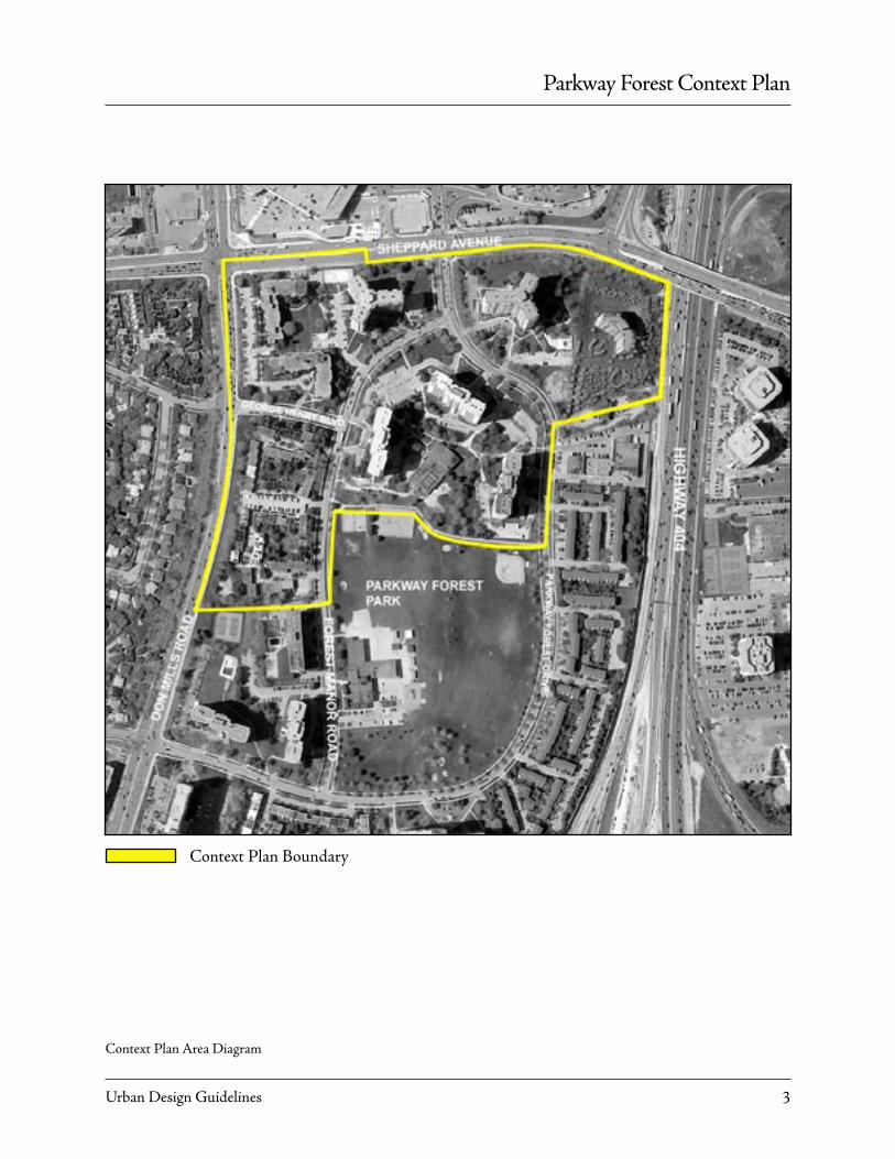
Location
The Parkway Forest Context Plan applies to the area stretching from the South East corner of Don Mills and Sheppard Avenue to the existing south property line of 32-50 Forest Manor Road, Parkway For-est Park, the eastern property line of 100 and 121 Parkway Forest Drive - all roughly South West of the intersection of Highways 401 and 404.
Guidelines
The Context Plan is comprised of a Block Diagram, a Structure Plan, a Linkage Diagram, a Height Dia-gram and a set of urban design principles. The plan demonstrates how the objectives of the ‘Sheppard East Subway Corridor Secondary Plan’ to intensify the neighborhood can be achieved. These guidelines also implement the ‘Sheppard Avenue Streetscape Plan’ approved by Council in 1997.
A. The Block Diagram illustrates potential development blocks created by existing and new streets and parks that can achieve the density objec-tives of the Sheppard East Subway Corrider second-ary plan in conjunction with the height diagram. B. The Linkage Diagram illustrates proposed connections within the neighborhood as well as to its
1.0 Introduction and Background
surroundings. C. The Structure Plan outlines a framework for the physical form of redevelopment. It proposes a public realm for the neighborhood using the exist-ing streets, parks and open spaces with new elements that build upon the best aspects of the neighborhood while facilitating the planned level of intensification. D. The Height Diagram provides a general-ized concept of the preferred distribution of building heights in the neighbourhood, outlined in the Urban Design Principles. The generalized height concepts may change as long as they conform to the Urban Design Principles.
Parkway Forest Context Plan
Urban Design Guidelines 3
Context Plan Area Diagram
Context Plan Boundary

Parkway Forest Context Plan
Urban Design Guidelines4
Surrounding Features
The development sites are located in the 48.5 ha (120 acre) Parkway Forest neighbourhood which is bounded on the south by Highway 401, on the east by Highway 404, on the north by Sheppard Av-enue East and on the west by Don Mills Road. The neighbourhood forms part of a larger community known as George Henry Farms which includes the residential subdivision of single and semi-detached homes and townhouses west of Don Mills Road. The community was developed in the late 1960’s and early 1970’s and was comprehensively planned to provide parkland, amenities, and a mix of housing types.
The existing Parkway Forest neighbourhood is com-prised of 12 apartment buildings ranging in heights from 6 to 19 storeys and a series of townhouse devel-opments. The townhouses are confined to identifiable blocks, with access to the units being primarily inter-nal to the block. The apartments are characteristic of towers in the park, with extensive open space, mature trees and surface parking surrounding the buildings. The majority of the residences in the neighbourhood are rental units.
At the centre of the community is a public park and an elementary school (Forest Manor Public School). A fire station and a local commercial shopping plaza are located along the eastern edge of the neighbour-hood next to Highway 404. The property at 121 Parkway Forest Drive, situated at the northeast corner of the community, is currently being developed under the City’s “Let’s Build” program with a 14-sto-rey, 232-unit affordable housing building.
Eunice’s Swim School and Recreation Centre, cur-rently a privately owned facility, is located in the middle of the community. The facility has a gross
View from Don Mills Road and Sheppard Ave looking Southeast
View from Sheppard Ave East looking Southwest
View from park looking North

Parkway Forest Context Plan
Urban Design Guidelines 5
View of Fairview Mall to north of site
View of Henry Farms, West Don Mills street edge
View of new Verdiroc Building to Northeast of site - 121 Parkway Forest Drive
floor area of 1,885m2 (20,290 sq.ft.) and contains a swimming pool, large gymnasium, meeting room space, and a 72-space childcare centre operated by the YMCA. The recreation facility was originally de-signed to meet the indoor community space needs for the existing residents in the community. The facility is over 30 years old and has fallen into disrepair.
The subject properties comprise approximately 13 hectares (32 acres) of land on 5 separate development blocks which are located within walking distance of the Don Mills subway station (refer to Attachment 1). The blocks contain 1,553 residential rental units in five, 17-storey buildings (65 & 80 Forest Manor Road and 100, 110 & 125 Parkway Forest Dr), two, 6-storey buildings (120 & 130 George Henry Blvd.), and 114 townhouse units (32-50 Forest Manor Road). Three swimming pools exist on the sites: two outdoor and one indoor.
The following is a summary of the area context:
North: Sheppard Avenue East, then Fairview Mall and TTC commuter parking lot;
South: Highway 401, then a neighbourhood of high rise apartments in the Graydon Hall community;
East: Highway 404, then Consumers Road Business Park;
West: Don Mills Road, then single family dwellings.
Parkway Forest Context Plan
Urban Design Guidelines6
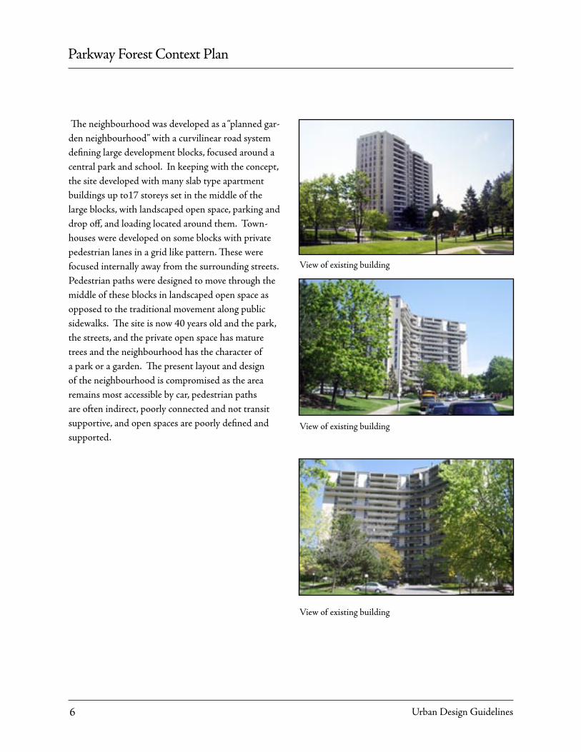
The neighbourhood was developed as a “planned gar-den neighbourhood” with a curvilinear road system defining large development blocks, focused around a central park and school. In keeping with the concept, the site developed with many slab type apartment buildings up to17 storeys set in the middle of the large blocks, with landscaped open space, parking and drop off, and loading located around them. Town-houses were developed on some blocks with private pedestrian lanes in a grid like pattern. These were focused internally away from the surrounding streets. Pedestrian paths were designed to move through the middle of these blocks in landscaped open space as opposed to the traditional movement along public sidewalks. The site is now 40 years old and the park, the streets, and the private open space has mature trees and the neighbourhood has the character of a park or a garden. The present layout and design of the neighbourhood is compromised as the area remains most accessible by car, pedestrian paths are often indirect, poorly connected and not transit supportive, and open spaces are poorly defined and supported.
View of existing building
View of existing building
View of existing building
Parkway Forest Context Plan
Urban Design Guidelines 7
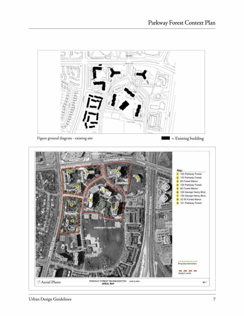
Figure ground diagram - existing site
Aerial Photo
= Existing building
100 Parkway Forest110 Parkway Forest65 Forest Manor125 Parkway Forest80 Forest Manor120 George Henry Blvd.130 George Henry Blvd.32-50 Forest Manor121 Parkway Forest
Proposed Demolition
Subject Lands

Parkway Forest Context Plan
Urban Design Guidelines8
Vision Statement:Goals:• To find opportunities to provide new housing, local retail and new community services for the Parkway Forest neighbourhood while at the same time respect-ing and enhancing the existing park like character .• Enhance the quality, coherence, safety, accessibility and amenity of public realm. To achieve these goals, the following principles will be employed:
Public Realm Principles• Create a high quality safe and comfortable, connected open space system including existing and future streets, walkways, parks, and other open spaces.• Maintain and enhance the existing street, park and school yard. • Provide a new high quality, safe and comfortable pedestrian connection between the subway and the neighbourhood.• Provide a new and improved pedestrian connection from the north east block into the neighbourhood. • Provide an additional public street to connect the neighbourhood to Don Mills Road• Integrate existing mature trees into the design of streets, parks and development blocks where possible. • Relocate existing at grade parking lots below grade to improve the landscape or park like character of the neighbourhood.• Consolidate servicing to minimize its impact on open space, buildings and the public realm.
2.0 Urban Design Ideas
Built Form: Location and Organization Principles:• Retain existing 17 storey buildings on blocks A, D, and E.• Locate new buildings in a manner that defines the edge of streets and open spaces, but maintains gener-ous landscaped setbacks of approx. 4-6m, in keeping with the park like character of the neighbourhood.
Conceptual sketch - looking north from Parkway Forest Park
Conceptual sketch - landscape masterplan

Parkway Forest Context Plan
Urban Design Guidelines 9
Proposed gateway buildings on Sheppard Ave. defining new entry to Parkway Forest Drive
• Locate new townhouses, midrise and podium base type buildings in a manner that does not create closed courtyards and always provides at least one side open to a street, a park, a courtyard or forecourt. • Provide the most intensive mix of local retail, services and residential on the block adjacent to the Sheppard entrance of the Don Mills subway station.• Keep the entrances to new and existing apartments visible and accessible from the street. • Provide ground floor uses in new buildings that encourage positive support and overlook for the ad-jacent open space ie garden apartments, community rooms, local retail uses, etc. • Provide a range of housing types including town-houses, mid-rise apartments and tall apartment towers. • Locate and design new service elements to minimize impacts on buildings, streets and open spaces.• Consolidate existing service elements such as ramps, garbage pick-up and loading areas.• Minimize surface parking.Massing Principles:• Use the 6 storey base building described in the Sheppard Corridor secondary plan for mid-rise base and podium buildings on Sheppard Avenue. Change material or set back floors above 6 storeys.• Limit the number of buildings that rise above the base. Locate them primarily on Sheppard and Don Mills Road. Step towers back from the base to miti-gate wind, shadows and impact of scale.• Use compact floor plates for buildings above 6 storeys so that they don’t block views from existing apartments or provide large shadows and bad wind conditions on adjacent streets, parks, and other open spaces. • Sculpt tall buildings into 3 prominent sections: base, shaft and roof. Rooftops to be designed to create distinctive skyline for the Don Mills Road/ Sheppard Avenue intersection. Podiums envisioned as brick-clad buildings with punched windows. Towers above predominantly glass and aluminum finish to differen-tiate from base.
Proposed gateway building on Sheppard Ave. defining new entry to Parkway Forest Drive
Parkway Forest Context Plan
Urban Design Guidelines10
The development framework is to be used as a guide to the form and layout of a new development within the Context Plan lands. A block diagram, structure diagram, linkage diagram and a building height dia-gram are the framework and graphically illustrate the essential elements and important relationships that will shape the emerging community.
3.0 Development Framework
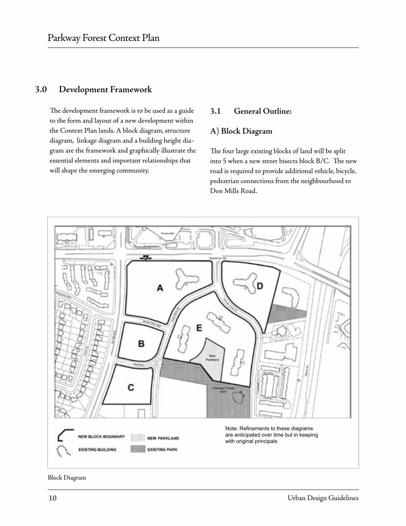
Block Diagram
3.1 General Outline:
A) Block Diagram
The four large existing blocks of land will be split into 5 when a new street bisects block B/C. The new road is required to provide additional vehicle, bicycle, pedestrian connections from the neighbourhood to Don Mills Road.
New Parkland
Note: Refinements to these diagrams are anticipated over time but in keeping with original principals
Parkway Forest Context Plan
Urban Design Guidelines 11
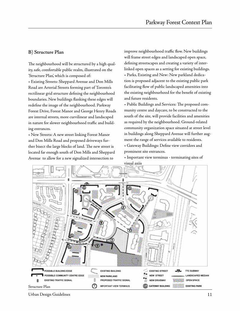
B) Structure Plan
The neighbourhood will be structured by a high qual-ity, safe, comfortable public realm, illustrated on the ‘Structure Plan’, which is composed of:• Existing Streets: Sheppard Avenue and Don Mills Road are Arterial Streets forming part of Toronto’s rectilinear grid structure defining the neighbourhood boundaries. New buildings flanking these edges will redefine the image of the neighbourhood. Parkway Forest Drive, Forest Manor and George Henry Roads are internal streets, more curvilinear and landscaped in nature for slower neighbourhood traffic and build-ing entrances.• New Streets: A new street linking Forest Manor and Don Mills Road and proposed driveways fur-ther bisect the large blocks of land. The new street is located far enough south of Don Mills and Sheppard Avenue to allow for a new signalized intersection to
improve neighbourhood traffic flow. New buildings will frame street edges and landscaped open space, defining streetscapes and creating a variety of inter-linked open spaces as a setting for existing buildings. • Parks, Existing and New: New parkland dedica-tion is proposed adjacent to the existing public park facilitating flow of public landscaped amenities into the existing neighbourhood for the benefit of existing and future residents.• Public Buildings and Services: The proposed com-munity centre and daycare, to be constructed to the south of the site, will provide facilities and amenities as required by the neighbourhood. Ground-related community organization space situated at street level in buildings along Sheppard Avenue will further aug-ment the range of services available to residents.• Gateway Buildings: Define view corridors and prominent site entrances.• Important view terminus - terminating sites of visual axiis
Structure Plan

Parkway Forest Context Plan
Urban Design Guidelines12
C) Linkage Diagram
A variety of pedestrian pathways and sidewalks connect the urban fabric of the neighbourhood both internally, as well as to the surrounding city, are illus-trated on the ‘Linkage Diagram’.
New internal urban design connections are proposed to join:• the existing subway at the NW corner of the site to the park and new community centre to the south• the NE corner of the site including new Verdiroc rental apartments building to the Parkway Forest neighbourhood and park.• The neighbourhood to the subway and other public transit• New driveways – further connecting existing streets into blocks
• Pedestrian walkways form an integrated pathway system linking elements of the neighbourhood. More formal pedestrian pathways flank the edges of existing and new streets and driveways. Less formal routes meander through landscaped open spaces between buildings, giving access to landscape open space and amenities. New buildings will provide “eyes on the street” increasing the public safety of outside connections.
Types of Pedestrian Links :• Outdoor public sidewalks - private walkways• New pedestrian crosswalks at grade.• Enclosed all weather links (at subway interface).• Below grade TTC tunnels.
Linkage Diagram
PARKWAY FOREST PARK
Parkway Forest Context Plan
Urban Design Guidelines 13
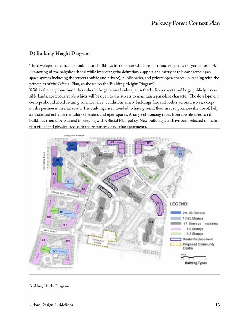
D) Building Height Diagram
The development concept should locate buildings in a manner which respects and enhances the garden or park-like setting of the neighbourhood while improving the definition, support and safety of this connected open space system including the streets (public and private), public parks, and private open spaces, in keeping with the principles of the Official Plan, as shown on the ‘Building Height Diagram’. Within the neighbourhood there should be generous landscaped setbacks from streets and large publicly acces-sible landscaped courtyards which will be open to the streets to maintain a park-like character. The development concept should avoid creating corridor street conditions where buildings face each other across a street, except on the perimeter arterial roads. The buildings are intended to have ground floor uses to promote the use of, help animate and enhance the safety of streets and open spaces. A range of housing types from townhouses to tall buildings should be planned in keeping with Official Plan policy. New building sites have been selected to main-tain visual and physical access to the entrances of existing apartments.
Building Height Diagram
Parkway Forest Context Plan
Urban Design Guidelines14
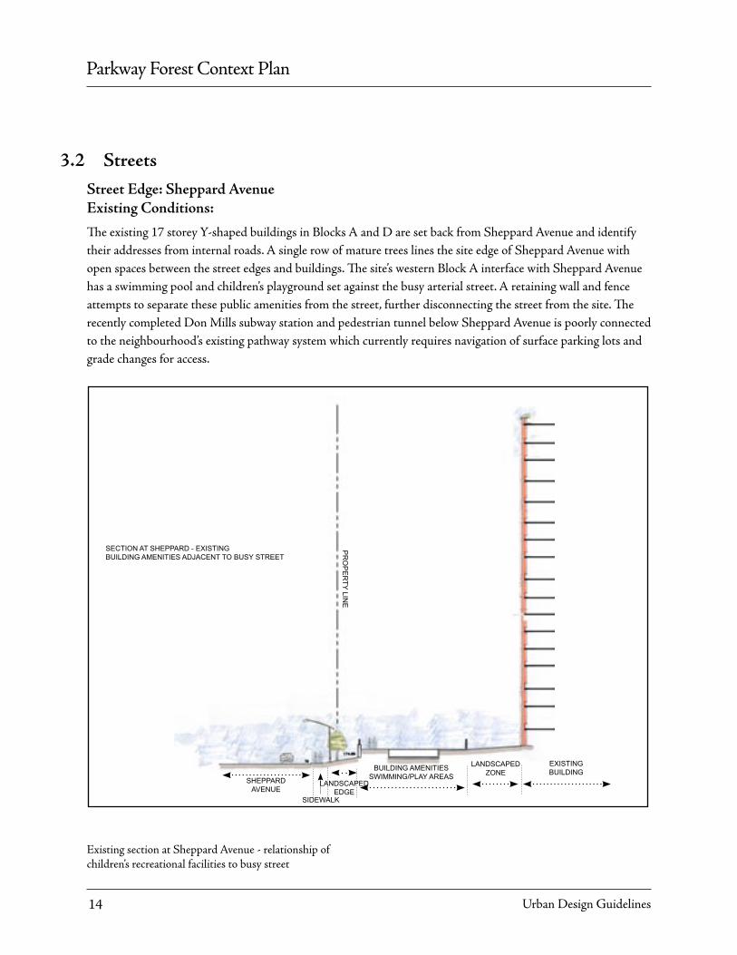
Street Edge: Sheppard AvenueExisting Conditions:
The existing 17 storey Y-shaped buildings in Blocks A and D are set back from Sheppard Avenue and identify their addresses from internal roads. A single row of mature trees lines the site edge of Sheppard Avenue with open spaces between the street edges and buildings. The site’s western Block A interface with Sheppard Avenue has a swimming pool and children’s playground set against the busy arterial street. A retaining wall and fence attempts to separate these public amenities from the street, further disconnecting the street from the site. The recently completed Don Mills subway station and pedestrian tunnel below Sheppard Avenue is poorly connected to the neighbourhood’s existing pathway system which currently requires navigation of surface parking lots and grade changes for access.
Existing section at Sheppard Avenue - relationship of children’s recreational facilities to busy street
SHEPPARD AVENUE
SIDEWALK
LANDSCAPEDEDGE
BUILDING AMENITIES SWIMMING/PLAY AREAS
LANDSCAPED ZONE
EXISTING BUILDING
SECTION AT SHEPPARD - EXISTING BUILDING AMENITIES ADJACENT TO BUSY STREET
PR
OP
ER
TY LINE
3.2 Streets
Parkway Forest Context Plan
Urban Design Guidelines 15
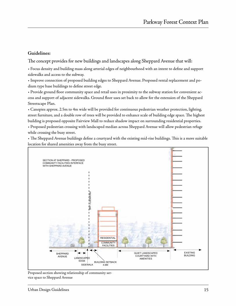
Proposed section showing relationship of community ser-vice space to Sheppard Avenue
Guidelines:
The concept provides for new buildings and landscapes along Sheppard Avenue that will:
• Focus density and building mass along arterial edges of neighbourhood with an intent to define and support sidewalks and access to the subway.• Improve connection of proposed building edges to Sheppard Avenue. Proposed rental replacement and po-dium type base buildings to define street edge.• Provide ground floor community space and retail uses in proximity to the subway station for convenient ac-cess and support of adjacent sidewalks. Ground floor uses set back to allow for the extension of the Sheppard Streetscape Plan.• Canopies approx. 2.5m to 4m wide will be provided for continuous pedestrian weather protection, lighting, street furniture, and a double row of trees will be provided to enhance scale of building edge space. The highest building is proposed opposite Fairview Mall to reduce shadow impact on surrounding residential properties.• Proposed pedestrian crossing with landscaped median across Sheppard Avenue will allow pedestrian refuge while crossing the busy street.• The Sheppard Avenue buildings define a courtyard with the existing mid-rise buildings. This is a more suitable location for shared amenities away from the busy street.
SHEPPARD AVENUE
SIDEWALK
LANDSCAPEDEDGE
QUIET LANDSCAPED COURTYARD WITH
AMENITIES
EXISTING BUILDING
PR
OP
ER
TY LINE
COMMUNITY FACILITIES
RESIDENTIAL
BUILDING SETBACK 4-6M
SECTION AT SHEPPARD - PROPOSED COMMUNITY FACILITIES INTERFACE WITH SHEPPARD AVENUE

Parkway Forest Context Plan
Urban Design Guidelines16
Street Edge: Don Mills RoadExisting Conditions:
The existing Don Mills Road slopes downwards away from its intersection with Sheppard Avenue at a greater rate than the internal (almost parallel) neighbourhood along Forest Manor Road, resulting in a grade difference of over 9m at the Southern edge of the site. This grade change is treated as a landscaped berm with buildings at the top. The west edge of Don Mills Road utilizes concrete retaining walls, fences and trees to separate rear yards of single residential homes facing internal streets with little visual connection to the major arterial road. The northern Don Mills edge of the existing Parkway Forest neighbourhood has 6 storey apartment buildings set back from the major street with large surface parking lots in the space between. Moving southwards, townhouses and mature trees line the edge of the top of the berm with the existing sidewalk at street level below. Townhouses have grade related units with views to public courtyards.
All the blocks fronting Don Mills road are proposed for new development with demolition of existing buildings. In addition a public transit 4m right of way is requested along the Eastern site edge which impacts the existing berm. The landscaped berm will be maintained as much as possible to create a buffer between ground-related units at the base of the building and Don Mills Road.
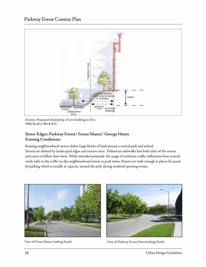
Section: Existing relationship of 5 to 6 storey buildings to Don Mills Road at block A
DON MILLS ROAD LANDSCAPED
EDGE
LANDSCAPED HUMP
SIDEWALK
EXISTING SURFACE PARKING
EXISTING BUILDING
SECTION AT DON MILLS - EXISTING SURFACE PARKING
DISCONNECTS BUILDING FROM SIDEWALK

Parkway Forest Context Plan
Urban Design Guidelines 17
GuidelinesThe concept provides for new buildings and landscapes along Don Mills Road that will:
• Provide definition and support for Don Mills Road with proposed building edges along Block A to Northern Don Mills Street Edge. Provide retail usage in proximity to subway station for convenient access and support of adjacent sidewalks.• Step the tower 3 to 6M from Block A base to reduce impact on streetscape below. Provide canopies along Don Mills Road for continuous pedestrian weather protection. Provide lighting, street furniture, and double row of trees in order to contribute to the pedestrian scale of building edge space. Block A Don Mills edge point tower to be lower than Sheppard Avenue tower to reduce impact of shadows on and preservation of views for residents of Henry Farms Neighbourhood to West of Don Mills Road.
Section: Proposed relationship of buildings to Don Mills Road at block A
HE
NR
Y FA
RM
S P
RO
PE
RTY
LIN
E
DON MILLS ROAD
LANDSCAPEDEDGE
RETAIL AT GROUND PARKING BELOW
GRADE
BUILDING SETBACK
4-6MSIDEWALK SIDEWALK
PORTION OF TOWER ABOVE 45º PLANE SUBJECT TO
HIGHER ARCHITECTURAL STANDARDS. BUILDING TO BE SCULPTED ARCHITECTURALLY
INTO BASE, SHAFT AND ROOF.
7 S
TOR
EY
PO
DIU
M
SECTION AT DON MILLS - PROPOSED STRONG BUILDING CONNECTION
(RETAIL INTERFACE TO SIDEWALK)
45º
3 - 6M
• The block B/C existing berm relationship to Don Mills is to be preserved if possible in co-ordination with surface transit request for right of way.• Podium type buildings flanking Don Mills Road are to provide ground related units opening onto berm and internal landscaped areas for “eyes on the street” and contribution of private landscape to public realm.• Taller buildings in block B/C are to fall below 45° line extending east from Western Don Mills neighbourhood edge property boundaries.
Parkway Forest Context Plan
Urban Design Guidelines18
Street Edges: Parkway Forest/ Forest Manor/ George HenryExisting Conditions:
Existing neighbourhood streets define large blocks of land around a central park and school.Streets are defined by landscaped edges and mature trees . Pedestrian sidewalks line both sides of the streets and curve to follow their form. While intended primarily for usage of residents, traffic infiltration from arterial roads adds to the traffic on the neighbourhood streets at peak times. Streets are wide enough in places for paral-lel parking which is usually at capacity around the park during weekend sporting events.
View of Parkway Forest Drive looking NorthView of Forest Manor looking South
Section: Proposed relationship of new building to Don Mills Road at Block B/C
SETBACK 7-10mSIDEWALKEXISTING
STREET
PR
OP
ER
TY L
INE
EXISTING BERMED TREES TO BE RETAINED
IF POSSIBLE
OUTDOOR TERRACELANDSCAPED
EDGE
VARIES
Parkway Forest Context Plan
Urban Design Guidelines 19
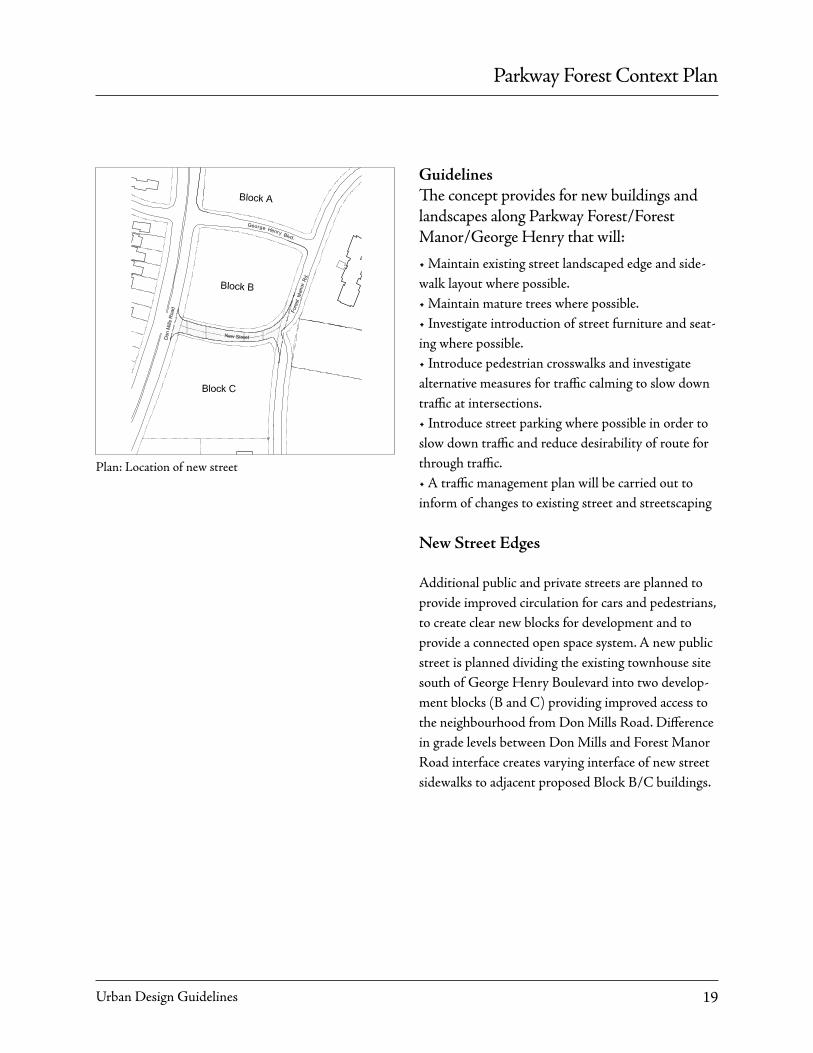
Plan: Location of new street
GuidelinesThe concept provides for new buildings and landscapes along Parkway Forest/Forest Manor/George Henry that will:
• Maintain existing street landscaped edge and side-walk layout where possible.• Maintain mature trees where possible.• Investigate introduction of street furniture and seat-ing where possible.• Introduce pedestrian crosswalks and investigate alternative measures for traffic calming to slow down traffic at intersections.• Introduce street parking where possible in order to slow down traffic and reduce desirability of route for through traffic.• A traffic management plan will be carried out to inform of changes to existing street and streetscaping
New Street Edges
Additional public and private streets are planned to provide improved circulation for cars and pedestrians, to create clear new blocks for development and to provide a connected open space system. A new public street is planned dividing the existing townhouse site south of George Henry Boulevard into two develop-ment blocks (B and C) providing improved access to the neighbourhood from Don Mills Road. Difference in grade levels between Don Mills and Forest Manor Road interface creates varying interface of new street sidewalks to adjacent proposed Block B/C buildings.

Parkway Forest Context Plan
Urban Design Guidelines20
New Driveways/Private Streets
Two new private streets are proposed which divide the large blocks A, D and E into smaller blocks. They have been aligned so as to join the two northern most blocks diagonally south to the park, school and proposed community centre, linking these blocks and the subway in a safe direct manner. These streets are private because of their location over existing under-ground garages making them unacceptable for public roads. These private streets will fulfill the many roles of a public street as defined by the Official Plan.
• Private roads with public feel, pedestrian sidewalks, trees and landscaping• Associated visitor parking, drop-off areas will be accomodated.
Guidelines
• Although private by legal definition, driveways will have look and feel of public streets.• Landscaped edges, pedestrian sidewalks.• Associated visitor parking, drop-off areasSection at new driveway
Guidelines
• New street to be designed with similar characteris-tics as existing streets.• Introduce distinctive crosswalks at points of major crossings.• Landscaped edges, and pedestrian sidewalks are to be included for all streets.
45ºLANDSCAPED
SETBACK 4-6m SIDEWALK
CL
EXISTING STREET AND PARALLEL PARKING
SIDEWALK
45º
ROW OF TREES DEFINE STREET
EDGES
ENTRANCE
LANDSCAPED SETBACK
4-6m
New building relationship to existing internal street
45º
PR
OP
ER
TY L
INE
PR
OP
ER
TY L
INE
SETBACK 4-6m SIDEWALK
LANDSCAPED EDGE
CL
EXISTING STREET AND PARALLEL PARKING
LANDSCAPED EDGE
SIDEWALK

Parkway Forest Context Plan
Urban Design Guidelines 21
3.3 Open space
Parks And Public Space
Th ere are two public parks in the neighbourhood. Parkway Forest Park, 5.2ha in size, is centrally lo-cated, used actively for sporting events and adjacent to the Block E property boundary. Th e other is a 0.5ha park acquired through the development approval pro-cess for 121 Parkway Forest and is situated just north of the existing Fire Hall.
A new community centre is proposed on City owned land. Th e area is currently programmed with basket-ball and tennis courts. To prevent a net loss of open space, land on which the existing Block E private com-munity facility is located is proposed to be dedicated for parkland purposes and would connect contigu-ously to Parkway Forest Park.
Guidelines
• Replace existing outdoor amenities such as basket-ball/ tennis courts, children’s play areas, swimming pool and community open spaces to be displaced by new development on new public parkland .• Provide a variety of proposed amenities: children’s play areas, basketball courts, tennis courts• Design outdoor seating areas, benches, landscaped points of interest.• Link proposed parkland dedication to existing parks and rest of neighbourhood. Integrate into system of pedestrian pathways major spines linking new community centre and path to subway at Don Mills / Sheppard Avenue and NE corner of site adjacent to new 121 Parkway Forest building.
Proposed ameneties: children’s play area
Proposed community centre and new public parkland
CommunityCentre
NewPublic
Parkland

Parkway Forest Context Plan
Urban Design Guidelines22
Private Space
A variety of new private open spaces will be defined by edges of new and existing buildings, adjacent to ar-terial roads, driveways and vehicular drop-offs. Build-ing setbacks will be hard ladscaped at more urban intersections where ground floor retail or community service facilities can be supported. Setbacks may be soft landscaped where residential garden edges are appropriate in keeping with the park-like nature of the neighborhood.
Guidelines
• Private space will have look and feel of public space• Pedestrian movement through private open space is encouraged - this is not proposed as a gated commu-nity• Where yards of grade-related units defined for exclusive use of private residents, fences, landscaped separations will be designed as positive contribution to public realm• Variety of types of spaces ranging in size and scale as defined by surrounding buildings• Variety of finishes in spaces – soft landscape park-like areas as well as hard courtyards with trees.
Example of private landscaped space contributing to public realm
Example of private landscaped space contributing to public realm
Parkway Forest: existing landscaped private space between buildings

Parkway Forest Context Plan
Urban Design Guidelines 23
A range of housing types from townhouses to tall buildings are proposed in keeping with official plan policy.
Grade Related Buildings
Grade related units are proposed at approximately 3 storeys in height in the form of townhouses. The base of taller buildings may also be defined as grade related when they open directly to ground level land-scaped edges.
Guidelines
• Create “eyes on the street” visual links to exterior to enhance public safety
• Entrances should encourage ground floors to open to private / public yard areas
• To meet Toronto Urban Design guidelines for infill townhouses
• Landscaping of setback from street, private yards and front entrances to contribute to streetscape and surroundings
• Design in contemporary style of architecture.
Example of grade-related unit
Base of 17 storey building at Parkway Forest has direct relationship to outside, to be encouraged in proposed developments.
Example of grade-related unit
3.4 Building Typologies

Parkway Forest Context Plan
Urban Design Guidelines24
Midrise Buildings
Generally midrise buildings will be in the form of 7 storey free standing buildings or as base/podium type buildings defining street edges. Height is defined so as not to exceed a 1:1 street proportion as encouraged in the secondary plan.
Guidelines
• Set back 4-6m from property line in order to pro-mote connection of grand floor units and amenities to the public realm.• Design in contemporary style of architecture.• Long base buildings should be articulated to provide visual interest.
Taller Buildings
Generally a tall building is defined as exceeding a 1:1 street proportion. Point towers are proposed at up to 36 storeys in height, while slab buildings are envi-sioned up to 25 storeys.
Guidelines
• Set back podium base of point tower to approxi-mately 4 to 6m from property line in order to pro-mote connection to public realm.• Set back point towers from podiums below approxi-mately 3 to 6m on public street edge side in order to reduce impact on pedestrian scale, mitigate wind and shadows.• Use a compact floor plate for point towers to mini-mize: blocking of views from existing apartments, large shadows and bad wind conditions on adjacent streets and open spaces.• Sculpt point tower into 3 prominent sections: base, shaft and roof.
Midrise building
Midrise building scales tower to street
Midrise building scales tower to street

Parkway Forest Context Plan
Urban Design Guidelines 25
3.5 Community Facilities
Community Centre And Daycare
The existing community centre at Parkway For-rest contains a private swim school, gymnasium and daycare centre. The building is in a poor state and proposed for demolition.
Guidelines
• New community centre / daycare to be completed prior to demolition of existing to ensure uninterrupt-ed availability of facilities to community.• Community centre to include a variety of amenities such as, swimming pool, basketball, gym as well as, meeting and administration areas. • Community centre and adjacent outdoor areas to be designed to encourage places for community to meet.• Building program to be developed with city and community use groups.• Building and functions to be integrated into sur-rounding parkland as much as possible for example, relationship of daycare indoor to outside playground areas, as well as visual links.• Reduced parking requirements to increase land-scaped space surrounding building and encourage residents to walk to buildings.• Community Centre finishes to be developed to similar standard as Wellesley Community Centre, Toronto.
View of Wellesley Community Centre, Toronto
Interior view of Wellesley Community Centre, Toronto
Existing community centre at Parkway Forest
Rooftops to be designed to create distinctive skyline for the Don Mills Road/ Sheppard Avenue intersec-tion.• All buildings to be designed in contemporary style of architecture. Block “A” point towers above 45° plane sloping from opposite property lines to be designed to higher architectural standard.• Tall buildings in blocks “B” and “C” to remain below 45° line sloping east from Henry Farms west property boundary.
Parkway Forest Context Plan
Urban Design Guidelines26
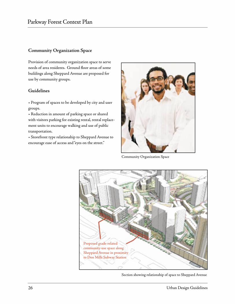
Community Organization Space
Provision of community organization space to serve needs of area residents. Ground fl oor areas of some buildings along Sheppard Avenue are proposed for use by community groups.
Guidelines
• Program of spaces to be developed by city and user groups.• Reduction in amount of parking space or shared with visitors parking for existing rental, rental replace-ment units to encourage walking and use of public transportation.• Storefront type relationship to Sheppard Avenue to encourage ease of access and “eyes on the street.”
Community Organization Space
Section showing relationship of space to Sheppard Avenue
Proposed grade-relatedcommunity-use space along Sheppard Avenue in proximityto Don Mills Subway Station

Parkway Forest Context Plan
Urban Design Guidelines 27
3.6 Commercial
Existing Commercial
An existing plaza at Parkway Forrest provides com-mercial goods and services to area residents. Fairview Mall, south of Sheppard Avenue is a large regional shopping centre with a range of stores, office towers providing services and a public library.
Proposed Commercial
Owing to the large amount of commercial space al-ready available in the area a small retail component is proposed at the northwest corner of the site, adjacent to the existing subway.
Guidelines
• Small retail stores of the type usually found in high pedestrian traffic nodes.• Type of commercial stores not requiring specific parking to be used by area residents and subway users.• Commercial type uses, such as restaurants to en-hance outdoor public courtyards.• Canopy overhangs along retail and commercial frontages on streets and publicly accessible open space.• Minimum canopy overhang 3m.
Existing view of Fairview Mall
View of service retail supporting a high pedestrian traffic node
Existing commercial plaza at Parkway Forest

Parkway Forest Context Plan
Urban Design Guidelines28
Parking Areas
A large proportion of existing parking spaces are located at grade. Th ese areas displaced by proposed new buildings will be relocated below grade.
Guidelines
• Most new parking and rental replacement parking proposed below grade. • Wider driveways to permit parallel parking.• Integrate above grade parking into the site design in a manner that minimizes its impact. Screeen parking from streets with planting.
Servicing
Many existing loading areas are insuffi cient. New Rental Replacement buildings to be linked to existing rental buildings below grade parking.
Guidelines
• Improved truck loading areas for existing and new buildings. Rental Replacement buildings should share loading facilities where possible and is subject to review by the city.
• Proposed ramps for new buildings to fall mostly within building envelope, wherever practical, and screened wtih planting when outside building.
• Existing ramps to remain where possible with inte-gration into site and lanscape design.
Existing service area at Parkway Forest
Existing grade related parking at Parkway Forest
Shared ramps between existing and new rental replacement buildings leave more landscaped open space at grade.
Shared ramps for new and existing rental buildings
3.7 Parking Areas and Servicing

Parkway Forest Context Plan
Urban Design Guidelines 29
3.8 Traffic Infiltration
Much community discussion revolved around reduc-tion of through traffic from adjacent arterial streets through the neighbourhood .
Guidelines
Through traffic may be reduced by the following measures:• Improvement to arterial routes such as the introduc-tion of a double left turn at Don Mills and Sheppard Ave.• Traffic signalization, signage and slowing down the traffic through urban design measures: introduction of crosswalks connecting neighhbourhood pathways and on street parking, increasing visual interest of routes with buildings and trees flanking streets.
Landscaped median of the type proposed on Sheppard Avenue at the intersection of Don Mills Road
Creation of safe pedestrian crosswalks
Parkway Forest Context Plan
Urban Design Guidelines30
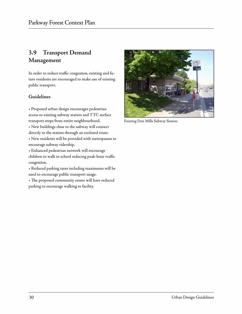
In order to reduce traffic congestion, existing and fu-ture residents are encouraged to make use of existing public transport.
Guidelines
• Proposed urban design encourages pedestrian access to existing subway station and TTC surface transport stops from entire neighbourhood.• New buildings close to the subway will connect directly to the station through an enclosed route.• New residents will be provided with metropasses to encourage subway ridership.• Enhanced pedestrian network will encourage children to walk to school reducing peak-hour traffic congestion.• Reduced parking rates including maximums will be used to encourage public transport usage.• The proposed community centre will have reduced parking to encourage walking to facility.
Existing Don Mills Subway Station
3.9 Transport Demand Management

Parkway Forest Context Plan
Urban Design Guidelines 31
3.10 Phasing and Implementation
• The context plan provides a framework for a range of development options to ensure Secondary Plan policies can be achieved in this area.• To be developed through Zoning By-Law Amend-ment and Official Plan Amendment.• Development to be phased