parking assessment studybond parking assessment study, rye, nh 2-1 section 2 introduction the...
TRANSCRIPT

Town of Rye Ocean Boulevard Corridor
Parking Assessment Study Prepared For: Town of Rye Rye, New Hampshire January 5, 2015

Table of Contents Tighe&Bond
i
Executive Summary
1 Executive Summary
1.1 Suggested Next Steps ................................................................... 1-1
2 Introduction
3 Findings
4 Existing Conditions Assessment 4.1 State Parking Facilities .................................................................. 4-1
4.1.1 Jenness State Beach Parking Lot ........................................... 4-8 4.1.2 Rye Harbor State Parking Lot ............................................... 4-8 4.1.3 Wallis Sands State Beach Parking Lot .................................... 4-8 4.1.4 Ordiorne State Park (Seacoast Science Center Parking Lot) ...... 4-8 4.1.5 Odiorne State Park Parking Lot (Boat Launch Area) ................. 4-9
4.2 Residents Only Permit Parking Areas ............................................... 4-9 4.2.1 Sawyer Beach .................................................................... 4-9 4.2.2 Cable Road Extension .......................................................... 4-9 4.2.3 Jenness Avenue Extension ................................................... 4-9 4.2.4 Atlantic Avenue Extension .................................................. 4-10 4.2.5 Wallis Road Extension ....................................................... 4-10 4.2.6 Wallis Road ...................................................................... 4-10 4.2.7 Beach Access Opposite Petey’s Summertime Seafood Restaurant4-10
4.3 Non-Resident Parking Areas ......................................................... 4-10 4.4 Private Parking........................................................................... 4-10
4.4.1 Private Perkins Road Parking Lot ......................................... 4-11 4.4.2 Carriage House ................................................................ 4-11
5 Parking Observations 5.1 Ocean Boulevard at Sawyer’s Beach ................................................ 5-1 5.2 Ocean Boulevard between Perkins Road and Harbor Avenue ............... 5-1 5.3 Ocean Boulevard between Harbor Road and Rye Harbor State Park ..... 5-3 5.4 Ocean Boulevard between Rye Harbor State Park and Washington Road5-3 5.5 Ocean Boulevard between Washington Road and Highland Park Avenue 5-3 5.6 Ocean Boulevard between Highland Park Avenue and Wallis Road ....... 5-3 5.7 Ocean Boulevard between Wallis Road and Old Ocean Boulevard ......... 5-3 5.8 Ocean Boulevard between Old Ocean Boulevard and Fairhill Avenue .... 5-3 5.9 Ocean Boulevard between Fairhill Avenue and Pulpit Rock Road .......... 5-4 5.10 Ocean Boulevard between Pulpit Rock Road and Odiorne Point State Park5-4 5.11 Parking Demand ........................................................................... 5-4
5.11.1 State Maintained Parking Areas ............................................ 5-4 5.11.2 Resident Only Parking Areas ................................................ 5-4

Table of Contents Tighe&Bond
ii
5.11.3 Non-Resident Parking Areas ................................................. 5-5 5.11.4 Private Parking ................................................................... 5-6
6 Safety and Signage Observations 6.1 Limited Sight Distance .................................................................. 6-1 6.2 Multi-Modal Conflicts ..................................................................... 6-1 6.3 Unauthorized Signage ................................................................... 6-1 6.4 No Parking Signage ...................................................................... 6-2 6.5 Parking By Permit Only Signage ..................................................... 6-2 6.6 Damaged or Missing Signage ......................................................... 6-2 6.7 Police Department Data ................................................................. 6-2
7 Parking Alternatives and Financial Analysis 7.1 Do Nothing Alternative .................................................................. 7-6 7.2 Minor Revisions to Parking ............................................................. 7-6
7.2.1 Sight Distance Enhancements .............................................. 7-6 7.2.2 Removal of Unauthorized Traffic Control Devices ..................... 7-6 7.2.3 Pavement Markings to Identify On-Street Parking ................... 7-7 7.2.4 Figure 3B-21 from MUTCD Manual, 2009 ................................ 7-7
7.3 Eliminate Parking along Ocean Boulevard ......................................... 7-8 7.3.1 East Side of the Congested Ocean Boulevard Area ................... 7-8 7.3.2 Both Sides of the Congested Ocean Boulevard Area ................. 7-8
7.4 Create Remote Seasonal Parking Lots .............................................. 7-8 7.5 Metered Parking ........................................................................... 7-9
J:\R\R0294 Town of Rye, NH - Parking Study RFP\REPORT\DRAFT Parking Assessment Study 100914.docx

Tighe&Bond
Parking Assessment Study, Rye, NH 1-1
Section 1 Executive Summary The seacoast is a popular summer destination, with the Ocean Boulevard (Route 1A) corridor in the Town of Rye an attractive destination for residents and visitors. This corridor is heavily traveled by vehicles and bicycles, visiting the beaches and observing the coast. The Ocean Boulevard corridor is a mixture of residential and commercial uses, with a number of popular state parks located along this corridor.
The limited width of the corridor, with no sidewalks or bicycle paths compounded with the multiple residential and commercial driveways, creates potential safety conflicts.
The seasonal popularity of the beaches results in a parking demand that exceeds the available supply. This scenario is not unique and is typical of summer vacation areas, depending on the day (i.e., weekend versus weekday) and weather condition. While the seasonal impact to residents can be disruptive, we have noted that there is an adequate “resident only” parking supply along the corridor.
Although this study focused on parking along the Ocean Boulevard corridor, we noted signage and striping inconsistencies that appear to have evolved over the years in response to parking demands. Also, a number of signs have been added to the corridor that were neither installed nor approved by the Town of Rye. We recommend the town conduct a comprehensive assessment of all signage and striping along the corridor to ensure signage and striping are in accordance with the latest standards and approved by the town and New Hampshire Department of Transportation (NHDOT).
In this study, we have provided our observations for the town’s consideration regarding adjusting parking along the corridor. To provide proper sight distances, we have recommended eliminating parking adjacent to roadway intersections and near intersections with residential and commercial driveways. In the congested areas along the Jenness State Beach and Pirates Cove area, we have also suggested that designated parking spaces could be striped to eliminate confusion on where parking is allowed in proximity to the roadway and driveway intersections. Other options provided include removal of parking along the more congested sections of Ocean Boulevard.
We recognize the Town of Rye’s commitment in maintaining beach access for residents as well as for visitors. Some of our recommendations involve the elimination of visitor parking spaces. Removal of parking spaces will create an even bigger need for areas for vehicles to park. As part of this study, we also looked at town-owned property to potentially provide seasonal parking.
Finally, we conducted an initial assessment for the feasibility of installing parking kiosks along the corridor to control parking and generate revenue in support of the additional costs that the summer demands place upon the town due to the popularity of the beaches. Our initial conclusion is that the introduction of parking kiosks would result in positive revenue for the town during the summer season.
1.1 Suggested Next Steps This parking study identified a number of recommended improvements to the Ocean Boulevard corridor that Rye should consider completing in the coming years. Below is a

Section 1 Executive Summary Tighe&Bond
Parking Inventory Assessment - Ocean Boulevard, Rye, NH 1-2
list of potential action items, in no order of priority, that the town should consider prioritizing and budgeting for.
Include with 2015 beach stickers a map that shows the Resident Only Parking areas. This would be beneficial to residents looking for beach access parking.
Send a letter to NHDOT regarding keeping vegetation cleared along shoulders so signage and site distances are not blocked. If vegetation is cleared it will allow bicyclists to use the paved shoulders and stay out of travel lanes.
Prepare an overall proposed parking striping plan for the Wallis Sands, Pirates Cove and Jenness Beach areas. This plan would include MUTCD recommended parking stall lengths, widths and clearances to driveways and crosswalks. This initial plan could be completed at the “GIS level” in order to provide the town a preliminary number of total parking spaces that would be created and spaces “lost” due to the formal striping.
Perform a sign inventory of all signage along the Ocean Boulevard Corridor. Remove all unauthorized and non-conforming signage. Prepare a formal plan to replace and or/add signage in accordance with the latest state regulations. The plan should include recommendations on standardizing signage along the corridor and signage for Resident Parking Only areas.
Retain an experienced Real Estate Broker/Consulting Firm to identify privately owned properties along the Ocean Boulevard Corridor that could be obtained to create a seasonal lot operated by the Town of Rye. The lot would be sized to account for the spaces lost due to the more formal striping.
Meet with the State of NH to obtain more detail on the state’s metered parking system including occupancy of metered spaces, yearly operating costs and enforcement costs. This would provide valuable information to the town to determine if seasonal metered spaces would provide the needed revenue to offset the initial and yearly operating costs and enforcement costs.
Meet with State of New Hampshire, NHDOT and Rockingham County representatives to update them on outcome of this parking study and planned work to keep communications open among all parties.
Meet with Hampton representatives to discuss operations and revenues of town owned seasonal parking lots.
Meet with COAST officials and/or City of Portsmouth representatives to discuss the costs associated with operating a seasonal beach shuttle service. There are also a number of Cape Cod communities that could be contacted regarding this matter.

Tighe&Bond
Parking Assessment Study, Rye, NH 2-1
Section 2 Introduction The 18-mile stretch of the New Hampshire seacoast is a popular tourist destination during the summer months due to the beach areas along the Ocean Boulevard (Route 1A) corridor, such as Jenness State Beach, Rye Harbor State Park, and Wallis Sands State Beach. Warm summer weekend days result in heavy parking demands along the Ocean Boulevard corridor and attract cyclists and joggers to the area. With the high demand for parking and the presence of multi-modal transportation along the Ocean Boulevard corridor, concerns have been raised over parking and safety in the area which include:
Limited number of beach parking spaces available for residents,
Inconsistent signage to identify where vehicles can park and where parking is restricted,
Limited sight distances at intersections and driveways due to on-street parking,
Providing crosswalks with proper sight distance along Ocean Boulevard,
Preliminary analysis of the feasibility of installing parking meters, and
Conflicts between motorists, cyclists, pedestrians, and residents.
Tighe & Bond, Inc. (Tighe & Bond) has prepared this Parking Assessment Study to evaluate and provide recommendations to address the issues raised above.
Our study area consisted of Ocean Boulevard between the North Hampton Town Line and Odiorne State Park. Over the 2-month period of July and August 2014, we conducted numerous field visits to observe parking demands. These observations included peak summer weekends and weekdays. Figure 1 shows an aerial image of the Ocean Boulevard study area.

ODIORNE POINTSTATE PARK
WALLIS SANDSSTATE PARK
PETEY'SSEAFOOD & BAR
WASH
ING
TO
N R
OAD
WALLIS
RO
AD
OCEAN BOULEVARD(ROUTE 1A)
PO
LLO
CK D
RIV
E
MATCH
LIN
E
RYE
NO
RTH
HAM
PTO
N
JENNESSBEACH
FOSSBEACH
RYEHARBOR
RYEHARBOR
STATE PARK
RAY'SSEAFOOD
RESTAURANT
PRIVATEBEACH
PARKING LOT
CEN
TRAL
RO
AD
SOUTH
ROAD
OCEAN BOULEVARD
(ROUTE 1A)
CABLE
RO
AD
WASH
ING
TO
N R
OAD
PERKIN
S R
OAD
HARBO
R ROAD
LOCK
E RO
AD
OCEAN BOULEVARD
(ROUTE 1A)
MATCH
LIN
E
R-0
29
4_
Ro
ad
s_
wit
h A
eri
als
.dw
gD
ate
Plo
tte
d:
Se
p 1
9,
20
14
- 4
:24
pm
Plo
tte
d B
y:
BJ
L
177 Corporate DrivePortsmouth, New Hampshire 03801(603) 433-8818September 2014 R-0294_Roads.dwg
Tighe&BondConsulting Engineers
www.tighebond.com
N
00SCALE IN FEET
GRAPHIC SCALE
600' 1200'FIGURE 1: PARKING ASSESSMENT STUDY
RYE, NEW HAMPSHIRE
Tighe&Bond
Parking Assessment Study, Rye, NH 3-1
Section 3 Findings Tighe & Bond has completed this Parking Assessment Study of the Ocean Boulevard corridor during the months of July and August 2014. Our observations include:
Resident Parking: To address comments that there is insufficient beach parking available for residents, we conducted periodic observations over the 2-month period of the “resident only” designated parking areas. Overall, we noted there were spaces available within the designated “resident only” parking areas. At more popular areas (e.g., Cable Road and Wallis Road), the parking lots were generally full at peak times. The perceived lack of “resident only” parking may be due to a limited available information. Although a list of the designated areas where Beach Parking Permits are valid is provided on the town’s website (www.town.rye.nh.us/Pages/RyeNH_Selectmen/beach.pdf/beachparking.pdf), it is recommended that the town consider providing a map of the “resident only” parking areas to residents and property owners when purchasing a Beach Parking Permit. In addition, it is recommended that additional signage be posted to identify “resident only” parking. This signage should be consistent at all the “resident only” parking areas.
Visitor Parking: Not unique to the Town of Rye, the beaches are very popular destinations on warm summer days. While the tourist season is generally recognized as Memorial Day to Labor Day, the peak summer beach season occurs during the months of July and August and is very much dependent on the weather and the day of the week (i.e., weekend versus weekday). As validation, we observed large parking demands during warm summer weekends.
Public-for-Fee Parking: We noted the Perkins Road lot (behind Summer Sessions) and the Carriage House Restaurant parking lot are operated on private property and provide public parking for a fee. These two lots have capacity for approximately 150 vehicles. Although these lots provide much needed additional parking capacity, consideration should be given to delineating parking spaces so parked vehicles do not encroach into the Ocean Boulevard right-of-way. Since the added spaces create an additional need for services, consideration should be given to providing public toilets for the parking lot users.
State-for-Fee Parking: The state operates six parking lots along the Ocean Boulevard corridor, which provide parking for approximately 767 vehicles. These lots include Jenness Beach State Park, Rye Harbor, Rye Harbor State Park, Wallis Sands State Park, and Odiorne State Park.
Safety Observations: The Ocean Boulevard corridor is predominately a residential area with pockets of commercial activity. This corridor is popular for vehicles, bicycles, and pedestrians. Many people use this corridor to travel the limited New Hampshire coastline, without stopping in the Town of Rye.
Due to the lack of sidewalks and designated bicycle lanes, this congested area creates potential conflict points between vehicles, cyclists, and pedestrians. While there has been an effort to redirect bicycle traffic for the East Coast

Section 3 Findings Tighe&Bond
Parking Assessment Study, Rye, NH 3-2
Greenway off Ocean Boulevard, our observation indicated that cyclists prefer to travel along Ocean Boulevard.
There are a number of safety improvements that can be implemented to improve the safety in the corridor. We recommend the Town consider completing the following additional studies and coordinate the findings with the New Hampshire Department of Transportation (NHDOT).
Install consistent signage and pavement markings in accordance with Manual on Uniform Traffic Control Devices (MUTCD) guidelines.
Provide clear sight distances at roadway and driveway intersections per NHDOT statutes.
Provide pedestrian designated walkways and additional crosswalks.
Install pedestrian crossing signs such as In-Street Pedestrian Crossing signs (R1-6) that would be placed on Ocean Boulevard at the crosswalk locations on the centerline.
Provide clear sight lines at crosswalks by restricting on-street parking (minimum 20 foot separation per NHDOT and MUTCD standards).
Overflow Visitor Parking Impact on Residents: As part of our evaluation, we inventoried locations of where overflow parking was occurring. For the most part, we observed general compliance with the parking signage and striping as vehicles were properly in areas designated for parking, including marked “No Parking On Pavement” areas.
Metered Parking: It has been suggested that metered parking may be an option to control parking demand and generate revenue. Based on the popularity of the private-for-fee parking lots and the state metered lots, the introduction of metered parking would not be expected to significantly impact the popularity of beach parking during peak, summer months along the Ocean Boulevard corridor.
We compiled a simple analysis of the number of available unmetered parking spaces in the most congested areas with potential revenue generation for the 3-month period, offset by the capital costs to set up a metered parking system and the ongoing operational and maintenance costs. Based on our initial analysis, it appears there would be sufficient revenue generated to support seasonal metered parking. We recommend a more in-depth financial analysis be completed if town is interested in pursuing this option. Before the Town of Rye proceeds with metered parking, we recommend that a formal written agreement be established with the state that allows on-street metered parking with stipulations regarding payment structure, maintenance, and ownership.
Parking Facilities:
State Owned: A review of the existing state facilities along the Ocean Boulevard corridor revealed that the parking lots are generally built to capacity.

Section 3 Findings Tighe&Bond
Parking Assessment Study, Rye, NH 3-3
Privately Owned for Fee Parking Lots: Two private, seasonal-for-fee parking lots along the Ocean Boulevard corridor are generally full and help offset the parking demand during summer weekends. With the removal of parking spaces along the corridor to address safety concerns, the Town may want to consider allowing additional temporary seasonal-for-fee parking on private property. While the privately-owned lots provide needed parking, proper ordinances should be in place to ensure parked vehicles do not encroach into the public rights-of-way, pedestrian ways are defined and signed, and proper restroom facilities are provided.
Town Owned: There are no town-operated parking lots along the Ocean Boulevard corridor. Based on a review of tax maps and town-owned properties, three potential areas have been identified for potential seasonal overflow parking: Rye Elementary School (461 Sagamore Road), Rye Junior High School (501 Washington Road), and the undeveloped Outer Marker property. The use of any of the three properties would require proper signage to direct visitors to the locations, security measures, and a shuttle service to transport users to the various beaches. If the town considers these properties desirable, further study should be conducted to determine the viability of parking at any of these three sites.
The town may also want to consider purchasing strategically located properties and converting them to seasonal-for-fee parking lots as has been done in other communities. A financial analysis should be conducted to determine the payback period.
Crash Data: We reviewed crash data provided by the Rye Police Department for the past 3 years, and no one area or factor seemed to be dominant with the reported collisions. Based on coordination efforts with local officials, NHDOT determined that the posted 35 miles per hour speed limit is appropriate for the Ocean Boulevard corridor as observed speeds were generally higher when the beach areas were not crowded.

Tighe&Bond
Parking Assessment Study, Rye, NH 4-1
Section 4 Existing Conditions Assessment As part of this Parking Assessment Study, we inventoried existing parking facilities along Ocean Boulevard between the North Hampton Town Line and Odiorne State Park, as well as select side streets and parking areas adjacent to the corridor. This assessment included field visits over the 2-month, July and August 2014 study period. We also had discussions with Rye Police Department and Rockingham Planning Commission officials to identify past and current studies for the corridor.
State-maintained parking is found near Jenness State Beach, Rye Harbor State Park, Wallis Sands State Beach, Seacoast Science Center, and Odiorne Point State Park.
“Resident only” permit parking is located in various points along Ocean Boulevard, including: Sawyer Beach, Cable Road Extension, Atlantic Avenue Extension, Jenness Avenue Extension, and Wallis Road Extension with smaller areas specified with posted signs.
Two private-for-fee parking lots are located along the corridor on Perkins Road and at the Carriage House.
There are a number of scenic overlook areas with a one-hour parking limit along the corridor.
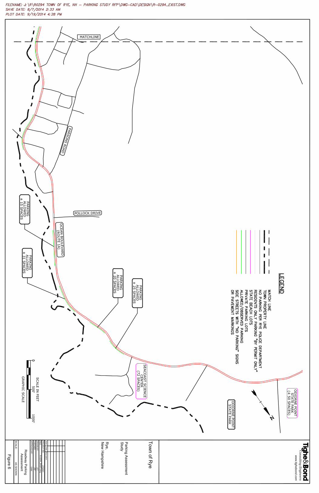
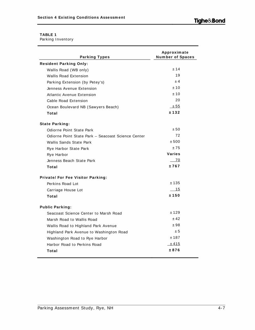
Figures 2 through 6 show these parking areas with the approximate quantity of available parking spaces as compiled from available mapping information and field verification. Each parking area is summarized in the following with a tabulated inventory provided in Table 1.
4.1 State Parking Facilities Within the limits of this Parking Assessment Study, 6 parking areas were identified as being state-operated that provide parking for approximately 767 vehicles. Jenness State Beach, Rye Harbor State Park, Rye Harbor State Marina, Wallis Sands State Beach, and Odiorne State Park charge a parking fee for usage during peak months.
We noted the seasonal Rye Harbor for fee parking lot as the sixth state-operated parking facility. Our observations indicated, however, that this parking lot provides parking only for those utilizing the various charter boat services at Rye Harbor. This lot was not included in the inventory as it would not address the congestion in the Jenness State Beach and Pirates Cove areas due to its location.


Section 4 Existing Conditions Assessment Tighe&Bond
Parking Assessment Study, Rye, NH 4-7
TABLE 1 Parking Inventory
Parking Types Approximate
Number of Spaces
Resident Parking Only: Wallis Road (WB only) ±14
Wallis Road Extension 19
Parking Extension (by Petey's) ±4
Jenness Avenue Extension ±10
Atlantic Avenue Extension ±10
Cable Road Extension 20
Ocean Boulevard NB (Sawyers Beach) ±55
Total ±132 State Parking:
Odiorne Point State Park ±50
Odiorne Point State Park – Seacoast Science Center 72
Wallis Sands State Park ±500
Rye Harbor State Park ±75
Rye Harbor Varies
Jenness Beach State Park 70
Total ±767 Private/For Fee Visitor Parking:
Perkins Road Lot ±135
Carriage House Lot 15
Total ±150 Public Parking:
Seacoast Science Center to Marsh Road ±129
Marsh Road to Wallis Road ±42
Wallis Road to Highland Park Avenue ±98
Highland Park Avenue to Washington Road ±5
Washington Road to Rye Harbor ±187
Harbor Road to Perkins Road ±415
Total ±876

Section 4 Existing Conditions Assessment Tighe&Bond
Parking Assessment Study, Rye, NH 4-8
4.1.1 Jenness State Beach Parking Lot The Jenness State Beach parking lot is paved and accommodates approximately 70 vehicles with angled parking, which includes 2 motorcycle spaces and 3 accessible parking spaces.
It is a “Pay and Display” system made via two kiosks (i.e., $2 per hour during summer months and $1 per hour in the spring and fall) between 8 AM and 12 AM from May 1st to October 1st.
This parking lot has direct access to Jenness State Beach as well as provides restroom accommodations.
4.1.2 Rye Harbor State Parking Lot Rye Harbor State Park provides a public parking lot that can accommodate approximately 75 vehicles.
A park tollbooth is manned at the entrance to collect parking fees of $4 for adults and $2 for children, which is charged on weekends only from May 4th to May 24th and then full time from May 25th to September 2nd.
Gate hours are between 8 AM and 6 PM from May 25th to June 14th, and between 8 AM and 8 PM from June 15th to September 2nd.
This parking area is a gravel lot and provides access to picnic tables and restrooms, there is no sandy beach.
4.1.3 Wallis Sands State Beach Parking Lot Wallis Sands State Beach is the largest state beach parking lot in the study area, accommodating approximately 500 vehicles, including 8 accessible parking spaces.
Reserved parking for staff and motorcycles is located along the fence at the front of the parking lot.
The parking rate is $15 per vehicle during the peak season (between May 24th and September 2nd).
A park tollbooth is manned where fees are charged on weekends only from May 4th to May 23rd and then full time from May 24th to September 2nd.
Gate hours are between 8 AM and 6 PM from May 24th to June 20th, and between 8 AM and 8 PM from June 21st to September 2nd.
This location also includes a small convenience store, restroom accommodations, a bathhouse with showers and a sandy beach.
4.1.4 Ordiorne State Park (Seacoast Science Center Parking Lot) The Seacoast Science Center is located within Odiorne Point State Park and
provides approximately 72 parking spaces within a paved lot that includes 7 accessible parking spaces.

Section 4 Existing Conditions Assessment Tighe&Bond
Parking Assessment Study, Rye, NH 4-9
The parking fees are $4 for adults and $2 for children ages 3 to 12.
A park tollbooth is manned to collect parking fees weekends between 8 AM and 6 PM from May 4th to May 24th, and full time from May 25th to September 2nd.
4.1.5 Odiorne State Park Parking Lot (Boat Launch Area) Odiorne State Park provides an additional gravel parking lot to accommodate
approximately 50 vehicles (with no designated parking spaces).
Parking fees are $4 for adults and $2 for children ages 6 to 11.
The gates are open weekends between 8 AM and 6 PM from May 4th to May 24th, and full time from May 25th to September 2nd.
This parking area provides access to a boat launch and the state park trails.
4.2 Residents Only Permit Parking Areas Town of Rye resident parking by permit is allowed in seven separate areas along Ocean Boulevard and nearby side streets in the study area. These locations include Sawyer Beach, Cable Road Extension, Jenness Avenue Extension, Atlantic Avenue Extension, Wallis Road Extension (and portion of Wallis Road), the beach access opposite Petey’s Summertime Seafood restaurant, and Old Town Way.
4.2.1 Sawyer Beach Sawyer Beach is located on Ocean Boulevard near the Ocean Boulevard intersection with Sea Road.
This area accommodates approximately 55 parallel (unmarked) parking spaces for town residents with permits only along the Ocean Boulevard northbound shoulder.
4.2.2 Cable Road Extension Cable Road Extension provides a beach access point for Cable Beach.
This area accommodates angled and parallel parking for 20 vehicles that includes 1 accessible parking space.
One marked parking space was observed to be used by two portable restrooms.
4.2.3 Jenness Avenue Extension Jenness Avenue Extension provides a beach access point (near Jenness State Beach).
This area has the ability to accommodate approximately 10 parallel parking spaces for town residents only with a permit.
Although parking spaces are not marked, signage is posted to identify permitted parking.

Section 4 Existing Conditions Assessment Tighe&Bond
Parking Assessment Study, Rye, NH 4-10
4.2.4 Atlantic Avenue Extension The Atlantic Avenue Extension is a beach access point (near Jenness State Beach).
This area has the ability to accommodate approximately 10 parallel, unmarked parking spaces for town residents with a permit.
Although parking spaces are not marked, signage is posted to identify permitted parking.
4.2.5 Wallis Road Extension The Wallis Road Extension is a beach access point for Pirates Cove.
This paved parking lot is marked to accommodate 19 angled parking spaces for town residents only with a permit, including 2 accessible parking spaces.
4.2.6 Wallis Road Wallis Road accommodates approximately 14 parallel parking spaces for town residents with a permit near Pirates Cove.
Parking is permitted along the westbound shoulder, off the pavement.
The roadway is labeled with signs prohibiting parking for those without residential permits and the pavement has “No Parking On Pavement” markings.
4.2.7 Beach Access Opposite Petey’s Summertime Seafood Restaurant The beach access opposite Petey’s Summertime Seafood restaurant (i.e., near 1314 Ocean Boulevard) accommodates approximately 4 parallel parking spaces for town residents with a permit. This extension is labeled with signs prohibiting parking for those without a residential parking permit.
4.3 Non-Resident Parking Areas Along the Ocean Boulevard corridor, signage and pavement markings are present to assist visitors in finding areas to park. Some side streets along the Ocean Boulevard corridor (e.g., Perkins Road, Baker Avenue, Cable Road, Old Beach Road, and Locke Road) allow for public parking within defined limits. One-hour parking is allowed at four Ocean Boulevard scenic turn-off areas.
4.4 Private Parking Private-for-fee parking within the study area is fairly limited. As part of our assessment, we did not include parking spaces available at commercial establishments (e.g., Sandpiper, Petey’s Summertime Seafood restaurant, Petey’s Red Roof Market, The Beach Hut, Ray’s Seafood Restaurant, etc.). In addition, we did not include private members only parking lots for the Surf Club and the Rye Beach Club.

Section 4 Existing Conditions Assessment Tighe&Bond
Parking Assessment Study, Rye, NH 4-11
4.4.1 Private Perkins Road Parking Lot Behind Dunes Motor Inn and Sandpiper Country Store, a private lot near Jenness State Beach on Perkins Road is available for public parking for $15 per day with a staff member collecting fees. This lot is an open field without designated spaces and can accommodate approximately 135 parked vehicles.
4.4.2 Carriage House For fee parking is available at the Carriage House between 8 AM and 4 PM on weekends. There are 15 spaces available.

Tighe&Bond
Parking Assessment Study, Rye, NH 5-1
Section 5 Parking Observations During the summer months, the parking demand along Ocean Boulevard and the surrounding area is weather dependent regardless of the day of the week. Although high volumes of activity can occur during nice weather on weekdays, weekends generally experience the highest volume of traffic along the Ocean Boulevard corridor with the Rye beaches as the main attraction.
The corridor has no sidewalks, designated walking routes, or bicycle lanes. The presence of parked vehicles along the corridor creates a potential safety conflict when cyclists and pedestrians travel along the corridor.
The table provided at the end of this section summarizes our field observations of the parking areas summarized in the following. During field visits throughout July and August 2014, inventories and observations during both weekdays and weekends revealed the following:
5.1 Ocean Boulevard at Sawyer’s Beach During peak hours, we observed the availability of “residents only” parking
spaces.
There appears to be sufficient width along the west side of Ocean Boulevard to add additional “resident only” parking spaces.
5.2 Ocean Boulevard between Perkins Road and Harbor Avenue
The Jenness State Beach parking lot was observed to be full during the majority of the times we conducted field visits. When Jenness State Beach lot was full, vehicles parked along the Ocean Boulevard northbound and southbound lanes up to Gray Court.
“No Parking” signs were posted in front of residential homes or on either side of the residential driveways along Ocean Boulevard. Based on discussions with local officials, the placement of these signs is not approved by town staff or Police Department officials. As part of the New Hampshire Statutes (RSA 265:14), “No person shall place any unauthorized sign, signal, marking or device which purports to be or is an imitation of or resembles an official traffic control device…” Therefore, it is strongly recommended that these signs be removed or replaced with legal signage to be authorized by the NHDOT and/or Town of Rye.

Section 5 Parking Observations Tighe&Bond
Parking Assessment Study, Rye, NH 5-2
Traffic cones were observed adjacent to residential driveways to discourage vehicles from parking (e.g., corner of Ocean Boulevard and Perkins Road and near Baker Avenue along the northbound shoulder). Based on discussions with local officials, the placement of these traffic cones is not approved by town staff or Police Department officials. Since these traffic cones are unauthorized traffic control devices (RSA 265:14), it is strongly recommended that these illegal traffic cones be removed.
The Rye Police Department placed traffic cones along the Ocean Boulevard northbound shoulder at Old Beach Road and Cable Road to discourage parking near the intersection. Based on discussions with Police Department officials, the intent of these traffic cones is to allow ample sight distances to and from the minor streets.
Vehicles were parked in the off-pavement permitted areas along Perkins Road, Baker Avenue, and Cable Road. In some cases, however, vehicles were observed to protrude onto the pavement and were issued violation tickets.
Vehicles parked along Perkins Road, Baker Avenue, Cable Road, and Old Beach in permitted areas and along Ocean Boulevard in close proximity to driveways. This event resulted in limited sight distances to and from driveways. Posted signage in this area included “No Parking” and “No Parking Between Signs.” Based on discussions with local officials, the placement of these signs is not approved by town staff nor Police Department officials. Since these traffic signs are unauthorized traffic control devices (RSA 265:14), it is strongly recommended that these signs be removed or replaced with legal signage to be authorized by the NHDOT and/or Town of Rye.
A “No Parking” sign and pavement markings are present along Locke Road westbound lane between Old Beach Road and Ocean Boulevard. No signs or pavement markings prohibiting parking are posted along Locke Road eastbound.
Vehicles parked along the Ocean Boulevard northbound and southbound shoulders past Locke Road (up to the condominium complex at 1988 Ocean Boulevard).
During weekend observations, vehicles parked along Locke Road at Ocean Boulevard in violation of the posted “No Parking” signs.

Section 5 Parking Observations Tighe&Bond
Parking Assessment Study, Rye, NH 5-3
5.3 Ocean Boulevard between Harbor Road and Rye Harbor State Park
On weekends, the gravel lot turnoff area near 1750 Ocean Boulevard was full with parked vehicles for people using the boat launch and participating in stand-up paddle boarding lessons.
5.4 Ocean Boulevard between Rye Harbor State Park and Washington Road
Parking is available along the length of the eastern side of Ocean Boulevard from Rye Harbor State Park to Washington Road for access to Foss Beach.
Parking along Washington Road westbound is permitted off pavement between Ocean Boulevard and Winslow Way.
5.5 Ocean Boulevard between Washington Road and Highland Park Avenue
One-hour parking is permitted along the scenic pull off areas along the Ocean Boulevard northbound lane.
“No Parking” signs are posted along Ocean Boulevard southbound within this area.
5.6 Ocean Boulevard between Highland Park Avenue and Wallis Road
A “No Parking” sign is posted along Ocean Boulevard northbound near Concord Point. During observations, however, vehicles parked between Highland Park Avenue and the bridge prior to Petey’s Summertime Seafood restaurant.
Vehicles were observed parking along the Ocean Boulevard southbound shoulder between Petey’s Summertime Seafood restaurant and Wallis Road.
5.7 Ocean Boulevard between Wallis Road and Old Ocean Boulevard
During the weekend observations, the permitted parking area along the Ocean Boulevard southbound shoulder was vacant.
5.8 Ocean Boulevard between Old Ocean Boulevard and Fairhill Avenue
“No Parking” signs are posted along Ocean Boulevard northbound and southbound.
Beach visitors within this area can park at Wallis Sands State Park.

Section 5 Parking Observations Tighe&Bond
Parking Assessment Study, Rye, NH 5-4
5.9 Ocean Boulevard between Fairhill Avenue and Pulpit Rock Road
“One Hour Parking” signs are posted in the scenic pull off areas along the Ocean Boulevard northbound lane.
There are “No Parking” signs posted along Ocean Boulevard southbound.
5.10 Ocean Boulevard between Pulpit Rock Road and Odiorne Point State Park
“No Parking” signs are posted along Ocean Boulevard northbound and southbound.
5.11 Parking Demand
5.11.1 State Maintained Parking Areas Within the Ocean Boulevard study area, there are 5 state-operated parking areas that provide parking for approximately 767 vehicles (i.e., Jenness State Beach, Rye Harbor State Park, Wallis Sands State Beach, the Seacoast Science Center, and Odiorne State Park).
Jenness State Beach (±70 spaces) was found to be between 70-80% occupied on weekdays and 100% full on a Saturday in July.
Rye Harbor State Park (±75 spaces) was found to be 25% occupied on weekdays and 50% full on a Saturday in July.
Wallis Sands State Beach (±500 spaces) was found to be between 25-50% occupied on weekdays and 95% full on a Saturday in July.
Seacoast Science Center (±72 spaces)-no occupancy data available.
Odiorne State Park (±50 spaces) was found to be between 10-25% occupied on weekdays and 90% full on a Saturday in July.
5.11.2 Resident Only Parking Areas Sawyer Beach (±55 spaces) was found to be between 25-50% occupied on
weekdays and 60% full on a Saturday in July.
Cable Road Extension (±20 spaces) was found to be 10% occupied on weekdays and 20% full on a Saturday in July.
Jenness Avenue Extension (±10 spaces) was found to be 10% occupied on weekdays and 70% full on a Saturday in July.
Atlantic Avenue Extension (±10 spaces) was found to be 10% occupied on weekdays and 15% full on a Saturday in July.

Section 5 Parking Observations Tighe&Bond
Parking Assessment Study, Rye, NH 5-5
Wallis Road Extension (±19 spaces) was found to be between 5-20% occupied on weekdays and 100% full on a Saturday in July.
Wallis Road (±14 spaces) was found to be between 10-20% occupied on weekdays and 70% full on a Saturday in July.
The beach access opposite Petey’s Summertime Seafood restaurant (±4 spaces) was found to be 25% occupied on weekdays and 50% occupied on a Saturday in July.
5.11.3 Non-Resident Parking Areas Along the Ocean Boulevard corridor, signage and pavement markings are present to assist visitors in finding areas to park. Some side streets along the Ocean Boulevard corridor (e.g., Perkins Road, Baker Avenue, Cable Road, Old Beach Road, and Locke Road) allow for public parking within defined limits. One-hour parking is allowed at four Ocean Boulevard scenic turn-off areas.
Four Ocean Boulevard northbound scenic turn-off areas beyond Wallis Sands State Beach (±84 spaces) were found to be between 10-20% occupied on weekdays and 15-80% full on a Saturday in July.
The four one hour parking areas along Ocean Boulevard northbound (±45 spaces) were found to be between 25-75% occupied on weekdays and 90% full on a Saturday in July.
Ocean Boulevard southbound between Old Ocean Boulevard and Wallis Road (±42 spaces) was found to be between 50-75% occupied on weekdays and 95% occupied on a Saturday in July.
Ocean Boulevard southbound between Wallis Road and Petey’s Summertime Seafood restaurant (±50 spaces) was found to be between 25-50% occupied on weekdays and 100% occupied on a Saturday in July.
Ocean Boulevard northbound in the vicinity of Petey’s Summertime Seafood restaurant (±6 spaces) was found to be between 20-50% occupied on weekdays and 80% occupied on a Saturday in July.
Ocean Boulevard northbound between the Bridge and Petey’s Summertime Seafood restaurant (±20 spaces) was found to be 25% occupied on weekdays and 10% occupied on a Saturday in July.
Four Ocean Boulevard northbound scenic turn-off areas beyond Rye Harbor State Park (±22 spaces) were found to be between 0-10% occupied on weekdays and 70% full on a Saturday in July.
Ocean Boulevard northbound between Washington Road and Washington Way (±5 spaces) was found to be between 0-20% occupied on weekdays and 50% occupied on a Saturday in July.
Ocean Boulevard northbound between Washington Way and Ray’s Seafood restaurant (±187 spaces) was found to be between 20-75% occupied on weekdays and 85% occupied on a Saturday in July.

Section 5 Parking Observations Tighe&Bond
Parking Assessment Study, Rye, NH 5-6
Ocean Boulevard between Cable Road and the condominium complex at 1988 Ocean Boulevard (±370 spaces) was found to be between 80-90% occupied on weekdays and 95% full on a Saturday in July.
Old Beach Road (±45 spaces) was found to be between 20-50% occupied on weekdays and 90% full on a Saturday in July.
Cable Road eastbound (±5 spaces) was found to be between 0-75% occupied on weekdays and 75% full on Saturdays in July.
Ocean Boulevard northbound from Cable Road to Jenness State Beach (±45 spaces) was found to be between 25-80% occupied on weekdays and 90% full on a Saturday in July.
Ocean Boulevard southbound from Myrica Avenue to Baker Avenue (±46 spaces) was found to be between 0-90% occupied on weekdays and 90% full on a Saturday in July.
5.11.4 Private Parking Private-for-fee parking within the study area is fairly limited. As part of our assessment, we observed private parking areas at the private lot near Jenness State Beach on Perkins Road (behind Dunes Motor Inn and Sandpiper Country Store) and at the Carriage House.
The private Perkins Road parking lot (±135 spaces) was found to be 0% occupied on weekdays and 90% occupied on a Saturday in July.
The Carriage House lot (±15 spaces) was found to be 100% occupied on a Saturday in July.

Section 5 Parking Observations Tighe&Bond
Parking Assessment Study, Rye, NH 5-7
TABLE 2 Inventory of Parking Occupancy/Frequency
Field Observations
(±% Occupied)
Location of Parking Type of Parking
No. of Spaces Signage 7/22 7/24 7/26
Odiorne Point State Park State ± 50 None 10 25 90
Seacoast Science Center State 72 None N/A N/A N/A
NB Turn-off #1 Public ± 22 1-hour 20 10 80
NB Turn-off #2 Public ± 20 1-hour 10 10 25
NB Turn-off #3 Public ± 30 1-hour 10 10 50
NB Turn-off # 4 Public ± 12 1-hour 20 10 15
Ocean Blvd NB 1-Hr Parking (4 Turn-offs) Public ± 45 1-hour 75 25 90
Wallis Sands State Park State 500 None 50 25 95
SB Old Ocean Blvd to Wallis Rd Public ± 42 No Parking Between Signs 50 75 95
Wallis Rd (WB only) Resident ± 14 By Permit Only 10 20 70
Wallis Rd Ext. Resident 19 By Permit Only 20 5 100
Ocean Blvd (SB from Wallis to Petey's) Public ± 50 None 25 50 100
Ocean Blvd (NB in front of Petey's) Public ± 6 None 20 50 80
Petey's Resident Parking Resident ± 4 Restricted Area Parallel Parking Permit Only 25 25 50
Ocean Blvd ( NB from bridge to #1353) Public ± 20 No Parking Between Signs 25 25 10
Ocean Blvd NB 1-Hr Parking (4 Turn-offs) Public ± 22 1-hour 10 0 70
NB Washington Rd to Washington Way Public ± 5 None 20 0 50
Ocean Blvd (NB from Washington to Rays) Public 187 None 75 20 85
Rye Harbor State Park State ± 75 None 20 25 50

Section 5 Parking Observations Tighe&Bond
Parking Assessment Study, Rye, NH 5-8
TABLE 2 (continued) Inventory of Parking Occupancy/Frequency
Field Observations
(±% Occupied)
Location of Parking Type of Parking
No. of Spaces Signage 7/22 7/24 7/26
Ocean Blvd (NB/SB Condos to Cable Road) Public ± 370 No Parking Between Signs 90 80 95
Old Beach Road Public ± 45 No Parking on Pavement 50 20 90
Jenness Ave Ext. Resident ± 10 Restricted Area Parallel Parking Permit Only 10 10 70
Atlantic Ave Ext. Resident ±10 Restricted Area Parallel Parking Permit Only 10 10 15
EB Cable Road Public ± 5 No Parking on Pavement 0 75 75
Cable Road Ext. Resident 20 By Permit Only 10 10 20
Ocean Blvd (NB from Cable Rd to Jenness Beach) Public ± 45 No Parking Between Signs 80 25 90
Ocean Blvd (SB from Myrica Ave to Baker Ave) Public ± 46 No Parking Between Signs 90 0 90
Perkins Road Parking Lot (for fee) Private ± 135 None 0 0 90
Carriage House Private 15 None 0 0 100
Jenness Beach State Park State 70 None 80 70 100
Ocean Blvd NB (Sawyers Beach) Resident ±55 Restricted Area Parallel Parking Permit Only 50 25 60
Rye Beach Club Private 37 Member Parking Only 75 15 95
Totals No. of Spaces
State Parking 767 Resident Permit Parking 132 Non-Resident Parking 927 Private Parking 187

Tighe&Bond
Parking Assessment Study, Rye, NH 6-1
Section 6 Safety and Signage Observations During the initial stages of this Parking Assessment Study, we were made aware of safety concerns expressed by residents and town staff regarding conflicts between motorists, cyclists, pedestrians, and residents in the study area. Based on this knowledge, we offer the following observations and recommendations.
6.1 Limited Sight Distance The study area is predominately residential properties with pockets of commercial uses. Parking in proximity to the multiple driveways and town road intersections is a concern due to limited sight distances for vehicles entering Ocean Boulevard from side streets and residential driveways.
We recommend a study be conducted along the Ocean Boulevard corridor to include all intersecting roadways and driveways in determining whether proper sight distances are provided at each of these points.
6.2 Multi-Modal Conflicts No sidewalks or defined bicycle lanes are provided along the Ocean Boulevard corridor. There are a limited number of striped crosswalks along the corridor. Pedestrians were observed walking between parked vehicles and along Ocean Boulevard. The mix of multi-modal traffic, combined with the lack of sidewalks, designated bicycle lanes, and sidewalks during high activity periods introduces a safety concern.
Along Ocean Boulevard where high multi-modal transportation activity is greater (e.g., between Jenness State Beach and Locke Road, and between Petey’s Summertime Seafood restaurant and Highland Park Avenue to the south and Wallis Road to the north), the town may want to consider restricting on-street parking along one or both sides to create designated walking or biking routes to reduce conflicts.
6.3 Unauthorized Signage Parking restriction signs (i.e., “No Parking” and “No Parking Between Signs”) are posted along Ocean Boulevard between Perkins Road and Atlantic Avenue in the vicinity of residences. Based on discussions with local officials, the placement of these signs is not approved by town staff or Police Department officials.
As previously identified but repeated here to signify the importance, the New Hampshire Statutes (RSA 265:14) maintain that, “No person shall place any unauthorized sign, signal, marking or device which purports to be or is an imitation of or resembles an official traffic control device…” Therefore, it is

Section 6 Safety and Signage Observations Tighe&Bond
Parking Assessment Study, Rye, NH 6-2
strongly recommended that these signs be removed or replaced with legal signage to be authorized by the NHDOT and/or Town of Rye. The signage prohibiting parking within this area should be inventoried and assessed. All town approved signs should be in conformance with MUTCD guidelines, and all unauthorized and/or non-conforming signs should be removed.
6.4 No Parking Signage Different parking restriction signs are provided along the Ocean Boulevard corridor (e.g., “No Parking,” “No Parking Between Signs,” “No Parking On Pavement,” “No Parking Here To Corner,” “Tow Zone, No Parking,” and “Parking By Permit Only”).
Consideration should be given to bringing consistency to the parking restriction signage to better identify allowable parking areas.
Consideration could be given to replacing the “No Parking” signs with “No Parking Here To Corner” signs in conformance with MUTCD guidelines at intersections to better identify the restricted parking areas.
6.5 Parking By Permit Only Signage Signage for “Parking By Permit Only” and “Beach Access” are not uniform in appearance or posting. Some “Parking By Permit Only” signs have been damaged or removed and have not been replaced. As a result, many of the areas allowing resident permit parking only may not be fully utilized (e.g., Jenness Avenue Extension, Atlantic Avenue Extension, and Wallis Road).
It is recommended that new signs for “Parking By Permit Only” and “Beach Access” be posted to better clarify the areas for parking by permit.
6.6 Damaged or Missing Signage We observed signage that was damaged or maybe missing along the corridor.
Signs that are damaged or removed should be replaced with signs in conformance with MUTCD guidelines.
6.7 Police Department Data Reported crashes within the Rye Police Department’s records show that the Ocean Boulevard corridor has experienced the following:
2012: 8 reported collisions of which 1 involved a pedestrian and 2 involved cyclists;
2013: 6 reported collisions of which 2 involved pedestrians;
2014: 3 reported collisions between January 1, 2014 and August 22, 2014.

Section 6 Safety and Signage Observations Tighe&Bond
Parking Assessment Study, Rye, NH 6-3
These data show that there were no fatalities or personal injuries reported within the study area during the time periods evaluated, even those incidents between vehicles and pedestrians or cyclists. With the heavy parking demand and number of vehicles traveling along the Ocean Boulevard corridor, the crash data do not indicate a significant safety concern. It appears that the on-street parking along the Ocean Boulevard corridor may help to reduce vehicle speeds, acting similar to a traffic calming device.
Parking tickets were issued by the Rye Police Department along Ocean Boulevard as follows:
2012: 1,415 total occurrences with the following violations were issued at a total fine cost of $40,366:
488 no parking
386 permit parking
140 parked on roadway
136 one-hour parking
100 other
80 wrong side of roadway
47 within 15 feet of a fire hydrant
12 in front of driveway
8 parallel parking
7 handicapped parking
6 parked on sidewalk
3 overnight parking
2 parked on crosswalk
2013: 1,507 total occurrences with the following violations were issued at a total fine cost of $46,620:
642 no parking
497 permit parking
171 parked on roadway
61 wrong side of roadway
50 other
47 one-hour parking
18 within 15 feet of a fire hydrant
7 handicapped parking

Section 6 Safety and Signage Observations Tighe&Bond
Parking Assessment Study, Rye, NH 6-4
7 in front of driveway
4 parked on sidewalk
3 overnight parking
2014 (between January 1st and October 1st): 1,370 total occurrences with the following violations were issued at a total fine cost of $42,340:
504 no parking
470 permit parking
134 parked on roadway
107 one-hour parking
66 wrong side of roadway
32 within 15 feet of a fire hydrant
21 in front of driveway
18 other
9 overnight parking
6 parallel parking
2 handicapped parking
1 parked on crosswalk
The town may want to consider raising the fine amounts to make it more of a deterrent to park illegally.

Tighe&Bond
Parking Assessment Study, Rye, NH 7-6
Section 7 Parking Alternatives and Financial Analysis The following recommended alternatives have been developed for consideration by the Town of Rye to address congestion and improve safety along the Ocean Boulevard corridor and its nearby side streets. An in-depth study would have to be completed to evaluate the benefits and detriments of each of the parking alternatives.
The parking alternatives described in the following range from minor existing parking layout revisions to eliminating all parking in some of the more congested areas along Ocean Boulevard.
For all of the parking alternatives described, we suggest that the improvements to signage stated previously in this report be completed concurrently with any parking modifications. Any proposed parking signs or pavement markings should be coordinated with NHDOT officials for review and approval for such devices proposed to be installed or removed within the state right-of-way. In addition, wayfinding signs may be considered to direct visitors and/or residents to specific parking areas for beach access.
7.1 Do Nothing Alternative For comparison purposes, a parking alternative was developed that considered maintaining current parking conditions within the Ocean Boulevard study area (i.e., a “Do Nothing” alternative). As previously described in this report, the current parking demand exceeds the supply on peak weekend days in the summer. Upon observations, however, there was adequate “resident only” parking spaces available. In addition, the “Do Nothing” alternative would not address the limited sight distances, improper and inconsistent signage, and unauthorized traffic control devices.
7.2 Minor Revisions to Parking
7.2.1 Sight Distance Enhancements As described previously in this study, parking which limits sight distances along the multiple driveway and roadway intersections, and crosswalks along the Ocean Boulevard corridor and surrounding area creates a safety concern. We recommend the town conduct a more in-depth study of sight distances at intersections and crosswalks along the corridor and develop a comprehensive plan for permanent sight distance improvements that conform to the latest design standards.
7.2.2 Removal of Unauthorized Traffic Control Devices Currently, traffic cones are located at some intersections and “No Parking” signs are posted in front of residential homes or on either side of the residential driveways along Ocean Boulevard to assist with extending available sight lines. The signage and traffic cones prohibiting parking within the study area should be inventoried and assessed. Based on the New Hampshire Statutes (RSA 265:14), unauthorized traffic control devices such as some present along the Ocean Boulevard corridor are strongly recommended to be removed or replaced with legal signage to be authorized by the NHDOT and/or Town of Rye in conformance with MUTCD guidelines.

Section 7 Parking Alternatives and Financial Analysis Tighe&Bond
Parking Assessment Study, Rye, NH 7-7
7.2.3 Pavement Markings to Identify On-Street Parking As part of this suggested study of the intersections, we also recommend that parking spaces in the congested portions of the corridor be striped (i.e., between Marsh Road and Highland Park Avenue, and between Harbor Road and Perkins Road). Striping of the allowed spaces would provide a more defined area for parking and ensure proper sight distances are maintained.
An alternative to marked parking spaces would be to stripe no parking areas within an intersection and posting appropriate signage. Do Not Block Intersection pavement markings could be striped to identify the edges of an intersection in close proximity to an area where vehicles may stop or park and impede or limit sight distances for other vehicles from entering the intersection. The pavement markings would be accompanied by “Do Not Block Intersection” signs.
7.2.4 Figure 3B-21 from MUTCD Manual, 2009

Section 7 Parking Alternatives and Financial Analysis Tighe&Bond
Parking Assessment Study, Rye, NH 7-8
7.3 Eliminate Parking along Ocean Boulevard
7.3.1 East Side of the Congested Ocean Boulevard Area In an effort to minimize the potential safety conflicts between pedestrians, cyclists, and vehicles, the Town may want to consider creating bicycle and pedestrian routes along Ocean Boulevard. To provide bicycle and pedestrian routes, the elimination of parking could be considered along the east side of Ocean Boulevard in the congested portion of the corridor (i.e., from Marsh Road to Highland Park Avenue, and from Harbor Road to Perkins Road). Segments of the Ocean Boulevard corridor provide 8 foot wide shoulders which could be considered in creating a more defined bicycling/walking route. This area may also be striped and reconfigured to provide a designated northbound bicycle route.
This option, however, would eliminate approximately 140 parking spaces which would increase the current excessive demand for spaces along the corridor at peak summer times. If this option is desired, the town should also consider creating seasonal remote parking lots to remain parking space neutral by offsetting the loss of 140 on-street parking spaces.
7.3.2 Both Sides of the Congested Ocean Boulevard Area Another option to reducing conflicts between pedestrians, cyclists, and vehicles is to eliminate all parking along Ocean Boulevard in the congested areas (i.e., from Marsh Road to Highland Park Avenue, and from Harbor Road to Perkins Road). This option would also help to alleviate the limited sight distances at driveways and roadway intersections along both sides of Ocean Boulevard.
This option, however, would eliminate approximately 555 parking spaces and would worsen the current parking shortage for visitors to the Rye beaches. The elimination of all parking in this area may also create a financial hardship for commercial establishments that rely on beach visitors. In addition, the existing on-street parking acts as a traffic calming measure and prohibiting all parking in this area may create a situation with higher vehicle traveling speeds. As with the previous option, consideration of this alternative should also include the creation of remote seasonal parking lots.
7.4 Create Remote Seasonal Parking Lots With the potential elimination of parking along the Ocean Boulevard corridor as previously outlined, the demand for parking would be high and could have the ramification of more visitors parking in residential neighborhoods that are not currently signed to regulate parking. The Town may want to consider the seasonal use of existing town lots or constructing seasonal public parking on undeveloped town properties to accommodate the redistributed demand.
We reviewed tax maps for larger parcels of land owned by the town and found three potential locations for remote parking opportunities. Further research would be required to determine the viability of these properties for seasonal parking.
1. Rye Elementary School parking lot
2. Rye Junior High School parking lot
3. Outer Marker Property

Section 7 Parking Alternatives and Financial Analysis Tighe&Bond
Parking Assessment Study, Rye, NH 7-9
Since none of these sites are in close proximity to the beaches, the seasonal lots would require some form of shuttle service, a public education campaign and wayfinding signs to direct visitors to these remote lots. In addition, a financial analysis would need to be completed in determining a parking fee to support the shuttle service. A source if additional information could be COAST or the City of Portsmouth which operates a shuttle service for downtown workers.
Another option the town may want to consider is purchasing private properties along the corridor to construct town-operated for fee seasonal parking lots. The Town of Hampton operates seasonal lots and could be consulted to determine operating costs.
7.5 Metered Parking We were requested to consider if metered parking would be beneficial to generate revenue to offset some of the additional seasonal costs to the Town of Rye from the need for additional enforcement and traffic control during the summer season. For the purposes of developing an initial ballpark estimate to determine if metering should be considered, we used the following assumptions:
Metered parking would be restricted to the congested areas of the corridor (i.e., from Marsh Road to Highland Park Avenue, and from Harbor Road to Perkins Road). For the purposes of this preliminary analysis, we have assumed 646 metered parking spaces.
The metered parking period would be between Memorial Day and Labor Day (assumed 90 days).
Parking rates of $2.00 per hour were used, which is similar to the State-maintained parking lot rates. We have assumed a cost of $16 per day with a parking period of 8 AM to 4 PM.
50% occupancy of metered spaces over the 90 day period to account for inclement weather days, undesirable beach temperature days, and weekdays. (This occupancy rate assumption should be confirmed with the state.)
Pay-and-Display kiosks would be installed seasonally, similar to those used at Jenness State Beach. We have assumed 1 kiosk for every 15 parking spaces. The number of kiosks would depend on the layout, as they are typically spaced for every 15-20 vehicles.
Installation and removal would be conducted by Public Works Staff each year.
A temporary summer employee would be hired to collect funds daily and monitor the kiosks (assumed 90 days).
The hiring of a temporary summer police officer/staff to provide enforcement of the metered spaces (assumed 90 days).
We have included additional costs for credit card fees, wireless communications fees, maintenance of kiosks, vandalism, replacement of kiosks, etc.
Based on a very preliminary analysis (see Tables 3 and 4), it appears that the installation of metered parking could generate a yearly revenue of $465,000, offset by initial startup costs of $308,000 and yearly operating and maintenance costs of $60,000.

Section 7 Parking Alternatives and Financial Analysis Tighe&Bond
Parking Assessment Study, Rye, NH 7-10
This analysis has resulted in a first year net of $97,000 and an ongoing revenue of approximately $400,000.
If the town desires to pursue this option further, a more in-depth financial and parking analysis should be completed prior to implementing a metered parking system. A good source for occupancy rates, operating costs and enforcement costs would be the State of New Hampshire. The town would need to implement parking policies and establish spending priorities for the meter revenue. The town should also formalize a parking agreement with the state.
An unintended consequence of metered spaces is that visitors may park on residential streets to avoid paying $16 per day for parking. Although revenues from the metered parking spaces and potentially increased citations could be a source for funding public improvements, the parking spillover into residential neighborhoods may worsen.

Section 7 Parking Alternatives and Financial Analysis Tighe&Bond
Parking Assessment Study, Rye, NH 7-11
TABLE 3 Potential Revenue
Location No. of Spaces
Assumed Peak Season (Days)
Assumed Parking Utilization a
Potential Revenue b
Assumed Potential Revenue
Marsh Road to Wallis Road ±42 90 50% $16.00 $30,240.00
Wallis Road to Highland Park Avenue ±98 90 50%
$70,560.00
Harbor Road to Perkins Road ±506 90 50% $364,320.00
Total ±646 $465,120.00
a Occupancy of spaces over 90-day peak season assumed to be 50% to account for poor weather and weekdays. b Assumed $2/hour for 8-hour day.

Section 7 Parking Alternatives and Financial Analysis Tighe&Bond
Parking Assessment Study, Rye, NH 7-12
TABLE 4 Approximate Operating Costs for Metered Parking
Item Frequency Of Fee Unit Cost (Approximate)
Kiosk Unit a One Time $7,000.00/each Approximate Start Up Cost $308,000.00
Seasonal Install/Removal of Kiosk Unit b Annual $10,000.00
Seasonal Labor (Collection and Enforcement) c Annual $25,000.00 Maintenance and Fees Annual $25,000.00 Approximate Total Annual Cost $60,000.00
a Assuming 646 spaces, each unit handling 15 spaces, would require 44 kiosks. b These kiosks are assumed to be removed and stored during the winter months to prevent damage.
c Fee collection is assumed to be daily by 2 temporary 90 day seasonal staff for 6 hours/day at $15/hour to collect revenue and provide enforcement.
J:\R\R0294 Town of Rye, NH - Parking Study RFP\REPORT\DRAFT Parking Assessment Study 100914.docx