paraic mckevitt architects - heritage council
TRANSCRIPT

PARAIC MCKEVITT ARCHITECTS

PARAIC MCKEVITT ARCHITECTS
THE THOLSEL GATE, CARLINGFORD CONSERVATION PLAN Address Tholsel Street / Fairgreen, Carlingford, Co. Louth Date; November 2020 Report prepared by; Paraic McKevitt MRIAI Conservation Architect (Grade 2) Paraic McKevitt Architects Oystercatcher House Carlingford Co. Louth Email: [email protected] Mobile: 087 2373399 With the assistance of; Donald Murphy MA MIAI Archaeologist Archaeological Consultancy Services Unit Ltd. Unit 21 Boyne Business Park, Greenhills, Drogheda, Co Louth Email: [email protected] Mobile: 087 9802232 With funding and further assistance by The Heritage Council and the Irish Walled Towns Network

PARAIC MCKEVITT ARCHITECTS
CONTENTS
1. INTRODUCTION 2. CORE DATA 3. SITE LOCATION 4. CONTEXT, DESCRIPTION AND ANALYSIS 5. CARTOGRAPHIC ANALYSIS 6. HISTORIC PHOTOGRAPHIC ANALYSIS 7. FUTURE USE 8. PROPOSAL DRAWINGS 9. SURVEY DRAWINGS 10. SURVEY PHOTOGRAPHS 11. NATIONAL INVENTORY OF ARCHITECTURAL HERITAGE 12. NIAH PHOTOGRAPHS 13. NATIONAL MONUMENTS SERVICE

PARAIC MCKEVITT ARCHITECTS
1.0 INTRODUCTION This Conservation Plan and Feasibility Study was commissioned by Carlingford Heritage CLG in cooperation with the Heritage Council and with funding provided by the Irish Walled Towns Network, in order to endeavour to bring this iconic building back into the public conscience by finding an appropriate use and conservation approach. This study is comprised of a written, drawn and photographic analysis and record of the fabric of The Tholsel Gate, Carlingford, Co. Louth. The building in question was a former Town Gate and Tholsel (administrative building) as described by the National Inventory of Architectural Heritage and the National Monument Service. The purpose of this study is to outline how it might be possible to carry out appropriate development works which would not affect the protected structure or any part of it and yet would allow public access and facilitate education about the building, and the walled town it guarded entry to.

PARAIC MCKEVITT ARCHITECTS
2.0 CORE DATA GENERAL PURPOSE OF ASSESSMENT; Feasibility Study to explore the possibility of future public use ADDRESS; Tholsel Street / Fairgreen, Carlingford, Co. Louth. No Eircode available. PLANNING AUTHORITY Louth County Council RECORD OF PROTECTED STRUCTURES LHS 005-012 NATIONAL INVENTORY OF ARCHITECTURAL HERITAGE REGISTER NUMBER 13825045 RATING Regional RECORD OF MONUMENTS AND SITES REGISTER NUMBER LH005-042009 STATUS Scheduled for inclusion in the next revision of the RMP AUTHOR OF REPORT Paraic McKevitt, B Arch Sc, H Dip Arch, MRIAI, Conservation Grade 2 ORGANISATION Paraic McKevitt Architects, Dundalk Street, Carlingford, Co. Louth QUALIFICATIONS OF AUTHOR
Bachelor of Architecture (Dublin University - Trinity College) Higher Diploma in Architecture (Bolton Street – Dublin Institute of Technology) Member of the Royal Institute of the Architects of Ireland Accredited in Conservation to Grade 2 (RIAI)

PARAIC MCKEVITT ARCHITECTS
3.0 SITE LOCATION

PARAIC MCKEVITT ARCHITECTS
Holy Trinity Church
Tholsel
Commissioned Artist’s impression of the original Tholsel – Heritage Centre, Carlingford
4.0 CONTEXT, DESCRIPTION AND ANALYSIS
GENERAL
Tholsel is a name traditionally used for a local municipal or administrative building used to collect tolls and taxes and to administer trade and other documents in Irish towns and cities. It was at one stage one of the most important secular buildings in the Irish townscape. Carlingford’s Tholsel is by some distance the oldest remaining in the country (1450?) with Clonmel’s Main Guard the next oldest dating from 1675.
Their level of importance was generally reflected in the prominence of these buildings as well as the expensive materials and architectural techniques used in their construction. Carlingford’s Town Gate and Tholsel, as it may have been in medieval times, had long since been laid to ruin leaving us only able to speculate as to its former architectural appearance.
Years later, its former glory a distant memory, it was simplistically re-modelled at a time when different rules applied and when its use was no longer required. Indeed, its repair appears only to have been warranted to avoid having a ruined building adjacent to the newly complete Holy Trinity Church and Landlord’s residence.
PARAIC MCKEVITT ARCHITECTS
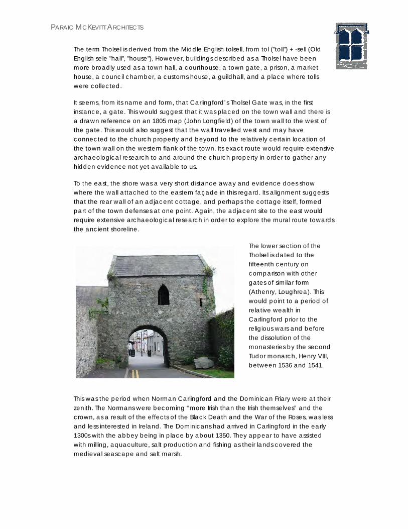
The term Tholsel is derived from the Middle English tolsell, from tol ("toll") + -sell (Old English sele "hall", "house"), However, buildings described as a Tholsel have been more broadly used as a town hall, a courthouse, a town gate, a prison, a market house, a council chamber, a customs house, a guildhall, and a place where tolls were collected.
It seems, from its name and form, that Carlingford’s Tholsel Gate was, in the first instance, a gate. This would suggest that it was placed on the town wall and there is a drawn reference on an 1805 map (John Longfield) of the town wall to the west of the gate. This would also suggest that the wall travelled west and may have connected to the church property and beyond to the relatively certain location of the town wall on the western flank of the town. Its exact route would require extensive archaeological research to and around the church property in order to gather any hidden evidence not yet available to us.
To the east, the shore was a very short distance away and evidence does show where the wall attached to the eastern façade in this regard. Its alignment suggests that the rear wall of an adjacent cottage, and perhaps the cottage itself, formed part of the town defenses at one point. Again, the adjacent site to the east would require extensive archaeological research in order to explore the mural route towards the ancient shoreline.
The lower section of the Tholsel is dated to the fifteenth century on comparison with other gates of similar form (Athenry, Loughrea). This would point to a period of relative wealth in Carlingford prior to the religious wars and before the dissolution of the monasteries by the second Tudor monarch, Henry VIII, between 1536 and 1541.
This was the period when Norman Carlingford and the Dominican Friary were at their zenith. The Normans were becoming “more Irish than the Irish themselves” and the crown, as a result of the effects of the Black Death and the War of the Roses, was less and less interested in Ireland. The Dominicans had arrived in Carlingford in the early 1300s with the abbey being in place by about 1350. They appear to have assisted with milling, aquaculture, salt production and fishing as their lands covered the medieval seascape and salt marsh.

PARAIC MCKEVITT ARCHITECTS
Their Abbey was outside the town and commanded one of the two rivers serving Carlingford with population settlement to the south of the town already based around this river. This area was a sort of Irishtown outside the walls of the Norman town. The monks would have worked in this environment to earn income for their sponsors and of course, the church in Rome.
Markets were available to this industry (Note street names; Market Square, The Fairgreen) as was access to a port, although at a cost, one suspects, at least after the Normans had settled in. This situation that may at least partly explain an economic symbiosis between the monastery-controlled production to the south of the town and the port related merchant wealth of the town itself. The role of the town gate in controlling goods and people between one and the other would have made it a sort of Checkpoint Charlie and a place for dialogue.
Carlingford probably played an important role in the North of a slowly diminishing Pale at the time and it is perhaps not surprising that this little building was then chosen to hold a parliament meeting, another whisper of the possibility of a building of significant note.
It is at this time that many of the medieval buildings in Carlingford are built including the Mint and Taaffe’s castle. It is a time of relative peace and wealth judging by the buildings we have left. It was prior to the 16th and 17th centuries which saw the Tudor expansion, the Plantations, Cromwell and the Jacobite/Williamite wars culminating in the establishment of the protestant ascendancy.
Property which once belonged to the monasteries, for the most part, filtered down through these two centuries into lands owned by the protestant ascendancy and the Church of Ireland.
The Mint, Tholsel Street

PARAIC MCKEVITT ARCHITECTS
By 1700, the Carlingford of Normans and monasteries was in ruins. The Abbey was left as a shadow of its former self and its stone used to create the new protestant estate of Ghan House owned by a Mr. Stannus. The salt marsh was drained, The Sluice gate Folly and estate walls constructed and the Church of Ireland assumed control of the ancient buildings on the hill near the southern boundary of the town where the Heritage Centre now sits. The site may have included a mix of buildings including a more ancient church or chapel and, perhaps, a mural tower, in ruins. These buildings and maybe its site along with remnants of the old wall were modified into what was to become Holy Trinity Church and its large encompassing graveyard.
The ruined stump of what was probably a fine three story town gate and Tholsel was roughly tidied up, given a new set of steps and a new roof and made look presentable, probably more because it was in front of the church than out of any great sense of caring for history.
And so, the Tholsel remained, unaltered through the 19th and 20th centuries to how we see it today, a composite of hundreds of years of one town’s fortunes. If it could speak, we would be enthralled with its stories and doubtless proud and caring of it for having survived.

PARAIC MCKEVITT ARCHITECTS
THE THOLSEL
As mentioned above, significant portions of the upper sections of the building have been rebuilt particularly in the northeast corner. The rebuilt masonry was capped with a pitched roof making the east and west elevations gabled, both capped with barge stones which closely matches the gable detail of the former Holy Trinity church adjacent. This would suggest that these works were connected and were part of the same construction phase.
These alterations were probably carried out by the Marquess of Anglesey, dating these modifications to the 1820/1840 period. The same may be said about roof and tower adjustments to the building or buildings which became Holy Trinity Church at this time. The Church of Ireland Schoolhouse was also constructed in this period.
It is probable then that the two large pointed arched windows were placed to the north and south facades at this time. Similarly, the doorway in the north façade at first floor (A), its staired access (B) and the small circular opening (C) between the door and the pointed window may also have been constructed at this time.
The first-floor doorway is linteled with particular, yellow-toned sandstone favoured at the time (A) with further similar stones laid untidily
together in the wall directly over. The small circular opening (C) referred to above uses a semi-circular lintel stone of an older window medieval window. The jamb and cill stones of this window may have been incorporated into the masonry over the first-floor entrance doorway adjacent. Indeed, there is enough of this type of stone to suggest several former windows of a similar style.
The pointed window to the southern wall has chamfered limestone jamb stones with bar-holes (at D over) on its western side. It is suggested that these might indicate that this window was, at least in part, original. The lack of any other dressed window stones points to the extent of demolition prior to remodeling.
Rebuilt Northeast corner and revised stepped entrance
A
B
C
D

PARAIC MCKEVITT ARCHITECTS
East wall
A. Collared roof trusses B. High level loop – partly
blocked up C. Corbelled soldier course
strengthening and straightening the gable
D. Garderobe E. Entrance doorway
As you enter the first-floor chamber you are greeted with a further flight of five limestone steps leading to floor proper of the chamber. The floor is nearly 3.25m above the level of the current street under and possibly 4m or more above the original ground level. The wall just to the east of the steps and the doorway is narrower at this point than the rest of the eastern wall as can be seen in the survey drawings (first floor plan). Why or how this occurred is not known but it certainly made the wall weaker and may suggest why a corbelled soldier course is laid above returning it to a wider, more robust, thickness.
There is also a loop with an internal splay in this eastern wall at the top of this flight of steps looking seaward. Also pointing seaward, and very possibly evacuating onto the shore at one point is a garderobe chute (or a toilet facility to non-archaeologists) perfectly positioned for seated comfort. It would appear to have been a separate little chamber with its own loop facing south and shaped with a curved wall and semi-circular alcove for the seat. Sunlight pours through it during the day which must have made the call of nature an enjoyable experience! Why wouldn’t you have a parliamentary gathering with such state-of-the-art facilities.
A
B
C
D
E

PARAIC MCKEVITT ARCHITECTS
The Garderobe with a semi-circular alcove for the seat and south facing loop in a gently curved wall on the right hand side
The internal splays of the loop have ship designs scraped into the plaster of eighteenth or early nineteenth century origin. There is evidence of a low stone ceiling above it.
The west wall has three notable details. In the northwest corner there is a small rectangular cupboard (A) and a loop window to the south west (B). This is the most architecturally composed loop given the splays and stepped cill stones. At high level there is another larger internally splayed window which has been partly blocked up (C). This is one area where judicious removal of the blocking stones would restore the window to its original design intent. As it is west facing it would also allow more light, and sun-light, to fill the chamber.
C
A B

PARAIC MCKEVITT ARCHITECTS
A similar ‘sister’ high level window is located in the opposite east wall. It is also partly blocked up and may also be restored for similar reasons.
The roof is a cut timber structure with collar ties giving a raised ceiling height, Slates are fixed to battens and parged to the underside with the gables finished with barge stones similar to Holy Trinity Church. A lot of the parging remains and the slates do not show evidence of slippage or nail rot. It is none the less at a point in its life where closer investigation may inform the need to re-slate so as to secure the roof for the foreseeable future.
The ground floor consists of a barrel-vaulted passage with a small rectangular chamber to the east side which is entered from the north with a flat arched doorway. There is tentative evidence that part of the south wall of the chamber was adjusted and may have also opened out onto the Fairgreen side. There is no evidence of an original stair on ground floor prompting the suggestion that access to the upper floor was from the wall-walk of the town wall originally.
There is tentative evidence of a spiral staircase in the northeast corner at first floor but this would not have extended to the ground level. Certainly, the level of the adjacent church property is at the correct level to support this position.

PARAIC MCKEVITT ARCHITECTS
5.0 CARTOGRAPHIC ANALYSIS Maps are all copied from the Irish Historic Towns Atlas No.23 - Carlingford 1568 - ROBERT LYTHE Part of map of Cooley (The National Archives: Public Record Office)
Possibly the Tholsel but may also be building/s on the site of the current Ghan House. No town wall shown.
“King John’s” Castle
“Taaffe’s” Castle ?
Salt Marsh / Seascape
Current Heritage Centre given tower noted to the west of the building. Noted as a church here given the crucifix symbol used to the top of the tower.
Abbey building with central tower
A remarkably well drawn map with important buildings shown in some detail. The medieval seascape and salt marsh to the south west of the town is shown along with a lot of detail in the surrounding area. This map was created during the early years of the reign of Elizabeth I and three years after Sir Walter Raleigh brings back potatoes and tobacco from the New World. These are the years preceding the first Desmond rebellion signalling the beginnings of anti-Catholic English governance.
PARAIC MCKEVITT ARCHITECTS
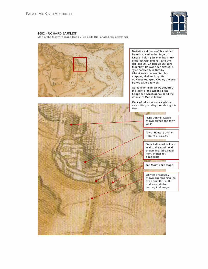
1602 - RICHARD BARTLETT Map of the Moyry Pass and Cooley Peninsula (National Library of Ireland)
Gate indicated in Town Wall to the south. Wall shown as a substantial item. Tholsel not discernible
“King John’s” Castle shown outside the town walls
Tower House, possibly “Taaffe’s” Castle?
Salt Marsh / Seascape
Only one roadway shown approaching the town from the south and seems to be leading to Grange
Bartlett was from Norfolk and had been involved in the Siege of Kinsale, holding junior military rank under Sir John Brockett and the lord deputy, Charles Blount, Lord Mountjoy. He was decapitated in Tyrconnell early in 1603 by inhabitants who resented his mapping their territory. He obviously escaped Cooley the year before alive and well!
At the time this map was created, the Flight of the Earls had just happened which announced the demise of Gaelic Ireland.
Carlingford was increasingly used as a military landing port during this time.

PARAIC MCKEVITT ARCHITECTS
1624 - NICHOLAS PYNNAR Map of Carlingford Lough (British Library)
Town walls clearly shown
Carlingford Lough
Bastion?
Abbey
Church on the coast
Irish Sea
Perhaps Holy Trinity Church (Heritage Centre) or Taaffe’s Castle?
Town Gate? May be the Tholsel and seems to indicate a tall, multi storied, parapeted
structure
“Taaffe’s” Castle perhaps? It is not shown on the shore which might mean that this represents a different castle of unknown location or perhaps the “Mint”
King John’s Castle or perhaps the Castle that was/is situated at the foot of Castle Hill?
In 1618 Captain Nicholas Pynnar was issued with a commission to carry out a new survey to map the progress of the Ulster Plantation.
His map of Carlingford is unclear in some regards, for example the castle appears not to have been illustrated, or if it was it is shown as being of lesser importance. The streetscape is also difficult to interpret.
A town gate is shown however and is located to the south (left hand side) near to the Abbey which is shown, as was normal, outside the town walls. The Town walls look to be substantial with a curious bastion shaped battlement on the shore to the south (left hand side).
PARAIC MCKEVITT ARCHITECTS
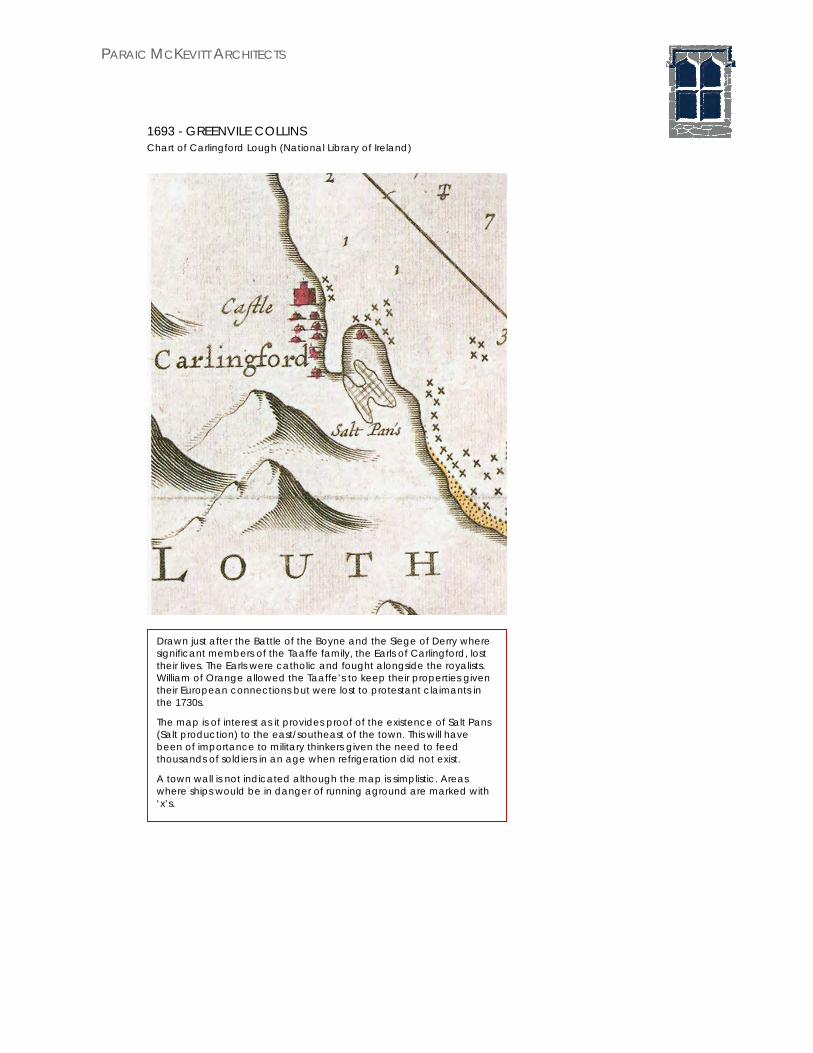
1693 - GREENVILE COLLINS Chart of Carlingford Lough (National Library of Ireland)
Drawn just after the Battle of the Boyne and the Siege of Derry where significant members of the Taaffe family, the Earls of Carlingford, lost their lives. The Earls were catholic and fought alongside the royalists. William of Orange allowed the Taaffe’s to keep their properties given their European connections but were lost to protestant claimants in the 1730s.
The map is of interest as it provides proof of the existence of Salt Pans (Salt production) to the east/southeast of the town. This will have been of importance to military thinkers given the need to feed thousands of soldiers in an age when refrigeration did not exist.
A town wall is not indicated although the map is simplistic. Areas where ships would be in danger of running aground are marked with ‘x’s.

PARAIC MCKEVITT ARCHITECTS
1766 - MATTHEW WREN Part of A Topographical Map of the County of Louth (Royal Irish Academy)
Possibly the Tholsel but may also be the Mint. It is located to the rear of the former Holy Trinity Church and at the head of a suggested street behind the shore buildings (Newry Street/ Tholsel Street)
“King John’s” Castle
“Taaffe’s” Castle (?) shown on the shore?
Former Holy Trinity Church (Heritage Centre)
Possibly the Abbey. Shown at the confluence of two roads approaching the town. The Crossalaney road is shown for the first time together with its connection to Catherine’s Grove
The medieval seascape and salt marsh is now shown as having been drained and set out as the estate of Carlingford House (now Ghan House).
Wren’s map is created during the height of the Penal years and the protestant ascendancy. The wars of the 16th and 17th centuries are over. There is no attempt to portray walled defenses and the estate of Carlingford (Ghan) house is now shown set out on lands formerly controlled by the old church. This involved the reclaiming of the low-lying salt marsh lands to the east. Ghan house is known to have been built with stone reclaimed from the Abbey and offers a further suggestion that the estate was previously in the ownership of the Dominican Friars. This would also suggest that the monks oversaw the aquaculture related to the Salt Marsh (salt production) and fishing in the lough generally.
It may be that most of the town wall was or had been removed at this time.

PARAIC MCKEVITT ARCHITECTS
1793 - D. MCCARY ‘A Map of three tenements lying in the town of Carlingford’ (Viscount de Vesci)
1805 - JOHN LONGFIELD Part of ‘A map of three lots of ground situate in the town of Carlingford’ (National Library of Ireland)
Change in pencil style may indicate rebuilt section over the archway including the roof
Tholsel
Archway shown much taller than it is now
Part of “A map of three tenements lying in the town of Carlingford… belonging to the Chancellor of Christs Church Dublin in the present tenure of Thomas James Fortesque Esq.”
This is the earliest known map/document that relates to the Tholsel specifically and outlines properties in its vicinity in the ownership of the church of Ireland.
The sketch is interesting in that it seems to show the archway being much taller than it is currently, perhaps indicating that the level of Tholsel Street was raised in this period to its current height.

PARAIC MCKEVITT ARCHITECTS
The wall connecting to the western side of the Tholsel is noted as being the Town Wall
Tholsel Street. Noted as being “formerly the Main Street but now an insignificant Back Lane”
The Tholsel
Stepped entrance to Tholsel not shown or indicated
Elsewhere on the same document Dundalk Street is noted as “formerly a Back Lane but now the Main Street of Carlingford”.

PARAIC MCKEVITT ARCHITECTS
1833 - JAMES FRAIN A map of the town of Carlingford (Viscount de Vesci)
Burgage plots continue between Tholsel Street and the former shoreline to the west
Tholsel Street
The “Mint”
Church property apparently extends to both Tholsel Street and Dundalk Street
Tholsel. Stepped access in place. Boundary alignment to the west not as per the current arrangement
Dundalk Street
Building adjacent to the Tholsel, now demolished

PARAIC MCKEVITT ARCHITECTS
1907 – Ordnance Survey map of County Louth Royal Irish Academy – Irish Historic Towns Atlas No. 23
Railway in place (1873-1876) and former shoreline landfilled
Building adjacent to the Tholsel, now demolished
Church of Ireland Schoolhouse in place – built c. 1840

PARAIC MCKEVITT ARCHITECTS
6.0 HISTORIC PHOTOGRAPHIC ANALYSIS
Laurence Collection (1875 – 1900); National Library of Ireland
Author not known (c. 1900); www.carlingfordpeople.ie
Verge parapet appears to be missing. In place currently
Lean-to roof adjacent – now demolished except for its tall rear wall (west side)

PARAIC MCKEVITT ARCHITECTS
Although nearly all of the surrounding buildings shown here have been demolished, the Tholsel itself remains is a similar state

PARAIC MCKEVITT ARCHITECTS
Mary Evans Collection (c. 1920); National Museums of Northern Ireland

PARAIC MCKEVITT ARCHITECTS
Author not known (c. 1955?); www.carlingfordpeople.ie
Southeast facing window partly blocked up.

PARAIC MCKEVITT ARCHITECTS
Irish Architectural Archive (c. mid-20th century)

PARAIC MCKEVITT ARCHITECTS
Author not known (c. 1986); www.carlingfordpeople.ie

PARAIC MCKEVITT ARCHITECTS
7.0 FUTURE USE Currently the Tholsel Gate is locked and access is not possible. Two pigeons are the only regular users these days although they do not seem to be of a mind to use the garderobe! A sycamore tree is growing steadily out of one of the walls of the 19th century staired access and a very, very mature Ivy is rampaging unchecked through all available nooks and crannies. Regrettable the adjacent owner seems unwilling to care for the Tholsel and cut the trunk in order to slowly remove the ivy to best conservation practice. The community continues to try to suggest helpful actions she could take in this regard but to no avail at the moment. As part of my survey work I did manage, with the help of some local gentlemen, to cut the trunk of the aforementioned sycamore tree and clean up pigeon guano under correct health and safety procedures. As mentioned in the introduction, the purpose of this study is to outline how it might be possible to carry out appropriate development works which would not affect the protected structure or any part of it and yet would allow public access and education about the building and its story. The following proposal are suggested. Archaeology
Coordinated archaeological investigations should be undertaken prior to any works taking place and its findings used to inform and adjust and future installations or repairs
archaeological investigations should take place to the street areas to the north and south of the Gate, in the adjacent church graveyard to the southwest and to the adjacent property to the east.
Roof
Carefully remove slates if required, check timberwork for rot and repair as necessary, re install slates and re-parge using lime mortar
Check barge stones for stability and adjust as necessary Staired Access and Doorway
Repairs required to the top of the walls using limestone and lime mortar to match
Steps to be repointed and made as level as possible Hand rail to be added to assist climbing the stairs Install a new timber door fabricated to match a medieval door
First Floor Chamber
Clean down and make good all walls and features therein in accordance with best conservation practice. Explore the possibility of localised pointing and painting using limewash.

PARAIC MCKEVITT ARCHITECTS
Clean down and, if necessary, stabilise floor area. Explore possibility of unblocking high level window loops to the east and
west wall Fit all openings with sensitively design and fitted glass screens to prevent
pigeon access and provide safety from falling Explore the possibility of lathing and plastering the ceiling, leaving a section
open in order to view the roof structure Use the unseen areas of the new attic space as well as the top of the north
and south wall for electrical installations (lighting) Install a new timber floor suspended or floating over the existing floor and
supported sensitively off stable masonry below. This new floor would have a guardrail surrounding allowing a shelf to lean on.
A small area to the east would be available for written and image related interpretation
In the centre of this area would be the principle focus of the new future use and MUST be an item of interest and significance. There is not too much space to work with. This report suggests an item similar to that used at Place Cailhau, Bordeaux, France in front of its Town Gate as being something that may fit our interpretive, artistic, child friendly and educational purposes
INSTALLATION AT PLACE DU PALAIS, BORDEAUX Place du Palais is a small, recently pedestrianized square in Bordeaux in south west France located just behind one of its more prominent Town Gates, Porte Cailhau. It is a place which was part of the Angevin Empire and one that King John, a longtime associate of Carlingford’s castle was a King. It indeed could be argued that Carlingford was at one point its most northerly outpost. Also of interest is that Diarmait Mac Murchada, when endeavouring to solicit Norman assistance had to travel to Bordeaux to meet the then King Henry II.
Porte Cailhau – Facing east to the Gironde River port
Porte Cailhau – Facing west and Place du Palais in the foreground

PARAIC MCKEVITT ARCHITECTS
In the square is a small metal table, moulded and shaped to portray part of the town of Bordeaux. Its edges are starting to become shiny with the touch of those engaged with it. A similar table showing how Carlingford was during the time the Tholsel was in its heyday. The Bordeaux piece is not an accurate scaled representation. More important buildings are larger and have a childlike quality to them. Details are enlarged to show them off in the best light. Its childlike innocence seems to encourage touch and engagement and might also offer the ability to be just a little bit fanciful. What harm?

PARAIC MCKEVITT ARCHITECTS
8.0 PROPOSAL DRAWINGS

