palestinian national authority eia final... · palestinian national authority ... 1-1. rawabi aims...
TRANSCRIPT

Palestinian National Authority Environmental Quality Authority
Environmental Impact Assessment For
The New City of Rawabi
Prepared by
Projects Unit (ANUPU) An‐Najah National University
Nablus ‐ Palestine
January 2010

List of Abbreviations
ANU An‐Najah National University ANUPU An‐Najah National University Projects Unit BOD Biochemical Oxygen Demand COD Chemical Oxygen Demand dB Dimension Decibel DST Dead Sea Transform DN Deutsche (German) Norm EA Environmental Assessments EIA Environmental Impact Assessment EMP Environmental Management Plan EMMP Environmental Management and Monitoring Plan EHS Environment Health and Safety ES Environmental Screening ESSEC Earth Sciences and Seismic Engineering Center EEM Environmental Evaluation Matrix EI Environmental Index EO Environmental Officer EQA Environmental Quality Authority GDP Gross Domestic Product GMTC Geotechnical and Material Testing Center HV High Voltage HWE House for Water and Environment IBC International Building Code IEE Initial Environmental Evaluation IFC International Finance Cooperation ISO International Organization of Standardization JDECO Jerusalem District Electricity Company JWU Jerusalem Water Undertaking LRTF Low Rate Trickling Filter ML Local Magnitude (Richter Magnitude Scale) MMS Modified Mercally Scale MoPWH Ministry of Public Works and Housing MoA Ministry of Agriculture MoJ Ministry of Justice MoL Ministry of Labor MoT Ministry of Transportation MoTA Ministry of Tourism and Antiquities MoLG Ministry of Local Government MBR Membrane Bioreactor NFPA National fire Protection Association OD Oxidation Ditch OP/BP Operational Policy/Bank Procedures OPIC Overseas Private Investment Cooperation

3
PA Palestinian Authority PCBS Palestinian Central Bureau of Statistics PEL Palestinian Environmental Law PGA Peak Ground Acceleration PHPC Palestinian Higher Planning Council PM Pest Management PMDC Palestinian Meteorological Data Center PPA Palestinian Power Authority PWA Palestinian Water Authority RMPR Rawabi Master Plan Report RDC Rawabi Development Committee TOR Terms of Reference TSS Total Suspended Solids UBC Uniform Building Code WBWD West Bank Water Department WHO World Health Organization WWTP Wastewater Treatment Plant Z Seismic Zone Factor

TABLE OF CONTENTS 1. INTRODUCTION 9 1.1 Background 9 1.2 EIA Objectives 10 1.3 EIA Scoping 10 1.4 EIA Methodology 11 1.5 Public Consultation 12 1.5.1 Palestinian Ministries and Authorities 12 1.5.2 Other Consultations 15
2. LEGAL AND INSTITUTIONAL FRAMEWORK 16 2.1 Administrative and Institutional Framework 16 2.2 Environmental Legislation and Regulations 18 2.2.1 Palestinian Environmental Law 18 2.2.2 Palestinian Environmental Assessment Policy 18 2.2.3 World Bank IFC Project Categories 20 2.2.4 World Bank Environmental and Social Safeguards Policies 21
3. PROJECT DESCRIPTION 27 3.1 Rawabi – Great Expectations 27 3.2 Project Site 29 3.3 Project Construction 30 3.4 Construction Materials 31 3.5 Life and Fire Safety Design Considerations 31 3.6 Rawabi Zoning 32 3.7 Rawabi Infrastructure and Utility Systems 33 3.7.1 Road Network 33 3.7.2 Water Supply System 34 3.7.3 Sewerage System 36 3.7.4 Solid Waste Collection and Disposal System 37 3.7.5 Power Supply System 38
3.8 Energy Efficiency Design Requirements 39 4. BASELINE ENVIRONMENTAL DATA 40 4.1 Topography 40 4.2 Climate and Weather 41 4.3 Hydro‐geological Environment 42 4.4 Surface Water 43 4.5 Soils 44 4.6 Biological Environment 45 4.6.1 Flora 45 4.6.2 Fauna 47
4.7 Historical and Archaeological Sites 47 4.8 Local Geology and Seismic site Effect 47 4.9 Geopolitical Aspects and Land Use 49
5. POTENTIAL ENVIRONMENTAL IMPACTS 51 5.1 Analysis of the Project Alternatives 51

5
5.1.1 Water Supply System 51 5.1.2 Wastewater Treatment plant 52 5.1.3 Wastewater Treatment and Reuse 53 5.1.4 Solid Waste Management 54
5.2 Environmental Impacts during Construction 56 5.2.1 General 56 5.2.2 Impacts on Noise 57 5.2.3 Impacts on Air Quality 58 5.2.4 Impacts on Agricultural Resources and Soil 58 5.2.5 Impacts on Water Drainage 59 5.2.6 Impacts on Cultural and Historical Resources 60 5.2.7 Impacts on the Socio‐Economic Conditions 60 5.2.8 Occupational Health and Safety 62
5.3 Environmental Impacts Post Development 62 5.3.1 Impacts on Air Quality 63 5.3.2 Impacts on Noise 63 5.3.3 Impacts on Socio‐Economic Conditions 64 5.3.4 Rawabi private and public transport 65
5.4 Other Environmental Impacts 66 5.4.1 Impact on vegetation 66 5.4.2 Impact on Flora and Fauna 66 5.4.3 Visual Impacts and Aesthetic 67 5.4.4 Slope Stability Impacts 67
5.5 Cumulative Impact Assessment 67 5.5.1 Cumulative Impacts on Noise 68 5.5.2 Cumulative Impacts on Groundwater 68 5.5.3 Cumulative Impacts on Soils 68 5.5.4 Cumulative Impacts on Surface Water 69 5.5.5 Cumulative Impacts on Vegetation and Wildlife 69 5.5.6 Cumulative Impacts on Aesthetics 69 5.5.7 Cumulative Impacts on Air Quality 69 5.5.8 Cumulative Impacts on Grazing 69 5.5.9 Cumulative Impacts on Hazardous Materials 70 5.5.10 Cumulative Impacts on Socio‐Economic Conditions 70 5.5.11 Cumulative Impacts on Cultural and Historical Resources 70
5.6 Environmental Evaluation Matrix 70 6. MITIGATION MEASURES 72 6.1 During Construction 72 6.2 Post Development 72 6.3 Vegetation Plan 73
7. ENVIRONMENT MANAGEMENT AND MONITORING PLAN 82 7.1 Environmental Management Framework 82 7.2 Institutional Requirements and Environmental Training 82 7.3 Management of the Wastewater Treatment Plant 83 7.4 Environmental Standards 83 7.5 Waste Disposal 84
8. CONCLUSION AND OVERALL ASSESSMENT 85

6
9. EIA REPORT PREPARERS 86 10. REFERENCES 87 11. ANNEXES 88 Annex I: Environmental Management and Monitoring Plan (During Construction) 89 Annex II: Environmental Management and Monitoring Plan (Post Construction) 95 Annex III‐A: EQA Terms of Reference (TOR) 100 Annex III‐B: Scope of Services 109 Annex IV: Sample letters between Bayti and neighborhood villages 115 Annex V: Letter sent to the Palestinian Authorities 119 Annex VI: Letter of MoT and Reply 120 Annex VII: Field Surveys 121 Annex VIII: EQA comments and ANUPU replies 126 Annex IX: Maps 137

7
LIST OF FIGURES Figure 1‐1: Geographic setting of Rawabi in the West Bank (Source: www.rawabi.ps) ........... 9 Figure 3‐1: The envisioned integrated model of Rawabi (Source: www.rawabi.ps) ............... 28 Figure 3‐2: Regional location of Rawabi (Source: www.rawabi.ps) ........................................ 29 Figure 3‐3: Site characteristics of Rawabi City ......................................................................... 29 Figure 3‐4: Rawabi and its surrounding villages (Source: RMPR) ............................................ 30 Figure 3‐5: Rawabi 1 planned road network (Source: RMPR) ................................................. 34 Figure 3‐6: Schematic of water infrastructure (Source: ANUPU) ............................................ 35 Figure 3‐7: Depiction of the location of the WWTP (Source: RMPR) ...................................... 36 Figure 4‐1: The topographic features of Rawabi (Source: ANUPU) ......................................... 40 Figure 4‐2: Surface hydrogeology of the area and the groundwater divide (Source: ANUPU)
.......................................................................................................................................... 42 Figure 4‐3: Vulnerability Map of Ramallah District (Source: HWE) ......................................... 43 Figure 4‐4: Surface water drainage system in the mid‐western part of the West Bank with
Rawabi location highlighted (Source: ANUPU) ..................................................... 43 Figure 4‐5: Soil classifications in the district of Ramallah and Al‐Bireh (Source: ANUPU) ...... 45 Figure 4‐6: General view of the area with Crataegus Aroni which is one of the endangered
trees in Palestine ................................................................................................... 46 Figure 4‐7: The prevailing plant Sarcopoterium Spinosum with a Ceratonia Siliqua tree ...... 46 Figure 4‐8: Seismic Hazard Map and Seismic Zone Factor for Building Code (source: ESSEC) 48 Figure 5‐1: Cultivated olive trees in the neighborhood of Rawabi site ................................... 59

8
LIST OF TABLES Table 2‐1: Milestones of Rawabi development (Source: Rawabi brochure) ............................. 17 Table 3‐1: Geographical information of the surrounding communities (Source: RMPR) ......... 30 Table 3‐2: Proposed land use classes for Rawabi ...................................................................... 32 Table 4‐1: Average monthly climate parameters for Rawabi neighborhood based on data
for 2000‐2008 (Source: PMDC) ................................................................................ 41 Table 4‐2: Soil description at seven different locations in the study area (Source: GMTC) ...... 45 Table 5‐1: Project Construction activities and potential impacts .............................................. 57 Table 5‐2: Maximum admissible noise levels for urban areas (Source: DN) ............................. 64 Table 5‐3: Environmental Evaluation Matrix comparing “No Build” versus “Build” options .... 71 Table 6‐1: Mitigation measures during construction and corresponding ranking as per each
identified element ................................................................................................... 74 Table 6‐2: Post development mitigation measures and corresponding ranking as per each
identified element ................................................................................................... 79

1. INTRODUCTION
1.1 Background
Rawabi is a new Palestinian planned city to be located north of Ramallah as shown in Figure 1-1. Rawabi aims to be a response to the severe shortage of affordable housing in Palestine, to reverse the substantial decline in the construction sector activity and to stimulate the Palestinian economy. Upon completion, Rawabi will have a population of 40,000 with an extent of 6,300 dunums (630 hectare). The ultimate goal is to create a sustainable development framework and a prototype for development in Palestine.
An‐Najah University Projects Unit (ANUPU) was approached by Bayti Real Estate Investment Company, the developer of Rawabi, to conduct an Environmental Impact Assessment (EIA) study to assess the environmental and social impacts of constructing Rawabi and to identify the mitigation measures both during construction and post development. This EIA study provides recommendations on mitigation measures and proposes an environmental management and monitoring plan.
Figure 1‐1: Geographic setting of Rawabi in the West Bank (Source: www.rawabi.ps)
RawabiRawabi

10
1.2 EIA Objectives
The purpose of this EIA study is to identify the direct and indirect impacts that the development of Rawabi will have on the natural resources, eco‐system, and the socio‐economic dimensions of the neighboring communities and populations. The later objective is crucial since Rawabi is planned to be well‐integrated with its surroundings and to be well‐connected with its neighborhood. Accordingly, mitigation measures will be proposed and an environmental management and monitoring plan will be prepared to address the identified impacts and the corresponding mitigation measures.
The EIA document is intended to provide the decision‐makers and international donors with an understanding of the impacts of developing Rawabi, in order for them to make an informed decision. The assessment includes suggested efforts to avoid or minimize the adverse effects and methods to enhance the positive effects.
The objectives of the EIA study are as follows: 1. Investigate and record the existing social, economic, and environmental conditions
that correspond to the proposed Rawabi location prior to the development. 2. Describe the different construction aspects of the proposed project including the
water distribution system, storm water drainage, wastewater collection and treatment, solid waste management, power supply, access and internal road network.
3. Define and assess the potential beneficial and adverse impacts resulting from the project.
4. Propose mitigation measures in order to minimize the adverse effects and enhance the beneficial effects.
5. Prepare an Environmental Management and Monitoring Plan (EMMP) for the project.
1.3 EIA Scoping
Scoping is meant to identify the issues to be covered by the EIA study, to focus on the most important impacts and especially to raise concerns of the impacted neighborhood. The Terms of Reference (TOR) for the EIA was prepared in collaboration with Bayti and OPIC representatives and later was forwarded to the Environmental Quality Authority (EQA) for review. Accordingly, it was amended and later approved. A copy of the TOR is annexed to this report (see Annex III‐A). Further discussions took place between Bayti and ANUPU and several site visits have been conducted further EIA scoping. Different categories were considered in the EIA. The potential beneficial and adverse effects in each category were identified based on literature review, on‐site data collection and surveying, intensive investigations by individual experts through field surveys and site specific investigations (see Annex VII). The following categories of impacts were considered in the EIA: 1) Agricultural impacts were investigated by looking at the agricultural values, gathering
crop and soil types, and through field survey.

11
2) Natural Plant and their habitat impacts were investigated using available technical
reports and through field survey. 3) Natural Animal, birds and their habitat were investigated using available technical
reports and through field survey. 4) Surface and groundwater data were obtained from available reports and were used to
map surface and groundwater existence. Later these data were used to assess the hydrogeology and surface water catchments at Rawabi.
5) Air quality impacts were based on generalized regional‐level data combined with growth
forecasts. In addition, acoustic impacts (noise and vibration) were investigated. 6) Socio‐economic impacts (living and employment conditions) were investigated using
available data and the data of the Palestinian Central Bureau of Statistics (PCBS).
7) Municipal services and utilities impacts (water supply, sewerage system, solid waste collection and disposal, electricity, telecommunication, etc.) were investigated using existing information and the Rawabi Master Plan. Site visits enhanced these investigations.
8) Occupational health and safety measures have been investigated and identified as being
in accordance with the EQA and Civil Defense requirements and as being in accordance with the International Finance Corporation‘s Environment Health and Safety Guidelines (EHS).
9) Further impacts and assessments were investigated through field survey and site visits.
1.4 EIA Methodology
In order to carry out the EIA study for Rawabi and to achieve the expected outcomes, the following methodology was considered:
Phase I: Review and Data Collection In order to conduct a good environmental analysis, an iterative process of information gathering, alternative development, and impact forecasting was conducted. The first step in this phase was reviewing the available reports for this project. The second step was contacting relevant Palestinian governmental agencies to inform them of the process and obtain their cooperation and any other information including the potential issues they deem important and other concerns or desires for this project. This information was used to create informational exhibits of known social, economic, and ecological issues in the project area.
During this phase, all available relevant documents and materials provided by Bayti were reviewed including the proposals, technical studies, reports, maps, etc. Thereafter, site

12
visits, field surveys, and interviews were carried out. This phase enabled ANUPU to describe the existing conditions in the proposed site of Rawabi along with a depiction of the project activities.
Other available reports and maps about the hydrogeology, hydrology, natural resources, agriculture and soil conditions, land use, and archaeology of Rawabi surrounding areas were collected and reviewed.
Phase II: Environmental Impact Assessment EIA study was conducted based on the data collected. The study includes baseline assessment, prediction of the potential environmental and social impacts, proposing mitigation measures, and the design of an Environmental Management and Monitoring Plan (EMMP). The whole EIA study was guided by the continuous correspondence and consultation with Bayti staff, where updates on work progress were furnished. Phase III: Report Writing Upon the completion of the analysis, a draft report was prepared. The draft report was presented and submitted to EQA for their comments, feedback information and review. Thereafter, the final report was prepared after taking into account all the comments. After amending and replying the comments, 15 copies of the final report were submitted to the EQA to be distributed to the relevant parties for final approval.
1.5 Public Consultation
1.5.1 Palestinian Ministries and Authorities
To further identify the issues and concerns to be addressed in the EIA, letters to the various Palestinian Ministries and Authorities were sent to inform them of the project. These included Ministry of Local Government, Palestinian Water Authority (PWA), Ministry of Agriculture, Ministry of Planning, Ministry of Public Works, Ramallah Governorate, and others. A copy of a sample letter is annexed to this report (see Annex IV). The letters informed the addressee of the Rawabi project and requested any comments or concerns to be addressed in the EIA study. Only the Ministry of Transportation (MoT) replied to the letter, raising their concerns regarding the increase in traffic loads on the access roads. To serve Rawabi, the MoT suggested constructing an additional access road outside of the existing road passing through ‘Atara and/or widening the existing road to account for the increase in the traffic loads. The main outcomes of some of these meetings are listed below: 1. Ministry of National Economy The meeting was held with Engineer Khader Daraghmeh who represents the Ministry of National Economy in the EIA national committee. Engineer Daraghmeh pointed out the following:

13
• Rawabi is a unique project in Palestine which makes the task of developing the EIA a unique assignment.
• Protection measures should consider the different urban activities of the City of Rawabi and the impacts on the surrounding environment. To do so, we do need to know what harm the establishment of Rawabi might have on the surrounding environment and how to mitigate such harm.
• From the Ministry of National Economy perspective, Rawabi will create additional jobs both during the implementation and operation phases. Also, Rawabi will help young couples to find housing, thus contributing to solving the growing problem of the lack of proper housing in the Ramallah area.
2. Environmental Quality Authority The meeting was held with Engineer Mahmoud Abu‐Shanab, who represents the Environmental Quality Authority in the EIA national committee, and Eng. Amjad Kharraz, who is responsible for EIA studies. They pointed out the following:
• Rawabi is a unique project as a planned city rather than unplanned expansions. • They mentioned that the city of Rawabi should have a clear plan for the treatment
and reuse of treated wastewater and the collection and dumping of solid waste. • The EIA report should touch on how to compensate the loss of wild life that exist on
the project site and will be lost due to the construction of Rawabi. This should include keeping green areas within the project.
• They recommended that the study team considers air pollution and the pollution that would result especially in the construction phase.
• They believed that the spirit of the draft report is more positive than reality. • Investigation on the socio‐economic conditions of the surrounding communities
should be considered. • The report should emphasize the role of Bayti and its responsibility in implementing
the mitigation measures to minimize the negative environmental impact of the different project components.
3. Palestinian Water Authority The meeting was held with engineer Majidah Alawneh who represents the Palestinian Water Authority in the EIA national committee. Engineer Alawneh pointed out the following:
• It is expected that high water demand will exist within Rawabi and significant quantities of waste water and solid waste will be generated.
• For the above reason, Rawabi should consider all reuse options, especially for agriculture.
• Engineer Alawneh believes that water prices will be high and she is concerned that people will not be able to afford such prices.

14
4. Ministry of Tourism and Antiques The meeting was held with engineer Awni Shawamreh who assured us that there are no major historical or archeological sites within the Rawabi site. Engineer Shawamreh pointed out the following:
• No major historical sites exist in the area. The area is near a small historical site in Ajjul town but the project will not have any impact on this site.
• The project is free of historical sites but he believes that the project will affect the touristic value of the area.
• Local tourism will be affected by the project and also the project will affect the green cover of the area.
5. Ministry of Local Government The meeting was held with engineer Tawifiq Bidayri and engineer Walid Halayqa. Engineer Bidayri was fully aware of the project as he is following up the file of Rawabi site and Master Plan approvals by the Palestinian Higher Planning Council headed by the MoLG. Engineer Halayqa, the head of the Joint Service Councils Directorate, did support the EIA study and indicated that it should detail the potential negative impacts and should clearly address the mitigation measures. Mr. Halayqa was the former head of the Operations Directorate in the EQA. 6. Ministry of Agriculture The meeting was held with Engineer Tahseen Barakat, who and Engineer Tha’er Al‐Rrabi are members of the EIA national committee. Engineer Barakat pointed out the following:
• The project site is an agricultural land cultivated partially with olive trees. The construction of Rawabi will decrease the agricultural areas in general. However, Eng. Tahseen recalls that out of the 6,300 donums of Rawabi, a certain percentage will be allocated as green areas. This action will mitigate the effect on the agricultural and enhance the green areas.
• Uprooting the existing plants such as olive trees, Za’roor and Batem will have its negative impact on the biodiversity of the area. However, cultivating green areas and planting new trees and/or resettlement of the plants would mitigate this negative impact.
• Constructing the new city of Rawabi on the proposed site will reduce the areas available for grazing and would affect the livestock rising in the nearby villages. Engineer Barakat recommended reusing the wastewater after being treated to the international standards in cultivating crops required for feeding and rising livestock.
• Ministry of Agriculture is concerned about the wastewater that will be disposed, in particular during the construction phase and before the wastewater treatment plant is constructed. Therefore suitable measures should be taken.
• The construction activities and the movements of heavy vehicles would negatively affect the nearby agricultural areas. In addition, the possibility of oil and fuel spillage

15
may danger the nearby areas. Therefore an environmental management plan and proper mitigation measures should be implemented.
1.5.2 Other Consultations
Different consultative meetings took place during the course of preparing the EIA study. These meetings involve people from governmental and non‐governmental organizations in addition to residents from the surroundings towns of the Rawabi site. These meetings focus on the expected impact of the project from the perspective of the people interviewed and focused mainly on the environment. In general, negative impacts like the generation of wastewater and solid waste, additional noise and dust, and the effect on the aesthetic view of the area were concerns raised in most of the meetings. Most of the people interviewed believe that the project will have a positive socio‐economic impact through alleviating the housing shortage problem in the Ramallah area and the generation of new jobs. Several other meetings took place between Bayti representatives and the Local Governmental Units of the neighboring villages. As indicated by the minutes provided to ANUPU, the delegates of ‘Ajjul gave their blessings and moral support to Bayti for the successful development of Rawabi with willingness to cooperate on resolving any future outstanding issues, specifically regarding the land. Additional efforts were made by Bayti with two other neighboring villages – ‘Abwein and ‘Atara – where official letters were sent to the local councils requesting for them to appoint representatives for the prospective meetings to discuss issues related to Rawabi. ‘Atara responded positively and two nominees were appointed. ‘Abwein requested a visit to the site of Rawabi. Such visits and several other meetings were conducted at the Rawabi site, during which meetings with individuals took place. As a result of these visits, Rawabi was positively accepted by the neighboring villages and by the different institutions and ministries. Annex IV lists sample letters that have been exchanged between Bayti and the Local Governmental Units of the neighboring villages. These letters inform about Rawabi project and address issues related to the development of the City of Rawabi and the common interests with the neighboring villages. In this regard it is worth mentioning that the 6,300 dunums approved by the Palestinian Higher Planning Council (PHPC) as the boundary of the city of Rawabi contains land parcels that were formerly owned by citizens of these villages. These land parcels were partly within the town planning boundaries of the three villages ‘Atara, ‘Abwein and ‘Ajjul. Most of the owners of these land parcels sold their lands for the development of Rawabi.

16
2. LEGAL AND INSTITUTIONAL FRAMEWORK
2.1 Administrative and Institutional Framework
Bayti is the Real Estate Investment Company that is developing Rawabi and is jointly owned by Qatari Diar Real Estate Investment Company and Massar International. Qatari Diar is fully owned by the Qatar Investment Authority and was founded to support Qatar’s rapidly expanding economy and to provide structure and quality control for the country’s real estate development priorities. Capitalized at US$1 billion, Qatari Diar has the investment resources to be truly innovative and forward‐thinking. Massar International is a holding company headquartered in Ramallah, Palestine that oversees and manages a network of 15 subsidiaries. The business activities of Massar are real estate development, financial and investment services and corporate business development. At the administrative and institutional level, the main objective is to establish a municipality capable of managing the city of Rawabi. Municipalities in Palestine are regulated by the Ministry of Local Government (MoLG). The municipalities in Palestine are classified as A, B, and C according to the number of inhabitants and the municipal services provided. As for the MoLG laws and regulations, a village or a residential community can be upgraded to a municipality under certain conditions. Law number (1) of 1977 of the Palestinian Local Government Units indicated in clause (4) that the establishment of a new municipality requires a decision to be taken by the cabinet based on the recommendation of the Minister of Local Government. Clause (3) of the same law defines the municipality as a respective entity that has its character and its financial identity where its duties, authorities, and functions are defined by the law of Palestinian Local Government Units. According to Clause (5‐1) of the Jordanian Municipalities Law number (2) of 1955, the majority of a community can request establishing a municipality by writing a request to the Governor, who then recommends that to the Minister of the Interior. The Minister forms a committee to confirm the request and check the necessity for establishing the municipality. If it is found necessary, the Minister then decides to establish the municipality and defines its boundaries. Clause (5‐3) of the same law gives the Minister the right to form the Municipal Council from the inhabitants. The appointed Council has one year mandate after which elections should take place. The boundaries of the city of Rawabi were approved on September 24, 2008 by the PHPC. The application was made by Bayti after a special permission that was issued by MoLG for Bayti to apply. Rawabi has then its legal entity and approved boundaries. Table 2-1 summarizes the milestones that mark the development of Rawabi.

17
Table 2‐1: Milestones of Rawabi development (Source: Rawabi brochure) Date Milestone
December 3, 2007 Founding of Bayti Real Estate Investment Company
April 20, 2008 Bayti and the Palestinian Authority sign public‐private partnership agreement
May 4, 2008 Israeli Civil Administration agrees to the construction of the Rawabi access road in Area “C”
May 21, 2008 Qatari Diar joins forces with Massar International to develop Rawabi
June 6, 2008 AECOM is awarded Rawabi Master Plan development contract September 15, 2008 RTI International completes economic growth strategy for Rawabi
September 24, 2008 Approval of city limits by the Palestinian Higher Planning Council (PHPC)
November 2, 2008 Submission of the Detailed Master Plan to the Palestinian Ministry of Local Government
January 25, 2009 Palestinian Ministry of Local Government posts the Detailed Master Plan for 60‐day public comment period
March 5, 2009 Palestinian Cabinet approval of land appropriation strategy March 25, 2009 The 60‐day objection period is over April 15, 2009 “Grow for a Greener Palestine” program is initiated June 23, 2009 The PHPC approval of the Detailed Master Plan To overcome the legal and institutional problems, it is recommended to establish a development committee for Rawabi (RDC). The members of this committee can be from Bayti, owners of the land parcels, and from potential residents of Rawabi. The RDC can then apply to the MoLG and get the approval from the Ministry to be appointed in charge of Rawabi. The RDC can then have its legal status, bank account, assets, and properties. The RDC can represent the interest of Rawabi in front of the legal and governmental institutions and the international community and donors. The RDC committee can be at some stage recognized as a village council. Later and after the population number increase, Rawabi is then upgraded to a municipality as to the laws and regulations of the local authorities and the approval of the MoLG. Then a municipal council is elected for Rawabi. Rawabi municipality is to include different departments and units, among which is a unit of environment and health. This unit will be responsible for health and environmental issues in Rawabi including the solid waste management activities. It will also coordinate training and public awareness for new workers to be employed in managing the solid waste and other environmental systems.

18
2.2 Environmental Legislation and Regulations
2.2.1 Palestinian Environmental Law
The Palestinian environmental legal and administrative framework has taken major strides towards protecting environmental resources and institutionalizing their sustainable management. The Environment Law of Palestine (PEL) is comprehensive, covering the main issues relevant to environmental protection and law enforcement. The objectives of the PEL include:
• Protecting the environment from all types of pollution • Protecting public health and social welfare • Incorporating environmental resources protection in all social and economic
development plans and promote sustainable development to protect the rights of future generations
• Conserving ecologically sensitive areas, protecting biodiversity, and rehabilitating environmentally damaged areas
• Promoting environmental information collection and publication, public awareness, education and training
The Environment Law of Palestine of 1999 states in Chapter 1, article 45, “The Ministry (later named Environmental Quality Authority – EQA), in coordination with the competent agencies, shall set standards to determine which projects and fields shall be subject to the environmental impact assessment studies. It shall also prepare lists of these projects and set the rules and procedures of the environmental impact assessment”.
2.2.2 Palestinian Environmental Assessment Policy
The Palestinian Ministerial Council approves the Palestinian Environmental Assessment Policy, through resolution number 27‐23/4/2000. This Policy shall be interpreted and implemented to support the sustainable economic and social development of the Palestinian people through assisting in meeting the following goals:
1. Ensuring an adequate standard of life in all its aspects, and not negatively affecting the basic needs, or the social, cultural and historical values of people as a result of development activities
2. Preserving the capacity of the natural environment to clean and sustain itself 3. Conserving biodiversity, landscapes and the sustainable use of natural resources 4. Avoiding irreversible environmental damage, and minimizing reversible
environmental damage, from development activities An Application for Environmental Approval and two types of Environmental Assessment (EA) reports represent the sequential stages in the project cycle and the EA review process. The EQA shall provide guidance on the content and preparation for these reports. The Application for Environmental Approval is the project document informing the relevant permitting authorities and the EQA that a project is being considered which may be subject

19
to the EA Policy. It is the document used by the EQA to screen a project for its disposition under the EA Policy, and to consider permitting conditions. The application for Environmental Approval should also list what environmental and other permits must be obtained and complied with, indicate how the expected conditions of these permits will be fulfilled, and include a signed statement by the proponent that these conditions will be fulfilled. The Initial Environmental Evaluation (IEE) Report documents the results of a general, reconnaissance‐level evaluation of the likely environmental impacts of a proposed project, based largely on existing information. An IEE Report should be prepared during pre‐feasibility studies of a project. Its main purpose is to identify likely impacts, to estimate their severity, to indicate which impacts may be significant, and to indicate what opportunities are available to mitigate adverse environmental impacts and enhance potential environmental benefits. As appropriate, an IEE Report should include proposals for monitoring and managing likely impacts, especially those which affect local people. The EIA Report documents the results of a comprehensive environmental impact assessment of a project, based on terms‐of‐reference approved by the EQA. It is broader in scope and contains more detailed analysis than an IEE Report. An EIA involves sufficient surveys and fieldwork to adequately study and analyze the issues to be addressed. It should be undertaken during pre‐feasibility and/or detailed feasibility studies of a project, and in close cooperation with engineering, financial and other project planning work. An EIA Report describes the environmental planning that went into a project and what features are incorporated to mitigate adverse impacts and capture potential benefits. It includes an analysis of the severity and significance of impacts and benefits, especially for individuals and communities directly affected by the project. It also provides an environmental monitoring and management plan. Based on the application for Environmental Approval, screening criteria are used to determine whether an IEE or an EIA is required for a project. The project proponent must first obtain initial approval from the appropriate Ministry or Local Planning Committee. The proponent then submits an application for Environmental Approval to the EQA. The EQA will notify the appropriate permitting authorities that an application for Environmental Approval has been received and that an EIA is required. The EIA Report is used as a basis for determining whether or not Environmental Approval is granted and, if so, under what conditions. A determination of whether or not an IEE or an EIA must be conducted will be based on a screening process. The criterion will be based on requirements of relevant land use plans, and on whether the project is likely to:
1. Use a natural resource in a way that preempts other uses of that resource 2. Displace people or communities

20
3. Be located in or near environmentally sensitive areas such as natural reserves, wetlands, or registered archeological and cultural sites
4. Generate unacceptable levels of environmental impact 5. Create a state of public concern, or 6. Require further, related development activities that may cause significant
environmental impacts Without limiting its content, an Environmental Approval may specify:
• Required measures to mitigate adverse environmental impacts or capture potential environmental benefits, including a compliance schedule
• Measures that the proponent must implement in order to comply with relevant standards and requirements
• Monitoring and reporting duties of the proponent The proponent of the project, Bayti, is committed to the standards and requirements for the protection of the environment and is to apply all the required mitigation measures addressed in this report. Bayti Real Estate Investment Company has expressed their legal commitment towards this EIA.
2.2.3 World Bank IFC Project Categories
An environmental and social category is assigned to an investment project after appraisal and before public disclosure during the IFC project/investment cycle. Under IFC Operational Policy (OP 4.01) projects are assigned a category of A, B, or C, in descending order of environmental and social sensitivity, or FI, in the case of financial institutions that on‐lend to clients who may present environmental and social concerns. Category A: This list is limited to those projects with significant adverse social and/or environmental impacts that are diverse, irreversible, or unprecedented. These projects require a full, detailed EIA. The list of projects under this category would include, but not be limited to:
• Landfill subprojects • Large healthcare waste management projects • Wastewater treatment systems
Category B: A proposed project is classified as Category B if its potential adverse environmental impacts on human populations or environmentally important areas including wetlands, forests, grasslands, and other natural habitats are less adverse than those of Category A projects. B projects are expected to have limited adverse social and/or environmental impacts that can be readily addressed through mitigation measures. Projects falling under this category would include, but not be limited to:
• Construction of schools, housing, training centers, etc. • Construction of health units, dispensaries, maternity clinics, medical research, etc. • Construction of roads, bridges and water passage ways.

21
• Construction of water reservoirs. Category C: These are projects known to have minimal or no adverse environmental impacts, and accordingly will not require any environmental assessment or follow‐up. Training, institutional capacity building, awareness, minor rehabilitation and furnishing/equipping of schools and training centers are examples of subprojects falling under Category C. Most of the service delivery type of projects falls under this category, including certain financial intermediary projects. Categories B and C require Initial Environmental Examination, limited EMP, and/or Environmental Screening (ES). Category FI: A proposed project is classified as Category FI if it involves investment of the Bank funds through a financial intermediary. Environmental Screening is applied to FI projects to determine the level of Environmental Assessment (EA) to be required. The construction of Rawabi city involves several subprojects that may fall under the above different IFC project categories and are subject to the screening criteria of the World Bank and/or any financing institution or potential donors. This EIA addresses the general potential environmental and social impacts of the construction of Rawabi. It will then serve as the document to inform the IFC and donors of the different project activities and pave the way towards financing subprojects of Rawabi.
2.2.4 World Bank Environmental and Social Safeguards Policies
Under the World Bank’s operational policies, there are ten environmental and social policies referred to as the Bank’s “safeguard policies”. The Bank’s environmental assessment policy and procedures in light of these ten safeguard policies are described in OP/BP (Operational Policy/Bank Procedures) 4.01. The EIA shall aim at examining the potential negative and positive environmental performance of the projects. The examination and assessment are required to be conducted in accordance with the World Bank’s environmental assessment policy and procedures OP/BP 4.01. The environmental assessment is addressed through:
• Reviewing the ten safeguard policies and ensuring that the proposed project does
not trigger a safeguard policy that makes it ineligible for Rawabi construction. • Describing any safeguard issues and impacts associated with the Rawabi project.
Identifying and describe any potential large scale, significant and/or irreversible impacts.
• Describing any potential indirect and/or long term impacts due to anticipated future activities in the project area
• Describing measures taken to address safeguard policy issues. Provide an assessment of project proponent capacity to plan and implement the measures described.
• Identifying the key stakeholders and describing the mechanisms for consultation and disclosure of safeguard policies, with an emphasis on potentially affected people.
22
The following is a discussion of each of the safeguard policies in relation to the Rawabi Project, to determine if any of the policies are applicable to the Rawabi project.. Accordingly, the corresponding action and/or mitigation measures are to be taken and applied. Environmental Assessment (EA) (OP/BP 4.01): The World Bank's safeguard system, including Environmental Assessment, is an essential tool for integrating environmental and social concerns into development policies, programs and projects by providing minimum requirements that all Bank‐supported operations meet. The safeguard policies of the Bank are instituting a “do no harm” approach and are fundamental in meeting the three pillars of the World Bank Environment Strategy:
• Improving the quality of life • Improving the quality of growth • Protecting the quality of the regional and global commons
Among the ten World Bank Safeguard Policies, Environmental Assessment (EA), a formal Bank policy since 1989, was the first process to mandate the screening of Bank‐funded projects for their environmental – and to some extent social – impacts. In this EIA, the environmental assessment and potential impacts due to the construction of Rawabi have been conducted and identified. The positive versus negative impacts on the different environmental parameters are noted. Based on the assessment, the EMMP has been formulated and is presented in Annexes I and II. The mitigation measures during construction (Table 6‐1 and Annex I) and post development (Table 6‐2 and Annex II) of Rawabi are presented. Natural Habitats (OP/BP 4.04): Natural habitats are land and water areas for where (i) the ecosystems' biological communities are formed largely by native plant and animal species, and (ii) human activity has not essentially modified the area's primary ecological functions. All natural habitats have important biological, social, economic, and existence value. Important natural habitats may occur in tropical humid, dry, and cloud forests; temperate and boreal forests; Mediterranean‐type shrub lands; natural arid and semi‐arid lands; mangrove swamps, coastal marshes, and other wetlands; estuaries; sea grass beds; coral reefs; freshwater lakes and rivers; alpine and sub alpine environments, including herb fields, grasslands, and paramos; and tropical and temperate grasslands. Conservation of natural habitats, like other measures that protect and enhance the environment, is essential for long‐term sustainable development. It is therefore necessary to support the protection, maintenance, and rehabilitation of natural habitats and their functions in its economic and sector work, project financing, and policy dialogue. It is essential to apply a precautionary approach to natural resource management to ensure opportunities for environmentally sustainable development.

23
Although the site where Rawabi is to be constructed is a range of land that is not essentially modified, it is considered as the potential expansion of the nearby villages. The 6,300 dunum land parcels of Rawabi were belonging to these villages. Therefore, the construction of Rawabi will not affect natural habitats and will not trigger the Natural Habitats Policy. Moreover, Rawabi Master Plan enhances the natural habitats as it envisions the construction of two forests (tree crown cover) and water retention structures that will enhance the natural habitats. Forests (OP/BP 4.36): A forest is an area of land of not less than 1.0 hectare with tree crown cover (or equivalent stocking level) of more than 10 percent that have trees with the potential to reach a minimum height of 2 meters at maturity in situ. A forest may consist of either closed forest formations, where trees of various stories and undergrowth cover a high proportion of the ground, or open forest. Young natural stands and all plantations that have yet to reach a crown density of 10% or tree height of 2 meters are included under the forest, as are areas normally forming part of the forest areas that are temporarily unstocked due to human intervention such as harvesting or natural causes but that are expected to revert to forest. The definition includes forests dedicated to forest production, protection, multiple uses, or conservation, whether formally recognized or not. The definition excludes areas where other land uses not dependent on tree cover predominate, such as agriculture, grazing or settlements. The management, conservation, and sustainable development of forest ecosystems and their associated resources are essential for lasting poverty reduction and sustainable development, whether located in countries with abundant forests or in those with depleted or naturally limited forest resources. The objective of this policy is to assist borrowers to harness the potential of forests to reduce poverty in a sustainable manner, integrate forests effectively into sustainable economic development, and protect the vital local and global environmental services and values of forests. No forests or vegetation habitats are to be endangered by Rawabi project; therefore, this safeguard policy is not triggered. On the contrary, Rawabi is considering the construction of green areas as part of Rawabi landscape, which will enhance this policy. Pest Management (PM) (OP 4.09): In assisting borrowers to manage pests that affect either agriculture or public health, the World Bank supports a strategy that promotes the use of biological or environmental control methods and reduces reliance on synthetic chemical pesticides. In appraising a project that will involve pest management, it is necessary to assess the capacity of the country’s regulatory framework and institutions to promote and support safe, effective, and environmentally sound pest management. In Palestine, the use of pesticides is not controlled and the capacity to control and manage pest needs enhancement. There are regulations that controls and manage the pests and the use of pesticides, but their enforcement and implementation is still weak.
24
Rawabi is seen to create a sustainable development framework and Palestinian prototype for development. This includes the enforcement of regulations and applying appropriate management plans and thus supports integrated approaches to pest management. Therefore this policy is not triggered but supported by Rawabi project. Rawabi is not an agriculture‐based community and thus there will be limited use of pesticides. Cultural Property (CP) (OPN 11.03): The United Nations term “cultural property” includes sites having archeological (prehistoric), paleontological, historical, religious, and unique natural values. Cultural property, therefore, encompasses both remains left by previous human inhabitants (for example, middens, shrines, and battlegrounds) and unique natural environmental features such as canyons and waterfalls. The rapid loss of cultural property in many countries is irreversible and often unnecessary. There are no archeological sites in Rawabi project area. On the other hand, the implementation of the project in terms of rehabilitation and construction of roads, schools, etc. will enhance the Cultural and Heritage of the societies and will support their cultural properties. Indigenous Peoples (OD 4.20): This policy contributes to the World Bank’s mission of poverty reduction and sustainable development by ensuring that the development process fully respects the dignity, human rights, economies, and cultures of Indigenous Peoples. For all projects that affect Indigenous Peoples, it is essential to engage in a process of free, prior, and informed consultation that results in broad community support for the project by the affected Indigenous Peoples. The measures to be included are to (a) avoid potentially adverse effects on the Indigenous Peoples’ communities; or (b) when avoidance is not feasible, minimize, mitigate, or compensate for such effects. The projects should be designed to ensure that the Indigenous Peoples receive social and economic benefits that are culturally appropriate and gender and inter‐generationally inclusive. The identities and cultures of Indigenous Peoples are inextricably linked to the lands on which they live and the natural resources on which they depend. These distinct circumstances expose Indigenous Peoples to different types of risks and levels of impacts from development projects, including loss of identity, culture, and customary livelihoods, as well as exposure to disease. Gender and intergenerational issues among Indigenous Peoples are also complex. As social groups with identities that are often distinct from dominant groups in their national societies, Indigenous Peoples are frequently among the most marginalized and vulnerable segments of the population. As a result, their economic, social, and legal status often limits their capacity to defend their interests in and rights to lands, territories, and other productive resources, and/or restricts their ability to participate in and benefit from development. At the same time, Indigenous Peoples play a vital role in sustainable development and their rights are increasingly being addressed under both domestic and international law. No Indigenous peoples are to be affected by Rawabi project. On the other hand, Rawabi is considering social and economic aspects related to the potential citizens of Rawabi and its neighborhood. The assessments and preparations of Rawabi project are covering the socio‐

25
economic features of the communities. Dignity, human rights, economies, and cultures are fully respected by Rawabi. Involuntary Resettlement (OP/BP 4.12): The assessment indicates that involuntary resettlement under development projects, if unmitigated, often gives rise to severe economic, social, and environmental risks: production systems are dismantled; people face impoverishment when their productive assets or income sources are lost; people are relocated to environments where their productive skills may be less applicable and the competition for resources greater; community institutions and social networks are weakened; kin groups are dispersed; and cultural identity, traditional authority, and the potential for mutual help are diminished or lost. This policy includes safeguards to address and mitigate these impoverishment risks. Involuntary resettlement is in no way expected to occur and this safeguard policy is not triggered by the construction of the city of Rawabi. On the other hand, Rawabi is to welcome and attract inhabitants from other Palestinian villages and cities. This is considered a positive impact of Rawabi as it will enhance urban development and provide new residential areas for Palestinians. Safety of Dams (OP/BP 4.37): For the life of any dam, the owner is responsible for ensuring that appropriate measures are taken and sufficient resources are provided for the safety of the dam, irrespective of its funding sources or construction status. No dams are to be constructed as part of Rawabi project and this safeguard environmental policy is not triggered. The construction of Rawabi retention structures to collect rainwater and to store reclaimed wastewater will be according to the appropriate safety and health measures. Projects on International Waterways (OP/BP 7.50): This policy applies to the following types of international waterways:
• Any river, canal, lake, or similar body of water that forms a boundary between, or any river or body of surface water that flows through, two or more states;
• Any tributary or other body of surface water that is a component of any waterway described in above; and
• Any bay, gulf, strait, or channel bounded by two or more states or, if within one state, recognized as a necessary channel of communication between the open sea and other states and any river flowing into such waters.
Also this policy applies to the following types of projects:
• Hydroelectric, irrigation, flood control, navigation, drainage, water and sewerage, industrial, and similar projects that involve the use or potential pollution of international waterways; and
• Detailed design and engineering studies of projects, including those to be carried out by the World Bank as an executing agency or in any other capacity.

26
The site of Rawabi does not intersect with any international waterways. On the other hand, the drainage of storm water through the natural wadis and the stream courses may be affected by the construction activities. These impacts and their corresponding mitigation measures are covered by this EIA study. Therefore, this safeguard policy is not triggered by the Rawabi project. Projects in Disputed Areas (OP/BP 7.60): Projects in disputed areas may raise a number of delicate problems affecting relations not only between the World Bank and its member countries, but also between the country in which the project is carried out and one or more neighboring countries. In order not to prejudice the position of either the World Bank or the countries concerned, any dispute over an area in which a proposed project is located is dealt with at the earliest possible stages. Rawabi is located in the West Bank in an area designated “A” by the Oslo II Agreement between Palestinian Authority (PA) and Israel. The Israeli occupation practices control the activities in all Palestinian Territories. This political dispute affects the construction work due to closures and checkpoints that limit the free movements of the Palestinians. Such obstacles are normally taken care of by the political stakeholders and the joint committees. Therefore, this safeguard policy is considered not triggered and measures are to be applied to overcome the problems of construction permits and travel complications.

27
3. PROJECT DESCRIPTION
3.1 Rawabi – Great Expectations
As a new urban development and the first Palestinian planned city in Palestine, planning and design of Rawabi takes its cues from both local and contemporary practices. The development of Rawabi provides the opportunity to learn from best practices and to build a town which will become a model for future development in Palestine.
Rawabi is located between Jerusalem and Nablus, only 9 km north of Ramallah. Rawabi will be constructed in phases where the initial phase has an area of 760 dunums. The city limits (the municipal boundaries) are composed of 6,300 dunums.
The Rawabi project will cost well above $500 million. With an official motto of Live, Work, Grow, Rawabi will offer more than 5,000 affordable housing units, initially housing 25,000 and ultimately becoming home to 40,000 residents. Rawabi will be situated in areas under full control and jurisdiction of the Palestinian National Authority.
Due to its location, Rawabi has the potential to be as a new regional service center with a range of retail, commercial, educational and public facilities. This will contribute to growth and development of the Palestinian economy where for instance it expected that 8,000 to 10,000 job opportunities will be created during Rawabi construction. In addition, the development of Rawabi will reduce pressures on Ramallah as the main center within the West Bank which suffers from high levels of demand on existing services and infrastructure.
Bayti aims to revitalize the construction and construction materials sector with the Rawabi project. Subsectors to be positively affected by the construction of Rawabi are as follows: stone quarrying, cutting, finishing of stone, brick and block, steel and aluminum, concrete and asphalt, plastics, including pipes, tanks, and carpentry.
Rawabi will be the first Palestinian city to be built in accordance with a Master Plan which depicts the way the new city will grow and flourish and how future land use decisions will contribute to the achievement of social, economic and environmental goals. None of the other Palestinian cities have this advantage, which will be reflected in enhancing the living standards of the city of Rawabi in comparison to these of the other Palestinian cities.
Rawabi is distinguished from other Palestinian cities established long ago (hundreds or thousands of years) as a result of the natural growth of a village or a town and without consideration of a Master Plan. The Rawabi Master Plan was developed by a consortium of international world class planners and engineers lead by AECOM in close cooperation with An Najah and Birzeit Universities and Bayti’s technical in‐house team.
The majority of Rawabi will be developed on steep slopes and hillsides that provide picturesque views and spectacular opportunities for residential, commercial and leisure sites. Rawabi’s business district will be an investor‐friendly commercial center, unprecedented in Palestine. Its commercial activity will be launched from a hub of high‐tech and research‐related businesses in a variety of sectors. The Rawabi Commercial Center forms the heart of the new city; a mixed‐use center that serves the whole city and outer

lying communities. The center will feature retail shops, restaurants, commercial and residential space, cultural and civic facilities, and a pedestrian promenade.
Rawabi’s residential areas will be constructed around the city center featuring a pedestrian promenade for retail shops and restaurants, as well as residential and commercial space, a shopping mall, banks, grocery stores, medical offices, a library, cultural and civic facilities, and professional service providers. The city will offer a wide range of amenities including community playgrounds, walking trails, a hospital, a hotel, a mall, a library and a movie cinema.
A full range of public services including schools, mosques, a church, a library, and healthcare facilities will be distributed throughout the city, which will serve not only the Rawabi community, but also the residents of the surrounding villages.
The positive economic impact of housing development on national economies is a widely recognized fact. A large‐scale affordable housing development, such as the development of Rawabi, is proven to be highly beneficial to the health and vitality of larger metropolitan and regional economies across the world. Key indicators show that Rawabi has strong potential to significantly contribute to the economic development of the surrounding villages, nearby metropolitan areas and the economy of Palestine as a whole.
Rawabi will reduce the chronic unemployment in the West Bank by generating estimated 8,000 – 10,000 jobs during the active construction phase and between 3,000 – 5,000 new long‐term job opportunities within the city. Thus, Rawabi would integrate in an ideal manner between the different aspects social, economic, environmental, and development as shown in Figure 3-1.
Figure 3‐1: The envisioned integrated model of Rawabi (Source: www.rawabi.ps)
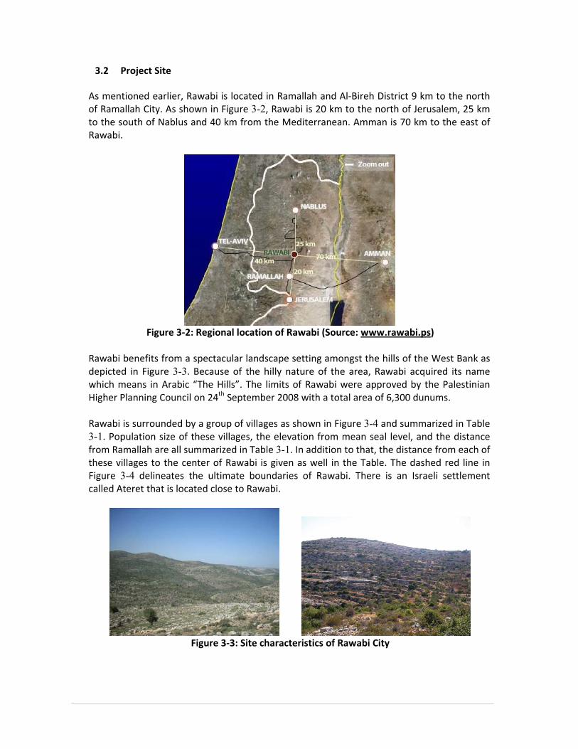
3.2 Project Site
As mentioned earlier, Rawabi is located in Ramallah and Al‐Bireh District 9 km to the north of Ramallah City. As shown in Figure 3-2, Rawabi is 20 km to the north of Jerusalem, 25 km to the south of Nablus and 40 km from the Mediterranean. Amman is 70 km to the east of Rawabi.
Figure 3‐2: Regional location of Rawabi (Source: www.rawabi.ps)
Rawabi benefits from a spectacular landscape setting amongst the hills of the West Bank as depicted in Figure 3-3. Because of the hilly nature of the area, Rawabi acquired its name which means in Arabic “The Hills”. The limits of Rawabi were approved by the Palestinian Higher Planning Council on 24th September 2008 with a total area of 6,300 dunums. Rawabi is surrounded by a group of villages as shown in Figure 3-4 and summarized in Table 3-1. Population size of these villages, the elevation from mean seal level, and the distance from Ramallah are all summarized in Table 3-1. In addition to that, the distance from each of these villages to the center of Rawabi is given as well in the Table. The dashed red line in Figure 3-4 delineates the ultimate boundaries of Rawabi. There is an Israeli settlement called Ateret that is located close to Rawabi.
Figure 3‐3: Site characteristics of Rawabi City

Figure 3‐4: Rawabi and its surrounding villages (Source: RMPR)
Table 3‐1: Geographical information of the surrounding communities (Source: RMPR)
Community Population Elevation
(m msl)
Distance from
Ramallah (km)
Distance from
Rawabi (km)
‘Abwein 3,119 600 37 2.5 ‘Atara 2,270 811 15 2 Birzeit 4,529 765 11 4.4 ‘Ajjul 1,237 500 20 1.7 Deir as Sudan 1,191 498 20 3.4 Umm Safa 612 630 20 2.4 Jibiya 148 669 16 3.3 Kobar 3,677 640 13 3.9 Burham 619 640 12 3
3.3 Project Construction
Construction of Rawabi City is expected to occur over a span of 7 to 10 years, depending on local market factors. Construction phasing will begin with the site preparation for mobilization of materials, equipment and personnel to the project site area. The first phase of the development will encompass approximately 150 dunums of the 760 dunum site and will span approximately the first 2 years of the project’s development.

31
The construction camp site is approximately 35 dunums and will sit adjacent to the ‘Atara/‘Ajjul road to facilitate movement of materials and personnel from outside the project site. Due to the volume of construction material expected over the construction life of the project, a second service road direct from Israel Highway 465 will be constructed through undeveloped lands to mitigate traffic impact on the villages of ‘Atara and ‘Ajjul. The construction camp will house the construction offices for site managers, consultant engineers, testing engineers, contractors, first aid clinic and ancillary requirements such as sanitary and eating facilities. Also included in the construction camp will be the necessary concrete batch plant, concrete block manufacturing equipment and yard and other materials fabrication yards as needed. The construction camp site will be fully fenced and include security. Temporary electrical power for the construction camp will be via an 11 KVA line served via the main trunk system in the nearby village of ‘Ajjul. Backup, standby diesel generation is also to be provided. Construction management staffing will be comprised of approximately 40 full‐time, on‐site management and engineering staff. Additional laborers will be working on the construction site on an as needed basis. It is estimated that the peak number of laborers will be in the range of 2,500.
3.4 Construction Materials
Building construction will use many of the same materials as found in the current vernacular construction within Palestine; that is concrete, local stone and steel reinforcing. The method of construction will use improved technologies to expedite the construction durations however, the basic materials will remain the same. Specifications being developed for the building systems of mechanical, electrical, plumbing and vertical transportation will take into account prevention of use of hazardous building materials such as lead‐based paint, aluminum wiring, asbestos containing materials, lead pipes, etc. Equally important will be the prevention from use of flammable construction materials, formaldehyde containing materials, etc. The excess stones and cutting materials are to be crushed and used as aggregates and building materials to the extent possible. The Plan is to use any material produced at site in the construction activities. This will minimize the waste and will enhance the reuse of excavation materials. Stones and other building materials are to be purchased from the local Palestinian market. This supports the production and the national economy.
3.5 Life and Fire Safety Design Considerations
Fire hydrants are to be provided at the junctions of the main streets and where required according to the international standards. All multistory residential units are to be designed and constructed in accordance with the US National Fire Protection Association guidelines. Automatic fire fighting systems are to be installed in the parking floors of the buildings. Emergency exits are considered in the designs. Special facilities and special passages are to be provided for the disabled.

32
Construction of all residential, commercial and public buildings within Rawabi shall comply with local, national and international codes as applicable with design to be to the highest standard applicable. When there is a conflict between various code requirements, always the most stringent/conservative standard shall apply. Particular attention shall focus on the International Code Council codes and to compliance with the Life Safety Codes of the U.S. National Fire Protection Association (NFPA) or other recognized, equal international standards.
3.6 Rawabi Zoning
The Master Plan prepared by AECOM, an international consultant, of the first phase of Rawabi (Rawabi 1) relates to an area within the approved boundary which extends to 760 dunums. The development includes construction of residential neighborhoods, residential units, the commercial center and a range of public facilities such as schools, health centers, kindergarten, bus stations, a fire station, a police station, mosques, a church, green areas, etc. The land use of the 760 dunums of Rawabi 1 is summarized in Table 3-2. It includes provision for the full range of public facilities required to support a population of up to 20,000 people. The facilities have been placed within the commercial and local centers to ensure accessibility. The land use classifications of the whole 6,300 dunums of Rawabi are summarized roughly in Table 3-2 and are to support a population of up to 40,000 people.
Table 3‐2: Proposed land use classes for Rawabi
Land Use Rawabi 1
% from total area
Rawabi% from
total area Area
(dunums) Area
(dunums) Residential 338.4 45% 2,030.7 32.2% Commercial center‐ retail, offices and Residential
53.1 7% 80.5 1.3%
Public Facilities 78.3 10% 257.6 4.1% Green areas 115.6 15% 3,134.4 49.8% Pedestrian areas/squares 35.3 4% ‐ ‐ Roads 134.2 18% 594.7 9.4% Others/wadis 5.1 1% 202.1 3.2%
Total 760 100% 6,300 100% For the next phases of Rawabi, the remaining 5,540 dunums out of the 6,300 will be developed. About 50% of the 6,300 are then to be developed as green/agricultural areas (around 3,134 dunums). An additional 1,692 dunums are to be developed as residential area totaling in addition to Rawabi 1 about 32% of the total area of Rawabi. Public areas are to include 78 dunums of Rawabi 1 and additional 179 dunums totaling about 4.1% of the total area of the city of Rawabi. The commercial area of Rawabi 1 is 53 dunums, while after construction of the whole Rawabi the commercial areas are to total 80 dunums (about 1.3%). The internal roads network of Rawabi is to total around 595 dunums, from which 134 are in the first phase (Rawabi 1). The remaining 3.2% of the 6,300 dunums are located in the wadis and are then

33
considered mainly as natural areas. The wastewater treatment plant is to be constructed in the wadi area downstream the northern wadi bounding Rawabi. Rawabi 1 is to include eight schools, two mosques, one church, two clinics, a fire station, a police station and a library. Later when the whole Rawabi city is constructed it will include fourteen schools, four health facilities and other public and municipal buildings and facilities.
3.7 Rawabi Infrastructure and Utility Systems
3.7.1 Road Network
The main roads of Rawabi 1 are depicted in Figure 3-5. As can be seen from the figure, there is a main ring road. A multi‐lane road of a total pavement width ranging from 10.5‐12 m is proposed for the Rawabi access road and loop around the commercial center of Rawabi. The total length of road network in Rawabi 1 totals about 11.5 km including the south access road of about 5 km. There will be two main junctions that connect the main ring road of Rawabi with the existing ‘Atara/‘Ajjul road. These junctions will be the main entrances/exits to Rawabi. A new access road is proposed to link Birzeit to the ‘Atara/‘Ajjul road bypassing ‘Atara and crossing an area that is designated “C” as to Oslo agreement. This road is about 4.5 km long. The road starts from the northern area of Rawabi and moves around the north‐western side of Birzeit at a location of 1 km to the east of ‘Atara checkpoint. This proposed road intersects with the regional road #465 through a lower corridor below this regional road. The total width of the road is 25 m where for each lane it is 7.2 m and for the central island it is 3.4 m. According to the “Traffic Assessment of Rawabi” study, Rawabi 1 is expected to generate net new vehicular trips of 1,327 and 1,168 vehicles/hour during the AM and PM peak hours, respectively. In addition, 3,025 and 5,841 person‐trips/hour would be generated in the AM and PM peak‐hour, respectively. Rawabi is to provide and enhance the infrastructural facilities in the area through constructing a new road network which will support the socio‐economy of the neighborhood communities. As an example, no hospital exists in the area and those who are in need of special medical treatment must travel to Ramallah. The city of Rawabi is to provide such, along with other services. The provision of schools, mosques, clinics and other facilities of Rawabi will support the very limited existing infrastructure in the surrounding villages. Rawabi sewerage and wastewater treatment systems may be expanded to include the other surrounding communities that can be served.

Figure 3‐5: Rawabi 1 planned road network (Source: RMPR)
3.7.2 Water Supply System
The proposed water infrastructure for Rawabi considers the utilization of three different sources of water for use/reuse and these are: a potable water source (i.e. from groundwater through a well), non‐potable water from treated wastewater, and harvested storm water. For the source of the potable water, negotiations are taking place with Israelis, Palestinian Water Authority (PWA), Jerusalem Water Undertaking (JWU), and West Bank Water Department (WBWD). According to JWU and Bayti, water supply alternatives are to connect Rawabi to: (i) Umm Safa 2’’ connection / Ateret near Rawabi (Mekorot), (ii) Mekorot water pipe near Salfit Governorate/Ariel, and (iii) Shillo/Sinjil water pipe. According to an official letter from PWA sent to Bayti, the experts of the PWA do not recommend the development of a new groundwater well in Rawabi area. The letter is directing Bayti to consult JWU in regard to water supply. As shown in Figure 3-6, all domestic water use types must be supplied from the potable freshwater source except for toilet flushing where it can be supplied from the above mentioned three water sources through a separate piping system. Daily water demand is proposed to equal 150 l/c.d where 100 liters are of potable quality for drinking, bathing, and laundry (domestic use), while the remaining 50 l/c.d is non‐potable quality for toilet flushing from the treated wastewater.
Rawabi Access Road Existing ‘Atara/’Abween Road Connector Road Link Road Site Boundary

For Rawabi 1 where the total population is expected to reach 20,000 persons, a total average of 3750 m3/day of water is projected for domestic use (2500 m3/day) and for toilet flushing (1250 m3/day). However, for the subsequent phases of Rawabi, the total daily water consumption will become higher. Based on the daily water consumption of 150 l/c‐d, it is estimated that 7,500 m3/day of water is needed to support the residential, commercial, public facilities and agricultural needs. The first phase (Rawabi 1) will likely include the construction of a 5000 m3 storage reservoir. Later, another reservoir of the same capacity (5000 m3) is recommended. The capacity of the reservoir allows for the required storage for fire demand.
Figure 3‐6: Schematic of water infrastructure (Source: ANUPU)
It is proposed that potable supply be pumped to a central storage reservoir (near the end of the Birzeit road) that is sufficiently high to allow a gravity‐fed water distribution network taking into consideration that the pressure head of the supplied water is within the 20‐90 bar range to maintain an adequate water supply service while preventing pipe bursts and leakage. To enhance this, the entire area is divided into four pressure zones depending on the ground surface elevation differences. In the situations where the minimum 2 bar pressure is not maintained in zone 1, an in‐line booster pump can be installed (i.e. within the building). Where high pressures beyond the 9 bar limit exist, pressure reducing valves can be used (in zones 3 and 4). Roof storage tanks for cold water will not be installed and cold water supply will be provided directly from the water distribution network. This is an important issue to consider when determining the source of freshwater in order to make sure that the central reservoir will be

adequately full at all times, especially during the summer time when water availability gets low. In addition, the size of the central reservoir should be sufficient to provide water to meet the 100 l/c‐d for at least two days along with an additional reserve for firefighting and commercial water use. As for firefighting requirements in terms of water infrastructure, hydrants are to be distributed throughout the residential areas at regular distance intervals. In addition, for each floor in buildings, a hose reel cabinets should be provided. The fire fighting extinguishers, either manual or automatic, are then to be installed in these cabinets.
3.7.3 Sewerage System
All generated wastewater (black and grey) within Rawabi will be collected by a gravitational sewerage system that will be discharged to a centralized Waste Water Treatment Plant (WWTP). Plastic (i.e. uPVC) is expected to be used for sewer pipes and manholes will be used wherever necessary. The trunk sewers will follow the main roads before connecting to the WWTP. The proposed treatment process will be Membrane Bioreactor (MBR) which is capable of producing high quality effluent. The proposed site of the WWTP is depicted in Figure 3-7. The effluent from the WWTP will be used in irrigation and supplied to the community for use in toilet flushing. This requires the use of a pump to distribute the treated wastewater up to the storage reservoirs of each pressure zone and to be distributed in the foul water system. If a storm water retention structure is constructed, the treated wastewater can be pumped to be mixed with the storm water and/or stored behind the retention structure. This will provide further dilution and polishing of the treated effluent and will also provide storage for the foul water to be reused.
Figure 3‐7: Depiction of the location of the WWTP (Source: RMPR)

37
The WWTP will be located adjacent to the wadi at the northern end of Rawabi downhill. Sewers shall be laid in designated road reservations to connect all manholes and direct flows to the proposed central WWTP. The treated effluent from the WWTP is to be pumped back into a non‐potable (foul) water distribution system in order to be reused for toilet flushing, gardening and landscaping. To avoid any health risks and environmental impacts, the WWTP structures and ponds are to be sealed and lined with Polyethylene to prevent infiltration. Strict directions are to be posted at the site preventing drinking the water and swimming. The area around the WWTP is to be planted with trees to add to the cleaning of the environment and to enhance the land use.
3.7.4 Solid Waste Collection and Disposal System
It is expected that there will be a variety of different sources of solid waste in Rawabi yet the main source will be residential. Types of solid waste from residential areas in Rawabi will be: food wastes, paper, cardboard, plastics, textiles, leather, yard wastes, wood, glass, tin cans, aluminum, other metals, ashes, street leaves, special wastes and household hazardous waste. Commercial waste comes from stores, restaurants, markets, and offices. Types of commercial waste are paper, cardboard, plastics, wood, food waste, glass, metals, and sometimes‐special wastes. Institutional solid waste comes mainly from schools and governmental centers. According to the preliminary study titled “Integrated solid waste management for Rawabi – First Palestinian new master‐planned community” by Issam Al‐Khatib, the predicted generation rate of solid wastes at Rawabi is 0.94 kg/capita/day. The WHO standards are 0.8‐1.0 kg/capita/day. Accordingly, the total estimated amount of solid waste that will be generated and disposed from Rawabi is at about 38 tons per day." The suggested machinery to be used for solid waste collection processes include a compactor truck, with a capacity of 15 m3, a Roll‐on‐off Truck with a capacity of 10 m3 and a sweeping truck. The collection frequency of solid waste at Rawabi will be on a daily basis. The handling of the residential solid waste in the buildings is intended to be carried out by collecting waste in plastic bags in the apartment and to be later disposed of by the family members to the solid waste containers, which are to be located in the residential neighborhood within the landscaping and have a capacity of 1/2 m3 each. Collectors are responsible for transporting the containers to the closed collection vehicle where the containers’ contents are mechanically emptied and compacted. Commercial waste, in general, is to be collected in large movable containers (10 m3) and in containers that can be coupled to large stationary compactors. The waste in the commercial center, in particular, is to be handled in a different way due to difficulties of waste collecting vehicles to access the commercial center. Movable metal containers of 10 m3 are located at the edges of the commercial center. Types of waste generated in the commercial center are mainly comprise of paper, cartoon, fruits and vegetable residues, meat and bone residues, food residues, and street sweepings in

38
addition to residential waste from apartments and offices in this region. Paper and cartoon are temporarily stored inside the shop to be later disposed of in the 10 m3 containers. Fruit and vegetable residue is to be kept temporarily in the shop until a farmer collects them to feed his livestock or to be disposed of at the end of the day. The meat and bone residue from butchers and poultry shops in addition to food residue from restaurants are to be kept in plastic bags in the shop or the restaurant till the end of the day and then disposed of in the 10 m3 container. The owner of the shop is responsible for disposing of all the previous mentioned types of wastes. Streets in the commercial area are to be swept early in the morning and the sweepings are loaded in handcarts that are pushed by the waste collectors to near the 10 m3 container. The residential waste generated from apartments and offices in the commercial center is collected in plastic bags and disposed of in the nearest 10 m3 container. It is worth mentioning that waste baskets or bins are to be installed in the appropriate places in the commercial center in order to enable pedestrians to put small pieces of wastes inside these baskets and bins instead of throwing wastes on the ground. The final solid waste disposal site that could be used by Rawabi might be one of the following:
• Ramallah and Al‐Bireh Sanitary Landfill which has been suggested to be constructed in Rammun, about 40 kilometers from Ramallah city and will serve the entire governorate of Ramallah and Al‐Bireh
• Al‐Bireh dumping site which is adjacent to Ramallah and controlled by the Israeli military authority
3.7.5 Power Supply System
The estimated electrical demand for Rawabi (in excess of the number of households in the area covered by the Master Plan of phase I) is 10 MVA. The nearest supply point is the existing Jerusalem District Electricity Company (JDECO) 33kV/11kV substation at Sinjil. The substation is fed from the Israeli network and has a current capacity of 10MVA. This will be increased to 20MVA to supply Rawabi. It is proposed that all power will be distributed by underground cables. Therefore, a high voltage (HV) network will operate at 11kV. As a result, not only Rawabi will benefit from this infrastructure, but also it will distribute power to a number of local substations throughout Rawabi. Here 630kVA transformers will provide the 400V mains distribution voltage cables that will feed individual buildings and other amenity requirements including street lighting. The final distribution will be via feeder pillars. At a few strategic locations the 11kV/400V substations will be interconnected to other parts of the local 11kV network. This will increase the security of the 11kV network benefiting Rawabi and the surrounding villages. Mains voltage of three phases of 400V or a single phase of 220V will feed individual consumers via feeder pillars. These feeder pillars would normally be integrated into the

39
outside or boundary wall of the building. This will need to be developed as part of the detailed design of the buildings to ensure that the aesthetic of the buildings is maintained. Feeder pillars are to be closed in safe closets accessible only to authorized personnel. Clear warning signs are to be posted at the buildings near the closets to instruct the inhabitants and to avoid risks and health hazards.
3.8 Energy Efficiency Design Requirements
Although not actively enforced, local Palestinian Energy Efficient Building Codes require thermal efficiencies for buildings with levels of established U values, the overall heat transfer coefficient. These Palestinian energy codes establish the total U value for all external walls, including windows, doors, and any other openings, shall not exceed 1.8 W/m2.K and the total U value of all roofs and floors separating two levels, which have different energy source, shall not exceed 1.2 W/m2.K. The local traditional methods of construction do not utilize thermal barriers or separations which results in a U values in excess of 2.47 W/m2.K. The designs and construction technology of Rawabi will introduce methods of thermal insulation which will not only meet the required Palestinian Energy Codes but will be superior in thermal efficiencies. Studies are currently underway to determine the cost effectiveness of various systems. Energy consuming appliances and systems such as lights, elevators and escalator, water pumps and motors will comply with the ASREA 90.1‐2004 requirements. Further, Rawabi will apply enhanced refrigerants management throughout the development of the project and will be responsible for implementing and encouraging responsible use of refrigerants which are the responsible for the ozone depletion and contribute negatively to the global warming. For construction of the residential units, the use of refrigerant will be eliminated totally and natural ventilation and cooling will be used in lieu of mechanical systems. For the commercial and mixed‐use buildings, refrigerants and mechanical systems recommended to be used are those that minimize or eliminate the emission of compounds that contribute to ozone depletion and global warming. Rawabi is focused on passive energy efficiencies in the design of the residential buildings. Passive energy uses in Rawabi will include the implementation of solar water heating panels to be located on the rooftops for each residential unit and electric instantaneous hot water units to minimize the loss of water during the wait time for hot water at the facets. The residential units will also utilize high efficiency gas fired water heaters for winter months use rather than the local traditional diesel fired boilers. Further passive energy measures include natural cooling strategies to be used in all the residential units omitting the use of any mechanical system. This will be accomplished with many design principles and concepts, including reduction of ambient air temperatures with the general building orientations to minimize the solar gain and implementation of abundant landscape with plant materials, water features and shade structures to add to the natural cooling of the project.

4. BASELINE ENVIRONMENTAL DATA
4.1 Topography
The topography of Ramallah District can be divided into three parts: the eastern slopes, mountain crests and western slopes. The eastern slopes are located between the Jordan Valley and the central mountains. They are characterized by steep slope which contribute to forming young wadis such as Wadi El‐Maquk. Mountain crests form the watershed line and separate the eastern and western slopes. Elevation ranges on average between 640 and 880 meters above mean sea level (amsl). Western slopes are characterized by gentle slopes and have elevation ranges between 250‐500 m amsl. The topography of the area, where Rawabi is to be constructed is dominated by a series of hills separated from each other by narrow valleys. As depicted in Figure 4-1, the highest elevation of the hills reaches approximately 820 m amsl in the south while the minimum elevation in the area is about 435 m amsl to the north.
Figure 4‐1: The topographic features of Rawabi (Source: ANUPU)
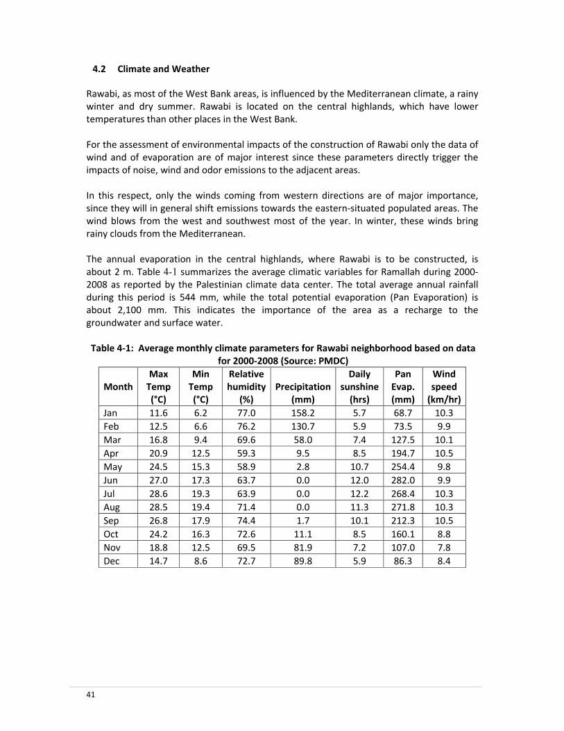
41
4.2 Climate and Weather
Rawabi, as most of the West Bank areas, is influenced by the Mediterranean climate, a rainy winter and dry summer. Rawabi is located on the central highlands, which have lower temperatures than other places in the West Bank. For the assessment of environmental impacts of the construction of Rawabi only the data of wind and of evaporation are of major interest since these parameters directly trigger the impacts of noise, wind and odor emissions to the adjacent areas.
In this respect, only the winds coming from western directions are of major importance, since they will in general shift emissions towards the eastern‐situated populated areas. The wind blows from the west and southwest most of the year. In winter, these winds bring rainy clouds from the Mediterranean. The annual evaporation in the central highlands, where Rawabi is to be constructed, is about 2 m. Table 4-1 summarizes the average climatic variables for Ramallah during 2000‐2008 as reported by the Palestinian climate data center. The total average annual rainfall during this period is 544 mm, while the total potential evaporation (Pan Evaporation) is about 2,100 mm. This indicates the importance of the area as a recharge to the groundwater and surface water. Table 4‐1: Average monthly climate parameters for Rawabi neighborhood based on data
for 2000‐2008 (Source: PMDC)
Month
Max Temp (°C)
Min Temp (°C)
Relative humidity
(%)Precipitation
(mm)
Daily sunshine (hrs)
Pan Evap. (mm)
Wind speed (km/hr)
Jan 11.6 6.2 77.0 158.2 5.7 68.7 10.3 Feb 12.5 6.6 76.2 130.7 5.9 73.5 9.9 Mar 16.8 9.4 69.6 58.0 7.4 127.5 10.1 Apr 20.9 12.5 59.3 9.5 8.5 194.7 10.5 May 24.5 15.3 58.9 2.8 10.7 254.4 9.8 Jun 27.0 17.3 63.7 0.0 12.0 282.0 9.9 Jul 28.6 19.3 63.9 0.0 12.2 268.4 10.3 Aug 28.5 19.4 71.4 0.0 11.3 271.8 10.3 Sep 26.8 17.9 74.4 1.7 10.1 212.3 10.5 Oct 24.2 16.3 72.6 11.1 8.5 160.1 8.8 Nov 18.8 12.5 69.5 81.9 7.2 107.0 7.8 Dec 14.7 8.6 72.7 89.8 5.9 86.3 8.4

4.3 Hydro‐geological Environment
The exposed formations in the Rawabi neighborhood area consist mainly of carbonates rocks ranging in age from Late‐Jurassic1 to recent. The exposed rocks of the area are primarily upper cretaceous carbonate rocks. Unconsolidated, Quaternary alluvial2 sediments overlie the major rock formations. The whole area is karstic and thus is very sensitive to groundwater pollution, as groundwater is the most important freshwater source in the whole area. Figure 4-2 shows the local exposed (outcropping) formations in the area of Upper and Lower Beit Kahil. These formations represent the lower aquifer, which is an excellent source of drinking water when under confined conditions. Typical lithology includes dolomitic limestone, limestone, and karstic limestone. This indicates a high vulnerability to contamination as thus the area is of high sensitivity. However, few areas are of Kobar group which act as an aquitard. As shown in Figure 4-2, the groundwater divide (the dashed line in Figure 4-2) bisects the study area and thus the area lies between the western and eastern aquifer basins. The two groundwater basins are: 1. The western groundwater basin (Auja Tamaseeh sub‐basin): This basin underlies
approximately 65% of the Ramallah District and its water flows towards the west. 2. The eastern groundwater basin: This basin underlies the eastern part of the Ramallah
District (35%). Its water flows towards the east and southeast.
Figure 4‐2: Surface hydrogeology of the area and the groundwater divide (Source: ANUPU)
1 Formation name is Maleh and the typical lithology is marl interbedded with chalky limestone or dolomitic limestone 2 Alluvium gravels and fan deposits

The above indicates that Rawabi is located on a sensitive area that is vulnerable to groundwater contamination as shown in Figure 4-3. Therefore special concerns and measures should be considered to protect the groundwater basins and disposal of hazardous wastes should be strictly prevented.
Figure 4‐3: Vulnerability Map of Ramallah District (Source: HWE)
4.4 Surface Water
The surface water system (based on topography) drains west and contributes to Wadi Yasin and Auja (Yarkon) River draining to the Mediterranean north of Tel Aviv as shown in Figure 4-4. Rawabi is located on the mountainous hills that drain into wadi Yasin bounding Rawabi from the north and the south. Wadi Yasin drains further wadi Sareida that drains further into Al Auja River.
Figure 4‐4: Surface water drainage system in the mid‐western part of the West Bank with
Rawabi location highlighted (Source: ANUPU)
Rawabi

44
‘Ain Dara spring is located downstream the southern wadi of the City of Rawabi; therefore the mountains of Rawabi are part of the recharge area of ‘Ain Dara spring. Downstream the northern Wadi, the site for the WWTP is proposed. The construction of Rawabi is expected to increase the runoff from the area towards the two wadis on both sides of Rawabi. This is true especially with the relatively high slopes that exist in the area. This increase in the runoff can be made beneficial with the proposed detention storage facility. It is therefore necessary to consider this increase in runoff when sizing the detention storage. Initial estimated shows that some 50,000 cubic meter of water per year can be collected through the detention storage facility.
4.5 Soils
The following soil associations are common in the Ramallah district:
• Alluvial arid brown soil on which several irrigated crops can be grown such as fodders (Alfalfa, barley, etc.);
• Brown lithosols and loessial arid brown soils on which annual field crops, mainly wheat and barley can be grown;
• Terra rossa, brown rendzinas and pale rendzinas, which are the most suitable soils for agricultural purposes;
• Brown rendzinas and pale rendzinas, which are also suitable for agricultural purposes.
The soil types of Terra rossa, brown rendzinas are in general outcropped with rocks. The parent materials, from which these soil types were originally initiated, are mainly dolomite and hard limestone. In general, this soil has a pH range of 7.5‐8.1 with clay to clay‐loam soil texture. The major native vegetation covers are Quercus Calliprinos, Pistacia Palestina, Pistacia Lentiscus, and Pistacia Antlantica Amygdalus. These soils are used to cultivate field crops, mainly wheat and barley, vineyards, olive and fruit trees. Figure 4-5 depicts soil classifications in the area. As indicated above and as shown by Figure 4-5, Rawabi is located on a soil that is classified as Terra rossa soil, which is suitable for agricultural purposes. Within Rawabi and as it is located on a mountainous area, it is characterized as stony land. Based on the geotechnical study carried out by Geotechnical and Material Testing Center (GMTC) on January 2009 for Rawabi, Table 4-2 describes the surface soil of the study area at seven different locations within the 760 dunums area of the first phase of Rawabi. The surface soil material (the first one meter depth) can be described as light reddish silty clay material with pebbles and in some places it is highly fractured rock. The results of Table 4-2 are in line with the soil formation of the Terra rossa soil, where Rawabi is located and the exposed rock formation of the area described above. Silty clay and weak fractured limestone are the main two geological formation described by the geotechnical tests.
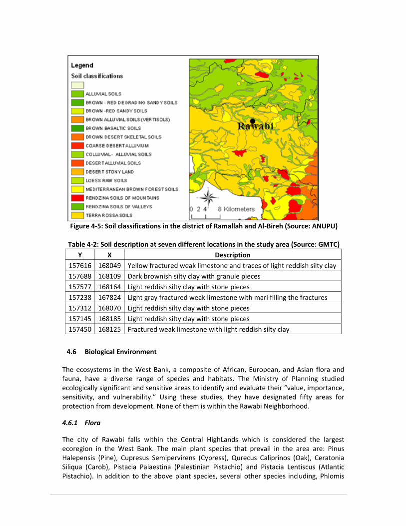
Figure 4‐5: Soil classifications in the district of Ramallah and Al‐Bireh (Source: ANUPU)
Table 4‐2: Soil description at seven different locations in the study area (Source: GMTC)
Y X Description157616 168049 Yellow fractured weak limestone and traces of light reddish silty clay 157688 168109 Dark brownish silty clay with granule pieces 157577 168164 Light reddish silty clay with stone pieces 157238 167824 Light gray fractured weak limestone with marl filling the fractures 157312 168070 Light reddish silty clay with stone pieces 157145 168185 Light reddish silty clay with stone pieces 157450 168125 Fractured weak limestone with light reddish silty clay
4.6 Biological Environment
The ecosystems in the West Bank, a composite of African, European, and Asian flora and fauna, have a diverse range of species and habitats. The Ministry of Planning studied ecologically significant and sensitive areas to identify and evaluate their “value, importance, sensitivity, and vulnerability.” Using these studies, they have designated fifty areas for protection from development. None of them is within the Rawabi Neighborhood.
4.6.1 Flora
The city of Rawabi falls within the Central HighLands which is considered the largest ecoregion in the West Bank. The main plant species that prevail in the area are: Pinus Halepensis (Pine), Cupresus Semipervirens (Cypress), Qurecus Caliprinos (Oak), Ceratonia Siliqua (Carob), Pistacia Palaestina (Palestinian Pistachio) and Pistacia Lentiscus (Atlantic Pistachio). In addition to the above plant species, several other species including, Phlomis

Viscosa, Sarcopoterium Spinosum (Balan), Cistus Creticus and Thymus Capitatus (Thyme) are prevailed. Figure 4-6 and Figure 4-7 and depict part of these species.
Figure 4‐6: General view of the area with Crataegus Aroni which is one of the endangered
trees in Palestine
Figure 4‐7: The prevailing plant Sarcopoterium Spinosum with a Ceratonia Siliqua tree
47
Natural plants in this area are important as a production purpose; several plant species are used for this purpose including Cyclamen Persicum (Cyclamen), Gundelia Tourtifortie (Gundelia), and Salvia Triloba (Sage), Thymus Capitatus (Thyme), Crataegus Aroni and Ceratonia Siliqua.
Rawabi area is also considered as part of the natural grazing rangeland in Palestine. The agroforestry provide a significant source of income for many rural populations. Small natural plants of herbs, trees and shrubs that are found in the project area (mountains) are utilized for grazing as a dependent source of feeding.
Natural plants are important as biodiversity conservation. In Palestine several globally consumed crops such as wheat and barley were first domesticated. Therefore, the genetic stock of several plant species including pistachio, apple, and pear are found in the area. In addition to the natural plants, olives are cultivated in this area. Along the area which was investigated, it was noticed that olives in many places were associated with natural trees mainly Pistachia species and Qurecus species. In addition, many grasses were also observed growing within the olive groves.
4.6.2 Fauna
Animals and birds are distributed in Palestine in 16 Agro‐zoological areas, among these is the Mediterranean region in which the city of Rawabi fall. The prevailinged type of birds in Rawabi is Alctoris chunkar (Shunnar), yet this type of wild birds is highly distributed throughout all Palestinian mountains and not limited to the Rawabi proposed site, and therefore is not highly threatened. This type is among species that are allowed to be hunted according to Shtayeh and Kalil (1995). However, we did notice a red Fox (Vulpes Palaestine) in the area. Poultry farms that are scattered in the neighborhood could be the reason for the existence of such animals. Despite the persistence of the study team to detect any significant wildlife that might exist in the area, it is obvious that no significant wildlife exists and the team was not able to see any signs of such wildlife except for some grazing that is very minimal.
4.7 Historical and Archaeological Sites
The area chosen for the development of Rawabi does not contain any historical or archaeological sites according to the investigations and the available information. This has also been indicated by the MoTA during their interview. Nevertheless, there are historical sites in the neighboring villages such as the Sheikh Qattrawani site in ‘Atara and the old village of ‘Ajjul.
4.8 Local Geology and Seismic site Effect
The historical seismicity of Palestine, and the instrumental earthquake studies since the mid of the past century demonstrate that the damaging earthquakes were located along the Dead Sea Transform (DST). The DST is a left‐lateral fault between the Arabia and the Sinai

tectonic plates that transfers the opening at the Red Sea to the Taurus‐Zagrous collision zone. The estimated Modified Mercally Scale (MMS) intensities of historical earthquakes in the Dead Sea region reach up to X, whereas the determinable magnitudes of the recorded earthquakes range between 1.0 and 6.5 on the Local Magnitude (ML) scale. These damaging earthquakes caused in several cases severe devastation and many hundreds and sometimes thousands of fatal casualties. The site visit investigation to Rawabi site showed that the exposed sequence of rocks (Ramallah Group) mainly consists of carbonates; limestone, dolomite, marl and chalk and it includes other sediments as chert, clay, with ages ranging from lower Cretaceous to upper Cretaceous. The formations outcrops and reported lithology from groundwater boreholes indicate that the limestone thickness ranges from about 50 m to 210 m containing dolomite, some chalk, chalky marl and marl appear at different locations of the formations. Figure 4-8 shows the seismic hazard map and seismic zone factor for building code that characterize Palestine ranging from the relatively weak seismic zone west, to the relatively strong seismic zone in the east.
Figure 4‐8: Seismic Hazard Map and Seismic Zone Factor for Building Code (source: ESSEC)
Based on the seismic Peak Ground Acceleration (PGA) map, Rawabi area is located in zone 2A and it is very close to zone 2B (recommended to consider it as zone 2B). The seismic zone factor (Z) on the rock for the zone 2A is equal to 0.15 and is 0.2 for zone 2B. According to the
Rawabi

49
Uniform Building Code (UBC), International Building Code (IBC), Jordanian code and Arab uniform code Rawabi can be considered as moderate seismic area. The major structural elements in the study area are mainly local faults, striking in E‐W, NW‐SE, NE‐SW directions with approximate lengths of about 2, 3, 4 and 6 km. Local site effect (landslides, amplification and faulting systems) plays an important role on the intensity of earthquakes. Recent studies of large destructive earthquakes have shown that damages during the earthquakes are often caused by the amplification of seismic waves in near‐surface geology, where the post disaster damage assessment showed that the local site effect may have a dominant contribution to the intensity of damage and destruction. So, it has become recognized that the local site conditions have a very important role on the response of structures. Thus, earthquake resistant design of new structures and evaluating should take into account their response to site ground motions. As mentioned above, it is clear that the local geology in some areas in Rawabi, where soft sediments of marl, clay marl and chalky will be a potential for causes to landslides or seismic amplification. Where, the soil and rock at a site have specific characteristics that can significantly amplify the incoming earthquake motion traveling from the earthquake sources. In a seismic environment, the geotechnical investigation should be a requirement to evaluate the behavior of the supporting soils under earthquake excitation. Also in term of determining or predicting the impact and consequences upon the structure and the foundation types is highly recommended. The disaster management and emergency response requirements should be taken into account at the different milestones of Rawabi master plan.
4.9 Geopolitical Aspects and Land Use
Rawabi is located in the central highlands and it is part of the neighborhood of the surrounding villages and is therefore considered as having potential for integration with these villages. The villages of ‘Abwein, ‘Atara, and ‘Ajjul provided their lands to the development of Rawabi with areas equal to 1,000; 2,000 and 4,000 dunums, respectively, and these correspond to 6%, 20%, and 60% of the total areas of the three villages, respectively. The land of Rawabi is currently an unused rangeland. Downhill from Rawabi are wadis that are partially utilized by farmers for rain fed agriculture. The wadis are subject to storm water drainage from the hills and to the disposal of wastewater and solid waste from adjacent villages. The majority of Rawabi will be developed on the steep slopes and hillsides that provide picturesque views and spectacular opportunities for residential, commercial and leisure sites. The construction of Rawabi will also enhance the geopolitics of the area as more people will use the roads leading to Rawabi.

50
Coordination with the PA and the Israeli Palestinian Joint Committees will also be needed when Rawabi is to establish the police station and the civil defense as the movement of the policemen and Palestinian officials need to be coordinated when moving outside areas “A”. Another issue to consider is access to water resources in the area. Rawabi overlies both the western and eastern aquifer basins as discussed in section 4.3. However, the western aquifer is considered the best potential option from which Rawabi can obtain its water supply.

51
5. POTENTIAL ENVIRONMENTAL IMPACTS
5.1 Analysis of the Project Alternatives
The two main alternatives, as addressed in the EIA study, are the construction of the City of Rawabi “Build” alternative versus maintaining the current situation and not constructing the City of Rawabi “No Build” alternative. These two alternatives are assessed from the environmental point of view. The positive and negative environmental impacts of the construction of Rawabi are addressed to recommend whether to construct “Build” or not to construct “No Build” Rawabi. On the other hand, there are different services associated with the development of the City of Rawabi. In the following sections, the alternatives of the main services that are to be developed parallel to the construction of Rawabi are summarized.
5.1.1 Water Supply System
The water supply system had different alternatives in terms of the proposed source of water. Given the fact that the experts at the PWA do not recommend the development of a new groundwater well and after consultation with JWU and WBWD officials by the Bayti team, the following are the potential sources of water proposed for the Rawabi project:
Connect Rawabi with Um Safa 2" connection/ Ateret near Rawabi
Connect Rawabi with Mekorot line near Salfit Governorate/ Ariel Settlement
Connect Rawabi to Shillo/ Sinjil water pipe
Based on the above alternatives, it is clear that Rawabi will depend on Mekorot Company for its future water supply system. This means that Rawabi will have to negotiate its water supply quantities with the Israelis through PWA and WBWD and any additional quantities will have to be approved by Israeli officials. Also, the cost of water will be dependent on the Mekorot’s water prices for Rawabi. The previous experience shows that Mekorot prices are affordable for communities connected to Mekorot system, such as JWU service area. Anyhow the decisions in regard of water supply and which water resources to be utilized for supplying Rawabi is the sole decision of the PWA. Based on demand estimates, some 4,000 cubic meters of water per day is needed for Rawabi City. This quantity is translated to some 3 Mcm/year which is not a small quantity for Mekorot to make available without serious commitments from all sides involved. In addition, the 2" pipeline is not seen as feasible for such a quantity. This will require additional infrastructure regardless of what alternative is selected. Initial estimates show a conveyance pipeline of 8" diameter will be necessary to convey such quantities of water. Such a pipe diameter is not available at present from the three proposed alternatives.

52
5.1.2 Wastewater Treatment plant
All generated wastewater (black and grey) within Rawabi will be collected by a gravity sewerage system that will be discharged to a centralized Waste Water Treatment Plant (WWTP). There are three potential locations for the WWTP:
• Alternative 1 (Rawabi only) has the coordinate of X= 168,700, Y= 159,200 and the elevation is around 460 meters above sea level. The candidate site is in Area B on the regional wadi, which flows to the West. This alternative encounters a local wastewater management for Rawabi City alone.
• Alternative 2 (Ein Sinya cluster) has the coordinate of X= 171,600, Y= 154,700 and the elevation is around 600 meters above sea level. The candidate site near Ein Sinya is in Area B on the wadi, which flows downhill to the North West. This alternative is considering a regional wastewater management for Rawabi City and the surrounding villages defined as Ein Sinya cluster.
According to the Palestinian Water Authority (PWA) database and the geology and hydrology of the two locations, the exposed formations in Rawabi area (alternative 1) and Ein Sinya cluster (alternative 2) consist mainly of Upper Bet Kahil and Yatta and Hebron formations of Upper Alpian Upper Cenomanian age. This means that the project area is located in the eastern basin. In the project area, the outcropping formations belong to the lower aquifer, and therefore, these formations represent the recharging area for the lower aquifer (lime stone and dolomites) and the water table is very deep. Therefore, this area is classified as a sensitive area where good sealing and/or high quality effluent must be ensured.
• Alternative 3 (Bani Zeid cluster) has the coordinate of X= 160,000, Y= 162,800 and the elevation is around 260 meters above sea level. The candidate site is in Area B on the regional wadi, which flows to the west. This area can be considered moderately sensitive because it is classified as aquitard. Therefore this location could be considered suitable for WWTP construction.
According to the Palestinian Water Authority (PWA) database and the geology and hydrology of the this location, the area is located at the lower Cenomanian age (Yatta formation) which consists of marl, clay and marly limestone, limestone and dolomitic limestone in the upper part and limestone/chalky limestone and dolomite in the lower part. This area can be considered moderately sensitive because it is classified as aquitard. Alternative one (Rawabi only) is the alternative considered by Bayti and is the one addressed in this EIA study. The location is adjacent to the wadi at the northern end of Rawabi downhill. Wastewater flows were calculated based on population projections and estimated per capita wastewater generation rates. The eventual population of Rawabi is expected to reach 30,582 by the year 2030. Wastewater flows for Rawabi City and the surrounding villages are

53
investigated and defined as three possible alternative solutions of wastewater management. In the study conducted by Bier Zeit University, two treatment processes are considered:
• Low Rate Trickling Filter (LRTF)
• Oxidation Ditch (OD) A third alternative of considering MBR treatment process was later addressed by Bayti. The MBR is capable of producing high quality effluent.
5.1.3 Wastewater Treatment and Reuse
Two concepts of wastewater collection, treatment and reuse were addressed for Rawabi Community. The first concept (Concept I) is based on the assumption that Rawabi will have the luxury of unlimited potable water supply which is not the case in Palestine. In this assumption, both black water and grey water are discharged to the same sewer system. Then the wastewater is treated to the quality standards that allow its discharge into the wadi without being reused. The discharged effluent is then to contribute to the surface drainage system, recharge the groundwater system and/or being reused for irrigation downstream. The wastewater needs to be treated before it can be reused or disposed of. This suggests that the treatment facility needs to be situated close to where irrigation water can be reused. In addition, storage facilities are required to conserve effluent during the winter months when there is no irrigation demand. Concept II of wastewater collection, treatment and reuse is based on the assumption that Rawabi will face a limited water supply due to the scarce water resources in Palestine. In this assumption, the treated wastewater is to be pumped back to be reused in a foul water distribution system. The ever increasing urbanization in Palestine results in continuous growth of urban water demand. This necessitates, on one hand, the development of non‐conventional water resources, and on the other hand, lowering the overall water demand. This could be achieved by reusing treated wastewater as an alternative water resource. When considering urban water reuse, onsite grey water reuse has the potential to play a significant role. The household water consumption in Palestine ranges between 70‐120 L/c/d. The majority of the consumed water (80‐90%) is transformed into two major streams:
1. Grey water: originating from all household 'water producing' appliances except toilets, comprising 60‐70% of the in‐house water consumption; therefore the expected grey wastewater generated is 75 L/c/d on average.
2. Black water: originating from toilets, comprising 30‐40% of the in‐house water consumption. Grey water reuse for toilet flushing is a feasible option as it can reduce the net water demand by 40‐60 L/c/d.

54
Reuse of treated wastewater (Grey water) for toilet flushing is not common in Palestine for cultural reasons. Grey water, in contrast to common perception, may be quite polluted, and thus may pose health risks and negative aesthetics (e.g. offensive odor) and environmental effects. As a result, highly efficient and reliable treatment systems, conveyance, and storage are required. The wastewater treatment will take into consideration the demanded water quality (reuse for toilet flushing and the surplus will be used for irrigating landscape). The treated wastewater is returned and distributed via a foul water system to be reused for toilet flushing by the households. This reduces the pressure on the scarce water resources. The wastewater reuse system proposed for the city of Rawabi will provide more sustainable sanitation system and, as such, a more sustainable and unique approach to water use and wastewater collection, treatment and recycling.
5.1.4 Solid Waste Management
The alternatives of solid waste collection systems that were considered for Rawabi are:
• The handling of solid waste in single‐story as well as multi‐story buildings through picking up and carrying the waste to the public container by an available family member.
• Using chute systems which is a relatively new method and is not applied widely in Palestine, but could be implemented in Rawabi City. Chute system is a collection system used in vertical buildings, based on the idea of throwing solid waste through pipes with specific diameters to containers found in basements of the buildings. Waste is picked up by building maintenance personnel and taken to the container in the basement area. The tenant then takes waste to the container in the basement.
• The handling of the residential solid waste in the buildings could be carried out by collecting waste in plastic bags in the apartment and to be later disposed of by the family members to the solid waste containers. The containers are to be located in the residential neighborhood within the landscaping. The capacity of the container in this room is 1/2 m3. Collectors are responsible for transporting the container from the trash room to the closed collection vehicle where the container contents are mechanically emptied and compacted.
There are different land‐filling alternatives that could be used by Rawabi for the final disposal of the solid waste:
1. Ramallah dumping site
The Ramallah landfill was established in the late 1960s, with an original area of about 4,500 m2. As a result, the accumulation of waste has reached risky levels, with piles of more than 60 meters high. In 1995, the Ramallah municipality tried to close the dump and searched for an alternative site. Choices were very limited in the overpopulated and confined city. The
55
problem was further complicated when the nearby town of Betunia closed its landfill, as this site was also located in the populated area within the boundaries of its municipality and became harmful for public health, with Betunia beginning to use the Ramallah landfill in 1996. To date, Ramallah’s dumping site is still used by both Ramallah and Betunia municipalities serving 44,550 persons, and it is still overloaded. It does not have additional space to be extended.
2. Ramallah and Al‐Bireh District Sanitary Landfill
A new sanitary dumpsite has been suggested to be constructed in Rammun, about 40 kilometers from Ramallah City, which will serve the entire governorate of Ramallah and Al‐Bireh, and it has been licensed by the Israelis because it is in Israeli controlled “C” area. It is expected to construct this sanitary landfill within the five coming years, as it is approved by the Ministry of Local government and the Environmental Quality Authority. It is expected to serve 374,636 persons after its establishment.
3. Al‐Bireh dumping site
Al‐Bireh municipality, adjacent to Ramallah, has had its own dumping site outside its boundaries since 1981. The landfill is considered to be in area C, controlled by the Israeli military, and outside the jurisdiction of the Palestinian Authority. Over the years, this site served other communities in A, B, and C areas, including the Al‐Ama’ari, Qalandia and al‐Jalazun refugee camps, Ramallah and Beituniya municipalities in emergency situations, and Jerusalem district areas, including Al‐Ram and Bir‐Nabala neighborhoods. The total population served by this dumpsite reached around 100,000 in the year 2000. Moreover, the Israeli settlements of Beit Eil and Psagot are, illegally and by force, using the Al‐Bireh dumping site.
4. Birzeit Transfer Station
There will be a transfer station in the same location as Birzeit dumping site, as part of the Ramallah and Al‐Bireh sanitary landfill project. This place can be used by Rawabi City to dispose of its solid waste as it will be very near to Rawabi City. The transfer station is a facility where solid waste is collected and sorted for recycling and disposal. Materials are consolidated into larger loads for hauling to a landfill or recycling markets. All of the services that are available to residents and businesses at the existing landfill will be available at the transfer station. Through a procurement process, the collected solid waste will be transported to the sanitary landfills. It is to stress here that the management of the solid waste of Rawabi should cope with the Palestinian National Strategy for Solid Waste Management.
56
5.2 Environmental Impacts during Construction
5.2.1 General
During the construction of Rawabi, a set of negative, although temporary, impacts have to be expected. However, these impacts do not exceed the normal range of impacts accompanied with construction activities. Shortly after Rawabi is completed, the technical construction and installation activities will not encompass any extraordinarily negative impact, which needs to be explicitly addressed. On the contrary, the accompanied negative impacts are restricted and are of temporary character, for they will end with the finalization of the construction works. The transport of the construction materials and workers to Rawabi will intensify the traffic on the main road that leads to the location. Thus, it will generate considerable dust clouds across the area. As a mitigation measure, the transportation trucks should be covered during transportation and should be checked and maintained from time to time to control the dust and gases emissions. A construction camp and a construction road are to be made at the site to facilitate the construction activities. The camp is then to provide overnight accommodation for the workers and thus reduce the daily traffic to and from the site during construction. The construction activities, such as the excavations at the site, may produce huge amounts of rocks and soils that may affect the areas around the site. Protection and safety measures during construction are obligatory measure to be implemented by the contractors. As a construction project, the Rawabi project involves certain negative effects on air quality and noise generation that can be very serious if not properly managed during project planning and implementation. However, it must be emphasized that impacts on air quality arising from construction works are temporary and short‐term. Environmental problems related to air quality and noise generation that are listed below can be avoided or minimized by appropriate constructive monitoring which is essential for insuring that construction contractors will comply with environmental standards. These problems are:
• Noise due to heavy vehicles that are expected to be used in this project such as stone crushers and drillers.
• Noise due to cut and fill activities which are of significant quantities in the Rawabi project where the amount of cutting volume that reaches to some 2.0 million cubic meters.
• Noise generated from additional traffic to and within the project site especially due to the movement of heavy vehicles and material delivery trucks.
• Dust from earthworks, cut and fill activities and from construction activities • Dust, odors, fumes and emissions from vehicle movement
Table 5‐1 lists the construction activities and the potential impact on the significant environmental issues. The (+) sign indicates positive potential impact while the (–) sign indicates negative potential impact. The (0) sign indicates neutral impact.

57
Table 5‐1: Project Construction activities and potential impacts Significant Environmental Issues
Project Construction Activities
Socio‐economic Conditions
Cultural and
Historical Resources
Air Quality and noise
Water Resources
Agricultural and natural Resources
0 0 ‐1 0 ‐1 Demolition of excavation materials
0 0 ‐1 ‐1 0 Heavy Machinery Operation
+1 ‐1 ‐1 ‐1 ‐1 Construction of Infrastructure
0 0 ‐1 ‐1 ‐1 Excavations and Earthwork
+1 0 ‐1 0 0 Construction of Buildings and Facilities
0 0 ‐1 ‐1 ‐1 Solid Waste Disposal
0 0 ‐1 0 +1 Wastewater Disposal
+1 +1 ‐1 0 ‐1 Transportation and traffic
‐1 ‐1 ‐1 ‐1 ‐1 Accidents and Unplanned Events
+1 +1 ‐1 ‐1 ‐1 Construction of Rawabi access roads
5.2.2 Impacts on Noise
Noise is unwanted and undesirable as it has an adverse effect on human beings and their environment. Noise can disturb natural wildlife and ecological systems. Two types of noise emissions are of concern: 1) Impulse noise that is, noise of short duration and high intensity such as explosions and sonic booms. 2) Continuous noise such as the pump stations and the compressors during operation. Important factors in determining noise levels that will potentially impact the population include; distance from the noise source; natural or man‐made barriers between the source and the impacted population, weather conditions which could potentially absorb, reflect; and the type of construction phase.

58
Noise levels should be controlled; noise barriers are recommended; occupational health measures should be enforced; and regular health tests and checks should be done for the staff. All these are among the recommended mitigation measures during the construction of Rawabi. In general, the sources of noise pollution are mainly traffic and motor vehicles, construction of roads and buildings and industrial activities. Noise pollution may increase from the vehicles that are old and not in good working conditions. Moreover, it is the habit of the people to use their horns frequently specially in traffic jams. In many places, vehicles noise pollution is increased by the topography of the West Bank; vehicles produce greater noise as they climb hills. At present, the Rawabi neighborhood does not suffer any severe noise problem since the area lacks any development or economic activities. Minor noise level is generated by cars passing by on the road between ‘Ajjul and ‘Atara and some settlers’ movement to and from the Ateret settlement.
5.2.3 Impacts on Air Quality
Air quality measurements are not available either at the Rawabi site or within most of the West Bank cities. Though the West Bank, which houses few heavy industries, suffers from substantial air pollution especially in the main urban areas and their vicinities. More than 90% of air pollution is a result of human activities. The increase in population of the West Bank, the expansion of industrial activities, the use of diesel cars for transit buses and taxis and the transboundary air pollutants are key factors to the deterioration of air quality in the West Bank. The lack of preventive legislation, codes and regulations to protect the environment leads to the heightening of the effect of human activities on air pollution. Climate and topography play a crucial role in transmitting air pollutants from one place to another. Among the most common and dangerous air pollutants in the West Bank are sulfur dioxide(SO2), suspended particulate matter (dust), nitrogen oxides (NOX), carbon oxides (COX) and lead Pb. Dust levels in the West Bank are high during certain seasons due to the dry sandy wind that blows from Saudi Arabia (Khamaseen wind). Except for the emissions from vehicles passing on the road of ‘Atara/’Ajjul, no major human activities exist at present in Rawabi that could cause high potential of air pollution. During the construction activities of Rawabi, the dust and vehicle gas emissions are expected to increase adding to the air pollution. When Rawabi is in operation, regular vehicle trips will result in air pollution. Therefore, it is obligatory to apply the recommended mitigation measures stated in the EMMP.
5.2.4 Impacts on Agricultural Resources and Soil
With the exception of some olive trees (see Figure 5-1), no major agricultural activities exist in the Rawabi area or in the neighboring communities. The land of Rawabi cannot be considered a high value land for agricultural use based on criteria like soil type, depth and

texture, slope gradient, infiltration rate, salinity and acidity of the soil and availability of water.
Figure 5‐1: Cultivated olive trees in the neighborhood of Rawabi site
The development of Rawabi is anticipated to restrict the wild habitat among the area since the area will become more accessible for people. In addition, the project will most likely threaten many species that are endangered like Grategous, Qurecus, and Cyclamen and will also damage the biodiversity areas. Therefore it is recommended to implement the vegetation plan described in section 6.3 as well as to implement the recommended mitigation measure in this regard. Potential increases in soil erosion rates will start during site clearance. The potential for soils to undergo erosion, and the extent to which the erosion occurs, will be a function of the occurrence of intense precipitation events (rain), the extent/steepness of slopes and soil nature. Soil erosion can cause an increase in sedimentation of downstream areas, landslides and flooding, unless it is adequately controlled. It is anticipated that soil erosion impacts could be significant if poorly controlled. However, with adequate control measures, the eroded sediments can be contained on‐site. It is therefore crucial that soil erosion control measures are fully implemented and maintained efficiently. Control measures include construction and maintenance of adequately sized detention ponds and sediment basins prior to the clearing of each new construction phase. It is also important to exercise terracing of exposed slopes, and grass seeding of cut slopes during the early stages of construction.
5.2.5 Impacts on Water Drainage
Rawabi is located in the Auja River drainage catchment (see Figure 4-4). The wadis flowing on both sides of Rawabi are draining to the Auja stream towards the Mediterranean Sea
60
north of Tel Aviv. Any pollution of the storm water courses may affect the aquatic life in the Auja and might reach the Mediterranean. During the construction of Rawabi, huge amounts of demolishing materials are expected to generate. The accumulation of the excavation materials on the storm water courses will negatively impact the drainage and may cause flooding problems. It is therefore necessary to keep the wadis and storm water courses clear and clean by applying the measures suggested in the EMMP related to water courses and wadis. The storm water courses are important as they are located within the recharge area of the groundwater aquifers. Two naturally flowing springs are located downstream of Rawabi, namely ‘Ain Dara spring and Al‐Balad spring. The construction activities of Rawabi are not to endanger the groundwater aquifers as no hazardous materials are encountered in these activities. The measures required and suggested to be implemented are to mitigate any potential impacts on the groundwater aquifers. The construction of Rawabi is expected to increase the storm water runoff from the built up areas towards the two wadis on both sides of Rawabi. This is true especially with the relatively high slopes that exist in the area. The increase in the runoff is beneficial after the construction of the proposed detention storage structures and/or the grading and trussing of the wadis. The storm water is to be detained and allowed to recharge of the groundwater aquifers. It is therefore necessary to consider this increase in runoff when sizing the detention storage. Initial estimated shows that some 50,000 cubic meter of water per year can be collected through the detention storage facility.
5.2.6 Impacts on Cultural and Historical Resources
From the published and available information, the proposed Rawabi site is not considered to have specific recreational, historical or cultural significance and, as such, the development of the site will have no adverse impact. On the other hand, Rawabi as a new urban center will attract the visitors. The rehabilitation and construction of the access roads to Rawabi will encourage the visitors and tourists to visit the neighborhood centers. Umm Safa, few kilometers west of Rawabi, is a known forest and Deir As‐Sudan, west of Rawabi, is an ancient town. The construction of Rawabi and the access roads is thus to enhance the cultural and historical resources of the area.
5.2.7 Impacts on the Socio‐Economic Conditions
In terms of demographics, it is necessary to consider not only the potential population in Rawabi but also the neighboring populations, since the zone of influence of developments in the region extends to adjacent areas (a high percentage of the employed population in the Rawabi construction project are expected to come from the neighboring villages). Positive impacts with a high significance rating (both with and without measures to enhance the benefits) include: employment creation; opportunities for using local labor; opportunities for supporting Rawabi development; training and skills development opportunities, etc. Furthermore, the positive impact of the construction of Rawabi in terms

61
of increasing investor confidence is rated as being of high significance, if the positive aspects of the project are actively promoted. During the construction phase, hundreds of direct and indirect employment opportunities are expected to be created. The project will therefore support the short‐term employment of unskilled and semi‐skilled workers. The positive impact of employment creation during construction is anticipated to be of high significance. These includes enhancement of the Palestinian economy, provision of jobs for public workers and handcrafts, utilization of national products and building materials, etc. All such activities are to increase the production value and contribute to the Palestinian economic development and national income.
The Rawabi project will cost more than $500 million. With an official motto of Live, Work, Grow, Rawabi will feature more than 5,000 affordable housing units, initially housing 20,000 inhabitants and ultimately becoming home to 40,000 residents. Therefore, the construction of Rawabi will help ease the acute housing shortage prevailing in this district and will also reduce pressures on Ramallah as the main center within the West Bank which suffers from high levels of demand on existing housing, services and infrastructure. Certainly, young couples, who tend to wait a considerable period to marry, will find affordable apartments – thus encouraging them to complete marriage ceremonies earlier.
From an economic point of view, it is widely recognized that housing development influences positively the national economies. The project of Rawabi will provide between 8,000‐10,000 direct jobs during construction employing local engineers, construction workers, and draftsmen. Training of unskilled and semi skilled local construction workers is another social and economic advantage of constructing Rawabi. In addition, there are positive impacts on sub sectors such as stone quarrying, cutting, finishing of stone, brick and block, steel and aluminum, concrete and asphalt, plastics including pipes and tanks, and carpentry. Increased demand for construction materials and equipment will stimulate local production and prompt further job creation. Moreover, local companies processing the above materials will also become important throughout the construction period. The local production of most construction materials remains advantageous to the project, as it is much more cost effective due to high transportation costs and the import constraints currently facing the West Bank. Large‐scale affordable housing development, such as the development of Rawabi, is also proving to be highly beneficial to the health and vitality of larger metropolitan and regional economies across the world. Key indicators show that Rawabi has strong potential to significantly contribute to the economic development of the surrounding villages, nearby metropolitan areas and the economy of Palestine as a whole. Not only during construction, but also after Rawabi’s development, it is expected that individuals will be offered training at local training institutions. Therefore, opportunities exist for the training and development of skills of local employees. Local training and skills development centers, organizations and institutions would be used for this purpose and may, therefore, benefit through an increase in the number of enrolled trainees. The positive impact of training and skill development opportunities associated with the construction of Rawabi is therefore assessed to be of high significance, both with and without additional benefit enhancement measures.

62
5.2.8 Occupational Health and Safety
Workers may be exposed to sunshine, high noise and dust levels during landscaping, access road and site preparation. To ensure the health and safety of the workers during the construction of Rawabi, it is recommended that an on‐site health monitoring program is maintained to provide an early warning of the presence of any injury, or infectious diseases in staff. Site operational practices should be maintained at a high standard at all times in order to minimize health impacts. However, the anticipated health impacts are classified into the following categories:
• Eye and respiratory related diseases: construction workers are expected to be susceptible to eye and respiratory diseases due to their routine exposure to dust and exhaust emissions on site. These effects could possibly be mitigated through pre‐employment health screening.
• Pathogenic micro‐organisms related diseases: non‐communicable diseases (i.e. between humans) but propagated through unhygienic conditions and vectors. Possible impacts may be mitigated by implementing a vector and pest control programs, conducting regular hygiene inspections and implementing a waste management program.
• Physical injuries: caused primarily by occupational‐related accidents, animal bites, etc. Activities such as land clearing, tree‐felling, earthworks, construction of facilities present various occupational hazards to the workers on site. These risks can be mitigated through the provision of appropriate training and emergency response procedures.
Through adherence to the standard operational protocols that are widely adopted elsewhere in the world, the risk of disease transmission to local communities is considered to be extremely low. The potential negative impact on public health, therefore, is considered to be of minimal significance.
5.3 Environmental Impacts Post Development
Subsequent development phases will be planned in accordance with future Master Plans of Rawabi. The construction is to take place under the oversight of the Palestinian Authority. The eventual population of Rawabi is expected to reach 40 thousands. The Master Plan for the development of Rawabi 1 covering 760 dunums has been prepared and approved covering all the infrastructure utilities and services for the first phase. The development of the rest of the City of Rawabi includes the construction of further roads and residential areas in addition to schools and other facilities as described earlier. Several environmental impacts are expected post development of the New City of Rawabi. These are most important and are discussed in the following sections.

63
5.3.1 Impacts on Air Quality
Air pollution during the operation phase will be caused by traffic fumes, wastewater collection and treatment facilities, improper solid waste collection, energy utilization processes and any anticipated industries within the Rawabi project. As the future mix of activities of the Rawabi project is not exactly defined, accurate estimates of definite elements and quantities of emissions cannot be made and only some conclusions on potential pollutants are possible. Diesel fuel combustion as used for buses and cars will generate emissions of heavy metals which are present in the oil such as Cd, Cu, Cr, Ni, Pb, and Zn in addition to lead (Pb) emissions generated from the combustion of leaded gasoline used in some private cars. Significant increase in SO2 and NO3 and particulate matter is to be expected from the increased traffic. Air pollution may also result as an impact of poor handling and storing of solid waste and might include risk of fires, wastes blowing off and impairment of air quality by odor. The same applies to cases of malfunctioning or overload of the wastewater treatment plant. The air quality problem is also associated with solid waste collection and odor created during loading operations. Odor is primarily a nuisance agent; however the level of odor created depends largely on the method of collection implemented. Rawabi is to employ the best available solid waste collection technology to minimize air emissions during frequent loading operations. Containers are to be located in the residential neighborhood within the landscaping, where solid waste is collected in these well maintained containers of a capacity of 1/2 m3 each. The containers are to be evacuated mechanically via closed collection vehicles with rear compactor. Ultimately, waste is to be transported to the sanitary landfill. Thus, the expected level of solid waste management in Rawabi is considered to be positive.
5.3.2 Impacts on Noise
The operation of Rawabi will result in permanent increases in exposure of humans to general audible noise, which is the noise commonly encountered in the everyday urban living environment. The sources for noise pollution will be the Rawabi daily activities including commercial activities, solid waste collection, water supply and wastewater treatment and others, in addition to the increased traffic for residents and workers within the Rawabi area. For the later phases of the project, the sources of noise during the construction periods of these phases will be dealt with by the Rawabi Municipality. After the completion of Phase 1 people will be eventually living in Rawabi, the municipality will be functioning, and the municipal regulation will be enforced. This means that additional mitigation measures will have to be implied by Rawabi Municipality during the construction of phase 2 and 3 of the Rawabi project. For general calculations and measurement of noise level, the dimension Decibel (dB) is taken. Maximum admissible noise levels for different urban areas possibly affected by technical facilities according to German regulations are given in Table 5-2. The noise levels
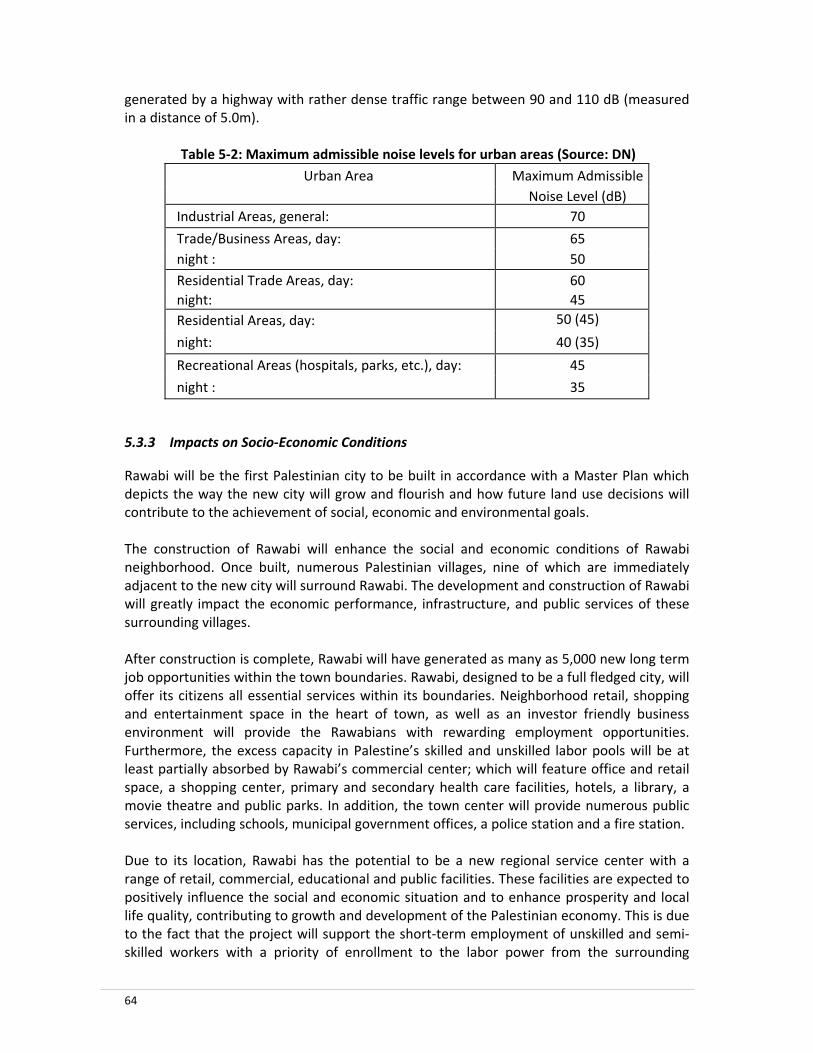
64
generated by a highway with rather dense traffic range between 90 and 110 dB (measured in a distance of 5.0m).
Table 5‐2: Maximum admissible noise levels for urban areas (Source: DN)
Urban Area Maximum Admissible Noise Level (dB) Industrial Areas, general: 70
Trade/Business Areas, day: 65 night : 50 Residential Trade Areas, day: 60 night: 45 Residential Areas, day: 50 (45)
night: 40 (35)
Recreational Areas (hospitals, parks, etc.), day: 45
night : 35
5.3.3 Impacts on Socio‐Economic Conditions
Rawabi will be the first Palestinian city to be built in accordance with a Master Plan which depicts the way the new city will grow and flourish and how future land use decisions will contribute to the achievement of social, economic and environmental goals. The construction of Rawabi will enhance the social and economic conditions of Rawabi neighborhood. Once built, numerous Palestinian villages, nine of which are immediately adjacent to the new city will surround Rawabi. The development and construction of Rawabi will greatly impact the economic performance, infrastructure, and public services of these surrounding villages. After construction is complete, Rawabi will have generated as many as 5,000 new long term job opportunities within the town boundaries. Rawabi, designed to be a full fledged city, will offer its citizens all essential services within its boundaries. Neighborhood retail, shopping and entertainment space in the heart of town, as well as an investor friendly business environment will provide the Rawabians with rewarding employment opportunities. Furthermore, the excess capacity in Palestine’s skilled and unskilled labor pools will be at least partially absorbed by Rawabi’s commercial center; which will feature office and retail space, a shopping center, primary and secondary health care facilities, hotels, a library, a movie theatre and public parks. In addition, the town center will provide numerous public services, including schools, municipal government offices, a police station and a fire station. Due to its location, Rawabi has the potential to be a new regional service center with a range of retail, commercial, educational and public facilities. These facilities are expected to positively influence the social and economic situation and to enhance prosperity and local life quality, contributing to growth and development of the Palestinian economy. This is due to the fact that the project will support the short‐term employment of unskilled and semi‐skilled workers with a priority of enrollment to the labor power from the surrounding

65
villages. In addition to the potential increase in income for residents in the region, the project of Rawabi is expected to contribute a substantial percentage to Palestine Gross Domestic Product (GDP) over the construction period and after the completion of Rawabi. It is anticipated that the highly educated native workforce makes Palestine a desirable destination for international corporations seeking to outsource operations. The presence of international corporations and foreign investors in Rawabi will result in valuable knowledge transfer and strengthen the local workforce. Partnerships with local universities, such as Birzeit and An‐Najah will further prompt employment opportunities. Additional potential social and economical impacts have been considered with respect to the development of Rawabi. These impacts include but not limited to: (i) land acquisition and change of land use; (ii) visual impacts; (iii) impacts on public health and safety; and (iv) aesthetic impacts. The home association concept of Rawabi is another positive social impact as it will enhance the cooperation and sharing of services and utilities within the Harah; a collection of households living in a neighborhood. The social values and meanings are then to be strengthened and developed towards the benefit of the Harah. According to the last census that was organized in 2007 by the Palestinian Central Bureau of Statistics, the gender issues show that Palestinian society is in a unique development category, which in many ways similar to developing countries in certain areas, such as fertility rates and the high percentage of youth. However, Palestinian society also resembles developed countries in other indicators, such as high school enrollment among girls and higher life expectancy of women. Rawabi with its educational facilities will enhance the opportunity for female education. Moreover, commercial center will encourage females to join the work force.
5.3.4 Rawabi private and public transport
It is estimated that during the existence of Rawabi, trips by thousands of private cars and tens of minibus taxis from and to Rawabi town will be made during the day. Therefore, the impact of the project on utilization of surplus public transport capacity during operations is positive. In addition, more than 10,000 private cars are expected to be owned by Rawabi residents. This has been estimated based on the assumption that each family and household will count 5‐8 capita and will own 1‐2 cars on average. The number of housing units in the City of Rawabi is planned at more than 5,000 totaling about 10,000 cars. The size of the workforce during operation will be substantially smaller than during the construction phase. Given that workforce employees will be mainly on management, staff and operator level, it is likely that less use will be made of public transport post development. But it is worth mentioning that there will be 40,000 residents, hundreds of different shops and some private and public institutions in Rawabi. A significant percentage of them will use public transport allocated by the traffic department. Therefore, there will be less potential for conflict between transport operators during operation.

66
The negative impact of transport operator conflict during operations is assessed to be of medium significance both with and without mitigation.
5.4 Other Environmental Impacts
5.4.1 Impact on vegetation
Except for some olive trees, no major agricultural activities exist in the Rawabi area or in the neighboring communities. The land of Rawabi cannot be considered a high value land for agricultural uses based on criteria like soil depth, type and texture, slope gradient, infiltration rate, salinity and acidity of the soil and water availability. Based on United States Department of Agriculture – Soil Conservation Services Classification, most of the soil of Rawabi project is considered as class 7 soils (Soils with very severe limitations that make them unsuitable for cultivation and restrict their use to pasture grasses, range grasses, woodlands, wildlife, or esthetics). Examples of these soils are those soils on very steep slopes with lots of rocks which reduce considerably their capacity as rangelands. Therefore there is no important effect on cultivation.
5.4.2 Impact on Flora and Fauna
The impact of the project on natural vegetation, forest and biodiversity is closely considered. A long the area which was investigated, it was noticed that olives in many places was associated with natural trees mainly Pistachia species and Qurecus species. In addition many grasses were also observed growing within the olive groves. The value was based on the importance of the land as for natural vegetation. The biodiversity areas are very important and limited in Palestine. Therefore, they were assigned the highest scale value. A similar consideration was given for the forest for the same reason. The limitation of the rangeland in Palestine makes the grass land a significant sector. The construction of Rawabi will result in changing the habitat of the present faunas and consequently most of them will disappear. In addition, the development of Rawabi will uproot the vegetation mainly Sarcopoterium Spinosum (Balan) which is the main nest of the Alctoris Chunkar (Shunnar). Impacts on birds and mammals can occur due to the presence of additional people and equipment during construction at the site. Presence of additional people and noise of equipment compel these birds and mammals to flee from the region and consequently lead to loss in habitat and upset of natural patterns. The establishment of the city of Rawabi will result in the following impact:
• Destroying several plant species. • Restricting the wild habitat among these places. • Making these areas more accessible for people. • Threatening many species that are endangered like; Grategous, Qurecus, and
Cyclamen. • Great damage being imposed on biodiversity areas.

67
5.4.3 Visual Impacts and Aesthetic
The landscape of the West bank is a composite of numerous natural and man‐made elements reflecting an environment of great ecological, cultural and historic value. This landscape is an important resource that is exposed to many threats due to the limited land available and to the rapidly growing population of Palestine. From the hilltops of Rawabi, one has a panoramic view of the eastern coastal line of the Mediterranean, located 40 kilometers to the West. The Jordanian capital, Amman, is 70 kilometers to the east of Rawabi. In a modern architecturally designed and constructed town such as Rawabi, the visual impacts of the project are likely to be considered as positive. As such, impact of the town structures and lighting at night on scenic quality would be visually outstanding in the area, and probably more attractive than the surrounding existing villages. The normal lighting required would be of medium significance, when seen in the larger context of the future Rawabi development. However, changes of the landscape and scenery and consequently the loss of tourism value of the area cause to consider the visual impacts as negative. Contamination of land is caused mainly by windblown litter and random dumping in open areas and along roadways. This contamination causes an aesthetic impact and loss of property value. The expected proper collection system of waste at Rawabi will lead to a reduction in land spoiled by illegal waste dumping and littering. As such, it is considered that there are positive impacts on land use as a consequence of implementation of waste collection and transfer system, providing the sitting of waste collection containers is undertaken in a practical manner.
5.4.4 Slope Stability Impacts
There are potential slope stability impacts of the constructed buildings and roads if not properly designed. The design of all constructed site infrastructure has considered the stability issues surrounding the Rawabi town including the stability of valley side slope.
5.5 Cumulative Impact Assessment
A cumulative impact is defined as follows: the impact on the environment resulting from the incremental impact of the action when added to other past, present, and reasonably foreseeable future actions. Cumulative impacts can result from individually minor but collectively significant actions taking place over a period of time. Cumulative effects can be positive as well as negative, depending on the discipline being evaluated. It is possible that some environmental disciplines can be negatively affected and others positively affected.

68
5.5.1 Cumulative Impacts on Noise
At present, the Rawabi neighborhood does not suffer from any severe noise problems since the area does not host any development or economic activities. Minor noise levels are generated by cars passing on the road between ‘Ajjul and ‘Atara. During Rawabi’s construction, noise levels will rise depending on construction activities and traffic levels. It is expected that heavy trucks will be used, thus creating considerable noise, but only temporarily. Naturally, construction noise will also be temporary. During Rawabi’s operation, the sources of noise pollution will be the city’s daily activities, including commercial activities, solid waste collection, water supply, wastewater treatment and others, in addition to the increased traffic for residents and workers within Rawabi area as well as the traffic to and from Rawabi. These activities have an impact that peaks during specific hours and will increase until Rawabi development reaches its saturation level. Overall, Rawabi will lead to increased cumulative noise levels for the area in the future.
5.5.2 Cumulative Impacts on Groundwater
The development of Rawabi will result in increased impervious surface area and storm water runoff. Without proper storm water controls, the construction of Rawabi could negatively impact the groundwater quality in case of recharge occurrence. Potential cumulative impacts could include discharge of pollutants to groundwater typically associated with road runoff. The overload of the wastewater treatment plant or the malfunctioning of it will lead to potential infiltration of wastewater, thus enhancing the negative cumulative impact on the quality of groundwater. The cumulative impact is highly enhanced when considering that the whole area is karstic and is very sensitive to pollution. However, if proper mitigation measures are considered then the cumulative impacts on the groundwater quality are not considered significant. Regarding water supply, the development of Rawabi through the different phases, along with the post‐development activities and living requirements, will be a major strain on water resources. Since there are several alternative sources suggested for Rawabi, it is not yet clear whether the impact of the development of the city of Rawabi entails cumulative negative impacts or if the available water resources can yield sufficient water without exceeding its productivity rate.
5.5.3 Cumulative Impacts on Soils
The construction activities associated with the development of Rawabi will change local soil profiles and modify local topography through cut and fill activities. Rawabi development activities could increase the potential for soil erosion as groundcover is cleared and runoff amounts are increased. This has a cumulative negative impact. Soil compaction due to construction activities would result in an increase in surface runoff from the area. This also will cumulatively increase sediment transport. However, since the soil contains clay, the rate of erosion will be slow.
69
5.5.4 Cumulative Impacts on Surface Water
At a cumulative level, Rawabi will have impacts on the modification of surface water channels. Also, it will result in a modification of the magnitude of natural runoff – especially after construction of the buildings and the impervious paved roads, as urbanization tremendously increases the runoff.
5.5.5 Cumulative Impacts on Vegetation and Wildlife
Cumulative impacts on vegetation and wildlife would include a removal and conversion of the vegetation cover to impervious surfaces. Wildlife populations using these habitats would decline or wildlife use would be modified by the changes. Other cumulative impacts on wildlife could include modification to patterns of movement. The construction of Rawabi will result in changing the habitat of the present faunas and consequently most of them will disappear. In addition, the development of city of Rawabi will uproot the vegetation, mainly Sarcopoterium Spinosum (Balan) —the main nest of the Alctoris Chunkar (Shunnar). Impacts on fauna may occur due to the presence of additional people and equipment at the site. Presence of additional people and noise from equipment compel the fauna to flee from the region and consequently lead to loss in habitat and upset of natural patterns. The establishment of the city of Rawabi will result in the following cumulative impacts: destruction of several plant species, restricting the wildlife habitat, and threatening many species that are endangered, such as Grategous, Qurecus, and Cyclamen. The measures recommended in the EMMP will mitigate and compensate for these impacts.
5.5.6 Cumulative Impacts on Aesthetics
The city of Rawabi will contribute to a gradual conversion of vacant land to an urban (residential and commercial) area. This represents a change of an unfilled hilly area to an inhabited one. The construction of Rawabi will result in diminished natural landscaping of a hilly area, due to build‐up. This is a cumulative negative impact.
5.5.7 Cumulative Impacts on Air Quality
During the construction activities of Rawabi, the dust and vehicular gas emissions are expected to increase, thus adding to air pollution. When Rawabi is in operation, regular vehicle trips will result in air pollution. In case of the malfunctioning of the wastewater treatment plant and the solid waste collection system, bad odor would result. All of this will result in a cumulative, significant impact unless mitigated. It is therefore required to comply with the mitigation measures listed in the EMMP.
5.5.8 Cumulative Impacts on Grazing
Grazing is taking place in the proposed location of Rawabi and surrounding areas. However, during construction activities and post development, it is expected that grazing in the area discontinue or will undergo major changes. This is because there will be surface disturbance and reduction in the forage available for grazing. This will lead to long‐term cumulative impacts on grazing. Nevertheless and since the area is rocky in many locations, the area
70
does not constitute a major rangeland area and thus the negative cumulative impact on grazing will not be significant.
5.5.9 Cumulative Impacts on Hazardous Materials
The construction of Rawabi may include the storage and use of materials that, if spilled, could result in localized deterioration of soil and groundwater quality. Long‐term degradation can be avoided if cleanup occurrs immediately after spillage or if non‐hazardous materials are used.
5.5.10 Cumulative Impacts on Socio‐Economic Conditions
In general, positive impacts include: employment creation; opportunities for using local labor; opportunities for supporting Rawabi development; training and skill development opportunities, etc. During the construction phase and post development of Rawabi, thousands of direct and indirect employment opportunities are expected to be created. These lead to an enhancement of the Palestinian economy, provision of jobs for public workers and handcrafts, utilization of national products and building materials, etc. All such activities are to increase the production value and contribute to the Palestinian economic development and national income. This will yield positive cumulative impacts.
5.5.11 Cumulative Impacts on Cultural and Historical Resources
From the published and available information, the proposed Rawabi site itself is not considered to have specific recreational, historical or cultural significance and, as such, the development of the site will have no adverse impact on those considerations. Nevertheless, there are historical sites in the neighboring villages such as the Sheikh Qattrawani site in ‘Atara and the old village of ‘Ajjul. Also, Umm Safa – a few kilometers west of Rawabi – has a known forest and Deir As‐Sudan, west of Rawabi, is an ancient town. The construction of Rawabi and the access roads are thus foreseen to enhance the cultural and historical resources of the area and to have a long‐term, positive cumulative impact.
5.6 Environmental Evaluation Matrix
Numerous techniques and methods have been developed for evaluating and presenting the effects of proposed and ongoing developmental activities on the Environment. The Environmental Evaluation Matrix (EEM) presents an itemization of environmental criteria and an assessment of likely perceived impacts for each of the alternatives studied against this criteria. Then the EEM is used to evaluate the expected future condition of the environmental quality, both ‘with’ and ‘without’ the project. The EEM enables the calculation of an Environmental Index (EI), which is calculated for the given project indicating a value for or against the favor of the project. Table 5-3 is the EEM comparing “Build” versus “No‐Build” options of the city of Rawabi. The weights are assigned to the environmental parameters differentiating their relative importance. The weights were assigned using the ranking techniques, were the rank ordering the environmental factors in their relative importance; 1 is assigned to the most important factor, 2 to the second most important factor and so forth. The consultant team
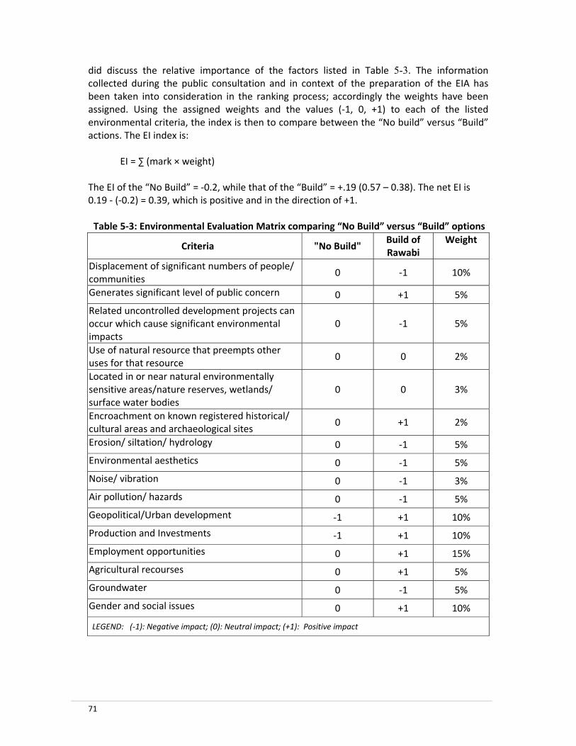
71
did discuss the relative importance of the factors listed in Table 5-3. The information collected during the public consultation and in context of the preparation of the EIA has been taken into consideration in the ranking process; accordingly the weights have been assigned. Using the assigned weights and the values (‐1, 0, +1) to each of the listed environmental criteria, the index is then to compare between the “No build” versus “Build” actions. The EI index is:
EI = ∑ (mark × weight) The EI of the “No Build” = ‐0.2, while that of the “Build” = +.19 (0.57 – 0.38). The net EI is 0.19 ‐ (‐0.2) = 0.39, which is positive and in the direction of +1. Table 5‐3: Environmental Evaluation Matrix comparing “No Build” versus “Build” options
Criteria "No Build" Build of Rawabi
Weight
Displacement of significant numbers of people/ communities
0 ‐1 10%
Generates significant level of public concern 0 +1 5%
Related uncontrolled development projects can occur which cause significant environmental impacts
0 ‐1 5%
Use of natural resource that preempts other uses for that resource
0 0 2%
Located in or near natural environmentally sensitive areas/nature reserves, wetlands/ surface water bodies
0 0 3%
Encroachment on known registered historical/ cultural areas and archaeological sites
0 +1 2%
Erosion/ siltation/ hydrology 0 ‐1 5%
Environmental aesthetics 0 ‐1 5%
Noise/ vibration 0 ‐1 3%
Air pollution/ hazards 0 ‐1 5%
Geopolitical/Urban development ‐1 +1 10%
Production and Investments ‐1 +1 10%
Employment opportunities 0 +1 15%
Agricultural recourses 0 +1 5%
Groundwater 0 ‐1 5%
Gender and social issues 0 +1 10%
LEGEND: (‐1): Negative impact; (0): Neutral impact; (+1): Positive impact

72
6. MITIGATION MEASURES
This section summarizes mitigation measures that are required and recommended, and it also presents information regarding the responsibility of the implementation and management. Bayti ought to demand the contractors to include in their bid documents illustrative plans that comply with these measures. In addition, Bayti is obliged to coordinate with the pertinent Palestinian authorities regarding the monitoring of the measures. The following sections summarize the mitigation measures as proposed for implementation during and after project construction.
6.1 During Construction
The mitigation measures during construction are listed in Table 6-1 as per the corresponding environmental item and are ranked as required or recommended. Required should be implemented to avoid and mitigate the adverse impacts while recommended are additional mitigation measures to be implemented to further enhance and protect the environment. Impacts that occur during construction are primarily associated with land preparation, earth works, material transportation and movement of heavy machinery. Such impacts are mostly short term, local, and caused by the contractor’s activities in the area. These impacts and the corresponding concerns are usually minor and can be easily addressed using appropriate mitigation measures in the contracts of the civil works and therefore can be mitigated through proper co‐ordination with the contractor and concerned parties. The most important issues are for:
• Construction and demolition wastes. • Risk of damage to agricultural, archaeological, or historical sites. • Risks of damage of the surrounding environment such as the agricultural areas, the
ecological system and the vegetative cover.
6.2 Post Development
After the construction of Rawabi further remedies and measures are recommended as detailed in Table 6-2. These measures are required and/or recommended to be implemented to maintain Rawabi’s environment and to mitigate and compensate the environmental impacts that are expected post development of Rawabi. Both Table 6-1 and Table 6-2 rank the mitigation measures as required and recommended. No significant cumulative impact is expected to be caused by the development of Rawabi. The construction or the City of Rawabi is by itself a positive cumulative impact as a new Palestinian city is created on a rangeland area classified as “A” by Oslo agreement. The urban development of that area has cumulative positive impacts and will continue enhancing the neighborhood.

73
6.3 Vegetation Plan
The following is a proposed plan to conserve the endangered species:
• Collecting different propagating materials from the above plant species during the growing season, seed collection and other propagation parts could be utilized.
• The propagation material has to be sent to a professional nursery to perpetuate them
• Other tree species could also introduced from nurseries or other site for the establishment
• Establishing a vegetation area that will be cultivated with the propagated plant species and other species including: several endangered plant species such as: Pinus Halepensis (Pine), Cupresus Semipervirens (Cypress), Qurecus Caliprinos (Oak), Ceratonia Siliqua (Carob), and Crataegus Aroni (Zaroor).
• Increase the public awareness for such places that will be more accessible (fire signs aware, cuttings and grazing prevention)
• Establishing new reserve area away from the project in the governmental lands (if available). This will substitute the losses of the established species, and assists the endangered species to survive.

Table 6‐1: Mitigation measures during construction and corresponding ranking as per each identified element
Item Mitigation Measures Rank
Excavatio
n and Wastes
• The contractor will store excess cut materials in areas that minimize environmental damage. Some of the excess aggregate materials may be used to aid in agricultural lands reclamation activities. Other excess materials will be used in the construction activities and the retention structure of the storm water. Remaining materials may also be available for uses in concurrent or future construction activities or be demolished properly.
• The contractor will separately store all high quality soils and use them to reclaim agricultural lands under the direction of the Ministry of Agriculture (MoA). During the design process, prior to implementation, it is to locate, design and submit final storage site plans. Compliance with this directive will be ensured during the design‐build process and inspection during construction.
• The contractor must transport the construction waste to a dumping area that is approved by MPW. • It is suggested to allocate a nearby abandoned stone crusher or quarry and landfill it with the construction waste and demolition.
Required Recommended Required Recommended
Agriculture
• In order to arrive at a no net loss of arable lands, the proponent will coordinate agricultural reclamation activities with the MoA. The amount, location, and timing of these reclamation efforts will be submitted for review and approval to the Ministries of Public Works (MPW) and the MoA.
• The contractor will remove olive and other valuable trees in a way that they can be transplanted in other suitable locations as determined by the MoA. The removed trees shall be stored in accordance with MoA instructions. The trees to be transplanted will be tagged prior to clearing and grubbing activities. Compliance with this directive will be verified during continuous construction inspection.
Required Required
Dust
• The contractor will utilize a dust palative such as calcium carbonate or other suitable dust control means during earthwork activities in cleared or erodible areas. Continuous visual inspections during construction will verify compliance with/need for additional compliance measures.
Required

75
Social and
Econo
mic • In order to mitigate social or economic impacts associated with owned lands, the proponent should consider
exchanging lands for privately owned lands required for the project. • In order to mitigate economic impacts from lost lands and ownership, the proponent should consider direct monetary compensation. This compensation would be based on average market price in the West Bank.
• In order to mitigate social or economic impacts associated with land ownership, the proponent should consider compensating farmers for 100% of the value of land removed from agricultural production.
Recommended Recommended Recommended
Safety and
labo
r
• The contractor will utilize industry standard construction zone safety practices and equipment. This includes detours, warning signs, and temporary traffic control devices. These shall be inspected daily during construction of the project.
• The contractor will comply with the Palestinian employment and wage guidelines. This measure is intended to maximize the employment benefits of construction. Compliance with this directive will be verified during random inspections and interviews throughout the construction process.
• In order to minimize potential health hazards, the contractor will utilize procedures that maximize worker safety and wellbeing. This includes exposure to heat, noise, dust, and solid and hazardous waste. These procedures will be established during negotiations between Bayti and the contractors working on the site. They can be modified during the coordination meetings.
Required Required Required
Roads and Traffic
• The contractor will abide by local laws concerning maximum weight and speeds of vehicles transporting construction materials. The purpose of this measure is to minimize potential safety or environmental hazards such as traffic accidents, pavement damage, or excess dust generation. Compliance with this measure will be verified during continuous construction inspection.
• In order to achieve a safer road network, utilizing additional measures should be considered; e.g. pavement and curve marking such as raised reflectors between lanes and painted barriers on curves.
• In order to avoid impacting the availability of transportation services, the contractor should provide transportation for workers to and from the construction site.
Required Recommended Recommended
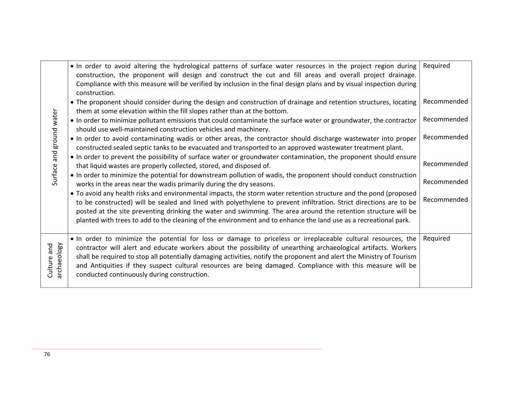
76
Surface and grou
nd water
• In order to avoid altering the hydrological patterns of surface water resources in the project region during construction, the proponent will design and construct the cut and fill areas and overall project drainage. Compliance with this measure will be verified by inclusion in the final design plans and by visual inspection during construction.
• The proponent should consider during the design and construction of drainage and retention structures, locating them at some elevation within the fill slopes rather than at the bottom.
• In order to minimize pollutant emissions that could contaminate the surface water or groundwater, the contractor should use well‐maintained construction vehicles and machinery.
• In order to avoid contaminating wadis or other areas, the contractor should discharge wastewater into proper constructed sealed septic tanks to be evacuated and transported to an approved wastewater treatment plant.
• In order to prevent the possibility of surface water or groundwater contamination, the proponent should ensure that liquid wastes are properly collected, stored, and disposed of.
• In order to minimize the potential for downstream pollution of wadis, the proponent should conduct construction works in the areas near the wadis primarily during the dry seasons.
• To avoid any health risks and environmental impacts, the storm water retention structure and the pond (proposed to be constructed) will be sealed and lined with polyethylene to prevent infiltration. Strict directions are to be posted at the site preventing drinking the water and swimming. The area around the retention structure will be planted with trees to add to the cleaning of the environment and to enhance the land use as a recreational park.
Required Recommended Recommended Recommended Recommended
Recommended Recommended
Cultu
re and
archaeology
• In order to minimize the potential for loss or damage to priceless or irreplaceable cultural resources, the contractor will alert and educate workers about the possibility of unearthing archaeological artifacts. Workers shall be required to stop all potentially damaging activities, notify the proponent and alert the Ministry of Tourism and Antiquities if they suspect cultural resources are being damaged. Compliance with this measure will be conducted continuously during construction.
Required

77
Soil
• In order to minimize soil erosion and water quality deterioration during and after construction, the proponent will design a sediment and erosion control Program. This program will be monitored continuously during construction. The presence of rill or inter‐rill erosion, slope sloughing or excess sedimentation is evidence of failed compliance.
• In order to minimize soil erosion, the precursor to water quality deterioration and blown dust, during and after construction, the proponent shall progressively vegetate exposed areas caused by construction activities as appropriate for the location. This vegetation of all impacted areas shall begin as soon as possible after work at a site is completed. This program will be monitored continuously during construction and monthly until the vegetation is stable
Required Recommended
Noise
• In order to minimize noise impact the contractor shall not operate heavy or noisy machinery between the hours of 22:00 and 05:00. Compliance will be monitored continuously during construction.
• In order to minimize noise or olfactory impacts, the proponent should place the mobile stone crusher and temporary concrete mix plants away from the populated areas.
• In order to minimize noise impacts during the construction of later phases of Rawabi, the proponent should ban the use of engine brakes (Jack braking) near occupied houses or other sensitive receptors such as parks.
Required Recommended Recommended
Seismic and
land
slide
• In order to minimize damage from seismic forces or other landslide events, the proponent shall design the buildings, roads, culverts, retaining walls, water drainage systems, slopes, and any other structures or fill material and aggregate piles to resist reasonably expected levels of seismic activity. Compliance to this will be monitored in the design and continuously during construction.
Required
Solid
waste • Use of closed containers for solid waste and avoid burning or disposal of the wastes in open areas.
• The contractor should dispose of container/waste materials in productive ways such as mechanical chipping/mulching of wood for use as moisture retaining ground cover.
Required Recommended

78
Hazardo
us wastes
• The contractor shall outline, submit, and implement a plan to store hazardous materials in special containment sites that are designed to confine these materials, even in the event of a spill. These sites shall be restored after construction is completed. Compliance will be monitored continuously during construction.
• In order to minimize potential social, economic or environmental damage, the contractor shall develop and utilize a spill response plan and educate appropriate staff as to the proper procedures included in the plan. This plan will be submitted to the EQA for approval prior to hazardous materials being transported for the project. Compliance to this plan will be monitored during construction.
• In order to minimize potential social, economic or environmental damage, the contractor shall mark vehicles transporting hazardous materials as to the type of cargo and location of cleanup equipment and supplies. These supplies will be kept in the hazardous materials containment site. Compliance to this plan will be monitored during construction.
• In order to minimize the potential for a hazardous materials spill, the contractor should use non‐hazardous materials during construction if possible and practical.
Required Required Required Recommended
Natural Resou
rces
• In order to minimize environmental impacts, the contractor will locate workers camps away from natural resources including springs and biodiversity areas. The potential locations of these camps will be submitted to EQA for approval prior to camp construction. Compliance with this requirement will be monitored during camp location.
• In order to maintain a viable population of rare and threatened plants, the proponent will retain a qualified botanist to conduct a walkover along the entire site at regular intervals. The purpose of this walkover is to collect and sow seeds and transplant any rare or endangered plants to more suitable locations. The biologist, in coordination with the EQA, will determine the appropriate locations to re‐establish these plants.
• In order to avoid disrupting breeding behavioral or destroying nesting habitat, the proponent shall conduct clearing activities in biodiversity only during late summer or early fall. Compliance with this will be monitored continuously during construction.
Required Recommended Recommended
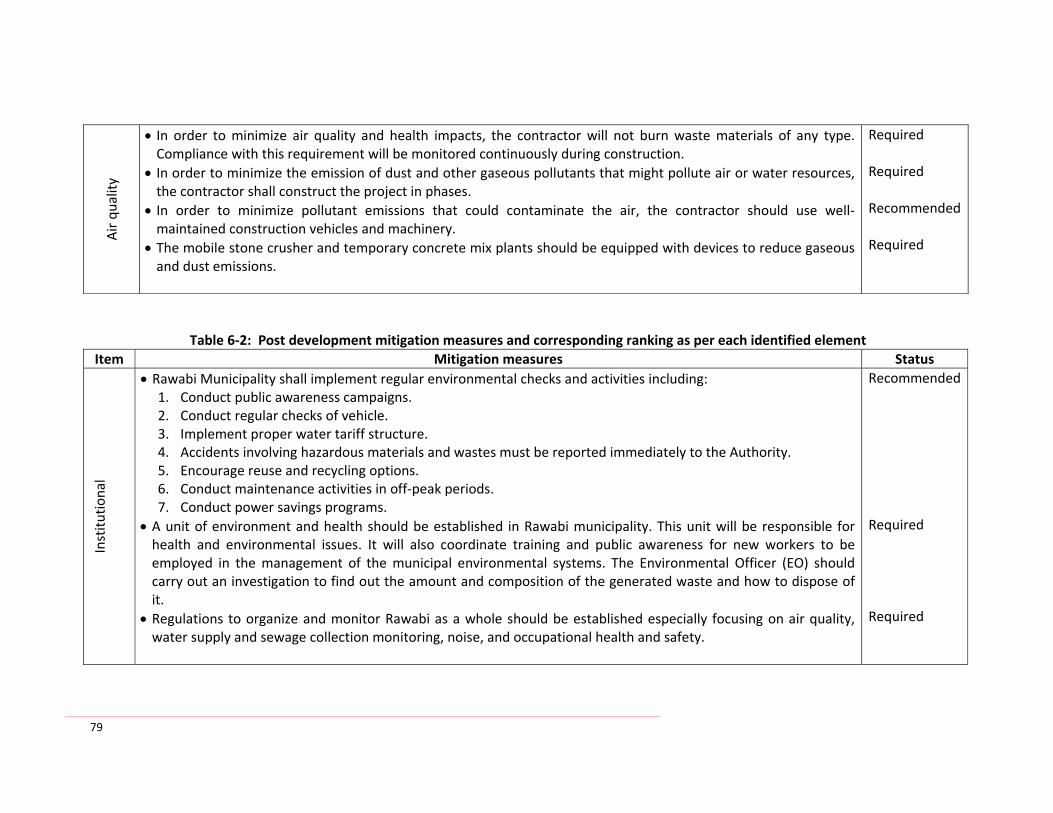
79
Air quality
• In order to minimize air quality and health impacts, the contractor will not burn waste materials of any type. Compliance with this requirement will be monitored continuously during construction.
• In order to minimize the emission of dust and other gaseous pollutants that might pollute air or water resources, the contractor shall construct the project in phases.
• In order to minimize pollutant emissions that could contaminate the air, the contractor should use well‐maintained construction vehicles and machinery.
• The mobile stone crusher and temporary concrete mix plants should be equipped with devices to reduce gaseous and dust emissions.
Required Required Recommended Required
Table 6‐2: Post development mitigation measures and corresponding ranking as per each identified element Item Mitigation measures Status
Institu
tional
• Rawabi Municipality shall implement regular environmental checks and activities including: 1. Conduct public awareness campaigns. 2. Conduct regular checks of vehicle. 3. Implement proper water tariff structure. 4. Accidents involving hazardous materials and wastes must be reported immediately to the Authority. 5. Encourage reuse and recycling options. 6. Conduct maintenance activities in off‐peak periods. 7. Conduct power savings programs.
• A unit of environment and health should be established in Rawabi municipality. This unit will be responsible for health and environmental issues. It will also coordinate training and public awareness for new workers to be employed in the management of the municipal environmental systems. The Environmental Officer (EO) should carry out an investigation to find out the amount and composition of the generated waste and how to dispose of it.
• Regulations to organize and monitor Rawabi as a whole should be established especially focusing on air quality, water supply and sewage collection monitoring, noise, and occupational health and safety.
Recommended Required Required

80
Water • In order to meet the expected water demands of Rawabi, the proponent may consult the Palestinian Water
Authority to develop new water resources such as drilling new wells. A comprehensive hydro‐geological study is suggested in this regard.
Recommended
Waste
water • Use air jitters to vacuum toxic gases from manholes during maintenance and cleaning activities of the sewage
system. • Conduct regular preventive maintenance to the wastewater collection system
Required Recommended
Solid
Waste
• Daily cover of wastes, spraying and fighting rodents and insects are required to control the unhealthy conditions. • Periodical collection of solid waste and transport to an approved sanitary landfill site
Required Required
Traffic and
Noise • Strict enforcement of speed limits inside Rawabi roads may be considered. This may reduce both the number and
severity of accidents. • In order to monitor safety performance inside Rawabi, accident reporting guidelines and an accident database for all accidents occurring may be established.
• Increase in noise levels due to traffic sources in comparison to current ambient noise levels can be minimized through the use of well‐serviced and maintained vehicles, in addition to the traffic reduction measures
Required Recommended Recommended
Hazardo
us
wastes
• The proponent is to establish a set of procedures for dealing with the accidental spill of hazardous materials. These procedures would include methods for cleaning fuel, battery acids or radiator fluids that leak during an accident. These procedures should ensure that the materials do not enter the environment
Recommended

81
Natural Resou
rces
• In order to reduce the damage to the natural area, it is recommended to establish vegetation areas cultivated with the following: halepensis (Pine), Cupresus semipervirens (Cypress), Qurecus caliprinos (Oak), Ceratonia siliqua (Carob), and Crataegus aroni (Zaroor).
• In order to reduce the damage to the natural area, it is recommended to increase the public awareness for such places that will be more accessible (fire signs aware, cuttings and grazing prevention)
• In order to reduce the damage to the natural faunas, it is recommended to establish vegetation areas. This will help the birds and animals to reestablish themselves. These green areas will help keeping and reestablishing nests and places for both animals and birds to stay and reproduced.
Required Recommended Recommended
Cultu
re and
archaeology • In order to facilitate a potential tourism to Rawabi, the proponent may consult the Ministry of Tourism and
Antiquities and wish to give investigation preference to sites near and inside Rawabi. • In order to reduce the damage to the archaeological sites, it is recommended to increase the public awareness for such places.
Recommended Recommended
Electricity
• The electricity feeder pillars are to be integrated into the outside or boundary wall of the buildings and are to be closed in safe closest accessible only to authorized personnel.
• Clear warning signs are to be posted at the buildings near the closets to instruct the inhabitants and to avoid risks and health hazards.
• Apply the energy efficiency and energy savings measures
Recommended Required Required

7. ENVIRONMENT MANAGEMENT AND MONITORING PLAN
The objective of the EMMP is to cater to the environmental and social needs of the project in a simple, responsive and cost effective manner that will not necessarily overload or impede the project. The EMMP demonstrates the proposed monitoring activities that encompass all major impacts and identify the way in which it will be integrated into project supervision. The EMMP provides highlights of management issues to ensure that the implementation of Rawabi project will be according to the recommendation set forth in the EIA. In the EMMP (Annex X), the environmental mitigation and monitoring actions are presented in a matrix format. The matrix identifies the issues and mitigation measures. It also carries out the mitigation measures, environmental monitoring, and the monitoring actions. The EMMP provides tools for environmental auditing. The environmental parameters addressed in the EMMP include, but not limited to: • Dust and gases emissions • Water (wastewater, storm water, treatment plant) • Construction wastes • Accidental risks • Loss of vegetation
7.1 Environmental Management Framework
The primary objective of environmental management is to ensure the implementation of the project activities in a manner that does not cause unwarranted adverse impacts on the environment. The type and significance of the environmental impacts vary according to the function and sector of the project. Both positive and negative impacts on the environment and social life are presented in detail along with the findings of the environmental assessment. Environmental auditing is recommended during the different phases of the project, to ensure further assessment of the impacts and to control their effects. The environmental matrix (see Annexes I and II) shows the expected impacts of Rawabi, sector wise, and it also lists the mitigations to be implemented prior to the construction of the projects. The matrix identifies the issues and the mitigation measures proposed to be implemented during and after the construction of the project.
7.2 Institutional Requirements and Environmental Training
The development of training modules and manuals followed by introductory courses will focus on safe operation and maintenance of the wastewater treatment plant, on appropriate procedures for the laboratories responsible for the analysis of emissions and effluent, and on safety measures for the operator and employees of the Rawabi. The basis

83
of the development of the training modules and manuals will be an analysis of the actual situation, the existing standard operation and maintenance procedures. It is recommended to establish a training facility in Rawabi. Municipal and other related institutions, employees should be educated not only on operational related matters but also on potential hazards and environmental, health and safety matters. Training programs for employees may include the following:
• Scope of problems related to the environment, • Reason and purpose of the environmental regulations, • Handling, storing, and labeling of chemicals and hazardous materials (including
separate packing of hazardous waste in secure containers for separate collection), • Proper collection and intermediate storage of wastes at Rawabi, • Protection against health hazards, • Safety programs and prevention of accidents, • Procedures for emergency care of injured personnel, • Control and maintenance of facilities.
7.3 Management of the Wastewater Treatment Plant
To safeguard water quality, an adequate operation and maintenance of the wastewater treatment plant is essential. To avoid environmental and health hazards, Rawabi Waste Water Treatment Plant (WWTP) staff should be trained in the following fields:
• Specific chemist and biology of the wastewater treatment process, • Characteristics of wastewater (COD, BOD, TSS, etc.), • Wastewater calculation, • Treatment process (theory and practical application, operation of related
equipment) Chemical additions (pH control, calculation of dosages, operating procedures),
• Maintenance, • Laboratory procedures (proper sampling techniques. calibration of laboratory
instruments standard analytical procedures, data preparation and evaluation), • Safety matters (prevention and handling of accidents, safe handling, storage and
disposal of chemicals).
7.4 Environmental Standards
As accuracy of sampling and analysis of emissions and effluents will be critical for the effectiveness of the environmental monitoring programs, it should be guaranteed that quality standards are fulfilled. In the case of training requirements, the laboratory staff that will be in charge of the analysis should be trained in the following aspects of laboratory management and quality control:

84
• Laboratory regulations, • Preventive measures for accidents, • Signature of all responsible persons, • Organization of quality assurance including responsibilities, • Qualification and further education of laboratory staff, • Operational procedures for all aspects of sampling, • Calibration of instruments, reference compound, • Handling of chemicals, • Standard analytical procedures for all laboratory analyses required according to
recognized standards (e.g. ISO 9000), • Procedures for tracking of samples, • Statistical measures and evaluation of results treatment of faulty results, • Reporting of analyses according to standardized reporting forms documentation
system, • Environment and safe disposal of laboratory waste (classification, collection,
intermediate storage, transport and final disposal), • Procurement rules and regulations of equipment and consumables.
7.5 Waste Disposal
• Introduction of solid waste databases, which facilities the documentation and implementation of a solid waste management concept,
• Only one department should assume responsibility for the different stages of waste management. This should include the approval of policies related to solid waste management,
• A regulator system for management and monitoring of hazardous wastes has to be developed for follow‐up of wastes from the source to the dumpsite.

85
8. CONCLUSION AND OVERALL ASSESSMENT
Rawabi will be the first Palestinian city to be built in accordance with a Master Plan which depicts the way the new city will grow and flourish and how future land use decisions will contribute to the achievement of social, economic and environmental goals. Any funding agency like OPIC may consider plans to finance projects for the new city of Rawabi. In accordance with OPIC and the requirements of other potential international funding agencies, this EIA, which is based on a master planning and feasibility study level, is conducted to examine the existing situation and to identify the reasonably foreseeable significant effects, both beneficial and adverse, of the proposed project on the environment. The EIA report summarizes the results of the impact assessment for the Rawabi project. It includes an overview of the key social and environmental impacts associated with the construction and post development of Rawabi. It recommends alternatives and measures which address adverse environmental impacts resulting from the project implementation. It is concluded that providing the proposed and recommended mitigation measures and the environmental, social, health and safety management of the facilities are incorporated and addressed in the ways described within this report. Consequently, associated environmental, social and health impacts can be maintained within acceptable levels. The EIA has investigated and assessed the significance of the predicted positive and negative impacts associated with the proposed Rawabi project. These impacts, along with the wider environmental issues, will need to be considered in the decision‐making process. No negative impacts of high significance were identified, provided that all mitigation measures are applied effectively. In order to ensure effective application of the management actions and monitoring proposed in this EIA, a comprehensive EMMP (Annexes I and II) is prepared. Recommendations are provided for the best practicable environmental option, mitigation and management actions, as well as suggested monitoring during construction and post development. The proponent of the project, Bayti, is committed to the standards and requirements for the protection of the environment and to the application of all the required mitigation measures addressed in this EIA. Bayti Real Estate Investment Company has expressed its legal commitment towards this EIA. It is recommended to approve this EIA and to issue the environmental approval for the construction of Rawabi.

86
9. EIA REPORT PREPARERS
The following are the names and qualifications of the key report preparers: Hafez Shaheen, PhD (Team Leader), Department of Civil Engineering, An‐Najah National University
Dr. Shaheen is a recognized authority in Environmental Planning of Engineering Systems. He has broad knowledge of and experience in the field of water, wastewater and environmental engineering systems including design, planning and management. He participated in a number of consulting projects as a Project Manager or Deputy Project Manager and/or design supervisor in the fields of water, wastewater and environmental engineering including water distribution systems, wastewater systems, and solid waste management. He is very well experienced within the preparation of feasibility studies and environmental impact assessment for several infrastructure projects in different engineering fields.
Mohammad N. Almasri, PhD
Water Resources Management and Engineering Department of Civil Engineering, An‐Najah National University
Atef Abu Jaish, MSc
Environmental Researcher MSc. Environmental Sciences Water and Environmental Studies Institute, An‐Najah National University
Anan Jayyousi, PhD
Water Resources Management and Engineering Department of Civil Engineering, An‐Najah National University
Hassan Abu Qaoud, PhD Agronomist Agricultural Department, An‐Najah National University
Ammar Jarrar, PhD Water Resources Management and Engineering Head of Projects Unit, An‐Najah National University
Jalal Dabiek, PhD Civil and Earthquake Engineering Director, Earth Sciences and Seismic Engineering Center An‐Najah National University

87
10. REFERENCES
Al‐Esiawi, D. 1998. Wild flowers of Jordan and neighboring countries. Amman, Jordan.
Al‐Khatib, Issam. (2009). Integrated Solid Waste Management for Rawabi First Palestinian New Master‐Planned Community. Birzeit University (BZU), Palestine.
Aliewi, A., Abu Sada, J., and Imseih N. (2009). Assessment of Groundwater Vulnerability for Ramallah Wastewater Treatment Plant. House of Water and Environment (HWE), Palestine.
Awadallah, F., Al‐Sahili, K. (2009). Traffic assessment for Rawabi, Palestine.
British Geological Survey (2004). A New Hydro‐geological Map of the West Bank. Scale 1:250000.
GMTC. (February, 2009). Site investigations report for the proposed New Community of Rawabi located Ajoul‐Palestine. Geotechnical and Material Testing Center (GMTC). Palestine.
Issac, J. and M. Saade. (1999). Strategic option for sustainable natural resource management in Palestine. Agricultural Natural Resources. The Palestinian Conference on Agricultural Policy and Strategies. Hebron. Palestine.
Issac, J. and S. Gasteyer. (2000). The Issue of Biodiversity in Palestine. Applied Research Institute – Jerusalem, Palestine.
Mohammad, A. (2000). Vegetation cover and productivity of the rangeland in the southern parts of the West Bank. Bethlehem Univ. J. (19) 75‐87.
Sharholy, M., Ahmad, K., Mahmood, G., Trivedi, R. C. (2008). "Municipal solid waste management in Indian cities – A review.
Seo, S., Aramaki, T., Hwang, Y., Hanaki, K. (2004). "Environmental impact of solid waste treatment methods in Korea." Journal of Environmental Engineering Division.
Shtayeh, M. and Kalil, A. 1995. Protection of the Palestinian Environment. Nablus, Palestine.
Staples, D., Pope, D. (May, 2009). Rawabi Project‐design Intent Document for Water Utilities. Faber Maunsell Limited.
World Bank (1994). Environmental Assessment Source Book, Vol. II, Washington, D.C. World Bank.
World Bank (1994). Environmental Assessment Source Book, Vol. III, Washington, D.C. World Bank.
World Bank (1994). Environmental Assessment Source Book, Vol. I, Washington, D.C. World Bank.
Zimmo, Omar. (March, 2009). Sewerage System for Rawabi Community. Birzeit University (BZU), Palestine.

88
11. ANNEXES
Annex I: Environmental Management and Monitoring Plan (During Construction) Annex II: Environmental Management and Monitoring Plan (Post Construction) Annex III‐A: EQA Terms of Reference (TOR) Annex III‐B: Scope of Services Annex IV: Exchanged letters between Rawabi and neighborhood villages Annex V: Letter sent to the Palestinian Authorities Annex VI: Letter of MoT and Reply Annex VII: Field Surveys Annex VIII: EQA comments and ANUPU reply Annex IX: Maps

89
Annex I: Environmental Management and Monitoring Plan (During Construction) Co
nstruction
activities
Environm
ental
Elem
ent
Potential Impacts
Mitigation Measures
Responsible party
Duration of
measure
Monitoring Institution
Excavatio
n and Waste Dem
olition
Air, w
ater cou
rses and
wad
is
• Excavation and excess wastes
• Dust production • Close of waterways and wadis
• Altering the hydrological patterns of surface water
• Store excess cut materials in areas that minimize environmental damage.
• Use excess aggregate materials in agricultural lands reclamation activities.
• Use excess materials in the construction activities and the retention structures.
• Remaining materials to be demolished properly. • Separate and store all high quality soils and use them to reclaim agricultural lands.
• Design and submit final storage site plans. • Transport the construction waste to an approved site.
• Utilize a dust palliative such as calcium carbonate or other suitable dust control means.
• Water spray of the construction site and the stockpiles of the excess cut materials.
• Cover stored excess cut materials.
Contractor Bayti Bayti Contractor Contractor Consultant Contractor Contractor Contractor Contractor
During Design and bu
ild process
EQA and MoPWH MoA MoPWH EQA and MoPWH Bayti MoPWH EQA MoPWH MoPWH
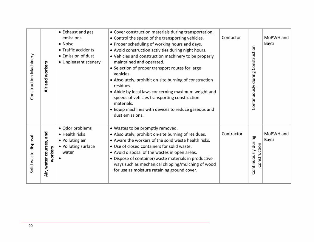
90
Constructio
n Machine
ry
Air and
workers
• Exhaust and gas emissions
• Noise • Traffic accidents • Emission of dust • Unpleasant scenery
• Cover construction materials during transportation. • Control the speed of the transporting vehicles. • Proper scheduling of working hours and days. • Avoid construction activities during night hours. • Vehicles and construction machinery to be properly maintained and operated.
• Selection of proper transport routes for large vehicles.
• Absolutely, prohibit on‐site burning of construction residues.
• Abide by local laws concerning maximum weight and speeds of vehicles transporting construction materials.
• Equip machines with devices to reduce gaseous and dust emissions.
Contactor
Continuo
usly during Co
nstructio
n
MoPWH and Bayti
Solid
waste dispo
sal
Air, w
ater cou
rses, and
workers
• Odor problems • Health risks • Polluting air • Polluting surface water
•
• Wastes to be promptly removed. • Absolutely, prohibit on‐site burning of residues. • Aware the workers of the solid waste health risks. • Use of closed containers for solid waste. • Avoid disposal of the wastes in open areas. • Dispose of container/waste materials in productive ways such as mechanical chipping/mulching of wood for use as moisture retaining ground cover.
Contractor
Continuo
usly during
Constructio
n
MoPWH and Bayti
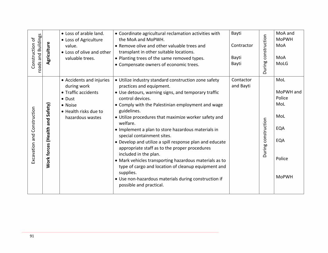
91
Constructio
n of
roads and Bu
ildings
Agriculture
• Loss of arable land. • Loss of Agriculture value.
• Loss of olive and other valuable trees.
• Coordinate agricultural reclamation activities with the MoA and MoPWH.
• Remove olive and other valuable trees and transplant in other suitable locations.
• Planting trees of the same removed types. • Compensate owners of economic trees.
Bayti Contractor Bayti Bayti
During constructio
n MoA and MoPWH MoA MoA MoLG
Excavatio
n and Co
nstructio
n
Work forces (H
ealth an
d Safety)
• Accidents and injuries during work
• Traffic accidents • Dust • Noise • Health risks due to hazardous wastes
• Utilize industry standard construction zone safety practices and equipment.
• Use detours, warning signs, and temporary traffic control devices.
• Comply with the Palestinian employment and wage guidelines.
• Utilize procedures that maximize worker safety and welfare.
• Implement a plan to store hazardous materials in special containment sites.
• Develop and utilize a spill response plan and educate appropriate staff as to the proper procedures included in the plan.
• Mark vehicles transporting hazardous materials as to type of cargo and location of cleanup equipment and supplies.
• Use non‐hazardous materials during construction if possible and practical.
Contactor and Bayti
During constructio
n
MoL MoPWH and Police MoL MoL EQA EQA Police MoPWH

92
Excavatio
ns and
Co
nstructio
n
Natural Resou
rces
(Flaura an
d Faun
a)
• Endanger rare species • Impact sensitive areas
• Locate worker camps away from environmentally sensitive areas.
• Retain a qualified botanist to conduct a walkover along the entire site at regular intervals.
• Collect and sow seeds and transplant any rare or endangered plants to more suitable locations.
• Apply a special program for the re‐settlement of the wildlife and re‐establishment of additional habitat. •
Bayti
During constructio
n
EQA and MoA
Constructio
n of
Rawabi
Social and
Econ
omic
• Loss of private lands and properties
• Loss of agricultural production
• Loss of trees
• Exchanging lands for privately owned lands required for the project.
• Direct monetary compensation. • Compensating farmers for 100% of the value of land removed from agricultural production.
Bayti
Once at th
e actio
n
MoPWH and MoJ
Transportatio
n of con
struction
material
Air, n
eighbo
rhoo
d, roa
ds
• Traffic accidents • Pavement damage • Excess dust • Availability of transportation services
• Abide by local laws concerning maximum weight and speeds of vehicles transporting construction materials.
• Utilize additional measures; e.g. pavement and curve marking such as raised reflectors between lanes and painted barriers on curves.
• Provide transportation for workers to and from the construction site.
Contractor and Bayti
Once at th
e actio
n
Police MoPWH and MoLG

93
Constructio
n works
Culture an
d archaeolog
y
• Loss or damage of cultural resource
• Alert and educate workers about the possibility of unearthing archaeological artifacts.
• Stop all activities, notify and alert the Ministry of Tourism and Antiquities (MoTA) if they suspect cultural resources are being damaged.
Contractor and Bayti
Once at th
e actio
n
MoTA, MoLG and MoPWH
Constructio
n works
Surface an
d grou
nd water
• Altering the hydrological patterns
• Potential pollution of surface water
• Impacting the spring located down stream
• Design and construct the cut and fill areas and overall project drainage along this project to maintain existing runoff and recharge patterns.
• Consider drainage and retention structures, locating them at some elevation within the fill slopes rather than at the bottom.
Consultant
MoPWH, PWA and EQA
• Use well‐maintained construction vehicles and machinery.
• Discharge wastewater into proper constructed sealed septic tanks to be evacuated and transported to an approved wastewater treatment plant.
• Ensure that liquid wastes are properly collected, stored, and disposed.
• Conduct construction works in the areas near the wadis primarily during the dry seasons.
• Seal retention structure and line them with polyethylene to prevent infiltration.
Contractor
Once at th
e actio
n
MoPWH and EQA

94
Excavatio
ns and
Con
struction
Soil an
d land
slide
• Soil erosion • Ware quality deterioration
• Landslide • Dust emission • Hillside erosion
• Design a Sediment and Erosion Control Program. • Balance cut and fill designs
Consultant
During Co
nstructio
n
Bayti and MoPWH
• Vegetate exposed areas caused by construction activities as appropriate for the location.
Bayti
MoA
• Implement erosion control measures • Construction detention ponds and sediment basins • Implement terracing of exposed slopes • Replant uprooted trees • Grass seeding of cut slopes
Contractor
MoPWH and Bayti
• Design the roads, culverts, retaining walls, water drainage systems, slopes, and any other structures to resist reasonably expected levels of seismic activity.
Consultant
Bayti
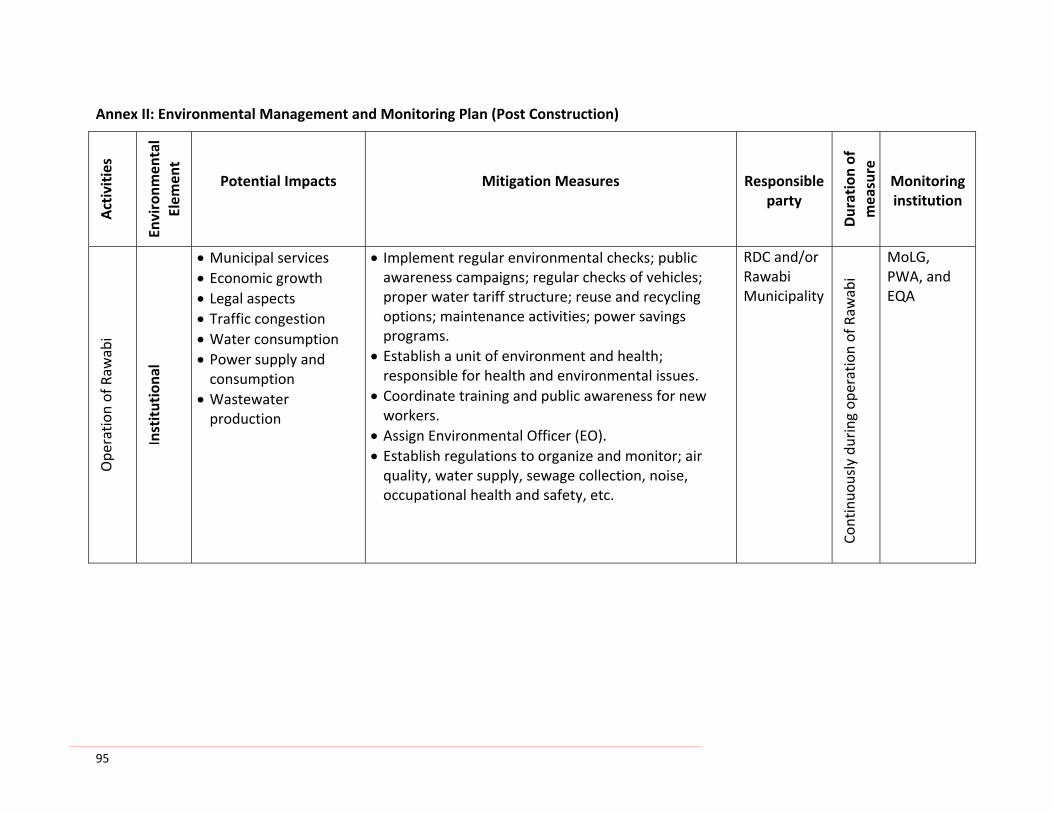
95
Annex II: Environmental Management and Monitoring Plan (Post Construction) Activities
Environm
ental
Elem
ent
Potential Impacts
Mitigation Measures
Responsible party
Duration of
measure
Monitoring institution
Ope
ratio
n of Raw
abi
Institutiona
l
• Municipal services • Economic growth • Legal aspects • Traffic congestion • Water consumption • Power supply and consumption
• Wastewater production
• Implement regular environmental checks; public awareness campaigns; regular checks of vehicles; proper water tariff structure; reuse and recycling options; maintenance activities; power savings programs.
• Establish a unit of environment and health; responsible for health and environmental issues.
• Coordinate training and public awareness for new workers.
• Assign Environmental Officer (EO). • Establish regulations to organize and monitor; air quality, water supply, sewage collection, noise, occupational health and safety, etc.
RDC and/or Rawabi Municipality
Continuo
usly during op
eration of Raw
abi
MoLG, PWA, and EQA
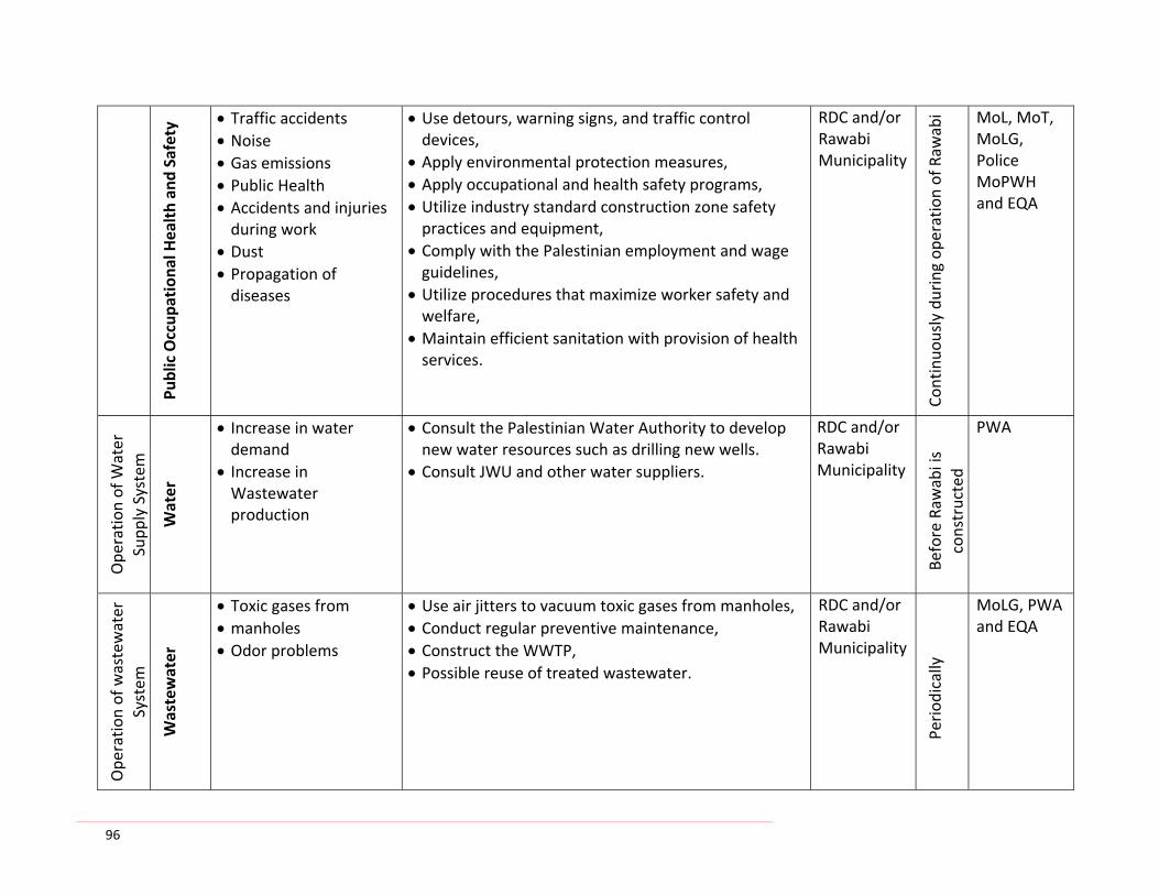
96
Public Occup
ationa
l Health an
d Safety • Traffic accidents
• Noise • Gas emissions • Public Health • Accidents and injuries during work
• Dust • Propagation of diseases
• Use detours, warning signs, and traffic control devices,
• Apply environmental protection measures, • Apply occupational and health safety programs, • Utilize industry standard construction zone safety practices and equipment,
• Comply with the Palestinian employment and wage guidelines,
• Utilize procedures that maximize worker safety and welfare,
• Maintain efficient sanitation with provision of health services.
RDC and/or Rawabi Municipality
Continuo
usly during op
eration of Raw
abi MoL, MoT,
MoLG, Police MoPWH and EQA
Ope
ratio
n of W
ater
Supp
ly System
Water
• Increase in water demand
• Increase in Wastewater production
• Consult the Palestinian Water Authority to develop new water resources such as drilling new wells.
• Consult JWU and other water suppliers.
RDC and/or Rawabi Municipality
Before Raw
abi is
constructed
PWA
Ope
ratio
n of wastewater
System
Wastewater
• Toxic gases from • manholes • Odor problems
• Use air jitters to vacuum toxic gases from manholes, • Conduct regular preventive maintenance, • Construct the WWTP, • Possible reuse of treated wastewater.
RDC and/or Rawabi Municipality
Period
ically
MoLG, PWA and EQA

97
Ope
ratio
n of Pow
er
supp
ly System
Electricity
• Electric shocks • Health risks • Energy and fuel consumption
• Integrate electricity feeder pillars into the outside or boundary wall of the buildings,
• Closed feeder pillars in safe closet accessible only to authorized personnel,
• Post clear warning signs at the buildings near the closest to instruct the inhabitants and to avoid risks and health hazards.
RDC and/or Rawabi Municipality
Continuo
usly
MoLG, EQA and PPA
Solid
waste
collection and
Air and
Pub
lic
• Odor • Insects • Rodents • Potential health risks and diseases
• Daily cover of wastes • Spraying and fighting disease vectors such as rodents and insects
• Effective periodical collection of solid waste and transport to an approved sanitary land fill site
RDC and/or Rawabi Municipality
Continuo
usly
MoLG and EQA
Traffic and
pub
lic
transport
Air and
Pub
lic
• Dust emission • Emission of gases • Increase in noise levels
• Accidents
• Strict enforcement of speed limits, • Establish accident reporting guidelines and an accident database,
• Use of well‐serviced and maintained vehicles, • Use of traffic reduction measures, • Provide enclosed refuse collection vehicles or, • Provide cloth tarpaulins to cover open top vehicles.
RDC and/or Rawabi Municipality
Continuo
usly
Police MoLG MoT MoT MoLG Police
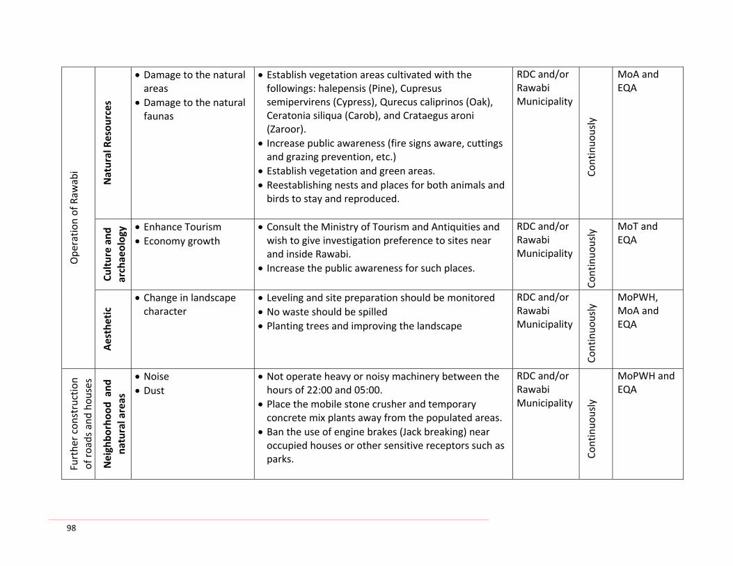
98
Ope
ratio
n of Raw
abi
Natural Resou
rces
• Damage to the natural areas
• Damage to the natural faunas
• Establish vegetation areas cultivated with the followings: halepensis (Pine), Cupresus semipervirens (Cypress), Qurecus caliprinos (Oak), Ceratonia siliqua (Carob), and Crataegus aroni (Zaroor).
• Increase public awareness (fire signs aware, cuttings and grazing prevention, etc.)
• Establish vegetation and green areas. • Reestablishing nests and places for both animals and birds to stay and reproduced.
RDC and/or Rawabi Municipality
Continuo
usly
MoA and EQA
Culture an
d archaeolog
y • Enhance Tourism • Economy growth
• Consult the Ministry of Tourism and Antiquities and wish to give investigation preference to sites near and inside Rawabi.
• Increase the public awareness for such places.
RDC and/or Rawabi Municipality
Continuo
usly MoT and
EQA
Aesthetic
• Change in landscape character
• Leveling and site preparation should be monitored • No waste should be spilled • Planting trees and improving the landscape
RDC and/or Rawabi Municipality
Continuo
usly MoPWH,
MoA and EQA
Furthe
r constructio
n of roads and
hou
ses
Neighbo
rhoo
d and
na
tural areas
• Noise • Dust
• Not operate heavy or noisy machinery between the hours of 22:00 and 05:00.
• Place the mobile stone crusher and temporary concrete mix plants away from the populated areas.
• Ban the use of engine brakes (Jack breaking) near occupied houses or other sensitive receptors such as parks.
RDC and/or Rawabi Municipality
Continuo
usly
MoPWH and EQA

99
Air and
Pub
lic
• Noise • Gas emission
• Control the speed of the transporting vehicles • Proper scheduling of working hours and days • Avoid construction activities during night hours • Vehicles and construction machinery to be properly maintained and operated
• Selection of proper transport routes for large vehicles • Abide by local laws concerning maximum weight and speeds of vehicles transporting construction materials.
• Equip machines with devices to reduce gaseous and dust emissions.
Contractor
Continuo
usly
Police MoPWH,
Rawabi
Mun
icipality
MoT and EQA

Environment Quality Authority Terms of Reference for Environmental Impact Assessment Rawabi
100 | 137
Annex III‐A: EQA Terms of Reference (TOR)
Environmental Impact Assessment
Project RawabiProponent Bayti Real Estate Investment Company
Contact
Project No
Application Date
Terms of Reference Date 11 June 2009
1. GENERAL REQUIREMENTS
These terms of reference (TOR) for an Environmental Impact Assessment (EIA) apply to the above‐referenced project (….) as described in the Proponent’s Application for Environmental Approval. Any significant changes to the Project as described in that Application may require that new TOR be prepared and approved by the Palestinian Environment Quality Authority (EQA) (Authority) before the Application can be considered further.
The EIA shall be carried out in conformity with requirements of the Palestinian Environmental Assessment Policy (PEAP), and with the General Guidelines for Environmental Assessment (the Guidelines) published by the Authority.
The EIA shall be a comprehensive evaluation of environmental impacts of the Project, and should be undertaken during pre‐feasibility and/or detailed feasibility studies. Its main purposes are
1) to assist the Proponent in planning the Project and
2) to provide the Authority with the information it needs to consider granting Environmental Approval.
The EIA describes the environmental planning that went into a project and what features are incorporated to mitigate adverse impacts and capture potential benefits. It includes an analysis of the severity and significance of impacts and benefits, especially for individuals and communities directly affected by the project. It also provides an environmental management plan.
The EIA Report shall be of sufficient quality to provide the Authority with the information needed to:
i) grant Environmental Approval, with or without conditions; OR ii) withhold Environmental Approval since the project has unacceptable environmental impacts.
The EIA report is expected to provide an overall description of the relevant parts and stages of the project using maps at appropriate scale where necessary and including the following information: location, general layout, size, capacity, etc.; pre‐construction activities,

Environment Quality Authority Terms of Reference for Environmental Impact Assessment Rawabi
101 | 137
construction activities, schedule, staffing and support, facilities and services, required on‐site and of‐site infrastructure…
2. SCOPE OF THE EVALUATION
The EIA shall focus on addressing key issues important to:
i) improved Project planning and design; ii) the local community; iii) the Authority in considering Environmental Approval; and iv) permitting authorities (…) in considering the issuing of permits required for the Project to
proceed.
Valued environmental components (VECs) which must be considered during the EIA are indicated with a check mark (√) in Annex A. As required for clarification, the VECs and the issues related to them are discussed further in Annex B.
The EIA shall assess project compliance with relevant local, district, regional and national land use and development policies, plans and programs, and with relevant regulatory standards.
The spatial boundaries and timeframe of the EIA shall be established to adequately address all direct, indirect, and cumulative as well as transboundary impacts on the VECs. As required for clarification, further directions concerning the spatial boundaries and timeframe of the EIA are provided in Annex B.
3. ENVIRONMENTAL PLANNING
The Authority expects the EIA to contribute positively and significantly to the planning and design of the Project. The EIA Report shall document how environmental factors were incorporated into Project planning and design, and what the results were. EIA study and reporting requirements on environmental planning are described in the Guidelines. The Proponent shall pay particular attention to the need to:
i) consider alternatives in planning and designing the Project; and ii) develop an environmental management plan (EMP).
As required for clarification, further directions concerning the consideration of alternatives and the development of an environmental management plan are provided in Annex B.
4. STAKEHOLDER CONSULTATION
In undertaking the EIA, the Proponent shall consult with relevant local, district and national governmental agencies to ensure that their concerns, interests and regulatory requirements are adequately reflected in the EIA strategy and report. Without limiting the scope of these consultations, a preliminary list of these agencies is included in Annex B of these TOR.

Environment Quality Authority Terms of Reference for Environmental Impact Assessment Rawabi
102 | 137
General guidance on public consultation is given in the Guidelines. Specific consultation requirements for this Project are discussed in Annex B.
5. MINIMUM EIA REPORT REQUIREMENTS
The EIA Report must contain at least:
i) Non‐technical executive summary; ii) An introduction to the project, the proponent, and the EIA strategy; iii) A summary of stakeholder and public consultations about the project; iv) Baseline conditions v) A description of the environmental planning for the project, and particularly of the
alternatives that were considered; vi) A description of the project, including environmental design and protection features; vii) Suitable maps showing the location of the project site(s), route(s) and alternatives, and
the arrangement of project facilities within the preferred site or route; viii) An assessment of significant, potential impacts and their mitigation measures; ix) An environmental monitoring and management plan; and x) Identification of the names and responsibilities of the people who carried out the EIA.
The EIA Report, and/or the letter of submission which accompanies it, must clearly indicate the extent to which the Proponent:
i) is in agreement with the contents of the Report; and ii) is committed to implementing the environmental planning, design, mitigation, compensation
and management measures it contains.
The Proponent shall note that the EIA Report will be reviewed by the Authority and other Palestinian National Authority (PNA) agencies using standard procedures. The comprehensive evaluation criteria used in these procedures represent quality standards which the Authority expects the Proponent to meet in his EIA Report.
The Proponent shall also note that if the draft EIA Report fails to meet the minimum requirements specified above, it will not be accepted for review by the Authority.
6. SUBMISSION AND REVIEW OF THE EIA REPORT
The Proponent shall submit three (3) copies of the draft EIA Report to the Authority's offices in Ramallah.
When the Authority is satisfied that the draft EIA Report meets the minimum reporting requirements, the Proponent shall submit 15 copies of the Report for detailed technical review under the provisions of the EA Policy.
The Authority will receive the feedback from the Proponent and has the right to change, add any paragraph necessary and the consultant should make the necessary changes depending on that.

Environment Quality Authority Terms of Reference for Environmental Impact Assessment Rawabi
103 | 137
Annex A
Valued Environmental Components (VECs)
Category Environmental ComponentBiophysical, Resource and √ Climate and air quality Land Use Components √ Surface water hydrology and quality √ Groundwater hydrology and quality √ Terrain and natural hazards
√ Soils and vegetation √ Wildlife resources and use √ Aquatic resources and use √ Recreation and tourism resources and use √ Forest resources and use √ Agricultural resources and use Mineral resources and use Economic Components √ Direct employment and income √ Indirect/induced employment and income √ Labor market conditions √ Sources of supplies, materials and services √ Transportation requirements √ Infrastructure development requirements and costs √ Government revenues/costs √ Indirect/induced economic development opportunities Cultural and Heritage √ Archaeological sites Components √ Traditional use sites √ Historic sites and landscape features Social Components √ Social/demographic profile √ Population √ Housing and accommodation √ Land and water use √ Transportation and traffic √ Community service delivery √ Local government revenues/costs √ Social support services √ Community stability, cohesion and well being √ Gender equity Health Components √ Supply of health facilities and services √ Community water supply and watersheds √ Waste treatment and discharge √ Ambient air and water quality √ Public health risks √ Worker health and safety √ Noise √ Local community health

Environment Quality Authority Terms of Reference for Environmental Impact Assessment Rawabi
104 | 137
Annex B
Specific EIA Requirements
VECs and Related Issues/Concerns
The EIA Report shall study issues and concerns related to the following VECs as follows:
• Air Quality
1. the wind directions and the boundaries of their negative impacts; 2. Source reduction and other mitigation measures; and 3. The monitoring system to be adopted.
• Groundwater hydrology and quality
1. The geology and hydrology of the area including the infiltration rates, outcrops and aquifer type, and the water table;
2. The possible sources of pollution to groundwater; 3. Negative impacts onto the groundwater and their mitigation measures; and 4. The monitoring system that will be established.
• Surface water hydrology and quality
1. The maximum annual rainfall; 2. The natural drainage system in the area; 3. The mitigation measures to be adopted; and 4. The monitoring plan.
• Soil and vegetation
1. The presence of endangered spaces in the area and measures to conserve them; 2. Possible negative impacts on the surrounding forestry and measures to conserve and
enhance them; 3. Soil erosion especially during construction and mitigation measures required for conserving
soils for other uses such as greening of the area; and 4. Vegetation conservation plan.
• Water resources and uses
1. The available water resources and uses scheme; 2. The safe yield of such resources; 3. The expected project's water consumption and its impacts on the resources and other
users; and 4. Measures to mitigate such impacts.

Environment Quality Authority Terms of Reference for Environmental Impact Assessment Rawabi
105 | 137
• Wildlife
1. The native Fauna; 2. The endangered wildlife in the area; 3. Sources of disturbance to the habitat; 4. Mitigation measures required to reduce or avoid disturbance; and 5. Plans to enhance the surrounding wildlife habitat.
• Recreation and tourism
1. The impacts of the project on the recreational and tourism activities in the area; 2. The role of the project to conserve the resources of such activities and measures to
enhance them.
• Agriculture
1. The agricultural activities in the area; 2. The project impact on the agricultural land uses and activities; 3. Possible mitigation measures; and 4. Plan for the area agricultural enhancement.
• Direct employment and income and labor market conditions
1. The project's impact on employment and income; 2. Measures to enhance the employment and income rates; 3. The impacts on local communities; and 4. Possible mitigation measures of any negative impacts on local communities.
• Sources of supplies, materials and services.
1. The nature of such sources; 2. The impact of such sources on the project, local communities, and the Palestinian economy; 3. Measures to mitigate such impacts; and 4. Plans and policies to insure sustainable Palestinian sources.
• Transportation
1. The expected traffic increase and routes to accommodate such increase; 2. The parking policy in the project area; 3. Map of the transportation system inside and outside the industrial estate during the
different project phases; and 4. Measures to mitigate congestion, air pollution, accidents and to ease transportation.

Environment Quality Authority Terms of Reference for Environmental Impact Assessment Rawabi
106 | 137
• Infrastructure
1. The capacity of the infrastructure to handle the project activities; and 2. The possible impacts of the development activities on the infrastructure and their
mitigation measures.
• Historic and Archeological sites and landscape features
1. In case of the presence of any archeological and historical site and landscape features in the area, a plan for conservation of such sites should be suggested; and
2. The plan should suggest also the coherence of the project landscaping with these sites and possible social and economic impact.
• Demographic profile, population and housing
1. The demographic map of the area; 2. The expected demographic changes in the map as a result of the project; 3. The housing needs to accommodate population increase; 4. The socio‐economical impacts of the population increase and a new housing; and 5. Compensation and other mitigation measure.
• Other social issues of concern that could attest from the scoping and public consultation which will be held prior to or during the report preparation
• Public health, health facilities and services
1. The possible health impacts of the project activities on workers, beneficiaries and the surrounding communities;
2. Accidents and health risks assessment; 3. Health facilities and services to serve both the Project and the neighboring communities; 4. The health monitoring plan; and 5. Other mitigation measures to avoid health risks and accidents.
• Waste water
1. Industrial and sewage water collection and treatment systems and technologies that will be established;
2. Who will be served by the proposed systems; 3. Measures for source reduction; 4. Treated waste water reuse; and 5. The possible impacts of wastewater collection, treatment and reuse or disposal and their
mitigation measures.
• Solid and hazardous wastes.
1. The solid and hazardous wastes management systems that will be suggested for the project;

Environment Quality Authority Terms of Reference for Environmental Impact Assessment Rawabi
107 | 137
2. Assessment of needs for equipment and facilities; 3. Measures for prevention and source reduction; and 4. Possible environmental impacts of handling and disposal of such wastes and the
mitigation measures.
• Noise and safety
1. Assessment of sources of risk and hazards that may endanger workers visitors and the neighborhoods' safety;
2. Measures to mitigate such risks and to improve safety; 3. Noise levels allowed; and 4. Measures to reduce noise levels.
Spatial Boundaries and Timeframe for the Study
• As appropriate to encompass anticipated effects on each VECs or group of VECs
i) Mapped definition of study area, including any alternatives to be considered. ii) Study time frame for construction phase and operation phase. iii) The possible transboundary impacts.
Alternatives to be Considered
• Alternatives within the site shall examine:
1. the different phases of the project; and 2. the locations of different facilities of the project based on clear criteria.
• Alternatives should consider:
i) Choice of technologies and processes; ii) Supply of materials, goods and services, especially where local suppliers exist; iii) Labor supply and scheduling for construction; iv) Handling of hazardous materials; v) Waste management; and vi) Water supply.
Minimum Requirements for an Environmental Monitoring and Management Plan
• For monitoring each phase of the project:
i) Environmental variables to be monitored, and frequency; and ii) Reporting to appropriate authorities and local community.
• Issues/concerns that are to be the subject of the environmental management plan, and reporting requirements to government and the public,
• Environmental standards and guidelines that will be adopted or required.
Environment Quality Authority Terms of Reference for Environmental Impact Assessment Rawabi
108 | 137
Stakeholder Consultation Requirements
Stakeholder consultation will be carried out during the early stages of report preparation. The purposes of consultation are:
1. To inform the public of all issues and concerns related to the project; 2. To determine public concerns. 3. To specify project performance standards to be met; 4. To collect data, information or local knowledge; 5. To avoid future conflicts with affected or concerned stakeholders; and 6. To mitigate public environmental concerns.
The consultant has to examine suitable means to reach and get feedback from the public.
Consultations and feedback should be included in the report.
In principle, stakeholders that will be consulted are the following.
1. The site and neighborhood land owners. 2. Affected communities and groups. 3. The surrounding municipalities. 4. Public institutions in the area. 5. The Palestinian ministries of:
• Agriculture • Transportation • Labor • Health • Local Government • Housing and Public Works • Water Authority • National Economy • Tourism and Antiquities.
6. The academic and scientific community. 7. NGOs in the region. 8. Other stakeholders the consultant finds that they are affected by the project.
During public consultations, page 4 of this TOR has to be examined and any additional concerns should be considered.
The significance of all issues and concerns mentioned in this TOR or presented during public consultations should be examined based on clear environmental criteria.

109 | 137
Annex III‐B: Scope of Services
Scope of Services for the Environmental Impact Assessment of Rawabi Community
Environmental Impact Assessment for Rawabi
First Palestinian Planned Community
Scope of Services
June 2009

110 | 137
Introduction: Rawabi is the first Palestinian planned community ‐ a response to the severe shortage of affordable housing in Palestine and the need to reverse the substantial decline in construction sector activity and to stimulate the Palestinian economy. The vision is to create a sustainable community with a mix of dwelling types and sizes and associated community facilities, new employment opportunities, open space and infrastructure. The community will have a potential population of 40,000 located on 6,300 dunum when completed. The ultimate aim is to create a sustainable development framework and prototype for development within other parts of Palestine. An‐Najah National University (ANU) through the Projects Unit (ANUPU) provides specialist engineering and environmental services to developers, government and professional clients in environmental assessment, management and monitoring. The specialist fields covered by our multi‐disciplinary staff include urban planning and development, GIS, hydrology and hydraulics, wastewater, water quality, air quality, solid waste, socio‐economy, local policies and legal framework, and biodiversity. Our services are relevant to residential, resort, commercial, industrial and infrastructure development in urban, rural and natural environments. These services are provided by our staff of scientists and engineers from our well‐equipped Water and Environmental Studies Institute (WESI) and other scientific centers which carried out many strategic projects, such as planning for Ramallah, Bitonia and Albeireh, as well as several Environmental Impact Assessment (EIA) including EIA of the Water Projects, EIA of the proposed site of a new cement factory at Qalqeelyah area, EIA of the proposed site of a new sanitary landfill in Anabta area, EIA of the proposed site of a new sanitary landfill in Asira Ash‐Shamalia, among other projects. The aim of this study is to examine the environmental and socio‐economic effects of the construction, operation and reclamation of the new planned community that covers 6,300 dunum. The study will identify also the relevant natural resources, the eco‐system and the population likely to be affected. Direct and indirect impacts will be identified and any particularly vulnerable groups or species highlighted. All the services of ANUPU described in the following shall be carried out in close co‐operation with Bayti and, as far as relevant, with other concerned authorities. It has been attempted to outline ANUPU's tasks during execution of this service as detailed as possible. However, ANUPU shall bear in mind that the list of tasks and activities can by no means be considered as the complete description of ANUPU's duties. It is understood that ANUPU performs all work as necessary to fulfill the objectives. During the ANUPU's assignment other Consultants and advisors may provide services to Bayti and/or other local authorities.

111 | 137
Environmental Impact Assessment content and Format for Rawabi community:
ANUPU assessment policies and procedures will be in line with the 2007 International Finance Corporation‘s Environment Health and Safety Guidelines (EHS). The study will be submitted to Bayti Real Estate Company in English and in accordance with international report standards (table of contents, introduction, etc). EIA study will cover 6,300 dunum and include the following contents:
1) Executive Summary – A non‐technical synopsis of significant findings of the EIA including
Concise project description; Identification of project sponsors, operators and contractors; Identified potential environmental and social impacts; Planned mitigation measures; Planned monitoring efforts.
2) Policy, legal and administrative framework: collect and document all relevant information on the policy, legal and administrative frameworks within which Rawabi project will be constructed and operated including:
The environmental and social requirements in occupied Palestinian Territories (OPT) and whether the Palestinian Authority imposes any regulations at a national level.
Requirements of any financers or insurers.
The consultant should obtain all the Palestinian Authority Approvals needs for the EIA from the relevant bodies’ authorities, and should attend all needed meetings till getting the Approval.
3) Project description
Information that concisely describes the scope of the project and its geographic, ecological, social and temporal context. The description should include the following, but not limited to:
The project site and the project’s area of influence; A general description of materials that will be used in housing construction. A general description of any associated external facilities, infrastructure and inputs on
which the project depends including pipelines, access roads and raw material sourcing; A general description of how necessary services will be provided to the housing
development, including the provision of potable water, wastewater treatment and solid waste disposal.
A general description of the life and fire safety considerations that have been incorporated into the project's design. All multistory residential units should be designed and constructed in accordance with an internationally‐acceptable life and fire safety code, such as those issued by the U.S. National Fire Protection Association; and

112 | 137
A general description of energy efficiency considerations that were incorporated in the project design, including the use of energy‐efficient building materials and insulation, if applicable.
4) Parameters necessary for conducting the EIA: ANUPU will carry out a survey in order to cover the parameters listed below and in reference to Baseline Assessment, Predicted Environmental and Social Impact, Mitigation Measures, Cumulative Impact Analysis and Environmental Management and Monitoring plan. These parameters include but not limited to:
Land environment: soil quality, fertility status and erosion and measures for selecting suitable local plant species for greenbelt development in and around the sites and top soil conservation plan.
Water quality and waste water management: water sources, waste water generation and the impact of waste water on ground water and the measures for water conservation and rainwater harvesting.
Solid waste: topsoil erosion, emissions from waste and hazardous waste and the measures for good practices in construction management and guidelines for municipal waste management.
Air quality and noise: air emissions, vibrations on the surrounding environment and noise due to demolition and construction activities and the measures to lower the point source emissions, greenbelt development and noise level controlling.
Biological environment: flora (watershed value and habitat fragmentation) and fauna (construction activity, ecosystem diversity and unique or sensitive natural habitat) and the measures for restoration/regeneration of rare plants and development of thick green belt.
Socio‐economic and health environment: damages to any historical sites if present in the area, nearby villages and public health and the measures to be taken into account for the needs of people.
Energy efficiency and conservation Geopolitical aspects: cross‐boundary issues and other neighboring Palestinian
communities and nearby Israeli colonies including by‐pass roads and Military Check Points.
4.1 Baseline Assessment: Information and conditions of the study area prior to project implementation. It includes typical required surveyed information on the parameters (listed in bullet 4) but not limited to: Physical geography of the project area (geology, topography, climate, geo‐hydrology
and meteorology, etc.). Description of national parks or any other environmentally, culturally or archeologically
protected areas, if exist in the project vicinity. A description of unique or sensitive natural habitats in the project vicinity; Identification of any internationally threatened or endangered species in the project
vicinity; The susceptibility of the project area to natural hazards (earthquakes, floods, etc.) An assessment of existing environmental quality of the study area (preferably
quantified) including ambient air, water and soil conditions; and

113 | 137
Any pre‐existing contamination that may be found at the project development site due to past land uses.
Fauna and flora (with particular attention to any threatened or endangered species) and a social component.
Basic demographic information as well as information about social services available in the area (police, fire schools, transportation).
4.2 Predicted Environmental and Social Impacts: include all impacts that will be addressed in both the construction phase and the operational phase in accordance to the parameters (listed in bullet 4). It also predicts and assesses the project's likely impacts, in quantitative terms to the extent possible. Information provided will include but not limited to: Identification of planned mitigation measures for all anticipated project impacts, such as
the management of erosion during and after construction, management of construction debris, disposal of treated effluent and adequate disposal of solid waste generated during development occupancy;
Identification of any residual impacts that cannot be mitigated; Description of the processes for monitoring and measuring the efficacy of identified
mitigation measures, such as monitoring of water quality in treated wastewater effluent;
Description of the quality of provided data and any identified data gaps.
4.3 Analysis of Alternatives (when applicable): Information provided should include: A discussion of alternative sources of potable water supply to the development that
were considered; A discussion of wastewater treatment options that were considered; and A discussion of materials that were evaluated for development construction.
4.4 Mitigation Measures: this will be incorporated into the project design and the monitoring and evaluation activities that are required to ensure that mitigating measures are implemented and future problems are avoided. Proper mitigation measures will be suggested the parameters (listed in bullet 4).
4.5 Cumulative Impact Analysis: ANUPU will submit an evaluation and analysis of the cumulative impacts of project implementation including other existing facilities in the same geographic area that have similar impacts, and impacts from reasonably foreseeable projects in the same geographic area, the above parameters (listed in bullet 4) will be analyzed. Typically cumulative impacts associated with housing projects include as for example an increase in the traffic congestion and in the demand on public services.
4.6 Stakeholder Consultation: Full documentation of the public consultation process that was undertaken during document preparation. The field survey consultation will measure the direct and indirect impacts for the neighboring communities and the Palestinian Authority institutions during and after the construction of Rawabi.

114 | 137
4.7 Environmental Management and Monitoring Plan (EMMP): EMMP will be set up considering the parameters (listed in bullet 4), which covers all phases of the project from preconstruction through decommissioning, and also outlines mitigation and other measures that will be undertaken to ensure compliance with environmental regulations and reduce or eliminate adverse impacts. The plan will cover a proposal for recommending the proposed project to use goods and products that are environmentally friendly. It will also include a description and detail on mitigation and monitoring measures that will be implemented to offset potential environmental and social impacts. Required elements include: A description of the environmental management system that will be put in place to
ensure that projected project outcomes will be met in terms of environmental and social performance;
A description of the laws, regulations, and requirements imposed under the OPIC Agreement that are applicable to the project;
A description of the risks and impacts that cannot be avoided or prevented and the mitigation measures that will be put in place to reduce these risks and impacts to acceptable levels;
A description of the means to be employed to assess the effectiveness of mitigation measures employed in the project; and
Reporting requirements.

115 | 137
Annex IV: Sample letters between Bayti and neighborhood villages

116 | 137

117 | 137

118 | 137

119 | 137
Annex V: Letter sent to the Palestinian Authorities

120 | 137
Annex VI: Letter of MoT and Reply
المحترم جرار عمار. د/ األخ المشاريع، وحدة مدير
وبعد، طيبة تحية
السكنية روابي مدينة إلنشاء البيئي األثر تقييم: الموضوع
.الرائد العمل هذا انجاز في التوفيق لكم ونتمنى روابي لمدينة البيئي األثر تقييم في مجهودآم لكم نشكر بداية
ي التقرير على االطالع بعد ة عن المرسل األول ي مدين ع ودراسة طرفكم، من رواب ي وحدود الطرق، شبكة توزي ع رواب رى م الق
ين الرئيسي الطريق على روابي مدينة من سيتدفق الذي المروري الحجم إلى واستنادًا المجاورة، والمدن وين عطارة ب ل وعب والمتمثي اشرتم آما مساءا، الذروة ساعة في مرآبة 1168و صباحا الذروة ساعة في مرآبة 1327 في رآم، ف ذا ضوء وفي تقري الحمل ه
يزداد بالطبع والذي – الجديد المروري نويا س اءا س ى بن ة الطبيعي النمو معدالت عل ؤر وطبيع ى التنموي الجذب ب ذا سترافق الت ه .المشروع
ذروة ساعات في( الحالي الوقت في مروريا مكتظ طريق هو اهللا رام و عطارة بين الرابط الرئيسي الطريق أن وحيث ه ،)ال د فان وعني مينة من المتدقف الجديد المروري الحجم تحميل د رواب ه الب ى سيضيف وان ة االآتظاظ مشكلة ال وث القائم ي وتل ي ( بيئ ساعات فق مسارب قدرة بدراسة التوصية تجدر هنا ومن – االضافي المروري الحمل هذا مع يتناسب بشكل) الذروة الي الطري ى من ( الح وإل .ذلك وبعد البناء مراحل خالل عليه المتوقعه المرورية واالحمال االحجام تحمل على) اهللا رام
ول أحد يكون وقد ة الحل راح هي المروري ة اضافي مخرج اقت دا للمدين ق عن بعي ى العمل أو سردا -عطارة طري ادة عل عرض زي
ثالث ليتسع المذآورة المنطقة في الطريق ر أو حارات ل ي أآث اه آل ف ذا ) التصميمية الحاجة حسب ( اتج ل وه د آفي العبء من بالح .الطريق هذه على االضافي الحمل من الناتج الكبير
وتقديرنا احترامنا وتقبلوا
شعث علي. د
والمواصالت النقل وزارة وآيل
:والمواصالت النقل وزارة وآيل شعث، علي. د رسالة حول مالحظات
الى اإلشارة تجدر ولكن روابي، مدينة والى من المرورية التدفقات نتيجة اهللا رام-عطارة شارع على المروري الحجم سيزداد بالتأآيد :يلي ما
م 4,5 حوالي بطول روابي لمدينة جديد خاص طريق هناك سيكون ي مسارات 4 من ومكون آ تقبل ف ة من يتجه المس ا المدين جنوب .الشمالية الجهة من زيت بير لمدينة المخطط الدائري الطريق مع ويلتقي
ي التصور على بناء الساعة في االتجاهين في مرآبة آالف 4-3 عن يقل ال ما زيت بير مدينة حول الدائري الطريق سيستوعب األول .زيت بير-اهللا رام شارع على آثيرا الضغط سيخفف ما وهذا مسارات، 4 من المكون الطريق لتصميم
مستواه ورفع تأهيله إعادة بعد عجول-عطارة شارع مع الربط خالل من روابي لمدينة والغرب الشرق جهة من مدخلين هناك سيكون
.التصميمي
ة ولتسهيل الناجم المروري الضغط لتخفيض الشرقية، الشمالية الجهة من روابي لمدينة إضافي مخرج أيضا هناك سيكون من الحرآ .الغربي والشمال الشرقي والجنوب الشرقي الشمال في األخرى المناطق والى

121 | 137
Annex VII: Field Surveys
Several visits were conducted to Rawabi site for data collection and investigations in order to carry out the EIA study. Details on some of these visits are presented below: Visit on June 11, 2009 The first visit was conducted by all members of the EAI study team of interdisciplinary fields from An‐Najah National University. The team was accompanied by two engineers from Bayti to clarify any answer any inquiries that might arise during this visit. The study team walked Rawabi site and around the hill where the commercial center is expected to be constructed. Few days later another site visit was conducted by the study team. Among the other objectives of the different site visits conducted, the following were achieved:
• Investigate intensively, describe and record the existing environmental conditions that correspond to the Rawabi proposed location prior to its development,
• Investigate the expected agricultural impacts and characteristics of the study area, • Investigate the biological impacts; animals and habitat and plants and habitat in the project
area, • Verify and assess the hydrogeological data and assessment of the surface water catchments
at Rawabi, • Investigate the existing access roads to Rawabi site and the planned access and internal
roads network, • See the water courses, storm water flow directions, and the location of the proposed
wastewater treatment plant, • Visit the surrounding villages, ‘Ajjul, ‘Abwein, ‘Atara, in order to assess the impacts of the
project on the neighborhood, • Investigate current land use and assess the natural resources, its biological, social and
existence value, • Describe the surface soil; type, color, and nature in different locations of the study area, • Investigate the natural plants that are important as biodiversity conservation, • See animals that may exist in the area (vertebrates and invertebrates). • Examine the presence of certain types of crops in the area, • Investigate the natural grazing rangeland and natural plants of herbs, trees, and shrubs • Examine the olive trees that may be uprooted from the project area • Examine the area for the presence of any historical or archaeological sites
Visit on August 8, 2009
All members of the EIA study team visited the proposed site of Rawabi. The team arrived at the location at 6 AM in order to eyewitness any animals that might be around. In addition, the study team sought to learn more about the fauna and flora of the study area, to better appreciate the existing surface water drainage systems, and to visit the local springs. The members of the team were divided into two groups each to walk around in different direction in the area and the neighborhood reaching the hills and the floor of the wadi. The team had

witnessed a fox which fleeted away the moment he sensed our presence. The presence of foxes in the region might be ascribed to the many henneries scattered there. Unfortunately, no other animals were witnessed at that time in the whole area except for dogs, birds, and snakes. It was the opportunity for the biological expert within the team to record additional findings in this field. From our observations, the area is characterized by steep slopes with exceptions in the northwest where few flat spots exist. In addition, in the northwest where the altitude decreases, the area becomes rockier as shown. Close to the wadi course, terraces can be seen where olive trees are abundant.
The outcropping of rocks in the northwestern areas of Rawabi site
The terraces located near the wadi course along with olive trees.
Few holes in the ground and between rocks indicating the nests for snakes and mammals were seen. The pinch marks of the surveying team who did the topographic survey for Rawabi, marked in red, were seen. In addition, manure (fresh and raw) of different types of animals (goats, sheep and donkeys) has been traced during the walk indicating the use of the area by sheep boys and farmers. The two wadis draining Rawabi were investigated. The runoff from rain is clearly to flow by gravity into the two directions where the two wadis are. The wadi to the north is to meet two other wadis at a point where the wastewater treatment plant is proposed to be constructed. Further down, the

wadi continues to flow passing ‘Ajjoul from the north. It has been reported that Al‐Balad spring is flowing in that wadi. We have seen a resort with a swimming pool indicating the use of the water from the spring. The other wadi to the south is draining the other part of Rawabi and is meeting ‘Ain Dara spring. Finally, the team visited ‘Ain Dara spring. Its estimated yield is about 40‐50 cubic meters per hour. The water of the spring is utilized in agriculture and henneries. Some farms cultivated with various types of vegetable were observed around the spring. Water from the spring is also sold to some villages in Ramallah district. It was realized that the future construction of the wastewater treatment plant will not affect the water quality of the spring since the spring is far away from Rawabi in addition to the fact that the spring is located in a different drainage area and thus cannot be affected by the runoff generated by Rawabi. The team conversed with few citizens in ‘Ajjul village where they expressed their willingness to sell their pieces of land if a fair price for the land was offered.
‘Ain Dara and a hennery farm located done hills of the project area To conclude, it is clear that no significant wildlife exist and the team was not able to see any sign of such wildlife except for some grazing that is very minimal. It is worth noting that it has been reported by Rawabi team that a wild pig was seen once during their visits. During all the several field visits conducted by the EIA study team, this did not happen. It is known that wild pigs are linked to the offensive behavior of Israeli settlers against the Palestinians. Visit on July 1, 2009 This visit was mainly for investigating the natural resources and habitat. It was conducted by Dr. Hassan and an assistant. They spent most of the time trying to identify the different types of the plant species that are scattered on the hills and slopes of the site where the city of Rawabi is to be built. The following photos were snapped of some that exist in the area. This visit was helpful in identifying the impacts on the endangered species and in forming the proposed vegetation plan among the other mitigation measures.

Crategeous aroni tree with Pistachia palaestina Ceratonia siliqua trees
Pistachia palaestina
Qurecus caliprinos (Oak),
Pinus halepensis (Pine) (Prevailing spp) Crategeous aroni

Salvia triloba (Sage) with other species
Cupresus semipervirens (Cypress) trees in the area
Ceratonia siliqua (Carob) tree

126 | 137
Annex VIII: EQA comments and ANUPU replies

127 | 137

128 | 137

129 | 137

130 | 137
ANUPU Reply (First Round)
Nablus 2/11/2009 Dear Eng. Mahmoud Abu Shanab Deputy General Director Directorate of Environmental Protection Environmental Quality Authority Ramallah, Palestine Project: Environmental Impact Assessment Study for Rawabi City Subject: EQA comments dated 11/10/2009 Proponent: Bayti Real Estate Investment Company Consultant: ANUPU Dear Eng. Mahmoud Thank you very much for the comments of the EQA on the EIA report that has been prepared by ANUPU for the construction of Rawabi New City. The comments received were considered and elaborated in the Final EIA. The following is a description of how the comments have been considered. The number in each of the following point reflects the comment number in the EQA comments. The EQA comments and the reply to these are annexed to the main report of the EIA (Annex VIII).
1. The report is now directed to the Environment Quality Authority (EQA) and submitted to it as prerequisite for getting the environmental approval of the project. The same correction is also considered in the executive summary and the main report of the EIA.
2. The EIA objectives have been corrected to consider the socio‐economic dimensions as per page 2 of the TOR, scope of the evaluation (section 1.6). The socio economic conditions are covered by sections 5.2.7, and 5.5.10 of the EIA.
3. Yes. The sewerage system and the foul water system are separated different systems. The treated wastewater is to be pumped back into a foul water distribution system to be reused for toilet flushing or for landscape and gardening. We have modified the EIA to clearly state that.
4. The sentences regarding the national decisions have been taken out. Ii is clearly stated now that the decisions in regard of water supply and which water resources to be utilized for supplying Rawabi is the sole decision of the PWA (see 4.9 and 5.5.1). Also see 042 of the executive summary.
5. The numbers are revisited and reexamined. The number (2100 mm) is the potential evaporation measured as Pan Evaporation (section 0.4.3 and 4.2).
6. The meant paragraph now matches the value in the Environmental Evaluation Matrix (EEM) (table 0‐3). The text in the report was amended accordingly. We agree that it is for certain that the landscape and the scenery will change by the implementation of this project where the environmental aesthetics were given a ‐1 in the EEM.

131 | 137
7. Explanations for the standards or principles used for weighing the environmental criteria in the environmental evaluation matrix (EEM) were added. As you know this is a subjective issue depending mainly on the information available and on the experience. The weights were assigned using the ranking techniques, were the rank ordering the environmental factors in their relative importance; 1 is assigned to the most important factor, 2 to the second most important factor and so forth. The information collected during the public consultation and in context of the EIA study has been taken into consideration in the ranking process; accordingly the weights have been assigned. The EEM matrix has been revisited by ANUPU and slightly modified.
8. The sentence has been edited to reflect the fact that the impacts during construction are temporary and that the actual impacts are those post development (see 0.11.1 and 0.11.2). Also see 5.2 and 5.3. The mitigation measures for both are listed in 6.1 and 6.2.
9. The mitigation measures include a special program for the re‐settlement of the wildlife. The general perception of the proposed resettlement wildlife program is featured in the mitigation measures (table 6.2) and in the EMMP (Annex II). The vegetation plan is covered by section 6.3. See also 0.11.3.
10. All missing abbreviations are now included.
11. The correct term (mitigation measure) according to the proposed has been considered.
12. The comment has been considered and the text is corrected accordingly. The term biological is now used to mean both animals and habitat.
13. The realization and implementation of Rawabi will enhance the cultural and heritage of the societies and support their properties as the new city of Rawabi will invites more populations and visitors to the area. Those will then know about the neighborhood cultures and will visit the historical places in the area. Also the commercial activities will be enhanced as the new city of Rawabi will be a new market for the goods produced by the neighborhood villages. The EEM table has been modified to read positive instead of neutral.
14. Your comment has been considered. The RDC committee can be at some stage recognized as a village council. Later and after the population number increase, Rawabi is then upgraded to a municipality as to the laws and regulations of the local authorities and the approval of the MoLG. See sections 0.2 and 2.1.
15. The reason was added to the text and corrected accordingly (section 4.6.2). Shunnar is a wild bird that is highly distributed throughout all Palestinian mountains and not limited to the Rawabi proposed site, and therefore is not highly threatened.
16. The table of the land use classes for Rawabi (Table 3.2) is now modified to present the land use for the whole Rawabi city as to the master plan. The text is modified accordingly (section 3.6).
17. What was meant by temporary treatment plant is that during the early phase of the development of Rawabi, few thousands of inhabitants are to produce little quantities of wastewater, not sufficient for operating a centralized WWTP. Therefore compacted treatment units were considered as a temporary solution. This is not valid anymore as the MBR technology is now selected for the WWTP which allow the staging and expansion of the WWTP to account for the little quantities of wastewater. The sentence was deleted and more is added about the WWTP (see 3.7.3 and 5.1.2).

132 | 137
18. The source of information for the rate of solid waste generated is added. It is Al‐Khatib, Issam (January, 2009). The figure stated as 0.94 kg/c/d aws measured by sampling at different location as reported by the reference. This figure is slightly higher than the World Health Organization (WHO) figure of 0.8 kg/c/d.
19. The whole report is now modified as more information has been made available and renumbering of chapter 5 and other chapters have been redone.
20. Transportation was added as a major part or cause of air pollution in the section on Air quality. This is also made clear in other parts of the EIA report.
21. The sections of the socio economic conditions and impacts have been modified. Therefore the meant paragraph has been modified. Training as a social impact to enhance the capacity of the people and workers. On the other hand training (environmental training) is recommended as one action of the environmental management and monitoring plan. It is meant to aware the people and workers of Rawabi of the safe operation and maintenance of the environmental facilities. It is also related to the health and occupational safety requirements. Section 7.2 has been modified to considering the EQA comment.
22. You are correct; NO3 is not one of the nitrogen oxides. It has been corrected and it is now NO2.
23. The whole section about impacts on noise has been modified. The sentence regarding the municipal laws is not anymore there. It was meant that yes there are municipal regulations that control the noise and prevent people for noising, but needs enforcing. Anyhow the whole EIA is now modified considering the EQA comments.
24. Yes. dB is the abbreviation for decibel. It is added to the abbreviation list.
25. It was meant to say by the area instead of plant. The table (Table 5.2) is now modified.
26. As said the section on socio‐economic conditions was modified. The reasons for the increase in income for the residents in the region are elaborated (section 5.2.7).
27. The comment is considered and each chapter in now on a new page.
28. The word "abandoned" is corrected.
29. The recommendation to consider seismic loads in the design of building and other project components is added (Table 6.1, page 76).
30. The comment has been considered and the paragraph that noted the bylaws is deleted.
31. Missing references have been added.
32. We will ask Bayti to provide the required map to be annexed separate to the report. The detailed descriptions and the figures in the report give full picture of the development of Rawabi. More is added to the new version of the EIA (see figures 3.4, 3.5, and 3.7).
33. It was made clear that mitigation measures should come as measures to be implemented (required). In tables 6.1 and 6,2, the term "suggested" is replaced by "recommended" to mean that it should also be implemented and followed. The sentence "Required should be implemented to avoid and mitigate the adverse impacts while recommended are additional mitigation measures to be implemented to further enhance and protect the environment" clearly indicate that all mitigation measures should be followed.

133 | 137
34. The report now includes now analysis of alternatives (section 5.1 of main report and 0.5 of the executive summary). It is here to stress that the alternatives are either to construct Rawabi or not to construct Rawabi. i.e. 'Build' versus 'No build' actions.
It is also to state that the EIA report is now in a better format providing more information about the project reflecting the EQA comments. In the meanwhile more elaboration on environmental issues has been added. Sincerely Yours ANUPU

134 | 137

135 | 137
ANUPU Reply (Second Round)
Nablus 3/12/2010 Dear Eng. Mahmoud Abu Shanab Deputy General Director Directorate of Environmental Protection Environmental Quality Authority Ramallah, Palestine Project: Environmental Impact Assessment Study for Rawabi City Subject: EQA comments dated 28/12/2009 Proponent: Bayti Real Estate Investment Company Consultant: ANUPU Dear Eng. Mahmoud Thank you very much for the second round of comments on the above mentioned EIA report as per your letter No. 48/009 dated 28/12/2009. The comments received have been considered and elaborated in the EIA as detailed below point by point. These and the previous EQA comments along with the clarification letters are annexed to the EIA report (Annex VIII).
1. In addition to the figures and tables inside the EIA that show the location of the project, routs, alternatives and arrangement of the project facilities, two A3 maps detailing the project sites and the land uses are now annexed to the EIA.
2. The EIA has been carefully reviewed to amend and correct the typing, printing and writing mistakes.
3. The Ministry of Agriculture has been consulted and their comments are now added (point 6 of section 1.5.1).
4. The construction of a temporary solid waste landfill for Rawabi as one of the alternatives for solid waste management is now dropped. It is stressed that the management of the solid waste of Rawabi should cope with the Palestinian National Strategy for Solid Waste Management.
5. The word "flora" on line 5 of section 0.9.5, page xvii (Executive Summary) and first line of third paragraph of page 69 (Main Report) is revised and corrected.
6. Table 0‐3, page xix (Executive Summary) and table 5‐3, page 71 (Main Report) are now revised and amended to reflect your comment.
7. Line 4 of the third paragraph of page 16 has been revised.
8. By stating that there are three types of Environmental Assessment Report, it is meant that the Environmental Application is one of these three in addition to the IEE and EIA. The statement has been rephrased indicating that there are two reports; IEE and EIA and addressing the Environmental Application separately.
9. Section 3.6 (Rawabi Zoning), page 32 has been revised.

136 | 137
10. The colors and background of figure 3.6, page 35 are now modified to make it clearer.
11. Regarding the surface water, yes it is true that Rawabi is located on the mid‐western mountainous hills of the West Bank, but it is located within wadi Yasin which drain totally to the West (Figure 4.4). The water divide that is shown on figure 4.2 is the groundwater divide and not the water surface divide. The surface water flows totally to the west, while that water that infiltrate into the ground flow mostly to the west and partially to the east contributing to the western and eastern groundwater aquifer systems respectively.
12. The population of Rawabi in the second paragraph of page 61 is revised and corrected to cope with the other parts of the EIA.
13. The second paragraph of page 63 in revised and lead (Pb) as one product of consuming Benzene fuel is added. On the other hand, it is expected that most of the vehicles to be used in Rawabi are to use unleaded fuel only as most of the modern vehicle use.
14. The last line of page 72 (Main Report) has been revised.
It is also to state that section 4.8 (Local Geology and Seismic Site Effect) has been further modified addressing additional information of the seismic activities and landslide impacts. Sincerely Yours ANUPU

137 | 137
Annex IX: Maps
1. Rawabi city limits approved by the Palestinian Higher Planning Council 2. Rawabi Master Plan and land use map