page reindexed. taxi procedures. 1.5. parking information
TRANSCRIPT

.AIRPORT.BRIEFIN
G.
17 JUN
0510-1P1
Page reindexed. Taxi procedures.|
JEPPESEN SA
ND
ERSON
, INC., 2004, 2005. A
LL RIGHTS RESERV
ED.
CHA
NG
ES:
EDDM/M
UC
MUNICH, G
ERMANY
JEPPESEN
MUN
ICH
1. G
ENERA
L
1.2
.3. R
UN-U
P T
ESTS
Validity of the engine test hangar regulations rem
ains unaffected.- Engine test runs for m
aintenance reasons are only permitted in the engine
test hangar.- The operating period of the engine test hangar is H
24.- In order to ensure com
pliance with the existing noise abatem
ent conditions, facility restrictions m
ay be imposed, if necessary.
Use of the engine test hangar shall alw
ays be announced via phone ext. 21131 to the FM
G traffic centre, com
prising the following data:
ACFT identification, period of use, expected tim
e for towing and planned
change of position.A
CFT shall not taxi under their ow
n power into or out of the engine test hangar.
1.3
.1. G
ENERA
L
1.3
.2. S
TO
P B
ARS
Stop bars are installed at CA
T II/III holding positions, TWY intersections,
junctions and sections. Taxiing across stop bars is strictly prohibited when they
are switched on. C
learances of any kind do not cover permission for taxiing
across an operating stop bar.
1.3
.3. G
UID
ANCE W
ITHIN
AREA
OF A
PRO
N C
ONTRO
L CO
MPETENCY
1.4
. TA
XI P
RO
CEDURES
1.5
. PA
RKIN
G IN
FO
RM
ATIO
N
Modified B
onus List:Beginning w
ith the summ
er flight plan 2002, take-offs and landings in the period from
2200-0600LT are only allowed w
ith ACFT that are listed in the actual bonus
list of the "Bundesm
inisterium fuer V
erkehr, Bau- und W
ohnungswesen"
. This list has been extended by the authorizing agency to include the A
CFT types
B737-600/700/800. Flights according to paragraphs 1.2.2.1 b) and 1.2.2.2. are
exempt from
this regulation. The authorizing agency reserves the Right to modify
the list beginning in the year 2004.
1.3
. LOW
VIS
IBILIT
Y P
RO
CEDURES (LV
P) D
URIN
G C
AT II/
III O
PERA
TIO
NS
Whenever operation of C
AT II/III LV
P is announced, taxiing is restricted to TW
Ys w
ith operating centerline lights for all ACFT.
TWY centerline lights w
ithin the ILS sensitive area from RW
Y 08R/26L tow
ards TW
Y T and from
RWY 08L/26R tow
ards TWY M
are colour-coded (yellow-green).
After landing pilots are requested to report vacating the colour-coded centerline
lights to indicate that the ACFT has vacated the ILS sensitive area.
Within area of A
pron Control com
petency ACFT m
ay be guided by means of
segmented green TW
Y centerline lights, even if all-w
eather operations CA
T II/III are not active. Unless otherw
ise instructed, taxiing is permitted for
ACFT only on TW
Ys w
ith operating centerline lights.Taxi guidance lines to the parking positions are yellow
-lighted.Taxiing across operating red stop bars is not perm
itted.
Visual D
ocking Guidance System
available at stands 101, 102, 103A, 103B
, 104, 105, 107A
, 107B, 108, 109A
, 109B, 109X
, 110, 111A, 111B
, 112, 112B, 113A
, 113B
, 115A, 115B
, 116, 117A, 117B
, 118, 119, 120, 121, 131-135, 141-144, 151-155, 161-165, 181-189, 201-224, 231-234, 243-256, 305-317, 901-907.
On the aprons A
CFT m
ust taxi on or along yellow, blue or orange taxiing guide lines.
Apron 10: W
hen taxiing, pilots shall observe the restriction of the MA
X
permissible w
ingspans for the relevant taxiing corridors. TW
Y D
3 orange and blue MA
X w
ingspan 170'/52m.
TWY W
1, O1, O
3 orange and blue MA
X w
ingspan 118'/36m.
Licensed to BR
ITISH A
IRW
AYS PLC
, . Printed from JeppView
disc 19-05.N
otice: After 13.10.2005 0901Z this chart should not be used w
ithout first checking JeppView or N
OTA
Ms.
.AIRPORT.BRIEFIN
G.
10-1P2| JEPPESEN
SAN
DERSO
N, IN
C., 2004, 2005. A
LL RIGHTS RESERV
ED.
1 JUL 05
Use of RW
Ys.
CHA
NG
ES:
EDDM/M
UC
MUNICH, G
ERMANY
JEPPESEN
MUN
ICH
2. A
RRIV
AL
2.1
. SPEED R
ESTRIC
TIO
NS
MA
X 250 K
T below FL 100 or as by A
TC. N
ot applicable within airspace C
.
2.2
. NO
ISE A
BA
TEM
ENT P
RO
CEDURES
2.2
.1. R
EVERSE T
HRUST
When landing, reverse thrust other than idle thrust shall only be used to an
extent necessary for safety reasons.
2.3
. CA
T II/
III OPERA
TIO
NS
RWYs 08L, 08R, 26L and 26R are approved for C
AT II/III operations, special
aircrew and A
CFT certification required.
2.4
. RUNW
AY O
PERA
TIO
NS
2.4
.1. IN
DEPENDENT P
ARA
LLEL A
PPRO
ACHES O
N R
WYs 0
8L/
08R A
ND 2
6L/
26R
Following the conditions and procedures described below
, independent parallel approaches m
ay be conducted for approaches on the parallel RWY system
in all m
eteorological conditions:a) O
ne approach radar system (A
SR) is in operation.b) B
oth parallel ILS systems are in operation; or
one of the two ILS system
s is in operation while the localizer of the other is
in operation.c) Radar separation of at least 3 N
M, and/or 1000' vertical separation is
maintained until both A
CFT are stabilized on the localizer course w
ithin 25 N
M.
d) For radar vectoring to the Instrument Landing System
(ILS), a course is allocated, show
ing an angle of not more than 30^ to the localizer course.
e) After a change of frequency to aerodrom
e control, the air-traffic controller at the aerodrom
e will take over the supervision of approaches w
ith ASR
until touchdown or until the pilot-in-com
mand reports "
aerodrome in sight"
.f) If the air-traffic controller ascertains deviations in one of the approaching A
CFTs course w
hich reduce the lateral separation, not only will the deviating
ACFT be requested to perform
an evasive maneuver, but also the A
CFT on
the parallel approach, even if the latter is flying on the correct final approach. If the conditions under a) or b) no longer apply, radar and/or vertical separationw
ill be provided imm
ediatly.
2.4
.2. A
VO
IDA
NCE O
F A
N U
NIN
TENDED C
RO
SSIN
G O
F T
HE F
INA
L APPRO
ACH
CO
URSE W
ITH P
ARA
LLEL R
WYs W
HEN R
ADIO
CO
NTA
CT IS
TEM
PO
RA
RILY
IM
PO
SSIB
LEIf an A
CFT is on a radar vector w
hich leads it to final approach course at an angle of 50^ or less, or if A
CFT has been cleared to a w
aypoint located on the final approach course, the pilot shall turn inbound to the final approach of the previously announced RW
Y and shall adhere to the cleared altitude/flight level,
unless the pilot has been instructed by ATC
clearance to cross final approach course.
2.4
.3.2
. FREQ
UENCY C
HA
NG
E
2.4
.3 A
IR T
RA
FFIC
HA
NDLIN
G
2.4
.3.1
. USE O
F R
WYs
While being transferred from
MUN
ICH A
rrival to MUN
ICH D
irector, initial callshall be restricted to C
ALL SIG
N only, in order to avoid frequency congestion.
Arriving A
CFT via RO
KIL/LA
ND
U have to expect RW
Y 08L/26R.
Arriving A
CFT via N
APSA
/BETO
S/TILGO
have to expect RWY 08R/26L.
Pilots, whose flight is supposed to be positioned at the stand-groups 700/800/900
and hangar 1, 3, 4 should duly advise Approach C
ontrol. If traffic permits, these
flights will be guided to RW
Y 08R/26L to avoid taxi delay on the ground.
When RW
Y vacated, contact G
round.
Licensed to BR
ITISH A
IRW
AYS PLC
, . Printed from JeppView
disc 19-05.N
otice: After 13.10.2005 0901Z this chart should not be used w
ithout first checking JeppView or N
OTA
Ms.

.AIRPORT.BRIEFIN
G.
10-1P3| JEPPESEN
SAN
DERSO
N, IN
C., 2004, 2005. A
LL RIGHTS RESERV
ED.
1 JUL 05
None.
CHA
NG
ES:
EDDM/M
UC
MUNICH, G
ERMANY
JEPPESEN
MUN
ICH
2. A
RRIV
AL
2.4
.3.3
. HIR
O (H
IGH IN
TENSIT
Y R
UNW
AY O
PERA
TIO
NS)
Acft
heavym
edium (JET)
medium
(PROP) / light
heavym
edium (JET +
PROP) / light
heavym
edium (JET)
medium
(PROP) / light
heavym
edium (JET +
PROP) / light
Turn off intersectionA
10A
8A
5B10B7
B6
B8
B11
A6
A9
Dist from
THR ft/m
7415' / 2260m5610' / 1710m4167' / 1270m7218' / 2200m5184' / 1580m7283' / 2220m5446' / 1660m3806' / 1160m7218' / 2200m5184' / 1580m
RWY
08L 08R 26L 26R
To achieve the highest possible rate/hour for arrivals and departures, RWY
occupancy times are to be reduced to a m
inimum
.RW
Ys shall be vacated via high speed turn-offs.
Whenever RW
Y conditions perm
it, the following or earlier high-speed turn-offs
shall be used:
2.5
. TA
XI P
RO
CEDURES
ACFT shall establish radio contact w
ith MUN
ICH A
pron prior leaving area of A
TC com
petency and taxi independently as instructed by MUN
ICH A
pron to the position assigned. A
pron 10: ACFT w
ill be taken over and guided by a follow-m
e car.
2.6
.1.2
. PRO
CEDURE
2.6
.1. F
UEL S
AVIN
G A
ND N
OIS
E R
EDUCIN
G ILS
APPRO
ACH P
RO
CEDURES
(CO
NTIN
OUS D
ESCENT A
PPRO
ACH - C
DA
)
2.6
.1.1
. GENERA
LFor the purpose of fuel-saving and noise abatem
ent during approach the follow
ing approach procedure is announced. It may be requested by the pilot
or offered by the controller. It can be conducted only in connection with an
ILS approach.
ACFT w
ill be guided by the approach control unit by means of radar vectoring
and will be cleared for a continuous descent to the interm
ediate approach altitude in such a w
ay that after reaching this intermediate approach altitude on the
localizer course, about 1 NM
will be left for intercepting the glide path in level
flight. This intermediate approach segm
ent will serve to reduce speed.
Intermediate approach altitude: 5000'. It is assum
ed that the continuous descent w
ill be performed at a rate of 300 ft/N
M (descent angle approx 3^),
down to the cleared altitude.
If, for specific reasons (e.g. separation, airspace structure, obstacles), altitudes above the interm
ediate approach altitude have to be initially assigned, these restrictions w
ill be lifted early enough to allow a continuous descent at a rate
of 300 ft/NM
. D
etails about the distance from touchdow
n will be transm
itted to the pilot together w
ith the clearance for descent and usually at 20, 15 and 10 NM
from
touchdown. This should enable the pilot to correct the rate of descent
as required.
2.6
. OTHER IN
FO
RM
ATIO
N
Plan earlier high-speed turn-offs only if vacating RWY via these exits is assured.
Do not vacate via TW
Y A
7 and/or B9 unless advised by M
UN
ICH Tow
er! In the interest of noise abatem
ent, from 2200-0600LT arriving A
CFT should
leave the RWY during idle thrust via the high-speed turn-offs stated above or later.
It is recomm
ended to name the respective high-speed turn-off during the approach
briefing (cockpit).
Licensed to BR
ITISH A
IRW
AYS PLC
, . Printed from JeppView
disc 19-05.N
otice: After 13.10.2005 0901Z this chart should not be used w
ithout first checking JeppView or N
OTA
Ms.
.AIRPORT.BRIEFIN
G.
17 JUN
0510-1P4
Page reindexed.|
JEPPESEN SA
ND
ERSON
, INC., 2004, 2005. A
LL RIGHTS RESERV
ED.
CHA
NG
ES:
EDDM/M
UC
MUNICH, G
ERMANY
JEPPESEN
MUN
ICH
2. A
RRIV
AL
On approaches in accordance w
ith the CD
A, pilots are also expected to use the
approach techniques recomm
ended for noise abatement in the vicinity of A
PTs (see A
IR TRAFFIC
CO
NTRO
L page GERM
AN
Y-1).
2.6
.1.3
. NO
ISE A
BA
TEM
ENT
2.6
.2. A
IR T
RA
FFIC
HA
NDLIN
G
2.6
.2.1
. PRO
CEDURE
2.6
.2.2
. CLE
ARA
NCE LIM
ITW
ith no further clearance issued, pilots have to consider the following clearance
limits of the respective Standard A
rrival Routes: ROKIL (via W
LD), LA
ND
U (via
DIM
GA
and DIN
OG
), NA
PSA (via SB
G), B
ETOS (via D
ISUN
) or TILGO
(via AN
DEC
).
2.6
.2.3
. HO
LDIN
G P
RO
CEDURE
Expect holding overhead ROKIL/LA
ND
U/TILG
O and N
APSA
according to thearrival route. RN
AV-equipped A
CFT are expected to enter published RN
AV-
holdings.
2.6
.2.4
. CO
MM
FA
ILURE P
RO
CEDURE
Only in the case of com
munication failure have pilots to proceed to the respective
Initial Approach Fix M
UN
/MIQ
, to hold overhead and execute a standardinstrum
ent approach following the published procedures.
Pilots already cleared for a RNA
V-transition should follow
the transition andexecute a standard instrum
ent approach to the respective RWY.
In case of traffic situations allowing no C
DA
(e.g. approaches of aircraft with
different performance data), pilots w
ill be informed by the notice N
O C
DA
PO
SSIBLE. In this case, approaches m
ust be conducted according to the previous procedures.
Arriving A
CFT w
ill be guided to final by radar vectoring or RNA
V guidance
(transitions/waypoints).
Licensed to BR
ITISH A
IRW
AYS PLC
, . Printed from JeppView
disc 19-05.N
otice: After 13.10.2005 0901Z this chart should not be used w
ithout first checking JeppView or N
OTA
Ms.
.AIRPORT.BRIEFIN
G.
17 JUN
0510-1P5
Page reindexed. De-icing.
| JEPPESEN
SAN
DERSO
N, IN
C., 2004. 2005. A
LL RIGHTS RESERV
ED.
CHA
NG
ES:
EDDM/M
UC
MUNICH, G
ERMANY
JEPPESEN
MUN
ICH
3. D
EPA
RTURE
3.1
. DE-IC
ING
3.1
.1. G
ENERA
L
3.1
.2. JE
T A
CFT (C
OM
MERCIA
L ACFT)
The de-icing on the areas listed below is perform
ed with A
CFT engines running.
The following facilities are also available for A
TR 42/72 with operative
propeller braking.
MUNIC
H D
e-ic
ing:
NORTH D
A1 (R
wy 0
8L/26R)
NORTH D
A2 (R
wy 0
8L/26R)
NORTH D
A3 (R
wy 0
8L/26R)
121.9
121.6
5
131.4
5
SOUTH D
A1 (R
wy 0
8R/26L)
SOUTH D
A2 (R
wy 0
8R/26L)
SOUTH D
A3 (R
wy 0
8R/26L)
121.6
121.8
7
135.2
2
3.1
.3. P
RO
PELLE
R-D
RIV
EN A
CFT (C
OM
MERCIA
L ACFT)
Special areas are assigned for the de-icing of ACFT. The location of the de-icing
areas is depicted on chart 10-9.D
e-icing notification to the de-icing coordinator is mandatory at least 15 m
inutes prior to off-block on frequency 130.6 or via telephone (A
PT phone 181 - 65 66; external phone 089 - 977 - 65 66).A
TC w
ill arrange the de-icing sequence and assign the respective de-icing area.D
uring the de-icing treatment the assigned A
TC frequency has to be m
onitored.
3.1
.4. G
ENERA
L AVIA
TIO
N A
CFT
Pilots shall request start-up clearance 5 min prior to expected start-up tim
e from
MUN
ICH D
elivery.O
n initial radio contact the respective apron designation shall always be indicated.
After starting the engines, pilots w
ill receive instruction to establish contact on the frequency of M
UN
ICH A
pron.
On apron 10 a de-icing area is assigned to G
eneral Aviation A
CFT. O
n this de-icing area those G
eneral Aviation A
CFT are de-iced w
hich cannot be de-iced according to para 3.1.2. above. D
e-icing is performed w
ith engines switched-off.
3.2
.1. S
TA
RT-U
P
To obtain push-back instructions from a nose-in position, pilots m
ust request perm
ission from M
UN
ICH A
pron.In order to avoid delays in taxiing, pilots are instructed to start engines during push-back.A
fter completion of push-back "
ready to taxi" shall be reported to M
UN
ICH A
pron.To obtain instructions for taxiing from
a taxi-out position, pilots must request
taxi clearance from M
UN
ICH A
pron reporting "ready to taxi"
.O
n initial radio contact with M
UN
ICH A
pron, pilots shall report position and RW
Y assigned.
Permission for push-back or taxiing from
a position may only be requested if
the pilot can perform the m
aneuver imm
ediately. A
pron 10: Taxiing maneuvers shall be perform
ed without a follow
-me car on the
pilots own responsibility.
3.3
. SPEED R
ESTRIC
TIO
NS
MA
X 250 K
T below FL 100 or as by A
TC. N
ot applicable within airspace C
.
3.2
. STA
RT-U
P, P
USH-B
ACK &
TA
XI P
RO
CEDURES
3.2
.2. P
USH-B
ACK &
TA
XIIN
G
Propeller-driven ACFT (except A
TR 42/72) are de-iced on aprons 1, 2, 3, 6, 7, 8 and 9 at their respective parking position. D
e-icing is performed w
ith engines sw
itched off. Information on possible delay shall be obtained from
"M
unich Delivery"
before starting the dei-icing procedure.
Licensed to BR
ITISH A
IRW
AYS PLC
, . Printed from JeppView
disc 19-05.N
otice: After 13.10.2005 0901Z this chart should not be used w
ithout first checking JeppView or N
OTA
Ms.
.AIRPORT.BRIEFIN
G.
17 JUN
0510-1P6
Page reindexed. HIRO
.|
JEPPESEN SA
ND
ERSON
, INC., 2004, 2005. A
LL RIGHTS RESERV
ED.
CHA
NG
ES:
EDDM/M
UC
MUNICH, G
ERMANY
JEPPESEN
MUN
ICH
3. D
EPA
RTURE
3.4
.1. U
SE O
F R
WYs
3.4
.2. F
REQ
UENCY C
HA
NG
EW
hile being transferred from A
TC G
round to Tower, initial call shall be om
ittedand TW
R frequency shall be monitored to be ready for further clearances at all
times.
After departure, pilots shall change to the pre-selected departure frequency only
when advised by TW
R.
3.4
.3. H
IRO
(HIG
H IN
TENSIT
Y R
WY O
PERA
TIO
NS)
3.4
. RW
Y O
PERA
TIO
NS
Departing A
CFT into N
and NE directions have to expect RW
Y 08L/26R.
Departing A
CFT into N
W directions have to expect RW
Y 08L or 26L.
Departing A
CFT into SW
, S and SE directions have to expect RWY 08R/26L.
Acft
heavy + m
edium (JET)
light (JET) + turboprop
light (JET) + turboprop
heavy + m
edium (JET)
heavy + m
edium (JET)
light (JET) + turboprop
light (JET) + turboprop
heavy + m
edium (JET)
heavy + m
edium (JET)
light (JET) + turboprop
light (JET) + turboprop
heavy + m
edium (JET)
heavy + m
edium (JET)
light (JET) + turboprop
light (JET) + turboprop
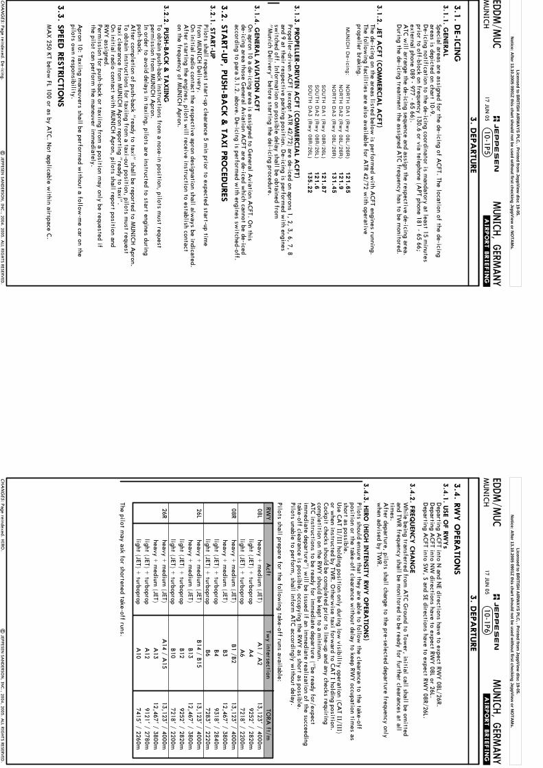
Twy intersectionA
1 / A2
A4
A6
B1 /B
2B3
B4B6
B14 / B
15B13
B12
B10
A14 / A
15A
13A
12A
10
TORA
ft/m13,123' / 4000m
9252' / 2820m7218' / 2200m
13,123' / 4000m12,467' / 3800m
9318' / 2840m7283' / 2220m
13,123' / 4000m12,467' / 3800m
9252' / 2820m7218' / 2200m
13,123' / 4000m12,467' / 3800m
9121' / 2780m7415' / 2260m
RWY
08L 08R 26L 26R
The pilot may ask for shortened take-off runs.
Pilots should ensure that they are able to follow the clearance to the take-off
position or the take-off clearance without delay to keep RW
Y occupation tim
es asshort as possible.Use C
AT II/III holding position only during low
visibility operation (CA
T II/III) or w
hen instructed by TWR. O
therwise taxi forw
ard to CA
T I holding position.Cockpit checks should be com
pleted prior to line-up and any checks requiringcom
pletition on the RWY should be kept to a m
inimum
.A
TC instructions to be ready for im
mediate departure ("
be ready for/expect im
mediate departure"
) will be issued if an im
mediate realization of the succeeding
take-off clearance is possible, occupying the RWY as short as possible.
Pilots unable to perform, shall inform
ATC
accordingly without delay.
Pilots shall prepare for the following take-off runs available:
Licensed to BR
ITISH A
IRW
AYS PLC
, . Printed from JeppView
disc 19-05.N
otice: After 13.10.2005 0901Z this chart should not be used w
ithout first checking JeppView or N
OTA
Ms.

.AIRPORT.BRIEFIN
G.
17 JUN
0510-1P7
Page reindexed.|
JEPPESEN SA
ND
ERSON
, INC., 2004, 2005. A
LL RIGHTS RESERV
ED.
CHA
NG
ES:
EDDM/M
UC
MUNICH, G
ERMANY
JEPPESEN
MUN
ICH
3. D
EPA
RTURE
3.4
.4. C
TO
T (C
ALC
ULA
TED T
AKE-O
FF T
IME)
Pilots shall be ready for take-off at the RWY H
olding Point not later than theCTO
T. At M
UN
ICH A
PT, a taxi time of 12 m
inutes generally has to be takeninto account. A
dditionally, delays in excess of 10 minutes can be expected at
the RWY H
olding Point, especially during peak hours.If A
CFT de-icing is required at the respective rem
ote de-icing areas near theRW
Ys, taxi tim
es, including de-icing, may exceed 30 m
inutes.Pilots shall be ready to start engines duly in advance of their C
TOT and shall
request start-up with A
TC accordingly.
Start-up clearance may be w
ithheld by ATC
if the necessary taxi time does
not suffice to comply w
ith a CTO
T.Pilots, w
ho are aware that they cannot com
ply with the C
TOT, shall duly apply
for a new C
TOT via the airline operator or handling agent.
In exceptional cases, ATC
(MUN
ICH D
elivery) will handle coordination w
ith theCEU
.
3.5
. OTHER IN
FO
RM
ATIO
N
3.5
.1. D
ATA
LINK D
EPA
RTURE C
LEA
RA
NCE (D
CL)
DFS D
eutsche Flugsicherung Gm
bH is offering to grant start-up and route
clearance at MUN
ICH A
PT using Datalink. The procedures for this are described
in an AIC
. Deviations from
this and depending on the traffic and weather situation,
the route clearance can be transmitted via D
atalink in advance after receiving a RC
D, w
hile start-up clearance will be granted on the frequency listed in the
CLD
as the occasion arises.Pilots shall m
aintain listening watch on this frequency and shall refrain from
asking questions about the start-up clearance. The follow
ing time param
eters apply:t t ttt
25 min prior to EO
BT for unregulated flights.
30 min prior to C
TOT for A
TFM regulated flights.
11 min prior to EO
BT for unregulated flights.
16 min prior to C
TOT for A
TFM regulated flights.
1 min
5 min
1 min
i t 012
Licensed to BR
ITISH A
IRW
AYS PLC
, . Printed from JeppView
disc 19-05.N
otice: After 13.10.2005 0901Z this chart should not be used w
ithout first checking JeppView or N
OTA
Ms.
.AIRPORT.BRIEFIN
G.
17 JUN
0510-1P
Page reindexed.|
JEPPESEN SA
ND
ERSON
, INC., 2004, 2005. A
LL RIGHTS RESERV
ED.
CHA
NG
ES:
EDDM/M
UC
1.2
. NO
ISE A
BA
TEM
ENT P
RO
CEDURES
MUNICH, G
ERMANY
JEPPESEN
1. G
ENERA
L
1.1
. ATIS
MUN
ICH*
ATIS
123.12
For additional depiction refer to 10-4 chart.
and charter services
of ACFT that do not generate
services pursuant to para 4 No. 1 a PostG
1.2
.1. G
ENERA
LPilots shall reduce noise disturbance caused by aircraft engines to an unavoidablem
inimum
at MUN
ICH A
PT and its vicinity. This applies in particular to the times
of night flying restrictions.
1.2
.2. N
IGHT F
LYIN
G R
ESTRIC
TIO
NS
From 2200-0600LT, flight operations are subject to the follow
ing restrictions for noise abatem
ent reasons:Restrictions regarding operating tim
es:N
ight flights are only permitted w
ith the following provisions and w
ith ACFT
not exceeding the noise limits as stipulated by A
nnex 16 Section 3 of the IC
AO
Convention:
1.2
.2.1
. In c
om
merc
ial s
chedule
d a
ir serv
ice
a) up to 28 scheduled flight movem
ents in the period from - 2200-2330LT for take-offs and landings and - from
0500-0600LT for landings only. Intercontinental flights shall have priority; in exceptional cases and if there is a particular traffic-related interest, such flights m
ay be planned up to 2400LT.b) D
elayed landings and take-offs in the period from 2200-2400LT, provided
the scheduled time of arrival or departure at or from
MUN
ICH A
PT is planned before 2200LT or in the case of flight m
ovements stated in paragraph 1.2.2.1.,
1.2.2.2. and 1.2.2.3. before 2330LT and provided the arrival or departure is before 2400LT. Early landings in the period from
0500-0600LT, provided the scheduled arrival tim
e is planned after 0600LT.c) Flights by airlines w
hose ACFT are m
ainly maintained at M
UN
ICH A
PT in the period from
2200-2330LT for all landings and for scheduled take-offs of flights in intercontinental traffic and from
0500-0600LT for take-offs for ferry flights (em
pty flights) and for landings in intercontinental traffic. In exceptional cases and if there is a particular traffic-related interest, flights in intercontinental traffic m
ay be planned up to 2400LT.
1.2
.2.2
. Schedule
d ta
ke-o
ffs o
r landin
gs
on average an individual noise level exceeding 75 dB
(A) at any single noise
measuring point in the vicinity of M
UN
ICH A
PT, in the period from 2200-2330LT
and from 0500-0600LT.
This regulation shall also apply with low
er priority to passenger flights by airlines w
ith ACFT w
ith a maxim
um take-off w
eight of more than 12t,
provided such flights are carried out regularly and are reported to the APT
Coordinator of the Federal Republic of G
ermany the day before to the
following address:
Flughafenkoordinator der Bundesrepublik D
eutschlandFA
C 2 - TERM
INA
L 2 BEREIC
H E, H
BK 37
60549 Frankfurt/Main
Tel. (069) 690-53081, -5 23 41, -3 20 51, -5 23 31, -2 95 01, -4 56 01, -5 23 51Telefax: (069) 69 05 08 11, SITA
: FRAZTX
H, A
FTN: ED
DFY
HYX
1.2
.2.3
. Flig
hts
that a
re p
erfo
rmed fo
r(Postal A
ct) dated 22nd Decem
ber 1997 (Official Federal G
azette I, page 3294) or are carried out as surveying flights for the calibration of navigational aids from
2200-0600LT.Exceptions: A
bove stated restrictions regarding operating times do not apply to:
- Flights for providing assistance in emergencies and disasters and for executing
police duties, - Landings for m
eteorolgical, technical and other flight safety reasons, - Flights that have been approved in justified exceptional cases by the "
Bayerisches Staatsm
inisterium fuer W
irtschaft, Verkehr und Technologie"
or upon its instruction - by the Luftaufsicht at M
UN
ICH A
PT, in substantiated individual cases to avoid serious disruptions to air traffic or in cases of special public interest.
Licensed to BR
ITISH A
IRW
AYS PLC
, . Printed from JeppView
disc 19-05.N
otice: After 13.10.2005 0901Z this chart should not be used w
ithout first checking JeppView or N
OTA
Ms.
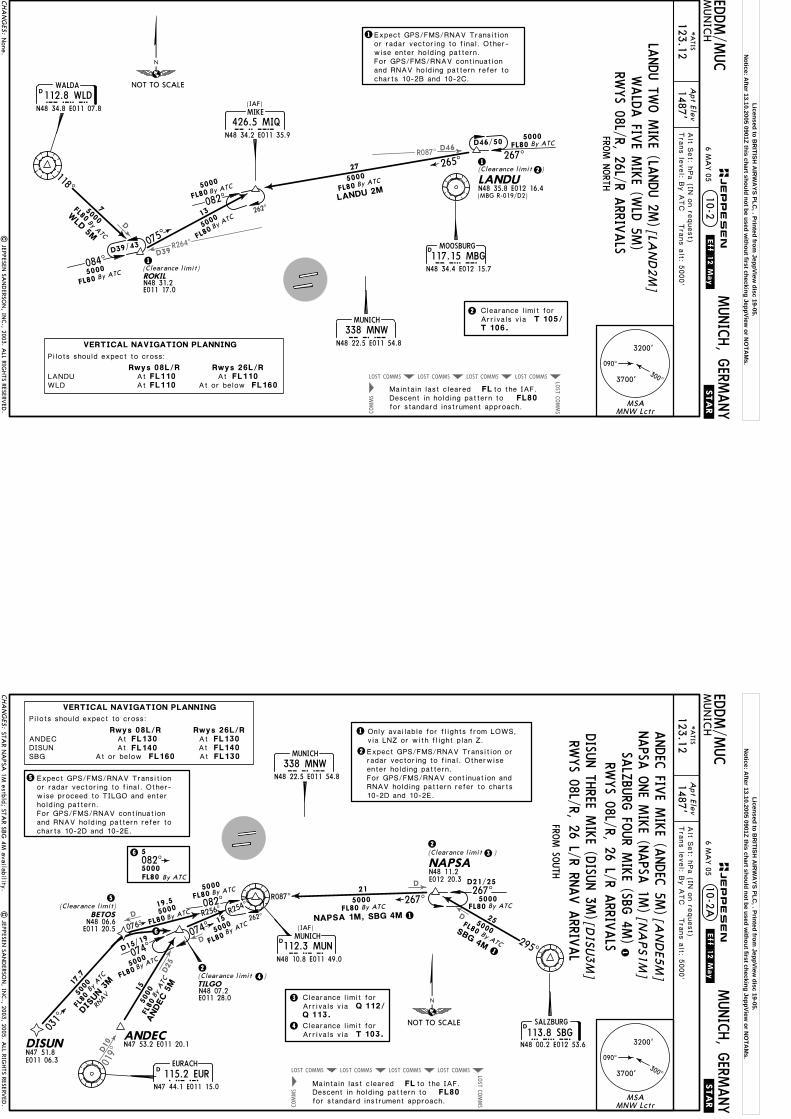
R087^D46
D39R264^
D
COMMSLOST COMMSLOST COMMSLOST COMMSLOST
COMMS
LOST
COMMS
LANDUN48 35.8 E012 16.4
267^
5000D46/50
265^27
5000
ROKIL
E011 17.0N48 31.2
082^5000
262^
5000
075^
13
(IAF)
1
(Clearance limit)1084^
D39/43
5000
118^
75000WLD
5M
FL80FL to the IAF.Maintain last cleared
Descent in holding pattern tofor standard instrument approach.
By ATC
By ATC
By ATC
By ATC
By ATC
By ATC
FL80
FL80
FL80
FL80
FL80
FL80
D
D
FROM N
ORTH
| JEPPESEN
SAN
DERSO
N, IN
C., 2003. A
LL RIGHTS RESERV
ED.
Apt Elev
EDDM/M
UC
10-2.STA
R.
MUNICH, G
ERMANY
MUN
ICH
1487'*A
TIS
123.12Tra
ns le
vel: B
y A
TC T
rans a
lt: 5000'
1Expect GPS/FMS/RNAV Transitionor radar vectoring to final. Other-wise enter holding pattern.For GPS/FMS/RNAV continuationand RNAV holding pattern refer tocharts 10-2B and 10-2C.
Alt S
et: h
Pa (IN
on re
quest)
LANDU 2M
VERTICAL NAVIGATION PLANNING
FL110FL110 FL160At
At
Pilots should expect to cross:
Rwys 26L/RRwys 08L/R
At or belowLANDUWLD
FL110At
2(Clearance limit )
(MBG R-019/D2)
2
None.
MSAMNW Lctr
3200'
3700'
090^
300^
NOT TO SCALE
MOOSBURG
MBG117.15 MBGN48 34.4 E012 15.7
MIQN48 34.2 E011 35.9
MIKE
426.5 MIQ
MUNICH
338 MNW MNWN48 22.5 E011 54.8
112.8 WLDN48 34.8 E011 07.8WLD
WALDA
WALD
A FIV
E MIKE (W
LD 5M
)
CHA
NG
ES:
JEPPESEN.Eff.12.M
ay.
RWYS 08L/R, 26L/R A
RRIVALS
6 MA
Y 05
[LAN
D2M
]LA
NDU TW
O M
IKE (LA
NDU 2M
)
Clearance limit forArrivals via T 105/T 106.
Licensed to BR
ITISH A
IRW
AYS PLC
, . Printed from JeppView
disc 19-05.N
otice: After 13.10.2005 0901Z this chart should not be used w
ithout first checking JeppView or N
OTA
Ms.
D10
D
D25
D
D
019^
D
COMMSLOST COMMSLOST COMMSLOST COMMSLOST
COMMS
LOST
COMMS
ANDEC
082^
5000
262^
074^
074^
R254^
15
5000
TILGO
D15/19
15
5000
ANDEC 5
M
267^5000
NAPSA
25
21
295^
SBG 4M
5000
D21/25
R087^ 267^5000
5000
N48 07.2E011 28.0
R256^
076^
5000
6
5000
DIS
UN 3
M
031^
DISUN
BETOSN48 06.6E011 20.5
RNAV
2
(Clearance limit)5
2
(IAF)By ATC
By ATCBy ATC
By ATC
By ATC
By ATC
By A
TC
By A
TC
FL80
FL80FL80
FL80
FL80
FL80
FL80By ATC
FL80
FL80
FL80FL to the IAF.Maintain last cleared
Descent in holding pattern tofor standard instrument approach.
D
N47 53.2 E011 20.1N47 51.8E011 06.3
D
N48 11.2E012 20.3
D
5
2
FROM SO
UTH
Apt Elev
EDDM/M
UC
.STAR.
MUNICH, G
ERMANY
MUN
ICH
1487'*A
TIS
123.12Tra
ns le
vel: B
y A
TC T
rans a
lt: 5000'
RWYS 08L/R, 26 L/R RN
AV A
RRIVAL
10-2A
Alt S
et: h
Pa (IN
on re
quest)
DISU
N TH
REE MIKE (D
ISUN 3M
)
19.5
17.7
VERTICAL NAVIGATION PLANNING
FL130
FL130FL160
FL130At At
At
Pilots should expect to cross:
Rwys 26L/RRwys 08L/R
At or belowFL140At FL140At
ANDECDISUNSBG
Expect GPS/FMS/RNAV Transitionor radar vectoring to final. Other-wise proceed to TILGO and enterholding pattern.For GPS/FMS/RNAV continuationand RNAV holding pattern refer tocharts 10-2D and 10-2E.
4
(Clearance limit )4
1
6 5082^
FL80 By ATC5000
3(Clearance limit )
3
NAPSA 1M, SBG 4M
1STAR N
APSA
1M estbld; STA
R SBG
4M availability.
| JEPPESEN
SAN
DERSO
N, IN
C., 2003, 2005. A
LL RIGHTS RESERV
ED.
1
1
Only available for flights from LOWS,via LNZ or with flight plan Z.
Expect GPS/FMS/RNAV Transition orradar vectoring to final. Otherwiseenter holding pattern. For GPS/FMS/RNAV continuation andRNAV holding pattern refer to charts10-2D and 10-2E.
MSAMNW Lctr
3200'
3700'
090^
300^
NOT TO SCALE113.8 SBG
SALZBURG
N48 00.2 E012 53.6
EURACH
EUR115.2 EURN47 44.1 E011 15.0
SBG
MUNICH
338 MNW MNWN48 22.5 E011 54.8
MUNICH
112.3 MUNMUNN48 10.8 E011 49.0
SALZ
BURG
FOUR M
IKE (SBG
4M)
[DISU
3M
]
ANDEC
FIVE M
IKE (A
NDEC
5M)[A
ND
E5M
]
CHA
NG
ES:
JEPPESEN.Eff.12.M
ay.
RWYS 08L/R, 26 L/R A
RRIVALS
6 MA
Y 05
Clearance limit forArrivals via T 103.
NAPSA
ONE M
IKE (N
APSA
1M) [N
APS1
M]
Clearance limit forArrivals via Q 112/Q 113.
Licensed to BR
ITISH A
IRW
AYS PLC
, . Printed from JeppView
disc 19-05.N
otice: After 13.10.2005 0901Z this chart should not be used w
ithout first checking JeppView or N
OTA
Ms.

MUNICH338 MNWMNW
N48 22.5 E011 54.8
ROKIL
LANDU
MAGAT
DM411
DM412
DM420
DM421DM422
DM424
DM425
DM426
DM428
DM429
DM430DM431
DM433
MAX IAS 240 KT
TRANSITION ROUTING
.RNAV.TRANSITIO
N.
LANDU 08
N48 29.6E012 22.7
(RWY 08L)
GPS- O
R FMS-EQ
UIPPED
AIRC
RAFT
BY A
TC
5000FL80
By ATC
Optional
N48 34.6E012 00.7
N48 28.9E012 12.3
N48 25.7E011 31.3
N48 26.7E011 43.5
N48 27.2E011 49.6
N48 27.6E011 55.7
N48 21.1E011 37.1(FAF)
E011 09.7
N48 24.9E011 20.8
N48 19.8E011 20.8N48 18.9
E011 10.7
N48 24.0
5000FL80
By ATC
N48 32.3 E011 30.1
DM427
MAX IAS 240 KT
N48 28.1 E012 01.8
DM423
MAX IAS 220 KT
N48 26.2 E011 37.4
8.7 12.4
77
6.1
6.8
4.9
5.1
7.57
4.14.1
4.14.1
4.1
6.6
ROKIL 08082^
082^
172^
172^
LANDU 0
8
231^
262^
RNAV A
PPROACH TRA
NSITIO
NS
N48 31.2 E011 17.0
N48 35.8 E012 16.4
20.5
GPS/FMS CLEARANCE PHRASEOLOGY
"Cleared xxx Transition":1.
2. "Cleared xxx Transition and Profile":
Authorization to fly the lateral GPS/FMS-route. Altitude & speed assignments will be issued by ATC.
Authorization to fly the GPS/FMS-route as published, including the vertical con-straints depicted on the procedure.
3. "Cleared direct Waypoint xxx":Authorization to fly from the presentposition to one or a combination ofwaypoints. Altitude & speed assign-ments will be issued by ATC.
(Clearance limit)
(FL80+(6000') - MAGAT (5000').
ROKIL 08
; K220-) - DM420 -DM430 - DM431LANDU - DM427(K240-) - DM423
ROKIL - DM411(K240-) - DM412 - DM427 - DM423 (FL80+;K220-) - DM420 - DM430 - DM431 (6000') - MAGAT (5000').
N48 20.5 E011 29.8
At 5000'At 6000'
At or above FL80
(Clearance limit)
By ATC
On downwind transition expect vector to final.After receiving a 'DIRECT TO WAYPOINT'-clearance and reaching this pointwithout having received a follow-up clearance, the last flown heading exceedingthis waypoint shall be maintained.Speed limits are mandatory from the respective waypoint throughout the entire transition route unless cancelled by ATC.
LANDU 08, RO
KIL 08
NOT TO SCALE
JEPPESEN
CHA
NG
ES:
TRAN
S LEVEL: B
Y A
TCTRA
NS A
LT: 5000'
* A
TIS123.1
2
1486
10-2BMUNICH, G
ERMANY
MUN
ICH
Munich
090^
MSA
300^3700'
3200'
MNW Lctr
.Eff.16.May.
| JEPPESEN
SAN
DERSO
N, IN
C., 1999, 2002. A
LL RIGHTS RESERV
ED.
082^
082^
262^
3 MA
Y 02
RNA
V TRA
NSITIO
NS revised; notes.
Licensed to BR
ITISH A
IRW
AYS PLC
, . Printed from JeppView
disc 19-05.N
otice: After 13.10.2005 0901Z this chart should not be used w
ithout first checking JeppView or N
OTA
Ms.
DM439
DM436GUDEG
MUNICH
338 MNWMNWN48 22.5 E011 54.8
DM412
DM411
DM420
DM421
DM423DM424
DM425DM427
DM428
DM429MAX IAS 240 KT
.RNAV.TRANSITIO
N.
N48 29.6E012 22.7
Optional
N48 32.3E011 30.1
N48 28.9E012 12.3
N48 26.2E011 37.4
N48 26.7E011 43.5
N48 28.1E012 01.8
(FAF)E011 09.7
N48 24.9E011 20.8
N48 24.0
N48 34.6 E012 00.7
DM426
MAX IAS 220 KTN48 27.6 E011 55.7
DM422
MAX IAS 240 KT
N48 25.7 E011 31.3
77
6.6
7.57
4.14.1
4.14.1
4.1 5.1
082^
172^
172^
262^
ROKIL 26
LANDU 26
11
10.5
56
6
262^
N48 22.7E011 58.2 N48 23.2
E012 05.6
E012 14.6
N48 24.5E012 23.5
5000FL80
By ATC
LANDUN48 35.8 E012 16.4
ROKIL5000FL80
By ATC
N48 31.2 E011 17.0
DM438N48 23.9
20.5
On downwind transition expect vector to final.After receiving a 'DIRECT TO WAYPOINT'-clearance and reaching this pointwithout having received a follow-up clearance, the last flown heading exceedingthis waypoint shall be maintained.Speed limits are mandatory from the respective waypoint throughout the entire transition route unless cancelled by ATC.
TRANSITION ROUTING
LANDU 26(5000')
ROKIL 26
LANDU - DM412(K240-) - DM411 - DM422 - DM425 (FL80+)
GPS/FMS CLEARANCE PHRASEOLOGY
"Cleared xxx Transition":1.
2. "Cleared xxx Transition and Profile":
Authorization to fly the lateral GPS/FMS-route. Altitude & speed assignments will be issued by ATC.
Authorization to fly the GPS/FMS-route as published, including the vertical con-straints depicted on the procedure.
3. "Cleared direct Waypoint xxx":Authorization to fly from the presentposition to one or a combination ofwaypoints. Altitude & speed assign-ments will be issued by ATC.
- GUDEG.
ROKIL - DM422(K240-) - DM425 (FL80+)(5000') - GUDEG.
DM426(K220-) - DM429 - DM439 - DM438 -
- DM426(K220-) - DM429 - DM439 - DM438
5000'At
(Clearance limit)
By ATC
(Clearance limit)
119^ N48 27.2 E011 49.6
At or above FL80
LANDU 26, RO
KIL 26
RNAV A
PPROACH TRA
NSITIO
NS
(RWY 26R)
GPS- O
R FMS-EQ
UIPPED
AIRC
RAFT
BY A
TC
NOT TO SCALE
JEPPESEN
CHA
NG
ES:
TRAN
S LEVEL: B
Y A
TCTRA
NS A
LT: 5000'
* A
TIS123.1
2
1486
10-2CMUNICH, G
ERMANY
MUN
ICH
Munich
090^
MSA
300^3700'
3200'
MNW Lctr|
JEPPESEN SA
ND
ERSON
, INC., 1999, 2002. A
LL RIGHTS RESERV
ED.
.Eff.16.May.
262^
082^
262^
3 MA
Y 02
RNA
V TRA
NSITIO
NS revised; notes.
Licensed to BR
ITISH A
IRW
AYS PLC
, . Printed from JeppView
disc 19-05.N
otice: After 13.10.2005 0901Z this chart should not be used w
ithout first checking JeppView or N
OTA
Ms.

BETOSTILGO
NAPSA
BEGEN
DM461
DM459DM458
DM456DM455
DM454
DM452
DM451
DM440
DM441
DM443
MUNICH338 MNWMNW
N48 22.5 E011 54.8
DM450
DM457
MAX IAS 240 KT
.RNAV.TRANSITIO
N.
Optional
5000FL80
By ATC
N48 16.6 E012 03.7
DM460
MAX IAS 240 KTN48 07.8 E011 34.5
DM453
N48 11.2E012 20.3
N48 18.1E012 24.5N48 17.4
E012 14.1
N48 19.2E011 28.9
N48 19.7E011 36.1
N48 14.3E011 33.3
N48 15.2E011 45.5
N48 16.2E011 57.6N48 15.7
E011 51.6
N48 18.4E011 19.8
N48 13.5E011 22.9
N48 10.1E012 04.8
N48 17.7E011 10.9
N48 12.6E011 11.8
N48 06.6E011 20.5 N48 07.2
E011 28.0
BETOS 08BETOS 08
TILGO 08
NAPSA 08
77
66.1
7
7.4
5
5.2
4.9
4.4
12.36.6
4.14.1
4.14.1
4.1
082^
082^
262^
295^
352^
352^
(FAF)
5000FL80
By ATC
20.5
On downwind transition expect vector to final.After receiving a 'DIRECT TO WAYPOINT'-clearance and reaching this pointwithout having received a follow-up clearance, the last flown heading exceedingthis waypoint shall be maintained.Speed limits are mandatory from the respective waypoint throughout the entire transition route unless cancelled by ATC.
GPS/FMS CLEARANCE PHRASEOLOGY
"Cleared xxx Transition":1.
2. "Cleared xxx Transition and Profile":
Authorization to fly the lateral GPS/FMS-route. Altitude & speed assignments will be issued by ATC.
Authorization to fly the GPS/FMS-route as published, including the vertical con-straints depicted on the procedure.
3. "Cleared direct Waypoint xxx":Authorization to fly from the presentposition to one or a combination ofwaypoints. Altitude & speed assign-ments will be issued by ATC.
TRANSITION ROUTING
BETOS 08(5000')
BETOS - DM460(K240-) - DM461 - DM457 - DM453 - BEGEN.
(Clearance limit) (Clearancelimit)
By ATC
(FL80+; K220-) -DM450 - DM440 - DM441
NAPSA 08 NAPSA - DM457(K240-) - DM453 (FL80+ - BEGEN.(5000')DM441
TILGO 08 TILGO - DM460(K240-) - DM461 - DM457 - DM453 ; K220-) -(FL80+(5000') - BEGEN.DM450 - DM440 - DM441
(Clearancelimit)MAX IAS 220 KT
At or above FL80N48 14.8 E011 39.4
At 5000'
; K220-) - DM450 - DM440 -
RNAV A
PPROACH TRA
NSITIO
NS
(RWY 08R)
GPS- O
R FMS-EQ
UIPPED
AIRC
RAFT
BY A
TC
BETOS 08, N
APSA
08, TILGO 08
NOT TO SCALEJEPPESEN
CHA
NG
ES:
TRAN
S LEVEL: B
Y A
TCTRA
NS A
LT: 5000'
* A
TIS123.1
21486
10-2DMUNICH, G
ERMANY
MUN
ICH
Munich
| JEPPESEN
SAN
DERSO
N, IN
C., 1999, 2002. A
LL RIGHTS RESERV
ED.
262^
082^
.Eff.16.May.
090^
MSA
300^3700'
3200'
MNW Lctr
3 MA
Y 02
RNA
V TRA
NSITIO
NS revised; notes.
Licensed to BR
ITISH A
IRW
AYS PLC
, . Printed from JeppView
disc 19-05.N
otice: After 13.10.2005 0901Z this chart should not be used w
ithout first checking JeppView or N
OTA
Ms.
DM446
DM448 DM449
NELBI
BETOS
NAPSA
DM459
DM458
DM455
DM454
DM452DM451
DM450
DM457
.RNAV.TRANSITIO
N.
Optional
DM460
N48 11.2E012 20.3
N48 18.1E012 24.5
N48 17.4E012 14.1
N48 14.3E011 33.3
N48 15.2E011 45.5
N48 15.7E011 51.6
N48 13.5E011 22.9
N48 12.6E011 11.8
N48 06.6E011 20.5
NAPSA 26
77
77.4
4.14.1
4.14.1
4.1 DM456
MAX IAS 220 KTN48 16.2 E011 57.6
DM461
MAX IAS 240 KTN48 10.1 E012 04.8
10.4
N48 07.8E011 34.5
352^
352^
047^
044^
082^
262^
262^
11.5
10.7
6.6
BETO
S 26
TIL
GO 26
5.2
4.96.1
6.8
MUNICH
338 MNWMNWN48 22.5 E011 54.8
E012 03.7N48 16.6
N48 21.4E011 57.2
N48 23.3E012 23.7
(FAF)
5000FL80
By ATC
TILGON48 07.2E011 28.0
FL80By ATC
5000
DM453
MAX IAS240 KT
N48 14.8E011 39.4
N48 21.9 E012 04.5
20.5
By ATC
(Clearance limit)
On downwind transition expect vector to final.After receiving a 'DIRECT TO WAYPOINT'-clearance and reaching this pointwithout having received a follow-up clearance, the last flown heading exceedingthis waypoint shall be maintained.Speed limits are mandatory from the respective waypoint throughout the entire transition route unless cancelled by ATC.
GPS/FMS CLEARANCE PHRASEOLOGY
"Cleared xxx Transition":1.
2. "Cleared xxx Transition and Profile":
Authorization to fly the lateral GPS/FMS-route. Altitude & speed assignments will be issued by ATC.
Authorization to fly the GPS/FMS-route as published, including the vertical con-straints depicted on the procedure.
3. "Cleared direct Waypoint xxx":Authorization to fly from the presentposition to one or a combination ofwaypoints. Altitude & speed assign-ments will be issued by ATC.
(Clearancelimit)
(Clearance limit)
At 5000'
At 6000'N48 22.6 E012 13.6
TRANSITION ROUTING
BETOS 26(6000')DM459 - DM449 - DM448
NAPSA 26
TILGO 26
BETOS - DM 452 - DM453(K240-) - DM455 (FL80+) - DM456(K220-) -(5000') - NELBI .
(FL80+)
(FL80+).(5000') - NELBI(6000')
.(5000') - NELBI(6000')
FL80At or above
RNAV A
PPROACH TRA
NSITIO
NS
(RWY 26L)
GPS- O
R FMS-EQ
UIPPED
AIRC
RAFT
BY A
TC
TILGO - DM453(K240-) - DM455 - DM456(K220-) - DM459 - DM449 - DM448
NAPSA - DM461(K240-) - DM460 - DM452 - DM455 - DM456(K220-) - DM459 - DM449 - DM448
BETOS 26, N
APSA
26, TILGO 26
NOT TO SCALE
JEPPESEN
CHA
NG
ES:
TRAN
S LEVEL: B
Y A
TCTRA
NS A
LT: 5000'
* A
TIS123.1
21486
10-2EMUNICH, G
ERMANY
MUN
ICH
Munich
| JEPPESEN
SAN
DERSO
N, IN
C., 1999, 2002. A
LL RIGHTS RESERV
ED.
.Eff.16.May.
262^
262^
082^
090^
MSA
300^3700'
3200'
MNW LctrRN
AV TRA
NSITIO
NS revised; notes.
3 MA
Y 02
Licensed to BR
ITISH A
IRW
AYS PLC
, . Printed from JeppView
disc 19-05.N
otice: After 13.10.2005 0901Z this chart should not be used w
ithout first checking JeppView or N
OTA
Ms.
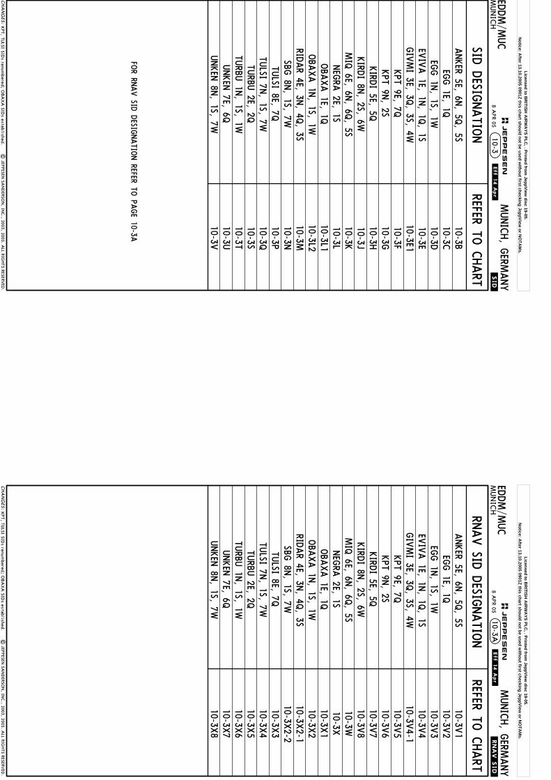
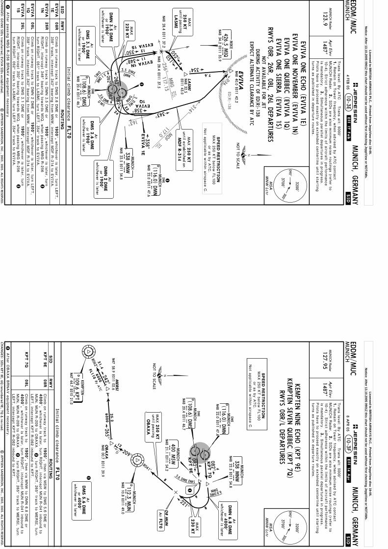
SID D
ESIGNATIO
NREFER TO
CHART
10-3B10-3C10-3D10-3E
FOR RN
AV SID
DESIG
NATIO
N REFER TO
PAGE 10-3A
.SID.
10-3ED
DM/M
UC
MUN
ICH
MUNICH, G
ERMANY
ANKER 5E, 6N
, 5Q, 5S
EVIV
A 1E, 1N
, 1Q, 1S
EGG 1E, 1Q
EGG 1N
, 1S, 1W
| JEPPESEN
SAN
DERSO
N, IN
C., 2003, 2005. A
LL RIGHTS RESERV
ED.
10-3E110-3F10-3G10-3H10-3J10-3K10-3L
10-3M10-3N10-3P
KPT 9E, 7Q
KPT 9N
, 2SKIRD
I 5E, 5QKIRD
I 8N, 2S, 6W
RIDAR 4E, 3N
, 4Q, 3S
SBG 8N
, 1S, 7WTU
LSI 8E, 7QTU
LSI 7N, 1S, 7W
UNKEN
7E, 6QUNKEN
8N, 1S, 7W
MIQ 6E, 6N
, 6Q, 5S
GIV
MI 3E, 3Q
, 3S, 4W
NEG
RA 2E, 1S
10-3Q10-3S10-3T10-3U10-3V
TURBU
1N, 1S, 1W
TURBU
2E, 2Q
10-3L1
KPT, TU
LSI SIDs renum
bered; OBA
XA
SIDs established.
10-3L2OBA
XA 1E, 1Q
OBA
XA 1N
, 1S, 1W
CHA
NG
ES:
.Eff.14.Apr.
JEPPESEN
8 APR 05
Licensed to BR
ITISH A
IRW
AYS PLC
, . Printed from JeppView
disc 19-05.N
otice: After 13.10.2005 0901Z this chart should not be used w
ithout first checking JeppView or N
OTA
Ms.
RNAV SID
DESIG
NATIO
NREFER TO
CHART
EDDM/M
UC
MUN
ICH
MUNICH, G
ERMANY
10-3A.RNAV.SID.
10-3V1
10-3V2
10-3V3
10-3V4
ANKER 5E, 6N
, 5Q, 5S
EVIV
A 1E, 1N
, 1Q, 1S
EGG 1E, 1Q
EGG 1N
, 1S, 1W
| JEPPESEN
SAN
DERSO
N, IN
C., 2003, 2005. A
LL RIGHTS RESERV
ED.
10-3V5
10-3V6
10-3V7
10-3V8
10-3W10-3X
10-3X3
KPT 9E, 7Q
KPT 9N
, 2SKIRD
I 5E, 5QKIRD
I 8N, 2S, 6W
RIDAR 4E, 3N
, 4Q, 3S
SBG 8N
, 1S, 7WTU
LSI 8E, 7QTU
LSI 7N, 1S, 7W
UNKEN
7E, 6QUNKEN
8N, 1S, 7W
MIQ 6E, 6N
, 6Q, 5S
GIV
MI 3E, 3Q
, 3S, 4W
NEG
RA 2E, 1S
10-3X4
10-3X5
10-3X6
10-3X7
10-3X8
TURBU
1N, 1S, 1W
TURBU
2E, 2Q
10-3V4-1
10-3X2-1
10-3X2-2
OBA
XA 1E, 1Q
OBA
XA 1N
, 1S, 1W10-3X
110-3X
2
KPT, TU
LSI SIDs renum
bered; OBA
XA
SIDs established.
CHA
NG
ES:
.Eff.14.Apr.
JEPPESEN
8 APR 05
Licensed to BR
ITISH A
IRW
AYS PLC
, . Printed from JeppView
disc 19-05.N
otice: After 13.10.2005 0901Z this chart should not be used w
ithout first checking JeppView or N
OTA
Ms.

R258^
016^MUN D25
253^R235^
3
078^3.1 DME DMS
4
7.2 DME
Apt Elev
.SID.
.Eff.8.Jul.ED
DM/M
UC
MUN
ICH
MUNICH, G
ERMANY
MUN
ICH Radar
123.9
1487'
082^
082^
N48 34.4 E012 00.1
10-3B
262^
262^
2 DME DMN
ANKER 5
Q
055^
MA
X220 K
T
8
Tra
ns le
vel: B
y A
TC T
rans a
lt: 5000'
1.
MUNIC
H R
adar.
2.
3.
Remain
on T
ower fre
quency, w
hen a
dvis
ed b
y A
TC c
onta
ct
8
N48 26.7
E011 58.5
FL70
NOT A
VAILA
BLE FOR FLIG
HTS V
IA A
IRWAY (U
)Z 30
FILE SIDS EG
G 1E (A
NKER 5E, 5Q
) OR EG
G 1S, 1W
(ANKER 6N
, 5S)ON C
HARTS 10-3C
& 10-3D
MA
X230 K
Tuntil passing
DM
S 7
.2 D
ME
| JEPPESEN
SAN
DERSO
N, IN
C., 2003, 2004. A
LL RIGHTS RESERV
ED.
orw
hichever is later
DM
S 3
.1 D
ME
1900'
At
SID
s a
re a
lso m
inim
um n
ois
e ro
utin
gs (re
fer to
10-4
B) . S
trict a
dhere
nce w
ithin
the lim
its o
f airc
raft p
erfo
rmance
is m
andato
ry.
Pilo
ts h
ave to
pro
ceed e
xactly
on e
xte
nded c
ente
rline u
ntil s
tartin
gtu
rns a
s p
ublis
hed in
departu
re ro
ute
s.
Sim
ulta
neous p
ara
llel d
epartu
res in
pro
gre
ss.
D13.8
MBG
MA
X250 K
TA
NKER
until passing
MA
X250 K
Tuntil established on
MBG
R-2
58
4
SIDs renum
bered & revised.
Initia
l clim
b c
leara
nce
NO
T TO SC
ALE
AN
KER 5
E
AN
KER 6
N
AN
KER 5
Q
AN
KER 5
S
RW
YSID
RO
UT
IN
G
08R
26R
08L
26L
DMS
360^
16
14
15
ANKER
N48 27.1
N48 27.0
E011 37.6
E011 37.9
ANK
ER
5E
090^
300^3700'
3200'
MSA
MN
W Lctr
MIQ
426.5 MIQ
MIKE
N48 34.2 E011 35.9
MUNICH
MNW
338 MNW
N48 22.5 E011 54.8
N48 22.0 E011 47.6
DMUNICH
DM
NDME
(116.0) DMN
DME
DMUNICH
DM
SN48 20.4 E011 46.7
(108.6) DMS
DMUNICH
MU
N112.3 M
UN
N48 10.8 E011 49.0
MUNICH
MSW
400 MSW
N48 21.1 E011 54.2
1900',
1900',
1900',
1900',
3.5 DMEDMN
9
10348^
350^
1
ANKER
5S
ANKER
6N
D12.5
MBG
DMB
G117.15 M
BGN48 34.4 E012 15.7
MOOSBU
RG
CHA
NG
ES:
JEPPESEN
1
orw
hichever is later1900'
At
DM
N 3
.5 D
ME
ANKER SIX
NOVEM
BER (ANKER 6N
)
2
orw
hichever is later1900'
At
DM
N 2
DM
E
3
RWYS 08R, 26R, 08L, 26L D
EPARTU
RES
ANKER FIV
E ECHO (A
NKER 5E)
ANKER FIV
E QUEBEC
(ANKER 5Q
)ANKER FIV
E SIERRA (A
NKER 5S)
N48 32.0
E011 57.2
Clim
b o
n ru
nway tra
ck to
Clim
b o
n ru
nway tra
ck to
DMN 3
.5 D
ME o
r
Clim
b o
n ru
nway tra
ck to
DMN 2
DME o
rwhic
hever is
late
r, turn
Clim
b o
n ru
nway tra
ck to
DMS 3
.1 D
ME o
r
2
43
SPEED
RESTRIC
TIO
NMAX 2
50 K
T b
elo
w F
L100
or a
s b
y A
TC.
Not a
pplic
able
with
in a
irspace C
.
then v
ia M
SW
to D
MS 7
.2 D
ME, tu
rn
whic
hever is
late
r,tu
rn R
IGHT, in
terc
ept 3
50^ b
earin
g to
ward
s M
IQ, w
hen p
assin
g M
BG
R-2
53 tu
rn R
IGHT, in
terc
ept M
BG R
-258 in
bound to
D12.5
MBG, tu
rnLEFT, in
terc
ept M
UN R
-016 to
ANKER.
whic
hever is
late
r,tu
rn R
IGHT, in
terc
ept 3
48^ b
earin
g to
ward
s M
IQ, w
hen p
assin
g M
BG
R-2
53 tu
rn R
IGHT, in
terc
ept M
BG R
-258 in
bound to
D12.5
MBG, tu
rnLEFT, in
terc
ept M
UN R
-016 to
ANKER.
25 JUN
04
LEFT, 3
60^ tra
ck to
ANKER.
LEFT, in
terc
ept M
BG R
-235 in
bound to
D13.8
MBG, tu
rn L
EFT, 3
60^
track to
ANKER.
Licensed to BR
ITISH A
IRW
AYS PLC
, . Printed from JeppView
disc 19-05.N
otice: After 13.10.2005 0901Z this chart should not be used w
ithout first checking JeppView or N
OTA
Ms.
Apt Elev
.SID.
EDDM/M
UC
MUN
ICH
MUNICH, G
ERMANY
MUN
ICH Radar
127.9
51487'
10-3C
4
4
5.6 DME
DMS
orwhichever is later
4000'DMN 6.8 DME
At
082^
082^
2
1
230 KT
DMN 6.8 DME
MAXuntil passing
1
2
Tra
ns le
vel: B
y A
TC T
rans a
lt: 5000'
1.
MUNIC
H R
adar.
2.
3.
Remain
on T
ower fre
quency, w
hen a
dvis
ed b
y A
TC c
onta
ct
230 KT
DMS 5.6 DME
MAXuntil passing
MAX 250 KTuntil passing
MDF
Initial climb clearance FL70
| JEPPESEN
SAN
DERSO
N, IN
C., 2003, 2004. A
LL RIGHTS RESERV
ED.
EGGENFELDEN
393 EGGEGGN48 23.8 E012 45.0
19
5000
058^ S
IDs a
re a
lso m
inim
um n
ois
e ro
utin
gs (re
fer to
10-4
B). S
trict a
dhere
nce w
ithin
the lim
its o
f airc
raft p
erfo
rmance
is m
andato
ry.
have to
pro
ceed e
xactly
on e
xte
nded c
ente
rline u
ntil s
tartin
g tu
rns
as p
ublis
hed in
departu
re ro
ute
s.
Sim
ulta
neous p
ara
llel d
epartu
res in
pro
gre
ss. P
ilots
See other side.
090^300^3700'
3200'
MSAMNW Lctr
MUNICH
MNW338 MNWN48 22.5 E011 54.8
N48 22.0 E011 47.6
D MUNICH
DMNDME
(116.0) DMN
DME
DMUNICH
DMSN48 20.4 E011 46.7
(108.6) DMS MUNICH
MSW400 MSWN48 21.1 E011 54.2
CHA
NG
ES:
JEPPESEN.Eff.8.Jul.
SPEED RESTRICTIONMAX 250 KT below FL100
or as by ATC.Not applicable within airspace C.
08R4000',
1900',
1900',4000',
RWYS 08R/L D
EPARTU
RES
then via MSW to DMS 5.6 DME or
then via MNW to DMN 6.8 DME or
112^
121^
R301^R292^
19
19
DMILLDORF117.0 MDFMDF
N48 14.1 E012 20.2
6.8DM
E
DMN
NOT TO SCALE
orwhichever is later
DMS 5.6 DME4000'
At
Climb on runway track to
Climb on runway track to
EGGEN
FELDEN
ONE EC
HO (EG
G 1E)
EGGEN
FELDEN
ONE Q
UEBEC
(EGG 1Q
)RWYSID ROUTING
EGG 1E
EGG 1Q 08L
EGG 1E
EGG 1Q
to MDF, MDF R-058 to EGG.
to MDF, MDF R-058 to EGG.
whichever is later, turn RIGHT, intercept MDF R-292 inbound
whichever is later, turn RIGHT, intercept MDF R-301 inbound
25 JUN
04
FOR SID
S RWYS 26R/L REFER TO
CHART 10-3D
NOT A
VAILA
BLE FOR FLIG
HTS V
IA (U
)L 605 & (U
)M 749
Licensed to BR
ITISH A
IRW
AYS PLC
, . Printed from JeppView
disc 19-05.N
otice: After 13.10.2005 0901Z this chart should not be used w
ithout first checking JeppView or N
OTA
Ms.

Apt Elev
.SID.
.Eff.17.Feb.
EDDM/M
UC
MUN
ICH
MUNICH, G
ERMANY
MUN
ICH Radar
127.951487'
10-3D
103^
R283^
4
4.5 DME
DMS 145^
R325^
262^
180^
1.6
DME DMS
2DM
E
DMN
13
12
MAX 220 KT
MSEuntil passing
262^
262^
orwhichever is later
1900'DMS 1.6 DME
Turn at
MAX 210 KTuntil established on
MUN R-325MAX
210 KT
MAX 250 KTuntil passingDMS 14 DME
EGG 1
N, 1
S
EGG 1S
Initial climb clearance FL70
EGGENFELDEN
393 EGGEGGN48 23.8 E012 45.0
| JEPPESEN
SAN
DERSO
N, IN
C., 2003, 2004. A
LL RIGHTS RESERV
ED.
19
5000
058^
4
4
MAX 250 KTuntil passing
MUN
75 100 150 200 250 300Gnd speed-KT
334' per NM
413' per NM
418 557 835 1114 1392 1671
516 689 1033 1377 1722 2066
D15.4 MUN
15.4058^
R238^
6
N48 11.6E012 11.9
Tra
ns le
vel: B
y A
TC T
rans a
lt: 5000'
1.
MUNIC
H R
adar.
2.
3.
Remain
on T
ower fre
quency, w
hen a
dvis
ed b
y A
TC c
onta
ct
SID
s a
re a
lso m
inim
um n
ois
e ro
utin
gs (re
fer to
10-4
). Stric
t adhere
nce w
ithin
the lim
its o
f airc
raft p
erfo
rmance
is m
andato
ry.
have to
pro
ceed e
xactly
on e
xte
nded c
ente
rline u
ntil s
tartin
g tu
rns
as p
ublis
hed in
departu
re ro
ute
s.
Sim
ulta
neous p
ara
llel d
epartu
res in
pro
gre
ss. P
ilots
NOT A
VAILA
BLE FOR FLIG
HTS
VIA
AIRW
AYS (U
)L 605 & (U
)M 749
None.
090^300^3700'
3200'
MSAMNW Lctr
MUNICH
MNW338 MNWN48 22.5 E011 54.8
N48 22.0 E011 47.6
D MUNICH
DMNDME
(116.0) DMN
DME
DMUNICH
DMSN48 20.4 E011 46.7
(108.6) DMS
DMUNICH
MUN112.3 MUNN48 10.8 E011 49.0
CHA
NG
ES:
JEPPESEN
SPEED RESTRICTIONMAX 250 KT below FL100
or as by ATC.Not applicable within airspace C.
26L1
1900',
1900',
1900',
1
RWYS 26R/L D
EPARTU
RES
14DMEDMS
31
086^
3
MUNICH
MSE385 MSEN48 20.0 E011 39.2
NOT TO SCALE
2
Climb on runway track to DMN 2 DME or
Climb on runway track to DMS 1.6 DME or
Climb on runway track to
4 FEB 05
EGGEN
FELDEN
ONE N
OVEM
BER (EGG 1N
)EG
GEN
FELDEN
ONE SIERRA
(EGG 1S)
EGGEN
FELDEN
ONE W
HISK
EY (EG
G 1W
)
EGG 1N
EGG 1S
EGG 1W
26R
DMILLDORF117.0 MDFMDF
N48 14.1 E012 20.2
RWYSID ROUTING
EGG 1N
EGG 1S
EGG 1W
If unable to comply with speed and turn restrictions request SID EGG 1W.
whichever is later, turn LEFT withinDMS 4.5 DME, 180^ track, intercept MUN R-325 inbound to MUN, MUN R-086 to D15.4MUN, turn LEFT, intercept MDF R-238 inbound to MDF, MDF R-058 to EGG.
whichever is later, turn LEFT, 180^track, intercept MUN R-325 inbound to MUN, MUN R-086 to D15.4 MUN, turn LEFT,intercept MDF R-238 inbound to MDF, MDF R-058 to EGG.
intercept 262^ bearing via MSE to DMS 14 DME, turnLEFT, intercept MUN R-283 inbound to MUN, MUN R-086 to D15.4 MUN, turn LEFT,intercept MDF R-238 inbound to MDF, MDF R-058 to EGG.
These SIDs require minimum climb gradientsof
4200',EGG 1N:
EGG 1S:
334' per NM (5.5%) until passing
413' per NM (6.8%) until passing
orwhichever is later
1900'
AtDMN 2 DME
due to High IntensityRadio Transmission Area (HIRTA).
Radio Transmission Area (HIRTA).4200', due to High Intensity
3
2
Licensed to BR
ITISH A
IRW
AYS PLC
, . Printed from JeppView
disc 19-05.N
otice: After 13.10.2005 0901Z this chart should not be used w
ithout first checking JeppView or N
OTA
Ms.
R120^R126^
R168^D31
WLD
112.8
wdl
Apt Elev
.SID.
.Eff.17.Feb.
EDDM/M
UC
MUN
ICH
MUNICH, G
ERMANY
MUN
ICH Radar
123.91487'
10-3E1
4
3.
GIV
MI
N48 42.1
E011 21.9
125000
2 DME DMN
1
1
orw
hichever is later
DM
S 2
.6 D
ME
1900'
At
309^
082^
082^262^
262^M
AX
220 K
T
MA
X220 K
T
313^
Initia
l clim
b c
leara
nce
FL70
MA
X250 K
Tuntil passing
MIQ
MA
X250 K
Tuntil passingD15.2
WLD
Tra
ns le
vel: B
y A
TC T
rans a
lt: 5000'
1.
MUNIC
H R
adar.
2.
3.
Remain
on T
ower fre
quency, w
hen a
dvis
ed b
y A
TC c
onta
ct
SID
s a
re a
lso m
inim
um n
ois
e ro
utin
gs (re
fer to
Pilo
ts h
ave to
pro
ceed e
xactly
on e
xte
nded c
ente
rline u
ntil s
tartin
gtu
rns a
s p
ublis
hed in
departu
re ro
ute
s.
Sim
ulta
neous p
ara
llel d
epartu
res in
pro
gre
ss.
4.5 DME
DMN
10-4
). Stric
t adhere
nce w
ithin
the lim
its o
f airc
raft p
erfo
rmance
is m
andato
ry.
MANDATO
RY FO
R FLIGHTS
JET ONLY
(EXCEPTIO
N: A
LL FLIGHTS A
LLOWED
IF IN A
CCORD
ANCE
WITH
REMARK
S OF A
IRWAY T 161)
MA
X250 K
Tuntil passingD17 W
LD
New
chart.|
JEPPESEN SA
ND
ERSON
, INC., 2005. A
LL RIGHTS RESERV
ED.
VIA
Y 101 - LA
NGI - U
L 610OR V
IA Y
101 - LANGI - Z
104 - WUR - Z
104/Z 12
OR V
IA Y
101 - ERNAS - T 161
GIV
MI 3
E
GIV
MI 3
Q
GIV
MI 3
S
GIV
MI 4
W
08R
08L
26L
26R
090^300^
3700'
3200'
MSA
MN
W Lctr
MIQ
426.5 MIQ
MIKE
N48 34.2 E011 35.9
MUNICH
MNW
338 MNW
N48 22.5 E011 54.8
N48 22.0 E011 47.6
DMUNICH
DM
NDME
(116.0) DMN
DME
DMUNICH
DM
SN48 20.4 E011 46.7
(108.6) DMS
CHA
NG
ES:
JEPPESEN
2.6DM EDMS
2019
2
1900',
1900',
1900',
1900',
DME
5.3DME
DMS
DMN
300^306^
348^
D38 A
LB
D17 W
LD
7
14
9
129
5000
MUNICH
MSE
385 MSE
N48 20.0 E011 39.2
ALB
D111.2 ALB
N49 12.9 E011 13.3
ALLERSBERG
NO
T TO SC
ALE
N48 24.5 E011 28.1
N48 26.9
E011 27.3
5
GIV
MI 3
S
GIV
MI 4
W2
orw
hichever is later1900'
At
DM
N 2
DM
E
GIV
MI 3E
GIV
MI 3Q
RWYS 08R/L, 26L/R D
EPARTU
RESGIV
MI FO
UR W
HISK
EY (G
IVMI 4W
)
D15.2
WLD
GIV
MI TH
REE ECHO (G
IVMI 3E)
GIV
MI TH
REE QUEBEC
(GIV
MI 3Q
)GIV
MI TH
REE SIERRA (G
IVMI 3S)
RW
YSID
RO
UT
IN
G
orw
hichever is later1900'
At
DM
N 3
.5 D
ME
Clim
b o
n ru
nway tra
ck to
DMS 2
.6 D
ME o
r
Clim
b o
n ru
nway tra
ck to
DMN 2
DME o
r
Clim
b o
n ru
nway tra
ck to
Clim
b o
n ru
nway tra
ck to
DMN 3
.5 D
ME o
r
whic
hever is
late
r,
then v
ia M
SE to
DMS 5
.3 D
ME, tu
rnRIG
HT, in
terc
ept W
LD R
-126 in
bound to
D17 W
LD, tu
rn R
IGHT, in
ter-
cept A
LB R
-168 in
bound to
GIV
MI.
whic
hever is
late
r,tu
rn R
IGHT, in
terc
ept W
LD R
-120 in
bound to
D15.2
WLD, tu
rn R
IGHT,
inte
rcept A
LB R
-168 in
bound to
GIV
MI.
whic
hever is
late
r, turn
LEFT w
ithin
DMN 4
.5 D
ME to
MIQ
, 309^ b
earin
g to
GIV
MI.
turn
LEFT to
MIQ
, 309^ b
earin
g to
GIV
MI.
4 FEB 05
SPEED
REST
RIC
TIO
NMAX 2
50 K
Tbelo
w F
L100
or a
s b
y A
TC.
Not a
pplic
able
with
in a
irspace C
.
Licensed to BR
ITISH A
IRW
AYS PLC
, . Printed from JeppView
disc 19-05.N
otice: After 13.10.2005 0901Z this chart should not be used w
ithout first checking JeppView or N
OTA
Ms.
314^
MDF
117.0
MDF
ED(R)-138
D36
256^
163^
MBG
117.15 MBG
LASM
I
Apt Elev
.SID.
.Eff.17.Feb.
EDDM/M
UC
MUN
ICH
MUNICH, G
ERMANY
MUN
ICH Radar
123.91487'
10-3E
Initia
l clim
b c
leara
nce
FL70
| JEPPESEN
SAN
DERSO
N, IN
C., 2003, 2005. A
LL RIGHTS RESERV
ED.
Tra
ns le
vel: B
y A
TC T
rans a
lt: 5000'
1.
MUNIC
H R
adar.
2.
3.
Remain
on T
ower fre
quency, w
hen a
dvis
ed b
y A
TC c
onta
ct
SID
s a
re a
lso m
inim
um n
ois
e ro
utin
gs (re
fer to
Pilo
ts h
ave to
pro
ceed e
xactly
on e
xte
nded c
ente
rline u
ntil s
tartin
gtu
rns a
s p
ublis
hed in
departu
re ro
ute
s.
Sim
ulta
neous p
ara
llel d
epartu
res in
pro
gre
ss.
NOT A
VAILA
BLE FOR JET
10-4
). Stric
t adhere
nce w
ithin
the lim
its o
f airc
raft p
erfo
rmance
is m
andato
ry.
DURIN
G A
CTIV
ITY O
F ED(R)-138
EXPEC
T ALTERN
ATE C
LEARA
NCE BY
ATC
2
22
GIV
MI SID
s transferred; EVIV
A SID
s established.
1
262^
262^082^ 082^
348^
350^
EVIVA 1N
EVIVA 1S
5
051^052^
358^EVIVA
1Q
EVIV
AN48 40.0 E011 42.2
354^7.6
N48 32.5
E011 43.0
5
11
12
N48 28.4 E011 37.2
N48 28.4 E011 37.5
MA
X250 K
Tuntil passing
LASM
I
343^
MA
X250 K
Tuntil established on
MDF R
-314
22
24
2.6
DMED
MS
3.1
DME
DMS
3.5 DME
2D
ME
DMN
DM
N
358^EV
IV
A 1
E
orw
hichever is later1900'
At
DM
N 3
.5 D
ME
MA
X220 K
T
1
NO
T TO SC
ALE
08R
090^300^
3700'
3200'
MSA
MN
W Lctr
N48 22.0 E011 47.6
DMUNICH
DM
NDME
(116.0) DMN
DME
DMUNICH
DM
SN48 20.4 E011 46.7
(108.6) DMS
CHA
NG
ES:
JEPPESEN
1900',
26R
08L
1900',
26L
1900',
1900',
RWYS 08R, 26R, 08L, 26L D
EPARTU
RES
Clim
b o
n ru
nway tra
ck to
DMS 2
.6 D
ME o
r
Clim
b o
n ru
nway tra
ck to
DMN 3
.5 D
ME o
r
Clim
b o
n ru
nway tra
ck to
DMN 2
DME o
r
Clim
b o
n ru
nway tra
ck to
DMS 3
.1 D
ME o
r
RW
YSID
RO
UT
IN
G
4 FEB 05
EVIV
A O
NE N
OVEM
BER (EVIV
A 1N
)
EVIV
A O
NE SIERRA
(EVIV
A 1S)
EVIV
A O
NE EC
HO (EV
IVA 1E)
EVIV
A O
NE Q
UEBEC
(EVIV
A 1Q
)
Afte
r passin
g M
BG R
-256 B
RNAV e
quip
ment n
ecessary
.
whic
hever is
late
r, turn
whic
hever is
late
r, turn
RIG
HT, in
terc
ept 3
50^ b
earin
g to
ward
s M
IQ, w
hen p
assin
g M
BG R
-256
turn
RIG
HT, 0
52^ tra
ck to
LASMI, tu
rn L
EFT, 3
54^ tra
ck to
EVIV
A.
RIG
HT, in
terc
ept 3
48^ b
earin
g to
ward
s M
IQ, w
hen p
assin
g M
BG R
-256
turn
RIG
HT, 0
51^ tra
ck to
LASMI, tu
rn L
EFT, 3
54^ tra
ck to
EVIV
A.
MIQ
426.5 MIQ
MIKE
N48 34.2 E011 35.9
MUNICH
MNW
338 MNW
N48 22.5 E011 54.8
SPEED
REST
RIC
TIO
NMAX 2
50 K
T b
elo
w F
L100
or a
s b
y A
TC.
Not a
pplic
able
with
in a
irspace C
.
whic
hever is
late
r, turn
LEFT,
358^ tra
ck, in
terc
ept 3
43^ b
earin
g fro
m M
NW
, inte
rcept M
DF R
-314 to
EVIV
A.
whic
hever is
late
r, turn
LEFT,
358^ tra
ck, in
terc
ept 3
43^ b
earin
g fro
m M
NW
, inte
rcept M
DF R
-314 to
EVIV
A.
EV
IV
A1E
EV
IV
A1N
EV
IV
A1Q
EV
IV
A1S
orw
hichever is later
DM
S 3
.1 D
ME
1900'
At
orw
hichever is later
DM
S 2
.6 D
ME
1900'
At
orw
hichever is later1900'
At
DM
N 2
DM
E
Licensed to BR
ITISH A
IRW
AYS PLC
, . Printed from JeppView
disc 19-05.N
otice: After 13.10.2005 0901Z this chart should not be used w
ithout first checking JeppView or N
OTA
Ms.
D
Apt Elev
.SID.
EDDM/M
UC
MUN
ICH
MUNICH, G
ERMANY
MUN
ICH Radar
127.951487'
10-3F
4
4
5.6 DME DMS
6
KPT 7
Q
8
082^
082^KPT 9
E
orw
hichever is later4000'
DM
N 6
.8 D
ME
AtM
AX
230 K
T
Initia
l clim
b c
leara
nce
FL70
| JEPPESEN
SAN
DERSO
N, IN
C., 2003, 2005. A
LL RIGHTS RESERV
ED.
Tra
ns le
vel: B
y A
TC T
rans a
lt: 5000'
1.
MUNIC
H R
adar.
2.
3.
Remain
on T
ower fre
quency, w
hen a
dvis
ed b
y A
TC c
onta
ct
SID
s a
re a
lso m
inim
um n
ois
e ro
utin
gs (re
fer to
Pilo
ts h
ave to
pro
ceed e
xactly
on e
xte
nded c
ente
rline u
ntil s
tartin
gtu
rns a
s p
ublis
hed in
departu
re ro
ute
s.
Sim
ulta
neous p
ara
llel d
epartu
res in
pro
gre
ss.
D8 M
UN
1
1
8
SIDs K
PT 8E, 6Q renum
bered 9E, 7Q &
revised.
10-4
) . Stric
t adhere
nce w
ithin
the lim
its o
f airc
raft p
erfo
rmance
is m
andato
ry.
22
2
MERSI
N47 58.9 E011 02.6
209^
265^242^
R062^
MA
X250 K
Tuntil passing
OBA
XA
At
FL7
0
12
25.2
6000
OBA
XA
N48 00.7 E011 39.9
31.4
6000
FL110
By ATC
08R
08L
090^300^
3700'
3200'
MSA
MN
W Lctr
MUNICH
MNW
338 MNW
N48 22.5 E011 54.8
N48 22.0 E011 47.6
DMUNICH
DM
NDME
(116.0) DMN
DME
DMUNICH
DM
SN48 20.4 E011 46.7
(108.6) DMS
DMUNICH
MU
N112.3 M
UN
N48 10.8 E011 49.0
MUNICH
MSW
400 MSW
N48 21.1 E011 54.2
CHA
NG
ES:
JEPPESEN
.Eff.14.Apr.
SPEED
REST
RIC
TIO
NMAX 2
50 K
T b
elo
w F
L100
or a
s b
y A
TC.
Not a
pplic
able
with
in a
irspace C
.
1900',
4000',
4000',
1900',
KPT 9
E
KPT 7
Q
then v
ia M
SW
to D
MS 5
.6 D
ME o
r
then v
ia M
NW
to D
MN 6
.8 D
ME o
r
RWYS 08R/L D
EPARTU
RES
6.8DME
DMN
221^
R041^
KP
TD109.6 K
PTKEM
PTEN
N47 44.7 E010 21.0
NO
T TO SC
ALE
Clim
b o
n ru
nway tra
ck to
Clim
b o
n ru
nway tra
ck to
RW
YSID
RO
UT
IN
G
whic
hever is
late
r, turn
RIG
HT, in
terc
ept M
UN R
-041 in
bound to
whic
hever is
late
r, turn
RIG
HT, in
terc
ept M
UN R
-041 in
bound to
orw
hichever is later
DM
S 5
.6 D
ME
4000'
At
8 APR 05
KEM
PTEN N
INE EC
HO (K
PT 9E)KEM
PTEN SEV
EN Q
UEBEC
(KPT 7Q
)
MUN, M
UN R
-209 to
OBAXA
, turn
RIG
HT, 2
65^ tra
ck to
MERSI, tu
rnLEFT, in
terc
ept K
PT R
-062 in
bound to
KPT.
, turn
RIG
HT, 2
65^ tra
ck to
MERSI, tu
rnMUN, M
UN R
-209 to
OBAXA
LEFT, in
terc
ept K
PT R
-062 in
bound to
KPT.
Afte
r OBAXA B
RNAV e
quip
ment n
ecessary
.
Licensed to BR
ITISH A
IRW
AYS PLC
, . Printed from JeppView
disc 19-05.N
otice: After 13.10.2005 0901Z this chart should not be used w
ithout first checking JeppView or N
OTA
Ms.
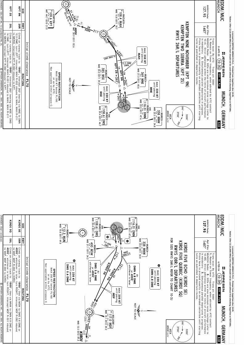
D
D
Apt Elev
.SID.
EDDM/M
UC
MUN
ICH
MUNICH, G
ERMANY
MUN
ICH Radar
127.951487'
10-3G
211^5000
R062^
242^M
ERSI
N47 58.9 E011 02.6
4
4
12.5 DME DMN
262^
262^
By ATC
262^
262^
20
31
MA
Xuntil passing
220 K
T
MSE
MA
Xuntil passing
220 K
T
MNE
MA
X250 K
Tuntil passing
MA
H
Initia
l clim
b c
leara
nce
FL70
| JEPPESEN
SAN
DERSO
N, IN
C., 2003, 2005. A
LL RIGHTS RESERV
ED.
Tra
ns le
vel: B
y A
TC T
rans a
lt: 5000'
1.
MUNIC
H R
adar.
2.
3.
Remain
on T
ower fre
quency, w
hen a
dvis
ed b
y A
TC c
onta
ct
SID
s a
re a
lso m
inim
um n
ois
e ro
utin
gs (re
fer to
Pilo
ts h
ave to
pro
ceed e
xactly
on e
xte
nded c
ente
rline u
ntil s
tartin
gtu
rns a
s p
ublis
hed in
departu
re ro
ute
s.
Sim
ulta
neous p
ara
llel d
epartu
res in
pro
gre
ss.
6000
Fl110
10-4
) . Stric
t adhere
nce w
ithin
the lim
its o
f airc
raft p
erfo
rmance
is m
andato
ry.
SIDs K
PT 8N, 1S renum
bered 9N, 2S.
26R
26L
090^300^
3700'
3200'
MSA
MN
W Lctr
MUNICH
MNW
338 MNW
N48 22.5 E011 54.8
N48 22.0 E011 47.6
DMUNICH
DM
NDME
(116.0) DMN
DME
DMUNICH
DM
SN48 20.4 E011 46.7
(108.6) DMS
CHA
NG
ES:
JEPPESEN
.Eff.14.Apr.
SPEED
REST
RIC
TIO
NMAX 2
50 K
T b
elo
w F
L100
or a
s b
y A
TC.
Not a
pplic
able
with
in a
irspace C
.
RWYS 26R/L D
EPARTU
RES
KPT 9
N
KPT 2
S
1900',
1900',
14DMEDMS
232^
R052^
14
KPT 9
N16
KP
TD109.6 K
PTKEM
PTEN
N47 44.7 E010 21.0
MUNICH
MSE
385 MSE
N48 20.0 E011 39.2
MNE
MUNICH
369 MNE
N48 21.3 E011 40.6
MAH
D108.4 MAH
MAISA
CH
N48 15.8 E011 18.7
NO
T TO SC
ALE
KPT 2
S
R051^231^
KEM
PTEN TW
O SIERRA
(KPT 2S)
Clim
b o
n ru
nway tra
ck to
Clim
b o
n ru
nway tra
ck to
RW
YSID
RO
UT
IN
G
12.5
DME, tu
rn L
EFT, in
terc
ept M
AH R
-052 in
bound to
MAH, M
AH R
-211
to M
ERSI, in
terc
ept K
PT R
-062 in
bound to
KPT.
inte
rcept 2
62^ b
earin
g v
ia M
NE to
DMN
14 D
ME, tu
rn L
EFT, in
terc
ept M
AH R
-051 in
bound to
MAH, M
AH R
-211
to M
ERSI, in
terc
ept K
PT R
-062 in
bound to
KPT.
inte
rcept 2
62^ b
earin
g v
ia M
SE to
DMS
8 APR 05
KEM
PTEN N
INE N
OVEM
BER (KPT 9N
)
Licensed to BR
ITISH A
IRW
AYS PLC
, . Printed from JeppView
disc 19-05.N
otice: After 13.10.2005 0901Z this chart should not be used w
ithout first checking JeppView or N
OTA
Ms.
D40
086^
D
Apt Elev
.SID.
EDDM/M
UC
MUN
ICH
MUNICH, G
ERMANY
MUN
ICH Radar
127.9
51487'
10-3H
5000
4
4
5.6 DME DMS
orw
hichever is later4000'
DM
N 6
.8 D
ME
At
082^
082^2
1
230 K
T
DM
N 6
.8 D
ME
MA
Xuntil passing
1
2230 K
T
DM
S 5
.6 D
ME
MA
Xuntil passing
MA
X250 K
Tuntil passing
MDF
Initia
l clim
b c
leara
nce
FL70
| JEPPESEN
SAN
DERSO
N, IN
C., 2003, 2004. A
LL RIGHTS RESERV
ED.
Tra
ns le
vel: B
y A
TC T
rans a
lt: 5000'
1.
MUNIC
H R
adar.
2.
3.
Remain
on T
ower fre
quency, w
hen a
dvis
ed b
y A
TC c
onta
ct
SID
s a
re a
lso m
inim
um n
ois
e ro
utin
gs (re
fer to
10-4
B) . S
trict a
dhere
nce w
ithin
the lim
its o
f airc
raft p
erfo
rmance
is m
andato
ry.
Pilo
ts h
ave to
pro
ceed e
xactly
on e
xte
nded c
ente
rline u
ntil s
tartin
gtu
rns a
s p
ublis
hed in
departu
re ro
ute
s.
Sim
ulta
neous p
ara
llel d
epartu
res in
pro
gre
ss.
Chart reindexed.
090^300^
3700'
3200'
MSA
MN
W Lctr
MUNICH
MNW
338 MNW
N48 22.5 E011 54.8
N48 22.0 E011 47.6
DMUNICH
DM
NDME
(116.0) DMN
DME
DMUNICH
DM
SN48 20.4 E011 46.7
(108.6) DMS
DMUNICH
MU
N112.3 M
UN
N48 10.8 E011 49.0
MUNICH
MSW
400 MSW
N48 21.1 E011 54.2
CHA
NG
ES:
JEPPESEN
.Eff.19.Feb.
SPEED
REST
RIC
TIO
NMAX 2
50 K
T b
elo
w F
L100
or a
s b
y A
TC.
Not a
pplic
able
with
in a
irspace C
.
FOR SID
S RWYS 26R/L REFER TO
CHART 10-3J
KIRD
I 5
E
KIRD
I 5
Q
08R
08L
4000',
1900',
1900',
4000',
RWYS 08R/L D
EPARTU
RESthen v
ia M
SW
to D
MS 5
.6 D
ME o
r
then v
ia M
NW
to D
MN 6
.8 D
ME o
r
112^
093^
121^
R301^R292^
19
19
KIR
DI 5
E
KIR
DI 5
Q
KIR
DI
DMILLD
ORF
117.0 MDF
MD
FN48 14.1 E012 20.2
N48 12.5 E012 49.3
6.8DME
DMN
NO
T TO SC
ALE
orw
hichever is later
DM
S 5
.6 D
ME
4000'
At
19
KIRD
I FIVE EC
HO (K
IRDI 5E)
KIRD
I FIVE Q
UEBEC
(KIRD
I 5Q)
Clim
b o
n ru
nway tra
ck to
Clim
b o
n ru
nway tra
ck to
RW
YSID
RO
UT
IN
G
6 FEB 04
to M
DF, M
DF R
-093 to
KIR
DI.
whic
hever is
late
r, turn
RIG
HT, in
terc
ept M
DF R
-292 in
bound
to M
DF, M
DF R
-093 to
KIR
DI.
whic
hever is
late
r, turn
RIG
HT, in
terc
ept M
DF R
-301 in
bound
Licensed to BR
ITISH A
IRW
AYS PLC
, . Printed from JeppView
disc 19-05.N
otice: After 13.10.2005 0901Z this chart should not be used w
ithout first checking JeppView or N
OTA
Ms.
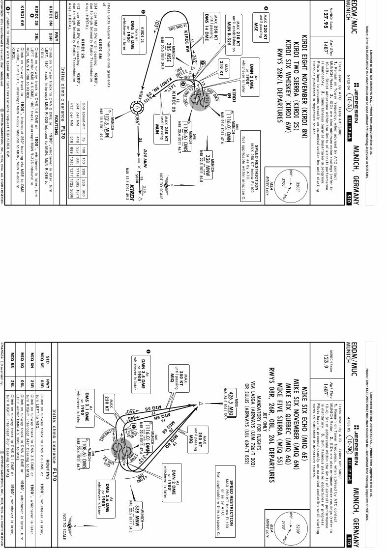
D40
Apt Elev
.SID.
EDDM/M
UC
MUN
ICH
MUNICH, G
ERMANY
MUN
ICH Radar
127.9
51487'
10-3J
103^
R283^25
D25 M
UN
4
4.5 DME
DMS
145^
R325^
262^
180^
1.6
DME
DMS
2 DME DMN
13
12
15
MA
X220 K
T
MSE
until passing
KIRDI 8N, 2S
262^ 262^
orw
hichever is later1900'
DM
S 1
.6 D
ME
Turn at
KIRD
I 2S
MA
X210 K
Tuntil established on
MUN R
-325
MA
X210 K
T
MA
X250 K
Tuntil passingDM
S 1
4 D
ME
MA
X250 K
Tuntil passing
MUN
Initia
l clim
b c
leara
nce
FL70 7
5100
150
200
250
300
Gnd s
peed-K
T
334' p
er N
M
413' p
er N
M
418
557
835
1114
1392
1671
516
689
1033
1377
1722
2066
| JEPPESEN
SAN
DERSO
N, IN
C., 2003, 2004. A
LL RIGHTS RESERV
ED.
Tra
ns le
vel: B
y A
TC T
rans a
lt: 5000'
1.
MUNIC
H R
adar.
2.
3.
Remain
on T
ower fre
quency, w
hen a
dvis
ed b
y A
TC c
onta
ct
SID
s a
re a
lso m
inim
um n
ois
e ro
utin
gs (re
fer to
10-4
B) . S
trict a
dhere
nce w
ithin
the lim
its o
f airc
raft p
erfo
rmance
is m
andato
ry.
Pilo
ts h
ave to
pro
ceed e
xactly
on e
xte
nded c
ente
rline u
ntil s
tartin
gtu
rns a
s p
ublis
hed in
departu
re ro
ute
s.
Sim
ulta
neous p
ara
llel d
epartu
res in
pro
gre
ss.
SIDs renum
bered & revised; chart reindexed.
090^300^
3700'
3200'
MSA
MN
W Lctr
MUNICH
MNW
338 MNW
N48 22.5 E011 54.8
N48 22.0 E011 47.6
DMUNICH
DM
NDME
(116.0) DMN
DME
DMUNICH
DM
SN48 20.4 E011 46.7
(108.6) DMS
DMUNICH
MU
N112.3 M
UN
N48 10.8 E011 49.0
CHA
NG
ES:
JEPPESEN
.Eff.19.Feb.
SPEED
REST
RIC
TIO
NMAX 2
50 K
T b
elo
w F
L100
or a
s b
y A
TC.
Not a
pplic
able
with
in a
irspace C
.
KIRD
I 8
N
KIRD
I 2
S
KIRD
I 6
W
26R
26L
1
1900',
1900',
1900',
If unable
to c
omply
with
speed a
nd tu
rn re
stric
tions re
quest S
ID K
IRDI 6
W.
RWYS 26R/L D
EPARTU
RES
14DMEDMS
31
086^5000
KIR
DI
3
MUNICH
MSE
385 MSE
N48 20.0 E011 39.2
NO
T TO SC
ALE
N48 12.5 E012 49.3
KIRD
I 2
S
KIRD
I 6
W
KIRD
I TWO SIERRA
(KIRD
I 2S)
orw
hichever is later1900'
At
DM
N 2
DM
EKIRD
I8N
2
KIRD
I EIGHT N
OVEM
BER (KIRD
I 8N)
KIRD
I SIX W
HISK
EY (K
IRDI 6W
)
Clim
b o
n ru
nway tra
ck to
DMN 2
DME o
r
Clim
b o
n ru
nway tra
ck to
DMS 1
.6 D
ME o
r
Clim
b o
n ru
nway tra
ck to
whic
hever is
late
r, turn
RW
YSID
RO
UT
IN
G
These S
IDs re
quire
min
imum c
limb g
radie
nts
of
4200',
4200',
6 FEB 04
KIRD
I 8
N
KIRD
I 2
S
LEFT, 1
80^ tra
ck, in
terc
ept M
UN R
-325 in
bound to
MUN, M
UN R
-086 to
KIR
DI.
whic
hever is
late
r, turn
LEFT w
ithin
DMS 4
.5 D
ME, 1
80^ tra
ck, in
terc
ept M
UN R
-325 in
bound to
MUN, M
UN R
-086 to
KIR
DI.
14 D
ME, tu
rn L
EFT, in
terc
ept M
UN R
-283 in
bound to
MUN, M
UN R
-086 to
KIR
DI.
1
334' p
er N
M (5
.5%) u
ntil p
assin
g
413' p
er N
M (6
.8%) u
ntil p
assin
g
due to
Hig
h In
tensity
Radio
Tra
nsmis
sio
nAre
a (H
IRTA).
due to
Hig
h In
tensity
Radio
Tra
nsmis
sio
nAre
a (H
IRTA).
inte
rcept 2
62^ b
earin
g v
ia M
SE to
DMS
3
2
Licensed to BR
ITISH A
IRW
AYS PLC
, . Printed from JeppView
disc 19-05.N
otice: After 13.10.2005 0901Z this chart should not be used w
ithout first checking JeppView or N
OTA
Ms.
Apt Elev
.SID.
.Eff.17.Feb.
EDDM/M
UC
MUN
ICH
MUNICH, G
ERMANY
MUN
ICH Radar
123.91487'
10-3K
3.1 DME DMS
082^
082^
1
orw
hichever is later1900'
At
DM
N 3
.5 D
ME
1
262^
262^
313^
Initia
l clim
b c
leara
nce
FL70
| JEPPESEN
SAN
DERSO
N, IN
C., 2003, 2005. A
LL RIGHTS RESERV
ED.
Tra
ns le
vel: B
y A
TC T
rans a
lt: 5000'
1.
MUNIC
H R
adar.
2.
3.
Remain
on T
ower fre
quency, w
hen a
dvis
ed b
y A
TC c
onta
ct
SID
s a
re a
lso m
inim
um n
ois
e ro
utin
gs (re
fer to
Pilo
ts h
ave to
pro
ceed e
xactly
on e
xte
nded c
ente
rline u
ntil s
tartin
gtu
rns a
s p
ublis
hed in
departu
re ro
ute
s.
Sim
ulta
neous p
ara
llel d
epartu
res in
pro
gre
ss.
MA
X250 K
Tuntil passing
MIQ
MA
X250 K
Tuntil passing
MIQ
MANDATO
RY FO
R FLIGHTS
OR SU
LUS (A
IRWAYS (U
)L 604/T 852)VIA
LASG
A (A
IRWAYS (U
)M 726/T 202)
JET ONLY
SID availability.
10-4
). Stric
t adhere
nce w
ithin
the lim
its o
f airc
raft p
erfo
rmance
is m
andato
ry.
NO
T TO SC
ALE
08R
090^300^
3700'
3200'
MSA
MN
W Lctr
MIQ
426.5 MIQ
MIKE
N48 34.2 E011 35.9
MUNICH
MNW
338 MNW
N48 22.5 E011 54.8
N48 22.0 E011 47.6
DMUNICH
DM
NDME
(116.0) DMNDME
DMUNICH
DM
SN48 20.4 E011 46.7
(108.6) DMS
CHA
NG
ES:
JEPPESEN
SPEED
REST
RIC
TIO
NMAX 2
50 K
T b
elo
w F
L100
or a
s b
y A
TC.
Not a
pplic
able
with
in a
irspace C
.
MIKE FIV
E SIERRA (M
IQ 5S)
MIQ
6E
MIQ
6N
MIQ
6Q
MIQ
5S
1900',
26R
08L
1900',
26L
1900',
1900',
2.6DM E
2DME
3.5 DMEDMN
DMN
DMS
20
16
19
17348^
350^MIQ 5S
MIQ
6E
MIQ 6N
MIQ
6Q
.5DME
DMN 4
orw
hichever is later
DM
S 3
.1 D
ME
1900'
At
MA
X220 K
T
RWYS 08R, 26R, 08L, 26L D
EPARTU
RES
MIKE SIX
ECHO (M
IQ 6E)
MIKE SIX
NOVEM
BER (MIQ 6N
)MIKE SIX
QUEBEC
(MIQ 6Q
)
Clim
b o
n ru
nway tra
ck to
DMS 2
.6 D
ME o
r
Clim
b o
n ru
nway tra
ck to
DMN 3
.5 D
ME o
r
Clim
b o
n ru
nway tra
ck to
DMN 2
DME o
r
Clim
b o
n ru
nway tra
ck to
DMS 3
.1 D
ME o
r
RW
YSID
RO
UT
IN
G
turn
LEFT to
MIQ
.whic
hever is
late
r,
turn
RIG
HT, in
terc
ept 3
48^ b
earin
g to
MIQ
.whic
hever is
late
r,
LEFT w
ithin
DMN 4
.5 D
ME to
MIQ
.whic
hever is
late
r, turn
turn
RIG
HT, in
terc
ept 3
50^ b
earin
g to
MIQ
.whic
hever is
late
r,
orw
hichever is later1900'
At
DM
N 2
DM
Eorw
hichever is later
DM
S 2
.6 D
ME
1900'
At
4 FEB 05
Licensed to BR
ITISH A
IRW
AYS PLC
, . Printed from JeppView
disc 19-05.N
otice: After 13.10.2005 0901Z this chart should not be used w
ithout first checking JeppView or N
OTA
Ms.

D
44
5.6 DME DMS
6
8
082^
082^
orw
hichever is later4000'
DM
N 6
.8 D
ME
AtM
AX
230 K
T
D8 M
UN
1
8
209^
MA
X250 K
Tuntil passing
OBA
XA
At
FL7
0
12
Apt Elev
.SID.
EDDM/M
UC
MUN
ICH
MUNICH, G
ERMANY
MUN
ICH Radar
127.951487'
10-3L1
Initia
l clim
b c
leara
nce
FL70
Tra
ns le
vel: B
y A
TC T
rans a
lt: 5000'
1.
MUNIC
H R
adar.
2.
3.
Remain
on T
ower fre
quency, w
hen a
dvis
ed b
y A
TC c
onta
ct
SID
s a
re a
lso m
inim
um n
ois
e ro
utin
gs (re
fer to
Pilo
ts h
ave to
pro
ceed e
xactly
on e
xte
nded c
ente
rline u
ntil s
tartin
gtu
rns a
s p
ublis
hed in
departu
re ro
ute
s.
Sim
ulta
neous p
ara
llel d
epartu
res in
pro
gre
ss.
10-4
) . Stric
t adhere
nce w
ithin
the lim
its o
f airc
raft p
erfo
rmance
is m
andato
ry.
New
chart.|
JEPPESEN SA
ND
ERSON
, INC., 2005. A
LL RIGHTS RESERV
ED.
OBA
XA
1Q
OBA
XA
1E
OBA
XA
N48 00.7 E011 39.9
1
MUNICH
MNW
338 MNW
N48 22.5 E011 54.8
N48 22.0 E011 47.6
DMUNICH
DM
NDME
(116.0) DMN
DME
DMUNICH
DM
SN48 20.4 E011 46.7
(108.6) DMS
DMUNICH
MU
N112.3 M
UN
N48 10.8 E011 49.0
MUNICH
MSW
400 MSW
N48 21.1 E011 54.2
SPEED
REST
RIC
TIO
NMAX 2
50 K
T b
elo
w F
L100
or a
s b
y A
TC.
Not a
pplic
able
with
in a
irspace C
.
6.8DME
DMN
221^
R041^
NO
T TO SC
ALE
08R
090^300^
3700'
3200'
MSA
MN
W Lctr
CHA
NG
ES:
JEPPESEN
.Eff.14.Apr.
1900',
4000',
then v
ia M
SW
to D
MS 5
.6 D
ME o
rClim
b o
n ru
nway tra
ck to
RW
YSID
RO
UT
IN
G
whic
hever is
late
r, turn
RIG
HT, in
terc
ept M
UN R
-041 in
bound to
8 APR 05
OBA
XA O
NE EC
HO (O
BAXA 1E)
NOT A
VAILA
BLE FOR PISTO
N EN
GINE &
TURBO
PROP A
IRCRA
FT
OBA
XA
1E
MUN, M
UN R
-209 to
OBAXA.
OBA
XA
1Q
08L
4000',
1900',
then v
ia M
NW
to D
MN 6
.8 D
ME o
rClim
b o
n ru
nway tra
ck to
whic
hever is
late
r, turn
RIG
HT, in
terc
ept M
UN R
-041 in
bound to
MUN, M
UN R
-209 to
OBAXA.
OBA
XA O
NE Q
UEBEC
(OBA
XA 1Q
)RW
YS 08R/L D
EPARTU
RES
FILE SIDS TU
RBU 2E (O
BAXA 1E) O
R TURBU
2Q (O
BAXA 1Q
)ON C
HART 10-3S
orw
hichever is later
DM
S 5
.6 D
ME
4000'
At
Licensed to BR
ITISH A
IRW
AYS PLC
, . Printed from JeppView
disc 19-05.N
otice: After 13.10.2005 0901Z this chart should not be used w
ithout first checking JeppView or N
OTA
Ms.
R283^
D
Apt Elev
.SID.
EDDM/M
UC
MUN
ICH
MUNICH, G
ERMANY
MUN
ICH Radar
127.951487'
10-3L2
Initia
l clim
b c
leara
nce
FL70
Tra
ns le
vel: B
y A
TC T
rans a
lt: 5000'
1.
MUNIC
H R
adar.
2.
3.
Remain
on T
ower fre
quency, w
hen a
dvis
ed b
y A
TC c
onta
ct
SID
s a
re a
lso m
inim
um n
ois
e ro
utin
gs (re
fer to
Pilo
ts h
ave to
pro
ceed e
xactly
on e
xte
nded c
ente
rline u
ntil s
tartin
gtu
rns a
s p
ublis
hed in
departu
re ro
ute
s.
Sim
ulta
neous p
ara
llel d
epartu
res in
pro
gre
ss.
10-4
) . Stric
t adhere
nce w
ithin
the lim
its o
f airc
raft p
erfo
rmance
is m
andato
ry.
| JEPPESEN
SAN
DERSO
N, IN
C., 2005. A
LL RIGHTS RESERV
ED.
New
chart.
103^
262^
4.5DME
DMS
145^
R325^
4
180^
1.6
DME
DMS
2 DME
DMN
13
12
OBAXA
1N, 1S
262^ 262^
MA
X250 K
Tuntil passingDM
S 1
4 D
ME
MA
X210 K
Tuntil established on
MUN R
-325
209^12
OBA
XA
N48 00.7 E011 39.9
MA
X250 K
Tuntil passing
OBA
XA
75
100
150
200
250
300
Gnd s
peed-K
T
334' p
er N
M
413' p
er N
M
418
557
835
1114
1392
1671
516
689
1033
1377
1722
2066
D4 M
UN
N48 11.8
E011 43.2
19
26R
090^300^
3700'
3200'
MSA
MN
W Lctr
CHA
NG
ES:
JEPPESEN
.Eff.14.Apr.1
900',
RW
YSID
RO
UT
IN
G
8 APR 05
NOT A
VAILA
BLE FOR PISTO
N EN
GINE &
TURBO
PROP A
IRCRA
FT
OBA
XA
1N
Clim
b o
n ru
nway tra
ck to
DMN 2
DME o
rwhic
hever is
late
r, turn
LEFT, 1
80^ tra
ck, in
terc
ept M
UN R
-325 in
bound to
MUN, M
UN R
-209 to
OBAXA.
OBA
XA O
NE SIERRA
(OBA
XA 1S)
OBA
XA O
NE N
OVEM
BER (OBA
XA 1N
)
OBA
XA O
NE W
HISK
EY (O
BAXA 1W
)
OBA
XA
1S
26L
1900',
Clim
b o
n ru
nway tra
ck to
DMS 1
.6 D
ME o
rwhic
hever is
late
r,tu
rn L
EFT w
ithin
DMS 4
.5 D
ME, 1
80^ tra
ck, in
terc
ept M
UN R
-325 in
-bound to
MUN, M
UN R
-209 to
OBAXA.
Clim
b o
n ru
nway tra
ck to
1900',
OBA
XA
1W
inte
rcept 2
62^ b
earin
g v
ia M
SE to
DMS
14 D
ME, tu
rn L
EFT, in
terc
ept M
UN R
-283 in
bound to
D4 M
UN, tu
rnRIG
HT, in
terc
ept M
UN R
-209 to
OBAXA.
ON C
HART 10-3T
FILE SIDS TU
RBU 1N
(OBA
XA 1N
) OR TU
RBU 1S, 1W
(OBA
XA 1S, 1W
)
MUNICH
MNW
338 MNW
N48 22.5 E011 54.8
N48 22.0 E011 47.6
DMUNICH
DM
NDME
(116.0) DMN
DME
DMUNICH
DM
SN48 20.4 E011 46.7
(108.6) DMS
14DMEDMS
27M
UNICH
MSE
385 MSE
N48 20.0 E011 39.2
2
OBA
XA
1N
OBA
XA
1S
orw
hichever is later1900'
DM
S 1
.6 D
ME
Turn at
OBA
XA
1S
MA
X220 K
Tuntil passing
MSE
MA
X210 K
T
orw
hichever is later1900'
At
DM
N 2
DM
E3
DMUNICH
MU
N112.3 M
UN
N48 10.8 E011 49.0
OBA
XA
1W
NO
T TO SC
ALE
These S
IDs re
quire
min
imum c
limb g
radie
nts
of
4200',
OBA
XA
1N
334' p
er N
M (5
.5%) u
ntil p
assin
gdue to
Hig
h In
tensity
Radio
Tra
nsmis
sio
nAre
a (H
IRTA).
4200',
OBA
XA
1S
413' p
er N
M (6
.8%) u
ntil p
assin
gdue to
Hig
h In
tensity
Radio
Tra
nsmis
sio
nAre
a (H
IRTA).
1
1If u
nable
to c
omply
with
speed a
nd tu
rn re
stric
tions re
quest S
ID O
BAXA 1
W.
SPEED
REST
RIC
TIO
NMAX 2
50 K
T b
elo
w F
L100
or a
s b
y A
TC.
Not a
pplic
able
with
in a
irspace C
.
RWYS 26R/L D
EPARTU
RES
2
3
Licensed to BR
ITISH A
IRW
AYS PLC
, . Printed from JeppView
disc 19-05.N
otice: After 13.10.2005 0901Z this chart should not be used w
ithout first checking JeppView or N
OTA
Ms.

4
5.6 DME DMS082^
4
262^262^
MAX230KT
MAXuntil passing
220 KT
MSE
NEGRA 2E
8
14
MAX 250 KTuntil passing
MAH
NEGRAN47 43.3 E009 25.6
246^
254^6000
6000
Apt Elev
.SID.
.Eff.17.Feb.
EDDM/M
UC
MUN
ICH
MUNICH, G
ERMANY
MUN
ICH Radar
127.951487'
10-3L| JEPPESEN
SAN
DERSO
N, IN
C., 2003, 2004. A
LL RIGHTS RESERV
ED.
Initial climb clearance FL70
1
1
2
2
Tra
ns le
vel: B
y A
TC T
rans a
lt: 5000'
1.
MUNIC
H R
adar.
2.
3.
Remain
on T
ower fre
quency, w
hen a
dvis
ed b
y A
TC c
onta
ct
SID
s a
re a
lso m
inim
um n
ois
e ro
utin
gs (re
fer to
10-4
). Stric
t adhere
nce w
ithin
the lim
its o
f airc
raft p
erfo
rmance
is m
andato
ry.
have to
pro
ceed e
xactly
on e
xte
nded c
ente
rline u
ntil s
tartin
g tu
rns
as p
ublis
hed in
departu
re ro
ute
s.
Sim
ulta
neous p
ara
llel d
epartu
res in
pro
gre
ss. P
ilots
82.6
100.2
MAX 250 KTuntil passing MUN
D8 MUN
FL70At
3
6
3
None.
DMUNICH
MUN112.3 MUNN48 10.8 E011 49.0
MUNICH
MSW400 MSWN48 21.1 E011 54.2
SPEED RESTRICTIONMAX 250 KT below FL100
or as by ATC.Not applicable within airspace C.
221^
R041^
MUNICH
MNW338 MNWN48 22.5 E011 54.8
DME
DMUNICH
DMSN48 20.4 E011 46.7
(108.6) DMS
14DMEDMS MUNICH
MSE385 MSEN48 20.0 E011 39.2
MAHD108.4 MAH
MAISACH
N48 15.8 E011 18.7
NOT TO SCALE
R051^
231^
NEGRA 1S
090^300^3700'
3200'
MSAMNW Lctr
CHA
NG
ES:
JEPPESEN
NEG
RA O
NE SIERRA
(NEG
RA 1S)
NEG
RA TW
O EC
HO (N
EGRA
2E)
RWYS 08R, 26L D
EPARTU
RESAVAILA
BLE SAT, SU
N &
HOL
ON W
ORK
ING D
AYS N
OT TO
BE FILED IN
FLIGHT PLA
NWILL BE A
SSIGNED
BY A
TC O
NLY
IF ED(R)-207 IS N
OT A
CTIV
E
08R 1900',4000',
then via MSW to DMS 5.6 DME orClimb on runway track to
RWYSID ROUTING
26L 1900',Climb on runway track to intercept 262^ bearing via MSE to DMS
to MUNwhichever is later, turn RIGHT, intercept MUN R-041 inbound
, MUN R-254 to NEGRA.
NEGRA 2E
14 DME, turn LEFT, intercept MAH R-051 inbound to MAHNEGRA 1S
, MAHR-246 to NEGRA.
After MUN BRNAV equipment necessary.After MAH BRNAV equipment necessary.
orwhichever is later
DMS 5.6 DME4000'
At
4 FEB 05
Licensed to BR
ITISH A
IRW
AYS PLC
, . Printed from JeppView
disc 19-05.N
otice: After 13.10.2005 0901Z this chart should not be used w
ithout first checking JeppView or N
OTA
Ms.
D
D28
313^
135000
20 DME DMS
5000
4
4
1RIDARN48 35.3E010 48.2
262^
262^
Apt Elev
.SID.
EDDM/M
UC
MUN
ICH
MUNICH, G
ERMANY
MUN
ICH Radar
123.9
1487'
10-3M
1
whichever is lateror 1900'
DMN 2 DMEAt
082^
082^262^
262^
2
3
2 MAX 220 KTuntil passing
MNE
MAX 220 KTuntil passing
MSE
3
313^
Initial climb clearance FL70
MAX 250 KTuntil passing
DMN 22 DME
MAX 250 KTuntil passing
MIQ
MAX 250 KTuntil passing
DMS 20 DME
| JEPPESEN
SAN
DERSO
N, IN
C., 2003, 2004. A
LL RIGHTS RESERV
ED.
Tra
ns le
vel: B
y A
TC T
rans a
lt: 5000'
1.
MUNIC
H R
adar.
2.
3.
Remain
on T
ower fre
quency, w
hen a
dvis
ed b
y A
TC c
onta
ct
SID
s a
re a
lso m
inim
um n
ois
e ro
utin
gs (re
fer to
10-4
B) . S
trict a
dhere
nce w
ithin
the lim
its o
f airc
raft p
erfo
rmance
is m
andato
ry.
Pilo
ts h
ave to
pro
ceed e
xactly
on e
xte
nded c
ente
rline u
ntil s
tartin
gtu
rns a
s p
ublis
hed in
departu
re ro
ute
s.
Sim
ulta
neous p
ara
llel d
epartu
res in
pro
gre
ss.
Restriction withdraw
n; chart reindexed.
NOT TO SCALE
08R
MIQ426.5 MIQMIKE
N48 34.2 E011 35.9 MUNICH
MNW338 MNWN48 22.5 E011 54.8
N48 22.0 E011 47.6
D MUNICH
DMNDME
(116.0) DMN
DME
DMUNICH
DMSN48 20.4 E011 46.7
(108.6) DMS
SPEED RESTRICTIONMAX 250 KT below FL100
or as by ATC.Not applicable within airspace C.
1900',
26R
08L
26L
1900',
1900',
1900',
RIDAR4E
RIDAR4Q
RIDAR3S
270^271^ R090^ 19
6000
22DMEDM
N
WLD112.8 WLDD
N48 34.8 E011 07.8
WALDA
MUNICH
MSE385 MSEN48 20.0 E011 39.2
MUNICH
MNE369 MNEN48 21.3 E011 40.6
2.
6DME
2 DMEDM
N
DMS
4.5DM
E
DMN
20 19
RIDAR 3N
RIDAR 3S
RIDAR 4E
RIDAR 4Q
41
40
MAHD108.4 MAHMAISACH
N48 15.8 E011 18.7
090^300^
3700'
3200'
MSA
MN
W Lctr
CHA
NG
ES:
JEPPESEN.Eff.19.Fe
b.
DEPA
RTURES
RWYS 08R, 26R, 08L, 26L
RWYSID ROUTING
RIDAR FO
UR EC
HO (RID
AR 4E)
RIDAR TH
REE NOVEM
BER (RIDAR 3N
)RID
AR FO
UR Q
UEBEC
(RIDAR 4Q
)RID
AR TH
REE SIERRA (RID
AR 3S)
orDMS 2.6 DME
1900'
At
whicheveris later
Climb on runway track to DMS 2.6 DME or
Climb on runway track to
Climb on runway track to DMN 2 DME or
Climb on runway track to
later, turn LEFT to MIQ, intercept WLD R-090 inbound to WLD,WLD R-271 to RIDAR.
whichever is
to DMN 22 DME, turn RIGHT, intercept MAH R-313 to RIDAR.intercept 262^ bearing via MNE
later, turn LEFT within DMN 4.5 DME to MIQ, intercept WLDR-090 inbound to WLD, WLD R-271 to RIDAR.
to DMS 20 DME, turn RIGHT, intercept MAH R-313 to RIDAR.intercept 262^ bearing via MSE
whichever is
6 FEB 04
RIDAR3N
Licensed to BR
ITISH A
IRW
AYS PLC
, . Printed from JeppView
disc 19-05.N
otice: After 13.10.2005 0901Z this chart should not be used w
ithout first checking JeppView or N
OTA
Ms.
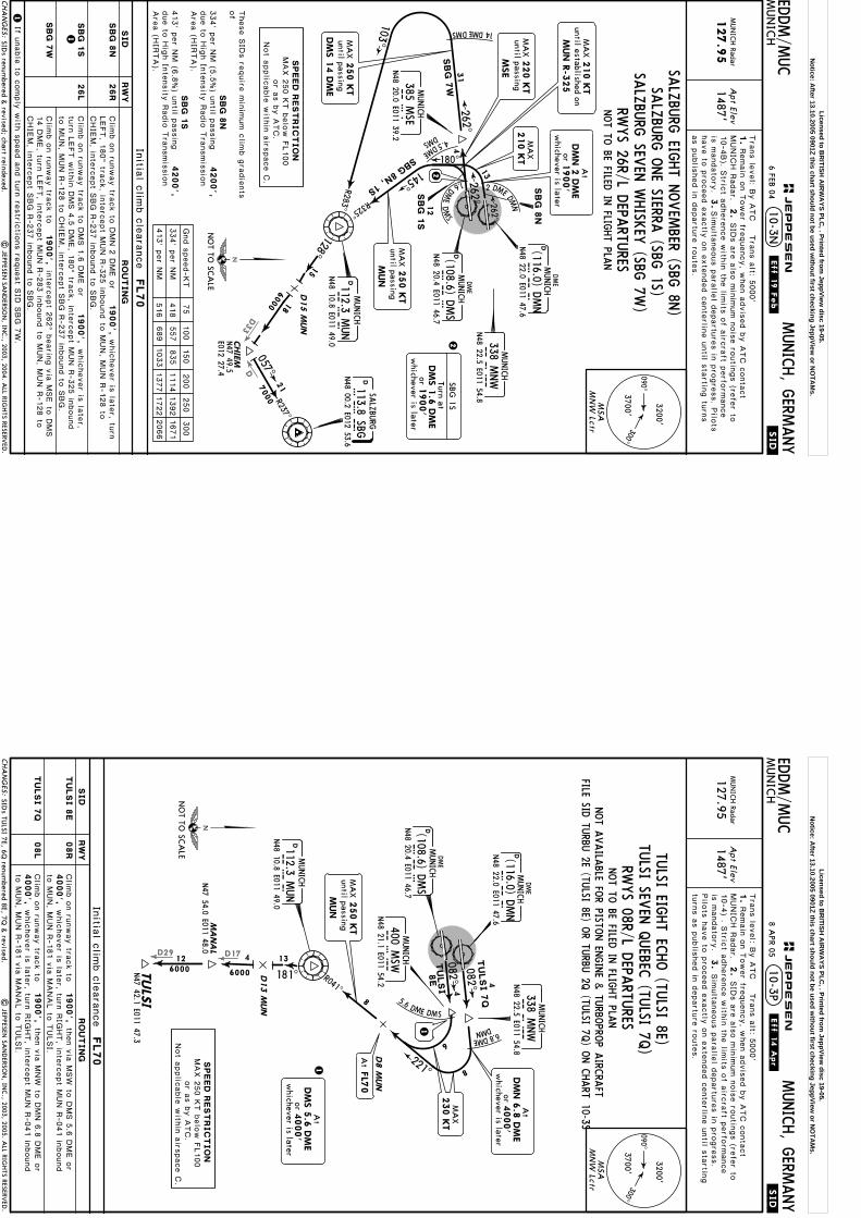
DD33
Apt Elev
.SID.
EDDM/M
UC
MUN
ICH
MUNICH, G
ERMANY
MUN
ICH Radar
127.9
51487'
10-3N
NOT TO
BE FILED IN
FLIGHT PLA
N
103^
R283^
6000
D15 M
UN
262^
E012 27.4
057^7000 R237^
4.5DME
DMS
145^
R325^
4
180^
1.6
DME
DMS
2 DME DMN
13
1821
12
SBG 8N, 1S
262^
262^
MA
X250 K
Tuntil passing
MUN
MA
X210 K
Tuntil established on
MUN R
-325
MA
X250 K
Tuntil passingDM
S 1
4 D
ME
Initia
l clim
b c
leara
nce
FL70 7
5100
150
200
250
300
Gnd s
peed-K
T
334' p
er N
M
413' p
er N
M
418
557
835
1114
1392
1671
516
689
1033
1377
1722
2066
| JEPPESEN
SAN
DERSO
N, IN
C., 2003, 2004. A
LL RIGHTS RESERV
ED.
Tra
ns le
vel: B
y A
TC T
rans a
lt: 5000'
1.
MUNIC
H R
adar.
2.
3.
Remain
on T
ower fre
quency, w
hen a
dvis
ed b
y A
TC c
onta
ct
SID
s a
re a
lso m
inim
um n
ois
e ro
utin
gs (re
fer to
10-4
B). S
trict a
dhere
nce w
ithin
the lim
its o
f airc
raft p
erfo
rmance
is m
andato
ry.
have to
pro
ceed e
xactly
on e
xte
nded c
ente
rline u
ntil s
tartin
g tu
rns
as p
ublis
hed in
departu
re ro
ute
s.
Sim
ulta
neous p
ara
llel d
epartu
res in
pro
gre
ss. P
ilots
SIDs renum
bered & revised; chart reindexed.
090^300^
3700'
3200'
MSA
MN
W Lctr
MUNICH
MNW
338 MNW
N48 22.5 E011 54.8
N48 22.0 E011 47.6
DMUNICH
DM
NDME
(116.0) DMN
DME
DMUNICH
DM
SN48 20.4 E011 46.7
(108.6) DMS
DMUNICH
MU
N112.3 M
UN
N48 10.8 E011 49.0
CHA
NG
ES:
JEPPESEN
.Eff.19.Feb.
SPEED
REST
RIC
TIO
NMAX 2
50 K
T b
elo
w F
L100
or a
s b
y A
TC.
Not a
pplic
able
with
in a
irspace C
.
26R
26L
1
1
SBG
8N
SBG
1S
SBG
7W
If unable
to c
omply
with
speed a
nd tu
rn re
stric
tions re
quest S
ID S
BG 7
W.
1900',
1900',
RWYS 26R/L D
EPARTU
RES
128^15
CHIE
M
SBG
D113.8 SBGSA
LZBU
RG
N48 00.2 E012 53.6
14DMEDMS
31
2
MUNICH
MSE
385 MSE
N48 20.0 E011 39.2
SBG
7W
SBG
8N
SBG
1S
N47 49.5
NO
T TO SC
ALE
orw
hichever is later1900'
At
DM
N 2
DM
E
SALZ
BURG
EIGHT N
OVEM
BER (SBG 8N
)
SALZ
BURG
SEVEN
WHISK
EY (SBG
7W)
orw
hichever is later1900'
DM
S 1
.6 D
ME
Turn atSB
G 1S
MA
X220 K
Tuntil passing
MSE
MA
X210 K
T
Clim
b o
n ru
nway tra
ck to
DMN 2
DME o
r
Clim
b o
n ru
nway tra
ck to
DMS 1
.6 D
ME o
r
LEFT, 1
80^ tra
ck, in
terc
ept M
UN R
-325 in
bound to
MUN, M
UN R
-128 to
CHIE
M, in
terc
ept S
BG R
-237 in
bound to
SBG.
whic
hever is
late
r, turn
RW
YSID
RO
UT
IN
G
These S
IDs re
quire
min
imum c
limb g
radie
nts
of
4200',
4200',
6 FEB 04
SALZ
BURG
ONE SIERRA
(SBG 1S)
SBG
8N
SBG
1S
turn
LEFT w
ithin
DMS 4
.5 D
ME, 1
80^ tra
ck, in
terc
ept M
UN R
-325 in
bound
to M
UN, M
UN R
-128 to
CHIE
M, in
terc
ept S
BG R
-237 in
bound to
SBG.
whic
hever is
late
r,
1900',
Clim
b o
n ru
nway tra
ck to
14 D
ME, tu
rn L
EFT, in
terc
ept M
UN R
-283 in
bound to
MUN, M
UN R
-128 to
CHIE
M, in
terc
ept S
BG R
-237 in
bound to
SBG.
inte
rcept 2
62^ b
earin
g v
ia M
SE to
DMS
334' p
er N
M (5
.5%) u
ntil p
assin
gdue to
Hig
h In
tensity
Radio
Tra
nsmis
sio
nAre
a (H
IRTA).
413' p
er N
M (6
.8%) u
ntil p
assin
gdue to
Hig
h In
tensity
Radio
Tra
nsmis
sio
nAre
a (H
IRTA).
2
Licensed to BR
ITISH A
IRW
AYS PLC
, . Printed from JeppView
disc 19-05.N
otice: After 13.10.2005 0901Z this chart should not be used w
ithout first checking JeppView or N
OTA
Ms.
D29 D17
Apt Elev
.SID.
EDDM/M
UC
MUN
ICH
MUNICH, G
ERMANY
MUN
ICH Radar
127.951487'
082^
082^
10-3P
MA
NA
LN47 54.0 E011 48.0
TULS
IN47 42.1 E011 47.3
4
4
5.6 DME DMS
6000
8E
6
8
TULSI
TULSI 7
Q
412
181^6000
13
Initia
l clim
b c
leara
nce
FL70
SIDs TU
LSI 7E, 6Q renum
bered 8E, 7Q &
revised.|
JEPPESEN SA
ND
ERSON
, INC., 2003, 2005. A
LL RIGHTS RESERV
ED.
Tra
ns le
vel: B
y A
TC T
rans a
lt: 5000'
1.
MUNIC
H R
adar.
2.
3.
Remain
on T
ower fre
quency, w
hen a
dvis
ed b
y A
TC c
onta
ct
SID
s a
re a
lso m
inim
um n
ois
e ro
utin
gs (re
fer to
Pilo
ts h
ave to
pro
ceed e
xactly
on e
xte
nded c
ente
rline u
ntil s
tartin
gtu
rns a
s p
ublis
hed in
departu
re ro
ute
s.
Sim
ulta
neous p
ara
llel d
epartu
res in
pro
gre
ss.
D8 M
UN
MA
X250 K
Tuntil passing
MUN
8
1
1
10-4
) . Stric
t adhere
nce w
ithin
the lim
its o
f airc
raft p
erfo
rmance
is m
andato
ry.
D13 M
UN
090^300^
3700'
3200'
MSA
MN
W Lctr
MUNICH
MNW
338 MNW
N48 22.5 E011 54.8
N48 22.0 E011 47.6
DMUNICH
DM
NDME
(116.0) DMN
DME
DMUNICH
DM
SN48 20.4 E011 46.7
(108.6) DMS
DMUNICH
MU
N112.3 M
UN
N48 10.8 E011 49.0
MUNICH
MSW
400 MSW
N48 21.1 E011 54.2
CHA
NG
ES:
JEPPESEN
.Eff.14.Apr.S
PEED
REST
RIC
TIO
NMAX 2
50 K
T b
elo
w F
L100
or a
s b
y A
TC.
Not a
pplic
able
with
in a
irspace C
.
RWYS 08R/L D
EPARTU
RES
08R
08L
4000',
TU
LSI 8
E
TU
LSI 7
Q
1900',
1900',
4000',
then v
ia M
SW
to D
MS 5
.6 D
ME o
r
then v
ia M
NW
to D
MN 6
.8 D
ME o
r
NO
T TO SC
ALE
6.8DME
DMN
221^
R041^
orw
hichever is later4000'
DM
N 6
.8 D
ME
At
MA
X230 K
T
Clim
b o
n ru
nway tra
ck to
Clim
b o
n ru
nway tra
ck to
RW
YSID
RO
UT
IN
G
NOT A
VAILA
BLE FOR PISTO
N EN
GINE &
TURBO
PROP A
IRCRA
FTFILE SID
TURBU
2E (TULSI 8E) O
R TURBU
2Q (TU
LSI 7Q) O
N C
HART 10-3S
to M
UN, M
UN R
-181 v
ia M
ANAL to
TULSI.
whic
hever is
late
r, turn
RIG
HT, in
terc
ept M
UN R
-041 in
bound
to M
UN, M
UN R
-181 v
ia M
ANAL to
TULSI.
whic
hever is
late
r, turn
RIG
HT, in
terc
ept M
UN R
-041 in
bound
TULSI EIG
HT EC
HO (TU
LSI 8E)
At
FL7
0
orw
hichever is later
DM
S 5
.6 D
ME
4000'
At
8 APR 05
TULSI SEV
EN Q
UEBEC
(TULSI 7Q
)
NOT TO
BE FILED IN
FLIGHT PLA
N
Licensed to BR
ITISH A
IRW
AYS PLC
, . Printed from JeppView
disc 19-05.N
otice: After 13.10.2005 0901Z this chart should not be used w
ithout first checking JeppView or N
OTA
Ms.

D17D29
Apt Elev
.SID.
EDDM/M
UC
MUN
ICH
MUNICH, G
ERMANY
MUN
ICH Radar
127.951487'
10-3Q
103^
R283^
262^
4.5DME
DMS
145^
R325^
4
180^
1.6
DME
DMS
2 DME DMN
13
181^
13
MA
NA
L
TULS
IN47 42.1 E011 47.3
60006000 D
13 M
UN
4
12
12
TULSI
7N, 1S
262^ 262^
Initia
l clim
b c
leara
nce
FL70
MA
X250 K
Tuntil passing
MUN
MA
X250 K
Tuntil passingDM
S 1
4 D
ME
75
100
150
200
250
300
Gnd s
peed-K
T
334' p
er N
M
413' p
er N
M
418
557
835
1114
1392
1671
516
689
1033
1377
1722
2066
MA
X210 K
Tuntil established on
MUN R
-325
| JEPPESEN
SAN
DERSO
N, IN
C., 2003, 2005. A
LL RIGHTS RESERV
ED.
Tra
ns le
vel: B
y A
TC T
rans a
lt: 5000'
1.
MUNIC
H R
adar.
2.
3.
Remain
on T
ower fre
quency, w
hen a
dvis
ed b
y A
TC c
onta
ct
SID
s a
re a
lso m
inim
um n
ois
e ro
utin
gs (re
fer to
Pilo
ts h
ave to
pro
ceed e
xactly
on e
xte
nded c
ente
rline u
ntil s
tartin
gtu
rns a
s p
ublis
hed in
departu
re ro
ute
s.
Sim
ulta
neous p
ara
llel d
epartu
res in
pro
gre
ss.
Restriction in chart heading established.
N47 54.0
E011 48.0
10-4
) . Stric
t adhere
nce w
ithin
the lim
its o
f airc
raft p
erfo
rmance
is m
andato
ry.
090^300^
3700'
3200'
MSA
MN
W Lctr
MUNICH
MNW
338 MNW
N48 22.5 E011 54.8
N48 22.0 E011 47.6
DMUNICH
DM
NDME
(116.0) DMN
DME
DMUNICH
DM
SN48 20.4 E011 46.7
(108.6) DMS
DMUNICH
MU
N112.3 M
UN
N48 10.8 E011 49.0
CHA
NG
ES:
JEPPESEN
.Eff.14.Apr.
26R
26L
1
1
RWYS 26R/L D
EPARTU
RES
14DMEDMS
31M
UNICH
MSE
385 MSE
N48 20.0 E011 39.2
NO
T TO SC
ALE
TU
LSI 7
N
TU
LSI 1
S
TU
LSI 7
W
1900',
1900',
1900',
2
TU
LSI 7
N
TU
LSI 1
S
TULSI 7
W
RW
YSID
RO
UT
IN
G
TULSI O
NE SIERRA
(TULSI 1S)
TULSI SEV
EN W
HISK
EY (TU
LSI 7W)
orw
hichever is later1900'
DM
S 1
.6 D
ME
Turn at
TULSI 1S
MA
X220 K
Tuntil passing
MSE
Clim
b o
n ru
nway tra
ck to
DMN 2
DME o
r
Clim
b o
n ru
nway tra
ck to
DMS 1
.6 D
ME o
r
Clim
b o
n ru
nway tra
ck to
LEFT w
ithin
DMS 4
.5 D
ME, 1
80^ tra
ck, in
terc
ept M
UN R
-325 in
bound to
MUN,
MUN R
-181 v
ia M
ANAL to
TULSI.
DME, tu
rn L
EFT, in
terc
ept M
UN R
-283 in
bound to
MUN, M
UN R
-181 v
ia M
ANAL
to T
ULSI.
inte
rcept 2
62^ b
earin
g v
ia M
SE to
DMS 1
4
whic
hever is
late
r, turn
180^ tra
ck, in
terc
ept M
UN R
-325 in
bound to
MUN, M
UN R
-181 v
ia M
ANAL to
TULSI.
whic
hever is
late
r, turn
LEFT,
These S
IDs re
quire
min
imum c
limb g
radie
nts
of
4200',
4200',
TU
LSI 7
N
TU
LSI 1
S
TULSI SEV
EN N
OVEM
BER (TULSI 7N
)
MA
X210 K
T
ON C
HART 10-3T
orw
hichever is later1900'
At
DM
N 2
DM
E
If unable
to c
omply
with
speed a
nd tu
rn re
stric
tions re
quest S
ID T
ULSI 7
W.
FILE SID TU
RBU 1N
(TULSI 7N
) OR TU
RBU 1S, 1W
(TULSI 1S, 7W
)
334' p
er N
M (5
.5%) u
ntil p
assin
g
413' p
er N
M (6
.8%) u
ntil p
assin
g
due to
Hig
h In
tensity
Radio
Tra
nsmis
sio
nAre
a (H
IRTA).
due to
Hig
h In
tensity
Radio
Tra
nsmis
sio
nAre
a (H
IRTA).
SPEED
REST
RIC
TIO
NMAX 2
50 K
Tbelo
w F
L100
or a
s b
y A
TC.
Not a
pplic
able
with
in a
irspace C
.
8 APR 05
NOT A
VAILA
BLE FOR PISTO
N EN
GINE &
TURBO
PROP A
IRCRA
FTNOT TO
BE FILED IN
FLIGHT PLA
N
2
Licensed to BR
ITISH A
IRW
AYS PLC
, . Printed from JeppView
disc 19-05.N
otice: After 13.10.2005 0901Z this chart should not be used w
ithout first checking JeppView or N
OTA
Ms.
D30
Apt Elev
.SID.
EDDM/M
UC
MUN
ICH
MUNICH, G
ERMANY
MUN
ICH Radar
127.951487'
082^
082^
10-3S
TURBU
N47 43.7 E012 07.1
4
4
5.6 DME DMS
2E
6
8
TURBU
TURBU 2
Q
Initia
l clim
b c
leara
nce
FL70
| JEPPESEN
SAN
DERSO
N, IN
C., 2003, 2005. A
LL RIGHTS RESERV
ED.
154^15
10
5
D15 M
UN
D25 M
UN
6000
9000
Tra
ns le
vel: B
y A
TC T
rans a
lt: 5000'
1.
MUNIC
H R
adar.
2.
3.
Remain
on T
ower fre
quency, w
hen a
dvis
ed b
y A
TC c
onta
ct
SID
s a
re a
lso m
inim
um n
ois
e ro
utin
gs (re
fer to
10-4
). Stric
t adhere
nce w
ithin
the lim
its o
f airc
raft p
erfo
rmance
is m
andato
ry.
have to
pro
ceed e
xactly
on e
xte
nded c
ente
rline u
ntil s
tartin
g tu
rns
as p
ublis
hed in
departu
re ro
ute
s.
Sim
ulta
neous p
ara
llel d
epartu
res in
pro
gre
ss. P
ilots
MA
X250 K
Tuntil passing
MUN
8
D8 M
UN
1
1
SID reference in chart heading.
090^
300^3700'
3200'
MSA
MN
W Lctr
MUNICH
MNW
338 MNW
N48 22.5 E011 54.8
N48 22.0 E011 47.6
DMUNICH
DM
NDME
(116.0) DMN
DME
DMUNICH
DM
SN48 20.4 E011 46.7
(108.6) DMS
DMUNICH
MU
N112.3 M
UN
N48 10.8 E011 49.0
MUNICH
MSW
400 MSW
N48 21.1 E011 54.2
CHA
NG
ES:
JEPPESEN
.Eff.14.Apr.
SPEED
REST
RIC
TIO
NMAX 2
50 K
T b
elo
w F
L100
or a
s b
y A
TC.
Not a
pplic
able
with
in a
irspace C
.
TURBU
TWO EC
HO (TU
RBU 2E)
RWYS 08R/L D
EPARTU
RES
08R
08L
4000',
TU
RBU
2E
TU
RBU
2Q
1900',
1900',
4000',
then v
ia M
SW
to D
MS 5
.6 D
ME o
r
then v
ia M
NW
to D
MN 6
.8 D
ME o
r
NO
T TO SC
ALE
6.8DME
DMN
221^
R041^
orw
hichever is later4000'
DM
N 6
.8 D
ME
At
TURBU
TWO Q
UEBEC
(TURBU
2Q)
MA
X230 K
T
Clim
b o
n ru
nway tra
ck to
Clim
b o
n ru
nway tra
ck to
RW
YSID
RO
UT
IN
G
whic
hever is
late
r, turn
RIG
HT, in
terc
ept M
UN R
-041 in
bound
whic
hever is
late
r, turn
RIG
HT, in
terc
ept M
UN R
-041 in
bound
MANDATO
RY FO
R PISTON EN
GINE &
TURBO
PROP A
IRCRA
FTNOT A
VAILA
BLE FOR JET A
IRCRA
FT
ON C
HARTS 10-3L1 &
10-3U
to M
UN, M
UN R
-154 to
TURBU.
to M
UN, M
UN R
-154 to
TURBU.
At
FL7
0
orw
hichever is later
DM
S 5
.6 D
ME
4000'
At
FILE SIDS O
BAXA 1E/U
NKEN
7E (TURBU
2E)OR O
BAXA 1Q
/UNKEN
6Q (TU
RBU 2Q
)
8 APR 05
Licensed to BR
ITISH A
IRW
AYS PLC
, . Printed from JeppView
disc 19-05.N
otice: After 13.10.2005 0901Z this chart should not be used w
ithout first checking JeppView or N
OTA
Ms.
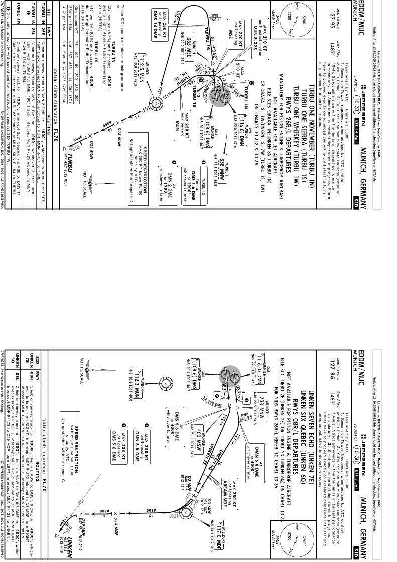
D30
Apt Elev
.SID.
EDDM/M
UC
MUN
ICH
MUNICH, G
ERMANY
MUN
ICH Radar
127.951487'
10-3T
103^
R283^
262^
4.5DME
DMS
145^
R325^
4
180^
1.6
DME
DMS
2 DME
DMN
13
12
TURBU
1N, 1S
262^ 262^
Initia
l clim
b c
leara
nce
FL70
MA
X250 K
Tuntil passing
MUN
MA
X250 K
Tuntil passingDM
S 1
4 D
ME
75
100
150
200
250
300
Gnd s
peed-K
T
334' p
er N
M
413' p
er N
M
418
557
835
1114
1392
1671
516
689
1033
1377
1722
2066
MA
X210 K
Tuntil established on
MUN R
-325
| JEPPESEN
SAN
DERSO
N, IN
C., 2003, 2005. A
LL RIGHTS RESERV
ED.
TURBU
N47 43.7 E012 07.1
154^15
10
5
D15 M
UN
D25 M
UN
6000
9000
Tra
ns le
vel: B
y A
TC T
rans a
lt: 5000'
1.
MUNIC
H R
adar.
2.
3.
Remain
on T
ower fre
quency, w
hen a
dvis
ed b
y A
TC c
onta
ct
SID
s a
re a
lso m
inim
um n
ois
e ro
utin
gs (re
fer to
10-4
). Stric
t adhere
nce w
ithin
the lim
its o
f airc
raft p
erfo
rmance
is m
andato
ry.
have to
pro
ceed e
xactly
on e
xte
nded c
ente
rline u
ntil s
tartin
g tu
rns
as p
ublis
hed in
departu
re ro
ute
s.
Sim
ulta
neous p
ara
llel d
epartu
res in
pro
gre
ss. P
ilots
SID reference in chart heading.
090^300^
3700'
3200'
MSA
MN
W Lctr
MUNICH
MNW
338 MNW
N48 22.5 E011 54.8
N48 22.0 E011 47.6
DMUNICH
DM
NDME
(116.0) DMN
DME
DMUNICH
DM
SN48 20.4 E011 46.7
(108.6) DMS
DMUNICH
MU
N112.3 M
UN
N48 10.8 E011 49.0
CHA
NG
ES:
JEPPESEN
.Eff.14.Apr.
SPEED
REST
RIC
TIO
NMAX 2
50 K
T b
elo
w F
L100
or a
s b
y A
TC.
Not a
pplic
able
with
in a
irspace C
.
26R
26L
1
1
RWYS 26R/L D
EPARTU
RES
14DMEDMS
31M
UNICH
MSE
385 MSE
N48 20.0 E011 39.2
NO
T TO SC
ALE
TU
RBU
1N
TU
RBU
1S
TU
RBU
1W
1900',
1900',
1900',
2
TU
RBU
1N
TU
RBU
1S
TURBU 1
W
RW
YSID
RO
UT
IN
G
TURBU
ONE SIERRA
(TURBU
1S)orw
hichever is later1900'
DM
S 1
.6 D
ME
Turn at
TURB
U 1S
MA
X220 K
Tuntil passing
MSE
Clim
b o
n ru
nway tra
ck to
DMN 2
DME o
r
Clim
b o
n ru
nway tra
ck to
DMS 1
.6 D
ME o
r
Clim
b o
n ru
nway tra
ck to
inte
rcept 2
62^ b
earin
g v
ia M
SE to
DMS 1
4
whic
hever is
late
r, turn
whic
hever is
late
r, turn
LEFT,
These S
IDs re
quire
min
imum c
limb g
radie
nts
of
4200',
4200',
TU
RBU
1N
TU
RBU
1S
MA
X210 K
T
If unable
to c
omply
with
speed a
nd tu
rn re
stric
tions re
quest S
ID T
URBU 1
W.
MANDATO
RY FO
R PISTON EN
GINE &
TURBO
PROP A
IRCRA
FTNOT A
VAILA
BLE FOR JET A
IRCRA
FT
ON C
HARTS 10-3L2 &
10-3V
180^ tra
ck, in
terc
ept M
UN R
-325 in
bound to
MUN, M
UN R
-154 to
TURBU.
LEFT w
ithin
DMS 4
.5 D
ME, 1
80^ tra
ck, in
terc
ept M
UN R
-325 in
bound to
MUN,
MUN R
-154 to
TURBU.
DME, tu
rn L
EFT, in
terc
ept M
UN R
-283 in
bound to
MUN, M
UN R
-154 to
TURBU.
FILE SIDS O
BAXA 1N
/UNKEN
8N (TU
RBU 1N
)
TURBU
ONE N
OVEM
BER (TURBU
1N)
TURBU
ONE W
HISK
EY (TU
RBU 1W
)
orw
hichever is later1900'
At
DM
N 2
DM
E3
OR O
BAXA 1S, 1W
/UNKEN
1S, 7W (TU
RBU 1S, 1W
)
334' p
er N
M (5
.5%) u
ntil p
assin
g
413' p
er N
M (6
.8%) u
ntil p
assin
g
due to
Hig
h In
tensity
Radio
Tra
nsmis
sio
nAre
a (H
IRTA).
due to
Hig
h In
tensity
Radio
Tra
nsmis
sio
nAre
a (H
IRTA).
8 APR 05
2
3
Licensed to BR
ITISH A
IRW
AYS PLC
, . Printed from JeppView
disc 19-05.N
otice: After 13.10.2005 0901Z this chart should not be used w
ithout first checking JeppView or N
OTA
Ms.
R301^R292^
D46
128^
178^
Apt Elev
.SID.
EDDM/M
UC
MUN
ICH
MUNICH, G
ERMANY
MUN
ICH Radar
127.9
51487'
10-3U
4
4
5.6 DME DMS
N47 55.1 E012 20.7
11000
082^
082^2
12
230 K
T
DM
N 6
.8 D
ME
MA
Xuntil passing
Initia
l clim
b c
leara
nce
FL70
orw
hichever is later4000'
DM
N 6
.8 D
ME
At
1
MA
X250 K
Tuntil passingA
BEA
M M
DF
| JEPPESEN
SAN
DERSO
N, IN
C., 2003, 2004. A
LL RIGHTS RESERV
ED.
Tra
ns le
vel: B
y A
TC T
rans a
lt: 5000'
1.
MUNIC
H R
adar.
2.
3.
Remain
on T
ower fre
quency, w
hen a
dvis
ed b
y A
TC c
onta
ct
SID
s a
re a
lso m
inim
um n
ois
e ro
utin
gs (re
fer to
10-4
B) . S
trict a
dhere
nce w
ithin
the lim
its o
f airc
raft p
erfo
rmance
is m
andato
ry.
Pilo
ts h
ave to
pro
ceed e
xactly
on e
xte
nded c
ente
rline u
ntil s
tartin
gtu
rns a
s p
ublis
hed in
departu
re ro
ute
s.
Sim
ulta
neous p
ara
llel d
epartu
res in
pro
gre
ss.
Restriction in chart heading.
08R
08L
090^300^
3700'
3200'
MSA
MN
W Lctr
MUNICH
MNW
338 MNW
N48 22.5 E011 54.8
N48 22.0 E011 47.6
DMUNICH
DM
NDME
(116.0) DMN
DME
DMUNICH
DM
SN48 20.4 E011 46.7
(108.6) DMS
CHA
NG
ES:
JEPPESEN
.Eff.8.Jul.
SPEED
REST
RIC
TIO
NMAX 2
50 K
T b
elo
w F
L100
or a
s b
y A
TC.
Not a
pplic
able
with
in a
irspace C
.
NO
T TO SC
ALE
4000',
1900',
1900',
then v
ia M
SW
to D
MS 5
.6 D
ME o
r
then v
ia M
NW
to D
MN 6
.8 D
ME o
r 20
4 17
D3 M
DF
D3 M
DF
UNKEN
D15 M
DF
N48 15.3
N48 15.7
E012 16.4
E012 16.1
N47 41.4
E012 41.8
8500 5500
DMILLD
ORF
117.0 MDF
MD
FN48 14.1 E012 20.2
112^16
16
UNKEN 7
E
UNKEN 6
Q
MSW
MUNICH
400 MSW
N48 21.1 E011 54.2
6.8DME
DMN
D19 M
DF
121^
DMUNICH
MU
N112.3 M
UN
N48 10.8 E011 49.0
orw
hichever is later
DM
S 5
.6 D
ME
4000'
At
DM
S 5
.6 D
ME
230 K
TM
AX
until passing
RW
YSID
RO
UT
IN
G
4000',
Clim
b o
n ru
nway tra
ck to
Clim
b o
n ru
nway tra
ck to
UN
KEN
7E
UN
KEN
6Q
whic
h-
whic
h-
ever is
late
r, turn
RIG
HT, in
terc
ept M
DF R
-301 in
bound to
D3 M
DF, tu
rn R
IGHT,
inte
rcept M
DF R
-178 to
D19 M
DF, tu
rn L
EFT, in
terc
ept M
UN R
-128 to
UNKEN.
UNKEN
SIX Q
UEBEC
(UNKEN
6Q)
FOR SID
S RWYS 26R/L REFER TO
CHART 10-3V
RWYS 08R/L D
EPARTU
RES
UNKEN
SEVEN
ECHO (U
NKEN
7E)
NOT A
VAILA
BLE FOR PISTO
N EN
GINE &
TURBO
PROP A
IRCRA
FTFILE SID
TURBU
2E (UNKEN
7E) OR TU
RBU 2Q
(UNKEN
6Q) O
N C
HART 10-3S
ever is
late
r, turn
RIG
HT, in
terc
ept M
DF R
-292 in
bound to
D3 M
DF, tu
rn R
IGHT,
inte
rcept M
DF R
-178 to
D19 M
DF, tu
rn L
EFT, in
terc
ept M
UN R
-128 to
UNKEN.
25 JUN
04
Licensed to BR
ITISH A
IRW
AYS PLC
, . Printed from JeppView
disc 19-05.N
otice: After 13.10.2005 0901Z this chart should not be used w
ithout first checking JeppView or N
OTA
Ms.

R258^
016^
MUN
R235^
D25
078^
Apt Elev
EDDM/M
UC
MUN
ICH
MUNICH, G
ERMANY
MUN
ICH Radar
123.9
1487'
.RNAV.SID.(OVERLAY).
[AN
KE5
E] [A
NKE6
N]
[AN
KE5
Q]
[AN
KE5
S]
DM
051
DM
066
DM
064
DM
056
DM
083
DM
065
DM
057
N48 21.6 E011 59.8
N48 21.3
E011 39.7
N48 29.5 E011 37.2
N48 29.5
E011 37.0
262^
262^082^
082^4.3
8.4
2.1
4
5.9
N48 34.4 E012 00.1
N48 32.3 E011 59.2
10-3V1
ANKER 5
Q
055^
MA
X230 K
T
N48 20.0
E011 39.2
MA
X220 K
T
MA
X220 K
T
DM
077
N48 25.4
E011 55.2DM
070
N48 22.1
E011 50.6
DM
072
N48 22.8
E011 52.5
DM
079
N48 27.4
E011 59.9
0.9
3.7
14.8
0.2
6.9
Initia
l clim
b c
leara
nce
FL70
NOT A
VAILA
BLE FOR FLIG
HTS V
IA A
IRWAY (U
)Z 30
FILE RNAV SID
EGG 1E (A
NKER 5E, 5Q
) OR EG
G 1S, 1W
(ANKER 6N
, 5S)ON C
HARTS 10-3V
2 & 10-3V
3
| JEPPESEN
SAN
DERSO
N, IN
C., 2004. A
LL RIGHTS RESERV
ED.
Tra
ns le
vel: B
y A
TC T
rans a
lt: 5000'
1.
MUNIC
H R
adar.
2.
3.
Remain
on T
ower fre
quency, w
hen a
dvis
ed b
y A
TC c
onta
ct
SID
s a
re a
lso m
inim
um n
ois
e ro
utin
gs (re
fer to
10-4
B) . S
trict a
dhere
nce w
ithin
the lim
its o
f airc
raft p
erfo
rmance
is m
andato
ry.
Pilo
ts h
ave to
pro
ceed e
xactly
on e
xte
nded c
ente
rline u
ntil s
tartin
gtu
rns a
s p
ublis
hed in
departu
re ro
ute
s.
Sim
ulta
neous p
ara
llel d
epartu
res in
pro
gre
ss.
034^3.1
2
MA
X250 K
T
AN
KER 5E, 5Q
MA
X250 K
T
MA
X250 K
T
RNA
V SID
s renumbered &
revised.
NO
T TO SC
ALE
AN
KER 5
E
AN
KER 6
N
AN
KER 5
Q
AN
KER 5
S
08R
26R
08L
26L
360^
090^300^
3700'
3200'
MSA
MN
W Lctr
MIQ
426.5 MIQ
MIKE
N48 34.2 E011 35.9
MUNICH
MNW
338 MNW
N48 22.5 E011 54.8
DMUNICH
MU
N112.3 M
UN
N48 10.8 E011 49.0
348^
350^ANKER
5S
DMB
G117.15 M
BGN48 34.4 E012 15.7
MOOSBU
RG
CHA
NG
ES:
JEPPESEN
.Eff.8.Jul.
SPEED
REST
RIC
TIO
NMAX 2
50 K
T b
elo
w F
L100
or a
s b
y A
TC.
Not a
pplic
able
with
in a
irspace C
.
(1900'+
) -
(1900'+
) -
(1900'+
) -
(1900'+
) -
9.6ANKER 6N
7.8
ANKER
AN
KER 5
E
RNAV D
EPARTU
RES (OVERLA
Y 10-3B)
ANKER SIX
NOVEM
BER (ANKER 6N
)
RWYS 08R, 26R, 08L, 26L
RW
YSID
RO
UT
IN
G
ANKER FIV
E ECHO (A
NKER 5E)
ANKER FIV
E QUEBEC
(ANKER 5Q
)ANKER FIV
E SIERRA (A
NKER 5S)
DM
083 (K
230-) - A
NKER (K
250-).
DM066 (K
220-) - D
M064 (K
250-) - D
M065 - A
NKER.
DM070 - D
M072 - D
M077 - D
M079 - A
NKER (K
250-).
DM051 (K
220-) - D
M056 (K
250-) - D
M057 - A
NKER.
25 JUN
04
Licensed to BR
ITISH A
IRW
AYS PLC
, . Printed from JeppView
disc 19-05.N
otice: After 13.10.2005 0901Z this chart should not be used w
ithout first checking JeppView or N
OTA
Ms.
Apt Elev
EDDM/M
UC
MUN
ICH
MUNICH, G
ERMANY
MUN
ICH Radar
127.9
51487'
10-3V2
Tra
ns le
vel: B
y A
TC T
rans a
lt: 5000'
1.
MUNIC
H R
adar.
2.
3.
Remain
on T
ower fre
quency, w
hen a
dvis
ed b
y A
TC c
onta
ct
Initial climb clearance FL70
.RNAV.SID.(OVERLAY).
5
DM071
DM080N48 21.2 E011 55.7
N48 22.8 E011 59.6
082^
082^
6.9
MAX250 KT
EGGENFELDEN393 EGGEGG
N48 23.8 E012 45.0
5000
058^
| JEPPESEN
SAN
DERSO
N, IN
C., 2004. A
LL RIGHTS RESERV
ED.
19.2
SID
s a
re a
lso m
inim
um n
ois
e ro
utin
gs (re
fer to
10-4
B). S
trict a
dhere
nce w
ithin
the lim
its o
f airc
raft p
erfo
rmance
is m
andato
ry.
Sim
ulta
neous p
ara
llel d
epartu
res in
pro
gre
ss. P
ilots
have to
pro
ceed e
xactly
on e
xte
nded c
ente
rline u
ntil s
tartin
g tu
rns
as p
ublis
hed in
departu
re ro
ute
s.
See other side.
090^
300^3700'
3200'
MSAMNW Lctr
CHA
NG
ES:
JEPPESEN.Eff.8.Jul.
08R
EGGEN
FELDEN
ONE EC
HO (EG
G 1E)
EGGEN
FELDEN
ONE Q
UEBEC
(EGG 1Q
)
RWYSID ROUTING
EGG 1E
EGG 1Q 08L (1900'+) - DM071
(1900'+) - DM080 (4000'+;
(4000'+;
K230-) - MDF (K250-) - EGG.
K230-) - MDF (K250-) - EGG.
NOT TO SCALE
RWYS 08R/L RN
AV D
EPARTU
RES (OVERLA
Y 10-3C
)
MUNICH
MNW338 MNWN48 22.5 E011 54.8
SPEED RESTRICTIONMAX 250 KT below FL100
or as by ATC.Not applicable within airspace C.
112^121^
R301^R292^
DMILLDORF117.0 MDFMDF
N48 14.1 E012 20.2
17.916.3
4000'At or above
230 KTMAX
4000'At or above
230 KTMAX
EGG 1QEGG 1E
FOR RN
AV SID
S RWYS 26R/L REFER TO
CHART 10-3V
3
25 JUN
04
NOT A
VAILA
BLE FOR FLIG
HTS V
IA (U
)L 605 & (U
)M 749
Licensed to BR
ITISH A
IRW
AYS PLC
, . Printed from JeppView
disc 19-05.N
otice: After 13.10.2005 0901Z this chart should not be used w
ithout first checking JeppView or N
OTA
Ms.
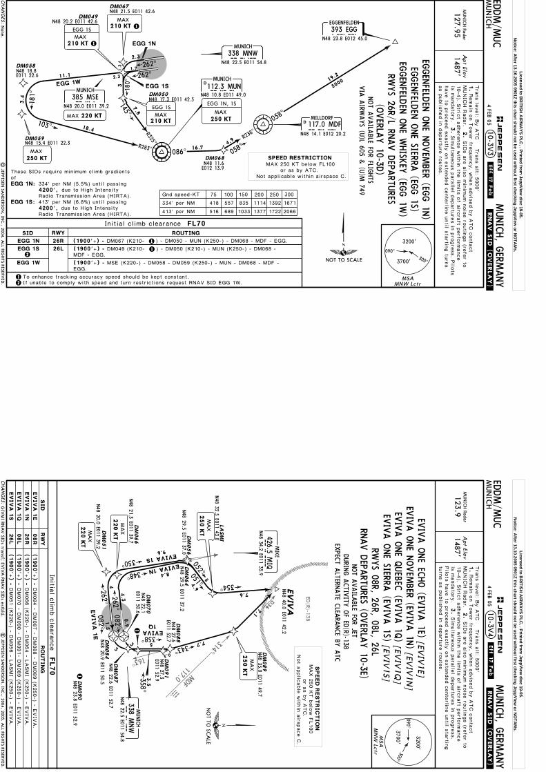
Apt Elev
.Eff.17.Feb.
EDDM/M
UC
MUN
ICH
MUNICH, G
ERMANY
MUN
ICH Radar
127.951487'
10-3V3
Tra
ns le
vel: B
y A
TC T
rans a
lt: 5000'
1.
MUNIC
H R
adar.
2.
Remain
on T
ower fre
quency, w
hen a
dvis
ed b
y A
TC c
onta
ct
Initial climb clearance FL70
75 100 150 200 250 300Gnd speed-KT
334' per NM
413' per NM
418 557 835 1114 1392 1671
516 689 1033 1377 1722 2066
.RNAV.SID.(OVERLAY).
1
1
103^
R283^
145^
R325^
180^
DM067
DM059
DM058
DM049N48 21.5 E011 42.6
N48 20.2 E011 42.6
N48 18.8E011 22.6
DM050
262^
262^
2.3
7.8
1.7
3.4
18.4
181^
2.3
N48 17.3 E011 42.5
31.3
MAX210 KT
N48 15.4 E011 22.3
MAX250 KT
EGGENFELDEN
393 EGGEGGN48 23.8 E012 45.0
5000
058^
16.7058^
R238^
| JEPPESEN
SAN
DERSO
N, IN
C., 2004. A
LL RIGHTS RESERV
ED.
DM068
4.9
19.2
N48 11.6E012 13.9
MAX250 KT
EGG 1N, 1S
1
have to
pro
ceed e
xactly
on e
xte
nded c
ente
rline u
ntil s
tartin
g tu
rns
as p
ublis
hed in
departu
re ro
ute
s.
is m
andato
ry.
3.
Sim
ulta
neous p
ara
llel d
epartu
res in
pro
gre
ss. P
ilots
10-4
). Stric
t adhere
nce w
ithin
the lim
its o
f airc
raft p
erfo
rmance
SID
s a
re a
lso m
inim
um n
ois
e ro
utin
gs (re
fer to
EGG 1S
NOT A
VAILA
BLE FOR FLIG
HTS
VIA
AIRW
AYS (U
)L 605 & (U
)M 749
None.
090^300^3700'
3200'
MSAMNW Lctr
CHA
NG
ES:
JEPPESEN
26L2
2
4 FEB 05
26R
RWYSID ROUTING
EGG 1N
EGG 1S
EGG 1W
These SIDs require minimum climb gradientsof
4200',EGG 1N:
EGG 1S:
334' per NM (5.5%) until passing
4200',413' per NM (6.8%) until passing
(1900'+) -
(1900'+) -
(1900'+) -
1 To enhance tracking accuracy speed should be kept constant.
DM067 (K210-
DM049 (K210-
) - DM050 - MUN (K250-) - DM068 - MDF - EGG.
) - DM050 (K210-) - MUN (K250-) - DM068 -MDF - EGG.
EGG.MSE (K220-) - DM058 - DM059 (K250-) - MUN - DM068 - MDF -
If unable to comply with speed and turn restrictions request RNAV SID EGG 1W.
MUNICH
MNW338 MNWN48 22.5 E011 54.8
DMUNICH
MUN112.3 MUNN48 10.8 E011 49.0
11.1
MUNICH
MSE385 MSEN48 20.0 E011 39.2
MAX 220 KT
MAX210 KT 1
086^
NOT TO SCALE
DMILLDORF117.0 MDFMDF
N48 14.1 E012 20.2EG
GEN
FELDEN
ONE SIERRA
(EGG 1S)
EGGEN
FELDEN
ONE W
HISK
EY (EG
G 1W
)
EGGEN
FELDEN
ONE N
OVEM
BER (EGG 1N
)
EGG 1N
EGG 1SEGG 1W
MAX210 KT
EGG 1S
due to High Intensity
due to High Intensity
Radio Transmission Area (HIRTA).
Radio Transmission Area (HIRTA).
RWYS 26R/L RN
AV D
EPARTU
RES(O
VERLA
Y 10-3D
)SPEED RESTRICTIONMAX 250 KT below FL100
or as by ATC.Not applicable within airspace C.
Licensed to BR
ITISH A
IRW
AYS PLC
, . Printed from JeppView
disc 19-05.N
otice: After 13.10.2005 0901Z this chart should not be used w
ithout first checking JeppView or N
OTA
Ms.
314^
D36
163^
MDF
117.0
MDF
ED(R)-138
Apt Elev
.Eff.17.Feb.
EDDM/M
UC
MUN
ICH
MUNICH, G
ERMANY
MUN
ICH Radar
123.91487'
| JEPPESEN
SAN
DERSO
N, IN
C., 2004, 2005. A
LL RIGHTS RESERV
ED.
Tra
ns le
vel: B
y A
TC T
rans a
lt: 5000'
1.
MUNIC
H R
adar.
2.
3.
Remain
on T
ower fre
quency, w
hen a
dvis
ed b
y A
TC c
onta
ct
SID
s a
re a
lso m
inim
um n
ois
e ro
utin
gs (re
fer to
Pilo
ts h
ave to
pro
ceed e
xactly
on e
xte
nded c
ente
rline u
ntil s
tartin
gtu
rns a
s p
ublis
hed in
departu
re ro
ute
s.
Sim
ulta
neous p
ara
llel d
epartu
res in
pro
gre
ss.
NOT A
VAILA
BLE FOR JET
10-4
). Stric
t adhere
nce w
ithin
the lim
its o
f airc
raft p
erfo
rmance
is m
andato
ry.
DURIN
G A
CTIV
ITY O
F ED(R)-138
EXPEC
T ALTERN
ATE C
LEARA
NCE BY
ATC
GIV
MI RN
AV SID
s transf; EVIV
A RN
AV SID
s estbld.
LASM
I
EVIV
AN48 40.0 E011 42.2
.RNAV.SID.(OVERLAY).
10-3V4
[EVIV
1E]
[EVIV
1N
] [EV
IV1Q
] [EV
IV1S]
Initia
l clim
b c
leara
nce
FL70
DM
051
N48 20.0 E011 39.2
4
DM
066
4.3
N48 21.3 E011 39.7
262^
262^
DM
064
N48 29.5 E011 37.2
DM
056
N48 29.5 E011 37.0
DM
070
DM
084
N48 22.1
E011 50.6
082^
082^
N48 20.9 E011 50.5D
M090
N48 23.8 E011 52.9
DM
087
N48 22.6 E011 52.7
DM
088
DM
089
N48 35.0 E011 49.7
DM
091
N48 32.5 E011 43.0
N48 27.6
E011 52.7N48 27.3
E011 52.9
MA
X220 K
T
MA
X220 K
T
348^
350^
8.4
9.6
EVIVA 1N
EVIVA 1S
MA
X250 K
T5
4.9051^
052^
354^7.6
7.1
MA
X250 K
T
7.7
0.3
343^
358^
0.91.5
33
5
EVIVA
1E
EVIVA1Q
3.5358^
1
1
NO
T TO SC
ALE
090^
300^3700'
3200'
MSA
MN
W Lctr
MIQ
426.5 MIQ
MIKE
N48 34.2 E011 35.9
MUNICH
MNW
338 MNW
N48 22.5 E011 54.8
CHA
NG
ES:
JEPPESEN
4 FEB 05
EVIV
A O
NE N
OVEM
BER (EVIV
A 1N
)
EVIV
A O
NE SIERRA
(EVIV
A 1S)
EVIV
A O
NE EC
HO (EV
IVA 1E)
EVIV
A O
NE Q
UEBEC
(EVIV
A 1Q
)
EV
IV
A 1
N
EV
IV
A 1
E
EV
IV
A 1
Q
EV
IV
A 1
S
RWYS 08R, 26R, 08L, 26L
RNAV D
EPARTU
RES (OVERLA
Y 10-3E)
(1900'+
) -
(1900'+
) -
(1900'+
) -
(1900'+
) -
08R
26R
08L
26L
RW
YSID
RO
UT
IN
G
DM084 - D
M087 - D
M088 - D
M089 (K
250-) - E
VIV
A.
DM066 (K
220-) - D
M064 - L
ASMI (K
250-) - E
VIV
A.
DM051 (K
220-) - D
M056 - L
ASMI (K
250-) - E
VIV
A.
DM070 - D
M090 - D
M091- D
M089 (K
250-) - E
VIV
A.
SPEED
REST
RIC
TIO
NMAX 2
50 K
T b
elo
w F
L100
or a
s b
y A
TC.
Not a
pplic
able
with
in a
irspace C
.
Licensed to BR
ITISH A
IRW
AYS PLC
, . Printed from JeppView
disc 19-05.N
otice: After 13.10.2005 0901Z this chart should not be used w
ithout first checking JeppView or N
OTA
Ms.
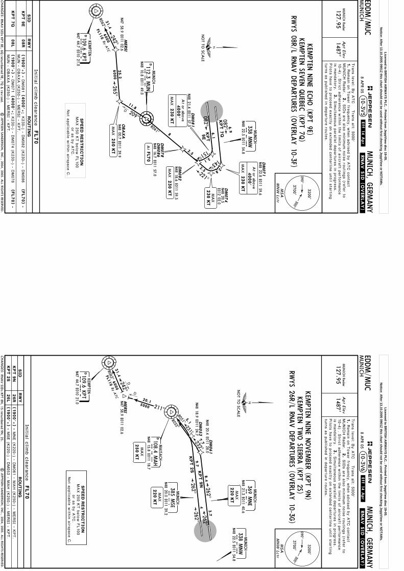
D
Apt Elev
.Eff.14.Apr.
EDDM/M
UC
MUN
ICH
MUNICH, G
ERMANY
MUN
ICH Radar
127.951487'
.RNAV.SID.(OVERLAY).
KPT 7
Q082^
082^
DM
071
DM
074
DM
081
DM
082
N48 21.4 E011 57.3
N48 22.8 E011 59.6
6.1
KPT
9E
2.5
10-3V5
6.9
N48 20.5
E012 02.0
Initia
l clim
b c
leara
nce
FL70
N48 18.6 E011 59.5
Tra
ns le
vel: B
y A
TC T
rans a
lt: 5000'
1.
MUNIC
H R
adar.
2.
3.
Remain
on T
ower fre
quency, w
hen a
dvis
ed b
y A
TC c
onta
ct
SID
s a
re a
lso m
inim
um n
ois
e ro
utin
gs (re
fer to
Pilo
ts h
ave to
pro
ceed e
xactly
on e
xte
nded c
ente
rline u
ntil s
tartin
gtu
rns a
s p
ublis
hed in
departu
re ro
ute
s.
Sim
ulta
neous p
ara
llel d
epartu
res in
pro
gre
ss.
2.5
8
DM
086
N48 16.7 E011 57.0
DM
078
RNA
V SID
s KPT 8E, 6Q
renumbered 9E, 7Q
& revised.
10-4
) . Stric
t adhere
nce w
ithin
the lim
its o
f airc
raft p
erfo
rmance
is m
andato
ry.
| JEPPESEN
SAN
DERSO
N, IN
C., 2004, 2005. A
LL RIGHTS RESERV
ED.
MERSI
N47 58.9 E011 02.6
209^
265^242^
R062^
25.2
6000
OBA
XA
N48 00.7 E011 39.9
31.4
6000
FL110
By ATC
MA
X230 K
T
11.8
3.1
151^
2.8
143^
090^
300^3700'
3200'
MSA
MN
W Lctr
CHA
NG
ES:
JEPPESEN
(1900'+
) -
(1900'+
) -
RWYS 08R/L RN
AV D
EPARTU
RES (OVERLA
Y 10-3F)
08R
08L
KPT 9
E
KPT 7
Q
DM
081
DM
071
MUNICH
MNW
338 MNW
N48 22.5 E011 54.8
DMUNICH
MU
N112.3 M
UN
N48 10.8 E011 49.0
R041^
NO
T TO SC
ALE
(4000'+
;
(4000'+
;
RW
YSID
RO
UTIN
G
SPEED
REST
RIC
TIO
NMAX 2
50 K
T b
elo
w F
L100
or a
s b
y A
TC.
Not a
pplic
able
with
in a
irspace C
.
230 K
T
4000'
At or above
MA
X
K230-) - D
M082 (K
230-) - D
M086
(FL70) -
K230-) - D
M074 (K
230-) - D
M078
(FL70) -
8 APR 05
KEM
PTEN N
INE EC
HO (K
PT 9E)KEM
PTEN SEV
EN Q
UEBEC
(KPT 7Q
)
MUN - O
BAXA (K
250-) - M
ERSI - K
PT.
MUN - O
BAXA (K
250-) - M
ERSI - K
PT.
KP
TD109.6 K
PTKEM
PTEN
N47 44.7 E010 21.0
MA
X250 K
T
230 K
T
4000'
At or above
MA
X
AtFL7
0
221^
230 K
TM
AX
Licensed to BR
ITISH A
IRW
AYS PLC
, . Printed from JeppView
disc 19-05.N
otice: After 13.10.2005 0901Z this chart should not be used w
ithout first checking JeppView or N
OTA
Ms.
D
D
Apt Elev
EDDM/M
UC
MUN
ICH
MUNICH, G
ERMANY
MUN
ICH Radar
127.951487'
.RNAV.SID.(OVERLAY).
211^5000
R062^
242^M
ERSI
N47 58.9 E011 02.6
262^
262^
By ATC
DM
061
DM
053
N48 20.4 E011 28.0
N48 18.9 E011 24.7
10-3V6
7.7
20.1
31.4
5.1
MA
X220 K
T
MA
X220 K
T
Initia
l clim
b c
leara
nce
FL70
MA
X250 K
T
Tra
ns le
vel: B
y A
TC T
rans a
lt: 5000'
1.
MUNIC
H R
adar.
2.
3.
Remain
on T
ower fre
quency, w
hen a
dvis
ed b
y A
TC c
onta
ct
SID
s a
re a
lso m
inim
um n
ois
e ro
utin
gs (re
fer to
Pilo
ts h
ave to
pro
ceed e
xactly
on e
xte
nded c
ente
rline u
ntil s
tartin
gtu
rns a
s p
ublis
hed in
departu
re ro
ute
s.
Sim
ulta
neous p
ara
llel d
epartu
res in
pro
gre
ss.
6000
FL110
10-4
) . Stric
t adhere
nce w
ithin
the lim
its o
f airc
raft p
erfo
rmance
is m
andato
ry.
| JEPPESEN
SAN
DERSO
N, IN
C., 2004, 2005. A
LL RIGHTS RESERV
ED.
RNA
V SID
s KPT 8N
, 1S renumbered 9N
, 2S.
262^
262^
090^
300^3700'
3200'
MSA
MN
W Lctr
CHA
NG
ES:
JEPPESEN
.Eff.14.Apr.
(1900'+
) -
(1900'+
) -
26R
26L
KPT 9
N
KPT 2
S
MUNICH
MNW
338 MNW
N48 22.5 E011 54.8
SPEED
REST
RIC
TIO
NMAX 2
50 K
T b
elo
w F
L100
or a
s b
y A
TC.
Not a
pplic
able
with
in a
irspace C
.
232^
R052^
KPT 9
N
KP
TD109.6 K
PTKEM
PTEN
N47 44.7 E010 21.0
MAH
D108.4 MAH
MAISA
CH
N48 15.8 E011 18.7
NO
T TO SC
ALE
KPT 2
S
R051^231^
RWYS 26R/L RN
AV D
EPARTU
RES (OVERLA
Y 10-3G
)
8.4
9.7
KEM
PTEN TW
O SIERRA
(KPT 2S)M
UNICH
MSE
385 MSE
N48 20.0 E011 39.2
MNE
MUNICH
369 MNE
N48 21.3 E011 40.63
.7
4
RW
YSID
RO
UT
IN
G
MNE (K
220-) - D
M061 - M
AH (K
250-) - M
ERSI - K
PT.
MSE (K
220-) - D
M053 - M
AH (K
250-) - M
ERSI - K
PT.
8 APR 05
KEM
PTEN N
INE N
OVEM
BER (KPT 9N
)
Licensed to BR
ITISH A
IRW
AYS PLC
, . Printed from JeppView
disc 19-05.N
otice: After 13.10.2005 0901Z this chart should not be used w
ithout first checking JeppView or N
OTA
Ms.

086^
D
D40.4
| JEPPESEN
SAN
DERSO
N, IN
C., 2004. A
LL RIGHTS RESERV
ED.
Apt Elev
EDDM/M
UC
MUN
ICH
MUNICH, G
ERMANY
MUN
ICH Radar
127.9
51487'
.RNAV.SID.(OVERLAY).
[KIR
D5E]
[KIR
D5Q
]
10-3V7
5000
5
DM
071
DM
080
N48 21.2 E011 55.7
N48 22.8 E011 59.6
082^
082^
6.9
Initia
l clim
b c
leara
nce
FL70
MA
X250 K
T
New
chart.
Tra
ns le
vel: B
y A
TC T
rans a
lt: 5000'
1.
MUNIC
H R
adar.
2.
3.
Remain
on T
ower fre
quency, w
hen a
dvis
ed b
y A
TC c
onta
ct
SID
s a
re a
lso m
inim
um n
ois
e ro
utin
gs (re
fer to
10-4
B) . S
trict a
dhere
nce w
ithin
the lim
its o
f airc
raft p
erfo
rmance
is m
andato
ry.
Pilo
ts h
ave to
pro
ceed e
xactly
on e
xte
nded c
ente
rline u
ntil s
tartin
gtu
rns a
s p
ublis
hed in
departu
re ro
ute
s.
Sim
ulta
neous p
ara
llel d
epartu
res in
pro
gre
ss.
090^
300^3700'
3200'
MSA
MN
W Lctr
CHA
NG
ES:
JEPPESEN
.Eff.19.Feb.
(1900'+
) -
KIRD
I 5
E
KIRD
I 5
Q
08R
08L
RWYS 08R/L RN
AV D
EPARTU
RES (OVERLA
Y 10-3H
)FO
R RNAV SID
S RWYS 26R/L REFER TO
CHART 10-3V
8
MUNICH
MNW
338 MNW
N48 22.5 E011 54.8
DMUNICH
MU
N112.3 M
UN
N48 10.8 E011 49.0
SPEED
REST
RIC
TIO
NMAX 2
50 K
T b
elo
w F
L100
or a
s b
y A
TC.
Not a
pplic
able
with
in a
irspace C
.
112^
093^
121^
R301^R292^
KIR
DI 5
E KIR
DI 5
Q
KIR
DI
DMILLD
ORF
117.0 MDF
MD
FN48 14.1 E012 20.2
N48 12.5 E012 49.3
NO
T TO SC
ALE
17.9
19.5
DM
071
(1900'+
) -
DM
080
16.3
KIRD
I FIVE EC
HO (K
IRDI 5E)
KIRD
I FIVE Q
UEBEC
(KIRD
I 5Q)
4000'
At or above
230 K
TM
AX
4000'
At or above
230 K
TM
AX
(4000'+
;
(4000'+
;
RW
YSID
RO
UT
IN
G
K230-) - M
DF (K
250-) - K
IRDI.
K230-) - M
DF (K
250-) - K
IRDI.
6 FEB 04
Licensed to BR
ITISH A
IRW
AYS PLC
, . Printed from JeppView
disc 19-05.N
otice: After 13.10.2005 0901Z this chart should not be used w
ithout first checking JeppView or N
OTA
Ms.
D40. 4
| JEPPESEN
SAN
DERSO
N, IN
C., 2004. A
LL RIGHTS RESERV
ED.
Apt Elev
EDDM/M
UC
MUN
ICH
MUNICH, G
ERMANY
MUN
ICH Radar
127.9
51487'
.RNAV.SID.(OVERLAY).
[KIR
D8N
] [K
IRD
2S]
[KIR
D6W
]
10-3V8
11
103^
R283^25
D25 M
UN
145^
R325^
180^
DM
067
DM
059
DM
058
DM
049
N48 21.5 E011 42.6
N48 20.2 E011 42.6
N48 18.8
E011 22.6
DM
050
262^
262^
2.3
7.8
15.4
1.7
3.4
18.4
181^
2.3
N48 17.3 E011 42.5
3 1.3
Initia
l clim
b c
leara
nce
FL70
MA
X210 K
T
KIRD
I 2S
N48 15.4 E011 22.3
MA
X250 K
T
1
75
100
150
200
250
300
Gnd s
peed-K
T
334' p
er N
M
413' p
er N
M
418
557
835
1114
1392
1671
516
689
1033
1377
1722
2066
MA
X250 K
T
KIRD
I 8N, 2S
New
chart.
1
Tra
ns le
vel: B
y A
TC T
rans a
lt: 5000'
1.
MUNIC
H R
adar.
2.
3.
Remain
on T
ower fre
quency, w
hen a
dvis
ed b
y A
TC c
onta
ct
SID
s a
re a
lso m
inim
um n
ois
e ro
utin
gs (re
fer to
10-4
B) . S
trict a
dhere
nce w
ithin
the lim
its o
f airc
raft p
erfo
rmance
is m
andato
ry.
Pilo
ts h
ave to
pro
ceed e
xactly
on e
xte
nded c
ente
rline u
ntil s
tartin
gtu
rns a
s p
ublis
hed in
departu
re ro
ute
s.
Sim
ulta
neous p
ara
llel d
epartu
res in
pro
gre
ss.
090^
300^3700'
3200'
MSA
MN
W Lctr
CHA
NG
ES:
JEPPESEN
.Eff.19.Feb.
(1900'+
) -
RWYS 26R/L RN
AV D
EPARTU
RES (OVERLA
Y 10-3J)
KIRD
I 8
N
KIRD
I 2
S
KIRD
I 6
W
26R
26L
2(1900'+
) -
(1900'+
) -
2To e
nhance tra
ckin
g a
ccura
cy s
peed s
hould
be k
ept c
onsta
nt.
MUNICH
MNW
338 MNW
N48 22.5 E011 54.8
SPEED
REST
RIC
TIO
NMAX 2
50 K
T b
elo
w F
L100
or a
s b
y A
TC.
Not a
pplic
able
with
in a
irspace C
.086^5000
KIRD
I 8
N
KIR
DI
NO
T TO SC
ALE
N48 12.5 E012 49.3
KIRD
I 2
S
11.1
KIRD
I 6
W
DM067 (K
210-
DM049 (K
210-
If unable
to c
omply
with
speed a
nd tu
rn re
stric
tions re
quest R
NAV S
ID K
IRDI 6
W.
KIRD
I TWO SIERRA
(KIRD
I 2S)
MUNICH
MSE
385 MSE
N48 20.0 E011 39.2
MA
X220 K
T
RW
YSID
RO
UT
IN
G
KIRD
I EIGHT N
OVEM
BER (KIRD
I 8N)
KIRD
I SIX W
HISK
EY (K
IRDI 6W
)) - DM050 - M
UN (K
250-) - K
IRDI.
) - DM050 (K
210-) - M
UN (K
250-) - K
IRDI.
MSE (K
220-) - D
M058 - D
M059 (K
250-) - M
UN - K
IRDI.
6 FEB 04
MA
X210 K
T
KIRD
I 2S
These S
IDs re
quire
min
imum c
limb g
radie
nts
of
4200',
4200',
KIRD
I 8
N
KIRD
I 2
S
1
DMUNICH
MU
N112.3 M
UN
N48 10.8 E011 49.0
MA
X210 K
T
334' p
er N
M (5
.5%) u
ntil p
assin
g
413' p
er N
M (6
.8%) u
ntil p
assin
g
due to
Hig
h In
tensity
Radio
Tra
nsmis
sio
nAre
a (H
IRTA).
due to
Hig
h In
tensity
Radio
Tra
nsmis
sio
nAre
a (H
IRTA).
Licensed to BR
ITISH A
IRW
AYS PLC
, . Printed from JeppView
disc 19-05.N
otice: After 13.10.2005 0901Z this chart should not be used w
ithout first checking JeppView or N
OTA
Ms.
D46
D33
237^ SBG113.8
D21
GBS
Apt Elev
.SID.
EDDM/M
UC
MUN
ICH
MUNICH, G
ERMANY
MUN
ICH Radar
127.9
51487'
10-3V
103^
R283^
262^
4.5DME
DMS
145^
R325^
4
180^
1.6
DME
DMS
2 DME DMN
13
11000
13
6000 18
15
D15 M
UN
CHIE
MN47 49.5
E012 27.4
12
UNKEN
8N, 1S
262^
262^
MA
X250 K
Tuntil passingDM
S 1
4 D
ME
MA
X250 K
Tuntil passing
MUN
Initia
l clim
b c
leara
nce
FL70
1
MA
X210 K
Tuntil established on
MUN R
-325
75
100
150
200
250
300
Gnd s
peed-K
T
334' p
er N
M
413' p
er N
M
418
557
835
1114
1392
1671
516
689
1033
1377
1722
2066
| JEPPESEN
SAN
DERSO
N, IN
C., 2003, 2004. A
LL RIGHTS RESERV
ED.
Tra
ns le
vel: B
y A
TC T
rans a
lt: 5000'
1.
MUNIC
H R
adar.
2.
3.
Remain
on T
ower fre
quency, w
hen a
dvis
ed b
y A
TC c
onta
ct
SID
s a
re a
lso m
inim
um n
ois
e ro
utin
gs (re
fer to
10-4
B) . S
trict a
dhere
nce w
ithin
the lim
its o
f airc
raft p
erfo
rmance
is m
andato
ry.
Pilo
ts h
ave to
pro
ceed e
xactly
on e
xte
nded c
ente
rline u
ntil s
tartin
gtu
rns a
s p
ublis
hed in
departu
re ro
ute
s.
Sim
ulta
neous p
ara
llel d
epartu
res in
pro
gre
ss.
See other side.
090^300^
3700'
3200'
MSA
MN
W Lctr
MUNICH
MNW
338 MNW
N48 22.5 E011 54.8
N48 22.0 E011 47.6
DMUNICH
DM
NDME
(116.0) DMN
DME
DMUNICH
DM
SN48 20.4 E011 46.7
(108.6) DMS
DMUNICH
MU
N112.3 M
UN
N48 10.8 E011 49.0
CHA
NG
ES:
JEPPESEN
.Eff.8.Jul.
SPEED
REST
RIC
TIO
NMAX 2
50 K
T b
elo
w F
L100
or a
s b
y A
TC.
Not a
pplic
able
with
in a
irspace C
.
26R
26L
31M
UNICH
MSE
385 MSE
N48 20.0 E011 39.2
NO
T TO SC
ALE
2
UN
KEN
8N
UN
KEN
1S
UNKEN 7
W
UNKEN
128^
1900',
If unable
to c
omply
with
speed a
nd tu
rn re
stric
tions re
quest S
ID U
NKEN 7
W.
1900',
1900',
UN
KEN
8N
UN
KEN
1S
UN
KEN
7W
1
RWYS 26R/L D
EPARTU
RESN47 41.4 E012 41.8
14DMEDMS
UNKEN
EIGHT N
OVEM
BER (UNKEN
8N)
UNKEN
ONE SIERRA
(UNKEN
1S)UNKEN
SEVEN
WHISK
EY (U
NKEN
7W)
orw
hichever is later1900'
DM
S 1
.6 D
ME
Turn at
UN
KEN
1S
Clim
b o
n ru
nway tra
ck to
DMN 2
DME o
r
Clim
b o
n ru
nway tra
ck to
DMS 1
.6 D
ME o
r
Clim
b o
n ru
nway tra
ck to
LEFT, 1
80^ tra
ck, in
terc
ept M
UN R
-325 in
bound to
MUN, M
UN R
-128 v
iaCHIE
M to
UNKEN.
whic
hever is
late
r, turn
RW
YSID
RO
UT
IN
G
NOT A
VAILA
BLE FOR PISTO
N EN
GINE &
TURBO
PROP A
IRCRA
FT
MA
X220 K
Tuntil passing
MSE
MA
X210 K
T
FILE SID TU
RBU 1N
(UNKEN
8N) O
R TURBU
1S, 1W (U
NKEN
1S, 7W)
ON C
HART 10-3T
orw
hichever is later1900'
At
DM
N 2
DM
E
These S
IDs re
quire
min
imum c
limb g
radie
nts
of
4200',
4200',
turn
LEFT w
ithin
DMS 4
.5 D
ME, 1
80^ tra
ck, in
terc
ept M
UN R
-325 in
-bound to
MUN, M
UN R
-128 v
ia C
HIE
M to
UNKEN.
whic
hever is
late
r,
14 D
ME, tu
rn L
EFT, in
terc
ept M
UN R
-283 in
bound to
MUN, M
UN R
-128
via
CHIE
M to
UNKEN.
inte
rcept 2
62^ b
earin
g v
ia M
SE to
DMS
UN
KEN
8N
UN
KEN
1S
334' p
er N
M (5
.5%) u
ntil p
assin
g
413' p
er N
M (6
.8%) u
ntil p
assin
g
due to
Hig
h In
tensity
Radio
Tra
nsmis
sio
nAre
a (H
IRTA).
due to
Hig
h In
tensity
Radio
Tra
nsmis
sio
nAre
a (H
IRTA).
25 JUN
04
2
Licensed to BR
ITISH A
IRW
AYS PLC
, . Printed from JeppView
disc 19-05.N
otice: After 13.10.2005 0901Z this chart should not be used w
ithout first checking JeppView or N
OTA
Ms.
R120^R126^
R168^D31
WLD
112.8
wdl
DM
055
DM
063
DM
052
DM
060
N48 27.5 E011 25.9
N48 19.9 E011 37.8
| JEPPESEN
SAN
DERSO
N, IN
C., 2005. A
LL RIGHTS RESERV
ED.
Apt Elev
.Eff.17.Feb.
EDDM/M
UC
MUN
ICH
MUNICH, G
ERMANY
MUN
ICH Radar
123.91487'
.RNAV.SID.(OVERLAY).
DM
070
DM
084
N48 20.9
E011 50.5
DM
085
DM
073
GIV
MI
5000
262^
262^
3.5
4.9
082^
1.5
4
12.1
0.9
082^4
309^
7.8
Initia
l clim
b c
leara
nce
FL70
309^313^
2
N48 42.1 E011 21.9
MA
X250 K
T
MA
X250 K
T
N48 21.4 E011 40.9
MA
X220 K
T
N48 22.1 E011 50.6
N48 25.1 E011 52.0
N48 23.7 E011 52.0
[GIV
M3E]
[GIV
M3Q
] [G
IVM
3S]
[GIV
M4W
]
Tra
ns le
vel: B
y A
TC T
rans a
lt: 5000'
1.
MUNIC
H R
adar.
2.
3.
Remain
on T
ower fre
quency, w
hen a
dvis
ed b
y A
TC c
onta
ct
SID
s a
re a
lso m
inim
um n
ois
e ro
utin
gs (re
fer to
Pilo
ts h
ave to
pro
ceed e
xactly
on e
xte
nded c
ente
rline u
ntil s
tartin
gtu
rns a
s p
ublis
hed in
departu
re ro
ute
s.
Sim
ulta
neous p
ara
llel d
epartu
res in
pro
gre
ss.
MANDATO
RY FO
R FLIGHTS
JET ONLY
(EXCEPTIO
N: A
LL FLIGHTS A
LLOWED
IF IN A
CCORD
ANCE
WITH
REMARK
S OF A
IRWAY T 161)
10-3V4-1
10-4
). Stric
t adhere
nce w
ithin
the lim
its o
f airc
raft p
erfo
rmance
is m
andato
ry.
N48 25.6
E011 26.4
MA
X250 K
T
MA
X220 K
T
New
chart.
VIA
Y 101 - LA
NGI - U
L 610OR V
IA Y
101 - LANGI - Z
104 - WUR - Z
104/Z 12
OR V
IA Y
101 - ERNAS - T 161
090^300^
3700'
3200'
MSA
MN
W Lctr
CHA
NG
ES:
JEPPESEN
(1900'+
) -
(1900'+
) -
(1900'+
) -
(1900'+
) -
GIV
MI 3
E
GIV
MI 3
Q
GIV
MI 3
S
GIV
MI 4
W
08R
08L
26L
26R
MIQ
426.5 MIQ
MIKE
N48 34.2 E011 35.9
MUNICH
MNW
338 MNW
N48 22.5 E011 54.8
300^306^
348^
D38 A
LB
7
5000AL
BD111.2 A
LBN49 12.9 E011 13.3
ALLERSBERG
NO
T TO SC
ALE
GIV
MI 3
S
GIV
MI 4
W
GIV
MI 3E
GIV
MI 3
Q
11.7
9.4
15.1 14.1
RWYS 08R/L, 26L/R
RNAV D
EPARTU
RES (OVERLA
Y 10-3E1)
RW
YSID
RO
UTIN
G
DM084 - D
M085 - M
IQ (K
250-) - G
IVMI.
DM070 - D
M073 - M
IQ (K
250-) - G
IVMI.
DM052 (K
220-) - D
M055 (K
250-) - G
IVMI.
DM060 (K
220-) - D
M063 (K
250-) - G
IVMI.
SPEED
RESTRIC
TIO
NMAX 2
50 K
T b
elo
w F
L100
or a
s b
y A
TC.
Not a
pplic
able
with
in a
irspace C
.
GIV
MI TH
REE ECHO (G
IVMI 3E)
GIV
MI TH
REE QUEBEC
(GIV
MI 3Q
)GIV
MI TH
REE SIERRA (G
IVMI 3S)
GIV
MI FO
UR W
HISK
EY (G
IVMI 4W
)
4 FEB 05
Licensed to BR
ITISH A
IRW
AYS PLC
, . Printed from JeppView
disc 19-05.N
otice: After 13.10.2005 0901Z this chart should not be used w
ithout first checking JeppView or N
OTA
Ms.

Apt Elev
.Eff.17.Feb.
EDDM/M
UC
MUN
ICH
MUNICH, G
ERMANY
1487'
.RNAV.SID.(OVERLAY).
10-3W
MUN
ICH Radar
123.9
4
DM
051
DM
066
DM
070
DM
084 N48 22.1
E011 50.6
DM
085
DM
073
262^
262^
4.3
082^
082^
1.5
N48 20.9 E011 50.5
4
0.9
4
N48 25.1 E011 52.0
MA
X220 K
T
MA
X220 K
T
N48 21.3 E011 39.7
N48 20.0 E011 39.2
309^313^
Initia
l clim
b c
leara
nce
FL70
MA
X250 K
T
| JEPPESEN
SAN
DERSO
N, IN
C., 2003, 2005. A
LL RIGHTS RESERV
ED.
Tra
ns le
vel: B
y A
TC T
rans a
lt: 5000'
1.
MUNIC
H R
adar.
2.
3.
Remain
on T
ower fre
quency, w
hen a
dvis
ed b
y A
TC c
onta
ct
SID
s a
re a
lso m
inim
um n
ois
e ro
utin
gs (re
fer to
Pilo
ts h
ave to
pro
ceed e
xactly
on e
xte
nded c
ente
rline u
ntil s
tartin
gtu
rns a
s p
ublis
hed in
departu
re ro
ute
s.
Sim
ulta
neous p
ara
llel d
epartu
res in
pro
gre
ss.
N48 23.7 E011 52.0
VIA
LASG
A (A
IRWAYS (U
)M 726/T 202)
OR SU
LUS (A
IRWAYS (U
)L 604/T 852)
10-4
). Stric
t adhere
nce w
ithin
the lim
its o
f airc
raft p
erfo
rmance
is m
andato
ry.
MANDATO
RY FO
R FLIGHTS
JET ONLY
SID availability.
08R
26R
08L
26L
090^
300^3700'
3200'
MSA
MN
W Lctr
CHA
NG
ES:
JEPPESEN
(1900'+
) -
(1900'+
) -
(1900'+
) -
(1900'+
) -
MIKE FIV
E SIERRA (M
IQ 5S)
RNAV D
EPARTU
RES (OVERLA
Y 10-3K
)
MIQ
6E
MIQ
6N
MIQ
6Q
MIQ
5S
MIQ
426.5 MIQ
MIKE
N48 34.2 E011 35.9
MUNICH
MNW
338 MNW
N48 22.5 E011 54.8
SPEED
REST
RIC
TIO
NMAX 2
50 K
T b
elo
w F
L100
or a
s b
y A
TC.
Not a
pplic
able
with
in a
irspace C
.
348^
350^MIQ 5S
MIQ
6E
MIQ 6N
MIQ
6Q
13.1
NO
T TO SC
ALE
14.4
15.1
14.1
RWYS 08R, 26R, 08L, 26L
RW
YSID
RO
UT
IN
G
MIKE SIX
ECHO (M
IQ 6E)
MIKE SIX
NOVEM
BER (MIQ 6N
)MIKE SIX
QUEBEC
(MIQ 6Q
)
DM084 - D
M085 - M
IQ (K
250-).
DM066 (K
220-) - M
IQ (K
250-).
DM
070 - D
M073 - M
IQ (K
250-).
DM051 (K
220-) - M
IQ (K
250-).
4 FEB 05
Licensed to BR
ITISH A
IRW
AYS PLC
, . Printed from JeppView
disc 19-05.N
otice: After 13.10.2005 0901Z this chart should not be used w
ithout first checking JeppView or N
OTA
Ms.
D
082^
082^
8
209^
OBA
XA
N48 00.7 E011 39.9 A
pt Elev
EDDM/M
UC
MUN
ICH
MUNICH, G
ERMANY
MUN
ICH Radar
127.951487'
10-3X1
Initia
l clim
b c
leara
nce
FL70
Tra
ns le
vel: B
y A
TC T
rans a
lt: 5000'
1.
MUNIC
H R
adar.
2.
3.
Remain
on T
ower fre
quency, w
hen a
dvis
ed b
y A
TC c
onta
ct
SID
s a
re a
lso m
inim
um n
ois
e ro
utin
gs (re
fer to
Pilo
ts h
ave to
pro
ceed e
xactly
on e
xte
nded c
ente
rline u
ntil s
tartin
gtu
rns a
s p
ublis
hed in
departu
re ro
ute
s.
Sim
ulta
neous p
ara
llel d
epartu
res in
pro
gre
ss.
10-4
) . Stric
t adhere
nce w
ithin
the lim
its o
f airc
raft p
erfo
rmance
is m
andato
ry.
OBA
XA
1Q
OBA
XA
1E
MA
X250 K
T
11.8
DM
086
N48 16.7 E011 57.0
DM
078
2.5
DM
074
DM
071
N48 22.8 E011 59.6
2.5
3.1
6.1
6.9
DM
081
N48 21.4 E011 57.3
N48 20.5 E012 02.0
DM
082
N48 18.6 E011 59.5
2.8
143^
151^
| JEPPESEN
SAN
DERSO
N, IN
C., 2003, 2005. A
LL RIGHTS RESERV
ED.
RIDA
R SIDs transferred; O
BA
XA
SIDs established.
.RNAV.SID.(OVERLAY).
MUNICH
MNW
338 MNW
N48 22.5 E011 54.8D
MUNICH
MU
N112.3 M
UN
N48 10.8 E011 49.0
SPEED
REST
RIC
TIO
NMAX 2
50 K
T b
elo
w F
L100
or a
s b
y A
TC.
Not a
pplic
able
with
in a
irspace C
.
221^
R041^
NO
T TO SC
ALE
08R
090^
300^3700'
3200'
MSA
MN
W Lctr
CHA
NG
ES:
JEPPESEN
.Eff.14.Apr.
RW
YSID
RO
UT
IN
G
8 APR 05
NOT A
VAILA
BLE FOR PISTO
N EN
GINE &
TURBO
PROP A
IRCRA
FT
OBA
XA
1E
OBA
XA
1Q
08L
FILE RNAV SID
S TURBU
2E (OBA
XA 1E) O
R TURBU
2Q (O
BAXA 1Q
)ON C
HART 10-3X
5
(1900'+
) -
DM
081
(4000'+
;K230-) - D
M082 (K
230-) - D
M086
(FL70) -
MUN - O
BAXA (K
250-).
(1900'+
) -
DM
071
(4000'+
;K230-) - D
M074 (K
230-) - D
M078
(FL70) -
MUN - O
BAXA (K
250-).
230 K
T
4000'
At or above
MA
X
230 K
T
4000'
At or above
MA
X
230 K
TM
AX
230 K
TM
AX
AtFL7
0
OBA
XA O
NE EC
HO (O
BAXA 1E)
[OBA
X1E]
[OBA
X1Q
]OBA
XA O
NE Q
UEBEC
(OBA
XA 1Q
)RW
YS 08R/L RN
AV D
EPARTU
RES (OVERLA
Y 10-3L1)
Licensed to BR
ITISH A
IRW
AYS PLC
, . Printed from JeppView
disc 19-05.N
otice: After 13.10.2005 0901Z this chart should not be used w
ithout first checking JeppView or N
OTA
Ms.
R283^
D
Apt Elev
EDDM/M
UC
MUN
ICH
MUNICH, G
ERMANY
MUN
ICH Radar
127.951487'
10-3X2
Initia
l clim
b c
leara
nce
FL70
Tra
ns le
vel: B
y A
TC T
rans a
lt: 5000'
1.
MUNIC
H R
adar.
2.
3.
Remain
on T
ower fre
quency, w
hen a
dvis
ed b
y A
TC c
onta
ct
SID
s a
re a
lso m
inim
um n
ois
e ro
utin
gs (re
fer to
Pilo
ts h
ave to
pro
ceed e
xactly
on e
xte
nded c
ente
rline u
ntil s
tartin
gtu
rns a
s p
ublis
hed in
departu
re ro
ute
s.
Sim
ulta
neous p
ara
llel d
epartu
res in
pro
gre
ss.
10-4
). Stric
t adhere
nce w
ithin
the lim
its o
f airc
raft p
erfo
rmance
is m
andato
ry.
103^
262^
145^
R325^
180^OBAXA
1N, 1S 262^
262^209^
OBA
XA
N48 00.7 E011 39.9
75
100
150
200
250
300
Gnd s
peed-K
T
334' p
er N
M
413' p
er N
M
418
557
835
1114
1392
1671
516
689
1033
1377
1722
2066
| JEPPESEN
SAN
DERSO
N, IN
C., 2003, 2005. A
LL RIGHTS RESERV
ED.
SBG
SIDs transferred; O
BA
XA
SIDs established.
.RNAV.SID.(OVERLAY).
1
2
1
DM
059
N48 15.4 E011 22.3
DM
058
N48 18.8
E011 22.6
MA
X250 K
T
181^
3.4
11.8
18.4
7.8
3
2.3
1.7 2.3
N48 21.5 E011 42.6
DM
067
DM
049
N48 20.2 E011 42.6
1
N48 17.3 E011 42.5
DM
050
MA
X210 K
T
OBA
XA
1S
1.3
MA
X250 K
T
OBA
XA
1N, 1S
26R
090^
300^3700'
3200'
MSA
MN
W Lctr
CHA
NG
ES:
JEPPESEN
.Eff.14.Apr.
RW
YSID
RO
UT
IN
G
8 APR 05
NOT A
VAILA
BLE FOR PISTO
N EN
GINE &
TURBO
PROP A
IRCRA
FT
OBA
XA
1N
OBA
XA
1S
26L
OBA
XA
1W
MUNICH
MNW
338 MNW
N48 22.5 E011 54.8
MUNICH
MSE
385 MSE
N48 20.0 E011 39.2
DMUNICH
MU
N112.3 M
UN
N48 10.8 E011 49.0
NO
T TO SC
ALE
These S
IDs re
quire
min
imum c
limb g
radie
nts
of
4200',
OBA
XA
1N
334' p
er N
M (5
.5%) u
ntil p
assin
gdue to
Hig
h In
tensity
Radio
Tra
nsmis
sio
nAre
a (H
IRTA).
4200',
OBA
XA
1S
413' p
er N
M (6
.8%) u
ntil p
assin
gdue to
Hig
h In
tensity
Radio
Tra
nsmis
sio
nAre
a (H
IRTA).
2
1
RWYS 26R/L RN
AV D
EPARTU
RES (OVERLA
Y 10-3L2)
FILE RNAV SID
S TURBU
1N (O
BAXA 1N
) OR TU
RBU 1S, 1W
(OBA
XA 1S, 1W
)ON C
HART 10-3X
6
(1900'+
) -
DM067 (K
210-
) - DM050 - M
UN - O
BAXA (K
250-).
If unable
to c
omply
with
speed a
nd tu
rn re
stric
tions re
quest R
NAV S
ID O
BAXA 1
W.
To e
nhance tra
ckin
g a
ccura
cy s
peed s
hould
be k
ept c
onsta
nt.
(1900'+
) -
DM049 (K
210-
(1900'+
) -
MSE (K
220-) - D
M058 - D
M059 (K
250-) - M
UN - O
BAXA.
OBA
XA O
NE N
OVEM
BER (OBA
XA 1N
)[O
BA
X1N
]OBA
XA O
NE SIERRA
(OBA
XA 1S)
[OBA
X1S]
OBA
XA O
NE W
HISK
EY (O
BAXA 1W
)[O
BA
X1W
]
OBA
XA
1W
11.1
OBA
XA
1S
MA
X210 K
TO
BA
XA
1N
MA
X220 K
T
) - DM050 (K
210-) - M
UN - O
BAXA (K
250-).
210 K
TM
AX
210 K
TM
AX1
OBA
XA
1S
MA
X210 K
T1
OBA
XA
1S
SPEED
REST
RIC
TIO
NMAX 2
50 K
Tbelo
w F
L100
or a
s b
y A
TC.
Not a
pplic
able
with
in a
irspace C
.
Licensed to BR
ITISH A
IRW
AYS PLC
, . Printed from JeppView
disc 19-05.N
otice: After 13.10.2005 0901Z this chart should not be used w
ithout first checking JeppView or N
OTA
Ms.
D28.8D16.9
Apt Elev
EDDM/M
UC
MUN
ICH
MUNICH, G
ERMANY
MUN
ICH Radar
127.951487'
.RNAV.SID.(OVERLAY).
10-3X3
082^
082^
181^
MA
NA
LN47 54.0 E011 48.0
TULS
IN47 42.1 E011 47.3
6000
TULSI 7
Q
DM
071
DM
074
DM
081
DM
082
N48 21.4 E011 57.3
N48 22.8 E011 59.6
N48 20.5 E012 02.0
6.1
TU
LSI 8
E
2.5
3.911.9
N48 18.6 E011 59.5
6000
13
MA
X250 K
T
6.9
Initia
l clim
b c
leara
nce
FL70
| JEPPESEN
SAN
DERSO
N, IN
C., 2003, 2005. A
LL RIGHTS RESERV
ED.
Tra
ns le
vel: B
y A
TC T
rans a
lt: 5000'
1.
MUNIC
H R
adar.
2.
3.
Remain
on T
ower fre
quency, w
hen a
dvis
ed b
y A
TC c
onta
ct
SID
s a
re a
lso m
inim
um n
ois
e ro
utin
gs (re
fer to
Pilo
ts h
ave to
pro
ceed e
xactly
on e
xte
nded c
ente
rline u
ntil s
tartin
gtu
rns a
s p
ublis
hed in
departu
re ro
ute
s.
Sim
ulta
neous p
ara
llel d
epartu
res in
pro
gre
ss.
2.5
8
DM
086
N48 16.7 E011 57.0
DM
078
At
FL7
0
RNA
V SID
s TULSI 7E, 6Q
renumbered 8E, 7Q
& revised.
10-4
) . Stric
t adhere
nce w
ithin
the lim
its o
f airc
raft p
erfo
rmance
is m
andato
ry.
[TULS8
E][TU
LS7Q
]151^
3.1
2.8
143^
D13 M
UN
090^
300^3700'
3200'
MSA
MN
W Lctr
CHA
NG
ES:
JEPPESEN
.Eff.14.Apr.
(1900'+
) -
DM
081
(1900'+
) -
DM
071
RWYS 08R/L RN
AV D
EPARTU
RES (OVERLA
Y 10-3P)
MUNICH
MNW
338 MNW
N48 22.5 E011 54.8
DMUNICH
MU
N112.3 M
UN
N48 10.8 E011 49.0
SPEED
REST
RIC
TIO
NMAX 2
50 K
T b
elo
w F
L100
or a
s b
y A
TC.
Not a
pplic
able
with
in a
irspace C
.
NO
T TO SC
ALE
R041^
230 K
TM
AX
230 K
TM
AX
(4000'+
;
(4000'+
;
08R
08L
TU
LSI 8
E
TU
LSI 7
Q
RW
YSID
RO
UT
IN
G
NOT A
VAILA
BLE FOR PISTO
N EN
GINE &
TURBO
PROP A
IRCRA
FTFILE RN
AV SID
TURBU
2E (TULSI 8E)
OR TU
RBU 2Q
(TULSI 7Q
) ON C
HART 10-3X
5
MUN (K
250-) - M
ANAL - T
ULSI. K
230-) - D
M082 (K
230-) - D
M086
(FL70) -
MUN (K
250-) - M
ANAL - T
ULSI. K
230-) - D
M074 (K
230-) - D
M078
(FL70) -
NOT TO
BE FILED IN
FLIGHT PLA
N
8 APR 05
TULSI EIG
HT EC
HO (TU
LSI 8E)TU
LSI SEVEN
QUEBEC
(TULSI 7Q
)
221^
4000'
At or above
230 K
TM
AX
4000'
At or above
230 K
TM
AX
Licensed to BR
ITISH A
IRW
AYS PLC
, . Printed from JeppView
disc 19-05.N
otice: After 13.10.2005 0901Z this chart should not be used w
ithout first checking JeppView or N
OTA
Ms.

D16.9D28.8
Apt Elev
EDDM/M
UC
MUN
ICH
MUNICH, G
ERMANY
MUN
ICH Radar
127.951487'
.RNAV.SID.(OVERLAY).
10-3X4
11
103^
R283^
145^
R325^
DM
059
DM
058
N48 18.8
E011 22.6
DM
050
180^
DM
067
DM
049
N48 21.5 E011 42.6
N48 20.2 E011 42.6
262^
262^
2.3
1.7
7.8
3.4
18.4
181^13
MA
NA
LN47 54.0 E011 48.0
TULS
IN47 42.1 E011 47.3
60006000
3.911.9
[TULS7
N]
[TULS1
S] [TU
LS7W
]
181^
2.3
N48 17.3 E011 42.5
3 1.3
Initia
l clim
b c
leara
nce
FL70
MA
X210 K
T
TULSI 1S
N48 15.4 E011 22.3
MA
X250 K
T
75
100
150
200
250
300
Gnd s
peed-K
T
334' p
er N
M
413' p
er N
M
418
557
835
1114
1392
1671
516
689
1033
1377
1722
2066
1
MA
X250 K
T
TULSI 7N
, 1S
| JEPPESEN
SAN
DERSO
N, IN
C., 2003, 2005. A
LL RIGHTS RESERV
ED.
1
Tra
ns le
vel: B
y A
TC T
rans a
lt: 5000'
1.
MUNIC
H R
adar.
2.
3.
Remain
on T
ower fre
quency, w
hen a
dvis
ed b
y A
TC c
onta
ct
SID
s a
re a
lso m
inim
um n
ois
e ro
utin
gs (re
fer to
Pilo
ts h
ave to
pro
ceed e
xactly
on e
xte
nded c
ente
rline u
ntil s
tartin
gtu
rns a
s p
ublis
hed in
departu
re ro
ute
s.
Sim
ulta
neous p
ara
llel d
epartu
res in
pro
gre
ss.
10-4
) . Stric
t adhere
nce w
ithin
the lim
its o
f airc
raft p
erfo
rmance
is m
andato
ry.
D13
MUN
Restriction in chart heading established.
262^
090^300^
3700'
3200'
MSA
MN
W Lctr
CHA
NG
ES:
JEPPESEN
.Eff.14.Apr.
26R
26L
2
(1900'+
) -
1
DM067 (K
210-
(1900'+
) -
DM049 (K
210-
(1900'+
) -
MUNICH
MNW
338 MNW
N48 22.5 E011 54.8
DMUNICH
MU
N112.3 M
UN
N48 10.8 E011 49.0
NO
T TO SC
ALE
11.1
TU
LSI 7
N
TU
LSI 1
STULSI 7
W
If unable
to c
omply
with
speed a
nd tu
rn re
stric
tions re
quest R
NAV S
ID T
ULSI 7
W.
TU
LSI 7
N
TU
LSI 1
S
TU
LSI 7
W
RWYS 26R/L RN
AV D
EPARTU
RES (OVERLA
Y 10-3Q
)
MUNICH
MSE
385 MSE
N48 20.0 E011 39.2
MA
X220 K
T
RW
YSID
RO
UT
IN
G
TULSI O
NE SIERRA
(TULSI 1S)
TULSI SEV
EN W
HISK
EY (TU
LSI 7W)
) - DM050 - M
UN (K
250-) - M
ANAL - T
ULSI.
) - DM050 (K
210-) - M
UN (K
250-) - M
ANAL -
TULSI.
MSE (K
220-) - D
M058 - D
M059 (K
250-) - M
UN - M
ANAL - T
ULSI.
NOT A
VAILA
BLE FOR PISTO
N EN
GINE &
TURBO
PROP A
IRCRA
FT
These S
IDs re
quire
min
imum c
limb g
radie
nts
of
4200',
4200',
TU
LSI 7
N
TU
LSI 1
S
2To e
nhance tra
ckin
g a
ccura
cy s
peed s
hould
be k
ept c
onsta
nt.
TULSI SEV
EN N
OVEM
BER (TULSI 7N
)
FILE RNAV SID
TURBU
1N (TU
LSI 7N) O
R TURBU
1S, 1W (TU
LSI 1S, 7W)
ON C
HART 10-3X
6
MA
X210 K
T
TULSI 1S
MA
X210 K
T
334' p
er N
M (5
.5%) u
ntil p
assin
g
413' p
er N
M (6
.8%) u
ntil p
assin
g
due to
Hig
h In
tensity
Radio
Tra
nsmis
sio
nAre
a (H
IRTA).
Are
a (H
IRTA).
due to
Hig
h In
tensity
Radio
Tra
nsmis
sio
n
8 APR 05
NOT TO
BE FILED IN
FLIGHT PLA
N
SPEED
REST
RIC
TIO
NMAX 2
50 K
Tbelo
w F
L100
or a
s b
y A
TC.
Not a
pplic
able
with
in a
irspace C
.
Licensed to BR
ITISH A
IRW
AYS PLC
, . Printed from JeppView
disc 19-05.N
otice: After 13.10.2005 0901Z this chart should not be used w
ithout first checking JeppView or N
OTA
Ms.
D29.7
Apt Elev
EDDM/M
UC
MUN
ICH
MUNICH, G
ERMANY
MUN
ICH Radar
127.951487'
.RNAV.SID.(OVERLAY).
10-3X5
082^
082^
DM
071
DM
074
DM
081
DM
082
N48 21.4 E011 57.3
N48 22.8 E011 59.6
N48 20.5 E012 02.0
6.1
TU
RBU 2
E
2.5
N48 18.6 E011 59.5
Tra
ns le
vel: B
y A
TC T
rans a
lt: 5000'
1.
MUNIC
H R
adar.
2.
Remain
on T
ower fre
quency, w
hen a
dvis
ed b
y A
TC c
onta
ct
MA
X250 K
T
6.9
| JEPPESEN
SAN
DERSO
N, IN
C., 2003, 2005. A
LL RIGHTS RESERV
ED.
Initia
l clim
b c
leara
nce
FL70
TURBU
N47 43.7 E012 07.1
154^
15
10 D15 M
UN
D25 M
UN
6000
9000
[TURB2E]
[TURB2Q
]
TURBU 2
Q
4.7
SID
s a
re a
lso m
inim
um n
ois
e ro
utin
gs (re
fer to
10-4
). Stric
t adhere
nce w
ithin
the lim
its o
f airc
raft p
erfo
rmance
3.
is m
andato
ry.
Sim
ulta
neous p
ara
llel d
epartu
res in
pro
gre
ss. P
ilots
have to
pro
ceed e
xactly
on e
xte
nded c
ente
rline u
ntil s
tartin
g tu
rns
as p
ublis
hed in
departu
re ro
ute
s.
2.5
8
DM
086
N48 16.7 E011 57.0
DM
078
At
FL7
0
SID reference in chart heading.
151^3.1
2.8
143^
TU
RBU
2E
TU
RBU
2Q
090^
300^3700'
3200'
MSA
MN
W Lctr
CHA
NG
ES:
JEPPESEN
.Eff.14.Apr.
MUNICH
MNW
338 MNW
N48 22.5 E011 54.8
DMUNICH
MU
N112.3 M
UN
N48 10.8 E011 49.0
SPEED
REST
RIC
TIO
NMAX 2
50 K
T b
elo
w F
L100
or a
s b
y A
TC.
Not a
pplic
able
with
in a
irspace C
.
NO
T TO SC
ALE
221^
R041^
230 K
TM
AX
230 K
TM
AX
(1900'+
) -
DM
081
(1900'+
) -
DM
071
(4000'+
;
(4000'+
;
08R
08L
RW
YSID
RO
UT
IN
G
TURBU
TWO EC
HO (TU
RBU 2E)
TURBU
TWO Q
UEBEC
(TURBU
2Q)
MANDATO
RY FO
R PISTON EN
GINE &
TURBO
PROP A
IRCRA
FTNOT A
VAILA
BLE FOR JET A
IRCRA
FT
RWYS 08R/L RN
AV D
EPARTU
RES (OVERLA
Y 10-3S)
FILE RNAV SID
S OBA
XA 1E/U
NKEN
7E (TURBU
2E)
MUN (K
250-) - T
URBU.
MUN (K
250-) - T
URBU.
K230-) - D
M082 (K
230-) - D
M086
K230-) - D
M074 (K
230-) - D
M078
(FL70) -
(FL70) -
OR O
BAXA 1Q
/UNKEN
6Q (TU
RBU 2Q
) ON C
HARTS 10-3X
1 & 10-3X
7
8 APR 05
4000'
At or above
230 K
TM
AX
4000'
At or above
230 K
TM
AX
Licensed to BR
ITISH A
IRW
AYS PLC
, . Printed from JeppView
disc 19-05.N
otice: After 13.10.2005 0901Z this chart should not be used w
ithout first checking JeppView or N
OTA
Ms.
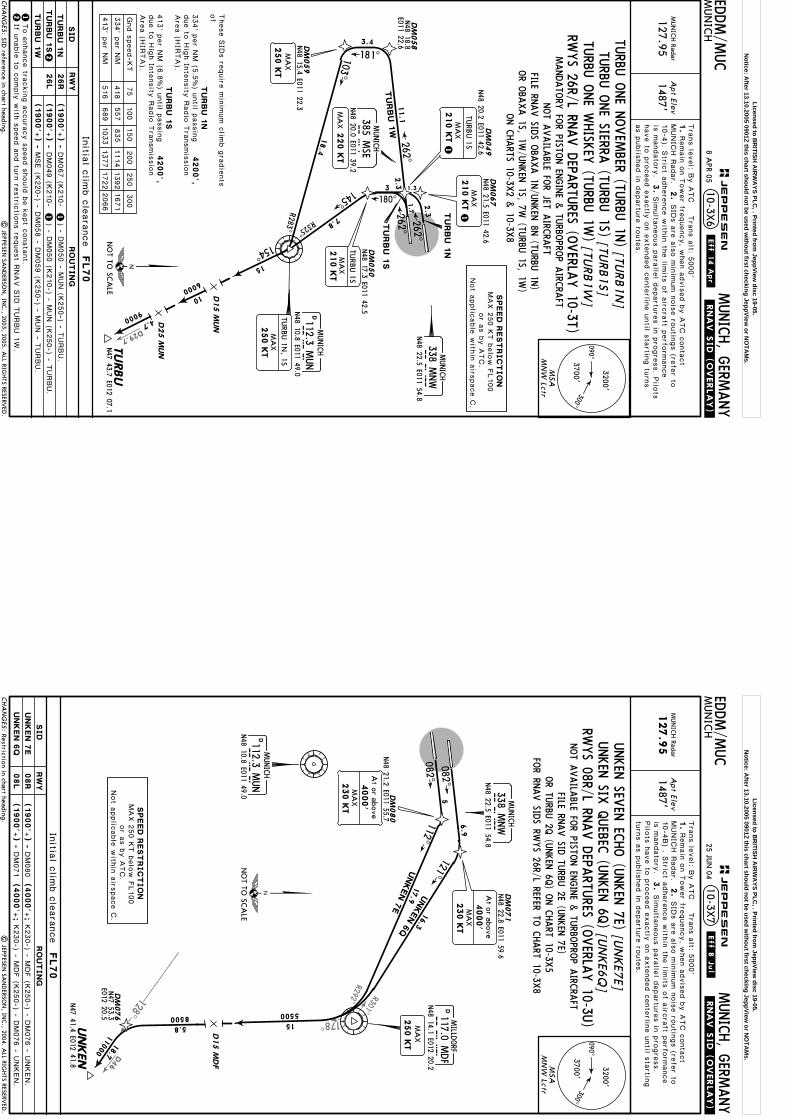
D29.7
75
100
150
200
250
300
Gnd s
peed-K
T
334' p
er N
M
413' p
er N
M
418
557
835
1114
1392
1671
516
689
1033
1377
1722
2066
Apt Elev
EDDM/M
UC
MUN
ICH
MUNICH, G
ERMANY
MUN
ICH Radar
127.951487'
.RNAV.SID.(OVERLAY).
10-3X6
11
103^
R283^
145^
R325^
DM
059
DM
058
N48 18.8
E011 22.6
DM
050
180^
DM
067
DM
049
N48 21.5 E011 42.6
N48 20.2 E011 42.6
262^
262^
2.3
1.7
7.8
3.4
18.4
181^
2.3
N48 17.3 E011 42.5
Tra
ns le
vel: B
y A
TC T
rans a
lt: 5000'
1.
MUNIC
H R
adar.
2.
Remain
on T
ower fre
quency, w
hen a
dvis
ed b
y A
TC c
onta
ct
3 1.3
Initia
l clim
b c
leara
nce
FL70
MA
X210 K
T
TURB
U 1S
N48 15.4 E011 22.3
MA
X250 K
T
1
MA
X250 K
T
TURB
U 1N
, 1S
| JEPPESEN
SAN
DERSO
N, IN
C., 2003, 2005. A
LL RIGHTS RESERV
ED.
TURBU
N47 43.7 E012 07.1
154^15
10 D15 M
UN
D25 M
UN
6000
9000
[TURB1N
] [TU
RB1S]
[TURB1W
]
4.7
have to
pro
ceed e
xactly
on e
xte
nded c
ente
rline u
ntil s
tartin
g tu
rns
as p
ublis
hed in
departu
re ro
ute
s.
is m
andato
ry.
3.
Sim
ulta
neous p
ara
llel d
epartu
res in
pro
gre
ss. P
ilots
10-4
). Stric
t adhere
nce w
ithin
the lim
its o
f airc
raft p
erfo
rmance
SID
s a
re a
lso m
inim
um n
ois
e ro
utin
gs (re
fer to
SID reference in chart heading.
262^
TU
RBU
1S
TU
RBU
1W
These S
IDs re
quire
min
imum c
limb g
radie
nts
of
4200',
4200',
TU
RBU
1N
TU
RBU
1S
090^300^
3700'
3200'
MSA
MN
W Lctr
CHA
NG
ES:
JEPPESEN
.Eff.14.Apr.
26R
26L
2
(1900'+
) -
2
DM067 (K
210-
(1900'+
) -
DM049 (K
210-
(1900'+
) -
MUNICH
MNW
338 MNW
N48 22.5 E011 54.8
DMUNICH
MU
N112.3 M
UN
N48 10.8 E011 49.0
SPEED
REST
RIC
TIO
NMAX 2
50 K
T b
elo
w F
L100
or a
s b
y A
TC.
Not a
pplic
able
with
in a
irspace C
.
NO
T TO SC
ALE
11.1
TU
RBU
1N
TU
RBU
1S
TURBU 1
W
If unable
to c
omply
with
speed a
nd tu
rn re
stric
tions re
quest R
NAV S
ID T
URBU 1
W.
TU
RBU
1N
MUNICH
MSE
385 MSE
N48 20.0 E011 39.2
MA
X220 K
T
RW
YSID
RO
UTIN
G
1To e
nhance tra
ckin
g a
ccura
cy s
peed s
hould
be k
ept c
onsta
nt.
MA
X210 K
T
TURB
U 1S
) - DM050 - M
UN (K
250-) - T
URBU.
) - DM050 (K
210-) - M
UN (K
250-) - T
URBU.
MSE (K
220-) - D
M058 - D
M059 (K
250-) - M
UN - T
URBU.
TURBU
ONE SIERRA
(TURBU
1S)
MANDATO
RY FO
R PISTON EN
GINE &
TURBO
PROP A
IRCRA
FTNOT A
VAILA
BLE FOR JET A
IRCRA
FT
TURBU
ONE N
OVEM
BER (TURBU
1N)
TURBU
ONE W
HISK
EY (TU
RBU 1W
)
FILE RNAV SID
S OBA
XA 1N
/UNKEN
8N (TU
RBU 1N
)
ON C
HARTS 10-3X
2 & 10-3X
8
MA
X210 K
T1
RWYS 26R/L RN
AV D
EPARTU
RES (OVERLA
Y 10-3T)
OR O
BAXA 1S, 1W
/UNKEN
1S, 7W (TU
RBU 1S, 1W
)
334' p
er N
M (5
.5%) u
ntil p
assin
g
413' p
er N
M (6
.8%) u
ntil p
assin
g
due to
Hig
h In
tensity
Radio
Tra
nsmis
sio
nAre
a (H
IRTA).
due to
Hig
h In
tensity
Radio
Tra
nsmis
sio
nAre
a (H
IRTA).
8 APR 05
Licensed to BR
ITISH A
IRW
AYS PLC
, . Printed from JeppView
disc 19-05.N
otice: After 13.10.2005 0901Z this chart should not be used w
ithout first checking JeppView or N
OTA
Ms.
D46
128^
178^
R301^R292^
| JEPPESEN
SAN
DERSO
N, IN
C., 2004. A
LL RIGHTS RESERV
ED.
Apt Elev
EDDM/M
UC
MUN
ICH
MUNICH, G
ERMANY
MUN
ICH Radar
127.9
51487'
.RNAV.SID.(OVERLAY).
10-3X7
DM
071
DM
080
N48 21.2 E011 55.7
N48 22.8 E011 59.6
DM
076
N47 53.3
E012 20.5
5
11000
082^
082^
6.9
[UN
KE7
E] [U
NKE6
Q]
4000'
At or above
230 K
TM
AX
MA
X250 K
T
Initia
l clim
b c
leara
nce
FL70
4000'
At or above
230 K
TM
AX
Tra
ns le
vel: B
y A
TC T
rans a
lt: 5000'
1.
MUNIC
H R
adar.
2.
3.
Remain
on T
ower fre
quency, w
hen a
dvis
ed b
y A
TC c
onta
ct
SID
s a
re a
lso m
inim
um n
ois
e ro
utin
gs (re
fer to
10-4
B) . S
trict a
dhere
nce w
ithin
the lim
its o
f airc
raft p
erfo
rmance
is m
andato
ry.
Pilo
ts h
ave to
pro
ceed e
xactly
on e
xte
nded c
ente
rline u
ntil s
tartin
gtu
rns a
s p
ublis
hed in
departu
re ro
ute
s.
Sim
ulta
neous p
ara
llel d
epartu
res in
pro
gre
ss.
Restriction in chart heading.
090^
300^3700'
3200'
MSA
MN
W Lctr
CHA
NG
ES:
JEPPESEN
.Eff.8.Jul.
(1900'+
) -
(1900'+
) -
08R
08L
DM
080
DM
071
UN
KEN
7E
UN
KEN
6Q
MUNICH
338 MNW
N48 22.5 E011 54.8
SPEED
REST
RIC
TIO
NMAX 2
50 K
T b
elo
w F
L100
or a
s b
y A
TC.
Not a
pplic
able
with
in a
irspace C
.
NO
T TO SC
ALE
15UNKEN
D15 M
DF
8500 5500
DMILLD
ORF
117.0 MDF
MD
FN48 14.1 E012 20.2
112^UNKEN 7
E
UNKEN 6
Q
121^
DMUNICH
MU
N112.3 M
UN
N48 10.8 E011 49.0
5.8
18.7
17.9
16.3
UNKEN
SIX Q
UEBEC
(UNKEN
6Q)
RWYS 08R/L RN
AV D
EPARTU
RES (OVERLA
Y 10-3U
)
N47 41.4 E012 41.8
(4000'+
;
(4000'+
;
MNW
UNKEN
SEVEN
ECHO (U
NKEN
7E)K230-) - M
DF (K
250-) - D
M076 - U
NKEN.
K230-) - M
DF (K
250-) - D
M076 - U
NKEN.
RW
YSID
RO
UT
IN
G
NOT A
VAILA
BLE FOR PISTO
N EN
GINE &
TURBO
PROP A
IRCRA
FT
FOR RN
AV SID
S RWYS 26R/L REFER TO
CHART 10-3X
8
FILE RNAV SID
TURBU
2E (UNKEN
7E)OR TU
RBU 2Q
(UNKEN
6Q) O
N C
HART 10-3X
5
25 JUN
04
Licensed to BR
ITISH A
IRW
AYS PLC
, . Printed from JeppView
disc 19-05.N
otice: After 13.10.2005 0901Z this chart should not be used w
ithout first checking JeppView or N
OTA
Ms.

237^SBG113.8
GBS
D33.4
D20.6D
46.1
| JEPPESEN
SAN
DERSO
N, IN
C., 2004. A
LL RIGHTS RESERV
ED.
Apt Elev
EDDM/M
UC
MUN
ICH
MUNICH, G
ERMANY
MUN
ICH Radar
127.9
51487'
.RNAV.SID.(OVERLAY).
10-3X811
103^
R283^
145^
R325^
DM
059
DM
058
N48 18.8
E011 22.6
DM
050
180^
DM
067
DM
049
N48 21.5 E011 42.6
N48 20.2 E011 42.6
262^
262^
2.3
1.77.8
3.4
18.4
[UN
KE8
N]
[UN
KE1
S] [U
NKE7
W]
11000
6000
15
D15 M
UN
CHIE
MN47 49.5
E012 27.4
18.4
12.7
181^
2.3
N48 17.3 E011 42.5
3 1.3
N48 15.4 E011 22.3
MA
X250 K
TM
AX
250 K
T
UN
KEN
8N, 1S
Initia
l clim
b c
leara
nce
FL70
1
75
100
150
200
250
300
Gnd s
peed-K
T
334' p
er N
M
413' p
er N
M
418
557
835
1114
1392
1671
516
689
1033
1377
1722
2066
1
1
MA
X210 K
T
UN
KEN
1S
Tra
ns le
vel: B
y A
TC T
rans a
lt: 5000'
1.
MUNIC
H R
adar.
2.
3.
Remain
on T
ower fre
quency, w
hen a
dvis
ed b
y A
TC c
onta
ct
SID
s a
re a
lso m
inim
um n
ois
e ro
utin
gs (re
fer to
10-4
B) . S
trict a
dhere
nce w
ithin
the lim
its o
f airc
raft p
erfo
rmance
is m
andato
ry.
Pilo
ts h
ave to
pro
ceed e
xactly
on e
xte
nded c
ente
rline u
ntil s
tartin
gtu
rns a
s p
ublis
hed in
departu
re ro
ute
s.
Sim
ulta
neous p
ara
llel d
epartu
res in
pro
gre
ss.
See other side.
090^
300^3700'
3200'
MSA
MN
W Lctr
CHA
NG
ES:
JEPPESEN
.Eff.8.Jul.
(1900'+
) -
2To e
nhance tra
ckin
g a
ccura
cy s
peed s
hould
be k
ept c
onsta
nt.
DM067 (K
210-
(1900'+
) -
DM049 (K
210-
(1900'+
) -
MUNICH
MNW
338 MNW
N48 22.5 E011 54.8
SPEED
REST
RIC
TIO
NMAX 2
50 K
T b
elo
w F
L100
or a
s b
y A
TC.
Not a
pplic
able
with
in a
irspace C
.
NO
T TO SC
ALE
11.1
UN
KEN
8N
UN
KEN
1S
UN
KEN
7W
If unable
to c
omply
with
speed a
nd tu
rn re
stric
tions re
quest R
NAV S
ID U
NKEN 7
W.
DMUNICH
MU
N112.3 M
UN
N48 10.8 E011 49.0U
NKEN
N47 41.4
E012 41.8
128^
RWYS 26R/L RN
AV D
EPARTU
RES (OVERLA
Y 10-3V
)
MUNICH
MSE
385 MSE
N48 20.0 E011 39.2
MA
X220 K
T
UNKEN
EIGHT N
OVEM
BER (UNKEN
8N)
UNKEN
ONE SIERRA
(UNKEN
1S)UNKEN
SEVEN
WHISK
EY (U
NKEN
7W)
) - DM050 (K
210-) - M
UN (K
250-) - C
HIE
M -
UNKEN.
) - DM050 - M
UN (K
250-) - C
HIE
M - U
NKEN.
26R
26L
UN
KEN
8N
UN
KEN
1S
UN
KEN
7W
2
RW
YSID
RO
UT
IN
G
These S
IDs re
quire
min
imum c
limb g
radie
nts
of
4200',
4200',
UN
KEN
8N
UN
KEN
1S
MSE (K
220-) - D
M058 - D
M059 (K
250-) - M
UN - C
HIE
M -
UNKEN.
NOT A
VAILA
BLE FOR PISTO
N EN
GINE &
TURBO
PROP A
IRCRA
FTFILE RN
AV SID
TURBU
1N (U
NKEN
8N)
OR TU
RBU 1S, 1W
(UNKEN
1S, 7W) O
N C
HART 10-3X
6
MA
X210 K
T
UN
KEN
1S
MA
X210 K
T
334' p
er N
M (5
.5%) u
ntil p
assin
g
413' p
er N
M (6
.8%) u
ntil p
assin
g
due to
Hig
h In
tensity
Radio
Tra
nsmis
sio
nAre
a (H
IRTA).
due to
Hig
h In
tensity
Radio
Tra
nsmis
sio
nAre
a (H
IRTA).
25 JUN
04
Licensed to BR
ITISH A
IRW
AYS PLC
, . Printed from JeppView
disc 19-05.N
otice: After 13.10.2005 0901Z this chart should not be used w
ithout first checking JeppView or N
OTA
Ms.
262^DM053
N48 18.9 E011 24.7
5.1
MAX220 KT
MAX250 KT
.RNAV.SID.(OVERLAY).
082^
DM081
DM082
6.1
3.1151^
Apt Elev
.Eff.17.Feb.
EDDM/M
UC
MUN
ICH
MUNICH, G
ERMANY
MUN
ICH Radar
127.951487'
10-3X
Tra
ns le
vel: B
y A
TC T
rans a
lt: 5000'
1.
MUNIC
H R
adar.
2.
Remain
on T
ower fre
quency, w
hen a
dvis
ed b
y A
TC c
onta
ct
| JEPPESEN
SAN
DERSO
N, IN
C., 2003, 2004. A
LL RIGHTS RESERV
ED.
Initial climb clearance FL70
NEGRAN47 43.3 E009 25.6
246^
254^6000
6000
[NEG
R2E]
[NEG
R1S]
NEGRA 2E
82.6
100.2
have to
pro
ceed e
xactly
on e
xte
nded c
ente
rline u
ntil s
tartin
g tu
rns
as p
ublis
hed in
departu
re ro
ute
s.
3.
is m
andato
ry.
Sim
ulta
neous p
ara
llel d
epartu
res in
pro
gre
ss. P
ilots
10-4
). Stric
t adhere
nce w
ithin
the lim
its o
f airc
raft p
erfo
rmance
SID
s a
re a
lso m
inim
um n
ois
e ro
utin
gs (re
fer to
2.5
8
DM086N48 16.7E011 57.0
None.
231^
R041^
N48 18.6 E011 59.5
At FL70
N48 21.4E011 57.3
(1900'+) -
MUNICH
MNW338 MNWN48 22.5 E011 54.8
MAHD108.4 MAH
MAISACH
N48 15.8 E011 18.7
R051^
9.7
MUNICH
MSE385 MSEN48 20.0 E011 39.2
4
(1900'+) - DM081
DMUNICH
MUN112.3 MUNN48 10.8 E011 49.0
221^
(4000'+;
MAX 250 KT
NOT TO SCALE
090^
300^3700'
3200'
MSAMNW Lctr
CHA
NG
ES:
JEPPESEN
NEG
RA O
NE SIERRA
(NEG
RA 1S)
NEG
RA TW
O EC
HO (N
EGRA
2E)
AVAILA
BLE SAT, SU
N &
HOL
ON W
ORK
ING D
AYS N
OT TO
BE FILED IN
FLIGHT PLA
NWILL BE A
SSIGNED
BY A
TC O
NLY
IF ED(R)-207 IS N
OT A
CTIV
E
08R
RWYSID ROUTING
26L
NEGRA 2E
NEGRA 1S
RWYS 08R, 26L RN
AV D
EPARTU
RES (OVERLA
Y 10-3L)
NEGRA 1S
MUN (K250-) - NEGRA.K230-) - DM082 (K230-) - DM086 (FL70) -
MSE (K220-) - DM053 - MAH (K250-) - NEGRA.
4 FEB 05
SPEED RESTRICTIONMAX 250 KT below FL100
or as by ATC.Not applicable within airspace C. 230 KT
4000'At or above
MAX
MAX 230 KT
Licensed to BR
ITISH A
IRW
AYS PLC
, . Printed from JeppView
disc 19-05.N
otice: After 13.10.2005 0901Z this chart should not be used w
ithout first checking JeppView or N
OTA
Ms.

D
D28
313^
Apt Elev
EDDM/M
UC
MUN
ICH
MUNICH, G
ERMANY
MUN
ICH Radar
123.91487'
.RNAV.SID.(OVERLAY).
13
50005000
RIDARN48 35.3E010 48.2
DM062
DM054
DM073
DM084
N48 25.1E011 52.0
N48 20.9E011 50.5
N48 18.2 E011 14.9
DM085N48 23.7E011 52.0
262^
262^ 082^N48 19.3 E011 13.3
1.5
082^
DM070N48 22.1E011 50.6
4
40.9
MAX220 KT
MAX220 KT
18.3
309^313^
23.2
1.5
Initial climb clearance FL70
MAX250 KT T
rans le
vel: B
y A
TC T
rans a
lt: 5000'
1.
MUNIC
H R
adar.
2.
3.
Remain
on T
ower fre
quency, w
hen a
dvis
ed b
y A
TC c
onta
ct
SID
s a
re a
lso m
inim
um n
ois
e ro
utin
gs (re
fer to
Pilo
ts h
ave to
pro
ceed e
xactly
on e
xte
nded c
ente
rline u
ntil s
tartin
gtu
rns a
s p
ublis
hed in
departu
re ro
ute
s.
Sim
ulta
neous p
ara
llel d
epartu
res in
pro
gre
ss.
New
chart.|
JEPPESEN SA
ND
ERSON
, INC., 2005. A
LL RIGHTS RESERV
ED.
10-3X2-1
10-4
). Stric
t adhere
nce w
ithin
the lim
its o
f airc
raft p
erfo
rmance
is m
andato
ry.
[RID
A3S]
[RID
A4Q
]
[RID
A3N
]
[RID
A4E]
MAX250 KT
MAX250 KT
262^
262^
R090^
08R
26R
08L
26L
090^
300^3700'
3200'
MSAMNW Lctr
CHA
NG
ES:
JEPPESEN.Eff.14.A
pr.
(1900'+) -
(1900'+) -
(1900'+) -
(1900'+) -
RIDAR 4E
RIDAR 3N
RIDAR 4Q
RIDAR 3S
NOT TO SCALE
MIQ426.5 MIQMIKE
N48 34.2 E011 35.9
MUNICH
MNW338 MNWN48 22.5 E011 54.8
270^271^
6000
WLD112.8 WLDD
N48 34.8 E011 07.8
WALDA
RIDAR 3N
RIDAR 3S
RIDAR 4E
RIDAR 4Q
MAHD108.4 MAHMAISACH
N48 15.8 E011 18.7
16.2
15.1
18.7
14.1
MUNICH
MSE385 MSEN48 20.0 E011 39.2
MUNICH
MNE369 MNEN48 21.3 E011 40.6
3.7
4
RWYS 08R, 26R, 08L, 26L
RWYSID ROUTING
8 APR 05
RNAV D
EPARTU
RES(O
VERLA
Y 10-3M
)
RIDAR TH
REE SIERRA(RID
AR 3S)
RIDAR FO
UR Q
UEBEC
(RIDAR 4Q
)
RIDAR TH
REE NOVEM
BER(RID
AR 3N
)
RIDAR FO
UR EC
HO
(RIDAR 4E)
SPEED RESTRICTIONMAX 250 KT below FL100
or as by ATC.Not applicable within airspace C.
MIQ (K250-) - WLD - RIDAR.DM084 - DM085 -
DM062 (K250-) - RIDAR.MNE (K220-) -
DM070 - DM073 -MIQ (K250-) - WLD - RIDAR.
MSE (K220-) -DM054 (K250-) - RIDAR.
Licensed to BR
ITISH A
IRW
AYS PLC
, . Printed from JeppView
disc 19-05.N
otice: After 13.10.2005 0901Z this chart should not be used w
ithout first checking JeppView or N
OTA
Ms.
D
D33.4
Apt Elev
EDDM/M
UC
MUN
ICH
MUNICH, G
ERMANY
MUN
ICH Radar
127.951487'
.RNAV.SID.(OVERLAY).
NOT TO
BE FILED IN
FLIGHT PLA
N
11
103^
R283^
6000
D15 M
UN
E012 27.4
057^7000 R237^
145^
R325^
DM
059
N48 15.4
E011 22.3
DM
058
N48 18.8
E011 22.6
DM
050
180^
DM
067
DM
049
N48 21.5 E011 42.6
N48 20.2 E011 42.6
262^
262^
2.3
1.7
7.8
18.420.6
3.4
18.4
181^
2.3
N48 17.3 E011 42.5
Tra
ns le
vel: B
y A
TC T
rans a
lt: 5000'
1.
MUNIC
H R
adar.
2.
Remain
on T
ower fre
quency, w
hen a
dvis
ed b
y A
TC c
onta
ct
3 1.3
Initia
l clim
b c
leara
nce
FL70
MA
X250 K
T
210 K
TM
AX
SBG
1S
75
100
150
200
250
300
Gnd s
peed-K
T
334' p
er N
M
413' p
er N
M
418
557
835
1114
1392
1671
516
689
1033
1377
1722
2066
1
MA
X250 K
T
SBG
8N, 1S
have to
pro
ceed e
xactly
on e
xte
nded c
ente
rline u
ntil s
tartin
g tu
rns
as p
ublis
hed in
departu
re ro
ute
s.
is m
andato
ry.
3.
Sim
ulta
neous p
ara
llel d
epartu
res in
pro
gre
ss. P
ilots
10-4
). Stric
t adhere
nce w
ithin
the lim
its o
f airc
raft p
erfo
rmance
SID
s a
re a
lso m
inim
um n
ois
e ro
utin
gs (re
fer to
10-3X2-2
| JEPPESEN
SAN
DERSO
N, IN
C., 2005. A
LL RIGHTS RESERV
ED.
New
chart.
262^
090^300^
3700'
3200'
MSA
MN
W Lctr
CHA
NG
ES:
JEPPESEN.Eff.14.A
pr.
26R
26L
2
SBG
8N
SBG
1S
SBG
7W
(1900'+
) -
12To e
nhance tra
ckin
g a
ccura
cy s
peed s
hould
be k
ept c
onsta
nt.
DM067 (K
210-
(1900'+
) -
DM049 (K
210-
(1900'+
) -
If unable
to c
omply
with
speed a
nd tu
rn re
stric
tions re
quest R
NAV S
ID S
BG 7
W.
MUNICH
MNW
338 MNW
N48 22.5 E011 54.8
DMUNICH
MU
N112.3 M
UN
N48 10.8 E011 49.0
128^ 15
CHIE
M
SBG
D113.8 SBGSA
LZBU
RG
N48 00.2 E012 53.6
SBG
7W
N47 49.5
NO
T TO SC
ALE
SBG
8N
SBG
1S
11.1
RWYS 26R/L RN
AV D
EPARTU
RES (OVERLA
Y 10-3N
)
MUNICH
MSE
385 MSE
N48 20.0 E011 39.2
MA
X220 K
T
MA
X210 K
T1
RW
YSID
RO
UTIN
G
SALZ
BURG
EIGHT N
OVEM
BER (SBG 8N
)
SALZ
BURG
SEVEN
WHISK
EY (SBG
7W)
) - DM050 - M
UN (K
250-) - C
HIE
M - S
BG.
) - DM050 (K
210-) - M
UN (K
250-) - C
HIE
M -
SBG.
MSE (K
220-) - D
M058 - D
M059 (K
250-) - M
UN - C
HIE
M - S
BG.
These S
IDs re
quire
min
imum c
limb g
radie
nts
of
4200',
4200',
SBG
8N
SBG
1S
8 APR 05
SALZ
BURG
ONE SIERRA
(SBG 1S)
MA
X210 K
T
SBG
1S
334' p
er N
M (5
.5%) u
ntil p
assin
g
413' p
er N
M (6
.8%) u
ntil p
assin
g
due to
Hig
h In
tensity
Radio
Tra
nsmis
sio
nAre
a (H
IRTA).
due to
Hig
h In
tensity
Radio
Tra
nsmis
sio
nAre
a (H
IRTA).
SPEED
REST
RIC
TIO
NMAX 2
50 K
T b
elo
w F
L100
or a
s b
y A
TC.
Not a
pplic
able
with
in a
irspace C
.
Licensed to BR
ITISH A
IRW
AYS PLC
, . Printed from JeppView
disc 19-05.N
otice: After 13.10.2005 0901Z this chart should not be used w
ithout first checking JeppView or N
OTA
Ms.
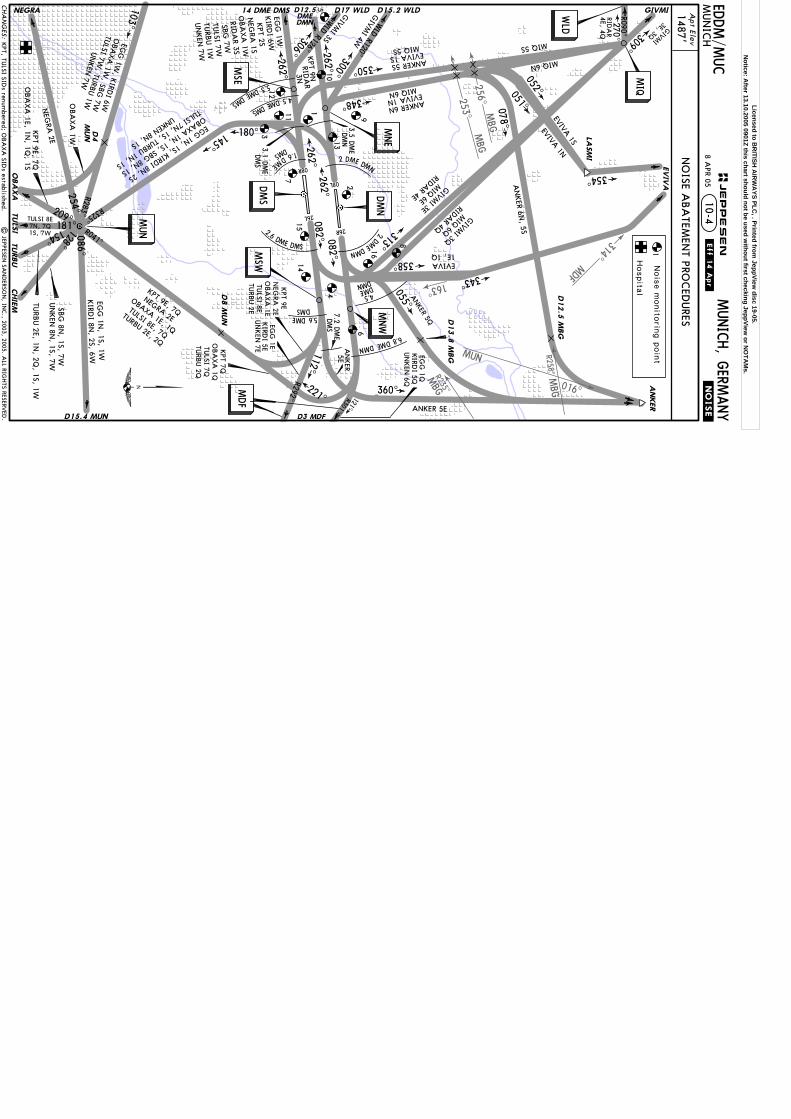
R258^MBG 016^
MUN
253^MBG
MBG
R235^
314^M
DF
256^MBG
163^
EDDM/M
UC
MUN
ICH
MUNICH, G
ERMANY
2.6DME DMS
078^A
NKER 6N
, 5S
5E
DMS
6.8DMEDMN
5.6DME
KIRD
I 6W
128^
D17 WLD
1.6DM
E
DMS
DMS
4.5 DME DMS
5.3 DME DMS
3.1 DME
350^
DMN
2 DME DMN
7.2 DME
DMS
ANKER
360^
181^
103^
R283^
ANKER 5E
3.5 DME
348^
MIQ 6N
262^
262^
180^145^
R325^
EVIVA 1N
ANKER 5S
MIQ 6N
2 DME DMN
.NOISE.
1487'A
pt Elev
GIVMI
309^
082^
082^
055^
313^
D15.2 WLD
262^
262^
EGG
1W
NEG
RA 2E
NEGRA
154^
SBG
8N, 1S, 7W
UN
KEN
8N, 1S, 7W
TURB
U 2E, 1N
, 2Q, 1S, 1W
| JEPPESEN
SAN
DERSO
N, IN
C., 2003, 2005. A
LL RIGHTS RESERV
ED.
D13.8
MBG
14 DME DMS D12.5DMEDMN
D8 M
UN
LASM
I
343^
052^051^
EVIVA 1S
EVIVA 1N
EVIV
A
ANKER 6N
MIQ 5S EVIVA 1S
10-4
354^
4.5DMEDMN
358^ EVIVA1E, 1Q
KPT 2S
NEG
RA 1S
OBA
XA
1W
RIDA
R 3S
SBG
7W
TULSI 7W
TURB
U 1W
UN
KEN
7W
EGG 1N, 1S, KIRDI 8N, 2S
OBAXA 1N, 1S, SBG 8N, 1S
TULSI 7N, 1S, TURBU 1N, 1S
UNKEN 8N, 1S
KPT, TU
LSI SIDs renum
bered; OBA
XA
SIDs established. 209^
D4
MUN
KPT 9E, 7Q
OBA
XA
1E, 1N, 1Q
, 1S
OBA
XA
1W
TULSI 8E7N, 7Q1S, 7W
CHA
NG
ES:
JEPPESEN
.Eff.14.Apr.
NO
ISE ABA
TEMEN
T PROCED
URES
08R
08L
26R
26L
DMN
DMS
MNW
MSW
MNE
MSE
TULS
I
MIQ
WLD
221^ 121^
112^306^
300^
270^
1
6
16
8
4
1415
2
13
9
3
11
12
105
KIRD
I 5Q
7
4E, 4Q
MIQ 6E
MIQ 6Q
1Nois
e m
onito
ring p
oin
t
Hospita
l
KPT 9N
086^
R041^
AN
KER
KI RD
I 8N, 2S, 6W
KIRD
I 5E
MIQ 5S
UN
KEN
6Q
UN
KEN
7E
R090^
D3 MDF
R292^ R301^
D12.5
MBG
RIDA
R
RIDAR 4Q
RIDAR 4E
CHIE
M
WLD R120^
WLD R126^
3E, 3QGIVMI
MUN
MDF
GIVM
I 4W
GIVM
I 3S
GIVMI 3Q
GIVMI 3E
ANKER 5Q
254^
TURBU
EGG
1N, 1S, 1W
D15.4 MUN
EGG
1E
EGG
1Q
RIDA
R3N
8 APR 05
KPT 9E
NEG
RA 2E
OBA
XA
1ETU
LSI 8ETU
RBU 2E
KPT 9E, 7Q
NEGRA 2E
OBAXA 1E, 1Q
TULSI 8E, 7Q
TURBU 2E, 2Q
KPT 7Q
OBA
XA
1QTU
LSI 7QTU
RBU 2Q
EGG
1W, K
IRDI 6W
OBA
XA
1W, SBG
7W
TULSI 7W
, TURBU
1WUN
KEN
7W
OBA
XA
Licensed to BR
ITISH A
IRW
AYS PLC
, . Printed from JeppView
disc 19-05.N
otice: After 13.10.2005 0901Z this chart should not be used w
ithout first checking JeppView or N
OTA
Ms.

1549'
1541'1542' 01^E
HA
NG
AR 1
1525'
Apt Elev
MUN
ICH G
round
121.77121.7
Tower
MUN
ICH Radar (D
EP)M
UN
ICH A
rrival (DEP)
Rwy 08L/26R
118.7Rw
y 08R/26L
120.5Rw
y 08L/26R
121.97Rw
y 08R/26L
121.82
Apron 1
Apron 2
121.92
Apron 3
North
128.02South
120.77N
orth
123.9South
127.95
*A
TIS
123.12
MUN
ICH D
elivery(Start-up clearance)
121.72
48-2048-20
48-2148-21
48-2248-22
11-44 11-44
11-45
11-45
11-46
11-46
11-47
11-47
11-48
11-48
11-49
11-49
11-50
11-50
| JEPPESEN
SAN
DERSO
N, IN
C., 1999, 2005. A
LL RIGHTS RESERV
ED.
TAKE-O
FF
ABCD .JAR-OPS.
RCLM
(DA
Y only)
or RL
250m
300m
400m
500m
& m
ult. RVR req
125m
150m
NIL
(DA
Y only)
HIRL, C
L
All R
wys
1
1
Operators applying U
.S. Ops Specs: C
L required below 300m
; approved guidance system required
below 150m
.
RCLM
(DA
Y only)
or RLRL &
CL
200m
250m
& m
ult. RVR req
150m
200m
LVP m
ust b
e in
Forc
e
Approved O
peratorsRL, C
L
For A
IRPO
RT B
RIE
FIN
G re
fer to
10-A
BP p
ages
1548'
Responsible for aprons 1, 6, 7, 8 and 9.Responsible for apron 2.Responsible for aprons 3, 10, 11 and helicopter.
ACA
RS:
1
14 JAN
05Limit of A
TCcom
petence area
LEGEN
D
Apron Entry N
o.
De-icing area
N2
DA
1
DCL note added.
1D
atalink departure clearance to grant start-upand route clearance w
ill be offered daily from0600-2230 LT by Tow
er. Outside these tim
esstart-up has to be requested via frequency only.
FO
R P
ARKIN
G P
OSIT
IONS
SEE 1
0-9
A
MA
INTENA
NCE
APRO
NS 3
& 4
FO
R P
ARKIN
G
PO
SIT
IONS S
EE 1
0-9
AM
AIN
TENA
NCE
APRO
N 1
08R082^
08L082^
Elev
Elev
HA
NG
AR 4
HA
NG
AR 3
DA
1
DA
2B1
B2
S1
ENG
INE
TEST
HA
NG
AR
1449'
A
1486'
1537'
1594'
APRO
N 6
1547'
1572' 1578'
00200
400600
8001000
10002000
30004000
1200
Feet
Meters
26R262^
APRO
N10
Overflying of parkingareas prohibited
TM
L2
ARP 13,123'
13,123'
4000m
4000m
Elev1467'
Elev1470'
A1
A2
DA
2
DA
1
NN
N
NN
N
A4
A4
MM
MM
M
A6
A7
A8
A9
A8
A5
A6
DA
1DA
2
A14
A15
N
CA
RG
O
R
RR
DA
1
DA
2
SS
SS
SS
SS
TT
T
TT
T
B4
B4
B6
B6
B7
B8
B8
B9
B14
B15
O2
N2
N4
S8
S5
S6 C4
C3
C2
C1
W1W
1
S4
S3
S2
N1
ControlTow
er1726'
O1O
1
1
N
available upto B
747-400B
C
D
E
F
G
H
DA
3
DA
3
B7
A13D
A3
1551'
26L262^
DA
3B3
B11
B10
B11
B10
B12
B12
APRO
N 7
APRO
N 8
APRO
N 9
APRO
N
APRO
N 2 D
6
APRO
N 1
1
D4
D2
N3
S7
W2
D5
CENTER 2
D1
D3
APRO
N 3
TERM
INA
L 1
B13
A9
M
A5
A10
A10
A12
A12
10
HA
NG
AR
Z1
Z2
1541'
1557'W
EST
B12
O3
Taxiing outside area of ATC
competency
only with perm
ission of MUN
ICH A
PRON
and on its instruction.
MUN
ICH
N48 21.2 E011 47.2
MUNICH, G
ERMANY
1487'
10-9ED
DM/M
UC
JEPPESEN
CHA
NG
ES:
RWY
AD
DITIO
NA
L RUN
WA
Y IN
FORM
ATIO
N
ThresholdLA
ND
ING
BEY
ON
DUSA
BLE LEN
GTH
S
WID
THTA
KE-O
FFG
lide Slope
6 5RV
RRV
R7
197'60m
567TA
KE-O
FF RUN
AVA
ILABLE
RVR
RVR
89
890TA
KE-O
FF RUN
AVA
ILABLE
08L26R
12,090'3685m
RWY 08L:
RWY 26R:
197'60m
08R
RWY 08R:
26L
RWY 26L:
12,010'3661m
12,150'3703m
From rw
y head
From rw
y head13,123'(4000m
)9252'(2820m
)7218'(2200m
)6627'(2020m
)
From rw
y headtw
y A4 int
twy A
6 inttw
y A7 int
twy A
13 inttw
y A12 int
twy A
10 inttw
y A7 int
13,123'(4000m)
12,467'(3800m)
9121'(2780m)
7415'(2260m)
5610'(1710m)
twy B
3 inttw
y B4 int
twy B
6 inttw
y B9 int
13,123' (4000m)
12,467' (3800m)
9318' (2840m)
7283' (2220m)
5479' (1670m)
From rw
y headtw
y B13 int
twy B
12 inttw
y B10 int
twy B
9 int
13,123'(4000m)
12,467'(3800m)
9252'(2820m)
7218'(2200m)
6627'(2020m)
HIRL C
L ALSF-II TD
Z PAPI-L (3.0^)
HIRL C
L ALSF-II TD
Z PAPI-L (3.0^)
HIRL C
L ALSF-II TD
Z PAPI-L (3.0^)
HIRL C
L ALSF-II TD
Z PAPI-L (3.0^)
D6
1554'1551'
HST-A
5, A8, A
10 & A
12HST-A
9, A6 &
A4
HST-B
11, B8, B
6 & B
4HST-B
7, B10 &
B12
23
4
234
AIS
+ MET
DCL
0
Licensed to BRITISH AIRWAYS PLC, . Printed from JeppView disc 19-05.
Notice: After 13.10.2005 0901Z this chart should not be used without first checking JeppView or NOTAMs.

| JEPPESEN
SAN
DERSO
N, IN
C., 1999, 2005. A
LL RIGHTS RESERV
ED.
48-21.5
11-45.211-45.3
11-45.411-45.5
11-45.611-44.8
11-44.911-45.1
48-20.7
48-20.611-44.711-45.0
151
Hold for
FOLLO
WM
E
11-45.211-45.3
11-45.411-45.1
48-20.6
805N
805S
804N
804S
803N
803S
802N
802S
801N
801S
48-20.8 11-44.7
O1 orange
O1 blue
W1 orange
W1 blue
203243244245
246
247
202A/B
201A/B
204A/B
205A/B
207A/B
209A/B
W 322 E
W 321 E
305306307308
248A/B
W2
O2
Cente
r2
Wingspan up to
98'/30m.
208
206
APRO
N 2
250253
254W
2
O3
O2
D2
210A/B
212A/B
213A/B
215A/B
211214
W 326 E
W 325 E
W 324 E
W 323 E
309310
311312
313
314
315
252A/B
249A/B
O3 orange
O3 blue
APRO
N 3
251A/B
D5
255
256
D4
221
217A/B
219A/B
220A/B
216
218
231
232233234
261262
335339
338337
336 W 327 E
316
317
D3
D3 o
range
D3 b
lue
Cente
r2
W2
O2
D3
222A/B
223A/B
224A/B
334333
332331
241242
14 JAN
05
HA
NG
AR 3
11-45
48-20.5
HA
NG
AR 4
HA
NG
AR 1
0
N
TAXIIN
G O
UTSID
E AREA
OF A
TC C
OM
PETENCE
ON
LY W
ITH PERM
ISSION
OF M
UN
ICH A
PRON
AN
D O
N ITS IN
STRUCTIO
N.
11-47.2
11-46.7
48-20.4
MUNICH, G
ERMANY
MUN
ICH
JEPPESEN
EDDM/M
UC
48-21.3
11-46.811-46.9
DA
2
B1
ENG
INE
TEST
HA
NG
AR
B3
DA
2
N2
LEGEN
D
Apron entry N
o.
De-icing area
Parking stand
48-21.2
48-21.1
48-21
CA
RG
O
Limit of A
TCcom
petence area
Helicopterparking
11-47.911-48
11-47.8
Z1
R
B4
S2
601N
601
601S602
603N
603
603S
605N605
605S604
606A
S
T
B4
APRO
N 6
MA
INTENA
NCE
APRO
N 1
DA
1
T
B2
DA
3
S
S1
R606M
AIN
TENA
NCE
APRO
N 3
48-20.6
48-20.5
DA
1
11-47.111-45.9
11-4611-46.3
11-46.411-46.5
11-46.611-46.2
11-46.111-45.9
CHA
NG
ES:
48-20.4
904N902N
903N
703N
703S
B4 48-20.9
48-20.6
48-20.7
RWY 08R/26L
907M
R
R
S3
ST
T
B6
S
907906
905S905
905N904904S
903902S902
903S906N
906S
907N
907S
701N
701S
702N
702SA
PRO
N 8
APRO
N 7
B6
901
MA
INTENA
NCE
APRO
N 4
B9
174144
107A
C2
175181
182
183151
131
107B
109A109B
112
110B
109X
W1
C4
191
192
193
194
195
162A
163
164B165
162B
164A
W1
O1
184
185
186
187
152A
154B
155
132
133
134
135
152B
154A153
C3
188
189161 A
PRO
N 1
O1
B7
B11
48-20.7
S5
S6
T
B11
101
W1
O1
171
172
173
141
142143
102
103A104
105
103B170
APRO
N 1
C1
B8
196
S4
T
B8
B7
S
APRO
N 9
197
N1
N2
NA
411-46.5
11-46.811-47
11-46.911-46.7
A1
A2
DA
3N
DA
211-46.4
M
TERM
INA
L2
TERM
INA
LF
AIS
+M
ET
D6
AVG
AS
APRO
N 1
0
APRO
N 1
1
N5
Z2
10-9A
11-47.4N4
11-47.5N3
D1
11-47.2B10
T11-48
11-48.111-47.9
11-47.411-47.3
11-47.8B12
B14
B13
DA
3
B12
WEST
T
TERM
INA
L1
11-4711-47.1
S
121
108
111A111B
113A113B
115A115B
ARP
110A
112B116117A117B
118
119
120
Control
Tower
1726'
S
S8
S
B12
S7
DA
2
S9
48-21
D6
R
None.
Licensed to BRITISH AIRWAYS PLC, . Printed from JeppView disc 19-05.
Notice: After 13.10.2005 0901Z this chart should not be used without first checking JeppView or NOTAMs.
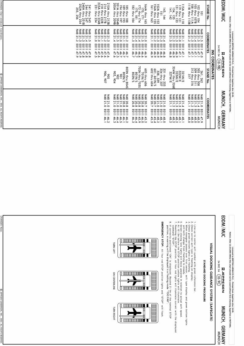
10-9B24 D
EC 04
| JEPPESEN
SAN
DERSO
N, IN
C., 2004. A
LL RIGHTS RESERV
ED.
Chart reindexed. C
oordinates.CHA
NG
ES:
JEPPESEN
EDDM/M
UC
MUNICH, G
ERMANY
MUN
ICH
CO
ORDIN
ATES
CO
ORDIN
ATES
INS C
OO
RDIN
ATES
STA
ND N
o.
STA
ND N
o.
N48 21.5 E011 47.0
N48 21.5 E011 47.1
N48 21.4 E011 47.1
N48 21.3 E011 47.1
N48 21.2 E011 47.1
N48 21.1 E011 47.1
N48 21.0 E011 47.1
N48 21.3 E011 46.9
N48 21.2 E011 46.9
N48 21.5 E011 46.8
N48 21.4 E011 46.8
N48 21.3 E011 46.8
N48 21.3 E011 46.9
N48 21.2 E011 46.9
N48 21.1 E011 46.9
N48 21.0 E011 46.9
N48 21.5 E011 46.6
N48 21.4 E011 46.6
N48 21.4 E011 46.7
N48 21.3 E011 46.7
N48 21.2 E011 46.7
N48 21.1 E011 46.7
N48 21.0 E011 46.7
N48 21.5 E011 47.5
N48 21.4 E011 47.6
N48 21.3 E011 47.6
N48 21.2 E011 47.6
N48 21.1 E011 47.6
N48 21.0 E011 47.6
N48 21.0 E011 47.5
N48 21.5 E011 47.8
N48 21.4 E011 47.8
N48 21.3 E011 47.8
N48 21.3 E011 47.9
N48 21.2 E011 47.9
N48 21.0 E011 47.9
N48 21.4 E011 48.0
N48 21.3 E011 48.0
N48 21.2 E011 48.0
N48 21.1 E011 48.0
N48 21.4 E011 48.1
N48 21.3 E011 48.1
N48 21.3 E011 48.2
N48 21.2 E011 48.2
N48 21.1 E011 48.2
N48 21.0 E011 48.0
N48 21.0 E011 48.1
N48 21.0 E011 48.2
N48 20.7 E011 45.4
N48 20.7 E011 45.3
N48 20.7 E011 45.2
N48 20.8 E011 46.0
N48 20.8 E011 45.9
N48 20.8 E011 46.4
N48 20.8 E011 46.3
N48 20.8 E011 46.2
N48 20.8 E011 46.1
N48 21.0 E011 46.5
N48 21.0 E011 46.4
N48 21.0 E011 46.3
N48 21.0 E011 46.2
N48 21.0 E011 46.1
101102 thru 104105 thru 107B108 thru 111A111B
thru 113B
115A thru 118
119 thru 121131 thru 133
134, 135141, 142
143, 144
151152A
thru 153154A
thru 155161 thru 163
164A
thru 165170, 171
172 thru 174175, 181
182 thru 184
185 thru 188189 thru 193194 thru 197
201A thru 204B
205A thru 209B
210A
thru 213B214 thru 217B218 thru 222B
223A thru 224B
231 thru 234
241 thru 243244 thru 247
248A thru 251B
252A thru 254
255, 256
261, 262 305 thru 308 309 thru 311 312 thru 316
317
321W/E
322W/E
323W/E
324W thru 326E
327W/E
331 thru 333334 thru 337
338, 339 601, 601N
/S602 thru 604
605 thru 606
701N/S
702N thru 703S
801N/S
802N/S
803N
thru 804S805N
/S901 902
903, 904
905 906, 907
Licensed to BR
ITISH A
IRW
AYS PLC
, . Printed from JeppView
disc 19-05.N
otice: After 13.10.2005 0901Z this chart should not be used w
ithout first checking JeppView or N
OTA
Ms.
10-9C
| JEPPESEN
SAN
DERSO
N, IN
C., 2004. A
LL RIGHTS RESERV
ED.
24 DEC
04
None.
CHA
NG
ES:
JEPPESEN
EDDM/M
UC
MUNICH, G
ERMANY
MUN
ICH
EM
ERG
EN
CY
STO
P:
All fo
ur re
d S
TOP p
ositio
n lig
hts
and "
STOP" w
ill flash.
1. L
ine-u
p to
cente
r acft s
ymbol w
ith g
reen re
fere
nce b
ar.
2. C
heck c
orre
ct a
cft ty
pe is
flashin
g o
n d
ispla
y.
4. W
hen n
osegear p
asses o
ver firs
t sensor, a
cft ty
pe d
ispla
y a
nd g
reen b
otto
m lig
hts
will b
oth
change fro
m fla
shin
g to
ste
ady.
5. G
reen c
losin
g ra
te lig
hts
will m
ove u
pward
s in
rela
tion to
actu
al a
cft s
peed.
7. R
eachin
g th
e S
TOP p
ositio
n, a
ll four re
d lig
hts
will illu
min
ate
curre
nt w
ith th
e d
ispla
yed
command "
STOP".
position, a warning w
ill be displayed in a flashing mode "
TOO
FAR"
.
VIS
UA
L DO
CKIN
G G
UID
ANCE S
YSTEM
(SA
FEG
ATE)
TURN
LEFTO
N C
ENTERLIN
ETU
RN RIG
HT
STA
NDA
RD D
OCKIN
G P
RO
CEDURE
3. C
heck g
reen b
otto
m lig
hts
are
flashin
g.
6. A
t 10'/
3m b
efo
re th
e S
TOP p
ositio
n y
ello
w lig
hts
will illu
min
ate
.
8. If c
orre
ctly
positio
ned "
OK" is
dis
pla
yed. B
eyond 3
'/1m o
f the n
omin
al S
TOP
Licensed to BR
ITISH A
IRW
AYS PLC
, . Printed from JeppView
disc 19-05.N
otice: After 13.10.2005 0901Z this chart should not be used w
ithout first checking JeppView or N
OTA
Ms.
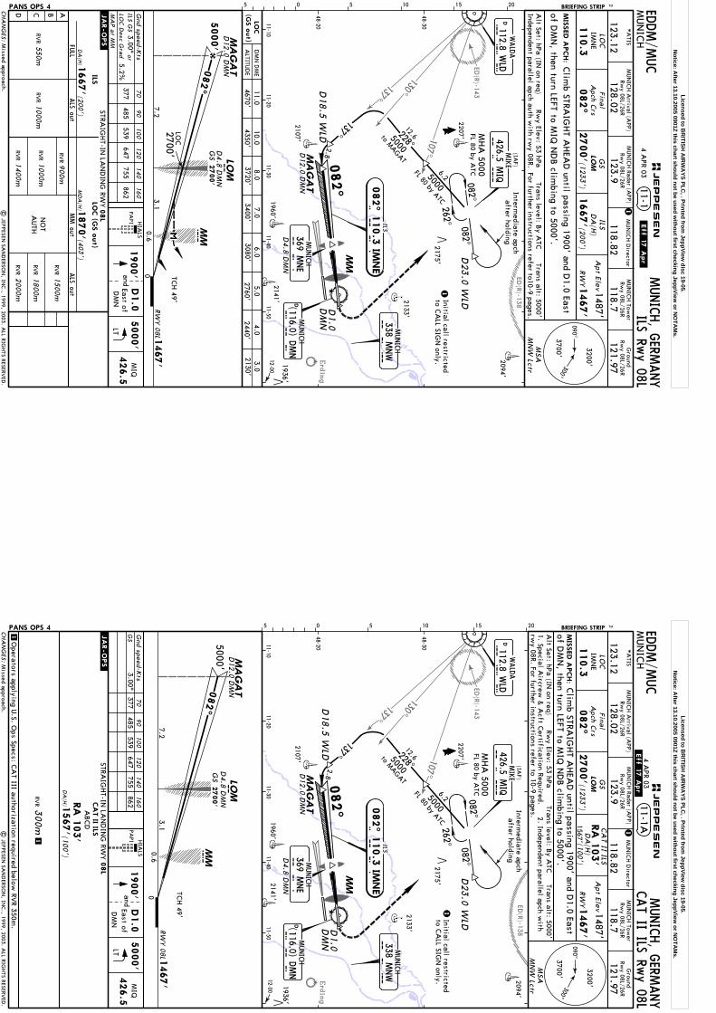
107^
137^
ED(R)-138
ED(R)-143
Erding
130^
Intermediate apch
after holding
082^082^
MHA
5000FL 80 by A
TC6.25000
228^
5000
262^
137^
D18.5
WLD
2.8MA
GA
T
MIS
SED A
PCH:
11-1M
UN
ICH
MUNICH, G
ERMANY
LOC
IMN
EFina
lA
pch Crs
082^
2700'
DA
(H)
1487'
1467'
Apt Elev
RW
Y
PANS OPS 4
Gnd speed-K
tsHIA
LSPA
PI
05 5 10 15 20.JAR-OPS.
2094'
2133'
2141'1960'
2107'
2207'D
23.0
WLD
FL 80 by ATC
12.6
MUN
ICH Tow
erRw
y 08L/26R
118.7
Ground
Rwy 08L/26R
121.97118.82
MUN
ICH D
irectorM
UN
ICH A
rrival (APP)
*A
TIS
123.12
MUN
ICH Radar (A
PP)
128.02123.9
Rwy 08L/26R
Rwy 08L/26R
BRIEFING STRIP TM
to MAGAT
D12.0 D
MN
ILS Rwy 08L
110.3
LOM
1667' ILS(2
00')
MM
LOC
(GS o
ut)
NO
TA
UTH
ILSLO
C (G
S o
ut)
LOM
MMC
5000'
00.6
RWY 08L
2700'7.2
3.1
082^
1467'
D4.8 D
MN
m
377485
539647
755862
ILS GS
3.00^or
5.2%LO
C D
esc Gra
d
MA
P a
t MM
70
90
100
120
140
160
D12.0 D
MN
MA
GA
T
ILS
082^ 1
10.3
IMNE
I M N E
TCH 49'
EDDM/M
UC
Rwy Elev: 53 hPa
Trans level: By A
TCTrans alt: 5000'
Alt Set: hPa (IN
on req)
1
Initial call restrictedto C
ALL SIG
N only.
1
1900'
| JEPPESEN
SAN
DERSO
N, IN
C., 1999, 2003. A
LL RIGHTS RESERV
ED.
48-20
48-30
11-1011-20
11-3011-40
11-5012-00
LT
5000'
426.5
MIQ
Independent parallel apch auth with rw
y 08R. For
furtherinstructions
referto10-9 pages.
MSA
MN
W Lctr
4 APR 03
.Eff.17.Apr.
(1233')
Clim
b STRAIG
HT A
HEA
D until passing 1900' and D
1.0 EastD1.0
DM
N
andD1.0
East ofD
MN
of DM
N, then turn LEFT to M
IQ N
DB clim
bing to 5000'.
GS
GS
2700'
LOC
2175'
(IAF)
MUNICH
338 MNW
MUNICH
(116.0) DMN
D M
ND
M N W
DWALD
A
112.8 WLD
W L
D
CHA
NG
ES:
090^300^
3200'
3700'
STRAIG
HT-IN
LAN
DIN
G RW
Y
ABCD
ALS out
DA
(H)
08L
1667'
1870'
RVR
(200')
(403')
ALTITU
DE
10.08.0
7.06.0
4.03.0
2130'D
MN
DM
E
4350'3720'
3400'3080'
2440'
RVR
1000m
RVR
1400m
RVR
1500m
2000m
RVR
900m
JEPPESEN
082^MD
A(H
)
ALS out
FULL
MM out
RVR
1800m
RVR
1000m
RVR
550m
D4.8 D
MN
MUNICH
369 MNE
M N E
426.5 MIQ
MIKE
M I Q
1936'
Missed approach.
5.02760'
11.04670'
Licensed to BR
ITISH A
IRW
AYS PLC
, . Printed from JeppView
disc 19-05.N
otice: After 13.10.2005 0901Z this chart should not be used w
ithout first checking JeppView or N
OTA
Ms.
107^
137^
ED(R)-138
ED(R)-143
Erding
130^
Intermediate apch
after holding
082^082^
MHA
5000FL 80 by A
TC6.25000
228^
5000
262^137^
D18.5
WLD
2.8MA
GA
T
MIS
SED A
PCH:
MUN
ICH
MUNICH, G
ERMANY
LOC
IMN
EFina
lA
pch Crs
082^
2700'
1487'
1467'
Apt Elev
RW
Y
PANS OPS 4
2094'
2133'
2141'1960'
2107'
2207'D
23.0
WLD
FL 80 by ATC
12.6
MUN
ICH Tow
erRw
y 08L/26R
118.7
Ground
Rwy 08L/26R
121.97118.82
MUN
ICH D
irectorM
UN
ICH A
rrival (APP)
*A
TIS
123.12
MUN
ICH Radar (A
PP)
128.02123.9
Rwy 08L/26R
Rwy 08L/26R
BRIEFING STRIP TM
to MAGAT
D12.0 D
MN
110.3
LOM
MM
ILS
082^ 1
10.3
IMNE
I M N E
CAT II ILS Rw
y 08L
DA
(H)
CA
T II ILSRA
103'
1567' (100')
1O
perators applying U.S. O
ps Specs: CA
T III authorization required below RV
R 350m.
11-1A
m
Gnd speed-K
ts
LOM
MMC
5000'
00.6
RWY 08L
7.23.1
082^
1467'
D4.8 D
MN
377485
539647
755862
3.00^70
90
100
120
140
160
D12.0 D
MN
MA
GA
T
TCH 49'
GS
1300m
RVR CA
T II ILS
DA
(H)
(100')
ABCD
.JAR-OPS.
RA
103'
1567'
EDDM/M
UC
1
Alt Set: hPa (IN
on req)Trans level: B
y ATC
Trans alt: 5000'Rw
y Elev: 53 hPa
Initial call restrictedto C
ALL SIG
N only.
1
| JEPPESEN
SAN
DERSO
N, IN
C., 1999, 2003. A
LL RIGHTS RESERV
ED.
48-20
48-30
11-1011-20
11-3011-40
11-5012-00
HIA
LS
PAPI
1900'
LT
5000'
426.5
MIQ
1. Special Aircrew
& A
cft Certification Required.
2. Independent parallel apch with
rwy 08R. For further instructions refer to 10-9 pages.
MSA
MN
W Lctr
4 APR 03
.Eff.17.Apr.
(1233')
Clim
b STRAIG
HT A
HEA
D until passing 1900' and D
1.0 EastD1.0
DM
N
andD1.0
East ofD
MN
of DM
N, then turn LEFT to M
IQ N
DB clim
bing to 5000'.
2175'
GS
GS
2700'
05 5 10 15 20
(IAF)
MUNICH
338 MNW
MUNICH
(116.0) DMN
D M
ND
M N W
426.5 MIQ
MIKE
M I Q
DWALD
A
112.8 WLD
W L
D
CHA
NG
ES:
090^300^
3200'
3700'
JEPPESEN
082^
D4.8 D
MN
MUNICH
369 MNE
M N E
STRAIG
HT-IN
LAN
DIN
G RW
Y08L
1936'
Missed approach.
Licensed to BR
ITISH A
IRW
AYS PLC
, . Printed from JeppView
disc 19-05.N
otice: After 13.10.2005 0901Z this chart should not be used w
ithout first checking JeppView or N
OTA
Ms.
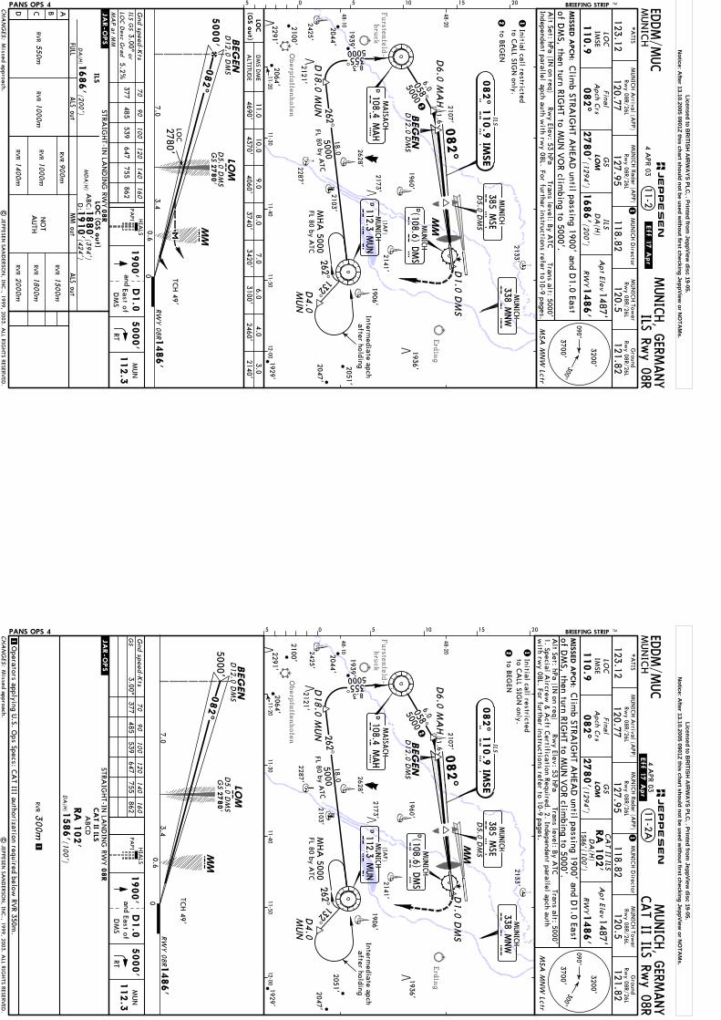
Furstenfeld-
bruck
Oberpfaffenhofen
Erding
Intermediate apch
after holding
D4.0
MUN
5000355^8.3
132^262^
18.0
5000262^
MHA
5000FL 80 by A
TC
MIS
SED A
PCH:
MUN
ICH
MUNICH, G
ERMANY
LOC
IMSE
082^
2780'
DA
(H)
1487'
1486'
Apt Elev
RW
Y
MSA
MN
W Lctr
PANS OPS 4
HIA
LSPA
PI
Rwy Elev: 53 hPa
Alt Set: hPa (IN
on req)Trans level: B
y ATC
Trans alt: 5000'
11-2
2133'
1960'
2628'
2425'
2287'
1929'
2141'
1906'
2103'
2107'
2051'
2
2
FL 80 by ATC
MUN
ICH Tow
erRw
y 08R/26L
120.5
Ground
Rwy 08R/26L
121.82118.82
MUN
ICH D
irector
120.77
MUN
ICH A
rrival (APP)
*A
TIS
123.12127.95
MUN
ICH Radar (A
PP)Rw
y 08R/26LRw
y 08R/26L
2173'
1.6
ILS Rwy 08R
110.9
LOM
1686'(200')
ILS
ILS
082^ 1
10.9
IMSE
I M S E
(GS o
ut)
LOC
Gnd speed-K
ts70
90
100
120
140
160
377485
539647
755862
ILS GS
3.00^or
5.2%LO
C D
esc Gra
d
MA
P a
t MM
NO
TA
UTH
ILSLO
C (G
S o
ut)
BEG
EN
LOM
MMC
5000'
00.6
RW
Y 08R
2780'
7.03.4
082^
1486'
D5.0
DM
Sm
D12.0 D
MS
BEG
EN
D12.0 D
MS
TCH 49'
Final
Apch C
rs
05 5 10 15 20 BRIEFING STRIP TM
M S E
385 MSE
D5.0
DM
S
.JAR-OPS.
EDDM/M
UC
Initial call restrictedto C
ALL SIG
N only.
1
1
1900'
| JEPPESEN
SAN
DERSO
N, IN
C., 1999, 2003. A
LL RIGHTS RESERV
ED.
48-10
48-20
11-2011-30
11-4011-50
12-00
RT
5000'
MUN
112.3
Forfurther
to10-9 pages.
referinstructions
Independentparallel
apch auth with rw
y 08L.
Missed approach.
4 APR 03
.Eff.17.Apr.
(1294')
Clim
b STRAIG
HT A
HEA
D until passing 1900' and D
1.0 East
D1.0
DM
S
D1.0
andEast ofD
MS
GS
of DM
S, then turn RIGHT to M
UN
VO
R climbing to 5000'.
GS
2780'LO
C
(IAF)
058^
50006.0D
MAISA
CH
108.4 MAH
M A H
D112.3 M
UN
MUNICH
M U
N
D18.0
MUN
D6.0
MA
H
CHA
NG
ES:
090^300^
3200'
3700'
ALTITU
DE
DM
S DM
E11.0
8.07.0
6.04.0
3.04690'
3740'3420'
3100'2460'
2140'
JEPPESEN
MUNICH
338 MNW
M N W
MM
082^
STRAIG
HT-IN
LAN
DIN
G RW
Y
ABCD
ALS out
DA
(H)
08R
1686'
1910'
RVR
(200')
(424')
RVR
1000m
RVR
1400m
RVR
1500m
2000mRV
R
900m
MD
A(H
)
ALS out
FULL
MM out
RVR
1800mRV
R1000m
RVR
550m
1880'(3
94')
ABC:
D:
MUNICH
1936'2047'
1939'
2044'
2121'
2291'
2100'
2064'
DMUNICH
(108.6) DMS
D M
S
9.04060'
10.04370'
to BEG
EN
Licensed to BR
ITISH A
IRW
AYS PLC
, . Printed from JeppView
disc 19-05.N
otice: After 13.10.2005 0901Z this chart should not be used w
ithout first checking JeppView or N
OTA
Ms.
Furstenfeld-
bruck
Oberpfaffenhofen
Erding
5000355^8.3
Intermediate apch
after holding
132^262^
18.0
5000262^
MHA
5000FL 80 by A
TCD
4.0
MUN
MIS
SED A
PCH:
MUN
ICH
MUNICH, G
ERMANY
LOC
IMSE
Final
Apch C
rs
082^
2780'
1487'
1486'
Apt Elev
RW
Y
MSA
MN
W Lctr
PANS OPS 4 05 5 10 15 20
Rwy Elev: 53 hPa
Alt Set: hPa (IN
on req)Trans level: B
y ATC
Trans alt: 5000'
2133'
1960'
2628'
2425'
2287'
1929'
2141'
1906'
2103'
2107'
2051'
2
2
FL 80 by ATC
MUN
ICH Tow
erRw
y 08R/26L
120.5
Ground
Rwy 08R/26L
121.82118.82
MUN
ICH D
irector
120.77
MUN
ICH A
rrival (APP)
*A
TIS
123.12127.95
MUN
ICH Radar (A
PP)Rw
y 08R/26LRw
y 08R/26L
2100'
BRIEFING STRIP TM
2173'
1.6
110.9
LOM
M S E
385 MSE
D5.0
DM
S
ILS
082^ 1
10.9
IMSE
I M S E
BEG
EN
D12.0 D
MS
CAT II ILS Rw
y 08R11-2A
DA
(H)
CA
T II ILSRA
102'
1586' (100')
1O
perators applying U.S. O
ps Specs: CA
T III authorization required below RV
R 350m.
BEG
EN
LOM
MMC
5000'
00.6
RW
Y 08R
7.03.4
082^
1486'
mD
12.0 D
MS
TCH 49'
Gnd speed-K
ts377
485539
647755
8623.00^
70
90
100
120
140
160
GS
1300m
RVR CA
T II ILS
DA
(H)
(100')
ABCD
.JAR-OPS.
RA
102'
1586'
D5.0
DM
S
EDDM/M
UC
Initial call restrictedto C
ALL SIG
N only.
1
1| JEPPESEN
SAN
DERSO
N, IN
C., 1999, 2003. A
LL RIGHTS RESERV
ED.
48-10
48-20
11-2011-30
11-4011-50
12-00
HIA
LSPA
PI1900'
RT
5000'
MUN
112.3
1. Special Aircrew
& A
cft Certification Required. 2. Independent parallel apch auth
with rw
y 08L. For further instructions refer to 10-9 pages.
.Eff.17.Apr.
4 APR 03(1294')
Clim
b STRAIG
HT A
HEA
D until passing 1900' and D
1.0 East
D1.0
DM
S
D1.0
andEast ofD
MS
GS
of DM
S, then turn RIGHT to M
UN
VO
R climbing to 5000'.
GS
2780'
(IAF)
058^
50006.0D
MAISA
CH
108.4 MAH
M A H
D112.3 M
UN
MUNICH
M U
N
D18.0
MUN
D6.0
MA
H
CHA
NG
ES:
090^300^
3200'
3700'
JEPPESEN
MUNICH
338 MNW
M N W
DMUNICH
(108.6) DMS
D M
S
MM
MUNICH
082^
STRAIG
HT-IN
LAN
DIN
G RW
Y08R
1936'2047'
2291'
2121'
1939'
2044'
2064'
Missed approach.
to BEG
EN
Licensed to BR
ITISH A
IRW
AYS PLC
, . Printed from JeppView
disc 19-05.N
otice: After 13.10.2005 0901Z this chart should not be used w
ithout first checking JeppView or N
OTA
Ms.
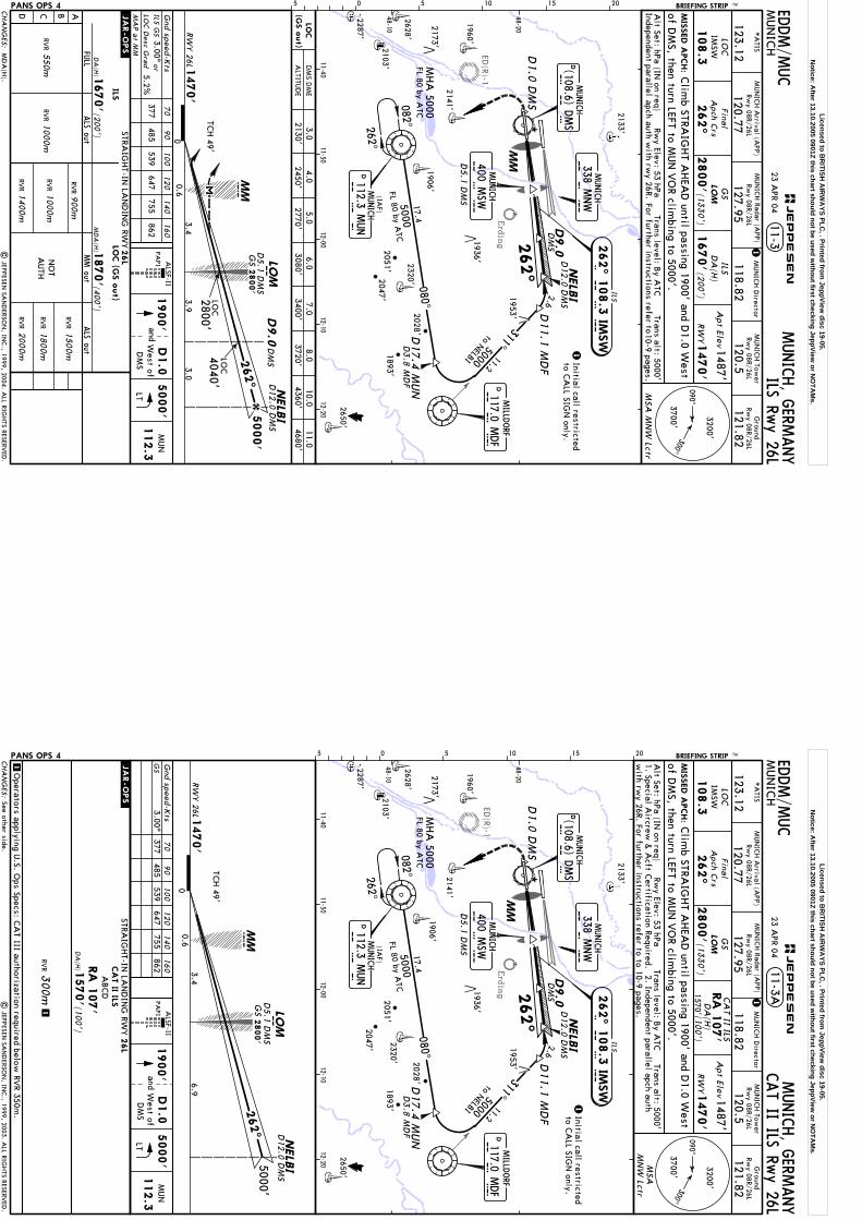
Erding
ED(R)-1
NELB
I2.6
311^11.2
5000
082^262^
MHA
5000FL 80 by A
TC17.4
5000
080^
D3.8
MD
F
MIS
SED A
PCH:
MUN
ICH
MUNICH, G
ERMANY
LOC
IMSW
Final
Apch C
rs
262^
2800'
DA
(H)
1487'
1470'
Apt Elev
RW
Y
MSA
MN
W Lctr
PANS OPS 4 05 5 10 15 20
Alt Set: hPa (IN
on req)Trans level: B
y ATC
Trans alt: 5000'Rw
y Elev: 53 hPa
11-3
2133'
1960'
2628'
2287'
2141'
1906'
2103'
2650'
1953'
2051'
2173'
FL 80 by ATC
MUN
ICH Tow
erRw
y 08R/26L
120.5
Ground
Rwy 08R/26L
121.82118.82
MUN
ICH D
irector
120.77
MUN
ICH A
rrival (APP)
*A
TIS
123.12127.95
MUN
ICH Radar (A
PP)Rw
y 08R/26LRw
y 08R/26L
BRIEFING STRIP TM
D12.0 D
MS
to NELBI
ILS Rwy 26L
108.3
LOM
1670'(200')
ILS
MMD
5.1
DM
S
ILS
262^ 1
08.3
IMSW
I M S W
LOC
(GS o
ut)
PAPI
Gnd speed-K
ts70
90
100
120
140
160
377485
539647
755862
ILS GS
3.00^or
5.2%LO
C D
esc Gra
d
MA
P a
t MM
.JAR-OPS.
NO
TA
UTH
ILSLO
C (G
S o
ut)
NELB
ILO
M
MMC
5000'
00.6
RWY 26L
2800'3.0
3.4
262^
1470'
D5.1
DM
Sm
D12.0 D
MS
TCH 49'
D9.0
DM
S
DM
SD9.0
3.9
4040'
| JEPPESEN
SAN
DERSO
N, IN
C., 1999, 2004. A
LL RIGHTS RESERV
ED.
EDDM/M
UC
Initial call restrictedto C
ALL SIG
N only.
1
1
1900'
48-10
48-20
11-4011-50
12-0012-10
12-20
LT
5000'
MUN
112.3
Forfurther
to10-9 pages.
referinstructions
Independentparallel
apch auth with rw
y 26R.
(1330')
Clim
b STRAIG
HT A
HEA
D until passing 1900' and D
1.0 West
D1.0
DM
S
D1.0
West ofD
MS
and
GS
of DM
S, then turn LEFT to MUN
VO
R climbing to 5000'.
2800'
GS
LOC
LOC
23 APR 04
ALSF-II
MD
A(H
).
(IAF)
D112.3 M
UN
MUNICH
M U
N
D17.4
MUN D
MILLD
ORF
117.0 MDF
M D
F
D11.1
MD
F
MUNICH
DD M
S(108.6) D
MS
CHA
NG
ES:
090^300^
3200'
3700'
ALTITU
DE
DM
S DM
E3.0
4.06.0
7.08.0
11.02130'
2450'3080'
3400'3720'
4680'
JEPPESEN
M S W
400 MSW
MUNICH
262^
MUNICH
338 MNW
M N W
STRAIG
HT-IN
LAN
DIN
G RW
Y
ABCD
ALS out
DA
(H)
26L
1670'
RVR
(200')
RVR
1000m
RVR
1400m
RVR
1500m
2000mRV
R
900mALS out
FULL
MM out
RVR
1800mRV
R1000m
RVR
550m
MD
A(H
) 1870'(4
00')
1936'
2028'2320'2047'
5.02770'
10.04360'
1893'
Licensed to BR
ITISH A
IRW
AYS PLC
, . Printed from JeppView
disc 19-05.N
otice: After 13.10.2005 0901Z this chart should not be used w
ithout first checking JeppView or N
OTA
Ms.
Erding
ED(R)-1
NELB
I2.6
311^11.2
5000
082^262^
MHA
5000FL 80 by A
TC17.4
5000
080^
D3.8
MD
F
MIS
SED A
PCH:
MUN
ICH
MUNICH, G
ERMANY
LOC
IMSW
Final
Apch C
rs
262^
2800'
1487'
1470'
Apt Elev
RW
Y
PANS OPS 4 05 5 10 15 20
Alt Set: hPa (IN
on req)Trans level: B
y ATC
Trans alt: 5000'Rw
y Elev: 53 hPa
2133'
1960'
2628'
2287'
2141'
1906'
2320'2103'
2650'
1953'
2051'
2173'
FL 80 by ATC
MUN
ICH Tow
erRw
y 08R/26L
120.5
Ground
Rwy 08R/26L
121.82118.82
MUN
ICH D
irector
120.77
MUN
ICH A
rrival (APP)
*A
TIS
123.12127.95
MUN
ICH Radar (A
PP)Rw
y 08R/26LRw
y 08R/26L
BRIEFING STRIP TM
D12.0 D
MS
to NELBI
108.3
LOM
MMD
5.1
DM
S
ILS
262^ 1
08.3
IMSW
I M S W C
AT II ILS Rw
y 26L11-3A
DA
(H)
CA
T II ILSRA
107'
1570' (100')
1O
perators applying U.S. O
ps Specs: CA
T III authorization required below RV
R 350m.
NELB
ILO
M
MMC
5000'
00.6
RWY 26L
3.4
262^
1470'
D5.1
DM
S
D12.0 D
MS
TCH 49'
Gnd speed-K
ts377
485539
647755
8623.00^
70
90
100
120
140
160
GS
1300m
RVR CA
T II ILS
DA
(H)
(100')
ABCD
.JAR-OPS.
RA
107'
1570' m
D9.0
DM
S
6.9
| JEPPESEN
SAN
DERSO
N, IN
C., 1999, 2003. A
LL RIGHTS RESERV
ED.
EDDM/M
UC
Initial call restrictedto C
ALL SIG
N only.
1
1
48-10
48-20
11-4011-50
12-0012-10
12-20
PAPI
1900'
LT
5000'
MUN
112.3
1. Special Aircrew
& A
cft Certification Required.
2. Independent parallel apch authw
ith rwy 26R. For further instructions refer to to 10-9 pages.
MSA
MN
W Lctr
(1330')
Clim
b STRAIG
HT A
HEA
D until passing 1900' and D
1.0 West
D1.0
DM
S
D1.0
West ofD
MS
and
GS
of DM
S, then turn LEFT to MUN
VO
R climbing to 5000'.
GS
2800'
23 APR 04
ALSF-II
See other side.
(IAF)
D112.3 M
UN
MUNICH
M U
N
D17.4
MUN D
MILLD
ORF
117.0 MDF
M D
F
D11.1
MD
F
MUNICH
DD M
S(108.6) D
MS
CHA
NG
ES:
090^300^
3200'
3700'
JEPPESEN
M S W
400 MSW
MUNICH
262^
MUNICH
338 MNW
M N W
STRAIG
HT-IN
LAN
DIN
G RW
Y26L
1936'
2047'
2028'
1893'
Licensed to BR
ITISH A
IRW
AYS PLC
, . Printed from JeppView
disc 19-05.N
otice: After 13.10.2005 0901Z this chart should not be used w
ithout first checking JeppView or N
OTA
Ms.
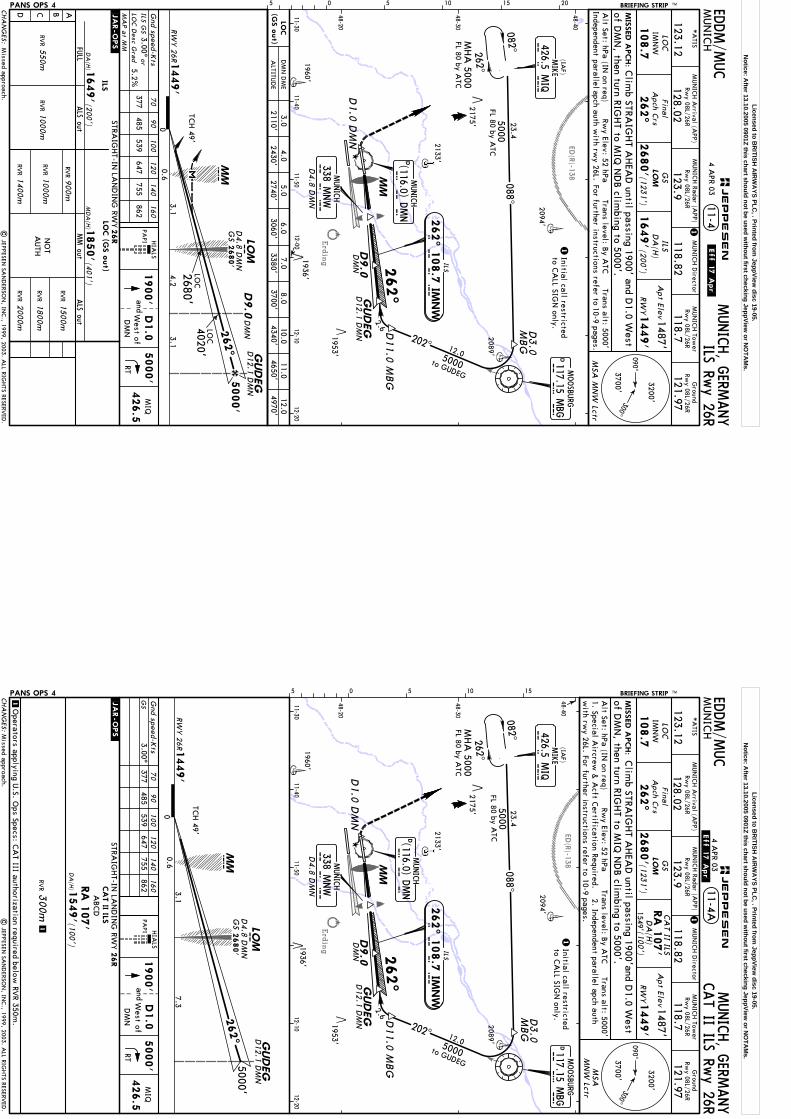
Erding
ED(R)-138
GUDEG
M I Q
426.5 MIQ
5000082^262^
MIS
SED A
PCH:
MUN
ICH
MUNICH, G
ERMANY
LOC
IMN
WFina
lA
pch Crs
262^
2680'
DA
(H)
1487'
1449'
Apt Elev
RW
Y
MSA
MN
W Lctr
PANS OPS 4 05 5 10 15 20
1649'(200')
Rwy Elev: 52 hPa
Trans level: By A
TCTrans alt: 5000'
Alt Set: hPa (IN
on req)
11-4
MHA
5000FL 80 by A
TC
2133'
1960'
2094'
2089'
1953'
FL 80 by ATC
MUN
ICH Tow
erRw
y 08L/26R
118.7
Ground
Rwy 08L/26R
121.97118.82
MUN
ICH D
irector
128.02
MUN
ICH A
rrival (APP)
*A
TIS
123.12123.9
MUN
ICH Radar (A
PP)Rw
y 08L/26RRw
y 08L/26R
BRIEFING STRIP TM
to GUDEG
D12.1 D
MN
ILS Rwy 26R
108.7
LOM
ILS
262^
ILS
262^ 1
08.7
IMNW
I M N W
D4.8
DM
N
MUNICH
338 MNW
M N W
LOC
(GS o
ut)
HIA
LSPA
PIG
nd speed-Kts
70
90
100
120
140
160
377485
539647
755862
ILS GS
3.00^or
5.2%LO
C D
esc Gra
d
MA
P a
t MM
.JAR-OPS.
NO
TA
UTH
ILSLO
C (G
S o
ut)
GUDEG
LOM
MMC
5000'
00.6
RWY 26R
2680'4.2
3.1
262^
1449'
D4.8
DM
ND
12.1 DM
Nm
TCH 49'
D9.0
DM
N
4020'
3.1
| JEPPESEN
SAN
DERSO
N, IN
C., 1999, 2003. A
LL RIGHTS RESERV
ED.
DM
ND9.0
EDDM/M
UC
Initial call restrictedto C
ALL SIG
N only.
1
1
1900'
48-20
48-30
48-40
11-3011-40
11-5012-00
12-1012-20
RT
5000'
426.5
MIQ
Forfurther
to10-9 pages.
referinstructions
Independentparallelapch auth w
ith rwy 26L.
4 APR 03
.Eff.17.Apr.
(1231')
Clim
b STRAIG
HT A
HEA
D until passing 1900' and D
1.0 West
D1.0
DM
N
D1.0
andW
est ofD
MN
GS
of DM
N, then turn RIG
HT to M
IQ N
DB clim
bing to 5000'.
2175'
LOC
LOC
GS
2680'
202^5000
(IAF)
12.0
2.6 D11.0 M
BG
MIKE
23.40 88^
DMOOSBU
RG
117.15 MBG
M B
G
CHA
NG
ES:
090^300^
3200'
3700'
ALTITU
DE
3.04.0
6.07.0
8.0D
MN
DM
E10.0
2110'2430'
3060'3380'
3700'4340'
JEPPESEN
MM
STRAIG
HT-IN
LAN
DIN
G RW
Y
ABCD
ALS out
DA
(H)
26R
1649'
RVR
(200')
RVR
1000m
RVR
1400m
RVR
1500m
2000mRV
R
900mALS out
FULL
MM out
RVR
1800mRV
R1000m
RVR
550m
1850'(4
01')
MD
A(H
)
D3.0
MBG
1936'
MUNICH
(116.0) DMN
DD M
N
Missed approach.
5.02740'
11.04650'
12.04970'
Licensed to BR
ITISH A
IRW
AYS PLC
, . Printed from JeppView
disc 19-05.N
otice: After 13.10.2005 0901Z this chart should not be used w
ithout first checking JeppView or N
OTA
Ms.
Erding
ED(R)-138
GUDEG
M I Q
426.5 MIQ
500 0082^262^
MIS
SED A
PCH:
MUN
ICH
MUNICH, G
ERMANY
LOC
IMN
WFina
lA
pch Crs
262^
2680'
1487'
1449'
Apt Elev
RW
Y
PANS OPS 4
Rwy Elev: 52 hPa
Trans level: By A
TCTrans alt: 5000'
Alt Set: hPa (IN
on req)
MHA
5000FL 80 by A
TC
2133'
1960'
2094'
2089'
1953'
FL 80 by ATC
MUN
ICH Tow
erRw
y 08L/26R
118.7
Ground
Rwy 08L/26R
121.97118.82
MUN
ICH D
irector
128.02
MUN
ICH A
rrival (APP)
*A
TIS
123.12123.9
MUN
ICH Radar (A
PP)Rw
y 08L/26RRw
y 08L/26R
BRIEFING STRIP TM
to GUDEG
D12.1 D
MN
108.7
LOM
262^
D4.8
DM
N
MUNICH
338 MNW
M N W
CAT II ILS Rw
y 26R11-4A
DA
(H)
CA
T II ILSRA
107'
1549' (100')
1O
perators applying U.S. O
ps Specs: CA
T III authorization required below RV
R 350m.
GUDEG
LOM
MMC
5000'
00.6
RWY 26R
3.1
262^
1449'
D4.8
DM
N
D12.1 D
MN
TCH 49'
Gnd speed-K
ts377
485539
647755
8623.00^
70
90
100
120
140
160
GS
1300m
RVR CA
T II ILS
DA
(H)
(100')
ABCD
.JAR-OPS.
RA
107'
1549' m
D9.0
DM
N
7.3
| JEPPESEN
SAN
DERSO
N, IN
C., 1999, 2003. A
LL RIGHTS RESERV
ED.
EDDM/M
UC
Initial call restrictedto C
ALL SIG
N only.
1
1
48-20
48-30
48-40
11-3011-40
11-5012-10
12-20
HIA
LS
PAPI
1900'
RT
5000'
426.5
MIQ
1. Special Aircrew
& A
cft Certification Required.
2. Independent parallel apch auth
05 5 10 15
MSA
MN
W Lctr
with rw
y 26L. For further instructions refer to 10-9 pages.
ILS
262^ 1
08.7
IMNW
I M N W
.Eff.17.Apr.
4 APR 03(123
1')
Clim
b STRAIG
HT A
HEA
D until passing 1900'and D
1.0 West
D1.0
DM
N
D1.0
West ofD
MN
and
GS
of DM
N, then turn RIG
HT to M
IQ N
DB clim
bing to 5000'.
2175'
GS
2680'
202^5000
(IAF)
12.0
MUNICH
(116.0) DMN
D M
ND
2.6 D11.0 M
BG
MIKE
23.4088^
DMOOSBU
RG
117.15 MBG
M B
G
CHA
NG
ES:
090^300^
3200'
3700'
JEPPESEN
MM
MBG
D3.0
STRAIG
HT-IN
LAN
DIN
G RW
Y26R
1936'
Missed approach.
Licensed to BR
ITISH A
IRW
AYS PLC
, . Printed from JeppView
disc 19-05.N
otice: After 13.10.2005 0901Z this chart should not be used w
ithout first checking JeppView or N
OTA
Ms.
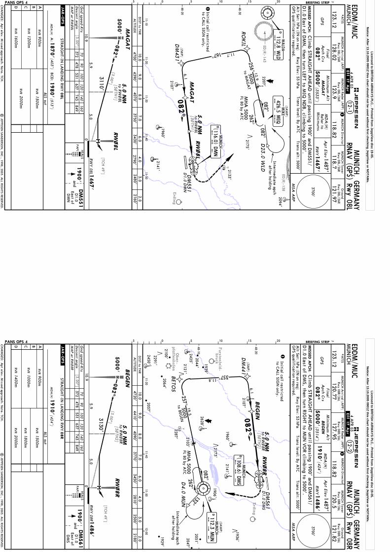
Erding
ED(R)-143
ED(R)-138
[TCH 49']
[3.00^]
[3.00^]
[5~TH
1]
[5~TH
1]
MA
GA
T
MIS
SED A
PCH:
12-1M
UN
ICH
MUNICH, G
ERMANY
GPS
082^
Minim
um A
lt
5000'(3
533')
MD
A(H
)Refer to
Minim
ums
1487'
1467'
Apt Elev
RW
Y
PANS OPS 4
Gnd speed-K
ts70
90
100
120
140
160
Final
Apch C
rs
05 5 10 15 20.JAR-OPS.
5.0
082^
5.0
NM
to RW
~8L
RW
~8L
MA
GA
T
5.0
NM
RW
~8L
BRIEFING STRIP TM
082^
262^
Intermediate apch
after holding
D23.0
WLD
11.7
12.9
6.1
RO
KILD
M431
256^
167^
MHA
5000FL 80 by A
TC
5000
D1.0
DM
N
| JEPPESEN
SAN
DERSO
N, IN
C., 1998, 2003. A
LL RIGHTS RESERV
ED.
to MA
GA
T
2094'
11-1011-20
11-3011-40
11-50
48-20
48-30
MA
GA
T
(IAW
P)
082^
(IWP)
to RW
~8L
372478
531637
743849
RNAV (G
PS) Rwy 08L
WALD
A112.8 W
LDW
LD
D
DM
551
HIA
LS
PAPI
EDDM/M
UC
4 APR 03
.Eff.17.Apr.
MUN
ICH Tow
erRw
y 08L/26R
118.7
Ground
Rwy 08L/26R
121.97118.82
MUN
ICH D
irectorM
UN
ICH A
rrival (APP)
*A
TIS
123.12
MUN
ICH Radar (A
PP)
128.02123.9
Rwy 08L/26R
Rwy 08L/26R
1
D1.0 East of D
MN
, then turn LEFT to MIQ
ND
B, clim
bing to 5000'.Clim
b STRAIG
HT A
HEA
D until passing 1900' and D
M551/
1Initial call restrictedto C
ALL SIG
N only.
1900'and
East ofD
1.0
DM
N
Apt elev. M
issed approach. Note. TC
H.
MSA
ARP
2175'
JEPPESEN
5000'
082^
RW
Y 0
8L 1
467'
5.9
CHA
NG
ES:
3700'
STRAIG
HT-IN
LAN
DIN
G RW
Y
ABCD
ALS out
MD
A(H
)
08L
1870'
1980'
RVR
(403')
(513')
BCD
:
ALTITU
DE
9.08.0
7.06.0
4.03.0
2480'4390'
4070'3750'
3430'2790'
2133'
2141'1960'
2107'
2207'
RVR
1600m
RVR
1500m
2000mRV
R
900m
MA
P a
t RW~8L
A:
RVR
1200m
3110'
426.5 MIQ
MIKE
M I Q
MUNICH
(116.0) DMN
D M
ND
DM
551
DIST to TH
R
GPS qualification required.
Descent a
ngle
Alt Set: hPa (IN
on req)Rw
y Elev: 53 hPaTrans level: B
y ATC
Trans alt: 5000'
2.02160'
10.04700'
10.90
Licensed to BR
ITISH A
IRW
AYS PLC
, . Printed from JeppView
disc 19-05.N
otice: After 13.10.2005 0901Z this chart should not be used w
ithout first checking JeppView or N
OTA
Ms.
Erding
Ober-
pfaffenhofen
Furstenfeld-
bruck
[3.00^]
[TCH 49']
[3.00^]
[5~TH
2]
[5~TH
2]
MUN
ICH
MUNICH, G
ERMANY
GPS
Final
Apch C
rs
082^
Minim
um A
lt
5000'(3
514')
1487'
1486'
Apt Elev
RW
Y
PANS OPS 4
Gnd speed-K
ts70
90
100
120
140
160
HIA
LS
PAPI
05 5 10 15 20
BEG
EN
DM
561
BEG
EN
2450'11-20
11-4011-50
12-00
48-10
48-20
.JAR-OPS.
Rwy Elev: 53 hPa
Alt Set: hPa (IN
on req)Trans level: B
y ATC
Trans alt: 5000'
12-2
BEG
EN
RW
~8R
082^
5.0
NM
to RW
~8R
MD
A(H
)
1910'(424')
MIS
SED A
PCH:
D1.0
DM
S
RW
~8R
Intermediate apch
after holding
MHA
5000FL 80 by A
TC
MUN
ICH Tow
er
120.5
Ground
121.82118.82
MUN
ICH D
irectorM
UN
ICH A
rrival (APP)
*A
TIS
123.12
MUN
ICH Radar (A
PP)
120.77127.95
Rwy 08R/26L
Rwy 08R/26L
Rwy 08R/26L
Rwy 08R/26L
082^262^
DM
441
BETO
S
257^
357^
6.1
11.8
19.5
to BEG
EN5000
2057'
132^
(IAW
P)
BRIEFING STRIP TM
| JEPPESEN
SAN
DERSO
N, IN
C., 1998, 2003. A
LL RIGHTS RESERV
ED.
(IWP)
372478
531637
743849
RNAV (G
PS) Rwy 08R
GPS qualification required.
EDDM/M
UC
4 APR 03
.Eff.17.Apr.
1
Clim
b STRAIG
HT A
HEA
D until passing 1900' and D
M561/
D1.0 East of D
MS, then turn RIG
HT to M
UN
VO
R climbing to 5000'.
5.0
NM
to RW
~8R
1Initial call restrictedto C
ALL SIG
N only.
1900'and
D1.0
East ofD
MS
Apt elev. M
issed approach. Note. TC
H.
2291'
1936'2047'
2044'
2064'
1939'
2121'
MSA
ARP
5000'
082^
5.9
3130'
CHA
NG
ES:
3700'
ALTITU
DE
9.08.0
7.06.0
4.03.0
4410'4090'
3770'3450'
2810'2500'
2107'
1960'
2628'
2173'
2425'
2287' 2103'
1929'
2141'
1906'
2051'
DMUNICH
D M
S(108.6) D
MS
STRAIG
HT-IN
LAN
DIN
G RW
Y
ABCD
ALS out
MD
A(H
)
08R
1910'
RVR
(424')
RVR
1000m
RVR
1400m
RVR
1500m
2000mRV
R
900m
1800mRV
R JEPPESEN
DM
561
5.0RW
Y 08R1
486'
MA
P a
t RW~8R
2100'
D112.3 M
UN
MUNICH
M U
N
D4.0
MUN
DIST to TH
R
Descent a
ngle
2.02180'
10.04720'
10.90
Licensed to BR
ITISH A
IRW
AYS PLC
, . Printed from JeppView
disc 19-05.N
otice: After 13.10.2005 0901Z this chart should not be used w
ithout first checking JeppView or N
OTA
Ms.

Erding
[3.00^]
[TCH 49']
[3.00^][5~
TH3]
[8~TH
1]
[8~TH
1][5~
TH3]
ED(R)-1
MIS
SED A
PCH:
12-3M
UN
ICH
MUNICH, G
ERMANY
GPS
262^
Minim
um A
lt
5000'(3
530')
MD
A(H
)Refer to
Minim
ums
1487'
1470'
Apt Elev
RW
Y
PANS OPS 4
Gnd speed-K
ts70
90
100
120
140
160
PAPI
Alt Set: hPa (IN
on req)Trans level: B
y ATC
Trans alt: 5000'Rw
y Elev: 53 hPa
NELB
I
DM
541
RW
26L
262^
Final
Apch C
rs
.JAR-OPS.
05 5 10 15 20
NELB
I
262^
RW
26L
MHA
5000FL 80 by A
TC
BRIEFING STRIP TM
8.0
NM
to RW
26L
5.0
NM
to RW
26L
| JEPPESEN
SAN
DERSO
N, IN
C., 1998, 2004. A
LL RIGHTS RESERV
ED.
DM
541
D1.0
DM
S082^262^
NA
PSA
DM
448
6.1
12.2
21.0
8.0
NM
to RW
26L
5.0
NM
to RW
26L
NELB
I
08 8^
337^
to NELB
I50 00
11-4011-50
12-0012-10
12-20
48-10
48-20
(IWP)
(IAW
P)
374481
534641
748855
RNAV (G
PS) Rwy 26L
GPS qualification required.
EDDM/M
UC
MUN
ICH Tow
er
120.5
Ground
121.82118.82
MUN
ICH D
irectorM
UN
ICH A
rrival (APP)
*A
TIS
123.12
MUN
ICH Radar (A
PP)
120.77127.95
Rwy 08R/26L
Rwy 08R/26L
Rwy 08R/26L
Rwy 08R/26L
1
Clim
b STRAIG
HT A
HEA
D until passing 1900' and D
M541/
D1.0 W
est of DM
S, then turn LEFT to MUN
VO
R climbing to 5000'.
1Initial call restrictedto C
ALL SIG
N only.
1900'
D1.0
West ofD
MS
and
1936'
MSA
ARP
23 APR 04
ALSF-II
MD
A(H
).CHA
NG
ES:
3700'
2133'
1960'
2628'
2173'
2141'
1906'
2320'2051'
1953'
STRAIG
HT-IN
LAN
DIN
G RW
Y
ABCD
MD
A(H
)
26L
1870'
1980'
(400')
(510')
BCD
:
MA
P a
t RW26L
A:
MUNICH
DD M
S(108.6) D
MS
ALS out
RVR
RVR
1600m
RVR
1500m
2000mRV
R
900m
JEPPESEN
ALTITU
DE
1.04.0
6.07.0
9.010.0
1840'2800'
3430'3750'
4390'4710'
5000'
RWY 26L1
470'
3.05.0
2.9
4070'3120'
RVR
1200m
D112.3 M
UN
MUNICH
M U
N
2103'
2287'
1929'
2650'
DIST to TH
R
Descent a
ngle
2028'
2047'
3.02480'
2.02160'
10.90
1893'
Licensed to BR
ITISH A
IRW
AYS PLC
, . Printed from JeppView
disc 19-05.N
otice: After 13.10.2005 0901Z this chart should not be used w
ithout first checking JeppView or N
OTA
Ms.
Erding
ED(R)-138
[3.00^]
[TCH 49']
[3.00^][5~
TH4]
[8~TH
2]
[8~TH
2]
[5~TH
4]
ED(R)-1
ED(R)-27
MIS
SED A
PCH:
MUN
ICH
MUNICH, G
ERMANY
GPS
Final
Apch C
rs
262^
Minim
um A
lt
5000'(3
551')
1487'
1449'
Apt Elev
RW
Y
PANS OPS 4
Gnd speed-K
ts70
90
100
120
140
160
05 5 10 15 20
GUDEG
PAPI
.JAR-OPS.
Rwy Elev: 52 hPa
Trans level: By A
TCTrans alt: 5000'
Alt Set: hPa (IN
on req)
12-4
GUDEG
RW
26R
262^
8.0
NM
to RW
26R
5.0
NM
to RW
26R
8.0
NM
to RW
26R
RW
26R
DM
531
MD
A(H
)
1850'(401')
| JEPPESEN
SAN
DERSO
N, IN
C., 1998, 2003. A
LL RIGHTS RESERV
ED.
BRIEFING STRIP TM
082^262^
MHA
5000FL 80 by A
TC
M I Q
426.5 MIQ
(IAW
P)
085^
185^
27.0
12.0
6.0
to GUD
EG5000
LAN
DU
D1.0
DM
N
11-3011-40
11-5012-00
12-1012-20
48-20
48-30
48-40
5.0
NM
to RW
26R
GUDEG
(IWP)
372478
531637
743849
RNAV (G
PS) Rwy 26R
GPS qualification required.
EDDM/M
UC
MUN
ICH Tow
erRw
y 08L/26R
118.7
Ground
Rwy 08L/26R
121.97118.82
MUN
ICH D
irectorM
UN
ICH A
rrival (APP)
*A
TIS
123.12
MUN
ICH Radar (A
PP)
128.02123.9
Rwy 08L/26R
Rwy 08L/26R
1
1Initial call restrictedto C
ALL SIG
N only.
Clim
b STRAIG
HT A
HEA
D until passing 1900' and D
M531/
D1.0 W
est of DM
N, then turn RIG
HT to M
IQ N
DB clim
bing to 5000'.
1900'
D1.0
West of
DM
N
and
MSA
ARP
2175'
23 APR 04
See other side.
ALSF-II
5000'
262^
RWY 26R
1449'
3.05.0
3.0
CHA
NG
ES:
3700'
ALTITU
DE
2.04.0
6.07.0
9.010.0
2140'2780'
3410'3730'
4370'4690'
2089'
2133'
1960'
1953'
STRAIG
HT-IN
LAN
DIN
G RW
Y
ABCD
ALS out
MD
A(H
)
26R
1850'
RVR
(401')
RVR
1000m
RVR
1400m
RVR
1500m
2000mRV
R
900m
1800mRV
R JEPPESEN
DM
438
MUNICH
(116.0) DMN
D M
ND
4050'
3090'
MA
P a
t RW26R
MIKE
DM
531
2094'
DIST to TH
R
Descent a
ngle
1936'
3.02460'
11.00
Licensed to BR
ITISH A
IRW
AYS PLC
, . Printed from JeppView
disc 19-05.N
otice: After 13.10.2005 0901Z this chart should not be used w
ithout first checking JeppView or N
OTA
Ms.
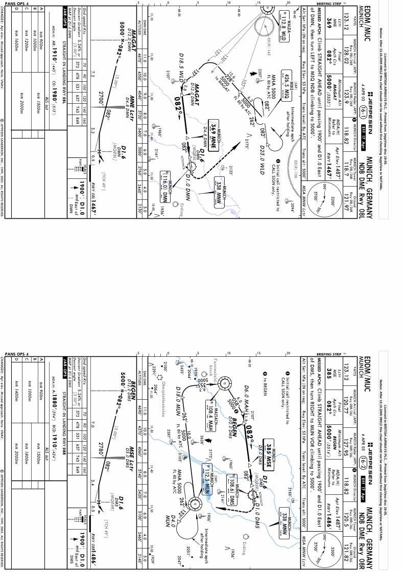
107^
130^
137^
ED(R)-138
ED(R)-143
Erding
[TCH 49']
[MQ
~8L]
[3.00^]
[3.00^]
[MQ
~8L]
D1.6
DM
N
082^
Intermediate apch
after holding
082^082^
MHA
5000FL 80 by A
TC6.25000
228^
5000
262^
137^
D18.5
WLD
2.8
MA
GA
T
MA
GA
TM
NE Lc
tr
DM
ND1.6
082^
MIS
SED A
PCH:
16-1M
UN
ICH
MUNICH, G
ERMANY
NDB D
ME Rw
y 08L
LctrM
NE
369
Final
Apch C
rs
082^
Minim
um A
lt
5000'(3
533')
MD
A(H
)Refer to
Minim
ums
1487'
1467'
Apt Elev
RW
Y
MSA
MN
W Lctr
PANS OPS 4
Gnd speed-K
ts70
90
100
120
140
160
372 478
531 637
743 849
HIA
LSPA
PI
05 5 10 15 20.JAR-OPS.
2094'
2133'
2141'1960'
2107'
2207'D
23.0
WLD
11-1011-20
11-3011-40
11-5012-00
48-20
48-30
48-40
FL 80 by ATC
12.6
MUN
ICH Tow
erRw
y 08L/26R
118.7
Ground
Rwy 08L/26R
121.97118.82
MUN
ICH D
irectorM
UN
ICH A
rrival (APP)
*A
TIS
123.12
MUN
ICH Radar (A
PP)
128.02123.9
Rwy 08L/26R
Rwy 08L/26R
BRIEFING STRIP TM
MA
GA
T
to MAGAT
D12.0 D
MN
D12.0 D
MN
| JEPPESEN
SAN
DERSO
N, IN
C., 1999, 2003. A
LL RIGHTS RESERV
ED.
EDDM/M
UC
.Eff.17.Apr.
4 APR 03
1
1Initial call restricted toCA
LL SIGN
only.
Alt Set: hPa (IN
on req)Rw
y Elev: 53 hPaTrans level: B
y ATC
Trans alt: 5000'
Clim
b STRAIG
HT A
HEA
D until passing 1900' and D
1.0 East
1900'
D1.0
East ofD
MN
and
of DM
N, then turn LEFT to M
IQ N
DB clim
bing to 5000'.
2175'
Apt elev. M
issed approach. Note. V
NA
V.
(IAF)
MUNICH
338 MNW
MUNICH
(116.0) DMN
D M
ND
MUNICH
M N E
082^
369 M
NE
D4.8
DM
N
M N W
D1.0
DM
N
426.5 MIQ
MIKE
M I Q
DWALD
A
112.8 WLD
W L
D
5000'
082^
RW
Y 0
8L 1
467'
2700'3.2
D4.8
DM
N
0.57.2
CHA
NG
ES:
090^300^
3200'
3700'
STRAIG
HT-IN
LAN
DIN
G RW
Y
ABCD
ALS out
MD
A(H
)
08L
1910'
1980'
RVR
(443')
(513')
CD
:A
B:
Descent G
radient
MA
P a
t D1.6 D
MN
ALTITU
DE
10.08.0
7.06.0
4.03.0
2130'D
MN
DM
E
4350'3720'
3400'3080'
2440'
RVR
1000m
RVR
1200m
RVR
1600m
RVR
1500m
2000m
RVR
900m
JEPPESEN
1936'
5.02760'
9.04040'
11.04670'
Descent a
ngleor
5.24%
Licensed to BR
ITISH A
IRW
AYS PLC
, . Printed from JeppView
disc 19-05.N
otice: After 13.10.2005 0901Z this chart should not be used w
ithout first checking JeppView or N
OTA
Ms.
Furstenfeld-
bruck
Oberpfaffenhofen
Erding
[TCH 49']
[MQ
~8R]
[3.00^]
[3.00^]
[MQ
~8R]
D1.6
DM
S
BEG
EN
082^
5000355^8.3
Intermediate apch
after holding
132^262^
18.0
5000262^
MHA
5000FL 80 by A
TCD
4.0
MUN
DM
SD1.6
082^
MIS
SED A
PCH:
MUN
ICH
MUNICH, G
ERMANY
NDB D
ME Rw
y 08R
LctrM
SE
385
Final
Apch C
rs
082^
Minim
um A
lt
5000'(3
514')
MD
A(H
)Refer to
Minim
ums
1487'
1486'
Apt Elev
RW
Y
MSA
MN
W Lctr
PANS OPS 4 Gnd speed-K
ts70
90
100
120
140
160
372 478
531 637
743 849
HIA
LS
PAPI
05 5 10 15 20
BEG
EN
MSE Lc
tr
.JAR-OPS.
Rwy Elev: 53 hPa
Alt Set: hPa (IN
on req)Trans level: B
y ATC
Trans alt: 5000'
16-2
11-2011-30
11-4011-50
12-00
48-10
48-20
2133'
1960'
2628'
2425'
2287'
1929'
2141'
1906'
2103'
2107'
2051'
2
2
FL 80 by ATC
MUN
ICH Tow
erRw
y 08R/26L
120.5
Ground
Rwy 08R/26L
121.82118.82
MUN
ICH D
irector
120.77
MUN
ICH A
rrival (APP)
*A
TIS
123.12127.95
MUN
ICH Radar (A
PP)Rw
y 08R/26LRw
y 08R/26L
2100'
BRIEFING STRIP TM
BEG
EN
D12.0 D
MS
D12.0 D
MS
2173'
1.6
| JEPPESEN
SAN
DERSO
N, IN
C., 1999, 2003. A
LL RIGHTS RESERV
ED.
EDDM/M
UC
.Eff.17.Apr.
4 APR 03
1
Clim
b STRAIG
HT A
HEA
D until passing 1900' and D
1.0 East
1Initial call restricted toCA
LL SIGN
only.
1900'
D1.0
East ofD
MS
and
of DM
S, then turn RIGHT to M
UN
VO
R climbing to 5000'.
Apt elev. M
issed approach. Note. V
NA
V.
(IAF)
058^
50006.0
082^
D
MAISA
CH
108.4 MAH
M A H
D112.3 M
UN
MUNICH
M U
N
D18.0
MUN
D6.0
MA
H
5000'
082^
RW
Y 08R1
486'
7.0
2780'3.4
D5.0
DM
S
0.5
CHA
NG
ES:
090^300^
3200'
3700'
Descent G
radient
ALTITU
DE
DM
S DM
E11.0
8.07.0
6.04.0
3.04690'
3740'3420'
3100'2460'
2140'
STRAIG
HT-IN
LAN
DIN
G RW
Y
ABCD
ALS out
MD
A(H
)
08R
1880'
1910'
RVR
(394')
(424')
BCD
:
RVR
1000m
RVR
1400m
RVR
1500m
2000mRV
R
900m
A:
1800mRV
R JEPPESEN
MUNICH
M S E
385 M
SE
D5.0
DM
S
MUNICH
338 MNW
M N W
DMUNICH
(108.6) DMS
D M
S
D1.0
DM
S
1936'2047'
2064'2291'
2044'
1939'
9.04060'
10.04370'
MA
P a
t D1.6 D
MS
Descent a
ngleor
5.24%
to BEG
EN
Licensed to BR
ITISH A
IRW
AYS PLC
, . Printed from JeppView
disc 19-05.N
otice: After 13.10.2005 0901Z this chart should not be used w
ithout first checking JeppView or N
OTA
Ms.
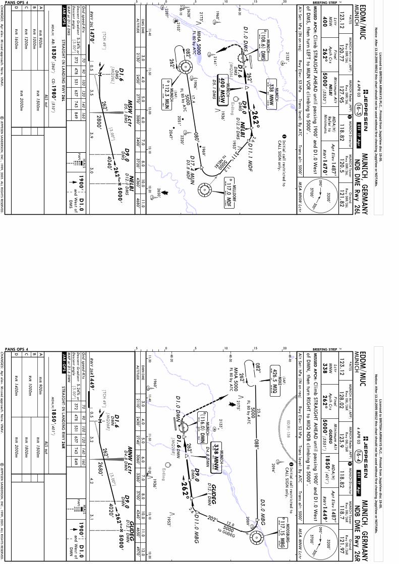
Erding
[TCH 49']
[MQ
26L][3.00^]
[3.00^]
[MQ
26L]
D9.0
NELB
ID1.6
DM
SD
MS
262^2.6
311^11.2
5000
262^
082^262^
MHA
5000FL 80 by A
TC17.4
5000
080^
D3.8
MD
F
DM
SD9.0
DM
SD1.6
262^
MIS
SED A
PCH:
MUN
ICH
MUNICH, G
ERMANY
NDB D
ME Rw
y 26L
LctrM
SW
400
Final
Apch C
rs
262^
Minim
um A
lt
5000'(3
530')
MD
A(H
)Refer to
Minim
ums
1487'
1470'
Apt Elev
RW
Y
MSA
MN
W Lctr
PANS OPS 4 Gnd speed-K
ts70
90
100
120
140
160
372 478
531 637
743 849
HIA
LS
PAPI
05 5 10 15 20
NELB
IM
SW
Lctr
.JAR-OPS.
Alt Set: hPa (IN
on req)Trans level: B
y ATC
Trans alt: 5000'Rw
y Elev: 53 hPa
16-3
11-4011-50
12-0012-10
12-20
48-10
48-20
2133'
1960'
2628'
2287'
2141'
1906'
2320'2103'
2650'
1953'
2051'
2173'
FL 80 by ATC
MUN
ICH Tow
erRw
y 08R/26L
120.5
Ground
Rwy 08R/26L
121.82118.82
MUN
ICH D
irector
120.77
MUN
ICH A
rrival (APP)
*A
TIS
123.12127.95
MUN
ICH Radar (A
PP)Rw
y 08R/26LRw
y 08R/26L
BRIEFING STRIP TM
NELB
I
D12.0 D
MS
to NELBI
D12.0 D
MS
| JEPPESEN
SAN
DERSO
N, IN
C., 1999, 2003. A
LL RIGHTS RESERV
ED.
EDDM/M
UC
4 APR 03
.Eff.17.Apr.
1
1Initial call restricted toCA
LL SIGN
only.
Clim
b STRAIG
HT A
HEA
D until passing 1900' and D
1.0 West1
900'
D1.0
andW
est ofD
MS
of DM
S, then turn LEFT to MUN
VO
R climbing to 5000'.
Apt elev. M
issed approach. Note. V
NA
V.
MUNICH
400 M
SW
MUNICH
338 MNW
D1.0
DM
S
M S W
D5.1
DM
S
M N W
(IAF)
D112.3 M
UN
MUNICH
M U
N
D17.4
MUN D
MILLD
ORF
117.0 MDF
M D
F
D11.1
MD
F
MUNICH
DD M
S(108.6) D
MS
5000'
262^
RWY 26L1
470'
3.9
2800'3.5
D5.1
DM
S
0.53.0
4040'
CHA
NG
ES:
090^300^
3200'
3700'
Descent G
radient
MA
P a
t D1.6 D
MS
ALTITU
DE
DM
S DM
E3.0
4.06.0
7.08.0
10.02130'
2450'3080'
3400'3720'
4360'
STRAIG
HT-IN
LAN
DIN
G RW
Y
ABCD
ALS out
MD
A(H
)
26L
1830'
1980'
RVR
(360')
(510')
CD
:A
B:
RVR
1000m
RVR
1200m
RVR
1600m
RVR
1500m
2000mRV
R
900m
JEPPESEN
1936'
2047'
1969'
5.02770'
11.04680'
orD
escent angle
5.24%
Licensed to BR
ITISH A
IRW
AYS PLC
, . Printed from JeppView
disc 19-05.N
otice: After 13.10.2005 0901Z this chart should not be used w
ithout first checking JeppView or N
OTA
Ms.
Erding
ED(R)-138
[TCH 49']
[3.00^]
[MQ
26R]
[3.00^]
[MQ
26R]
D9.0
DM
N
D1.6
DM
N
GUDEG
262^
M I Q
426.5 MIQ
500 0082^262^
DM
ND9.0
DM
ND1.6
262^
MIS
SED A
PCH:
MUN
ICH
MUNICH, G
ERMANY
NDB D
ME Rw
y 26R
LctrM
NW
338
Final
Apch C
rs
262^
Minim
um A
lt
5000'(3
551')
MD
A(H
)1487'
1449'
Apt Elev
RW
Y
MSA
MN
W Lctr
PANS OPS 4 Gnd speed-K
ts70
90
100
120
140
160
372 478
531 637
743 849
05 5 10 15 20
GUDEG
MNW
Lctr
1850'(401')
PAPI H
IALS
.JAR-OPS.
Rwy Elev: 52 hPa
Trans level: By A
TCTrans alt: 5000'
Alt Set: hPa (IN
on req)
16-4
11-3011-40
11-5012-00
12-1012-20
48-20
48-30
48-40
MHA
5000FL 80 by A
TC
2133'
1960'
2094'
2089'
1953'
FL 80 by ATC
MUN
ICH Tow
erRw
y 08L/26R
118.7
Ground
Rwy 08L/26R
121.97118.82
MUN
ICH D
irector
128.02
MUN
ICH A
rrival (APP)
*A
TIS
123.12123.9
MUN
ICH Radar (A
PP)Rw
y 08L/26RRw
y 08L/26R
BRIEFING STRIP TM
GUDEG
to GUDEG
D12.1 D
MN
D12.1 D
MN
| JEPPESEN
SAN
DERSO
N, IN
C., 1999, 2003. A
LL RIGHTS RESERV
ED.
EDDM/M
UC
4 APR 03
.Eff.17.Apr.
1
Clim
b STRAIG
HT A
HEA
D until passing 1900' and D
1.0 West1
900'
D1.0
West ofD
MN
and
1Initial call restricted toCA
LL SIGN
only.
of DM
N, then turn RIG
HT to M
IQ N
DB clim
bing to 5000'.
2175'
Apt elev. M
issed approach. Note. V
NA
V.
MUNICH
338 M
NW
202^5000
262^
(IAF)
12.0
MUNICH
(116.0) DMN
D M
ND
2.6
D4.8
DM
N
D11.0 M
BG
M N W
MIKE
23.408 8^
D3.0
MBG
DMOOSBU
RG
117.15 MBG
M B
G5000'
262^
RWY 26R1
449'
4.2
2680'
3.2
D4.8
DM
N
0.53.1
4020'
CHA
NG
ES:
090^300^
3200'
3700'
Descent G
radient
MA
P a
t D1.6 D
MN
ALTITU
DE
3.04.0
6.07.0
8.0D
MN
DM
E10.0
2110'2430'
3060'3380'
3700'4340'
STRAIG
HT-IN
LAN
DIN
G RW
Y
ABCD
ALS out
MD
A(H
)
26R
1850'
RVR
(401')
RVR
1000m
RVR
1400m
RVR
1500m
2000mRV
R
900m
1800mRV
R JEPPESEN
D1.0
DM
N
1936'
5.02740'
11.04650'
12.04970'
Descent a
ngleor
5.24%
Licensed to BR
ITISH A
IRW
AYS PLC
, . Printed from JeppView
disc 19-05.N
otice: After 13.10.2005 0901Z this chart should not be used w
ithout first checking JeppView or N
OTA
Ms.