pacific ocean - noaa coral reef information system
TRANSCRIPT

NOAA Coral Reef Ecosystem Research Plan
74
The Northwestern Hawaiian Islands are home to more than 7,000 marine species, including the Bluefin Trevally. Photo credit: James Watt.
Jurisdiction-Specific Research Needs: Pacific Ocean

75
NOAA Coral Reef Ecosystem Research Plan
Th
e H
awai
ian
Isla
nd
sthe hawaiian islandsThe Hawaiian Archipelago stretches for over 2,500 km from the island of Hawaii in the southeast to Kure Atoll (the world’s highest latitude atoll) in the northwest. Hawaii is located in the middle of the Pacific Ocean (Figure HI-1), making it one of the most isolated archipelagos in the world. As a result of its location, Hawaii’s coral reefs possess some of the highest marine endemism recorded for a number of taxa, and are structurally influenced by exposure to large open ocean swells. Within the archipelago, there are two distinct regions: the Main Hawaiian Islands (MHI) made up of populated, high volcanic islands and the Northwestern Hawaiian Islands (NWHI) consisting of mostly uninhabited atolls and banks.
Early Hawaiians recognized that coral reefs were a building block of the islands and used coral in religious ceremonies to demonstrate honor and care for ocean resources. Coral reefs were important to the ancient Hawaiians for food, cultural practices, recreation, and survival. Today, coral reef communities continue to provide Hawaiians with food and protection from storm waves, and are critically important to the state’s approximately $800 million per year marine tourism industry (Cesar and van Beukering 2004).
Although the MHI and NWHI are one ecosystem, resource management and research for these regions have historically differed. This separation or regionalization has
been maintained in this research plan when developing research priorities for the Hawaiian Archipelago.
Main Hawaiian Islands
Coral reef communities in the MHI range from newly formed colonies at the edges of recent lava flows to established fringing reefs (Figure HI-2). Many of these reef communities are located near urban areas. Over 70% of the State’s 1.2 million people live on Oahu, mostly concentrated in the Honolulu metropolitan area. In addition to this resident population, nearly seven million tourists visit Hawaii each year. This large number of people has put pressure on Hawaii’s coral reefs through various direct and indirect means. Many coastal areas adjacent to urban centers are impacted by land-based sources of pollution, fishing pressure, recreational overuse, and invasive species. Despite these stressors, Hawaii’s coral reefs, especially those far from urban centers, remain in good to fair condition compared with other reefs around the world.
Coral reef ecosystems in the MHI are managed through MPAs with varying levels of protection. These include marine life conservation districts, fisheries management areas, a marine laboratory refuge, natural area reserves, NWRs, and the Hawaiian Islands Humpback National Marine Sanctuary. One of the most well known marine life conservation districts is Hanauma Bay, established in
Figure HI-1. Locator map for the Hawaiian archipelago. (See Figure 5 for geographical context.) Map: A. Shapiro.

NOAA Coral Reef Ecosystem Research PlanT
he
Haw
aiia
n Is
lan
ds
76
Hawaiian Islands FISHING
Haw
aiia
n Ar
chip
elag
o
Mai
n Ha
wai
ian
Isla
nds
Only
Management Objective Research Need
Conserve and manage fisheries to prevent overfishing, rebuild stocks, and minimize destructive fishing.
See Jurisdiction-Wide Section for additional research needs.
Assess the ecological impacts of non-extractive activities conducted in coral reef ecosystems on managed fisheries species.
√
Evaluate the potential of restocking ecologically important species (e.g., parrotfish, jacks, spiny lobster). √
Develop affordable ciguatera test kits that would allow a viable fishery for roi. √
Assess the ecological impact of aquarium collection on species of special concern, such as endemics, and develop scientific guidelines for aquarium fishery management.
√
Evaluate and improve the effectiveness of MPAs as a fisheries management tool.
See Jurisdiction-Wide Section for additional research needs.
Evaluate the effectiveness of Hawaii’s MPAs to determine how differing levels of protection improve catches of economically important coral reef resources and identify optimal MPA design under various scenarios.
√
Compare the benefits of fishery replenishment areas for the aquarium fishery in West Hawaii and determine additional management measure needed to rebuild stocks of species that have not rebounded within the fishery replenishment areas and surrounding fished areas.
√
Increase fishers’ participation in fisheries management.
Document historical and cultural knowledge of Hawaiian coral reef resources and their ecology, as well as their historical trends in abundance size, distribution, and community composition.
√
1967. Marine life conservation districts with strict no-take restrictions have been established at specific locations in Hawaii to help restore fish stocks and have met with some success. Even with all of these protections in place, Hawaii’s coral reef MPAs are not as effective as they could be due to difficulties enforcing current regulations and laws, as well as recreational overuse of these MPAs by the tourism industry. 6
� Introductory material was taken, with slight modifications, from Gulko et al. (2002) and Friedlander et al. (2005a).
Research Needs
The research needs detailed below represent both MHI-specific research needs, and archipelago-wide research needs focused on identifying linkages between the NWHI and MHI. Understanding the linkages between the NWHI and MHI is critical because the knowledge gained can be applied to the management of the entire archipelago. NWHI-specific research needs are detailed in the next section.

77
NOAA Coral Reef Ecosystem Research Plan
Th
e H
awai
ian
Isla
nd
s
Figure HI-2. Locator map for the Main Hawaiian Islands. Map: A. Shapiro. Source: Friedlander et al. (2005a).

NOAA Coral Reef Ecosystem Research PlanT
he
Haw
aiia
n Is
lan
ds
78
Hawaiian Islands POLLUTION
Haw
aiia
n Ar
chip
elag
o
Mai
n Ha
wai
ian
Isla
nds
Only
Management Objective Research Need
Reduce the impacts of pollutants on coral reef ecosystems by improving the understanding of their effects.
See Jurisdiction-Wide Section for additional research needs.
Quantify the individual and synergistic impacts of nutrients, chemicals, and pathogens from sewage on reef condition.
√
Develop effective tools for tracking sewage-borne pollutants from cesspools and injection wells. √
Quantify nutrient, fertilizer, and sediment inputs from different sources (e.g., surface water, groundwater, injection wells, septic systems, and cesspools) and determine their impacts on coral reef ecosystems.
√
Develop sediment transport models for critical reef areas. √
Improve water quality by reducing land-based pollutant inputs and impacts on coral reef ecosystems.
See Jurisdiction-Wide Section for additional research needs.
Develop low-cost tools to assess concentrations and loads of nearshore water pollutants that can be easily implemented by managers and volunteers.
√
Develop protocols to evaluate the effectiveness of land-based pollution management methods. √
Create science-based guidelines for the evaluation, improvement, and/or development of permitting and regulatory tools for protecting coral reef ecosystems from pollution stress.
√
Identify biological criteria for coral reefs that could be incorporated into state water quality standards. √
Hawaiian Islands COASTAL USES
Haw
aiia
n Ar
chip
elag
o
Mai
n Ha
wai
ian
Isla
nds
Only
Management Objective Research Need
Reduce the impacts from recreational use, industry, coastal development, and maritime vessels on coral reef ecosystems.
See Jurisdiction-Wide Section for additional research needs.
Determine the ecosystem impacts of current and proposed non-extractive activities (e.g., snorkeling, wading, scuba diving, boating, and anchoring) and prioritize areas for protection based on their economic and ecological importance.
√
Evaluate the effectiveness of current management efforts at reducing impacts from non-extractive activities.
√
Identify BMPs that should be incorporated into relevant development permits to protect coral spawning and recruitment events, and determine their effectiveness.
√
Examine the economic and legal factors contributing to destructive development and construction practices, and recommend economic incentives, regulatory changes, and BMPs to mitigate these impacts.
√
Assess the loss of coral reef productivity and potential reef fish biomass as a result of large-scale harbor development, dredging projects, and beach replenishment activities.
√
Evaluate Hawaii’s artificial reef program. Provide scientifically-based recommendations for expanding the program if it is deemed effective and shown to have minimal impacts.
√
Determine the extent of damage due to anchorage of large vessels. √

79
NOAA Coral Reef Ecosystem Research Plan
Th
e H
awai
ian
Isla
nd
s
Hawaiian Islands COASTAL USES
Haw
aiia
n Ar
chip
elag
o
Mai
n Ha
wai
ian
Isla
nds
Only
Management Objective Research Need
Protect, conserve, and enhance the recovery of protected, threatened, and other key species.
Continue conducting research aimed at the protection, conservation, and recovery of protected species (i.e., marine mammals, sea turtles, and birds) that utilize coral reef ecosystems.
√
Restore injured and degraded coral reef habitat.
See Jurisdiction-Wide Section for additional research needs.
Develop coastal and beach restoration techniques (e.g., stream channels, beach replenishment, and harbor development) that minimize impacts on adjacent reefs.
√
Manage coral reef ecosystems and their uses in a holistic manner.
See Jurisdiction-Wide Section for additional research needs.
Characterize and assess oceanographic factors that influence the distribution and abundance of biotic components of coral reef ecosystems.
√
Evaluate and improve the effectiveness of MPAs as a management tool.
See Jurisdiction-Wide Section for additional research needs.
Evaluate the effectiveness of Hawaii’s MPAs to determine how differing levels of protection influence effectiveness and identify optimal MPA design under various scenarios.
√
Develop coupled ecosystem-hydrodynamic models to simulate and examine various management options. √
Assess population replenishment and connectivity among islands, banks, and associated coral reef ecosystems.
√
Improve hydrodynamic, ecosystem, and resource assessment models that capture the dynamics, structure, and function at appropriate temporal and spatial scales.
√
Identify indicator species (i.e., those which are indicative of the overall condition of the ecosystem) and keystone species (i.e., those of importance in structuring the composition of the ecosystem) for use as monitoring tools.
√
NOAA Coral Reef Ecosystem Research PlanT
he
Haw
aiia
n Is
lan
ds
80
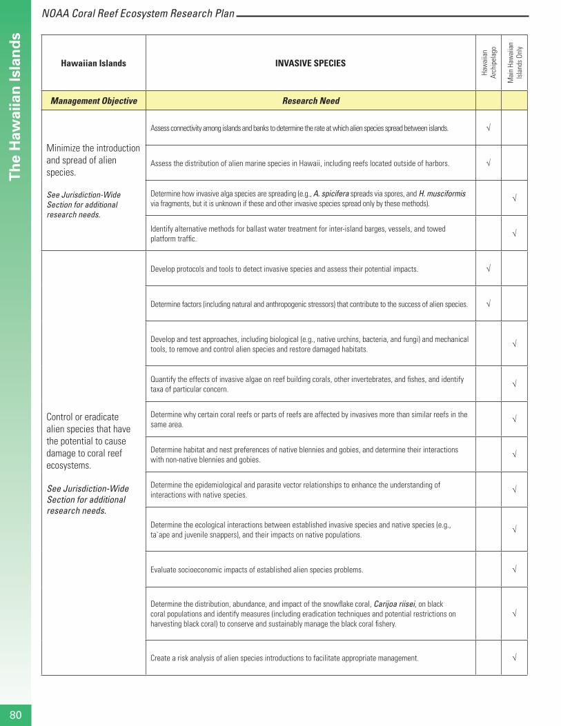
Hawaiian Islands INVASIVE SPECIES
Haw
aiia
n Ar
chip
elag
o
Mai
n Ha
wai
ian
Isla
nds
Only
Management Objective Research Need
Minimize the introduction and spread of alien species.
See Jurisdiction-Wide Section for additional research needs.
Assess connectivity among islands and banks to determine the rate at which alien species spread between islands. √
Assess the distribution of alien marine species in Hawaii, including reefs located outside of harbors. √
Determine how invasive alga species are spreading (e.g., A. spicifera spreads via spores, and H. musciformis via fragments, but it is unknown if these and other invasive species spread only by these methods).
√
Identify alternative methods for ballast water treatment for inter-island barges, vessels, and towed platform traffic.
√
Control or eradicate alien species that have the potential to cause damage to coral reef ecosystems.
See Jurisdiction-Wide Section for additional research needs.
Develop protocols and tools to detect invasive species and assess their potential impacts. √
Determine factors (including natural and anthropogenic stressors) that contribute to the success of alien species. √
Develop and test approaches, including biological (e.g., native urchins, bacteria, and fungi) and mechanical tools, to remove and control alien species and restore damaged habitats.
√
Quantify the effects of invasive algae on reef building corals, other invertebrates, and fishes, and identify taxa of particular concern.
√
Determine why certain coral reefs or parts of reefs are affected by invasives more than similar reefs in the same area.
√
Determine habitat and nest preferences of native blennies and gobies, and determine their interactions with non-native blennies and gobies.
√
Determine the epidemiological and parasite vector relationships to enhance the understanding of interactions with native species.
√
Determine the ecological interactions between established invasive species and native species (e.g., ta`ape and juvenile snappers), and their impacts on native populations.
√
Evaluate socioeconomic impacts of established alien species problems. √
Determine the distribution, abundance, and impact of the snowflake coral, Carijoa riisei, on black coral populations and identify measures (including eradication techniques and potential restrictions on harvesting black coral) to conserve and sustainably manage the black coral fishery.
√
Create a risk analysis of alien species introductions to facilitate appropriate management. √

81
NOAA Coral Reef Ecosystem Research Plan
Th
e H
awai
ian
Isla
nd
s
Hawaiian Islands CLIMATE CHANGE
Haw
aiia
n Ar
chip
elag
o
Mai
n Ha
wai
ian
Isla
nds
Only
Management Objective Research Need
Minimize the effects of climate change on coral reef ecosystems.
See Jurisdiction-Wide Section for additional research needs.
Assess the resistance and resilience of specific populations, locations, and habitats to episodic events (e.g., coral bleaching), emphasizing areas that may serve as sources of reproductive propagules.
√
Improve the capacity to forecast and respond to bleaching events.
Develop a predicative capability to identify potential impacts of climate change. √
Develop response protocols to mitigate and reduce damage to coral reefs from stressors during bleaching events
√
Assess the extent and severity of bleaching in Hawaiian waters. √
Hawaiian Islands EXTREME EVENTS
Haw
aiia
n Ar
chip
elag
o
Mai
n Ha
wai
ian
Isla
nds
Only
Management Objective Research Need
Identify causes and consequences of diseases in coral reef ecosystems and mitigate their impacts.
See Jurisdiction-Wide Section for additional research needs.
Characterize the types, distribution, and prevalence of diseases in coral reef ecosystems at sites included in the Hawaii’s monitoring program.
√
Determine links between coral disease and anthropogenic stressors (including fishing effort and marine recreational activities).
√
Develop protocols to assess community level changes through time following a coral disease outbreak. √
Reduce impacts to and promote restoration of coral reef organisms affected by extreme events.
Develop models to predict how increasing storms (in both number and severity) may alter the structure and distribution of reefs in Hawaii.
√

NOAA Coral Reef Ecosystem Research PlanT
he
Haw
aiia
n Is
lan
ds
82
Northwestern Hawaiian Islands
MANAgeMeNT goAl
Maintain ecosystem integrity by implementing ecosystem-based management principles.
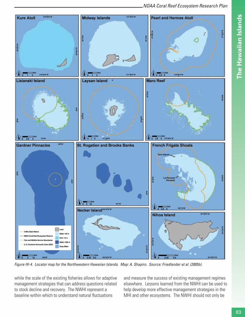
The NWHI consist of small islands, atolls, submerged banks, and reefs, and stretch for more than 2,000 km northwest of the high windward MHI (Figures HI-3 and HI-4). The majority of the islets and shoals remain uninhabited, although Midway, Kure, and Laysan Islands and French Frigate Shoals have all been occupied for extended periods over the last century by various government agencies.
With coral reefs around the world in decline, it is extremely rare to be able to examine a coral reef ecosystem that is relatively free of human influence and consisting of a wide range of healthy coral reef habitats. The remoteness and limited activities that have occurred in the NWHI have resulted in minimal anthropogenic impacts. The region
represents one of the few large-scale, intact, predator-dominated reef ecosystems remaining in the world and offers an opportunity to examine what could occur if larger, more effective no-take marine reserves are established elsewhere. The high proportion of endemic species and unique mix of tropical and sub-tropical assemblages has identified the NWHI as a global biodiversity hotspot. The NWHI are critically important to a number of wide-ranging species such as seabirds, turtles, monk seals, and sharks. Strong ecological linkages are provided by these and a few other organisms for the transfer of energy and nutrients among ecosystems.
The nearly pristine condition of the NWHI allows scientists to understand how unaltered ecosystems are structured, how they function, and how they can most effectively be preserved. The NWHI provide an unparalleled opportunity to assess how a “natural” coral reef ecosystem functions in the absence of major human intervention. These reefs consist of discrete ecological subunits that can be used as replicates to examine large-scale ecological processes,
Figure HI-3. The Northwestern Hawaiian Islands, which extend across the north central Pacific, represent a vast, remote coral eco-system that has been subjected to relatively minimal anthropogenic impacts. Map: A. Shapiro. Source: Friedlander et al. (2005b).
83
NOAA Coral Reef Ecosystem Research Plan
Th
e H
awai
ian
Isla
nd
s
Figure HI-4. Locator map for the Northwestern Hawaiian Islands. Map: A. Shapiro. Source: Friedlander et al. (2005b).
while the scale of the existing fisheries allows for adaptive management strategies that can address questions related to stock decline and recovery. The NWHI represent a baseline within which to understand natural fluctuations
and measure the success of existing management regimes elsewhere. Lessons learned from the NWHI can be used to help develop more effective management strategies in the MHI and other ecosystems. The NWHI should not only be

NOAA Coral Reef Ecosystem Research PlanT
he
Haw
aiia
n Is
lan
ds
84
conserved for their intrinsic value, but also for their value to hedge against fisheries collapses and as a model for ecosystem-based management.7
To preserve and protect the NWHI for future generations, President Bush signed a Proclamation on June 15, 2006 creating the Northwestern Hawaiian Islands Marine National Monument (Bush 2006). The national monument was created to preserve access for Native Hawaiian cultural activities; provide for carefully regulated educational and scientific activities; enhance visitation in a special area around Midway Island; prohibit unauthorized access to the monument; phase out commercial fishing over a five-year period; and ban other types of resource extraction and dumping of waste.
Research Needs
The research needs described herein are for light-dependent coral reef ecosystems in the NWHI. This section was jointly developed by a working group consisting of NWHI resource managers and affiliated researchers, including the State of Hawaii, FWS, NOAA’s Pacific Islands Fisheries Science Center, NOAA’s National Marine Sanctuary Program, and
7 Introductory material was taken, with slight modifications, from Friedlander et al. (2005b).
the University of Hawaii. As a result of a working group process, it was determined that the format of this section should differ from the other regional sections in this document. Because of the remote nature of the NWHI, many of the threats and stressors that typically impact coral reef ecosystems are not present (e.g., coastal uses). To account for this, the format of the plan was modified. Also, only management objectives with associated research needs are included in the plan. This resulted in the removal of two important management objectives that need mentioning: outreach activities and improving coordination and collaboration among agencies, institutions, and scientists. Outreach activities, while generally not considered to be research, are pivotal to the implementation and success of management actions. Improving coordination and collaboration between agencies, institutions, and individual scientists conducting research in the Hawaiian Archipelago is critical to the success of this research plan, but clearly not a research priority. 89
8 While this research plan focuses on the shallow coral reef ecosystems in the NWHI, connectivity with the deep coral ecosystems has been documented. This connectivity is acknowledged in this plan by supporting ongoing research in the deep coral ecosystems of the NWHI.
9 As a re
NWHI An Ecosystem Approach9
Management Objective Research Need
Characterize NWHI shallow coral reef ecosystems and function.
Map, characterize, and assess coral reefs and their associated habitats.
Catalogue existing data sets, document current data collection programs, and assess the quality (e.g., statistical rigor) of these data/programs.
Describe species diversity, trophic structure, and associated dynamics (including habitat linkages with other ecosystem components) of coral reef ecosystems.
Characterize critical oceanographic factors that influence the distribution and abundance of biotic components of coral reef ecosystems.
Assess population replenishment and connectivity among islands, banks, and associated coral reef ecosystems.
Improve hydrodynamic, ecosystem, and resource assessment models that capture the dynamics, structure, and function at appropriate temporal and spatial scales.
Develop decision support analysis tools that incorporate the complexity, dynamics, and uncertainty associated with NWHI processes to assist managers in resource decision making processes.
Identify the distribution and occurrence of deepwater hermatypic coral reefs, including identification of the extent and distribution of these habitats at each island.

85
NOAA Coral Reef Ecosystem Research Plan
Th
e H
awai
ian
Isla
nd
s
NWHI An Ecosystem Approach9
Management Objective Research Need
Understand human impacts, natural variability, and episodic events.
Evaluate and assess impacts (direct and indirect) of human activities (e.g., recreational fishing, subsistence, research, and ecotourism) on coral reef ecosystems.
Understand the potential effects of coral disease on population dynamics, community structure, and ecosystem function.
Assess resistance and resilience of specific populations and locations habitats to episodic events (e.g., coral bleaching), emphasizing areas that may serve as sources of reproductive propagules.
Establish long-term monitoring programs that incorporate biotic and abiotic data to document and assess spatiotemporal changes in biota.
Document and remediate hazardous waste that poses a threat to fish, wildlife, or their habitats.
Maintain and, where appropriate, restore natural shallow coral reef ecosystems.
Identify and implement effective restoration, recovery, and remediation strategies to address human impacts, including marine debris accumulations, ship groundings, and hazardous waste.
Restore, where possible, anthropogenically degraded coral reef habitats that are important for sustaining vertebrate and invertebrate stocks.
Identify robust ecosystem-based management indicators that reflect trophic interactions, community composition, biodiversity, and other metrics of ecosystem status.
Identify robust metrics to assess coral reef ecosystems (e.g., biodiversity and other statistical measures of assemblage structure; biomass size spectra; and life history responses to keystone species such as apex predators) that are consistent with existing mandates.
Identify indicator species (i.e., those which are indicative of the overall condition of the ecosystem) and keystone species (i.e., those of importance in structuring the composition of the ecosystem) for use as monitoring tools.
Evaluate the effectiveness of MPAs as a management tool.
Assess the effectiveness of MPAs in conserving ecologically important species and their habitats.
Evaluate the costs and benefits of MPAs, including compensation or assistance programs for those displaced from these areas.
Assess the connectivity among MPAs within the NWHI and between adjacent ecosystems (e.g., Johnston Atoll).
Reduce the threat of alien species to shallow coral reef ecosystems in the NWHI.
Characterize biological and ecological requirements of specific alien species and develop effective prevention and eradication methods.
Conduct research to support the detection, removal, and control of alien species in coral reef ecosystems in the NWHI.
Protect, conserve, and enhance recovery of protected, threatened, and other key species.
Characterize the role of protected species (i.e., marine mammals, sea turtles, and birds) in coral reef ecosystems and the threats impacting these species, and develop measures to enhance their conservation.
9 As a result of a working group process, it was determined that an ecosystem-based approach would be more appropriate for the NWHI than a threat-based approach. Because of the remote nature of the NWHI, many of the threats and stressors that typically impact coral reef ecosystems are not present.

NOAA Coral Reef Ecosystem Research PlanC
om
mo
nw
ealt
h o
f th
e N
ort
her
n M
aria
na
Isla
nd
s
86
commonwealth oF the northern mariana islands
The 290 km long Mariana Islands Archipelago encompasses 14 islands of the U.S. Commonwealth of the Northern Mariana Islands (CNMI), the U.S. Territory of Guam, and numerous offshore banks (Figure CNMI-1). From a geological perspective, the islands can be divided into two groups: a southern and a northern island arc region. Although the islands of the older southern arc, which includes Rota, Tinian, Saipan, and Farallon de Mendinilla, are volcanic in origin, they are nearly all covered with uplifted limestone derived from coral reefs. The West Mariana Ridge is a series of seamounts, lying 145 to 170 km west of and parallel to the main island chains. The southern arc islands have the oldest and most developed reefs in CNMI, which are predominantly located along the western (leeward) sides. The majority of CNMI’s residents live on Rota, Tinian, and Saipan (the capital). The volcanic islands north of Saipan make up the northern island arc region. In general, limited modern reef development exists along this active arc, although recent surveys show numerous patches of extensive reef growth are found on Maug, Asuncion, Agrihan, Pagan, Alamagan, and Guguan. Although some of the islands north of Saipan have held small permanent and seasonal communities, most permanent residents were evacuated in 1981 after the eruption of Pagan. 10
Coral reef ecosystems in CNMI are, on the whole, in reasonably good condition. However, it must be recognized that coral reef ecosystems in CNMI cannot be realistically treated as a single entity since the geology, oceanography, ecological history, and human activities vary widely across the 14 islands and associated reef shoals and banks. Biological diversity, across coral reef taxa, is variable among islands and isolated reefs, with limited data indicating that offshore banks and reefs support lower diversity, probably due to lower habitat diversity.
Anthropogenic effects, such as nonpoint source pollution and fishing pressure, have clearly affected areas in proximity to the populated southern islands. Based on fisheries information, the northern islands and more distant banks and reefs appear to be in better condition than those closer to population centers. Environmental stressors such
10 It should be noted that residents have resettled several of the northern islands since 1981.
as volcanic ashfall, elevated sea surface temperature, and crown-of-thorns starfish, Acanthaster planci, predation have clearly had localized negative effects on coral reefs in the Marianas (Figure CNMI-2). Past military activity in the northern part of Tinian has had an impact on the condition of the island due to improper waste disposal, but current military activities have shown minimal damage to the coral reefs themselves.
Establishment of MPAs to serve as spawning stock areas and to ensure habitat integrity, not only for coral reef fish but for food organisms as well, may be the most effective management tool available to maintain levels of spawning stock biomass necessary to replenish or sustain coral reef fisheries. In 1994, the first no-take MPA was established in CNMI at Sasanhaya Bay Fish Reserve in Rota. In the late 1990s, a bill was introduced to create two additional MPAs – Tinian Marine Sanctuary (Tinian Island) and Managaha Marine Conservation Area (Saipan Lagoon). The Managaha Marine Conservation Area was established by law in 2000, but the Tinian Marine Sanctuary has yet to be created.11
11 Introductory material was taken, with slight modifications, from Starmer et al. (2002, 2005).
Figure CNMI-2. Crown-of-thorns starfish, Acanthaster planci, feeding on live coral adjacent to an artificial reef. Photo credit: James P. McVey, NOAA Sea Grant Program.

87
NOAA Coral Reef Ecosystem Research Plan
Co
mm
on
wea
lth
of
the
No
rth
ern
Mar
ian
a Is
lan
ds
Figure CNMI-1. Locator map for the Commonwealth of the Northern Marianas Islands. (See Figure 5 for geographical context.) Map: A. Shapiro. Source: Starmer (2005).

NOAA Coral Reef Ecosystem Research PlanC
om
mo
nw
ealt
h o
f th
e N
ort
her
n M
aria
na
Isla
nd
s
88
Research Needs
CNMI FISHING
Management Objective Research Need
Conserve and manage fisheries to prevent overfishing, rebuild stocks, and minimize destructive fishing.
See Jurisdiction-Wide Section for additional research needs.
Evaluate fishing effort and catch per unit effort in the Saipan Lagoon.
Conduct stock assessments in the Saipan Lagoon and other selected nearshore locations and compare to 2005 fish stock assessments to evaluate the effectiveness of the net ban.
Conduct a socioeconomic valuation of recreational and subsistence coral reef fisheries.
Determine the archipelago-wide population status of managed reef species using fishery dependent and independent programs.
Establish the home ranges of key target or indicator species.
Evaluate and improve the effectiveness of MPAs as a fisheries management tool.
See Jurisdiction-Wide Section for additional research needs.
Evaluate the impact of establishing a user fee structure for MPAs and fishing activities based upon willingness to pay and economic valuations of uses and users.
Increase fishers’ participation in fisheries management.
Evaluate the current level of participation by fishers in fisheries management and determine the desired level of participation to best manage fisheries.
Document historical and cultural knowledge of CNMI coral reef resources and their ecology, and their historical trends in abundance, size, distribution, and community composition.
CNMI POLLUTION
Management Objective Research Need
Reduce the impacts of pollutants on coral reef ecosystems by improving the understanding of their effects.
See Jurisdiction-Wide Section for additional research needs.
Identify the effects of pollution and other anthropogenic factors on CNMI’s coral reef ecosystems.
Determine the concentration and impacts of pollutants on nearshore water quality between Taga Beach and Barcinas Bay on Tinian.
Evaluate the ability of monitoring programs to detect ecosystem change associated with land-based pollutants.
Identify the sources and impacts of pollutants (e.g., sewer outfalls, Puerto Rico dump site, and golf courses) on coral reef condition.
Improve water quality by reducing land-based pollutant inputs and impacts on coral reef ecosystems.
See Jurisdiction-Wide Section for additional research needs.
Develop and test methods for improving water quality.
Model the impacts of land-use activities on nearshore water quality to predict the efficiency of various management schemes.
Identify appropriate methods and plants for Talakaya watershed to stabilize soil and provide a habitat conducive to the restoration of the native terrestrial ecosystem.
Assess effectiveness of revegetation in reducing soil erosion in Talakaya watershed.
Evaluate effectiveness of management actions to restore (and in some cases create) mangrove and wetland areas to reduce and-based pollutants.
Improve the understanding of the economic benefits of improved water quality.
Identify reasons for low stakeholder participation in management opportunities and means to increase support.

89
NOAA Coral Reef Ecosystem Research Plan
Co
mm
on
wea
lth
of
the
No
rth
ern
Mar
ian
a Is
lan
ds
CNMI COASTAL USES
Management Objective Research Need
Reduce the impacts from recreational use, industry, coastal development, and maritime vessels on coral reef ecosystems.
See Jurisdiction-Wide Section for additional research needs.
Develop criteria to use in the review of environmental assessments and environmental impact statements.
Determine resource base and human pressure (including land-based pollution and fishing pressure) trends in the northernmost islands.
Identify the environmental impacts associated with existing marine-related activities and user conflicts among these activities.
Assess the impacts from non-extractive activities on coral reef condition.
Evaluate the effectiveness of management measures to reduce pressures from coastal uses on CNMI’s coral reef ecosystems.
Balance resource use to minimize user conflicts, provide equitable uses, and ensure optimal benefits to present and future generations.
Conduct an economic valuation of coral reef ecosystems in CNMI.
Reduce impacts from and restore habitat damaged by vessel anchoring and groundings.
Assess the identity, location, condition, and ownership of derelict and grounded vessels and determine their impacts to assist in prioritizing vessel removal.
Restore injured and degraded coral reef habitats.
See Jurisdiction-Wide Section for additional research needs.
Evaluate the effectiveness of management actions to restore shoreline, sandy beach, and nearshore water quality.
Manage coral reef ecosystems and their uses in a holistic manner.
See Jurisdiction-Wide Section for additional research needs.
Compare the historical extent and condition of mangroves, grass beds, and coral reefs with their current status to determine if conservation measures are necessary.
Evaluate and improve the effectiveness of MPAs as a management tool.
See Jurisdiction-Wide Section for additional research needs.
Conduct specific valuation of the impact of MPAs on resident fishing populations.
Evaluate the effectiveness of current MPAs to protect the long-term stability of CNMI’s coral reef ecosystems.
Evaluate the impact of establishing a user fee structure for MPAs and fishing activities based upon users’ willingness to pay and economic valuations of uses.

NOAA Coral Reef Ecosystem Research PlanC
om
mo
nw
ealt
h o
f th
e N
ort
her
n M
aria
na
Isla
nd
s
90
CNMI INVASIVE SPECIES
Management Objective Research Need
Minimize the introduction and spread of alien species.
See Jurisdiction-Wide Section for research needs.
Control or eradicate invasive species that have the potential to cause damage to coral reef ecosystems.
Identify those species in CNMI waters with the potential for invasive behavior (e.g., Tilapia) and develop appropriate management plans for each species.
CNMI CLIMATE CHANGE
Management Objective Research Need
Minimize the effects of climate change on coral reef ecosystems.
See Jurisdiction-Wide Section for research needs.
CNMI EXTREME EVENTS
Management Objective Research Need
Identify causes and consequences of diseases in coral reef ecosystems and mitigate their impacts.
See Jurisdiction-Wide Section for additional research needs.
Determine the distribution, abundance, and types of coral diseases prevalent in CNMI and their impacts on coral reef condition.
Reduce the collateral impacts from harmful algal blooms on nearshore areas.
Assess the relative importance of ground water and surface water discharges in contributing to harmful algal blooms in Saipan.
Identify and reduce the negative impacts of Acanthaster planci.
Determine the ecological and economic impacts of Acanthaster planci populations and identify strategies to minimize outbreaks.

91
NOAA Coral Reef Ecosystem Research Plan
Gu
am
Guam
Guam, a U.S. territory located at 13o 28’ N, 144o 45’ E, is the southernmost island in the Mariana Archipelago (Figure GUAM-1). It is the largest island in Micronesia, with a land mass of 560 km2 and a maximum elevation of approximately 405 m. It is also the most heavily populated island in Micronesia with a population of about 164,000 people (est. July 2003). The northern portion of the island is relatively flat and consists primarily of uplifted limestone. The island’s principle source aquifer “floats” on denser sea water within the limestone plateau; and is recharged from rainfall percolating through surface soils (Guam Water Planning Committee 1998). The southern half of the island is primarily volcanic, with more topographic relief and large areas of highly erodible soils (Young 1988). This topography creates a number of watersheds throughout the southern areas which are drained by 96 rivers (Best and Davidson 1981).
The condition of Guam’s coral reefs (including fringing reefs, patch reefs, submerged reefs, offshore banks, and barrier reefs) varies considerably, depending on a variety of factors including geology, human population density, degree of coastal development, levels and types of marine resource uses, oceanic circulation patterns, and frequency of natural disturbances (e.g., typhoons and earthquakes). Many of Guam’s reefs have declined in health over the past 40 years. The average live coral cover on the fore reef slopes was approximately 50% in the 1960s (Randall 1971), but by the 1990s had dwindled to less than 25% live coral cover and only a few having over 50% live cover (Birkeland 1997). Still, in the past, Guam’s reefs have recovered after drastic declines. For example, an outbreak of the crown-of-thorns starfish, Acanthaster planci, in the early 1970s reduced coral cover in some areas from 50 to 60% to less than 1%. Twelve years later, greater than 60% live coral cover was recorded for these areas (Colgan 1987). A more distressing indicator of the condition of Guam’s coral reefs is the marked decrease in rates of coral recruitment.
Guam’s coral reefs are an important component of its tourism industry. The reefs and the protection that they provide make Guam a popular tourist destination for Asian travelers (70 to 80% from Japan). According to the Guam Economic Development Authority, the tourism industry accounts for up to 60% of the government’s annual revenues and provides more than 20,000 direct and indirect jobs. Guam hosted nearly 1 million visitors in 2003 (GVB 2004).
Traditionally, coral reef fishery resources formed a substantial part of the local Chamorro community’s diet and included finfish, invertebrates, and sea turtles (Amesbury and Hunter-Anderson 2003). Today, coral reef resources are both economically and culturally important. Reef fish, although somewhat displaced from the diet by westernization and declining stocks, are still found at the fiesta table and at meals during the Catholic Lenten season. Many of the residents from other islands in Micronesia continue to include reef fish as a staple part of their diet (Amesbury and Hunter-Anderson 2003). Sea cucumbers, sea urchins, mollusks, marine algae, and a variety of crustaceans are also eaten locally. In addition to the cash and subsistence value of edible fish and invertebrates, reef-related fisheries are culturally important as family and group fishing is a common activity in Guam’s coastal waters.
Over 10% of Guam’s coastline has been set aside in five Marine Preserves: Tumon Bay, Piti Bomb Holes, Sasa Bay, Achang Reef Flat, and Pati Point. The preserves were established by local law in 1997 in response to decreasing reef fish stocks, but were not fully enforced until 2001. Fishing activity is restricted in the preserves with limited cultural take permitted in three of the five areas. The preserves are complemented by the War in the Pacific National Historical Park; Ritidian NWR; the two Naval Ecological Reserve Areas, Orote and Haputo; and the Guam Territorial Seashore Park. While the five marine preserves are enforced, the other areas currently have limited management and enforcement. 12
12 Introductory material was taken, with slight modifications, from Porter et al. (2005).

NOAA Coral Reef Ecosystem Research PlanG
uam
92
Figure GUAM-1. Locator map for Guam. (See Figure 5 for geographical context.) Map: A. Shapiro. Source: Porter et al. (2005).

93
NOAA Coral Reef Ecosystem Research Plan
Gu
am
Research Needs
GUAM FISHING
Management Objective Research Need
Conserve and manage fisheries to prevent overfishing, rebuild stocks, and minimize destructive fishing.
See Jurisdiction-Wide Section for additional research needs.
Analyze fisheries stock assessment data, including creel surveys and in situ visual assessments, to determine the condition of different functional groups (e.g., herbivores, detritivores, and piscivores) and determine possible causes of any community shifts, if present.
Study the role of soft corals as reef fish habitat.
Evaluate and improve the effectiveness of MPAs as a fisheries management tool.
See Jurisdiction-Wide Section for additional research needs.
Evaluate the effectiveness of marine preserves in enhancing fish populations in adjacent areas (i.e., spillover) using inshore creel and participation surveys.
Assess, inside and outside MPAs, the relationship between herbivorous fishes and algal abundance, composition, chemical defense, and other environmental factors on Guam reef flats.
GUAM POLLUTION
Management Objective Research Need
Reduce the impacts of pollutants on coral reef ecosystems by improving the understanding of their effects.
See Jurisdiction-Wide Section for additional research needs.
Model water circulation patterns around reefs and adjacent inshore habitats.
Develop a digital watershed atlas for Guam.
Develop a GIS-based erosion potential model to estimate sediment delivery to estuarine and coral reef environments of southern Guam.
Determine the status of the waters found in each of Guam’s 20 watersheds.
Conduct primary screening for chemicals of environmental concern in Guam’s coastal waters.
Conduct screening for heavy metals in marine organisms in Pago Bay into which the Ordot Dump Watershed drains.
Evaluate the effectiveness of using soft corals as bioindicators of persistent contaminants in Guam’s coastal waters.
Improve water quality by reducing land-based pollutant inputs and impacts on coral reef ecosystems.
See Jurisdiction-Wide Section for additional research needs.
Study the effects of tree planting and erosion control measures in reducing pollution from Fouha Watershed.

NOAA Coral Reef Ecosystem Research PlanG
uam
94
GUAM COASTAL USES
Management Objective Research Need
Reduce the impacts from recreational use, industry, coastal development, and maritime vessels on coral reef ecosystems.
See Jurisdiction-Wide Section for additional research needs.
Characterize and assess the major threats to and use of Guam’s coast.
Conduct an assessment of all recreational activities along Guam’s coastline and their effects on coral reef ecosystems, including seagrass beds.
Determine the effects of motorized personal watercraft on coral reef ecosystems.
Evaluate the effectiveness of the implementation of the New Seashore Reserve Plan.
Determine the effectiveness of the existing public awareness and outreach materials and programs.
Balance resource use to minimize user conflicts, provide equitable uses, and ensure optimal benefits to present and future generations.
Expand Guam’s coral reef valuation study to better capture the value of the coral reef to Guam’s traditions and culture.
Assess the societal costs of coral reef ecosystem degradation.
Conduct a feasibility study of instituting a recreational user fee for management and monitoring parameters.
Restore injured and degraded coral reef habitat.
See Jurisdiction-Wide Section for additional research needs.
Assess the effectiveness of coral restoration efforts that are coupled with watershed restoration, MPA designation, and pollution abatement programs.
Protect, conserve, and enhance the recovery of protected, threatened, and other key species.
Characterize the role of protected species (i.e., marine mammals, sea turtles, and birds) in coral reef ecosystems and the threats impacting these species, and develop measures to enhance their conservation.
Manage coral reef ecosystems and their uses in a holistic manner.
See Jurisdiction-Wide Section for additional research needs.
Characterize the size, condition, productivity, and seasonal changes in seagrass beds and impacts associated with human activities.
Evaluate and improve the effectiveness of MPAs as a management tool.
See Jurisdiction-Wide Section for additional research needs.
Conduct a study of the non-extractive value of icon species in marine preserves.
Assess the connectivity and replenishment among the offshore banks and the island of Guam with particular attention to the role of marine preserves.
Identify additional protections needed to provide long-term stability and resilience of Guam’s coral reef ecosystems.
Assess socioeconomic factors influencing the effectiveness of Guam’s MPAs.

95
NOAA Coral Reef Ecosystem Research Plan
Gu
amGUAM INVASIVE SPECIES
Management Objective Research Need
Control or eradicate alien and native invasive species that have the potential to cause damage to coral reef ecosystems.
See Jurisdiction-Wide Section for additional research needs.
Develop protocols and tools to control the growth of the native green alga, Enteromorpha clathrata, in the intertidal zone of Tumon Bay and East Agana Bay.
Assess the population and distribution of the native invasive red algae, Gracilaria salicornia and Acanthophora spicifera, in Pago Bay and in reefs of Tumon Bay, East Agana Bay, and Cocos Lagoon; and develop protocols and tools to control the growth of the algae.
GUAM CLIMATE CHANGE
Management Objective Research Need
Minimize the effects of climate change on coral reef ecosystems.
See Jurisdiction-Wide Section for additional research needs.
Assess and quantify the impacts of bleaching on corals during and after bleaching events.
Identify areas to protect to ensure long-term stability of coral reef ecosystems.
GUAM EXTREME EVENTS
Management Objective Research Need
Identify causes and consequences of diseases in coral reef ecosystems and mitigate their impacts.
See Jurisdiction-Wide Section for additional research needs.
Conduct a baseline assessment of coral diseases.
Establish a protocol for rapidly identifying, assessing, and mitigating disease epizootics, bleaching episodes, and predator outbreaks.
Reduce the occurrence and intensity of harmful algal blooms.
Investigate the relationship between cyanobacteria, pollution, and reef condition, including elements (e.g., nutrients, iron, and temperature) which may trigger or cause cyanobacterial blooms.

NOAA Coral Reef Ecosystem Research PlanA
mer
ican
Sam
oa
96
american samoa
American Samoa is a U.S. Territory located approximately 4,200 km south of Hawaii (Figure AMSAM-1). It is the only U.S. jurisdiction in the South Pacific. American Samoa comprises seven islands (five volcanic islands and two coral atolls) with a combined land area of approximately 200 km2. The five volcanic islands, Tutuila, Aunu’u, Ofu, Olosega, and Ta’u, are the major inhabited islands of American Samoa. Tutuila, the largest island, is also the center of government and business. Rose Atoll is uninhabited, while Swains Island is inhabited by a subsistence population (of about 10 people). Due to the steepness of the main islands, shallow water habitats around the islands are limited and consist primarily of fringing coral reefs (85% of total coral reef area) with a few offshore banks (12%) and two atolls (3%). The fringing reefs have narrow reef flats (50 to 500 m); depths of 1000 m are reached within 2 to 8 km from shore.
Coral reefs in American Samoa provide an important source of food for villagers through daily subsistence use and sales at local stores. They also provide infrastructure and shoreline protection from storm wave action, and are important to the Samoan culture. Other potential uses of the reefs are low at present (e.g., tourism or the aquarium trade).
In recent years, the corals have demonstrated considerable resilience following a series of natural disturbances, including four hurricanes in the past 18 years, a devastating crown-of-thorns starfish, Acanthaster planci, invasion in 1978, and several recent bleaching events. Following each disturbance, the corals eventually recovered and grew to maintain the structural elements of the reefs. However, because serious fishing pressure has occurred, the Territory’s coral reef ecosystem cannot be considered healthy based on the resilience of the corals alone. Furthermore, climate change impacts (e.g., coral bleaching and disease) are becoming increasingly apparent and pose a major, repetitive impact to the structure and function of local reefs. Additionally, the Territory’s high population growth rate (2.1% per year) continues to strain the environment with issues such as extensive coastal alterations, fishing pressure, loss of wetlands, soil erosion and coastal sedimentation, solid and hazardous waste disposal, and pollution.
American Samoa has several MPAs, three Federal, one territorial, and several village-managed. Rose Atoll is designated as a NWR under the joint jurisdiction of the FWS and the Department of Commerce in cooperation with the Territory of American Samoa (WPRFMC 2001). Fagatele Bay National Marine Sanctuary encompasses a small embayment, and the National Park of American Samoa administers land and coral reef areas on four islands. The territory has also established Ofu Vaoto Marine Park. For the past three years, several villages have instituted community-based fisheries management regimes, banning fishing in part or all of their adjacent reef. Each village writes its own fisheries management plan with the assistance of the American Samoa Department of Marine and Wildlife Resources, but the primary goal overall is to enhance fisheries resources on the reefs. Territorial coordination of coral reef decision-making resides with the Coral Reef Advisory Group, a collaboration of Federal and territorial agencies including NOAA, DOI, the local Department of Commerce and the local Department of Marine and Wildlife Resources, American Samoa Environmental Protection Agency, and the American Samoa Community College’s Sea Grant Program. 1314
13 Introductory material was taken, with slight modifications, from Craig (2002) and Craig et al. (2005).

97
NOAA Coral Reef Ecosystem Research Plan
Am
eric
an S
amo
a
Figure AMSAM-1. Locator map for American Samoa. (See Figure 5 for geographical context.) Map: A. Shapiro. Source: Craig et al. (2005).

NOAA Coral Reef Ecosystem Research PlanA
mer
ican
Sam
oa
98
Research Needs
American Samoa FISHING
Management Objective Research Need
Conserve and manage fisheries to prevent overfishing, rebuild stocks, and minimize destructive fishing.
See Jurisdiction-Wide Section for additional research needs.
Determine sustainable harvest levels and fishing limits for the various fisheries.
Assess the socioeconomic and biological implications of the recent ban on scuba spearfishing.
Assess the impact of harvest in subsistence, artisanal, and export fisheries.
Evaluate aquaculture projects that minimize impacts to habitats, fishery stocks, and existing fishing communities. 14
Assess the cost and benefits of aquaculture of local organisms with regard to their ease of production, economic potential (for local markets and export), and environmental impact.
Conduct a socioeconomic survey to determine the level of acceptance of aquaculture products in the local market, appropriate products and potential economic returns, and interest levels of potential aquaculture farmers.
Evaluate a demonstration aquaculture facility(s) that promotes environmentally-friendly culture systems (e.g., green water tank culture and aquaponics) that can be used for training, education, and research.
American Samoa POLLUTION
Management Objective Research Need
Reduce the impacts of pollutants on coral reef ecosystems by improving the understanding of their effects.
See Jurisdiction-Wide Section for additional research needs.
Clarify the role of pollution in causing degradation of coral reef ecosystems.
Evaluate the ability of monitoring programs to detect ecosystem change associated with inputs of land-based pollutants.
Develop a circulation model for the main islands in the territory, including nearshore waters.
Improve water quality by reducing land-based pollutant inputs and impacts on coral reef ecosystems.
See Jurisdiction-Wide Section for additional research needs.
Analyze and evaluate coral reef condition and water quality of reef sites adjacent to selected watersheds to help determine the efficacy of the nonpoint source program.
Develop criteria to use in the review of environmental assessments and environmental impact statements.
Identify potential modifications to water and sewer facilities and evaluate their effectiveness in preventing cyclones from spilling contaminants into nearshore waters.
14 While managers and scientists in American Samoa take a cautious view of aquaculture, based on negative experiences elsewhere and the industry’s potential to harm coral reef ecosystems, the Territory’s homogenous economic base makes it attractive to small-scale aquaculture ventures similar to those found elsewhere in tropical areas. It has therefore been recognized that management-driven research, while not currently a priority, may be desired on an as-needed basis in the future.

99
NOAA Coral Reef Ecosystem Research Plan
Am
eric
an S
amo
a
American Samoa COASTAL USES
Management Objective Research Need
Reduce the impacts from recreational use, industry, coastal development, and maritime vessels on coral reef ecosystems.
See Jurisdiction-Wide Section for additional research needs.
Evaluate the effectiveness of land use permits aimed to mitigate impacts on adjacent reefs.
Quantify soil erosion resulting from coastal development on steep volcanic soils and associated impacts to coral reef ecosystems.
Evaluate and update BMPs for watersheds.
Restore injured and degraded coral reef habitat.
See Jurisdiction-Wide Section for research needs.
Reduce rapid population growth in American Samoa.
Evaluate social, economic, and population impacts on coral reef ecosystems and model the future of these ecosystems with continued population growth.
Evaluate and improve the effectiveness of MPAs as a management tool.
See Jurisdiction-Wide Section for research needs.
American Samoa INVASIVE SPECIES
Management Objective Research Need
Minimize the introduction and spread of alien species.
See Jurisdiction-Wide Section for research needs.
American Samoa CLIMATE CHANGE
Management Objective Research Need
Minimize the effects of climate change on coral reef ecosystems.
See Jurisdiction-Wide Section for additional research needs.
Identify populations or communities that have endogenous factors which make them less susceptible to the effects of climate change.
American Samoa EXTREME EVENTS
Management Objective Research Need
Identify causes and consequences of diseases in coral reef ecosystems and mitigate their impacts.
See Jurisdiction-Wide Section for research needs.

NOAA Coral Reef Ecosystem Research PlanU
.S. P
acifi
c R
emo
te In
sula
r A
reas
100
u.s. PaciFic remote insular areas
The U.S. has sovereign Federal jurisdiction over eight low coral islands, atolls, and reefs in the central Pacific that are not under the control of other U.S. territories or states. They are Rose Atoll (see American Samoa Section’s Figure AMSAM-1), at the east end of American Samoa; Wake Atoll, north of the Marshall Islands; Johnston Atoll, southwest of the Hawaiian Islands; Kingman Reef, Palmyra Atoll, and Jarvis Island, all in the northern Line Islands; and Howland Island and Baker Island, northwest of the Phoenix Islands (Figure PRIA-1). The U.S. Pacific Remote Insular Areas (PRIAs) span latitudes from 19°N to 14°S, include three islands on the Equator, and serve as natural reef laboratories to monitor the effects of oceanic processes and climate over time and space because of minimal anthropogenic impacts. All of the PRIAs were free of human habitation at the time of their discovery by Americans and Europeans two centuries ago, although Rose and Wake Atolls have local island names (Nu‘u O Manu and Enen Kio, respectively) and were periodically visited by Samoans and Marshallese, respectively. These eight remain among the most remote and pristine coral reefs in the world.
All eight PRIAs except Wake Atoll are NWRs administered by the FWS, and are among the Nation’s most important MPAs. Rose Atoll is under the joint jurisdiction of the FWS and the Department of Commerce in cooperation with the Territory of American Samoa (WPRFMC 2001).15 Wake Atoll is under the jurisdiction of DOI and presently serves as a military base under the administration of the U.S. Air Force.
The PRIAs provide key habitats for many native species of plants, insects, birds, reptiles, marine mammals, and thousands of reef species. Many nationally and internationally recognized threatened, endangered, migratory, vulnerable, and depleted species thrive and are protected at the PRIAs, including the green turtle, hawksbill turtle, coconut crab, pearl oyster, giant clams, reef sharks, groupers, humphead wrasse, bumphead parrotfish, whales, and dolphins.
15 Note: Elements of the American Samoa regional sections of this plan may apply to Rose Atoll, if they are consistent or complementary to the research needs identified in this section.
Although historically spared of impacts that degrade reefs near more populated U.S. areas, these remote oceanic and reef ecosystems have suffered from a variety of human impacts since the mid 19th century, including guano mining, feather gathering, sea turtle harvest, alien species predation, fishing, temporary settlements, ship groundings, World War II era military occupation, and atmospheric missile and nuclear weapons testing. Remoteness was a blessing in past centuries, keeping these areas generally free of anthropogenic effects, but now they are the targets of fishers and trespassers beyond the watchful eye and reach of enforcement and surveillance authorities, and threatened by unauthorized harvests and the invasive species that accompany them (J. Maragos, personal communication). Derelict debris, ship groundings, fuel spills, hazardous/toxic waste, and climate change are additional impacts. Although the FWS has been successful in eradicating alien rats and cats from most PRIA refuges, rats and mice remain at Palmyra, and invasive ants and scale insects are now decimating rare beach forest stands at Rose and Palmyra.
Lagoon, reef, and island habitats at Palmyra, Wake, Johnston, and Baker still suffer from the residual effects of coastal construction and dumping of contaminants, toxics, and debris, exacerbating some of the adverse effects of climate change and degrading the resilience of resident species, populations, and habitats.
The remoteness of the PRIAs has also thwarted access to and scientific characterization of these areas, including terrestrial, shallow reef, and deep sea habitats surrounding the islands. Before NOAA-sponsored research cruises began in 2000, there was little information available for proper management, recovery of species, and restoration of habitats, especially in marine waters. Even today very little is known about marine habitats below diving depths of about 30 m. Scuba diving at the PRIAs is also constrained by the great distance to the nearest medical facilities, and scuba divers must emphasize safety and accident prevention via limitations on maximum depth, duration, and frequency of diving. Hence, future data collection must rely more on alternatives to scuba, especially remote sensing data collection. Moreover, FWS terrestrial wildlife biologists, coral reef biologists, and ecotoxicologists have relied on NOAA research vessels and the U.S. Coast Guard to provide access to evaluate, monitor, and restore wildlife and habitats, which presently is the only reliable means of access to the PRIAs.

101
NOAA Coral Reef Ecosystem Research Plan
U.S
. Pac
ific
Rem
ote
Insu
lar
Are
as
Figure PRIA-1. Locator map for the U.S. Pacific Remote Insular Areas. (See Figure 5 for geographical context.) Map: A. Shapiro. Source: Brainard et al. (2005).

NOAA Coral Reef Ecosystem Research PlanU
.S. P
acifi
c R
emo
te In
sula
r A
reas
102
1� Note: commercial fishing is prohibited within the eight remote Pacific NWRs.17 Researchers working at Palmyra Atoll should consult with the FWS, NOAA, the Western Pacific Regional Fishery Management Council, The Nature Conservancy, and researchers at Scripps Institution of Oceanography.
The research needs for the PRIAs address the issues of reduced access, surveillance, enforcement, research, monitoring and management capacity, and takes advantage of NOAA research vessels, satellites, bathymetric mapping platforms, oceanographic buoys, instrumentation, remotely
operated and towed vehicles, deep-diving submersibles, and other NOAA assets to address these deficiencies in a spirit of cooperation with FWS, DOI, the U.S. Department of Defense, and other collaborating institutions.1617
Research Needs
U.S. Pacific Remote Insular Areas FISHING
Management Objective Research Need
Conserve and manage fisheries to prevent overfishing, rebuild stocks, and minimize destructive fishing. 16
See Jurisdiction-Wide Section for additional research needs.
Determine the natural fluctuation of fishery species in the PRIAs to enable comparison with exploited populations outside the NWRs.
Compare fishery-independent assessments of species in the Samoan archipelago to non-fished stocks at no-take Rose Atoll NWR.
Evaluate the feasibility of the low-level, catch-and-release recreational bone-fishery at Palmyra NWR17 and recommend measures to sustain the fishery.
Assess the recovery of fish populations at Johnston Atoll NWR since closure of the recreational fishery in 2004 when the U.S. military abandoned its presence at the atoll.
Evaluate and improve the effectiveness of MPAs as a fisheries management tool.
See Jurisdiction-Wide Section for additional research needs.
Develop and establish visual and sonic sensors that can be remotely activated and monitored via satellite to document and discourage unauthorized access and harvest of fish and wildlife resources within the no-take PRIAs, and for application to manage fisheries outside refuges.
Assess targeted fishery species within and outside refuges to demonstrate the values of no-take areas in replenishing overfished stocks outside the refuges.
U.S. Pacific Remote Insular Areas POLLUTION
Management Objective Research Need
Reduce the impacts of pollutants on coral reef ecosystems by improving the understanding of their effects.
See Jurisdiction-Wide Section for additional research needs.
Characterize the ecological impacts of land-based discharges on lagoon water quality at Palmyra Atoll NWR, and evaluate potential ecological benefits of restoration alternatives.
Improve water quality by reducing land-based pollutant inputs and impacts on coral reef ecosystems.
See Jurisdiction-Wide Section for additional research needs.
Determine the need for remediation of contaminants (i.e., unexploded ordnance, fuel spills, other toxic and hazardous waste, material disposal, and historic sewage discharges in lagoon, reef, and coastal areas) on Johnston, Palmyra, and Baker NWRs, and at Wake Atoll.
Evaluate the impacts of pollutants at Palmyra, Johnston, Midway, and Baker NWRs, and at Wake Atoll, and evaluate the efficacy of alternative measures to restore habitats.
Assess, model, and monitor planned restoration of water quality and circulation within the lagoon at Palmyra Atoll NWR degraded by World War II military construction.

103
NOAA Coral Reef Ecosystem Research Plan
U.S
. Pac
ific
Rem
ote
Insu
lar
Are
as
U.S. Pacific Remote Insular Areas POLLUTION
Management Objective Research Need
Monitor coral reef condition to understand and address unexpected changes or events related to land-based and atmospheric pollution.
Implement a detailed monitoring program, in collaboration with FWS at the eight NWRs and Department of Defense and DOI at Wake Atoll, including multiple depth regimes and permanently-marked sites to determine the impact of previous disturbances and characterize future changes.
U.S. Pacific Remote Insular Areas COASTAL USES
Management Objective Research Need
Assess the impacts from former recreational use and coastal development on coral reefs.
Assess lagoon and shoreline impacts attributed to World War II era military construction on Johnston and Wake Atolls, and evaluate the efficacy of possible remedial measures.
Balance resource use to minimize user conflicts, provide equitable uses, and ensure optimal benefits to present and future generations.
Provide data to support the preparation and coordination of comprehensive conservation plans by the FWS for the eight PRIAs refuges.
Reduce impacts from and restore habitat damaged by vessel anchoring and groundings.
Evaluate the use of deep sea in situ assets to survey possible shipwreck sites at Baker and other PRIAs.
Develop a response plan with the FWS and U.S. Coast Guard to conduct initial damage assessments of fuel spills and ship groundings in the NWRs.
Assess the impacts of fuel spills and ship groundings on PRIA reefs during and after shipwreck removal and other restoration actions.
Assess the ecosystem recovery after the completion of wreckage removal in 2005 of a 1993 fishing vessel grounding offshore at Rose Atoll.
Assess the ecosystem recovery of the 1991 fishing vessel grounding at Palmyra Atoll.
Protect, conserve, and enhance the recovery of protected, threatened, and other key species.
Conduct research aimed at the protection, conservation, and recovery of protected species (i.e., marine mammals, sea turtles, and birds) that utilize coral reef ecosystems.
Restore injured and degraded coral reef habitats.
See Jurisdiction-Wide Section for additional research needs.
Evaluate the deep sea World War II era dumping of military material off Baker Island NWR, and possibly off other refuges.
Manage coral reef ecosystems and their uses in a holistic manner.
See Jurisdiction-Wide Section for additional research needs.
Describe species diversity, trophic structure, and associated dynamics of shallow coral reef ecosystems in the eight islands in the PRIAs.

NOAA Coral Reef Ecosystem Research PlanU
.S. P
acifi
c R
emo
te In
sula
r A
reas
104
U.S. Pacific Remote Insular Areas INVASIVE SPECIES18
Management Objective Research Need
Minimize the introduction and spread of alien species.
See Jurisdiction-Wide Section for research needs.
Control or eradicate invasive species that have potential to cause damage to coral reef ecosystems.
Document the diversity, distribution, and abundance of invasive species, identify impacts on coral reef ecosystems, and identify ways to prevent their spread.
U.S. Pacific Remote Insular Areas CLIMATE CHANGE
Management Objective Research Need
Minimize the effects of climate change on coral reef ecosystems.
See Jurisdiction-Wide Section for additional research needs.
Collect and analyze coral cores for past climatic events, and conduct assessments to identify active coral bleaching events denoting bleached vs. non-bleached species.
Mitigate the impacts from climate change on coral reef ecosystems.
Restore lagoonal circulation at Palmyra degraded by World War II construction and track the ability of these actions at preventing a repeat of the massive bleaching event and coral die-off on the western terrace that was associated with the discharge of heated lagoonal waters.
Model the effectiveness of various measures to maximize lagoon circulation and flushing at Palmyra and reduce water residence time in the lagoon to reduce heating of lagoon waters before exiting the lagoon.
U.S. Pacific Remote Insular Areas EXTREME EVENTS
Management Objective Research Need
Identify causes and consequences of diseases in coral reef ecosystems and mitigate their impacts.
See Jurisdiction-Wide Section for additional research needs.
Evaluate the impacts of episodic wave events and the role of these events in forming and maintaining spatial and vertical distributions of corals, algae, and fishes.
Characterize the prevalence of disease, and document affected species and the types of diseases present at each site to serve as a baseline.
18
18 To prevent introduction of alien species during research activities in the PRIAs, the hulls of NOAA research ships should be scrubbed and cleaned of fouling organisms just prior to departure to the PRIAs. Also, scuba gear should be decontaminated when diving in different areas to prevent introduction of pathogens.
105
NOAA Coral Reef Ecosystem Research Plan
Pac
ific
Free
ly A
sso
ciat
ed S
tate
sPaciFic Freely associated states
The Pacific Freely Associated States include the Republic of the Marshall Islands (the Marshalls), the Federated States of Micronesia (FSM), and the Republic of Palau (Palau). These islands are all independent countries that at one-time were governed by the U. S. as part of the Trust Territory of the Pacific Islands after World War II. Although these countries are independent, they still maintain close ties with the U.S. and are eligible to receive funds from U.S. Federal agencies, including NOAA, DOI, EPA, and the National Science Foundation.
The coral reef resources of these islands remain mostly unmapped.
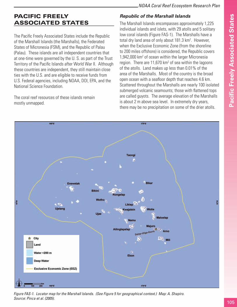
Republic of the Marshall Islands
The Marshall Islands encompasses approximately 1,225 individual islands and islets, with 29 atolls and 5 solitary low coral islands (Figure FAS-1). The Marshalls have a total dry land area of only about 181.3 km2. However, when the Exclusive Economic Zone (from the shoreline to 200 miles offshore) is considered, the Republic covers 1,942,000 km2 of ocean within the larger Micronesia region. There are 11,670 km2 of sea within the lagoons of the atolls. Land makes up less than 0.01% of the area of the Marshalls. Most of the country is the broad open ocean with a seafloor depth that reaches 4.6 km. Scattered throughout the Marshalls are nearly 100 isolated submerged volcanic seamounts; those with flattened tops are called guyots. The average elevation of the Marshalls is about 2 m above sea level. In extremely dry years, there may be no precipitation on some of the drier atolls.
Figure FAS-1. Locator map for the Marshall Islands. (See Figure 5 for geographical context.) Map: A. Shapiro. Source: Pinca et al. (2005).

NOAA Coral Reef Ecosystem Research PlanP
acifi
c Fr
eely
Ass
oci
ated
Sta
tes
106
Tropical storms (typhoons) are relatively rare, but can be devastating. Lagoons within the atolls typically have at least one deep-pass access; however, some, such as Namdrik, have no natural passes.
In general, the reefs of the Marshalls are in good condition and have experienced minimal damage from bleaching, destructive fishing techniques, and sedimentation. Even those in the former nuclear test sites show remarkable recovery, although many of the larger bomb craters may not fill in for years, if at all. However, there is some evidence of unsustainable resource exploitation – the largest giant clams have been harvested and the current take of grouper, reef shark, and Napoleon wrasse may not be sustainable. The reefs near the urban areas of Majuro are stressed, but still have an abundance of fish and invertebrates. Localized outbreaks of crown-of-thorns starfish, Acanthaster planci, and coral disease were observed around Majuro in 2005. Recent information on the status of coral reefs of the Marshalls can be found in Maragos and Holthus (1999), Price and Maragos (2000), NBTRMI (2000), and Pinca et al. (2005).
The need to protect Marshallese marine resources stems from both a precautionary effort to conserve pristine reefs and a direct demand from local fishers who report a decline in target species for both commercial and local use. Lower abundance of clams, fish, lobsters, and cowry shells have been reported by local populations from the outer atolls. Marine reserves and other management measures are still in their infancy, but several atolls (Jaluit, Arno, Likiep, Mili, and Rongelap) are spearheading this effort. In 2000, the National Biodiversity Strategy and Action Plan (NBSAP) and the National Biodiversity Report were approved by the Cabinet. Both address the need for conservation and management of natural resources. The NBSAP recommends strengthening the concept of ‘mo’, a traditional system of taboo identifying certain areas as ‘pantries’ that could be harvested only periodically. The NBSAP also addressed the need for sustainable fishing practices and retention of local knowledge. 19
Federated States of Micronesia
The FSM is comprised of four states – from east to west, Kosrae, Pohnpei, Chuuk, and Yap. Along with Palau, these comprise the Caroline Islands (Figure FAS-2). Each island or group has its own language, customs, local government, and reef tenure system. FSM has high islands and low
19 Introductory material was taken, with slight modifications, from Pinca et al. (2005).
atolls, and a strong dependence on coral reefs and marine resources, both economically and culturally. Each state supports population centers on high volcanic islands surrounded by barrier reefs (Pohnpei, Chuuk) or very broad fringing reefs that are nearly barrier reefs (Kosrae, Yap). All states except Kosrae also include remote clusters of atolls and low coral islands (Maragos and Holthus 1999). Spalding et al. (2001) estimated total shallow water coral reef area off the FSM to be 5,440 km2. Kosrae is a single volcanic island with a landmass of 109 km2 and an elevation of 629 m. It is surrounded by a fringing reef and has a single harbor. The volcanic island of Pohnpei is the largest island in the FSM and is the FSM capitol. It has an area of 345 km2 with a well-developed barrier reef surrounding a narrow lagoon. It and the eight nearby coral islands and atolls make up the State of Pohnpei. Chuuk State (formerly known as Truk) has 15 inhabited volcanic and coral islands and atolls. Chuuk Lagoon is the largest atoll in the FSM and serves as the population and political center of Chuuk State. It is famous for the Japanese ships that were sunk in the lagoon during World War II. Yap State has a main volcanic island approximately 100 km2, along with 15 coral islands and atolls. The peoples inhabiting the offshore atolls and coral islands in Chuuk, Yap, and Pohnpei states are among the most traditional, with a highly sophisticated marine tenure and associated marine resource management system.
The condition of FSM coral reef ecosystems is generally good to excellent. Most of the reefs in the low islands are in excellent condition. The primary human impacts come from fishing, ship groundings, and coastal development (including dredging and filling). Sedimentation from dredging and road construction projects has resulted in localized reef destruction, including much of Okat. Construction of an airport on top of a broad reef at Okat has further damaged the reefs. On the island of Pohnpei, expansion of sakau cultivation (called kava in other cultures) has reduced rainforest cover by two-thirds, resulting in increased sedimentation on coastal reefs.
In the FSM, traditional leaders (chiefs or their equivalent) and community groups are active in traditional governance as well as western-style, democratically elected officials. This dual system provides opportunities and challenges to reef and marine resource protection. Over the past several years, Kosrae has begun to develop a MPA program that involves co-management of coastal resources between local communities and state resource

107
NOAA Coral Reef Ecosystem Research Plan
Pac
ific
Free
ly A
sso
ciat
ed S
tate
s
management agencies. Currently, Kosrae has four MPAs that are managed by government agencies and/or local communities. These are the Utwe-Walung Marine Park and three Areas of Special Concern: the Tukasungai (Trochus niloticus) Sanctuary (commonly referred to as the “Trochus Sanctuary”), the Giant Clam (Tridacna spp.) Sanctuary, and the Okat-Yela Mangrove Reserve. Chiefs and other traditional leaders usually control protection of specific areas. In Yap, the villages own the reefs and have authority over resource use. A number of the islands have areas set aside for reef protection and limited resource extraction, but currently the FSM lacks the enforcement capacity to protect the MPAs (A. Edward, pers. comm.). 20
20 Introductory material was taken, with slight modifications, from Hasurmai et al. (2005).
Republic of Palau
Palau, part of the Caroline Islands group, is the westernmost archipelago in Oceania, located 741 km east of Mindanao in the southern Philippines and about 1,300 km southwest of Guam (Figure FAS-3). Palau is composed of inhabited islands and 700+ islets, stretching 700 km from Ngeruangel Atoll in the Kayangel Islands in the north to Helen Reef in the south. The archipelago consists of a clustered island group (including Babeldaob, Koror, Peleiu, Angaur, Kayangel, Ngeruangel, and the Rock Islands) and six isolated islands (Helen Reef, Tobi, Merir, Pulo Anna, Sonsorol, and Fana) that lie approximately 339 to 599 km to the southwest (Figure FAS-4). Babeldaob, the second largest island in Micronesia after Guam, is the biggest island in the Palauan chain; however, the country’s capital and greatest population is located on Koror. The volcanic island of Babeldaob and its reefs are separated from Koror and the southern islands of the group by a deep (30 to 40 m), east-west pass called Toachel El Mid.
Figure FAS-2. Locator map for the Federated States of Micronesia. (See Figure 5 for geographical context.) Map: A. Shapiro. Source: Hasurmai et al. (2005).

NOAA Coral Reef Ecosystem Research PlanP
acifi
c Fr
eely
Ass
oci
ated
Sta
tes
108
Figure FAS-3. The nation of Palau is an archipelago in the Caroline Islands. Most Palauans reside in the cluster of the northern islands (see Figure FAS-4 for detail of main island group). (See Figure 5 for geographical context.) Map: A. Shapiro. Source: Golbuu et al. (2005).

109
NOAA Coral Reef Ecosystem Research Plan
Pac
ific
Free
ly A
sso
ciat
ed S
tate
sPalau has numerous island and reef types, including volcanic islands, atolls, raised limestone islands, and low coral islands. A barrier reef surrounds much of the main island cluster, from the northern tip of Babeldaob down to the southern lagoon, merging into the fringing reef with Peleliu in the south. Palau has the most diverse coral fauna of Micronesia and the highest density of tropical marine habitats of comparable geographic areas around the world.
Palau has already done a great deal toward limiting the impacts of tourists on reef resources. Mooring buoys, laws preventing the collection of corals, and diving tour operator education help conserve the culturally and economically important reef resources. The largest direct impact on some reef sites is now the volume of divers with varying levels of training. Increased sedimentation is another major threat to coral reef ecosystems worldwide (McCook et al. 2001; Wolanski and Spagnol 2000; Wolanski et al. 2003), and Palau is no exception. Sedimentation associated with runoff from coastal development poses a serious threat to reefs around Babeldaob. Foreign-based fishing activities are also a problem; poachers from Indonesia and the Philippines are frequently encountered on Helen’s Reef. Ship groundings have also been occurring off the main islands, as well as those in the south.
The Palau Ministry of Resources and Development has overlapping jurisdiction with each of Palau’s 16 state governments for all marine areas within 12 nm of the high tide watermark. National and state agencies, in coordination with locally based nongovernmental organizations, have put a variety of management tools in place to address issues such as fishing, recreational use, and land-based sources of pollution to protect the marine resources of Palau. Several MPAs have been established throughout Palau to provide measures of protection for marine resources tailored to the management goals and intended purpose of the individual MPAs. Most of Palau’s MPAs have been designated by the states and management of these areas falls under the authority of the local governments. In addition, there are MPAs designated by the national government for the purpose of protecting biodiversity and significant habitats. The designation of a MPA by the local governments is initiated by the implementation of a traditional moratorium, or ‘bul’, on the area, prohibiting all use for a restricted time period (usually one to three years). The majority of these MPAs were designated to address local concerns of decreased
commercial reef fish populations. Palau recently passed the Protected Areas Network Act of 2003 which provides a framework for the establishment of a MPA network in Palau. Much of the design, criteria, and regulations are still under development, and expertise and technical assistance are needed to assist in implementation.21
21 Introductory material was taken, with slight modifications, from Birkeland et al. (2002) and Golbuu et al. (2005).

NOAA Coral Reef Ecosystem Research PlanP
acifi
c Fr
eely
Ass
oci
ated
Sta
tes
110
Figure FAS-4. A detailed map of Palau’s main island cluster. Map: A. Shapiro. Source: Golbuu et al. (2005).

111
NOAA Coral Reef Ecosystem Research Plan
Pac
ific
Free
ly A
sso
ciat
ed S
tate
sResearch Needs
PACIFIC FREELY ASSOCIATED STATES FISHING Al
l
Repu
blic
of t
he M
arsh
all I
slan
ds
Fede
rate
d St
ates
of M
icro
nesi
a
Repu
blic
of P
alau
Management Objective Research Need
Conserve and manage fisheries to prevent overfishing of stocks, rebuild overfished stocks, and minimize destructive fishing.
See Jurisdiction-Wide Section for additional research needs.
Create benthic habitat maps that include fish-habitat associations to provide spatial framework for research and management activities.
√
Quantify the impacts of subsistence fishing on populations of fished species. √
Document traditional knowledge and evaluate its application to modern fisheries management. √
Determine sustainable harvest levels and fishing limits for the various fisheries. √
Examine how physical factors and biological components control the transport of fish and coral larvae around Palau.
√
Evaluate implications of recent fishery regulations including bans on spearfishing, gill, and drag nets; and seasonal and spatial closures on key reef species and on fishermen.
√
Evaluate and characterize marine ornamental fisheries and the role of aquaculture efforts in reducing impacts associated with the aquarium trade
√
Characterize live reef food fish fisheries (for Asian markets), including locations and species harvested, extent of cyanide use and illegal fishing, and impacts on target populations
Characterize the threat to coral reef ecosystems from commercial fishing and fishing gear. √ √
Determine catch per unit effort and trends in population structure of target fish species. √
Protect, conserve, and enhance the recovery of protected, threatened, and other key species.
Assess the abundance of harvested species, including clams, fish, lobsters, and cowry shells, in outer atolls to provide early warning of population declines and unsustainable harvest levels.
√
Evaluate and improve the effectiveness of MPAs as a fisheries management tool.
See Jurisdiction-Wide Section for additional research needs.
Evaluate the effectiveness of the Trochus and Giant Clam Sanctuaries in protecting these species from overfishing and in preventing logging and coastal development along sanctuary shorelines.
√

NOAA Coral Reef Ecosystem Research PlanP
acifi
c Fr
eely
Ass
oci
ated
Sta
tes
112
PACIFIC FREELY ASSOCIATED STATES POLLUTION Al
l
Repu
blic
of t
he M
arsh
all I
slan
ds
Fede
rate
d St
ates
of M
icro
nesi
a
Repu
blic
of P
alau
Management Objective Research Need
Reduce the impacts of pollutants on coral reef ecosystems by improving the understanding of their effects.
See Jurisdiction-Wide Section for additional research needs.
Quantify the impacts of the Majuro sewage outfall on adjacent coral reef resources, including coral recruitment rates, coral condition, and benthic cover.
√
Characterize the extent of nutrient and chemical leakage from septic tanks on Babeldaob Island.
√
Evaluate impacts of coastal construction (including ports, docks, airfields, causeways, and roads) on coral reef ecosystems, especially those that are proximate to human population centers (e.g., Majuro and Likiep).
√
Determine the water quality around the dump area and sewage outfall. √
Determine the water quality in primary watersheds with current and future development plans.
√
Quantify nutrient loads in key watersheds on Babeldaob Island. √
Improve water quality by reducing land-based pollutant inputs and impacts on coral reef ecosystems.
See Jurisdiction-Wide Section for additional research needs.
Evaluate the effectiveness of various management strategies to protect forested land on Babeldaob Island.
√
Manage land use in priority watersheds to significantly reduce land-based pollutants, particularly the clearing of upland rain forest areas for sakau farming.
√
Determine the water quality in primary watersheds with current and future development plans, and identify alternative management measures to reduce impacts; and determine their effectiveness.
√
Develop national and state land use plans covering terrestrial and marine systems in Palau. √
Assess coral reef ecosystem condition adjacent to and offshore from areas of coastal development to assist in prioritization of sites to receive new sewage treatment plants and waste disposal facilities.
√
PACIFIC FREELY ASSOCIATED STATES COASTAL USES Al
l
Repu
blic
of t
he M
arsh
all I
slan
ds
Fede
rate
d St
ates
of M
icro
nesi
a
Repu
blic
of P
alau
Management Objective Research Need
Reduce the impacts from recreational use, industry, coastal development, and maritime vessels on coral reef ecosystems.
See Jurisdiction-Wide Section for additional research needs.
Quantify the impact of development on marine resources and assess the transport of pollutants from these areas into the Rock Islands.
√
Evaluate BMPs for minimizing sedimentation associated with coastal development and changes in land use practices.
√
Assess impacts of motorboat fuel and antifouling paints on marine animal survivorship, including investigating gamete and larvae susceptibility.
√
Forecast the impacts of proposed development projects on nearshore water quality and circulation patterns.
√
Document sedimentation associated with dredging and road construction projects and its impacts on coral reef ecosystems.
√

113
NOAA Coral Reef Ecosystem Research Plan
Pac
ific
Free
ly A
sso
ciat
ed S
tate
s
PACIFIC FREELY ASSOCIATED STATES COASTAL USES Al
l
Repu
blic
of t
he M
arsh
all I
slan
ds
Fede
rate
d St
ates
of M
icro
nesi
a
Repu
blic
of P
alau
Management Objective Research Need
Reduce impacts from and restore habitat damaged by vessel anchoring and groundings.
Document vessel anchoring and groundings and determine their impact on coral reef ecosystems.
√
Document the impacts of grounded foreign long-line vessels on surrounding reefs and prioritize mitigation efforts.
√
Restore injured and degraded coral reef habitat.
See Jurisdiction-Wide Section for research needs. √
Evaluate and improve the effectiveness of MPAs as a management tool.
See Jurisdiction-Wide Section for additional research needs.
Determine which areas and resources might benefit the most from additional protection. √
Undertake marine eco-regional assessments to identify habitats and conservation targets, threats to these resources, and high priority areas for conservation including areas resistant and resilient to threats and spawning aggregation sites.
√
Develop criteria for designing networks of MPAs that include oceanographic parameters and ecological design principles.
√
Evaluate the effectiveness of the marine resource certification program in building local capacity for coral reef ecosystem stewardship.
√
PACIFIC FREELY ASSOCIATED STATES INVASIVE SPECIES Al
l
Repu
blic
of t
he M
arsh
all I
slan
ds
Fede
rate
d St
ates
of M
icro
nesi
a
Repu
blic
of P
alau
Management Objective Research Need
Minimize the introduction and spread of alien species.
See Jurisdiction-Wide Section for additional research needs.
Document the presence of marine alien invertebrates in Palau, including the hydroid Eudendrium cameum which has the potential for becoming a ‘pest’ organism in Palau. √
Control or eradicate invasive species that have the potential to cause damage to coral reef ecosystems.
See Jurisdiction-Wide Section for research needs. √
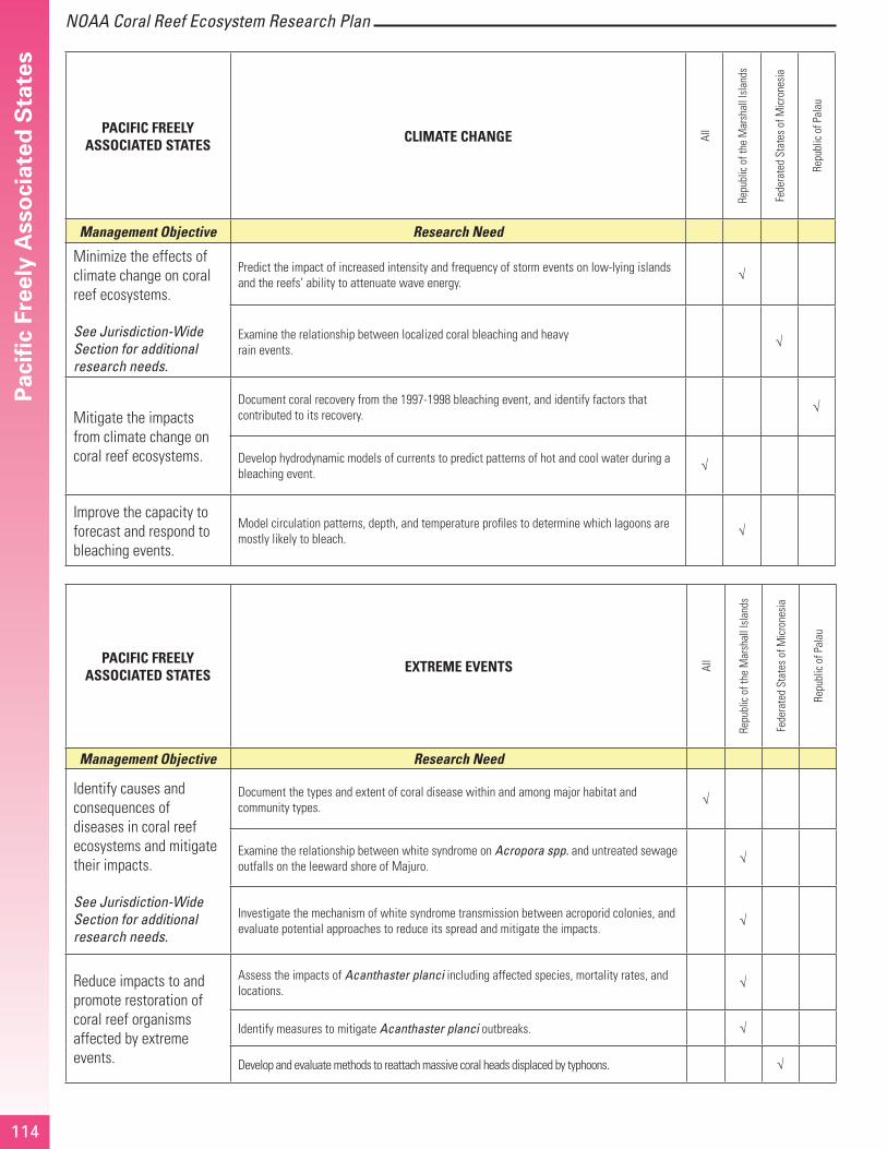
NOAA Coral Reef Ecosystem Research PlanP
acifi
c Fr
eely
Ass
oci
ated
Sta
tes
114
PACIFIC FREELY ASSOCIATED STATES CLIMATE CHANGE Al
l
Repu
blic
of t
he M
arsh
all I
slan
ds
Fede
rate
d St
ates
of M
icro
nesi
a
Repu
blic
of P
alau
Management Objective Research Need
Minimize the effects of climate change on coral reef ecosystems.
See Jurisdiction-Wide Section for additional research needs.
Predict the impact of increased intensity and frequency of storm events on low-lying islands and the reefs’ ability to attenuate wave energy.
√
Examine the relationship between localized coral bleaching and heavy rain events.
√
Mitigate the impacts from climate change on coral reef ecosystems.
Document coral recovery from the 1997-1998 bleaching event, and identify factors that contributed to its recovery.
√
Develop hydrodynamic models of currents to predict patterns of hot and cool water during a bleaching event.
√
Improve the capacity to forecast and respond to bleaching events.
Model circulation patterns, depth, and temperature profiles to determine which lagoons are mostly likely to bleach.
√
PACIFIC FREELY ASSOCIATED STATES EXTREME EVENTS Al
l
Repu
blic
of t
he M
arsh
all I
slan
ds
Fede
rate
d St
ates
of M
icro
nesi
a
Repu
blic
of P
alau
Management Objective Research Need
Identify causes and consequences of diseases in coral reef ecosystems and mitigate their impacts.
See Jurisdiction-Wide Section for additional research needs.
Document the types and extent of coral disease within and among major habitat and community types.
√
Examine the relationship between white syndrome on Acropora spp. and untreated sewage outfalls on the leeward shore of Majuro.
√
Investigate the mechanism of white syndrome transmission between acroporid colonies, and evaluate potential approaches to reduce its spread and mitigate the impacts.
√
Reduce impacts to and promote restoration of coral reef organisms affected by extreme events.
Assess the impacts of Acanthaster planci including affected species, mortality rates, and locations.
√
Identify measures to mitigate Acanthaster planci outbreaks. √
Develop and evaluate methods to reattach massive coral heads displaced by typhoons. √