pacific islands clima te science center - university of...
TRANSCRIPT
Pacific Islands Climate Science Center
-------------------------------------------------------
Science for coastal adaptation: Creating a high-resolution digital elevation model for Majuro Atoll, RMI
with Jeffrey Danielson, USGS Earth Resources Observation and Science Centerand Monica Palaseanu-Lovejoy, USGS Eastern Geographic Science Center
presents the Paci�ic Climate Science Webinar Series
[2 pm PDT/5 pm EDT/9 pm UTC/Oct 26th, 7 am ChST]Wednesday, October 25th at 11:00 am HST
Webinar and Call-in information for PI-CSC Webinar
Date: Wednesday, October 25th, 2017Time: 11:00 am, Hawaii Time (Honolulu, GMT – 10:00)
When it is time to attend the meeting, please visit this link:https://usgs.webex.com/usgs/j.php?MTID=mf05b0a62cba990809da683a134f105e9 To hear the speaker, you must call the teleconference: +1 (703) 648 – 4848 plus 71487# when prompted
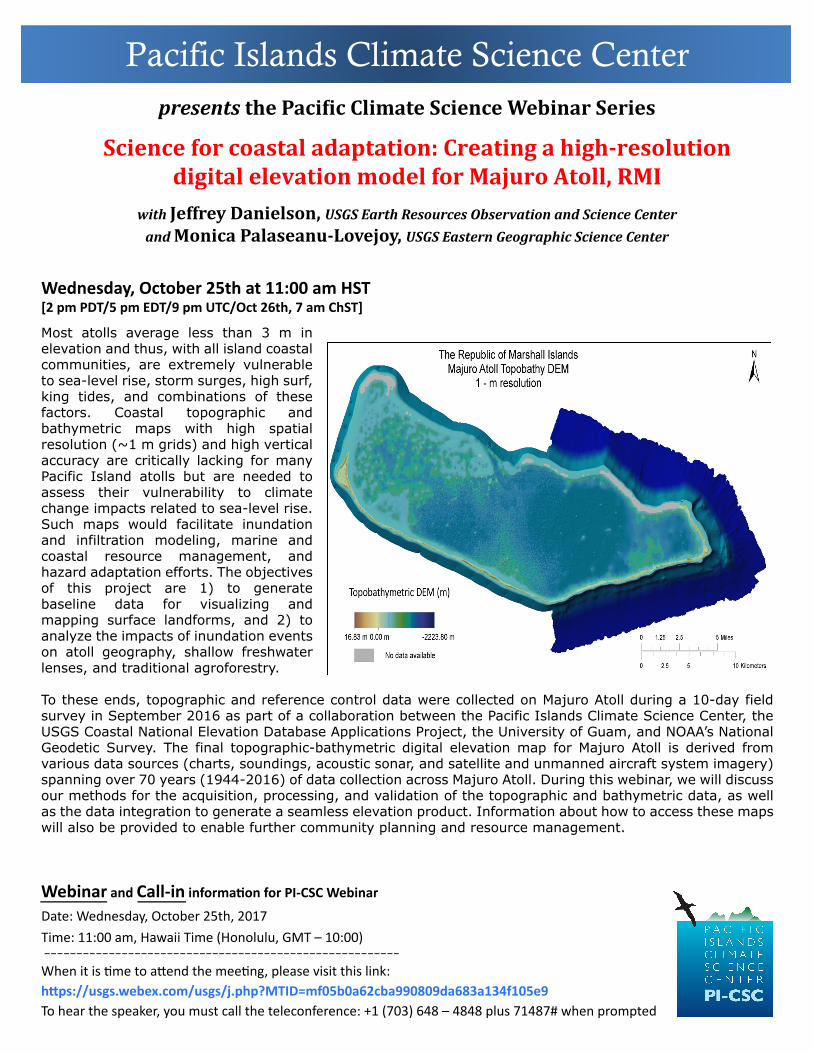
Most atolls average less than 3 m in elevation and thus, with all island coastal communities, are extremely vulnerable to sea-level rise, storm surges, high surf, king tides, and combinations of these factors. Coastal topographic and bathymetric maps with high spatial resolution (~1 m grids) and high vertical accuracy are critically lacking for many Pacific Island atolls but are needed to assess their vulnerability to climate change impacts related to sea-level rise. Such maps would facilitate inundation and infiltration modeling, marine and coastal resource management, and hazard adaptation efforts. The objectives of this project are 1) to generate baseline data for visualizing and mapping surface landforms, and 2) to analyze the impacts of inundation events on atoll geography, shallow freshwater lenses, and traditional agroforestry.
To these ends, topographic and reference control data were collected on Majuro Atoll during a 10-day field survey in September 2016 as part of a collaboration between the Pacific Islands Climate Science Center, the USGS Coastal National Elevation Database Applications Project, the University of Guam, and NOAA’s National Geodetic Survey. The final topographic-bathymetric digital elevation map for Majuro Atoll is derived from various data sources (charts, soundings, acoustic sonar, and satellite and unmanned aircraft system imagery) spanning over 70 years (1944-2016) of data collection across Majuro Atoll. During this webinar, we will discuss our methods for the acquisition, processing, and validation of the topographic and bathymetric data, as well as the data integration to generate a seamless elevation product. Information about how to access these maps will also be provided to enable further community planning and resource management.