overall summary of all classifications
TRANSCRIPT

The Moray Council
Environmental Services - Direct Services
Roads Department
List of Public Roads
Road No / Burgh Road / Street Name Road / Street Description
Carriageway Footway / Footpath
Cycleway / CycleTrack
Lengths (Km)
Overall Summary of All ClassificationsA Class Roads 157.229 38.516 0.265
B Class Roads 295.892 37.203 1.230
C Class Roads 363.137 44.154 2.286
Unclassified Roads 733.528 399.362 5.761
1,549.786 519.235 9.542Total
Remote Footpaths 0.000 19.349 0.000
Remote Cycle Tracks 0.000 0.000 26.033
0.000 19.349 26.033Total
Page 1 of 125Date Printed - 21/06/13 11:57:30

The Moray Council
Environmental Services - Direct Services
Roads Department
List of Public Roads
Road No / Burgh Road / Street Name Road / Street Description
Carriageway Footway / Footpath
Cycleway / CycleTrack
Lengths (Km)
A Class RoadsA95 Keith - Glenbarry Road From Trunk Road A96 (Church Road) in Keith to Council
Boundary at Glenbarry14.180 1.099 0.000
A97 Banff - Aberchirder - Huntly Road
Portion of Road from Bridge of Marnoch to Council Boundary at Auchingoul
0.753 0.000 0.000
A98 Fochabers - Cullen - Fraserburgh Road
From A96 at Fochabers (Main Road), via Arradoul (Main Road) then Cullen (Castle Terrace, Bayview Road, Seafield Street, Seafield Road) thence to Council Boundary at Tochieneal, east of Cullen.
20.912 3.926 0.000
A920 Dufftown - Huntly Road From junction with Route A941 at Burnend via Auchindoun to Council Boundary at Corsemaul.
6.097 0.000 0.000
A939 Nairn - Tomintoul - Ballater Road
From Council Boundary at Bridge of Brown via Tomintoul (Main Street and Auchbreck Road) and Blairmarrow to Council Boundary at Lecht Hill.
18.060 1.283 0.000
A940 Forres - Grantown Road From junction with Forres Bypass, Market Street, Victoria Roundabout, St Catherines Road, Grantown Road to junction with A939 to Dava.
23.048 2.222 0.000
A941 (E) Lossiemouth - Elgin - Dufftown - Rhynie Road
From A95 at Craigellachie via Edward Avenue and Hill Street in Craigellachie then Balvenie Street, The Square and Fife Street in Dufftown then through Lower and Upper Cabrach to Council Boundary near Elrick.
27.388 3.785 0.000
A941 (W) Lossiemouth - Elgin - Dufftown - Rhynie Road
From Lossiemouth Harbour (at junction with Commerce Street) via Pitgaveny Street, Clifton Road and Elgin Road in Lossiemouth, then south via Lossiemouth Road, North Street (Bishopmill), Bishopmill Brae and Cumming Street to roundabout on A96 at Alexandra Road. Then from roundabout on A96 near Ladyhill via Northfield Terrace, Hay Street, Station Road, New Elgin Road and Main Street in Elgin, then south via Main Road in Fogwatt, Elgin Road, New Street and High Street in Rothes to A95 near Craigellachie Bridge.
29.894 10.202 0.265
A942 Buckie - Findochty - Portknockie Road
From junction with Route A98 East of Inchgower via Buckie (High Street, North High Street, Low Street, Marine Place, Rathburn Street, Commercial Road, Reidhaven Street, Great Eastern Road, Buckie) Findochty (Strathlene Road, Netherton Terrace) and Portknockie (Station Road, Church Street, Bridge Street) to junction with Route A98 at Denside
11.089 9.486 0.000
A990 Enzie - Portgordon - Buckie Road
From junction with Route A98 at Enzie via Portgordon (Station Road, Lennox Place, West High Street, East High Street, Gordon Street) to Buckie (Great Western Road, Main Street, Bridge Place, Yardie, Baron Street, Bank Street, Buckie)
5.808 6.513 0.000
157.229 38.516 0.265Total of A Class Roads - ( No of Records 10 )
Page 2 of 125Date Printed - 21/06/13 11:57:30

The Moray Council
Environmental Services - Direct Services
Roads Department
List of Public Roads
Road No / Burgh Road / Street Name Road / Street Description
Carriageway Footway / Footpath
Cycleway / CycleTrack
Lengths (Km)
B Class RoadsB975 Castle Road From Route B9014 near Bridge of Poolinch to junction
with Route A941 at Maltkiln Bridge.0.723 0.000 0.000
B9002 Cabrach - Lumsden (Burn of Craig) Road
From Route A941 at a point north of Elrick to Council Boundary south of Elrick.
1.039 0.000 0.000
B9007 Forres - Ferness - Duthil Road From Council Boundary near Relugas to Route A940 at Logie Lodge.
4.230 0.000 0.000
B9008 Delnashaugh - Auchbreck - Tomintoul Road
From junction with Route A95 at Delnashaugh via Craggan, Auchbreck and Tomnavoulin to junction with Route A939 north east of Tomintoul
21.414 0.000 0.000
B9009 Dufftown - Auchbreck (Glen Rinnes) Road
From Route A941 in Dufftown (Conval Street) via Glen Rinnes to junction with Route B9008 at Auchbreck.
17.357 0.973 0.000
B9010 Elgin - Rafford - Forres Road From Route A96 in Elgin (Pluscarden Road) then southwards via Pittendreich, Wester Manbeen and Cloddach to Bogside, then south westwards via Buinach and Kellas to Edinvale Farm, north westwards via Rafford (Main Road) to Route B9011 in Forres (St Leonards Road, Tolbooth Street, Forres)
27.549 3.737 0.000
B9011 Forres - Findhorn Road Nairn Road from Greshop Roundabout, Bridge Street, High Street, Victoria Road to Findhorn Roundabout thence to meet B9089 in Kinloss (Main Road) then from Kinloss (Findhorn Road), to Findhorn.
9.577 6.298 0.000
B9012 Elgin - Williamston Road From Route A941 in Elgin (Morriston Road, Duffus Road) thence northwards via Duffus (Hopeman Road) to meet Route B9040 at Williamston
9.265 1.182 0.220
B9013 Newton - Burghead Road From Route A96 at Newton northwards via College of Roseisle crossroads (Main Road) to Burghead (St Aethans Road) thence to the termination of Granary Street (at west end of No 71).
8.487 2.166 0.000
B9014 Dufftown - Keith Road From Route A941 in Dufftown (Low Road), via Parkmore (Main Road) then Drummuir (Dufftown Road) to Route A96 in Keith (Fife Street, Regent Square Keith).
16.343 1.940 0.000
B9015 Rothes - Kingston Road From Route A941 in Rothes (North Street) northwards crossing Route A96 at Mosstodloch thence (via Garmouth Road, Mosstodloch) to Garmouth (South Road, Church Street, Spey Street, Kingston Road) thence to Kingston (Shore Road, terminating on Lein Road at "Rivendel" and also on Beach Road at turning loop at entrance to car park)
22.101 3.088 0.427
B9016 Keith - Buckie Road From junction with Route A96 west of Little Forgie via Aultmore (Main Road) Ryeriggs and Craiglug to junction with Route A98 at Enzie.
10.604 0.083 0.000
B9017 Crooksmill - Newmill - Montgrew Road
From junction with Route A96 at Woodside via Newmill (Main Street, The Square) to junction with Route A95 at Montgrew.
4.900 1.071 0.000
B9018 Keith - Cullen Road From junction with Route A95 at Auchinhove via Grange Cross Roads Nethertown of Windyhills Farm, Berryhillocks, Lintmill (Main Road) to junction with Route A98 at Cullen.
16.614 0.810 0.000
B9022 Portsoy - Huntly Road From Council Boundary at Glenbarry via Ternemny to Council Boundary at Bridge of Isla.
7.040 0.000 0.000
B9040 Lossiemouth - Burghead Road From Route A941 in Lossiemouth (Queen Street, Stotfield Road) westwards via Hopeman and Cummingston (Main Road) to join the Route B9013 at entrance to Burghead.
12.729 6.632 0.102
B9089 Kinloss - Burghead Road From Route B9011 in Kinloss (Main Road), eastwards to Wards crossroads thence northwards to join Route B9013 near the entrance to Burghead.
10.075 1.755 0.000
B9102 Dandaleith - Grantown Road From Council Boundary near Delnapot north via Upper Knockando (Main Road) and Archiestown (High Street) to join Route A941 near Craigellachie.
20.614 1.056 0.000
B9103 (W) Lossie - Sheriffston - Orton - Mulben Road (West)
From Route A941 in Lossiemouth (Inchbroom Road) via Leuchars to Route A96 at Sheriffston and from Route A96 south-eastwards to junction with Route B9015 at Orton, then from Route B9015 at Garbity south eastwards to Boat O' Brig thence via Auchroisk to Route A95 at Mulben.
18.205 0.873 0.000
Page 3 of 125Date Printed - 21/06/13 11:57:31

The Moray Council
Environmental Services - Direct Services
Roads Department
List of Public Roads
Road No / Burgh Road / Street Name Road / Street Description
Carriageway Footway / Footpath
Cycleway / CycleTrack
Lengths (Km)
B Class RoadsB9103 (E) Lossie - Sherrifston - Orton -
Mulben Road (East)From Route A941 in Lossiemouth (Inchbroom Road) via Leuchars to Route A96 at Sheriffston and from Route A96 south-eastwards to junction with Route B9015 at Orton, then from Route B9015 at Garbity south eastwards to Boat O' Brig thence via Auchroisk to Route A95 at Mulben.
4.853 0.000 0.000
B9104 Fochabers - Spey Bay Road From Route A96 at Spey Bridge northwards via Bogmoor (Bogmoor Road) to Spey Bay (Beach Road) to the 'Y' junction.
8.671 2.658 0.000
B9115 Drummuir - Turfhillock - Newtack Road
From junction with Route B9014 at Forkins via Turfhillock to Council Boundary at Bridge of Blairmoon and from Council Boundary at Bridge of Blairmoon via Edintore to junction with Route A96 at Newtack.
6.709 0.000 0.000
B9116 Keith - Newmill Road From Route A96 in Keith (Seafield Avenue, Newmill Road, Keith) via Bridge of Kinminitie to junction with Route B9017 at Main Street, Newmill.
2.051 1.306 0.000
B9117 Cairnhill - Rothiemay - Hazelbrae Road
From junction with Route A95 at Cairnhill to junction with Route B9022 at Rothiemay Cross Roads and from junction Route B9022 via Rothiemay (Anderson Drive and Mayen Road) and Mayen to Council Boundary at Glennie.
9.765 0.046 0.000
B9118 Bridge of Isla - Rothiemay (Deveronside) Road
From junction with Route B9022 at Whitestones by Deveronside via Rothiemay (Anderson Drive and Deveronside Road) to junction with Route B9117 at Rothiemay.
2.682 0.344 0.000
B9135 Muirton - Lossiemouth Road From Route A941 near Cocklehill via Muirton, Kinneddar, and roundabout at RAF Lossiemouth, via Muirton Road to join Route B9040 near Muirton Crescent.
3.238 0.425 0.481
B9136 Bridge of Avon - Bridge of Livet (Avonside) Road
From junction with Route A939 at Bridge of Avon via Ballantruan, Inverchebit and Drumin to junction with Route B9008 at Bridge of Livet.
14.137 0.000 0.000
B9137 Lagmore - Ballindalloch Station Road
From Route A95 at Lagmore towards Ballindalloch Station.
1.392 0.000 0.000
B9138 Marypark - Blacksboat Road From junction with Route A95 at Marypark via Blacksboat Bridge to Route B9102
1.740 0.000 0.000
294.104 36.443 1.230Total of B Class Roads - ( No of Records 29 )
Page 4 of 125Date Printed - 21/06/13 11:57:31

The Moray Council
Environmental Services - Direct Services
Roads Department
List of Public Roads
Road No / Burgh Road / Street Name Road / Street Description
Carriageway Footway / Footpath
Cycleway / CycleTrack
Lengths (Km)
C Class RoadsC1H Dufftown - Maggieknockater
(Kininvie) RoadFrom junction with Route B9014 at Parkmore Distillery via Kininvie House to junction with Route A95 at Maggieknockater.
5.336 0.000 0.000
C1E Garmouth - Lhanbryde - Fogwatt Road
From Route B9015 in Garmouth (High Street, Station Road) to Route A96 at Lhanbryde and from Route A96 at Lhanbryde southwards via Clackmarras to junction with Route A941 at Fogwatt. Incl St Andrew's Road, Lhanbryde from west to east roundabouts with A96
14.844 3.529 0.000
C2E Elgin - Birnie Road From Roundabout on Route A941 at Main Street New Elgin, (Birnie Road), then southwards via Castlehill to Birnie (Glenlossie Road), then north eastwards via Rashcrook to join A941 one and a quarter miles north of Fogwatt, with branch one quarter mile south of Elgin, south westwards via Paddockhaugh joining Route B9010 200 yards south of Cloddach.
9.191 0.593 0.367
C3E Elgin - Pluscarden - Rafford Road
From junction with Route B9010 at Pittendreich, westwards for a quarter of a mile, then south westwards via Miltonduff (Main Road) and Pluscarden to junction with Route B9010 near Briach.
13.851 0.382 0.000
C4L Bogmuchals - Berryhillock Road
From Council Boundary at Green Hill via Berryhillock (Main Road) to junction with Route B9018.
3.186 0.000 0.000
C4E Brodieshill - Cloves - Lochinver Road
From Route A96 a quarter mile east of Burgie School southwards to Brodieshill Farm, then eastwards via Toreduff to Cloves, then eastwards via Redhill to Class III Road C3E a quarter mile west of Pittendreich with branch northwards from Cloves to Route A96 in Alves Village (Station Road, Alves)
11.757 0.035 0.000
C5E East Grange - Spindle Muir Road
From Route A96 a quarter mile west of Gateside Farm northwards via East Grange to join Route B9089 near Milton Brodie, with branch a half mile south of Route B9089 via Coltfield, crossing Class III Road C25E Kirkton thence eastwards via Kintrae to join Class III Road C24E at Waterymains.
15.868 0.000 0.000
C5H Edingight - Bogmuchals - Brodiesford Road
From junction with Class III Road C6H at Edingight to Council Boundary at Inverkindling.
3.123 0.000 0.000
C6E Scotsburn - Kinloss Road From Route A96 at Scotsburn northwestwards via Kinloss (Scotsburn Road) to join Route B9089 at Kinloss.
2.183 0.530 0.000
C6H Thornton - Fortry Road From junction with Route A95 at Thornton via Fortry to junction with Class III Road C5H at Edingight.
4.851 0.000 0.000
C7E Brodie - Dyke - Kintessack Road
From C9E at Brodie Station north eastwards via Dyke (Main Road) to Kintessack, then eastwards to Earnhill, then southwards to rejoin Route A96 west of Findhorn Bridge.
8.880 0.033 0.000
C7L Craibstone - Fordyce (Hoggie) Road
From junction with Route B9018 at Craibstone via Cotton Hill to Council Boundary at Little Cultain.
5.817 0.000 0.000
C8E Banarach Road From A96 Northwards and Eastwards past Dalvey Cottage to C7E with Branch Northwards via Banarach to C7E at Mudhall.
2.874 0.000 0.000
C8H Deveronside - Cabrach Road From junction with Route A941 at Bridgend to Council Boundary north of Belcherrie, thence from Council Boundary at Edinglassie to Council Boundary at Haugh of Glass.
5.788 0.000 0.000
C9E Brodie - Muirside - Kintessack Road
From Route A96 at Brodie Station north westwards via Muirside then eastwards to join Class III Road C7E in Kintessack, with branch to Council Boundary.
6.122 0.000 0.000
C10E Bogs of Dalvey - Earlsmill - Feddan Road
From Route A96 at Bogs of Dalvey south westwards via Little Tearie to Earlsmill, then northwards to rejoin Route A96 at Feddan, with branch South from Earlsmill to Council Boundary.
4.512 0.000 0.000
C11E Darnaway - Tilliglens - Relugas Road
From Class III Road C10E near Little Tearie southwards via Conicavel (Main Road) to Council Boundary at Daltulich Bridge and from near Relugas across Route B9007 via Tilliglens to Route A940.
12.721 0.000 0.000
C11L Drybridge - Deskford Road From junction with Route A98 and Route A942 south of Buckie via Hilton and Weston to junction with Route B9018 at School south of Deskford.
10.367 0.000 0.000
Page 5 of 125Date Printed - 21/06/13 11:57:31

The Moray Council
Environmental Services - Direct Services
Roads Department
List of Public Roads
Road No / Burgh Road / Street Name Road / Street Description
Carriageway Footway / Footpath
Cycleway / CycleTrack
Lengths (Km)
C Class RoadsC12E Hatton - Dallas - Branchill
RoadFrom Route B9010 at Hatton southwards via Dallas Village (Main Road) then northwestwards via Dallas Lodge and Branchill rejoining Route B9010 a half mile west of Craigmill.
7.183 0.838 0.000
C13E Dallas - Knockando Road From Class III Road C12E in Dallas Village south westwards over River Lossie then southwards to junction with Route B9102 at Knockando (Dallas Road).
11.757 0.034 0.000
C13L Lintmill - Highfield - Burnside - Brodiesford Road
From junction with Route B9018 at Lintmill (Tochieneal Corner) then to Council Boundary at Tochieneal.
0.671 0.074 0.000
C14E Mannachie - Rafford Road From Route A940 in Forres, Mannachie Road, then south eastwards via Mannachie to join Route B9010 in Rafford Village.
5.144 1.159 0.000
C15E (E) Archiestown - Carron - Derrybeg Road (East)
From Archiestown southwards to Unclassified Road 139E then westwards for a quarter mile then southwards via Tombreck Farm, Carron(Main Road), Dailuaine Distillery to junction with Route A95 near Derrybeg.
2.474 0.000 0.000
C15E (W) Archiestown - Carron - Derrybeg Road (West)
From Archiestown southwards to Unclassified Road 139E then westwards for a quarter mile then southwards via Tombreck Farm, Carron(Main Road), Dailuaine Distillery to junction with Route A95 near Derrybeg.
4.248 0.000 0.000
C16E Byres - Tannachy Road From Route B9104 at Gavin Brae north eastwards via Tannachy to join route A990 in Portgordon (Stewart Street).
4.368 0.464 0.000
C17H Rinnachat - Edinvillie - Beatshaugh Road
From junction with Route A95 at Rinnachat at Cross Roads via Milton of Edinvillie to junction with Route B9009 at Glack. Including 125m added 31/08/05, loop road from C17H at Mill of Edinville in a south westerly then north westerly direction to rejoin C17H at Ardmhor, formerly PU Road No 23.
8.496 0.000 0.000
C17E Wellheads Road From Route A98 at Swiss Cottage north eastwards via Wellheads Farm across Route B9016 via Old Clochan (Main Road) to junction with Class III Road C67L at Thornybank.
7.008 0.000 0.000
C18E Sleepieshill Road From Route A96 at Loch Oire northwards via Urquhart Village to Viewfield with branch north westwards past Stonewells to pillars, then from Viewfield eastwards via Lochhills (Main Road), Fernyfield and Binns to junction with Class III Road C1E in Garmouth Village (Innes Road).
10.892 0.283 0.000
C19E Scotstonhill - Fernyfield Road From Route A96 at The Belts north eastwards across Route B9103 three quarters of a mile north of Sheriffston eastwards to junction with Class III Road C18E at Fernyfield.
6.564 0.000 0.000
C20H Knockandhu - Chapeltown of Glenlivet Road
From junction with Route B9008 at Knockandhu via Nether Clashnoir, Chapeltown (Main Road) & Distillery to Eskemulloch.
5.159 0.000 0.000
C20E Linkwood - Troves Elgin Road From Route A941 in Elgin (Linkwood Road) to Roundabout at end of Reiket Lane then from Reiket Lane via Troves to join Class III Road C1E near Troves.
4.501 1.525 0.026
C21E Linksfield - Caysbriggs Road From Class III Road C22E in Elgin, Caysbriggs Road, then via Linksfield eastwards for a half mile to junction with unclassified roads 34E and 37E northwards via Pitairlie and Caysbriggs joining B9103 west of Arthur's Bridge.
5.353 0.314 0.000
C23E Woodside-Calcots Road From Class III Road C22E (Newmill Road) via Calcots Road to Route B9103 at Bridge of Calcots
3.149 0.045 0.000
C24E Elgin - Westerfolds - Duffus Road
From Route A941 in Elgin (Covesea Road) to Westerfolds thence westward to join Route B9012 near Crosslots.
7.666 1.003 0.091
C25E Alves - Roseisle - Duffus Road From Route A96 in Alves Village (Burghead Road) then northwards to meet Route B9089 at Wards Crossroads, thence eastwards to Roseisle (Kinloss Road), crossing Route B9013 at Roseisle (Duffus Road) then via Bank of Roseisle to join Route B9012 near Rothills with branch northwards past Duffus Manse to join B9012 at Begrow.
10.295 0.363 0.000
Page 6 of 125Date Printed - 21/06/13 11:57:31

The Moray Council
Environmental Services - Direct Services
Roads Department
List of Public Roads
Road No / Burgh Road / Street Name Road / Street Description
Carriageway Footway / Footpath
Cycleway / CycleTrack
Lengths (Km)
C Class RoadsC26E Miltonduff - Lochside Road From Class III Road C3E at Miltonduff northwards via
Whitefield Farm crossing Class III Road C4E to Route A96 at Newton Toll and from Route A96 to Class III Route C24E near Lochside, with branch from Woodside Cottage to The Rowans.
8.265 0.256 0.000
C29E Edinvale Road From junction with Route B9010 at Edinvale Farm north eastwards to Class III Road C3E at Pluscarden House
5.232 0.000 0.000
C31L Barhill - Buckie Road From junction with Route A98 west of Inchgower Distillery via Barhill Road to Buckie, (Barhill Road, St Peter's Road, St Andrew's Square, West Church Street) joining Route A942 at Cluny Square.
2.763 4.141 0.000
C32L Westertown - Findochty (Bauds) Road
From junction with Route A98 at Westertown to Route A942 at Findochty.
1.489 0.000 0.000
C33L Findochty - Rathven Road From junction with Route A942 at Findochty via Loanhead to Class III Road C68L then from Class III Road C68L to Class III Road C43L in Rathven (Bede Road).
2.789 0.094 0.000
C34H Knock Station Road From junction with Route A95 at Knock Farm Cottages, via Knock (Main Road), to junction with Route B9022 at Craigend.
1.734 0.000 0.000
C35H Glack of Midthird - Auchindoun Road
From junction with Route B9014 south of Drummuir Castle via Glack of Midthird to junction with Route A920 near Bridge of Auchindoun including leg to Route B9014 north of Midthird
4.302 0.000 0.000
C42H Knauchland - Tillydown Road From junction with Route B9022 at Shielparks via Knauchland to Council Boundary at Burn of Tillydown.
3.211 0.000 0.000
C43L Rathven Road From Route A942 at Cluny Square, Buckie (East Church Street, McLaren's Brae, March Road), to March Road Roundabout via Rathven Road to Rathven (Main Road) to junction with Route A98 near Connage.
3.398 2.740 0.000
C44L Hill of Maud Road From junction with Route A98 at Connage via Hill of Maud to junction with Class III Road C11L at Braehead.
4.220 0.000 0.000
C45H Rumbuch - Wood of Mulderie Road
From junction with Route A96 at Bridge of Rumbuch via Woodside of Mulderie to junction with Class III Road C49H at Malcolmburn
4.346 0.000 0.000
C46H Grange Crossroads - Fortry Crossroads Road
From junction with Route B9018 at Grange Crossroads via Crannach to junction with Class III Road C6H at Fortry Crossroads.
3.086 0.000 0.000
C47H Fortry Crossroads - Grange Station Road
From junction with Class III Road C6H at Fortry Crossroads via Braco to junction with Route A95 thence south to entrance to former Grange Station.
4.090 0.000 0.000
C48H Whitehill - Edingight (Sillyearn) Road
From junction with Route A95 near Whitehill via Sillyearn to junction with Class III Roads C5H, C6H at Edingight House.
3.057 0.000 0.000
C49H Malcolmburn - Mulben Road From junction with Class III Road C45H at Malcolmburn to junction with Route A95 at Mulben.
1.311 0.000 0.000
C54H Crooksmill - Muldearie - Rosarie Road
From Route A96 at Crooksmill via Strypeside of Muldearie and Cullieshangan to Route A95 at Rosarie.
3.710 0.000 0.000
C55H Drummuir - Bodinfinnoch - Glentauchers Road
From Route B9014 east of Drummuir Castle via Mains of Bodinfinnoch to Route A95 at Glentauchers.
7.027 0.000 0.000
C56H Turfhillock - Blairmore Road From junction with Route B9115 past Lower Lynemore to Council Boundary at Bridge of Netherton.
1.115 0.000 0.000
C57H Bridge of Livet - Minmore Road From junction with Route B9136 at Bridge of Livet to junction with Class III Road C58H at Blairfindy Lodge.
1.841 0.000 0.000
C58H Minmore - Tomnavoulin Road From junction with Class III Road C57H at Blairfindy Lodge via Gallowhill to junction with Route B9008 at Tomnavoulin.
3.210 0.000 0.000
C59H Aberlour - Edinvillie Road From junction with Route A95 at Dowans via Ruthrie (Main Road) and Bush to junction with Class III Road C17H at Edinvillie.
2.575 0.020 0.000
C60H Downan - Drumin (The Gullet) Road
Link road between Road B9008 at Downan and Route B9136 near Drumin.
0.636 0.000 0.000
C62L Clune - Ardiecow - Bogmuchals Road
From junction with Route B9018 at Clune via Milton to Class III Road C7L then from Class III Road C7L via Ardiecow to Council Boundary at Standingmanhill.
3.917 0.000 0.000
Page 7 of 125Date Printed - 21/06/13 11:57:31

The Moray Council
Environmental Services - Direct Services
Roads Department
List of Public Roads
Road No / Burgh Road / Street Name Road / Street Description
Carriageway Footway / Footpath
Cycleway / CycleTrack
Lengths (Km)
C Class RoadsC65H Drummuir - Wood of Kininvie
RoadFrom junction with Route B9014 south of Drummuir Castle via Lochpark to access to Wood of Kininvie at Grid Ref NJ 35720,43404
1.288 0.000 0.000
C67L Arradoul - Thornybank Road From junction with Route A98 at Arradoul (Westerton Cottages Road) to junction with Class III Road C17E at Thornybank, including lay-by and footway from Taramanda to Ranzo off A98.
2.031 0.098 0.000
C68L Carnoch - Strathlene Road From junction of Route A98 at Carnoch via Moor of Scotstown to Route A942 at Strathlene.
2.665 0.000 0.000
C72H Newmill - Tarmore - Keith Road
From junction with Route B9017 south east of Newmill across Route B9116 at Bridge of Kinminitie to Keith at Bridge of Tarmore; (Alexander Road, Station Road, Keith) joining Route A96 at Regent Street, Keith.
2.730 0.586 0.000
C73L Rothiemay - Garronhaugh - Bridge of Marnoch Road
From Council Boundary at Garronhaugh via Turtory to junction with Route A97 at Bridge of Marnoch.
3.704 0.000 0.000
C73H Rothiemay - Garronhaugh Road
From junction with Route B9118 at Milltown of Rothiemay Church via Rothiemay (Main Street) and Corskellie to Council Boundary at Woodfold with branch to Council Boundary at Mountain Burn.
3.915 0.366 0.000
C74H Forgieside - Killiesmont - Guilyknowes Road
From junction with Route B9016 south of Aultmore Distillery via Forgieside, Killiesmont and Guilyknowes to Route B9017 thence to junction with Class III Road C72H.
3.518 0.000 0.000
C75H Marypark - Edintore Road Link road connecting Route A96 and Route B9115 at Marypark.
0.616 0.000 0.000
C77H Bomakelloch - Mains of Davidston Road
From junction with Route B9115 to Bomakelloch to Council Boundary at Bridge of Davidston.
0.270 0.000 0.000
C80H Glenrinnes Lodge - Kirkton of Mortlach - Dufftown Road
From junction with Route B9009 north of Glenrinnes Lodge to U99H at Kirkton of Mortlach then from U99H to Dufftown (Church Street) to join Route A941 at The Square, Dufftown.
2.150 1.035 0.000
C102L Freuchny Road From Class III Road C43L at McLaren's Brae to Route A942 at Commercial Road via Freuchny Road, Buckie.
0.095 0.165 0.000
346.505 20.705 0.484Total of C Class Roads - ( No of Records 69 )
Page 8 of 125Date Printed - 21/06/13 11:57:31

The Moray Council
Environmental Services - Direct Services
Roads Department
List of Public Roads
Road No / Burgh Road / Street Name Road / Street Description
Carriageway Footway / Footpath
Cycleway / CycleTrack
Lengths (Km)
Unclassified RoadsU1H Ternemny Road From junction with Route B9022 via Ternemny Farm to
Craigbourach.1.852 0.000 0.000
U4H Redhill Road From Class III Road C73H near Corskellie via Redhill to Council Boundary on Fourman Hill.
2.716 0.000 0.000
U6E Bellie Graveyard Road Access Road from Route B9104 to Bellie Graveyard. 0.164 0.000 0.000
U6H Tarryblake Road From Route B9117 near Coldhome to Tarryblake House. 1.374 0.000 0.000
U8E Enzie - Cunninghaugh Road From Route B9016 near Craiglug northwards, crossing Route A98 at Mill of Tynet via Nether Dallachy (Beaufighter Road), joining Route B9014 near Cunninghaugh.
7.671 0.000 0.000
U9E Auchenhalrig Road From Route B9104 at Byres eastwards via Upper Dallachy (Main Road) and Auchenhalrig (Main Road) to Unclassified Road 8E.
2.847 0.000 0.000
U10E Dallachy Road From Route B9104 eastwards to junction with Unclassified Road 8E at Nether Dallachy (Spey Road).
0.617 0.000 0.000
U10aH Moss-Side Road From Route B9117 near Mannoch Hill via Moss-side to Route B9022 at Shielparks.
2.063 0.000 0.000
U10H Retanach Road From Route B9117 at Inchcorsie via Retanach to Class III Road C42H Knauchland.
2.707 0.000 0.000
U11E Balnacoul Road From Route B9015 (Rothes - Kingston Road) north east to turning circle
0.466 0.000 0.000
U13E Forgiehill Road From Class III Road C49H at Malcolmburn northwards, crossing Route A96 at Redpath Burn via Braewynner Mast to join Route B9016 a quarter mile south of Raefin.
7.467 0.000 0.000
U14E Ordiequish Road From A96 in Fochabers (East Street, Ordiequish Road) then Southwards via Ordiequish, Hill of Cairnty, Easterton, Delfur to B9103.
8.304 1.080 0.000
U15H Gallowhill Road From Class III Road C46H at Crannoch via Gordonstown and Gallowhill to Route A95 at Grange Church.
3.132 0.000 0.000
U15aH Muiryfold Road From Unclassified Road 15H near Gallowhill via Muiryfold to Route C6H.
0.789 0.000 0.000
U16H Clerkseat Road From Route A95 near Bridge of Clerkseat via Clerkseat to Route B9018 near Mid Paithnick.
1.405 0.000 0.000
U16E Maryhill Road From Route B9015 a quarter mile south of Orton, westwards to Maryhill Farm.
0.841 0.000 0.000
U17H Moss-Side of Paithnick Road From Route B9018 at Paithnick via Moss-Side of Paithnick to junction with Unclassified Road 18H near Kilbady.
1.446 0.000 0.000
U18H Greenbog Road From Route B9018 at Grange Cross Roads via Greenbog to junction with Unclassified Road 17H near Kilbady.
1.207 0.000 0.000
U18E Mosstodloch - Garmouth Road From Route A96 at Mosstodloch, (Stynie Road) then northwards via Stynie Farm and Essil Graveyard to junction with Route B9015 in Garmouth.
4.837 0.643 0.000
U19E Dipple Road From Route A96 at Spey Bridge (Dipple Brae) southwards via Dipple Farm and Dipple Graveyard to junction with Route B9015 at Orton Post Office.
4.861 0.270 0.000
U19H Garrowood Road From Class III Road C47H at Grange Station via Garrowood to Council Boundary near Lower Garrowood.
1.180 0.000 0.000
U20E Badentinan Road From Route B9103 at Clatteringbriggs eastwards to Orbliston Station then south eastwards via Orbliston Farm to junction with Route B9015.
3.073 0.000 0.000
U20H Cairnhill Road From Class III Road C47H near Braco to Route A95 at Cairnhill.
0.744 0.000 0.000
U20aH Nethermill Road From Route A95 near Grange Hall southwards via Nethermills to bridge over Swiftly Burn.
0.533 0.000 0.000
U21E Millhill Road From Route B9015 - 1 mile south of Mosstodloch westwards via Millhill Farm to junction with Unclassified Road 20E at Orbliston Station.
1.752 0.000 0.000
U22E Hatton Road From Route B9015 - one and a half miles south of Mosstodloch eastwards to Unclassified Road 19E.
0.976 0.000 0.000
U22H Knockbog Road From Class III Road C5H at Cottartown Moss via Knockbog to Class III Road C48H near Whitehills.
3.164 0.000 0.000
U22bH Limehillock Road From Route A95 at Limehillock to access road leading to Council houses including said access road.
0.163 0.000 0.000
Page 9 of 125Date Printed - 21/06/13 11:57:31

The Moray Council
Environmental Services - Direct Services
Roads Department
List of Public Roads
Road No / Burgh Road / Street Name Road / Street Description
Carriageway Footway / Footpath
Cycleway / CycleTrack
Lengths (Km)
Unclassified RoadsU22aH Sillyearn - Drumnagorach
RoadFrom Class III Road C48H near Whitehill via Sillyearn Crofts to Route A95 at Drumnagorach.
1.969 0.000 0.000
U23aH Balnamoon Road From Route B9018 at Burnend north westwards towards Balnamoon Moss.
1.530 0.000 0.000
U23H Croylet Road From Class III Road C5H near Edingight via Wester Croylet to Route B9018 at Burnend.
3.038 0.000 0.000
U23E Loch Oire Road (Old Trunk Road)
Road at Loch Oire with branch northwards to junction of Route A96 and Class III Road C18E.
2.132 0.000 0.000
U24H Windyhills Road From Route B9018 near Nethertown of Windyhills to access road to Myreside.
0.536 0.000 0.000
U26H Foggy Moss Road From Route B9018 near Mid Paithnick via Foggy Moss and Chapelhead to access road to Roehill.
2.404 0.000 0.000
U27E Meft Road From Class III Road C1E at Lhanbryde, Burnside Road then northwards via Darkland and Longhill, to cross Class III Road C19E at Meft, then northwards to Unclassified Road 31E, one quarter of a mile east of Leuchars.
3.321 0.291 0.000
U30E Darkland Road From Route B9103 at Sheriffston north eastwards, crossing Unclassified Road 27E at Darkland, to junction with Class III Road C18E in Urquhart Village.
3.524 0.781 0.000
U31E Leuchars Road From Route B9103 at Milltown, eastwards via Leuchars House crossing Class III Road C19E then southwards to junction with Unclassified Road No. 30E at Urquhart School.
3.804 0.000 0.000
U33H Denwell - Coldhome Road From Junction with Route A96 at Keith (Denwell Road) through Denlands via Braehead, Coldhome and Mains of Auchindachy to Route B9014. (Length from U43H to TR A96 added 08/06/04)
3.517 0.000 0.000
U34H Tarnash Road From Route A96 at Tarnash to Bridge over Burn of Tarnash.
0.236 0.000 0.000
U34E Wester Calcots Road From Pitgaveny crossroads southwards to join Class III Road C23E at Woodside
1.430 0.000 0.000
U35H Drum - Ardrone Road From Keith via Drum and Little Ardrone to Meikle Ardrone. 3.233 0.610 0.000
U36E Spynie Farm Road From Class III Road C21E northwards to Spynie Farm. 0.800 0.000 0.000
U37H Allanbuie Road From Class III Road C54H at Allanbuie to Route A95 at Loanside.
0.366 0.000 0.000
U37E Pitgaveny Road From Class III Road C23E at Elgin north eastwards to Pitgaveny crossroads
1.339 0.000 0.000
U38E Covesea Road From Class III Road C24E near Westerfolds northwards to join Route B9040 near Covesea Farm.
2.869 0.000 0.000
U39E Myreside Road From Class III Road C24E a quarter of a mile north of Elgin Burgh boundary eastwards to Route A941 at Myreside.
0.769 0.000 0.000
U40E Westerfolds - Muirton Road From Class III Road C24E at Westerfolds eastwards to Drainie then south eastwards to join B9135.
3.035 0.000 0.000
U41H Ardioch - Oxwell Road From Class III Road C74H near Tarrycroys School via Ardioch and Oxwell to junction with Whitestones and Fellowsters Road.
1.673 0.000 0.000
U42H Bridgend - Corsairtly - Braehead Road
From Route A95 at Bridgend to Route B9014 near Corsairtly and thence southward to junction of road to Fife Cottage.
1.613 0.000 0.000
U43bH Backmuir Road From Route A96 near Netherton to Council housing scheme at Backmuir.
0.234 0.000 0.000
U43H Blackhillock Road From Unclassified Road 33H near Keith via Blackhillock Quarry to Route A96 near Netherton Farm.
2.582 0.000 0.000
U43E Laverockloch Road From Morriston Road, Elgin north westwards via Laverockloch to join Route B9012 a quarter of a mile east of junction with Class III Road C26E.
1.808 0.398 0.000
U43aH Rosehall Road From Unclassified Road 43H near Blackhillock Quarry via Rosehall Farm to Route A96 at Rosehall.
0.408 0.000 0.000
U44H Auchoynanie Road From Keith (Bridge Street and Edindiach Road) via Ardiemannoch and Auchoynanie past Forestry Commission Road to Wester Herricks.
3.557 0.868 0.000
Page 10 of 125Date Printed - 21/06/13 11:57:32

The Moray Council
Environmental Services - Direct Services
Roads Department
List of Public Roads
Road No / Burgh Road / Street Name Road / Street Description
Carriageway Footway / Footpath
Cycleway / CycleTrack
Lengths (Km)
Unclassified RoadsU46H North Bogbain - Muldearie From Class III Road C45H at North Bogbain via Hills of
Muldearie to Class III Road C54H at Strypeside of Muldearie.
1.944 0.000 0.000
U47E Loanhead Road From Class III Road C26E, a quarter of a mile west of junction with Route B9012 north-westwards via Loanhead, joining Class III Road C5E at Kintrae.
1.490 0.000 0.000
U47H Maisley - Wester Chalder Road From Route B9014 at Maisley, via Broadfield and West Chalder to Route B9014 at Mill of Towie.
3.000 0.000 0.000
U49E Kaim Road From Class III Road C25E at Broomhill northward to Inverugie Farm.
1.321 0.000 0.000
U49H Sand Lane (Newmill) From Route B9017 (Main Street, Newmill) via Sand Lane and Slate Quarries to Newton Brae.
3.851 0.043 0.000
U50aH Greycairns - Wellside Road From Class III Road C21H, via Greycairns to junction with Unclassifed Road 51H at Wellside.
1.463 0.000 0.000
U50H Newmill - Garralburn - Thievesbush Road
From junction with Route B9017 at Church of Newmill via Howe Moor, Garralburn and Thievesbush to bridge at Burn of Fernking.
4.398 0.000 0.000
U51H High-Glen Road From Route B9017 through High Glen, thence via Slackheads and Broadrashes to Upper Cross Roads at Wellside.
2.567 0.000 0.000
U51E Roseisle - Cummingston Road From Class III Road C25E a quarter of a mile east of Roseisle Crossroads northwards to join Route B9012 in Cummingston Village.
2.321 0.000 0.000
U52H Brae of Montgrew - Braehill Road
From Route B9017 via Brae of Montgrew and Bonnethill to junction with Class III Road C21H near Howe Moor.
2.441 0.000 0.000
U53L Leitcheston Road From Council Boundary near Leitcheston crossing C62L near Milton to Route B9018 Ha'Burn Bridge.
2.049 0.000 0.000
U57H Arndilly - Aikenway Road From Route A95 at Bridge of Fiddich via Arndilly to Aikenway.
6.584 0.000 0.000
U57L Kirktown Road From Route B9018 near School via Kirktown of Deskford (Main Road) to Route B9018 near Ardoch.
1.605 0.000 0.000
U57aL Oathillock Road From Unclassified Road 57L at Kirktown of Deskford via Oathillock to Class III Road C7L.
1.492 0.000 0.000
U58aL Duffushillock - Blackhillock Road
From Unclassified Road 58L at Lornochburn via Duffushillock and Tods Plantation to Unclassified Road 58bL (Poorhouse Road).
1.325 0.000 0.000
U58L Lornochburn Road From Class III Road C11L at Weston via Lornochburn to Class III Road C11L at Rosebank.
2.341 0.000 0.000
U58bL Poorhouse Road From Class III Road C11L via Poorhouse and Blackhillock to Route B9018 at Craibstone.
3.155 0.000 0.000
U58cL Swailend - Berryhillock Road From Unclassified Road 58bL near Blackhillock via Swailend to Route B9018 and thence via Berryhillock (Burnside Crescent) to Class III Road C4L.
1.960 0.000 0.000
U58H Viewfield Road From Route A95 at Wood of Gauldwell via Viewfield to junction with Unclassified Road 57H.
1.047 0.000 0.000
U58E Wester Alves Road From Route A96 at Alves School (Coltfield Road) northwards via Coltfield to join Route B9089 near Easter Coltfield.
3.454 0.049 0.000
U59L Blairock Road From Route B9018 at Nether Blairock via Braidbog to Class III Road C11L at Dabreich.
2.880 0.000 0.000
U59E Hempriggs Road From Class III Road C5E 1 mile west of Coltfield northwards via Upper Hempriggs to join Route B9089.
0.576 0.000 0.000
U59H Mains of Mulben - Shalloch Road
From Class III Road C49H at Bridge of Dalmany via Mulben and Backshalloch to junction with Unclassified Road 13E at Malcolmburn.
3.171 0.000 0.000
U60E Asliesk Road From Class III Road C4E south to Asliesk. 0.802 0.000 0.000
U60H Belnagarrow - Oldtown Road From Route A95 at Bridge of Belnagarrow via Belnagarrow and Oldtown to Route A95 at West Lodge of Auchlunkart.
2.690 0.000 0.000
U61H Balnabreich Road From Route A95 at Auchlunkart via Church of Boharm past Balnabreich to junction with Route A95 east of Balnabreich.
1.059 0.000 0.000
U61L Greenbank Road From Class III Road C11L at Hilton Cottar Houses via Drybridge (Main Road) and Greencraig to Redburn Road end.
3.187 0.000 0.000
Page 11 of 125Date Printed - 21/06/13 11:57:32

The Moray Council
Environmental Services - Direct Services
Roads Department
List of Public Roads
Road No / Burgh Road / Street Name Road / Street Description
Carriageway Footway / Footpath
Cycleway / CycleTrack
Lengths (Km)
Unclassified RoadsU62E Sea Park Road From Route B9011 at Sea Park south westwards via Mill
Of Grange and Invererne Road North to A96 TR at Forres4.323 0.313 0.000
U63L Auchentae Road From Route A990 near Portgordon via Auchentae to Route A98 near Arradoul.
1.983 0.000 0.000
U63aL Blaemuir Road From Uncl. Road 61L near Drybridge (Clochan Road) via Blaemuir to junction with Unclassified Road 63bL near Thorneybank Croft.
0.827 0.000 0.000
U63H Cairnty Road From Route B9103 at Cummingston via Woodside of Cairnty to Unclassified Road 14E at Easterton.
3.103 0.000 0.000
U63cL Farnachty Road From Class III Road C17E near Farnachty to Unclassified Road 63bL at Slack of Bait.
0.841 0.000 0.000
U63E Mill of Grange Road From Unclassified Road 62E southwards via Milton of Grange to join Route B9011 near Forres.
1.056 0.000 0.000
U63bL Minduff Road From junction with Class III Road C67L near Thorneybank Croft to Minduff.
1.865 0.000 0.000
U64H Balnacoul Road From Route A95 at Wester Cauldwell via Windyhillocks and Balnacoul to Unclassified Road 60H at Belnagarrow.
3.421 0.000 0.000
U64E Netherton - Seafield Road From Forres northwards via Waterford to Seafield then eastwards to Netherton, then southwards to join Unclassified Road 62E at Mill of Grange.
4.509 0.559 0.000
U65H Drakemyre Road From Route A96 near Forgie to junction with road to Blackfold.
1.048 0.000 0.000
U65L March Road From Route A98 near Newtonhill to Class III Road C43L at Cunningholes.
1.263 0.000 0.000
U66aL Loanhead - Buckie Road From Class III Road C33L west of Loanhead (Muirycrook Road) to Buckie (Craigbo Roundabout).
0.684 0.088 0.000
U66L Loanhead - Portessie Road From Class III Road C33L at Loanhead via Portessie (Station Road) to Route A942 (Great Eastern Road)
0.679 0.096 0.000
U66E Newton of Struthers Road From Class III Road C5E near East Grange westwards via Newton of Struthers to join Class III Road C6E.
1.985 0.000 0.000
U67E Inchdammie Road From Route A96 - near Tarras northwards to join Route B9011 one and three-quarter miles north of Forres.
0.806 0.000 0.000
U68aH Drumgrain - Howdoup Road From Route B9115 north of Bamakelloch past Drumgrain and Burn of Davidson to Route B9014 at Bridge of Howdoup.
2.236 0.000 0.000
U68E Earnhill - Kincorth Road From Class III Road C7E at Earnhill northwards to Kincorth.
1.148 0.000 0.000
U68L The Bauds Road From Class III Road C68L at Carnoch wood to Class III Road C32L near Georgetown and from Class III Road C32L near Georgetown to A942 near Denside, and from Route A942 at Denside to Route A98 west of Mountabor.
3.923 0.000 0.000
U69E Broom of Moy Road From Class III Road C7E eastwards to Nets Cottage, Broom of Moy.
0.750 0.000 0.000
U70aL Broadley Road From Unclassified Road 70L at Broadley (Main Road) to Route B9016.
0.580 0.000 0.000
U70L Burnside Road From Route A98 near Howcore via Mains of Cowfurrich to Class III Road C17E at Burnside.
1.645 0.000 0.000
U70E Wellhill Road From Class III Road C7E near Kintessack northwards to Wellhill.
0.817 0.000 0.000
U71aL Berrybauds Road From Class III Road C17E at Pathhead Wood to Berrybauds.
1.463 0.000 0.000
U71L Oran Road From Route A98 at Arradoul via Oran to Class III Road C17E at Holmie.
1.866 0.000 0.000
U71H The Gullet Road From Route B9014 at Drummuir School to junction with Class III Road C55H.
0.309 0.007 0.000
U72L Oxhill Road From Route B9016 near Craiglug to line of former Highland Railway beyond Nether Allaloth.
1.290 0.000 0.000
U72E Wellhead Farm Road From Class III Road C7E south of Kintessack eastwards to Wellhead Farm.
0.552 0.000 0.000
U73H Towiebeg Road From junction with Uncl. Road 76H at Breezybrae Cottage to B9014 near Bridge of Towiebeg.
0.978 0.000 0.000
U74H Bellyhack Road From Class III Road C56H at Lynemore via Mains of Bellyhack to Wester Corrie.
3.040 0.000 0.000
Page 12 of 125Date Printed - 21/06/13 11:57:32

The Moray Council
Environmental Services - Direct Services
Roads Department
List of Public Roads
Road No / Burgh Road / Street Name Road / Street Description
Carriageway Footway / Footpath
Cycleway / CycleTrack
Lengths (Km)
Unclassified RoadsU74E Cotterton Road From Class III Road C9E a half mile north of Brodie
westwards via Cotterton to Council Boundary near Macbeth's Hillock.
2.115 0.000 0.000
U76E Barleymill - Tearie Road From Class III Road C7E at Barleymill southwards across Route A96 to Tearie and then joining Class III Road C10E.
1.213 0.000 0.000
U76H Tenantown Road From Class III Road C55H near Tenantown via Tenantown to Unclassified Road 73H Breezybrae Cottage.
1.185 0.000 0.000
U77H Brawlands Road From Class III Road C1H at Tulloch via Blackhillock and Old School House to access road to Brawlands Farm.
3.050 0.000 0.000
U77L Tochieneal Road From Class III Road C13L via Tochieneal Cottages to Route A98 at Crannoch Hill Cottages.
0.546 0.000 0.000
U78L Cullen Old Church Road From Cathy Terrace to Cullen Old Kirk 0.766 0.040 0.000
U80E Whitemire Road From Class III Road C11E at Logiebuchany south westwards via Whitemire to Council Boundary.
2.302 0.000 0.000
U82H Aldivalloch Road From Route A941 at Bridge of Kings ford via Aldunie to Aldivalloch.
3.576 0.000 0.000
U82E Mundole Road From Route A96 at Findhorn Bridge south eastwards to junction with Unclassifed Road 83E then southwards to join Route A940 one and a half miles from Forres.
2.341 0.300 0.000
U83E Mannachie - Pilmuir Road From Class III Road C14E at Mannachie westwards to Route A940 at Whiterow, then northwards to Forres (at old Burgh Boundary) with branches eastward via Balnageith Road to join Route A940 and westwards to join Unclassified Road 82E.
2.991 0.178 0.000
U83H Milltown (Cabrach) Road From Route A941 near Cabrach School via Farm of Milltown to Unclassified Road 82H at Aldunie.
2.313 0.000 0.000
U85E Old Blairs Road From Class III Road C14E, a quarter mile south of Mannachie south eastwards via Old Blairs to join route A940.
1.665 0.000 0.000
U85H Tomnaven Road From Class III Road C8H at Tombain over River Deveron via Oldtown of Corinacy to Tomnaven.
2.985 0.000 0.000
U86H Lower Cabrach School Road From Route A941 at Crofthead via Lower Cabrach Public School to junction with Class III Road C8H.
0.677 0.000 0.000
U88E Divieside Road From Route A940 one mile south of Dunphail eastwards to access road to Tomcork with branches to Dallasbroughty Farm and Aulthanachan Burn.
4.413 0.000 0.000
U89E Halfdavoch Road From Route A940 4 miles south of Forres, south eastwards via Craighead, Craigroy to Halfdavoch Lodge: then south westwards to rejoin Route A940 at Dunphail Station, with branch from Halfdavoch Lodge northwards to Phorp.
10.699 0.000 0.000
U90E Bilbohall Road From Wards Road south to Heldon View 0.642 0.166 0.000
U93H Balvenie Road From Route A941 at Balvenie to junction with road to Milltown of Balvenie.
0.449 0.000 0.000
U94E Brodieshill - Califer Road From Class III Road C4E at Brodieshill Farm southwards to Lethenhill then south westwards to Califer, then westwards to Blervie Crossroads then westwards via New Forres Quarry to join Route B9010 at Cathay.
7.605 0.000 0.000
U94bH Burnside of Markie Road From Council Boundary at Burnside of Markie to junction with road to Wester Braetown.
1.172 0.000 0.000
U94H Raws Road From Route A941 at Raws Cottage via Raws to March at Glencorrie.
1.143 0.000 0.000
U95E Blervie Castle - Lawrenceton Road
From Route U96E near Scotsburn via Lawrenceton, Blervie and Templestone to join Route B9010 a half mile north of Rafford.
4.445 0.000 0.000
U95H Glenrinnes Church - Croftglass Road
From Route B9009 near Recletich via Milltown of Laggan, Church of Glenrinnes, Easter Achmore and Nether Achmore to Croftglass.
5.874 0.000 0.000
U96H Burn of Ellivreid Road From Unclassified Road 95H near Tomachan to B9009 near Wester Clashmarlich.
0.589 0.000 0.000
U96E Scotsburn - New Forres Road From Route A96 at Scotsburn southwestwards to Cathay Crossroads then south to join Route B9010.
3.854 0.000 0.000
Page 13 of 125Date Printed - 21/06/13 11:57:32

The Moray Council
Environmental Services - Direct Services
Roads Department
List of Public Roads
Road No / Burgh Road / Street Name Road / Street Description
Carriageway Footway / Footpath
Cycleway / CycleTrack
Lengths (Km)
Unclassified RoadsU97H Bellandy Road From Unclassified Road 95H near Mill of Laggan to Farm
of Upper Bellandy.1.952 0.000 0.000
U97E Tarras Road From Route A96 at Tarras to join Unclassified Road 96E, a half mile north of Cathay.
0.953 0.000 0.000
U98H Shenval (Edinvillie) Road From Class III Road C17H south of Lower Blairmain via Shenval to Class III Road 17H near Benrinnes Glenlivet Distillery.
1.614 0.000 0.000
U99E Bognie Road From Unclassified Road 94E, a half mile south of Lethenhill, south eastwards to meet Class III Road C3E at Bognie.
2.364 0.000 0.000
U99H Pittyvaich - Convalleys Road From Route A941 in Dufftown via Kirkton of Mortlach (Mortlach Road) Pittyvaich and Nether Cluny to junction with Route B9009 at Convalleys.
4.745 0.072 0.000
U101E Church Road From Route A96 a half mile west of Alves southwards via Alves Church to join Class III Road C4E near Monaughty Farm.
0.803 0.000 0.000
U102H Bluehill Quarry Road From Route A95 at Bridge of Allachoy to junction with Route A941 at Moor Cottage.
2.062 0.000 0.000
U102E Sourbank Road From Route B9010 at south end of Rafford Village, north-eastwards to Sourbank.
1.267 0.036 0.000
U103H Ruthrie Road From Route A95 near Kinermony through Daugh of Ruthrie to junction with Class III Road C59H near Cottertown.
1.053 0.000 0.000
U104H Boginduie Road From Class III Road C17H to No 4 Ben Rinnes Distillery 0.520 0.000 0.000
U105E Garrowslack Road From turning circle at Cragganmore to C4E then southwards via New Alves to Garrowslack then eastwards via Marchhead joining Class III Road C26E south of Whitefield Farm.
4.698 0.000 0.000
U106H Birkenbush Road From Class III Road C59H at Glenallachie Distillery to PU Road No 22 at bridge near Birkenbush Farm.
0.453 0.000 0.000
U107H Fairy Knowe Road From Unclassified Road 108H to access road to Hatton Farm.
0.704 0.000 0.000
U107E Fernielea Road From Route B9010 at south end of Rafford Village, southwards to access to Hidden Hills.
1.328 0.000 0.000
U108L Clochan Road From Class III Road C17E southward via Clochan to the junction of Roads to Newbigging and Moor of Clachan.
0.143 0.000 0.000
U108E Cluny Road From Route B9010 near Cantsford south-eastwards to near Blackhillock.
1.668 0.000 0.000
U108H Gownie Road From Square at Aberlour (Route A95) via Queen's Road and Allachie Drive past Upper Mains to junction of road to Gownie Farm.
2.405 0.761 0.000
U109H Balnakyle Road From Class III Road C15E near Daluaine Cottage via Balnakyle to Access Road to Locherbain Farm.
2.159 0.000 0.000
U109E Coldhome - Dallas Road From Class III Road C12E 300 yards from Dallas south to Craigroy, with branch eastwards to join Class III Road C13E at Dallas Bridge, then north westwards past Coldhome rejoining Class III Road C12E, three quarters of a mile south of Dallas Lodge.
6.083 0.000 0.000
U109aH Marypark Phones Road From Route B9138 at Marypark to forestry access road leading to access road to Phones Farm
2.067 0.000 0.000
U111E Auchtertyre Road From Class III Road C3E three quarters of a mile south of Ness End Bridge eastwards to join Unclassified Road 112E at "Malkella"
4.744 0.000 0.000
U112E Miltonduff Road From Class III Road C3E at Miltonduff (Cloddach Road) south eastwards via Distillery to join Route B9010 200 yards north of Cloddach.
2.493 0.530 0.000
U113E Shougle Road From Class III Road C2E at Birnie School southwards past Shougle Farm to Bardonside.
2.845 0.000 0.000
U115H Auchdregnie Road From Route B9008 at Bridge of Livet via Tombae to Bridge over Allt Dregnie.
3.719 0.000 0.000
U116E Birchpark Road From Unclassified Road 112E at "Chimneys" north eastwards to Route B9010 a half mile south of Wester Manbeen.
0.549 0.000 0.000
U117bH Achnascraw Road From Class III Road C20H at Braes of Glenlivet Post Office to Achnascraw.
0.534 0.000 0.000
Page 14 of 125Date Printed - 21/06/13 11:57:32

The Moray Council
Environmental Services - Direct Services
Roads Department
List of Public Roads
Road No / Burgh Road / Street Name Road / Street Description
Carriageway Footway / Footpath
Cycleway / CycleTrack
Lengths (Km)
Unclassified RoadsU117H Clashnoir - Calier Road From Class III Road C20H at Nether Clashnoir via
Belachnochkan to Tomalienan.1.870 0.000 0.000
U117aH Lettoch Road From Unclassified Road 117H north of Belachnochkan to the Farm of Lettoch.
0.437 0.000 0.000
U117E Paddockhaugh Road From Paddockhaugh on Class III Road C2E eastwards to join Class III Road C2E at Castlehill.
1.363 0.000 0.000
U118E Glenlatterach Road From Unclassified Road 113E at Shougle southwards towards Glenlatterach.
1.286 0.000 0.000
U118H Kilnmaichlie Road From Route A95 at Lagmore via Kilnmaichlie to March between Shenval of Kilnmaichlie and Chapeltown of Kilnmaichlie.
6.230 0.000 0.000
U119E Birkenbaud Road From Unclassified Road 113E at Shougle eastwards via Wardend to join Route A941 at Fogwatt.
3.338 0.000 0.000
U119H Inveraven Church Road From Route A95 at Bellehiglash to Churchyard of Inveraven.
0.486 0.000 0.000
U121H Minmore Road From Class III Road C57H near Minmore to point where road turns south at "Birchbrae".
0.212 0.000 0.000
U122H Bogarrow Road From Route B9136 at Drumin Smithy via Bogarrow to Class III Road C57H at Blanfindy Lodge.
1.714 0.000 0.000
U123E Moss of Barmuckity Road From Route A96, a half mile east of Elgin, southwards via Barmuckity Farm then eastwards for 1 mile then north to re-join Route A96 at Sheriffston.
2.597 0.027 0.000
U123H Tombreckachie - Shenval Road
From Route B9008 at Bridge of Tombreckachie to Route B9009 at Shenval.
1.887 0.000 0.000
U124H Milltown of Tombreckachie Road
From Milltown of Tombreckachie through Morinsh to junction with Unclassified Road 125aH near Bridge of Ballachurn.
2.812 0.000 0.000
U124E Trochail Road From Class III Road C2E, a half mile south of Rashcrook to rejoin Class III Road C2E at Castlehill.
1.208 0.000 0.000
U125H Auldich Road From Route B9008 south of Bridge of Tommore via Auldich to Access Road to Knocknashalg Farm.
0.944 0.000 0.000
U125aH Craighead - Bluefolds Road From Route B9009 at Craighead to Bluefolds. 1.448 0.000 0.000
U126H Glenfarclas - Peterfair Road From Route A95 near Glenfarclas Distillery past Glenfarclas Farm and Tomfarclas to junction with Route A95 at Inveraven School.
3.921 0.000 0.000
U128H Delnabo Road From junction with Route A939 south of Tomintoul via Tomintoul (Smiddy Lane and Delnabo Road) and Delnabo to its termination at Private Road approximately half a mile south of Bridge over Water of Ailnack.
2.964 0.048 0.000
U128E Longmorn Distillery Road From Route A941 to Longmorn Distillery. 0.606 0.165 0.000
U129H Auchriachan Road From Route B9008 at Bridge of Conglass to access track to Mill of Auchriachan
0.186 0.000 0.000
U129E Teindland Road From Route B9103 a quarter mile east of Errol Farm south eastwards via Milltown and Strypes to Teindland Farm, with branch from Milltown northwards to rejoin Route B9103 a quarter mile west of Cranloch. Greenside-Logieburn section added Jan 2003 (1,545m)
6.301 0.000 0.000
U130E Braehead Road From Class III Road C1E a half mile south of Clackmarras, south, east and south to Braehead Farm.
1.351 0.000 0.000
U131E Auchinroath Road From Route B9105 in Rothes, Speyburn Road north westwards via Auchenroath Farm to join Route A941 a quarter mile south of Pitcraigie
2.938 0.000 0.000
U132H Slate Quarry Road From Route A939 near Wester Fodderletter via Cnocfergan and Inverlochy to Route B9136 at Inverchebit.
7.302 0.000 0.000
U134H Glenconglass Road From Unclassified Road 135H to forestry access 0.470 0.000 0.000
U135H Croughly Road From Route B9136 near Kirkmichael Old Manse via Croughly to Route B9008 at Achriachan.
6.028 0.000 0.000
U136E Whiteacen Road From Route B9102 200 yards west of Overton north westwards to Whiteacen Farm.
1.707 0.000 0.000
U137H Greycairns - Groalpans Road From Unclassified Road 50aH at Greycairns to bridge over Garral Burn at Groalpans.
0.843 0.000 0.000
U137E Macallan Road From Route B9102 three-quarters of a mile from Dandaleith southwards to Macallan Distillery.
0.710 0.000 0.000
Page 15 of 125Date Printed - 21/06/13 11:57:33

The Moray Council
Environmental Services - Direct Services
Roads Department
List of Public Roads
Road No / Burgh Road / Street Name Road / Street Description
Carriageway Footway / Footpath
Cycleway / CycleTrack
Lengths (Km)
Unclassified RoadsU138H Bridge of Grange - Meikle
Cantlay RoadFrom Route A95 at Old Bridge of Grange to Meikle Cantlay.
0.790 0.000 0.000
U138E Elchies Road From Route B9102 at Overton south westwards past Ringorm to Newfield then westwards to rejoin Route B9102 at Ladycroft.
3.541 0.000 0.000
U139E Ballintomb Road From Route B9102, 1 mile east of Archiestown south westwards to join Class III Road C15E at Rinafiach and from Class III Road C15E at Ballimeanach westwards to rejoin Route B9102 at Brackenhowes.
4.406 0.000 0.000
U139H Tarryblake - Viewfield Road From Unclassified Road 6H at junction of road to Tarryblake House to Viewfield.
0.500 0.000 0.000
U140H Haughs Road From Route A96 via Haughs Farm to Route B9017. 0.433 0.000 0.000
U141H Followsters Road From Class III Road C74H at Yondertown to Unclassified Road 41H at Followsters.
1.459 0.000 0.000
U141E Imperial Cottages Road From Class III Road C15E south westwards. 0.656 0.000 0.000
U142E Cardhu Road From Route B9102 2 miles south of Archiestown westwards via Cardhu (Main Road) to access road to School. Including section from B9102 in s. easterly direction to turning place at Farm near Knockando House.
1.803 0.000 0.000
U142H Ploverwards Road From Class III Road C5H near Edingight Smithy to junction of road to Ploverwards, formerly PU Road No 33.
0.556 0.000 0.000
U142.5E Tamdhu Road From Route B9102 a half mile east of Knockando south eastwards past Tamdhu to Station Yard.
1.134 0.000 0.000
U143H Drumnagorrach - Seggycrook Road
From junction with Route A95 at Drumnagorrach to junction of roads to Shiel and Seggycrook.
0.551 0.000 0.000
U143E Poolflasgan Road From Route B9102 at Poolflasgan Bridge northwards for 183 metres.
0.183 0.000 0.000
U144E Cottage Road From Route B9102 a half mile west of Brackenhowes north westwards to join Class III Road C13E one and a half miles north of Knockando.
3.917 0.000 0.000
U144H Weetyfoot Road From Route B9117 via Millegin to Weetyfoot, formerly PU Road No 27.
0.847 0.000 0.000
U145H Eastertown - Westertown Road From Route B9008 at Tomnavoulin westwards to Bridge over Allt a Choire.
0.410 0.000 0.000
U145E Glenarder Road From Route B9102 a half mile south of Cally Bridge westwards to Access road to Corglass (to end of bitmac section)
1.986 0.000 0.000
U146H Markie Road From Class III Road C8H at Haugh of Glass westwards to Bridge over Markie Water.
0.942 0.000 0.000
U147H Easter Esquibuie Service Road Service road on north west side of Route A95 from Easter Esquibuie Farm road and north eastwards to Cottages with link to Route A95.
0.118 0.000 0.000
U148H Rothiemay Cross Road Service Road
Service road fronting Cottages on north east side of Route B9117 at its junction with Route B9022 on south east side of Rothiemay Cross Roads.
0.078 0.000 0.000
U181E Lower Auchinreath Road From Class III Road C16E northwards via Lower Auchinreath to terminate at The Old Steading
0.716 0.000 0.000
443.961 8.419 0.000Total of Unclassified Roads - ( No of Records 209 )
Page 16 of 125Date Printed - 21/06/13 11:57:33

The Moray Council
Environmental Services - Direct Services
Roads Department
List of Public Roads
Road No / Burgh Road / Street Name Road / Street Description
Carriageway Footway / Footpath
Cycleway / CycleTrack
Lengths (Km)
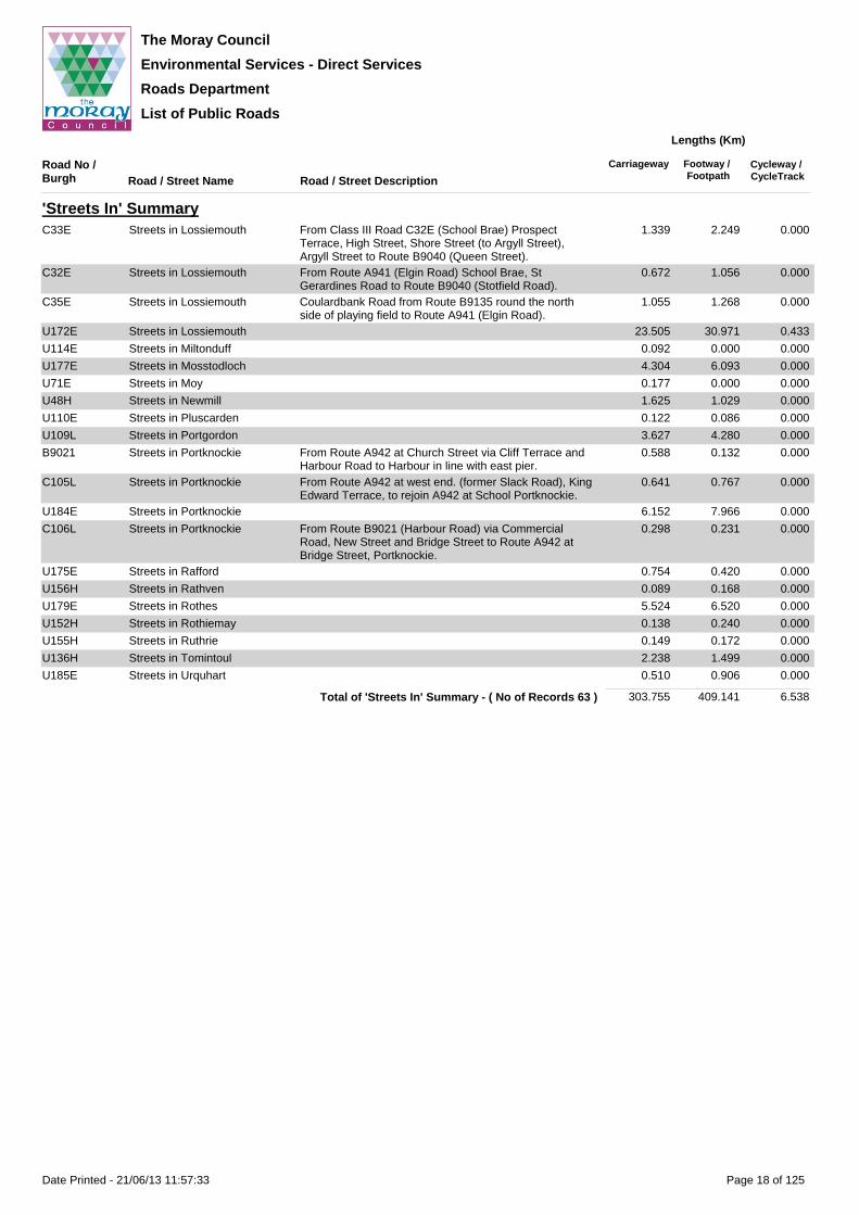
'Streets In' SummaryU100aH Streets in Aberlour 4.496 5.908 0.000
U183E Streets in Alves 0.483 0.737 0.000
U140E Streets in Archiestown 0.506 0.000 0.000
U5E Streets in Bogmoor 0.475 0.000 0.000
U176E Streets in Buckie 35.605 50.414 0.127
U182E Streets in Burghead 6.843 9.790 0.000
C34E Streets in Burghead Grant Street from Route B9013 (Granary Street) to Bath Street
0.486 0.860 0.000
U114H Streets in Carron 0.523 0.000 0.000
U117cH Streets in Chapeltown 0.121 0.036 0.000
U188E Streets in Cragganmore 0.060 0.000 0.000
U150H Streets in Craigellachie 2.169 2.158 0.000
C108L Streets in Cullen From Route A98 at Seafield Street via York Place, South Castle Street, and North Castle Street, to Route A98 at Bayview Road, Cullen.
0.478 0.928 0.000
U178L Streets in Cullen 6.740 8.590 0.000
C107L Streets in Cullen From Route A98 at west end of Castle Terrace via Seatown, Foreshore Road, Harbour and Seafield Street to junction with Route A98 Cullen.
0.731 0.686 0.000
U166E Streets in Cummingston 0.421 0.556 0.000
U151H Streets in Drummuir 0.099 0.193 0.000
U174H Streets in Dufftown 4.347 6.911 0.000
U48E Streets in Duffus 2.661 1.960 0.000
U167E Streets in Dyke 0.439 0.662 0.000
C39E Streets in Elgin From Northfield Terrace, High Street (including Pedestrianised Area) and South College Street to Greyfriars Street
0.757 1.411 0.000
C30E Streets in Elgin Greyfriars Street, South Street, Elgin forming loop from Route A96 to Route A96
1.104 1.955 0.021
U171E Streets in Elgin 86.757 128.199 3.804
C31E Streets in Elgin From Class III Road C39E (High Street), Lossie Wynd (to Alexandra Road)
0.143 0.163 0.028
C40E Streets In Elgin From Roundabout at Route A96 (Reiket Lane) to Roundabout at A941 (Thornhill Road)
1.993 2.124 0.728
U148E Streets in Findhorn 2.103 2.269 0.000
C104L Streets in Findochty Station Road from Route B9020 (Commercial Street) to junction with Route B9020 at Blantyre Terrace and Station Road, Findochty.
0.131 0.007 0.000
B9020 Streets in Findochty From Route A942 via Schoolhill, Commercial Street, Main Street, Sterlochy Street, Blantyre Terrace and Station Road to Route A942 at Railway Bridge.
1.200 0.628 0.000
U186E Streets in Findochty 3.889 5.974 0.000
U149E Streets in Fochabers 7.829 10.520 0.000
U173E Streets in Forres 37.570 50.255 0.763
C37E Streets in Forres Orchard Road and South Street. 0.966 1.618 0.000
C36E Streets in Forres Tytler Street 0.314 0.447 0.000
U164E Streets in Garmouth 1.375 1.527 0.000
U169E Streets in Hopeman 7.322 10.294 0.000
C118H Streets in Keith From Class III Road C72H at Station Road via Station Road northwards and thence south eastwards to junction with Route B9116 Seafield Avenue
0.580 0.544 0.000
U180E Streets in Keith 19.616 21.687 0.000
C117H Streets in Keith From Route A96 at Church Road via Mid Street and Reidhaven Square to Route A96 at Moss Street.
0.712 1.124 0.000
U165E Streets in Kingston 0.054 0.000 0.000
U168E Streets in Kinloss 1.265 1.159 0.634
U170E Streets in Lhanbryde 6.488 10.438 0.000
U157L Streets in Lintmill 0.171 0.314 0.000
U187E Streets In Longmorn 0.134 0.042 0.000
Page 17 of 125Date Printed - 21/06/13 11:57:33
The Moray Council
Environmental Services - Direct Services
Roads Department
List of Public Roads
Road No / Burgh Road / Street Name Road / Street Description
Carriageway Footway / Footpath
Cycleway / CycleTrack
Lengths (Km)
'Streets In' SummaryC33E Streets in Lossiemouth From Class III Road C32E (School Brae) Prospect
Terrace, High Street, Shore Street (to Argyll Street), Argyll Street to Route B9040 (Queen Street).
1.339 2.249 0.000
C32E Streets in Lossiemouth From Route A941 (Elgin Road) School Brae, St Gerardines Road to Route B9040 (Stotfield Road).
0.672 1.056 0.000
C35E Streets in Lossiemouth Coulardbank Road from Route B9135 round the north side of playing field to Route A941 (Elgin Road).
1.055 1.268 0.000
U172E Streets in Lossiemouth 23.505 30.971 0.433
U114E Streets in Miltonduff 0.092 0.000 0.000
U177E Streets in Mosstodloch 4.304 6.093 0.000
U71E Streets in Moy 0.177 0.000 0.000
U48H Streets in Newmill 1.625 1.029 0.000
U110E Streets in Pluscarden 0.122 0.086 0.000
U109L Streets in Portgordon 3.627 4.280 0.000
B9021 Streets in Portknockie From Route A942 at Church Street via Cliff Terrace and Harbour Road to Harbour in line with east pier.
0.588 0.132 0.000
C105L Streets in Portknockie From Route A942 at west end. (former Slack Road), King Edward Terrace, to rejoin A942 at School Portknockie.
0.641 0.767 0.000
U184E Streets in Portknockie 6.152 7.966 0.000
C106L Streets in Portknockie From Route B9021 (Harbour Road) via Commercial Road, New Street and Bridge Street to Route A942 at Bridge Street, Portknockie.
0.298 0.231 0.000
U175E Streets in Rafford 0.754 0.420 0.000
U156H Streets in Rathven 0.089 0.168 0.000
U179E Streets in Rothes 5.524 6.520 0.000
U152H Streets in Rothiemay 0.138 0.240 0.000
U155H Streets in Ruthrie 0.149 0.172 0.000
U136H Streets in Tomintoul 2.238 1.499 0.000
U185E Streets in Urquhart 0.510 0.906 0.000
303.755 409.141 6.538Total of 'Streets In' Summary - ( No of Records 63 )
Page 18 of 125Date Printed - 21/06/13 11:57:33

The Moray Council
Environmental Services - Direct Services
Roads Department
List of Public Roads
Road No / Burgh Road / Street Name Road / Street Description
Carriageway Footway / Footpath
Cycleway / CycleTrack
Lengths (Km)
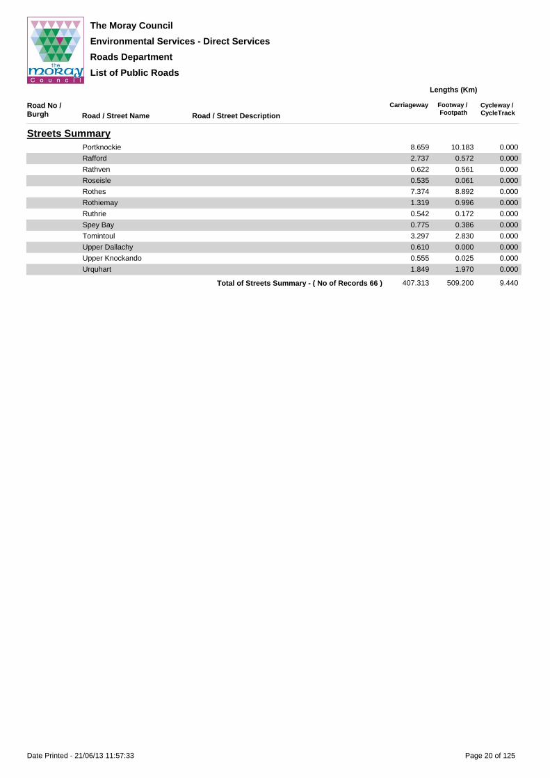
Streets SummaryAberlour 5.676 6.689 0.000
Alves 1.067 1.123 0.000
Archiestown 1.293 1.031 0.000
Arradoul 1.140 0.841 0.000
Auchenhalrig 0.469 0.000 0.000
Aultmore 0.546 0.083 0.000
Berryhillock 0.440 0.000 0.000
Birnie 0.597 0.000 0.000
Bogmoor 1.306 0.000 0.000
Broadley 0.340 0.000 0.000
Buckie 46.067 65.268 0.127
Burghead 8.700 12.816 0.000
Cardhu 0.348 0.000 0.000
Carron 0.523 0.000 0.000
Carron 0.177 0.000 0.000
Chapeltown 0.232 0.036 0.000
Conicavel 0.363 0.000 0.000
Cragganmore 0.060 0.000 0.000
Craigellachie 2.946 2.921 0.000
Cullen 9.877 12.611 0.000
Cummingston 1.398 2.353 0.000
Dallas 0.904 0.872 0.000
Drummuir 0.842 0.641 0.000
Drybridge 0.514 0.000 0.000
Dufftown 9.723 11.722 0.000
Duffus 3.251 2.207 0.000
Dyke 1.052 0.695 0.000
Edinvillie 0.318 0.000 0.000
Elgin 105.519 152.343 6.575
Findhorn 4.465 4.289 0.000
Findochty 5.715 7.044 0.000
Fochabers 10.071 13.183 0.000
Fogwatt 0.972 0.000 0.000
Forres 46.994 62.503 0.763
Garmouth 4.438 2.497 0.000
Hopeman 8.565 11.544 0.000
Keith 26.008 28.827 0.000
Kingston 1.112 0.063 0.000
Kinloss 5.081 3.732 0.634
Kirktown Of Deskford 0.331 0.000 0.000
Knock 0.303 0.000 0.000
Lhanbryde 8.144 13.242 0.000
Lintmill 0.598 0.512 0.000
Lochhills 0.293 0.000 0.000
Longmorn 0.134 0.042 0.000
Lossiemouth 31.241 41.588 0.914
Miltonduff 1.688 1.168 0.000
Mosstodloch 7.228 9.077 0.427
Moy 0.177 0.000 0.000
Nether Dallachy 0.634 0.000 0.000
Newmill 2.561 2.143 0.000
Parkmore 0.412 0.020 0.000
Pluscarden 0.122 0.086 0.000
Portgordon 5.464 6.740 0.000
Page 19 of 125Date Printed - 21/06/13 11:57:33
The Moray Council
Environmental Services - Direct Services
Roads Department
List of Public Roads
Road No / Burgh Road / Street Name Road / Street Description
Carriageway Footway / Footpath
Cycleway / CycleTrack
Lengths (Km)
Streets SummaryPortknockie 8.659 10.183 0.000
Rafford 2.737 0.572 0.000
Rathven 0.622 0.561 0.000
Roseisle 0.535 0.061 0.000
Rothes 7.374 8.892 0.000
Rothiemay 1.319 0.996 0.000
Ruthrie 0.542 0.172 0.000
Spey Bay 0.775 0.386 0.000
Tomintoul 3.297 2.830 0.000
Upper Dallachy 0.610 0.000 0.000
Upper Knockando 0.555 0.025 0.000
Urquhart 1.849 1.970 0.000
407.313 509.200 9.440Total of Streets Summary - ( No of Records 66 )
Page 20 of 125Date Printed - 21/06/13 11:57:33

The Moray Council
Environmental Services - Direct Services
Roads Department
List of Public Roads
Road No / Burgh Road / Street Name Road / Street Description
Carriageway Footway / Footpath
Cycleway / CycleTrack
Lengths (Km)
AberlourU108H Allachie Drive (U108H) See Unclassified Road U108H
From Queens Road to Braes of Allachie.0.518 0.291 0.000
U100aH Allachy Terrace From Queens Road to Mary Avenue 0.326 0.504 0.000
Allardyce Crescent From Allachy Terrace in loop to rejoin Allachy Terrace - incl. short cul-de-sac to south
0.310 0.603 0.000
Braes of Allachie From Allachie Drive north then eastwards to hammerhead 0.101 0.000 0.000
Chapel Terrace From Queens Road (108H) southwards to hammerhead at 13-33
0.242 0.389 0.000
Conval Drive From High Street (A95) to Speyside Care Home 0.228 0.371 0.000
Dowans Road From A95 to C59H 0.475 0.314 0.000
Elchies Road From High Street (A95) to Public House 0.097 0.024 0.000
Farm Close From Tower Place eastwards to hammerhead - incl leg to south
0.084 0.166 0.000
Hill Avenue From High Street (A95) to Mary Avenue 0.066 0.058 0.000
Hotel Lane (North) From High Street (A95) to church 0.070 0.041 0.000
Hotel Lane (South) From High Street (A95) to Mary Avenue 0.065 0.018 0.000
Linn Brae From Queens Road in a south westerly then a south easterly direction via roundabout then a westerly direction to hammerhead
0.697 1.018 0.000
Mary Avenue From access to Tower Villa to Queens Road (U108H) then from Queens Road (U108H) to Conval Drive then from Conval Drive to north eastern boundary at rear of No 25 High Street
0.673 1.074 0.000
U108H Queens Road (U108H) See Unclassified Road 108HFrom High Street to Allachie Drive.
0.398 0.470 0.000
C59H Ruthrie Road (C59H) See Route C59HFrom A95 (T) south to National Speed Limit signs
0.264 0.020 0.000
U100aH Sellar Place Access road off Dowans Road.From Dowans Road to turning hammerhead
0.218 0.355 0.000
Speyside High School Road From Queen's Road to turning circle at rear of High School
0.302 0.259 0.000
Station Court Cul-de-sac off High Street 0.164 0.174 0.000
Taylor Court Cul-de-sac off Sellar Place 0.118 0.211 0.000
Tower Place Cul-de-sac off Conval Drive including link to High School 0.187 0.276 0.000
Victoria Terrace From High Street (A95) to entrance to car park 0.073 0.053 0.000
5.676 6.689 0.000Total of Aberlour - ( No of Records 22 )
Page 21 of 125Date Printed - 21/06/13 11:57:33

The Moray Council
Environmental Services - Direct Services
Roads Department
List of Public Roads
Road No / Burgh Road / Street Name Road / Street Description
Carriageway Footway / Footpath
Cycleway / CycleTrack
Lengths (Km)
AlvesC25E Burghead Road (C25E) See Class III Road C25E
From A96(T) north to National Speed Limit signs0.271 0.302 0.000
U183E Carden Close Cul-de-sac off Burghead Road, incl turning circle 0.263 0.474 0.000
U58E Coltfield Road (U58E) See Unclassified Road 58EFrom A96(T) north to National Speed Limit signs
0.083 0.049 0.000
U183E Moir Street From Burghead Road in a north westerly then a south westerly then a south easterly direction to terminate in a turning hammerhead, formerly PU Road No 143.
0.141 0.111 0.000
Smiddy Place Cul-de-sac off Elgin-Forres Road, A96 0.079 0.152 0.000
C4E Station Road (C4E) See Class III Road C4EFrom A96(T) south to National Speed Limit signs
0.230 0.035 0.000
1.067 1.123 0.000Total of Alves - ( No of Records 6 )
Page 22 of 125Date Printed - 21/06/13 11:57:33

The Moray Council
Environmental Services - Direct Services
Roads Department
List of Public Roads
Road No / Burgh Road / Street Name Road / Street Description
Carriageway Footway / Footpath
Cycleway / CycleTrack
Lengths (Km)
ArchiestownB9102 High Street (B9102) See Route B9102
From The Square east to National Speed Limit signs0.476 0.932 0.000
U140E Moss Street From The Square in a northerly direction to forestry access
0.067 0.000 0.000
Smiddy Lane From High Street to South Lane - formerly PU Road No 1, then part of South Lane.
0.066 0.000 0.000
South Lane From The Square to Smiddy Lane, formerly PU Road No 10.
0.307 0.000 0.000
The Square From Moss Street in a southerly direction to High Street. 0.066 0.000 0.000
C15E (W) The Square (C15E) See Class III Road C15EFrom High Street (B9102) south to National Speed Limit signs
0.151 0.000 0.000
B9102 West End (B9102) From High Street at junction with C15E to national speed limit signs
0.160 0.099 0.000
1.293 1.031 0.000Total of Archiestown - ( No of Records 7 )
Page 23 of 125Date Printed - 21/06/13 11:57:34

The Moray Council
Environmental Services - Direct Services
Roads Department
List of Public Roads
Road No / Burgh Road / Street Name Road / Street Description
Carriageway Footway / Footpath
Cycleway / CycleTrack
Lengths (Km)
ArradoulA98 Main Road (A98) See Route A98
Between National Speed Limit signs1.012 0.751 0.000
C67L Thornybank Road (C67L) See Route C67LFrom Main Road (A98) south to National Speed Limit signs
0.128 0.090 0.000
1.140 0.841 0.000Total of Arradoul - ( No of Records 2 )
Page 24 of 125Date Printed - 21/06/13 11:57:34

The Moray Council
Environmental Services - Direct Services
Roads Department
List of Public Roads
Road No / Burgh Road / Street Name Road / Street Description
Carriageway Footway / Footpath
Cycleway / CycleTrack
Lengths (Km)
AuchenhalrigU9E Main Road (U9E) See Unclassified Road 9E
Between National Speed Limit signs0.469 0.000 0.000
0.469 0.000 0.000Total of Auchenhalrig - ( No of Records 1 )
Page 25 of 125Date Printed - 21/06/13 11:57:34

The Moray Council
Environmental Services - Direct Services
Roads Department
List of Public Roads
Road No / Burgh Road / Street Name Road / Street Description
Carriageway Footway / Footpath
Cycleway / CycleTrack
Lengths (Km)
AultmoreB9016 Main Road (B9016) See Route B9016
Between National Speed Limit signs0.546 0.083 0.000
0.546 0.083 0.000Total of Aultmore - ( No of Records 1 )
Page 26 of 125Date Printed - 21/06/13 11:57:34

The Moray Council
Environmental Services - Direct Services
Roads Department
List of Public Roads
Road No / Burgh Road / Street Name Road / Street Description
Carriageway Footway / Footpath
Cycleway / CycleTrack
Lengths (Km)
BerryhillockU58cL Burnside Crescent (U58cL) See Unclassified Road 58cL
From Main Road (C4L) south to National Speed Limit signs
0.268 0.000 0.000
C4L Main Road (C4L) See Class III Road C4LBetween National Speed Limit signs
0.172 0.000 0.000
0.440 0.000 0.000Total of Berryhillock - ( No of Records 2 )
Page 27 of 125Date Printed - 21/06/13 11:57:34
The Moray Council
Environmental Services - Direct Services
Roads Department
List of Public Roads
Road No / Burgh Road / Street Name Road / Street Description
Carriageway Footway / Footpath
Cycleway / CycleTrack
Lengths (Km)
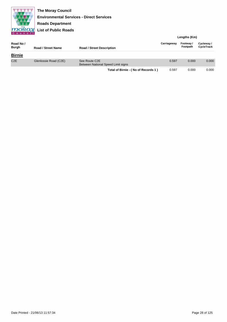
BirnieC2E Glenlossie Road (C2E) See Route C2E
Between National Speed Limit signs0.597 0.000 0.000
0.597 0.000 0.000Total of Birnie - ( No of Records 1 )
Page 28 of 125Date Printed - 21/06/13 11:57:34

The Moray Council
Environmental Services - Direct Services
Roads Department
List of Public Roads
Road No / Burgh Road / Street Name Road / Street Description
Carriageway Footway / Footpath
Cycleway / CycleTrack
Lengths (Km)
BogmoorB9104 Bogmoor Road (B9104) See Route B9104
Between National Speed Limit signs0.831 0.000 0.000
U5E The Muir (U5E) Loop road off B9104 from Nos 13/15 Bogmoor Road in a westerly then a northerly then an easterly direction to rejoin B9104 at No 2 The Muir, formerly PU Road No 62.
0.475 0.000 0.000
1.306 0.000 0.000Total of Bogmoor - ( No of Records 2 )
Page 29 of 125Date Printed - 21/06/13 11:57:34

The Moray Council
Environmental Services - Direct Services
Roads Department
List of Public Roads
Road No / Burgh Road / Street Name Road / Street Description
Carriageway Footway / Footpath
Cycleway / CycleTrack
Lengths (Km)
BroadleyU70aL Main Road (U70aL) See Unclassified Road 70aL
From U70L east to National Speed Limit signs0.340 0.000 0.000
0.340 0.000 0.000Total of Broadley - ( No of Records 1 )
Page 30 of 125Date Printed - 21/06/13 11:57:34

The Moray Council
Environmental Services - Direct Services
Roads Department
List of Public Roads
Road No / Burgh Road / Street Name Road / Street Description
Carriageway Footway / Footpath
Cycleway / CycleTrack
Lengths (Km)
BuckieU176E Aboyne Street From Rathburn Street southwards 0.074 0.157 0.000
Admiralty Street From Gordon Street to East Carlton Terrace 0.143 0.248 0.000
Alba Road From Mavers Lane to Watt Avenue 0.139 0.107 0.127
Alexander Street From Sutherland Street in a south westerly direction to terminate in a loop passing John Street and Hay Street, formerly PU Road No 102.
0.118 0.071 0.000
Alnath Place From Barfield Road to Netherha Road 0.075 0.144 0.000
Anderson Drive From Barhill Road roundabout to Alba Road 0.110 0.218 0.000
Anson Way Cul-de-sac off Archibald Grove, including turning place 0.106 0.211 0.000
Anton Street From Land Street to Sutherland Street then from Sutherland Street to James Street then from James Street to Robert Street then from Robert Street then from Robert Street to Merson Street then from Merson Street to entrance to playing fields
0.326 0.582 0.000
Archibald Grove From Douglas Crescent to High Street 0.727 1.100 0.000
Banff Street From Railway Terrace to West Church Street 0.060 0.110 0.000
A990 Bank Street (A990) From Baron Street to North High Street 0.059 0.114 0.000
U176E Barfield Road From Barhill Road to Carnie Place 0.298 0.545 0.000
Barhill Road From No 6 in a north westerly direction to terminate at north gable of Pavillion, formerly PU Road No 191.
0.113 0.072 0.000
C31L Barhill Road (C31L) See Class III Road C31LFrom Golf View Drive south to National Speed Limit signs
0.444 0.763 0.000
U176E Baron Place From Baron Street to steps 0.051 0.000 0.000
Baron Street From A990 southwards to No.1 0.104 0.202 0.000
A990 Baron Street (A990) From Yardie to Bank Street 0.170 0.301 0.000
U176E Blairdaff Street From South Pringle Street to Cluny Lane 0.175 0.333 0.000
Blantyre Terrace From Reidhaven Street to entrance to Shipyard 0.205 0.217 0.000
Bowie's Lane From Main Street to Harbour Head 0.035 0.041 0.000
Braeview Road Cul-de-sac off Letterfourie Road 0.335 0.549 0.000
A990 Bridge Place (A990) From Main Street to Yardie 0.054 0.076 0.000
U176E Bridgend From St Helena Brae to A990 0.035 0.069 0.000
Brodie Avenue Cul-de-sac off Milton Drive. 0.154 0.168 0.000
Bruce Avenue From Burns Square to Linn Crescent 0.216 0.430 0.000
Bryson Crescent From Samson Avenue in a loop back to Samson Avenue 0.259 0.517 0.000
Burnbank From Cameron Crescent to Steinbeck Road 0.209 0.192 0.000
Burns Square Square connecting Wallace Avenue, Harbour Street and Bruce Avenue
0.107 0.126 0.000
Burnside Court Cul de sac off Netherha Road 0.198 0.141 0.000
Cameron Crescent From High Street to turning area at No 35 including link to Highfield Road
0.635 1.166 0.000
Campbell Street From Chancellor Road southwards 0.112 0.220 0.000
Carnie Place From Inward Road to Barfield Road 0.058 0.113 0.000
Cathcart Grove From Hamilton Path to Newlands Lane 0.168 0.308 0.000
Cathedral Street From St Peters Terrace to Seaview Terrace 0.154 0.062 0.000
Chancellor Road From Craigbo Roundabout to Station Road 0.420 0.773 0.000
Chapel Street From Station Road to Great Eastern Road 0.172 0.086 0.000
Cliff Street From East Church Street to Linn Avenue 0.081 0.130 0.000
Cliff Terrace From Cliff Street to House No 23 0.261 0.248 0.000
Cluny Lane From High Street to Blairdaff Street at No.22 0.138 0.077 0.000
Cluny Place From West Church Street to Cluny Terrace 0.139 0.221 0.000
Cluny Terrace From Cluny Place to Gordon Street with branch to No.22 0.204 0.259 0.000
Commerce Street From East Church Street to Linn Avenue 0.080 0.111 0.000
A942 Commercial Road (A942) See Route A942From Marine Place to Rathburn Street
0.635 0.777 0.000
U176E Cooper Street From McKenzie Road to Inward Road 0.064 0.125 0.000
Craigbo Brae From Reidhaven Street to Samson Avenue 0.154 0.022 0.000
Craigbo Terrace From Samson Avenue to Craigbo Roundabout 0.443 0.453 0.000
Page 31 of 125Date Printed - 21/06/13 11:57:34

The Moray Council
Environmental Services - Direct Services
Roads Department
List of Public Roads
Road No / Burgh Road / Street Name Road / Street Description
Carriageway Footway / Footpath
Cycleway / CycleTrack
Lengths (Km)
BuckieU176E Craigenroan Place Four streets from Great Eastern Road (A942) to Chapel
Street0.110 0.198 0.000
Craigview Main section from Station Road for a distance of 75m plus stub to north for a distance of 47m
0.125 0.057 0.000
Cross Lane From Cathedral Street to Land Street 0.098 0.000 0.000
Crown Street From Blantyre Terrace to Ianstown Terrace 0.074 0.129 0.000
Cunningholes From March Road Roundabout to Stripeside Roundabout 0.420 0.000 0.000
Doocot Way Access Road leading off Burnside Court 0.175 0.036 0.000
Doran Drive From Spey Drive to Steinbeck Road 0.216 0.353 0.000
Dougall's Brae From New Street north to A990 0.117 0.000 0.000
Douglas Crescent From Stripeside Roundabout to Shearer Avenue including Cul-de-sacs at Nos 8 to 72, 74 to 82, 144 to 160, 172 to 186 and 19 to 59
1.057 1.516 0.000
Duguid Street From Cluny Lane (opposite Nos 12 and 14) to West Cathcart Street then from West Cathcart Street to hammerhead at No 15
0.197 0.355 0.000
Dunbar Street From St Pauls Street to The Bow 0.076 0.140 0.000
Duthie Place Cul-de-sac off Archibald Grove, including turning place 0.113 0.191 0.000
East Carlton Terrace From North Pringle Street to Admirality Street 0.138 0.274 0.000
East Cathcart Street From High Street to Cathcart Grove including area fronting No 8 East Cathcart Street
0.251 0.423 0.000
C43L East Church Street (C43L) See Class III Road C43LFrom Cluny Square to Cliff Street
0.495 0.933 0.000
U176E Elsley Place From Sutherland Crescent to West Church Street 0.151 0.165 0.000
Farquhar's Lane From High Street to Garden Lane 0.059 0.000 0.000
Findlater Street From turning area at No 12 Great Eastern Road to Great Eastern Road at No 18
0.134 0.236 0.000
Freuchny Lane From High Street to Old Mill Court 0.093 0.000 0.000
C102L Freuchny Road (C102L) See Class III Road C102LFrom Commercial Road (A942) to MacLarens Brae (C43L)
0.095 0.165 0.000
U176E Garden Lane From Newlands Lane to East Cathcart Street then from East Cathcart Street to Freuchny Lane
0.238 0.063 0.000
George Street From Chancellor Road southwards 0.118 0.235 0.000
Gibb's Lane From Main Street (A990)to Seaview Terrace 0.110 0.024 0.000
Golf View Drive Cul-de-sac off Barhill Road 0.249 0.239 0.000
Gordon Street From Cluny Terrace at junction with Admiralty Street to West Street
0.292 0.524 0.000
Grant Street From Reidhaven Street (A942) southwards 0.099 0.000 0.000
A942 Great Eastern Road (A942) From No.1 Great Eastern Road east to national speed limit sign
1.623 2.005 0.000
U176E Great Western Court Cul-de-sac off Great Western Road 0.091 0.172 0.000
A990 Great Western Road (A990) From Main Street (A990) to national speed limit signs. 0.407 0.762 0.000
U176E Greenbank Court Cul-de-sac off Redburn Drive including turning circle 0.108 0.099 0.000
Hall Street From North Pringle Street to Admiralty Street 0.118 0.223 0.000
Hanover Court Cul-de-sac south of Newlands Lane 0.077 0.071 0.000
Harbour Head From No 48 Main Street to No 19 Harbour Head 0.030 0.002 0.000
Harbour Street From East Church Street (C43L) to Burns Square then from Burns Square to Well Road
0.334 0.595 0.000
Hay Street From Seaview Road to Alexander Street 0.053 0.078 0.000
Hendry Terrace From Well Road to Scott Terrace 0.136 0.269 0.000
A942 High Street (A942) See Route A942From National speed limit signs to Cluny Square
1.234 2.024 0.000
U176E High Street (Service Road East)
From No.99 to turning hammerhead 0.224 0.202 0.000
High Street (Service Road West)
Service road between Steinbeck Road and Cameron Crescent
0.170 0.000 0.000
High Street Lane From 61 High Street to Garden Lane 0.060 0.000 0.000
Highfield Road From High Street to No 55 0.619 1.186 0.000
Page 32 of 125Date Printed - 21/06/13 11:57:35

The Moray Council
Environmental Services - Direct Services
Roads Department
List of Public Roads
Road No / Burgh Road / Street Name Road / Street Description
Carriageway Footway / Footpath
Cycleway / CycleTrack
Lengths (Km)
BuckieU176E Hope Street From Great Eastern Road to Craigbo Roundabout
including leg from No 6 to No 120.223 0.077 0.000
Ianstown Terrace From Reidhaven Street (A942) to King Street 0.149 0.061 0.000
Inward Road From Turner Street to St Paul Street 0.234 0.446 0.000
James Street From Seaview Road to St Peters Road (C31L) 0.278 0.508 0.000
John Street From Seaview Road to Alexander Street 0.052 0.076 0.000
King Street From Blantyre Terrace to Ianstown Terrace 0.094 0.177 0.000
Lady Road From Dunbar Street to Barfield Road 0.124 0.229 0.000
Land Street From Seaview Terrace to St Andrews Square 0.240 0.430 0.000
Letterfourie Gardens Cul-de-sac off Letterfourie Road 0.188 0.334 0.000
Letterfourie Road From Netherha Road in loop back to Netherha Road including turning loop at No 21 to No 31.
0.367 0.634 0.000
Lidl Access Road From East Cathcart Street south east 0.079 0.092 0.000
Linn Avenue Access Road off Commerce Street 0.258 0.426 0.000
Linn Crescent From Harbour Street to Stripeside Roundabout 0.321 0.603 0.000
Logie's Lane From Low Street (A942) to meet Logie`s Lane Remote Footpath at underbridge
0.051 0.000 0.000
A942 Low Street (A942) See Route A942From Bank Street (A942) at No.4 Low Street to Marine Place (A942) at No.52 Low Street
0.241 0.434 0.000
C43L MacLaren's Brae (C43L) See Class III Road C43LFrom Cliff Street to Freuchny Road (C102L)
0.348 0.667 0.000
A990 Main Street (A990) See Route A990From Bridge Place (A990) to No.141 Main Street at Great Western Road (A990)
0.694 1.262 0.000
U176E Manar Street From Rathburn Street (A942) southwards 0.062 0.101 0.000
C43L March Road (C43L) See Class III Road C43LFrom Freuchny Road (C102L) to roundabout
0.686 0.451 0.000
U176E March Road (Ind Estate West) From March Road (C43L) to west including turning loop 0.313 0.318 0.000
March Road East From Rathven Road to turning circle, including section to March Road
0.323 0.526 0.000
March Road North From C43L March Road to Cox`s 0.076 0.100 0.000
March Street From Rathburn Street southwards 0.073 0.071 0.000
Marchmont Crescent Cul-de-sac off March Road (C43L) 0.276 0.186 0.000
A942 Marine Place (A942) See Route A942From No.52 Low Street (A942) to junction with Old Station Yard
0.165 0.159 0.000
U176E Maud View Cul-de-sac off Archibald Grove 0.103 0.193 0.000
Mavers Lane From Alba Road to Smirack Road 0.054 0.052 0.000
McIntosh Avenue Loop off Samson Avenue 0.067 0.081 0.000
McKenzie Road From Turner Street to Cooper Street 0.169 0.326 0.000
McNaughton Avenue From Burnbank to Cameron Crescent 0.191 0.363 0.000
McWilliam Crescent Cul-de-sac off High Street 0.351 0.597 0.000
Meadows View From The Meadows in an easterly direction to terminate in a turning hammerhead
0.071 0.134 0.000
Merson Street From St Peters Road (C31L) to Seaview Road 0.254 0.464 0.000
Mid Street From No 1 Seatown to No 40 Seatown. 0.168 0.247 0.000
Midmar Street From High Street to South Pringle Street 0.336 0.493 0.000
Mill Crescent From Harbour Street to Well Road 0.395 0.763 0.000
Millbank Terrace From Well Road in a loop back to Well Road 0.406 0.405 0.000
Milton Drive From Well Road to Scott Terrace 0.807 1.387 0.000
Moray View Court Cul-de-sac off Muirycrook Road (U66aL) 0.137 0.277 0.000
U66aL Muirycrook Road (U66aL) See Unclassified Road 66aLFrom Craigbo Roundabout to National speed limit signs
0.244 0.088 0.000
U176E Munro Way From High Street westwards to terminate in hammerhead at access to Mill of Buckie steadings
0.325 0.085 0.000
Netherha Road From Barhill Road (C31L) to Sutherland Crescent. 0.522 0.944 0.000
New Street From Gordon Street to Cluny Terrace 0.320 0.521 0.000
Page 33 of 125Date Printed - 21/06/13 11:57:35

The Moray Council
Environmental Services - Direct Services
Roads Department
List of Public Roads
Road No / Burgh Road / Street Name Road / Street Description
Carriageway Footway / Footpath
Cycleway / CycleTrack
Lengths (Km)
BuckieU176E Newlands Lane From High Street to Harbour Street 0.429 0.483 0.000
A942 North High Street (A942) See Route A942From Cluny Square to Bank Street (A942)
0.191 0.314 0.000
U176E North Pringle Street From West Church Street (C31L) to Gordon Street 0.202 0.319 0.000
Ogilvie Street From Station Road (U66L) westwards parallel to Great Eastern Road
0.126 0.000 0.000
Park Grove Cul-de-sac west from Shearer Avenue 0.151 0.262 0.000
Parkland View Cul-de-sac off Archibald Grove 0.059 0.122 0.000
Paterson's Lane From Cluny Terrace to Admiralty Street 0.049 0.000 0.000
Provost Reid Crescent Loop off Midmar Street 0.274 0.548 0.000
Queen Street From West Church Street (C31L) southwards 0.218 0.409 0.000
Raffan Road From Milton Drive to Douglas Crescent including Cul-de-sacs to north and south.
0.352 0.647 0.000
Railway Terrace From Gordon Street to North Pringle Street then from North Pringle Street to Banff Street
0.258 0.525 0.000
Rannas Place (Part) From Great Eastern Road in a loop back to Great Eastern Road between No 25 and No 26 including leg between No 32 and No 25
0.179 0.000 0.000
A942 Rathburn Street (A942) See Route A942From No.4 Reidhaven Street (A942) to junction with March Street
0.153 0.274 0.000
C43L Rathven Road (C43L) See Class III Road C43LFrom roundabout to National speed limit signs
0.160 0.018 0.000
U176E Redburn Drive From Letterfourie Road to Barhill Road (C31L) 0.282 0.541 0.000
Regency Road Cul-de-sac off Archibald Grove 0.115 0.232 0.000
A942 Reidhaven Street (A942) See Route A942From No.4 Reidhaven Street to No.1 Great Eastern Road (A942)
0.418 0.548 0.000
U176E Richmond Street From Rathburn Street southwards 0.062 0.120 0.000
Robert Court Cul-de-sac off Robert Street 0.056 0.129 0.000
Robert Street From Seaview Road to St Peters Road (C31L) 0.285 0.479 0.000
Samson Avenue From Craigbo Terrace to Craigbo Roundabout 0.354 0.601 0.000
School Road From Chancellor Road southwards to entrance to school 0.076 0.148 0.000
Scott Terrace From Well Road to Hendry Terrace including loop from No 8 to No 18
0.220 0.320 0.000
Seafield Street From Blantyre Terrace to Ianstown Terrace 0.089 0.138 0.000
Seatown From Dougall's Brae to Cluny Terrace with leg round to No.70 Seatown and leg to No.97 Seatown
0.506 0.590 0.000
Seaview Place From Cluny Place to North High Street (A942) 0.122 0.088 0.000
Seaview Road From Seaview Terrace at junction with Land Street to No 40 Seaview Road
0.396 0.468 0.000
Seaview Terrace From Seaview Road to St Helena Brae 0.148 0.018 0.000
Seld Street From St Peters Road (C31L) to McKenzie Road 0.062 0.118 0.000
Shanks Lane From East Church Street (C43L) to Newlands Lane 0.065 0.087 0.000
Shearer Avenue From Milton Drive to Archibald Grove including loop at No 2 to No 14 and Cul-de-sac at No 19
0.500 0.568 0.000
Slaughterhouse Brae From Great Western Road (A990) to Seaview Road 0.354 0.056 0.000
Smirack Road From Mavers Lane to Watt Avenue 0.151 0.107 0.000
South Land Street From Elsley Place then from House No 1 to No 8 0.081 0.084 0.000
South Pringle Street From West Church Street (C31L) to West Cathcart Street then from West Cathcart Street to Midmar Street
0.267 0.435 0.000
South West Street From West Church Street (C31L) to West Cathcart Street 0.131 0.232 0.000
Spey Drive From Steinbeck Road to McNaughton Avenue 0.136 0.223 0.000
C31L St Andrew's Square (C31L) See Class III Road C31LFrom St Peters Road to West Church Street
0.063 0.109 0.000
U176E St Helena's Brae From Seaview Terrace to No 19 Bridge End 0.115 0.043 0.000
St Paul Street From St Peters Road (C31L) to Barfield Road 0.195 0.362 0.000
C31L St Peter's Road (C31L) See Class III Road C31LFrom No.79 St Peters Road to St Andrews Square
0.494 0.844 0.000
Page 34 of 125Date Printed - 21/06/13 11:57:35

The Moray Council
Environmental Services - Direct Services
Roads Department
List of Public Roads
Road No / Burgh Road / Street Name Road / Street Description
Carriageway Footway / Footpath
Cycleway / CycleTrack
Lengths (Km)
BuckieU176E St Peters Road (Service Road) Service Road fronting No 68 to No 76 St Peters Road 0.064 0.070 0.000
St Peter's Terrace From Land Street to No.1 Union Terrace 0.173 0.249 0.000
U66L Station Road (U66L) From Great Eastern Road to Chancellor Road then from Chancellor Road to speed limit past Station Road Cul-de-sac (PU No 79)
0.310 0.096 0.000
U176E Steinbeck Road From High Street (A942) to Cameron Crescent 0.413 0.625 0.000
Stripeside From Stripeside Roundabout southwards 0.142 0.169 0.000
Stuart Street From Chancellor Road southwards 0.104 0.206 0.000
Sutherland Crescent From St Peters Road to Netherha Road. 0.152 0.282 0.000
Sutherland Street From Seaview Road to St Peters Road 0.271 0.393 0.000
The Bow From Dunbar Street in a loop to Lady Road 0.124 0.135 0.000
The Meadows From Highfield Road in a westerly then a south westerly then a north westerly direction to terminate in a turning hammerhead including stubs at No 18 and No 20
0.283 0.542 0.000
Titness Street From West Street to North Pringle Street 0.152 0.295 0.000
Turner Street From McKenzie Road to Inward Road 0.063 0.126 0.000
Victoria Street From Chancellor Road southwards 0.091 0.180 0.000
Wallace Avenue From Mill Crescent to Burns Square 0.177 0.350 0.000
Watt Avenue From Alba Road to Smirack Road 0.054 0.102 0.000
Well Road From High Street (A942) to Stripeside including loops at No 41 to No 75 and No 101 to No 115
0.895 1.441 0.000
West Carlton Terrace From Gordon Street to North Pringle Street 0.134 0.247 0.000
West Cathcart Street From Queen Street to High Street (A942) 0.573 1.058 0.000
C31L West Church Street (C31L) See Class III Road C31LFrom Cluny Square to St Peters Road (C31L)
0.793 1.470 0.000
U176E West Street From West Church Street (C31L) to Gordon Street 0.157 0.290 0.000
Westburn Court Cul-de-sac off Golf View Drive 0.139 0.239 0.000
Whispering Meadows From roundabout on High Street to turning circle including hammerheads at No 26 and No 30.
0.448 0.851 0.000
Whitefield Court Cul-de-sac off Redburn Drive 0.113 0.121 0.000
William Street From Seaview Road southwards 0.080 0.153 0.000
Wilsons Land From Cathedral Street in an easterly direction to terminate at No 2 Union Terrace, formerly PU Road No 78.
0.072 0.069 0.000
Woodside Close Cul-de-sac off Land Street 0.074 0.082 0.000
Yardie From No.2 Yardie to No.65 Yardie including branches at No.24 and No.11
0.370 0.219 0.000
Yardie - Lane 1 From No 61 to No 65 0.039 0.049 0.000
Yardie - Lane 2 From No 59 to No 55 0.041 0.076 0.000
Yardie - Lane 3 From No 47 to No 51 0.045 0.084 0.000
A990 Yardie (A990) See Route A990From No.30 Baron Street (A990) to junction with Dougall's Brae
0.286 0.200 0.000
U176E Yuill Avenue Loop off Well Road 0.255 0.503 0.000
46.067 65.268 0.127Total of Buckie - ( No of Records 203 )
Page 35 of 125Date Printed - 21/06/13 11:57:35

The Moray Council
Environmental Services - Direct Services
Roads Department
List of Public Roads
Road No / Burgh Road / Street Name Road / Street Description
Carriageway Footway / Footpath
Cycleway / CycleTrack
Lengths (Km)
BurgheadU182E Bath Street From Grant Street to Church Street 0.212 0.000 0.000
Bayview From Sigurd Street to turning circle 0.087 0.134 0.000
Brander Street From Station Road to Granary Street (B9013) then from Granary Street (B9013) to Grant Street (C34E) then from Grant Street (C34E) to Forteath Street
0.215 0.343 0.000
Church Street From commencement of Harbour to Granary Street (B9013) then from Granary Street (B9013) to Grant Street (C34E) then from Grant Street (C34E) to Forteath Street
0.228 0.356 0.000
Davidson Place Cul-de-sac off Keith Road 0.082 0.077 0.000
Dunbar Street From Kinloss Street to Park Street then from Park Street to Sellar Street then from Sellar Street to Brander Street then from Brander Street to Young Street then from Young Street to Church Street then from Church Street to Bath Street
0.556 1.018 0.000
Firth View Cul-de-sac off Fraser Road, including turning circle 0.134 0.189 0.000
Forest Place Cul-de-sac off Forest Road (Formerly Known as Forest Drive)
0.072 0.115 0.000
Forest Road From St Aethans Road to hammerhead 0.257 0.374 0.000
Forteath Street From gable of No 76 Forteath Street to Park Street 0.433 0.778 0.000
Forteath Street (South) From Brander Street to Young Street 0.094 0.082 0.000
Fraser Road From Route B9013 (St Aethans Road ) eastwards to meet Route B9040 at transmitter (formerly B9012)
1.043 1.073 0.000
Granary Street From Kinloss Street to No 22 Granary Street 0.160 0.257 0.000
B9013 Granary Street (B9013) See Route B9013From Grant Street (B9013) to No.71
0.509 0.929 0.000
Grant Street (B9013) See Route B9013From No.17 to St Aethans Road (B9013)
0.207 0.349 0.000
C34E Grant Street (C34E) See Class III Road C34EFrom No.17 westwards to Bath Street
0.486 0.860 0.000
U182E Keith Road Access road off Fraser Road 0.241 0.422 0.000
King Street From Kinloss Street to Park Street then from Park Street to Sellar Street then from Sellar Street to Brander Street then from Brander Street to Young Street then from Young Street to Church Street then from Church Street to No.75 King Street
0.502 0.934 0.000
Kinloss Street From Station Road to Grant Street (B9013) then from Grant Street (B9013) to King Street
0.186 0.316 0.000
MacKenzie Place Cul-de-sac off St Aethans Road 0.161 0.270 0.000
McDonald Crescent Cul-de-sac off St Aethans Road 0.202 0.166 0.000
Park Street From Station Road to Granary Street (B9013) then from Grant Street (B9013) to Forteath Street
0.232 0.336 0.000
Pinewood Road Cul-de-sac off Forest Road 0.066 0.096 0.000
School Lane Opposite school 0.045 0.038 0.000
Sellar Street From Granary Street (B9013) to Grant Street (C34E) then from Grant Street (C34E) to Forteath Street
0.185 0.318 0.000
Sigurd Street From Keith Road to Route B9040 (Lossiemouth - Burghead Road) including stub leading to No 23 to No 29
0.379 0.696 0.000
St Aethans Avenue From St Aethans Drive in a south westerly direction to terminate in a turning hammerhead
0.089 0.065 0.000
St Aethans Close From St Aethans Drive in a north easterly direction to terminate in a turning hammerhead
0.070 0.043 0.000
St Aethans Drive From Fraser Road in a south easterly direction to terminate in a turning circle
0.258 0.428 0.000
B9013 St Aethans Road (B9013) See B9013From Grant Street (B9013) to National speed limit signs
0.655 0.888 0.000
U182E Station Court From Station Road turning hammerhead southwards to terminate in turning hammerhead
0.086 0.011 0.000
Station Road From Park Street to Bridge Street (Caravan Park Road) + 61m. Extension to Station Ct. incl h/head
0.205 0.256 0.000
Torfness Place Cul-de-sac off St. Aethans Road 0.110 0.153 0.000
Torridon From Sigurd Street to hammerhead 0.068 0.139 0.000
Page 36 of 125Date Printed - 21/06/13 11:57:35

The Moray Council
Environmental Services - Direct Services
Roads Department
List of Public Roads
Road No / Burgh Road / Street Name Road / Street Description
Carriageway Footway / Footpath
Cycleway / CycleTrack
Lengths (Km)
BurgheadU182E Young Street From Granary Street (B9013) to Grant Street (C34E) then
from Grant Street (C34E) to Forteath Street0.185 0.307 0.000
8.700 12.816 0.000Total of Burghead - ( No of Records 35 )
Page 37 of 125Date Printed - 21/06/13 11:57:35
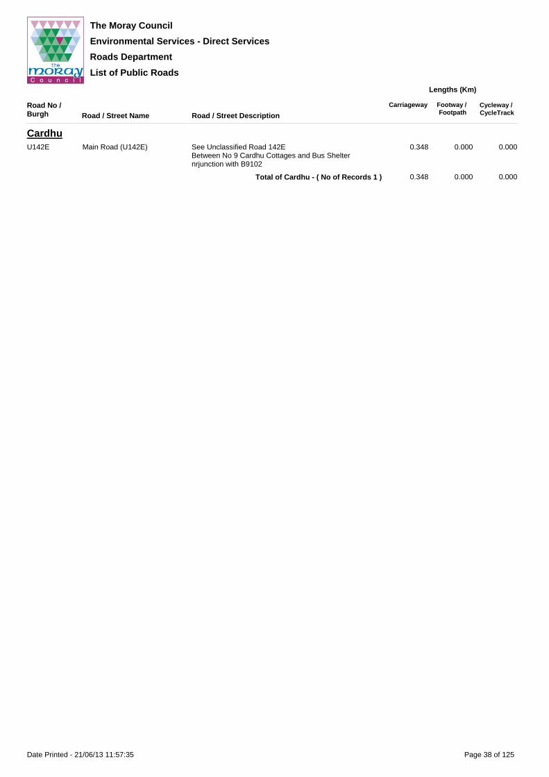
The Moray Council
Environmental Services - Direct Services
Roads Department
List of Public Roads
Road No / Burgh Road / Street Name Road / Street Description
Carriageway Footway / Footpath
Cycleway / CycleTrack
Lengths (Km)
CardhuU142E Main Road (U142E) See Unclassified Road 142E
Between No 9 Cardhu Cottages and Bus Shelter nrjunction with B9102
0.348 0.000 0.000
0.348 0.000 0.000Total of Cardhu - ( No of Records 1 )
Page 38 of 125Date Printed - 21/06/13 11:57:35

The Moray Council
Environmental Services - Direct Services
Roads Department
List of Public Roads
Road No / Burgh Road / Street Name Road / Street Description
Carriageway Footway / Footpath
Cycleway / CycleTrack
Lengths (Km)
CarronU114H Dailuaine Terrace From C15E south of Dailuaine Distillery, in a northerly
direction to turning area at No 1 including cul-de-sac serving house Nos 19 - 24.
0.523 0.000 0.000
C15E (W) Main Road (C15E) See Class III Road C15EFrom 'Craigdhu' north to national speed limit signs
0.177 0.000 0.000
0.700 0.000 0.000Total of Carron - ( No of Records 2 )
Page 39 of 125Date Printed - 21/06/13 11:57:35

The Moray Council
Environmental Services - Direct Services
Roads Department
List of Public Roads
Road No / Burgh Road / Street Name Road / Street Description
Carriageway Footway / Footpath
Cycleway / CycleTrack
Lengths (Km)
ChapeltownU117cH Cottages Road Cul-de-sac off Class III Road C20H 0.121 0.036 0.000
C20H Main Road (C20H) See Class III Road C20HBetween national speed limit signs
0.111 0.000 0.000
0.232 0.036 0.000Total of Chapeltown - ( No of Records 2 )
Page 40 of 125Date Printed - 21/06/13 11:57:35

The Moray Council
Environmental Services - Direct Services
Roads Department
List of Public Roads
Road No / Burgh Road / Street Name Road / Street Description
Carriageway Footway / Footpath
Cycleway / CycleTrack
Lengths (Km)
ConicavelC11E Main Road (C11E) See Class III Road C11E
Between national speed limit signs0.363 0.000 0.000
0.363 0.000 0.000Total of Conicavel - ( No of Records 1 )
Page 41 of 125Date Printed - 21/06/13 11:57:35

The Moray Council
Environmental Services - Direct Services
Roads Department
List of Public Roads
Road No / Burgh Road / Street Name Road / Street Description
Carriageway Footway / Footpath
Cycleway / CycleTrack
Lengths (Km)
CragganmoreU188E The Old Mart Cul-de-sac off Lagmore - Ballindalloch Station Road
(B9137)0.060 0.000 0.000
0.060 0.000 0.000Total of Cragganmore - ( No of Records 1 )
Page 42 of 125Date Printed - 21/06/13 11:57:35

The Moray Council
Environmental Services - Direct Services
Roads Department
List of Public Roads
Road No / Burgh Road / Street Name Road / Street Description
Carriageway Footway / Footpath
Cycleway / CycleTrack
Lengths (Km)
CraigellachieU150H Brickfield Cul-de-sac off Hill Street including widening on north side
fronting houses No 5 and No 80.202 0.315 0.000
Brickfield Court Cul-de-sac off Brickfield 0.054 0.072 0.000
Coopers Court Cul-de-sac off Brickfield 0.153 0.085 0.000
Croft Place Cul-de-sac off Brickfield. 0.149 0.399 0.000
A941 (E) Edward Avenue (A941) See Route A941From national speed limit sign to junction with Fife Street
0.320 0.293 0.000
U150H Fife Street From Route A941 at Edward Avenue to Leslie Terrace 0.163 0.065 0.000
A941 (E) Hill Street (A941) See Route A941From Edward Avenue (A941) at junction with Fife Street to national speed limit signs
0.457 0.470 0.000
U150H John Street From Fife Street to Spey Road 0.226 0.283 0.000
Lawrence Road From John Street to Spey Road 0.193 0.374 0.000
Leslie Terrace From Fife Street to Spey Road 0.224 0.129 0.000
Spey Road From Route A941 at Hill Street to Route A95 at Victoria Street
0.667 0.436 0.000
Telford Bridge Access Road From A95 northwards to Remote footpath over Telford Bridge
0.138 0.000 0.000
2.946 2.921 0.000Total of Craigellachie - ( No of Records 12 )
Page 43 of 125Date Printed - 21/06/13 11:57:35

The Moray Council
Environmental Services - Direct Services
Roads Department
List of Public Roads
Road No / Burgh Road / Street Name Road / Street Description
Carriageway Footway / Footpath
Cycleway / CycleTrack
Lengths (Km)
CullenU178L Albert Terrace From Lower Blantyre Street to Victoria Place 0.325 0.339 0.000
A98 Bayview Road (A98) See Route A98From junction with Seafield Crescent (C107L) to No.1 Castle Terrace
0.223 0.311 0.000
U178L Binview Road From Queen`s Drive to Old Church Road 0.174 0.299 0.000
Blantyre Street From Seafield Place to Sea Street 0.172 0.060 0.000
Campbell Place Seafield Street to Campbell Street 0.175 0.018 0.000
Campbell Street From Albert Terrace north westwards 0.061 0.112 0.000
A98 Castle Terrace (A98) See Route A98From No.1 Castle Terrace to national speed limit signs
0.385 0.665 0.000
U178L Cathay Terrace From Seafield Place to Findlater Drive 0.315 0.520 0.000
Findlater Circle From Findlater Drive to hammerhead 0.105 0.211 0.000
Findlater Drive From Cathay Terrace to B9018 Keith - Cullen Road 0.404 0.732 0.000
Findlater Drive Spur From Findlater Drive northwards past Toll House 0.049 0.000 0.000
C107L Foreshore Road (C107L) See Class III Road C107LFrom No.201 Seatown to Seafield Street (C107L)
0.449 0.467 0.000
U178L Glebe Park Crescent Loop off Judy's Lane 0.323 0.612 0.000
Grant Street From The Square to entrance to Cullen House 0.184 0.328 0.000
Judy's Lane Access road off Cathay Terrace 0.135 0.242 0.000
Logie Avenue From Logie Drive to Victoria Place 0.099 0.183 0.000
Logie Drive From Seafield Place to Seaview Place (Remote Footpath) 0.222 0.199 0.000
Lower Blantyre Street From Station Road to Campbell Place then from Campbell Place to No 21 Lower Blantyre Street
0.130 0.063 0.000
New View Court Cul-de-sacs off Sea Street. From No.7 to No.20 0.147 0.257 0.000
C108L North Castle Street (C108L) See Class III Road C108LFrom Bayview Road (A98) to Grant Street
0.169 0.333 0.000
U178L North Deskford Street From Grant Street northwestwards to No 23/24 0.115 0.213 0.000
Ogilvie Park From Findlater Drive in a loop back to Findlater Drive 0.419 0.828 0.000
U78L Old Church Road (U78L) See Unclassifed Road 78LFrom Cathay Terrace westwards
0.316 0.040 0.000
U178L Queen's Drive From South Deskford Street to turning circle 0.217 0.428 0.000
Reidhaven Place From Seafield Place south eastwards to No 6 0.149 0.286 0.000
Reidhaven Street From Seafield Place north west to No.22 then from Station Road to Campbell Place then from Campbell Place to No.40
0.369 0.238 0.000
Sea Street From Seafield Street (A98) to Reidhaven Street then from Reidhaven Street to New View Court
0.154 0.125 0.000
Seafield Place From South Deskford Street to South Castle Street (C108L) and York Place (C108L) then from South Castle Street (C108L) and York Place (C108L) to Seafield Street (A98) then from Seafield Street (A98) to Logie Drive
0.449 0.807 0.000
A98 Seafield Road (A98) See Route A98From junction with Seafield Place to national speed limit signs
0.678 0.837 0.000
Seafield Street (A98) See Route A98From junction with Seafield Street (C107L) to junction with Seafield Place
0.326 0.554 0.000
C107L Seafield Street (C107L) See Class III Road C107LFrom junction with Seafield Street (A98) to Foreshore Road (C107L)
0.180 0.157 0.000
U178L Seafield Street Spur From Bayview Road (A98) to Seafield Street (C107L) opposite No 57.
0.083 0.000 0.000
Seatown From Seatown (C107L) at No.58A to Foreshore Road (C107L) at No.121 with branch to No.21 Castle Terrace (A98). Also includes sections from No.77 to No.111, branch from Gospel Hall to No.87 and No.97 to No.119 with leg to meet Foreshore Road (C107L) at No.123.
0.855 0.385 0.000
C107L Seatown (C107L) See Class III Road C107LFrom No.47 to No.57 Seatown.
0.102 0.062 0.000
U178L Seaview Place Cul-de-sac off Victoria Place 0.051 0.063 0.000
Page 44 of 125Date Printed - 21/06/13 11:57:35

The Moray Council
Environmental Services - Direct Services
Roads Department
List of Public Roads
Road No / Burgh Road / Street Name Road / Street Description
Carriageway Footway / Footpath
Cycleway / CycleTrack
Lengths (Km)
CullenC108L South Castle Street (C108L) See Class III Road C108L
From Grant Street to Seafield Place0.174 0.337 0.000
U178L South Deskford Street From Grant Street to Seafield Place 0.176 0.342 0.000
Station Road Seafield Street (A98) to Lower Blantyre Street 0.123 0.016 0.000
The Square Off Seafield Street (A98) 0.078 0.080 0.000
Victoria Crescent Loop off Victoria Place 0.054 0.060 0.000
Victoria Place From Seafield Place to Seaview Place 0.186 0.308 0.000
Victoria Street From Seafield Place to Albert Terrace 0.242 0.236 0.000
C108L York Place (C108L) See Class III Road C108LFrom Seafield Place to Seafield Road (A98)
0.135 0.258 0.000
9.877 12.611 0.000Total of Cullen - ( No of Records 43 )
Page 45 of 125Date Printed - 21/06/13 11:57:36

The Moray Council
Environmental Services - Direct Services
Roads Department
List of Public Roads
Road No / Burgh Road / Street Name Road / Street Description
Carriageway Footway / Footpath
Cycleway / CycleTrack
Lengths (Km)
CummingstonU166E Back Street Cul-de-sac off Main Road B9040 to Seaview Road 0.167 0.209 0.000
B9040 Main Road (B9040) See Route B9040Between national speed limit signs
0.977 1.797 0.000
U166E Seaview Road Cul-de-sac off Main Road B9040. 0.254 0.347 0.000
1.398 2.353 0.000Total of Cummingston - ( No of Records 3 )
Page 46 of 125Date Printed - 21/06/13 11:57:36
The Moray Council
Environmental Services - Direct Services
Roads Department
List of Public Roads
Road No / Burgh Road / Street Name Road / Street Description
Carriageway Footway / Footpath
Cycleway / CycleTrack
Lengths (Km)
DallasC13E Knockando Road (C13E) See Class III Road C13E
From Main Road (C12E) to national speed limit sign0.199 0.034 0.000
C12E Main Road (C12E) See Class III Road C12EBetween national speed limit signs
0.705 0.838 0.000
0.904 0.872 0.000Total of Dallas - ( No of Records 2 )
Page 47 of 125Date Printed - 21/06/13 11:57:36

The Moray Council
Environmental Services - Direct Services
Roads Department
List of Public Roads
Road No / Burgh Road / Street Name Road / Street Description
Carriageway Footway / Footpath
Cycleway / CycleTrack
Lengths (Km)
DrummuirB9014 Dufftown Road (B9014) See Route B9014
Between national speed limit signs0.659 0.441 0.000
U71H The Gullet (U71H) See Unclassified Road 71HFrom Dufftown Road (B9014) to national speed limit sign
0.084 0.007 0.000
U151H Tocher Terrace Cul-de-sac off B9014 0.099 0.193 0.000
0.842 0.641 0.000Total of Drummuir - ( No of Records 3 )
Page 48 of 125Date Printed - 21/06/13 11:57:36

The Moray Council
Environmental Services - Direct Services
Roads Department
List of Public Roads
Road No / Burgh Road / Street Name Road / Street Description
Carriageway Footway / Footpath
Cycleway / CycleTrack
Lengths (Km)
DrybridgeU63aL Clochan Road (U63aL) See Unclassified Road 63aL
From Main Road (U61L) to national speed limit sign0.096 0.000 0.000
U61L Main Road (U61L) See Unclassified Road 61LBetween national speed limit signs
0.418 0.000 0.000
0.514 0.000 0.000Total of Drybridge - ( No of Records 2 )
Page 49 of 125Date Printed - 21/06/13 11:57:36

The Moray Council
Environmental Services - Direct Services
Roads Department
List of Public Roads
Road No / Burgh Road / Street Name Road / Street Description
Carriageway Footway / Footpath
Cycleway / CycleTrack
Lengths (Km)
DufftownU174H Aigen Place From Hill Street on northerly direction to h/head 0.091 0.169 0.000
Albert Place From Balvenie Street (A941) to Tininver Street 0.207 0.379 0.000
A941 (E) Balvenie Street (A941) See Route A941From The Square (A941) to War Memorial
0.581 1.062 0.000
U174H Braehead Terrace From Church Street (C80H) to Fife Street (A941) 0.177 0.062 0.000
B975 Castle Road (B975) See Route B975From Station Road (A941) to national speed limit sign
0.246 0.000 0.000
U174H Chapel Court Cul-de-sac off Mount Crescent 0.063 0.142 0.000
C80H Church Street (C80H) See Class III Road C80HFrom The Square (A941) to Mortlach Road (U99H)
0.697 1.035 0.000
U174H Conval Crescent From Conval Street (B9009) north then east to turning hammerhead
0.070 0.099 0.000
B9009 Conval Street (B9009) See Route B9009From The Square (A941) west to national speed limit sign
0.415 0.778 0.000
U174H Corsemaul Drive From Mount Street to turning circle including short cul-de-sac at No 10
0.303 0.427 0.000
Ferrier Road From Balvenie Street eastwards 0.069 0.055 0.000
A941 (E) Fife Street (A941) Part of Route A941 from Dufftown Square to junction with Dufftown - Cabrach Road opposite Crachie Cottage.
0.710 0.956 0.000
U174H Hill Street From Balvenie Street (A941) to Kininvie Court 0.313 0.480 0.000
Hillside Avenue From Conval Street to Nos. 46-39 0.309 0.534 0.000
Kininvie Court From Hill Street in a southerly then a south westerly direction to terminate in a turning hammerhead.
0.183 0.361 0.000
Louise Street Cul-de-sac off Albert Place 0.288 0.525 0.000
B9014 Low Road (B9014) Part of Route B9014 from junction A941 Dufftown - Cabrach Road to junction with B975 Castle - Dufftown Road.
0.947 0.069 0.000
U174H Macduff Place From Balvenie Street to York Street 0.110 0.213 0.000
Maclennan Place From Tomnamuidh Road, eastwards to hammerhead at house No. 25
0.150 0.300 0.000
Market Leys Service Road off Conval Crescent 0.168 0.000 0.000
U99H Mortlach Road (U99H) See Unclassified Road 99HFrom Fife Street (A941) to national speed limit sign
0.997 0.072 0.000
U174H Mount Crescent From Mount Street to Chapel Court 0.090 0.179 0.000
Mount Street From Stephen Avenue to Corsemaul Drive 0.289 0.335 0.000
Queen Street From Louise Street between Nos 2a and 2 in a loop back to Louise Street between Nos 12 and 14, including leg to No 10 Queen Street, then from Lousie Street to Tomnamuidh Road
0.232 0.326 0.000
Rinnes Place Cul-de-sac off Tomnamuidh Road 0.079 0.194 0.000
St Michaels Lane Cul-de-sac off Hillside Avenue 0.066 0.105 0.000
A941 (E) Station Road (A941) See Route A941From War Memorial to national speed limit sign.
0.660 0.708 0.000
U174H Stephen Avenue From Albert Place to Fife Street (A941) 0.177 0.333 0.000
A941 (E) The Square (A941) See Route A941From Conval Street (B9009)to Fife Street (A941) including legs to Balvenie Street (A941) east and west of the Clock Tower
0.123 0.131 0.000
U174H Tininver Street From Albert Place to Playing Field 0.138 0.270 0.000
Tomnamuidh Road From junction with Albert Place to No.41(75m extension from house no. 27 to 41 (17/12/03))
0.292 0.565 0.000
Westburn Road From Hillside Avenue with branch to west and north 0.164 0.291 0.000
York Street From Conval Street (B9009) to Hill Street 0.319 0.567 0.000
9.723 11.722 0.000Total of Dufftown - ( No of Records 33 )
Page 50 of 125Date Printed - 21/06/13 11:57:36

The Moray Council
Environmental Services - Direct Services
Roads Department
List of Public Roads
Road No / Burgh Road / Street Name Road / Street Description
Carriageway Footway / Footpath
Cycleway / CycleTrack
Lengths (Km)
DuffusU48E Burnside Road From Gordonstoun Road to Hall Place 0.126 0.036 0.000
Church Place Cul-de-sac off Church Road 0.069 0.105 0.000
Church Road From Hopeman Road (B9012) to Northfield 0.232 0.442 0.000
Dunbar Lane From Milne Lane to Burnside Road then from Burnside Road to Well Lane
0.213 0.000 0.000
Gordonstoun Road From B9012 to entrance to Gordonstoun School at West Lodge
0.669 0.009 0.000
Hall Place From Milne Lane to Burnside Road then from Burnside Road to Well Lane
0.211 0.000 0.000
B9012 Hopeman Road (B9012) See Route B9012Between national speed limit signs
0.590 0.247 0.000
U48E Milne Lane From Hopeman Road (B9012) to Hall Place 0.124 0.114 0.000
Northfield From St Peters Road north west then south west to No 36/No 37
0.313 0.617 0.000
St Peter's Lane From Milne Lane to Burnside Road then from Burnside Road to Well Lane
0.219 0.000 0.000
St Peter's Road From Church Road including Cul-de-sac from No 21 to No 22
0.359 0.637 0.000
Well Lane From Gordonstoun Road to Hall Place 0.126 0.000 0.000
3.251 2.207 0.000Total of Duffus - ( No of Records 12 )
Page 51 of 125Date Printed - 21/06/13 11:57:36

The Moray Council
Environmental Services - Direct Services
Roads Department
List of Public Roads
Road No / Burgh Road / Street Name Road / Street Description
Carriageway Footway / Footpath
Cycleway / CycleTrack
Lengths (Km)
DykeU167E Darklass Place Cul-de-sac off Darklass Road. 0.132 0.234 0.000
Darklass Road Cul-de-sac of Main Road (C7E) 0.206 0.252 0.000
Glebe Park Cul-de-sac off Darklass Road 0.077 0.155 0.000
C7E Main Road (C7E) See Class III Road C7EBetween national speed limit signs
0.613 0.033 0.000
U167E Russell Brae Cul-de-sac off Darklass Road 0.024 0.021 0.000
1.052 0.695 0.000Total of Dyke - ( No of Records 5 )
Page 52 of 125Date Printed - 21/06/13 11:57:36

The Moray Council
Environmental Services - Direct Services
Roads Department
List of Public Roads
Road No / Burgh Road / Street Name Road / Street Description
Carriageway Footway / Footpath
Cycleway / CycleTrack
Lengths (Km)
EdinvillieC17H Main Road (C17H) See Class III Road C17H
Between national speed limit signs0.318 0.000 0.000
0.318 0.000 0.000Total of Edinvillie - ( No of Records 1 )
Page 53 of 125Date Printed - 21/06/13 11:57:37
The Moray Council
Environmental Services - Direct Services
Roads Department
List of Public Roads
Road No / Burgh Road / Street Name Road / Street Description
Carriageway Footway / Footpath
Cycleway / CycleTrack
Lengths (Km)
ElginU171E Abbey Street From Greyfriars Street (C30E) to Institution Road 0.171 0.330 0.000
Academy Street From South Street (C30E) to Station Road (A941) 0.552 1.056 0.000
Alba Place Cul-de-sac off Balmoral Terrace including Service Road 0.162 0.159 0.000
Alma Place From Moss Street to Academy Street then from Academy Street to Reidhaven Street then from Reidhaven Street to South Guildry Street
0.187 0.022 0.000
Anderson Crescent From Brodie Drive to Reid Street 0.205 0.373 0.000
Anderson Drive From Bezack Street loop to east 0.389 0.739 0.000
Ardgilzean Place Cul-de-sac off McIntosh Drive 0.062 0.106 0.000
Argus Place Cul-de-sac off Covesea Road 0.126 0.258 0.000
Ashburton Court Cul-de-sac off Manitoba Avenue. 0.118 0.203 0.000
Ashfield Drive Cul-de-sac north west from Oakfield Road 0.306 0.518 0.000
Ashgrove Court Cul-de-sac off Ashgrove Place 0.067 0.111 0.000
Ashgrove Place Cul-de-sac off Ashgrove Road 0.106 0.175 0.000
Ashgrove Road From East Road (A96) to Linkwood Road (C20E) 0.739 1.156 0.000
Ashgrove Square Cul-de-sac off Ashgrove Road 0.121 0.232 0.000
Bailies Drive From No 2 Springfield Road in a northerly then westerly direction to terminate in hammerhead at Nos 65/108 including link between Nos 25 and 29 Bailies Drive to Springfield Road
0.588 1.126 0.000
Bain Avenue From Reiket lane to No.50 Bain Avenue. 0.301 0.574 0.000
Bain Road From Bain Avenue to No.51 Bain Road 0.296 0.541 0.017
Balmoral Terrace From junction with Lossiemouth Road (A941) and North Street (A941) to turning circle
0.212 0.389 0.000
Bardon Place Cul-de-sac off Manbeen Place 0.208 0.392 0.000
Barlink Road From Reiket Lane to No.77 Barlink Road. 0.295 0.485 0.081
Barmuckity Lane Cul-de-sac off McMillan Avenue. 0.090 0.087 0.000
Batchen Lane From Thunderton Pl west then south to South St. Including stub to rear of 240 High St, and all parking areas.
0.259 0.311 0.000
Batchen Street From High Street (C39E) to South Street (C30E) 0.120 0.224 0.000
Beech Brae North of Duffus Road including spurs to No. 30-42 and No. 50-62.
0.775 1.483 0.000
Beechfield Road Cul-de-sac east from Oakfield Road 0.281 0.495 0.000
Bezack Street From School Brae to Croft Road 0.272 0.492 0.000
Bibby Place From Blackfriars Road to Haugh Road 0.128 0.229 0.000
U90E Bilbohall Road See Unclassified Road 90EFrom junction with Fleurs Road and Wards Road south to National speed Limit signs.
0.201 0.166 0.000
U171E Birkenhill From A941 at Birkenhill Croft then in a northerly and southerly direction (Old section of A941)
0.171 0.031 0.000
Birkenhill Place From Robertson Drive south 0.204 0.407 0.000
Birnie Circle From Birnie Drive in a loop, via roundabout, back to Birnie Drive
0.317 0.561 0.000
Birnie Crescent Loop off Sandy Road including cul-de-sac 0.527 1.031 0.000
Birnie Drive From Birnie Road to turning circle 0.280 0.137 0.197
Birnie Place From Sandy Road to Gordon Street then from Gordon Street to turning area at No 3 including loop from No 11 to No 47
0.625 0.802 0.000
C2E Birnie Road (C2E) See Class III Road C2EFrom roundabout at Main Street (A941) to national speed limit sign
0.586 0.593 0.367
U171E Birnie Road (Service Road) From Main Street to No 10 including leg north to No 2 and hammerhead opposite No 8
0.170 0.191 0.000
A941 (W) Bishopmill Brae (A941) See Route A941From Cumming Street (A941) at junction with Trinity Place to No1 North Street (A941)
0.417 0.730 0.000
U171E Blackburn Court Cul-de-sac off Riverside Drive 0.049 0.106 0.000
Page 54 of 125Date Printed - 21/06/13 11:57:37

The Moray Council
Environmental Services - Direct Services
Roads Department
List of Public Roads
Road No / Burgh Road / Street Name Road / Street Description
Carriageway Footway / Footpath
Cycleway / CycleTrack
Lengths (Km)
ElginU171E Blackfriars Road From south end of Trinity Place where it meets North
Lane in a westerly direction to parking area opposite No 19 including parking area and turning hammerhead then from Haugh Road in a westerly direction to River Lossie at Hill Street.
0.354 0.086 0.062
Blane Place From Brodie Drive in a loop to north west 0.109 0.148 0.000
Blantyre Place From North Street (A941) to Braemorriston Road 0.215 0.261 0.000
Blantyre Street Cul-de-sac off Blantyre Place 0.117 0.222 0.000
Borough Briggs Road From Haugh Road to Bishopmill Brae 0.402 0.544 0.000
Braco Place Cul-de-sac off Hawthorn Road 0.054 0.122 0.000
Braelossie Place Cul-de-sac off West Road 0.093 0.000 0.000
Braemorriston Road From West High Street to Morriston Road 0.236 0.354 0.000
Bremner Drive From Linksfield Road (C21E) in a south easterly direction to turning hammerhead at link with Marleon Field.
0.390 0.354 0.255
Bridge Street From Bishopmill Brae (A941) north to No 41 and south to Old Bishopmill Bridge including 2 No hammerheads
0.277 0.393 0.000
Brinuth Place Cul-de-sac off Glenlossie Drive 0.191 0.303 0.000
Brodie Drive From North Street (A941) to Munro Place and round to Waterside Street - Remote Footpath including layby opposite house No 65 and No 71.
0.829 1.390 0.000
Brodie Place Cul-de-sac off Brodie Drive 0.084 0.000 0.000
Bruceland Gardens Cul-de-sac off Bruceland Road 0.103 0.206 0.000
Bruceland Road From West Road to Wittet Drive then from Wittet Drive to Private Access to Bruceland House.
0.988 0.351 0.000
Bruceland Road (Loop Section)
Housing. Loop around No 6 to No 52 including access to parking area
0.228 0.000 0.000
Brucelands From Bruceland Road southwards and westwards to terminate in turning circle, including 5 No. cul-de-sacs
0.644 0.599 0.000
U43E Brumley Brae (U43E) See Unclassified Road U43EFrom junction with Smith Drive to national speed limit sign with branch to Morriston Road
0.488 0.398 0.000
U171E Burn Place From Robertson Drive south east 0.064 0.136 0.000
Burnside Place From Anderson Drive south east 0.064 0.152 0.000
Calcots Court Cul-de-sac off Woodside Terrace 0.049 0.054 0.000
Calcots Crescent From McMillan Avenue in a loop back to McMillan Avenue.
0.262 0.520 0.000
C23E Calcots Road (C23E) See Class III Road C23EFrom Newmill Road (C22E) east to national speed limit sign
0.168 0.045 0.000
U171E Cameron Road From Spynie Street to Lossiemouth Road (Service Road 3)
0.218 0.229 0.000
Caroline Place From Caroline Street to Braemorriston Road 0.086 0.083 0.000
Caroline Street From Caroline Street to Braemorriston Road (B9012) 0.164 0.311 0.000
Castlehill Street From Robertson Drive to Birkenhill Place 0.153 0.314 0.000
Cathedral Road From North College Street south 0.188 0.360 0.000
Chandlers Rise From Lesmurdie Road in an easterly then northerly direction to turning circle, incl cul-de-sacs serving No's.14,54,92, including part of stub leading to Chandlers Court
0.731 1.403 0.000
Chanonry Road From Pansport Road (C22E) eastwards to Pinefield Road 0.246 0.480 0.000
Chanonry Road North From Moycroft Road eastwards to end of radius at junction with Chanonry Street
0.233 0.415 0.000
Chanonry Road South From Moycroft Road eastwards to terminate in a turning circle.
0.371 0.645 0.000
Chanonry Spur From Chanonry Road North, northwards to turning circle 0.150 0.235 0.000
Chanonry Street From Chanonry Road North southwards to Chanonry Road South
0.152 0.292 0.000
Chapel Court Cul-de-sac off Hill Street 0.055 0.054 0.000
Christie Place From Deanshaugh Road to Fraser Avenue 0.223 0.414 0.000
Christie Road From Christie Place to Deanshaugh Terrace then from Deanshaugh Terrace to Reid Street
0.224 0.438 0.000
Page 55 of 125Date Printed - 21/06/13 11:57:37

The Moray Council
Environmental Services - Direct Services
Roads Department
List of Public Roads
Road No / Burgh Road / Street Name Road / Street Description
Carriageway Footway / Footpath
Cycleway / CycleTrack
Lengths (Km)
ElginU171E Clarendon Court Cul de sac off Manitoba Avenue 0.130 0.229 0.000
Cockburn Place From Christie Place to Fraser Avenue including Cul-de-sac at No 17 to No 46
0.559 0.798 0.000
Cockmuir Place Cul-de-sac off Glenlossie Drive 0.112 0.203 0.000
Coleburn Court Cul-de-sac off Mossend Place 0.091 0.077 0.000
Collie Street From North College Street southwards 0.041 0.069 0.000
Commerce Street From High Street southwards to South Street/Greyfriars Street junction
0.094 0.180 0.000
Conon Crescent From Wiseman Road in a loop back to Wiseman Road 0.226 0.453 0.000
Convener Street From North Street to Main Street (A941) 0.218 0.422 0.000
Cooper Street From Duff Place to Morriston Road 0.126 0.012 0.000
Councillors Walk Cul-de-sacs off Bailies Drive 0.223 0.389 0.000
Covesea Grove From Covesea Rise to turning circle. 0.176 0.295 0.018
Covesea Rise From roundabout on Covesea Road (C24E) westwards to turning circle.
0.646 1.021 0.124
C24E Covesea Road (C24E) See Class III Road C24EFrom Lossiemouth Road (A941) to national speed limit sign
0.675 1.003 0.091
U171E Croft Road From Main Street (A941) to Murray Street and Bezack Street then from Murray Street and Bezack Street to Meadow Crescent
0.180 0.322 0.000
Culbard Street From South Street (C30E) to Moray Street 0.123 0.224 0.000
A941 (W) Cumming Street (A941) See Route A941From Alexandra Road (A96) roundabout to Bishopmill Brae (A941) at junction with Trinity Place
0.098 0.144 0.011
U171E Dean of Guild Way Cul-de-sacs off Bailies Drive 0.268 0.430 0.000
Deanshaugh Court Cul-de-sac off Lesmurdie Road 0.082 0.113 0.050
Deanshaugh Road From Christie Place to Lesmurdie Road (Not including cul-de-sac at the end)
0.306 0.551 0.000
Deanshaugh Terrace From Deanshaugh Road to Munro Place 0.483 0.866 0.000
Diagonal Road From Pinefield Parade south westwards to Perimeter Road
0.117 0.000 0.000
Doocot Lane Cul-de-sac off Bain Road. 0.065 0.005 0.005
Double Dykes Road From Bruceland Road to Pluscarden Road (B9010) 0.157 0.005 0.000
Duff Avenue From Institution Road to Maisondieu Road (C22E) 0.338 0.665 0.000
Duff Avenue (Cul-de-sac) Cul-de-sac off Duff Avenue 0.082 0.102 0.000
Duff Place From Braemorriston Road to Morriston Road including leg to No 64
0.350 0.585 0.000
B9012 Duffus Road (B9012) See Route B9012From Morriston Road (B9012) to national speed limit sign
0.986 0.576 0.220
U171E Duncan Drive From Morriston Road to Hamilton Drive 1.109 2.342 0.000
East Back Street From North Street (A941) to Brodie Drive 0.290 0.276 0.000
East High Street (Bishopmill) From Lamb Street to East Back Street including leg to west from Lamb Street to steps
0.195 0.249 0.000
Edgar Road From New Elgin Road (A941) to entrance to Greenwards Primary School
0.973 0.197 0.876
Eemins Place Cul-de-sac off Hebenton Road, including turning area and hammerhead
0.243 0.439 0.000
Elmfield Road Cul-de-sac east from Ashfield Drive 0.122 0.229 0.000
Ernest Hamilton Court Cul-de-sac off Bremner Drive 0.114 0.121 0.000
Esmonde Gardens From Covesea Road (C24E) in a loop to north and south to Lossiemouth Road (Service Road 1)
0.406 0.618 0.000
Fairfield Avenue Cul-de-sac off Mayne Farm Road including access to Day Centre
0.265 0.389 0.000
Fairfield Way Cul-de-sac off Fairfield Avenue 0.082 0.140 0.000
Fairway Avenue Loop south off High School Drive including 3 cul-de-sacs 0.442 0.854 0.000
Ferrier Terrace Cul-de-sac off Spynie Street 0.139 0.240 0.000
Findhorn Court From Riverside Drive to No 24 Findhorn Court including cul-de-sac from No 1 to No 17 Findhorn Court
0.102 0.191 0.000
Page 56 of 125Date Printed - 21/06/13 11:57:37

The Moray Council
Environmental Services - Direct Services
Roads Department
List of Public Roads
Road No / Burgh Road / Street Name Road / Street Description
Carriageway Footway / Footpath
Cycleway / CycleTrack
Lengths (Km)
ElginU171E Findrassie Court From Covesea Rise southwards to terminate in turning
hammerhead0.069 0.136 0.000
Findrassie Crescent Cul-de-sac off McIntosh Drive leading eastwards and then south in a curve ending in a turning point cul-de-sac
0.104 0.188 0.000
Fleurs Drive From Pluscarden Road (B9010) to Bruceland Road 0.242 0.477 0.000
Fleurs Place From Fleurs Drive to turning circle 0.294 0.600 0.000
Fleurs Road From Pluscarden Road (B9010) to Wards Road/Bilbohall Road
0.245 0.435 0.000
Fleurs Road (Service Road) Service Road off Fleurs Road 0.157 0.173 0.000
Fogwatt Lane From Bain Avenue in a loop back to Bain Avenue. 0.334 0.654 0.000
Forteath Avenue From Rose Avenue to Wards Road (C22E) 0.527 1.002 0.000
Forteath Street From Pluscarden Road (B9010) to Hawthorn Road 0.154 0.306 0.000
Francis Place From Academy Street to Moss Street 0.070 0.131 0.000
Fraser Avenue From Christie Place to Lesmurdie Road 0.297 0.585 0.000
Fulmar Road From Anderson Crescent to Munro Place 0.126 0.231 0.000
Gedloch Place Cul-de-sac off Glenlossie Drive 0.064 0.129 0.000
Gisborne Court Cul-de-sac off Manitoba Avenue, including turning circle 0.066 0.097 0.000
Glassgreen Brae From Birnie Circle to hammerhead 0.093 0.189 0.000
Glassgreen Place From Birnie Circle to turning circle 0.093 0.010 0.000
Glen Elgin Drive From Birnie Road to hammerhead 0.195 0.263 0.107
Glen Moray Drive From Edgar Road to Springfield Road 0.435 0.375 0.038
Glenlossie Drive From Edgar Road to Springfield Road 0.473 0.782 0.082
Glover Street From High Street (C39E) to Greyfriars Street (C30E) 0.095 0.122 0.000
Golf View Crescent Cul-de-sac south from Springfield Road 0.352 0.620 0.000
Gordon Street From South Street (C30E) to Moray Street 0.139 0.271 0.000
Gordon Street (New Elgin) From Springfield Road to Land Street then from Land Street to Birnie Road (C2E)
0.456 0.865 0.000
Grampian Road From Tyock Industrial Estate in a north easterly direction for a distance of 33m approximately and in a south westerly then a north westerly direction for a distance of 197m approximatley
0.213 0.315 0.000
Grant Street From Pluscarden Road (B9010) to Mayne Road 0.203 0.381 0.000
Grays Walk Cul-de-sac off Lossiemouth Service Road 1 0.115 0.224 0.000
C30E Greyfriars Street (C30E) See Class III Road C30EFrom South Street (C30E) to South College Street (A96T)
0.309 0.607 0.000
U171E Grove Place From West High Street to West Back Street then from West Back Street to Blantyre Place
0.073 0.000 0.000
Gurness Circle Cul-de-sac off Manitoba Avenue including turning circle 0.184 0.454 0.000
Hall Place From South Street (C30E) to rear entrance to Police Station
0.070 0.020 0.000
Hamilton Crescent Loop off Hamilton Drive 0.370 0.734 0.000
Hamilton Drive From Duffus Road (B9012) to Brumley Brae 0.962 1.895 0.000
Hanover Court Cul-de-sac off Haugh Road 0.017 0.036 0.000
Hardhillock Avenue Access road south & west off High School Drive including cul-de-sac north.
0.405 0.673 0.000
Harrison Terrace From Munro Place to hammerhead 0.321 0.301 0.000
Haugh Road From bridge over River Lossie at entrance to Morriston Playing Field past Boroughbriggs Road to roundabout on Alexandra Road
0.399 0.375 0.228
Haugh Road (Cul-de-sac) Cul-de-sac off Haugh Road 0.054 0.093 0.000
Hawthorn Road From South Street (C30E) to Grant Street 0.267 0.016 0.000
Hay Place From Wards Road, in a north easterly then northerly direction to terminate in hammerhead (Formerly part of Hay Street)
0.195 0.180 0.002
A941 (W) Hay Street (A941) See Route A941From Station Road (A941) at junction with Wards Road (C22E) to Northfield Terrace (A941) at junction with South Street (C30E)
0.543 0.963 0.011
U171E Hazel Court Cul-de-sac off Woodside Terrace 0.030 0.073 0.000
Page 57 of 125Date Printed - 21/06/13 11:57:37
The Moray Council
Environmental Services - Direct Services
Roads Department
List of Public Roads
Road No / Burgh Road / Street Name Road / Street Description
Carriageway Footway / Footpath
Cycleway / CycleTrack
Lengths (Km)
ElginU171E Hebenton Road From Covesea Road south westwards including loop and
laybys and short cul-de-sac at 48/680.666 1.250 0.000
Heldon Place Cul-de-sac off Glenlossie Drive 0.166 0.326 0.000
Hermes Road From Fulmar Road to hammerhead 0.294 0.582 0.000
High School Drive Access road off Springfield Road including Cul-de-sacs at No 17 to No 25 and No 29 to No 41
0.598 0.982 0.000
High School View Access road southwest off High School Drive 0.069 0.122 0.000
C39E High Street (C39E) Class III Road C39EFrom roundabout with Alexandra Road (A96T) to North Street and from Commerce Street to South College Street (C39E)
0.497 0.879 0.000
High Street (C39E) Pedestrianised Area
Pedestrianised Area (See C39E)Pedestrian area between North Street and Commerce Street (including section of road on the southside of the church)
0.183 0.377 0.000
U171E Hill Street From High Street (A96) to Blackfriars Road 0.205 0.210 0.000
Hill Terrace From Hill Street to Ladyhill Wynd. 0.105 0.097 0.000
Institution Road From Moss Street to hammerhead at No 1 0.426 0.784 0.000
Jock Inkson's Brae From Oldmills Rd westwards to Sheriffmill Road including cul-de-sac below Braelossie Hotel (73m of 171E) and widening of carriageway and new footway at west end of Jock Inkson's Brae (Formerly known as Old Mills Branch Road)
0.460 0.184 0.000
Kennedy Place Cul-de-sac off Hebenton Road (Section linking Spynie Brae added 8/7/03)
0.145 0.275 0.000
King Street From hammerhead at Nos 25 and 27 to North College Street then from North College Street to west end of Brewery Bridge
0.418 0.653 0.000
King Street (New Elgin) From Springfield Road to Land Street 0.261 0.515 0.000
Kingsmills From Newmill Road at Cathedral Court in a loop back to Newmill Road at Cathedral Court with legs to Newmill Road between No 151 and No 157 Kingsmills and No 58 and No 72 Kingsmills
0.763 1.449 0.000
Kingsmills Court Courtyard off Kingsmills 0.077 0.000 0.000
Kirkhill Court Cul-de-sac off Newmill Service Road 0.054 0.128 0.000
Kirkton Place Cul-de-sac west from Golf View Crescent 0.287 0.465 0.000
Kyd Drive From Bremner Dr. n-eastwards in loop to Bremner Dr. incl short cul-de-sac to Flat 41 (NOT parking)
0.232 0.342 0.000
Ladyhill Road Not including Car Parking but Car Parking is maintained by Council
0.191 0.309 0.000
Ladyhill Wynd Cul-de-sac off Hill Terrace 0.029 0.031 0.000
Laich O' Moray View From Covesea Rise southwards to turning hammerhead 0.132 0.264 0.000
Lamb Street From Bridge Street to East High Street 0.057 0.080 0.000
Land Street From Main Street (A941) to Sandy Road 0.487 0.931 0.000
Lang Walk From Morriston Road to Smith Drive 0.069 0.133 0.000
Langstane Place Cul-de-sac north from Robertson Drive 0.043 0.066 0.000
Lazarus Lane From North College Street to notional hammerhead at end (amended 23/03/04)
0.053 0.039 0.000
Leggat Road From Tait Avenue to McIntosh Drive 0.103 0.204 0.000
Leonach Crescent From Glen Elgin Drive to hammerhead 0.137 0.006 0.006
Leonach Place From Glen Elgin Drive to turning circle 0.128 0.000 0.008
Leslie Place From Bremner Drive (No 4) to Bremner Drive (No 26) 0.204 0.145 0.000
C22E Lesmurdie Road (C22E) See Class III Road C22EFrom Newmill Road (C22E) at junction with Calcots Road (C22E) to Lossiemouth Road (A941)
1.153 1.038 1.025
U171E Lesmurdie Road (Service Road)
Service Road from No.69 to No.91 Lesmurdie Road 0.086 0.093 0.000
Leuchars Drive From Riverside Drive to Woodside Terrace including parking area at No 3 to No 7
0.146 0.272 0.000
Linksfield From Lesmurdie Road to Linksfield Court 0.060 0.083 0.000
Linksfield Court Cul-de-sac off Linksfield 0.075 0.156 0.000
Page 58 of 125Date Printed - 21/06/13 11:57:37

The Moray Council
Environmental Services - Direct Services
Roads Department
List of Public Roads
Road No / Burgh Road / Street Name Road / Street Description
Carriageway Footway / Footpath
Cycleway / CycleTrack
Lengths (Km)
ElginU171E Linksfield Place From Deanshaugh Road to Longmoor Crescent 0.077 0.144 0.000
C21E Linksfield Road (C21E) See Class III Road C21EFrom Lesmurdie Road (C22E) to national speed limit sign
0.226 0.314 0.000
U171E Linkwood Place Industrial Estate access road off Linkwood Way incl turning circle and hammerhead
0.395 0.427 0.000
C20E Linkwood Road (C20E) See Class III Road C20E From roundabout at New Elgin Road (A941) to Reiket Lane (C40E) roundabout and from junction with Reiket Lane (C40E) at No.2 Distillery Cottages to national speed limit sign
1.548 1.525 0.026
U171E Linkwood Way Industrial Estate access road off East Road (A96) including turning circle
0.304 0.471 0.000
Logan Court Cul-de-sac off Lesmurdie Road to turning hammerheads at No`s 8/9 and No 19
0.167 0.123 0.062
Longmoor Crescent From Deanshaugh Terrace to Reid Street 0.222 0.335 0.000
Longmorn Crescent Cul-de-sac off Fogwatt Lane. 0.132 0.012 0.000
Lossie Cottages Cul-de-sacs off Riverside Drive 0.052 0.000 0.000
C31E Lossie Wynd (C31E) See Class III Road C31E (From High Street to A96)From High Street (C39E) to Alexandra Road (A96)
0.143 0.163 0.028
U171E Lossie Wynd North From A941 to hammerhead at Halfords Car Park and including access road to Cooper Park.
0.183 0.279 0.000
A941 (W) Lossiemouth Road (A941) See Route A941From North Street (A941) at junction with Balmoral Terrace to national speed limit sign
0.853 0.647 0.071
U171E Lossiemouth Road (Service Road 1)
From Covesea Road (C24E) to No 112 Lossiemouth Road
0.415 0.384 0.000
Lossiemouth Road (Service Road 2)
From Munro Place to Lesmurdie Road (C22E) 0.394 0.377 0.000
Lossiemouth Road (Service Road 3)
From Spynie Street to Cameron Road 0.237 0.228 0.000
MacKenzie Place Cul-de-sac off Fraser Road 0.134 0.299 0.000
Maida Place From Moss Street to Academy Street 0.066 0.002 0.000
A941 (W) Main Street (A941) See Route A941From New Elgin Road (A941) at junction with North Street to national speed limit sign
0.960 1.153 0.022
U171E Main Street Lane From No 41 Main Street in an easterly direction to terminate at Bezack Street, formerly PU Road No 90.
0.060 0.099 0.000
Maisondieu Place From Seafield Crescent to Maisondieu Road (C22E) 0.148 0.294 0.000
C22E Maisondieu Road (C22E) See Class III Road C22EFrom roundabout with New Elgin Road (A941) to roundabout with East Road (A96)
0.698 1.037 0.000
U171E Manbeen Place Cul-de-sac off Glen Moray Drive 0.130 0.085 0.000
Manitoba Avenue From Reiket Lane (C40E) north the north east then south east to Reiket Lane (C40E). (315m added 26/10/05)
0.612 1.083 0.000
Manitoba Place Cul-de-sac off Manitoba Avenue, including turning circle 0.162 0.285 0.000
Mannoch Court Cul-de-sac off Heldon Place 0.131 0.291 0.000
Marchfield Place Cul-de-sac off Glenlossie Drive 0.195 0.428 0.000
Market Drive From Milnefield Avenue westward (101m) with branch north (60m)
0.163 0.289 0.000
Marleon Field (Main Road) From Lesmurdie Road (C22E) to Bremner Drive 0.362 0.591 0.097
Marleon Field (Side Roads) Cul-de-sac at No 11 to No 16 and from No 36 to roundabout then north west to hammerhead at No 57 and south to hammerhead at No 67
0.470 0.546 0.338
Marleon Place Cul-de-sac off Marleon Field 0.135 0.114 0.000
Mayne Road From South Street (C30E) to Wards Road 0.802 1.559 0.000
McIntosh Drive From Morriston Road in a loop back to Morriston Road 0.812 1.463 0.000
McMillan Avenue From Reiket Lane to Barmuckity Lane 0.258 0.212 0.250
Meadow Crescent From Murray Street including loop 0.394 0.754 0.000
Millar Street Cul-de-sac off Murray Street 0.118 0.250 0.000
Millbuie Street Cul-de-sac off Bain Road. 0.161 0.324 0.000
Page 59 of 125Date Printed - 21/06/13 11:57:37

The Moray Council
Environmental Services - Direct Services
Roads Department
List of Public Roads
Road No / Burgh Road / Street Name Road / Street Description
Carriageway Footway / Footpath
Cycleway / CycleTrack
Lengths (Km)
ElginU171E Milnefield Avenue From Linkwood Road (C20E) in a loop to north and south
to Market Drive including Cul-de-sac at No 31 to No 630.798 1.263 0.000
Mitchell Crescent From North Street (A941) to Brodie Drive including loop from No 13 to No 29
0.353 0.249 0.000
Moray Place From Moray Street to Hay Place 0.190 0.361 0.000
Moray Street From Moss Street to Rose Avenue 0.536 0.789 0.000
Morriston Road From B9012 to A96From junction with Duffus Road (B9012) to West Road (A96)
1.742 1.943 0.007
B9012 Morriston Road (B9012) See Route B9012From North Road (A941) to Duffus Road (B9012)
0.224 0.359 0.000
U171E Morriston Road (Service Road) Service Road from opposite Duff Place to junction with Brumly Brae (U43E)
0.727 0.702 0.000
Moss Street From Laichmoray roundabout northwards to Greyfriars Street (C30E)
0.528 1.030 0.000
Mossend Place Cul-de-sac off Glen Moray Drive 0.272 0.462 0.000
Moycroft Road From East Road north 0.529 0.751 0.000
Muirfield Court Cul-de-Sac off Muirfield Road 0.026 0.000 0.000
Muirfield Crescent Cul-de-Sac off Muirfield Road 0.086 0.157 0.000
Muirfield Road From Gordon Street in a loop to north and south to Sandy Road
0.708 1.308 0.000
Munro Place From Brodie Drive via roundabout past Harrison Terrace and Fulmar Road to Lossiemouth Road
0.177 0.202 0.000
Murdoch's Wynd Cul-de-sac off Blackfriars Road 0.108 0.058 0.000
Murray Street From Croft Road to Thornhill Road (C40E) 0.218 0.382 0.000
Myreside Circle From Covesea Rd (C24E), round north side including roundabout, to No.61 and back to Myreside Circle round south side including stubs at No's.56 and 73.
0.753 1.299 0.052
Nelson Square 2 No link roads from Lossiemouth Service Road 2 to Hermes Road
0.127 0.132 0.000
A941 (W) New Elgin Road (A941) See Route A941From Laichmoray roundabout to Main Street (A941) at junction with North Street
0.644 0.936 0.150
U171E Newfield Drive From Newfield Road eastwards to turning hammerhead 0.099 0.194 0.000
Newfield Place From Newfield Road westwards to turning hammerhead 0.063 0.132 0.000
Newfield Road From Linksfield Road (C21E) northwards to turning circle 0.374 0.664 0.000
Newfield Terrace From Newfield Road westwards to turning hammerhead 0.095 0.195 0.000
C22E Newmill Road (C22E) See Class III Road C22EFrom Lesmurdie Road (C22E) at junction with Calcots Road (C22E) to Pansport Road (C22E) at junction with North College Street
0.563 1.013 0.000
U171E Newmill Road (Service Road 1)
From Newmill Road past Kingsmills to east end of Brewery Bridge
0.174 0.288 0.000
Newmill Road (Service Road 2)
From Riverside Drive to Woodside Terrace 0.154 0.166 0.000
Newton Place Cul-de-sac off McIntosh Drive 0.090 0.144 0.000
Nicol Street From North Street to Land Street 0.277 0.510 0.000
North College Street From Alexandra Road (A96) to Pansport Road (C22E) 0.379 0.516 0.000
North College Street (Cul-de-sac)
From No 1 High Street to No 9 North College Street including road and parking areas to north
0.064 0.095 0.000
North Guildry Street From South Street (C30E) to Moray Street 0.133 0.261 0.000
North Port From Lossie Wynd (C31E) to car park at rear of Museum including leg to Ionic Close
0.321 0.491 0.000
North Street From Alexandra Road (A96) to High Street (C39E) 0.097 0.151 0.000
A941 (W) North Street (A941) See Route A941From Bishopmill Brae (A941) At No.1 to Lossiemouth Road (A941) at junction with Balmoral Terrace
0.299 0.536 0.000
U171E North Street (Bishopmill) Bishopmill (Service Road) from N-side of Morriston Rd to the S-side of Balmoral Terrace
0.053 0.070 0.000
North Street (New Elgin) From junction with New Elgin Road (A941) and Main Street (A941) to Springfield Road at junction with Nicol Street
0.208 0.326 0.000
Page 60 of 125Date Printed - 21/06/13 11:57:37

The Moray Council
Environmental Services - Direct Services
Roads Department
List of Public Roads
Road No / Burgh Road / Street Name Road / Street Description
Carriageway Footway / Footpath
Cycleway / CycleTrack
Lengths (Km)
ElginA941 (W) Northfield Terrace (A941) From High Street (A96) to South Street (C30E) 0.142 0.275 0.000
U171E Oakbank Place Cul-de-sac off Spynie Street 0.067 0.137 0.000
Oakfield Road From Linkwood Road (C20E) to Ashfield Drive 0.115 0.195 0.000
Oakwood Avenue From McIntosh Drive in a loop back to McIntosh Drive including Cul-de-sacs at Nos 3/9 and 4/10
0.269 0.492 0.000
Oldmills Road From West Road (A96) to Morriston Road 0.956 0.752 0.000
Ontario Court Cul de sac off Manitoba Avenue 0.082 0.168 0.000
Pansport Court Cul-de-sac off Pansport Road (38m formerly part of Grampian Road)
0.088 0.094 0.000
Pansport Place From Pansport Road (C22E) to Cathedral Road with leg north to No's.16 and 18
0.213 0.363 0.000
C22E Pansport Road (C22E) See Class III Road C22EFrom roundabout at East Road (A96) to Newmill Road (C22E) at junction with North College Street
0.220 0.396 0.000
U171E Parkview Cul de sac off Pond Park Place 0.085 0.170 0.000
Perimeter Road From Pinefield Parade westwards then southwards past Playing Fields then eastwards to its end
0.612 0.180 0.000
Petrie Crescent From Mayne Road to Wittet Drive (C22E) 0.271 0.540 0.000
Pinefield Crescent From Pinefield Parade to Reiket Lane (C40E) 0.375 0.389 0.000
Pinefield Crescent (Cul-de-sac East)
Cul-de-sac at House Nos 58 to 83 0.073 0.169 0.000
Pinefield Crescent (Cul-de-sac West)
Cul-de-sac at House Nos 31 to 50 0.067 0.156 0.000
Pinefield Crescent Loop From Pinefield Parade opposite Perimeter Road to Pinefield Crescent at House No 24
0.307 0.197 0.000
Pinefield Parade From East Road (A96) to Perimeter Road 0.393 0.000 0.000
Pinefield Road From Trunk Road A96 northwards to cul-de-sac at Grampian Road including cul-de-sac to east towards Tyock Industrial Estate (Added 11/02/04 - 70m).
0.224 0.398 0.000
Pinegrove From Reiket Lane (C40E) to hammerhead at House No 31/32
0.230 0.346 0.000
Pioneer Place Cul-de-sac off Covesea Road (C24E) 0.060 0.125 0.000
Pitgaveny Court Cul-de-sac off Woodside Terrace 0.054 0.085 0.000
U37E Pitgaveny Road (U37E) See Unclassified Road 37EFrom Calcots Road (C23E) to national speed limit sign
0.039 0.000 0.000
U171E Pluscarden Place Cul-de-sac off Pluscarden Road (B9010) 0.032 0.071 0.000
B9010 Pluscarden Road (B9010) See Route B9010From West Road (A96) roundabout to national speed limit sign
1.137 1.696 0.000
U171E Pluscarden Road (Housing Loop)
Loops around No 19 to 65 and No 67 to 113. Accesses to parking areas 30m and 34m, added 24/08/06 (former remote footpaths)
0.700 0.000 0.000
Pond Park Place Cul de sac off School Brae 0.132 0.256 0.000
Pringle Road From Anderson Crescent to Lesmurdie Road (C22E) 0.265 0.539 0.000
Priory Place Cul-de-sac off Maisondieu Road (C22E) 0.204 0.351 0.000
Quarry Road From Morriston Road to Duncan Drive 0.103 0.191 0.000
Quebec Place Cul-de-sac off Manitoba Avenue including spur to No. 9 0.170 0.324 0.000
Queen Street From South College Street (A96) to Institution Road 0.136 0.257 0.000
Reid Street From Deanshaugh Road to Lesmurdie Road (C22E) 0.528 0.965 0.000
Reidhaven Street From Moray Street to Station Road (A941) 0.426 0.819 0.000
C40E Reiket Lane (C40E) See Class III Road C40EFrom East Road (A96) roundabout to roundabout at Linkwood Road (C20E)
1.122 1.272 0.728
U171E Reynolds Crescent From Reiket Lane eastwards in a loop, including cul-de-sac at No.105
0.731 1.411 0.000
Riverside Drive From Newmill Road (C22E) to Findhorn Court 0.289 0.503 0.000
Robertson Drive Loop to N.W. from Thornhill Road (C40E) with 2 cul-de-sacs
0.716 1.319 0.000
Rose Avenue From Wards Road (C22E) to Forteath Avenue and Moray Street then from Forteath Avenue and Moray Street to Mayne Road
0.353 0.685 0.000
Page 61 of 125Date Printed - 21/06/13 11:57:37

The Moray Council
Environmental Services - Direct Services
Roads Department
List of Public Roads
Road No / Burgh Road / Street Name Road / Street Description
Carriageway Footway / Footpath
Cycleway / CycleTrack
Lengths (Km)
ElginU171E Rose Place From Rose Avenue to Moray Place then from Moray
Place to Nos 12 and 14 Rose Place0.090 0.177 0.000
Rosebrae Crescent Cul-de-sac off McIntosh Drive 0.112 0.200 0.000
Roseisle Drive Cul de sac off Beech Brae (incl stub RHS) Extension to the north-west towards Roseisle Place from house No 14 to house No 10c, incl service verges & footways added 04/02/04 (76m)
0.189 0.298 0.000
Roseisle Place From Extension to Roseisle Drive at house No 10c in a westerly direction to turning hammerhead, incl stub at house No 7 and incl service verges and footways.
0.102 0.086 0.000
Rowan Court Cul-de-sac off Woodside Road 0.050 0.109 0.000
Rowan Lea Cul-de-sac off Manitoba Avenue 0.105 0.081 0.000
Russell Place Cul-de-sac off Hebenton Road 0.129 0.282 0.000
Sandy Road From Springfield Road to Birnie Road (C2E) 0.410 0.416 0.000
School Brae From Main Street (A941)to No 23 School Brae 0.190 0.333 0.000
Seafield Crescent From Seafield Street to Maisondieu Road (C22E) 0.211 0.343 0.000
Seafield Street From Institution Road to Maisondieu Road (C22E) 0.357 0.707 0.000
Sey Burn Wynd From Covesea Rise southwards to turning circle, incl cul-de-sac to east, to No. 3
0.249 0.369 0.071
Shaw Place Cul-de-sacs off Ashgrove Road 0.535 0.509 0.000
Sheriffmill Road From West Road to north east end of Sheriffmill Bridge then from south east end of Sheriffmill Bridge to Morriston Road
0.669 0.461 0.000
Smith Drive From Quarry Road to Morriston Road Service Road 0.615 1.206 0.000
Smith Street From Main Street (A941) to Convener Street then from Convener Street to Nicol Street
0.160 0.116 0.000
South College House Cul-de-sac off Pansport Place 0.062 0.092 0.000
South College Street Service Road at Nos. 64-102 0.137 0.125 0.000
C39E South College Street (C39E) Class III Road C39EFrom High Street (C39E) to Greyfriars Street (C30E)
0.077 0.155 0.000
U171E South Guildry Street From Moray Street to Station Road (A941) 0.425 0.729 0.000
C30E South Street (C30E) See Class III Road C30EFrom High Street (A96) roundabout to Greyfriars Street (C30E) at junction with Moss Street
0.795 1.348 0.021
U171E South Street Service Road Off Batchen Lane serving South Street Car Park including 2No hammerheads
0.147 0.185 0.000
South View Road Cul-de-Sac off Hay Street 0.195 0.293 0.000
Spey Court Cul-de-sac off Riverside Drive 0.081 0.138 0.000
Springburn Place Robertson Drive south east and north east 0.217 0.432 0.000
Springfield Court From The Mews southwards then eastwards to turning hammerhead
0.091 0.015 0.000
Springfield Drive Loop off Springfield Gardens including hammerhead 0.418 0.818 0.025
Springfield Gardens From Glen Moray Drive to Springfield Drive 0.309 0.550 0.011
Springfield Road From Nicol Street/North Street to High School Drive 0.916 1.431 0.056
Spynie Brae From roundabout on Covesea Rise, south then west to end at house no. 33
0.420 0.475 0.328
Spynie Heights From Spynie Brae, northwards to terminate in turning hammerhead
0.070 0.135 0.000
Spynie Place Cul-de-sac off Spynie Road 0.045 0.102 0.000
Spynie Street From Covesea Road (C24E) to Duffus Road (B9012) 0.893 1.551 0.000
St Andrews Road Cul-de-sac off Pinefield Crescent 0.196 0.332 0.000
St Andrews Square Cul-de-sac off Pinefield Crescent 0.063 0.146 0.000
St Catherines Place From Forteath Avenue to Wards Road (C22E) 0.190 0.371 0.000
St Giles Road From A96 Trunk Road, through underpass, to Lossie Wynd
0.124 0.228 0.000
St Giles Road (Cul-de-sac) From North Street to rear access to Clydesdale Bank 0.049 0.048 0.017
A941 (W) Station Road (A941) From Hay Street (A941) at junction with Wards Road (C22E) to Laichmoray roundabout
0.299 0.421 0.000
U171E Stonecross Crescent Cul-de-sac off Waulkmill Road. 0.063 0.000 0.000
Stonecrosshill Cul-de-sacs off Reiket Lane 0.208 0.302 0.000
Page 62 of 125Date Printed - 21/06/13 11:57:37

The Moray Council
Environmental Services - Direct Services
Roads Department
List of Public Roads
Road No / Burgh Road / Street Name Road / Street Description
Carriageway Footway / Footpath
Cycleway / CycleTrack
Lengths (Km)
ElginU171E Sunnyside Road Stub off Fairfield Way 0.041 0.042 0.000
Tait Avenue From Morriston Road to McIntosh Drive 0.183 0.336 0.000
Taylor Place From Kennedy Place in a south westerly then a south easterly direction to terminate in a turning hammerhead.
0.093 0.117 0.000
The Wards From Wards Road (C22E) southwards via level crossing to Edgar Road
0.378 0.194 0.185
C40E Thornhill Road (C40E) See Class III Road C40EFrom roundabout at Main Street (A941) to roundabout at Reiket Lane (C40E)
0.871 0.852 0.000
U171E Thornhill Road (Cul-de-sac) 1-3 Thornhill Road 0.041 0.042 0.000
Three Rivers Walk Cul-de-sac off Riverside Drive 0.157 0.043 0.000
Thunderton Place From High Street (C39) to South Street (C30E) 0.120 0.000 0.000
Tomail Place Cul-de-sac off Glen Moray Drive 0.078 0.176 0.000
Trinity Place From Blackfriars Road northwards to A941 Lossiemouth Road (Formerly part of North Street)
0.196 0.356 0.000
Trinity Road From Trinity Place to Borough Briggs Road 0.158 0.306 0.000
Tyock Industrial Estate Industrial Estate access road off East Road and Grampian Road including cul-de-sac with turning circle to north and 2 No roads to south with turning circle at No 24
0.747 0.935 0.000
Victoria Crescent From Maisondieu Road (C22E) to East Road (A96) 0.268 0.503 0.000
Victoria Road From Victoria Crescent to hammerhead 0.175 0.344 0.000
Wardend Place Cul-de-sac off Brinuth Place 0.213 0.282 0.149
Wards Road From Wittet Drive to Fleurs Road 0.086 0.076 0.000
C22E Wards Road (C22E) See Class III Road C22EFrom junction with Station Road (A941) to Wittet Drive (C22E)
0.981 1.345 0.000
U171E Waterside Street From Bridge Street in a north easterly direction to terminate ia a hammerhead at Pumping Station, excluding doorsteps and footways, formerly PU Road No 190.
0.193 0.000 0.000
Waulkmill Road From Barlink Road in a loop back to Barlink Road. 0.200 0.020 0.000
Weaver Place Cul-de-sac off North College Street 0.127 0.123 0.000
West Back Street From North Street (A941) westwards 0.154 0.111 0.000
West High Street (Bishopmill) From Braemorriston Road east to hammerhead 0.170 0.273 0.000
Westpark Road From South Street to hammerhead. 0.071 0.110 0.000
Whytes Place From Kyd Drive northwards to hammer head thence south eastwards to hammer head
0.143 0.175 0.000
Willow Place Cul-de-sac off Woodside Terrace 0.104 0.206 0.000
Winster Place Cul-de-sac off Hebenton Road 0.054 0.109 0.000
Wiseman Road From Fleurs Road to Pluscarden Road (B9010) 0.292 0.559 0.000
C22E Wittet Drive (C22E) See Class III Road C22EFrom Wards Road (C22E) to West Road (A96)
0.617 1.182 0.000
U171E Woodlands Crescent Loop off Spynie Street 0.168 0.349 0.000
Woodside Terrace From Newmill Road to turnig area at Pitairlie Walk 0.356 0.615 0.000
Yewfield Road Cul-de-sac east from Ashfield Drive 0.075 0.117 0.000
Young Street From Wards Road (C22E) to Forteath Avenue then from Forteath Avenue to Mayne Road
0.263 0.515 0.000
105.519 152.343 6.575Total of Elgin - ( No of Records 375 )
Page 63 of 125Date Printed - 21/06/13 11:57:37

The Moray Council
Environmental Services - Direct Services
Roads Department
List of Public Roads
Road No / Burgh Road / Street Name Road / Street Description
Carriageway Footway / Footpath
Cycleway / CycleTrack
Lengths (Km)
FindhornU148E Bowling Green Road From B9011 at No 183 Findhorn to Church Place 0.167 0.075 0.000
Broomwalk From the end of Seaforth Place to terminate in turning circle
0.198 0.040 0.000
Caledon Place From Yacht Club Road to Culbin Sands Road 0.058 0.057 0.000
Church Place Cul-de-sac off Bowling Green Road 0.049 0.005 0.000
Cromarty Court Cul-de-sac off Dunes Road, incl turning circle 0.159 0.217 0.000
Culbin Sands Road From Main Road (B9011), north-westwards, past Culbin Sands Apartments to the access leading to the old Icehouses
0.166 0.259 0.000
Dunes Road From Main Road (B9011) in a north-easterly direction to junction with Cromarty Court
0.085 0.068 0.000
Elvin Place Cul-de-sac off Fyrish Road incl loop and laybys 0.309 0.593 0.000
Fyrish Road From Main Road (B9011) to turning hammerhead at No.12 including 2 No. cul-de-sacs at No.1 to No.4 and No.5 to No.10
0.364 0.488 0.000
Heathneuk From Dunes Road eastwards to terminate in turning circle 0.177 0.000 0.000
B9011 Main Road (B9011) See Route B9011From national speed limit sign in a loop back to No.200
2.362 2.020 0.000
U148E School Square From Main Road (B9011) to Bowling Green Road 0.035 0.065 0.000
Seaforth Place From Bowling Green Road to Broom Walk and Linksview 0.217 0.397 0.000
Yacht Club Road From Main Road (B9011) at the Crown & Anchor north-westwards to Caledon Place
0.119 0.005 0.000
4.465 4.289 0.000Total of Findhorn - ( No of Records 14 )
Page 64 of 125Date Printed - 21/06/13 11:57:37

The Moray Council
Environmental Services - Direct Services
Roads Department
List of Public Roads
Road No / Burgh Road / Street Name Road / Street Description
Carriageway Footway / Footpath
Cycleway / CycleTrack
Lengths (Km)
FindochtyB9020 Blantyre Terrace (B9020) See Route B9020
From Hythe to Station Road (B9020) at junction with South Blantyre Street
0.257 0.000 0.000
U186E Burnside Street From Seafield Street to Mid Street then from Mid Street to access to Primary School
0.212 0.230 0.000
Castle Street From Strathlene Road (A942) to Seafield Street 0.188 0.269 0.000
Chapel Street From Commercial Street (B9020) to No.6 Chapel Street 0.062 0.048 0.000
Church Street From Blantyre Terrace (B9020) east to end of road 0.092 0.126 0.000
Cliff Street From Reidhaven Crescent north east to turning hammerhead
0.095 0.161 0.000
B9020 Commercial Street (B9020) From Schoolhill (B9020) at junction with Jubilee Terrace to Main Street (B9020) at junction with Station Road (C104L)
0.213 0.208 0.000
U186E Craigview From South Blantyre Street to Reidhaven Crescent at junction with MacKenzie Street
0.130 0.192 0.000
Duke Street From The Hythe at No.1 Duke Street east to No.15 0.113 0.207 0.000
Dyce Crescent From Station Road (B9020) in a loop back to Station Road (B9020) including cul-de-sac at No.10
0.469 0.783 0.000
Firth View Cul-de-sac off Hall Street 0.017 0.056 0.000
Hall Street From Station Road (B9020) to Dyce Crescent 0.168 0.225 0.000
Hythe From Blantyre Terrace (B9020) to Back Street 0.115 0.058 0.000
Jubilee Terrace From junction with Schoolhill (B9020) and Commercial Street (B9020) north to 'Admirals Inn'
0.108 0.103 0.000
Mackenzie Street From Hall Street to Reidhaven Crescent 0.094 0.180 0.000
B9020 Main Street (B9020) From Commercial Street (B9020) at junction with Station Road (C104L) to Sterlochy Street (B9020) at No.1
0.154 0.025 0.000
U186E Mid Street From Netherton Terrace (A942) to south 0.154 0.237 0.000
Morven Crescent Loop from Seaview Road to Seaview Road including cul-de-sac at No.70
0.378 0.733 0.000
A942 Netherton Terrace (A942) From Strathlene Road (A942) at junction with Seafield Street to national speed limit sign
0.320 0.302 0.000
U186E New Street From Duke Street to South Blantyre Street at junction with Craigview
0.267 0.379 0.000
North Blantyre Street From Church Street to South Blantyre Street 0.096 0.176 0.000
Old School Court From Craigview in a south westerly then a south easterly direction to terminate in a turning hammerhead.
0.077 0.147 0.000
Reidhaven Crescent From Craigview at junction with Cliff Street to Dyce Crescent
0.113 0.203 0.000
B9020 Schoolhill (B9020) From Netherton Terrace (A942) to Commercial Street (B9020) at junction with Jubilee Terrace
0.146 0.073 0.000
U186E Seafield Street From Netherton Terrace (A942) south to No.14 0.176 0.253 0.000
Seaview Road From Netherton Terrace (A942) to Station Road (B9020) 0.315 0.597 0.000
South Blantyre Street From New Street at junction with Craigview to Blantyre Terrace (B9020)
0.134 0.154 0.000
B9020 Station Road (B9020) From Blantyre Terrace (B9020) at junction with South Blantyre Street to A942
0.323 0.315 0.000
C104L Station Road (C104L) See Class III Road C104LFrom Commercial Street (B9020) to Station Road (B9020)
0.131 0.007 0.000
B9020 Sterlochy Street (B9020) From Main Street (B9020) at No.1 Sterlochy Street to Blantyre Terrace (B9020) at No.31 Sterlochy Street
0.107 0.007 0.000
A942 Strathlene Road (A942) From national speed limit sign to Netherton Terrace (A942) at junction with Seafield Street
0.175 0.133 0.000
U186E The Creagan From The Hythe east. 0.127 0.081 0.000
The Steadings Cul-de-sac off Netherton Terrace (A942) 0.189 0.376 0.000
5.715 7.044 0.000Total of Findochty - ( No of Records 33 )
Page 65 of 125Date Printed - 21/06/13 11:57:37

The Moray Council
Environmental Services - Direct Services
Roads Department
List of Public Roads
Road No / Burgh Road / Street Name Road / Street Description
Carriageway Footway / Footpath
Cycleway / CycleTrack
Lengths (Km)
FochabersU149E Burnbank From West Street in a loop round to No.25 0.200 0.265 0.000
Castle Gordon Court From Castlehill Road including 2 No. hammerheads 0.063 0.125 0.000
Castle Street From West Street to East Street 0.422 0.397 0.000
Castlehill Road From Ordiequish Road in a loop back to Ordiequish Road including cul-de-sac at No 16 to No 32
0.490 0.875 0.000
Charlotte Street From High Street (A96) to West Street 0.220 0.269 0.000
Christie Place From Charlotte Street to East Street (U14E) 0.267 0.339 0.000
B9104 Cullen Road (B9104) From roundabout at A96 to national speed limit sign 0.255 0.108 0.000
U149E Duke Street From The Square to Castle Street 0.068 0.133 0.000
Duncan Avenue From East Street to turning circle including cul-de-sac at No.3 to No.7
0.246 0.308 0.000
East Street From High Street (A96) to Castle Street 0.116 0.192 0.000
U14E East Street (U14E) From High Street (A96) to Burnside Road 0.252 0.392 0.000
U149E George Street From High Street (A96) to South Street 0.101 0.159 0.000
Gordon Street From High Street (A96) to West Street 0.165 0.158 0.000
B9104 High Street (B9104) From Spey Bay roundabout to Lennox Place. 1.230 1.389 0.000
U149E Institution Road From Charlotte Street to Westmorland Street then from Westmorland Street to East Street (U14E) then from East Street (U14E) to entrance to Primary School
0.372 0.255 0.000
Lennox Crescent From mini roundabout at Cullen Road southwards to turning point.
0.314 0.304 0.000
B9014 Lennox Crescent (B9014) From High Street to Cullen Road (incl. mini roundabout at Cullen Road).
0.088 0.096 0.000
U149E Maxwell Street From East Street to Westmorland Street then from Westmorland Street to High Street (A96)
0.274 0.327 0.000
Milne Road From Castlehill Road to Slorachs Brae including turning area at No.22
0.265 0.454 0.000
Milnescroft Court Cul-de-Sac off West Street 0.074 0.127 0.000
Murrayfield From Ordiequish Road (U14E) in a loop back to Ordiequish Road (U14E)
0.581 0.826 0.000
Ordiequish Road (Cul-de-sac) From Ordiequish Road in a south easterly direction to terminate in a turning hammerhead.
0.050 0.090 0.000
U14E Ordiequish Road (U14E) From Burnside Road to national speed limit sign 0.417 0.678 0.000
U149E Richmond Place Cul-de-sac off West Street 0.075 0.000 0.000
Slorachs Brae From Castlehill Road to Milne Road 0.148 0.252 0.000
South Street From East Street (U14E) to Westmorland Street then from Westmorland Street to Charlotte Street then from Charlotte Street to West Street
0.409 0.416 0.000
Spey Avenue From Spey Road, at No.1 Spey Avenue, in a northerly direction thence in a north-westerly direction to terminate in turning hammerhead at house No.6 and also in a south-easterly direction to terminate in hammerhead at house No.20
0.198 0.385 0.000
Spey Court From Spey Road at house No.13 in a southerly direction to terminate in hammerhead at house No.5 Spey Court with legs to No.'s 4 and 7
0.124 0.043 0.000
Spey Crescent From roundabout at the end of Spey Road in a southerly direction to hammerhead at house No 4 and in a northerly direction from roundabout to hammerhead at house No 19, including roundabout
0.241 0.435 0.000
Spey Drive From Spey Road at house No.5 in a southerly direction to terminate in hammerhead at house No.5 Spey Drive
0.127 0.040 0.000
Spey Road From West Street at Milnescroft Court in a southerly direction via roundabout then a westerly direction to Spey Crescent
0.304 0.513 0.000
Spey Street From George Street to West Street 0.113 0.110 0.000
The Square North and south of High StreetFrom Gordon Street to Maxwell Street and from George Street to Charlotte Street
0.125 0.101 0.000
West Street From Castle Street to High Street (A96) then from High Street (A96) to Spey Road at Milnescroft Court.
0.658 1.006 0.000
Page 66 of 125Date Printed - 21/06/13 11:57:37

The Moray Council
Environmental Services - Direct Services
Roads Department
List of Public Roads
Road No / Burgh Road / Street Name Road / Street Description
Carriageway Footway / Footpath
Cycleway / CycleTrack
Lengths (Km)
FochabersU149E Westmorland Street From Castle Street to High Street (A96) then from High
Street (A96) to Christie Place0.269 0.437 0.000
Whiteash Place Cul-de-sac off Milne Road. 0.033 0.060 0.000
Woodside Place From Woodside Road to No.27, including turning hammerheads at No's.7 and 8, an leg through to Ordiequish Road (U14E)
0.415 0.728 0.000
Woodside Road From West Street to Ordiequish Road 0.302 0.391 0.000
10.071 13.183 0.000Total of Fochabers - ( No of Records 38 )
Page 67 of 125Date Printed - 21/06/13 11:57:37

The Moray Council
Environmental Services - Direct Services
Roads Department
List of Public Roads
Road No / Burgh Road / Street Name Road / Street Description
Carriageway Footway / Footpath
Cycleway / CycleTrack
Lengths (Km)
FogwattA941 (W) Main Road (A941) See Route A941
Between national speed limit signs0.972 0.000 0.000
0.972 0.000 0.000Total of Fogwatt - ( No of Records 1 )
Page 68 of 125Date Printed - 21/06/13 11:57:37

The Moray Council
Environmental Services - Direct Services
Roads Department
List of Public Roads
Road No / Burgh Road / Street Name Road / Street Description
Carriageway Footway / Footpath
Cycleway / CycleTrack
Lengths (Km)
ForresU173E Adam Drive From St Leonards Road south with branches east and
west0.293 0.548 0.000
Albert Street From Orchard Road (C37E) to Castle Street then from Castle Street to Burdshaugh
0.308 0.429 0.000
Alexandra Terrace From St Leonards Road (B9010) to Nelson Road then from Nelson Road south to turning area
0.349 0.551 0.000
Allan Drive Loop to east from Mannachie Road 0.239 0.470 0.000
Anderson Crescent From Fleurs Road in a loop to Macdonald Drive including cul-de-sac at No.91
0.696 1.318 0.000
Argentier Road From Forbeshill to Barwell Road 0.124 0.246 0.000
Baillies Road From Councillors Walk to north west 0.098 0.144 0.000
Balnageith Gardens From Pilmuir Road West in a westerly direction to terminate in a turning hammerhead.
0.068 0.011 0.000
Balnageith Rise From Knockomie Rise at No 91 in a loop back to Knockomie Rise at No 143 Balnageith Rise including stubs at No19 to No27 and No 55 to No 59 and Cul-de-sacs at No 29 to No 49, No 66 to No 125 and No 127 to No 141.
0.601 0.671 0.000
U83E Balnageith Road (U83E) See Unclassified Road 83EFrom Grantown Road (A940) to national speed limit sign
0.333 0.178 0.000
U173E Barwell Road From No.1 to No.19 0.137 0.238 0.000
Batchen Street From High Street (B9011) to North Road 0.137 0.186 0.000
Beechway Cul-de-sac off Lochview 0.111 0.177 0.000
Birkenhillock Road From Forbeshill round in a loop to No.60 0.327 0.649 0.000
Blaven Court Cul-de-sac off Nairn Road including turning circle and 45m of ex Morayshire Tractors Road
0.277 0.284 0.000
Bogton Road From Caroline Street to north east to track to Croft Rd (not including track)
0.948 0.655 0.000
Braid Crescent Loop to north off Orchard Road 0.050 0.025 0.000
Brewster Drive From MacKenzie Drive to Adam Drive 0.178 0.360 0.000
B9011 Bridge Street (B9011) See Route B9011From St Catherines Road (A940) roundabout to High Street (B9011) at Council Offices
0.157 0.300 0.000
U173E Brig Wynd From Strathcona Road to north 0.036 0.087 0.000
Brodie Place From Grant Place to north including 3 No. turning areas 0.197 0.404 0.000
Burdshaugh From Orchard Road (C37E) to Castle Street/Burdsyard Road
0.475 0.452 0.000
Burdsyard Road From Burdshaugh to Sanquhar Road 0.175 0.296 0.000
Bynack Place Cul-de-sac off Grant Drive 0.106 0.133 0.000
Califer Road From Pilmuir Road opposite No 51 in a loop to No 145 Califer Road including 9 No cul-de-sacs
0.961 1.950 0.000
Caroline Street From High Street (B9011) to North Road then from North Road to Lea Road
0.319 0.159 0.000
Castle Street From Orchard Road (C37E) to Burdsyard Road 0.409 0.752 0.000
Castlehill Road From High Street (B9011) to Orchard Road (C37E) 0.174 0.327 0.000
Church Road Loop to east from Kingsway (including Manse Wynd) 0.121 0.000 0.000
Cicely Place From Albert Street to south 0.071 0.152 0.000
Claremont From North Road to north 0.042 0.048 0.000
Clovenside Road From Victoria Road (B9011) to Edgehill Road at Funeral Home
0.618 0.010 0.000
Corrour Court Cul-de-sac north off Grant Drive 0.041 0.100 0.000
Councillors Walk From Pilmuir Road south including cul-de-sacs at No 1 to No 11 and No 24 to No 47
0.475 0.886 0.000
Croft Road From Findhorn Road to turning circle 0.354 0.524 0.000
Culbin Road From Califer Road to north east 0.090 0.150 0.000
Cumming Street From High Street (B9011) to Orchard Road (C37E) 0.239 0.440 0.000
Doune Park Cul-de-sac off Croft Road 0.123 0.240 0.000
Drumduan Gardens From Drumduan Road to Drumduan Park including turning hammerhead at No.13
0.186 0.270 0.000
Page 69 of 125Date Printed - 21/06/13 11:57:37

The Moray Council
Environmental Services - Direct Services
Roads Department
List of Public Roads
Road No / Burgh Road / Street Name Road / Street Description
Carriageway Footway / Footpath
Cycleway / CycleTrack
Lengths (Km)
ForresU173E Drumduan Park Extension southwards of Drumduan Gardens to turning
circle including 3 no cul-de-sacs0.510 0.895 0.000
Drumduan Road From Victoria Rd (parallel to B9011) to Drumduan Gardens
0.452 0.441 0.000
Drumduan Road (Forbeshill Access)
Old Trunk Road section from B9011 to hammerhead. 0.302 0.464 0.000
Drumine Road From Califer Road opposite No 180 to turning area at No 7 to No 11 Califer Road including 5 No cul-de-sacs
0.441 0.933 0.000
Earlsland Crescent Cul-de-sac off Forbeshill from No.1 round to No.37 with branch to No.13
0.173 0.330 0.000
Edgehill Road From St Leonards Road (B9010) to Clovenside Road at Funeral Home
0.729 0.034 0.000
Ferry Road Service Road off Grantown Road (A940) to Balnageith Road (U83E)
0.137 0.145 0.000
Ferryhill From Grantown Road (A940) to No.8 Ferryhill including cul-de-sac to No.33
0.363 0.275 0.000
Findhorn Road From Victoria Road to 2 No hammerheads at Sueno's Stone
0.297 0.241 0.000
Findhorn Road (Cul-de-sac) From Findhorn Road to hammerhead at house No 14 0.082 0.000 0.000
Fleurs Avenue From Fleurs Crescent to north west 0.049 0.084 0.000
Fleurs Crescent From Fleurs Road to Fleurs Drive 0.129 0.248 0.000
Fleurs Drive From Fleurs Road to Mannachie Road (C14E) 0.150 0.286 0.000
Fleurs Place From St Catherine's Road (A940) to MacDonald Drive 0.263 0.488 0.000
Fleurs Road From Anderson Crescent west to No.1, including connecting road to Fleurs Place
0.259 0.190 0.000
Forbes Road From Pilmuir Road to north and east to turning hammerhead
0.203 0.373 0.000
Forbeshill From Drumduan Road (Forbeshill Access) south to No.138 including 9No. cul-de-sacs
1.248 2.045 0.000
Forres Enterprise Park From A96 via 3 No roundabouts then north and south to hammerheads and from roundabout at Strathcona House south east to roundabout including legs north east and south west. Ph 1 - 410m, Ph 2 - 168m, Ph 3 - 145m, Ph 4 - 276m, Ph 5 - 341m
1.340 0.348 0.763
Fraser Street From Stuart Street south to No.16 Randolph Lane 0.079 0.141 0.000
Fulton Road From Tolbooth Street (B9010) to Bank Lane 0.093 0.125 0.000
Glenelg Road Cul-de-sac, north off Grant Drive 0.071 0.065 0.000
Glenmore Place Cul-de-sac north off Grant Drive 0.060 0.066 0.000
Gordon Street From High Street (B9011) to Invererne Road 0.318 0.275 0.000
Grant Drive Loop access road, off Grantown Road (A940) 0.776 1.353 0.000
Grant Place From St Catherines Road to west including 2 No. cul-de-sacs and turning area at No.17
0.177 0.294 0.000
Grant Road From Grant Drive to No.7 and leg to No.14 0.226 0.440 0.000
A940 Grantown Road (A940) See Route A940From St Catherines Road (A940) at junction with Fleurs Place to national speed limit sign
1.355 1.083 0.000
U173E Green Road From Braid Crescent to Hainings Road 0.111 0.050 0.000
Greshop Industrial Est.Road Cul-de-Sac off West Road in a northerly then westerly direction. Constructed by HIDB
0.187 0.223 0.000
Grovita Gardens Cul-de-sac off Mannachie Road. 0.117 0.048 0.000
Hainings Road From Castlehill Road to Cumming Street 0.134 0.102 0.000
B9011 High Street (B9011) See Route B9011From Victoria Road (B9011) at junction with North Road to Bridge Street (B9011) at Council Offices
0.688 1.267 0.000
U173E Highfield From Forbeshill at No.102, in a loop back to No.1 Highfield. Includes legs at No's.21 and 45 and cul-de-sac at No.50
0.600 1.103 0.000
Hilltop Road Cul-de-sac south from Highfield 0.202 0.400 0.000
Invererne Gardens From Market Street in an easterly then a northerly direction to terminate in a turning hammerhead including hammerhead at access to house No 15.
0.154 0.188 0.000
Page 70 of 125Date Printed - 21/06/13 11:57:37
The Moray Council
Environmental Services - Direct Services
Roads Department
List of Public Roads
Road No / Burgh Road / Street Name Road / Street Description
Carriageway Footway / Footpath
Cycleway / CycleTrack
Lengths (Km)
ForresU62E Invererne Road North (U62E) See Unclassified Road 62E
From A96 to national speed limit sign0.375 0.313 0.000
U173E Invererne Road South From Market Street (A940) to No 1 Burnside Cottages 0.365 0.478 0.000
Iowa Gardens Cul-de-sac off Iowa Place 0.049 0.098 0.000
Iowa Place From Nairn Road (B9011) to Robertson Place at 'Ellan Vannin'
0.122 0.103 0.000
King's Way From Orchard Road north to No.1 King's Way 0.102 0.136 0.000
Kintail Grove Cul-de-sac north off Grant Drive 0.099 0.152 0.000
Knockomie Gardens From Grantown Road (A940) to turning circle including cul-de-sacs at No.2 to No.17, No.19 to No.54, No.41 to No.51 and No.64 to No.81
0.664 0.836 0.000
Knockomie Rise From A940 to No 115 and in a loop from No 1 to No 113 including cul-de-sacs at No 19 to No 81 and No 36 to No 62
0.748 0.972 0.000
Lea Road From Gordon Street north to Mosset Park 0.136 0.072 0.000
Leask Road From Gordon Street to North Street 0.111 0.188 0.000
Leys Road From South Street (C37E) to High Street (B9011) 0.230 0.324 0.000
Little Crook From St Catherines Road (A940) west to 'Mo Dhachaidh' and south to Meikle Crook, including cul-de-sac at No.12
0.337 0.283 0.000
Loch View Extension of Sanquhar Road from junction with Woodside Drive south then west to No.13.
0.333 0.523 0.000
Lochview Grove Cul-de-sac off Loch View 0.071 0.011 0.000
Logie Court Cul-de-sac off Market Street 0.093 0.162 0.000
MacBeth Road From Varis Road to north 0.055 0.123 0.000
MacDonald Drive From roundabout at Fleurs Place to Anderson Crescent 0.307 0.565 0.000
MacKenzie Drive From St Leonards Road (B9010) south with branches east and west
0.232 0.459 0.000
Mannachie Avenue Link road between Mannachie Road (C14E) and Mannachie Rise including cul-de-sac to south
0.218 0.313 0.000
Mannachie Brae From Mannachie Road (C14E) westwards to turning circle thence westwards to turning hammerhead, including short cul-de-sac to No.16
0.332 0.351 0.000
Mannachie Gardens From Mannachie Road (C14E) at house No.1, in a westerly direction in a loop to house No 47, including footways & service verges
0.276 0.200 0.000
Mannachie Grove From Mannachie Road (C14E) at house No.30, westwards to turning circle including cul-de-sacs serving houses No's.10, 28, 15, 80, 60 & including footways and service verges
0.769 0.901 0.000
Mannachie Rise Extension to Mannachie Avenue including loop and hammerhead
0.458 0.787 0.000
C14E Mannachie Road (C14E) See Class III Road C14EFrom Grantown Road (A940) to national speed limit signs
0.696 1.159 0.000
U173E Mannachie Road (Cul-de-sac) From Mannachy Road (C14E) in northerly then westerly direction to footway at Grantown Road (A940)
0.105 0.140 0.000
Mannachie Terrace From Mannachie Road eastwards and round in a loop to No.24
0.181 0.275 0.000
A940 Market Street (A940) From A96 south to roundabout with St Catherines Road (A940)
0.304 0.408 0.000
U173E Meikle Crook From Thornhill Road to Iowa Place including cul-de-sac to No.9
0.282 0.444 0.000
Moray Gardens Cul-de-sac off Drumduan Road (Forbeshill Access) 0.210 0.126 0.000
Moray Street From Pilmuir Road to south 0.111 0.180 0.000
Morlich Square Cul-de-sac north off Grant Drive 0.069 0.106 0.000
Mosset Grove From Invererne Road in a westerly then a north westerly direction to terminate in a turning hammerhead and in a south westerly direction from house No.2 to terminate in a turning hammerhead.
0.103 0.039 0.000
B9011 Nairn Road (B9011) See Route B9011From roundabout on A96 to roundabout at St Catherines Road (A940)
0.634 1.060 0.000
U173E Nelson Road From Sanquhar Road to St Leonards Road (B9010) 0.375 0.698 0.000
Page 71 of 125Date Printed - 21/06/13 11:57:37

The Moray Council
Environmental Services - Direct Services
Roads Department
List of Public Roads
Road No / Burgh Road / Street Name Road / Street Description
Carriageway Footway / Footpath
Cycleway / CycleTrack
Lengths (Km)
ForresU173E North Road From Gordon Street to High Street (B9011) 0.616 0.894 0.000
North Street From High Street (B9011) to North Road 0.143 0.202 0.000
Old Bridge Court Cul-de-sac off Nairn Road (B9011) to turning hammerhead at No.29
0.082 0.037 0.000
Old Mint Road From Kingsway west then north to Strathcona Road at No.19
0.139 0.000 0.000
C37E Orchard Road (C37E) See Class III Road C37EFrom St Catherines Road (A940) to roundabout at Tolbooth Street (B9010)
0.633 1.029 0.000
U173E Pilmuir Road From Robertson Place at junction with Councillors Walk south west to end of road near No.61
0.604 1.065 0.000
Pilmuir Road West From Pilmuir Road at Riverlea Bar to Balnageith Road (U83E), including 2 No hammerheads opposite football pavillion.
0.835 0.602 0.000
Plasmon Lane From Fleurs Place eastwards to turning hammerhead 0.120 0.196 0.000
Queens Own Place Cul-de-sac off Old Bridge Court 0.040 0.040 0.000
Ramflat Road From Pilmuir Road to Nairn Road (B9011) 0.173 0.319 0.000
Redcraig Access road off U82E (Mundole Road) 0.513 0.808 0.000
Robertson Place From Iowa Place to Pilmuir Road at junction with Councillors Walk
0.076 0.073 0.000
Romach Road From Ramflat Road west then north to No.12 0.159 0.307 0.000
Roysvale Place From Castle Street to east (with branches north to No.15 and No.24 and 2 No branches south to Burdsyard Road)
0.484 0.511 0.000
Russell Place From North Road to Bogton Road 0.152 0.091 0.000
Ryvoan Place Cul-de-sac north off Grant Drive 0.054 0.085 0.000
Sanquhar Drive From Sanquhar Road east to turning hammerhead. 0.170 0.272 0.000
Sanquhar Road From Orchard Road (C37E) to Lochview at junction with Woodside Drive
0.948 1.397 0.000
Sanquhar Terrace From Sanquhar Drive south and then north to No.17, including branch to No.16
0.244 0.296 0.000
Shieldaig Road Cul-de-sac off Grant Drive 0.111 0.126 0.000
C37E South Street (C37E) See Class III Road C37EFrom High Street (B9011) to roundabout at Tolbooth Street (B9010)
0.333 0.589 0.000
U173E Springfield Court Cul-de-sac off Doune Park 0.118 0.241 0.000
A940 St Catherines Road (A940) See Route A940From roundabout with Market Street (A940) to Grantown Road (A940) at junction with Fleurs Place
0.464 0.731 0.000
U173E St Leonard's Court Cul-de-sac and turning area off St Leonard's Drive 0.166 0.318 0.000
St Leonards Drive Cul-de-sac south off St Leonards Road including hammerheads
0.226 0.289 0.000
B9010 St Leonards Road (B9010) See Route B9010From roundabout with Tolbooth Street (B9010) to national speed limit sign
1.687 1.415 0.000
U173E St Ronans Road From North Road to Bogton Road 0.137 0.139 0.000
Strathcona Road From Kingsway west then south to Orchard Road (C37E) 0.193 0.335 0.000
Stuart Street From No.8 to Moray Street then from Moray Street to No.43
0.177 0.292 0.000
Thornhill Crescent From St Catherines Road (A940) west then south to No.36, including branch to No.23
0.215 0.357 0.000
Thornhill Place From Thornhill Road to No.31 0.158 0.313 0.000
Thornhill Road From St Catherines Road (A940) to Councillors Walk 0.182 0.347 0.000
B9010 Tolbooth Street (B9010) See Route B9010From High Street (B9011) to roundabout with St Leonards Road (B9010)
0.230 0.412 0.000
U173E Torridon Park Cul-de-sac northeast off Grant Drive including 2No hammerheads
0.130 0.224 0.000
Tulloch Park From North Road to High Church 0.099 0.165 0.000
C36E Tytler Street (C36E) See Class III Road C36EFrom roundabout at Market Street (A940) north west to turning hammerhead at 'Kingdom Hall'
0.314 0.447 0.000
Page 72 of 125Date Printed - 21/06/13 11:57:38

The Moray Council
Environmental Services - Direct Services
Roads Department
List of Public Roads
Road No / Burgh Road / Street Name Road / Street Description
Carriageway Footway / Footpath
Cycleway / CycleTrack
Lengths (Km)
ForresU173E Urquhart Street From High Street (B9011) to Leys Road then from Leys
Road to South Street (C37E)0.137 0.000 0.000
Varis Road From Ramflat Road to Forbes Road 0.080 0.142 0.000
B9011 Victoria Road (B9011) See Route B9011From roundabout at A96 to High Street (B9011) at junction with North Road
0.876 1.298 0.000
U173E Walker Court From Market Street in a north-easterly direction to terminate in a turning circle
0.102 0.031 0.000
U64E Waterford Road (U64E) See Unclassified Road 64EFrom Invererne Road North (U62E) at Benromach House west to national speed limit sign
0.345 0.559 0.000
U173E Wellside Court Cul-de-sac from Councillors Walk west to turning area 0.062 0.097 0.000
West Park Road From Nairn Road (B9011) to Pilmuir Road 0.101 0.173 0.000
West Road East section of Greshop Industrial Estate from roundabout on A96 and section west to access to Lidl Store
0.289 0.314 0.000
White Road From Forbeshill to Barwell Road 0.110 0.217 0.000
Woodend Cul-de-sac off Woodside Drive 0.092 0.061 0.000
Woodside Drive Loop off Lochview including cul-de-sac at No 44 to No 58 0.809 1.457 0.000
Woodside Park Cul-de-sac off Woodside Drive (Excluding cul-de-sac at Nos 2 to 12)
0.196 0.342 0.000
46.994 62.503 0.763Total of Forres - ( No of Records 156 )
Page 73 of 125Date Printed - 21/06/13 11:57:38

The Moray Council
Environmental Services - Direct Services
Roads Department
List of Public Roads
Road No / Burgh Road / Street Name Road / Street Description
Carriageway Footway / Footpath
Cycleway / CycleTrack
Lengths (Km)
GarmouthU18E Church Road (U18E) See Unclassified Road 18E
From junction with South Road (B9015) and Church Street (B9015) to national speed limit sign
0.252 0.155 0.000
B9015 Church Street (B9015) See Route B9015From South Road (B9015) at junction with Church Road (U18E) to Spey Street (B9015) at junction with High Street (C1E)
0.135 0.072 0.000
U164E Hedge Road From South Road (B9015) in a northerly then westerly direction to Station Road (C1E) including cul-de-sac serving houses No.17 to 31, formerly PU Road No.26.
0.257 0.422 0.000
C1E High Street (C1E) See Class III Road C1EFrom Station Road (C1E) at junction with Innes Road (C18E) to Church Street (B9015)
0.144 0.022 0.000
C18E Innes Road (C18E) See Class III Road C18EFrom High Street (C1E) to national speed limit sign
0.494 0.000 0.000
U164E Jockies Loan From Station Road (C1E) in a north easterly direction to terminate in a turning hammerhead.
0.066 0.038 0.000
B9015 Kingston Road (B9015) See Route B9015From Spey Street (B9015) at 'Old Bank House' to bridge over burn
0.633 0.076 0.000
U164E Lemanfield Crescent Cul-de-sac off Church Road (U18E) to turning area at No.13
0.243 0.466 0.000
Northfield Place From Station Road (C1E) to hammerhead 0.126 0.194 0.000
South Road From Station Road (C1E) to Hedge Road including leg up bridge to South Road (B9015)
0.469 0.193 0.000
B9015 South Road (B9015) See Route B9015From Church Street (B9015) at junction with Church Road (U18E)
0.339 0.025 0.000
U164E South Road (Cul-de-sac) Cul-de-sac off South Road (B9015), formerly Stewart Place(Addresses of 3No houses in cul-de-sac are on South Road)
0.047 0.058 0.000
B9015 Spey Street (B9015) See Route B9015From Church Street (B9015) at junction with High Street (C1E) to Kingston Road (B9015) at 'Old Bank House'
0.392 0.074 0.000
C1E Station Road (C1E) See Class III Road C1EFrom High Street (C1E) at junction with Innes Road (C18E) to speed limit sign
0.674 0.546 0.000
U164E The Sidings Cul-de-sac off South Road including extension to new hammerhead.
0.167 0.156 0.000
4.438 2.497 0.000Total of Garmouth - ( No of Records 15 )
Page 74 of 125Date Printed - 21/06/13 11:57:38

The Moray Council
Environmental Services - Direct Services
Roads Department
List of Public Roads
Road No / Burgh Road / Street Name Road / Street Description
Carriageway Footway / Footpath
Cycleway / CycleTrack
Lengths (Km)
HopemanU169E Beach Terrace From Harbour Street eastwards (Houses 1-5) 0.044 0.090 0.000
Cameron Terrace Cul-de-sac off School Road 0.095 0.196 0.000
Church Lane From Farquhar Street at No.52 to Thom Street at No.51, formerly PU Road No.91.
0.054 0.000 0.000
Clark Street From Hutcheon Street at No.7 to Harbour Street at No.40 0.091 0.082 0.000
Coal Row Cul-de-sac off McPherson Street 0.086 0.070 0.000
Cooper Street From Manse Road to Harbour Street 0.385 0.717 0.000
Drummuir Place Cul-de-sac off Duff Street (70m) plus hammerhead (14m) In 1988 known as Drummuir Road
0.083 0.038 0.000
Duff Street From Harbour Street to Drummuir Place 0.372 0.647 0.000
Dunbar Street From School Road to No.31 Dunbar Street 0.216 0.369 0.000
East Beach Road From Seapark eastwards to hammerhead 0.105 0.073 0.000
B9040 East Road (B9040) See Route B9040From Forsyth Street (B9040) at junction with School Road to national speed limit sign
0.475 0.380 0.000
U169E Farquhar Street From School Road to Harbour Street then from Harbour Street to loop at No.68 to No.73
0.600 0.689 0.000
B9040 Forsyth Street (B9040) See Route B9040From East Road (B9040) at junction with School Road to western boundary of 'Woodside'
0.768 0.870 0.000
U169E Golf Crescent Loop off Golf Road including spurs to No 9 and 35/37 0.359 0.685 0.000
Golf Road From School Road to east end of Golf Crescent (including former Bain Terrace)
0.247 0.439 0.000
Golf View From Lodge Road to hammerheads. 0.075 0.047 0.000
Gordon Street From Cooper Street to Duff Street 0.145 0.259 0.000
Harbour Street From Forsyth Street (B9040) to Harbour 0.637 0.890 0.000
Havers Place Cul-de-sac of School Road 0.096 0.190 0.000
Hutcheon Street From Cooper Street to Duff Street 0.151 0.274 0.000
Inverugie Road From Forsyth Street (B9040) to entrance to Telephone Exchange
0.075 0.137 0.000
Lodge Road From East Road (B9040) to hammerhead at entrance to Golf Club.
0.232 0.191 0.000
Lodge View From Milnefield Drive to Golf Road including 2No hammerheads
0.324 0.520 0.000
Manse Road From Forsyth Street (B9040) to turning area at No.31 including cul-de-sac at No.1.
0.311 0.312 0.000
McPherson Street From Harbour Street at No.59 to Mid Street opposite the Hall
0.217 0.253 0.000
Meadow Gardens From Meadow View to turning hammerhead including stub at No.4 and No.5.
0.150 0.137 0.000
Meadow View From Lodge View past Meadow Gardens to Lodge Road. 0.216 0.183 0.000
Mid Street From School Road to Macpherson Street 0.236 0.331 0.000
Millfield Drive From East Road (B9040) to Golf Road 0.195 0.364 0.000
Moray Street From Cooper Street at No.23 to Duff Street at No.36 0.152 0.288 0.000
New Street From Cooper Street at No.11 to Duff Street at No.20 0.145 0.262 0.000
Park Street From Cooper Street at No.19 to Duff Street at No.28 0.144 0.281 0.000
School Road From East Road to hammerhead at No.30 0.439 0.727 0.000
Seapark From the end of Beach Terrace via 'Shangri-la' to include road serving nos. 7-21 at Playing Field
0.230 0.255 0.000
Thom Street From School Road to Harbour Street then from Harbour Street to No.51
0.329 0.240 0.000
Weddershill Court Cul-de-sac off Forsyth Street (B9040) 0.086 0.058 0.000
8.565 11.544 0.000Total of Hopeman - ( No of Records 36 )
Page 75 of 125Date Printed - 21/06/13 11:57:38

The Moray Council
Environmental Services - Direct Services
Roads Department
List of Public Roads
Road No / Burgh Road / Street Name Road / Street Description
Carriageway Footway / Footpath
Cycleway / CycleTrack
Lengths (Km)
KeithC72H Alexandra Road (C72H) See Class III Road C72H
From Station Road (C72H) to national speed limit sign0.228 0.450 0.000
U180E Balloch Court Cul-de-sac off Balloch Road 0.048 0.065 0.000
Balloch Lane Access road to Fire Station off Balloch Road. 0.061 0.099 0.000
Balloch Road From Den Road to Westerton Road 0.636 1.017 0.000
A95 Banff Road (A95) See Route A95From Church Road (A96) to national speed limit sign
0.500 0.828 0.000
U180E Bankers Lane From 159/161 Mid Street (C117H) to 132/136 Moss Street (A96T)
0.096 0.000 0.000
Bankers Lane East From 123 Moss Street (A96T) to Tesco Access Road 0.061 0.000 0.000
Bankers Lane West From 158/160 Mid Street (C117H) to 121 Land Street 0.115 0.000 0.000
Braco Street From Station Road (C118H) to Wellington Terrace 0.274 0.271 0.000
Braeside From Cameron Drive to No 9 Braeside including leg to south to 2 No turning circles and cul-de-sacs east and west
0.555 0.841 0.000
U44H Bridge Street (U44H) See Unclassified Road 44HFrom Moss Street (A96) to No.1 Bridge Street
0.217 0.393 0.000
U180E Broad Lane From 7/9 Mid Street to 8/10 Moss Street (A96T) 0.097 0.016 0.000
Broad Lane West From 7 Land Street to 4/10 Mid Street 0.115 0.000 0.000
Broomhill Court From end of Broomhill Road southwards to turning circle and hammerhead and including cul-de-sac at Nos 7-11
0.288 0.486 0.000
Broomhill Road From Banff Road (A95) to Broomhill Court 0.455 0.796 0.000
Bydand Walk Cul-de-sac north from Banff Road (A95) 0.075 0.003 0.000
Cameron Drive From Muldearie View to Braeside including leg to Hay Crescent
0.470 0.864 0.000
Chapel Street From Reidhaven Square to Cameron Drive 0.308 0.577 0.000
Coopers Lane From 167/169 Mid Street (C117H) to 140/146 Moss Street (A96T)
0.099 0.000 0.000
Coopers Lane West From 166/168 Mid Street (C117H) westwards to 42/44 Union Street
0.260 0.000 0.000
Cuthil Avenue From Cuthil Road to Hay Crescent 0.170 0.342 0.000
Cuthil Crescent From Cuthil Avenue to Land Street ( Formerly part of Cuthil Avenue)
0.090 0.174 0.000
Cuthil Road From Chapel Street to Hay Crescent 0.213 0.405 0.000
Den Crescent From Edindiach Road (U44H)in a loop back to Edindiach Road (U44H) including cul-de-sac at No.96 to No.118
0.498 1.011 0.000
Den Road From Moss Street (A96) to Old Den Road 0.087 0.062 0.000
U33H Denwell Road (U33H) See Unclassified Road 33HFrom A96 to access to 'Braehead'
1.249 0.000 0.000
U180E Distillers Lane From 103/105 Mid Street (C117H) to 82/86 Moss Street (A96T)
0.096 0.000 0.000
Distillers Lane East From 75 Moss Street (A96T) to Balloch Road 0.060 0.000 0.000
Distillers Lane West From 102/104 Mid Street (C117H) to 75/77 Land Street 0.115 0.000 0.000
U35H Drum Road (U35H) See Unclassified Road 35HFrom junction with church Road (A96) and Moss Street (A96) to national speed limit sign
0.329 0.585 0.000
U180E Duff Street From Regent Street (A96) to Mar Place 0.202 0.395 0.000
Dunnyduff Road From Moss Street (A96) across Balloch Road to Edindiach Road (U44H)
0.362 0.522 0.000
Earlsmount Road From Regent Street (A96) to Wellington Terrace 0.089 0.000 0.000
U44H Edindiach Road (U44H) See Unclassified Road 44HFrom Bridge Street (U44H) to national speed limit sign
0.455 0.475 0.000
U180E Edithfield Crescent From Newmill Road (B9116) southwards then eastwards to terminate in hammerhead
0.121 0.190 0.000
Fairmers Lane From 15/17 Mid Street to 14/16 Moss Street (A96T) 0.096 0.000 0.000
Fairmers Lane East From 11/15 Moss Street (A96T) to 8/10 Balloch Road 0.060 0.000 0.000
U108E Fairmers Lane West From 12/14 Mid Street to 9 Land Street 0.113 0.000 0.000
U180E Festival Lane From 63/65 Mid Street (C117H) to 52/54 Moss Street (A96T)
0.096 0.000 0.000
Festival Lane East From 51/53 Moss Street (A96T) to 50/52 Balloch Road 0.061 0.000 0.000
Page 76 of 125Date Printed - 21/06/13 11:57:38

The Moray Council
Environmental Services - Direct Services
Roads Department
List of Public Roads
Road No / Burgh Road / Street Name Road / Street Description
Carriageway Footway / Footpath
Cycleway / CycleTrack
Lengths (Km)
KeithU180E Festival Lane West From 66/70 Mid Street (C117H) to 37/45 Land Street 0.114 0.000 0.000
B9014 Fife Street (B9014) See Route B9014From Regent Square (B9014) to national speed limit sign
0.895 1.253 0.000
U180E Findlater Lane From 39 Mid Street to 34/36 Moss Street (A96T) 0.095 0.014 0.000
Findlater Lane East From 35/37 Moss Street (A96T) to 32/34 Balloch Road 0.060 0.000 0.000
Findlater Lane West From 36/38 Mid Street to 25/27 Land Street 0.115 0.000 0.000
Fraser Place From Mar Place in a loop back to Mar Place 0.299 0.592 0.000
Green Court Cul-de-sac off School Road 0.088 0.132 0.000
Hay Crescent From Cuthil Road to Cuthil Avenue 0.157 0.272 0.000
Institute Lane From 145 Mid Street (C117H) to 116/120 Moss Street (A96T)
0.096 0.000 0.000
Institute Lane East From 111 Moss Street (A96T) to 62 Balloch Road 0.060 0.000 0.000
Institute Lane West From 140/142 Mid Street (C117H) to 107/109 Land Street 0.116 0.000 0.000
Isla Brae From Newmill Road (B9116) to turning circle including leg to No.5
0.279 0.506 0.000
Jessiman's Brae From Braco Street to Station Road (C118H) 0.124 0.000 0.000
Kelman Place Cul-de-sac off Chapel Street 0.048 0.105 0.000
Kynoch Terrace From Broomhill Road at 'Strathmore' in a loop back to Broomhill Road at entrance to Broomhill Court
0.358 0.547 0.000
Land Street From Church Road to Seafield Park 0.834 1.362 0.000
Langstane Lane From 85 Mid Street (C117H) to 68/70 Moss Street (A96T) 0.096 0.000 0.000
Langstane Lane East From 63/65 Moss Street (A96T) to 58/60 Balloch Road 0.061 0.000 0.000
Langstane Lane West From 86/88 Mid Street (C117H) to 59/63 Land Street 0.114 0.000 0.000
Legion Lane From 123/127 Mid Street (C117H) to 100/104 Moss Street (A96T)
0.096 0.000 0.000
Legion Lane East From 91/93 Moss Street (A96T) to Balloch Road 0.061 0.000 0.000
Legion Lane West From 122/126 Mid Street (C117H) to 91/93 Land Street 0.115 0.000 0.000
Mar Court Cul-de-sac off Mar Place 0.158 0.295 0.000
Mar Place From Nelson Terrace to Fife Street (B9014) then from Fife Street (B9014) to cul-de-sac at No.11 to No.29
0.389 0.522 0.000
Mid Street From Reidhaven Square (C117H) south to Seafield Park 0.242 0.429 0.000
C117H Mid Street (C117H) See Class III Road C117HFrom Reidhaven Square (C117H) north to Church Road (A96)
0.499 0.887 0.000
U180E Muldearie View From Cameron Crescent south-eastwards to terminate in turning circle
0.296 0.316 0.000
Nelson Brae From Nelson Circle in a north easterly direction to terminate at north eastern boundaries of house Nos 4 and 7.
0.066 0.115 0.000
Nelson Circle From Nelson Terrace in a south easterly then a southerly direction to terminate in a turning hammerhead.
0.140 0.244 0.000
Nelson Court From Nelson Brae in a south easterly then a southerly direction to terminate in a turning hammerhead.
0.124 0.046 0.000
Nelson Terrace From Regent Street (A96) to hammerhead and from Fife Street (B9014) to hammerhead
0.932 1.605 0.000
Newmill Road From Newmill Road (B9116) to northern boundary of No.1 Islabank Cottages
0.084 0.089 0.000
B9116 Newmill Road (B9116) See Route B9116From Seafield Avenue (B9116) to national speed limit sign
0.369 0.605 0.000
U180E Old Town From A96 south westwards to railway bridge, (with branch north eastwards behind supermarket back to A96), then across railway bridge, splitting north eastwards to Union Street and south westwards to No 34 Old Town (including hammerhead)
0.510 0.409 0.000
Pipers Lane From 73/79 Mid Street (C117H) to 60/64 Moss Street (A96T)
0.096 0.000 0.000
Pipers Lane East From 57/59 Moss Street (A96T) to 54/56 Balloch Road 0.061 0.000 0.000
Pipers Lane West From 76/78 Mid Street (C117H) to 51/55 Land Street 0.115 0.057 0.000
Ploo Lane From 93/95 Mid Street (C117H) to 76/78 Moss Street (A96T)
0.096 0.000 0.000
Page 77 of 125Date Printed - 21/06/13 11:57:38

The Moray Council
Environmental Services - Direct Services
Roads Department
List of Public Roads
Road No / Burgh Road / Street Name Road / Street Description
Carriageway Footway / Footpath
Cycleway / CycleTrack
Lengths (Km)
KeithU180E Ploo Lane East From 67/71 Moss Street (A96T) to Balloch Road 0.060 0.000 0.000
Ploo Lane West From 94/96 Mid Street (C117H) to 65/69 Land Street 0.115 0.000 0.000
Police Lane From Turner Street to Church Road (A96) 0.198 0.082 0.000
Provosts Lane From 133/137 Mid Street (C117H) to 108 Moss Street (A96T)
0.096 0.000 0.000
Provosts Lane East From 103 Moss Street (A96T) to Balloch Road 0.060 0.000 0.000
Provosts Lane West From 132/134 Mid Street (C117H) to 99/101 Land Street 0.115 0.000 0.000
Quarryhill From Braeside northwards to No.51 0.194 0.415 0.000
Railway Lane From 175/177 Mid Street (C117H) to 154 Moss Street (A96T)
0.098 0.000 0.000
Railway Lane West From 174/176 Mid Street (C117H) to 139/141 Land Street 0.116 0.058 0.000
Regent Court Cul-de-sac off Regent Street (A96) 0.136 0.274 0.000
B9014 Regent Square (B9014) See Route B9014From Fife Street (B9014) to Regent Street (A96)
0.090 0.061 0.000
U180E Reidhaven Square From Mid Street to Land Street 0.045 0.142 0.000
C117H Reidhaven Square (C117H) See Class III Road C117HFrom Moss Street (A96) to, and including, roundabout
0.213 0.237 0.000
U180E School Road From Banff Road (A95) to Drum Road (U35H) 0.262 0.392 0.000
B9116 Seafield Avenue (B9116) See Route B9116From Church Road (A96) to Seafield Avenue (C118H) at junction with Newmill Road (B9116)
0.576 0.701 0.000
C118H Seafield Avenue (C118H) See Class III Road C118HFrom Seafield Avenue (B9116) at junction with Newmill Road (B9116) to Station Road (C118H)
0.091 0.090 0.000
U180E Seafield Park From Moss Street (A96) west then south to southern boundary of "The Poplars" including branch north to Land Street
0.350 0.000 0.000
Seafield Terrace From Seafield Avenue (B9116) north to "Sithean" 0.149 0.000 0.000
Seafield Walk From No 2 Land Street in a westerly direction to terminate at east gable of No 2 Seafield Walk, formerly PU Road No 82.
0.039 0.000 0.000
Simmereve Lane From 47/48 Mid Street to 42 Moss Street (A96T) 0.095 0.000 0.000
Simmereve Lane East From 41/43 Moss Street (A96T) to 36 Balloch Road 0.060 0.000 0.000
Simmereve Lane West From 44/46 Mid Street to 29 Land Street 0.115 0.000 0.000
Simmers Lane From No 10 Land Street in a westerly direction to terminate in a hammerhead north of No 8 Seafield Street, formerly PU Road No 83.
0.133 0.000 0.000
Smiddie Lane From 31/33 Mid Street to 28/32 Moss Street (A96T) 0.097 0.000 0.000
Smiddie Lane East From 27/29 Moss Street (A96T) to 20/28 Balloch Road 0.061 0.000 0.000
Smiddie Lane West From 26/30 Mid Street to 21/25 Land Street 0.115 0.049 0.000
Sodgers Lane From 113/115 Mid Street (C117H) to 92/96 Moss Street (A96T)
0.096 0.000 0.000
Sodgers Lane East From 83/85 Moss Street (A96T) to Balloch Road 0.060 0.000 0.000
Sodgers Lane West From 112/114 Mid Street (C117H) to 83a/85 Land Street 0.115 0.010 0.000
Spinners Lane From 23/25 Mid Street to 22/24 Moss Street (A96T) 0.097 0.003 0.000
Spinners Lane East From 19/21 Moss Street (A96T) to 16/18 Balloch Road 0.060 0.000 0.000
Spinners Lane West From 26 Mid Street to 15/17 Land Street 0.114 0.047 0.000
Station Road From Seafield Avenue (C118H) to entrance to Car Park at Station
0.284 0.455 0.000
C118H Station Road (C118H) See Class III Road C72H and C118HFrom Station Road at junction with Seafield Avenue (C118H) to Station Road (C72H)
0.489 0.454 0.000
C72H Station Road (C72H) See Class III Road C72H and C118HFrom Station Road (C118H) to Regent Street (A96)
0.079 0.121 0.000
U180E Taylor Court Cul-de-sac off Taylor Road. 0.096 0.093 0.000
Taylor Road Cul-de-sac off Broomhill Road. 0.134 0.202 0.000
Tesco Access Road From Westerton Road to private access to Tesco Store 0.027 0.054 0.000
Turner Court Cul-de-sac off Turner Street 0.048 0.047 0.000
Turner Street From Cameron Drive to Land Street including link to Hay Crescent
0.342 0.381 0.000
Page 78 of 125Date Printed - 21/06/13 11:57:38

The Moray Council
Environmental Services - Direct Services
Roads Department
List of Public Roads
Road No / Burgh Road / Street Name Road / Street Description
Carriageway Footway / Footpath
Cycleway / CycleTrack
Lengths (Km)
KeithU180E Union Court Cul de sac off Union Street 0.066 0.105 0.000
Union Street From Church Road (A96) to Land Street then from Land Street to Mid Street (C117H) then from Mid Street (C117H) to Moss Street (A96) then from Moss Street (A96) to Union Terrace.
0.573 1.041 0.000
Union Terrace From Union Street to hammerhead at No.26 to No.30 including leg north to Drum Road
0.371 0.708 0.000
Victoria Place Cul-de-sac off Jessimans Brae 0.072 0.043 0.000
Viewfield From Braeside northwards to hammerhead 0.229 0.393 0.000
Weavers Lane From 151/153 Mid Street (C117H) to 124/130 Moss Street (A96T)
0.096 0.000 0.000
Weavers Lane East From 117/119 Moss Street (A96T) to 70 Balloch Road 0.060 0.000 0.000
Weavers Lane West From 150/154 Mid Street (C117H) to 113/117 Land Street 0.115 0.000 0.000
Wellington Terrace From Regent Street (A96) to Braco Street 0.287 0.281 0.000
Westerton Court Cul-de-sac off Westerton Road 0.048 0.069 0.000
Westerton Road From Balloch Road to Westerton Road North 0.259 0.345 0.000
Westerton Road North From Westerton Road, north to tangent point and east to hammerhead.
0.134 0.205 0.000
26.008 28.827 0.000Total of Keith - ( No of Records 130 )
Page 79 of 125Date Printed - 21/06/13 11:57:38

The Moray Council
Environmental Services - Direct Services
Roads Department
List of Public Roads
Road No / Burgh Road / Street Name Road / Street Description
Carriageway Footway / Footpath
Cycleway / CycleTrack
Lengths (Km)
KingstonB9015 Beach Road (B9015) See Route B9015. (Road terminates at turning loop
opposite car park)From Shore Road (B9015) at 'Speyview' west to turning loop
0.552 0.000 0.000
U165E Lein Road Turning hammerhead at western end of Lein Road fronting 'Shingle Bank'.
0.054 0.000 0.000
B9015 Lein Road (B9015) See Route B9015From Shore Road (B9015) at 'Inverspey' west to western boundary of 'Rivendell'
0.369 0.042 0.000
Shore Road (B9015) See Route B9015From 'Speyview' south to Kingston Road (B9015) at burn
0.137 0.021 0.000
1.112 0.063 0.000Total of Kingston - ( No of Records 4 )
Page 80 of 125Date Printed - 21/06/13 11:57:38

The Moray Council
Environmental Services - Direct Services
Roads Department
List of Public Roads
Road No / Burgh Road / Street Name Road / Street Description
Carriageway Footway / Footpath
Cycleway / CycleTrack
Lengths (Km)
KinlossB9089 Burghead Road (B9089) See Route B9089
From Main Road (B9011) to national speed limit sign1.993 1.690 0.000
U168E Easter Road From Burghead Road (B9089) to mini roundabout at junction with North Road
0.613 0.071 0.634
B9011 Findhorn Road (B9011) See Route B9011From Main Road (B9011) to national speed limit sign
0.320 0.263 0.000
U168E Glebe Crescent Cul-de-sac off Glebe Road 0.127 0.310 0.000
Glebe Road From Findhorn Road (B9011) to hammerhead at No 46 including loop to garages
0.360 0.622 0.000
B9011 Main Road (B9011) See Route B9011From Findhorn Road (B9011) to national speed limit sign
0.845 0.090 0.000
U168E Manse Road Cul-de-sac off Findhorn Road incuding minor access road 0.165 0.156 0.000
C6E Scotsburn Road (C6E) See Class III Road C6EFrom Burghead Road (B9089) to national speed limit sign
0.658 0.530 0.000
5.081 3.732 0.634Total of Kinloss - ( No of Records 8 )
Page 81 of 125Date Printed - 21/06/13 11:57:38

The Moray Council
Environmental Services - Direct Services
Roads Department
List of Public Roads
Road No / Burgh Road / Street Name Road / Street Description
Carriageway Footway / Footpath
Cycleway / CycleTrack
Lengths (Km)
Kirktown Of DeskfordU57L Main Road (U57L) See Unclassified Road 57L
Between national speed limit signs0.331 0.000 0.000
0.331 0.000 0.000Total of Kirktown Of Deskford - ( No of Records 1 )
Page 82 of 125Date Printed - 21/06/13 11:57:38

The Moray Council
Environmental Services - Direct Services
Roads Department
List of Public Roads
Road No / Burgh Road / Street Name Road / Street Description
Carriageway Footway / Footpath
Cycleway / CycleTrack
Lengths (Km)
KnockC34H Main Road (C34H) See Class III Road C34H
Between national speed limit signs0.303 0.000 0.000
0.303 0.000 0.000Total of Knock - ( No of Records 1 )
Page 83 of 125Date Printed - 21/06/13 11:57:38
The Moray Council
Environmental Services - Direct Services
Roads Department
List of Public Roads
Road No / Burgh Road / Street Name Road / Street Description
Carriageway Footway / Footpath
Cycleway / CycleTrack
Lengths (Km)
LhanbrydeU170E Baxter Place Cul-de-sac off Schoolbrae 0.066 0.155 0.000
Burns Road Cul-de-sac off Robertson Road 0.145 0.207 0.000
Burnside Road (Cul-de-sac) Cul-de-sac off Burnside Road. 0.071 0.111 0.000
U27E Burnside Road (U27E) See Unclassified Road 27EFrom St Andrews Road (C1E) north to national speed limit sign
0.271 0.291 0.000
U170E Clashlands Drive Access road off Woodlands Drive to turning hammerhead 0.131 0.216 0.000
Drumbeg Crescent Cul-de-sac off Clashlands Drive to turning hammerhead 0.177 0.334 0.000
Elsher Close Cul-de-sac off Elsher Road 0.049 0.102 0.000
Elsher Road Loop from Robertson Road to Robertson Road 0.551 0.810 0.000
Garmouth Place Cul-de-sac off Garmouth Road 0.089 0.128 0.000
C1E Garmouth Road (C1E) See Class III Road C1EFrom St Andrews Road (C1E) at No.29 to national speed limit sign
0.653 1.314 0.000
U170E Garmouth Road (Cul-de-sac) Cul-de-sac off Garmouth Road (C1E) 0.043 0.096 0.000
Garmouth Road North Cul-de sac off Garmouth Road (C1E) leading to Blackshaw, Cranmoss, Harestones and March Courts
0.168 0.267 0.000
Gilliebog Place Cul-de-sac off Woodlands Drive to turning hammerhead 0.079 0.116 0.000
Glenesk Road From Robertson Road including 2 No cul-de-sacs 0.267 0.471 0.000
Kirkhill Drive Cul-de-sac from Burnside Road (U27E) with short cul-de-sac at south end
0.365 0.678 0.000
Kirkland Hill Cul-de-sac off Burnside Road (U27E) 0.245 0.432 0.000
Lady Margaret Drive From St Andrews Road (C1E) at No.50 in a loop back to St Andrews Road at No.58, including spurs to No's.1 and 11 Lady Margaret Drive
0.264 0.269 0.000
Neils View Cul-de-sac off Elsher Road 0.116 0.234 0.000
Northfield Place Cul-de-sac off Woodlands Drive 0.114 0.165 0.000
Park Road From Robertson Road including 3 No cul-de-sacs 0.270 0.485 0.000
Parkview Cul-de-sac off Garmouth Road (C1E) 0.095 0.144 0.000
Robertson Place From Robertson Road to Templand Road 0.067 0.134 0.000
Robertson Road From Garmouth Road (C1E) in a loop back to Garmouth Road (C1E), Includes cul-de-sac from No.156 to No.178 on southeast side and link through to St Andrews Road (C1E) at 'Glenmona'. Extension to west added 10-10-97.
1.293 2.147 0.000
Schoolbrae From Robertson Road north-west round to No.14 Schoolbrae and south-east round to No.19 Schoolbrae
0.291 0.596 0.000
C1E St Andrews Road (C1E) See Route C1EFrom roundabout at east end of Lhanbryde west to national speed limit sign
0.732 1.199 0.000
U170E St Moluag Place Cul-de-sac off Garmouth Road (C1E) 0.126 0.238 0.000
Station Road From St Andrew's Road (C1E), southwards to its end below 'Scarra Brae' (formerly part of C1E)
0.133 0.046 0.000
Templand Place From Robertson Road to Templand Road 0.071 0.121 0.000
Templand Road From Robertson Road to hammerhead 0.363 0.639 0.000
The Dominies Cul-de-sac off Elsher Road 0.072 0.152 0.000
Woodlands Drive From Garmouth Road (C1E) via roundabout to hammerhead at No.98
0.518 0.820 0.000
Woodview Crescent From Garmouth Road (C1E) via roundabout to hammerhead at No.98
0.249 0.125 0.000
8.144 13.242 0.000Total of Lhanbryde - ( No of Records 32 )
Page 84 of 125Date Printed - 21/06/13 11:57:38

The Moray Council
Environmental Services - Direct Services
Roads Department
List of Public Roads
Road No / Burgh Road / Street Name Road / Street Description
Carriageway Footway / Footpath
Cycleway / CycleTrack
Lengths (Km)
LintmillC13L Burnside (C13L) See Class III Road C13L
From Main Road (B9018) east to national speed limit sign0.138 0.074 0.000
B9018 Main Road (B9018) See Route B9018Between national speed limit signs
0.289 0.124 0.000
U157L Seafield Road From Main Road (B9018) west to eastern boundary of No.5
0.129 0.250 0.000
Tochieneal Corner From Main Road (B9018) in a loop back to Main Road (B9018)
0.042 0.064 0.000
0.598 0.512 0.000Total of Lintmill - ( No of Records 4 )
Page 85 of 125Date Printed - 21/06/13 11:57:38

The Moray Council
Environmental Services - Direct Services
Roads Department
List of Public Roads
Road No / Burgh Road / Street Name Road / Street Description
Carriageway Footway / Footpath
Cycleway / CycleTrack
Lengths (Km)
LochhillsC18E Main Road (C18E) See Class III Road C18E
Between national speed lmit signs0.293 0.000 0.000
0.293 0.000 0.000Total of Lochhills - ( No of Records 1 )
Page 86 of 125Date Printed - 21/06/13 11:57:38

The Moray Council
Environmental Services - Direct Services
Roads Department
List of Public Roads
Road No / Burgh Road / Street Name Road / Street Description
Carriageway Footway / Footpath
Cycleway / CycleTrack
Lengths (Km)
LongmornU187E Lithe Lochan Cul-de-sac off U128E Longmorn Distillery Road 0.134 0.042 0.000
0.134 0.042 0.000Total of Longmorn - ( No of Records 1 )
Page 87 of 125Date Printed - 21/06/13 11:57:38

The Moray Council
Environmental Services - Direct Services
Roads Department
List of Public Roads
Road No / Burgh Road / Street Name Road / Street Description
Carriageway Footway / Footpath
Cycleway / CycleTrack
Lengths (Km)
LossiemouthU172E Allan Lane From Clifton Road (A941) to Church Street then from
Church Street to Macduff Street then from Macduff Street to Moray Street
0.234 0.058 0.000
Ardivot Place Cul-de-sac off Balormie Place 0.117 0.171 0.000
Argyle Street From Queen Street (B9040) to Dunbar Street 0.184 0.349 0.000
C33E Argyle Street (C33E) See Class III Route C33EFrom Shore Street (C33E) to Commerce Street then from Commerce Street to Queen Street (B9040)
0.165 0.299 0.000
U172E Bailey Place Cul-de-sac off Boyd Anderson Drive 0.117 0.205 0.000
Baker Street From Queen Street (B9040) to Commerce Street 0.094 0.121 0.000
Balormie Place From Ardivot Place to Drainie Way 0.095 0.179 0.000
Beach Road From Stotfield Road (B9040), northwards then westwards to terminate at car park
0.150 0.050 0.000
Bishops Court From Muirton Road (B9135) eastwards to Drainie Way at No.33, including stub at No 52 but excluding cul-de-sac from Nos. 2 to 36
0.391 0.432 0.262
Boyd Anderson Drive From Coulardbank Road in a loop to rejoin Coulardbank Road
1.048 1.729 0.000
Brander Street From Shore Street to Queen Street (B9040) then from Queen Street (B9040) to Union Street then from Union Street to James Street
0.302 0.507 0.000
Carvel Street From Argyle Street (C33E) to Brander Street 0.199 0.098 0.000
Castle Court Cul-de-sac south from Coulardbank Road to turning hammerhead
0.131 0.257 0.000
Chapel Lane From Clifton Road (A941) to Church Street then from Macduff Street to Moray Street
0.173 0.000 0.000
Church Street From Elgin Road (A941) to Seatown Ring Road at junction with Seatown Road
0.500 0.807 0.000
A941 (W) Clifton Road (A941) See Route A941From Elgin Road (A941) at junction with Ramsay Lane to Pitgaveny Street (A941) at junction with Quarry Road
0.766 1.348 0.000
U172E Clifton Road Lay-by Fronting 1629 Restaurant 0.033 0.000 0.000
Commerce Street From Pitgaveny Street (A941) to Brander Street then from Brander Street to Kimberly Street
0.763 1.219 0.000
Community Way Cul-de-sac off Boyd Anderson Drive to turning hammerhead
0.117 0.232 0.000
Coulardbank Court Cul de sac of Coulardbank Road 0.132 0.262 0.000
Coulardbank Crescent From No.51 Bishops Court southwards to hammerhead then east to hammerhead then north to No.31 Bishops Court
0.285 0.391 0.000
C35E Coulardbank Road (C35E) See Class III Road C35EFrom Muirton Road (B9135) roundabout east to Elgin Road (A941)
1.055 1.268 0.000
U172E Coulardbank Road (Cul-de-sac)
From Manson Terrace in a north easterly direction to terminate where old road was stopped up
0.098 0.184 0.000
Coulardhill From Dunbar Street to No.92 then in a loop to north and south
0.602 1.055 0.000
Coulardhill Terrace From Coulardhill to St Gerardines Road (C32E) 0.147 0.253 0.000
Cromarty Place Cul-de-sac off Boyd Anderson Drive including spurs to Nos 10 to 28 and Nos 34 to 52
0.235 0.521 0.000
Dean Terrace From Hythehill to No.29 Dean Terrace including loop round No's.39 and 41.
0.341 0.610 0.000
Drainie Way Road off Fulmar Road (81m extension southwards incl cul-de-sac to No.29)
0.242 0.406 0.000
Dunbar Street From Prospect Terrace (C33E) to St Gerardines Road (C32E) then from St Gerardines Road (C32E) to hammerhead fronting No.147 to No.153.
1.277 2.280 0.050
A941 (W) Elgin Road (A941) See Route A941From Clifton Road (A941) at junction with Ramsay Lane to national speed limit sign
0.579 0.928 0.000
U172E Fairisle Place Cul-de-sac off Boyd Anderson Drive 0.130 0.254 0.000
Faroes Court From Boyd Anderson Drive to supermarket car park including hammerhead at cul-de-sac
0.085 0.090 0.000
Page 88 of 125Date Printed - 21/06/13 11:57:38

The Moray Council
Environmental Services - Direct Services
Roads Department
List of Public Roads
Road No / Burgh Road / Street Name Road / Street Description
Carriageway Footway / Footpath
Cycleway / CycleTrack
Lengths (Km)
LossiemouthU172E Fastnet Place Cul-de-sac off Boyd Anderson Drive 0.064 0.107 0.000
Fisher Place Cul-de-sac off Boyd Anderson Drive 0.077 0.127 0.000
Forth Place Cul-de-sac off Boyd Anderson Drive including spurs to No's.1-11 & 27-37
0.189 0.291 0.000
Forties Place Cul-de-sac off Boyd Anderson Drive including spur to Nos 8 to 14
0.072 0.234 0.000
Freeman Way From Bishops Court eastwards to terminate in hammerhead
0.125 0.052 0.000
Fulmar Road Cul-de-sac off Muirton Road (B9135) (8.0m extension added 28-02-01)
0.179 0.317 0.000
Gilmour Crescent Cul-de-sacs off Elgin Road (A941) 0.270 0.421 0.000
Grant Lane From Clifton Road (A941) to Church Street then from Church Street to Macduff Street then from Moray Street to No.26 Grant Lane including 2 No turning hammerheads. (Macduff Street to rear of No 28 Moray Street is not adopted)
0.406 0.143 0.000
Halliman Way Cul-de-sac off Boyd Anderson Drive 0.069 0.142 0.000
Hersbruck Court Cul-de-sac off Ramsay Lane to turning hammerhead 0.026 0.046 0.000
C33E High Street (C33E) See Class III Road C33EFrom Prospect Terrace (C33E) at junction with Dunbar Street to Queen Street (B9040) then from Queen Street (B9040) to Commerce Street then from Commerce Street to Shore Street (C33E)
0.375 0.675 0.000
U172E Hill Street From High Street (C33E) to Pitgaveny Street (A941) 0.078 0.141 0.000
Hillocks Way From Moray Street southwards 0.058 0.000 0.000
Hillview Place Cul-de-sac off Boyd Anderson Drive 0.097 0.131 0.000
Hythe View From Bishops Court eastwards via roundabout to terminate in hammerhead
0.247 0.449 0.000
Hythehill From roundabout on Macdonald Drive to Spynie Place 0.131 0.309 0.000
Imlach Way Home Zone off Moray Street 0.273 0.026 0.000
Inchbroom Avenue From Inchbroom Road (B9103) at No.36 to No.84 including cul-de-sacs to No's.51, 98, 30 and 14
0.636 1.152 0.000
Inchbroom Court Cul-de-sac off Inchbroom Road (B9103) 0.048 0.013 0.000
B9103 (W) Inchbroom Road (B9103) See Route B9103From Elgin Road (A941) to national speed limit sign
0.157 0.273 0.000
U172E James Street From High Street (C33E) to St Gerardines Road (C32E) and from St Gerardines Road (C32E) to 'Green Howe'
0.948 1.289 0.000
John Street From Argyle Street (C33E) to Victoria Street then from victoria Street to Brander Street
0.190 0.183 0.000
Kellas Avenue From Moray Street to turning hammerhead at No.39 including leg south to turning area at No.17
0.302 0.078 0.000
Kimberley Street From Commerce Street to Stotfield Road (B9040) and from Stotfield Road (B9040) to James Street
0.223 0.319 0.000
King Street From Shore Street (C33E) to Commerce Street and from Commerce Street to Queen Street (B9040) and from Queen Street (B9040) to James Street and from James Street to Dunbar Street and from Dunbar Street to Prospect Terrace (C33E)
0.442 0.754 0.000
Kinneddar Street From Shore Street (C33E) to Commerce Street and from Commerce Street to Queen Street (B9040) and from Queen Street (B9040) to James Street and from James Street to Dunbar Street
0.347 0.561 0.000
Lesmurdie Place From Dunbar Street to Prospect Terrace (C33E) 0.139 0.284 0.000
Macdonald Drive From Dunbar Street to turning circle at No 66/No 103 0.656 1.108 0.000
Macduff Street From Elgin Road (A941) to Queens Lane 0.418 0.358 0.000
Macroberts Reply From No.74 Bishops Court northwards to hammerhead including cul-de-sac to east to No.13
0.191 0.377 0.000
Malin Place Cul-de-sac off Boyd Anderson Drive including turning circle
0.190 0.311 0.000
Manson Terrace From Coulardbank Road to boundary of 32 Dean Terrace including cul-de-sac at entrance to Lancaster Gate
0.173 0.175 0.000
Page 89 of 125Date Printed - 21/06/13 11:57:38

The Moray Council
Environmental Services - Direct Services
Roads Department
List of Public Roads
Road No / Burgh Road / Street Name Road / Street Description
Carriageway Footway / Footpath
Cycleway / CycleTrack
Lengths (Km)
LossiemouthU172E Marine Court From Stotfield Road in a southerly direction to terminate
in turning hammerhead past Halliman House0.152 0.053 0.000
Mitchell Street From Shore Street southwards 0.045 0.078 0.000
Moray Street From Elgin Road (A941) to Church Street 0.632 1.062 0.000
Muirton Court Within Muirton - Loop off B9135 0.097 0.112 0.000
B9135 Muirton Road (B9135) From Stotfield Road (B9040) south to national speed limit sign
0.993 0.425 0.481
U172E Newlands Place Cul-de-sac off Drainie Way 0.040 0.024 0.000
North Covesea Terrace From South Covesea Terrace to South Covesea Terrace 0.527 0.589 0.007
Ogston Lane From Clifton Road (A941) to Church Street then from Church Street to Macduff Street
0.173 0.056 0.000
Paradise Lane From Paradise Row to Tullochs Brae 0.119 0.000 0.000
Paradise Row From Stotfield Lane to Paradise Lane 0.094 0.000 0.000
Park Place From Quarry Road to Clifton Road (A941) then from Clifton Road (A941) to turning hammerhead.
0.174 0.133 0.000
A941 (W) Pitgaveny Street (A941) See Route A941From Commerce Street to Clifton Road (A941) at junction with Quarry Road
0.293 0.301 0.000
U172E Prospect Court Cul-de-sac off Prospect Terrace (C33E) 0.091 0.043 0.000
C33E Prospect Terrace (C33E) See Class III Road C33EFrom junction with School Brae (C32E) and St Gerardines Road (C32E) to High Street (C33E) at junction with Dunbar Street
0.534 0.865 0.000
U172E Prospect View Cul-de-sac off St Geradines Road 0.086 0.010 0.000
Quarry Road From Clifton Road (A941) to School Brae (C32E) / Prospect Terrace (C33E)
0.649 0.203 0.000
B9040 Queen Street (B9040) See Route B9040From Pitgaveny Street (A941) to Stotfield Road (B9040)
0.650 1.155 0.000
U172E Queens Lane From Clifton Road (A941) to Church Street then from Church Street to Macduff Street
0.183 0.091 0.000
R.A.F. Lossiemouth Access Road
From Muirton Road (B9135) roundabout to R.A.F. Lossiemouth gates
0.017 0.027 0.012
Ramsay Lane From Clifton Road (A941) to Church Street then from Church Street to Macduff Street then from Macduff Street to Moray Street
0.235 0.035 0.000
Rinnes Drive From Coulardbank Road (C35E) to Macdonald Drive 0.122 0.184 0.000
Rockall Place Cul-de-sac off Boyd Anderson Drive 0.083 0.114 0.000
Rose Lane From Clifton Road (A941) to Church Street then from Church Street to Macduff Street then from Macduff Street to Moray Street
0.234 0.000 0.000
C32E School Brae (C32E) See Class III Road C32EFrom Elgin Road (A941) to St Gerardines Road (C32E)
0.166 0.159 0.000
U172E Schoolhill Terrace From Coulardhill to St Gerardines Road (C32E) 0.145 0.288 0.000
Seatown Ring Road From Church Street to entrance to Caravan Site including loop around Seatown and turning area at No 44.
0.693 0.546 0.000
Seatown Road From Clifton Road (A941) to Church Street 0.169 0.436 0.000
Seatown Road (Cul-de-sac) From Seatown Road to turning hammerhead 0.076 0.007 0.000
Shackleton Place Cul de sac off Boyd Anderson Drive 0.075 0.152 0.000
Shore Street From Shore Street (C33E) to Brander Street 0.206 0.165 0.000
C33E Shore Street (C33E) Class III Road C33EFrom High Street (C33E) to Argyle Street (C33E)
0.265 0.410 0.000
U172E Smithfield Place Cul de sac off Fulmar Road 0.064 0.031 0.000
South Covesea Terrace From North Covesea Terrace to North Covesea Terrace 0.595 0.619 0.018
Spynie Place From Dean Terrace to hammerhead 0.122 0.282 0.000
C32E St Gerardines Road (C32E) See Class III Road C32EFrom School Brae (C32E) to Stotfield Road (B9040)
0.506 0.897 0.000
U172E St Margarets Crescent From roundabout on MacDonald Drive to Dunbar Street. 0.323 0.440 0.084
St Margarets Crescent (Cul-de-sac)
From St Margarets Crescent opposite No.33 in a north westerly direction to terminate in a turning hammerhead
0.058 0.110 0.000
Page 90 of 125Date Printed - 21/06/13 11:57:38

The Moray Council
Environmental Services - Direct Services
Roads Department
List of Public Roads
Road No / Burgh Road / Street Name Road / Street Description
Carriageway Footway / Footpath
Cycleway / CycleTrack
Lengths (Km)
LossiemouthU172E St Margarets Crescent
(School Access)From St Margarets Crescent opposite No.58 in a south westerly direction to terminate at entrance to Primary School
0.050 0.049 0.000
Steading View Cul-de-sac off B9135. 0.267 0.401 0.000
Stotfield Lane From No 1 Paradise Row to James Street opposite Kilearn
0.066 0.000 0.000
Stotfield Road From Stotfield Road (B9040) to Brander Street 0.111 0.214 0.000
B9040 Stotfield Road (B9040) See Route B9040From Queen Street (B9040) to national speed limit sign
1.232 1.614 0.000
U172E Sunbank Place Cul-de-sac off Macdonald Drive including 2 No link roads. 0.309 0.354 0.000
Town Hall Lane From High Street (C33E) to Hill Street 0.074 0.094 0.000
Tullochs Brae From Stotfield Road (B9040) to Dunbar Street 0.141 0.005 0.000
Union Street From Argyle Street to Victoria Street then from Victoria Street to Kimberly Street
0.305 0.576 0.000
Victoria Street From Commerce Street to Queen Street (B9040) then from Queen Street (B9040) to James Street
0.208 0.372 0.000
Westend Drive Cul-de-sac off Boyd Anderson Drive 0.209 0.398 0.000
31.241 41.588 0.914Total of Lossiemouth - ( No of Records 112 )
Page 91 of 125Date Printed - 21/06/13 11:57:38

The Moray Council
Environmental Services - Direct Services
Roads Department
List of Public Roads
Road No / Burgh Road / Street Name Road / Street Description
Carriageway Footway / Footpath
Cycleway / CycleTrack
Lengths (Km)
MiltonduffU112E Cloddach Road (U112E) See Unclassified Road U112E.
From Main Road (C3E) at War Memorial to national speed limit sign
0.802 0.530 0.000
U114E Lower Lochiepots Road (U114E)
From Cloddach Road (U112E) to hammerhead 0.092 0.000 0.000
C3E Main Road (C3E) See Class III Road C3EBetween national speed limit signs
0.520 0.382 0.000
C26E Mosstowie Road From Main Road to speed limit at Mosstowie School 0.274 0.256 0.000
1.688 1.168 0.000Total of Miltonduff - ( No of Records 4 )
Page 92 of 125Date Printed - 21/06/13 11:57:38

The Moray Council
Environmental Services - Direct Services
Roads Department
List of Public Roads
Road No / Burgh Road / Street Name Road / Street Description
Carriageway Footway / Footpath
Cycleway / CycleTrack
Lengths (Km)
MosstodlochU177E Balnacoul Lane From Balnacoul Road to access to No 15 Balnacoul Lane 0.167 0.000 0.000
Balnacoul Road From west end of No.55 Balnacoul Road to east end of No.31 Balnacoul Road including cul-de-sacs at No's.11, 34 and 44 and leg north to Pinewood Road
0.585 0.796 0.000
Birnie Place From Stynie Road to turning circle including cul-de-sacs at No 13 to No 19, No 50 to No 68 and access to Scout Hall.
0.420 0.697 0.000
Dean Place From Glebe Road to Service Area 0.082 0.157 0.000
Dean Place (Service Area) Dean Place and Stewart Place Service Area 0.098 0.000 0.000
U19E Dipple Brae (U19E) See Unclassified Road 19E.From A96 to national speed limit sign
0.296 0.270 0.000
U177E Findlay Road From Stynie Road (U18E) eastwards 0.181 0.264 0.000
B9015 Garmouth Road (B9015) See Route B9015From A96 to national speed limit sign
0.586 0.665 0.000
U177E Glebe Road From Garmouth Road (B9015) to Stynie Road (U18E) 0.326 0.564 0.000
Inchberry Place From Dipple Brae (U19E) to No.8 including branch to No.3
0.150 0.187 0.000
Inchberry Road From Dipple Brae (U19E) to junction with former A96 Trunk Road.
0.276 0.015 0.000
Linksfield Road From Balnacoul Road past Pinewood Road to turning hammerhead
0.124 0.236 0.000
B9015 Main Road (B9015) See Route B9015 1.687 1.561 0.427
U177E Mill Place From Glebe Road to Service Area 0.084 0.166 0.000
Mill Place (Service Area) Mill Place and Newton Place Service Area 0.093 0.000 0.000
Mossmill Park From Stynie Road (U18E) including loop road between No 51 and No 63
0.586 1.129 0.000
Newton Place From Glebe Road to Mill Place (Service Area) 0.092 0.185 0.000
Old School Road From Main Road (B9015) south west to access to car park
0.111 0.000 0.000
Pinewood Road From Garmouth Road (B9015) to Linksfield Road including cul-de-sacs at No.6 to No.16, No.18 to No.28, No.49 to.65 and No.68 to No.76.
0.754 1.430 0.000
Stewart Place From Glebe Road to Dean Place (Service Area) 0.093 0.186 0.000
Stynie Road (Service Road) From Birnie Place to Findlay Road 0.082 0.081 0.000
U18E Stynie Road (U18E) See Unclassified Road 18EFrom Trunk Road A96 to national speed limit sign
0.355 0.488 0.000
7.228 9.077 0.427Total of Mosstodloch - ( No of Records 22 )
Page 93 of 125Date Printed - 21/06/13 11:57:38

The Moray Council
Environmental Services - Direct Services
Roads Department
List of Public Roads
Road No / Burgh Road / Street Name Road / Street Description
Carriageway Footway / Footpath
Cycleway / CycleTrack
Lengths (Km)
MoyU71E Moy House Court Cul-de-sac off Class III Road C7E 0.177 0.000 0.000
0.177 0.000 0.000Total of Moy - ( No of Records 1 )
Page 94 of 125Date Printed - 21/06/13 11:57:38

The Moray Council
Environmental Services - Direct Services
Roads Department
List of Public Roads
Road No / Burgh Road / Street Name Road / Street Description
Carriageway Footway / Footpath
Cycleway / CycleTrack
Lengths (Km)
Nether DallachyU8E Beaufighter Road (U8E) See Unclassified Road U8E
Between national speed limit signs0.315 0.000 0.000
U10E Spey Road (U10E) See Unclassified Road U10EFrom Beaufighter Road (U8E) to national speed limit sign
0.319 0.000 0.000
0.634 0.000 0.000Total of Nether Dallachy - ( No of Records 2 )
Page 95 of 125Date Printed - 21/06/13 11:57:38

The Moray Council
Environmental Services - Direct Services
Roads Department
List of Public Roads
Road No / Burgh Road / Street Name Road / Street Description
Carriageway Footway / Footpath
Cycleway / CycleTrack
Lengths (Km)
NewmillU48H Back Street From Morven Lane at No.82 Back Street in a westerly
direction crossing Hill Street to terminate at western boundary of 'Billamy'.
0.271 0.054 0.000
Fairburn Lane From Main Street to Isla Road. 0.064 0.045 0.000
Hill Street From The Square (B9017) to No.38 Hill Street 0.264 0.439 0.000
Isla Road From Marks Lane to Balloch Lane including 156m added 31/08/05 from Balloch Lane to Mill Brae.
0.311 0.093 0.000
B9017 Main Street (B9017) See Route B9017Between national speed limit signs excluding The Square
0.689 0.922 0.000
U48H Marks Lane From Main Street (B9017) to Isla Road 0.062 0.036 0.000
Mill Brae From The Square (B9017) to Class III Road C72H 0.310 0.158 0.000
Morven Lane From No.107 Main Street in a northerly direction to No.82 Back Street.
0.116 0.000 0.000
U49H Sand Lane (U49H) See Unclassified Road 49HFrom Main Street (B9017) to national speed limit sign
0.109 0.043 0.000
U48H South Street From Mill Brae eastwards 0.227 0.204 0.000
B9017 The Square (B9017) See Route B9017Between No.69 and No.73 Main Street
0.138 0.149 0.000
2.561 2.143 0.000Total of Newmill - ( No of Records 11 )
Page 96 of 125Date Printed - 21/06/13 11:57:38
The Moray Council
Environmental Services - Direct Services
Roads Department
List of Public Roads
Road No / Burgh Road / Street Name Road / Street Description
Carriageway Footway / Footpath
Cycleway / CycleTrack
Lengths (Km)
ParkmoreB9014 Main Road (B9014) See Route B9014
Between national speed limit signs0.412 0.020 0.000
0.412 0.020 0.000Total of Parkmore - ( No of Records 1 )
Page 97 of 125Date Printed - 21/06/13 11:57:39

The Moray Council
Environmental Services - Direct Services
Roads Department
List of Public Roads
Road No / Burgh Road / Street Name Road / Street Description
Carriageway Footway / Footpath
Cycleway / CycleTrack
Lengths (Km)
PluscardenU110E Abbeylands Road Cul-de-sac off C3E 0.122 0.086 0.000
0.122 0.086 0.000Total of Pluscarden - ( No of Records 1 )
Page 98 of 125Date Printed - 21/06/13 11:57:39

The Moray Council
Environmental Services - Direct Services
Roads Department
List of Public Roads
Road No / Burgh Road / Street Name Road / Street Description
Carriageway Footway / Footpath
Cycleway / CycleTrack
Lengths (Km)
PortgordonU109L Cathcart Street From junction with March Street to No.2 Cathcart Street 0.084 0.059 0.000
Crown Street From Station Road (A990) to Tannachy Road 0.286 0.552 0.000
Crown Terrace From Crown Street in a loop back to Crown Street including leg to No.51
0.342 0.672 0.000
Duke Lane From East High Street (A990) to Duke Street 0.026 0.013 0.000
Duke Street From Post Office Brae eastwards to Nos 11/12 0.106 0.150 0.000
Duke Street Lane From Gordon Square (A990) and East High Street (A990) to Duke Street
0.028 0.016 0.000
Earl Street From Station Road (A990) to Garden Lane 0.157 0.070 0.000
Earls View Cul-de-sac off Station Road 0.240 0.254 0.000
A990 East High Street (A990) See Route A990From Gordon Square at junction with Duke Street Lane to Hope Street (A990) at either side of the Church
0.133 0.223 0.000
U109L Garden Lane From Station Road (A990) to western boundary of No.16 Stewart Street
0.131 0.028 0.000
A990 Gordon Square (A990) See Route A990From West High Street (A990) at junction with Post Office Brae to High Street East (A990) at junction with Duke Street Lane
0.041 0.035 0.000
Gordon Street (A990) See Route A990From Hope Street (A990) at junction with East High Street (A990) to national speed limit sign
0.343 0.645 0.000
U109L Harbour Head From March Street opposite No.1 in a westerly direction to terminate at road access to East Pier of Harbour.
0.076 0.000 0.000
Hope Street From West High Street (A990) opposite No 8 to Hope Street (A990) at Hope Street Lane
0.182 0.124 0.000
A990 Hope Street (A990) See Route A990From Hope Street Lane to March Street
0.046 0.059 0.000
U109L Hope Street Lane From Hope Street (A990) between No 6 and No 8 Hope Street to Harbour Head, formerly PU Road No 174.
0.040 0.000 0.000
A990 Lennox Place (A990) See Route A990From Stewart Street (C16E) at junction with Station Road (A990) to West High Street (A990) at No.7 Craiganroan Corner
0.183 0.322 0.000
U109L March Street From Hope Street (A990) and Gordon Street (A990) northwards
0.066 0.057 0.000
Post Office Brae From West High Street (A990) and Gordon Square (A990) to Richmond Place
0.239 0.184 0.000
Reid Terrace Cul-de-sac off Station Road (A990) 0.193 0.109 0.000
Richmond Place From Richmond Terrace to turning hammerhead 0.313 0.562 0.000
Richmond Terrace From Station Road (A990) to Richmond Place 0.375 0.572 0.000
Shore Street From junction at Cathcart Street to No 2 Shore Street 0.061 0.050 0.000
A990 Station Road (A990) See Route A990From Lennox Place (A990) to national speed limit sign.
0.381 0.382 0.000
U109L Stewart Street Service Road running parallel to C16E 0.314 0.144 0.000
C16E Stewart Street (C16E) See Class III Road C16EFrom Lennox Place (A990) at junction with Station Road (A990) to national speed limit sign
0.510 0.464 0.000
U109L Tannachy Road From Crown Street to Tannachy Terrace including Cul-de-sac at No.5 to No.23
0.103 0.172 0.000
Tannachy Terrace From Tannachy Road to Richmond Place including cul-de-sac at No 9 to No 35.
0.265 0.492 0.000
A990 West High Street (A990) See Route A990From Lennox Place (A990) at No.7 Craigenroan Corner to Gordon Square (A990) at junction with Post Office Brae
0.200 0.330 0.000
5.464 6.740 0.000Total of Portgordon - ( No of Records 29 )
Page 99 of 125Date Printed - 21/06/13 11:57:39

The Moray Council
Environmental Services - Direct Services
Roads Department
List of Public Roads
Road No / Burgh Road / Street Name Road / Street Description
Carriageway Footway / Footpath
Cycleway / CycleTrack
Lengths (Km)
PortknockieU184E Addison Street From Patrol Road eastwards to No.2 0.179 0.148 0.000
Admiralty Street From Seafield Terrace to Addison Street 0.332 0.642 0.000
Blantyre Place From Harbour Road (B9021) to Harbour Place 0.081 0.052 0.000
A942 Bridge Street (A942) See Route A942From Bridge Street (C106L) at junction with Church Street (A942) to national speed limit sign
0.322 0.498 0.000
C106L Bridge Street (C106L) See Class III Road C106LFrom New Street (C106L) at junction with Union Street to Bridge Street (A942) at junction with Church Street (A942)
0.079 0.035 0.000
U184E Bruce Place Cul-de-sac off Samson Street 0.051 0.000 0.000
A942 Church Street (A942) See Route A942From No 2 to No 40 Church Street
0.334 0.246 0.000
B9021 Church Street (B9021) See Route B9021From No 40 to No 42 Church Street
0.041 0.036 0.000
U184E Cliff Terrace Fronting No 6 and No 7. 0.035 0.000 0.000
B9021 Cliff Terrace (B9021) See Route B9021From No 1 to No 5 Cliff Terrace
0.081 0.079 0.000
U184E Commercial Road From New Street to Admiralty Street 0.111 0.015 0.000
C106L Commercial Road (C106L) See Class III Road C106LFrom New Street to Harbour Road (B9021)
0.117 0.031 0.000
U184E Craig View Road From Admirality Street to Samson Avenue then from Samson Avenue to Mairs Street including spur to east at No 12 and No 14 Mairs Street
0.163 0.309 0.000
Dover Street From Commercial Road to Victoria Place 0.114 0.024 0.000
Falconer Terrace From Park Street to Seafield Street then from Seafield Street to Admirality Street then from Admirality Street to Samson Street then from Samson Street to Slater Crescent
0.191 0.254 0.000
Findlater Avenue From King Edward Terrace to Haig Street. 0.091 0.179 0.000
Firthview From King Edward Terrace to Haig Street 0.144 0.284 0.000
Geddes Avenue From Samson Street to Logie Drive 0.118 0.215 0.000
Gordon Street From Commercial Road to Patrol Road 0.068 0.137 0.000
Haig Place Cul-de-sac off Haig Street 0.064 0.141 0.000
Haig Street From A942 via roundabout to western boundary of No 32 Haig Street.
0.448 0.722 0.000
Harbour Place From Harbour Road south 0.081 0.000 0.000
B9021 Harbour Road (B9021) See Route B9021From No 1 Cliff Terrace to Harbour
0.466 0.017 0.000
U184E Harbour Terrace From Harbour Road to Patrol Road 0.071 0.047 0.000
High Street From Bridge Street to Station Road 0.391 0.594 0.000
Hill Street From Commercial Road (C106L) to Church Street (A942) then from Church Street (A942) to High Street then from High Street to Haig Street then from Haig Street to hammerhead
0.341 0.322 0.000
C105L King Edward Terrace (C105L) See Class III Road C105LFrom Station Road (A942) to Bridge Street (A942)
0.641 0.767 0.000
U184E Logie Drive From Geddes Avenue to Wood Place 0.066 0.067 0.000
Mairs Street From Slater Crescent to Addison Street 0.141 0.254 0.000
Mid Street From Commercial Road to Pulteney Street 0.141 0.060 0.000
Moray View Cul-de-sac off Seaview Place to the east 0.013 0.013 0.000
New Street From Commercial Road to Patrol Road 0.058 0.116 0.000
C106L New Street (C106L) See Class III Road C106LBetween Commercial Road and Union Street
0.102 0.165 0.000
U184E Park Street From Bridge Street to Patrol Road 0.235 0.436 0.000
Patrol Place From Commercial Road to Patrol Road 0.075 0.075 0.000
Patrol Road From Harbour Terrace to Addison Street 0.264 0.038 0.000
Pulteney Street From Cliff Terrace (B9012) to Hill Street then from Hill Street to Mid Street
0.224 0.223 0.000
Reidhaven Street From Bridge Street to Patrol Road 0.188 0.346 0.000
Samson Place Cul-de-sac off Samson Street 0.042 0.069 0.000
Page 100 of 125Date Printed - 21/06/13 11:57:39

The Moray Council
Environmental Services - Direct Services
Roads Department
List of Public Roads
Road No / Burgh Road / Street Name Road / Street Description
Carriageway Footway / Footpath
Cycleway / CycleTrack
Lengths (Km)
PortknockieU184E Samson Street From Geddes Avenue to Addison Street 0.236 0.419 0.000
Seafield Street From Seafield Terrace to Patrol Road 0.276 0.520 0.000
Seafield Terrace From Bridge Street with legs to Seafield Street and Bowling Green
0.166 0.098 0.000
Seaforth Street From Commercial Road to Patrol Road 0.074 0.145 0.000
Seaview Place Cul-de-sac off Haig Street to north (between 30/32 Haig Street) thence westwards to chage of surface
0.075 0.128 0.000
Slater Crescent From Falconer Terrace in a loop back to Falconer Terrace 0.088 0.074 0.000
Station Court Cul-de-sac off Station Road 0.082 0.159 0.000
A942 Station Road (A942) See Route A942Between Church Street and National Speed limit sign
0.324 0.343 0.000
U184E Union Street From Mid Street to Bridge Street (C106L) and New Street (C106L) then from Bridge Street (C106L) and New Street (C106L) to Reidhaven Street then from Reidhaven Street to Park Street
0.104 0.022 0.000
Victoria Place From Church Street to No 6 Victoria Place then in 3 legs to Union Street with branch to Mid Street
0.164 0.055 0.000
Victoria Street From Patrol Road to Commercial Road (C106L) then from Commercial Road (C106L) to Union Street
0.151 0.225 0.000
Westfield Drive Cul-de-sac off King Edward Terrace 0.111 0.216 0.000
Wood Place From Slater Crescent to Logie Drive 0.104 0.123 0.000
8.659 10.183 0.000Total of Portknockie - ( No of Records 52 )
Page 101 of 125Date Printed - 21/06/13 11:57:39

The Moray Council
Environmental Services - Direct Services
Roads Department
List of Public Roads
Road No / Burgh Road / Street Name Road / Street Description
Carriageway Footway / Footpath
Cycleway / CycleTrack
Lengths (Km)
RaffordU175E Granary Park(off B9010) Cul-de-sac from Route B9010 to turning hammerhead 0.134 0.000 0.000
Granary Park(off U102E) Cul-de-sac off Unclassified Road 102E to turning hammerhead
0.123 0.215 0.000
Kirkside Cul-de-sac off B9010 including layby and stub to Church and stub at No. 7
0.122 0.000 0.000
B9010 Main Road (B9010) See Route B9010Between National Speed limit signs
1.983 0.152 0.000
U175E Mary Croft Cul-de-sac off B9010 including turning place 0.101 0.205 0.000
Old Road From C14E at bridge, south then east to join B9010 0.274 0.000 0.000
2.737 0.572 0.000Total of Rafford - ( No of Records 6 )
Page 102 of 125Date Printed - 21/06/13 11:57:39

The Moray Council
Environmental Services - Direct Services
Roads Department
List of Public Roads
Road No / Burgh Road / Street Name Road / Street Description
Carriageway Footway / Footpath
Cycleway / CycleTrack
Lengths (Km)
RathvenC33L Bede Road (C33L) See Class III Road C33L
From Main Road (C43L) north to National Speed Limit signs
0.099 0.094 0.000
U156H Kirk Road Cul-de-sac off Main Road 0.089 0.168 0.000
C43L Main Road (C43L) See Class III Road C43LBetween National Speed Limit signs
0.434 0.299 0.000
0.622 0.561 0.000Total of Rathven - ( No of Records 3 )
Page 103 of 125Date Printed - 21/06/13 11:57:39

The Moray Council
Environmental Services - Direct Services
Roads Department
List of Public Roads
Road No / Burgh Road / Street Name Road / Street Description
Carriageway Footway / Footpath
Cycleway / CycleTrack
Lengths (Km)
RoseisleC25E Duffus Road (C25E) See Class III Road C25E
From Main Road (B9013) north to National Speed Limit Signs
0.080 0.061 0.000
Kinloss Road (C25E) See Class III Road C25EFrom Main Road (B9013) south to National Speed Limit Signs
0.191 0.000 0.000
B9013 Main Road (B9013) See Route B9013Between National Speed Limit Signs
0.264 0.000 0.000
0.535 0.061 0.000Total of Roseisle - ( No of Records 3 )
Page 104 of 125Date Printed - 21/06/13 11:57:39

The Moray Council
Environmental Services - Direct Services
Roads Department
List of Public Roads
Road No / Burgh Road / Street Name Road / Street Description
Carriageway Footway / Footpath
Cycleway / CycleTrack
Lengths (Km)
RothesU179E Ashville Court Cul-de-sac off Provost Christie Drive 0.053 0.066 0.000
Ben Aigan View From Spey Street via two roundabouts to turning circle 0.335 0.523 0.000
Ben Aigan Way Cul-de-sac off Ben Aigan View 0.122 0.144 0.000
Bobbies Lane High Street to Land Street (Formerly Lane 11) 0.078 0.000 0.000
Bouncers Lane High Street to Land Street (Formerly Lane 10) 0.078 0.000 0.000
Breich Street From Manse Brae to Glennies Lane 0.258 0.158 0.000
Burnside Street From New Street to entrance to Graveyard 0.399 0.515 0.000
Caperdonich From New Street to Caperdonich Cottages 0.063 0.005 0.000
Dod Patersons Lane Off Green Street south (Formerly Lane 5) 0.048 0.000 0.000
Dominies Lane New Street to Breich Street (Formerly Lane 3) 0.038 0.030 0.000
Dunrobin Lane Off Green Street southwards (Formerly Lane 6) 0.049 0.000 0.000
A941 (W) Elgin Road (A941) From roundabout at New Street to national speed limit signs
0.316 0.051 0.000
U179E Forsyth Avenue Cul-de-sacs off Green Street 0.178 0.242 0.000
Garrows Lane Off Green Street southwards (Formerly Lane 7) 0.048 0.000 0.000
Glennies Lane New Street to Breich Street (Formerly Lane 2) 0.039 0.074 0.000
Green Street From Seafield Square to PU Road No 97 (Sewage Works Access Road).
0.590 1.098 0.000
Greenfield Lane Off Green Street south (Formerly Lane 9) 0.050 0.000 0.000
A941 (W) High Street (A941) See Route A941From Seafield Square south to National Speed Limit signs
0.535 0.923 0.000
U179E High Street (Service Road) Parallel to Land Street from No 79 Land Street to No 116 High Street
0.101 0.163 0.000
Johnnie Daveys Lane Off Green Street south (Formerly Lane 8) 0.049 0.000 0.000
Land Street From Seafield Square south to No 102 then east to No 112 and west to High Street
0.724 0.962 0.000
Land Street (No 62 - 68) Off Land Street from No 62 to No 68 Land Street (Formerly Lane 15)
0.072 0.075 0.000
Land Street (No 80 - 98) Off Land Street from No 80 to No 98 Land Street (Formerly Lane 14)
0.075 0.162 0.000
Manse Brae New Street to Breich Street (Formerly Lane 4) 0.047 0.000 0.000
A941 (W) New Street (A941) See Route A941From Seafield Square north to Glen Grant Roundabout
0.504 0.846 0.000
B9015 North Street (B9015) See Route B9015From Glen Grant Roundabout north to National Speed Limit signs
0.495 0.552 0.000
U179E Provost Christie Drive Loop (double) from Green Street with 2 accesses 0.636 1.231 0.000
School Terrace Cul-de-Sac off Breich Street 0.088 0.000 0.000
Seafield Lane Station Road to New Street (Formerly Lane 1) 0.039 0.000 0.000
Seafield Square From High Street to Green Street 0.106 0.170 0.000
Spey Drive From Spey Street south 0.239 0.453 0.000
Spey Street From Ben Aigan View to Remote Cycle Track to Ben Aigan View, formerly part of PU Road No 72.
0.380 0.359 0.000
Station Lane From New Street to Station Street 0.039 0.071 0.000
Station Street From New Street east then north to hammerhead at Back Burn
0.425 0.006 0.000
Teenies Lane High Street to Land Street (Formerly Lane 12) 0.078 0.013 0.000
7.374 8.892 0.000Total of Rothes - ( No of Records 35 )
Page 105 of 125Date Printed - 21/06/13 11:57:39

The Moray Council
Environmental Services - Direct Services
Roads Department
List of Public Roads
Road No / Burgh Road / Street Name Road / Street Description
Carriageway Footway / Footpath
Cycleway / CycleTrack
Lengths (Km)
RothiemayB9117 Anderson Drive (B9117) See Route B9117
From No 1A-16 Anderson Drive north to National Speed Limit signs
0.299 0.033 0.000
B9118 Anderson Drive (B9118) See Route B9118From Mayen Road (B9118) to Deveronside Road (B9118)
0.322 0.301 0.000
U152H Castle Terrace From Anderson Drive to Riddoch Court 0.043 0.087 0.000
B9118 Deveronside Road (B9118) See Route B9118From Anderson Drive (B9118) west to National Speed Limit signs
0.170 0.043 0.000
C73H Main Street (C73H) See Route C73HFrom Anderson Drive (B9118) south to National Speed Limit signs
0.318 0.366 0.000
B9117 Mayen Road (B9117) See Route B9117From Anderson Drive east to National Speed Limit signs
0.072 0.013 0.000
U152H Riddoch Court From Castle Terrace to turning hammerhead 0.095 0.153 0.000
1.319 0.996 0.000Total of Rothiemay - ( No of Records 7 )
Page 106 of 125Date Printed - 21/06/13 11:57:39

The Moray Council
Environmental Services - Direct Services
Roads Department
List of Public Roads
Road No / Burgh Road / Street Name Road / Street Description
Carriageway Footway / Footpath
Cycleway / CycleTrack
Lengths (Km)
RuthrieU155H Glenallachie Cottages Road Service Road off C59H serving Nos 1 to 10 Glenallachie
Cottages0.149 0.172 0.000
C59H Main Road (C59H) See Class III Road C59HBetween National Speed Limit signs
0.393 0.000 0.000
0.542 0.172 0.000Total of Ruthrie - ( No of Records 2 )
Page 107 of 125Date Printed - 21/06/13 11:57:39

The Moray Council
Environmental Services - Direct Services
Roads Department
List of Public Roads
Road No / Burgh Road / Street Name Road / Street Description
Carriageway Footway / Footpath
Cycleway / CycleTrack
Lengths (Km)
Spey BayB9104 Beach Road (B9104) See Route B9104
From National Speed Limit signs near U8e junction north to the end of public road
0.775 0.386 0.000
0.775 0.386 0.000Total of Spey Bay - ( No of Records 1 )
Page 108 of 125Date Printed - 21/06/13 11:57:39

The Moray Council
Environmental Services - Direct Services
Roads Department
List of Public Roads
Road No / Burgh Road / Street Name Road / Street Description
Carriageway Footway / Footpath
Cycleway / CycleTrack
Lengths (Km)
TomintoulA939 Auchbreck Road (A939) See route A939
From Main Street (A939) east to National Speed Limit signs
0.089 0.036 0.000
U136H Birnies Lane From No 34 Main Street in a south westerly direction to Tomnabat Lane, formerly PU Road No 92.
0.068 0.060 0.000
Conglass Lane From Road leading to The Square in a north westerly direction to No 12 Conglass Lane
0.199 0.177 0.000
Cults Drive From Road leading to The Square in a north westerly direction to hammerhead at junction with lane to rear of No 95 Main Street, 442m formerly part of PU Road No 56
0.445 0.052 0.000
U128H Delnabo Road (U128H) From Main Street to Tomnabat Lane - Formally PU209 0.075 0.048 0.000
U136H Lecht Drive From A939 in a south easterly direction to Smiddy Lane, formerly part of PU Road No 55.
0.311 0.059 0.000
Main Street From Main Street (A939) adjacent to No 34 in south easterly direction to No116a.
0.414 0.661 0.000
A939 Main Street (A939) See Route A939From National Speed Limit sign near Stuart Place to Birnies Lane
0.792 1.247 0.000
U136H Smiddy Court Cul-de-sac off Main Street 0.028 0.042 0.000
U128H Smiddy Lane (U128H) See Unclassified Road U128HFrom Main Street east to National Speed Limit signs
0.103 0.000 0.000
U136H Stuart Place From Main Street to No. 6 Stuart Place 0.109 0.083 0.000
The Square From Main Street in a south westerly direction to Cults Drive and from Main Street in a north easterly direction to Conglass Lane
0.135 0.135 0.000
Tomnabat Lane From road leading to The Square to Delnabo Road (U128H) then from Delnabo Road (U128H) to Playground (345m formerly part of PU Road No 56)
0.529 0.230 0.000
3.297 2.830 0.000Total of Tomintoul - ( No of Records 13 )
Page 109 of 125Date Printed - 21/06/13 11:57:39

The Moray Council
Environmental Services - Direct Services
Roads Department
List of Public Roads
Road No / Burgh Road / Street Name Road / Street Description
Carriageway Footway / Footpath
Cycleway / CycleTrack
Lengths (Km)
Upper DallachyU9E Main Road (U9E) See Unclassified Road 9E
Between National Speed Limit signs0.610 0.000 0.000
0.610 0.000 0.000Total of Upper Dallachy - ( No of Records 1 )
Page 110 of 125Date Printed - 21/06/13 11:57:39

The Moray Council
Environmental Services - Direct Services
Roads Department
List of Public Roads
Road No / Burgh Road / Street Name Road / Street Description
Carriageway Footway / Footpath
Cycleway / CycleTrack
Lengths (Km)
Upper KnockandoC13E Dallas Road (C13E) See Class III Road C13E
From Main Road (B9102) north to National Speed Limit signs
0.110 0.000 0.000
B9102 Main Road (B9102) See Route B9102Between National Speed Limit signs
0.445 0.025 0.000
0.555 0.025 0.000Total of Upper Knockando - ( No of Records 2 )
Page 111 of 125Date Printed - 21/06/13 11:57:39

The Moray Council
Environmental Services - Direct Services
Roads Department
List of Public Roads
Road No / Burgh Road / Street Name Road / Street Description
Carriageway Footway / Footpath
Cycleway / CycleTrack
Lengths (Km)
UrquhartU185E Beils Brae Loop off Station Road incl cul-de-sacs at No 9 to No 19,
No 23 to No 43 and No 49 to No 690.510 0.906 0.000
U30E Main Street (U30E) See Unclassified Road 30EFrom Station Road (C18E) east to National Speed Limit signs
0.758 0.781 0.000
U31E Meft Road (U31E) See Unclassified Road 31EFrom Main Street (U30E) north to National Speed Limit signs
0.083 0.000 0.000
C18E Station Road (C18E) See Class III Road C18EBetween National Speed Limit signs
0.498 0.283 0.000
1.849 1.970 0.000Total of Urquhart - ( No of Records 4 )
Page 112 of 125Date Printed - 21/06/13 11:57:39

The Moray Council
Environmental Services - Direct Services
Roads Department
List of Public Roads
Road No / Burgh Road / Street Name Road / Street Description
Carriageway Footway / Footpath
Cycleway / CycleTrack
Lengths (Km)
Remote Footpaths & Cycle TracksAberlour Linn Brae - Remote Footpath
(1)From Linn Brae between No.26 and No.27 to Chapel Terrace
0.000 0.028 0.000
Linn Brae - Remote Footpath(2)
From turning hammerhead on Linn Brae between No.5 and No.6 to Linn Brae
0.000 0.041 0.000
Alves Carden Close - Remote Footpath
From Smiddy Place to Carden Close. 0.000 0.043 0.000
Carsehill - Remote Footpath From turning circle at start of U105E in a northerly direction to A96.
0.000 0.290 0.000
Moir Street - Remote Footpath From Moir Street to Main Street (A96T) 0.000 0.047 0.000
Smiddy Place - Remote Footpath (1)
Fronting No.9 Smiddy Place. 0.000 0.007 0.000
Smiddy Place - Remote Footpath (2)
From Smiddy Place to junction with A96 Trunk Road. 0.000 0.018 0.000
Buckie Buckie/Findochty - Remote Cycle Track
From March Road (C43L) in Buckie to C33L at junction with A942 in Findochty
0.000 0.000 3.210
Chancellor Walk - Remote Footpath
From Chancellor Road opposite Campbell Street to Rannas Place at No 25 with branch to hall
0.000 0.159 0.000
Duthie Place - Remote Footpath
Archibald Grove to Duthie Place 0.000 0.075 0.000
Elsley Place - Remote Footpath
From Elsley Place to West Church Street 0.000 0.073 0.000
Hamilton Path - Remote Footpath
From Mill Crescent to access road to Lidl Store 0.000 0.113 0.000
Hangmans Brae - Remote Footpath
From Seaview Place to Baron Street 0.000 0.064 0.000
Highfield Road - Remote Footpath
From opposite junction with Cameron Crescent to Leisure Centre
0.000 0.341 0.000
Jock Grants Brae - Remote Footpath
From Cluny Terrace to Baron Place 0.000 0.042 0.000
Logie's Lane - Remote Footpath
Logies Lane - From East Church Street to lower section at underbridge
0.000 0.074 0.000
McWilliam Crescent - Remote Footpath
McWilliam Crescent to Maud View 0.000 0.090 0.000
Moray View Court - Remote Footpath (1)
From Moray View Court between No.1 and No.2 to Muirycrook Road (U66aL)
0.000 0.044 0.000
Moray View Court - Remote Footpath (2)
From Moray View Court between No 4 and No 5 to Muirycrook Road (U66aL)
0.000 0.022 0.000
Park Grove - Remote Footpath McWilliam Crescent to Park Grove 0.000 0.085 0.000
Shearer Avenue - Remote Footpath
Shearer Avenue to Anson Way 0.000 0.043 0.000
Slaughterhouse Brae - Remote Footpath
From old bridge to Slaughterhouse Brae 0.000 0.048 0.000
Yardie Steps - Remote Footpath
From A990 to Seatown between No.41 and No.47 0.000 0.060 0.000
Burghead Davidson Place to Fraser Road - Remote Footpath
From Davidson Place to Fraser Road 0.000 0.063 0.000
McDonald Crescent - Remote Footpath
From McDonald Crescent to Fraser Road 0.000 0.051 0.000
Craigellachie Telford Bridge - Remote Footpath
From access to Sewage Tanks (U150H) over Bridge northwards then eastwards to join A941
0.000 0.355 0.000
Victoria Street - Remote Footpath
From A95 fronting shops then up ramp to Edward Avenue 0.000 0.087 0.000
Cullen Bayview Road to Seatown - Remote Footpath
From Bayview Road (A98) to rear of No 117 Seatown 0.000 0.071 0.000
Judys Lane - Remote Footpath From Judys Lane to Seafield Road 0.000 0.023 0.000
Seafield Lane - Remote Footpath
From Seafield Street to South Deskford Street, formerly PU Footpath No 132.
0.000 0.156 0.000
Seaview Place - Remote Footpath
From Seaview Place to Logie Drive 0.000 0.065 0.000
Dufftown Balvenie Street - Remote Footpath
From Balvenie Street between No.55 and No.57 east with legs north to Louise Street and south to Queen Street.
0.000 0.125 0.000
Page 113 of 125Date Printed - 21/06/13 11:57:39
The Moray Council
Environmental Services - Direct Services
Roads Department
List of Public Roads
Road No / Burgh Road / Street Name Road / Street Description
Carriageway Footway / Footpath
Cycleway / CycleTrack
Lengths (Km)
Remote Footpaths & Cycle TracksDufftown Chapel Court - Remote
FootpathFrom Chapel Court to Mount Street 0.000 0.046 0.000
Elgin Academy Street - Remote Cycle Track
From Moray Street Car Park to Academy Street 0.000 0.000 0.027
Alba Place to Lossiemouth Road - Remote Footpath
From Alba Place to Lossiemouth Road 0.000 0.021 0.000
Alexandra Road - Remote Cycle Track
From Alexandra Road to Library Car Park 0.000 0.000 0.023
Alexandra Road (Underpass) - Remote Cycle Track
The underpass including ramps at each side 0.000 0.000 0.088
Alexandra Road (Underpass) Remote Footpath - Steps on north side
Steps between the two Remote Cycle Tracks on north side of underpass
0.000 0.007 0.000
Alexandra Road (Underpass) Remote Footpath - Steps to Bus Station
Steps between Bus Station and underpass 0.000 0.006 0.000
Alexandra Road (Underpass) Remote Footpath - Steps to St Giles Road
Steps between St Giles Road (Cul-de-sac) and underpass 0.000 0.004 0.000
Anderson Drive - Remote Footpath (1)
From rear of No.14 Anderson Drive to No.9 Wellbrae Court
0.000 0.076 0.000
Anderson Drive - Remote Footpath (2)
From No.12 Anderson Drive to No.8 Wellbrae Court 0.000 0.080 0.000
Ashburton Court - Remote Footpath
Serving No.1 to No.4 Ashburton Court 0.000 0.032 0.000
Ashfield Drive - Remote Footpath
From No.57 Ashfield Drive to Linkwood Road. 0.000 0.025 0.000
Avon Walk - Remote footpath Serving No.1 to No.5 and No.6 to No.12 Avon Walk 0.000 0.094 0.000
Bain Avenue to McMillan Avenue - Remote Cycle Track
From Bain Avenue to McMillan Avenue. 0.000 0.000 0.159
Barlink Road - Remote Cycle Track
From Barlink Road at No 2 in a loop back to Barlink Road between No 42 and No 44.
0.000 0.000 0.238
Batchen Lane - Remote Footpath
From Batchen Lane to High Street 0.000 0.033 0.000
Batchen Street Lane - Remote Footpath
From Batchen Street past No.17 to Thunderton Place. 0.000 0.024 0.000
Beech Walk - Remote Footpath
From Woodside Terrace north Fronting No's.1to 9 Beech Walk
0.000 0.034 0.000
Ben Aigan Walk - Remote Cycle Track
From No 26 Ben Rinnes Walk to Wardend Place at No 5 0.000 0.000 0.122
Ben Rinnes Walk - Remote Cycle Track
From Springfield Road at No.110 to Wardend Place at No.3 Ben Rinnes Walk
0.000 0.000 0.348
Birnie Crescent to High School Drive - Remote Footpath
From No 9 Birnie Crescent to rear of No 35 High School Drive including legs to No 51 High School Drive, between No 45 and No 47 High School Drive and between No 19 and No 21 Birnie Crescent.
0.000 0.306 0.000
Birnie Crescent to Sandy Road - Remote Footpath
From Birnie Crescent between No 29 and No 31 to Sandy Road
0.000 0.058 0.000
Birnie Place - Remote Footpath
From No.1 Birnie Place to Main Street (A941) 0.000 0.040 0.000
Birnie Road - Remote Cycle Track
From Birnie Road, opposite Gordon Street, around perimeter of site back to Birnie Road , opposite Sandy Road including links to Birnie Drive, A941, Birnie Circle and Glen Elgin Drive
0.000 0.000 1.038
Bishopmill Brae - Remote Footpath
From Bishopmill Brae to West High Street 0.000 0.039 0.000
Blackburn Court to Newmill Road - Remote Footpath
From Blackburn Court to Newmill Road (Service Road 2) 0.000 0.037 0.000
Blackfriars Road - Remote Cycle Track
From parking area at west end of Blackfriars Road to access road from Tesco
0.000 0.000 0.013
Blackfriars Road to Cumming Street - Remote Cycle Track
From Blackfriars Road to Cumming Street 0.000 0.000 0.148
Page 114 of 125Date Printed - 21/06/13 11:57:39

The Moray Council
Environmental Services - Direct Services
Roads Department
List of Public Roads
Road No / Burgh Road / Street Name Road / Street Description
Carriageway Footway / Footpath
Cycleway / CycleTrack
Lengths (Km)
Remote Footpaths & Cycle TracksElgin Blackfriars Road to Ladyhill
Road - Remote Cycle TrackFrom entrance to underpass at North Lane along south side of Blackfriars Road including link across A96 to join footpath at Ladyhill Road car park
0.000 0.000 0.022
Blantyre Place - Remote Footpath (1)
From 12 Blantyre Place to 14 West Back Street 0.000 0.033 0.000
Blantyre Place - Remote Footpath (2)
From rear of No.12 Blantyre Place to Braemorriston Road, including branch to West Back Street at rear of No.30 Blantyre Place
0.000 0.090 0.000
Blantyre Place - Remote Footpath (3)
From rear of No.12 Braemorriston Road to rear of No.30 West High Street.
0.000 0.054 0.000
Blantyre Street - Remote Footpath
From Blantyre Street at No.33 to Caroline Street between No's.11 and 13
0.000 0.068 0.000
Borough Briggs Road - Remote Footpath
From Borough Briggs Road to Bishopmill Brae 0.000 0.024 0.000
Bremner Drive to Whytes Place - Remote Footpath
From Bremner Drive to Whytes Place between No 8 and No 9
0.000 0.023 0.000
Brewery Bridge - Remote Footpath
From King Street to Newmill Road, Service Road 1 0.000 0.034 0.000
Bridge Street - Remote Footpath
From Bridge Street to Bishopmill Brae 0.000 0.023 0.000
Brinuth Place - Remote Footpath
From Brinuth Place between No's.5 and 7 to Marchfield Place at No.2
0.000 0.077 0.000
Brodie Drive - Remote Cycle Track
From Brodie Drive opposite No 61 to entrance to Primary School opposite No 86 Brodie Drive
0.000 0.000 0.243
Brodie Place - Remote Footpath (1)
Serving No.1 to No.7 0.000 0.040 0.000
Brodie Place - Remote Footpath (2)
From North Street (A941) to Brodie Place (Garages) 0.000 0.076 0.000
Brodie Place - Remote Footpath (3)
From Brodie Drive to North Street including spur to No's.14 to No's.18 Brodie Place
0.000 0.108 0.000
Calcots Court - Remote Footpath (1)
From Inchbroom Walk fronting No's.9 to 14 Calcots Court 0.000 0.033 0.000
Calcots Court - Remote Footpath (2)
From No.7 Calcots Court south between No.6 and No.7 0.000 0.015 0.000
Chapel Court - Remote Footpath (1)
From Chapel Court to Hill Terrace 0.000 0.012 0.000
Chapel Court - Remote Footpath (2)
From Chapel Court to High Street 0.000 0.015 0.000
City Arms Close - Remote Footpath
From High Street to Ladyhill Road 0.000 0.077 0.000
Cooper Street - Remote Footpath
From Duff Place to Morriston Road fronting No.1 to No.23 and No.2 to No.24 Cooper Street
0.000 0.221 0.000
Covesea Rise - Remote Cycle Track
From Brodie Drive opposite No 61 to entrance to Primary School opposite No 86 Brodie Drive
0.000 0.000 0.062
Covesea Rise - Remote Footpath
From No.13 Covesea Rise to No.15 Spynie Brae 0.000 0.110 0.000
Covesea Road - Remote Cycle Track (1)
Covesea Road between Nos 85 and 87 Myreside Circle 0.000 0.000 0.034
Covesea Road - Remote Cycle Track (2)
From A941 to Covesea Road 0.000 0.000 0.029
Covesea Road to Myreside Circle - Remote Footpath
From Covesea Road north past No 1 Myreside Circle to unadopted footpath
0.000 0.028 0.000
Croft Walk - Remote Footpath From No 23 Croft Road to School Walk 0.000 0.130 0.000
Duff Place - Remote Footpath (1)
From car park at rear of No.15 Duff Place south west to Duff Place
0.000 0.036 0.000
Duff Place - Remote Footpath (2)
From No.58 Morriston Road to Duff Place 0.000 0.028 0.000
Duncan Drive - Remote Footpath
Steps leading from Duncan Drive up to Duffus Road 0.000 0.007 0.000
Dyke Walk - Remote Footpath From rear of No.9 Rashcrook Walk to junction with School Walk at south west corner of cemetery
0.000 0.121 0.000
East Back Street - Remote Footpath
From No.3 East Back Street to No.32 East High Street 0.000 0.036 0.000
Page 115 of 125Date Printed - 21/06/13 11:57:39
The Moray Council
Environmental Services - Direct Services
Roads Department
List of Public Roads
Road No / Burgh Road / Street Name Road / Street Description
Carriageway Footway / Footpath
Cycleway / CycleTrack
Lengths (Km)
Remote Footpaths & Cycle TracksElgin East High Street - Remote
FootpathSteps leading from Bishopmill Brae up to East High Street 0.000 0.008 0.000
Edgar Road to Glenlossie Drive - Remote Footpath
From No 157 Edgar Road to the rear of No 41 Glenlossie Drive
0.000 0.257 0.000
Eemins Place - Remote Footpath
From turning circle between No's.34 and 35 Eemins Place to Covesea Road
0.000 0.033 0.000
Elgin to Lossiemouth - Remote Cycle Track
From rear of No 43 Esmonde Gardens, Elgin northwards via A941 thence B9135 to terminate at roundabout at access to RAF Lossiemouth
0.000 0.000 5.899
Fairway Avenue to High School Drive - Remote Footpath
From Fairway Avenue between No 9 and No 11 to High School Drive between No 24 and No 26
0.000 0.094 0.000
Ferrier Terrace - Remote Footpath
From No.32 Ferrier Terrace to No.15 Spynie Place 0.000 0.112 0.000
Fiddoch Walk - Remote Footpath
From Riverside Drive serving No.1 to No.5 Fiddich Walk 0.000 0.048 0.000
Findhorn Court - Remote Footpath (1)
From Findhorn Court to No.1 Pitairlie Walk 0.000 0.033 0.000
Findhorn Court - Remote Footpath (2)
Footpath east of No's.18 to 23 Findhorn Court 0.000 0.037 0.000
Findhorn Court - Remote Footpath (3)
Footpath east of No's.9 to 17 Findhorn Court 0.000 0.040 0.000
Findhorn Court - Remote Footpath (4)
Footpath east of No's. 7 and 8 Findhorn Court 0.000 0.018 0.000
Fleurs Place - Remote Footpath
From No.21 Fleurs Place to No.86 Pluscarden Road 0.000 0.134 0.000
Glen Moray Drive - Remote Cycle Track
In two legs from Springfield Road north west then in two legs to Edgar Road opposite The Wards
0.000 0.000 0.468
Glen Moray Drive to Bailies Drive - Remote Cycle Track
From Glen Moray Drive opposite Wardend Place to Bailies Drive between No 65 and No 108
0.000 0.000 0.086
Glenlossie Drive to Springfield Road - Remote Cycle Track
From Glenlossie Drive between No 41 and No 43 to No 74 Springfield Road
0.000 0.000 0.249
Golf View Crescent - Remote Footpath (1)
From No 19 Golf View Crescent north east to Sandy Road 0.000 0.067 0.000
Golf View Crescent - Remote Footpath (2)
From Springfield Road opposite Glen Moray Drive south east to meet Golf View Crescent Remote Footpath (1)
0.000 0.021 0.000
Golf View Crescent - Remote Footpath (3)
From Golf View Crescent between No 35 and No 37 then in two legs to Sandy Road Remote Cycle Track
0.000 0.079 0.000
Golf View Crescent - Remote Footpath (4)
From Golf View Crescent Remote Footpath (1) at No 21 to Sandy Road Remote Cycle Track
0.000 0.026 0.000
Golf View Crescent to Kirkton Place - Remote Footpath
From No 46 Golf View Crescent to Kirkton Place between No 1 Kirkton Place and No 6 Golf View Crescent
0.000 0.057 0.000
Hamilton Crescent - Remote Footpath
Serving No 18 to No 22 Hamilton Crescent 0.000 0.065 0.000
Hamilton Drive to Morriston Road - Remote Cycle Track
From Hamilton Drive at junction with Duffus Road (B9012) to No 105 Morriston Road.
0.000 0.000 0.240
Harrow Inn Close - Remote Footpath
From South Street to High Street 0.000 0.090 0.000
Haugh Road - Remote Footpath
From Haugh Road to Alexandra Road 0.000 0.054 0.000
Hawthorn Lane - Remote Footpath
From Hawthorn Road to Mayne Road 0.000 0.038 0.000
Hay Street to Hay Place - Remote Cycle Track
From Hay Street, fronting No 23 Hay Street, to Hay Place 0.000 0.000 0.032
Hay's Close - Remote Cycle Track
From South Street between Nos.17 and 21 to High Street between Nos.82 and 90
0.000 0.000 0.087
Hazel Court - Remote Footpath From Hazel Court north west fronting No's.7 to 24 0.000 0.039 0.000
Hebenton Road - Remote Footpath (1)
From No 1 Hebenton Road behind Russel Place to private car park including link to Russell Place between No 8 and No 9.
0.000 0.176 0.000
Hebenton Road - Remote Footpath (2)
From Hebenton Road past No.26 and No.27 Russell Place to parking area at Russell Place
0.000 0.035 0.000
Heldon Place - Remote Footpath
From rear of garages on Heldon Place to Springfield Road
0.000 0.043 0.000
Page 116 of 125Date Printed - 21/06/13 11:57:39
The Moray Council
Environmental Services - Direct Services
Roads Department
List of Public Roads
Road No / Burgh Road / Street Name Road / Street Description
Carriageway Footway / Footpath
Cycleway / CycleTrack
Lengths (Km)
Remote Footpaths & Cycle TracksElgin High School Drive - Remote
FootpathFrom High School Drive between No 27 and No 29 then in two legs between No 23 and No 31 to rear of No 27 Kirkton Place
0.000 0.101 0.000
Hill Terrace - Remote Footpath From Hill Terrace to High Street 0.000 0.008 0.000
Inchbroom Walk - Remote Footpath
From Woodside Terrace serving No's.1 to 6 Inchbroom Walk
0.000 0.068 0.000
Ionic Close - Remote Footpath From High Street to North Port Car Park 0.000 0.033 0.000
Kennedy Place - Remote Footpath
From hammerhead between No 10 and No 11 Kennedy Place to hammerhead on Winster Place
0.000 0.036 0.000
Kirkhill Court - Remote Footpath
From No.5 Kirkhill Court to No.7 Leuchars Drive 0.000 0.194 0.000
Kirkton Place - Remote Footpath (1)
From No 8 Kirkton Place to Springfield Road 0.000 0.029 0.000
Kirkton Place - Remote Footpath (2)
From No 28 Kirkton Place to Springfield Road 0.000 0.029 0.000
Kirkton Place - Remote Footpath (3)
From rear of No 34 Kirkton Place to Springfield Road 0.000 0.030 0.000
Kirkton Place - Remote Footpath (4)
From No 34 Kirkton Place north west to Springfield Road 0.000 0.055 0.000
Kirkton Place to Golf View Crescent - Remote Footpath
From Kirkton Place between No 17 and No 19 to Golf View Crescent between No 46 and No 48
0.000 0.055 0.000
Kyd Drive - Remote Footpath (1)
From Kyd Drive north eastwards between Nos.25 and 27 to north east boundary
0.000 0.018 0.000
Kyd Drive - Remote Footpath (2)
From junction of Kyd Drive and Whyte's Place north-east between No.23 Whyte's Place and No.11 Kyd Drive to north east boundary
0.000 0.028 0.000
Ladyhill Road - Remote Footpath
From Ladyhill Road Car Park to North Street 0.000 0.013 0.000
Ladyhill Wynd - Remote Footpath
From Ladyhill Wynd to High Street 0.000 0.012 0.000
Laich O' Moray View - Remote Footpath
From Laich O' Moray View westwards to playground 0.000 0.044 0.000
Laich O' Moray View to Spynie Brae - Remote Footpath
From Laich O'Moray View to Spynie Brae 0.000 0.010 0.000
Lang Walk - Remote Cycle Track
From No.20 Smith Drive to join private lane at rear of No.10 Hamilton Crescent
0.000 0.000 0.316
Laverockloch - Remote Cycle Track
From Class III Road 26E to Unclassified Road 43E 0.000 0.000 0.297
Leonach Place - Remote Cycle Track
From Leonach Place between No 5 and No 6 to Birnie Drive between No 4 and No 6
0.000 0.000 0.058
Lesmurdie Road - Remote Cycle Track
From Lesmurdie Road opposite No 105 to Bremner Drive opposite house No 3.
0.000 0.000 0.098
Linksfield to Marleon Field & Chandlers Rise - Remote Cycle Track
From Linksfield Court to Marleon Field opposite No 39 including link to Chandlers Rise between No 29 and No 31
0.000 0.000 0.242
Linkwood Road - Remote Cycle Track
From Roundabout at end of Reiket Lane over old railway bridge to Linkwood Road
0.000 0.000 0.093
Logan Court to Newfield Terrace - Remote Cycle Track
From Logan Court to Newfield Terrace 0.000 0.000 0.024
Longwood Walk - Remote Cycle Track
From Edgar Road to Wardend Place at gable of No 10 including leg to Greenwards Primary School opposite No 17 Longwood Walk
0.000 0.000 0.213
Lossie Cottages - Remote Footpath (1)
Footpath east of No's.1 to 5 Lossie Cottages 0.000 0.044 0.000
Lossie Cottages - Remote Footpath (2)
Footpath east of No's.11 to 16 Lossie Cottages 0.000 0.046 0.000
Lossie Cottages - Remote Footpath (3)
Serving No 22 to No 27 Lossie Cottages including leg east serving No 31 to No 28 Lossie Cottages
0.000 0.099 0.000
Lossie Wynd North to Alexandra Road - Remote Cycle Track
From Lossie Wynd North to Alexandra Road. 0.000 0.000 0.012
Lossie Wynd-Bridge St - Remote Footpath
From old Bishopmill Bridge to Lossie Wynd North including leg to west to Bishopmill Brae
0.000 0.163 0.000
Page 117 of 125Date Printed - 21/06/13 11:57:39

The Moray Council
Environmental Services - Direct Services
Roads Department
List of Public Roads
Road No / Burgh Road / Street Name Road / Street Description
Carriageway Footway / Footpath
Cycleway / CycleTrack
Lengths (Km)
Remote Footpaths & Cycle TracksElgin Manitoba Avenue - Remote
Footpath (1)From No.61 Manitoba Avenue to No.11 Ashburton Court 0.000 0.046 0.000
Manitoba Avenue - Remote Footpath (2)
From No.13 to No.17 Manitoba Avenue 0.000 0.021 0.000
Manitoba Avenue / Gurness Circle - Remote Footpath (1)
From Manitoba Avenue to No.10 Gurness Circle 0.000 0.018 0.000
Manitoba Avenue / Gurness Circle - Remote Footpath (2)
From Gurness Circle between No.1 and No.2 to Manitoba Avenue
0.000 0.018 0.000
Manitoba Avenue / Gurness Circle - Remote Footpath (3)
Manitoba Avenue to rear of No.10 to No.17 Gurness Circle
0.000 0.059 0.000
Manitoba Avenue / Ontario Court - Remote Footpath
From Manitoba Avenue between No.17 and No.19 to Ontario Court between No.13 and No.14
0.000 0.080 0.000
Manitoba Avenue / Quebec Place - Remote Footpath (1)
From rear of No.9 Gurness Circle to Manitoba Avenue 0.000 0.054 0.000
Manitoba Avenue / Quebec Place - Remote Footpath (2)
From Manitoba Avenue fronting No.32 and No.34 to Quebec Place
0.000 0.021 0.000
Manitoba Avenue / Quebec Place - Remote Footpath (3)
From No.24 Manitoba Avenue to Quebec Place 0.000 0.051 0.000
Mannoch Court - Remote Footpath
From No.20 Mannoch Court to No.43 Glen Lossie Drive 0.000 0.043 0.000
Maple Walk - Remote Footpath Serving No.6 to No.13 Maple Walk 0.000 0.054 0.000
Mayne Road - Remote Footpath
From Mayne Road, fronting Mansfield Hotel, to South Street
0.000 0.016 0.000
McMillan Avenue to Calcots Crescent - Remote Footpath
From McMillan Avenue to Calcots Crescent. 0.000 0.063 0.000
Meadow Crescent to School Walk - Remote Footpath
From No.55 Meadow Crescent to School Walk 0.000 0.032 0.000
Meadow Crescent to Thornhill Road - Remote Footpath
From No.83 Meadow Crescent to Thornhill Road (C40E) 0.000 0.037 0.000
Morriston Road - Remote Footpath
From 13 Morriston Road to Spynie Street at rear of No.2 Woodland Crescent.
0.000 0.198 0.000
Mossend Place - Remote Footpath
From No.31 to No.61 Mossend Place 0.000 0.115 0.000
Munro Place - Remote Cycle Track
On island on Munro Place, at junction with A941 0.000 0.000 0.030
Myreside Circle - Remote Cycle Track (1)
From Myreside Circle to Esmonde Gardens 0.000 0.000 0.032
Myreside Circle - Remote Cycle Track (2)
From stub at No 75 Myreside Circle past Nursery to east boundary of site near No 61
0.000 0.000 0.159
Myreside Circle - Remote Footpath (1)
From No.62 Myreside Circle to No.12 Myreside Circle 0.000 0.036 0.000
Myreside Circle - Remote Footpath (2)
From No.48 Myreside Circle north to No.14 Myreside Circle
0.000 0.060 0.000
Myreside Circle - Remote Footpath (3)
From play area to 24 Myreside Circle, 40 Myreside Circle and to link with remote footpath behind 48 Myreside Circle
0.000 0.144 0.000
Myreside Circle - Remote Footpath (4)
From Myreside Circle north west between No 5 and No 7 to unadopted footpath
0.000 0.029 0.000
Myreside Circle - Remote Footpath (5)
From Myreside Circle north east between No 19 and No 21 to unadopted footpath
0.000 0.035 0.000
Myreside Circle - Remote Footpath (6)
From Myreside Circle north east between No 49 and No 51 to unadopted footpath
0.000 0.028 0.000
North College Street - Remote Footpath
From North College Street Cul-de-sac to A96 trunk road 0.000 0.020 0.000
North Street to Harrison Terrace - Remote Footpath
From North Street to Harrison Terrace 0.000 0.019 0.000
North Street to New Elgin Road - Remote Cycle Track (1)
From North Street north west then south east to New Elgin Road at No 10
0.000 0.000 0.298
North Street to New Elgin Road - Remote Cycle Track (2)
From North Street at junction with Baillies Drive to New Elgin Road opposite No 1
0.000 0.000 0.275
Parkview to Main Street - Remote Cycle Track
From No.10 Parkview to No.1 Main Street 0.000 0.000 0.025
Pinefield Crescent - Remote Footpath
From St Andrews Road to Reiket Lane serving No.84 to No.89 Pinefield Crescent
0.000 0.037 0.000
Page 118 of 125Date Printed - 21/06/13 11:57:39

The Moray Council
Environmental Services - Direct Services
Roads Department
List of Public Roads
Road No / Burgh Road / Street Name Road / Street Description
Carriageway Footway / Footpath
Cycleway / CycleTrack
Lengths (Km)
Remote Footpaths & Cycle TracksElgin Pitairlie Walk - Remote
FootpathFrom Riverside Drive fronting No's.4 to 9 Pitairlie Walk 0.000 0.050 0.000
Pitgaveny Court - Remote Footpath (1)
From Pitgaveny Court south serving No.4 and No.5 0.000 0.018 0.000
Pitgaveny Court - Remote Footpath (2)
From Pitgaveny Court south serving No.8 and No.7 0.000 0.019 0.000
Pond Park Place - Remote Footpath
From No.9 Pond Park Place to Cemetery Road (PU) 0.000 0.008 0.000
Quebec Place to Gurness Circle - Remote Footpath (1)
From Quebec Place between No.11 and No.13 to Gurness Circle
0.000 0.022 0.000
Quebec Place to Gurness Circle - Remote Footpath (2)
From Gurness Circle to No.23 Quebec Place 0.000 0.005 0.000
Quebec Place to Gurness Circle - Remote Footpath (3)
From Gurness Circle between No.36 Manitoba Avenue and No.9 Quebec Place to Quebec Place
0.000 0.016 0.000
Quebec Place to Manitoba Place - Remote Footpath
From Quebec Place to No.4 Manitoba Place 0.000 0.035 0.000
Rashcrook Walk to Robertson Drive - Remote Footpath
From No 9 Rashcrook Walk to No 77 Robertson Drive 0.000 0.067 0.000
Reiket Lane to Doocot Lane - Remote Cycle Track
From Reiket Lane to Doocot Lane. 0.000 0.000 0.557
Reiket Lane to Shaw Place - Remote Cycle Track
From Reiket Lane to Shaw Place 0.000 0.000 0.502
Reiket Lane to Stonecross Crescent - Remote Cycle Track
From Reiket Lane to Stonecross Crescent. 0.000 0.000 0.250
Robertson Drive to School Walk - Remote Footpath (1)
From No.17 Robertson Drive to School Walk 0.000 0.040 0.000
Robertson Drive to School Walk - Remote Footpath (2)
From Robertson Drive between No's.27 and 29 to School Walk fronting No.14
0.000 0.039 0.000
Robertson Drive to School Walk - Remote Footpath (3)
From No 43 Robertson Drive to School Walk 0.000 0.039 0.000
Roseisle Place - Remote Cycle Track
From turning hammerhead between No 8 Roseisle Place and No 39 Covesea Rise to turning circle on Covesea Rise.
0.000 0.000 0.023
Sandy Road - Remote Cycle Track
On west side of Sandy Road in two legs from No 37 and No 35 Sandy Road north west then in two legs to Springfield Road
0.000 0.000 0.348
Sandy Road - Remote Footpath (1)
From Sandy Road Remote Cycle Track to Sandy Road opposite Muirfield Road
0.000 0.025 0.000
Sandy Road - Remote Footpath (2)
From Sandy Road opposite Muirfield Road to Sandy Road Remote Cycle Track
0.000 0.023 0.000
Sandy Road - Remote Footpath (3)
From Sandy Road opposite No 9 to Sandy Road Remote Cycle Track
0.000 0.033 0.000
School Brae Place - Remote Footpath
From No.7 to existing footway at No.9 to No.15. 0.000 0.099 0.000
School Walk - Remote Cycle Track
From No 57 Thornhill Road to entrance to New Elgin Primary School
0.000 0.000 0.455
Sey Burn Wynd - Remote Cycle Track
From Sey Burn Wynd to Covesea Road 0.000 0.000 0.011
Sey Burn Wynd to Covesea Road - Remote Footpath
From No.3 Sey Burn Wynd to Covesea Road 0.000 0.009 0.000
Shaw Place - Remote Footpath From No.13 to No.26 including leg fronting No 24 0.000 0.094 0.000
Sheriffmill Bridge - Remote Cycle Track
Cycle Track over Sheriffmill Bridge 0.000 0.000 0.030
Sheriffmill Road - Remote Footpath
From A96 to Sheriffmill Road then from Sheriffmill Road to access to The Oaks.
0.000 0.028 0.000
South Lesmurdie Northern Perimeter - Remote Footpath
From No.1 Woodside Terrace to No.2 Beech Walk 0.000 0.434 0.000
South Lesmurdie Southern Perimeter - Remote Footpath
From No.5 Lossie Cottages around southern perimeter to Findhorn Court at Pump House
0.000 0.240 0.000
South View Road - Remote Footpath (1)
Serving No 1 to No 12 South Park Court 0.000 0.043 0.000
South View Road - Remote Footpath (2)
From South View Road to rear of No's.1 and 2 South Court
0.000 0.026 0.000
Page 119 of 125Date Printed - 21/06/13 11:57:40

The Moray Council
Environmental Services - Direct Services
Roads Department
List of Public Roads
Road No / Burgh Road / Street Name Road / Street Description
Carriageway Footway / Footpath
Cycleway / CycleTrack
Lengths (Km)
Remote Footpaths & Cycle TracksElgin South View Road - Remote
Footpath (3)From South View Road round south side of Darliston House
0.000 0.041 0.000
Spey Court - Remote Footpath Fronting No.8 and No.9 Spey Court 0.000 0.021 0.000
Springburn Place - Remote Footpath
From hammerhead on Springburn Place, at rear of No 27 Birkenhill Place, to Thornhill Road (C40E)
0.000 0.019 0.000
Springfield Drive - Remote Footpath
Serving No.7 to No.39 Springfield Drive 0.000 0.115 0.000
Springfield Gardens - Remote Footpath
From Springfield Gardens between No.23 and No.30 to footway running parallel to Glen Moray Drive
0.000 0.013 0.000
Springfield Road to Sandy Road - Remote Footpath
From rear of No 15 High School Drive to Sandy Road opposite Land Street including legs between No 27 Kirkton Place and No 49 and No 51 Golf View Crescent
0.000 0.410 0.000
Spynie Brae - Remote Cycle Track
From Spynie Brae to Sey Burn Wynd 0.000 0.000 0.072
Spynie Brae - Remote Footpath
From No.25 Spynie Brae south to playground 0.000 0.052 0.000
Spynie Brae to Findrassie Court - Remote Footpath
From Spynie Brae to Findrassie Court including stub eastwards to playground
0.000 0.083 0.000
Spynie Heights - Remote Footpath
From Spynie Heights eastwards to playground 0.000 0.043 0.000
St Andrews Road - Remote Footpath
Fronting Nos.21-27 St Andrews Road 0.000 0.024 0.000
St Andrews Square - Remote Footpath (1)
From No.5 St Andrews Square to St Andrews Road 0.000 0.069 0.000
St Andrews Square - Remote Footpath (2)
Fronting No's.13 to 18 St Andrews Square 0.000 0.040 0.000
St Andrews Square - Remote Footpath (3)
Fronting No's.19 to 24 St Andrews Square 0.000 0.039 0.000
St Andrews Square - Remote Footpath (4)
Fronting No's.26 to 30 St Andrews Square 0.000 0.026 0.000
Stonecrosshill - Remote Footpath
From rear of No 4 Stonecrosshill to No 12 Stonecrosshill 0.000 0.026 0.000
Stonecrosshill to Reiket Lane - Remote Footpath (1)
From rear of No 12 Stonecrosshill to No 19 Reiket Lane 0.000 0.144 0.000
Stonecrosshill to Reiket Lane - Remote Footpath (2)
Footpath from rear of Nos 19 to No 29 Reiket Lane including spur to Stonecrosshill, to end at No 15 Reiket Lane
0.000 0.049 0.000
Strathcant Walk - Remote Footpath (1)
From Anderson Drive between No's.23 and 25 to School Walk at No.26
0.000 0.053 0.000
The Wards - Remote Cycle Track
From Edgar Road northwards to Scout Hall access road 0.000 0.000 0.328
The Wards - Remote Footpath From The Wards westwards along Scout Hall access road to Remote Cycle Track
0.000 0.066 0.000
Thornhill Road to Birkenhill Place - Remote Footpath
From Thornhill Road between No's.77 and 79 to Birkenhill Place
0.000 0.021 0.000
Three Rivers Walk - Remote Footpath
From Riverside Drive between No's.6 and 8 south to footpath leading to gable end of No's.7 and 9 including branches leading to Three Rivers Walk
0.000 0.076 0.000
Wardend Place - Remote Cycle Track
From Wardend Place to Longwood Walk including leg serving No 20 to No 16 Wardend Place
0.000 0.000 0.060
Wardend Place to Glenlossie Drive - Remote Cycle Track
From No 10 Wardend Place to No 50 Glen Lossie Drive 0.000 0.000 0.113
Wards Road - Remote Footpath (1)
From No 22 Wards Road to South View Road 0.000 0.042 0.000
Wards Road - Remote Footpath (2)
From Wards Road, fronting Fire Station, to Hay Street 0.000 0.033 0.000
Waterside Street - Remote Footpath
Waterside Street to Brodie Drive 0.000 0.141 0.000
Waulkmill Grove - Remote Footpath (1)
From rear of No.1 Waulkmill Grove to rear of No.15 Waulkmill Grove
0.000 0.137 0.000
Waulkmill Grove - Remote Footpath (2)
From Reiket Lane at No.1 Waulkmill Grove around perimeter of grass area back to Reiket Lane at No.28 Waulkmill Grove
0.000 0.186 0.000
Page 120 of 125Date Printed - 21/06/13 11:57:40

The Moray Council
Environmental Services - Direct Services
Roads Department
List of Public Roads
Road No / Burgh Road / Street Name Road / Street Description
Carriageway Footway / Footpath
Cycleway / CycleTrack
Lengths (Km)
Remote Footpaths & Cycle TracksElgin Waulkmill Grove - Remote
Footpath (3)From No.22 Waulkmill Grove to Stonecrosshill. 0.000 0.023 0.000
West Back Street - Remote Footpath
From No.23 West Back Street to No.28 West High Street. 0.000 0.039 0.000
West High Street - Remote Footpath
From West High Street to West Back Street 0.000 0.025 0.000
Westpark Road - Remote Footpath
Westpark Road to High Street 0.000 0.055 0.000
Willow Place - Remote Footpath (1)
From Willow Place north between No 6 Maple Walk and No 34 Willow Place
0.000 0.023 0.000
Willow Place - Remote Footpath (2)
From Willow Place north between No 22 Willow Place and No 20 Hazel Court
0.000 0.027 0.000
Woodlands Lane - Remote Footpath
From No 1 Duffus Road north for 82m 0.000 0.082 0.000
Findhorn Cromarty Court - Remote Footpath
Serving No 18 and No 19 Cromarty Court 0.000 0.017 0.000
Elvin Place to Cromarty Court - Remote Footpath
From Elvin Place to Cromarty Court 0.000 0.036 0.000
Seaforth Place to Playing Field - Remote Footpath
From Seaforth Place/Broomwalk southwards to Playing Field
0.000 0.043 0.000
Fochabers Milne Road - Remote Footpath From Milne Road between No.33 and No.35 to private road.
0.000 0.032 0.000
Forres B9011 - Remote Cycle Track From Findhorn Road in Forres at Suenos Stone across footbridge over A96 along B9011 to Kinloss then along B9011 to Findhorn to terminate in Findhorn at northern access to Findhorn Foundation.
0.000 0.000 5.615
Balnageith Rise - Remote Footpath
From Balnageith Rise between No 12 and No 14 to Knockomie Rise between No 97 Knockomie Rise and No 52 Balnageith Rise
0.000 0.125 0.000
Birkenhillock Road - Remote Footpath
Footpath from No.2 Birkenhillock Road to No.56 Birkinhillock Road
0.000 0.049 0.000
Burngreen Lane - Remote Footpath
From Gordon Street to junction with private footpath alongside duck pond
0.000 0.125 0.000
Califer Road - Remote Footpath (1)
Serving No 1 to No 6 Califer Road 0.000 0.041 0.000
Califer Road - Remote Footpath (10)
Serving No 54 to No 59 Califer Road 0.000 0.036 0.000
Califer Road - Remote Footpath (11)
Serving No 50 to No 53 Califer Road and No 69 Califer Road
0.000 0.056 0.000
Califer Road - Remote Footpath (13)
Serving No 115 to No 123 Califer Road 0.000 0.045 0.000
Califer Road - Remote Footpath (14)
Serving No 121 to No 123 Califer Road 0.000 0.014 0.000
Califer Road - Remote Footpath (15)
From No 77 Califer Road to No 123 Califer Road 0.000 0.069 0.000
Califer Road - Remote Footpath (16)
Serving No 89 to No 95 Califer Road 0.000 0.035 0.000
Califer Road - Remote Footpath (17)
Serving No 125 to No 131 Califer Road 0.000 0.045 0.000
Califer Road - Remote Footpath (2)
From No 12 Califer Road to Ramflat Road at rear of No 18 Pilmuir Road
0.000 0.139 0.000
Califer Road - Remote Footpath (3)
Serving No 17 to No 21 Califer Road 0.000 0.051 0.000
Califer Road - Remote Footpath (4)
Serving No 22 to No 31 Califer Road 0.000 0.062 0.000
Califer Road - Remote Footpath (5)
Serving No 74 to No 80 Califer Road 0.000 0.040 0.000
Califer Road - Remote Footpath (6)
Serving No 90 to No 96 Califer Road 0.000 0.035 0.000
Califer Road - Remote Footpath (7)
Serving No 124 to No 126 Califer Road 0.000 0.020 0.000
Califer Road - Remote Footpath (8)
Serving No 202 to No 226 Califer Road 0.000 0.048 0.000
Page 121 of 125Date Printed - 21/06/13 11:57:40

The Moray Council
Environmental Services - Direct Services
Roads Department
List of Public Roads
Road No / Burgh Road / Street Name Road / Street Description
Carriageway Footway / Footpath
Cycleway / CycleTrack
Lengths (Km)
Remote Footpaths & Cycle TracksForres Califer Road - Remote
Footpath (9)Serving No 232 to No 234 Califer Road 0.000 0.014 0.000
Castle Street to Burdshaugh - Remote Footpath
From Castle Street to Burdshaugh 0.000 0.056 0.000
Culbin Road - Remote Footpath (1)
Serving No 10 to No 14 Culbin Road 0.000 0.032 0.000
Culbin Road - Remote Footpath (2)
Serving No 7 to No 9 Culbin Road 0.000 0.013 0.000
Drumduan Road - Remote Cycle Track
From east end of Drumduan Road to link up with Cycle Track running parallel to A96 Trunk Road
0.000 0.000 0.055
Ferryhill - Remote Footpath From No 24 Ferryhill to No 29 then north to No 23 and south back to Ferryhill
0.000 0.093 0.000
Ferryhill to No.24 - Remote Footpath
From Ferryhill to parking area at No 24. 0.000 0.018 0.000
Grant Road - Remote Footpath Serving Nos 1-6 Grant Road 0.000 0.052 0.000
Grant Road to Grantown Road - Remote Footpath
From Grant Road to footway adjacent to Grantown Road (A940) at No 13 Grant Drive
0.000 0.036 0.000
Highfield - Remote Footpath From stub at No 21 Highfield to footpath alongside Cemetery
0.000 0.021 0.000
Invererne Gardens to Mosset Grove - Remote Footpath
From Invererne Gardens to Mosset Grove 0.000 0.053 0.000
Invererne Road to A96 Trunk Road - Remote Footpath
From Invererne Road to A96 Trunk Road 0.000 0.014 0.000
Ivy Lane - Remote Footpath From High Street (B9011) at St Margarets Church to North Road
0.000 0.102 0.000
Knockomie Gardens - Remote Cycle Track
From Knockomie Gardens between No 32 and No 33 to turning circle on Ferryhill
0.000 0.000 0.034
Mannachie Brae - Remote Cycle Track
From Mannachie Brae opposite No 7 to Ferryhill with branch to Mannachie Grove
0.000 0.000 0.173
Mannachie Grove - Remote Cycle Track
From Mannachie Road to link with Mannachie Grove at No 57 including link to Cycle Track leading to Forres Heights
0.000 0.000 0.259
Mannachie Rise to Lochview - Remote Footpath
From Mannachie Rise at No.29 to Lochview 0.000 0.069 0.000
Milnes Wynd - Remote Footpath
From High Street (B9011) at Forres High Church to North Road
0.000 0.150 0.000
Old Bridge Court - Remote Footpath (1)
From No.2 Old Bridge Court to No.18 Old Bridge Court 0.000 0.057 0.000
Old Bridge Court - Remote Footpath (2)
Between No 27 and No 28 Old Bridge Court 0.000 0.029 0.000
Pilmuir Road - Remote Footpath
At gable of No 82 Pilmuir Road and serving No 82 to No 90 Pilmuir Road
0.000 0.069 0.000
Pilmuir Road to Drumine Road - Remote Footpath (1)
Serving No 86 to No 90 Pilmuir Road and No 45 to No 49 Drumine Road
0.000 0.047 0.000
Pilmuir Road to Drumine Road - Remote Footpath (2)
From rear of No 39 Drumine Road to No 80 Pilmuir Road then to No 15 Drumine Road
0.000 0.070 0.000
Pilmuir Road to Drumine Road - Remote Footpath (3)
Serving No 68 to No 74 Pilmuir Road, No 29 to No 35 and No 23 to No 27 Drumine Road
0.000 0.095 0.000
Queens Own Place to Nairn Road - Remote Footpath
Footpath from No.15 Queens Own Place to Nairn Road at No.25 Queens Own Place
0.000 0.053 0.000
Romach Road - Remote Footpath
Serving No 12 to No 15 Romach Road 0.000 0.027 0.000
Roysvale Terrace - Remote Footpath
From No.1 to No.8 Roysvale Terrace then from No.9 to No.14 Roysvale Terrace.
0.000 0.113 0.000
St Catherines Road - Remote Footpath
From Bridge Street along west bank of Mosset Burn to Orchard Road
0.000 0.204 0.000
Tytler Street to A96 Trunk Road - Remote Footpath
From Tytler Street to A96 Trunk Road 0.000 0.015 0.000
West Road - Remote Footpath From West Road to West Road opposite access to Lidl Store
0.000 0.055 0.000
Woodside Drive to Beechway - Remote Footpath
From Woodside Drive to Beechway 0.000 0.061 0.000
Garmouth Hedge Road - Remote Footpath
From Station Road to Hedge Road between No 29 and No 31.
0.000 0.054 0.000
Page 122 of 125Date Printed - 21/06/13 11:57:40

The Moray Council
Environmental Services - Direct Services
Roads Department
List of Public Roads
Road No / Burgh Road / Street Name Road / Street Description
Carriageway Footway / Footpath
Cycleway / CycleTrack
Lengths (Km)
Remote Footpaths & Cycle TracksGarmouth The Sidings - Remote Footpath From access road to Station House in north easterly then
an easterly direction to terminate at existing footway at the rear of house No.10 including link between house Nos.20 and 29
0.000 0.144 0.000
The Sidings to Station Road - Remote Footpath
From The Sidings between No 8 and No 10 to Station Road
0.000 0.038 0.000
Hopeman Colins Brae Steps - Remote Footpath
From Farquhar Street to Cooper Street between No's.59 and 61 Farquhar Street
0.000 0.055 0.000
Hopeman to Duffus - Cycle Track
From Lodge Road, Hopeman along north side of B9040 to a point approximately 150m from junction B9040/B9012 then in a southerly direction back to B9012 then along west side of B9012 to terminate opposite drainage ditch north of Begrow Farm
0.000 0.000 1.431
Kirk Brae Steps - Remote Footpath
From Farquhar Street to Cooper Street between No.53 and No.55 Farquhar Street
0.000 0.059 0.000
Meadow Gardens - Remote Footpath
From No.12 Meadow Gardens to link up with footpath at No.25 Lodge Road
0.000 0.055 0.000
Meadow View - Remote Footpath
From Meadow View between No.10 and No.12 to link up with footpath on East Road between No.20 and No.22
0.000 0.062 0.000
Keith Nelson Court - Remote Footpath
From Nelson Circle to Nelson Court. 0.000 0.020 0.000
Lhanbryde Drumbeg Crescent - Remote Footpath
From No.5 Drumbeg Crescent to Garmouth Road 0.000 0.131 0.000
Emslie Court - Remote Footpath
Emslie Court - From St Moluag Place to Baxter Place including legs fronting No.5 to No.7 and No.8 to No.10 Emslie Court.
0.000 0.091 0.000
Garmouth Place - Remote Footpath
Serving No 8 to No 19 Garmouth Place including two links to cul-de-sac
0.000 0.074 0.000
Garmouth Road - Remote Footpath
From Garmouth Road to School Brae. 0.000 0.025 0.000
Kirkland Hill - Remote Footpath Footpath and steps from Kirkland Hill opposite No15 southwards to Kirkhill Drive
0.000 0.039 0.000
Pinewood Walk - Remote Footpath
From Garmouth Road to Baxter Place. 0.000 0.085 0.000
School Brae - Remote Footpath
From School Brae at No.19 to Robertson Road at No.168. 0.000 0.026 0.000
St Moulag Place - Remote Footpath
From St Molug Place to Glenesk Road 0.000 0.101 0.000
Lossiemouth Ardivot Place - Remote Footpath
From Ardivot Place to Dunbar Street. 0.000 0.123 0.000
Bishops Court - Remote Footpath
From No.66 Bishops Court northwards to No.16 Macroberts Reply
0.000 0.046 0.000
Boyd Anderson Drive - Remote Footpath (1)
From Boyd Anderson Drive between No 9 and No 7 Shackleton Place to Shackleton Place
0.000 0.030 0.000
Boyd Anderson Drive - Remote Footpath (2)
From Boyd Anderson Drive between No 6 and No 8 Forties Place to Forties Place
0.000 0.021 0.000
Boyd Anderson Drive - Remote Footpath (3)
From Boyd Anderson Drive between No 4 to No 10 Cromarty Place to Cromarty Place
0.000 0.033 0.000
Boyd Anderson Drive - Remote Footpath (4)
From Boyd Anderson Drive between No 16 and No 18 Cromarty Place to Cromarty Place
0.000 0.020 0.000
Boyd Anderson Drive - Remote Footpath (6)
From Boyd Anderson Drive between No 18 to No 24 Cromarty Place and No 11 Shackleton Place to Shackleton Place at No 20
0.000 0.056 0.000
Clifton Road to Seatown Road - Remote Footpath
From Clifton Road to Seatown Road 0.000 0.034 0.000
Coulardbank Crescent - Remote Footpath (1)
From 12 Coulardbank Crescent to 43 Bishops Court 0.000 0.050 0.000
Coulardbank Crescent - Remote Footpath (2)
From No 11 Coulardbank Crescent southwards then eastwards to Coulardbank Road
0.000 0.052 0.000
Cromarty Place - Remote Footpath (1)
From south of No 40 Cromarty Place to Shackleton Place between No 16 and No 18
0.000 0.068 0.000
Cromarty Place - Remote Footpath (3)
From Cromarty Court at rear of No 52, past Nos 10-18 Shackleton Place to end opposite No.1
0.000 0.115 0.000
Cromarty Place - Remote Footpath (4)
From No.37 Cromarty Place to rear of No 19 Forth Place 0.000 0.036 0.000
Page 123 of 125Date Printed - 21/06/13 11:57:40

The Moray Council
Environmental Services - Direct Services
Roads Department
List of Public Roads
Road No / Burgh Road / Street Name Road / Street Description
Carriageway Footway / Footpath
Cycleway / CycleTrack
Lengths (Km)
Remote Footpaths & Cycle TracksLossiemouth Cromarty Place - Remote
Footpath (5)Serving No 25 to No 31 Cromarty Place 0.000 0.026 0.000
Cromarty Place - Remote Footpath (6)
From Cromarty Place between No 28 and No 30 to Cromarty Place between No 38 and No 42
0.000 0.043 0.000
Cromarty Place - Remote Footpath (7)
From Cromarty Place between No 24 and No 26 to Cromarty Place at No 28
0.000 0.048 0.000
Dunbar Street - Remote Cycle Track
From Dunbar Street opposite No 105 to Stotfield Road. 0.000 0.000 0.109
Forties Place - Remote Footpath (1)
From No 12 Forties Place with leg to Cromarty Place between No 3 and No 5, leg to Cromarty Place between No 11 and No 13 and leg to Forties Place at No 16
0.000 0.092 0.000
Forties Place - Remote Footpath (2)
Serving No 16 to No 22 Forties Place 0.000 0.033 0.000
Forties Place - Remote Footpath (3)
From No 14 Forties Place to Cromarty Place between No 15 and No 17
0.000 0.043 0.000
Forties Place - Remote Footpath (4)
From No 21 Forties Place to north of No 22 Forties Place and No 25 Cromarty Place to footpath to rear of No 21 Forth Place
0.000 0.114 0.000
Freeman Way - Remote Cycle Track
From No 2 Freeman Way north to Hythe View then between No 4 and No 5 in two legs to footpath along boundary of school.
0.000 0.000 0.178
Freeman Way - Remote Footpath
From end of cul-de-sac at No.3 Freeman Way northwards to roundabout at Hythe View
0.000 0.030 0.000
Hersbruck Court - Remote Footpath
Serving No 13 to No 19 Hersbruck Court 0.000 0.043 0.000
Imlach Way - Remote Footpath (1)
Serving No.4 to No.8 Imlach Way 0.000 0.036 0.000
Imlach Way - Remote Footpath (2)
From turning circle between No 12 and No 14 Imlach Way to Canal Bank Remote Footpath
0.000 0.006 0.000
Imlach Way - Remote Footpath (3)
Serving No 11 and No 13 Imlach Way 0.000 0.033 0.000
James Square - Remote Footpath
Footpaths crossing James Square 0.000 0.260 0.000
Macroberts Reply - Remote Footpath
From No.6 Macroberts Reply to No.52 Fulmar Road 0.000 0.018 0.000
Malin Place - Remote Footpath From Boyd Anderson Drive to Malin Place. 0.000 0.063 0.000
Muirton Road - Remote Footpath
Crossing Muirton Road fronting Health Centre car park 0.000 0.008 0.000
Quarry Road - Remote Footpath
From Clifton Road (A941) to Quarry Road 0.000 0.023 0.000
Shackleton Place - Remote Footpath
Serving No 10 to No 16 Shackleton Place 0.000 0.024 0.000
St Margarets Crescent - Remote Cycle Track
From parking area opposite No 39 St Margarets Crescent to main access to Primary School
0.000 0.000 0.059
St Margarets Crescent - Remote Footpath (1)
Serving No 52 to No 58 St Margarets Crescent 0.000 0.025 0.000
St Margarets Crescent - Remote Footpath (2)
From St Margarets Crescent (cul-de-sac) to St Margarets Crescent
0.000 0.023 0.000
St Margarets Crescent to Dunbar Street - Remote Footpath
From No 91 St Margarets Crescent to Dunbar Street opposite No 145
0.000 0.139 0.000
Station Park - Remote Footpath
Adjacent to road leading to harbour and Station Park leisure area.
0.000 0.131 0.000
Miltonduff Ballantine Circle - Remote Footpath
From Main Road (C3E) to rear of Nos 1 to 3 Miltonduff Farm Cottages to end at the unadopted road Ballantine Circle between Nos 12 and 13
0.000 0.000 0.000
Mosstodloch Balnacoul Lane - Remote Footpath
From Garmouth Road to access to No 15 Balnacoul Lane 0.000 0.064 0.000
Birnie Place - Remote Footpath
From No 29 Birnie Place to No 43 Birnie Place 0.000 0.070 0.000
Spey Walk - Remote Footpath From No 4 Findlay Road to No 3 Spey Walk 0.000 0.066 0.000
Portgordon Tannachy Road to Richmond Terrace - Remote Footpath
From Tannachy Road to Richmond Terrace 0.000 0.036 0.000
Page 124 of 125Date Printed - 21/06/13 11:57:40

The Moray Council
Environmental Services - Direct Services
Roads Department
List of Public Roads
Road No / Burgh Road / Street Name Road / Street Description
Carriageway Footway / Footpath
Cycleway / CycleTrack
Lengths (Km)
Remote Footpaths & Cycle TracksPortgordon Tannachy Terrace to Play
Area - Remote FootpathFrom Tannachy Terrace to play area. 0.000 0.015 0.000
Portknockie King Edward Terrace to Hill Street - Remote Footpath
From King Edward Terrace to Hill Street 0.000 0.021 0.000
Moray View - Remote Footpath Serving No 1 and No 2 Moray View 0.000 0.019 0.000
Station Court to Haig Street - Remote Footpath
From Station Court to Haig Street. 0.000 0.066 0.000
Station Road to Westfield Drive - Remote Footpath
From Station Road to Westfield Drive 0.000 0.026 0.000
Stuart Place - Remote Footpath
From Admiralty Street to Samson Street 0.000 0.092 0.000
Westfield Drive to Firthview - Remote Footpath
From Westfield Drive to Firthview 0.000 0.034 0.000
Rothes Ben Aigan View - Remote Footpath
From Ben Aigan View between No 13 and No 13a to Spey Street
0.000 0.021 0.000
North Street - Remote Footpath
Serving No 2 to No 6 North Street 0.000 0.042 0.000
Station Street - Remote Cycle Track
From road off Station Street leading to playground to footbridge then from footbridge to rear entrance to Primary School.
0.000 0.000 0.334
0.000 19.349 26.033Total of Remote Footpaths & Cycle Tracks - ( No of Records 376 )
Page 125 of 125Date Printed - 21/06/13 11:57:40