ormat nevada, inc. wild rose geothermal...
TRANSCRIPT

Stillw
ater Field Office, N
evada
ENVIRONMENTAL ASSESSMENT
Ormat Nevada, Inc.
Wild Rose Geothermal Project
DOI-BLM-NV-C010-2012-0050-EA
U.S. Department of the Interior Bureau of Land Management
Carson City District Stillwater Field Office
5665 Morgan Mill Road Carson City, NV 89701
775-885-6000
July, 2012

It is the mission of the Bureau of Land Management to sustain the health, diversity, and productivity of the public lands for the use and enjoyment of present and future generations.
DOI-BLM-NV-C010-2012-0050-EA

TABLE OF CONTENTS Section Page
1.0 INTRODUCTION/PURPOSE AND NEED.................................................................1 1.1 INTRODUCTION ......................................................................................................1 1.2 BACKGROUND ........................................................................................................1 1.3 PURPOSE AND NEED..............................................................................................2 1.4 LAND USE PLAN CONFORMANCE STATEMENT.............................................2 1.5 RELATIONSHIP TO LAWS, REGULATIONS, POLICIES, AND PLANS ...........3
2.0 PROPOSED ACTION AND ALTERNATIVES .........................................................6 2.1 PROPOSED ACTION................................................................................................6
2.1.1 SCHEDULE OF ACTIVITIES ..........................................................................6 2.1.2 EXPLORATION WELLS..................................................................................7 2.1.3 POWER PLANT AND ANCILLARY FACILITIES ........................................8 2.1.4 WELLS, PIPELINES, ACCESS ROADS, AND SUPPORT FACILITIES ....11 2.1.5 GEN-TIE ..........................................................................................................16 2.1.6 AREA OF DISTURBANCE ............................................................................20 2.1.7 ENVIRONMENTAL PROTECTION MEASURES .......................................20
2.2 ALTERNATIVES CONSIDERED BUT NOT ANALYZED IN DETAIL.............23 2.3 NO ACTION ALTERNATIVE................................................................................23
3.0 AFFECTED ENVIRONMENT AND ENVIRONMENTAL CONSEQUENCES..26 3.1 SCOPING AND ISSUE IDENTIFICATION...........................................................26
3.1.1 SUPPLEMENTAL AUTHORITIES................................................................26 3.1.2 RESOURCES OTHER THAN SUPPLEMENTAL AUTHORITIES .............27 3.1.3 RESOURCES OR USES PRESENT AND BROUGHT FORWARD FOR
ANALYSIS ......................................................................................................28 3.2 MIGRATORY BIRDS..............................................................................................28
3.2.1 AFFECTED ENVIRONMENT........................................................................28 3.2.2 ENVIRONMENTAL CONSEQUENCES.......................................................29
3.3 VISUAL RESOURCES............................................................................................31 3.3.1 AFFECTED ENVIRONMENT........................................................................31 3.3.2 ENVIRONMENTAL CONSEQUENCES.......................................................32
3.4 MINERALS ..............................................................................................................33 3.4.1 AFFECTED ENVIRONMENT........................................................................33 3.4.2 ENVIRONMENTAL CONSEQUENCES.......................................................33
3.5 WILDLIFE/KEY HABITAT....................................................................................34 3.5.1 AFFECTED ENVIRONMENT........................................................................34 3.5.2 ENVIRONMENTAL CONSEQUENCES.......................................................34
3.6 BLM SENSITIVE SPECIES ....................................................................................37 3.6.1 AFFECTED ENVIRONMENT........................................................................37 3.6.2 ENVIRONMENTAL CONSEQUENCES.......................................................38
3.7 LIVESTOCK (GRAZING).......................................................................................38 3.7.1 AFFECTED ENVIRONMENT........................................................................38 3.7.2 ENVIRONMENTAL CONSEQUENCES.......................................................39
3.8 CULTURAL RESOURCES .....................................................................................39 3.8.1 AFFECTED ENVIRONMENT........................................................................39
WILD ROSE GEOTHERMAL PROJECT JULY 2012 ENVIRONMENTAL ASSESSMENT Page i
3.8.2 ENVIRONMENTAL CONSEQUENCES.......................................................40 3.9 NATIVE AMERICAN RELIGIOUS CONCERNS.................................................42
3.9.1 AFFECTED ENVIRONMENT........................................................................42 3.9.2 ENVIRONMENTAL CONSEQUENCES.......................................................42
4.0 CUMULATIVE IMPACTS .........................................................................................44 4.1 PAST AND PRESENT ACTIONS ..........................................................................44 4.2 REASONABLY FORESEEABLE FUTURE ACTIONS........................................44 4.3 CUMULATIVE IMPACTS......................................................................................45
4.3.1 WILDLIFE/KEY HABITAT (INCLUDING MIGRATORY BIRDS AND BLM SENSITIVE SPECIES) ....................................................................................45
4.3.2 VISUAL RESOURCES ...................................................................................45 4.3.3 MINERALS......................................................................................................45 4.3.4 LIVESTOCK GRAZING.................................................................................45 4.3.5 CULTURAL RESOURCES.............................................................................46 4.3.6 NATIVE AMERICAN RELIGIOUS CONCERNS ........................................46 4.3.7 NO ACTION ALTERNATIVE .......................................................................46
5.0 CONSULTATION AND COORDINATION.............................................................47 5.1 AGENCIES, GROUPS, AND INDIVIDUALS CONTACTED ..............................47 5.2 LIST OF PREPARERS.............................................................................................47
6.0 REFERENCES..............................................................................................................49
List of Tables
Table 2: Potential Regulatory Permits and Approvals..................................................................4 Table 3: Wild Rose Wells ...........................................................................................................12 Table 4: Area of Disturbance: Wells, Access Roads, Power Plant, and Ancillary Facilities .....20 Table 5: Area of Disturbance: Gen-tie Options ..........................................................................20 Table 6: Supplemental Authorities and Rationale for Detailed Analysis for the Proposed Action26 Table 7: Resources Other Than Supplemental Authorities ..........................................................28 Table 8: Birds of Conservation Concern Potentially Occurring within the Project Area...........30 Table 9: BLM Sensitive Species Potentially Occurring within the Project Area .......................35 Table 10: List of Preparers..........................................................................................................47
List of Figures
Figure 1: Project Area...................................................................................................................5 Figure 2: Project Overview.........................................................................................................24 Figure 3: Gen-tie Options ...........................................................................................................25
WILD ROSE GEOTHERMAL PROJECT JULY 2012 ENVIRONMENTAL ASSESSMENT Page ii

C
List of Appendices
A Geothermal Lease Stipulations B Interdisciplinary Team Checklist for EA Preparation
Biological Survey Report
LIST OF ACRONYMS AND ABBREVIATIONS
APLIC Avian Power Line Interaction Committee BLM United States Department of the Interior, Bureau of Land Management CFR Code of Federal Regulations CRMP Consolidated Resource Management Plan DOI United States Department of the Interior EA environmental assessment FLPMA Federal Land Policy and Management Act gen-tie generation-tiekV kilovolt MW megawatt NEPA National Environmental Policy Act of 1969 ROD Record of Decision ROW right-of-way US United States USC United States Code VRM visual resource management
WILD ROSE GEOTHERMAL PROJECT JULY 2012 ENVIRONMENTAL ASSESSMENT Page iii

1.0 INTRODUCTION/PURPOSE AND NEED
1.1 INTRODUCTION
The United States (US) Department of Interior (DOI), Bureau of Land Management (BLM) Stillwater Field Office, Carson City District (CCD), has prepared this Environmental Assessment (EA) to analyze potential impacts on the human and natural environment that may result from geothermal exploration and development within the Ormat Nevada, Incorporated (Ormat) Dead Horse Wells Geothermal Unit (NVN-84239X) and from the construction and operation of an associated transmission line to bring electricity to market.
This EA analyzes the potential impacts from these activities, specifically, the proposed drilling and testing of four additional exploration wells, the proposed construction and operation of a geothermal power plant; drilling, testing, and operation of 18 geothermal production and injection wells; conversion of exploration wells to production or injection wells; construction and operation of pipelines to carry geothermal fluid between well fields and the power plant; and construction of a 120-kilovolt (kV) generation-tie (gen-tie) and associated structures.
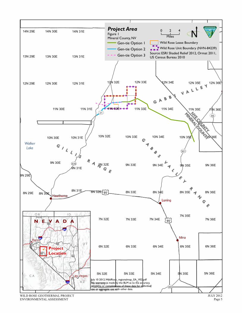
Exploration and development activities would be contained within two of the four federal geothermal leases of the Dead Horse Wells Geothermal Unit (Unit), which is located in the western portion of Gabbs Valley, approximately 17 miles west of Gabbs, in Mineral County, Nevada (see Figure 1, Project Area). Three transmission line (gen-tie) options are also analyzed in this EA, all of which would occur completely on BLM-administered lands.
A geothermal lease typically grants the lessee access to geothermal resources in the lease area for a period of 10 years. The terms of the lease require the lessee to show a certain level of diligence toward developing the geothermal resources within the lease area or the lease may be terminated. Once an area is developed for productive use of geothermal energy, the lease allows the lessee use of the resource for 40 years, with a right of renewal for another 40 years. Geothermal exploration and production on federal land conducted through leases is subject to terms and stipulations to comply with all applicable federal, state, and local laws and regulations pertaining to sanitation, water quality, wildlife, safety, and reclamation (see Appendix A, Geothermal Lease Stipulations). Lease stipulations may be site-specific and are derived from the environmental analysis process at the time of lease issuance. This EA considers the potential environmental impacts of the proposed action and has been prepared in accordance with the National Environmental Policy Act of 1969 (NEPA), the Council on Environmental Quality regulations implementing NEPA, and the Federal Lands Policy and Management Act of 1976 (FLPMA).
1.2 BACKGROUND
Exploration activities in the Unit were previously evaluated in the Gabbs Valley and Dead Horse Wells Exploration Projects EA (BLM 2009). A Finding of No Significant Impact and Decision Record were signed on January 13, 2010. Geothermal exploration activities authorized by BLM are current and ongoing in the Unit. Through these exploration activities, Ormat has acquired new information about the geothermal resource and is seeking authorization for four new
WILD ROSE GEOTHERMAL PROJECT JULY 2012 ENVIRONMENTAL ASSESSMENT Page 1
exploration wells in addition to seeking authorizations for the development of a power plant, associated facilities, and a gen-tie.
Ormat has submitted to the BLM (Stillwater Field Office of the Carson City District) the following:
� An amended Operations Plan for exploration of several newly identified well locations in the Lease Area;
� A Plan of Utilization for the development of a geothermal power plant, well field, and associated facilities; and
� A Plan of Development for the construction of a gen-tie to connect produced power to the electric grid.
In 2011, Ormat changed the name of activities in the Unit from Dead Horse to Wild Rose. Ormat is currently proposing the Wild Rose Geothermal Development Project (Project). The project is located within the 13,800-acre Dead Horse Wells Geothermal Unit (NVN-84239X), which is comprised of four federal geothermal leases. Table 1 displays the leases held and their legal land descriptions. Exploration and development activities would occur only in leases NVN-83929 and NVN-83931. These two leases comprise the Lease Area, as described from here on in this EA.
Table 1: Leases Within the Dead Horse Wells Geothermal Unit Lease Number Section Number Township, Range
NVN-83929* Sections 1-3 and 10-14 T11N, R32E NVN-83930 Sections 4-5, 8-9 and 15-17 T11N, R32E NVN-83931* Sections 5-8 T11N, R33E NVN-83932 Sections 30-32 T12N, R33E * denotes lease affected by geothermal exploration and development activities
1.3 PURPOSE AND NEED
The purpose of the proposed action is to explore for potential resources of geothermal fluid minerals and to develop such resources if they are found. The need for the proposed action isestablished by the BLM’s responsibility under the Geothermal Steam Act of 1970; the regulations under 43 Code of Federal Regulations (CFR) 3270; the Minerals Leasing Act of 1920, as amended; and Secretarial Order 3285 of March 11, 2009.
1.4 LAND USE PLAN CONFORMANCE STATEMENT
The proposed action and alternatives described below are in conformance with the Carson City District Office Consolidated Resource Management Plan (CRMP). The desired outcome for minerals and energy management under the CRMP, page MIN-1, is to “encourage development of energy and mineral resources in a timely manner to meet national, regional, and local needs consistent with the objectives for other public land uses” (BLM 2001). The CRMP minerals and energy management direction applies the following restriction on geothermal leasing: “Nodrilling or storage facilities will be allowed within 650 feet of any pond, reservoir, canal, spring,
WILD ROSE GEOTHERMAL PROJECT JULY 2012 ENVIRONMENTAL ASSESSMENT Page 2

or stream. Other protective areas near water may be required to protect riparian habitat and threatened and endangered species” (BLM 2001).
The proposed action is consistent with State of Nevada and Mineral County ordinances, policies, and plans.
1.5 RELATIONSHIP TO LAWS, REGULATIONS, POLICIES, AND PLANS
The proposed action is consistent with federal laws and regulations; state and local government laws and regulations; and other plans, programs, and policies to the extent practicable within federal law, regulation, and policy. Specific approvals and permits would be required for constructing, operating, and maintaining the proposed geothermal project.
The EA has been prepared in accordance with the following statutes and implementing regulations, policies, and procedures:
� NEPA, as amended (Public Law 91-190, 42 United States Code (USC) 4321 (et seq.) � 40 CFR 1500 (et seq.). Regulations for Implementing the Procedural Provisions of NEPA � Considering Cumulative Effects under NEPA (CEQ 1997) � 43 CFR Part 46, Implementation of NEPA of 1969; Final Rule, effective November 14,
2008� DOI requirements (Departmental Manual 516, Environmental Quality) (DOI 2008) � BLM NEPA Handbook (H-1790 1), as updated (BLM 2008a) � The Geothermal Steam Act of 1970 (30 USC 1001-1025) � 43 CFR 3200, Geothermal Resources Leasing and Operations; Final Rule, May 2, 2007 � The Energy Policy Act of 2005; The National Energy Policy, Executive Order 13212 and
best management practices (BMPs) as defined in Surface Operating Standards and Guidelines for Oil and Gas Exploration and Development, Fourth Edition (Gold Book) (BLM 2007a)
� The Geothermal Energy Research, Development, Demonstration Act of 1974 � The Federal Land Policy and Management Act of 1976 (Public Law 94 579, 43 USC
1761 (et seq.); � Rights-of-Way (ROWs) under the FLPMA and the Mineral Leasing Act (43 CFR 2880),
final Rule, April 22, 2005 � Carson City District NEPA Compliance Guidebook (Draft) (BLM 2008b) � The Act of July 31, 1947, as amended (30 USC 601 et seq.) � The federal government is authorized to collect fees and to require reimbursement of its
costs, as described in Section 304 of FLPMA [43 USC 1734] and the Independent Offices Appropriation Act of 1952 [31 USC 9701]
In 2008, the BLM completed the Programmatic Environmental Impact Statement for Geothermal Resources Leasing in the Western United States (BLM 2008c). This Programmatic Environmental Impact Statement was the foundation for a Record of Decision (ROD) and Resource Management Plan Amendments for Geothermal Resources Leasing in the Western United States (BLM 2008d). This ROD amended BLM Resource Management Plans, including the CRMP (BLM 2001), to identify public lands that are administratively and legally closed or
WILD ROSE GEOTHERMAL PROJECT JULY 2012 ENVIRONMENTAL ASSESSMENT Page 3

open to leasing; and to develop a comprehensive list of stipulations, BMPs, and procedures to serve as consistent guidance for future geothermal leasing and development. Special stipulations developed in the ROD were applied to geothermal resource leases subsequently issued by BLM, including the federal geothermal leases issued to Ormat for Wild Rose in 2010.
Copies of the stipulations are attached to this EA as Appendix A. Ormat is required to comply with all lease stipulations.
The proposed action would be subject to other applicable permits listed in Table 2, Potential Regulatory Permits and Approvals, prior to beginning construction.
Table 2: Potential Regulatory Permits and Approvals Regulatory Agency Authorizing Action
BLM Right-of-Way
BLM Notice of Intent
BLM Geothermal Drilling Permit
BLM Permit to Construct Power Plant
Nevada Division of Minerals Permit to Drill an Oil and Gas and Geothermal Well
Nevada Department of Environmental Protection –
Bureau of Water Protection Control
Construction Stormwater Permit
Department of Conservation and Natural Resources, Nevada Division of Water Resources
Temporary Consumptive Water Use permit
Nevada Department of Conservation and Natural Resources, Division of Environmental Protection, Bureau of Air Pollution Control
Surface Area Disturbance Permit
BLM, Nevada Division of Historic Preservation and Archaeology
Section 106 compliance with the National Historic Preservation Act
WILD ROSE GEOTHERMAL PROJECT JULY 2012 ENVIRONMENTAL ASSESSMENT Page 4
!
!
!
!
£¤95
£¤95
UV361
UV31
UV839
UV360
UV89
Mina
Luning Hawthorne
8N 32E
7N 32E
6N 32E
8N 31E 8N 33E
9N 31E
6N 35E
7N 35E
5N 33E
7N 33E
5N 35E
6N 33E
9N 33E
6N 34E
7N 34E
8N 35E
9N 32E 9N 34E
5N 32E
8N 34E
5N 34E
9N 35E
10N 35E
5N 36E
10N 34E 10N 32E 10N 33E
8N 36E
7N 36E
8N 30E
6N 36E
10N 31E
12N 33E
9N 36E
12N 32E 12N 35E
13N 31E
12N 30E
13N 30E
12N 31E 12N 34E
11N 34E 11N 32E 11N 33E 11N 35E 11N 30E
10N 36E
11N 31E
14N 31E 14N 30E
10N 30E
8N 29E
13N 29E
5
12N 29E
9N 30E
14N 29E
12N 36E
11N 36E
9N 29E
!
! Reno
Las Vegas
JULY 2012
C A
A Z
U T
I DO R
£¤
£¤93
50
£¤95N E V A D A
NYECO
UNTY
WalkerLake
MINERAL COUN
TY
ProjectLocation
GA
BB
S
VA
LL
EY
RA
NG
E
G A B B S V A L L E Y
§̈¦80
§̈¦80
§̈¦15 July 10 2012,WildRose_regionalmap_EA_V02.pdfNo warranty is made by the BLM as to the accuracy, reliability, or completeness of these data for individualuse or aggregate use with other data.
GI L L I S
RA
NG
E
WILD ROSE GEOTHERMAL PROJECT
£¤6£¤95
0 2 4
Miles
Source: ESRI Shaded Relief 2012, Ormat 2011, US Census Bureau 2010
Project Area
Gen-tie Option 1
Gen-tie Option 2
Gen-tie Option 3
N TIONAL SYSTEM OF PUBLIC LANDS
U.S. DEPARTMENT OF THE INTERIORBUREAU OF LAND MANAGEMENT
Figure 1Mineral County, NV
Wild Rose Lease Boundary
Wild Rose Unit Boundary (NVN-84239)
ENVIRONMENTAL ASSESSMENT Page 5

2.0 PROPOSED ACTION AND ALTERNATIVES
2.1 PROPOSED ACTION
The proposed action includes the following four components:
� Drilling and testing of up to four exploration wells; � Construction and operation of a 15- to 35-megawatt (MW) net rated (up to 40 MW gross)
geothermal power plant facility and electrical substation;� Construction and operation of geothermal production and injection wells, pipelines,
access roads, and support facilities; and � Construction and operation of a 120-kV gen-tie and switching station.
Figure 2, Project Overview, displays the well pads, candidate power plant locations, accessroads, and pipelines. Because of their scale, the three gen-tie options are displayed in Figure 3,Gen-tie Options.
The proposed project schedule and a detailed description of each component of the proposed action are provided in the following sections.
2.1.1 Schedule of Activities
Exploration Wells
The applicant proposes to start exploration drilling activities as soon as possible following BLM approval and Nevada Division of Minerals permit issuance. This aspect of the project would follow the process outlined in Section 2.1.2, Exploration Wells, and would be performed concurrently with similar exploration activities approved in the 2009 exploration EA. Drilling of each exploration well is expected to take three months.
Power Plant and Production and Injection Wells
Construction of the energy plant and well field facilities, including associated access roads and ancillary facilities, is anticipated to start in the fourth quarter of 2012 and would take approximately eight months once all permits are obtained and equipment orders are scheduled.
Gen-tie
Construction of the gen-tie is anticipated to start in the fourth quarter of 2012 and would take approximately eight months to complete. Construction would commence only after all required permits and authorizations have been secured.
Commercial operations are anticipated to commence during the third quarter of 2013.
WILD ROSE GEOTHERMAL PROJECT JULY 2012 ENVIRONMENTAL ASSESSMENT Page 6
2.1.2 Exploration Wells
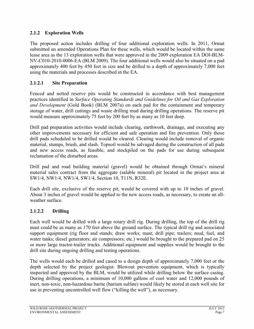
The proposed action includes drilling of four additional exploration wells. In 2011, Ormat submitted an amended Operations Plan for these wells, which would be located within the same lease area as the 13 exploration wells that were approved in the 2009 exploration EA DOI-BLM-NV-C010-2010-0006-EA (BLM 2009). The four additional wells would also be situated on a pad approximately 400 feet by 450 feet in size and be drilled to a depth of approximately 7,000 feet using the materials and processes described in the EA.
2.1.2.1 Site Preparation
Fenced and netted reserve pits would be constructed in accordance with best management practices identified in Surface Operating Standards and Guidelines for Oil and Gas Exploration and Development (Gold Book) (BLM 2007a) on each pad for the containment and temporary storage of water, drill cuttings and waste drilling mud during drilling operations. The reserve pit would measure approximately 75 feet by 200 feet by as many as 10 feet deep.
Drill pad preparation activities would include clearing, earthwork, drainage, and executing any other improvements necessary for efficient and safe operation and fire prevention. Only those drill pads scheduled to be drilled would be cleared. Clearing would include removal of organic material, stumps, brush, and slash. Topsoil would be salvaged during the construction of all pads and new access roads, as feasible, and stockpiled on the pads for use during subsequent reclamation of the disturbed areas.
Drill pad and road building material (gravel) would be obtained through Ormat’s mineral material sales contract from the aggregate (salable mineral) pit located in the project area at SW1/4, NW1/4, NW1/4, SW1/4, Section 10, T11N, R32E.
Each drill site, exclusive of the reserve pit, would be covered with up to 10 inches of gravel. About 3 inches of gravel would be applied to the new access roads, as necessary, to create an all-weather surface.
2.1.2.2 Drilling
Each well would be drilled with a large rotary drill rig. During drilling, the top of the drill rig mast could be as many as 170 feet above the ground surface. The typical drill rig and associated support equipment (rig floor and stands; draw works; mast; drill pipe; trailers; mud, fuel, and water tanks; diesel generators; air compressors; etc.) would be brought to the prepared pad on 25 or more large tractor-trailer trucks. Additional equipment and supplies would be brought to the drill site during ongoing drilling and testing operations.
The wells would each be drilled and cased to a design depth of approximately 7,000 feet or the depth selected by the project geologist. Blowout prevention equipment, which is typically inspected and approved by the BLM, would be utilized while drilling below the surface casing. During drilling operations, a minimum of 10,000 gallons of cool water and 12,000 pounds of inert, non-toxic, non-hazardous barite (barium sulfate) would likely be stored at each well site for use in preventing uncontrolled well flow (“killing the well”), as necessary.
WILD ROSE GEOTHERMAL PROJECT JULY 2012 ENVIRONMENTAL ASSESSMENT Page 7
The well bore would be drilled using non-toxic, temperature-stable drilling mud composed of a bentonite clay-water or polymer-water mix for all wells. Variable concentrations of additives would be added to the drilling mud as needed to prevent corrosion, increase mud weight, and prevent mud loss. Some of the mud additives may be hazardous substances, but they would only be used in low concentrations that would not render the drilling mud toxic. Additional drilling mud would be mixed and added to the mud system as needed to maintain the required quantities.
2.1.2.3 Site Decommission
After the well drilling and testing operations are completed, liquids from the reserve pits would then be evaporated. The solid contents remaining in each of the reserve pits, typically consisting of non-hazardous, non-toxic drilling mud and rock cuttings, would be tested for pH, metals, and total petroleum hydrocarbon or oil and grease concentrations to confirm that they are not hazardous. If the test results indicate that these solids are non-hazardous, the solids would then be mixed with the excavated rock and soil and buried by backfilling the reserve pit.
If Ormat determines a well to have no commercial potential, it may continue to be monitored but would eventually be plugged and abandoned in conformance with the well abandonment requirements of the BLM and Nevada Division of Minerals. Abandonment typically involves filling the well bore with clean, heavy abandonment mud and cement until the top of the cement is at ground level, which is designed to ensure that fluids would not move across these barriers into different aquifers. The well head and any other equipment would then be removed, the casing cut off well below ground surface, and the hole backfilled to the surface.
When the well is no longer required for monitoring, it would also be abandoned by filling the well bore with clean, heavy abandonment mud and cement until the top of the cement is at ground level, then cutting off the casing and tubing below ground level.
Following completion of exploration well testing, all of the drilling and testing equipment would be removed from the site. The surface facilities remaining on the site would likely consist only of several valves on top of the surface casing, which would be chained and locked. A temperature profile of the well may also be run.
Following the abandonment of a well, the access roads and well pads constructed would be reclaimed. Each well pad and constructed road would be disked and graded, if necessary, to de-compact the soil, turn under any applied gravel, and restore grade, if necessary. Stockpiled topsoil, if any, would be placed back over the disturbed areas.
2.1.3 Power Plant and Ancillary Facilities
The proposed action includes construction and operation of an approximately 15- to 35-MW net rated (40 MW gross) geothermal energy plant. The proposed energy plant would be located on approximately 10 acres in one of two candidate locations: Section 1 or Section 12, T11N, R32E, Mount Diablo Base & Meridian (see Figure 2). At either location, an approximately 0.4-acre substation, used to transform generated low voltage electrical energy to the higher voltage required for a transmission line, would be constructed within the energy plant boundary.
WILD ROSE GEOTHERMAL PROJECT JULY 2012 ENVIRONMENTAL ASSESSMENT Page 8

The most prominent features of the energy plant, both in height and mass, are the air-cooled condensers. They range between 28 and 35 feet in height and are about two thirds the length of the site. The balance of the plant is an array of pipes and a small building to house electrical equipment. The perimeter of the site is fenced with chain link to prevent unauthorized entry.
All buildings housing the offices, electrical room, control room and auxiliary buildings would be a rigid, steel-frame, pre-engineered structure with steel panel walls and a steel roof. The exterior of the building would be painted consistent with BLM visual color guidelines to blend in with the surrounding area.
A chain link fence would be installed around the main facility area in order to prevent unwarranted access to the facility by the public and the entering of wildlife into the facility/electrical generation area. The chain link fence would be equipped with controlled-entry gates to allow vehicle egress/ingress as necessary.
A monopole supporting a radio communications dish would be established within the proposed power plant area of disturbance. The top of the dish would be approximately 40 feet above ground surface. The dish and pole would be painted a BLM-approved color to blend in with the landscape. The radio tower would provide a microwave communications link from the power plant site to the existing High Sierra Communications site located at Bald Mountain. The microwave link will be in the Federal Communications Commission licensed 6 GHz range with actual frequencies determined during the microwave path analysis and Federal Communications Commission frequency coordination.
2.1.3.1 Power Plant Construction
Upon BLM approval, initial site preparation would commence with grubbing and clearing of the power plant area. Following grubbing and clearing, topsoil would be removed and stockpiled for later use in re-vegetation and reclamation. Subsequently, cutting of slopes would be required where necessary. Native materials would be used in site and road building as much as possible.
Ancillary facilities and energy plant components that would be constructed on the energy plant pad include offices, restrooms, the electrical room and control room; maintenance building; condensing fan equipment; geothermal fluids containment basin; electrical substation and other smaller, ancillary structures.
Preparation activities would begin with clearing, earthwork, drainage and other improvements to commence construction. A portion of the energy plant site and adjacent well pads would be devoted to equipment and materials laydown, storage, construction equipment parking, small fabrication areas, office trailers and parking. Equipment and materials laydown space is required for large turbine parts, structural steel, piping spools, electrical components, switchyard apparatus, and building parts.
Temporary utilities would be provided for the construction offices, the laydown area, and the energy plant site. Temporary construction energy would be supplied by a temporary generator and, if available when the transmission line is completed, at the site by utility-furnished power. Area lighting, drinking water, and portable toilets and sanitations would be implemented.
WILD ROSE GEOTHERMAL PROJECT JULY 2012 ENVIRONMENTAL ASSESSMENT Page 9
2.1.3.2 Power Plant Operation
The 15- to 35-MW net (up to 40 MW gross) power plant would utilize a binary design with an air cooled heat rejection system.
The geothermal fluids for the binary energy plant would be produced from the production wells by pumping. Once delivered to the energy plant, the heat in the geothermal fluid would be transferred to the “binary” (or secondary) fluid in multiple stage non-contact heat exchangers. The binary turbine units would use pentane (C5H12), a flammable but non-toxic hydrocarbon, as the binary fluid, which circulates in a closed loop. The heat from the geothermal fluid vaporizes the binary fluid, which turns the binary turbine and electrical generator to make electricity.
The vaporized binary fluid exits the turbine and is condensed back into a liquid in a non-contact, air-cooled condenser. The condensed binary fluid is then pumped back to the heat exchangers for re heating and vaporization, completing the closed-loop cycle.
The residual geothermal fluid from the heat exchangers is pumped under pressure out to the geothermal injection wells through the injection pipelines and injected back into the geothermal reservoir. The geothermal fluid would flow through the binary energy plant in a closed system, with no emissions of non-condensable gases to the atmosphere.
During normal well field operations, total geothermal fluid production rates are expected to be approximately 12,500 gallons per minute at 275°F (and up to 16,000 gallons per minute in the summer, when rates would be higher). Individual production well flow rates are expected to be approximately 2,165 gallons per minute with a wellhead pressure of about 220 pounds per squareinch gauge (psig).
Geothermal fluid injection rates are approximately 12,500 gallons per minute (up to 16,000 gallons per minute in the summer). Individual injection wells are expected to receive approximately 2,165 gallons per minute of 170°F geothermal fluid with wellhead injection pressures of about 300 psig.
2.1.3.3 Substation Construction
A new substation would be required under all alternatives. This substation would be located on BLM-administered lands adjacent to the proposed Wild Rose power plant.
The substation would include a 13.8-kV circuit breaker to protect the electric generator, a minimum of 80 megavolt ampere 13.8 kV/120 kV transformer, 120 kV potential and current transformers for metering and system protection, and a circuit breaker to protect the substation.
Work at the substation site would begin by clearing existing vegetation and grading a level pad for installation of the substation. Once the pad is prepared, the site would be secured with chain-link fencing, including structure footings and the installation of underground utilities and electrical grid integration. Aboveground structures and equipment would then be installed, followed by the addition of gravel to the site to a depth of approximately 4 inches.
WILD ROSE GEOTHERMAL PROJECT JULY 2012 ENVIRONMENTAL ASSESSMENT Page 10

The construction workforce would consist of up to 7 personnel. Project construction would also require additional support personnel, including construction inspectors, surveyors, project managers, and environmental inspectors. Existing roads would be utilized whenever possible to access the ROW. In areas where no reasonable access roads exist, Ormat would utilize overland travel to access the ROW.
Construction is anticipated to start in the fourth quarter of 2012 and would take approximately 2months to complete. Construction would commence only after all required permits and authorizations have been secured. Ormat has a planned in-service date of the third quarter of 2013 for the entire project.
2.1.3.4 Substation Operation
Ormat plans to have the gen-tie and associated facilities operational and in-service by the third quarter of 2013, after which operations and maintenance personnel would maintain the proposed transmission system by monitoring, testing, and repairing equipment.
2.1.3.5 Site Decommission
At the end of project operations all aboveground facilities and areas of surface disturbance associated with geothermal development would be removed and reclaimed. Ultimately, Ormat would implement a site reclamation plan. The plan would address restoring the surface grades, surface drainage, and revegetation of cleared areas. Stormwater diversion would remain in place until successful revegetation is attained.
2.1.4 Wells, Pipelines, Access Roads, and Support Facilities
The number of geothermal production and injection wells required for the project is principally dependent on the productivity (or injectivity) of the wells and the temperature and pressure of the produced geothermal fluid. Production wells flow geothermal fluid to the surface. Injection wells are used to inject geothermal fluid from the energy plant into the geothermal reservoir. Injection ensures the longevity and renewability of the geothermal resource.
Ormat is proposing 14 production wells and 4 injection wells, all located within the Dead Horse Geothermal Unit on BLM-administered lands. The production and injection well locations are tentative and may need to be adjusted as additional geologic, geophysical and geothermal reservoir information is obtained as new wells are drilled and tested. Temporary surface disturbance for the proposed 14 production and 4 injection wells would be 4.2 acres at each well pad, or 75.6 acres in total. After interim reclamation, there would be 2.5 acres of permanent disturbance at each well pad, or 45 acres in total. The proposed well sites and selected attributes are listed in Table 3, Wild Rose Wells.
2.1.4.1 Geothermal Well Drilling and Testing
A detailed geothermal drilling program would be submitted to the BLM for review and approval prior to beginning drilling operations. This section summarizes the well drilling activities for purposes of evaluating potential environmental consequences. If necessary, the BLM may
WILD ROSE GEOTHERMAL PROJECT JULY 2012 ENVIRONMENTAL ASSESSMENT Page 11
include additional provisions or conditions needed to address environmental concerns or other site-specific issues with the geothermal drilling permit.
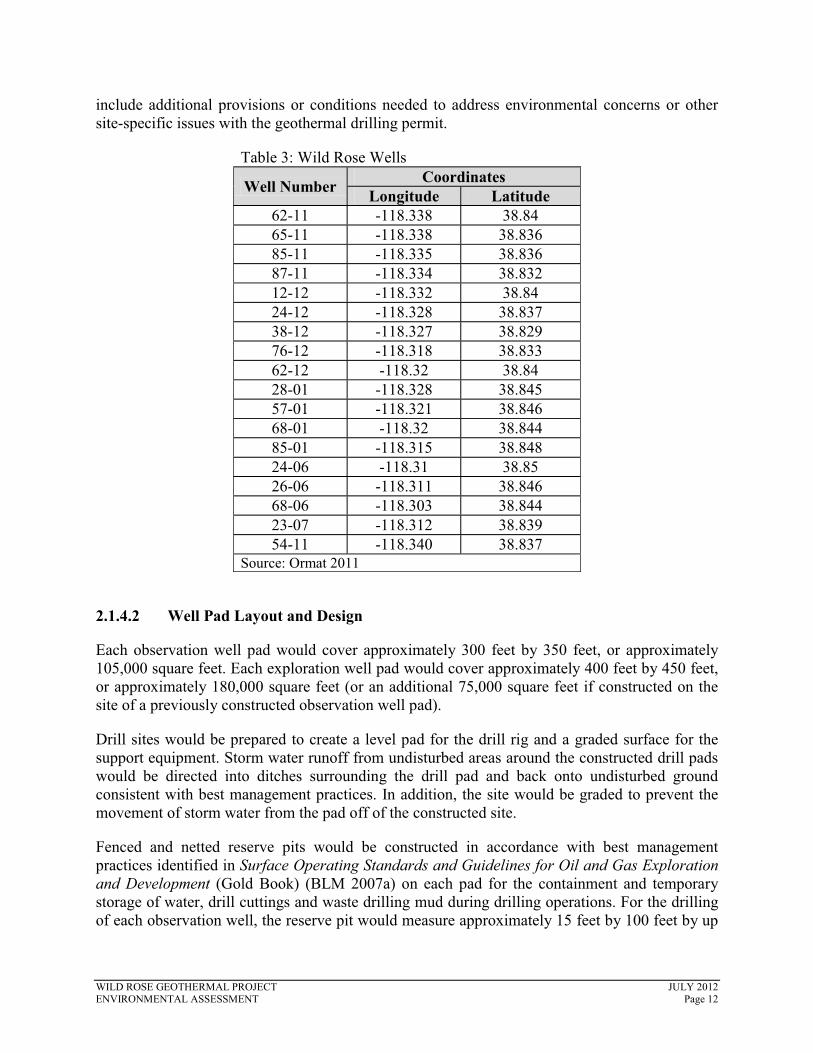
Table 3: Wild Rose Wells
Well Number Coordinates Longitude Latitude
62-11 -118.338 38.8465-11 -118.338 38.83685-11 -118.335 38.83687-11 -118.334 38.83212-12 -118.332 38.8424-12 -118.328 38.83738-12 -118.327 38.82976-12 -118.318 38.83362-12 -118.32 38.8428-01 -118.328 38.84557-01 -118.321 38.84668-01 -118.32 38.84485-01 -118.315 38.84824-06 -118.31 38.8526-06 -118.311 38.84668-06 -118.303 38.84423-07 -118.312 38.83954-11 -118.340 38.837
Source: Ormat 2011
2.1.4.2 Well Pad Layout and Design
Each observation well pad would cover approximately 300 feet by 350 feet, or approximately 105,000 square feet. Each exploration well pad would cover approximately 400 feet by 450 feet, or approximately 180,000 square feet (or an additional 75,000 square feet if constructed on the site of a previously constructed observation well pad).
Drill sites would be prepared to create a level pad for the drill rig and a graded surface for the support equipment. Storm water runoff from undisturbed areas around the constructed drill pads would be directed into ditches surrounding the drill pad and back onto undisturbed ground consistent with best management practices. In addition, the site would be graded to prevent the movement of storm water from the pad off of the constructed site.
Fenced and netted reserve pits would be constructed in accordance with best management practices identified in Surface Operating Standards and Guidelines for Oil and Gas Exploration and Development (Gold Book) (BLM 2007a) on each pad for the containment and temporary storage of water, drill cuttings and waste drilling mud during drilling operations. For the drilling of each observation well, the reserve pit would measure approximately 15 feet by 100 feet by up
WILD ROSE GEOTHERMAL PROJECT JULY 2012 ENVIRONMENTAL ASSESSMENT Page 12

to 10 feet deep. For the drilling of each exploration well, the reserve pit would measure approximately 75 feet by 200 feet by up to 10 feet deep.
Each well would be drilled with a large rotary drill rig. During drilling, the top of the drill rig mast could be as much as 170 feet above the ground surface. The typical drill rig and associated support equipment would be brought to the prepared pad on 25 or more large tractor-trailer trucks. Additional equipment and supplies would be brought to the drill site during ongoing drilling and testing operations.
Drilling would be conducted 24-hours per day, 7-days per week by a crew of nine to ten workers. During short periods, the number of workers on site during drilling would be as high as 18.
Drill pad preparation activities would include clearing, earthwork, drainage and other improvements necessary for efficient and safe operation and for fire prevention.
Up to 69,700 cubic yards of aggregate may be required for the proposed project activities. Water required for observation and exploration well drilling could range up to as much as 50,000gallons per day during the first 2 months of construction of the energy plant and 5,000 gallons per day thereafter for 6 months. Up to approximately 325 gallons of water would be consumed per day for the facility operations (0.37 acre-feet per year). Water necessary for all of these activities would be obtained from shallow water well(s) drilled from one or more of the proposed drill sites as approved by the BLM and under a waiver for the temporary use of ground water from the Nevada Department of Water Resources.
2.1.4.3 Well Drilling
The wells would each be drilled and cased to a design depth of approximately 7,000 feet, or the depth selected by the project geologist. Blowout prevention equipment, which is typically inspected and approved by the BLM, would be utilized while drilling below the surface casing. During drilling operations, a minimum of 10,000 gallons of cool water and 12,000 pounds of inert, non-toxic, non-hazardous barite (barium sulfate) would likely be stored at each well site for use in preventing uncontrolled well flow (“killing the well”), as necessary.
The well bore would be drilled using non-toxic, temperature-stable drilling mud composed of a bentonite clay-water or polymer-water mix for all wells. Variable concentrations of additives would be added to the drilling mud as needed to prevent corrosion, increase mud weight, and prevent mud loss. Some of the mud additives may be hazardous substances, but they would only be used in low concentrations that would not render the drilling mud toxic. Additional drilling mud would be mixed and added to the mud system as needed to maintain the required quantities.
In the event that very low pressure areas are encountered, compressed air may be added to the drilling mud, or used instead of drilling mud, to reduce the weight of the drilling fluids in the hole and assist in carrying the cuttings to the surface. Additionally, each well may need to beworked over or redrilled if mechanical or other problems are encountered while drilling or setting casing which prevent proper completion of the well in the targeted geothermal reservoir or if the well does not exhibit the anticipated permeability, productivity or injectivity. Depending on the circumstances encountered, working over a well may consist of lifting the fluid in the well column with air or gas or stimulation of the formation using dilute acid or rock fracturing
WILD ROSE GEOTHERMAL PROJECT JULY 2012 ENVIRONMENTAL ASSESSMENT Page 13

techniques. Well redrilling may consist of reentering and redrilling the existing well bore; reentering the existing well bore and drilling and casing a new well bore; or sliding the rig over a few feet on the same well pad and drilling a new well bore through a new conductor casing.
2.1.4.4 Flow Testing
Once the slotted liner has been set in the bottom of the well bore, and while the drill rig is still over the well, the residual drilling mud and cuttings would be flowed from the well bore and discharged to the reserve pit. This may be followed by one or more short-term flow tests, each lasting from two to four hours and also conducted while the drill rig is over the well. Each test would consist of flowing fluid from the exploration well into portable steel tanks brought onto the well site while monitoring geothermal fluid temperatures, pressures, flow rates, chemistry and other parameters. An “injectivity” test may also be conducted by injecting the produced geothermal fluid from the steel tanks back into the well and the geothermal reservoir. The drill rig would likely be moved from the well site following completion of these short-term tests.
One or more long-term flow tests (five days or more) of each well drilled would likely be conducted following the short-term flow tests to more accurately determine long-term well and geothermal reservoir productivity.
2.1.4.5 Emergency Contingency Plans
An Injury Contingency Plan; a Fire Contingency Plan; a Spill or Discharge Contingency Plan; and a Hydrogen Sulfide Contingency Plan would all be implemented in order to alleviate and mitigate health risks and increase overall safety for the project. Additionally, collaboration with local public services including fire, police, and ambulance would be accomplished by Ormat throughout the duration of the project.
2.1.4.6 Geothermal Fluid Pipelines
The geothermal fluid production and injection pipelines would bring the geothermal fluid from the production wells to the energy plant and deliver the cooled geothermal fluid from the energy plant to the injection wells, respectively.
The production and injection pipeline routes generally follow the shortest distance from each well pad to the next well pad or the energy plant in order to minimize the amount of pipe required, reduce heat losses and the energy required to move the fluids, and minimize the amount of ground disturbance. In addition, the proposed pipeline routes generally follow existing or proposed roads to facilitate ongoing monitoring and future maintenance.
However, the final alignment of the pipeline routes would be dictated by the specific wells completed for the project and the need to match fluid characteristics and balance fluid volumes in these pipelines.
2.1.4.7 Pipeline Construction
Pipeline construction would begin by vertically auguring nominal 24-inch diameter holes into the ground about 3 to 5 feet deep at approximately 30-foot intervals along the pipeline route. Dirt
WILD ROSE GEOTHERMAL PROJECT JULY 2012 ENVIRONMENTAL ASSESSMENT Page 14

removed from the holes would be cast on the ground adjacent to each hole. The steel pipe “sleeper” would be placed in the hole and concrete poured to fill the hole slightly above the ground surface. The steel pipe sleeper would extend above the concrete, averaging approximately one foot above ground surface.
While the concrete is curing, the approximately 30-foot long steel pipe sections would be delivered and placed along the construction corridor. A small crane would lift the pipe sections onto the pipe supports and temporary pipe jacks so that they could be welded together into a solid pipeline. Once welded and the welds tested, the pipe would be jacketed with insulation and an aluminum sheath (appropriately colored, likely covert green, to blend with the area).
When completed, the top of the new geothermal pipelines would average three feet (and up to six feet) above the ground surface. Electrical power and instrumentation cables for the wells would then either be installed in steel conduit constructed along the same pipe sleepers or hung by cable from pipe along the pipeline route.
The pipelines would be constructed across roads to allow continued vehicle access. This would typically use the cut and fill method, where a trench would be cut through the road, a prefabricated, “U” shaped, oversized pipe sleeve (containing the fabricated geothermal fluid pipeline with the insulation and metal cladding in place) installed in the trench, the excavated dirt backfilled and compacted around and above the oversize pipe sleeve, and the roadbed material repaired or replaced.
2.1.4.8 The Source, Quality, and Proposed Consumption Rate of Water Used
Water required for construction activities would be obtained from geothermal fluid, the carframe well, or David Holmgren Ranch or Gary Armstrong Ranch. Temporary construction water pipeline would be laid on the side of the existing roads and no additional surface disturbance isanticipated.
Approximately 50,000 gallons per day would be consumed during the first two months of construction of the energy plant and 5,000 gallons per day thereafter for six months. Up to approximately 325 gallons of water will be consumed per day for the facility operations (0.37 acre feet per year).
2.1.4.9 Site Access and Road Construction
Principal access to the lease area is from an east-west trending county-maintained gravel road from Nevada State Highway 361 south of Gabbs, Nevada (see Figure 1). Several overland routes were permitted in the exploration phase. These routes would require construction for utilization activities.
There would be 3.6 miles of new access roads constructed, resulting in 10.8 acres of disturbance (assuming a 25-foot-wide area of disturbance). Road beds would be 20 feet wide and constructed using a dozer and/or road grader. Proposed access roads are displayed in Figure 1.
WILD ROSE GEOTHERMAL PROJECT JULY 2012 ENVIRONMENTAL ASSESSMENT Page 15
Gravel would be laid at a depth of approximately four to six inches. Assuming an average depth of five inches and a road bed width of 20 feet, approximately 5,823 cubic yards of gravel would be required for access road construction.
Constructed access roads crossing existing drainages may require installation of culverts. Culvert installation would follow BLM design criteria and would be constructed pursuant to standards established in the Gold Book (BLM 2007a).
2.1.4.10 Surface Reclamation
After the well drilling and testing operations are completed, liquids from the reserve pits would then be evaporated. The solid contents remaining in each of the reserve pits, typically consisting of non-hazardous, non-toxic drilling mud and rock cuttings, would be tested (for pH, metals, and total petroleum hydrocarbon or oil and grease concentrations) to confirm that they are nothazardous. If the test results indicate that these solids are non-hazardous, the solids will then be mixed with the excavated rock and soil and buried by backfilling the reserve pit.
If a well is judged by Ormat to have no commercial potential, it may continue to be monitored, but will eventually be plugged and abandoned in conformance with the well abandonment requirements of the BLM and Nevada Division of Minerals. When no longer required for monitoring, wells would also be abandoned and filled. Following completion of exploration well testing, all of the drilling and testing equipment would be removed from the site. Following the abandonment of a well, the access roads and well pad constructed will be reclaimed.
2.1.5 Gen-Tie
The proposed action includes the construction and operation of an overhead 120- kV gen-tie and associated facilities. Under each option, an approximately 8.5-acre switching station would be constructed at the termination point. Ormat has identified three gen-tie routing options, described below.
2.1.5.1 Options
Ormat has not yet signed a power purchase agreement for the electricity that would be produced from the proposed Wild Rose power plant. To allow Ormat to be better able to respond to the evolving renewable energy needs of both Nevada and California, Ormat seeks to maintain the option of entering into a power purchase agreement with either NV Energy, which would require a connection to existing NV Energy infrastructure, or with a California utility, which would require a connection to the existing TG Power transmission line. To address Ormat’s need for flexibility, this EA analyzes three gen-tie options, described below. Ormat seeks approval of two of the three routes: Option 1, which would provide a ROW for building a gen-tie connection to NV Energy and one of either Option 2 or Option 3, which would provide a ROW for constructing a gen-tie connection to the TG Power transmission line.
All three gen-tie options have a common starting point at the site of the proposed substation adjacent the proposed Wild Rose power plant. Additionally, for all three options, the gen-tiewould be located entirely on BLM-administered lands. Depending on the route selected, the project would cross approximately 20.5 miles (Option 1), 6.7 miles (Option 2) or 5.8 miles
WILD ROSE GEOTHERMAL PROJECT JULY 2012 ENVIRONMENTAL ASSESSMENT Page 16

(Option 3) of lands administered by the BLM, Carson City District, Stillwater Field Office. Figure 1 shows the approximate locations of the three gen-tie options and where each would connect into the power grid. Unique descriptions of each gen-tie route are provided in the following paragraphs, followed by descriptions of components common to all route options.
Gen-Tie Option 1
The proposed Option 1 route would travel east from the proposed substation for 1.6 miles, and then shift northeast for 2 miles as it begins to parallel Rawhide Road. The gen-tie would follow Rawhide Road southeast for 15.2 miles, cross Nevada State Route 361, and terminate in 1.7 miles, at the NV Energy line, approximately 1.3 miles east of State Route 361 and 0.15 milessouth of Finger Rock Road.
Once commercial operations begin, power would be delivered to the NV Energy grid by connecting the proposed power plant electrical substation to a proposed switching station at the NV Energy line. Gen-tie, substation, and switching station construction would occur on BLM-administered lands. The gen-tie would be approximately 20.5 miles long.
Gen-Tie Option 2
The proposed Option 2 route would travel west from the proposed substation for 2 miles along Rawhide Road, and then shift southwest for 4.7 miles, following State Highway 839. The line terminates at the TG Power transmission line.
For this gen-tie route, power would be delivered to the TG Power grid by connecting the proposed power plant electrical substation to a proposed switching station at the TG Power transmission line. Gen-tie, substation, and switching station construction would occur on BLM-administered lands. The gen-tie would be approximately 6.7 miles long.
Gen-Tie Option 3
The proposed Alternative 3 route would travel west from the proposed substation for 4.9 miles along Rawhide Road before crossing State Highway 839. The line terminates at the TG Power transmission line.
As under Alternative 2, power would be delivered to the TG Power grid by connecting the proposed power plant electrical substation to a proposed switching station at the TG Power line. Gen-tie, substation, and switching station construction would occur on BLM-administered lands. The gen-tie would be approximately 5.8 miles long.
2.1.5.2 Components
The gen-tie would consist of a single 120-kV circuit on direct-burial, self-supporting wooden monopole structures. Structure heights would be 55 to 70 feet, and the span would be between 300 and 450 feet depending on the terrain (one span would be 464 feet to avoid an archaeological site). These types of structures would be installed including tangent, angle and dead-end poles. The diameter at the base of the structure would range from two to three feet. Structure sites would include assembly and crane-landing areas. Angle and dead-end structures
WILD ROSE GEOTHERMAL PROJECT JULY 2012 ENVIRONMENTAL ASSESSMENT Page 17

would be assembled and insulators would be attached to the pole. The poles would be erected with a truck-mounted crane to lift and set the structure after it is assembled.
Each 120-kV gen-tie would consist of a single conductor per phase using 397.5 MCM 26/7 non-specular ACSR “Ibis” cable. One 12- to 48-fiber fiber optical ground wire will be used in the design for telecommunications and to shield against lightning strikes. In the event a fiber optical ground wire is not required for this project, a 3/8-inch EHS overhead ground wire can be substituted. The overhead conductors would be non-specular to reduce sunlight reflection and minimize impacts on visual resources. Each structure would carry a single overhead ground wire/fiber optic cable for lightning protection and fiber optic communications. The overhead ground wire measures approximately 0.75 inches in diameter and is constructed of concentric layers of galvanized steel wires surrounding a hollow core containing 12 to 48 fiber optic strands, depending on the final requirements. Metering and communications equipment would be required at each generator site.
At the termination point, an approximately 8.5-acre switching station would be constructed to interconnect with existing lines. The switching station would be located on BLM-administered lands and construction would follow the procedures described for the power plant and substation.
2.1.5.3 ROW Width Requirements
During construction activities, Ormat would require a temporary 300-foot-wide ROW. After construction is complete, Ormat would obtain a permanent 90-feet easement to accommodate the swing of the conductor.
2.1.5.4 Construction, Operation, and Decommissioning
A crew of up to 7 workers would begin working at the site approximately 1 to 2 weeks prior to the start of construction. During this time, they would transport equipment and construction materials to the project site.
The initial activity prior to construction would be the engineering survey and staking of project facilities. This would include marking structure locations, anchor sites, staging and material yards, wire setup sites, and the substation and switching station location. The site would be staked and preconstruction plant and wildlife surveys would occur to delineate any sensitive resource areas.
In order to establish work areas where poles and conductors would be installed, vegetation clearing and grading within the ROW could be necessary. In all locations, Ormat would utilize overland travel to the extent possible and vegetation removal would be minimized to the maximum extent possible.
At each structure site, work areas are required to facilitate the safe operation of equipment and construction operations. Construction laydown areas will be located in previously disturbed areas whenever possible (i.e., along access roads or on well pads). At each location, a work area would be cleared and leveled only if necessary. In most relatively level terrain, this would not be needed.
WILD ROSE GEOTHERMAL PROJECT JULY 2012 ENVIRONMENTAL ASSESSMENT Page 18
Temporary work areas, approximately 300 feet by 300 feet, would be necessary at each gen-tiestructure site. A 30-foot by 40-foot area would also be required for line construction equipment. Several stringing sites and angle points, which would each have an area of approximately 300 by 300 feet, would be necessary to install the conductor. Stringing sites would be located approximately every 15,000 to 20,000 feet along the gen-tie.
Staging areas would be required for the temporary storage and mobilization of construction equipment and materials. These staging areas would be located at existing well pads, the power plant site, or at the carframe well. Staging areas would also serve as reporting locations for workers and parking spaces for vehicles.
Materials, such as gen-tie poles, insulators, hardware, and guy wire anchors would be delivered from the staging area to each gen-tie structure site. Assembly crews would attach insulators, travelers, and hardware to form a complete structural unit. Erection crews would use a large, truck-mounted mobile crane to place the structures directly into the ground, depending on the soil conditions and results of geotechnical surveys.
Conductor and shield wire would be delivered on reels by flatbed truck to the various stringing sites along the ROW. Other equipment required to install the conductor would include reel stringing trailers, tensioning machines, pullers, and several trucks including a bucket truck.
Waste materials and debris from construction areas would be collected, hauled away, or disposed of at approved landfill sites. Cleared vegetation would be shredded and distributed over the ROW as mulch and erosion control or disposed of offsite, depending on agency agreements. Rocks removed during foundation excavation would be redistributed over the ROW to resemble adjacent site conditions. Reclamation would include also re-contouring of impacted areas to match the surrounding terrain, and cleaning any trash out of gullies.
After construction is complete, all existing roads would be left in a condition equal to or better than their preconstruction condition, as directed by the BLM and as applicable. Additionally, all other areas disturbed by construction activities would be recontoured, decompacted, and seeded. BLM-approved seed mixes would be applied to these disturbed areas. Ormat would attempt to close or restrict vehicle access to areas that have been seeded until the reclamation success criteria have been achieved.
Permanent disturbance would be limited to a 20-foot by 30-foot pad on both sides of the gen-tieat each pole location, which would be used for future maintenance.
The electrical equipment and monopoles are anticipated to have a lifetime of approximately 50 to 60 years or more depending upon maintenance operations and climatic conditions. Structures, conductors, shield wire, insulators, and hardware would be left in place, dismantled, and replaced or removed from the ROW during the life of the project.
Emergency maintenance, such as repairing downed wires during storms and correcting unexpected outages, would be performed by Ormat or licensed maintenance contractors.
WILD ROSE GEOTHERMAL PROJECT JULY 2012 ENVIRONMENTAL ASSESSMENT Page 19
2.1.6 Area of Disturbance
Table 4, Area of Disturbance: Wells, Access Roads, Power Plant, and Ancillary Facilities,summarizes the proposed new facilities with estimated area of permanent and temporary disturbance for each facility. Table 5, Area of Disturbance: Gen-tie Options, summarizes the three proposed gen-tie options with estimated area of permanent and temporary disturbance for each option.
Table 4: Area of Disturbance: Wells, Access Roads, Power Plant, and Ancillary Facilities
Disturbance Type Temporary Disturbance (Approximate)
Permanent Disturbance (Approximate)
Exploration Wells 16.8 acres 10 acres Production and Injection
Wells 75.6 acres 45 acres
Power Plant and Substation 10 acres 10 acres Switching Station 8.5 acres 8.5 acres
Access Roads 10.8 acres 10.8 acres Total 121.7 acres 84.3 acres
Source: Ormat 2011
Table 5: Area of Disturbance: Gen-tie Options
Disturbance Type Temporary Disturbance (Approximate)
Permanent Disturbance (Approximate)
Gen-tie Option 1 773 4.7Gen-tie Option 2 252 1.5Gen-tie Option 3 218 1.3
Source: Ormat 2011
Combining the gen-tie options with the other components of the proposed action, total temporary disturbance would be approximately 894.7 acres (Option 1), 373.7 acres (Option 2), or 339.7 acres (Option 3). Permanent disturbance would be approximately 89 acres (Option 1), 85.5 acres (Option 2), or 85.3 acres (Option 3).
2.1.7 Environmental Protection Measures
2.1.7.1 Environmental Compliance
All construction, operation, and maintenance activities associated with the project would be conducted in compliance with all relevant federal, state, and local regulations and permits, and would also be conducted in accordance with the requirements and conditions specified in the BLM ROW Grant and NEPA documentation. In addition to the requirements stipulated in the project permits (see Appendix A, Geothermal Stipulations), Ormat has committed to implementing environmental protection measures that would further facilitate avoidance and/or minimization of potential adverse environmental impacts. Additionally, federal, state, and local agencies would be involved in the permitting of the selected transmission line.
WILD ROSE GEOTHERMAL PROJECT JULY 2012 ENVIRONMENTAL ASSESSMENT Page 20

Ormat proposes the following specific environmental protection measures:
1. Water would be applied to the ground during the construction and utilization of the drill pads, access roads, and other disturbed areas as necessary to control dust.
2. Reserve pits and all sumps containing potentially harmful liquids to wildlife would be fenced and netted. Fencing would be eight feet high and of a material conforming to Nevada Department of Wildlife recommendations. Netting would be 1.5-inch mesh, secured to the ground; four to five feet above the liquid solution surface.
3. Portable chemical sanitary facilities would be available and used by all personnel during periods of well drilling and/or flow testing, and construction. These facilities would be maintained by a local contractor.
4. To prevent the spread of invasive, nonnative species, all contractors will be required to power-wash their vehicles and equipment, including body and undercarriage, prior to entering BLM-administered lands.
5. Any infestations of noxious weed species discovered during construction or operation would be treated prior to disturbance. The location of the weeds would be communicated to the Stillwater Field Office weed coordinator, and treatment methods and herbicides used would be discussed prior to treatment.
6. All construction and operating equipment would be equipped with applicable exhaust spark arresters. Fire extinguishers would be available on the active sites. Water that is used for construction and dust control would be available for firefighting. Personnel would be allowed to smoke only in designated areas, and they would be required to follow applicable BLM regulations regarding smoking.
7. Cut and fill activities have been minimized through the selection of the power plant site and pipeline routes. Offsite storm water would be intercepted in ditches and channeled to energy dissipaters as necessary to minimize erosion around the power plant. To minimize erosion from storm water runoff, access roads would be maintained consistent with the best management practices applicable to development roads. BLM best management practices for storm water would be followed, as applicable, on public lands.
8. Sumps that do not contain liquids harmful to wildlife would be graded to allow wildlife to escape or have escape ramps installed.
9. Water wells would be cased to a depth below the lowest groundwater aquifer to prevent co-mingling of fluids, in compliance with appropriate sections of the NRS 534A.010 through NRS 534A.090 and all other applicable local, state, and federal regulations.
10. A spill or discharge contingency plan would be implemented to mitigate the impact of potential sources of accidental spills or discharges.
11. Following project construction, areas of disturbed land no longer required for operations would be reclaimed to promote the reestablishment of native plant and wildlife habitat.
12. Any areas containing cultural resources of significance would be avoided, or the potential for impacts mitigated in a manner acceptable to the BLM. Ormat employees, contractors, and suppliers would be reminded that all cultural resources are protected and if uncovered shall be left in place and reported to the Ormat representative and/or their supervisor.
13. A buffer of approximately 30 to 50 meters would be established around eligible and unevaluated cultural sites that lie very close to project activities. When initial construction is close to the buffered areas, an archaeological monitor would be present to insure that eligible and unevaluated cultural sites are not disturbed.
WILD ROSE GEOTHERMAL PROJECT JULY 2012 ENVIRONMENTAL ASSESSMENT Page 21

14. The proposed transmission line would also provide raptor protection in compliance with the standards described in the “Suggested Practices for Raptor Protection on Power Lines, The State of the Art in 2006” (APLIC 2006).
15. An anti-perching device, (e.g., a Kaddas Enterprises type KE1058 cone or equal) would be installed on the top of each transmission line pole along the entirety of thetransmission line.
16. All power poles will utilize BLM-approved raptor deterrents. 17. Construction noise would be minimized through practices which avoid or minimize
actions which may typically generate greater noise levels, or generate distinctive impact noise.
18. Ormat will obtain and comply with an Underground Injection Control permit, as appropriate.
2.1.7.2 Fire Contingency Plan
All construction and operating equipment would be equipped with applicable exhaust spark arresters. Fire extinguishers would be available on the site. Water that is used for construction and dust control would be available for firefighting. Personnel would be allowed to smoke only in designated areas, and they would be required to follow applicable BLM regulations regarding smoking. The following fire contingency plan is provided below:
1. Any small fires which occur at the power plant facility or around the well pad during drilling and/or testing operations should be able to be controlled by rig personnel utilizing on-site firefighting equipment.
2. The BLM Carson City District Office ([775]-885-6000) would be notified of any wildland fire, even if the available personnel can handle the situation or the fire poses no threat to the surrounding area. Additionally, the Sierra Front Interagency Dispatch Center would be notified at (775)-883-5995.
3. A roster of emergency phone numbers would be available onsite so that the appropriate firefighting agency can be contacted in case of a fire.
4. All vehicles shall carry at a minimum a shovel and five gallons of water (preferably in a backpack pump), in addition to a conventional fire extinguisher.
5. Adequate firefighting equipment (a shovel, a pulaski, standard fire extinguisher(s), and an ample water supply) shall be kept readily available at each active drill site.
6. Vehicle catalytic converters (on vehicles that would enter and leave the drill site on a regular basis) shall be inspected often and cleaned of all flammable debris.
7. All cutting/welding torch use, electric-arc welding, and grinding operations shall be conducted in an area free, or mostly free, from vegetation. An ample water supply and shovel shall be on hand to extinguish any fires created from sparks. At least one person in addition to the cutter/welder/grinder shall be at the work site to promptly detect fires created by sparks.
8. Personnel would be responsible for being aware of and complying with the requirements of any fire restrictions or closures issued by the BLM Carson City District Office, as publicized in the local media or posted at various sites throughout the field office district.
WILD ROSE GEOTHERMAL PROJECT JULY 2012 ENVIRONMENTAL ASSESSMENT Page 22

2.1.7.3 Methods for Meeting Air Quality Standards
There would be no noncondensable gas emissions during normal operations. However, some of the binary working fluid would be released to the atmosphere from rotating seals and flanges. Also during normal operations, a small quantity of air enters the pentane loop in the air cooled condenser. The pentane would be discharged back to the atmosphere via a purge stack. Some liquid pentane would be stored on-site in a tank. Residual pentane would be evaporated to the atmosphere when the binary power plant unit is opened. Nevada Division of Environmental Protection’s Bureau of Air Pollution Control would issue a permit to ensure ambient concentrations of ozones from these sources would not exceed applicable Ambient Air Quality Standards.
Ormat would continue to maintain its Surface Area Disturbance permit with the Bureau of Air Pollution Control, and continue to implement the required actions to minimize fugitive dust emissions, during the well drilling and construction phases of the project. Once the plant is operational, the Surface Area Disturbance regulation would continue as a part of the project’sAir Quality Operating permit.
2.1.7.4 CFR Compliance
Ormat would comply with 43 CFR 3200.4 and all relevant noise, air and water quality standards at all times and Ormat would provide compliance measures for these regulations upon request. Ormat would collect and provide appropriate, additional environmental data if required.
Ormat would additionally be required to describe all abandonment efforts of utilization facilities and site restoration procedures, to comply with the requirements of 43 CFR 3200.4. Ormat would have to comply with Nevada Division of Water Resources regulation in abandoning and plugging wells Ormat would prepare site for Nevada Division of Water Resources approval, and then implement a site reclamation plan. The plan would address restoring the surface grades, surface drainage, and re-vegetation of cleared areas. Stormwater diversion would remain in place until successful re-vegetation is attained.
2.2 ALTERNATIVES CONSIDERED BUT NOT ANALYZED IN DETAIL
No other reasonable alternative routes or modes were identified. Well locations were determined based on commercial potential and gen-tie route selection was predicated upon the gen-tie line interconnecting to the nearest available transmission line with available capacity. The three proposed gen-tie options are also the shortest and most direct route to the point of interconnection.
2.3 NO ACTION ALTERNATIVE
Under the No Action Alternative none of the plans or applications filed by Ormat would be approved by the BLM. The proposed action would not be implemented as proposed on federal lands, and none of the potential environmental effects of implementing the proposed action would occur.
WILD ROSE GEOTHERMAL PROJECT JULY 2012 ENVIRONMENTAL ASSESSMENT Page 23

54a1
1
68-0
1
26-0
6
85-0
1
85-1
1
68-0
6
24-0
6
23-0
7
57-0
1 76-1
2
62-1
2
28-0
1
12-1
2
24-1
2
38-1
2
87-1
1
62-1
1
65-1
1 Ra
whi
deRd
Rabb
itSp
rings
RdN
TIO
NA
L S
YS
TE
M O
F P
UB
LIC
LA
ND
S
U.S
. DE
PAR
TM
EN
T O
F T
HE
IN
TE
RIO
RB
UR
EA
U O
F LA
ND
MA
NA
GE
ME
NT
Can
dida
tePo
wer
Pla
nt 1
Can
dida
tePo
wer
Pla
nt 2
Proj
ect
Ove
rvi
!
! R
eno
Las V
egas
Proj
ect
Loca
tion
N E
V A
D A
So
urce
: Orm
at 2
011,
US
Cen
sus
Bure
au 2
010,
US
Topo
Map
s 20
12
§̈¦80
§̈¦15
July
10
2012
,Wild
Rose
_wel
ls_EA
_V02
No
war
rant
y is
mad
e by
the
BLM
as
to t
he a
ccur
acy,
relia
bilit
y, or
com
plet
enes
s of
the
se d
ata
for
indi
vidu
al
use
or a
ggre
gate
use
with
oth
er d
ata.
0 1,
000
ewPr
opos
ed a
cces
s ro
ad a
nd p
ipel
ine
Pow
er P
lant
Opt
ions
Fe
et
Exis
ting
road
and
pro
pose
d pi
pelin
e W
ild R
ose
Uni
t Bo
unda
ry (
NV
N-8
4239
) M
iner
al C
ount
y, N
V
Wel
lpad
s (4
00x4
50ft)
W
ild R
ose
Leas
e Bo
unda
ry
Figu
re 2
WIL
D R
OSE
GEO
THER
MA
L PR
OJE
CT
JULY
201
2EN
VIR
ON
MEN
TAL
ASS
ESSM
ENT
Page
24
Raw
hide
Rd
StateHwy839
State Hwy 31
Rabbit Springs Rd
StateRte23
Finger
RockRd
10N
35E
10N
34E
10N
32E
10
N 3
3E
11N
34E
11N
32E
11
N 3
3E
11N
35E
12N
34E
12N
33E
12N
32E
12
N 3
5E
11N
31E
9N 3
3E
9N 3
4E
9N 3
5E
Gen
-tie
Opt
i
!
! R
eno
Las V
egas
Proj
ect
Loca
tion
N E
V A
D A
So
urce
: Orm
at 2
011,
US
Cen
sus
Bure
au 2
010,
US
Topo
Map
s 20
12
TIO
NA
L S
YS
TE
M O
F P
UB
LIC
LA
ND
S
U.S
. DE
PAR
TM
EN
T O
F T
HE
IN
TE
RIO
RB
UR
EA
U O
F LA
ND
MA
NA
GE
ME
NT
§̈¦80
§̈¦15
July
10
2012
,Wild
Rose
_gen
ties_
EA_V
02.p
dfN
o w
arra
nty
is m
ade
by t
he B
LM a
s to
the
acc
urac
y,re
liabi
lity,
or c
ompl
eten
ess
of t
hese
dat
a fo
r in
divi
dual
us
e or
agg
rega
te u
se w
ith o
ther
dat
a.
0 1
Gen
-tie
Opt
ion
1 W
ild R
ose
Uni
t Bo
unda
ry (
NV
N-8
4239
) on
s M
iles
Gen
-tie
Opt
ion
2 W
ild R
ose
Leas
e Bo
unda
ry
Min
eral
Cou
nty,
NV
Gen
-tie
Opt
ion
3 Pr
ivat
e Pa
rcel
s (a
ll ot
her
land
is B
LM)
Figu
re 3
WIL
D R
OSE
GEO
THER
MA
L PR
OJE
CT
JULY
201
2EN
VIR
ON
MEN
TAL
ASS
ESSM
ENT
Page
24

3.0 AFFECTED ENVIRONMENT AND ENVIRONMENTAL CONSEQUENCES
3.1 SCOPING AND ISSUE IDENTIFICATION
This section identifies and describes the current condition and trend of elements or resources in the human environment which may be affected by the Proposed Action or Alternatives and the environmental consequences or effects of the action(s).
The BLM Stillwater Field Office held an interdisciplinary team meeting on February 27, 2012 (see Appendix B, Interdisciplinary Team Checklist for EA Preparation). The following issues were identified as needing to be addressed in the environmental assessment: Migratory Birds,Visual Resources, Minerals, Wildlife/Key Habitat, BLM Sensitive Species, and Livestock Grazing.
The following issues were identified as not being present in the proposed project area: Areas of Critical Environmental Concern; Environmental Justice; Farm Lands; Forests and Rangelands; Human Health and Safety; Native American Religious Concerns; Threatened and/or Endangered Species; Wild and Scenic Rivers; Wilderness; Lands with Wilderness Characteristics; Recreation; and Wild Horses and Burros. Threatened and endangered species are discussed in this EA to clearly lay out the reason for a conclusion of no impact to this resource, in accordance with the Endangered Species Act.
3.1.1 Supplemental Authorities
Appendix 1 of the BLM’s NEPA Handbook, H-1790-1 (BLM 2008a) identifies supplemental authorities that are subject to requirements specified by statute or executive order and must be considered in all BLM environmental documents (Table 6, Supplemental Authorities and Rationale for Detailed Analysis for the Proposed Action). Supplemental authorities that could be affected by the proposed action are further described in this EA.
Table 6: Supplemental Authorities and Rationale for Detailed Analysis for the Proposed Action
Elementsa Not Presentb
Present/ Not
Affectedb
Present/ May Be
AffectedcRationale
Air Quality X Not present. Areas of Critical Environmental Concern
X Not present.
Cultural Resources X The proposed action will avoid all historic properties.
Environmental Justice
X Not present.
Farmlands (prime or unique)
X Not present.
Forests and Rangeland
X Not present.
WILD ROSE GEOTHERMAL PROJECT JULY 2012 ENVIRONMENTAL ASSESSMENT Page 26

Table 6: Supplemental Authorities and Rationale for Detailed Analysis for the Proposed Action
Elementsa Not Presentb
Present/ Not
Affectedb
Present/ May Be
AffectedcRationale
Floodplains X Not present. Human Health and Safety
X Not present.
Invasive, Nonnative, and Noxious Species
X Not present.
Migratory Birds X Carried forward in Section 3.3.Native American Religious Concerns
X The proposed action will not impact any traditional cultural properties, significant religious or sacred sites, or other known sites of cultural importance.
Threatened or Endangered Species
X After consulting with the BLM wildlife biologist and the USFWS website for Nevada, no T & E species are known to exist in the project area.
Wastes, Hazardous or Solid
X No hazardous wastes occur in the proposed project area and all solid wastes would be disposed off -site.
Water Quality (Surface/Ground)
X Not present.
Wetlands/Riparian Zones
X Not present.
Wild and Scenic Rivers
X Not present.
Wilderness X The proposed action is located near the Gabbs Wilderness Study Area, but will not affect wilderness character.
a See BLM Handbook H-1790-1(BLM 2008a), Appendix 1, Supplemental Authorities to be Considered. b Supplemental authorities determined to be not present or present/not affected need not be carried forward or discussed further in the document.
c Supplemental authorities determined to be present/may be affected must be carried forward in the document.
3.1.2 Resources Other Than Supplemental Authorities
Resources or uses that are not supplemental authorities as defined by BLM’s Handbook H-1790-1 (BLM 2008a) are present in the project area. BLM specialists have evaluated the potential impact of the proposed action on these resources and documented their findings in Table 7,
WILD ROSE GEOTHERMAL PROJECT JULY 2012 ENVIRONMENTAL ASSESSMENT Page 27
Resources Other Than Supplemental Authorities. Resources or uses that may be affected by the proposed action are further described in this EA.
3.1.3 Resources or Uses Present and Brought Forward for Analysis
The following resources are present in the project area, may be affected by the proposed action,and are carried forward for analysis:
� Migratory Birds � Visual Resources � Minerals � Wildlife/Key Habitat � BLM Sensitive Species � Livestock Grazing
Table 7: Resources Other Than Supplemental Authorities
Resource or Issue Present/ Not Affecteda
Present/May Be Affectedb Rationale
Visual Resources X Carried forward in Section 3.4.Minerals X Carried forward in Section 3.5.Wildlife/Key Habitat X Carried forward in Section 3.6.BLM Sensitive Species X Carried forward in Section 3.7.Livestock Grazing X Carried forward in Section 3.8.a Resources or uses determined to be not present/not affected need not be carried forward or discussed further in the document. b Resources or uses determined to be present/may be affected must be carried forward in the document.
3.2 MIGRATORY BIRDS
3.2.1 Affected Environment
On January 11, 2001, President Clinton signed Executive Order 13186 placing emphasis on the conservation and management of migratory birds. Migratory birds are protected under the Migratory Bird Treaty Act of 1918, and the Executive Order addresses the responsibilities of federal agencies to protect migratory birds by taking actions to implement the Migratory Bird Treaty Act. BLM management for migratory bird species on BLM-administered lands is based on Instruction Memorandum No. 2008-050 (BLM 2007e). Based on this Instruction Memorandum, migratory bird species of conservation concern include “Species of Conservation Concern” and “Game Birds Below Desired Conditions.” These lists were updated in 2008 (USFWS 2008).
There is also a Memorandum of Understanding between the BLM and US Fish and Wildlife Service to promote the conservation of migratory birds. The purpose of the Memorandum of Understanding is to strengthen migratory bird conservation by identifying and implementing strategies that promote conservation and avoid or minimize adverse impacts on migratory birds through enhanced collaboration between the two agencies, in coordination with state, tribal, and
WILD ROSE GEOTHERMAL PROJECT JULY 2012 ENVIRONMENTAL ASSESSMENT Page 28
local governments. The US Fish and Wildlife Service has also outlined a plan to conserve and protect migratory birds in its Migratory Bird Strategic Plan 2004-2014. The strategy includes direct collaboration with the BLM in making land use and planning decisions (USFWS 2004).
3.2.1.1 Golden Eagle
The Bald and Golden Eagle Protection Act (1940 as amended 1959, 1962, 1972, 1978) prohibits the take or possession of bald and golden eagles with limited exceptions. Take, as defined in the Eagle Act, includes “to pursue, shoot, shoot at, poison, wound, kill, capture, trap, collect, molest or disturb.” Disturb means “to agitate or bother a bald or golden eagle to a degree that causes or is likely to cause, based on the best scientific information available, (1) injury to an eagle, (2) a decrease in its productivity, by substantially interfering with normal breeding, feeding or sheltering behavior, or (3) nest abandonment, by substantially interfering with normal breeding, feeding or sheltering behavior.”
Important eagle-use area is defined in the Eagle Act as an eagle nest, foraging area, or communal roost site that eagles rely on for breeding, sheltering, or feeding, and the landscape features surrounding such nest, foraging area, or roost site are essential for the continued viability of the site for breeding, feeding, or sheltering eagles.
BLM requires consideration and NEPA analysis of golden eagles and their habitat for all renewable energy projects (BLM Instruction Memorandum No. 2010-156). One golden eagle was spotted approximately two miles from Gen-tie Option 1 and a half mile from Gen-tieOptions 2 and 3 (see Appendix C, Biological Survey Report). No golden eagle nests were observed during the biological survey or identified in survey data from the Great Basin Bird Observatory (GBBO 2012).
Key habitats found within the proposed action area that support life requisites of migratory birds are described in detail in Section 3.5, Wildlife/Key Habitat.
3.2.1.2 Birds of Conservation Concern
Birds of Conservation Concern for Bird Conservation Region 9 (Great Basin), which could potentially occur within the project area are presented in Table 8, Birds of Conservation Concern Potentially Occurring within the Project Area.
3.2.2 Environmental Consequences
3.2.2.1 Proposed Action
Impacts on migratory birds would be similar to those described in Section 3.5, Wildlife/Key Habitat. Construction of a power plant, gen-tie, well connection pipelines, and surface disturbance from roads, parking, and laydown areas would result in permanent, direct loss of cold desert scrub habitat. This could disturb any birds nesting nearby. In order to prevent these disruptions pre-construction nesting bird surveys would be performed.
WILD ROSE GEOTHERMAL PROJECT JULY 2012 ENVIRONMENTAL ASSESSMENT Page 29

Table 8: Birds of Conservation Concern Potentially Occurring within the Project Area Species Habitat Potential for Occurrence
Golden eagle Aquila chrysaetos
Variety of open and semi-open landscapes with sufficient mammalian prey base and cliff sites for nesting
Confirmed.
Ferruginous hawk Buteo regalis
Grasslands and semi-desert shrublands; nest in isolated trees, on rock outcrops, or ground
Potential to occur.
Peregrine falcon Falco peregrinus
Various open situations where there are suitable nesting cliffs, forages in open habitats.
Potential to occur.
Loggerhead shrike Lanius ludovicianus
Open country with scattered trees and shrubs, desert scrub; nests in shrubs or small trees
Confirmed. Observed within project area during surveys.
Brewer’s sparrow Spizella breweri
Sagebrush, greasewood, perennial upland grasslands
Potential to occur.
Sage sparrow Amphispiza belli
Treeless sagebrush or salt desert shrubland with little or no cheatgrass invasion
Potential to occur.
Sage Thrasher Oreoscoptes montanus
Salt desert scrub, montane shrubland,sagebrush
Potential to occur. Observed near the project area within the last 12 years by GBBO.
Sources: GBBO 2010; NatureServe 2011; Nevada Department of Wildlife 2006
Indirect temporary effects from noise, human presence, and heavy equipment present during construction activities may lead to reduced pairing and nesting success for individuals within or near the overall footprint of the project. This in turn may affect foraging opportunities for species that prey on adults, nestlings, or eggs. Raptor species, such as prairie falcon, that prey on rodents and lizards also may be affected by these activities.
Netting, or other appropriate mitigation, would be installed over or near reserve pits to prevent access and mortality of migratory birds.
The noise from the construction of a geothermal power plant will have a different effect on nearby birds than the noise from its operation. This is because loud, brief noises, such as those from drilling, are more likely to be perceived by nearby birds as predatory calls, eliciting an artificial, yet still physically depletive, fight or flight response. On the other hand, the consistent and lower decibel background noise emitted from a power plant inhibits birds’ ability to hear sounds and communicate to each other. This explains why pairing success and nest density significantly reduced in the presence of consistent anthropogenic noise (Barker et al. 2009) However, noise affects different species differently. Some birds can actually increase the frequency of their calls in these situations, while others will simply move away. Therefore, habitat loss may be greater than the actual project footprint.
WILD ROSE GEOTHERMAL PROJECT JULY 2012 ENVIRONMENTAL ASSESSMENT Page 30

The Proposed Action would result in a net loss of golden eagle foraging habitat for the life of the project. While the project site does not support golden eagle nesting habitat, it is expected that golden eagles could forage within the project site throughout the year. Due to the size of the project compared to available foraging habitat, population-level effects on golden eagles in the region are unlikely. As a result, operation of the Wild Rose project is not expected to result in take or disturbance of golden eagles as defined under the Bald and Golden Eagle Protection Act.
Operation of the gen-tie towers and transmission lines could result in direct mortality from bird strikes and electrocution. The proposed project will follow all the mitigation guidelines laid out by the Avian Power Line Interaction Committee (APLIC) to prevent bird fatalities from electrocution. Based on APLIC recommendations (APLIC 2006), adequate spacing between conductors (eight feet or greater based on the wingspan of a female bald eagle) would be implemented. In addition, shield wire would be grounded at regular intervals and insulated hardware and conductors would be used. Installing perch deterrents and bird diverters on the gen-tie and conducting pre-construction migratory bird nest surveys would minimize and/or eliminate impacts on individual birds by minimizing avian collisions with transmission facilities and preventing electrocution.
Due to the minimal extent of noise effects from the power plant (BLM regulations mandate that noise at one-half mile—or at the lease boundary if closer—from a major geothermal operations shall not exceed 65 A-weighted decibels (43 CFR 3200.4[b])) and the small permanent habitat acreage loss (85.3-89 acres, depending on the gen-tie option selected) relative to the hundreds of thousands of acres of available cold desert scrub habitat around the project area, population viability for any one species is not expected to be in jeopardy as a result of the components of the proposed action.
3.2.2.2 No Action Alternative
Under the no action alternative, BLM would not approve the Wild Rose Geothermal Project, the facilities would not be constructed, and there would be no change in existing migratory birds conditions at the site.
3.3 VISUAL RESOURCES
3.3.1 Affected Environment
The BLM initiated the visual resource management (VRM) process to manage the quality of landscapes on public lands and to evaluate the potential impacts on visual resources resulting from development activities. The VRM system addresses different levels of scenic values, which require different levels of management. The BLM uses four unique VRM classes to assess scenic values and visual impacts. VRM Class I is the most restrictive towards landscape alteration and development activities, and VRM Class IV is the least restrictive (BLM 2007b).
VRM classes are utilized to identify minimum levels to the visual resource when a proposed development action is analyzed using the BLM’s Visual Resource Management Inventory and Contrast Rating Manuals 8410-1 and 5432-1.1. By using this system, the impact magnitude to visual resources can be measured by separating the landscape into its major features (landform,
WILD ROSE GEOTHERMAL PROJECT JULY 2012 ENVIRONMENTAL ASSESSMENT Page 31

vegetation and structures) and predicting the magnitude of change to each of the basic visual elements (line, form, color and texture) within each of the features (BLM 2011b).
The proposed project would occur in an area where no VRM classes have been established (BLM 2011a). Projects of this nature are generally required to meet VRM Class III objectives in such a situation (BLM 2007c). The VRM Class III objective is to partially retain the existing character of the landscape. The level of change to the characteristic landscape should be moderate. Management activities may attract attention but should not dominate the view of the casual observer. Changes should repeat the basic elements found in the predominant natural features of the characteristic landscape (BLM 2007c).
The characteristic landscape of the project area is dry and arid desert, with the Gabbs Valley Mountain Range of the central Nevada desert surrounding the proposed project site, gen-tie lines, and ancillary facilities.
Sensitive receptors in the project area include people recreating in the area. Recreational activities can include hiking, bird watching, nature photography, mountain biking, and OHV use.
3.3.2 Environmental Consequences
3.3.2.1 Proposed Action
Temporary impacts on visual resources would occur during the 8-month construction period for the power plant, gen-tie, and ancillary facilities. Heavy equipment, including large tractor-trailer trucks, would be present on-site. Equipment laydown would be located in previously disturbed areas.
Drilling equipment would be seen from Rawhide Road. Roads, drill pads, and laydown areas are near ground level and would not affect visual resources. During the approximately 45-day drilling process for each exploration well, the top of the drill rig would be up to 170 feet above the ground surface, depending on the drill rig used. During drilling operations, the rig would be visible at distances of greater than 1 mile from the respective drill sites, and lights used when drilling at night would increase rig visibility. All drill rig and well test facility lights would be limited to those required to safely conduct the operations and would be shielded and/or directed in a manner that focuses direct light to the immediate work area.
Depending on the gen-tie option selected, equipment used for construction of a portion of the gen-tie route would be visible from either State Highway 361 (Option 1) or State Highway 839 (Options 2 and 3). Construction impacts would be minor and short-term and would be consistent with VRM Class III objectives.
Long-term impacts would include approximately 84.3 acres of surface disturbance from the construction of the power plant and ancillary facilities. All newly constructed structures would be below 85 feet tall and the energy plant, pipelines, wellheads, pump motors and motor control buildings would each be painted consistent with BLM visual guidelines to blend with the area and minimize visibility. The fence constructed around each of the production well sites would also be painted an appropriate color to blend with the area.
WILD ROSE GEOTHERMAL PROJECT JULY 2012 ENVIRONMENTAL ASSESSMENT Page 32
The three gen-tie options would generally parallel existing roads. Gen-tie towers would be 55 to 70 feet high and would be visible to travelers on Rawhide Road. Depending on the option selected, gen-tie towers would also be intermittently visible to travelers on State Highways 839 or 361.
In sum, the facilities of the proposed action would be noticeable to sensitive receptors, but would not dominate their view. As such, their impact on the characteristic landscape would be moderate.
3.3.2.2 No Action Alternative
Under the no action alternative, BLM would not approve the Wild Rose Geothermal Project, the facilities would not be constructed, and there would be no change in existing visual resource conditions at the site.
3.4 MINERALS
3.4.1 Affected Environment
Industrial mineral commodities in Mineral County include diatomite, clay, brines, fluorite, barite, gypsum, aluminous minerals, pumics, perlite, stone, limestone, sand and gravel, and silica. Minor occurrences of graphite, mica, talcose material, alunite, and quartz crystals have been noted (Archbold 1966).
There are six active mines within the project area (BLM 2011a).
There are no known deposits of salable or leasable minerals within the project area except those geothermal resources leased to Ormat.
3.4.2 Environmental Consequences
3.4.2.1 Proposed Action
None of the six active mines in the project area overlap with any of the proposed project components, including gen-tie lines, power plant, well pads, and ancillary facilities (BLM 2011a). As such, the proposed action would have a negligible impact on existing mineral resources.
There is the potential for future conflict between the proposed action and any locatable mining claim activities which may be proposed on any project lands during the same time period. Neither the geothermal unit operator nor the mineral claimants may proceed with operations on leased or claimed public lands without notice to the BLM. Should operations be proposed which would result in potential conflict between the two parties, the BLM would attempt to assist the two parties to reduce or eliminate the conflict.
Relocating well sites and access routes in the project area could create the same surface conflicts with locatable mining claim exploration activities. However, Ormat and the mining claimant or
WILD ROSE GEOTHERMAL PROJECT JULY 2012 ENVIRONMENTAL ASSESSMENT Page 33

operator would negotiate to reduce or eliminate conflicts that may arise from any relocated geothermal activity.
3.4.2.2 No Action Alternative
Under the no action alternative, BLM would not approve the Wild Rose Geothermal Project, the facilities would not be constructed, and there would be no change in existing minerals conditions at the site.
3.5 WILDLIFE/KEY HABITAT
3.5.1 Affected Environment
The Nevada Department of Wildlife’s Wildlife Action Plan (2006) characterized Nevada’s vegetative land cover into eight broad ecological system groups and linked those with Key Habitat types. Along with survey data, Key Habitats can be used to infer likely occurrences of wildlife species assemblages. The Key Habitat type that would be affected directly or indirectly by the proposed action is Cold Desert Scrub. Wildlife found during the August 2011 field surveys in the Wild Rose lease area are typical of this habitat. Wildlife species observed included various birds (see Section 3.6, Migratory Birds), black-tailed jackrabbit (Lepus californicus),white-tailed antelope squirrel (Ammospermophilus leucurus) and Kit Fox (Vulpes macrotis). Inaddition, both feral cattle (Bos primigenius) and horse (Equus ferus caballus) were also found in the project area (Silva 2012). In addition, the Nevada Department of Wildlife reported that the following species have been observed in the vicinity of the project area: mountain lion (Puma concolor), coachwhip (Masticophis flagellum), long-nosed leopard lizard (Gambelia wislizenii), western patch-nosed snake (Salvadora hexalepis), desert banded gecko (Coleonyx variegatus),yellow-backed spiny lizard (Sceloporus uniformis), desert horned lizard (Phrynosoma platyrhinos), Panamint rattlesnake (Crotalus stephensi), zebra-tailed lizard (Callisaurus draconoides), Great Basin collared lizard (Crotaphytus bicinctores) and western fence lizard (Sceloporus occidentalis). Although no bat roosting habitat is likely found in the Wild Rose lease area, habitat is found in mines, caves, and rock crevices of the nearby Gabbs Valley Range, and bats may use the area for foraging.
3.5.1.1 Big Game
Occupied pronghorn antelope distribution exists throughout the entire project area and within a three-mile buffer area. Bighorn sheep distribution exists in the Gabbs Valley Range in the south-central portion of the project area and three-mile buffer area. There are no known elk or mule deer distributions in the vicinity of the project area.
3.5.2 Environmental Consequences
3.5.2.1 Proposed Action
Construction of a power plant, gen-tie, well connection pipelines, and surface disturbance from roads, parking, and laydown areas would result in permanent direct loss of habitat for all wildlife and potential mortality from vehicle collisions and destruction of underground burrows for reptiles and small mammals that forage and/or have burrow complexes within the cold desert
WILD ROSE GEOTHERMAL PROJECT JULY 2012 ENVIRONMENTAL ASSESSMENT Page 34

scrub habitat. Acres of habitat that would be temporarily and permanently disturbed are approximately 100 acres. This habitat loss and disturbance may lead to reduced breeding success for individuals that are displaced into surrounding areas as well as those affected by the fragmentation of the overall footprint of the project. This in turn may affect distribution of large mammals, such as big game, and raptors that forage on rodents and small mammals.
Indirect effects to wildlife from the construction of a power plant typically come from increased noise, human presence, and heavy equipment present during construction activities. The presence of construction workers, equipment and noise could cause animals to avoid the area. This is especially disruptive to any species which use this area during sensitive activities, such as roosting, reproduction or foraging.
Table 9: BLM Sensitive Species Potentially Occurring within the Project Area Species Habitat Potential for Occurrence
Plants Nevada dune beardtongue Penstemon arenarius
Deep, volcanic, sandy soils; common associates include fourwing saltbush, littleleaf horsebrush, and greasewood
Potential to occur, though not observed during surveys.
Lahontan beardtongue Penstemon palmeri var. macranthus
Along washes, roadsides, and canyon floors, particularly on carbonate-containing substrates, usually where subsurface moisture is available throughout most of the summer.
Potential to occur, though not observed during surveys.
Birds Golden eagle Aquila chrysaetos
Variety of open and semi-open landscapes with sufficient mammalian prey base and cliff sites for nesting
Confirmed.
Ferruginous hawk Buteo regalis
Grasslands and semi-desert shrublands; nest in isolated trees, on rock outcrops, or ground
Potential to occur.
Burrowing owl Athene cunicularia
Treeless areas with low vegetation and burrows
Potential to occur.
Loggerhead shrike Lanius ludovicianus
Open country with scattered trees and shrubs, desert scrub; nests in shrubs or small trees
Confirmed. Observed within project area during surveys.
Mammals Western pipistrelle bat Pipistrellus hesperus
Deserts and lowlands, desert mountain ranges, desert scrub flats, and rocky canyons
Potential foraging habitat.
Pallid bat Antrozous pallidus
Arid deserts and grasslands, often near rocky outcrops and water
Potential foraging habitat.
Spotted bat Euderma maculatum
Various habitats from desert to montane, including canyon bottoms, and open pastures
Potential foraging habitat.
WILD ROSE GEOTHERMAL PROJECT JULY 2012 ENVIRONMENTAL ASSESSMENT Page 35
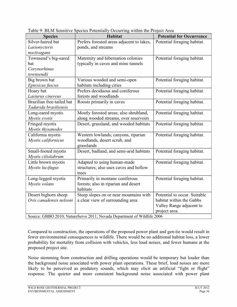
Table 9: BLM Sensitive Species Potentially Occurring within the Project Area Species Habitat Potential for Occurrence
Silver-haired bat Lasionycteris noctivagans
Prefers forested areas adjacent to lakes, ponds, and streams
Potential foraging habitat.
Townsend’s big-eared bat Corynorhinus townsendii
Maternity and hibernation colonies typically in caves and mine tunnels
Potential foraging habitat.
Big brown bat Eptesicus fuscus
Various wooded and semi-open habitats including cities
Potential foraging habitat.
Hoary bat Lasiurus cinereus
Prefers deciduous and coniferous forests and woodlands
Potential foraging habitat.
Brazilian free-tailed bat Tadarida brasiliensis
Roosts primarily in caves Potential foraging habitat.
Long-eared myotis Myotis evotis
Mostly forested areas; also shrubland, along wooded streams, over reservoirs
Potential foraging habitat.
Fringed myotis Myotis thysanodes
Desert, grassland, and wooded habitats Potential foraging habitat.
California myotis Myotis californicus
Western lowlands; canyons, riparian woodlands, desert scrub, and grasslands
Potential foraging habitat.
Small-footed myotis Myotis ciliolabrum
Desert, badland, and semi-arid habitats Potential foraging habitat.
Little brown myotis Myotis lucifugus
Adapted to using human-made structures; also uses caves and hollow trees
Potential foraging habitat.
Long-legged myotis Myotis volans
Primarily in montane coniferous forests; also in riparian and desert habitats
Potential foraging habitat.
Desert bighorn sheep Ovis canadensis nelsoni
Steep slopes on or near mountains with a clear view of surrounding area
Potential to occur. Suitable habitat within the Gabbs Valley Range adjacent to project area.
Source: GBBO 2010; NatureServe 2011; Nevada Department of Wildlife 2006
Compared to construction, the operations of the proposed power plant and gen-tie would result in fewer environmental consequences to wildlife. There would be no additional habitat loss, a lower probability for mortality from collision with vehicles, less loud noises, and fewer humans at the proposed project site.
Noise stemming from construction and drilling operations would be temporary but louder than the background noise associated with power plant operations. These brief, loud noises are more likely to be perceived as predatory sounds, which may elicit an artificial “fight or flight” response. The quieter and more consistent background noise associated with power plant
WILD ROSE GEOTHERMAL PROJECT JULY 2012 ENVIRONMENTAL ASSESSMENT Page 36

operation could affect animals’ ability to perceive sounds. This would affect different species differently, depending on how they use sound and the frequency of these sounds. For example, bats (e.g., pallid bat) that find their prey from noise that the prey makes instead of echolocation have been shown to avoid noisy areas. Bats using echolocation are unlikely to be affected because those ultrasonic signals are above the spectrum of human noise. Rodents that use chirps to warn of predators may be susceptible to increased predation because these chirps may be masked from the power plant noise (Barber et al. 2009). This in turn may affect the distribution of predators. In effect, noise may create a much larger habitat disturbance than the project footprint alone. Due to the minimal extent of noise effects from the power plant and the small permanent habitat acreage loss (85.3 to 89 acres, depending on the gen-tie option selected) relative to the hundreds of thousands of acres of available cold desert scrub habitat adjacent to the project area, population viability for any one species is not expected to be in jeopardy as a result of the components of the proposed action.
3.5.2.2 No Action Alternative
Under the no action alternative, BLM would not approve the Wild Rose Geothermal Project, the facilities would not be constructed, and there would be no change in existing wildlife/key habitat conditions at the site.
3.6 BLM SENSITIVE SPECIES
BLM sensitive species are defined in BLM Manual 6840 (Special Status Species Management) as native species found on BLM-administered lands for which the BLM has the capability to significantly affect the conservation status of the species through management and either one of the following:
1. There is information that a species has recently undergone, is undergoing, or is predicted to undergo a downward trend such that the viability of the species or a distinct population segment of the species is at risk across all or a significant portion of the species range; or
2. The species depends on ecological refugia or specialized or unique habitats on BLM-administered lands, and there is evidence that such areas are threatened with alteration such that the continued viability of the species in that area would be at risk (BLM 2008e).
3.6.1 Affected Environment
A list of sensitive species associated with BLM-administered lands in Nevada was signed in 2011 (BLM 2011c). Table 9, BLM Sensitive Species Potentially Occurring within the Project Area, presents BLM Sensitive Species and their habitat association within the Wild Rose lease area. Key habitats found within the Wild Rose lease area that support life requisites of BLM-designated Sensitive Species are described in detail in Section 3.5, Wildlife/Key Habitat.
Direct and indirect effects from permanent noise associated with the proposed project operation would be similar to those described in Section 3.2, Migratory Birds, and Section 3.5,Wildlife/Key Habitat.
Due to the minimal extent of noise effects from the power plant and the small habitat acreage loss (85.3 to 89 acres depending on the gen-tie option selected) relative to the hundreds of
WILD ROSE GEOTHERMAL PROJECT JULY 2012 ENVIRONMENTAL ASSESSMENT Page 37

thousands of acres of available cold desert scrub habitat adjacent to the project area, population viability for any one species is not expected to be in jeopardy as a result of the components of the proposed action. In addition, the proposed project is not expected to contribute to the need for listing any BLM Sensitive Species.
3.6.2 Environmental Consequences
3.6.2.1 Proposed Action
Impacts on BLM Sensitive Species would be similar to those described for migratory birds and wildlife in Section 3.2, Migratory Birds, and Section 3.5, Wildlife/Key Habitat, respectively. Construction of a power plant, gen-tie, and well connection pipelines and surface disturbance from roads, parking, and laydown areas would result in permanent direct loss of foraging and nesting habitat, as well as potential mortality for some species that may collide with the gen-tieand towers associated with drilling operations. Indirect effects from noise, human presence, and heavy equipment present during construction activities may lead to reduced breeding success for individuals within and adjacent to the overall footprint of the project. This in turn may affectdistribution of raptors that forage on rodents and small mammals. Indirect impacts from construction may also cause habitat avoidance adjacent to the project, causing a larger area of impact than just the footprint alone. For example, desert bighorn sheep may avoid the area when traveling between mountain ranges.
3.6.2.2 No Action Alternative
Under the no action alternative, BLM would not approve the Wild Rose Geothermal Project, the facilities would not be constructed, and there would be no change in existing BLM Sensitive Species conditions at the site.
3.7 LIVESTOCK (GRAZING)
3.7.1 Affected Environment
BLM manages rangelands on public lands under 43 CFR Part 4100 and BLM Handbooks 4100 to 4180 and conducts grazing management practices in accordance with BLM Manual H-4120-1 (BLM 1984; BLM 2011d).
The 13,800-acre Lease Area overlaps approximately 2.5 percent of the 512,449-acre Pilot-Table Mountain allotment. On the portion of their route outside the Lease Area the permanent 90-foot-wide corridors for the three gen-tie options would overlap approximately 44.2 acres (Option 1), 50.7 acres (Option 2), or 204.5 acres (Option 3) of the Pilot-Table Mountain allotment. These gen-tie acreages represent between 0.008 and 0.04 percent of the allotment.
In addition, the western-most 1,400 feet of Gen-tie Option 2 overlaps approximately 2.9 acres or 0.002 percent of the Gillis Mountain allotment. This is the only portion of the proposed action located outside the Pilot-Table Mountain allotment.
WILD ROSE GEOTHERMAL PROJECT JULY 2012 ENVIRONMENTAL ASSESSMENT Page 38

3.7.2 Environmental Consequences
3.7.2.1 Proposed Action
To prevent access by cattle to areas which might be harmful to them, the reserve pits and power plant site would be fenced in conformance with the Gold Book. In addition, none of the proposed project activities would substantially limit livestock's access to the undisturbed portions of the geothermal lease area.
Due to the small percentage of allotted acres lost to direct disturbance, fencing of those project facilities potentially harmful to livestock, and the fact that project facilities and practices would not prevent continued access by livestock to the undisturbed lands within the geothermal lease area and along the transmission line corridor, no impacts on livestock grazing are expected.
3.7.2.2 No Action Alternative
Under the no action alternative, BLM would not approve the Wild Rose Geothermal Project, the facilities would not be constructed, and there would be no change in existing livestock grazing conditions at the site.
3.8 CULTURAL RESOURCES
3.8.1 Affected Environment
The background research for this project compiled information about the prehistory and history of the project area through literature search and documentation analysis, which was used to help identify previously-recorded sites and form expectations about site density in the project area. General Land Office plats and other historical maps, historical indices, and land patents were also consulted prior to the fieldwork to identify potential historic features.
The entire project area was inventoried to BLM Class III standards, as defined in the BLM Cultural Resources Inventory General Guidelines (BLM 2012), and consisted of a block survey area totaling 205 acres and a linear survey corridor, 60 feet wide and approximately 28 miles in length, totaling approximately 2,000 acres. The linear survey area was surveyed by walking along the length of the corridor; the block survey was examined with transects spaced no more than 30 meters apart. When cultural resources were encountered, the sites and isolates were mapped with Trimble GeoXT GPS units, recorded on site/isolate forms, and photographed. Historic artifacts were not usually photographed, unless particularly unusual or diagnostic (e.g., glass or ceramic marker’s marks, embossing, complete bottles, etc.). No shovel probes were conducted and no cultural materials were collected during the inventory.
The inventory resulted in the identification of four previously-recorded sites, 59 newly-recorded archaeological sites, and 64 isolated finds. The four previously-recorded sites were re-located and updated during the current inventory. One site is a prehistoric complex lithic scatter and habitation site and is recommended as eligible for inclusion in the National Register of Historic Places (NRHP) under Criterion D (i.e., has yielded, or may be likely to yield, information important in prehistory or history).
WILD ROSE GEOTHERMAL PROJECT JULY 2012 ENVIRONMENTAL ASSESSMENT Page 39

The second eligible site is a multicomponent site that includes a prehistoric lithic scatter and a portion of the historic Wadsworth to Columbus Freight Road. The Wadsworth and Columbus Freight Road has been recommended as eligible in its entirety; however, the individually recorded segments evaluated in the project area are recommended as non-contributing elements of the larger site.
These historic properties will be avoided during drilling and construction activities in the project area.
The remaining sites within the project area, the other two previously recorded sites (both historic refuse scatters), and 59 newly-recorded sites are recommended not eligible for inclusion in the National Register of Historic Places.
Isolated finds consist of 15 prehistoric artifacts and 49 historic features or artifacts. The historic isolated finds consist predominantly of cans, along with rock cairns, prospect pits, survey markers, and miscellaneous historic artifacts, including one mason jar, one piece of twisted medium gauge wire, and a welded metal cover. Prehistoric isolates consist of four cryptocrystalline silicate flakes, two obsidian flakes, one fine-grained volcanic flake, one chalcedony flake, one core, one projectile point fragment, and one cryptocrystalline silicate Elko Eared projectile point base. All of the isolated finds are considered categorically not eligible for inclusion in the National Register of Historic Places per the State Protocol Agreement between the BLM and Nevada State Historic Preservation Officer (BLM 2009).
3.8.2 Environmental Consequences
3.8.2.1 Proposed Action
Any surface disturbing activities during exploration and construction of the well pads, power plant, gen-tie lines, pipelines, roads, parking, and laydown areas could have direct impacts on cultural resources, including damaging, destroying, or displacing artifacts and features, and construction of modern features out of character with a historic setting. Damaging, displacing, or destroying cultural resources could include removing artifacts from their situational context, breaking artifacts, and shifting, obliterating or excavating features without appropriate scientific recording.
Indirect impacts to cultural resources would include changing the character of the property’s use or physical features within the property’s setting and introducing visual, atmospheric, or audible elements that diminish the integrity of the property’s historic features. A geothermal plant, well pads, and associated facilities construction would place modern features onto a landscape that did not have them previously, thereby juxtaposing “modern” industrial features onto an historic landscape. Additionally, with the increased human presence of site workers during all phases of geothermal development, there is the risk of illicit collecting of surface artifacts resulting in a loss of scientific information (Eagles et al. 2002).
The potential for undiscovered buried cultural resources and/or human remains exists despite previous archaeological surveys and investigations. Surface disturbing activities could directly impact undiscovered cultural resources and/or human remains by exposing buried material,resulting in inadvertent artifact destruction or loss of scientific context. Indirect impacts could
WILD ROSE GEOTHERMAL PROJECT JULY 2012 ENVIRONMENTAL ASSESSMENT Page 40

result from the increased human presence from anticipated site workers, leading to possible illicit collecting of newly exposed materials.
Reclamation and abandonment of geothermal developments would eliminate the indirect viewshed or setting impacts for cultural resources. With reclamation practices, the natural and historic setting would be restored. However, if any cultural resources were damaged in previous phases of project development, these impacts would remain as cultural resources are non-renewable and their destruction is permanent.
However, as part of the project’s design features (see Section 2.1.7, Environmental Protection Measures), Ormat has committed to avoiding cultural resources of significance, or will mitigate impacts in a manner acceptable to the BLM. When initial construction is close to the buffered areas, an archaeological monitor would be present to insure that eligible and unevaluated cultural sites are not disturbed. Additionally, Ormat employees, contractors, and suppliers would be reminded that all cultural resources are protected and if uncovered shall be left in place and reported to the Ormat representative and/or their supervisor.
The following cultural resource protection measures would be implemented by Ormat:
� Avoid known eligible and potentially eligible cultural resource sites through design, construction, and operation of the project.
� A 100-foot buffer zone would be established around eligible and potentially eligible cultural resource sites to help provide protection to the sites. The Proposed Action would not encroach into the established 100-foot buffer zone.
� The project facilities would be operated in a manner consistent with the engineered design to prevent problems associated with run-off that could affect adjacent cultural sites. This includes the use of acceptable erosion control methods that are applicable to the site conditions.
� Where the installation of project facilities could impact eligible or potentially eligible cultural sites, Ormat would retain a qualified archaeologist to serve as a cultural monitor during construction of the facility in order to avoid potential effects to cultural site(s). The BLM would decide when cultural monitors are necessary.
� Limit vehicle and equipment travel to established roads and roads that are part of the Proposed Action.
� Any accidental discovery of cultural resources, items of cultural patrimony, sacred objects, or funerary items would require that all activity in the vicinity of the find ceases, and Terri Knutson, Field Manager, Stillwater Field Office, 5665 Morgan Mill Road Carson City, Nevada 89701, be notified immediately by phone (775-885-6000) with written confirmation to follow. The location of the find would not be publicly disclosed, and any human remains must be secured and preserved in the place until a Notice to Proceed is issued by the authorized officer.
These design features would at the very least reduce, but likely eliminate, the noted impacts commonly experienced during surface disturbing activities. Additionally, having monitors in place during construction would provide immediate attention to newly discovered sites, allowing for data recording and recovery of materials, and adding to the cultural history of the region.
WILD ROSE GEOTHERMAL PROJECT JULY 2012 ENVIRONMENTAL ASSESSMENT Page 41

3.8.2.2 No Action Alternative
Under the no action alternative, BLM would not approve the Wild Rose Geothermal Project and the facilities would not be constructed, resulting in no impact to any of the recorded or possibly buried cultural resources.
3.9 NATIVE AMERICAN RELIGIOUS CONCERNS
3.9.1 Affected Environment
Native American resources are sites, areas and materials important to Native Americans for religious, spiritual or traditional reasons, such as villages, burials, petroglyphs, rock features, or spring locations. Fundamental to Native American religions is the belief in the sacred character of physical places, such as mountain peaks, springs, or burials; traditional rituals often prescribe the use of particular native plants, animals, or minerals. Activities that may affect sacred areas, their accessibility, or the availability of materials or natural resources used in traditional practices are also considered when evaluating a project’s impacts on Native American resources.
Ethnographic information indicates that the Northern Paiute and Western Shoshone occupied the study area, and their way of life is characterized by the concept of living in harmony with the natural environment. Rituals and ceremonies address the need to ensure that plants, animals, and physical elements flourish. The continued welfare of the people depends on these rituals and ceremonies being performed properly. The manner of performing the rituals and ceremonies, the places at which they are performed, and perhaps even the time of their performance are often prescribed.
3.9.2 Environmental Consequences
Types of impacts that could occur from geothermal exploration, drilling and construction, and plant operations include direct disturbance of locations or landscapes associated with traditional beliefs, resource gathering areas, hunting and fishing areas, water sources, hot springs, ancestral sites, human remains, and trails. Other impacts could result from alterations of visual and aural aspects of the cultural landscape’s setting both on the project site and in adjacent areas; increased access and site workers, which could lead to increased incidents of vandalism, unauthorized collection of ancestral sites; decreased tribal member access or interference with the exercise of treaty rights or cultural uses and practices such as resource gathering or hunting; and the potential for erosion, pollution, habitat loss, and less tangible changes to natural features and resources that tribal members may consider sacred.
Exploration, construction, or operations activities in or around hot spring sources would likely impact traditional cultural resources and could possibly impact other tribal interests. Impacts could include loss of access, interference with use, and changes in flow or temperature of hotsprings. Since the thermal water in these springs is often considered sacred, there is a potential for loss of sacred sites, and the healing energy and power they provide to the tribal users who value them. Since the nearest hot springs are four miles away from the project area, no impacts are anticipated to occur.
WILD ROSE GEOTHERMAL PROJECT JULY 2012 ENVIRONMENTAL ASSESSMENT Page 42

Tribal consultation has been ongoing and will continue until completion of the project. The tribes have noted concerns and comments on the adverse effects on water resources (both hot and cold), and have recommended avoidance of all cultural and Native American resources. Ormat has agreed to avoid all historic and prehistoric eligible sites.
WILD ROSE GEOTHERMAL PROJECT JULY 2012 ENVIRONMENTAL ASSESSMENT Page 43

4.0 CUMULATIVE IMPACTS
Cumulative Impacts are defined by the Council on Environmental Quality in 40 CFR 1508.7 as “impacts on the environment which result from the incremental impact of the action when added to other past, present and reasonably foreseeable future actions regardless of what agency (federal or non-federal) or person undertakes such other actions.” Cumulative impacts can result from individually minor but collectively significant actions taking place over time. The analysis area for the cumulative impact analysis is the same as the analysis area for each resource found in Section 3, Affected Environment and Environmental Consequences.
4.1 PAST AND PRESENT ACTIONS
Current land use activities in the vicinity include dispersed recreation, military training exercises, livestock grazing, mineral exploration and production activities, and geothermal exploration activities.
In 2000, a ROD was signed by the Deputy Assistant Secretary of the Navy and the BLM Carson City Field Office Manager for the Environmental Impact Statement for Proposed Fallon Range Training Complex Requirements at Naval Air Station Fallon, Nevada. Portions of the Environmental Impact Statement analyzed the impacts of developing new fixed and mobile electronic warfare sites in valleys within and surrounding Naval Air Station Fallon. The fixed electronic warfare site, EW-72, is located within the lease area (BLM 2000). Three mobile sites are located along the western and northern margins of the playa and outside the project area.
In 2005, Kennecott Rawhide Mining Company requested BLM conduct a sale of selected parcels of public land within and adjacent to fee land owned by Kennecott Rawhide Mining Company atthe Denton-Rawhide Mine. Consolidation of land ownership in the mine area would allow Kennecott Rawhide Mining Company to pursue sustainable development options or alternative post-mine land uses unrelated to mining. Active mining operations were completed in October 2002 and the site is undergoing reclamation. The majority of mining related equipment has been decommissioned or otherwise removed from the mine complex. Process solution will continue to be applied to the heap leach facility until economic recovery of precious metals is no longer possible (BLM 2007d). The mine is located approximately 7 miles northwest of the project area.
In 2009, BLM approved Ormat’s request to perform geothermal exploration activities in the Wild Rose and Gabbs Valley lease areas in Mineral and Nye Counties, respectively. Included in the project are the drilling and testing of up to 58 temperature gradient holes, constructing up to 38 observation well pads, flow-testing each completed well, constructing new access roads, drilling temporary water wells at one or more proposed drill site, and the development of mineral material sales at four proposed new gravel pits. Activities for this project are currently ongoing.
4.2 REASONABLY FORESEEABLE FUTURE ACTIONS
Reasonably foreseeable future actions constitute those actions that are known or could reasonably be anticipated to occur within the analysis area for each resource, within a time frame appropriate to the expected impacts from the proposed action. For the proposed action, the time frame for potential future action is assumed to be the duration of the lease, or approximately 40
WILD ROSE GEOTHERMAL PROJECT JULY 2012 ENVIRONMENTAL ASSESSMENT Page 44
years. Reasonably foreseeable future actions include dispersed recreation, including off-highway vehicle use and hunting, and continued geothermal exploration and development in the Wild Rose and Gabbs Valley areas.
4.3 CUMULATIVE IMPACTS
4.3.1 Wildlife/Key Habitat (Including Migratory Birds and BLM Sensitive Species)
Wildlife could be affected negatively by displacement or disruption of normal behavioral patterns due to any of the reasonably foreseeable future actions, but, in particular, construction, project operations and maintenance, and site rehabilitation from geothermal energy development.Energy development in the region could fragment habitats and disrupt wildlife movement corridors. In addition, some of these projects and actions could increase traffic, conflicts with humans, and competition for habitat niches.
Based on the analysis in Section 3, Affected Environment and Environmental Consequences, the proposed action would cause a minimal change in noise levels and less than 100 acres of habitat loss. Permanent impacts would be primarily limited to the power plant, switching station, and ancillary facilities because those sites would be fenced off. As such, the proposed project would only have a minor contribution to wildlife within the analysis area when combined with past, present, and reasonably foreseeable future actions.
4.3.2 Visual Resources
Development of the proposed project and any additional reasonably foreseeable geothermal exploration and development facilities would result in a change to the existing visual landscape through the introduction of geothermal power generation equipment and associated transmission infrastructure. The proposed action would alter the visual character of the project area (including the viewshed from portions of the Gabbs Wilderness Study Area), and the cumulative projects described in this analysis could potentially change the visual character of the area from rural, open space to a more developed feel both at the generating facilities and along transmission line routes.
4.3.3 Minerals
The proposed action would not affect minerals or their future exploration, extraction, or processing and would not contribute to any cumulative impacts on these resources.
4.3.4 Livestock Grazing
Reasonably foreseeable future actions could add to cumulative decreases in vegetation and increases in soil disturbances, which could result in incremental losses in the availability of forage used for livestock. However, as the proposed action is not expected to result in any impacts on range resources, no cumulative impacts are expected from the proposed action.
WILD ROSE GEOTHERMAL PROJECT JULY 2012 ENVIRONMENTAL ASSESSMENT Page 45

4.3.5 Cultural Resources
Impacts to the integrity of setting of any subsequently identified National Register listed oreligible sites where integrity of setting is critical to listing or eligibility could occur from the establishment of geothermal development facilities, including well pads, roads, and plants.Construction activities could increase the likelihood of vandalism and illegal collecting/excavation of cultural sites (Eagles et al. 2002). These impacts to cultural resources could be reduced through the Section 106 process of the National Historic Preservation Act.Mitigation measures requiring surveys for cultural resources prior to surface disturbing activities, as required by the proposed action, would reduce the potential impacts to cultural resources, if implemented for the other actions.
4.3.6 Native American Religious Concerns
Over the last 15 to 20 years, BLM and the tribes have witnessed an increase in the use of BLM-administered lands by various groups, organizations, and individuals. New ways to utilize the public lands are also on the rise. Livestock grazing, pursuit of recreation opportunities, hunting,fishing, oil, gas, geothermal, and mining leasing, exploration and development, along with relatively newer uses such as OHV use, interpretive trails, and mountain biking, are among many increasing activities within the BLM Stillwater Field Office administrative boundary.
In addition to all the existing, growing, and developing uses of the public lands, fluid mineral leasing and exploration would continue to contribute to the general decline in sites and associated activities of a cultural, traditional, and spiritual nature.
The traditional lands of the Paiute and Western Shoshone encompass the majority of the State of Nevada (including the BLM Stillwater administrative area). It is imperative that BLM and affected tribes remain flexible and open to productive and proactive communication in order to assist each other in making decisions that would significantly reduce or eliminate any adverse effects to all parties’ interests, resources, and/or activities.
4.3.7 No Action Alternative
Under the No Action Alternative, the project site would not be explored and developed for geothermal resources at this time and would be available for development in the future. There would be no impacts from the proposed action to any of the identified resources or activities from implementation of the No Action Alternative.
All resource values have been evaluated for cumulative impacts. It has been determined that cumulative impacts would be negligible as a result of the proposed action or No Action Alternative.
WILD ROSE GEOTHERMAL PROJECT JULY 2012 ENVIRONMENTAL ASSESSMENT Page 46
5.0 CONSULTATION AND COORDINATION
5.1 AGENCIES, GROUPS, AND INDIVIDUALS CONTACTED
The following agencies, groups, and individuals were original Dead Horse exploration project:
Nevada Natural Heritage Project
� Eric S. Miskow, Biologist III/Data Manager
Native American Consultation
� Yomba Shoshone Tribe � Walker River Paiute Tribe � Yerington Paiute Tribe
Naval Air Station, Fallon
U.S. Fish and Wildlife Service
Ormat Nevada Incorporated
� Scott Kessler, Project Manager
contacted for the preparation of the
Since the proposed action is being proposed as an expansion to the original Dead Horse exploration plan, and since the location is identical to that of the original project with no additional resource issues identified, separate consultation and coordination was determined to be unnecessary prior to the release of this Draft EA. All agency feedback on that original project was incorporated into this EA.
5.2 LIST OF PREPARERS
Table 10: List of Preparers Name Project Expertise
BLM Stillwater Field Office Ed Klimasauskas Project Manager John Axtell Wild Horses and Burros Ken Depaoli Minerals Jill Devaurs Livestock Grazing Coreen Francis Forest and Rangelands (HFRA Projects Only) Steve “Chip” Kramer NEPA Angelica Rose NEPA
Dave Schroeder Reclamation Compliance Specialist – Wastes, Hazardous or Solid
Dan Westermeyer Visual Resources John Wilson Migratory Birds, Wildlife/Key Habitat, BLM
WILD ROSE GEOTHERMAL PROJECT JULY 2012 ENVIRONMENTAL ASSESSMENT Page 47

Table 10: List of Preparers Sensitive Species
Jason R. Wright Tribal Consultation, Cultural Resources, Native American Religious Concerns
EMPSi Andrew Gentile Project Manager Drew Vankat Deputy Project Manager, NEPA James Bode Livestock Grazing, Minerals, Visual Resources Jenna Jonker Geographic Information Systems
Matt Kluvo Migratory Birds, Wildlife/Key Habitat, BLM Sensitive Species
Laura Long Technical editing and formatting Silva Environmental Services Jon Silva Biological survey report
WILD ROSE GEOTHERMAL PROJECT JULY 2012 ENVIRONMENTAL ASSESSMENT Page 48

6.0 REFERENCES
APLIC (Avian Power Line Interaction Committee). 2006. Suggested Practices for Avian Protection on Power Lines. State of the Art in 2006. Avian Power Line Interaction Committee. Pier Final Report CEC-500-2006-022. 227 pp.
Archbold, N.L. 1966. Industrial Deposits of Mineral County, Nevada. Nevada Bureau of Mines: Report 14. Internet Web Site: http://www.nbmg.unr.edu/dox/r14.pdf. Accessed October 27, 2011.
Barber, J.R., Fristrup, K.M., Brown, C.L., Hardy, A.R., Angeloni, L.M., and Crooks, K.R. 2009.Conserving the wild life therein: Protecting park fauna from anthropogenic noise. ParkScience, Vol. 26, No. 3, Winter 2009 – 2010. National Park Service, U.S. Department of the Interior, Natural Resource Program Center, Office of Education and Outreach.
Barker, J. P. 1990. Cultural Resources Inventory General Guidelines. Bureau of Land Management, Nevada State Office, Reno. Fourth edition (revised).
BLM (United States Department of Interior, Bureau of Land Management). 1984. Bureau of Land Management Grazing Management Handbook (BLM Handbook H-4120-1). 1984.
_____. 2000. Final EIS for Proposed NAS Fallon Range Training Complex Requirements NAS Fallon, Nevada. 260p.
_____. 2001. Consolidated Resource Management Plan. Carson City Field Office, Carson City, NV. May 2001.
_____. 2007a. Surface Operating Standards and Guidelines for Oil and Gas Exploration and Development, Fourth Edition (Gold Book).
_____. 2007b. Visual Resource Management: VRM System. Internet Web Site: http://www.blm.gov/nstc/VRM/vrmsys.html. Accessed on October 26, 2011.
_____. 2007c. Salt Wells Geothermal Drilling EA-NV-030-07-05 (February 2005). Internet Web Site: http://www.blm.gov/nv/st/en/fo/carson_city_field/blm_information/nepa/salt_wells_geot hermal.html. Accessed on April 2, 2012.
_____. 2007d. Denton-Rawhide Mine Land Sale Proposed Plan Amendment and Environmental Assessment (EA#: EA-NV-030-07-021). 27 pp.
_____. 2007e. Memorandum No. 2008-050. BLM Interim Management Guidance - Migratory Bird Treaty Act and Executive Order 13186. December 18, 2007
_____. 2008a. National Environmental Policy Act Handbook H-1790-1. January 2008. BLM, Washington, DC.
WILD ROSE GEOTHERMAL PROJECT JULY 2012 ENVIRONMENTAL ASSESSMENT Page 49

_____. 2008b. Carson City District NEPA Compliance Guidebook (Draft).
_____. 2008c. Final Programmatic Environmental Impact Statement for Geothermal Leasing in the Western United States. FES 08-44. October 2008. Internet Web site:www.blm.gov/wo/st/en/prog/energy/geothermal/geothermal_nationwide/Documents/Fina l_PEIS.html. Accessed on April 2, 2012.
_____. 2008d. Record of Decision and Resource Management Plan Amendments for Geothermal Leasing in the Western United States. BLM-WO-GI-09-003-1800, FES – 08-44. December 2008.
_____. 2008e. Manual 6840 – Special Status Species Management. December 12, 2008. Bureau of Land Management, Washington, DC.
_____. 2009. Gabbs Valley and Dead Horse Wells Geothermal Exploration Projects Environmental Assessment. DOI-BLM-NV-C010-2010-0006-EA. U.S. Department of the Interior, Bureau of Land Management, Carson City District, Stillwater Field Office. December 5, 2009. 241 pp.
_____. 2011a. GIS data online with BLM eGIS server for Carson City District Office. Accessed October 24, 2011.
_____. 2011b. Carson City District 2011 Geothermal Leasing Environmental Assessment. DOI-BLM-NV-CO10-2010-0020-EA. Internet Web Site: http://www.blm.gov/pgdata/etc/ medialib/blm/nv/field_offices/carson_city_field/geothermal_salt_wells/geothermal_leasi ng.Par.60246.File.dat/Geothermal%20Leasing%20EA%20Cover%20October%202010.p df. Accessed November 22, 2011.
_____. 2011c. Nevada BLM Sensitive Species List. Instruction Memorandum NV-2011-59 . Signed 06-27-2011. Reno, NV.
_____. 2011d. TGP Dixie Development Company, LLC. Coyote Canyon Geothermal Utilization Environmental Assessment. DOI-BLM-NV-C010-2011-0001-EA. Available online at: http://www.blm.gov/nv/st/en/fo/carson_city_field/blm_information/nepa/tgp_coyote_can yon.html. Accessed November 22, 2011.
_____. 2012. A Class III Cultural Resource Inventory of Approximately 1,838 acres for the Ormat Wild Rose Geothermal Project, Mineral County, Nevada. Prepared by Chambers Group, Inc. under BLM Cultural Resource Use Permit N-77525. BLM Report No. CRR 3-2594(P).
CEQ (Council on Environmental Quality). 1997. Considering Cumulative Effects Under the National Environmental Policy Act. January 1997. 7 pp.
DOI (United States Department of Interior). 2008. Department of the Interior Departmental Manual 516. May 8, 2008.
WILD ROSE GEOTHERMAL PROJECT JULY 2012 ENVIRONMENTAL ASSESSMENT Page 50

Eagles, Paul F.J., Stephen F. McCool, Christopher D. Haynes. 2002. Sustainable Tourism in Protected Areas: Guidelines for Planning and Management. Best Practice Protected Area Guidelines No. 8. World Commission on Protect Areas. Available for download at: http://www.iucn.org/about/union/commissions/wcpa/wcpa_puball/wcpa_bpg/
Great Basin Bird Observatory (GBBO). 2010. Summary of Conservation Priority Bird Species in Nevada. Draft of November 30, 2004.
_____. 2012. Provisional Eagle survey data. Obtained from GBBO March 26, 2012.
NatureServe. 2011. NatureServe Explorer. Internet Web site: http://www.natureserve.org/explorer/. Accessed on April 9, 2012.
Nevada Department of Wildlife. 2006. Nevada Wildlife Action Plan. June 23, 2006. Internet Web site: http://www.ndow.org/wild/conservation/cwcs/index.shtm. Accessed on August 18, 2011.
Ormat. 2011. Unpublished GIS data. Ormat Technologies, Inc. Reno, Nevada.
Silva Environmental Services (Silva). 2012. Flora and Fauna Preliminary Assessment for the Wild Rose Transmission Line. Mineral County, Nevada. April, 2012.
USFWS (United States Fish and Wildlife Service). 2004. A Blueprint for the Future of Migratory Birds. Migratory Bird Program Strategic Plan 2004-2014. United States Department of Interior, Fish and Wildlife Service. Internet Web site: http://www.fws.gov/migratorybirds/AboutUS/mbstratplan/MBStratPlanTOC.html.Accessed on April 2, 2012.
_____. 2008. Birds of Conservation Concern 2008. United States Department of Interior, Fish and Wildlife Service, Division of Migratory Bird Management, Arlington, Virginia. 85pp.
_____. 2011. Nevada’s Endangered, Threatened, Proposed and candidate Species by County. Internet Web site: http://www.fws.gov/nevada/protected_species/species_by_county.html. Accessed on August 5, 2011.
WILD ROSE GEOTHERMAL PROJECT JULY 2012 ENVIRONMENTAL ASSESSMENT Page 51