optimization of water resources management under aquifer ... · optimization of water resources...
TRANSCRIPT
Optimization of water resources managementunder aquifer overexploitation conditions: theAdra - Campo de Dalias system, Spain
M. Pulido’, J. Andreu’, A. Sahuquillol, V. Pinilla2, A. Sanchez3, J.Capillal and J. Paredesl1Dept.. Ingenieria Hidraulica y Medio Ambiente. Technical University ofValencia, Spain.2PROINTEC S.A. 3Subdirecci6n G. de Gestic5ndel Dominio PublicoHidraulico. W. Medio Ambiente, Spain. 4Dept. Fisica Aplicada.Technical University of Valencia, Spain.
Abstract
The water resources system made up by the Adra River basin and the Campo deDalias aquifer is located in western Ah-oeria (Spain). The climate conditions ofthe area and the application of high-tech agricultural methods have led to a veryhigh value crop production. However, water is a very scarce resource in the area,and the Campo de Dalias system of aquifers is under a very importantoverexploitation. The undesirable effects include seawater intrusion, importantlocal drawdowns and a general decay in water quality. In this frameworkoptimizing the management of the available resources with the criteria ofminimizing overexploitation effects is of paramount importance. In order todetermine the optimum management, the system has been represented by meansof a mathematical model based on the simulation model SMGES, integrated inthe AQUATOOL Decision Support System. With this model it is possible toevaluate different management strategies accounting for the interaction betweensurface water and groundwater, changing the operation of the system in differentways. It is possible to specify rules for reservoir operation, limits to pumping as afunction of aquifer state, water supply restrictions when stored water volumebecomes too low, and so on. The analysis of results shows that the systemoperation can be improved introducing minimum target volumes to be stored inthe upper Adra basin and reorganizing groundwater abstractions.
© 2002 WIT Press, Ashurst Lodge, Southampton, SO40 7AA, UK. All rights reserved.Web: www.witpress.com Email [email protected] from: Hydraulic Information Management, CA Brebbia and WR Blain (Editors).ISBN 1-85312-912-7

88 II<vdrm[ic lnjotvnation Management
1 Introduction
The high value of the crops produced in the coastal plain of Campo de Dalias(Almeria) led to an spectacular increase of cultivated land and population thatstarted four decades ago. In fact, this development became the main factor ofeconomic growth in the province. Currently, the area of cultivated land undergreenhouses is over 20,000 ha.
Associated to this quick development there has been an importantincrement of water demand, mostly supplied by groundwater from the Campo deDalias aquifers. These aquifers also supply the urban water demand of apopulation about 250,000 inhabitants, including Almeria city. Ln the period from1984/85 to 1994/95 the average annual water vohune abstracted from theaquifers was 127 hrn3. These withdrawals have caused drawdowns inpiezometric heads of the most productive limestone aquifers leading to levelsbelow the sea level. This has provoked seawater intrusion problems andprogressive water quality degradation in sectors of eastern and especially westernarea of the Campo, In the last 16 years more than 300 pumping wells have beenabandoned (because of water quality or quantity problems) and about 125 newwells have been drilled (Dominguez et al. [6]). During the period 1987/88 thissystem begins to receive water imported from the Beninar reservoir, located inthe contiguous Adra River basin, by means of the Beninar-Aguadulce channel.
In the research described in this paper, several conjunctive use strategiesare analyzed with the goal of determining optimal management operational rulesfor the available resources. This is done with the objective of minimizingoverexploitation effects by importing water from the Adra River (limited bystakeholders rights and maximizing reliability of water supply) and relocatingpumping wells. A simulation model reproduces all the relevant aspects of thesystem, allowing the evaluation of different management alternatives.
2 Description of the system
The system includes the following subsytems: Campo de Dalias, Sierra de Giidorand Adra River basin.
The Campo de Dalias is a coastal plain of 330 km2, delimited by theMediterranean Sea in the South and the Sierra de Gador in the North. Itconstitutes the main water supply source in the western Ahneria, either forirrigation (main consumption destination) or for urban and industrial supply.
From an hydrogeological point of view, the Campo de Dalias is made upby several interconnected aquifer units in the plain and by the southern part ofSierra de Gador. The main recharge area of this complex system is Sierra deGador, where infiltration takes place in an area of 160 km2, made up by highpermeability limestone and dolomites. The aquifer subunits are interconnected,with a complex spatial disposition. In some areas there are up to three units in avertical cross sections (ITGE [7], [8]). Depending on their structural dispositionwe can distinguish the Upper and Medium aquifers, mainly detritic, and theLower aquifers, very fracturated and fragmented in blocks, belonging to the
© 2002 WIT Press, Ashurst Lodge, Southampton, SO40 7AA, UK. All rights reserved.Web: www.witpress.com Email [email protected] from: Hydraulic Information Management, CA Brebbia and WR Blain (Editors).ISBN 1-85312-912-7
Hydraulic lnftimation ,J{anagetnent 89
carbonated triassic series of the Gador formation. There are six main subaquifersin the Campo de Dalias: in the western, the Inferior Occidental Aquifer (AIO)and the Escama of Balsanueva aquifer (AEBN), in the central area the CentralUpper Aquifer (ASC) and in the north-eastern the Inferior North-easthemAquifer (AIN), Intermediated North-east (AMN) and North-east Upper (ASN).These subunits are assimilated to large blocks of a spatial discretization. Thecontact surfaces among them define the possible areas of flow. The pumpingwells and recharge are assigned to the subunit or block to which they physicallybelong.
The Adra River basin is located in the southern slope of Sierra Nevada,limiting with the Llanos de Berja to the east, eastern limit of Sierra de Gtidor,and with the Sierra la Contraviesa to the west.
The Beninar reservoir, located in the Adra River, has an active storagecapacity of 60 hm3 and important losses by infiltration. In this basin there areseveral aquifers, corresponding to different Iithologies and hydrodynamicproperties of the existing rock formations. However, the main aquifer is theTuron-Peiiarrodada aquifer, made up by limestone and dolomites of the Lujarformation. It reaches the surface in three outcrop areas: Peiiarrodada, Tur6n andCerron-Alvarez. Downstream the reservoir, the Adra River flows through thecalcareous area of Turon, where its has carved a deep canyon at the end of whichseveral springs are found, the Fuentes de Marbella springs. Before theconstruction of Beninar dam, the springs were fed by infiltration in the river bedand through the limestone outcrop of Tur6n, approximately in the sameproportion. Currently water rarely flows through the canyon and the inflows ofthe springs are explained by the rainfall infiltration and the reservoir losses.Several wells have been drilled to capture part of the reservoir infiltration to thelimestone aquifer. Pumped water can be incorporated to the Beninar-Aguadulcechannel.
In the lower Adra River basin the Neogenous and Quatemaries materialsmake up an aquifer system called Delta of the Adra River, in a general sense, thelimits of which are the impermeable Alpujarndes materials and the sea. Surfacewater from the Adra River is used to irrigate crops on the right bank of the delta.On the left bank, applied water is pumped from the aquifer.
3 Mathematical simulation model
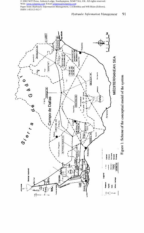
The conceptual model of the system is shown in Fig. 1. The system isrepresented by a mathematical model based on the simulation model SIMGES.This is part of the Decision Support System known as AQUATOOL (Andreu etal. [3]), developed at the Technical University of Valencia for complex watersystems planning and management. SIMGES is a general model for thesimulation of water resources systems with several elements of regulation andstorage, either surface or subsurface ones, water intakes, channels, consumptionunits, pumping from aquifers, etc., and is able to consider conjunctive use ofsurface and groundwater. The design of a scheme representing the system,introduction of data and analysis of results are facilitated by graphical user
© 2002 WIT Press, Ashurst Lodge, Southampton, SO40 7AA, UK. All rights reserved.Web: www.witpress.com Email [email protected] from: Hydraulic Information Management, CA Brebbia and WR Blain (Editors).ISBN 1-85312-912-7
90 Hydraulic in/ornIation .i[anageruent
interfaces and postprocessors. The simulation is made at a monthly time step andreproduces the water flow through the system following the operation rulesdefined by the model user. The results of the model simulation comprise theevolution of all the interesting variable: inflows, water stored in reservoirs,releases, strearnflows, control variables of aquifers, etc., monthly and amually.Average values for the simulation horizon are also computed, as well as deficitsand reliability for the different demands. The simulation has been made for thehistorical hydrological series to the reservoir that corresponds to the period from1945/46 to 1994/95.
3.1 Modelization of Adra subsystem
The scheme includes only one reservoir, Beninar. The reservoir operationsimulation is based on a simple mass balance, adding the inflow to the reservoirfor every month to the initial storage, and subtracting the outflow and infiltrationand evaporation losses. Part of the water stored in Beninar reservoir istransferred, by infiltration to the Turon-Peiiarrodada aquifer, process that hasbeen incorporated to the model by an equation that relates water stored andinfiltration. The coefficients in the equation are calibrated using data of dailybalance in the reservoir.
The Tur6n aquifer receives the recharge of rainfall infiltration, reservoirseepage and water infiltration in the calcareous canyon of Turon. The outflow inthe Fuentes de Marbella springs depends on the state of the aquifer and therecharge of the period. The simulation model of the aquifer has been integratedin the global model using a semi-distributed Model (Sahuquillo [12], Pulido etal., [10]) comprised by four virtual blocks that are simulated as agregatedmodels. Two main considerations justify the use of this type of Model:- Given the goals of this study, the model of the Turon aquifer is only a minorpiece of the system model. An exhaustive knowledge of the spatial and temporalevolution of the aquifer is not needed. This type of model allows a simple andmathematically sounded way to model the relationship between recharge anddischarge in karstic aquifers.- This semi-distributed model requires the calibration of a few parameters thatcan be estimated directly from the input and output data of the system. Thus, thelimited knowledge of the formation is properly accounted for avoiding theunnecessary construction of a large distributed model where a great number ofparameters would have to be estimated.
The wells at Cortijo de Picon allow pumping water from the Turon aquiferto the Beninar channel, which transfers water from the Beninar reservoir to theCampo de Dalias.The fust intake ditches along the river (zone close to Fuentes de Marbellasprings) have been grouped under the name of Tomas Menores demand unit. Thegroundwater abstraction in the alluvial of the Adra River, downstream theFuentes de Marbella springs and in the Deltas is made by means of subsurfacedraining galleries, wells and boreholes.
© 2002 WIT Press, Ashurst Lodge, Southampton, SO40 7AA, UK. All rights reserved.Web: www.witpress.com Email [email protected] from: Hydraulic Information Management, CA Brebbia and WR Blain (Editors).ISBN 1-85312-912-7
Hvdmtdic ll~omation Atancigetnent
/’ \7
91
© 2002 WIT Press, Ashurst Lodge, Southampton, SO40 7AA, UK. All rights reserved.Web: www.witpress.com Email [email protected] from: Hydraulic Information Management, CA Brebbia and WR Blain (Editors).ISBN 1-85312-912-7
92 Hydraulic Injiwnation Management
The two existing galleries are related with the Antonio Ruiz and SanFernando canals, which conveys the water to the irrigation districts of Guainosand San Fernando Canal.
The surface water still flowing downstream the above diversions, is usedfor urban water supply and partially divertid through minor ditches that irrigatemainly the eastern area of the Delta. The urban water demands are considered inthe mathematical model as an agregated unit identified as UDU A&a. They aresatisfied by an intake in the spring of the Fuentes de Marbella springs and twowells in the Delta aquifer. Generally the river flow does not reach the deltaicplain because of the existance of two large diversions that feed a complex ditchesnetwork. The most important irrigation districts in the municipality of Adra are:Adra Community, San Fernando Canal Community, and the Cairos-Zabala one.The Adra Community manages all the surface water resources of the river, and itis divided in three sectors: Vega de la Alqueria, Vega del Adra and Vega de laHabana. The Otros Riegos demand comprises the irrigation demands of theremaining irrigation districts of the Adra delta.
The Delta aquifer is integrated in the simulation scheme of the system by adistributed model using the Eigenvalue Method (Sahuquillo [13]), based on theaquifer calibration by a finite difference model. The Eigenvalue Method allows amore efficient integration of an aquifer distributed model in the simulation ofcomplex systems with conjunctive use, without losing accuracy (Andreu andSahuquillo [1]). The model (CHSE [4]) comprises 139 active cells, of 400 m inthe coastal direction by 253 m in the perpendicular direction, and a thickness of100 m (the simulation has been done with a constant transmissivity layer foreach cell). The AQUIVAL module (Capilla and Andreu [3]) has been used forthe preprocess of the aquifer by the Eigenvalue Method. The recharge stressesconsidered over the aquifer are: rainfall infiltration, intltration loses in theAlqueria, Vega Adra – La Habana ditches, infiltration in the river and irrigationand urban return flows. Pumping is made to satisfy the demands of La Habana,Cairos-Zabala, San Fernando in Adra, Otros Riegos and Adra Urban Demand.There is also a borehole close to the river that pumps water to the San Fernandocanal.
3.2 Modelization of Campo de Dalias subsystem.
The aquifer system of Campo de Dalias is integrated in the simulation scheme ofthe system by a model based on the Eigenvalue Method, using the calibration ofthe aquifer by a integrated ftite differences model (Pinilla and Sahuquillo [9]).The spatial discretization used in the model consists on 22 element of large sizeor macrocells. The delimitation of the macrocells coincides, with somevariations, with the zones in which the ITGE (Technological Geomining Instituteof Spain) has traditionally grouped the exploitation. These zones wereestablished following mainly hydrogeological criteria. In spite of their size, therepresentation of the system by means of these macrocells is consideredappropriate because those that are more important, regarding the abstractionvolume and lateral exchange with others, have very high transmissivities that
© 2002 WIT Press, Ashurst Lodge, Southampton, SO40 7AA, UK. All rights reserved.Web: www.witpress.com Email [email protected] from: Hydraulic Information Management, CA Brebbia and WR Blain (Editors).ISBN 1-85312-912-7

Hvdruulic Infiwmotim ,I!mcigenzetlt 93
makes them to be well represented by a single average level. The degree ofknowledge for the hydrodynamic properties of the aquifers, theirinterconnection, the exploitation and the piezometric head evolution during thecalibration period, are very different. In general, the data of exploitation andpiezometric levels are more reliable for the most recent periods. The best period,for which data have better quality, runs from the hydrological year 1976/77 to1994/94.
In the aquifers of the Campo, recharge is due to rainfall and runoffinfiltration in the ravines of the south slope of the Sierra of Gador (maincontribution to recharge), to rain infiltration in the Campo plain and toinfiltration in irrigated areas. Based on the volume balance at a daily time step,the infiltration of precipitation and runoff that takes place in the Sierra of Gadorhas been evaluated for each macrocell of the aquifer model using an aggregatedrainfall-runoff model of few parameters, Temez model (T6mez [14]). This hasbeen done for each element of a grid in which the whole area has beenpreviously discretized. The infiltration values for irrigation flow returns,increased by rain and losses in urban supply network, depends on the irrigationsurface at each moment. The loses in the supply network imply a low value,especially considering the uncertainty to which their evaluation is subjected. Thevalues of irrigation returns obtained for the 1994/95 period were extended for thewhole simulation period. Regarding the effect of precipitation in the humidyears, we consider that is partly compensated by the consequent reduction ofirrigation, and it can be considered in average values. For each cell of the modelthe recharge by irrigation return values, rain and runoff infiltration in the Sierraof G6dor were added in a monthly recharge series.
One of the objectives of the present study is the determination ofalternative abstraction distributions in the aquifers of the Campo of Dalias withthe goal of reducing the effects of overexploitation on it. This objective hasconditioned the criteria of modeling pumping and water uses in the Campo. Ithas been considered that it was not reasonable to go into the detail of waterdistribution for its use in the Campo, assuming that, given a global quantity ofavailable resources in the Campo de Dalias, this is applied in field with a similardistribution to which was applied in an “standard” campaign, like the one of1994/95. It is important to reflect appropriately the abstraction in each macrocellof the model in order to be able to analyze the evolution of the overexploitation.For it, 22 “units of pumping” have been defined in the conceptual model(nomenclature that reflects the emphasis in the aspect of pumping distribution).Each unit of pumping has been associated to a macrocell of the aquifers systemof the Campo and all of them with possibilities of receiving contributions of theBeninar Channel. The following conceptualization of the operation has beenmade:- For each alternative, a global demand in the Campo, DT, is defined. It shouldbe supplied by water from Beninar channel and aquifers withdrawals.
- f~( %i$h altenwti% a Coefficient Of pump~g dis~ibution, ~i, is defined for
each macrocell i, so that ~ ai =1.j=l
© 2002 WIT Press, Ashurst Lodge, Southampton, SO40 7AA, UK. All rights reserved.Web: www.witpress.com Email [email protected] from: Hydraulic Information Management, CA Brebbia and WR Blain (Editors).ISBN 1-85312-912-7

94 Hydraulic l@rmltion ltanagetnem
- As a consequence of the simulation of Adra subsystem, the quantity oftransfered water from Beninar for every period, TBt, is obtained.- The global quantity to be withdrawn from the Campo aquifers is: BT’ =DT-TB,
- The quantity to be withdrawn from each macrocell is: B,,i = ai * BTtTherefore, all the demands that at each moment are supplied from the
aquifers of the Campo de Dalias and the water imported by the Benirtar channelare represented by the 22 units of pumping (uB).
4 Management strategies
Water management of the system is made every month in the following way. Theurban demand UDU Adra (highest priority) makes use of spring outflow. If theoutflow is enough to satisfy the monthly demand, the excess flows downstream.If it is insufficient, the water released from the reservoir is increased in enoughquantity to satisfy the UDU Adra demand considering the infiltration losses tothe aquifer when water flows through the canyon of Turon. For each intake ofirrigation demand in the river with the right to surface water supply, the wateravailable is obtained by adding up the springs outflows and the water releasedfrom the reservoir, and subtracting the water diverted to higher priority demands.If this water is insufficient, the release is increased in the precise quantity.
When there is not enough water in the reservoir the different demands aresatisfied by priority order until reaching the minimum storage volume of thereservoir. The less prioritized demands will suffer the corresponding shortage. Ifthe flow in the downstream intakes of the A&a River is lower that the minimumflow required for recharge to the Delta aquifer, additional release from theBeninar reservoir will occur. The resources of the reservoir are released so that,in case of existing shortage, UDU Adra is the f~st demand to be supplied. Thefollowing priority corresponds to the demands of Vega de Adra, Alqueria andTomas A4enores. They are followed by the demands of La Habana, UDA San
Fernando and Otros Riegos C. S. F., which can compensate shortage by means ofpumping supply from the aquifer of the Delta. Finally, the remaining availablestored water is transferred to supply the demands of the Campo de Dalias. The
Otros Riegos and Cairos-Zabala demands are supplied exclusively withgroundwater. In the demands that can obtain surface and groundwater supply, thelatter is used as a complement to the former when the surface water supply is notenough.
In the different simulations, we have considered the possible use of thePozo-Picon wells to transfer water to the Beninar Channel. This possibilityallows to take advantage of the infiltration from the reservoir to Tur6n aquiferand the capacity of regulation that the latter offers. The effect of using the wellsto pump water to the A&a River has also been studied as a means of completingthe guarantees in satisfaction of the demands associated with the river.
Using the model with the scheme of the system corresponding to theprevious situation to the construction of the Beninar dam and channel, thehistorical guarantees of satisfaction of the A&a traditional demands have beendetermined. These guarantees turn out to be relatively high, and the objective is
© 2002 WIT Press, Ashurst Lodge, Southampton, SO40 7AA, UK. All rights reserved.Web: www.witpress.com Email [email protected] from: Hydraulic Information Management, CA Brebbia and WR Blain (Editors).ISBN 1-85312-912-7
that the management with the new infrastructure does not worsen theseguarantees of satisfaction.
fly means of the use of the model with the complete system scheme, somepreliminary simulations have yielded a first estimation of the average volumes tobe transferred to the Campo de Dalias. The repercussions that this derivationwould have on the guarantees of the demands of the Delta of Adra and on thestate of the Delta aquifer have also been analyzed. The main conclusion of thesepreliminary simulations is that, in order to avoid damaging the demands of theAdra River and the Delta aquifer, it is necessary to determine and establish areservation curve for the Beninar reservoir. When the stored volume is locatedbelow this curve, transfer to the Campo will not be allowed. Likewise, it showsthe convenience of establishing a minimum flow at the beginning of the Deltawith the purpose of assuring enough recharge to the Adra aquifer.
By means of multiple simulations and using a critical biennium of inflowsto Beninar reservoi, a reservation curve has been determined to maintain theindicators of demand satisfaction and Delta aquifer levels under acceptableconditions. Once the Adra demands have been satisfied, if there is still water inthe reservoir above the reservation curve, either the Campo de Dalias demand forthis month or the available volume up to the reservation curve (if lower than theCampo demand) will be transferred by the Beninar channel. The water of thechannel is distributed among the Campo demands. If there is a water shortage,the Campo demands can obtain the water by pumping from the correspondingaquifers of the Campo until the demands are satisfied.
Finally, a sensitivity analysis of the results of the simulations versusvariations in the reservation volumes adopted for the Beninar reservoir has beencarried out. Transferred volumes through the Beninar channel, levels ofsatisfaction of the demands, and balances in the aquifers and surface outflowsinto the sea have been compared.
5 Considered alternatives
Using the reservation curve previously determined, we have proceeded to thesimulation of alternatives that affect directly to the aquifers of the Campo deDalias. The first simulation (“Simulation 130”) considers the Campo de Daliasdemand as equal in magnitude and distribution among cells to the historical oneregistered in the period 1994/1995. This demand was 130 hm~lyear, with 0.5 hm3of them satisfied with water from Beninar Channel, and the rest, 129.5 hm3, withwater abstracted from the aquifers of the Campo. The objective of this simulationis to evaluate the improvements achieved in the system management with the useof the reservation curve, maintaining the value of the demands of the last periodfrom which reliable data is available. An average annual transfer of22.5 hm3/year from Beninar reservoir to the Campo de Dalias is obtained. Inspite of it, the evolution of levels in the Campo de Dalias is not sustainable. Mostof the surface of the inferior carbonate aquifers (AIN and AIO) remains underthe sea level during most of the simulation period, sometimes to more than 20meters below. Considering the results, it was necessa~ to look for alternatives
© 2002 WIT Press, Ashurst Lodge, Southampton, SO40 7AA, UK. All rights reserved.Web: www.witpress.com Email [email protected] from: Hydraulic Information Management, CA Brebbia and WR Blain (Editors).ISBN 1-85312-912-7

96 Hydraulic [nfornzation ifanagenzen{
for the system management. The two bases that have been used to define thesealternatives were:
- The total volume of demand to be satisfied jointly by surface andgroundwater in the Campo de Dalias. The simulations show that the evolution ofthe aquifers is not sustainable if the pumping volume corresponding to thedemand of the campaign 1994/95 is maintained. The possibility of obtainingadditional resources has been analyzed, so that the total water volume to besatisfied from the Adra and the aquifers of the Campo de Dalias were lower.Concretely, reductions to 100.5, 90.5 and 80.5 hm’lyear of the demand to besatisfied by means of transfer and pumping in the Campo have been considered.These decreases would be compensated by the improvement of the efficiency ofthe uses and for the use of alternative sources, as desalination or transfer fromother systems.
- The reorganization of groundwater abstractions from the Campo deDalias aquifers. Starting from the distribution of historical abstractionscorresponding to the year 1994/95, the simulations demonstrate that there areaquifer subsystems of the Campo de Dalias that do not evolve in a sustainableway, even when reduction of abstractions is considered. Therefore, it isnecessary to study the consequences of reorganizing the abstractions. Diversealternatives with different distribution of abstractions among the aquifers of theCampo have been simulated for the different hypotheses of global demand (table1) and the evolution of the resulting levels has been studied.
The different alternatives have been simulated and the results have beencompared and analyzed. These results have been used to establish conclusions onthe most advisable alternatives and, in general, on the management of the wholesystem.
For the study of the effect of the different alternatives on the system ofaquifers of the Campo de Dalias, the results have been analyzed for differentcontrol variables along the simulation. For each alternative the inflows andoutflows to the sea have been plotted in aggregated balance for the wholesystem, as well as individually for each cell in connection with the sea.
6 Conclusions
The main conclusions on the different alternatives of conjunctivemanagement of the Adra-Campo de Dalias system are synthesized in thefollowing aspects.
Regarding the Adra basin we conclude that:- To preserve the satisfaction of the Adra basin demands and the situation
of the Delta aquifer is necessary to establish the reservation curve in the Beninarreservoir.
- If the resources of the Adra basin are properly managed, the averageamual volume that is transferable to the Campo de Dalias ranges from 21 to22 hrn3/year. The average annual water volume in Beninar reservoir releasedtoward the Delta of Adra would range from 4.2 hrn3/year (“Simulation 80.5”) to4.8 hm3/year (“Simulation 130”). Maintaining the reservation curve and the
© 2002 WIT Press, Ashurst Lodge, Southampton, SO40 7AA, UK. All rights reserved.Web: www.witpress.com Email [email protected] from: Hydraulic Information Management, CA Brebbia and WR Blain (Editors).ISBN 1-85312-912-7

H~drmdic [yfoma!fon .Mmagemew 97
minimum flows defined in the beginning of the Delta of Adra (O.15 hm3/month),the guarantees of the demands and the Delta aquifer state are acceptable for thesevalues of transfer.
Table 1: Annual demand in each pumping unit for each simulation
3W42L.Y30 1 W4JL. 109.5 : S!MIL1OM WA / AML2LSM i SttiN&sos 1
~ ~ Amnualdwni?nd(hnF)Tar6ti,.Pam@nko 31.13 14.64 20.16 1418 i 1.46
Tomtliar 27.16 *2,77 17.59 1243 to 03
Profonda 7.05 3.31 456 3.32 2.6s
TOTPL 66.33 SO.TI 42.31 29.93 24.l@
W.&N 0.74 0.00 0,00 0.00 0.00
As.C. Annual dem.nd (hnt)
Balerm Oc+l 066 0.0’3 0.70 0,70
CMyar 0,23 176 034 1.34 134
AJacmnes 000 1.16 000 0.50 050
Sta. Marfa 7.42 20,23 11.07 16.07 1607
San Pgu8tin 181 6,50 2.70 4,sn 4.80
TOTAL 9.4s 30,31 14,11 23.41 23.41
AI.N. Annual demand (hn?)
El Aguila 25.16 15,39 2122 1545 12.49
El ~SO 1039 635 8.76 6,38 5.16
vicar 0.26 021 0.29 0,21 017
l-a Gangosa 000 O.w Oco O.w 0C61
Roquetas 0.00 Olm O.co 000 Ow
AIyaduke E 9.6s 021 029 021 017
FWadulce R O.cm 0.00 0.0+) 0.00 0.03
TOTAL 4S.46 22.16 20.S4 22.25 17.99
& M.N bnnual demand (hnf)
Et VISO 1 .s3 2.35 2.33 2.35 235
b Gang.asa 2.46 +.76 1.76 176 176
Roqwtas 0.03 O,w OCQ 0131 O.w
TOTPA 3.W 4.11 4.11 4.11 4.11
El vh 4.25 1177 7.97 9.47 947
Roquetas 029 0.55 0.55 0.65 065
Awaduke E 0.47 O.sa 0,6s o.6a 066
TOTAL 5.01 13.20 S.40 10,80 10.80
Vo.oo i 100.s0 ! *OO.SO } $0.30 ~ 60.60
- If the increase of levels in the occidental part of the Delta caused drainage andsalinity problems, it would be convenient to reorder the groundwater abstractionin the Delta by transferring part of the pumping from the oriental to theoccidental part. Although it does not seem probable according to the obtainedresults, if seawater intrusion problems were presented in the oriental riverbankduring a drought period it would be possible to supply the community of LaHabana temporarily with surface water.- The Cortijo-Picon wells should be used for the Benhmr channel supply(therefore, for the Campo de Dalias supply) whenever the outflows from theFuentes de Marbella springs are greater than 2 hrn3/month. The average annualvolume of pumping ranges from 0.7 to 1.7 hm3/year, depending on thealternative, although the use of the wells is sporadic. Moreover, it is possible toguarantee 100?4. reliability for those demands of Adra with surface supply. Thiscan be achieved by using the Cortijo-Pic6n wells to supply the Adra River in
© 2002 WIT Press, Ashurst Lodge, Southampton, SO40 7AA, UK. All rights reserved.Web: www.witpress.com Email [email protected] from: Hydraulic Information Management, CA Brebbia and WR Blain (Editors).ISBN 1-85312-912-7
98 H~dt-cn{iic [njiirmation A{anagenzenl
those few occasions in which the water volumes of Beninar reservoir plus theFuentes’ outflows are insufficient.
Regarding the Campo de Dalias we conclude that:- In order to achieve a sustainable evolution of the Campo de Dalias system ofaquifers, it is necessary to decrease the total demand supplied by resources fromthe Campo de Dalias aquifers and the transfer by 40-50 hm3/year. It can beattained either by improving the efficiency of the uses andlor resorting toalternative sources, as desalination or importing water from other systems. Giventhe uncertainties associated to the behavior of the system, the most prudentoption would be a reduction of 50 hm3/ year.- Likewise, it is necessary to reorganize groundwater abstractions according totable 1 in order to accomplish a sustainable evolution of the carbonate inferioraquifers of the Campo de Dalias. This reordering produces and increasegroundwater abstraction in the superior aquifers (ASC and ASN) and a decreasein the inferior carbonate aquifers (AIO and AIN) that at the moment bear 850/0ofthe water pumped in the Campo. Since the ASC presents a high salinity, it willbe necessary to treat the water to obtain an acceptable level for their use.- In the proposed solutions it is observed that, in the sequences of humid years inthe aquifers of the AIN, certain levels that can produce important outflows offresh water to the sea are reached. To determine the most appropriate form ofwithdrawing part of those flows it would be necessary to have a more accuratemodeling of the carbonate aquifers of the northeast part of the Campo.- Nonetheless, it seems highly advisable to begin diminishing the exploitation ofthe inferior carbonate aquifers and taking strict control of exploitation andevohition of levels and seawater intrusion in the affected aquifers. In spite of theachieved advances (Pulido Bosch et al. [11], Dominguez [5]) there are stilluncertainties about the real situation of the seawater intrusion in the aquifers andits possible evolution. To reduce these uncertainties a detailed analysis of thenecessary control and the most appropriate methods is required, as well as theelaboration of annual reports on the evolution of the control variables(abstraction, levels and water quality).
Acknowledgements
The model that has been described is integrated in the “Study for the determination of theCampo de Dalias Water Plan” (“Estudio para la determinacibn de] Plan de 0rdenaci6n delCampo de Dalks”), carried out for the Confederation Hidrogratica del Sur de Espaila(Water Agency of Southern Spain), under the technical direction of the GeneralSubbureau of Hydraulic Public Domain Management of the Ministry of Environment ofSpain. This study has been commissioned to the consultant company PROINTEC, Corp.The Department of Hydraulic Engineering and Environment of the Technical Universityof Valencia has collaborated in its realization. We appreciate the ConfederationHidrogr&fica del Sur authorization for the presentation of these results and the informationprovided. We ako thank the IGME for their collaboration and information supplied.
© 2002 WIT Press, Ashurst Lodge, Southampton, SO40 7AA, UK. All rights reserved.Web: www.witpress.com Email [email protected] from: Hydraulic Information Management, CA Brebbia and WR Blain (Editors).ISBN 1-85312-912-7

Hydrazllic !tlfomaiion .J{arrczgemem 99
References
[1] kdreu, J.& Sahuquillo, A. Efficient aquifer simulation incomplex system. Jour.Water Resources PIantringatrd Managemen/, ASCE, 113(1), pp, 110-129,1987.
[2] hdreu, J., Capella, J.& Sanchis, E. AQUATOOL, ageneralized decision-suppofisystem for water-resources planning and operational management. Journal ofHydrolo~, No. 177, pp. 269-291, 1996.
[3] Capella, J.& Andreu, J. AQUIVAL: AGUIfor ~oundwater modeling inco~oratedinto the simulation of complex water resources systems. Hydraulic EngineeringSoftiare. Computational Mechanics Publications (cd.W.R.Blain).pp.71 -80, 1996.
[4] CHSE. Esttiiopara ladeterminaci6n de/ Plande 0rdenaci6n del Campode Da1ias.Confederaci6n Hidrogrifica del Sur de Espaila. Ministerio de Medio Ambiente,2001.
[5] Dominguez, P. Funcionamiento hidrogeolbgico yntecanismos deintwsibn marinaen sistemas carbonatados de estructura compleja: aplicacibn al Acuifero InferiorNoreste (AIN) del Campode Dalias (Almeria). Tesis doctoral. DET-UPC- IGME(intldita), 2000.
[6] Dominguez, P., Gonz~lez, A.& Franqueza, P.A. Situaci6n actual delosacuiferosdelCampode Dalias. Unejemplo delanecesidad deconocer elestado actualizadodelfuncionamiento de un sistema complejo intensamente explotado. VHSimposio deHidrogeologia, Murcia. Ed. IGME. Tomo XXIII. p. 21 I-225,2001.
[7] ITGE. Sintesis hidrogeologica de] Campo de Dalias (Almeria). Propuesta deprimeras actuaciones deinvestigaci6n ygesti6n. Ministeriode Industria y Energia,Madrid, 169 pp., 1989
[8] ITGE. Si~aci6n delosacuiferos del Campode Dalimen relaci6n consudeclaraci6ndesobreexplotaci6n. VI Simposio de Hidrogeologia, Sevilla, Tomo XXI, pp. 443-467, 1995.
[9] Pinilla, V.& ShuquiIlo, A. Modelomatematico paralaevaluacion delflujodeaguasubterranean en 10S acuiferos del Campo de Dalias. Conferencia International Lascarasdel Agua Subterrdnea, UPC, Barcelona, IGME, 2001.
[lO]Pulido, M.& Sahuquillo, A. Modelacion delmrelaciones rio-acuifero. ModeloP1uncehdarEnglobado. VHSimposio de Hidrogeologia, Murcia, IGME, XXJJI, pp.151-163,2001.
[11] Pulido Bosch, A., Vallejos, A., Molina, L. & Pulido Leboeuf, P. Problematichidrogeologica del Campo de Dalias-Sierra de Gador (Almeria). El Campo deDalias, Paradigma deusointensivo. Papeles de Proyecto Aguas Subterranean, SerieA, 4:5-36. Fundaci6rr Botin., 2000.
[12] Sahuquillo, A. Modelos phsricelulares englobados. Uti/izaci6n conjunta de aguassupery?ciaIes y subterrtitreas. no 43 del SGOP, Serv. Pub]. del MOPU, Madrid, 1983.
[13] Sahuquillo, A. An eigenvalue numerical technique for solving unsteady groundwatercontinuously in time. Water Resources Research, 19 (1), pp. 87-93, 1983.
[14]T6mez, J.R. Modelo matemhtico de transformacibn precipitacick-aportacibn.ASINEL, Espaiia, 1977.
© 2002 WIT Press, Ashurst Lodge, Southampton, SO40 7AA, UK. All rights reserved.Web: www.witpress.com Email [email protected] from: Hydraulic Information Management, CA Brebbia and WR Blain (Editors).ISBN 1-85312-912-7