operational and safety analysis - highway 97 - spruce … george, b.c. v33101015.200 august 2008...
TRANSCRIPT
EBA Eng inee r ing Cons u l t an ts L td . p . 604 .685 .0275 • f . 604 .684 .6241 • Ocean i c P laz a , 9 t h F l oo r
1066 Wes t Has t i ngs S t ree t • Vanc ouv e r, B r i t i s h Co lumb ia V6E 3X2 • CANADA
British Columbia Ministry of Transportation and Infrastructure
ISSUED FOR USE
OPERATIONAL AND SAFETY ANALYSIS HIGHWAY 97/SPRUCE STREET
PRINCE GEORGE, B.C.
V33101015.200
August 2008
ISSUED FOR USE
hwy 97 and spruce cover letter.doc
EBA Eng inee r ing Consu l t an ts L td .
p . 604 .685 .0275 • f . 604 .684 .6241 • Ocean i c P laz a , 9 t h F l oo r 1066 Wes t Has t i ngs S t ree t • Vanc ouv e r , B r i t i s h Co lumb ia V6E 3X2 • CANADA
August 15, 2008 EBA File: V33101015.200 Ministry of Transportation and Infrastructure 213-1011 Fourth Avenue Prince George, B.C. V2L 3H9 Attention: Mr. Gordon Wagner, P.Eng., Regional Manager of Engineering Dear Gordon: Re: Operational and Safety Analysis – Highway 97/Spruce Street Prince George, B.C.
Please find attached a report documenting the analysis, results and conclusions from the requested Operational and Safety Review for the intersection of Highway 97/Spruce Street in Prince George, B.C. This study was carried in response to a request to the Ministry of Transportation and Infrastructure to permit a left turn in movement from the Highway into Spruce Street. The study also considers the option of having the left in movement accommodated at Victoria Street as well as the feasibility of implementing a traffic signal at the Spruce Street intersection.
The technical work for this study was undertaken by NovaTrans Engineering and de Leur Consulting. Mr. Marco Guarneschelli (M.Eng., P.Eng.) of NovaTrans is a Professional Engineer and has considerable experience in traffic forecasting and traffic analysis while Mr. Paul de Leur (Ph.D., P.Eng.) is a recognized expert in traffic safety analysis and regularly provides advice to ICBC regarding traffic safety issues and has published numerous papers on collision prediction modeling. Resumes from the primary authors of the report are attached for reference. An independent technical review was also undertaken by EBA Engineering Consultants.
We have reviewed the work undertaken and concur with the overall recommendations of the study that the requested left turn in movement from Highway 97 should not be permitted due to safety concerns and the poor performance of the movement that may trigger the need for a traffic signal.
If you have any questions regarding the report, please contact Mr. Guarneschelli directly. Yours truly, EBA Engineering Consultants Ltd.
Stephen Gardner, M.Sc Transportation Planning Specialist Ph: 604-685-0275 [email protected]

HHiigghhwwaayy 9977
SSpprruuccee SSttrreeeett IInntteerrsseeccttiioonn
OOppeerraattiioonnss aanndd SSaaffeettyy AAnnaallyyssiiss
NovaTrans Engineering Inc. de Leur Consulting Limited
____________________________ ________________________ M. Guarnaschelli, M.Eng., P.Eng. P.deLeur, Ph.D., P.Eng.
August 2008
Highway 97 Spruce Street Intersection Operations and Safety Analysis August 2008
de Leur Consulting Limited 1 NovaTrans Engineering Inc.
Table of Contents
1. Executive Summary 1
2. Background 6
3. Options 8 3.1 Base Case 8 3.2 Option 1: Left In at Spruce 9 3.2 Option 2: Left In at Victoria 10 3.2 Option 3: Signalization at Spruce 10
4. Traffic Forecasting 11
5. Operational Analysis 12
6. Additional Issues 18 6.1 Frontage Road Proximity 18 6.2 Other Comparable Left Turn In Bays 18
7. Safety Analysis 20 7.1 Objectives 20 7.2 Methodology 20 7.3 Results 22 7.4 Safety Conclusions 27
8. Conclusions and Recommendations 28
Appendix A Consultant Credentials 30

Highway 97 Spruce Street Intersection Operations and Safety Analysis August 2008
de Leur Consulting Limited 2 NovaTrans Engineering Inc.
1. Executive Summary:
Hwy 97 is an integral and important part of the provincial primary highway network being one of the few primary highways serving Northern BC. The Province has considered numerous requests for the accommodation of a left turn movement from Highway 97 SB into Spruce Street in Prince George since 1985. Recently, as a result of the construction of the Simon Fraser Bridge, additional requests have been made. The Ministry of Transportation and Infrastructure desires to have an independent review of the desirability of allowing left turn movements to be made from Hwy 97 at Spruce or Victoria Streets. This operational and safety analysis constitutes this review.
Three options were generated for the operations and safety analysis. Options 1 and 2, consist of unsignalized Left In Turn Bays from Hwy 97 SB into either Spruce or Victoria Streets. Option 3 involved the signalization of Option 1 and was generated as a part of this report.
The forecasting of background traffic for the Highway 97 Spruce Street project was based on the forecasts carried out for the Simon Fraser Bridge study (High Growth) as well as an additional forecast based on a growth rate of 2% per year (Low Growth). The forecasting for the traffic that would be utilizing the added left turn bays for movements from the Highway onto either Spruce or Victoria Streets was carried out on the basis of existing turning volumes. Considering these different trip types, and their basis, a likely present left in volume of 150 veh/hr. during the PM peak period was calculated. For the future an additional 30 trips per hour were added based on minimal residential growth and the development of an additional hotel within the commercial area adjacent to Highway 97 for a total of 180 veh/hr future left turn in trips.
Table 1.1 Operations Analysis Results Summary
Period Option Performance Measures Comments
SB Left In NB ThroughLoS / Delay Queue LoS / Delay Queue
(sec) (m) (sec) (m)
Present PM Peak Base Existing N/A N/A A N/A
1 LI @ Spruce C / 17 12 A N/A Operates marginally well2 LI @ Victoria C / 17 12 A N/A3 Signal C / 29 44 A / 5 46
Future Low Growth Base Existing N/A N/A A N/A No significant difficultiesPM Peak Hour(Year 2023) 1 LI @ Spruce E / 49 39 A N/A LT Failure
2 LI @ Victoria E / 49 39 A N/A LT Failure3 Signal E / 78 70 D / 37 218 * Unacceptable NB Queue / LoS
* Distance from Spruce to Queensway Onramp is 300 m.
The traffic forecasts described above were utilized for the analysis of the operations of the Spruce and Victoria St. intersections under the different options. The Synchro / Simtraffic software suite was utilized for the analyses providing a standard set of performance measures; namely Level of
Highway 97 Spruce Street Intersection Operations and Safety Analysis August 2008
de Leur Consulting Limited 3 NovaTrans Engineering Inc.
Service (LoS), vehicular delay and queue length. The Level of Service (LoS) performance scale is a scale used to categorize the operations of a facility from excellent (LoS A) to Very Poor (LoS F) which is defined in greater detail in Section 5 of the report. The results of the analyses are summarized in Table 1.1 above and tabulated in greater detail in Table 5.1 within the report. A number of additional issues were reviewed along with the traffic operations summary presented above. A subject known to cause significant operational problems, particularly under higher volumes, is the proximity of the Ford Avenue frontage road access points to the highway access at either the Spruce or Victoria Street intersections. The short distance (16 m.) between the highway and the frontage road offers no place for the storage of turning vehicles. This means that there is a risk of vehicles that need to turn left onto the frontage road stacking in this area preventing highway SB left turning vehicles from clearing the highway intersection. In general, the Province’s experience with short-bulb frontage road intersections has been very negative. Comments have also been made relating to the provision of apparently similar left turn bays along other portions of Highway 97 and Highway 16 in the Prince George area, in particular the left turn in entrance to the Treasure Cove Casino from Highway 97 NB just south of the Highway 16 intersection. A review of the specifics of this left turn bay location yield a number of site specific differences from the Spruce St. left turn bay request. These are as follows:
• Level of Service: The Expected Opening Day LoS was calculated to be LoS A with little degradation over the 15 year facility Service Life leading to a LoS A. This is largely caused by two factors 1) lower turning volumes than the Spruce St. left turn; and 2) long available gaps in the opposing traffic stream
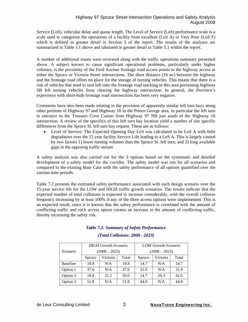
A safety analysis was also carried out for the 3 options based on the systematic and detailed development of a safety model for the corridor. The safety model was run for all scenarios and compared to the existing Base Case with the safety performance of all options quantified over the various time periods. Table 7.2 presents the estimated safety performance associated with each design scenario over the 15-year service life for the LOW and HIGH traffic growth scenarios. The results indicate that the expected number of total collisions is expected to increase considerably, with the overall collision frequency increasing by at least 100% if any of the three access options were implemented. This is an expected result, since it is known that the safety performance is correlated with the amount of conflicting traffic and each access option creates an increase in the amount of conflicting traffic, thereby increasing the safety risk.
Table 7.2: Summary of Safety Performance
(Total Collisions: 2008 - 2023)
HIGH Growth Scenario (2008 – 2023)
LOW Growth Scenario (2008 – 2023) Scenario
Spruce Victoria Total Spruce Victoria Total Baseline 18.8 N/A 18.8 14.7 N/A 14.7 Option 1 37.6 N/A 37.6 31.0 N/A 31.0 Option 2 18.8 31.2 50.0 14.7 26.3 41.0 Option 3 51.8 N/A 51.8 44.8 N/A 44.8
Highway 97 Spruce Street Intersection Operations and Safety Analysis August 2008
de Leur Consulting Limited 4 NovaTrans Engineering Inc.
Changes in the collision severity for each of the options was also calculated and tabulated in Table 7.4 with total collision costs over the 15-year service life calculated and tabulated in Table 7.6, both tables contained within the body of the report.
From the discussion presented above the following conclusions can be made:
Operations
1) The operations of the Highway 97 SB Left turn for both Options 1 (Left In at Spruce) and 2 (Left In at Victoria) are very similar as a result of the need to find gaps in the same volume of opposing NB traffic.
2) Both options perform marginally well on Opening Day but below the Province’s and the public’s expectations for a new facility.
3) Traffic growth will cause the operations to degrade over time reaching the critical LoS E threshold sometime between 2013 and 2018 and the unacceptable LoS F threshold sometime between 2015 and 2024.
4) Early failure of a new facility is poor economics without the value for money and return on investment required.
5) On failure it is very likely that the Province would be requested to find an operational solution to the failure. The logical next step would be the signalization of this movement, although this is contrary to the Province’s efforts to advance Highway 97 to a free-flow facility and would likely be in conflict with the upstream merge ramps at the Queensway Interchange.
6) By nature signalization would cause delays to the northbound highway traffic, delays to which the highway traffic is not presently subjected to.
7) A variety of optimal timing plans were analyzed for the low Growth PM Peak scenario with the best LoS achieved being a LoS E for the SB Left turn and a LoS D for the highway NB through traffic.
8) The critical NB queues were calculated to be between 190 and 270 m. in length, generally placing the tail end of the queue within about 100 m. or less of the Queensway Interchange merging on-ramp. This would create a new safety hazard.
Safety
1) The introduction of an unsignalized intersection that provides a left-turn from Hwy 97 into Spruce or Victoria Street will result in a significant increase in the collision frequency.
2) The introduction of a signalized intersection at Spruce Street will cause the largest increase in collision frequency because of the need for the Highway 97 traffic to stop, creating a significant potential for rear-end type collisions. The split of traffic from Hwy 97 versus Spruce Street will result is a considerable safety penalty for motorists traveling on Hwy 97.
3) The introduction of unprotected left-turn movements at an intersection is known to create deterioration in the collision severity because of the significant consequences associated with a traffic conflict generated between opposing traffic directions.
a. Additional safety concern exists because of the potential for an increase in speed for NB traffic resulting from the improvements to the Simon Fraser Bridge.
b. Safety risk is also increased for the left-turning traffic due to the potential for limited traffic gaps, which may lead to poor driver behaviour if delays are excessive (e.g., acceptance of higher risk levels).
4) The increase in collision costs associated with the three access options in relation to the baseline (existing) conditions is expected to be significant. The additional collision costs are estimated to be at least $2.5M over a 15-year service life.
Highway 97 Spruce Street Intersection Operations and Safety Analysis August 2008
de Leur Consulting Limited 5 NovaTrans Engineering Inc.
5) Comparing the safety performance estimated at the three access options to the provincial average accident rate reveals that all access scenarios are expected to perform worst than the provincial average collision rate, and in some cases, the calculated collision rate is significantly higher than the provincial average collision rate.
6) There are several other design and operational considerations that will affect the safety performance of the access options on Highway 97.
a. The queue lengths for the southbound left-turn from Highway 97 into Spruce Street could spill back and interfere with the through movements on Highway 97. This may occur because of the limited space available due to the proximity of the Upland Street underpass, particularly when there is excessive delay or lack of gaps in the Highway 97 traffic. This could create unexpected and severe rear-end collisions at the start of the left-turn lane.
b. If the storage length and deceleration distance for southbound left-turning traffic is reduced due to considerable queuing, it is possible that some deceleration will occur in the Highway 97 through lane, creating a potential for rear-end collisions.
c. An opening that provides for a southbound left-turn from Highway 97 into Spruce Street will create the opportunity for unintended and undesirable left-turn out movements. The opening may also appeal to pedestrian and cyclist who may want to cross Highway 97 in this area.
d. The sight-distance for the Victoria Street left-turn access may be somewhat limited and the operation may be marginalized due to the presence of the on-ramp traffic from Queensway.
7) The close proximity of the intersection of the Ford Avenue frontage road at Spruce Street in relation to Highway 97 at Spruce Street will have several operational difficulties that will adversely impact safety performance.
The resulting recommendations are as follows:
• That the requested left turn movement from Highway 97 SB into either Spruce or Victoria Street not be allowed.
Highway 97 Spruce Street Intersection Operations and Safety Analysis August 2008
de Leur Consulting Limited 6 NovaTrans Engineering Inc.
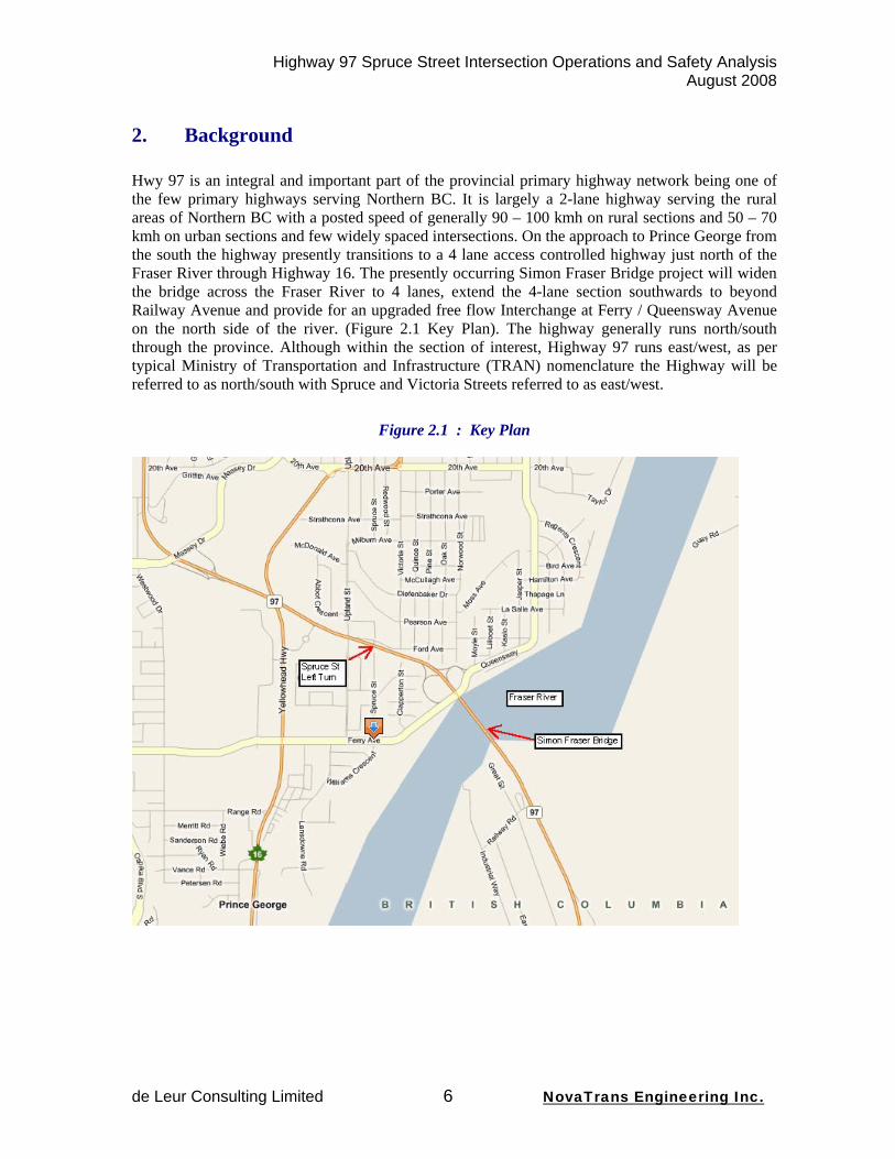
2. Background Hwy 97 is an integral and important part of the provincial primary highway network being one of the few primary highways serving Northern BC. It is largely a 2-lane highway serving the rural areas of Northern BC with a posted speed of generally 90 – 100 kmh on rural sections and 50 – 70 kmh on urban sections and few widely spaced intersections. On the approach to Prince George from the south the highway presently transitions to a 4 lane access controlled highway just north of the Fraser River through Highway 16. The presently occurring Simon Fraser Bridge project will widen the bridge across the Fraser River to 4 lanes, extend the 4-lane section southwards to beyond Railway Avenue and provide for an upgraded free flow Interchange at Ferry / Queensway Avenue on the north side of the river. (Figure 2.1 Key Plan). The highway generally runs north/south through the province. Although within the section of interest, Highway 97 runs east/west, as per typical Ministry of Transportation and Infrastructure (TRAN) nomenclature the Highway will be referred to as north/south with Spruce and Victoria Streets referred to as east/west.
Figure 2.1 : Key Plan

Highway 97 Spruce Street Intersection Operations and Safety Analysis August 2008
de Leur Consulting Limited 7 NovaTrans Engineering Inc.
The Province has considered numerous requests for the accommodation of a left turn movement from Highway 97 SB into Spruce Street in Prince George. The original 1971 approval for the commercial development at Spruce Street and Hwy 97 included development conditions of Right In / Right Out Only access. This was followed by a proposal in 1976 by the business owners to install median barriers to prevent unsafe SB left turn movements. This was carried out at the time. Beginning in 1985, however, there have been a number of requests for the SB left turn movement, all turned down by TRAN (formerly Ministry of Transportation). Recently, as a result of the construction of the Simon Fraser Bridge, renewed requests have been made. The Ministry of Transportation and Infrastructure desires to have an independent review of the desirability of allowing left turn movements to be made from Hwy 97 at Spruce or Victoria Streets. This operational and safety analysis constitutes this review.
Highway 97 Spruce Street Intersection Operations and Safety Analysis August 2008
de Leur Consulting Limited 8 NovaTrans Engineering Inc.
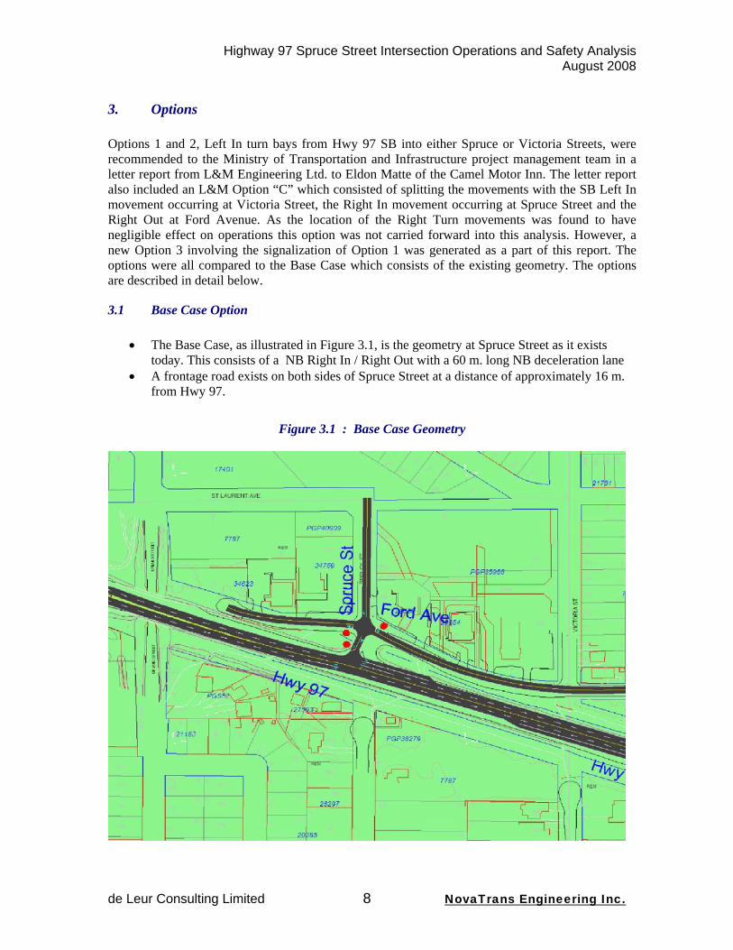
3. Options Options 1 and 2, Left In turn bays from Hwy 97 SB into either Spruce or Victoria Streets, were recommended to the Ministry of Transportation and Infrastructure project management team in a letter report from L&M Engineering Ltd. to Eldon Matte of the Camel Motor Inn. The letter report also included an L&M Option “C” which consisted of splitting the movements with the SB Left In movement occurring at Victoria Street, the Right In movement occurring at Spruce Street and the Right Out at Ford Avenue. As the location of the Right Turn movements was found to have negligible effect on operations this option was not carried forward into this analysis. However, a new Option 3 involving the signalization of Option 1 was generated as a part of this report. The options were all compared to the Base Case which consists of the existing geometry. The options are described in detail below.
3.1 Base Case Option
• The Base Case, as illustrated in Figure 3.1, is the geometry at Spruce Street as it exists today. This consists of a NB Right In / Right Out with a 60 m. long NB deceleration lane
• A frontage road exists on both sides of Spruce Street at a distance of approximately 16 m. from Hwy 97.
Figure 3.1 : Base Case Geometry
Highway 97 Spruce Street Intersection Operations and Safety Analysis August 2008
de Leur Consulting Limited 9 NovaTrans Engineering Inc.
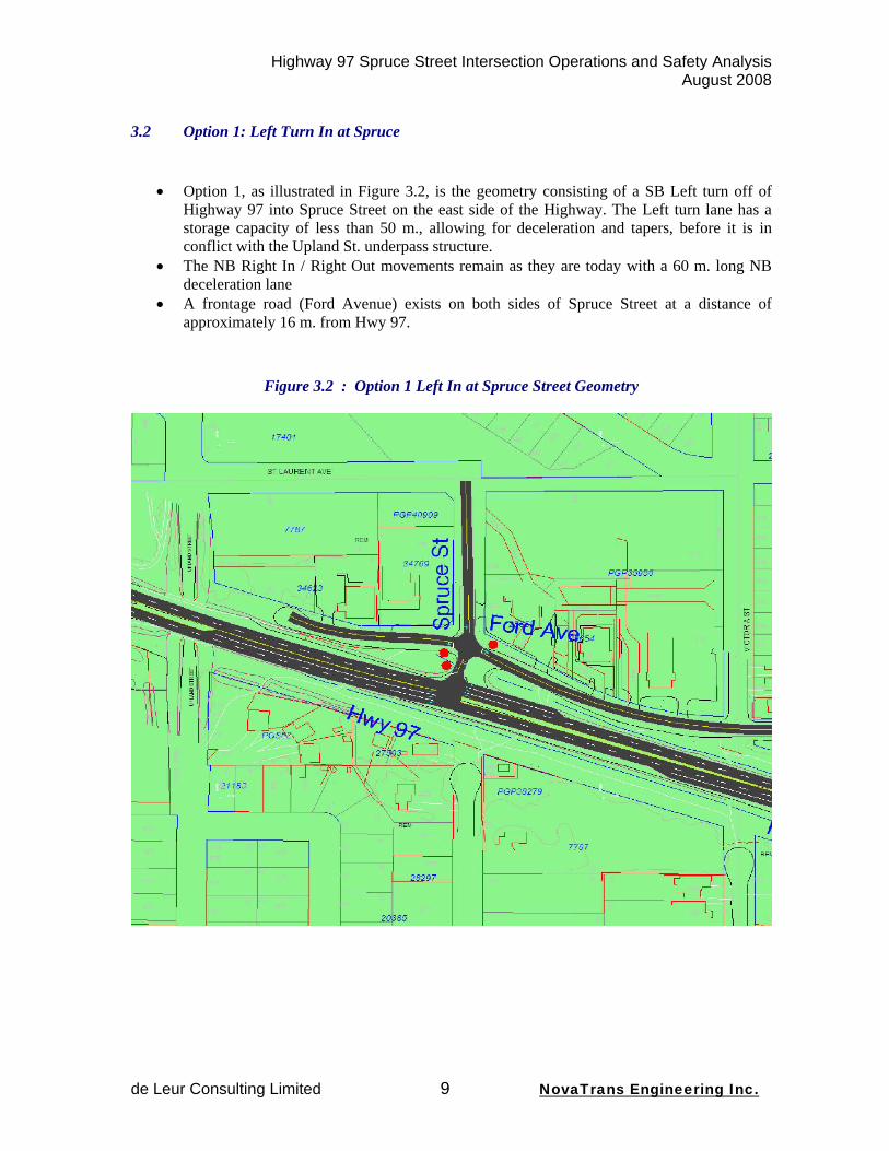
3.2 Option 1: Left Turn In at Spruce
• Option 1, as illustrated in Figure 3.2, is the geometry consisting of a SB Left turn off of
Highway 97 into Spruce Street on the east side of the Highway. The Left turn lane has a storage capacity of less than 50 m., allowing for deceleration and tapers, before it is in conflict with the Upland St. underpass structure.
• The NB Right In / Right Out movements remain as they are today with a 60 m. long NB deceleration lane
• A frontage road (Ford Avenue) exists on both sides of Spruce Street at a distance of approximately 16 m. from Hwy 97.
Figure 3.2 : Option 1 Left In at Spruce Street Geometry

Highway 97 Spruce Street Intersection Operations and Safety Analysis August 2008
de Leur Consulting Limited 10 NovaTrans Engineering Inc.
3.3 Option 2: Left Turn In at Victoria
• Option 2, as illustrated in Figure 3.3, is the geometry consisting of a Left turn off of Highway 97 SB into Victoria Street on the east side of the Highway.
• The NB Right In / Right Out movements at Spruce Street remain as they are today with a 60 m. long NB deceleration lane
• A frontage road (Ford Avenue) exists north and south of both Spruce and Victoria Streets at a distance of approximately 16 m. from Hwy 97.
Figure 3.3 : Option 2 Left In at Victoria Street Geometry
3.4 Option 3 Signalization at Spruce • Option 3, involves the signalization of the Spruce Street intersection as illustrated in
Figure 3.1, including the Left turn off of Highway 97 SB into Spruce Street. Again, the Left turn lane has a storage capacity of less than 50 m., allowing for deceleration and tapers, before it is in conflict with the Upland St. underpass structure. NB Right In / Right Out movements remain and a frontage road exists on both sides of Spruce Street at a distance of approximately 16 m. from Hwy 97. The signal timing would also accommodate left out movements as the Ministry has indicated that, under signalization, partial movements would not be considered.

Highway 97 Spruce Street Intersection Operations and Safety Analysis August 2008
de Leur Consulting Limited 11 NovaTrans Engineering Inc.
• This option involves the optimization of the signal timings based on various criteria as described in the discussion presented in Section 5 Operational Analysis.
4. Traffic Forecasting
The forecasting of background traffic for the Highway 97 Spruce Street project was initially based on the forecasts carried out for the Simon Fraser Bridge study. The forecasts from this study spanned the area along Highway 97 from Railway Ave. to the south to the Highway 16 intersection to the north. The forecast included a full set of collected turning volumes from the year 2004 as well as traffic forecasts to 2020 and 2030. As the time horizon desired for his project was 15 years from the present, or 2023, the 2020 forecast was used as the closest forecast to the desired year and the results extrapolated for another 3 years. The peak period was determined to be the PM peak hour and as a result the focus of the operational analyses is on this period.
The source for the Simon Fraser Bridge report forecasts was the City of Prince George Emme/2 planning model. This model uses future population and employment forecasts to generate estimates of future traffic volumes and patterns. The forecast was calculated to result in a growth rate of approximately 3.5% per year. As this is a fairly robust growth rate, analysis based on a range of rates was considered to be appropriate with a low growth scenario created and reported on using a lower growth rate of 2% per year.
The forecasting for the traffic that would be utilizing the added left turn bays for movements from the Highway onto either Spruce or Victoria Street was carried out on the basis of existing turning volumes. So, for example, the residential users of the left in movement would either be returning workers or returning other users such as from school, shopping etc. which would be redirected to this location from other existing neighbourhood access locations. The work trips turning left in would be the reverse movement of the morning AM peak trips turning right out of the neighbourhood. The other trips would be a proportion of the PM peak trips turning right out of the neighbourhood. The commercial users would be southbound users which can be related to the northbound right in commercial users. Considering these different trip types, and their basis, a likely present left in volume of 150 veh/hr. was calculated. For the future an additional 30 trips were added based on minimal residential growth and the development of an additional hotel within the commercial area adjacent to Highway 97 for a total of 180 veh/hr future left turn in trips. Figure 4.1 presents the results of the background future traffic forecasts with the added left turn bay traffic for both low and high growth scenarios. There was also a need to forecast the Annual Average Daily Traffic (AADT) for the purposes of the safety analysis. This was done using 24-hour turning movement counts from the Highway 16 / Highway 97 intersection.

Highway 97 Spruce Street Intersection Operations and Safety Analysis August 2008
de Leur Consulting Limited 12 NovaTrans Engineering Inc.
Figure 4.1: Highway 97 at Spruce St. PM Peak Hour Traffic Forecasts
Legend: # (#) [#] = Existing (Low Growth) [High Growth] PM Peak Hour traffic (vehicles / hour)
5. Operational Analysis
The traffic forecasts described above were utilized for the analysis of the operations of the Spruce and Victoria St. intersections under the different options. The Synchro / Simtraffic software suite was utilized for the analyses providing a standard set of performance measures as defined in the Transportation Research Board (TRB) Highway Capacity Manual as well as providing visual simulations of the expected performance. The results of the analyses are tabulated in Table 5.1 below. The 3 options described earlier and the Base Case Existing situation is analyzed for each of the 3 time period scenarios. The operational performance is calculated for each of the critical movements; 1) the requested left turn bay which is the southbound (SB) left in movement, 2) the existing westbound (WB) right turn movements out of the site and 3) the highway northbound (NB) through movement. For each movement three performance measures are used 1) the Level of Service (LoS), 2) the delay in seconds per vehicle and 3) the queue length in metres. The Level of Service (LoS) performance scale is a scale utilizing the letters A through F, to categorize the operations of a
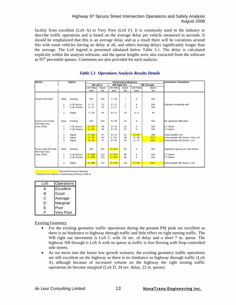
Highway 97 Spruce Street Intersection Operations and Safety Analysis August 2008
de Leur Consulting Limited 13 NovaTrans Engineering Inc.
facility from excellent (LoS A) to Very Poor (LoS F). It is commonly used in the industry to describe traffic operations and is based on the average delay per vehicle measured in seconds. It should be emphasized that this is an average delay and as a result there will be variations around this with some vehicles having no delay at all, and others having delays significantly longer than the average. The LoS legend is presented tabulated below Table 5.1. The delay is calculated explicitly within the analysis software, and the queue lengths were also extracted from the software as 95th percentile queues. Comments are also provided for each analysis.
Table 5.1 Operations Analysis Results Details Period Option Performance Measures Comments / Simulation
SB Left In WB Right Out NB ThroughLoS / Delay Queue LoS / Delay Queue LoS / Delay Queue
(sec) (m) (sec) (m) (sec) (m)
Present PM Peak Base Existing N/A N/A C / 16 7 A N/A
1 LI @ Spruce C / 17 12 C / 17 7 A N/A Operates marginally well2 LI @ Victoria C / 17 12 C / 17 7 A N/A
3 Signal C / 29 44 B / 17 19 A / 5 46
Future Low Growth Base Existing N/A N/A D / 34 22 A N/A No significant difficultiesPM Peak Hour(Year 2023) 1 LI @ Spruce E / 49 39 D / 34 22 A N/A LT Failure
2 LI @ Victoria E / 49 39 D / 34 22 A N/A LT Failure
3 Signal F / 192 67 B / 11 21 E / 67 188 Unacceptable LoS3 Signal E / 55 60 C / 34 48 D / 36 274 * Unacceptable NB Queue / Hwy LoS3 Signal E / 78 70 B / 20 32 D / 37 218 * Unacceptable NB Queue / LoS
Future High PM Peak Base Existing N/A N/A F / 247 86 A N/A Significant queuing on side streetsPM Peak Hour(Year 2023) 1 LI @ Spruce F / 430 115 F / 247 86 A N/A LT Failure
2 LI @ Victoria F / 430 115 F / 247 86 A N/A LT Failure
3 Signal F / 188 121 F / 102 116 F / 92 531 * Unacceptable NB Queue / LoS
Critical Performance Measure* Distance from Spruce to Queensway Onramp is 300 m.
LoS OperationsA ExcellentB GoodC AverageD MarginalE PoorF Very Poor
Existing Geometry
• For the existing geometry traffic operations during the present PM peak are excellent as there is no hindrance to highway through traffic and little effect on right turning traffic. The WB right out movement is LoS C with 16 sec. of delay and a short 7 m. queue. The highway NB through is LoS A with no queue as traffic is free flowing with Stop-controlled side streets.
• As we move into the future low growth scenario, the existing geometry traffic operations are still excellent on the highway as there is no hindrance to highway through traffic (LoS A) although because of increased volume on the highway the right turning traffic operations do become marginal (LoS D, 34 sec. delay, 22 m. queue).
Highway 97 Spruce Street Intersection Operations and Safety Analysis August 2008
de Leur Consulting Limited 14 NovaTrans Engineering Inc.
• For the future high growth scenario, again the traffic operations are still excellent on the highway as there is no hindrance to highway through traffic (LoS A) but because of increased volume on the highway the WB right out turning traffic operations become very poor (LoS F, 247 sec. delay, 86 m. queue).
Option 1: Left In at Spruce St.
• The Option 1 traffic operations during the present PM peak are marginal. Although the LoS for the SB left in movement is forecast to be average (LoS C, 16sec. delay, 11 m. queue), this would be considered by the Province to be inadequate for the opening day of a new facility with an expected life of 15 – 20 years given that degradation will occur with increasing volumes. The WB right out movement remains similar to the existing situation with a LoS C, 16 sec. of delay and a short 7 m. queue. There would remain no hindrance to highway through traffic (LoS A) as it remains freeflow.
• The Option 1 traffic operations for the future low growth PM scenario are poor. The SB left in LoS is forecast to be poor (LoS E, 49 sec. delay, 39m. queue), as left turning vehicles would find difficulty in finding gaps in the opposing NB traffic to turn through. It should be noted that the LoS F threshold is 50 sec. of delay so this movement is actually right on the threshold of the very poor LoS F. The WB right out movement again remains similar to the existing situation being marginal with a LoS D, 34 sec. of delay and a 22 m. queue. There would remain no hindrance to highway through traffic (LoS A) as it remains freeflow.
• The Option 1 traffic operations for the future high growth PM scenario are very significantly poor. The SB left in LoS is forecast to be a very poor LoS F, with 430 sec. of delay, and an extremely long 115 m. queue, again as left turning vehicles would find great difficulty in finding gaps in the opposing NB traffic. Again, as with the Existing Geometry, because of increased volume on the highway the WB right out turning traffic operations become very poor (LoS F, 247 sec. delay, 86 m. queue).There would remain no hindrance to highway through traffic (LoS A) as it remains freeflow.
Option 2: Left In at Victoria St.
• As the left in operations at Victoria St. face the same NB opposing traffic as the left in at Spruce St. the Option 2 traffic operations mirror those for option 1, therefore being marginal during the present PM peak, poor for the future low growth PM scenario and very significantly poor for the future high growth PM peak scenario.
• The difference between these two options is the geometry. The Victoria St. location is about 150 m. south of the Spruce St. location. As a result, there is more room for a longer left turn bay to allow for queue build-up and deceleration. On the other hand this would also move the northbound turning movements to within 150 m. of the Queensway Interchange NB On-ramp. As the intent of the development of Highway 97 is towards a free-flow system, conflicting movements at such a short distance are inappropriate.
Average opening day Levels of Service and early failure of the non-signalized left in movements options presented above can be expected to cause discontent among the facility users likely leading to safety difficulties as users resort to taking greater chances out of frustration. Early failure of a new facility is poor economics without the value for money and return on investment required. As a result additional solutions, based on likely public requests at the time of failure, were generated and explored. The most likely solution and public request would be for the replacement of the new facility with a traffic signal. Consequently, Option 3 included the signalization of the Spruce St. access point.
Highway 97 Spruce Street Intersection Operations and Safety Analysis August 2008
de Leur Consulting Limited 15 NovaTrans Engineering Inc.
Option 3: Signalization of Spruce St. access • Should a traffic signal be immediately implemented in this location, the Option 3 traffic
operations during the present PM peak are forecast to be marginal. Although the SB left in LoS is forecast to be average (LoS C, 29 sec. delay, 44 m. queue), this would again be considered by the Province to be inadequate for a the opening day of a new facility with an expected life of 15 – 20 years given that degradation will occur immediately with increasing volumes. The WB right out movement operations would be good with a LoS B, 17 sec. of delay, and a 19 m. queue. Under this option, for the first time there would be some hindrance to highway through traffic as this traffic would have to stop at a new signal. Although the operations would be very good (LoS A) some discontent would be likely as the longer-distance travelling public is faced with more erosion of their travel time.
• Traffic signal timing allows for a fair amount of flexibility in signal operations. Cycle lengths can be set shorter to prevent the build-up of longer queues where geometry is constrained or longer where capacity is an issue and the effects of yellow and red “lost” time are to be minimized. As a result a number of signal timing alternatives were analyzed under the future low growth PM peak hour scenario in an attempt to identify the optimal timing.
• A critical issue in the operations of Highway 97 is the proximity of the back of a NB queue waiting at the Spruce St. intersection to the free-flow Queensway NB On-ramp, As a result, the first signal timing alternative analyzed was one intended to minimize the queue length created at the signal (short cycle). The queue length created under this scenario was still 188 m. which places the back of the queue at just over 100 m. from the end of the on-ramp merge. However, traffic operations under this scenario were very poor with a LoS F, 192 sec. of delay and 67 m. of queue for the SB left in. Even more critically, highway traffic would be faced with a poor LoS E with 67 sec. of delay and the 188 m. queue mentioned earlier. The highway traffic is a much greater volume than the desired turning traffic and hence new impacts on this traffic should be avoided if possible.
• An attempt was then made to find a signal timing which minimized the LoS and delays for the various movements (longer cycle). While the LoS dropped to E with a 55 sec. delay for the SB left turn in, and to a LoS D with a 36 sec. delay for the highway NB through movement the trade-off was a queue length of almost 280 m., almost reaching the Queensway NB On-ramp merge point. This results in severe safety concerns.
• A final attempt was made to find a signal timing which balanced the two above effects. This resulted in the LoS staying at E with a delay increasing to 78 sec. for the SB left turn in, and the NB Through movement LoS also remaining a LoS D with a 37 sec. delay. However, the trade-off was a queue length of 218 m. which placed the end of the NB queue within approximately 80 m. of the Queensway NB On-ramp merge point. Again, this would result in severe safety concerns.
• As stated in the Option 3 the signal timing would also accommodate left out movements as the Ministry has indicated that, under signalization, partial movements would not be considered. The critical NB queues would form regardless of this, however, as the removal of this movement would not prevent the need to stop the NB traffic for the Left In movement.
• Queuing on Spruce St beyond the Ford Avenue frontage road entrance would also be both an operational and a safety problem. This issue is considered in more detail in Section 6.1 of this report.

Highway 97 Spruce Street Intersection Operations and Safety Analysis August 2008
de Leur Consulting Limited 16 NovaTrans Engineering Inc.
Time to Failure The above results were based on the medium-term 2023 time horizon. The question has also arisen as to when the left turn bay could be expected to fail. The gradual deterioration in the traffic operations for the SB Left turn bay that occurs over time with increasing opposing traffic is presented in Figure 5.2 below. The delay, per vehicle in seconds, calculated for each year, is plotted versus time. Plots are presented for both the Low Growth and the High Growth scenarios. The thresholds for the various Levels of Service are also shown. The marginal LoS D occurs when 25 seconds of delay occurs, the Poor LoS E at 35 seconds of delay and the very poor LoS F at 50 seconds of delay. As a result, the marginal LoS D can be expected to occur between 2011 (High Growth) and 2013 (Low Growth), the Poor LoS E can be expected to occur between 2013 (High Growth) and 2018 (Low Growth) with the very poor LoS F occurring somewhere between 2015 (High Growth) and 2024 (Low Growth). Once again, it should be emphasized that early failure of a new facility is poor economics without the value for money and return on investment required.
Table 5.2 Left Turn Bay Delay Degradation Over Time
Spruce St. Left Turn Bay Delay and LoSFor Low and High Traffic Growth
0
10
20
30
40
50
60
70
80
90
100
2008
2009
2010
2011
2012
2013
2014
2015
2016
2017
2018
2019
2020
2021
2022
2023
Year
Del
ay (s
ec)
LowHigh
LoS F
LoS E
LoS D
Operations Summary In summary the operations of the Highway 97 SB Left turn for both Options 1 (Left In at Spruce) and 2 (Left In at Victoria) are very similar as a result of the need to find gaps in the same volume of opposing NB traffic. Both options perform marginally well on Opening Day but below the Province’s, and the public’s, expectations for a new facility given future traffic growth. Traffic growth will cause the operations to degrade over time reaching the critical LoS E threshold, with 35 seconds of delay per vehicle, sometime between 2013 and 2018 and the unacceptable LoS F threshold, with 50 seconds of delay per vehicle, sometime between 2015 and 2024. These LoS do not meet normally expected engineering standards. Early failure of a new facility is poor economics without the value for money and return on investment required.

Highway 97 Spruce Street Intersection Operations and Safety Analysis August 2008
de Leur Consulting Limited 17 NovaTrans Engineering Inc.
On failure a further operational solution would be required. If the Left In movement would continue to be accommodated, the logical next step would be the signalization of this movement, although this is contrary to the Province’s efforts to advance Highway 97 to a free-flow facility and would likely be in conflict with the upstream merge ramps at the Queensway Interchange. By nature signalization would cause delays to the northbound highway traffic, delays to which the highway traffic is not presently subjected to. A variety of optimal timing plans were analyzed for the low Growth PM Peak scenario with the best LoS achieved being a LoS E with 78 sec. of delay for the SB Left turn and a LoS D with 37 seconds of delay for the highway NB through traffic. However, the critical NB queues were calculated to be between 188 and 274 m. in length, generally placing the tail end of the queue within about 100 m. or less of the Queensway Interchange merging on-ramp. This would create a new safety hazard.
Highway 97 Spruce Street Intersection Operations and Safety Analysis August 2008
de Leur Consulting Limited 18 NovaTrans Engineering Inc.
6. Additional Issues
6.1 Frontage Road Proximity A subject not specifically analyzed but known to cause significant operational problems, particularly under higher volumes, is the proximity of the frontage road access points to the highway access at either the Spruce or Victoria Street intersections. The short distance (16 m.) between the highway and the frontage road offers no place for the storage of turning vehicles. In fact the Province’s minimum standard for frontage road bulb separations from highways is 45 m. Entering from the highway, this means that there is a risk of vehicles that need to turn left onto the frontage road stacking in this area preventing highway SB left turning vehicles from clearing the highway intersection. This can cause these vehicles to become trapped with significant consequent safety difficulties. In addition, vehicles turning out (for example with a signal in place) stack across the frontage road entrances backing frontage road vehicles up and causing significant driver frustration. In general, in higher traffic volume locations, as a result of limited storage space, short-bulb frontage road intersection operations have been found to be very poor.
6.2 Other Comparable Left Turn In Turn Bays Comments have also been made relating to the provision of apparently similar left turn bays along other portions of Highway 97 and Highway 16 in the Prince George area. While the Province has general policies with regards to the provision of access on controlled access highways every access point is subject to a specific set of conditions and is considered on its own technical merits. One location that is often mentioned, largely because of its close proximity and recent implementation, is the left turn in entrance to the Treasure Cove Casino from Highway 97 NB just south of the Highway 16 intersection. A review of the specifics of this left turn bay location yield a number of site specific differences from the Spruce St. left turn bay request. These are as follows:
• Level of Service: The Expected Opening Day LoS was calculated to be LoS A with degradation over the 15 year facility Service Life to a LoS A. This is compared to the Opening Day LoS C calculated for the Spruce St. Left In LoS. This is largely caused by two factors 1) lower turning volumes than the Spruce St. left turn; and 2) Long available gaps in the opposing traffic stream
• Turning Volumes: The PM Peak left turn in at Treasure Cove Casino is 38 veh/hr for both Opening Day and the 15-year horizon vs. 150 and 180 veh/hr for the Spruce St. turn bay for the same periods respectively. This can be attributed to a number of factors;
o the Casino site is self-contained with no access to the rest of the neighbourhood therefore traffic generated is site traffic only; and
o NB Left turning traffic into the Casino site is only 12% of the arriving traffic because it originates largely from areas outside of Prince George via Highway 97 south of the Fraser River and Queensway. In contrast, traffic to the SB Left in requested at Spruce St. would largely originate from Prince George via Hwy 97 North and Highway 16 East as well as outside of Prince George via Highway 16 West.
Highway 97 Spruce Street Intersection Operations and Safety Analysis August 2008
de Leur Consulting Limited 19 NovaTrans Engineering Inc.
• Opposing Traffic Stream Gaps: The traffic opposing the Casino NB Left Turn In entrance emanates from the traffic signal at Highway 97 / Highway 16 about 150 m. north of the entrance. As a result of the signal operations the traffic is highly platooned with long gaps between platoons during certain signal phases allowing for left turn movements to occur. In contrast the traffic opposing the SB Left in requested at Spruce St. emanates from the Queensway interchange or from across the Simon Fraser Bridge and is therefore highly dispersed providing far fewer available gaps. It should also be noted that the requested left turn into the Casino site off of Highway 16 was rejected for this same reason. The left turn bay occurred after the major intersection rather than before and could not therefore take advantage of gaps created by traffic signal caused platooning.

Highway 97 Spruce Street Intersection Operations and Safety Analysis August 2008
de Leur Consulting Limited 20 NovaTrans Engineering Inc.
7. Safety Analysis
7.1 Objectives Several objectives were formulated for the safety analysis of the three access options developed for the southbound Highway 97 traffic to turn left into the Spruce Street area in the City of Prince George. These objectives are as follows:
1) Quantify the long-term safety performance that would be associated with each of the three access options and compare the safety performance of these options with the existing access that does not allow the southbound left-turn movement;
2) Evaluate the safety performance of the left-turn access in comparison to provincial average safety performance benchmarks; and,
3) Summarize any safety concerns associated with the design elements that are required for the left-turn access options.
7.2 Methodology A systematic methodology was developed to complete the required safety analysis. A description of the various tasks is provided below. Task 1: Develop a Safety Model for the Corridor The safety performance for the three access options was obtained by developing a safety model for the corridor. A safety model allows for the estimation of safety performance based on the site-specific design and operating characteristics of the facilities. The foundation of the safety model is a set of collision prediction models (CPMs) that can estimate the collision frequency at the intersections, based on the characteristics of the intersection and corresponding safety risk. Faculty from the Department of Civil Engineering at the University of British Columbia (UBC) developed the CPMs that were used in the safety model developed for this study. The CPMs were developed using collision and traffic volume data from the Province of British Columbia and as such, the CPMs are applicable to this study. It should be noted that a safety modeling approach has become a preferred method of estimating safety performance and will be a recommended procedure in the forthcoming Highway Safety Manual (HSM) that is being prepared by the Federal Highway Administration in the United States. The scope for the safety model included all of the intersections on highway 97 between Railway Road and the junction of Highway 97 / Highway 16, including the following intersections:
- Railway Road, - Highway 97 at Queensway Southbound, - Highway 97 at Queensway Northbound, - Victoria Street, - Spruce Street, and - Highway 97 at Highway 16
One of the fundamental inputs into the safety model is the traffic volume that will use the facility, since traffic volume represents the exposure element in road safety risk. The safety model requires the annual average daily traffic (AADT), which was obtained from NovaTrans Engineering for each access option under review.

Highway 97 Spruce Street Intersection Operations and Safety Analysis August 2008
de Leur Consulting Limited 21 NovaTrans Engineering Inc.
The safety model that was developed for this assignment was validated using the historical safety records for the targeted intersections on the corridor. It was determined that the level of agreement between the predicted results from the safety model and the observed (historical) collision data was very good. The safety model of the existing highway conditions predicted a total of 10.7 collisions per year at the intersections, while a total of 10.2 police reported collisions were recorded at the intersections. This provided a level of certainty that the safety model was providing an adequate level of predictive capability. Task 2: Run the Safety Model for the Design Scenarios The safety model was run for the baseline design (i.e., the existing access configuration) and for each of the three access design scenarios for two specific time periods. The safety performance was estimated for a base year (2008) and then again for a horizon year (2023). This provided a total service life of 15 years. Rather than run the safety model for each year, the safety performance for each intervening year (i.e., 2009 to 2022) was obtained by simple interpolation, which would be accurate for a relative comparison of the access options. The output from the safety model provided the predicted collision frequency, which was summed over the 15-year time horizon for the baseline condition and for each of the three access options. In order to capture the range of potential traffic growth in the study area, two unique traffic growth scenarios were developed. The rationale for these traffic growth scenarios was described earlier in this report and included the following:
- A HIGH traffic growth scenario, and - A LOW traffic growth scenario.
Task 3: Quantify the Relative Safety Impacts With the safety performance results produced by the safety model for each of the design scenarios for both time periods (base year and horizon year) and for both traffic growth scenarios (HIGH-growth and LOW-growth), the next step was to quantify the safety impacts. The first step was to create collision severity profiles for the different types of collisions that would be caused by the movements that would be allowed for the access options. This is important because it is known that head-on and left-turn, crossing incidents are more severe than other types of incidents such as rear-end or side-swipe incidents. The collision severity profiles were applied to the total predicted collision frequency to determine the breakdown by collision severity type, which includes fatal collisions, injury collisions and property damage only collisions (PDO). The predicted collision frequency for each access scenario was converted into an economic value by using the Ministry’s average cost per collision type. The Ministry’s average cost of collisions is based on a willingness to pay economic model, which is a comprehensive economic costing model that include all the societal costs associated with the occurrence of collisions. The average collision cost values used in this assignment are as follows:
- Fatal: $5,600,000 / incident - Injury: $100,000 / incident - PDO: $7,350 / incident
The breakdown of the collision frequency (by severity level) was multiplied by the corresponding average collision cost to obtain the total collision cost for each access scenario. This allowed for a comparison of the relative safety performance, in terms of collision frequency and collision cost for the three access design scenarios in relation to the base case condition. For simplicity, the estimated collision costs were not converted to a net present value.
Highway 97 Spruce Street Intersection Operations and Safety Analysis August 2008
de Leur Consulting Limited 22 NovaTrans Engineering Inc.
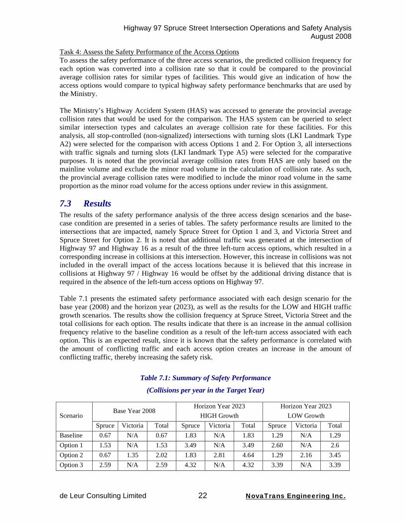
Task 4: Assess the Safety Performance of the Access Options To assess the safety performance of the three access scenarios, the predicted collision frequency for each option was converted into a collision rate so that it could be compared to the provincial average collision rates for similar types of facilities. This would give an indication of how the access options would compare to typical highway safety performance benchmarks that are used by the Ministry. The Ministry’s Highway Accident System (HAS) was accessed to generate the provincial average collision rates that would be used for the comparison. The HAS system can be queried to select similar intersection types and calculates an average collision rate for these facilities. For this analysis, all stop-controlled (non-signalized) intersections with turning slots (LKI Landmark Type A2) were selected for the comparison with access Options 1 and 2. For Option 3, all intersections with traffic signals and turning slots (LKI landmark Type A5) were selected for the comparative purposes. It is noted that the provincial average collision rates from HAS are only based on the mainline volume and exclude the minor road volume in the calculation of collision rate. As such, the provincial average collision rates were modified to include the minor road volume in the same proportion as the minor road volume for the access options under review in this assignment.
7.3 Results The results of the safety performance analysis of the three access design scenarios and the base-case condition are presented in a series of tables. The safety performance results are limited to the intersections that are impacted, namely Spruce Street for Option 1 and 3, and Victoria Street and Spruce Street for Option 2. It is noted that additional traffic was generated at the intersection of Highway 97 and Highway 16 as a result of the three left-turn access options, which resulted in a corresponding increase in collisions at this intersection. However, this increase in collisions was not included in the overall impact of the access locations because it is believed that this increase in collisions at Highway 97 / Highway 16 would be offset by the additional driving distance that is required in the absence of the left-turn access options on Highway 97. Table 7.1 presents the estimated safety performance associated with each design scenario for the base year (2008) and the horizon year (2023), as well as the results for the LOW and HIGH traffic growth scenarios. The results show the collision frequency at Spruce Street, Victoria Street and the total collisions for each option. The results indicate that there is an increase in the annual collision frequency relative to the baseline condition as a result of the left-turn access associated with each option. This is an expected result, since it is known that the safety performance is correlated with the amount of conflicting traffic and each access option creates an increase in the amount of conflicting traffic, thereby increasing the safety risk.
Table 7.1: Summary of Safety Performance
(Collisions per year in the Target Year)
Base Year 2008 Horizon Year 2023
HIGH Growth Horizon Year 2023
LOW Growth Scenario Spruce Victoria Total Spruce Victoria Total Spruce Victoria Total
Baseline 0.67 N/A 0.67 1.83 N/A 1.83 1.29 N/A 1.29 Option 1 1.53 N/A 1.53 3.49 N/A 3.49 2.60 N/A 2.6 Option 2 0.67 1.35 2.02 1.83 2.81 4.64 1.29 2.16 3.45 Option 3 2.59 N/A 2.59 4.32 N/A 4.32 3.39 N/A 3.39
Highway 97 Spruce Street Intersection Operations and Safety Analysis August 2008
de Leur Consulting Limited 23 NovaTrans Engineering Inc.
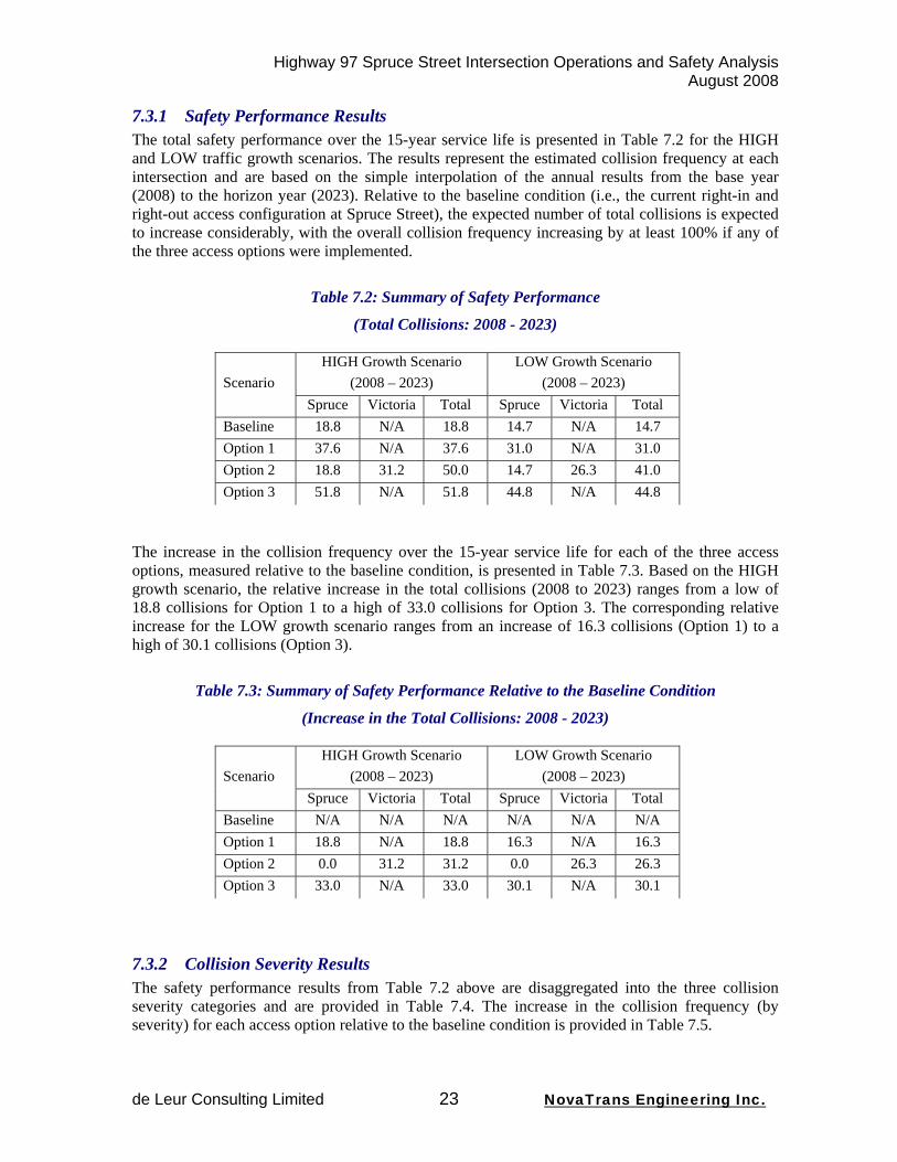
7.3.1 Safety Performance Results The total safety performance over the 15-year service life is presented in Table 7.2 for the HIGH and LOW traffic growth scenarios. The results represent the estimated collision frequency at each intersection and are based on the simple interpolation of the annual results from the base year (2008) to the horizon year (2023). Relative to the baseline condition (i.e., the current right-in and right-out access configuration at Spruce Street), the expected number of total collisions is expected to increase considerably, with the overall collision frequency increasing by at least 100% if any of the three access options were implemented.
Table 7.2: Summary of Safety Performance
(Total Collisions: 2008 - 2023)
HIGH Growth Scenario (2008 – 2023)
LOW Growth Scenario (2008 – 2023) Scenario
Spruce Victoria Total Spruce Victoria Total Baseline 18.8 N/A 18.8 14.7 N/A 14.7 Option 1 37.6 N/A 37.6 31.0 N/A 31.0 Option 2 18.8 31.2 50.0 14.7 26.3 41.0 Option 3 51.8 N/A 51.8 44.8 N/A 44.8
The increase in the collision frequency over the 15-year service life for each of the three access options, measured relative to the baseline condition, is presented in Table 7.3. Based on the HIGH growth scenario, the relative increase in the total collisions (2008 to 2023) ranges from a low of 18.8 collisions for Option 1 to a high of 33.0 collisions for Option 3. The corresponding relative increase for the LOW growth scenario ranges from an increase of 16.3 collisions (Option 1) to a high of 30.1 collisions (Option 3).
Table 7.3: Summary of Safety Performance Relative to the Baseline Condition
(Increase in the Total Collisions: 2008 - 2023)
HIGH Growth Scenario (2008 – 2023)
LOW Growth Scenario (2008 – 2023) Scenario
Spruce Victoria Total Spruce Victoria Total Baseline N/A N/A N/A N/A N/A N/A Option 1 18.8 N/A 18.8 16.3 N/A 16.3 Option 2 0.0 31.2 31.2 0.0 26.3 26.3 Option 3 33.0 N/A 33.0 30.1 N/A 30.1
7.3.2 Collision Severity Results The safety performance results from Table 7.2 above are disaggregated into the three collision severity categories and are provided in Table 7.4. The increase in the collision frequency (by severity) for each access option relative to the baseline condition is provided in Table 7.5.

Highway 97 Spruce Street Intersection Operations and Safety Analysis August 2008
de Leur Consulting Limited 24 NovaTrans Engineering Inc.
Table 7.4: Summary of Collision Severity (Total Collisions and (Percent) : 2008 - 2023)
HIGH Growth Scenario (2008 – 2023)
LOW Growth Scenario (2008 – 2023) Scenario
Spruce Victoria Total Spruce Victoria Total Baseline
Fatal: Injury: PDO:
0.2 (1.1%) 8.0 (42.8%)
10.6 (56.1%)
N/A
0.2 (1.1%)
8.0 (42.8%) 10.6 (56.1%)
0.2 (1.1%)
6.3 (42.8%) 8.2 (56.1%)
N/A
0.2 (1.1%) 6.3 (42.8%) 8.2 (56.1%)
Option 1 Fatal:
Injury: PDO:
0.5 (1.3%)
20.2 (53.7%) 16.9 (45.0%)
N/A
0.5 (1.3%)
20.2 (53.7%) 16.9 (45.0%)
0.4 (1.3%)
16.7 (53.7%) 13.9 (45.0%)
N/A
0.4 (1.3%)
16.7 (53.7%) 13.9 (45.0%)
Option 2 Fatal:
Injury: PDO:
0.2 (1.1%) 8.0 (42.8%)
10.6 (56.1%)
0.4 (1.3%)
16.8 (53.7%) 14.0 (45.0%
0.6 (1.2%)
24.8 (49.6%) 24.6 (49.2%)
0.2 (1.1%)
6.3 (42.8%) 8.2 (56.1%)
0.4 (1.3%)
14.1 (53.7%) 11.8 (45.0%)
0.6 (1.4%)
20.4 (49.8%) 20.0 (48.8%)
Option 3 Fatal:
Injury: PDO:
0.4 (0.8%)
24.8 (47.8%) 26.6 (51.4%)
N/A
0.4 (0.8%)
24.8 (47.8%) 26.6 (51.4%)
0.4 (0.8%)
21.4 (47.8%) 23.0 (51.4%)
N/A
0.4 (0.8%)
21.4 (47.8%) 23.0 (51.4%)
(%) refers to % of total collisions
Table 7.5: Summary of Collision Severity Relative to the Baseline Condition (Increase in the Total Collisions and (Percent): 2008 - 2023)
HIGH Growth Scenario (2008 – 2023)
LOW Growth Scenario (2008 – 2023) Scenario
Spruce Victoria Total Spruce Victoria Total Option 1
Fatal: Injury: PDO:
0.3 (1.6%)
12.2 (64.9%) 6.3 (33.5%)
N/A
0.3 (1.6%)
12.2 (64.9%) 6.3 (33.5%)
0.2 (1.2%)
10.4 (63.8%) 5.7 (35.0%)
N/A
0.2 (1.2%)
10.4 (63.8%) 5.7 (35.0%)
Option 2 Fatal:
Injury: PDO:
0.0 (0%) 0.0 (0%) 0.0 (0%)
0.4 (1.3%)
16.8 (53.8%) 14.0 (44.9%)
0.4 (1.3%)
16.8 (53.8%) 14.0 (44.9%)
0.0 (0%) 0.0 (0%) 0.0 (0%)
0.4 (1.5%)
14.1 (53.6%) 11.8 (44.9%)
0.4 (1.5%)
14.1 (53.6%) 11.8 (44.9%)
Option 3 Fatal:
Injury: PDO:
0.2 (0.6%)
16.8 (50.9%) 16.0 (48.5%)
N/A
0.2 (0.6%)
16.8 (50.9%) 16.0 (48.5%)
0.2 (0.7%)
15.1 (50.2%) 14.8 (49.1%)
N/A
0.2 (0.7%)
15.1 (50.2%) 14.8 (49.1%)
(%) refers to % of total collisions

Highway 97 Spruce Street Intersection Operations and Safety Analysis August 2008
de Leur Consulting Limited 25 NovaTrans Engineering Inc.
7.3.3 Collision Costs Results The safety impacts associated with the baseline condition and the three left-turn options were converted into an economic value by applying the Ministry’s average collision costs, which were listed earlier in this chapter of the report. The results, which are provided in Table 7.6, include the total estimated collision costs over the 15-year service life for both the HIGH and LOW traffic growth scenarios. The total collision costs over the 15-year service life range from approximately $2.0M for the existing (baseline) access to over $6M for the Option 2 access scenario (for the HIGH traffic growth scenario). The total collision costs are somewhat lower for the LOW traffic growth scenario, ranging from approximately $1.6M for the baseline to over $5M for Option 2. It is noted again, that the collision costs were not discounted to a net present value.
Table 7.6: Summary of Collision Costs
(Total Collision Costs: 2008 - 2023)
Collision Costs ($M) for the HIGH Growth Scenario
(2008 – 2023)
Collision Costs ($Ms) for the LOW Growth Scenario
(2008 – 2023) Scenario
Spruce Victoria Total Spruce Victoria Total Baseline $2.0 $0 $2.0 $1.6 $0 $1.6 Option 1 $4.9 $0 $4.9 $4.1 $0 $4.1 Option 2 $2.0 $4.1 $6.1 $1.6 $3.5 $5.1 Option 3 $4.9 $0 $4.9 $4.2 $0 $4.2
The collision costs for the three access options, measured relative to the baseline, are presented in Table 7.7. This table shows that the collision costs would rise considerably with any of the three access options. Considering the HIGH growth scenario, the additional collision costs are expected to increase from approximately $2.9M for Option 3 to over $4.0M for Option 2. The incremental increase in the collision cost for the LOW growth scenario is also significant, ranging from approximately $2.5M to $3.5M.
Table 7.7: Summary of Collision Costs Relative to the Baseline Condition
(Increase in the Total Collision Costs: 2008 - 2023)
Collision Costs ($M) for the HIGH Growth Scenario
(2008 – 2023)
Collision Costs ($Ms) for the LOW Growth Scenario
(2008 – 2023) Scenario
Spruce Victoria Total Spruce Victoria Total Option 1 $2.9 $0 $2.9 $2.5 $0 $2.5 Option 2 $0 $4.1 $4.1 $0 $3.5 $3.5 Option 3 $2.9 $0 $2.9 $2.7 $0 $2.7
Highway 97 Spruce Street Intersection Operations and Safety Analysis August 2008
de Leur Consulting Limited 26 NovaTrans Engineering Inc.
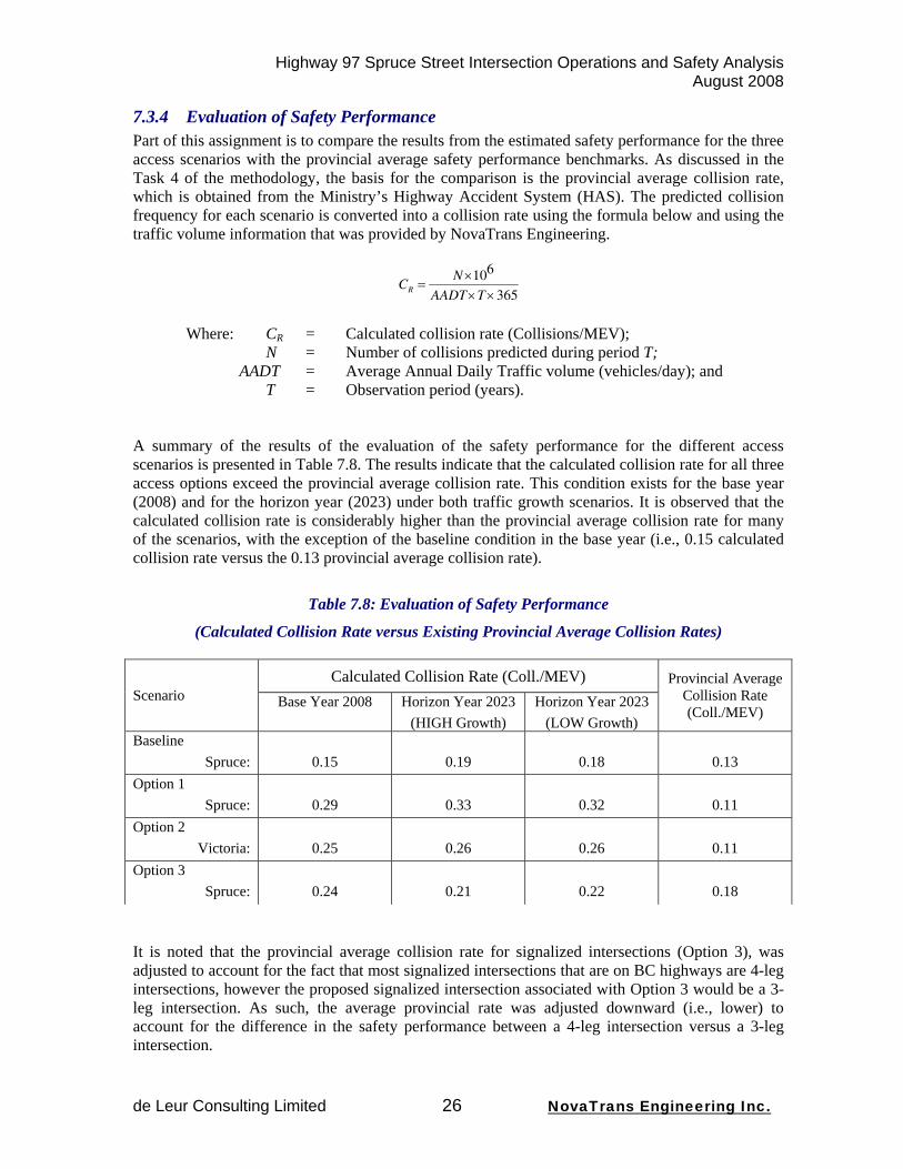
7.3.4 Evaluation of Safety Performance Part of this assignment is to compare the results from the estimated safety performance for the three access scenarios with the provincial average safety performance benchmarks. As discussed in the Task 4 of the methodology, the basis for the comparison is the provincial average collision rate, which is obtained from the Ministry’s Highway Accident System (HAS). The predicted collision frequency for each scenario is converted into a collision rate using the formula below and using the traffic volume information that was provided by NovaTrans Engineering.
CR =N×106
AADT×T×365
Where: CR = Calculated collision rate (Collisions/MEV);
N = Number of collisions predicted during period T; AADT = Average Annual Daily Traffic volume (vehicles/day); and T = Observation period (years).
A summary of the results of the evaluation of the safety performance for the different access scenarios is presented in Table 7.8. The results indicate that the calculated collision rate for all three access options exceed the provincial average collision rate. This condition exists for the base year (2008) and for the horizon year (2023) under both traffic growth scenarios. It is observed that the calculated collision rate is considerably higher than the provincial average collision rate for many of the scenarios, with the exception of the baseline condition in the base year (i.e., 0.15 calculated collision rate versus the 0.13 provincial average collision rate).
Table 7.8: Evaluation of Safety Performance
(Calculated Collision Rate versus Existing Provincial Average Collision Rates)
Calculated Collision Rate (Coll./MEV) Scenario Base Year 2008 Horizon Year 2023
(HIGH Growth) Horizon Year 2023
(LOW Growth)
Provincial Average Collision Rate (Coll./MEV)
Baseline Spruce:
0.15
0.19
0.18
0.13
Option 1 Spruce:
0.29
0.33
0.32
0.11
Option 2 Victoria:
0.25
0.26
0.26
0.11
Option 3 Spruce:
0.24
0.21
0.22
0.18
It is noted that the provincial average collision rate for signalized intersections (Option 3), was adjusted to account for the fact that most signalized intersections that are on BC highways are 4-leg intersections, however the proposed signalized intersection associated with Option 3 would be a 3-leg intersection. As such, the average provincial rate was adjusted downward (i.e., lower) to account for the difference in the safety performance between a 4-leg intersection versus a 3-leg intersection.
Highway 97 Spruce Street Intersection Operations and Safety Analysis August 2008
de Leur Consulting Limited 27 NovaTrans Engineering Inc.
7.4 Safety Conclusions Several conclusions can be obtained from the safety analysis of the three options that provide a left-turn for southbound Highway 97 traffic into Spruce or Victoria Streets. These conclusions and general safety concerns are summarized below.
1) The introduction of an un-signalized intersection that provides a left-turn from Highway 97 into Spruce Street or Victoria Street will result in a significant increase in the collision frequency (refer to Table 7.3).
2) The introduction of a signalized intersection at Spruce Street will cause the largest increase in collision frequency because of the need for the Highway 97 traffic to stop, creating a significant potential for rear-end type collisions. The split of traffic from Highway 97 versus Spruce Street will result is a considerable safety penalty for motorists traveling on Highway 97.
3) The introduction of un-protected left-turn movements at an intersection are known to create deterioration in the collision severity because of the significant consequences associated with a traffic conflict generated between opposing traffic directions.
a. Additional safety concern exists because of the potential for an increase in speed for northbound traffic as a result of the forthcoming improvements to the Simon Fraser Bridge, which could worsen collision severity for left-turning traffic.
b. Safety risk is also increased for the left-turning traffic due to the potential for limited traffic gaps, which may lead to poor driver behaviour if delays are excessive (e.g., acceptance of higher risk levels).
4) The increase in collision costs associated with the three access options in relation to the baseline (existing) conditions is expected to be significant. The additional collision costs are estimated to be at least $2.5M over a 15-year service life.
5) Comparing the safety performance estimated at the three access options to the provincial average accident rate reveals that all access scenarios are expected to perform worst than the provincial average collision rate, and in some cases, the calculated collision rate is significantly higher than the provincial average collision rate.
6) There are several other design and operational considerations that will affect the safety performance of the access options on Highway 97.
a. The queue lengths for the southbound left-turn from Highway 97 into Spruce Street could spill back and interfere with the through movements on Highway 97. This may occur because of the limited space available due to the proximity of the Upland Street underpass, particularly when there is excessive delay or lack of gaps in the Highway 97 traffic. This could create unexpected and severe rear-end collisions at the start of the left-turn lane.
b. If the storage length and deceleration distance for southbound left-turning traffic is reduced due to considerable queuing, it is possible that some deceleration will occur in the Highway 97 through lane, creating a potential for rear-end collisions.
c. An opening that provides for a southbound left-turn from Highway 97 into Spruce Street will create the opportunity for unintended and undesirable left-turn out movements. The opening may also appeal to pedestrian and cyclist who may want to cross Highway 97 in this area.
d. The sight-distance for the Victoria Street left-turn access may be somewhat limited and the operation may be marginalized due to the presence of the on-ramp traffic from Queensway.
7) The close proximity of the intersection of the Ford Avenue frontage road at Spruce Street in relation to Highway 97 at Spruce Street will have several operational difficulties that will adversely impact safety performance.
Highway 97 Spruce Street Intersection Operations and Safety Analysis August 2008
de Leur Consulting Limited 28 NovaTrans Engineering Inc.
8. Conclusions and Recommendations
From the discussion presented above the following conclusions can be made:
Operations
1) The operations of the Highway 97 SB Left turn for both Options 1 (Left In at Spruce) and 2 (Left In at Victoria) are very similar as a result of the need to find gaps in the same volume of opposing NB traffic.
2) Both options perform marginally well on Opening Day but below the Province’s and the public’s, expectations for a new facility.
3) Traffic growth will cause the operations to degrade over time reaching the critical LoS E threshold, sometime between 2013 and 2018 and the unacceptable LoS F threshold, sometime between 2015 and 2024.
4) Early failure of a new facility is poor economics without the value for money and return on investment required.
5) On failure it is very likely that the Province would be requested to find an operational solution to the failure. The logical next step would be the signalization of this movement, although this is contrary to the Province’s efforts to advance Highway 97 to a free-flow facility and would be in conflict with the upstream merge ramps at the Queensway Interchange.
6) By nature signalization would cause delays to the northbound highway traffic, delays to which the highway traffic is not presently subjected to.
7) A variety of optimal timing plans were analyzed for the low Growth PM Peak scenario with the best LoS achieved being a LoS E for the SB Left turn and a LoS D for the highway NB through traffic.
8) The critical NB queues were calculated to be between 190 and 270 m. in length, generally placing the tail end of the queue within about 100 m. or less of the Queensway Interchange merging on-ramp. This would create a new safety hazard.
Safety
1) The introduction of an unsignalized intersection that provides a left-turn from Hwy 97 into Spruce or Victoria Street will result in a significant increase in the collision frequency.
2) The introduction of a signalized intersection at Spruce Street will cause the largest increase in collision frequency because of the need for the Highway 97 traffic to stop, creating a significant potential for rear-end type collisions. The split of traffic from Hwy 97 versus Spruce Street will result is a considerable safety penalty for motorists traveling on Hwy 97.
3) The introduction of unprotected left-turn movements at an intersection is known to create deterioration in the collision severity because of the significant consequences associated with a traffic conflict generated between opposing traffic directions.
c. Additional safety concern exists because of the potential for an increase in speed for NB traffic resulting from the improvements to the Simon Fraser Bridge.
d. Safety risk is also increased for the left-turning traffic due to the potential for limited traffic gaps, which may lead to poor driver behaviour if delays are excessive (e.g., acceptance of higher risk levels).
Highway 97 Spruce Street Intersection Operations and Safety Analysis August 2008
de Leur Consulting Limited 29 NovaTrans Engineering Inc.
4) The increase in collision costs associated with the three access options in relation to the baseline (existing) conditions is expected to be significant. The additional collision costs are estimated to be at least $2.5M over a 15-year service life.
5) Comparing the safety performance estimated at the three access options to the provincial average accident rate reveals that all access scenarios are expected to perform worst than the provincial average collision rate, and in some cases, the calculated collision rate is significantly higher than the provincial average collision rate.
6) There are several other design and operational considerations that will affect the safety performance of the access options on Highway 97.
e. The queue lengths for the southbound left-turn from Highway 97 into Spruce Street could spill back and interfere with the through movements on Highway 97. This may occur because of the limited space available due to the proximity of the Upland Street underpass, particularly when there is excessive delay or lack of gaps in the Highway 97 traffic. This could create unexpected and severe rear-end collisions at the start of the left-turn lane.
f. If the storage length and deceleration distance for southbound left-turning traffic is reduced due to considerable queuing, it is possible that some deceleration will occur in the Highway 97 through lane, creating a potential for rear-end collisions.
g. An opening that provides for a southbound left-turn from Highway 97 into Spruce Street will create the opportunity for unintended and undesirable left-turn out movements. The opening may also appeal to pedestrian and cyclist who may want to cross Highway 97 in this area.
h. The sight-distance for the Victoria Street left-turn access may be somewhat limited and the operation may be marginalized due to the presence of the on-ramp traffic from Queensway.
7) The close proximity of the intersection of the Ford Avenue frontage road at Spruce Street in relation to Highway 97 at Spruce Street will have several operational difficulties that will adversely impact safety performance.
The resulting recommendations are as follows:
• That the requested left turn movement from Highway 97 SB into either Spruce or Victoria Street not be allowed.

Highway 97 Spruce Street Intersection Operations and Safety Analysis August 2008
de Leur Consulting Limited 30 NovaTrans Engineering Inc.
Appendix A
Consultant Credentials
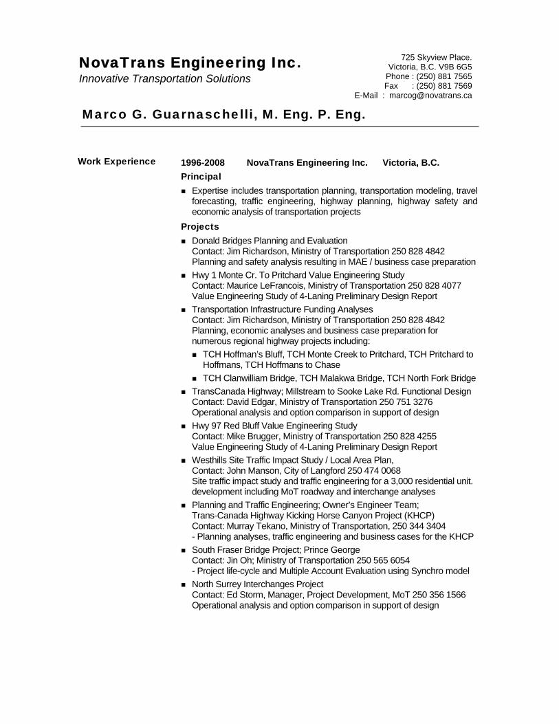
Marco G. Guarnaschelli, M. Eng. P. Eng.
1996-2008 NovaTrans Engineering Inc. Victoria, B.C. Principal
Expertise includes transportation planning, transportation modeling, travel forecasting, traffic engineering, highway planning, highway safety and economic analysis of transportation projects
Projects Donald Bridges Planning and Evaluation
Contact: Jim Richardson, Ministry of Transportation 250 828 4842 Planning and safety analysis resulting in MAE / business case preparation
Hwy 1 Monte Cr. To Pritchard Value Engineering Study Contact: Maurice LeFrancois, Ministry of Transportation 250 828 4077 Value Engineering Study of 4-Laning Preliminary Design Report
Transportation Infrastructure Funding Analyses Contact: Jim Richardson, Ministry of Transportation 250 828 4842 Planning, economic analyses and business case preparation for numerous regional highway projects including:
TCH Hoffman’s Bluff, TCH Monte Creek to Pritchard, TCH Pritchard to Hoffmans, TCH Hoffmans to Chase
TCH Clanwilliam Bridge, TCH Malakwa Bridge, TCH North Fork Bridge TransCanada Highway; Millstream to Sooke Lake Rd. Functional Design
Contact: David Edgar, Ministry of Transportation 250 751 3276 Operational analysis and option comparison in support of design
Hwy 97 Red Bluff Value Engineering Study Contact: Mike Brugger, Ministry of Transportation 250 828 4255 Value Engineering Study of 4-Laning Preliminary Design Report
Westhills Site Traffic Impact Study / Local Area Plan, Contact: John Manson, City of Langford 250 474 0068 Site traffic impact study and traffic engineering for a 3,000 residential unit. development including MoT roadway and interchange analyses
Planning and Traffic Engineering; Owner’s Engineer Team; Trans-Canada Highway Kicking Horse Canyon Project (KHCP) Contact: Murray Tekano, Ministry of Transportation, 250 344 3404 - Planning analyses, traffic engineering and business cases for the KHCP
South Fraser Bridge Project; Prince George Contact: Jin Oh; Ministry of Transportation 250 565 6054 - Project life-cycle and Multiple Account Evaluation using Synchro model
North Surrey Interchanges Project Contact: Ed Storm, Manager, Project Development, MoT 250 356 1566 Operational analysis and option comparison in support of design
NovaTrans Engineering Inc. Innovative Transportation Solutions
725 Skyview Place. Victoria, B.C. V9B 6G5
Phone : (250) 881 7565 Fax : (250) 881 7569
E-Mail : [email protected]
Work Experience
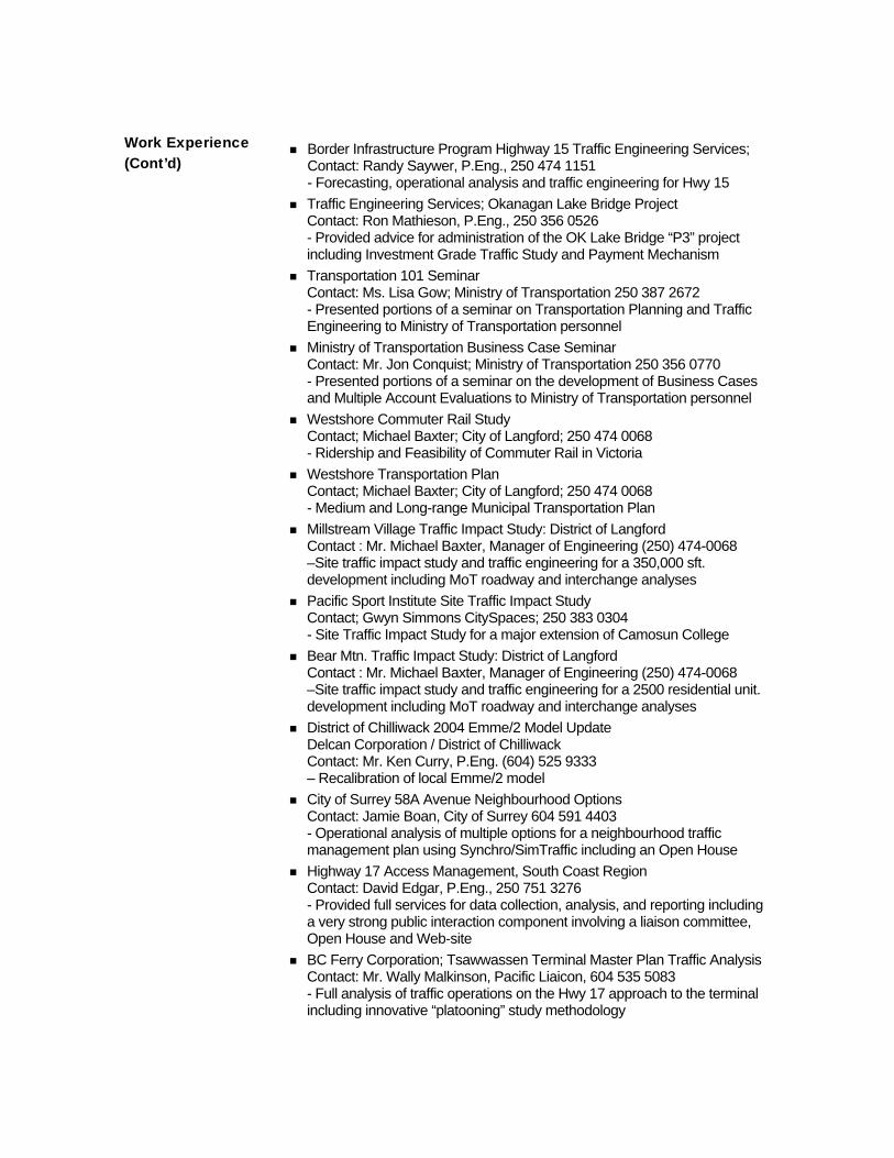
Border Infrastructure Program Highway 15 Traffic Engineering Services; Contact: Randy Saywer, P.Eng., 250 474 1151 - Forecasting, operational analysis and traffic engineering for Hwy 15
Traffic Engineering Services; Okanagan Lake Bridge Project Contact: Ron Mathieson, P.Eng., 250 356 0526 - Provided advice for administration of the OK Lake Bridge “P3” project including Investment Grade Traffic Study and Payment Mechanism
Transportation 101 Seminar Contact: Ms. Lisa Gow; Ministry of Transportation 250 387 2672 - Presented portions of a seminar on Transportation Planning and Traffic Engineering to Ministry of Transportation personnel
Ministry of Transportation Business Case Seminar Contact: Mr. Jon Conquist; Ministry of Transportation 250 356 0770 - Presented portions of a seminar on the development of Business Cases and Multiple Account Evaluations to Ministry of Transportation personnel
Westshore Commuter Rail Study Contact; Michael Baxter; City of Langford; 250 474 0068 - Ridership and Feasibility of Commuter Rail in Victoria
Westshore Transportation Plan Contact; Michael Baxter; City of Langford; 250 474 0068 - Medium and Long-range Municipal Transportation Plan
Millstream Village Traffic Impact Study: District of Langford Contact : Mr. Michael Baxter, Manager of Engineering (250) 474-0068 –Site traffic impact study and traffic engineering for a 350,000 sft. development including MoT roadway and interchange analyses
Pacific Sport Institute Site Traffic Impact Study Contact; Gwyn Simmons CitySpaces; 250 383 0304 - Site Traffic Impact Study for a major extension of Camosun College
Bear Mtn. Traffic Impact Study: District of Langford Contact : Mr. Michael Baxter, Manager of Engineering (250) 474-0068 –Site traffic impact study and traffic engineering for a 2500 residential unit. development including MoT roadway and interchange analyses
District of Chilliwack 2004 Emme/2 Model Update Delcan Corporation / District of Chilliwack Contact: Mr. Ken Curry, P.Eng. (604) 525 9333 – Recalibration of local Emme/2 model
City of Surrey 58A Avenue Neighbourhood Options Contact: Jamie Boan, City of Surrey 604 591 4403 - Operational analysis of multiple options for a neighbourhood traffic management plan using Synchro/SimTraffic including an Open House
Highway 17 Access Management, South Coast Region Contact: David Edgar, P.Eng., 250 751 3276 - Provided full services for data collection, analysis, and reporting including a very strong public interaction component involving a liaison committee, Open House and Web-site
BC Ferry Corporation; Tsawwassen Terminal Master Plan Traffic Analysis Contact: Mr. Wally Malkinson, Pacific Liaicon, 604 535 5083 - Full analysis of traffic operations on the Hwy 17 approach to the terminal including innovative “platooning” study methodology
Work Experience (Cont’d)
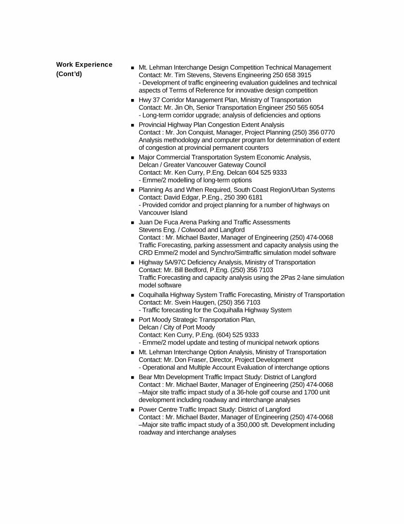
Mt. Lehman Interchange Design Competition Technical Management Contact: Mr. Tim Stevens, Stevens Engineering 250 658 3915 - Development of traffic engineering evaluation guidelines and technical aspects of Terms of Reference for innovative design competition
Hwy 37 Corridor Management Plan, Ministry of Transportation Contact: Mr. Jin Oh, Senior Transportation Engineer 250 565 6054 - Long-term corridor upgrade; analysis of deficiencies and options
Provincial Highway Plan Congestion Extent Analysis Contact : Mr. Jon Conquist, Manager, Project Planning (250) 356 0770 Analysis methodology and computer program for determination of extent of congestion at provincial permanent counters
Major Commercial Transportation System Economic Analysis, Delcan / Greater Vancouver Gateway Council Contact: Mr. Ken Curry, P.Eng. Delcan 604 525 9333 - Emme/2 modelling of long-term options
Planning As and When Required, South Coast Region/Urban Systems Contact: David Edgar, P.Eng., 250 390 6181 - Provided corridor and project planning for a number of highways on Vancouver Island
Juan De Fuca Arena Parking and Traffic Assessments Stevens Eng. / Colwood and Langford Contact : Mr. Michael Baxter, Manager of Engineering (250) 474-0068 Traffic Forecasting, parking assessment and capacity analysis using the CRD Emme/2 model and Synchro/Simtraffic simulation model software
Highway 5A/97C Deficiency Analysis, Ministry of Transportation Contact: Mr. Bill Bedford, P.Eng. (250) 356 7103 Traffic Forecasting and capacity analysis using the 2Pas 2-lane simulation model software
Coquihalla Highway System Traffic Forecasting, Ministry of Transportation Contact: Mr. Svein Haugen, (250) 356 7103 - Traffic forecasting for the Coquihalla Highway System
Port Moody Strategic Transportation Plan, Delcan / City of Port Moody Contact: Ken Curry, P.Eng. (604) 525 9333 - Emme/2 model update and testing of municipal network options
Mt. Lehman Interchange Option Analysis, Ministry of Transportation Contact: Mr. Don Fraser, Director, Project Development - Operational and Multiple Account Evaluation of interchange options
Bear Mtn Development Traffic Impact Study: District of Langford Contact : Mr. Michael Baxter, Manager of Engineering (250) 474-0068 –Major site traffic impact study of a 36-hole golf course and 1700 unit development including roadway and interchange analyses
Power Centre Traffic Impact Study: District of Langford Contact : Mr. Michael Baxter, Manager of Engineering (250) 474-0068 –Major site traffic impact study of a 350,000 sft. Development including roadway and interchange analyses
Work Experience (Cont’d)

Unfunded Projects Prioritization, BC Transportation Financing Authority Contact : Mr. David Marr, Director, Planning and Evaluation 356-2100 –Performance analysis of the provincial unfunded project list leading to recommendations for prioritization
Provincial Highway Plan : Mobility and Heavy Vehicle Measures Ministry of Transportation & Highways, Highway Planning Branch Contact : Mr. Jon Conquist, Manager, Project Planning (250) 356 0770 - Operational analysis at the overall provincial level
Provincial Highway Plan : Urban Area Performance Ministry of Transportation & Highways, Highway Planning Branch Contact : Mr. Jon Conquist, Manager, Project Planning (250) 356 0770 - Operational and safety analysis at the overall provincial level
Trans Canada Highway : Cache Creek to the Rockies : Business Cases Contact : Mr. Joe Camilleri, Manager of Engineering (250) 953-4949 –Operational, Safety and Multiple Account Evaluation for a major 2-lane roadway upgrade program using a variety of simulation models
South Fraser Perimeter Road : 4-Laning Justification Report Ministry of Transportation & Highways, Okanagan Lake Bridge Project Contact : Mr. Ron Mathieson, P.Eng. (250) 356 1867 – Traffic Operations Analysis and Traffic Simulation Modelling
Highway 17 : Central Saanich Access Options Reid Crowther and Partners Ltd. / Min. of Transportation & Highways Contact: Mr. Mike Baker, P.Eng. (250) 744 2100 – Emme/2 Highway Planning Study / Multiple Account Option Evaluation
Trans-Canada Highway : Port Mann to Hope : Functional Planning Delcan Corporation / Ministry of Transportation Contact: Mr. Ken Curry, P.Eng. (604) 525 9444 – Multi-modal Highway Upgrade Option Evaluation
Highway 11 Programming and Benefit/Cost Analysis Ministry of Transportation & Highways, Region 1 Contact : Mr. Derek Wilson, P.Eng. (604) 660 3615 – Benefit/Cost Analysis and Corridor Project Ranking
City of Kelowna: Highway 97 Access City of Kelowna Contact: Ron Westlake, P.Eng. (250) 862 3339 -Arterial operations study using the Synchro and SimTraffic simulation model software
Hwy 1 @ Admirals/Mackenzie : Traffic Analysis and Simulation Ministry of Transportation & Highways, Vancouver Island Region Contact : Mr. Gerry Froese, P.Eng. (250) 390 6109 – Traffic Operations Analysis and Traffic Simulation Modelling
Okanagan Lake Bridge Project : Traffic Analysis and Simulation Ministry of Transportation & Highways, Okanagan Lake Bridge Project Contact : Mr. Ron Mathieson, P.Eng. (250) 356 1867 – Traffic Operations Analysis and Traffic Simulation Modelling
Vision for Highway 17 : McKenzie Ave. to Swartz Bay Earth Tech Inc. / Min. of Transportation & Highways Contact: Mr. Mike Baker, P.Eng. (250) 744 2100 –Highway Planning and Operations Study
Work Experience (Cont’d)

Trans-Canada Highway : Revelstoke : Functional Planning Report Delcan Corporation / Ministry of Transportation Contact: Mr. Henk Bertsch, P.Eng. (604) 525 9444 – Planning, Forecasting and Traffic Engineering Sub-Consultant
Trans-Canada Highway : Cape Horn Interchange : Functional Planning Delcan Corporation / Ministry of Transportation Contact: Mr. Ken Curry, P.Eng. (604) 525 9444 – Economic Analysis / Multiple Account Evaluation
Highway 17 : Central Saanich Access Options Reid Crowther and Partners Ltd. / Min. of Transportation & Highways Contact: Mr. Mike Baker, P.Eng. (250) 744 2100 – Emme/2 Highway Planning Study / Multiple Account Option Evaluation
Developing a Road Safety Module for the Regional Transportation Model Hamilton Associates / ICBC Contact: Mr. Sany Zein, M.Eng P.Eng. (604) 684 4488 – Emme/2 Transportation Model Roadway Safety Module
Inland Island Highway : Piercy Rd. Extension Planning Criteria Report Ministry of Transportation & Highways, Region 2 Contact : Mr. Randy Sawyer, P.Eng. (250) 953 4949 – Route study analysis, route needs, traffic, geometric, signalization and signing and Multiple Account Planning Evaluation
Planning and Preliminary Traffic Engineering Inland Island Highway : South Courtenay Connector Ministry of Transportation & Highways, Region 2 Contact : Mr. Jim Klaver, Highway Design Coordinator, VIHP (250) 953 4949 – Route study analysis, route needs, traffic, geometric, signalization and signing requirements as well as coordination of interaction with the public and preparation of Open House materials for the $ 20 M project
Whistler Comprehensive Transportation Strategy : Modelling Component Reid Crowther and Partners Ltd. / Municipality of Whistler Contact: Ms. Jane Farquharson, P.Eng. (604) 298 6181 – Option Evaluation using Whistler Emme/2 model
Analysis and Assessment of the Transportation Impacts related to the OCP Growth Options Edwin Hull Associates / Capital Regional District Contact : Mr. Larry Roberts, Transportation Analyst, CRD - Transportation impact analysis using the CRD Emme/2 model
Inland Island Highway : Buckley Bay Ferry Traffic Impact Mitigation Ministry of Transportation & Highways, Contact : Mr. Ralph English, P.Eng., Project Manager, (250) 953 4949
Nanaimo Parkway Interchange Property Protection : Business Case and Multiple Account Evaluation Analysis Ministry of Transportation, Systems Planning Contact: Ms. Denise Kors, Corridor Mgmt. Engineer (250) 356 5565 – Business Case analysis utilizing life cycle costs for the determination of appropriate property acquisition strategies for corridor protection
Work Experience (Cont’d)
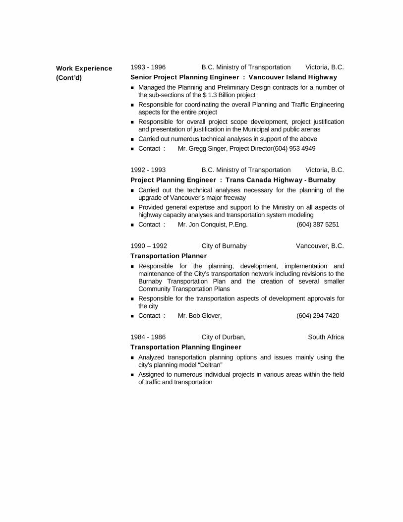
1993 - 1996 B.C. Ministry of Transportation Victoria, B.C. Senior Project Planning Engineer : Vancouver Island Highway
Managed the Planning and Preliminary Design contracts for a number of the sub-sections of the $ 1.3 Billion project
Responsible for coordinating the overall Planning and Traffic Engineering aspects for the entire project
Responsible for overall project scope development, project justification and presentation of justification in the Municipal and public arenas
Carried out numerous technical analyses in support of the above Contact : Mr. Gregg Singer, Project Director (604) 953 4949
1992 - 1993 B.C. Ministry of Transportation Victoria, B.C. Project Planning Engineer : Trans Canada Highway - Burnaby
Carried out the technical analyses necessary for the planning of the upgrade of Vancouver’s major freeway
Provided general expertise and support to the Ministry on all aspects of highway capacity analyses and transportation system modeling
Contact : Mr. Jon Conquist, P.Eng. (604) 387 5251
1990 – 1992 City of Burnaby Vancouver, B.C. Transportation Planner
Responsible for the planning, development, implementation and maintenance of the City’s transportation network including revisions to the Burnaby Transportation Plan and the creation of several smaller Community Transportation Plans
Responsible for the transportation aspects of development approvals for the city
Contact : Mr. Bob Glover, (604) 294 7420
1984 - 1986 City of Durban, South Africa Transportation Planning Engineer
Analyzed transportation planning options and issues mainly using the city’s planning model “Deltran”
Assigned to numerous individual projects in various areas within the field of traffic and transportation
Work Experience (Cont’d)
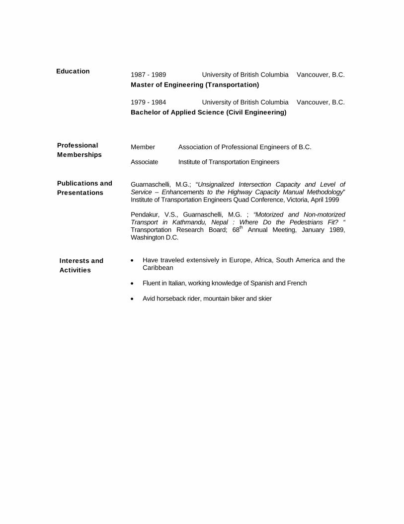
1987 - 1989 University of British Columbia Vancouver, B.C. Master of Engineering (Transportation)
1979 - 1984 University of British Columbia Vancouver, B.C. Bachelor of Applied Science (Civil Engineering)
Member Association of Professional Engineers of B.C.
Associate Institute of Transportation Engineers
Guarnaschelli, M.G.; “Unsignalized Intersection Capacity and Level of Service – Enhancements to the Highway Capacity Manual Methodology” Institute of Transportation Engineers Quad Conference, Victoria, April 1999
Pendakur, V.S., Guarnaschelli, M.G. ; “Motorized and Non-motorized Transport in Kathmandu, Nepal : Where Do the Pedestrians Fit? “ Transportation Research Board; 68th Annual Meeting, January 1989, Washington D.C.
• Have traveled extensively in Europe, Africa, South America and the Caribbean
• Fluent in Italian, working knowledge of Spanish and French
• Avid horseback rider, mountain biker and skier
Education
Professional Memberships
Publications and Presentations
Interests and Activities
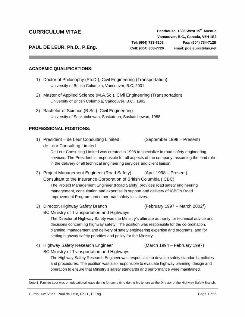
Curriculum Vitae: Paul de Leur, Ph.D., P.Eng. Page 1 of 6
CURRICULUM VITAE PAUL DE LEUR, Ph.D., P.Eng.
ACADEMIC QUALIFICATIONS:
1) Doctor of Philosophy (Ph.D.), Civil Engineering (Transportation) University of British Columbia, Vancouver, B.C, 2001
2) Master of Applied Science (M.A.Sc.), Civil Engineering (Transportation) University of British Columbia, Vancouver, B.C., 1992
3) Bachelor of Science (B.Sc.), Civil Engineering University of Saskatchewan, Saskatoon, Saskatchewan, 1988 PROFESSIONAL POSITIONS:
1) President – de Leur Consulting Limited (September 1998 – Present) de Leur Consulting Limited
De Leur Consulting Limited was created in 1998 to specialize in road safety engineering services. The President is responsible for all aspects of the company, assuming the lead role in the delivery of all technical engineering services and client liaison.
2) Project Management Engineer (Road Safety) (April 1998 – Present) Consultant to the Insurance Corporation of British Columbia (ICBC)
The Project Management Engineer (Road Safety) provides road safety engineering management, consultation and expertise in support and delivery of ICBC’s Road Improvement Program and other road safety initiatives.
3) Director, Highway Safety Branch (February 1997 – March 20021) BC Ministry of Transportation and Highways
The Director of Highway Safety was the Ministry’s ultimate authority for technical advice and decisions concerning highway safety. The position was responsible for the co-ordination, planning, management and delivery of safety engineering expertise and programs, and for setting highway safety priorities and policy for the Ministry.
4) Highway Safety Research Engineer (March 1994 – February 1997) BC Ministry of Transportation and Highways
The Highway Safety Research Engineer was responsible to develop safety standards, policies and procedures. The position was also responsible to evaluate highway planning, design and operation to ensure that Ministry’s safety standards and performance were maintained.
Note 1: Paul de Leur was on educational leave during for some time during his tenure as the Director of the Highway Safety Branch.
Penthouse, 1385 West 15th Avenue Vancouver, B.C., Canada, V6H 1S2
Tel: (604) 733-7108 Fax: (604) 734-7128 Cell: (604) 803-7726 email: [email protected]

Curriculum Vitae: Paul de Leur, Ph.D., P.Eng. Page 2 of 6
RECENT PROFESSIONAL EXPERIENCE:
1) Transportation Engineering Management, Evaluation and Analysis The following sample of projects involved the explicit evaluation of safety. The duties typically required the evaluation of the historical safety performance and a determination of how the location(s) was performing relative to expected normal value. In addition, many of the projects involved the analysis and prediction of future safety performance based on the specific design characteristics of the design(s), which was completed using safety modeling techniques (e.g., collision prediction models and collision modification factors). Many of the projects also involved some cursory research to examine the safety effect of design elements on safety performance. More detail concerning the specifics of any projects is available upon request.
- South Fraser Perimeter Road (SFPR), Gateway Program, British Columbia - CH2MHill for the BC Ministry of Transportation (2007 - 2008)
- Kicking Horse Canyon Project (TCH): Golden, British Columbia - FOCUS Engineering for the BC Ministry of Transportation (2006 - 2008)
- Sea to Sky Highway Improvement Project (Highway 99): Vancouver to Whistler - SNC Lavalin for the BC Ministry of Transportation (2005 - 2008)
- Coast Meridian Overpass Design: City of Port Coquitlam - Urban Systems for the City of Port Coquitlam (2005 - 2006)
- Donald Bridge Rehabilitation: Highway 1: West of Golden, British Columbia - NOVATrans Engineering for the BC Ministry of Transportation (2006)
- Cathedral Grove Provincial Park (Highway 4): Safety Assessment, Vancouver Island - BC Ministry of Environment (2006)
- Highway 97 at Crosier Road, Northern British Columbia - IBI Engineering for the BC Ministry of Transportation (2006)
- Trans Canada Lighting Review, Port Mann Bridge to Second Narrows Bridge - DMD and Associates ltd. For the BC Ministry of Transportation (2006)
- Okanagan Lake Bridge (Highway 97), Kelowna, British Columbia - EVM Management Ltd. for the BC Ministry of Transportation (2005)
- Highway 97: Clinton to Lac la Hache Northern British Columbia - IBI Engineering for the BC Ministry of Transportation (2005)
- Marine Way Pedestrian Safety Assessment, New Westminster, British Columbia - ASSOCIATED Engineering for the BC Ministry of Transportation (2005)
- Pattulla Bridge: Rehabilitation and Safety Improvements, New Westminster, British Columbia - ASSOCIATED Engineering for Translink (2005)
- King George Highway at 88th Avenue, Surrey, British Columbia - TSI Engineering for the BC Ministry of Transportation (2005)
- Highway 97C at Garcia Road, Northern British Columbia - IBI Engineering for the BC Ministry of Transportation (2005)
- Trans Canada Highway at 192 Overpass, Surrey, British Columbia - TSI Engineering for the BC Ministry of Transportation (2005)
- Highway 91/91A Queensborough Bridge, New Westminster, British Columbia - ASSOCIATED Engineering for the BC Ministry of Transportation (2004)
- Fernan Lake Road Safety Improvements, Fernan Lake, Idaho, USA - EARTHTECH Engineering for the Idaho Department of Transportation (2003)

Curriculum Vitae: Paul de Leur, Ph.D., P.Eng. Page 3 of 6
2) Road Safety Audits The following is a sample of Road Safety Audit Projects that have been completed. It is noted that the ICBC Annual Municipal Road Safety Audit Program typically completes over 15 audits per year for various municipalities within British Columbia. To date, over 120 Road Safety Audits have been completed and a complete listing is available upon request.
- ICBC Annual Municipal Road Safety Audit Program (2001 – 2008) - Trans Canada: Hilltop Road to Balmoral Road, Salmon Arm, British Columbia (2008) - Trans Canada: 156th Street Underpass, Surrey, British Columbia (2008) - Highway 97: 100th Avenue to Road 261: Fort St. John, British Columbia (2007) - 104th Avenue: Scott Road to 128th Street, Surrey, British Columbia (2007) - Intersection of 2nd Avenue at 4th Avenue, City of Whitehorse, Yukon (2006) - Rabbits Foot Canyon, Yukon Territories (2006) - Qualicum Beach Development: Ring Road from Highway 19 to Rupert Street (2005) - Highway 97 in the area of 103 Mile Hill: Phase 1, 100 Mile House, British Columbia (2005) - Old Hope Princeton Way, Hope, British Columbia (2004) - Lougheed Highway: 285th to Silverdale / McLean, Mission British, Columbia (2004) - Highway 11 Widening, Mission British, Columbia (2004) - Trans Canada at the 200th Street Interchange, Surrey British Columbia (2003)
3) Value Analysis / Value Engineering Several Value Analysis (VA) and Value Engineering (VE) assignments have been completed over the years as shown in the list below. Included in the VA / VE assignments was the quantification of safety benefits or dis-benefits associated with the base design and the various design proposals that were generated as part of the VA / VA sessions.
- Highway 97: Road 261 to Charlie Lake Road (Phase 2), Fort St. John (2008) - Highway 97: 100th Avenue to Road 261 (Phase 1), Fort St. John (2007) - Highway 97: Bennett Creek to Link Creek (Pine Pass area), Northern British Columbia (2006) - Highway 97: Bentley Road to Okanagan Lake Park, Summerland, British Columbia (2006) - Wright Station Curves (Highway 97), Northern British Columbia (2006) - Cariboo Connector (Highway 97), Northern British Columbia (2005) - Horse Lake Road and Highway 97, 100 Mile House, British Columbia (2005) - Sea to Sky Highway Improvements (Highway 99), Vancouver to Whistler (2003 – 2005)
4) Research and Evaluation Several research and evaluation projects have been completed, as shown in the listing below. The details of each project are available upon request and many of the projects have been described in a research paper, as listed in a subsequent section of this curriculum vita.
- Technical Advisor to the Expansion of the Intersection Safety Camera Program (ICBC) (2008) - Review of Transport Canada’s RSV2010 Targets for the BC Ministry of Transportation (2008) - Safety Implications of Bypass Lane Design, Yukon Territories (2007) - Evaluation of Roadway Pavement Markings, BC Ministry of Transportation (2006) - Evaluation of the Safety Effect of Wildlife Fencing, BC Ministry of Transportation (2005 – 2006) - Edmonton Photo Radar Evaluation, Edmonton Police Commission (2006) - Safety Effect of Roadway Lighting, BC Ministry of Transportation (2006) - Wire Rope Safety Fence Evaluation, BC Ministry of Transportation (2005) - Placement of Barriers at Interchanges, BC Ministry of Transportation (2004) - Safety Input to Context Sensitive Design Guidelines, BC Ministry of Transportation (2003)
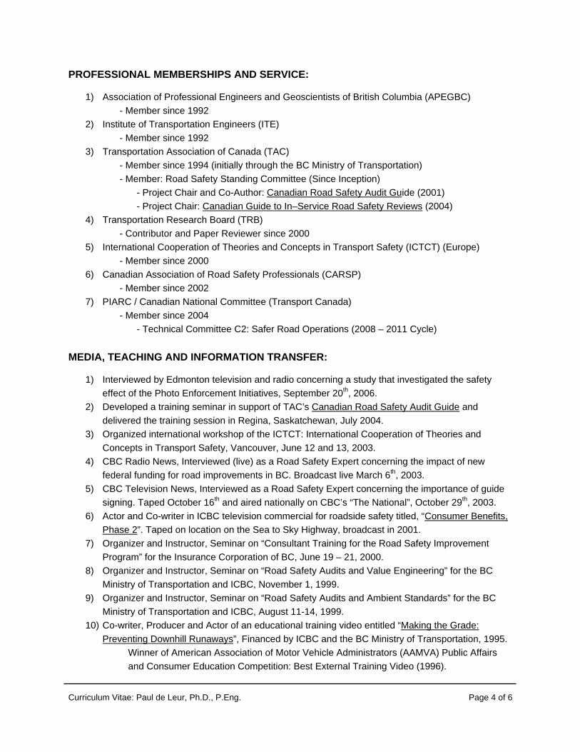
Curriculum Vitae: Paul de Leur, Ph.D., P.Eng. Page 4 of 6
PROFESSIONAL MEMBERSHIPS AND SERVICE:
1) Association of Professional Engineers and Geoscientists of British Columbia (APEGBC) - Member since 1992
2) Institute of Transportation Engineers (ITE) - Member since 1992 3) Transportation Association of Canada (TAC) - Member since 1994 (initially through the BC Ministry of Transportation) - Member: Road Safety Standing Committee (Since Inception) - Project Chair and Co-Author: Canadian Road Safety Audit Guide (2001) - Project Chair: Canadian Guide to In–Service Road Safety Reviews (2004) 4) Transportation Research Board (TRB) - Contributor and Paper Reviewer since 2000 5) International Cooperation of Theories and Concepts in Transport Safety (ICTCT) (Europe)
- Member since 2000 6) Canadian Association of Road Safety Professionals (CARSP)
- Member since 2002 7) PIARC / Canadian National Committee (Transport Canada) - Member since 2004 - Technical Committee C2: Safer Road Operations (2008 – 2011 Cycle)
MEDIA, TEACHING AND INFORMATION TRANSFER:
1) Interviewed by Edmonton television and radio concerning a study that investigated the safety effect of the Photo Enforcement Initiatives, September 20th, 2006.
2) Developed a training seminar in support of TAC’s Canadian Road Safety Audit Guide and delivered the training session in Regina, Saskatchewan, July 2004.
3) Organized international workshop of the ICTCT: International Cooperation of Theories and Concepts in Transport Safety, Vancouver, June 12 and 13, 2003.
4) CBC Radio News, Interviewed (live) as a Road Safety Expert concerning the impact of new federal funding for road improvements in BC. Broadcast live March 6th, 2003.
5) CBC Television News, Interviewed as a Road Safety Expert concerning the importance of guide signing. Taped October 16th and aired nationally on CBC’s “The National”, October 29th, 2003.
6) Actor and Co-writer in ICBC television commercial for roadside safety titled, “Consumer Benefits, Phase 2”. Taped on location on the Sea to Sky Highway, broadcast in 2001.
7) Organizer and Instructor, Seminar on “Consultant Training for the Road Safety Improvement Program” for the Insurance Corporation of BC, June 19 – 21, 2000.
8) Organizer and Instructor, Seminar on “Road Safety Audits and Value Engineering” for the BC Ministry of Transportation and ICBC, November 1, 1999.
9) Organizer and Instructor, Seminar on “Road Safety Audits and Ambient Standards” for the BC Ministry of Transportation and ICBC, August 11-14, 1999.
10) Co-writer, Producer and Actor of an educational training video entitled “Making the Grade: Preventing Downhill Runaways”, Financed by ICBC and the BC Ministry of Transportation, 1995.
Winner of American Association of Motor Vehicle Administrators (AAMVA) Public Affairs and Consumer Education Competition: Best External Training Video (1996).

Curriculum Vitae: Paul de Leur, Ph.D., P.Eng. Page 5 of 6
RECENT PUBLICATIONS:
1) Refereed Journals
1. Sayed, T., and de Leur, P. (2006), “Evaluation of Edmonton’s Intersection Safety Camera Program”, Transportation Research Record Number 2009, Journal of the Transportation Research Board (TRB), pages 37-45, 2007.
2. Sayed, T., and de Leur, P. (2005), “Predicting the Safety Performance Associated with Highway Design Decisions: A Case Study of the Sea to Sky Highway”, The Canadian Journal of Civil Engineering, Volume Number 32 (4), April 2005, pages 352 – 360, 2005.
3. Sayed, T., de Leur, P. and Sawalha, A. (2004), “Evaluating the Insurance Corporation of British Columbia (ICBC) Road Safety Improvement Program”, Transportation Research Record Number 1865, Journal of the Transportation Research Board (TRB), pages 57-63, 2004.
4. de Leur , P., and Sayed, T. (2003), “A Framework to Proactively Consider Road Safety within the Roadway Planning Process”, The Canadian Journal of Civil Engineering, Volume Number 30 (4), pages 711-719, 2003.
5. Lin, F., Sayed, T., and de Leur, P. (2003), “Estimating the Safety Benefits of Road Improvements: A Case Based Approach”, The American Society of Civil Engineering (ASCE): Journal of Transportation Engineers, Volume 129, Issue 4, pages 385 – 391, July / August 2003.
6. de Leur, P., and Sayed, T. (2002), “The Development of a Road Safety Risk Index”, Transportation Research Record Number 1784, Journal of the Transportation Research Board (TRB), pages 33 – 42, 2002.
7. de Leur, P., and Sayed, T. (2001) “Using An Auto Insurance Claims Prediction Model for Road Safety Evaluation”, The Canadian Journal of Civil Engineering (CJCE), Volume Number 28 (5), pages 804-812, 2001.
8. de Leur, P., Abdelwahab, W., and Navin, F., (1994) “Evaluating Hazardous Roadsides Using Computer Simulation”, American Society of Civil Engineers (ASCE), Journal of Transportation Engineers, Vol. 120(2), pp. 229 – 245, 1994.
2) Conference Proceedings (Abstract and Paper are refereed)
9. de Leur, P. (2008), “Integrating Road Safety Audits and Value Engineering”, 2008 Technical Conference and Exhibit Compendium of Papers, Institute of Transportation Engineers (ITE), Miami, Florida, USA , April 2008.
10. Sayed, T., de Leur, P., and Pump, J. (2008) “Proven Benefits In Road Safety Improvement Programs”, Proceedings of the 87th Annual Meeting of the Transportation Research Board, Washington DC, January 2008.
11. de Leur, P., and Sayed, T. (2004), “Road Safety Performance Associated With Traffic Signal Design”, Proceedings of the 2004 Society of Italian Infrastructure (SIIV), New Technologies, Florence, Italy, October 27 – 29, 2004.
12. Sayed, T., and de Leur, P. (2003), “The Successful Application of Road Safety Research to Improve the Sea to Sky Highway, British Columbia, Canada, 16th Annual ICTCT Workshop, Soesterberg, The Netherlands, October 29 – November 1, 2003.
Curriculum Vitae: Paul de Leur, Ph.D., P.Eng. Page 6 of 6
13. de Leur, P., and Sayed, T. (2002), “Developing a Systematic Framework for Proactive Road Safety Planning”, Proceedings of the 2002 Annual Meeting of the Transportation Research Board, Washington DC, USA, January 13-17, 2002.
14. de Leur, P., (2002), “The Canadian Road Safety Audit Guide (TAC)”, Included in the Proceedings of the 2002 Annual Meeting of the Transportation Research Board (TRB), Washington DC, USA, January 13-17, 2002.
15. Lin, F., Sayed, T., and de Leur, P. (2001), “Pre-Implementation Evaluation of Roadway Safety Improvements”, Proceedings of the 80th TRB Annual Meeting, Transportation Research Board, Washington DC, USA, January 7 – 11, (proceedings published on CD).
16. Miska, E., de Leur, P., and Sayed, T., (2001), Safety Performance Associated with Improved Traffic Signal Design and Increase Signal Conspicuity, ITE Annual Meeting and Exhibit, Philadelphia Pennsylvania, Compendium of Technical Papers, 2001.
17. de Leur, P., and Sayed, T. (2001) “Auto Insurance Claims Prediction Models”, Proceedings of the 80th TRB Annual Meeting, Transportation Research Board, Washington DC, USA, January 7 – 11, (proceedings published on CD), 2001.
18. de Leur, P., and Sayed, T. (2000), “Developing a Effective Process for Proactive Road Safety Planning”, Proceedings of the 13th Annual International Conference of the ICTCT, Corfu, Greece, October 5 and 6, 2000.
19. de Leur, P., Yee, H., and Sayed, T., (1996) “Guidelines for Locating, Designing and Maintaining Truck Runaway Lanes”, Proceedings of the 1996 Annual Conference, Transportation Association of Canada (TAC) Annual Conference, Charlottetown, PEI, Canada, October 6-9, 1996.
20. de Leur, P., Holowachuk, L., and Sayed, T. (1995) “Enhancing Safety for Trucking Operations on Steep Grades in BC”, Proceedings of the Annual Conference, Transportation Association of Canada (TAC), Victoria, BC, Canada, October 22-25, Volume 5, pp. A51 – A66, 1995.
3) Sample of Other / Important Published Work
21. Sayed, T., and de Leur, P., (2006) “ICBC 2006 Road Improvement Program Evaluation” Report prepared for the Insurance Corporation of British Columbia
22. Sayed, T., and de Leur, P., (2006) “Evaluation of Edmonton’s Photo Enforcement Initiatives”, Edmonton Police Commission, 2006.
23. de Leur, P., Ho, G., and Zein, S., (2001) “The Canadian Road Safety Audit Guide”, National Manual prepared for the Transportation Association of Canada (TAC).
24. Sayed, T., and de Leur, P., (2001) “ICBC 2000 Road Improvement Program Evaluation” Report prepared for the Insurance Corporation of British Columbia.
25. Ho, G., de Leur, P., and Sayed, T., (2000) “Trans-Link Strategic Transportation Plan: Managing Road Safety: Technical Memorandum Number 34”, prepared for Trans-Link BC.
26. de Leur, P., and Sayed, T. (2000) “A Framework for Proactive Road Safety Planning” Report prepared for the Insurance Corporation of British Columbia (ICBC).