ohio rapid assessment method for wetlands v. 5 ohio rapid assessment method for wetlands v. 5.0...
TRANSCRIPT

State of Ohio 401/Wetland Ecology UnitEnvironmental Protection Agency Division of Surface Water
Ohio Rapid Assessment Method for Wetlands v. 5.0
User's Manual and Scoring Forms
February 1, 2001
Robert A. Taft, Governor Christopher Jones, DirectorState of Ohio Environmental Protection Agency
P.O. Box 1049, Lazarus Government Center, 122 S. Front Street, Columbus, Ohio 43216-1049 ————————————————————————————————————————————————
ii
Ohio Rapid Assessment Method for Wetlands v. 5.0
User's Manual and Scoring Forms
February 1, 2001
401/Wetland Ecology UnitDivision of Surface Water
Lazarus Government CenterP.O. Box 1049
122 S. Front StreetColumbus, Ohio 43216-1049
Robert A. Taft, Governor Christopher Jones, DirectorState of Ohio Environmental Protection Agency
iii
Appropriate Citation:
Mack, John J. 2001. Ohio Rapid Assessment Method for Wetlands, Manual for Using Version 5.0. Ohio EPA Technical Bulletin Wetland/2001-1-1. Ohio Environmental Protection Agency, Division ofSurface Water, 401 Wetland Ecology Unit, Columbus, Ohio.
This entire document including scoring forms can be downloaded from the website of the Ohio EPA,Division of Surface Water:
http://www.epa.ohio.gov/dsw/401/index.aspx

iv
Acknowledgments
John J. Mack authored this publication. The author would also like to credit the authors of theWashington State Wetland Rating System. The Qualitative Habitat Evaluation Index (QHEI) for streams(Rankin 1989), developed by Edward Rankin, Ohio EPA, provided considerable inspiriation. KellyCapuzzi, Ohio EPA, authored portions of the coastal marshes and oak openings questions. MickMicacchion of Ohio EPA's Wetland Ecology Unit provided invaluable assistance in developing and fieldtesting this method.
Earlier versions of this method (1.0, 2.0, 3.0, 4.0, 4.1) were very similar to the Washington State WetlandRating System, Second Edition Washington State Department of Ecology, 1993. Version 5.0represents a substantial departure from the format and structure of the Washington Rating Systemalthough elements still remain. Text in Section 5.0 was borrowed and paraphrased from theWashington Rating System manual; images in Section 5.0 were scanned and imported from theWashington Rating System manual.
The Ohio Rapid Assessment Method for Wetlands could not have been developed without theassistance of Ohio EPA's 401/Wetland Ecology Unit including Laura Fay, Tom Harcarik, AmyHoltshouse, Linda Merchant, Dan Osterfeld, Ric Queen, Michael Smith, and Holly Tucker, and the pastand present members of the Ohio Rapid Assessment Method Workgroup:
Sandy Doyle-Ahern EMH & T, Inc.John Baird Ohio Department of TransportationKim Baker Ohio Department of Natural ResourcesJim Blake U.S. Army Corps of Engineers, Huntington DistrictTodd Crandall Davey Resource GroupMark DeBrock Natural Resource Conservation ServiceM. Siobhan Fennessy Kenyon College, formerly of Ohio EPAJohn Kiertscher Envirotech Consultants, IncRoy Kroll Winous Point Marsh ConservancyKen Lammers U.S. Fish and Wildlife ServiceJohn Marshall Ohio Department of Natural ResourcesMick Micacchion Ohio Environmental Protection AgencyKathleen Ryan U.S. Army Corps of Engineers, Buffalo DistrictRay Showman American Electric PowerJulie Sibbing National Audobon SocietyMegan Sullivan U.S. Fish and Wildlife ServiceMark Taylor U.S. Army Corps of Engineers, Huntington DistrictKaren Wise Davey Resource Group

v
OHIO ENVIRONMENTAL PROTECTION AGENCY
Division of Surface Water401/Wetland Ecology UnitLazarus Government Center122 S. Front StreetP.O. Box 1049Columbus, Ohio 43216-1049(614) 644-2001(614) 644-2745(fax)http://www.epa.ohio.gov/dsw/401/index.aspxhttp://www.epa.ohio.gov/
OHIO DEPARTMENT OF NATURAL RESOURCES
Division of Natural Areas and PreservesData ServicesNatural Heritage Program1889 Fountain Square Court, Bldg. F-1Columbus, Ohio 43224-1331614-265-6453http://www.dnr.state.oh.us/odnr/dnap/
Division of WildlifeCentral Office1840 Belcher Drive, Bldg. G-3Columbus OH 43224-1329614-265-6300http://www.dnr.state.oh.us/odnr/wildlife/
CoordinatorNational Waterfowl Management Plan - OhioOhio Division of Wildlife1840 Belcher DriveColumbus, OH 43224-1329614-265-6330 (phone)614- 262-1143 (fax).
U.S. ARMY CORPS OF ENGINEERS
Buffalo District(Lake Erie Basin)1776 Niagara StreetBuffalo, NY 14207-3199(716) 879-4330
Huntington District(Muskingum, Hocking, Scioto R. Basins)502 Eighth StreetATTN: CEORH-OR-FHuntington, WV 25701-2070(304) 529-5210
Louisville District(Little and Great Miami R. Basins)CEORL-OR-FP.O. Box 59Louisville, KY 40201-0059(502) 582-5607
Pittsburgh District(Mahoning River Basin)William S. Moorehead Federal Bldg.1000 Liberty AvenuePittsburgh, PA 15222-4186(412) 644-7182
U.S. FISH AND WILDLIFE SERVICE
Washington, D.C. Office Division of Endangered Species Mail Stop 420ARLSQ 1849 C St., NWWashington, D.C. 20240
Region Three Ecological Services Operations Federal BuildingFt. Snelling, Twin Cities, MN 55111
Reynoldsburg Ecological Services Field Office6950 Americana Parkway, Suite HReynoldsburg, OH 43068-4132Phone: (614) 469-6923Fax: (614) 469-6919
Migratory Bird CoordinatorU.S. Fish and Wildlife ServiceBHW Federal Building, 1 Federal DriveFort Snelling, MN 55111-4056Phone: (612) 713-5458Fax: (612) 713-5286
Joint Venture CoordinatorNational Waterfowl Management Plan - OhioU.S. Fish and Wildlife ServiceBHW Federal Building1 Federal DriveFort Snelling, MN 55111-4056612- 713-5433 (phone)612- 713-5286 (fax).

vi
Table of Contents
Acknowledgments . . . . . . . . . . . . . . . . . . . . . . . . . . . . . . . . . . . . . . . . . . . . . . . . . . . . . . . . . . . . . . . . . . . iv
1.0 INTRODUCTION. . . . . . . . . . . . . . . . . . . . . . . . . . . . . . . . . . . . . . . . . . . . . . . . . . . . . . . . . . . . . . 11.1 Ohio’s Wetland Categorization Scheme. . . . . . . . . . . . . . . . . . . . . . . . . . . . . . . . . . . . . . . . . 11.2 Sequence of Review under Wetland Antidegradation Rule. . . . . . . . . . . . . . . . . . . . . . . . . 31.3 Relationship to Earlier Versions of the ORAM. . . . . . . . . . . . . . . . . . . . . . . . . . . . . . . . . . . . 71.4 Cautionary Statement. . . . . . . . . . . . . . . . . . . . . . . . . . . . . . . . . . . . . . . . . . . . . . . . . . . . . . 10
2.0 INTERPRETING THE RESULTS OF THE ORAM. . . . . . . . . . . . . . . . . . . . . . . . . . . . . . . . . . . . . . 122.1 Interpreting the Narrative Rating Answers. . . . . . . . . . . . . . . . . . . . . . . . . . . . . . . . . . . . . . 12
2.1.1 The wetland is a Category 1 wetland. . . . . . . . . . . . . . . . . . . . . . . . . . . . . . . . . . 122.1.2 The wetland should be evaluated for possible Category 3 status. . . . . . . . . . . . 132.1.3 The wetland is a Category 3 wetland. . . . . . . . . . . . . . . . . . . . . . . . . . . . . . . . . . 13
2.2 Quantitative Rating. . . . . . . . . . . . . . . . . . . . . . . . . . . . . . . . . . . . . . . . . . . . . . . . . . . . . . . . 132.2.1 General considerations for the quantitative score. . . . . . . . . . . . . . . . . . . . . . . . 132.2.2 Interpreting and applying the quantitative score. . . . . . . . . . . . . . . . . . . . . . . . . 15
2.3 Problem situations and reevaluation of ORAM categorization. . . . . . . . . . . . . . . . . . . . . . 152.4 Seasonality, Droughts and Floods. . . . . . . . . . . . . . . . . . . . . . . . . . . . . . . . . . . . . . . . . . . . 16
3.0 HOW TO USE THE ORAM AND THIS USER’S MANUAL. . . . . . . . . . . . . . . . . . . . . . . . . . . . . . . . 17
4.0 BACKGROUND INFORMATION. . . . . . . . . . . . . . . . . . . . . . . . . . . . . . . . . . . . . . . . . . . . . . . . . . . . 19
5.0 DETERMINING THE SCORING BOUNDARIES. . . . . . . . . . . . . . . . . . . . . . . . . . . . . . . . . . . . . . . 215.1 General Guidelines. . . . . . . . . . . . . . . . . . . . . . . . . . . . . . . . . . . . . . . . . . . . . . . . . . . . . . . . 215.2 Wetlands that form a Patchwork on the Landscape. . . . . . . . . . . . . . . . . . . . . . . . . . . . . . 225.3 Wetlands divided by artificial boundaries. . . . . . . . . . . . . . . . . . . . . . . . . . . . . . . . . . . . . . . 235.4 Wetlands contiguous with an area of open water . . . . . . . . . . . . . . . . . . . . . . . . . . . . . . . . 23
5.4.1 The area of open water is less than or equal to 20 acres in size. . . . . . . . . . . . 235.4.2 The area of open water is greater than 20 acres in size. . . . . . . . . . . . . . . . . . . 24
5.5 Wetlands contiguous to a stream, river or ditch. . . . . . . . . . . . . . . . . . . . . . . . . . . . . . . . . . 245.6 Estuarine Wetlands. . . . . . . . . . . . . . . . . . . . . . . . . . . . . . . . . . . . . . . . . . . . . . . . . . . . . . . 255.7 Scoring Boundaries where only part of a wetland is Category 3. . . . . . . . . . . . . . . . . . . . . 25
6.0 NARRATIVE RATING. . . . . . . . . . . . . . . . . . . . . . . . . . . . . . . . . . . . . . . . . . . . . . . . . . . . . . . . . . . . 276.1 Critical Habitat. . . . . . . . . . . . . . . . . . . . . . . . . . . . . . . . . . . . . . . . . . . . . . . . . . . . . . . . . . . . 276.2 State or Federal Threatened or Endangered Species. . . . . . . . . . . . . . . . . . . . . . . . . . . . . 286.3 High Quality Wetlands. . . . . . . . . . . . . . . . . . . . . . . . . . . . . . . . . . . . . . . . . . . . . . . . . . . . . 286.4 Significant breeding/nonbreeding bird concentration areas. . . . . . . . . . . . . . . . . . . . . . . . 296.5 Category 1 Wetlands. . . . . . . . . . . . . . . . . . . . . . . . . . . . . . . . . . . . . . . . . . . . . . . . . . . . . . 296.6 Bogs. . . . . . . . . . . . . . . . . . . . . . . . . . . . . . . . . . . . . . . . . . . . . . . . . . . . . . . . . . . . . . . . . . . 306.7 Fens. . . . . . . . . . . . . . . . . . . . . . . . . . . . . . . . . . . . . . . . . . . . . . . . . . . . . . . . . . . . . . . . . . . 326.8 Old Growth and Mature Forested Wetlands. . . . . . . . . . . . . . . . . . . . . . . . . . . . . . . . . . . . . 33
6.8.1 Old Growth Forests. . . . . . . . . . . . . . . . . . . . . . . . . . . . . . . . . . . . . . . . . . . . . . . . 336.8.2 Mature Forested Wetlands. . . . . . . . . . . . . . . . . . . . . . . . . . . . . . . . . . . . . . . . . . 35
6.9 Lake Erie Coastal and Tributary Wetlands. . . . . . . . . . . . . . . . . . . . . . . . . . . . . . . . . . . . . 366.10 Lake Plains Sand Prairies (Oak Openings). . . . . . . . . . . . . . . . . . . . . . . . . . . . . . . . . . . . 376.11 Relict Wet Prairies. . . . . . . . . . . . . . . . . . . . . . . . . . . . . . . . . . . . . . . . . . . . . . . . . . . . . . . 37

vii
7.0 QUANTITATIVE RATING. . . . . . . . . . . . . . . . . . . . . . . . . . . . . . . . . . . . . . . . . . . . . . . . . . . . . . . . . 387.1 Metric 1: Wetland Size. . . . . . . . . . . . . . . . . . . . . . . . . . . . . . . . . . . . . . . . . . . . . . . . . . . . . 387.2 Metric 2: Upland Buffers and Surrounding Land Use. . . . . . . . . . . . . . . . . . . . . . . . . . . . . 38
7.2.1 Question 2a: Average Buffer Width. . . . . . . . . . . . . . . . . . . . . . . . . . . . . . . . . . . 397.2.2 Question 2b: Intensity of Predominant Surrounding Land Use(s). . . . . . . . . . . 39
7.3 Metric 3: Hydrology. . . . . . . . . . . . . . . . . . . . . . . . . . . . . . . . . . . . . . . . . . . . . . . . . . . . . . . 407.3.1 Question 3a: Sources of Water. . . . . . . . . . . . . . . . . . . . . . . . . . . . . . . . . . . . . 40
7.3.1.1 High pH Groundwater . . . . . . . . . . . . . . . . . . . . . . . . . . . . . . . . . . . . . 417.3.1.2 Other Groundwater . . . . . . . . . . . . . . . . . . . . . . . . . . . . . . . . . . . . . . . 417.3.1.3 Precipitation . . . . . . . . . . . . . . . . . . . . . . . . . . . . . . . . . . . . . . . . . . . . . 427.3.1.4 Seasonal Surface Water . . . . . . . . . . . . . . . . . . . . . . . . . . . . . . . . . . . 427.3.1.5 Perennial Surface Water (lake or stream) . . . . . . . . . . . . . . . . . . . . . 42
7.3.2 Question 3b: Connectivity. . . . . . . . . . . . . . . . . . . . . . . . . . . . . . . . . . . . . . . . . . 427.3.3 Question 3c: Maximum Water Depth. . . . . . . . . . . . . . . . . . . . . . . . . . . . . . . . . 447.3.4 Question 3d: Duration of Standing Water/Saturation . . . . . . . . . . . . . . . . . . . . . 447.3.5 Question 3e: Modifications to Natural Hydrologic Regime. . . . . . . . . . . . . . . . . 44
7.4 Metric 4: Habitat Alteration and Development . . . . . . . . . . . . . . . . . . . . . . . . . . . . . . . . . . 477.4.1 Question 4a: Substrate/Soil Disturbance . . . . . . . . . . . . . . . . . . . . . . . . . . . . . . 477.4.2 Question 4b: Habitat Development. . . . . . . . . . . . . . . . . . . . . . . . . . . . . . . . . . 487.4.3 Question 4c: Habitat alteration. . . . . . . . . . . . . . . . . . . . . . . . . . . . . . . . . . . . . . 48
7.5 Metric 5: Special Wetland Communities. . . . . . . . . . . . . . . . . . . . . . . . . . . . . . . . . . . . . . . 507.6 Metric 6: Vegetation, Interspersion, and Microtopography. . . . . . . . . . . . . . . . . . . . . . . . 51
7.6.1 Question 6a: Wetland Plant Communities. . . . . . . . . . . . . . . . . . . . . . . . . . . . . 517.6.1.1 Aquatic Bed Class. . . . . . . . . . . . . . . . . . . . . . . . . . . . . . . . . . . . . . . . 517.6.1.2 Emergent Class. . . . . . . . . . . . . . . . . . . . . . . . . . . . . . . . . . . . . . . . . . 527.6.1.3 Shrub Class. . . . . . . . . . . . . . . . . . . . . . . . . . . . . . . . . . . . . . . . . . . . . 527.6.1.4 Forested Class. . . . . . . . . . . . . . . . . . . . . . . . . . . . . . . . . . . . . . . . . . . 527.6.1.5 Mudflat Class. . . . . . . . . . . . . . . . . . . . . . . . . . . . . . . . . . . . . . . . . . . . 537.6.1.6 Open Water Class. . . . . . . . . . . . . . . . . . . . . . . . . . . . . . . . . . . . . . . . 537.6.1.7 Other Classes Not Listed. . . . . . . . . . . . . . . . . . . . . . . . . . . . . . . . . . . 53
7.6.2 Question 6a continued: Assigning Points to Vegetation Communities. . . . . . . . 547.6.2.1 Assigning a "0" score. . . . . . . . . . . . . . . . . . . . . . . . . . . . . . . . . . . . . . 567.6.2.2 Assigning a "1" score. . . . . . . . . . . . . . . . . . . . . . . . . . . . . . . . . . . . . . 567.6.2.3 Assigning a "2" score. . . . . . . . . . . . . . . . . . . . . . . . . . . . . . . . . . . . . . 577.6.2.4 Assigning a "3" score. . . . . . . . . . . . . . . . . . . . . . . . . . . . . . . . . . . . . . 58
7.6.3 Question 6b: Horizontal (plan view) community interspersion. . . . . . . . . . . . . . 587.6.4 Question 6c: Coverage of Invasive Plant Species. . . . . . . . . . . . . . . . . . . . . . . 597.6.5 Question 6d: Microtopography. . . . . . . . . . . . . . . . . . . . . . . . . . . . . . . . . . . . . . 60
8.0 REFERENCES. . . . . . . . . . . . . . . . . . . . . . . . . . . . . . . . . . . . . . . . . . . . . . . . . . . . . . . . . . . . . . . . . 61
9.0 APPENDICES. . . . . . . . . . . . . . . . . . . . . . . . . . . . . . . . . . . . . . . . . . . . . . . . . . . . . . . . . . . . . . . . . . 63
viii
List of Tables
Table 1. Decision Matrix for SEJ portion of Antidegradation Review.. . . . . . . . . . . . . . . . . . . . . . . . . . . 5Table 2. Comparison table between Version 4.0/4.1 and ORAM v. 5.0 . . . . . . . . . . . . . . . . . . . . . . . . . 9Table 3. Metrics in quantitative rating and the partitioning of the score . . . . . . . . . . . . . . . . . . . . . . . . 14Table 4. Decision table for determining a patchwork on the landscape . . . . . . . . . . . . . . . . . . . . . . . . 23Table 5. Characteristics of old-growth forests in the central hardwood forest region . . . . . . . . . . . . . . 35Table 7. Qualitative cover scale for vegetative comminutes. . . . . . . . . . . . . . . . . . . . . . . . . . . . . . . . . 55Table 8. Narrative descriptions of vegetation community quality. . . . . . . . . . . . . . . . . . . . . . . . . . . . . . 55Table 9. Mudflat and open water community quality. . . . . . . . . . . . . . . . . . . . . . . . . . . . . . . . . . . . . . . . 55Table 10. Cover scale for microtopographic habitat features. . . . . . . . . . . . . . . . . . . . . . . . . . . . . . . . 60
List of Figures
Figure 1. Boundaries for contiguous wetlands along a stream corridor or floodplain. . . . . . . . . . . . . . 21Figure 2. Scoring boundaries for wetlands located in a patchwork or mosaic on the landscape.. . . . . 22Figure 3. Scoring boundaries of wetlands contiguous to areas of open fresh water <20 acres.. . . . . . 24Figure 4. Scoring boundaries of wetlands contiguous to areas of open fresh water 20acres . . . . . . . . 24Figure 5. Scoring boundaries for wetlands contiguous to a stream or river. . . . . . . . . . . . . . . . . . . . . . 25Figure 6. Hypothetical wetland example for estimating average buffer width. . . . . . . . . . . . . . . . . . . . 39Figure 7. Hypothetical wetlands for estimating degree of interspersion. . . . . . . . . . . . . . . . . . . . . . . . . 59
1
1.0 INTRODUCTION.
The regulation of wetlands under the federal and state environmental laws, e.g. under Section 401 and404 of the Clean Water Act, has required the assessment of the function and quality of wetlands in orderto determine whether to permit the destruction, alteration, or degradation of a wetland and to determinethe appropriate level of mitigation that should be required. This type of assessment is different from thedelineation of whether a particular location is a "wetland" at all, i.e. a "jurisdictional" wetland. Delineationattempts to draw a line around a location to call what lies within the line a "wetland" and subject toprotection, and what lies outside the line, something else (typically upland areas).
Assessment attempts to determine the ecological quality and the level of function of a particular wetland. Among other things, the State of Ohio's Wetland Water Quality Standards require applicants to use "anappropriate wetland evaluation methodology acceptable to the director" to determine the appropriatecategory for the wetland which is the subject of the application. These methods are often called "rapidassessment methods." Ohio EPA has used a method developed by the State of Washington'sDepartment of Ecology (Washington DE 1993) and adapted it for use in Ohio as a "draft" Ohio RapidAssessment Method for Wetlands (ORAM) versions 1.0, 2.0, 3.0, 4.0 and 4.1 (Fennessy et al. 1998b). While still retaining some elements of the Washington State Wetlands Rating System, ORAM v. 5.0represents a substantial departure from its format and focus.
A serious question in the development of such assessment tools is their sensitivity, i.e. their ability todistinguish between wetlands of differing quality and disturbance levels in order to properly categorize asite. The development and use of rapid assessment methods is not meant to replace more detailedquantitative measures of ecosystem function. In fact, Ohio EPA has ongoing research to developnumeric biocriteria for wetlands and other more intensive measures of wetland function and condition.
The numeric score obtained from the Ohio Rapid Assessment Method for Wetlands (ORAM) is not, andshould not be considered, an absolute number with intrinsic meaning. The numeric score should beconsidered in light of other available information. The numeric score does however allow for relativecomparisons between wetlands to be made. Where ORAM scores fall at the "break points" betweenwetland categories, for example, between Category 1 and 2, or 2 and 3, the ORAM score, by itself, isnot sensitive enough to distinguish between wetland type and other assessment techniques andprofessional judgment will need to be used in categorizing the wetland.
This User's Manual is intended to explain the underlying scientific rationale for the ORAM, to providedetailed explanatory notes for the different sections and scores of the ORAM, and to aid in the consistentuse of the ORAM.
Ohio Administrative Code (OAC) Rule 3745-1-54 requires that "an appropriate wetland evaluationmethodology acceptable to the director" be used to determine the category of the wetland which is thesubject of the application. In general, Ohio EPA considers the ORAM to be "an appropriate wetlandevaluation methodology", however the appropriateness of its use, as with any assessment method,should be evaluated based on the conditions present at each particular wetland. Although this methodhas been developed for use in Ohio, it is a general wetland assessment tool and may have broadergeographic applications.
1.1 Ohio’s Wetland Categorization Scheme.
As with any attempt to differentiate wetlands based on some measure of "quality", there is considerablecontroversy over how such assessments should be performed and whether they should be performed atall. The ORAM has been developed to provide a relatively fast and easy method for determining theappropriate category of a particular wetland under the Wetland Antidegradation Rule, OAC Rule 3745-1-54. In order to properly use the ORAM, it is critical to understand the controlling rule language for
2
determining a wetland’s category. The various parts of the ORAM are intended to incorporate thenarrative descriptions by means of questions in the Narrative Rating Forms and the scoring scheme inthe Quantitative Rating Form. However, in the event of a conflict between the ORAM and the provisionsin the Wetland Water Quality Standards and Wetland Antidegradation Rule, the rule language shouldalways be considered controlling.
In Ohio, the Ohio Environmental Protection Agency (Ohio EPA) recently adopted regulations whichcategorize wetlands based on their quality and impose differing levels of protection based on thewetland's category (OAC rules 3745-1-50 through 3745-1-54). The regulations specify three wetlandcategories: Category 1, Category 2, and Category 3 wetlands. These categories correspond towetlands of low, medium and high "quality." In addition, there is an implied fourth category described inthe definition of Category 2 wetlands, i.e. wetlands that are degraded but restorable. These potentiallyrestorable wetlands are Category 2 wetlands and receive the same level of regulatory protection as otherCategory 2 wetlands.
Category 1 Wetlands
Ohio Administrative Code Rule 3745-1-54(C)(1) defines Category 1 wetlands as wetlands which“...support minimal wildlife habitat, and minimal hydrological and recreational functions," and as wetlandswhich “...do not provide critical habitat for threatened or endangered species or contain rare, threatenedor endangered species.” In addition, Category 1 wetlands are often hydrologically isolated, and havesome or all of the following characteristics: low species diversity, no significant habitat or wildlife use,limited potential to achieve beneficial wetland functions, and/or a predominance of non-native species.
Examples given in the rule of Category 1 wetlands are those that have developed on excavated ormined lands or wetlands that are isolated from other surface waters and that are dominated by invasiveplant species like narrow-leaved cat-tail (Typha angustifolia), purple loosestrife (Lythrum salicaria), reedcanary grass (Phalaris arundinacea), European buckthorn (Rhamnus frangula), or giant reed(Phragmites australis). In other instances, Category 1 wetlands may be wetlands which have beenseriously degraded by human-caused disturbances such that the wetland' s species diversity andfunctionality has been significantly compromised.
Category 1 wetlands are often isolated emergent marshes dominated by cattails with little or no uplandbuffers located in active agricultural fields. Category 1 forested, depressional wetlands are lesscommon, if only for the fact that they often have had the trees removed at some time in the past, andtherefore, definitionally, are no longer "forested." However, Category 1 forested systems do exist. Typically, they have been disturbed by grazing activities, stormwater inputs, or other hydrologicmodifications. A confounding factor for forested wetlands is that the canopy may be relatively matureand diverse because of the long-lived nature of most tree species. Such wetlands often have a"reasonable potential for restoration" such that they will be Category 2 wetlands.
Category 1 wetlands are defined as "limited quality waters" in OAC Rule 3745-1-05(A). They areconsidered to be a resource that has been so degraded or with such limited potential for restoration, orof such low functionality, that no social or economic justification and lower standards for avoidance,minimization, and mitigation are applied.
Degraded but Restorable Category 2 Wetlands
As discussed below, OAC Rule 3745-1-54(C) states that wetlands that are assigned to Category 2constitute the broad middle category that “...support moderate wildlife habitat, or hydrological orrecreational functions," but also include "...wetlands which are degraded but have a reasonable potentialfor reestablishing lost wetland functions." This language creates an implied fourth category of wetlands. The Rater should expect to observe certain wetlands which are presently of somewhat lower quality than

3
other undegraded Category 2 wetlands, but which could be restored. The Rater should expect toobserve "fair" and "good" quality Category 2 wetlands. Professional judgment and other more detailedmeasures of biology and functions may be necessary when evaluating a wetland that is degraded butmay have a reasonable potential for restoration.
It should again be stressed that this "fourth" category does not mean that these wetlands receive lessprotection or applications to impact these wetlands should be easier to obtain. Category 2 includeswetlands of moderate quality and also wetlands that are degraded but could be restored. The sameavoidance, minimization, and mitigation standards apply to the entire category. Being able to identifydegraded but restorable wetlands allows for increased enhancement and restoration possibilities; itshould not be used as a tool for authorizing further degradation.
Category 2 Wetlands
Ohio Administrative Code Rule 3745-1-54(C)(2) defines Category 2 wetlands as wetlands which "...support moderate wildlife habitat, or hydrological or recreational functions," and as wetlands which are"...dominated by native species but generally without the presence of, or habitat for, rare, threatened orendangered species; and wetlands which are degraded but have a reasonable potential forreestablishing lost wetland functions."
Generally, Category 2 wetlands do not have rare, threatened or endangered species or the habitat forsuch species. While this is usually true, Ohio EPA has studied wetlands which, while otherwiseappearing to be Category 2 wetlands, have an endangered species present within their boundaries.
Category 2 wetlands constitute the broad middle category of "good" quality wetlands. In comparison toOhio EPA's stream designations, they are equivalent to "warmwater habitat" streams, and thus can beconsidered a functioning, diverse, healthy water resource that has ecological integrity and human value. Some Category 2 wetlands are relatively lacking in human disturbance and can be considered to benaturally of moderate quality; others may have been Category 3 wetlands in the past, but have beendisturbed "down to" Category 2 status.
Category 3 Wetlands
Wetlands that are assigned to Category 3 have “...superior habitat, or superior hydrological orrecreational functions.” They are typified by high levels of diversity, a high proportion of native species,and/or high functional values. Category 3 wetlands include wetlands which contain or provide habitat forthreatened or endangered species, are high quality mature forested wetlands, vernal pools, bogs, fens,or which are scarce regionally and/or statewide.
It is important to stress that a wetland may be a Category 3 wetland because it exhibits one or all of theabove characteristics. For example, a forested wetland located in the flood plain of a river may exhibit“superior” hydrologic functions (e.g. flood retention, nutrient removal), but not contain mature trees orhigh levels of plant species diversity.
1.2 Sequence of Review under Wetland Antidegradation Rule.
Once a wetland has been properly categorized, Paragraph (D) of OAC Rule 3745-1-54 outlines thesequence of review and the substantive review requirements applicable to Category 1, 2, or 3 wetlands. An overview of these requirements is important to properly use and apply the ORAM.
A sequenced review is mandated under OAC Rule 3745-1-54(D). The Director cannot authorize alowering of water quality unless the applicant makes the demonstrations specified by the rule."Compensatory mitigation" is only appropriate after the applicant has demonstrated that the wetland
1 "Practicable alternative" is defined in OAC Rule 3745-1-50(GG) as, "...available and capable ofbeing done after taking into consideration cost, existing technology and logistics in light of overall and basic projectpurposes. For the purposes of this definition, (1) "available" means an alternative which is obtainable for thepurpose of the project; (2) "basic project purpose" means the generic function of the project; and (3) "overall projectpurpose" means the basic project purpose plus consideration of costs and technical and logistical feasibility."
2 Note that "direct" and "indirect impacts" are defined terms in OAC Rule 3745-1-50. “Directimpacts" mean effects which are caused by the action and occur at the same time and place. "Indirect impacts"means effects which are caused by the project that occur farther removed in distance from the project, but are stillreasonably foreseeable. Indirect impacts may include related effects on air and water and other natural systems,including ecosystems, and other adverse environmental impacts that may be a consequence of the project.
4
impacts cannot be avoided, that the unavoidable impacts have been minimized, that the impacts arenecessary to accommodate important social or economic development in the area in which the wetlandis located, and, for Category 3 wetlands, the proposed activity is necessary to meet a demonstratedpublic need. Thus, for example, compensatory mitigation is not appropriate unless and until it isdemonstrated that an impact cannot be avoided altogether.
It is important to stress that Category 2 and 3 wetlands receive the identical regulatory protection underthe sequenced review described below with the exception that for Category 3 wetlands, there is anadditional requirement to demonstrate "public need." Therefore, adverse impacts to Category 2wetlands should be avoided, minimized, mitigated for, and justified by important social and economicdevelopment to the same extent as for Category 3 wetlands. Under the Wetland Water QualityStandards, Category 2 wetlands represent intact, strongly functioning, valuable water resources in theState of Ohio's landscape.
Step 1: Avoidance.
Impacts to wetlands should be avoided unless the applicant demonstrates that there is no practicablealternative1 to the impacts. For Category 2 and 3 wetlands, a rebuttable presumption that less damagingupland alternatives exist is created in OAC Rule 3745-1-54. It is presumed that the wetland impacts canbe avoided unless the applicant rebuts this presumption and demonstrates that the impact is notavoidable.
Step 2: Minimization.
For those impacts which cannot be avoided, the applicant must take "appropriate and practicablesteps...to minimize potential adverse impacts on the wetland ecosystem."
For Category 1 wetlands, the minimization requirement is satisfied if stormwater controls are installed.
For Category 2 and 3 wetlands, OAC Rule 3745-1-54 states that the "...applicant shall minimize allpotential adverse impacts foreseeably caused by the project and each application shall include anevaluation of: (a) the spatial requirements of the project; (b) the location of existing structural or naturalfeatures that may dictate the placement or configuration of the proposed project; (c) the overall andbasic purpose of the project and how the purpose relates to the placement, configuration or density ofthe project; (d) the sensitivity of the site design to the natural features of the site, including topography,hydrology, and existing flora and fauna; (e) direct and indirect2 impacts..."

3 See OAC Rules 3745-1-54(D)(1) and 3745-1-05(A)(11).
4 Water Quality Standards for Wetlands, National Guidance, US EPA Office of Water, EPA440/S-90-011, July 1990; Questions and Answers on: Antidegradation, United States Environmental ProtectionAgency, Office of Water, Regulations and Standards, August 1985; Water Quality Standards Handbook: SecondEdition, United States Environmental Protection Agency, Office of Water, EPA-823-B-94-005a, August 1994; Interim Economic Guidance for Water Quality Standards Workbook, United States Environmental ProtectionAgency, Office of Water, EPA-823-B-95-002, March 1995; Water Quality Guidance for the Great Lakes System: Supplementary Information Document (SID) (U.S. EPA, Office of Water, EPA-820-B-95-001, March 1995)
5
Step 3: Social/economic justification.
It is a mandatory element of state water quality standards that the standards include an antidegradationrequirement and that prohibits the lowering of water quality unless it is necessary to accommodateimportant social or economic development in the area in which the water body is located. Thisrequirement is included in OAC Rule 3745-1-54(D)(2) and (D)(3) for Category 2 and 3 wetlands. SinceCategory 1 wetlands are definitionally "limited quality waters", the social and economic justification (SEJ)is not required.3
A detailed discussion of the SEJ portion of an antidegradation review is beyond the scope of thismanual. The Rater is referred to Table 1 and U.S. EPA guidance documents for additional guidance asto when and how this demonstration can be satisfied.4 The matrix in Table 1 lists the initial factors thatshould probably be considered given the relative degree of the lowering of water quality and the relativeimportance of the development. The SEJ demonstration in OAC Rule 3745-1-54 is essentially abalancing test which compares the amount or degree of the lowering of water quality to the importanceof the social and economic development. Thus, for example, if the lowering of water quality is "minor"but the development is "very important," the balance shifts to allowing the impact.
Table 1. Decision Matrix for SEJ demonstration. Matrix elements are nonbinding characterizationsthat an impact may be authorized given its size and the relative importance development.
degree of lowering ofwater quality/degreeof wetland impact
importance of social oreconomic development
minor moderate major
not important not allowable not allowable not allowable
important probably allowable may be allowable, ormay not be allowable
may not be allowable
very important probably allowable may be allowable may be allowable, ormay not be allowable

5 In order to determine what a "public need" demonstration is, it is helpful to explore the moretypically performed SEJ review that has been a part of the federal and state antidegradation policy since itsinception. The Water Quality Guidance for the Great Lakes System: Supplementary Information Document (SID)(U.S. EPA, Office of Water, EPA-820-B-95-001, March 1995) contains a concise summary of the SEJ review:
In determining whether or not a proposed activity will support important social and economic development,Tribes and States should consider the geographic area in which the significant lowering of water qualitywill occur, the current or baseline economic condition of that area, the net positive impacts that will resultfrom the proposed activity and the possibility of other development occurring in the area that will result insimilar economic and social benefits but will not cause a significant lowering of water quality.
The focus of this review is then on the "area" where the lowering of water quality will occur and requires abalancing of the positive social/economic effects of the development versus the negative effects of the lowering ofwater quality plus the negative social/economic effects of the development. The emphasis is on the state of the localeconomy, unemployment rates, jobs created, jobs lost, the economic value of the water body to be impacted, theeconomic impact on the water body (e.g. tourism, recreation, fishing, etc.). See also OAC Rule 3745-1-05(C)(6)(e)and (l) for factors which can be considered "economic." See OAC Rule 3745-1-05(C)(6)(b), (c), (d), and (f) forfactors which can be considered "social."
6
Step 4. Storm water controls (Category 2 and 3 only).
For both Category 2 and 3 wetlands, OAC Rule 3745-1-54 requires that stormwater and water qualitycontrols be installed "...to ensure that peak post-development rates of surface water runoff from theimpacted wetland site do not exceed the peak pre-development rates of runoff from the on-sitewetlands, for all categories of wetlands. Water quality improvement measures shall be incorporated intothe design of the storm water control measures to the maximum extent practicable. Examples of thesemeasures include, but are not limited to, incorporating vegetated areas in the storm water control plans." Note that for Category 1 wetlands, these types of controls suffice to satisfy the minimization requirement.
Step 5 (Category 3 only). Public Need Demonstration for Category 3 Wetlands.
In addition to and different from the SEJ demonstration, impacts to Category 3 wetlands are notallowable unless the applicant demonstrates "The proposed activity is necessary to meet ademonstrated public need, as defined in rule 3745-1-50 of the Administrative Code.."5 OhioAdministrative Code Rule 3745-1-50(II) defines the entire phrase "public need" as follows:
"Public need" means an activity or project that provides important tangible or intangible gains tosociety, that satisfies the expressed or observed needs of the public where accrued benefitssignificantly outweigh reasonably foreseeable detriments (Emphasis added).
Public need is defined in terms of societal gains and losses and not local gains and losses. Thus, inorder for a project or activity to satisfy a "public need" it must, 1) provide tangible/intangible gains tosociety; 2) these gains must satisfy the expressed or observed needs of the public; 3) the accruedbenefits of these gains to society must significantly outweigh the reasonably foreseeable detriments ofachieving these gains; and 4) assuming 1, 2, and 3 are present, the project or activity must be necessaryto meet the demonstrated public need.
In answering these four questions, several factors should be considered. First, although it can be saidthat society benefits from improvements in the local economy, new jobs, etc., these are factorsconsidered in the SEJ portion of the antidegradation review and should generally be excluded from a

7
consideration of societal gains. However, there may be examples where the 1) reduction inunemployment or improvement in the local economy is so great, or 2) the unemployment is so high andthe local economy so depressed, or both, that these economic factors could also be said to constitute asocietal gain.
Second, it probably will be much easier for state and local government to adequately documentexpressed or observed public needs for projects involving the transportation system, energy, floodcontrol, parks and recreation, public buildings, schools, museums, hospitals, and other similar publicprojects. Private, commercial, or industrial ventures may fail on this component of the definition of publicneed.
Third, when considering whether the accrued benefits from the gains to society significantly outweigh thereasonably foreseeable detriments from the project, the “gains” to society must be more thanincremental in nature: the societal gains must significantly outweigh the reasonably foreseeabledetriments from the project. Detriments from the destruction of a Category 3 wetland include but are notlimited to the following: 1) not meeting public policy goals of the Clean Water Act, i.e. restoring andmaintaining the chemical, physical and biological quality of the nation's waters; 2) losing these wetlandsas a resource for future generations; 3) loss of wetland habitat; 4) loss of functions and values of thesewetlands as wildlife habitat, flood retention, nutrient removal, etc.; 5) fostering additional development inaquatic and terrestrial habitats in the immediate vicinity where there may be greater societal gains fromchanneling development away from those habitats.
And, fourth, assuming the need addressed by the project is a "public need", the final question is whetherthe project is "necessary" to satisfy that need. "Necessary" is defined in Webster's II New RiversideDictionary (1983) and means, "...1. Absolutely required: indispensable. 2. Needed to bring about acertain effect or result <the necessary equipment>..." Again, it is important to distinguish between"societal" gains and "local" gains: is the project necessary to satisfy a societal gain? The answer couldwell be "No, it is not necessary." The public need could be met in some other fashion that does notimpact Category 3 wetlands. The answer could be also be "Yes," depending on the facts relating to the particular development being proposed.
Step 6. Compensatory mitigation.
The final step in the review process is compensatory mitigation, provided the applicant has satisfied thepreceding steps. It is important to stress that for Category 2 and 3 wetlands, compensatory mitigationshould be considered a last resort and a final step of unavoidable, unminimizable impacts. Category 1wetlands have less restrictive review standards, and therefore it is expected that compensatorymitigation will be an early consideration versus a final one. The requirements of compensatorymitigation are outlined in detail in OAC Rule 3745-1-54 and will not be discussed further in this Manual.
It should be noted that the ORAM has not been developed to allow its use in the evaluation of thesuccess of a mitigation project. Use of the ORAM in this manner should be avoided or should be donewith extreme caution. Ohio EPA will be investigating whether the ORAM can be used to evaluatemitigation wetlands with or without substantial modifications.
1.3 Relationship to Earlier Versions of the ORAM.
Users familiar with earlier versions of the ORAM should find much that is similar in this version. TheNarrative Rating questions are virtually identical. Nearly every question in ORAM v. 4.1 QuantitativeRating (the final “draft” version) can be found somewhere in ORAM v. 5.0. See Table 2 for side by sidecomparison of Quantitative Rating questions in ORAM v. 5.0 with v. 4.1.
Most importantly, it is not intended or expected that wetlands evaluated under earlier versions of
8
the ORAM, and any certification and permitting decisions based on those evaluations, should berescored or reconsidered using v. 5.0. Version 5.0 should be used for applications pending as of thedate of this Manual and for applications received after the date of this manual.
The biggest change Raters will be faced with in ORAM v.5.0 is the revisions to the Quantitative Rating. The main changes and the rationale for them are discussed below.
Revision of format, scores, and scoring ranges
With ORAM v. 5.0, Ohio EPA revised the Quantitative Rating into a format similar to that already in useby Ohio EPA for the Qualitative Habitat Evaluation Index (QHEI) for streams. Ohio EPA has hadconsiderable experience using the QHEI and in successfully correlating it with biological data fromstreams (Rankin 1989). The format and internal logic of the questions in the QHEI is already familiarwithin the regulated community of Ohio. In addition, several new questions, in particular Metric 3 and 4(discussed below) were very easy to develop using the QHEI style.
The score from the Quantitative Rating now ranges from 0 to 100, whereas under earlier versions of theORAM, the score ranged from 0 to some indeterminable limit (high 50s to low 60s). Ohio EPA believesthat a 100 point scale provides several advantages: 1) it has a definite maximum, 2) it is a much moreintuitive base 10 scale, and 3) it provides a greater range of scores, allowing for more visual “spread”when graphing the score versus quantitative biological data.
Finally, each “metric” in ORAM v. 5.0 also has a definite maximum. This allows the entire score to beeasily partitioned and allows for a relative weighting of importance attributed to each metric. It alsoallows the Rater to expressly understand any built in assumptions or subjectivity and to better evaluatethe methods success and failure.
Addition of Metrics expressly addressing Hydrology and Habitat Alteration
One of the main shortcomings of earlier versions of the ORAM was a failure to expressly address thehydrology (and human modifications thereto) of a wetland and also human alterations to a wetland'snatural habitat. These two factors account for much, if not most, of the possible disturbances to awetland and to the wetland's perceived overall “quality.” Earlier versions of the ORAM addressed“human disturbance” in an indirect fashion, if at all, and did not expressly address all aspects of awetland’s hydrology.

9
Table 2. Comparison table between quantitative rating questions in Version 4.0/4.1 and ORAMv. 5.0
Version 5.0 Version 4.1 comments
1 1
2a 11
2b 12
3a 8i,10a, 10c, 10d groundwater and precipitation choices have no direct counterparts in earlierversions of the ORAM
3b 10a, 10b, 13, 14 connectivity to riparian or upland areas based on Questions 13 and 14 from ORAMv. 4.1; however, emphasis much reduced
3c none this question has no direct counterpart in earlier versions of the ORAM althoughearlier versions of ORAM asked questions regarding ponding of water and implicitlyincluded an evaluation of depth
3d 8g, 8h
3e none no direct counterpart except Question 1 (Disturbances) in qualitative sections ofVersions 3 and 4.
4a none no direct counterpart except Question 1 (Disturbances) in qualitative sections ofVersions 3 and 4.
4b none no direct counterpart except Question 1 (Disturbances) in qualitative sections ofVersions 3 and 4.
4c none no direct counterpart, however, earlier versions implicitly addressed this evaluation
4d none no direct counterpart except Question 1 in qualitative sections of versions 3 and 4.
5 none however, this question merely assigns points based on Qualitative (now calledNarrative) questions found in every version of ORAM.
6a 2, 4a-d, 7, 8c however, methods for identifying communities and assigning points are somewhatmodified from earlier versions.
6b none
6c 5
6d 8e, 8f, 8h

10
Addition of point values to wetlands listed in Narrative Rating
Since the adoption of the Wetland Water Quality Standards in May 1998 and the widespread use of theORAM Versions 3.0, 4.0, and 4.1 in Ohio, Ohio EPA has found considerable attention and deferencebeing paid to the particular “score” that a wetland obtains on the Quantitative Rating. Version 5.0addresses this circumstance in at least three ways: by including an express cautionary statementregarding the “score” (See Section 2.0); by developing a broader scoring range and calibrating it againstactual biological data; and by ensuring, to the maximum extent possible, that the scores obtained usingORAM v.5.0 are high for Category 3 wetlandsand low for Category 1 wetlands. To this end, Metric 5was added to the Quantitative Rating which assigns additional points to wetlands which may be, or aredetermined to be, Category 3 wetlands in the Narrative Rating, and deducts points for certain types ofCategory 1 wetlands.
Discrimination in scores based on wetland type, number of vegetation classes or proximity to surfacewaters
One of the other major shortcomings to prior versions of the ORAM was a clear preference for wetlandslocated near streams and discrimination against groundwater-driven or precipitation-driven depressionalsystems. In addition, earlier versions of the ORAM assigned 40-60% of the total points a wetland mightobtain to an enumeration of the number of vegetation communities >0.25 acres in size and the numberof species in those communities with an areal cover >10%. However, earlier versions of the ORAM didnot include an express evaluation of the importance or quality of those vegetation communities for thatwetland, or whether the species present were merely invasive weeds and disturbance-tolerant nativeplants. These problems led to both overscoring of low quality, highly disturbed wetlands that happenedto have multiple vegetation classes and/or proximity to surface waters, as well as underscoring of highquality, undisturbed, depressional wetlands with a single vegetation class.
The scoring scheme in Version 5.0 does not discriminate between wetlands with different types ofhydrologic regimes, e.g. between a forested seep wetland located on a flood plain with seasonalinundation and a leatherleaf (Chamaedaphne calyculata) bog with precipitation and minor amounts ofsurface run-off from a small watershed. Rather, ORAM v. 5.0 evaluates the “intactness” of thehydrologic regime and natural habitat attributable to that type of wetland. It also provides the Rater withthe ability to evaluate the “quality” and size of plant communities present. In the example above, boththe riparian forested wetland and the leatherleaf bog can score the maximum points for hydrology ifthere are no, or no apparent, modifications to the natural hydrologic regime and habitats.
1.4 Cautionary Statement.
The Ohio Rapid Assessment Method is designed to aid in the determination of wetland categories asdefined in Ohio's Wetland Antidegradation Rule (OAC Rule 3745-1-54). As such, the method isdesigned to identify the appropriate level of regulatory protection a particular wetland should receive. It isnot designed or intended to be used to determine a particular wetland's ecologic or human value. Theuse of the Ohio Rapid Assessment Method should not be considered as a substitute, and is not intendedto be a substitute, for detailed studies of the functions and biology of a wetland. In addition, while thescore and conclusions of the ORAM are designed such that they correlate well with more detailedmeasures of a wetland's biology, they are not, and should not, be considered absolutely definitive.
While every effort has been made to reduce the failure rate, and to increase the usability of the method,the Rater should be aware that as a "rapid", "qualitative" procedure, the method, and especially, thequantitative score may incorrectly categorize a wetland. In all instances, the definitions andrequirements found in OAC Rule 3745-1-54 are ultimately controlling, and in the event of aconflict between the ORAM and the rule, the definitions and requirements of the rule control.

11
While the instances where such failures may occur in the future cannot be known, the Rater should beaware of this possibility. For example, position in the landscape may markedly affect a wetland'sfunctionality. For example, a forested wetland located in the flood plain of a river may exhibit “superior”hydrologic functions (e.g. flood retention, nutrient removal) but not contain mature trees or high levels ofplant species diversity. This wetland would be a Category 3 wetland. This same system located in anisolated woodlot of an active farm field may only be a Category 2 or even a Category 1 wetland if it hasbeen substantially degraded. Similarly, wetlands located in heavily urbanized areas will lose points inthe Quantitative Rating. See Metric 2. Metric 2 (buffers and surrounding land use) focuses on thegeneralized observed decline in wetland quality as upland buffers decrease and land uses intensify. However, very high quality systems can exist as self-maintaining wetlands in urbanized contexts. Whenfaced with this situation, the Rater should consider other portions of the wetland rules, e.g. OAC Rule3745-1-54(B)(3)(regional significance), 3745-1-54(C)(2) (degraded category two wetlands), etc.

6 OAC Rule 3745-1-54(C) includes narrative criteria describing the characteristics of Category 1, 2,or 3 wetlands. These criteria should be distinguished for the narrative wetland water quality standards in OAC Rule3745-1-51.
12
2.0 INTERPRETING THE RESULTS OF THE ORAM.
The Ohio Rapid Assessment Method for Wetlands has been derived from the Washington StateWetlands Rating System (Washington DE 1993). In addition, Ohio's method has been developed withthe aid of a team of wetland experts with a diverse background in the protection, assessment,restoration, and management of Ohio's wetlands.
Ohio EPA has and is continuing to undertake substantial research to validate and calibrate the OhioRapid Assessment Method using vascular plants, macroinvertebrates, and amphibians as indicatororganisms. Ohio EPA has validated and calibrated other qualitative evaluation schemes for othersurface water systems, e.g. the Qualitative Habitat Evaluation Index for Streams (Rankin, 1989). Theresults from Ohio EPA wetland biocriteria studies, to date, support the conclusion that the ORAM is ableto distinguish between Category 1, 2 and 3 wetlands as they are defined in OAC Rule 3745-1-54(Fennessy, Geho, Elifritz, and Lopez 1998a; Fennessy, Gray, Lopez, and Mack 1998b; Mack,Micacchion, Augusta, and Sablak 2000; Micacchion, Gray, and Mack 2000).
Scoring ranges are found in the most recent version of the companion document ORAM v. 5.0Quantitative Score Calibration. This and subsequent revisions to the scoring ranges are posted on OhioEPA's web page at http://www.epa.ohio.gov/dsw/401/index.aspx.
As previously discussed, rapid assessment methods are not a substitute for detailed studies of thebiology and functions of wetlands. Every attempt has been made to reduce the "error-rate" of thismethod, but the user should always evaluate the possibility that the method may have over- or under-scored the wetland being evaluated, especially when the wetland does not fit into the assumptions builtinto this method. In this regard, the Rater will do well to remember that nature does not read the User'sManual.
Given that the ORAM is primarily a regulatory tool for determining a wetland's category, user's should beespecially cautious in applying the results of the method outside of this context, although Ohio EPA isbeginning to evaluate its use in other contexts, e.g. evaluation of success of restoration projects.
2.1 Interpreting the Narrative Rating Answers.
The Narrative Rating is designed to incorporate narrative elements of the Wetland Water QualityStandards and Wetland Antidegradation rules as well as to require the Rater to consult knowninformation sources regarding the wetland. Depending on the question, there are three possibleanswers to the Narrative Rating: the wetland is a Category 1 wetland; the wetland “should be evaluatedfor possible Category 3 status”; and, "the wetland is a Category 3 wetland." Each of these “answers”presents separate interpretation issues.
2.1.1 The wetland is a Category 1 wetland.
This is a possible answer to Question 5 of the Narrative Rating. If the Rater answers "yes" to thisquestion, the wetland should be considered a Category 1, unless the wetland scores above the Category1 threshold on the Quantitative Rating. In that case the Rater should reevaluate the category of thewetland using the narrative criteria6 in OAC Rule 3745-1-54(C) and further evaluate the wetland usingdetailed assessments, including determining a wetland IBI score for that type of wetland.

13
2.1.2 The wetland should be evaluated for possible Category 3 status.
This is a possible answer for Narrative Rating Questions 1, 8b, 9b, 9e, and 11. For a wetland thatshould be evaluated for possible Category 3 status, the Rater should 1) evaluate the category of thewetland using the narrative criteria in OAC Rule 3745-1-54(C) and 2) evaluate the category of thewetland using the Quantitative Rating. If the wetland is determined to be a Category 3 wetland usingeither of these, it is a Category 3 wetland. In addition, detailed biological or functional assessments mayalso be used to determine the wetland's category, including determining a wetland specific IBI score.
2.1.3 The wetland is a Category 3 wetland.
This is a possible answer to Narrative Rating Questions 2, 3, 4, 6, 7, 8a, 9d, and 10. In this situation, thewetland should be considered a Category 3 wetland unless the wetland scores in the Category 1 rangeon the Quantitative Rating. In that case the Rater should reevaluate the category of the wetland usingthe narrative criteria in OAC Rule 3745-1-54(C) and further evaluate the wetland using detailedbiological or functional assessments, including determining the IBI score for that type of wetland.
2.2 Quantitative Rating.
2.2.1 General considerations for the quantitative score.
In interpreting the score from the Quantitative Rating, the Rater is referred to the most recent version ofthe companion document ORAM v.5.0 Score Calibration which is posted on Ohio EPA's web page athttp://www.epa.ohio.gov/dsw/401/index.aspx. Some general considerations in interpreting the ORAMscore are discussed below.
The Rater is cautioned that the ORAM scoring breakpoints that are in use at the time the wetland israted may have been developed based on the scoring and study of wetlands located primarily in theother ecological regions. Ohio EPA will be studying wetlands in all of the state's ecoregions in thecoming years, but the user should be aware that the scoring ranges and breakpoints may have beencalibrated based on biological data obtained from wetlands of classes (vegetation, hydrogeomorphic) orregions different from the wetland being evaluated. Thus, the scoring breakpoints should be appliedwith caution to wetlands located in ecoregions that have not been studied and to wetlands located inriparian or lacustrine settings. Ohio EPA has found significant ecoregional differences in streams, andthis may also be the case for wetlands (Ohio EPA 1988a, 1988b, 1989).
The ORAM score ranges from 0 to 100. A 100 point scale provides several advantages: 1) it has adefinite maximum, 2) it is a much more intuitive base 10 scale, and 3) it provides a greater range ofscores, allowing for more visual “spread” when graphing the score versus quantitative biological data. Each “metric” in ORAM v. 5.0 also has a definite maximum. This allows the entire score to be easilypartitioned and allows for a relative weighting of importance attributed to each metric. It also allows theRater to expressly understand any built in assumptions or subjectivity and to better evaluate themethod's success and failure. Table 3 shows the maximum score possible for each question andsubquestion as well as the percentage of the total score represented by each question.

14
Table 3. Metrics in quantitative rating and the partitioning of the score
Metric Title submetricsubmetricmaximum
metric maximum
% total score each metric
1 Wetland Size None 6 6 6%
2 Upland buffers andsurrounding land use
2a Average buffer width 7 14 14%
2b Surrounding Land Use 7
3 Hydrology 3a Sources of Water 11 30 30%
3b Connectivity 3
3c Maximum water depth 3
3d Duration inundation orsaturation
4
3e Modifications to naturalhydrologic regime
12
4 Habitat alteration anddevelopment
4a Substrate Disturbance 4 20 20%
4b Habitat development 7
4c Habitat alteration 9
5 Special WetlandCommunities
None 10+/10- 10 10%
6 Vegetation,Interspersion,Microtopography
6a Wetland vegetationcommunities
18 20 20%
6b Horizontal communityinterspersion
5
6c Presence of Table 1Invasives
-5
6d Microtopography 12

7 Similar language is used in the narrative language for Category 1and 2 wetlands. OAC Rules3745-1-54(C)(1) and (2).
15
2.2.2 Interpreting and applying the quantitative score.
The following decision rules should be used to interpret the score a wetland receives on the QuantitativeRating.
Wetlands that fall clearly within the scoring range for a wetland category.
Assuming the category has not been determined using the Narrative Rating, if the Quantitative Ratingscore is within the scoring range for a particular category, the wetland should be assigned to thatcategory. For example, assume the scoring range for a Category 2 wetland is 35.0 to 59.9. The wetlandreceives a score of 43 on the quantitative rating; the wetland should be assigned to Category 2. In allinstances however, the narrative criteria described in OAC Rule 3745-1-54(C) or detailed functional orbiological assessments can be used to clarify or change a categorization based solely on an ORAMscore.
Wetlands that fall within the scoring “gray zone” between categories.
Assuming the category has not been determined using the Narrative Rating, if the quantitative ratingscore is between the scoring ranges for Categories 1 and 2 or Categories 2 and 3, i.e. is in the "grayzone" between categories, the Rater can do either of the following:
1. Assign the wetland to the higher of the two categories, e.g. if the wetland is in the grayzone between Category 1 and 2, the Rater would assign the wetland to Category 2;
2. Assess the quality of the wetland using a nonrapid method, i.e. a detailed functionaland/or biological assessment of the wetland and use this information in conjunction withany wetland indices of biotic integrity, the narrative criteria in OAC Rule 3745-1-54(C),etc., to assign the wetland to a category.
2.3 Problem situations and reevaluation of ORAM categorization.
Although it was designed to minimize such occurrences, in certain situations the ORAM and the ORAMscore calibration may over- or under-categorize a particular wetland. Built into the ORAM is theassumption that human disturbance degrades the biological integrity and functioning of wetlandecosystems. This assumption is sound and well supported by the literature. However, in someinstances a wetland may be degraded but still exhibit one or more moderate or superior functions, whichcould result in the wetland being under-categorized by the ORAM. Conversely, it is possible that awetland could be over-categorized by the ORAM.
The narrative criteria for a Category 3 wetland in OAC Rule 3745-1-54(C) states that "Wetlandsassigned to Category 3 support superior habitat, or hydrological or recreational functions..." Thus, awetland only needs to exhibit superior functioning in one or these areas to be Category 3.7 Thus, awetland may be under-categorized using this method, but still exhibit one or more superior functions,e.g. a wetland's biotic communities may be degraded by human activities, but the wetland may stillexhibit superior hydrologic functions because of its type, landscape position, size, local or regionalsignificance, etc. In this circumstance, the narrative criteria in OAC Rule 3745-1-54(C)(3) are controllingand the under-categorization should be corrected.
16
2.4 Seasonality, Droughts and Floods.
The Rater should be aware that the time of year in which a rapid assessment is performed may affectmetric and submetric scores as well as the overall score for the wetland. Based on the use of previousversions and this version of the ORAM, the most reliable scores are obtained during the growing season: approximately April through October depending on where in the state the wetland is located. Althoughthere are numerous seasonal factors which could affect the assessment, several bear consideration: Insituations where categorization will be based solely on the wetland's quantitative score, the time of theyear of the assessment should be evaluated to determine whether the score has been suppressed dueto seasonal factors and whether the wetland has been under-categorized because of this.
1. Assessments should generally not be performed when their has been significantsnowfall which obscures the wetland and its plant communities. If an assessment isperformed during such a time, it should be rescored after snowmelt.
2. Some riparian wetlands experience very deep flood events at various times during theyear. Given the ORAM's reliance on an evaluation of plant community quality,heterogeneity, sources of hydrology, etc., a follow up assessment may be necessaryafter the flood waters have receded.
3. Assessments performed in the winter or early spring will often find large areas of whatappears to be open water but in actuality later in the growing season is really mudflatwith obligate annuals, aquatic beds, or sedge meadow. This situation can occur at inland wetlands, in riparian contexts, and in coastal situations. In these circumstances,the Rater should make a notation on the rating forms that the open water may not be"open water" or the Rater may need to infer the community present during the growingseason from plant stems or seed heads left over from the previous season.
4. Given their reliance on plant communities, Metric 6 and Submetric 4c may beunderscored during winter, early spring, or late fall.
5. Metric 3 and its submetric questions may be underscored during drought years or duringlate summer drydowns typical of many inland depressional wetlands. During theseperiods, it is likely that secondary indicators of hydrology will need to be used to answerthese questions. Areas of uncertainty should be noted on the scoring sheets.
A reassessment or confirmation of an assessment performed during a problem period can be required,especially in situations where categorization was based solely on the wetland's score and it is within agray zone or just below a category breakpoint.

17
3.0 HOW TO USE THE ORAM AND THIS USER’S MANUAL.
The ORAM consists of a series of questions found in the following forms:
Background InformationScoring Boundary WorksheetNarrative RatingQuantitative RatingWetland Categorization Worksheets
Each of these sets of questions emphasizes different aspects of the wetland category descriptions foundin OAC Rule 3745-1-54. Failure to properly complete all questions may result in the incorrectcategorization of the wetland. For example, failure to properly complete the Narrative Rating will notallow the rater to determine whether the wetland is a Category 3 wetland because of the documentedpresence of a threatened or endangered species (Recall that OAC Rule 3745-1-54(C)(3) states that thepresence of threatened or endangered species is an indicator that the wetland is a Category 3 wetland).
The underlying logic and purpose of the ORAM is discussed briefly below. More detailed discussions ofindividual questions can be found in Sections 5.0, 6.0, and 7.0.
The “Background Information” incorporates basic information about the Rater, the location of thewetland, the wetland’s size, shape, and position in the landscape, and the information sources the Raterhas used, e.g. USGS Maps, Wetland Inventory Maps, etc. In addition to estimating the size of thewetland, it is implicit in filling out the Background Information form that the Rater determine the “scoringboundaries” of the wetland being evaluated. This determination is discussed in detail in Section 4.0.
The "Scoring Boundary Worksheet" is designed to ensure that the Rater has properly decided whatwetland or wetlands are being evaluated since incorrectly establishing the scoring boundaries cansubstantially change the result of the ORAM evaluation.
The “Narrative Rating” consists of a series of eleven questions designed to determine whether a wetlandis a Category 3 wetland or to alert the Rater that the wetland may be a Category 3 wetland. Asdiscussed above, Category 3 wetlands support “superior” habitat, hydrological, or recreational functions. They often provide habitat for threatened or endangered species or are wetlands of exceptional qualityor rarity. Questions 1, 2, 3, and 4 of the Narrative Rating portion of the ORAM ask the Rater to consultthe Natural Heritage Program database and/or other readily available information sources to determinewhether the wetland in question has the characteristics of a Category 3 wetland. These questions areintended to be answered by “literature review” type activities that can be performed “in the office.”
Questions 5 through 11 of the Narrative Rating are also designed to determine whether a wetland is aCategory 3 wetland or to alert the Rater that the wetland may be a Category 3 wetland. In addition, theNarrative Rating also allows the Rater to determine whether a wetland is a Category 1 wetland. Withregards to Category 3 wetlands, these questions focus more on whether the wetland in question isunique, regionally scarce or scarce throughout Ohio, e.g. bogs, fens, mature or old-growth forestedwetlands, coastal marshes, etc, and also allows for the identification of particular types of wetlandswhich often have high levels of diversity, high native species richness, or high functional values.
It is very important to properly and thoroughly answer each of the questions in the Narrative Rating. These questions are designed to categorize certain wetlands as very low quality (Category 1) or as veryhigh quality (Category 3). Therefore, just completing the Quantitative Rating Questions gives anincomplete answer as to the wetland’s regulatory category.
The Quantitative Rating consist of six “metrics”: wetland size (metric 1), upland buffers and surrounding
18
land use (metric 2), hydrology (metric 3), habitat (metric 4), special wetland communities (metric 5) andvegetation, interspersion, and microtopography (metric 6). The score is on a 100 point scale. Interpreting the final score is discussed below in Section 2.0. These questions are intended to act assurrogates for more direct and time-consuming measures of function. They are designed to ensure thatwetlands that have moderate to high quality functions and habitats will be rated as Category 2 or 3wetlands, while highly degraded systems with minimal functions or habitats will be rated as Category 1wetlands.
The following sections (4.0, 5.0, 6.0, 7.0) contain detailed information for completing the Ohio RapidAssessment Method for Wetlands. These sections are organized in a linear fashion beginning withestablishing the scoring boundaries and then working through each set of questions in turn.
It should be noted that the ORAM is flexible enough to be completed using only inventory maps andaerial photographs. However, this is not sufficient to categorize a wetland for regulatory purposes. It isexpected that in most instances a field survey will need to be performed.
The time necessary to evaluate a particular wetland will vary. For small isolated wetlands, the Narrativeand Quantitative Ratings may be able to be answered in a few minutes. For large wetlands, or wetlandsthat are part of a complex of wetlands that must be scored together, it may take several hours toaccurately evaluate the wetland. In some instances inventory maps and aerial photographs may beuseful, in conjunction with the field survey, in answering some of the Quantitative Rating questions, e.g.connectivity to riparian or upland corridors, size of vegetation classes, etc.
The ORAM is designed to be used by persons with a wide range of training and experience. It does notrequire the Rater to be an expert in field botany although it does require and assume an ability to identifythe dominant plant species and a knowledge of basic vegetation sampling techniques, e.g. the ratershould be familiar with the concept of “cover” and how to determine percent cover. The method alsorequires an ability to recognize high quality or unique wetlands (e.g. fens and mature forested wetlands),and a familiarity with the kinds of wetlands and the type and quality of the vegetation communitiestypically found in the regions of Ohio in which the Rater is working. In addition, the Rater should beaware of the amphibian species that live and breed in wetlands, and be able to evaluate whether awetland provides habitat for such species. In general, persons trained to delineate wetlands inaccordance with the 1987 Corps of Engineers Delineation Manual should have the necessary basicskills to use the ORAM.
19
4.0 BACKGROUND INFORMATION.
Name
The name of the Rater(s) should be listed
Date
The date the wetland is visited should be included. If the Rater does not perform a site visit, the date theform is completed should be included.
Affiliation
The Rater’s affiliation should be listed, e.g. business name, governmental entity, etc.
Address
List address where the Rater can be contacted.
Phone Number
List the phone number where the Rater can be contacted.
e-mail address
List the e-mail address, if any, where the Rater can be contacted.
Name of Wetland
Include the name of the wetland if one exists. Alternatively, provide the name of the parcel, the owner’sname, or any other descriptive title used to identify the wetland, e.g. Wetland located on the Smith tract,or Wetland B-1, etc.
Vegetation Communities
List all of the vegetation communities present within the wetland being evaluated.
HGM Class
Describe the hydrogeomorphic class that the Rater would assign the wetland to.
Location of Wetland
Describe the location of the wetland with sufficient detail that someone unfamiliar with its location couldfind it by reference to USGS maps, County Road Maps, etc. If the property has a street address, includethe street address. For example, “Wetland is located 0.3km northeast of the intersection of Highway 1and Main Street in Pleasantville Township, Utopia County. Include a locational sketch to aid in locatingthe wetland.
Latitude/Longitude or UTM Coordinate
Include the wetland’s latitude and longitude.
20
USGS Quad Name
List the name(s) of the United States Geological Survey 7.5 minute Quadrangle map that cover the areawhere the wetland is located.
County, Township, Section, and Subsection
List the names of the county, township, section, and subsection where the wetland is located.
Sources of Information
The intent of this section is for the Rater to identify the sources of information used by the Rater tocomplete the forms.
Wetland Size
The estimated size of the wetland in acres or hectares should be listed. In addition, the Rater shouldindicate how the size was estimated, e.g. visually, using a map, GIS, by a survey, etc. Refer to Section4.0 for a more detailed discussion of estimating wetland size.
Site Sketch
A sketch of the wetland indicating its approximate shape, major vegetation classes and open waterclasses, relation to other surface waters, landmarks, and a north arrow should be included. A moredetailed map of the wetland, if one is available, can be referred to here in place of a hand-drawn sketch.
Comments, Discussion of Problems, Justification for Categorization Changes
The Rater should include narrative discussing problem questions, uncertainties, or reasons fordisagreeing with ORAM results in this section.
Final Score
The score from the Quantitative Rating should be written here.
Wetland Category
The wetland’s category as determined by the Rater should be listed.
8 Most of this section is substantially similar to the Washington State Wetland Rating System, 2nd
Edition, 1993, pages 12-14, 57-60 (Washington DE 1993). Credit for the concepts, format, figures, and in someinstances, text goes to the authors of that manual.
9 For the purposes of the ORAM, "Scoring boundary" means the boundary placed around a wetlandfor the purposes of categorizing a wetland using the Ohio Rapid Assessment Method for Wetlands. Depending onthe circumstances, the scoring boundary, may or may not coincide with the jurisdictional boundary. "Jurisdictionalboundary" means the legal boundary of the wetland for the purposes of determining whether the location isregulatable under the Clean Water Act.
21
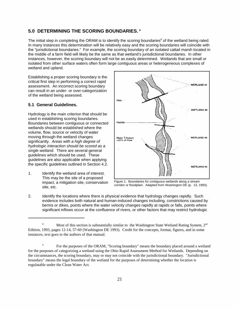
Figure 1. Boundaries for contiguous wetlands along a streamcorridor or floodplain. Adapted from Washington DE (p. 13, 1993).
5.0 DETERMINING THE SCORING BOUNDARIES. 8
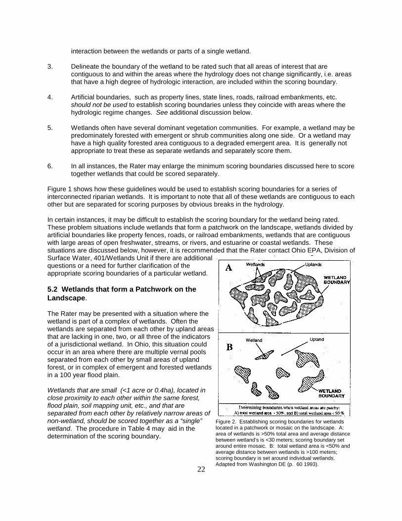
The initial step in completing the ORAM is to identify the scoring boundaries9 of the wetland being rated. In many instances this determination will be relatively easy and the scoring boundaries will coincide withthe “jurisdictional boundaries.” For example, the scoring boundary of an isolated cattail marsh located inthe middle of a farm field will likely be the same as that wetland’s jurisdictional boundaries. In otherinstances, however, the scoring boundary will not be as easily determined. Wetlands that are small orisolated from other surface waters often form large contiguous areas or heterogeneous complexes ofwetland and upland.
Establishing a proper scoring boundary is thecritical first step in performing a correct rapidassessment. An incorrect scoring boundarycan result in an under- or over-categorizationof the wetland being assessed.
5.1 General Guidelines.
Hydrology is the main criterion that should beused in establishing scoring boundaries. Boundaries between contiguous or connectedwetlands should be established where thevolume, flow, source or velocity of watermoving through the wetland changessignificantly. Areas with a high degree ofhydrologic interaction should be scored as asingle wetland. There are several generalguidelines which should be used. Theseguidelines are also applicable when applyingthe specific guidelines outlined in Section 4.2.
1. Identify the wetland area of interest. This may be the site of a proposedimpact, a mitigation site, conservationsite, etc.
2. Identify the locations where there is physical evidence that hydrology changes rapidly. Suchevidence includes both natural and human-induced changes including, constrictions caused byberms or dikes, points where the water velocity changes rapidly at rapids or falls, points wheresignificant inflows occur at the confluence of rivers, or other factors that may restrict hydrologic
22
Figure 2. Establishing scoring boundaries for wetlandslocated in a patchwork or mosaic on the landscape. A: area of wetlands is >50% total area and average distancebetween wetland’s is <30 meters; scoring boundary setaround entire mosaic. B: total wetland area is <50% andaverage distance between wetlands is >100 meters;scoring boundary is set around individual wetlands. Adapted from Washington DE (p. 60 1993).
interaction between the wetlands or parts of a single wetland.
3. Delineate the boundary of the wetland to be rated such that all areas of interest that arecontiguous to and within the areas where the hydrology does not change significantly, i.e. areasthat have a high degree of hydrologic interaction, are included within the scoring boundary.
4. Artificial boundaries, such as property lines, state lines, roads, railroad embankments, etc.should not be used to establish scoring boundaries unless they coincide with areas where thehydrologic regime changes. See additional discussion below.
5. Wetlands often have several dominant vegetation communities. For example, a wetland may bepredominately forested with emergent or shrub communities along one side. Or a wetland mayhave a high quality forested area contiguous to a degraded emergent area. It is generally notappropriate to treat these as separate wetlands and separately score them.
6. In all instances, the Rater may enlarge the minimum scoring boundaries discussed here to scoretogether wetlands that could be scored separately.
Figure 1 shows how these guidelines would be used to establish scoring boundaries for a series ofinterconnected riparian wetlands. It is important to note that all of these wetlands are contiguous to eachother but are separated for scoring purposes by obvious breaks in the hydrology.
In certain instances, it may be difficult to establish the scoring boundary for the wetland being rated. These problem situations include wetlands that form a patchwork on the landscape, wetlands divided byartificial boundaries like property fences, roads, or railroad embankments, wetlands that are contiguouswith large areas of open freshwater, streams, or rivers, and estuarine or coastal wetlands. Thesesituations are discussed below, however, it is recommended that the Rater contact Ohio EPA, Division ofSurface Water, 401/Wetlands Unit if there are additionalquestions or a need for further clarification of theappropriate scoring boundaries of a particular wetland.
5.2 Wetlands that form a Patchwork on theLandscape.
The Rater may be presented with a situation where thewetland is part of a complex of wetlands. Often thewetlands are separated from each other by upland areasthat are lacking in one, two, or all three of the indicatorsof a jurisdictional wetland. In Ohio, this situation couldoccur in an area where there are multiple vernal poolsseparated from each other by small areas of uplandforest, or in complex of emergent and forested wetlandsin a 100 year flood plain.
Wetlands that are small (<1 acre or 0.4ha), located inclose proximity to each other within the same forest,flood plain, soil mapping unit, etc., and that areseparated from each other by relatively narrow areas ofnon-wetland, should be scored together as a “single”wetland. The procedure in Table 4 may aid in thedetermination of the scoring boundary.
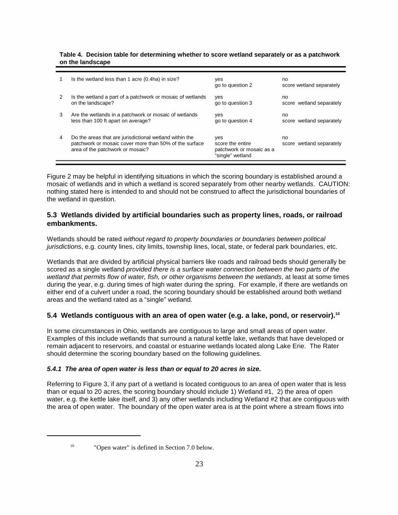
10 "Open water" is defined in Section 7.0 below.
23
Table 4. Decision table for determining whether to score wetland separately or as a patchworkon the landscape
1 Is the wetland less than 1 acre (0.4ha) in size? yesgo to question 2
no score wetland separately
2 Is the wetland a part of a patchwork or mosaic of wetlandson the landscape?
yesgo to question 3
noscore wetland separately
3 Are the wetlands in a patchwork or mosaic of wetlandsless than 100 ft apart on average?
yesgo to question 4
noscore wetland separately
4 Do the areas that are jurisdictional wetland within thepatchwork or mosaic cover more than 50% of the surfacearea of the patchwork or mosaic?
yesscore the entirepatchwork or mosaic as a“single” wetland
noscore wetland separately
Figure 2 may be helpful in identifying situations in which the scoring boundary is established around amosaic of wetlands and in which a wetland is scored separately from other nearby wetlands. CAUTION: nothing stated here is intended to and should not be construed to affect the jurisdictional boundaries ofthe wetland in question.
5.3 Wetlands divided by artificial boundaries such as property lines, roads, or railroadembankments.
Wetlands should be rated without regard to property boundaries or boundaries between politicaljurisdictions, e.g. county lines, city limits, township lines, local, state, or federal park boundaries, etc.
Wetlands that are divided by artificial physical barriers like roads and railroad beds should generally bescored as a single wetland provided there is a surface water connection between the two parts of thewetland that permits flow of water, fish, or other organisms between the wetlands, at least at some timesduring the year, e.g. during times of high water during the spring. For example, if there are wetlands oneither end of a culvert under a road, the scoring boundary should be established around both wetlandareas and the wetland rated as a “single” wetland.
5.4 Wetlands contiguous with an area of open water (e.g. a lake, pond, or reservoir).10
In some circumstances in Ohio, wetlands are contiguous to large and small areas of open water. Examples of this include wetlands that surround a natural kettle lake, wetlands that have developed orremain adjacent to reservoirs, and coastal or estuarine wetlands located along Lake Erie. The Ratershould determine the scoring boundary based on the following guidelines.
5.4.1 The area of open water is less than or equal to 20 acres in size.
Referring to Figure 3, if any part of a wetland is located contiguous to an area of open water that is lessthan or equal to 20 acres, the scoring boundary should include 1) Wetland #1, 2) the area of openwater, e.g. the kettle lake itself, and 3) any other wetlands including Wetland #2 that are contiguous withthe area of open water. The boundary of the open water area is at the point where a stream flows into
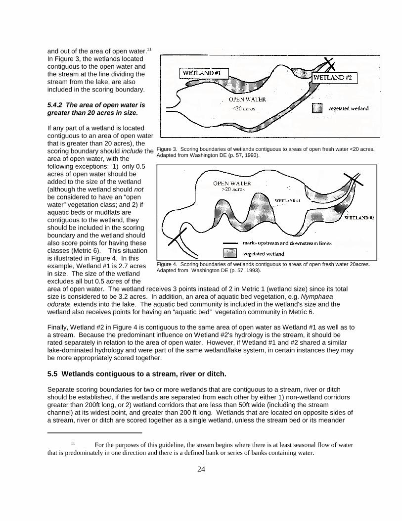
11 For the purposes of this guideline, the stream begins where there is at least seasonal flow of waterthat is predominately in one direction and there is a defined bank or series of banks containing water.
24
Figure 3. Scoring boundaries of wetlands contiguous to areas of open fresh water <20 acres. Adapted from Washington DE (p. 57, 1993).
Figure 4. Scoring boundaries of wetlands contiguous to areas of open fresh water 20acres. Adapted from Washington DE (p. 57, 1993).
and out of the area of open water.11 In Figure 3, the wetlands locatedcontiguous to the open water andthe stream at the line dividing thestream from the lake, are alsoincluded in the scoring boundary.
5.4.2 The area of open water isgreater than 20 acres in size.
If any part of a wetland is locatedcontiguous to an area of open waterthat is greater than 20 acres), thescoring boundary should include thearea of open water, with thefollowing exceptions: 1) only 0.5acres of open water should beadded to the size of the wetland(although the wetland should notbe considered to have an “openwater” vegetation class; and 2) ifaquatic beds or mudflats arecontiguous to the wetland, theyshould be included in the scoringboundary and the wetland shouldalso score points for having theseclasses (Metric 6). This situationis illustrated in Figure 4. In thisexample, Wetland #1 is 2.7 acresin size. The size of the wetland excludes all but 0.5 acres of thearea of open water. The wetland receives 3 points instead of 2 in Metric 1 (wetland size) since its totalsize is considered to be 3.2 acres. In addition, an area of aquatic bed vegetation, e.g. Nymphaeaodorata, extends into the lake. The aquatic bed community is included in the wetland's size and thewetland also receives points for having an “aquatic bed” vegetation community in Metric 6.
Finally, Wetland #2 in Figure 4 is contiguous to the same area of open water as Wetland #1 as well as toa stream. Because the predominant influence on Wetland #2's hydrology is the stream, it should berated separately in relation to the area of open water. However, if Wetland #1 and #2 shared a similarlake-dominated hydrology and were part of the same wetland/lake system, in certain instances they maybe more appropriately scored together.
5.5 Wetlands contiguous to a stream, river or ditch.
Separate scoring boundaries for two or more wetlands that are contiguous to a stream, river or ditchshould be established, if the wetlands are separated from each other by either 1) non-wetland corridorsgreater than 200ft long, or 2) wetland corridors that are less than 50ft wide (including the streamchannel) at its widest point, and greater than 200 ft long. Wetlands that are located on opposite sides ofa stream, river or ditch are scored together as a single wetland, unless the stream bed or its meander
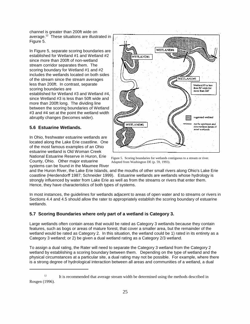
12 It is recommended that average stream width be determined using the methods described inRosgen (1996).
25
Figure 5. Scoring boundaries for wetlands contiguous to a stream or river. Adapted from Washington DE (p. 59, 1993).
channel is greater than 200ft wide onaverage.12 These situations are illustrated inFigure 5.
In Figure 5, separate scoring boundaries areestablished for Wetland #1 and Wetland #2since more than 200ft of non-wetlandstream corridor separates them. Thescoring boundary for Wetland #1 and #2includes the wetlands located on both sidesof the stream since the stream averagesless than 200ft. In contrast, separatescoring boundaries areestablished for Wetland #3 and Wetland #4,since Wetland #3 is less than 50ft wide andmore than 200ft long. The dividing linebetween the scoring boundaries of Wetland#3 and #4 set at the point the wetland widthabruptly changes (becomes wider).
5.6 Estuarine Wetlands.
In Ohio, freshwater estuarine wetlands arelocated along the Lake Erie coastline. Oneof the most famous examples of an Ohioestuarine wetland is Old Woman CreekNational Estuarine Reserve in Huron, ErieCounty, Ohio. Other major estuarinesystems can be found in the Maumee Riverand the Huron River, the Lake Erie Islands, and the mouths of other small rivers along Ohio's Lake Eriecoastline (Herdendorff 1987; Schneider 1999). Estuarine wetlands are wetlands whose hydrology isstrongly influenced by water from Lake Erie as well as from the streams or rivers that enter them. Hence, they have characteristics of both types of systems.
In most instances, the guidelines for wetlands adjacent to areas of open water and to streams or rivers inSections 4.4 and 4.5 should allow the rater to appropriately establish the scoring boundary of estuarinewetlands.
5.7 Scoring Boundaries where only part of a wetland is Category 3.
Large wetlands often contain areas that would be rated as Category 3 wetlands because they containfeatures, such as bogs or areas of mature forest, that cover a smaller area, but the remainder of thewetland would be rated as Category 2. In this situation, the wetland could be 1) rated in its entirety as aCategory 3 wetland; or 2) be given a dual wetland rating as a Category 2/3 wetland.
To assign a dual rating, the Rater will need to separate the Category 3 wetland from the Category 2wetland by establishing a scoring boundary between them. Depending on the type of wetland and thephysical circumstances at a particular site, a dual rating may not be possible. For example, where thereis a strong degree of hydrological interaction between all areas and communities of a wetland, a dual
26
rating would not be appropriate, even if parts of the wetland were of lower quality due to pastdisturbances.
Under the ORAM, dual ratings are never acceptable for Category 3 wetlands that are determined to beCategory 3 using the Narrative Rating. In no instance is a Category 1/2 or 1/3 dual rating appropriateunder the ORAM.
It is important to stress that in deciding whether a dual rating is appropriate, it will be necessary todemonstrate that the Category 3 wetland will be protected from direct and indirect adverse impacts. Ifthis cannot be demonstrated, then a dual rating is inappropriate and the entire wetland should be ratedas a Category 3 wetland. The use of a dual rating should be considered an exception rather than therule in establishing scoring boundaries and categorizing wetlands.
13 “The Natural Heritage Data Base was started in 1976. It now contains over 13,000records which represent known locations for Ohio's rare plants and animals, high quality plant communities andother natural features. Data are obtained from a broad range of sources including the division's botanists,zoologist and ecologist, museums and herbaria, publications and experts throughout the state. In addition to thedivision's needs, data are used in the department's environmental review process and are provided to consultingfirms, federal, state and local government agencies, conservation groups and private citizens.” Excerpted fromhttp://www.dnr.state.oh.us/odnr/dnap/heritage/herintro.html.
27
6.0 NARRATIVE RATING.
The Narrative Rating consists of a series of eleven questions designed to determine whether a wetlandis a Category 1 or Category 3 wetland or to alert the Rater that the wetland may be a Category 3wetland. As discussed above in Section 1.3, Category 3 wetlands support “...superior habitat, orsuperior hydrological or recreational functions.” They often provide habitat for threatened orendangered species or are wetlands of exceptional quality.
The first four questions ask the Rater to consult the U.S. Fish and Wildlife Service, the State of Ohio’sNatural Heritage Database13 and/or other readily available information sources to determine whether thewetland in question has the characteristics of a Category 3 wetland. These questions are intended to beanswered by literature review type activities that can be performed in the office.
The remaining questions focus more on whether the wetland in question is of very poor quality, locallyscarce or scarce throughout Ohio, e.g. bogs, fens, mature or old-growth forested wetlands, undisturbedcoastal marshes, etc., and also allows for the identification of particular types of wetlands which oftenhave high levels of diversity, high native species richness, or high functional values. It is very importantto properly and thoroughly answer each of the questions in the Narrative Rating. Just completing theQuantitative Rating may give an incomplete answer as to the wetland’s regulatory category.
6.1 Critical Habitat.
Question 1. Is the wetland in a township, section, or subsection of a United States Geological Survey 7.5minute Quadrangle that has been designated by the U.S. Fish and Wildlife Service as critical habitat forany threatened or endangered plant or animal species?
Critical habitat is defined as the geographic area containing physical or biological features essential tothe conservation of a listed species or as an area that may require special management considerationsor protection. However, as of December 1, 2000, of the federally listed endangered or threatenedspecies that are or may be present in Ohio, only the Indiana Bat has had critical habitat designated, andthis critical habitat is located outside the State of Ohio. See 50 CFR 17.95(a). However, the U.S. Fishand Wildlife Service recently proposed critical habitat for the Great Lakes breeding population of thePiping Plover along portions of the State of Ohio's Lake Erie shoreline. See 65 Federal Register 41812(July 6, 2000).
The Rater should contact the Region 3 Headquarters or the Reynoldsburg Ecological Services Office forupdates as to whether critical habitat has been designated for other federally listed threatened orendangered species. See Important Contacts at the beginning of the Manual. See also USFWSendangered species program homepage for summary lists of endangered and threatened species inOhio and Region 3 at http://www.fws.gov/r9endspp/r3spndx.html.
14 The status list for rare native Ohio plants is revised every two years. The current 1998-99 listcontains 642 species and became effective on June 13, 1998. See http://www.dnr.state.oh.us/odnr/dnap/heritage/ forthe most recent version of the list. State status is determined from records in the Natural Heritage Data Base. SixOhio plants are also included on the federal list of endangered and threatened species. Running buffalo clover(Trifolium stoloniferum) is federally endangered. Northern monkshood (Aconitum noveboracense), lakeside daisy(Hymenoxys herbacea), small whorled pogonia (Isotria medeoloides), prairie fringed orchid (Platantheraleucophaea), and Appalachian spiraea (Spiraea virginiana), are federally threatened.
15 See OAC Rule 1501:31-23-01 for a list of state threatened, endangered, and special interestanimal species. See Appendix VII for federally threatened and endangered animal species.
16 Fees for the submission of a Data Request Form are determined by the time it takes to completethe request. As of 2001, the charge is $25.00 per ½ hour with a ½ minimum. A cost estimate can be provided uponrequest. Unless otherwise specified, an invoice will accompany the data services response.
28
6.2 State or Federal Threatened or Endangered Species.
Question 2. Is the wetland known to contain an individual of, or documented occurrences of federal orstate-listed threatened or endangered plant14 or animal species15?
In order to properly answer this question, the Rater should, at a minimum, submit a Data Request Formto the Ohio Department of Natural Resources, Division of Natural Areas and Preserves, Natural HeritageDatabase Services, 1889 Fountain Square, Building F-1, Columbus, Ohio 43224, 614-265-6453(phone), 614-265-3096 (fax), http://www.dnr.state.oh.us/odnr/dnap/heritage/.16
In the Data Request Form, the Rater should specifically request that the Natural Heritage Database besearched for records of state and federal endangered species that have been documented to occur atthe wetland being evaluated.
In addition, the Rater should consult any other published literature and accounts available to the Raterwhich indicate that an endangered or threatened species has been found at the wetland beingevaluated.
Finally, Question 2 should be answered affirmatively, if the Rater, or other persons known to the Rater,actually observes a state or federal threatened or endangered species at the wetland.
6.3 High Quality Wetlands.
Question 3. Is the wetland on record with the Ohio Natural Heritage Program as a high quality wetland?
In order to properly answer this question, the Rater should, at a minimum, do both of the following: Submit a Data Request Form to the Ohio Department of Natural Resources, Division of Natural Areasand Preserves, Natural Heritage Database Services, 1889 Fountain Square, Building F-1, Columbus,Ohio 43224, 614-265-6453 (phone), 614-265-3096 (fax), http://www.dnr.state.oh.us/odnr/dnap/heritage. The Rater should specifically request in the “Other Features” category of the Data Request Formwhether the wetland is documented in the Natural Heritage Database as a wetland of high quality on aCounty, Regional, and/or Statewide level.
Finally, the Rater should consult any other published literature and accounts available to the Rater which

17 See OAC Rule 3745-1-50( T). “Hydrologically isolated wetlands” means those wetlands which, (1) have no surface water connection to a surface water of the state; (2) are outside of, and not contiguous to, anyone hundred-year "flood plain" as that term is defined in this rule; and (3) have no contiguous hydric soil betweenthe wetland and any surface water of the state.
29
indicate that the wetland being evaluated is of high quality.
6.4 Significant breeding/nonbreeding bird concentration areas.
Question 4. Does the wetland contain documented regionally significant breeding or nonbreedingwaterfowl, neotropical songbird, or shorebird concentration areas?
In order to properly answer this question, the Rater should, at a minimum, do both of the following: 1. Submit a Data Request Form to the Ohio Department of Natural Resources, Division of Natural Areasand Preserves, Natural Heritage Database Services, 1889 Fountain Square, Building F-1, Columbus,Ohio 43224, 614-265-6453 (phone), 614-265-3096 (fax), http://www.dnr.state.oh.us/odnr/dnap/heritage. The Rater should specifically request in the “Other Features” category of the Data Request Formwhether the wetland is documented in the Natural Heritage Database as a wetland wherebreeding/nonbreeding animal concentrations are known to occur.
2. Consult the North American Waterfowl Management Plan for Ohio. State Contact: Pat Ruble, OhioDivision of Wildlife, 1840 Belcher Drive, Columbus, OH 43224-1329, 614-265-6330 (phone), 614-262-1143 (fax). Regional Contact: Jim Leach, Joint Venture Coordinator, U.S. Fish and Wildlife ServiceBHW Federal Building, 1 Federal Drive, Fort Snelling, MN 55111-4056, 612- 713-5433 (phone), 612-713-5286 (fax).
Finally, the Rater should consult any other published literature and accounts available to the Rater whichindicate that the wetland being evaluated provides regionally significant breeding or nonbreedingconcentration areas.
6.5 Category 1 Wetlands.
Question 5. Is the wetland less than 1 acre in size and hydrologically isolated and either (1) comprisedof vegetation that is dominated (greater than eighty per cent areal cover) by Phragmites australis,Lythrum salicaria, or Phalaris arundinacea, or (2) an acidic pond created or excavated on mined landsthat has little or no vegetation?
Certain types of wetlands are of such low quality and so small that the Wetland Antidegradation ruledescribes them as, in a sense, automatic Category 1 wetlands. In addition, it is assumed that the loss ofthis type of wetland is able to be successfully mitigated. See OAC Rule 3745-1-54(C)(1)(c). The keyfeature of these wetlands is that they are small, and that they are completely “hydrologically isolated”from all other surface waters.17 In order to be considered hydrologically isolated, the wetland beingevaluated must meet all three of the criteria in the definition in OAC Rule 3745-1-50(T). Assuming thewetland is hydrologically isolated, two types of wetlands are automatically considered to be Category 1wetlands.
The first type are wetlands dominated by purple loosestrife (Lythrum salicaria), reed canary grass(Phalaris arundinacea), or phragmites (Phragmites australis). Generally, these wetlands will appear tobe small shallow, emergent marshes. The second type are wetlands that often develop on strip-minedlands. They are generally characterized by shallow, depressional areas with sparse or no vegetation.
18 See OAC Rule 3745-1-54(C)(3)(c): Wetlands assigned to category 3 may include, but are notlimited to: wetlands which contain or provide habitat for threatened or endangered species; high quality forestedwetlands, including old growth forested wetlands, and mature forested riparian wetlands; vernal pools; and wetlandswhich are scarce regionally and/or statewide including, but not limited to, bogs and fens (emphasis added).
30
6.6 Bogs.
Question 6. Is the wetland a peat-accumulating wetland that has 1) no significant inflows or outflows, 2)>30% cover of acidophilic mosses, particularly Sphagnum spp., 3) at least one of species listed in Table1 in the wetland, and 4) <25% cover of the invasive species listed in Table 1?
Bogs are defined in OAC Rule 3745-1-50 as “a peat-accumulating wetland that has no significant inflowsor outflows and supports acidophilic mosses, particularly Sphagnum spp.” In Ohio, bogs are relicts ofthe Wisconsinin glaciation. Bogs are often separated from “fens” (see next section) on the basis ofdifferences in vegetation or water chemistry. However, Andreas (1985) states that this separation isoften difficult and that in Ohio it is compounded by the fact that Ohio glacier-created bogs and fens are atthe southern limit of their North American range, they are small in terms of surface area, and neitherbogs or fens are represented in Ohio by the “classic” type of bog and fen found further north in Michigan,northern Wisconsin, or Minnesota.
Andreas (1985, p. 116) defines a “sphagnous bog” as a habitat that
...(1) develops in an area where drainage is blocked and there is little or no circulation of water,(2) contains a Spaghnum dominated ground layer which accumulates to form a more or lesscontinuous mat, (3) has a shrubby vegetation dominated by members of the Ericaceae and aherbaceous layer primarily dominated by members of the Cyperaceae, and (4) has a water pHbetween 3.5 and 5.5. Typically, bog waters are brown due to the accumulation of organicmaterial. In Ohio, plant communities with the above characteristics are referred to as Spaghnummats, leatherleaf bogs, ericaceous shrub bogs, tamarack bogs, and more recently, ombrotrophicto weakly minerotrophic swamps...
In contrast, Andreas (1985, p. 116) defines “fens” as a habitat,
...characterized by having (1) relatively clear water coming from an artesian source whichsurfaces as springs or seeps, (2) a wet, springy calcareous substrate which supportsminerotrophic species of Spaghnum and other bryophytes which do not accumulate to form acontinuous mat, (3) vegetation dominated by members of the Cyperaceae, Compositae,Rosaceae and Graminae [Poaceae] with approximately 20% of the vegetation made up ofshrubs, usually including Potentilla fruticosa, and (4) water pH between 5.5 and 8.0.
Bogs are specifically mentioned in OAC Rule 3745-1-54 in the examples of the types of the wetlandsthat may be Category 3 wetlands.18 Bogs are often Category 3 wetlands because they exhibit highlevels of biodiversity, are difficult to mitigate, are highly sensitive to disturbance, are generally scarceboth regionally and statewide, and usually have threatened or endangered species present. See OACRule 3745-1-54 paragraphs (B)(2)a)(i), (B)(2)(b)(vii), (B)(3), (B)(4), and (C)(3).
In Ohio, most of the bogs present prior to European settlement have been destroyed or degraded. Gordon (1966) maps several large bog complexes in northeast (Geauga, Portage, Summit, Stark,Trumbull Counties), north-central (Seneca, Crawford, Morrow Counties), and south-central Ohio(Licking, Fairfield, Perry Counties). The plant and animal species present in Ohio bogs are often at thesoutherly limits of their distribution and represent important reservoirs of genetic diversity.
19 Characteristic bog species from Table 1 in ORAM Scoring Form.
Calla palustris Nemopanthus mucronatusCarex atlantica var. capillacea Schechzeria palustrisCarex echinata Vaccinium macrocarponCarex oligosperma Vaccinium corymbosumCarex trisperma Vaccinium oxycoccosChamaedaphne calyculata Woodwardia virginica Decodon verticillatus Xyris difformis Eriophorum virginicum Larix laricina
20 Invasive/exotic plant species from Table 1 in ORAM Scoring Form.
Lythrum salicaria (purple loosestrife)Myriophyllum spicatum (European milfoil) Najas minor (lesser naiad) Phalaris arundinacea (reed canary grass)Phragmites australis (phragmites or giant reed) Potamogeton crispus (curly pondweed)Ranunculus ficaria (lesser celandine) Rhamnus frangula (European buckthorn) Typha angustifolia (narrow-leaved cattail)Typha xglauca (hybrid cattail)
31
Certain Ohio bogs are classified as Category 3 wetlands, regardless of the bog's score in quantitativequestions. A Category 3 bog has the following characteristics:
1) No significant inflows or outflows of surface water with significance relating to whether thebog’s hydrologic regime is dominated by precipitation and evapotranspiration. However, it isexpected that most bogs will have some surface water inputs from upland watershed areas. True ombrotrophic boreal bogs were probably very rare in Ohio at the time of settlement;
2) Acidophilic mosses, particularly Sphagnum spp., are growing in the bog.
3) Percent cover of the acidophilic mosses is greater than 30%.
4) At least one characteristic bog plant species is present19; and
5) the cover of invasive species is less than 25%?20
It is important to stress that not every bog will necessarily meet the criteria of Question 6 for automaticclassification as a Category 3 wetland. In particular, bogs that are overrun with invasive species(Rhamnus frangula is a common invader), or are otherwise degraded may not satisfy the criteria in thisquestion.
32
6.7 Fens.
Question 7. Is the wetland a carbon accumulating (peat, muck) wetland that is saturated during most ofthe year, primarily by a discharge of free flowing, mineral rich, ground water with a circumneutral pH (5.5-9.0) and with one or more plant species listed in Table 1 and the cover of invasive species listed in Table1 is <25%?
A Fen is defined in OAC Rule 3745-1-50 as
a carbon accumulating (peat, muck) wetland that is saturated, primarily by a discharge of freeflowing ground water during most of the year. Fens are rarely inundated. Fens often have asloped surface which prevents the accumulation of stagnant or ponded water. The water of fensis usually mineral rich and has a circumneutral pH (5.5-9.0). In calcareous fens, soil may bedominated by deposits of calcium carbonate rich sediments (marl). Characteristic indicatorvegetation species may include, but are not limited to Potentilla fruticosa, Solidago ohioensis,Lobelia kalmii, Cacalia plantaginea, Deschampsia cespitosa, Triglochin spp., Parnassia glauca,Gentianopsis spp., Rhynchospora spp., and some Eleocharis spp.”
It should be noted that this definition is considerably broader than the definition proposed by Andreas(1985) and cited above. Fens are specifically mentioned in OAC Rule 3745-1-54 in the examples of thetypes of the wetlands that may be Category 3 wetlands. Fens are often Category 3 wetlands becausethey exhibit high levels of biodiversity and groundwater discharge, are difficult to mitigate, are highlysensitive to disturbance, are generally scarce both regionally and statewide, and usually havethreatened or endangered species present. See OAC Rule 3745-1-54 paragraphs (B)(2)a)(i),(B)(2)(b)(i), (B)(2)(b)(vii), (B)(3), (B)(4), and (C)(3).
In Ohio, most of the fens present prior to European settlement have been destroyed or degraded. Stuckey and Denny (1981) map the distribution of 52 known fens in Ohio. Fens are found throughoutthe state but large concentrations exist in northeast Ohio (Holmes, Portage, Stark, and SummitCounties) and in west-central Ohio (Champaign, Clark, Greene, Logan, and Miami Counties). Fens areoften associated with esker-kame complexes near major end moraines (Stuckey and Denny 1981). Andreas (1985) found that 50% of Ohio peatlands (bogs and fens) were associated with esker-kamecomplexes (e.g. Mad River and Summit Interlobate Areas), and 82% of Ohio peatlands occur on or nearburied pre-glacial river valleys. The plant and animal species present in Ohio fens are often at the limitsof their distribution, and represent important reservoirs of genetic diversity.
Certain Ohio fens are classified as Category 3 wetlands, regardless of the fens’ score in quantitativequestions. A Category 3 fen has the following characteristics:
1) Saturated during most of the year, primarily by a discharge of free flowing, mineral rich,ground water with a circumneutral pH (5.5-9.0);
21 Characteristic fen species from Table 1 in ORAM Scoring Form.
Zygadenus elegans var. glaucus Potentilla fruticosaCacalia plantaginea Rhamnus alnifoliaCarex flava Rhynchospora capillaceaCarex sterilis Salix candidaCarex stricta Salix myricoidesDeschampsia caespitosa Salix serissimaEleocharis rostellata Solidago ohioensisEriophorum viridicarinatum Tofieldia glutinosaGentianopsis spp. Triglochin maritimumLobelia kalmii Triglochin palustreParnassia glauca
33
2) One or more fen plant species listed in Table 121 is present; and
3) The cover of invasive species listed in Table 1 is less than 25%
As was discussed above regarding bogs, it is important to stress that not every fen will necessarily meetthe criteria of Question 7 for automatic classification as a Category 3 wetland. Fens that are overrunwith invasive species, or are otherwise degraded may not satisfy the criteria in this question.
6.8 Old Growth and Mature Forested Wetlands.
6.8.1 Old Growth Forests.
Question 8a. Is the wetland a forested wetland and is the forest characterized by, but not limited to, thefollowing characteristics: overstory canopy trees of great age (exceeding at least 50% of a projectedmaximum attainable age for a species); little or no evidence of human-caused understory disturbanceduring the past 80 to 100 years; an all-aged structure and multilayered canopies; aggregations of canopytrees interspersed with canopy gaps; and significant numbers of standing dead snags and downed logs?
Very little “old-growth” forest remains in Ohio and its surrounding states. Parker (1989) estimates that0.07 percent of the original forest in the Central Hardwood Region (Ohio, Illinois, Missouri, Kentucky,Tennessee, West Virginia, western Pennsylvania, northern Arkansas, southern Wisconsin, and easternIowa) remains. In Ohio, many of the remaining old growth forests remnants have been acquired by thestate or by local or regional park districts. e.g. Drew Woods (Darke County), Goll Woods (FultonCounty), Hueston Woods (Butler County), Fowler Woods (Richland County). However, other relictforests probably still remain. According to Parker (1989), most of the old-growth forests remaining in theCentral Hardwood Region are the result of long-term protection on family farms.
Prior to settlement, the Great Black Swamp, located in northwest Ohio on a former bed of Lake Erie, wasone of the largest swamp forests in the lower 48 states. This large wetland system has largely beendestroyed, although remnants remain in isolated woodlots in this largely agricultural region. In fact, insome western Ohio counties, many remaining woodlots contain some type of vernal pools, wet woods,or swamp forest (Mack, pers. obs.). In northeast Ohio, many forested wetlands remain, and some ofthese may contain old-growth stands. For example an old growth stand was recently “discovered” andacquired as Johnson Woods State Nature Preserve in Wayne County.
Thus, while the Rater should not expect to encounter old growth forests frequently, this situation should
34
always be considered a possibility, especially in regions that had large areas of swamp forestpresettlement.
There has not been as coordinated an effort in the Central Hardwood Region to define what an old-growth forest is as has occurred in the Pacific Northwest (Parker 1989). The definition used in Question8a and in OAC Rule 3745-1-50(EE) is largely based on Parker (1989, p.6). He states,
Mesic old-growth deciduous forests are defined here as those with overstory canopy trees olderthan 150 years and with little or no understory disturbance (human-caused) during the past 80 to100 years. These forests have an all-aged structure and multilayered canopies. Many standscurrently have canopies of mid-seral species and understories of late-seral shade tolerantspecies with dominant canopy individuals ranging from 80 to 160 cm in diameter. Horizontalstructure is characterized by aggregations of canopy trees interspersed with small all-agedcanopy gaps of varying species composition. Significant numbers of standing dead snags anddowned logs are also present. The mix of species found in any given forest varies by sitefactors and along north-south and east-west regional gradients.
Table 5, reproduced from Parker (1989, p. 8) is included as an aid in determining what is or may be old-growth forest.
Question 8a can be answered in the affirmative based on the Rater’s professional judgment after a sitevisit in which the wetland being evaluated appears to have many or all of the characteristics of an old-growth forest. The Rater is cautioned that often the jurisdictional wetland portion of the forest will onlybe a small area of the total forest. For example, in Drew Woods State Nature Preserve in Darke County,most of the forest is upland forest dominated by various Oak species with ash and hickory as significantco-dominants. Portions of the forest contain relatively small, vernal pools with canopy gaps over themwith buttonbush (Cephalanthus occidentalis) and some large swamp white oaks (Quercus bicolor) nearthe edges of the pools. Simply counting the species and basal areas of the trees within the jurisdictionalwetland boundary could lead to a conclusion that the “wetland” is not “old-growth forest.” This is anerroneous conclusion; when faced with this or similar situations, the Rater should conclude that wetlandis part of an old-growth forest.
Question 8a can also be safely answered in the negative when the Rater does not observe any largetrees in the canopy, especially when the forest is clearly young second growth with most or all trees lessthan 45cm dbh.
In borderline situations, or where the Rater wishes to quantitatively confirm his or her conclusion that theforest is or is not old growth, it is recommended that standard forest inventory methods be used (Seee.g. Peet et al. 1998).

35
Table 5. Characteristics of mesic old-growth forests in the central hardwoodforest region from published literature. From Parker (1989, p.8).
character range reference
tree species richness (#/forest) 20-40 See Parker (1989) for citations
herbaceous species (#/forest) 17-53
breeding bird species richness (# forest) 18-33
tree density (stems > or = to 10 cm dbh ha-1) 161-427
basal area (m2 ha-1) 25-35
volume (1000 bd. ft. ha-1) 39-62
mean age of overstory mortality (years) 135-210
Maximum age of overstory mortality (years) 190-375
Annual mortality (%) 0.6-0.9
Deadwood on ground (Mg ha-1) 16-24
Standing snags (stems > 10 cm dbh ha-1) 19-44
Canopy distribution random
mean canopy gap size (m2) 50-374
Canopy gaps (% of forest) 7-8
6.8.2 Mature Forested Wetlands.
Question 8b. Is the wetland a forested wetland and is the upper forest canopy dominated by trees withlarge diameters at breast height (dbh), generally diameters greater than 45cm (17.7in) dbh?
A “forested wetland” is defined in OAC Rule 3745-1-50(O) as “...a wetland class characterized by woodyvegetation that is twenty feet [6 meters] tall or taller.” This definition follows the classification outlined inCowardin et al. (1979). For the purposes of answering this question, the Rater should distinguishbetween a predominately emergent or scrub-shrub wetland that has a small area of trees located withinit or along its margin such that it may receive points in Metric 6 of the Quantitative Rating for having a“forested” vegetation class (in which case this question should be answered “no”), and a wetland that ispredominately a “forest,” in which case the question should be answered "yes." Question 8b asks theRater to evaluate the maturity of wetlands that are predominately “forests” or predominately “forested.”
Given that most of Ohio’s original forest has been cut at some point in the last two centuries ofsettlement and allowed to regenerate, it is likely the Rater will frequently encounter forested wetlandswhich are 60 to 100 years old. In some areas of the state (e.g. the Eastern Corn Belt Plains Ecoregion),many of the remaining wetlands are located in large and small woodlots of varying stages of forestdevelopment (Mack, pers. obs.). When evaluating such wetlands, the Rater should be sensitive to thepossibility that the wetland is or is part of a mature second growth forest.
As with Question 8a above, Question 8b can be answered in the affirmative based on the Rater’sprofessional judgment after a site visit in which the wetland being evaluated appears to have many or allof the characteristics of a mature forested wetland. The Rater is again cautioned that often thejurisdictional wetland portion of the forest will only be a small area of the total forest, and that simply

36
counting the species and basal areas of the trees within the jurisdictional wetland boundary could lead toa conclusion that the “wetland” is not a “mature forested wetland.” This is an erroneous conclusion;when faced with this or similar situations, the Rater should conclude that the wetland is part of a matureforest.
Question 8a can also be safely answered in the negative when the Rater does not observe any largetrees in the canopy, especially when the forest is clearly young second growth with most or all trees lessthan 45cm (17.7in) dbh and/or between 6 and 15 meters in height.
In borderline situations, or where the Rater wishes to quantitatively confirm his or her conclusion that theforest is or is not mature forest, it is recommended that standard forest inventory methods be used (Seee.g. Peet et al. 1998).
6.9 Lake Erie Coastal and Tributary Wetlands.
Lake Erie coastal and tributary wetlands. Question 9a. Is the wetland located at an elevation lessthan 575 feet on the USGS map, adjacent to this elevation, or along a tributary to Lake Erie that isaccessible to fish?
Question 9b. Does the wetland's hydrology result from measures designed to prevent erosion and theloss of aquatic plants, i.e. the wetland is partially hydrologically restricted from Lake Erie due tolakeward or landward dikes or other hydrological controls?
Question 9c. Are Lake Erie water levels the wetland's primary hydrological influence, i.e. the wetland ishydrologically unrestricted (no lakeward or upland border alterations), or can the wetland becharacterized an "estuarine" wetland with lake and river influenced hydrology? These include sandbardeposition wetlands, estuarine wetlands, river mouth wetlands, or those dominated by submersedaquatic vegetation.
Question 9d. Does the wetland have a predominance of native species within its vegetationcommunities, although non-native or disturbance tolerant native species can also be present?
Question 9e. Does the wetland have a predominance of non-native or disturbance tolerant native plantspecies within its vegetation communities?
Of all the Great Lakes, the industrialized Lake Erie shoreline has the smallest number and area ofwetlands (Herdendorf 1987). Of those that remain, most are preserved today as diked units. Coastalwetlands with unrestricted hydrology are very rare on Ohio's Lake Erie coastline and represent the lastrelicts of a once extensive coastal wetland system. Coastal wetlands were formed in the deltas of riversthat flow into the lake and in protected areas behind natural barrier beaches or levees (Herdendorf 1987;Schneider 1999). Coastal wetlands provide numerous benefits including flood control, shorelineprotection, nutrient-cycle control, trapping sediment, fish spawning and nursery grounds, and water fowlhabitat.
Herdendorff (1987) defines coastal wetlands of Lake Erie as all wetlands located within 1 km of the lakeshore, or if further from the shore, those that are directly influenced by water level changes of the lake ortheir connecting waterways.
This question presents the Rater with a series of either/or statements to first determine if the wetland ispotentially a Lake Erie coastal or tributary wetland (Question 9a), and then to determine whether thewetland is a Category 3 wetland (Question 9c and 9d), or whether the wetland may be a Category 3wetland (9b and 9d). Given their rarity and significance coastal or tributary wetlands with unrestrictedhydrology and a predominance of native plant species are classified as Category 3 wetlands. Schneider
37
(1999) in his survey of the Lake Erie Coast found only a few of these types of wetlands remaining. Hydrologically restricted wetlands or degraded unrestricted wetlands should be evaluated for Category 3status.
6.10 Lake Plains Sand Prairies (Oak Openings).
Question 10. Is the wetland located in Lucas, Fulton, Henry, or Wood Counties and can the wetland becharacterized by the description below? The wetland has a sandy substrate with interspersed organicmatter, a water table often within several inches of the surface, and often with a dominance of thegramineous vegetation listed in Table 4 (woody species may also be present). The Ohio Department ofNatural Resources can provide assistance in confirming this type of wetland and its quality.
The Oak Openings region was so named because of the thin groves or scattered clumps of oaks standsor islands which were surrounded by wet prairie “openings”. The typical soil found in the oak openingsis composed of mostly Ottokee soils (deep sand over till) with very poor drainage (Hawkins, 1977).
The Oak Openings are sand-hills or dunes that are the remains of the old beach ridges of glacial LakeWarren. The dunes are 15 to 30 feet above the adjacent lowland and are underlain by an imperviousblue clay. The higher dunes are well-drained, light colored and low in organic matter with poorly drainedsoils found in the depressions. Parts of the Oak Openings have been preserved as publicly-ownednatural areas such as Irwin Prairie, Schwamberger Preserve, Oak Openings Metro Parks, Secor MetroPark and Wildwood Preserve.
Oak openings wetlands are a very unique type of wetland system in Ohio. It is recommended that theRater consult with Ohio DNR, metroparks naturalists, and other local experts if you suspect a wetlandmay fit this characterization.
6.11 Relict Wet Prairies.
Question 11. Is the wetland a relict wet prairie community dominated by some or all of the followingspecies listed in Table 1. Extensive prairies were formerly located in the Darby Plains (Champaign,Clarke, Greene, Madison and Union counties), Sandusky Plains (Wyandot, Crawford, and MarionCounties), northwest Ohio (e.g. Erie, Huron, Lucas, Wood counties), and portions of western OhioCounties (e.g. Darke, Mercer, Miami, Montgomery, Van Wert counties, etc.).
Extensive areas of prairie were present in Ohio prior to settlement (Sears 1926; Transeau 1935; Gordon,1966). Ohio prairies were often "wet" prairie communities that developed below glacial moraines and onformer glacial lake beds (Sears 1926; Transeau 1935). Large prairies were formerly located in theDarby Plains (Champaign, Clarke, Greene, Madison and Union Counties), Sandusky Plains (Wyandot,Crawford, and Marion Counties), portions of western Ohio Counties (e.g. Darke, Mercer, Miami,Montgomery, Van Wert Counties, etc.), and northwest Ohio (e.g. Erie, Huron, Lucas, Wood Counties). The northwest Ohio prairies may be Oak Openings Sand Prairies described in the previous section.
Virtually all of Ohio's native prairies have been destroyed by agricultural activities although relict areasstill remain along railroad rights of way and in occasional larger contiguous areas. Relict wet prairie isthus one of the rarest community types in Ohio.
Anderson (1982) identified several types of prairie communities. The slough grass-bluejoint prairie willusually be a jurisdictional wetland; in certain instances, the "big bluestem prairie" may also be a wetlanddepending on the soils and hydrology. A list of indicator species is provided in Table 1 of the ORAMScoring Forms. It is recommended that the Rater consult with Ohio EPA or Ohio DNR, local metroparksnaturalists, and other local experts, if you suspect a wetland may fit this characterization.
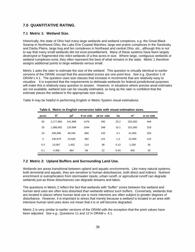
38
7.0 QUANTITATIVE RATING.
7.1 Metric 1: Wetland Size.
Historically, the state of Ohio had many large wetlands and wetland complexes, e.g. the Great BlackSwamp in Northwest Ohio, the Lake Erie Coastal Marshes, large wet prairie complexes in the Sanduskyand Darby Plains, large bog and fen complexes in Northeast and central Ohio, etc., although this is notto say that many small wetlands did not exist presettlement. Many of these systems have been largelydestroyed or fragmented into relict wetlands of a few acres in size. Where large, contiguous wetlands orwetland complexes exist, they often represent the best of what remains in the state. Metric 1 thereforeassigns additional points to large wetlands versus small.
Metric 1 asks the rater to estimate the size of the wetland. This question is virtually identical to earlierversions of the ORAM, except that the associated scores are one point less. See e.g. Question 1 ofORAM v.4.1. The question uses size classes that increase in increments that are relatively easy tovisualize. It is expected that the requirements to delineate wetlands for federal jurisdictional purposeswill make this a relatively easy question to answer. However, in situations where precise areal estimatesare not available, wetland size can be visually estimated, so long as the rater is confident that theestimate places the wetland in the appropriate size class.
Table 6 may be helpful in performing English or Metric System visual estimations.
Table 6. Metric to English conversion table with visual estimation sizes.
acres ft2 yd2 ft on side yd on side ha m2 m on side
50 2,177,983 241,998 1476 492 20.2 202,000 449
25 1,088,992 120,999 1044 348 10.1 101,000 318
10 435,596 48,340 660 220 4.1 41,000 203
3 130,679 14,520 362 121 1.2 12,000 110
0.3 13,067 1,452 114 38 0.12 1,200 35
0.1 4,356 484 66 22 0.04 400 20
7.2 Metric 2: Upland Buffers and Surrounding Land Use.
Wetlands are areas transitional between upland and aquatic environments. Like many natural systems,both terrestrial and aquatic, they are sensitive to human disturbances, both direct and indirect. Nutrientenrichment or eutrophication from stormwater inputs, urban runoff, or agricultural runoff can degradewetlands just as these disturbances can degrade streams and lakes.
The questions in Metric 2 reflect the fact that wetlands with “buffer” zones between the wetland andhuman land uses are often less disturbed than wetlands without such buffers. Conversely, wetlands thatare located in places where human land use is more intensive are often subject to greater degrees ofdisturbance. However, it is important to stress that merely because a wetland is located in an area withintensive human land uses does not mean that it is or will become degraded.
Metric 2 is very similar to earlier versions of the ORAM with the exception that the point values havebeen adjusted. See e.g., Questions 11 and 12 in ORAM v. 4.1.

39
Figure 6. Hypothetical wetland example for estimating average bufferwidth.
7.2.1 Question 2a: Average Buffer Width.
For the purposes of this question, “buffer” means non-anthropogenic landscape features which have thecapability of protecting the biological, physical, and/or chemical integrity of the wetland from effects ofhuman activity. Typically, a buffer could be forested or shrubby margin, prairie, streams or lakes, oldfields, and in certain instances more managed landscapes like meadows or hay fields. Intensivehuman land uses should not be counted as buffers. These include active agricultural row cropping,fenced or unfenced pastures, paved areas, housing developments, golf courses, mowed or highlymanaged parkland, mining or construction sites, etc. A comprehensive list is not proposed in thismanual. The key concept is whether the buffer area, whatever it is, functions to protect the wetland fromdegradation.
In order to calculate the average buffer width, estimate the width of buffer on each side of the wetland toa maximum of 50m and divide by the number of sides, e.g. the average buffer width of a wetland withbuffers of 100m, 50m, 0m and 0m would be calculated as follows: abw =(50 + 50 + 0 + 0)/4 = 25. See Figure 6. The wetland in Figure 6 would score 4points for Question 2a. A wetland withbuffers greater than 50m on all sideswould have an abw$50m and wouldscore 7 points.
This procedure works well with smallerwetlands. For very large wetlands orwetlands with unusual shapes there maybe multiple "sides" and it may be difficultto measure, determine, or obtain accessto all of the sides of the wetland. In thissituation, the Rater may consider thisquestion to provide a buffer continuumfrom very narrow to wide and assign thepoints associated with the mostappropriate category.
7.2.2 Question 2b: Intensity ofPredominant Surrounding LandUse(s).
In order to answer this question, the Rater should evaluate the intensity of the predominant land uses inthe areas outside the wetland and beyond the wetland’s buffer zone, i.e. more than 50m (164 ft) if thewetland has buffers greater than 50m on all sides. The questions form a continuum from most intensiveto least intensive land uses. In many instances, the Rater will need to “double check” and average thescore. This question asks the Rater to generally characterize the type of land uses that are mostcommon in the immediate vicinity of the wetland. Several examples are offered to aid in answering thisquestion.
Example 1. Wetland is a deep (90cm), largely unvegetated (except for the canopy trees above it) vernalpool, located entirely within a large, contiguous patch of second growth forest. Upland forest extendsfrom 100 to 300m on all sides of the wetland. Outside of the forest, the land use is agricultural rowcropping. Score: the wetland is entirely surrounded by second growth forest and should receive a scoreof 7.
40
Example 2. The wetland is deep, largely unvegetated (except for the canopy trees above it) vernalpool, located at the edge of a large, contiguous patch of second growth forest. Outside of the forest, theland use is agricultural row cropping. The boundary of hydric soils extends from the current wetlandedge into the agricultural field. Score: the Rater should double check “very low” (7) and “high” (1), andaverage the scores , (7+1)/2=4.
Example 3. The wetland is a vegetatively diverse emergent marsh located in the floodplain of a StateScenic River. A mature forested, riparian corridor is adjacent to one side of the wetland; on the otherside is a fenced pasture (Note: both sides of the river have a forested, riparian corridor). Score: theRater should double check “very low” and “moderately high”, and average the scores, (7+3)/2=5.
Example 4. The wetland is an isolated, depressional cattail marsh. On one side, the wetland has nobuffer and is immediately adjacent to active row cropping. On the other three sides, the wetland issurrounded by a new fallow field. Score: the Rater should double check “moderately high” (3) and“high” (1), and average the scores, (3+1)/2=2.
Example 5. The wetland is a depressional buttonbush swamp with forested margins. The wetland isbisected by a small, paved township road. The wetland has mature to young second growth forest onone side, a “shrubby” old field (probably >10 years old) on 2 sides, and is hydrologically connected toanother buttonbush swamp on the fourth side but is separated from this other wetland by a 20 to 50meter wide upland forested area. Score: the Rater should double check "very low" and "low" andaverage the scores, (7+5)/2=6.
7.3 Metric 3: Hydrology.
“Hydrology is probably the single most important determinant for the establishment and maintenance ofspecific types of wetlands and wetland processes.” (Mitsch and Gosselink, 1996, p.55, italics in theoriginal). Thus, 30% of the total points possible in the ORAM Quantitative Rating are awarded in Metric3. This metric asks the Rater to evaluate the wetland’s water budget, hydroperiod, the hydrologicconnectivity of the wetland to other surface waters, and finally, the degree to which the wetland’shydrology has been altered by human disturbances.
The functions and values of a particular wetland’s hydrology and position in the landscape areaddressed both implicitly and explicitly in these questions. The Rater should be familiar with thedefinitions, criteria and methods of the Corps of Engineers Wetlands Delineation Manual (U.S. ACOE1987, hereafter the 1987 Manual) for determining whether a particular area has wetland hydrology. Inaddition, the Rater’s answers to Questions 3a, 3b, 3c and 3d can often be based on the sameinformation and indicators of wetland hydrology discussed in the 1987 Manual.
A wetland can receive no more than 30 points for Metric 3 even though it is possible, although not likely,that a particular wetland could score more than 30 points. If this occurs, the Rater should give thewetland a score of 30 for Metric 3.
7.3.1 Question 3a: Sources of Water.
This question relates to a wetland's water budget. It also reflects that wetlands with certain types ofwater sources, or multiple water sources, e.g. high pH groundwater or perennial surface water
22 This question has no direct counterpart in earlier versions of the ORAM.
23 This question has no direct counterpart in earlier versions of the ORAM.
41
connections, can be very high quality wetlands or can have high functions and values. This questionasks the Rater to check all of the following water sources that are part of the wetland’s hydrologicbudget:
G High pH groundwater (5 points)G Other groundwater (3 points)G Precipitation (1 point)G Seasonal/Intermittent surface water (3 points)G Perennial surface water (lake or stream) (5 points)
The applicability of each of these options is discussed in detail below.
7.3.1.1 High pH Groundwater.22
This type of water source is usually associated with fens. But, high pH groundwater can also be presentin smaller quantities such that a “fen” per se does not develop although the wetland may have plants orsubstrates characteristic of fens. In other situations, groundwater may express at breaks in a slopeabove a river or creek and a "seep fen" may develop under a forest canopy or in unforested areas. Inthese situations, the Rater will often observe a rich graminoid (sedge and grass species) herbaceouslayer growing under a forest canopy or in full or part sun. Skunk cabbage (Symplocarpus foetidus) mayalso be observed, although this plant may also be associated with other groundwater seeps.
The presence of high pH groundwater (pH > 7.5) can be inferred from marl beds or from the dominanceof calciphile vascular plants in the herbaceous layer. Alternatively, simple handheld pH probes can beused. If groundwater discharges are observable but are not confirmed as “high pH,” the wetland shouldbe scored as “other groundwater."
7.3.1.2 Other Groundwater.23
Although many wetlands may receive inputs from the water table as part of their annual water budget,this question should not be scored unless the Rater can observe seeps or other signs that groundwateris a source of water, or unless the Rater has more detailed water budget data available that confirms anet input of groundwater to the wetland. It is often expensive and time-intensive to obtain more detailedinformation on a wetland's subsurface hydrology. Therefore, it is not expected that the Rater obtainsuch information in order to complete this portion of ORAM. "Other groundwater" should not bescored without observable or documentary evidence. However, if the Rater suspects but doesnot observe sufficient evidence of groundwater inputs, this should be noted on the scoring formsfor further investigation, especially if the wetland's category might change.
Because of this, the Rater should be aware that wetlands can be underscored if groundwater inputs arenot readily observable or the Rater evaluates the wetland at a time of year when the wetland is a netexporter of water to local groundwater. However, Ohio EPA believes the ORAM will be robust enoughthat wetlands will score highly in other portions of the Quantitative Rating such that they will beappropriately categorized. If the Rater suspects but does not have evidence to support scoring thewetland for "other groundwater," this should be noted on the scoring sheets or comments section andrevisited if the loss of these points affects a categorization decision.
24 See 1987 Manual, Part III, Wetland Hydrology, pages 34-41.
42
As with high pH groundwater, other groundwater can be inferred by observing seeps or rivulets flowinginto the wetland or by observing plant species associated with groundwater, e.g. skunk cabbage(Symplocarpus foetidus), sweet flag (Acorus calamus), species typically associated with fens, variousCyperaceae species, etc. Other circumstantial factors which can be used to infer whether "othergroundwater" is present are whether what otherwise appears to be an isolated wetland remainsinundated or saturated through late summer and fall, and the clarity or oxygen content of the water.
7.3.1.3 Precipitation.
At a minimum, every wetland evaluated under the ORAM receives at least 1 point since all wetlandsreceive precipitation as a hydrologic input. Note that this question has no counterpart in earlier versionsof the ORAM
7.3.1.4 Seasonal Surface Water.
Many wetlands receive a substantial portion of their annual hydrologic input from seasonal orsemiseasonal flooding from nearby streams or rivers. Wetlands located in the headwater areas ofwatersheds or that have their own small watersheds, often receive intermittent surface water inputs viadefinable small channels that flow into the wetland after a substantial rain event. Note, that this type ofsurface water input should be distinguished from seasonal or semiseasonal flood events and should bescored under the precipitation category.
In order to award points for “seasonal” surface water, the Rater should observe a definable channel,tributary, stream, etc. whereby surface water flows into the wetland. Seasonal surface water, e.g. fromspring flooding of a river or stream, can be inferred using the indicators of hydrology outlined in the 1987Manual, e.g. recorded data, drift lines, sediment deposits, etc. The Rater does not need to actuallyobserve surface water flowing into the wetland at the time the rating is being performed. The use ofsecondary indicators, as outlined in the 1987 Manual is necessary and expected.24
7.3.1.5 Perennial Surface Water (lake or stream).
A wetland has a “perennial surface water” connection to a lake or stream if there is a permanent ornearly permanent surface water connection between the wetland and the lake or stream such that thewetland’s hydrology is completely or significantly dominated by water from the stream or lake. Thequalifier “significantly” is used since some wetlands can have other water sources, in addition to theconnection to the stream or lake, that also are important. For example, a wetland that forms on themargins of a kettle lake can have a perennial surface water connection to the lake, and can also receivehigh pH ground water. Both water sources are significant to the wetland’s overall hydrology.
Note that this question is substantially similar to earlier versions of the ORAM. See e.g. Question 10c inORAM v. 4.1.
7.3.2 Question 3b: Connectivity.
Question 3b awards points for a wetland’s position in the landscape. This question incorporates aspectsof earlier versions of the ORAM (see Question 10a, 10b, 13 and 14 of ORAM v. 4.1) and awardsadditional points if a wetland is located in a flood plain, is located between a stream or lake and a humanland use, is part of a riparian or upland corridor, or is part of a wetland or upland (e.g. forest or prairie)complex. Fennessy et al. (1998b) found strong positive correlations between a wetland’s proximity toother wetlands and the wetland’s “quality.” Wetlands that are located in 100 year flood plains or that are

25 See question 10a of ORAM v. 4.1 for the counterpart to this question.
26 See question 10b of ORAM v. 4.1 for the counterpart to this question.
27 See questions 13 and 14 of ORAM v. 4.1 for the counterparts to this and following question.
43
in a position to intercept contaminated water before it reaches a stream or lake have functions that arevalued by human society. Wetlands located in riparian or upland corridors, or that are part of largernatural systems, e.g. large, contiguous patches of forest are important components of watersheds andregional ecosystems.
100 Year Flood plain.25
"Flood plain" is defined in OAC Rule 3745-1-50(P) as “...the relatively level land next to a stream or riverchannel that is periodically submerged by flood waters. It is composed of alluvium deposited by thepresent stream or river when it floods.” Where they are available, the Rater can use flood insurance ratemaps (FIRMs) and flood boundary and floodway maps published by the Federal EmergencyManagement Agency (FEMA). These maps cover over 99 percent of the flood-prone communities in theUnited States and can be obtained at no cost from the FEMA Flood Map Distribution Center in Baltimore,Maryland. Guidance on using FIRMs is provided in the FEMA publication entitled How to Read a FloodInsurance Rate Map (FEMA, 1980).
Wetland is located between a stream/lake and other human use.26
This question asks the Rater to determine whether the wetland is located between a surface water and adifferent adjacent land use, such that run-off from the adjacent land use could flow through the wetlandbefore it discharges into the surface water. "Different adjacent land uses" include agricultural,commercial, industrial, mining, or residential uses.
Wetland is part of a wetland or upland complex27
Both this and the next question ask whether the wetland is in physical proximity to, or a part of othernearby wetland or upland natural areas. The difference is whether the area the wetland is connected tois “long and narrow”, like a river, or more “squarish”, like a large, contiguous forest or woodlot. If thelatter is the case, this question applies; if the former, the next question applies. In some instances, bothmay apply where a wetland is located in a riparian corridor but is adjacent to a large wetland or uplandcomplex. In this case, the wetland should be scored for both.
Wetland is part of a riparian/upland corridor
The term “corridor” has its common meaning and should be understood differently from the term“complex” used in the preceding question. Riparian corridors are typically areas within the flood plain ofrivers or streams that are often forested, however, a mix of natural and human land uses is possible. The key concept for deciding to score this and the preceding question is whether the wetland isconnected to other natural areas such that organisms can move between or through the systems. Upland corridors can be as narrow as a vegetated fence row along a farm field, that eventually connectsto a woodlot, forest, or riparian corridor.

28 See 1987 Manual, Part III, Wetland Hydrology, pages 34-41.
29 This question incorporates portions of earlier versions of the ORAM. See e.g., Question 8g and8h in ORAM v. 4.1.
44
7.3.3 Question 3c: Maximum Water Depth.
Depth of water often correlates well with permanence of inundation and also relates to other habitatfeatures of the wetland, e.g. use of the wetland as breeding pools by salamanders and otheramphibians. There is some redundancy between this question and Question 3d (duration). However, itis generally easier to determine depth, even when the wetland is dry, than duration, especially when thewetland may only be visited once or during one season. This question asks the Rater to determine themaximum water depth of the wetland being rated as follows:
G >70cm (27.6in) (3 points)G 40 to 70cm (15.7 to 27.6in) (2 points)G <40cm (<15.7in) (1 point)
The Rater does not need to actually observe the wetland when its water depth is greatest in order toaward the maximum points for this question. The use of secondary indicators, as outlined in the 1987Manual is necessary and expected in order to properly answer this Question.28
7.3.4 Question 3d: Duration of Standing Water/Saturation.29
Duration of standing water/soil saturation often correlates well with use of the wetland as breeding ormigratory habitat, e.g. breeding pools for salamanders and other amphibians. There is someredundancy between this question and Question 3b (connectivity). This question will often be difficultto answer if the wetland is only visited once in the late summer or fall. The use of secondary indicators,as outlined in the 1987 Manual is necessary and expected in order to properly answer this Question. The scoring categories correspond approximately to Zones II, III, and IV of Table 5 of the 1987 Manual,with Zone IV being subdivided into seasonally inundated and seasonally saturated.
G semipermanently to nearly permanently inundated or saturated (4 points) G regularly inundated or saturated (3 points)G seasonally inundated (2 points)G seasonally saturated upper 30cm (12in) (1 point)
The Rater does not need to actually observe the wetland during the wettest time of the year in order toaward the points for this question.
7.3.5 Question 3e: Modifications to Natural Hydrologic Regime.
This question asks the Rater to evaluate the “intactness” of, or lack of disturbance to, the naturalhydrologic regime of the type of wetland that is being evaluated. Given that hydrology is one of thefundamental determinants of wetland function, and disturbances to hydrology one of the main sources ofdegradation to wetlands, this question represents 12% of the total possible points awardable under theQuantitative Rating.
It is very important to stress that this question does not discriminate between wetlands with differenttypes of hydrologic regimes, e.g. between a forested seep wetland located on a flood plain with seasonalinundation and a bog with precipitation and minor amounts of surface run-off from a small watershed.

45
Rather, it asks the rater to evaluate the “intactness” of the hydrologic regime attributable to that type ofwetland, with "type" referring to the wetland's hydrogeomorphic class or vegetation community class, orboth. In the example above, both the forested seep wetland and the leatherleaf bog can score themaximum points (12) if there are no apparent modifications to the natural hydrologic regime.
In order to properly answer this question, the Rater should check all possible disturbances to thewetland’s hydrology that are observed by the Rater. The following list of disturbances, that are locatedin or near the wetland, is provided on the rating sheet:
G ditchG tileG dikeG weirG stormwater input (urban, ag field run-off, etc.)G point source discharge (nonstormwater)G filling/gradingG road bed/RR trackG dredgingG other__________________
All available information, field visits, aerial photos, maps, etc. can be used to identify a possible ongoingor past hydrologic disturbance. It is important to stress that this is a list of possible disturbances to thewetland’s natural hydrology. The Rater must then evaluate whether the activity actually disturbed thewetland’s hydrology (see examples below).
Once the Rater has listed all possible past and ongoing disturbances, the Rater must determine whetherany of the observed disturbances caused more than trivial alterations to the natural hydrologic regime, orhave occurred so far in the past that current hydrology should be considered to be "natural." Thepossible scoring categories are listed below:
G none or none apparent (12 points). There are no modifications or no modifications that areapparent to the Rater.
G recovered (7 points). The wetland appears to have recovered from past modifications whichaltered the wetland's natural hydrologic regime.
G recovering (3 points). The wetland appears to be in the process of recovering from pastmodifications which altered the wetland's natural hydrologic regime.
G recent or no recovery (1 point). The modifications have occurred recently, and/or the wetlandhas not recovered from past modifications, and/or the modifications are ongoing.
In instances where the Rater believes that a wetland falls between two categories, or where the Rater isuncertain as to which category is appropriate, it is appropriate to “double check” and average the score. The labels on the scoring categories are intended to be descriptive but not controlling. In someinstances, it may be more appropriate to consider the scoring categories as fixed locations on ahydrologic disturbance continuum, from very high to very low or no disturbance.
12 9.5 7 5 3 2 1 š-------------š--------------š--------------š-------------š--------------š-------------š
none or recovered recovering recent or no none apparent recovery
46
It is very important to stress that the Rater may check one or several of these possibledisturbances, yet still determine that disturbances did not alter the natural hydrologic regime. Ifthe Rater does not observe any alterations, or determines that the alterations have made trivial changesto the natural hydrology, then the maximum points should be assigned. If the alterations have causedmore than trivial changes, a score of 1, 3 or 7, or an intermediate score of 2 or 5 (if 1 and 3 or 3 and 7are double-checked) should be assigned. If the Rater is unsure whether the alterations were more thantrivial or did not occur so far in the past that the current conditions are "natural," 7 and 12 should bedouble-checked and a score of 9.5 assigned.
Example 1. The wetland is a complex of marshes, aquatic beds, fens and forested seep wetlandslocated around the perimeter of a natural kettle lake. In the 1930s, portions of the wetland were filledand dredged to develop a private beach/picnic/campground area. A dike with a weir was installed todeepen the lake by several feet. The private beach is still in use throughout the growing season. Approximately, 15 hectares (37 acres) of high quality wetlands remain. Score: the past disturbances didnot seriously impact this groundwater-driven wetland system, although a considerable amount ofwetland was probably flooded when the lake level was raised but the system appears to have recoveredfrom this disturbance. “Recovered” should be checked and the wetland receives a score of 7.
Example 2. The wetland is a 4 hectare (10 acres) depressional, buttonbush swamp with areas offorested wetland with closed canopy on one side. No significant outflows are observed although a small,shallow ditch from an abandoned farm field is observed. A small, asphalt-paved township road cuts offthe forested area from the buttonbush swamp. A small culvert connects the two wetlands. The roadwas installed more than 25 years ago. Score: double check “none or none apparent” and “recovered”since it is unclear whether the disturbances disturbed the natural hydrologic regime at all, or whether thewetland has recovered from the disturbances. The wetland receives a score of “9.5" for this question.
Example 3. The wetland is a 2.5 hectare (6 acre) predominately emergent marsh with a strongshrub/sapling component. Small amounts of fill were placed to construct a pole barn 15 meters from thewetland's edge. Score: check “none or none apparent” and assign a score of “12" since the fillingactivity did not affect the wetland’s natural hydrology.
Example 4. The wetland is a forested wetland with shallow (<20cm deep) pools located in an isolatedwoodlot. Surrounding farm fields have been ditched and tiled and are actively farmed and the county soilmap shows large areas of hydric soils extending through portions of the woodlot into the surroundingfarm fields. The remaining wetland areas appear to be at the local topographic low. A feeder ditchpasses along one side of the woodlot. The herbaceous layer appears degraded and over-run by poisonivy (Toxicodendron radicans). Score: double check “recovering” and “recent or no recovery” since itappears that the ditching and tiling has and is diverting water from this remnant wetland but it is unclearwhether the wetland has not recovered or is in the process of recovering from this hydrologicmodification.
Example 5. Wetland is a seasonally-flooded, forested wetland on the flood plain of a warmwater habitatcreek. The wetland abuts a wooded ridge and is located at the side of a former pasture. Theunderstory is regularly mowed and woody debris removed by the owner. Some selective cutting hasalso occurred. Score: “none or none apparent” (12 points) since the disturbances, while substantial,have not affected the wetland's natural hydrology (But see Metric 4 habitat alterations).
Example 6. Wetland is a remnant forested, depressional wetland that was avoided during developmentof a large commercial, residential development, but is now completely landlocked by streets, stores andapartment housing. The wetland has old field vegetation around its margins but has a diverse canopyand herbaceous vegetation within its boundaries. It is suspected that the surrounding development hasincreased the surface flows into the wetland, although no stormsewers directly discharge into thewetland. Score: since it is unclear whether the development has actually affected the wetland’s natural

30 None of the questions in this metric have direct counterparts in earlier versions of the ORAMscoring scheme. However, earlier versions of the ORAM included a qualitative question titled variously “human-caused disturbances” or "lack of human-caused disturbances” which asked the Rater to determine whether varioustypes of hydrologic and habitat disturbances were present. See e.g., Question 1 in ORAM v. 3.0 or Question 7 inORAM v. 4.0. Lack of such disturbances was an indicator that a high quality wetland may be present. Version 5.0assigns a point value to human disturbances in this Metric and in Metric 3e (hydrologic modifications).
47
hydrologic regime, although it seems likely that there has been some type of disturbance, the Raterdecides to view the scores as points on a hydrologic disturbance continuum and double checks “noneor none apparent” and “recovered” and assigns a score of “9.5.”
Example 7. The wetland is a 2 hectare (5 acre) depressional forested wetland located in a mature forestof 10 hectares (24 acres). The wetland has a diverse sedge flora. The forest is located on a large 40hectare (98 acre) plot of undeveloped land located within a heavily urbanized suburb. Score: the Ratershould check none or none apparent (12 pts.) since the natural hydrologic regime has not beendisturbed by the surrounding urbanization.
7.4 Metric 4: Habitat Alteration and Development.30
While hydrology may be the single most important determinant for the establishment and maintenanceof specific types of wetlands and wetland processes, there is a range of other factors and activities whichaffect wetland quality and cause disturbances to wetlands that are unrelated to hydrology. This metricattempts to evaluate these things under the rubric “habitat alteration.”
In many instances, items checked as possible hydrologic disturbances in Question 3e will be insteadalterations to a wetland’s habitat or disruptions in its development (successional state). In otherinstances, a disturbance may be appropriately considered under both Metric 3 and Metric 4. In anycase, the Rater should carefully consider what is the actual proximate (direct) cause of the disturbanceto the wetland.
7.4.1 Question 4a: Substrate/Soil Disturbance.
This question asks the Rater to evaluate generally physical disturbances to the soil and surfacesubstrates of the wetland. The continuum of recovery or disturbance seen in Question 3e is also usedhere with disturbance ranging from recent to none:
G none or none apparent (4 points). There are no disturbances or no disturbances apparent tothe Rater.
G recovered (3 points). The wetland appears to have recovered from past disturbances.
G recovering (2 points). The wetland appears to be in the process of recovering from pastdisturbances.
G recent or no recovery (1 point). The disturbances have occurred recently, and/or wetlandhas not recovered from past disturbances, and/or the disturbances are ongoing.
The Rater should check the most appropriate category to describe the present state of the wetland. Ininstances where the Rater believes that a wetland falls between two categories, or where the Rater isuncertain as to which category is appropriate, it is expected and highly appropriate to “double check” andaverage the score. Note also that the labels on the scoring categories are intended to be descriptive but

48
not controlling. In some instances, it may be more appropriate to consider the scoring categories asfixed locations on a disturbance continuum, from very high to very low or no disturbance.
Examples of substrate/soil disturbance include filling and grading, plowing, grazing (hooves), vehicle use(motorbikes, off-rode vehicles, construction vehicles), sedimentation, dredging, and other mechanicaldisturbances to the surface substrates or soils.
7.4.2 Question 4b: Habitat Development.
This question asks the Rater to assign an overall qualitative rating of how well-developed the wetland isin comparison to other ecologically or hydrogeomorphically similar wetlands. More than most questions,this question presumes the Rater has a good sense of the types of wetlands and the range in quality ofthose wetlands typical of the region, watershed, or state. Again, a scoring continuum is presented frompoor to excellent. Uncertainties in assigning a wetland to a particular category should be resolved bydouble checking the two most appropriate categories and averaging the score.
G Excellent (7 points). Wetland appears to represent the best of its type or class.
G Very good (6 points). Wetland appears to be a very good example of its type or class but islacking in characteristics which would make it excellent.
G Good (5 points). Wetland appears to be a good example of its type or class but because ofpast or present disturbances, successional state, etc. is not excellent.
G Moderately Good (4 points). Wetland appears to be a fair to good example of its type orclass.
G Fair (3 points). Wetland appears to be a moderately good example of its type or class butbecause of past or present disturbances, successional state, etc. is not good.
G Poor to Fair (2 points). Wetland appears to be a poor to fair example of its type or class.
G Poor (1 point). Wetland appears to not be a good example of its type or class because ofpast or present disturbances, successional state, etc.
7.4.3 Question 4c: Habitat alteration.
This question is directly analogous to Question 3e, except that it asks the Rater to evaluate the“intactness” of, or lack of disturbance to, the natural habitat of the type of wetland that is beingevaluated. Again, it is very important to stress that this question does not discriminate between wetlandswith different types of habitat, e.g. between a forested vernal pool and a flood plain forested wetland. This questions asks the rater to evaluate the “intactness” of the habitat attributable to that type ofwetland. In the example above, both the vernal pool and flood plain forest can score the maximumpoints (9) if there are no, or no apparent, modifications to the natural habitat.
In order to properly answer this question, the Rater should check all possible alterations to the wetland’shabitat that are observed by the Rater using list of possible disturbances on the rating sheet:
G mowingG grazing (cattle, sheep, pigs)G clearcuttingG selective cuttingG woody debris removal

49
G toxic pollutantsG shrub/sapling removalG herbaceous/aquatic bed removalG sedimentationG nutrient enrichmentG dredgingG farming
All available information, field visits, aerial photos, maps, etc. can be used to identify possible ongoing orpast habitat alterations. It is important to stress that this is a list of possible alterations to the wetland’shabitat. The Rater must then evaluate whether the activity actually disturbed the habitat (see examplesbelow).
Once the Rater has listed all possible past and ongoing disturbances, the Rater must determine whetherany of the observed disturbances caused more than trivial alterations to the natural habitat, or haveoccurred so far in the past that current conditions should be considered to be "natural." The possiblescoring categories are listed below:
G none or none apparent (9 points). There are no alterations or no alterations apparent to theRater.
G recovered (6 points). The wetland appears to have recovered from past alterations.
G recovering (3 points). The wetland appears to be in the process of recovering from pastalterations.
G recent or no recovery (1 point). The alterations have occurred recently, and/or the wetlandhas not recovered from past alterations, and/or the alterations are ongoing.
In instances where the Rater believes that a wetland falls between two categories, or where the Rater isuncertain as to which category is appropriate, it is appropriate to “double check” and average the score. The labels on the scoring categories are intended to be descriptive but not controlling. In someinstances, it may be more appropriate to consider the scoring categories as fixed locations on a habitatdisturbance continuum, from very high to very low or no disturbance.
9 7.5 6 4.5 3 2 1 š-------------š--------------š--------------š-------------š--------------š-------------š
none or recovered recovering recent or no none apparent recovery
It is very important to stress that the Rater may check one or several of these possibledisturbances, yet still determine that disturbances did not alter the natural habitat of the wetland. If the Rater does not observe any alterations, or determines that the alterations have made trivialchanges to the natural habitat, then the maximum points should be assigned. If the alterations havecaused more than trivial changes, a score of 1, 3 or 6, or an intermediate score of 2 or 4.5 (if 1 and 3 or3 and 6 are double-checked) should be assigned. If the Rater is unsure whether the alterations weremore than trivial or did not occur so far in the past that the current conditions are "natural," 6 and 9should be double-checked and a score of 7.5 assigned.
Example 1. The wetland is a large 100 hectare (247 acre) fen, marsh, wet prairie, located between endmoraines and receiving artesian ground water as its predominate source of hydrology. The wetland is arelict of a much larger wetland complex that existed presettlement. In the 1950s, peat mining occurredthroughout the wetland. Adjacent wetland areas were ditched and tiled and are now actively farmed.

50
The wetland is now largely vegetated with narrow-leaved cattail (Typha angustifolia), although smallareas of fen vegetation are maintained by removing cattails through cutting or spraying. Score: thepeat mining was a substantial disturbance to the wetland's natural vegetation from which the wetlandmay either have not recovered from or be in the process of recovering from. The Rater double checks“recovering” and “recent or no recovery” to resolve this uncertainty and assigns a score of “2.”
Example 2. The wetland is a 1.5 hectare (3.7 acre) formerly forested/buttonbush swamp wetland inwhich most of the trees were removed to incorporate the wetland into a golf course as a water hazard. The wetland also received large amounts of sediment during golf course construction. The wetland nowsupports a diverse emergent marsh community along with a richly vegetated forested/buttonbushcommunity along one side. Score: “recovering” is checked (3 points) since the clear cutting haschanged the vegetative community and “reset” the successional “clock” of a part of the wetland but aforested/buttonbush swamp component remains relatively intact.
Example 3. The wetland is a 3.0 hectare (7.4 acre) forested wetland which was heavily grazed by cattleno more than 5 years ago. The wetland is near a large (400 hectare, 988 acre) mature second growthforest with other forested wetlands that were fenced off from the pasture. The wetland has few treeseedlings or saplings and no shrubs, although a relatively diverse herbaceous (sedges and grasses)community is now present. Score: the wetland appears to be recovering from the heavy grazing. TheRater assigns a score of “3" to this wetland.
Example 4. The wetland is a 2 hectare (5 acre) depressional forested wetland located in a mature forestof 10ha. The wetland has a diverse sedge flora. The forest is located on a large 40 hectare (98 acre)plot of undeveloped land located within a heavily urbanized suburb. Surrounding the forest are otherwetlands, some of which have been clear cut, mowed, or partially filled. Score: the Rater should checknone or none apparent (9 points) since the forested wetland does not appear to be disturbed eventhough the surrounding area is heavily urbanized.
Example 5. Wetland is an emergent marsh dominated by river bullrush (Scripus fluviatilis) and reedcanary grass (Phalaris arundinacea) surrounding a kettle lake. Much of the wetland and surroundingupland areas was farmed until 15 years ago, when the groundwater fed kettle lake was allowed to revertto a natural state. The surrounding hillsides can be characterized as young “old-field.” Carp, bullheadsand green sunfish are abundant in the lake itself. Score: the Rater considers double-checking“recovering” and “recent or no recovery”, but ultimately decides that the system as a whole is in theprocess of recovering from these past disturbances. A score of “3" is assigned.
Example 6. Wetland is a forested, depressional wetland with a rich herbaceous community with severalrare or endangered plant species. As recently as 15 years ago, the wetland and adjacent upland forestswere selectively cut. The canopy of the forest has largely reestablished itself. Score: the wetland has“recovered” from this disturbance and a score of “6" is assigned.
7.5 Metric 5: Special Wetland Communities.
This metric assigns or deducts up to 10 additional points to the types of wetlands and circumstancesaddressed in the Narrative Rating Questions. No wetland can ever receive more than 10 points forthis metric even if multiple categories are applicable, e.g. the wetland is a fen (10 points) with thedocumented occurrence of an endangered species (10 points) for a total of 20 points: the score forMetric 5 would still be only 10 points.
If the Rater answers “yes” to the questions 2, 4, 5, 6, 7, 8a, 8b, 9b, 9c, 10, or 11 in the Narrative Rating,the Rater should check the appropriate scoring category(ies) in Metric 5. Refer to the Section 6.0 forguidance in determining whether one of these choices is applicable.

51
7.6 Metric 6: Vegetation, Interspersion, and Microtopography.
Vascular plants are an easily observable component of most wetland communities. Increases anddecreases in the diversity, horizontal and vertical complexity, and abundance of plant species are wellcorrelated with disturbances to wetlands. See Fennessy et al. 1998a and 1998b; Mack et al. 2000. Also included in this metric are physical habitat attributes like standing dead trees, hummocks, andcoarse woody debris since these are ultimately plant-produced attributes.
Users of earlier versions of the ORAM should find this Metric to be familiar. See e.g., Questions 2, 3, 4,5, 7, 8e, and 8f of ORAM v. 4.1.The most important difference in v. 5.0 is the use of a “cover scale”which requires the Rater to evaluate the quality of the plant communities and physical habitats present inthe wetland. This scale is discussed in detail below in Questions 6a and 6d.
7.6.1 Question 6a: Wetland Plant Communities.
This question asks the Rater to identify all of the plant communities present within the wetland beingevaluated. Six communities are identified: aquatic bed, emergent, shrub, forested, mudflats, and openwater (with mudflats and open water being notable for their overall lack of vegetation). As in all previousversions of the ORAM, to be counted towards the score, a vegetation community must cover a minimumcontiguous area within the wetland. This area is set at 0.1 hectares or 1000m2 (0.2471 acres)
Importantly, when evaluating the presence or absence of a plant community, the Rater must considersimultaneously its horizontal and vertical distribution. For example, a typical Ohio marsh will often havehorizontally dispersed zones of vegetation: emergent to aquatic bed to open water. However,vegetation communities can also be vertically stratified: a forested wetland may have a “forestcommunity” composed of trees, with buttonbush (a shrub class) and a rich sedge herbaceous layer (anemergent class).
The definitions for the vegetation classes listed in the ORAM v. 5.0 are largely based on the vegetationclassification scheme outlined in Cowardin et al. (1979).
7.6.1.1 Aquatic Bed Class.
The “aquatic bed” vegetation community includes wetlands or areas of wetlands dominated by plantsthat grow principally on or below the surface of the water for most of the growing season in most years.
The most common types of plants found in Aquatic bed habitats in Ohio are water celery (Vallisneriaamericana), pondweed (Potamogeton spp.), Chara spp. Najas spp., water milfoil (Myriophyllum spp.),waterweed (Elodea spp.), coontail (Ceratophyllum spp.), water lilies (Nymphaea spp.), spatterdock(Nuphar spp.), water-cup (Ranunculus flabellaris and R. longirostris), mermaid weed (Proserpinacapalustris) and bladderwort (Utricularia spp.) . Floating aquatic species like duckweed (Lemna spp.,Spirodela spp.), watermeal (Wolffia spp.), Riccia sp., and Ricciocarpus sp. are excluded from thedefinition of “aquatic bed” for the purposes of ORAM v. 5.0, although Cowardin et al. (1979) includesthem in their classification.
In most instances, aquatic beds will occur as a distinct zone or ring in the wetland; however, occasionallyaquatic beds can occur as an “understory” below shrubs or trees. For example, watercup (Ranunculusflabellaris) often grows in rich beds in inundated pools of forested wetlands and buttonbush swamps. Inthis situation, the Rater should consider the aquatic bed community to be present even though it occursunder a “canopy” of shrubs or trees.

31 Common shrub species found in bogs and fens include leatherleaf (Chaemaedaphne calyculata),blueberries (Vaccinium spp.), Labrador tea (Ledum groenlandicum), bog birch (Betula pumila), shrubby cinquefoil(Potentilla fruticosa), and hoary willow (Salix candida).
52
7.6.1.2 Emergent Class.
The “emergent” vegetation community includes wetlands or areas of wetlands dominated by erect,rooted, herbaceous hydrophytes, excluding mosses and lichens. This vegetation is present for most ofthe growing season in most years. These wetlands are usually dominated by perennial plants.
Emergent wetlands can maintain the same appearance in areas with relatively stable hydrology or canchange appearance if water levels fluctuate strongly or in drought years. Common names for emergentcommunities include marsh, wet meadow, wet prairie, sedge meadow, fens, prairie pothole, andbluejoint slough.
In Ohio, with the exception of the Lake Erie coastal and estuarine wetlands, most emergent communitiesare classified as “palustrine” emergent wetlands. Cowardin et al. (1979) distinguishes betweenpersistent and nonpersistent emergent communities but this distinction is not critical for the purposes ofthe ORAM. The most common types of plants found in emergent wetlands include cattails (Typha spp.),sedge family plants (Carex spp., Scirpus spp., Eleochris spp., Cyperus spp. etc.), burreeds (Sparganiumspp.) rushes (Juncus spp.), grass family plants (Glyceria spp., Phalaris arundinacea, Phragmitesaustralis, Leersia spp., Poa palustris, Calamogrostis spp., Spartina pectinata, etc.), and many broad-leaved persistent and nonpersistent dicots (e.g. Lythrum spp., Lysimachia spp., Rumex verticillatus,Polygonum spp., Peltandra virginica, Pontederia cordata, Sagittaria spp., Alisma subcordatum, Lycopusspp., Bidens spp., Impatiens spp., Iris spp., Mimulus spp., Verbena hastata, Boehmeria cylindrica,Asclepias incarnata).
In most instances, emergent communities will occur as distinct zones or rings in the wetland; however,an emergent community can also be found as an “understory” below shrubs or trees. For example,some forested wetlands in Ohio can have very rich, diverse herbaceous communities also. In thissituation, the Rater should consider the emergent community to be present even though it occurs undera “canopy” of shrubs or trees.
7.6.1.3 Shrub Class.
The “shrub” vegetation community includes wetlands or areas of wetlands dominated by woodyvegetation less than 6m (20 ft) tall. The plant species include true shrubs, young trees, or trees orshrubs that are small or stunted because of environmental conditions.
Shrub wetlands may represent a successional stage leading to forested wetland or they may berelatively stable plant communities (Anderson 1982). Outside of shrub dominated bogs and fens31, oneof the most common scrub-shrub communities in central and western Ohio is a buttonbush(Cephalanthus occidentalis) swamp. Buttonbush is common under closed canopies within otherwiseforested wetlands, under breaks in the canopy of upland and wetland forests, and also by itself inotherwise treeless wetlands. Alder (Alnus spp.), Viburnum spp. and buckthorn (Rhamnus spp.) arecommon scrub-shrub dominants. Willows (Salix spp.), chokeberries (Aronia (Pyrus) spp.), dogwoods(Cornus spp.), Spirea spp., blueberries (Vaccinium spp.), winterberry (Ilex verticillata) and swamp rose(Rosa palustris) are also common shrub components in many Ohio wetlands.
7.6.1.4 Forested Class.
The “forested” vegetation community includes wetlands or areas of wetlands characterized by woody
32 A hemlock (Tsuga canadensis)/white pine (Pinus strobus) community can be found in at leasttwo northeast Ohio forested wetlands. Contact Ohio Department of Natural Resources, Division of Natural Areasand Preserves, for more information regarding this uncommon Ohio wetland community.
53
vegetation greater than 6m (20ft) or taller. Forested wetlands have an overstory of trees and oftencontain an understory of young trees and shrubs and an herbaceous layer, although the youngtree/shrub and herbaceous layers can be largely missing from some types of forested wetlands.
In some parts of Ohio, forested wetlands were probably the most common type of wetland, e.g. theformer Great Black Swamp in northwest Ohio. Forested wetlands are also common in flood plainswhere they form a mosaic with upland riparian forests. Finally, both vegetated and unvegetateddepressional forested wetlands are common in Ohio. Unvegetated forested wetlands are defined as“vernal pools” in OAC Rule 3745-1-50. Vegetated forested wetlands typically have a rich herbaceouslayer with multiple Carex sp. and monocot and dicot forbs.
The most commonly observed canopy trees in Ohio forested wetlands are probably silver maple (Acersaccarhinum), American elm (Ulmus americana), and green and red ash (Fraxinus pennsylvanicapennsylvanica, F. pennsylvanica subintegerrima). Other Ohio wetland tree species include swamp whiteoak (Quercus bicolor), pin oak (Q. palustris), red maple (Acer rubrum), black ash (Fraxinus nigra), blackwillow (Salix nigra), and in Northeast Ohio, yellow birch (Betula allegheniensis), sourgum (Nyssasylvatica), and hemlock (Tsuga canadensis). With the exception of tamarack (Larix laricina) in bogs32,most Ohio forested wetlands are dominated by broad-leaved deciduous trees.
7.6.1.5 Mudflat Class.
The “mudflat” class is generally equivalent to the “unconsolidated bottom/mud” class/subclass (PUB3)described in Cowardin et al. (1979). Although not commonly found in inland wetlands, it is a veryfrequent component of Lake Erie coastal wetlands. The mudflat class includes wetlands or areas ofwetlands characterized by exposed or shallowly inundated substrates of unconsolidated particles of siltand clay, although coarser sediments or organic material may be intermixed, with vegetative cover lessthan 30%. If vegetation is present it will often be limited to annual plants, e.g. some smartweeds(Polygonum spp.), flatsedges (Cyperus spp.) and other annual hyrophytes, which can becomeestablished in years when the mudflat dries down enough to trigger germination of these plants from theseed bank. Upland pioneer species and weed species, e.g. barnyard grass (Echinochloa crusgalli) orcocklebur (Xanthium chinense), can also become established during these times.
7.6.1.6 Open Water Class.
The “open water” class is equivalent to the “open water - unknown bottom” class in Cowardin et al.(1979). “Open water” can occur in both inland and coastal wetlands and includes areas of wetlands thatare 1) inundated, 2) unvegetated (no emergent or aquatic bed vegetation), and 3) “open”, i.e. there is no“canopy” of any type of vegetation: “open water” does not definitionally occur under a canopy of shrubsor trees.
7.6.1.7 Other Classes Not Listed.
Although it is expected that the classes described above will be sufficient to characterize most if not allOhio wetlands, the Rater may be faced with a wetland or portion of a wetland that does not fit within oneof these communities. In this situation, it is recommended that the classification outlined in Cowardin etal. (1979), Classification of Wetlands and Deepwater Habitats of the United States, or Anderson (1982),be used to determine an appropriate classification of the wetland. The Rater should clearly documentthe reasons for using the new class. The class should then be scored using the cover scale (see below).

54
7.6.2 Question 6a continued: Assigning Points to Communities Using “Cover Scale”.
One of the major differences between ORAM v. 5.0 and prior versions is the evaluation of the quality ofvegetation communities and the relative importance of that community in relation to the other vegetationcommunities in the wetland. Prior versions of the ORAM required the Rater to merely count the numberof vegetation communities observable from a plan view perspective with an area >0.25 acres (0.1ha)and to count species with areal coverage >10%, whether the species present were merely invasiveweeds or disturbance-tolerant native plants. This method led to both overscoring of low quality, highlydisturbed wetlands which happened to have multiple vegetation classes, as well as underscoring of highquality, undisturbed, depressional wetlands with a single vegetation class.
These problems have been corrected by requiring a qualitative evaluation of each community present inthe wetland using a cover scale of 0 (not present or less <0.1ha) to 3 (high quality). See Table 7.
"Low," "moderate," and "high" quality vegetation communities presume the Rater has knowledge of thetypes and range in quality of the vegetation communities found in wetlands in the region where thewetland is located, such that the Rater can place a particular community on a relative scale of quality. Table 8 provides narrative descriptions of vegetation community quality.
For mudflat and open water classes an alternative quality scale is used based on the size of theseclasses. See Table 9.
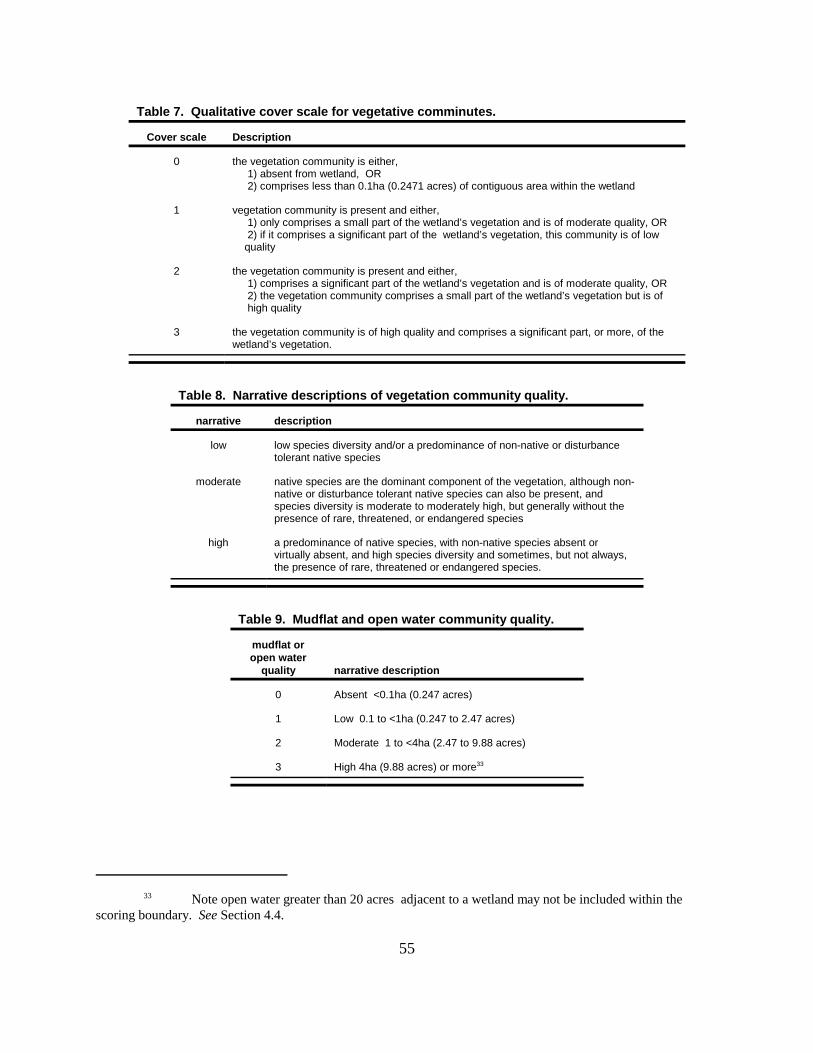
33 Note open water greater than 20 acres adjacent to a wetland may not be included within thescoring boundary. See Section 4.4.
55
Table 7. Qualitative cover scale for vegetative comminutes.
Cover scale Description
0 the vegetation community is either, 1) absent from wetland, OR 2) comprises less than 0.1ha (0.2471 acres) of contiguous area within the wetland
1 vegetation community is present and either, 1) only comprises a small part of the wetland’s vegetation and is of moderate quality, OR 2) if it comprises a significant part of the wetland’s vegetation, this community is of low quality
2 the vegetation community is present and either, 1) comprises a significant part of the wetland’s vegetation and is of moderate quality, OR 2) the vegetation community comprises a small part of the wetland’s vegetation but is of high quality
3 the vegetation community is of high quality and comprises a significant part, or more, of thewetland’s vegetation.
Table 8. Narrative descriptions of vegetation community quality.
narrative description
low low species diversity and/or a predominance of non-native or disturbancetolerant native species
moderate native species are the dominant component of the vegetation, although non-native or disturbance tolerant native species can also be present, andspecies diversity is moderate to moderately high, but generally without thepresence of rare, threatened, or endangered species
high a predominance of native species, with non-native species absent orvirtually absent, and high species diversity and sometimes, but not always,the presence of rare, threatened or endangered species.
Table 9. Mudflat and open water community quality.
mudflat oropen water
quality narrative description
0 Absent <0.1ha (0.247 acres)
1 Low 0.1 to <1ha (0.247 to 2.47 acres)
2 Moderate 1 to <4ha (2.47 to 9.88 acres)
3 High 4ha (9.88 acres) or more33
56
The following guidelines are presented for when and how to assign a score to a vegetation community.
7.6.2.1 Assigning a "0" score.
All classification schemes are artificial to greater or lesser extent and impose arbitrary thresholds. Thus,it is likely that most wetlands have some element of most of the vegetation communities describedabove. Emergent marshes often have a wooded fringe that is located on hydric soils and within thejurisdictional boundary of the wetland. Unvegetated forested wetlands often have small amounts ofbuttonbush growing under a closed canopy, or have small amounts of emergent wetland vegetation ormesic woodland herbs growing on logs or the bases of trees. However, for the purposes of this method,in order for a vegetation community to be considered "present" in the wetland, the community mustcover a minimum contiguous area of 0.1 hectares or 1000m2 (0.2471 acres), unless the wetland itself isless than 0.1 hectares in size, in which case the Rater will need to select the single most characteristicclass. This minimum area is equivalent to an area with the dimensions 31.6 x 31.6 meters (34.6 x 34.6yards).
Some qualifications and explanations for what constitutes the "minimum contiguous area" may behelpful.
1. With regard to the herbaceous vegetation that comprises emergent and aquatic bed communities, thecommunity may have areas of bare ground, small areas of open water, or somewhat sparse stem ortussock density. Some forested wetlands have diverse herbaceous emergent communities that arecharacterized by scattered tussocks growing throughout the wetland or in wide or narrow zones aroundthe shallower perimeter areas of the wetland. The Rater should "sum up" all the parts of this entirecommunity, including open areas between tussocks or stems, when determining whether it meets theminimum size.
2. If the forested vegetation area is no more than a thin band of 1 or 2 trees around some or all of theperimeter, a score of 0 should be assigned. Conversely, many emergent marshes and buttonbushswamps grade into a clearly forested community with a closed canopy and a rather abrupt change occurs in understory vegetation, either in a zone around the perimeter or on one or several sides,especially when upland forest is nearby. In this situation a forested community should be considered tobe present and a score of 1, 2, or 3 assigned.
3. Scrub-shrub and emergent communities can often be densely intermingled; however, it is equallycommon for emergent marshes to have one or several buttonbush, willow, or dogwood plants scatteredhere or there. The coverage of these scattered individuals should not be "summed up" to meet the sizethreshold. The Rater should be able to observe one to three large patches of shrubs or small treeswhich together are equal or greater than 0.1 hectares (0.2471 acres).
4. Mudflats and open water classes do not occur under any type of "canopy." Thus, a vernal pool neverhas an open water class, or a mudflat class after the pool dries down by late summer.
7.6.2.2 Assigning a "1" score.
In assigning a score of "1" to a vegetation community that is determined to be present, the Rater mustfind one of the following:
1. The vegetation community only comprises a small part of the wetland’s entire vegetationand is of moderate quality, or
2. The vegetation community comprises a significant part of the wetland’s vegetation, andthis community is of low quality.

57
The Rater is asked to compare the relative contribution of the vegetation community to all of thevegetation communities that make up this wetland. If the relative contribution is small, then a "1" isappropriately assigned to this community even if it is of moderate quality (if it is of high quality, a "2"should be assigned. See the next section). Alternatively, if the relative contribution is significant, but thecommunity is of low quality, the Rater can also assign a "1."
If neither of the choices above apply, the Rater must consider assigning at least a "2" to the community.
Example 1. The wetland is a 4 hectare (9.88 acre) high quality emergent marsh. Areas of buttonbushand swamp loosestrife are present with surface area of 0.5 to 1.0 hectares (1.2 to 2.5 acres). The southedge of the wetland abuts a young second growth forest and a forested wetland community of 0.2hectares (0.5 acres) has developed at this margin. Score: The forested wetland community receives ascore of "1" since it only comprises a small part of the wetland's entire vegetation. Conversely, theemergent marsh will receive a score of "2" or higher.
Example 2. Portions of a forested flood plain wetland have been clearcut and partially filled. Sedimentation from a nearby construction site has resulted in an emergent community dominated bynarrow-leaved cattail and Phragmites australis. The emergent community is approximately 30% of thearea of mapped hydric soils. Score: The emergent community receives a score of "1" since it comprisesa significant part of the wetland's present vegetation; however, it is of low quality (Note: the remainingforested component will likely receive a score of 2 or more).
7.6.2.3 Assigning a "2" score.
In assigning a score of "2" to a vegetation community that is determined to be present, the Rater mustfind one of the following:
1. The vegetation community comprises a significant part of the wetland’s vegetation andis of moderate quality, or
2. The vegetation community comprises a small part of the wetland’s vegetation but is ofhigh quality.
"Significance" is understood as whether the community is ecologically significant part of the entirewetland. In some instances, however, just considering the physical size of a community may go a longway to deciding what the ecological significance of the community is. For example, if 6.5ha of a 7.0hamarsh is an "emergent" vegetation community, and 0.5ha is relatively narrow (20-40m wide), moderatequality, forested wetland community in one corner, the forested component probably does not comprisea significant part of the of the wetland' s vegetation (and the Rater should reconsider assigning a "1" tothe forested community).
Alternatively , if the relative contribution is small, but the community is of high quality, the Rater shouldassign a "2" to the vegetation community.
If neither of the choices above apply, the Rater should consider assigning a "3" to the community.
Example 1. The wetland is a 7 hectare (17 acre) wetland located in the flood plain of a low-gradient riverthat floods one to several times yearly. Approximately 3 hectares (7.4 acres) is buttonbush, 1 hectare2.5 acres) open water, and 3 hectares (7.4 acres) is second-growth forested with silver maple and greenash. The forested portions of the wetland lie around the central area of buttonbush and open water. Adiverse, sedge-dominated herbaceous community (Carex muskingumensis, C. grayii, C. lacustris, C.lupulina, C. typhina) is present under portions of the forested wetland; annual and perennial emergents(Polygonum cespitosum, P. hydropiperoides, and Iris versicolor) and a floating aquatic herb

58
(Proserpinaca palustris) are present in the margins of the buttonbush/open water area. Score: fourcommunities are present in this wetland: forested, open water, emergent, and scrub-shrub (The aquaticbed species is not present over a sufficient area to count as a separate community). The forestedwetland is of moderate quality given the moderate species diversity and age of the forest and shouldreceive a score of 2 points. The emergent and buttonbush (scrub-shrub) community appear to be highquality and would receive a score of 3 (refer to discussion in next section of when to assign a score of3). Referring to Table 8, the open water is determined to be low quality based on its size and receives a1 point.
Example 2. The wetland is a 2.5 hectare (6.2 acre) forested wetland ringing a central 0.3 hectare (0.75acre) area dominated by buttonbush. On two sides a rare sedge is present growing in tussocks in areasmore shallowly inundated (0.25 hectares or 0.6 acres in area) under a mixed canopy of green ash, silvermaple, and American elm; other wetland and mesic forest herbs grow intermixed with the tussocks or ondowned logs and tree bases. Score: herbaceous community counts as an "emergent" class andreceives a score of two as a "high quality community present in small amounts. Forested community ispresent in moderate quality in large amounts and receives a score of "2"; the scrub-shrub community ispresent in moderate quality in small amounts and receives a score of "1". 7.6.2.4 Assigning a "3" score.
In assigning a score of "3" to a vegetation community that is determined to be present, the Rater mustfind that the vegetation community is,
1. of high quality, and
2. that it comprises a significant part, or more, of the wetland’s vegetation.
Example 1. Wetland is an intact 2.5 hectare (6.2 acre) relict wet prairie that is part of a 15 hectare (37acre) oak savannah. The wetland is dominated by bluejoint grass (Calamagrostis stricta), lake sedge(Carex lacustris), and tussock sedge (Carex stricta) and has a diverse assemblage of prairie forbs. Thewetland also has small areas (0.3 hectares or 0.75 acres) of open water dominated by mermaid weed(Proserpinaca palustris) and water primrose (Ludwigia palustris). The emergent community is of highquality and comprises a significant amount of the wetland's vegetation and scores a "3"; the aquatic bedcommunity is of moderate quality but is only a small part of the wetland's vegetation and scores a "1".
Example 2. Wetland is a 1.5 hectare (3.7 acre), high quality floating-leaved marsh surrounded by a 7hectare (17 acre) buttonbush/swamp rose shrub swamp located on the flood plain of a low-gradientstream. Areas of young second growth swamp forest (<2 hectares or 5 acres) exist at the margins of thewetland. Lake cress (Armoracia lacustris) is present in the marsh. The aquatic bed community andscrub-shrub communities receive a score of "3"; The swamp forest community receives a score of "1".
7.6.3 Question 6b: Horizontal (plan view) community interspersion.
This question is identical to the horizontal interspersion question found in earlier versions of the ORAM. In order to properly answer this question, the Rater must evaluate the wetland from a "plan view," i.e. asif the Rater was hovering above the wetland in the air and looking down upon it. Figure 7 is provided as

34 List of invasive/exotic plant species
Lythrum salicaria (purple loosestrife)Myriophyllum spicatum (European milfoil) Najas minor (lesser naiad) Phalaris arundinacea (reed canary grass)Phragmites australis (phragmites or giant reed) Potamogeton crispus (curly pondweed)Ranunculus ficaria (lesser celandine) Rhamnus frangula (European buckthorn) Typha angustifolia (narrow-leaved cattail)Typha xglauca (narrow-common cattail hybrid)
59
Figure 7. Hypothetical wetlands for estimating degree of interspersion.
an aid in evaluating the degree of horizontal interspersion. The Rater can select from the followingcategories of interspersion:
G high (5 points). Wetland has a high degree of plan view interspersion.
G moderately high (4 points). Wetland has a moderately high degree of plan view interspersion.
G moderate (3 points). Wetland has a moderate degree of plan view interspersion.
G moderately low (2 points). Wetland has a moderately low degree of plan view interspersion.
G low (1 point). Wetland has a low degree of plan view interspersion.
G none (0 points). Wetland has no plan view interspersion.
7.6.4 Question 6c: Coverage of Invasive Plant Species.
In Metric 5, a "-10" point deduction is assigned to hydrologically isolated wetlands that have >80% coverof the species listed in Table 1.34 However, other types of wetlands can be invaded by these species

60
and many wetlands have coverages of less than 80% for these species. This question incorporatesnarrative descriptions found in OAC Rule 3745-1-54 for Category 1 wetlands and requires the Rater todeduct points for the presence of the listed invasive plant species or to add a point if these species areabsent from the wetland being rated.
7.6.5 Question 6d: Microtopography.
This final question in Metric 6 asks the Rater to evaluate various plant-derived microtopograhic habitatfeatures often present in wetlands and whether the wetland provides breeding pools for amphibians,particularly salamanders. A 0 to 3 point cover scale similar to that used in Question 6a is used to rateboth the quantity and quality of habitat features present in the wetland.
The features to be evaluated are,
G vegetated hummocks/tussocksG coarse woody debris >10cm (6in)G standing dead trees >25cm(10in)G amphibian breeding pools
The Rater checks all of the microtopographic features that are present in the wetland and then assignsa cover score of 0, 1, 2, or 3. See Table 10.
Table 10. Cover scale for microtopographic habitat features.
microtopographichabitat quality
narrative description
0 feature is absent or functionally absent from the wetland
1 feature is present in the wetland in very small amounts orif more common, of low quality
2 feature is present in moderate amounts, but not of highestquality, or in small amounts of highest quality
3 present in moderate or greater amounts and of highestquality
61
8.0 REFERENCES.
Anderson, Dennis M. 1982. Plant Communities of Ohio: A preliminary classification and description. Division of Natural Areas and Preserves, Ohio Department of Natural Resources, Columbus, Ohio.
Andreas, Barbara K. 1995. A Floristic Assessment System for Northern Ohio. Technical Report WRP-DE-8 February 1995. U.S. Army Corps of Engineers, Washington DC.
Cowardin, Lewis M., Virginia Carter, Francis C. Golet, and Edward T. LaRoe. 1979. Classification ofWetlands and Deepwater Habitats of the United States. U.S. Fish and Wildlife Service, FWS/OBS-79/31, December 1979.
Federal Emergency Management Agency (FEMA). April 1980. "How to Read a Flood Insurance RateMap." Available from the FEMA Regional Offices.
Gordon, Robert B. 1966. Natural Vegetation of Ohio at the time of the Earliest Land Surveys. OhioBiological Survey, Columbus, Ohio.
Herdendorff, Charles E. 1987. The Ecology of the Coastal Marshes of Western Lake Erie: ACommunity Profile. Biological Report 85(7.9) February 1987. National Wetlands Research Center, Fishand Wildlife Service, U.S. Department of the Interior, Washington, D.C.
Mack, John J., Mick Micacchion, Lauren Augusta, and Greg Sablak. 2000. Vegetation Indices of BioticIntegrity for Wetlands and calibration of the Ohio Rapid Assessment Method for Wetlands v. 5.0. Volume 1: Final Report to U.S. EPA Grant No. CD985276, Interim Report to U.S. EPA GrantNo. CD985875, Division of Surface Water, Ohio Environmental Protection Agency, Columbus, Ohio.
Micacchion, Mick, Michael A. Gray, and John J, Mack. 2000. Amphibian and MacroinvertebrateAttributes for Ohio Wetlands. Volume 2: Final Report to U.S. EPA Grant No. CD985276, InterimReport to U.S. EPA Grant No. CD985875, Division of Surface Water, Ohio Environmental ProtectionAgency, Columbus, Ohio.
Mitsch, William J. and James G. Gosselink. 1986. Wetlands, 2nd Edition. Van Nostrand ReinholdCompany, New York, New York.
Ohio Environmental Protection Agency. 1988a. Biological Criteria for the Protection of Aquatic Life:Volume I. The role of biological data in water quality assessment. Ecological Assessment Section,Division of Water Quality Planning and Assessment, Columbus, Ohio.
Ohio Environmental Protection Agency. 1988b. Biological Criteria for the Protection of Aquatic Life:Volume II. Users Manual for biological field assessment of Ohio surface waters. EcologicalAssessment Section, Division of Water Quality Planning and Assessment, Columbus, Ohio.
Ohio Environmental Protection Agency. 1989a. September 30, 1989 Addendum to Biological Criteriafor the Protection of Aquatic Life: Volume II, 1988. Ecological Assessment Section, Division of WaterQuality Planning and Assessment, Columbus, Ohio.
Ohio Environmental Protection Agency. 1989b. Biological Criteria for the Protection of Aquatic Life:Volume III. Standardized Biological Field Sampling and Laboratory Methods for Assessing Fish andMacroinvertebrate Communities. Ecological Assessment Section, Division of Water Quality Planningand Assessment, Columbus, Ohio.
Omernik, J. M. 1987. Ecoregions of the conterminous United States. Annals of the Association of

62
American Geographers 77:118-125. .
Rankin, Edward T. 1989. The Qualitative Habitat Evaluation Index (QHEI): Rationale, Methods, andApplication. Ecological Assessment Section, Division of Surface Water, Ohio Environmental ProtectionAgency, Columbus, Ohio.
Rosgen, Dave. 1996. Applied River Morphology. Wildland Hydrology, Pagosa Springs, Colorado.
Parker, George R. 1989. Old-Growth Forests of the Central Hardwood Region. Natural Areas Journal,9(1):5- 9.
Schneider, Gregory J. 1999. Rare plant species and plant community inventory of the Lake Erie coast. Final Report for The Lake Erie Protection Fund Grant # LEPF-97-07. Division of Natural Areas andPreserves, Ohio Department of Natural Resources, Fountain Square, Columbus, Ohio.
Sears, Paul B. (1926). The natural vegetation of Ohio II. The prairies. Ohio Journal of Science 26:128-146.
Transeau, Edgar N. (1935). The Prairie Peninsula. Ecology 16(3):423-437.
U.S. Army Corps of Engineers (ACOE). 1987. Corps of Engineers Wetlands Delineation Manual. Technical Report Y-87-1, Final Report, January 1987, Wetlands Research Program, U.S. Army Corps ofEngineers, Waterways Experiment Station, Vicksburg, MI
U.S. Environmental Protection Agency. 1997. Level III ecoregions of the continental United States(revision of Omernik, 1987). Corvallis, Oregon, U.S. EPA - National Health and EnvironmentalResearch Laboratory Map M-1, various scales.
Washington DE. 1993. Washington State Wetlands Rating System, Western Washington, 2nd Ed,Publication No. 93-74. Washington Department of Ecology, August 1993
Wilhelm, Gerould and Douglas Ladd. 1988. Natural Area Assessment in the Chicago Region. Transactions of the 53rd North American Wildlife and Natural Resources Conference.

63
9.0 APPENDICES.
ORAM v.5.0 FormsORAM v.4.1 Forms

64
This page intentionally left blank