oglethorpe county and the cities of arnoldsville, crawford ... county... · the cities of...
TRANSCRIPT

Oglethorpe County and
the Cities of Arnoldsville, Crawford, Lexington and Maxeys
Comprehensive Plan 2037 Good Ground, Deep Roots.
Prepared by Williams & Associates
and the Oglethorpe County Board of Commissioners
ACKNOWLEDGMENTS
BOARD OF COMMISSIONERS Chairman – Billy Pittard District 1 – Phil Sanders District 2 – Andy Saxon District 3 – David R. Clark District 4 – John D. Meyer District 5 – George Gabriel
STAKEHOLDERS Dennis Jentgens Johnnie Harper Clara Harper Michelle Ballif Larry Nackenund Sherry Abrams Alexander Abrams Walter W. Whitaker Martine Wanzer Ron Wanzer Doug Cosby Richard Owens Sid Stedhens Melvin Fleming George Gabriel Bobby Arnold Kathy Luceill Joane Maki Marilyn Stone Steve Johnson
Debbie Hardegree Kathy Wright Liz McGhee Sarah Johnson Christi Fordyce Katie Baldwin Paul Thiel Mack Baldwin Josh Robinson Leslie Lawson Ron Fields Sherry Fields John T. Middleton Tina Fleming Dennis Daniel Susan Robinson Lee W. Norman Clandette A Norman Bobby Leaguwe
STAFF Josh Hawkins – County Administrator Amy Forrester – County Clerk Amy Stone – Economic Development Director Houston Harker - County Planner

TABLE OF CONTENTS
INTRODUCTION 4 SCOPE 4 COMMUNITY GOALS 4 METHODOLOGY 4 HISTORY 5 OGLETHORPE BY THE NUMBERS 7 COMMUNITY ENGAGEMENT 10 COMMUNITY PERSPECTIVE 12 MAP 1 - EXISTING LAND USE 16 AREAS REQUIRING SPECIAL ATTENTION 17 MAP 2 - AREAS REQUIRING SPECIAL ATTENTION 18 MAP 3 – ENVIRONMENTAL AREAS MAP 19 MAP 4 – FEDERAL WETLANDS MAP 20 COMMUNITY VISION 21 VISION STATEMENT 21 COMMUNITY GOALS 21 GUIDING PRINCIPLES 23 CHARACTER AREAS 24 THE “BACK-FORTY” 26 RURAL LIVING 29 RESIDENTIAL TRANSITION 32 COUNTRY CROSSROADS 32 GATEWAY CORRIDOR 35 EMPLOYMENT CENTER 38 MAP 5 - FUTURE LAND USE 41 ISSUES & OPPORTUNITIES 42 ECONOMIC DEVELOPMENT 42 POPULATION 44 COMMUNITY FACILITIES, SERVICES, AND INFRASTRUCTURE 44 HOUSING 44 TRANSPORTATION 45 LAND USE 45 NATURAL RESOURCES 46 SUMMARY OF COMMUNITY OBJECTIVES 47 TRANSPORTATION 50 MAP 6: SURVEY OF ROADS IN OGLETHORPE COUNTY 51 MAP 7: PROPOSED FIREFLY TRAIL 52 SHORT-TERM WORK PROGRAM 53 ECONOMIC DEVELOPMENT 53 HOUSING 54 NATURAL AND CULTURAL RESOURCES 55 COMMUNITY FACILITIES AND SERVICES 56 LAND USE 57

4
INTRODUCTION Oglethorpe County has completed a state-mandated update of its Comprehensive Plan, also known as the Community Agenda. The process was managed with guidance and involvement of local residents, a Stakeholder Committee and County Staff. Local staff and elected and appointed officials will use the Comprehensive Plan as a reference in making rezoning and capital investment decisions. The plan’s policies will guide rezoning decisions and decisions by elected officials and staff to reinforce the goals of the community. This document outlines the community’s vision, identifies the key issues and opportunities throughout the community, sets forth a set of supportive policies to help guide local decision makers, and outlines a short-term work program outlining the community’s actions over the next five years.
SCOPE The Comprehensive Plan was prepared under the Rules of the Georgia Department of Community Affairs, Chapter 110-12-1 -.02 — Requirements, specifically Chapter 110-12-1-.03 – Plan Elements. The Comprehensive Plan includes the following five components:
COMMUNITY GOALS Needs & Opportunities Community Work Program Land Use Element Transportation Element This plan is a living document and is intended to be updated as necessary to reflect changes in local conditions.
METHODOLOGY The report contains several technical key components addressing of the issues and opportunities resulting from an analysis of the available data; an analysis of existing development patterns; an evaluation of the community’s existing policies and development patterns for consistency with DCA’s Quality Community Objectives; and an analysis of supportive data and information illustrating conformance with the Department of Natural Resources Environmental Planning Criteria and the Service Delivery Strategy. The report is a product of a review of the community’s plans, policies, regulations and development patterns and encompasses Oglethorpe County and the cities of Arnoldsville, Crawford, Lexington, and Maxeys. The Community Assessment is the first step in the revision of the Comprehensive Plan. The Community Agenda represents the community’s vision, goals, policies, key issues and opportunities that the community chooses to address, and an action plan highlighting the necessary tools for implementing the plan. For the Oglethorpe County By the Numbers section of this report, the data was compiled from United States Census, Department of Education, and American Community Survey sources. This data represents demographic information for the population of Oglethorpe County. This data includes information about the age, race, ethnicity, education, employment and population aggregate and projections. The Future Land Use Map was created by first holding meeting under the guidance of the planning staff and the county officials with consideration for current zoning, demography, transportation, growth patterns and overall goals for the county.
5
HISTORY EARLY SETTLEMENT
This area was long inhabited by various Indian tribes. By the Treaty of 1773 it was part of a large tract surrendered by the Creeks and Cherokees to the colony of Georgia. Four years later, that land became Wilkes County. In 1793, Oglethorpe County was created out of the western portion of Wilkes and named in honor of the great English philanthropist, Gen. James Edward Oglethorpe, founder of the Georgia colony only sixty years before. With only traders and trappers, there were no permanent settlements in what would become Oglethorpe County until 1774, when a small band of families from North Carolina located on Long Creek, near the present site of Lexington. Extensive settlement of the new lands had been delayed by the Revolutionary War, but by 1784, bounty grants and other incentives offered by the State produced a rapid tide of immigrants into all the open lands. Many of the newcomers had been tobacco planters in Virginia and North Carolina. They found the area well suited to the production of tobacco, although, as a cash crop, it was quickly superseded by cotton after the invention of the cotton gin in 1793. Some of the settlers from Virginia and North Carolina were distinguished men and women of influence and wealth, who could be considered part of the old aristocracy. They were noted for their culture, education, integrity, and leadership. They and their descendants played important and influential roles in the development of Oglethorpe County, Georgia, and the nation. RAILROADS
Completed in 1841, the Athens-Augusta Railroad (later the Georgia Railroad) was the first railroad in Georgia and only the third constructed in the United States. Many of Oglethorpe’s towns, including Arnoldsville, Crawford, Maxeys, Hutchins, Stephens, and Dunlap, prospered around the early railroad depots. CIVIL WAR
The War Between the States (1861-1865) disrupted the agriculture and economy of the South. Oglethorpe Coun-ty sent four companies of soldiers to fight - the Gilmer Blues, the Oglethorpe Rifles, the T.R.R. Cobb Infantry, and the Echols Artillery. In all, 766 men from Oglethorpe County, almost three-fourths of the adult white male population, fought in the War. Recovery after the War was slow. The old plantation system was soon replaced by tenant farming. The majority of freed slaves in the county remained on the plantations, working for wages or sharecropping. Widespread poverty gave rise to the crop-lien mortgage system which trapped land-poor farmers and tenants in an all-cotton program and an unending cycle of poverty and debt. Many Oglethorpe County residents migrated to the west. GOLD RUSH
The economy and population rebounded in the 1880s-90s. New industries began to develop, and as prices rose, cotton once again became king. About that time gold was discovered in the Flatwoods section of southeastern Oglethorpe County. A gold rush ensued. A number of gold mines were opened and foreign capitalists flocked to the county. These mines failed to produce gold in sufficient quantities, and they were eventually abandoned. TWENTIETH CENTURY
The period during the late nineteenth and early twentieth centuries was a time of great prosperity for Oglethorpe County. In 1920, the population reached an all-time high of 20,287. Then, economic and agricultural disaster struck. Cotton prices plummeted and remained low for the next twenty years. Devastating droughts and boll weevil infestations hit in the 1920s, followed by the Great Depression of the early 1930s. It was an onslaught that permanently altered agriculture and the way of life in the county. Cotton farming was abandoned and

6
Oglethorpe County lost over half its population in a flight to the cities that continued unabated for the next forty years. Agricultural diversification and general economic development in the region have reversed the trend and Oglethorpe County is once again growing. FAMOUS MEN OF OGLETHORPE COUNTY
William Harris Crawford (1772-1834) - U.S. Congressman, U.S. Senator (President Pro Tempore), Minister to France, U.S. Secretary of War, U.S. Secretary of Treasury, candidate for President of the United States (he was the leading candidate but suffered a stroke). His great ability as a statesman and his six foot, three inch, "majestic" appearance led Emperor Napoleon to call him "the most regal man in my entire court," and the only man he had ever met who made him feel like bowing. During the height of Crawford's political career, many of the great men of the nation came to visit him at "Woodlawn," his home just west of Crawford. Among them were Henry Clay and President Monroe, who reportedly consulted with Crawford about policies that led to the Monroe Doctrine. Crawford's likeness appears on a U.S. fifty-cent bill issued in 1875. Crawford County and the towns of Crawford and Crawfordville are named in his honor. George Mathews (1739-1812) Twice Governor of Georgia, first Georgian elected to the U.S. Congress. Meriwether Lewis (1774-1809) Leader of the famous Lewis and Clark Expedition, Private Secretary to President Thomas Jefferson, Governor of the Louisiana Territory. Stephen Upson (1785-1824) Legislator, one of Georgia’s most eminent lawyers. Once called “the wisest man in Georgia.” Upson County is named in his honor. Wilson Lumpkin (1783-1870) Georgia Governor, U.S. Congressman, State Repre-sentative. Lumpkin County is named for him. George R. Gilmer (1790-1859) Twice Governor of Georgia, U.S. Congressman. Gilmer County is named for him. Joseph Henry Lumpkin (1799-1867) First Chief Justice of the Georgia Supreme Court, he was instrumental in framing the state penal code, co-founder of the Lumpkin School of Law at the University of Georgia, founded the Phi Kappa Literary Society. He was the brother of Wilson Lumpkin. Educated at the University of Georgia and Princeton, he was renowned for his eloquence and intelligence. David C. Barrow (1852-1929) University of Georgia Chancellor for over twenty years. Barrow County is named for him.
William Harris Crawford
Meriweather Lewis
Joseph Henry Lumpkin
OGLETHORPE BY THE NUMBERS
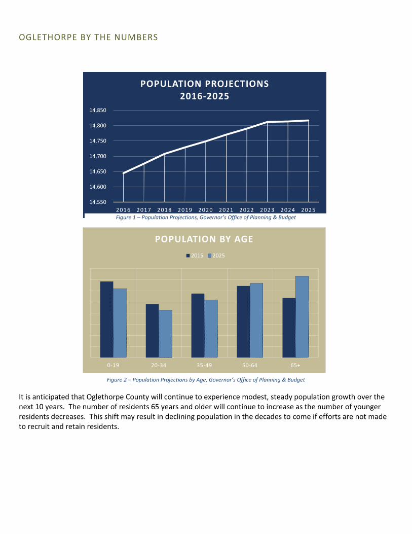
It is anticipated that Oglethorpe County will continue to experience modest, steady population growth over the next 10 years. The number of residents 65 years and older will continue to increase as the number of younger residents decreases. This shift may result in declining population in the decades to come if efforts are not made to recruit and retain residents.
14,550
14,600
14,650
14,700
14,750
14,800
14,850
2016 2017 2018 2019 2020 2021 2022 2023 2024 2025
POPULATION PROJECTIONS 2016-2025
Figure 1 – Population Projections, Governor’s Office of Planning & Budget
Figure 2 – Population Projections by Age, Governor’s Office of Planning & Budget
0-19 20-34 35-49 50-64 65+
POPULATION BY AGE
2015 2025

Oglethorpe County’s population is a predominately comprised of white, non-Hispanic people. African Americans account for the next largest group with about 17% of the population. In terms of ethnography, 4% of Oglethorpe County residents identify as Hispanic.
There are approximately 14,600 residents in 5,542 households in Oglethorpe. The median household value is $121,000 as compared to the State of Georgia median value of $148,100 and the national median value of $178,600. The high school educational attainment rate of 79% is somewhat below the national average of 88%. Oglethorpe residents participate in the labor force at a rate of 57% compared to the national labor force participation rate of 63%. Most Oglethorpe residents are employed outside of the community. Approximately 1,098 commute into Oglethorpe for work and 6,165 commute out leaving about 750 that live and work in the county. The average commute time is 29 minutes compared to the national average of 24.5 minutes. There are 166 employer establishments in Oglethorpe County.
White, Non-hispanic
76%
Black or African American
18%
Latino4%
Other3%
POPULATION BY RACE
White, Non-hispanic Black or African American Latino Other
Figure 1 – Population by Race, US Census Bureau Quick Facts v.2015
Figure 4 – Facts at a Glance, US Census Bureau Quick Facts
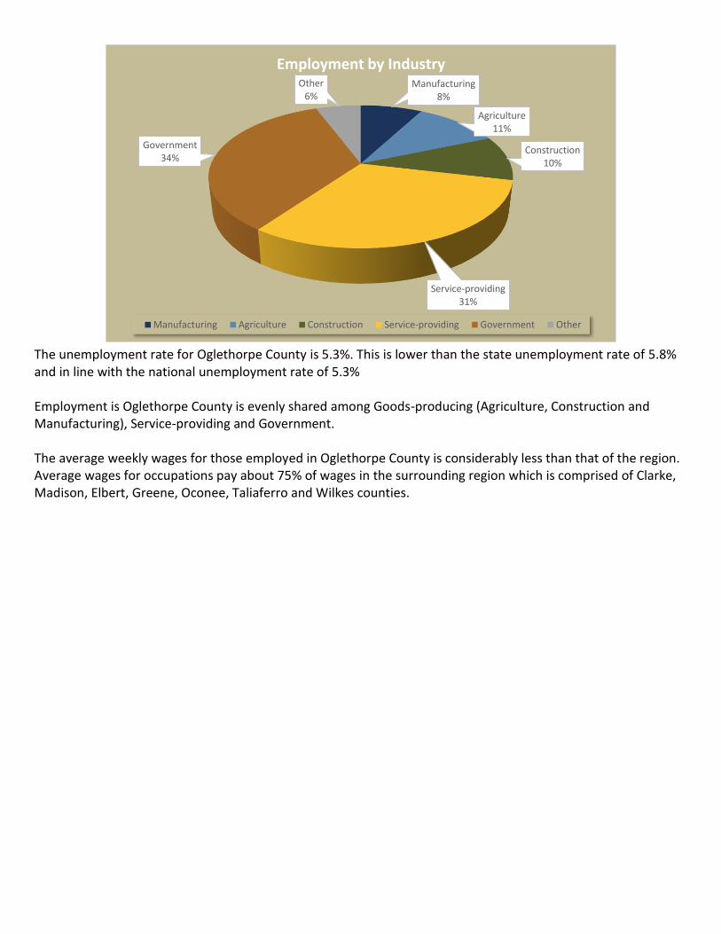
The unemployment rate for Oglethorpe County is 5.3%. This is lower than the state unemployment rate of 5.8% and in line with the national unemployment rate of 5.3% Employment is Oglethorpe County is evenly shared among Goods-producing (Agriculture, Construction and Manufacturing), Service-providing and Government. The average weekly wages for those employed in Oglethorpe County is considerably less than that of the region. Average wages for occupations pay about 75% of wages in the surrounding region which is comprised of Clarke, Madison, Elbert, Greene, Oconee, Taliaferro and Wilkes counties.
Manufacturing8%
Agriculture11%
Construction10%
Service-providing31%
Government34%
Other6%
Employment by Industry
Manufacturing Agriculture Construction Service-providing Government Other

10
COMMUNITY ENGAGEMENT
METHODOLOGY
Approximately 170 people attended a Town Hall Meeting to discuss issues generated during the first comprehensive planning process. After a brief overview of the project and a description of each of the issues, they ranked 10 issues developed by the steering committee in order of significance, first on paper and then using an electronic keypad system. There were only 100 keypads, so the poll on paper was collected from the rest of the participants to be added later. The keypad results were used to choose the top three issues as discussion topics. Facilitators took notes as small groups of participants discussed the importance of the issues and what needed to be done about them.
Participants sat at separate tables, each supplied with a computer. Most tables also had a facilitator to key in discussion notes. Those tables without a facilitator were asked to choose a participant to act as scribe for the group. The groups discussed the top three issues and a general question about any issues that weren't in the poll.
What follows is the responses from polling and from the discussions.
ISSUES AND CONCERNS
ISSUES The 10 issues developed by the steering committee are listed in order below. Paper responses from the overflow group were added manually and compared to the keypad-only results; the additions did not change the rank order of the top three. Participants ranked issues in order of significance: 1 is most significant, 10 is least significant. Rank scores were derived from the average of the participants poll results.
ISSUE RANK Protect and support agricultural uses 3.47 Plan for growth 3.88 Create opportunities for economic development 3.98 Coordinate infrastructure expansion with land uses 4.90 Protect rural character and small town charm 5.27 Encourage innovative development techniques 6.38 Ensure compatible land uses 6.40 Protect historic resources 6.53 Protect environmentally sensitive areas 6.66 Support recreation 7.39
DISCUSSION/TOPICS AND TRENDS Participants sat at separate tables, each supplied with a computer. Most tables also had a facilitator to key in discussion notes. Those tables without a facilitator were asked to choose a participant to act as scribe for the group. The groups discussed the top three issues and a general question about any issues that weren't in the poll. The following is a summary of the responses.
What is important about protecting and supporting agricultural uses? “Agriculture is the economic base of the county, the number one revenue generator. It's a tradition in Oglethorpe County and one of the most important characteristics of the community. Providing food also important to the wider community. Many people enjoy living in a rural area; protecting agriculture also protects the rural character of the county.”
11
What needs to be done to accomplish protecting and supporting agricultural uses? “Plan carefully to keep other kinds of development from encroaching on agricultural land. Zoning can be used but is not acceptable to all residents. Some would like to see zoning codes removed, along with other regulations. Keep property taxes low and/or provide tax exemptions or other incentives for farmers. Publicize Oglethorpe County agriculture. Support a local farmers market. Encourage other agriculture-related businesses. Educate the community, especially young people, about agriculture through the school system and encourage organizations like 4-H and FFA.”
What is important about planning for growth? “Planning ensures that the infrastructure for growth is in place, so roads don't become congested, and water supplies and sewage capacity aren't overwhelmed. It allows local control over what type of growth occurs where. It can encourage business, increasing the tax base, while preserving the character of the county.”
What needs to be done to accomplish planning for growth? “Improve the roads and other infrastructure (residents disagree about widening Highway 78). Use zoning to direct growth (also a controversial subject). Encourage businesses to locate in Oglethorpe County. Seek input from the community, including young people. Reduce government regulation. What is important about creating opportunities for economic development? Business taxes improve the tax base and keeps money in the county. Businesses provide jobs for the local residents, and provide opportunity for young people so that they don't have to relocate.”
What needs to be done to accomplish creating opportunities for economic development? “Offer tax and other incentives to businesses. Support local businesses; shop in the county. Join the Chamber of Commerce. Create a development authority or a downtown development authority in each of the towns. Improve the county's infrastructure and education. Businesses are attracted to places with good schools, so that would help with recruitment efforts. Market the county to appropriate businesses and retirees. Utilize the re- sources of the university.”
What issues did we miss? “The school system needs attention. Transportation is an issue: there is disagreement about widening Highway 78 and putting bypasses around Crawford and Lexington; there is no mass transit option in the county. Recreation is another area that did not receive sufficient attention. Public safety and other county services, including a senior center are issues. The community needs to be involved. Oglethorpe County needs to be marketed better. The environment needs to be considered.”

12
COMMUNITY PERSPECTIVE As part of the public input process, county residents were asked to answer a series of questions regarding their perceptions of Oglethorpe County. The following chart highlights their responses to questions directed towards an analysis of Oglethorpe County’s strengths, weaknesses, opportunities and threats.
OVERALL VISION
When you think of Oglethorpe, which three words come to mind? Country/rural Home Agricultural/Farming
If you could add something to Oglethorpe County that would make a positive difference for the future, what would you add? Strong business community Better infrastructure More restaurants and retail New recreational facilities If you could take something away from Oglethorpe County that would make a positive difference for its future, what would you take away? Worn down infrastructure / blight Government School Board troubles
In your opinion, what would be an ideal version of Oglethorpe County in 10 years? A county that still maintains its rural qualities, agricultural roots, has more retirement type facilities, visitor accommodations, really nice restaurants, tours of the historic homes and other places in the county. A county with approximately 50,000 people, two or three national chain restaurants and one national chain grocery store designed around the rural ideals of Oglethorpe County. The version it is today, but with improved recreation facilities, a few added tax generating industrial businesses, and a few more retail and restaurant businesses. A beautified 78 corridor with more small businesses, a handful of retirement communities that blend well into the landscape, beautified parks and recreation and a totally remodeled high school.
STRENGTHS
What in Oglethorpe attracts the most residents? Rural, small-town feeling Location / Proximity Low cost of living What in Oglethorpe attracts the most visitors? Historic resources Hunting Rural What in Oglethorpe attracts the most businesses? Lower taxes

13
What aspect of Oglethorpe County is the biggest source of pride in the community? Schools History Rural way of life
Where is the one place in Oglethorpe County you would take a visitor so they would always remember their visit? Watson Mill Lexington Goodness Grows County Courthouse
OPPORTUNITIES
What are Oglethorpe’s biggest opportunities for improvement? Attract more businesses / jobs Fix existing infrastructure Improve school system
In your opinion, what is the best way to attract more of the following to Oglethorpe County? Retail: Keep money in the county and not take it to Athens-Clarke County. Economic development: Paper mills or crop processing centers. Large employers that complement the agrarian lifestyle. Infrastructure: Infrastructure aimed at economic development. Everything else would follow.
What business / industry is best suited for Oglethorpe County? Agriculture Retirement Communities Retail / Restaurant Manufacturing
CHALLENGES
What are the biggest challenges facing Oglethorpe County? Lack of local businesses and jobs Growth issues Lack of a tax base Bad infrastructure
What is missing in Oglethorpe County? Restaurants and retail Jobs and activities for high school graduates Diversified economy Sports-related facilities

14
ANALYSIS OF CURRENT CONDITIONS
EXISTING LAND USE The existing land use information and map is used to illustrate the issues and opportunities in relation to the existing development patterns. Analyzing the existing land use map in conjunction with the historical trend data can help to illustrate how the development patterns were formed.
The land use map is an illustration of what is currently on the ground and includes the cities of Arnoldsville, Crawford, Lexington, and Maxeys. It is based on a compilation of tax assessor’s data in comparison with aerial photography, and field surveys to determine what the predominant land use is for every parcel of land throughout the county.
Table 1 defines the types of land uses found in Oglethorpe County, and Table 2 breaks down the existing land use by category and total acreage. Figure 1 illustrates the existing countywide land use map. Table 1 - Land Use Definitions
Land Use Category Definition
Agriculture, forestry, fishing, and hunting
These establishments grow crops, raise animals, harvest timber, and harvest fish and other animals from a farm, ranch, or their natural habitats.
Arts, entertainment, and recreation
These establishments operate facilities or provide services for a variety of cultural, entertainment, and recreational functions.
Education, public administration, health care, and other institutions
This is an aggregation of all public and institutional facilities.
General sales or services Comprise the vast majority of establishments typically associated with commercial land use.
Manufacturing and wholesale trade
Manufacturing establishments are located in plants, factories or mills and employ workers who create new products by hand; wholesaling is an intermediate step in the distribution of merchandise. Wholesalers either sell or arrange the purchase of goods to other businesses and normally operate from a warehouse or office.
Mining and extraction establishments
These establishments refer to all activities that extract solid, liquid, or gaseous minerals or perform other preparations of these materials at a mine site.
Residence or accommodation functions
Comprise all establishments offering residence or accommodation, such as homes, apartments, elderly housing, and hotels.
Transportation, communication, information, and utilities
Establishments that serve passengers and cargo movements; produce or distribute information; or provide utility services.
All land use categories are based on the Land Based Classification System Land Classification Categories, as developed by the American Planning Association.

15
Table 2 – Breakdown of Land by Use
Oglethorpe is primarily an agricultural community with over 86% of the county in a rural or agricultural state and nearly 15% of the residential acreage on lots greater than 40 acres. The majority of residential development lies outside of the municipal limits of Crawford, Arnoldsville, Lexington and Maxeys within unincorporated Oglethorpe County.
Commercial and industrial areas do not account for a significant portion of developed land in the county, representing a total of less than 0.3%.

MAP 1 - EXISTING LAND USE
Existing Land Use Oglethorpe County,
Georgia Prepared by Hugh Harker
For the County Government of Oglethorpe County, Georgia August 2016
Source: US National Wetlands Inventory

Watson Mill State Park
AREAS REQUIRING SPECIAL ATTENTION
INTRODUCTION As growth continues there are inevitably going to be impacts to the existing natural and cultural environment as well as the community facilities, services and infrastructure that are required to service existing and future development. This section outlines areas where growth should be avoided, where growth is expected to occur, and where growth could potentially be stimulated. Map 2 provides a map of all Areas Requiring Special Attention.
AREA DESCRIPTIONS AREAS OF SIGNIFICANT NATURAL OR CULTURAL RESOURCES The map illustrates the presence of a variety of environmentally sensitive areas located throughout the county. The environmental areas include wetlands, floodplains, streams, groundwater recharge areas, steep slopes, and the small water supply watershed for the Crawford reservoir.
AREAS WHERE RAPID DEVELOPMENT OR CHANGE OF LAND USE IS LIKELY TO OCCUR Existing development patterns have indicated that the northwestern area of the county has experienced the most rapid rates of growth. The presence of an expanded water system originating in Arnoldsville and the proximity to the increasing employment opportunities in Athens-Clarke County indicates that this area is likely to continue to experience residential growth over the next twenty years under the existing conditions.
AREAS WHERE THE PACE OF DEVELOPMENT HAS OR MAY OUT PACE THE AVAILABILITY OF COMMUNITY FACILITIES AND SERVICES, INCLUDING TRANSPORTATION Existing development patterns have indicated that the northwestern area of the county has experienced the most rapid rates of growth. The presence of an expanded water system originating in Arnoldsville and the proximity to the increasing employment opportunities in Athens-Clarke County indicates that this area is likely to continue to experience residential growth over the next twenty years under the existing conditions.
AREAS WITH INFILL AND/OR REDEVELOPMENT OPPORTUNITIES Infill/redevelopment opportunities exist within the municipalities, specifically within downtown Lexington’s historic district, which contains a number of historic structures that represent opportunities for the rehabilitation of existing historic structures for economic development purposes.

18
MAP 2 - AREAS REQUIRING SPECIAL ATTENTION
Areas Requiring Special Attention Oglethorpe County,
Georgia Prepared by Hugh Harker
For the County Government of Oglethorpe County, Georgia August 2016
Source: US National Wetlands Inventory

19
MAP 3 – ENVIRONMENTAL AREAS MAP
Environmental Map Oglethorpe County,
Georgia Prepared by Hugh Harker
For the County Government of Oglethorpe County, Georgia August 2016
Source: US National Wetlands Inventory
20
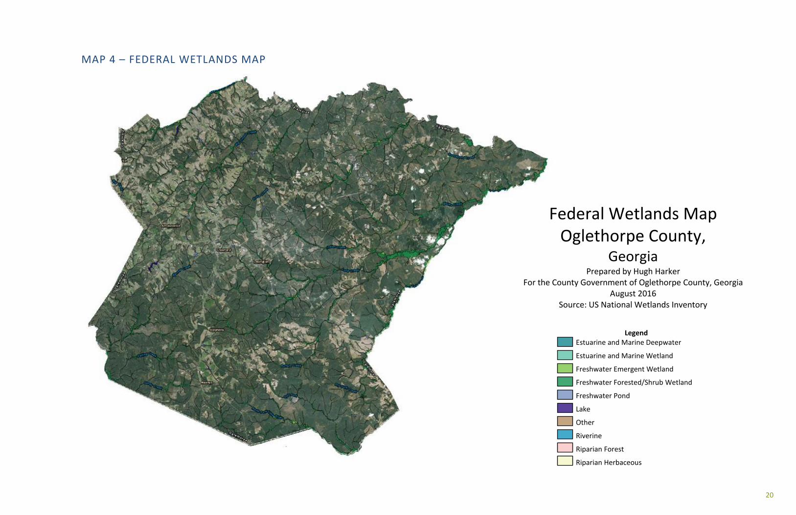
MAP 4 – FEDERAL WETLANDS MAP
Federal Wetlands Map Oglethorpe County,
Georgia Prepared by Hugh Harker
For the County Government of Oglethorpe County, Georgia August 2016
Source: US National Wetlands Inventory
Legend Estuarine and Marine Deepwater
Estuarine and Marine Wetland
Freshwater Emergent Wetland
Freshwater Forested/Shrub Wetland
Freshwater Pond
Lake
Other
Riverine
Riparian Forest
Riparian Herbaceous

COMMUNITY VISION
VISION STATEMENT Oglethorpe County is a peaceful farming community with a stable economy, only a short drive from Athens and the
University of Georgia. The county’s rural qualities offer a supportive living environment for families of all ages that value
self-reliance and relief from urban sprawl. The community desires residential growth that is balanced with the ability of the
schools and government to provide high quality service. New and continued economic activity will complement the county’s
lifestyle in a way which supports the rural qualities identified in the county narrative.
COMMUNITY GOALS ECONOMIC PROSPERITY Oglethorpe County will seek to maintain its rural agricultural character by growing those industries which are compatible with a rural community. The goal is to encourage appropriate development for Oglethorpe County by expanding agricultural and light industrial development, encouraging home occupation and small business growth. These commercial sectors will be encouraged to balance the burden on services from the growth in single family housing stemming from the growth of the Athens Metropolitan Area.
The Agricultural industry is the central economic engine for Oglethorpe County. The county will support smart and appropriate growth for intensive agricultural uses. This will be accomplished by enforcing the county’s zoning code to ensure development occurs in areas appropriate for this type of development. The county will continue to encourage and support less intensive agricultural use throughout the county.
The industrial economy is important in Oglethorpe County. The Future Land Use Plan identifies areas in Oglethorpe County which have or have the potential to have the infrastructure to support industrial growth. Mineral extraction will continue to be an active part of Oglethorpe County’s industrial sector. The growth of this sector will continue to be moderated by the Oglethorpe County Zoning Code.
RESOURCE MANAGEMENT Oglethorpe County will promote the efficient use of the county’s natural resources and identify and protect environmentally sensitive areas of the community. Oglethorpe County will encourage and promote the conservation of farm land and land which has or can be used for mineral extraction. The county will continue to encourage the growth of the green energy sector in the country. Through the zoning code, Oglethorpe County will restrict the development of those intensive industrial and agricultural uses in locations that could negatively impact the environmentally sensitive areas.
EFFICIENT LAND USE Oglethorpe County will maximize the use of the existing infrastructure. Oglethorpe County will identify areas in Future Land Use Map which have the most appropriate infrastructure to support commercial, residential, or industrial growth and focus development -through zoning - in these areas. Oglethorpe County will encourage residential and commercial development in areas along major transportation corridors and in and around the cities in the county. This density will be supported with improvements to the local infrastructure.
22
SENSE OF PLACE Oglethorpe County will protect and enhance the community’s unique qualities. New development will contribute to, not take away from, the character and sense of place of the Oglethorpe County. This will be accomplished by controlling form and development through the zoning code. Oglethorpe County will work to preserve and protect historic buildings and cultural landmarks. Oglethorpe County will encourage “Agri-tousim” as a use which will capitalize on the bucolic character of the county. The County will encourage the use of historic buildings in the cities in the county. Oglethorpe is a rural county and will work to preserve this character through regulation of development.
REGIONAL COOPERATION When possible, Oglethorpe County will cooperate with neighboring jurisdictions to address shared needs. Oglethorpe County, will work with its neighboring counties when joint development of projects will benefit the county tax payers. Oglethorpe County will remain a part of a regional transportation planning organization, Joint Solid Waste Committee, and the Northeast Georgia Joint Development Authority.
HOUSING Oglethorpe County will create conditions for housing construction that adequately supports an active but aging population. Policy will support housing options which allow extended and multi-generational families to live in proximity to one another. Housing options should make possible the independent, family-centered lifestyle described in the county narrative with a safe and quiet living environment. Land use conflict between residential and intensive agriculture will be avoided. The quality, value, and desirability of housing options in the community will increase over time and, overall, homes in Oglethorpe County will be highly desirable.
TRANSPORTATION Oglethorpe County will address the transportation needs of the community by improving infrastructure where needed. When possible, Oglethorpe County will foster alternative to motorized transportation, however, because of the rural nature of the county, it is unlikely that there will be large-scale development of this type of infrastructure in the foreseeable future. Oglethorpe will, when needed, employ traffic calming measures to ensure the safe movement of vehicles throughout the county. When possible, Oglethorpe County will encourage connectivity between commercial developments. In order to preserve existing infrastructure, heavy truck traffic will be closely managed and daily traffic counts on unpaved roads will be limited. The transportation network will ensure reliable access to all occupied structures by emergency service providers, school transportation, and postal deliveries. Major arterial routes will have smooth, safe, constant flow of traffic.

23
GUIDING PRINCIPLES PROTECT AND SUPPORT AGRICULTURAL USES. Agriculture remains an important part of the county’s identity as well as its economy. The Future Development Map designates an agricultural area limiting infringement and incompatibility between non-farm and farm uses. Additionally, buffers and separation requirements between residential and agricultural uses should be implemented wherever necessary.
COORDINATE INFRASTRUCTURE EXPANSION WITH LAND USE. It is important that future land use decisions are coordinated with the capacities of existing infrastructure. The expansion of supportive infrastructure networks (roads, water, sewer, gas, broadband, electricity) should be guided by the Future Development Map illustrating areas designated for growth to provide the most efficient and cost-effective use of public funds. ENCOURAGE INNOVATIVE DEVELOPMENT TECHNIQUES. Master planned developments and subdivisions with conservation or traditional neighborhood design, meeting the county’s vision and goals, will be encouraged to increase the amount of open space within new development, promote a compatible mixture of uses, and protect environmentally sensitive areas. Additionally, intensive development will be encouraged within nodes at major intersections providing inter-parcel connectivity, increasing safety and minimizing the impact of increased vehicle trips on the road network.
ENCOURAGE THE EXPANSION OF EMPLOYMENT OPPORTUNITIES (INDUSTRIAL, OFFICE, OR COMMERCIAL USES) IN APPROPRIATE LOCATIONS. The Future Development Map illustrates ample space to accommodate employment-generating uses. These areas are concentrated along existing and planned arterial thoroughfares with access to existing or planned water service. The county and its cities will continue to program appropriate infrastructure expansion within these areas to expand and diversify the local economy.
PROTECT ENVIRONMENTALLY SENSITIVE AREAS. Oglethorpe County’s environmentally sensitive areas are important components of the county’s identity and vital to the environmental integrity of the county and region. As the county continues to grow increased pressures will be placed on the county’s resources as development encroaches on sensitive natural areas. The Future Development Map illustrates the significant environmentally sensitive areas and limits incompatible land uses in conjunction with the county’s zoning code.
LAND USE COMPATIBILITY. The intensity, scale and design of new development should be compatible with the function, character, and scale of adjacent land uses. Adequate transitions and buffers should be provided as needed to mitigate any adverse impacts on adjacent properties.

24
CHARACTER AREAS
INTRODUCTION
Community character areas attempt to address the overall pattern of development within an area rather than focusing on the specific use of each individual parcel. Areas are defined in terms of the desired development characteristics and the appropriate types of land uses. The purpose of the community character area is to:
• Link the county’s vision, goals, policies, and regulations. • Define the mixing and integration of appropriate and complimentary uses. • Provide guidance to developers regarding the qualitative aspects of desired development patterns. • Provide land use compatibility and transition standards. • Coordinate the goals and policies of all other components of the Comprehensive Plan within land use
decisions.
The core of the county’s vision is the preservation of the rural character. The Future Development Map outlines the general intent for accommodating growth, while maintaining a positive relationship between the natural and built environments. As a whole, the map illustrates the relationship of land use to the supportive infrastructure and community facilities over the long-term. The arrangement of land development patterns indicates the long- term investment strategies for efficiently accommodating new growth.
The desired patterns of future development are represented on the Future Development Map by the various Character Areas. The map represents the Comprehensive Plan’s goals and policies and reflects current development patterns and expected trends. Each of the map designations illustrates the predominant types of land uses proposed within the general areas. The map, along with the supportive goals and policies should be considered together as a guide for rezoning decisions. The following table provides an overview of each of the character areas.
Character Area Description
Back Forty Primarily forest and farms, land preservation a priority and lowest level of infrastructure support.
Rural Living Balanced mix of forestry, farms, and homes. The area is within reasonable commuting distance to major regional employers and under pressure to develop, however services cannot be efficiently provided so residential growth should remain modest.
Residential Transition Intended to accommodate bulk of county’s residential growth. This area is situated in proximity to schools, arterial roads, municipal water, and existing communities. Primary location for retail economic activity inside the county. Increased residential density may be allowed.
Country Crossroads Identified areas are a reflection of existing communities. Intended to allow for a mix of uses including residential and commercial uses within community nodes. The area is designed to provide limited convenience shopping and services for surrounding residential areas.

25
Gateway Corridor This character area includes a full spectrum of live, work, shop, and play land uses. This area is highly visible and represents a central section of the county including US Highway 78 extending from the Arnoldsville Road to Crawfordville Road.
Employment Center The overall character of the area is intended for large-scale, employment intensive commercial uses. The area is designed to provide a compatible mix of commercial development (retail and services), professional offices, and light industrial uses.
26
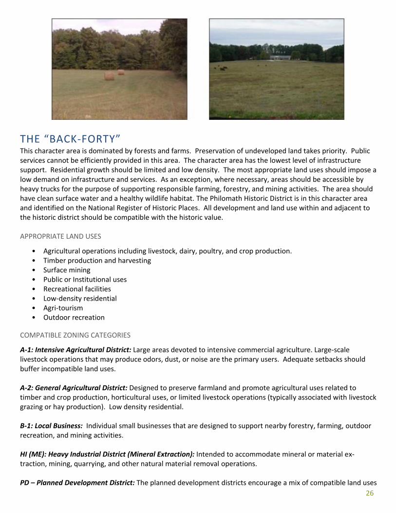
THE “BACK-FORTY” This character area is dominated by forests and farms. Preservation of undeveloped land takes priority. Public services cannot be efficiently provided in this area. The character area has the lowest level of infrastructure support. Residential growth should be limited and low density. The most appropriate land uses should impose a low demand on infrastructure and services. As an exception, where necessary, areas should be accessible by heavy trucks for the purpose of supporting responsible farming, forestry, and mining activities. The area should have clean surface water and a healthy wildlife habitat. The Philomath Historic District is in this character area and identified on the National Register of Historic Places. All development and land use within and adjacent to the historic district should be compatible with the historic value. APPROPRIATE LAND USES
• Agricultural operations including livestock, dairy, poultry, and crop production. • Timber production and harvesting • Surface mining • Public or Institutional uses • Recreational facilities • Low-density residential • Agri-tourism • Outdoor recreation
COMPATIBLE ZONING CATEGORIES
A-1: Intensive Agricultural District: Large areas devoted to intensive commercial agriculture. Large-scale livestock operations that may produce odors, dust, or noise are the primary users. Adequate setbacks should buffer incompatible land uses. A-2: General Agricultural District: Designed to preserve farmland and promote agricultural uses related to timber and crop production, horticultural uses, or limited livestock operations (typically associated with livestock grazing or hay production). Low density residential. B-1: Local Business: Individual small businesses that are designed to support nearby forestry, farming, outdoor recreation, and mining activities. HI (ME): Heavy Industrial District (Mineral Extraction): Intended to accommodate mineral or material ex- traction, mining, quarrying, and other natural material removal operations. PD – Planned Development District: The planned development districts encourage a mix of compatible land uses
27
and allow greater flexibility with regard to site development to meet the vision and goals of the county. The districts are designed as an overlay appended to the underlying zoning category (residential, commercial, institutional or industrial).
QUALITY COMMUNITY OBJECTIVES
The following Quality Community Objectives will be pursued in the Back Forty character area:
Sense of Place: The county narrative is built on life in the Back Forty. Outdoor recreation and abundant wildlife contribute to the quality of the area. Efficient Land Use: New development should be limited in this area due to the limited existing infrastructure. Maintain open space and encourage conservation practices. Resource Management: Responsible farming and forestry practices help to maintain a healthy environment. Stewardship of the land is valued and passed from generation to generation. Resources from land help to support the broader economy with wood, granite, and food. Heritage Preservation: The traditional character of the community should be maintained through preserving and revitalizing historic areas of the community, encouraging new development that is compatible with traditional features of the community, and protecting other scenic or natural features that are important to defining the community’s character. Open Space Preservation: New development should be designed to minimize the amount of land consumed, and open space should be set aside from development for use as public parks or as greenbelts/wildlife corridors. Compact development ordinances are one way of encouraging this type of open space preservation.
Environmental Protection: Environmentally sensitive areas should be protected from negative impacts of development, particularly when they are important for maintaining traditional character or quality of life of the community or region. Wherever possible, the natural terrain, drainage, and vegetation of an area should be preserved.
28
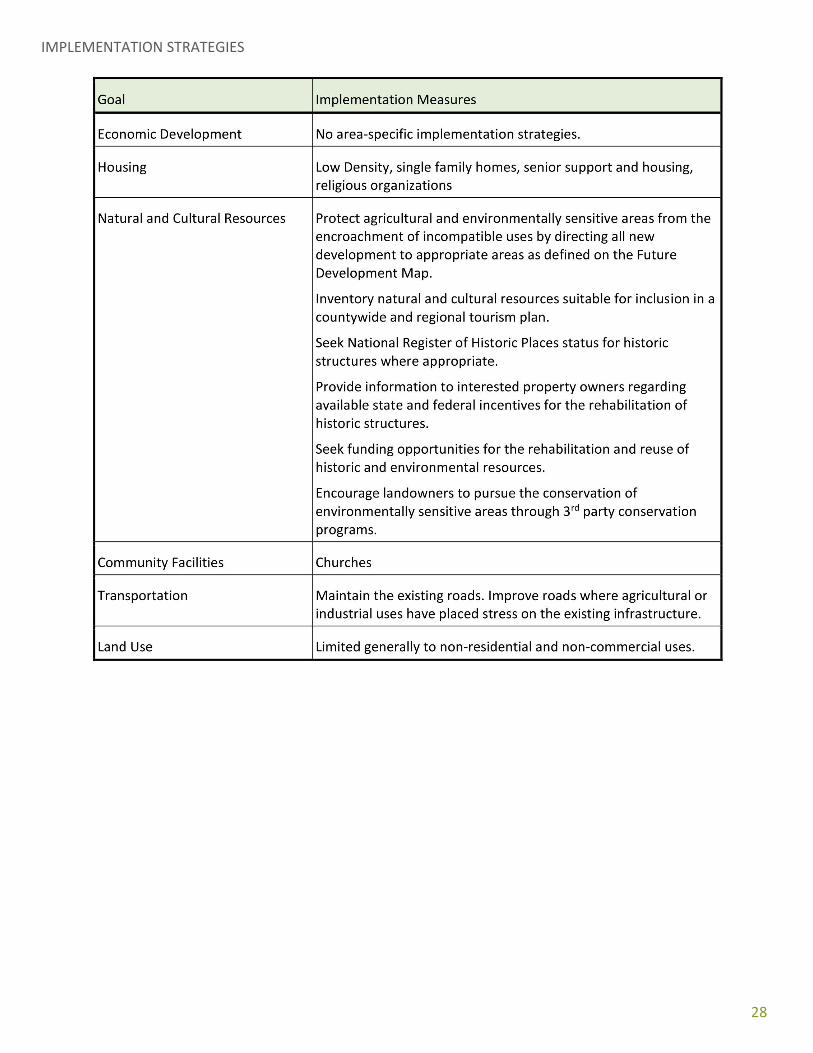
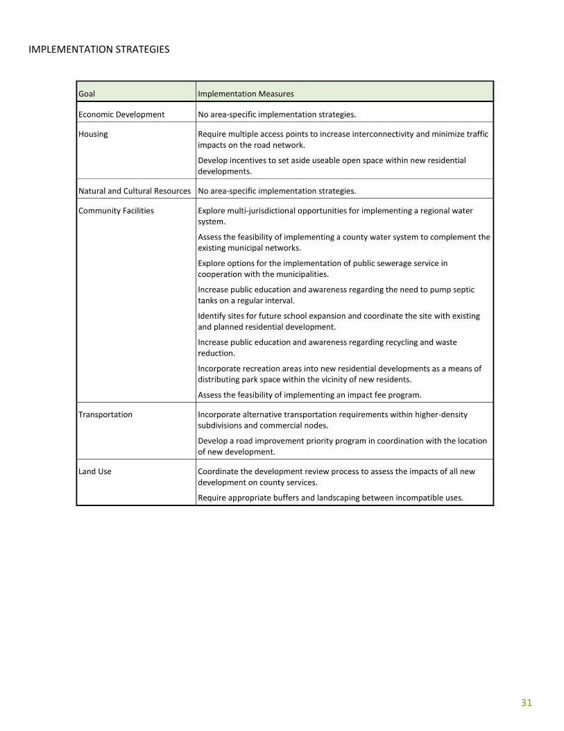
IMPLEMENTATION STRATEGIES

29
RURAL LIVING This character area is a balanced mix of forestry, farms, and homes. The area is within reasonable commuting distance to major regional employers. It represents an area under pressure to develop, but is also an area where services cannot be most efficiently provided. Major residential development that characterizes suburban sprawl should be prohibited. Tracts commonly range in size from 10 to 20 acres. Grazing, row crops and other general agricultural uses are appropriate, but this character area should not experience new intensive agriculture. Adequate buffers should mitigate land use conflict between existing intensive agriculture and existing residential areas. The Smithonia Historic District is identified on the National Register of Historic Places and all development within and adjacent to the district should be compatible with the historic value.
APPROPRIATE LAND USES
• Residential uses at low densities • Public or institutional uses. • Recreational facilities. • General agricultural uses • Local business
COMPATIBLE ZONING CATEGORIES
AR : Agricultural/Rural Residential District: Intended for low-density single-family residential development. The district is intended to preserve the scenic and rural characteristics of the county and discourage higher development intensities in areas that do not have adequate existing, or planned, infrastructure networks.
A-2 : General Agricultural District: Designed to preserve farmland and promote agricultural uses related to timber and crop production, horticultural uses, or limited livestock operations (typically associated with pasture land).

30
B-1 : Local Business: Individual small businesses that are compatible with residential uses. OS : Open Space/Conservation Design Development District: The purpose is to allow greater flexibility in site design and to encourage the preservation of open space.
QUALITY COMMUNITY OBJECTIVES
The following Quality Community Objectives will be pursued in the Rural Living area:
Housing Options: Create conditions that support an active but aging population. Support housing options which allow extended and multi-generational families to live in proximity to one another. Improve the quality, value, and desirability of housing options in the community. Housing options should make possible the independent lifestyle described in the county narrative with a safe and quiet living environment. Avoid land use conflict between housing and intensive agriculture. Encourage infill of existing approved subdivisions with vacant lots and the provision of amenities which support individual health and fitness. Sense of Place: An easy commuting distance to Athens and UGA but far enough for a life away from urban clutter and noise. The community social network is made of neighbors that know and support each other and often volunteer as youth coaches, first responders, litter cleaners, or church leaders. Economic Prosperity: This area is home to many in the Athens area workforce. The character of the area helps regional employers attract a high-quality workforce by providing a desirable place to live and raise a family. The prosperity of regional employers is prerequisite to the success of Oglethorpe County. Home-based businesses should be encouraged and supported with adequate connectivity. Efficient Land Use: Land use should match the level of existing infrastructure. Balance the mix of land uses between residential, forest, and farms. Expansion of infrastructure, with the exception of broadband access, should be avoided. Community Health: Ensure that all community residents, regardless of age, ability, or income, have access to facilities and programs that foster better health and fitness.

31
IMPLEMENTATION STRATEGIES
32
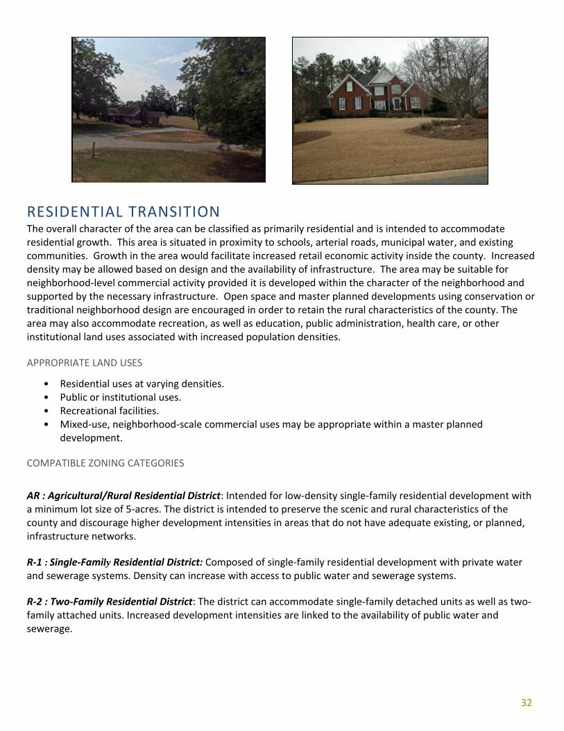
RESIDENTIAL TRANSITION The overall character of the area can be classified as primarily residential and is intended to accommodate residential growth. This area is situated in proximity to schools, arterial roads, municipal water, and existing communities. Growth in the area would facilitate increased retail economic activity inside the county. Increased density may be allowed based on design and the availability of infrastructure. The area may be suitable for neighborhood-level commercial activity provided it is developed within the character of the neighborhood and supported by the necessary infrastructure. Open space and master planned developments using conservation or traditional neighborhood design are encouraged in order to retain the rural characteristics of the county. The area may also accommodate recreation, as well as education, public administration, health care, or other institutional land uses associated with increased population densities.
APPROPRIATE LAND USES
• Residential uses at varying densities. • Public or institutional uses. • Recreational facilities. • Mixed-use, neighborhood-scale commercial uses may be appropriate within a master planned
development.
COMPATIBLE ZONING CATEGORIES
AR : Agricultural/Rural Residential District: Intended for low-density single-family residential development with a minimum lot size of 5-acres. The district is intended to preserve the scenic and rural characteristics of the county and discourage higher development intensities in areas that do not have adequate existing, or planned, infrastructure networks.
R-1 : Single-Family Residential District: Composed of single-family residential development with private water and sewerage systems. Density can increase with access to public water and sewerage systems.
R-2 : Two-Family Residential District: The district can accommodate single-family detached units as well as two-family attached units. Increased development intensities are linked to the availability of public water and sewerage.
30
R-3 : Multi-Family Residential District: Intended for high-density, attached residential development requiring access to adequate infrastructure networks including roads, public water, and public sewer. OS : Open-Space/Conservation Design Development District: The purpose is to allow greater flexibility in site design and to encourage the preservation of open space. PD : Planned Development District: The planned development districts encourage a mix of compatible land uses and allow greater flexibility with regard to site development to meet the vision and goals of the county. The districts are designed as an overlay appended to the underlying zoning category (residential, commercial, institutional or industrial). B-1 : Local Business District: The district is intended for the development of small clusters of neighbor- hood-scale commercial activities in proximity to increased residential densities associated with single-family residential development.
QUALITY COMMUNITY OBJECTIVES
The following Quality Community Objectives will be pursued in the Residential Transition area: Housing Choices: A range of housing size, cost, and density should be provided in each community to make it possible for all who work in the community to also live in the community, to promote a mixture of income and age groups in each community, and to provide a range of housing choice to meet market needs.
Open Space Preservation: New development should be designed to minimize the amount of land consumed, and open space should be set aside from development for use as public parks or as greenbelt/wildlife corridors. Compact development ordinances are one way of encouraging this type of open space preservation. Transportation Alternatives: Alternatives to transportation by automobile, including mass transit, bicycle routes, and pedestrian facilities, should be made available in each community. Greater use of alternate transportation should be encouraged.
Traditional Neighborhoods: Traditional neighborhood development patterns should be encouraged, including use of more human scale development, compact development, mixing of uses within easy walking distance of one another, and facilitating pedestrian activity.
31
IMPLEMENTATION STRATEGIES
32
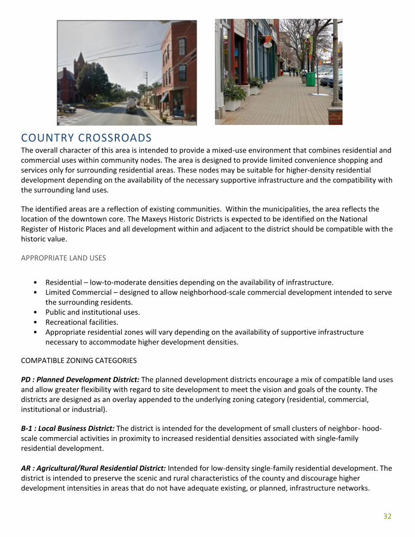
COUNTRY CROSSROADS The overall character of this area is intended to provide a mixed-use environment that combines residential and commercial uses within community nodes. The area is designed to provide limited convenience shopping and services only for surrounding residential areas. These nodes may be suitable for higher-density residential development depending on the availability of the necessary supportive infrastructure and the compatibility with the surrounding land uses.
The identified areas are a reflection of existing communities. Within the municipalities, the area reflects the location of the downtown core. The Maxeys Historic Districts is expected to be identified on the National Register of Historic Places and all development within and adjacent to the district should be compatible with the historic value.
APPROPRIATE LAND USES
• Residential – low-to-moderate densities depending on the availability of infrastructure. • Limited Commercial – designed to allow neighborhood-scale commercial development intended to serve
the surrounding residents. • Public and institutional uses. • Recreational facilities. • Appropriate residential zones will vary depending on the availability of supportive infrastructure
necessary to accommodate higher development densities.
COMPATIBLE ZONING CATEGORIES
PD : Planned Development District: The planned development districts encourage a mix of compatible land uses and allow greater flexibility with regard to site development to meet the vision and goals of the county. The districts are designed as an overlay appended to the underlying zoning category (residential, commercial, institutional or industrial).
B-1 : Local Business District: The district is intended for the development of small clusters of neighbor- hood-scale commercial activities in proximity to increased residential densities associated with single-family residential development. AR : Agricultural/Rural Residential District: Intended for low-density single-family residential development. The district is intended to preserve the scenic and rural characteristics of the county and discourage higher development intensities in areas that do not have adequate existing, or planned, infrastructure networks.
33
R-1 : Single-Family Residential District: Composed of single-family residential development. Intensities can increase with access to public water and sewerage systems.
R-2 : Two-Family Residential District: The district can accommodate single-family detached units as well as two-family attached units. Increased development intensities are linked to the availability of public water and sewerage systems. R-3 : Multi-Family Residential District: Intended for high-density, attached residential development requiring access to adequate infrastructure networks including roads, water, and sewer. QUALITY COMMUNITY OBJECTIVES
Housing Choices: A range of housing size, cost, and density should be provided in each community to make it possible for all who work in the community to also live in the community, to promote a mixture of income and age groups in each community, and to provide a range of housing choice to meet market needs. Open Space Preservation: New development should be designed to minimize the amount of land consumed, and open space should be set aside from development for use as public parks or as greenbelts/wildlife corridors. Compact development ordinances are one way of encouraging this type of open space preservation. Transportation Alternatives: Alternatives to transportation by automobile, including mass transit, bicycle routes, and pedestrian facilities, should be made available in each community. Greater use of alternate transportation should be encouraged. Traditional Neighborhoods: Traditional neighborhood development patterns should be encouraged, including use of more human scale development, compact development, mixing of uses within easy walking distance of one another, and facilitating pedestrian activity. Infill Development: Communities should maximize the use of existing infrastructure and minimize the conversion of undeveloped land at the urban periphery by encouraging development or redevelopment of sites closer to the downtown or traditional urban core of the community. Sense of Place: Traditional downtown areas should be maintained as the focal point of the community or, for newer areas where this is not possible, the development of activity centers that serves as community focal points should be encouraged. These community focal points should be attractive, mixed-use, pedestrian-friendly places where people choose to gather for shopping, dining socializing and entertainment.

34
IMPLEMENTATION STRATEGIES
35
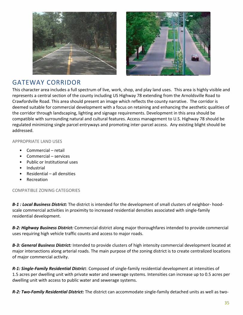
GATEWAY CORRIDOR This character area includes a full spectrum of live, work, shop, and play land uses. This area is highly visible and represents a central section of the county including US Highway 78 extending from the Arnoldsville Road to Crawfordville Road. This area should present an image which reflects the county narrative. The corridor is deemed suitable for commercial development with a focus on retaining and enhancing the aesthetic qualities of the corridor through landscaping, lighting and signage requirements. Development in this area should be compatible with surrounding natural and cultural features. Access management to U.S. Highway 78 should be regulated minimizing single parcel entryways and promoting inter-parcel access. Any existing blight should be addressed.
APPROPRIATE LAND USES
• Commercial – retail • Commercial – services • Public or Institutional uses • Industrial • Residential – all densities • Recreation
COMPATIBLE ZONING CATEGORIES
B-1 : Local Business District: The district is intended for the development of small clusters of neighbor- hood-scale commercial activities in proximity to increased residential densities associated with single-family residential development. B-2: Highway Business District: Commercial district along major thoroughfares intended to provide commercial uses requiring high vehicle traffic counts and access to major roads. B-3: General Business District: Intended to provide clusters of high intensity commercial development located at major intersections along arterial roads. The main purpose of the zoning district is to create centralized locations of major commercial activity. R-1: Single-Family Residential District: Composed of single-family residential development at intensities of 1.5 acres per dwelling unit with private water and sewerage systems. Intensities can increase up to 0.5 acres per dwelling unit with access to public water and sewerage systems. R-2: Two-Family Residential District: The district can accommodate single-family detached units as well as two-
36
family attached units. Increased development intensities are linked to the availability of public water and sewerage. R-3: Multi-Family Residential District: Intended for high-density, attached residential development requiring access to adequate infrastructure networks including roads, water, and sewer. PD : Planned Development District: The planned development districts encourage a mix of compatible land uses and allow greater flexibility with regard to site development to meet the vision and goals of the county. The districts are designed as an overlay appended to the underlying zoning category (residential, commercial, institutional or industrial). LI : Light Industrial District: The intent of the district is to provide a suitable environment for clustered light industrial uses that have a low-impact on the surrounding environment. OS : Open-Space/Conservation Design Development District: The purpose is to allow greater flexibility in site design and to encourage the preservation of open space.
QUALITY COMMUNITY OBJECTIVES
The following Quality Community Objectives will be pursued in the Gateway Corridor:
ECONOMIC PROSPERITY: This area is the economic center of gravity. A full variety of retail establishments should be available, including restaurants, daily necessities, and groceries. Entrepreneurs should focus on this area for a place of business. TRANSPORTATION OPTIONS: This area experiences a high level of through-traffic as well as local traffic. Smooth, safe flow of vehicle traffic is priority. Interconnecting access should be used to optimize access points on high-traffic arterial routes. Sidewalks and bike lanes may help to alleviate local traffic. Traffic calming and road design can help to achieve safe, efficient flow. COMMUNITY HEALTH: Support amenities and infrastructure which encourage walking and bicycling. Provide areas designated for fitness and recreation. HOUSING OPTIONS: Support residential options for all ages. Encourage housing options designed for senior citizens. HERITAGE PRESERVATION: The traditional character of the community should be maintained through preserving and revitalizing historic areas of the community, encouraging new development that is compatible with traditional features of the community, and protecting other scenic or natural features that are important to defining the community’s character.
ENVIRONMENTAL PROTECTION: Stormwater controls should offer protections from negative impacts of development. Wherever possible, the natural terrain, drainage, and vegetation of an area should be preserved.

37
IMPLEMENTATION STRATEGIES

38
EMPLOYMENT CENTER The overall character of the area is intended for large-scale, employment intensive commercial uses. The area is designed to provide a compatible mix of commercial development (retail and services), professional offices, and light industrial uses.
The intended types of development require access to the necessary supportive infrastructure, including public water and sewerage service and major transportation networks. Public sewerage is available in certain areas and the expansion of this service has been identified as a long-term need to accommodate the desired commercial growth.
Developments using planned development concepts are encouraged, such as business/office parks that provide internal transportation networks minimizing the traffic impacts on the arterial road network. General commercial retail and service development should be focused along the US Highway 78 corridor to increase access and visibility. Inter-parcel access should be promoted along the corridor eliminating the need for multiple access points.
APPROPRIATE LAND USES
• Office and professional development. Where possible office uses should be clustered. • Light industry - this includes warehouse and distribution centers, wholesale companies, research and
technology uses, or other similar businesses that do not have significant impacts on the environment.
COMPATIBLE ZONING CATEGORIES
OIP : Office/Institutional/Professional District: The intent of the district is to cluster a variety of professional and business offices and allows small-scale commercial uses that are appropriate within an office setting. LI : Light Industrial District: The intent of the district is to provide a suitable environment for clustered light industrial uses that have a low-impact on the surrounding environment.
HI :Heavy Industrial District: Intended for intensive manufacturing operations that have the potential to adversely impact the environment, or the public health, safety, and welfare.
PD : Planned Development District: The planned development districts encourage a mix of compatible land uses and allow greater flexibility with regard to site development to meet the vision and goals of the county. The districts are designed as an overlay appended to the underlying zoning category (residential, commercial, institutional or industrial).
39
QUALITY COMMUNITY OBJECTIVES
The following Quality Community Objectives will be pursued in the Employment Center:
Growth Preparedness: Each community should identify and put in place the prerequisites for the type of growth it seeks to achieve. These might include infrastructure to support new growth, appropriate training of the work- force, ordinances and regulations to manage growth as desired, or leadership capable of responding to growth opportunities and managing new growth when it occurs.
Employment Options: A range of job types should be provided in each community to meet the diverse needs of the local workforce.
Appropriate Businesses: The businesses and industries encouraged to develop or expand in the community should be suitable for the community in terms of job skills required, long-term sustainability, linkages to other economic activities in the region, impact on the resources of the area, and future prospects for expansion and creation of higher-skill job opportunities.
Regional Cooperation: Regional cooperation should be encouraged in setting priorities, identifying shared needs, and finding collaborative solutions, particularly where it is critical to success of a venture, such as protection of shared natural resources or redevelopment of a transportation network. Environmental Protection: Environmentally sensitive areas should be protected from negative impacts of development, particularly when they are important for maintaining traditional character or quality of life of the community or region. Wherever possible, the natural terrain, drainage, and vegetation of an area should be preserved.

40
IMPLEMENTATION STRATEGIES

MAP 5 - FUTURE LAND USE
42
ISSUES & OPPORTUNITIES
ECONOMIC DEVELOPMENT
VISION STATEMENT: Invest in the long-term stability of the local economy through the diversified attraction of new
economic activity and the retention and expansion of existing business and industry.
ISSUES: There is a lack of available employment opportunities in Oglethorpe County for the existing labor force. The skills of the existing labor force are mismatched with the locally available jobs increasing the outflow of commuters. POLICY:
• Promote the use of regional workforce training programs to diversify the skill levels of the local labor force.
ISSUES: The county needs to increase the amount of economic activity to offset the increasing tax burden on homeowners. OPPORTUNITIES: The county has an abundance of pristine natural areas that could be utilized as a tool to promote Eco- and agri- tourism as an economic development strategy. The municipal downtown areas possess valuable historic resources that could redirect small business activity to the cities. The county owns a sizable tract of land suitable for light industrial development. POLICY:
• Actively promote and market Oglethorpe County through regional partnerships, state agencies, interstate clearinghouses, and local sources such as the Economic Development Department and Chamber of Commerce websites.
• Capitalize on Oglethorpe County’s expanding agricultural economy through a focus on agribusiness recruitment.
• Market local historic and natural assets to increase tourism-generated revenues. • Market suitable land for light industrial development.
ISSUES: The wastewater treatment plant (located in the City of Crawford) has excessive capacity. The lack of data infrastructure networks necessary to support economic growth. POLICY:
• Focus economic growth in areas that are served by the sewer system to support cash flow and proper functioning of the sewer system.

43
• Expand broadband coverage, capacity, and competition among carriers. ISSUES: The county has a collection of historic resources. Information and educational materials about these resources exist in numerous forms, but little coordination exists in using this information to promote economic development opportunities. The county’s cultural resources are thoroughly documented through formal surveys and other local initiatives. The county’s most significant properties are also recognized through National Register listing. Crawford, Stephens, Maxeys and Arnoldsville are, however, not formally recognized as historic communities. POLICY:
• Create and/or participate in formal programs using state or national models to promote cultural resources and foster economic development opportunities through the increase in cultural tourism.
• Promote the use of state, federal, and local financial incentives for rehabilitating historic properties. Seek preservation grants to assess the reuse potential of government and non-profit owned buildings.
• Support community-driven efforts to designate historic areas through listing in the National Register of Historic Places.
• Continue participation and enhancements to the Certified Local Government Program (CLG) in Lexington and improve planning tools used in preservation planning (e.g., design guidelines, surveys, preservation studies, and training).

44
POPULATION VISION STATEMENT:
Prepare community for population changes by investing in appropriate infrastructure.
ISSUES: One third of the population is over age 55.
POLICY: • Plan for infrastructure and housing options which support an active, aging population.
COMMUNITY FACILITIES, SERVICES, AND
INFRASTRUCTURE VISION STATEMENT:
Provide the highest quality and well-maintained community facilities and services given finite available resources.
ISSUES The water network is limited in the county and does not provide adequate pressure throughout the service area. Impacts of growth on the capacities of the school system and other public facilities and services, such as parks, recreation facilities, libraries, etc. Need to address the impacts of new growth on the long-term landfill capacity. POLICY:
• Explore inter-jurisdictional opportunities for infrastructure expansion maximizing the efficiency of financial investment.
• Include school site planning in growth management decisions addressing the location of new facilities in relation to residential growth.
• Focus infrastructure investment in areas designated for new development as outlined on the Future Development Map.
• Maintain adequate facilities for governmental, administrative, public safety, and human service delivery functions.
• Coordinate future development decisions with the Board of Education to address issues relating to school capacities and future locations.
• Coordinate future development decisions with the municipalities and the availability of adequate water service.
HOUSING VISION STATEMENT:
Provide a safe, quiet, high-quality living environment for all residents.
ISSUES: Residential development on the fringe of the county increases the investment required in infrastructure expenditure (roads, water, schools, public safety) and provides greater proximity to employment and shopping opportunities outside of the county.

45
POLICY:
• Encourage new housing in a geographic location which improves the local economy and business viability along the gateway corridor.
• Promote clustered residential development that provides usable open space for recreation activities. • Minimize the potential conflict between residential development and adjacent incompatible uses.
TRANSPORTATION VISION STATEMENT:
Provide adequate transportation infrastructure for smooth, safe flow in Oglethorpe County. ISSUES: Increased truck traffic and congestion within downtown Lexington and Crawford along U.S. Highway 78. The increase in residential development in conjunction with the increase in commuter labor force can be attributed to the increase in Vehicle Miles Traveled (VMT) on local roads that are not designed to accommodate increased levels of traffic. Limited governmental ability to maintain or adopt private roads OPPORTUNITIES: Work closely with the Madison-Athens-Clarke-Oconee-Regional-Transportation-Study (MACORTS) to address the increasing transportation needs for Oglethorpe County. POLICY:
• Plan for new roads which will help alleviate traffic along the 78 Corridor. Work within the regional transportation planning authority to plan.
• Implement improvements in areas where heavy trucks are necessary for agriculture or mineral excavation to prevent the destruction of public infrastructure.
• Plan for traffic volume along major transportation corridors.
LAND USE VISION STATEMENT:
Promote the orderly development of land to accommodate growth through the coordination of available and planned public facilities and services and the protection of key natural and cultural
resources.
ISSUES: New development is occurring within the unincorporated areas disconnected from existing municipalities. Residential development is encroaching into active agricultural areas increasing the potential conflicts between farms and subdivisions. Fringe development is increasing the outward flow of shoppers and workers. The potential for conflict between the location of new residential areas and incompatible uses. POLICY:
• Encourage reinvestment and redevelopment opportunities within existing municipalities. • Reserve land for commercial/industrial growth on the Future Land Use map to accommodate economic

46
development initiatives. • Create public/private partnerships that identify financially feasible opportunities for preserving
greenspace. • Promote compact, contiguous residential development patterns within the identified growth areas to
increase the efficiency of service delivery. • Encourage the cluster of intensive commercial activities in identified nodes and along corridors to reduce
strip development along major roads. • Promote a mixture of uses, where appropriate, as identified on the Future Development Map. • Maintain a cooperative relationship among local governments to ensure the orderly development of the
county and municipalities. • Promote the preservation of agricultural and forestry uses in areas identified on the Future Development
Map. • Encourage infill of existing residential subdivisions with infrastructure and amenities that increase value,
safety, and health
NATURAL RESOURCES VISION STATEMENT:
Protect, enhance, and promote the natural resources of Oglethorpe County.
ISSUES Preservation of agricultural resources and open space/greenspace. Uniform enforcement of Environmental Ordinances by all jurisdictions. Need to retain adequate space for agricultural uses. Need to minimize adverse impacts of development on environmentally sensitive areas. POLICY:
• Promote clustered development patterns that retain a higher percentage of tree-cover and reduce the potential for negative impacts on environmentally sensitive areas.
• Protect environmentally sensitive areas throughout the county from the encroachment of incompatible development.
47
SUMMARY OF COMMUNITY OBJECTIVES ECONOMIC PROSPERITY
As identified by the community during the Community Vision session, it is important to maintain its rural agricultural character by growing those industries which are compatible with a rural community. This can be done by encouraging appropriate development for Oglethorpe County by expanding agricultural and light industrial development, and encouraging home occupation and small business by county residences. Additionally, the county will continue to encourage less intensive agricultural use throughout the county. As noted on the Future Land Use Map, the area along Highway 78 identified as “Gateway Corridor” and “Employment Centers” have been identified by this report as the area which has the most appropriate infrastructure for moderate industrial sector growth. Policies identified by the short-term work plan are as follows:
• Support newly created Economic Development department to recruit and retain jobs in the community. Continue cooperative relationship with local Chamber of Commerce to support existing businesses.
• Actively promote and market Oglethorpe County through state agencies, interstate clearinghouses, and local sources such as the Economic Development and Chamber of Commerce website.
• Monitor the change in local economic conditions and assess the needs of local business and industry. • Market Oglethorpe County as a destination for retirees.
RESOURCE MANAGEMENT
As a rural county, Oglethorpe’s central economic activity is intrinsically tied to the cultivation and exploitation of the county’s natural resources. It is therefore necessary to promote the efficient use of the county’s natural resources. To achieve this, Oglethorpe County will restrict the development of those intensive industrial and agricultural uses which will negatively impact the environmentally sensitive areas. Oglethorpe County will promote the conservation of farm land and land which has or can be used for mineral extraction and continue to encourage the growth of the green energy sector in the country. Policies identified by the short-term work plan are as follows:
• Enforce all environmental protection criteria • Protect agricultural, residential, and environmentally sensitive areas from the encroachment of
incompatible uses by following Future Development Map and zoning code. • Inventory natural and cultural resources suitable for inclusion as tourism in a county-wide and regional
tourism plan. • Support community-driven designation on the National Register of Historic Places where appropriate.
EFFICIENT LAND USE
In order to make the best use of the county’s land, the county plans to maximize the use of the existing infra- structure and minimize the costly conversion of undeveloped land. On the Future Land Use Map the areas identified as “Employment Center” and “Gateway Corridor” have been identified as having the most appropriate infrastructure to support commercial and dense residential growth. Those areas identified as “Country Crossroads” and “Residential Transition” have been identified as those areas which are most appropriate for residential growth. The area identified as Rural Living is a balanced mix of forest, farm, and residential, but protected from sprawl. The area identified as the “Back Forty” has been identified as the area of the county which is best left undeveloped as farms and forest.

48
SENSE OF PLACE
During the branding process and visioning session, the rural character and small-town feel of the county was very important to the local population. In order to achieve this, the provisions provided in the Future Land Use plan will preserve rural character through regulation of development. New municipal code is anticipated to promote agritourism. The county will continue to encourage the use of historical buildings and cultural land- marks within the county.
REGIONAL COOPERATION
Oglethorpe County will continue to work with the regional transit planning Authority and cooperate with neighboring jurisdictions to address shared needs. As outlined in our transportation plan, the County will work to identify those projects which will address regional concerns and enhance the quality of transportation infra- structure within the region. Additionally, Oglethorpe County will work with our neighbors through the Regional planning authority.
HOUSING
Oglethorpe County will create conditions for housing construction that adequately supports an active but aging population. Policy will support housing options which allow extended and multi-generational families to live in proximity to one another. Housing options should make possible the independent, family-centered lifestyle described in the county narrative with a safe and quiet living environment. Land use conflict between residential and intensive agriculture will be avoided. The quality, value, and desirability of housing options in the community will increase over time and, overall, homes in Oglethorpe County will be highly desirable. TRANSPORTATION
Oglethorpe County will address the transportation needs of the community by improving infrastructure where needed. When possible, Oglethorpe County will foster alternative to motorized transportation, however, because of the rural nature of the county, it is unlikely that there will be large-scale development of this type of infrastructure in the foreseeable future. Oglethorpe will, when needed, employ traffic calming measures to ensure the safe movement of vehicles throughout the county. When possible, Oglethorpe County will encourage connectivity between commercial developments. In order to preserve existing infrastructure, heavy truck traffic will be closely managed and daily traffic counts of all types of vehicles on unpaved roads will be limited. The transportation network will ensure reliable access to all occupied structures by emergency service providers, school transportation, and postal deliveries. Major arterial routes will have smooth, safe, constant flow of traffic. Policies identified by the short-term work plan are as follows:
• Evaluate the impact of agricultural, residential and commercial development on county roads and determine which roads need upgrades.
• Develop a road improvement priority program in coordination with the location of new development. • Replace and enhance deteriorating infrastructure such as bridges, culverts, and fords. • Incorporate alternative transportation requirements in development codes for higher –density
subdivisions and commercial nodes. • Encourage residential and business density in areas along major transportation corridors and in and
around the cities in the county.
EDUCATIONAL OPPORTUNITIES
The county will continue to provide quality education to school-age children. The county will also attempt to
49
improve PRE-K enrollment as this has proven to be important to the future success of students. The county will also continue to support adult education and library resources to provide the county with continuing education and self-improvement.
COMMUNITY HEALTH
Oglethorpe County will ensure that all community residents, regardless of age, ability, or income, have access to critical goods and services, safe and clean neighborhoods, and good work opportunities. Residents need to be involved in their community. The county will continue to emphasize the importance of caring for senior citizens as they age. By focusing on those lands identified as environmentally sensitive, the conservation and preservation of land in order to promote a healthy life and maintain quality drinking water for the community.

TRANSPORTATION INTRODUCTION
This section is designed to serve as a supplement to the MACORTS documentation. These additions are intended to further meet the Georgia DCA requirements for the transportation portion of the comprehensive plan. This portion of the plan is intended to serve as a survey of the existing infrastructure, and an examination of the issues and opportunities.
Due to the complexity of Transportation planning, it is important to have a thorough documentation of the infrastructure assets available to a community. To this end, it is also important to consider the success and failures of the current transportation system. Oglethorpe County, Georgia like all large rural counties has its fair share of transportation issues and challenges. At 442 square miles, Oglethorpe County is one of the larger counties in Northeast Georgia. Despite the size of the county, Oglethorpe County is rather sparsely populated at just 33 people per square mile.
The first point of this portion of the comprehensive plan will be an inventory of the existing infrastructure in the county. By conducting this inventory and analysis, this comprehensive plan will underscore particular opportunities to improve the transportation infrastructure to better meet the needs of the citizens of Oglethorpe County.
ROADWAY CLASSIFICATION
In 1974, the Federal Highway Administration published the manual Highway Functional Classification - Concepts, Criteria and Procedures. The manual was revised in 1989 and forms the basis of this roadway classification inventory. Functional classification is the process by which streets and highways are grouped into classes, or systems, according to the character of traffic service that they are intended to provide. In general, there are three functional classifications: Arterial, Collector, and Local roads. All streets and highways are grouped into one of these classes, depending on the character of the traffic (i.e., local or long distance) and the degree of land access that they allow. These classifications are further described in the following table.
Arterial: Provides the highest level of service at the greatest speed for the longest uninterrupted distance, with some degree of access control. Arterials can be further classified as principal or minor. Principal arterials generally move higher volumes of traffic at higher speeds over longer distances than minor arterials.
Collector: Provides a less highly developed level of service at a lower speed for shorter distances by collecting traffic from local roads and connecting them with arterials.
Local: Consists of all roads not defined as arterials or collectors; primarily provides access to land with little or no through movement. The Georgia Department of Transportation maintains and operates the state highways system. In Oglethorpe County, there are portions of Georgia State Highway 77 and Georgia State Highway 22. Additionally, a portion of United States Highway 78 runs though Oglethorpe County. These routes are with providing quick unhindered mobility throughout the region. Any changes to these routes would require coordination with either the Georgia Department of Transportation and/or the Federal Government in the case of US 78. (See Map 6)
SIGNALIZED INTERSECTION INVENTORY
Signalized intersections will be provided where necessary. Road design and management of growth patterns can
Type Length (Miles)
Arterial Roads 77.1
Collector Streets 512.2
Local Streets 35.9
Unpaved 222

influence the need for signalized intersections. As an alternative at high volume intersections, round-a-bouts may be appropriate.
EVACUATION ROUTES
There are no specific evacuation routes in Oglethorpe County. In the event of an emergency, the County will coordinate with the appropriate state and federal authorities.
MAP 6: SURVEY OF ROADS IN OGLETHORPE COUNTY

BRIDGE INVENTORY
According to the 2015 U.S. Department of Transportation National Bridge Inventory, there are fifty bridges in Oglethorpe County. Of these, two are functionally obsolete. Six are counted as being structurally deficient. Bridges count for a total of 12,409 square meters of Oglethorpe’s roadways. The total area structurally deficient bridges is 2,102 square meters.
BIKE AND PEDESTRIAN TRAILS
Currently, community groups are interested in pursuing a rails-to-trails project known as the Firefly Trail. The concept uses old railways to construct an improved surface for pedestrians and bicycles. The old railroad runs through Oglethorpe County connecting the towns of Arnoldsville, Crawford, Stephens, and Maxeys with Athens to the North and West and Union Point to the South East.
RAILROADS
The existing railways in Oglethorpe County are currently not in use. The existing right of way is currently under consideration to be part of the Firefly Greenway.
ACTIVE TRANSPORTATION
There is currently no sidewalk inventory available for Oglethorpe County. However, according to the MACORTS plan, sidewalks are an important part of enabling pedestrian access by incorporating sidewalks along arterial streets and “near neighborhood activity centers such as schools, recreational facilities, and shopping centers.”
PARKING
Oglethorpe’s downtowns and retail centers seem to have adequate parking to meet the demands of the rural county. In the future, if any area becomes deficient in parking, then appropriate actions will be taken in order to ensure that county residents and visitors will be able patronize local business and government services.
MAP 7: PROPOSED FIREFLY TRAIL

SHORT-TERM WORK PROGRAM
ECONOMIC DEVELOPMENT
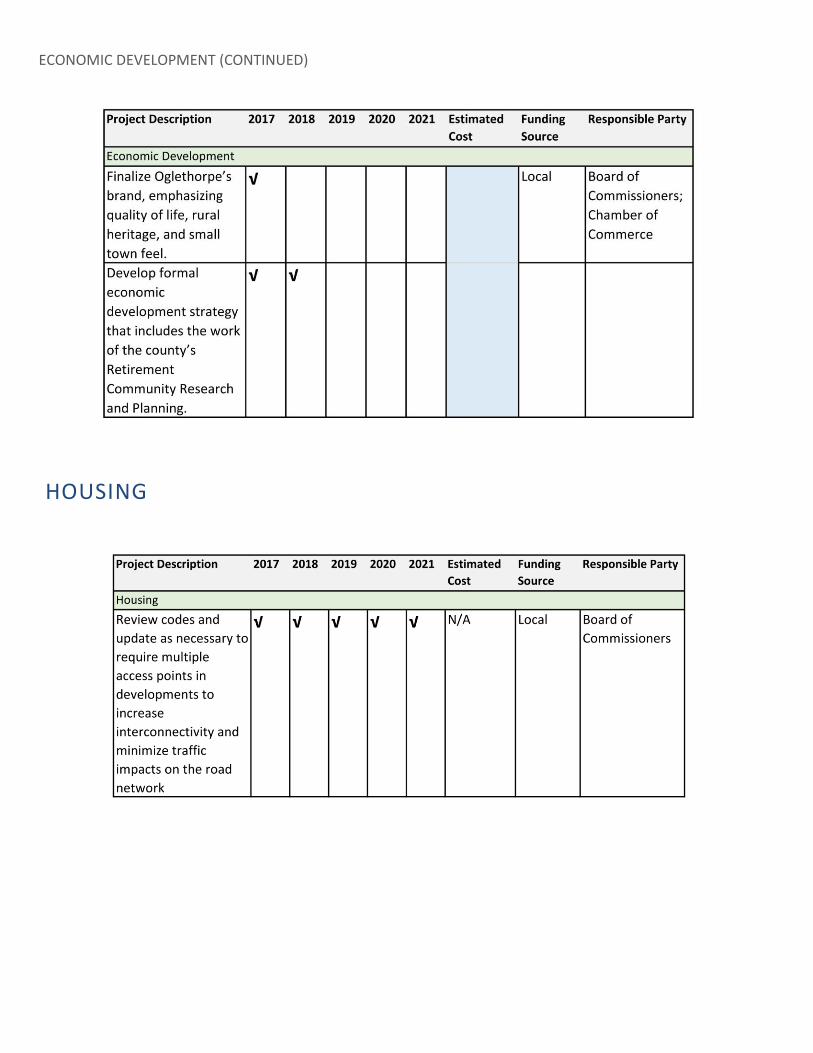
ECONOMIC DEVELOPMENT (CONTINUED)
HOUSING

NATURAL AND CULTURAL RESOURCES

COMMUNITY FACILITIES AND SERVICES

COMMUNITY FACILITIES AND SERVICES (CONTINUED)
LAND USE
66