of alaska william department of natural...
TRANSCRIPT

STATE OF ALASKA
W i l l i a m A. E g a n - G o v e r n o r
DEPARTMENT OF NATURAL RESOURCES
P h i l R. H o l d s w o r t h - C o m m i s s i o n e r
D I V I S I O N OF MINES AND MINERALS
J a m e s A . W i l l i a m s - D i r e c t o r
GEOLOGIC REPORT NO. 23
THE GEOLOGY AND GEOCHEMISTRY OF THE: INMACHUK RIVER MAP AREA, SENARD PENINSULA, ALASKA
BY
G o r d o n H e r r e i d
Juneau, A l a s k a N o v e m b e r 1966
TABLE OF CONTENTS Page
INTRODUCTION
GEOLOGY
R o c k types Marble Schis t and marble G r a n i t e
A s s e s E a r s grani te A m e r i c a n C r e e k g ran i te
O l i v i n e basal t
S t r u c t u r e
MINERAL D E P O S I T S
H a n n u m C r e e k lead-zinc deposit H a r r y s C r e e k H a n n u m C r e e k
O l d G l o r y C r e e k gossan
PinnePl R i v e r gossan
N e l s o n Creek placer c u t
I l a n n u m C r e e k lead-zinc deposit
Szrearn s e d i m e n t g e o c h e m i s t r y of the Inmachuk region
.Eiseussion of geochemical r e s u l t s
SUGGESTIONS FOR PROSPECTORS
REFERENCES CITED
Page
Figure 1 - Geological-geochemical map o f the upper lnmachuk River area, Seward Peninsula, Alaska
Figure 2 - Hannum Creek lead-zinc deposit.
Figure 3 - Gossan on Old Glory Creek, 0.8 m i le above i t s confluence w i t h the P inne l l River.
Figure 4 - Concentration frequency graphs f o r metal content o f stream sediment samples.
TABLES
Table 1 - Assay samples from lnmachuk region.
Table 2 - Laboratory and f i e l d analyses of stream sediment samples from the lnmachuk map area.
Table 3 - Laboratory and f i e l d analyses o f geochemical samples from the Hannurn Creek deposit.
I n Pocket
14

THE GEOLCJY bW GEOCHEMISTRY OF THE I-!!CHUK RIVER MAP AREA. SEWARD PENINSULA. AIASKA
by Gordon Herreid
ABSTRACT
me Inmazhuk map area covers 110 square miles i n northern Seward Penin- sula. 10 miles south of Kotzebue Sound and 2 5 miles southwest of Deering. The k n o w rniceral deposits i n the area a r e lead-zinc lodes and gold placers i n the vl-ini* of IEannum Creek, two gossan areas about 8 miles southeast of Hannrzm Creek and reported placer t i n i n the creeks 2-5 miles south of the gossans. Placer gold i s a l so present on the Inmachpk River, immediately eas t of zhe map areao
Mosr o f :he area consists of tundra and muskeg-covered f l a t s and l o w h i l l s underla-n by mica schis t . phy l l i t e , and minor marble. A th ick section of marble, which m d e r l i e s these rocks, is exposed on a s t ruc tu ra l dome about 2 x 8 miles i n extent i n the southern pa r t of the map area. Doming was probably related t o intrusion of ~ e s o z o i c ( ? ) grani te which is exposed i n two small plutons on the dome. Minor fold axes a r e present, mostly with low to moderate plunges northwest and southeast. A sca t te r ing of gently dipping axial planes of folds indicates tha t la rge overturned folds ray be resent.
The FsLx*q Czeek deposit i s a pyrite-lead-zinc replacement of marble associated wi-,h s i l i c i f i c a t i o n , probably along a northwest trending fau l t . The dapcsit L e about a mile long, bu t exposures are too poor t o evaluate the grade and .-cnnmage of ore.
E ~ ~ r r e gossrr. deposits southeast of Hannum Creek have low gold and base m e t a l 2;nzes.rs and apFear t o be f a u l t controlled p y r i t i c ( ? ) replacements of warble,
A t the I-hnnm Creek deposit high s o i l t race element anomalies a r e closely assczrsted with the are. Stream sediments show anomalous amounts of (".oe.?il) lead for 7 miles downstream from the deposit. The readi ly ex- tractable heavy metal snomaly is much more r e s t r i c t ed , indicating t h a t the lead I n the sediments is d e t r i t a l .
A weak stream sediment lead anomaly (70 ppm) two miles long is associ- aced w i c h s zorthwest trending f a u l t zone on the dome. A weak t i n anomaly (8-20 ppm) i s present i n stream sediments along the northeast f lank of the dome. These anomalies extend across drainages and evidently represent underlying bedrock mineralization. No ore showings or f l o a t were found i n these areaso
The map area l i e s about ten miles south of Kczzebue Sound in -,he north- ern p a r t of the Sewasd Peninsula. I t includes low tundra-ccvered h i l l s , muskeg f l a t s , and a prominent range of limestone h i l l s . It i s readi ly aeces- s i b l e from Name by bush planes, which can land on one of $he two a i r s t r i p s a t Hannum Creek. A road about twenty miles long connects the gold placer mining area on the fnmschuk River with Deering. An area of about 110 square miles was mapped, extending from the v i c i n i t y of the Hannum Creek lead-zinc deposit south and eas t along a reputed mineral b e l t t h a t contains a pro- minent gossan on Old Glory Creek and t i n i n the scream gravels. Travel was by tracked vehicle, and emphasis was on covering a large area with a sstram sediment geochemical survey concurrent with m3pping a s much geology a s possible within the available time. The period f r ~ m July 13 t o July 3 1 , 1965 was spent i n the f i e l d . The author was ably asszsted by Kenc Smith. Thanks a r e extended t o and Mrs. Neal W. Foster fo r t 5 e i r hospi ta l i ty a t ETannEm Creek.
The low h i l l s and f l a t s i n the region a r e covered with tundra and devoid cf outcrops. However, a l l but the smallest streams in the area a r e somewhat incised and have gravel f l o a t and cccasional outcrops along t h e i r valley walls or stream banks. The prominent h i l l s and mountains i n the sputhwestern p a r t of the area, t o be referred t o here a s the O l d Glary Dome, have good exposures, mostly of rubble, bu t with occasional bedrock outcrops- Flat-lying basalt r i m s many of the larger val leys i n the area. Little t h e was spent i r ~ exanining the areas betwees, the strems0
Rock %ypes
Marble
Light 50 medium gray marble, usually with grains 11'2 ts 1 mrn in diameter, makes up the bulk of the Old Glory Dome. The marble has a blocky fracture snd forms slopes s f frost-heaved rubble with scattered outcrops of bedrock i n place, Locally the marble has p la ty beds 112 inch t o 2 f e e t thick, of ten with rudely crenulated surf aces. When interbedded with s c h i s t ,
contortled folding may be presenta Elsewhere bedding i s obscureo
Ae icu la r kremolite, sften as radiating masses, is present a t the north end G£ the dome (upper hnmachuk ~ i v e r ) and i n a number of l o c a l i t i e s a t the south end of the dome (figure 1). A few small areas of dolomite were recognized an the upper Inmachak River and on upper Old Glory Creek. In general, the marble i s made up of l i g h t gray c a l c i t e , is not dolomitic, and
csntzins no recognizable metamorphic minerals. No f o s s i l s were seen, nor could they be expected t o have survived the def o m t i o n and recrys ta l l iza t ion .

Schisz snd marble
The szh i s t var ies from a black calcarecus p h y l i i t e to a dark muscovite s c h 2 . s ~ ~ Both of these rock types are composed essent ia l ly of quartz, musccvite, and c a l c f t e , and commonly have strongly crenulated fo l i a t ion planes. The s c h i s t a t the junction of Hannum and Cunningham Creeks i s typicalo I t is a s i lve ry medium gray rock composed of quartz, muscovite, c a l c i t e , and minor dolomite and chlor i te . It has strongly crenulated f o l i - a t ion planes and folded and boudined quartz veins up t o a few inches wide. Typical black p h y l l i t s a t the junction of Hannum Creek and the Tnmachuk River has strongly crenulated fo l ia t ion planes with a micacesus sheen and limy layers folded and boudined on a scale of a few inches or l e s s with f o l d s s l i g h ~ l y overturned t o the southwest,
I n many s f the outcrops along the creeks marble and calcareous s c h i s t a r e interbedded with noncalcareous sch i s t* A t such places, where l i tho - logic contsccs are v i s i b l e , the rocks can be seen t o be folded om both minor and major scales, with a x i a l planes of folds of ten having moderate dips. Marble evidently undexlies a small portion of the tundra-covered areas , b u t has no expression i n the topography o r vegetation pat terns , 2nd therefore cannot be mapped a s a separate unit.
The presence of massive marble in the a n t i c l i n a l s t ruc turs of the Old Glory Dome indicates t h a t it underlies and is presumably older than t h e schis t . This i s i n agreement with other areas on the Seward Peninsula. These rccks are probably of lower Paleozcic age a s indicated on the Geologic Map of Alaska ( ~ u t r o zrrd Pzyne, 1957).
Granite
Asses Ears s r a n i t e - This r ~ c k is a medium-grained, subhedral granular b i o t i t e grani te containing p e r t h i t i c orthoclase, andesine, quartz, b i o t i t e , h s rnb lede , and rni5cr apatite, a l l a n i t e ( 3 ) , and ~ y r i t s , It is v i r t u a l l y unaltered, A coxzact metamorp5ie aureole i s exkensively developed north- e a s t cf t h i s grani te , but seems t o be lacking in the marble jus t west of the Intrusive. Trenoli te (figure 1) is present in the marble on upper Magnet Creek, b u t not cn the marble ridge f u s t w e s t of Asses Ears. The hornfels f loat on Magsek Creek i s a fine-grabed bluish-green rock containing diopsfde, b i o t i t e , znd minor scapcl i te , plagioclase, orthoclase, and quartz,
American Creek s r a n i t e - This is a medium-grained, subhedral granular grani te composed of p e r t h i t i c orthoclase, ol igoclase , b i o t i t e , and minor sphene. Alteration i s limited t o minor s e r i c i t i z a t i o n of oligoclase and chlor i t iza t ion of b i o t i t e - Quartz and feldspar-rich zones, loca l ly con- taining minor purple f l u o r i t e , a re present. Copper, lead, zinc, nickel , and t i n were sought i n these zones but not detected by x-ray fluorescence. This g ran i te i s surrounded by a narrow contact metamorphic aureole no more than a few tans of f e e t wide. Fine-grained hornfels similar i n appearance

t o t h a t on Magnet Creek is present . It contains diopslde and minor vesu- v i a n i t e , c a l c i t e , quar tz , and fe ldspar . Less a l t e r e d marble i s a l so presen t , with bands of green diopside and brown vesuviani te .
The g r a n i t i c rocks on t h e Seward Peninsula a re considered t o be of Mesozoic age by Dutro and Payne (1957) and e a r l i e r U.S. Geological Survey wr i t e r s . The Asses Ears and American Creek plutons a r e probably no exception.
Olivine Basal t
This rock forms a volcanic cone a t Virginia Butte and conspicuous f l a t - ly ing rims along many of t he l a rge stream va l leys ( f igure 1). A t Virginia Butte, a sample thought t o represent t he base of a flow is por- p h y r i t i c o l iv ine basa l t , The fine-grained rock is composed of e a l c i e andesine l a t h s , t i n y magnetite(?) g ra in s and o l iv ine with phenscrysts of o l iv ine up t o 1/2 mm i n diameter. The volcanic rim j u s t northwest of t he mouth of Col l ins Creek is s imi lar porphyr i t i c o l iv ine b a s a l t except t h a t the ground- mass is camposed of fine-grained c a l c i e andesine l a t h s and augi te with a d iabas ic texture. This rock has greenish granular inclus ions up t o an inch i n diameter made u p of o l i v i n e , chrome diopside, e n s t a t i t e , and chrome sp ine l .
The b a s a l t or ig inated a s flows which followed t h e stream valleys on a surface of low r e l i e f . Later down-cutting by the streams has excavated t h e va l leys t o severa l hundred f e e t below the base of t h e flows leaving the b a s a l t a s rims along t h e upper port ions of t he val leys .
The b a s a l t s a r e of Quaternazy age (Hopkins, 1959).
St ructure
The preeer-ze of crenula t ions and minor f o l d s "ch~oughout t he map area i nd i ca t e s thzs tke marble and s c h i s t a r e s t rongly defcrmed t ec ton i t e s , probably with complex m i n o r folding. The gently-dipping a x i a l planes of fo lds i n s c h i s t ind marble near t he mouth of Perry Creek suggest t h a t recumbant folding is presen t i n t h a t area. On Old Glory Dome the outcrop p a t t e r n , the a t t i t u d e of beds, and the plunges of minor fo lds and crenula t ions i nd i ca t e t h a t the gross s t r u c t u r e is a doubly plunging (domal) a n t i c l i n e which br ings marble t o t he surface. The outcrop p a t t e r n of the dome i s complicated by fau l t ing and poss ibly by some overturned folding.
The American Creek g r a n i t e pluton crosscuts t h e s t r u c t u r e , and both it and the Asses Ears g r a n i t e w e r e evidently emplaced after folding had been completed. Probably the doming was superimposed on the e a r l i e r s t r u c t u r e s of the marble and s c h i s t and i s r e l a t e d t o the in t rus ion of t he g r a n i t e bodies. The presence of cross-cutting t remol i te c r y s t a l s i n a
nuniber of places on the dome suggests tha t post-kinemazic thermal meta- morphism has taken place,
The west trending f a u l t a t the south end of the Old Glory gossan (figures 1 and 2 ) probably was the controll ing s t ruc ture along which ore solutions traveled, A t the Hannum Creek deposit, the presence of quartz- i t e breccia on Harrys Creek i n conjunction with replacement of marble by quartz suggests f a u l t control a l so , with the f a u l t s probably trending north- westerly pa ra l l e l t o the deposit. A t the head of Old Glory Creek an elongated lead anomaly a l so seems t o follow a northwest trending fau l t . Very l i k e l y the ancient grain of the bedrock has t o some extent controlled these l a t e r fau l t s . A more recentewmple of t h i s control is the Imuruk Lake graben s t ructure , which dropped down along northwest trending normal f a u l t s during Quaternary time ( ~ o p k i n s , 1959).
MINERAL DEPOSITS
Hannum Creek lead-zinc depost
Mineralized zones of t h i s deposit a r e exposed on Harrys Creek and i n trenches on Harrys and Hannum Creeks. These a r e northwest trending lead- and zinc-bearing s i l i c i f i e d zones 30-150 f e e t wide, i n marble. The area between the two creeks, a distance of a mile along the s t r i k e of the deposit , i s covered and has not been trenched.
Harrys Creek
The b e s t exposures, with the most promising looking ore , a r e located on Harrys Creek. Here an i r regular zone of qua r t z i t e and associated marble gossan trends northwest and i s exposed i n the banks of the creek and i n trenches north and south of the creek. Typically, the quar tz i te is a course-grained, porous rock often with s m a l l cav i t i e s l ined with quartz c rys ta l s . In Harrys Creek north of Sample F (f igure 2 ) coarse-grained planar bedded quartz i te crops out for f i f t een fee t , Immediately eas t of the quar t z i t e is marble almost ident ica l i n appearance with the quar tz i te and w i t h the same bedding atti tude. The quartzite here and elsewhere is probably a replacement of marble. A t the contact between the two l i e s an eighteen-inch band of gossan with a central vein of galena t w o t o three inches wide (AS-2, table 1).
This zone of quar tz i te and associated ore extends up the h i l l t o the southeast, where it is exposed i n several trenches. Massive and dis- seminated galena i s present i n quar tz i te a t 2 (f igure 2 ) and a small amount of galena f l o a t has been stock-piled i n the v ic in i ty . The large dump a t the north end of t h i s trench contains brown s o i l and angular fragments of ce l lu la r qua r t z i t e with a leached appearance- An assay sample (AS-1, table 1) taken from t h i s dump contains 4.0% lead and i s an indication

of the grade of a wide zone of ieached quar t z i t e , This trench i s 15 t o 20 f e e t deep b u t does not reach solid unweathered quar tz i te bedrock.
The str ipped area a t F e q o s e s a limy gossan. Cre minerals were only seen at the south end, near T. Here disseminated pyr i te and galena a r e asso- ciated with s i l i c i f i e d marble. In th in sect ion, the rock contains a scattering of fine (0.01 mm) quartz grains , amounting t o 5% of the rock, along boundaries of (0.1 mm) c a l c i t e grains, which make up the bulk of the rock. About 2% p y r i t e i s present. This p a r t i a l replacement of marble by quartz probably represents the incompleted development of quartzi te.
The gossan a t N and 0, i n the str ipped area north of Harrys Creek, i s similar but no su l f ides were seen, The anomalous s o i l sample a t Q indicates tha t ore may l i e e a s t of t h i s gossan.
A t sample 5, much gossan f l o a t is present In the south bank of Harrys Creek, 'This rock contains disseminated galena and gun-metal-blue f e l t e d masses of c r y s t a l l i n e boulangerite (Pb5SbqS11].
Quar tz i t e breccia f l o a t i n Harrys Creek a t sample 6 contains qua r t z i t e c l a s t s cemented by quar tz i te , This breccia is evidence aE f a u l t control of the quar tz i te replacement in the area.
Mnnum Creek
The only ore exposed i n t h i s area i s i n a trench a t AT ( f igure 2 ) . Here a gossan zone t h i r t y f e e t wide i s exposed, with marble on e i the r side. The gossan contains limonite and scattered s c h i s t f ragme~ts . A t i tssouthwestern contact, the marble is s i l i c i f i e d fo r a width of six f e e t (assay AS-3, table 1). In th in sect ion the rock contains scat tered grains of pyr i t e , brown sphaler i te , and minor amounts of an unidentif ied black i c i cu la r mineral i n a granular quartz matrix,
Large cparkzi te boulders a r e present in several piaees along Hannum Creek and in t rench AO. Quartz i te bedrock from the north end of trench A0 is a p a r t i a l l y s i l i c i f i e d marble composed mainly of quartz grains and che r t with seatterecc residual c a l c i t e grains. This s i l i c i f i e d zone occurs near the marble-schist contact and is assoc i ta ted with strong zinc anomalies,
Old Glory Creek gossan
This gossan is exposed over an area of 110 f e e t x 500 f e e t on lower Old Glory Creek (figures 1 and 3 ) . The country rock i n the area is marble interbedded with sch i s t , The gossan marks the replacement for 500 f e e t along a marble bed by dolomite, quartz, py r i t e (?) , s e r i c i t e , ch lo r i t e , and spots of green fuchs i te (chrome muscovite). This mineralized zone is bounded on the south by a poorly exposed fau l t . A second pa ra l l e l (?) f a u l t , 1/4 m i l e t o the north, is bordered along one s i d e by a dolomitized zone. These mineralized zones appear t o be the r e s u l t of wall rock replacement by solutionr tha t traveled along the fau l t s .

An analysis of the ferruginous marble from the Old Glory Creek gossan shows 0.04 ounce per ton gold, 500 par ts per mil l ion zinc, 100 ppm molyb- denum, and 100 ppm nickel. (AS-4, table I). A s o i l sample taken on the slope twenty f e e t below the gossan was not anomalous, nor was the stream sediment sample taken from Old Glory Creek downstream from the gossan. This gossan represents a leached pyr i te or pyrrhotite-bearing su l f ide deposit which could possibly reach ore grade i n lead o r zinc below the zone of leaching.
Pinnell River gossan
A small bu t c l e a r l y v i s i b l e orange gossan (f igure 1) is present above the Fairhaven Ditch, one m i l e e a s t of the O l d Glory gossan. The rock under- lying the gossan is marble pa r t ly replaced by i so la ted grains and ve in le t s of quartz and ve in le t s of fuchsite. The carbonate i s now largely dolomite. A grab sample of the gossan (AS-5, table 1) contains 500 ppm copper, lead, zinc, and 0.5 percent chromium, and 0.02 oz/ton gold. A s o i l sample (112) taken just below the outcrop was not anomalous. This deposit probably had an or igin similar t o that of the Old Glory gossan.
Nelson Creek placer c u t
On the l e f t l i m i t (northern) bench jus t above the mouth of Nelson Creek, a t r ibutary of Old Glory Creek, s c h i s t bedrock with quartz veins is w e l l exposed i n an abandoned placer cut. Minor fo lds a r e present i n the s c h i s t and a l l quartz veins a r e boudined o r folded, A sample of vein quartz and s m a l l amounts of the enclosing s c h i s t (AS-6, tab le 1) assays $0.70 gold per ton. Boundined (pre-or synkinematic) veins such a s these of ten carry small amounts of gold which may provide a source of placer gold under favorable conditions of weathering and erosion. The sch i s t is cross- c u t by a zone of c lay a l t e r a t i o n and is loca l ly bleached.
A piece of pyrite-bearing gossan f l o a t was found on Old Glory Creek jus t b s P ~ w the mouth of Nelson Creek.
GEOCHEMISTRY
Geochemical s o i l and stream sediment samples were taken i n the v i c i n i t y of the Hannum Creek ore deposit ( table 3) t o determine the e f f e c t of t h e deposit on themetalcontents of the soils and stream sediments, With this background information, stream sediment samples were taken along a l l the major drainages between Cunningham Creek on the north and Magnet Creek on the south, a distance of 13 miles ( table 2 ) . Samples were of mud o r s i l t taken from stream beds, (below the waterwhere?ossible). These were analyzed i n the f i e l d using the cold extractable heavy metals method described by Hawkes (1963) modified for most of the stream sediment samples by using the ammonium - i t r a t e extractant f u l l strength. Samples were

l a t e r analyzed f o r t o t a l copper, lead, zinc, and molybdenum i n the minus 80 mesh fact ion by Rocky Mountain Geochemical Laboratories of S a l t Lake City, Utah, Tin was analyzed by the U . S , Geological Survey, Branch of Exploration Research.
Concentration frequency graphs of lead, zinc, and t i n (f igure 4) indicate the threshold values of stream sediment anomalies t o be: Lead, 40 ppm; zinc, 240 ppm; . t in , 8 ppm. No copper o r molybdenum anomalies were found,
Hannum Creek lead-zinc deposit
The Wenches on Hannum and Harrys Creeks have been excavated i n the frozen ground a t considerable e f f o r t over a long period of time, Recon- naissance s o i l sampling was done i n the trenched areas t o determine whether the mineralized areas could be outlined by geochemical methods. The sample loca t ioas are plotted on f igure 2 , The pat tern of strong lead and zinc anomalies in the v ic in i ty of the quar tz i te and gossan areas indicates tha t s o i l sampling is ef fec t ive i n detecting soil-covered ore deposits i n t h i s area.
Most samples were taken a t shallow depths (6 t o 12 inches) t o duplicate the conditions of sampling i n tundra-covered frozen ground. In the s ide of a trench at sample s i t e V ( f igure 2 ) samples were taken a t depths of one foot and seven f e e t (near bedrock) t o determine the gradient of metals i n the s o i l , The shallow sample contains 60% l e s s zinc than the deep one and both have greater than 1000 ppm lead. I t appears t h a t l i t t l e advantage would be (-;-ained by deep s o i l sampling i n t h i s area.
The Bead snd zinc contents of stream sediment samples shown on f igure 2 increase a s the deposit is approached from downstream and drop off sharply upstreain E r o m it. It i s unlikely t h a t other s ign i f i can t lead deposits a r e preserrk -ups,krszm on e i the r Hannum or Harrys Creek. The p o s s i b i l i t y of zinc mineralization i n the headwaters of Hannum Creek is indicated by the moderate anomaly a r t sample 39 (f igure 1).
The strong zinc-lead anomaly a t the spring (AV, f igure 2 ) t h a t drains from the marble-schist contact on Hannum Creek indicates continuation of the mineral zone eas t of the creek. This spring is reported t o flow year around,
Stream sediment geochemistry of the Inmachuk region
The Hannwn Creek deposit i s c l ea r ly ref lected by the lead content of stream sediments below the deposi t (f igure 1) , Progressively decreasing anomalous lead values continue down Hannum Creek and the Inmachuk River fo r 7 m i l e s , a s f a r a s samples were taken. These values a r e i n sharp contrast t o the l o w lead contents of sediments i n the t r i b u t a r i e s from the southwest.

Evidently no deposits a s large a s the Hannum Creek deposit a r e c u t by streams draining the area between Hannum Creek and the Pinnell River. I f the Hannum Creek deposit were undiscovered, geochemical sampling would e a s i l y de tec t it. I t is noteworthy t h a t low cold extractable heavy metal analyses of most of these samples indicate tha t the lead i n the anomalous stream sediment samples represents d e t r i t a l lead minerals and not lead adsorbed on the c lays , A mineral deposit located between creeks and not cu t by a good drainage would produce a smaller anomaly lacking d e t r i t a l galena and would be more d i f f i c u l t t o detect .
Moderate t i n anomalies a r e associated with the Hannum Creek deposi t and a r e present on American and Perry Creeks, A l l three samples from near the Hannum Creek deposit which have been analyzed for t i n a r e anomalous (2, 22 , 31). Two were taken downstream from the deposit and a r e a l s o anomalsus i n lead and zinc, but the t h i r d was taken upstream from the deposit and is only anomalous i n t in . The lack of a d i r e c t re la t ionship of t i n t o lead and zinc is indicated a l s o by the area of moderate t i n anomalies on American and Perry Creeks, which contains only background amounts of lead and zinc.
A moderate lead anomaly is indicated by f ive samples taken near the heads of Old Glory and American Creeks. The presence of a lead anomaly adjacent t o the t i n anomaly could be an example of mineral zoning.
The weak lead anomaly a t 71 (f igure 1) is i n stream sedinents immediately below Hmchuk Springs.
The prominent gossan on Old Glory Creek and the minor gossan above the Fairhaven Ditch, one mile t o the e a s t , appear t o be fault-controlled replacements of marble with associated s i l i c i f i c a t i o n and dolomitization - features which a r e typical of ore deposits. Samples of the ferruginous f ines from these gossans were s l i g h t l y anomalous i n gold, s i l v e r , and chromium (AS-4 and AS-5, table 1). Soi l samples taken a t the downhill s ide of both of these gsssans were not anomalous. Moreover there a r e no stream sediment anomalies associated with e i t h e r of them, However, the moderate zinc anomaly a t 113 (figure 1) is on an eastern t r ibutary t o the Pinnell River which cu t s the possible eastern extension of the f a u l t a t t he Old Glory and Fairhaven Ditch gossans. Further prospecting, pa r t i cu la r ly up the northern branch of t h i s creek, seems warranted.
The weak t i n anomaly a t 59 and the weak zinc anomaly a t 133 were both- taken i n grassy areas with no outcrops.
Discussion of geochemical r e s u l t s
The geochemical s o i l and stream sediment sample a t and below the Hannum Creek deposit c lear ly shows the usefulness of t h i s method i n finding and defining the boundaries of t h i s type of deposit. I f it w e r e not cu t by

active streams, the stream sediment anomaly would be much l e s s marked.
The anomalous samples elsewhere i n the region f a l l into f a i r l y well- defined groups which suggests tha t they actual ly re f lec t areas containing greater than average concentrations of metals. It is doubtful that these areas contain deposits as rich as the Hannum Creek deposit, and any in te res t in them w i l l probably wait on developments a t Hannum Creek,
The a b i l i t y t o outline areas of anomalous metal content and detec t possible zaaation of metals is a valuabe too l i n relating the a r ea l geology to ore deposits, particularly in areas where extensive cover masks much of the surface,
CONCLUSIONS
Bedrock i n the map area is mainly sch i s t , l i m y schist , and minor marble underlain by l i gh t gray marble, The marble has been exposed by doming of a large area centered on the headwatersof Old Glory Creek, Two s m a l l cross- cutting grani te bodies may be related t o the u p l i f t of the dome by a l a r g e r grani t ic body a t depth, Pervasive minor folding and crenulation of the marble and sch i s t axe probably related t o complex large scale folds which. formed a t considerable depth. These folds a re a t l eas t i n pa r t overturned, mis folding is much older than the doming and i s unrelated t o it,
The Hannum Creek lead-zinc deposit is the most promising ore deposit known i n the map area, The ore is galena-pyrite-sphalerite which occurs i n a quartzi te ( s i l i c i f i ed marble) zone, Introduction of ore minerals was probably related t o the s i l i c i f i ca t i on of the marble along a northwest trending f a u l t zone. In addition, discontinuous low-grade quartz-pyrite- galena deposits a r e present along the margins of the quartzi te zone,
The Ohd Glory gassan, 73 miles southeast of the Hannum Creek deposit, is also a fault-controlled replacement of marble but no ore minerals a r e exposed. ferruginous marble is moderately t o strongly anomalous i n zinc, molybdenum, chromium, gold, and s i lve r , The gossan is evidently underlain by a pflite ox pyrrhotite-bearing sulfide deposit whose size and grade a r e unknown,
A similar, but smaller gossan is present a mile east of t h i s deposit near the Pinnell River, These deposits, and a l so an area with anomalous lead content on O l d Glory Dome, a re probably a l l closely associated with faul ts .
Stream sediment sampling i n the map area outlined three areas with anomalous metal contents and one drainage anomaly. The strongest anomaly is

associated with the Hannum Creek lead-zinc deposit. Near Harrys Creek, samples of s o i l s overlying t h i s deposit a r e highly anomalous and give a c l ea r indication of the underlying lead-zinc ore. Stream sediment samples show a progressively decreasing lead anomaly f o r 7 miles downstream. Zinc drops off t o background much more rapidly.
The lead anomaly a t the head of O l d Glory Creek is not associated with known mineral deposits. It is much weaker than the Hannum Creek anomaly and may r e f l e c t minor showings associated with a prominent north-northwest trending f a u l t which extends in to the v i c i n i t y of the American Creek g ran i t e body.
The long ax i s of the,weak t i n anomaly on American and Perry Creeks extends across the creeks, roughly p a r a l l e l t o the regional s t ruc ture r a the r than down the creeks. This pat tern indicates t h a t the anomaly represents greater than average concentrations of t i n i n bedrock i n the area of the anomaly, and not a drainage anomaly from the v i c i n i t y of the American Creek granite,
In the Old Glory Dome area a d on Hannum Creek, t i n and lead (with o r without zinc] a r e not coextensive in occurrence and a r e probably not c lose ly re la ted i n origin.
SUGGESTIONS FOR PROSPECTORS
Stream sediment geochemistry is exceptionally effect ive i n locating lead deposits which a r e c u t by creeks. It is probably less ef fec t ive where d e t r i t a l lead minerals a r e not present i n the drainage.
A l l areas on the Seward Peninsula with even small placer showings should be prospected by stream sediment sampling a t in te rva ls of one t o two m i l e s . Samples should be analyzed for t o t a l copper, lead, zinc, and t i n a s w e l l as cold extractable metal for most e f fec t ive resul ts .
REFERENCES CITED
Dutro, T. J . , Jr., and Payne, T. G . , 1957, ~ e o l o g i c map of Alaska: U. S. ~ e o l o g i c a l Survey.
Hawkes, H.E., 1963, Dithizone f i e l d t e s t s : Econ. Geol. v. 58, p. 579-586.
Hopkins, D.M., 1959, History of Imuruk Lake, Seward Peninsula, Alaska: G e o l . Soc. American ~ u l l e t i n v. 70, p. 1033-1046.


Schi s t
0 200 feet - om
A
Marb l e
Gossan r u b b l e
White v e i n q u a r t z ( f l o a t ;
Bedding, arrow shows p lunge o f minor f o l d s
Con tac t (de f ined ; approximate; assumed)
Assay sample (Tab le I )
Geochemical s o i l sample
F l o a t M - marb le Sch - s c h i s t
Figure 3. Gossan on Old Glory Creek, 0.8 mile obwe its mf luence with the Pinnell Hver

TIN Mode - 3 Threshold - 8
LEAD Mode - 20 Threshold - 40
ZINC Mode - 120 Threshold - 240
S t r o n q l y
0 200 400 600 800 1000
CONCENTRATION (PPM)
Figure 4. Concentration frequency p p h s for metal content of stream sedment samples
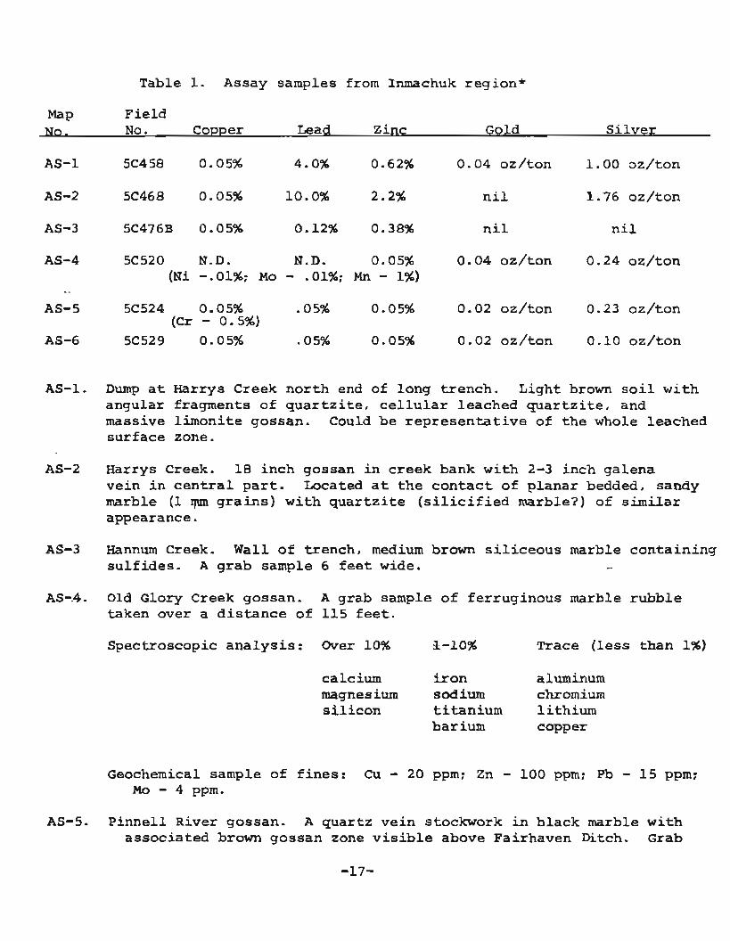
Table 1. Assay samples from Inmachuk region*
MaP Fie ld No. Copper Lead Zinc Gold S i l v e r
AS-2 5C468 0.05% 10.0% 2.2% n i l 1.76 oz/ton
AS-3 5C476B 0.05% 0 -12% 0.38% n i l n i l
AS-4 5C 52 0 N.D. N.D. 0.0596 0.04 oz/ton 0.24 oz/ton ( N i -.01%; MO - .01%; Mn - 1%)
AS-1. Dump a t Harrys Creek nor th end of long t rench. Light brown s o i l w i t h angular fragments of q u a r t z i t e , c e l l u l a r leached q u a r t z i t e , and massive l imoni t e gossan. Could be r e p r e s e n t a t i v e of t h e whole leached su r face zone.
AS-2 Harrys Creek. 1 8 inch gossan i n c reek bank w i t h 2-3 inch galena ve in i n c e n t r a l p a r t . Located a t t h e c o n t a c t o f p lanar bedded, sandy marble (1 qun g r a i n s ) w i t h q u a r t z i t e ( s i l i c i f i e d marble?) of similar appearance.
AS-3 Hannum Creek. W a l l of t rench , medium brown s i l i c e o u s marble con ta in ing s u l f i d e s . A g rab sample 6 f e e t wide. -.
AS-.4. Old Glory Creek gossan. A grab sample o f fe r ruginous marble rubb le taken over a d i s t a n c e of 115 f e e t .
Spectroscopic a n a l y s i s : Over 10% %-lo% Trace (less than 1%)
calcium i r o n aluminum magnesium sodium chromium s i l i c o n t i t a n i u m l i th ium
barium copper
Geochemical sample of f i n e s : Cu - 20 ppm; Zn - 100 ppm; Pb - 1 5 ppm; Mo - 4 ppm.
AS-5. P inne l l River gossan. A quar t z ve in stockwork i n b lack marble w i t h associa ted brown gossan zone v i s i b l e above Fairhaven Ditch. G r a b

sample of gossan. S o i l below the gossan (112, f i gu re 1) Cu - 20 ppm; Zn - 85 ppm; Pb - 15 ppm.
AS-6. Left l i m i t (northern) bench a t mouth of Nelson Creek boudined quartz veins cu t t ing s c h i s t i n o ld placer cut .
*Souce of data: Precious metals - f i r e assay, Division of Mines and Minerals, Metallurgy Branch, Don S te in , analys t
Base metals - x-ray fluorescence, Division of Mines and Minerals, Metallurgy Branch, Nam Ok Cho, ana lys t
Geochemical analyses (given i n ppm) - Rocky Mountain Geochemical Laboratories

Table 2* Laboratory and f ie ld analyses of stream sedamerlt samples from t h e Inmachuk map are& (1)
F i e l d No.
F ie ld Stream
Tin sediment - ------ -- Float , e t e , --
Sch with 10% qtz Sch 50%; M 50% Sch 70%; M 25%; gossan 5% Seh; M; gossan 3$ Sch; Mi gosaan i n S. bank Seh; M; q t z i t e breccia )6" M 100%; (2" sch 85%; M 5$; Vein
q t z 10% )6" M 1.00%; <2" sch 85%; M 5$; Vein
qtz 10% Sch 10%; M 90$ ~ c h 20%; M 804 Sch 95%; M 5%; qtz 5% Sch 88%; M 2%; qtz 10% Sch 80%; Qtz 20$ ~ c h 80%; . q t z 20$ sch 98%; q t z 2% Sch 95$; q t z 5% Sch Sch 97% qtz 3% Sch 90%; q t z 10% Sch 90%; qtz 10% Sch 80%; qtz 20%; 4' p y r i t e vein Sch 90%; q t z 104 sch 20$; M 70$; qtz 5% ~ c h 40%; q t z i t e 60% Sch 70%; q t z i t e 30$ Sch; 4' q t z i t e bed i n creek Sch 40%; M 20%; q t z i t e 40$ Sch 5096; M 20$; q t z i t e 20% Sch 90%; M 8%; qtz 2% ~ c h 85$; M lo$; qtz 5$ Sch Sch 90%; q t z i t e 2$; b l , s l a t e 2$;
b a s a l t 3$ Sch Sch Sch; Fz s t a i n

Table 2. (continued)
Fie ld Field NO
test (2) Concentration (ppm) Stream ml.dz. Copper Zinc Lead Molybdenum Tin sediment Float , etc.
3" 35 l* 30 3* 35 2* 4 5 3 5 20 6 20 3 3 5 6 20 miss ing - 20 - 20 - - 2 5
- 2 5 60
6* 40 -. 15 - 20 - - 25
- 1 5 1 5 - 1 5 - 20 - - 3 5
- 3 5
- 30 20
2 25 6 20 - 2 5 3 - 35
20 - 35
- 20 - 3 5
Sch 50%; M 50$ Sch 10%; M go$ Sch 904; qtz 3$; basa l t 64; rn 1$ Sch Sch 95% qtz 5$ Sch Sch Sch 80$; qtz 20$; Fe s t a i n Sch
Sch 75s; bl . sch 20$; q tz 5% Sch Sand only Sch Sch Sch and basa l t Sch and basa l t Sch and basa l t Sch and basa l t Basalt
Basalt
Sch Sch 504; qtz lo$; basa l t 40$
Sch 90%; q tz 10$ Sch 35$; volcanics 60%; qtz 25% Sch 90%; qtz 10$ Sch 90s; q tz 10% S C ~ 85%; M 15$ Sch 60$; M; Dolo; calc-ech;
Fe stained creek bad Sch; Fe stained creek bed Sch 80s; M 20%
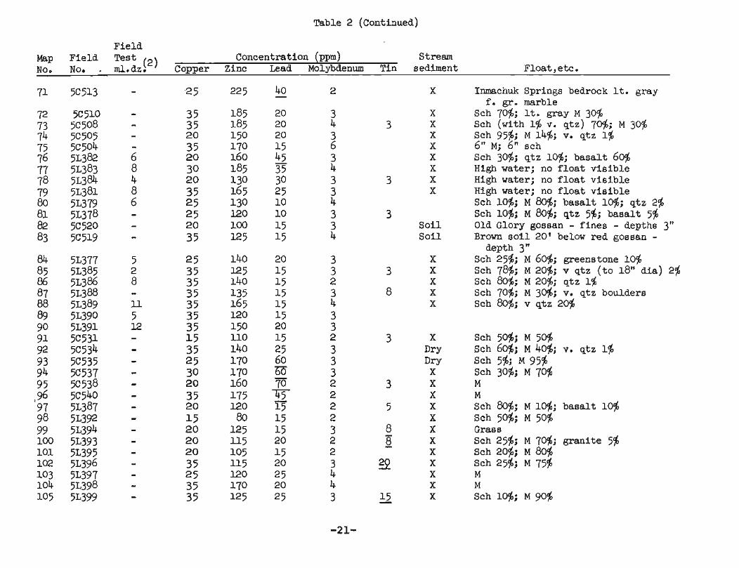
Table 2 (continued)
Fie ld Map F ie ld T e s t ( 2 ) Concentration (ppm) No. Nor . ml.dz. Copper Zinc Lead Molybdenum Tin
Stream sediment
S o i l S o i l
Inmachuk Springs bedrock It. gray f . gr. marble
Sch 70%; It. gray M 30% Sch (with 1% v. q tz ) 70%; M 30% Sch 95%; M 14%; v. qtz 1% 6" M; 6" sch Sch 30%; qtz 10%; basa l t 60$ High water; no f l o a t v i s i b l e High water; no f l o a t v i s i b l e High water; no f l o a t v i s i b l e Sch 10%; M 80%; basa l t 10%; qtz 2% Sch 104; M 804; q tz 5%; basa l t 5% Old Glory gossan - f i ne s - depths 3" Brown s o i l 20' below red gossan -
depth 3" Sch 25$; M 60%; greenstone 10% Sch 789; M 20%; v qtz ( t o 18'' dia ) 2% ~ c h 80%; M 20%; qtz 1% Sch 70%; M 30%; v. qtz boulders Sch 80%; v qtz 20%
Sch 50$; M 50% ~ c h 604; M 40$; v. q tz 1% sch 5%; M 95% Sch 30%; M 70% M M Sch 80%; M 16; basa l t 10% Sch 50$; M 50% Grass Sch 25%; M 70%; grani te 5% Sch 20%; M 80% Sch 25%; M 75% M M Sch 10%; M 90%
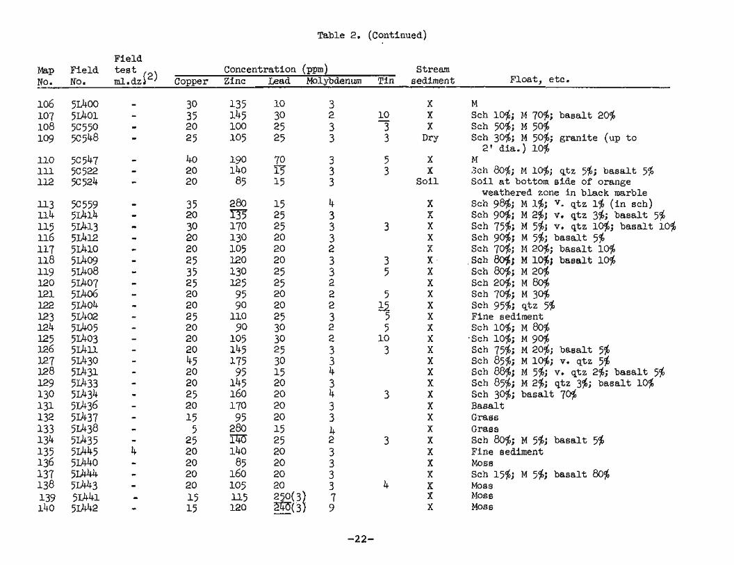
Table 2. (continued)
Fie ld Map Fie ld t e s t Concentration (ppm Stream NO. NO. - ml.dzi2) Copper Zinc Lead Molibdenum Tin sediment
110 5 ~ 5 4 7 - 40 190 - 70 3 5 X 111 5C522 - 20 140 1 5 3 3 X 112 5C524 - 20 85 1 5 3 S o i l
Float, etc.
M Sch 10%; M 70$; basa l t 20% Sch 50$; M 50$ Sch 30%; M 50%; grani te (up t o 2' dia. ) 10%
M 3ch 80%; M 10%; qtz 5$; ba sa l t 5$ S o i l a t bottom s ide of orange
weathered zone i n black marble ~ c h 98%; M 1%; v. qtz 1% ( i n sch) Sch go$; M 2$j v. qtz 3$; ba sa l t 5% Sch 75$; M 5$; v. qtz 10%; basa l t 10$ Sch 904; M 5$; basa l t 5$ Sch 70%; M 2046; basa l t 10%
jSch 80$; M lo$; basa l t 10$ Sch 80%; M 20% Sch 20%; M 80$ Sch 70%; M 30$ Sch 95%; qtz 5$ Fine sediment ~ c h 10%; M 80$
,Sch 10%; M 90% Sch 75$; M 20%; basa l t 546 ~ c h 85%; M lo$; v. q tz 54 Sch 88$; M 5$; v. qtz 2%; ba sa l t 5% Sch 85%; M 2$; qtz 346; basa l t lo$ Sch 30$; basa l t 70$ Basalt Grass Grass Sch 80%; M 5%; basa l t 54 Fine sediment Moss Sch 15%; M 546; basa l t 8046 Moss Moss Moss

Table 2. (continued)
F ie ld Map F ie ld test (2) Concentration (ppm) Stream No. No* ml.dz. Copper Zinc Lead Molybdenum Tin sediment Float , e t c .
Sch Sch 40%; v, qtz 10%; o l i v i n e b a s a l t 50%
Basal t Basal t boulders Basalt Basalt Sch 80%; M 1%; b a s a l t 20% Sch 10%; gran i t e 1%; hornfe ls 90$ Moss M 20%; hornfels 70%; b a s a l t 10% S l a t e 10%; M 10%; hornfels 90% Hornfels; Fe s t a i n i n creek M 50%; g ran i t e 10%; hornfels 40% M 50%; g ran i t e 10%; hornfels 40% Sch sch 804; M 20% Sch 30%; M 70% Sch TO$; M 30% M 95%; g ran i t e 5% M 95%; g ran i t e 5%
-------------------em-------
(1) Sample locat ions shown on f igure 1. S o i l samples from H a n . r I ~ Creek deposi t shown on t a b l e 3. (2) Milliliters dithizone , cold ext rac table heavy metals f i e l d test ( 3) In ter ference i n lead d e t e q i n a t i o n . +. Sample run twice ( f i e l d t e s t ) * Dilution of ex t rac tan t with water 1:4; unmarked samples run with 1:l d i l u t i o n - Not run J Greater than 40 Underline ind ica tes anomalous value S h - Schis t Qtz - Quartz M - Msrble Qtzite-Quartzite

Table 3. Laboratory and f i e l d analyses of geochemical samples from the Hannum Creek deposit (1)
Fie ld Stream Map Fie ld T e s t ( 2 ) Concentration (ppm) Sediment S o i l No. No. m l dz Copper Zinc Lead Molybdenum Sample Depth Float, remarks
X Light brown s o i l i n bank with Sch. frags. -
X X
3" - 90% M, 10$ Sch. 3" - 70% Sch., 20$ m, 10% gossan
Sch. frags.
1 f t . deep, taken i n s ide of trench 7 f t . deep, taken i n s ide of trench Sch., q t z i t e Brown s i l i ceous frags. i n s o i l Sch., Qtz i te Qtzi te and s c h i s t frags.
Sch., Qtz i te
Brown mud Fines only

Table 3. (Continued)
Field Stream Map Field Test (2) Concentration (ppm) Sediment Soil , No. No. ml dz Copper Zinc Lead Molybdenum Sample Depth Float, remarks
AG 5~490 16* 30 485 40 3 Fines only AH 5~489 16* 30 3 3 40 3 Basalt cobble AI 5~488 16* 35 '-m 3 5 3 Fines only A J 5 ~ 4 8 7 18* 20 'F7 70 2 Fines AK 5~486 >20* 35 lo50 -I-1000 3 X 2x2 Ft. prospect p i t Sch,
Qtz i te , basalt AL 5~483 - 30 +lo00 - 7 5 3 AM 5~484 12* 25 320 55 3 X AN 5 ~ 4 8 5 7* 2 5 185 40 3 A0 5 ~ 4 8 1 ll* 50 +lo00 60 5 X Qtz i te f loat , Sch. bedrock AP 5C592 - 2 5 35 40 1 AQ 5~479 11* 20 5 50 5 5 3 AR 5 ~ 4 7 8 6 * 20 410 - 105 3 AS 5C477 18s 20 - 550 - 185 3 AT 5~476 14* 20 750 - - 39 5 3 Sample from 1 f t . dark gray
s o i l over gossan Au 5c591 - 2 5 750 +lo00 1 AV 5C593 - 20 1 - 600 - 1 Perennial spring, limonite s t a in
on rock, about 50 gal/minute AW 5 ~ 4 7 4 > 2O* 20 660 160 2 Sch. vein qtz., basal t - Ax 5~473 - 20 39 5 T 3 ~ c h . with qtz. veins AY 5~494 - 20 140 30 4 1 5L301 1 5 35 300 - 330 2 X See Table 2 2 5L302 )20* 25 750 500 3 II st n
3 5 ~ 4 5 1 A 8* 25 630 320 3 Dry f l II 11
4 5~452 15* 30 875 460 3 Dry It II t1
5 5~462 5,8* 20 450 170 - 2 x w I t $1
6 5 ~ 4 6 1 4 5 2 5 200 25 2 x I t 11 I t
12 5L303 4 25 125 100 3 X I t 11 11
22 5L300 > 20 25 360 110 3 X II II II
23 5~304 8+ 30 350 40 3 x II I) 11
24 5L305 3* 30 190 15 3 X 10 H I1
25 5~306 7* 30 225 20 3 X I 1 11 11
18 Location of samples shown on figure 2 Mil l i le ters dithizone fo r cold extractable heavy metals f i e l d t e s t
st 1:4 dilution of extractant with water. Unmarked samples run with 1:l dilution > Greater than - Not run
Sch* Schist M Marble
n+s-l+n. O r r a r t . ~ i +.P -9 E;,