objectives, policies and methods significant resource management issues · 2016-11-15 ·...
TRANSCRIPT

obje
ctiv
es, p
olic
ies
and
met
hods
sig
nifi
cant
res
ourc
e m
anag
emen
t iss
ues
This section updated 11 July 2016
This part of the Policy Section sets out the programme
of objectives, policies and methods the District Plan has
adopted to manage the effects of activities on natural and
physical resources. Each objective is concerned with the
protection and enhancement of particular resources or
aspects of the environment, and addresses the significant
resource management issues that face the City. An
explanation, and statement of the principal reason for the
adoption of objectives, policies and methods, are also
provided.
Further explanation of a number of overarching
general strategic or policy responses to key matters, such
as population growth and City form, are set out in Part 6
of the Policy Section. Individual policies and methods are
placed in this context and it is shown how they combine
together as an integrated whole, as a response to the issues
facing the City. A full explanation of some policies and
methods is not possible without setting out this general
strategic direction taken by the City.
In order to achieve the most effective management of
effects of activities, the City has been divided into a
number of management areas. This allows the application
of policies and methods, not only on a City-wide basis but
also in terms of the particular natural and physical features
that are found in different parts of the City. As a
preliminary to understanding how they are applied, these
management areas are set out as follows:

obje
ctiv
es, p
olic
ies
and
met
hods
Natural Areas & Human EnvironmentsTwo layers of management areas form the basisfor applying policies and methods. The first layer liesacross the whole City and is concerned with themanagement of effects of activities on natural andphysical resources (other than structures). Thesemanagement areas (called Natural Areas) are definedaround certain key resources, around their relativesignificance or importance, and the level ofprotection required to ensure their continued healthand survival.
The second management layer also lies over thewhole city and is collectively known as the HumanEnvironments. These Human Environments aredefined around the City’s landscapes and local areaswhich are identified in Part 3.6 and Part 3.7. Theyform the basis for managing the effects of activitieson landscape, amenity values, neighbourhoodcharacter and heritage. They also form the basis formanaging the effects of activities on human healthand safety. Outside the urban area, the HumanEnvironments are defined primarily by the naturallandscapes and the mix of buildings within them.The Human Environments within the urban area 59reflect the variations in both the types of buildings,and the character derived from the dominantactivities that take place in different areas. TheseNatural Areas and Human Environments are set outbelow in summary. Further explanation is found inPart 6.
Natural Areas
Riparian Margins/Coastal Edges:
Includes the margins of streams, lakes, wetlandsand the City’s coastline. Riparian Margins (streams,
lakes and wetlands) and Coastal Edges areparticularly sensitive to the adverse effects of use anddevelopment. These areas, particularly when
vegetated, have a significant role to play in themaintenance and enhancement of water quality.They can also contribute to the protection of
ecological values, preservation of natural characterand the avoidance and mitigation of natural hazards.
Protected:
Includes the areas which have been identified as
containing outstanding native vegetation and/oroutstanding natural features. Some parts of the City’scoastal environment also fall into this Natural Area.
These areas were mostly identified using the
Protected Natural Area Survey methodology andhave been defined on the basis of providing a highlevel of protection to resources that lie within them.
The areas of outstanding native vegetation andoutstanding natural features are identified in Part 3.5.
Coastal:
Includes those areas of largely unmodified
natural coastal character that lie outside the moremodified coastline of the urban area and outside anyProtected Natural Area. A high level of protection is
provided in this coastal environment. The identifiedcoastal area is shown on Map 3.5(c) in Part 3 of thePolicy Section.
Managed:
Includes all areas of significant and outstanding
native fauna habitat, and those areas of vegetationthat have been identified as significant using thecriteria developed by the Council. The management
approach recognises the need to provide a level ofprotection that is compatible with the capacity of thearea to absorb impacts. However it also recognises
that some settlement may occur. The areas ofsignificant and outstanding fauna habitat andsignificant vegetation are identified in Part 3.5.
Restoration Natural Area
Includes those areas of native vegetation with
between 20% and 50% native vegetation cover thatare over 300m2
in area. The management approachis the need to provide protection for the natural
regeneration process. It is recognised however thatsettlement may occur. The Restoration Areas areidentified in Part 3.5.
These five Natural Areas are collectively knownas the Green Network, the overall term that conveysthe shape and form of the City’s primarily naturalresources and ecosystems. Some policies apply to theGreen Network as a whole while others apply tocomponents within it.
General:
Includes all those areas of the City that lie outside
the Green Network. There is considerablegeographic diversity, including the foothills, theurban area and those small areas on the West Coast
and the Manukau Coast that are occupied by villages,or where no native vegetation is found. There arethree overlays on the Green Network and General
Natural Area as listed below. Whilst the General
2

bjec
tive
s, p
olic
ies
and
met
hods
Natural Area Rules apply to these overlays, they also
provide important descriptive information which is
incorporated into the long-term management of the
Green Network. These are:
Ecological Linkage Opportunities:
Includes those areas that have been identified as
opportunities for linkages between fragments of
native vegetation which, if replanted, would improve
the sustainability of those fragments of vegetation,
or which would act as wildlife corridors. These areas
are identified in Part 3.5.
Natural Landscape Elements:
Includes those features that are essential
landscape elements in the City’s outstanding
landscapes. These are identified in Part 3.6
Human Environments
Waitakere Ranges:
Includes the bush-covered areas of the Waitakere
Ranges, and the west coast and Manukau coast,
where natural elements and wilderness character
dominate. It incorporates the outstanding coastal
and Waitakere Ranges landscapes identified in Part
3.6.
Bush Living:
Includes those intensively settled areas within the
Waitakere Ranges, where natural features dominate,
but settlement has substantially fragmented the
bush. A partly residential but, nonetheless, “non-
urban” character predominates as a result. It
incorporates the bush living local area identified in
Part 3.7.
Coastal Villages:
Includes the small settlements that lie along the
Manukau coast and the west coast. These are Parau,
Cornwallis, Huia and Little Huia, Karekare, Piha and
Bethells/Te Henga, and are identified in Part 3.7.
Foothills:
Includes the mixed landscape of the easternfoothills catchments of Oratia, Opanuku, Swanson
and upper Kumeu streams, excluding the relativelycontinuous bush cover of the upper catchments andridges. The Foothills Environment incorporates the
foothills landscape identified in Part 3.6 and 3.7.
Countryside:
Includes those areas to the north of the urbanarea which form the rural/pastoral landscape
identified in Part 3.6.
Rural Villages:
Includes the small settlements found within the
Countryside Environment: Whenuapai,Hobsonville, Whenuapai Airbase, WaitakereTownship and the Herald Island Villages. These are
identified in Part 3.7.
Open Space:
These are the areas of publicly owned open spaceranging from the large park areas in the Waitakere
Ranges to the small local parks in the urban area.
Living:
Includes all areas within the intensively settledurban area that are primarily residential in character.
These are identified in Parts 3.6 and 3.7.
Working:
Includes areas which are primarily industrial incharacter within the urban area. (See Part 3.6)
Community:
Includes the town centres and other smaller areaswhich are the focus of shopping, service, recreationaland communal activities. (See Part 3.6)
Special Areas
Includes areas that contain a unique grouping ofactivities differing markedly from the surroundingarea. These are:
• Harbour View North• Monterey Park• Bible College• Hospital• the three existing marae areas within the City• Boating (Te Atatu)• Quarry• Balefill
3
o

obje
ctiv
es, p
olic
ies
and
met
hods
• Marina (West Harbour)• Lincoln Park• Corban Winery Estate• Monier (CSR)Scheduled Sites
Includes those sites containing a single activity
which differs markedly from the surrounding area.These sites are listed in the Rules Section of theDistrict Plan.
4
bjec
tive
s, p
olic
ies
and
met
hods
5.0 ISSUE - MANAGING CITY GROWTH
Management of growth is a key issue for both
Waitakere City and the region as a whole. The city’s
growth is largely driven by increases in residential
population. Other elements of growth include
employment, community services, business and
retail activities and infrastructure.
In 2004 the following key growth issues were
identified for Waitakere City:
• population was expanding faster than estimatedrates;
• limited land area to provide for growth;• a potential shortage of employment land was
predicted by 2009;• Waitakere City had only achieved sporadic
success in concentrating urban intensificationwithin and around town centres; and
• there was increasing pressure to accommodate ahigher intensity of development in the rural partof the city, including the internationallysignificant Waitakere Ranges and Foothills.Waitakere City has been growing steadily both
economically and in population since the District
Plan was first notified in 1995, and in 2004 was the
fifth largest city in New Zealand. From a population
of 155,565 in 1996, the number of residents grew at
an average annual rate of 1.7% over the following
five years to 168,750 (2001 census). The population
as at 30 June 2004 was estimated to be 185,600.
Whilst there appears to be limited capacity for
residential growth, Waitakere City is growing at a
faster rate than previously anticipated. Consequently
Waitakere City is predicted to reach a population of
303,000 (ARGS) several years earlier than 2050 (a
147,000 or 94% increase). It is projected that the city
would need to accommodate at least half this
population (74,500) by the year 2021. This quantity
of growth and limited capacity has significant
implications for future growth management and will
have implications for the City’s natural and physical
resources if growth is not more directly managed
through the District Plan.
Historically, residential housing has been
dominated by single unit detached housing. In 2001
approximately 80% of the 56,172 dwellings in the
City (Census 2001 figures) were in this form.
Typically this style of development results in
densities of approximately 10 houses per hectare.
Due to the trend of average house size declining, this
growth means that proportionally more dwellings
and services will be required in the future. In order
to accommodate this growth, 1200-1500 new
household units would need to be created annually.
If this form of development was to continue, then
the City would require over 100 hectares of land to
be converted for residential purposes every year.
Much of this would be in greenfields areas, of a form
commonly referred to as low density urban sprawl.
Such an approach would have a significant impact on
the valuable features that are currently protected by
the Metropolitan Urban Limit (MUL) and would not
create necessary transport efficiencies for the
Auckland region.
The bulk of the City is covered by landscape and
parklands that have high value. The Waitakere
Ranges and Foothills Protection Project (2003-2005)
has identified that the Waitakere Ranges area is
under unique pressure for subdivision, use and
development due to its close proximity to Auckland,
New Zealand’s largest metropolitan area.
Subdivision and resultant development is increasing
the numbers of built structures in the landscape and
altering the character of the area, with associated
earthworks and vegetation clearance leading to
irreversible loss of environmental and landscape
values. The pressure for subdivision and
development is likely to increase relative to the City
and Region’s rapidly growing population. The
foothills and coastal villages are currently absorbing
most of this pressure, with adverse effects becoming
increasingly apparent.
Accordingly, approximately 26,000ha was
proposed to be included in the Waitakere Ranges
and Foothills Special Heritage Area. Furthermore,
approximately 27,760ha of the City is located outside
the 1999 MUL and is therefore considered rural.
Urban zoned land (within the 1999 MUL) comprises
some 8,208ha. On this basis a large portion of the
City is not available for urban intensification.
The issues which can arise from such
development are outlined in the following
Objectives
5
o

obje
ctiv
es, p
olic
ies
and
met
hods
of this Chapter and include adverse effects ofdevelopment on:-
• Water - Quality and Quantity• Native Vegetation and Fauna Habitat• Land (including soils)• Air Quality/Atmospheric Quality• Ecosystem Stability• Outstanding Natural Features• The Natural Character of the Coast and Margins
of Lakes, Rivers and Wetlands• Mauri• Outstanding Landscapes• Amenity Values - Health and Safety• Amenity Values - Landscapes, Local Areas and
Neighbourhood Character• Heritage
These issues are also documented and influenced
by the Auckland Regional Policy Statement (ARPS)
- the Auckland Regional Growth Strategy (ARGS
1999), the Northern and Western Sectors Agreement
(NAWSA 2001) and the Local Government
Auckland Amendment Act 2004 (LG(A)AA).
All of these documents highlight the need to
manage growth in an integrated manner with the aim
of consolidating development to a sustainable
compact urban form, with well-integrated land uses
and transport network. This not only necessitates
managing urban growth but also integrating
peripheral urban growth and rural growth. In
particular growth is not anticipated within areas of
high environmental and landscape values (such as
the Waitakere Ranges) and only limited provision for
growth is anticipated in other rural areas.
In particular, the LG(A)AA requires the
integration of land use and transport to contribute in
an integrated manner to the following matters:
• providing increased certainty in the assessmentof resource consents, designations, and planchanges related to transport and urban form,and ensuring that transport and land usepatterns are aligned to achieve sustainability,efficiency, and liveability in the AucklandRegion;
• managing transport and transport infrastructure,facilitating a multimodal transport network, andfacilitating integrated transport management;
• reducing adverse effects of transport on theenvironment (including improving air and waterquality, reducing noise and stormwater,improving heritage protection and reducing
community disruption and transport land use),and reducing the adverse effects and increasingthe positive interactions of transport and landuse;
• supporting compact sustainable urban form andsustainable urban land use intensification(including location, timing and sequencingissues, and associated quality, character, andvalues of urban form and design); and
• integrating transport and land use policies toreinforce metropolitan urban and ruralobjectives of the Auckland Regional PolicyStatement, the development of a competitiveand efficient economy and a high quality of life,underpinned by a quality environment andamenity.
This City has a legal obligation under the RMA to
give effect to the ARPS and particularly under the
LG(A)AA to align the Auckland region’s planning
documents (including the District Plan) with the
ARGS. However it is also a basis of this District Plan
that an urban consolidation strategy be pursued. It is
also necessary that the effects of urban growth are
managed in that way so that the issues outlined
elsewhere in this Chapter are adequately addressed.
This is particularly important in an environment of
significant population and housing growth.
It is estimated in the ARGS that Waitakere City
will need to find capacity to accommodate an
additional 147,000 people by the year 2050. This new
residential growth will need to be located near existing
services, facilities, and around town centres within the
urban areas as first preference to achieve a compact
sustainable urban form. Historically there has been
significant intensification within key town centres
however significant compact urban development has
also been occurring outside these areas.
There must be confidence that the traditional
form of providing for residential housing growth is
re-orientated so that housing form is dominated by
well planned and developed higher intensity
development, priority for such development being
within existing urban boundaries (i.e. those
boundaries defined by the metropolitan urban limits
as at 2004) and more specifically those areas identified
for nodal development in Policy Map X and Schedule
Y.
Council has a strategic policy of directing
growth into its three primary town centres as
identified in the ARGS - New Lynn, Henderson and
Westgate/Massey North (“town centres” has the
6
bjec
tive
s, p
olic
ies
and
met
hods
same meaning as “sub-regional centres” in the
ARGS). In these town centres residential
development will be in the form of medium to high
density with a high level of local amenity and easy
access to local facilities.
This type of land use in the form of compact
urban development will provide enough local
catchment to support public transport, walking and
cycling which in turn reduces dependence on the
private car for travel. Having a large range of services
nearby will also increase people’s mobility.
Additional compact urban development will also
be necessary in neighbourhood centres, in the new
development areas in the north of the City, and along
key transport corridors as identified on Policy Map X
and Schedule Y to ensure that urban intensification
is occurring in locations that support public
transport.
It follows that development outside the
metropolitan urban limits needs to be very carefully
managed, not only to ensure the achievement of
urban consolidation strategies, but also to protect
the qualities of rural areas, such as natural features
(including vegetation, streams and soils), landscapes,
rural character and the efficient provision of
infrastructure. While some growth will occur in rural
areas, this will be more to provide for rurally-based
activities and, to a limited extent, appropriate living
choices, rather than to accommodate the bulk of the
City’s growth.
These strategies are not new. They have existed
in this District Plan since it was notified in 1995.
However, the following issues have become evident:
1. The means by which urban consolidation isintended to be achieved needs to be very clearlyexplained, so that there is no doubt about theoutcomes expected;
2. Development within rural areas needs to bemanaged in an integrated manner with urbangrowth;
3. The expected outcomes need to be supportedby district plan provisions which provide, in anappropriate and realistic way, for residentialintensification;
4. These opportunities need to be focused inlocations which will support linkages totransport networks, community services andemployment - town centres, intensive corridorsand arterial roads inside the MUL;
5. New areas for employment need to beintroduced within the City to keep pace withpopulation growth and stem the flow of existingresidents leaving the City to work each day;
6. The issue of design at building, site,neighbourhood and community levels needs tobe recognised so that attractive, workable andliveable places are created (particularly inrelation to residential, mixed use, business andindustrial development);
7. In providing for the scope, location and form ofhousing development, recognition needs to begiven to social, economic and cultural well being.The issue of how urban growth is to be managed
has therefore been identified, in 2005, as one which
requires specifically targeted district plan attention.
A further issue for the City is that of employment
growth. While the rate of population growth has
been and will remain high, this is not being matched
by the rate of employment growth. An increase in
the number of people living in the City means more
people to attract more business and generate more
local employment, together with additional demands
for social and community infrastructure. This has
implications for how the City manages the impacts
of growth and continues to work towards
sustainability.
Waitakere City is home to 15% of the region’s
population and only 8% of regional jobs. In 1996
56% of Waitakere City’s workforce commuted out
of the City for employment. This figure rose slightly
in 2003. Council’s strategic policy is to reduce the
migration of employees to 40% and achieve a target
of 60% of the workforce working locally (in
Waitakere) and not having to commute out of the
City for employment. In order for this to occur,
additional employment land is required and certain
types of employment need to be targeted to meet the
local workforce demand.
Waitakere is a city of small to medium businesses
with 93% employing fewer than 10 people. The
manufacturing sector makes up 20% of local
employment. Construction and retail are the next
largest employment sectors. Waitakere is
creating proportionally more jobs than peripheral
Auckland, particularly in the manufacturing,
construction, and business service areas. To
capitalize on this
opportunity Waitakere
7
o

obje
ctiv
es, p
olic
ies
and
met
hods
needs to provide business settings to support theclustering of compatible activities, particularly
business services, clean production products, marine
industry, engineering and light industry, and
transport. These business areas are also compatible
with export cluster demand identified in the
Auckland Regional Economic Development
Strategy (AREDS).
In 2004 Waitakere City had approximately 490ha
of land identified as Working Environment. As of
June 2004, Waitakere City had 29.7ha of vacant land
(greenfields) and 76.9ha of potentially vacant land
(brownfields) in the Working Environment, giving a
total area of around 106.6ha. Prior to 2001 the
annual uptake of this industrial land was 17.6ha.
Council research indicates that the uptake between
2001-2004 has been around 12.3ha per year. These
figures generally correlate with a recent Auckland
Regional Council study that estimates annual
demand for industrial land in Waitakere City
between 1998-2004 at 11.9ha. At this rate there is a
capacity of around 9 years. However large areas will
not be available for some time and there is also a
shortage of accessible large footprint business sites.
In reality this means there is more likely to be 5-7
years industrial land capacity. Again it is critical that
Waitakere City takes a more directive approach to
managing employment growth.
Population growth needs to be supported by the
provision of community services, such as parks,
libraries, community centres, and social and health
services. These services need to be easily accessed by
residents.
Business services are also important. With
particular regard to retail activities, the district plan
management approach is under Objective 11 in this
Chapter, and in Chapter 6.
An associated issue in managing city growth is
that of providing for a transport network which will
provide linkages from, to, and between all land use
activities in the City, as well as routes that run
through the City.
There is a critical link between land use activities
and transport networks. Potentially, the most
efficient transport modes are those which can
accommodate large numbers of people on a
dedicated transport route. Public transport provides
that means, and has the potential to avoid, minimise
or at least delay the need for new roads and roads/
motorway upgrading.
Public transport needs to be well planned, well
located, efficient, attractive and affordable. This
District Plan supports all of those aims.
In addition, it is important that as many people as
possible live and work within accessible distance of a
public transport node. This involves the need to not
only locate new development around town centres
and along intensive corridors but to also improve
existing and new transport connections (including
cycling and walking) within areas of existing
development. This is a form of integration which is
provided for and supported by this District Plan.
The District Plan also supports the Auckland
Regional Land Transport Strategies in the
promotion of increasing residential and employment
densities in town centres and along intensive
corridors. The provision of growth nodes at Massey
North, Hobsonville Village and Hobsonville
Peninsula is critical to transport and land use
integration.
The City’s infrastructure resources need to be
recognised when considering any urban growth
proposal. It makes sense to efficiently utilise existing
infrastructure, where capacity is available. Priority
needs to be given to providing for growth where the
benefits of that growth location most outweigh the
economic and environmental costs of infrastructure
provision or upgrading. Particular attention needs to
be given to the impact of new infrastructure on
coastal margins, waterways and harbours.
In all of the above urban growth of all forms
needs to be encouraged to develop in such a way as
will achieve sustainable, energy-efficient and water-
minimal and waste-minimal outcomes.
In summary, the following are the issues which
need to be addressed when managing City growth;
General:
Accommodating significant population growth,
which will continue throughout the planning period;
• Increasing the percentage of resident workforce
employed locally;
8

bjec
tive
s, p
olic
ies
and
met
hods
• Ensuring the provision of a balanced range of
urban activities, easily accessed by new
populations;
• The integration of land use activity and
transport networks, and in particular providing
linkages between higher intensity residential
areas and employment areas, and public
transport nodes;
• Managing development so that it achieves the
efficient use of resources;
• Managing development so that it is efficient and
sustainable.
Specific:
• Accommodating at least 70% of the City’s
population growth within metropolitan urban
limit boundaries as existed in 2004;
• Provision for adequate employment land within
the City to allow a significant proportion of the
City’s residents to work locally;
• Opportunities for intensive residential and
mixed use development focused in town centres
(particularly, New Lynn, Henderson and Massey
North), around intensive corridors and arterial
roads within the MUL as identified in Policy
Map X and Schedule Y of the District Plan;
• Certainty that the opportunities provided for
intensive residential and mixed use activities will
be established when land is developed/
redeveloped;
• Providing adequately for housing which is
affordable, and suitable for a range of social and
cultural needs;
• Managing peripheral expansion of the urban
area in a way that the Auckland Regional
Growth Strategy and this District Plan’s
emphasis on urban consolidation is respected,
and any newly developed areas maintain a
compact urban form;
• Ensuring that newly developed or redeveloped
areas are adequately supported by community
services, business activities (including retail),
infrastructure and transport networks;
• Ensuring that the Waitakere Ranges, including
the foothills, remain permanently rural
(excluding land that falls within the
Metropolitan Urban Limits and any land that is
identified as Foothills Environment that falls
outside the Waitakere Ranges Heritage Area
identified on Policy Map X);
• Managing other rural areas so that they remain
rural, without compromising future potential for
alternative use, including future urban use;
• Identifying land for urban growth in the
NorSGA Corridor of the City, which can be
well-serviced and connected to transport
networks, and to provide for appropriate
opportunities for employment, community
services, business and retail;
• Ensuring adequate provision for transport
networks, including public transport routes,
public transport interchanges and nodes, a
primary arterial road network and well-
connected secondary road networks.
Objective 0
To manage growth in such a way that will
ensure the City develops and redevelops to
achieve a sustainable compact urban form in a
manner that appropriately manages adverse
cumulative and reverse sensitivity effects.
Growth should be focused in and around town
centres and intensive corridors, and where
appropriate enabled in neighbourhood centres
and corridors. Growth should be integrated,
particularly with the transport system, result in
high amenity values, contribute to the
management of population growth, provide
employment opportunities, as well as provide
appropriate community and business services.
This objective can be achieved by managing the
location, density, scale, form, character, timing
and sequencing of urban and rural growth. In
order to achieve sustainable urban
consolidation, all urban activities including
urban growth and development should be
directed to areas inside the Metropolitan Urban
Limit and managed in a manner that protects
significant environmental values.
Explanation
It is a major theme ofthis District Plan, within
9
o

obje
ctiv
es, p
olic
ies
and
met
hods
the wider regional framework, to ensure theconsolidation of urban development. In order toensure urban consolidation can be achieved anintegrated approach needs to be taken to growthwithin the urban area and its periphery as well asrural growth. Particular consideration also needs tobe given to the mix of residential and employmentgrowth within existing and future urban areas. Theaim by 2021 is to ensure that 78% of the City’sgrowth is to occur inside the 2001 MUL, 17% is tobe accommodated in peripheral urban growth areas(the Northern Strategic Growth Area, Penihana andBabich land), and 5% of the City’s growth will beprovided within the rural part of the City. Asignificant increase in the number of people thatwork locally is also necessary to achieve sustainableurban consolidation, although it is acknowledgedthat the relationship between where people live andwork is not merely a sub-regional issue.Significant urban intensification has beenoccurring in town centres and neighbourhoodcentres and along intensive corridors. Additionalintensification has however been occurring outsidethese areas which in certain cases has not beensupportive of promoting sustainable urbandevelopment or integrating transport and land useplanning. The aim of this objective is to re-directurban growth to areas that support sustainablecompact urban form. This objective recognises thebenefits that compact urban form approach candeliver, including reduced vehicle trips (both interms of distances and trip numbers) and thecreation of compact mixed use centres which have ahigh level of urban amenity.
This objective also recognises that urbanactivities, as defined in the Auckland Regional PolicyStatement (ARPS), should occur within theMetropolitan Urban Limit (MUL). Urban activitiesoutside the MUL have the potential to undermine acompact urban form, to divert growth into areaswith unsuitable infrastructure or unsustainableenvironmental capacity, as well as to negatively affectthe qualities of rural areas. It also recognises thaturban growth may be appropriate in and aroundneighbourhood centres identified in Schedule Y ofthe District Plan, as well as along corridors(including the area adjacent to the corridor), otherthan those identified in Schedule 1 of the ARPS, andPolicy Map X and Schedule Y of the District Plan.Such growth may be enabled having regard to theenvironmental effects of any proposed developmentand whether the proposed developmentcompromises the relevant policies of the ARPS.
Areas have been identified in Schedule 1 of theARPS and Policy Map X and Schedule Y of theDistrict Plan within which these residential andcommercial urban growth aims can be achieved.Methods are also adopted to provide as muchcertainty as possible that this will occur, and in a waywhich results in development beingcomprehensively planned so that it is workable,integrated, with high amenity value and with valuedresources protected and enhanced. Accordingly,identification of urban intensification has beenavoided in areas of significant natural and landscapevalue.
A key driver for land use changes at MasseyNorth/Westgate, Hobsonville Village andHobsonville Airbase is to provide employment landwithin Waitakere City to stem the flow of residentsout of the City to work which ultimately adds to theAuckland region’s traffic congestion problems. Theobjective is to create compact urban developmentfocused on town centres/ transport nodes which hasstrong provision of locally accessible employmentland and provision for high density residential/mixed use development. This approach of centreswith walkable local catchments to support passengertransport is aligned with the key aim of theLG(A)AA 2004 of land use and transportintegration.
An application to bring the Babich land insidethe MUL was lodged with the Auckland RegionalCouncil in 2004. A similar application to urbaniseland at Penihana is likely when the ARPS is reviewedin 2009. Should these applications be successful,additional land on the western flank of theMetropolitan Urban Limit will not need to beconsidered for urbanisation until at least 2021.
The bulk of rural intensification is provided forthrough the Structure Plan process in the Foothillsand Countryside Environments and thedevelopment of vacant sites. The Birdwood,Swanson, Oratia, and Dilworth Structure Plans inconjunction with vacant lots in the rural part of theCity are sufficient to accommodate rural growthuntil at least 2021. Structure Planning in theCountryside Environment has been deferred untilthe future of the Whenuapai Airport is confirmed sothat potential future urbanisation is notcompromised and reverse sensitivity and waterquality issues can be quantified and addressed.
Subdivision provisions in the remaining ruralparts of the City provide for limited intensification.Subdivision below District Plan standards isgenerally prohibited in the rural Waitakere Rangesand the Bush Living Environments and applications
10
bjec
tive
s, p
olic
ies
and
met
hods
to go below District Plan standards in the CoastalVillage, Rural Village, Countryside and FoothillsEnvironment and Special Areas are likely to benotified. Nevertheless the ongoing protection of thevalues of the Waitakere Ranges is contingent on themajority of future growth being located within theurban area and in the peripheral urban areas in thenorth of the City.
Policy 0.1
The further development or re-developmentof urban areas should be planned to provide thefollowing:
• In the town centre areas identified asCommunity Environment, CommunityPeriphery Environment or identified mixeduse area within a Special Area provision formixed use development, includingresidential activity, above ground floor level;
• In any Living Environment which is withina 10 minute walking distance of the NewLynn Community Environment or theHenderson Community Environment or theMassey North/Westgate Special Area, anynew development should achieve ahousehold unit density of at least 40household units/hectare (gross);
• In any other area identified as LivingEnvironment as at 2004, which is within a 10minute walking distance of any train stationor is on a regional arterial route,development should achieve an averagehousehold unit density of 30 households/hectare (gross);
• In any new area introduced by a planchange, which is intended primarily forresidential purposes, residential densitiesshould achieve an average household unitdensity of 40 households/hectare (gross).Where such areas are in close proximity tosensitive rural and/or heritage areas (suchas the Waitakere Ranges Heritage Area)consideration should be given to the ways inwhich adverse effects on the amenity valuesof these areas can be avoided or mitigated;
• Single unit detached housing should belocated in areas other than those describedabove;
• Further growth and development which hasan urban character should be avoided inareas with the following characteristics:
• Outstanding Coastal Natural Character
• Outstanding Natural Landscapes
• Areas prone to natural hazards including flooding or instability
• Significant or outstanding vegetation or fauna habitat including riparian margins;
• Achieve compact urban form.
Explanation
This policy is important to achieve a compacturban form. Emphasis is given to achieving higherdensities in critical locations such as around towncentres and intensive corridors as stipulated in PolicyMap X and Schedule Y of the District Plan, whilehaving regard to the effects of development in closeproximity to sensitive rural and/or heritage areas. Insuch areas it is expected that the existingenvironment will alter over time to a new form. Newgrowth areas are also expected to be developed athigher densities, so as to enable the efficient use ofnewly developing areas. Lower density developmentis still provided for in other areas, and particularlyexisting suburbs which have been historicallydeveloped to lower densities and have a clearlydefined valued character. In some cases it isnecessary to restrain higher density developmentwhere this can have adverse effects on existingresidential character. It is noted that density targetsidentified in the Policy will need to be reviewed anddetermined at the time of detailed concept planningthat is required prior to urban areas beingsignificantly developed or redeveloped.
In respect of household densities, “gross” areasinclude all roads, reserves, stream margins, etc.generally taken over a sizeable area (2ha plus). “Net”areas do not include perimeter or collector roads, butwill include roads/access internal to a developmentand all private spaces such as parking and privateopen space.
At the densities sought, it will be necessary toprovide substantial 2-3 storey or higher mediumdensity or apartment developments in and aroundtown centres, train stations and on regional routes.Similar development will be expected in new urbangrowth areas. However, there should still be theopportunity to provide for a mix of housing types toensure a variation of urban form and a range ofhousing choice.
Further urban growth which has an urbancharacter in areas with significant natural andlandscape values and areas prone to hazards shouldbe avoided. Titirangi/Laingholm is one sucharea that whilst having
11
o

obje
ctiv
es, p
olic
ies
and
met
hods
these physical characteristics is located inside theMetropolitan Urban Limit, a situation that is uniquein the region.Methods
District Plan Rules:
• New Human Environments• Provision for intensive housing and mixed use
developments• Rules requiring minimum densities• Subdivision Rules
Other Methods:
• comprehensive area plans• provision of design guidelines• provision of design advice• development agreements• Waitakere City Growth Management Strategy• Northern and Western Sectors Agreement• Monitoring• Integrated Transport Assessments
Policy 0.2
The priority areas for urban intensificationshould be within and around the Henderson andNew Lynn Community Environments and theMassey North/Westgate Special Areas. Urbanintensification is required to ensure efficient use ofthat land resource. This includes provision forbusiness (including retail), high density residentialand mixed use development, and other employmentactivity which is appropriate to town centrecharacter and has the ability to be serviced bytransport networks and other infrastructure, andwhich avoids or mitigates any potential reversesensitivity effects.
Explanation
The city has three major town centres, at NewLynn, Henderson and Westgate/Massey North.Each of these centres is well located and integratedwith public transport to accommodateintensification of urban activity. Some opportunitiesavailable at New Lynn have already been recognised.That centre will further develop with a range of landuses. It is important in this area, and in and aroundthe other major centres, that the land resource closeto services and transport nodes is efficientlydeveloped. That is necessary if the City’sconsolidation/intensification strategies are to beachieved. High density residential development istherefore not only encouraged, but will be required
in critical locations, subject to ensuring good designand high quality amenity.
These town centres are also very importantemployment areas, and there is a significantopportunity to establish close work to homelinkages.
The Westgate/Massey North area in particularprovides a suitable large land resource for business.This will be well located next to a Town Centre, thenew State Highways 16 and 18. It will also beintegrated with the Quality Transit network.
These are also the main centres in which retailactivity will occur. Adequate and flexible provisionwill be made for such activity, with an emphasis oncomprehensive planning to produce integratedshopping precincts with distinctive, high amenityand sustainable design. Sustainable design includesconsiderations of environmental, social, economicand cultural sustainability.
Comprehensive planning through provision ofsite analysis, concept plans and comprehensivedevelopment plans will be required to ensure thatdevelopment occurs in an integrated manner,including provision for communtiy services andinfrastructure.
Methods
District Plan Rules:
• New Human Environments• Provision for intensive housing and mixed use
developments• Rules requiring minimum densities• Medium Density Housing, Apartment Housing
and Mixed Use Rules• Rules requiring Concept Plans, Comprehensive
Development Plans, and Site Analysis
Other Methods:
• monitoring• provision of design guidelines• provision of design advice• independent design reviews• comprehensive area plans
Policy 0.3
Opportunities for intensive residential andmixed use development in town centres otherthan New Lynn, Henderson and Massey North/Westgate, should be encouraged. In addition,intensification is desirable around town centresand on intensive corridors identified in Schedule1 of the Auckland Regional Policy Statement
12

bjec
tive
s, p
olic
ies
and
met
hods
and Policy Map X and Schedule Y of the DistrictPlan. Where appropriate, development can beenabled in neighbourhood centres identified inSchedule Y of the District Plan and corridors,having regard to the matters set out in the Auck-land Regional Policy Statement, in particularthe Policies in Section 2.6.5.
Explanation
To achieve urban consolidation, it will beimportant that development and redevelopmentoccurs in other locations close to services, shops andtransport nodes/routes. Development includesresidential, mixed use, and commercial development,as well as retail. These other locations wheredevelopment is being encouraged includeneighbourhood centres identified in Schedule Y ofthe District Plan, as well as along intensive corridorsidentified in Schedule 1 of the ARPS, Policy Map Xand Schedule Y of the District Plan.
It may be appropriate for commercial activities,including retail activities, to be located in othercorridors, where the effects of such activities areappropriately managed and achieves Objective 0.Regard should therefore be had to managing theeffects that development in other corridors may haveon the function and role of identified town centres,neighbourhood centres and intensive corridors,along with the efficient use and management of thetransport system.
The terms “intensive corridors”,“neighbourhood centres” and “corridors” aredefined in the Auckland Regional Policy StatementAppendix 2-D. The District Plan relies on andadopts the definition of these terms as contained inthe Auckland Regional Policy Statement.
The District Plan makes provision for mediumdensity and apartment development in and aroundthe City’s neighbourhood centres, and on the arterialroads within the MUL (refer Policy Map X andSchedule Y). In most cases this will be anopportunity to be encouraged rather than arequirement, but it is expected that significantdevelopment will occur in these areas.
Methods
District Plan Rules:
• Provision for intensive housing and mixed usedevelopments
• Medium Density Housing and Mixed Use Rules
Other Methods:
• monitoring
• Waitakere City Growth Management Strategy• provision of design guidelines• provision of design advice• independent design reviews• comprehensive area plans
Policy 0.4
When designing new urban development atthe site, neighbourhood or community levels,attention should be given to the following:• The need for a variety of development
forms, in such a way as will provide foraffordability and choice, to ensure that newdevelopment is integrated with existingdevelopment, and to avoid visual monotony;
• Provision is made for mixed use activity andcommunity services as integral componentsof land use and urban form;
• Provision is made for appropriate visual andactivity connections to streets, according tolocation and the form of existing andexpected future development, including theprovision of streetscape design whichencourages integration of the street withadjoining development;
• As far as it is possible, development formspart of a comprehensive area plan whichincorporates access to open space,community services, transport networks,work places and shops;
• That existing community identities arerecognised and, if necessary such as inredeveloping intensive areas, managed to adefinable new identity;
• Emphasis is given to creatinginterconnected vehicle, walking and cyclingroutes, providing logical, attractive and safelinkages to activities within and beyond thesite or areas;
• Existing features such as significantstreams, vegetation, heritage buildings/sites, landscapes and views are adequatelyrecognised and where possible protectedand enhanced. In circumstances whereprotection and enhancement are notpossible, some form of mitigation will berequired to improve the sustainable valuesof the natural and built environment;
• That public access is provided alongsideand to stream and coastal margins;
• Potential conflictsbetweenincompatible land
13
o

obje
ctiv
es, p
olic
ies
and
met
hods
uses are recognised and provided for,including through managing design, trafficand noise;• Comprehensive planning is undertakenbefore achieving a high urban amenitystandard through building design andarticulation, street and access and parkingarea design, lighting themes and landscapetreatment;
• Private development is designed to addresspublic places;
• The design and location of newdevelopment should consider its potential toadversely affect the operation, maintenance,and upgrading of regionally significantinfrastructure;
• Developments are managed so that theycontinue to be maintained to a highstandard.
Explanation
The importance of good design is critical to thesuccess of urban consolidation strategies.Communities must be created which residents andother users are attracted to, and proud of. This is notan easy task. The potential for adverse effects onamenity, land use conflicts, and possible socialconcerns, increases with the increase in density if notappropriately managed. It therefore becomes moreimportant to ensure good design management. ThisDistrict Plan, and the mechanisms conducted in itsimplementation, will require good design.
Methods
District Plan Rules:
• Rules requiring attention to elements of design• Streetscape Rules• Medium Density Housing, Apartment Housing
and Mixed Use Rules• Concept Plans• Rules requiring Comprehensive Development
Plans
Other Methods:
• design guidelines• independent design reviews• monitoring• Integrated Transport Assessments
Policy 0.5
Public transport interchanges and othernodes should be provided for and/or upgraded
in locations which will support existing or newland use activities such as intensive housingdevelopments and employment/business areas.
Explanation
There is an important linkage between theintensification of urban development and publictransport infrastructure. The use of public transportwill be better encouraged if people can get to it easily,and where the interchanges or nodes are visuallyattractive, sheltered and safe. Such interchanges andnodes will include those associated with trains, busesand ferries.
Methods
District Plan Rules:
• As required, new rules, Human Environmentsor designations
Other Methods:
• Monitoring
• Integrated Transport Assessments
Policy 0.6
Improvements to transport networks, including
public transport routes and roads will be
encouraged, with a particular emphasis on
improvements required to achieve the form of
development outlined in the above policies.
Explanation
Those people who use a bus or train, or who
walk or cycle, are best served by a transport route
which will get them to their destination quickly,
safely and efficiently. Those who need to use
vehicles for business activities have the same aims.
Those that use car transport also need to be provided
for, although commuters in particular have a lesser
priority as cars are a less efficient mode of transport.
Priority will therefore be given to ensuring that
public transport, and walking and cycle routes are
provided and/or upgraded in such a way as will best
link developing intensive urban areas with
workplaces and community facilities. The next
priority will be road routes which link major centres
of activity.
14

bjec
tive
s, p
olic
ies
and
met
hods
Methods
District Plan Rules:
• As required, new rules, Human Environmentsor designations
Other Methods:
• monitoring
Policy 0.7
(a) Prior to, or concurrent with, any new devel-opment, transport infrastructure should beprovided by the developer which results inthe integration of the development with thetransport network to appropriately manageeffects on the environment arising from thedevelopment. Adequate provision should bemade for carparking to serve the develop-ment. Where appropriate, to manage the ef-fects of the development, the developmentshould be located so as to enable the com-munity that the development serves to haveready access to other modes of transport, in-cluding public transport.
(b) Where appropriate, to manage the effects ofany new development, the developer should:
• Minimise water use and need for freshwater; and
• Minimise the generation of and/or theoff-site disposal of storm water andwastewater.
(c) Ensure that any public open space that isprovided by any land owner is:
• readily visible and accessible, such aswith a generous street frontage or border-ing the front yards of sites or front facesof buildings;
• located to provide visual relief, particu-larly in intensively developed areas;
• integrated with surrounding develop-ment;
• sized according to community and neigh-bourhood needs;
• developed so that it is practicable, rele-vant to local needs and usable; and
• easily maintained.
Explanation
(a) Transport infrastructure to and around new de-velopments and areas of development needs tobe carefully planned so that it is efficient, inte-grated, safe and has high amenity value. Use ofthe region’s valuable land resource for car park
provision is to be minimised (where practicable)because the land may be better utilised for otheractivities. However current poor access to pub-lic transport provision for many people in thecommunity means that they remain reliant onprivate motor vehicles. As such adequate provi-sion for car parking should be made in new de-velopments to meet the community’s needs asset out in the District Plan.While commercial development, including retaildevelopment, may provide car parking to meetthe community’s needs, the developmentshould enable access to other modes of trans-port where that is practicable. The provision ofcar parking may not be a priority for residentialdevelopment, and in particular for higher resi-dential density developments. This encouragesthe use of land for other activities and encour-ages high density residential development inlocations near public transport nodes.
(b) West Auckland has water, storm water andwaste water infrastructure capacity issues. Manyareas where intensification is to occur alreadyhave existing public infrastructure networks.Where existing public infrastructure is to beused for water, storm water or waste-water man-agement, it will be upgraded as necessary to pro-vide greater capacity, longer operational life orto meet new environmental standards. To mini-mise water usage and manage storm water run-off, where appropriate to manage the effects ofthe development, the demands on public infra-structure should be minimised by developers us-ing sustainable on-site techniques such as watertanks, permeable surfaces and waste reductiondevices. In greenfields areas new infrastructurewill be provided.
(c) Providing open space is important as it createspassive and active recreational space, preservesand enhances natural features, and providesvisual relief as an integrated part of the overallurban form. Comprehensive open space plan-ning will be encouraged. In line with the Coun-cil’s open plan policy(s), the Council willexercise its discretion to ensure any open spaceacquired or required from land owners is in linewith any Council policy(s) on open space. Thiswill ensure that any open space that is requiredor acquired (where this is appropriate) is of highquality, in a desirable location and of a size thatis able to be used as public open space.
15
o

obje
ctiv
es, p
olic
ies
and
met
hods
MethodsDistrict Plan Rules:
• Medium Density Housing, Apartment Housingand Mixed Use Rules
Other Methods:
• comprehensive area plans• provision of design guidelines• provision of design advice• Catchment Management Plans• Waitakere City Parks Strategy• monitoring• travel Plans• Integrated Transport Assessments• Concept Plans
Policy 0.8
Provision should be made for sustainability and
energy-efficiency in development and building
design.
Explanation
There are many simple and cost-effective
techniques available for creating developments
which are more environment-friendly than
traditional methods. Encouragement will be given to
passive solar design, the use of renewable resources
in buildings and energy-efficient building practices.
Methods
Other Methods:
• comprehensive area plans• provision of design guidelines• provision of design advice• monitoring
Policy 0.9
Peripheral urban growth should be restricted to
the areas depicted in Schedule 1 of the Auckland
Regional Policy Statement.
Explanation
The Auckland Regional Policy Statement, the
Auckland Regional Growth Strategy and the
Northern and Western Sectors Agreement outline
the staging and sequencing of regional and sub-
regional growth for the Auckland Region to 2021
and beyond 2050. A detailed analysis of these
documents undertaken in 2005 indicates that
Waitakere City was outstripping current population
growth projections. The Waitakere City Growth
Management Strategy adjusts these growth
projections accordingly. It is anticipated that 78% of
future population growth can be accommodated
within the 2001 MUL, 17% in the NorSGA area and
on the Penihana and Babich land, with 5% in the
rural area through provision of development on
existing vacant lots, subdivision provided by existing
District Plan standards, and existing structure plans.
The Waitakere City Growth Management
Strategy sequences growth as follows:
In accordance with this strategy changes to the
ARPS and the District Plan were proposed at Hob-
sonville Airbase, Hobsonville Village Centre, and
Westgate/Massey North and Babich in 2005 (Refer
Policy Map Z and Schedule Y).
If regional and sub-regional growth strategies
are to be successful, there should be no need for the
formal introduction of plan changes for new growth
areas on the periphery of the City, other than those
identified in the Waitakere City Growth Manage-
ment Strategy, until at least 2021. Progress will need
to be monitored, and factors such as the expected
rate of population and household growth may
change and have an impact on when further land is
required. However any departure from this policy
will require justification, and a critical examination
of the success of consolidation policies.
Urban expansion in 2005 had been focused in
the various areas for different reasons, all areas will
aid in the integration between land use and trans-
port planning and will be comprehensively planned
using concept plans. Ad hoc urban development
1-10 years Babbich, Airbase, Westgate town centre and Massey North, approx 33% of Hobsonville corridor
10-20 years Penihana, and remaining Hobsonville Corridor
20+ Rest of Hobsonville Peninsula, and Redhills
16

bjec
tive
s, p
olic
ies
and
met
hods
outside the MUL has the potential to undermine a
compact contained urban form and should be
avoided.
Hobsonville Airbase
Part of the Hobsonville Airbase land is close to a
deep water channel in the Waitemata Harbour. The
site had been identified as particulalry suitable for
marine industry based on this resource, and areas
have been reserved for that purposed, consistent
with Council’s general strategy of encouraging
employment growth.
Further, with the progressive closing of the
Hobsonville Airbase, and the transfer of land to a
single entity planning for future development, the
opportunity has arisen to pursue a large greenfields
development which meets the City’s aims for attrac-
tive, compact, mixed use, accessible and well inte-
grated development. In the current planning
period, this will be the major greenfields location of
new residential development. It is expected that the
area will provide for a population of approximately
6-8,000 residents, or more than double the popula-
tion that would have been accommodated in con-
ventional low-density suburbs. It is of critical
importance that the development of this area be
carefully managed as a model of the urban form
intended in the City and beyond.
The deep water access also provides an import-
ant opportunity for a commuter ferry facility. Pro-
vision for that facility should be retained in the
Landscaping Special Area.
Westgate/Massey North
Development of Massey North involves the
creation of a new Town Centre to the North of but
integrated with the existing Westgate Centre. The
Town Centre will follow a traditional main-street
mixed use model with a compact urban form. It will
comprise a retail core including mixed use
surrounded by other business activities (including
retail) and high density residential development. A
large employment area focussing on industrial
activities will be provided adjacent to and integrated
with the Town Centre to maximise the economic
and social benefits of the Town Centre. Location of
employment land adjacent to the Town Centre is
similar to that of the sub-regional town centres of
Henderson and New Lynn.
Hobsonville Village Centre
Reinforcing the intensification of the
Hobsonville Village Centre Special Area and linking
it with employment growth that is focussed on a
major motorway interchange is a key factor in
managing urban growth at this node. Providing a
clear direction for growth pressures around the
Brigham Creek Road interchange is vital. The land
around this interchange will be more desirable to the
commercial sector as a result of the increased
accessibility to this area offered by the Motorway
(SH18). Should central government decide to allow
the development of Whenuapai Airbase as a
commercial airport, the Brigham Creek Road
interchange area will be able to provide, within the
MUL, land for the development of service and
industry requirements to support such a facility. A
short distance away from this proposed interchange,
along the southern side of Hobsonville Road is a
string of commercial development within an existing
residential area. This development constitutes the
beginnings of a neighbourhood centre. There is a
need to formalise this area in the District Plan as the
Hobsonville Village with a clearly defined core.
Babich
The Babich land has long been identified as an
area of urban expansion. Intensification of the area
will bring about significant improvements in the
environmental and recreational values of the
Paremuka stream and its tributaries and amenity
values generally.
Methods
District Plan Rules:
• New Human Environments• Provision for a marine industry precinct, and
other employment provisions supporting thatprecinct
• Provision for intensive housing, communityservices and mixed use developments
• Rules requiringminimum densities
17
o

obje
ctiv
es, p
olic
ies
and
met
hods
• Medium density housing, apartment housingand mixed use rules• Provision for a ferry facility• Concept Plans• Rules requiring Comprehensive Development
Plans
Other Methods:
• monitoring• design partnerships• independent design reviews• Northern and Western Sectors Agreement• monitoring
Policy 0.10
Ad hoc employment/business growth in
appropriate environments should be avoided,
particularly outside the MUL. The supply of,
and demand for, employment land within the
Metropolitan Urban Limits should be
continuously monitored so that sufficient land
remains available to accommodate the City’s
employment growth and business needs. If
necessary, further plan changes should be
initiated at any time as necessary to provide for
employment/business land needs. Activities
should not compromise the ability of Working
Environment, Community Environment and
employment special areas to provide
employment opportunities within Waitakere
City.
Explanation
If the percentage of people employed in the city
relative to the resident workforce is to increase then
every opportunity needs to be taken to provide for
employment growth. Land suitable for business
(including industrial) development is a scarce
resource. Those areas which have been identified for
such activity, including Working Environments and
employment areas outside town centre cores, need
to be prioritised for employment generating
activities. Further areas also need to be provided,
particularly in locations which offer flexibility for
business of a variety of types and scale, and in
locations accessible to transport networks. In rural
areas, urban activities have the potential to detract
from achieving a compact urban form and should be
avoided. The ability of the City’s resources to meet
demands for business location shall be strictly
monitored and factors such as the expected rate of
population and household growth may change and
have an impact on if or when further land is required.
If found to be necessary, further district plan
changes will be promulgated to provide for those
demands. However, any departure from this policy
will require justification in terms of relevant regional
policy instruments and agreements, and a critical
examination of the success of consolidation policies.
Methods
District Plan Rules:
• new Human Environments, as necessary• Rules ensuring employment use of defined
Working Environments
Other Methods:
• monitoring
Policy 0.11
Apart from peripheral urban growth
provided for in Policy 0.9, further intensive
settlement within rural areas should not occur in
order to accommodate population growth prior
to 2021. Growth thresholds established by
existing rural subdivision standards should be
maintained in order to permanently protect the
Waitakere Ranges and their foothills and the
remaining rural area.
Explanation
As noted in Policy 0.9, the Waitakere City
Growth Management Strategy 2005 indicates that
the majority of the City’s growth will be
accommodated within the urban and peripheral
urban areas. The strategy also signals that 5% of the
City’s population growth will be accommodated
within the rural area. In particular, the Waitakere
Ranges area is to be permanently contained to
further development possible through existing
(2004) District Plan provisions. That is essential in
order to adequately protect the outstanding
landscape and flora and fauna in that area, and its
importance as a regionally significant landscape,
natural area and passive recreational resource.
18

bjec
tive
s, p
olic
ies
and
met
hods
Within the Foothills development will also be
managed to the limitations of the rules, protecting
the rural character of that area and its importance as
a landscape and rural resource adjoining the urban
area and Waitakere Ranges. Opportunities available
through structure plans already in place (Oratia and
Birdwood) or significantly advanced (Swanson and
Dilworth) provide a substantial amount of
population growth within the Foothills. In the wider
rural area a mix of vacant sites and development
provided through the District Plan subdivision
provisions will satisfy lifestyle choices and
anticipated population growth at least until 2021.
Progress will need to be monitored, and factors such
as the expected rate of population and household
growth may change and have an impact on when
further intensification is required. However any
departure from this policy will require justification,
and a critical examination of the success of urban
consolidation policies.
Methods
District Plan Rules:
• Subdivision rules
Other Methods:
• Monitoring
Policy 0.12
Prior to operative urban zonings, peripheral
urban growth areas should not be compromised
by the location, nature, scale and extent of
activities and by the subdivision of land.
Significant new areas proposed for urban
development, existing urban areas proposed for
significant redevelopment or new rural areas
proposed for further intensive settlement are to
be provided through a structure/concept
planning process. Rural areas that are to be
retained as rural should not be compromised by
ad hoc urban development and activities.
Explanation
The development of new urban growth areas
should not be unnecessarily constrained by activities
that have been established or by subdivision that has
occurred. For this reason, future urban growth area
should be managed in a way that avoids any obstacles
that may hinder future development.
Such areas should be developed in a
comprehensive manner, following a full assessment
of environmental factors that will enable the land to
be developed efficiently and with due regard to
existing and future land use. Significant areas of land
should only be released for development where
structure or concept plans have been put in place in
advance of subdivision or development
commencing.
19
o

obje
ctiv
es, p
olic
ies
and
met
hods
20

bjec
tive
s, p
olic
ies
and
met
hods
Schedule Y
Location Action Priority Tinming
Town Centres
Henderson Concept Plan Implementation High 2005 - ongoing
New Lynn Concept Plan Review with associated District Plan changes to be notified
High 2005 - ongoing
Westgate Concept Plan with associated District Plan changes to be notified High 2005 - ongoing
Neighbourhood Centres
Glen Eden Concept Plan to be reviewed Implementation High 2005/2006/2007
Te Atatu Peninsula(Harbour View)
Concept Plan to be developed Medium 2006/2007
Te Atatu South Concept Plan to be developed Medium 2007/2008
Swanson Concept Plan to be developed Medium 2008/2009
Ranui Concept Plan to be developed Medium 2009/2010
Sturges Concept Plan to be developed Low After 2016
Fruitvale Concept Plan to be developed Low After 2016
Sunnyvale Concept Plan to be developed Low After 2016
Hobsonville Village Concept Plan with associated District Plan changes to be notified High 2005
Kelston Concept Plan to be developed Low After 2016
Glendene Concept Plan to be developed Low After 2016
Sunderland Head Village Concept Plan with associated District Plan changes to be notified High 2005 - ongoing
Trig Road Centre Concept Plan to be developed Low 2009/2010
Industrial Centres
Span farm Concept Plan to be developed Low 2009/2010
Massey North EmploymentPrecinct
Concept Plan with associated District Plan changes to be notified High 2005 - ongoing
New Lynn Employment Precinct
Concept Plan with associated District Plan changes to be notified High 2005 - ongoing
Henderson Employment Precinct
Concept Plan to be implemented High 2006/2007
Ranui Employment Precinct
Concept Plan to be developed Low
Growth Areas
Babich Proposed Concept Plan and associated District Plan changes to become operative
High 2005 - ongoing
Hobsonville Airbase Concept Plan with associated District Plan changes to be notified High 2005 - ongoing
Redhills Concept Plan to be developed Low After 2021
Hobsonville Corridor Concept Plan to be developed Medium After 2011
Hobsonville Peninsula Concept Plan to be developed Low After 2021
Penihana Concept Plan to be Developed for:Allot 698 SO 51836 Waipareira;Lot 1 DP 362284;Lot 2 DP 362284;Lot 1 DP 95461;Lot 2 DP 95461;Lot 5 DP 95461; andLot 2 DP 132964.
Medium 2008/2009
21
o

obje
ctiv
es, p
olic
ies
and
met
hods
22

bjec
tive
s, p
olic
ies
and
met
hods
5.1 ISSUE - EFFECTS ON WATER: QUALITY AND QUANTITY
The City’s waterways have been profoundly
affected by past and current settlement decisions,
and by the way various activities have been carried
out. Urban development has resulted in the runoff of
soils into the Upper Waitemata Harbour in
particular, and although the rate of development in
this area has eased in recent years, it continues to be
a major problem for the Harbour. Contaminants
from manufacturing, pastoral farming, horticulture,
and stormwater runoff from impermeable surfaces
continue to affect water quality.
There has been a loss and degradation of in-stream flora and fauna due to the presence ofcontaminants that are directly toxic, or due to thepresence of silt and sediments which make it difficultfor plants and shellfish to survive. In addition, theremoval of streamside vegetation has meant theraising of water temperatures, growth of undesirablealgae and further loss of instream fauna. Suchvegetation also plays a major role in the capture ofsediment and contaminants from pasture and fromthe urban area.
Most affected, are the Opanuku, the Oratia andthe Ngongetepara stream systems, and smallersystems within the urban area. In addition, there arelocalised problems at Piha, Karekare and Te Henga/Bethells, from the leakage of sewage into thestreams. The estuarine areas, particularly along theWhau Creek, have been affected by the location ofindustry immediately adjacent.
Where the streams flow through areas of pasture,stream edges have been affected by stock grazingand trampling. The Ngongetepara, in particular, hasbeen affected in this way. Lake Wainamu has alsobeen affected by grazing, trampling and weeds.
Reduction of stream flows and the drawing off ofwater for local and region-wide water supplies, havealso had a major impact. The most affected systemsare the Waitakere River, Huia Stream and LittleMuddy Creek, all of which have had their headwatersdammed for water supply purposes. The result hasbeen highly modified down-stream ecosystems andin the Waitakere River catchment, the creation of alarge wetland area.
Motor vehicles are a major source of waterpollution - with vehicle wear and the deposition andemission of oil, rubber and other contaminantsassociated with them onto road surfaces, and theirrunoff from roads into the stormwater system.
These contaminants are not easy to treat before theyreach the City’s streams and coastal areas. Areduction in pollution is, to some extent, dependenton a reduction in vehicle use.
Journeys to work are another major tripgenerator. Of concern are the relatively highnumbers of Waitakere residents who work outsidethe City. Significant numbers of residents travel toplaces of employment outside the City by car. thisvehicle use impacts on water quality.
Retail activities are major ‘trip generators’,influencing the amount, duration and routes ofvehicle trips. The location of retail activities isimportant in determining trip patterns, including theviability of passenger transport and therefore thedegree of water pollution.
The dispersal of retail activities away from majorareas of population and business activity andparticularly away from town centres couldundermine the strategic direction and transportationobjectives of the Auckland Regional PolicyStatement, such as those provisions which relate topopulation intensification around major nodes,reduction in private motor vehicle use and emissionsand encouragement of greater use of publictransport.
The expansion of the urban area into the ruraland Waitakere Ranges landscapes is also a keypressure on water quality. The traditional low densitysuburbs and “spread city” have brought majorchanges to the City’s streams and coastal areas.Increased areas of impermeable surfaces bringproblems associated with untreated stormwater.
Urbanisation and the resulting increase inimpermeable surfaces has resulted in the increasedquantities of water being run into the City’s streamsand rivers, this in turn has resulted in an increase inthe size and frequency of flooding events.
These changes to the City’s waterways haveresulted in the following significant resourcemanagement issues:
General:
• degradation of the quality of waterways and thehealth and functioning of aquatic ecosystemsand, in particular, the degradation of the urbanstreams, the Ngongetepara stream and theUpper Waitemata Harbour;
• loss of naturally occurring food sources, bothvegetation and fauna.
Specific:
23
o

obje
ctiv
es, p
olic
ies
and
met
hods
• runoff of soils and sediments into waterways;• discharge of contaminants into waterways(including aquifers) - point source and general(diffuse) discharges;
• increased water temperature from removal ofstreamside vegetation;
• loss of fauna habitat;• alteration of water courses and the interface
between land and water;• piping and culverting of water courses;• release of weeds into water courses or along
stream and lake edges;• further reduction of in-stream flows in the City’s
main stream systems;• increase in the size and frequency of flood
events;• runoff of contaminants from impermeable
surfaces and, in particular, contaminants fromvehicle use.
Objective 1
To manage the effects of landuse on theenvironment and, in particular, avoid, remedy ormitigate effects on the quality and quantity ofthe City’s water resource, includingmaintaining:• the life-supporting capacity of water;• the ability to use aquatic ecosystems as a
food source;• the availability of water as a healthy place of
recreation.
Explanation
The Resource Management Act requires that thelife-supporting capacity of the City’s water resourceis safeguarded. The great emphasis placed by theCity’s residents on the City’s waterways and coastalwaters, and the strong role that the streams play inshaping the eastern part of the City, mean that therecreational aspects of water are also highly valued.Tangata whenua and residents also place greatimportance on being able to gather food - plants andfauna - from the streams and harbours. These are theprincipal reasons for the adoption of this objective.Esplanade Reserves and Strips are useful tosafeguard the life-supporting capacity of the City’swater resource. They create a buffer betweendevelopment and the watercourse or coast.Stormwater quality ponds and other mitigationmeasures are also important methods for ensuringthat the life-supporting capacity of water issafeguarded. (This objective must also be consideredalongside others, which are concerned with the
protection of natural and physical resources,landscapes and amenity values and restoration ofecosystems, for a complete understanding ofCouncil’s approach to water. These are set out inlater sections.)
Policy 1.1
Settlement should be of a type and densitythat avoids, remedies or mitigates adverseimpacts on water quality. In particular,settlement should be:• located away from coastal edges, riparian
margins and areas prone to flooding, andthese flood hazard areas within the Oratia,Opanuku and Swanson stream catchments.
Urban development should not occur in
locations where such development will lead to
significant adverse impacts on water quality and
quantity. Urban development shall be avoided
in the following general locations:
-The Waitakere Ranges and West Coast-The Foothills of the Waitakere Ranges-The northern rural Countryside Areaprovided that the consolidation of
population within the urban area is within thecapacity of any stormwater and wastemanagement infrastructure. Limited settlementmay occur outside the urban area where suchsettlement does not cause adverse impacts onthe City’s waterways and their margins.
Only limited further settlement shall occur in
the Waitakere Ranges Environment and Bush
Living Environment area outside the
Metropolitan Urban Limit, in recognition of the
unique and sensitive environmental quality of
this area. Minor household units are not
permitted in this area, unless attached to the
main dwelling house.
Some further settlement is allowable but thesubdivision of land is strictly limited to amaximum level. Beyond that level subdivision isgenerally prohibited, except where provided forin the rules, such as for certain boundaryadjustments, vesting of reserves, and in Oratia(refer Appendix XIV) where development isrestricted to the General Natural Area andoutside the Outstanding Natural Landscapeareas (refer policy Map 3.6b).
This is partly in recognition of the
importance of the water resource in the
Waitakere Ranges to the local and regional
24
bjec
tive
s, p
olic
ies
and
met
hods
wider environment and the need to avoid any
further degradation of that resource. Any
subdivision that is provided for in the rules must
take account of likely subsequent development
processes, and the relationship between
subdivision design and development impacts.
Where circumstances exist on large sites(generally 30 ha or more) which provide theopportunity to meet objectives of the planthrough a site-specific management approach,and net environmental benefit may be gainedfrom alternative settlement patterns, particularprovision may be made for these sites to beidentified as a Large Property ManagementArea within the District Plan. Any such processof identification will be undertaken via a PlanChange process.
Having regard to the historical patterns ofsubdivision and settlement, limited furthersettlement may occur in that part of theTitirangi-Laingholm area which is inside theMetropolitan Urban Limit and where areticulated wastewater system is in place, butwhere there is not an adequate stormwaterinfrastructure. In this area densities that may beapplied for are set out in the thresholds forDiscretionary Activities in the subdivision rules.These provisions are designed to ensure thatsite-generated and cumulative adverse effectson flooding, water quality and land stability areavoided or can be mitigated.
The subdivision rules in that part of Titirangishown as Area 1 in Appendix XI of the PlanningMaps recognise the generally north-drainingcharacteristics of that area. Densities in Area 2as shown in Appendix XI of the Planning Mapsare more conservative, partly in recognition ofthe more sensitive nature of this area, generallydraining directly to the Manukau Harbour and,in some areas, subject to land stability concerns.
Any subdivision that is allowed must takeaccount of likely subsequent developmentprocesses, and the relationship betweensubdivision design and development impacts.
Settlement in the Oratia Structure Plan area
should be of a type and density that avoids,
remedies or mitigates adverse impacts on water
quality and quantity. In particular:
• settlement should be located away fromriparian margins and areas prone toflooding, and flood hazard areas;
• development shall be managed to avoidfurther adverse effects, including cumulativeeffectsIn the Foothills Environment minor
household units should be located within 6.0metres of the main dwelling to ensure there isonly one area of residential activity on the site,and to ensure subdivision of the minorhousehold dwelling from the main dwellingdoes not occur. This will help minimise the areaof impermeable surface, particularly ifdriveways are not to be duplicated. Limitedprovision is made for minor household unitsseparated 6.0 metres or more as a DiscretionaryActivity in the Oratia structure plan area, but inother structure plan areas minor householdunits 6.0 metres or more from the main dwellingare to be possible only where the minorhousehold unit and associated development isestablished in a way which is consistent withany subdivision possibilities made available bythe structure plan. Outside structure plan areas,minor household units 6.0 metres or more fromthe main dwelling are to be allowed only on sitesexceeding 2.5 hectares in area, and these mustbe assessed in accordance with possibilities andconstraints which may apply in later structureplan processes.
Settlement in other structure plan areas(except the Swanson Structure Plan Area)should also be of a type and density that avoids,remedies or mitigates adverse impacts in termsof water quality and quantity. Subdivision shallbe managed to a permanent threshold asindicated on any structure plan forming part ofthe Plan to avoid further adverse effects on waterquality and flooding, particularly cumulativeeffects. For these reasons, subdivision beyondthat provided for in a structure plan isprohibited. Any subdivision that is provided forunder a structure plan must take account oflikely subsequent development processes andthe relationship between subdivision design anddevelopment impacts.
In relation to the Swanson Structure Planarea shown on the planning maps:
• Subdivision under any Swanson StructurePlan must take account of likelysubsequent development, and therelationship between subdivision designand development impacts on water quality.
• Subdivision shall bemanaged within the
25
o
obje
ctiv
es, p
olic
ies
and
met
hods
limits shown on any Swanson StructurePlan (during the life of the plan) to avoidfurther adverse effects, particularlycumulative effects, on water quality andflooding.Settlement in urban growth areas north ofthe city shall be of a type and density whichreflects the need to efficiently utilise urban land,in a way which avoids, remedies or mitigatesadverse impacts on water quality and quantity.Special attention shall be given to the need toensure that water entering the Upper WaitemataHarbour does not adversely affect theabsorption abilities of the harbour environmentto the extent that the overall quality of thatenvironment is diminished.
Explanation
This policy signals an approach to themanagement of settlement so that it is located awayfrom vulnerable waterways and areas prone toflooding hazard. It also signals that future settlementwill be consolidated where possible within theexisting urban area. However, the management ofthis consolidation process must ensure that anyinfrastructure is able to cope with pressures on it.
In the urban area, settlement densities are alreadyin excess of what would be viable without theprovision of infrastructure. The existence of awastewater drainage system relieves the immediateurban area from most impacts on water quality,although concerns still exist about treatment beforedisposal. Such a system allows intensification andrelief of pressure on resources in rural, bush andcoastal areas.
The existing stormwater system within the urbanarea does not generally provide for the removal ofcontaminants before discharge into waterways, andthere is a need for upgrading to avoid or minimiseadverse impacts.
The Waitakere Ranges Environment and BushLiving Environment area outside the MetropolitanUrban Limit contains a natural environment which islocally, regionally and nationally important. Minorhousehold units separated from the main dwellinghouse are not allowed.
In the Oratia Structure Plan areas particularregard must be given to the effects, includingcumulative effects, of development on water qualityand quantity (see also Policy 1.4). Structure planningand resource consent processes will ensure issues,such as flood hazards, are adequately addressed andthat development will only occur where adverseeffects are avoided, remedied or mitigated. It is also
expected that there will not be any developmentbeyond that provided for in a structure plan, whichwill have been carefully prepared to ensure local andcumulative impacts of settlement on water qualityand flooding are avoided.
Minor household units located 6.0 metres ormore from the main dwelling are not provided for instructure plan areas (other than the Oratia StructurePlan which was developed earlier than otherstructure plans), unless the structure plan providesfor subdivision on the site concerned. Minorhousehold units 6.0 metres or more from the maindwelling have the potential to create at least most ofthe generated adverse effects as for a full dwelling.
The policy is intended to avoid the “spread city”pattern which creates a number of adverse effects ona range of resources. Although the traditional low-density suburbs of the last forty years have created ahigh level of amenity, they have also created effectson natural resources, including water quality, thatneed more careful management. Therefore, a policyof containment and consolidation has been adopted.The policy does recognise that some further limitedsettlement outside the urban area is possible where,amongst other matters, adverse effects on waterquality are avoided.
The Waitakere Ranges and Bush LivingEnvironment outside the Metropolitan Urban Limitcontains a natural environment which is locallyregionally and nationally important.
Settlement is strictly controlled to avoid adverseeffects, including cumulative effects, of developmenton the water resource which forms a criticalcomponent of this area’s ecology and ecosystems. Itis partly for this reason that subdivision beyond therules thresholds is generally prohibited.
Subdivision beyond that provided for in the rulesis non-complying in the Oratia catchment wheredevelopment can be accommodated within theGeneral Natural Area and outside the OutstandingNatural Landscape area.
In the Titirangi-Laingholm area within theMetropolitan Urban Limit, some provision is madefor further subdivision and settlement, however, asthis area does not have, and is unlikely to have, aproper stormwater system (for flooding and waterquality purposes). the plan sets out thresholds forsubdivision as a Discretionary Activity.
A subdivision proposal will be the subject ofassessment through the consent process to ensurethat there are no more than minor adverse effects onflooding and water quality. Those provisions havebeen carefully prepared to ensure local andcumulative impacts of settlement on water quality,
26

bjec
tive
s, p
olic
ies
and
met
hods
flooding and land stability are avoided or can bemitigated.
Wherever possible, encouragement will be givento the entire subdivision of a site to be considered atone time only. This will provide most certaintyregarding the effects of subdivision. However, wheresubdivision is to be proposed in stages, it will beimportant to show in concept how the balance of thesite can be subdivided in accordance with districtplan policy and provisions.
That part of Titirangi shown as Area 1 inAppendix XI of the Planning Maps is generallynorth-draining and less sensitive than Area 2 asshown in the Planning Maps which generally drainsdirectly to the Manukau Harbour and, in some areas,is subject to land stability concerns. Note howeverthat the boundary between Areas 1 and 2 has beendeliberately adjusted as shown on Appendix XI ofthe Planning Map to follow logical road and propertylines.
New urban growth areas to the north of the citydrain into the Upper Waitemata Harbour. Theharbour has suffered a declining environmentalquality as a result of the inadequacies of past landdevelopment and drainage methods. It is importantthat all future development incorporates a sufficientstandard of stormwater and wastewater qualitycontrol infrastructure to ensure that the overallquality of the harbour environment is not furtherdegraded, and if possible is enhanced.
Methods
District Plan Rules:
• Subdivision Rules• Residential Activities/Density Rules• Riparian Margins/Coastal Edges Natural Areas
Rules• Buildings Rule• Natural Hazards Rules• Structure Plans• Provision for Medium Density Housing• Special Areas Rules
(See Part 6 for further explanation of policies
relating to management of settlement pressures).
Policy 1.2
Activities should be located within the urbanarea in a way that supports the reduction ofvehicle trip length and numbers, and thepromotion of public transport, thereforeminimising discharges into the stormwater
system and waterways of contaminantsdeposited onto impermeable surfaces frommotor vehicles. Particular regard should be hadfor the location of intensive housing within andadjacent to central locations, and housing athigher than traditional densities in any newurban growth areas. Provision should also bemade for the integration into all new growthareas of employment activity and mixed-usedevelopment.
Explanation
This centralisation policy has been adoptedbecause of the significant impacts on water qualitythat arise from the runoff into the stormwatersystem of contaminants deposited onto roads frommotor vehicles. Although the upgrade of stormwatersystems will reduce the effect of stormwater,prevention at source is also an important policydirection for the City. (This centralisation strategyhas also been adopted in order to give effect to otherobjectives - explanation of the overall policyapproach is set out in Part 6.) Medium densityhousing and apartments are specifically identified inthe policy in recognition of the way higher densitiescan contribute to the achievement of a viablepassenger transport system.
Methods
District Plan Rules:
• Provision for apartments• Apartment Design Criteria• Provision for Medium Density Housing• Medium Density Housing Design Assessment
Criteria• Working Environment Retailing Rule• Non-Residential Activities Rules
Other Methods:
• Provision of design guidelines for mediumdensity housing and apartments and advice tointerested groups and individuals;
• promotion of medium density housing atHarbour View and other areas of the City;
• promotion of apartments and mixed usedevelopments in the New Lynn and HendersonTown Centres
• continued implementation of town centrerevitalisation programmes.
• Council shall make available to developers andlandowners the“Passenger Transport
27
o

obje
ctiv
es, p
olic
ies
and
met
hods
Supportive Land Use Guidelines” prepared bythe Auckland Regional Council.Policy 1.3
Retail activities should be located in a waythat minimises the adverse impacts on waterquality of the discharge of contaminants frommotor vehicles onto impermeable surfaces andinto waterways. Retail activities should beencouraged to establish in locations which willminimise vehicle trip length and numbers,promote passenger transport, support majortown centres as key transport destination points,and reinforce those areas identified forpopulation intensification. Any location of retailactivity outside of town centres should notcompromise the achievement of these aims.
Explanation
Retail activities have been identified as having amajor influence on the number and pattern ofvehicle trips within the City. The wide dispersal ofretail activities increases vehicle trips across the Citywith consequent impacts on water quality fromcontaminants. The consolidation of retail activities willcontribute to the reduction of trips by (amongstother things) encouraging people to carry outmultiple shopping tasks, sometimes in conjunctionwith other activities, or to utilise public or masspassenger transport systems. These aims would bebest met by generally consolidating retail activity intown centres which are, or will be, close to the highestpopulation concentrations. Any new retail activityoutside town centres will need to satisfy the mattersoutlined in Policy 11.17.
Methods
District Plan Rules:
• Working Environment Retailing Rule• Non-Residential Activities Rules• Scheduled Sites Rules
Policy 1.4
Settlement within the FoothillsEnvironment, the Countryside Environmentareas of the City, should be designed andlocated, and be of a density that recognises theirkey positions in relation to protecting valuednatural resources, including freshwater qualityand quantity and the quality of coastal waters.Particular regard should be had for the
cumulative impacts of settlement in these areas,the comprehensive design and management ofsettlement, and the relationship of individualsites with the surrounding catchments andnatural and physical resources. Wheredevelopment takes place, riparian managementand other appropriate methods should be usedwhich result in the protection and enhancementof the quality and quantity of water inwaterbodies on the site.
Explanation
These areas are key locations in managing theadverse impacts on a range of resources andenvironmental concerns. The design of subdivisions,and the amount of subsequent development thattakes place, will have major impact on, amongstother issues, water quality. This policy placesemphasis on achieving a quality of subdivision thattakes account of likely subsequent developmentprocesses, and the relationship between subdivisiondesign and development impacts.
Methods
District Plan Rules:
• Subdivision Rules• Structure Plans (provide for protection and
enhancement of vegetation in riparian areas as arequirement of subdivision to assist with theprotection of water quality.)
Other Methods:
• design advice and guidelines on goodsubdivision practice.
• advice and guidelines on appropriate ecologicalenhancement.
• guidelines on restoration and revegetation ofstream edges.
Policy 1.5
Activities (including structures) should bemanaged in a way that avoids further clearanceand damage to native vegetation within themargins of the City’s lakes, rivers, wetlands andthe coast, provided that exotic vegetation maybe removed where there is a programme torestore native vegetation to the riparian marginsand coastal edges.
Explanation
The removal of vegetation from riparian marginsand coastal edges results in the loss of shade, erosion,
28

bjec
tive
s, p
olic
ies
and
met
hods
an increase on the quantity of runoff and a reducedability to absorb pollutants that run off into thestreams and coastal waters. For this reason, theDistrict Plan specifically protects streamside andcoastal edge vegetation and places emphasis on theretention of native vegetation, which contributes tothe greater viability of ecosystems in the riparianmargins, coastal edges and waterways, and theoverall biodiversity of the City. In order to protectand shade the riparian margins and coastal edges,exotic vegetation may need to be retained unless it isa noted environmentally damaging plant, or is to bereplaced with native vegetation.
Methods
District Plan Rules:
• Riparian Margins/Coastal Edges Natural AreasRules
• Vegetation Clearance Rules• Earthworks Rules• Buildings Rule• Impermeable Surface Rules• Establishment of Vegetation Rules
Other Methods:
• protection and planting programmes on thecity’s reserves (reserve management plans);
• guidelines to planting;• promotion of private covenants to protect native
bush;• establishment of stream restoration programmes
in partnership between Council, landowners andthe community.
Policy 1.6
Activities (including structures andimpermeable surfaces), should be designed,located and carried out in a way that they do notimpede or adversely affect the potential for theregeneration of native vegetation, or reduce theextent, range and linkages between areas ofnative vegetation within riparian margins andcoastal edges.
Explanation
There has been considerable regeneration ofbush within Waitakere City over the last fifty years.This policy has been adopted because it is importantthat buildings and hard surfaces do not prevent anyfurther regeneration along riparian margins andcoastal edges.
Methods
District Plan Rules:
• Riparian Margins/Coastal Edges Natural AreasRules
• Vegetation Clearance Rules• Earthworks Rules• Buildings Rules• Impermeable Surfaces Rules• Establishment of Vegetation Rules• Stock Rules
Other Methods:
• Guidance on design of impermeable surfaceswithin riparian margins and coastal edges.
Policy 1.7
Activities should be managed in a way thatencourages the absorption of rainfall andsurface water runoff on-site, avoids the creationor exacerbation of stormwater floodingproblems off-site and minimises the runoff ofsurface water into stream catchments andwaterways.
Explanation
Stormwater which has absorbed contaminantsfrom roads and other hard surfaces is a majorpressure on water quality in the urban area. Similarly,stormwater in non-urban areas can contribute to thescouring and erosion of soils and the depositing ofcontaminants in streams, estuaries and harbours.This policy is intended to achieve the highestpossible absorption of rainfall on-site.
Methods
District Plan Rules:
• Riparian Margins/Coastal Edges Natural AreasRules
• Impermeable Surfaces Rules• Building Coverage Rules• Earthworks Rules• Within Structure Plan Areas subdivisions will be
assessed to ensure that stormwater dischargerates and where necessary total volume ofstormwater runoff remain at no higher than pre-development levels and to ensure that there isno direct entry of stormwater to watercourseswhether by piping or other means. This mayrequire a variety of on-site managementtechniques.
29
o

obje
ctiv
es, p
olic
ies
and
met
hods
• Provision of guidelines and advice on methodsfor minimising production of stormwater.
Policy 1.8
Activities, including the management offorestry and woodlots should be carried out in away that avoids, remedies or mitigates, sominimising, the movement of soils andsediment and other contaminants into receivingwaters, and the degradation of water quality in away that destroys or reduces their:
• ability to support instream vegetation andfauna;
• ability to be used as a food source;
• clarity, quality and flow, and suitability forswimming.
Explanation
The loss of topsoil from sites and runoff intowaterways is a particular problem in the AucklandRegion, with the Upper Waitemata Harbour beingespecially vulnerable to the effects of runoff.Earthworks, or quarrying of any kind, involve theloss or runoff of topsoils and silt, and are the majorcause of siltation of waterways. Where there is littlevegetation to capture run-off, the problem isexacerbated. Pastoral farming and horticulture, andthe exposure of the soils at the time of forest harvest,also increase the likelihood of soils and sedimentsbeing deposited in waterways.
Methods
District Plan Rules:
• Earthworks Rules
• Vegetation Clearance Rules
• The Auckland Regional Council hasresponsibility for earthworks involving morethan 1ha. In those cases, resource consents willhave to be obtained from the Regional Council.
Other Methods:
• guidelines on management of earthworks;
• application of good practice principles toCouncil’s operations.
Policy 1.9
Activities should be carried out in a way thatavoids modification to the structure and form ofwatercourses, riparian margins and coastaledges. Particular regard should be had for
avoiding the piping and culverting of streams,and the effects of any earthworks.
Explanation
The modification of watercourses can affectwater quality by increasing the potential for erosion,and by contributing to the removal of streamside andinstream vegetation. This policy seeks to maintainthe margins of streams, lakes, wetlands, and thecoastal areas in their natural state.
Methods
District Plan Rules:
• Riparian Margins/Coastal Edges Natural AreasRules
• Earthworks Rules
• Vegetation Clearance Rules
Policy 1.10
Impermeable surfaces and stormwaterinfrastructure should be designed and managedin a way that avoids adverse impacts on waterquality, including the life-supporting quality ofwater, arising from the discharge of stormwaterinto the City’s watercourses.
Explanation
Stormwater is frequently contaminated withpollutants washed off roads and other impermeablesurfaces. Their discharge untreated into waterways isa major threat to water quality. Alternatives tountreated discharge of stormwater are possible,although the complete entrapment and treatment ofcontaminants at this time is problematic. This policyseeks to ensure that stormwater systems are designedto an appropriate level to protect water quality.
It is anticipated that, as a result of this policy,pressure on water quality will be minimised.
Methods
District Plan Rules:
• Subdivision: Sites must be connected to anappropriate adjacent reticulated stormwatersystem, or it must be possible to managestormwater adequately on site. Assessmentcriteria include long term and cumulative effectson water quality and appropriateness of thestormwater system to the site.
Other Methods:
30

bjec
tive
s, p
olic
ies
and
met
hods
• as the owner of the City’s stormwater system,Council must apply for resource consents fromthe Auckland Regional Council to dischargestormwater into the City’s waterways. Thismeans any new systems that are connected tothe network and the existing system, must beupgraded to the appropriate level.
Policy 1.11
Activities should be carried out in a way thatdoes not give rise to the reduction of in-streamwaterflows to the extent that naturally occurringfreshwater aquatic ecosystems are adverselyaffected. Where aquatic ecosystems are alreadyadversely affected by the reduction of instreamwaterflows, methods such as riparianmanagement should be used to enable thequality of these ecosystems to be enhanced.
Explanation
The reduction of stream flows can have a majorimpact on water quality and aquatic ecosystems.While some water can be drawn off without majorimpact, the effects need to be carefully monitoredand assessed.
Methods
• Riparian Margins/Coastal Edges Natural AreaRules
Policy 1.12
Any point discharge to a waterway should bewithin the capacity of the receiving waters toabsorb adverse effects in a way that harm towater quality and aquatic ecosystems is avoided.Where water quality and aquatic ecosystems arealready adversely affected, methods such asriparian management and stormwater treatmentshould be used, to enable the quality of theseecosystems to be enhanced.
Explanation
Discharges to water have a major impact onwater quality. The District Plan adopts this policybecause it is essential that all discharges are managedin a way that they minimise any possibility ofdegrading receiving waters.
Methods
• Riparian Margins/Coastal Edges Natural AreaRules
• Waitakere City Council has no power to regulatedischarges into waterways; this is theresponsibility of the Auckland Regional Council.It has a complementary role in advocating animprovement of discharges to any of the City’swaterways.
• Ongoing monitoring, review and upgrade ofdrainage and stormwater systems to standardsset in any water discharge consent.
Policy 1.13
The use, manufacture and storage ofhazardous materials should be managed in away that avoids, mitigates or remedies theescape of hazardous substances into the City’swaterway, and any consequent adverse effectson the quality of the City’s water resource.
Explanation
The escape of contaminants into the City’swaterways has the potential to cause considerableand, possibly, irrevocable harm to water quality, andthe aquatic ecosystems and flora and fauna that aredependent on that water quality.
It is anticipated that as a result of this policy,pressure on water quality will be minimised.
Methods
• Hazardous Facilities and Contaminated SitesRules
Other Methods:
• provision of information to users about effectsof hazardous substances and techniques forbetter management;
• promotion of alternatives to use of hazardoussubstances;
• provision of disposal and storage facilities toencourage householders and businesses todispose of substances safely.
Policy 1.14
Activities and structures involving thedisposal, movement and storage of solid wasteand sewage should be designed and managed ina way that avoids, mitigates or remedies anydischarge or leakage of contaminants into theCity’s waterways.
31
o

obje
ctiv
es, p
olic
ies
and
met
hods
ExplanationAs with other discharges, solid waste and sewagehave the potential to affect water quality. Althoughrecent innovations in the management of solid wastein landfills have reduced the likelihood of leakage ofcontaminants, the potential continues to exist. It alsoexists with the transport of human waste throughnetworked infrastructure and with the seepage ofsewage effluent from poorly maintained or installedseptic tanks.
It is anticipated that, as a result of this policy,adverse effects on water quality will be minimised.
Methods
District Plan Rules:
• Subdivision Rules• Residential Activities/Density Rules• Infrastructure Rules• Earthworks Rules
Other Methods:
• exploration of improved methods for managinglandfills within the City;
• more sustainable management of solid wasteand wastewater as outlined in Council’s SolidWaste Strategy and Water Cycle Strategy whichaim to ensure that adverse effects relating tothese activities are avoided, remedied ormitigated;
• provision of guidelines and advice on alternativemethods of sewage disposal in unreticulatedareas.
Policy 1.15
Wherever possible, activities should bedesigned and managed to:• minimise demand for water and energy in a
way that further reduces demands for waterand energy supply systems, and extractionof water from the City’s waterways;
• reduce, reuse or recycle any solid waste tominimise demand for solid waste landfills;
as a way of avoiding potential unacceptable
effects on water quality and aquatic ecosystems.
Explanation
Continuing and increasing demand for water andenergy, and the continued production of waste and
for storage, places further pressure on waterresources. Demand for water and energy can resultin damming of rivers and subsequent impactsdownstream from reduced water flows. The need to
store solid waste means there is always potential forleaching of contaminants into the soils, groundwaterand into nearby waterways. However, improvedstorage and management techniques for the landfillshave reduced the likelihood of this occurring. Since1993, Waitakere City Council has had a Solid WasteStrategy in place which is intended to reduce theproduction of waste, through the recycling ofmaterials.
Methods
District Plan Rules:
• Subdivision Rules• Building Location, Height, and Height in
Relation to Boundaries Rules
Other Methods:
• provision of information to residents andbusinesses about recycling and elimination ofsolid waste, water conservation and efficientenergy use;
• continuation of Waitakere City Council’s solidwaste recycling and water conservationprogrammes;
• sustainable management of solid waste andwastewater as outlined in Council’s Solid WasteStrategy and Water Cycle Strategy which aim toensure that adverse effects relating to theseactivities are avoided, remedied or mitigated.
Policy 1.16
Subdivision design should provideprotection of riparian margins and coastal edgesin a way that promotes the survival unmodifiedof riparian and coastal edge vegetation and theretention of existing water courses.
Explanation
The City’s waterways are especially vulnerable tothe effects of activities. Subdivision design can havea major influence on the subsequent effects ofactivities. For this reason a policy that seeks thehighest possible level of protection for these areas atthe time of subdivision has been adopted.
Methods
District Plan Rules:
• Subdivision Rules - esplanade reservesprovisions
• Financial Contributions Rules
32

bjec
tive
s, p
olic
ies
and
met
hods
• Riparian Margins/Coastal Edges Natural AreasRules
Policy 1.17
Subdivision and development withinStructure Plan Areas and Urban Concept PlanAreas should be designed and managed in a waythat emphasis is given to the protection andenhancement of streams, lakes, watercourses,wetlands and the coast and their margins in thedevelopment restoring low quality areas ofvegetation or revegetating bare areas alongwaterway margins.
Explanation
Appropriate management of headwaters ofstreams and watercourses, even if too small to beidentified as part of the Riparian Margins NaturalArea, are important for the protection andenhancement of water quality. Activities involved inthe subdivision and development of land havesignificant potential for the degradation of waterquality and aquatic and riparian ecosystems.
Revegetation in these areas is especially valuablebecause it reduces erosion and flooding, as well ashelping to filter out pollutants and sediments beforethey reach streams and waterways. Theintensification of development in structure planareas and urban concept plan areas must not result indegradation of the waterways and where possiblerestoration and enhancement of native (indigenous)vegetation alongside watercourses should beundertaken to avoid, remedy and mitigate potentialeffects.
Methods
District Plan Rules:
• Within structure plans and Urban Concept PlanAreas provision must be made for theprotection, restoration and/or revegetation ofwaterways and riparian areas. This protection,restoration, or revegetation must be completedprior to the issuing of a certificate for thesubdivision under Section 224 of the Act.
Policy 1.18
That a wide range of opportunities for non-residential activities be provided within theurban area to help reduce the need for travel,and as a consequence reduce the discharge of
contaminants from motor vehicles onto roadsand waterways.
Explanation
This policy signals that the Plan must provide forsufficient opportunities within the City to meet agreater proportion of the employment needs of thecommunity. Currently (1996 census) up to 60% ofthe City’s labour force commutes out of the city eachday. The vehicle trips created by this commuting area major source of water pollution. The Planpromotes a range of opportunities for employmentactivities to stem this outward commuting. TheWorking and Community Environmentsemployment special areas have been specifically setup to cater for employment activities. Non-Residential Activities are possible in the otherresidential and rural human environments, providedthat their effects are compatible with the quality ofthe environment in these areas.
Methods
District Plan Rules:
• Non-Residential Activities are possible in allEnvironments. The most liberal provisions foremployment activities are in the Working andCommunity Environments, where many Non-Residential Activities are a Permitted Activity. Inthe other Human Environments, Non-Residential Activities larger than a homeoccupation, generally require a resource consent.
Policy 1.19
Activities (including temporary activities)and structures should be managed in a way thatavoids, remedies or mitigates adverse effects onthe surface water in rivers and lakes. Activitiesshould not present a flood hazard or generateexcessive noise or pollution, and should notadversely affect:• the natural character and amenity of the
waterbody;• the cultural significance of the waterbody;• landscape values;• native vegetation; or,• habitat values.
Methods
District Plan Rules:
• Riparian Margins/Coastal Edges Rules
33
o

obje
ctiv
es, p
olic
ies
and
met
hods
Policy 1.20Where possible, an esplanade reserve oresplanade strip of 20m in width should be takenon all subdivision which adjoins the coast, astream 3m wide or greater, a wetland or lake, toprotect and enhance the water quality orquantity of the water body. There will be nograzing of stock on these esplanade areas.
Methods
District Plan Rules:
• Subdivision Rules - esplanade reservesprovisions
• Stock Rules• Riparian Margins/Coastal Edges Natural Areas
Rules• Coastal Natural Areas Rules• City Wide Noise Rules
Policy 1.21
Within the Birdwood Urban Concept Plan area,
subdivision design is expected to result in a
settlement pattern that maintains and enhances
the natural state of the Chamberlain Stream
including its headwaters. Any piping of the
stream will not be desirable and subdivision
design will need to incorporate methods to
ensure that stormwater runoff into the stream is
minimised. Runoff resulting from development
in the Birdwood Urban Concept Plan area must not
exacerbate flooding in the downstream Swanson
catchment or erosion of the Chamberlain
Stream channel and its headwaters.
Explanation
The protection and enhancement of the
Chamberlain Stream has been identified as a key
resource management issue for the Birdwood Urban
Concept Plan area. Given the steepness of the land and
the vulnerability of the Chamberlain Stream to
erosion, future subdivision and development could
result in a modified stream environment where
stream erosion is exacerbated and habitat values for
flora and fauna are compromised. This policy seeks
to ensure that the design of future subdivision and
development does not result in the Chamberlain
Stream being further degraded. A range of lot sizes
have been adopted to enable subdivision and
development to occur within the constraints that
have been identified. For the area identified on the
Birdwood Urban Concept Plan as the Living 2
Environment, a minimum average site size of
2000m² and a minimum site size of 1250m² will
apply.
The average size site for the area identified on the
Birdwood Urban Concept Plan map as Living 4
Environment, is intended to maintain an overall
average that can accommodate sufficient
development area that does not exceed an overall
maximum 20% impermeable surface area but also
provides some flexibility of site sizes. The maximum
20% impermeable surface area is based on the
stormwater modelling for the Chamberlain Stream
catchment. This is the maximum amount of
impermeable surface that can be accommodated
within the Living 4 Environment part of the Birdwood
Urban Concept Plan area without leading to an increase
in pre-development stormwater runoff volumes.
Methods
District Plan Rules:
• Subdivision Rules - maximum and minimum average lot sizes;
• Impermeable surface rules;
• Riparian margin rules.
Other Methods
• provision of a Comprehensive Catchment Management Plan for the Chamberlain Stream.
These are the primary methods to ensure that
within the Birdwood Urban Concept Plan area,
stormwater volumes that can exacerbate existing
stream erosion problems are maintained at pre-
development levels and where possible stream
margins are enhanced through planting, limitations
on earthworks, impermeable surfaces and location
of buildings.
34

bjec
tive
s, p
olic
ies
and
met
hods
ANTICIPATED ENVIRONMENTAL RESULTS
The preceding Objective, Policies and Methodsrelating to the protection of the City’s water resourceare expected to achieve the following:• an improved level of water quality within the
City’s waterways, including lakes, streams,wetlands and the coastal waters;
• reduction of sediments and other contaminantsentering the water, such that waters are capableof supporting native aquatic biota, and beingsafely used for recreation and as a food source;
• retention and maintenance of natural watercourses, including estuaries, lakes and rivers;
• stable and viable aquatic ecosystems and, inparticular, increased numbers of aquaticinvertebrates in previously degraded waters;
• retention and improvement of wetlands and, inparticular, retention of the Waitakere Riverwetland system;
• maintenance of naturally occurring water flowsin the City’s stream systems;
• protection of water quality to a level thatsatisfies the concerns of tangata whenua as setout in their Resource Management Statements.
MONITORING INDICATORS
In order to assess the suitability and effectivenessof the objectives, policies and methods in achievingthe anticipated environmental results relating towater quality and quantity, the Council will developand maintain a monitoring programme which mayinclude the following monitoring indicators:• surveys of tangata whenua/iwi to ascertain their
satisfaction with the quality and quantity of thewater resource;
• monitoring the quality of water, includingsediment and heavy metals in aquaticenvironments, using biological organisms andother physical parameters, such as water levels inwetlands and lakes, and waterflows in streams;
• monitoring riparian margin and coastal edgevegetation cover and quality, including theoccurrence of weed species, the presence ofgrazing stock and the degree of formal/legalprotection afforded to riparian margins andcoastal edges;
• monitoring natural hazard (flooding andinundation by the sea) occurrence and risk;
• monitoring effectiveness of urban consolidationpolicies through measuring changes in water
quality resulting from stormwater treatment(among other measures);
• monitoring resource consents for activitieswithin the coastal and aquatic environments,(including the number of applications grantedconsent, compliance with consent conditions,and the effectiveness of those conditions);
• monitoring effectiveness of retail strategypolicies by undertaking annual traffic countsaround the City and specific monitoring ofcontaminants associated with motor vehicles,such as zinc levels in sediment;
• monitoring any reduction in vehicle trip lengthand numbers (or average trip length and averagevehicle kilometres travelled (VKT));
• monitoring any reduction in average VKT byresidents near town centres and transport nodescompared with those who live further away;
• monitoring any increase in passenger transportuse overall and in particular by those who livenear town centres and transport nodescompared with those who live far away;
• monitoring comparisons of average VKT toretail activities in town centres with VKT tosuch activities outside of town centres;
• undertaking comparative studies of shoppingbehaviour in Waitakere - the extent to whichresidents shop inside or outside the City, andwhether outsiders shop in the City, and theeffects of this behaviour on VKT;
• undertaking comparative studies of the trafficgenerating effects of different land used such asresidential, retail, institutional, recreational,employment, etc. and the differences in VKTdepending on their location with respect to eachother and passenger transport.
35
o

obje
ctiv
es, p
olic
ies
and
met
hods
5.2 ISSUE - EFFECTS ON NATIVEVEGETATION AND FAUNA HABITAT
Much of the native forest of the WaitakereRanges and the lowland parts of the City has beenmodified over the last 150 years. The total area ofnative forest has been reduced significantly butwhereas areas in the Waitakere Ranges and foothillshave regenerated during the last 60-80 years, the lossin the lowland areas has been almost total.
Not only has the total area of native forest beenreduced but some kinds of forest have almostdisappeared. The kahikatea and ti kouka wetlandsfound near the Whau Creek and the Opanuku andOratia streams are largely gone. The mixed totara,matai, puriri and taraire forest of the northern part ofthe City is also virtually gone. Thus the naturallyoccurring variety of native plants has beenprofoundly affected.
In the past, the loss of both the amount andvariety of bush occurred because of the timbermilling industry and the establishment of farms.Over the last 60 years, bush has continued to be lostbecause of settlement pressures, and in particular,the desire to establish housing in areas ofregenerating bush. New Zealand’s native forestsregenerate sequentially, with manuka and kanukaproviding a protective covering beneath which thelarger and more long lived species, such as kauri andrimu, are able to establish. The removal of these andother nursery species prevents this regenerationfrom occurring. In addition, intensification withinthe urban area is beginning to affect the total treecover of both native and exotic trees in the oldersuburbs.
The health of bush is also affected by such thingsas coverage of their roots by impermeable surfaces,and their disturbance by site works. Excessive runofffrom stormwater can also affect their health. Inaddition, the way in which bush is removed canaffect surrounding bush and its ability to shelterregenerating undergrowth. An “edge” effect can becreated where wind can burn those trees along theedge of an area of bush. Thus the fragmentation ofbush can have cumulative impacts well beyond theimmediate area. Fragmentation and the increase inedge effects also mean that weeds can invade thebush more easily. Weeds are considered to pose oneof the greatest threats in the long term to theintegrity of native ecosystems in Waitakere City.Weeds such as ginger, jasmine, monkey apple andclimbing asparagus, invade the edges and gaps innative ecosystems created by disturbance to thebush.
Key pressures now come from expansion of theurban area, particularly in the Titirangi/Laingholmareas, and the pressure for rural-residential lifestyleblocks in the foothills. Bush is cleared for housing,and the result is overall loss and fragmentation ofhabitat along with increased threat from weeds andpests.
In the past, the original forests, wetlands andcoastal areas provided a diversity of fauna habitat inWaitakere City. Previous sections have recordedhow much of the habitat in the lowlands areas hasdisappeared, and how the estuarine areas have beenaffected by silting and discharge of contaminants.While some of the streams and lakes provide a seriesof reasonably healthy and intact aquatic ecosystems,the native streams and forest habitat of the lowlandshave all but disappeared or are severely degraded.
Removal of bush has resulted in thefragmentation and isolation of habitat for fauna,which reduces the ability of some species to moveeasily across areas in search of food. Thisfragmentation affects the quality of the remaininghabitat and, in some cases, prevents the naturalrecolonisation of bird species lost from theWaitakere Ranges, because there is no way ofpopulations moving across open ground.
As with native vegetation, the key pressure onnative fauna habitat comes from expansion of theurban area, and intensification of residentialactivities in the foothills and Waitakere Ranges. Inaddition, the grazing of stock can damage wetlandsand forest undergrowth.
The release of weeds from gardens establishedadjacent to or in the bush is a major problem.Domestic pets and grazing stock also causeconsiderable damage - either through damage tovegetation or through predation of wildlife, andbirds in particular.
The rate of vegetation clearance is low todaycompared with the past. It must also be recognisedthat settlement will continue to occur and onoccasion there will be justified needs for vegetationclearance, for instance to establish road linkages.However, it must also be recognised that thecumulative effects of past and present landmanagement practices continue to degrade andthreaten native fauna habitat and species.
These changes to the City’s native forest,shrublands and wetlands have resulted in thefollowing significant resource management issues:
36

bjec
tive
s, p
olic
ies
and
met
hods
General:
• a reduction in the City’s naturally occurringbiodiversity and loss of a valued resource.
• degradation of aquatic habitat;• reductions in the total area of fauna habitat, and
especially forest habitat and wetlands;• the fragmentation of habitat particularly in the
lowland areas;• continued degradation of coastal habitat and
mangrove areas.
Specific:
• felling and removal of vegetation - in particular,in areas of outstanding and significant nativevegetation;
• degradation of flora habitat - particularly fromcoverage and disturbance of tree root systems;
• exposure of native vegetation to “edge” effects;• drainage and coverage of wetlands and
introduction of environmentally damagingplants.
• increased vulnerability of wildlife species, and ofbirds in particular;
• cutting and clearance of native vegetation andwetlands;
• alteration of natural water levels within wetlands;• grazing and trampling of forest and wetlands;• presence of environmentally damaging plants;• eating of native vegetation by introduced
animals; • predation of native wildlife by introduced
mammals (stoats, rats, cats and dogs);• isolation of forest and bush remnants;• disturbance of native fauna by land use activities.
Objective 2
To protect the City’s native vegetation and fauna habitat, including protecting:
• the quality and resilience of the resource;• the variety and range of species and their
contribution to the biodiversity of the City;• their ecological integrity;• their healthiness as a potential source of
harvest for cultural purposes.
Explanation
Overall resilience relates to the ability ofecosystems and natural resources to withstandadverse effects, including the healthiness andintactness of an ecosystem, habitat or community ofplants. In relation to the Green Network, it relates to
the overall healthiness of the Network’s constituentparts and their ability to survive. Biodiversity relatesto the overall diversity of genes species of vegetationand fauna and biological communities that existwithin the City, the Green Network or an ecosystem.This diversity, which is best served by maintainingthe range of native species and genetic stock in theCity, contributes to the stability and resilience of theCity’s environment. Ecological integrity relates tothe completeness, comprehensiveness andrepresentative nature of natural resources in the City,or within the Green Network, and their function asa complete series of ecosystems and constituentparts of wider ecological processes. (See Glossary forfurther explanations.)
Tangata whenua and residents place a high valueon these resources for heritage, cultural and amenityreasons (including recreational use and for theirbeauty). This objective is intended to encapsulate allaspects or concerns about protecting nativevegetation and habitat, including protecting it to thedegree that it might be a source of material forcultural use. In some circumstances, protection ofnative vegetation and fauna habitat will require activeenhancement, such as weed and pest control and re-stocking with native plants. Such actions may benecessary to protect the continued significance ofsome areas from the ongoing effects of pastactivities, such as the release of plant and animalpests and edge effects. (This Objective must beconsidered alongside Objectives relating to waterquality, landscape, amenity values and heritage, for afull understanding of the District Plan’s approach toprotection of native vegetation.)
Policy 2.1
Settlement should be of a type and densitythat avoids or minimises adverse impacts onnative vegetation and fauna habitat. Inparticular, settlement should be:• located away from areas of significant and
outstanding native vegetation and faunahabitat, provided that where circumstancesexist on large sites (generally 30 ha or more)which provide the opportunity to meet theobjectives of the Plan through a site-specificmanagement approach, and netenvironmental benefit may be gained fromalternative settlement patterns, particularprovision may be made for these sites to beidentified as a LargePropertyManagement Area
37
o

obje
ctiv
es, p
olic
ies
and
met
hods
within the District Plan. Any such process ofidentification will be undertaken via a PlanChange process.• Urban development should not occur inlocations where such development will leadto significant adverse impacts on nativevegetation and fauna habitat, including theeffects of environmentally damaging plantsand the reduction of the extent, range andlinkages between fauna habitats. Urbandevelopment should be avoided in thefollowing locations:
- The Titirangi/Laingholm area
- The Waitakere Ranges and West Coast
- The foothills of the Waitakere Ranges.
Only limited further settlement shall occur inthe Waitakere Ranges Environment and BushLiving Environment area outside theMetropolitan Urban Limit, in recognition of theunique and sensitive environmental quality ofthis area. Minor household units are notpermitted in this area, unless attached to themain dwelling/house.
Limited settlement may occur in theFoothills Environment, where such settlementdoes not cause adverse impacts on areas ofnative vegetation and fauna habitat. Generally,such areas shall be avoided and protected fromfuture development.
Having regard to the historical patterns ofsubdivision and settlement, limited furthersettlement may occur in that part of theTitirangi-Laingholm area which is inside theMetropolitan Urban Limit. In this area densitiesthat may be applied for are set out in thethresholds for Discretionary Activities in thesubdivision rules. These provisions aredesigned to ensure that site-generated andcumulative adverse effects on native vegetationand fauna habitat are avoided or can bemitigated.
The subdivision rules in that area shown asArea 1 in Appendix XI of the Planning Mapsrecognise the closer proximity of that area tourban parts of the district. Conversely, densitiesthat may be applied for in that area shown asArea 2 in Appendix XI of the Planning Maps aremore conservative, partly in recognition of themore sensitive nature of this area, which isgenerally further from the urban parts of thedistrict and which contains larger intact areas ofnative vegetation and fauna habitat.
In all of the Titirangi-Laingholm area anysubdivision that is allowed must avoiddevelopment which will effectively fragmentlarger intact areas of native vegetation. For thatreason, wider opportunities exist in the GeneralNatural Area, where the main emphasis is onvegetation and habitat rehabilitation, with amore conservative approach required in theManaged Natural Area.
While subdivision to a specified site densityis allowed for in the Managed Natural Area,vegetation clearance is limited to no more than500m² per site (or otherwise as permitted by thePlan) and must be mitigated by the balanceareas of native vegetation on the site beingpermanently protected by suitable protectioncovenants or other legal mechanisms applied atsubdivision stage.
Only limited further settlement shall occur inthe Waitakere Ranges and Bush LivingEnvironment outside the Metropolitan UrbanLimit, in recognition of the unique and sensitiveenvironmental quality of this area. Some furthersettlement is allowable but the subdivision ofland is strictly limited to a maximum level.
Beyond that level subdivision is generallyprohibited, except where provided for in therules, such a for certain boundary adjustments,vesting of reserves, and in Oratia (referAppendix IV) where development is restrictedto the General Natural Area and outside theOutstanding Natural Landscape areas (referpolicy Map 3.6b).
This is partly in recognition of theimportance the native vegetation and faunahabitat in the Waitakere Ranges has to the localand wider environment and the need to avoidany further degradation of that resource.
Any subdivision that is provided for in therules must take account of likely subsequentdevelopment processes, and the relationshipbetween subdivision design and developmentimpacts.
Explanation
This policy signals an approach to the
management of settlement so that it is located awayfrom vulnerable native vegetation and fauna. It alsosignals that, where possible, future settlement will be
accommodated within the urban area. The intensityof settlement within and adjacent to areas of nativevegetation and fauna habitat has a direct impact on
the amount and quality of the resource. This
38

bjec
tive
s, p
olic
ies
and
met
hods
consolidation policy is consistent with other policieswhich seek to shift settlement away from the “spreadcity” pattern, a pattern which creates a number of
adverse effects on a range of resources. Although thetraditional low-density suburbs of the last forty yearshave created a high level of amenity, they have also
created adverse effects on natural resources,including native vegetation and fauna habitat, thatneed more careful management. Vegetation of the
Waitakere Ranges is a finite resource that is only aremnant of the historical natural resources of the
region. Cumulative effects of additional clearanceand development need to be taken into accountwhen determining the level of development that
should take place in the future. Therefore a policy of containment and con-
solidation has been adopted.
Minor household units separated from the maindwellinghouse are not allowed in the WaitakereRanges Environment and Bush Living Environment
area outside the Metropolitan Urban Limit.The structure plan approach identifies areas of
significant and outstanding vegetation and fauna
habitat and indicates potential developmentlocations that avoid these important naturalresources. The identification of structure plan
densities is designed to ensure that buildingplatforms and accessways will be contained withinexisting cleared areas away from important native
vegetation areas on a site. Existing vegetation thatrequires restoration and vulnerable areas such assteep, erosion-prone slopes and the margins of
waterways which can be stabilised and improvedthrough re-vegetation are also identified.
The planting of these areas can form part of the
requirements to be completed prior to the issuing ofa certificate for the subdivision under section 224 ofthe Act.
Infestations of environmentally damaging plantsmay be required to be removed.
Areas within structure plans that are identified
for protection may be required to be fenced orprotected by covenant. This will ensure thatdamaging land use practices such as the grazing of
animals in the under-story does not compromise theintegrity of the vegetation and fauna habitat.
Potential cumulative adverse effects of
settlement on significant native vegetation and faunahabitat such as the escape of environmentally
damaging plants, the effect of pets, such as cats and
dogs on indigenous fauna and the physical impact ofhigher population densities in terms of tramplingand firewood collection should be taken into
account in the setting of structure plan subdivisiondensities.
It is expected that a subdivision carried out via a
structure plan will result in an improvement in theoverall resilience, biodiversity, integrity and extent ofexisting native vegetation and fauna habitat.
Limited settlement may occur inside theMetropolitan Urban Limit at Titirangi/Laingholm,
recognising the historical pattern of settlementwithin that area. However, as this area contains aunique environment which includes substantial areas
of native vegetation, further development will not beallowed beyond that site density provided for as aDiscretionary Activity limit in the subdivision rules.
Those rules have been carefully prepared to ensurelocal and cumulative impacts of settlement on nativevegetation and fauna habitat are avoided.
A subdivision proposal will be the subject ofassessment through the consent process to ensurethat there are no more than minor adverse effects on
native vegetation and fauna habitat. Wheresubdivision is to be allowed, particularly importantareas of native vegetation and fauna habitat are to be
avoided, including the avoidance of developmentwhich may effectively fragment larger areas ofvegetation
The clearance of native vegetation is limited tono more than 500m² for each additional site createdand subdivision consents will contain conditionsensuring that areas of native vegetation not requiredfor development will be permanently protected fromfuture development and, where necessary, madesubject to management plan requirements forrehabilitation and maintenance.
Development in already-cleared areas must besubject to environmental enhancement and
rehabilitation, implemented through a managementplan approach including revegetation proposals.
Wherever possible, encouragement will be given
to the entire subdivision of a site to be considered atone time only. This will provide most certaintyregarding the effects of subdivision. However, where
subdivision is to be proposed in stages, it will beimportant to show in concept how the balance of thesite can be subdivided in accordance with district
plan policy and provisions.
39
o

obje
ctiv
es, p
olic
ies
and
met
hods
The Waitakere Ranges and Bush livingEnvironment outside the Metropolitan Urban Limitcontains a natural environment which is locally,
regionally and nationally important.
Settlement is strictly controlled to avoid adverseeffects, including cumulative effects, of developmenton native vegetation and fauna habitat which forms
a critical component of this area’s ecology andecosystems.
It is partly for this reason that subdivisionbeyond the rules thresholds is generally prohibited(see, for example, policies 1.1, 3.1, 5.4 and 9.1 for
other reasons).
Potential cumulative adverse effects of settle-ment on areas of native vegetation and fauna habitatsuch as the escape of environmentally damaging gar-
den plants, the effect of pets, such as cats and dogson indigenous fauna and the physical impact of high-er population densities in terms of trampling and
firewood collection should be taken into account.This will ensure that damaging land use practicessuch as the grazing of animals in the understory does
not compromise the integrity of the vegetation andfauna habitat.
Methods
District Plan Rules:
• Subdivision Rules
• Residential Activities/Density Rules
• Riparian Margins/Coastal Edges Natural Areas -Building Rules
• Natural Hazards Rules
• Structure Plans
• Provision for Medium Density Housing
• Within the Protected and Coastal Natural Areas,no further subdivision is possible, unless it is forthe purpose of creating reserves or for boundaryadjustments. Building is possible on alreadysubdivided sites. However, recognition is madeof situations where circumstances exist on largesites (generally 30ha or more) which provide theopportunity to meet objectives of the Planthrough a site-specific management approach.Landowners on large sites within these areasmay apply for status as a Large PropertyManagement Area where this can be shown tobe the case, and where net environmentalbenefit is achievable. Within the ManagedNatural Area, subdivision down to 4 ha ispossible, with one dwelling per site.
Policy 2.2
[1] Settlement within the FoothillsEnvironment, should be designed and located,and be of a density, that recognises their keypositions in relation to surrounding natural andphysical resources.
[2] Subdivision of land within any SwansonStructure Plan area shall be undertaken in amanner that ensures the establishment of allrestoration and enhancement plantingidentified on the Structure Plan, together withthe permanent protection of such planting onceestablished.
Explanation
[1] The Foothills Environment is a key locationin managing adverse effects on a range of naturalresources and environmental concerns. The designof subdivision and the amount of subsequentdevelopment that takes place will have major impacton, amongst other matters, native vegetation. Thispolicy is intended to ensure that adverse impacts onnative vegetation and fauna habitat from subdivisionand subsequent development are minimised throughcontrolling the location and density of newsubdivision that can occur.
[2] The Structure Plan approach identifies areasof significant and outstanding vegetation and faunahabitat and indicates potential developmentlocations that avoid these important naturalresources. Structure Plans seek to ensure thatbuilding platforms and accessways will be containedwithin existing cleared areas away from importantnative vegetation areas on a site. Existing vegetationthat requires restoration and vulnerable areas such assteep, erosion-prone slopes and the margins ofwaterways which can be stabilised and improvedthrough revegetation are also identified. Theplanting of these areas can form part of therequirements to be completed prior to the issuing ofa certificate for the subdivision under Section 224 ofthe Act. Infestations of environmentally damagingplants may be required to be removed.
[3] Areas within the structure plan that areidentified for protection may be required to befenced or placed in protective covenants. This willensure that damaging land use practices such as thegrazing of animals in the understory does notcompromise the integrity of the vegetation and faunahabitat. Potential cumulative adverse effects ofsettlement on significant and outstanding nativevegetation and fauna habitat such as the escape ofenvironmentally damaging garden plants, the effect
40

bjec
tive
s, p
olic
ies
and
met
hods
of pets, such as cats and dogs on indigenous faunaand the physical impact of higher populationdensities in terms of trampling and firewoodcollection should be taken into account in the settingof structure plan subdivision densities. It is expectedthat a subdivision carried out via a structure plan willresult in an improvement in the overall resilience,biodiversity, integrity and extent of existing nativevegetation and fauna habitat.
Methods
District Plan Rules:
• Subdivision Rules• Structure Plans
[1] The structure plan approach, whereby a sitesubdivision is designed in conjunction with othersites and in relation to the wider area taking intoaccount of the natural resources and amenity values.The potential cumulative effects of increased densityon significant and outstanding vegetation and faunahabitat are assessed during the development of astructure plan.
[2] The structure plan is designed to ensurebuilding platforms and accessways are located withinareas that do not require native vegetation clearance.Areas are identified within a structure plan whereexisting vegetation should be restored to improve itsintegrity or where revegetation may be needed forprotection of waterways or steep, erosion-proneareas or for amenity purposes. Revegetation andrestoration is required prior to the issuing of the finalsubdivision Section 224 certificate.
[3] Areas of existing significant or outstandingvegetation are identified and may be required to beprotected through methods such as fencing and theregistering of protective covenants on Certificate ofTitles. It is expected that a subdivision carried out viaa structure plan will result in an improvement in theoverall resilience, biodiversity, integrity and extent ofexisting native vegetation and fauna habitat.
Other Methods:
• design advice and guidelines on goodsubdivision practice.
• advice and guidance of appropriate ecologicalenhancement
• revegetation guidelines for Waitakere City• weed and pest control programmes
Policy 2.3
In areas of significant and outstandingnative vegetation and fauna habitat, clearance
may be carried out to the extent that a dwellingand driveway can be adequately provided.Activities should be managed so that clearanceof:• native vegetation in Riparian Margins/
Coastal Edges Natural Areas; • outstanding vegetation beyond 300m2; • significant native vegetation and significant
and outstanding fauna habitat beyond300m2; is avoided. It is recognised that in some
instances, clearance greater than 300m2 may be
necessary in areas of significant native
vegetation and significant and outstanding
fauna habitat, where this extra clearance will
result in a more appropriate placing of the
dwelling and driveway. In these situations,
clearance beyond 500m2 is to be avoided.
Buildings and driveways should be placed on
already cleared land where possible.
The vegetation clearance rules recognise
that vegetation clearance of native trees up to
6m in height within 3m of the eaves of a dwelling
may be appropriate for health and safety
reasons.
Explanation
This policy is concerned with managing theamount of native vegetation that may be clearedfrom within the Green Network, whilst recognisingthe needs of people in bush covered areas. There arehealth and safety reasons that may make limitedclearance around existing houses appropriate. Theremoval of native vegetation has a direct impact onthe range and variety of plant species and canfragment bush to the degree that wildlife is unable tomove easily in search of food, or to breed.
Methods
District Plan Rules:
• Subdivision Rules• Vegetation Clearance Rules
The Green Network incorporates all areas of theCity which contain significant and outstandingnative vegetation and fauna habitat. The amount ofclearance possible in each part of the GreenNetwork relates to the significance of the resourcesand their ability to absorb the impacts of clearance.• Generally, subdivision which creates
opportunities for newsettlement is notpossible. However,
41
o

obje
ctiv
es, p
olic
ies
and
met
hods
recognition is made of situations wherecircumstances exist on large sites (generally 30haor more) which provide the opportunity to meetobjectives of the Plan through a site-specificmanagement approach. Some landowners onlarger sites may apply for status as a LargeProperty Management Area where this can beshown to be the case, and where netenvironmental benefit is achievable.Other Methods:
• possible incentives through Waitakere CityCouncil’s funding and rating systems to promoteprivate initiatives to protect bush;
• provision of guidelines and information aboutbush protection, including tree planting, weedand pest control and formal legal protection.
Policy 2.4
Where native vegetation is cleared, thisshould be carried out in a way that:• avoids high quality bush and locates in
lower quality bush - clearing should takeplace in areas which avoid native vegetationon the site which may have greatersignificance than other native vegetation, asassessed in an ecological or landscapecontext
• avoids notable trees, - the tree’s significancebeing measured by whether it is:- highly representative of its species, or
- of a rare species, or
- of high value in providing for the local
diversity of species, or
- of a significant size and/or shape, or
- of significance in a landscape context
• minimises any edge effect on remainingnative vegetation;
• minimises adverse effects on ecosystems;• does not isolate or remove linkages between
areas of native vegetation or fauna habitat;• does not impede the movement of native
fauna;• avoids disturbance of root systems of
remaining native vegetation.
Explanation
Exposure to wind, high light levels, weeds andpests, and the unnecessary fragmentation of bush,and isolation of vegetation and fauna species, havebeen identified as key effects on these areas. Thispolicy ensures that where native vegetation is
removed, it is done in a way that minimises impactson the remaining vegetation. Also, whereverpossible, clearing should take place in areas whichavoid notable trees and locates in the lower qualitybush areas on a site.
Methods
District Plan Rules:
• Vegetation Clearance Rules• Earthworks Rules
Other Methods:
• provision of guidelines, advice and informationabout bush protection, including tree planting,weed and pest control and formal legalprotection.
Policy 2.5
Activities should not give rise to release ofplants or pests that are likely to cause harm tonative vegetation and habitat and fauna species.
Explanation
The escape of weeds into the City’s forests, bushand wetlands and the activities of pests pose a majorthreat to the survival of native flora and fauna. Manycommon garden plants can cause major problems ifplanted near native bush.
Domestic pets such as cats, dogs and ferrets canalso have, through predation, adverse effects onnative fauna.
Methods
District Plan Rules:
• Establishment of Vegetation Rules• Environmentally Damaging Plants Appendix
Other Methods:
• active provision of detailed information aboutthe impacts of weeds and pests within the City;
• advocacy for the inclusion of plant and animalpests of Waitakere City in any Pest ManagementStrategies relevant to the City;
• participation in joint weed and pest managementstrategies within the Auckland Region.
Policy 2.6
Activities should not give rise to the drainageor flooding of wetland habitat beyond naturallyoccurring fluctuations in water levels.
42
bjec
tive
s, p
olic
ies
and
met
hods
Explanation
Wetlands are especially vulnerable to the effectsof drainage and flooding. This policy has beenadopted to ensure that any action is assessed,amongst other concerns, against the changes inwater level in these habitats.
Methods:
Council has no direct influence over the level ofin-stream water flows and the extraction of water.However, it considers that a strong advocacyapproach is necessary in implementing this policy.
Policy 2.7
Activities should be managed in a way thatavoids damage to undergrowth and removal offorest floor material, to the extent that thenatural cycle of decay and regrowth withinnative ecosystems are adversely affected.
Explanation
Although the City does not have any large scalepastoral farming activities, stock is kept in thefoothills area. Stock can cause considerable damageto undergrowth and compaction of soils. Firewoodcollection also strips the undergrowth in these bushareas and interferes with the natural cycling ofnutrients. For these reasons the District Plan adoptsa policy that requires the protection not only of theforest canopy but also the forest understorey.
Methods
District Plan Rules:
• Stock Rules
Other Methods:
• active provision of information to propertyowners running stock about impacts on bush;
• education about impacts of firewood collection;• possible provision of financial incentives to
encourage landowners with existing rights torun stock to fence out areas of bush.
Policy 2.8
Woodlots should be:• located and managed so that the adverse
effects on the resilience, biodiversity andintensity of the Green Network that arisefrom the self-seeding of exotic trees withinany area of significant and outstanding
native vegetation and fauna habitat areavoided or remedied;
• managed so that the production processavoids damage to significant andoutstanding vegetation and fauna habitat.
Explanation
The encouragement of planting of woodlots,particularly those that are used for the ongoingsupply of fuel, is a benefit to the City. However, it isimportant that the presence of such woodlots shouldnot degrade existing native vegetation and that anyharvest does not result in damage to naturalresources.
Methods
District Plan Rules:
• Establishment of Vegetation Rules• Earthworks Rules• Building Location Natural Landscape Elements
(Sensitive Ridgelines) Rules• Forestry, whether native or exotic, and the
planting and harvesting of exotic and nativetimber woodlots within a Large PropertyManagement Area which is carried out inaccordance with the concept plan included inthis Plan does not require a resource consent.
Other Methods:
• promotion of the New Zealand Forest Accord.
Policy 2.9
The use, manufacture and storage ofhazardous materials should be managed in away that avoids the possibility of escape ofhazardous substances into the City’s soils orwaters, and any consequent adverse effects onthe City’s native vegetation and fauna habitat.
Explanation
The possibility of escape of contaminants into
the City’s soils and waterways has the potential tocause considerable and, possibly, irrevocable harmto the City’s native vegetation. This policy has been
adopted as a precaution against any accident orrelease of toxic contaminants to soils andcontamination of vegetation.
Methods
District Plan Rules:
43
o
obje
ctiv
es, p
olic
ies
and
met
hods
• Hazardous Facilities and Contaminated SitesRules• Financial Contributions Rules
Other Methods:
• provision of information to users about effectsof hazardous substances and techniques forbetter management;
• promotion of alternative non-hazardoussubstances;
• provision of disposal and storage facilities toencourage householders and businesses todispose of hazardous substances safely.
Policy 2.10
Activities should be carried out in a way thatminimises coverage of the root systems of nativevegetation.
Explanation
Tree roots are sensitive to coverage, disturbanceand damage. What takes place within any clearedarea that is adjacent to native vegetation, has thepotential to harm these root systems, and ultimately,the survival and health of any tree or othervegetation.
Methods
District Plan Rules:
• Earthworks Rules• Impermeable Surfaces Rules• Building Coverage Rules
Other Methods:
• provision of guidelines, advice and informationabout bush protection.
Policy 2.11
Harvesting of native plants for medicines,weaving and ritual purpose shall be undertakenin a way that minimises any adverse effect on thephysical and spiritual health of these resources,provided that any harvest is carried out in a waythat is consistent with other objectives andpolicies and with joint management protocolsdrawn up by Council and iwi.
Explanation
Te Kawerau A Maki, Ngati Whatua, pan-tribalMaori, Pacific Island groups and residents have aninterest in being able to harvest plants for cultural
purposes. Such groups acknowledge that this mustbe done within the wider context of policies toprotect the environment. For these reasons, theDistrict Plan adopts a policy that provides for themanaged harvest of plants - in a way that isconsistent with wider responsibilities and with thepractice of kaitiakitanga by iwi.
Methods
District Plan Rules:
The harvesting of plants for medicines, weavingand ritual purposes requires a resource consent.Assessment criteria include impacts on the resourceitself, ecosystem stability and the Green Network,and consistency with the Joint Harvest Protocols.
Other Methods:
• provision of information about harvest methodsand protocols.
Policy 2.12
Infrastructure should be designed andlocated so that clearance of outstanding nativevegetation is avoided, and clearance ofsignificant native vegetation and significant andoutstanding fauna habitat is minimised.
Explanation
It is anticipated that as a result of this policy,pressure on these natural resources will beminimised. However, if there is an adverse effectCouncil may require that the effect is offset.
Methods
District Plan Rules:
• Infrastructure Rules
• Vegetation Clearance Rules
Policy 2.13
Subdivision design should:
• provide a level of protection of significantand outstanding native vegetation and faunahabitat, and restoration areas, that, wherepossible avoids clearance of, and damage to,this resource;
• minimise adverse effects arising fromsubsequent placement of structures, roads,and other infrastructure, on the overall
44

bjec
tive
s, p
olic
ies
and
met
hods
resilience, biodiversity and integrity of theGreen Network;
• minimise adverse effects during the courseof establishing the subdivision, includingthose arising from surveying;
• provide for the recognition of the naturalvalues of native vegetation and fauna habitatand linkages between these areas.
• provide for an esplanade reserve oresplanade strip of 20m in width wheresubdivision of sites adjacent to the coast,river or lake occurs and it is considered thatthe protection of native vegetation and faunahabitat would benefit from public ownershipor a legal protection covenant.
Explanation
The city’s native vegetation and fauna habitat ishighly valuable and vulnerable to adverse effectsarising from a range of activities. Appropriatesubdivision design is crucial to ensure that theminimum damage to native ecosystems occurs as aresult of the subdivision process. This shouldinclude ensuring that the subdivision layout is assympathetic to natural features on site as ispracticable. For this reason, this policy actively seeksa high level of protection for these areas throughsubdivision design.
Methods
District Plan Rules:
• Subdivision Rules• Subdivision Rules - provision of esplanade
reserves• Vegetation Clearance Rules• Restoration Natural Areas Rules
Policy 2.14
Some areas of significant native vegetationand fauna habitat are under threat as a result ofpast activities, such as animal and plant pestrelease, exposure to edge effects and removal ofseed sources, and active restoration andrehabilitation will be appropriate in thesecircumstances.
Methods
District Plan Rules
• Establishment of Vegetation Rules• Restoration Natural Areas Rules• Stock Rules
• Environmentally Damaging Plants Appendix
Policy 2.15
Where activities result in an unavoidableadverse effect on native vegetation and faunahabitat, there may be a requirement to remedyor mitigate these adverse effects on or off thesite.
Methods
District Plan Rules
• Financial Contributions Rules
ANTICIPATED ENVIRONMENTAL RESULTS
The Objectives and Policies seeking sustainablemanagement of the City’s significant nativevegetation and fauna habitat are expected to achievethe following:• retention of areas of Outstanding Vegetation
including wetland vegetation and mangroves;• retention of all native riparian and coastal edge
vegetation;• retention of native vegetation in the Green
Network, sufficient to ensure that thesignificance of the vegetation is retained andthat fragmentation of native fauna habitat isavoided;
• extended protection of existing native faunahabitat;
• stable or increased populations of vulnerablenative fauna;
• protection of the quality of native bush to a levelthat satisfies the concerns of tangata whenua asset out in their Resource ManagementStatements.
MONITORING INDICATORS
In order to assess the suitability and effectivenessof the Objectives, Policies and Methods in achievingthe anticipated environmental results relating tosignificant and outstanding native vegetation andfauna habitat, the Council will develop and maintaina monitoring programme which may include thefollowing monitoring indicators:• monitoring Riparian Margins/Coastal Edges
Natural Areas, Ecological LinkageOpportunities and Restoration Natural Areas, toassess the amount of revegetation or restorationand the degree offormal/legal
45
o

obje
ctiv
es, p
olic
ies
and
met
hods
protection afforded, and the degree to whichlandowners and the community are involved inthese areas of restoration;• surveys of tangata whenua/iwi to ascertain theirsatisfaction with the level of protection of theamount and quality of native vegetation andfauna habitat;
• monitoring changes in overall vegetation cover(biomass) of different types (pasture, lawns,exotic trees and native vegetation, etc);
• monitoring the distribution of environmentallydamaging plants, presence of animal pests andgrazing stock, and the presence of exotic plantspecies within the Green Network;
• monitoring the quality and quantity (area) ofoutstanding and significant native fauna habitatand vegetation and the presence of andpopulation status of aquatic and terrestrial nativefauna;
• monitoring the degree of formal/legalprotection afforded areas of outstanding native vegetation;
• monitoring resource consents for activitieswithin areas of outstanding and significantnative vegetation and fauna habitat, riparianmargins, coastal edges and restoration areas,including the number of applications grantedconsent, compliance with consent conditionsand the effectiveness of those conditions.
• monitoring the effect of urban consolidation onthe ability of people and communities to meettheir social and economic needs, includinghousing affordability.
46

bjec
tive
s, p
olic
ies
and
met
hods
5.3 ISSUE - EFFECTS ON LAND (INCLUDING SOILS)
Removal of vegetation has resulted in loss oftopsoils into both the Manukau and WaitemataHarbours. Earthworks generating sediment whichthen discharge to water have also contributed to theloss of topsoils. Although soil loss from theWaitakere Ranges and upper catchments of thefoothills has slowed since the regeneration ofvegetation in these areas, soil loss still occurs as theresult of site development and earthworks.
Development on the edge of the WaitemataHarbour continues to contribute to the silting of thiswater area. The replacement of forest with pasture insome areas, particularly the lower foothills and thenorthern parts of the City, as well as in the City’sparks and open spaces, may mean that soil losscontinues in these areas with little abatement.
Some of the City’s soils, within the urban andrural areas, are adversely affected by sprays, fertilisersand other contaminants. The use of sprays can resultin a generalised increase in contaminants andfertilisers in the soils. There are also areas around theCity which are contaminated, either from spillage orleaching of toxic materials, such as on a timber millsite, or from landfills which have not beenadequately designed and managed to preventleakages. This use and disposal of toxic materials is aproblem for the City’s soils, as it is for water and airquality.
There are a number of areas within the City thatare vulnerable to erosion, slipping or subsidence andto flooding. These are generally noted on the naturalhazard register held by Waitakere City Council. Theexacerbation of these hazards and the adverse effectthat this has on the land resource is an importantissue.
However, the main pressure on soils is fromcoverage by buildings and roads, as a result ofpopulation pressures and the accompanying need forhouses, roads and other structures. Much of theCity’s lands on the eastern edge have been coveredby low-density settlement. Although this hasdelivered a valued way of life for many, it has alsomeant a rapid take-up of land. Fragmentation of landinto lots which unnecessarily constrain future landuse options is contrary to sustainable management.
These changes to the City’s land have resulted inthe following significant resource managementissues:
General:
• the reduction in the life-supporting capacity ofall soils in the City from contamination,compaction, erosion, topsoil removal andcoverage with impermeable surfaces.
Specific:
• removal of topsoils at the time of sitedevelopment or earthworks;
• coverage of the City’s lands with impermeablesurfaces;
• contamination of the City’s soils with toxicmaterials or leachates from landfills;
• erosion and compaction of soils;• the location of structures, impermeable surfaces,
earthworks and bush clearance which exacerbateslipping, subsidence and/or erosion.
Objective 3
To maintain the life-supporting capacity ofthe City’s land resource.
Policy 3.1
Intensive housing should be encouragedaround main town centres, railway stations andmajor roads to help provide for the efficient useof land within the urban area. Intensivedevelopment should be accommodated in theCity’s town centres and in specific LivingEnvironments, providing further opportunities forurban consolidation. Within the CommunityEnvironment (New Lynn) and the Living (L6)Environment, purpose-built apartmentdevelopments should be a minimum height toensure efficient use is made of a limited landresource. The conversion of existing buildings,as well as additions to buildings, for residentialactivities, is also encouraged.
Explanation
The City’s housing stock is primarily two to threebedroom housing, each located on its own site,which traditionally provided for young families. Aspeople age and families grow up, there is a cyclicallowering of household densities which, coupled withnatural population growth, increases pressure fornew housing. Few alternatives, apart from minorhousehold units and somehousing designedspecifically for older
47
o

obje
ctiv
es, p
olic
ies
and
met
hods
people, exist on any scale in the City. This policysignals the importance of ensuring a choice ofhousing, if pressure for the outward spread of theurban area is to be restrained, and pressures on theland resource eased.Within the City’s town centres there are a rangeof opportunities for intensive housingdevelopments. In the New Lynn Town Centre there isthe opportunity for apartment developments withinthe commercial area of the Centre, as well as in theLiving (L6) Environment. A minimum height for newresidential developments is imposed to ensure thatland is used efficiently. The Living (L6) Environmentapplies to undeveloped land on the south-easternfringe of the centre where comprehensivelydesigned, mid-rise apartments, appropriatelybuffered from adjacent industrial activities, need tobe accommodated to help achieve the city’s overallurban consolidation goals. The Living (L5)Environment provides further opportunities formedium density housing close to New Lynn. Aminimum density of development applies in theLiving (L5) Environment to ensure that scarcedevelopment opportunities are not taken up by lowdensity development.
Methods
District Plan Rules:
• Subdivision Rules;
• Provision for Apartments;
• Apartment Design Criteria;
• Provision for Medium Density Housing;
• Medium Density Housing Design AssessmentCriteria;
• Residential Activities/Density Rules.
Other Methods:
• advocacy of a range of housing types;
• provision for a range of housing types atHarbour View.
Policy 3.2
Activities involving the disturbance of soil orrock and exposure of soils should be carried outin a way that avoids, or where unavoidable,remedies or mitigates any adverse effects on thesurrounding topsoil and soil structure.
Explanation
The loss and runoff of topsoils and silts fromsites due to site development, are a problem in theAuckland Region. Earthworks or quarrying of anykind involves the loss or runoff of topsoils and silt,and where there is little vegetation to capture run-off, the problem is exacerbated. Pastoral farming andhorticulture, and the exposure of the soils resultingfrom forestry activities, also bring adverse effects onland stability, and consequent impacts on waterquality and stream flow. This policy is concernedwith avoiding unnecessary disturbance of soils, andwhere such disturbance does occur, ensuring that itis done in a way that minimises soil loss, compactionand disturbance of surrounding soils.
Methods
District Plan Rules:
• Earthworks Rules;
• Establishment of Vegetation Rules;
• Vegetation Clearance Rules.
• The Auckland Regional Council has theresponsibility for earthworks involving morethan 1ha of land. In those cases, resourceconsents will have to be obtained from theRegional Council.
Other Methods:
• guidelines on management of earthworks;
• application of good practice principles toCouncil’s operations - especially roading andquarry management.
Policy 3.3
The use, manufacture and storage ofhazardous materials should be managed in away that avoids the possibility of escape ofhazardous substances into the City’s soils andany consequent adverse effects on the healthand fertility of the City’s land resource.
Explanation
The possibility of escape of contaminants intothe City’s soils has the potential to causeconsiderable and, possibly, irrevocable harm. Thispolicy has been adopted as a precaution against anyaccident or release of toxic materials into the City’ssoils.
48

bjec
tive
s, p
olic
ies
and
met
hods
Methods
District Plan Rules:
• Hazardous Facilities and Contaminated SitesRules
Other Methods:
• provision of information to users about effectsof hazardous substances and techniques forbetter management;
• promotion of alternative non-hazardoussubstances;
• provision of disposal and storage facilities toencourage householders and businesses todispose of substances safely.
Policy 3.4
Activities should be carried out in a way thatdoes not exacerbate slipping, subsidence, and/or erosion of soils and any natural hazard eventwithin an identified natural hazard area.
Explanation
There are a number of areas within the City thatare vulnerable to erosion, slipping or subsidence andto flooding. These are noted on the natural hazardregister held by Waitakere City Council. It isimportant to avoid exacerbation of these hazardsand adverse effects on the land resource.
Methods
District Plan Rules:
• Natural Hazard Rules
• Earthworks Rules
• Subdivision Rules
Other Methods:
• provision of information on stability- sensitiveareas.
Policy 3.5
Activities and structures involving thedisposal, movement and storage of solid waste,and human and animal waste, should bedesigned and managed in a way that avoids anydischarge or leaching of contaminants into theCity’s soils.
Explanation
As with other discharges, solid waste and humanand animal waste has the potential to affect soilquality. Although recent approaches to themanagement of solid waste have reduced thelikelihood of leakage of contaminants, the potentialcontinues to exist. Current systems managing humanwaste either pipe it to a treatment station or treat itas part of a septic tanks system. This policy has beenadopted as a precautionary approach, seeking toavoid any discharge to the City’s soils.
It is anticipated that as a result of this policy,pressure on the land resource will be minimised.However, if there is any adverse effect from theconstruction or operation of infrastructure, Councilmay require that the effect is offset.
Methods
District Plan Rules:
• Subdivision Rules• Earthworks Rules
Other Methods:
• promotion of the minimisation of waste throughCouncil’s Water Cycle Strategy and Solid WasteManagement Strategy.
Policy 3.6
The use and development (including
settlement patterns and subdivision) of the
City’s higher quality soils resource shall be
sustainable managed to ensure that the soil’s
intrinsic qualities, including productivity and
versatility are maintained as far as practical.
Explanation
This policy is intended to ensure that the City’s
non-renewable higher quality and versatile soil
resource in the northern rural area of the City is
recognised and taken into account in resource
management decisions relating to settlement
patterns and density.
Waitakere City has higher quality soils generally
located in the Whenuapai/Hobsonville area. Future
development and subdivision including future urban
development and settlement patterns in the
Whenuapai/Hobsonville area should be cognisant
of the areas of higher
quality soils to ensure that
49
o

obje
ctiv
es, p
olic
ies
and
met
hods
they are sustainably managed in relation to theirintrinsic qualities and productive potential.
Methods
• Subdivision Rules
Policy 3.7
The Birdwood Urban Concept Plan and part of the
Babich Urban Concept Plan have been identified as
stability sensitive areas. Subdivision design
should ensure that site sizes are a sufficient size
to accommodate astable building platform,
services and all necessary roading and driveway
access. Where there is no connection to
reticulated stormwater, specific regard will need
to be given to subdivision design, the potential
on-site and off-site adverse effects on land
stability resulting from discharging stormwater
directly to ground and any necessary mitigation
measures. In the Babich Urban Concept Plan area low
impact design stormwater management
systems, which minimise impervious surfaces,
utilise soils and vegetation to trap pollutants and
reduce stormwater runoff, and limit earthworks
should be used. In particular subdivision
density and design should ensure that the
margins of streams are protected from
earthworks and other disturbances. The
provision of a larger average site size, 2000m²
(minimum average) 1250m² (minimum) in the
Living 4 Environment will help ensure that sites
are a sufficient size to accommodate a building
platform and access, but flexible enough to
enable some clustering of development on more
stable land.
Explanation
Land identified as ‘Living 4’ within the Birdwood
Urban Concept Plan area and in the Babich Urban
Concept Plan is identified as being either steep land or
potentially unstable. Whilst some further
investigations have been carried out in the Birdwood
Urban Concept Plan area to determine the extent of
this instability (mainly in the northern part of the
Concept Plan area above Chamberlain Road), the
potential for adverse effects on land stability caused
by development of these areas of land is still an issue.
In particular the effects generated by earthworks
associated with development of new sites and
stormwater being discharged directly to ground,
rather than a conventional reticulated system.
Similarly, limited investigations have been carried
out in the Babich Urban Concept Plan area, and these
have identified a number of deep-seated faults as
well as clarifying the extent of the areas of instability.
On closer investigation it may be found possible to
subdivide to a minimum site size of 1250m² in some
locations, although in other places larger lot sizes will
be required, including to ensure that the 2000m²
minimum average lot size is achieved. Watercourses
must be protected, and in particular earthworks and
other development with the potential for adverse
effects on stream systems should not occur in the
riparian margins associated with the watercourses in
this area (except as required to provide for necessary
stream crossings and stormwater works identified in
the discharge consent). Additionally, extreme care
must be taken with any earthworks associated with
subdivision of the area to minimise adverse effects
on the water table, with consequent adverse effects
on the streams and their habitat values. In general,
this policy seeks to ensure that subdivision and
development on steeper less stable land creates sites
that can easily accommodate a dwelling, accessway
and provide for non-reticulated stormwater disposal
without generating adverse effects or necessitating
significant land modification.
Methods
District Plan Rules
• Subdivision Rules
• Natural Hazard Rules
ANTICIPATED ENVIRONMENTAL RESULTS
These Objectives and Policies related to thesustainable management of the City’s land resourceare expected to achieve the following:
• retention of soil stability;
• retention of topsoils and reduction of erosion;
• reduction in incidence of soil contamination;
• increased efficiency in the use of land.
50

bjec
tive
s, p
olic
ies
and
met
hods
MONITORING INDICATORS
In order to assess the suitability and effectivenessof the objectives, policies and methods in achievingthe anticipated environmental results relating toland, the Council will develop and maintain amonitoring programme which may include thefollowing monitoring indicators:• monitoring natural hazards (land stability and
flooding) - occurrence and risk;• surveys of tangata whenua/iwi to ascertain their
satisfaction with the level of protection of landresources;
• monitoring changes in landuse;• monitoring the health of soils and the degree of
soil contamination;• monitoring resource consents for activities that
involve earthworks, land modification,development or subdivision, or changes inlanduse, including the number of applicationsgranted consent, compliance with consentconditions and the effectiveness of thoseconditions;
• monitoring the amount of sediment dischargedto natural waterways as a result of earthworks;
• monitoring the area affected by earthworks,including landfills, cleanfills, mining, andconstruction of driveways, roads and buildingplatforms, and how this affects the integrity ofthe landform.
51
o

obje
ctiv
es, p
olic
ies
and
met
hods
5.4 ISSUE - EFFECTS ON AIRQUALITY/ATMOSPHERIC QUALITY
Waitakere City experiences and contributes tothe Auckland Region’s air quality problems. Theadverse effects on air of some industrial emissions,agrichemical spray drift, and motor vehicleemissions are partly determined by land usedecisions.
In Waitakere City, sensitive land uses such asresidential, life-style and organic farming haveexperienced adverse effects from agrichemical spraydrift. Adverse effects on air quality also occur in thevicinity of some industrial processes. These adverseeffects are influenced by location and bufferingconsiderations, and by the conditions that newactivities, particularly incompatible land users, arerequired to meet.
The dispersal of retailing away from major areasof population and business activity and particularlyaway from town centres could undermine thestrategic direction and transportation objectives ofthe Auckland Regional Policy Statement, such asthose provisions which relate to populationintensification around major nodes, reduction inprivate motor vehicle use and emissions andencouragement of greater use of public transport.
The adverse effects of motor vehicle emissionson air quality are particularly marked. For example,on the average summer week day in Auckland in1993 motor vehicles accounted for approximately94% of all carbon monoxide emissions (756 tonnes/day), 81% of all emissions of oxides of nitrogen (82tonnes/day), and 46% of all carbon dioxideemissions (6,560 tonnes/day). Motor vehicles andindustry also emit sulphur dioxide and particulates.Of these pollutants, particulates currently affectamenity, and carbon monoxide and particulateconcentrations have the potential to affect humanhealth.
Concerns regarding emissions of carbon dioxide(C02 ) do not relate to ambient air quality, but ratherstem from the fact that C02 is a greenhouse gas.Increases in the atmospheric concentrations ofgreenhouse gases (a group which also includesmethane and nitrous oxide) have been implicated inglobal climate change. Although there is nointernational scientific consensus, the body ofopinion within the International Panel on ClimateChange is that “the balance of evidence suggests adiscernible human influence in global climate”.Climate change is a cumulative global effect, towhich Waitakere City makes a contribution. Localcontributions arising from land use activities may be
addressed at a local level, so long as the means do notconflict with measures taken at the regional andnational level. Regional objectives and policies are setout in the Proposed Regional Policy Statement.
Motor vehicle emission levels, and the viability ofalternative modes of transport, are largely a functionof urban form. In this context, land use decisionswhich influence population density and the locationof trip destination points relative to each other, areparticularly important. Thus land use planning is ameans of addressing all vehicle emissions at source.
After emission, carbon dioxide is removed fromthe atmosphere through dissolution in the ocean andphotosynthesis. Photosynthesis, particularly byforests and phytoplankton, converts carbon dioxideinto plant material, and releases oxygen back into theatmosphere. Consequently, protection andenhancement of vegetation assists in mitigating theeffects of increases in atmospheric concentrations ofcarbon dioxide.
From the above discussion, the followingsignificant resource management issues have beenidentified as arising from land use activities:
General:
• reduced ambient air quality in metropolitanparts of the City;
• localised reductions in air quality in the vicinityof some land uses;
• the City’s contribution to global changes inclimate.
Specific:
• reduced ambient air quality due mainly to motorvehicle emissions;
• localised effects of industrial emissions inworking environments;
• localised effects of spray drift in and adjacent toareas where agrichemical sprays are used;
• contribution to global climate change fromvehicle C02 emissions.
Objective 4
To manage the effects of land use on theenvironment and, in particular, to maintain airquality, including contributing to themaintenance of the atmosphere at a local,national and global level.
Policy 4.1
52

bjec
tive
s, p
olic
ies
and
met
hods
Retail activities should be located in a waythat minimises the adverse impacts of motorvehicles on air quality. Retail activities shouldbeen encouraged to locate in locations whichwill minimise vehicle trip length and numbers,promote passenger transport, support majortown centres as key transport destination points,and reinforce those areas identified forpopulation intensification. Any location of retailactivity outside of town centres should notcompromise the achievement of these aims.
Explanation
This policy emphasises the consolidation of retailactivities in order to reduce the need for and length ofvehicle trips. The policy has been adopted in partbecause of significant impacts on air quality that arisefrom vehicle emissions. Retail activities have beenidentified as having a major influence on the numberand pattern of vehicle trips with the City. The widedispersal of retail activities increases vehicle tripsacross the City, with consequent impacts on airquality from fossil fuel combustion products. Theconsolidation of retail activities will contribute to thereduction of trips by (amongst other things)encouraging people to carry out multiple shoppingtask sometimes in conjunction with other activities,or to utilise public or mass passenger transportsystems. These aims would be best met by generallyconsolidating retail activity in major town centres whichare, or will be, close to the highest populationconcentrations. Any new retail activity outside towncentres will need to satisfy the matters outlined inPolicy 11.17.
Methods
District Plan Rules:
• Retailing Rules• Non-Residential Activities Rules• Scheduled Sites Rules• Working and Community Environment Rules
Other Methods:
• provision of design guidelines for mediumdensity housing and apartments and advice tointerested groups and individuals;
• promotion of medium density housing atHarbour View and other areas of the City;
• promotion of apartments and mixed usedevelopments in the New Lynn and HendersonTown Centres;
• continued implementation of town centrerevitalisation programmes.
Policy 4.2
Intensive housing (such as Medium DensityHousing or Apartments) should be encouragedin areas where it will help to reduce emissionsfrom motor vehicles by reducing vehicle triplength and vehicle numbers and support publictransport, in particular around main towncentres, train stations and major roads.Apartments should be accommodated withinidentified areas in the main town centres of theCity, and avoided outside these areas.
Apartments and other intensive housingshould be located in the following areas of theCity:• Apartments, particularly in mixed use
development, should be located in the maintown centres of the City, in various precinctsin the Hobsonville Base Village area (tosupport the future ferry service planned toservice the Hobsonville area), in the MasseyNorth Town Centre Special Area-Precinct B,in the Hobsonville Village Centre SpecialArea in mixed use, and in the Living 6Environment adjacent to the New Lynntown centre.
• Medium density housing is moreappropriately located in residential areasthat are close to transport hubs includingalong key transport routes, and adjacent tocommunity environments.
• Mid to high rise apartments are notappropriate outside these areas.
Explanation
Research carried out in Australia and NewZealand has revealed strong links between lowdensity urban settlement and high levels of privatevehicle use. The studies show that higher densitiescorrelate with higher passenger transport use, andthat if these higher densities are located around maintransport routes and junctions, this would contributeto more viable passenger transport systems (be it busor train transport). Current densities, even withincreased infill housing, are considered to beinsufficient to enhance a viable passenger transportsystem.
This policy encourages the concentration ofapartments within the Community Environment of theNew Lynn and Henderson town centres, inparticular, as a way of contributing to the viability ofpublic transport systems.Medium-rise apartmentdevelopments are also
53
o

obje
ctiv
es, p
olic
ies
and
met
hods
provided for in the Crown Lynn Place area of NewLynn. Mid to high-rise apartments are notappropriate outside of the City’s town centres.While medium density housing has beenoccurring around town centres there is a need toencourage higher density development in the maintown centres. Apartment living is activelyencouraged, preferably as part of multi-storey,developments that contribute to the vitality andliveliness of the town centres, helping to develop aresident community, and to counter pressures forthe continued outward spread of the urban area.
Medium density housing is provided for andencouraged in a wider range of residential areasincluding along key transport routes. Mediumdensity housing in Living Environments that aredistant from transport and community hubs isdiscouraged.
This policy encourages the concentration ofmedium density housing around and withinCommunity Environments and along key transportroutes, as a way of contributing to the viability oftransport systems. It is also intended to contribute tothe vitality and liveliness of these central areas, as away of maintaining and enhancing community focuson them, and countering pressures for an outwardspread of the urban area. The concentration ofmedium density housing in these areas, and thelimited construction in the Living Environment,ensure that there is less immediate pressure onsurrounding residential areas.
Method
District Plan Rules:
• provision for Apartments;
• Apartment Design Criteria;
• Provision for Medium Density Housing;
• Medium Density housing Assessment Criteria.
Other Methods:
• provision of design guidelines and advice tointerested groups and organisations;
• promotion of medium density housing onCouncil-owned land at Harbour View;
• adoption of a strong advocacy position byWaitakere City Council with interested groups.
• Council shall make available to developers andlandowners the “Passenger TransportSupportive Land Use Guidelines” prepared bythe Auckland Regional Council.
Policy 4.3
Pedestrian and cycle access should bedesigned and constructed in a way thatfacilitates the use of cycling and walking astransport methods, as means of avoiding theeffects of motor vehicle emissions on air. Thisincludes constructing them so that they are safeand easy to use, and choosing a route thatmaximises links with local neighbourhoods,shops, schools, community facilities, localrecreation areas and town centres, and accessroutes to and through, where appropriate, theGreen Network.
Explanation
The key to encouraging a shift from motorisedvehicle use to other forms of transport is theprovision of a safe, pleasant and integratedpedestrian and cycling system, that is linked with allparts of the City, and provides ease of movementaround the local area.
Such a comprehensive system does not exist inWaitakere City. The policy does not necessarily meanthat a separate pedestrian and cycle system has to beprovided. Indeed it has been shown that the safety ofpedestrians and cyclists is increased if the footpathsand cycle access are integrated with the road system.Clearly however, greater attention has to be paid tothe design of this part of the access system.
Methods
District Plan Rules:
• Subdivision Rules
Other Methods:
• ensuring that cyclists’ needs are met throughWaitakere City’s actions and through itsIntegrated Transport Strategy.
Policy 4.4
Roads should be designed and constructedin a way which minimises the adverse effects ofmotor vehicle emissions on air. This meansreducing motor vehicle trip lengths andnumbers, and alleviating congestion:
• through appropriate traffic control; and,
• by creating a roading pattern whichmaximises connections within and betweenlocal neighbourhoods, shops, schools,community facilities, recreation areas and
54

bjec
tive
s, p
olic
ies
and
met
hods
town centres, taking into account naturaltopographic features; and,
• by designing and constructing roads in away which facilitates the use of alternativemodes of transport that are less pollutingthan the private motor vehicle, such aspassenger transport, cycling and walking.
Explanation
The roading network has developed to servicethe public’s needs to access home, work andamenities. To date, land use provisions havegenerally led to these being too separated to enablewalking or cycling between them. The resultingpopulation density has been too low to allowdevelopment of an effective passenger transportsystem. In the absence of any viable alternative, thepublic has come to rely on cars for passengertransport, and the roading network has beendesigned to facilitate that choice. Little provision hasbeen made to facilitate the use of alternative modesof transport which have less adverse effect on airquality, such as passenger transport, bicycles andwalking.
Taken together, the policies in the Planencourage, and are expected to result in, a higherdensity, mixed use city form. This will allow manymore people’s transport needs to be met by meansthat are less polluting than the private motor vehicle.It is not possible to avoid the cumulative effects ofmotor vehicle emissions on the air, nor to remedy ormitigate the effects of emission after the event.Consequently this policy calls for the effects to beminimised, and indicates what is meant by this termin the context of roading design.
Methods
District Plan Rules:
• Subdivision Rules
Other Methods:
• provision of road design guidelines in Council’sCode of Practice that indicate how integrationand good design can be achieved.
• Council shall make available to developers andlandowners the “Passenger TransportSupportive Land Use Guidelines” prepared bythe Auckland Regional Council.
• advocating provision of bus priority lanes, buslinks, and park and ride facilities within thetransport network, as an important means ofproviding for the efficient flow of traffic.
Policy 4.5
Where possible, the use of fossil fuels shouldbe minimised and eliminated as a source ofenergy and heating and replaced with renewablesources, the latter to be in a form that has theleast adverse effect on the environment.Sustainable sources of energy should be used. Inparticular, the following sources should bepromoted:• solar (space-heating and solar power); • biogas (eg methane from landfills);• wind;• wood fuel (only when burned in appliances
designed to minimise effects on air quality);• waterways (undammed).
Explanation
Policies 4.1 to 4.4 are concerned with influencingurban form to reduce vehicle trips, thus reducingemission of pollutants from use of fossil fuels in cars.This policy is concerned with minimising the use offossil fuels as a source of energy and heating. Thislong term policy is essential to eventually eliminatingthe problem of fossil fuel use as a key pressure on theenvironment.
Methods
Council recognises that it has an importantadvocacy role in this area and, in particular, inadvocating to other government bodies the need toseek alternatives.
Policy 4.6
Activities involving the production and useof nuclear energy and storage of radioactivenuclear waste should not be located inWaitakere City, provided that the use ofradioactive materials for health services mayoccur.
Explanation
This policy conveys the clear rejection of theproduction and use of nuclear energy, and storage ofradioactive nuclear waste within the City. Thepotential for adverse effects on natural and physicalresources, on the environment generally and onhuman health is that such activities involving use ofradio active materials will not be allowed to locatewithin the City. An exception is made for the medicaluse of radioactivematerials.
55
o

obje
ctiv
es, p
olic
ies
and
met
hods
MethodsDistrict Plan Rules:
• Prohibited Activities Rules
Policy 4.7
That a wide range of opportunities for Non-Residential Activities be provided within theurban area to help reduce the need for travel,and as a consequence reduce the discharge ofcontaminants from motor vehicles into the air.
Explanation
This policy signals that the Plan must provide forsufficient opportunities within the City to meet agreater proportion of the employment needs of thecommunity. Currently (1996 census) up to 60% ofthe City’s labour force commutes out of the city eachday. The vehicle trips created by this commuting area major source of air pollution. The Plan promotes awide range of opportunities for employmentactivities to stem this outward commuting. TheWorking and Community Environmentsemployment special areas have been specifically setup to cater for employment activities. Non-Residential Activities are possible in the otherresidential and rural human environments, providedthat their effects are compatible with the quality ofthe environment in these areas.
Methods
District Plan Rules:
Non-Residential Activities are possible in allEnvironments. The most liberal provisions foremployment activities are in the Working andCommunity Environments, where many Non-Residential Activities are a Permitted Activity. In theother Human Environments, Non-ResidentialActivities larger than a home occupation, generallyrequire a resource consent.
ANTICIPATED ENVIRONMENTAL RESULTS
The preceding objective and policies relating tothe protection of air quality are expected to achievethe following:
• a long term reduction in the concentration ofmotor vehicle contaminants, in the air;
• a long term reduction in motor vehicleemissions of greenhouse gases, particularlycarbon dioxide, into the air;
MONITORING INDICATORS
In order to assess the suitability and effectivenessof the objectives, policies and methods in achievingthe anticipated environmental results relating to airquality, the Council will develop and maintain amonitoring programme which may include thefollowing monitoring indicators:• monitoring changes in vehicle ownership and
use in the City as a key source of greenhousegases;
• monitoring the effectiveness of urbanconsolidation policies as they affect air quality,by measuring changes in journey to workpatterns, passenger and private transportationusage, and the location and type of businessesaround town centres;
• obtaining ambient air quality data for WaitakereCity against which the effects of policiesinfluencing motor vehicle emissions can bemeasured. If the Auckland Regional Council isunable to provide this data, then Council mayundertake its own monitoring in the City, in amanner that complements the AucklandRegional Council’s regional monitoringprogramme;
• monitoring resource consents for activitiesrelating to air discharges, including the numberof applications granted consent, compliancewith consent conditions and the effectiveness ofthose conditions.
• monitoring the effect of urban consolidation onthe ability of people and communities to meettheir social and economic needs, includinghousing affordability.
56

bjec
tive
s, p
olic
ies
and
met
hods
5.5 ISSUES - EFFECTS ON ECOSYSTEM STABILITY
The Resource Management Act gives particularstatus to ecosystems, for their role in maintaining lifeand also because of their intrinsic value. The loss ofenvironmental quality, continued reduction in theextent of habitat and the loss of biodiversity from arange of factors such as the adverse effect of mynasand magpies on native birds, have all contributed tothe undermining of the balances and processes thatare inherent to the City’s native ecosystems.
Agricultural and horticultural systems are alsovulnerable to the problems of instability andconsequent problems with pests and weeds. Thisinstability can be a feature of the single crop systemssuch as pastoral farming and orcharding.
These changes to the City’s native ecosystemshave resulted in the following significant resourcemanagement issues:
General:
• instability of native ecosystems;
• instability of exotic ecosystems;
• adverse impacts, including human use of naturaland physical resources on natural regenerationprocesses.
Specific:
• reduction of extent, representativeness andvariety of native vegetation and fauna species;
• decline in the quality of air, soils and waterwhich further undermines stability;
• vulnerability of native species toenvironmentally damaging plants and predators;
• isolation of native vegetation and fauna habitat.
Objective 5
To protect processes of natural regenerationwithin the City, and promote and maintain linksbetween areas of significant and outstandingnative vegetation and fauna habitat, so that theirresilience is protected and enhanced.
Set out below are the policies that have beenadopted to address this objective.
Policy 5.1
Activities within Restoration Natural Areas,should be carried out in a way that does notimpede regeneration of native vegetation. Wherepossible, activities in areas identified asEcological Linkage Opportunities should notprevent the future regeneration of these areas.
Explanation
The essential task within Restoration Areas andareas identified as Ecological Linkage Opportunitiesis to protect both existing areas of native vegetationand processes of regeneration that will create a“bridge” or link between different areas of bush.These link and restoration areas form a series ofecological corridors through the City, from the largebush covered areas of the Waitakere Ranges, to thethin fingers of bush reaching down into the urbanarea and the Waitemata and Manukau Coasts. Thispolicy has been adopted in order to ensure thatregeneration is a priority in these areas, and thatadverse effects on the City’s ecosystems areminimised. Regenerating ecosystems with primaryspecies such as manuka and kanuka contribute to thebiodiversity of the City’s native ecosystems, and canplay an essential role in the process of regenerationto mature forest. The future of the City’s flora andfauna (such as the kauri and kereru) is dependentupon the retention and continuing succession ofthese young forests of manuka and kanuka.
Ecological linkages should be of a size and shapethat maximises ecological benefit and is tailored tolocation. This means that to be most effective theyshould be compact and rounded, with a low ratio ofedge to area to minimise deleterious edge effectssuch as weed invasion.
It should be noted that linkages provideecological benefits of variable degree along acontinuum for both vegetation and fauna. Theeffectiveness and purpose of linkages varies withsize. For example, central urban or LivingEnvironments have fragmented bush remnants whilethe Waitakere Ranges and Bush Living Environmentsprovide large areas of contiguous bush.
Within central urban areas a shelterbelt of treesprovides shade, amenity value, the buffering of noiseand environmental pollutants, and roosting sitesbetween which birds can hop. Within rural and bushenvironments the density of development is less andthe quality and extent of native forest is greater. Inthese environmentsecological linkages can bemore extensive (ie. greater
57
o

obje
ctiv
es, p
olic
ies
and
met
hods
than 50 metres in width) and bring a greatercomplexity of benefits, including ground-basedcorridors along which smaller faunal species such asinsects and lizards can move. In addition, linkages inthese areas can provide better seed sources andconditions for plant germination, including the moresensitive inner core forest species.Methods
District Plan Rules:
• Vegetation Clearance Rules• Establishment of Vegetation Rules• Buildings Rules • Earthworks Rules• Earthworks which require a resource consent
within the General Natural Area are alsoassessed in terms of impacts on possibleregeneration of Ecological LinkageOpportunities.
• Impermeable Surfaces Rules• Impermeable Surfaces which require a resource
consent within the General Natural Area arealso assessed in terms of impacts on possibleregeneration of Ecological LinkageOpportunities.
Other Methods:
• encouragement and support for landownersallowing natural regeneration;
• support for fencing out stock;• planting programmes and the Keep Waitakere
Beautiful Programme;• advice on weed and pest control.
Policy 5.2
Activities within the Transport Environmentshould be carried out in a way that promotes andenhances natural regeneration processes withinthe Green Network, and in areas identified asEcological Linkage Opportunities, includingpromoting and enhancing the overall resilience,diversity and ecological integrity of the GreenNetwork and its parts.
Explanation
In addition to the identified Restoration NaturalAreas and Ecological Linkage Opportunities, allroads within the City have potential to be furtherlinkages between areas of native vegetation. Thedesign of road verges, the planting of trees and themanagement of infrastructure, and any consequentremoval of trees, have the potential for adverse
effects on what are effectively green spaces orlinkages within and around the wider GreenNetwork. This policy seeks to manage activitieswithin the Transport Environment so that theultimate stability of native ecosystems is enhanced.
Methods
District Plan Rules:
• Subdivision Rules• Vegetation Clearance Rules• Restoration Natural Areas Rules• Subdivision designs which involve the creation
of new roads should ensure that they are capableof incorporating planting within the roadreserves without interfering with existing andfuture infrastructure
Other Methods:
• carrying out of Council operations within theTransport Environment in a way that maintainsand improves the range and quality of nativevegetation.
Policy 5.3
Activities on any public land should becarried out in a way that promotes and enhancesregeneration and the re-establishment oflinkages between areas of native vegetation andfauna habitat within the Green Network, and theeffectiveness of any adjacent EcologicalLinkage Opportunities and Restoration NaturalAreas in protecting the stability of nativeecosystems.
Explanation
The City’s parks and reserves provide furtheroases of green, within the urban area in particular,which contribute to the linking of native vegetation.They also contribute to the establishment of areaswhich native fauna, particularly birds, can use toroam more freely in search of food. The design ofthese areas of open space, the way in which they areplanted and the nature of the activities that take placewithin them, can re-establish and protect linkagesbetween native resources. For these reasons, thispolicy requires that activities within the Open SpaceEnvironment are managed to support theseconcerns.
Methods
District Plan Rules:
58

bjec
tive
s, p
olic
ies
and
met
hods
• Vegetation Clearance Rules• Restoration Natural Areas Rules• Open Space Environment Rules
Other Methods:
• planting programmes as part of ReserveManagement Plans;
• provision for ecological corridors on those areasof open space that fall within the GreenNetwork.
Policy 5.4
Activities (including subdivisions) should bedesigned, be of a nature and scale, and belocated and managed in a way that avoids orminimises adverse effects on the overallresilience, biodiversity and ecological integrityof the Green Network and its constituent parts,and enhances linkages between naturalresources in all parts of the City. Particularregard should be had for the design ofsubdivision and the placement of structures inmaintaining the linkages between nativevegetation, fauna habitats, natural features,landforms and waterways.
Explanation
This policy emphasises the importance ofensuring activities are assessed, amongst otherconcerns, in relation to their effects on naturalprocesses of regeneration within the City. Ofparticular concern is the regeneration of resourceswithin the Green Network.
In the Paremuka Catchment, development ofnew urban areas, including as set out in the BabichUrban Concept Plan, will be carried out in a way thatprotects and enhances the Paremuka Stream and itstributaries including a 50m reserve along theParemuka Stream.
Structure plans provide a co-ordinatedcatchment-based approach to development that canassess the cumulative effects of activities and betterenhance ecological linkages between existing areas ofnative fauna habitat and better protect and restoreexisting ecosystems.
Minor household units separated from the maindwellinghouse are not allowed in the WaitakereRanges Environment and Bush Living Environmentarea outside the Metropolitan Urban Limit.
In the Titirangi-Laingholm area within theMetropolitan Urban Limit, some provision is madefor further subdivision in recognition of thehistorical patterns for subdivision and settlement.
However, as this area comprises a unique part of theGreen Network, further development is confined tothe thresholds provided for as a DiscretionaryActivity in the relevant subdivision rules.
Those rules have been carefully prepared toensure local and cumulative impacts of settlement onecosystems are avoided or mitigated.
Where subdivision is to be allowed, particularlyimportant ecosystems are to be avoided. Whereverpossible, encouragement will be given to subdivisionof sites being considered at one time only. This willprovide most certainty regarding the effects ofsubdivision.
However, where subdivision is to be proposedin stages, it will be important to show in concept howthe balance of the site can be subdivided inaccordance with district plan policy and provisions.
The Waitakere Ranges and Bush LivingEnvironment outside the Metropolitan Urban Limitcontains a natural environment which is locally,regionally and nationally important.
Settlement is strictly controlled to avoid adverseeffects, including cumulative effects, of developmenton ecosystems. It is partly for this reason thatsubdivision beyond the rules thresholds is generallyprohibited (see, for example, policies 1.1, 2.1, 3.1 and9.1 for other reasons).
Methods
District Plan Rules:
• Subdivision Rules• Vegetation Clearance Rules• Restoration Natural Areas Rules• Riparian Margins/Coastal Edges Natural Areas
Rules
Other Methods:
• weed and pest control programmes
Policy 5.5
Activities within Structure Plan Areas musthave regard to ecosystem stability. StructurePlans should be designed in such a way thatprotects and enhances the quality of naturalresources, including native vegetation andamenity plantings and the re-establishment oflinkages between areas of native vegetation andfauna habitat. Structure plan design shouldprotect the overall resilience, biodiversity andecological integrity ofindigenous ecosystems.
59
o

obje
ctiv
es, p
olic
ies
and
met
hods
ExplanationThe design of subdivisions and the subsequent
development that takes place can have major impact
on ecosystems stability. Structure plans must ensure
that vegetation removal and earthworks are
minimised by the careful identification of proposed
building platforms and accessways. Infestations of
environmentally damaging plants should be
removed. The location and size of areas identified
for revegetation, protection, restoration and
enhancement will be integral to ensuring that
indigenous ecosystems are maintained and wherever
possible improved. This policy seeks to achieve this
in structure plan areas by managing subdivision and
subsequent development.
Methods
District Plan Rules:
• All activities (including structure plansubdivision proposals) affecting the quality ofnatural and physical resources which passthrough a resource consent process, will beassessed, in addition to other concerns, in termsof their impacts on the Green Network andregeneration processes.
Policy 5.6
When restoration plantings are carried out,preference should be given to the use ofindigenous species, with a further preference forthe use of local genetic stock.
Explanation
The purpose of restoration plantings willgenerally be to restore an area depleted in indigenousvegetation and fauna habitat to a natural state. Forthis, the use of eco-sourced and eco-sited indigenousplants is most appropriate to increase the extent ofexisting naturally occurring native vegetation andfauna habitat, and to reduce the risk of geneticpollution that can arise from interbreeding betweennaturally occurring plants and plants from otherparts of New Zealand or cultivars. It is recognisedthat appropriately eco-sourced plants will not alwaysbe available for use, but should always be used inpreference. For example, the continued use ofmarram grass in dune stabilisation programmes isnecessary in the short term at Te Henga beach untiladequate supplies of native plants such as spinifexand pingao can be acquired, but once these supplies
have been established the use of marram grassshould be phased out.
Policy 5.7
Where activities result in an adverse effect onthe overall resilience, biodiversity and ecologicalintegrity of the Green Network and itsconstituent parts, there may be a requirement toremedy or mitigate these adverse effects.
Policy 5.8
The Paremuka Stream is a key Green
Network area in the City, with considerable
scope to be an effective ecological corridor
through protection and restoration of existing
natural resources. To this end, significant
ecological restoration is already underway in
esplanade reserves adjacent to recently
urbanised areas. Pedestrian and bicycle links
established in these esplanade reserves provide
opportunities for residents and visitors to have
positive interactions with the Green Network. It
is appropriate that this approach is continued
along the length of the Paremuka Stream.
Accordingly, any intensification of land use
within this catchment, including in the Babich
Urban Concept Plan area, will be carried out so as to
provide for continuation of the minimum 50m
esplanade reserve on both sides of the stream to
both improve the natural values of the stream
and riparian areas and to enable maximum
appreciation of this important resource. Any
intensification of land use within this
catchment, including in the Babich Urban Concept
Plan area, will be carried out so as to provide for
the protection and enhancement of this stream
and its tributaries. Settlement is to be directed
away from the waterways, with any impacts
from stormwater avoided through the
implementation of stormwater management
systems that minimise as much as possible any
adverse changes to the natural water systems
within streams. In addition, and as a particular
consideration of development processes, the
natural qualities of the stream beds and stream
margins need to be recognised, retained and
60

bjec
tive
s, p
olic
ies
and
met
hods
enhanced, and active restoration and
revegetation of stream margins should
accompany any development in the area. The
loss or modification of any remaining stream in
the catchment should be avoided, except as is
necessary to facilitate the provision of necessary
stream crossings and stormwater works
identified in the discharge consent. Any barriers
to the movement of native fish up and down the
streams are to be avoided, or appropriate fish
passage devices utilised.
Explanation
The upper Paremuka Catchment has undergone
significant conversion from rural to urban land use
over the last few years. This process is ongoing, with
land within the Babich Urban Concept Plan recently
included within the Metropolitan Urban Limits and
made available for residential development. There
will be opportunities through the subdivision
process for the Council to acquire reserves adjacent
to the Paremuka Stream and, in places, its tributaries
that enable the continuation of the creation of an
ecological corridor. Providing for public access to
and along these areas further promotes the Green
Network by giving residents and visitors the
opportunity to interact with healthy natural areas.
Any development within the Paremuka Catchment,
including within the Babich Urban Concept Plan area
must adopt a stream protection focus, in order to
ensure the ongoing viability of the Paremuka Stream
and its tributaries as locally significant aquatic
habitats.
ANTICIPATED ENVIRONMENTAL RESULTS
The Objective and Policies relating to thesustainable management of Ecological LinkageOpportunities and Restoration Natural Areas frominappropriate activities, are expected to achieve thefollowing:• reduction of the isolation of native bush within
the foothills and lowland areas of the City;• establishment of ecological corridors;• increased stability of native fauna populations.
MONITORING INDICATORS
In order to assess the suitability and effectivenessof the objectives, policies and methods in achievingthe anticipated environmental results relating toecological stability, and in particular EcologicalLinkage Opportunities and Restoration NaturalAreas, the Council will develop and maintain amonitoring programme which may include thefollowing monitoring indicators:• measuring the number and area of revegetated
sites, and the formal/legal protection affordedto these areas and areas of significant andoutstanding vegetation;
• surveys of tangata whenua/iwi to ascertain theirsatisfaction with the level of protection of theamount and quality of the indigenous vegetationand fauna habitat;
• monitoring changes in the overall vegetationcover (biomass) according to different types(pasture, lawns, exotic trees and indigenousvegetation etc);
• monitoring environmentally damaging plants(weeds) distribution and abundance, thepresence of animal pests and grazing stock and their access to natural areas, and the
presence of exotic plant species within the Green
Network;
• monitoring the quality and quantity of the waterand sediment in aquatic environments, includingheavy metals and biological organisms,particularly the avoidance of or improvement inthe quality of contaminants reaching naturalwaterways and coastal waters, and preventingculverting of streams and lowering water flows;
• monitoring resource consents within riparianmargins, coastal edges and restoration areas,relating to development or subdivision,including the number of applications grantedconsent, compliance with consent conditions,and the effectiveness of those conditions.
• Monitoring the effect of urban consolidation onthe ability of people and communities to meettheir social and economic needs, includinghousing affordability.
61
o

obje
ctiv
es, p
olic
ies
and
met
hods
5.6 ISSUE - EFFECTS ONOUTSTANDING NATURAL FEATURES: LANDFORMS, GEOLOGICAL SITES AND SOILS
These sites are located primarily in the coastalareas and the Waitakere Ranges and foothills wherethey are less susceptible to the immense pressuresthat occur within the urban area. Many are foundwithin the publicly owned parks where the mainpressures arise from visitor use. Some areas, such asthe dune systems at Whatipu and Bethells/TeHenga, are particularly vulnerable to such things asoff-road vehicles, while the latter also suffer fromthe effects of stock. Where the landforms are locatedon private land, they are potentially vulnerable to theeffects of removal of bush and any earthworks.
These changes to the City’s outstanding naturalfeatures have resulted in the following significantresource management issues:
General:• modification to and detraction from the form
and structural integrity of the City’s OutstandingNatural Features;
• accelerated erosion and some compaction ofOutstanding Natural Features and in particular,the dunes of the west coast.
Specific:• removal of vegetation;
• removal of rock and soil as a result of miningand earthworks;
• soil compaction by stock, vehicles and people;
• modification of the form and natural processesassociated with natural features by stock,vehicles and people.
Objective 6
To maintain the form, integrity and extent ofthe City’s outstanding natural features(landforms, geological sites, and representativesoil types)
Explanation
The question of protecting the city’s outstandingnatural features rests on the requirements of Section6(b) and also Section 5(a) of the Act.
Policy 6.1
Settlement should be:• located in a way that avoids, or where
unavoidable, minimises encroachment ofstructures and roads on outstandinglandforms and geopreservation sites;
Explanation
This policy is intended to minimise settlementpressures on outstanding landforms andgeopreservation sites.
Methods
District Plan Rules:
• Subdivision Rules
Policy 6.2
Activities should be carried out or located sothat they do not:• disturb the underlying rock, covering soils
and vegetation on any Outstanding NaturalFeature (outstanding land forms andgeopreservation sites), to the extent that thesignificance of the site, in terms of form andmaterials, is adversely affected;
• or impede any natural process that isintegral to the nature of the feature.
Explanation
This policy is concerned with protecting thefundamental form and structure of the City’soutstanding natural features. This involvesprotecting against the removal of rock and soils andthe retention of vegetation where possible, so thatthere is no exacerbation of erosion beyond thatwhich occurs naturally. Protection of the processesthat form these outstanding natural features is alsoimportant, particularly in the case of the dunes areas.
Methods
District Plan Rules:
• Vegetation Clearance Rules• Establishment of Vegetation Rules• Earthworks Rules
Policy 6.3
Subdivision should provide a level ofprotection for the conservation values ofoutstanding landforms and geo-preservation
62

bjec
tive
s, p
olic
ies
and
met
hods
sites, and be designed in a way that allows theplacement of structures (includinginfrastructure) within these areas withoutadverse effects.
Explanation
The City’s outstanding landforms are vulnerableto effects arising from development. This policyactively seeks a high level of protection for thesesites.
Methods
District Plan Rules:
• Subdivision Rules• Esplanade Reserves Provisions
ANTICIPATED ENVIRONMENTAL RESULTS
The Objective, Policies and Methods relating tothe protection of the City’s Outstanding NaturalFeatures are expected to achieve the following:• retention of the form, and extent of the City’s
outstanding landforms and geopreservationsites;
• maintenance of the extent of the City’srepresentative soils.
MONITORING INDICATORS
In order to assess the suitability and effectivenessof the objectives, policies and methods in achievingthe anticipated environmental results relating tooutstanding natural features, the Council willdevelop and maintain a monitoring programmewhich may include the following monitoringindicators:• surveys of tangata whenua/iwi to ascertain their
satisfaction with the level of protection ofoutstanding natural features;
• monitoring the condition of outstanding naturalfeatures (geopreservation sites, representativesoil sites and outstanding landforms);
• monitoring the degree of formal/legalprotection afforded areas containingoutstanding natural features;
• monitoring resource consents for modificationor development of outstanding natural featuresincluding the number of applications grantedconsent, compliance with consent conditions,and the effectiveness of those conditions
• monitoring the effect of urban consolidation onthe ability of people and communities to meettheir social and economic needs, includinghousing affordability.
63
o

obje
ctiv
es, p
olic
ies
and
met
hods
5.7 ISSUE - EFFECTS ON NATURALCHARACTER OF THE COAST AND MARGINS OF LAKES, RIVERS AND WETLANDS
The Resource Management Act requires theprotection of the natural character of the coastalenvironment and the margins of the City’s lakes,rivers and wetlands, as a matter of nationalimportance. Within the area of urban developmentthat lies along the Waitemata Harbour coastline,much of the natural character has been lost. Thewest coast and Manukau coast environment and thenarrow area along the coastal scarp north ofLimeburners Bay, are the areas where naturalcharacter is largely intact, and natural processes canoccur in a relatively unimpeded way. However manyof the city’s streams have been altered, by bothfarming practices and urban development. The mostintact are within the Waitakere Ranges and upperfoothills area.
The pressures on natural character arise fromfurther settlement, further modification of watercourses within already settled areas, and from suchthings as flood protection works within the foothillscatchments.
The changes to the natural character of the city’scoast and riparian margins have resulted in thefollowing significant resource management issues:
General:
• reduction in the form and structural integrity oflandforms, quality of water and vegetation coverin coastal and riparian areas;
• alteration to the way in which natural processesact on coastal areas, such that natural characteris degraded.
Specific:
• modification of the interface between land andwater;
• cutting and clearance of bush and vegetation onand adjacent to water areas and within thecoastal environment;
• discharges of contaminants into waterways;
• runoff of soils;
• alteration of water courses;
• impeding of sand-dune accretions.
Objective 7
To preserve and enhance the naturalcharacter of the City’s coastal environment andlakes, rivers and wetlands and their margins,including preserving the action on the land ofthose processes which form that naturalcharacter.
Explanation
This Objective seeks to preserve and enhance thenatural character of the City’s coastal environment,lakes, rivers and wetlands and their margins. Inaddition, the Objective recognises that the naturalcharacter of these areas is formed by the action ofsuch things as the wind and the sea. Protecting theunimpeded action of these forces is seen as essentialto the maintenance of that natural character.
Set out below are the policies that have beenadopted in relation to this Objective.
Policy 7.1
Settlement should be:• located away from the City’s coastal edges
and riparian margins;• urban development should be avoided in
outstanding coastal areas• located away from all coastal dunelands,
wetlands, estuaries and potential coastalhazard areas, including land susceptible toflooding or potentially affected by predictedsea level rise.Limited settlement may occur in the
Titirangi-Laingholm area which is inside theMetropolitan Urban Limit, where suchsettlement does not cause adverse impacts onoutstanding coastal areas, outstanding naturallandscapes and riparian margins.
Generally, such areas shall be avoided andprotected from future development. Whereverpossible, encouragement will be given to theentire subdivision of a site to be considered atone time only. This will provide most certaintyregarding the effects of subdivision.
However, where subdivision is to beproposed in stages, it will be important to showin concept how the balance of the site can besubdivided in accordance with district planpolicy and provisions.
Until such time as a further plan changeconfirms any replacement for the current policyand rule framework for management of the area,development that is dependent on a coastal
64

bjec
tive
s, p
olic
ies
and
met
hods
location or ancillary to the marine industry orferry activities may occur on and adjacent to theexisting modified coastal margin at the easternend of the former Hobsonville Airbase (withinthe Landing Special Area) provided thatdevelopment does not adversely impact on thenatural landscape qualities of the HobsonvillePeninsula and the land/water interface.
Explanation
Further intensification of settlement and theaccompanying processes of site development, have adirect impact on the natural character of coastaledges and riparian margins. This policy signals thatintensification and expansion of settlement along theWest and Manukau Coasts should be avoided.Preferably, future growth should be located withinthe urban area. This policy is consistent with a rangeof other policies that seek to relieve the impact offuture population growth and development onvulnerable resources. (See Part 6 for furtherexplanation of the overall approach.)
The former Hobsonville Airbase contains ahardstand area adjoining the Waitemata Harbour,which for many years has included provision forboat access to the harbour. This is an existingresource which has been identified as a criticalcomponent in the development of a marine industryat Hobsonville. Further development of an accessroad to the hardstand area and boat retrieval/launching facilities at the hardstand will be requiredto serve the marine industry. This area has also beenidentified as suitable for a ferry service. Thedevelopment of these facilities has been providedfor, and can be developed in a way that respects theexisting character of this area.
Methods
District Plan Rules:
• Subdivision Rules
Policy 7.2
Activities should be located, designed andmanaged to minimise impediments to thenatural inward migration of the sea, to theinward migration or erosion of sand-duneaccretions or to any changing course of anywaterway, lake or wetland in order to preservethe natural character of the area and to maintainthe operation of naturally occurring processes.In particular, subdivisions should be designedto ensure that any structures, impermeable
surfaces or earthworks do not adversely affectnatural character or impede the action of the seaor streams, rivers and lakes. Remedial work mayoccur, where human life or property associatedwith existing settlement may be adverselyaffected by the movement of sand duneaccretions and other natural processes.
Explanation
This policy is concerned with ensuring thatbarriers that impede the natural action of the sea andthe wind on the coastal environment, are minimised.It recognises that not only can modifications to thecoast change existing natural character but that theycan impede or markedly change the way naturalprocesses create that character. However, the policyalso makes provision for some remedial work wherehuman life, or property associated with existingsettlements, is affected by those natural processes.
Methods
District Plan Rules:
• Subdivision Rules• Earthworks Rules• Coastal Natural Areas Rules
Other Methods:
• design advice about location of buildings andstructures in the Coastal, Protected and RiparianMargins/Coastal Edges Natural Areas.
Policy 7.3
Activities should avoid modification to thenatural interface between coastal waters,wetlands, lakes, or rivers and the surroundingland, or any further exacerbation of any effectsresulting from existing modifications to theinterface between coastal waters, wetlands,lakes and rivers and surrounding land. Inparticular, subdivisions should be designed toensure that any structures, impermeablesurfaces or earthworks do not adversely affectthe natural character of this interface. Remedialwork on that interface may occur, where humanlife or property associated with existingsettlement may be adversely affected. StructurePlans should give particular regard to thenatural character of waterways and theirmargins and the natural character of the coast.The design of astructure plansubdivision should not
65
o

obje
ctiv
es, p
olic
ies
and
met
hods
adversely effect natural character. Identificationof infestations of environmentally damagingplants to be removed and areas for revegetation,restoration and protection which will serve toavoid, remedy, or mitigate the effects ofdevelopment on natural character should beidentified. Appropriate works to achieverevegetation, restoration and protection willform part of the requirements of the structureplan subdivision process.Appropriate works to achieve revegetationand the restoration and protection of nativevegetation form a particular part of thesubdivision rules and assessment criteria forthat part of the Titirangi-Laingholm area whichis within the Metropolitan urban Limit.
Explanation
This policy retains the interface between landand sea in an unmodified state where possible.Although a considerable area of the coast and theCity’s streams has been modified, this policy isintended to minimise further change. This interface,is an integral aspect of the natural character ofcoastal edges and riparian margins.
Methods
District Plan Rules:
• Subdivision Rules• Provision for Structure Plans• Impermeable Surfaces Rules• Buildings Rules• Riparian Margins/Coastal Edges Natural Areas
Rules• Earthworks Rules. The effects of further
development will be mitigated through theprotection and restoration of existing vegetationand revegetation of coastal margins and streams,rivers, wetlands and their margins.
Policy 7.4
Activities should be carried out in a way thatremoval or damage to native vegetation thatcontributes to and is an essential part of thenatural character of coastal edges and riparianmargins, is minimised.
Explanation
The City’s streams and coastal environment haveunique communities of vegetation along theirmargins. These are an essential part of the naturalcharacter of these areas. If that character is to be
retained, it is important that this native vegetation isprotected. For that reason, Council has adopted apolicy to avoid further loss of this native vegetationcover.
Methods
District Plan Rules:
• Vegetation Clearance Rules
Other Methods:
• information about impacts of bush clearance inCoastal, Riparian Margins and Protected NaturalAreas.
Policy 7.5
Activities involving the removal of shell,sand, and soils from the City’s beaches andestuaries, should be carried out in a way thatavoids adverse effects on the natural character ofthese areas.
Explanation
Council has jurisdiction over the City’s beacheswhere they lie above mean high water springs. Theremoval of sand and shells from these areas is to beavoided because of the impacts on natural character.Removal can result in increased erosion of cliffs andforeshore, or dunes.
Methods
District Plan Rules:
• Earthworks Rules
Policy 7.6
Restoration and rehabilitation of the naturalcharacter of coastal areas, wetlands, lakes andrivers and their margins should occur whereappropriate.
Methods
District Plan Rules
• Restoration Natural Areas Rules
Policy 7.7
Where adverse effects on the naturalcharacter of coastal or freshwater areas cannotbe avoided, there may be a requirement toremedy or mitigate these adverse effects.
66

bjec
tive
s, p
olic
ies
and
met
hods
ANTICIPATED ENVIRONMENTAL RESULTS
The Objective and Policies relating to theprotection of the natural character of the coast andthe margins of streams, lakes and wetlands isexpected to achieve the following:• retention of estuaries, lakes and streams within
the coastal environment as important faunahabitat;
• continued unimpeded action of natural forceson the coastal environment;
• retention of undamaged sand dune accretions;• maintenance of characteristic coastal and
riparian vegetation.
MONITORING INDICATORS
In order to assess the suitability and effectivenessof the objectives, policies and methods in achievingthe anticipated environmental results relating totangata whenua, the Council will develop andmaintain a monitoring programme which mayinclude the following monitoring indicators:• monitoring resource consents relating to
earthworks, land modifications, development,subdivision, modification or use of natural waterresources, vegetation clearance, including thenumber of applications granted consent,compliance with consent conditions and theeffectiveness of those conditions.
• monitoring the effect of urban consolidation onthe ability of people and communities to meettheir social and economic needs, includinghousing affordability.
67
o

obje
ctiv
es, p
olic
ies
and
met
hods
5.8 ISSUE - EFFECTS ON THESPIRITUAL DIMENSION (MAURI)
Adverse effects on the mauri or life force that isconsidered by Maori to exist within all aspects of lifeand the environment, have occurred within the City.
This spiritual dimension (te wairua) of theenvironment is considered by tangata whenua to beseverely degraded in many parts of the City.Contamination of the City’s waters is a clear andcontinuing example of this, as is the loss of bush andthe contamination of the soils. The effects ofdifferent pressures on various resources have beendocumented in previous sections.
These changes to the City’s environment haveresulted in the following significant resourcemanagement issues:
General:
• the degradation of the mauri of some parts ofthe city, in particular some waterways;
• degradation of other areas to the point that themauri has become dangerous and indiscriminatein its impacts.
Specific:
• degradation of water, soils, air quality and theextent and variety of native vegetation and faunahabitat;
• absence of appropriate protocols;
• undermining of mana of iwi/hapu kaitiaki, andthe practice of kaitiakitanga.
Objective 8
To protect and maintain those aspects of theenvironment that are of significance to tangatawhenua, including:
• protecting the spiritual dimension and themauri (life force) of natural and physicalresources and of humans;
• recognising and protecting the kaitiaki ofthese resources and significant sites andwaahi tapu within the City;
• providing for those institutions that areintegral to the relationship of tangatawhenua with their environment;
in a way that promotes the expression and
practice of kaitiakitanga (guardianship).
Policy 8.1
Any activity that takes place within the City’scoastal edges or riparian margins must becarried out in a way that adverse effects on thequality of the water resource, and the mauri ofthat waterway, taiapure or mahinga maataitaiare avoided or, where unavoidable, are remediedor mitigated.
Explanation
As noted above, the quality of the City’swaterways is a central concern to tangata whenua,and the obligations to protect water systems play akey part in the duties of kaitiaki. This policyrecognises this importance. It provides forinvolvement of tangata whenua in assessing theeffects of any proposed activity on the physical andspiritual health of the City’s water resource, and onthe margins of the City’s waterways. It alsorecognises the importance of the City’s waters as afood source, and any management systems thatmight be adopted by iwi in relation to mahingamaataitai (seafood gathering areas) and taiapure(tangata whenua fisheries management areas).
Methods
District Plan Rules:
• Riparian Margins/Coastal Edges Natural AreasRules
Other Methods:
• conduct of Council operations and services totake account of iwi concerns about waterquality;
• development of planting programmes withinreserve management plans.
Policy 8.2
Activities involving the clearance of nativevegetation and fauna habitat within the GreenNetwork should be carried out in a way that themauri of that resource is not adversely affected.
Explanation
The retention of remaining native vegetation isseen as essential by tangata whenua. Protection ofthis natural resource is a key responsibility forkaitiaki. This policy recognises this importance andprovides for ensuring that activities avoid harm tothe physical and spiritual health of bush and faunahabitat.
68

bjec
tive
s, p
olic
ies
and
met
hods
Methods
District Plan Rules:
• Vegetation Clearance Rules
Policy 8.3
Any activity involving the intensification ofsettlement or subdivision within the GreenNetwork, the Waitakere Ranges, Bush Living,Foothills and Countryside Environments,should be managed in a way that avoids,remedies or mitigates adverse effects on thequality of water, soils and native vegetation andfauna habitat, and the mauri of those resources.
Explanation
These areas of the City are highly valued bytangata whenua, for both the resources they containand also because of their wilderness character andlandscape values. For Te Kawerau a Maki, theWaitakere River Valley and the area around Bethells/Te Henga has special significance as the main placeof settlement.
Tangata whenua have identified thatintensification of settlement in these areas is aparticular concern, both in terms of impacts onnatural and physical resources and also on landscapevalues, and particularly the wilderness qualities ofthese areas. This policy requires that any proposedincrease in population and buildings should beassessed in terms of impacts on those matters ofconcern to both iwi.
Methods
District Plan Rules:
• Subdivision Rules
Policy 8.4
Any activity within the Riparian Margins/Coastal Edges Natural Areas, Coastal NaturalAreas and Protected Natural Areas that involves:• disturbance of soils and removal of rock;• alteration to the natural character of the
coastal area or impeding of any naturalprocess that forms that character;
• alteration to the interface between land andwater;
• removal of vegetation;should be managed in a way that avoids,
remedies or mitigates adverse effects on the
natural character and mauri of the coastal area.
Explanation
Te Kawerau a Maki and Ngati Whatua bothidentified that the alteration and disruption ofnatural processes, and the degradation of the coastalenvironment, are issues of particular concern tothem, and that the coastal areas are of particularimportance in the history and culture of both iwi.This policy requires that any disturbance of soil, rockand vegetation within these areas should not have anadverse impact on the physical and spiritual health ofthe area, as assessed by iwi.
Methods
District Plan Rules:
• Vegetation Clearance Rules• Earthworks Rules• Impermeable Surfaces Rules• Buildings Rules• Stock Rules
Other Methods:
• conduct of Council operations and services totake account of iwi concerns about water quality.
Policy 8.5
Any activity (including subdivision designand placement of structures), should be carriedout in a way that avoids adverse effects on thehistorical, cultural or spiritual significance ofany site or waahi tapu of significance to iwi. Theeffect of activities which facilitate the directrelationship of iwi with their waahi tapu shouldalso be taken into account. Particular regardshould be had for the effect of activities withinthe iwi heritage areas.
Explanation
This policy has been adopted in response to therequirements of the Resource Management Act torecognise the relationship of iwi with their waahitapu and other taonga as a matter of nationalimportance, and to have particular regard for theirprotection.
Throughout the City, but primarily within thecoastal environment, there is a range of sites that arehighly significant to tangata whenua as waahi tapu orsacred sites. These include urupa (burial grounds),battle fields, places where visions have occurred,places of agreement between tribes and hapu (sub-tribe), and landing sites forwaka (canoes). In somecases no physical evidence
69
o

obje
ctiv
es, p
olic
ies
and
met
hods
remains, in others the middens, pa and storage pitsare the remaining evidence of events andsettlements.Te Kawerau a Maki and Ngati Whatua haveprovided maps and lists of sites of those areas whichare of particular cultural, historical and spiritualsignificance. These maps are illustrated in Part 4 ofthis document. Many of the sites are recordedarchaeological sites, and this information is availablethrough the Land Information Memoranda systemheld by Council. A small number of sites, inparticular those involving urupa (burial sites) andkoiwi (human remains), are not described in thissystem but information is provided to landowners,so that enquiries about the significance of these areascan be made to the relevant iwi. This process is usedto protect vulnerable sites from disturbance. Mostsites lie within areas of public ownership.
Methods
District Plan Rules:
• Subdivision Rules All subdivisions pass througha resource consent process which allowsassessment of impacts on a range of matters,including impact on waahi tapu and other sitesof significance. Where the application providesfor the return of waahi tapu to iwi, the positiveeffects on iwi will be taken into account.
• Heritage Rules
Policy 8.6
Any activity involving landfills and cleanfillsshould be carried out in a way that avoidsadverse effects on the mauri of the City’s soilsand waters.
Explanation:
The District Plan has adopted this policy inacknowledgement of the concerns stated by TeKawerau a Maki and Ngati Whatua about theimpacts of landfills and cleanfills on soils, and thelong term issues related to possible leaching andpollution of surrounding soils and waters.
Methods
District Plan Rules:
• Earthworks Rule
Policy 8.7
Structures and driveways should not beplaced on any Outstanding Natural Feature(landforms) or Natural Landscape Element in away that detracts from the significance of theselandforms and landscape elements for iwi.
Explanation
Te Kawerau a Maki and Ngati Whatua haveindicated a particular concern for the way in whichstructures have been placed on the ridgelines of theWaitakere Ranges. This concern is not simply for thevisual effects but, in some cases, is also for theplacement of structures on peaks that are consideredto be tribal tupuna or ancestors.
Methods
District Plan Rules:
• Earthworks Rules
• Building Location - Natural LandscapeElements Rules
Other Methods:
• conduct of Council operations and services totake account of iwi concerns about water quality.
Policy 8.8
Harvesting of plant materials for medicines,food, weaving and ritual purpose shall beundertaken in a way that avoids remedies ormitigates any adverse effect on the physical andspiritual health of these resources, provided thatany harvest is carried out in a way that isconsistent with other District Plan Objectivesand Policies, and with joint managementprotocols drawn up by Council and iwi.
Explanation
Te Kawerau a Maki, Ngati Whatua, pan-tribalMaori, Pacific Island groups and residents have astrong interest in having the ability to harvestresources for cultural use. In particular, there isinterest in the planting of productive plants, such asfruit trees and flax, on public lands. It isacknowledged that this must to be done within thewider context of policies to protect the environment.This policy provides for the managed harvest ofplants in a way that is consistent with the DistrictPlan’s wider responsibilities, and with the practice ofkaitiakitanga.
70

bjec
tive
s, p
olic
ies
and
met
hods
Methods
District Plan Rules:
Harvesting of native plants for cultural purposesmust pass through a resource consent process.Assessment criteria include: a requirement that theplants used for harvesting can absorb any impactsand continue to function as a healthy component ofthe surrounding ecosystem, in the short and longterm; impacts on the ecological integrity of theGreen Network (including fauna habitat); seasonalconditions of the resource; heritage status of anylisted heritage trees; and other criteria set out underthe harvest protocol.
Assessment of the resource consent is carriedout by the iwi under the delegation powers set out inSection 34 of the Resource Management Act. Thedelegation of such powers is made in accordancewith the conditions set down in the joint harvestprotocol.
Other Methods:
• development of planting programmes on Cityreserves;
• joint Harvest Protocols.
Policy 8.9
Marae may be established in any part of theCity, provided that adverse effects on: • water quality and quantity;• significant and outstanding indigenous
vegetation and fauna habitat andecosystems;
• vegetation biomass;• soils;• natural hazards;
are avoided, remedied or mitigated, and the
proposal is compatible with the protection of
those physical and natural characteristics
identified as contributing to the health and
safety of occupants of neighbouring sites, and
road users.
Explanation
Marae are considered by iwi and pan-tribal Maorigroups as central to any relationship with theenvironment. Marae are defined in the District Planas providing for the following: • wharenui (wharepuni) or Meeting House, carved
or otherwise;• whare karakia (place of prayer/worship);
• wharekai (Dining Hall), Kaauta (Cookhouse/Kitchen);
• tangihanga, hura kohatu, hui-a-iwi;• kaumatua housing (housing for elders);• general housing;• employment facilities;• places of learning - including purapura (pre-
school), kohanga reo (language nests), kurakaupapa (schools for older children), takangawananga (advanced learning institutions);
• healing and health services;• the ability to carry out tangihanga.
The concept encompasses marae as a generalactivity, similar in breadth of activities and buildingsto the concept of a village. The marae as the area ofmain communal buildings is still pre-eminent, but italso involves the wider idea of kainga or village. Assuch, the concept has evolved to encompass a way ofsettlement that differs from that which has occurredin many New Zealand towns and cities.
This policy avoids past approaches that confinemarae to particular parts of the City, simply on thebasis that they differ from mainstream settlementpatterns. It ensures that marae, as with any otheractivity, avoid or mitigate adverse effects on theenvironment. This includes addressing effects onnatural and physical resources and compatibility withthe need to protect the health of residents and roadusers in an area.
The policy does not include the requirement tohave particular regard for the visual amenity andneighbourhood character of an area. Marae buildingsdiffer markedly from most existing residentialbuildings in terms of bulk and form. To require theseto be in keeping with character, would be to providean indirect way of excluding them from certain partsof the City. However, the most important argumentfor this approach is that provision for marae, whichare a central focal point for the relationship of Maoriwith their taonga, is a matter of national importance,which must be recognised and provided for.Although amenity values must be paid particularregard, they cannot outweigh the considerations ofSection 6(e).
Methods
District Plan Rules:
• Marae Special Area Rules
71
o

obje
ctiv
es, p
olic
ies
and
met
hods
ANTICIPATED ENVIRONMENTAL RESULTSThe preceding Objective, Policies and Methodsrelating to the provision for the concerns of tangatawhenua are expected to achieve the following:• a quality of natural resources that satisfies the
particular concerns of tangata whenua;• strengthening of iwi role as kaitiaki;• provision within the City for marae and
associated activities.
MONITORING INDICATORS
In order to assess the suitability and effectivenessof the objectives, policies and methods in achievingthe anticipated environmental results relating totangata whenua, the Council will develop andmaintain a monitoring programme which mayinclude the following monitoring indicators:• monitoring resource consents relating to
earthworks, land modifications, development,subdivision, modification or use of natural waterresources, vegetation clearance, including thenumber of applications granted consent,compliance with consent conditions and theeffectiveness of those conditions;
• independent auditing of whether Council ismeeting its obligations to tangata whenua askaitiaki and under Sections 6(e), 7(a) and 8 ofthe Resource Management Act;
• a statement from iwi about the state of theenvironment.
72

bjec
tive
s, p
olic
ies
and
met
hods
5.9 ISSUE - EFFECTS ON OUTSTANDING LANDSCAPES
When considering the totality of the City’soutstanding landscapes, the key characteristics are:• a sense of wilderness and wildness and distance
from urban areas;• the dominance of natural features over built
features;• in the coastal area a sense of the uncontrolled
and uncontrollable nature of natural forces,particularly the force of the sea and the wind;
• the largely unmodified elements which definethe coastal and bush landscapes. These are thedunes, headlands, bays and major coastal edges,the estuaries, clifftops, scarps and hilltops. Keyelements which have undergone considerablemodification are the waterways and the bushcover, although the latter has regenerated to adegree that a “native” feel predominates.Key pressures on these landscapes are the
continued demand for settlement and visitornumbers in the west coast areas, and along theManukau coastline. Quite apart from impacts onenvironmental quality, there is potential for majorimpacts on the dominant wilderness character ofthese landscapes.
Settlement fragments the bush landscape with anincreased scattering of housing, as is found in theTitirangi/Laingholm area. Although visuallyattractive in its mix of natural features and structures,such settlement, nonetheless, would fundamentallyalter the landscape if it was to occur further to thewest. Growth pressures have also resulted in theexpansion of the Piha and Huia settlements - mostnoticeably Piha. Although the villages themselves arenot included within the landscape, they have a majorimpact on it. As Piha, in particular, has expanded, ithas shifted from being a small cluster of baches andhouses around the beach area, to a substantialsettlement that has moved up the surroundingslopes, until some houses encroach on the ridgelineitself. Similar changes have happened at the easternend of Huia.
While Bethells/Te Henga remains small, thegeneral settlement of the Waitakere Valley creates adifferent landscape from the “wilderness”landscapes beyond Te Aute ridgeline. However, itcontinues to be an integral part of the wideroutstanding landscape.
The expansion of Piha and the beauty of theWaitakere Ranges and west coast brings a significantnumber of visitors to the area. The effects of thesevisitors, to a degree, depend on the nature of the
services and the “experiences” that are providedwithin the area.
Low key tramping and small accommodationbuildings have less impact visually and on the quietwilderness character of the area. However, there is apoint at which numbers, irrespective of the nature ofthe tourism, affect the quality of these landscapes.Noise, disturbance, traffic generation and sheerpresence have an undoubted effect on the totallandscape. Whether there is a sense that even low keytourism has begun to breach the landscape values isnot clear. However such effects are cumulative andsubtle.
These changes to the City’s outstandinglandscapes have resulted in the following significantresource management issues:
General:
• degradation of the landscape qualities of theoutstanding Waitakere Ranges and coastallandscapes of the City.
Specific:
• a visual deterioration of the natural landscapesthrough the introduction of more buildings,structures and urban style roads;
• undermining of the wilderness character of thelandscapes from the increased presence ofvisitors, residents and traffic;
• encroachment of coastal village settlements onthe surrounding outstanding landscape;
• domination of landscape elements through theplacement of structures on ridgelines andheadlands and other natural landscape elements;
• modification of landscape elements, alteration ofthe form and coverage of land forms, the land/water interface, and vegetation cover;
• dominance of natural landscape character bystructures of an inappropriate colour.
Objective 9
To protect the quality and significance of theCity’s outstanding landscapes, includingmaintaining:• the form and significance of those landscape
elements that define each landscape;• the landscape character that is associated
with each landscape and contributes to itsuniqueness andvalue for residents.
73
o

obje
ctiv
es, p
olic
ies
and
met
hods
ExplanationLandscape elements are those tangible naturaland physical features that define and contribute to alandscape. Landscape characteristics are those moreintangible features, such as a sense of wilderness inthe Waitakere Ranges Environment, whichcontribute to the feeling and overall nature of thelandscape.
This Objective emphasises the importance ofprotecting both landscape elements and landscapecharacter, if the totality of the landscape is to survive.The principal reasons for adopting this Objective liein the requirements of Section 6(b) under theResource Management Act. It also lies in the clearwish of residents to protect what is regarded as aunique and beautiful part of the City.
Policy 9.1
Settlement within the City’s outstandinglandscapes should:• be of a type and density that does not
degrade natural landscape features, theirwilderness character, or other landscapecharacteristics;
• urban development should be avoided onareas identified as having outstandinglandscape characteristics.Where circumstances exist on large sites
(generally 30 ha or more) which provide theopportunity to meet objectives of the Planthrough a site-specific management approachand net environmental benefit may be gainedfrom alternative settlement patterns, particularprovision may be made for these sites to beidentified as a Large Property ManagementArea within the District Plan. Any such processof identification will be undertaken via a PlanChange process.
Only limited further settlement shall occur inthe Waitakere Ranges Environment and BushLiving Environment area outside theMetropolitan Urban Limit, in recognition of theoutstanding landscape qualities of this area.Minor household units are not permitted in thisarea, unless attached to the maindwellinghouse.
In the Foothills Environment minorhousehold units should be located within 6.0metres of the main dwelling to ensure there isonly one area of residential activity on the site,and to ensure subdivision of the minorhousehold dwelling from the main dwellingdoes not occur. This will help minimise the
adverse landscape effects that can occurthrough spread development. Limited provisionis made for minor household units separated 6.0metres or more as a Discretionary Activity in theOratia structure plan area, but in other structureplan areas minor household units 6.0 metres ormore from the main dwelling are to be possibleonly where the minor household unit andassociated development is established in a waywhich is consistent with any subdivisionpossibilities made available by the structureplan. Outside structure plan areas, minorhousehold units 6.0 metres or more from themain dwelling are to be allowed only on sitesexceeding 2.5 hectares in area, and these mustbe assessed in accordance with possibilities andconstraints which may apply in later structureplan processes.
Settlement within the Foothills Environmentshould be designed and located and be of adensity, that recognises this area’s key positionin relation to surrounding natural and physicalresources. Structure plans in the FoothillsEnvironment should provide for opportunitiesto protect and enhance the outstandinglandscape qualities of the Waitakere Ranges. Inparticular, structure plans shall provide for apermanent density and level of development, asshown on a structure plan forming part of thePlan, so as not to compromise the significanceof the foothills as an ecological and visual bufferbetween the urban area of the City andpredominantly bush clad area of the WaitakereRanges.
For these reasons, subdivision beyond thatprovided for in a structure plan is prohibited.
Having regard for the historical patterns ofsubdivision and settlement within that part ofthe Titirangi-Laingholm area which is inside theMetropolitan Urban Limit, limited settlement isprovided for in the plan rules.
Settlement in this area must be designed,located and of a density, that sufficientlyrecognises the surrounding natural and physicalresources. Parts of the area are classified as anoutstanding coastal area and outstandingnatural landscape (see maps in Section 3 of thisPolicy Section).
The scale of development must beappropriate to the capacity of the landscape toabsorb that development without degradation ofthe landscape qualities of those areas.
Accordingly, the plan sets out thresholds forsubdivision as a Discretionary Activity. Those
74

bjec
tive
s, p
olic
ies
and
met
hods
provisions are designed to ensure site-generatedand cumulative adverse effects on landscapequality that are more than minor are avoided orcan be mitigated.
The subdivision rules in that part of Titirangishown as Area 1 in Appendix XI of the PlanningMaps recognise the proximity of that area tourban parts of the district.
Site densities that apply in that area shown asArea 2 in Appendix XI of the Planning Maps aremore conservative, partly in recognition of themore sensitive nature of this area with its moresubstantial bush landscape, facing out towardsthe Manukau Harbour and bordering that partof the Waitakere Ranges which is outside theMetropolitan Urban Limit.
Any subdivision that is allowed must takeaccount of likely subsequent developmentprocesses, and the relationship betweensubdivision design and development impacts.
Only limited further settlement shall occur inthe Waitakere Ranges and Bush LivingEnvironment outside the Metropolitan UrbanLimit, in recognition of the outstandinglandscape qualities of this area.
Some further settlement is allowable but thesubdivision of land is strictly limited to amaximum level. Beyond that level subdivision isgenerally prohibited, except where provided forin the rules, such as for certain boundaryadjustments and vesting of reserves and inOratia (refer Appendix IV) where developmentis restricted to the General Natural Area andoutside the Outstanding Natural Landscapeareas (refer policy Map 3.6b).
This is partly in recognition of theoutstanding landscape qualities of theWaitakere Ranges and the need to avoid anyfurther degradation of that resource. Anysubdivision that is provided for in the rules musttake account of likely subsequent developmentprocesses, and the relationship betweensubdivision design and development impacts.
Explanation
Further settlement within the coastal andWaitakere Ranges landscapes, has the potential forsignificant adverse effects. Increased populationnumbers results in increased traffic movements andnoise, as well as an increase in the human presencewithin these areas. This can detract from the quietand wilderness character which are characteristic ofthe outstanding landscapes. In addition, as new areasare subdivided and developed, there is a greater
likelihood of bush removal, and a reduction in thedominant natural character in some areas. Within thecoastal landscapes, the increase in the number ofbuildings can become particularly visuallydestructive because the relatively low growing natureof the vegetation means that it is difficult to visuallyscreen development. For these reasons, this policyseeks to limit any further intensification, to a levelthat is appropriate to absorb further settlement,without degradation of the essential qualities whichmake up the outstanding landscapes.
The Waitakere Ranges Environment and BushLiving Environment area outside the MetropolitanUrban Limit contains a natural environment which islocally, regionally and nationally important. Minorhousehold units separated from the maindwellinghouse are not allowed.
Minor household units located 6.0 metres ormore from the main dwelling are not provided for instructure plan areas (other than the Oratia StructurePlan which was developed earlier than otherstructure plans), unless the structure plan providesfor subdivision on the site concerned. Minorhousehold units 6.0 metres or more from the maindwelling have the potential to create at least most ofthe generated adverse effects as for a full dwelling.
In structure plan areas particular regard must begiven to the adverse effects, including cumulativeeffects, of development on outstanding landscapes.It is expected that there will not be any developmentbeyond that provided for in the structure plan whichwill have been carefully prepared to ensure local andcumulative impacts of settlement on the outstandinglandscape qualities of the Waitakere Ranges andFoothills.
In the Titirangi-Laingholm area within theMetropolitan Urban Limit, some provision is madefor further subdivision and settlement.
However, as this area has a unique blend of builtdevelopment within a natural landscape borderingthe Waitakere Ranges outside the Metropolitanurban Limit, the plan sets out thresholds forsubdivision as a Discretionary Activity.
A subdivision proposal will be the subject ofassessment through the consent process to ensurethat there are no more than minor adverse effects onlandscape quality.
The plan’s provisions have been carefullyprepared to ensure local and cumulative impacts ofsettlement on outstanding landscapes are avoided orcan be mitigated, including through provision for thepermanent protection of
75
o
obje
ctiv
es, p
olic
ies
and
met
hods
significant vegetation, required revegetation, andareas free from development.Wherever possible, encouragement will be givento subdivision of sites being considered at one timeonly. This will provide most certainty regarding theeffects of subdivision.
However, where subdivision is to be proposed instages, it will be important to show in concept howthe balance of the site can be subdivided inaccordance with district plan policy and provisions.
The Waitakere Ranges and Bush LivingEnvironment outside the Metropolitan Urban Limitcontains a natural environment which is locally,regionally and nationally important. Settlement isstrictly controlled to avoid adverse effects, includingcumulative effects, of development on theoutstanding landscape qualities of this area.
It is partly for this reason that subdivisionbeyond the rules thresholds is prohibited (see, forexample, policies 1.1, 2.1, 3.1 and 5.4 for otherreasons).
Subdivision beyond that provided for in the rulesis non-complying in the Oratia catchment wheredevelopment can be accommodated within theGeneral Natural Area and outside the OutstandingNatural Landscape Area.
In the Swanson Structure Plan area particularregard must be given to the adverse effects, includingcumulative effects, of development on outstandinglandscapes. It is expected that there will not be anydevelopment beyond that provided for in thestructure plan which will have been carefullyprepared to ensure local and cumulative impacts ofsettlement on the outstanding landscape qualities ofthe Waitakere Ranges and Foothills.
Methods
District Plan Rules:
• Subdivision Rules• Within the Coastal Natural and Protected
Natural Areas subdivision is limited to boundaryadjustments and creation of reserves. However,recognition is given to situations wherecircumstances exist on large sites (generally 30haor more) which provide the opportunity to meetobjectives of the Plan through a site-specificmanagement approach. Landowners on largesites within these areas may apply for status as aLarge Property Management Area where this isshown to be the case, and where netenvironmental benefit is achievable. Theminimum lot sizes within the Waitakere RangesEnvironment have been set to be in keeping
with densities within the Managed Natural Areaof the Green Network.
Other Methods:
• design guidelines and advice for building withinthe City’s outstanding landscapes.
• monitoring the effect of urban consolidation onthe ability of people and communities to meettheir social and economic needs, includinghousing affordability.
Policy 9.2
Settlement within the FoothillsEnvironment, should be designed and located,and be of a density, that recognises their keypositions in relation to the surrounding naturaland physical resources.
Structure plans in these areas should providefor opportunities to protect and enhance theoutstanding landscape qualities of theWaitakere Ranges. Within the FoothillsEnvironment structure plans should reflect abuilding density and level of development thatdoes not compromise the significance of thefoothills as an ecological and visual bufferbetween the urban area of the City and thebushed area of the Waitakere Ranges. The levelof intensification of development must beappropriate to the capacity of the landscape toabsorb that level of development withoutdegrading of the essential landscape qualities ofthese areas.
Explanation
This area is a key location in the management ofadverse effects on a range of resources andenvironmental concerns. The design of subdivisionsand the scale, location and design of subsequentdevelopment that takes place can have a majorimpact on the City’s outstanding landscapes. Thispolicy places an emphasis on achieving a quality ofsubdivision that takes account of likely subsequentdevelopment processes, and the relationshipbetween subdivision design and developmentimpacts.
Methods
District Plan Rules:
• Subdivision Rules• Provision for Structure Plans
Structure plans set in place a developmentpattern that maintains and enhances the outstanding
76

bjec
tive
s, p
olic
ies
and
met
hods
landscape qualities of the Bush Living and WaitakereRanges Environments and which cements theFoothills role as an ecological and visual amenitybuffer, helping to protect the Waitakere Ranges byemphasising and facilitating the creation of(ecological) green linkages between the WaitakereRanges and the urban area of the City. Theprotection and enhancement areas required in eachstructure plan and the establishment of a density ofdevelopment that does not compromise theoutstanding landscape features of the WaitakereRanges serves to reinforce the Green Networkpolicies that:• promote ecological linkages and restoration
areas and the protection of significant andoutstanding vegetation;
• help ensure urban growth is consolidated withinthe existing urban boundaries by allowing somecarefully targeted and managed developmentopportunities that are planned comprehensivelyrather than in an ad hoc and unrelated way.
Other Methods:
• design advice and guidelines on goodsubdivision practice.
• advice and guidelines on appropriate ecologicalenhancement.
Policy 9.3
Structures (including fences) and drivewaysshould be designed and placed in such a waythat they do not detract from the visualsignificance of those landscape elements thatare essential to the City’s outstandinglandscapes, and do not detract from landscapeelements that are essential to the City’scharacter. Particular regard should be had forthe placement of structures so that they do notintrude above any sensitive ridge line whenviewed from a public place, or intrude visuallyon any other Natural Landscape Element.Consideration shall be given to the mostpracticable option with respect to the placementand provision of infrastructure.
Explanation
The placement of structures in landscapes thatare predominantly natural in character, has thepotential for a major impact on their unique qualities.A particular concern is the way in which buildingsand structures, such as transmission masts, havebeen placed on ridgetops in the past. This is also ofconcern to iwi, where structures have been placed on
ridgelines that have a particular cultural significance.With landscapes that offer such magnificent views,there is considerable pressure to place buildings onridges and headlands to take advantage of them.
This policy is intended to manage the location ofstructures, roads and accessways so that they do notintrude into the overall natural character and visualqualities of these landscapes. Natural LandscapeElements are shown on Maps 3.6(c) and 3.6(d).Sensitive ridgelines, headlands, cliffs and scarps arealso shown on the Natural Areas Maps in the MapsSection of the District Plan.
Methods
District Plan Rules:
• Subdivision Rules • Building Location - Natural landscape Elements
Rules
Other Methods:
• design guidelines and advice for building withinthe City’s outstanding landscapes.
Policy 9.4
Structures (including fences), anddriveways, should, where practicable, either beconstructed of materials, or be of a colour, orscreened by vegetation, in a way that does notdominate or detract from the natural characterand visual amenity of the City’s outstandinglandscapes, and ensures that they merge withthe surrounding bush or coastal vegetation.
Explanation
The impact of built features on natural characterhas been identified as an issue in these landscapes.Where development is clearly visible, design aspectsof a built feature such as materials used, dimensionand colour, can combine to detract from the naturalcharacter of an area. This includes the impacts whenviewed from some distance - such as when theScenic Drive Ridge is viewed from within the urbanarea, as well as the impacts when viewed from moreproximate locations.
These concerns can be addressed through theuse of appropriate materials or paints, or byscreening buildings in a way that they are not visiblefrom any public area. This policy is intended tomerge structures with surrounding vegetation.
Methods
77
o
obje
ctiv
es, p
olic
ies
and
met
hods
District Plan Rules:• Within the Waitakere Ranges, Coastal Villagesand Bush Living Environments, provision ismade for the assessment of development designto ensure that structures are integrated withsensitive natural landscapes that characterisethese locations. The design of any developmenthas an effect on the overall visual impact andamenity of an area.
Other Methods:
• provision of design guidelines to residents in theCity.
Policy 9.5
Structures should be of a height, scale andform that is compatible with the scale ofbuildings located within the City’s outstandinglandscapes.
Explanation
One of the landscape elements that contributesto the overall nature of these landscapes is the scaleand form of buildings that are located within them.In the past, settlement in these areas involved eitherhouses associated with timbermilling or farming, orbaches for summer visitors. Most of the timber-milling buildings have disappeared and what remainsis domestic in scale. These buildings have become anelement in the landscape - especially the coastallandscapes - and it is important that any futurebuilding remains in keeping with the small-scale,relatively unobtrusive structures.
Methods
District Plan Rules:
• Building Height Rules• Building Location - Natural Landscape
Elements Rules
Other Methods:
• design guidelines and advice for building in theWaitakere Ranges, Coastal Villages and the BushLiving Environments.
Policy 9.6
Roads and driveways within the City’soutstanding landscapes should be designed in away that avoids, remedies or mitigates adverseeffects on natural landscape character and visualamenity, including minimising use of kerbing,
channelling and formed footpaths, providedthat, where these are required to avoid adverseeffects on natural and physical resources, theymay be used.
Explanation
The design of roads running through anessentially natural landscape can have major impactson landscape qualities. The highly designed roadsassociated with the urban area - with kerbing,channelling and formed footpaths - areinappropriate in such a landscape. The hard edgesand contrasts of colour and tones, and the essentially‘urban feel’ detract from the visual and wildernessqualities and characteristics. This policy requires thatroads remain relatively unformed. The only situationwhere the use of channelling and kerbing mightoccur, is where unformed road edges wouldcontribute to scouring of tree roots and erosion dueto stormwater runoff.
Methods
District Plan Rules:
• Subdivision Rules• Earthworks Rules• Impermeable Surfaces Rules
Other Methods:
• provision of design guidelines in Council’s Codeof Practice;
• standards for the maintenance and upgrading ofthe road system.
Policy 9.7
Roading should be provided and designed ina way that does not increase traffic movementsto a level that detracts from the characteristiclevels of quiet and wilderness character of theoutstanding landscapes. Construction of newroads, where these would have a significantadverse visual effect, should be minimised in theoutstanding landscapes.
Explanation
Provision of, or upgrade of roads, brings thepotential for greater usage. For example, the upgradeof the road between Little Huia and Whatipu wouldmake access easier and would be likely to result ingreater visitor numbers to that area, particularly oversummer months. Increased traffic movements andnoise, and increased visitor numbers all have aneffect, both on landscape character and on the health
78
bjec
tive
s, p
olic
ies
and
met
hods
of natural and physical resources which are essentialto that character. Improved access also bringsgreater settlement pressures, as has occurred withthe upgrade of Piha Road. For this reason, theDistrict Plan has adopted a policy approach thatrequires any roading upgrade or extension to beassessed against likely resulting impacts on landscapecharacter.
Methods
District Plan Rules:
• Subdivision Rules
• Earthworks Rules
• Impermeable Surfaces Rules
Other Methods:
• provision of design in Code of Practice;
• standards for maintenance and upgrade of roadsvia Council operations.
Policy 9.8
Activities within the outstanding landscapes,coastal villages and bush living areas should bemanaged in a way that ensures that the amountand frequency of traffic movement through theCity’s outstanding landscapes is at a level thatavoids adverse effects on the wildernesscharacter and characteristic levels of quiet.
Explanation
The coastal villages and the bush-livingsettlements on the upper catchments of the easternfoothills are islands of intensive settlement withinthe City’s outstanding landscapes. Expansion ofservices and activities within these areas has thepotential to have major impacts on the immediatelysurrounding coastal landscapes and on the WaitakereRanges landscape. An increase in visitor numbersand vehicle trips by residents commuting to the City,and from the increased presence of urban typeactivities and streetscapes in a wilderness landscape,will have an effect on the quality of these areas.
The flow of visitors into these outstandinglandscapes has the potential to undermine thequalities of quiet and wilderness character thatcontribute to their uniqueness and value. Increasednumbers also have the potential to degrade thequality of natural and physical resources - forexample, through the trampling of sensitive coastalecosystems or the disturbance of bird breeding orresting areas. These ecosystems and resources are
essential elements in these landscapes and contributedirectly to their unique qualities.
This policy is also concerned with ensuringvisitor services and structures are of a scale that theydo not attract inappropriate numbers to an area.Traffic movements through these landscapes canrise to a level that they harm those landscapeelements and sensitive ecosystems that are essentialto the area’s uniqueness and significance.
Methods
District Plan Rules:
• Non-Residential Activities Rules
Policy 9.9
Activities should be managed in a way thatavoids, remedies or mitigates damage to orclearance of native vegetation from theoutstanding coastal and Waitakere Rangeslandscapes.
Explanation
The native forest and coastal vegetation that isfound within these landscapes is, in its variety andbeauty, a key element in defining these areas asoutstanding, and giving them their dominant naturalcharacter. Therefore the removal of bush has thepotential to undermine these qualities. For thatreason, this policy is intended to ensure that anybush removal takes into account impacts on thevisual qualities of the surrounding outstandinglandscapes, and their natural character.
In the Titirangi-Laingholm area within theMetropolitan Urban Limit some provision is madefor further settlement by way of subdivision.
However, the clearance of native vegetation isconfined to 500m² for each additional site created,partly to ensure that landscape qualities aremaintained.
For the same reason, subdivision consents willcontain conditions ensuring that areas of nativevegetation not required for development will bepermanently protected from future development.
In the Titirangi-Laingholm area within theMetropolitan Urban Limit some provision is madefor further settlement by way of subdivision.
However, the clearance of native vegetation isconfined to 500m² for each additional site created,partly to ensure that landscape qualities aremaintained. For the samereason, subdivisionconsents will contain
79
o

obje
ctiv
es, p
olic
ies
and
met
hods
conditions ensuring that areas of native vegetationnot required for development will be permanentlyprotected from future development.Wherever possible, encouragement will be givento the entire subdivision of a site to be considered atone time only. This will provide most certaintyregarding the effects of subdivision.
However, where subdivision is to be proposed instages, it will be important to show in concept howthe balance of the site can be subdivided inaccordance with district plan policy and provisions.
Methods
District Plan Rules:
• Vegetation Clearance Rules
• Subdivision Rules
Other Methods:
• possible incentives through Council’s fundingand rating systems to promote private initiativesto protect bush;
• provision of guidelines and information aboutbush protection.
Policy 9.10
Activities should be carried out in a way thatdoes not impede or alter the inward migration ofthe sea, the inward migration or erosion (wherethat occurs naturally) of sand-dune accretions orany naturally changing course of any waterway,lake or wetland to the extent that the naturalcharacter of the area is altered, or that thenaturally occurring processes themselves arechanged in any way. Remedial work on sanddune accretions may occur where human life orproperty associated with existing settlementmay be adversely affected.
Explanation
The coastal landscapes of the west coast and theManukau coast gain their unique character, in part,from the actions of natural processes on the coastalenvironment. Although the Manukau coastline ismore gentle, the integrity of both landscapes isderived from the actions of the wind and sea on theland and the bush. This policy protects this naturalcharacter as essential to the City’s outstandinglandscapes, but acknowledges that there may belimited instances where earthworks and otheractivities might be carried out.
Methods
District Plan Rules:
• Earthworks Rules
• Buildings Rules
• Impermeable Surfaces Rules
Other Methods:
• design advice about the location of buildingsand structures in the coastal environment.
Policy 9.11
Where possible activities should avoidmodifications to the naturally occurringinterface between coastal waters, wetlands orrivers and the surrounding land within the City’soutstanding landscape areas. Remedial work onthat interface should only occur in exceptionalcircumstances where human life or propertyassociated with existing settlement may beadversely affected.
Explanation
The natural unmodified coastline is an essentialaspect of the coastal landscape. This policy isconcerned with avoiding small incremental changesto the coastline that may be brought about byactivities on the land.
Methods
District Plan Rules:
• Earthworks Rules
• Buildings Rules
• Impermeable Surfaces Rules
• Building Location - Natural LandscapeElements Rules
Other Methods:
• design advice about location of buildings andstructures in the Coastal Natural Area.
Policy 9.12
Activities should not give rise tomodification of the form and structure of thoselandscape elements, and in particular, naturallandscape elements, identified as essential tothe City’s outstanding landscapes, such thattheir contribution to the overall quality of theCity’s outstanding landscapes is adverselyaffected.
80

bjec
tive
s, p
olic
ies
and
met
hods
Explanation
These landscape elements are essential featuresin the City’s outstanding landscapes. Modificationwould undermine the coherence of the overalllandscape and its significance within the City.
Methods
District Plan Rules
• Earthworks Rules• Buildings Rules• Impermeable Surfaces Rules• Building Location - Natural Landscape
Elements Rules
Policy 9.13
Activities involving the trimming andpruning of vegetation may be carried out in away that maintains, uninterrupted, theidentified public views of the City noted on Map3.6(e) and in Appendix K of the Policy Section.Any such trimming or clearing should be carriedout in a way that minimises damage tovegetation.
Explanation
Waitakere City Council has a number ofoutstanding views, both into the City and from theCity, at certain key focal points. Those views arehighly valued and contribute significantly to thequalities of the City’s outstanding landscapes. Someare major landmarks which, in a sense, define theoverall image of the City and add to its value forresidents. Most are located within areas ofregenerating bush. For these reasons, this policyallows for their maintenance.
Methods
District Plan Rules:
• Vegetation Clearance
Other Methods:
• general provision of information about impactsof activities on landscapes;
• promotion of an approach to development thatintegrates management and mitigation of effectson these landscapes as part of the developmentprocess.
Policy 9.14
Subdivision should be designed in a waythat:• minimises the intrusion of structures and
driveways into the natural landscape, andsubsequent effects on landscape character;
• avoids, where possible, the placement ofstructures and driveways so that theyintrude on to Natural Landscape Elements;and
• minimises adverse effects on other naturalfeatures, including native vegetation andheritage objects and sites.
Explanation
The way a subdivision is designed can have amajor influence on the way in which structures anddriveways are placed in the landscape. This policyseeks to ensure that the shape of any subdivisionallows for the placement of structures away fromsensitive parts of the City’s outstanding landscapes.
Methods
District Plan Rules:
• Earthworks Rules• Subdivision Rules• Impermeable Surfaces Rules• Vegetation Clearance Rules• Heritage Rules
Other Methods:
• guidelines for subdivision in the WaitakereRanges.
ANTICIPATED ENVIRONMENTAL RESULTS
The preceding Objective, Policies and Methodsrelating to the protection of outstanding landscapes,are expected to achieve the following:• retention and maintenance of the qualities, form
and integrity of the landscape elements whichare identified as contributing to the essentialcharacter of the City’s outstanding landscapes;
• retention of the landscape characteristics thatcontribute to the City’s outstanding landscapes,in particular the maintenance of dominantnatural features, levels of characteristic quietnessand wilderness character.
81
o

obje
ctiv
es, p
olic
ies
and
met
hods
MONITORING INDICATORSIn order to assess the suitability and effectivenessof the objectives, policies and methods in achievingthe anticipated environmental results relating tooutstanding landscapes, the Council will develop andmaintain a monitoring programme which mayinclude the following monitoring indicators:• surveying people’s perception of access to public
open spaces, quality natural character andeffectiveness of bush protection mechanisms;
• monitoring indigenous vegetation inoutstanding landscape areas for quality, quantityand degree of formal legal protection;
• surveys of traffic movements, traffic counts andvisitor counts;
• monitoring resource consents in areas ofoutstanding landscapes, relating to: earthworks,land modification, development andsubdivision, including the number ofapplications granted consent, compliance withconsent conditions, and the effectiveness ofthose conditions.
• monitoring the effect of urban consolidation onthe ability of people and communities to meettheir social and economic needs, includinghousing affordability.
82

bjec
tive
s, p
olic
ies
and
met
hods
5.10 ISSUE - EFFECTS ON AMENITY VALUES: HEALTH AND SAFETY
Human communities (and, it is assumed, theindividuals that make up these communities), aredefined under the Resource Management Act asbeing an integral part of the environment. As such,the effects of activities on those elements, andcharacteristics of the environment that contribute tohuman enjoyment of it, are a concern under the Act.
The proximity of structures, the relationshipbetween them in terms of height and shadowing, andthe nature, shape and location of usable open spacebetween structures, have long been acknowledged ashaving an impact on the health and wellbeing ofresidents or users of a building. More recently, it hasbeen acknowledged that the relationship between“private” space and public spaces, such as roads,parks, car parks and public squares and the locationof structures, including pathways, within these areas,has a major impact on safety. The ability to movearound these areas, between the private home andthe public or semi-public areas such as shops, alsohas a major impact on both safety and a sense ofbelonging which can contribute to both physical andmental health.
Amenity values that contribute to the wellbeingof residents and workers, include, amongst otherthings, maintaining a safe and accessibleenvironment. There is a strong tradition of publicaccess in New Zealand, particularly as it relates to thecoast, lakes, rivers and streams. The maintenanceand enhancement of public access is important tolocal communities for a variety of cultural,recreational, scientific and commercial reasons.
There are a great number of aspects to publicaccess, including: public access to and alongwaterways; public access through elements of thegreen network; safe efficient pedestrian accessthrough urban areas; issues of equality of access; andaccess for the disabled.
The amount of noise, vibration, odour orartificial light discharged or emitted by an activity,can also have a major impact on health.
Residential activities within town centres helpbring vitality and vibrancy to these areas, but due totheir sensitivity to noise and other effects, they canhave an impact on the operation of surroundingtown centre activities such as restaurants and cafes.
Some parts of the City are experiencingincreasing ambient noise levels, while the generalphysical layout of sections, houses, neighbourhoodsand roads, continues to be under pressure frompopulation growth.
These changes to the City’s environment, andparticularly to the more intensively settled urbanarea, have resulted in the following significantresource management issues:
General:
• modification and undermining of physicalcharacteristics which contribute to the healthand safety of residents and workers.
Specific:
• increases in ambient and single event noiseoccurrences;
• overshadowing and loss of adequate daylight toresidential and non-residential buildings, and ofsunlight to residential buildings;
• loss of privacy from inappropriate placement ofbuildings;
• odour, dust and vibration nuisance;• reduction in the darkness of the night sky, to a
level that disrupts sleep;• increased vulnerability to or fear of attack;• constraints on the ability of all people to move
easily within their environment;• reductions in the availability of an appropriate
amount of accessible open space for residents;• inappropriately designed housing;• impediments to public access to and along the
coast and waterways;• impediments to public access between areas of
public land.
Objective 10
To maintain and enhance those natural andphysical characteristics (amenity values) thatcontribute to the wellbeing of residents andworkers, including maintaining:• an acceptable level of quiet and freedom
from nuisance created by noise, odour, dustand vibration;
• adequate levels of daylight and sunlight indwellings;
• adequate levels of darkness for sleep;• a safe environment;• an accessible environment, which includes
enhancing public access to and along thecoast and waterways and between areas ofpublic land;
• adequate levels ofon-site privacy;
• healthy air quality.
83
o

obje
ctiv
es, p
olic
ies
and
met
hods
This Objective is intended to achieve, at thevery least, a minimum level of physical healthand wellbeing for residents, workers andvisitors. The Resource Management Actrequires the District Plan to manage the effectsof activities on the environment and humans. Italso requires the Plan to have particular regardfor the maintenance and enhancement of thosenatural and physical characteristics thatcontribute to people’s appreciation of, amongstother things, its pleasantness. Any enjoyment orsense of pleasantness derived from theenvironment is fundamentally dependent onwhether residents, workers and visitors find it ahealthy place to be.
Policy 10.1
Non-residential activities should bemanaged in a way that emissions of odour, dust,electro-magnetic radiation, radio frequencyradiation and other discharges to air do notcause a nuisance, or otherwise have an adverseeffect on the health of occupants of surroundingresidential properties. Where a resource consentis required and specific reference is made in therules or assessment criteria to health and safetymatters, an assessment of adverse effects will berequired. This will include, where relevant,reference to any appropriate standards orscientific opinion. Where activities cannot bemanaged in a way that avoids the creation of anuisance on adjacent sites;• they must be located at a sufficient distance
from those sites, or within an appropriateWorking Environment or within anappropriate Special Area Environment.
• or appropriate performance measures tominimise emissions should be imposed sothat the adverse effects of any emissions areavoided.Residential activities in town centres and
identified mixed use areas will require specificdesign to attentuate permitted noise to avoidreverse sensitivity effects.
Explanation
The perception of what is a distasteful odour canvary from person to person. Tolerance can also vary.However, although the identification of odournuisance is inherently problematic, this policy hasbeen adopted to limit the impact of odour emissions.In addition, dust and other discharges can be anuisance and a health problem. This policy seeks to
limit their impacts on surrounding sites. Aprecautionary approach should be taken to themanagement of electro-magnetic radiation and radiofrequency radiation.
Rule 3 and 3A in the Community Environmentand Rule 3 in the Working Environments specifies,as a Permitted Activity, minimum setbacks fromboundaries with a Living and/or Open SpaceEnvironment. Those minimum setbacks reinforcethe intention of this policy. However, it isacknowledged that there will be circumstances, suchas those related to the particular use proposed,constraints of the development site and the natureand position of adjoining development, which willenable to the policy to be met at a lesser separationdistance than specified in the rules.
As the New Lynn Town Centre is not an IndustrialAir Quality Management Area under the AucklandRegional Plan: Air Land and Water it may not be anappropriate location for activities that generatesignificant air discharges. As a result, over time, achange in the nature of employment related activitiesin the centre is expected with the likely departure ofa number of older, heavier industries. In the interim,to avoid adverse effects that may arise from theintensification of a range of activities in the centre,development in the Living (L5) Environment and Living(L6) Environment and residential development in theCommunity Environment (New Lynn) must provideappropriate design responses (including setbacksand consideration of building orientation anddesign), to buffer residential apartment activitiesfrom the adjoining Working and CommunityEnvironments and any Special Areas. In addition,Rule 10 of the Community Environment (New Lynn)specifies minimum setbacks for air discharge devices,including air conditioning, from existing siteboundaries to maintain opportunities for a range ofactivities to be developed on adjacent sites withoutexperiencing adverse nuisance effects. Rule 2.2(d) ofthe Living Environment requires that apartments in theLiving (L6) Environment be provided with forcedmechanical ventilation to mitigate potentialnuisance, dust and odour from activities undertakenon adjoining sites.
Methods
District Plan Rules:
• Non-Residential Activities Rules. Non-residential activities are permitted activitieswhere offensive odour, dust and other dischargesemitted or generated are not discernible byneighbours. Provision is made for the location
84
bjec
tive
s, p
olic
ies
and
met
hods
of more noxious activities within the City’sWorking Environments. Requirements for theLincoln Working Environment are more stringentthan in other Working Environments, inrecognition of the greater mix of activities in thisarea.
• Air Discharges, Odour, Dust, Glare andVibration Rules
• Working and Community Environment Rules• Rules and criteria relating to infrastructure
effects on the well-being, safety and health ofany person.
Other Methods:
• monitoring
Policy 10.2
Activities in residential and rural areasshould not emit noise such that it causes anuisance to occupants of surroundingproperties. Activities within town centres cangenerate varying noise effects, and should bemanaged so as to avoid excessive noise beyondthat permitted in the area that conflicts with theneed to encourage a mix of non-residential andresidential activities in these areas. Residentialactivities will require specific design to meetacoustic attenuation standards in town centresand mixed use areas.
New activities within town centres,particularly residential activities shall bedesigned to meet a reasonable level of acousticattenuation, while at the same time recognisingthat town centres provide a noisier environmentthan traditional residential environments.
Explanation
Noise has been identified by residents as one ofthe most significant concerns that affect health.Noise, single intensive noise sources andbackground or ambient noise levels, contribute tostress which in turn can become a significant factoraffecting people’s health. This policy is concernedwith addressing both single source or event noiseand ambient noise levels. Standards for noise are setout in all the Human Environments. In all cases thestandards are set to reflect the characteristic levels ofquiet of the area, and all fall within the safety levelsfor people. It is acknowledged that the noise levelswithin a town centre can be greater than traditionalresidential areas. The District Plan seeks to ensurethat reasonable noise attenuation is provided byresidential activities within town centres and
recognises that residential activities must coexistwith existing and future activities.
Methods
District Plan Rules:
• General Noise Standards• Residential Activities - Noise Attenuation• Noise Rules• Standards for noise are set out in all the Human
Environments. In all cases the standards are setto reflect the characteristic levels of quiet of thearea, and all fall within the safety levels forhumans. Any activity emitting noise exceedingthese standards is a non-complying activity.
Policy 10.3
Activities should be managed in a way thatany associated artificial lighting of roads,driveways, signs and sites and the exterior ofbuildings do not detract from the ability ofoccupants of surrounding buildings to achieveuninterrupted and adequate levels of sleep.
Explanation
Artificial lighting, particularly in residential areas,can be of such a level of glare that it reduces people’sability to sleep, or interrupts sleep to the extent thatit creates stress, and at times, direct physical effectson the health of residents. The development of towncentres may result in additional lighting of buildingsto create a sense of place, and may conflict with theincreasing number of residential activities within thesame area. There are two aspects to this problem: thegeneral loss of a dark night sky from the cumulativeeffects of lighting and the nuisance caused by singlesources that emit a high level of glare.
Methods
District Plan Rules:
• Air Discharges, Odour, Dust, Glare andVibration Rules
• Non-Residential Activities Rules• Signs Rules• Open Space Environments Rules
Other Methods:
• information on possible lighting designsolutions;
• management oflighting in parks andon roads;
85
o

obje
ctiv
es, p
olic
ies
and
met
hods
• Code of Practice: lighting guidelines.Policy 10.4
Residential activities should provide for anadequate area of outdoor space for recreationand leisure, including providing: • sufficient outdoor space for the anticipated
number of occupants of the dwelling;• outdoor space which is of a usable shape for
recreation;• sunlight access to the outdoor space area.
Where such outdoor space cannot beprovided on-site, the offsetting of consequentadverse effects on public open space that arisefrom increased usage may be required. Such anoffsetting of effects would be in addition to anyother requirement to contribute to the provisionof public open space made under Policy 10.7.
Explanation
The provision of an area of outdoor space on-site, sufficient to provide for children’s play andrelaxation and leisure for others, has long beenconsidered to contribute to the health and well-beingof residents. This policy continues to require suchprovision. In addition, the provision of on-sitebuilding outdoor space relieves pressure on areas ofpublic open space. This is important within moreintensively settled areas, in particular, where higherdensities increase usage of a limited resource.However the policy provides for sufficient flexibilityto allow the offsetting of the effects of not providingon-site outdoor space, through financialcontributions to the provision of public open space.
In intensive housing (apartment) developments,open space is provided through minimum balconysizes and outlook areas for each unit.
Methods
District Plan Rules:
• Outdoor Space Rules;• Building Coverage Rules;• Subdivision Rules;• Apartment Rules.
Policy 10.5
Structures should be placed to ensure thatadequate levels of daylight reach any habitablerooms on-site, and allow adequate levels ofsunlight and daylight to reach adjacentproperties throughout the year. In town centres,
taller buildings men that access to sunlight isless certain. A minimum outlook spaceunobstructed by buildings or structures needs tobe provided to ensure that access to daylight andair to the dwelling is maintained.
Explanation
Overshadowing can affect the health ofresidents. Traditionally, protection of neighboursfrom the effect of overshadowing has been aconcern of land-use management in more intensivelysettled areas. It continues to be an issue in areaswhere there are settlement pressures - both on-siteand for neighbours.
In higher density living areas, reduced access tosunlight is common. Minimum requirements areimposed to ensure that reasonable access to daylightis maintained.
Methods
District Plan Rules:
• Height in Relation to Boundaries, Separation ofBuildings Rules;
• Front Yards Rules;• Building Coverage Rules;• Height Rules• Building Location - Privacy and Amenity Rules;• Apartment Rules.
Policy 10.6
Buildings, storage and parking areas shouldbe designed and placed on-site, or screened in away that maintains the privacy and onsiteamenity of adjacent residential properties,including the privacy of outdoor space.Particular regard should be had for theprotection of privacy within the more intensivelysettled Living and Rural Villages Environments.
Explanation
Privacy is a highly valued aspect of residentiallife, and something that is under pressure as a resultof intensification of residential areas. This policy isadopted to ensure that buildings do not intrude onthe privacy of existing households. It alsoemphasises the importance of having privateoutdoor space, as well as privacy within a house.
Rule 3 in the Community Environment and Rule3 in the Working Environment specifies, as aPermitted Activity, minimum setbacks fromboundaries with a Living and/or Open SpaceEnvironment. Those minimum setbacks reinforce
86
bjec
tive
s, p
olic
ies
and
met
hods
the intention of this policy. However, it isacknowledged that there will be circumstances, suchas those related to the particular use proposed,constraints of the development site and the natureand position of adjoining development, which willenable the policy to be met at a lesser separationdistance than specified in the rules. In the New LynnTown Centre, to protect the operation of adjacentindustrial activities, appropriate setbacks and buffersshould be provided within the Living (L6)Environment, to limit reverse sensitivity effects ofresidential apartments on activities in adjoiningWorking and Community Environments and anySpecial Areas.
Methods
District Plan Rules:
• Outdoor Space Rules;• Building Location Rules;• Landscape Treatment Rules;• Building Coverage Rules;• Yards Rules.
Policy 10.7
New public and semi-public spaces shouldbe designed in a way that ensures the safety ofall users and, in particular, should provide for: • overlooking (surveillance) of public and
semi-public spaces from surroundingbuildings during the day and where possibleat night;
• direct and efficient movement routesthrough such spaces;
• adequate signage indicating connectionswith other routes, and the location of thespace within the surrounding area for publicreserves, walkways, and within CommunityEnvironments;
• adequate lighting;• integration of pedestrian systems with
vehicle routes;• the minimisation of any physical barrier to
the reasonable movement of people withinany public space.
Explanation
This policy has been adopted in order to ensurethat new buildings are designed and located aroundpublic and semi-public spaces (such as car parks), ina way that avoids adverse impacts on the safety andmobility of users. It also sets out those key factorswhich are relevant to achieving safe spaces.
Although the management of activities in terms ofimpacts on safe public space has not been part oftraditional land-use planning, safety and freedomfrom fear are important to the amenity of anycommunity. New semi public spaces in town centres,such as plazas and through site links, should be thesubject of a Safety Audit assessing their safety, withthe outcomes of the audit taken into account in thedesign of these spaces.
Methods
District Plan Rules:
• Subdivision Rules
Other Methods:
• Town centre revitalisation;• Roading upgrades and design;• Council’s Code of Practice.
Policy 10.8
Land use development and subdivision mustrecognise the need for a transportation strategywhich provides for the safe and efficientmovement of people through private and publictransport in a way that avoids, remedies ormitigates potential adverse effects on theenvironment and which does not compromisethe needs of future generations, through:• ensuring the safe movement of pedestrians,
cyclists and vehicles around the City;• recognising and providing for the
interdependence between transportationand other activities;
• supporting the creation of an efficientpublic transport network which provides anintegrated system with appropriate levels ofconvenience and services;
• ensuring the protection of the transportcorridor for public transport purposes,conveyance of goods and communications;
• ensuring that the impact of activities on thecapacity and safety of the road system isadequately catered for;
• maintaining amenity values that contributeto the well-being of residents and workers;
• integrating roads with safe and efficientpedestrian cycle routes;
• minimising impacts of noise and trafficmovement on the amenity of surroundingsites;
• contributing whererequired to an
87
o

obje
ctiv
es, p
olic
ies
and
met
hods
upgrading of the transport system,proportionate to the pressures on thatsystem created by the developmentproposed;• enabling the communal use of parking areasto encourage multi modal visits to towncentres;
• encouraging visits to town centres by arange of transport modes;
• encouraging the efficient use of parkingareas;
• providing flexibility to parking standardswithin town centres, to recognise the mixeduse nature and increased range of activitieswithin walking distance of town centres andto encourage use of public transport.
Explanation
There is a need to manage the use anddevelopment of the City’s transportation resourcesin a way that enables people in communities toprovide for their social and economic well-being,while providing for the sustainable management ofthe City’s environment. The roading system has beendesigned around the efficient flow of vehicle trafficand relief of congestion. These aims are important,but just as important are the health of surroundingresidents, amenity levels and the need to provideadequately for public transport, pedestrian and cycleaccess. The transportation system must provide foran adequate balance of these concerns.
In town centres, urban concept plans have beenprepared to show future transport linkages that arerequired to ensure that the centres can cope with theadditional movement of people, vehicles and goods.Development and subdivision is expected to providefor the linkages and connections shown.
Methods:
District Plan Rules:
• Subdivision Rules;
• General Noise Standards Rules;
• Assessment criteria for subdivision design onGreenfields sites require, amongst otherconcerns, that roads are designed to ensure safeand efficient movement of traffic. Criteria alsoinclude assessment of impacts on amenityvalues;
• Subdivision along high noise routes (strategicarterial roads, regional arterial roads, distinctarterial roads, as shown on the primary roadingnetwork, Maps Section of the District Plan),
must be designed to minimise or mitigate theimpacts of traffic noise;
• Rules relating to financial contributions providea formula for calculating the impact levy for thesupply of infrastructure. (See Part 6.2.12 forfurther explanation of financial contributions);
• Urban Concept Plans.
Other Methods:
• Council’s Code of Practice.
Policy 10.9
Any settlement should be provided withadequate appropriate and safe infrastructuresufficient to ensure the health (including safetyfrom fire) of residents and the wider community.Reticulated networks for the disposal of sewageand stormwater, for water supply, electricitysupply and for telephones are available throughmuch of the city. These networks may providethe most environmentally appropriate means ofservicing developments, and developmentsshould be provided with connections to thesenetworks where that is possible and appropriate.Where a network is not available, adequateprovision should be made through other means.Any such provision should be consistent withother objectives relating to the protection ofnatural and physical resources, compatible withexisting disposal and supply systems, andappropriately designed to ensure a safe serviceand minimisation of maintenance costs.
Explanation
Provision of infrastructure, to a level that ensuresadverse effects on public health are avoided, is anessential aspect of any objective relating to the healthof the community. While there are certainefficiencies achieved by requiring sites to beconnected to a networked system, this is not the onlyway of responding to the problem. Therefore thispolicy adopts an approach that does not stipulatewhat kind of infrastructure is provided, so long as itachieves appropriate environmental outcomes.
Methods
District Plan Rules:
• Subdivision Rules
• Infrastructure Rules
Other Methods:
88

bjec
tive
s, p
olic
ies
and
met
hods
• investment by the community in sustainableinfrastructure systems that are consistent withmaintaining the health of residents;
• provision of information about infrastructuredesign.
Policy 10.10
Any activity that generates vibration shouldbe carried out in a way that does not cause anuisance, or otherwise have an adverse effect onthe health of occupants of adjacent properties.
Explanation
• The vibration caused by machinery, such aselectric motors, can cause considerable nuisanceand distress for surrounding neighbours.Therefore this policy seeks to limit theseimpacts.
Methods
District Plan Rules:
• Air Discharges, Odour, Dust, Glare andVibration Rules
• Quarry Special Areas Rules• Vibration emitted by any activity must not be
discernible at the boundary of any site withinthe Living, Countryside, Coastal and RuralVillages, Bush Living, Foothills and WaitakereRanges Environments. Within the Working andCommunity Environments the concerns are theimpacts outside the Environment itself. This isdue to the primarily non-residential nature ofthese Environments. Vibration should not bediscernible at the boundary of any site adjacentto another Human Environment. Any activityexceeding this standard must have a resourceconsent.
Policy 10.11
Activities should provide for:• the on-site parking and loading of motor
vehicles; and• the location and design of access to car
parking and loading areas, including areasfor reverse manoeuvring to ensure that thesafe and efficient functioning of adjacentroads, according to the positioning of thatroad in the Roading Hierarchy, is notadversely affected.
provided that:
• car parking for activities in the New LynnTown Centre core may be provided throughpublic or private facilities located on anothersite(s) where doing so promotes theintegrated development of that area.
• the provision of car parking for residentialactivities in the Community Environment(New Lynn) reflects the urban design andland use and transport integrationopportunities of the town centre and publictransport hub.
• within Town Centres or identified SpecialAreas the Council will enable the communaluse of car parking to encourage the efficientuse of car parking areas. In addition,consideration will be given to flexibleparking standards within town centres torecognise the mixed use nature of towncentres and to encourage use of publictransport, provided that such flexibility doesnot compromise the roading hierarchy.
Explanation
Street parking has the potential to cause hazardsfor pedestrians and cars through the reduction ofroom for manoeuvring, and the impeding of sightlines. Safe access on- and off-site can also becompromised. This policy requires sufficient on-siteparking and manoeuvring area to relieve pressureson the surrounding streets and to ensure safe accesson- and off-site. This will vary according to thefunction of the road and the amount of traffic that ithas been designed to cater for. (See Appendix M fora description of the Roading Hierarchy.)
In the Community Environment (New Lynn), the carparking standards provide for car parkingcommensurate with the land use and transportintegration opportunities offered by the town centre,public transport hub and the availability of public carparks. Smaller identified sites in the New Lynn TownCentre with Town Centre - Mainstreet Typology 1 areexempt from the minimum car parking standards toenable integrated development and efficient use ofsmaller sites (also refer Policy11.21). It is anticipatedthat car parking provision in the New Lynn Town Centrecore will be addresses comprehensively, including bythe implementation of the New Lynn Town CentreParking Management Plan.
Methods
District Plan Rules:
• Carparking Rules
89
o

obje
ctiv
es, p
olic
ies
and
met
hods
Other Methods:• provision of guidelines relating to the parkingneeds of different activities.
• Council Parking Management Plans• Travel Demand Management Plans
Policy 10.12
The use, manufacture and storage ofhazardous materials should be managed in away that avoids the possibility of escape ordischarge of hazardous substances and anyconsequent adverse effects on human health.
Explanation
As with discharges generally, the possibility ofescape of contaminants has the potential to causeconsiderable and, possibly, irrevocable harm toresidents. This policy has been adopted as aprecaution against any escape release of toxicmaterials into the environment.
Methods
District Plan Rules:
• Hazardous Facilities and Contaminated SitesRules
Other Methods:
• provision of information to users about effectsof hazardous substances and techniques forbetter management;
• promotion of alternative non-hazardoussubstances;
• provision of disposal and storage facilities toencourage householders and businesses todispose of hazardous substances safely.
Policy 10.13
Activities should be carried out in a way thatavoids or mitigates adverse effects of naturalhazards on natural and physical resources andon the health and safety of people andcommunities.
Explanation
The Resource Management Act and this Plandefine “natural hazard” to mean “any atmosphericor earth or water related occurrence (includingearthquake, tsunami, erosion, volcanic andgeothermal activity, landslip, subsidence,sedimentation, wind, drought, fire or flooding) theaction of which adversely affects or may adversely
affect human life, property, or other aspects of theenvironment”.
Section 106 of the Resource Management Actand Section 36 of the Building Act establish specificresponsibilities for consent authorities (i.e. territorialauthorities) dealing with building on or subdivisionof land that is, or is likely to be, subject to (generally)instability, inundation, or subsidence. Apart fromthese specific responsibilities, the functions of theCouncil in relation to Natural Hazards aredetermined by the relevant provisions of theProposed Auckland Regional Policy Statement, asprovided by Section 62(1)(ha) of the ResourceManagement Act. In practical terms, the RegionalCouncil is responsible for co-ordination of NaturalHazards management in the region, and for thewider ranging hazards of earthquake, tsunami andvolcanism. Council is responsible within its districtfor the natural hazards of fire and wind in additionto the matters referred to in Section 106 of theResource Management Act and Section 36 of theBuilding Act.
There are a number of areas within the City thatare known to be vulnerable to erosion, slipping orsubsidence, or flooding. These are shown on theNatural Hazards map held by Waitakere CityCouncil and are noted on its Hazards Register. It isimportant to avoid exacerbation of these hazardsand to avoid any danger to residents.
Proposals to use, develop or protect land whichis known to be affected by natural hazards may besubject to limitations or conditions which arenecessary to ensure that there will not be adverseeffects on people or property, and that adverseeffects of natural hazards on the environment willnot be exacerbated. It is also important to recognisethat the Hazards Register records only those hazardsof which the Council has knowledge. Other naturalhazards may be identified from time to time, andwhere this occurs the existence of the hazard mayconstrain the use, development or protection of theland affected by the hazard.
Sea level rise is amongst the hazards whichcannot readily be quantified. There is ongoing debateas to the rate of sea level rise, and it is therefore notpossible to quantify its potential effects. The hazardhas been considered to the extent that it can bepracticably taken account of, in the course ofpreparing the coastal elements of the HazardsRegister.
Methods
District Plan Rules:
90

bjec
tive
s, p
olic
ies
and
met
hods
• Natural Hazards Rules• Subdivision Rules• Earthworks Rules• Erosion prone areas identified in structure plans
can require planting.• Vegetative material cleared from land which is
subject to the hazard of fire may be required tobe disposed of in a manner that does notexacerbate that hazard.
Policy 10.14
Activities should be of a scale and locatedand managed in a way that:• any traffic generated by the activity,
including heavy traffic, does not detractfrom the capacity of the road to cater safelyfor motor vehicles, pedestrians and cyclists,and the wellbeing of residents occupyingsurrounding sites;
• the safe and efficient functioning of the roadnetwork is not adversely affected.
Explanation
Any activity generates a number of vehicle tripsto and from a site. The increased traffic movementcan have a direct impact on the safety of road usersand can also have an impact on the wellbeing ofresidents through increased noise, fumes andvibration. Vehicle noise in particular, can contributeto the increase in ambient noise levels. Thegeneration of traffic does not necessarily have to beproblematic, if the activity is located in anappropriate area. Therefore the District Plan hasadopted a policy that seeks to match trafficgeneration levels to road capacity and the function ofthe road in relation to the surrounding area.
Methods
District Plan Rules:
• Traffic Generation Rules• Non-Residential Activities Rules• Temporary Activities Rules• Traffic generation standards are set for non-
residential activities according to thecharacteristics of an area and the function ofadjacent roads. It is assumed that residentialactivities generate an acceptable level of traffic atall times. Any activity that exceeds thesestandards must seek a resource consent which isassessed, amongst other concerns, againstimpacts on amenity, noise, traffic movement,and road safety.
Policy 10.15
Settlement within those parts of the Citywhere existing noise levels exceed thatcompatible with human health should beavoided, provided that settlement may occurwhere any adverse effect on occupants of anysite can be remedied or mitigated through thedesign of structures and the screening of the sitefrom the noise source.
Explanation
There are some areas of the City, particularlyaround the RNZAF air bases, where noise levelsexceed that compatible with human health. Anumber of high noise routes have also beenidentified. In the case of the airbases, the DistrictPlan has adopted a policy that seeks to avoid furthersettlement in these areas as a precaution againstfurther harm. However it recognises that this shouldbe balanced against the possibility that designsolutions may offset the effect. The habitable roomsof dwellings on sites adjoining High Noise Routes or onsites adjoining future High Noise Routes must beconstructed to achieve the stated performancestandards and the process is more rigorous.
Methods
District Plan Rules:
• Subdivision Rules;• General Noise Standards Rules;• Residential Activities - Noise Attenuation; • General Apartment Design Rules;• Noise Rules.
Policy 10.16
Driveways, carriageways and carparkingareas should:• be laid out in a way that provides for the safe
circulation of vehicles and pedestrians;• be of sufficient design quality to ensure the
safe passage of motor vehicles, cyclists andpedestrians and discharge of stormwater;
• be designed to avoid edge fretting;• allow safe, ready access to adjoining sites.
Explanation
There is potential for accidents involvingvehicles and pedestrians within car parks anddriveways, because of themixing of both activitieswithin an area where
91
o

obje
ctiv
es, p
olic
ies
and
met
hods
manoeuvring of vehicles also takes place.Inappropriate and inadequate design can also lead toaccidents. It is therefore important that drivewaysand car parks are designed in a way that minimisespotential for problems.Methods
District Plan Rules:
• Subdivision Rules• Carparking Rules
Policy 10.17
Settlement in all parts of the City should beat a density that is within the capacity of watersupply, stormwater, wastewater and solid wasteinfrastructure to safely absorb the effects of thatsettlement, and to provide for the health of allresidents, visitors and workers.
Explanation
The safe management of water supply,stormwater, wastewater and solid wastes is essentialto the health of the community. Any new settlementin an area brings increased pressure on systems,either on-site systems such as septic tanks, ornetworked infrastructure. Although the communitycan choose to invest in the expansion ofinfrastructure, it is essential that population densitiesremain within the capacity of whatever exists at thattime. In some areas, of course, densities are dictatedby the need to protect vulnerable natural andphysical resources. This may result in densities thatare less than those that could be accommodated bythe infrastructure. This policy signals the importanceof managing population density in terms of humanhealth, as well as the health of other aspects of theenvironment.
Methods
District Plan Rules:
• Subdivision Rules• Residential Activities / Density Rules• Building Coverage Rules• Infrastructure Rules
Policy 10.18
Subdivision should be designed and laid outin a way that ensures:• sufficient access for any emergency vehicle;
• adequate provision of necessaryinfrastructure;
• safe movement of pedestrians, motorvehicles and cyclists through an area.
• efficient use of land for urban activities.
Explanation
It is important that new settlements deliver anadequate level of safety to residents. Subdivisiondesign, particularly in the layout of roads, has majorimpacts on the ability to provide these basic services.
When locating building platforms regard shouldbe given to proximity to overhead lines. Whenbuilding within 20 metres of a transmission line orwithin 4m of any other electricity line it is advisableto contact the owner of that line. The New ZealandCode of Practice for Electrical Safety DistancesNZECP 34, 2001 may assist in determining a safedistance between lines and buildings.
Methods
District Plan Rules:
• Subdivision Rules• Infrastructure Rules
Other Methods:
• Council’s Code of Practice.• New Zealand Code of Practice for Electrical
Safety Distances NZECP 34, 2001.
Policy 10.19
The location of activities and buildings onknown contaminated sites should be avoided,where this will lead to adverse effects on humanhealth and/or safety. Where there is a more thanminor adverse effect development may onlyoccur where remediation and restoration actionsin relation to such a site have been carried out,sufficient to ensure that the contaminatedmaterials on site will have no adverse effects onhuman health.
Explanation
A range of industries and activities have, in thepast, contaminated a number of sites around theCity. Known contaminated sites are noted on a listheld by Council. It is important that no habitablebuilding should be located on such a site, or the sitebe used, until the contamination has been adequatelydealt with. There are a number of places within theBabich Urban Concept Plan area that are contaminatedfrom chemicals used in past horticultural, viticultural
92

bjec
tive
s, p
olic
ies
and
met
hods
and agricultural activities, and these will need to beremediated before the construction of any dwellings.
Methods
District Plan Rules:
• Hazardous Facilities and Contaminated SitesRules
Policy 10.20
Subdivisions should be designed andadequate public access set aside so that;• potential demand for public access between
areas of public land; and• potential demand for public access to and
along the City’s waterways and coast; and,• potential for recreational use of the adjacent
sea, harbour, river or lake; can be provided for, where that use or access
is compatible with protection of conservation
values.
Explanation
The Resource Management Act and thecommunity put considerable value on the provisionof public access to the City’s waterways. This policyensures that at the time of subdivision, when thepattern of settlement and access is set, adequateprovision is made for public access.
Methods
District Plan Rules:
• Subdivision Rules
Policy 10.21
Activities including structures, trees, andlighting within the approach path of an airfield,shown on the Airbase Map, must be operatedand/or be of a height that is consistent with thesafe operation of aircraft using the airfield.
Explanation
Waitakere City Council has two airbasesassociated with the Ministry of Defence. This policyis concerned with ensuring that there is noimpediment to the operation of aircraft using thebase. This requires regard to be had for the height ofstructures and trees, and glare from lights.
Methods
District Plan Rules:
• Height Rules• Air Discharges, Odour, Dust, glare and
Vibration Rules
Policy 10.22
Where possible and appropriate, throughresource consent procedures or by negotiation,public access to and along the City’s coast andwaterways, and between areas of public land,should be enhanced through the setting aside ofesplanade strips and access strips or thewidening of existing esplanade reserves.
Methods
District Plan Rules:
• Subdivision Rules
Policy 10.23
Where possible, an esplanade reserve oresplanade strip of 20m in width should be takenwhere land is subdivided and it is necessary andappropriate to maintain and/or enhance publicaccess or public recreational opportunities.
Methods
District Plan Rules:
• Subdivision Rules
Policy 10.24
Activities in areas surrounding RNZAF BaseAuckland should be managed in a way thatensures emissions of odour, dust,electromagnetic radiation and bird aggregationdo not cause a hazard to aircraft flying inassociation with RNZAF Base Auckland. Whereactivities cannot be managed in a way thatavoids the creation of such a hazard, they mustbe located at a sufficient distance from RNZAFbase Auckland so that such an effect is avoided.
Methods
District Plan Rules:
93
o

obje
ctiv
es, p
olic
ies
and
met
hods
• Air Discharges, Odour, Dust, Glare andVibration Rules
Policy 10.25
The adverse effects of aircraft noise arisingfrom existing use of the runways and helicopterlanding areas at RNZAF Base Auckland on thepeople’s health and safety in existing and futureresidential areas of the City should be avoided,remedied or mitigated.
Explanation
The adverse effects of flying activity inassociation with RNZAF Base Auckland can beavoided by limiting the location of sensitive activitiesin areas of high cumulative noise. Activities whichare sensitive to high cumulative levels of aircraftnoise are residential activities, hospitals, educationalinstitutions, and rest homes. Adverse effects may beremedied or mitigated by the application of acousticinsulation to activities which are sensitive to aircraftnoise within areas of moderately high aircraft noiselevels.
Methods
District Plan Rules:
• Rules controlling activities which are sensitive toaircraft noise in identified areas;
• Rules specifying the need for acoustic insulationfor activities which are sensitive to aircraft noisein identified areas.
Policy 10.26
Activities involving the production and useof nuclear energy and storage of radioactivewaste should not be located in Waitakere City,provided that the use and storage of smallamounts of radioactive materials that do notpose a significant risk to public health and safetyfor health, educational, industrial and researchservices may occur.
Policy 10.27
(a) The Council will consider requiring a
financial contribution where a land use or
subdivision:may create adverse effects on
any or all of the following:
(i) roads;
(ii) carparking;
(iii) wastewater treatment or disposal systems;
(iv) stormwater treatment or disposal systems;
(v) public water supply systems;
(vi) reserves;
(vii) legitimate public access to and along water ways or public land
and/or
(b) results in increased demands on or for any of the items (i.) to (vii.) above
and/or
(c) uses excess capacity in any of items (i.) to (vi.) above.
Such a financial contribution should:
• relate to the adverse effect(s) on items (i) to(vii) which are likely to be, or would havebeen, generated by the activity, and
• be taken for the purpose of avoiding,remedying, mitigating or offsetting thatadverse effect(s), and
• be determined in an open and accountablemanner in accordance with financialcontribution rules 1, 2 and 3.
Explanation
Financial contributions are a method of ensuringthat resource users adequately avoid, remedy ormitigate adverse effects on the city’s parks andinfrastructure. The plan allows a financialcontribution to be taken for any adverse effect onthese matters, to the extent that it is caused bygrowth. Financial contributions are not taken toavoid, remedy or mitigate adverse effects on otherparts of the environment, as this can be achieveddirectly through a resource consent conditionrequiring works and services on or off the site.
Methods
District Plan Rules:
• Financial Contributions Rules
Other Methods:
• promotion of an approach to development thatintegrates management and mitigation ofadverse effects on health and safety as part ofthe development process.
Policy 10.28
Public open space should provide for the
recreation needs of the city’s residents by:
94
bjec
tive
s, p
olic
ies
and
met
hods
• Providing for a range of activities,facilities and experiences in existing andnew parks
• Ensuring that development is appropriateto the size and function of a park
• Ensuring that development in parks iswell designed, located and maintainedparticularly with respect to adjoiningproperties
Explanation
Provision has been made, by way of definitions, for
basic parks infrastructure, facilities and activities,
which are necessary for the appropriate use and
development of parks, as permitted activities. Public
open space provides for both passive and active
recreation for the city’s residents, and the range of
activities and facilities provided for recreation on the
City’s network of parks and reserves should be
related to the size and purpose of the park. New
development and redevelopment on parks would
take into account reserve management plans but
where such plans do not exist, the current Parks
Strategy. There are existing controls relating to the
bulk and location of buildings on parks, and these
have been extended to include the new provisions
for parks furniture, parks facilities and parks infrastructure,
etc. and other parks activities such as parks
maintenance.
Parks are a public asset for the enjoyment and
benefit of the wider community and there are also
advantages for residents living next to a park but
development and use of parks needs to be balanced
to ensure that the amenities and privacy of properties
adjoining parks is considered. The provision of
adequate setbacks and landscaping can mitigate
effects such as noise from development and
activities of parks on the amenities of surrounding
properties. Measures to make parks safer include the
provision of permeable fencing on park boundaries
to facilitate surveillance from the properties
surrounding them.
Methods
District Plan Rules
• Open Space Environment Rules
Other Methods
• The Parks Strategy
• Reserve Management Plans
• Councils “Code of Practice”
MONITORING INDICATORS The Objective and Policies related to the
protection of amenity values that maintain the healthof residents are expected to achieve the following:• provision of adequate levels of daylight,
sunlight, privacy and open space on-site:• safe and accessible public spaces including
roads;• local environments free from excessive levels of
noise, odour, glare, vibration, and electro-magnetic radiation;
• levels of public open space sufficient to providefor the recreation needs
• adequate levels of privacy
ANTICIPATED ENVIRONMENTAL RESULTSIn order to assess the suitability and effectiveness
of the Objectives, Policies and Methods in achievingthe anticipated environmental results in the humanenvironment relating to protecting amenity values(health and safety), the Council will develop andmaintain a monitoring programme which mayinclude the following monitoring indicators:• undertaking surveys of people’s perceptions of
the quality and amenity values of the humanenvironment, and their access to open space andrecreational facilities;
• monitoring Council’s complaints register fornuisance issues relating to amenity values suchas parking, signs, lack of privacy, overshadowing,over-dominance and loss of access to daylightand sunlight;
• monitoring resource consents in the HumanEnvironments, relating to; access to sunlight anddaylight, air discharges, noise, dust, odour andvibration, including the number of applicationsgranted consent, compliance with consentconditions, and the effectiveness of thoseconditions.
95
o

obje
ctiv
es, p
olic
ies
and
met
hods
5.11 ISSUE - EFFECTS ON AMENITYVALUES - LANDSCAPES, LOCAL AREAS AND NEIGHBOURHOOD CHARACTER
Chapter 3 identified the key landscape elementsand landscape characteristics that contributed to theamenity of particular landscapes and areas withinthem. These were set out in a series of tables. Thelandscape elements varied from the ridgelines, bushand stream catchments of the foothills, to the rollingpasture of the countryside area, to the primarily builtforms of the urban area. The character ranged fromthe complexities of the foothills, to the pastoralfeeling of the north, to the residential character ofthe living environment.
The City’s local areas and villages can be affectedby intensification of settlement and, to a degree,changing uses, such that some of the key elementsand characteristics that make these areas unique canbe adversely affected. The key factors affecting localareas are changes in section size and the style ofhousing, such that the original style, form and scaleof buildings is changed, and loss of the essentialcharacter of an area that is derived from thedominant activities. In most areas, this is an issue ofthe fragmentation of residential activities (apart fromthe foothills catchments where the key elements arethe mix of orchards, vineyards, pasture andresidential activities), and the construction ofbuildings that are out of scale with the existingbuildings and section sizes of the area.
Town centres, neighbourhood centres andIntensive Corridors have a more urban, built-upcharacter and a constant movement of people andvehicles, creating a node or area of activity.Intensification of activities and development in towncentres, neighbourhood centres and IntensiveCorridors provides for an increasing mix of useswithin these areas and where appropriate along othercorridors. Such intensification of uses has beenprovided for through Objective 0 and Policy 0.3.One of the aims of Objective 0 is to limit poorlydesigned development which may potentially detractfrom the character of town centres and adverselyaffect the vitality and vibrancy of these areas.
The dispersal of retailing away from major areasof population and business activity, and particularlyaway from town centres, neighbourhood centre andIntensive Corridors, could undermine the strategicdirection and transportation objectives of theAuckland Regional Policy Statement, such as thoseprovisions which relate to population intensificationaround major nodes and along Intensive Corridors,
reduction in private motor vehicle use and emissionsand encouragement of greater use of publictransport. In addition, the dispersal of retailing awayfrom town centres, neighbourhood centres andIntensive Corridors has the potential to:• lead, through the inefficient use of the physical
resources of such centres and IntensiveCorridors, to a lowering of amenity values,particularly in the pedestrian-orientated areas,and
• detract from their ability to provide an effectivecommunity node and reduce the extent to whichthey are able to provide for the community’ssocial and economic wellbeing.These potential changes to local areas,
particularly in the more intensively settled urbanarea, raise the following significant resourcemanagement issues:
Pressures on these areas have resulted in thefollowing significant resource management issues:
General:
• modification of noted landscape elements andlandscape character to the degree that they nolonger contribute to, or are a factor in, theamenity values of the landscape.
• a loss of the unique combination of elementsand characteristics, and a sense of place andbelonging, such that they no longer contributeto or are a factor in the amenity values of thearea.
• loss of amenity where development is permittedaway from town centres, neighbourhood centresand Intensive Corridors.
Specific:
• The effects are set out in Table 5.11(a)• Specific effects are set out in Table 5.11(b):
96

bjec
tive
s, p
olic
ies
and
met
hods
Table5.11(a) Effects on the City’s Other Landscapes
LANDSCAPES EFFECTS ON LANDSCAPE ELEMENTS
EFFECTS ON LANDSCAPE CHARACTER
Foothills • modification to streams/watercourses
• removal of bush for housing and other buildings
• encroachment on ridgelines
• loss of older pasture, orcharding and vineyard areas
• spreading of buildings in lower catchments down into the valleys
• provision of urban style roading
• increased noise
• increasing dominance of the built over natural/cultivated features
• loss of visual variety
• increased population levels to the extent that the original community feeling is lost
Countryside • loss of open rolling landscape with intensification
• loss of visual effect of rural pastoral landscapes
• possible further pressure on streams
• removal of remnant native bush
• increasing dominance of buildings in the previously pastoral landscape
• reduction in the non-urban feeling through the introduction of retail and commercial activities normally found in the urban area
Urban (residential) • reductions of planting on private sections with infill housing
• reduction in amount of space around buildings with more intensive settlement
• possible dominance of surrounding sites by larger buildings
• feeling of openness and greenness undermined
• loss of relative quiet
• possible undermining of characteristic residential character to the degree that it is no longer the defining feature
• overwhelming of any natural features
Urban (towncentres)
• possible loss of pedestrian access with increasing use and focus on car travel
• potential loss of quiet spaces
• overwhelming of any remaining natural features by larger buildings etc.
• loss of community focus and feeling, through dispersal of retail activities away from towncentres
• undermining of character derived from dominant retail activities
Urban (work)
• loss of remaining natural features and amenities
Coastal (Scott Road to BrighamsCreek)
• loss of remaining natural features • loss of coastal character
97
o
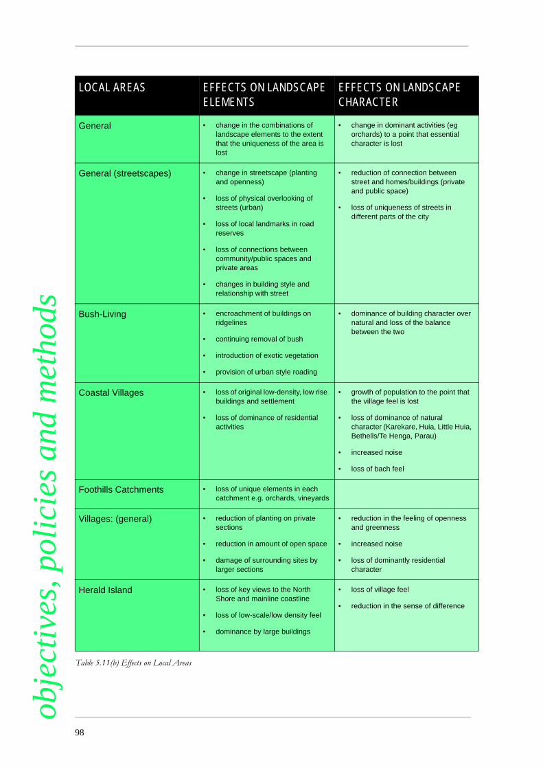
obje
ctiv
es, p
olic
ies
and
met
hods
LOCAL AREAS EFFECTS ON LANDSCAPEELEMENTSEFFECTS ON LANDSCAPE CHARACTER
General • change in the combinations of landscape elements to the extent that the uniqueness of the area is lost
• change in dominant activities (eg orchards) to a point that essential character is lost
General (streetscapes) • change in streetscape (planting and openness)
• loss of physical overlooking of streets (urban)
• loss of local landmarks in road reserves
• loss of connections between community/public spaces and private areas
• changes in building style and relationship with street
• reduction of connection between street and homes/buildings (private and public space)
• loss of uniqueness of streets in different parts of the city
Bush-Living • encroachment of buildings on ridgelines
• continuing removal of bush
• introduction of exotic vegetation
• provision of urban style roading
• dominance of building character over natural and loss of the balance between the two
Coastal Villages • loss of original low-density, low rise buildings and settlement
• loss of dominance of residential activities
• growth of population to the point that the village feel is lost
• loss of dominance of natural character (Karekare, Huia, Little Huia, Bethells/Te Henga, Parau)
• increased noise
• loss of bach feel
Foothills Catchments • loss of unique elements in each catchment e.g. orchards, vineyards
Villages: (general) • reduction of planting on private sections
• reduction in amount of open space
• damage of surrounding sites by larger sections
• reduction in the feeling of openness and greenness
• increased noise
• loss of dominantly residential character
Herald Island • loss of key views to the North Shore and mainline coastline
• loss of low-scale/low density feel
• dominance by large buildings
• loss of village feel
• reduction in the sense of difference
Table 5.11(b) Effects on Local Areas
98

bjec
tive
s, p
olic
ies
and
met
hods
Table 5.11(b) Effects on Local Areas
Hobsonville/WhenuapaiAirbases
• loss of original planned features
Whenuapai • loss of “edge village” feel from intensification
Waitakere Township • dominance of residential buildings • loss of “village” feel
• increased noise
• loss of openness
• loss of focus around transport links
Older suburbs of New Lynn,Green Bay, and Glen Eden
• reduction in section size to less
than 450m2
• lack of greenness and openness
Kelston, Glendene and TeAtatu South, Te AtatuPeninsula
• inappropriate section size (relative to proposed buildings)
• lack of greenness and openness
Fringe suburbs of Massey,Ranui, and West Harbour
• inappropriate placement of buildings
• loss of greenness and openness
New Lynn Town Centre • Loss of feeling of enclosure/containment of the streetscape
• Inadequate connections and lost opportunities for additional connections
• Loss of relationship between street and ground floor activities
• Incompatible activities/reverse sensitivity
• Under utilisation of land/lack of intensification
• Poor street amenity
LOCAL AREAS EFFECTS ON LANDSCAPE ELEMENTS
EFFECTS ON LANDSCAPE CHARACTER
99
o

obje
ctiv
es, p
olic
ies
and
met
hods
Objective 11To achieve a quality of settlement andassociated activities within each of the City’sHuman Environments which is sympathetic to,and protects and enhances, the dominantnatural and physical (including building)features which contribute to the amenity valueand the neighbourhood character of an area,including maintaining and enhancing:• the quality and character of different
patterns of settlement within the City’sintensively settled residential areas;
• the pedestrian-oriented amenity values ofthe town centres and the character of thoseareas as retail centres;
• the utilitarian nature and character of theindustrial areas;
• the natural and physical features that giveeach rural and coastal village its particularand unique character;
• the pastoral/rural character of the northernparts of the City;
• the complex, mixed landscape of thefoothills.
Explanation
This Objective is concerned with protectingthose aspects of the environment that areparticularly valued by the community andrecognising the varying character of each part of theCity. Unlike the management of activities within theCity’s outstanding landscapes, this Objective is notconcerned with maintaining the total landscape as itpresently exists. That is, while those elements andcharacteristics might be protected, there is alsoconsiderable opportunity for change and flexibilitythat allows an area to evolve and respond tochanging circumstances, albeit within a frameworkof what people value.
For example, within a residential area, a streetmight change from being exclusively residential -new activities may move in and it may become amore mixed neighbourhood - so long as the openstreetscape remains, the greenness is protected,buildings are of an appropriate scale, and thedominant residential character is retained. ThisObjective is concerned about the quality and natureof change, within a framework of commonlyaccepted values about what contributes to theamenity of an area.
This Objective recognises the importance ofmaintaining and enhancing the particular elementsand characteristics that define the various
landscapes, local areas and neighbourhoods of theCity. These elements and characteristics are set outin Part 3. The management of activities as they affectamenity values is a significant resource managementissue for the City.
Set out below are the policies that have beenadopted to implement this Objective:
Policy 11.1
Where possible settlement should be of atype and a density that protects amenity values,including neighbourhood character of differentparts of the City, by:• maintaining the low density of sites with
high levels of private planting, large areas ofopen space around dwellings and detachedhousing characteristic in the Glen Eden,Green Bay and New Lynn local characterareas and the Coastal and Rural Villages.
• allowing for development within theKelston, Te Atatu South and Te AtatuPeninsula local character areas, providedthat it maintains the existing low-densitycharacter high levels of planting, andopenness of the area;
• providing for more intensive settlement inother parts of the Living Environment in away that protects the wellbeing of residentsand enhances the amenity of these areas;
• providing for higher intensity developmentin or adjacent to town centres;
• ensuring that settlement densities areconsistent with the dispersed pattern ofsettlement within the CountrysideEnvironment.
• providing for a pattern of settlement in theFoothills Environment that is in keepingwith complex, varied and overall naturalcharacter of the area.
• maintaining the characteristic patterns ofsettlement within the Rural VillagesEnvironment and Coastal VillagesEnvironment.
Explanation
Within each Environment there are variations inbuilding style and section size which contribute tothe particular character of different neighbourhoods.Residents value the different features whichcontribute to the character. This policy has beenadopted to ensure that any pressures for futuredevelopment in the City, are managed in a way thatis compatible with amenity values and character.
100

bjec
tive
s, p
olic
ies
and
met
hods
This policy does not seek to keep densities similar topresent levels in all parts of the City. Rather, thepolicy manages the rate and quality of change andtakes account of cumulative impacts within certaindefined parameters.(See Part 6 for furtherexplanation of the links between policies relating tourban containment and protection of amenityvalues).
Within each Environment there are variations inbuilding style and section size which contribute tothe particular character of different neighbourhoods.
Residents value the different features whichcontribute to the character. This policy has beenadopted to ensure that any pressures for futuredevelopment in the City, are managed in a way thatis compatible with amenity values and character.
This policy does not seek to keep densitiessimilar to present levels in all parts of the city.Rather, the policy manages the rate and quality ofchange and takes account of cumulative impactswithin certain defined parameters. (See Part 6 forfurther explanation of the links between policiesrelating to urban containment and protection ofamenity values).
Methods
District Plan Rules:
• Residential Activities / Density Rules• Provision for Medium Density Housing• Provision for apartments• Subdivision Rules
Policy 11.2
Activities should be managed in a way thatavoids the clearance of or damage to trees andvegetation, to extent that the followingcharacteristics are adversely affected:• the visual dominance of trees on private
property within the neighbourhoods of theLiving Environment;
• the remnant native vegetation within theurban Human Environments;
• the remaining native vegetation alongriparian margins and coastal edges in theurban area and Foothills Environment;
• the shelter trees along fencelines andclumps of vegetation within the pastorallandscape of the Countryside Environment;
• the mixture of native and exotic vegetationand the scattering of native vegetation alongridgelines and stream edges in the FoothillsEnvironment;
• the lines of trees along road edges within theTransport Environment;
• the amenity value associated with nativevegetation and its relative significance in allparts of the City;
• the historic and cultural value of treesassociated with the above characteristics;provided that nothing in this policy should
prevent the removal of species identified in the
Environmentally Damaging Plants List.
Explanation
Trees and other vegetation, be they native orexotic, are always a significant element in definingthe amenity values of an area. They are highly valuedby residents. This is acknowledged in Objective 9(Outstanding Landscapes) but is also fundamentallyimportant to protecting the amenity of other parts ofthe City. This policy is concerned with protectingtrees in a way that ensures the different patterns ofvegetation in the City’s Human Environments,which contribute to the amenity of an area, areprotected.
Methods
District Plan Rules:
• Vegetation Clearance Rules• Riparian Margins / Coastal Edges Rules• Heritage Rules• Subdivision Rules• Residential Activities / Density Rules
Policy 11.3
Buildings and structures should be locatedso that they maintain the neighbourhoodcharacter, visual amenity of the surroundingarea and the characteristic streetscape of thearea, including providing for: • the overlooking of streets by buildings;• maintaining characteristic links between
private and public space arising from theorientation of buildings and the way theyface the street;
• the setback of buildings from the roadboundary where appropriate;
• planting of section frontages;• the expectation that buildings will be
constructed according to a street frontagetypology where such streets have beenidentified within theplan.
101
o
obje
ctiv
es, p
olic
ies
and
met
hods
in a way that gives particular regard to variationsin amenity values, and neighbourhood
character.
Explanation
The design and appearance of buildings andstreets is a valued feature of the City. Protecting thekey elements of these landscapes, local areas andneighbourhoods and streets, and providing for theirparticular character within different Environments,is an important aspect to protecting overall amenity.This policy is specifically concerned with theretention of key elements that define different partsof the City.
In terms of the achievement of good urbandesign outcomes within Town Centres, the DistrictPlan seeks to encourage buildings to be constructedup to the public street edges with active streetfrontages and the provision for weather protection.
A major influence on the characteristic opennessof the City’s more urban Human Environments, isthe degree to which buildings are set back from thefront boundary of their site, their degree ofintegration with the street (doors and openingsversus high, blank walls), and the overall width of theroad within the Transport Environment. The widthof the carriageway is incidental to this effect. Thewidth of the berm and the amount of planting canalso contribute to the characteristic “greenness” ofmany of these areas.
The District Plan seeks to better manage thecritical interface between the public parts of towncentres (streets and public places) and privateproperty. Housing developments involving mediumdensity developments and/or apartments require ananalysis of the site being developed and its context toensure that development contributes to an attractivestreetscape.
There may be situations where a seriousdetraction from amenity values or neighbourhoodcharacter could occur, for instance throughinadequate maintenance of land or buildings or thepresence of unsightly stored structures and vehicles.This can be a particular problem when affectingamenity values of neighbourhood character inresidential and other living environments, and alsostreetscapes and other areas which are visible to thegeneral public. The Plan contains controls over themaintenance of land and buildings in most areas, andreference is also made to obligations under Section17 of the Act.
Methods
District Plan Rules:
• Yards Rules• Building Coverage Rules• Height in Relation to Boundaries, Separation of
Building Rules• Building Height Rules• Apartment Rules and Design Criteria• Site Analysis Rules• Street Frontage Rules
Other Methods:
• carrying out of Council operations within theTransport Environment in a way that isconsistent with this policy.
Policy 11.4
Structures (including infrastructure) withinthe Transport Environment should be of a scale(height, form and bulk), and designed, locatedand managed in a way that avoids, remedies ormitigates the adverse effects on the amenityvalues and neighbourhood character of anysurrounding Environments (includingsignificant public views) and which enhancesthe amenity of the Transport Environment itself.In particular, structures should: • be compatible with the existing streetscape,
including the links between streetscape andthe neighbourhood character and amenity ofthe surrounding Environments;
• minimise impact on views from adjacentsites and significant public views;
• minimise the removal or damage to existingnative and exotic vegetation;
• minimise physical domination and intrusioninto the privacy of adjoining sites;
• located so that planting of road berms canbe provided for.
Explanation
The relationship between a road and thesurrounding areas can have a major impact onamenity and neighbourhood character. Structuresand activities can dominate surrounding sites andintrude upon significant public views. Similarly, thenature of the streetscape itself, (the combination ofhard surfaces, berms, vegetation and the overallwidth and connection with surrounding privatespaces) is a major component of the amenity andcharacter of an area. Indeed roads, along withreserves and parks, are the prominent areas of publicspace that define and enhance many residential areas.This policy manages activities not only in terms of
102 This page updated 11 July 2016

bjec
tive
s, p
olic
ies
and
met
hods
impacts on the Transport Environment itself, butalso in terms of impacts on the relationship betweenthe Transport Environment and the surroundingarea, including views from adjacent sites andsignificant public views. Rule 3 in the Communityand Working Environments specifies, as a PermittedActivity, minimum setbacks from boundaries with aLiving and/or Open Space Environment. Thoseminimum setbacks reinforce the intention of thispolicy. However, it is acknowledged that there willbe circumstances, such as those related to theparticular use proposed, constraints of thedevelopment site and the nature and position ofadjoining development, which will enable to thepolicy to be met at a lesser separation distance thanspecified in the rules.
Methods
District Plan Rules:
• Transport Environments Rules • Vegetation Clearance Rules• Subdivision Rules• Infrastructure Rules• Street Frontage Rules
Policy 11.5
New public open space should be designedand located in a way that:• minimises isolation and separation of such
space from public roads;• maximises access to local neighbourhoods
(where that is compatible with the role suchopen space may have within the GreenNetwork);
• where possible, creates or contributes to aneighbourhood focal point;
• ensures, where appropriate, integration withthe objectives and policies relating to theGreen Network;
• enhances practical public access linkagesbetween areas of public open space, roads,and to and along waterways and the coast;
• enhances the amenity values of thesurrounding Environment and neigh-bourhood character.
Explanation
The amenity values and benefit that derive frompublic open space within the urban area, can beadversely affected by the location of buildings andspaces around it. In particular, the isolation of publicopen spaces, can mean that their full potential is not
realised, or that people are discouraged from usingthem.
Where an open space has a multiple purpose, asan ecological corridor between remnant native bushas well as for recreation, for example, then thequestion of public access becomes moreproblematic. However, where public open space isprovided for recreational and other amenitypurposes only, then these considerations of accessare important.
In the Paremuka Catchment, reserves along theParemuka Stream and its tributaries, including asproposed on the Babich Urban Concept Plan map,address recreational, ecological and stormwatermanagement purposes. Accordingly a minimumwidth of 50m has been identified for reserves alongthe Paremuka Stream to adequately incorporatethese functions.
Methods
District Plan Rules:
• Subdivision Rules
Policy 11.6
New roads must be designed andconstructed in a way that is consistent with:• the integration with safe and efficient
pedestrian and cycle routes;• the enhancement of the surrounding
streetscape;• the provision of planting;• the protection of the amenity values and
neighbourhood character of the surroundingarea.
Explanation
The roading pattern, perhaps more than anyother kind of landuse, has shaped Waitakere City’surban area. However, it is a system that has beenprimarily designed around the efficient flow ofvehicle traffic and relief of congestion. Amenitylevels and pedestrian and cycle access have beenconsidered subsequent to these concerns; andimpacts on surrounding amenity, in particular, havenot been seen as a major constraint on the upgradingor provision of new roading. The result has been thecreation of a system that can encourage vehiclemovements, to the detriment of the amenity of thesurrounding area.
This policy signals thatdecisions about roadinghave to be made within the
103
o

obje
ctiv
es, p
olic
ies
and
met
hods
wider context of protecting amenity and character,and that efficient flows of traffic will be provided forin conjunction with addressing these other matters.Methods
District Plan Rules:
• Subdivision Rules
All subdivisions that involve the creation ofroads are required to pass through a resourceconsent process. Assessment of a proposal includesconsideration of the design of roads and theintegration of transport systems to ensure that theadverse effects from the development of roads areavoided, remedied or mitigated.
Policy 11.7
Infrastructure should be designed andmanaged in a way that:
• will maintain, and not adversely affect theamenity values and neighbourhoodcharacter of the surrounding area, includingstreetscape character;
• placement on sensitive ridgelines in a waythat visual intrusion above that ridgelinewhen viewed from a public place is avoided,or where unavoidable, remedied ormitigated;
• does not detract from the significance totangata whenua of any ridgeline;
• minimises disturbance of natural andphysical features;
• does not physically dominate adjoiningsites;
• minimises adverse effects on the UpperWaitemata Harbour.
Explanation
Infrastructure takes many forms, fromtelecommunication masts to roads and pipes. Often,because of its size, it dominates and visually intrudeson landscape values and the visual amenity of areas.Its location, materials used, height and form can allhave an impact on amenity. For these reasons, apolicy has been adopted which is concerned withintegrating infrastructure, where possible, into thelocal Environment, in a way that protects andenhances the amenity of these areas.
Methods
District Plan Rules:
• Infrastructure Rules
• Vegetation Clearance Rules
• Building Location - Natural LandscapeElements Rules
• Earthworks Rules
Policy 11.8
Structures, (except within the Working andCommunity Environments and specificintensive Living Environments Living 5 andLiving 6), should be of a form, height and scalewhich avoids physical domination ofsurrounding sites and buildings, which does notadversely affect the landscape character andother amenity values of these areas, and whichminimises encroachment on views. Inparticular, relocated housing must be of a scale,form and finished quality, and located so as tomaintain and enhance surrounding amenityvalues and neighbourhood character.
Explanation
This policy is concerned with ensuring structuresare of a scale and height that does not overwhelm thegenerally low-rise building character of the HumanEnvironments. This is important in the non-urbanEnvironments, in that failure to protect buildingscale and form would detract from the dominantnatural character. Within the Living and RuralVillages Environments, the construction ofbuildings that have no reference to surroundingbuilding form and scale, would lead to domination ofsites and a loss of the overall cohesiveness that ischaracteristic of these areas.
The presence of buildings that are not of similardesign as residential buildings - in terms ofcomplexity of the floor plan, use of windows,placement of entrances - can detract from theresidential character of an area. The presence of non-residential buildings in a residential neighbourhoodcan also isolate housing, making residents vulnerableto and fearful of attacks on their safety. For thesereasons, this policy has been adopted which requiresactivities to take account of these concerns.
Low to mid-rise residential apartment buildingsare appropriate in specific Living Environments (Living5 and 6) to achieve the intensification of activitieswithin and around town centres. Developments inthis environment will create some over shadowingand domination of adjoining sites.
Methods
104

bjec
tive
s, p
olic
ies
and
met
hods
District Plan Rules:
• Building Height Rules• Building Location - Natural Landscape
Elements Rules• Building Coverage Rules• Non-Residential Activities Rules• Relocated Buildings Rules
Policy 11.9
Structures and accessways should be placedin such a way that they do not encroach visuallyon those natural landscape elements that havebeen identified as contributing to the amenity ofan area. Particular regard should be had for theplacement of structures so that intrusion aboveany sensitive ridgeline when viewed from apublic place is avoided, or where unavoidable,remedied or mitigated.
Explanation
The intrusion of structures onto valued naturalfeatures is a particular concern of residents.Encroachment above ridgelines is especiallyproblematic. For these reasons this policy managesthe placement of structures, with a particularemphasis on protecting ridgelines.
It is recognised that some sensitive ridgelineshave already undergone a level of modification,primarily although not solely as a result of buildingdevelopment. Where the level of development hasnot entirely compromised the ridgeline and thereremains an opportunity for reducing furtherdegradation the ridgelines are listed as ModifiedSensitive Ridgeline.
Those sensitive ridgelines where little or nomodification has taken place will be subject to morestringent controls and assessment under the DistrictPlan rules and are identified as Natural SensitiveRidgelines. This category includes sensitiveridgelines in rural areas which, although modified bythe removal of native vegetation, contain relativelyfew buildings and other development and are stillregarded as natural.
Modified Sensitive Ridgelines and NaturalSensitive Ridgelines are shown on the Natural AreasMaps. The steepness of land below the ridgelinedetermines the width of the area within which thesensitive ridgeline rules will apply. There are threedifferent buffer widths of 25m, 65m, and 100meither side of the centreline of the sensitive ridge.
Methods
District Plan Rules:
• Building Location - Natural LandscapeElements Rules
• Subdivision Rules
Other Methods:
• guidelines on the design and location ofbuildings in sensitive landscape elements.
Policy 11.10
Non-residential activities should bedesigned and managed in a way that:• maintains the visual amenity values of the
Environment they are in;• maintains the amenity of the site and
surrounding area when viewed from thestreet;
• adequately screens any associatedcarparking, vehicle access and storage areasfrom view, from residential sites.
Explanation
Large commercial and industrial buildings, pavedareas and accessways can have a considerable impacton the appearance of different Environments. Thispolicy seeks to manage impacts by requiring thescreening of these areas from view from eitherpublic places, or from surrounding residentialproperties. Impacts on amenity are particularlypressing within the more residential Environments,and where natural features predominate, but it is alsoan issue in the Working and CommunityEnvironments.
Methods:
District Plan Rules:
• Non-Residential Activities Rules• Working and Community Environment Rules
Policy 11.11
Signs should be designed so that they do notintrude visually on to the amenity of thesurrounding area or detract from surroundingneighbourhood character, and the safety ofvehicles and pedestrians on any adjacent roadsand state highways. Because of their potential tooffend and adversely affect the neighbourhoodcharacter and amenity value of the City’sresidentialenvironments, signageassociated with
105
o

obje
ctiv
es, p
olic
ies
and
met
hods
commercial sex activities and small brothelsthat are home occupations are prohibited in theresidential Human Environments of the City.Explanation
Signs have been identified as having considerableimpact on both the visual amenity of an area and thesafety of road users, where the number and design ofsigns can be a source of distraction and confusion.This policy manages the dimensions and materialsused for signs in different parts of the City and alsothe location of inappropriate signs.
Methods
District Plan Rules:
• Signs Rules
• Scheduled Sites Rules
Where signs are visible from a motorway or StateHighway and exceed Permitted Activity standards,then Transit New Zealand may be consulted.
Policy 11.12
Activities should be of a scale, and locatedand managed in a way, that does not increasethe number of vehicle trips, including heavyvehicle trips, to a level that adversely affects theamenity values of the surrounding Environmentor neighbourhood, taking into account thelocation of the site in relation to the roadinghierarchy and the characteristic levels of quietfound in these areas.
Explanation
Any activity generates a number of vehicle tripsto and from a site. The increased traffic movementcan have a direct impact on the amenity values of anarea, particularly the valued levels of quiet in an area.This policy requires consideration of the numberand frequency of vehicle trips generated by anactivity in terms of their impact on amenity values.
Methods
District Plan Rules:
• Traffic Generation Rules
Policy 11.13
Activities should be carried out in a way thatmaintains the characteristic levels of quiet ofeach Human Environment.
Explanation
This policy is designed to protect a level of quietfound in different Environments, and avoidsincremental rises in noise to the level such that theamenity value associated with that quiet is adverselyaffected. Mixed Use Development - Noise Rules ensurethat amenity levels are maintained and to encouragea variety of compatible mixed use activities withintown centres.
Methods
District Plan Rules:
• General Noise Standards Rules• Noise Rules• Residential Activities - Noise Attenuation
Policy 11.14
Activities and structures located within theCommunity and Working Environments:• must be of a height and scale which is
compatible with the scale of buildings ofany adjacent Environment;
• should not physically dominate anyresidential building to the extent that theamenity values of an area are adverselyaffected;
• should be screened in a way that buildings,parking and storage areas are not visiblefrom any site adjacent to the Environmentboundary.
Tall buildings (20m and over) in the
Community Environment (New Lynn) should
be designed to avoid any adverse effects on the
pedestrian environment associated with
changes to wind conditions and to allow for
reasonable sunlight and daylight access to
streets and public places.
Explanation
Buildings within these Environments have thepotential to dominate surrounding residential areasand to detract from their amenity. This policy isconcerned with managing the impacts of largercommercial and industrial buildings on the edge ofthese Environments as a way of avoiding theseeffects.
Development proposals involving all buildingsover 20 metres in height in New Lynn, andapartment buildings over 20 metres in height inother parts of the City are required to provide an
106

bjec
tive
s, p
olic
ies
and
met
hods
assessment of likely wind effects. Buildings over 20metres in height must be stepped back from thestreet edge to allow for some sunlight and daylightaccess to streets.
Methods
District Plan Rules:
• Working and Community Environments Rules• Height in Relation to Boundaries Rules• Building and Development Location Rules
Policy 11.15
Activities on main shopping streets withintown centres shall be designed, located andmanaged to promote: • a high standard of urban design and
amenity, including weather protection forpedestrians;
• buildings will be expected to be designedaccording to the street frontage typologywhere identified within the District Plan.
• interesting building facades at street level;• the minimisation of conflict with motor
vehicles so that the connection betweenpedestrian areas and retail spaces isretained. Particular regard should be had forthe location of vehicle access, storage andoff-street parking away from the area wherea building fronts a footpath.
Explanation
This policy signals that the quality of theCommunity Environment should be protected andenhanced, and that in doing so, the needs ofpedestrians in particular should be provided for. Alack of weather protection can detract from theamenity and pleasantness of the core shopping areaof the Community Environments. The appearanceof buildings along the main streets of theCommunity Environments can have a major impacton amenity values in these areas. Blank walls, off-street parking in front of buildings and storage areascan detract from the amenity of an area, particularlyfor pedestrians. For these reasons, Council hasadopted a policy that intends any new activity shouldnot detract from, and should enhance, the amenityof the Community Environments.
In the case of mall-style development (whichgenerally has shop frontages internally rather thanexternally focused) it is recognised that there may bea need to locate car parking areas adjoining streetfrontages, and also to provide vehicle access
driveways from the road to car parking and serviceareas. Care should be taken when designing suchdevelopments to, wherever practicable, locate theseareas and driveways away from any road likely to be ahigh pedestrian-count route. In all situations, carparking and access driveways should be designed tobe safe and to recognise appropriate amenitystandards, for instance through the use of landscapetreatment and good building design.
Methods
District Plan Rules:
• Working and Community Environments Rules• Height in Relation to Boundaries Rules• Building and Development Location Rules
Other Methods:
• provision of design advice• town centre revitalisation programmes.
Policy 11.15A
Retail activities in the town centre periphery,and in particular smaller shops or precincts ofshops, should be located and designed tointegrate, as far as is practicable, with the towncentre core. Integration measures shouldinclude the provision of visual and pedestrianlinkages.
Explanation
The town centre periphery may accommodate arange of retail activities, including destination storesand other activities requiring good vehicle access.There is the potential, without good layout anddesign, for inappropriate development to occur, andthis can be a particular issue with small shops (under400m2 in retail floorspace) or precincts of shops.Attention needs to be given not only to on-sitelayout and design, but also to the existing and futuredevelopment of the town centre as a whole. Inparticular, there is a need to ensure good integrationbetween the town centre periphery and the town centre core.This is necessary to ensure that the town centre doesnot become fragmented, and to provide in the bestway possible for future expansion of the town centrecore. For instance developments should face towardsthe town centre core, rather than away from the core.Pedestrian connections to the town centre core shouldbe as direct as possible, attractive and safe.
Methods
107
o

obje
ctiv
es, p
olic
ies
and
met
hods
District Plan Rules:• Building and Site Design Rules
Policy 11.16
Structures that front on to Catherine Place orMemorial Drive, or are located on the north sideof Great North Road in the HendersonCommunity Environment, should be designedto ensure that sunlight can reach these areas.
Explanation
These areas within the Henderson CommunityEnvironment and Community Environment (New Lynn)are key places, for shopping and rest and as meetingareas for visitors to the town centre. It is importantthat there are adequate levels of sunlight to theseareas to protect their amenity value for users.
Methods
District Plan Rules:
• Community Environments Rules• Building Bulk, Location and Design Rules
Other Methods:
• design advice and guidelines for developmentwithin the Community Environment.
Policy 11.17
Retail activities should be managed toenable people and communities to provide fortheir social and economic wellbeing in a waythat sustains and enhances the quality ofcommercial and community facilities andservices, amenity values and general vibrancy ofthe City’s town centres, having particular regardto the following:• supporting urban consolidation and mixed
use development in locations which are
accessible by private and public transport
modes, and discouraging development
which could be better located in respect of
accessibility;
• promoting the pedestrian orientated
amenity values of town centres including
pedestrian precincts, pathways and parks,
landscaping, street furniture and shop
display frontages;
• encouraging, where appropriate, the
integration of new retail activity with
existing retail and other community
resources and activities in the same area,
and in particular in town centres including
site and building design integration and
pedestrian and road linkages;
• establishing and enhancing the quality and
design of buildings;
• recognising the importance that arises from
the role of town centres as community nodes
in the City;
• recognising that the development of
inappropriate retail activity can create
adverse effects on the function served by,
and the amenity values of, town centres;
• ensuring that the development of new retailactivity does not result in adverse social and
economic effects by causing a significant
decline in amenity in town centres of the
positive contribution made by town centresto the social and economic wellbeing of
people and communities in the city;
• enabling potentially incompatible retailactivities, including those which will
compromise pedestrian-orientated amenity
values or residential amenities, to establish
in locations where adverse effects can be
remedied or mitigated;
• enabling competition between retailers and
types of retailing.
A sequential approach to the location ofretail activity is adopted which favours locationsin town centres (particularly major towncentres) where retailing is generally a permittedactivity. There is only limited provision forpermitted retail activity outside town centres.However proposals for retail activity in workingenvironments at the edge of town centres and onmajor roads, are subject to resource consent orplan change procedures which require it to beshown that a town centre location would notbetter serve the Plan’s objectives and policies.
Explanation
The City’s major town centres play a key role incontributing to the quality of life in the City. They arethe focus of many retail activities and othercommunity, service and residential activitiesresulting in a mix of often interdependent land useswhich contribute to a sense of place and identity.This physical form and mix is well developed alreadyat the Henderson and New Lynn town centres andmay evolve at the Westgate town centre. These majortown centres provide, or may provide, high levels of
108

bjec
tive
s, p
olic
ies
and
met
hods
accessibility to employment, services, housing andfacilities for the whole community.
This policy seeks to enhance the City’s major towncentres by retaining those characteristics that givethem value to the community. The policy recognisesthat it is shopping which forms the primary basis tothe health and vibrancy of major town centres. Retailingin major town centres should be sustained and alsoenhanced by making provision for new retaildevelopments and other uses and, whereappropriate, expanding the community environments.
The policy also recognises the importance ofother town centres, being community environmentscovering smaller centres, located on main roads and/or close to railway stations. These town centres are welllocated to serve local communities. They should besustained and also enhanced by enabling new retaildevelopments and other uses and, whereappropriate, expanding the community environments.
The policy recognises that the retailing sector isdynamic. While there is a general emphasis onencouraging retail activity to locate in town centresthere will be situations where certain types of retailactivity should be allowed for in other locations.
One example is the need to provide for localshops serving the convenience needs of the City’sneighbourhoods. Other examples are the categoriesof factory, trade-orientated, yard-based andautomotive retail activity which are best suited toworking environments.
Yet other stores take the form of showroomswhere the products on display are commonlysamples of what may be purchased, large and bulky,are infrequently purchased and usually requireseperate delivery (by van or truck rather than by car).These types of retail activity may also be appropriatelylocated outside the town centres.
Some shops are primarily “destination stores”(which are the sole or main destination of theircustomer’s shopping trips). These stores can be animportant component in the continuing success andvitality of the major town centres and it is preferable thatthey be sited and laid out in a manner which does notimpair pedestrian amenity, particularly in communityenvironment core areas. However such stores may, ifinappropriately located or designed, compromisepedestrian-based amenity values in communityenvironment core areas, and residential amenity values intown centre periphery areas. These stores may thereforebe better located alongside, or outside, the major towncentres, for instance on major roads, provided that thiswould not conflict with the matters listed in thispolicy and other relevant policies such as Policies 1.3and 4.1.
Expansion of existing centres or new retailcentres may also be necessary to provide for thegrowth and changing needs of the community.
A sequential approach is utilised by the Plan toassess proposals to establish retail activities.
Retailing is generally provided for in town centresand other community environments as a permitted activity.If a location other than a town centre is proposed itmust be shown that, having regard to the matterslisted in this Policy and other relevant policies suchas Policies 1.3 and 4.1, the community would not bebetter served by having the proposed activity locatedin a town centre.
If it can be shown that the community would notbe better served by having the proposed activitylocated in a town centre, then an alternative locationcan be considered. For instance, a location alongsidea town centre is likely to be accessible to transportsystems (including roads and public or masspassenger transport) to maintain and enhance acoherent town centre and to provide good inter-relationships (including pedestrian links) betweenthe town centre and the new development. Somelocations with direct access to a major road may alsobe suitable in this regard.
Retail activity not provided for in the Plan, such asa new or expanded shopping centre, may beprovided for by way of a plan change which, togetherwith other relevant matters, should also recogniseand provide for the matters listed in this Policy andother relevant policies such as Policies 1.3 and 4.1.
This approach is further explained in Part 6.2.4.
Policy 11.17 (a)
Retail activities within the WorkingEnvironment should be restricted to support theamenity values, community focal point andtransport hub roles of town centres. Yardorientated retail activities that may causeadverse effects on the amenity of town centresmay be located within the WorkingEnvironment, along with shops selling goodsmanufactured on-site, automotive parts andfood and convenience shops.
Retail activities within the Massey NorthEmployment Special Area will be restricted toensure that retail activities consolidate withinthe Massey North Town Centre Special Areaand to ensure that a suitable area of employmentland is retained for other employment activities.
Policy 11.17 (b)
109
o
obje
ctiv
es, p
olic
ies
and
met
hods
Provision should continue to be made forsufficient land within the major town centres ofthe City to allow retail activities in these centresto grown in a cohesive and unfragmentedmanner.
Explanation
A consequence of the District Plan adopting acentralisation strategy to retail activities is that themain town centres of the city need to be of sufficientsize to accommodate future growth in retailfloorspace. This policy recognises that the centreswill grow over time.
Policy 11.17 (c)
The Lincoln Centre Special area recognisesthe unique circumstances and location of theCentre. Activities in the Lincoln Centre SpecialArea should be restricted to a range of retailactivities that will not undermine the amenityvalues of Henderson.
Explanation
The Lincoln Centre occupies a site that is on thefringe of the Henderson Town Centre. The site hasthe potential to accommodate a range of retailactivities in way that will not adversely affect theeconomic health of Henderson, and hence itsamenity values. A limited range of retail activities ispossible, with the list based on previous PlanningTribunal decisions.
Methods
District Plan Rules:
• Working and Community Environments Rules• Retailing Rules• Building Bulk, Location and Design Rules• Scheduled Sites Rules• Non-Residential Activities Rules
Policy 11.18
Non-residential activities (other than retailactivities) may be located within residentialareas of the City, provided that the individualand cumulative impacts of such a provision donot adversely affect amenity values andneighbourhood character or fragmentresidential activities to the point that essentialresidential character is lost, and the safety ofresidents is harmed.
In residential areas that provide forapartment-type developments, a broad range of
non-residential activities can locate in theseareas to provide a mixed use environment forresidents, provided that the nature and scale ofactivities is managed to protect the vibrancy ofadjacent town centre cores.
Explanation
Past planning practice has emphasised theseparation of residential activities from otheractivities. While in recent years there has been someeasing of these policies to allow such things as homeoccupations, the establishment of businesses, smallfactories and restaurants in residential areas has beenrelatively difficult.
Allowing a greater mix of activities at the locallevel would contribute to a reduction of vehicle tripsand associated adverse impacts on amenity fromvehicle use. However, such a change must becarefully managed so that the mix of activitiescontributes to the enhancement of localneighbourhoods, and does not undermine them tothe point that further pressures are created to moveaway from these areas. This would include a carefulassessment of cumulative effects of non-residentialactivities on the essential residential character of anyarea, and the extent to which it can be fragmented byother activities, before that character is lost andsafety is adversely affected. It also involves carefulmanagement of noise, glare, odour and otherpotential sources of nuisance such as hours ofoperation.
Because the separation of activities has occurredlargely because of past planning controls andbecause the resulting amenity of these areas is theresult of regulation, any shift towards a moresustainable suburban form requires a clear policydirection in the District Plan
Provision is made for a limited quantity ofconvenience shops, restaurants (food) excluding drivethroughs, and shops that sells food and beverageswithin the higher intensity Living (L6) Environment tosupport the local community, while ensuring that theamenity values of the town centre are not lost by retailactivities wanting to locate on the periphery of the towncentre, instead of within the town centre.Opportunities to establish other non-residentialactivities are also provided within the Living (L6)Environment to support employment opportunities,including for residents. The quantity and type of non-residential activities are controlled to ensure that thearea has a predominantly residential focus. Themajority of non-residential should be concentratedaround the propsoed open space. In addition, within theLiving (L5) environment smaller scale work places with
110

bjec
tive
s, p
olic
ies
and
met
hods
a maximum gross floor area of 150m2, located on theground floor of a building and fronting a street will alsosupport employment opportunities for residents.
The Marina Special Area recognises the uniquemix of marina, commercial and residential activitiespossible on the site. The Plan imposes rules toensure that development provides a high qualitymarine village atmosphere while maintainingamenity including, where appropriate, views throughand over the site to the harbour and public accessand enjoyment of the foreshore.
The Whenuapi Special Area recognises theunique characteristics of the longstanding presenceof timber-based and associated activities atWhenuapai. The Plan provides for existing andproposed activities within the Special Area whileensuring that development remains consistent withthe character of the site and neighbourhood, and thelimitations by the existing infrastructure.
Small Brothels can function as homeoccupations within residential areas and the effectsof these activities are similar to other retail servicesthat are home occupations. Where small brothels donot comply with the definition of home occupationand/or the permitted activity standards for therelevant residential Human Environment, in termsof their potential for causing adverse effects and/orserious nuisance and offence to members of thepublic, they are recognised as being inappropriateand are not provided for in residential HumanEnvironments. The nature of the adverse effects ofCommercial Sex Activities are such that it isappropriate to encourage those activities to locate inthe commercial and industrial parts of the City,where their effects are less likely to affect the amenityvalues and neighbourhood character of residentialareas.
Methods
District Plan Rules:
• Scheduled Sites Rules• Non-Residential Activities Rules• City Wide Rules
Policy 11.19
Residential activities may be located withinthe Community Environment, provided that theimpacts of odour, noise, vibration and glare onany residential activity can be adequatelymitigated, so as to avoid reverse sensitivity.Apartments within town centres are encouraged
to enable intensification and enhance thevibrancy and mix of uses.
Explanation
Traditionally, the separation of residentialactivities from non-residential activities, has meantthat very little housing has been able to locate withinthe Community Environments. In some cases thishas been desirable because of the possible impacts ofindustrial processes on human health. However, inareas of light industry and commercial businesses, arange of uses can be compatible. For this reason,Council has adopted a policy that endorses themixing of uses in town centres. The development ofapartments in town centres is actively encouraged toprovide a greater choice of housing, with advantagesfor people to locate adjacent to work the towncentres or within walking distance of a transportnode. The new Apartment Design Criteria willensure a high level of internal amenity for residentsand issues of reverse sensitivity will be addressed,with particular regard to be given to the airdischarges of adjacent/nearby industrial uses, solong as they remain in operation. Mixed use is seenas a major benefit to the City.
Methods
District Plan Rules:
• Residential Activities including apartmentsRules;
• Apartment Design Criteria.
Policy 11.20
Activities located on sites in the peripheryarea of the Henderson CommunityEnvironments and the Massey North TownCentre Special Area (Precincts B, C, D) shall bedesigned and carried out in a way that ensuresthere are safe pedestrian linkages providedbetween the development and the core of thetown centre and that site layout and design ofthe development contributes to the pedestrian-oriented amenity of the centre. Pedestrianlinkages within the New Lynn Town Centreshall be in accordance with the New LynnConcept Plan.
Explanation
The amenity of the City’s town centres, with alltheir vibrancy and interest, is derived primarily fromtheir pedestrian scale, andthe location of shops and
111
o

obje
ctiv
es, p
olic
ies
and
met
hods
services to cater for pedestrians using the core areas.If these amenity values are to be maintained, then theretention of pedestrian linkages and a high level ofamenity for pedestrians is essential.The size of the Henderson CommunityEnvironment means that development on the edgeof the centres can result in the fragmentation of anintegrated centre. This is contrary to the promotionof these centres as pedestrian oriented communityand transport hubs, and contrary to theenhancement of amenity values. The New LynnConcept Plan has been developed to promoteincreased pedestrian connectivity within the centre.This policy seeks to maintain these links and toensure the enhancement of these areas.
Methods
District Plan Rules:
• Building Bulk, Location and Design Rules• New Lynn Concept Plan Rules
Policy 11.21
Off-street car parking within the core of theHenderson Community Environment and theentire Community Environment (New Lynn)should be provided in a way that:
• protects and enhances the visual amenityand pedestrian based character of the area;
• ensures a flexibility of use as a way ofmaintaining and enhancing the vibrancyand interest that is characteristic of the coreby taking advantage of the potential forsharing of car parking and available accessto passenger transport;
• enables the redevelopment of smalleridentified properties in the central core ofthe New Lynn town centre, by not requiringcar parking to be provided in all instances.
Explanation
Off-street car parking is required in all parts of theCity as a way of maintaining road safety.Requirements under this provision relate to thefunction of the road and the nature or size of theactivity on site. However, visual amenity of theCommunity Environment core can be adverselyaffected by large areas of car parking. The policy alsorecognises that car parking requirements may affectthe character of the area by imposing costs onactivities that lead to the exclusion of some. Thiswould have an adverse effect on the range ofactivities and therefore the character of the area. Car
parking associated with activities in the retail area ofa Town Centre may need to be located as required bythe applicable street typology, to manage adverseeffects.
The policy recognises that there is potential forthe sharing of car parking within these areas and, thatthe need for car parking may vary relative to otherareas because of the nature of retail shoppingpatterns, and the function of the core as a passengertransport node. In New Lynn, there are norequirements for on-site car parking for smalleridentified sites in the central core of the centre (referto the identified sites in Appendix XXVIII(C) thathave frontage to a Town Centre - Mainstreet Typology 1).This is to enable the reuse and redevelopment ofthese sites for a range of mixed use activities.
Methods
District Plan Rules:
• Landscaping Treatment - Car parking Rules;• Street Frontage Rules;• Urban Concept Plan.
Other Methods:
• Council parking management Plans (includingmonitoring of occupancy of the available publiccar parking spaces (on street and off street) todetermine the timing of additional provision ofTravel Demand Management Plans.
Policy 11.22
Pursuant to Operative Plan Change 37,Policy 11.22 has been deleted and replaced byPart 5B.3.3 which provides the introduction,existing character and amenity statement,future character and amenity statement,objectives and policies for Titirangi village.
Policy 11.23
Activities and structures should be designed,located and carried out in a way that maintainsand enhances the particular character andamenity of the City’s Special Areas. Particularregard should be given to ensuring that thecharacter and amenity arising from the uniquecomplex of activities within each Special Area ismaintained, and in the case of the Quarry andBalefill Special Areas, the site should be restoredto a level of amenity similar to the surroundingarea when current active use of the site ends.
Explanation
112

bjec
tive
s, p
olic
ies
and
met
hods
A range of Special Areas was identified in Part 3.They differ from local areas and neighbourhoods inthat the latter are variations of the main landscapesthat lie across the City. The Special Areas, incontrast, are unique exceptions to areas thatotherwise have many features in common. Theiruniqueness arises from the nature of the activitiescarried out on site, the kinds of structures associatedwith the site and the clear boundaries that liebetween these areas and the surroundingEnvironments. This policy recognises their uniquenature and provides for the operation of theseactivities within the surrounding environment. TheQuarry and Balefill differ from other Special Areas inthat they must be restored to a high level of amenityonce the particular activities have ended.
The Balefill Management Plan indicates that thearea is to become a passive recreation reserve, asdecided in the mediation agreement betweenCouncil and the community. Once sufficientrestoration work has been carried out the Balefill sitewill be reidentified as Open Space Environment.This restoration work is envisaged as taking at leastten years to complete.
The Monier (CSR) Special Area is located on a largesite on the edge of the New Lynn Town Centre and hasbeen identified as having potential, in the long-term,to provide for the future expansion of the towncentre. The special area classification protects theexisting activities associated with the manufacturingof ceramic-related building products while ensuringthat any change of use does not adversely affect thefuture potential of the site. Redevelopment of thesite for activities not involving a continuation of thecurrent industrial and manufacturing activities willrequire a Plan Change.
Methods
District Plan Rules:
• Special Areas Rules
Other Methods:
• Quarry and Balefill Management Plans.
Policy 11.24
Activities within the Lincoln Road WorkingEnvironment should be designed, located andcarried out in a way that recognises and providesfor:• the higher standard of amenity that exists in
this area relative to other WorkingEnvironments;
• the maintenance of a range of locationchoices for businesses.
Explanation
The Lincoln Road Working Environment can bedistinguished from other Working Environments byhigher standards of amenity and the presence of lessnoxious industry. The area already has a mix ofresidential activities due to the proximity of the BibleCollege of New Zealand, and this mix could beextended by residential development along the banksof the Henderson Creek. Reinforcing these amenitylevels will help maintain a range of business locationsin the City while allowing for limited residentialdevelopment.
Methods
District Plan Rules:
• Working Environment Rules• Residential Activities Rules• Residential Activities - Noise Attenuation
Policy 11.25
A range of activities may be located andcarried out within the Harbour View NorthSpecial Area, provided that:• there are no adverse effects on natural
features and the natural character ofadjacent open space;
• adverse effects on the health of residentsand amenity values of any adjacent site areavoided;
• the ecological linkage opportunities andrestoration areas on the site and on theadjacent open area are protected andenhanced.
Explanation
This Special Area provides more flexibility forthe establishment of residential and commercialactivities. It surrounds Te Atatu town centre andcommercial area, and is intended to provideenhanced opportunities for mixed use development.
Methods
District Plan Rules:
• Special Area Rule 6 Harbour View NorthSpecial Area
Other Methods:
113
o

obje
ctiv
es, p
olic
ies
and
met
hods
• Council operations - via a Council manageddevelopment process for the site.
Policy 11.26
Buildings and other structures within theBethells/Te Henga Coastal VillageEnvironment should be designed and located,and be of a colour and materials that ensuretheir compatibility with:
• the exposed nature of the area and thelimited screening of structures byvegetation;
• the relatively sparse and stunted vegetation;
• the outstanding visual amenity associatedwith the surrounding wetlands, river andcoastal landforms;
• the wild relatively undeveloped character;
• the landscape values of the surroundingcoastal landscape;
and which enhances the visual amenity and
character of the area.
Explanation
The settlement at Bethells/Te Henga occupies aunique place within the City’s outstanding coastallandscapes. The area is complex, with dramaticlandforms and river areas, and in the area of thesettlement is relatively exposed. The natural featuresdominate, but the visual impacts, and the impacts ofthe settlement on outstanding landscape characterare major because of that exposure. This policydifferentiates between the Bethells/Te HengaVillage and other coastal villages by recognising thatthe particular visual nature of this area requires aparticular policy response.
Methods
District Plan Rules:
• Building - Building Height Rules• Building Location - Natural Landscape
Elements Rules
Other Methods:
• Design guidelines for buildings in a coastalenvironment.
Policy 11.27
Where possible, the amenity of the urbanarea should be enhanced through the provisionof a range of opportunities for different housingtypes, provided that such provision occurs in a
way that is consistent with the protection ofother amenity values within an area.
Explanation
Waitakere City has a limited range of housingavailable to residents. This restricts the ability ofsingle parent and single person households to settlein the City. For some groups, especially older people,this forces them to move, and to leave those areaswhich they especially value in terms of amenityvalues and neighbourhood character. A flexible andvaried building resource, particularly housingresource, therefore, is a key element in contributingto peoples’ enjoyment of their environment. Forthese reasons, Council has adopted policies and rulesthat signals a need to shift towards a greater varietyand choice.
Methods
District Plan Rules:
• Provision for apartments; • Apartment Rule; • Apartment Design Criteria; • Provision for Medium Density Housing;• Medium Density Housing Design Assessment
Criteria.
114

bjec
tive
s, p
olic
ies
and
met
hods
Policy 11.28
Medium density housing should becomprehensively designed so that a high qualityof amenity is provided to the overalldevelopment. Particular regard should be givento:
• designing for visual and aural privacy,safety, sunlight and daylight access, on-siteparking and outdoor space in a way that isappropriate to and consistent with themedium density settlement pattern;
• protecting the privacy and amenity ofsurrounding residential areas;
• integrating the development with anyadjacent public open space and road systemsuch that safe use of these areas is ensured;
• integrating the development with thesurrounding neighbourhood, andcommunity focal points, so that they areaccessible, where possible, on foot.
Explanation
The number of medium density housingdevelopments established in the last decade withinWaitakere City has been significant, while designoutcomes have been mixed. This policy seeks a highquality environment within any area of mediumdensity housing and encourages the integration ofsuch housing within the wider context. Particularemphasis is placed on ensuring that amenitystandards for medium density housing are of a veryhigh standard.
Methods
District Plan Rules:
• Provision for Medium Density Housing;
• Medium Density Housing Design AssessmentCriteria;
• Apartment Rule;
• Apartment Design Criteria.
Other Methods:
• Council projects and advocacy of mediumdensity housing and apartments.
Policy 11.28(a)
Apartments should be located in the City’stown centres. They should be comprehensivelydesigned as an integral part of the mixed useenvironments in these areas. The design ofapartments it to be managed to ensure that theyprovide a high quality living environment forresidents. Apartments shall be of a minimumsize (floor area) to provide reasonable internalspaces, while decks, balconies and outlookareas are mandatory.
Explanation
Apartments are suitable activities for town centreenvironments. This policy seeks to encourageapartments in mixed use developments in the City’stown centres of New Lynn and Henderson andother specific locations. Apartment developmentswill be required to comply with the minimumstandards of the Apartment City-wide rule and theperformance criteria detailed in the Apartment DesignCriteria. This is to ensure a high standard of amenityfor the occupants of the developments and for theintegration of the buildings with the existing andfuture built form of the town centre.
Methods
District Plan Rules:
• Apartment Rule;• Apartment Design Criteria.
Other Methods:
• Council projects and advocacy of good designfor apartments
Policy 11.29
[1] Structure Plans should be designed toensure that subsequent development iscompatible with landscape character, amenityvalues and the noted landscape features of thearea including providing for:• protecting the amenity values and privacy of
each lot;• protecting the amenity values, and character
of each Structure Plan Area;• retaining and protecting existing areas of
indigenous vegetation;• enhancing and restoring areas of indigenous
and exotic vegetation for reasons of visual
115
o

obje
ctiv
es, p
olic
ies
and
met
hods
amenity and/or ecosystem stability, and/orsoil retention;• a density of development that does notcompromise Council’s urban consolidationpolicies or undermine the urbancontainment policies of the AucklandRegional Policy Statement;
• a permanent pattern of subdivision thatdoes not increase pressure for, or engenderexpectations of, further subdivision at a latertime;
• a level of development and density ofpopulation that does not increase demandsfor an urban level of infrastructure, roadingand servicing; and
• recognition, protection and enhancement ofthe quality of the landscape within andaround any Swanson Structure Plan area.
[2] In recognition of the above, structure plans
In recognition of the above, any Swanson
Structure Plan shall be prepared in a way which
establishes a permanent density of development
to be shown on any Swanson Structure Plan
forming part of the Plan. For these reasons,
subdivision beyond that provided for in any
Swanson Structure Plan is prohibited. For these
reasons, subdivisions beyond that provided for
in any Swanson structure Plan is prohibited.
[3] In the Foothills Environment minor
household units should be located within 6.0
metres of the main dwelling to ensure there is
only one area of residential activity on the site,
and to ensure subdivision of the minor
household dwelling from the main dwelling
does not occur. This will help minimise the
adverse amenity effects that can occur through
spread development. Limited provision is made
for minor household units separated 6.0 metres
or more as a Discretionary Activity in the Oratia
structure plan area, but in other structure plan
areas minor household units 6.0 metres or more
from the main dwelling are to be possible only
where the minor household unit and associated
development is established in a way which is
consistent with any subdivision possibilities
made available by the structure plan. Outside
structure plan areas, minor household units 6.0
metres or more from the main dwelling are to
allowed only on sites exceeding 2.5 hectares in
area, and these must be assessed in accordance
with possibilities and constraints which may
apply in later structure plan processes.
[4] The considerations in preparing any
Swanson Structure Plan for the Swanson
Structure Plan area should include whether any
lot which includes one or more minor household
units located more than 15 metres from the
existing principal dwelling should be allocated a
subdivision opportunity having regard to:
• the possibilities of sharing access;• lot boundaries and accessways that avoid
streams and riparian margins;
• whether any new principal dwelling on anew lot (which contains the MHU) can bebuilt without exacerbating any existingadverse effects on the FoothillsEnvironment landscape or the amenities ofneighbours; and
• all the other relevant factors in the othersub-policies.
Explanation
If not carefully managed, subdivision and develop-
ment within a structure plan area has the potential
for various adverse effects on amenity values includ-
ing:
• the loss of rural character;• increased noise levels;• loss of visual amenity; and• adverse effects on the characteristic landscape of
the structure plan area.It is expected that there will not be any
development beyond that provided for in thestructure plan and other rules (such as the residentialdensity rules), which have been carefully prepared toensure local and cumulative impacts of settlement onamenity values are avoided. Minor household unitslocated 6.0 metres or more from the main dwellingare not provided for in structure plan areas (otherthan the Oratia Structure Plan which was developedearlier than other structure plans), unless thestructure plan provides for subdivision on the siteconcerned. Minor household units 6.0 metres ormore from the main dwelling have the potential tocreate at least most of the generated adverse effectsas for a full dwelling.
Methods
District Plan Rules:
116

bjec
tive
s, p
olic
ies
and
met
hods
• Subdivision Rules• The structure plan establishes an appropriate
level of subdivision potential for each site andsets out any areas that require protection orenhancement to improve or restore theenvironmental quality or amenity of the site.
• The identification of the proposed sites hasbeen determined through four stages:1. Assessment of the natural environment and
resources of each site. This involves the identification of natural features such as native bush, stream and riparian areas, landform features and areas prone to erosion and subsidence. Information gathered by Council through riparian surveys, Protected Natural Areas studies, natural hazards studies and landscape assessments contribute to this assessment.
2.Examination of how human activity hasinfluenced the landscape, with shelter belts,earthworks, existing buildings, and existingland uses. The effects of land uses such as thegrazing of animals in bush areas and riparianmargins and weed infestation are noted.Consideration is given to how these effectsmay be mitigated, through the requirement forthe protection or restoration of areas ofindigenous vegetation. Areas that will requirerevegetation to ensure visual amenity ismaintained are also identified at this time.
3.Based on the assessment of landscape andnatural features suitable building platformsand accessways are identified, giving anindication of the likely density in the structureplan area. The projected density is theconsidered in the context of community issuessuch as facilities, rural character and heritage.Community issues have been identifiedthrough ongoing consultation with theresidents in the area. In the Oratia StructurePlan experience this consultation was over aperiod of several years. Through publicmeetings, working parties, residents liaisongroup, questionnaires, surveys, flyers andmany opportunities for informal feedback aclear picture if the valued features andcharacter of the area emerges. Heritage valuesare identified by professional archaeologists.
4.Assessment is made of the likely impact andcumulative effects of such a density on theinfrastructure of the area and on theenvironment and whether the desired level ofservicing would be sustainable inenvironmental terms. The projected densityshould not have a significant impact on theexisting level of servicing and should notgenerate demand for “urban” levels of
infrastructure such as wider roads, footpaths,more urban style stormwater management,and reticulated sewage disposal. The projecteddensity must also be consistent with the urbancontainment policies of the Auckland RegionalPolicy Statement.
The density shown by the structure plan isdetermined using all four of these factors. In the caseof the Oratia Structure Plan provision is made as a
discretionary activity for greater densities and it isexpected that any application will be assessed inrelation to these same four factors, together with
other relevant policies and provisions in the DistrictPlan.
Policy 11.30
Non-residential activities in the non-urban
areas of the city should be of a type, scale and
intensity that will not, on an individual or
cumulative basis, lead to adverse effect on the
maintenance and enhancement of rural
landscape and amenity values. In particular
non-residential activities that may be more
appropriately located in the urban area and
which generate a significant number of trips
from the urban area and/or cause other non-
residential activities to group around them
thereby leading to incremental urban growth,
should avoid locating in non-urban areas.
Explanation
Non-residential activities that serve the urban
area often seek out locations that are on the edge of
the city. The rural character of the city fringe can be
lost through this pressure as incremental changes
create a semi urban feel, while activities draw traffic
into locations not designed to cater for this traffic,
causing congestion. This policy recognises that a
range of non-residential activities can locate in the
non-urban areas of the city without adverse effects,
particularly those serving the local area. However
activities that have an urban focus are often best
located within the urban area.
Methods
District Plan Rules:
• Non-Residential Activities Rules• Traffic Generation
Rules
117
o

obje
ctiv
es, p
olic
ies
and
met
hods
Policy 11.31Filming Activities should be managed in a
way that recognises the generally short term
nature of the activity. The adverse effects of
Filming Activities on amenity and character, in
particular traffic generation and modifications
to the landforms from temporary structures,
should be avoided, mitigated or remedied.
Explanation
This policy recognises the special characteristics
of filming as an activity. Most filming involves theconstruction of temporary sets, which have only atransitory affect on the environment. Filming can
also generate extra traffic, although generally forshort periods of time, and this traffic may need to bemanaged to avoid any adverse effects.
Methods
District Plan Rules:
• Non-Residential Activities Rules• Traffic Generation Rules
Policy 11.32
Public open space should be managed in a way
that balances the needs of the city’s residents for
recreational opportunities with the protection of
the natural environment by:
• ensuring that the management anddevelopment of recreational facilities onland in the Open Space Environment issensitive to the natural landscapeelements and qualities
• protecting outstanding natural featuresand vegetation in the Green Networkfrom development
• ensuring that where necessary the naturalenvironment is enhanced by plantingand/or restoration
• maintaining the infrastructure andfacilities on parks to provide a high levelof environmental amenity
Explanation
Public open space includes land in all the natural
areas in the Green Network and the provision for
development and for different types of activities will
depend on the natural attributes on each individual
park. Infrastructure in parks should be well
maintained to ensure the public’s enjoyment and
safety. The need for ongoing maintenance in the
city’s parks, such as clearing and improving tracks
and trails, weed removal and replanting and
upgrading bridges and boardwalks has been
recognised with the provision for parks maintenance
in the Open Space Environment and Natural Area Rules.
The Council and the Auckland Regional Council
have responsibilities to ensure that this is undertaken
in a timely and sustainable manner that ensures
positive outcomes for the environment.
Methods
District Plan Rules:
• Open Space Environment rules
• Natural Areas rules
Other Methods
• The Parks Strategy
• Reserve Management Plans
• Council’s “Code of Practice”
• Supervision and monitoring of parks contractors
(NOTE: Policies 11.33 - 11.50 are contained within the Plan Changes
13-18).
Policy 11.33
In order to achieve Objective 11, the designof new development and significant alterationsto existing buildings should take into accountthe existing and future development on the siteand its effects on the wider neighbourhood toensure that developments are well integratedwithin the site and in the wider neighbourhood.Therefore applications for mixed usedevelopments, including retail development andapartments, medium density housing willrequire a site analysis. This requires applicantsto record the physical features or characteristicsof the neighbourhood and the site. The key is toconsider the interaction between existingfeatures and characteristics and achieve adesign on the site that responds to the identifiedexisting and future character of theneighbourhood. A site analysis shall include andaddress:
118

bjec
tive
s, p
olic
ies
and
met
hods
• a description of the site and locality,buildings, activities, traffic and pedestriannetworks;
• the pattern of development in theneighbourhood;
• the built form, scale and character ofsurrounding development;
• architectural and roof styles;
• cross sections and a written statementexplaining how the design of the proposeddevelopment has responded to the siteanalysis; and
• any other notable features or characteristicsof the neighbourhood
Explanation
The site analysis is an important part of thedesign process. A site analysis includes describingthe site and locality, buildings, activities, traffic andpedestrian networks, to identify constraints andopportunities to ensure the proposal will relate to thesurrounding context. The site analysis may consist ofa series of overlays of the site and neighbourhood,but also needs to include cross sections and a writtenstatement explaining how the design of the proposeddevelopment has responded to the site analysis. Thesite analysis should provide a better understanding ofthe proposal and may also provide opportunities tomake changes to improve urban design and safetyoutcomes.
Policy 11.34
Hobsonville Airbase
Development at the former HobsonvilleAirbase (which consists of the HobsonvilleMarine Industry Special Area, the HobsonvilleBase Village Special Area, the HobsonvilleFuture Development Special Area and theHobsonville Landing Special Area), shall be of adensity, scale, design and character, and besequenced in such a way, as to:
• accommodate a share (6,000 to 8,000residents) of the City’s projected populationgrowth;
• create an employment area focused onmarine industry, making best use of thenearby deep channel in the WaitemataHarbour;
• make provision for a choice of livingenvironments (including high and mediumdensity as well as more conventionalhousing typologies), commercial, social and
community facilities and employmentopportunities;
• establish forms of development and patternsof land use that are integrated with thetransport concept shown on the HobsonvilleUrban Area Concept Plan - Features, whichare supportive of pedestrian, cycle andpublic transport use, located according totransport accessibility requirements wherepossible and which reduce reliance onprivate motor vehicles;
• achieve a high standard of urban andpedestrian amenity through design, atComprehensive Development Plan andother resource consent stages, thatcontributes to a positive sense of place andidentity and minimises adverse effects,including reverse sensitivity effects, betweenresidential and non-residential activities;
• provision for accessible areas of usable openspace, including around the coast and ofsufficient number and location to be withina walkable distance for all residents, andintegrated with surrounding land uses;
• maintain valued elements of the Airbase’sexisting character, heritage, and thecharacter of the coastal edge through theretention of selected buildings and features,sympathetic design and the location ofbuildings and open space;
• adopt sustainable infrastructure whichminimises the effects of off site disposal ofstorm water and wastewater;
• incorporate and encourage the adoption ofcost effective energy efficiency measures;
• ensure that no development proceedswithout a Comprehensive DevelopmentPlan being in place, that, in accordance withthe rules and criteria relating toComprehensive Development Plans,provides comprehensive parameters for thedevelopment of each entire precinct orSpecial Area as shown on the HobsonvilleUrban Concept Plan;
• ensure that Comprehensive DevelopmentPlans remain as approved once developmentwithin the relevant precinct or Special Areahas commenced, or be subject to a furtherresource consent;
• ensure that residential or non-residentialdevelopment (other than HobsonvilleMarine IndustryActivities developedin accordance with a
119
o

obje
ctiv
es, p
olic
ies
and
met
hods
Comprehensive Development Plan) withinthe Future Development Special Areaoccurs only subsequent to a plan change, tobe introduced only when significantdevelopment has occurred or is committedwithin the Hobsonville Base Village SpecialArea.Explanation
The Hobsonville Airbase is divided into SpecialAreas, these being:
•The Hobsonville Marine Industry Special Area
•The Hobsonville Base Special Area (which isfurther divided into precincts)
•The Hobsonville Landing Special Area
•The Hobsonville Future Development SpecialArea
The rules for these special areas are intended toensure that the redevelopment of the Airbase iscarried out in a comprehensive and sustainablemanner, that makes efficient use of the limited landresource, takes best advantage of its special qualities,achieves land use and transport integration, providesadequate amounts of open space, and results in acommunity with high environmental and amenitystandards. The method used includes a requirementfor a Comprehensive Development Plan approvalprior to any development commencing. Therequirement for a Comprehensive DevelopmentPlan provides for the certainty that developmentdesign will be coordinated. At the same time, itprovides the potential for flexibility with regard tosuch matters as bulk and location controls, includingwhere there are Comprehensive Development Plansacross more than one Precinct. The comprehensiveapproach can ensure that one part of a precinct inthe Hobsonville Base Village Special Area can relatesatisfactorily to all other parts, and also to adjoiningprecincts.
Methods
District Plan Rules:
• Special Area Rules
• Comprehensive Development Plan Rules
• City Wide Rules
• Other District Plan Rules As Applicable
Policy 11.35
Development within the Hobsonville MarineIndustry Special Area shall be subject to priorapproval of a comprehensive development plan,
prepared in accordance with the rules to meetthe following policy provisions.
Development within the Hobsonville MarineIndustry Special Area shall be primarily for arange of employment-related activities thatrecognise the location of this land near to a deepwater channel in the Waitemata Harbour, theposition of the land next to mixed use includingresidential activities, the existing landscape andheritage features, and views in to the site fromthe Waitemata Harbour and North Shore City(Beach Haven).
All development within this Special Areashall:
• ensure the efficient and effective use of thelimited land resource;
• ensure there are no more than minoradverse effects on natural resources,including water quality and nativevegetation;
• while landscape character may change(including through the establishment oflarge structures for boat building purposes),ensure that change is managed to provideenvironments which are visually compatiblewith development within the HobsonvillePeninsula, and are of an appropriate urbanform as viewed from outside the Peninsula;this will include, but not be limited to, themitigation measures associated with anuninterrupted form in terms of bulk andscale of marine industry buildings as viewedfrom the following North Shore City sites:Hilders Park (Beach Haven wharf);Aeroview Drive esplanade reserve; andAmelia Place esplanade reserve;
• ensure adequate provision is made forroading, stormwater and wastewaterdrainage, and all other infrastructure;
• ensure adequate provision is made for carparking, within ComprehensiveDevelopment Plan resource consents and inspecific development consents, whileencouraging reduced need for the use ofcars (through such means as indicatinglikely employee numbers and provision tobe made for access by public transport) andtherefore car parking;
• ensure residents are protected from adverseeffects on health and amenity values;
• ensure the historical, cultural or spiritualsignificance of any site, or any waahi tapu ofsignificance to iwi is recognised;
120

bjec
tive
s, p
olic
ies
and
met
hods
• achieve a high standard of urban andpedestrian amenity through design thatminimises adverse effects, including reversesensitivity effects, between residential andnon-residential activities;
• having regard to the above, ensuredevelopment proceeds in a manner thatrecognises the need for a comprehensiveapproach to future development on theHobsonville Peninsula, including theachievement of high standards of urbandesign.
The following further policy provisions shallapply to areas within the Hobsonville MarineIndustry Special Area as shown on theHobsonville Peninsula Urban Concept Plan, theboundaries of which must be accuratelydetermined on the approved comprehensivedevelopment plan.
Area “aa”
Activities developed within “Area aa” shallbe restricted to Hobsonville Marine IndustryActivities as defined in the Rules, with theprimary activity on each site requiring or beingdirectly associated with the need for large boataccess to the deep water channel of the UpperWaitemata Harbour. The primary limitation ofactivities to this purpose recognises the rarequality of the deep water access of that resource,which should not be compromised by theintroduction of activities that compromiseefficient and sustainable utilisation of thatresource.
It is recognised that buildings of apotentially large height and bulk may bedeveloped in “Area aa”, to accommodate theconstruction of large boats. Such buildings needto be appropriately designed and coloured.These buildings shall also be part of acomprehensive layout and design alongsideother development within Areas “aa”, “bb”,“cc” and “dd”, ensuring that the adverse effectsof large scale buildings are mitigated in adjacentmarine buffer areas and when viewed fromoutside the Hobsonville Marine IndustrySpecial Area including from North Shore City(Beach Haven).
The development of “Area aa” shallintegrate with;
•“Area dd”
•esplanade reserves
•the Hobsonville Landing Special Area; and
•the Sunderland Village Precinct in theHobsonville Base Village Special Area;
when viewed from the following North Shore
City locations:
•Hilders Park (Beach Haven wharf)•Aeroview Drive esplanade reserve•Amelia Place esplanade reserve
The area developed within “aa” that faces the
above locations shall present a differentiated
appearance in terms of:
•scale (height);•form (shape and architectural style); and•massing (the arrangement and overall
volume of a group of buildings).In addition, the area developed within “aa” that
faces the above locations shall ensure that the
detail of individual buildings is considered and
reflected in the design, proposals for new
vegetation planting are clearly set out and
existing vegetation is retained where possible.
As “Area aa” is close to, and in some casesadjoins areas that may be utilised for residentialactivities it is important that care be taken toensure there are no more than minor adverseeffects arising from noise, discharges to air orodour. Controls, such as buffers and therequirement to produce operationalmanagement plans, are proposed to ensureminimum standards of health and amenity.
Area “bb”
Activities developed within “Area bb” shallbe restricted to Hobsonville Marine IndustryActivities as defined in the Rules, provided thatno activity shall be permitted that is not aPermitted Activity in respect of the Air QualitySection of the Auckland Regional Plan: Air Landand Water. Buildings established within “Areabb” are expected to be of a lesser height andbulk to than buildings within “Area aa”, and tohave appropriate facade detailing to ensure asuitable interface is achieved to adjoining roadsand/or special areas. This may be achievedby having buildings of lesser height and bulkand of a higher design quality, for instance theoffice component of buildings, on the road side,but still adjoining larger factory-type buildings.
As “Area bb” is close to, and in some casesadjoins areas that may be utilised for residentialactivities it is important that care be taken toensure there are nomore than minor
121
o
obje
ctiv
es, p
olic
ies
and
met
hods
adverse effects arising from noise, discharges toair or odour. Controls, such as buffers and therequirement to produce operationalmanagement plans, are proposed to ensureminimum standards of health and amenity.Area “cc”
Activities developed within “Area cc” shall
be restricted to Hobsonville Marine Industry
Activities as defined in the Rules, provided that
no activity shall be permitted that is not a
Permitted Activity in respect of the Air Quality
Section of the Auckland Regional Plan: Air Land
and Water. Any identified heritage buildings
and their surrounds within “Area cc” shall be
managed in accordance with a heritage
management plan approved as part of the
comprehensive development plan, and any new
buildings are sensitive to the location and scale
of the existing heritage buildings and their
surrounds.
Buildings adjoining the Hobsonville Base
Village Special Area are expected to be of a
lesser height and bulk and to have appropriate
facade detailing to ensure a suitable interface is
achieved, particularly to adjoining roads. This
may be achieved by having buildings of lesser
height and bulk and of a higher design quality,
for instance the office component of buildings,
on the road side, but still adjoining larger
factory-type buildings.
As “Area cc” is close to, and in some cases
adjoins areas that may be utilised for residential
activities it is important that care be taken to
ensure there are no more than minor adverse
effects arising from noise, discharges to air or
odour. Controls, such as buffers and the
requirement to produce operational
management plans, are proposed to ensure
minimum standards of health and amenity.
Area “dd”
Activities developed within “area dd” mayinclude residential and/or mixed use activities(except retail activities), but in all cases shall beassociated with a building design that providesa visual buffer to the buildings in “Area aa”, andrecognises the prominent position of this land inthe landscape. In particular, it is important to
avoid buildings of an industrial form andappearance, such as buildings with large solidwalls facing northwards or eastwards out overthe Waitemata Harbour and North Shore City(Beach Haven). Buildings will also need to be ofa sufficient height to mitigate the visual effect ofexisting or possible industrial buildings within“Area aa”:
when viewed from the following North ShoreCity locations:
•Hilders Park (Beach Haven wharf);
•Aeroview Drive esplanade reserve, and
•Amelia Place esplanade reserve.
The area developed within “dd” that faces the
above locations shall present a differentiated
appearance in terms of:
•scale (height);
•form (shape and architectural style); and
•massing (the arrangement and overallvolume of a group of buildings).
In addition, the area developed within “dd” that
faces the above locations shall ensure that the
detail of individual buildings is considered and
reflected in the design, proposals for new
vegetation planting are clearly set out and
existing vegetation is retained where possible.
No activity shall be permitted that is not aPermitted Activity in respect of the Air QualitySection of the Auckland Regional Plan: Air Landand Water.
Activities which do not meet the abovepolicy shall be avoided in the HobsonvilleMarine Industry Special Area.
Explanation
The Hobsonville Peninsula contains a uniqueresource which has become available fordevelopment with the closure of the HobsonvilleAirbase. A Marine Industry Special Area has beenintroduced into the Plan, building on the accessavailable from this area to a deep water channelwithin the Waitemata Harbour. Development of theMarine Industry Special Area needs to have regard tothe special qualities of the area, including landscapeand heritage features, the coastal edge, the outlookover the harbour, and views in to the site from theWaitemata Harbour and North Shore City (BeachHaven).
Amenity and design standards adopted throughthe Comprehensive Development Plan process willneed to address these concerns. New buildingsdeveloped in the Marine Industry Special Area must
122

bjec
tive
s, p
olic
ies
and
met
hods
achieve a differentiated appearance in terms of scale,form and overall massing.
Areas “aa”, “bb”, “cc” and “dd” are consideredto have different contextual settings and thereforethere are different expectations as to their role andfunction as part of the Marine Industry Special Area.However for all of these Areas, new buildings arecollectively expected to achieve or contribute to asense of variety and composition.
Building design shall address: •scale - height of buildings;•form - shape and architectural style of
buildings; and•massing - arrangement and overall volume of
the group of buildings.
If different building forms are not practical,
variety should still be achieved through variations in
materials, detailing, and colour.
In particular, buildings within “Area dd” willneed to be designed to present an attractiveappearance as viewed from the Waitemata Harbourand North Shore City (Beach Haven). This willinclude new vegetation, design and site specificrequirements of buildings that face and can beviewed from the Waitemata Harbour and NorthShore City (Beach Haven) to ensure such buildingsare of an appropriate scale and buildings being ofsufficient height to mitigate the visual effect ofexisting or possible industrial buildings within Area“aa”. Existing vegetation shall be retained wherepossible.
Consideration also needs to be given to theadequate provision of infrastructure.
Methods
District Plan Rules:
• Special Area Rules
• Comprehensive Development Plan Rules
• City Wide Rules
• Other District Plan Rules As Applicable
Policy 11.36
The Hobsonville Base Village Special Areamay be developed for a range of activities whichrecognise the unique quality and history of thisarea, its coastal location and its suitability for arange of sustainable urban development,focused on:-
• pursuing principles of urban sustainabilityand excellence of urban form, including(but not limited to) access to sunlight anddaylight, and maintenance of amenityvalues;
• pursuing principles of non-reliance on theprivate motor vehicle as a necessary meansof transport, by encouraging higher densityand mixed use development, integratingurban form, with public transport,pedestrian and cycleway movementnetworks, and requiring a high standard ofplanning for integrated urban form andmovement networks at the comprehensivedevelopment plan consenting stage and insubsequent consents;
• ensuring that land use developmentrequiring the construction of new roads iscompatible with a highly inter-connectedroading system;
• efficient use of the land resource, includingthe provision of housing at a higher densitythan traditionally associated with suburbanareas, and requiring densities to at least theminimum number of household unitsspecified in the rules for each precinct;
• ensuring that transport and land usepatterns are aligned to achievesustainability, efficiency and liveability;
• providing for a range of housing choices;• provision for appropriate non-residential
and mixed use buildings and activities;• provision for neighbourhood retail centres
of a scale and design appropriate toservicing the local (Hobsonville BaseVillage) community only, recognising theHobsonville Village Centre as being theprimary retail service centre for this area ofthe City;
• provision for planned community and openspace facilities;
• protection of the natural values and accessto the coast;
• recognising the historical, cultural orspiritual significance of any site, or anywaahi tapu of significance to iwi;
• promotion of sustainable infrastructure anddevelopment;
• protecting and enhancing heritage values,amenity and character features;
• provision for comprehensive, planneddevelopment whichintegrates, internally
123
o

obje
ctiv
es, p
olic
ies
and
met
hods
to both the Special Area and its Precincts,and externally to other areas;• once a Comprehensive Development Planhas been approved, changes to thatapproved plan will be assessed on adiscretionary basis;
• providing flexible provisions for car parkingso that car parking areas are located wherethey do not compromise good site layoutand overall urban form, and requirednumbers of car parks are limited to theminimum necessary using Council’sParking and Driveway Guideline as astarting point.
The Hobsonville Base Village Special Area isdivided into precincts. Policies relating to eachprecinct are set out below. Activities which donot meet the policy provisions shall be avoided:-
A. Sunderland Head Precinct
The Sunderland Head Precinct shall bedeveloped to retain the existing heritagecharacter while incorporating:
• no less than 379 household units;
• retention of Village Green;
• retention of the heritage housing adjacent tothe Village Green;
• retention of the Cadet Building and flagpole area as acknowledgement of the AirForce heritage;
• retain the historic base commander’s house,chapel and surrounding grounds/trees;
• retention of a representative sample of theinter-war cottages;
• walk access along cliff-top reserve;
• view shafts west along Marine Paradetowards Buckley Avenue and North Eastdown Wharf Road;
• provision of a view shaft to the landing fromthe eastern edge of the Village Green;
• provision for a small scale neighbourhoodretail centre including allowance forcommercial/office uses, located, designedand sized such that it will provide acommunity/shopping node sufficient toservice the convenience shopping needs ofthe local community. Retail activities in theneighbourhood retail centre shall be limitedto an average shop gross floor area of 200m²,a maximum gross floor area of 500m² pershop and 2,000m² gross floor area overall.Outside the neighbourhood retail centreretail activities, including in any mixed use
area, retail activities are to be limited toconvenience shops (no more than 100m²)and restaurants (no more than 200m²), withno more than two adjoining retail premisesin any one location. These controls areintended to ensure that retail activities areencouraged to locate in the HobsonvilleVillage Centre;
• a buffer zone of mixed use activity, adjacentto the Marine Industry Special Area (southside of Hudson Bay Road);
• retention of the character of the CatalinaBlock;
• allowance for mixed use development in thearea of the existing Officers Mess;
• provide easy access for public transport andprivate vehicles to the Ferry at the landing;
• retain palms at south of Hudson Bay Roadi.e. open area at Village Green surroundedto North and West by heritage buildingswith a secondary area of apartments at theNorth West and mixed use and commercialareas focusing on street edges;
• Retention and enhancement of coastalnatural character through the provision ofesplanade reserves/public open space andthe provision of appropriate public access.
B. Campus/Runway Park Precinct
The Campus/Runway Park Precinct shall bedeveloped to:• provide for no less than 674 household units;• provide a mix of housing densities to
integrate with surrounding areas;• provide for apartment housing at the edges
of major open space (major roads andplaying fields);
• retain the Buckley Avenue palm trees as aniconic features of the peninsula;
• provide for early childhood education andstate educational facilities for years 1 - 13;
• provide for community playing fields;• provide for existing gully wilderness areas;• provide for a walkway across the peninsula
to link foreshore reserves.
C. Motorway Interchange Precinct
The Motorway Interchange Precinct shall bedeveloped to:-• provide for no less than 96 household units;• ensure the integrity of the motorway
interchange is protected by limiting accessfrom the motorway access road north ofBuckley Avenue;
124

bjec
tive
s, p
olic
ies
and
met
hods
• retain the Buckley Avenue Palms andsurrounding character;
• provide for a small scale neighbourhoodretail centre including allowance forcommercial/office uses, located, designedand sized such that it will provide acommunity/shopping node sufficient toservice the convenience shopping needs ofthe local community. Retail activities in theneighbourhood retail centre shall be limitedto an average shop gross floor area of 200m²,a maximum gross floor area of 500m² pershop and 2,000m² gross floor area overall.Outside the neighbourhood retail centreretail activities, including in any mixed usearea, retail activities are to be limited toconvenience shops (no more than 100m²)and restaurants (no more than 200m²), withno more than two adjoining retail premisesin any one location. These controls areintended to ensure that retail activities areencouraged to locate in the HobsonvilleVillage Centre;
• provide for additional mixed-use (non-retaildevelopment) including medium-highdensity residential activities andcommercial/office activities;
• retain the Buckley Avenue Palms andsurrounding character.
D. Hudson Bay Precinct
The Hudson Bay Precinct shall bedeveloped to:-• provide for no less than 169 household units;• retain a representative sample of heritage
housing;• retain the palm trees along Buckley Avenue;• provide generally throughout the Precinct
for medium and apartment density housing;• provide for medium and high density
housing along Buckley Avenue;• provide for mixed use activity adjacent to
the Parade Ground Precinct and the FutureDevelopment Special Area.
E. Buckley Precinct
The Buckley Precinct shall be developed to:-• provide for no less than 247 household units;• provide for low density housing at the
escarpment;• provide for medium and apartment density
housing along Buckley Avenue;• retain the palm trees along Buckley Avenue;• provide a walkway along cliff-top reserve;
• retain the gully wilderness areas andvegetation;
• retention and enhancement of coastalnatural character through esplanadereservers/public open space and theprovision of appropriate public access.
F. Triangle Precinct
The Triangle Precinct shall be developed to:-• provide for no less than 50 household units;• provide for a reserve opposite the church;• provide for medium density housing.
G. Base Housing Precinct
The Base Housing Precinct shall bedeveloped to:-• provide for no less than 382 household units;• provide for medium density housing
adjacent to Hobsonville Village Precinctand along Clark Road.
H. Hobsonville Village Precinct
The Hobsonville Village Precinct shall bedeveloped to:-• provide for no less than 152 household units;• provide for mixed use activities adjacent to
the existing retail centre, provided that, inorder to encourage retail activities to locatein the Hobsonville Village Town Centre, thetotal amount of gross floor space allocatedto retail sales shall not exceed 2,000m²;
• provide for integration with the HobsonvilleVillage Centre.
Explanation
The Hobsonville Base Village Special Areaencompasses an area which was part-developed andpart-greenfields, formerly used as part of theHobsonville Airbase. This area has been identified asa suitable urban growth area. The area has a specialquality due to its historical use as an airbase. The landis relatively flat and readily accessible from existingand future strategic transport routes.
This area provides an opportunity to create aform of urban development which meets regionaland City objectives for an efficient and sustainableurban form, as well as appropriately protecting andenhancing heritage values.
In order to best manage these resources this areahas been identified as a special area, and has beenfurther divided into precincts. Each precinct has itsown characteristics and opportunities. The planrequires that developmentof each precinct conformto an overall concept plan,
125
o

obje
ctiv
es, p
olic
ies
and
met
hods
and that no new development occurs until acomprehensive development plan has beenapproved for the precinct. In this way, developmentwill proceed in a planned and comprehensivemanner. Development of a substantial part of theHobsonville Base Village Special Area will benecessary before development of the HobsonvilleFuture Urban Special Area can be commenced.Development of each successive precinct areaneeds to have regard to the special qualities of thearea, including landscape and heritage features, thecostal edge, the outlook over the harbour, amenityand design standards within and between areas ofdevelopment, and the adequate provision ofinfrastructure. This policy recognises thatdevelopment will occur on the hobsonvillePeninsula, however this development needs to bemanaged to ensure a comprehensive, well-designedresult is achieved.
Two neighbourhood retail centres are providedfor, in the Sunderland Head and MotorwayInterchange Precincts. Limited provision is alsomade for mixed use development in other precincts.While provision for some retail activity is importantto meet the needs of the local community, it must berecognised that the primary centre servicing theHobsonville Peninsula is expected to be theHobsonville Village Centre.
Methods
District Plan Rules:
• Special Area Rules
• Comprehensive Development Plan Rules
• City Wide Rules
• Other District Plan Rules As Applicable
• Air Discharge Management Plan
• Limited Access Road (Motorway Interchange Precinct C)
Policy 11.37A
The Hobsonville Future DevelopmentSpecial Area has been identified as an area forfuture development which is expected tocomprise mainly housing. It will includesignificant open space/reserve areas (includingareas adjacent to the coast). Non-residentialactivity, such as that which may be desirable tosupport the Marine Industry Special Area ispossible.
The exact form and provision of residentialand non-residential development (other thanHobsonville Marine Industry Activitiesdeveloped in accordance with a ComprehensiveDevelopment Plan) will be determined by afuture plan change. A plan change providing forresidential and non-residential development(other than Hobsonville Marine IndustryActivities developed in accordance with aComprehensive Development Plan) of theHobsonville Future Development Special Areashall not be notified until no less than 80% of theexpected number of household units arecommitted within each of the Sunderland Head(expected number 379 household units),Campus/Runway Park (expected number 674household units), Buckley (expected number247 household units), and Hudson Bay(expected number 169 household units)Precincts.
Any development will also be subject to a fullrange of infrastructure services being available.Prior to a Plan Change for residential and non-residential development (other thanHobsonville Marine Industry Activitiesdeveloped in accordance with a ComprehensiveDevelopment Plan), the Future DevelopmentArea shall not be subdivided, developed or usedin a manner which has the potential to:• Undermine or prejudice the development of
the Hobsonville Base Village Special Area inthe manner anticipated by Policies 11.34 and11.36;
• Undermine the potential for urbanintensification, nor result in uncoordinatedor inefficient provision of infrastructure;
• Compromise future development options forthe area; and
• Have adverse effects on the naturalcharacter of the coast or the heritagefeatures of the area.
The Future Development Special Area shall rec-ognise and protect the collective natural andcultural heritage, and open space features of“Bomb Point” and adjoining marine areas.
Explanation
This area may be made available, for futureresidential and non-residential development (otherthan Hobsonville Marine Industry Activitiesdeveloped in accordance with a ComprehensiveDevelopment Plan), by way of a plan change, oncefurther investigation and consultation has beenundertaken and the specified minimum threshold of
126

bjec
tive
s, p
olic
ies
and
met
hods
development has occurred in the Hobsonville Base
Village Special Area. Achieving that threshold is
important, as opening up too much land at one time
can actively undermine the establishment of a
compact, efficient settlement in a manner that future
retrofitting cannot reliably infill. Limiting the land
available at any one time encourages a more compact
neighbourhood to develop. Once the minimum
threshold of residential development has been
reached in the Hobsonville Base Village Special
Area, a plan change can be notified and processed in
order to enable residential and non-residential
development within the Future Development
Special Area to proceed. While the exact mix of land
uses for the Future Development Area is yet to be
determined, “Bomb Point”, which is the area located
east of the existing “Boundary Road”, will be
preferred for provision of the substantial coastal
park for passive recreation purposes as part of the
new urban community for the overall Hobsonville
Peninsula.
Methods
District Plan Rules:
• Special Area Rules
• Countryside Environment District Plan Rules
Policy 11.37B
The Hobsonville Landing Special Area
provides significant opportunities for the
development of activities which will benefit
from a harbourside location. The exact form and
provision of development will be determined by
a future plan change. As an initial stage of
development the area may be utilised for
activities developed for access for large boats to
the deep water channel, the retrieval and
launching of boats, ferry facilities, and some of
the parking associated with ferry facilities.
Activities that may frustrate utilisation of the
deep water channel for these purposes must be
avoided.
Explanation
This area is required for boat access to theharbour in conjunction with the Hobsonville MarineIndustry Special Area, and has also been identified assuitable for a ferry facility. Those activities aretherefore provided for as a discretionary activity.There is a potentially wide range of other possibleforms of development, but further investigation isrequired to identify and refine those possibilities.Future development will be determined by way ofplan change, once appropriate further investigationsand consultation is carried out.
It may not be possible (at either initial or laterstages), to fully accommodate parking associatedwith a ferry facility within the Hobsonville LandingSpecial Area. In that event, possibilities foralternative parking may be sought in adjoiningSpecial Areas.
Methods
District Plan Rules:
• Special Area Rules
• City Wide Rules
• Other District Plan Rules As Applicable
Policy 11.38
The Hobsonville Village Centre Special Areashall primarily provide for employment andlimited retail opportunities that will serviceprojected population growth at Hobsonville andthe Hobsonville Peninsula over time. Anysubdivision or development in this Special Areashould be designed to provide employment,retail, community and residential activitieswhere appropriate. It shall also serve the localcommunity, and integrate with local, sub-regional and regional transport infrastructureand services. It shall be compatible withlandscape features, and the ecological qualitiesof the upper Waitemata Harbour. In particularthe design of development shall:-• provide, as part of the first stage in the
development process, for pedestrian, cyclistand bus routes, and road networks thatintegrate well with land use activities withinand around the Special Area and allow forsafe and efficient movements that connectwith transport networks around and beyondthe Special Area;
127
o

obje
ctiv
es, p
olic
ies
and
met
hods
• recognise that Precinct A and Precinct A2are well located in relation to localcommunities and transportation networksand represents a finite resource of land thatcan be appropriately developed forindustrial purposes. These Precincts shallbe limited to the development ofemployment-focused (non-retail) activities;
• enable compact development in Precinct Bof the Hobsonville Village mixed use centre,to provide for the shopping needs of theexisting and future residential andemployment population in the Hobsonvillearea in the Village Centre itself, togetherwith limited provision for residential andcommercial activities adjoining that Centre(recognising that the major town centreserving the northern part of the City islocated at Massey North);
• recognise the need to provide adequatesafety and amenity for users of HobsonvilleRoad, Hobsonville Primary School, andresidents across Hobsonville Road to thesouth;
• ensure that suitable linkages for pedestriansand traffic are provided across HobsonvilleRoad;
• promote intensive rather than low densitydevelopment, in such a way that encourageshigh densities of employment andresidential activity adjacent to transport andefficient use of land for all activities,including retail activities (includingsupermarkets) where these activities areprovided for;
• provide for activities with more intensiveemployment densities along HobsonvilleRoad in support of the Frequent ServiceNetwork, while providing for land extensiveuses that are freight intensive near theBrigham Creek Interchange;
• ensure that adverse effects on naturalresources, including water quality andnative vegetation are avoided, remedied ormitigated;
• while landscape character may change,ensure that change is managed to provideenvironments which are visually compatiblewith the surrounding environs;
• ensure that adequate provision is made forroading and all other infrastructure;
• ensure that adequate provision is made forstormwater and wastewater drainage,consistent with any relevant network
discharge consent based upon a integratedcatchment management plan;
• protect residents from adverse effects onhealth and amenity values;
• provide for ecological and pedestrianlinkages, including through enhancement ofthe riparian margins and urban open space;
• maintain and enhance the natural landscapequalities of the riparian margins
• ensure that the heritage values ofHobsonville are recognised and protected;
• ensure that transport and land use patternsare aligned to achieve sustainability,efficiency, liveability, a competitive economyand a high quality of life underpinned by aquality environment and amenity;
• having regard to the above, developmentproceeds in a manner that recognises theneed for a comprehensive approach tofuture development in the HobsonvilleVillage Centre Special Area, including theachievement of high standards of urbandesign.
Explanation
The Hobsonville Village Centre Special Area hasbeen developed to enable integrated land use andtransport outcomes to occur in the proximity of theSH18 interchange, and public transport services onHobsonville Road. It seeks to expand the range andscale of employment, retail and other activitiesappropriate to serve the Hobsonville community.Retail activities (including supermarkets) arespecifically provided for in Precinct B, to assist inachieving a high density of development in theVillage Centre (Retail). The Special Area provides fordevelopment of high quality commercial, mixed useand industrial precincts. These will provide greaterlocal employment for the City’s residents, in areaslocated close to transport networks, and will help toaddress a long-term shortfall in industrial zoned landfor employment purposes in the North West ofAuckland. The Council envisages that the land in theHobsonville Village Special Area (Precincts A andA2) and the land west of Precinct A2 will provideemployment for approximately 1,500 people.
The Frequent Service Network is a networksupporting high quality all-day public transportservices which will provide connections between keylocations, including the city centre, metropolitancentres, and major town centres. The FrequentService Network and its supporting infrastructurewill support intensification and development at keylocations.
128

bjec
tive
s, p
olic
ies
and
met
hods
High standards of urban and landscape designare required in any development. This will respectthe existing amenity, and the natural and heritagevalues of the area.
Methods
District Plan Rules:
• Special Area Rules
• Comprehensive Development Plan Rules
• Working Environment Rules
• City Wide Rules
Policy 11.39
The Hobsonville Village Centre Special Areashall be developed in accordance with thefollowing (see the Hobsonville Village UrbanConcept Plan for Precinct locations and otherfeatures):-• The Hobsonville Village Urban Concept
Plan, the Hobsonville Village Centre StreetTypology Concept Plan, and HobsonvilleVillage Urban Concept Transport Plan;
• An emphasis on providing, within definedPrecincts, for employment (Precinct A andPrecinct A2), retail and mixed useopportunities (Precinct B) that will serviceprojected population growth at Hobsonvilleand the Hobsonville Peninsula (see theHobsonville Village Urban Concept Planand Policies 11.40 - 11.43);
• Focusing retail activity within thepedestrian-orientated Village Centre inPrecinct B;
• Limiting provision for retail activity in theBusiness area adjoining the Village Centre,for those retail activities as provided for inSpecial Area Rule 25, as they are notappropriate within the pedestrian-orientatedparts of the Precinct;
• Limiting retail activity in Precinct A andPrecinct A2 to the provision of thoseactivities that will support the localemployee community, such as lunch barsand service stations;
• Limiting medium/high density residentialactivity in Precinct B to support the mixeduse function of that Precinct;
• Provision of areas of open space,particularly within Precinct D, for amenity,sporting, recreational and ecological
purposes serving local residents, employeesand visitors;
• Provision of reserves for drainage/stormwater purposes;
• Development incorporating roads asindicated on the Hobsonville Village UrbanConcept Plan. In most cases, the exactpositioning of roads will be determined atfuture stages of development, but it will beexpected that road connections throughsites will be provided as generally indicated;
• Identified “Strategic Access Points” in thepositions shown on the Hobsonville VillageUrban Concept Plan;
• Provision of bus, cycle and pedestriannetworks, designed to promote themaximum use and safety of transport modesother than private motor vehicles;
• Provision of “Slip Lanes” that will limit thenumber of access points on to HobsonvilleRoad east of the intersection with BrighamsCreek Road;
• To ensure a high quality of streetscapeincluding, but not limited to, built form,and/ or, landscaping adjoining HobsonvilleRoad;
• To recognise the amenity values for bothpedestrians and the residential environmenton the southern side of Hobsonville Road,and to recognise the need to manage trafficmovements along Hobsonville Road,including by reference to Frontage Controlsor building performance standards asspecified in the rules;
• Recognising the Hobsonville PrimarySchool in Precinct C as an existing andpotentially growing physical and social/educational resource, and the requirementfor the provision of suitable buffer treatmentaround parts of that Precinct by way offencing a landscape interface area(including bund) and building setbackrequirements within Precinct A to mitigatenoise and visual effects on the school arisingfrom subdivision and/or development ofadjacent sites
• Identifying land within the New ZealandTransport Agency Designation (NZTA 4)for appropriate development, subject to thedesignation prevailing in all cases while itremains in place.
Explanation
129
o

obje
ctiv
es, p
olic
ies
and
met
hods
There are a number of important features in theHobsonville Village Centre Special Area that need tobe recognised as requiring integrated management asthe land is developed. The Concept Plan techniquehas been utilised to identify these features.Development in accordance with the HobsonvilleVillage Urban Concept Plan provides acomprehensive, integrated and coordinatedapproach to ensure that the area is efficientlydeveloped, that there is good integration betweenland uses and transportation networks, and thatthere are appropriate standards of amenity.
Methods
District Plan Rules:
• Special Area Rules
• Comprehensive Development Plan Rules
• City Wide Rules
• Urban Concept Plan Maps
Policy 11.40
Precincts A and A2 - Industry
Precinct A3 - Business
Policy 11.40 is concerned with the land identi-
fied as “Industry” and “Business” in Hobson-
ville.
Precincts A and A2 - Industry
Precinct A and A2 - Industry shall bedeveloped for non-residential activities such asmanufacturing, offices and industry. Particularencouragement will be given to activities whererelatively high numbers of employees arerequired. Two storey development is to berequired as a standard on sites having frontageto Hobsonville Road, to encourage higheremployment densities along that publictransport corridor and to support the FrequentService Network.
Residential activities will reduce the area ofland available for employment activities and/ormay create reverse sensitivity issues, andtherefore are prohibited from locating inPrecinct A and A2.
Retail activities in Precinct A and A2 aregenerally to be avoided, as these should belocated in the Precinct B - Hobsonville VillageCentre. Exceptions to this are small shops thatsupport the local employee community, such as
convenience food outlets, small shopssubsidiary to manufacturing activities, andservice stations.
Precinct A and A2 aim to achieve a highstandard of architectural, urban design andlandscape development, particularly in thoseareas facing Hobsonville Road, Brighams CreekRoad and the Hobsonville Primary School(Precinct C) where it is important to control theeffects of non-residential development on thesurrounding environment. Specific rules onfencing, buildings setbacks, landscaping, andbuilding frontage controls, seek to encouragegood design outcomes.
Precinct A2 is an area of land west ofHobsonville Primary School, that has the samepolicy and rule framework as Precinct A. Furthertechnical work is required before Precinct A2will be able to be developed for non-residentialactivities such as manufacturing, offices andindustry. This technical work includes anintegrated catchment management plan andassociated network discharge consents, and anintegrated transport assessment. Until suchtime as this technical work is completed and therelevant approvals provided, ad-hoc residentialand non-residential development shall not beprovided for.
Precinct A3 - Business
To the north and west of the Village Centre(Retail), is an area suitable for limitedcommercial use and is identified as Business onthe Hobsonville Village Urban Concept Plan.
Explanation
Precinct A and A2
This policy recognises the proximity of PrecinctA and A2 to important transport infrastructure. TheDistrict Plan encourages land for employmentpurposes to be set aside as part of encouragingshorter vehicle trips, and reducing pollution andvehicle emissions. Retail activities are specificallylimited in this precinct to ensure that valuableindustrial zoned land for employment purposes isnot used for low-level employment businesses.Residential activities are not provided for in PrecinctA and A2. Overall, this policy aims to ensure thatdevelopment in Precinct A and A2 is managed toensure a well-designed employment area thatsupports the Frequent Service Network onHobsonville Road.
130
bjec
tive
s, p
olic
ies
and
met
hods
Precinct A2 requires further technical work to becompleted and approved before industrialdevelopment is able to commence on the land. Thistechnical work will require consultation withAuckland Council, Auckland Transport and the NewZealand Transport Agency. Once this technicalwork is complete, all relevant policies and rules thatapply to Hobsonville Village Centre Special AreaPrecinct A will apply to Precinct A2.
Precinct A3 - Business
The “Business” zone identification includesprovision for service stations, takeaway food outlets,automotive supplies, and offices.
The scale of retail activities shall be limited tothat necessary to serve the convenience needs of thelocal Hobsonville and surrounding community.Large format retail activities are to be avoided in thisarea. Provision is also made in this area forapartments above ground floor level.
Methods
District Plan Rules:
• Special Area Rules
• Working Environment Rules
• City Wide Rules
Policy 11.41
Precinct B - Hobsonville Village Centre (Retail)
The Hobsonville Village Centre (Retail) hasbeen identified as an appropriate location for theVillage Centre (Retail) that will strengthen thelink between existing commercial and retaildevelopment on the southern side ofHobsonville Road. The Precinct is wellpositioned to service communities in theHobsonville Peninsula, the existing residentialpopulation along Hobsonville Road, andadjacent neighbourhoods.
The Hobsonville Village Centre (Retail)Precinct provides opportunities to combine landuse activities in close proximity to HobsonvillePeninsula and public open space. Thisanticipate retail, mixed use and commercialactivities being developed over time, butindustrial activities shall be avoided.
The mixed use town centre precinct providesopportunities to combine land use activities inclose proximity to Hobsonville Peninsula andpublic open space. This anticipates retail, mixed
use and commercial activities (especiallylocated to the west of Sinton Road), butindustrial activities shall be avoided.
The 400m radius from the middle of theMixed Use town centre will encourage mediumdensity and apartment housing to establishwithin that area, thereby encouraging furtherpublic transport routes in the locality.
It is considered that the provision of retail/mixed use/commercial land will consolidateexisting retail development on HobsonvilleRoad and its environs. Specific controls on thebuilt form of development in this area shouldensure that the area achieves integrated designoutcomes.
Within the Hobsonville Village Centre(Retail) it is anticipated that any supermarketwill have a maximum of 4,000m² in gross floorarea. Any supermarkets will be located inHobsonville Village Centre (Retail) withinPrecinct B. Precinct B is shown on theHobsonville Village Urban Concept Plan.Supermarket activities and other, smaller shops(500m² maximum gross floor area with anoverall maximum average of 300m²) andactivities such as medical, banking and otherprofessional services may be able to locate inthis area. This will provide a balanced mix ofretail services to the surrounding community(including the Hobsonville Peninsula). Anysupermarkets should contribute to the creationof a cohesive Village retail area.
Specific controls on the built form ofdevelopment in this Precinct should ensure thatthe area achieves a pedestrian orientated villagecharacter, with relatively intensive buildings andactive street frontages on the relevant streets asdefined on the Hobsonville Village Centre StreetTypology Concept Plan.
To the north and west of the Village Centre(Retail) zone, is an area suitable for limitedcommercial use that includes provision forservice stations, takeaway food outlets,automotive supplies, and offices. Provision isalso made in this area for apartments aboveground floor level. This scale of retail activitiesshall serve the needs of the local Hobsonvillecommunity. Large format retail activities are tobe avoided in this area.
The mixed use area has been identifiedwithin Precinct B. The proximity of this area tothe Village Centre(Retail) will encouragemedium to high density
131
o

obje
ctiv
es, p
olic
ies
and
met
hods
housing, encouraging further public transportroutes in the locality. Any reverse sensitivityeffects arising from the proximity of residentialuses in a mixed use environment will beaddressed through design standards for thebuildings containing residential activities.Explanation
The Hobsonville Village Centre (Retail) zone inPrecinct B will consolidate retail and retail servicesthat already exist at Hobsonville Village and buildupon these strengths. However, it is important thatthe development of this area is managed in anappropriate manner to ensure that any actual orpotential adverse effects on the amenity andcharacter of this area are avoided, remedied ormitigated. Any supermarkets will be well-served byroad and pedestrian access, and are able to serve as afocus for the remainder of the retail area.
It will be important to maintain quality urbandesign outcomes in this Village Centre as it will servecommunities at the Hobsonville Village Centre, theHobsonville Peninsula and beyond. It is the firstcentre visible from State Highway 18 for peopletravelling from North Shore City.
Methods
District Plan Rules:
• Special Area Rules
• Comprehensive Development Plan Rules
• City Wide Rules
Policy 11.42
Precinct C - School
The Hobsonville Primary School is expectedto grow and develop further to serve a largerpopulation at Hobsonville. The design of schoolbuildings should integrate with the new towncentre. This development of land adjacent to theschool will require effects such as noise, reversesensitivity, building design and safety issues tobe adequately assessed. The HobsonvilleVillage Urban Concept Plan shows indicativeroads that will provide access to Precinct B,enable connectivity and eventually analternative spine road through HobsonvilleCorridor. However, it should be noted that theschool is likely to generate effects through afterhours use of facilities. The school is located inan important visual catchment and thereforedevelopment on this slight ridge will be visible
from a wide viewing audience. It is essential thatthe roading pattern adjacent to and around theschool supports the range of non-residentialactivities planned for the area and creates awalkable catchment to the mixed use towncentre.
Explanation
The existing primary school has been recognisedas fulfilling and important role in this centre. It isappropriate that this urban land use should belocated within the Metropolitan Urban Limits andcontinue to provide for the educational needs of thecommunity it serves.
Methods
District Plan Rules:
• Special Area Rules
• City Wide Rules
Policy 11.43
Precinct D - Open Space
The Hobsonville Domain and adjoiningreserve are intended to function as Open SpaceEnvironment and provide passive recreationalspace bordering onto the Mixed Use towncentre precinct. The Concept Plan intends thatthis land is managed as Open SpaceEnvironment with those rules governing itsmanagement.
Explanation
The existing Open Space at Hobsonville VillageCentre is open and pastoral in character. Thereforethe existing Open Space Environment Rules shallapply.
Methods
District Plan Rules:
• City Wide Rules
Policy 11.44
The Massey North Town Centre SpecialArea shall be developed for urban activitieswhich recognise the importance of the area as amajor town centre and its suitability for a rangeof sustainable urban development outcomes.This area should be developed in a way whichachieves an integrated and compact town
132

bjec
tive
s, p
olic
ies
and
met
hods
centre, providing for a broad range of mutuallycompatible activities and employmentopportunities that are integrated with publictransport, is surrounded by a supportive towncentre periphery and provides a strongcommunity focal point. This is to be achieved asfollows:
(i) For all Precincts
(a) Ensuring that development of precincts A,B, C, D and E does not compromise the aim(expressed above) of the overall MasseyNorth Town Centre.
(b) Ensuring that development takes intoaccount and does not compromise theMassey North Urban Concept Plan.
(c) Ensuring that comprehensive developmentplans are substantially in accordance withthe Massey North Urban Concept Plan, andwhere there is more than minor change,applications shall be accompanied by anassessment of how this policy is being metthrough the proposed comprehensivedevelopment plan.
(d) Ensuring that the expansion of the MasseyNorth Town Centre Area is undertaken in acoherent, integrated and compact fashion.
(e) Ensuring that land use is sequenced andaligned with the delivery of transportservices and infrastructure to achievesustainability, efficiency, liveability, acompetitive economy and a high quality oflife underpinned by a quality environmentand amenity.
(f) Provide flexibility to parking standards toenable the most efficient use of the scarceland resource, and encourage visitors to thetown centre to use public transport, or,when they choose to bring their vehicles tothe town centre, use communal parkingareas.
(g) Activities and buildings should be designedand located so that they address the streetand public spaces thereby contributing toamenity values and in particular pedestrianaccessibility and safety.
(h) Activities and buildings should be sited anddesigned in a manner which promotesinformal surveillance of streets and publicspaces.
(i) Buildings should be designed according toperimeter block principles where carparking is provided behind buildings exceptfor kerbside parking, and with the main
“activity frontage” for buildings orientedtowards public streets rather than parkingareas.
(j) Allowing for and encouraging residentialand office activities to be located above theground level.
(k) The height and location of buildings shouldgenerally provide for an enclosedstreetscape and improved urban densitywhile retaining a satisfactory pedestrianenvironment at street level.
(l) Imposing activity thresholds to ensure theestablishment of a vibrant mixed use towncentre including office, community,commercial and residential activities.
(m)Requiring the location, design and layout oflarge format retail sales or retail serviceswithin the Town Centre Area shown on theMassey North Urban Concept Plan to relatewell to adjoining sites and activities.
(n) Ensuring the efficient and effective use ofresources in particular those associated withland.
(o) Ensuring that there are no more than minoradverse effects on natural resources,including water quality and nativevegetation.
(p) Acknowledging that while landscapecharacter may change, ensuring that changeis managed to provide areas that are visuallycompatible internally to precincts, and withthe surrounding land, roads and precincts.
(q) Ensuring provision is made for roading,stormwater and wastewater drainage and allother infrastructure.
(r) Ensuring that development in closeproximity to existing infrastructure isdesigned and constructed so that theoperation of existing regionally significantinfrastructure is not compromised to anysignificant extent.
(s) Ensuring existing and future residents areprotected from adverse effects on health andamenity values, such as from noise.
(t) Ensuring open space, ecological andpedestrian/cycling linkages are providedfor, including enhancement of the riparianmargins.
(u) Ensuring that development is consistentwith the Integrated CatchmentManagement Plan - Totara Creek, AucklandRegional Councilpermit No. 26185.
133
o

obje
ctiv
es, p
olic
ies
and
met
hods
(v) Having regard to the above, ensuring thatdevelopment proceeds in a manner thatrecognises the need for a comprehensiveapproach to future development within theMassey North area, including theachievement of high standards of urbandesign.
(w)Requiring development contributions.(x) Ensuring that buildings and development
are in accordance with the relevantcomprehensive development plan.
(y) Ensuring that the location and access formajor traffic generators is compatible withthe safe and efficient operation of the statehighway network.
(z) By providing for a built form that can giveeffect to regional targets for employmentdensities in town centres.
(aa)Ensuring that vehicle access to StateHighway 16 occurs only at the StrategicAccess Points shown on the Massey NorthUrban Concept Plan, unless it can beconclusively demonstrated that alternativeaccess points would result in a betteroutcome for all of the following:
• the efficiency of the road and state highway network,
• public transport,
• pedestrian activity,
• urban amenity,
• an integrated town centre focused around the mainstreet.
(ab)Providing for safe, and convenientpedestrian and vehicle connections toMassey East, including but not limited to afuture link to Oriel Avenue.
(ac)Ensuring that once state highway status hasbeen removed from Fred Taylor Drive andthe section of State Highway 16 north ofDon Buck Road to the edge of the MasseyNorth Town Centre Special Area, that it isredesigned in a manner which encouragespedestrian activity and movement andcontributes to the integration of the MasseyNorth town centre with a high degree ofurban amenity, while ensuring vehiclemovements are facilitated.
(ad)Ensuring that the integration of theWestgate/Massey North town centre acrossFred Taylor Drive is not compromised byheavy truck traffic travelling from theMassey North Special Employment area byintroducing engineering and traffic
management mechanisms that direct trucktraffic away from Fred Taylor Drive.
(ae)Protecting the safety of pedestrians passingbetween Precinct A and Precinct E, and thefunction of Fred Taylor Drive, by providingpedestrian linkages which encouragepedestrian activity across Fred Taylor Drive,between Precincts A and E Town CentreMainstreets, when Precinct A is developed.
The Massey North Town Centre SpecialArea has been divided into five precincts. Thespecific policies relating to each precinct aredescribed below:
(ii)Town Centre Precinct Area A
The Town Centre Precinct Area A shall bedeveloped as a compact, pedestrian orientatedretail core with larger scale retail sales or retailservices integrated with smaller retail tenanciesand provision made for commercial (includingoffices), mixed use, community and residentialdevelopment. It is expected that this precinctwill be developed as an integrated high quality,comprehensively designed town centre by:
(a) Requiring development to provide a highlevel of amenity values for pedestrians whoare utilising the public realm.
(b) Utilising good urban design principlesincluding, where relevant to the streettypology, methods such as the developmentof verandah coverage on footpaths, zerosetback of buildings along street frontagesand minimum areas of glazing to ensurethat blank wall facades are minimised alongpublic streets.
(c) The development of interactive frontages,and the avoidance of blank facades alongthe public realm.
(d) Ensuring parking buildings and largeformat retail developments are sleeved bythe provision of speciality retail shopping orresidential and commercial activities.
(e) Nominating street frontages to theproposed streets and requiring all buildingsto be designed in accordance with the streettypologies.
(f) Creating a diversity and choice in terms ofthe shopping and recreational experiencefor the community, as well as enablingdifferent sized commercial enterprises andcommunity activities to take up theopportunity provided by the development ofthe Town Centre Precinct Area A.
134

bjec
tive
s, p
olic
ies
and
met
hods
(g) Imposing minimum floor levels along themain street thereby ensuring that the abilityto provide a compact mixed use TownCentre Precinct Area A is achieved.
(h) The design of the Town Centre PrecinctArea A as a whole is focused upon having itintegrate with the public transport facilitiesthat service the town centre and the linkswithin the City and across the AucklandRegion.
(i) Maintain areas of open space and riparianmargins to provide for stormwatermitigation and passive recreationalopportunities. Any reduction in the RiparianMargins/Coastal Edges Natural Area orEcological and Urban Open Space Areashould not compromise the TotaraIntegrated Catchment Management Plan.
(j) Managing the design and location of newsubdivision and development proposed nearregionally significant infrastructure toaddress its potential to adversely affect theoperation, maintenance, upgrading andextension of such infrastructure.
(iii)Town Centre Precinct Area B
The Town Centre Precinct Area B shall:(a) Enable the development of comprehensively
planned large format retail developmentsbetween the proposed apartment housingand the proposed State Highway 16Motorway, to act as a buffer for thoseresidential activities. More flexible designstandards will be applied to large formatretail than those standards expected in theTown Centre Precinct Area A. However,these developments will need to provide ahigh standard of amenity, particularly foradjacent pedestrian environments. Use ofactive street frontages is the generallypreferred method for providing amenity, butother methods may also be considered incases where active street frontages are notfeasible.
(b) Enable apartment and mixed use activitiesto occur along the green network and toutilise the amenity value for the riparianmargins for residents. The apartmentdevelopment will be encouraged to locatemixed use activities on the ground floors.
(c) Restrict residential activities along theMotorway, to ensure that the adverse effectson residential development from theMotorway are avoided.
(d) Avoid the establishment of supermarkets/department stores and/or significantintensive/speciality retail units that mightdetract from the intensification outcomessought within the Town Centre PrecinctArea A.
(e) Allow the establishment of othercomplementary activities other than largeformat retail within Town Centre PrecinctArea B, such as residential, commercial andmixed use activities.
(f) Ensure integration of public transportfacilities throughout the Town Centre whilereinforcing the development of the TownCentre Main Street in Precinct A.
(g) Maintain areas of open space and riparianmargins to provide for stormwatermitigation and passive recreationalopportunities. Any reduction in the RiparianMargins/Coastal Edges Natural Area orEcological and Urban Open Space Areashould not compromise the TotaraIntegrated Catchment Management Plan.
(h) Managing the design and location of newsubdivision and development proposed nearregionally significant infrastructure toaddress its potential to adversely affect theoperation, maintenance, upgrading andextension of such infrastructure.
(iv)Town Centre Precinct Area C
The Town Centre Precinct Area C shall:(a) Enable commerce, and business, one
supermarket, retail services and retail salesto occur along the frontage to Fred TaylorDrive, and along the existing State Highway16.
(b) Enable apartment and mixed use activitiesto occur along the green network and toutilise the amenity value for the riparianmargins for residents. The apartmentdevelopment will be encouraged to locatemixed use activities on the ground floors.
(c) Avoid the establishment of either malls orlarge retail units that might detract from theintensification outcomes sought within theTown Centre Precinct A. Exceptions to thisare:•Provision for one supermarket located
within the south-eastern street blockadjoining Fred Taylor Drive/SH16.
•Provision for largerretail units in thePrecinct C street
135
o

obje
ctiv
es, p
olic
ies
and
met
hods
blocks adjacent to SH 16 north of theintersection with Don Buck Road. Theselarge retail units are to be limited to theactivities listed in Special Area Rule 1.2Massey North Town Centre Precinct CActivities.(d) Allow the intensive establishment of othercomplementary activities other than retailwithin Town Centre Precinct Area C, suchas residential, commercial and mixed useactivities.
(e) Ensure integration of public transportfacilities throughout the Town Centre whilereinforcing the development of the townCentre Main Street in Precinct A.
(f) Maintain areas of open space and riparianmargins to provide for stormwatermitigation and passive recreationalopportunities. Any reduction in the RiparianMargins/Coastal Edges Natural Area orEcological and Urban Open Space Areashould not compromise the TotaraIntegrated Catchment Management Plan.
(v) Town Centre Precinct Area D
The Town Centre Precinct Area D shall:(a) Enable commercial and business, and
limited retail sales or retail services to occuralong the frontage to State Highway 16.
(b) To enable apartment and mixed useactivities to occur and to utilise the amenityvalue for the riparian margins for residents.The apartment development will beencouraged to locate mixed use activities onthe ground floors.
(c) Provide an opportunity to establish a schoolwithin close proximity to the Town CentreCore and new residential.
(d) Avoid the establishment of supermarkets/department stores and/or significant retailunits that might detract from theintensification outcomes sought within theTown Centre Precinct Area A.
(e) Allow the intensive establishment of othercomplementary activities other than retailwithin Town Centre Precinct Area D, suchas residential, commercial and mixed useactivities.
(f) Ensuring integration of public transportfacilities throughout the town centre whilereinforcing the development of the towncentre Main Street in Precinct A.
(g) Maintain areas of open space and riparianmargins to provide for stormwater
mitigation and passive recreationalopportunities. Any reduction in the RiparianNatural Area or Drainage/Ecological Spaceshould not compromise the TotaraIntegrated Catchment Management Plan.
(vi)Town Centre Precinct Area E
The Town Centre Precinct Area E shall:
(a) Integrate the existing Westgate ShoppingCentre into an expanded Town Centre, withconnections where possible across FredTaylor Drive.
(b) Retain and allow limited expansion of retailsales or retail services in the WestgateShopping Centre at the same time as thedevelopment of the Town Centre Core andother precincts. The main focus on theWestgate Centre is to consolidate the centrefor large format retail sales or retail serviceswhile encouraging small scale retail todevelop such that improved urban designperformance is achieved for the Centre andin particular the north-south axis to the newTown Centre along Main Street is reinforced
(c) Avoid the establishment of malls orsignificant intensive/speciality retail unitsin Precinct E not provided for in SpecialArea Rule 1.2 unless it has been authorisedby an approved comprehensive developmentplan that demonstrates that it will notdetract from the intensification outcomessought within the Town Centre PrecinctArea A.
(d) Allow development that exceeds the retailthresholds in Special Area Rule 1.2 aftersubstantial town centre development hasbeen established and is operating withinPrecinct A, or as authorised in an approvedcomprehensive development plan.
(e) Allow the intensive establishment of othercomplementary activities other than retailwithin Town Centre Precinct Area E, suchas residential, commercial and mixed useactivities.
(f) Ensure integration of public transportfacilities across Fred Taylor Drive tofacilitate access throughout the town centrewhile reinforcing the development of thetown centre Main Street in Precinct A.
(g) Manage the design and location of newsubdivision and development proposed nearregionally significant infrastructure toaddress its potential to adversely affect the
136

bjec
tive
s, p
olic
ies
and
met
hods
operation, maintenance, upgrading andextension of such infrastructure.
Explanation
The Massey North Town Centre Special Areahas been identified as a strategically importantlocation for the development of the town centre.The aim is to expand the existing Westgate TownCentre to develop into an expanded and integratedtown centre. In this expansion Fred Taylor Drivewill remain a busy road servicing the town centre,which could have the effect of separating pedestrianactivity between Precinct A and Precinct E.Therefore, it is important that provision is made forconvenient, safe and attractive pedestrianconnections across, Fred Taylor Drive when thestate highway status is removed, while recognisingthat Fred Taylor Drive, will also be an importantdistrict arterial. This is to be addressed bycomprehensive development plans for Precinct Aand in any engineering design work for Fred TaylorDrive. The District Plan seeks to ensure that thedevelopment of a new pedestrian focused towncentre to the north of Fred Taylor Drive is integratedwith the existing Westgate precinct, to ensure thatthe area is developed as one integrated centre. Theintended policy outcome will be a town centre whichincorporates a compact, integrated, range ofmutually compatible activities and facilities,developed in close proximity to important publicand private transport corridors.
One of the key drivers of the Massey NorthTown Centre Special Area is to provideopportunities for increased employment within thecity. It is considered that the establishment of retailsales or retail services that provide good pedestrianamenity will create demand for other landuseintensification within the town centre, includingincreased non-retail employment. It is alsoconsidered that creating a mixture of employmentactivities other than retail, encourages optimumpassenger transport use. In this regard, the AucklandRegional Policy Statement sets employment densitytargets for sub regional town centres with a QualityTransit Network, such as Massey North. Thereforeit is important that Massey North develops a densebuilt form over time that can support thoseemployment densities. The following regulatorymethods give effect to this: street typologies, activitythresholds, requirements for comprehensivedevelopment plans, minimum floor area ratios,minimum storey heights and maximum parkingratios.
It is not efficient or effective to regulateemployment density directly so that the plancontains rules that set minimum standards for builtform that will facilitate achievement of the targetemployment density. Maximum parking standardsare also set in the plan to facilitate higher densitiesand encourage public transport use.
The District Plan seeks to enable flexibility fordevelopment, provided that such development giveseffect to the relevant policies for each of theproposed town centre precincts, and the outcomesthat the Plan is seeking to achieve. The plan alsoseeks to encourage reusable and adaptable buildings,and to achieve excellent urban design outcomes.
The environmental issues relating to the upperWaitemata Harbour means that a higher quality ofdevelopment in terms of environmental standardswill be required. This includes high standards ofcontrol for the quantity and quality of stormwaterdischarged from the town centre.
It is proposed that the development of MasseyNorth Town Centre will be staged so as to achieve acompact urban form with a level of intensificationand quality of outcome that is consistent with thepolicies of the District Plan and the outcomes thatare sought through the Local Government(Auckland) Amendment Act 2004.
Development contributions will be necessary tofund the significant infrastructural costs associatedwith the establishment of the Town Centre.Council’s Long Term Council Community Plan setsout the development contributions that will bepayable. These development contributions are setunder the Local Government Act 2002 and areindependent of the district plan. Developmentcontributions will be used to fund infrastructuresuch as but not limited to, stormwater andwastewater. Financial contributions will continue tobe taken under section 409 of the RMA for reservecontribution processes.
Existing town centres represent anagglomeration of significant resources and have anassociated value and range of benefits to thecommunity. This presents challenges for theidentification of appropriate mechanisms to ensurethat such resources are sustainably managed forexisting and future communities.
Retail sales or retail services in new or expandedlocations may improve access to goods and servicesand better enable the community to meet their socialand economic needs. However, any change in thepattern of distribution of
137
o

obje
ctiv
es, p
olic
ies
and
met
hods
commercial centres can result in adverse effects orrequire consideration of linkages with other aspectsof urban form, including:•relationship to living areas, transport routes andcommunity facilities;
•efficient use of existing resource includingpublic infrastructure and the ability to accessgoods and services through a variety oftransport modes;
•impact on existing centres, the significance ofthe impact and whether there is a reduction inthe social and economic function and amenityof these centres;
•consequential impact on the ability of existingcentres to function as focal pointscontributing to the wellbeing of people andcommunities; and
•whether affected centres have outlived theiroriginal historical function and whether therate of transition is such as to maintain anappropriate level of function and amenity.
Activities within town centres can, if notappropriately managed, give rise to adverse effectson the visual and other amenities within andadjoining the areas including effects of buildingheight, form and design, and effects of an activity’snoise production, hours of operation and trafficgeneration.
Parking and traffic generation are key issues indetermining the integration of town centres with thecapacity and safety of the supporting road network.Given the proximity of these areas to the proposedarterial road network, there is a need to ensure thatparking and access layout and effects on the widerroad network for the town centre are managed toavoid adverse effects on the safety and efficiency ofthe roading network while encouraging publictransport use.
The Massey north Town Centre Special Area hasbeen divided into five “precincts” (see Massey NorthUrban Concept Plan). Each precinct has its owncharacteristics, constraints and opportunities, andneeds to be managed and developed in differentways.
The approach the District Plan Massey NorthTown Centre Special Area provisions take is toidentify each precinct and to set up an objectives andresource management approach which partly relatesto the whole of the special area and partly relates toeach individual precinct.
Permitted activities are limited to the specifieduse of existing buildings and activities. All newdevelopment will be subject to three layers ofmanagement control.
The first layer of management relates to thewhole of the special area. The plan change includesthe Massey North Urban Concept Plan, whichillustrates the precincts and major roading patternand green network, together with amenity andcharacter features and the expected land uses. Eachelement of the concept plan must be incorporatedinto the ultimate development of each precinct. Inthis way, an overall planned approach todevelopment occurs.
A second layer of management involves thenecessary preparation of a comprehensivedevelopment plan before any development isallowed. Comprehensive development plans areprepared on a precinct basis and assessed via aresource consent application. The comprehensivedevelopment plan must include relevant elements ofthe Massey North Urban Concept Plan, as well asgreater detail in matters such as final roadingpatterns, open space provision, proposed positionsof key buildings, satisfaction of minimum housingdensities, and indicative site layouts. There are alsoexpectations for design guidelines and the allocationof streetscape typologies for the proposed roading,which will inform the urban design controls fordevelopment. The aim is to ensure new developmentis of a co-ordinated high quality. The provision ofinfrastructure is also addressed at this time, with itbeing necessary to ensure such matters asstormwater and wastewater disposal are adequatelycatered for.
Future development of land over which highvoltage transmission lines or under which highvoltage transmission cables pass, must be managedto ensure it does not adversely affect the lines orcables. This includes management of issues such asencroachment (resulting in reverse sensitivity issues),adverse effects such as dust from earthworks andoperations, and compliance with mandatoryseparation distances from existing lines.
The third layer of management involves aresource consent requirement for each buildingproposed, and for any activity not listed as apermitted activity for the precinct. This allowsdetailed assessment of the design and quality of eachbuilding and how it relates to the street andsurrounding development, as well as ensuringactivities are appropriate and complementary. Eachbuilding and activity will be assessed against theother layers of management - i.e. the concept planand comprehensive development plan.
There are a range of other rules applying in theMassey North Town Centre Special Area whichcover such matters as height, gross floor area
138

bjec
tive
s, p
olic
ies
and
met
hods
controls and thresholds, noise, parking and naturalareas management.
While this approach does involve a high level ofmanagement that is considered justified consideringthat the expected new development will be at arelatively high density and will need to be carefullydesigned.
All of this is supported by a comprehensive set ofassessment criteria, and an overall basis of specialarea policies which outline expectations formanagement of the area as a whole, and eachprecinct.
Town Centre Precinct Area A
The town centre retail core should be developedas a compact, pedestrian orientated retail based towncentre with larger scale retail sales or retail services atthe periphery and appropriate provision for mixeduse, commercial and residential development. It isexpected that this precinct will be developed to ahigh quality, comprehensive design.
Activities will be expected to provide a high levelof amenity values for pedestrians who are utilisingthe public realm, utilising up to date approaches tourban design including matters such as thedevelopment of verandah coverage on footpaths andminimum areas of glazing to ensure that blank wallfacades are minimised.
To assist the development of interactivefrontages, and assist with the avoidance of blankfacades, parking buildings and large format retaildevelopments will be sleeved by the provision ofspecialty retail shopping.
All buildings should be designed in accordancewith the streetscape typologies as identified in theapproved comprehensive development plan.
The use of thresholds levels has been included toencourage a variety of activities to occur in the towncentre. This will provide diversity and choice interms of the shopping and recreational experiencefor the community, as well as enable different sizedcommercial enterprises and community activities totake up the opportunity provided by thedevelopment of the town centre. To this end, theRules also seek minimum floor levels along the mainstreet thereby ensuring that the ability to provide acompact mixed use town centre is achieved.
The Plan also seeks to provide flexibility toparking standards to enable the most efficient use ofthe scarce land resource in the town centre, andencourage visitors to the town centre to use publictransport, or, when they choose to bring theirvehicles to the town centre, use communal parkingareas. Consequently, the design of the town centre as
a whole is focused upon having it integrate with thepublic transport facilities that service the town centreand the links within the City and across the AucklandRegion.
Town Centre Precinct Area B
The Town Centre Precinct Area B requiresresidential activities to occur along the greennetwork to utilise the amenity value for the riparianmargins for residents. The residential activity islocated within walking distance of the town centrecore, thereby reducing the need for residents to usevehicles to complete their shopping/business.Apartment residential use will be encouraged tolocate mixed use activities on the ground floors.Residential activity will be restricted along themotorway, to ensure that the adverse effects onresidential development from the motorway areavoided.
The Plan seeks to enable the development oflarge format retail developments between theapartment residential areas and the proposed StateHighway 16 motorway, to act as a buffer for thoseresidential activities. The large format retail will berequired to meet more flexible design standards thanthose standards expected in the town centre core.However these developments will need to provideinteractive facades and be of a human scale.
Town Centre Precinct Area C
The Town Centre Precinct Area C will have animportant role in supporting the functioning of thetown centre core, but will have a distinctly differentpattern of development. This pattern ofdevelopment seeks to ensure that the intensity ofdevelopment of the town centre core is notdispersed across a large area. Consequently somecommercial and business activities and retail will beenabled to occur along the frontage to Fred TaylorDrive, and along the existing State Highway 16. Thiscommercial and retail area will act as a buffer toapartment residential that is proposed to be locatedwithin precinct C.
The precinct seeks to encourage apartmentdevelopment along the green network areasidentified within precinct C, thereby providingamenity values associated with the green network tothe residents. The quality of the urban design of thisprecinct will be similar to the town centre core, giventhis precinct’s supporting role for the town centrecore.
It is expected that thedevelopment of retail salesor retail services within
139
o

obje
ctiv
es, p
olic
ies
and
met
hods
this precinct will complement the development ofthe town centre core. Significant retail sales or retailservices units are to be avoided within the precinct,except that a supermarket and other specified largeretail units for bulky goods and services are to beprovided for.Town Centre Precinct Area D
The Town Centre Precinct Area D will have animportant role in supporting the functioning of thetown centre core, but will have a distinctly differentpattern of development. This pattern ofdevelopment seeks to ensure that the intensity ofdevelopment of the town centre core is notdispersed across a large area. Consequently somecommercial and business activities and retail will beenabled to occur along the frontage to the existingState Highway 16. This commercial and retail areawill act as a buffer to apartment development that isproposed to be located within precinct D. Theprecinct also requires apartment residentialdevelopment. The quality of the urban design of thisprecinct will be similar to the town centre core, giventhis precinct’s supporting role for the town centrecore.
This precinct has scope for the development ofcommunity facilities, and a large area of open spaceassociated with the riparian margins. The communityarea identified is considered to provide an idealopportunity for school facility which is integral tothe development of the town centre, and thosefacilities will service the new residents and theworkforce that spends its working day in the towncentre or the Massey North Employment SpecialArea. The provision of open space in this precinctseeks to address the passive recreational needs ofboth the residents and the workforce, while avoidingand mitigating the effects of the development on thestreams and their riparian margins. Significant retailsales or retail services are to be avoided within theprecinct.
Town Centre Precinct Area E
This precinct seeks to ensure that additionaldevelopment within the existing Westgate ShoppingCentre does not compromise the objectives for theoverall Massey North Town Centre Special Area.Those objectives seek to integrate the WestgateShopping Centre into the larger Town Centre, withconnections where possible across Fred TaylorDrive.
A limited amount and scale of further retailactivity is provided for in Precinct E, to allow furtherconsolidation and expansion of existing activity, to
encourage mixed use development, to enhance theexisting Mainstreet and to sleeve existing largeformat buildings. Beyond these thresholds,and upuntil such time as substantial development has beenestablished and is operating within Town CentrePrecinct A, development is required to be assessed inrealtion to how it will reinforce a compact pedestrianoriented retail core in Precinct A, including its MainStreet, and how it will contribute to the creation of aPrecinct E Main Street and the pedestrian amenity ofthat Main Street. The limitations on retail sales andretail services may therefore be exceeded only as partof a comprehensive development plan resourceconsent for the whole of Precinct E.
The plan seeks to provide flexibility of othercomplementary activities to establish within theprecinct.
This intensification at the Westgate ShoppingCentre will enable other retail uses to locate withinthe area, while requiring integration with new towncentre, and ensuring that development of theprecinct does not compromise the objective for thetown centre as a whole.
The integration will include the upgrading ofpublic transport facilities and integration of publictransport across Fred Taylor Drive to facilitateaccess throughout the town centre while reinforcingthe development of the town centre main street inprecinct A.
Methods
District Plan Rules:
• Urban Concept Plans
• Comprehensive Development Plans
• Special Area Rules
• Community and Living Environment Rules
• City Wide Rules
Other Methods:
• Design Guidelines
Policy 11.45
The Massey North Employment Special Areahas been sequenced and prioritised for industrial andemployment development. It shall be developed toachieve an integrated business and employment area,providing for a broad range of mutually compatiblebusiness activities and employment opportunitiesthat are integrated with private and public transport.Land extensive industrial and employment activitiesare to be located in this Special Area. These activities
140

bjec
tive
s, p
olic
ies
and
met
hods
include manufacturing, construction, wholesaletrade, transport, storage, and ancillary commercialactivities associated with these activities. Theseactivities typically require:
• large land and parcels;• relatively low land costs per square metre;• preferably vacant land;• good transport access, especially road/
motorway;• a guaranteed and consistent energy supply;• distance from sensitive land uses;• medium to high broadband capacity.
An intergrated business and employment area will beachieved by:
• ensuring that development primarily providesfor land extensive industrial and employmentactivities, with preference for land extensiveindustrial activities that have higher employmentdensities;
• ensuring that businesses that are not landintensive industrial and employment activitiesare located in the Massey North Town CentreSpecial Area rather than the Massey NorthEmployment Special Area;
• ensuring that development gives effect to theoverall Massey North Urban Concept Planframework including road location;
• ensuring that the subdivision or development ofthis employment land is undertaken in acoherent, integrated and compact fashion;
• ensuring that land use is sequenced and alignedwith the delivery of transport services andinfrastructure to achieve sustainability, efficiencyand liveability;
• provide flexibility in parking standards to enablethe most efficient use of the scarce landresource, and to encourage use of publictransport or shared parking;
• ensuring that activities and buildings aredesigned and located so that they address thestreet and public spaces, thereby contributing toamenity values and in particular pedestrianaccessibility and safety;
• ensuring that activities and buildings are sitedand designed in a manner which promotesinformal surveillance of streets and publicspaces;
• preventing residential activities from locatingwithin this area;
• preventing retail activities from establishingwithin this area other than minor convenienceretail that serves the local employee community,subsidiary manufacturing retail, yard based retail,
service stations and automotive and marineproducts parts and accessories;
• ensuring the efficient and effective use of a finitephysical resource in particular those associatedwith employment land;
• ensuring that there are no more than minoradverse effects on natural resources, includingwater quality and native vegetation;
• recognising that while landscape character maychange, ensuring that change is managed toprovide environments which are visuallycompatible with the surrounding futureenvirons;
• ensuring adequate provision is made forroading, stormwater and wastewater drainageand all other infrastructure;
• ensure that development is consistent with theIntegrated Catchment Management Plan -Totara Creek, Auckland Regional Councilpermit No. 26185;
• ensuring that ecological and pedestrian linkagesare provided for, including enhancement of theriparian margins;
• requiring development contributions;• ensuring that development in close proximity to
existing infrastructure is designed andconstructed so that the operation of thatexisting regionally significant infrastructure isnot compromised to any significant extent;
• ensuring that vehicle access to State Highway 16occurs only at the Strategic Access Points shownon the Massey North Urban Concept Plan,unless it can be conclusively demonstrated thatalternative access points would result in a betteroutcome for all of the following:
• the efficiency of the road and state highway network;
• public transport;
• pedestrian activity;
• urban amenity.
Having regard to the above, requiring thatdevelopment proceeds in a manner that recognisesthe need for a comprehensive approach todevelopment within the Massey North EmploymentSpecial Area, including the achievement of anexcellent standard of industrial urban design.
Activities that do not achieve the aboverequirements shall be avoided in the Massey NorthEmployment Special Area.
141
o

obje
ctiv
es, p
olic
ies
and
met
hods
ExplanationThe Massey North Employment Special Areahas been identified as a strategically importantlocation for the development of land extensiveindustrial and employment activities. For thepurpose of this policy “land intensive employmentactivities” does not include retail other than retailprovided for in rule 27.2(b). These will incorporate awide range of mutually compatible employmentactivities and facilities, developed in close proximityto public and private transport corridors.
The land is currently fragmented into landparcels. Maintaining the current CountrysideEnvironment identification within this area couldlead to inappropriate development of these landparcels. Accordingly, further fragmentation of theexisting land parcels in this area would beinappropriate in the short term. Activities such asparks, filming and existing residential and ruralactivities have been provided for as these will notsignificantly impact on the potential futuredevelopment of the area.
The supply of suitable employment landthroughout the city is considered to be an importantfactor in enabling the community to live close towhere they work to minimise travel demand. Peoplemay need or choose to travel further to a obtain job,however it is important to provide opportunities forlocal employment for less mobile people, to reduceregional connection and for ongoing populationgrowth.
In addition, employment activities can, if notappropriately managed, give rise to adverse effectson the visual and other amenities within andadjoining the areas of business activity. These effectsinclude building height, form and design, auraleffects, hours of operation and traffic generation.
The District Plan seeks to ensure that this areaof land is retained as land extensive industrial andemployment land resource to support employmentwhile ensuring that potential effects on theenvironment from the development of this resourceis avoided, remedied or mitigated. Location ofbusinesses that are not land extensive industrial andemployment activities in the employment specialarea is to be avoided so that the availability of thisland resource is maintained for land extensiveindustrial and employment activities.
The District Plan seeks to allow flexibility todevelopment provided that such developmentrecognises the focus upon the provision of a supplyof employment land that will increase businessactivity within the city.
The Massey North Employment Special Areaalso aims to achieve a reasonable standard ofarchitectural, urban design and landscapedevelopment, as the interfaces between the privateand public realm are seen as important.
The Massey North Employment Special Areaemphasises the provision of public transportfacilities that are integrated with the employmentnode. This is considered to be consistent with thepolicies of the District Plan and achieves theoutcomes that are sought through the LocalGovernment (Auckland) Amendment Act 2004.
Existing commercial centres represent anagglomeration of significant resources and have anassociated value and range of benefits to thecommunity; this presents challenges for theidentification of appropriate mechanisms to ensurethat such resources are sustainably managed forexisting and future communities.
For this reason land extensive industrial activitiesare located in the Massey North EmploymentSpecial Area whereas businesses that are not landextensive industrial activities such as offices andmost retail activities are preferentially located in theMassey North Town Centre Special Area. Thisapproach minimises reverse sensitivity issuesbetween industry and commercial activities and alsominimises reverse sensitivity of the Whenuapaiairport to commercial activities.
Also other business activities that are not landextensive industrial activities such as commercialoffices and retail, which can achieve a higher density,should be located within the adjacent town centrespecial area. This location will ensure those activitiessupport each other and can be integrated with highdensity residential activity, community facilities,public transport systems and other infrastructure.
Residential activity is prohibited and core retailactivities are discouraged from locating within theMassey North Employment Special Area. Anexception to the limitation on retail is the provisionfor retail which supports the local employeecommunity, such as lunch bars. Subsidiarymanufacturing retail and yard based retail areprovided for as these are not considered to beappropriate activities within a town centre. Suchactivities still require a resource consent to avoid,remedy or mitigate any adverse effects that mayarise.
The sensitive environmental issues relating to theupper Waitemata Harbour means that a higherquality of development in terms of environmentalstandards will be required, particularly in terms ofthe management of earthworks and the design of
142

bjec
tive
s, p
olic
ies
and
met
hods
infrastructure, particularly stormwater andwastewater. The potential impact of futuredevelopment on the water quality of the upperWaitemata Harbour makes it important that theactual or potential adverse effects of developmentwithin the Massey North Employment Special Areaare comprehensively managed.
Future development of land over which highvoltage transmission lines or under which highvoltage transmission cables pass, must be managedto ensure it does not adversely affect the lines orcables. This includes management of issues such asencroachment (resulting in reverse sensitivity issues),adverse effects such as dust from earthworks andoperations, and compliance with mandatoryseparation distances from existing lines.
Development contributions will be necessary tofund the significant infrastructural costs associatedwith the establishment of the area. One of the keysto accessing this employment node is theestablishment of the proposed Northside Drive. Theconstruction of roading will be levied through theLTCCP. Reserve contributions will be levied via theDistrict Plan.
Overall, this policy recognises that developmentwill occur on the Massey north Employment SpecialArea, however this development needs to bemanaged to ensure a comprehensive, well-designedemployment centre is created. (Note: see alsoSection 6.2.15 of the Explanation of the StrategicDirection for further detail on how development willbe managed).
Methods
District Plan Rules:
• Special Area Rules
• Working Environment Rules
• City Wide Rules
Policy 11.46
The New Lynn Town Centre shall continueto redevelop and intensify as a mixed use urbancentre, providing for a range of retail, service,employment and residential activities within acompact urban environment. This is to beachieved by:(i) Allowing for a mix of residential and non-
residential activities (including retailactivities) within the central part of NewLynn, generally in that area within 400m ofMemorial Drive, and covering Great North
Road and Clark Streets west of Ward/Veronica Streets, including Totara Avenue,Delta Avenue and the northern part ofCrown Lynn Place. Allowing for a mix ofresidential and non-residential activities(including retail activities) within theCommunity Environment (New Lynn) thatshould be designed to avoid or mitigate anypotential reverse sensitivity effects onexisting developments in the area.
(ii) Providing for industrial and employmentactivities generally east of Binstead Road,Ward and Veronica Streets and AstleyAvenue. Residential activities shall beavoided in this industrial area.
(iii)Enabling intensive residential developmentin the Ambrico Place, Crown Lynn Placeand Reid Road Living Environment areason the proviso that these developments shallbe designed and located so as to avoid ormitigate any potential reverse sensitivityeffects on industrial and commercialdevelopment in the locality.Notwithstanding Policy 3.1, in the Living(L6) Environment in New Lynn, differentminimum heights may apply to supportapartment development with a variety offorms and scales, provided that efficient useis made of the limited land resource andminimum dwelling densities from AppendixH of the Auckland Regional PolicyStatement are achieved.
(iv)Providing for the continued operation of theMonier (CSR Building Products) plantwithin Monier (CSR) Special Area. In theevent notice is given in accordance withMonier (CSR) Special Area Rule 28, theLiving (L6) Environment and theCommunity Environment will apply.
(v) Once notice is given in accordance withMonier (CSR) Special Area Rule 28, the size,scale, design and trip generation of retailactivities on Lot 4 DP 122011 and PartsDeposited Plan 3659 comprised incertificates of title NA71A/355, NA365/81and NA291/293 (and subsequent legaldescriptions should these properties bemodified) shall be managed to encouragehigh quality pedestrian amenity, to managethe transition and interface between theCommunity Environment and Living (L6)Environment, tomitigate local effectson the road network,
143
o
obje
ctiv
es, p
olic
ies
and
met
hods
and to avoid the establishment of retailactivity greater than 2000m2 gross floor area.(vi)Managing actual or potential reverse
sensitivity effects through the design andacoustics attenuation of new residentialdevelopments.
Explanation
The New Lynn Town Centre is in a process oftransition from a suburban to an urban environment,consistent with City and Regional urban growthstrategies. While recognising the existing retail area,including Lynnmall, that has developedincrementally over a decade, as part of this process agreater mixing of activities is anticipated, along witha more intensively developed urban pattern. Toensure that a range of activities can locate in thetown centre, an expanded mixed use commercial areais provided. This commercial area will need toaccommodate a substantial increase in retail floorspace,as well as a range of service and residential activities.Retail development is anticipated to occur alongClark Street, helping to meet demand for additionalretail activities, including larger format retail. Furtherintensification of retail activities within the currentretail area is also expected. However retaildevelopment should not spread beyond this corearea, as this will lead to a fragmented centre.
Within the expanded Community Environment,rules relating to the street frontages are in place tomaintain and extend the built character of thecurrent mainstreet area, and to ensure new retaildevelopments contributes to an integrated centrewith high standards of pedestrian amenity.
To manage the transition and interface betweenthe Community Environment and the future proposedLiving (L6) Environment on the current Monier (CSR)Special Area. It is important to manege the size, scale,design of retail activities on Lot 4 DP 122011 and PartsDeposited Plan 3659 comprised in certificate of titleNA71A/355, NA365/81 and NA291/293 (andsubsequent legal descriptions should theseproperties be modified). Potential adverse effects onthe local network from vehicle trips generated fromretails activities on Lot 4 DP 122011 and PartsDeposited Plan 3659 comprised in certificates of titleNA71A/355, NA365/81 and NA291/293 (andsubsequent legal descriptions should theseproperties be modified) need to mitigated.
Surrounding the mixed, commercial core are anumber of areas focused on specific activities. Theseareas are provided to ensure that a broad mix ofactivities can continue to operate in the area, and thatemployment and residential activities will not be
forced out of the centre by an uncontrolledexpansion of retail and commercial activities.
In terms of residential areas, a new Living (L5)Environment has been created to provide for mediumdensity housing and low-rise apartments in theRewarewa Creek and Reid Road areas north-west ofthe New Lynn Town Centre and in the Ambrico Placearea was previously identified as Working Environment,although is almost exclusively used for mediumdensity housing.
A new Living (L6) Environment provides formedium rise apartments in the Crown Lynn Place/Clinker Place area. This Environment provides animportant opportunity to increase the number ofhousehold units in the New Lynn Town Centre throughthe provision of medium-rise apartments. The area iswithin close walking and cycling distance of theTown Centre, bus station and the train stationmaking it ideal for apartments. Apartment-typedevelopment, with a minimum height, will ensure thatthe areas unique opportunities will be realised andallow for an efficient utilisation of land. Itsidentification as Living (L6) Environment clearlyindicates the residential potential of the land andprevents pressure for locating retail activities outsidethe Community Environment (New Lynn) and theexisting walkable, compact town centre precinct.
Existing industrial activities will continue in theeastern flank of the Centre. To protect this area foremployment related activities, residentialdevelopment is a Non Complying Activity. Toensure ongoing compatibility between the mix ofuses during the time of transition particular regard isto be given to the effects of noise and air dischargesof industrial uses and their existing use rights, on thedevelopment of the Community and Living (L6)Environments.
The New Lynn Town Centre incorporates an area ofland fronting Rankin Ave which is currently used forbrick manufacture and is Monier (CSR) Special Area. Itis expected that its existing use will continue well intothe planning period. In the long term, it is anticipatedthat the industrial activity may cease and the landmay become available for alternative use.Accordingly, the planning maps identify HumanEnvironment to provide for the existing use of the landand provide alternative activities for the land whichwould apply should industrial activity cease.
Methods
District Plan Rules:
• Building Design - Street Frontages
144

bjec
tive
s, p
olic
ies
and
met
hods
• Provision for apartments
• Living Environment Rules
• Community Environment (New Lynn) Rules
• New Lynn Urban Concept Plan
• Monier (CSR) Rules
Other Methods:
• Design guidelines
• Monitoring
Policy 11.47
Development with frontage to a street shouldbe of a high standard in terms of layout, designand visual appearance, contributing to thedevelopment of high quality environmentswithin integrated mixed use town centres andtheir adjoining neighbourhoods. Developmentshould be designed in recognition of its locationand having regard to the nature of the adjoiningstreet(s).
Particular attention should be paid to:• Development of attractive, safe and active
streets that are well defined by their adjacentbuildings. Buildings should be designed tocontain the street, and provide spatialdefinition to the environment. Main streetsshould generally be a minimum of twostoreys in height (in order to provide floorarea in the town centre that is suitable foractivities other than retail, and to providethe appropriate sense of scale to thestreetscape).
• Ensuring that development and buildingsencourage pedestrian priority in the streetenvironment where appropriate. Main streetlocations situated within the centre’s coreare considered to have the highestpedestrian priority and this diminishestoward the periphery of the centre.
• Ensuring that activities and developmentrelate positively to the street, creating anattractive public/private interface. Theplacement and design of buildings shouldensure that there is an appropriate degree ofintegration between buildings and thestreet. In principle developments are to bedesigned and located to ensure that thestreet is the primary means by whichpedestrians move between activities andbuildings throughout the town centre.
• Blank walls along street frontages should beavoided and appropriate articulation,transparent openings and, if appropriatelandscape treatment should be provided toenhance the visual appearance of thefrontage.
• Informal surveillance of streets and publicspaces from activities and buildingsincluding through the placement ofwindows, doors, decks and balconies.
• The location and nature (includingoperational requirements) of thedevelopment.
With respect to specific elements within TownCentres:
(i) Main Street• Buildings on main streets should be
designed to contain the street, and generallybe a minimum of two storeys in height alongthe street edge. in order to:• provide floor area in the town centre that
is suitable for activities other than retail;• signify a suitable town centre character;
and• provide the appropriate send of scale to
the streetscape.• Along main streets buildings should provide
continuous weather protection wherebuildings abut the street and, whereappropriate, ensure car parking, loadingspaces and storage areas are located to therear or within buildings to help retain activestreet frontages.
(ii) Commercial Street, Residential and MixedUse Areas
• For developments on sites with roadfrontage to Commercial streets (such asTypology 3 and 4), parts of the building maybe set back to accommodate some carparking to the side of buildings (and inTown Centre peripheral locations (such aTypology 6), to the front of buildings)provided that a safe high quality pedestrianenvironment is provide by a buildingfronting the street and landscaping of carparking areas.
• Providing weather protection above thepedestrian entrance on the street facade ofthe building to enhance the visualappearance of the frontage and provideamenity
• Streets with apredominance of
145
o
obje
ctiv
es, p
olic
ies
and
met
hods
residential activities should provideentrances, habitable rooms, glazing, andbalconies facing the street. Car parking andgaraging should be recessed to avoiddominating of the street and landscapetreatment utilised to soften the appearanceof buildings, driveways and car parking.With respect to Large Format Retail Buildings:
It is important to enable large format retail activ-ities to locate in centres, and in doing so to dis-tinguish supermarkets and department storesfrom other large format retail activities withintown centres in respect of operational character-istics. Supermarkets and department stores havesocial and economic benefits for the vitality ofcentres and the community and it is essential tomanage their effects on both urban form and thestreet environment. Supermarkets and depart-ment stores should be designed and operated insuch a way so to ensure they:• integrate with the existing or planned future
urban form;• provide an interesting and varied facade to
mitigate potential effects arising from largescale stand alone, utilitarian buildings; and
• interact with the street network and ensurethat any effects on pedestrian amenity areavoided, remedied or mitigated.
Explanation
With the prospect of a more mixed, intensiveurban environment in existing town centres and thedevelopment of new integrated mixed use towncentres and neighbourhoods in Massey North/Westgate, Hobsonville Village and HobsonvilleAirbase, high standards of urban design are neededto ensure that the amenity of centres andneighbourhoods is maintained and enhanced toensure that they develop as attractive employment,living and community hubs. To this end the policy(and associated rules) sets out a range of matters thatneed to be taken into account in the design andlayout of new development. A particular emphasis isplaced on the public/private interface. Active streetfrontages are sought where practicable andappropriate, whereby development positivelyintegrates with streets. In general, town centres thathave a high proportion of their streets lined by activefrontages also demonstrate a vibrant mix of retailand employment activities. Together the active streetfrontages and mix of activities combine to createcentres of high amenity that are valued communityresources.
Urban centres consist of a mix of uses, buildingtypes and quality, street environments andpedestrian movement patterns that reflectcommunity values. These urban centres provideopportunities for a variety of community servicesand amenity. The policy recognises the range ofstreet environments.
Increasingly retail activities and in particularsupermarkets and department stores are seeking toestablish in larger format stores. These activities canplay a significant role in town centres and areencouraged to locate in - or on the periphery of -town centres and provide convenience to thecommunity. As a consequence it is considerednecessary that the operational requirements of thesespecific retails activities are suitably recognised.
However, it also important that these buildingsand the spaces around then are well designed tomanage any environmental effects on amenityvalues. Relevant to such management are theparticular characteristics of the activity, and itslocation. for instance, large format retail activitieslocated on main streets which have high levels ofpedestrian movements will be expected to respondto higher pedestrian amenity values, compared tosuch activities which are located in areas with hightraffic volumes and lower pedestrian activities.
This policy seeks to recognise the role theseactivities play in their contribution to the communityand acknowledge their operational requirements.
Methods
District Plan Rules:
• Building Design - Street Frontage
• Urban Concept Plans
• Comprehensive Development Plans
Other Methods:
• Design Guidelines
Policy 11.48
Subdivision and development within theNew Lynn Town Centre must contribute to theachievement of the New Lynn Urban ConceptPlan, and in particular the provision of proposedopen space, roads and street linkages andconnections shown:
• New buildings and development andextensions to existing buildings shall notcompromise the attainment of the proposed
146

bjec
tive
s, p
olic
ies
and
met
hods
roads and indicative streets and connectionsshown on the New Lynn Urban ConceptPlan.
• Proposed Roads and Indicative Streetsshould be provided at the time ofsubdivision and development:
- proposed roads should be provided in thelocation shown;
- for Indicative Streets there is flexibilityover the alignment of these connections,but in general, development proposalsshould provide the same level ofconnectivity to adjacent sites and roadsas that shown on the New Lynn UrbanConcept Plan;
- Indicative Connections may be providedin a variety of ways and may followdifferent alignments, provided that routesare safe and provide reasonably directconnections between activity areas.
• Proposed Open Space should be providedgenerally in accordance with the New LynnUrban Concept Plan for the benefit ofresidents, visitors and workers of the localand greater New Lynn area.
• In the Living (L6) Environmentdevelopment around the Proposed OpenSpace shall be of a height and form thatcontributes to the amenity of the ProposedOpen Space with the majority of non-residential activities located around theProposed Open Space.
Explanation
With the intensification of activities in the NewLynn Town Centre area there will be more movementin and around the centre by foot, bike and vehicle.To cope with this additional movement, as well as todevelop a more integrated centre, there is a need foradditional street connections, particularly in thesouth-eastern quadrant. Additional reserve areas arealso needed to meet the recreational demands of alarger population.
In the central part of the Town Centre, there areproposals to extend Memorial Drive over the rail lineso that it connects with Clark Street, as well as anextension of Clark Street so it joins Great NorthRoad, west of Totara Avenue. These newconnections will help to distribute traffic moreevenly through the centre, while creating a moreintegrated retail area. As part of these changes, partof Crown Lynn Place may be closed to through
traffic, with access provided by two new connectionsto the east and west.
In the south-east, apartment-type developmentis anticipated in part of this area, and newconnections are needed to help existing and futureresidents easily access the central part of the towncentre.
The policies and rules make a distinctionbetween proposed roads and indicative streets.Proposed roads need to be provided in the locationindicated to ensure that the centre can functionefficiently, both now and in the future. There is moreflexibility over the alignment and role of theindicative streets. Their function is to enable betterlocal circulation.
Methods
District Plan Rules:
• Subdivision Rules
• Urban Concept Plan
Other Methods:
• Design guidelines
Policy 11.49
The Working Environment (New Lynn)shall be maintained for employment-relatedactivities. Residential activities may not belocated within this environment. Retail activitiesare limited to those that serve the day-to-dayneeds of workers, or are associated withmanufacturing activities.
Explanation
The role of the Working Environment (New Lynn) inproviding for employment and economicdevelopment is critical. Increased employment willbe required within the City to provide for a growingresident population, to contribute to the localeconomy and to reduce dependency on otherdistricts for employment. The development ofresidential activities in the Working Environment (NewLynn) reduces land availability for employmentactivities.
Maintenance of the New Working Environment(New Lynn) for employment and economicdevelopment activities avoids reverse sensitivityeffects from the development of incompatibleresidential activities.Reverse sensitivity refersto the difficulties that
147
o

obje
ctiv
es, p
olic
ies
and
met
hods
often arise when activities which are lawfully carriedout on neighbouring sites cause residents living inthe Working Environment to complain as they haveexpectations relating to the environmental quality oftheir residential units. Effects such as noise, odour,vibration, pollution (both air and solid waste), traffic,parking and the visual qualities of buildings are themost common sources of complaints. The presenceof residential activities can therefore adverselyimpact on the operation and continued developmentof existing businesses (which may include potentiallynoxious activities) and deter other businesses fromlocating in New Lynn. Note: Caretakers units, beingan activity subsidiary to the primary land use areprovided for within the Working Environment (NewLynn).Methods
District Plan Rules:
• Working Environment Rules
Policy 11.50
Commercial Sex Activities are provided forwithin the Community Environment and withinthe Working Environment to avoid any adverseeffects that commercial sex activities may haveon the amenity values and neighbourhoodcharacter of residential Human Environments.However commercial sex activities in theCommunity Environment are directed to storeysabove the street to ensure that a high qualityenvironment is provided in the CommunityEnvironment. Adverse cumulative effectsarising from Commercial Sex Activities beinglocated in proximity to each other shall beavoided.
Explanation
The Prostitution Reform Act 2003decriminalised prostitution and requires that Councilprovide for commercial sex activities within the City. TheCouncil has developed its Commercial Sex Strategy toco-ordinate its response to the Prostitution ReformAct 2003.
The Prostitution Reform Act 2003 allows theCouncil to control the location of commercial sexactivities. This control seeks to manage theenvironmental effects of the business of prostitution, toensure that the activity is not offensive or a nuisanceto ordinary members of the public, and to ensure
that the activity is not incompatible with theneighbourhood character.
All commercial sex activities other than homeoccupations are discouraged from locating inpredominately residential Human Environment(s),so as to maintain the amenity values andneighbourhood character of those HumanEnvironment(s).
The District Plan seeks to ensure that highstandards of urban design and safety are provided inthe Community Environment. This contributes tothe development of high quality pedestrianenvironments within integrated town centres andtheir adjoining neighbourhoods. Consequently theDistrict Plan requires a high standard ofdevelopment (in terms of layout, design and visualappearance) with active street frontages, largeexpanses of glazing, and display space that providesa high level of public and private interface.Commercial sex activities often seek to operatediscreetly, and large areas of ground level displayspace associated with commercial sex activities may notbe desirable to this industry. The alternative (largeareas of blank walls) would also not be consideredappropriate, as this type of development would notcontribute to a high quality CommunityEnvironment.
The Policy also seeks to avoid the establishmentof clusters of commercial sex activities as these clusterswould detract from the quality pedestrianenvironments within the Community Environment.They could also have the potential to cause offenceor nuisance to members of the public and/or beincompatible with the surrounding neighbourhood.
Methods
District Plan Rules:
• Non-Residential Activities Rules
Policy 11.51
Subdivision shall be designed to avoid,remedy or mitigate the actual or potentialadverse effects on amenity values, landscapecharacter, and rural and neighbourhoodcharacter. Minimum lot sizes and dimensionscreated through the subdivision process will bedetermined with regard to the likely anticipatedland uses upon those lots and the effects onenvironmental and amenity values (includingthe environment of the proposed subdivision).Subdivision within the Foothills, Countryside,Rural Villages, Coastal Villages, Bush Living
148

bjec
tive
s, p
olic
ies
and
met
hods
Environment and Waitakere RangesEnvironments should be of a scale, density,intensity and location that is sympathetic to andreflects the natural and physical qualities andrural or coastal character of the locality. Thesubdivision standards identified in the DistrictPlan are appropriate thresholds for maintainingamenity, character, and environmental values.
Explanation
Subdivision and the intensification of land usewhich follows can have adverse effects on theamenity values of landscapes, including local areas,and the effects on neighbourhood and ruralcharacter, particularly where subdivision design(including lot size and shape of sites and site access)is not compatible with the surrounding land.
The District Plan sets in place minimum siteareas within the subdivision rules to provide anappropriate level of subdivision which reflects theoutcomes sought by the objectives and policies ofthe District Plan as a whole. The structure planningprocess may lead to further subdivision subject to athorough assessment of cumulative impacts and adistrict plan change process. Further subdivisionoutside of these parameters has the potential toresult in adverse effects on character and amenityand where this occurs it should be avoided.
Subdivision is closely associated with therelationship with land use, and site areas, dimensionsand related standards for size of buildings and spacearound them. Subdivision is also the process whichprovides the framework of services provision forland uses including, roading, water supply, sewagedisposal, energy, telecommunications, stormwaterand trade wastes.
In rural areas such as the Countryside andFoothills Environments, the size and scale of rural-residential allotments relates to the provision ofservices, effects on the environment and the likelypotential density of dwellings. The plan seeks toensure that subdivision, and the subsequent land useis compatible with the character and amenity valuesof existing development.
Boundary adjustment subdivisions which do notresult in an increase in buildable sites and do notenable further subdivision potential are consistentwith this policy.
Methods:
District Plan Rules
• Subdivision Rules• Human Environment Rules
• Natural Environment Rules
Policy 11.52
Any development in the Marae Special Area(Te Atatu) shall be designed to be compatiblewith landscape features, amenity values, theexisting and future development of theHarbourview-Orangihina Park, the specialamenity and ecological qualities of theadjoining Open Space Environment, WhauRiver and Waitemata Harbour, and should inparticular provide that:• there are no more than minor adverse effects
on natural resources, including water qualityand native vegetation;
• while landscape character may change,ensuring that change is managed to provideenvironments which are visually compatiblewith the surrounding environs;
• pedestrian linkages are provided for,including through enhancement of thecoastal edge; and
• the natural landscape qualities of the coastaledges are maintained and enhanced.In regard to the above, development shall
proceed in a manner that recognises the need fora Comprehensive Development Plan approachto future development on the Marae SpecialArea (Te Atatu).
Consequently a resource consent for aComprehensive development Plan is requiredprior to the establishment of any buildings ordevelopment within the Marae Special Area (TeAtatu). The Comprehensive Development Planwill apply to the whole 2.5 hectares of landcontained within the Marae Special Area (TeAtatu). The requirements which must be shownin that Comprehensive Development Plan are:• The location and design of the wharenui,
the wharekai and the kauta; • The staging of development for the whole of
the Comprehensive Development Plan, withthe:
• wharenui;
• wharekai; and
• kauta
in the first stage of the development;• The staging of development for the whole of
the Comprehensive Development Plan, withany:
149
o

obje
ctiv
es, p
olic
ies
and
met
hods
• kaumatua housing;• employment facilities;
• pura pura (preschool);
• kohanga-reo (language nests);
• kurakaupapa (schools for older children);
• takanga wananga (advanced learning institutions);
• healing and health services; and
• Residential Activities subsidiary to the foregoing in the second or a latter stage of development.
• The location and design of proposed roadsand infrastructure. Regard here will need tobe given to the adequacy of road access andthe capacity of and quality of infrastructure,such as storm water disposal, waste waterdisposal and water supply;
• The way in which earthworks and anyexisting vegetation are to be managed;
• Provision for avoiding or mitigating anyeffects of development on archaeologicalremains and/or heritage items;
• Provision for aural and visual amenitybetween the Marae Special Area (Te Atatu)and any land adjoining that Special Area,having particular regard to the Open SpaceEnvironment which adjoins the Special Areaand the residential development to the westof Te Atatu Road;
• Design guidelines incorporating thelocation, design and scale of buildings andfencing taking into account the location ofthe development in relation to open spaceand public views identified in Appendix K ofthe Plan;
• Provision for car parking and manoeuvringareas; and
• Provision for addressing any ecologicaleffects and landscape treatment.
Once the Comprehensive Development Planhas a resource consent, the applicant mustundertake the development of the site inaccordance with the Plan and the approvedstaging of the development.
If the applicant proposes development that isnot in accordance with the approvedComprehensive Development Plan, a resourceconsent for a revised ComprehensiveDevelopment Plan must be granted before theproposed development may occur.
Explanation
The Harbourview land is a unique resource inWaitakere City. The landscape character of theHarbourview-Orangihina Park is defined in terms ofits topographical landform, vegetation cover and theinfluence of human activity within the area. The areais located on the edge of the large metropolitan areaof the Te Atatu Peninsula. The topographicallandform within the Harbourview-Oranghihina Parkis one of the most interesting landscape features. Thesteep escarpment clearly delineates the upper andlower terraces and has served to determine land usesalong the site during the last century.
Vegetation cover in the Harbour View-Orangihina Park is limited, and is a mix of openpasture, exotic and native trees, weed species andstreamside riparian vegetation. On the lowerescarpment, the vegetation reflects the coastalmarine area within which it sits.
The development of a marae has the capacity tocreate adverse effects on the environment. Overallthis Policy recognises that a marae development willoccur on the Harbourview land, however thisdevelopment needs to be managed to ensure a well-designed marae that fits within the natural characteris achieved. Consequently the development processwill involve the creation of a ComprehensiveDevelopment Plan. This will be designed to take intoaccount the unique qualities and characteristics ofthe environment including: existing and proposedPark development; landscape and heritage features;the coastal edge; the outlook over the harbour;amenity and design standards within and betweenareas of development; and the adequate provision ofinfrastructure.
Methods
District Plan Rules:
• Marae Special Area (Te Atatu)
Policy 11.53Lots 1 and 2 DP49129 and Lot 5 DP59154 are
large contiguous sites in the Henderson Valley,which form part of the Foothills Environment.Limited subdivision of Lots 1 and 2 DP49129and Lot 5 DP59154 is enabled, with an averagelots size of 4 hectares, and a minimum lot size of2 hectares. The averaging provision providesflexibility to the land owner to subdivide in apattern that addresses the environmentalconstraints that exist, while ensuring that ruralcharacter and landscape values are not adversely
150

bjec
tive
s, p
olic
ies
and
met
hods
affected. Ecological linkages are to bemaintained and where appropriate enhanced atthe time of subdivision by planting. Subdivisionalso needs to be provide for the on-goingmanagement of any un-subdivided land.
Explanation
Lots 1 and 2 DP49129 and Lot 5 DP59154 are asubstantial land area in the middle of HendersonValley. Subdivision of this land needs to be carefullymanaged to ensure that the rural character, landscapevalues and ecological linkages are maintained andenhanced where appropriate. To achieve this, a fourhectare average lot size is to be maintained, andbalance lots are to be appropriately managed. Thismay mean that subdivision is clustered to addresslandscape, ecological and storm water issues. Thelocation of the land provides an opportunity toimplement an important section of the FoothillsWalkway Project.
Policy 11.54Use and development of the Corban Estate
Special Area shall enable:
• all forms of art and cultural activity,including but not limited to educationalfacilities for arts and cultural activity, andactivities subsidiary to or supportive of artsand cultural activity
• maintenance of the identified heritagebuildings and items, consistent with theirheritage classifications, and ensuring thatnew development is sympathetic to andrespectful of the heritage buildings anditems, and of the heritage values of theSpecial Area
• maintenance and public enjoyment of theheritage values of Corban Estate
• maintenance and public enjoyment of theopen space and natural character associatedwith the Opanuku Stream margins
• medium density housing within the areamarked as Area A in the Corban EstateConcept Plan.
Use and development of the Corban Estatefor other activities shall be allowed only if theydo not conflict with the above.
Policy 11.55Urban development in Penihana North should be
consistent with the Penihana North Urban ConceptPlan, achieving:
i. medium density housing within walking
distance of the Swanson railway station
and Swanson Town Centre that has a
height of up to two storeys and
predominantly comprises detached
townhouses and/or semi-detached
duplex houses;
ii. interconnected road and pedestrian and
cycle linkages particularly to the
railway station, Swanson Town Centre
and the open space network;
iii. a transition in residential density where
development adjoins the Foothills
Environment, through the provision of a
range of residential lot sizes, including
larger residential lots; and
iv. an appropriate roadscape to Christian
Road that acknowledges the rural
amenity of land in the Foothills Environment
located opposite Penihana North.
Explanation
Policy Map X identifies Swanson (which includesthe Penihana North land) as a ‘neighbourhood node’and provides a 500 metre radius circle forintensification around the Swanson railway station.Policy 0.9 and Schedule Y identifies Penihana North asa growth area having priority for urban developmentafter 2011.
Consistent with Policy 0.1, provision is madewithin part of Penihana North for medium densityhousing. This applies in the Living Environment(Penihana North) in the vicinity of the Swansonrailway station and Swanson Town Centre, where adensity of more than one dwelling for every 350m2 ofnet site area is to be achieved. As such, the Plan onlyprovides for subdivision to create sites large enoughand appropriately shaped for future medium densityhousing proposals or for medium density housing, inwhich case a land use consent for medium densityhousing needs to precede or be made concurrentlywith subdivision.
Penihana North offers a unique opportunity tocreate new urban development within this‘greenfields’ location which provides quality mediumdensity housing. This is a response to and recognitionof the suitability of this land for more intensivedevelopment and the recent ‘double tracking’ of therailway and the upgrading of the railway station forpassenger transport.Policy 11.55 establishes apreference for the type of
151
o

obje
ctiv
es, p
olic
ies
and
met
hods
medium density housing to be predominantly detachedtownhouses and/or semi-detached duplex houses.Some opportunities exist for higher density types ofmedium density housing within 250 metres of theSwanson train station, provided that thepredominant form of housing remains as detachedtownhouses and/or semi-detached duplexhouses.“Predominant form of housing” meansoccupying greater than 50% of the land withinwalking distance (500m) from both the SwansonTrain Station (central point) and Swanson TownCentre (central point), as identified on the PenihanaNorth Urban Concept Plan.The provision of medium density housing is subjectto specific design criteria for Penihana North (DesignElement J), which includes a limitation on the heightof development to two storeys. Comprehensivelydesigned medium density housing applications will besubject to the detailed design criteria, in addition tothe District Plan’s Urban Design Rules whichnecessitate the provision of a detailed site andneighbourhood analysis, with the analysis needing toidentify, amongst other matters, any notable naturalor heritage features.
Recognising that Penihana North adjoins theFoothills Environment and the Waitakere RangesHeritage Area, the Living 2 Environment (PenihanaNorth) on the southern part of the land provides arange of conventional and larger residential lots as adensity transition to the rural edge. Medium densityhousing is not provided for in the Living 2 Environment(Penihana North) and subdivision applications for lotsshould have a minimum size of 600m2. A minimumlot size of 1200 m2 is required in Area A illustratedon the Penihana North Urban Concept Plan. Specificroadscape designs are required to Christian Road toacknowledge the rural amenity of this road.
The Penihana North Urban Concept Plan provides aframework for the subdivision and development of theland. The Urban Concept Plan recognises existingenvironmental characteristics of the land includingthe Blewitt Gully stream and an area of ManagedNatural Area (in regenerating native vegetation) andseeks to protect and enhance these features. TheUrban Concept Plan identifies the primary, secondaryand indicative secondary roading links to provideconnections between the land and the surroundingneighbourhood, including a direct connection to theSwanson railway station which is to be establishedwhen subdivision development occurs in PenihanaNorth. Neighbourhood reserves are identified, alongwith pedestrian and cycle linkages. Stormwater is tobe managed through identified stormwater
management areas (stormwater treatment anddisposal systems).
Specific Subdivision Design Criteria for PenihanaNorth require consideration to be given to designelements that expand upon the elements illustratedin the Penihana North Urban Concept Plan. The focus ison “movement networks”, “block size and lot type”,“design of roads” and “design of reserves”. Where aland use consent application precedes or is processedconcurrently with a subdivision application therelevant matters shall apply to the assessment of thatland use application.
ANTICPATED ENVIRONMENTAL RESULTS
The preceding Objective and Policies relating to
the protection of the City’s amenity values are
expected to achieve the following:
• integration of development proposals withsurrounding landscape elements, landscapecharacter and neighbourhood character of eachpart of the City, such that the significance of thelatter for the City is retained;
• relation of the overall open and vegetatedlandscapes, local areas and neighbourhoods as asignificant factor in defining the amenity of theCity;
• increased variety of housing and location ofhousing within the urban area of the City;
• vibrant, interesting town centres which providea full range of shopping and service facilities;
• accessible, safe and attractive pedestriannetworks into and through the town centres;
• integration of natural and built features withinnew subdivisions and older parts of the City;
• retention and enhancement of the range andquality of streetscapes within the City; and thelinks between street and private land;
• safe, attractive public open space.
MONITORING
In order to assess the suitablility and
effectiveness of the Objectives, Policies and
Methods in achieving the anticipated environmental
results relating to amenity values, the Council will
develop and maintain a monitoring programme
which will include the following monitoring
indicators:
• undertaking surveys of people’s perceptions ofthe quality and amenity values of the
152

bjec
tive
s, p
olic
ies
and
met
hods
environment, neighbourhood character, localarea character and their access to open spaceand recreational facilities;
• monitoring Council’s complaints register fornuisance issues relating to vegetation removaland signs;
• monitoring resource consents relating to:vegetation removal, signs, building height, formand location, traffic, noise, including the numberof applications granted consent, compliancewith consent conditions and the effectiveness ofthose conditions.
Methods
District Plan Rules
• Penihana North Urban Concept Plan• Subdivision Rules and Subdivision Design
Criteria for Penihana North• Provision for Medium Density Housing and
Penihana North design criteria in Design ElementJ
• Living Environment rules• Urban Design Rules
153
o

obje
ctiv
es, p
olic
ies
and
met
hods
5.12 ISSUE - EFFECTS ON HERITAGEPart 3 identified a range of places, objects,buildings and other structures, streets and waahi tapuwhich the City’s residents and iwi value to the degreethat they would like to see them passed on intact tofuture generations. In the case of such things ascemeteries and urupa (burial grounds), they wouldwish also to protect them out of respect for the deadand for the continued spiritual significance of thesite.
Effects on archaeological sites (see glossary fordefinition) and many waahi tapu have includeddisturbance of the site itself to the point that theoriginal features have been lost, or exposure to theweather has increased so that the natural processesof weathering are hastened. Sites such as middens areparticularly vulnerable to even the most limitedearthworks while the larger sites such as pre-european settlement gardens, kainga and pa sites, areaffected by such things as excavation, quarrying andploughing. Waahi tapu (sacred sites) associated withbattles or rituals, have been affected by inappropriateuse or by discharges.
Buildings and other structures are, of course,vulnerable to complete removal as landowners seekto release the site for other uses. Within WaitakereCity there is some impact from expansion ofcommercial and retail activities around the towncentres, as older, mainly residential buildings arereplaced by new commercial ventures. But thegreater pressures are found within the olderresidential areas undergoing intensification. Theresults are two-fold: the removal of larger, olderbuildings from a site and their replacement with anincreased number of units, and the subdivision andcross-leasing of a section and the placement of a newbuilding in a way that dominates the older heritagebuilding, and destroys the context of gardens orspace around it.
Further pressure is placed on buildings whereproperty owners either change the existing features,such as ornamentation, cladding or joinery, or add tothe buildings in a way that is at odds with theirexisting form, scale and detailing. For example, newor additional rooms within the roof line of an oldervilla are often added in a way that the roof line or theline of any dormer windows, is set at a differentangle. Often, new materials are used which areinappropriate. The cumulative effect of thesechanges is to undermine the heritage values ofbuildings, especially where the architectural style orfeatures have been a factor in their identification asheritage items.
These changes to heritage sites, objects andbuildings, result in the following significant resourcemanagement issues for the City:
General:
• the loss/destruction of places, buildings, treesand objects which are part of the environment’sheritage values;
• the modification of structures and sites to adegree that the integrity of the heritage values islost.
Specific:
• earthworks and removal of materials from aheritage site;
• coverage of a site by buildings or impermeablesurfaces;
• trampling of heritage sites by stock;
• removal of buildings, structures, trees andmaterials associated with waahi tapu;
• use of materials, joinery and ornamentation onheritage buildings, in a way that is in conflictwith the key elements that contribute to theheritage values of the building;
• additions to and modification to the basic scale,form, layout and roof line of any structure, in away that is in conflict with the key elements thatcontribute to the heritage values of the building;
• the placing of new structures, objects orvegetation on or over any waahi tapu or otherheritage site, in a way that undermines thespiritual and heritage significance of that site;
• loss and degradation of natural resources;
• modification to key landscape elements.
Objective 12
To manage the effects of activities on theCity’s valued heritage in a way that:
• maintains its variety and complexity;
• recognises and protects its national,regional and local significance;
• protects the links between particularheritage objects and the surroundingcontext;
• integrates heritage with people’s everydaylives where possible and appropriate.
154

bjec
tive
s, p
olic
ies
and
met
hods
Policy 12.1
Activities should be carried out in a way thatavoids or minimises adverse effects on the City’svalued natural heritage, including the extentand range of species. Particular regard shall behad for protecting native vegetation and faunahabitat, and rare or threatened fauna species.
Explanation
Because a considerable number of the City’snatural features have been lost in the City’s lowlands,and modified in Waitakere Ranges and coastal areas,the remaining native vegetation and fauna habitat ishighly valued. It contributes to the sense of identityof many residents, and is a strong part of thememories of many older residents. What remains inthe urban and lowland areas is especially significantin terms of heritage values, although the ecologicalvalues of some remnant vegetation areas have beencompromised. Exotic trees and vegetation are alsohighly valued, especially in the urban area. Thispolicy emphasises the importance of these featuresfrom a heritage perspective.
Methods
District Plan Rules:
• Heritage Rules• Vegetation Clearance Rules
Policy 12.2
Activities must be carried out in a way thatavoids demolition or partial demolition of aListed Heritage site, building or object. If anapplicant will suffer unreasonable hardship byreason of restrictions on demolition or partialdemolition, Council may adopt one of thefollowing courses of action:• take steps to acquire any scheduled item
and any land on which it is situated;• enter into any other agreement which is
mutually acceptable to the Council, theapplicant and/or owner of the listed item,and the Historic Places Trust asappropriate;
• offer any other suggestions or assistancewhich would be likely to reduce anyhardship suffered by the applicant or owner.
and will take account of:
• whether there is any change in thecircumstances that has resulted in a
reduction of significance since the item waslisted in the District Plan;
• whether any building can be economicallyadapted for re-use;
• whether any item can be relocated on or off-site, and the impact that relocation wouldhave on the heritage significance of theobject;
• whether any alteration to the area can bemade that retains the heritage significanceof the object;
• whether any alteration to the area can bemade that retains the heritage significanceof the item while accommodating theobjectives of the applicant.
Explanation
An inventory of heritage sites, objects andbuildings is held by Waitakere City Council. Fromthis inventory, a list of buildings which are importantfor historical, architectural, community, visual,pattern (patterns of settlement), and landmarkreasons, have been selected for protection under theDistrict Plan. This policy is concerned with theretention, intact, of those items. However, it doesrecognise that in some circumstances, demolition orpartial demolition may be warrantable. The criteriaensure that the circumstances of the applicant maybe taken into account alongside the heritage value ofthe item.
Methods
District Plan Rules:
• Heritage Rules
Other Methods:
• Possible incentives through Council’s fundingand rating systems to promote heritageprotection.
Policy 12.3
Alterations and additions to the exterior ofany heritage item listed in the City Wide RulesHeritage Appendix of the District Plan and theinterior of any heritage item where thatprotection is provided for in the HeritageAppendix of the Plan, should be carried out in away that is consistent with the heritage valuesfor which it has been listed and anyConservation Plan required for a Category I
155
o

obje
ctiv
es, p
olic
ies
and
met
hods
item, and is sympathetic to and protects thefollowing features:• street elevation and streetscape;
• style and character of the building;
• interior quality of the building;
• scale, form and detailing, including roofform, roof angles and eaves;
• the heritage significance of the building;
• historic fabric, significant materials andoriginal craftsmanship;
• original materials including claddingprofiles, coloured texture;
• original setting, including protection andmaintenance of surrounding trees andgardens.
Methods
District Plan Rules:
• Heritage Rules
Other Methods:
• provision of design guidelines;
• provision of design advice.
Policy 12.4
Activities on sites containing heritage itemslisted in the District Plan, should be managedand located, and be of a scale, form andappearance which does not detract from theappearance and integrity of the listed heritageitem. Particular regard should be had for signs,structures and exterior lighting placed on oradjacent to a heritage item, the location ofvehicle access points and parking areas, thedesign of paths, fencing and gates and theretention of vegetation. Subdivision should bemanaged to ensure that any land closelyassociated with the value or significance of aheritage item in the Plan, is maintained withinthe same site.
Explanation
A heritage item does not exist in isolation fromthe surrounding area. In particular, the scale andlocation of any adjacent structures, the design ofgardens and the retention of trees can affect heritagevalues. In areas of intensive settlement, wheresurrounding sites are undergoing furtherdevelopment, the impacts on heritage items can bemarked. The domination of a heritage item(s) andthe reduction of surrounding space such that the
original relationship of a building with a site is lost,can be a particular issue.
Methods
District Plan Rules:
• Heritage Rules • Subdivision Rules
Policy 12.5
Activities on sites adjacent to sitescontaining listed heritage items shall bedesigned, located and carried out in a way thatminimises:• physical domination of the listed heritage
item;• loss of the original setting, including
surrounding trees and gardens;• incompatibility with the scale and form of
any heritage building, including roof formand roof angles.
Explanation
A heritage item does not exist in isolation fromthe surrounding area. In particular, the scale andlocation of any structures on adjacent sites, thedesign of gardens and the retention of trees, canaffect heritage values. In areas of intensivesettlement, where adjacent sites are undergoingfurther development, the impacts on heritage itemscan be marked. The domination of a heritage item(s)and the reduction of surrounding space such that theoriginal relationship of a building with a site is lost,can be a particular issue. This policy gives emphasisto the impacts of decisions by surroundinglandowners.
Methods
District Plan Rules:
• Heritage Rules
Policy 12.6
Activities should be carried out in a way thatavoids the clearance of any listed heritagevegetation, provided that any such vegetationmay be cleared where:• the vegetation is a threat to the health and
safety of residents;• the vegetation has been certified as carrying
a disease contagious to other vegetation,and/or is dying.
156

bjec
tive
s, p
olic
ies
and
met
hods
Explanation
This policy is concerned with the protection ofheritage vegetation from clearance. However, itrecognises that there may be circumstances where atree presents a danger to life or property. In thissituation, the felling of the tree will be considered.
Methods
District Plan Rules:
• Heritage Rules
• Vegetation Clearance Rules
A resource consent must be sought for theclearance of any item listed on the HeritageVegetation List. The application will be assessed interms of the state of the tree and the danger itpresents.
Policy 12.7
Activities within the dripline of any listedheritage tree should avoid any adverse effect onthe health of the tree including:
• altering the soil levels or water table byaddition to or excavation or compaction ofsoils;
• damage to root systems;
• damage to the tree from fires or storage ofmaterials;
• release of toxic substances;
• introducing environmentally damagingplants.
Explanation
This policy is concerned with the protection ofheritage trees from activities that may cause damageto or death to the tree. The dripline of a tree usuallysignifies the outward spread of the tree’s rootsystem. Therefore, the limitation of activities withinthe dripline provides protection to both the rootsystem and those parts of the tree above ground.
Methods
District Plan Rules:
• Heritage Rules
• Vegetation Clearance Rules
Other Methods:
• design advice and advice about the protection ofthe tree.
Policy 12.8
Activities should not cause adverse effects tothe physical structure and integrity of anyarchaeological site listed in the District Plan,including adverse effects arising from:• the removal, addition, excavation or
compaction of any soil, rock or othermaterials, on or in the vicinity of the listedarchaeological site;
• the planting of vegetation on or in thevicinity of any listed archaeological site;
• the removal of vegetation from a listed sitein a way that causes adverse effects on thestability of the site, the form, structure, andmaterials of the site, and the overall integrityof its heritage values;
• subdivision of the site or adjoining sites in away that causes adverse effects on the valueor significance of the listed archaeologicalsite.
Explanation
There are a limited number of archaeologicalsites which are listed in the District Plan. Keyimpacts on these sites arise from earthworks(including quarrying), and the placement ofinappropriate structures in the vicinity. This policy isconcerned with protecting the actual structure of thesite and its integrity in terms of heritage values. Thisinvolves consideration of the way a site might bemodified and the extent of any proposedmodification.
Methods
District Plan Rules:
• Heritage Rules• Subdivision Rules
The Historic Places Trust has primaryresponsibility for the regulation of activities relatingto the protection of archaeological sites. The DistrictPlan does not duplicate this process, except whereparticular sites have been identified as being ofparticular heritage value to the City. In those cases, aresource consent is required to assess, amongst othermatters, impacts on the site’s heritage values. Thisapproach does not, in anyway, imply that otherarchaeological sites
157
o

obje
ctiv
es, p
olic
ies
and
met
hods
protected via the Historic Places Trust are not ofintrinsic value to the City. Rather, the duplication ofregulatory processes carried out by the HistoricPlaces Trust is recognised, and Waitakere CityCouncil’s own resource consent processes ensurethat the issuing of a resource consent for any activityon a site that has not received consent from theTrust is prevented. Waitakere City Council willcontinue to monitor the effectiveness of thisprocess.Policy 12.9
Natural and cultural resources of national,
regional or local significance that are located on
public open space must be sustainably managed
to ensure their long term protection. These
resources on public open space are:
• Outstanding natural features, landforms,geological sites and soils
• Outstanding landscapes• The natural character of the coast and
margins of lakes, rivers and wetlands• Significant and outstanding native
vegetation and fauna habitat• Rare and threatened plants• Waahi tapu and other archaeological sites of
significance to Maori • Buildings, sites, artefacts and trees of
historical significanceThey are identified on the Maps (City and
Tangata Whenua) and Appendices in the PolicySection to the District Plan.
Methods
District Plan Rules:
• Natural Areas Rules - Vegetation ClearanceEarthworks and Establishment of Vegetation
• Open Space Environment Rules• Heritage Rules• Policy Maps and Appendices
Other Methods:
• Reserve Management Plans• Management Protocols between public
agencies/organisations• Public education programmes• Pest eradication• Fencing or excluding public access for short
periods to allow restoration or breedingprogrammes to be implemented
• Non-regulatory support to voluntaryorganisations involved in projects
Explanation
The outstanding natural resources together with
the historical and cultural heritage in Waitakere have
created a unique identity for the City. Many of these
natural and cultural resources are located in the
City’s parks and reserves and contribute to the
recreation opportunities and leisure of its residents
and for future generations. The protection and
enhancement of natural and cultural resources is an
important aspect in the management of parks and
reserves. Iwi and the public agencies that administer
the parks have a responsibility and important role to
provide leadership in the management practices and
protection of the City’s natural and cultural heritage
resources.
Special interest groups and private individuals
also make an important contribution to the
conservation, understanding and appreciation of
these resources. Public involvement in projects such
as coastal restoration, the preparation of reserve
management plans and education programmes is
also an important part of the process of appreciating
and learning about the City’s natural and cultural
resources. The sharing of ideas, scientific knowledge
and information between all parties in the
community will achieve the best outcome for the
City’s natural and cultural heritage resources.
It should be noted that there is no inventory of
endangered and uncommon plants in the District
Plan. However, Stanley de Lange and Cameron 2005
(Auckland Botanical Society Journal 60(2): 152-157)
contains a list. The Department of Conservation, the
Auckland Botanical Society Journal(s) and/or
recognized experts may be consulted on this matter.
ANTICIPATED ENVIRONMENTAL RESULTS
The preceding Objective and Policies relating to theprotection of the City’s heritage are expected toachieve the following:• retention of the qualities of each heritage item
that contributes to its heritage value;
• retention of the number, range and quality ofitems that have been identified as contributingto the City’s heritage value
158

bjec
tive
s, p
olic
ies
and
met
hods
MONITORING
In order to assess the suitability and effectiveness ofthe Objectives, Policies and Methods in achievingthe anticipated environmental results relating toheritage, the Council will develop and maintain amonitoring programme which will include thefollowing monitoring indicators:• monitoring Council’s register of heritage sites by
reviewing the heritage resource data base asappropriate;
• surveying people’s perceptions of theeffectiveness of heritage protection mechanismsand the amenity value of heritage sites;monitoring resource consents on heritage sites
relating to earthworks, vegetation removal,
development and building modification, including
the number of applications granted consent,
compliance with consent conditions and the
effectiveness of those conditions.
159
o