nspdr development planning intelligence management tool
TRANSCRIPT

Mfanafuthi Gama Branch: Spatial Planning and Land Use Management
Directorate: Spatial Information Services Private Bag X 833, Pretoria, 0001; Tel: 012 312 8777; Fax: 086 692 8882; Capitol
Towers, 224 Helen Joseph Street, Pretoria, 0001
2014

PROBLEM STATEMENT
• The domain of spatial planning covers the multiplicity of decisions about place, whether through planning or through the activities of other organizations.
• To holistically approach spatial planning demands we require a horizontal integration that deals with the issues of vertical integration between different spatial scales by drawing them at the local level.
• The envisaged National Spatial Planning Data Repository (NSPDR) platform will integrate different spheres of governance based on the spatial planning data information for an integrated approach of spatial planning information across horizontal and vertical scales.
• As it becomes essential to understand various components of planning tools and the dimensions which informs the need for relevant spatial data information.

POLICY REFERENCE
National Development Plan: 2030
“For building spatial capabilities in South Africa, the spatial data assembly and analysis need to be informed by the success and experience of spatial planning observatories internationally and at provincial and city-region scale. There is a need to collect, continually update and analyse data and other information relevant to spatial planning. The improved spatial planning and coordination should enable collecting, integrating and managing information from various sector departments and agencies.”

OBJECTIVE
• The overall aim of this project aims to improve integrated planning by facilitating real-time sharing of planning information (spatial and alpha-numeric) between provincial services departments and their role players. This includes the local and district municipalities where most of the services development planning is taking place. It also involves regional and provincial planning to support the overall development objectives set by national and provincial government.
• To provide a central information management system to facilitate “real-time” sharing of both spatial and attribute information. Such a system must also be able to store documents, photographs, data files and maps in relation to spatial location and institutional areas.
• Many of the current planning processes do not have a spatial referencing and some departments rely only on excel spreadsheets to manage their planning and business processes. The Provinces needs a spatial planning platform which is easy to use, accessible to all departments and able to facilitate sector specific planning processes. Where possible, these processes must be based on best practices and give the necessary guidance on norms and standards to the planners using it.
• Sustainable rural development and poverty eradication are key government programmes in the National Development Plan. Many of the rural poor are dependent on government subsidies or rely on financial support from migrating workers. This is both an economic and social challenge and can only be resolved through spatial analysis and integrated planning across economic sectors.
• Spatial planning data is critical in providing support to day to day planning and decision making processes by planners, decision makers, developers, investors etc.

RATIONALE
• In South Africa, there are multiple spatial data initiatives by various government departments as well as state owned entities including private organizations with little or no cooperation on development and sharing of spatial data.
• Some of these initiatives are located within following departments: • Rural Development and Land Reform; • Monitoring and Evaluation; • Human Settlements, • Environmental Affairs; • Economic Development; and • Science and Technology.
• Similar initiatives are also found within • National Planning Commission (NPC); • Statistics South Africa; • Fiscal and Financial Commission; • National Demarcation Board; • Council of Scientific and Industrial Research (CSIR); • Human Sciences Research Council (HSRC); • Development Bank of Southern Africa (DBSA); • Eskom, • Cape Urban Observatory; and • Independent Electoral Commission.
• Private sector role players include: Global Insight; Knowledge Factory; Afrigis; • The above areas we all need to correct while maintaining our custodianship responsibilities.

LEGISLATIVE
The Spatial Planning and Land Use Management Act,2013 provides in Clause 9 as follows:
9. (1) The Minister—
(a) must, within available resources, provide support and assistance in the performance of its land use management functions and related obligations to any—
(i) province as contemplated in section 125(3) of the Constitution; or
(ii) municipality as contemplated in section 154(1) of the Constitution; and
(b) must monitor—
(i) compliance with the development principles and norms and standards;
(ii) progress made by municipalities with the adoption or amendment of land use schemes;
(iii) quality and effectiveness of municipal spatial development frameworks and other spatial planning and land use management tools and instruments; and
(iv) the capacity of provinces and municipalities to implement this Act.
(2) The national government must, in accordance with this Act and the Intergovernmental Relations Framework Act, develop mechanisms to support and strengthen the capacity of provinces and municipalities to adopt and implement an effective spatial planning and land use management system.

OBJECTIVES OF THE NSPDR
Include performing a Legislative Analysis to establish the core functions of each sector department;
• To undergo a business analysis to understand the planning processes of each function and to identify their core spatial planning and land use management data needs (i.e. the Master Data Repository);
• To perform database analysis to identify existing spatial planning and land use management data sources and data linking options to populate the Master Data Repository;
• To perform user requirements assessment in all provinces in order to establish the best suited requirements and data framework for a national data repository
• To enable the tracking of projects as they happen and also influence them before they start. It would therefore influence major actors in spatial planning to align their programs and budgets to planning needs identified and specified in the PGDP/PSDF/SDF/IDP processes.
• The primary objective of NSPDR is therefore to store and broadcast current spatial planning data for all provinces. This will include the planning review process which is essentially checking alignment between local plans and the provincial plan.
• To improve integrated planning by facilitating real-time sharing of spatial planning information (spatial and alpha-numeric) between provincial services departments and their role players.
• The national spatial planning and land use management data repository would be developed so as to integrate diverse spatial planning and land use management data, and to simplify and streamline a process that ordinarily takes months, into an instantaneous platform

OBJECTIVES OF PILOT IN FS AND NC SPISYS – Free State and
Northern Cape
SPIsys is a web-based
geographical information
system and governance tool
to assist government with
planning and implementing
appropriate solutions for
sustainable development.
Key layers included :
demography of the
population, state of the
environment, natural
resources & land cover,
current land uses, future
spatial development,
current service
infrastructure, infrastructure
projects, service delivery
outcomes and many more.
The pilot programme of Spatial Planning Information Systems (SPISYS) of Free State and Northern
Cape provides the information of the key verticals and horizontals associated as part of the SDI
initiatives.
Highlights the key gaps associated with spatial planning dimensions, data information, and the
associated linkages.
Establishment of an Integrated Spatial Information Management System to enable a uniform,
effective and comprehensive system of spatial planning and land use management for the
Republic;
Ensure that the system of spatial planning and land use management are enabled to promote
social and economic inclusion;
Ensure the system provide a platform for development principles and norms and standards;
Provide for tools and information to enable sustainable and efficient use of land;
Provide a platform and institutional arrangements and framework for cooperative government and
intergovernmental relations amongst the national, provincial and local spheres of government; and
Provide a platform to enable the measurement to monitor the redress of the imbalances of the
past and to ensure that there is equity in the application of spatial development planning and land
use management systems.

Approach & Methodology Adopted
• The following framework/methodology was adopted for the initial review of spatial planning data information repository initiatives.

CASE STUDIES
STUDY COUNTRY LEGAL
FRAMEWORK
STANDARDS
COMPLIANCE
DATA COVERAGE
International Cases
Data.gov.uk United Kingdom Yes Yes National
NSDI – Republic of Korea Republic of Korea Yes Yes National
NSDI – Malaysia Malaysia Yes Yes National
NSDI – Australia Australia Yes Yes National
CUGIR – NSDI United States Yes Yes Local
SPISYS – Free State and Northern Cape South Africa Yes No Provincial pilots
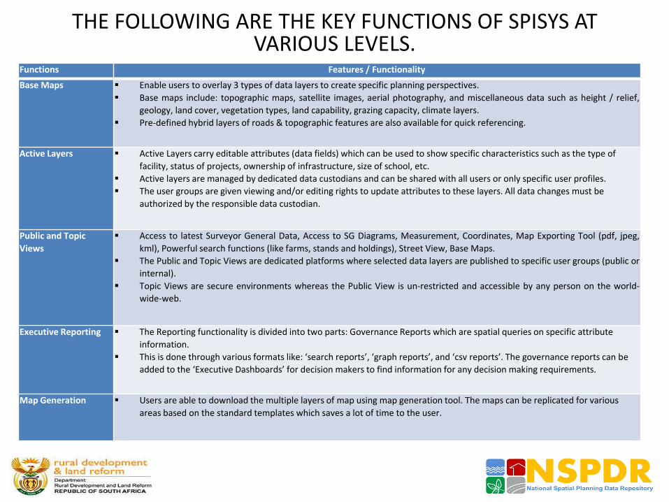
THE FOLLOWING ARE THE KEY FUNCTIONS OF SPISYS AT VARIOUS LEVELS.
Functions Features / Functionality
Base Maps Enable users to overlay 3 types of data layers to create specific planning perspectives.
Base maps include: topographic maps, satellite images, aerial photography, and miscellaneous data such as height / relief,
geology, land cover, vegetation types, land capability, grazing capacity, climate layers.
Pre-defined hybrid layers of roads & topographic features are also available for quick referencing.
Active Layers Active Layers carry editable attributes (data fields) which can be used to show specific characteristics such as the type of
facility, status of projects, ownership of infrastructure, size of school, etc.
Active layers are managed by dedicated data custodians and can be shared with all users or only specific user profiles.
The user groups are given viewing and/or editing rights to update attributes to these layers. All data changes must be
authorized by the responsible data custodian.
Public and Topic
Views
Access to latest Surveyor General Data, Access to SG Diagrams, Measurement, Coordinates, Map Exporting Tool (pdf, jpeg,
kml), Powerful search functions (like farms, stands and holdings), Street View, Base Maps.
The Public and Topic Views are dedicated platforms where selected data layers are published to specific user groups (public or
internal).
Topic Views are secure environments whereas the Public View is un-restricted and accessible by any person on the world-
wide-web.
Executive Reporting The Reporting functionality is divided into two parts: Governance Reports which are spatial queries on specific attribute
information.
This is done through various formats like: ‘search reports’, ‘graph reports’, and ‘csv reports’. The governance reports can be
added to the ‘Executive Dashboards’ for decision makers to find information for any decision making requirements.
Map Generation Users are able to download the multiple layers of map using map generation tool. The maps can be replicated for various
areas based on the standard templates which saves a lot of time to the user.

THE FOLLOWING ARE THE KEY FUNCTIONS OF SPISYS AT VARIOUS LEVELS continued.
Spatial Planning Tools This function supports Land Use Management and the development of Spatial Development Frameworks (SDFs). The tool
guides planners through the SDF planning process and provides useful tools to enable accurate spatial planning.
All planners use the standardized planning categories, which include the following six main Spatial Planning Categories (SPCs)
and their subcategories: Core Conservation Areas, Natural Buffer Areas, Agricultural Areas, Urban Related Areas, Industrial
Areas, and Surface Infrastructure.
SPIsys also offers past and current SDF's as reference information and facilitates alignment between them.
Integrated
Development Planning
SPIsys can assist municipalities and sector partners to develop sector specific development plans, integrate and align these to
the Spatial Development
The IDP review process can also be engaged using SPIsys by showing the location of proposed projects spatially against the
development objectives of the SDF to ensure full integration and alignment across services and sector role players.
E-Lodgement The E-Lodgement facilitates functionalities related to: existing land use rights, title deed checks, future development
framework, current and future service plans, application registrations, document uploading facilities.
The other documentation includes: decision records, impact studies, layouts, services agreement, engineering studies, GPS
coordinates etc.
Network Analysis The network analysis function uses the location of facilities, transport routes, travel speed, population density and other
demographic information to inform land use planning and decision-making.
Web Map Services A Web Map Service (WMS) shares geo-referenced map images across software platforms, where users can extract images of
maps from SPIsys for display in desktop GIS software.
The WMS function can include base maps and any inactive layer (not active layers) Subject specific views can also be created
within SPIsys using the map functionality and then shared through the WMS service as combined views to external platforms.
Data Custodianships Data in SPIsys is maintained through a Custodianship model through data champions in the various sector departments.
External users can request data additions and data changes, which are presented to the data custodian for approval for any
spatial additions, relocations and attribute changes.
Functions Features / Functionality

LESSONS LEARNT • The following are the key observations noted based on the user and functional analysis
document review, and the review of spatial planning information system data repository:
• The gap analysis presented here does not cover financial data, licensing, coordination and integration issues, funding and training.
Hierarchy / Scope
The user requirement analysis covers the scope at provincial level, and does not cover the requirement analysis at local level. The lessons from Korea, Australia and CUGIR shows that SDI is approached across horizontal and vertical sectors from top-bottom and bottom-up approaches.
Reporting Levels
The list of information captured in the user requirement analysis documents for several horizontal sectors (departments) is in the form of a ‘generic list’, which is derived based on questionnaires / workshops conducted for target groups. This could be further enhanced in terms of identification of reporting levels and the data sets associated with it.
Limited executive reporting needs are identified in the user requirement analysis (e.g.: only one reporting identified in ‘user requirement of spatial planning and information’: progress / completion status of project implementation).
User and Functional Analysis
The reports do not clearly distinguish between: user, business, functional and non-functional requirement analysis for respective departments.
The details available / captured are in basic list form and not categorized as per reporting levels, functionality, and interdependence of the reporting levels.

LESSONS LEARNT continued Linkages
The linkages among the user, business and functional requirements and the reporting needs are not defined and linked to the existing planning tools, and stakeholders.
Data Custodians/ Stakeholders
The spatial and non-spatial data requirements are not distinctly listed and linked/ identified to the data custodians.
The details of the associated stakeholders and spatial data interface are not defined (e.g, for planning and development, how many stakeholders are linked and need particular spatial and non-spatial information for different reporting levels).
SDI Standards
The user requirement analysis summarizes the requirements; however the details are not distinctly available as per the coverage in terms of SDI standards: Data, Standards, Technology, Policy, Access & Metadata, Application, and Partnerships.
Gap Analysis
The reporting levels, associated stakeholders, planning tools at different spheres of governance, and the spatial planning data/ information (spatial and non-spatial) matrix for gap analysis/ integration is not clearly listed /provided.

Summary
• The findings of this study highlight some of the ways in which thinking about SDIs / Repositories has developed both locally and internationally over the years.
• It is important to note that SDI initiatives are regarded as crucial instruments for countries to develop their geo-spatial data to support development objectives.
• As highlighted above, five international cases were reviewed. The overall summary of the key lessons learnt is grouped into the following areas: legal frameworks, usage pattern, data usability, metadata, data access, quality, coverage, granularity, implementation plans, project financing, and technical platform.
• The NSPDR is a 36 months project; 1st phase is UR and functional requirements, 2nd phase being the technical component and the third phase will be roll out and implementation.

Stakeholder Engagements
&
User Requirements Gathering

Landscape
Infrastructure to publish and access authentic spatial data to aid planning is not adequate
• Lack of standardisation
• Technological challenges
• Leadership
Various initiatives have been undertaken within South Africa.
• Insufficient education on benefits of such a repository
• Fragmentation of initiatives
• Lack of compliance with meta-data standards
• Unclear restrictions/rights of use
• Long term commitment to current reliable data

Framework
• Spatial Planning and Land Use Management (SPLUM) Act, 2013
• Spatial Data Infrastructure (SDI) Act, 2003
• National Development Plan (NDP) Vision 2030
Mandate for National Spatial Planning Data
Repository (NSPDR) is
derived from
The proposed NSPDR is a significant step towards evidence-based planning

Project Objective
• Promote integrated planning by creating an ecosystem for real-time sharing of spatial information
• Remove subjectivity from the planning function, and move towards evidence-based approach
• Develop ‘Big-Data’ approach for content search and discovery
• Record project initiatives

Project Scope
Determination of the pre-requisite for establishing the National Spatial Planning Data Repository for South Africa:
– Business requirements analysis;
– User requirements analysis;
– Functional requirements analysis; and
– Non-functional requirement analysis.

Desktop Studies Study Country Legal
Framework Standards Compliance
Coverage
NSDI Republic of South Korea
Y Y National
NSDI Malaysia Y Y National
NSDI Australia Y Y National
CUGIR United States of America
Y Y Local
Data.Gov.UK United Kingdom Y Y National

Benefits
Reduce cost and effort of data
acquisition
Data and cost sharing
Improved data confidence
Remove duplicity of effort
Increased efficiency
Data ownership is acknowledged
and enforced
Open access to data under Open General License
Restrictions on commercial use
Common tool set for decision
making
Hide the complexity of the Planning function
In-built best practices
Legal compliance

Completed Activities PROJECT OBJECTIVES & DELIVERABLES CURRENT PHASE & EXPECTED COMPLETION
DATE
Completed Activities
Project kick-off meeting 14 October 2013
Setup project portal 27 November 2013
Revised inception report and project plan 05 December 2013
Project communication plan 05 December 2013
Revised desktop research 03 January 2014
Spatial planning engagements:
National workshop - Gauteng 27 February 2014
o Workshop report 14 March 2014
o Preliminary user survey result 06 May 2014
o Limpopo SPLUMA Implementation
Forum
22 May 2014

National NSPDR Workshop Purpose:
• Familiarise key spatial users with the NSPDR project.
• Introduce the conceptual uses or capabilities of the envisaged repository.
• Identify and explore synergies with similar or complementary initiatives across the country.
• Obtain inputs from stakeholders with regards to how they are currently creating, accessing and sharing spatial planning data.
• Explore immediate and future applications of the spatial planning data repository.
• Define the way forward with regards to the spatial planning data repository to ensure optimal use and ownership.

Workshop Results Participants: • 138 participants representing various spheres of government
as well as public entities.
Summary of Results Indicate that Participants (workshop report completed):
• Welcome the idea of spatial planning data repository
• Require spatial planning data to be available to all spheres of government. But, there must be restriction regarding sensitive data.
• Want a repository to be freely accessible to all users.
• Suggest that roles and responsibilities of users and custodians must be defined.
• Require tools to be able to access data across various databases.

Results Contd… • Suggest that core datasets for incorporation into a
repository as well as the custodians of those datasets must identified.
Examples of spatial planning data

Results Contd…
• Require that information within a repository must be both spatial and non-spatial data.
• Wants datasets within a repository to be updated frequently and time stamped.
• Need a repository that will also cater for an offline connectivity mode as some of the rural areas do not have internet connectivity.

User Requirements Survey Results Participants:
• 76 participants from National Departments, Provincial Departments, Municipalities and Public Entities completed the user requirements survey.
STAKEHOLDERS GP KZN NW LP EC WC MP No. of Stakeholders No. of Participants
National
Departments 10 - - - - - - 10 16
Provincial
Departments 2 3 4 1 1 4 4 19 23
Local Government 24 28
Metropolitan
Municipalities 3 1 - - - - - 4 4
District
Municipalities - - 2 2 - 1 - 5 6
Local
Municipalities - 1 4 6 2 1 1 15 18
Public Entities 3 - - - - - - 3 9
Total 18 5 10 9 3 6 5 56 76

Survey Results
Summary of Results Indicate that Participants (initial report done):
• Require access to variety of spatial and non-spatial planning data.
• Want a repository that will to integrate disparate data sources and facilitate easy access and sharing of data.
• Suggest that a repository for spatial planning data be funded by National Government.
• Need a repository to contain tools to enable easy search and discovery of data.
• Require a repository that will support multiple modes of sharing data.
• Suggest that a repository must be freely accessible to all spheres of Government.
• Require that a repository must be compatible with other GIS software and IT devices currently in use.

Way Forward PROJECT OBJECTIVES & DELIVERABLES CURRENT PHASE & EXPECTED COMPLETION DATE
Planned Activities
o Western Cape Spatial Information
Forum
12 June 2014
o KwaZulu Natal Forum TBC
o Eastern Cape Forum TBC
o Online user survey closing 30 June 2014
Compilation of reports:
o Business requirements specifications 18 July 2014
o User requirements specifications 18 July 2014
o Functional requirements specifications 18 July 2014
o Non-functional requirements
specifications
18 July 2014
Integration of requirements specifications
reports
04 August 2014

User Requirements Survey
• Please complete the online questionnaire by visiting: www.DevelopmentGrid.net and
– Share your experiences from similar initiatives
– Share how you currently create, access and share spatial data
– Suggest options for immediate and future application of the repository
– Provide inputs on the way forward with regard to the spatial data repository to ensure eventual use and ownership

Way forward
• User requirements will be collected and synchronized in the seven other provinces (Mpumalanga, Eastern Cape, Limpopo, KwaZulu Natal, Gauteng, North West, and Western Cape) to establish the best suited requirements and data framework for a national data repository.
• This will furthermore provide much needed guidance to the implementation of SPLUMA, spatial development planning, rural development plans, and inter-governmental relations and cooperation (IGR).
• The province may continue to develop a provincial planning intelligence center.
• The system however should be interoperable and have similar data informants/structures to allow synergies with the NSPDR.
• Discussion around hosting costs and accessibility to the more rural municipalities (funding model).
• Governance structures usability and sustainability of the system (setting up of National Planning Forum).

Thank you
www.dataworld.co.za