north carolina floodplain mapping … carolina floodplain mapping program cooperating technical...
TRANSCRIPT

NORTH CAROLINA FLOODPLAIN MAPPING PROGRAM
COOPERATING TECHNICAL STATE FINAL BASIN PLAN — LITTLE TENNESSEE RIVER BASIN
Prepared by the:
State of North Carolina and the Federal Emergency Management Agency
Final: June 8, 2007

North Carolina Floodplain Mapping Program Cooperating Technical State
TABLE OF CONTENTS PAGE
Contact Information.................................................................................................. iv
Abbreviations and Acronyms ...................................................................................... v
I. Introduction ...................................................................................................1
Why the State of North Carolina Created the Floodplain Mapping Program.........1
Components of the North Carolina Floodplain Mapping Program........................2
Floodplain Mapping Program Funding and Work Plan........................................3
Program Benefits............................................................................................3
II. Little Tennessee River Basin Description...........................................................5
III. Scoping Phase for the Little Tennessee River Basin ...........................................7
Step 1—Initial Research and Community Coordination .................................... 10
Step 2—Initial Scoping Meetings.................................................................... 12
Step 3—Draft Basin Plan ............................................................................... 14
Step 4—Final Scoping Meetings ..................................................................... 14
Step 5—Final Basin Plan.............................................................................. 155
IV. Elevation and Flood Data Development and Digital FIRM Production forthe Little Tennessee River Basin ............................................................... 16
Base Map..................................................................................................... 16
Topographic Data ......................................................................................... 16
Flood Hazard Data........................................................................................ 17
1. Detailed Study—Riverine............................................................... 17
2. Redelineation ............................................................................... 22
3. Limited Detailed Study.................................................................. 22
4. Use of Effective Information.......................................................... 23
Variations from Community-Identified Needs and Priorities ................. 24
Digital FIRMs................................................................................................ 24
V. Community Review and Due Process.............................................................. 25
Final Basin Plan — Little Tennessee River Basin Date: June 8, 2007 Page i
North Carolina Floodplain Mapping Program Cooperating Technical State
TABLE OF CONTENTS PAGE
List of Figures Figure 1. Three Phases of Development and Production....................................3
Figure 2. Phases of the North Carolina Statewide Floodplain Mapping Program...3
Figure 3. Little Tennessee River Basin Vicinity Map ...........................................5
Figure 4. Process for Scoping the Little Tennessee River Basin ..........................9
Figure 5. Components of a Digital FIRM ......................................................... 16
List of Tables Table 1. Total Flood Claims and Repetitive Loss Claims.....................................1
Table 3a. USGS Gage Information – Detailed Studied Flooding SourcesError! Book
Table 3b. USGS Gage Information – Approximate Zone A Flooding SourcesError! B
Table 2. Community Information .....................................................................7
Table 4. Initial Scoping Meetings for the Little Tennessee River Basin .............. 12
Table 5. Summary of Riverine Flooding Sources to be Studied in Detail............ 18
Table 6. Summary of Technical Methods for the Little Tennessee River Basin... 23
Table 7. Summary of Digital FIRMs for the Little Tennessee River Basin........... 25
Appendices
Appendix A. Attendance Sheets from Initial Scoping Meetings ........................A-1
Appendix B. Summaries of Community-Identified Flood Mapping Needs................................................................B-1
Appendix C. Attendance Sheet(s) from Final Scoping Meeting(s) ....................C-1
Appendix D. Summary of Riverine Flooding Sources to be Studied by Redelineation .......................................................................... D-1
Appendix E. Summary of Flooding Sources to be Studied by
Limited Detailed Methods……………………………………………………….E-1 Appendix F. Summary of Variations from Community-Identified
Needs and Priorities……………………………………………………………….F-1
Final Basin Plan — Little Tennessee River Basin Date: June 8, 2007 Page ii

North Carolina Floodplain Mapping Program Cooperating Technical State
TABLE OF CONTENTS
A. Attachments 1. Community Recommendations – Little Tennessee River Basin A. Graham County, North Carolina
B. Jackson County, North Carolina C. Macon County, North Carolina D. Swain County, North Carolina
2. Final Basin Plan – Little Tennessee River Basin A. Graham County, North Carolina B. Jackson County, North Carolina C. Macon County, North Carolina D. Swain County, North Carolina
Final Basin Plan — Little Tennessee River Basin Date: June 8, 2007 Page iii
North Carolina Floodplain Mapping Program Cooperating Technical State
CONTACT INFORMATION
Questions or comments about this Basin Plan can be directed to:
Randy Mundt, Community Development Planner North Carolina Floodplain Mapping Program (919)715-5711 x119 or [email protected]
Questions about the National Flood Insurance Program (NFIP) and NFIP mapping can be directed to the Federal Emergency Management Agency’ s Map Assistance Center toll free information line at 1-877 FEMA MAP (1-877-336-2627) or [email protected].
Final Basin Plan — Little Tennessee River Basin Date: June 8, 2007 Page iv

North Carolina Floodplain Mapping Program Cooperating Technical State
ABBREVIATIONS AND ACRONYMS
The following abbreviations and/or acronyms are used throughout this Basin Plan.
Abbreviation/Acronym Description BFE Base Flood Elevation
CGIA Center for Geographic Information and Analysis
CTS Cooperating Technical State
DEMs Digital Elevation Models
DFIRM Digital Flood Insurance Rate Map
DOQs Digital Orthophoto Quadrangles
FEMA Federal Emergency Management Agency
FEMA-MCC FEMA’s Mapping Coordination Contractor (Dewberry)
FIS Flood Insurance Study
FIRM Flood Insurance Rate Map
FMIS Floodplain Mapping Information System
GIS Geographic Information Systems
LIDAR Light Detection and Ranging
MENCA Mapping and Engineering Needs Community Assessment
NAVD 88 North American Vertical Datum of 1988
NCEM North Carolina Division of Emergency Management
NCDENR North Carolina Department of Environment and Natural Resources
NCFMP North Carolina Floodplain Mapping Program
NFIP National Flood Insurance Program
NGVD 29 National Geodetic Vertical Datum of 1929
TIN Triangulated Irregular Network
USGS U. S. Geological Survey
Final Basin Plan — Little Tennessee River Basin Date: June 8, 2007 Page v

North Carolina Floodplain Mapping Program Cooperating Technical State
I. INTRODUCTION
The State of North Carolina, through the Federal Emergency Management Agency’s (FEMA’s) Cooperating Technical Community partnership initiative, has been designated as the nation’s first Cooperating Technical State (CTS). As a CTS, the State has assumed primary ownership and responsibility for updates of the National Flood Insurance Program’s (NFIP) Flood Insurance Rate Maps (FIRMs) for all North Carolina communities. This role has traditionally been fulfilled by FEMA.
North Carolina faces extreme hazard and consequence from hurricanes and flooding. Since 1989, there have been 21 federally declared disasters in North Carolina. Damages from Hurricane Floyd alone have reached $3.5 billion. As a result of Hurricane Floyd, 4,117 uninsured and under-insured homes were destroyed. Table 1 below shows the number of flood claims and repetitive loss claims in the Little Tennessee River Basin between the years of 1978 and 2003. The State’s vulnerability to hurricanes and flooding make it crucial that communities and property owners have accurate, up-todate information about the flood risk. The updated DFIRMs produced through this Program will help to protect the lives and property, and contribute to the general well being, of North Carolina citizens.
County No. of Claims (2002) Repetitive Loss Claims (as of 2003)
Graham 2 0 Jackson 9 0 Macon 0 0 Swain 5 1
Table 1. Total Flood Claims and Repetitive Loss Claims
Why the State of North Carolina Created the Floodplain Mapping Program
There are several reasons why the State has initiated this Program; these include the following:
• Approximately 55% of North Carolina FIRMs were at least 10 years old. • Approximately 75% of North Carolina FIRMs were at least 5 years old. • FEMA’s mapping budget is finite; on average, North Carolina received only one
updated flood study for one county per year. • Many counties and communities have indicated that they do not have the
resources to take on this responsibility.
Final Basin Plan — Little Tennessee River Basin Date: June 8, 2007 Page 1
North Carolina Floodplain Mapping Program Cooperating Technical State
Components of the North Carolina Floodplain Mapping Program
The North Carolina Floodplain Mapping Program involves the following:
• Acquisition of high-resolution topographic data and development of accurate Digital Elevation Models (DEMs.)
• Development of up-to-date, accurate flood hazard data and floodplain mapping. • Production of seamless digital FIRM coverage statewide:
- DFIRMs will be produced on a statewide basis where all counties and incorporated communities are seamlessly shown across one set of state maps.
- Digital Orthophoto Quadrangles (DOQs), produced in partnership by the State of North Carolina and the U.S. Geological Survey (USGS), will be used as the primary base map. In areas where there is a locally produced base map that is more current or accurate than the DOQs, the locally developed map may be used to supplement or in place of the DOQs as the base.
- Flood Elevations on the DFIRMs will be converted to the North American Vertical Datum of 1988 (NAVD 88).
The North Carolina Floodplain Mapping Program, administratively located in the North Carolina Division of Emergency Management (NCEM) oversees and manages the Program. NCFMP will work closely with several other state agency partners (North Carolina Geodetic Survey [NCGS], Center for Geographic Information and Analysis [CGIA], and the Floodplain Management Branch) to ensure quality map production. In the production of the Basin Plan, NCFMP has worked in close cooperation with the Floodplain Management Branch of the NCEM to ensure that all flood hazards and NFIP issues are addressed. Additionally, after the updated flood data and maps are produced, NCFMP coordinates with Floodplain Management to conduct training and outreach to assist communities in utilizing the new data and maps to implement floodplain management and hazard mitigation activities.
The North Carolina Floodplain Mapping Program has also implemented a state-of-theart, dynamic Floodplain Mapping Information System (FMIS) to analyze, maintain, and archive maps and associated flood hazard data. The FMIS also serves to present and distribute the mapping data and associated reports to the public via the Internet without the user needing to have sophisticated Geographic Information System (GIS) software. An additional component of the Program is a real-time flood forecasting and inundation mapping capability. The North Carolina Flood Warning System is currently being piloted in the Tar-Pamlico and Neuse River Basins.
The development of topographic and flood data and production of statewide digital FIRM panels will have three phases (Figure 1): (1) scoping, (2) flood map production, and (3) Community Review and Due Process (post-preliminary process).
Final Basin Plan — Little Tennessee River Basin Date: June 8, 2007 Page 2

North Carolina Floodplain Mapping Program Cooperating Technical State
Scoping Flood Map Production
Community Review and Due Process
Figure 1. Three Phases of Development and Production
Flood Mapping Program Funding and Work Plan
In August 2000, the North Carolina General Assembly allocated $42.8 million to the Floodplain Mapping Program. FEMA has contributed an additional $30.65 million toward the Program as well as in-kind contribution of engineering, mapping, and program management services. The State has also worked with other Federal partners to secure additional needed funding. Based on the General Assembly’s directive, work began on the six eastern river basins as shown in Figure 2 (Phase I—Cape Fear, Lumber, Neuse, Pasquotank, Tar-Pamlico, and White Oak). Work was initiated on six additional river basins in 2003 (Phase II—Chowan, Roanoke, Yadkin, Catawba, Watauga, and New). Work on the remaining five basins (Phase III—Broad, French Broad, Little Tennessee, Hiawassee, and Savannah) began in the summer of 2005, in which the General Assembly of North Carolina provided an additional $10 million.
Figure 2. Phases of the North Carolina Floodplain Mapping Program
Program Benefits
The North Carolina Statewide Floodplain Mapping Program will provide many benefits to North Carolina communities, property owners, and citizens. These include:
• The updated flood hazard data will provide current, accurate information for North Carolina communities and property owners to make safe siting and design
Final Basin Plan — Little Tennessee River Basin Date: June 8, 2007 Page 3
North Carolina Floodplain Mapping Program Cooperating Technical State
decisions when rebuilding from flooding disasters, building new structures and infrastructure, and retrofitting existing structures.
• The use of the updated data by communities for floodplain management will dramatically reduce long-term flood losses to the State of North Carolina, its communities, and its citizens.
• Updated flood hazard data will alert those at risk to flooding of the need to purchase flood insurance protection.
• It will be faster and more cost effective to update DFIRMs. • Current, updated base maps and the digital format of the FIRMs will allow users
to make more efficient, precise flood risk determinations. • The resultant DFIRMs will be the official NFIP maps; these DFIRMs will also be
used by communities for floodplain management purposes. • The digital format of the DFIRMs will allow use with GIS for analysis and
planning. • The digital Floodplain Mapping Information System will allow online access to all
map users 24 hours a day without requiring sophisticated GIS software. • The DEMs being developed will be useful for almost any engineering or planning
application, such as site design, storm-water management, transportation planning and design, and spill response.
This report summarizes and provides details about the scoping phase that was completed for the Little Tennessee River Basin and how the results of this scoping effort were used to generate a plan for developing updated flood data and statewide DFIRMs for counties and communities located within the Little Tennessee River Basin. This report also describes the process and schedule for completing the map production and community review phases.
Final Basin Plan — Little Tennessee River Basin Date: June 8, 2007 Page 4
North Carolina Floodplain Mapping Program Cooperating Technical State
II. LITTLE TENNESSEE RIVER BASIN DESCRIPTION
The Little Tennessee River Basin is located within the Blue Ridge Province of the Appalachian Mountains of western North Carolina and east-central Tennessee. Roughly 75% of its land area is situated in Tennessee, but its headwaters are in northern Georgia and the western North Carolina Mountains. It is bordered to the south and west by the Hiwassee and Savannah River Basins, and it is bordered to the north and east by the French Broad River Basin. The Little Tennessee River Basin covers approximately 1,800square miles. It is located in the Blue Ridge/Appalachian Mountains region of North Carolina. Figure 3 below shows the location of the North Carolina counties within the Little Tennessee River Basin.
Figure 3. Little Tennessee River Basin Vicinity Map
Final Basin Plan — Little Tennessee River Basin Date: June 8, 2007 Page 5
North Carolina Floodplain Mapping Program Cooperating Technical State
The Little Tennessee River Basin is not large in land area, but does contain more than 2,500 miles of streams, and 18,000 acres of lakes, and contains three subbasins: the Upper Little Tennessee River subbasin, the Tuckasegee River subbasin, and the Lower Little Tennessee River subbasin.
The total distance of freshwater flooding sources sums to equal approximately 2,565 miles in the Little Tennessee River Basin. The Little Tennessee River Basin is comprised of portions or all of Cherokee, Clay, Graham, Jackson, Macon, and Swain counties. It is also composed of 9 municipalities including Bryson City, Dillsboro, Forest Hills, Franklin, Highlands, Robbinsville, Santeetlah, Sylva, and Webster. Additionally, most of the Eastern Band of Cherokee Indians reservation lies within the Little Tennessee River Basin, including six communities: Big Cove, Birdtown, Painttown, Snowbird, Wolftown, and Yellowhill. According to the 2000 Census data, the population of the Little Tennessee River Basin is approximately 79,493, and is expected to increase by 31% by 2020, driven primarily by second homes and retirees. There is also a significant seasonal growth in the basin due to recreation and tourism.
Nearly 89% of the basin is forested with much of it located within the Great Smoky Mountains National Park or the Nantahalah National Forest; about one-half of the Little Tennessee River Basin is federally owned. Steep slopes limit the land area suitable for development and crop production. The Little Tennessee River Basin supports a large variety of aquatic species, including rare fish, mussels, and insects, as well as rare wetland communities, such as spray cliffs and mountain bogs.
Clay, Cherokee, Jackson and Macon Counties are all located partially within the Little Tennessee River Basin. Table 2 below summarizes the counties and communities located partially or entirely within the Little Tennessee River Basin and their current NFIP participation and mapping status.
Final Basin Plan — Little Tennessee River Basin Date: June 8, 2007 Page 6
North Carolina Floodplain Mapping Program Cooperating Technical State
Table 2. Community Information
Community Name County Participation Status
Date of Current
NFIP Map Unincorporated Areas Cherokee Participating 7/19/1993 Unincorporated Areas Clay Participating 4/1/1999 Unincorporated Areas Graham Participating 7/17/1986 Town of Lake Santeetlah Graham Not Participating Not Mapped
Town of Robbinsville Graham Participating 12/1/1989 Unincorporated Areas Jackson Participating 5/17/1989 Town of Dillsboro Jackson Participating 2/6/1991 Village of Forest Hills Jackson Not Participating Not Mapped Town of Sylva Jackson Participating 12/15/1990 Town of Webster Jackson Participating 2/10/1978 Unincorporated Areas Macon Participating 6/1/2001 Town of Franklin Macon Sanctioned 7/3/1976 Town of Highlands Macon Not Participating Not Mapped Unincorporated Areas Swain Participating 2/15/1989 City of Bryson City Swain Participating 12/4/1984 Eastern Band of Cherokee Indians Swain, Graham Participating 5/17/1989
III. SCOPING PHASE FOR THE LITTLE TENNESSEE RIVER BASIN
The State worked closely with FEMA and Dewberry, to complete the scoping phase for the Little Tennessee River Basin counties and communities in the Spring of 2006. Stated simply, “scoping” involves determining what areas are floodprone and need to have flood hazard data developed, what methods will be used to generate that hazard data, and how the data will be presented on the DFIRMs. For the Little Tennessee River Basin, the comprehensive scoping phase entailed:
• Researching and inventorying available elevation, flood hazard, and digital base map data that may be useful for preparing updated DFIRMs;
• Assessing existing flood hazard data (for example: flood elevation profiles, floodplain boundaries, or floodways) on effective FIRMs for adequacy;
• Providing outreach to, and receiving input from, counties and communities regarding their needs for updated DFIRMs;
• Identifying data that needs to be developed or acquired, such as digital base maps, DEMs, or field surveys of stream channels, and hydraulic structures
• Determining the proposed scales and paneling scheme for statewide DFIRM production; and
• Developing a schedule for completion of updated flood hazard data and digital FIRM production.
Final Basin Plan — Little Tennessee River Basin Date: June 8, 2007 Page 7

North Carolina Floodplain Mapping Program Cooperating Technical State
For flooding sources within the basin, the flood hazard data from the effective FIRMs were assessed for adequacy in consultation with the impacted counties and communities. For areas where the existing flood hazard data was deemed to be inadequate or outdated, a priority level was established and the most appropriate method of developing updated data was selected based on the:
• Type and extent of man-made and natural changes within the floodplain and/or watershed;
• Quality of data available; and • Existing and/or proposed levels of development affected by the flooding source.
Final Basin Plan — Little Tennessee River Basin Date: June 8, 2007 Page 8

North Carolina Floodplain Mapping Program Cooperating Technical State
The process followed for completing the scoping is shown in Figure 4 and is described further below.
Scoping Flood Map Production
Initial Research & Community
Coordination
Initial Scoping Meeting
Draft Basin Plan
Step 1 Step 2 Step 3
Analysis and
Mapping
Final Scoping Meeting
Revise Draft Basin Plan
Technical & Cost
Proposals for
Contractors
Distribute Final Basin
Plan to Communities
Finalize Basin Plan
Step 4 Step 5
Figure 4. Process for Scoping the Little Tennessee River Basin
Final Basin Plan — Little Tennessee River Basin Date: June 8, 2007 Page 9

North Carolina Floodplain Mapping Program Cooperating Technical State
Step 1—Initial Research and Community Coordination
The State held two central “kickoff” meetings in 2005 with county and community floodplain administrators, engineers, and planners on August 8 and 9 in Cullowhee and Marion, North Carolina, respectively. The objectives of the meetings were to overview the State’s CTS Agreement with FEMA and the North Carolina Floodplain Mapping Program, inform the floodplain administrators of the process that will be followed to develop updated mapping, and encourage them to be an active participant in the process. A questionnaire regarding the communities’ mapping needs was mailed prior to the meeting and distributed to those community representatives in attendance. This questionnaire contained pointed questions designed to help each community systematically ascertain its flood mapping needs. The county and municipal officials were encouraged to complete the questionnaire and submit it back to the NCFMP either digitally via e-mail or via hardcopy. Technical support was available for completion of the questionnaire through the State.
Completed questionnaires were received by the State from the following counties and communities in the Little Tennessee River Basin: Cherokee County, Jackson County, Town of Robbinsville, Town of Dillsboro, Town of Franklin, Town of Highlands, Town of Sylva, and the Town of Webster.
Additionally, the State completed research of community mapping needs as per its September 1999 Cooperating Technical Community agreement with FEMA, “Assessment of Community Mapping Needs.” Further, FEMA and Dewberry conducted research of effective Flood Insurance Study (FIS) and FIRM information and other relevant data available for each community in the FEMA Flood Mapping Archives and FEMA’s Mapping Needs Update Support System database. This database contains information on community mapping needs collected over the past few years through community surveys.
As part of the initial research, the State and Dewberry also evaluated post-Hurricane Floyd data, such as gage information, high-water marks, and inundation mapping, obtained from FEMA, the U.S. Army Corps of Engineers, and the USGS. The purpose of this evaluation was to identify areas where actual flooding elevations and inundation limits experienced did not match the flood hazard data in the effective FIS and FIRM, thereby indicating a mapping need.
Final Basin Plan — Little Tennessee River Basin Date: June 8, 2007 Page 10
North Carolina Floodplain Mapping Program Cooperating Technical State
U.S. Geological Survey Gage Data
Up-to-date analyses for stream gages located in the Little Tennessee River Basin were obtained from the USGS. The revised gage analyses were compared with effective FIRM information to determine the need for restudy of the flooding sources on which these gages are located. As part of this assessment, the 1% annual chance (100-year) discharge and water-surface elevation were compared. Table 3 outlines this information for all stream gages in the Little Tennessee River Basin.
Table 3a. USGS Gage Information
Detailed Studied Flooding Sources
USGS 100-year Discharge (cfs) 100-year WSEL (ft)
Gage Flooding Source Effective Gage Effective Gage
03512000 Oconaluftee River N/A 18,250 N/A N/A
03513000 Tuckasegee River N/A 50,680 N/A N/A N/A – not applicable because stream is currently not studied by detailed methods at gage
Table 3b. USGS Gage Information
Approximate Zone A Flooding Sources
USGS Gage Flooding Source
100-year Discharge (cfs)
100-year Elevation (NGVD) Effective Zone
LPIII Gage Zone A
03500000 Little Tennessee River 13,190 N/A Zone A
03500240 Cartoogechaye Creek 6,496 N/A Zone A
03503000 Little Tennessee River 23,830 N/A Zone A
03504000 Nantahala River 6,212 N/A Zone A N/A – not applicable because stream is currently not studied by detailed methods
The results of the initial research and responses to the community questionnaires were entered into a GIS-enabled scoping database: Mapping and Engineering Needs Community Assessment (MENCA). This database was used to generate “Initial Scoping Projects” for each community; these projects were used to conduct the Initial Scoping Meetings (Step 2).
Final Basin Plan — Little Tennessee River Basin Date: June 8, 2007 Page 11
North Carolina Floodplain Mapping Program Cooperating Technical State
Step 2—Initial Scoping Meetings
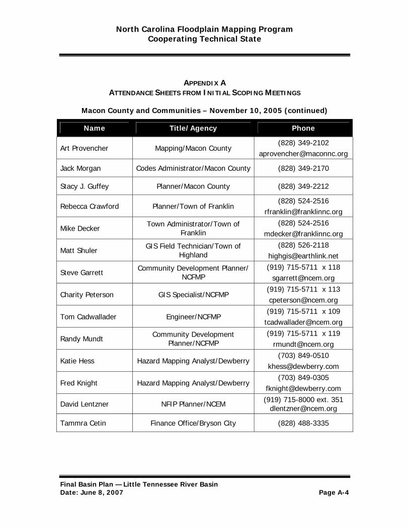
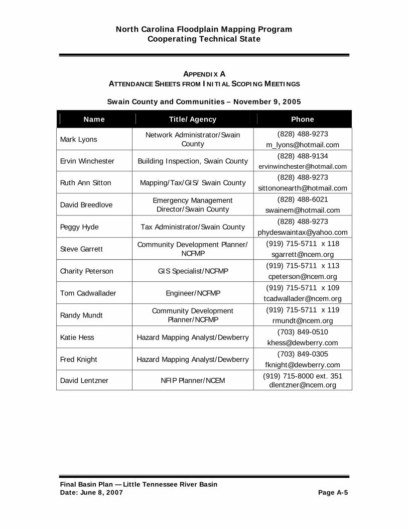
The State held meetings with each of the four counties (Graham, Jackson, Macon, and Swain) that contain the vast majority of area within the Little Tennessee River Basin to present the results of the initial research to the county and its communities and to discuss their flood mapping needs. Elected officials, floodplain administrators, emergency managers, and GIS staff were invited from the county and each incorporated community, including those communities that do not participate in the NFIP. The meetings were held at the Southwestern Community College in Sylva on November 9, 2005, and the Macon County Courthouse in Franklin on November 10, 2005, due to their central location and ease of accessibility within the river basins jurisdictions. Dewberry staff attended to provide program and technical support during the meetings. NCEM Floodplain Management Branch staff attended the meetings to exchange contact information with community Floodplain Administrators, establish contact with nonparticipating communities, and distribute copies of the current North Carolina model Flood Damage Prevention Ordinance. Table 3 summarizes the initial scoping meeting dates with each community. Meeting attendance sheets are included as Appendix A.
Please note that portions of some counties in the Little Tennessee River Basin (Cherokee, Clay, Macon, and Jackson) are situated in the adjoining Hiwassee and/or Savannah River Basins. The initial scoping meetings for all counties that comprise the Little Tennessee River Basin were conducted on a countywide basis and covered all areas of each county and community in the county irrespective of the basin. There are no studied streams within the Clay and Cherokee County portions of the Little Tennessee River Basin since a majority of these counties lie within the Hiwassee River Basin. Local officials did not have any floodplain mapping requests for the portions of Clay and Cherokee Counties that extended into the Little Tennessee River Basin. Table 4 contains a list of communities with the location and date of initial scoping meetings held for each community. Only those communities located entirely or partially within the Little Tennessee River Basin are listed in Table 4.
Table 4. Initial Scoping Meetings for the Little Tennessee River Basin
Community Meeting Location Meeting Date (s)
Eastern Band of Cherokee Indians
Tri-County Community College, Small Business
Center; Murphy, NC November 8, 2005
City of Bryson City
Southwestern Community College,
Jackson Campus, The Pines Building Library
November 9, 2005
Final Basin Plan — Little Tennessee River Basin Date: June 8, 2007 Page 12
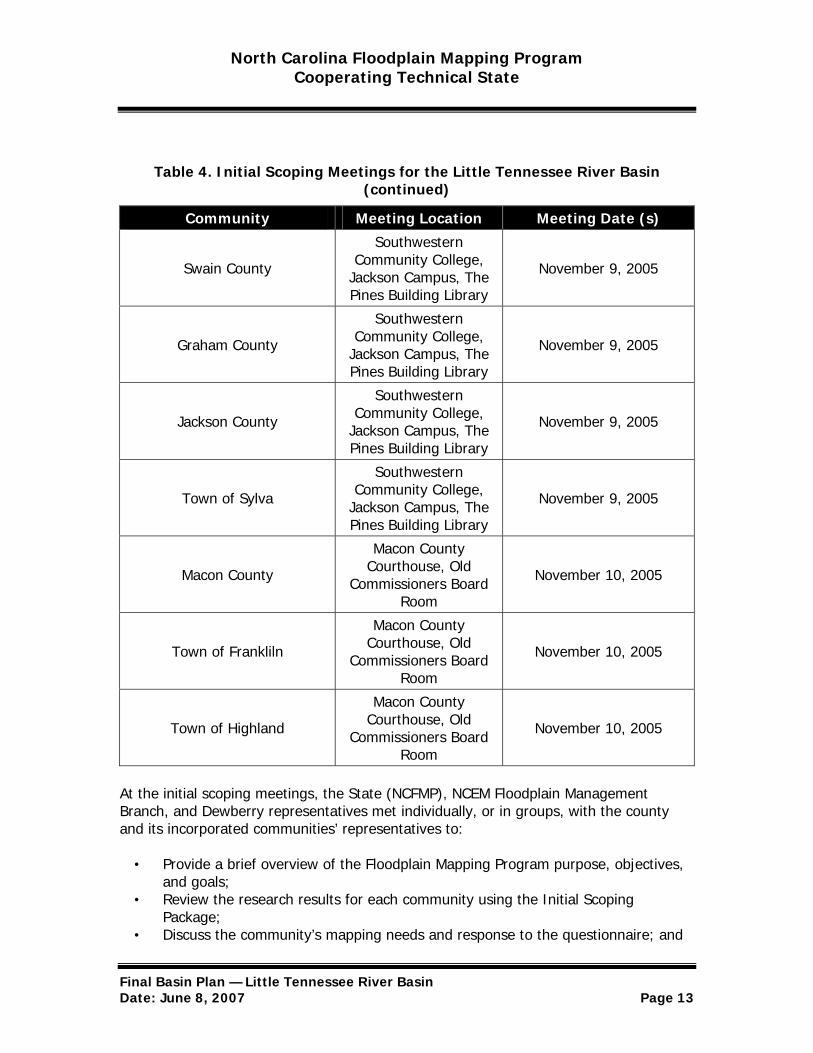
North Carolina Floodplain Mapping Program Cooperating Technical State
Table 4. Initial Scoping Meetings for the Little Tennessee River Basin (continued)
Community Meeting Location Meeting Date (s)
Swain County
Southwestern Community College,
Jackson Campus, The Pines Building Library
November 9, 2005
Graham County
Southwestern Community College,
Jackson Campus, The Pines Building Library
November 9, 2005
Jackson County
Southwestern Community College,
Jackson Campus, The Pines Building Library
November 9, 2005
Town of Sylva
Southwestern Community College,
Jackson Campus, The Pines Building Library
November 9, 2005
Macon County
Macon County Courthouse, Old
Commissioners Board Room
November 10, 2005
Town of Frankliln
Macon County Courthouse, Old
Commissioners Board Room
November 10, 2005
Town of Highland
Macon County Courthouse, Old
Commissioners Board Room
November 10, 2005
At the initial scoping meetings, the State (NCFMP), NCEM Floodplain Management Branch, and Dewberry representatives met individually, or in groups, with the county and its incorporated communities’ representatives to:
• Provide a brief overview of the Floodplain Mapping Program purpose, objectives, and goals;
• Review the research results for each community using the Initial Scoping Package;
• Discuss the community’s mapping needs and response to the questionnaire; and
Final Basin Plan — Little Tennessee River Basin Date: June 8, 2007 Page 13
North Carolina Floodplain Mapping Program Cooperating Technical State
• Identify available local data such as base maps, topographic data, ongoing studies, etc.
In assessing the communities’ flood mapping needs, emphasis was placed on:
• Areas of future development; • New or proposed crossings, encroachments, and flood controls; • Historically flooded areas; • Out-of-date or inadequate data on current FIRMs; • Existing data mismatches with contiguous communities; and • Out-of-date FEMA analyses (detailed or approximate).
For flooding sources identified in the meeting as having a flood mapping need, the community was asked to provide input on proposed study analysis methods and priorities.
Appendix B contains tables summarizing the community-identified flood mapping needs, suggested type of study, and priorities for each community within the Little Tennessee River Basin. Attachments 1A through 1D depict these community-identified needs and priorities.
Also, as part of the initial scoping effort, CGIA met with county GIS staff to inventory the availability of local GIS data to identify potential base map data resources for the Floodplain Mapping Program. Information collected from the survey form was entered into MENCA for each Phase III county.
Step 3—Draft Basin Plan
Based on the results of the Initial Scoping Meetings, the State synthesized the research and the community input. These results were used to develop the Draft Basin Plan for developing updated flood hazard data for the basin and for producing statewide DFIRM panels for the affected counties and communities within the Little Tennessee River Basin.
Section IV and the Appendices of the Draft Basin Plan included a list of flooding sources to be updated within the basin, including the technical method of update (detailed, limited detailed, or redelineation) and reach limits and stream miles to be updated. Section IV also included a comprehensive list of counties for which statewide DFIRM panels will be produced including digital base map source to be used and proposed DFIRM paneling and tiling scheme. Lastly, Section IV also included a projected schedule for completing the basin studies and statewide preliminary DFIRMs.
Step 4—Final Scoping Meetings
The draft Little Tennessee River Basin Plan was sent to affected counties and communities and posted on the State’s website on March 23, 2006. Subsequently, after
Final Basin Plan — Little Tennessee River Basin Date: June 8, 2007 Page 14
North Carolina Floodplain Mapping Program Cooperating Technical State
a 30-day review period, the State would typically holds a Final Scoping meeting for the Little Tennessee River Basin counties and communities.
The communities’ Chief Elected Officer, floodplain administrators, planners, Engineers, GIS staff, building and zoning officials would typically be invited from each county and incorporated community in the basin for the Final Scoping Meetings.
The objective of the final scoping meeting is for the State to overview the Draft Basin Plan, including the proposed scope, schedule for the project, and provide an opportunity for additional county and community input or suggested changes to the Draft Basin Plan. Typically, individual meetings, for each county would be scheduled for community leaders to meet with representatives from the State and Dewberry. However, in this case, jurisdictions were contacted by letters and phone calls in order to confirm the jurisdictions satisfaction and acceptance of the Draft Basin Plan and the proposed scope of flood hazard data studies.
This Final Basin Plan summarizes the comments and/or feedback received from these letters and phone calls.
Step 5—Final Basin Plan
After the jurisdiction’s acceptance of scope was verified, the Draft Basin Plan was revised, as necessary, to produce this Final Basin Plan. The Final Basin Plan contains specific information regarding comments that were received and how the Draft Basin Plan was revised and why.
The State then requested that its Flood Mapping Contractor prepare a technical and cost proposal to execute the components of the revised draft Little Tennessee River Basin Plan. After negotiations between the State and the Flood Mapping Contractor if the cost estimate indicates that the Basin Plan can be executed within the State’s available budget for the Little Tennessee River Basin, the Basin Plan will be finalized. However, if the negotiated cost estimate indicates that the Basin Plan cannot be executed within the State’s available budget, the State may have to modify the scope of the project.
Once the Little Tennessee River Basin Plan is finalized, the Final Basin Plan will be posted on the State website, www.ncfloodmaps.com, with a description and explanation of any changes made from the Draft Basin Plan.
Final Basin Plan — Little Tennessee River Basin Date: June 8, 2007 Page 15
North Carolina Floodplain Mapping Program Cooperating Technical State
IV. ELEVATION AND FLOOD DATA DEVELOPMENT AND DIGITAL FIRM PRODUCTION FOR THE LITTLE TENNESSEE RIVER BASIN
The State’s flood mapping contractor will develop digital elevation data, conduct engineering flood hazard analyses, and prepare floodplain delineations for the flooding sources in the Little Tennessee River Basin and produce statewide preliminary DFIRMs for the affected communities within the Little Tennessee River Basin.
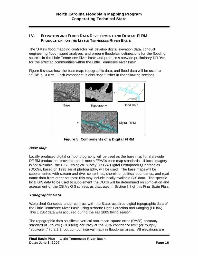
Figure 5 shows how the base map, topographic data, and flood data will be used to “build” a DFIRM. Each component is discussed further in the following sections.
Digital FIRM =
Base Flood DataTopography
+ +
Figure 5. Components of a Digital FIRM
Base Map
Locally produced digital orthophotography will be used as the base map for statewide DFIRM production, provided that it meets FEMA’s base map standards. If local imagery is not available, the U.S. Geological Survey (USGS) Digital Orthophoto Quadrangles (DOQs), based on 1998 aerial photography, will be used. The base maps will be supplemented with stream and river centerlines, shoreline, political boundaries, and road name data from other sources; this may include locally available GIS data. The specific local GIS data to be used to supplement the DOQs will be determined on completion and assessment of the CGIA’s GIS surveys as discussed in Section III of this Final Basin Plan.
Topographic Data
Watershed Concepts, under contract with the State, acquired digital topographic data of the Little Tennessee River Basin using airborne Light Detection and Ranging (LIDAR). This LIDAR data was acquired during the Fall 2005 flying season.
The topographic data satisfies a vertical root-mean-square error (RMSE) accuracy standard of ±25 cm (±0.8 feet) accuracy at the 95% confidence limit (or roughly “equivalent” to a 2.2 foot contour interval map) in floodplain areas. All elevations are
Final Basin Plan — Little Tennessee River Basin Date: June 8, 2007 Page 16
North Carolina Floodplain Mapping Program Cooperating Technical State
referenced to the NAVD 88 and reflect orthometric heights. Variably spaced, bare-earth digital topographic data in ASCII point file format is combined with imagery (either flown concurrently with the LIDAR data or using existing digital orthophotos) to establish a Triangulated Irregular Network (TIN) to include selected breaklines used for hydraulic modeling. Furthermore, uniformly spaced Digital Elevation Models (DEMs), with 20 ft. x 20 ft. or 50 ft. x 50 ft. post spacing, are generated in multiple file formats.
These topographic data will be primarily used for floodplain modeling and mapping for counties and communities in the Little Tennessee River Basin (described below). However, the data will also be useful for other State and county engineering and planning applications using ARC/INFO and other GIS software and will be available through the State’s online Information Management System described earlier in this plan. It is planned for these data to be available online in 2007.
Flood Hazard Data
In developing flood hazard data for each of the flooding sources in the Little Tennessee River Basin the State’s Flood Mapping Contractor will utilize one of four options available. These are described below. All flood elevations will be referenced to the NAVD 88. All analyses and mapping will comply with FEMA’s regulations, guidelines, and specifications for NFIP mapping.
1. Detailed Study—Riverine
This method entails using the Triangulated Irregular Network (TINs), supplements them with field surveys for channel bathymetry, bridge/culvert opening geometry, and channel and floodplain characteristics, to conduct fully detailed hydrologic and hydraulic analyses and floodplain mapping. This will include analyses of the 10%, 2%, 1%, and 0.2% annual chance flood peak discharges, water-surface elevations, profiles, and determination of a floodway. Riverine areas studied in detail will be designated as Zone AE on the updated DFIRMs. Flood profiles and base flood elevations will be referenced to NAVD 88.
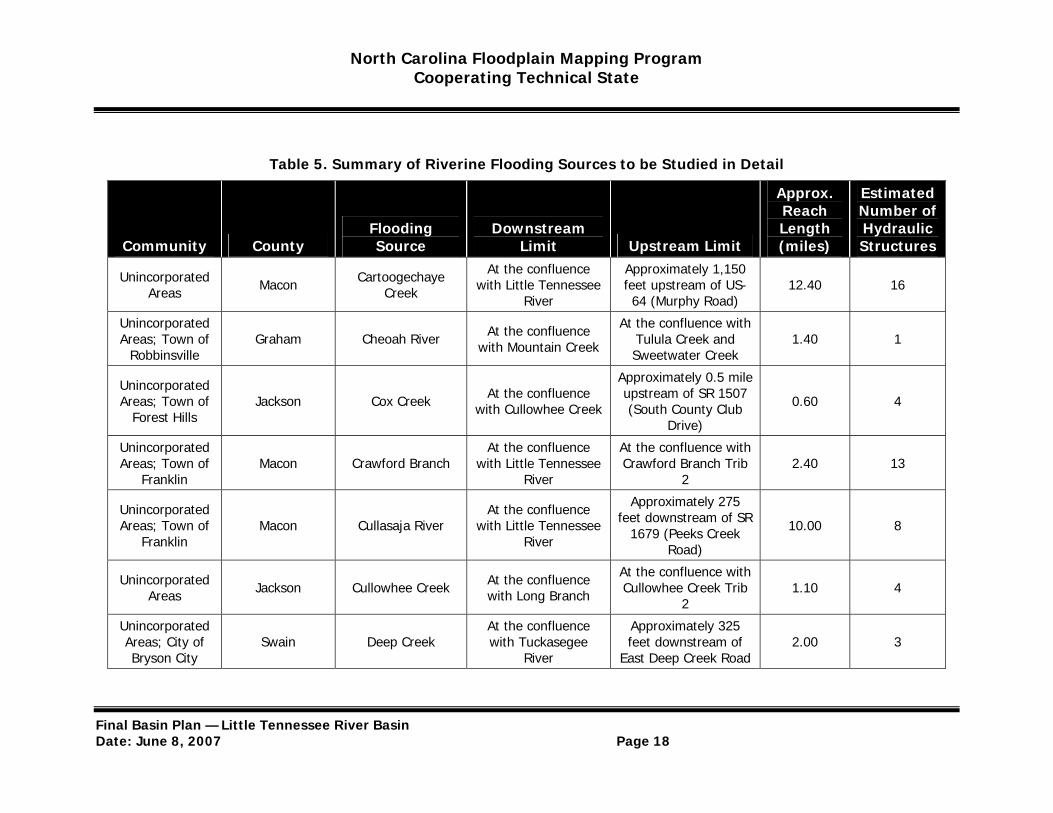
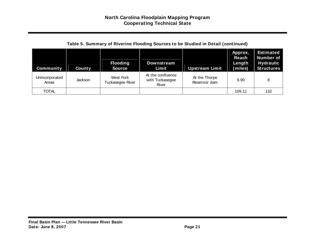
Table 5 summarizes the riverine flooding sources and reach descriptions within the Little Tennessee River Basin that will be studied using detailed methods. The estimated number of hydraulic structures is an approximation of the number of culverts, bridges, dams, and weirs along the reach to be studied in detail. These estimates were made based on the number of major road crossings using CGIA data and from the flood profiles in the current FIS report. Attachments 2A through 2D depict the specific reaches to be studied in detail.
Final Basin Plan — Little Tennessee River Basin Date: June 8, 2007 Page 17
North Carolina Floodplain Mapping Program Cooperating Technical State
Table 5. Summary of Riverine Flooding Sources to be Studied in Detail
Approx. Reach
Estimated Number of
Community County Flooding Source
Downstream Limit Upstream Limit
Length (miles)
Hydraulic Structures
Unincorporated Areas Macon Cartoogechaye
Creek
At the confluence with Little Tennessee
River
Approximately 1,150 feet upstream of US64 (Murphy Road)
12.40 16
Unincorporated Areas; Town of
Robbinsville Graham Cheoah River At the confluence
with Mountain Creek
At the confluence with Tulula Creek and Sweetwater Creek
1.40 1
Unincorporated Areas; Town of
Forest Hills Jackson Cox Creek At the confluence
with Cullowhee Creek
Approximately 0.5 mile upstream of SR 1507 (South County Club
Drive)
0.60 4
Unincorporated At the confluence At the confluence with Areas; Town of Macon Crawford Branch with Little Tennessee Crawford Branch Trib 2.40 13
Franklin River 2
Unincorporated Areas; Town of
Franklin Macon Cullasaja River
At the confluence with Little Tennessee
River
Approximately 275 feet downstream of SR
1679 (Peeks Creek Road)
10.00 8
Unincorporated Areas Jackson Cullowhee Creek At the confluence
with Long Branch
At the confluence with Cullowhee Creek Trib
2 1.10 4
Unincorporated At the confluence Approximately 325 Areas; City of Swain Deep Creek with Tuckasegee feet downstream of 2.00 3 Bryson City River East Deep Creek Road
Final Basin Plan — Little Tennessee River Basin Date: June 8, 2007 Page 18

North Carolina Floodplain Mapping Program Cooperating Technical State
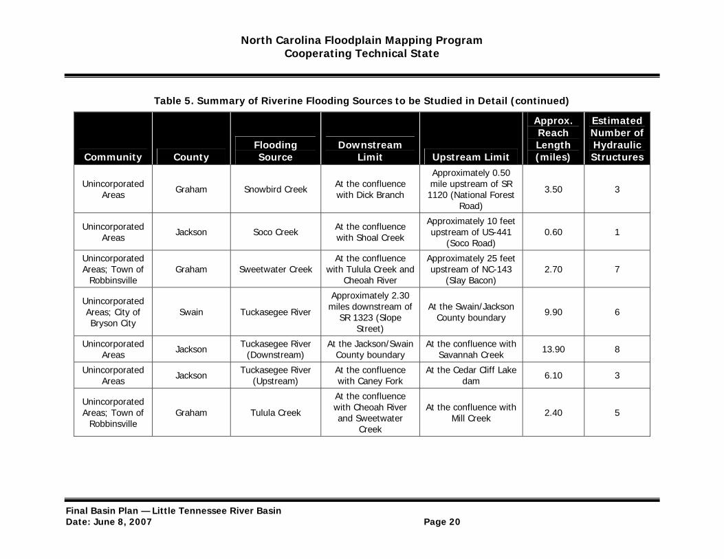
Table 5. Summary of Riverine Flooding Sources to be Studied in Detail (continued)
Approx. Reach
Estimated Number of
Community County Flooding Source
Downstream Limit Upstream Limit
Length (miles)
Hydraulic Structures
Unincorporated Areas; Town of
Franklin Macon Little Tennessee
River At the confluence with Cowee Creek
At the confluence with Middle Creek 22.80 11
Town of Franklin Macon Little Tennessee River Trib 12
At the confluence with Little Tennessee
River
Approximately 1,725 feet upstream of Ulco
Drive 0.80 4
Unincorporated Areas; Town of
Robbinsville Graham Long Creek At the confluence
with Cheoah River
Approximately 300 feet upstream of SR 1113 (Charlie Rogers
Road)
1.40 4
Town of Highlands Macon Mill Creek
Approximately 20 feet downstream of US-64
(Carolina Way)
At the confluence with Satulah Branch 0.50 3
Town of Highlands Macon Satulah Branch At the confluence
with Mill Creek At the confluence with Satulah Branch Trib 1 0.40 2
Unincorporated Areas; City of
Dillsboro Jackson Scott Creek
(Downstream)
At the confluence with Tuckasegee
River
At US Highway 23 and US Highway 441 0.11 1
Approximately 615 Unincorporated
Areas Jackson Scott Creek (Upstream)
feet downstream of SR 1445 (Bumgarner
At the confluence with North Fork Scott Creek 4.20 17
Road)
Final Basin Plan — Little Tennessee River Basin Date: June 8, 2007 Page 19
North Carolina Floodplain Mapping Program Cooperating Technical State
Table 5. Summary of Riverine Flooding Sources to be Studied in Detail (continued)
Approx. Reach
Estimated Number of
Community County Flooding Source
Downstream Limit Upstream Limit
Length (miles)
Hydraulic Structures
Approximately 0.50 Unincorporated
Areas Graham Snowbird Creek At the confluence with Dick Branch
mile upstream of SR 1120 (National Forest 3.50 3
Road)
Unincorporated Areas Jackson Soco Creek At the confluence
with Shoal Creek
Approximately 10 feet upstream of US-441
(Soco Road) 0.60 1
Unincorporated At the confluence Approximately 25 feet Areas; Town of Graham Sweetwater Creek with Tulula Creek and upstream of NC-143 2.70 7
Robbinsville Cheoah River (Slay Bacon)
Unincorporated Areas; City of Bryson City
Swain Tuckasegee River
Approximately 2.30 miles downstream of
SR 1323 (Slope Street)
At the Swain/Jackson County boundary 9.90 6
Unincorporated Areas Jackson Tuckasegee River
(Downstream) At the Jackson/Swain
County boundary At the confluence with
Savannah Creek 13.90 8
Unincorporated Areas Jackson Tuckasegee River
(Upstream) At the confluence with Caney Fork
At the Cedar Cliff Lake dam 6.10 3
Unincorporated Areas; Town of
Robbinsville Graham Tulula Creek
At the confluence with Cheoah River and Sweetwater
Creek
At the confluence with Mill Creek 2.40 5
Final Basin Plan — Little Tennessee River Basin Date: June 8, 2007 Page 20
North Carolina Floodplain Mapping Program Cooperating Technical State
Table 5. Summary of Riverine Flooding Sources to be Studied in Detail (continued)
Approx. Reach
Estimated Number of
Community County Flooding Source
Downstream Limit Upstream Limit
Length (miles)
Hydraulic Structures
Unincorporated Areas Jackson West Fork
Tuckasegee River
At the confluence with Tuckasegee
River
At the Thorpe Reservoir dam 9.90 8
TOTAL 109.11 132
Final Basin Plan — Little Tennessee River Basin Date: June 8, 2007 Page 21
North Carolina Floodplain Mapping Program Cooperating Technical State
2. Redelineation
This method involves no new analyses; rather, the effective FIS and FIRM data will be fitted to the updated base map using the new LIDAR-derived topographic data. Floodways and cross section locations are digitized from the effective FIRMs and Flood Boundary and Floodway Map. Flood profiles and base flood elevations are converted from NGVD 29 to NAVD 88.
Areas where this technique is used will be designated as Zone AE on the updated DFIRMs. This technique is useful for riverine and lacustrine flooding sources where the effective FIS engineering analyses are adequate but the topographic data used to delineate the floodplain boundaries is not sufficiently detailed or up-to-date.
The redelineation method will be used for all flooding sources within the Little Tennessee River Basin that are currently studied in detail on current FIRMs and that are not being restudied in detail as part of this Basin Plan. Appendix D depicts the specific reaches to be redelineated.
3. Limited Detailed Study
This method entails using the TINs being produced as part of the North Carolina Floodplain Mapping Program, without adding field-surveyed bathymetric or bridge/culvert opening geometric data, to conduct hydrologic and hydraulic analyses. In addition, this method does not include field surveys that determine specifics on channel and floodplain characteristics. However, bridge and culvert opening data from North Carolina Department of Transportation maintenance records is incorporated into the hydraulic analysis models. Limited detailed study will result in the delineation of the 1% annual chance floodplain boundaries and base flood elevations. These will be designated as Zone AE on the newly generated DFIRMs. Limited detailed study will also determine widths of the non-encroachment area at all studied cross sections. The non-encroachment widths given at modeled cross sections can be used by communities to enforce floodplain management ordinances that meet the requirement defined in 44 CFR 60.3(c)(10). This information will be provided in the Flood Insurance Study report to facilitate local floodplain management.
The limited detailed study is a “buildable” product with a supporting engineering model that can be upgraded to full detailed study at a later date by adding field-surveyed river or stream channel and bridge/culvert opening geometric data.
All flooding sources currently designated as Zone A on the effective FIRMs that are not being studied by detailed study methods will be reanalyzed using either the limited detailed study method or the use of effective information method explained below. In most cases, currently unmapped areas identified by communities as being a priority will be studied by the limited detailed study method unless they are otherwise being studied
Final Basin Plan — Little Tennessee River Basin Date: June 8, 2007 Page 22
North Carolina Floodplain Mapping Program Cooperating Technical State
by detailed methods. Attachments 2A through 2D depict the specific reaches to be studied using limited detailed methods.
Additionally, limited detailed study will be considered for unmapped flooding sources, with an emphasis on those in developed areas with a drainage area larger than 1-square mile. However, some floodprone areas with lesser drainage areas may also be mapped based on known hazards, level of development, and community-identified needs.
Appendix E summarizes the flooding sources and descriptions within the Little Tennessee Basin that will be studied using limited detailed methods.
4. Use of Effective Information
The study type "use of effective information" has been scoped for small effective Zone A areas that are likely backwater “fingers” that will be replaced with the backwater from the new or limited detailed study already scoped for the main stem. NCFMP will evaluate these reaches on a case-by-case basis after the main stem is studied to determine if the backwater replaces the effective Zone A “fingers” or if the tributary should be studied by limited detailed study. If the area is completely covered by backwater, NCFMP will not develop a "limited detailed" model for the reach. If the Zone A area extends beyond backwater and the contributing upstream drainage area is greater than 1-square mile in rural areas or 1/2-square mile in urban areas, NCFMP will study the reach using "limited detailed" methods. If the contributing drainage area is less than the urban and rural criteria, NCFMP will digitize the effective Zone A floodplain and map as a shaded Zone X.
Several areas within the Little Tennessee River Basin, totaling 92.84 stream miles, have been identified during scoping to be studied as Use of Effective Information.
Table 6 summarizes the estimated number of linear miles for each method to be applied in the Little Tennessee River Basin. Attachments 2A through 2D depict the technical methods to be applied to each flooding source within the Little Tennessee River Basin.
Table 6. Summary of Technical Methods for the Little Tennessee River Basin
Technical Method Estimated Linear
Miles
Detailed Study—Riverine 109.11
Redelineation 47.37
Limited Detailed Study 490.13
Use of Effective Information 92.84
Total 739.45
Final Basin Plan — Little Tennessee River Basin Date: June 8, 2007 Page 23
North Carolina Floodplain Mapping Program Cooperating Technical State
The Little Tennessee River Basin Study, which will include completion of the DEMs and preparation of updated flood hazard data, is scheduled to be completed by September 2008.
Variations from Community-Identified Needs and Priorities
In some instances, it was necessary to deviate from the needs and technical methods identified by a county or community in developing this Final Basin Plan. The State used a quantitative ranking system to address all community needs identified for detailed study based on several factors. These factors included:
• The age of the effective FIRM analyses (studies based on older analyses receive a higher ranking)
• Likely flood mapping impacts (the greater the anticipated change to the floodelevation and/or floodplain boundary, the higher the ranking)
• Level of development (areas of more dense existing or anticipated development receive a higher ranking, or conversely for flooding sources situated within public lands such as a National Forest, where the potential for development is severely limited will receive a lower ranking).
• Historical flood information (if gage data, high-water marks, inundation mapping, or community experience indicate a mapping problem, the higher the ranking)
• Mismatches with contiguous communities (significant mismatches in flood elevations and/or floodplain boundaries between adjacent communities receive a higher ranking)
• Whether any mitigation planning has been developed or is in the process of being developed (if so, the community receives a higher ranking)
Appendix F summarizes the areas where the flood data development described above as part of this Final Basin Plan differs from the community-identified needs and priorities.
Digital FIRMs
Using the base maps and flood hazard data described above, DFIRMs will be produced in seamless statewide format, including the unincorporated areas of each county in the Little Tennessee River Basin and their incorporated communities on one set of DFIRM panels. The DFIRMs will depict flood hazard and related data (floodplain and floodway boundaries, base flood elevations, cross sections, and flood insurance zone designations) and non-engineering reference features (road names and locations, stream and river centerlines, shorelines, corporate boundaries, airports, schools, and bench marks).
Because some of the land area of these counties within the Little Tennessee River Basin are at least partially located in adjacent river basins (Hiwassee and Savannah), completion of the final effective statewide DFIRMs will be dependent on completion of the basin studies for the adjacent basins. However, when the Little Tennessee River
Final Basin Plan — Little Tennessee River Basin Date: June 8, 2007 Page 24
North Carolina Floodplain Mapping Program Cooperating Technical State
Basin Study is completed, statewide preliminary DFIRMs will be issued for the portions of counties and communities within the Little Tennessee River Basin. (The community review and due process phases are discussed in more detail in Section V of this Final Basin Plan.)
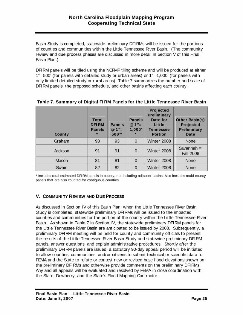
DFIRM panels will be tiled using the NCFMP tiling scheme and will be produced at either 1”=500’ (for panels with detailed study or urban areas) or 1”=1,000’ (for panels with only limited detailed study or rural areas). Table 7 summarizes the number and scale of DFIRM panels, the proposed schedule, and other basins affecting each county.
Table 7. Summary of Digital FIRM Panels for the Little Tennessee River Basin
County
Total DFIRM Panels
*
Panels @ 1”= 500’*
Panels @ 1”= 1,000’
*
Projected Preliminary
Date for Little
Tennessee Portion
Other Basin(s) Projected
Preliminary Date
Graham 93 93 0 Winter 2008 None
Jackson 91 91 0 Winter 2008 Savannah = Fall 2008
Macon 81 81 0 Winter 2008 None
Swain 82 82 0 Winter 2008 None
*Includes total estimated DFIRM panels in county, not including adjacent basins. Also includes multi-county panels that are also counted for contiguous counties.
V. COMMUNITY REVIEW AND DUE PROCESS
As discussed in Section IV of this Basin Plan, when the Little Tennessee River Basin Study is completed, statewide preliminary DFIRMs will be issued to the impacted counties and communities for the portion of the county within the Little Tennessee River Basin. As shown in Table 7 in Section IV, the statewide preliminary DFIRM panels for the Little Tennessee River Basin are anticipated to be issued by 2008. Subsequently, a preliminary DFIRM meeting will be held for county and community officials to present the results of the Little Tennessee River Basin Study and statewide preliminary DFIRM panels, answer questions, and explain administrative procedures. Shortly after the preliminary DFIRM panels are issued, a statutory 90-day appeal period will be initiated to allow counties, communities, and/or citizens to submit technical or scientific data to FEMA and the State to refute or contest new or revised base flood elevations shown on the preliminary DFIRMs and otherwise provide comments on the preliminary DFIRMs. Any and all appeals will be evaluated and resolved by FEMA in close coordination with the State, Dewberry, and the State’s Flood Mapping Contractor.
Final Basin Plan — Little Tennessee River Basin Date: June 8, 2007 Page 25

North Carolina Floodplain Mapping Program Cooperating Technical State
As the other basin studies impacting a county are completed, statewide preliminary DFIRM panels will be issued for the remaining portion(s) of the county. A preliminary DFIRM meeting will be held for those basins and the statutory 90-day appeal period will be provided and all appeals will be evaluated and resolved.
After issuing preliminary DFIRM panels for all areas of a county and evaluating and resolving all appeals and community comments, the statewide preliminary DFIRM panels will be finalized. FEMA’s Map Service Center will print and distribute the official DFIRMs to be used for flood insurance rating purposes. Additionally, the State will post the final statewide DFIRMs on its Floodplain Mapping Information System for distribution and access to communities and the public via the Internet.
During the community review and due process phase, many counties and communities will need to update their floodplain management ordinances; the communities will be given a 6-month period to adopt the updated DFIRMs and incorporate the DFIRMs into their ordinances before the new DFIRMs become effective. The NCEM Floodplain Management Branch and FEMA will coordinate this effort with the counties and communities that need to update their ordinances.
Final Basin Plan — Little Tennessee River Basin Date: June 8, 2007 Page 26

North Carolina Floodplain Mapping Program Cooperating Technical State
APPENDIX A ATTENDANCE SHEETS FROM INITIAL SCOPING MEETINGS
Eastern Band of Cherokee Indians – November 8, 2005
Name Title/Agency Phone
Jason Webb Eastern Band of Cherokee Indians (828) 357-1842
Steve Garrett Community Development Planner/ NCFMP
(919) 715-5711 x 118 [email protected]
Charity Peterson GIS Specialist/NCFMP (919) 715-5711 x 113 [email protected]
Tom Cadwallader Engineer/NCFMP (919) 715-5711 x 109
Randy Mundt Community Development Planner/NCFMP
(919) 715-5711 x 119 [email protected]
Katie Hess Hazard Mapping Analyst/Dewberry (703) 849-0510
Fred Knight Hazard Mapping Analyst/Dewberry (703) 849-0305
David Lentzner NFIP Planner/NCEM (919) 715-8000 ext. 351 [email protected]
Danny Gee NCEM/Area 15 Coordinator (828) 687-7125 [email protected]
Graham County and Communities – November 9, 2005
Name Title/Agency Phone
(828) 479-7967 Emergency Management Director, Terry Slaughter Graham County [email protected] (919) 715-5711 x 118Community Development Planner/ Steve Garrett NCFMP [email protected]
Final Basin Plan — Little Tennessee River Basin Date: June 8, 2007 Page A-1

North Carolina Floodplain Mapping Program Cooperating Technical State
APPENDIX A ATTENDANCE SHEETS FROM INITIAL SCOPING MEETINGS
Graham County and Communities – November 9, 2005 (continued)
Name Title/Agency Phone
Charity Peterson GIS Specialist/NCFMP (919) 715-5711 x 113 [email protected]
Tom Cadwallader Engineer/NCFMP (919) 715-5711 x 109
Randy Mundt Community Development Planner/NCFMP
(919) 715-5711 x 119 [email protected]
Katie Hess Hazard Mapping Analyst/Dewberry (703) 849-0510
Fred Knight Hazard Mapping Analyst/Dewberry (703) 849-0305
David Lentzner NFIP Planner/NCEM (919) 715-8000 ext. 351 [email protected]
Jackson County and Communities – November 9, 2005
Name Title/Agency Phone
John Wittekind Flood Plain Manager, Building Inspection Division, Jackson
County
(828) 586-7560 [email protected]
Michael Ensley Emergency Management Coordinator, Jackson County
(828) 586-7508 [email protected]
Ken Westmoreland Jackson County Manager (828) 631-2295
Linda Cable Planning/Jackson County (828) 631-2255
Bobby McMahan Tax Administrator/GIS/Jackson County
(828) 586-7572 [email protected]
Final Basin Plan — Little Tennessee River Basin Date: June 8, 2007 Page A-2
North Carolina Floodplain Mapping Program Cooperating Technical State
APPENDIX A ATTENDANCE SHEETS FROM INITIAL SCOPING MEETINGS
Jackson County and Communities – November 9, 2005 (continued)
Name Title/Agency Phone
Jay Denton Town Manager/Town of Sylva (828) 586-2719
Jim Aust Planner/Zoning Administrator/Town of Sylva
(828) 586-2719 [email protected]
Steve Garrett Community Development Planner/ NCFMP
(919) 715-5711 x 118 [email protected]
Charity Peterson GIS Specialist/NCFMP (919) 715-5711 x 113 [email protected]
Tom Cadwallader Engineer/NCFMP (919) 715-5711 x 109
Randy Mundt Community Development Planner/NCFMP
(919) 715-5711 x 119 [email protected]
Katie Hess Hazard Mapping Analyst/Dewberry (703) 849-0510
Fred Knight Hazard Mapping Analyst/Dewberry (703) 849-0305
David Lentzner NFIP Planner/NCEM (919) 715-8000 ext. 351 [email protected]
Macon County and Communities – November 10, 2005
Name Title/Agency Phone
David Key Emergency Management/Macon County
(828) 349-2067 [email protected]
Josh Pope GIS Analyst/Macon County (828) 349-2190
Jim Gulisano GIS Administrator/Macon County (828) 349-2219
Andy Muncey Network Administrator/Macon County
(828) 349-2177 [email protected]
Final Basin Plan — Little Tennessee River Basin Date: June 8, 2007 Page A-3
North Carolina Floodplain Mapping Program Cooperating Technical State
APPENDIX A ATTENDANCE SHEETS FROM INITIAL SCOPING MEETINGS
Macon County and Communities – November 10, 2005 (continued)
Name Title/Agency Phone
Art Provencher Mapping/Macon County (828) 349-2102
Jack Morgan Codes Administrator/Macon County (828) 349-2170
Stacy J. Guffey Planner/Macon County (828) 349-2212
Rebecca Crawford Planner/Town of Franklin (828) 524-2516
Mike Decker Town Administrator/Town of Franklin
(828) 524-2516 [email protected]
Matt Shuler GIS Field Technician/Town of Highland
(828) 526-2118 [email protected]
Steve Garrett Community Development Planner/ NCFMP
(919) 715-5711 x 118 [email protected]
Charity Peterson GIS Specialist/NCFMP (919) 715-5711 x 113 [email protected]
Tom Cadwallader Engineer/NCFMP (919) 715-5711 x 109
Randy Mundt Community Development Planner/NCFMP
(919) 715-5711 x 119 [email protected]
Katie Hess Hazard Mapping Analyst/Dewberry (703) 849-0510
Fred Knight Hazard Mapping Analyst/Dewberry (703) 849-0305
David Lentzner NFIP Planner/NCEM (919) 715-8000 ext. 351 [email protected]
Tammra Cetin Finance Office/Bryson City (828) 488-3335
Final Basin Plan — Little Tennessee River Basin Date: June 8, 2007 Page A-4
North Carolina Floodplain Mapping Program Cooperating Technical State
APPENDIX A ATTENDANCE SHEETS FROM INITIAL SCOPING MEETINGS
Swain County and Communities – November 9, 2005
Name Title/Agency Phone
Mark Lyons Network Administrator/Swain County
(828) 488-9273 [email protected]
Ervin Winchester Building Inspection, Swain County (828) 488-9134
Ruth Ann Sitton Mapping/Tax/GIS/ Swain County (828) 488-9273
David Breedlove Emergency Management Director/Swain County
(828) 488-6021 [email protected]
Peggy Hyde Tax Administrator/Swain County (828) 488-9273
Steve Garrett Community Development Planner/ NCFMP
(919) 715-5711 x 118 [email protected]
Charity Peterson GIS Specialist/NCFMP (919) 715-5711 x 113 [email protected]
Tom Cadwallader Engineer/NCFMP (919) 715-5711 x 109
Randy Mundt Community Development Planner/NCFMP
(919) 715-5711 x 119 [email protected]
Katie Hess Hazard Mapping Analyst/Dewberry (703) 849-0510
Fred Knight Hazard Mapping Analyst/Dewberry (703) 849-0305
David Lentzner NFIP Planner/NCEM (919) 715-8000 ext. 351 [email protected]
Final Basin Plan — Little Tennessee River Basin Date: June 8, 2007 Page A-5

North Carolina Floodplain Mapping Program Cooperating Technical State
Appendix B SUMMARIES OF COMMUNITY-IDENTIFIED FLOOD MAPPING NEEDS
The tables on the following pages provide summaries of flood mapping needs that have been identified by the counties and/or communities.
GRAHAM and Incorporated Areas—Community-Identified Mapping Needs Identifier Flooding Source Community Type of Study Priority Ranking Effective Zone
A Cheoah River Graham County Detailed Study – Riverine High 1 A
B Cooloska Branch Graham County Limited Detailed Study High 8 X
C Cooloska Branch Trib 2 Graham County Limited Detailed Study High 8 X
D Cooloska Branch Trib 2.2 Graham County Limited Detailed Study High 8 X
E Gladdens Creek Graham County Limited Detailed Study High 7 X F Juts Creek Graham County Limited Detailed Study High 6 A
G Long Creek Graham County Detailed Study – Riverine High 5 A
H Snowbird Creek Graham County Detailed Study – Riverine High 4 X
I Sweetwater Creek Graham County Detailed Study – Riverine High 3 A
J Tulula Creek Graham County Detailed Study – Riverine High 2 A
Final Basin Plan — Little Tennessee River Basin Date: June 8, 2007 Page B-1

North Carolina Floodplain Mapping Program Cooperating Technical State
Appendix B SUMMARIES OF COMMUNITY-IDENTIFIED FLOOD MAPPING NEEDS
GRAHAM and Incorporated Areas—Community-Identified Mapping Needs (continued) Identifier Flooding Source Community Type of Study Priority Ranking Effective Zone
K Long Creek Robbinsville, Town Of Detailed Study – Riverine High 5 A
L Tulula Creek Robbinsville, Town Of Detailed Study – Riverine High 2 A
JACKSON and Incorporated Areas—Community-Identified Mapping Needs Identifier Flooding Source Community Type of Study Priority Ranking Effective Zone A Big Witch Creek Jackson County Limited Detailed Study High 1 X
B Blackrock Creek Jackson County Limited Detailed Study High 6 X
C Brushy Fork Jackson County Limited Detailed Study Medium 5 A
D Bumgarner Branch Jackson County Limited Detailed Study High 9 X E Caney Fork Jackson County Limited Detailed Study High 5 A
F Caney Fork Jackson County Limited Detailed Study High 5 X
G Cope Creek Jackson County Limited Detailed Study Medium 5 A
H Cope Creek Jackson County Limited Detailed Study Medium 5 X
I Cox Creek Jackson County Detailed Study- Riverine High 8 X
J Cullowhee Creek Jackson County Detailed Study – Riverine High 7 AE with Floodway
K Cullowhee Creek Jackson County Detailed Study – Riverine High 7 A
Final Basin Plan — Little Tennessee River Basin Date: June 8, 2007 Page B-2
North Carolina Floodplain Mapping Program Cooperating Technical State
Appendix B SUMMARIES OF COMMUNITY-IDENTIFIED FLOOD MAPPING NEEDS
JACKSON and Incorporated Areas—Community-Identified Mapping Needs (continued) Identifier Flooding Source Community Type of Study Priority Ranking Effective Zone L Dills Branch Jackson County Limited Detailed Study Medium 5 X
M Dills Creek Jackson County Limited Detailed Study Medium 5 X
N Fisher Creek Jackson County Limited Detailed Study Medium 5 A O Fisher Creek Jackson County Limited Detailed Study Medium 5 X
P Flat Creek Jackson County Limited Detailed Study Medium 5 A
Q Greenland Creek Jackson County Limited Detailed Study Medium 5 A
R Hornbuckle Creek Jackson County Limited Detailed Study High 5 X S Hurricane Creek Jackson County Limited Detailed Study Medium 5 A
T Kitchen Branch Jackson County Limited Detailed Study Medium 5 X
U Locust Creek Jackson County Limited Detailed Study High 9 A
V Mill Creek Jackson County Limited Detailed Study High 7 A
W Monteith Branch Jackson County Limited Detailed Study Medium 5 X
X Oconoluftee River Jackson County and Swain County Redelineation Medium 5 AE with Floodway
Y Savannah Creek Jackson County Limited Detailed Study High 8 A
Z Scott Creek Jackson County Detailed Study - Riverine High 5 A
AA Scott Creek Jackson County; Dillsboro, City Of; Sylva, Town Of
Redelineation High 5 AE with Floodway
AB Scott Creek Jackson County Limited Detailed Study High 5 A
Final Basin Plan — Little Tennessee River Basin Date: June 8, 2007 Page B-3
North Carolina Floodplain Mapping Program Cooperating Technical State
Appendix B SUMMARIES OF COMMUNITY-IDENTIFIED FLOOD MAPPING NEEDS
JACKSON and Incorporated Areas—Community-Identified Mapping Needs (continued) Identifier Flooding Source Community Type of Study Priority Ranking Effective Zone AC Scott Creek Jackson County Limited Detailed Study High 5 X
AD Soco Creek Jackson County Detailed Study Medium 5 AE with Floodway
AE Sugar Fork Jackson County Limited Detailed Study Medium 5 A AF Tanasee Creek Jackson County Limited Detailed Study Medium 5 A
AG Tuckasegee River Jackson County Detailed Study - Riverine High 1 A
AH Tuckasegee River Jackson County Redelineation Medium 5 AE with Floodway
AI Tuckasegee River Jackson County Detailed Study - Riverine High 2 A
AJ Tuckasegee River Trib 13 Jackson County Limited Detailed Study Medium 5 A
AK Tuckasegee River Trib 13.1 Jackson County Limited Detailed Study Medium 5 A
AL West Fork Tuckasegee River Jackson County Detailed Study -
Riverine High 3 A
AM Wolf Creek Jackson County Limited Detailed Study Medium 5 A
AN Wrights Creek Jackson County Limited Detailed Study High 1 X
AO Bumgarner Branch Sylva, Town Of Limited Detailed Study High 9 X
AP Cope Creek Sylva, Town Of Limited Detailed Study Medium 5 A AQ Dills Branch Sylva, Town Of Limited Detailed Study Medium 5 X
AR Mill Creek Sylva, Town Of Limited Detailed Study High 7 A
Final Basin Plan — Little Tennessee River Basin Date: June 8, 2007 Page B-4

North Carolina Floodplain Mapping Program Cooperating Technical State
Appendix B MACON and Incorporated Areas—Community-Identified Mapping Needs
Identifier Flooding Source Community Type of Study Priority Ranking Effective Zone
A Crawford Branch Franklin, Town Of Detailed Study - Riverine Medium 5 X
B Cullasaja River Franklin, Town Of Detailed Study - Riverine High 2 A1-A99
C Little Tennessee River Franklin, Town Of Detailed Study - Riverine High 1 A1-A99
D Little Tennessee River Trib 12 Franklin, Town Of Detailed Study -
Riverine Medium 5 X
E Little Tennessee River Trib 13 Franklin, Town Of Limited Detailed Study Medium 5 X
F Allens Branch Macon County Limited Detailed Study Medium 5 X G Beasley Creek Macon County Limited Detailed Study Medium 5 X
H Big Creek Macon County Limited Detailed Study Medium 5 X
I Burningtown Creek Macon County Limited Detailed Study High 6 A
J Caler Fork Macon County Limited Detailed Study Medium High 3 X
K Cartoogechaye Creek Macon County Detailed Study - Riverine High 3 A
L Cat Creek Macon County Limited Detailed Study High 10 X
M Coon Creek Macon County Limited Detailed Study Medium 5 X
N Cowee Creek Macon County Limited Detailed Study High 6 A O Cowee Creek Macon County Limited Detailed Study High 6 X
Final Basin Plan — Little Tennessee River Basin Date: June 8, 2007 Page B-5
North Carolina Floodplain Mapping Program Cooperating Technical State
Appendix B SUMMARIES OF COMMUNITY-IDENTIFIED FLOOD MAPPING NEEDS
MACON and Incorporated Areas—Community-Identified Mapping Needs (continued) Identifier Flooding Source Community Type of Study Priority Ranking Effective Zone
P Cullasaja River Macon County Detailed Study - Riverine High 2 A
Q Cullasaja River Macon County Limited Detailed Study Medium 5 X
R Little Tennessee River Macon County Detailed Study - Riverine High 1 A
S Little Tennessee River Macon County Detailed Study - Riverine High 4 A
T Lowery Creek Macon County Limited Detailed Study Medium High 1 X
U Matlock Creek Macon County Limited Detailed Study Medium High 4 X
V Mill Creek Macon County Limited Detailed Study Medium 5 X
W Otter Creek Macon County Limited Detailed Study Medium 5 X
X Rabbit Creek Macon County Limited Detailed Study High 9 X Y Satulah Branch Town of Highlands Detailed Study Medium 5 X
Z Skeenah Creek Macon County Limited Detailed Study High 5 A
AA Watauga Creek Macon County Limited Detailed Study High 8 A
AB Watauga Creek Macon County Limited Detailed Study High 8 X
AC Whiteoak Creek Macon County Limited Detailed Study Medium High 2 X
Final Basin Plan — Little Tennessee River Basin Date: June 8, 2007 Page B-6

North Carolina Floodplain Mapping Program Cooperating Technical State
Appendix B SUMMARIES OF COMMUNITY-IDENTIFIED FLOOD MAPPING NEEDS
SWAIN and Incorporated Areas—Community-Identified Mapping Needs Identifier Flooding Source Community Type of Study Priority Ranking Effective Zone
A Deep Creek Bryson City, City Of and Swain County
Detailed Study – Riverine High 2 AE with
Floodway
B Jenkins Branch Bryson City, City Of Limited Detailed Study High 9 X
C Toot Hollow Branch Bryson City, City Of Limited Detailed Study High 4 X
D Tuckasegee River Bryson City, City Of Detailed Study – Riverine High 1 AE with
Floodway
E Adams Creek Swain County Limited Detailed Study High 4 X F Alarka Creek Swain County Limited Detailed Study High 6 A
G Alarka Creek Swain County Limited Detailed Study High 6 X
H Bunches Creek Swain County Limited Detailed Study High 3 X
I Connelly Creek Swain County Limited Detailed Study High 5 X
J Cooper Creek Swain County Limited Detailed Study Medium High 1 X
K Goose Creek Swain County Limited Detailed Study High 7 X
L Kirkland Creek Swain County; Bryson City, City of Limited Detailed Study High 10 X
M Nantahala River Swain County Detailed Study – Riverine High 3 A
N Pigeon Creek Swain County Limited Detailed Study High 9 X O Shepherd Creek Swain County Limited Detailed Study High 10 X
Final Basin Plan — Little Tennessee River Basin Date: June 8, 2007 Page B-7
North Carolina Floodplain Mapping Program Cooperating Technical State
Appendix B SUMMARIES OF COMMUNITY-IDENTIFIED FLOOD MAPPING NEEDS
SWAIN and Incorporated Areas—Community-Identified Mapping Needs (continued) Identifier Flooding Source Community Type of Study Priority Ranking Effective Zone P Silvermine Creek Swain County Limited Detailed Study High 7 X
Q Toot Hollow Branch Swain County Limited Detailed Study High 4 X
R Tuckasegee River Swain County Detailed Study - Riverine High 1 AE with Floodway
S Tuckasegee River Swain County Detailed Study - Riverine High 1 AE with Floodway
T Tuckasegee River Swain County Detailed Study - Riverine High 1 A
U Wesser Creek (into Nantahala River) Swain County Limited Detailed Study High 8 X
V Wesser Creek (into Connelly Creek) Swain County Limited Detailed Study Medium
High 3 X
Final Basin Plan — Little Tennessee River Basin Date: June 8, 2007 Page B-8
North Carolina Floodplain Mapping Program Cooperating Technical State
Appendix C Attendance Sheet(s) from Final Scoping Meeting
Final Scoping Meeting Attendance sheets are not available for the Little Tennessee River Basin. Jurisdictions were contacted by letter and phone calls to confirm community acceptance of scope.
Final Basin Plan — Little Tennessee River Basin Date: June 8, 2007 Page C-1
North Carolina Floodplain Mapping Program Cooperating Technical State
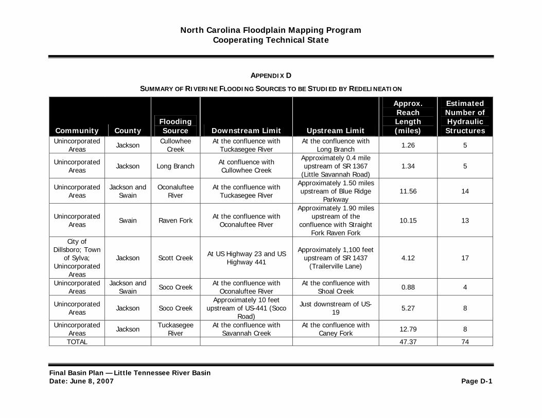
APPENDIX D
SUMMARY OF RIVERINE FLOODING SOURCES TO BE STUDIED BY REDELINEATION
Approx. Reach
Estimated Number of
Community County Flooding Source Downstream Limit Upstream Limit
Length (miles)
Hydraulic Structures
Unincorporated Areas Jackson Cullowhee
Creek At the confluence with
Tuckasegee River At the confluence with
Long Branch 1.26 5
Unincorporated Areas Jackson Long Branch At confluence with
Cullowhee Creek
Approximately 0.4 mile upstream of SR 1367
(Little Savannah Road) 1.34 5
Unincorporated Areas
Jackson and Swain
Oconaluftee River
At the confluence with Tuckasegee River
Approximately 1.50 miles upstream of Blue Ridge
Parkway 11.56 14
Approximately 1.90 miles Unincorporated
Areas Swain Raven Fork At the confluence with Oconaluftee River
upstream of the confluence with Straight 10.15 13
Fork Raven Fork City of
Dillsboro; Town of Sylva;
Unincorporated Jackson Scott Creek At US Highway 23 and US
Highway 441
Approximately 1,100 feet upstream of SR 1437
(Trailerville Lane) 4.12 17
Areas Unincorporated
Areas Jackson and
Swain Soco Creek At the confluence with Oconaluftee River
At the confluence with Shoal Creek 0.88 4
Unincorporated Areas Jackson Soco Creek
Approximately 10 feet upstream of US-441 (Soco
Road)
Just downstream of US19 5.27 8
Unincorporated Areas Jackson Tuckasegee
River At the confluence with
Savannah Creek At the confluence with
Caney Fork 12.79 8
TOTAL 47.37 74
Final Basin Plan — Little Tennessee River Basin Date: June 8, 2007 Page D-1
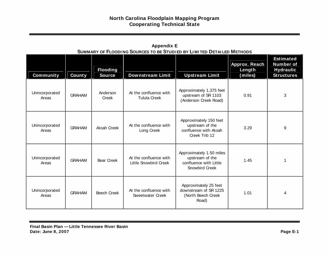
North Carolina Floodplain Mapping Program Cooperating Technical State
Appendix E SUMMARY OF FLOODING SOURCES TO BE STUDIED BY LIMITED DETAILED METHODS
Estimated
Community County Flooding Source Downstream Limit Upstream Limit
Approx. Reach Length (miles)
Number of Hydraulic Structures
Unincorporated Areas GRAHAM Anderson
Creek At the confluence with
Tulula Creek
Approximately 1,375 feet upstream of SR 1103
(Anderson Creek Road) 0.91 3
Approximately 150 feet Unincorporated
Areas GRAHAM Atoah Creek At the confluence with Long Creek
upstream of the confluence with Atoah 3.29 9
Creek Trib 12
Approximately 1.50 miles Unincorporated
Areas GRAHAM Bear Creek At the confluence with Little Snowbird Creek
upstream of the confluence with Little 1.45 1
Snowbird Creek
Approximately 25 feet Unincorporated
Areas GRAHAM Beech Creek At the confluence with Sweetwater Creek
downstream of SR 1225 (North Beech Creek 1.01 4
Road)
Final Basin Plan — Little Tennessee River Basin Date: June 8, 2007 Page E-1
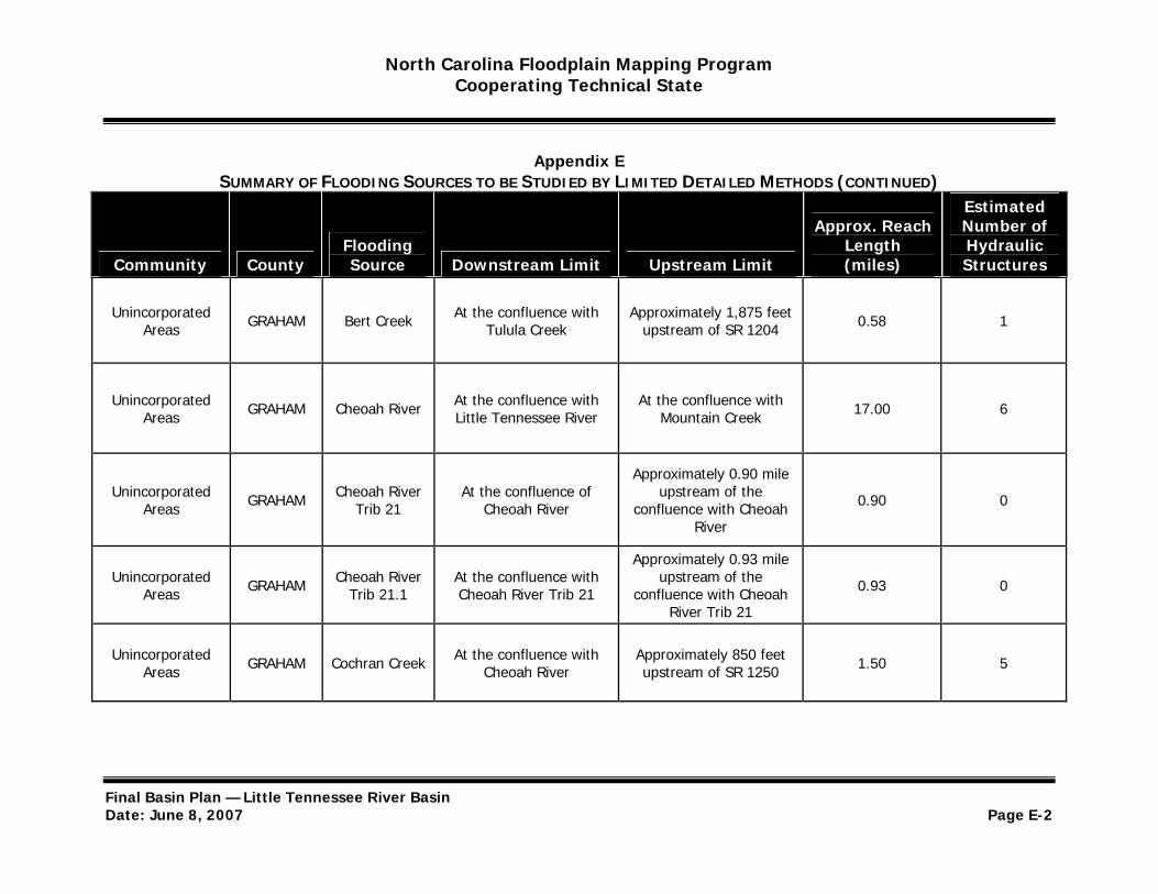
North Carolina Floodplain Mapping Program Cooperating Technical State
Appendix E SUMMARY OF FLOODING SOURCES TO BE STUDIED BY LIMITED DETAILED METHODS (CONTINUED)
Estimated
Community County Flooding Source Downstream Limit Upstream Limit
Approx. Reach Length (miles)
Number of Hydraulic Structures
Unincorporated Areas GRAHAM Bert Creek At the confluence with
Tulula Creek Approximately 1,875 feet
upstream of SR 1204 0.58 1
Unincorporated Areas GRAHAM Cheoah River At the confluence with
Little Tennessee River At the confluence with
Mountain Creek 17.00 6
Approximately 0.90 mile Unincorporated
Areas GRAHAM Cheoah River Trib 21
At the confluence of Cheoah River
upstream of the confluence with Cheoah 0.90 0
River
Approximately 0.93 mile Unincorporated
Areas GRAHAM Cheoah River Trib 21.1
At the confluence with Cheoah River Trib 21
upstream of the confluence with Cheoah 0.93 0
River Trib 21
Unincorporated Areas GRAHAM Cochran Creek At the confluence with
Cheoah River Approximately 850 feet upstream of SR 1250 1.50 5
Final Basin Plan — Little Tennessee River Basin Date: June 8, 2007 Page E-2

North Carolina Floodplain Mapping Program Cooperating Technical State
Appendix E SUMMARY OF FLOODING SOURCES TO BE STUDIED BY LIMITED DETAILED METHODS (CONTINUED)
Estimated
Community County Flooding Source Downstream Limit Upstream Limit
Approx. Reach Length (miles)
Number of Hydraulic Structures
Unincorporated Areas GRAHAM Cooloska
Branch At the confluence with
Snowbird Creek At the confluence with Cooloska Branch Trib 2 0.35 1
Approximately 0.14 mile Unincorporated
Areas GRAHAM Cooloska Branch Trib 2
At the confluence with Cooloska Branch
upstream of the confluence with Cooloska 0.14 0
Branch
Unincorporated Areas GRAHAM
Cooloska Branch Trib
2.2
At the confluence with Cooloska Branch Trib 2
At the confluence with Cooloska Branch Tribs
2.2.1 and 2.2.2 0.06 0
Unincorporated Areas GRAHAM Dry Creek At the confluence with
Stecoah Creek
Approximately 0.90 mile upstream of SR 1229
(Dry Creek Road) 1.36 2
Final Basin Plan — Little Tennessee River Basin Date: June 8, 2007 Page E-3

North Carolina Floodplain Mapping Program Cooperating Technical State
Appendix E SUMMARY OF FLOODING SOURCES TO BE STUDIED BY LIMITED DETAILED METHODS (CONTINUED)
Estimated
Community County Flooding Source Downstream Limit Upstream Limit
Approx. Reach Length (miles)
Number of Hydraulic Structures
Unincorporated Areas GRAHAM East Buffalo
Creek At the confluence with
Cheoah River
Approximately 0.70 mile upstream of SR 1254 (East Buffalo Road)
3.92 8
Approximately 0.51 mile Unincorporated
Areas GRAHAM Eller Mill Creek At the confluence with Little Snowbird Creek
upstream of the confluence with Little 0.51 1
Snowbird Creek
Unincorporated Areas GRAHAM Franks Creek At the confluence with
Tulula Creek
Approximately 425 feet upstream of SR 1207 (Franks Creek Road)
2.19 5
Unincorporated Areas GRAHAM Gladdens
Creek At the confluence with
Cheoah River At the confluence with Gladdens Creek Trib 3 0.89 3
Final Basin Plan — Little Tennessee River Basin Date: June 8, 2007 Page E-4
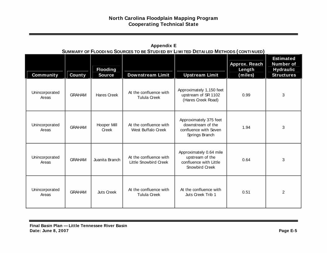
North Carolina Floodplain Mapping Program Cooperating Technical State
Appendix E SUMMARY OF FLOODING SOURCES TO BE STUDIED BY LIMITED DETAILED METHODS (CONTINUED)
Estimated
Community County Flooding Source Downstream Limit Upstream Limit
Approx. Reach Length (miles)
Number of Hydraulic Structures
Unincorporated Areas GRAHAM Hares Creek At the confluence with
Tulula Creek
Approximately 1,150 feet upstream of SR 1102 (Hares Creek Road)
0.99 3
Approximately 375 feet Unincorporated
Areas GRAHAM Hooper Mill Creek
At the confluence with West Buffalo Creek
downstream of the confluence with Seven 1.94 3
Springs Branch
Approximately 0.64 mile Unincorporated
Areas GRAHAM Juanita Branch At the confluence with Little Snowbird Creek
upstream of the confluence with Little 0.64 3
Snowbird Creek
Unincorporated Areas GRAHAM Juts Creek At the confluence with
Tulula Creek At the confluence with
Juts Creek Trib 1 0.51 2
Final Basin Plan — Little Tennessee River Basin Date: June 8, 2007 Page E-5
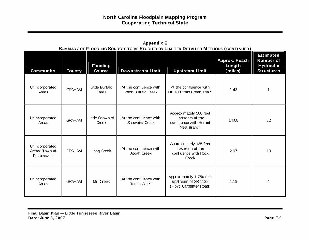
North Carolina Floodplain Mapping Program Cooperating Technical State
Appendix E SUMMARY OF FLOODING SOURCES TO BE STUDIED BY LIMITED DETAILED METHODS (CONTINUED)
Estimated
Community County Flooding Source Downstream Limit Upstream Limit
Approx. Reach Length (miles)
Number of Hydraulic Structures
Unincorporated Areas GRAHAM Little Buffalo
Creek At the confluence with
West Buffalo Creek At the confluence with
Little Buffalo Creek Trib 5 1.43 1
Approximately 500 feet Unincorporated
Areas GRAHAM Little Snowbird Creek
At the confluence with Snowbird Creek
upstream of the confluence with Hornet 14.05 22
Nest Branch
Unincorporated Areas; Town of
Robbinsville GRAHAM Long Creek At the confluence with
Atoah Creek
Approximately 135 feet upstream of the
confluence with Rock Creek
2.97 10
Unincorporated Areas GRAHAM Mill Creek At the confluence with
Tulula Creek
Approximately 1,750 feet upstream of SR 1132
(Floyd Carpenter Road) 1.19 4
Final Basin Plan — Little Tennessee River Basin Date: June 8, 2007 Page E-6
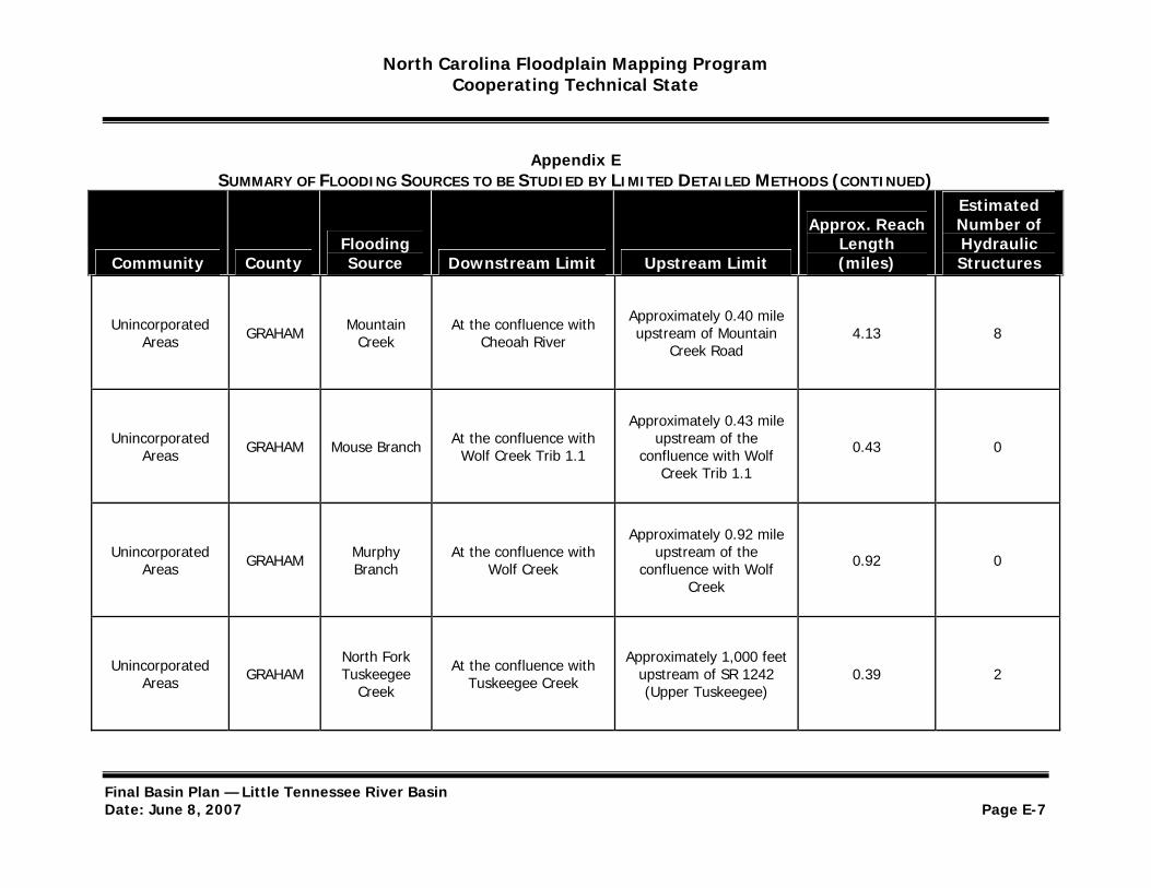
North Carolina Floodplain Mapping Program Cooperating Technical State
Appendix E SUMMARY OF FLOODING SOURCES TO BE STUDIED BY LIMITED DETAILED METHODS (CONTINUED)
Estimated
Community County Flooding Source Downstream Limit Upstream Limit
Approx. Reach Length (miles)
Number of Hydraulic Structures
Unincorporated Areas GRAHAM Mountain
Creek At the confluence with
Cheoah River
Approximately 0.40 mile upstream of Mountain
Creek Road 4.13 8
Approximately 0.43 mile Unincorporated
Areas GRAHAM Mouse Branch At the confluence with Wolf Creek Trib 1.1
upstream of the confluence with Wolf 0.43 0
Creek Trib 1.1
Approximately 0.92 mile Unincorporated
Areas GRAHAM Murphy Branch
At the confluence with Wolf Creek
upstream of the confluence with Wolf 0.92 0
Creek
Unincorporated Areas GRAHAM
North Fork Tuskeegee
Creek
At the confluence with Tuskeegee Creek
Approximately 1,000 feet upstream of SR 1242 (Upper Tuskeegee)
0.39 2
Final Basin Plan — Little Tennessee River Basin Date: June 8, 2007 Page E-7
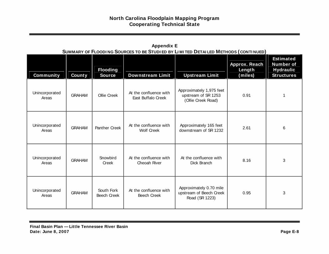
North Carolina Floodplain Mapping Program Cooperating Technical State
Appendix E SUMMARY OF FLOODING SOURCES TO BE STUDIED BY LIMITED DETAILED METHODS (CONTINUED)
Estimated
Community County Flooding Source Downstream Limit Upstream Limit
Approx. Reach Length (miles)
Number of Hydraulic Structures
Unincorporated Areas GRAHAM Ollie Creek At the confluence with
East Buffalo Creek
Approximately 1,975 feet upstream of SR 1253 (Ollie Creek Road)
0.91 1
Unincorporated Areas GRAHAM Panther Creek At the confluence with
Wolf Creek Approximately 165 feet downstream of SR 1232 2.61 6
Unincorporated Areas GRAHAM Snowbird
Creek At the confluence with
Cheoah River At the confluence with
Dick Branch 8.16 3
Unincorporated Areas GRAHAM South Fork
Beech Creek At the confluence with
Beech Creek
Approximately 0.70 mile upstream of Beech Creek
Road (SR 1223) 0.95 3
Final Basin Plan — Little Tennessee River Basin Date: June 8, 2007 Page E-8
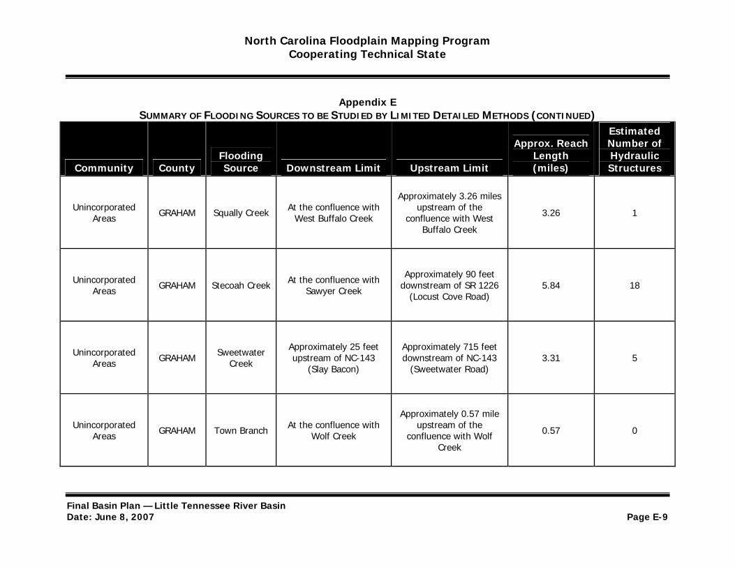
North Carolina Floodplain Mapping Program Cooperating Technical State
Appendix E SUMMARY OF FLOODING SOURCES TO BE STUDIED BY LIMITED DETAILED METHODS (CONTINUED)
Estimated
Community County Flooding Source Downstream Limit Upstream Limit
Approx. Reach Length (miles)
Number of Hydraulic Structures
Unincorporated Areas GRAHAM Squally Creek At the confluence with
West Buffalo Creek
Approximately 3.26 miles upstream of the
confluence with West Buffalo Creek
3.26 1
Unincorporated Areas GRAHAM Stecoah Creek At the confluence with
Sawyer Creek
Approximately 90 feet downstream of SR 1226
(Locust Cove Road) 5.84 18
Unincorporated Areas GRAHAM Sweetwater
Creek
Approximately 25 feet upstream of NC-143
(Slay Bacon)
Approximately 715 feet downstream of NC-143
(Sweetwater Road) 3.31 5
Approximately 0.57 mile Unincorporated
Areas GRAHAM Town Branch At the confluence with Wolf Creek
upstream of the confluence with Wolf 0.57 0
Creek
Final Basin Plan — Little Tennessee River Basin Date: June 8, 2007 Page E-9

North Carolina Floodplain Mapping Program Cooperating Technical State
Appendix E SUMMARY OF FLOODING SOURCES TO BE STUDIED BY LIMITED DETAILED METHODS (CONTINUED)
Estimated
Community County Flooding Source Downstream Limit Upstream Limit
Approx. Reach Length (miles)
Number of Hydraulic Structures
Approximately 0.40 mile Unincorporated
Areas GRAHAM Town Branch Trib 1
At the confluence with Town Branch
upstream of the confluence with Town 0.40 0
Branch
Unincorporated Areas GRAHAM Tulula Creek At the confluence with
Mill Creek
Approximately 450 feet upstream of US-129
(Tallulah Road) 5.44 18
Unincorporated Areas GRAHAM Tuskeegee
Creek At the confluence with Little Tennessee River
At the confluence with North Fork and South Fork Tuskeegee Creek
5.20 9
Unincorporated Areas GRAHAM West Buffalo
Creek At the confluence with
Cheoah River
Approximately 0.4 mile upstream of West Buffalo
Road 8.57 14
Final Basin Plan — Little Tennessee River Basin Date: June 8, 2007 Page E-10
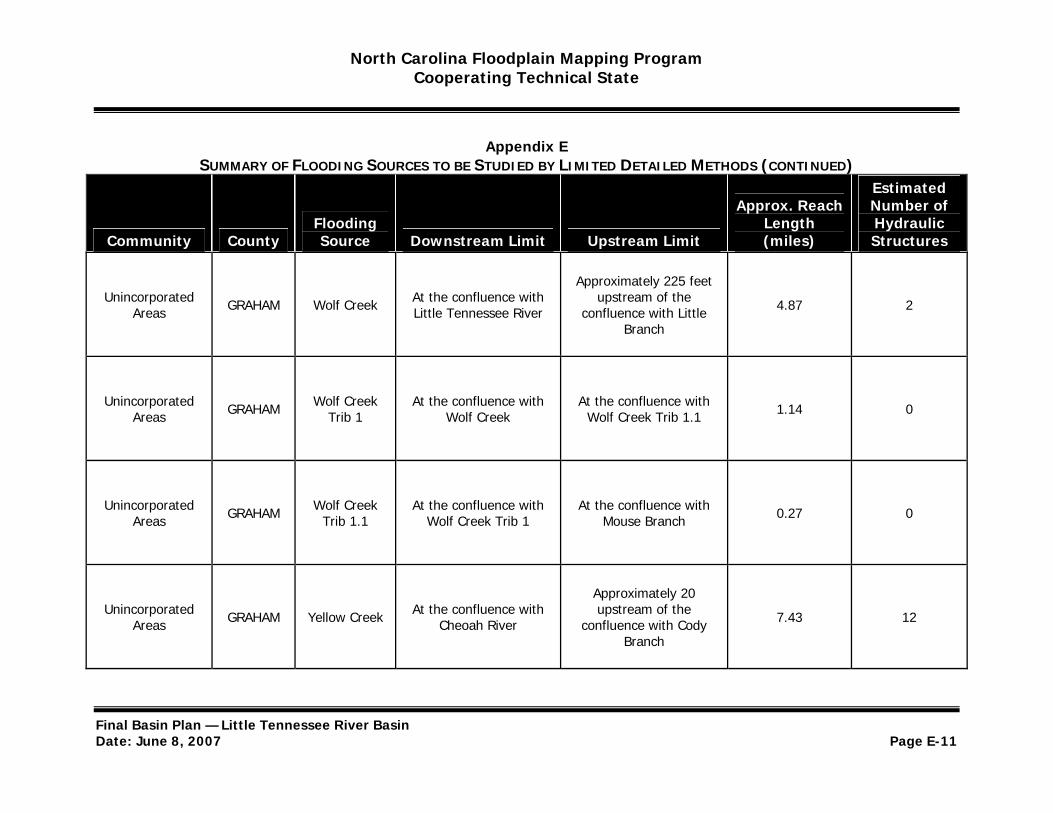
North Carolina Floodplain Mapping Program Cooperating Technical State
Appendix E SUMMARY OF FLOODING SOURCES TO BE STUDIED BY LIMITED DETAILED METHODS (CONTINUED)
Estimated
Community County Flooding Source Downstream Limit Upstream Limit
Approx. Reach Length (miles)
Number of Hydraulic Structures
Approximately 225 feet Unincorporated
Areas GRAHAM Wolf Creek At the confluence with Little Tennessee River
upstream of the confluence with Little 4.87 2
Branch
Unincorporated Areas GRAHAM Wolf Creek
Trib 1 At the confluence with
Wolf Creek At the confluence with
Wolf Creek Trib 1.1 1.14 0
Unincorporated Areas GRAHAM Wolf Creek
Trib 1.1 At the confluence with
Wolf Creek Trib 1 At the confluence with
Mouse Branch 0.27 0
Approximately 20 Unincorporated
Areas GRAHAM Yellow Creek At the confluence with Cheoah River
upstream of the confluence with Cody 7.43 12
Branch
Final Basin Plan — Little Tennessee River Basin Date: June 8, 2007 Page E-11
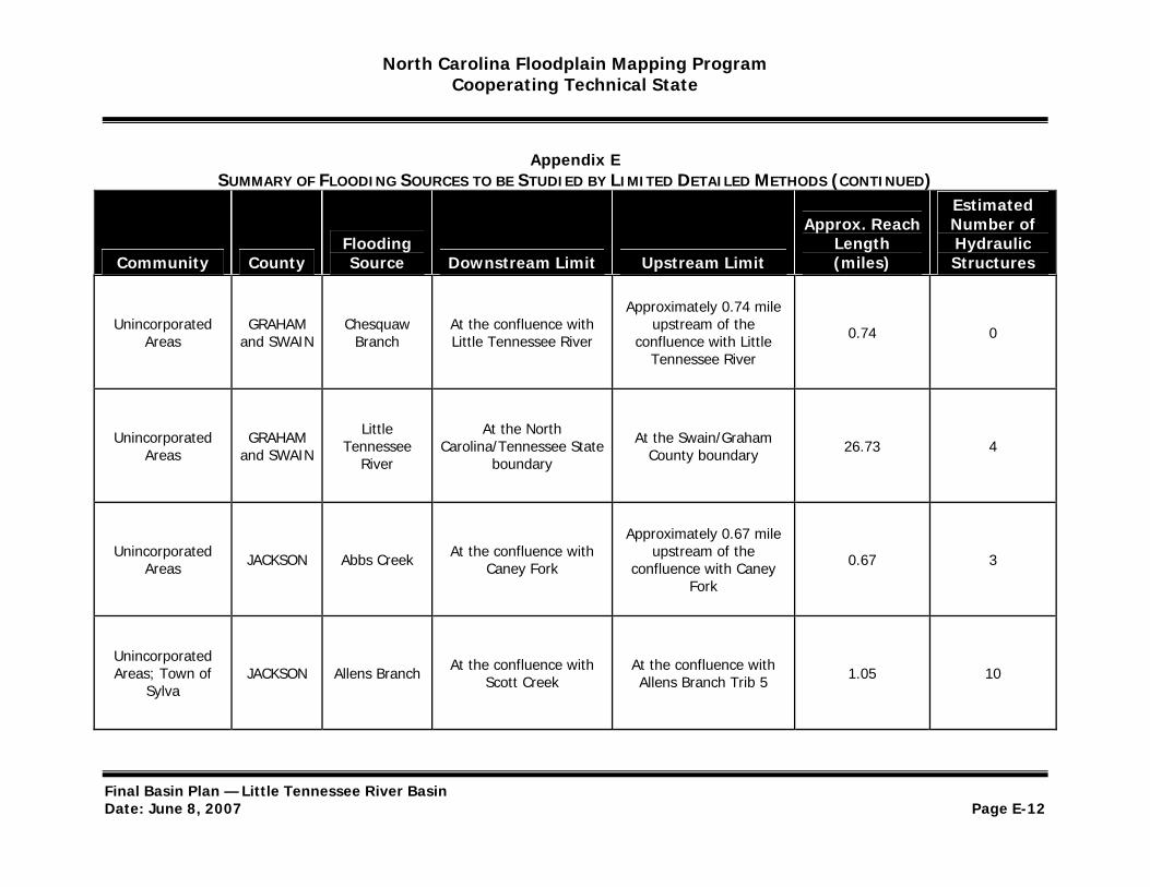
North Carolina Floodplain Mapping Program Cooperating Technical State
Appendix E SUMMARY OF FLOODING SOURCES TO BE STUDIED BY LIMITED DETAILED METHODS (CONTINUED)
Estimated
Community County Flooding Source Downstream Limit Upstream Limit
Approx. Reach Length (miles)
Number of Hydraulic Structures
Approximately 0.74 mile Unincorporated
Areas GRAHAM
and SWAIN Chesquaw
Branch At the confluence with Little Tennessee River
upstream of the confluence with Little 0.74 0
Tennessee River
Unincorporated Areas
GRAHAM and SWAIN
Little Tennessee
River
At the North Carolina/Tennessee State
boundary
At the Swain/Graham County boundary 26.73 4
Approximately 0.67 mile Unincorporated
Areas JACKSON Abbs Creek At the confluence with Caney Fork
upstream of the confluence with Caney 0.67 3
Fork
Unincorporated Areas; Town of
Sylva JACKSON Allens Branch At the confluence with
Scott Creek At the confluence with Allens Branch Trib 5 1.05 10
Final Basin Plan — Little Tennessee River Basin Date: June 8, 2007 Page E-12

North Carolina Floodplain Mapping Program Cooperating Technical State
Appendix E SUMMARY OF FLOODING SOURCES TO BE STUDIED BY LIMITED DETAILED METHODS (CONTINUED)
Estimated
Community County Flooding Source Downstream Limit Upstream Limit
Approx. Reach Length (miles)
Number of Hydraulic Structures
Unincorporated Areas JACKSON Barkers Creek At the confluence with
Tuckasegee River
Just downstream of the confluence with East Fork
Barkers Creek 1.16 3
Approximately 1.50 miles Unincorporated
Areas JACKSON Big Witch Creek
At the confluence with Wrights Creek
upstream of the confluence with Wrights 1.50 3
Creek
Approximately 1.18 miles Unincorporated
Areas JACKSON Blackrock Creek
At the confluence with Soco Creek
upstream of the confluence with Soco 1.18 1
Creek
Unincorporated Areas JACKSON Blanton
Branch At the confluence with
Scott Creek
Approximately 1.20 miles upstream of SR 1788 (Hidden Valley Road)
1.53 10
Final Basin Plan — Little Tennessee River Basin Date: June 8, 2007 Page E-13

North Carolina Floodplain Mapping Program Cooperating Technical State
Appendix E SUMMARY OF FLOODING SOURCES TO BE STUDIED BY LIMITED DETAILED METHODS (CONTINUED)
Estimated
Community County Flooding Source Downstream Limit Upstream Limit
Approx. Reach Length (miles)
Number of Hydraulic Structures
Unincorporated Areas JACKSON Buff Creek At the confluence with
Scott Creek
Approximately 0.69 mile upsteam of SR 1432 (Old
19-23) 0.69 5
Unincorporated Areas; Town of
Sylva JACKSON Bumgarner
Branch At the confluence with
Mill Creek Approximately 0.50 mile
upstream of NC-107 0.56 2
Unincorporated Areas JACKSON Camp Creek At the confluence with
Tuckasegee River
Approximately 350 feet upstream of SR 1408
Firefly Road) 2.50 13
Unincorporated Areas JACKSON Caney Fork At the confluence with
Tuckasegee River
Approximately 1.20 miles upstream of SR 1746 (Sugar Creek Road)
12.22 27
Final Basin Plan — Little Tennessee River Basin Date: June 8, 2007 Page E-14
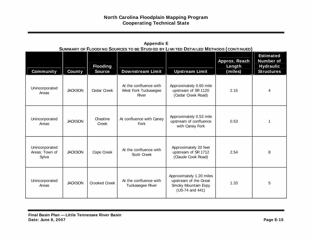
North Carolina Floodplain Mapping Program Cooperating Technical State
Appendix E SUMMARY OF FLOODING SOURCES TO BE STUDIED BY LIMITED DETAILED METHODS (CONTINUED)
Estimated
Community County Flooding Source Downstream Limit Upstream Limit
Approx. Reach Length (miles)
Number of Hydraulic Structures
Unincorporated Areas JACKSON Cedar Creek
At the confluence with West Fork Tuckasegee
River
Approximately 0.60 mile upstream of SR 1120 (Cedar Creek Road)
2.15 4
Unincorporated Areas JACKSON Chastine
Creek At confluence with Caney
Fork
Approximately 0.53 mile upstream of confluence
with Caney Fork 0.53 1
Unincorporated Areas; Town of
Sylva JACKSON Cope Creek At the confluence with
Scott Creek
Approximately 20 feet upstream of SR 1712 (Claude Cook Road)
2.54 8
Approximately 1.20 miles Unincorporated
Areas JACKSON Crooked Creek At the confluence with Tuckasegee River
upstream of the Great Smoky Mountain Expy 1.33 5
(US-74 and 441)
Final Basin Plan — Little Tennessee River Basin Date: June 8, 2007 Page E-15

North Carolina Floodplain Mapping Program Cooperating Technical State
Appendix E SUMMARY OF FLOODING SOURCES TO BE STUDIED BY LIMITED DETAILED METHODS (CONTINUED)
Estimated
Community County Flooding Source Downstream Limit Upstream Limit
Approx. Reach Length (miles)
Number of Hydraulic Structures
Unincorporated Areas JACKSON Cullowhee
Creek At the confluence with Cullowhee Creek Trib 2
Approximately 0.50 mile upstream of Ramp Cove
Road 4.01 13
Approximately 0.54 mile Unincorporated
Areas JACKSON Dark Ridge Creek
At the confluence with Scott Creek
upstream of the confluence with Scott 0.54 1
Creek
Unincorporated Areas JACKSON Dicks Creek At confluence with
Tuckasegee River
Approximately 650 feet upstream of SR 1388 (Dicks Creek Road)
1.95 9
Unincorporated Areas; Town of
Sylva JACKSON Dills Branch At the confluence with
Scotts Creek Approximately 10 feet upstream of SR 1380 1.45 7
Final Basin Plan — Little Tennessee River Basin Date: June 8, 2007 Page E-16
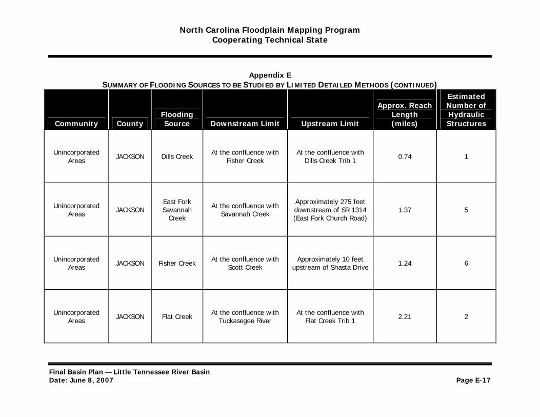
North Carolina Floodplain Mapping Program Cooperating Technical State
Appendix E SUMMARY OF FLOODING SOURCES TO BE STUDIED BY LIMITED DETAILED METHODS (CONTINUED)
Estimated
Community County Flooding Source Downstream Limit Upstream Limit
Approx. Reach Length (miles)
Number of Hydraulic Structures
Unincorporated Areas JACKSON Dills Creek At the confluence with
Fisher Creek At the confluence with
Dills Creek Trib 1 0.74 1
Unincorporated Areas JACKSON
East Fork Savannah
Creek
At the confluence with Savannah Creek
Approximately 275 feet downstream of SR 1314 (East Fork Church Road)
1.37 5
Unincorporated Areas JACKSON Fisher Creek At the confluence with
Scott Creek Approximately 10 feet
upstream of Shasta Drive 1.24 6
Unincorporated Areas JACKSON Flat Creek At the confluence with
Tuckasegee River At the confluence with
Flat Creek Trib 1 2.21 2
Final Basin Plan — Little Tennessee River Basin Date: June 8, 2007 Page E-17

North Carolina Floodplain Mapping Program Cooperating Technical State
Appendix E SUMMARY OF FLOODING SOURCES TO BE STUDIED BY LIMITED DETAILED METHODS (CONTINUED)
Estimated
Community County Flooding Source Downstream Limit Upstream Limit
Approx. Reach Length (miles)
Number of Hydraulic Structures
Approximately 1.27 miles Unincorporated
Areas JACKSON Gladie Creek At the confluence with Tuckasegee River
upstream of the confluence with 1.27 1
Tuckasegee River
Unincorporated Areas JACKSON Grassy Camp
Creek At the confluence with
Norton Creek
Approximately 950 feet upstream of SR 1143
(Norton Road) 1.52 3
Approximately 1.09 miles Unincorporated
Areas JACKSON Greenland Creek
At the confluence with Tuckasegee River
upstream of the confluence with 1.09 1
Tuckasegee River
Unincorporated Areas JACKSON Greens Creek At the confluence with
Savannah Creek
Approximately 1,050 feet upstream of SR 1370 (Sugar Fork Road)
2.50 7
Final Basin Plan — Little Tennessee River Basin Date: June 8, 2007 Page E-18
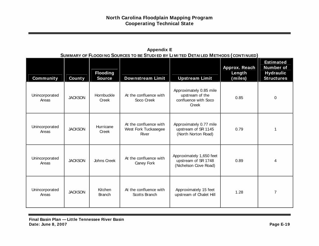
North Carolina Floodplain Mapping Program Cooperating Technical State
Appendix E SUMMARY OF FLOODING SOURCES TO BE STUDIED BY LIMITED DETAILED METHODS (CONTINUED)
Estimated
Community County Flooding Source Downstream Limit Upstream Limit
Approx. Reach Length (miles)
Number of Hydraulic Structures
Approximately 0.85 mile Unincorporated
Areas JACKSON Hornbuckle Creek
At the confluence with Soco Creek
upstream of the confluence with Soco 0.85 0
Creek
Unincorporated Areas JACKSON Hurricane
Creek
At the confluence with West Fork Tuckasegee
River
Approximately 0.77 mile upstream of SR 1145 (North Norton Road)
0.79 1
Unincorporated Areas JACKSON Johns Creek At the confluence with
Caney Fork
Approximately 1,650 feet upstream of SR 1748
(Nichelson Cove Road) 0.89 4
Unincorporated Areas JACKSON Kitchen
Branch At the confluence with
Scotts Branch Approximately 15 feet upstream of Chalet Hill 1.28 7
Final Basin Plan — Little Tennessee River Basin Date: June 8, 2007 Page E-19

North Carolina Floodplain Mapping Program Cooperating Technical State
Appendix E SUMMARY OF FLOODING SOURCES TO BE STUDIED BY LIMITED DETAILED METHODS (CONTINUED)
Estimated
Community County Flooding Source Downstream Limit Upstream Limit
Approx. Reach Length (miles)
Number of Hydraulic Structures
Unincorporated Areas JACKSON Knob Creek At the confluence with
Norton Creek
Approximately 30 feet downstream of Yellow
Mountain Road 1.59 3
Approximately 0.47 mile Unincorporated
Areas JACKSON Laurel Branch At the confluence with Tuckasegee River
upstream of the confluence with 0.47 1
Tuckasegee River
Unincorporated Areas JACKSON Little Pine
Creek At the confluence with
Pine Creek
Approximately 20 feet upstream of SR 1160
(Salt Rock Road) 1.08 3
Unincorporated Areas JACKSON
Little Savannah
Creek
At the confluence with Savannah Creek
Approximately 650 feet upstream of SR 1367
(Little Savannah Road) 1.58 5
Final Basin Plan — Little Tennessee River Basin Date: June 8, 2007 Page E-20
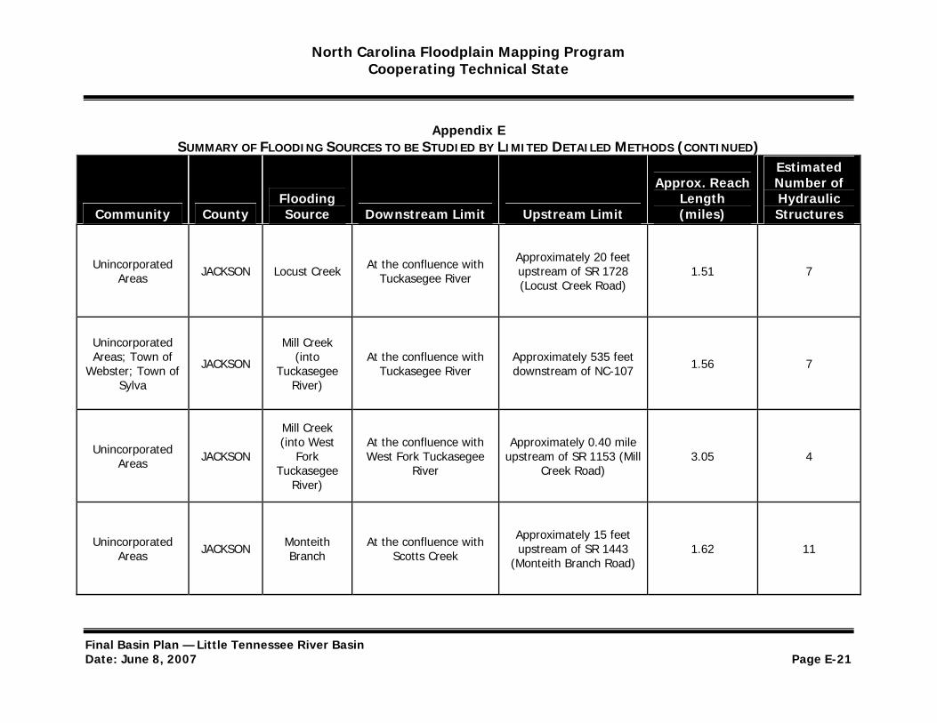
North Carolina Floodplain Mapping Program Cooperating Technical State
Appendix E SUMMARY OF FLOODING SOURCES TO BE STUDIED BY LIMITED DETAILED METHODS (CONTINUED)
Estimated
Community County Flooding Source Downstream Limit Upstream Limit
Approx. Reach Length (miles)
Number of Hydraulic Structures
Unincorporated Areas JACKSON Locust Creek At the confluence with
Tuckasegee River
Approximately 20 feet upstream of SR 1728 (Locust Creek Road)
1.51 7
Unincorporated Mill Creek Areas; Town of
Webster; Town of JACKSON (into Tuckasegee
At the confluence with Tuckasegee River
Approximately 535 feet downstream of NC-107 1.56 7
Sylva River)
Mill Creek
Unincorporated Areas JACKSON
(into West Fork
Tuckasegee
At the confluence with West Fork Tuckasegee
River
Approximately 0.40 mile upstream of SR 1153 (Mill
Creek Road) 3.05 4
River)
Unincorporated Areas JACKSON Monteith
Branch At the confluence with
Scotts Creek
Approximately 15 feet upstream of SR 1443
(Monteith Branch Road) 1.62 11
Final Basin Plan — Little Tennessee River Basin Date: June 8, 2007 Page E-21
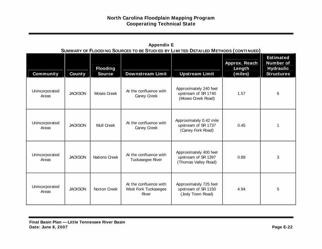
North Carolina Floodplain Mapping Program Cooperating Technical State
Appendix E SUMMARY OF FLOODING SOURCES TO BE STUDIED BY LIMITED DETAILED METHODS (CONTINUED)
Estimated
Community County Flooding Source Downstream Limit Upstream Limit
Approx. Reach Length (miles)
Number of Hydraulic Structures
Unincorporated Areas JACKSON Moses Creek At the confluence with
Caney Creek
Approximately 240 feet upstream of SR 1740 (Moses Creek Road)
1.57 6
Unincorporated Areas JACKSON Mull Creek At the confluence with
Caney Creek
Approximately 0.42 mile upstream of SR 1737 (Caney Fork Road)
0.45 1
Unincorporated Areas JACKSON Nations Creek At the confluence with
Tuckasegee River
Approximately 400 feet upstream of SR 1397 (Thomas Valley Road)
0.89 3
Unincorporated Areas JACKSON Norton Creek
At the confluence with West Fork Tuckasegee
River
Approximately 725 feet upstream of SR 1150 (Jody Town Road)
4.94 5
Final Basin Plan — Little Tennessee River Basin Date: June 8, 2007 Page E-22
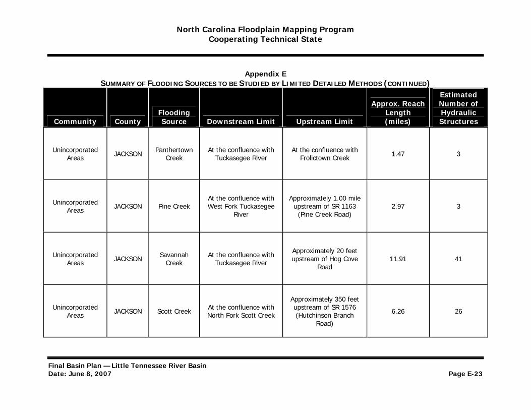
North Carolina Floodplain Mapping Program Cooperating Technical State
Appendix E SUMMARY OF FLOODING SOURCES TO BE STUDIED BY LIMITED DETAILED METHODS (CONTINUED)
Estimated
Community County Flooding Source Downstream Limit Upstream Limit
Approx. Reach Length (miles)
Number of Hydraulic Structures
Unincorporated Areas JACKSON Panthertown
Creek At the confluence with
Tuckasegee River At the confluence with
Frolictown Creek 1.47 3
Unincorporated Areas JACKSON Pine Creek
At the confluence with West Fork Tuckasegee
River
Approximately 1.00 mile upstream of SR 1163
(Pine Creek Road) 2.97 3
Unincorporated Areas JACKSON Savannah
Creek At the confluence with
Tuckasegee River
Approximately 20 feet upstream of Hog Cove
Road 11.91 41
Approximately 350 feet Unincorporated
Areas JACKSON Scott Creek At the confluence with North Fork Scott Creek
upstream of SR 1576 (Hutchinson Branch 6.26 26
Road)
Final Basin Plan — Little Tennessee River Basin Date: June 8, 2007 Page E-23
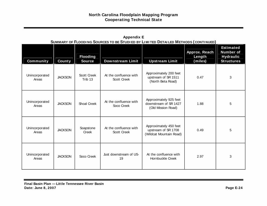
North Carolina Floodplain Mapping Program Cooperating Technical State
Appendix E SUMMARY OF FLOODING SOURCES TO BE STUDIED BY LIMITED DETAILED METHODS (CONTINUED)
Estimated
Community County Flooding Source Downstream Limit Upstream Limit
Approx. Reach Length (miles)
Number of Hydraulic Structures
Unincorporated Areas JACKSON Scott Creek
Trib 13 At the confluence with
Scott Creek
Approximately 200 feet upstream of SR 1511 (North Beta Road)
0.47 3
Unincorporated Areas JACKSON Shoal Creek At the confluence with
Soco Creek
Approximately 925 feet downstream of SR 1427
(Old Mission Road) 1.88 5
Unincorporated Areas JACKSON Soapstone
Creek At the confluence with
Scott Creek
Approximately 450 feet upstream of SR 1708
(Wildcat Mountain Road) 0.49 5
Unincorporated Areas JACKSON Soco Creek Just downstream of US
19 At the confluence with
Hornbuckle Creek 2.97 3
Final Basin Plan — Little Tennessee River Basin Date: June 8, 2007 Page E-24
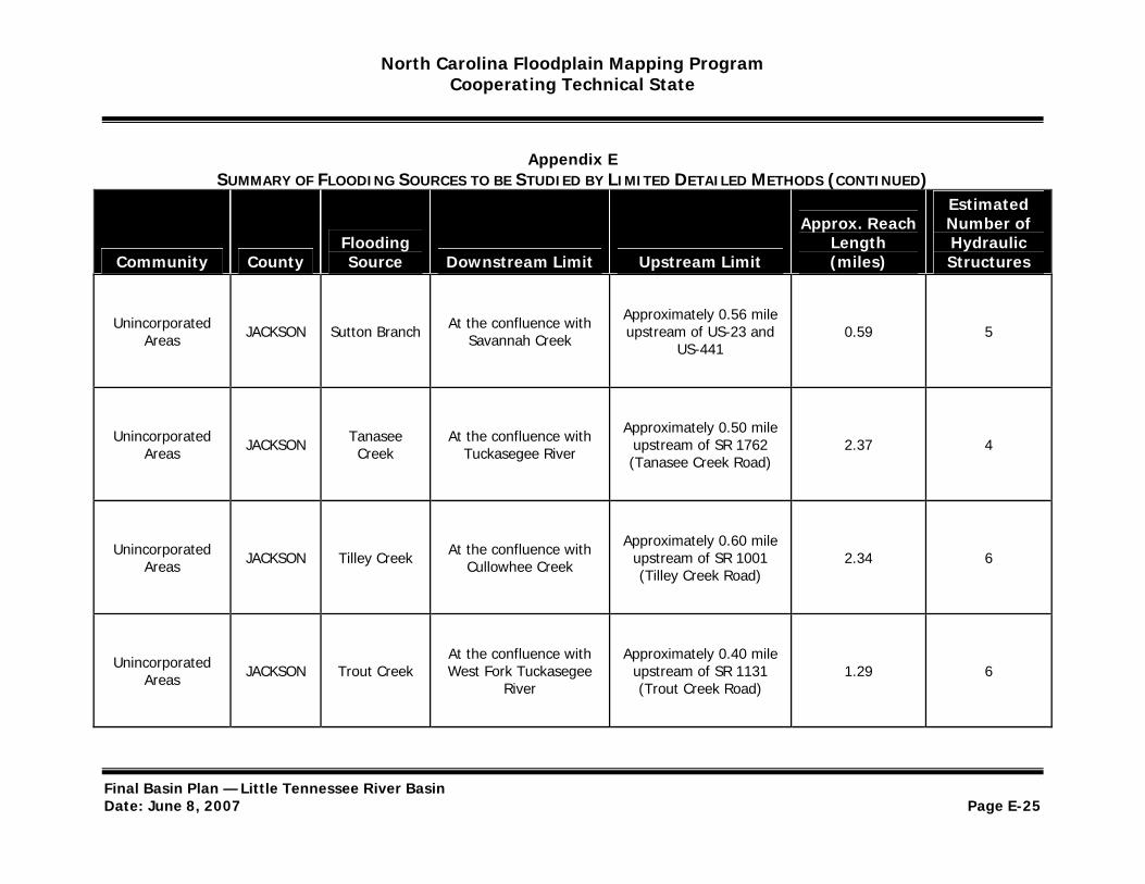
North Carolina Floodplain Mapping Program Cooperating Technical State
Appendix E SUMMARY OF FLOODING SOURCES TO BE STUDIED BY LIMITED DETAILED METHODS (CONTINUED)
Estimated
Community County Flooding Source Downstream Limit Upstream Limit
Approx. Reach Length (miles)
Number of Hydraulic Structures
Unincorporated Areas JACKSON Sutton Branch At the confluence with
Savannah Creek
Approximately 0.56 mile upstream of US-23 and
US-441 0.59 5
Unincorporated Areas JACKSON Tanasee
Creek At the confluence with
Tuckasegee River
Approximately 0.50 mile upstream of SR 1762 (Tanasee Creek Road)
2.37 4
Unincorporated Areas JACKSON Tilley Creek At the confluence with
Cullowhee Creek
Approximately 0.60 mile upstream of SR 1001 (Tilley Creek Road)
2.34 6
Unincorporated Areas JACKSON Trout Creek
At the confluence with West Fork Tuckasegee
River
Approximately 0.40 mile upstream of SR 1131 (Trout Creek Road)
1.29 6
Final Basin Plan — Little Tennessee River Basin Date: June 8, 2007 Page E-25
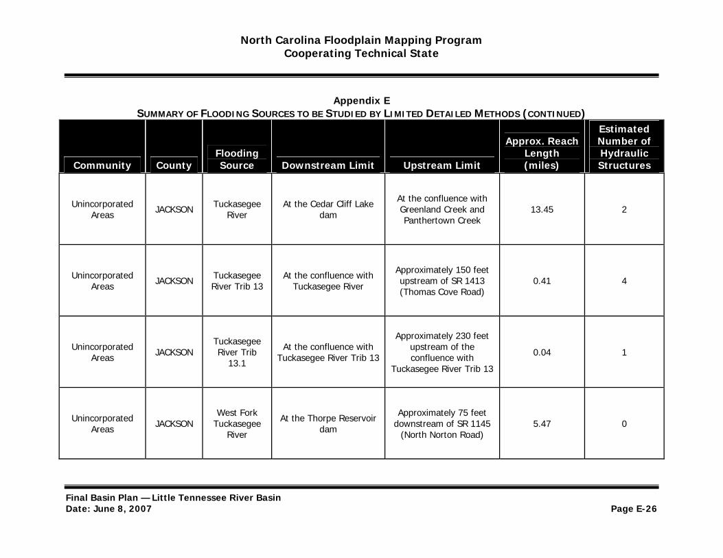
North Carolina Floodplain Mapping Program Cooperating Technical State
Appendix E SUMMARY OF FLOODING SOURCES TO BE STUDIED BY LIMITED DETAILED METHODS (CONTINUED)
Estimated
Community County Flooding Source Downstream Limit Upstream Limit
Approx. Reach Length (miles)
Number of Hydraulic Structures
Unincorporated Areas JACKSON Tuckasegee
River At the Cedar Cliff Lake
dam
At the confluence with Greenland Creek and Panthertown Creek
13.45 2
Unincorporated Areas JACKSON Tuckasegee
River Trib 13 At the confluence with
Tuckasegee River
Approximately 150 feet upstream of SR 1413 (Thomas Cove Road)
0.41 4
Unincorporated Areas JACKSON
Tuckasegee River Trib
13.1
At the confluence with Tuckasegee River Trib 13
Approximately 230 feet upstream of the confluence with
Tuckasegee River Trib 13
0.04 1
Unincorporated Areas JACKSON
West Fork Tuckasegee
River
At the Thorpe Reservoir dam
Approximately 75 feet downstream of SR 1145
(North Norton Road) 5.47 0
Final Basin Plan — Little Tennessee River Basin Date: June 8, 2007 Page E-26

North Carolina Floodplain Mapping Program Cooperating Technical State
Appendix E SUMMARY OF FLOODING SOURCES TO BE STUDIED BY LIMITED DETAILED METHODS (CONTINUED)
Estimated
Community County Flooding Source Downstream Limit Upstream Limit
Approx. Reach Length (miles)
Number of Hydraulic Structures
Unincorporated Areas JACKSON Wolf Creek At the confluence with
Tuckasegee River
Approximately 2.30 miles upstream of NC 281
(Canada Road) 4.06 2
Unincorporated Areas JACKSON Wrights Creek At the confluence with
Soco Creek
Approximately 1,450 feet upstream of Wrights
Creek Road 3.22 8
Unincorporated Areas MACON Allison Creek At the confluence with
Jones Creek
Approximately 1,550 feet downstream of SR 1133
(Allison Creek Road) 2.36 4
Unincorporated Areas MACON Beasley Creek At the confluence with
Cowee Creek At the confluence with
Huckleberry Creek 0.68 1
Final Basin Plan — Little Tennessee River Basin Date: June 8, 2007 Page E-27
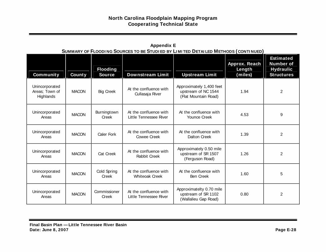
North Carolina Floodplain Mapping Program Cooperating Technical State
Appendix E SUMMARY OF FLOODING SOURCES TO BE STUDIED BY LIMITED DETAILED METHODS (CONTINUED)
Estimated
Community County Flooding Source Downstream Limit Upstream Limit
Approx. Reach Length (miles)
Number of Hydraulic Structures
Unincorporated Areas; Town of
Highlands MACON Big Creek At the confluence with
Cullasaja River
Approximately 1,400 feet upstream of NC 1544 (Flat Mountain Road)
1.94 2
Unincorporated Areas MACON Burningtown
Creek At the confluence with Little Tennessee River
At the confluence with Younce Creek 4.53 9
Unincorporated Areas MACON Caler Fork At the confluence with
Cowee Creek At the confluence with
Dalton Creek 1.39 2
Unincorporated Areas MACON Cat Creek At the confluence with
Rabbit Creek
Approximately 0.50 mile upstream of SR 1507
(Ferguson Road) 1.26 2
Unincorporated Areas MACON Cold Spring
Creek At the confluence with
Whiteoak Creek At the confluence with
Ben Creek 1.60 5
Unincorporated Areas MACON Commissioner
Creek At the confluence with Little Tennessee River
Approximatelty 0.70 mile upstream of SR 1102 (Wallalieu Gap Road)
0.80 2
Final Basin Plan — Little Tennessee River Basin Date: June 8, 2007 Page E-28

North Carolina Floodplain Mapping Program Cooperating Technical State
Appendix E SUMMARY OF FLOODING SOURCES TO BE STUDIED BY LIMITED DETAILED METHODS (CONTINUED)
Estimated
Community County Flooding Source Downstream Limit Upstream Limit
Approx. Reach Length (miles)
Number of Hydraulic Structures
Unincorporated Areas MACON Coon Creek At the confluence with
Watauga Creek
Approximately 30 feet upstream of SR 1331
(Brendle Road) 1.42 3
Unincorporated Areas MACON Cove Branch At the confluence with
Cullasaja River
Approximately 35 feet upstream of SR 1664
(Hunnicut Road) 0.57 3
Unincorporated Areas MACON Cowee Creek At the confluence with
Little Tennessee River At the confluence with
Beasley Creek 4.03 9
Unincorporated Areas MACON Coweeta
Creek At the confluence with Little Tennessee River
Approximately 0.70 miles upstream SR 1114
(Shope Road) 2.95 4
Final Basin Plan — Little Tennessee River Basin Date: June 8, 2007 Page E-29
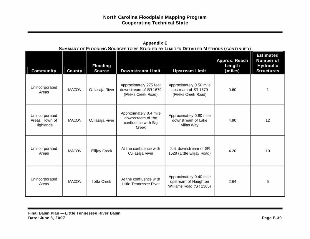
North Carolina Floodplain Mapping Program Cooperating Technical State
Appendix E SUMMARY OF FLOODING SOURCES TO BE STUDIED BY LIMITED DETAILED METHODS (CONTINUED)
Estimated
Community County Flooding Source Downstream Limit Upstream Limit
Approx. Reach Length (miles)
Number of Hydraulic Structures
Unincorporated Areas MACON Cullasaja River
Approximately 275 feet downstream of SR 1679
(Peeks Creek Road)
Approximately 0.50 mile upstream of SR 1679 (Peeks Creek Road)
0.60 1
Unincorporated Areas; Town of
Highlands MACON Cullasaja River
Approximately 0.4 mile downstream of the confluence with Big
Creek
Approximately 0.80 mile downstream of Lake
Villas Way 4.90 12
Unincorporated Areas MACON Ellijay Creek At the confluence with
Cullasaja River Just downstream of SR
1528 (Little Ellijay Road) 4.20 10
Unincorporated Areas MACON Iotla Creek At the confluence with
Little Tennessee River
Approximately 0.40 mile upstream of Haughton
Williams Road (SR 1385) 2.64 5
Final Basin Plan — Little Tennessee River Basin Date: June 8, 2007 Page E-30

North Carolina Floodplain Mapping Program Cooperating Technical State
Appendix E SUMMARY OF FLOODING SOURCES TO BE STUDIED BY LIMITED DETAILED METHODS (CONTINUED)
Estimated
Community County Flooding Source Downstream Limit Upstream Limit
Approx. Reach Length (miles)
Number of Hydraulic Structures
Unincorporated Areas MACON Jones Creek
At the confluence with Cartoogechaye Creek
and Poplar Cove Creek
At the confluence with Allison Creek 1.49 4
Little Unincorporated
Areas MACON Tennessee River
At the Swain/Macon County boundary
At the confluence with Cowee Creek 9.05 4
(Downstream)
Little Unincorporated
Areas MACON Tennessee River
At the confluence with Middle Creek
At the South Carolina and Macon County boundary 6.49 8
(Upstream)
Unincorporated Areas; Town of
Franklin MACON
Little Tennessee
River Trib 13
At the confluence with Little Tennessee River
Just upstream of US23/US-441 0.80 7
Unincorporated Areas MACON Lowery Creek At the confluence with
Jones Creek At the confluence with
Cloer Branch 1.26 5
Final Basin Plan — Little Tennessee River Basin Date: June 8, 2007 Page E-31
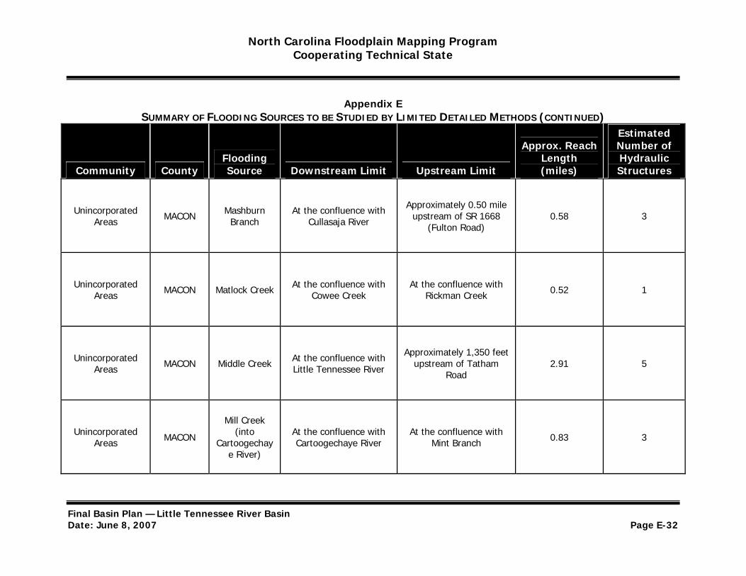
North Carolina Floodplain Mapping Program Cooperating Technical State
Appendix E SUMMARY OF FLOODING SOURCES TO BE STUDIED BY LIMITED DETAILED METHODS (CONTINUED)
Estimated
Community County Flooding Source Downstream Limit Upstream Limit
Approx. Reach Length (miles)
Number of Hydraulic Structures
Unincorporated Areas MACON Mashburn
Branch At the confluence with
Cullasaja River
Approximately 0.50 mile upstream of SR 1668
(Fulton Road) 0.58 3
Unincorporated Areas MACON Matlock Creek At the confluence with
Cowee Creek At the confluence with
Rickman Creek 0.52 1
Unincorporated Areas MACON Middle Creek At the confluence with
Little Tennessee River
Approximately 1,350 feet upstream of Tatham
Road 2.91 5
Mill Creek Unincorporated
Areas MACON (into Cartoogechay
At the confluence with Cartoogechaye River
At the confluence with Mint Branch 0.83 3
e River)
Final Basin Plan — Little Tennessee River Basin Date: June 8, 2007 Page E-32
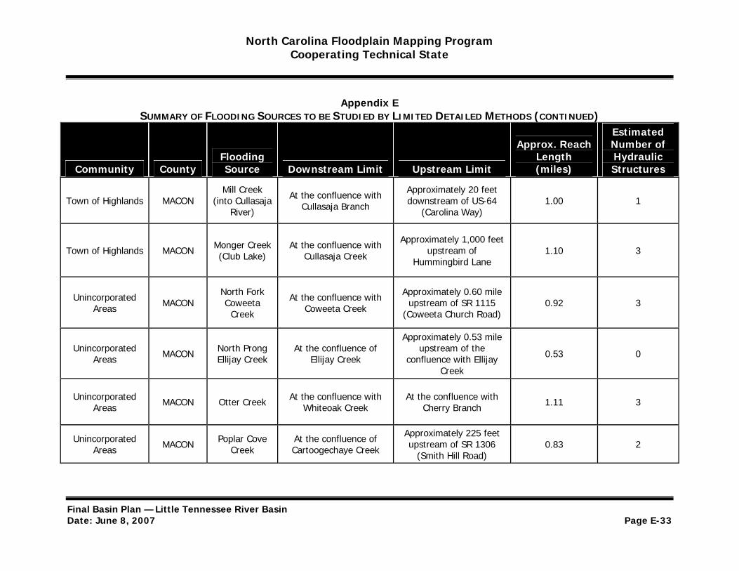
North Carolina Floodplain Mapping Program Cooperating Technical State
Appendix E SUMMARY OF FLOODING SOURCES TO BE STUDIED BY LIMITED DETAILED METHODS (CONTINUED)
Estimated
Community County Flooding Source Downstream Limit Upstream Limit
Approx. Reach Length (miles)
Number of Hydraulic Structures
Town of Highlands MACON Mill Creek
(into Cullasaja River)
At the confluence with Cullasaja Branch
Approximately 20 feet downstream of US-64
(Carolina Way) 1.00 1
Town of Highlands MACON Monger Creek (Club Lake)
At the confluence with Cullasaja Creek
Approximately 1,000 feet upstream of
Hummingbird Lane 1.10 3
Unincorporated Areas MACON
North Fork Coweeta
Creek
At the confluence with Coweeta Creek
Approximately 0.60 mile upstream of SR 1115
(Coweeta Church Road) 0.92 3
Approximately 0.53 mile Unincorporated
Areas MACON North Prong Ellijay Creek
At the confluence of Ellijay Creek
upstream of the confluence with Ellijay 0.53 0
Creek
Unincorporated Areas MACON Otter Creek At the confluence with
Whiteoak Creek At the confluence with
Cherry Branch 1.11 3
Unincorporated Areas MACON Poplar Cove
Creek At the confluence of Cartoogechaye Creek
Approximately 225 feet upstream of SR 1306
(Smith Hill Road) 0.83 2
Final Basin Plan — Little Tennessee River Basin Date: June 8, 2007 Page E-33
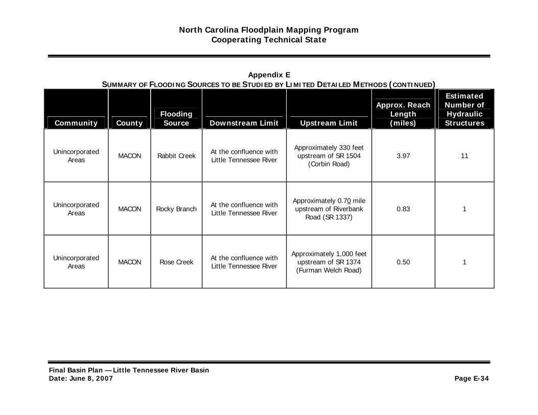
North Carolina Floodplain Mapping Program Cooperating Technical State
Appendix E SUMMARY OF FLOODING SOURCES TO BE STUDIED BY LIMITED DETAILED METHODS (CONTINUED)
Estimated
Community County Flooding Source Downstream Limit Upstream Limit
Approx. Reach Length (miles)
Number of Hydraulic Structures
Unincorporated Areas MACON Rabbit Creek At the confluence with
Little Tennessee River
Approximately 330 feet upstream of SR 1504
(Corbin Road) 3.97 11
Unincorporated Areas MACON Rocky Branch At the confluence with
Little Tennessee River
Approximately 0.70 mile upstream of Riverbank
Road (SR 1337) 0.83 1
Unincorporated Areas MACON Rose Creek At the confluence with
Little Tennessee River
Approximately 1,000 feet upstream of SR 1374 (Furman Welch Road)
0.50 1
Final Basin Plan — Little Tennessee River Basin Date: June 8, 2007 Page E-34
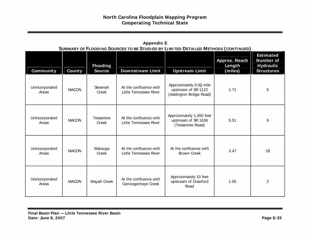
North Carolina Floodplain Mapping Program Cooperating Technical State
Appendix E SUMMARY OF FLOODING SOURCES TO BE STUDIED BY LIMITED DETAILED METHODS (CONTINUED)
Estimated
Community County Flooding Source Downstream Limit Upstream Limit
Approx. Reach Length (miles)
Number of Hydraulic Structures
Unincorporated Areas MACON Skeenah
Creek At the confluence with Little Tennessee River
Approximately 0.60 mile upstream of SR 1122
(Addington Bridge Road) 1.71 5
Unincorporated Areas MACON Tessentee
Creek At the confluence with Little Tennessee River
Approximately 1,450 feet upstream of SR 1636
(Tessentee Road) 5.51 9
Unincorporated Areas MACON Watauga
Creek At the confluence with Little Tennessee River
At the confluence with Brown Creek 3.47 18
Unincorporated Areas MACON Wayah Creek At the confluence with
Cartoogechaye Creek
Approximately 10 feet upstream of Crawford
Road 1.05 2
Final Basin Plan — Little Tennessee River Basin Date: June 8, 2007 Page E-35
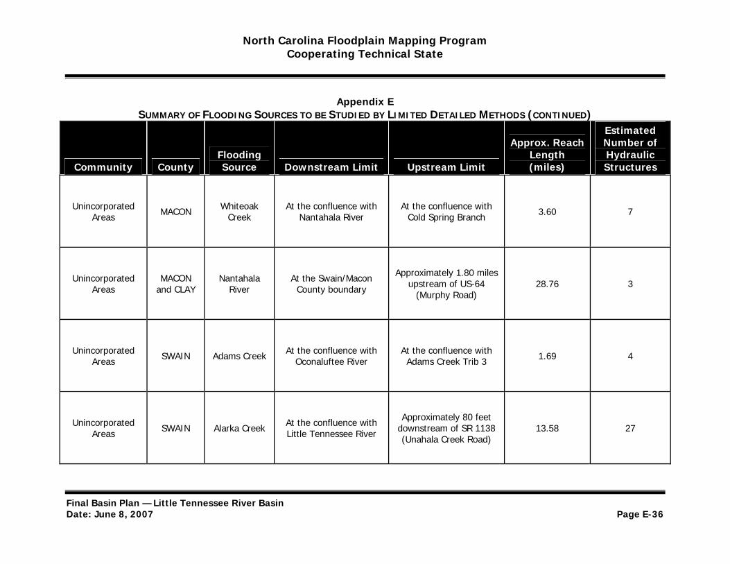
North Carolina Floodplain Mapping Program Cooperating Technical State
Appendix E SUMMARY OF FLOODING SOURCES TO BE STUDIED BY LIMITED DETAILED METHODS (CONTINUED)
Estimated
Community County Flooding Source Downstream Limit Upstream Limit
Approx. Reach Length (miles)
Number of Hydraulic Structures
Unincorporated Areas MACON Whiteoak
Creek At the confluence with
Nantahala River At the confluence with
Cold Spring Branch 3.60 7
Unincorporated Areas
MACON and CLAY
Nantahala River
At the Swain/Macon County boundary
Approximately 1.80 miles upstream of US-64
(Murphy Road) 28.76 3
Unincorporated Areas SWAIN Adams Creek At the confluence with
Oconaluftee River At the confluence with Adams Creek Trib 3 1.69 4
Unincorporated Areas SWAIN Alarka Creek At the confluence with
Little Tennessee River
Approximately 80 feet downstream of SR 1138 (Unahala Creek Road)
13.58 27
Final Basin Plan — Little Tennessee River Basin Date: June 8, 2007 Page E-36

North Carolina Floodplain Mapping Program Cooperating Technical State
Appendix E SUMMARY OF FLOODING SOURCES TO BE STUDIED BY LIMITED DETAILED METHODS (CONTINUED)
Estimated
Community County Flooding Source Downstream Limit Upstream Limit
Approx. Reach Length (miles)
Number of Hydraulic Structures
Unincorporated Areas SWAIN Bunches
Creek At the confluence with
Raven Fork
Approximately 0.70 mile upstream of Bunches
Creek Road 4.03 6
Approximately 1.18 miles Unincorporated
Areas SWAIN Chambers Creek
At the confluence with Little Tennessee River
upstream of the confluence with Little 1.18 0
Tennessee River
Unincorporated Areas SWAIN Connelly
Creek At the confluence with
Tuckasegee River At the confluence with Connelly Creek Trib 6 3.09 14
Unincorporated Areas SWAIN Cooper Creek At the confluence with
Tuckasegee River
Approximately 250 feet upstream of Isaac
Wiggins Road 1.95 3
Final Basin Plan — Little Tennessee River Basin Date: June 8, 2007 Page E-37
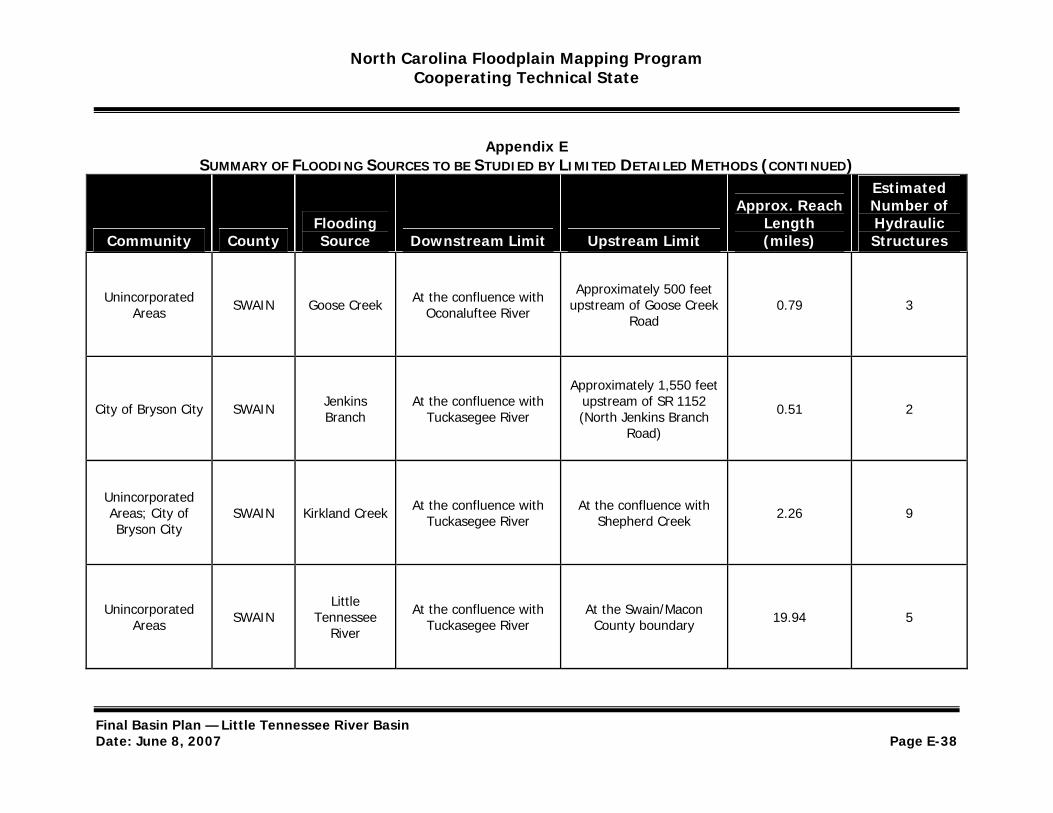
North Carolina Floodplain Mapping Program Cooperating Technical State
Appendix E SUMMARY OF FLOODING SOURCES TO BE STUDIED BY LIMITED DETAILED METHODS (CONTINUED)
Estimated
Community County Flooding Source Downstream Limit Upstream Limit
Approx. Reach Length (miles)
Number of Hydraulic Structures
Unincorporated Areas SWAIN Goose Creek At the confluence with
Oconaluftee River
Approximately 500 feet upstream of Goose Creek
Road 0.79 3
Approximately 1,550 feet
City of Bryson City SWAIN Jenkins Branch
At the confluence with Tuckasegee River
upstream of SR 1152 (North Jenkins Branch 0.51 2
Road)
Unincorporated Areas; City of Bryson City
SWAIN Kirkland Creek At the confluence with Tuckasegee River
At the confluence with Shepherd Creek 2.26 9
Unincorporated Areas SWAIN
Little Tennessee
River
At the confluence with Tuckasegee River
At the Swain/Macon County boundary 19.94 5
Final Basin Plan — Little Tennessee River Basin Date: June 8, 2007 Page E-38
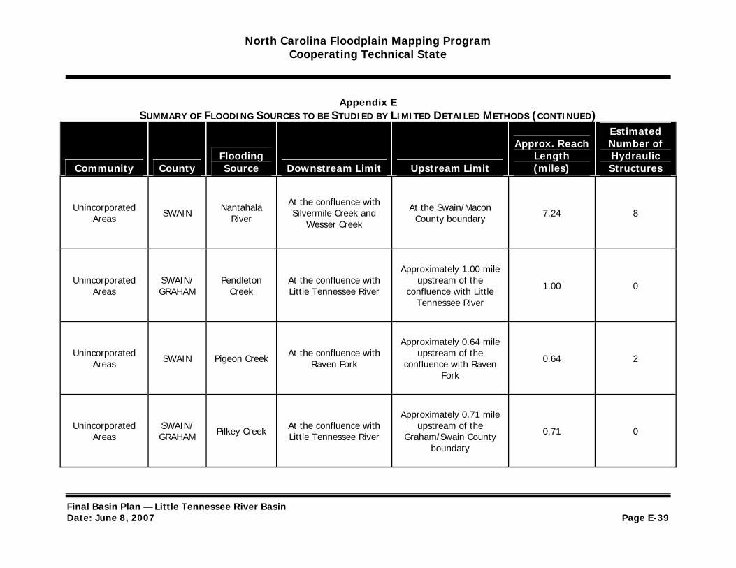
North Carolina Floodplain Mapping Program Cooperating Technical State
Appendix E SUMMARY OF FLOODING SOURCES TO BE STUDIED BY LIMITED DETAILED METHODS (CONTINUED)
Estimated
Community County Flooding Source Downstream Limit Upstream Limit
Approx. Reach Length (miles)
Number of Hydraulic Structures
Unincorporated Areas SWAIN Nantahala
River
At the confluence with Silvermile Creek and
Wesser Creek
At the Swain/Macon County boundary 7.24 8
Approximately 1.00 mile Unincorporated
Areas SWAIN/ GRAHAM
Pendleton Creek
At the confluence with Little Tennessee River
upstream of the confluence with Little 1.00 0
Tennessee River
Unincorporated Areas SWAIN Pigeon Creek At the confluence with
Raven Fork
Approximately 0.64 mile upstream of the
confluence with Raven Fork
0.64 2
Unincorporated Areas
SWAIN/ GRAHAM Pilkey Creek At the confluence with
Little Tennessee River
Approximately 0.71 mile upstream of the
Graham/Swain County boundary
0.71 0
Final Basin Plan — Little Tennessee River Basin Date: June 8, 2007 Page E-39
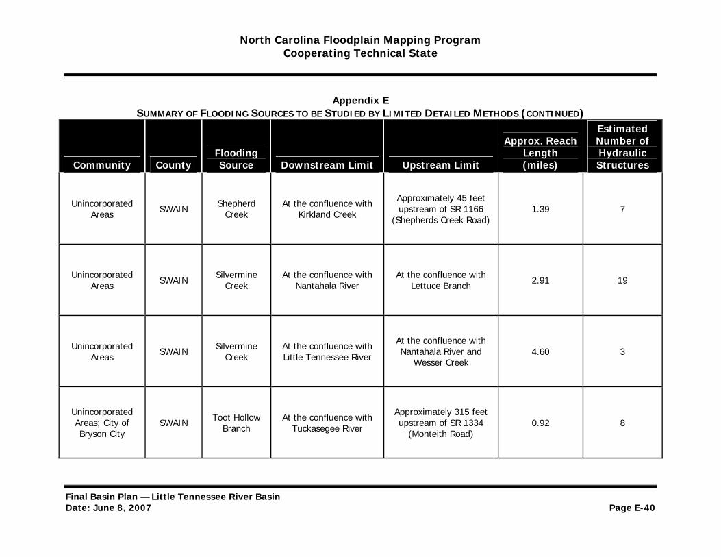
North Carolina Floodplain Mapping Program Cooperating Technical State
Appendix E SUMMARY OF FLOODING SOURCES TO BE STUDIED BY LIMITED DETAILED METHODS (CONTINUED)
Estimated
Community County Flooding Source Downstream Limit Upstream Limit
Approx. Reach Length (miles)
Number of Hydraulic Structures
Unincorporated Areas SWAIN Shepherd
Creek At the confluence with
Kirkland Creek
Approximately 45 feet upstream of SR 1166
(Shepherds Creek Road) 1.39 7
Unincorporated Areas SWAIN Silvermine
Creek At the confluence with
Nantahala River At the confluence with
Lettuce Branch 2.91 19
Unincorporated Areas SWAIN Silvermine
Creek At the confluence with Little Tennessee River
At the confluence with Nantahala River and
Wesser Creek 4.60 3
Unincorporated Areas; City of Bryson City
SWAIN Toot Hollow Branch
At the confluence with Tuckasegee River
Approximately 315 feet upstream of SR 1334
(Monteith Road) 0.92 8
Final Basin Plan — Little Tennessee River Basin Date: June 8, 2007 Page E-40
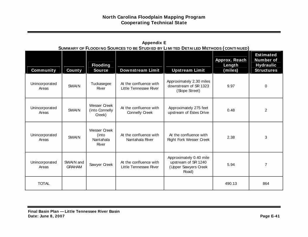
North Carolina Floodplain Mapping Program Cooperating Technical State
Appendix E SUMMARY OF FLOODING SOURCES TO BE STUDIED BY LIMITED DETAILED METHODS (CONTINUED)
Estimated
Community County Flooding Source Downstream Limit Upstream Limit
Approx. Reach Length (miles)
Number of Hydraulic Structures
Unincorporated Areas SWAIN Tuckasegee
River At the confluence with Little Tennessee River
Approximately 2.30 miles downstream of SR 1323
(Slope Street) 9.97 0
Unincorporated Areas SWAIN
Wesser Creek (into Connelly
Creek)
At the confluence with Connelly Creek
Approximately 275 feet upstream of Estes Drive 0.48 2
Wesser Creek Unincorporated
Areas SWAIN (into Nantahala
At the confluence with Nantahala River
At the confluence with Right Fork Wesser Creek 2.38 3
River
Unincorporated Areas
SWAIN and GRAHAM Sawyer Creek At the confluence with
Little Tennessee River
Approximately 0.40 mile upstream of SR 1240 (Upper Sawyers Creek
Road)
5.94 7
TOTAL 490.13 864
Final Basin Plan — Little Tennessee River Basin Date: June 8, 2007 Page E-41
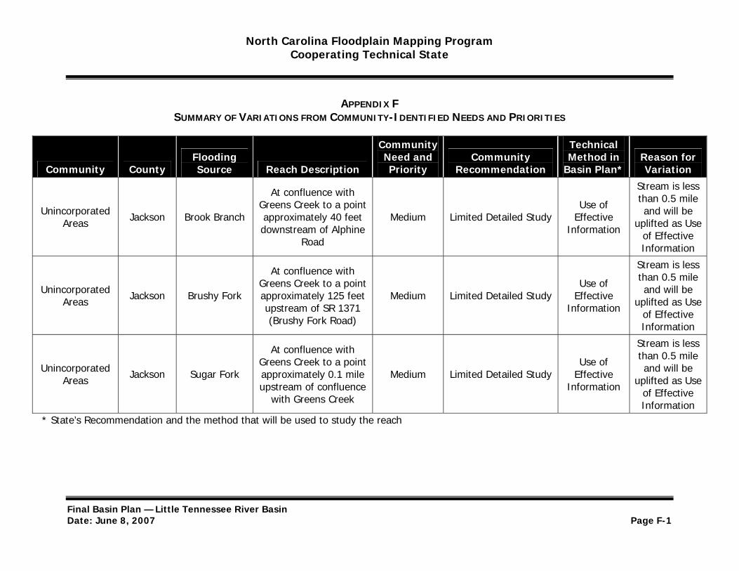
North Carolina Floodplain Mapping Program Cooperating Technical State
APPENDIX FSUMMARY OF VARIATIONS FROM COMMUNITY-IDENTIFIED NEEDS AND PRIORITIES
Community Technical Flooding Need and Community Method in Reason for
Community County Source Reach Description Priority Recommendation Basin Plan* Variation
Unincorporated Areas Jackson Brook Branch
At confluence with Greens Creek to a point approximately 40 feet downstream of Alphine
Road
Medium Limited Detailed Study Use of
Effective Information
Stream is less than 0.5 mile and will be
uplifted as Use of Effective Information
Unincorporated Areas Jackson Brushy Fork
At confluence with Greens Creek to a point approximately 125 feet upstream of SR 1371 (Brushy Fork Road)
Medium Limited Detailed Study Use of
Effective Information
Stream is less than 0.5 mile and will be
uplifted as Use of Effective Information
Unincorporated Areas Jackson Sugar Fork
At confluence with Greens Creek to a point approximately 0.1 mile upstream of confluence
with Greens Creek
Medium Limited Detailed Study Use of
Effective Information
Stream is less than 0.5 mile and will be
uplifted as Use of Effective Information
* State’s Recommendation and the method that will be used to study the reach
Final Basin Plan — Little Tennessee River Basin Date: June 8, 2007 Page F-1

North Carolina Floodplain Mapping Program Cooperating Technical State
APPENDIX FSUMMARY OF VARIATIONS FROM COMMUNITY-IDENTIFIED NEEDS AND PRIORITIES
Community Technical Flooding Need and Community Method in Reason for
Community County Source Reach Description Priority Recommendation Basin Plan* Variation
Unincorporated Areas Swain Nantahala
River
At the confluence with Silvermile Creek and
Wesser Creek to a point at the Swain/Macon County boundary
High Detailed Study Limited Detailed Study
Located mainly in the
Nantahala National Forest;
limited-to-zero development
potential * State’s Recommendation and the method that will be used to study the reach
Final Basin Plan — Little Tennessee River Basin Date: June 8, 2007 Page F-2