noaa ioos program office regional status … · – great lakes sea grant network lead for e/o ......
TRANSCRIPT

NOAA IOOS Program Office Regional Status Assessment for Great Lakes Observing System
February 29, 2008Roger L. Gauthier, Principal Investigator
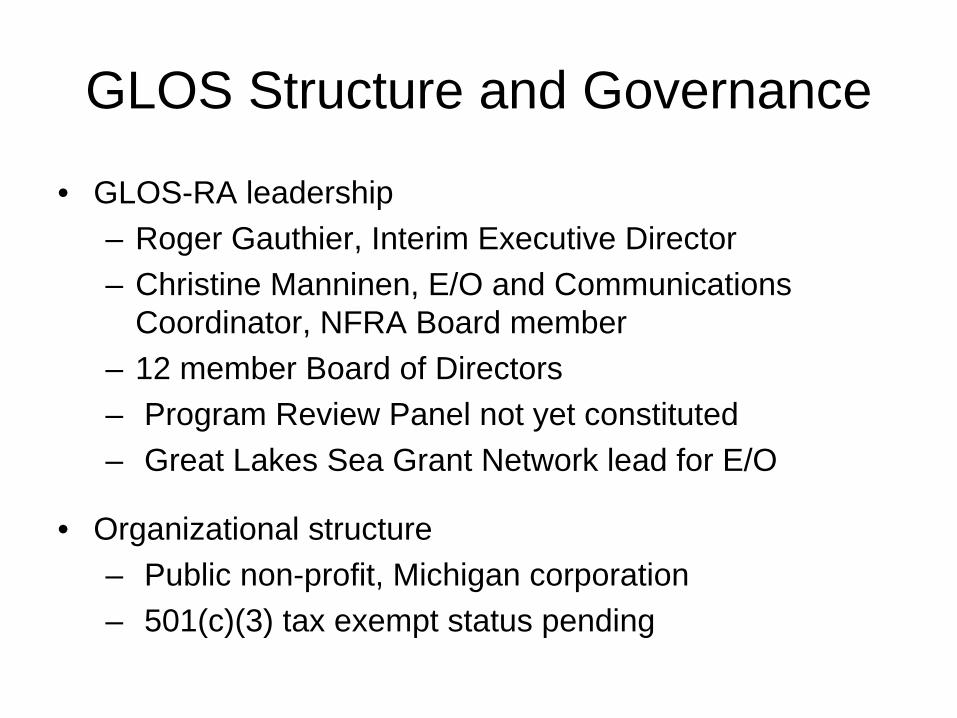
GLOS Structure and Governance
• GLOS-RA leadership– Roger Gauthier, Interim Executive Director– Christine Manninen, E/O and Communications
Coordinator, NFRA Board member– 12 member Board of Directors– Program Review Panel not yet constituted– Great Lakes Sea Grant Network lead for E/O
• Organizational structure – Public non-profit, Michigan corporation – 501(c)(3) tax exempt status pending

GLOS Structure and Governance
• Board membership
– No affiliations– No formal user group representation– Monthly conference calls– Annual Business/Technical meetings– Quarterly calls/meetings of subsystem teams

• Dr. Alfred Beeton (Treasurer)• Dr. Jeffrey Boehm (Secretary)• Dr. Gerald Galloway (BG, Ret)• Mr. Mark Grazioli, P.E.• Mr. Philip Keillor• Dr. Gail Krantzberg• Dr. Frank Kudrna, P.E. (Vice Chair)• Mr. Dale Phenicie• Dr. Harvey Shear• Dr. Richard Stewart• Mr. Nelson Thomas• Mr. Bill Werick (Chair)
Board of DirectorsBoard of Directors

Stakeholder Engagement
• Stakeholder types: extensive• Key stakeholder groups or individuals• Annual meetings / Periodic workshops• Periodic listserv announcements • Level of involvement - high

Stakeholder Engagement
• Key issues of importance to regional stakeholders, and how the RA addresses them?
• Quantifiable, tangible expressions of support from stakeholders – Specific examples that demonstrate benefit of
the RA to the region • Other stakeholders?

Great Lakes Regional Collaboration
Strategy
Protect drinking water supplies
Restore biologic integrity
Reduce loadings of nutrients, sediments and nutrients
Clean up toxic hot spots
Enhance resiliency to climatic variability / change
Limit adverse affects from aquatic invasive species
Improve navigation safety and efficiency
Support sustainable coastal communities

Great Lakes Observing SystemGreat Lakes Observing System
• Deep Water Observations• Science Vessels• Interconnecting Waterways• Nearshore Observations• Atmospheric Monitoring• Remote Sensing• Modeling and
Ecological Forecasting• Information Integration• Education and Outreach
Subsystems:


Great Lakes Federal Backbone ObservationsGreat Lakes Federal Backbone Observations

Critical Issues to be Addressed


Current Activities and Funding
• A summary of key activities in the region that are related to or support IOOS, including those not funded by NOAA IOOS
• Interaction/joint work with other federal agencies
• How can NOAA IOOS best support you in engaging other Federal agencies?

Current Activities and Funding
• Sources of funding – NOAA IOOS and other NOAA funds– Other Federal– Non-Federal
• RA plans/efforts to match IOOS dollars with funding from other sources– What sources, and in what areas of work?– How can the NOAA Program Office help?

Calendar Years
Funding Level Tasks
2003 - 2004 $ 110 K Convene Steering Committee and establish scope
2004 - 2005 $ 99 K
Draft Business Plan, define governance approachintegrate with national elements
2005 - 2006 $ 248 K Establish Regional Association and Board of Directors
2006 - 2007 $ 325 K
Enlist RA membership; conduct outreach, coordinate Regional DMAC
2007 - 2008 $ 400 K
Expand RA membership; refine Business Plan; implement regional DMAC
Regional Association Funding Regional Association Funding

Calendar Years
Fund Level Tasks
2007- 2008
$ 360 K Initiate Huron to Erie Corridor hydrodynamic modelingNOAA-GLERL ($100 K for continuous 2d model integration), USGS-MI ($125 K for 3d model development)Baird & Associates ($125K for 3d model risk assessment) GLOS-RA ($10K for coordination)
$ 50 K Develop “HarborView” pilots$ 65 K Initiate Great Lakes Modeling and Assessment Center$ 25 K Offshore Implementation Plan
Total $500K
Systems Grant Funding Systems Grant Funding

RA Coordination: Cooperative Agreements
• As we reach the end of the first set of RA coordination grants, provide a summary of overall progress– Milestones and status– Updates to the RA progress reports – Any new information?– How are you doing?

RA Coordination: Cooperative Agreements
• What will change with the new RA grant in FY08?
• New directions, partners, etc.?

RA Future Development
• RA views on function and performance metrics – How can we best measure outputs and
outcomes?• Objectives of the RA and plans for the
near-term FY08-12

RA Future Development
• Summary of top five priorities for development of RCOOS capabilities with cost estimates

Conceptual PlanConceptual Plan
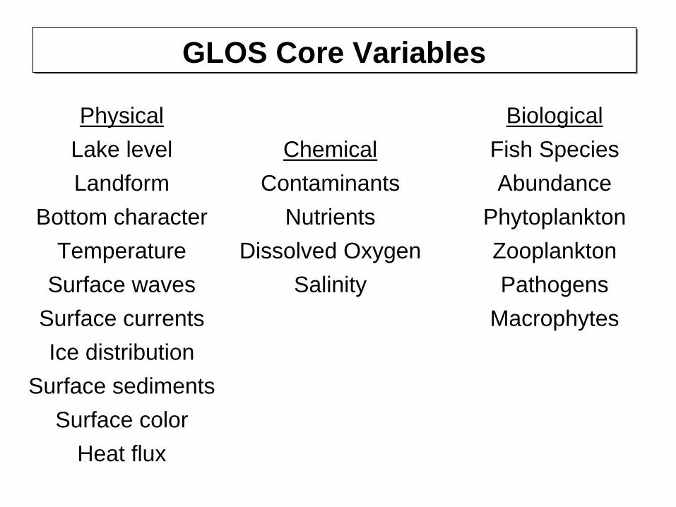
Physical Lake level Landform
Bottom character Temperature
Surface waves Surface currents Ice distribution
Surface sediments Surface color
Heat flux
GLOS Core VariablesGLOS Core Variables
Chemical Contaminants
Nutrients Dissolved Oxygen
Salinity
Biological Fish Species Abundance
PhytoplanktonZooplankton Pathogens
Macrophytes

Components
Data Discovery
Data Visualization
Data Evaluation
Data Access
Data Publishing
Core GLOS-DMAC FunctionalitiesCore GLOS-DMAC Functionalities
Tenants
Empower user/organizations
Make data accessible to ALL
Be extensible/expandable
Minimize duplication
Metadata driven
Standards based
Leverage open source software
Service Oriented Architecture
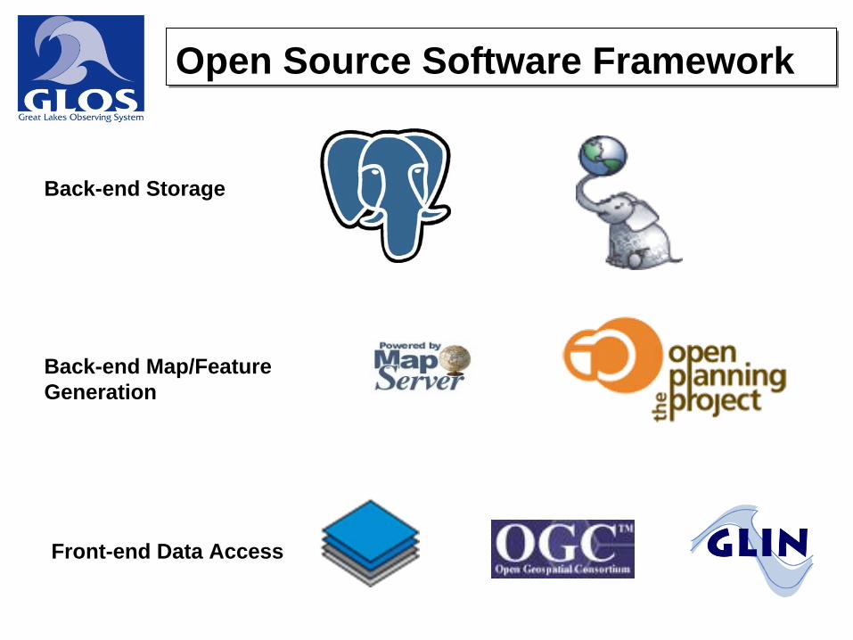
Back-end Storage
Back-end Map/FeatureGeneration
Front-end Data Access
Open Source Software FrameworkOpen Source Software Framework

• Ingest data from a variety of sources including federal, state, local, tribal and NGO agencies.
• Collect and integrate data of varying types including observational data, model output, remotely sensed data, “traditional” GIS Layers, et al.
• Collect data across differing time scales, including historical, real-time, and near real-time datasets.
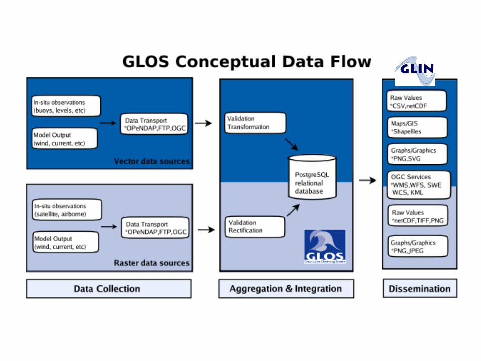
Data CollectionData Collection
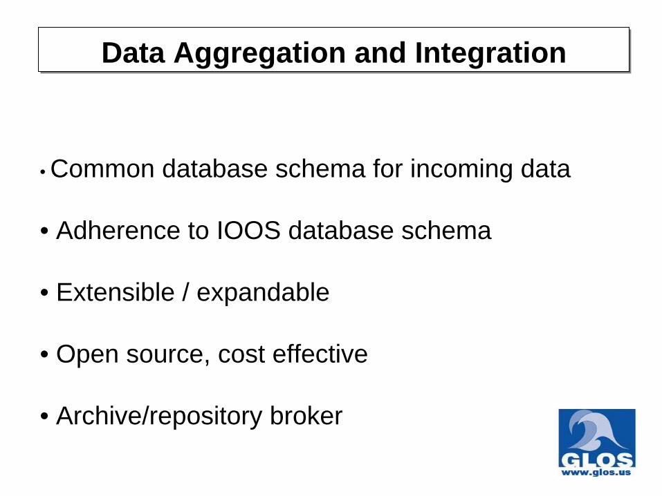
• Common database schema for incoming data
• Adherence to IOOS database schema
• Extensible / expandable
• Open source, cost effective
• Archive/repository broker
Data Aggregation and IntegrationData Aggregation and Integration

• Standards-based (Service Oriented Architecture)
• Interoperable
• Provide multiple ways GLOS-related datasets• Using 3 compatible approaches:
• Open layers, Chameleon/Map Server, Flash• Static maps and images• Time series and animated data• Web mapping applications• Direct file and database access
Data AccessData Access

Refine a comprehensive data schema
Incorporate additional geospatial datasets
Integrate with other IOOS DMAC and Canadian nodes
Provide additional formats and data types
(e.g. point and time series data, raster and imagery)
Improve search capabilities
Improve user interfaces
GLOS-DMAC Next StepsGLOS-DMAC Next Steps

RA Views on Regional and National IOOS
• RA needs with regard to the integration of regional and national planning efforts
• RA expectations for development of the “national backbone” of observations– In situ, remote sensing, and data
management and communications (DMAC) capabilities

Cross-regional Coordination
• Discuss existing and potential coordination with other IOOS RAs– On regional efforts/issues?– On a national scale?

Best Practices and Lessons Learned
• Describe problems encountered to date and their resolutions
• What are some “good ideas” or best practices that you can share with other RAs?

Parting Thoughts
• What support or information do you need from NOAA that you are not currently receiving?
• Is there input you would like to give to us, but don’t have a venue?

Parting Thoughts
• How can NOAA IOOS best receive regular updates or information from the RAs?– RA and partner achievements, news items,
expressions of stakeholder support, engagement of new stakeholders
– How can NOAA IOOS best understand (and articulate) how RAs support the national system?
– How can we help to support your • Other parting thoughts?
Short-Term “Work-Arounds”

Land cover circa 2001
Land cover circa 1996
Change data (1996 to 2001)
Percent impervious surface
Percent canopy surface
• Standardized, accessible inputs
• Innovative, repeatable procedures
• Consistent national coverage
• Relevant, accurate products
Current Great Lakes Land Cover Products:
Coastal Change Analysis Program Coastal Change Analysis Program

• Funded through 2008• Add ADCP in 2007• Add directional waves in 2007• Explore means for supporting
other chemical and biologic sensor deployments

3-D Modeling Initiative for the Huron to Erie Corridor
