no v 17 2gq5 - new mexico department of energy, minerals...
TRANSCRIPT
Form 3160-5 (April 2004)
UNITED STATES DEPARTMENT OF THE INTERIOR r \ r r \ A T? T F * ? T A
BUREAU OF LAND MANAGEMENT 1 H O l / A .
APPLICATION FOR PERMIT TO DRILL OR REENTER
la. Type of Work D R I L L r j REENTER
lb. Type of WeH [jf! Oil Well • Gas Well • O t h e r f~J Single Zone Q Multiple Zone
2. Name of Operator .
Nearburg Producing Company /r> "l*-/4— 3a. Address
3300 N A St.. Bldg 2. Ste 120. Midland. TX 79705 3b. Phone No. (include area code)
432/686-8235 4. Location of WeU (Report location clearly and in accordance with any Slate equirements)*
At surface 2590 FNL and and 330 FWL R E C E I V E D SUBJECT TO LIKE
Atproposedprod. ̂ 330 FNL and 660 FWL APPROVAL BY $PXl?L3
FORM APPROVED OMB NO. 1004-0137
Expires March 31,2007
5. Lease Serial No. NMNH16104
6. I f Indian, Allotee or Tribe Name
7. Unit or CA Agreement Name and No.
8. Lease Name and Well No.
Salt Draw 11 Federal #1 9. API WellNo.
10. Field and Pool, or Exploratory Willow Lake, SW: Delaware
1 l.Sec., T., R., M., or Blk. and Survey or Area
Sec 11. 25S, 28E 14. Distance in miles and direction from nearest town or post office*
21 miles SE of Carlsbad 12. County or Parish
Eddv 13.State
NM 15. Distance from proposed*
location to nearest property or lease line, ft. 330 (Also to nearest drg. unit line, if any)
16. No. of Acres in lease
1520.06
17. Spacing Unit dedicated to this weU
80
18. Distance from proposed location* to nearest well, drilling, completed, applied for, on this lease, ft.
990
19. Proposed Depth
6700
20.BLM/BIA Bond No. on file
NMB000153
21. Elevations (Show whether DF, KDB, RT, GL, etc.
2918 22. Approximate date work will start*
11/1/05 23. Estimated duration
40 days
24. Attachments
The following, completed in accordance with the requirements of Onshore Oil and Gas Order No. 1, shall be attached to this form:
1. Well plat certified by a registered surveyor. 2. A Drilling Plan
4. Bond to cover the operations unless covered by an existing bond on file (see Item 20 above).
3. A Surfactf Use Plan (if the location is on National Forest System Lands, the SUPO steSTbe filed with the appropriate Forest Service Office).
5. Operator certification. 6. Such other site specific information and/or plans
authorized officer. as may be required by the
25.Sig#atrTe \ _ . Name (Printed/Typed)
Sarah Jordan Title / i
Pr^uctipn Analyst Approvf^nauu.) / s / j o e G. Lara Name (Printed/Typed)
Isl Joe G. Lara Date
NOV 17 2GQ5 ™ACTLNG FIELD MANAGER Office CARLSBAD FIELD O] FFICE
Application approval does not warrant or certify that the applicant holds legal or equitable title to those rights in the subject tease which would entitle the applicant to conduct operations thereon. Conditions of approval, if any, are attached. A P P R O V A L F O R 1 Y E A R
Title 18 U.S.C. Section 1001 and Title 43 U.S.C. Section 1212, make it a crime for any person knowlingly and willfully to make to any department or agency of the United States any false, fictitious or fraudulent statements or representations as to any matter within its jurisdiction.
"(Instructions on page 2) D M ' 11 G> K I Cte.in*. I CX. p previa I -47
Ai- i 'KOVAL SUBJECT TO GENERAL REQUIREMENTS AND SPECIAL STIPULATIONS ATTACHED
DISTRICT I
ten * . m a n u BOBBS. KK OSSM
DISTRICT II
isol «. CBWS Arams, IBTKSU. KM sens
DISTRICT IH tOOO Ho Bras os Bd., Aztec, NM 87410 DISTRICT IV 1220 8. St. nUHCB BB, &1HTA IB. Mf S7M»
State of New Mexico Encrty. Minerals and Natural ReMarces D«p*rtm«tit
O I L C O N S E R V A T I O N D I V I S I O N 1220 SOUTH ST. FRANCIS DR. Santa Fe, New Mexico 87505
WELL LOCATION AND ACREAGE DEDICATION PLAT
Form C-102 Revised JUNE to. 2003
Submit to Appropriate District Office State Lease — 4 Copies
Pee Lease — 3 Copies
• AMENDED REPORT API Number Pool Code Pool Name
U)i'ik)Lo/^]6.^u): Ailaujrxf* Properly Code Property Name ^ J
SALT DRAW 11 FEDERAL Well Number
1 OGRID No. Operator Name
NEARBURG PRODUCING COMPANY Elevation
2918' Surface Location
UL or lot No.
E Section
1 1 Township
25-S Range
28-E Lot Idn Feet from the
2590 North/South line
NORTH Feet from the
330 Bast/Vest Une
WEST County
EDDY
Bottom. Hole Location If Different From Surface
UL or lot No.
0 SecUon
1 1 Township
25-S Range
28-E Lot Idn Peet from the
330 North/South line
NORTH Peet from the
660 Bast/West Une
WEST County
EDDY Dedicated Acres
So Joint or Infill Consolidation Code Order No.
NO ALLOWABLE WILL BE ASSIGNED TO THIS COMPLETION UNTIL ALL INTERESTS HAVE BEEN CONSOLIDATED OR A NON-STANDARD UNIT HAS BEEN APPROVED BY THE DIVISION
O J 7 ] B H Y=4187I2.6 N X=583373.6 E
. GRAZ.= 0 r 4 7 ' 2 0 " H.DIST.j^a?.?'
•330?
SEE I DETAIL
4 DETAIL '2923.5' 2924.9'
' 600^ 2911.3' ~ 2911.9' j
GEODETIC COORDINATES NAD 27 NME
SURF. Y=416446.6 N X=583063.6 E
LAT.=32'08'40.72~ N L0NG. = 104-03'53.86" W
OPERATOR CERTIFICATION
/ hereby certify tha the information
contained herein is true and complete to the
beat ef my knowledge and belief.
S i g n a t u r e /
Pen ted Name A
Tttlft-7 <J
SURVEYOR CERTIFICATION
/ hereby certify that the well location shown on this plat tvos plotted from field, nates of
actual sttnieys mode by me or imdtrr my
supervison, and that the same is true and
correct to the best of my beHef.
SEPTEMBER 15, 2005
P r o f e * * ! ^ f u r ^ r V N , ,
JR
Cers^&Ca. No. GARY EflJ^tjTtf 12641
STATEMENT ACCEPTING RESPONSIBILITY FOR OPERATIONS
Nearburg Producing Company 3300 North "A" Street, Building 2, Suite 120 Midland, Texas 77905
The undersigned accepts all applicable terms, conditions, stipulations and restrictions covering operations conducted on the leased land or portion thereof, as described below:
Lease No: NMNM16104
Legal Description of Land: SHL: 2590 FNL and 330 FWL BHL: 330 FNL and 660 FWL, Sec 11, 25S, 28E Eddy County, New Mexico
Formation(s) (if applicable): Delaware
Bond Coverage: $25,000 statewide bond of Nearburg Producing Company
BLM Bond File No: NMB000153
Date H. R. Willis / Drilling Manager
P

ATTACHMENT TO FORM 3160-3 SALT DRAW 11 FEDERAL #1 SHL: 2590 FNL AND 330 FWL
BHL: 330 FNL AND 660 FWL, SEC 11, 25S, 28E EDDY COUNTY, NEW MEXICO
DRILLING PROGRAM
1. GEOLOGIC NAME OF SURFACE FORMATION
Quaternary Alluvium/ Permian Ochoan
2. ESTIMATED TOPS OF IMPORTANT GEOLOGIC MARKERS
Delaware 2550 Cherry Canyon 3400
3. ESTIMATED DEPTHS OF ANTICIPATED FRESH WATER. OIL. OR GAS
Cherry Canyon Sand 4900
4. CASING AND CEMENTING PROGRAM
Casing Size From To Weight Grade Joint 8-5/8" 0'-850' 32# K55 STC 5-1/2" 0'-6700' 17# N80 LTC
Equivalent or adequate grades and weights of casing may be substituted at time casing is run, depending on availability.
We plan to drill a 12-1/4" hole to equal 850'. 8-5/8" casing will be cemented with 800 sxs Class "C" or volume necessary to bring cement back to surface.
7-7/8" hole will be drilled to 6700' and 5-1/2" production casing will be cemented with approximately 1000 sxs of Class "C" cement circulated to surface.
SALT DRAW 11 FEDERAL #1 Page 2
5. MINIMUM SPECIFICATIONS FOR PRESSURE CONTROL
The BOP stack will consist ofa 3,000 psi working pressure, dual ram type preventer and annular. A BOP sketch is attached.
6. TYPES AND CHARACTERTICS OF THE PROPOSED MUD SYSTEM
Spud and drill to 850' with fresh water mud for surface string. The production section from 850' to 6700' will be 10.0 ppg Brine Water system with mud weight sufficient to control formation pressures.
7. AUXILLARY WELL CONTROL AND MONITORING EQUIPMENT
None required.
8. LOGGING. TESTING. AND CORING PROGRAM
DLI7CNL/LDT/CAL/GR logging is planned. Drill stem tests, cores and sidewall cores are possible.
9. ABNORMAL CONDITIONS. PRESSURES. TEMPERATURES & POTENTIAL HAZARDS
None anticipated.
BHP expected to be 1,100 psi.
10. ANTICAPATED STARTING DATE:
Is planned that operations will commence on November 1, 2005 with drilling and completion operation lasting about 40 days.

LOCATION VERIFICATION MAP
SCALE: 7" = 2000'
SEC. 11 TWP. 25-S RGE. 28-E
SURVEY N.M.P.M.
CONTOUR INTERVAL: MALAGA, N.M. - 10'
COUNTY EDDY
DESCRIPTION 2590' FNL & 330' FWL
ELEVATION 2918' NEARBURG
OPERATOR PRODUCING COMPANY
LEASE SALT DRAW 11 FEDERAL
JOWWESTSURVEYMGCOkPANY 4ttM.aM.fWO
HOBB8.IUI SSMO (505)38*3117
U.S.G.S. TOPOGRAPHIC MAP MALAGA. N.M.
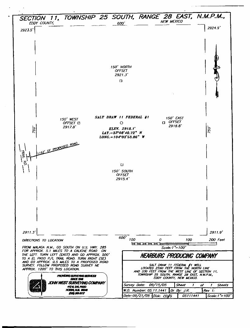
SECTION 11, TOWNSHIP 25 SOUTH, RANGE 28 EAST, N.M.P.M,. EDDY COUNTY. 600' N E W M E X I C 0
2923.5'[~ \ 2924.9'
150' NORTH OFFSET 2921.3'
•
o
150' WEST OFFSET a 2917.8'
SALT DRAW 11 FEDERAL gi
O
ELEV. 2918.1' LAT. =32-08'40.72" N
LONG.= 104"03'53.86" W
ISO' EAST • OFFSET
2918.8' o
iQ
•
150' SOUTH OFFSET 2915.4'
2911.3' l_ DIRECTIONS TO LOCATION
FROM MALAGA N.M., GO SOUTH ON U.S. HWY. 285 FOR APPROX. 5.1 MILES TO A CALICHE ROAD ON THE LEFT. TURN LEFT (EAST) AND GO APPROX. 500' TO A EL PASO P/L TRAIL ROAD. TURN RIGHT (SE) ANO GO APPROX. 0.5 MILES TO A PROPOSED ROAD SURVEY. FOLLOW PROPOSED ROAD SURVEY NE APPROX. 1200' TO THIS LOCATION.
HKMUmSUMEmtSBMCBS
JOHN WEST SLmVEYmCOfflWY 412 H. Ml PASO
HQBBS, Mit BS340
(soB&wiir .
600' 100
| 2911.9'
100 200 Feet l-l H H H T F T
Scale: 1"= 100'
NEARBURG PRODUCING COMPANY SALT DRAW 11 FEDERAL / I WEU
LOCATED 2590 FEET FROM THE NORTH LINE ANO JJO FEET FROM THE WEST UNE OF SECTION 11.
TOWNSHIP 25 SOUTH. RANGE 28 EAST, N.M.P.M.. EDDY COUNTY, NEW MEXICO.
Survey Date: 09/15/Q5 \Sheet
W.O. Number 05.11.1441 \Or By: J.R.
of Sheets
Rev I:
Date: 09/21/05 \Oisk: C0#5 \ 05111441 \Scale:l"—1Q0


Nearburg Producing Company Salt Draw 11 Fed #1 I"" Eddy Countv. NM I — Salt Draw 11 Fed #1
I UL * » • 40.710 NMMkj: 410440 00 #U3 OMCmr. •C.142T911V I i
| um VWQ4 3&3JM Cxang fwaoojotw t k * * m t c j — \vm\ | j D * C0.1C3- CM* <M*«tB7.2Q0S 1 U t M » 040.710 N M M * 410440 00 * « 0*IC4tw: .C.142T911V I M * M f t w I I W W TVOrtar. RKfl (OA) ft «*•«•)
^ t ^ ^ M ^ ^ ^ ^ ^ ^ ^ ^ ^ ^ K ^ ^ ^ W J M r f l ^ | Um VWQ4 3&3JM twang TjOOPBOtW tktJt, m t C J I W IWgn | _ j » M E _ _ f c j l t t » » » t 1 J » f l j j J ^ ^
« < W Scale = V.500(ftt E > » -500 0 500 1000 1500

Proposal Report Data: October 7.2005 Survey / DLS Computation Method: Minimum Curvatue / Lubinski
Client: Nearburg Produchg Company Vertical Section Azimuth: 7.790* Raid: Eddy County, NM Vertical Section Origin: N 0.000 ft, E 0.000 ft
Structure / Sot' Sat Draw 11 Fed #1/Salt Draw 11 Fed#1 TVD Reference Datum: RKB Wall: Salt Draw 11 Fed #1 TVD Reference Elevation: 0.0 ft relative to
Borehole: Salt Draw 11 Fed #1 Sea Bed / Ground Level Elevation: O.OOOftrerabVeto UWVAPK: Magnetic Declination: 8.467*
Survey Name 1Date: SaS Draw 11 Fed October 7.2005 Total Field Strength: 49119.232 nT Tort 1AHD1 DDI / ERD ratio: 90.000* / 2287.30 It / 5.468 / 0.472 Magnetic Dip: 60.163*
Grid Coordinate Syatam: NAD27 New Mexico State Planes, Eastern Zone US Feet Declination Date: October 07.2005 Location Lat/Long: N 32 8 40.718, W104 3 53.856 Magnetic Declination Model: IGRF2005
Location Grid N/EY/X: N 416446.600ftUS. E 583063.6m ftUS Norn Reference: Grid North Grid Convergence Angle: -tO.14279111* Total Corr Mag North -> Grid North: *8.324*
Grid Scale Factor: 059991699 Local Coordinates Referenced To: Well Head
Comments Measured Depth
Inclination Azimuth TVD Vertical Section NS EW Closure Cloture
Azimuth DLS Toot Face
(«) «teg) (deg) («> (ft) (ft) (ft) (ft) (deg) (deg/IOOft) (deg) Tie-tn 0.00 0.00 7.79 0.00 0.00 0.00 0.00 0.00 0.00 0.00 7.79M KOP 4329.13 0.00 7.79 4329.13 0.00 0.00 0.00 0.00 0.00 0.00 7.79M
4400.00 7.80 7.79 4399.78 4.81 4.77 0.65 4.81 7.79 11.00 O.OOG 4500.00 18.80 7.79 4496.95 27.78 27.52 3.76 27.78 7.79 11.00 O.OOG 4600.00 29.80 7.79 4587.96 68.86 68.22 9.33 68.86 7.79 11.00 O.OOG
4700.00 40.80 7.79 4669.45 126.55 125.38 17.15 126.55 7.79 11.00 O.OOG 4800.00 51.80 7.79 4738.44 198.73 196.90 26.94 198.73 7.79 11.00 O.OOG 4900.00 62.80 7.79 4792.38 282.75 280.14 38.32 282.75 7.79 11.00 O.OOG
Marker 4917.23 64.69 7.79 4800.00 298.20 295.45 40.42 298.20 7.79 11.00 7.79G 5000.00 73.80 7.79 4829.31 375.52 372.05 50.90 375.52 7.79 11.00 O.OOG
5100.00 84.80 7.79 4847.85 473.62 469.25 64.20 473.62 7.79 11.00 O.OOG EOC 5147.31 90.00 7.79 4850.00 520.87 516.06 70.60 520.87 7.79 11.00 O.OOG PBHL 6913.74 90.00 7.79 4850.00 2287.30 2266.19 310.03 2287.30 7.79 0.00 O.OOG
Version DO 3.2 ( gt3c892_05) Salt Draw 11 Fed #1\SaH Draw 11 Fed #l\SaS Draw 11 Fed #1\SattDraw 11 Fed #1_r1Generated 10/7/2005 10:32 AM Page 1 of 1
STATE OF NEW MEXICO ENERGY, MINERALS AND NATURAL RESOURCES DEPARTMENT
OIL CONSERVATION DIVISION
IN THE MATTER OF THE HEARING CALLED BY THE OIL CONSERVATION DIVISION FOR THE PURPOSE OF CONSIDERING:
CASE NO. 12116 Order No. R-l 1120
THE APPLICATION OF THE OIL CONSERVATION DIVISION FOR AN ORDER CREATING AND EXTENDING CERTAIN POOLS IN EDDY COUNTY, NEW MEXICO.
ORDER OF THE DIVISION
BY THE DIVISION;
This case came on for hearing at 8:15 a.m. on January 7, 1999, at Santa Fe, New Mexico, before Examiner Mark W. Ashley.
NOW, on this 21 a day of January, 1999, the Division Director, having considered the testimony, the record, and the recommendations of the Examiner.
FINDS THAT:
(1) Due public notice has been given and the Division has jurisdiction of this case and its subject matter.
(2) There is need for the creation of a new pool in Eddy County, New Mexico, for the production of oil from the Cisco formation, bearing the designation of Turkey Track-Cisco Pool. The Turkey Track-Cisco Pool was discovered by the Harvey E. Yates Company Palmillo "6" State Well No. 1 located in Unit K of Section 6, Township 19 South, Range 29 East, NMPM, which was completed in the Cisco formation on October 6, 1998. The top of the perforations is at 9,562 feet.
(3) There is need for the creation of a new pool in Eddy County, New Mexico, for the production of oil from the Delaware formation, bearing the designation of Southwest Willow Lake-Delaware Pool. The Southwest Willow Lake-Delaware Pool was discovered by the Santa Fe Energy Resources, Inc. Chapparal "10" Well No. 1 located in Unit F of Section 10, Township 25 South, Range 28 East, NMPM, which was completed in the

Case No. 12116 Order No. R-l 1120 -2- .
Delaware formation on September 22,1998. The top of the perforations is at 4,776 feet.
(4) There is need for certain extensions to the North Black River-Atoka Gas Pool, the Cedar Lake-Yeso Pool, the Cemetery-Morrow Gas Pool, the Cotton Draw-Bone Spring Pool, the Crow Flats-Morrow Gas Pool, the East Eagle Creek-Atoka-Morrow Gas Pool, the Livingston Ridge-Delaware Pool, the Loco Hills-Paddock Pool, and the Logan Draw-Morrow Gas Pool, all in Eddy County, New Mexico.
IT IS THEREFORE ORDERED THAT:
(a) A new pool in Eddy County, New Mexico, classified as an oil pool for Cisco production is hereby created and designated as the Turkey Track-Cisco Pool, consisting of the following described area:
TOWNSHIP 19 SOUTH. RANGE 29 EAST. NMPM Section 6: SW/4
(b) A new pool in Eddy County, New Mexico, classified as an oil pool for Delaware production is hereby created and designated as the Southwest Willow Lake-Delaware Pool, consisting of the following described area:
TOWNSHIP 25 SOUTH, RANGE 28 EAST. NMPM Section 10: NW/4
(c) The North Black River-Atoka Gas Pool in Eddy County, New Mexico, is hereby extended to include:
TOWNSHIP 23 SOUTH. RANGE 26 EAST. NMPM Section 32: E/2 Section 33: N/2 Section 34: NW/4
The Cedar Lake-Yeso Pool in Eddy County, New Mexico, is hereby extended
TOWNSHIP 17 SOUTH. RANGE 31 EAST. NMPM Section 19: NW/4
(d) to include:
(e) The Cemetery-Morrow Gas Pool in Eddy County, New Mexico, is hereby extended to include:

Case No. 12116 Order No. R-l 1120 -3-
TOWNSHIP 20 SOUTH. RANGE 24 EAST. NMPM Section 12: All Section 13: N/2
TOWNSHIP 20 SOUTH. RANGE 25 EAST. NMPM Section 7: W/2 Section 18: N/2
(f) The Cotton Draw-Bone Spring Pool in Eddy County, new Mexico, is hereby extended to include:
TOWNSHIP 24 SOUTH. RANGE 31 EAST. NMPM Section 3: E/2 Section 10: NE/4
(g) The Crow Flats-Morrow Gas Pool in Eddy County, New Mexico, is hereby extended to include:
TOWNSHIP 17 SOUTH. RANGE 27 EAST. NMPM Section 9: N/2
(h) The East Eagle Creek-Atoka-Morrow Gas Pool in Eddy County, New Mexico, is hereby extended to include:
TOWNSHIP 17 SOUTH. RANGE 25 EAST. NMPM Section 14: All
(i) The Livingston Ridge-Delaware Pool in Eddy County, New Mexico, is hereby extended to include:
TOWNSHIP 22 SOUTH. RANGE 31 EAST. NMPM Section 26: SW/4
(j) The Loco Hills-Paddock Pool in Eddy County, New Mexico, is hereby extended to include:
TOWNSHIP 17 SOUTH. RANGE 30 EAST. NMPM Section 17: NE/4 Section 22: SE/4
(k) The Logan Draw-Morrow Gas Pool in Eddy County, New Mexico, is hereby

Case No. 12116 Order No. R-l 1120 -4-
extended to include:
TOWNSHIP 17 SOUTH. RANGE 27 EAST. NMPM Section 15: E/2
IT IS FURTHER ORDERED THAT:
(1) Pursuant to Section 70-2-18, NMSA, 1978, an operator of any well that, by virtue of any of the above pool extensions, is subject to pool rules providing for spacing or proration units larger than the one presently dedicated thereto, shall have 60 days from the effective date of this order to file Form C-l 02 dedicating a standard unit for the pool to that well or to obtain Division approval of a non-standard unit. Pending such compliance, the well shall receive a maximum allowable in the same proportion to a standard allowable for the pool that the acreage dedicated to the well bears to a standard unit for the pool. Failure to file Form C-l 02 dedicating a standard unit to the well or to obtain Division approval of a non-standard unit within that 60-day period shall subject the well to cancellation of allowable.
(2) The effective date of this order and all creations and extensions included herein shall be February 1, 1999.
DONE at Santa Fe, New Mexico, on the day and year hereinabove designated.
SEAL
fd/

9 t o~S~C
C o u n t y
? — ' 1 . t > s I
. t
1 ~ 1 7 — — t 1 u 1 • 1 1 ~ 1 z
1 8 - 1 -7 - 1 6 —- l 1 ' 1 A • 1 •3 .
1 8 - 1 / - 1 6 —- l 1 ' 1 X
- 1 Q o 0 - i — 0 0 •3 1
- 1 y — — z 0 - z z z
1 z J z 1
0 Q
1
**> p 0 7 - 0 I
0 c J U — Z y 0 z 7 - z D z D
-3 1 "3
1 1 1 4 - — — - 3 c •5 z
... j X z J 4 - — — - 3 D J D
&?\:Mt/4 set, isYx-/«i>fJi«/»»fliT)

V.I067
lis I?
EOG Res-
it1» 8 n i p ' 0 ' 5 <