nice cÔte d’azur lfmndownload.vaccfrance.free.fr/charts/arr-dep-ad-2.lfmn.pdf · on star or with...
TRANSCRIPT

Sommaire / Summary
Objet Page ou carteSubject Page or chart
Sommaire AD2 LFMN SUMSummary
Consignes générales AD2 LFMN TEXT 1 > TEXT 5General rules
Environnement ENV 1 > ENV 3Environment
Carte régionale AD2 LFMN ARCArea chart
Carte radar AD2 LFMN AMSRRadar chart
Départs initiaux AD2 LFMN INIInitial departures
SID AD2 LFMN SID 1 > SID 2
STAR AD2 LFMN STAR 1 > STAR 2
AIP AD2 LFMN SUMFRANCE 15 APR 04
VERSO BLANC ➤AMDT 04/04 © SIA
NICE CÔTE D’AZURLFMN
☛

NICE CÔTE D’AZUR
AIP AD2 LFMN TEXT 1FRANCE 14 APR 05
AMDT 05/05 © SIA
TMA NICE
1 ORGANISMES CHARGÉS DES SERVICES DE LA CIRCULATIONAÉRIENNE
1.1 MARSEILLE ACC et NICE APP assurent la fourniture des services dela circulation aérienne de la TMA NICE (cf. ENR 2.3).
1.2 Espaces délégués à NICE APP1.2.1 Limites latérales et verticales (cf. ENR 2.3).
2 CALAGE ALTIMÉTRIQUEL’altitude de transition pour la TMA NICE est de 5000 ft.Le niveau de transition est calculé par NICE APP.
3 PROCÉDURES3.1 Limitation de vitesse
Sauf clairance particulière de NICE APP la vitesse indiquée (IAS) nedevra pas excéder 250 kt en dessous du FL 100.
3.2 Itinéraires IFR à l’intérieur de la TMA3.2.1 Les itinéraires normalisés d’arrivées aux instruments figurent sur les
cartes AD2 LFMN STAR.Les pilotes devront mentionner obligatoirement dans le champ “route”de leur plan de vol, le point de début de STAR ainsi que l’IAF associé(MUS ou NERAS).Certains itinéraires normalisés d’arrivées comportent des tronçons deroute RNAV.L’indicatif de ces itinéraires contient la lettre “R” commeindicateur d’itinéraire et ils sont préférentiels. Les tronçons RNAV de ces arrivées sont utilisables en B-RNAV par lesaéronefs répondant aux exigences complémentaires décrites dansl’AIP partie GEN 1.5.2, §1.5.4. En l’absence de la capacité RNAVrequise, le pilote doit s’annoncer “Non RNAV zone terminale” afin, soitde bénéficier d’un guidage radar, soit de se voir attribuer une arrivéeconventionnelle. En cas de perte de la capacité RNAV requise le pilotedoit annoncer “RNAV impossible [cause(raison)]” et suivre ou rejoindrel’arrivée conventionnelle correspondante. La portée de la clairanceSTAR ne concerne que le suivi de la route publiée.Tout changement de niveau de vol et de vitesse doit faire l’objet d’uneclairance délivrée sur l’initiative de l’organisme ATC ou sur demandepilote.Sur STAR ou en guidage radar, le pilote doit adapter le profil de des-cente afin de respecter les contraintes publiées. En cas d’impossibilité,il doit immédiatement en aviser l’organisme ATC.
3.2.2 Itinéraires normalisés de départ aux instruments (SID)Les itinéraires normalisés de départ aux instruments figurent sur lescartes AD2 LFMN SID. Sauf autorisation contraire de l'approche, lesaéronefs devront se conformer aux spécifications fixées pour chaqueitinéraire normalisé de départ. En cas d'impossibilité, le pilote doit enaviser le contrôle lors du premier contact.Les pilotes devront mentionner obligatoirement dans le champ «route»de leur plan de vol, le point de fin de SID.
3.2.3 Itinéraires de transitLes itinéraires de transit sont définis sur la carte AD2 LFMN ARC. Lestransits ne sont pas autorisés dans la TMA en dessous du FL 150 saufinstructions particulières du contrôle.
3.3 Procédures RADARMARSEILLE ACC et NICE APP disposent des fonctions de surveillan-ce, d’assistance et de guidage radar.
3.4 Transferts de communicationLes changements de fréquence ont lieu sur instruction de l’organismeresponsable du contrôle de l’aéronef. A chaque changement de fré-quence, l’aéronef doit contacter sans délai et en aucun cas plus d’uneminute après réception de l’instruction de changement de fréquence.
1 AIR TRAFFIC SERVICE UNITS
1.1 MARSEILLE ACC and NICE APP provide air traffic services in NICETMA (ref. ENR 2.3).
1.2 Airspaces assigned to NICE APP1.2.1 Lateral and vertical limits (ref. ENR 2.3).
2 ALTIMETER SETTINGThe transition altitude in NICE TMA is 5000 ft.The transition level is calculated by NICE APP.
3 PROCEDURES3.1 Speed restriction
Except under special clearance from NICE APP, the indicated airspeed(IAS) shall not exceed 250 kts below FL 100.
3.2 IFR routes within the TMA3.2.1 The Standard Instrument Arrival Routes are shown on charts AD2
LFMN STAR.Pilots must notify in the "route" field of their flight plan, the STAR begin-ning point as also the associated IAF (MUS or NERAS).
Some Standard Instrument Arrival Routes include RNAV route seg-ments.The route identification has the letter “R” as route indicator andthey are preferred routes. The RNAV segments of these arrivals are available in B-RNAV for air-craft meeting the additional requirements described in AIP, part GEN1.5.2, § 1. 5. 4. Without the required RNAV capability, the pilot mustreport "Non RNAV terminal area" in order to get a radar vectoring or aconventional arrival procedure. In case of loss of the required RNAVcapability, the pilot must report "Unable RNAV [due(reason) ]" and fol-low or join the corresponding conventional arrival. The STAR clearancecoverage only affects the published route data.
Any change in speed or flight level shall be subject to a clearanceissued on ATC proposal or on pilot request.
On STAR or with radar vectoring, the pilot shall adapt the descent pro-file in order to observe the published requirements. When it is not pos-sible, the pilot must immediately inform the ATC unit.
3.2.2 Standard Instrument Departure Routes (SID)The Standard Instrument Departure Routes are shown on charts AD2LFMN SID. Except otherwise cleared by the Approach Center, aircraftshall comply with the requirements specified for each SID. If it is notpossible, the pilot shall inform the ATC unit on the first contact.
Pilots must notify in the "route" field of their flight plan the SID finalpoint.
3.2.3 Transit routesThe transit routes are defined on chart AD2 LFMN ARC. Transit flightsare not authorized in the TMA below FL 150 except with special ATCinstructions.
3.3 RADAR proceduresMARSEILLE ACC and NICE APP provide radar surveillance, assistan-ce and guidance functions.
3.4 Transfert of communicationFrequency changes are carried out on aircraft ATC unit instruction.Upon every frequency change, pilot shall immediately contact andnever more than one minute after receiving the frequency change ins-truction.
☛

AMDT 05/05 © SIA
AD2 LFMN TEXT 2 AIP14 APR 05 FRANCE
NICE CÔTE D’AZUR
4 PANNE DE RADIOCOMMUNICATION4.1 Afficher 76004.2 Départ
En VMC : à l’intérieur de la TMA, faire demi-tour pour atterrir sur l’aéro-drome. Sinon appliquer la procédure IMC ci-dessous.En IMC : respecter l’itinéraire normalisé de départ aux instruments ense conformant aux spécifications fixées et en maintenant le niveauassigné jusqu ‘à la sortie de la TMA . Poursuivre ensuite le vol selon leplan de vol en vigueur.Note : dans le cas où le dernier niveau assigné ne serait pas compa-tible avec l’altitude minimale de sécurité, la montée sera poursuivievers le niveau de croisière.
4.3 Arrivée- Suivre la STAR PLN ou autorisée. En cas de guidage radar rejoindre
la STAR initiale.- Respecter les contraintes de niveau et de vitesse publiés.- Se présenter à l’IAF au dernier niveau de vol assigné pour lequel il y
a eu accusé de réception s’il est utilisable dans l’attente, à défaut leniveau le plus élevé de l’attente.
- Attendre à ce niveau jusqu’à la plus tardive des heures suivantes :. HAP,. Heure d’entrée dans l’attente plus 10 minutes.
- Puis descendre dans le circuit d’attente jusqu’au FL 080 (IAF MUS)ou FL 060 (IAF NERAS).
- Quitter l’IAF à ce niveau pour entreprendre la procédure d’approcheconnue ou estimée jusqu’à l’atterrissage.
Panne suivie d'une APIEffectuer la procédure de dégagement de la TMA ou effectuer laprocédure d'approche interrompue jusqu'à NERAS pour une nouvelleapproche à partir de ce point.Procédure de dégagement de la TMA (procédure obligatoire au termede la seconde tentative d'approche) : effectuer la procédure API jus-qu'à NERAS puis quitter à 3000 ft la TMA NICE sur le RDL 119 AZR(RM 119) pour rechercher les conditions VMC sur la Méditerranée.
4 Radiocommunication failure4.1 Squawk 76004.2 Departure
In VMC: within the TMA, fly back and land on the departureaerodrome.Otherwise apply the following IMC procedure.In IMC: follow the Standard Instrument Departure Route and complywith the specified requirements, maintaining the assigned level untilleaving the TMA. Then continue the flight according to the current flightplan.Note: In the case of the last assigned level is not consistent with theminimum safety altitude, climb to the cruising level.
4.3 Arrival- Follow the authorized or PLN STAR. In case of radar guidance, pro-
ceed to the initial STAR.- Observe the published flight level and speed requirements.- Proceed to the IAF at the last assigned level that was acknowledged,
if this level is available in the holding pattern, otherwise at the highestlevel in the holding pattern.
- stay in the holding pattern at this level until the latest time of the following:. EAT,. Arrival time in the holding pattern plus 10 minutes.
- Then descent in the holding pattern to FL 080 (IAF MUS) or FL 060(IAF NERAS).
- Leave the IAF at this level to perform the known or estimated approa-ch procedure until landing.
Failure followed with APICarry out the TMA clearing procedure or the missed approach proce-dure to NERAS for a new approach from this point.
TMA clearing procedure (mandatory procedure after the second mis-sed approach): carry out the API procedure to NERAS then leave at3000 ft the NICE TMA, on RDL 119 AZR (Magnetic track 119) andattempt to fly VMC over the Mediterranean sea.
☛
☛
☛

PROCÉDURES ET MÉTHODES D'EXPLOITATION PARTICULIÈRESL'aéroport de NICE CÔTE D'AZUR présente un certain nombre decaractéristiques topographiques, climatologiques et environnementalesqui ont conduit à des choix de procédures et de méthodes d'exploita-tion.Les équipages (et en particulier les pilotes peu habitués au site) doi-vent en prendre connaissance avant le vol. En complément de la docu-mentation officielle, le site internet www.niceairport.org présente unrésumé de ces particularités.
EXIGENCES OPERATIONNELLES APPLICABLES AUX EXPLOITANTSEN TRANSPORT PUBLICLe commandant de bord devra avoir obligatoirement suivi une instruc-tion portant sur l’ensemble des procédures utilisables et sur lescaractéristiques principales de l’infrastructure de l’aéroport. Il estdemandé aux exploitants de classer cet aérodrome en catégorie B enapplication des critères définis par l’AMC à l’OPS 1.975 relatif à lareconnaissance d’aérodrome.
EXIGENCES OPERATIONNELLES APPLICABLES AUX EXPLOITANTSEN AVIATION GENERALEIl est recommandé que le commandant de bord ait suivi une instructionà l’ensemble des procédures utilisables et aux caractéristiques del’infrastructure de l’aérodrome.
1 PARTICULARITÉS TOPOGRAPHIQUES ET MÉTÉOROLOGIQUES1.1 Situation
La plate-forme est située sur la côte ; elle est bordée au Nord et à l'Estpar la ville de Nice. Son emprise au sol est de taille limitée. La proximitéimmédiate de la mer ainsi que la présence du lit du Var occasionnentfréquemment des risques aviaires (lutte aviaire HJ).
1.2 Doublet de pistes spécialiséPar suite de sa superficie réduite, l’aérodrome dispose d’un doublet depistes rapproché spécialisé ; la piste sud dédiée aux décollages et la pistenord dédiée aux atterrissages (contrairement à la pratique la plus couran-te qui consiste à utiliser la piste adjacente aux installations terminalespour les décollages). L’alimentation de la piste Sud au décollage est com-plexe en QFU 04. Si, pour des raisons opérationnelles ou de sécurité,l’équipage demande à l’arrivée la piste 04R, les servitudes de dégage-ment imposent que la taxiway W soit libre de tout trafic, ce qui peutnécessiter un long préavis.
1.3 Obstacles/ReliefIl existe des sommets à 850 ft et à 2000 ft, respectivement à 3,5 NM età 5 NM des seuils 22, des sommets à 4200 ft à 9 NM dans le NW et leNE du terrain ; des sommets à plus de 10 000 ft à 29 NM dans le N-NEdu terrain.
1.4 Conséquences sur les espaces et trajectoiresLe volume utile pour les arrivées/départs est concentré essentiellementdans un secteur de 130° environ (QDR 090° - QDR 220°).
1.5 Orientations des pistes et ventsL'orientation des pistes a été déterminée par la topographie et non parla situation de vents dominants. Compte tenu des caractéristiques, desminima et des capacités horaires des procédures au QFU 22, le QFU 04 est privilégié et pourra être mis en service jusqu’à une compo-sante de vent arrière de 6 kt.Il existe des situations occasionnelles de cisaillement de vent (wind-shear) et parfois une composante de vent arrière simultanément aux 2 QFU.A noter une assez forte occurrence de vents de travers ou plein traversdue essentiellement aux brises de mer et de vallée (surtout au seuil 04proche de la vallée du Var).
SPECIFIC PROCEDURES AND OPERATING METHODS FOR NICEINTERNATIONALNICE COTE D’AZUR airport has topographic, environmental and cli-matological features that require specific procedures and operatingmethods. Crews should familiarise themselves with these before coming to Nice(this provision is particularly important for pilots not familiar with thisairport). In addition to the official documentation, the internet sitewww.niceairport.org gives a resume of these specific procedures.
OPERATIONAL REQUIREMENTS FOR COMMERCIAL OPERATORS
Captains must have followed a training programme on current proce-dures and the basic characteristics of the airports infrastructure.Operators are requested to classify the airport as Category B further tothe criteria as defined by AMC/OPS 1.975 relative to aerodrome fami-liarisation.
OPERATIONAL REQUIREMENTS FOR GENERAL AVIATION
It is recommended that Captains follow a training programme on cur-rent procedures and the basic characteristics of the airports infrastruc-ture.
1 TOPOGRAPHICAL AND METEOROLOGICAL FEATURES1.1 Location
On the coast and in close proximity to the built-up areas of Nice to theWest and North, the rest surrounded by sea, limiting the surface area.Due to the proximity of the sea and the river Var to the South there isthe risk of bird hazard (day time bird control from SR to SS).
1.2 Specialised parallel runwaysDue to the limited available space, the airport has dedicated closeproximity parallel runways; south runway for take-offs and north run-way for landings. (unlike most airports where the runway adjacent toairport terminals is used for departures).For access to the take off run-way, taxi routes cross the active landing runway. For 04R departuresaccess to the runway is complex. If, for any reason, the crew requestan arrival on 04r, it is necessary that taxiway “W” be free of all trafficand this may require a long delay.
1.3 Obstacles/Relief850 and 2000 ft peaks at 3,5 and 5 NM respectively, from RWY 22thresholds. Peaks up to 4200 ft 9 NM, NW and NE of the field withpeaks over 10000 ft 29 NM N/NE.
1.4 Effects on airspace and routesUseful volume for arrivals and departures mainly concentrated in asector of about 130° (QDR 090°-QDR 220°).
1.5 Runway direction (QFU) and windRunway direction was determined by local topography, not prevailingwind direction. Due to the complexity, capacity and the high minima ofQFU 22, landings and take-offs at QFU 04 are accepted with up to a 6 kt tail wind component.
Possibility of wind shear on final 04/22 combined with a strong tail windcomponent at medium altitude and cross wind on short final (confluentof gradient wind and sea breeze). Serious risk of cross or full crosswind component due to the sea andriver valley proximity and in particular RWY 04 threshold (close to theVar estuary).
AIP AD 2 LFMN TEXT 3FRANCE 14 APR 05
AMDT 04/05 © SIA
NICE CÔTE D’AZUR

AD 2 LFMN TEXT 4 AIP14 APR 05 FRANCE
2 ARRIVÉES2.1 ARRIVEES AU QFU 04
Le QFU 04 est préférentiel compte tenu de la météorologie et de latopographie ; il est utilisé environ 90 % du temps. La piste 04L, dédiéeaux atterrissages 04, mesure 2570 mètres. A noter un risque de confu-sion entre le taxiway U (largeur 60 m) et la piste 04L. En cas de condi-tions météorologiques favorables (10 km, 3000 ft), l'approcheMUS/NERAS-VOR/DME-MVI RWY 04L appelée “RIVIERA 04L” parl’ATC et sur l’ATIS est régulièrement mise en œuvre. Elle permet d'évi-ter le survol de l'Est de Cannes, de Vallauris et d'Antibes-Ville. Environ2/3 des arrivées 04 utilisent la procédure “RIVIERA 04L”. En cas de conditions météo moins favorables, la procédure ILS 04Lest mise en oeuvre ; c’est une procédure à 3° de pente permettant desapproches à moindre bruit sur Antibes notamment. Le PAPI 04L à 3°situé à droite du seuil 04L est réglé pour le passage au seuil d’avionsde catégorie D.
2.2 ARRIVEES AU QFU 22Le QFU 22 est utilisé environ 10 % du temps. Cette situation se ren-contre environ 120 jours par an pendant des périodes de quelquesheures en général (brise de mer), plus rarement des journées entièrespar fort vent de sud ouest à ouest. Les visibilités et plafonds sont sou-vent élevés. La piste 22R, dédiée aux atterrissages 22, mesure 2570 mètres. A noter un risque de confusion entre le taxiway U (lar-geur 60 m) et la piste 22R. En 22, la procédure d’approche normale-ment déclarée en service est l’approche MUS/NERAS-VOR/DME-MVIRWY 22 appelée “SALEYA 22” par l’ATC et sur l’ATIS. En cas indispo-nibilité du VOR/DME AZR la procédure MUS/NERAS-VOR/DME CGS-MVI RWY 22R est déclarée en service. En raison des obstacles, cesapproches présentent des minima météo élevés (8 km et 1500’) ; parmétéo défavorable quelques jours par an pour des périodes courtes,des risques d’attentes ou de déroutements peuvent être rencontrés.Pour l’accomplissement de ces approches 22, l’attention des équi-pages est attirée sur :
- le respect des vitesses et configurations machine AVANT laphase à vue,
- la présence d’obstacles élevés balisés à droite de l’étape de base,- la trajectoire finale très courte avec une pente de 3,5 °.
De nuit, si ces obstacles balisés ne sont pas visibles, la procéduren’est plus autorisée. Enfin, par fort vent d'ouest, l'occurrence occasion-nelle de fortes turbulences en finale 22 peut augmenter les risquesd'atterrissages interrompus et peut conduire l’ATC au report de tousles mouvements sur la piste 22L.Sauf situation exceptionnelle, les procédures d’approche de type MVLne seront jamais déclarées en service par les organismes de contrôlede Nice à des fins de desserte des pistes 22L et 22R de l’aérodrome.En particulier, la seule absence des conditions de mise en œuvre deces procédures MVI 22 ne sera pas considérée comme une situationexceptionnelle et ne donnera pas lieu à une utilisation autre que ponc-tuelle de MVL à des fins de desserte des pistes 22.
3 ATTERRISSAGEA l'atterrissage, les inverseurs de poussée et les inverseurs de pas deshélices ne peuvent être utilisés au-delà du ralenti que pour des raisonsopérationnelles et de sécurité (ex : vent arrière, piste mouillée oucontaminée,…).
2 ARRIVALS2.1 04 ARRIVALS
04 landings are preferred due to the meteorology, minima and topogra-phy; they are used about 90 % of the time. 04L, 2570 meters, is dedi-cated to landings. The 04L landing runway can be missled with thetaxiway U (60m wide). Under favourable meteorological conditions (10 km, 3000 ft) the MUS/NERAS-VOR/DME Circle-to-Land WithPrescribed Tracks procedure called “RIVIERA 04” by ATC and on theATIS is used , avoiding over-flying Cannes East, Vallauris and Antibes.About 2/3 of 04 arrivals use the RIVIERA approach. During less favou-rable conditions.ILS 04L is available. The 3 degree slope allows for low noise descentsover Antibes. The 3 degree 04L PAPI is situated to the left of 04L thre-shold; its threshold height has been calibrated for cat D aircraft.
2.2 22 ARRIVALS22 arrivals occur about 10 % of the time, about 120 days peryear forperiods of several hours at most (sea breezes) and occasionally all daywith strong West/South Westerly winds. Ceiling and visibility are usual-ly good except for a few days a year and then only for a few hours atmost. 22R, 2570 meters, is dedicated to landings. The 22R landingrunway can be missled with the taxiway U (60 m wide). Due to highground the final approach normally in operation is on a “fixed track”;MUS/NERAS-VOR/DME circle to land with prescribed tracks called“SALEYA 22” on the ATIS and by ATC. In case of VOR/DME AZR una-vailability the procedure MUS/NERAS-VOR/DME CGS-MVI RWY 22Ris in operation. Due to obstacle clearance the minimas are high (8 kmand 1500’); under certain adverse weather conditions there is arisk ofholding or diversion. To carry out these procedures aircrews should:
- check speed and aircraft set-up BEFORE the visual phase of theapproach,
- be aware of marked high obstacles on the right of base leg,- note the very short final descent at 3.5 degrees.
At night, if these marked obstacles are not visible, the procedure is notauthorised. During strong Westerly winds there may be high turbulenceon short final that could result in missed approaches; in this case thetraffic may be carried exceptionnally on RWY 22L.
A circle to land will not normally be designated by NICE ATC to beused for landing on RWY 22L or 22R. Notably, the mere absence ofoperating conditions for MVI 22 procedures has not to be consideredlike an exceptional situation and does not constitute a reason for usinga circle to land RWY 22 procedure except on limited basis.
3 LANDINGOn landing, thrust reversers and reverse pitch devices may only beused beyond reverse idle for technical or safety reasons (e.g.: tail wind,runway surface conditions, etc).
AMDT 04/05 © SIA
NICE CÔTE D’AZUR
☛
☛

4 DÉPARTSLa piste sud 04R/22L est dédiée aux décollages.En raison de l’exploitation en doublet inverse, les distances de roulageau départ sont relativement courtes, voire très courtes entre certainspostes de stationnement avions et les points d'arrêt de la piste nord04L/22R, points d’arrêt d’une piste active à l'atterrissage. Cette proxi-mité génère des risques d'incursion par des aéronefs débutant le rou-lage, ceci malgré le renforcement de la phraséologie et de la signalé-tique diurne et nocturne des intersections.Les 2 pistes sont rapprochées (309,50 m d'axe à axe), ce qui induitdes cheminements complexes, principalement pour alimenter le seuil04R où le taxiway W, balisé en axial vert, est utilisé systématiquement.La présence du relief dans l'axe des pistes 04 impose un virage de095° à 400 ft QFE au décollage.
5 HÉLISTATIONPrésence d'une hélistation recevant un trafic important au sud de laplate-forme. Elle est située à 200 m environ au sud de l'axe de piste04R/22L. Les trajectoires hélicoptères de raccordement sont limitéesau SE du terrain à 300 ft QNH de jour (500 ft QNH de nuit).
4 DEPARTURES3000 m South runway (04R/22L) dedicated to departures.The landing runway must be crossed before reaching take off threshold04R or 22L. Short taxying distances from certain stands to RWY04L/22R holding points can generate runway incursion risk despitereinforced phraseology and day/night illuminated markings.
Due to the 309,50 m separation of the two runways they are not inde-pendent and require complex taxi routes for access to RWY 04R/22Land in particular for access to 04R when taxiway “W”, marked in green,is dedicated to 04R departures to allow for landing on 04L.The presence of high ground on the extended centre-line of RWY04R/L imposes a 095° right turn at 400 ft QFE.
5 HELIPORTTo the South of the field there is a Helistation that has a high trafficdensity. It is located 300 m South of the 04R/22L centreline. Helicopterlinking routes are limited to the SE and not above 300 ft QNH duringthe day (500 ft QNH during the night).
AIP AD 2 LFMN TEXT 5FRANCE 14 APR 05
VERSO BLANC ➤AMDT 04/05 © SIA
NICE CÔTE D’AZUR
☛

PROCEDURES MOINDRE NUISANCES
1 GENERALITES1.1 Consignes1.1.1 Les aéronefs évoluant selon les règles de vol aux instruments doivent
respecter les procédures particulières élaborées en vue de limiter lesnuisances sonores et portées à la connaissance des usagers par lavoie de l’information aéronautique.
1.1.2 Les équipages doivent respecter les consignes de conduite machinedes manuels d’exploitation visant à réduire au minimum l’impact sono-re des atterrissages et décollages. Ces consignes doivent êtreconformes aux prescriptions OACI PANS-OPS, volume 1.
1.1.3 Les aéronefs évoluant selon les règles de vol à vue doivent respecterles consignes particulières élaborées en vue de limiter les nuisancessonores et portées à la connaissance des usagers par la voie del’information aéronautique.
1.2 Survol des terresIFR : Sauf pendant le suivi des procédures d’approche publiées, le sur-vol des terres doit obligatoirement être effectué au-dessus de 5000 ftASFC. Cette disposition est également applicable en approche à vue(voir carte Environnement – Approche à vue IAC AD 2 LFMN ENV 01et § 2.3).VFR : Sauf pour les besoins des atterrissages et des décollages ainsique ceux résultant du traitement de problèmes de contrôle (clairancesde l’organisme de contrôle), adopter la hauteur de survol la plus élevéepossible.
1.3 Vols d’entrainementLes vols d’entraînement des aéronefs dont la masse maximale audécollage est supérieure à 5,7 t sont interdits.Les vols d’entraînement des aéronefs dont la masse maximale audécollage est inférieure ou égale à 5,7 t sont interdits tous les jours,entre 1100 et 1300, heures locales.
2 ARRIVEESSauf situation particulière, tous les atterrissages s’effectuent sur laRWY 04L/22R. Dans tous les cas, il est recommandé d’éviter danstoute la mesure du possible, des augmentations de puissance ou depoussée en cours d’approche finale.
2.1 Configuration 042.1.1 Procédures “RIVIERA”
Les procédures “RIVIERA” sont les procédures préférentielles d’arrivéeà Nice lorsque les conditions météorologiques le permettent (visibilitéau sol supérieure ou égale à 10 km et plafond supérieur ou égal à3000 ft dans le secteur Sud-Ouest de l’aéroport).Elles sont destinées à mieux maîtriser les nuisances sonores sur lescommunes d’Antibes - Juan les Pins, Vallauris - Golfe Juan et Cannes.
2.1.2 Approches aux instruments directesPour diminuer les nuisances sonores générées par les aéronefs, lesapproches aux instruments directes doivent être effectuées, sauf impé-ratif de sécurité, en respectant les consignes suivantes :
. vitesse indiquée maximale de 200 kt en aval des points spécifiéssur les cartes IAC,
. sortie du train d’atterrissage recommandée après le passage deNC.
NOISE ABATEMENT PROCEDURES
1 GENERAL1.1 Instructions1.1.1 Aircraft operating IFR must comply with the special procedures provi-
ded in order to reduce noise nuisances and notified to the usersthrough Aeronautical Information Service.
1.1.2 Aircrews shall observe the engine operation instructions included in theoperating manuals aiming at reducing to a minimum the noise impactof landings and take-offs. These instructions shall comply with theICAO PANS-OPS provisions, volume 1.
1.1.3 Aircraft operating VFR must comply with the special procedures provi-ded in order to reduce noise nuisances and notified to the usersthrough Aeronautical Information Service.
1.2 Land overflying trafficIFR: Except when complying with published approach procedures, theland overflying traffic must be operated above 5000 ft ASFC. This pro-vision is also applicable in visual approach procedure (seeEnvironment – Visual approach chart IAC AD 2 LFMN ENV 01 and §2.3).VFR: Except for landings and takeoffs as also for air traffic control requi-rements (ATC unit clearances), use the highest possible level.
1.3 Training flightsTraining flights of aircraft with a maximum take off weight exceeding5.7 t, are prohibited.Training flights of aircraft with a maximum take off weight less than orequal to 5.7 t, are prohibited every day, between 1100 and 1300, localtime.
2 ARRIVALSExcept for special situation, all landings are performed on RWY04L/22R. In all cases, it is recommended to avoid when praticable,increased engine power or increased thrust during final approach.
2.1 Configuration 04 2.1.1 “RIVIERA” procedures
The “RIVIERA” procedures are preferred arrival procedures at Nice whenthe weather conditions enable these procedures to be applied (groundvisibility more than or equal to 10 km and ceiling above or equal to 3000 ftin the South-West sector of the aerodrome).They are intended to better manage the noise nuisances on the followingtowns: Antibes – Juan les Pins, Vallauris – Golfe Juan and Cannes.
2.1.2 Instrument straight-in approachesTo reduce the noise nuisances generated by aircraft, Instrumentstraight-in approaches shall be carried out, except for safety rea-sons, complying with the following instructions:. maximum indicated airspeed of 200 kt downstream from pointsspecified on charts IAC,
. Landing gear extension recommended after passing over NC.
AIP AD 2 LFMN ENV 1FRANCE 14 APR 05
AMDT 04/05 © SIA
NICE CÔTE D’AZUR

AD 2 LFMN ENV 2 AIP14 APR 05 FRANCE
2.2 Configuration 22Eviter le survol du Cap Ferrat, de Villefranche-sur-Mer et de la ville deNice.
2.3 Approches a vueLe pilote devra se conformer aux consignes de la carte EnvironnementApproche à Vue IAC AD2 LFMN ENV 01. En particulier :
- ne pas survoler les terres en dessous de 5000 ft ASFC ;- en configuration 04, afin de ne pas survoler le Cap et la ville
d’Antibes, éviter tout dépassement à l’ouest du radial 176° CGSà moins de 6 NM DME CGS ;
- en configuration 22, éviter le survol de la ville de Nice, deVillefranche-sur-Mer et du Cap Ferrat.
2.4 Inverseurs de pousseeA l’atterrissage, les inverseurs de poussée et les inverseurs de pas deshélices ne peuvent être utilisés au-delà du ralenti que pour des raisonsopérationnelles et de sécurité (ex : vent arrière, piste contaminée,...).
3 PARKINGS3.1 Utilisation des APU
L’utilisation de groupes électrogènes mobiles (GPU) ou de convertis-seurs électriques est impérative pendant l’escale d’un aéronef.Cependant, l’utilisation du groupe embarqué (APU) est tolérée sauf surle parking K pendant au maximum :
- 30 minutes après l’arrivée de l’avion au poste de stationnement,- 30 minutes avant le départ de l’avion du poste de stationnement,- toute la durée de l’escale si celle-ci est inférieure à 60 minutes.
3.2 Cas particulier : Utilisation du parking kiloAfin de limiter les nuisances sonores et olfactives dues aux aéronefsutilisant le parking Kilo, des consignes particulières d’utilisation de ceparking ont été définies dans la documentation aéronautique (partieAD2 LFMN APDC 02). Les aéronefs devant stationner sur ce parkingdoivent se conformer à ces restrictions d’utilisation. En particulier :
- à l’arrivée : arrêt des moteurs à l’entrée du parking au niveau dela ligne “STOP ENGINE AND APU” et tractage jusqu’au poste destationnement,
- l’APU ne doit pas être utilisé pendant la durée du stationnement.Si nécessaire, demander un GPU à l’assistant,
- au départ : tractage jusqu’à l’aire d’avitaillement et de mise enroute.
4 DEPARTS4.1 Sauf situation particulière, tous les décollages s’effectuent sur la RWY
04R/22L.
4.2 Jusqu’à 2000 ft, adopter la configuration et le régime de montée cor-respondant au moindre bruit selon les conditions opérationnelles dumoment.
4.3 Entre 2200 et 0730 locales, pour les départs via IRMAR et OKTET, uti-lisation préférentielle des SID IRMAR 2 M et OKTET 2 M (RWY 04) ouIRMAR 2 T et OKTET 2 T (RWY 22).
2.2 Configuration 22Avoid to fly over Cap Ferrat, Villefranche-sur-Mer and Nice city.
2.3 Visual approachesThe pilot shall comply with instructions of the Environment Visualapproach chart IAC AD2 LFMN ENV 01. In particular:
- do not fly over land below 5000 ft ASFC;- in configuration 04, in order not to fly over le Cap and Antibes
city, avoid to fly beyond the west of radial 176°CGS at less of 6 NM DME CGS;
- in configuration 22, avoid to fly over Avoid to fly over Nice city,Villefranche-sur-Mer and Cap Ferrat.
2.4 Thrust reversersOn landing, thrust reverser operation is prohibited and the propellerreverse pitch devices may be set to a position exceeding the reverseidle power only for operational and safety purposes (ex: tail wind,contaminated runway,...).
3 PARKINGS3.1 APU use
The use of the ground power units (GPU) or electrical inverters isrequired for aircraft stop servicing.However, the use of auxiliary power unit (APU) is authorized excepton parking K during a maximum of:
- 30 minutes after the arrival at the aircraft stand,- 30 minutes before the departure from the aircraft stand,- the whole duration of the stop if it is less that 60 minutes.
3.2 Special case use of parking kiloIn order to reduce the noise and olfactive nuisances due to aircraftusing the parking kilo, special operating instructions for this parkinghave been defined in the aeronautical documentation (part AD2 LFMNAPDC 02). Aircraft being to stand on this parking shall comply withthese operating restrictions. In particular:
- on arrival: Engine stopping upon entering the parking at the “STOP ENGINE AND APU” line and towing to the aircraft stand,
- the APU must not be used during the stop duration. If necessary,request for a GPU to the assistant,
- on departure: towing to the refueling and starting area.
4 DEPARTURES4.1 Except for special situation, all take offs are performed on RWY
04R/22L.
4.2 Up to 2000 ft use the climbing configuration and power setting corres-ponding to low noise procedure according to the current operationalconditions.
4.3 Between 2200 and 0730 local time, for departures via IRMAR andOKTET, preferred use of IRMAR 2 M and OKTET 2 M SIDs (RWY 04)ou IRMAR 2 T and OKTET 2 T (RWY 22).
AMDT 04/05 © SIA
NICE CÔTE D’AZUR
☛
☛

5 AUTRES RESTRICTIONS D’EXPLOITATION5.1 Vols de nuit
Les aéronefs équipés de turboréacteurs, non conformes aux normesénoncées à l’annexe 16 de la convention du 7 décembre 1944, volume1, 2ème partie, chapitre 3 d’une part, et les aéronefs les plus bruyants duchapitre 3 (1), d’autre part, ne peuvent :
- atterrir entre 2330 et 0615, heures locales d’arrivée sur l’aire destationnement ;
- décoller entre 2315 et 0600, heures locales de départ de l’aire destationnement.
Tous les exploitants effectuant des vols commerciaux au départ ou àl’arrivée de l’aérodrome de Nice-Côte d’Azur doivent publier, dansleurs manuels d’exploitation, la classification de leurs aéronefs auregard des définitions ci-dessous (1).
(1) “Les aéronefs les plus bruyants du chapitre 3” sont les aéronefséquipés de turboréacteurs dont la certification acoustique répond auxnormes énoncées au chapitre 3 de la deuxième partie du premier volu-me de l’annexe 16 de la convention relative à l’aviation civile internatio-nale du 7 décembre 1944 et qui présentent une marge cumulée desniveaux de bruit certifiés, par rapport aux limites admissibles définiesdans ce chapitre, inférieure à 5 EPNdB.
5.2 Essais moteursOn désigne par “essai moteur” toute opération effectuée sur un aéro-nef à l’arrêt au cours de laquelle le ou le(s) moteur(s) fonctionne(nt)pendant plus de 5 minutes ou à une puissance supérieure à celle utili-sée pour les séquence de mise en route ou de roulage.Aucun essai moteur ne peut être effectué entre 2100 et 0600 heureslocales. Des dérogations peuvent être accordées par le préfet desAlpes-Maritimes entre 2100 et 2300 heures locales, d’une part, et entre0500 et 0600 heures locales, d’autre part, pour des raisons tenant à lasécurité des vols, après demande du responsable du vol (propriétaire,exploitant technique ou exploitant commercial de l’aéronef). En outre,les avions équipés de moteurs à pistons peuvent faire, à toute heure,l’objet d’essais de moteurs dans la limite des vérifications nécessairesavant le décollage.
6 EXEMPTIONS / DEROGATIONS6.1 Exemptions
Les dispositions mentionnées dans les paragraphes 1.1, 1.2, 2.4 et 5.1ne font pas obstacle à l’atterrissage ou au décollage, à titre exception-nel, des aéronefs suivants :
- aéronefs effectuant des missions de caractère sanitaire ouhumanitaire ;
- aéronefs en situation d’urgence tenant à des raisons de sécuritéde vol (déroutement, …) ;
- aéronefs mentionnés à l’article L.110-2 du code de l’aviationcivile ;
- aéronefs effectuant des vols gouvernementaux.
6.2 DérogationsLe commandant de bord ne peut déroger aux règles définies dans lesparagraphes 1.1, 1.2, 2.4, 3, 5.1 et 5.2 que s’il le juge absolumentnécessaire pour des raisons de sécurité du vol.L’organisme de contrôle de la circulation aérienne peut, pour des rai-sons de sécurité des vols, délivrer des clairances dérogeant aux règlesétablies aux § 1.1. et 5.1.Les dérogations éventuelles aux procédures prescrites ci-dessus,autres que celles citées, en particulier en matière d’utilisation despistes, sont décidées par le directeur de l’aéroport.
5 OTHER OPERATING RESTRICTIONS5.1 Night flights
Turbojet aircraft, not complying with standards specified in annex 16 ofthe ICAO Convention dated 7 December 1944, volume 1, 2nd part,chapter 3 on the one hand, and the most noisy aircraft in chapter 3 (1),on the other hand, cannot:
- land between 2330 and 0615, local time of arrival to the parkingarea ;
- take off between 2315 and 0600, departure local time from theparking area.
All aircraft operator providing inbound and outbound commercial flightsat Nice-Côte d'Azur aerodrome shall notify, in their operating manuals,the classification of their aircraft according to the definitions mentionedbelow (1).
(1) "The most noisy aircraft in chapter 3", are turbojet aircraft whosenoise certification meets the requirements specified in chapter 3 of thesecond part in the first volume of the Annex 16 of the ICAO Conventiondated December 7th, 1944, and which have a cumulated margin of cer-tified noise levels, with respect to permissible noise limits defined inthis chapter, being less than 5 EPNdB.
5.2 Engine tests"Engine test" means any operation carried out on stationary aircraftwith engine(s) running either for more 5 minutes or at a power morethan those used for starting or taxiing sequences.No engine test can be performed between 2100 and 0600 local timeExemptions may be granted by the Prefect of the Alpes-Maritimes bet-ween 2100 and 2300 local time, on the one hand, and between 0500and 0600 local time, for flight safety reasons, after request from theflight responsible person (aircraft owner, technical operator or commer-cial operator). In addition, piston engine aircraft can, at any time, besubject to engine tests within the limits of checks required before takingoff.
6 EXEMPTIONS / DEROGATIONS6.1 Exemptions
The provisions specified in paragraphs 1.1, 1.2, 2.4 and 5.1 do not pre-vent the following aircraft from landing and taking off exceptionally:
- aircraft performing ambulance or humanitarian transport mis-sions;
- aircraft in emergency situation due to flight safety reasons (diver-sion,...);
- aircraft mentioned in article L. 110-2 of Civil Aviation Code;
- aircraft operating for government missions.
6.2 DerogationsThe flight captain can only waive the regulations defined in paragraphs1.1, 1.2, 2.4, 3, 5.1 and 5.2 if he thinks that it is absolutely necessaryfor flight safety reasons.The ATC unit can, for flight safety reason, issue clearances waiving therules specified in § 1.1 and 5.1.
The possible derogations of procedures prescribed above, other thanthose mentioned, especially for runway use, are decided by the airportmanager.
AIP AD 2 LFMN ENV 3FRANCE 15 APR 04
AMDT 04/04 © SIA
NICE CÔTE D’AZUR

����
����
����
����
����
����
��������
����
����
��������
����
� � � � � � � � � � � � � � � � � � � � � � � � � � � � � �
��
� ��
� ���
� � � � � � � � � � � � � � � � � � � � � � ��
� ��
� ���
��
�
��������
������ ��������
�����������������
�������
��������������������
������ ���������
��������
��������
������
�������
�������
������
�������
������� ��������� �
����
����
����
����
����
����
����
����
����
���
������ !" �
���
������� ��������� �
��
�
���
�
�
�����
���
�������
�������������� �
�������
����������������� �
��
�
��
��
�
�
���
����� ��
����
���
��� ���
��������
����
������
� ��� ��
���
�� ���
��
� �
��� ����
�� �
������
� ���
" #�����#������$��%
�&�������
� �!�
&� �
"!�������$��%
'( �$��%)�� �����*
���
" ���
����
�����
��!"
�� +
" ��!
&!���
� ���
��
� �"!
����
��"�
+ ���
��+�!
����
�#��������$��(
�����
��������
�������� ���������
�! ��
��!�! � ��
� "
&�" �
����
��� �
�����
���������$���%
�����
�����
�"����
��� !
�����
"!����!����
� �
��& �
����
����
��
����
����
��
��� ��
����
������
����
����
����
����
�����&����
&������
��
����
������
��������
�����
����
������
����
��
����
����
��
����
������
��
������
����
��
����
����
����
��
���������
����
����
����
����
��
��
����
�
�� ���� ����
����
��
���
�
��
����
����
��
� �
����
����
����
����
������
��
���������
�
����
(��
����
����
��
����
������
�!���������
����
��
���
��
�����
���� ��
��
����
����
������������
����
������
����
�������� ����
���
������ ��������
������������ &���
��
������
#�������
,��������
��
����
����
���
������
��
����
����
����
��������
����
���������
����
����
������
����
��
����
��
����
�����
����(�� �����
�
����
����
��
���������
��
������
��
��������
��� �
���
����
� ��
�
��� �
���
����
� ���
�
!��� � �!�
��& �
����
����
� � &� � &
������������� �����
�������
���-.'&�-/0.
����� ������������������������
����������
��������
���� �"" �1/.234-
���5��� �/01267.81/
���5��� � ������� �9921:$-
�2;<=-/:->?->>-:.-=2>
��������������
��������������)'*��������)�*��������)>*
�=2:47827/:-?=:1/.234-�������� !"#"��!
)@*4-94=>;4-A;?->?-=B/8A-7=B
����)��*
����������������������������������
�27/>8.�"C���/1/7=.128>;>7=0:47827/:-972.8:=48D2-?=:1/.234-�#"�$%&����'�����(��")&*(#%+!,!-�!.&�/%&*������ !"#"��!
�� ������� ����������� �
�� ������� ������������ �
������� ���������� ������������
�
���������� ��������
������������
������� ���������� ������������
�
�������� ���� ������� ������������������������� �
�
������ ���������
�������� � �����������
�������� � ���������
������� ���������� �������������
�
������� ������������ ��

����
����
����
����
����
����
����
����
����
����
��������
����
�����
������
�����
�����
�����
�����
���� �
��� �
���� �
��� �
� ���
� ���
� ���
������ ��� ��� �����
���������� �� �� ���
���������� ���������
������ ��� ����� ���
���������� ���������
� ���
� ���
���������� ���
����
������ ��� ������ ��
���������� ���������
���������� ���������
���������� ���������
���������� �� � ��
���������� ����� ���
�
�
�
�
�
�
���������� ���������
���������� ��� �����
������� �� �� ������
���������� �� ������
���������� ���������
���������� ���������
��
��
�
�
���������
�����
�����
��
�����
���
���
����
��
���
����
���
�� ��
����
���
�����
����
��� ������
�����
��!
�����
��
�������
���
���
���
��������
��
��
����� ����
���
�����
��"��
�����
�����
����������
������
��
"����
����
����
�� ��� ��
����
��� ���
��
��
���
����
����
���
�����
��"�
�!�
���
�����
����"
�������
� �����!
����
����
����
�����
����
����
�������������� �����
��������
�� �#$�%���#&�'$
����(����������� ���)��������������������**+,-.# ���)����/%0�1����)����/�0�1��� )����/20
������������� ������������������������������� ����
���� ����� ������ ��������
���� ��/ 0 ��������� ��
���������������������������
�#2�34$5$67#2�85&5834#2�*6945:#25&$;<+#&$�6&#�-,++#-$5,&*,6+� 9322#2� $#8*:+3$6+#2 ���������������������������������������� �� ����������� ��� ��!������������

����������������
���
������
������
������
������� ������� ������� �������
������
���
���
����
����
������
������
����
� ��
�� �
������������������!�����"����#��"��$�%&�������'
(��")��&�)�"*+���,"����-�����+*���)�.%�/� ���� �0'
�� ���� � �1"����&����1*�"���%"���%)+*�!�+'
2���3+"��4�5$"���6�'�������������������� ����������������������������������������������
������������������ �! "#$���%� ����!� &'�(�������������������������$
) �������*��*�����������+�������,�$
�%��$"&��&���"��&�%��)�%!!*��+��%%"�%�
-���������� ���*.��/��� ������*�����*�0-���������1�
��������������������!�����"����#.��*3)"��
�1"����&����1*�"���%"���%)+*�!�+'(��")��&�)�"*+���,"����-�����+*���)�.%�/� ���� �0'
���-�������������*�������(������������������������$
������������������������������������������������� �! "#$
%-2
�34%
2-3
�������������� �����
)���-�����)���
��������
�����(��0
��)�789�!�
����������������������������������������������������
��������������� ����� ��������������������
��������� ��!"��#�%"-%��*&%)�"*3%�,)"%��&�)���3+"��4�*�:�%%"�%1�%4�;#�������'�%)��%�3+"��4�%�&�+����%�!"�*��"��*3�4����%"���+*���%%��&%)�.%����/� �����<�-�����/� �����<�-
�����������������������������������.�����������5��*������������0 �� ���������� �����*���*�0������������*��������������$���� ��������������������1&���������������������� �1&�����6�������������� �1&�����6���
���
���
������
2���3+"��4�) �������*��*����������
=-%��*&�+��,������������������
�
�'�>
%-2���
�
�'�>
2-3���
$
�'�>
%-2���
�
�'�>
%-2���
��������������������������
� ���� ����,

����
����
����
����
����
����
����
����
����
����
����
����
������
���������
������
���������
���
����� ������
�������������������
� ��
�����
�����
�����
� �����
�����
���
�������
���������
�� ���
��������
����
�������
�
��
����
��
���
����������
��
�
����
����
����
������� ����
� ��
��������
�
����
��������
���
���
�
��
����
������
��
����
����
���
������
�� �� ��
�������
�
��
��
�������
�
����������
�
������
���
��
����
��������
���
����
� ����
� �� �� ����
��
!�
������
�����������
�
���
���������
��������������"#$%&'()
������������
*������������������������
��������
��
���������
�����������
*������
���������������
*������
�������
*���
�
������
�*
����
�*
����
����
*�
���
��������
����
��
����
��
��������
�������
�
������
�����
���
��������
�
� �����
��������
�������
���� ���������������
�
��������
�� �� ��
����
������ �
�����
�������
+,���-����./��0�1
�����0��-���.
������
����0�
� ����������
����
������0��-����.
�� ����
�� ��0��-���.
����
�� ��
����
*�����
����
��
���
����
����
����
* ������
������
�����
*���
���
����
�����0��
���
���
�����
����
����
����
���
�����0��-����.
��� ��*�
�����
�����
�����
�������
���� ����� ����/��1
������������� �������
�������������
��������
����2$�+���23�4$
���������5�������&)6%7�5�������%7�5�������%#&
������ ����������������
����������������� �� �! ��� ��"��0��0��0����0�
���8��������� ����������������� 99&%:-2
��0�����0����/+1�����0���/�1�����0����/(1
�#$$%�&%�'�((�$)'#�)�$��� 44':-2&�:%;2�����0�%'&�:%3('<32(�9"&$':#7'=&2(� ����>�����.�0
������������������� ������������ !"������#�����$%�& �'$%�&()�%� �&!()�������*�����#
��������������������������������

AIP AD 2 LFMN SID 1aFRANCE 14 APR 05
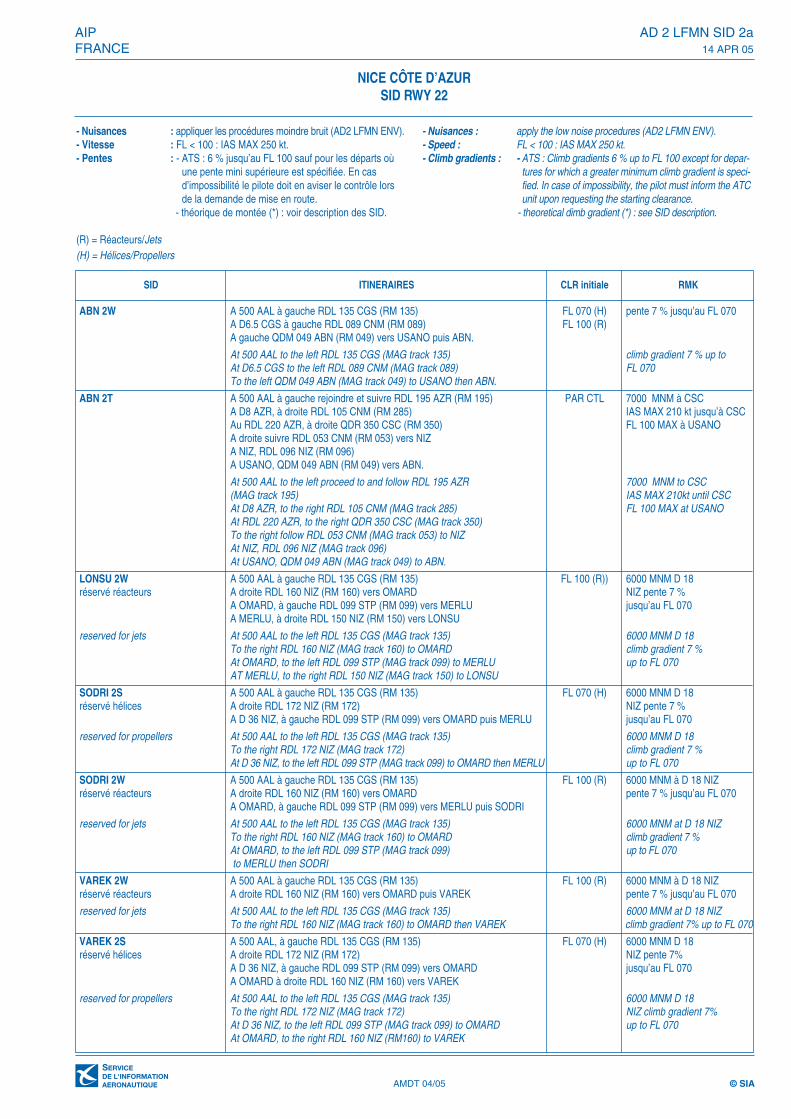
- Nuisances : appliquer les procédures moindre bruit (AD2 LFMN ENV).- Vitesse : FL < 100 : IAS MAX 250 kt.- Pentes : - ATS : Pente 6 % jusqu’au FL 100 sauf pour les
départs où une pente mini supérieure est spécifiée. Encas d’impossibilité, le pilote doit en aviser le contrôlelors de la demande de mise en route.
- théorique de montée (*) voir description des SID.(R) = Réacteurs/Jets(H) = Hélices/Propellers
- Nuisances : apply the low noise procedures (AD2 LFMN ENV).- Speed : FL < 100 : IAS MAX 250 kt.- Climb gradients : - ATS : Climb gradient 6 % up to FL 100 except for depar-
tures for which a greater minimum climb gradient is speci-fied. In case of impossibility, the pilot must inform theATC unit upon requesting the starting clearance.
- theoretical climb gradient (*) see SID description.
NICE CÔTE D’AZURSID RWY 04
ABN 2E A 400 AAL à droite RM 140 FL 100 (R)A D8 NIZ à gauche RDL 089 CGS (RM 089) FL 070 (H)A gauche QDM 049 ABN (RM 049) vers USANO puis ABN.
At 400 AAL to the right MAG track 140At D8 NIZ to the left RDL 089 CGS (MAG track 089)To the left QDM 049 ABN (MAG track 049) to USANO then ABN.
STP 2L A 400 AAL à droite RM 140 FL 070 (H) 6000 MNM D16réservé hélices A D8 NIZ RDL 160 NIZ (RM 160) NIZ pente 7%
A D11 NIZ à droite RM 219 jusqu’au FL 070A gauche RDL 184 NIZ (RM 184).A D34 NIZ à droite RDL 099 STP (RM 279) vers LERMA puis STP.
reserved for propellers At 400 AAL to the right MAG track 140 6000 MNM D16At D8 NIZ RDL 160 NIZ (MAG track 160) NIZ climb gradient 7% up toAt D11 NIZ to the right MAG track 219. FL 070To the left RDL 184 NIZ (MAG TRACK 184).At D34 NIZ to the right RDL 099 STP (MAG track 279) to LERMA then STP.
LONSU 2E A 400 AAL à droite RM 140 FL 100 (R) 6000 MNM D16réservé réacteurs A D8 NIZ RDL 160 NIZ (RM 160) vers OMARD. NIZ pente 7%
A OMARD, à gauche RDL 099 STP (RM 099) vers MERLU jusqu’au FL 070A MERLU, à droite RDL 150 NIZ (RM 150) vers LONSU.
reserved for jets At 400 AAL to the right MAG track 140 6000 MNM D16At D8 NIZ RDL 160 NIZ (MAG track 160) to OMARD. NIZ climb gradient 7% At OMARD, to the left RDL 099 STP (MAG track 099) to MERLU up to FL 070At MERLU, to the right RDL 150 NIZ (MAG track 150) to LONSU.
LONSU 2L A 400 AAL à droite RM 140 FL 070 (H) 6000 MNM D16réservé hélices A D8 NIZ RDL 160 NIZ (RM 160) NIZ pente 7%
A D11 NIZ à droite RM 219. jusqu’au FL 070A gauche RDL 172 NIZ (RM 172)A D36 NIZ à gauche RDL 099 STP (RM 099) vers OMARD puis MERLU.A MERLU, à droite RDL 150 NIZ (RM 150) vers LONSU.
reserved for propellers At 400 AAl to the right MAG track 140 6000 MNM D16At D8 NIZ RDL 160 NIZ (MAG track 160) NIZ climb gradient 7%At D11 NIZ to the right MAG track 219 up to FL 070To the left RDL 172 NIZ (MAG track 172)At D36 NIZ to the left RDL 099 STP (MAG track 099) to OMARD then MERLUAt MERLU, to the right RDL 150 NIZ (MAG track 150) to LONSU
SODRI 2E A 400 AAL à droite RM 140 FL 100 (R) 6000 MNM D16 NIZréservé reacteurs A D8 NIZ RDL 160 NIZ (RM 160) vers OMARD pente 7 % jusqu’au FL 070
A OMARD à gauche RDL 099 STP (RM 099) vers MERLU puis SODRI.
reserved for jets At 400 AAL to the right MAG track 140 6000 MNM D16 NIZAt D8 NIZ RDL 160 NIZ (MAG track 160) to OMARD climb gradient 7 % up toAt OMARD to the left RDL 099 STP (MAG track 099) to MERLU then SODRI. FL 070
VAREK 2E A 400 AAL à droite RM 140 FL 100 (R) 6000 MNM D16 NIZréservé réacteurs A D8 NIZ RDL 160 NIZ (RM 160) vers OMARD puis VAREK pente 7 % jusqu’au FL 070
reserved for jets At 400 AAL to the right MAG track 140 6000 MNM D16 NIZAt D8 NIZ RDL 160 NIZ (MAG track 160) to OMARD then VAREK climb gradient 7 %
up to FL 070
SID ITINERAIRES CLR initiale RMK
AMDT 04/05 © SIA

AD 2 LFMN SID 1b AIP14 APR 05 FRANCE
AMDT 04/05 © SIA
VAREK 2L A 400 AAL à droite RM 140 FL 070 (H) 6000 MNM D16 NIZréservé hélices A D8 NIZ RDL 160 NIZ (RM 160) pente 7% jusqu’au
A D 11 NIZ à droite RM 219 FL 070A gauche RDL 172 NIZ (RM 172)A D36 NIZ à gauche RDL 099 STP (RM 099) vers OMARDA OMARD à droite RDL 160 NIZ (RM 160) vers VAREK
reserved for propellers At 400 AAL to the right MAG track 140 6000 MNM D 16 NIZAt D8 NIZ RDL 160 NIZ (MAG track 160) climb gradient 7%At D11 NIZ to be right MAG track 219 up to FL 070To the left RDL 172 NIZ (MAG track 172)At D36 NIZ to the left RDL 099 STP (MAG track 099) to OMARDAt OMARD to the right RDL 160 NIZ (MAG track 160) to VAREK
SODRI 2L A 400 AAL à droite RM 140 FL 070 (H) 6000 MNM D16réservé hélices A D8 NIZ RDL 160 NIZ (RM 160) NIZ pente 7%
A D11 NIZ à droite RM 219 jusqu’au FL 070A gauche RDL 172 NIZ (RM 172)A D36 NIZ à gauche RDL 099 STP (RM 099) vers OMARD puis MERLU puis SODRI
reserved for propellers At 400 AAl to the right MAG track 140 6000 MNM D16At D8 NIZ RDL 160 NIZ (MAG track 160) NIZ climb gradient 7%At D11 NIZ to the right MAG track 219 up to FL 070To the left RDL 172 NIZ (MAG track 172)At D36 NIZ to the left RDL 099 STP (MAG track 099) to OMARD then MERLU then SODRI
RUBAS 2E A 400 AAL à droite RM 140 FL 100 (R) 6000 MNM D34 STPréservé réacteurs A D8 NIZ RDL 160 NIZ (RM 160) pente 7 % jusqu’au FL 070
A D11 NIZ à droite RDL 059 STP (RM 239)A D26 STP à gauche RDL 200 NIZ (RM 200) vers RUBAS.
reserved for jets At 400 AAL to the right MAG track 140 6000 MNM D34 STPAt D8 NIZ RDL 160 NIZ (MAG track 160) climb gradient 7 % up toAt D11 NIZ to the right RDL 059 STP (MAG track 239) FL 070At D26 STP to the left RDL 200 NIZ (MAG track 200) to RUBAS.
STP 2E A 400 AAL à droite RM 140 FL 100 (R) 6000 MNM D34 STPréservé réacteurs A D8 NIZ RDL 160 NIZ (RM 160) pente 7 % jusqu’au FL 070
A D11 NIZ à droite RDL 059 STP (RM 239)A D26 STP à gauche RDL 200 NIZ (RM 200)A D34 NIZ à droite RDL 099 STP (RM 279) vers STP.
reserved for jets At 400 AAL to the right MAG track 140 6000 MNM D34 STPAt D8 NIZ RDL 160 NIZ (MAG track 160) climb gradient 7 % At D11 NIZ to the right RDL 059 STP (MAG track 239) up to FL 070At D26 STP to the left RDL 200 NIZ (MAG track 200)At D34 NIZ to the right RDL 099 STP (MAG track 279) to STP.
PERUS 2E A 400 AAL à droite RM 140 FL 140 6000 MNM à NCA D8 NIZ à droite RDL 160 NIZ (RM 160)
RFL > 115 A D11 NIZ à droite vers NCA NC QDR 322 NC (RM 322)A AMIRO à gauche RDL 295 NIZ (RM 295) vers PERUS.Les pentes théoriques associées ici aux différents départs font abstraction des obstacles déterminant les pentes théoriques initiales voir AD2 LFMN INI 4.Pente théorique de montée : 4,5% déterminée par relief“Cime du Cheiron” 5833 ft.
At 400 AAL to the right MAG track 140 6000 MNM at NCAt D8 NIZ to the right RDL 160 NIZ (MAG track 160)At D11 NIZ to the right to NCAt NC QDR 322 NC (MAG track 322)At AMIRO to the left RDL 295 NIZ (MAG track 295) to PERUS.Theoretical gradient here associated to the different departures disregard obstacle which specify initial theoretical gradients see AD2 LFMN INI 4.Theoretical climb gradient 4,5 % specified by relief “Cîme du cheiron” 5833 ft
SID ITINERAIRES CLR initiale RMK
NICE CÔTE D’AZURSID RWY 04

PERUS 2L A 400 AAL à droite RM 140 FL 140 6000 MNM au QDR 189 NCA D8 NIZ à droite RDL 160 NIZ (RM 160)
RFL > 115 A D11 NIZ à droite vers CNMA CNM RDL 347 CNM (RM 347)A AMIRO à gauche RDL 295 NIZ (RM 295) vers PERUS.Les pentes théoriques associées ici aux différents départs font abstraction des obstacles déterminant les pentes théoriques initiales voir AD2 LFMN INI 4.Pente théorique de montée : 3,4% déterminée par reliefs “Montagne de Thiey”5096 ft et “Montagne de l'Audibergue” 5387 ft.
At 400 AAL to the right MAG track 140 6000 MNM at QDR 189 NCAt D8 NIZ to the right RDL 160 NIZ (MAG track 160)At D11 NIZ to the right to CNMAt CNM RDL 347 (MAG track 347)At AMIRO to the left RDL 295 NIZ (MAG track 295) to PERUS.Theoretical gradient here associated to the different departures disregard obstacle which specify initial theoretical gradients see AD2 LFMN INI 4.Theoretical climb gradient 3,4 % specified by relief “Montagne de Thiey” 5096 ft and “Montagne de l’Audibergue” 5387 ft.
BODRU 2E A 400 AAL à droite RM 140 FL 140 6000 MNM à NCA D8 NIZ à droite RDL 160 NIZ (RM 160)A D11 NIZ à droite vers NCA NC QDR 322 NC (RM 322)A AMIRO route RNAV 315 vers BODRU.Les pentes théoriques associées ici aux différents départs font abstraction des obstacles déterminant les pentes théoriques initiales voir AD2 LFMN INI 4.Pente théorique de montée : 4,5% déterminée par relief “Cime du Cheiron” 5833 ft.
At 400 AAL to the right MAG track 140 6000 MNM at NCAt D8 NIZ to the right RDL 160 NIZ (MAG track 160)At D11 NIZ to the right to NCAt NC QDR 322 (MAG track 322)At AMIRO RNAV to the left RDL 315 NIZ (MAG track 295) to PERUS.Theoretical gradient here associated to the different departures disregard obstacle which specify initial theoretical gradients (see AD2 LFMN INI 4).Theoretical climb gradient 4,5 % specified by relief “Cîme du cheiron” 5833 ft.
BODRU 2L A 400 AAL à droite RM 140 FL 140 6000 MNM au QDR 189 NCA D8 NIZ à droite RDL160 NIZ (RM 160)A D11 NIZ à droite vers CNM.A CNM RDL 347 CNM (RM 347)A AMIRO à gauche route RNAV 315 vers BODRU.Les pentes théoriques associées ici aux différents départs font abstraction des obstacles déterminant les pentes théoriques initiales voir AD2 LFMN INI 4.Pente théorique de montée : 3,4% déterminée par reliefs “Montagne de Thiey” 5096 ft et “Montagne de l'Audibergue” 5387 ft.
At 400 AAL to the right MAG track 140 6000 MNM at QDR 189 NCAt D8 NIZ to the right RDL 160 NIZ (MAG track 160)At D11 NIZ to the right to CNMAt CNM RDL 347 (MAG track 347)At AMIRO to the left RNAV route 315 to BODRU.Theoretical gradient here associated to the different departures disregard obstacle which specify initial theoretical gradients see AD2 LFMN INI 4.Theoretical climb gradient 3,4 % specified by relief “Montagne de Thiey” 5096 ft and “Montagne de l’Audibergue” 5387 ft.
AIP AD 2 LFMN SID 1cFRANCE 14 APR 05
AMDT 04/05 © SIA
NICE CÔTE D’AZURSID RWY 04
SID ITINERAIRES CLR initiale RMK

AD 2 LFMN SID 1d AIP14 APR 05 FRANCE
AMDT 04/05 © SIA
OKTET 2E A 400 AAL à droite RM 140 FL 140 6000 MNM à NCA D8 NIZ à droite RDL 160 NIZ (RM 160)A D11 NIZ à droite vers NCA NC QDR 322 NC (RM 322)A AMIRO à droite RDL 347 CNM (RM 347) vers OKTET.Les pentes théoriques associées ici aux différents départs font abstraction des obstacles déterminant les pentes théoriques initiales voir AD2 LFMN INI 4.Pente théorique de montée : 4,5% déterminée par relief “Cime du Cheiron” 5833 ft.
At 400 AAL to the right MAG track 140 6000 MNM at NCAt D8 NIZ to the right RDL 160 NIZ (MAG track 160)At D11 NIZ to the right to NCAt NC QDR 322 (MAG track 322)At AMIRO to the right RDL 347 CNM (MAG track 347) to OKTET.Theoretical gradient here associated to the different departures disregard obstacle which specify initial theoretical gradients see AD2 LFMN INI 4.Theoretical climb gradient 4,5 % specified by relief “Cîme du cheiron” 5833 ft.
OKTET 2L A 400 AAL à droite RM 140 FL 140 6000 MNM au QDR 189 NCA D8 NIZ à droite RDL 160 NIZ (RM 160)A D11 NIZ à droite vers CNMA CNM RDL 347 CNM (RM 347) vers AMIRO puis OKTET.Les pentes théoriques associées ici aux différents départs font abstraction des obstacles déterminant les pentes théoriques initiales voir AD2 LFMN INI 4.Pente théorique de montée : 3,4% déterminée par reliefs “Montagne de Thiey” 5096 ft et “Montagne de l'Audibergue” 5387 ft.
At 400 AAL to the right MAG track 140 6000 MNM at QDR 189 NCAt D8 NIZ to the right RDL 160 NIZ (MAG track 160)At D11 NIZ to the right to CNMAt CNM RDL 347 (MAG track 347) to AMIRO then OKTET.Theoretical gradient here associated to the different departures disregard obstacle which specify initial theoretical gradients see AD2 LFMN INI 4.Theoretical climb gradient 3,4 % specified by relief “Montagne de Thiey” 5096 ft and “Montagne de l’Audibergue” 5387 ft.
OKTET 2M A 400 AAL à droite RM 140 PAR CTL FL 100 MAX à NIZA D8 NIZ à gauche RDL 089 CGS (RM 089) A D14 CGS à gauche vers NIZA NIZ RDL 325 NIZ (RM 325)A BARSO route RNAV 326 vers OKTET.Les pentes théoriques associées ici aux différents départs font abstraction des obstacles déterminant les pentes théoriques initiales voir AD2 LFMN INI 4.Pente théorique de montée : 5,3% déterminée par pylône “Mt Agel” 4059 ft.
At 400 AAL to the right MAG track 140 BY ATC FL 100 MAX at NIZAt D8 NIZ to the left RDL 089 CGS (MAG track 089)At D14 CGS to the left to NIZA NIZ RDL 325 NIZ (MAG track 325)At BARSO RNAV route 326 to OKTET.Theoretical gradient here associated to the different departures disregard obstacle which specify initial theoretical gradients see AD2 LFMN INI 4.Theoretical climb gradient 5,3 % specified by pylon “Mt Agel” 4059 ft.
EPOLO 2E A 400 AAL à droite RM 140 FL 100(R) 6000 MNM D34 STPréservé réacteurs A D8 NIZ RDL 160 NIZ (RM 160) pente 7% jusqu’au FL 070
A D11 NIZ à droite RDL 059 STP (RM 239)A D26 STP à gauche RDL 200 NIZ (RM 200) vers RESBOA RESBO route RNAV 227 vers EPOLO
reserved for jets At 400 AAL to the right MAG track 140 6000 MNM D34 STPAT D8 NIZ RDL 160 NIZ (MAG track 160) climb gradient 7% At D11 NIZ to the right RDL 059 STP MAG track 239 up to FL 070At D26 STP to the left RDL 200 NIZ (MAG track 200) to RESBOAT RESBO RNAV track 227 to EPOLO
SID ITINERAIRES CLR initiale RMK
NICE CÔTE D’AZURSID RWY 04

AIP AD 2 LFMN SID 1eFRANCE 14 APR 05
EPOLO 2L A 400 AAL à droite RM 140 FL 070(H) 6000 MNM D16 NIZréservé hélices A D8 NIZ RDL 160 NIZ (RM 160) pente 7% jusqu’au FL 070
A D11 NIZ à droite RM 219A gauche RDL 184 NIZ (RM 184)A D34 NIZ à droite RDL 099 STP (RM 279) vers LERMAA LERMA route RNAV 234 vers EPOLO
reserved for propellers At 400 AAL to the right MAG track 140 6000 MNM D16 NIZAt D8 NIZ RDL 160 NIZ (MAG track 160) climb gradient 7%At D11 NIZ to the right MAG track 219 up to FL 070To the left RDL 184 NIZ (MAG track 184)At D34 NIZ to the right RDL 099 STP (MAG track 279) to LERMAAt LERMA RNAV track 234 to EPOLO
IRMAR 2E A 400 AAL à droite RM 140 FL 140 6000 MNM à NCA D8 NIZ RDL 160 NIZ (RM 160)A D11 NIZ à droite vers NC A NC RDL 343 NC (RM 343) vers BARSOA BARSO route RNAV 354 vers IRMARLes pentes théoriques associées ici aux différents départs font abstraction des obstacles déterminant les pentes théoriques initiales voir AD2 LFMN INI 4.Pente théorique de montée : 4,5 % déterminée par relief “Cime du Cheiron” 5833 ft.
At 400 AAL to the right MAG track 140 6000 MNM at NCAt D8 NIZ to the right RDL 160 NIZ (MAG track 160)At D11 NIZ to the right to NC then BARSOAt NC RDL 343 NC (MAG track 343) to BARSOAt BARSO RNAV route 354 to IRMAR.Theoretical gradient here associated to the different departures disregard obstacle which specify initial theoretical gradients see AD2 LFMN INI 4.Theoretical climb gradient 4,5 % specified by relief “Cîme du cheiron” 5833 ft.
IRMAR 2M A 400 AAL à droite RM 140 PAR CTL FL 100 MAX à NIZA D8 NIZ à gauche RDL 089 CGS (RM 089)A D14 CGS à gauche vers NIZA NIZ RDL 325 NIZ (RM 325)A BARSO à droite route RNAV 354 vers IRMAR.Les pentes théoriques associées ici aux différents départs font abstraction des obstacles déterminant les pentes théoriques initiales voir AD2 LFMN INI 4Pente théorique de montée : 5,3 % déterminée par pylône “Mt Agel” 4059 ft.
At 400 AAL to the right MAG track 140 BY ATC FL 100 MAX at NIZAt D8 NIZ to the left RDL 089 CGS (MAG track 089)At D14 CGS to the left to NIZA NIZ RDL 325 NIZ (MAG track 325)At BARSO to the right RNAV route 354 to IRMARTheoretical gradient here associated to the different departures disregard obstacle which specify initial theoretical gradients see AD2 LFMN INI 4.Theoretical climb gradient 5,3 % specified by pylon “Mt Agel” 4059 ft.
SID ITINERAIRES CLR initiale RMK
NICE CÔTE D’AZURSID RWY 04
AMDT 04/05 © SIA

����
����
����
����
����
����
����
����
����
����
����
����
�����
�����
�����
�������������������
�����
��������
�����
��������
��������
���������������
�������
��������
��������
��������
������
��������
��������������������
����
�������
��������
���������!���
��"�
�������#
�""� �""�"�$��
��
�� �� ��#
����%�
�"��
����
�"�����#
��
��
����
������$�
��
��
����
��������
����
��
��
������%�
��
��
��"��"
����
�
����
��
" ��"�
��
�"
�������
��
��������!���
���������!���
��������
����
���!���
�������
��������
�������
��������
������!��
�������
����
%�
$&���
����
�����%�
�$������
�������
�� ��
�������
�����#�
�"���#�
���
%�
#�� ��
�������
��#
����
��
��������
�������
��������
��
�"$� ����
����
�������#
����
����
�"��
����
����
��"�� �
��"�
����
��!��
����
����
�������
������
�� ����
��������
�� ����
�������� ��
���$
���� �"
�� �� ��#
����
�$ �� ��#
�������#
��������!��
�""��$
�����
��!��������
�""�����
�������#
�$�����#
�$��
�����
����
����
����
��
���
��#����&�'�����
������������()�*+,-.
����
��#��""
#����"&$�'����/
���
%����"&�'��"�����
�����
�����
����������&�
������
������&�'�����
������$&�'������
�����
�������
0/��'�����1��"&�2
�����
�����
����
����
����
�����
�����
�������
����
����
����
���
����
�����
���
�����
���
����
���
�����
�%�����&��
�������������������
������� �
����
�����
����
����������������()�*+,-.
�������
���������������� ����
������������
� ������
������1��2
���3��0%��34�5�
������ ����������������
����������������� ���� �������!
�"##$�%$�&�''�#(&"�(�#��)55,6'3+�6*73��$��&�*,+�6*4-,843-�9(+�,6):,;+3-�����<�������&
������������������� ���������� �!"#������$���� %&�'!�(%&�')*�&�!�'")*��+�������� �$
���������������������������������������
����������������+.=*:���������*:���������*)+
��"&$���&����&������&�
���>�������������������������99+*6'3
���&������&����102�!����&����1�2�!����&����1-2
ABN 2W A 500 AAL à gauche RDL 135 CGS (RM 135) FL 070 (H) pente 7 % jusqu’au FL 070A D6.5 CGS à gauche RDL 089 CNM (RM 089) FL 100 (R)A gauche QDM 049 ABN (RM 049) vers USANO puis ABN.
At 500 AAL to the left RDL 135 CGS (MAG track 135) climb gradient 7 % up toAt D6.5 CGS to the left RDL 089 CNM (MAG track 089) FL 070To the left QDM 049 ABN (MAG track 049) to USANO then ABN.
ABN 2T A 500 AAL à gauche rejoindre et suivre RDL 195 AZR (RM 195) PAR CTL 7000 MNM à CSCA D8 AZR, à droite RDL 105 CNM (RM 285) IAS MAX 210 kt jusqu’à CSCAu RDL 220 AZR, à droite QDR 350 CSC (RM 350) FL 100 MAX à USANOA droite suivre RDL 053 CNM (RM 053) vers NIZA NIZ, RDL 096 NIZ (RM 096)A USANO, QDM 049 ABN (RM 049) vers ABN.
At 500 AAL to the left proceed to and follow RDL 195 AZR 7000 MNM to CSC(MAG track 195) IAS MAX 210kt until CSCAt D8 AZR, to the right RDL 105 CNM (MAG track 285) FL 100 MAX at USANOAt RDL 220 AZR, to the right QDR 350 CSC (MAG track 350)To the right follow RDL 053 CNM (MAG track 053) to NIZAt NIZ, RDL 096 NIZ (MAG track 096)At USANO, QDM 049 ABN (MAG track 049) to ABN.
LONSU 2W A 500 AAL à gauche RDL 135 CGS (RM 135) FL 100 (R)) 6000 MNM D 18réservé réacteurs A droite RDL 160 NIZ (RM 160) vers OMARD NIZ pente 7 %
A OMARD, à gauche RDL 099 STP (RM 099) vers MERLU jusqu’au FL 070A MERLU, à droite RDL 150 NIZ (RM 150) vers LONSU
reserved for jets At 500 AAL to the left RDL 135 CGS (MAG track 135) 6000 MNM D 18To the right RDL 160 NIZ (MAG track 160) to OMARD climb gradient 7 % At OMARD, to the left RDL 099 STP (MAG track 099) to MERLU up to FL 070AT MERLU, to the right RDL 150 NIZ (MAG track 150) to LONSU
SODRI 2S A 500 AAL à gauche RDL 135 CGS (RM 135) FL 070 (H) 6000 MNM D 18réservé hélices A droite RDL 172 NIZ (RM 172) NIZ pente 7 %
A D 36 NIZ, à gauche RDL 099 STP (RM 099) vers OMARD puis MERLU jusqu’au FL 070
reserved for propellers At 500 AAL to the left RDL 135 CGS (MAG track 135) 6000 MNM D 18To the right RDL 172 NIZ (MAG track 172) climb gradient 7 % At D 36 NIZ, to the left RDL 099 STP (MAG track 099) to OMARD then MERLU up to FL 070
SODRI 2W A 500 AAL à gauche RDL 135 CGS (RM 135) FL 100 (R) 6000 MNM à D 18 NIZréservé réacteurs A droite RDL 160 NIZ (RM 160) vers OMARD pente 7 % jusqu’au FL 070
A OMARD, à gauche RDL 099 STP (RM 099) vers MERLU puis SODRI
reserved for jets At 500 AAL to the left RDL 135 CGS (MAG track 135) 6000 MNM at D 18 NIZTo the right RDL 160 NIZ (MAG track 160) to OMARD climb gradient 7 %At OMARD, to the left RDL 099 STP (MAG track 099) up to FL 070to MERLU then SODRI
VAREK 2W A 500 AAL à gauche RDL 135 CGS (RM 135) FL 100 (R) 6000 MNM à D 18 NIZréservé réacteurs A droite RDL 160 NIZ (RM 160) vers OMARD puis VAREK pente 7 % jusqu’au FL 070
reserved for jets At 500 AAL to the left RDL 135 CGS (MAG track 135) 6000 MNM at D 18 NIZTo the right RDL 160 NIZ (MAG track 160) to OMARD then VAREK climb gradient 7% up to FL 070
VAREK 2S A 500 AAL, à gauche RDL 135 CGS (RM 135) FL 070 (H) 6000 MNM D 18réservé hélices A droite RDL 172 NIZ (RM 172) NIZ pente 7%
A D 36 NIZ, à gauche RDL 099 STP (RM 099) vers OMARD jusqu’au FL 070A OMARD à droite RDL 160 NIZ (RM 160) vers VAREK
reserved for propellers At 500 AAL to the left RDL 135 CGS (MAG track 135) 6000 MNM D 18To the right RDL 172 NIZ (MAG track 172) NIZ climb gradient 7%At D 36 NIZ, to the left RDL 099 STP (MAG track 099) to OMARD up to FL 070At OMARD, to the right RDL 160 NIZ (RM160) to VAREK
AMDT 04/05 © SIA
AIP AD 2 LFMN SID 2aFRANCE 14 APR 05
NICE CÔTE D’AZURSID RWY 22
- Nuisances : appliquer les procédures moindre bruit (AD2 LFMN ENV).- Vitesse : FL < 100 : IAS MAX 250 kt.- Pentes : - ATS : 6 % jusqu’au FL 100 sauf pour les départs où
une pente mini supérieure est spécifiée. En casd’impossibilité le pilote doit en aviser le contrôle lorsde la demande de mise en route.
- théorique de montée (*) : voir description des SID.
(R) = Réacteurs/Jets(H) = Hélices/Propellers
- Nuisances : apply the low noise procedures (AD2 LFMN ENV).- Speed : FL < 100 : IAS MAX 250 kt.- Climb gradients : - ATS : Climb gradients 6 % up to FL 100 except for depar-
tures for which a greater minimum climb gradient is speci-fied. In case of impossibility, the pilot must inform the ATCunit upon requesting the starting clearance.
- theoretical dimb gradient (*) : see SID description.
SID ITINERAIRES CLR initiale RMK
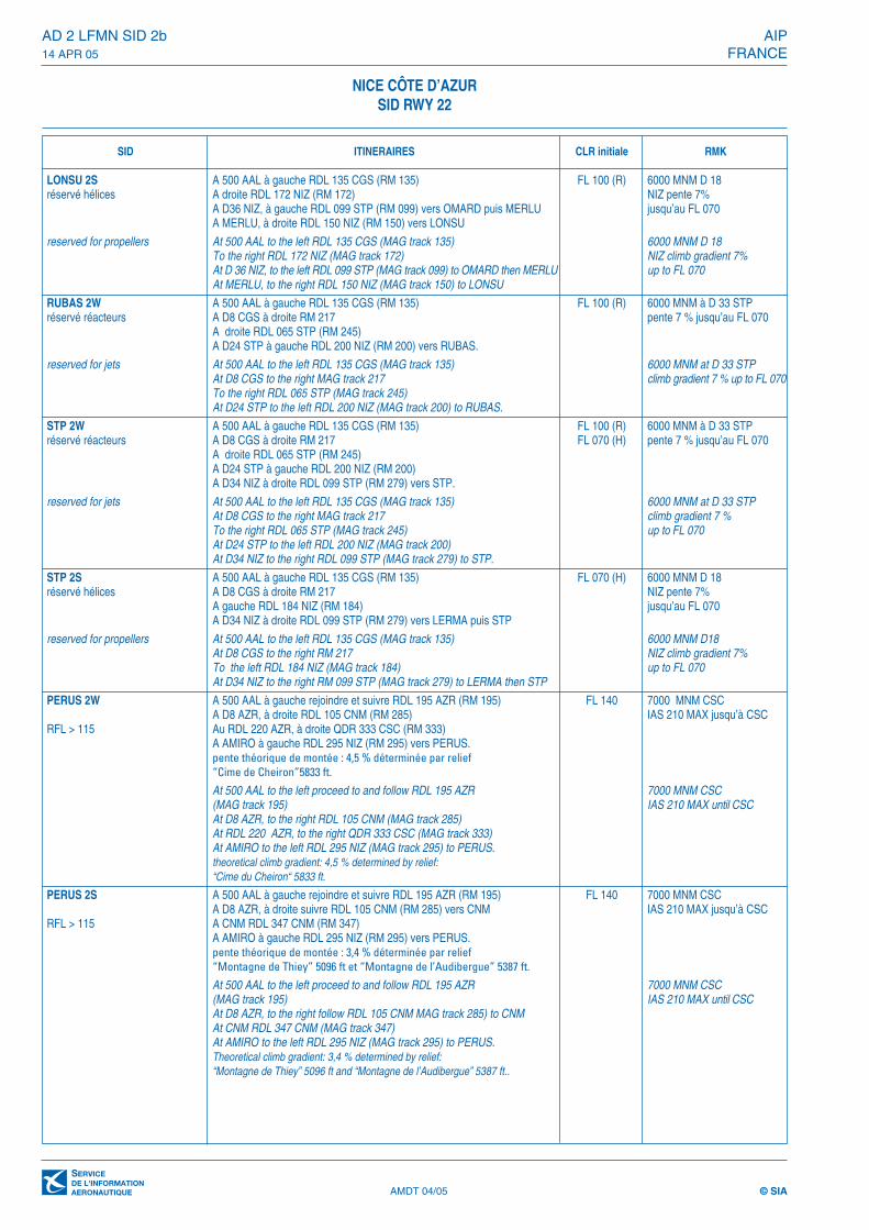
LONSU 2S A 500 AAL à gauche RDL 135 CGS (RM 135) FL 100 (R) 6000 MNM D 18réservé hélices A droite RDL 172 NIZ (RM 172) NIZ pente 7%
A D36 NIZ, à gauche RDL 099 STP (RM 099) vers OMARD puis MERLU jusqu’au FL 070A MERLU, à droite RDL 150 NIZ (RM 150) vers LONSU
reserved for propellers At 500 AAL to the left RDL 135 CGS (MAG track 135) 6000 MNM D 18To the right RDL 172 NIZ (MAG track 172) NIZ climb gradient 7%At D 36 NIZ, to the left RDL 099 STP (MAG track 099) to OMARD then MERLU up to FL 070At MERLU, to the right RDL 150 NIZ (MAG track 150) to LONSU
RUBAS 2W A 500 AAL à gauche RDL 135 CGS (RM 135) FL 100 (R) 6000 MNM à D 33 STPréservé réacteurs A D8 CGS à droite RM 217 pente 7 % jusqu’au FL 070
A droite RDL 065 STP (RM 245)A D24 STP à gauche RDL 200 NIZ (RM 200) vers RUBAS.
reserved for jets At 500 AAL to the left RDL 135 CGS (MAG track 135) 6000 MNM at D 33 STPAt D8 CGS to the right MAG track 217 climb gradient 7 % up to FL 070To the right RDL 065 STP (MAG track 245)At D24 STP to the left RDL 200 NIZ (MAG track 200) to RUBAS.
STP 2W A 500 AAL à gauche RDL 135 CGS (RM 135) FL 100 (R) 6000 MNM à D 33 STPréservé réacteurs A D8 CGS à droite RM 217 FL 070 (H) pente 7 % jusqu’au FL 070
A droite RDL 065 STP (RM 245)A D24 STP à gauche RDL 200 NIZ (RM 200)A D34 NIZ à droite RDL 099 STP (RM 279) vers STP.
reserved for jets At 500 AAL to the left RDL 135 CGS (MAG track 135) 6000 MNM at D 33 STPAt D8 CGS to the right MAG track 217 climb gradient 7 %To the right RDL 065 STP (MAG track 245) up to FL 070At D24 STP to the left RDL 200 NIZ (MAG track 200)At D34 NIZ to the right RDL 099 STP (MAG track 279) to STP.
STP 2S A 500 AAL à gauche RDL 135 CGS (RM 135) FL 070 (H) 6000 MNM D 18réservé hélices A D8 CGS à droite RM 217 NIZ pente 7%
A gauche RDL 184 NIZ (RM 184) jusqu’au FL 070A D34 NIZ à droite RDL 099 STP (RM 279) vers LERMA puis STP
reserved for propellers At 500 AAL to the left RDL 135 CGS (MAG track 135) 6000 MNM D18At D8 CGS to the right RM 217 NIZ climb gradient 7%To the left RDL 184 NIZ (MAG track 184) up to FL 070At D34 NIZ to the right RM 099 STP (MAG track 279) to LERMA then STP
PERUS 2W A 500 AAL à gauche rejoindre et suivre RDL 195 AZR (RM 195) FL 140 7000 MNM CSCA D8 AZR, à droite RDL 105 CNM (RM 285) IAS 210 MAX jusqu’à CSC
RFL > 115 Au RDL 220 AZR, à droite QDR 333 CSC (RM 333)A AMIRO à gauche RDL 295 NIZ (RM 295) vers PERUS.pente théorique de montée : 4,5 % déterminée par relief “Cime de Cheiron”5833 ft.
At 500 AAL to the left proceed to and follow RDL 195 AZR 7000 MNM CSC(MAG track 195) IAS 210 MAX until CSCAt D8 AZR, to the right RDL 105 CNM (MAG track 285) At RDL 220 AZR, to the right QDR 333 CSC (MAG track 333)At AMIRO to the left RDL 295 NIZ (MAG track 295) to PERUS.theoretical climb gradient: 4,5 % determined by relief: “Cime du Cheiron“ 5833 ft.
PERUS 2S A 500 AAL à gauche rejoindre et suivre RDL 195 AZR (RM 195) FL 140 7000 MNM CSCA D8 AZR, à droite suivre RDL 105 CNM (RM 285) vers CNM IAS 210 MAX jusqu’à CSC
RFL > 115 A CNM RDL 347 CNM (RM 347)A AMIRO à gauche RDL 295 NIZ (RM 295) vers PERUS.pente théorique de montée : 3,4 % déterminée par relief “Montagne de Thiey” 5096 ft et “Montagne de l’Audibergue” 5387 ft.
At 500 AAL to the left proceed to and follow RDL 195 AZR 7000 MNM CSC(MAG track 195) IAS 210 MAX until CSCAt D8 AZR, to the right follow RDL 105 CNM MAG track 285) to CNMAt CNM RDL 347 CNM (MAG track 347) At AMIRO to the left RDL 295 NIZ (MAG track 295) to PERUS.Theoretical climb gradient: 3,4 % determined by relief: “Montagne de Thiey” 5096 ft and “Montagne de l’Audibergue” 5387 ft..
AMDT 04/05 © SIA
AD 2 LFMN SID 2b AIP14 APR 05 FRANCE
NICE CÔTE D’AZURSID RWY 22
SID ITINERAIRES CLR initiale RMK

AIP AD 2 LFMN SID 2cFRANCE 14 APR 05
AMDT 04/05 © SIA
BODRU 2W A 500 AAL à gauche rejoindre et suivre RDL 195 AZR (RM 195) FL 140 7000 MNM CSCA D8 AZR, à droite RDL 105 CNM (RM 285) IAS 210 MAX jusqu’à CSCAu RDL 220 AZR, à droite QDR 333 CSC (RM 333) A AMIRO route RNAV 315 vers BODRU.pente théorique de montée : 4,5 % déterminée par relief “Cime de Cheiron”5833 ft.
At 500 AAL to the left proceed to and follow RDL 195 AZR 7000 MNM CSC(MAG track 195) IAS 210 MAX until CSCAt D8 AZR, to the right RDL 105 CNM MAG track 285)At RDL 220 AZR, to the right QDR 333 CSC (MAG track 333)At AMIRO RNAV route 315 to BODRU.theoretical climb gradient: 4,5 % determined by relief: “Cime du Cheiron“ 5833 ft.
BODRU 2S A 500 AAL à gauche rejoindre et suivre RDL 195 AZR (RM 195) FL 140 7000 MNM CSCA D8 AZR, à droite suivre RDL 105 CNM (RM 285) vers CNM IAS 210 MAX jusqu’à CSCA CNM RDL 347 CNM (RM 347)A AMIRO route RNAV 315 vers BODRU.pente théorique de montée : 3,4 % déterminée par relief “Montagne de Thiey” 5096 ft et “Montagne de l’Audibergue” 5387 ft.
At 500 AAL to the left proceed to and follow RDL 195 AZR MAG track 195) 7000 MNM CSCAt D8 AZR, to the right follow RDL 105 CNM (MAG track 285) to CNM IAS 210 MAX until CSCAt CNM RDL 347 CNM (MAG track 347)At AMIRO RNAV route 315 to BODRU.theoretical climb gradient: 3,4 % determined by relief: “Montagne de Thiey” 5096 ft and “Montagne de l’Audibergue” 5387 ft..
OKTET 2W A 500 AAL à gauche rejoindre et suivre RDL 195 AZR (RM 195) FL 140 7000 MNM CSCA D8 AZR, à droite RDL 105 CNM (RM 285) IAS 210 MAX jusqu’à CSCAu RDL 220 AZR, à droite QDR 333 CSC (RM 333)A AMIRO à droite RDL 347 CNM (RM 347) vers OKTET.pente théorique de montée : 4.5% déterminée par relief “Cime de Cheiron”5833 ft.
At 500 AAL to the left proceed to and follow RDL 195 AZR 7000 MNM CSC(Magnetic track 195) IAS 210 MAX until CSCAt D8 AZR, to the right RDL 105 CNM (MAG track 285)At RDL 220 AZR, to the right QDR 333 CSC (MAG track 333)At AMIRO to the right RDL 347 CNM to OKTET.theoretical climb gradient: 4.5% determined by relief: “Cime du Cheiron“ 5833 ft.
OKTET 2S A 500 AAL à gauche rejoindre et suivre RDL 195 AZR (RM 195) FL 140 7000 MNM CSCA D8 AZR, à droite RDL 105 CNM (RM 285). IAS 210 MAX jusqu’à CSCA CNM RDL 347 CNM (RM 347) vers AMIRO puis OKTET.pente théorique de montée : 3,4 % déterminée par relief “Montagne de Thiey” 5096 ft et “Montagne de l’Audibergue” 5387 ft.
At 500 AAL to the left proceed to and follow RDL 195 AZR 7000 MNM CSC(MAG track 195) IAS 210 MAX until CSCAt D8 AZR, to the right RDL 105 CNM (MAG track 285)At CNM RDL 347 CNM (MAG track 347) to AMIRO then OKTET.theoretical climb gradient: 3,4 % determined by relief: “Montagne de Thiey” 5096 ft and “Montagne de l’Audibergue” 5387 ft..
OKTET 2T A 500 AAL à gauche RDL 135 CGS (RM 135) PAR CTL FL 100 MAX à NIZA D 6,5 CGS à gauche RDL 089 CNM (RM 089)A D13 CGS à gauche vers NIZA NIZ RDL 325 NIZ (RM 325). A BARSO route RNAV 326 vers OKTET.pente théorique de montée : 4% déterminée par relief “Mont Vial” 5085 ft.
At 500 AAL to the left RDL 135 CGS (MAG track 135) BY ATC FL 100 MAX at NIZAt D 6,5 CGS to the left RDL 089 CNM (MAG track 089) At D13 CGS to the left to NIZAt NIZ RDL 325 NIZ (MAG track 325)At BARSO RNAV route 326 to OKTET.heoretical climb gradient: 4% determined by relief: “Mont Vial” 5085 ft .
NICE CÔTE D’AZURSID RWY 22
SID ITINERAIRES CLR initiale RMK

AD 2 LFMN SID 2d AIP14 APR 05 FRANCE
AMDT 04/05 © SIA
IRMAR 2W A 500 AAL à gauche rejoindre et suivre RDL 195 AZR (RM 195) FL 140 7000 MNM CSC(1) A D8 AZR, à droite RDL 105 CNM (RM 285) IAS 210 MAX jusqu’à CSC
Au RDL 220 AZR, à droite QDR 350 CSC (RM 350)A BARSO route RNAV 354 vers IRMAR.pente théorique de montée : 4,5 % déterminée par relief “Cime de Cheiron”5833 ft.
At 500 AAL to the left proceed to and follow RDL 195 AZR 7000 MNM CSC(MAG track 195) IAS 210 MAX until CSCAt D8 AZR, to the right RDL 105 CNM (MAG track 285)At RDL 220 AZR, to the right QDR 350 CSC (MAG track 350) At BARSO RNAV route 354 to IRMAR.theoretical climb gradient: 4,5 % determined by relief: “Cime du Cheiron“ 5833 ft.
EPOLO 2S A 500 AAL à gauche RDL 135 CGS (RM 135) FL 070 (H) 6000 MNM D 18réservé hélices A D8 CGS à droite RM 217 NIZ pente 7%
A gauche RDL 184 NIZ (RM 184) jusqu’au FL 070A D34 NIZ à droite RDL 099 STP (RM 279) vers LERMA puis route RNAV 234 vers EPOLO
reserved for propellers At 500 AAL to the left RDL 135 CGS (MAG track 135) 6000 MNM D18At D18 CGS to the right RM 217 NIZ climb gradient 7%To the left RDL 184 NIZ (MAG track 184) up to FL 070At D34 NIZ to the right RM 099 STP (MAG track 279)To LERMA then RNAV track 234 to EPOLO
EPOLO 2W A 500 AAL à gauche RDL 135 CGS (RM 135) FL 100 (R) 6000 MNM D32réservé réacteurs A D8 CGS à droite RM 217 STP pente 7%
A droite RDL 065 STP (RM 245) jusqu’au FL 070A D24 STP à gauche RDL 200 NIZ (RM 200) vers RESBOA RESBO route RNAV 227 vers EPOLO
reserved for jets At 500 AAL to the left RDL 135 CGS (MAG track 135) 6000 MNM D32At D8 CGS to the right RM 217 STP climb gradient 7%To the right RDL 065 STP (MAG track 245) up to FL 070At D24 STP to the left RM 200 NIZ (MAG track 200) to RESBOAt RESBO RNAV track 227 to EPOLO
IRMAR 2T A 500 AAL à gauche RDL 135 CGS (RM135) PAR CTL FL 100 MAX à NIZA D6,5 CGS à gauche RDL 089 CNM(RM 089)A D13 CGS à gauche vers NIZA NIZ RDL 325 NIZ (RM 325)A BARSO route RNAV 354 vers IRMARpente théorique de montée : 4% déterminée par relief “Mont Vial” 5085 ft.
At 500 AAL to the left RDL 135 CGS (MAG track 135) BY ATC FL 100 MAX at NIZAt D6,5 CGS to the left RDL 089 CNM (MAG track 089)At D13 CGS to the left to NIZAt NIZ RDL 325 NIZ (MAG track 325)At BARSO RNAV route 354 to IRMAR.theoretical climb gradient: 4% determined by reliefs: “Mont Vial” 5085 ft.
NICE CÔTE D’AZURSID RWY 22
SID ITINERAIRES CLR initiale RMK

����
����
����
����
����
����
����
����
����
����
����
����
���������
������
������
���������
�
�
�
�
�
� �
�������������������
�
�
�
�
�
�
�
�
�
�
�
�
���
�� ��
�� ��
�� ���
����
� �
� ��
�������
�
������
���
��� ��
��
����
���������
������
���� �
�� �
���������
���� �
���������
������
���������
���� �����������������������
��� ������� !��"#$%���&���'(
�����
����)�
�%�)
�%�%*���������+
������
� �� �����
��
��� ����
����
��������
���
���
���
����
����
�� ���
���
� ��
�������
�%,�&��� ���+
�������&� �&��+
������
�),����
�������������� ����+
��)�����-.)�� �&��+
�����&&
������ � �&�+
�,����� � ����.
��������� �� �������������)
�(#/#0�1/!��������!(�����2!00�03�4��)��������3������4�������56#(!�%���&���'(
�)��*
��%�%
�60#(#6$$6$�7�/�8� !//!
�����&�
�������������� �������
�������
���������
3�����9��:
������������������������������
����������������������� �������!
��5�#$0(5��(#6$�2���������������������
��3
����!(�-���!$�;(
���������� ����������������������������������� �!�"���������������# ���$�������%
�" ��#����$$� %�"�%� ����;;#� !5��62!������36#5��6$0#<$!0�=�5(#��/#>5!0���&�������)+��
������������������� ����������������� ������������ ������ �!����� ��!��"����#$��%&��
��%����
�?
�%�)�%�)��)����%�)��==56� !�%�)��6�5
&���& � � ����� �9-:�@�&��� �9%:�@�����& �90:���
�%�)��58A6/�%�)��6/
�?�?
&��&���

����
����
����
����
����
����
����
����
�����������������������
�
�
�
�
�
�
�
�
��
�
�
�
�
�
�
�
�
�
�����
�����
����
����
�
�
�
�
��
�
��
�
�
�
�
�
�
�
�
�
�� ������
�����
����
���������
�����
���
�������
��������
��������
�������
� ��
��������
� �� ���
�� �
� ���� ��
�� �� ���
������������ ��
���� ���
����
�� �
�����
�����������
��������
���� ��
����
� �����
�����
�����
������
���
��������
��������
�������
�������������
����
���
������
����
�����������
�������
����
��� ���������������
����������������
��������
����
���
�������
������
�������
���
� �� ���
� �� ���
��������
����
� �
���
���
��������
�����
�������
����
����
�� �� ���
��������
��������
����
�������
��������
������
����
��������
�����
����
���� �����
����
���
��
�� �
�� �
����
� ������
����
���������!� ��"
�#��������!����"
������
�������
�� �������!�����"
���
��#��
#� �
������
����
����
�����
����
����
����
�����������!����$
��������
�%&&'()*+,�-.%/�0'1*/120,3��������#���������������#�
��4������������������ ������/5*),���������6)
���������� ���� ���� ��
����������������������������4����������������
�� ������/5*),���������6)
���� ���������������� ��������
�� ������#1%0!,���7*2�����������6)
�����
����
����
�����
�����
�����
�����
�������������� �������
�������
���������
�������-��3
���,)�8#��,2�9)
������������������������������������������������� ����!�����������"�������#
�%/�*2.)/%0)*52�:%�������������������
����
���������� ���������������������������
�$ �������%%� &�$�&� ����99*0!,/�05:,� �����5*/�052.*;2,.�&1/)*0%'*</,.�����=�����"��
������������������� ������� �!"��#$������%����"�� &�!����&�' �!� &#�'�(����)�����%
�����
�>�
���������� ���������&&/50!,������5%/
���������� ���� ��-83�?����� ��-�3�?���������-.3����
�>��>�
����� /(+5'������5'
���� ���� �