newquay liskeard plymouth looe ... - great scenic railways€¦ · xit right from the railway...
TRANSCRIPT

Introduction
PLYMOUTH
FALMOUTHPENZANCE
TRURO
LOOE
NEWQUAY LISKEARD
ST IVES
Victoria Road
Bere Ferrers
Bere AlstonCalstock
Gunnislake
KeyhamSt Budeaux
Coombe Valley JunctionSt Keyne
CauselandSandplace
Par
LuxulyanBugleRoche
St Columb RoadQuintrell Downs
PerrranwellPenrynPenmere
St Erth
Lelant SaltingsLelant
Carbis Bay
Please remember all public rights of way cross private land,
so keep to paths and keep dogs on leads. Occasionally
short term work may mean diversions
are put in place, follow local signs
if necessary.
The maps in this booklet are intended
as a guide only; it is always
advisable to carry the
appropriate OS Map
with you whilst out
walking.
The branch lines of Cornwall offer some of the most scenic
train journeys in Britain.
From stunning
coastal views along
the St Ives Bay
Line to the beauty
of the Looe Valley
and the spectacular
views from Calstock
Viaduct on the
Tamar Valley Line,
there is plenty to
explore by rail and
then on foot.
In this booklet, you will find nine walks from stations across
Cornwall to enjoy. You can
find more walks at our website
www.greatscenicrailways.com
and in the Devon version of this
booklet too.
Luxulyanto EdenPages 10 & 11
St Keyne Wishing Well Halt Station to CauselandPages 16 & 17
Luxulyan MiningHeritage CircularPages 12 & 13
Penryn to Falmouthvia FlushingPages 8 & 9
Carbis Bayto Porthminster BeachPages 4 & 5
Looe to PolperroPages 14 & 15
Perranwell Village CircularPages 6 & 7
Calstock Station to Cotehele HousePages 20 & 21
Gunnislake Station to CalstockPages 18 & 19
Walking
St Ives Bay Line

DIStance 1¼ milesST IVeS BaY LIne
From the station car park, go down the road towards the
beach. Pass below Carbis Bay Hotel then follow a path
which leads steeply left, then right to reach a rail footbridge.
Cross the bridge, continue along the main footpath to reach
a wider lane coming in from the left. Continue past houses,
to a junction, the right branch is signed ‘Pedestrians Only’.
Take the lower right hand route from this junction which
leads downhill and then bends left. Where it levels off by
the railway, cross a stile on the right to a track which leads
beneath the railway and out to Porthminster Point.
The main route continues along a surfaced road, past
houses. Follow the lane left and uphill to the last house
and a ‘no Parking’ sign.
Bear right along a narrow path between trees. at a T junction
with a lane, turn right cross the railway bridge. Where the
lane bends sharply to the right, keep straight ahead down
a narrow path and steps to reach the Porthminster café
and beach.
Porthminster Beach
Carbis Bay Beach
Carbis Bay Hotel
CARBIS BAY
ST IVES
SOUTHWEST COAST PATH
SOUTHWEST COAST PATH
Carbis Bay to Porthminster Beach
DIStance 3 miles
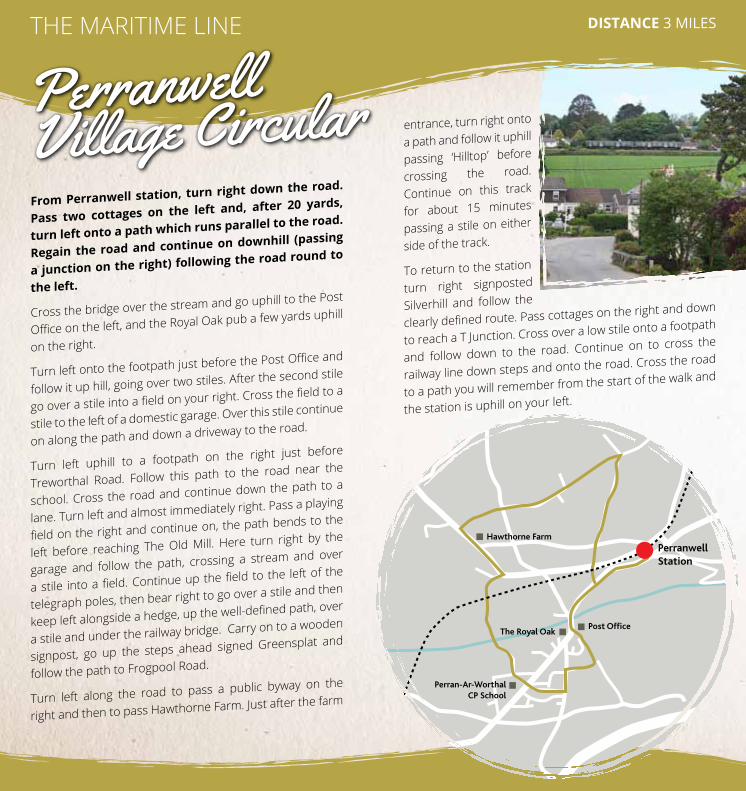
From Perranwell station, turn right down the road.
Pass two cottages on the left and, after 20 yards,
turn left onto a path which runs parallel to the road.
Regain the road and continue on downhill (passing
a junction on the right) following the road round to
the left.
Cross the bridge over the stream and go uphill to the Post
Office on the left, and the Royal Oak pub a few yards uphill
on the right.
Turn left onto the footpath just before the Post Office and
follow it up hill, going over two stiles. after the second stile
go over a stile into a field on your right. Cross the field to a
stile to the left of a domestic garage. Over this stile continue
on along the path and down a driveway to the road.
Turn left uphill to a footpath on the right just before
Treworthal Road. Follow this path to the road near the
school. Cross the road and continue down the path to a
lane. Turn left and almost immediately right. Pass a playing
field on the right and continue on, the path bends to the
left before reaching The Old Mill. Here turn right by the
garage and follow the path, crossing a stream and over
a stile into a field. Continue up the field to the left of the
telegraph poles, then bear right to go over a stile and then
keep left alongside a hedge, up the well-defined path, over
a stile and under the railway bridge. Carry on to a wooden
signpost, go up the steps ahead signed Greensplat and
follow the path to Frogpool Road.
Turn left along the road to pass a public byway on the
right and then to pass Hawthorne Farm. Just after the farm
entrance, turn right onto
a path and follow it uphill
passing ‘Hilltop’ before
crossing the road.
Continue on this track
for about 15 minutes
passing a stile on either
side of the track.
To return to the station
turn right signposted
Silverhill and follow the
clearly defined route. Pass cottages on the right and down
to reach a T Junction. Cross over a low stile onto a footpath
and follow down to the road. Continue on to cross the
railway line down steps and onto the road. Cross the road
to a path you will remember from the start of the walk and
the station is uphill on your left.
The Royal Oak
Hawthorne FarmPerranwell Station
Perran-Ar-Worthal CP School
Post Office
THE MARITIME LInE
Perranwell Village Circular

FLUSHING
FALMOUTH
PENRYN
Penryn Museum
St GluviasParish Church
Sailors Creek
Ferry
DIStance 5 miles approxTHE MARITIME LInE
Maritime Line trails from the track9 walks starting from stations along the truro to Falmouth branch line. Books are available for £3.00 (incl p&p) From Carrick ramblers at: bit.ly/CarrickRamblersWalksBooklets88
a riverside walk which starts in the ancient borough
of Penryn, ending in the pretty village of Flushing
before taking the ferry to Falmouth.
From the station, turn right uphill and then left down
Helston Road. Take the first turning on the left (Shute Lane)
and then first left into Mutton Row. Follow it along and then
down its steps to West Street. Turn right into town.
Take the second left into St Gluvias Street, down to
Commercial Road. At the bottom of the street, turn left and
cross onto Church Road, signed “Mylor Yacht Harbour”.
Go along Church Road, cross it with care at the church.
Follow the path just below the church car park, beside the
river, up through the cemetery, over a stile and along the
lower edge of fields to the beach.
Walk through the
reed bed before
turning right at
the T junction.
Continue on
beside the river
path to Sailors’
Creek (stepping stones). Continuing beside the river, go up
a fenced path to come out into a field. Cross the field to the
right, to a flight of steps onto the beach.
Turn left along the beach to the boat yard. now go up past
the old oyster sheds to the road. Turn right and follow the
road down past the Royal Standard pub before bearing
right down to the beach. now go along the road to the
quay and the ferry to Falmouth.
For ferry details, call Traveline on 0871 200 22 33
or visit www.falriver.co.uk
Penryn to Falmouth viaFlushing
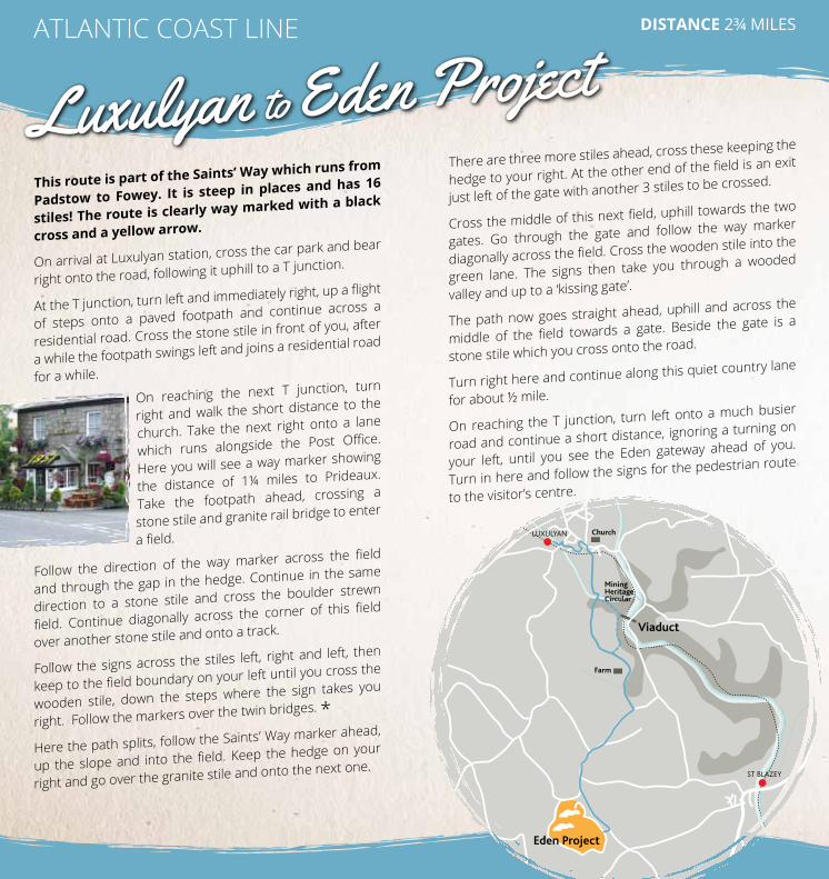
DIStance 2¾ milesaTLanTIC COaST LIne
this route is part of the Saints’ Way which runs from
Padstow to Fowey. It is steep in places and has 16
stiles! the route is clearly way marked with a black
cross and a yellow arrow.
On arrival at Luxulyan station, cross the car park and bear
right onto the road, following it uphill to a T junction.
At the T junction, turn left and immediately right, up a flight
of steps onto a paved footpath and continue across a
residential road. Cross the stone stile in front of you, after
a while the footpath swings left and joins a residential road
for a while.
On reaching the next T junction, turn
right and walk the short distance to the
church. Take the next right onto a lane
which runs alongside the Post Office.
Here you will see a way marker showing
the distance of 1¼ miles to Prideaux.
Take the footpath ahead, crossing a
stone stile and granite rail bridge to enter
a field.
Follow the direction of the way marker across the field
and through the gap in the hedge. Continue in the same
direction to a stone stile and cross the boulder strewn
field. Continue diagonally across the corner of this field
over another stone stile and onto a track.
Follow the signs across the stiles left, right and left, then
keep to the field boundary on your left until you cross the
wooden stile, down the steps where the sign takes you
right. Follow the markers over the twin bridges. *
Here the path splits, follow the Saints’ Way marker ahead,
up the slope and into the field. Keep the hedge on your
right and go over the granite stile and onto the next one.
There are three more stiles ahead, cross these keeping the
hedge to your right. At the other end of the field is an exit
just left of the gate with another 3 stiles to be crossed.
Cross the middle of this next field, uphill towards the two
gates. Go through the gate and follow the way marker
diagonally across the field. Cross the wooden stile into the
green lane. The signs then take you through a wooded
valley and up to a ‘kissing gate’.
The path now goes straight ahead, uphill and across the
middle of the field towards a gate. Beside the gate is a
stone stile which you cross onto the road.
Turn right here and continue along this quiet country lane
for about ½ mile.
On reaching the T junction, turn left onto a much busier
road and continue a short distance, ignoring a turning on
your left, until you see the eden gateway ahead of you.
Turn in here and follow the signs for the pedestrian route
to the visitor’s centre.
LUXULYAN
ST BLAZEY
Eden Project
Viaduct
Farm
Church
MiningHeritageCircular
Luxulyan to Eden Project

DIStance 3.7 milesaTLanTIC COaST LIne
This route takes in the spectacular Treffry
Viaduct and many other historic remains and is
part of the cornish Mining World Heritage Site.
www.cornishmining.org.uk
Follow the same directions as the walk to the eden
Project until *.
Where the path splits, take the left yellow arrow and
continue to follow the arrows, bearing right keeping the
leats on your left.
You emerge from the wood by crossing a wooden stile.
Look for the way marker ahead and left of you and follow
this down some steps to the Treffry Viaduct.
This was built between 1839 and 1842 and stands 30m
above the valley floor. It is entirely made of granite, has 10
arches and was the first of its type to be constructed in
the south west.
You can either turn back here and retrace your steps
back to the village, or continue on following the signs
to enjoy a longer walk which eventually leads you back
to the viaduct, after which you can retrace your earlier
steps back to the village.
Luxulyan Mining Heritage Circular
St Georges Island
LOOE
East Looe
West Looe
Talland Bay
Polperro
SOUTHWEST COAST PATH
SOUTHWEST COAST PATH
SOUTHWEST COAST PATH
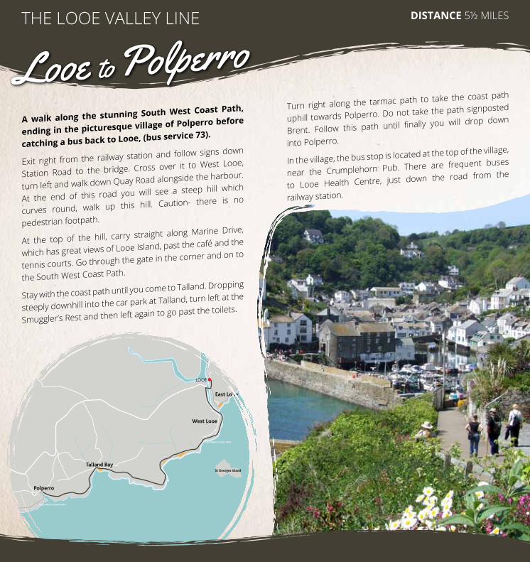
DIStance 5½ MILeSTHe LOOe VaLLeY LIne
a walk along the stunning South West coast Path,
ending in the picturesque village of Polperro before
catching a bus back to Looe, (bus service 73).
exit right from the railway station and follow signs down
Station Road to the bridge. Cross over it to West Looe,
turn left and walk down Quay Road alongside the harbour.
at the end of this road you will see a steep hill which
curves round, walk up this hill. Caution- there is no
pedestrian footpath.
at the top of the hill, carry straight along Marine Drive,
which has great views of Looe Island, past the café and the
tennis courts. Go through the gate in the corner and on to
the South West Coast Path.
Stay with the coast path until you come to Talland. Dropping
steeply downhill into the car park at Talland, turn left at the
Smuggler’s Rest and then left again to go past the toilets.
Turn right along the tarmac path to take the coast path
uphill towards Polperro. Do not take the path signposted
Brent. Follow this path until finally you will drop down
into Polperro.
In the village, the bus stop is located at the top of the village,
near the Crumplehorn Pub. There are frequent buses
to Looe Health Centre, just down the road from the
railway station.
Looe to Polperro
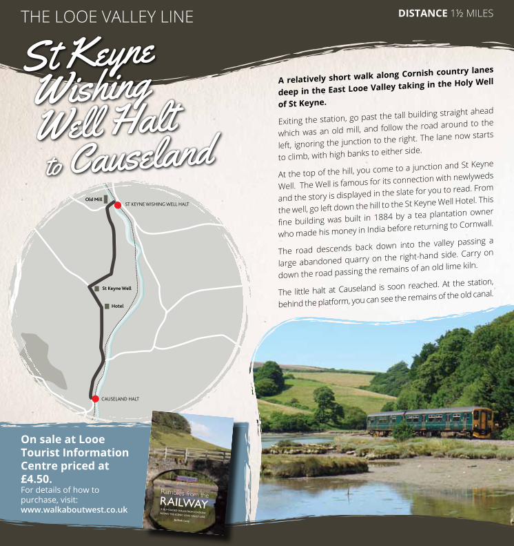
ST KEYNE WISHING WELL HALT
CAUSELAND HALT
Old Mill
St Keyne Well
Hotel
DIStance 1½ MILeSTHe LOOe VaLLeY LIne
On sale at Looe tourist Information centre priced at £4.50. For details of how to purchase, visit: www.walkaboutwest.co.uk
a relatively short walk along cornish country lanes
deep in the east Looe Valley taking in the Holy Well
of St Keyne.
exiting the station, go past the tall building straight ahead
which was an old mill, and follow the road around to the
left, ignoring the junction to the right. The lane now starts
to climb, with high banks to either side.
At the top of the hill, you come to a junction and St Keyne
Well. The Well is famous for its connection with newlyweds
and the story is displayed in the slate for you to read. From
the well, go left down the hill to the St Keyne Well Hotel. This
fine building was built in 1884 by a tea plantation owner
who made his money in India before returning to Cornwall.
The road descends back down into the valley passing a
large abandoned quarry on the right-hand side. Carry on
down the road passing the remains of an old lime kiln.
The little halt at Causeland is soon reached. at the station,
behind the platform, you can see the remains of the old canal.
Rambles from theRAILWAY9 SELF-GUIDED WALKS FROM STATIONSALONG THE SCENIC LOOE VALLEY LINE.
By Mark Camp
Immerse yourself in thetranquillity of the LooeValley Line with Ramblesfrom the Railway.
Leave the car behind andtake the train, departing at astation deep in the Cornishcountryside, from where youcan use this book to walka selection of tried andtested routes through alandscape as rich in historyas it is beauty.
With high quality maps andillustrated throughout, thisbook is all you need if youwish to explore thiswonderful part of Cornwall.
This book has been part-funded by the DesignatedCommunity Rail Development Fund which is backedby the Department forTransport, Network Rail andthe Association of Community Rail Partnerships.
FRONT_COVER.2:Layout 1 22/8/13 13:17 Page 1
St Keyne Wishing Well Halt to Causeland

Viaduct
Albaston
Metherell
Norris Green
RIVER TAMAR
GUNNISLAKE
CALSTOCK
BERE ALSTON
TAMAR VALLEY LInE DIStance 3 MILeS
A varied walk through fields, along footpaths ending
up in the delightful riverside village of calstock.
From Gunnislake station, walk towards the main road and
turn left up the hill towards Pearce’s Garage. Keep onto the
left fork of the road and head past the Tamar Valley Centre
into the village of albaston.
at the junction by the Queen’s Head pub, turn left and walk
down the road for a minute or so until you see a signpost on
the other side of the road which says Metherell/Cotehele.
Cross over the road and follow this quiet road for approx.
10 minutes.
as you start to go up a slight hill, you will see a gate and
a field which has a ‘Footpath to Danescombe’ sign, turn
left into this field and walk to the bottom until you get to a
stile. Go over the stile, down
the steps and then
follow the river.
Keep following the river until you get to a wooden gate, go
through it, and follow the path.
eventually you will pass some sheds, then a house on your
right. Go through the big gate and you will see an old white
cottage as you come out into the lane.
Walk just past the cottage and then take a right turn down
the track where it says ‘footpath’. Keep going past the old
mine on the right then the little mine train on the left, over
the little bridge, the cottages and down the hill.
You will see a large roofless building on your right, which is
an old paper mill and then the track splits. Head towards
the cottages and the left track. Keep going along this road
which will take you past the boatyard and under the viaduct.
eventually at the end of this road you will see the village.
Turn right for the pubs and shops, turn left for the station!
Gunnislake Station to Calstock
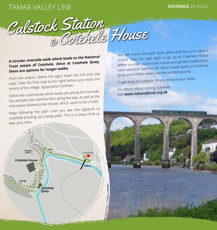
TAMAR VALLEY LInE DIStance 2½ MILeS
a circular riverside walk which leads to the national
trust estate of cotehele. Once at cotehele Quay,
there are options for longer walks.
From the station, follow the signs down the hill onto the
road. Take the first road to the right before you reach the
centre of the village, signposted Cotehele.
Follow the road ahead, which leads you along the riverside.
You will pass two old lime kilns along the way, as well as the
impressive Danescombe House, which used to be a hotel.
Keep following the path until you see the signpost to
Cotehele pointing up a steep path. This is a steep climb so
take your time.
You will notice the path soon splits and here you have a
choice. Take the right path to go up to Cotehele House
where you can explore the house and gardens (admission
rates apply) or take the left which heads down to Cotehele
Quay and further walks into the woods beyond.
To get back to Calstock, simply re-trace your steps.
For details about visiting Cotehele,
visit www.nationaltrust.org.uk
CALSTOCK
Cotehele House
CoteheleQuay
Kilns
Viaduct
Cottage
ProspectTower
Calstock Station to Cotehele House

If you have enjoyed the selection of walks we have
put together here, you may be interested in other
walks from railway stations in the far south west.
We have more walks and information about
detailed walks books you can buy on our website
www.greatscenicrailways.com
Other Walks
St Ives Bay Line
The South West Coast Path has put together a series
of walks from stations in Devon and Cornwall such as
newquay, Barnstaple, Torquay and Penzance. These walks
can be found at www.southwestcoastpath.org.uk, simply
search ‘railway walks’.
Look out for the Devon Walks from the Railway
booklet at GWR stations or download it at
www.greatscenicrailways.com
All information supplied in good faith and believed correct at time of going to print
(February 2018).
No responsibility can be accepted for any errors, changes or omissions. Published
by the Devon and Cornwall Rail Partnership, School of Geography, Plymouth
University, PL4 8AA Tel: 01752 584777. Email: [email protected]
Images supplied by Mark Camp, Tamar Valley AONB, Cornish Mining World Heritage,
Mark Lynam and Antony Christie.
Fund which is backed by the Department for Transport and ACoRP, the Association
of Community Rail Partnerships.
For information about train times and fares, contact
National Rail Enquiries on 08457 48 49 50 or visit
www.gwr.com
These great value tickets are available Monday to
Friday after the morning peak and anytime at
available all year round.
GroupSave
accepted on Crosscountry trains). Groups must have at
least one adult.
Unlimited Travel Tickets
Rangers and Rovers. There is an extensive range of
Ranger and Rover tickets available.
Visit www.greatscenicrailways.com for more
BritRail passes
International visitors can use their BritRail pass on all
the lines mentioned in this booklet.
Bus Links For details of public transport links, contact Traveline on
0871 200 22 33 or visit www.travelinesw.com
Dogs and cycles
Dogs and cycles can be taken free of charge
(max 2 dogs, 2 cycles).
For more information about other ways to enjoy days
out by train, visit www.greatscenicrailways.com
Rail Information