new urbanism: how urban design impacts health, wealth, and
TRANSCRIPT

Regis UniversityePublications at Regis University
All Regis University Theses
Spring 2017
New Urbanism: How Urban Design ImpactsHealth, Wealth, and Sustainability of Our CitiesJared Clements
Follow this and additional works at: https://epublications.regis.edu/theses
This Thesis - Open Access is brought to you for free and open access by ePublications at Regis University. It has been accepted for inclusion in All RegisUniversity Theses by an authorized administrator of ePublications at Regis University. For more information, please contact [email protected].
Recommended CitationClements, Jared, "New Urbanism: How Urban Design Impacts Health, Wealth, and Sustainability of Our Cities" (2017). All RegisUniversity Theses. 806.https://epublications.regis.edu/theses/806

Introduction
• Le Corbusier • Statistics on Automobile Dependence
1. How We Got Here • Suburban and Euclidean History
o Traditional Planning o What is Suburbia? o Suburbia History o What is Euclidean Zoning?
• The Rise of the Automobile o Introduction o Streetcar Allegory o The Highway Act of 1956 o Lead-in
2. Wealth, Health, and Climate Change (What’s wrong with our Cities?) • Wealth
o You Need a Car o Roads Don’t Create Jobs o Induced Demand
• Health o People Die on the Road o People Die Because of the Road (Obesity)
• Climate Change 3. The Solution: New Urbanism
• Walkability • Diversity
4. The Queen City of the Plains • Overview • Initiatives and Projects
o Walk Denver o Bike Denver
• Proposition: Wynkoop Square

“The cities will be part of the country; I shall live 30 miles from my office in one direction, under a pine tree; my secretary will live 30 miles away from it too, in the other direction, under another pine tree. We shall both have our own car. We shall use up tires, wear out road surfaces and gears, consume oil and gasoline. All of which will necessitate a great deal of work ... enough for all.”
—Le Corbusier, The Radiant City (1967)
Charles-Édouard Jeanneret, later known as Le Corbusier, was a 20th century architect and
planner and is considered one of the fathers of modern architecture. Influenced by industrial
cities at the turn of the 20th century, Le Corbusier’s designs were meant to escape what these
cities represented: dirtiness and overcrowding. He was one of the first to realize the enormous
impact automobiles would have on cities, and integrated their infrastructure as a main facet of his
designs. Le Corbusier's theories were quickly adopted by the planners and builders of Europe
and the United States who shared his distaste with the state of their cities. The passage at the start
of this section is indicative of what many in the early 20th century (and even some people today)
thought of as progress: escaping from the city (“…30 miles from my office”), removing the
rural-urban boundary (“…cities will be part of the country...”), using the maximum amount of
resources (“We shall use up tires, wear out road surfaces and gears, consume oil and gasoline.”),
and individual automobile ownership (“We shall both have our own car”).While Le Corbusier
may have seen an auto-dependent culture as the solution to the ills of the cities, a century later
we can see what an anti-urban approach to urbanism has wrought.
The United States is the definition of an automobile-dependent culture, where a car is
necessary to participate in daily life. As of 2011, America had the third highest number of
vehicles per capita, at 787 per 1000 people. The only two countries with more vehicles were two
wealthy European microstates, Monaco and San Marino (“NationMaster”, 2014). Le Corbusier’s

dream of a “radiant city” did not consider the lasting effects a consumption-reliant model of
growth would have on the American countryside, our wallets, and our health. Least of all, the
planners of the early 20th century did not foresee peak oil or climate change, the two largest
threats to our consumptive way of life.
As a nation, we need a change in how we organize our cities and in how we behave daily.
I will describe the events and decisions put us in this position, why we need a change, the
solutions that we can take from a design perspective, and finally, many initiatives taking place in
our own city of Denver.
Part I
THE RISE OF SUBURBIA
Humans have built mixed-use, pedestrian friendly communities of varied populations
since we have been organizing ourselves into cities. This includes pre-WWII America. Building
at a human scale and pace was not difficult for city planners to achieve because there were few
alternatives. Without rapid forms of transportation, cities were densely packed clusters of
neighborhoods. The proximity enjoyed by people in these cities rose out of necessity because the
easiest and most obvious way to travel was to walk. Businesses and civic centers existed where
people lived, close at hand and numerous. Urbanites generally lived in areas where they could
get most of the things they needed with relative ease.
As Andres Duany puts it, “Town planning, until 1930, considered a humanistic discipline
based upon history, aesthetics, and culture, became a technical profession based upon numbers”
(Duany,4). What Duany means here is that town planning stopped designing places for people,

and started designing places for cars. Town planners became focused on fitting more cars onto
more roads, rather than creating places where people wanted to be outside of their cars. While all
this road-building and car -manufacturing was good for the post WWII economy, the main
function of cities was lost with suburbia and the automobile: proximity. Proximity allows for
amenities and necessities to be easily gathered by a city dweller. Not only does living in a city
make it easy to get what you need commercially and civically, it also gives you more economic
opportunity. From an economic standpoint, cities encourage the quick transfer of goods and
ideas. They engender face-to-face interactions, allowing for rapid communication and
networking. Living in a city is more economically viable, both in America, and abroad. Take, for
example, that Americans who live in metropolitan areas with more than a million residents are,
on average, more than 50% more productive who live in smaller metropolitan areas. On average,
as the share of a country’s population that is urban rises by 10%, the country’s per capita output
increases by 30%. Per capita incomes are almost four times higher in those countries where a
majority of people live in cities than in those countries where a majority of people live in rural
areas. (Glaeser, 33).
As people move farther away from the urban areas that they depend upon, American
cities experience suburban sprawl. I use sprawl here meaning the expansion of populations from
urban areas into low-density, single function, often income-segregated areas, that are usually on
the outskirts of a city. In the following passage, Andres Duany, the founder of the Congress on
New Urbanism, discusses suburban sprawl by stating: “Suburban sprawl, now the standard North
American pattern of growth, ignores historical precedent and human experience. Unlike the
traditional neighborhood model, which evolved organically as a response to human needs,
suburban sprawl is an idealized artificial system.” (Duany, 2) What Duany is saying in this

passage is that suburbia is not a natural organization of humanity, and that many problems result
from its subscription. He goes on to write that “Unlike the traditional neighborhood, sprawl is
not healthy growth; it is essentially self-destructive.” (Duany, 3). He cites land consumption,
traffic problems, economic unviability, and the exacerbation of social inequity and isolation as
the unpleasant results of suburban sprawl.
The exact origins of suburbia are hard to pinpoint, but it wasn’t until the industrial
revolution and the invention of rapid forms of transportation that the suburb took off. In fact, the
first recorded suburb in American history came about in 1814 because of a steam ferry service
that allowed residents to live in Brooklyn and commute to Manhattan (Frumpkin, 18). The
promise of suburbia is an appealing one: a place where a person or family can enjoy all the
charms of rural life while maintaining the conveniences of urban life. However, as we have
learned from the past century, suburbia often fails to deliver on this claim. As James Howard
Kunstler says of suburbia: “The vast housing tracts that were laid down [for Americans] had all
the monotony of the industrial city they were trying to flee, and offered none of the city's
benefits, nor any of the countryside's real charms.”
The method of land management that facilitates suburban sprawl is called Euclidean
zoning. Also referred to as single-use zoning, Euclidean zoning is a land management method
where tracts of land are separated into large areas dedicated to a one primary application. The
term “Euclidean Zoning” refers to a supreme court case from 1926: Village of Euclid, Ohio v.
Ambler Realty Company. In the case, Ambler Realty owned 68 acres of land in the village of
Euclid, Ohio. The village, in an attempt to prevent the growth of industry which might change
the character of the village, developed a zoning ordinance to limit Ambler Realty from
developing the land for industry. Ambler Realty sued the city and eventually lost. It was the first

significant zoning-based court case in American history, and it effectively strengthened the use
of zoning codes in the country. Separating the residential from commercial interests, specifically
industry, was the main function of zoning codes originally. In fact, one of the earliest single-use
zoning laws took place in New York in the early 1900’s. The single-use zoning code was put into
place to separate industrial areas and the growing residential neighborhoods as the population
rose due to immigration.
Euclidean zoning has its roots in protecting residents from industry, but as the 20th
century wore on, industrialization evolved, our world became more globalized, and the American
industrial city evolved along with it. What did not change was our use of Euclidean zoning.
Many of the familiar blights of our sprawl-stricken cities exist because of Euclidean zoning,
including shopping malls, office parks, and the vast residential tracts of single family homes that
make up suburbia. Rapid transportation like trains and ferries originally enabled Euclidean-zoned
suburbs to exist, but it was the automobile that caused them to become America’s standard idea
of residence.
* * *
THE RISE OF THE AUTOMOBILE
The shift to an autocentric transportation system did not happen immediately. It took a
concerted effort from many parties to make way for the automobile. It was the goal of General
Motors, Standard Oil, Firestone Tires, Phillip Petroleum, and many others, who eventually
became the U.S. highway lobby (Snell, 1974), to cement the automobile as the main method of
transport in America.

One example of the American transport system being monopolized by the Automobile
industry is the story of National City Lines. NCL was a holding company that acquired transit
systems across America. They had holdings in cities like Los Angeles, Philadelphia, Baltimore,
Sacramento, and St. Louis. NCL was owned by Greyhound and Yellow Bus, who were General
Motors subsidiaries themselves. Once they controlled a city’s transit system, NCL would cripple
their streetcar system until it was considered too expensive to maintain. They would do this by
systematically lowering maintenance budgets, slowing down travel times, reducing areas served,
and increasing fares. This would naturally make street cars less appealing to citizens and
ridership would drop. NCL would then urge the cities to replace streetcar systems with the
cheaper-to-maintain bus programs; these buses were gladly sold to towns and cities by General
Motors. Streetcars relied on infrastructure built by tax dollars, and so the idea of allocating funds
to automobile infrastructure was enticing to cities. This way, public transport could be taken on
by buses, a cheaper alternative to streetcars, and their infrastructure could be shared by
individual automobile owners. (“Taken for a Ride”, 1996).
In 1951, General Motors, Firestone Tire, Standard Oil of California, Phillips Petroleum,
and Mack Trucks were convicted of "conspiring to acquire control of a number of transit
companies, forming a transportation monopoly" and "conspiring to monopolize sales of buses
and supplies to companies owned by National City Lines". The results of the trial were that
General Motors was fined $5,000 and General Motors treasurer H.C. Grossman was fined $1.
(Snell, 1974).
Coupled with various efforts from corporate entities, the rail systems in America faced
other challenges. During the war years, many had been so thoroughly used that they effectively
needed to be rebuilt. While Japan and Europe rebuilt their rail systems (Smith, 1974), the

privately-owned systems in America were abandoned. By 1955, 88% of America’s electric
streetcar system was dismantled (Nace, 2011).
In 1953, General Motors president, Charles Wilson, was appointed for secretary of
defense. While in office he worked closely with Dwight D. Eisenhower, and pushed for the
interstate highway system as a matter of national defense. While the main motivation of the
highway system was an economic one, having an extensive network of highways was appealing
to the department of defense and Eisenhower. During President Eisenhower’s military campaign
in Germany he saw the military advantages the Germans enjoyed by having a highway system.
They could quickly move their forces around the country, and could easily supply cities with
goods even in wartime. As the “National Love Affair” with automobiles continued its rise, the
Federal-Aid highway act of 1956 was passed, marking the beginning of America’s “Interstate
and Defense Highway System”. During this time, Francis Du Pont (whose family owned the
largest share of General Motors), was appointed Chief administrator of federal highways
(“Taken for a Ride”, 1996).
At the end of WWII, the American economic boom was in full swing. As its cities grew,
they became ever-more designed around the automobile. Urban planners and developers began
spreading our cities out over the vast American territory to meet the growing desire to live in the
countryside. In doing so this undeveloped territory was designed for cars rather than humans: we
built wide streets, did away with sidewalks, implemented single-use zoning codes, and raised
speed limits. How we built (and are building) our towns and cities influences countless aspects of
our civilization. The next section will discuss three such products of the built environment:
wealth, health, and sustainability.

Part II
A large part of the American built environment is suburban. Suburbia and the
automobile-centric lifestyle it encourages are wastes of resources; they are expensive, unhealthy,
and bad for the environment. As the passage of Le Corbusier’s stated, our cities wear out tires,
road surfaces and gears, and consume oil and gas. While using up resources is troubling, nothing
is as worrisome as the consumption of oil and gasoline. Not only does the burning of fossil fuels
contribute to global warming (more on that later), but oil consumption gets us closer to peak oil
with every barrel we use (if we aren’t already past it). Peak oil is the inevitable point in time
when our society reaches the maximum rate of oil production, and further production becomes
more expensive than it is worth. As an oil-dependent society, this is an enormous obstacle we
face. The following section will outline the various ways that our consumptive, automobile-
centric national lifestyle effects our wealth, health and sustainability.
WEALTH
In modern America, nearly every family needs at least one automobile to fully participate
in society. Though it began as a romantic notion of combining the urban and rural, Suburbia has
given rise to a phenomenon often referred to by urban planners and real estate agents as “Drive
‘til you qualify”. Per Jeff Speck, D.T.Y.Q. is when “[f]amilies of limited means move farther and
farther away from city centers to find housing that is cheap enough to meet bank lending
requirements.” (Speck, 30). Depending on a family’s circumstance, this is often their only
option. The problem is, not only do those less well-off live farther away from urban cores and
therefore spend more time in their cars, but a family’s income can fluctuate dramatically due to
gas prices. Gas is not the only thing that makes D.T.Y.Q. disadvantageous: the average
American family now spends about $14,000 per year driving multiple cars. In the past 50 years,

the typical family has gone from spending 10% of its total income on transportation, to 20%.
This means that this family works from January 1st until April 13th just to pay for its cars.
Remarkably, the typical “working” family, with an income of $20,000 to $50,000 pays more for
transportation than for housing.” (Speck, 30). With the notion of peak oil on the horizon, the
prospect of auto-centrism seems like it will only continue to grow in cost if we don’t change our
behavior, and not only on the individual level.
Automobile infrastructure projects are often trumpeted by campaigning politicians as
ways to alleviate local unemployment, stimulate economies and provide traffic congestion relief.
What they don’t mention is that for every minute our country spends in support of our current
level of automobile usage, we are sending $612, 500 overseas (Tamminen, 207). Furthermore,
Road and highway work, unfortunately, does not provide many employment opportunities. As
Jeff Speck puts it,
“Road and highway work, with its big machines and small crews, is notoriously bad at
increasing employment. In contrast, the construction of transit, bikeways and sidewalks
performs 60% to 100% better. A study of President Obama’s American Recovery and
Reinvestment Act documented a 70% employment premium for transit over highways.
By this measure, that job-creation program would have created fifty-eight thousand more
jobs if its road-building funds had gone to transit instead.” (Speck, 31)
Not only is building more automobile infrastructure a misallocation of resources in
regards to creating employment, it also fails to provide relief from congestion. This is due to the
concept of induced demand, which states that as supply for something increases, so too does the
demand. When roads and highways are expanded to alleviate traffic, the road becomes more
appealing, and therefore more people drive, causing even more congestion. Numerous studies

have shown this phenomenon in action (Duranton, 2011), and as the next section explains, the
more time people spend driving, the unhealthier they become.
* * *
HEALTH
America’s built environment, specifically that which encourages time spent driving, is
not good for our health. Driving in America can be dangerous, and is often deadly. For example,
car crashes have killed over 3.2 million Americans, considerably more than all of our wars
combined (NHTSA, 2015). In 2004 America experienced 14.5 traffic fatalities per 100,000
population. This may not seem significant, until it is compared with other countries, like
Germany, with its no-speed-limit autobahn, who suffered only 7.1, or Denmark, Japan and the
U.K., who rated a 6.8, 5.8, and 5.3 respectively (WHO, 2015).
Our automobile-centric culture is dangerous for a reason other than traffic fatalities:
obesity. In the mid-1970’s, 10% of Americans were obese. By 2007, that rate has risen to one in
three, with a second third of the population “clearly overweight”. As a nation, we have
collectively gained 5.5 billion pounds. Excessive weight now kills more Americans that
smoking. (Speck, 40). Our activity is born of our landscape, or to put it simply, we drive because
we must, even if that is making us fatter. For example, in San Diego, it has been reported that
60% of residents are overweight in a “low-walkable” neighborhood, compared to only 35% in a
high-walkable neighborhood. (Speck, 41). Another study found that for every additional five
minutes Atlanta-area residents drove each day, they were 3% more likely to be obese (Speck,
41)). This is especially troubling considering there are few alternatives to driving in Atlanta, a
city whose air quality is so bad that ranks in the top 15 worst U.S. cities to have asthma in. Poor

air quality is not just problematic in Atlanta. The pollution from our tailpipes is causing an even
larger problem: climate change.
* * *
CLIMATE CHANGE
To begin this section I should outline what climate change is and why it is a problem.
Global warming refers to the accumulation of greenhouse gases (such as carbon dioxide and
methane) in our atmosphere, which retain energy from the sun. This in turn causes the global
average temperature to rise. Events such as the melting of polar ice caps, severe weather,
ecosystem destruction, species extinction, reduction of agricultural production, severe droughts
and water scarcity can all result from a global average temperature rise of just a few degrees. The
increase of greenhouse gas emissions very clearly began its exponential rise with the onset of the
industrial revolution, as can be seen from the graph below (Rohde, 2004).

This figure shows the temperature variations on Earth over the past 2000 years. Because accurate
thermometers have existed for the past 200 years, this figure is made up mostly of proxy data
(that being data which indicates a temperature, such as tree ring data or ice cores) from 11
different studies. Though there are numerous places where the temperature of the earth changed
dramatically, as well as general trends toward warmer periods and cooler periods, the beginning
of the 1800’s shows a drastic and sudden rise of global temperature. This correlation with the
onset with the industrial revolution leads 97% of scientists to agree that humans are causing
global warming (J. Cook et al, 2016).
As I mentioned, greenhouse gases in the atmosphere are the cause of climate change.
Greenhouse gases are emitted from numerous sources in the US, and of these, the transportation
sector makes up around 26%(EPA, 2017). This falls second only to the production of electricity
which emits 30% of the United States’ greenhouse gases. Within the transportation sector,
automobiles (meaning passenger cars, light-duty trucks, SUVs, pickup trucks, and minivans)
account for over half of all transportation related emissions (EPA, 2017). Compare this with the
12% of total U.S. emissions that comes from the commercial and residential sector, which
accounts for all U.S. homes and businesses (excluding agriculture and industry). This clearly
shows that in the U.S. it is not simply a matter of how efficient your home or car is, what also
matters is whether you live in a walkable area, or a sprawl-stricken one.
In a recent study done by the EPA, Location Efficiency and Building Type—Boiling it
Down to BTU’s, researchers sought to illustrate the relationship between household energy
consumption and residential development patterns. They compared “conventional suburban
developments” (CSDs) with “transit oriented developments” (TODs), and accounted for factors

such as home type, (single family [attached and detached), and multi-family) as well as the
energy efficiency of the vehicles and homes (“green automobiles” and “green buildings”. The
unit of measurement for the study was British Thermal Units (per million, per year), or BTUs,
which is defined as “the amount of heat needed to raise one pound of water at maximum density
through one degree Fahrenheit” (“BTU”, Dictionary.com). The following table represents the
results of the study (EPA-JRC, 2011).
As can be seen from figure (X), in every classification of home type, from Single Family
Detached all the way to Multi-Family, the greenest homes in CSDs lost out to non-green the non-
green options in TODs. In fact, transportation energy use remained constant in all residence
types, with non-green CSD usage being over three times that of non-green TOD, and green CSD
being over double that of green TOD. As the authors of the study put it, “…the greenest home
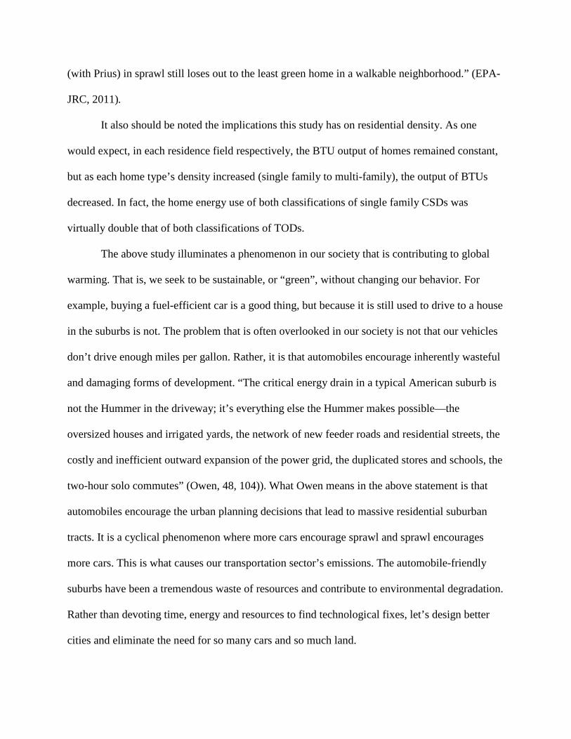
(with Prius) in sprawl still loses out to the least green home in a walkable neighborhood.” (EPA-
JRC, 2011).
It also should be noted the implications this study has on residential density. As one
would expect, in each residence field respectively, the BTU output of homes remained constant,
but as each home type’s density increased (single family to multi-family), the output of BTUs
decreased. In fact, the home energy use of both classifications of single family CSDs was
virtually double that of both classifications of TODs.
The above study illuminates a phenomenon in our society that is contributing to global
warming. That is, we seek to be sustainable, or “green”, without changing our behavior. For
example, buying a fuel-efficient car is a good thing, but because it is still used to drive to a house
in the suburbs is not. The problem that is often overlooked in our society is not that our vehicles
don’t drive enough miles per gallon. Rather, it is that automobiles encourage inherently wasteful
and damaging forms of development. “The critical energy drain in a typical American suburb is
not the Hummer in the driveway; it’s everything else the Hummer makes possible—the
oversized houses and irrigated yards, the network of new feeder roads and residential streets, the
costly and inefficient outward expansion of the power grid, the duplicated stores and schools, the
two-hour solo commutes” (Owen, 48, 104)). What Owen means in the above statement is that
automobiles encourage the urban planning decisions that lead to massive residential suburban
tracts. It is a cyclical phenomenon where more cars encourage sprawl and sprawl encourages
more cars. This is what causes our transportation sector’s emissions. The automobile-friendly
suburbs have been a tremendous waste of resources and contribute to environmental degradation.
Rather than devoting time, energy and resources to find technological fixes, let’s design better
cities and eliminate the need for so many cars and so much land.

Technological fixes, such as fuel efficient and electric cars, are the right answer to the
wrong question (Speck, 54). Fuel-efficient cars may not pollute as much, but they still encourage
an automobile-centric society. Furthermore, we know that fuel efficiency isn’t the answer due to
Jevon’s paradox. The nineteenth-century English economist William Stanley Jevons noted in his
book The Coal Question, that more fuel-efficient steam engines didn’t lead to less coal
consumption. In fact, the opposite was true. When the Watt steam engine was introduced, it
made energy use effectively less expensive, and helped move the world to an industrial era
powered by coal. Edward Glaeser defines the paradox with this statement: “The term Jevons
paradox refers to any situation in which efficiency improvements lead to more, not less,
consumption—one reason why low-calorie cookies can lead to larger waistlines and fuel-
efficient cars end up consuming more gas.” (Glaeser, 37). From an understanding of the
paradoxical nature of fuel efficiency and human behavior, it is obvious that, while well
intentioned, fuel efficiency is not the solution to climate change.
Similarly, electric cars are also a problematic approach to climate change. While they
seemingly produce no emissions of their own, in America an electric car is essentially still
powered by fossil fuels. This is because, as of 2015, 67% of America’s electricity comes from
fossil fuels (Speck, 52). So, while they may make consumers feel less guilty about their
contribution to climate change, they still are making a large contribution to global warming.
This approach to fighting climate change is worrisome to say the least. The movement to
implement “green” technology seemingly does nothing to address the real problems at hand.
While it is obvious that we need to change our behavior rather than changing what brand of item
we buy at the supermarket, many people still assume they are doing their part by buying the right
lightbulb. While the intention behind such purchases are good, and changing lightbulbs can

noticeably reduce household energy consumption, trading incandescent bulbs for energy efficient
ones saves as much carbon per year as living in a walkable neighborhood does in a single week
(“A Convenient Solution”, 2013). Rather than trying to change behavior to reduce carbon
emissions, politicians and entrepreneurs have sold greening to the public as a kind of
accessorizing (Rybczynski, 2010). Our collective behavior needs to change, and the solution has
been with us for thousands of years: the traditional neighborhood. Trying to stop climate change
by green-consumerism is not going to work. To borrow a term from Dan Mualouff, misplaced
green consumerism is much like cutting down a rainforest using hybrid-powered bulldozers. To
fight climate change, the built environment needs to be thoughtfully designed and redesigned in
ways that to encourage behavioral patterns that are not detrimental to ourselves, our economy or
the Earth. The following section will illustrate many of the design principles that facilitate such
behaviors.
Part III
THE SOLUTION: NEW URBANISM
Our built environment and the patterns of behavior encouraged by it determine how
wealthy, healthy, and sustainable society is. The following section will detail the various design
practices and principles, specifically those of New Urbanism, that positively affect the three
factors mentioned above.
In the late-eighties, a group of developers, planners, designers, architects, and engineers
were unhappy with the development trends at the time. They felt the developments of the day
were not serving people and communities, and sought to change it. At that time, and in most

places still today, because of our subscription to suburbanism, we have lost our proximity, our
vernacular architecture, and therefore our sense of place and community. Vernacular architecture
is what we have lost by building cookie cutter houses that look the same from Mississippi to
Arizona. It is architecture and building techniques specific to a region using local materials. For
the same reason a lawn is unnecessary in Las Vegas, a standard American townhouse in
Southern California is misplaced. Vernacular architecture not only is charming and gives people
a sense of place, but it also serves a purpose. It is understandable on a continent like America,
that wasn’t dwelt upon in the modern sense until recently, that regional architecture would not be
thought about all that often. But that townhouse in Southern California would be a lot better off
built in a style of home from a region with a climate similar to it, like the middle-east or
Mediterranean. Then it would have a courtyard that created a shady microclimate within the
home. Instead of matching building techniques with climates, we instead build based on trends.
We ship in wood from Canada, drywall from Mexico, shingles from Taiwan, and windows from
Germany.
In 1993, the New Urbanism movement was officially founded and sought to address
these issues. New Urbanism essentially seeks to create vibrant and walkable communities, that
are both integrated and beautiful. New Urbanism is based in the belief that cities and
communities are malleable products of developers, governments, and individuals. There are
numerous interrelated principles that make up the charter of new urbanism, and I have
consolidated the ones necessary into two categories, walkability and diversity, which I will
describe in the following pages.
* * *
Walkability

To a citizen, whether they know it or not, walkability indicates a successful urban center.
When a town center or main street has gotten it right, people can feel it, and will spend time in
that place.
In his book, Walkable City, Jeff Speck outlines the four necessities for a place to be
walkable. First, people must have a reason to walk. Cities and towns are made of, by, and for
people. Therefore, a neighborhood or downtown should be a place where the people of the city
can do all the things that people do without having to venture into another part of town. These
things include: working, shopping, eating, drinking, learning, recreating, convening, worshiping,
healing, visiting, celebrating, and sleeping (Speck, 27). Giving people a reason to walk means
creating places that facilitate all the things that people do. This is essentially the opposite of
Euclidean zoning. The image below serves to display the differences between conventionally
planned single-use zones, and walkable, traditionally planned zones.
It can easily be seen that walking seems a daunting prospect in the in the conventional area. This
is because, not only would it be a long walk that would essentially take the pedestrian to a single
point, but it also wouldn’t be a safe one. When you begin to separate everything from everything

else and disproportionally create automotive infrastructure, then you are going to get an
automotive landscape. On the other hand, is the traditional neighborhood structure. Note the
public space near the school and civic institution. It defines the center of the city while also
provided residents with a place to relax. Public spaces around civic centers afford people with
the opportunity to not only be physically close to their government buildings, but to enjoy it as
well. A quality public realm is one that is comfortable (meaning it has things like movable and
comfy chairs) and has visible signs of life (people and plants) (Burden).
Along with using mixed use zoning, creating a walkable space often also involves setting
up proper parking arrangements (Speck, 115). Successful parking in an urban area comes in
many forms. Curbside works well, as it functions not only as parking, but also slows traffic,
creates a buffer between pedestrian and road, and possibly generates revenue for the city.
Parking garages also work well, so long as they have commercial shopfronts to create a reason to
walk and break up the hardscape they created. In fact, there are many parking solutions that
agree with walkability, but there is one in particular that clashes with it: the open lot. While
parking lots may be the best way to organize our vehicles while we shop in big-box stores, they
are the worst when it comes to efficient use of space in dense urban environments. Take for
example the images below. They are renderings displaying all land area dedicated to parking in
downtown Denver, excluding street-side parking and multi-level garages, and raised 40 ft.

That is an extraordinary amount of space to be strictly dedicated to single-level, often private,
parking lots. These spaces not only could be used more efficiently (affordable housing? Retail?
Multi-level garages?) but more importantly they create empty spaces that interrupt the
experience of place. Two important aspects of making places feel inviting to pedestrians are
space and orientation. This means creating environments that are comfortable. Humans crave
having spaces defined for them; we need what is referred to as prospect (something to head
towards), refuge (a place to lessen feelings of exposure), and edges (visual cues to define spaces)

(Speck, 22). What these parking lots in downtown Denver do is halt any sense of enclosure
afforded by the streetscape. They dampen the very experience that the patrons of the parking lots
are seeking. To understand what is physically happening in these streets we need to use the
proper vocabulary, and the easiest way to describe urban design like this is in ratios. For
example, a 1/1 ratio of street width to building height creates an inviting street to walk down
(though the density of that area may not be ideal). The ratios of 1/6 and 6/1 are the generally the
limits to walkable urban areas. Skyscrapers often exceed this rule, which is why downtowns can
feel cold and imposing, but due to the volume of activity generated in and around them it is not
often a hindrance on pedestrians.
A street must be comfortable spatially if it is to be walkable, it needs to provide the
pedestrian with prospect, refuge, and edges. On a related note, a street must also feel safe (and be
safe) for pedestrians to use. Block length and street width are the hardest two factors in
perception of safety to change, but they are important to mention nonetheless. The rule of thumb
regarding ideal block length given by Jeff Speck in Walkable Cities is the average number of
lanes per city street multiplied by 100 should give you your block length. For example, Salt Lake
City, Utah, has blocks that follow this rule, though at an enormous scale. Their streets are on
average six lanes wide, and their blocks are 600 feet long on each side, the longest in America,
making each block a whopping 10 acres. At this scale, the blocks of Salt Lake City are not good
for its urban environment, but this is because when Joseph Smith began the plans for his spiritual
utopia he did not foresee the rise of the automobile. Originally, Smith’s plans would have been a
pedestrian utopia as well as a spiritual one (Mars). Instead, Salt Lake City has become such an
unfriendly city for pedestrians that people are encouraged to carry bright orange flags, provided
by the city at each corner, while using crosswalks. Small blocks, on the other hand, give the city

more street-side surface area, so to speak; they give people more spaces to define. They are also
safer. Block-size has an effect on how safe pedestrians feel, and for good reason. When you
double a city’s block size you nearly quadruple the number of fatal accidents on non-highway
streets (Speck, 213). This is because long blocks generally mean wide streets, and the wider
streets are, the faster people in automobiles feel comfortable travelling. This creates an unsafe
situation for everyone. Even the bible has a passage that alludes to the importance of road size:
“Broad is the road that leads to destruction… Narrow is the road that leads to life” (Matthew,
7:13-14).
Short blocks, narrow streets, and parallel parking slow down cars and therefore make
pedestrians safer. A fourth element of urban design for walkable places is the presence of trees.
Trees serve many purposes. First, they help to spatially denote the pedestrian realm. They create
a living edge between road and sidewalk, and often a vaulted ceiling as well. This creates shade
for pedestrians, who also will be more protected from the cars on the road by the trees.
* * *
Diversity
In the following section I use diversity to describe several ideas. First, as I discussed in the
section on walkability, a city should be zoned diversely, with multiple uses, so that numerous
types of businesses and homes can be found in a small area. Secondly, a city should have a
diverse selection of housing options, including apartments, duplexes, traditional single-family
homes, mixed-use (shop below, apartment above), etc. This allows for an area to be occupied by
people of various income levels. In the words of Peter Calthorpe, a city should have “odd little
corners for people with odd little lives” (Kelbaugh, 29). These insure the presence of people who

go outside at different times and are in places for different purposes, but who can and want use
many facilities in common.
While it is necessary to create housing for all income levels, it has become increasingly
apparent in Denver that this does not always work. Neighborhoods are being rapidly gentrified
all over the city, regardless of diversity of housing type. The hipsters and yuppies that do the
gentrifying, the indicators of a gentrification in-progress, only want to live in traditional
neighborhoods where many of the design elements I have discussed are in place. While this is a
reasonable desire, what often happens is that the neighborhoods become commodified. It
becomes a fashionable place to live, and all the people who made up the neighborhood get driven
out by the people seeking them. This continues until housing prices get too high and the
neighborhood is occupied solely by the hipsters and yuppies. Other than the obvious justice
issues brought on by the displacement of the less-well-off, what makes gentrification doubly
offensive is that the place itself has become less pleasant too. What I mean by this is that while
much of the urban landscape will be remain, what made the neighborhood appealing is gone.
When individual businesses change hands, and the Vietnamese grocery becomes a brewery
manned by bearded beanie-wearers, the structure of the neighborhood, what makes it walkable,
is still intact. But this goes to show that it is not just proper urban design that makes a
neighborhood good; it also takes diversity. A way to maintain diversity within a neighborhood is
for cities to adopt affordable housing initiatives that allow multiple income classes to dwell in
the same neighborhood. Diversity of people, not just of culture or race, but of income level and
age too, create good neighborhoods.
Part IV

QUEEN CITY OF THE PLAINS
Much of what has been discussed in the previous pages has been largely theoretical.
While theory is an important beginning to any field of thought, how theories are put into practice
is what really matters. The city of Denver, Colorado, has many advocacy groups and projects
that relate to the subject matter of this work. For the next section I will detail two of these
initiatives: WalkDenver and BikeDenver
When it comes to walkability in Denver, WalkDenver is one of the foremost advocacy
groups. They have many goals, one of which is to make Denver the most walkable city in the
U.S. by 2040. To do this, they engage in political advocacy campaigns. For example, in
2014 WalkDenver successfully advocated for the City and County of Denver to establish and
adopt a “Denver Moves Pedestrians” implementation plan, and to form a Pedestrian Advisory
Committee. The in 2015, WalkDenver launched the “Denver Deserves Sidewalks” campaign,
which called upon the City to assume responsibility for building and repairing sidewalks
(currently the responsibility of private property owners), and established a dedicated funding
source for this purpose.
Other projects that WalkDenver conducts include Project Shift which is a free 7-month
leadership program where members of the cohort are encouraged to walk in their neighborhoods.
They are given bus passes, a copy of Walkable City by Jeff Speck, and a FitBit. Participants meet
once a week to discuss their non-automobile transportation goals and achievements. Another of
WalkDenver’s projects is their Tactical Urbanism campaign, where members of the WalkDenver
team meet with communities to envision and design walkable infrastructure that suits the
neighborhood’s needs. WalkDenver also helps neighborhoods and school district design safe
routes for children to walk to school, and collects pedestrian data.

The pedestrian data collected by the WalkDenver team is used in many ways, one of
which is to inform websites like WalkScore.com. WalkScore uses a complex methodology to
analyze and rate give urban environments for their pedestrian-friendliness. This includes
algorithms concerning proximity to amenities, sidewalk safety, and street design. The image
below is a heatmap created to show the various WalkScores in the city of Denver. The higher a
WalkScore, the more walkable that neighborhood is.

A group doing similar work to WalkDenver, is BikeDenver. As its name would imply,
BikeDenver is a bicycle advocacy group who aims to serve as a voice for people across the city
who desire a safe and convenient network for bicycling. They emphasize that they are not anti-
car, but rather are pro-bicycle, seeking to make bicycles just as viable a form of transport as
automobiles. Along with advocating for bicycle-friendly legislation and policies, they also

provide education, community building, and consulting. In order to show how much work needs
to be done in Denver, I have created a heatmap showing the BikeScore of each neighborhood.

* * *
WYNKOOP SQUARE
Between 1965 and 1985, there was a push in cities across America to alleviate traffic
congestion by transforming regular roads into pedestrian malls. The movement did not prove to
be successful for numerous reasons. Of the 200 or so pedestrian malls created in the period, only
thirty remained as of 2012 (Urban Review STL). One of the most successful of these thirty is the
16th Street Mall in Denver. It opened in 1982 and was expanded even further in 2002 to reach all
the way to union station. It is a pedestrian-transit mall, meaning that there are no vehicles other
than the FreeMallRide.
The mall officially spans 16th street from Broadway to Wewatta. On one end of the mall
is a collection of important and impressive buildings, all within or around civic center park.
These include the Denver Art Museum, the United States Mint, the Denver City and County
Building, Lindsey-Flanigan Courthouse, The McNichols Civic Center, Denver’s Mayor Office,
and the Colorado State Capitol. On the other end of the mall is Wynkoop plaza, this is where I
believe downtown Denver could be improved. Wynkoop Plaza, in which stands Union Station,
could better serve the people of Denver by being transformed into a pedestrian-square. It would
be easy and cheap to make the change and could greatly benefit downtown Denver.
Why would Wynkoop Plaza make a good pedestrian-square? It is already one of the great
public spaces of America. There are five things that make a good public square. First, the ideal
size is 2-3 acres. This way it is large enough to host a variety of events, but small enough that a
person can easily be recognized a from across the square. Wynkoop Plaza is 2.1 acres, which is
within the ideal range. Secondly, the buildings surrounding the square should be about three to

four stories high. This height ensures that the edges of the square feel definite and provide a
sense of place, but still allow sunlight to fill most of the square. The buildings surrounding
Wynkoop Plaza are generally 4 stories high. While it is important that the edges of a square feel
definite, it is also equally necessary for them to be what urban designers call an “active and
permeable membrane”. This is a fancy way of saying an area where things go in and out of.
Ideally, it’s a commercial area that is attractive and useful for the public (e.g. restaurants with
café seating, bars, shops, etc.). Wynkoop Plaza is surrounded by restaurants, bars, and shops. It is
also important to use pavers as opposed to concrete blocks. What is around and above you in a
square is important, but so is what is under you. Using pavers not only designates an area as
pedestrian-only, they also provide a sense of depth and quality. They are easier to repair and
maintain than concrete slabs, and make spaces feel more charming than a prison yard. Wynkoop
Plaza has pavers on half of its surface. The other half is asphalt, because it is a road. This is the
main obstacle keeping Wynkoop Plaza from becoming Wynkoop Square. The cars on Wynkoop
street split the would-be square, making the full use of the retail district more difficult. If Denver
were to put this plan into action Wynkoop Square could become a destination for residents and
tourists alike that would encourage commerce all while featuring a transit hub as its centerpiece.
This thesis has sought to make clear that there are options for America’s built
environment. Suburbia should not be the standard American housing format. The automobile
centric culture and single-use zoning that encourages it has led to a nation where our lifestyle
implicitly is bad for public health, the wealth of the nation, and how sustainable our society is.
Though transit systems like streetcars may seem like a thing of the past, New Urbanism contests
that complex transit systems are a way of the future. Though automobile culture can be blamed
for much of the ills discussed in this work, the aim is not to do away with cars. Rather, what is

being called for is a transportation infrastructure that relies on no method of transport too
heavily. People should not have to own cars to participate in society. They should instead be free
to take whatever form of transport they desire. New Urbanism is a thoughtful and intentional
way for us to address the problems we are facing as a society. Without it, we will continue to
thoughtlessly and unintentionally harm ourselves and the planet.

References
“A Convenient Solution”. Dir. Congress for New Urbanism. N.p., n.d. Web.
"B.T.U." Dictionary.com. Dictionary.com, n.d. Web. 01 May 2017.
Burden, Amanda. "How Public Spaces Make Cities Work." Amanda Burden: How Public Spaces Make Cities Work | TED Talk | TED.com. Ted Talks, n.d. Web. 04 May 2017.
Duany, Andres, Elizabeth Plater-Zyberk, and Jeff Speck. Suburban Nation the Rise of Sprawl and the Decline of the American Dream. New York, NY: North Point, 2010. Print.
Duranton, Gilles and Matthew A. Turner. 2011. "The Fundamental Law of Road Congestion: Evidence from US Cities." American Economic Review, 101(6): 2616-52.
EPA-JRC, Jonathan Rose Companies For. "Location Efficiency and Housing Type: Boiling It Down to BTUs." Location Efficiency and Housing Type - Boiling It Down to BTUs (n.d.): n. pag. EPA.gov. EPA, 2011. Web. 2017.
EPA. "Sources of Greenhouse Gas Emissions." EPA. Environmental Protection Agency, 14 Apr 2017. Web. 01 May 2017
Frumkin, Howard, Lawrence Frank, and Richard J. Jackson. Urban Sprawl and Public Health Designing, Planning, and Building for Healthy Communities. Washington: Island, 2013. Print.
Glaeser, Edward Ludwig. Triumph of the City: How Our Greatest Invention Makes Us Richer, Smarter, Greener, Healthier, and Happier. New York, NY: Penguin, 2012. Print.
J. Cook, et al, "Consensus on consensus: a synthesis of consensus estimates on human-caused global warming," Environmental Research Letters Vol. 11 No. 4, (13 April 2016); DOI:10.1088/1748-9326/11/4/048002 & http://www.ipcc.ch/publications_and_data/ar4/wg1/en/spmsspm-human-and.html
Kelbaugh, Doug, and Peter Calthorpe. The Pedestrian Pocket Book a New Suburban Design Strategy. New York: Princeton Architectural, n.d. Print.
Kunstler, James Howard. The Geography of Nowhere: The Rise and Decline of America's Man- made Landscape. New York: Simon & Schuster, 1994. Print.
Mars, Roman. "Plat of Zion." 99% Invisible. 99% Invisible, Dec. 2016. Web. 04 May 2017.
"Matthew 7:13-14." The Holy Bible: Containing the Old and New Testaments Translated out of the Original Tongues and with the Former Translations Diligently Compared & Revised. New York: American Bible Society, 1986. N. pag. Print.
Nace, Ted. Gangs of America: The Rise of Corporate Power and the Disabling of Democracy. N.p.: Readhowyouwant.com, 2011. Print.

Nation Master. "All Countries Compared for Transport Road Motor Vehicles per 1000 People." NationMaster.com. NationMaster, n.d. Web. 30 Apr. 2017.
NHTSA. "Traffic Safety Facts." Nhtsa.dot.gov. NHTSA, 2015. Web. 2017.
Owen, David. Green Metropolis: Why Living Smaller, Living Closer, and Driving Less Are the Keys to Sustainability. London: Penguin, 2011. Print.
Rohde, Robert A. Reconstructed Temperature. Digital image. GlobalWarmingArt.com. N.p., 2004. Web.
Rybczynski, Witold. Makeshift Metropolis: Ideas about Cities. New York: Scribner, 2010. Print.
Smith, Stephen (Oct 31, 2011). "Why Tokyo's Privately Owned Rail Systems Work So Well". The Atlantic Cities.
Snell, Bradford C. (1974). American ground transport: a proposal for restructuring the automobile, truck, bus, and rail industries. Washington: U.S. Government Print Office
Speck, Jeff. Walkable City: How Downtown Can save America, One Step at a Time. New York: North Point, a Division of Farrar, Straus and Giroux, 2013. Print.
Taken for a Ride. Dir. Martha Olson and Jim Klein. PBS, 1996. Web.
Tamminen, Terry. Lives Per Gallon The True Cost of Our Oil Addiction. Washington: Island, 2012. Print.
Urban Review STL. "UrbanReview | SAINT LOUIS." Pedestrian Mall – UrbanReview | ST LOUIS. Urban Review STL, Oct. 2015. Web. 04 May 2017.
WHO, ed. (2015). "WHO Report 2015: Data tables" (PDF) (official report). Geneva, Switzerland: World Health Organisation (WHO). Retrieved 2016-01-26