new jersey beneficial use of dredged material for the
TRANSCRIPT

US Army Corps of Engineers New Jersey Department of
Philadelphia District Environmental Protection
New Jersey Beneficial Use of
Dredged Material for the
Delaware River
Feasibility Report and Integrated Environmental
Assessment
Volume I
10/18/2017

This page intentionally left blank

New Jersey Beneficial Use of
Dredged Material for the
Delaware River
Feasibility Report and Integrated Environmental
Assessment
ABSTRACT: This Feasibility Report and Integrated Environmental Assessment presents the draft findings
of a study to determine a coastal storm risk management plan for bayshore and flood-prone urban areas
along the Delaware Estuary shoreline of New Jersey. The report describes the engineering, economic,
social and environmental analyses that were conducted to develop a tentatively selected plan.
NOTE TO READER: To provide full and convenient access to the environmental, economic and
engineering documentation prepared for the study, the Environmental Assessment has been integrated
into this feasibility report in accordance with Engineering Regulation 1105-2-100.

This page intentionally left blank

1
New Jersey Beneficial Use of Dredged Material for the Delaware River
Feasibility Study Feasibility Report and Integrated Environmental Assessment
Executive Summary
1 Study Information The purpose of this report is to analyze coastal storm risk management (CSRM) issues in various New
Jersey communities, with the intent to beneficially use dredged material from Federal navigation
channels within the Delaware River and Bay and to recommend measures to manage and reduce risk
from coastal storms. The U.S. Army Corps of Engineers (USACE) and the Non-Federal Sponsor (New
Jersey Department of Environmental Protection – NJDEP) entered into a feasibility cost share agreement
(FCSA) on 27 February 2014.
This report was prepared in response to an October 26, 2005 resolution of the Committee on
Environment and Public Works of the United States Senate, as well as the Disaster Relief Appropriations
Act, 2013 (PL 113-2) which was passed in the aftermath of Hurricane Sandy (October 2012).
2 Problem The primary problems identified in this study are shoreline erosion, waves, and storm surge caused by
coastal storms, along with sea level change (SLC), which cause flood-related damages along the
Delaware River/Bay shoreline of New Jersey. The shoreline is characterized by a flat, low-lying coastal
plain with broad marshes and narrow barriers of sand along the bay beaches. The sand beach barrier is
widest and most well-developed near the mouth of the bay (south of Villas), becoming less prevalent to
the north. Based on the nature of the problem and overall characteristics of the study area, 33 specific
CSRM problem areas were identified.
The nature of the CSRM problem and the study area characteristics also present the following
opportunities:
Minimize erosion, wave and storm-surge related damages to New Jersey communities located
along and adjacent to the Delaware River and Bay/Estuary shoreline.
Increase the resiliency of the New Jersey shoreline by reducing its vulnerability to flood and
storm events.

2
Beneficially use dredged material to minimize erosion, wave and storm-surge related damages
and increase resiliency along the New Jersey shoreline.
Based on the characteristics of the study area and the associated problems, the study area was
evaluated in two defined planning reaches within the Delaware Estuary, which includes the Delaware
Bay and the tidal reach of the Delaware River. The “northern reach” is from the head of tide at Trenton,
NJ down to the approximate river/bay boundary (around Alder Cove), while the “southern reach”
extends south from the Alder Cove area (river/bay boundary) to the mouth of the Delaware Bay at Cape
May Point, NJ.
3 Plans Considered The primary planning objectives of this study are:
1. Improve coastal storm risk management (CSRM) for people, property and infrastructure along
and adjacent to the New Jersey shoreline from 2022 to 2072, via the beneficial use of dredged
material.
2. Increase the resiliency of coastal New Jersey, specifically along the Delaware Estuary shoreline,
via the beneficial use of dredged material.
The original 33 problem areas were subjected to Cycle 1 screening to confirm that CSRM was the
primary problem and that the use of dredged material was potentially feasible in a management
measure for the problem area. The PDT formulated non-structural and structural measures, as well as
natural and nature-based features (NNBF), for each problem area. In Cycle 2, the measures were
compared against the planning objectives to see if they were in line with the study purpose.
The North Atlantic Coast Comprehensive Study: Resilient Adaptation to Increasing Risk (NACCS) criteria
for assessing each measure’s CSRM Function were applied to determine if a measure met Objective 1.
The CSRM Function was based on the measure’s ability to mitigate flooding, attenuate wave action and
reduce shoreline erosion. Per the NACCS, if the selected measure received at least a “medium” ranking
for one of these three criteria and dredged material was feasible to use for implementation of the
measure, the PDT determined that the measure met Objective 1.
The NACCS criteria for assessing each measure’s resilience was applied to determine if a measure met
Objective 2. Specifically, if the NACCS ranking indicated a “medium” or higher “adaptive capacity” for a
selected measure, the PDT determined that the measure increased the shoreline resilience and met
Objective 2. Adaptive capacity is defined as a measure’s ability to adjust through natural processes,
operation and maintenance activities, or adaptive management, to preserve the measure’s function.

3
In order for measures to be carried forward for further analysis, they must have met one of the two
study objectives.
In the northern planning reach, the No Action Plan and the Levee/Dike Plan were formulated in Penns
Grove/Carneys Point and Pennsville. The alternative plans involving different forms of beach restoration
were not formulated at Penns Grove/Carneys Point and Pennsville due to the lack of homogeneous sand
dredged material sources close to the sites.
In the southern planning reach, the No Action Plan and the Levee/Dike Plan were formulated in Bivalve,
Shellpile, Port Norris and Maurice River Twp. At Gandys Beach, Fortescue, Reeds Beach, Pierces Point,
Del Haven and Villas, the No Action Plan and the Beach Restoration Plan were formulated. The Beach
Restoration with Groin(s) Plan was also formulated at Gandys Beach and Fortescue. The Beach
Restoration with Breakwater Plan was not formulated in the southern planning reach because the added
breakwater cost greatly outweighed any added CSRM benefits. Per the NACCS, an estimated total first
construction cost of a breakwater could be as high as $90,000,000 for a 10,000 feet stretch of shoreline.
Given the limited size of the structural inventories of the communities in the southern reach, the
potential CSRM benefits did not appear to offset the added cost.
Regarding the Beach Restoration with Groin(s), Breakwater, Living Shoreline & Wetland Plan, analysis
indicated that the additional features, such as wetlands or living shorelines, would provide minimal
additional CSRM compared to the added cost. For living shorelines, data from the NACCS indicated that
they are generally applicable to relatively low current and wave energy environments. However, in the
southern reach, the width of the bay (fetch) increases and allows wind to generate greater wave energy
at the shoreline, so that waves create an additional risk mechanism beyond inundation alone. The
additional damage mechanisms resulting from the combined effects of long-term and storm-related
erosion, inundation and waves (analogous to the damage mechanisms experienced on the open ocean
coast) minimize the potential effectiveness of living shorelines. The limited effectiveness coupled with a
$1,415 cost per linear foot of living shoreline construction (as estimated in the NACCS) also limits the
efficiency of the living shoreline feature. Per the NACCS, wetlands can slow the advance of storm surge
somewhat and slightly reduce the surge landward. In addition, wetlands can dissipate wave energy;
however, evidence suggests that slow-moving storms and those with long periods of high winds that
produce marsh flooding reduce this benefit (Resio and Westerlink, 2008). This limited effectiveness
coupled with a $2,593 cost per linear feet of wetland construction (as estimated in the NACCS) also
limits the efficiency of the wetland feature.
Based on the aforementioned formulation and alternative plans in each planning reach, the final array
of alternative plans includes the following:
1. No Action Plan
2. Levee/Dike Plan
3. Beach Restoration Plan
4. Beach Restoration with Groin(s) Plan

4
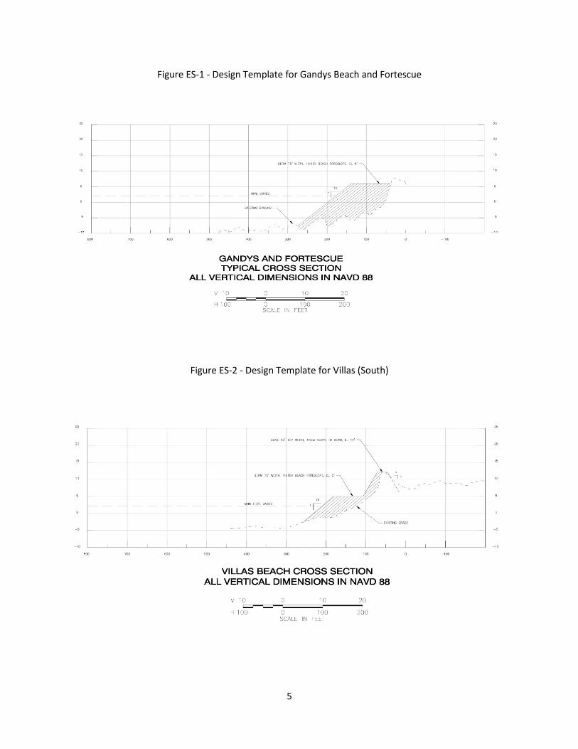
4 Tentatively Selected Plan The TSP consists of beach restoration at Villas (South) and beach restoration with groin(s) at Gandys
Beach and Fortescue.
For Gandys Beach, the proposed design template features a berm of 75 feet (ft) width at a height of +6
ft NAVD88 with a foreslope of approximately 130 ft length on a slope of 1V:10H extending bayward to a
tie-in depth of -7 ft NAVD88. A new terminal groin structure is proposed for the northern end of Gandys
Beach to offset the erosive nature of this portion of the bay. Over the last 25 years there has been
demonstrated shoreline retreat at Gandys Beach. Currently, there is significant armoring of the Gandys
shoreline using steel sheet piling, concrete sea wall and rubble armoring. The natural shoreline erosion
has created conditions where the Delaware Bay has flanked the town and the proposed beach
restoration will suffer unacceptable erosion rates without the use of a terminal groin.
For Fortescue, the proposed design template features a berm of 75 ft width at a height of +6 ft NAVD88
with a foreslope of approximately 100 ft length on a slope of 1V:10H extending bayward to a tie-in
depth of -4 ft NAVD88. At Fortescue, the existing terminal groin at the northern edge of the community
will be rehabbed and replaced as part of the recommended plan to reduce end losses and the associated
renourishment frequency.
The terminal groins at Gandys and Fortescue will be comprised of a timber stem section that will
prevent sediment migration. The timber stem will be comprised of sheeting, walers and piles. The
timber stem will be anchored bayward by a rubble mound groin, comprised of armor stone and bedding
stone.
At Villas (South), the proposed design template features a berm of 75 feet (ft) width at a height of +5 ft
NAVD 88 with a foreslope of approximately 100 ft length on a slope of 1V:10H extending bayward to a
tie-in depth -2 ft NAVD88. The berm is topped with a dune whose crest width is 25 ft at a height of +12
ft NAVD88. The dune transitions both bayward to the berm and landward to existing grade on a slope of
1V:5H.
5
Figure ES-1 - Design Template for Gandys Beach and Fortescue
Figure ES-2 - Design Template for Villas (South)

6
Based on the volume projections for initial construction at each of the 3 placement locations, a total of
approximately 700,000 cubic yards of dredged material would be required for initial construction. As
referenced in Section 3.4, the proposed source area (Brandywine and Miah Maull reaches of the
Delaware River Main Channel – designated Lower Reach E) is anticipated to have approximately 465,000
cubic yards of dredged material available annually that will need to be removed to maintain the 45 feet
depth. The anticipated dredging cycle for Lower Reach E is every two years to remove and place
930,000 cubic yards (465,000 x 2) of dredged material. The projected quantity and dredging cycle were
based on the feasibility report completed in support of the Delaware River Main Channel Deepening
project (MCD). Actual dredged material quantities will be verified prior to construction; therefore, the
PDT recognizes the possibility that there may be greater and/or lesser quantities available (than
currently projected) at the time of construction. If there is less dredged material available than
anticipated at the projected date of initial construction (2022), the Buoy 10 open water disposal site
(located one mile east of the Delaware River Main Channel in Lower Delaware Bay) may serve as a back-
up source for initial construction as it contains sand (approximately 750,000 cubic yards) previously
dredged from Lower Reach E during operation and maintenance of the Delaware River, Philadelphia to
the Sea navigation project. The PDT recognizes that the use of Buoy 10 as a back-up source would
necessitate a benthic habitat assessment and ultimately a Supplemental Environmental Assessment
(EA).
Varying volumes of dredged material are required at each of the placement locations, depending on the
length of shoreline to be nourished and the existing beach profile. In order to maintain the integrity of
design beachfill alternatives, beachfill nourishment must be included in the project design. If periodic
nourishment was not performed throughout the life of the project, the longshore and cross shore
sediment transport mechanisms, separate from storm induced erosion, would act to erode the design
beach. An 8-year periodic nourishment cycle is anticipated to maintain optimal CSRM. This
nourishment cycle is in line with the proposed operation and maintenance (O&M) dredging to be
performed in Lower Reach E (the proposed project dredged material source area for the TSP); however,
it will be further refined during plan optimization.
i
New Jersey Beneficial Use of Dredged Material for the Delaware River
Feasibility Study Feasibility Report and Integrated Environmental Assessment
Table of Contents
1 STUDY INFORMATION ........................................................................................................................... 1
1.1 PROBLEM DESCRIPTION ................................................................................................................ 1
1.2 STUDY AUTHORITY ........................................................................................................................ 1
1.3 PURPOSE AND SCOPE (PURPOSE AND NEED) ............................................................................... 3
1.4 LOCATION OF THE STUDY AREA .................................................................................................... 3
1.5 PRIOR REPORTS AND EXISTING PROJECTS .................................................................................... 8
1.6 PLANNING PROCESS AND REPORT ORGANIZATION ................................................................... 10
2 PROBLEM DESCRIPTION AND OBJECTIVES OF THE PROPOSED ACTION ............................................. 11
2.1 NATIONAL OBJECTIVES ............................................................................................................... 11
2.2 PUBLIC CONCERNS ...................................................................................................................... 11
2.3 PROBLEMS AND OPPORTUNITIES ............................................................................................... 14
2.4 WITHOUT PROJECT CONDITIONS ................................................................................................ 14
2.4.1 Existing Coastal Storm Risk ................................................................................................. 15
2.4.2 Historical Flooding .............................................................................................................. 16
2.4.3 Existing Coastal Storm Risk Management ........................................................................... 20
2.4.4 Future Without Project Conditions ..................................................................................... 20
2.4.5 Federal Interest ................................................................................................................... 21
2.5 PLANNING OBJECTIVES ............................................................................................................... 21
2.6 PLANNING CONSTRAINTS ........................................................................................................... 22
3 PLANS .................................................................................................................................................. 22
3.1 PLAN FORMULATION RATIONALE ............................................................................................... 22
3.2 MANAGEMENT MEASURES ......................................................................................................... 25

ii
3.3 PLAN FORMULATION .................................................................................................................. 31
3.4 FINAL ARRAY OF ALTERNATIVES EVALUATION AND COMPARISON ........................................... 33
3.4.1 Northern Reach Alternative Evaluation and Comparison ................................................... 36
3.4.2 Southern Reach Alternative Evaluation and Comparison ................................................... 43
3.5 PLAN SELECTION ......................................................................................................................... 53
3.5.1 Economic Summary............................................................................................................. 53
3.6 DESCRIPTION OF THE RECOMMENDED PLAN ............................................................................. 58
3.6.1 Plan Components ................................................................................................................ 58
3.6.2 Public Law 113-2 Requirements .......................................................................................... 60
3.6.3 Real Estate Requirements ................................................................................................... 62
3.6.4 Environmental Compliance ................................................................................................. 62
3.6.5 Environmental Operating Principles ................................................................................... 63
3.6.6 Contributions to the USACE Campaign Plan ....................................................................... 66
4 AFFECTED ENVIRONMENT .................................................................................................................. 66
4.1 ENVIRONMENTAL SETTING OF THE STUDY AREA ....................................................................... 66
4.2 PHYSICAL ENVIRONMENT ........................................................................................................... 68
4.2.1 Land Use .............................................................................................................................. 68
4.2.2 Physiography and Geology .................................................................................................. 68
4.2.3 Sediment Quality ................................................................................................................. 69
4.2.4 Climate and Climate Change ............................................................................................... 71
4.3 WATER RESOURCES .................................................................................................................... 73
4.3.1 Groundwater Quality and Public Water Sources ................................................................ 73
4.3.2 Surface Water Quality ......................................................................................................... 75
4.4 BIOLOGICAL RESOURCES ............................................................................................................. 77
4.4.1 Vegetation and Wetlands ................................................................................................... 77
4.4.2 Planktonic and Benthic Organisms ..................................................................................... 78
4.4.3 Fish ...................................................................................................................................... 80
4.4.4 Wildlife ................................................................................................................................ 84
4.4.5 Threatened and Endangered Species ................................................................................. 86
4.5 AIR QUALITY ................................................................................................................................ 90
4.6 NOISE .......................................................................................................................................... 92
4.7 VISUAL AND AESTHETIC VALUES ................................................................................................. 92

iii
4.8 HAZARDOUS, TOXIC AND RADIOACTIVE WASTE ........................................................................ 92
4.9 CULTURAL RESOURCES ............................................................................................................... 92
4.10 SOCIOECONOMIC ........................................................................................................................ 93
5 EFFECTS ON SIGNIFICANT RESOURCES* ............................................................................................. 94
5.1 PHYSICAL ENVIRONMENT ........................................................................................................... 95
5.1.1 Land Use .............................................................................................................................. 95
5.1.2 Physiography and Geology .................................................................................................. 96
5.1.3 Sediment Quality ................................................................................................................. 97
5.1.4 Climate and Climate Change ............................................................................................. 100
5.2 WATER RESOURCES .................................................................................................................. 102
5.3 BIOLOGICAL RESOURCES ........................................................................................................... 105
5.3.1 Vegetation and Wetlands ................................................................................................. 105
5.3.2 Planktonic and Benthic Organisms ................................................................................... 106
5.3.3 Fish .................................................................................................................................... 108
5.3.4 Wildlife .............................................................................................................................. 114
5.3.5 Threatened and Endangered Species ............................................................................... 117
5.4 HAZARDOUS, TOXIC AND RADIOACTIVE WASTE ...................................................................... 122
5.5 AIR QUALITY .............................................................................................................................. 123
5.6 NOISE ........................................................................................................................................ 124
5.7 CULTURAL RESOURCES ............................................................................................................. 125
5.8 SOCIOECONOMIC RESOURCES .................................................................................................. 126
5.9 CUMULATIVE IMPACTS ............................................................................................................. 127
6 PUBLIC INVOLVEMENT, REVIEW AND CONSULTATION* .................................................................. 130
6.1 Public Involvement Program ..................................................................................................... 130
6.2 Institutional Involvement .......................................................................................................... 131
6.2.1 Agency Coordination ......................................................................................................... 131
6.2.2 Compliance with Environmental Requirements ............................................................... 131
7 LIST OF PREPARERS ........................................................................................................................... 137
8 IMPLEMENTATION REQUIREMENTS ................................................................................................. 137
8.1 Institutional Requirements ....................................................................................................... 137
8.2 Implementation Schedule ......................................................................................................... 140
8.3 Cost Apportionment ................................................................................................................. 141

iv
8.4 Environmental Requirements ................................................................................................... 141
8.5 Views of Non-Federal Sponsor .................................................................................................. 141
9 REFERENCES ...................................................................................................................................... 142
10 RECOMMENDATIONS.................................................................................................................... 150

v
Figures Figure 1 - Study Area ..................................................................................................................................... 4
Figure 2 - Delaware River Basin Commission (DRBC) Zones ......................................................................... 7
Figure 3 - CSRM Problem Areas .................................................................................................................. 13
Figure 4 - Reeds Beach – July 2005 ............................................................................................................. 16
Figure 5 - Pierces Point – July 2005 ............................................................................................................. 17
Figure 6 - Pierces Point – July 2005 ............................................................................................................. 17
Figure 7 - Reeds Beach – July 2005 ............................................................................................................. 18
Figure 8 - Villas - October 2012 ................................................................................................................... 18
Figure 9 - Fortescue - March 2014 .............................................................................................................. 19
Figure 10 - Gandys Beach - March 2014 ..................................................................................................... 19
Figure 11 - Planning Reaches ...................................................................................................................... 35
Figure 12 - Southern Reach Beach-fx Evaluation ........................................................................................ 45
Figure 13 - TSP Overview ............................................................................................................................ 54
Figure 14 – Economic Sensitivity Analysis................................................................................................... 57
Figure 15 – Design Template for Gandys Beach & Fortescue ..................................................................... 59
Figure 16 - Design Template for Villas ........................................................................................................ 59
Figure 17 - Water Supplies: Ground & Surface Water ................................................................................ 74
Figure 18 - Delaware Estuary: Salt Line and Trenton Flow Data ................................................................. 77
Figure 19 - Delaware Estuary Mixing Zone Essential Fish Habitat .............................................................. 82
Figure 20 - Non-Attainment Areas for Ozone ............................................................................................. 91
Figure 21 - Reach E Sub-Reaches ................................................................................................................ 99
Figure 22 - Hopper Dredge ........................................................................................................................ 104

vi
Tables Table 1 - New Jersey Shoreline Erosion Rates ............................................................................................ 20
Table 2 - Problem Area Screening - Cycle 1 ................................................................................................ 24
Table 3 - Objectives/Measures Matrix ........................................................................................................ 29
Table 4 - Measure Applicability by Problem Area ....................................................................................... 31
Table 5 - Northern Planning Reach Alternatives ......................................................................................... 32
Table 6 - Southern Planning Reach Alternatives ......................................................................................... 32
Table 7 - Levee/Dike Plan Dredged Material Source Areas - Northern Reach ........................................... 36
Table 8 - Northern Planning Reach Alternative Comparison ...................................................................... 39
Table 9 - Northern Planning Reach Alternative Evaluation ........................................................................ 41
Table 10 - Beach Restoration Dredged Material Source Areas – Southern Reach ..................................... 44
Table 11 - Initial Southern Reach Economic Summary ............................................................................... 46
Table 12 – Southern Reach Alternative Comparison .................................................................................. 48
Table 13 - Southern Reach Alternative Evaluation ..................................................................................... 51
Table 14 - Project Cost ................................................................................................................................ 55
Table 15 – Summary of Costs & Benefits .................................................................................................... 55
Table 16 - Summary of CSRM Damages Prevented .................................................................................... 56
Table 17 - Summary of Environmental Compliance ................................................................................... 63
Table 18 - Delaware Estuary Watershed Climate Predictions: Present to 2100 ........................................ 72
Table 19 - Summary of Essential Fish Habitat Designated Species & Their Life Stages .............................. 82
Table 20 - Delaware Estuary Threatened & Endangered Species ............................................................... 87
Table 21 - Relative Sea Level Change (RSLC) Adjustments applied during Screening Level Assessments 100
Table 22 - Impacts of Cumulative Actions ................................................................................................ 129
Table 23 – Project Delivery Team ............................................................................................................. 137
Table 24 – Estimated Schedule of Federal and Non-Federal Expenditures .............................................. 141
Table 25 - Summary of Costs & Benefits ................................................................................................... 151

vii
Appendices
Appendix A – Economic Analysis
Appendix B – Real Estate Plan
Appendix C - Engineering
Appendix C1 – Hydrology & Hydraulics
Appendix C2 – Civil Design
Appendix C3 – Cost Engineering
Appendix C4 – Geotechnical Data
Appendix D – 404(b) Analysis
Appendix E – Pertinent Correspondence
Appendix F – Value Engineering Study

viii
This page intentionally left blank

1
1 STUDY INFORMATION The purpose of this report is to analyze coastal storm risk management (CSRM) issues in various New
Jersey communities, with the intent to beneficially use dredged material from Federal navigation
channels within the Delaware Estuary. The U.S. Army Corps of Engineers (USACE) and the Non-Federal
Sponsor (New Jersey Department of Environmental Protection – NJDEP) entered into a feasibility cost
share agreement (FCSA) on 27 February 2014.
1.1 PROBLEM DESCRIPTION Shoreline erosion, waves and storm surge caused by coastal storms, along with sea-level change (SLC),
cause flood-related damages along the Delaware Estuary shoreline of New Jersey.
The overall objective of the planning study is to improve CSRM for New Jersey communities located
along the Delaware Estuary area.
1.2 STUDY AUTHORITY The study authorities for the New Jersey Beneficial Use of Dredged Material for the Delaware River
Study (DMU) are the October 26, 2005 resolution of the Committee on Environment and Public Works of
the United States Senate (“Resolution”) and the Disaster Relief Appropriations Act, 2013 (PL 113-2).
The Resolution reads as follows:
“Resolved by the Committee on Environmental and Public Works of the United States Senate,
that the Secretary of the Army is requested to review the report of the Chief of Engineers on the
Delaware River between Philadelphia, Pennsylvania and Trenton, New Jersey, and Philadelphia
to the Sea, published as House Document 358, Eighty Third Congress, Second Session (1954),
and other pertinent reports, with a view to determining whether any modifications of the
recommendations contained therein are advisable in the interest of beneficial use of dredged
material resulting from the aforementioned project, including transfer and transport facilities
for the drying, rehandling, and transferring of dredged material, as it relates to comprehensive
watershed and regional sediment management (RSM), ecosystem restoration, navigation,
stream restoration, water quality, restoration of coal and other mined areas, cover material for
sanitary landfills and other allied purposes.”
In accordance with the Resolution, the project delivery team (PDT) reviewed the above-referenced
report of the Chief of Engineers to determine if any modifications to the recommendations were
warranted with regard to the beneficial use of dredged material. The feasibility study described herein
was conducted to facilitate the review. Upon initiation of the study, CSRM was identified as an “other
allied purpose” to be considered for the beneficial use of dredged material under this authority. As
discussed further in this section, the passage of PL 113-2 further mandated a CSRM feasibility study for
the subject study area.

2
Specifically regarding PL 113-2, a catastrophic storm (Hurricane Sandy) struck the Atlantic coastline,
resulting in loss of life, severe damages to the coastline, widespread power outages, and damage to
infrastructure, businesses and private residences. The storm also resulted in degraded coastal features,
which increased the risks and vulnerability from future storms. Expected changes in sea level, an
increased probability of extreme weather events, and other impacts of climate change are likely to
increase those risks even further. In the aftermath of Hurricane Sandy and the subsequent passage of
PL 113-2, Congress authorized supplemental appropriations to Federal agencies for expenses related to
the consequences of Hurricane Sandy. Chapter 4 of PL 113-2 identifies those actions directed by
Congress specific to USACE, including preparation of two interim reports to Congress, a project
performance evaluation report, and a comprehensive study to address the flood risks of vulnerable
coastal populations in areas affected by Hurricane Sandy within the boundaries of the North Atlantic
Division of USACE. The Second Interim Report to Congress (dated 30 May 2013) states that PL 113-2
“provides supplemental appropriations to address damages caused by Hurricane Sandy and reduce
future flood risk in ways that will support the long-term sustainability of the coastal ecosystem and
communities, and reduce the economic costs and risks associated with large-scale flood and storm
events.”
This study was identified in the Second Interim Report to Congress as an “Ongoing Study” for reducing
flooding and storm damage risks in the area affected by Hurricane Sandy. This CSRM study has been
authorized by and conducted in accordance with the Resolution and PL 113-2 and its associated reports
thereby formulating for CSRM via the beneficial use of dredged material.
PL 113-2 directed USACE to conduct a comprehensive study (the NACCS) to address the flood risks of
vulnerable coastal populations in areas that were affected by Hurricane Sandy within the boundaries of
the North Atlantic Division of the Corps. The NACCS was completed in January 2015 and provides a
step-by-step approach, with advancements in the state of science and tools to conduct three levels of
analysis. Tier 1 was a regional scale analysis (completed as part of the NACCS), Tier 2 was conducted at
a State or watershed scale (conceptual Tier 2 evaluations were completed in each state and the District
of Columbia), and Tier 3 would be a local-scale analysis that incorporates benefit-cost evaluations of
CSRM plans.
Under the NACCS, more than 31,200 miles of coastal shoreline were delineated into 39 planning reaches
based on State boundaries, shoreline types, geomorphic features, and extent of existing or planned risk
management projects. Based on coordination with a diverse set of agencies, the NACCS considers
population and supporting infrastructure, environmental and cultural resources, and existing and
planned CSRM efforts. The study also considers existing and future inundation and SLC. Specifically, the
NACCS identified the Delaware Bay shoreline as a high risk area requiring additional analysis.

3
1.3 PURPOSE AND SCOPE (PURPOSE AND NEED) The purpose of this report is to present the findings of a feasibility investigation that was conducted to
determine if there is a Federal interest and recommend a solution to identified CSRM problems at
various New Jersey communities. The study investigated the feasibility of addressing CSRM problem(s)
via the beneficial use of dredged material. CSRM alternatives utilizing dredged material were
formulated, compared/evaluated against the without project condition and ultimately will be optimized
in order to identify the National Economic Development (NED) plan. If screening does not indicate a
viable opportunity to implement CSRM alternatives with dredged material in select problem areas, then
other alternatives may be recommended for further analysis under another study authority.
1.4 LOCATION OF THE STUDY AREA The study area is located within the Delaware River watershed, which lies within the State of New Jersey
and the Delaware River itself. The north/south boundaries of the study area extend from Trenton, NJ to
Cape May Point, NJ (Figure 1). The centerline of the Delaware Estuary represents the western study
area boundary and it extends approximately 135 miles from the Atlantic Ocean upstream to the head of
tide at Trenton, New Jersey.
The study area includes flood prone areas along the mainstem Delaware River and Delaware Bay, but
also the tributaries of the Delaware which contribute to both tidal and fluvial flooding. Tributaries to
the Delaware River and Bay within the study area include: Dennis Creek, Maurice River, Cohansey River,
Stowe Creek, Alloway Creek, Salem River, Oldmans Creek, Raccoon Creek, Mantua Creek, Big Timber
Creek, Cooper River, Pennsauken Creek, Rancocas Creek and Black Creek.

4
Figure 1 - Study Area

5
This feasibility study evaluated coastal storm-related damages in New Jersey occurring in two defined
planning reaches within the Delaware Estuary system. The “northern reach” is from the head of tide at
Trenton, NJ down to the approximate river/bay boundary (around Alder Cove), while the “southern
reach” extends south from the Alder Cove area (river/bay boundary) to the mouth of the Delaware Bay
at Cape May Point, NJ. The northern reach includes four distinct zones of the tidal Delaware River
watershed, as defined by the Delaware River Basin Commission (DRBC):
Zone 2 – Zone 2 is the part of the Delaware River extending from the head of tidewater at
Trenton, NJ to the Trenton/Morrisville Toll Bridge below the mouth of Pennypack Creek,
including the tidal portions of the tributaries thereof (River Mile 133.4 to 108.4).
Zone 3 – Zone 3 is the part of the Delaware River extending from the Trenton/Morrisville Toll
Bridge to just below the mouth of Big Timber Creek (near Westville, NJ), including the tidal
portions of the tributaries thereof (River Mile 108.4 to 95.0).
Zone 4 – Zone 4 is the part of the Delaware River extending from just below the mouth of Big
Timber Creek to where the Delaware state boundary line approaches the New Jersey shoreline,
opposite of Marcus Hook, PA, including the tidal portions of the tributaries thereof (River Mile
95.0 to 78.8).
Zone 5 – Zone 5 is the part of the Delaware River extending from the Delaware boundary line
with the New Jersey shoreline to the south of Hope Creek Generating Station adjacent to Mad
Horse Creek Wildlife Management Area, including the tidal portions of the tributaries thereof
(River Mile 78.8 to 48.2).
The southern reach includes Zone 6 extending from Madhorse Creek Wildlife Management Area south
to the sea (Atlantic Ocean), including the tidal portions of the tributaries thereof (River Mile 48.2 to the
Sea – River Mile 0) (Figure 2).
In the northern reach, the width of the waterway is relatively smaller and the principal CSRM damages
are due to inundation related to coastal storm surge, as occurs during tropical storms, hurricanes or
nor’easters. However, in the southern reach, the width of the bay (fetch) increases and allows wind to
generate greater wave energy at the shoreline, so that waves create an additional risk mechanism
beyond inundation alone. Due to the additional damage mechanisms, the southern reach experiences
CSRM damages from the combined effects of inundation, waves and storm erosion, analogous to the
damage mechanisms experienced on the open ocean coast.
Sediment composition and grain size also vary between the northern and southern reaches. Sediment
deposition in the northern reach is dominated by fine-grained sediments, predominantly silts and clays.
All dredged sediment from the navigation channel in the northern reach is placed in USACE upland CDFs,
which contain hundreds of millions of cubic yards of sediment. In the southern reach, sediment
deposition becomes progressively coarser southward such that shoaling in the southernmost 15 miles of
the navigation channel consists of predominantly coarse-grained material. The nature of this sediment
is discussed in more detail in Section 5.1.3. Traditionally, all sediment dredged from this reach has been

6
either placed at Buoy 10 (approximately 1 mile east of the navigation channel) or brought north for
placement at the Artificial Island CDF.
More recently, material from the MCD project was beneficially placed as beach fill at Oakwood Beach,
Salem County, New Jersey (2014) and Broadkill Beach, Sussex County, Delaware (2015-2016).

7
Figure 2 - Delaware River Basin Commission (DRBC) Zones

8
1.5 PRIOR REPORTS AND EXISTING PROJECTS The Philadelphia District has been responsible for the construction and maintenance of the Delaware
River navigation channel since the late 19th Century, allowing deep-draft commercial vessels to call on
the Port of Philadelphia and other regional port facilities. As a result, there are several existing Federal
navigation projects which are maintained by USACE within the study area. There have also been several
water resource studies previously conducted within the study area.
USACE Projects
Delaware River, Philadelphia to the Sea NJ, PA & DE: This project provides a channel from Allegheny
Avenue, Philadelphia to deep water in Delaware Bay. It also provides six anchorages, dikes, and training
works for the regulation and control of tidal flow. The project channel, previously maintained at a depth
of 40 feet, was authorized for deepening to a depth of 45 feet mean lower low water (MLLW) by
Congress in 1992. Construction of the deepened channel was initiated in 2010 and is scheduled for
completion in 2018. Maintenance dredging of the 45 foot channel will be required and will be
performed as needed based on shoaling conditions and project funding. It is expected that maintenance
dredging of the project will occur on an annual basis. Federal maintenance dredging of the 40 foot
channel has historically generated approximately 3,000,000 cubic yards of dredged material annually.
Delaware River, Philadelphia to Trenton, NJ & PA: This project provides for a channel and turning basins
in the Delaware River from Allegheny Avenue in Philadelphia upstream approximately 30 miles to the
Marine Terminal in Trenton, NJ. The project dimensions vary from 35 to 40 feet deep and 300 to 400
feet wide. The project is complete except for deepening the channel from 25 to 35 feet between
Newbold Island and the Trenton Marine Terminal, which has been placed in the deferred category.
Schuylkill River: This project provides for a channel 6.5 miles long with depths of 22', 26', and 33' and
widths of 200', 300', and 400'. Maintenance dredged material (last performed in 2008) is pumped
directly to an upland disposal area by a cutter-head pipeline dredge.
Salem River: This project provides for an entrance channel 16' deep and 150' wide in the Delaware River
across Salem Cove to the mouth thence 16' deep and 100' wide to the fixed highway bridge in Salem. It
also provides for a cutoff between the mouth and Salem. The project length is approximately 5 miles.
Oakwood Beach: This CSRM project consists of a 50-feet wide berm that is 9,500 linear feet with
346,000 cubic yards of dredged material (from the Reedy Island Range of the Delaware River Main
Channel), with periodic nourishment and the extension of five stormwater outfall pipes. The project
was authorized by WRDA 1999, Title I, §101(b)(5), and was constructed as a Hurricane Sandy (PL 113-2)
"authorized but unconstructed" (ABU) project in 2014.
USACE Studies and Reports
Delaware Bay Coastline, DE & NJ Feasibility Study (USACE, 1991): The Delaware Bay Coastline, DE & NJ
Feasibility Study (1991) evaluated CSRM and ecosystem restoration problems along the Delaware Bay
coastline in Delaware and New Jersey. The feasibility study evaluated seven interim study areas with

9
four sites in New Jersey and three in Delaware. The study areas in New Jersey included the Maurice
River area, the Villas and Vicinity, Reeds Beach to Pierces Point, and Oakwood Beach. Congress
subsequently authorized the projects at Oakwood Beach, Reeds Beach–Pierces Point, and Villas, New
Jersey.
Delaware River Main Stem and Channel Deepening Project - Environmental Impact Statement (1992);
Supplemental Environmental Impact Statement (1997); Environmental Assessment (2009, 2011 and
2013): This project involves dredging as needed within the existing 40-foot Delaware River Federal
navigation channel to deepen it to 45 feet from Philadelphia Harbor, Pa. and Beckett Street Terminal
(Camden, NJ) along a 102.5-mile distance to deepwater in Delaware Bay. The deeper channel will
provide more efficient transportation of containerized, dry bulk (steel and slag) and liquid bulk (crude oil
and petroleum products) cargo to and from the Delaware River ports, with estimated net annualized
benefits of more than $13 million to the U.S. economy.
Oyster and Water Quality Study for the Delaware River Main Channel Deepening Project (2000, 2012,
2013, 2014 and 2015): Data collection and scientific analysis of water quality and oyster beds in
Delaware Estuary to assess possible hydrological changes due to channel deepening that may affect the
biology and ecology of the estuarine system.
Delaware River Waterfront, PA (USACE, 2009): This reconnaissance study was initiated in 2009, and
evaluates possible recommendations advisable in the interest of environmental restoration and
protection, mitigation for previous activities and projects, riparian habitat improvement, water quality
control, historic preservation, and other allied purposes, for the area extending from the Benjamin
Franklin Bridge to the Poquessing Creek, including the tidal portions of tributary creeks in the reach of
the Delaware River.
Delaware Bay Oyster Revitalization Project (USACE, 2005-2008): The native oyster population in the
Delaware Bay is imperiled by disease. This project revitalized the natural oyster beds through shell
planting/ transplanting over a four year period and has helped to maintain habitat diversity within the
Bay. The study area includes all of the Delaware Bay, both New Jersey and Delaware. USACE’s project
efforts were completed in 2008 but additional shell plants by the Partnership for the Delaware Estuary
and its collaborating partners have been conducted on a much smaller scale thereafter.
Delaware River Basin Comprehensive (USACE, 2006): This reconnaissance study was completed in May
2003. A FCSA was signed with the DRBC in July 2006. The objectives of this study were to: realize
ecosystem restoration benefits gained by the effective restoration of habitat impacted by mining
operations and wells, restore and protect the ecosystem and watershed; preserve open space and
farmland; adopt sound land use planning practices; make infrastructure investments that do not
promote sprawl; and invest in restoring public lands. The location of the study is within the Delaware
River Basin, which is located in 28 counties in portions of New York, New Jersey, Delaware and
Pennsylvania. The basin drains an approximate area of 12,765 square miles.

10
Biological Assessment (USACE, 2009): The BA evaluated potential impacts to Federally Listed Threatened
and Endangered Species resulting from the Delaware River Main Stem and Channel Deepening Project.
The BA included formal consultation with NMFS, pursuant to the Endangered Species Act.
Supplemental Biological Assessment (USACE, 2011): The Supplemental BA evaluated potential impacts
to the New York Bight distinct population segment of Atlantic sturgeon (Aciperser oxyrinchus oxyrinchus)
which is proposed for Federal Endangered Species Listing resulting from the Delaware River Main Stem
and Channel Deepening Project. The Supplemental BA included formal consultation with NMFS,
pursuant to the Endangered Species Act.
Delaware Estuary Salinity Monitoring Study (USACE, 2013): This study was completed in October 2013.
The study provides hydrodynamic modeling capabilities for the Delaware Estuary to examine flow
dynamics, salinity, and water quality. The study also collected population dynamics data for the Eastern
Oyster and Atlantic and shortnose sturgeon, which have shown historically low populations along the
Atlantic coast of North America. The model was used to assess the impacts of salinity variance to
estuarine water users and the information gathered was useful to the States of New Jersey, Delaware
and the DRBC in assessing low flow augmentation for the Delaware River and Bay.
Delaware River New Jersey, Delaware, and Pennsylvania Dredged Material Utilization and Beneficial Use
Opportunities Expedited Reconnaissance Study (USACE, 2013): In response to the original study
authorization from October 26, 2005, the Philadelphia District conducted this Expedited Reconnaissance
Study. The purpose of this study was to examine beneficial use opportunities using maintenance
dredged material from the Delaware River and its tributaries for multiple purposes. The findings of the
expedited reconnaissance study indicated that there is Federal interest in further investigations of
multiple-purpose beneficial sediment reuse opportunities through a feasibility study within New Jersey.
Reeds Beach and Pierces Point (USACE, 1998): This authorized, but unconstructed, ecosystem
restoration project proposes to restore an 80-feet wide berm over 6,800 linear feet in Middle Township,
Cape May County, NJ (along the Delaware Bay). The recommended plan entails a one-time placement
of sand for horseshoe crab and shorebird habitat. A Limited Re-evaluation Report (LRR) was completed
in 2006.
Villas and Vicinity (USACE, 1998): This authorized, but unconstructed, ecosystem restoration project
proposes to restore an 80-feet wide berm over 29,000 linear feet in Middle and Lower Township, Cape
May County, NJ (along the Delaware Bay). The recommended plan entails a one-time placement of sand
for horseshoe crab and shorebird habitat. The project has not received funding since 2006. Hurricane
Sandy struck the mid-Atlantic coastline in October 2012 causing widespread damage; therefore, this
project may require a LRR.
1.6 PLANNING PROCESS AND REPORT ORGANIZATION The planning process consists of six major steps: (1) Specification of water and related land resources
problems and opportunities; (2) Inventory, forecast and analysis of water and related land resources
conditions within the study area; (3) Formulation of alternative plans; (4) Evaluation of the effects of the

11
alternative plans; (5) Comparison of the alternative plans; and (6) Selection of the recommended plan
based upon the comparison of the alternative plans. The chapter headings and order in this report
generally follow the outline of an Environmental Assessment (EA). Chapters of the report related to the
six steps of the planning process as follows:
Chapter 2, Problem Description and Objectives of the Proposed Action, covers the first step in
the planning process (Specification of water and related land resources problems and
opportunities).
Chapter 3, Plans, is the heart of the report and is therefore placed before the detailed discussion
of resources and impacts. It covers the third step in the planning process (Formulation of plans),
the fourth step in the planning process (Evaluation of alternative plans), the fifth step in the
planning process (Comparison of alternative plans) and the sixth step of the planning process
(Selection of the recommended plan based upon the comparison of the alternative plans).
Chapter 4, Affected Environment, covers the second step of the planning process (inventory,
forecast and analysis of water and related land resources in the study area).
Chapter 5, Effects on Environmental Resources, covers the fourth step of the planning process
(Evaluation of the effects of the alternative plans).
This report was written in accordance with USACE Planning Modernization and meets the requirements,
under the National Environmental Policy Act, as a full disclosure document of environmental effects of
the proposed Federal agency actions. Information contained in the report demonstrates the decision-
making process. For more information on the detailed analysis, please refer to the appendices.
2 PROBLEM DESCRIPTION AND OBJECTIVES OF THE PROPOSED
ACTION This chapter presents the results of the first step of the planning process, the specification of water and
related land resources problems and opportunities in the study area. The chapter concludes with the
establishment of planning objectives and planning constraints, which is the basis for the formulation of
alternative plans.
2.1 NATIONAL OBJECTIVES The national or Federal objective of water and related land resources planning is to contribute to NED.
In addition, it must be consistent with protecting the nation’s environment, pursuant to national
environmental statutes, with applicable executive orders and with other Federal planning requirements.
Contributions to NED are increases in the net value of the national output of goods and services,
expressed in monetary units. Contributions to NED are the direct net benefits that accrue in the
planning area and in the rest of the nation as a result of reducing storm damages with the selected plan
in place within the study area.
2.2 PUBLIC CONCERNS As discussed in Section 1.2, the NACCS identified the Delaware River/Bay shoreline as a high risk area
requiring additional analysis. Under the purview of the NACCS, there was significant coordination with

12
state, county and local community agencies and representatives of non-profit organizations to identify
specific flood-prone problem areas within New Jersey. The additional analysis and coordination under
the NACCS identified the Delaware Bay shoreline as a “High Storm Impact” area from Hurricane Sandy.
For the Delaware Bay shoreline in the state of New Jersey, 33 CSRM problem areas were identified
extending from Burlington to Cape May Counties, as shown in Figure 3.

13
Figure 3 - CSRM Problem Areas

14
2.3 PROBLEMS AND OPPORTUNITIES This section describes the needs in the context of problems and opportunities that can be addressed
through water and related land resource management. The problems and opportunities are based upon
the project conditions that are described in Chapter 4, Affected Environment.
The primary problems identified in this study are shoreline erosion, waves and storm surge caused by
coastal storms, along with SLC, cause flood-related damages along the Delaware Estuary shoreline of
New Jersey. The shoreline is characterized by flat, low-lying coastal plains with broad marshes and
narrow barriers of sand along the bay beaches. The sand beach barrier is widest and most well-
developed near the mouth of the bay (south of Villas), becoming less prevalent to the north.
The nature of the CSRM problem and the study area characteristics also present the following
opportunities:
Minimize erosion, wave and storm-surge related damages to New Jersey communities located
along and adjacent to the Delaware Estuary shoreline.
Increase the resiliency of the New Jersey shoreline by reducing its vulnerability to flood and
storm events.
Beneficially use dredged material to minimize erosion, wave and storm-surge related damages
and increase resiliency along the New Jersey shoreline.
2.4 WITHOUT PROJECT CONDITIONS As referenced above, the CSRM problem areas are located in DRBC Zones 2 through 6. The Delaware
River region (comprised of DRBC Zones 2 through 5) is identified by DRBC as the Upper Estuary
Watershed and includes Mercer, Burlington, Camden, Gloucester and Salem Counties. These counties
are the more populated counties within the study area (located within both the New York and
Philadelphia Metropolitan areas) and contain numerous industries. The area within and surrounding
Trenton in Mercer County has a long history in the iron and steel industries, metals, rubber and
ceramics. The residential communities in Burlington, Camden and Gloucester Counties are
characterized by medium to high density single and multiple family urban homes with urban, bluff and
wetland shoreline types, as defined by the NACCS. Specifically, Gloucester County transitions to a more
rural and residential area with a patchwork of farmland, forests and communities. Salem County
consists primarily of farmland interspersed with woodland and residential communities characterized by
medium density single-family rural homes. The most populous communities within Salem County are
Pennsville Township, Carneys Point Township and Penns Grove. A number of municipalities are working
to preserve farmland within the county.
The Bay Region of the study area (DRBC Zone 6) includes bayshore communities in Cumberland (Sea
Breeze, Gandys Beach, Fortescue, Egg Island Point, Bivalve, Shellpile, Port Norris, Maurice River and
Delmont) and Cape May Counties (Reeds Beach, Pierces Point, Del Haven and Villas). The communities
in Cumberland County consist of low density single-family rural homes with wetland and urban shoreline
types, as defined by the NACCS. Bayshore communities in Downe Township were historically known for

15
their commercial/recreational fishing and hunting traditions. These communities and their surrounding
wetlands were severely flooded and eroded by Hurricane Sandy in October 2012.
Cape May County is the southernmost county in New Jersey that has consistently been a popular
summer destination. Tourism is the county’s single largest industry. Lower Township shares a shoreline
on both the Atlantic Ocean and the Delaware Bay and is the largest municipality in the county. Small
seasonal bungalows have been replaced along the Delaware Bay shoreline with medium to high density,
large multi-story homes. Fishing and farming in surrounding areas continues to be an important
economic factor.
2.4.1 Existing Coastal Storm Risk
The shorelines of the New Jersey Delaware Estuary are characterized by flat, low-lying coastal plains that
are subject to inundation during storms, wave attack, as well as the ongoing effects of shoreline erosion
and SLC. The Delaware Bay is 47 mi long and 27 mi wide measured at the widest point, making the area
vulnerable to wave attack, erosion and flood damages from coastal and potentially fluvial sources. The
shoreline consists of tidal marshes and sandy barriers or developed residential and commercial
infrastructure. Public and private property at risk includes densely populated sections of the shoreline
bordering the Delaware Estuary and associated tidal tributaries. Specifically, there are densely
developed urban areas, private residences, businesses (including refineries and chemical plants),
schools, infrastructure, roads and evacuation routes for coastal emergencies. Additionally, the study
area includes undeveloped areas that provide ecological, fisheries and recreational benefits as well as
ecosystem services. Dunes, beaches, marshes and estuarine ecosystems are quite fragile in some
locations and are threatened by coastal storm events and the effects of climate change. In addition,
there is an extensive network of private and state-preserved agricultural land in the study area.
Different regions of the Delaware Estuary exhibit differing flood and erosion problems. Developed
residential areas incur frequent flood damages to homes and businesses from storm events while lesser
developed regions incur excess inundation to natural habitat and farmland, incurring community and
recreational access and economic losses due to flooding.
As referenced above, the northern planning reach has densely developed urban areas and businesses
(including refineries and chemical plants). While much of the northern reach is developed with
residential communities, industry is concentrated in Camden, Burlington and Mercer Counties. In the
southern planning reach, the Delaware Bay shoreline (from the Cohansey River south to Cape May
Point) is characterized by small residential communities interspersed with expansive salt marshes,
narrow sandy beaches, dunes and low tide mud flats. The bay shoreline is not heavily developed and
ownership along the bay shoreline is a mix of private, state and Federal lands. Approximately 52,000
acres of New Jersey bay wetlands are state-owned, most as Fish and Wildlife Management Areas
(FWMA). New Jersey Wildlife Management Areas include: Mad Horse Creek, Dix, Nantuxent, Fortescue,
Egg Island, Heislerville, Dennis Creek and Higbee Beach. The one Federally protected area is Cape May
National Wildlife Refuge, a unit of the U.S. Fish and Wildlife Service (USFWS). Most of the beach areas,
such as Fortescue, Reeds Beach and south of Reeds Beach, are accessible from roads. There is limited

16
access to Moores Beach due to road washout at high tide. These areas incur frequent flood damages to
home and businesses from storm events while lesser developed regions incur excess inundation to
natural habitat, incurring community and recreational access and economic losses due to flooding.
Erosion and flooding are the primary coastal hazards that lead to property and infrastructure damages.
Coastal storms can occur at any time of the year and at varying levels of severity. Storm surge (i.e. over
and above normal tidal action) inundates land areas with estuarine waters.
2.4.2 Historical Flooding
According to the National Climatic Data Center (NCDC), the following flood events were reported
between January 1995 and December 2014:
Burlington County: 33 days with flood events (5 with property damage totaling $5.36 million)
Camden County: 26 days with flood events (3 with property damage totaling $1.35 million)
Gloucester County: 25 days with flood events (3 with property damage totaling $1.8 million)
Cumberland County: 18 days with flood events (2 with property damage totaling $11 million)
Cape May County: 58 days with flood events (7 with property damage totaling $319 million)
Salem County: 23 days with flood events (3 with property damage totaling $7.3 million)
Figure 4 - Reeds Beach – July 2005

17
Figure 5 - Pierces Point – July 2005
Figure 6 - Pierces Point – July 2005

18
Figure 7 - Reeds Beach – July 2005
Figure 8 - Villas - October 2012

19
Figure 9 - Fortescue - March 2014
Figure 10 - Gandys Beach - March 2014

20
2.4.3 Existing Coastal Storm Risk Management
USACE has evaluated potential CSRM along the Delaware Estuary shoreline since the early 1990s via the
Delaware Bay Coastline, DE & NJ Feasibility Study (1991) as well as the Delaware River Basin
Comprehensive (2006) feasibility study. In the northern reach, a CSRM project was constructed at
Oakwood Beach in 2014. The project consists of a 50-feet wide berm that is 9,500 feet long with
periodic nourishment and the extension of five stormwater outfall pipes. To date, no other Federal
CSRM projects have been constructed within the study area. USACE is not aware of state and/or local
CSRM projects within the study area.
2.4.4 Future Without Project Conditions
In August 1991, the Corps conducted a review of the Delaware Bay and its tributaries to determine the
magnitude, location and effect of the shoreline erosion problems under the scope of the Delaware Bay
Coastline – New Jersey and Delaware Reconnaissance Study. The study examined the New Jersey
shoreline in Cumberland and Cape May Counties. Table 1 provides a summary of shoreline erosion
trends in the aforementioned counties:
Table 1 - New Jersey Shoreline Erosion Rates
New Jersey Minimum
Shoreline Change
Rate
(ft/yr)
Maximum
Shoreline Change
Rate
(ft/yr)
Average Shoreline
Change Rate
(ft/yr)
Arnolds Pt to Bayside -2 -5 -3.5
Sea Breeze -2 -5 -3.5
Fortescue -1 -1 -1
Maurice River Cove -3 -12 -7.5
East Pt to Thompsons Beach Stable Stable Stable
Moores Beach -2 -6 -4
Reeds Beach -3 -3 -3
Green Creek to Villas +1 +1 +1
Villas to Cape May Canal -2 -2 -2
The minimum and maximum shoreline change rates listed on Table 1 were extracted from the 1991
Delaware Bay Coastline - New Jersey and Delaware Reconnaissance Study. The average of the minimum
and maximum shoreline change rates was then calculated by the PDT. This table highlights that the New
Jersey average shoreline change rates ranged from +1 ft/yr to -7.5 ft/yr in the area studied.
Assuming these trends continue and are potentially exacerbated by SLC, a significant amount of
shoreline erosion will occur along the New Jersey shoreline. In addition to the ongoing effects of
shoreline erosion and SLC, the Delaware Bay shoreline is vulnerable to flood-related damages from
coastal storm events. Increased storm and erosion damage will continue to undermine the

21
physiography supporting the existing structures and infrastructure in the developed areas and erode
adjacent marsh and wetland habitat.
It is important to note that in the absence of a Federal project under this study authority, maintenance
dredging is anticipated to continue throughout the Delaware Estuary with the majority of the dredged
material disposal occurring in CDFs and/or Buoy 10 open water disposal site. As discussed in Section 3.4
and shown on Figure 11, the proposed source of material for this project is Lower Reach E (Miah Maull
and Brandywine Ranges) of the Delaware Estuary main channel. The estimated future O&M dredging of
Miah Maull and Brandywine is projected to be 465,000 cy/yr, with a dredging interval of 2 years. For the
existing navigation project the dredged material disposal from Lower Reach E will be bottom dumping in
Buoy 10 for approximately 10 more years (based on the current plans to expand the Buoy 10 footprint);
however, after 10 years, the current plan is to take the material to the Artificial Island CDF for disposal.
Section 3.5.1 provides further discussion on the future without project conditions and the potential
economic impacts of such conditions.
2.4.5 Federal Interest
The Federal Government investigates prospective projects from a national point of view. When
determining the need for Federal investment in a project, the primary analysis centers on significance of
the problem and the benefits of possible solutions. In the case of this study, the focus is primarily on
CSRM benefits. It is also in the Federal and non-Federal sponsor’s interest to select a cost-effective plan,
specifically one in which the benefits exceed costs. It is important to note that benefits can include non-
monetary benefits such as reducing life-safety issues and improving the environmental quality. Federal
interest in the project is identified when both requirements are satisfied.
Based on historical records, the identified problem areas experience significant flood-related damage
every couple of years. It is within USACE and Federal interest to study the CSRM issues in this study area
because there are significant flood damages that result in residential and commercial property loss.
Impacts from frequent flooding in the past include significant economic costs. Developing a project that
will reduce the frequency of these damages and protect human life is within the Federal interest and a
primary mission of USACE.
2.5 PLANNING OBJECTIVES The water and related land resource problems and opportunities identified in this study area are stated
as specific planning objectives to provide focus for the formulation of plans and development of criteria.
These planning objectives represent desired positive changes in the “without project” conditions. The
base year, the year the project is assumed to be fully operational is 2022, and the period of analysis is
through the year 2072. The planning objectives are as follows:
1. Improve CSRM for people, property and infrastructure along and adjacent to the New Jersey
shoreline from 2022 to 2072, via the beneficial use of dredged material.
2. Increase the resiliency of coastal New Jersey, specifically along the Delaware Estuary shoreline,
via the beneficial use of dredged material.

22
According to the NACCS, coastal resilience is a function of the shoreline’s adaptive capacity. Adaptive
capacity is defined as a measure’s ability to adjust through natural processes, operation and
maintenance activities, or adaptive management, to preserve the measure’s function.
2.6 PLANNING CONSTRAINTS Unlike planning objectives that represent desired positive changes, planning constraints represent
restrictions that should not be violated. The planning constraints identified in this study are as follows:
CSRM must be achieved via the beneficial use of dredged material.
Avoid inducing flood damages.
Avoid conflicts with the existing engineering policies for CSRM projects.
Do not formulate CSRM plans for a single private property.
Avoid impacts to Threatened and Endangered Species.
Avoid degradation to water quality.
Avoid and/or minimize effects on cultural resources and historic structures, sites and features.
The timing of maintenance dredging will control the availability of sand for placement.
Existing topography for tying in dune alignment will impact CSRM benefits realized.
In addition to the aforementioned constraints, the following planning consideration was recognized
during the formulation process: Limit extensive changes to local land use designations and zoning.
3 PLANS This chapter describes the development of alternative plans that address the planning objectives, the
comparison of those plans and the selection of a plan. It also describes the recommended plan and its
implementation requirements.
3.1 PLAN FORMULATION RATIONALE As referenced in Section 2, 33 CSRM problem areas were identified in the study area. As part of the
alternative plan development, the PDT applied multiple rounds of screening to the 33 problem areas to
determine which areas could be addressed by a Federal project, in accordance with the study objectives.
Each of the identified problem areas was screened by the PDT to better understand the nature and
extent of the CSRM problems. Initially, the PDT posed the question as to whether CSRM was the
primary problem at each location. CSRM was considered a primary problem at a location if the
Composite Exposure Index (CEI), as calculated in the NACCS, was greater than 50%. In calculating the
CEI, the NACCS defined exposure as the presence of people, infrastructure, and/or environmental and
cultural resources affected by coastal storm risk hazards. Specifically, three exposure indices were
combined to develop the CEI:
Population Density and Infrastructure Index – the affected population and critical infrastructure
Social Vulnerability Index – segments of the population that may have more difficulty preparing
for and responding to natural disasters
23
Environmental and Cultural Resources Index – important habitat and cultural and environmental
resources that would be vulnerable to storm surge
Each index was multiplied by a relative weight and the results were summed to develop the total index.
Population density and infrastructure were weighted 80%, while social vulnerability and
environmental/cultural resources were each weighted 10%. The PDT chose to use the NACCS CEI as a
Cycle 1 screening tool since the CEI was heavily weighted toward the impact of CSRM risks to people and
infrastructure. While it was heavily weighted toward people and infrastructure, there were other
metrics (social vulnerability and environmental/cultural indices) that contributed to the overall CEI;
therefore, the PDT also applied best professional judgment to validate that the problem areas with
greater than 50% CEI were predominantly inhabited by people and structures. If the problem area had a
CEI greater than 50% and was subsequently validated by PDT best professional judgment, it was
evaluated further to determine if dredged material would be a feasible CSRM measure in the problem
area.
During Cycle 1 screening, a primary driver behind assessing the feasibility of using dredged material was
determining the transport distance from the dredged material source area to the problem area(s). In
addition, the amount of space and land available to place dredged material at the problem was
considered, as well as the shoreline type at the problem area, per the NACCS. From there, potential
sources of dredged material were identified:
Confined Disposal Facilities (CDFs) – In the Delaware River Watershed, the predominant dredged
material management practice has been to place material in upland CDFs after it is dredged
from the channel. Sediment is then sequestered and managed in the CDF for an indefinite
period of time. Within New Jersey, the PDT has identified 10 CDFs (Burlington Island,
Cinnaminson, Palmyra Cove, National Park, Oldmans, Pedricktown North & South, Penns Neck,
Killcohook and Artificial Island) that could serve as potential sediment sources for CSRM
solutions. The New Jersey CDFs are located in the northern planning reach and may serve as a
potential source for project areas in that portion of the watershed.
Delaware Estuary Main Channel – The Delaware Estuary channel could also serve as a source
area during O&M channel dredging, via a hopper dredge and associated piping/pumping of the
dredged material to a potential project area. Depending on the type of material needed and the
nature of the proposed project, dredging and piping/pumping from the main channel may serve
as a potential source throughout the study area.
Buoy 10 – Buoy 10 is an open water disposal site that is used for disposal of sandy dredged
material. Buoy 10 is located in the southern planning reach near the mouth of the Delaware Bay
and may be a viable sediment source for project areas in the lower portion of the study area.
If Cycle 1 screening indicated that CSRM was the primary problem and dredged material was a feasible
measure, the problem area was carried forward for further analysis under this “Ongoing Study.” If
CSRM was not the primary problem or dredged material was not considered a feasible measure, the

24
problem area was screened out and recommended for further analysis under another authority. The
results of the Cycle 1 screening are detailed in Table 2 below:
Table 2 - Problem Area Screening - Cycle 1
Cycle 1 Screening – NJ DMU
Question 1a: Is the CEI >50%? or Question 1b: Is the area at risk
primarily inhabited by people and infrastructure?
Question 2: Is DM a feasible
measure?
Carry Forward for Further Analysis under “Ongoing
Sandy Study”
N1 Burlington Y N N
N2 Beverly Y N N
N3 Delanco Y N N
N4 Riverside Y N N
N5 Riverton Y N N
N6 Palmyra Y N N
N7 Pennsauken Township Y N N
N8 Camden Y N N
N9 Collingswood Y N N
N10 Gloucester City Y N N
N11 West Deptford Y N N
N12 Paulsboro Y N N
N13 Greenwich/Gibbstown Y N N
N14 Logan Y N N
N15 Penns Grove Y Y Y
N16 Deepwater (Carneys Point) Y Y Y
N17 Pennsville Y Y Y
N18 City of Salem Y N N
N19 Elsinboro Y N Y
N20 Lower Alloways Creek N Y N
N21 Sea Breeze (Fairfield Twp.) Y N N
N22 Gandys Beach (Downe Twp.) Y Y Y
N23 Fortescue (Downe Twp.) Y Y Y
N24 Egg Island Point N Y N
N25 Bivalve (Commercial Twp.) Y Y Y
N26 Shellpile (Commercial Twp.) Y Y Y
N27 Port Norris (Commercial Twp.) Y Y Y
N28 Maurice River Twp. Y Y Y
N29 Delmont N Y N
N30 Reeds Beach Y Y Y
N31 Pierces Point Y Y Y
N32 Del Haven Y Y Y
N33 Villas Y Y Y
After the Cycle 1 screening, 20 sites were screened out from the initial 33 and recommended for further
potential analysis under another authority. Specifically, the 14 problem areas spanning Burlington
County to Gloucester County (N1 through N14) were screened out because majority of the shoreline in
these areas appeared to be fairly hardened and protected with limited available space for the placement

25
of dredged material. Penns Grove (N15) and Deepwater (Carneys Point – N16) were combined into one
problem area, given their proximity to each other. The City of Salem (N18) was screened out because
there was limited space for placement of dredged material. Elsinboro (N19) was screened out because
the flood risks are currently being managed by the Federal Oakwood Beach, NJ flood and CSRM project.
Hope Creek Generating Station (HCGS) is the primary structure located at the Lower Alloways Creek
problem area (N20). The Delaware River banks at HCGS are lined with heavy rip-rap, sheet piling and/or
wood piling to protect the banks from erosion. Other sections of the river bank upstream of the
property are similarly protected. Some areas further upriver are also protected by concrete structures
to prevent erosion and lateral migration of the river. Lands consisting of tidal marsh are located to the
north and east of the property. Based on the existing protection at N20 and the fact the FEMA
floodplain mapping indicates the HCGS property is not in the 100-YR floodplain and only partially in the
500-YR floodplain, N20 was screened out.
Sea Breeze (N21), Egg Island Point (N24) and Delmont (N29) were screened out because CSRM was not
considered to be the primary problem because the CEI was less than 50% and the areas were not
primarily inhabited by people and infrastructure.
3.2 MANAGEMENT MEASURES Alternative plans are a set of one or more management measures functioning together to address one
or more planning objectives. Management measures are the building blocks of alternative plans and are
defined as features or activities that can be implemented at a specific geographic site to address one or
more planning objectives. The PDT formulated as many measures as possible, with the understanding
that there would be at least one measure for each planning objective:
Non-Structural Measures:
1. Acquisition and Relocation – Buildings may be removed from vulnerable areas by acquisition
(buy-out), subsequent demolition, and relocation of the residents. Often considered a drastic
approach to storm damage reduction, property acquisition and structure removal are usually
associated with frequently damaged structures. Implementation of other measures may be
effective but if a structure is subject to repeated storm damage, this measure may represent the
best alternative to eliminating risks to the property and residents.
2. Building Retrofit - Building retrofit measures include dry flood proofing or elevation of a
structure. Dry floodproofing involves sealing flood prone structures from water with door and
window barriers, small scale rapid deployable floodwalls, ring walls, or sealants. Elevation of
structures is usually limited to residential structures or small commercial buildings. Whether a
structure may be elevated depends on a number of factors including the foundation type, wall
type, size of the structure, condition, etc.
3. Enhanced Flood Warning & Evacuation Planning - Flood warning systems and evacuation
planning are applicable to vulnerable areas. Despite improved tracking and forecasting
techniques, the uncertainty associated with the size of a storm, the path, or its duration
necessitate that warnings be issued as early as possible. Evacuation planning is imperative for
26
areas with limited access, such as barrier islands, high density housing areas, elderly population
centers, cultural resources, and areas with limited transportation options.
4. Flood Insurance - Residents that are uncertain about reducing risk to their belongings may be
prone to attempt to remain in vulnerable areas during storm events, creating further risk.
Knowing that personal property is insured, residents may be more comfortable with evacuating
vulnerable areas at the approach of a storm.
Structural Measures:
1. Levees and Dikes – Levees and dikes are embankments constructed along a waterfront to
prevent flooding in relatively large areas. They are typically constructed by compacting soil into
a large berm that is wide at the base and tapers toward the top. If a levee or dike is located in
an erosive shoreline environment, revetments may be needed on the waterfront side to reduce
impacts from erosion, or in cases of extreme conditions, the dike face may be constructed
entirely of rock. Levees may be constructed in urban areas or coastal areas; however, large
tracts of real estate are usually required due to the levee width and required setbacks.
2. Beach Restoration - Beach restoration, also commonly referred to as beach nourishment or
beachfill, typically includes the placement of sand fill to either replace eroded sand or increase
the size (width and/or height) of an existing beach, including both the beach berm and dunes.
Material similar to the native grain size is artificially placed on the eroded part of the beach.
3. Flood Wall(s) –
a. Permanent Flood Wall - A flood wall is a concrete or sheet pile structure that parallels
the channel on either side, rising above the surrounding floodplain (or above existing
levees). Similar to a levee, a flood wall reduces the volume of water leaving the river
channel.
b. Rapid Deployment Flood Wall (RDFW) – A flood wall that is temporarily erected along
the banks of a river or estuary, or in the path of floodwaters to prevent water from
reaching the area behind the structure. After the storm or flood, the structure is
removed. This category also includes permanently installed, deployable flood barriers
that rise into position during flooding due to the buoyancy of the barrier material and
hydrostatic pressure.
4. Shoreline Stabilization
a. Seawalls/Bulkheads - Structures are often needed along shorelines to provide risk
reduction from wave action or to stabilize and retain in situ soil or fill. Vertical structures
are classified as either seawalls or bulkheads, according to their function, while
protective materials laid on slopes are called revetments (USACE 1995). A bulkhead is
primarily intended to retain or prevent sliding of the land, while reducing the impact of
wave action is of secondary importance. Seawalls, on the other hand, are typically more
massive structures whose primary purpose is interception of waves and reduction of
wave-induced overtopping and flooding of the land structures behind. Note that under
this definition seawalls do not include structures with the principal function of reducing

27
risk to low-lying coastal areas. In those cases a high, impermeable, armored structure
known as a sea dike is typically required to prevent coastal flooding (USACE 2002).
b. Revetments - Onshore structures with the principal function of reducing the impacts to
the shoreline from erosion and typically consist of a cladding of stone, concrete, or
asphalt to armor sloping natural shoreline profiles (USACE 2002). They consist of an
armor layer, filter layer(s), and toe protection.
5. Storm Surge Barriers - Storm surge barriers reduce risk to estuaries against storm surge flooding
and waves. In most cases the barrier consists of a series of movable gates that stay open under
normal conditions to let the flow pass but are closed when storm surges are expected to exceed
a certain level.
6. Groins - Groins are structures that extend perpendicularly from the shoreline. They are usually
built to stabilize a stretch of natural or artificially nourished beach against erosion that is due
primarily to a net longshore loss of beach material. The effect of a single groin is accretion of
beach material on the updrift side and erosion on the downdrift side; both effects extend some
distance from the structure.
7. Breakwaters - In general, breakwaters are structures designed to reduce risk to shorelines,
beaches, or harbor areas from the impacts of wave action thereby reducing shoreline erosion
and storm damage. Breakwaters are usually built as rubble-mound structures (USACE 2002)
though they can be constructed from a variety of materials such as geotextile and concrete. The
dissipation of wave energy allows sand to be deposited behind the breakwater. This accretion
further reduces risk to the shoreline and may also widen the beach. Nor
Natural and Nature-Based Features (NNBF): Per the NACCS, natural features are created and evolve over
time through the action of physical, biological, geologic, and chemical processes operating in nature.
Nature-based features are those that may mimic characteristics of natural features, but are created by
human design, engineering, and construction to provide specific services such as coastal risk
management. Nature-based features are acted upon by the same physical, biological, geologic, and
chemical processes operating in nature, and as a result, generally must be maintained to reliably provide
the expected level of service.
1. Living Shoreline - Living shorelines represent a shoreline management option that combines
various erosion control methods and/or structures while restoring or preserving natural
shoreline vegetation communities and enhancing resiliency. Typically, creation of a living
shoreline involves the placement of sand, planting marsh flora; and, if necessary, construction of
a rock structure on the shoreline or in the near shore (VIMS 2013b). Living shorelines can use a
variety of stabilization and habitat restoration techniques that span several habitat zones and
use a variety of materials. Specifically, living shorelines can be used on upland buffer/back shore
zones, coastal wetlands and beach strand zones, and the subtidal water zone. Living shoreline
materials may include sand fill, clean dredged material, tree and grass roots, marsh grasses,
mangroves, natural fiber logs, rock, concrete, filter fabric, seagrasses, etc. (Maryland DNR,
2007).
28
2. Overwash Fans - Overwash is the landward transport of beach sediments across a coastal barrier
feature. Large coastal storms and their associated high winds, waves, and tides can result in
overwash of the beach and dune system. During storm conditions, elevated storm tides and high
waves may erode beaches and dunes, and the eroded sand can be carried landward by surging
water. The sand and water may wash over or break through the dunes, and spill out onto the
landward side of the barrier island. This deposit is usually fan-shaped and therefore is known as
an overwash fan (or washover fan) (Delaware Sea Grant, 2009). Engineered overwash fans
would increase overall barrier island stability and back bay CSRM capacity by increasing its
width/volume and providing a substrate suitable for wetland growth.
3. Reefs - Artificial reefs enhance the resilience of coastal areas by reducing the degradation and
shoreline erosion that would occur during a storm event.
4. Wetlands - Coastal wetlands may contribute to coastal FRM wave attenuation and sediment
stabilization. The dense vegetation and shallow waters within wetlands can slow the advance of
storm surge somewhat and slightly reduce the surge landward of the wetland or slow its arrival
time (Wamsley et al. 2010). Wetlands can also dissipate wave energy.
As previously referenced, the original 33 problem areas were subjected to Cycle 1 screening to confirm
that CSRM was the primary problem and that the use of dredged material was potentially feasible in a
management measure for the problem area. The PDT formulated structural and non-structural
measures for each problem area. In Cycle 2, the measures were compared against the planning
objectives to see if they were in line with the study purpose.
The NACCS criteria for assessing each measure’s Storm Damage Reduction Function was applied to
determine if a measure met Objective 1. The Storm Damage Reduction Function was based on the
measure’s ability to mitigate flooding, attenuate wave action and reduce shoreline erosion. Per the
NACCS, if the selected measure received at least a “medium” ranking for one of these three criteria and
dredged material was feasible to use for implementation of the measure, the PDT determined that the
measure met Objective 1.
The NACCS criteria for assessing each measure’s resilience was applied to determine if a measure met
Objective 2. Specifically, if the NACCS ranking indicated a “medium” or higher “adaptive capacity” for a
selected measure, the PDT determined that the measure increased the shoreline resilience and met
Objective 2. Adaptive capacity is defined as a measure’s ability to adjust through natural processes,
operation and maintenance activities, or adaptive management, to preserve the measure’s function.
In order for measures to be carried forward for further analysis, they must have met one of the two
study objectives.

29
Table 3 - Objectives/Measures Matrix
Management Measure Non-Structural
Structural NNBF Objective 1: Improve CSRM for people, property and infrastructure along and adjacent to the New Jersey shoreline from 2022 to 2072, via the beneficial use of dredged material.
Objective 2: Increase the resiliency of coastal New Jersey, specifically along the Delaware River/Bay shoreline, via the beneficial use of dredged material.
Management Measure Carried Forward for Further Analysis (Y/N)?
Levees and Dikes X
Y N Y
Flood Wall 1. Permanent 2. RDFW
X
1. Permanent - N 2. RDFW - N
1. Permanent - N 2. RDFW - N
N
Shoreline Stabilization 1. Seawalls/Bulkheads 2. Revetments
X
1. Seawalls/Bulkheads - N 2. Revetments – N
1. Seawalls/Bulkheads - N 2. Revetments - N
N
Storm Surge Barriers X N N N
Beach Restoration 1. Dune & Berm 2. Dune 3. Berm 4. Perched Beach 5. Geotubes
X
Y Y Y
Groins X
N Y Y
Breakwaters X
N Y Y
Overwash Fan X N Y Y
Living Shoreline X N Y Y
Reef X N Y Y
Wetland X N Y Y
Acquisition and Relocation X
N N N
Building Retrofit X
N N N
Enhanced Flood Warning & Evacuation Planning
X
N N N
Flood Insurance X
N N N
Non-Structural Measures
The non-structural measures were screened out because they did not meet at least one of the two study
objectives. While acquisition had a high storm damage reduction function and adaptive capacity, it did

30
not involve the use of dredged material. The same is true for the other three non-structural measures;
therefore, they were not carried forward for further analysis.
Structural Measures
During the Cycle 2 screening, beach restoration met both study objectives; therefore, beach restoration
measures were carried forward for further analysis. Per the NACCS, a well-designed beach restoration
project reduces risk to the structures and population behind it by providing a buffer against the
increased wave energy and storm surge generated during a coastal storm event. While it can function
well as a stand-alone measure, beach restoration can be used in combination with other structural
shoreline risk management measures, such as groins, breakwaters and reefs, in highly erosional areas.
Groins, breakwaters and reefs were also carried forward for further analysis because they potentially
enhance the functionality of beach restoration measures, thereby creating a more resilient shoreline.
According to the NACCS, levees and dikes contribute a low level of wave attenuation and little or no
erosion reduction; however, the PDT believes they are a potentially effective method of CSRM in
portions of the study area with more limited wave and erosion processes (northern planning reach).
Floodwall(s), shoreline stabilization and storm surge barriers were not carried forward for further
analysis because they did not meet the study objectives.
Natural and Nature-Based Features (NNBF)
Three NNBF measures (living shorelines, overwash fans and wetlands) were also carried forward for
further analysis because they met Objective 2. While these measures did not meet Objective 1, they did
exhibit enough adaptive capacity to be considered resilient measures that meet Objective 2.
Specifically, living shoreline creation involves the placement of sand, planting marsh flora, and if
necessary, construction of a rock structure on the shoreline or in the near shore (VIMS 2013b). Per the
NACCS, living shoreline materials may include sand fill, clean dredged material, tree and grass roots,
marsh grasses, mangroves, natural fiber logs, concrete, filter fabric, seagrasses, etc. (Maryland DNR,
2007). They are generally applicable to relatively low current and wave energy environments in
estuaries, rivers and creeks.
Engineered overwash fans would increase shoreline stability and resilience by increasing the shoreline
width/volume and providing a substrate suitable for wetland/plant growth. Essentially, the engineered
overwash fan would mimic the beneficial effects of natural overwash without the damages typically
associated with overwash. Sandy sediment for the overwash fan could come from borrow sources
and/or dredged material and be applied in a “thin layering” technique to mitigate for wetland erosion
and the impacts of SLC on wetlands.
Wetlands can increase shoreline resiliency by contributing to coastal CSRM wave attenuation and
sediment stabilization. The magnitude of these effects depends on the specific characteristics of the
wetlands, including the type of vegetation, its rigidity and structure, as well as the extent of the
wetlands and their position relative to the storm track. Sandy sediment is preferred in wetlands so that

31
plant roots develop more effectively; however, wetlands can contain a higher percentage of fines than
the beach region in front of them.
3.3 PLAN FORMULATION During the development of the array of alternatives, the management measures that passed Cycle 2
screening were applied to the remaining 12 CSRM problem areas that passed Cycle 1 screening, as
indicated on Table 4. Measures that were not beneficially using dredged material, but had the potential
to augment or to be considered as a scale to work with beneficial use were included in the formulation
process (groins, breakwater, reefs, etc.)
Table 4 - Measure Applicability by Problem Area
Problem Area Beach Restoration
Groins Breakwaters Reef Living Shoreline
Overwash Fans
Wetlands Levees/Dikes Shoreline Stabilization
Storm Surge
Barrier
Penns Grove/Carneys Point
X
Pennsville X
Gandys Beach X X X X X
Fortescue X X X X X
Bivalve X
Shellpile X
Port Norris X
Maurice River Twp. X
Reeds Beach X X X X X
Pierces Point X X X X X
Del Haven X X X X X
Villas X X X X X
Based on the characteristics of the study area and the associated problems, the remaining measures
were combined to form alternative plans which were ultimately evaluated and compared in two defined
planning reaches with the Delaware Estuary system. The northern reach is from the head of tide at
Trenton, NJ down to the approximate river/bay boundary (around Alder Cove), while the southern reach
extends south from the Alder Cove area to the mouth of the Delaware Bay at Cape May Point, NJ. The
northern reach experiences damages primarily due to inundation related to storm surge, as occurs
during tropical storms, hurricanes or nor’easters. As the width of the bay (fetch) widens moving south,
the southern reach experiences damages from the combined effects of long term and storm-related
erosion, inundation and waves; analogous to the damage mechanisms experienced on the open ocean
coast.
In the northern planning reach, the No Action Plan and one action alternative (Levee/Dike Plan) were
formulated based on the identified problems and shoreline characteristics of each problem area.

32
Table 5 - Northern Planning Reach Alternatives
Northern Planning Reach Alternatives
CSRM Problem Area
No Action Plan
Levee/Dike Plan
Beach Restoration Plan
Beach Restoration with Groin(s) Plan
Beach Restoration with Breakwater Plan
Beach Restoration with Groin(s), Breakwater, Living Shoreline & Wetland Plan
Penns Grove/Carneys Point
X X
Pennsville X X
As indicated on Table 5, the No Action Plan and the Levee/Dike Plan were formulated in Penns
Grove/Carneys Point and Pennsville. The alternative plans involving different forms of beach restoration
were not formulated at Penns Grove/Carneys Point and Pennsville due to the lack of homogeneous sand
dredged material sources close to the sites.
In the southern planning reach, the No Action Plan, the Levee/Dike Plan, the Beach Restoration Plan and
the Beach Restoration with Groin(s) Plan were formulated.
Table 6 - Southern Planning Reach Alternatives
Southern Planning Reach Alternatives
CSRM Problem Area No Action Plan
Levee/Dike Plan
Beach Restoration Plan
Beach Restoration with Groin(s) Plan
Beach Restoration with Breakwater Plan
Beach Restoration with Groin(s), Breakwater, Living Shoreline & Wetland Plan
Gandys Beach X X X
Fortescue X X X
Bivalve X X
Shellpile X X
Port Norris X X
Maurice River Twp. X X
Reeds Beach X X
Pierces Point X X
Del Haven X X
Villas X X
As indicated on Table 6, the No Action Plan and the Levee/Dike Plan were formulated in Bivalve,
Shellpile, Port Norris and Maurice River Twp. At Gandys Beach, Fortescue, Reeds Beach, Pierces Point,
Del Haven and Villas, the No Action Plan and the Beach Restoration Plan were formulated. The Beach
Restoration with Groin(s) Plan was also formulated at Gandys Beach and Fortescue. The Beach
Restoration with Breakwater Plan was not formulated in the southern planning reach because the added
breakwater cost greatly outweighed any added CSRM benefits. Per the NACCS, an estimated total first

33
construction cost of a breakwater could be as high as $90,000,000 for a 10,000 feet stretch of shoreline.
Given the limited size of the structural inventories of the communities in the southern reach, the
potential CSRM benefits did not appear to offset the added cost.
Regarding the Beach Restoration with Groin(s), Breakwater, Living Shoreline & Wetland Plan, analysis
indicated that the additional features, such as wetlands or living shorelines, would provide minimal
additional CSRM compared to the added cost. For living shorelines, data from the NACCS indicated that
they are generally applicable to relatively low current and wave energy environments. However, in the
southern reach, the width of the bay (fetch) increases and allows wind to generate greater wave energy
at the shoreline, so that waves create an additional risk mechanism beyond inundation alone. The
additional damage mechanisms resulting from the combined effects of long-term and storm-related
erosion, inundation and waves (analogous to the damage mechanisms experienced on the open ocean
coast) minimize the potential effectiveness of living shorelines. The limited effectiveness coupled with a
$1,415 cost per linear foot of living shoreline construction (as estimated in the NACCS) also limits the
efficiency of the living shoreline feature. Per the NACCS, wetlands can slow the advance of storm surge
somewhat and slightly reduce the surge landward. In addition, wetlands can dissipate wave energy;
however, evidence suggests that slow-moving storms and those with long periods of high winds that
produce marsh flooding reduce this benefit (Resio and Westerlink, 2008). This limited effectiveness
couple with a $2,593 cost per linear feet of wetland construction (as estimate in the NACCS) also limits
the efficiency of the wetland feature.
Based on the aforementioned formulation and alternative plans in each planning reach, the final array
of alternative plans includes the following:
1. No Action Plan
2. Levee/Dike Plan
3. Beach Restoration Plan
4. Beach Restoration with Groin(s) Plan
3.4 FINAL ARRAY OF ALTERNATIVES EVALUATION AND COMPARISON After the final array of alternatives was formulated, the first task was to forecast the most likely with-
project condition expected under each alternative plan. The criteria used to evaluate the alternative
plans include: contribution to the Federal objective and the study planning objectives, compliance with
environmental protection requirements, and the Principles & Guidelines’ (P&G’s) four evaluation criteria
(completeness, effectiveness, efficiency and acceptability). The second task was to compare each with-
project condition to the without-project condition and document the differences between the two. The
third task was to characterize the beneficial and adverse effects of magnitude, location, timing and
duration. The fourth task was to identify the plans that will be further considered in the planning
process, based on a comparison of the adverse and beneficial effects and the evaluation criteria. The
System of Accounts (National Economic Development, Environmental Quality, Regional Economic
Development and Other Social Effects) was used to facilitate the evaluation and display of effects of
alternative plans.

34
National Economic Development (NED) – Contributions to the NED account (increases in the net value
of the national output of goods and services, expressed in monetary units) through the reduction in
wave, erosion and inundation damages were measured with the following considerations: project cost,
annual cost, total annual benefits, annual net benefits and benefit to cost ratio.
Regional Economic Development (RED) – The RED account registers changes in the distribution of
regional economic activity that result from each alternative plan. Two measures of the effects of the
plan on regional economies are used in the account: regional income and regional employment.
Environmental Quality (EQ) – Beneficial effects in the EQ account are favorable changes in the
ecological, aesthetic and cultural attributes of natural and cultural resources. Adverse effects in the EQ
account are unfavorable changes in the ecological, aesthetic and cultural attributes of natural and
cultural resources.
Other Social Effects (OSE) – The OSE account is a means of displaying and integrating into water
resource planning information on alternative plan effects from perspectives that are not reflected in the
other three accounts. The categories of effects in the OSE account include the following: urban and
community impacts; life, health and safety factors; displacement; long-term productivity; and energy
requirements and energy conservation.
As previously referenced, the alternatives were evaluated in two defined planning reaches within the
Delaware River/Bay system. The northern reach is north of the river/bay boundary (Alder Cove), while
the southern reach extends south from the river/bay boundary to the mouth of the Delaware Bay. The
northern reach includes DRBC Zones 2-5, while the southern reach includes DRBC Zone 6.

35
Figure 11 - Planning Reaches

36
3.4.1 Northern Reach Alternative Evaluation and Comparison
The without project conditions and associated problem(s) at each specified CSRM problem area as well
as the availability of a suitable dredged material source area to help address the problem(s) greatly
influenced the evaluation and comparison of alternatives, with respect to the NED account.
In the northern reach, the array of alternatives were evaluated and compared across 2 CSRM problem
areas (Penns Grove/Carneys Point and Pennsville) under the NED account. In addition to the No Action
Plan, the Levee/Dike Plan was formulated at each CSRM problem area. As indicated on Table 7, 7
potential dredged material source areas were considered for the Levee/Dike Plan at the 2 problem
areas.
Table 7 - Levee/Dike Plan Dredged Material Source Areas - Northern Reach
Source Area Distance from Penns Grove/Carneys Point CSRM Problem Area
(Miles)
Distance from Pennsville CSRM
Problem Area (Miles)
Buoy 10 Open Water Disposal Site 65 60
Lower Reach E of the Delaware Bay Main Channel
64 59
Artificial Island CDF 16 11
Killcohook CDF 9 3
Penns Neck CDF 5 1
Pedricktown South CDF 2 7
Pedricktown North CDF 3 8
In addition, a Value Engineering (VE) study was conducted to evaluate the viability of applying the
Levee/Dike Plan to each problem area. The VE team consisted of the following technical disciplines: civil
engineering, geotechnical engineering, hydrology and hydraulic engineering, cost engineering and
planning. The Levee/Dike Plan was measured against the P&G’s evaluation criteria and determined to
have low efficiency and medium effectiveness. The low efficiency rating was based on the following:
Anticipation of a high cost of levee construction offsets the potential for significant damage
reduction.
Silt, sand and organic material comprise the bulk of dredged material available for use; however,
this material is unsuitable for levee construction without augmentation of the dredged material
and additional imported impervious fill for the levee core.
A medium rating was assigned for the effectiveness because given the pervious nature of the available
dredged material sources, the fill required for levee construction can only be partially supplied by
dredged material. Levee core and possibly other sections would need to come from elsewhere, or be
improved dredged material (e.g. soil mixing). The specified opportunity of dredged material utilization
would not be well addressed, due to limited and/or lack of use of dredged material.

37
As referenced in the VE study, available dredged material does not appear to be suitable for USACE
levee construction and would require augmentation to improve its suitability. This augmentation would
add costs to an already expensive levee construction cost; therefore, given the lack of suitable levee
construction material and elevated levee construction costs, Penns Grove/Carneys Point (N15) and
Pennsville (N17) were screened out from further consideration under this study.

38
This page intentionally left blank

39
Table 8 - Northern Planning Reach Alternative Comparison
National Economic Development (NED)
No Action Plan Levee/Dike Plan Beach Restoration Plan Beach Restoration with Groin(s) Plan
Project Cost vs. Project Benefits While there is no project cost, the No Action Plan does not provide CSRM benefits and will allow for increasing erosional impacts and coastal storm risk to the identified CSRM problem areas.
Per the NACCS parametric costs, levee construction costs are approximately $1,578 per linear foot. As referenced in the VE study, available dredged material does not appear to be suitable for USACE levee construction and would require augmentation to improve its suitability. The augmentation would add costs to an already expensive levee construction cost.
Not evaluated in northern planning reach due to the lack of homogeneous sand dredged material sources close to the sites.
Not evaluated in northern planning reach due to the lack of homogeneous sand dredged material sources close to the sites.
Environmental Quality (EQ)
Physiography & Geology Storms will continue to erode the shoreline undermining physiography supporting the existing infrastructure in the developed areas and continued erosion of adjacent wetlands.
Available dredged material does not appear to be suitable for USACE levee construction and would require augmentation to improve its suitability.
Not evaluated in northern planning reach due to the lack of homogeneous sand dredged material sources close to the sites.
Not evaluated in northern planning reach due to the lack of homogeneous sand dredged material sources close to the sites.
Sediment Quality Future maintenance dredging sand from the northern reach will be placed in CDFs located adjacent to DRBC Zones 2-5.
Available dredged material does not appear to be suitable for USACE levee construction and would require augmentation to improve its suitability.
Not evaluated in northern planning reach due to the lack of homogeneous sand dredged material sources close to the sites.
Not evaluated in northern planning reach due to the lack of homogeneous sand dredged material sources close to the sites.
Vegetation & Wetlands The majority of wetlands within the study area are estuarine intertidal emergent wetlands. The No Action Plan is expected to exacerbate the loss of shoreline vegetation and excessive inundation of neighboring wetlands.
In developed areas, the plan will have minimal effect. In wetland areas, the plan interrupts the hydrodynamic interface of tidal influx.
Not evaluated in northern planning reach due to the lack of homogeneous sand dredged material sources close to the sites.
Not evaluated in northern planning reach due to the lack of homogeneous sand dredged material sources close to the sites.
Planktonic & Benthic Organisms With the No Action Plan, continued erosion reduces water quality which in turn adversely impacts planktonic and benthic organisms.
No impact. Not evaluated in northern planning reach due to the lack of homogeneous sand dredged material sources close to the sites.
Not evaluated in northern planning reach due to the lack of homogeneous sand dredged material sources close to the sites.
Fish Under the No Action Plan, adult fish occurring in the nearshore zone would not be impacted. However, with continued erosion of the shoreline, larval and juvenile fish stages are likely to be adversely impacted by water quality reduction.
No impact. Not evaluated in northern planning reach due to the lack of homogeneous sand dredged material sources close to the sites.
Not evaluated in northern planning reach due to the lack of homogeneous sand dredged material sources close to the sites.
Wildlife Under the No Action Plan, wildlife species would continue to incur further losses in
Levee/dike footprint reduces available habitat for wildlife.
Not evaluated in northern planning reach due to the lack of homogeneous sand dredged material sources close to the
Not evaluated in northern planning reach due to the lack of homogeneous sand dredged material sources close to the

40
habitat quality and quantity due to ongoing flooding.
sites. sites.
Threatened & Endangered Species
Under the No Action Plan, continued erosion and flooding will result in degraded habitat for species.
Levee/dike footprint reduces available habitat for threatened and endangered species.
Not evaluated in northern planning reach due to the lack of homogeneous sand dredged material sources close to the sites.
Not evaluated in northern planning reach due to the lack of homogeneous sand dredged material sources close to the sites.
Air Quality No impact. Temporary impact to air quality during construction and maintenance operations.
Not evaluated in northern planning reach due to the lack of homogeneous sand dredged material sources close to the sites.
Not evaluated in northern planning reach due to the lack of homogeneous sand dredged material sources close to the sites.
Noise Normal noise levels created by traffic, businesses and industrial activities would continue under the No Action Plan.
Temporary elevation of noise levels during construction and maintenance operations.
Not evaluated in northern planning reach due to the lack of homogeneous sand dredged material sources close to the sites.
Not evaluated in northern planning reach due to the lack of homogeneous sand dredged material sources close to the sites.
Cultural Resources & Historic Properties
No impact. No impact because this plan was not proposed in the northern planning reach.
Not evaluated in northern planning reach due to the lack of homogeneous sand dredged material sources close to the sites.
Not evaluated in northern planning reach due to the lack of homogeneous sand dredged material sources close to the sites.
Other Social Effects (OSE)
Environmental Justice No impact. No impact because this plan was not proposed in the northern planning reach.
Not evaluated in northern planning reach due to the lack of homogeneous sand dredged material sources close to the sites.
Not evaluated in northern planning reach due to the lack of homogeneous sand dredged material sources close to the sites.
Quality of Life/Recreation Continued erosion and flooding will have an adverse impact on ecosystem services and related recreation opportunities.
Potential CSRM combined with a potential recreational use of the levee crest may improve quality of life and recreation.
Not evaluated in northern planning reach due to the lack of homogeneous sand dredged material sources close to the sites.
Not evaluated in northern planning reach due to the lack of homogeneous sand dredged material sources close to the sites.
Regional Economic Development (RED)
RED Impacts Same as NED impacts. Same as NED impacts. Not evaluated in northern planning reach due to the lack of homogeneous sand dredged material sources close to the sites.
Not evaluated in northern planning reach due to the lack of homogeneous sand dredged material sources close to the sites.

41
Table 9 - Northern Planning Reach Alternative Evaluation
Contribution to Planning Objectives
No Action Plan Levee/Dike Plan Beach Restoration Plan Beach Restoration with Groin(s) Plan
1. Improve CSRM for people, property and infrastructure along and adjacent to the New Jersey shoreline from 2022 to 2072, via the beneficial use of dredged material.
Erosion and storm-related damage will continue; therefore, the No Action Plan does not meet the objective.
While levees and dikes potentially could reduce impacts, this does not meet the objective because a cost-effective levee cannot be constructed with the available dredged material sources.
Not evaluated in northern planning reach. Not evaluated in northern planning reach.
2. Increase the resiliency of coastal New Jersey, specifically along the Delaware River/Bay shoreline, via the beneficial use of dredged material.
Erosion and storm-related damage will continue to reduce the resiliency of coastal New Jersey; therefore, the No Action Plan does not meet the objective.
While levees and dikes potentially could reduce impacts and increase the resiliency of coastal New Jersey, this does not meet the objective because a cost-effective levee cannot be constructed with the available dredged material sources.
Not evaluated in northern planning reach. Not evaluated in northern planning reach.
Response to Evaluation Criteria
Completeness This does not meet the completeness criteria because the No Action Plan does not provide CSRM benefits and will allow for increasing erosional impacts and coastal storm risk to the identified CSRM problem areas.
As referenced in the VE study, available dredged material does not appear to be suitable for USACE levee construction and would require augmentation to improve its suitability. The augmentation would add costs to an already expensive levee construction cost; therefore, the levee/dike plan will not provide a complete CSRM solution.
Not evaluated in northern planning reach. Not evaluated in northern planning reach.
Effectiveness This does not meet the effectiveness criteria because the No Action Plan does not provide CSRM benefits and will allow for increasing erosional impacts and coastal storm risk to the identified CSRM problem areas.
As referenced in the VE study, available dredged material does not appear to be suitable for USACE levee construction and would require augmentation to improve its suitability. The augmentation would add costs to an already expensive levee construction cost; therefore, the levee/dike plan will not provide an effective CSRM solution.
Not evaluated in northern planning reach. Not evaluated in northern planning reach.
Efficiency This does not meet the efficiency criteria. While there is no project cost, the No Action Plan does not provide CSRM benefits and will allow for increasing erosional impacts and coastal storm risk to the identified CSRM problem areas.
As referenced in the VE study, available dredged material does not appear to be suitable for USACE levee construction and would require augmentation to improve its suitability. The augmentation would add costs to an already expensive levee construction cost; therefore, the levee/dike plan will not provide an efficient CSRM solution.
Not evaluated in northern planning reach. Not evaluated in northern planning reach.
Acceptability This does not meet the acceptability criteria as State and local entities are generally supportive of improved CSRM.
The acceptability of the levee/dike plan is not known at this time as the aforementioned technical limitations of utilizing dredged material for levee construction prevented the levee/dike plan from being carried forward for further analysis.
Not evaluated in northern planning reach. Not evaluated in northern planning reach.
42
This page intentionally left blank

43
3.4.2 Southern Reach Alternative Evaluation and Comparison
Under the NED account in the southern reach, the array of alternatives were evaluated and compared
across 10 CSRM problem areas (Gandys Beach (N22), Fortescue (N23), Bivalve (N25), Shellpile (N26),
Port Norris (N27), Maurice River Twp. (N28), Reeds Beach (N30), Pierces Point (N31), Del Haven (N32)
and Villas (N33)).
Bivalve (N25), Shellpile (N26), Port Norris (N27), and Maurice River Twp. (N28) are located along the
Maurice River in Cumberland County, NJ. The Levee/Dike Plan was evaluated in these problem areas.
The Levee/Dike Plan was measured against the P&G’s evaluation criteria and determined to have low
efficiency and medium effectiveness, per the above-referenced VE study. The low efficiency rating was
based on the following:
Anticipation of a high cost of levee construction offsets the potential for significant damage
reduction.
Silt, sand and organic material comprise the bulk of dredged material available for use; however,
this material is unsuitable for levee construction without augmentation of the dredged material
and additional imported impervious fill for the levee core.
A medium rating was assigned for the effectiveness because given the pervious nature of the available
dredged material sources, the fill required for levee construction can only be partially supplied by
dredged material. Levee core and possibly other sections would need to come from elsewhere, or be
improved dredged material (e.g. soil mixing). The specified opportunity of dredged material utilization
would not be well addressed, due to limited and/or lack of use of dredged material.
Available dredged material does not appear to be suitable for USACE levee construction and would
require augmentation to improve its suitability. This augmentation would add costs to an already
expensive levee construction cost; therefore, given the lack of suitable levee construction material and
elevated levee construction costs, Bivalve (N25), Shellpile (N26), Port Norris (N27), Maurice River Twp.
were screened out from further consideration under this study.
The remaining 6 southern reach problem areas (Gandys Beach (N22), Fortescue (N23), Reeds Beach
(N30), Pierces Point (N31), Del Haven (N32) and Villas (N33)) are subject to CSRM damages from
inundation, waves and erosion. Therefore, they were evaluated with Beach-fx. In order to accomplish
the economic benefits analysis, Beach-fx required the application of the model SBEACH. SBEACH was
used to simulate the without project condition profile response to a larger number of storm conditions
in order to build the response database used by Beach-fx in the economic analysis. Based on the with-
project design templates, estimated sand quantities for initial construction and periodic nourishment
were determined within Beach-fx. Dredged material beach restoration source areas were identified and
the costs associated with placing material from those source areas were also provided as inputs into
Beach-fx.
For Gandys Beach, Fortescue, Reeds Beach, Pierces Point, Del Haven and Villas, the PDT focused the
alternative evaluation and comparison to the Beach Restoration Plan and the No Action Plan. Due to

44
the unacceptably high with-project end losses at Gandys Beach and Fortescue, the Beach Restoration
with Groin(s) Plan was also formulated at these two locations.
For the southern reach, the PDT focused on dredged material source areas with predominantly sandy
material and their associated distance from the placement locations.
Table 10 - Beach Restoration Dredged Material Source Areas – Southern Reach
Source Area Distance to Gandys Beach (Miles)
Distance to Fortescue
(Miles)
Distance to Reeds
Beach (Miles)
Distance to Pierces
Point (Miles)
Distance to Del Haven (Miles)
Distance to Villas
(Miles)
Buoy 10 Open Water Disposal Site
24 21 16 13 11 9
Lower Reach E of the Delaware Bay Main Channel
8 7 19 19 19 19
Geotechnical analysis of available dredged material for beach restoration further supported the
selection of potential source areas with available sand: Lower Reach E (Miah Maull and Brandywine
Ranges) of the main Delaware Estuary channel and the Buoy 10 open water disposal site. Lower Reach E
and Buoy 10 were identified as potential source areas based on the following criteria:
The sandy material in Lower Reach E and Buoy 10 has a similar grain size (approximately 0.30 –
0.50 mm) to the proposed beach destinations along the New Jersey shoreline.
Buoy 10 currently contains approximately 750,000 cubic yards of sandy material that could be
used for initial construction of the proposed beach destinations.
Lower Reach E (which was deepened to 45 feet in 2015/2016) is anticipated to have
approximately 465,000 cubic yards of dredged material available annually that will need to be
removed to maintain the 45 feet depth. The sandy material from the Lower Reach E was used
to construct a beach at Broadkill Beach.
Prior to the deepening of Lower Reach E, sandy dredged material from this reach was placed in
Buoy 10 for disposal.
Based on the projected quantities required for initial construction and periodic nourishment, Lower
Reach E (Miah Maull and Brandywine Ranges) of the main Delaware River channel is the likely dredged
material source for the CSRM project. Specifically, the proposed source area is anticipated to have
approximately 465,000 cubic yards of dredged material available annually that will need to be removed
to maintain the 45 feet depth. The anticipated dredging cycle for Lower Reach E is every two years to
remove and place 930,000 cubic yards (465,000 x 2) of dredged material.

45
Figure 12 - Southern Reach Beach-fx Evaluation

46
Considering the proposed source area and the projected quantities for initial construction and periodic
nourishment, the PDT determined that the likely project implementation would consist of a systematic
and continuous dredging operation with one primary mobilization shared across each site. The PDT
applied the systematic analysis to the six sites referenced above (Gandys Beach (N22), Fortescue (N23),
Reeds Beach (N30), Pierces Point (N31), Del Haven (N32) and Villas (N33)). While the likely project
implementation creates a system with non-separable dredge mobilization costs, the six sites do not
appear to be hydraulically connected. Therefore, each site was incrementally justified with individual
net benefits calculated for each site, rather than combining the net benefits for the six sites.
It is important to note that Villas (N33) was split into two sites (Villas North and Villas South) in the
Beach-fx model, based on distinct differences in topo-bathymetric conditions and coastal processes.
Villas North is characterized by a stable and mature dune system with historical shoreline changes of
+0.5 ft/yr and a very shallow submerged beach profile effective at dissipating wave energy. In contrast
Villas South is characterized by an eroding dune system (dune scarping was observed during site visit)
with historical shoreline changes of -1.5 ft/yr and a relatively deep submerged profile that is not as
effective at dissipating wave energy. The PDT decided that the differences in site conditions along Villas
were significant enough to justify two separate sites. Villas South is able to function as a standalone
project, independent of Villas North, because the primary damage driver at Villas South is erosion
damages. In this case Villas North shoreline is stable or accreting and the No Action alternative at Villas
North will not negatively impact the performance of beach restoration at Villas South.
Table 11 - Initial Southern Reach Economic Summary
Site Average
Annual Cost Average Annual
Benefits Average Annual
Net Benefits Benefit-Cost
Ratio
Gandys Beach $1,023,314 $2,323,296 $1,299,982 2.3
Fortescue $1,355,048 $2,736,996 $1,381,949 2.1
Reeds Beach $1,287,143 $1,064,524 -$222,618 0.8
Pierces Point $1,376,148 $682,885 -$693,263 0.5
Del Haven $1,022,270 $534,413 -$487,857 0.5
Villas (North) $1,188,301 $143,563 -$1,044,738 0.1
Villas (South) $1,920,791 $2,058,775 $137,984 1.1
Gandys Beach, Fortescue, and Villas (South) had positive Average Annual Net Benefits (AANB) and a
Benefit-Cost Ratio (BCR) above 1.0 over the 50-year project life. As each site must be independently
justified for inclusion in the TSP, Reeds Beach, Del Haven, Pierces Point, and Villas (North) were screened
from further consideration.

47
This page intentionally left blank

48
Table 12 – Southern Reach Alternative Comparison
National Economic Development (NED)
No Action Plan Beach Restoration Plan Beach Restoration with Groin(s) Plan
Project Cost vs. Project Benefits While there is no project cost, the No Action Plan does not provide CSRM benefits and will allow for increasing erosional impacts and coastal storm risk to the identified CSRM problem areas.
The benefits of beach restoration at Villas (South) are greater than the associated dredged material placement costs.
The benefits of beach restoration with groin(s) at Gandys Beach and Fortescue are greater than the associated dredged material placement costs. Despite the added initial construction cost associated with groins, the reduction in end losses and erosion provided by the groins adds benefit to the proposed project.
Environmental Quality (EQ)
Physiography & Geology Storms will continue to erode the shoreline, exposing the underlying peat and reducing available sandy beach habitat for wildlife. A loss of barrier beach could result in flood inundation to interior salt marshes, forests and neighboring farmland.
Beach restoration will help restore the natural bayfront physiography and geology. Also, beach nourishment using compatible grain size materials enhances habitat within the study area.
The construction of a hardened structure, such as a groin would not impact area geology, but would alter localized physiography of the beach by accumulating sand on the updrift side, stabilizing the beach but may cause erosion on the downdrift side. Groins at inlets (jetties) serve to reduce sand accumulation within the inlet.
Sediment Quality Future maintenance dredging sand from the proposed project source area will be placed at Buoy 10 for approximately 10 more years. Beyond this, dredging sand from the proposed source area will be place at Artificial Island CDF. This future practice will contribute to increasing sediment deficit in the Delaware Bay as studies indicate that the bed of the bay has eroded at a rate that exceeds the average annual rate at which new sediment is supplied from the watershed.
Beach restoration will reduce the sediment deficit in the Delaware Estuary and improve the overall health of the estuary.
The construction of a hardened structure, such as a groin impedes longshore sediment transport within the beach/intertidal habitat interface. Groins located at inlets (jetties) serve to reduce sediment end losses on the beach and sedimentation in the inlet.
Vegetation & Wetlands The majority of wetlands within the study area are estuarine intertidal emergent wetlands, with additional estuarine intertidal scrub-shrub and forested wetlands occurring intermittently. The No Action Plan is expected to exacerbate the loss of beach vegetation and excessive inundation of neighboring wetlands with erosion of the barrier beachfront.
Beach restoration will enhance reduction of risk to the adjacent wetlands and enable dune vegetation to establish with resultant higher berm and dune elevations.
The construction of a hardened structure, such as a groin would be located seaward of beach vegetation and wetlands. No adverse impact. Groins accumulate sand on the updrift beach side which may provide additional erosion protection for landward vegetation and wetlands.

49
Planktonic & Benthic Organisms With the No Action Plan, low quality intertidal habitat would continue to exist due to severe erosion and exposed peat. Continued shoreline erosion elevates water turbidity which reduces primary productivity.
Beach restoration will involve the pumping of dredged material onto the beach above the mean high water line, thereby minimizing impacts to intertidal infaunal organisms. However, despite the resiliency of intertidal benthic fauna, the initial beachfill will result in some mortalities of existing benthic organisms.
The construction of a hardened structure, such as a groin would permanently reduce available shallow water soft bottom habitat in the structure footprint but adds to intertidal habitat diversity by providing hard bottom substrate for benthic macroinvertebrates.
Fish Under the No Action Plan, adult fish occurring in the nearshore zone of the bay would not be impacted. However, with continued erosion of the barrier beaches, larval and juvenile fish stages are likely to be adversely impacted if area salt marshes incur lower habitat quantity and quality through loss of wetlands.
Beach restoration may temporarily adversely impact larval and juvenile fish by elevating turbidity levels within the nearshore zone. Beach restoration will not disrupt the natural shoreline transition zone from intertidal to beach berm and will have minimal to no impact on adult fish that can leave the impact area during construction.
Minor temporary impacts to fish during construction due to elevated turbidity. Groins provide habitat diversity through the creation of hard substrate in a soft bottom habitat for prey species and refugia from currents and for feeding.
Wildlife Under the No Action Plan, wildlife species would continue to incur further losses in habitat quality and quantity due to ongoing flooding and erosion.
Beach restoration will provide added risk reduction to wildlife habitats along the bayshore and within interior wetlands, scrub shrub and forested areas.
The construction of a hardened structure, such as a groin provides a resting area for waterbirds and feeding sites for coastal birds of prey. Groins may impede movement by small mammals, spawning horseshoe crabs, and terrapins.
Threatened & Endangered Species Under the No Action Plan, continued erosion and flooding will result in degraded habitat for species, including exposed underlying peat and scarped dunes.
Beach restoration can provide positive benefits to listed species by restoring preferred beach habitat and increased flood protection to interior wetlands, scrub shrub, and maritime forested habitats. Adverse impacts are avoided with environmental windows during placement operations.
The construction of a hardened structure, such as a groin would permanently reduce soft bottom habitat within the intertidal zone but provides erosion protection of beach habitat on the updrift side for beach foraging and nesting birds but impedes visual sight lines for foraging shorebirds. Groins at inlets accumulate sand on the updrift side, enlarging and elevating the beach, which is preferred by migratory shorebirds for predator avoidance.
Air Quality Air quality is generally good in the Delaware Bay region.
Temporary impact to air quality during construction and maintenance operations.
Temporary impact to air quality during construction and maintenance operations.
Noise Normal noise levels created by traffic, businesses and industrial activities would continue under the No Action Plan.
Temporary elevation of noise levels during construction and maintenance operations.
Temporary elevation of noise levels during construction and maintenance operations.
Cultural Resources & Historic Properties
The No Action Plan will have no impact on Cultural Resources and Historic Properties.
Due to the lack of a comprehensive survey of the Delaware bayshore, a Phase IA Archaeological Investigation will be conducted.
Due to the lack of a comprehensive survey of the Delaware bayshore, a Phase IA Archaeological Investigation will be conducted.
Other Social Effects
Environmental Justice The No Action Plan will have no impact on Environmental Justice
Beach restoration is not anticipated to result in any significant or negative human health or safety impacts. Also, it will not have a disproportionately high adverse effect on minority or low income populations and is in compliance with EO 12898.
Beach restoration with Groin(s) is not anticipated to result in any significant or negative human health or safety impacts. Also, it will not have a disproportionately high adverse effect on minority or low income populations and is in compliance with EO 12898.

50
Quality of Life/Recreation Continued erosion and flooding will have an adverse impact on ecosystem services and related recreation opportunities.
Beach restoration will enhance ecosystem services to humans by providing erosion control, water quality enhancement, storm risk management and habitat provision for wildlife and recreation.
Beach restoration with Groin(s) will enhance ecosystem services to humans by providing erosion control, water quality enhancement, storm risk management and habitat provision for wildlife and recreation.
Regional Economic Development (RED)
RED Impacts Same as NED impacts. Same as NED impacts. Same as NED impacts.
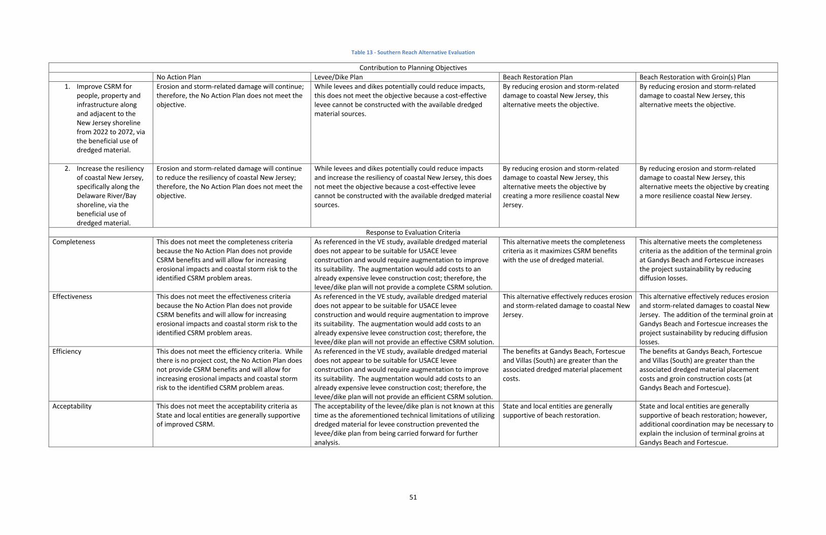
51
Table 13 - Southern Reach Alternative Evaluation
Contribution to Planning Objectives
No Action Plan Levee/Dike Plan Beach Restoration Plan Beach Restoration with Groin(s) Plan
1. Improve CSRM for people, property and infrastructure along and adjacent to the New Jersey shoreline from 2022 to 2072, via the beneficial use of dredged material.
Erosion and storm-related damage will continue; therefore, the No Action Plan does not meet the objective.
While levees and dikes potentially could reduce impacts, this does not meet the objective because a cost-effective levee cannot be constructed with the available dredged material sources.
By reducing erosion and storm-related damage to coastal New Jersey, this alternative meets the objective.
By reducing erosion and storm-related damage to coastal New Jersey, this alternative meets the objective.
2. Increase the resiliency of coastal New Jersey, specifically along the Delaware River/Bay shoreline, via the beneficial use of dredged material.
Erosion and storm-related damage will continue to reduce the resiliency of coastal New Jersey; therefore, the No Action Plan does not meet the objective.
While levees and dikes potentially could reduce impacts and increase the resiliency of coastal New Jersey, this does not meet the objective because a cost-effective levee cannot be constructed with the available dredged material sources.
By reducing erosion and storm-related damage to coastal New Jersey, this alternative meets the objective by creating a more resilience coastal New Jersey.
By reducing erosion and storm-related damage to coastal New Jersey, this alternative meets the objective by creating a more resilience coastal New Jersey.
Response to Evaluation Criteria
Completeness This does not meet the completeness criteria because the No Action Plan does not provide CSRM benefits and will allow for increasing erosional impacts and coastal storm risk to the identified CSRM problem areas.
As referenced in the VE study, available dredged material does not appear to be suitable for USACE levee construction and would require augmentation to improve its suitability. The augmentation would add costs to an already expensive levee construction cost; therefore, the levee/dike plan will not provide a complete CSRM solution.
This alternative meets the completeness criteria as it maximizes CSRM benefits with the use of dredged material.
This alternative meets the completeness criteria as the addition of the terminal groin at Gandys Beach and Fortescue increases the project sustainability by reducing diffusion losses.
Effectiveness This does not meet the effectiveness criteria because the No Action Plan does not provide CSRM benefits and will allow for increasing erosional impacts and coastal storm risk to the identified CSRM problem areas.
As referenced in the VE study, available dredged material does not appear to be suitable for USACE levee construction and would require augmentation to improve its suitability. The augmentation would add costs to an already expensive levee construction cost; therefore, the levee/dike plan will not provide an effective CSRM solution.
This alternative effectively reduces erosion and storm-related damage to coastal New Jersey.
This alternative effectively reduces erosion and storm-related damages to coastal New Jersey. The addition of the terminal groin at Gandys Beach and Fortescue increases the project sustainability by reducing diffusion losses.
Efficiency This does not meet the efficiency criteria. While there is no project cost, the No Action Plan does not provide CSRM benefits and will allow for increasing erosional impacts and coastal storm risk to the identified CSRM problem areas.
As referenced in the VE study, available dredged material does not appear to be suitable for USACE levee construction and would require augmentation to improve its suitability. The augmentation would add costs to an already expensive levee construction cost; therefore, the levee/dike plan will not provide an efficient CSRM solution.
The benefits at Gandys Beach, Fortescue and Villas (South) are greater than the associated dredged material placement costs.
The benefits at Gandys Beach, Fortescue and Villas (South) are greater than the associated dredged material placement costs and groin construction costs (at Gandys Beach and Fortescue).
Acceptability This does not meet the acceptability criteria as State and local entities are generally supportive of improved CSRM.
The acceptability of the levee/dike plan is not known at this time as the aforementioned technical limitations of utilizing dredged material for levee construction prevented the levee/dike plan from being carried forward for further analysis.
State and local entities are generally supportive of beach restoration.
State and local entities are generally supportive of beach restoration; however, additional coordination may be necessary to explain the inclusion of terminal groins at Gandys Beach and Fortescue.

52
This page intentionally left blank

53
3.5 PLAN SELECTION As referenced in Section 3.4, the project cost was compared against the benefits at each individual
dredged material placement location in to determine the BCR and net benefits at each placement
location.
The costs of transporting material to the DMU project site were compared against the Federal Standard
practice of dredged material disposal at the least cost, environmentally acceptable disposal location
(Buoy 10). The current Federal standard for dredged material disposal from the proposed TSP source
area is dredging via a hopper dredge and bottom dumping at Buoy 10 (an open water disposal site
located in southern planning reach adjacent to the mouth of the Delaware Bay). Buoy 10 is approaching
full capacity. USACE is currently pursuing a revised water quality certificate (WQC) to expand the
footprint of Buoy 10 and provide additional capacity, which will potentially extend Buoy 10’s viability for
dredged material disposal for approximately the first 10 years of the proposed project life. Beyond this
10 year threshold, the Federal standard will likely involve the placement of dredged material at Artificial
Island CDF, located approximately 40 miles upstream from the dredged TSP source location.
For initial construction through the first 10 years of the project life, project costs are based on the
difference between placement at the DMU project locations (with-project condition) and placement at
Buoy 10 (without-project condition). As referenced above, the without project condition changes after
year 10 due to limited capacity at Buoy 10; therefore, the with-project condition is compared against
disposal at Artificial Island CDF for years 11 to 50 of the project. The likely project implementation
would consist of a continuous dredging operation with one primary mobilization; therefore, the
mobilization cost is shared by the six sites analyzed with Beach-fx in the southern reach.
Throughout the 50-year project lifecycle, the dredged material unit placement cost is based on the
difference between without project condition (dredged material placement via the Federal standard)
unit placement costs and the with project condition (dredged material placement at the proposed DMU
project location) unit placement costs. The difference between these unit placement costs are
attributed to the DMU project. For example, if costs to place dredged material via the Federal Standard
for the ongoing Delaware River – Philadelphia to the Sea Navigation Project are $10 per cubic yard, and
the costs to transport the same material to a DMU project site for CSRM are $15 per cubic yard, then
the cost to the navigation project is $10 per cubic yard and the only cost applied to the DMU project is
the additional cost above the Federal standard, $5 per cubic yard.
The NED benefit categories included the following: reduction in damage to structures and content, local
costs foregone, emergency costs foregone, and incidental recreational benefits.
3.5.1 Economic Summary
Current results indicate that the benefits of the TSP at each placement location are greater than the
associated dredged material placement costs for Gandys Beach, Fortescue and Villas (South).

54
Figure 13 - TSP Overview
While the 3 individual dredged material placement sites have benefits exceeding costs, the placement

55
sites will undergo an optimization process that will ultimately determine the final footprint of the
recommended plan and its associated costs and benefits.
The project cost is summarized in Table 14:
Table 14 - Project Cost
Site Initial Construction
Cost
Periodic Nourishment
Cost
Total Project Cost Nourishment Cycle
Gandys Beach $12,766,361 $14,199,791 $26,966,152 8 years
Fortescue $15,964,212 $19,743,722 $35,707,934 8 years
Villas (South) $19,663,366 $30,953,006 $50,616,372 8 years
Total $48,393,939 $64,896,519 $113,290,458 -
Note: The cost values in Table 14 cover a 50-year period of analysis with a base year of 2022.
The TSP economic results are summarized on Table 15. The BCRs and associated net benefits listed in
Table 13 are subject to change as the tentatively selected plan is optimized.
Table 15 – Summary of Costs & Benefits
Site Average Annual Benefits (AAB)
Average Annual Costs (AAC)
Average Annual Net Benefits
(AANB)
Benefit-Cost Ratio (2.875%)
Gandys Beach $2,323,296 $991,518 $1,331,656 2.3
Fortescue $2,736,996 $1,327,105 $1,409,891 2.1
Villas (South) $2,058,775 $1,807,681 $251,094 1.1
Note: The cost and benefit values cover a 50-year period of analysis with a base year of 2022.
The Federal discount rate is 2.875%.
3.5.1.1 Residual Risk
Damages prevented constitute the CSRM benefits of the TSP. Benefits are computed using the formula
Without Project Damages – With Project Damages = CSRM Benefits. Residual Risk refers to the storm
damage a study area can be anticipated to experience post project implementation. This is computed
using Without Project Damages – CSRM Benefits = Residual Risk. Additional benefits, such as Benefits
During Construction (BDC), Local Costs Foregone and Recreational Benefits may also be present, but
were not quantified at this time. The table below provides a summary of damages prevented, which
increase as residual risk decreases.

56
Table 16 - Summary of CSRM Damages Prevented
Site Without Project Condition With Project Condition Damages Reduced
Total Damage AAD Total Damage AAD Total Damage AAD Residual
Gandys Beach $66,303,539 $2,516,092 $5,080,528 $192,796 $61,223,011 $2,323,296 7.66%
Fortescue $119,048,659 $4,517,669 $46,923,905 $1,780,672 $72,124,753 $2,736,996 39.42%
Villas (South) $55,255,523 $2,096,841 $1,003,115 $38,066 $54,252,408 $2,058,775 1.82%
Total $240,607,721 $9,130,602 $53,007,548 $2,011,534 $187,600,172 $7,119,067 22.03%
3.5.1.2 Risk & Uncertainty
As stated in Appendix A, Beach-fx is an event-based Monte Carlo life cycle simulation that uses historic
storms to calculate damages over the course of a project life cycle. The model links the predictive
capability of coastal evolution modeling with project area infrastructure information, structure and
content damage functions, and economic valuations to estimate the costs and total damages under
various CSRM alternatives while accounting for risk and uncertainty. The model output can then be used
to determine the net benefits of each project alternative. Storm damage is defined as the ongoing
monetary loss to contents and structures incurred as a direct result of wave attack, erosion, and
inundation caused by a storm of a given magnitude and probability. The model also computes
permanent shoreline reductions. These damages and associated costs are calculated over the project
period of analysis based on storm probabilities, tidal cycle, tidal phase, beach morphology, and many
other factors. Data on historic storms, beach survey profiles, and beach reactions to specific storm
events can be found in the Engineering Appendix C.
For the Future Without Project (FWOP) Condition and Future With Project (FWP) Condition, the
structure inventory and values are the same as the existing condition barring any structure that are
deemed condemned by Beach-fx over the period of analysis.
As previously stated, the current Federal standard for dredged material disposal from the proposed TSP
source area is dredging via a hopper dredge and bottom dumping at Buoy 10, which is approaching
operational capacity. While it is expected that NJDEP will provide a revised WQC for Buoy 10 providing
an additional 10 years of capacity, the PDT recognizes a degree of uncertainty related to the projected
Buoy 10 capacity as the WQC has not been granted to date. Because the assumed Federal Standard
impacts the NJ DMU study economics as project costs are based on the difference between placement
at the DMU project locations (with-project condition) and placement at Buoy 10 and/or Artificial Island,
an economic sensitivity analysis was conducted to evaluate the impact of the Federal Standard
assumptions on the project economics. The results of the sensitivity analysis are summarized on the
figure below:

57
Figure 14 – Economic Sensitivity Analysis
As indicated on the figure above, Gandys Beach and Fortescue have positive net benefits whether Buoy
10 is operational for up to 50 years or not operational at all. For Villas (South), net benefits become
negative if Buoy 10 has greater than 31.5 years of operational capacity.
Damage Functions
Damage functions are user-defined curves that are applied within the model to determine the extent of
storm-induced damages attributable to any specific combination of damage element type and
foundation type. There are six types of damage functions which include erosion, inundation, and wave
attack for both structure and content. For example, there is a specific set of six damage functions for
single-family residential one story Damage Elements with a slab foundation and a separate, unique set
of damage functions for single-family residential one story Damage Elements with a pile foundation. This
analysis used a total of 48 damage functions to calculate storm-induced damages.
Damage is determined as a percentage of overall structure or content value using a triangle distribution
of values, which looks at minimum, maximum and most likely value. For erosion functions, damage is
dependent upon the extent to which a structure’s footprint has been compromised and for inundation
and wave attack functions, damage is determined by the storm-surge heights in excess of first-floor
elevation.
Damage Functions were developed using the NACCS Physical Depth Damage Function Summary Report.
-$400,000
-$200,000
$0
$200,000
$400,000
$600,000
$800,000
$1,000,000
$1,200,000
$1,400,000
$1,600,000
$1,800,000
0 5 10 15 20 25 30 35 40 45 50Ave
rage
An
nu
al N
et
Be
ne
fits
($
)
Buoy 10 Lifetime Capacity (Years)
Average Annual Net Benefits (AANB) Sensitivity Analysis -Federal Standard Application
Gandys Beach Fortescue Villas (South)

58
Future Without Project Condition (FWOP) Damages
The FWOP net present value damages are a combination of the CSRM damages experienced at each
individual project site. Damages are measured by both structure and content and averaged over 300
iterations. Values are in Present Worth using the FY2017 Federal Discount Rate. All results are currently
shown at the Intermediate Relative Sea Level Change (RSLC) rate, but will include Historic (Low) and
High rates post-optimization.
3.6 DESCRIPTION OF THE RECOMMENDED PLAN
3.6.1 Plan Components
The TSP consists of beach restoration at Villas (South) and beach restoration with groin(s) at Gandys
Beach and Fortescue.
For Gandys Beach, the proposed design template features a berm of 75 feet (ft) width at a height of +6
ft NAVD88 with a foreslope of approximately 130 ft length on a slope of 1V:10H extending bayward to a
tie-in depth of -7 ft NAVD88. A new terminal groin structure is proposed for the northern end of the
Gandys Beach footprint to reduce longshore losses of sand from the proposed project area. Over the
last 25 years there has been demonstrated shoreline retreat at Gandys Beach. Currently, there is
significant armoring of the Gandys shoreline using steel sheet piling, concrete sea wall and rubble
armoring. The natural shoreline erosion has created conditions where the Delaware Bay has flanked the
town and the proposed beach restoration will suffer unacceptable erosion rates without the use of a
terminal groin.
For Fortescue, the proposed design template features a berm of 75 ft width at a height of +6 ft NAVD88
with a foreslope of approximately 100 ft length on a slope of 1V:10H extending bayward to a tie-in
depth of -4 ft NAVD88. At Fortescue, the existing terminal groin at the northern edge of the community
will be rehabbed and replaced as part of the recommended plan to reduce end losses and the associated
renourishment frequency.
The terminal groins at Gandys and Fortescue will be comprised of a timber stem section that will
prevent sediment migration. The timber stem will be comprised of sheeting, walers and piles. The
timber stem will be anchored bayward by a rubble mound groin, comprised of armor stone and bedding
stone.
At Villas (South), the proposed design template features a berm of 75 feet (ft) width at a height of +5 ft
NAVD 88 with a foreslope of approximately 100 ft length on a slope of 1V:10H extending bayward to a
tie-in depth -2 ft NAVD88. The berm is topped with a dune whose crest width is 25 ft at a height of +12
ft NAVD88. The dune transitions both bayward to the berm and landward to existing grade on a slope of
1V:5H.

59
Figure 15 – Design Template for Gandys Beach & Fortescue
Figure 16 - Design Template for Villas

60
Based on the volume projections for initial construction at each of the 3 placement locations, a total of
approximately 700,000 cubic yards of dredged material would be required for initial construction. As
referenced in Section 3.4, the proposed source area (Lower Reach E) is anticipated to have
approximately 465,000 cubic yards of dredged material available annually that will need to be removed
to maintain the 45 feet depth. The anticipated dredging cycle for Lower Reach E is every two years to
remove and place 930,000 cubic yards (465,000 x 2) of dredged material. The projected quantity and
dredging cycle were based on the feasibility report completed in support of the MCD project. Actual
dredged material quantities will be verified prior to construction; therefore, the PDT recognizes the
possibility that there may be greater and/or lesser quantities available (than currently projected) at the
time of construction. If there is less dredged material available than anticipated at the projected date of
initial construction (2022), Buoy 10 may serve as a back-up source for initial construction as it contains
sand (approximately 750,000 cubic yards) previously dredged from Lower Reach E during operation and
maintenance of the Delaware River, Philadelphia to the Sea navigation project. The PDT recognizes that
the use of Buoy 10 as a back-up source would necessitate a benthic habitat assessment and ultimately a
Supplemental Environmental Assessment (EA).
Varying volumes of dredged material are required at each of the placement locations, depending on the
length of shoreline to be nourished and the existing beach profile. In order to maintain the integrity of
design beachfill alternatives, beachfill nourishment must be included in the project design. If periodic
nourishment was not performed throughout the life of the project, the longshore and cross shore
sediment transport mechanisms, separate from storm induced erosion, would act to erode the design
beach. An 8-year periodic nourishment cycle is anticipated to maintain optimal CSRM. This
nourishment cycle is in line with the proposed operation and maintenance (O&M) dredging to be
performed in Lower Reach E (the proposed project dredged material source area for the TSP); however,
it will be further refined during plan optimization.
3.6.2 Public Law 113-2 Requirements
This section has been prepared to address how the TSP contributes to the resiliency of the New Jersey
shoreline; how it affects the sustainability of environmental conditions in the affected area; and how it
will be consistent with the findings and recommendations of the NACCS.
Resiliency is defined in the February 2013 USACE-NOAA Infrastructure Systems Rebuilding Principles
white paper as the ability to adapt to changing conditions and withstand, and rapidly recover from
disruption due to emergencies. Sustainability is defined as the ability to continue (in existence or a
certain state, or in force or intensity), with interruption of diminution.
3.6.2.1 Resiliency
One of the planning objectives of the NJ DMU is to “increase the resiliency of coastal New Jersey,
specifically along the Delaware Estuary shoreline, via the beneficial use of dredged material.” The
formulated measures and alternatives have all been designed to enhance the resiliency of the coastal
system, particular with regard to erosion and SLC.

61
In general CSRM projects, such as the NJ DMU, are engineered beaches that are designed, constructed
and periodically nourished to reduce the risk of economic losses arising from coastal storms. The intent
is to replicate the function of beaches in areas that were once part of natural, undeveloped systems that
have subsequently experienced significant human development and utilization. Storms reduce the
degree of storm risk management provided by the beach fill project; elevated water levels and larger-
than-normal waves displace sand from the berm and dune portions of the engineered beach profile and
transport it principally in the offshore direction. After the storm, normal tide and wave conditions
return, typically resulting in onshore-directed sand transport that rebuilds at least a portion of the berm
(i.e., beach). This natural recovery of the beach berm occurs over a period that may range from days to
months. Natural rebuilding of the dune is a process that requires years to decades, given its dependence
on wind transport and an adequate sand supply on the beach. In the period between the storm and the
partial natural recovery, an increased level of storm damage risk exists due to the eroded condition of
the project berm and dune relative to the level of risk associated with a constructed, fully maintained
project. Consequently, repair of an engineered beach to its design dimensions is usually accomplished as
a planned renourishment, which is included in the authorized period of analysis cycle, or as an
emergency activity under the USACE Flood Control and Coastal Emergencies authority (PL 84-99), to
restore the storm damage risk reduction function for which the project was authorized. This post-storm
repair is necessary because the engineered beach may not otherwise fully recover to its authorized
dimensions naturally, or at least not in a time frame that would minimize risks due to the deteriorated
condition. In this regard, it is apparent that storm risk management projects involving beach
replenishment possess intrinsic “resilience”, in light of the large volume of sediment that remains within
the system after a major disturbance and the associated repair or replenishment that is included to
restore the project design dimensions.
3.6.2.2 Sustainability/Adaptability
The NJ DMU recommended plan meets the economic, environmental and community sustainability
goals for the fifty year length of the project. Economic principals are used in benefit calculations, plan
formulation ranking and project justification by their contributions to the NED account. Environmental
concerns are evaluated in the integrated EA and through coordination and review with various resource
agencies. Social accounts are intrinsic in beach nourishment projects since they maintain habitat for
beach patrons. The nexus of these three pillars indicates that the recommended plan is sustainable.
3.6.2.3 Consistency with the NACCS
The NACCS was released in January 2015 and provides a risk management framework designed to help
local communities better understand changing flood risks associated with climate change and to provide
tools to help those communities better prepare for future flood risks. In particular it encourages
planning for resilient coastal communities that incorporates wherever possible sustainable coastal
landscape systems that takes into account, future sea level and climate change scenarios. The process
used to identify the TSP utilized the NACCS Risk Management framework that included evaluating
alternative solutions and also considering future SLC and climate change.
62
3.6.3 Real Estate Requirements
Based on the information available, the current TSP requires two (2) types of easements/instruments for
the combined projects. Currently, all mobilization and construction activities, including lay down and
storage of contractor materials and equipment, is assumed to be located within the project area Limit of
Construction for the entire project. Since at least one of the project areas may contain a private road
leading to a portion of the project area, a Road/Access Easement (Standard Estate No. 11) is anticipated
to be required for at least one area.
The standard Perpetual Beach Storm Damage Reduction Easement (Standard Estate No. 26) is required
for the construction of the beach berm and dune system on the beachfront properties that are above
the MHWL or that include riparian grants, including any owned by the local municipalities. Properties
requiring Standard Estate No. 26 include parcels located below the MHWL currently subject to riparian
grants. Easements must be acquired over the areas below the MHWL covered by riparian grants for
construction, operation and maintenance work required by the non-Federal sponsor and the
Government over the life of the project.
3.6.4 Environmental Compliance
Table 17 provides a summary of the environmental compliance status to date. Additional details
regarding the environmental compliance are provided in Section 6.2.2.

63
Table 17 - Summary of Environmental Compliance
Item Compliance
Anadromous Fish Conservation Act N/A
Archaeological and Historic Preservation Act, as amended, 16 U.S.C. 469, et seq. Pending
Clean Air Act of 1977, as amended, 42 U.S.C. 7609, et seq. Full
Clean Water Act, as amended, (Federal Water Pollution Control Act), 33 U.S.C. 1251, et seq.
Pending
Coastal Barrier Resources Act and Coastal Barrier Improvement Act of 1990 Full
Coastal Zone Management Act, 16 U.S.C. 1451, et seq. Pending
Endangered Species Act, 16 U.S.C. 1531, et seq. Pending
Estuary Protection Act, 16 U.S.C. 1221, et seq. Full
Farmland Protection Policy Act of 1981 N/A
Federal Water Project Recreation Act, 16 U.S.C. 460-12, et seq. Full
Fish and Wildlife Coordination Act, 16 U.S.C. 661, et seq. Pending
Land and Water Conservation Fund Act, 16 U.S.C. 460/ -460/-11, et seq. N/A
Magnuson-Stevens Fishery Conservation and Management Act of 1976 Full
Marine Mammal Protection Act of 1972 Full
Marine Protection, Research and Sanctuary Act, 33 U.S.C. 1401, et seq. N/A
Migratory Bird Treaty Act and Migratory Bird Conservation Act Pending
National Environmental Policy Act, 42 U.S.C. 4321, et seq. Full
National Historic Preservation Act, 54 U.S.C. 300101 et seq. Pending
Rivers and Harbor Act, 33 U.S.C. 401, et seq. Full
Submerged Lands Act of 1953 Full
Uniform Relocation Assistance and Real Property Acquisition Policies Act of 1970
N/A
Watershed Protection and Flood Prevention Act, 16 U.S.C. 1001, et seq. N/A
Wild and Scenic Rivers Act, 16 U.S.C. 1271, et seq. N/A
Executive Order 11988, Floodplain Management, May 24, 1977 (42 CFR 26951; May 25, 1977)
Full
Executive Order 11990, Protection of Wetlands, May 24, 1977 (42 CFR 26961; May 25, 1977)
Full
Executive Order 12898, Federal Actions to Address Environmental Justice in Minority Populations and Low-Income Populations, February 11, 1994
Full
Executive Order 13045, Disparate Risks Involving Children N/A
Note: The compliance categories used in this table were assigned based on the following:
Full Compliance (Full) – Having met all requirements of the statute, Executive Order (EO) or
other environmental requirements for the current stage of planning
Pending indicates coordination ongoing and will be completed prior to signature of FONSI.
3.6.5 Environmental Operating Principles
The USACE Environmental Operating Principles were developed to ensure that Corps of Engineers
missions include totally integrated sustainable environmental practices. The Principles provided
corporate direction to ensure the workforce recognized the Corps of Engineers role in, and responsibility

64
for, sustainable use, stewardship, and restoration of natural resources across the Nation and, through
the international reach of its support missions.
Since the Environmental Operating Principles were introduced in 2002 they have instilled environmental
stewardship across business practices from recycling and reduced energy use at Corps and customer
facilities to a fuller consideration of the environmental impacts of Corps actions and meaningful
collaboration within the larger environmental community.
The concepts embedded in the original Principles remain vital to the success of the Corps and its
missions. However, as the Nation’s resource challenges and priorities have evolved, the Corps has
responded by close examination and refinement of work processes and operating practices. This self-
examination includes how the Corps considers environmental issues in all aspects of the corporate
enterprise. In particular, the strong emphasis on sustainability must be translated into everyday actions
that have an effect on the environmental conditions of today, as well as the uncertainties and risks of
the future. These challenges are complex, ranging from global trends such as increasing and competing
demands for water and energy, climate and sea level change, and declining biodiversity; to localized
manifestations of these issues in extreme weather events, the spread of invasive species, and
demographic shifts. Accordingly, the Corps of Engineers is re-invigorating commitment to the
Environmental Operating Principles in light of this changing context.
The Environmental Operating Principles relate to the human environment and apply to all aspects of
business and operations. They apply across Military Programs, Civil Works, Research and Development,
and across the Corps. The Principles require a recognition and acceptance of individual responsibility
from senior leaders to the newest team members. Re-committing to these principles and environmental
stewardship will lead to more efficient and effective solutions, and will enable the Corps of Engineers to
further leverage resources through collaboration. This is essential for successful integrated resources
management, restoration of the environment and sustainable and energy efficient approaches to all
Corps of Engineers mission areas. It is also an essential component of the Corps of Engineers’ risk
management approach in decision making, allowing the organization to offset uncertainty by building
flexibility into the management and construction of infrastructure.
The Environmental Operating Principles are:
Foster sustainability as a way of life throughout the organization.
Proactively consider environmental consequences of all Corps activities and act accordingly.
Create mutually supporting economic and environmentally sustainable solutions.
Continue to meet our corporate responsibility and accountability under the law for activities
undertaken by the Corps, which may impact human and natural environments.
Consider the environment in employing a risk management and systems approach throughout
the life cycles of projects and programs.
Leverage scientific, economic and social knowledge to understand the environmental context
and effects of Corps actions in a collaborative manner.

65
Employ an open, transparent process that respects views of individuals and groups interested in
Corps activities.
Over the past 50 years, there has been a progressive decline in the average annual volume of sediment
removed from the Delaware Estuary system by dredging with no reductions in maintained depths or any
significant reduction in dredging projects requiring maintenance. The Delaware Bay shoreline has
incurred significant erosion and tidal flooding. Most shoreline erosion of the Delaware Bay is caused by
waves generated by local winds. The beach berm is the primary feature. A gently sloped beach
dissipates wave energy while dunes reduce the erosion impact of wind, buffer the effects of
floodwaters, and provide a sediment source to adjacent salt marshes (Knutson, 1988; Rosen, 1980). The
dune is the secondary feature that provides additional height to reduce storm surge overtopping. Dune
vegetation provides additional protection against erosion forces of wind and waves. American beach
grass (Ammophila breviligulata) is a natural dune plant species that increases stability of the dune. The
Delaware Bay beaches, including the beaches fronting residential communities, provide an important
stopover site for migratory birds that travel up and down the Atlantic Flyway, provide breeding habitat
for Federally and State-listed threatened and endangered species, as well as for many neo-tropical
migrating bird species. Diamondback terrapins and horseshoe crabs utilize these beaches for nesting
and spawning, respectively.
Fringing marshes along the shorelines have experienced significant lateral retreat. Inadequate
importation of suspended sediment (and confined upland placement of dredge material), SLC, frequent
severe storms, ship wakes, and to some extent, land subsidence, are believed to be the main causal
factors.
The above-referenced TSP will provide improved CSRM for the Delaware Bay shoreline by utilizing
dredged material to alleviate shoreline erosion and flooding. This TSP supports the Corps Environmental
Operating Principles by providing an economic and environmentally sustainable solution that enhances
shoreline resilience and sustainability by placing dredged sediment in the estuary system.
There is a potential for this TSP to enhance resiliency and sustainability of the natural coastal
environment by retaining sediment in the system, and thereby providing habitat protection and/or
restoration as well as shoreline stabilization. Specifically, the importation and deposition of new
sediments is essential to the long-term sustainability of coastal wetlands. Wetlands promote shoreline
stabilization and a defense against more frequent/lower level flooding events. Due to land conversion
and degradation, less than 5% of pre-settlement acreage of freshwater wetlands remains in the
Delaware Estuary. The U.S. EPA estimates that 35% of Delaware Bay’s rare species and 70-90% of the
estuary’s fish and shellfish depend on wetland habitats. These critical habitats are under constant
threat of storm damage and inundation.
Tidal wetlands provide some of the most productive natural ecosystems in the world, and are widely
recognized for their important ecological functions. The services they provide include flood protection
for coastal communities, maintenance of water quality, habitat for hundreds of species of fish and
wildlife, and carbon sequestration. Normally, tidal wetlands can build vertically (accrete) in order to

66
compensate for subsidence and/or SLC. This accretion occurs through the accumulation of organic
matter (peat) from autochthonous production as well as the importation and trapping of suspended
sediments washing in with tidal or storm flows by salt marsh vegetation.
The loss of shoreline fringing wetlands has exacerbated flooding and erosion problems. Once inundated,
long-term vegetation dies off leaving mudflats, eroded banks, and open water areas that can no longer
accrete sediments and keep pace with SLC. A robust beach berm and dune serves to provide protection
and sediment source to adjacent wetlands by reducing flooding. Coastal marshes provide naturally for
greater resilience to future storm damage. In combination with utilizing dredged material to build up
eroded shorelines, opportunities exist to establish “living shorelines,” which serve to further reduce
losses of tidal marshes. Fringing shellfish beds, such as oysters or mussels, serve as natural breakwaters
to trap sediments and absorb wave energy. Oysters and mussels build their own habitats and provide
habitat for other marine intertidal species, while armoring the substrate and binding to vegetation.
3.6.6 Contributions to the USACE Campaign Plan
The USACE Campaign Plan is comprised of four separate goals: 1 – Supporting the Warfighter, 2 –
Transforming Civil Works, 3 – Reducing Disaster Risks, and 4 – Preparing for Tomorrow.
Transforming Civil Works will enable the Corps to deliver essential water resource solutions using
effective transformation strategies through a systems-based watershed approach. The NJ DMU TSP
enhances resiliency and sustainability of the natural coastal environment by retaining sediment in the
system and improving CSRM and habitat protection along the New Jersey shoreline.
Reducing Disaster Risk will be achieved through the reduction in coastal storm risk offered by the
protective dune and berm.
Preparing for Tomorrow contributions are through maintaining a commitment to the project through
periodic nourishment and life cycle adaptive management while mitigating for increases in water levels
and storm frequency.
4 AFFECTED ENVIRONMENT The study area is located within the section of the Delaware Estuary watershed, which lies within the
State of New Jersey and the Delaware River itself. The north/south boundaries of the study area extend
from Trenton, NJ to Cape May Point, NJ (Figure 1). The centerline of the Delaware Estuary represents
the western study area boundary and it extends approximately 135 miles from the Atlantic Ocean
upstream to the head of tide at Trenton, New Jersey.
4.1 ENVIRONMENTAL SETTING OF THE STUDY AREA The NJ DMU study area extends from the head of tide at Trenton, Mercer County to Cape May Point in
Cape May County, New Jersey for a total of approximately 133.4 miles of the Delaware Estuary shoreline
(Mercer, Burlington, Camden, Gloucester, Salem, Cumberland and Cape May Counties).

67
The Delaware Bayshore (Cumberland and Cape May Counties) can be naturally divided into three
distinct geomorphic regions. From south to north (Cape May Point to Bidwell Creek), the Cape May
peninsula extends approximately 16 miles. The southern end of the peninsula is comprised of a
community of seasonal and year-round inhabitants. The two largest coastal communities (both in Lower
Township, Cape May County) are North Cape May and Villas. The shore is characterized by low dunes
fronted by a narrow strip of eroding coarse sand beach. Sand and mud flats are prevalent at low tide.
The middle section of the peninsula comprises the northern part of Middle Township and all the bay
shore of Dennis, Maurice, Downe, Lawrence, Fairfield and Greenwich Townships. Communities include
Sunray, Del Haven, Highs Beach, Pierces Point and Reeds Beach. Further north, the communities of
Moores and Thompsons Beach, and East Point are much smaller in size, containing a single row of
homes with access roads that require frequent maintenance due to persistent overwashing during
periods of high water. The Cape May Point State Park is located at the southern limit of the study area
and is considered one of the foremost bird viewing areas along the eastern seaboard for migratory
shorebirds. Erosion is a persistent problem along this stretch of shoreline. There are three wildlife
management areas located along the Delaware Bay shoreline from south to north: Higbee Beach, Cape
Island and Dennis Creek Wildlife Management Areas (WMAs). Just south of Dennis Creek WMA is the
Cape May National Wildlife Refuge.
The middle region shoreline (north of Bidwell Creek to Nantuxent Cove – approximately 40 miles)
consists predominantly of natural lands with salt marshes and interior maritime forests separating
smaller distinct residential communities. These include from south to north: Heislerville WMA, Egg
Island Fish and Wildlife Management Area (FWMA), the Nantuxent FWMA and the New Sweden WMA.
The town of Fortescue and Gandys Beach are the two largest communities. Commercial businesses
occur in the towns of Bivalve and Shellpile along the Maurice River mouth including seafood suppliers,
marinas and the Rutgers University Haskin Shellfish Research Laboratory. The shoreline consists of a
narrow strip of sandy beach with low to no vegetated dunes. The communities in this section are small,
surrounded by wetlands and have very narrow sandy beaches. These are Dyer Cove, Gandys Beach,
Money Island, Bay Point, Sea Breeze and Bay Side. The only exception is the town of Fortescue, which is
much larger (>200 homes). Fortescue is a popular fishing community and contains a state-owned
marina. The majority of the community is bulkheaded with little to no beach at high tide.
North of Nantuxent Cove, the upper bay region becomes narrower as it transitions into the lower
Delaware River. The area up to the Hope Creek Generating Station (approximately 30 miles) continues
to be predominantly natural undeveloped marsh and beach shoreline of the Dix WMA and Mad Horse
Creek WMA. Just behind the beach, the irregular salt marsh coast continues to dominate the shoreline
up the Delaware River to the mouth of the Salem River. This section lies in the southern part of Salem
County and comprises the bay shore of Lower Alloway and Elsinboro Townships. Just north of the Salem
River mouth is the Supawna Meadows National Wildlife Refuge. At the northern part of the bay in
Elsinboro Township is the community of Oakwood Beach.

68
4.2 PHYSICAL ENVIRONMENT
4.2.1 Land Use
The Delaware River, which is fed by 216 tributaries, is the longest un-dammed river east of the
Mississippi River. Approximately 15 million people, or about 5% of the U.S. population, rely on the
waters of the Delaware River Basin for drinking and industrial use, and the Delaware River is only a one
to two hour drive away for about 20% of the people living in the United States (Kaufman, 2011). The
Delaware River is a principal corridor for commerce that has sustained the region since America’s
colonial period and reached a zenith during World War II and thereafter. Today, it continues to be a
major port for national defense and economic interests. The Delaware Estuary has 64 municipalities
bordering it. The Estuary supports the 4th largest urban center in the nation and contains the world’s
largest freshwater port. The Estuary also sustains a wealth of natural and living resources, extensive
tidal marshes that sustain vibrant ecosystems and shoreline habitats for horseshoe crabs and migratory
shorebirds, and both fresh water and salt water habitats for shellfish (Kreeger et al., 2010). The beaches
and marshes of the Delaware Bay provide many natural areas for recreational opportunities such as
birding, fishing, kayaking, beachcombing and crabbing. Larger residential communities include:
Oakwood Beach (Elsinboro), Fortescue, Reeds Beach, Pierces Point and Villas.
In January 2017, the state of New Jersey purchased 204 acres of wetlands and upland buffers along the
Delaware Bay in Maurice River Township, Cumberland County for waterfowl and other wildlife habitat
preservation using funding from USFWS’ Coastal Wetlands Conservation Grant Program and NJDEP’s
Green Acres Program. The land will be added to the New Jersey Division of Fish and Wildlife’s 7,231-
acre Heislerville WMA. Ecotourism is a growing industry in New Jersey, particularly in the Delaware Bay
region considering New Jersey’s Atlantic Ocean coastline is more heavily developed. The bay region is
home to the state’s largest concentration of bald eagles and is a critical stopover area for migrating
shorebirds.
4.2.2 Physiography and Geology
The area is primarily a broad flat area with marshes, sandy beaches and forest. Its most notable feature
is the Pine Barrens, 760 square miles of protected forests and marshes, with predominant pitch pines
and white oaks.
Geologically, the Delaware Estuary is situated near the border of two subdivisions: the Appalachian
Piedmont province and the Atlantic Coastal Plain province. The Piedmont Plateau lies along the eastern
edge of the Appalachian Mountains and runs from New Jersey to Alabama. The formations of the
Piedmont Plateau consist primarily of Cambrian to Ordovician age, hard, crystalline rocks. They extend
downward and toward the Atlantic Ocean, forming a platform that supports the Coastal Plain. The
Piedmont Plateau borders the western side of the estuary between Philadelphia and Wilmington. The
Coastal Plain physiographic province borders the entire eastern side of the Delaware Estuary. The
formations of the coastal plain are much younger than those of the Piedmont, and are largely
unconsolidated sediments. The Coastal Plain sediment layers are mainly comprised of sands and clays
that dip to the southeast, and generally thicken oceanward. The older formations are at or near the
surface in the vicinity of the estuary, and are progressively deeper towards the Atlantic Ocean. The

69
unconsolidated sediments consist of pervious and impervious layers that form a series of aquifers and
aquicludes.
4.2.3 Sediment Quality
Extensive sediment quality sampling and analyses have been conducted within the Delaware Estuary,
primarily in association with the USACE Delaware River Main Stem Channel Deepening and Maintenance
Dredging projects in the uppermost portions of the navigation project (USACE, 1992, 1997). Most of this
sediment testing has occurred within the current project area reaches.
Sediment samples collected from the Main Stem Delaware River included bulk sediment analyses,
elutriate sediment analyses, Toxicity Characteristic Leaching Procedure (TCLP) analyses, biological
effects based sediment testing, and high resolution PCB congener analyses (USACE, 2009). The mean
and range of contaminant concentrations were provided for each reach of the proposed project area.
Mean contaminant concentrations fell within ranges considered to be background for soils and
sediments in New Jersey. Maximum concentrations that exceed background appear to be in isolated
samples, and are, therefore, limited in spatial distribution.
Due to concerns raised during the MCD Feasibility study regarding sediment chemical quality and the
potential adverse effects on aquatic resources, bulk sediment and elutriate analyses were conducted
(USACE, 1997). The majority of contaminant parameters evaluated were not detected in channel
sediments. Bulk analysis did not identify high concentrations of organic contaminants: PCBs were
detected in two samples (Bellevue and Liston Ranges); 4 pesticides (all below 0.1 ppm) were detected in
the Bellevue, Liston and Mifflin Ranges; and polycyclic aromatic hydrocarbons (PAHs) were detected in
several channel bends between Philadelphia Harbor and Artificial Island. Of the remaining volatile and
semi-volatile organic contaminants evaluated, only methylene chloride, acetone, 2-butanone, styrene
and phthalates were detected at quantifiable levels (all below 0.1 ppm). Heavy metals were found to be
widely distributed throughout the MCD project area, with concentrations in predominantly sandy bay
sediments lower than up-river sediments. The presence of heavy metals in channel sediments is
attributed to the urban and industrialized nature of the upper estuary. Refer to the 1997 Supplemental
EIS (USACE, 1997) for a more detailed discussion of the sediment quality analyses and potential impacts
to human health and biological effects testing.
Two additional sets of bulk sediment data were collected from the channel (Versar, 2003, 2005). A total
of 45 sediment cores were collected between Philadelphia and the Chesapeake and Delaware Canal and
analyzed for inorganics, pesticides, PCBs, volatile and semi-volatile organic compounds. In these
reaches of the river, the results were compared to Residential Direct Contact criteria developed by the
State of New Jersey, and used to evaluate the quality of dredged material. The most common
parameters detected in sediments were inorganic metals. Concentrations of inorganics in all 45 samples
were below New Jersey residential criteria except for thallium and arsenic. Two samples had thallium
concentrations (5.33 ppm and 7.24 ppm) above the residential criterion of 5 ppm. Two samples had
arsenic concentrations (51.4 ppm and 37.4 ppm) above the residential criterion of 19 ppm. Thallium
and arsenic, along with antimony, were the only inorganic parameters to exceed New Jersey criteria in

70
previous sampling efforts. The most frequently detected organic parameters in the upper river were
PAHs. PAHs are primarily formed through combustion of fossil fuels and are expected to be found in
highly industrialized and populated regions (USACE, 2009).
A multi-agency Sediment Quality Committee compiled a database of 932 in situ bulk chemistry sediment
samples in 2012 (RSMT, 2013). Samples were analyzed for the purpose of evaluating dredged material
for use in aquatic habitat restoration. The data was evaluated for the following contaminants of
concern (COC): arsenic, cadmium, cobalt, copper, lead, mercury, total chlordane, dieldrin, 4,4’-
DDT/DDD/DDE, benzo(a)pyrene, total PCBs and total dioxin/furan. The Committee considered
guidelines that are currently in use in the Delaware Estuary to evaluate sediment quality, including
Pennsylvania, New Jersey and Delaware state regulatory criteria for the evaluation of fill (soil, dredged
material, etc.) at upland sites; sediment quality guidelines used for ecological effects screening
purposes; state and DRBC water quality criteria, state criteria used to develop fish advisories; and eco-
effects data for toxicity, bioaccumulation, and community health indices.
Statistical analyses of the mean COC concentrations in each DRBC Water Quality Zone identified
significant differences between DRBC zones. The Committee concluded that sediments suitable for
“unrestricted” upland beneficial uses are usually interspersed among samples acceptable for
“limited/restricted” upland beneficial uses throughout the Delaware Estuary. However, the data suggest
that dredged material from DRBC Zone 6 (Delaware Bay) is most suitable for “unrestricted” upland
beneficial use projects. Dredged material from DRBC Zones 2 through 5 and the tributaries appear to be
suitable for either “unrestricted” or “limited/restricted” upland beneficial uses.
Explorations and test data from eleven (11) individual USACE and Philadelphia Regional Port Authority
(PRPA) investigations were compiled into a single geotechnical data report by Gehagan & Bryant
Associates, Inc. (GBA) dated October 2010. This GBA geotechnical report is included as Appendix C4 of
this feasibility report. These investigations between Philadelphia and the sea were conducted between
the early 1960s and 2010 for local project feasibility studies and the MCD. From this collection of data,
it was estimated that most materials in the main channel of Reach E consisted of sandy materials. In
2012, GBA conducted a supplemental geotechnical subsurface investigation for USACE Philadelphia
District and the PRPA. GBA collected vibracore samples of the riverbed sediment at 51 discrete
locations in the main channel. An extensive geotechnical laboratory testing program was performed,
results of which indicated the bulk of material encountered was sand. Results show that 92% of all
samples were predominantly sand (sand fraction greater than 50%). Only 12% of grain size samples had
silt and clay contents greater than 50%. The findings of this supplemental investigation essentially
confirmed previous findings and assumptions regarding the sediment grain sizes in the channel.
Specifically, the Philadelphia District has placed sand dredged from Lower Reach E (the Brandywine and
Miah Maull ranges of the Main Channel in DRBC Zone 6) in Buoy 10 approximately ten times between
1991 and 2012. In 2014, 11 sediment grab samples were collected in and around the Buoy 10 open
water disposal site by the Philadelphia District. All samples were analyzed for grain size and ranged
from 96.1% to 99.8% sand. The remaining component were shell fragments. Vibracores were collected

71
from Buoy 10 in 2007 (Schnabel Engineering, 2007) for the Philadelphia District and again in 2014 and
predominantly indicate similar results as the grab samples; however, there are some coarser sediments
(gravel) in pockets approximately 7 to 10 feet below the surface that may reduce total available
quantity. Materials with large grain sizes (>90% sand) are typically not contaminated and chemical
testing is not required. The munitions and explosives of concern (MEC) screening process will prevent
most of the coarser material from getting into the dredged material. The current estimate of sand
remaining within the Buoy 10 boundaries is approximately 750,000 cy.
4.2.4 Climate and Climate Change
It is anticipated that the global mean sea level will rise within the next 100 years. To include the direct
and indirect physical effects of projected future SLC on design, construction, operation and maintenance
of coastal projects, USACE follows guidance provided in the form of Engineering Regulation (ER) 1100-2-
8161 (developed with assistance of coastal scientists from the NOAA National Ocean Service and the
U.S. Geological Survey), and Engineering Technical Letter (ETL) 1100-2-1 Procedures to Evaluate Sea
Level Change: Impacts, Responses and Adaptation. Three estimates are required by the guidance; a
Baseline (or “Low”) estimate, which is based on historic sea level rise and represents the minimum
expected SLC, an intermediate estimate, and a high estimate representing the maximum expected SLC.
The Partnership for the Delaware Estuary (PDE) is a nonprofit organization that manages the Delaware
Estuary Program, one of 28 estuaries recognized by the U.S. Congress for its national significance under
the Clean Water Act. The PDE evaluated climate change effects within the Delaware Estuary (Kreeger et
al., 2010).
SLC due to climate change has been predicted to be greater in the Mid-Atlantic Region than points north
and south on the eastern seaboard. PDE’s Climate Adaptation Workgroup looked at the results of 14
different climate models to first test their accuracy in predicting past conditions for the region and
averaged them together to postulate a locally relevant future scenario. The team then evaluated the
vulnerabilities of the Delaware Estuary’s tidal wetlands, drinking water, and bivalve shellfish to changes
in physical and chemical conditions associated with climate change. Some aspects of a changing climate
may not be as severe here than in other watersheds while other changes may be more problematic.
For example, modest rises in temperature could lengthen growing seasons or boost productivity for
some signature species and help them compete with invasive species or keep pace with SLC. PDE’s
scientific team found that the length of the growing season is predicted to increase by about 15 days by
mid-century, and by up to 30 days by 2100 for the Delaware Estuary. Additionally, approximately 20
fewer frost days per year are predicted by mid-century and 40 fewer frost days by the end of the
century under a higher emissions scenario. The models show high confidence that average annual
temperatures will increase by the end of the 21st century by 2-4 degrees C. More warming is expected in
summer months. This conclusion is consistent with predictions by the Union of Concerned Scientists
which estimated that Pennsylvania summer temperatures could increase by 2-7 degrees C, depending
on the emissions scenario (UCS, 2008; Field et al., 2007).

72
Annual mean precipitation is predicted to increase by 7-9% by the end of the 21st century (median
projection). Higher increases are expected during winter months (Najjar, 2009; GCRP, 2009). Three
quarters of the models predict substantial increases in the frequency of extreme precipitation events
including heavy precipitation and consecutive dry days. The U.S. Global Climate Research Program
(GCRP) also predicted increases in extreme weather events and associated risks from storm surges
(GCRP, 2009) (Table 18).
Table 18 - Delaware Estuary Watershed Climate Predictions: Present to 2100
Climate Condition Model Evaluation: Biases & Issues
st 21 Century Prediction
Confidence Levels
Temperature
Monthly Mean
Slight cool bias in winter and summer
Warming: 1.9 – 3.7
oC median rise
by late century; Substantially greater warming in summer months
High
Inter-annual Variability
Slightly too much variability, but better with winter than summer
Intra-monthly Variability
Models’ mean reproduces correctly, but there is a large spread among the individual models
Extreme Temp
>80 F
Underestimates
Downscaled models show substantial increases
High
Precipitation
Monthly Mean Wet bias in winter and spring and a dry bias in summer
Increase in Precipitation: 7 - 9% median increase by late century; Substantial increase in winter months
Medium
Inter-annual Variability
Does not predict summer peak and winter minimum seen in observed conditions
Intra-monthly Variability
Mean reasonably captures, but too low in the summer
Extreme Precipitation
Short Term Drought
Slight low bias
Substantial increases, but less than ¼ of models show declines
Medium
Heavy Precipitation
Slight low bias
Growing Season Length
Predicts accurately Substantial increase by
end of century
High
Number of Frost Days
Somewhat high
Substantial decline
High
The Delaware Estuary freshwater tidal region extends about 70 river miles, and the salinity in areas
more seaward changes very gradually. This feature makes the Delaware Estuary unique among large
American estuaries because of the array of ecosystem services supplied to human and natural
communities tied to the extended salinity gradient, such as the supply of drinking water for people and
rare natural communities (Kreeger et al., 2010). Increasing sea level may result in larger tidal volumes
bringing salt water further up the estuary. Some of the salinity increase could be offset by anticipated
increases in precipitation. Sea level rise could increase the tidal range in the Delaware system (Walters,
1992), similar to expectations for the Chesapeake Bay (Zhong et al, 2008).

73
The Mid-Atlantic region is anticipated to experience SLC greater than the global average (GCRP, 2009).
Some regional variation in sea level results from gravitational forces, local land subsidence, wind, and
water circulation patterns. Sea level is expected to increase in the region by approximately 10 cm over
this century (Yin et al., 2009). Two other factors play prominent roles influencing SLC locally: land
subsidence and sediment accretion. New Jersey has been subsiding since the last Ice Age, causing a
steady loss of elevation. Subsidence is expected to continue through the next century at an average of
1-2 mm of land elevation loss per year (Engelhart et al., 2009). Sediment accretion is a natural process
whereby suspended sediments within the Delaware River, Bay, and tributaries settle and accumulate
along the shoreline such as on mudflats and in wetlands. Accretion cannot occur on developed surfaces
where erosion typically occurs or if the system is sediment starved from diversion processes (such as
dredging and upland placement operations). These factors play a significant role in either accelerating
or decreasing the rate of SLC and loss of habitat. The net increase in sea level compared to the change
in land elevation is the rate of relative sea level rise (RSRL). Kreeger et al. (2010) estimate relative sea
level rise for the Delaware Estuary watershed by the end of the century at 0.8 to 1.7 m.
4.3 WATER RESOURCES
4.3.1 Groundwater Quality and Public Water Sources
Groundwater is contained within aquifers, which are porous geologic formations that store or transit
groundwater. The 5 principal Coastal Plain aquifers are the Kirkwood-Cohansy aquifer system, the
Atlantic City 800-foot sand, the Wenonah-Mount Laurel aquifer, the Englishtown aquifer, and the
Potomac-Raritan-Magothy aquifer system. All but the Kirkwood-Cohansy are confined except where
they crop out or are overlain by permeable surficial deposits. The aquifers are recharged directly by
precipitation in outcrop areas, by vertical leakage through confining beds, and by seepage from surface
water bodies (Sargent et al., 1985).
As part of the U.S. Geological Survey’s (USGS’) National Water Quality Assessment Program (NAWQA),
USGS hydrologists in New Jersey assess surface and groundwater quality in the state’s coastal drainage
basins. In New Jersey, the NAWQA Program is focusing on the effect of land use on shallow
groundwater quality, spatial and temporal trends in groundwater quality, well vulnerability to
contamination from various sources, toxic materials in surface water, storm water quality and the
effects of interbasin surface water transfers on water quality.
More than 75% of the freshwater supply in the New Jersey Coastal Plain is from ground water. Water
quality is satisfactory except for some local excessive iron concentrations (as much as 460 milligrams per
liter) in several aquifers, including the Potomac-Raritan-Magothy, and occasional local contamination
from saltwater intrusion or waste disposal. In the unconfined Kirkwood-Cohansey aquifer system, water
is brackish or salty in some coastal areas. In confined aquifers, salinity generally increases with depth in
the southern and southeastern parts of the Coastal Plain (Sargent, et al., 1985). Groundwater
withdrawals in coastal areas have resulted in the landward movement of salty groundwater into
aquifers that are used heavily for water supply. As a result, more than 120 wells in Cape May County

74
alone have been abandoned since 1940. The USGS, in cooperation with Lower Township and the cities
of Cape May and Wildwood, developed a groundwater flow model that can be used to estimate
saltwater movement in coastal areas under various hypothetical groundwater withdrawal schemes. The
estimates help water managers decide how best to distribute future withdrawals to minimize additional
saltwater intrusion. Figure 17 shows a map of the watershed and service areas of community water
supplies.
Figure 17 - Water Supplies: Ground & Surface Water

75
In New Jersey, approximately 40% of the drinking water supply is groundwater. Human activities are
known to impact shallow groundwater quality. The quality of southern New Jersey’s groundwater
resources is generally good, although local problems exist. The Potomac and Magothy formations are
usually high in iron. Agricultural and urban areas have higher concentrations of nutrients, especially
nitrite plus nitrate, than undeveloped areas. The origin of the nitrite plus nitrate is believed to be
primarily fertilizers and releases from manure management, although septic systems and leaking sewer
systems likely contribute as well. A high chloride concentration is typical within two miles of Delaware
Bay and within one mile of tidal streams (USACE, 1992). The most widespread groundwater quality
problem in southern New Jersey has been saline encroachment.
4.3.2 Surface Water Quality
Nutrient monitoring is conducted by NJDEP within the Delaware Estuary. NJDEP (1999) has compiled
over a decade worth of physical and nutrient monitoring in New Jersey State waters, including the lower
Delaware Estuary. The report findings are that physical parameters of temperature, salinity and Secchi
depth are typical of what would be expected in the freshwater riverine portion of the upper study area,
the turbidity maximum zone of middle section of the study area (upper Delaware Bay) and in the lower
bay where oceanic influences dominate many physical parameters. Spring temperatures typically vary
from 10 – 20ᵒ C, while summer temperatures range from 20 - 25ᵒ C. Temperatures during the fall tend
to be near 15ᵒ C. Many Delaware Estuary stations did not show a seasonal component to Secchi depth,
but seasonal and often daily fluctuations for oxygen and nutrient levels. There were several stations
spread throughout the estuary that occasionally failed to achieve the NOAA minimum dissolved oxygen
standard (minimum 5.0 mg/L), particularly during the summer. Nutrient levels in the Delaware Estuary
exhibit seasonal patterns and spatial distribution where both ammonia and phosphorous were higher in
the summer and total nitrogen and nitrate were elevated in the fall. Nutrient levels were highest close
to the shoreline, and are likely attributed to anthropogenic activities (NJDEP, 1999).
Advances in the treatment of municipal and industrial waste and changes in manufacturing and
processing techniques over the past 40 years have led to improved surface water quality in many parts
of the Delaware River Basin. One indication of this improvement is the return of shad runs to the
Delaware River. The presence of toxic compounds, however, still leads to consumption advisories for
many fish species, and nutrient loadings adversely affect water quality and the health of ecological
communities. Many of the water-quality issues in the Delaware Estuary can be related to the high
human population density and related activities associated with urban, industrial, and agricultural land
use. Most concerns are related to human health (i.e. the quality of domestic water supply, the safety of
water contact recreation, and the safety of eating game fish) and the health of ecological communities
(USACE, 2009).
The proposed project area includes the lower portion of the Delaware Estuary. Surface water quality in
these reaches varies from fair in the uppermost portions to good in the lower Delaware Bay region. The
uppermost reach is considered a transition zone between urbanized upstream areas and rural Delaware
Bay. These zone is also the transitional area between the freshwater habitats upstream and more saline
areas downstream.

76
The DRBC is responsible for managing the water resources within the entire Delaware River Basin.
Pursuant to Section 305(b) of the Clean Water Act, the DRBC prepares biennial assessments of water
quality for the Delaware River. The DRBC considers all readily available data sets in its assessments,
such as the U.S. Environmental Protection Agency (EPA) STORET database, the U.S. Geological Survey
(USGS) NWIS database, the NOAA PORTS database, as a few examples. The reports provide an
assessment of waters in the Delaware River and Bay for support of various designated uses in
accordance with Section 305(b) of the Clean Water Act and identifies impaired waters, which consist of
waters that do not meet DRBC Water Quality Regulations (18 CFR 410).
The composite aquatic life assessment for 2012 yields a result of “Not Supporting” for aquatic life
(DRBC, 2012). It is important to note, however, that this result is largely driven by DRBC’s requirement
to categorize as not meeting criteria with 1 exceedance plus 1 confirmatory exceedance and based
primarily on fewer than 10% exceedances of criteria. It has been extensively documented that water
quality of the Delaware Estuary, particularly upstream in the tidal Delaware River, has greatly improved
over the past 50 years since implementation of the 1961 Delaware River Basin Compact and the 1970s
Federal Clean Water Act Amendments. Dissolved oxygen levels have increased while phosphorus and
nitrogen levels have decreased (Kauffman et al., 2009).
Salinity. Salinity within Delaware Estuary waters is important for its effects on habitat suitability for
living resources (fish, shellfish, plant life, etc.), and its impact on human uses of the water of the estuary
(industrial and municipal water supply withdrawals, groundwater recharge, etc.). A longitudinal salinity
gradient exists with salinity higher at the mouth and downbay and decreases in the upstream direction.
The distribution of salinity in the Delaware Estuary exhibits significant variability on both spatial and
temporal scales; at any given time, salinity reflects the opposing influences of freshwater inflow from
tributaries (and groundwater) versus saltwater inflow from the Atlantic Ocean.
The four longitudinal salinity zones within the Delaware Estuary, starting at the bay mouth are:
polyhaline (18 - 30 ppt) from the mouth of the bay to the vicinity of the Fortescue FWMA; mesohaline
(5 - 18 ppt) from the Fortescue area north to the vicinity of the Cohansey River; oligohaline (0.5 - 5 ppt)
from the Cohansey River area north to the vicinity of Riverfront Park near Bridgeport, and fresh (0.0 - 0.5
ppt) upriver. Although these zones are useful to describe the long-term average distribution of salinity
in the estuary, the longitudinal salinity gradient is dynamic and subject to short and long-term changes
caused by variations in freshwater inflows, tides, storm surge, weather (wind) conditions, etc. These
variations can cause a specific salinity value (isohaline) to move upstream or downstream by as much as
10 miles in a day due to semi-diurnal tides, and by more than 20 miles over periods ranging from a day
to weeks or months due to storm and seasonal effects on freshwater inflows.
The long-term average salt line location hovers in the vicinity of the Delaware Memorial Bridge (River
Mile 69-70). From 1998 to the present, the salt line data (i.e. the 7-day average location of 250 ppm
isochlor) shows that it has nearly reached as far north as River Mile 90 (the mouth of the Schuylkill River)

77
about three times and has flushed downstream below RM 59 (the C&D Canal entrance) about five times,
due to sustained high flows at Trenton, New Jersey (Figure 18).
Figure 18 - Delaware Estuary: Salt Line and Trenton Flow Data
4.4 BIOLOGICAL RESOURCES
4.4.1 Vegetation and Wetlands
In the upper reaches of the estuary, vegetation is predominantly riparian and includes emergent and
forested wetland species such as American beech (Fagus grandifolia), American sycamore (Platanus
occidentalis), black birch (Betula lenta), black cherry (Prunus serotina), black gum (Nyssa sylvatica),
boxelder (Acer negundo), common persimmon (Diospyros virginiana), eastern cottonwood (Populus
deltoids), eastern red cedar (Juniperus virginiana), hackberry (Celtis occidentalis), hickory (Carya spp.),
pin oak (Quercus palustris), red maple (Acer rubrum), sweetgum (Liquidambar styraciflua), tuliptree
(Liriodendron tulipifera), and willow (Salix nigra). Upland forests in this area are typically transitional
and dominated by oak (Quercus spp.). Non-native flora, including common reed (Phragmites australis),
mile-a-minute vine (Persicaria perfoliatum), and purple loosestrife (Lythrum salicaria) are also present.
As previously mentioned in Section 4.3.2, salinity is a key factor in the distribution of vegetation species
in an estuarine environment. Plant location is dependent upon their salinity tolerance. Freshwater
species tend to be located along the coastline as well as inland, while species that are more salt-tolerant
occur in coastal areas down river and down bay. Historically, the Delaware River and all tidal tributaries
were fringed with wetlands. The Delaware Estuary’s large tidal freshwater prism runs from Trenton,

78
New Jersey to around Carneys Point Township, New Jersey. Tidal wetlands provide essential spawning,
foraging, and nesting habitats for both land and aquatic species. Wetlands absorb contaminants,
nutrients, and suspended sediments from the water column, and help buffer the impact of storm surge
and flooding. The values of these ecosystems went largely unrecognized in the past, and most of these
wetlands on both shores have been eliminated through development. Losses are most severe in the
urban corridor. Freshwater riverine wetland plant species commonly found upriver include arrow arum
(Peltandra virginica ), spikerush (Eleocharis palustris), pickerelweed (Pontederia cordata), blue flag (Iris
versicolor), American threesquare (Scirpus americanus) and common reed (Phragmites australis).
Wetlands are considered one of the most productive ecosystems in the world and play an important
role in the maintenance of water quality. Dense vegetation filters sediment nutrients from the water
and provides coastal resiliency to storms and erosion. Wetlands provide habitat and food for a variety
of wildlife and tidal marshes in particular are vital as nursery areas for economically valuable fish and
crustaceans. New Jersey has about 916,000 acres of wetland, most of which are the coastal plain.
Forested wetlands are the most common and widely distributed wetlands in the state. Salt marshes are
the most common wetlands in the coastal areas. Between the 1780s and 1980s, New Jersey lost about
39 percent of its wetlands. Wetlands have been drained primarily for crop production and pasturage
and filled for housing, transportation, industrialization and landfills. In the Delaware Estuary, tidal
wetlands are flooded twice daily by tides and this tidal fluctuation maintains their high productivity.
Nontidal wetlands typically occur in freshwater zones such as lakes and upriver stream
(https://www.aswm.org).
Representative wetland plant species follow the salinity gradient. Typical freshwater marsh species
include common threesquare (Scirpus americanus), dotted smartweed (Polygonum punctatum),
common spikerush (Eleocharis palustris), wild rice (Zizania palustris), pickerelweed (Pontederia cordata),
and arrow arum (Peltandra virginica). Saltwater marsh species include smooth cordgrass (Spartina
alterniflora), salt hay (Spartina patens), spikegrass (Distichlis spicata), and marsh elder (Iva frutescens).
4.4.2 Planktonic and Benthic Organisms
The diversity of phytoplankton is high in the Delaware Estuary due to the presence of freshwater,
brackish, and marine environments. Several hundred species occur along the length of the estuary. The
most prominent are diatoms (Class Bacilliariophyceae) (Pennock and Herman, 1988). In the upper
reaches of the estuary, phytoplankton have lower diversity and are limited by water quality (i.e. the area
of higher anthropogenic influences and the turbidity maximum). Chlorophytes (green algae) and
diatoms were the predominant groups (ANSP, 1981). This phytoplankton community is indicative of an
enriched and turbid system, while many of the species are considered pollution tolerant (e.g.
Phizoclonium, Oscillatoria, and Cladophoroglomata). Upper estuary phytoplankton exhibit a period of
accumulation during the summer months. In the middle estuary region, the accumulation peaks
generally occur in spring, and transient blooms in September and November. Despite lower turbidity
and non-nutrient limiting conditions in the lower bay during summer months, chlorophyll

79
concentrations remain relatively low. Small green and brown algae make up much of the summer
phytoplankton population in the lower bay (Pennock and Harman, 1988).
Zooplankton occupy a critical position in the food web. These small drifting animals feed on
phytoplankton and provide a large food source for larger aquatic animals. The ANSP (1981) found that
the zooplankton found in the upper reaches of the project area consisted primarily of ciliates
(Codonella) and heliozoan protozoa (Actinosphaerium, Staurophyra) and rotifers (Keratella). The
zooplankton community in these upper portions of the estuary showed a high dominance of a few taxa
and populations were not particularly abundant. In the lower more saline reaches, 30 different species
of zooplankton have been identified, with more than 85% of them Copepods. Other common species
include Halicyclops fosteri, Eurytemora affinis, and Acaryia tonsa. Mysid shrimp (Neomysis americana)
also provide a significant food source for fish. Ecologically important crustaceans include the grass
shrimp (Palaemonetes spp.), fiddler crab (Uca spp.), and blue crab (Calinectes sapidus). The wedge
rangia (Rangia cuneata) is an important bivalve filter feeder in soft bottom habitats, and the coffee-bean
snail (Melampus bidentatus) serves as a detrial/algal razer in marshes. Other abundant forms included
crabs and shrimp larvae, mollusk larvae, barnacle larvae, and fish eggs and larvae (Pennock and Herman,
1988).
The distribution of benthic macroinvertebrates within the Delaware Estuary is determined by salinity,
sediment type, and current velocity. In the upper reaches where waters are brackish to fresh,
Oligochaeta and Hirundinea were the most abundant, although blue crabs have also been found in this
stretch of the river (PECO, 1977). The ANSP (1981) concluded that the predominant macroinvertebrate
fauna are sparse in this portion of the upper estuary, citing low species diversity due to the more
industrialized character of the river. The species most dominant were amphipods (Gammarus); isopods
(Cyathura, Chiridotea); and tubificid worms (Limnodrilus).
In contrast to the upper estuary, species diversity is greater, with more taxa contributing significantly to
the biota, in the more saline bay region. Over 30 taxa of polychaetes, mollusks, and crustaceans were
found. Important species include the polychaete Sabellaria vulgaris, the mysid shrimp Neomysus
Americana, amphipods Unciola and Acanthohaustorius, and the snail Nassarius trivittatus. Decapod
crustaceans in the lower bay include several species of crab (Ovalipes, Panopeus, Cancer, Libinia) and
the sand shrimp (Crangon septemspinosa) (RMC, 1988).
Maurer et al. (1978) conducted a quantitative bay-wide survey (207 stations) of benthic invertebrates
over two consecutive summers. A total of 169 species were collected and expectedly, the number of
species and number of individuals increased with increasing salinity and sediment grain size. Species
composition was similar to that in Chesapeake Bay and dominant species in other mid-Atlantic bight
estuaries. They compared their results with other estuaries throughout the world and these
relationships of species composition relative to salinity and sediment type were found to be similar.
A recent biological survey was performed by the Rutgers University Haskin Shellfish Research Laboratory
from August to the end of October 2014 that utilized seines along the shoreline marsh and shallow

80
water habitats at the Money Island/Gandys Beach Preserve and Nantuxent Creek. In this survey, several
macroinvertebrate taxa were collected, which included: horseshoe crab, Atlantic mud crab (Panopeus
herbstii), brown shrimp (Penaeus aztecus), grass shrimp (Paleomonetes spp.), sand shrimp (Crangon
septemspinosa), and blue crab (Callinectes sapidus) (USFWS, 2014).
The Eastern oyster (Crassostrea virginica) is an important species both ecologically and economically
that occurs in Delaware Bay from the mouth up to the upper portion of the bay where it narrows at
Hope Creek Generating Station. Although oysters can tolerate a wide range of salinity, populations
endure a trade-off such that in higher salinity environments of the lower bay, oysters experience faster
growth but reduced survival due to disease and predation, whereas in the lower salinity region of the
upper bay, oyster grow more slowly (Kraeuter et al., 2007) but disease and predation pressure are lower
(Munroe et al., 2013). Oyster populations dropped significantly in the 1950s due primarily to the
prevalence of an oyster disease (MSX). Populations recovered slightly during the 1970s and 1980s only
to be hit again by a second disease (Dermo). Since 1989, the condition of the bay’s oysters has
deteriorated despite careful management and a limited controlled fishery.
Blue crabs have been reported to occur above Wilmington, DE but are more common in the higher
salinity waters of the bay. The blue crab (Callinectes sapidus) inhabit nearshore coastal and estuarine
habitats. Delaware Bay is the northernmost range of blue crab distribution (Helser and Kahn, 2001).
Generally the crabs reside in shallow lower salinity waters in spring and summer and higher salinity
deeper waters in winter.
One of the Delaware Estuary’s notable species is the horseshoe crab (Limulus polyphemus). The crabs
spend the bulk of their lives on the bay and ocean bottom but gather on bay beaches during the high
tides of the full and new moons in May and June. Beach morphology (i.e. sediment type and grain size)
affects oxygen, temperature and moisture gradients, which in turn, affect egg survivability. Horseshoe
crabs appear to favor sandy beaches with a gentle slope (Botton and Loveland, 1987). In addition to the
intertidal zone used for spawning, horseshoe crabs use the adjacent shallow waters and tidal flats as
nursery habitat for juvenile life stages. Horseshoe crab eggs provide a critical food resource to migrating
shorebirds, and are economically valued as bait for the American eel and conch fisheries, and in the
manufacture of medical testing products.
4.4.3 Fish
The Delaware Estuary also supports over 200 fish species, both residents and migrants: freshwater
species, freshwater species that occasionally enter brackish water; estuarine species that remain in the
estuary their entire life cycle, anadromous and catadromous species passing through different salinity
reaches of the estuary, marine species which regularly spend time in the estuary, marine species that
utilize the estuary as a nursery and/or spawning area; and adventitious visitors of oceanic origin (ANSP,
1981). River herring (Alosa spp.) are anadromous species that live in the ocean but migrate upbay to
spawn in freshwater reaches of the river. Some commercially and recreationally important fisheries
include striped bass (Morone saxatilis), weakfish (Cynoscion regalis), summer flounder (Paralichthys
dentatus), croaker (Micropogonias undulates), and menhaden (Brevoortia tyrannis)(McHugh, 1981).

81
There are at least 31 species that are commercially harvested from the Delaware Estuary. Catadromous
species, such as the American eel (Anguilla rostrata), spend their lives within the estuary, but migrate to
the ocean to spawn. Species such as the spottail shiner (Notropis hudsonius) and the channel catfish
(Ictalurus punctatus) are year-round residents of fresh and brackish waters and do not migrate to any
significant degree to spawn. Species such as the Atlantic silverside (Menidia menidia) and bluefish
(Pomatomus saltatrix) spend their lives in higher salinity waters and spawn in the bay. Atlantic
menhaden (Brevoortia tyrannus) and the Atlantic croaker (Micropogon undulates) spawn offshore and
use the bay as a nursery area.
Other notable fish inhabitants include several species of sharks skates, and rays including sand tiger
(Carcharias taurus) and sandbar (Carcharhinus plumbeus) sharks, the cow-nosed stingray (Rhinoptera
bonasus) and clear-nose skate (Raja eglanteria). The lower portion of the Delaware Bay has been
designated as a Habitat Area of Particular Concern (HAPC) for sandbar shark. Pregnant females enter
the bay between late spring and early summer, give birth and depart shortly after while neonates
(young of the year) and juveniles (ages 1 and over) occupy nursery grounds until migration to warmer
waters in the fall (Rechisky and Wetherbee, 2003). Neonates return to their natal grounds as juveniles
and remain there during the summer. Tagging studies done by Merson and Pratt (2001) found that
sandbar sharks use the southwestern portion of the bay as pupping grounds and the entire bay for
summer feeding nursery area.
4.4.3.1 Essential Fish Habitat
Under provisions of the reauthorized Magnuson-Stevens Fishery Conservation and Management Act of
1996, the Delaware Estuary, spanning from the northern part of the state of Delaware south to the bay
mouth, is designated as Essential Fish Habitat (EFH) for species with Fishery Management Plans (FMPs)
and their important prey species. The area includes fifteen 10 minute x 10 minute squares. The map
depicted in Figure 19 shows the locations within the Delaware Estuary that the National Marine
Fisheries Service (NMFS) identifies as the mixing zone.

82
Figure 19 - Delaware Estuary Mixing Zone Essential Fish Habitat
The study area contains EFH for various life stages for 25 species of managed fish and shellfish. Table 19
presents the managed species and their life stage that EFH is identified for these fifteen 10 x 10 minute
squares covering the potential affected area.
Table 19 - Summary of Essential Fish Habitat Designated Species & Their Life Stages
Managed Species Eggs Larvae Juveniles Adults Spawning
Adults
Redfish (Sebastus fasciatus) n/a
Red Hake (Urophycis chuss) X

83
Managed Species Eggs Larvae Juveniles Adults Spawning
Adults
Winter flounder (Pleuronectes
americanus)
X X X X X
Windowpane flounder (Scopthalmus
aquosus)
X X X X X
Atlantic sea herring (Clupea
harengus)
X X
American plaice (Hippoglossoides
platessoides)
X
Bluefish (Pomatomus saltatrix) X X
Long finned squid (Loligo pealei) n/a n/a
Short finned squid (Illex ilecebrosus) n/a n/a
Atlantic butterfish (Peprilus
tricanthus)
X X X
Summer flounder (Paralicthys
dentatus)
X X
Scup (Stenotomus chrysops) X X
Black sea bass (Centropristus striata) X X
Surfclam (Spisula solidissima) n/a n/a
Ocean quahog (Artica islandica) n/a n/a
Spiny dogfish (Squalus acanthias) n/a n/a
King mackerel (Scomberomorus
cavalla)
X X X X
Spanish mackerel (Scomberomorus
maculatus)
X X X X
Cobia (Rachycentron canadum) X X X X
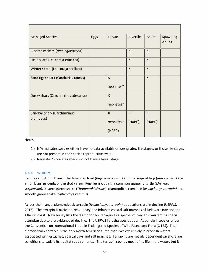
84
Managed Species Eggs Larvae Juveniles Adults Spawning
Adults
Clearnose skate (Raja eglantteria) X X
Little skate (Leucoraja erinacea) X X
Winter skate (Leucoraja ocellata) X X
Sand tiger shark (Carcharias taurus) X
neonates*
X
Dusky shark (Carcharhinus obscurus) X
neonates*
Sandbar shark (Carcharhinus
plumbeus)
X
neonates*
(HAPC)
X
(HAPC)
X
(HAPC)
Notes:
1.) N/A indicates species either have no data available on designated life stages, or those life stages
are not present in the species reproductive cycle.
2.) Neonates* indicates sharks do not have a larval stage.
4.4.4 Wildlife
Reptiles and Amphibians. The American toad (Bufo americanus) and the leopard frog (Rana pipens) are
amphibian residents of the study area. Reptiles include the common snapping turtle (Chelydra
serpentina), eastern garter snake (Thamnophi sirtalis), diamondback terrapin (Malaclemys terrapin) and
smooth green snake (Opheodrys vernalis).
Across their range, diamondback terrapin (Malaclemys terrapin) populations are in decline (USFWS,
2016). The terrapin is native to New Jersey and inhabits coastal salt marshes of Delaware Bay and the
Atlantic coast. New Jersey lists the diamondback terrapin as a species of concern, warranting special
attention due to the evidence of decline. The USFWS lists the species as an Appendix II species under
the Convention on International Trade in Endangered Species of Wild Fauna and Flora (CITES). The
diamondback terrapin is the only North American turtle that lives exclusively in brackish waters
associated with estuaries, coastal bays and salt marshes. Terrapins are heavily dependent on shoreline
conditions to satisfy its habitat requirements. The terrapin spends most of its life in the water, but it

85
must come ashore for nesting. Nesting normally occurs at bare or sparsely vegetated, unshaded, sandy
areas above the level of the normal high tides (Palmer and Cordes, 1988; Roosenburg, 1990; Burger and
Montevecchi, 1975). Nesting season extends from the beginning of June until the end of July, and
terrapins often aggregate in the waters adjacent to the nesting beaches during the nesting season
(Roosenburg, 1993).
The primary habitats of hatchlings and juveniles up to about the third year appear to be marshes and
tidal flats (Roosenburg et al., 2004; Draud et al., 2004). At this stage, they avoid open water, but instead
actively seek to hide under vegetation or debris in an apparent attempt to avoid being preyed upon
(Lovich et al., 1991; Burger, 1976; Pitler, 1985; Gibbons et al., 2001). It appears necessary that such
wetland habitat be located in proximity to the nesting sites, and most terrapin nesting studies have
indeed reported the presence of adjacent marshes (Roosenburg 1991; Burger and Montevecchi, 1975;
Feinberg and Burke, 2003; Butler et al., 2004; Chambers, 2000; Szerlag and McRobert, 2006; Aresco,
1996).
Birds. Many species of birds common to the Delaware Estuary are inhabitants of the wetlands and
tidewaters. Other species use wetlands and beaches during their migrations. The Delaware Estuary is
situated on the Atlantic Flyway and an important migratory route for many species of shorebirds and
waterfowl. Migratory shorebirds such as the ruddy turnstone (Arenaria interpres), short-billed
dowitcher (Limnodromus griseus), semi-palmated sandpiper (Calidris pussilla), sanderlings (Calidris
alba), and the imperiled red knot (Calidrus canutus) fly from southern Argentina each spring and stop at
the Delaware Bay to rest and feed on amphipods, chironomids, and horseshoe crabs (Chipley et al.,
2003). The total number of shorebirds counted in aerial surveys in Delaware Bay over a 6-week
migration period from May to mid-June range from 250,000 to more than 1,000,000 birds. Birds
observed in tidal marsh habitats are estimated at 700,000.
Neotropical songbirds also migrate in and out of the project area in the spring and fall. Species observed
in 1990 included the red-bellied woodpecker (Centurus carolinus), blue jay (Cyanocitta cristata), tree
swallow (Iridoprocne bicolor), versper sparrow (Pooecetes gramineus), American robin (Turdus
migratorius) and eastern bluebird (Sialia sialis). Other species known to inhabit the area are the
savannah sparrow (Passerculus sandwichensis), song sparrow (Melospiza melodia), mourning dove
(Zenaida macroura), gray catbird (Dumetella carolinensis), northern mockingbird (Mimus polyglottos),
redwinged blackbird (Agelaius phoenicues) and brown thrasher (Toxostoma rufum). Many of these birds
remain to breed in the vast woodlands along the coast. The geographical location and the healthy,
expansive upland edge of the wetlands of the lower estuary provide critical resting and feeding
opportunities to neotropical migrants.
Waterfowl common to the area include mallard (Anas platyrhynchos), American black duck (Anas
rubripes), northern pintail (Anas acuta), and wood duck (Aix sponsa). Canada geese (Branta Canadensis)
and snow geese (Chen caerulescens) frequent the region during fall, winter, and spring. Saltmarshes are
frequented by clapper rail (Rallus longirostris), seaside sparrow (Ammodramus maritimus), saltmarsh
sparrow (Ammodramus caudacutus), redwinged blackbird (Agelaius phoeniceus )and willet (Tringa

86
semipalmata). Wading bird species common to the area include the snowy egret (Leucophoyx thula),
glossy ibis (Plegadis falcinellus), and great blue heron (Ardea herodias). Over a dozen raptors reside or
migrate through the study area, such as the red-tailed hawk (Buteo lineatus), broad-winged hawk (Buteo
platypterus), northern harrier (Circus cyaneus), American kestrel (Falco sparverius), osprey (Pandion
haliaetus) and sharp-shinned hawk (Accipiter striatus). Typical owls include the barn owl (Tyto alba),
great horned owl (Bubo virginianus ) and long-eared owl (Asio otus).
Mammals. Many species of mammals inhabit the shoreline, tidal marshes and interior shrubland and
forests. Common to the study area are white tail deer (Odocoileus viiginianus), red fox (Vulpes vulpes),
raccoon (Procyon lotor), long-tailed weasel (Mustela frenata), striped skunk (Mephitis mephitis), river
otter (Lutra canadensis), muskrat (Ondatra zibethicus), gray squirrel (Sciurus carolinensis), eastern
chipmunk (Tamia striatus), eastern cottontail (Sylvilagus floridanus), Virginia opossum (Didelphis
virginiana), white-footed mouse (Peromyscus leucopus), meadow vole (Microtus pennsylvanicus), and
marsh rice rat (Oryzomys palustris).
4.4.5 Threatened and Endangered Species
Endangered species are those whose prospects for survival are in immediate danger because of a loss or
change of habitat, over-exploitation, predation, competition or disease. Threatened species are those
that may become endangered if conditions surrounding the species begin or continue to deteriorate.
Species may be classified on a Federal or State basis. The USACE Philadelphia District coordinates with
the USFWS and the NMFS regarding Federally-listed threatened and endangered species in the study
area. Extensive bayshore shorelines, adjacent marshes and woodlands, and shallow and deep water
habitats are prevalent within the study area, and provide habitat for several endangered and threatened
animal species.
The Delaware Estuary is within the historic range of 22 Federally-listed threatened or endangered
species: 17 animals and 5 plants (Table 20).

87
Table 20 - Delaware Estuary Threatened & Endangered Species
Status Species
T Bat, Northern long-eared (Myotis septentrionalis)
E Piping Plover (Charadrius melodus)
T Knot, red (Calidris canutus rufa)
T Sea turtle, green: except where endangered (Chelonia mydas)
E Sea turtle, hawksbill Entire (Eretmochelys imbricata)
E Sea turtle, Kemp's ridley Entire (Lepidochelys kempii)
E Sea turtle, leatherback Entire (Dermochelys coriacea)
E Loggerhead Turtle (Caretta caretta)
E Squirrel, Delmarva Peninsula fox Entire, except Sussex Co (Sciurus niger cinereus)
E Sturgeon, shortnose Entire (Acipenser brevirostrum)
E Atlantic sturgeon (Acipenser oxyrinchus oxyrinchus)
T Turtle, bog (=Muhlenberg) northern (Clemmys muhlenbergii)
E Whale, fin Entire (Balaenoptera physalus)
E Whale, humpback Entire (Megaptera novaeangliae)
E Whale, North Atlantic Right Entire (Eubalaena glacialis)
E Sei Whale (Balaenoptera borealis)
E Sperm Whale (Physeter macrocephalus)
T Amaranth, seabeach (Amaranthus pumilus)
T Beaked-rush, Knieskern's (Rhynchospora knieskernii)
E Dropwort, Canby's (Oxypolis canbyi)
T Pink, swamp (Helonias bullata)
T Pogonia, small whorled (Isotria medeoloides)
On May 4, 2015, the USFWS designated the northern long-eared bat (Myotis septentrionalis) as a
threatened species under the Endangered Species Act (ESA). In more recent years, the Federally-listed
and State-listed endangered piping plover (Charadrius melodus) have been occasionally sited on sandy
beaches of the lower bay but is not known to have nested along the bayshore. The Service proposed in
2006 to list the rufa subspecies of the red knot (Calidris canutus rufa) due to the high magnitude of
imminent threats to the subspecies, and as of September 2013 the Service listed the red knot as a
threatened species throughout its range, including New Jersey.
Piping plover. Outside of the study area, the oceanfront beaches of New Jersey support small breeding
populations of the Federally threatened piping plover (Charadrius melodus). There are currently no
known nesting areas on the Delaware Bay coastline. Cape May County possesses suitable habitat for
breeding piping plovers but no nests have been observed at the NJDEP Fish and Wildlife observation
stations closest to the proposed project since 2013: Cape May National Wildlife Refuge, Two-Mile
Beach, the Coast Guard Loran Support Unit (Wildwood), Coast Guard Training Center (Cape May), Cape
May City, Cape May Meadows, the Nature Conservancy refuge and Cape May Point State Park.

88
The Atlantic coast piping plover breeding population nests on wide, flat, sparsely vegetated barrier
beach habitats. These habitats include abundant moist sediment areas that are associated with dune
blowouts, washover areas, sand spits, unstable and recently closed inlets, ephemeral pools and sparsely
vegetated dunes. Locations suitable for breeding are also limited because these ground nesting birds
are especially sensitive to human-related disturbance and predation. In New Jersey the birds begin
arriving in mid-March to set up territories and perform courtship behavior. Egg laying begins mid-April.
The birds may re-nest one or more times if their nest is lost prior to hatching. Hatching takes place from
mid-May to mid-July. Generally, the young would be completely fledged by September 1 and often
earlier in July or August. Piping plover chicks are somewhat unusual in that they must leave the nest
shortly after hatching in order to begin foraging for food. Since the chicks are flightless, suitable feeding
areas must be located within a reasonable walking distance of the nest site. Feeding areas include the
wet portion of the beach, wrack lines, moist washover areas, and shorelines and flats associated with
coastal lagoons and ponds. If the vegetation is too dense, the chicks may be deterred from reaching the
feeding areas. The wave overwash that occurs during storms can be beneficial by creating low moist
feeding areas and by keeping the vegetation from becoming too dense (USFWS, 2016).
Red Knot. The Delaware Bay shoreline is known to be a major stopover site for the Federally threatened
red knot, during their northward migration in the spring. The red knots perform an unusually long
distance migration from their primary wintering areas in southern South America to their breeding areas
in the Canadian Arctic. While the red knots normally feed primarily on small bivalves, their spring
migration has evolved so that the Delaware Bay area has become their primary stopover location due to
the extraordinary abundance of horseshoe crab eggs. The eggs are considered to be a key factor that
allows red knots to gain sufficient body condition to complete the migration and accomplish their
breeding activity. The reduced availability of horseshoe crab eggs at the Delaware Bay stopover due to
commercial harvest of the crabs is believed to have been a primary cause for the decline of the red knot
population that was observed in the early 2000s.
Cape May National Wildlife Refuge has a five-mile stretch along the Delaware Bay that serves as a major
resting and feeding area for migratory shorebirds. The bayshore is second only to the Cooper River
Delta in Alaska as a major shorebird staging area in North America. In addition to the threatened red
knot, the arrival of more than 20 shorebird species coincides with the horseshoe crab spawning season
in May and early June. Most of their time is spent feeding on horseshoe crab eggs which are available
on the intertidal beaches, although they also make comparatively limited use of the exposed mud flats
and pans within the adjacent marshes and impoundments for roosting. Red knots are relatively
uncommon along Delaware Bay during the southward fall migration, which peaks in August (USFWS,
2016).
Sea turtles. There are five Federally-listed threatened or endangered sea turtles that occasionally enter
the Delaware Estuary including the endangered Kemp’s ridley turtle (Lepidochelys kempii), leatherback
turtle (Dermochelys coriacea) and hawksbill turtle (Eretmochelys imbricata), and the threatened green
turtle (Chelonia mydas) and loggerhead turtle (Caretta caretta). With the exception of the loggerhead
these species breed further south from Florida through the Caribbean and the Gulf of Mexico. The

89
loggerhead may have historically nested on coastal barrier beaches. No known nesting sites are within
the project area.
Whales. There are six species of Federally-endangered whales that have been observed along the
Atlantic coast that, on occasion, have traveled into the Delaware Bay. These include the sperm whale
(Physeter catodon), fin whale (Balaenoptera physalus), humpback whale (Megapter novaeangliae), blue
whale (Balaenoptera musculus), sei whale (Balaenoptera borealis) and North Atlantic right whale
(Balaena glacialis). These are migratory animals that travel north and south along the Atlantic coast. All
six species are also listed by the state of New Jersey.
Shortnose sturgeon. The shortnose sturgeon (Acipenser bevirostrum) is a Federally-listed endangered
species, and occurs primarily in the upriver freshwater portion of the Delaware Estuary. Interbasin
movements have been documented for shortnose sturgeon between the Delaware River and
Chesapeake Bay via the C&D Canal (NMFS, 2011).
Atlantic sturgeon. In 2010, NMFS proposed to list three Distinct Population Segments (DPSs) of the
Atlantic sturgeon (Acipenser oxyrhinchus oxyrinchus) in the Northeast Region. The New York Bight DPS,
which includes Atlantic sturgeon whose range extends into coastal waters of Long Island, the New York
Bight, and the Delaware Bay, from Chatham, MA to the Delaware-Maryland border of Fenwick Island, as
well as wherever these fish occur in coastal bays, estuaries, and the marine environment from the Bay
of Fundy, Canada to the Saint Johns River, FL. In 2012, NMFS issued rulings listing five DPS of Atlantic
sturgeon as threatened or endangered under the ESA. All five of these DPS may occur within waters of
the Delaware Bay. Atlantic sturgeon are anadromous, spending a majority of their adult life phase in
marine waters, migrating upriver to spawn in freshwater reaches of the Delaware River, then migrating
to lower estuarine brackish areas during juvenile growth phases. Adults migrate along the ocean coast
of New Jersey and Delaware.
In addition to the Atlantic and shortnose sturgeons, sea turtles, and whales, the NMFS has jurisdiction
over other listed species that are more likely to occur in the lower reaches of the estuary. Some marine
mammals may be classified as threatened or endangered species, but all fall under the jurisdiction of the
Marine Mammal Protection Act. The marine mammal species that are commonly encountered in the
Delaware Estuary are bottlenose dolphin (Tursiops truncatus), harbor porpoise (Phocoena phocoena),
harbor seal (Phoca vitulina concolor), and gray seal (Halichooerus grypus). Additional species not
commonly sighted but which may incidentally utilize the estuary are pygmy sperm whale (Kogia
breviceps), long-finned pilot whale (Globicephala melaena), harp seal (Cystophora cristata), and ringed
seal (Poca hispida).
Raptors. Although the bald eagle (Haliaeetus leucocephalus) and the peregrine falcon (Falco peregrines)
have been recently removed from the Federal endangered species list, these raptors do occur in the
project area. The bald eagle is still protected under the Bald and Golden Eagle Protection Act (BGEPA)
and both birds are protected under the Migratory Bird Treaty Act (MBTA).

90
A list of state threatened and endangered species of New Jersey can be accessed at
www.nj.gov/dep/fgw/tandespp.htm.
4.5 AIR QUALITY Ambient air quality is monitored by the NJDEP Division of Air Quality and is compared to the National
Ambient Air Quality Standards (NAAQS) throughout the state, pursuant to the Clean Air Act of 1970. Six
principal "criteria" pollutants are part of this monitoring program, which include ozone (O3), carbon
monoxide (CO), sulfur dioxide (SO2), nitrogen dioxide (NO2), particulate matter (PM10 and PM 2.5), and
lead (Pb). Sources of air pollution are broken into stationary and mobile categories. Stationary sources
include power plants that burn fossil fuels, factories, boilers, furnaces, manufacturing plants, gasoline
dispensing facilities, and other industrial facilities. Mobile sources include vehicles such as cars, trucks,
boats, and aircraft. New Jersey air quality data from air monitoring sites can be accessed from
www.njaqinow.net/. New Jersey air quality has improved significantly over the past 40 years, but
exceeds the current standards for ozone throughout the state and for fine particles in urban areas. With
the exception of Warren County, outside of the project study area, New Jersey has attained the sulfur
dioxide, lead and nitrogen dioxide standards.
The Clean Air Act requires that all areas of the country be evaluated and then classified as attainment or
non-attainment areas for each of the National Ambient Air Quality Standards. Areas can also be found to
be “unclassifiable” under certain circumstances. The 1990 amendments to the act required that areas
be further classified based on the severity of non-attainment. The classifications range from “Marginal”
to “Extreme” and are based on “design values”. The design value is the value that actually determines
whether an area meets the standard. For the 8-hour ozone standard for example, the design value is the
average of the fourth highest daily maximum 8-hour average concentration recorded each year for
three years. Their classification with respect to the 8-hour standard is shown in Figure 12. Ground-level
ozone is created when nitrogen oxides (NOx) and volatile organic compounds (VOC’s) react in the
presence of sunlight. NOx is primarily emitted by motor vehicles, power plants, and other sources of
combustion. VOC’s are emitted from sources such as motor vehicles, chemical plants, factories,
consumer and commercial products, and even natural sources such as trees. Ozone and the pollutants
that form ozone (precursor pollutants) can also be transported into an area from sources hundreds of
miles upwind. The project area is located within the 8-hour Ozone Nonattainment area shown in Figure
20. The entire state of New Jersey is in non-attainment and is classified as being “Marginal.”

91
Figure 20 - Non-Attainment Areas for Ozone
Greenhouse gases (GHG) trap heat in the atmosphere. Carbon dioxide is the most abundant GHG and
enters the atmosphere through burning fossil fuels (coal, natural gas and oil), solid waste, trees and
wood products, and also as a result of certain chemical reactions (e.g. manufacture of cement). Carbon
dioxide is removed from the atmosphere (or “sequestered”) when it is absorbed by plants as part of the
biological carbon cycle. Methane is emitted during the production and transport of coal, natural gas and
oil. Methane emissions also result from livestock and other agricultural practices and by the decay of
organic waste in municipal solid waste landfills. Nitrous oxide is emitted during agricultural and
industrial activities, as well as during combustion of fossil fuels and solid waste. Hydrofluorocarbons,
perfluorocarbons, sulfur hexafluoride, and nitrogen trifluoride are synthetic, powerful greenhouse gases
that are emitted from a variety of industrial processes. Fluorinated gases are sometimes used as
substitutes for stratospheric ozone-depleting substance (e.g., chlorofluorocarbons,
hydrochlorofluorocarbons, and halons) (USEPA, 2016).
The largest source of GHG emissions from human activities in the United States is from burning fossil
fuels for electricity, heat and transportation. The USEPA tracks total U.S. emissions and reports the total
national GHG emissions and removals associated with human activities.
92
4.6 NOISE Noise is of environmental concern because it can cause annoyance and adverse health effects to
humans and animals. Communities adjacent to the Delaware Estuary shoreline are more extensively
developed in the upper portion of the estuary along the Delaware River, primarily as residential and
commercial properties. Noise in this area is mostly due to traffic along inland main road corridors.
Vehicle traffic is minimal in the smaller bayshore communities, and more frequent in the larger
bayshore communities such as Villas and Cape May Point. In the bay region of the estuary, roads are
located further inland and noise generated is significantly less. Route 47 is the main road, a two-lane
state road that traverses inland 75 miles from Camden County south through rural areas of Cumberland
County and ends at Wildwood in Cape May County.
4.7 VISUAL AND AESTHETIC VALUES Aesthetics refer to the sensory quality of the resources (sight, sound, smell, taste and touch) and
especially with respect to judgment about their pleasurable qualities (Canter, 1993; Smardon et al.,
1986). The aesthetic quality of the study area is influenced by the natural and developed environment.
Aesthetic values are high in the study area due to the predominance of expansive salt marshes, open
water, beaches and the presence of Delaware Bay maritime communities consisting of fishing boats,
docks and related facilities. The presence of dilapidated structures damaged from erosion, flooding and
damaged revetments along the shoreline may detract from the high aesthetic value of the area.
4.8 HAZARDOUS, TOXIC AND RADIOACTIVE WASTE The PDT contracted with Environmental Data Resources, Inc. (EDR) to produce environmental database,
mapping and aerial photograph searches for the proposed dredged material placement areas. Database
searches were conducted for reports within a one mile radius of addresses located in the approximate
centers of the proposed dredged material placement areas. Each notation for each database find was
reviewed to determine which were considered closed by appropriate authority. In cases where the
review was inconclusive, the result was considered to be open. The United States Geological Survey,
public and private wells were considered to be open. Each remaining address for the database searches
was then reviewed for distance from the beachfill area, up or downgradient of the beachfill area, and
potential for impact to the planned nourishment of the beaches by pumping.
Facilities with potential HTRW impacts located within approximately ¼ mile of each dredged material
placement location were subjected to further case review and evaluation for potential impacts to the
proposed beachfill projects. No reported facilities were found to have the potential to adversely affect
the proposed beachfill projects. The USACE project team has elected to have EDR continue to monitor
the selected locations and EDR will provide updates electronically should any new environmental
records become available.
4.9 CULTURAL RESOURCES Background research shows no recorded historic properties eligible for or listed on the National Register
of Historic Places (NRHP) within the area of potential effect (APE) for Gandys Beach and Fortescue.
93
There have been no archaeological field investigations conducted in the project areas; however, there
have been several comprehensive studies that suggest that the beach area has moderate potential for
significant archaeological resources at either Gandys Beach or Fortescue.
There have been no historic structures analyses conducted in the project areas; however, given the
history of the region with early settlers who farmed salt hay, there is moderate potential for historic
structures potentially eligible for the NRHP to exist within the project area. Preservation New Jersey
named the village of Fortescue as one of the ten most endangered historic sites in New Jersey in 2014,
even after the damage caused by Hurricane Sandy.
Background research for the APE for Villas shows that there are identified archaeological sites on the
north and south extents of the project area. This indicates, as well as other comprehensive studies
previously conducted, that the beach area at The Villas has a moderate to high potential for significant
archaeological resources. Research has also found previously recorded historic structures that are
eligible for or listed on the NRHP. The Judge Nathanial Foster house is listed on the NRHP, and 8
structures have been determined to be eligible for listing along Bayshore Drive.
4.10 SOCIOECONOMIC New Jersey is the fourth smallest state but the most densely populated of the United States. Industry
such as pharmaceuticals, chemical, telecommunications, shipping and food processing predominate the
northern central portion of the state while in the proposed project area of southern New Jersey, tourism
has developed into the dominant industry. Colloquially, South Jersey refers to the area in New Jersey
within the influence of the Philadelphia metropolitan area, in contrast to the rest of New Jersey, located
within the New York metropolitan area. South Jersey is a peninsula with residential communities,
farmland, wetlands and the Pine Barrens.
The Delaware Estuary provides numerous economic benefits to the region. The Delaware River Port
Complex (including docking facilities in Pennsylvania, New Jersey and Delaware) is the largest freshwater
port in the world. According to testimony submitted to the U.S. House of Representatives
subcommittee in 2005, the port complex generates $19 billion in annual economic activity. It is one of
only 14 strategic ports in the nation transporting military supplies and equipment by vessel to support
our troops overseas. The Delaware River and Bay are home to the third largest petrochemical port as
well as five of the largest east coast refineries. Nearly 42 million gallons of crude oil are moved on the
Delaware River on a daily basis. There are approximately 3,000 deep draft vessel arrivals each year and
it is the largest receiving port in the United States for very large crude carriers (tank ships greater than
125,000 deadweight tons). It is the largest North American port for steel, paper and meat imports as
well as the largest number of cocoa beans and fruit on the east coast. Over 65% of Chilean and other
South American fruits imported into the United States arrive at terminal facilities in the tri-state port
complex. Wilmington, Delaware is home to the largest U.S. banana importing port, handling over one
million tons of this cargo annually from Central America. According to Rear Admiral Sally Brice-O’Hara,
District Commander of the Fifth Coast Guard District, “The port is critical not only to the region, but also
to the nation” (Kaufman, 2011).

94
Wetlands are ecologically and economically valuable to the state. Cranberry growing is a significant
industry in New Jersey, as it is the third largest producer in the United States. There are more than
3,600 acres of cranberry bog wetlands in New Jersey. Fishing and aquaculture contribute $1 billion
annually to the state’s economy. Commercial fishing includes over 100 species of fish and shellfish, such
as scallops, surf clams, blue crabs and herring. Hard clams and oysters account for the majority of the
aquaculture.
The upper region of the Delaware Bay has large oyster beds that are stock-assessed by the Rutgers
University Haskin Shellfish Research Laboratory for the state to manage a controlled fishery. Oysters
have also been a valuable food source and part of the mid-Atlantic’s cultural history for centuries. The
New Jersey fishery for C. virginica landed an estimated 94,470 bushels of oysters in 2011, worth
approximately 4.2 million in dockside value (Powell et al., 2012).
Numerous seaside resorts and small towns are located along the New Jersey bayshore. In between and
interior to these beach towns are tens of thousands of acres of tidal marshes, upland forests and
undeveloped beaches. Tourism is growing along New Jersey’s Delaware Bay shores as residents and
visitors seek out the quieter, less developed coastal areas west of the Atlantic Ocean beaches. Primary
interests include wildlife viewing, water recreation and special events or festivals (Schuster, 2016).
Environmental Justice. In accordance with Executive Order 12989 dated February 11, 1994
(Environmental Justice in Minority Populations), a review was conducted of the populations within the
affected areas. The U.S. Environmental Protection Agency (USEPA) definition for Environmental Justice
is: “the fair treatment and meaningful involvement of all people regardless of race, color, national origin
or income with respect to the development, implementation and enforcement of environmental laws,
regulations and policies.” The United States Census Bureau estimates the population of New Jersey to
be 8,958,013 (2015) and comprised of 68.6% Caucasian, 13.7% African American, 8.3% Asian American
and 9.4% other races. Hispanic or Latino members of the population (of any race) comprise 17.7% of
the population. New Jersey is identified as one of the most ethnically diverse states in the country. The
majority of the population resides in the counties surrounding New York City, Philadelphia and the
eastern Jersey shore. The more southern and northwestern counties are less densely populated.
Although New Jersey is the second wealthiest state (Lynn and Sheingold, 2015), more New Jersey
residents are in poverty now than in the past 5 decades. Poverty rates remain disproportionately higher
for blacks and Hispanics and the official poverty level is highest in Cumberland County. Low wage
occupations employ proportionately far more workers in New Jersey but bring home a proportionately
lower share of the state’s total earnings. Average household income has declined by more for the lower
income groups than the higher income groups over the period 2007 – 2014 (Legal Services of New
Jersey, 2015).
5 EFFECTS ON SIGNIFICANT RESOURCES* This section evaluates impacts that may occur as a result of the CSRM alternative plans, including the
TSP. Impacts resulting from the O&M dredging activities (that will serve as the CSRM dredged material
source) are fully evaluated in several NEPA documents specifically for the Delaware River Main Stem
95
Navigation Channel (see Section 1.5), and in the interest of brevity, are incorporated by reference
instead of being presented in this report. In addition to the No Action Plan, viable alternatives
considered during the alternative analysis included the Levee/Dike Plan, the Beach Restoration and the
Beach Restoration with Groin(s) Plan.
5.1 PHYSICAL ENVIRONMENT
5.1.1 Land Use
The communities along the Delaware Estuary shoreline have a long history of economic activity provided
by the waterway. The Delaware River continues to serve as a principal corridor for commerce as well as
a major strategic port for national defense. The economies of the towns have changed over the years
from ship building and oyster harvesting to primarily fishing, crabbing and tourism. The Delaware
Estuary shoreline communities have changed from rural farmsteads to seasonal vacation destinations
and year-round residential communities in the larger towns. The NJDEP, in partnership with private and
Federal natural resource organizations, promotes the preservation of natural resources surrounding the
communities along the bayshore and strives to increase the ecotourism to support these communities.
In addition, the National Fish and Wildlife Foundation (NFWF) is initiating studies within the Delaware
Bay region in support of programs and projects that will improve resilience by reducing communities’
vulnerability to coastal storms, SLC and flooding events by strengthening natural ecosystems and the
fish and wildlife habitat they provide.
The No Action Plan does not provide CSRM and will allow for continued erosional impacts and coastal
storm risk to infrastructure. Levees and dikes are embankments of sediments to raise elevation in a
linear fashion paralleling a water body and reduce flooding for the lands behind the structure. The
Levee/Dike Plan was evaluated at 6 locations in the study area (Penns Grove/Carneys Point, Pennsville,
Maurice River Township, Bivalve, Shellpile and Port Norris). This alternative was eliminated based on
the grain size incompatibility of the source material and the cost of augmenting the material to meet
USACE levee construction criteria.
The action alternatives entailing beach restoration would provide beneficial effects by establishing an
added buffer beach to provide protection to upland infrastructure and populations against storms and
flooding. Sand nourishment also creates additional habitat for beach flora and fauna, added inundation
protection to interior wetlands and more opportunities for recreational activities. The TSP entails beach
restoration at Villas, but also includes restoration of an existing terminal groin at Fortescue and
construction of a new terminal groin at Gandys Beach. The terminal groin restoration/construction is
intended to enhance the performance and longevity of the beach restoration project by reducing end
losses. The addition of a groin to a beach nourishment plan is typical in areas where relatively higher
beach erosion rates and losses occur. The TSP to provide CSRM with beach restoration will help the
shoreline communities be resilient against future storms and help provide economic sustainability,
recreational use and natural habitat restoration.
Generally, the proposed project would likely produce more favorable economic conditions than exist at
present, although construction operations will produce some minor adverse effects on land use. These
96
effects would primarily be temporary in nature, and land uses would continue as they had been under
pre-construction conditions after placement operations and construction.
5.1.2 Physiography and Geology
Erosion and flooding are the primary coastal hazards that adversely impact the estuarine shoreline.
Under the No Action Plan, tidal action and storms will continue to erode the shoreline, exposing the
underlying peat and reducing available sandy beach habitat for wildlife and CSRM for developed
stretches. A loss of barrier beach can also result in flood inundation to interior salt marshes, forests and
neighboring farmland.
Stockton University’s Coastal Research Center (CRC) conducts surveys at 31 sites along the Atlantic
Ocean and Delaware Bay beaches of Cape May County as part of their Beach Profile Network (NJBPN).
Four of these are located along the Delaware Bay shore: Reeds Beach in Middle Township, Villas in
Lower Township, North Cape May in Lower Township and at the Higbee Beach State Park (Farrell et al.,
2016). The CRC conducted post-Hurricane Sandy surveys on 12 and 26 November 2012 (Hurricane
Sandy made landfall on 29 October 2012) to evaluate severe beach erosion. Researchers compared
shoreline and beach volume changes of the post-storm surveys with surveys taken at the same NJBPN
pre-storm monitoring sites (19 October 2012). Between Reeds Beach and Cape May Point, the storm
surge flooded the Delaware Bay with 4-foot waves. High water levels and waves pounded dunes and
inundated low-lying areas with loss of some structures. Reeds Beach was hit hard due to the absence of
a bluff and minimal dune system. Sand was pushed across the service road to Bidwell Creek and inland
onto the salt marshes.
To the south, the bluff and sand dunes serve as a barrier. Some erosion of the dune occurred and
moved the zero elevation position towards the bay. The berm/dune slope was reduced in gradient
allowing sand to deposit on the terrace that extends over 1,000 feet into the bay from Villas to North
Cape May. This wide terrace is the geological result of long, slow erosion of the bluff by bay waves.
Higbee Beach is a natural area and suffered minimal bluff erosion and beach retreat (Farrell et al., 2016).
Alternative plans that include a hardened structure (such as a groin) perpendicular to the beach will not
impact the area geology, buy may alter the physiography of the beach. Groins deflect alongshore
currents resulting in greater accumulation of transported sediments on the updrift side. Groins impede
longshore sand transport, which may provide a benefit to navigation when positioned adjacent to inlets
and may also provide additional CSRM for structures located on the updrift side of the groin. Erosion
and extreme weather events will continue to be the primary drivers of flooding events.
The TSP involves the restoration of the berm and dune system at Villas fronting the developed sections
of the bayshore to provide CSRM. The construction of terminal groins at two of the beaches (Gandys
Beach and Fortescue) will provide added protection from erosion by restricting longshore transport
from carrying sediments northwest, particularly at Fortescue where a hardened structure currently
exists at the mouth of the inlet to reduce infilling. Beach nourishment restores the natural physiography
and habitat that existed along the shoreline fronting these communities. In addition, beach

97
nourishment using compatible grain size materials does not adversely impact the geology of the study
area.
5.1.3 Sediment Quality
Delaware Estuary sediment quality is described in the 1992 EIS (USACE, 1992), 1997 SEIS (USACE, 1997),
the 2009 EA (USACE, 2009), the 2011 EA (USACE, 2011) and the 2013 EA (USACE, 2013) for the MCD
project. This information is incorporated by reference.
The 1997 SEIS (USACE, 1997) sediment quality data included bulk sediment analysis, elutriate sediment
analysis, Toxicity Characteristic Leaching Procedure (TCLP) analysis, biological effects based sediment
testing and high resolution PCB congener analysis for the MCD project. Based on a review by the EPA,
the tests showed no toxicity or bioaccumulation of any significance. The USFWS commented that the
results of the chemical analysis indicated that contaminated loads in the sediments tested are low.
These chemical analyses investigated sediments extending approximately 102.5 river miles from
Philadelphia to the mouth of the Delaware Bay. Chemical contaminants are more likely to occur in the
upper reaches of the estuary where smaller grain size sediments are found (chemical constituents bind
to smaller grain size sediments) than in the lower reaches of the Delaware Bay where the proposed
beneficial use sediments occur.
This feasibility report focuses on sediment quality data for the Main Channel from the Miah Maull and
Brandywine Ranges within lower Reach E only (the proposed maintenance dredged material source area
for the TSP). The 1998 Inland Testing Manual (EPA-823-B-98-004) provides national guidance on the
evaluation of dredged material under the Clean Water Act. It states that no chemical analysis is
required if there is a “reasonable assurance that the proposed discharge material is not a carrier of
contaminants…For example, dredged material is most likely to be free of contaminants if the material is
composed primarily of sand, gravel or other inert material and is found in areas of high current of wave
energy [230.60(a)].” For the MCD project, the sediments tested within this ranges exhibited large grain
sizes and no contaminants were detected in these samples. The sediment grain size samples obtained in
2008 as part of the Delaware Estuary Program DEBI (Delaware Estuary Benthic Inventory) indicated that
the percent sand in Lower Reach E was 81-100%.
Prior to the deepening operations in 2015, sediment grain size data for Reach E bottom sediments
collected by USACE between 1991 and 2013 (176) samples were re-evaluated to identify the sub-
reaches where economic loading would be permitted during dredging. Economic loading refers to the
practice of filling a hopper dredge beyond overflow to achieve a higher density load (discussed in
greater detail in Section 5.2.2). The 2013 EA (USACE, 2013) considered both the environmental effects
of economic loading (i.e. turbidity) and the economic benefits and concluded that economic loading
could be conducted in Delaware Bay with minimal adverse environmental impacts and significant
economic benefits.
As indicated on Figure 21, Reach E was divided into 9 subsections. For sub-Reach E-7 through E-9 (the
Miah Maull and Brandywine Ranges), the weighted average for coarse-grained material was estimated
to be approximately 93 percent, with a confidence interval of 90 percent that another sample collected

98
within E-7 through E-9 would be between 90 and 95 percent coarse grained material. Coarse grained
material is defined as the portion of the sample that includes sand (passing the #4 to #200 screen) and
gravel (passing the #3 to #4 screen) (USACE, 2013).
For the No Action Alternative, future maintenance dredging sand from Lower Reach E will be placed at
Buoy 10 open water disposal site for approximately 10 more years. Beyond this, dredging sand from
Lower Reach E will be placed at Artificial Island CDF, per the Federal Standard for the least-cost,
environmentally acceptable disposal location. Although this is the least-cost method of disposing
maintenance dredging material from lower Reach E, there is no significant economic or environmental
benefit from this practice. Continued erosion of the beach and dune system will result in exposure of
the underlying peat and clay layers.
Sediments are a critical component of the estuarine system as they constitute the substrate for most
hydraulic, geochemical and biogenic processes that affect the overall “health” of the estuary. The
estuary acts as a sink for sediments eroded from the watershed above the head of tide. The most
seaward portion of the estuary (the bay) is also a sink for sandy sediment transported in from the ocean
primarily by tidal hydraulic processes.
The latest published sediment budget for the Delaware Estuary indicates that the bed of the estuary has
eroded at a rate that exceeds the average annual rate at which new sediment is supplied from the
watershed (i.e. upland fluvial input). Additionally, maintenance dredging coupled with disposal at CDFs
is the principal mechanism by which sediment is removed from the estuary. Decreasing dredged
quantities from the main channel over time (1937 – 2009) are indicative of this imbalance (Gebert and
Searfoss, 2012).
Beach nourishment is not expected to impact sediment quality. Grain size of the source material is
similar to that which occurs on the proposed placement beaches and materials with large grains sizes
(>90% sand) do not require chemical analysis for contamination.
Under the TSP, the use of sand dredged from lower Reach E for beach nourishment will provide a
tangible economic benefit (i.e. CSRM benefit) to the study area shoreline while restoring the sediments
typical of a healthy sandy beach shoreline. The addition of rehabilitating the groin at the northernmost
end of Fortescue and adding a new groin at Gandys Beach may impact sediment quality on the
downdrift side of the groin by reducing deposition and potentially exacerbating erosion through the
interference of longshore sediment transport, thereby exposing underlying peat and clay layers. The
updrift side of the groin will receive increased deposition, thereby increasing the width of the beach
fronting the community.

99
Figure 21 - Reach E Sub-Reaches
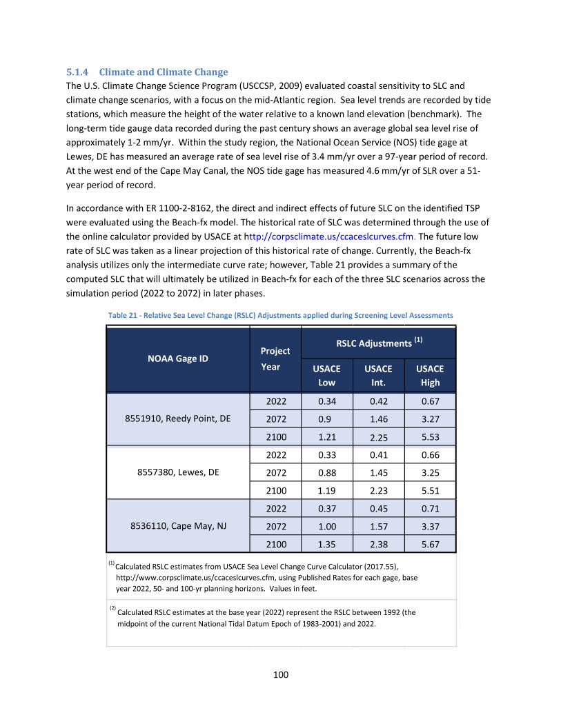
100
5.1.4 Climate and Climate Change
The U.S. Climate Change Science Program (USCCSP, 2009) evaluated coastal sensitivity to SLC and
climate change scenarios, with a focus on the mid-Atlantic region. Sea level trends are recorded by tide
stations, which measure the height of the water relative to a known land elevation (benchmark). The
long-term tide gauge data recorded during the past century shows an average global sea level rise of
approximately 1-2 mm/yr. Within the study region, the National Ocean Service (NOS) tide gage at
Lewes, DE has measured an average rate of sea level rise of 3.4 mm/yr over a 97-year period of record.
At the west end of the Cape May Canal, the NOS tide gage has measured 4.6 mm/yr of SLR over a 51-
year period of record.
In accordance with ER 1100-2-8162, the direct and indirect effects of future SLC on the identified TSP
were evaluated using the Beach-fx model. The historical rate of SLC was determined through the use of
the online calculator provided by USACE at http://corpsclimate.us/ccaceslcurves.cfm. The future low
rate of SLC was taken as a linear projection of this historical rate of change. Currently, the Beach-fx
analysis utilizes only the intermediate curve rate; however, Table 21 provides a summary of the
computed SLC that will ultimately be utilized in Beach-fx for each of the three SLC scenarios across the
simulation period (2022 to 2072) in later phases.
Table 21 - Relative Sea Level Change (RSLC) Adjustments applied during Screening Level Assessments
USACE
Low
USACE
Int.
USACE
High
2022 0.34 0.42 0.67
2072 0.9 1.46 3.27
2100 1.21 2.25 5.53
2022 0.33 0.41 0.66
2072 0.88 1.45 3.25
2100 1.19 2.23 5.51
2022 0.37 0.45 0.71
2072 1.00 1.57 3.37
2100 1.35 2.38 5.67
(2)
Calculated RSLC estimates at the base year (2022) represent the RSLC between 1992 (the
midpoint of the current National Tidal Datum Epoch of 1983-2001) and 2022.
RSLC Adjustments (1)
NOAA Gage ID Project
Year
(1) Calculated RSLC estimates from USACE Sea Level Change Curve Calculator (2017.55),
http://www.corpsclimate.us/ccaceslcurves.cfm, using Published Rates for each gage, base year 2022, 50- and 100-yr planning horizons. Values in feet.
8551910, Reedy Point, DE
8557380, Lewes, DE
8536110, Cape May, NJ

101
While the economic analysis is limited to the 50-yr life cycle, SLC was also assessed on a 100-yr planning
horizon, and used to qualitatively inform project performance (e.g. understanding future level of
protection offered in 2100), and identify potential for adaptive management (e.g. increasing dune/berm
height/width). SLC at 2100 will be used more quantitatively to guide optimization of proposed
protections measures during later project phases.
Most erosion along the Delaware Bay shoreline is caused by waves generated by local winds, especially
during storms. Wave exposed shorelines within estuaries and coastal bays are likely to see higher rates
of erosion with SLC increases (Rosen, 1978; Stevenson and Kearney, 1996). SLC has this effect because it
allows waves to impact the shoreline at a higher elevation (National Research Council, 2007). Erosion
rates on non-ocean tidal shorelines may be significantly higher than on the more exposed ocean coast
(French, 1990). One reason for this is that the non-ocean beaches lack exposure to the long period swell
waves that return sand to ocean beaches (Nordstrom, 1980). Since erosion of estuarine and bay
beaches is typically storm-driven (French, 1990), if the storm activity increases, this would compound
the effect of rising sea level. The No Action Plan will have no impact on SLC. While SLC is believed to be
an underlying driving force, there are many other factors that directly affect shoreline erosion including
the material composition of the shoreline, bank height, supply of sandy material in the littoral zone,
wave energy exposure, tidal range and human influences (Rosen, 1977 & 1980; Stevenson and Kearney,
1996; Perry, 2008). These factors often make it difficult to clearly discern the effect of SLC. Both beach
restoration and beach restoration with a terminal groin are expected to reduce the adverse impacts of
SLC on communities and beach habitat quality.
While there are many types of shorelines in estuaries, beaches tend to be the most common type and
are prominent in the proposed project area. These beaches, which are smaller than on the ocean coast,
may occur along the upland edge or so-called “fetch limited” barriers (Lewes et al., 2005). Their
presence also tends to reduce erosion of uplands and wetlands by absorbing wave energy. Beaches
tend to be relatively resilient to SLC since they are able to migrate landward as the shoreline retreats
and wetlands accrete sediment and build in elevation. However, the combination of SLC and increased
storm activity could cause more of the sand to be lost offshore. Riverine sediment input to the estuary
is a sediment source to the estuary shoreline; however, the Delaware Estuary is known to be in
sediment deficit due to significant shoreline stabilization in the upper reaches and decades of removal of
bottom sediments by dredging and placement into upland CDFs. Since bank erosion and riverine input
may serve as an important sediment source to bay shorelines, beneficial use of dredged material serves
to put sediment back into the system where the shoreline is sediment starved.
It is difficult to predict the impact of climate change on endangered species as there is significant
uncertainty in the rate and timing of climate change as well as the effects it may have on the species.
SLC could result in a reduction in available bird beach nesting habitat and increase the risk of nest
inundation, and changes in abundance and distribution of forage species. Interior maritime forest
habitat for passerine birds and wading birds is also at risk due to sea water inundation once barrier
beaches are eroded. Changes in water temperature could lead to a northward shift in the sea turtle
range; however, the anticipated change in sea temperatures within the next 50 years is not expected to
be greater than 1.5 to 2.0 and not deemed significant enough to contribute towards shifts in range or
102
distribution of sea turtles (NMFS, 2014) or warm enough for successful egg rearing. Sea turtle nesting
north of Virginia is relatively rare and is not expected to occur in the project area.
Rising sea level may result in moving the salt line upstream, and potentially reducing available
freshwater habitat for spawning, larvae and younger juvenile Atlantic sturgeon. Increased rainfall, as
predicted by some climate models, may increase runoff and scour, thereby exacerbating poor water
quality conditions but possibly counteracting a northern encroachment of the salt line. Atlantic
sturgeon prefer water temperatures up to approximately 28 degrees C. Increased droughts (or
increased withdrawals for human use) and low flow conditions are additional potential impacts
unrelated to the proposed project that can impact all Atlantic sturgeon life stages by reducing suitable
habitat and reducing water quality conditions.
Beaches in developed areas can become trapped between the development on the land side and rising
sea level on the water side, leaving little room for normal landward migration and sediment dynamics
(Defeo et al., 2009). The net result of these effects will probably be a net reduction in beach habitat.
Erosion on beaches fronting houses particularly affects estuarine beach dependent species such as
shorebirds, terns, horseshoe crabs and diamondback terrapins. While CSRM is the primary driver of this
feasibility study, the ancillary environmental benefits to returning dredged estuarine sediments to the
system through beach nourishment are significant.
A study by Galbraith et al. (2002) illustrates the potential effect of SLC on prime migratory shorebird
habitat. The study used the SLAMM version 4 to investigate the effect of SLC on beach and intertidal flat
habitat at Delaware Bay and four other sites on the west and Gulf coasts known for their importance to
migrating or wintering shorebirds. Delaware Bay supports the second largest spring concentration of
migrating shorebirds in the Western Hemisphere and is a critical stopover site for the red knot. Under a
conservative scenario where a global SLC of 0.34 m by 2100 is adjusted with tidal gage records, the
model predicted a 20 percent loss of Delaware Bay beach and intertidal flat habitat by 2050 and a 57
percent loss by 2100 (USFWS, 2016). The proposed TSP to conduct beach nourishment where possible
best mimics the natural shoreline habitat while affording additional defense against SLC. Although the
proposed hardened structure (terminal groin) does not necessarily offer added defense against SLC, it
reduces sand losses to the beach fronting the community by impeding longshore transport of sediments
and enlarging the beach width that in turn adds to increased resiliency in the face of SLC. In
combination with a terminal groin, beach nourishment lowers the risk of flooding to the developed
bayshore communities by providing an elevated beach berm buffer while reducing the rate of sediment
loss in highly erosional areas.
5.2 WATER RESOURCES Under the No Action Plan, inundation of flood waters along with storm waves on the Delaware bayshore
causes erosion during storms, thereby raising turbidity, reducing water quality and clarity, which is
further exacerbated by additional losses of vegetated land cover. Turbidity is the measure of the
cloudiness of the water caused by suspended matter such as clay, silt and organic matter, thereby
blocking the passage of light within the water columns. Continued erosion of the sandy beach
eventually results in exposing the underlying peat and clay layers which are repeatedly inundated with

103
each flood event, causing continued degradation of water quality and reducing beach, intertidal and
shallow water habitats.
Beach nourishment on sandy beaches typically results in a temporary nearshore impact (i.e. swash zone)
to water quality as placement operations elevate turbidity. While larger sand particles settle out more
quickly, finer sediments will remain suspended for longer periods, or even indefinitely in coastal
turbulent waters (Adriaanse and Coosen, 1991). Suspended particles can interfere with the biological
function of some organisms, such as feeding, respiration, reproduction and predator avoidance. High
turbidity and silt loads in the water can have detrimental impacts on filter feeding organism associated
with nearshore areas such as polychaetes, amphipods, isopods, decapods and mollusks. The longer
duration of diminished light penetration can detrimentally affect the photosynthetic activity of
phytoplankton, the primary producers of energy production. The NJDEP prefers that fill material be very
similar to existing beach sand to ensure minimization of turbidity during construction. The proposed
maintenance material dredged from Lower Reach E consists of predominantly large grained sand.
A robust dune and beach sand berm reduces turbidity as a result of the higher proportion of larger grain
sizes of sand particles to fine silts and clays and settles more quickly from turbulence during storm
events. A healthy beach and dune system is the first line of defense for bayfront infrastructure,
including homes, roads and utilities. They are also the first line of defense to reduce inundation to
adjacent marshes. Marsh vegetation has the capacity to improve and maintain water quality through
filtration, nutrient uptake and sediment trapping capacities. Large tracts of healthy marsh are
particularly important surrounding bayfront residential communities to serve to absorb surface water
and accrete sediments.
Beach restoration with a terminal groin will provide the same CSRM benefits as beach nourishment
alone, but a terminal groin adds longevity at two dredged material placement beaches where erosion
rates are significantly higher. Physical and biological impairments to water quality can result from the
placement operations due to increases in turbidity in the effluent run-off. Increased turbidity results
from the resuspension of sediments during operations and is temporary, but as noted, can impact
primary productivity and respiration of organisms in the immediate project area. Increased turbidity
can also impact prey species’ predator avoidance ability due to decreased clarity in the water column.
Impacts to water quality at the placement sites can be minimized through the creation of a temporary
sand dike surrounding the outfall pipe during pumping operations. Elevated turbidity will result
temporarily during construction of the terminal groin at Gandys Beach and rehabilitation of the groin at
Fortescue. Groins made with stone add heterogeneity to the intertidal habitat for benthic organisms
and foraging fish. Increased suspended sediment in the water can reduce dissolved oxygen (Johnston,
1981). This can be more of a concern during summer months when water temperatures are warmer
and less capable of holding dissolved oxygen (Hatin et al., 2007). The nature, degree and extent of the
suspended sediment plume in the water is controlled by a variety of factors including sediment particle
size, solids concentration, dredge type, discharge rate, water temperature and hydrodynamic forces (i.e.
waves, currents) causing horizontal mixing. The larger grain sizes of the proposed material source
reduce the amount of time the material stays in suspension.

104
Turbidity levels decrease exponentially with increasing distance from the placement site due to settling
and dispersion. Plume concentrations, particularly when the material is predominantly large grained
sand particles, is expected to quickly return to background levels in most cases. The vast majority of re-
suspended sediments resettle close to the construction site within one hour (Anchor Environmental,
2003). Overall, water quality impacts are anticipated to be minor and temporary.
Of the three major types of dredges available (hopper, cutter suction and mechanical), hopper dredges
are the most likely to be used to dredge the Main Channel in lower Reach E because of the exposed
conditions in the Delaware Bay and the relatively long distances between the Delaware River Federal
channel and the dredged material placement sites. Impacts resulting from the dredging operations are
thoroughly presented in the NEPA documentation for MCD navigation project (USACE, 1992, 1997,
2009).
Figure 22 - Hopper Dredge
Hopper dredges are self-propelled ships equipped with propulsion machinery, hoppers for dredged
material storage and dredge pumps (Figure 22). Dredged material is hydraulically raised through trailing
dragarms which “vacuum” water and sediment in contact with the channel bottom and discharge it into
the hoppers. The material is stored in the hoppers through transportation to the placement site. While
most hopper dredges are equipped with bottom doors or split hulls for release of material at open
water sites, they can also be equipped for pump-out of material to the beach nourishment beneficial
use sites.
As was previously mentioned in Section 5.1.3, the practice of filling a hopper beyond overflow to
achieve a higher density load is referred to as economic loading. The result is fewer loads required to
transport the same amount of dredged material, which decreases the overall operating time, and hence,

105
the project cost. Economic loading is most effective when dredging coarse grained sediments or
consolidated clay sediments due to higher settling velocities. Conversely, there is less potential for
benefits from economic loading of fine-grained sediments due to lower settling velocities. The
environmental effects of economic loading (i.e. turbidity) and the economic benefits are presented in
the 2013 EA (USACE, 2013) for the deepening project of the Delaware Main Navigation Channel.
A Section 401 Water Quality Certificate under the Clean Water Act of 1977 (PL 95-217), as amended,
and a consistency determination under the Coastal Zone Management act are required from the state of
New Jersey. Pursuant to Section 404 of the Clean Water Act, the impacts associated with the discharge
of fill material into waters of the United States are discussed in Appendix D.
5.3 BIOLOGICAL RESOURCES
5.3.1 Vegetation and Wetlands
Over 300,000 acres of tidal wetlands provide breeding and nursery habitats for finfish and shellfish, and
act as a natural flood and pollution control system along the shoreline of New Jersey. The majority of
wetlands within the vicinity of the proposed project areas are estuarine intertidal emergent wetlands,
with additional estuarine intertidal scrub-shrub and interior forested freshwater wetlands occurring
intermittently. In the southern reach of the study area, coastal salt marshes are intertidal ecosystems
occurring on soft sediments on which the vegetation is dominated by flowering plants, graminoids, forbs
and low shrubs. Salt marshes develop between terrestrial and marine environments, resulting in
biologically diverse communities adapted for harsh environmental conditions including desiccation,
flooding, and extreme temperature and salinity fluctuations. These wetlands are characterized by a mix
of marsh vegetation comprised of salt marsh cordgrass (Spartina alterniflora), salt grass (Distichlis
spicata), salt hay (Spartina patens), and black needlerush (Juncus roemerianus). Common tree and
shrub species include high tide bush (Iva frutescens), loblolly pine (Pinus taeda), Virginia pine (P.
virginiana) and eastern red cedar (Juniperus virginiana). Marshes act as nurseries to a wide variety of
organisms, some of which are notably threatened or marketed as important fisheries species (USFWS,
2016).
The No Action Plan is expected to exacerbate the loss of coastal vegetation and cause excessive
inundation of neighboring wetlands with erosion of the barrier beachfront. The beach restoration
alternatives will enhance protection of adjacent wetlands and enable dune vegetation to establish with
the resultant higher berm and dune elevations. The proposed project may result in minimal short-term
impacts to the vegetation that covers the existing dunes in areas where the fill will join the existing dune
face. The proposed nourishment project will temporarily stabilize the beach and dune vegetative
communities and prevent further erosion-related losses. The beach fill will furnish additional material to
existing dune vegetation so the plants can collect and bind wind-blown and storm-driven sand into dune
formations.
The addition of a hardened structure will produce a localized interference with the natural coastal
processes that allow for the exchange between the berm/dune and adjacent salt marshes. The
preferred plan entails planting American beach grass on the dune. Alternatives involving the

106
construction of a perpendicular hardened structure are expected to lower the erosion rate but will also
impede the natural transfer of sediments within the beach/intertidal habitat interface longitudinally,
resulting in greater accretion of sediments updrift of the groin. The downdrift side of the proposed
terminal groin at Fortescue has an inlet that will continue to accumulate a sediment delta at the inlet
mouth due to tidal creek flow to the bay. These sediments provide a downdrift sand source to the
shoreline to the north while sand on the updrift side of the terminal groins will accumulate sand fronting
the nearby homes as a result of alongshore currents. These structures will not impact vegetation as
they are located bayward of the dune vegetation line.
5.3.2 Planktonic and Benthic Organisms
With the No Action Plan, low quality intertidal habitat would continue to exist at the beach placement
sites due to severe erosion and exposed peat that underlies the sand veneer. Infaunal organisms within
the dredged material placement zone will be temporarily impacted by burial. By pumping dredged
material onto the beach above the MHWL and constructing a temporary sand berm seaward of the
placement pipe outfall, impacts to intertidal infauna can be minimized by reducing run-off and turbidity
back into the bay. Despite the resiliency of intertidal benthic fauna that are adapted to high energy
turbulent environments within the swash zone, the initial beachfill will result in some mortalities of
infaunal species. The addition of a hardened structure (i.e groin) would permanently impact intertidal
and beach habitat within the footprint as well as present a nearshore obstruction to alongshore
sediment transport processes. Most of the organisms inhabiting these dynamic zones are highly mobile
and respond to stress by displaying large diurnal, tidal and seasonal fluctuations in population densities
(Reilly and Bellis, 1983). The ability of a nourished area to recover depends on grain size compatibility of
the material pumped onto the beach (Parr and Lacy, 1978). Macrofaunal recovery is usually rapid after
pumping operations cease. Recovery of the macrofaunal community may occur within one or two
seasons because borrow material grain sizes are expected to be compatible with natural beach
sediments.
Recolonization depends on the availability of larvae, suitable conditions for settlement, mobile
organisms from nearby beaches, vertical migration of organisms through the placed material, and
mortality. The benthic community can, however, be somewhat different from the original community.
Dredged material pumping generates suspended sediments and increases turbidity. Recolonization of
the benthic community can be rapid, typically taking from a few months to a few years (Brooks et al.,
2006; Maurer et al., 1981a,b; 1982, Maurer et al., 1986; Saloman et al., 1982; Van Dolah et al., 1984)
through larval transport and settlement and based on seasonality and species’ life history characteristics
(Shull, 1997; Thrush et al., 1996; Zajac and Whitlatch, 1991). The groin adds heterogeneity to the
intertidal environment of soft bottom habitat by providing hard substrate for sessile marine organisms
to adhere to.
Larval recruitment and migration from adjacent, unaffected areas initially recolonize the disturbed area
(Van Dolah et al., 1984; Oliver et al., 1977). Anderson et al. (2010) evaluated benthic organisms within
Delaware Bay relative to major physical habitats of the seafloor, such as depth, sediment size,
topography, and salinity. Salinity and sediment type were primary factors in benthic species
composition. Annelids were the predominant benthic species inhabiting the project area as well as the
107
Delaware Bay as a whole. Some benthic studies have demonstrated only subtle changes in sediment
characteristics with a slight shift in corresponding benthic community composition post-dredging (Scott,
2012). No long term effects are expected as salinity would not change and the benthic community that
naturally exists in the area is present throughout the middle and lower bay region and dominated by
species with opportunistic life histories that exhibit rapid recruitment capabilities.
Blue crabs. Adult blue crabs (Callinectes sapidus) migrate to higher salinity waters of the lower
Delaware Bay in the December through March timeframe to overwinter. The crabs burrow into
sediments of the deep channel as water temperatures decline and are not likely to be in the shallow
waters of the project placement area during the cooler months of the year. During warmer months of
the year, blue crabs are active within the shallow waters of the bay, but crabs in between molts have the
mobility to move out of the area of disturbance at the placement sites.
Horseshoe crabs. Shallow water intertidal flats of Delaware Bay are prime spawning habitat for
horseshoe crab (Limulus polyphemus). Shallow water areas with low wave action and sand or mud
substrate are also important nursery areas for juvenile horseshoe crabs for their first two years.
Horseshoe crab eggs and larvae are a food source for migratory birds and several fish species. The 17
phases of instars of the horseshoe crab are food for finfish, loggerhead turtles, American eels (Anguilla
rostrata) and blue crabs.
A groin placed perpendicular to the shoreline may impede longshore transport of sediments but may
also create improved spawning habitat on the updrift side by trapping sand and is unlikely to adversely
impact horseshoe crab spawning. A terminal groin positioned perpendicular to the shoreline is less
likely to adversely affect horseshoe crabs than breakwaters or bulkheads parallel with the shoreline that
can trap horseshoe crabs. Botton and Loveland (1989) estimated that beach standings due to onshore
structures cause mortality in 10 percent of adult horseshoe crab populations in Delaware Bay each year.
Horseshoe crabs move in relation to beach slope and are capable of traveling along the length of the
groin in both directions, although riprap can entrap horseshoe crabs (Shuster and Botton, 1985). Groins
or jetties lying perpendicular to the shoreline can also benefit horseshoe crabs on spawning beaches by
reducing the intensity of wave action (Maryland Department of Natural Resources, unpublished data,
1998). Beach restoration projects that reduce risk to developed areas provide habitat for horseshoe
crab spawning.
In the lower Delaware Bay, migratory shorebird staging habitat was severely impacted by Hurricane
Sandy in 2012 and to a lesser extent by subsequent nor’easter storms. Beach erosion has been a
primary concern due to the loss of horseshoe crab spawning habitat along the thin veneers of coarse
sandy bay beaches. Horseshoe crabs are dependent upon access to beaches for spawning, with
preferred grain size sediment ranges and beach slope, both of which can be significantly impacted by
flooding and erosion. During 2014 and 2015, habitat restoration efforts to restore horseshoe crab
spawning habitat commenced and were funded by private wildlife-oriented organizations extending
from Cape May County into Cumberland County. Other restoration efforts included marsh restoration
on the Maurice River delta mudflats.

108
In addition to CSRM, beach nourishment of fronting bayshore communities will provide improved
habitat for horseshoe crab spawning along the beach face for important migratory shorebird stopover
sites. Restoring eroded beaches where horseshoe crabs spawn are important for both the crabs
themselves and numerous other species that depend on the crabs for food. The current beach berm
template is designed to have a suitable grain size (>0.3 mm) and slope (1H:10V), and is deep enough (>7
feet) to promote horseshoe crab spawning habitat.
5.3.3 Fish
Under the No Action Plan adult fish occurring in the nearshore zone of the bay are not likely to be
adversely impacted as fish occurring in this area are habituated to high energy wave environments and
elevated turbidity from waves. If erosion of the barrier beach continues, larval and juvenile fish stages
are likely to be adversely impacted if adjacent salt marshes incur lower habitat quantity and quality
through the potential loss of wetland vegetation from frequent flooding. Juvenile life stages rely on salt
marshes as nursery areas. A robust berm and dune system is the first line of defense for salt marshes.
Healthy productive wetlands also provide increased diversity of prey species for fish relative to barren
mudflats. With the proposed placement project, larval and juvenile fish may be temporarily adversely
impacted by elevated turbidity levels within the nearshore zone at the project site, but fish are motile
and will likely leave the area temporarily. The beaches involving construction of a hardened structure
would prolong the elevated turbidity levels during the construction period but will provide hard
substrate for sessile encrusting organisms, and refugia for shallow water fish species and foraging
species.
The marine habitat within the lower Delaware Bay has been designated as “Habitat Areas of Particular
Concern” (HAPC) by the NMFS for the sandbar shark (Carcharhinus plumbeus). The lower estuary is
important as a nursery and pupping grounds for their food source of benthic organisms along the
Delaware Bay shorelines (Pratt, 1999). Potential impacts of the TSP may include, but not be limited to:
changing the habitat characteristics, depth, profile, odor, turbidity and fauna of the nearshore area.
Indirect and temporary adverse impacts include the loss of forage food items. Prey species, principally
crabs and fish of many species, may be disrupted directly by the presence of physical activity in the area
and indirectly by the covering of vulnerable food web organisms with sand. The NMFS recommends
that dredging be avoided during the 1 May to 15 September period to prevent potential impacts to
newborn and juvenile sharks. After this time period, the young sharks have reached a larger size where
they could be more able to avoid the sand placement operations and likely to move into deeper waters.
Since this environmental window, in combination with the Corps’ objective to avoid sensitive periods for
other coastal species (e.g. horseshoe crab, blue crab), may result in an insufficient amount of remaining
time necessary for the dredging and placement operations, the USACE will continue to coordinate the
MCD maintenance dredging schedule with NJDEP and NMFS to determine how best to minimize or
avoid potential adverse impacts to HAPC.
As mentioned previously, for beach restoration alternatives (including the TSP), a sand dike that is 200
to 300 feet in length is typically constructed with existing beach material above the MHWL to contain
dredged material that is pumped landward of it. The dike will be long enough that most dredged

109
material will drop out on the beach and not return to the bay as a slurry. As material is deposited along
the beach, the dike may be repositioned seaward to contain the required tilling above the MHWL for
that section of beach under construction. The slurry is also controlled by the dike along the shoreline.
No dredged material will be hydraulically placed below the MHWL during any established restricted
period. The dike will be extended down the beach as the area behind the dike is tilled and the dredge
pipe is lengthened. The dredged material that has been deposited will be built into the dune and beach
berm. It is expected that little of this material will be re-deposited by wave action during the
spring/summer window period since weather and current conditions are generally mild. The dredge
pipe will be placed on pontoons for a minimum of 1,000 feet, extending offshore to avoid disrupting
young sandbar sharks mobility close to the shoreline.
The beach placement sites within the shallow intertidal areas will incur limited and short-term impacts
on finfish. Most early developmental stages are typically found more often in tidal creeks and
backwater areas. Most bottom dwelling and pelagic fishes in Delaware Bay are highly mobile and should
be capable of avoiding turbidity impacts of the placement operations. Due to suspension of food
particles in the water column, some finfish are attracted to the turbidity plume.
The primary impact to fisheries is the disturbance of benthic and epibenthic communities. As
mentioned in Section 5.3.2, the loss of benthos smothered during berm construction temporarily
disrupts food resources in the impact areas (Hackney et al., 1996). Rapid recolonization by
macroinvertebrates typical of highly dynamic environments will occur in the short-term within the
proposed sand placement sites. Depending on the time of year, benthos food resources can recolonize
within a year via larval recruitment as well as from immigration of adults from adjacent, undisturbed
areas (Burlas et al., 2001; Posey and Alphin, 2002; Byrnes et al., 2003). Recovery is most rapid if
construction is completed before seasonal increases in larval abundance and adult activity in the spring
and early summer (Herbich, 2000). Infaunal species will be permanently impacted within the footprint
of the proposed terminal groin at Gandys Beach and to a lesser extent due to the proposed groin
rehabilitation at Fortescue. Groins also present some positive attributes: the rock exterior will provide
refugia from currents, interstitial spaces and hard structures for sessile fish prey species.
5.3.3.1 Essential Fish Habitat
Essential Fish Habitat (EFH) is defined as “those waters and substrate necessary to fish for spawning,
breeding, feeding, or growth to maturity” and covers all habitat types utilized by a species throughout
its life cycle. The Magnuson-Stevens Fishery Conservation and Management Act (Public Law 104-267)
requires all Federal agencies to consult with NMFS on all actions, or proposed actions, permitted,
funded, or undertaken by the agency, that may adversely affect EFH.
Potential impacts to EFH under the No Action Plan and the beach nourishment alternatives (including
beach restoration with a hardened structure) have been described in the previous sections in reference
to water quality and benthic invertebrate prey species for both the intertidal and shallow water
placement zones. Impacts from placement operations can impact EFH in several ways: smothering of
eggs and larvae, the creation of higher suspended sediment levels in the water column, reduced feeding

110
success for site-feeding fish and reduced water oxygen levels. All of these impacts are temporary in
nature, occurring during and briefly after the construction period. Substrate conditions can often return
to similar preconstruction conditions and the benthic community recovers through recolonization.
Construction of groins reduces soft bottom habitat within the nearshore and intertidal zones but adds
hard substrate for increased habitat heterogeneity for fish and attaching sessile organisms.
A review of EFH designations and the corresponding 10 ft x 10 ft squares, which encompass the project
area was completed and coordinated with the NMFS. The following is an evaluation of the potential
effects associated with this project on EFH species:
American plaice: No adverse effect is anticipated on adults as they are concentrated in
oceanic deep water and not likely to be in the project area. Limited adverse effect is
anticipated on juveniles as they would be expected to move away from the disturbance
area. Impacts within the placement area will be minimized due to pumping of material onto
the beach above the MHWL and reducing turbidity. Impacts to prey species in the intertidal
zone will be temporarily impacted through burial but will recover through recolonization.
Atlantic butterfish: No adverse impacts are anticipated. All life history stages are pelagic
and oceanic. Construction activities will take place on the bottom in the nearshore and
intertidal zone. Elevated turbidity effects are temporary.
Atlantic sea herring: No adverse effect is anticipated as adults and juveniles occur in
pelagic waters and are not likely to be in the project area during the temporary
construction period. Eggs occur on bottom habitats of gravel, sand, cobble or shell
fragments in depths ranging from 20 to 80 meters and a salinity range of 32-33 (oceanic
waters) and are therefore not expected to be in the project area.
Black sea bass: No adverse effect is anticipated on juveniles and adults as this species
occurs primarily in offshore areas with structure and they can avoid temporary impacts to
the water column. Larvae are generally found on structural inshore habitat such as sponge
beds. Black sea bass eggs are found from May through October on the Continental Shelf
from southern New England to North Carolina and not within the intertidal zone.
Bluefish: No adverse effect on eggs and larvae as these occur in pelagic waters in deeper
water than the project area and generally are not collected in estuarine waters. Juveniles
and adults occur in mid-Atlantic estuaries from April through October. Temporary impacts
to prey items may occur in the project area. Juveniles and adults are expected to move
away from the project area during the temporary construction period. Elevated turbidity
will be short-term.
Clearnose skate: Habitat for juveniles and adults is generally shallow soft bottoms or rocky,
gravelly bottoms. Adults tend to move from shallow shores to deeper water in winter.

111
Impacts may occur to larvae though they are not likely to leave the project area during the
construction period. Juveniles and adults are highly mobile. Temporary disruption of
benthic food prey organisms may occur within the placement area.
Cobia: No adverse effect is anticipated for all life stages as they are all pelagic and
construction activities will take place on the nearshore bottom. Cobia are not expected to
occur in the project impact area.
Dusky shark: Neonates and early juveniles inhabit shallow coastal waters during summer
months. No adverse impact is anticipated for neonates, juveniles or adults as these stages
are expected to move out of the immediate impact area during the temporary construction
period, particularly if placement activities occur predominantly off-season. Dredge material
pumping at the placement site will occur above the high water line on the beach and
proceeds in sections to minimize turbidity impacts to the nearshore environment.
King mackerel: No adverse effect on all life stages is anticipated as all life stages of this
species are pelagic and the species is not expected to be in the area.
Little skate: Habitat consists of shallow coastal water over sand or gravel and up to 80
fathoms. Juveniles and adults are highly mobile. Larvae may be impacted by temporarily
elevated turbidity. A temporary disruption to benthic food prey organisms may occur.
Juveniles and adults of this species are likely to avoid the immediate impact area.
Red hake: No adverse effect is anticipated on adults as any that may occur in the Delaware
Bay during the temporary construction period are anticipated to move away from the
project area. In spring and summer, red hake move into waters less than 100 meters. They
are most abundant between Georges Bank and northern New Jersey. Eggs are pelagic.
During winter they tend to move into deeper waters offshore. Red hake are not frequently
found in Delaware Bay’s inshore waters.
Sandbar shark: Neonates and early juveniles are found in shallow coastal waters and use
the Delaware Bay as a nursery area. Adults are highly migratory and mostly congregate
offshore. Minimal adverse impact is anticipated for juveniles or adults as these stages are
expected to move out of the construction area during the temporary construction period.
If placement activities occur during the spring and summer pupping season, the dredge
pipe will be floated on pontoons to avoid disrupting movements of young sandbar sharks.
Sand is pumped onto the beach above the MHWL to minimize turbidity at the construction
site.
Sand tiger shark: Neonates and early juveniles are found in shallow coastal waters and use
the Delaware Bay. Adults are highly migratory and mostly congregate offshore. No
adverse impact is anticipated for juveniles or adults as these stages are expected to move

112
out of the construction area during the temporary construction period. If placement
activities occur during the spring and summer, the dredge pipe will be floated on pontoons
to avoid disrupting movements of young sharks. Sand will be pumped onto the beach
above the MHWL to minimize turbidity at the construction site.
Scup: Eggs and larvae are abundant in estuaries from May through September in waters
between 55 and 73 degrees F and salinities greater than 15 ppt. Juvenile and adults
typically occur in estuaries and bays and migrate to coastal waters in summer. Older life
history stages of the species would be expected to avoid the immediate placement area
during temporary construction. Any increase in turbidity at the placement site will be
minimal with pumping above the MHWL. Prey species composition may be temporarily
impacted due to placement activities.
Spanish mackerel: The species makes seasonal migrations along the Atlantic coast. No
adverse effect is anticipated for all life stages as they are all pelagic and not associated with
bottom habitats and construction activities will take place on the bottom. The species is not
anticipated to occur in the shallow waters of Delaware Bay.
Summer flounder: No adverse effect is anticipated on eggs and larvae because they are
pelagic and generally collected at depths of 30 to 360 feet. No adverse effect is anticipated
on juveniles and adults because they would be expected to move out of the construction.
Impacts within the placement area are minimized due to pumping of material onto the
beach above the MHWL and reducing turbidity. Impacts to prey species in the intertidal
zone will be temporary. The predominant benthic community composition consists of
dominant small taxa, such as polychates and small bivalves, species with fast recruitment
rates.
Windowpane flounder: No adverse effect is anticipated on eggs and larvae as they are
pelagic and work will be conducted on the bottom during the temporary construction
period. Prey species composition may be temporarily impacted during placement
operations. No adverse effect on juveniles and adults is anticipated in bottom habitats of
the berm placement site as these life stages are anticipated to move away from the
placement disturbance area during the temporary construction period. Pumping of
material onto the beach will occur above the MHWL and thereby minimize turbidity and
disruption of prey species composition.
Winter skate: habitat consists of shallow coastal water over sand or gravel and up to 80
fathoms. Juveniles and adults are highly mobile. Larvae may be impacted through
suffocation. A temporary disruption to benthic food prey organism may occur.
In conclusion, of the species identified with Fishery Management Plans, and juvenile life history stages
of highly migratory pelagics that may occur in the vicinity, the potential for adverse impacts to EFH is

113
considered temporary and minimal. The egg and larval stages of winter flounder, which occur
predominantly in inlets, are less likely to be impacted in the placement vicinities. The neonate stages of
several shark species are predominately located in shallower coastal waters during summer months, and
should be sufficiently mobile to leave the construction area. Potential impacts are further minimized if
dredging can be conducted during the cooler, nonbreeding months of the year (i.e. fall and winter). The
O&M dredging schedule for the Delaware River Main Channel Lower Reach E is predicated on storm
events and shoaling rates and cannot be determined at this time. To protect juvenile shark species, the
dredge pipe will be floated to avoid disruption of movements if placement operations occur between 1
May and 15 September, following procedures described by the NMFS. Based on the findings of the
Field Evaluation of Hopper Dredge Overflow for the Delaware River (USACE, 2013) and sediment quality
information provided (USEPA, 2002; and Hartwell and Hameedi, 2006), there is no evidence that
temporarily elevated turbidity created from sediments greater than 90 percent coarse grained material
adversely affects water quality or aquatic life. Therefore, the proposed beach restoration plan is not
expected to have significant adverse effects on the EFH and HAPC shark species for the affected life
stages.
At the beach placement site, the slurry of dredged material and water pumped onto the beach typically
results in an increase in localized turbidity. The Atlantic States Marine Fisheries Commission (Greene,
2002) review of the biological and physical impacts of beach nourishment cites several studies on
turbidity plumes and elevated suspended solids that drop off rapidly seaward of the sand placement
operation. Other studies support this finding that turbidity plumes and elevated TSS levels are typically
limited to a narrow area of the swash zone downcurrent of the discharge pipe (Burlas et al., 2001). Fish
eggs and larvae are the most vulnerable to increased sediment in the water column and are subject to
burial and suffocation. Juvenile fish and adults are capable of avoiding sediment plumes. Increased
turbidity due to placement operations will temporarily affect fish foraging behavior and concentrations
of food sources are expected to return to the nearshore zone once placement operations cease due to
the dynamic nature of nearshore benthic communities (Burlas et al., 2001). Turbidity impacts are
anticipated to be minimized by the placement of the dredge pipe above the MHWL during pump-out
and development of the raised beach berm moving along the shoreline. Most shallow water coastal
species will leave the area of disturbance at the immediate placement site.
The adverse impact on benthic organisms (including fish food prey items) in the placement areas
is considered to be localized, temporary and reversible as benthic studies have demonstrated
recolonization following placement operations within 13 months to 2 years. The construction of a
hardened structure (i.e. a terminal groin as part of the TSP) permanently impacts bay bottom
habitat within the footprint of the structure but also provides heterogeneity to the habitat in a
shallow mud to sand soft bottom habitat. Authorized maintenance dredging within Reach E in the
bay Main Channel will remove approximately 930,000 cubic yards of sandy material every 2 years.
The Delaware Estuary is considered sediment starved due to a long history of extensive shoreline
development in the upper riverine reaches and decades of dredging and placement into upland
CDFs. It is beneficial to the estuarine fish and wildlife coastal habitats to keep the dredged
material in the system by placing it on lower bay beaches rather than in CDFs.

114
5.3.4 Wildlife
Under the No Action Plan, wildlife species would continue to incur further losses in habitat quality and
quantity due to ongoing flooding and erosion. Several mammals, reptiles, amphibians and birds utilize
the beach and dune habitat of the proposed project areas. All of these species are mobile and expected
to leave the immediate impact area temporarily during construction. The USFWS NJFO supports further
investigation of providing CSRM to the New Jersey bayshore by beneficially using suitable dredged
material and to expand opportunities to natural areas for the recovery of red knots and state-listed
shorebirds, horseshoe crabs and marsh resiliency (USFWS, 2016).
The intent of the TSP is to meet the objective of minimizing storm impacts, while maximizing benefits to
fish and wildlife resources, and minimizing any adverse effects associated with the plan. Beach
nourishment restores beach habitat that is critical to all coastal wildlife, including horseshoe crabs,
migratory shorebirds, waterbirds, diamondback terrapins and beach foraging animals. Specifically, the
beach restoration plan will provide added protection to interior shrub and forested habitats adjacent to
the bayshore communities. The beach restoration with groin plan will provide similar protection with
added protection from sand losses. Inclusion of a hardened structure may result in a localized sand
transport impediment in the nearshore intertidal zone, thereby incurring increased sediment
accumulation on the updrift side of the groin and reduced sediments transported to the downdrift side
of the groin. Both terminal groins proposed at Gandys Beach and Fortescue are positioned adjacent to
inlets, which provide a sediment source to the downdrift side of the groins due to tidal river flow to the
bay.
Widespread population declines of many songbird species are among the most critical issues in avian
conservation today. Numerous studies have shown the critical role that maritime shrub, maritime red
cedar woodland and maritime forested habitats play for migrating passerines, especially within adjacent
natural lands such as Cape May National Wildlife Refuge and the Wildlife Management Areas, including
habitat surrounding the Delmarva Peninsula bayshore communities (Mizarhi, 2006; Clancy and McAvoy,
1997; McCann et al., 1993). Conservation of these habitats and the natural resources associated with
them is essential to perpetuate the migratory songbird resources of North America.
Birds. Beach nourishment operations should have minimal effect on birds in the area. Most birds are
seasonally transient, as well as highly mobile and can avoid the construction area due to the noise. Birds
that use the beach for nesting and breeding are more likely to be adversely impacted under the No
Action Plan as beach erosion continues. Beach nesting species are more likely to be adversely impacted
by beach nourishment activities than those species that use the area for feeding and resting during
migration if construction occurs during the nesting season. Birds may be temporarily displaced by
dredges, pipelines and other equipment along the beach, or may avoid foraging along the shore if they
are aurally affected (Peterson et al., 2001). Seasonal restrictions or temporary exclusion fencing helps
to reduce the potential for adverse impact for any construction alternative involving beach access by
construction personnel and equipment, which have the potential to crush eggs or hatchlings or induce
adults to abandon nest sites. Coarse sand or sand high in shell content can inhibit the birds’ ability to
extract food particles in the sand. Very fine sediments that temporarily reduce water clarity can also

115
decrease feeding efficiency of birds in the immediate area of construction for a short period of time
(Peterson et al., 2001). Sand historically dredged from the lower reaches of the Delaware Bay has been
determined to be compatible with existing beach sand.
The species listed in the appendices of the USFWS NJFO Planning Aid Report (located in Appendix E) are
protected under the Migratory Bird Treaty Act of 1918 (40 Stat. 755;16 U.S.C. 703-712), as amended and
occur in the project area. Some of these species listed are considered Birds of Conservation Concern
which are defined as species, subspecies, and populations of all migratory nongame birds that, without
additional conservation actions, are likely to become candidates for listing under the Endangered
Species Act (ESA) of 1973 (87 Stat. 884, as amended; 16 U.S.C. 1531 et seq.). Under the No Action Plan,
erosion will continue and may result in beaches with undesirable exposed peat and clay or grain size less
favorable to migratory shorebirds for feeding and resting (USFWS, 2016). Additionally, the No Action
alternative doesn’t restore a protective barrier beach berm and dune system that provides CSRM to
neighboring salt marshes, scrub shrub, and interior forest habitats during severe coastal storm events.
Migratory shorebirds are heavily dependent on successful horseshoe crab spawning to fuel the
remaining leg of their migration to arctic breeding grounds. A habitat suitability mapping study (Lathrop
et al., 2013) showed that Hurricane Sandy had a greater negative impact on horseshoe crab spawning
habitat along the Delaware Bay shoreline than the prior 8 years of typical shoreline dynamics. It is
possible that beach restoration can enhance or inhibit horseshoe crab spawning by changing grain size.
The proposed TSP will provide sand grain size and slope that are within the preferred range for
spawning horseshoe crabs. Adding sand to eroded beaches with compatible grain size renders bay
beaches more favorable than existing conditions. Spawning horseshoe crabs will avoid beaches with
exposed peat, which in turn, may reduce attraction of migratory shorebirds, including the red knot (an
imperiled species that relies heavily on horseshoe crab eggs) (Botton et al., 1988). Horseshoe crabs
spawn on beaches fronting residential communities. In turn, residents and state environmental
agencies promote seasonal beach use practices that avoid disturbance to migratory shorebirds, such as
keeping dogs leashed and not disturbing concentrations of feeding shorebirds during the spring
migration. Wide flat sandy, sparsely vegetated barrier beaches are the preferred nesting habitat for the
piping plover. Beach nourishment activities can provide positive benefits to listed species by restoring
preferred beach habitat.
Beach restoration involving the construction of a hardened structure can reduce available coastal
foraging habitat within its footprint. The preferred plan of beach restoration with terminal groins at
Gandys Beach and Fortescue is not likely to have a long-term adverse impact on these species. Beach
nourishment may temporarily divert birds away during the construction period but offer longer term
nesting opportunities for some shorebirds and colonial nesting waterbirds, particularly American
oystercatcher (Haematopus palliates, state endangered) and black skimmer (Rynchops niger, state
endangered). Terminal groins at the northern end of Gandys Beach and Fortescue will serve to retain
sand fronting the communities. Red knots (Calidris canutus rufa) (Federally threatened and state
endangered) will likely use these beaches in greater number for foraging (USFWS, 2016). The proposed
dredged material source is projected to be compatible with existing beach sand characteristics. The
inclusion of a groin at Gandys Beach and rehabilitation of an existing groin at Fortescue are not expected

116
to adversely impact birds. Some species such as ruddy turnstones, terns and other species of shorebirds
often congregate on groin structures for the benefit of the higher elevation above the beach for
enhanced viewing capabilities of their surroundings and prey.
Reptiles. Across their range, diamondback terrapin (Malaclemys terrapin) populations are in decline.
The state of New Jersey lists the diamondback terrapin as a species of greatest conservation need within
their State Wildlife Action Plan. The USFWS lists the species as an Appendix II species under the
Convention on International Trade in Endangered Species of Wild Fauna and Flora (CITES). The
diamondback terrapin is the only North American turtle that lives exclusively in brackish waters
associated with estuaries, coastal bays, and salt marshes. Terrapins are heavily dependent on shoreline
conditions to satisfy their habitat requirements.
The terrapin spends most of its life in brackish waters of coastal salt marshes, but it must come ashore
for nesting. Nesting normally occurs at bare or sparsely vegetated, unshaded, sandy areas above the
level of the normal high tides (Palmer and Cordes, 1988; Roosenburg, 1990; Burger and Montevecchi,
1975). Diamondback terrapins are a state species of concern. Although species of concern are not
protected under the ESA, the term commonly refers to species that are declining or appear to be in need
of conservation.
In the study area, terrapin habitat is mostly associated with shoreline beaches although road shoulders,
dikes, and tilled areas may occasionally be used. Coastal development, road kills and drowning in crab
traps have resulted in significant declines of the species in New Jersey. The Terrapin
Recovery/Conservation Project was initiated in 1989 and continues to address conservation needs of
terrapins. The No Action Plan poses no benefits to diamondback terrapins as beach habitat would
erode, reducing available suitable nesting habitat.
The TSP would provide improved nesting habitat for terrapins with an enlarged beach. Beach
nourishment and the construction/repair of terminal groins are not expected to result in adverse impact
to diamondback terrapins if construction occurs outside of the nesting season. Nesting season extends
from the beginning of June until the end of July, and terrapins often aggregate in the waters adjacent to
the nesting beaches during the nesting season (Roosenburg, 1993). Based on a study of a New Jersey
population, the incubation period for the eggs is typically on the order of 70 to 80 days with a range
between 61 and 104 days for individual terrapins (Burger, 1976; 1977). After hatching the terrapins
remain in the nest for several days before they emerge.
Beach restoration that includes a hardened structure that runs parallel to the shoreline (such as a
breakwater) can impede wildlife movement between the intertidal zone and the upper beach.
Perpendicular hardened structures, such as the proposed terminal groins at Fortescue and Gandys
Beach, do not impede terrapin access to the water from the beach and intertidal zone. However,
nesting success can be inhibited in developed areas where predators such as dogs are more likely to
occur (USFWS, 2016).

117
5.3.5 Threatened and Endangered Species
This section presents the potential impacts to threatened and endangered species and discusses the
listed species life history requirements and measures taken by the USACE to minimize or avoid adversely
impacting these species or their habitats. The No Action Plan will result in continued erosion of beaches
and flood risk to bayfront communities. Eroded beaches, particularly those with exposed underlying
peat and scarped dunes offer degraded habitat for wildlife in general.
The Federally listed species (threatened) under USFWS purview that may occur in the study area include
the red knot (Calidris canutus rufa) and northern long-eared bat (Myotis septentrionalis). Section 7(a)(2)
of the ESA requires every Federal agency to ensure that any action they authorize, fund or carry out is
not likely to jeopardize the continued existence of any listed species or result in the destruction of
adverse modification of critical habitat.
Federally-listed threatened and endangered species under the jurisdiction of NMFS are known to occur
in the vicinity of the study area. Pursuant to the ESA, the Corps is required to consult with NMFS on
potential adverse effects to the species under NMFS purview that may result from implementing project
activities.
Northern long-eared bat. A known maternity colony of the Federally-listed (threatened) northern long-
eared bat occurs at the Supawna Meadows National Wildlife Refuge (Supawna NWR). This refuge was
not evaluated as a potential project site. The species typically roosts underneath bark, crevices or
hollows of both live and dead trees in summer. In winter, northern long-eared bats less predominantly
hibernate in caves and abandoned mine portals. During the summer, this species typically roosts
underneath bark or in crevices of both live and dead trees. Northern long-eared bats are also known to
roost in structures such as buildings, barns, sheds or under eaves of windows (USFWS letter dated 2
February 2015). The USFWS has created a species-specific rule under authority of section 4(d) of the
ESA that provides measures that are necessary and advisable for the conservation of the northern long-
eared bat throughout its range, with the exception of removal from human dwellings by permitted
individuals. The project site locations included in the TSP are beach habitat. The proposed plan will not
impact surrounding saltmarsh vegetation, mature trees and buildings. The proposed project locations
are not considered northern long-eared bat habitat; therefore, no impacts to the northern long-eared
bat are anticipated.
Red knot. The final rule to list red knots as threatened under the ESA was 12 January 2015. Small
numbers of red knots may occur in New Jersey year-round, while large numbers rely on Delaware Bay
and Atlantic coast stopover habitats during the spring (May 1 through June 15) and fall (late-July
through October) migration periods, respectively (USFWS, 2016). The shorebirds rely on these staging
sites within the study area to feed and fuel the remaining leg of their >9,000 mile migration north to
summer breeding grounds. Threats to the red knot include disturbance, reduced food availability at
staging areas and loss of stopover habitat. Available records indicate that during spring migration red
knots occur in the study area from Cohansey Point south to Cape May Canal (shoreline and marshes
included) (USFWS, 2014).

118
The Corps is required to consult with USFWS for the protection of the red knot and its habitat pursuant
to Section 7 of the ESA. USFWS has requested informal consultation by the USACE for activities related
to the beneficial use of dredged material within the red knot foraging area. USFWS is currently
preparing a proposed rule to designate critical habitat for the red knot. Portions of the study area may
overlap with areas under consideration for proposed designation as critical habitat. To avoid delays or
interruption of a project that might still be ongoing when the final critical habitat rule is published,
USFWS recommends that the Corps request a conference opinion with USFWS for a project likely to
adversely affect critical habitat, even if it may not rise to adverse modification. While consultation
under Section 7 of the ESA is required when a proposed action may affect a listed species, a conference
is required only if the proposed action is likely to jeopardize the continued existence of a proposed
species or destroy or adversely modify proposed habitat. The conference process is discretionary for all
other determinations besides jeopardy/adverse modification.
The No Action Plan is likely to impose adverse impacts on the red knot stopover habitat along the
Delaware Bay as flooding and erosion of the beach will continue. The USFWS recommends that any
activity that proposes to modify the beach, dune, mudflats, intertidal zone or marsh habitats adhere to a
seasonal restriction extending from 15 April to 31 August to avoid impacts to horseshoe crabs. The
horseshoe crab is not known to spawn beyond the western limits of Cumberland County (Lathrop et al.,
2006). The proposed TSP is not likely to result in adverse modification of critical red knot habitat. Beach
nourishment is likely to improve eroded beach habitat utilized by red knots, although foraging areas will
be reduced within the footprint of the groin. To avoid altering the preferred spawning beach profile for
horseshoe crabs, dredged sand utilized will be similar to existing grain size dominated by coarse sandy
sediments. The design template for the beach berm slope will be similar to that which occurs on
beaches known for large horseshoe crab spawning congregations. The crabs spawn on bay beaches
fronting residential development but will avoid spawning on beaches that have insufficient sand depth
over peat (USFWS, 2016). The TSP will restore migratory bird foraging habitat and will provide both
protection to human infrastructure while also decreasing the need for increased shoreline armoring or
other structural stabilization that eliminates horseshoe crab habitat (USFWS, 2016).
Piping plover. A Federally-listed endangered species, the piping plover is a small migratory shorebird
that may occur on Delaware Bay shorelines. There are no recent records of piping plovers present
within the study area, most likely as a result of their development. As beach habitat evolves, either due
to beach nourishment activities or storm washovers, wider beach berms may potentially attract piping
plovers. USFWS does not cite the piping plover as a listed species expected to occur in the projected TSP
project area.
Bald eagles. This species was removed from the Federal List of Endangered and Threatened Wildlife
effective 8 August 2007. The bald eagle continues to be protected under the BGEPA and the MBTA. The
bald eagle also remains a state-listed species under the New Jersey Endangered and Non-game Species
Conservation Act (N.J.S.A. 23:2A et seq.), which carries protections under the state land use regulation
program. These Federal and state laws prohibit take of bald eagles. There are several active nests of
the bald eagle (Haliaeetus leucocephalus) within the Maurice River area and two active nests east of

119
Villas (USFWS, 2016). The No Action Plan and the TSP are not anticipated to result in any impact to bald
eagles in the area.
Sea turtles. In the marine environment, several species of sea turtles are Federally listed as threatened
or endangered under NMFS’ jurisdiction and are known to migrate along the Atlantic Ocean coast, while
some enter the Delaware Bay. These include the Loggerhead sea turtle (Caretta caretta), Kemp’s ridley
sea turtle (Lepidochelys kempi), Green sea turtle (Chelonia mydas), and the Leatherback turtle
(Dermochelys coriacea). All are listed as endangered with the exception of the loggerhead turtle, which
is listed as threatened. The No Action Plan is not expected to adversely affect sea turtles. The TSP is not
anticipated to adversely affect sea turtle species on land as these species do not nest in the area. The
furthest north that leatherbacks nest is southeastern Florida; Kemp’s ridleys only nest in Mexico; and
loggerheads nest as far north as Virginia. Nesting in the mid-Atlantic is generally rare. Sea turtles rarely
frequent the intertidal and near shore shallow zone of the proposed construction area for the beach
restoration alternatives. Sea turtles are capable of leaving the area during the temporary construction
period.
Potential impacts near the construction area in the marine environment may result from elevated
turbidity levels of the beach restoration alternatives that may impact foraging, migration or prey
species, burial of prey species and noise due to project construction operations.
The loggerhead is the most abundant species of sea turtle in U.S. waters. They migrate north along the
east coast as water temperatures warm in the spring and move back south in fall. They typically feed on
benthic invertebrates in hard bottom habitats (NMFS and USFWS, 2008). Mansfield (2006) saw a
decline from the 1980s to the 2000s in loggerhead spring residency in Chesapeake Bay and attributed it
to significant declines in prey items such as horseshoe crabs and blue crabs. The Kemp’s ridley is the
least abundant of the world’s sea turtle species. Suitable habitat occurs where there are available food
resources (e.g. crabs, invertebrates), seagrass beds, oyster reefs, sandy and mud bottoms, and rock
outcroppings (NMFS and USFWS, 2007). The Kemp’s ridley utilizes Delaware Bay for foraging (Stetzar,
2002) but leave the area to migrate down the coast to the south Atlantic and Gulf of Mexico in fall.
Green sea turtles are herbivorous and found in areas containing benthic algae and seagrasses. No sea
grass beds occur in the proposed placement sites; therefore, green sea turtles will not use the areas for
foraging. Seasonally, they are found in the Mid-Atlantic but are not common (Musick and Limpus, 1997;
Morreale and Standora, 1998). Leatherback turtles have the widest distribution of all extant sea turtles
species (from as far south as the Cape of Good Hope in Africa to as far north as Alaska and Norway.
Leatherbacks feed in colder waters and primarily occur in open oceanic waters and considered rare in
Delaware Bay.
In coordination with NMFS, USACE is required to have turtle deflector devices on the draghead of
hopper dredges in lower Delaware Bay to reduce the risk of sea turtle entrainment. Although a NMFS-
approved turtle monitor is not required on hydraulic cutterhead dredges, onboard observers are
required on hopper dredges between 1 May and 15 November to monitor dredging activities. An

120
observer trained in identifying biological material is also required to inspect the discharge basket on the
beach. Sea turtles do not occur in the action area from December through April.
Atlantic Sturgeon. Atlantic sturgeon (Acipenser oxyrinchus oxyrinchus) are a long-lived (approximately 60
years), late maturing, estuarine-dependent anadromous species (Bigelow and Schroeder, 1953;
Vladykov and Greeley, 1963; Dadswell, 2006; ASSRT, 2007). They can grow to over 14 feet in length and
weigh up to 800 pounds (Pikitch et al., 2005). Spawning areas within the Delaware Estuary are not yet
well defined, but believed to occur in flowing water above the salt line and below the fall line of the
river (Shirey et al., 1999), well north of the proposed project placement areas. Larvae and young
juveniles are believed to remain in the upper river portion of the estuary. Sub-adults and adults are
more salt-tolerant and travel out of the Delaware Bay at the mouth to the Atlantic Ocean (Brundage and
O’Heron, 2009), typically in late summer and early fall.
NMFS listed five Distinct Population Segments (DPSs) of Atlantic sturgeon under the ESA in 2012. Four
were listed as endangered (New York Bight DPS, Chesapeake Bay DPS, Carolina DPS and South Atlantic
DPS) and one was listed as threatened (Gulf of Maine DPS). The ESA also requires NMFS to designate
critical habitat for listed species. Critical habitat is defined as specific areas within the geographical
range occupied by the species that contain physical or biological features essential to their conservation.
NMFS designated critical habitat from Maine to Florida for the Atlantic sturgeon on 16 August 2017.
The final rule took effect on 18 September 2017. Approximately 340 miles of critical habitat was
designated for the New York Bight DPS and includes the Delaware River.
The No Action Plan will not impact Atlantic sturgeon, and the species is not likely to be adversely
impacted by beach placement operations of the beach restoration alternatives. The majority of impact
studies conducted on the species assess potential dredging impacts, such as possible entrainment of
cutterhead suction dredges or ship strikes by large vessels.
Burial of benthic invertebrate species will occur at the beach placement sites within the intertidal zone.
Atlantic sturgeon are not expected to be in the shallow intertidal zone of the selected placement areas
within the bay. Currently, numerous research activities are underway, involving NMFS and other
Federal, State and academic partners, to obtain more information on the distribution, abundance and
behavior of Atlantic sturgeon within the Delaware Estuary and other rivers of Mid-Atlantic Bight. The
project is not expected to adversely impact Atlantic sturgeon as the species is not likely to occur in the
shallow water nearshore and intertidal area of the bay where placement operations will occur.
Additionally, the project locations are located south of the designated critical habitat of the Delaware
River.
Shortnose sturgeon. Juvenile and adult shortnose sturgeon (Acipenser brevirostrum), an endangered
species, generally remain in the freshwater portions of the Delaware River above the
saltwater/freshwater interface, moving upstream in spring and summer and downstream during fall and
winter. Telemetry data has shown, however, that shortnose sturgeon make localized coastal migrations,
although not the significant marine migrations seen in Atlantic sturgeon. The NMFS concluded in their

121
B.O. (NMFS, 2015) that the presence of shortnose sturgeon is expected to be rare in the high salinity
levels of Reach E, although an occasional shortnose sturgeon may occur in this reach between late April
and mid-November.
Sturgeon are benthic feeders and are often found at or near the bottom in deeper waters while foraging
and moving into rivers. However, information suggests that Atlantic sturgeon are up off the bottom
while in offshore areas. Likewise, the species is not expected to travel in the shallower waters of the
project’s dredged material placement sites. The No Action Plan and the beach restoration alternatives,
including the TSP, are not likely to adversely impact shortnose sturgeon.
Due to the possibility of encountering munitions and explosives of concern (MEC) or unexploded
ordnance (UXO) within the lower Delaware Bay, screening is required on all dredges for beach
nourishment projects by the USACE Philadelphia District. Beginning in 2007, dredges are outfitted with
1) a screening device placed on the dredge intake or in a pipeline section prior to reaching the dredge
pump, and 2) a screen at the discharge end of the pipeline on the beach. The purpose of the screening
is to prevent ordnance from being deposited on the beach by dredging. The screening device on the
dredge intake prevents the passage of any material greater than 1.25 inches in diameter. The maximum
allowable opening size is 1.25 inches by 6 inches. The screening device on the discharge end (on the
beach) is designed to retain all items 0.75 inches in diameter and larger. Visual inspection of the screens
and sand placement are performed at all times while material is being placed on the beach. Assuming
use of a Hopper dredge, visual inspections of the interior and exterior of the beach basket are
performed after each in-flow cycle. The use of munitions screens further reduces the likelihood of
entrainment of fish or sea turtles (NMFS, 2014). No entrainment of Atlantic sturgeon, shortnose
sturgeon or sea turtles has been observed in Reach E during the past dredging events in the May-
November period. The reduced risk of entrainment in this reach is likely due to the width of the bay and
the relatively small area, by comparison, of the dredging area to the known use of areas outside of the
channel.
NMFS concluded in their most recent B.O. (NMFS, 2015) for the MCD project that no Atlantic or
shortnose sturgeon are likely to be injured or killed during hopper dredging operations in Reach E.
As presented in Section 4.4.2, water quality impacts are anticipated to be minor and temporary at the
placement locations. No information is available on the effects of TSS on sea turtles, but studies on the
effects of turbid waters on fish suggest that concentrations of TSS can reach thousands of milligrams per
liter before an acute toxic reaction is expected (Burton, 1993). Temporary turbidity plumes from beach
placement operations may affect turtle behavior or turtle prey behavior but turtles are highly mobile
and are likely to avoid areas of increased suspended solids.
Some marine mammals may be classified as threatened or endangered species, but all fall under the
jurisdiction of the Marine Mammal Protection Act. The marine mammal species that are commonly
encountered in the Delaware Estuary or traveling past the mouth of the Delaware Bay within the
Atlantic Ocean are bottlenose dolphin (Tursiops truncatus), harbor porpoise (Phocoena phocoena),

122
humpback whale (Megatera novaeangliae), harbor seal (Phoca vitulina concolor) and gray seal
(Halichooerus grypus). Species not commonly sighted but could possibly utilize the lower estuary are
pygmy sperm whale (Kogia breviceps), long-finned pilot whale (Globicephala melaena), fin whale
(Balaenoptera physalus), northern right whale (Eubalaena glacialis), harp seal (Cystophora cristata) and
ringed seal (Poca hispida).
Marine mammals would be expected to avoid dredging operations within the Delaware Bay. Section 7 of
the ESA, as amended, requires Federal agencies to consult with the NMFS to ensure that the action
carried out is not likely to jeopardize the continued existence of any endangered species or threatened
species or adversely modify or destroy designated critical habitat. In the 2015 BO for the MCD, NMFS
noted that although several whale species listed under their jurisdiction occur seasonally off the Atlantic
coast of Delaware, and occasional transient right and humpback whales have been observed near the
mouth of the Delaware Bay, no listed whales are known to occur in the proposed placement areas. The
USACE Philadelphia District coastal dredging projects, as a rule, require the dredge and tender vessels to
reduce transit speeds to 4 knots or less if any marine mammals, sea turtles or sturgeon are observed at
the surface within 400 meters.
The USACE Philadelphia District has conducted formal Section 7 consultation with the NMFS several
times for the MCD project and subsequent maintenance of the 45-foot channel. The MCD consultation
encompassed the entire 100 river mile length of the deepening project, including Reach E where the
present beneficial use of dredged material project dredging and placement operations are proposed.
Potential impacts due to dredging operations are evaluated in detail in NEPA reports prepared for the
MCD project. In the most recent BO for the MCD project (November 2015), NMFS concluded that the
proposed deepening is likely to adversely effect, but not likely to jeopardize the continued existence of
endangered shortnose sturgeon, the threatened Gulf of Maine Distinct Population Segment (DPS) of
Atlantic sturgeon, the threatened Northwest Atlantic DPS of loggerhead sea turtle or endangered
Kemp’s ridley sea turtle. The NMFS also concluded that the proposed action may affect, but is not likely
to adversely affect endangered Carolina DPS of Atlantic sturgeon, endangered green sea turtles or
endangered leatherback sea turtles. The BO specifies reasonable and prudent measures (RPMs) to be
taken, necessary to minimize and monitor take of shortnose and Atlantic sturgeon and sea turtles. Since
the proposed action to beneficially use dredged material from Reach E of the main channel within
Delaware Bay is a modification to the original dredged material disposal plan, the USACE has re-initiated
Section 7 consultation with NMFS. The USACE will abide by NMFS’ RPMs and terms and conditions as
specified through re-initiation of consultation.
5.4 HAZARDOUS, TOXIC AND RADIOACTIVE WASTE Beach placement activities (i.e. the TSP or the beach restoration with hardened structure alternatives)
are not expected to result in the identification and/or disturbance of HTRW, as it has been found that
coarse-grained material like sand in a high-energy area is unlikely to be contaminated with HTRW
(USACE, 1994). Although the potential is low, small caliber UXO may be encountered during dredging

123
operations, although unlikely considering that this Reach of the channel has most recently been dredged
previously in 2015/2016, during the MCD project. As a safety precaution, the Corps requires that a
screen be placed over the drag head to effectively prevent any of the UXO from entering the hopper and
also on the discharge pipe "basket" on the beach, before the sand is subsequently placed on the beach.
In the event that UXO is encountered during dredging, the screening will all but eliminate the possibility
of any UXO remaining on the new beach after construction.
The contractor would be responsible for proper storage and disposal of any hazardous material such as
oils and fuels used during the dredging and beach nourishment operations. The U.S. EPA and U.S. Coast
Guard regulations require the treatment of waste (e.g., sewage, gray water) from dredge plants and
tender/service vessels and prohibit the disposal of debris into the marine environment. The dredge
contractor will be required to implement a marine pollution control plan to minimize any direct impacts
to water quality from construction activity.
As stated in Section 4.7, no reported HTRW-related impacts were found to have the potential to
adversely affect either the No Action Plan or the proposed beachfill projects at the 3 dredged material
placement locations.
5.5 AIR QUALITY Air quality is generally good in the Delaware Bay region. No impacts to air quality would result from the
No Action Plan. Emissions of criteria pollutants, greenhouse gases, and other hazardous air pollutants
would result from the beach restoration alternatives, including the TSP, due to the operation of the
dredge pumps and coupled pump-out equipment, dredge propulsion engines, tugs, barges, and support
vessels used in the placement and relocation of mooring buoys. In addition, air emissions would result
from bulldozers, trucks, and other heavy equipment used in the construction of the berm and dune.
Carbon monoxide and particulate emissions at the project site, during construction, may be considered
offensive; but are generally not considered far-reaching. Exhaust from the construction equipment will
have an effect on the immediate air quality around the construction operation but should not impact
areas away from the construction area. These emissions will subside upon cessation of operation of
heavy equipment.
The 1990 Clean Air Act Amendments include the provision of Federal Conformity, which is a regulation
that ensures that Federal Actions conform to a nonattainment area’s State Implementation Plan (SIP)
thus not adversely impacting the area’s progress toward attaining the National Ambient Air Quality
Standards (NAAQS). The study area of the Delaware Bay encompasses two counties: Cumberland and
Cape May County, which are part of the Philadelphia-Wilmington-Atlantic City, PA-NJ-MD-DE marginal
areas that did not attain EPA’s 2008 standards by 20 July 2015 (oxides of nitrogen NOx and volatile
organic carbons VOCs).
There are two types of Federal Conformity: Transportation Conformity and General Conformity.
Transportation Conformity does not apply to the proposed construction projects because they are not

124
funded with Federal Highway Administration money and they do not impact the on-road transportation
system. General Conformity typically applies to USACE beach projects, however, maintenance dredging
activities are exempt from General Conformity review under 40 CFR Ch 1 Sec 93.153(c)(2)(ix): "(c) The
requirements of this subpart shall not apply to the following Federal actions: (2)(ix) Maintenance
dredging and debris disposal where no new depths are required, applicable permits are secured, and
disposal will be at an approved disposal site."
CEQ 2014 guidance on the consideration of greenhouse gases (GHGs) in NEPA reviews does not
mandate mitigation, only consideration of climate change during the alternatives evaluation screening,
and the effects of the proposed action on climate change. The No Action Plan would pose no impact on
GHG. Maintenance dredging will continue to occur with or without the current proposed plan.
However, the future implications of climate change will likely pose significant adverse effects in the
study area on both coastal storm risk to communities and loss of beach habitat under the No Action
scenario. The structural alternatives and the TSP would similarly pose impacts on GHG in the study area
by contributing construction equipment emissions. All of the remaining CSRM alternatives respond to
severe storm actions that erode beaches along the Delaware Bay shoreline. The degree to which the
TSP impacts GHGs is dependent on the duration of the construction period (i.e. the amount of
construction equipment emissions). Beach nourishment alone (Villas) would emit less emissions than
beach nourishment with a terminal groin (Gandys Beach and Fortescue) since the latter requires
additional equipment and duration of operations. Cumulative emissions are reduced because the
current study intends to beneficially use sand that will be dredged during maintenance operations of the
main navigation channel. Combining these projects reduces GHG emissions as the primary contributor:
the dredge is mobilized once to accomplish two goals-maintenance dredging for navigation and coastal
storm risk management on beaches. Additionally, the TSP entails dune grass planting which serves to
reduce GHGs through carbon sequestering.
5.6 NOISE No additional noise will result from the No Action Plan over existing and natural background noise
levels. The TSP will generate additional noise at the dredged material placement sites as construction
will consist of the sound of dredged material passing through pipes and discharging in a plume of water.
Earth-moving equipment, such as bulldozers, will shape the newly deposited dredged material and
produce engine noise in the nearby vicinity. Utilizing heavy earth-moving machinery fitted with
approved muffling apparatus reduces noise and vibration impacts.
Several researches have examined the effects of human-related noise and activities on wildlife. Burger
(1981) examined the direct and indirect effects on birds at a coastal bay refuge along the Atlantic coast.
In a refuge, people are present daily for various activities such as birdwatching, fishing or walking.
Burger noted that human activities involving rapid movements or close proximity to birds caused them
to flush. Slow-moving or low consistent sounds, resulted in far less birds flushing. Fletcher and Busnel
(1978) assembled a number of studies of noise impacts on a variety of species. For marine species,
acoustical signaling is an important means of communication over long distances. Ship traffic is the
predominant source of underwater noise, except under heavy sea conditions when natural noise

125
predominates. As with human reactions, they found that abrupt loud noises (i.e. a sonic boom or siren)
will cause wildlife alarm reactions more so than human-induced noises of a consistent pattern, such as
repeating take-offs and landings at a busy airfield where wildlife (birds, rabbits, etc.) grow accustomed
to the routine noises. Familiar anthropomorphic noises are also known to attract wildlife. In Norway
and Sweden, steam-engines attracted elk to the railroad lines, while bison were attracted to railway
engines in the U.S. This necessitated the fitting of cow-catchers on the train engines. At sea, some
porpoise and dolphin species are attracted to moving ships. The researchers concluded that many
animal species acclimate to continuous and intermittent sounds of 100 dB or less.
Popper and Hastings (2009) evaluated multiple studies conducted on the effects of pile driving noise on
the health and well-being of fish. Unlike the low continual hum of dredging, underwater pile driving
sounds are characterized by multiple rapid increases and decreases in sound pressure over a very short
period of time. Fish mortality has been observed in areas of pile-driving, with a number of fish showing
bleeding and damage to the swim bladder. In controlled studies of exposing caged fish to pile-driving
noise (Abbott et al., 2005; Ruggerone et al., 2008; Nedwell et al., 2006) results showed no difference in
mortality or pathology or behavioral differences in fish. Other researches address noise impacts to
marine mammals as well as fish and have documented that sounds can adversely impact behavior,
hearing and physiology, depending on distance from the sound source (Popper, 2003; Popper et al.,
2004; Popper and Hastings, 2009; Houghton and Mundy, 1987; Goertner et al., 1994; Govoni et al.,
2008).
Based upon data collected by Reine et al. (2014) for dredging operations, sediment removal and the
transition from transit to pump-out produce the highest sound levels from larger suction dredges at an
estimated source level (SL) of 172 decibels (dB) at 3 feet. The sediment removal operation will occur 6-7
miles offshore in the bay’s center. The two quietest activities would be seawater pump-out (flushing
pipes) and transiting (unloaded) to/from the placement site, with expected SLs of approximately 159
and 163 dB at 3 feet, respectively. Based upon attenuation rates observed by Reine et al. (in prep.), it
would be expected that at distances approximately 1.6-1.9 miles from the source, underwater sounds
generated by the dredges would attenuate to background levels. However, similar to in-air sounds,
wind (and corresponding sea-state) would play a role in dictating the distance to which project-related
underwater sounds would be above ambient levels and potentially audible to nearby receptors.
Underwater noise levels exceeding 160 dB could harass marine mammals.
5.7 CULTURAL RESOURCES Due to the moderate potential for significant archaeological sites at both Gandys Beach and Fortescue,
steps should be taken in order to minimize potential impacts. Field inspection involving a systematic
pedestrian survey that includes field collection and feature recordation of the tidal zone and shoreline
within the APEs is recommended. If sites are found, steps should be taken in order to minimize project
impacts during construction. Monitored construction of the project will ensure a No Adverse Effect to
significant archaeological sites and ultimately serve to protect these sites from further erosion.

126
The towns of Gandys beach and Fortescue may have historic structures, and may be determined as
historic districts. A full historic architectural assessment needs to be completed in order to determine if
the projects will impact historic properties, either directly or visually.
The Villas will require a more in depth analysis of both archaeological and historic structures to
determine if the project will have an adverse effect. A comprehensive Phase IA/B is needed for
archaeology, and an historic architectural assessment will need to be conducted to determine if the
project will have any impact to historic structures at the Villas.
5.8 SOCIOECONOMIC RESOURCES Erosion and flooding are the primary coastal hazards that adversely impact the estuarine shoreline and
lead to the loss of lives or damage to property and infrastructure in developed coastal areas. One of the
greatest threats from coastal storms is flooding caused by storm surge. Coastal flooding is the
inundation of land along the estuarine or oceanic shoreline by seawaters above the normal tidal range,
resulting in significant economic loss through the destruction of buildings, roads, infrastructure, natural
resources and wildlife habitats.
For the No Action Plan, future maintenance dredging sand from Lower Reach E will be placed at Buoy 10
open water disposal site for approximately 10 more years, based on the projections for additional
capacity. Beyond this, dredging sand from Lower Reach E will be placed at Artificial Island CDF, per the
Federal Standard for the least-cost, environmentally acceptable disposal location.
The No Action Plan is likely to have an adverse impact on the local economy, social structures and
quality of life within the local bayshore communities. Failure to restore and maintain coastal beaches
which reduce risk to homes and adjacent wetlands will likely result in increases in damages from storm
surges. Flood-related damages to infrastructure and nearby croplands will continue to occur. Crops
typically have a low tolerance to salinity so if salinity intrusion of floodwaters continues to occur during
significant storm events, interior field productivity and quality would decrease. Mature stands of trees
may also die due to saltwater intrusion. Conversion of emergent marsh to large un-vegetated open
water and mud flat due to overly frequent inundation would result in a diminished capacity of the
surrounding areas to support fish and wildlife populations. Wildlife-dependent recreational activities in
state wildlife refuge lands located behind the narrow barrier bayfront beaches, such as hunting, fishing,
wildlife observation and general enjoyment of natural spaces would be adversely affected with the
continued loss of wetlands and habitat diversity through erosion and inundation.
The TSP will provide more resilient beaches that would reduce risk to the residential communities,
adjacent salt marshes, interior freshwater wetlands, forests and pond habitats for wildlife. The inclusion
of a hardened structure (terminal groin) was found to be necessary at Gandys Beach and Fortescue
based on their geographic orientation, longshore sediment transport and the communities’ proximity to
inlets. Local long-term beneficial impacts to the socioeconomic environment would be realized from the
placement of dredged material to create a robust beach berm and dune system. Ecosystem services to
humans provided by beach restoration include erosion control, water quality enhancement, storm
protection, habitat provision for wildlife and recreation.

127
Environmental justice is the fair treatment and meaningful involvement of all people regardless of race,
color, national origin, or income, with respect to the development, implementation, and enforcement of
environmental laws, regulations, and policies. All interested parties and residents have equal access to
the current report review and comment process. Appropriate measures will be taken to ensure
consistency with local, regional, state and Federal regulations. All of the alternative plans, including the
TSP, would achieve the same degree of protection from environmental and health hazards for all races,
ethnicities and income levels. Implementation of the TSP is not anticipated to result in any significant or
negative human health or safety impacts. None of the alternatives will have a disproportionately high
adverse effect on minority or low income populations. The TSP is in compliance with EO 12898. The
project would generally have beneficial social and economic effects and would generally affect all
persons equally.
Protection of Children. Appropriate measures will be taken to ensure the protection of children by
assessing the health and safety risks of the proposed project that could disproportionately affect
children. Appropriate safety buffer zones will be established around construction activities with
effective fencing and other barriers.
5.9 CUMULATIVE IMPACTS Cumulative impacts are defined in 40 CFR 1508.7 as those effects that result from:
…the incremental impact of the action when added to other past, present, and reasonably foreseeable
future actions regardless of what agency (federal or non-federal) or person undertakes such other
actions. Cumulative impacts can result from individually minor but collectively significant actions taking
place over a period of time.
Table 22 summarizes the impact of cumulative actions by identifying the past, present and reasonably
foreseeable future condition of the various resources which are directly or indirectly impacted by the
proposed action and its alternatives. The table also illustrates the with-project and without-project
condition (the difference being the incremental impact of the project). Also illustrated is the future
condition with any reasonable alternatives (or range of alternatives).
Unavoidable Adverse Environmental Impacts. Unavoidable adverse environmental impacts associated
with beach placement operations include temporary loss (burial) of benthic organisms in the beach,
intertidal and shallow nearshore zone. Temporary water quality impacts result from the suspension of
sediments during pump out. Species of relatively non-motile infaunal invertebrates that inhabit the
placement area will be buried. Motile organisms such as fish and crabs should be able to escape. Many
of those species that are not able to escape the construction area are expected to recolonize after
project completion from adjacent similar habitat.
Impacts attributed to the construction of a terminal groin at Gandys Beach and the rehabilitation of the
terminal groin at Fortescue include a permanent loss of benthic organisms within the groin footprint,

128
temporary water quality impacts during construction and the reduction of alongshore currents with an
accumulation of material on the updrift side of the groin. The addition of a terminal groin increases
habitat heterogeneity within a soft bottom habitat by providing a hardened structure for sessile
encrusting organisms to adhere to as well as provide refugia and foraging habitat for fish within the
intertidal and nearshore shallow water zones.
In Delaware Bay, dredged material from Miah Maull and Brandywine Ranges is predominantly coarse to
medium grained clean sand and will be used for beneficial purposes for beach nourishment to reduce
flood risks and to enhance wildlife habitat and recreational use. While there would be environmental
disturbance during construction, the completed projects will create more productive healthy coastal
habitat and CSRM to communities.
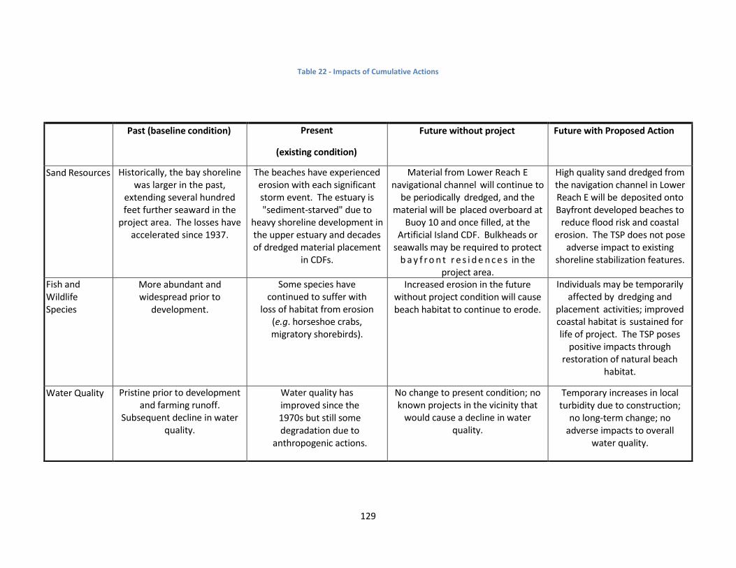
129
Table 22 - Impacts of Cumulative Actions
Past (baseline condition) Present
(existing condition)
Future without project Future with Proposed Action
Sand Resources Historically, the bay shoreline was larger in the past,
extending several hundred feet further seaward in the
project area. The losses have accelerated since 1937.
The beaches have experienced erosion with each significant storm event. The estuary is "sediment-starved" due to
heavy shoreline development in the upper estuary and decades of dredged material placement
in CDFs.
Material from Lower Reach E navigational channel will continue to
be periodically dredged, and the material will be placed overboard at
Buoy 10 and once filled, at the Artificial Island CDF. Bulkheads or
seawalls may be required to protect b a y f r o n t r e s i d e n c e s in the
project area.
High quality sand dredged from the navigation channel in Lower Reach E will be deposited onto Bayfront developed beaches to
reduce flood risk and coastal erosion. The TSP does not pose
adverse impact to existing shoreline stabilization features.
Fish and Wildlife Species
More abundant and widespread prior to
development.
Some species have continued to suffer with
loss of habitat from erosion (e.g. horseshoe crabs, migratory shorebirds).
Increased erosion in the future without project condition will cause beach habitat to continue to erode.
Individuals may be temporarily affected by dredging and
placement activities; improved coastal habitat is sustained for life of project. The TSP poses
positive impacts through restoration of natural beach
habitat.
Water Quality Pristine prior to development and farming runoff.
Subsequent decline in water quality.
Water quality has improved since the 1970s but still some degradation due to
anthropogenic actions.
No change to present condition; no known projects in the vicinity that
would cause a decline in water quality.
Temporary increases in local turbidity due to construction;
no long-term change; no adverse impacts to overall
water quality.

130
Short Term Uses of the Environment and Long-Term Productivity. The Delaware River port complex is
considered to be the world’s busiest freshwater port. The navigation channel requires periodic dredging
in areas that shoal. These periodic dredging events play a significant role in keeping the ports
competitive with others in the United States. Future maintenance dredging sand taken from the
navigation channel in lower Reach E would be placed at the Buoy 10 open water disposal site. Buoy 10
is estimated to be at or near capacity; however, USACE intends to expand the footprint and gain an
additional 10 years capacity via a revised Water Quality Certificate from NJDEP. Once Buoy 10 is filled to
capacity, future maintenance dredging sand would need to be transported and disposed at the nearest
CDF (Artificial Island) located approximately 40 miles to the north. Placement at either Buoy 10 or
Artificial Island provides no economic or environmental benefits to the proposed beach placement sites.
However, beneficial use of the high quality clean sand dredged from Lower Reach E placed on eroding
beaches provides substantial economic and environmental benefits.
Short-term use of the natural environment would be to achieve long-term productivity of the Delaware
River ports and increased CSRM to Bayfront communities. Dredging and placement operations both
place some stress on the aquatic environment (i.e. elevated turbidity and loss of benthic resources) with
limited long-term effects.
Irreversible and Irretrievable Commitments of Resources.
An irreversible commitment of resources is one in which the ability to use and/or enjoy the resource is
lost permanently. An irretrievable commitment of resources is one in which opportunities to use or
enjoy the resources as they presently exist are lost for a period of time due to decisions to mandate the
resource for another purpose. Beach placement operations would involve utilization of time and fossil
fuels, which are irreversible and irretrievable. Adverse environmental impacts associated with
placement operations are short-term in nature and will subside after construction is completed.
Placement of dredged material at the beneficial use sites is not irreversible. The project would provide
added CSRM to Bayfront communities from severe storm events but is not irreversible as storms will
continue to occur, and in combination with SLC, continue to erode the shoreline.
6 PUBLIC INVOLVEMENT, REVIEW AND CONSULTATION*
6.1 Public Involvement Program To announce the scoping phase of the feasibility study, a NEPA scoping letter was issued on 24
November 2014. The recipients were informed of the purpose and scope of the feasibility study and
were invited to provide input to the feasibility, including the scoping of the environmental issues that
should be addressed throughout the study. Following the 31 March 2015 Alternatives Milestone
meeting an additional NEPA scoping letter was issued on 27 April 2015.

131
6.2 Institutional Involvement
6.2.1 Agency Coordination
This feasibility study has been coordinated with the following agencies: the U.S. Fish and Wildlife Service
(USFWS), the National Marine Fisheries Service (NMFS), the U.S. Environmental Protection Agency
(EPA), and the New Jersey Department of Environmental Protection (NJDEP).
6.2.2 Compliance with Environmental Requirements
This section provides detailed discussion of agency coordination and associated environmental
requirements.
6.2.2.1 National Environmental Policy Act of 1969 (NEPA)
This feasibility report documents alternative plans evaluated and the effects of the alternative plans,
including the TSP, and contains an integrated Environmental Assessment. It will be subject to public
review and comment for a 45-day period. This public coordination and environmental impact
assessment complies with the intent of NEPA. The TSP is in compliance with the National Environmental
Policy Act of 1969, as amended, 42 U.S.C. 4321, et seq. P.L. 91-190.
6.2.2.2 Endangered Species Act of 1973
The TSP falls under the scope of the 20 November 2015 Biological Opinion Re-initiation – Deepening of
the Delaware River Federal Navigation Channel (NMFS, 2015). Consultation was reinitiated on 16
August 2016 with NMFS with the submittal of a Biological Assessment for the modification to
beneficially use the dredged material from Lower Reach E to place on the Bayfront beaches identified in
the TSP for this study. The project will adhere to the reasonable and prudent measures (RPMs) provided
in the Biological Opinion (NMFS, 2017) and terms of conditions necessary to minimize impacts to
shortnose and Atlantic sturgeon, sea turtles and whales. Pursuant to section 4(d) of the ESA, the project
will not impact designated critical habitat for the New York Bight DPS of Atlantic sturgeon.
Coordination with the USFWS New Jersey Field Office (NJFO) was initiated on 24 November 2014.
Consultation has been re-initiated and will be completed with USFWS review of the draft report.
Coordination with USFWS will be finalized prior to construction. This feasibility study is in compliance
with the Endangered Species Act of 1973, as amended, 16 U.S.C. 1531, et seq. P.L. 93-205.
6.2.2.3 Fish & Wildlife Coordination Act of 1958
Coordination with the USFWS for FWCA reports was initiated on 15 July 2015. The scope of work was
finalized on 11 September 2015. A Planning Aid Report was received from USFWS on 08 July 2016. A
final 2(b) report will be completed by the USFWS and submitted to USACE prior to finalization of the
feasibility report and integrated environmental assessment. The feasibility study is in compliance with
the Fish & Wildlife Coordination Act of 1958.
6.2.2.4 National Historic Preservation Act of 1966 (INTER ALIA)
The TSP is in compliance with Section 106 of the National Historic Preservation Act, as amended (P.L. 89-
665). As part of the requirements and consultation process contained within the National Historic
Preservation Act implementing regulations of 36 CFR 800, this TSP is also in compliance.

132
6.2.2.5 Clean Water Act of 1972
A Section 401 water quality certification application will be submitted to the New Jersey Department of
Environmental Protection (NJDEP) and USACE will obtain this certification prior to construction. All state
water quality requirements would be met. A Section 404(b)(1) evaluation is included in this report. The
feasibility study is in compliance with the Clean Water Act of 1972.
6.2.2.6 Clean Air Act of 1972
The short-term impacts from the construction equipment associated with the TSP will not significantly
impact air quality. The requirements of this rule are not applicable to this TSP because the project is
exempt from the General Conformity requirement under 40 CFR Ch. 1 Sec. 93.153(c)(2)(ix) for
maintenance dredging activities.
6.2.2.7 Coastal Zone Management Act of 1972
Coordination with the NJDEP requires Federal agencies to follow the state’s coastal management
policies to obtain Federal consistency under the Coastal Zone Management Act (CZMA). USACE has
determined that the TSP is consistent with the CZMA concerning acquisition of a Section 401 Water
Quality Certificate and other state authorizations. The draft feasibility report and integrated EA and
Section 404(b)(1) Evaluation have been submitted to the state in lieu of a summary of environmental
impacts to show consistency with the CZMA. A Federal consistency determination in coordination with
15 CFR 930 Subpart C will be obtained from the NJDEP prior to construction. Based on the information
contained in the scoping notice and comments provided by their reviewing agencies, the state had no
objections to the proposed activities.
6.2.2.8 Farmland Protection Policy Act of 1981
No prime or unique farmland would be impacted by implementation of this TSP. This Act is not
applicable to this project.
6.2.2.9 Wild and Scenic River Act of 1968
No designated Wild and Scenic river reaches would be affected by project-related activities. This Act is
not applicable to this project.
6.2.2.10 Marine Mammals Protection Act of 1972
USACE does not anticipate the take of any marine mammals during any activities associated with the
TSP. Should a hopper dredge be utilized, a trained government-certified sea turtle and marine mammal
observer will be stationed on the dredge during all water-related construction activities. Appropriate
actions will be taken to avoid adverse effects to listed and protected marine mammal species during
project construction, including all terms and conditions and reasonable and prudent measures provided
by NJDEP and NMFS. Therefore, this project is in compliance with this Act.
6.2.2.11 Estuary Protection Act of 1968
In the Estuary Protection Act of 1968, Congress declared that “many estuaries in the United States are
rich in a variety of natural, commercial and other resources, including environmental natural beauty,
and are of immediate and potential value to the present and future generations of Americans.” This Act
is intended to protect, conserve and restore estuaries in balance with developing them to further the

133
growth and development of the Nation. The TSP proposes to beneficially use sand material dredged
from the Delaware River Main Channel to restore eroded Bayfront barrier beaches. No development
will occur. The project will provide a positive benefit to the Delaware Estuary by keeping the dredged
sand within the lower estuarine system and will provide a sand source to neighboring undeveloped
beaches through natural longshore transport processes. Therefore, this TSP is consistent with the
purposes of this Act.
6.2.2.12 Federal Water Project Recreation Act
This Act provides funds for land acquisition or directs non-Federal agencies to administer project land
and water areas for recreation and fish and wildlife enhancement. In addition, while investigating and
planning a federal navigation, flood control reclamation, hydroelectric or multiple-purpose water
resource project, full consideration must be given to the opportunities when the project affords for
outdoor recreation and fish and wildlife enhancement. This TSP is consistent with the purposes of this
Act.
6.2.2.13 Magnuson-Stevens Fishery Conservation and Management Act of 1976
Coordination with NMFS to initiate consultation under the Magnuson-Stevens Fishery Conservation and
Management Act began on 22 December 2014. An Essential Fish Habitat Assessment was prepared for
the Delaware River Main Channel Deepening Project (the dredged material source) as well as for the
current EA (beneficial use placement areas). NMFS identified fish species with Essential Fish Habitat
Management Plans; identified ESA species and recommended avoiding sturgeon spawning habitat in the
upper Delaware River. NMFS advised that general time of year restrictions could be revised upon
review of the draft feasibility report and environmental assessment description of the TSP and its
potential impacts. The TSP is being coordinated with NMFS and is in compliance with the Act.
6.2.2.14 Submerged Lands Act of 1953
The project would occur on submerged lands of the State of New Jersey. The project is being
coordinated with the State and is in compliance with the Act.
6.2.2.15 Coastal Barrier Resources Act and Coastal Barrier Improvement Act of 1990
The Coastal Barrier Resources Act (CBRA) and the Coastal Barrier Improvement Act of 1990 (CBIA) limit
Federally subsidized development within CBRA System Units to limit the loss of human life by
discouraging development in high risk areas, to reduce wasteful expenditures of Federal resources and
to protect the natural resources associated with coastal barriers. No CBRA System Units will be
impacted by the proposed TSP beneficial use sites. The TSP is in compliance with the Coastal Barrier
Resources Act.
6.2.2.16 Rivers and Harbors Act of 1899
The Rivers and Harbors Act addresses river and harbor projects and activities within navigable waters.
The proposed action will beneficially use dredged material from the bay portion of the authorized
Philadelphia to the Sea Delaware River Navigation Channel to place on Bayfront beaches rather than
disposal at Buoy 10 or an upland CDF. The TSP is in compliance with this Act.

134
6.2.2.17 Anadromous Fish Conservation Act
This Act authorizes the Secretaries of the Interior and Commerce to enter into cooperative agreements
with the states and other non-Federal interests for conservation, development and enhancement of
anadromous fish and to contribute up to 50 percent as the Federal share of the cost of carrying out such
agreements. As this project is not receiving funding for these purposes, this Act does not apply.
6.2.2.18 Migratory Bird Treaty Act and Migratory Bird Conservation Act
Migratory birds would be minimally affected by dredging at the proposed sand source locations. USACE
will include the standard migratory bird protection requirements in the project plans and specifications
and will require the contractor to abide by those requirements. USACE will comply with all reasonable
and prudent measures as advised by the USFWS. Nourishment activities at the beach placement sites
will be monitored during the nesting season to protect nesting migratory birds. If nesting activities
occur within the construction area, appropriate buffers will be placed around nests to ensure their
protection. The TSP is in compliance with these Acts.
6.2.2.19 Marine Protection, Research and Sanctuaries Act (Ocean Dumping Act)
The term “dumping” as defined in the Act (3[33 U.S.C. 1402](f)) does not apply to the disposal of
material for beach nourishment or to the placement of material for a purpose other than disposal. The
disposal activities addressed in this EA have been evaluated under Section 404 of the Clean Water Act.
6.2.2.20 Uniform Relocation Assistance and Real Property Acquisition Policies Act of 1970
The purpose of this Act (PL 91-646) is to ensure that owners of real property to be acquired for Federal
and Federally assisted projects are treated fairly and consistently and that persons displaced as a direct
result of such acquisition will not suffer disproportionate injuries as a result of projects designed for the
benefit of the public as a whole. No acquisition of real property was considered. Therefore, this project
does not involve any real property acquisition or displacement of property owners or tenants.
Therefore, this Act is not relevant to this project.
6.2.2.21 Executive Order 11990, Protection of Wetlands
No wetlands would be affected by the TSP. The plan is in compliance with the goals of this Executive
Order.
6.2.2.22 Executive Order 11988, Floodplain Management
Executive Order 11988 requires federal agencies to avoid, to the extent possible, the long and short
term adverse impacts associated with the occupancy and modification of flood plains and to avoid direct
and indirect support of floodplain development wherever there is a practicable alternative. In
accomplishing this objective, “each agency shall provide leadership and shall take action to reduce the
risk of flood loss, to minimize the impact of floods on human safety, health, and welfare, and to restore
and preserve the natural and beneficial values served by flood plains in carrying out its responsibilities.
The Water Resources Council Floodplain Management Guidelines for implementation of EO 11988, as
referenced in USACE ER 1165-2-26, requires an eight step process that agencies should carry out as part
of their decision making on projects that have potential impacts to, or are within the floodplain. The
eight steps and project-specific responses to them are summarized below:
135
1. Determine if a proposed action is in the base floodplain (that area which has a one percent or
greater chance of flooding in any given year). The proposed action is within the base
floodplain; however, the project is designed to reduce damages to property and infrastructure
located landward of the proposed project.
2. If the action is in the base flood plain, identify and evaluate practicable alternatives to the
action or location of the action in the base flood plain. Chapter 3 of this document presents an
analysis of potential alternatives. Practicable measures and alternatives were formulated and
evaluated against Corps of Engineers guidance, including non-structural measures.
3. If the action must be in the flood plain, advise the general public in the affected area and
obtain their views and comments. There has been extensive coordination with pertinent
Federal, State and local agencies. The draft report was released for public review on 18 October
2017.
4. Identify beneficial and adverse impacts due to the action and any expected losses of natural
and beneficial flood plain values. Where actions proposed to be located outside the base
flood plain will affect the base flood plain, impacts resulting from these actions should also be
identified. The anticipated impacts associated with the TSP are summarized in Chapter 5 of this
report. Beneficial use of dredged material (consisting of predominantly coarse to medium-
grained clean sand) for placement on sandy beaches along the Delaware Bay will not only
reduce flood risks, but will restore or enhance the natural bayshore habitat. The nourished
sandy beach will reduce damages to fish, wildlife and other natural resources within this coastal
barrier system through restoration of habitat lost to erosion.
5. If the action is likely to induce development in the base flood plain, determine if a practicable
non-flood plain alternative for the development exists. The project provides benefits solely for
existing and previously approved development, and is not likely to induce development.
6. As part of the planning process under the Principles and Guidelines, determine viable
methods to minimize any adverse impacts of the action including any likely induced
development for which there is no practicable alternative and methods to restore and
preserve the natural and beneficial flood plain values. This should include reevaluation of the
No Action Alternative. There is no mitigation to be expected for the selected plan. The project
will not induce development in the flood plain and the project will not negatively impact the
natural or beneficial flood plain values. Chapter 3 of this report summarizes the alternative
identification, screening and selection process. The No Action Alternative was included in the
plan formulation phase.
7. If the final determination is made that no practicable alternative exists to locating the action
in the flood plain, advise the general public in the affected area of the findings. The Draft
Feasibility Report and Integrated Environmental Assessment was provided for public review on
18 October 2017. Each comment received will be addressed and, if appropriate, incorporated
into the Final Report. A record of all comments received will also be included in the Pertinent
Correspondence Appendix.
8. Recommend the plan most responsive to the planning objectives established by the study and
consistent with the requirements of the Executive Order. The recommended plan is the most
responsive to all of the study objectives and the most consistent with the executive order.

136
6.2.2.23 Executive Order 12898, Environmental Justice
On February 11, 1994, the President of the United States issued Executive Order 12898, Federal Actions
to Address Environmental Justice in Minority Populations and Low-Income Populations. The Executive
Order mandates that each Federal agency make environmental justice part of the agency mission and to
address, as appropriate, disproportionately high and adverse human health or environmental effects of
the programs and policies on minority and low-income populations.
The TSP is expected to result in coastal storm risk management benefits to residents of all
socioeconomic status. The beneficial effect of a wider, more sustainable beach and dune would benefit
all members of the public who are able to obtain transportation to access the beach. The storm damage
reduction benefits are primarily benefiting the landowners in this area. There are no disproportionate
adverse impacts to minority or low income populations resulting from the implementation of the TSP.
6.2.2.24 Executive Order 13045, Disparate Risks Involving Children
On April 21, 1997, the President of the United States issued Executive Order 13045, Protection of
Children from Environmental Health Risks and Safety Risks. The Executive Order mandates that each
Federal agency make it a high priority to identify and assess environmental health risks and safety risks
that may disproportionately affect children and ensure that its policies, programs, activities and
standards address disproportionate risks to children that result from environmental health risks or
safety risks. As the TSP does not affect children disproportionately from other members of the
population, the proposed action would not increase any environmental health or safety risks to children.

137
7 LIST OF PREPARERS The project delivery team (PDT) prepared the report and consisted of the following people:
Table 23 – Project Delivery Team
Name Discipline
Scott Sanderson USACE – Project Manager
Barbara Conlin USACE – Environmental Coordinator
Preston Oakley USACE – Economics
Robert Hampson USACE – Hydrology & Hydraulics
Nicole Minnichbach USACE – Cultural Resources
Patrick Falvey USACE – Civil Design
Derek Martowska USACE – Geotechnical Engineering
William Harris USACE – GeoEnvironmental
Alfredo Montes USACE – Cost Engineering
Heather Sachs USACE – Real Estate
Steve Long USACE – GIS & Floodplain Management
William Dixon NJDEP – Non-Federal Sponsor
Glenn Golden NJDEP – Non-Federal Sponsor
Robert VonBriel NJDEP – Non-Federal Sponsor
8 IMPLEMENTATION REQUIREMENTS
8.1 Institutional Requirements The completion of the feasibility study and recommendation by the District Engineer are the first steps
toward implementing the design and construction of the CSRM project along the New Jersey shoreline
of the Delaware Bay. Upon approval by USACE’s ASA (CW), the project will be considered for design and
construction with funding made available through P.L. 113-2 and/or a Water Resources Development
Act (WRDA).
Upon receipt of Federal construction funds, USACE and the non-Federal sponsor would enter into a
Project Partnership Agreement (PPA). This PPA would define the Federal and non-Federal

138
responsibilities for implementing, operating and maintaining the project. The Total Project Cost (Fully
Funded) of the CSRM project will be cost-shared 65% by the Federal government and 35% by the non-
Federal sponsor. The non-Federal sponsor (NJDEP) must comply with all applicable Federal laws and
policies and other requirements, including but not limited to:
Provide a minimum of 35% of initial project costs assigned to coastal and storm damage
reduction, plus 100% of initial project costs assigned to protecting undeveloped private lands
and other private shores which do not provide public benefits, and 50% of periodic nourishment
costs assigned to coastal and storm damage reduction, plus 100% of periodic nourishment costs
assigned to protecting undeveloped private lands and other private shores which do provide
public benefits, and as further described below:
o Provide, during design, 35% of design costs allocated to coastal and storm damage
reduction in accordance with the terms of the PPA entered into prior to commencement
of design work for the project;
o Provide all lands, easements, rights-of-way, including suitable borrow areas, and
perform or assure performance of all relocations, including utility relocations, as
determined by the Federal government to be necessary for the initial construction,
periodic nourishment or operation and maintenance of the project;
o Provide, during construction, any additional amounts necessary to make its total
contribution equal to 35% of initial project costs assigned to coastal and storm damage
reduction plus 100% of initial project costs assigned to protecting undeveloped private
lands and other private shores which do not provide public benefits;
Perform, or cause to be performed, any investigations for hazardous substances as are
determined necessary to identify the existence and extent of any hazardous substances
regulated under the Comprehensive Environmental Response, Compensation, and Liability Act
(CERCLA), Public Law (PL) 96-510, as amended, 42 U.S.C. 9601-9675, that may exist in, on, or
under lands, easements, or rights-of-way that the Federal government determines to be
required for the construction, operation, and maintenance of the project.
Coordinate all necessary cleanup and response costs of any CERCLA-regulated materials located
in, on, or under lands, easements, or rights-of-way that the Federal government determines to
be necessary for the construction, operation, or maintenance of the project.
Coordinate mitigation and data recovery activities associated with historic preservation, that are
in excess of one percent of the total amount authorized to be appropriated for the project.
Operate, maintain, repair, replace, and rehabilitate the completed project, or functional portion
of the project, including mitigation features, at no cost to the government, in a manner
compatible with the project’s authorized purposes and in accordance with applicable Federal
and state laws and any specific directions prescribed by the government in the Operations,
Maintenance, Replacement, Repair and Rehabilitation (OMRR&R) manual and any subsequent
amendments thereto.
Provide the Federal government a right to enter, at reasonable times and in a reasonable
manner, upon property that the non-Federal project partner, now or hereafter, owns or controls
for access to the project for the purpose of inspection, and, if necessary after failure to perform

139
by the non-Federal project partner, for the purpose of completing, operating, maintaining,
repairing, replacing, or rehabilitating the project. No completion, operation, maintenance,
repair, replacement, or rehabilitation by the Federal government shall operate to relieve the
non-Federal project partner of the responsibility to meet the non-Federal project partner’s
obligations, or to preclude the Federal government from pursuing any other remedy at law or
equity to ensure faithful performance.
Hold and save the United States free from all damages arising from the construction, operation,
maintenance, repair, replacement, and rehabilitation of the project and any project-related
betterments, except for damages due to the fault or negligence of the United States or its
contractors.
Keep, and maintain books, records, documents, and other evidence pertaining to costs and
expenses incurred pursuant to the project in accordance with the standards for financial
management systems set forth in the Uniform Administrative Requirements for Grants and
Cooperative Agreements to State and Local governments at 32 codes of Federal regulations
(CFR) Section 33.20.
As between the Federal government and the non-Federal project partners, the non-Federal
project partner shall be considered the operator of the project for the purpose of CERCLA
liability. To the maximum extent practicable, operate, maintain, repair, replace and rehabilitate
the project in a manner that will not cause liability to arise under CERCLA.
Comply with applicable provisions of the Uniform Relocation Assistance and Real Property
Acquisition Policies Act of 1790, Public Law 91-646, as amended by Title IV of the Surface
Transportation and Uniform Relocation Assistance Act of 1987 (Public Law 100-17), and the
uniform regulations contained in 49 CFR Part 24, in acquiring lands, easements, and rights-of-
way, required for construction, operation, and maintenance of the project, including those
necessary for relocations, borrow materials, and dredged or excavated material disposal, and
inform all affected persons of applicable benefits, policies, and procedures in connection with
said Act.
Comply with all applicable Federal and state laws and regulations, including, but not limited to,
Section 601 of the Civil Rights Act of 1964, Public Law 88-352 (42 U.S.C. 2000d), and Department
of Defense directive 5500.11 issue pursuant thereto, as well as Army regulation 600-7, entitled
“Nondiscrimination on the Basis of Handicap in Programs and Activities Assisted of Conducted
by the Department of the Army.
Participate in and comply with applicable Federal flood plain management and flood insurance
programs and comply with requirements in Section 402 of the Water Resources Development
Act of 1986, as amended.
Not less than once each year inform affected interests of the extent of protection afforded by
the project.
Publicize floodplain information in the area concerned and provide this information to zoning
and other regulatory agencies for their use in preventing unwise future development in the
flood plain and in adopting such regulations as may be necessary to prevent unwise future
development and to ensure compatibility with the protection provided by the project.

140
Prevent obstructions of or encroachments on the project (including prescribing and enforcing
regulations to prevent such obstructions or encroachments) which might hinder its operation
and maintenance, or interfere with its proper function, such as any new development on the
project lands or the addition of facilities which would degrade the benefits of the project.
Provide and maintain necessary access roads, parking areas, and other public use facilities, open
and available to all on equal terms.
Comply with Section 221 of Public Law 91-611, Flood Control Act of 1970, as amended, and
Section 103 of the Water Resources Development Act of 1986, Public Law 99-662, as amended,
which provides the Secretary of the Army shall not commence the construction any water
resources project or separable element thereof, until the non-Federal project partner has
entered into a written agreement to furnish its required cooperation for the project or
separable element.
At least twice annually and after storm events, perform surveillance of the Line of Protection
and determine any physical variances from the project design section and provide the results of
such surveillance to the Federal government.
Inform affected interests, at least annually, of the extent of protection afforded by the structural
flood damage reduction features.
Assume, as between the Federal government and the non-Federal sponsor, complete financial
responsibility for all necessary cleanup and response costs of any hazardous substances
regulated under CERCLA that are located in, on, or under lands, easements, or rights-of-way
required for construction, operation, maintenance, repair, rehabilitation, or replacement of the
project.
Not use funds from other Federal programs, including any non-Federal contribution required as
a matching share therefore, to meet any of the non-Federal sponsor’s obligations for the project
unless the Federal agency providing the funds verifies in writing that such funds are authorized
to be used to carry out the project.
8.2 Implementation Schedule Before design and construction may be initiated, the report must be approved and submitted to the
Office of Management & Budget. Further, the PPA must be executed by USACE and the non-Federal
sponsor. The following provides the current schedule for study approval and PPA execution:
Final Feasibility Report & Integrated EA to Corps Higher Authority for Approval June 2018
Chief’s Report submitted to ASA (CW) February 2019
ASA (CW) Final Feasibility Report & Integrated EA Approval August 2019
ASA (CW) submits report to OMB August 2019
Final Report to Congress August 2019
Start Plans and Specifications (Design Phase) March 2020
Execute PPA with non-Federal Sponsor March 2020
Finalize Plans and Specifications for Contract November 2020
Real Estate Certification for Contract February 2021

141
Ready to Advertise Contract March 2021
Award Construction Contract with Notice to Proceed October 2021
Complete Project Construction June 2022
8.3 Cost Apportionment As referenced above in Table 14 of Section 3.5.1, the total project cost is approximately $113,000,000.
The cost sharing is 65% Federal and 35% non-Federal, which includes cash and credits associated with
obtaining the required lands, easements, rights-of-way, and relocations (LERR). OMRR&R is a 100% non-
Federal responsibility and is included in the calculation of annualized project costs for economic
purposes. The Federal government will design the project, prepare detailed plans/specifications and
construct the project, exclusive of those items specifically required of the non-Federal partner.
The non-Federal partner is responsible for all LERR costs and all OMRR&R costs.
Table 24 – Estimated Schedule of Federal and Non-Federal Expenditures
Non-Federal Sponsor Contribution
Federal Contribution Total Project Cost
LERRD $7,986,835 N/A $7,986,835
Cash $31,664,825 $73,638,798 $105,303,623
Total $39,651,660 $73,638,798 $113,290,458
8.4 Environmental Requirements Requirements for Section 404 of the Clean Water Act of 1972, as amended, will be met prior to any
construction activity. The completed 404(b)(1) guidelines form is included in Appendix D.
A Section 401 Water Quality Certification and a consistency determination under the Coastal Zone
Management Act will be obtained from the State of New Jersey prior to project construction.
Requirements for the Endangered Species Act will be met with both USFWS and NMFS prior to
construction. Coordination with the resource agencies has occurred. For NMFS, compliance was
received under the Delaware River Main Channel Deepening Project Biological Opinion (BO).
8.5 Views of Non-Federal Sponsor The NJDEP fully supports the TSP and its associated implementation requirements. While this TSP
improves coastal protection along New Jersey's Delaware Bay shoreline, NJDEP requests that USACE
continue to look at maximizing opportunities for coastal resilience in New Jersey's Delaware Bay.
Specifically, NJDEP is aware that communities such as Reeds Beach, Pierces Point and Del Haven were
not incrementally justified; however, they were economically justified when evaluated as components
of a systematic solution, based on a continuous dredged material placement operation across 6 sites
(Gandys Beach, Fortescue, Reeds Beach, Pierces Point, Del Haven and Villas). NJDEP recognizes that the
TSP will undergo optimization and requests that the aforementioned systematic-benefits and their

142
associated regional economic and social impacts be strongly considered before finalization of the
recommended plan.
9 REFERENCES Abbott, R., J. Reyff and G. Marty, 2005. Final Report: Monitoring the Effects of Conventional Pile Driving
on Three Species of Fish. Richmond, CA: Manson Construction Company.
Adriannse, L.A. and J. Coosen, 1991. Beach and Dune Nourishment and Environmental Aspects. Coastal
Engineering 16: 129-146.
Allen, K.O. and J.W. Hardy, 1980. Impacts of Navigation Dredging on Fish and Wildlife: A Literature
Review. U.S. Fish and Wildlife Service. Biological Service Program. FWS: OBS-80/07. 81 pp.
Amos, W., 1966. The Life of the Seashore. New York: McGraw-Hill, Inc.
Atkins Global, 2009. Management Plan for the Delaware Bay Beaches.
Aresco, M.J., 1996. Malaclemys terrapin terrapin Reproduction and Nest Predation. Herpetological
Review 27(2): 77.
Bohlen, W.F., 1978. Factors Governing the Distribution of Dredged Suspended Sediments. Proceedings
of the 16th Coastal Engineering Conference, American Society of Civil Engineers. West Germany.
Botton, M. and R. Loveland, 1989. Reproductive Risk: High Mortality Associated with Spawning by
Horseshoe Crabs (Limulus Polyphemus) in Delaware Bay, USA, Mar. Biol. 101: 143-151.
Botton, M.L. and R.E. Loveland, 1987. Orientation of the Horseshoe Crab (Limulus polyphemus) on a
Sandy Beach. Biol. Bull. (Woods Hole) 173: 289-298.
Burger, J., 1981. The Effect of Human Activity on Birds at a Coastal Bay. Biological Conservation, Vol. 21,
Issue 3, pg 231-241.
Burger, J., 1976. Behavior of Hatchling Diamondback Terrapins (Malaclemys Terrapin) in the Field.
Copeia 1976(4): 742-748.
Burger, J. and W.A. Montevecchi, 1975. Nest Site Selection in the Terrapin Malaclemys Terrapin. Copeia
1975(1): 113-119.
Bushek, D., S. Ford and S.E. Burt, 2012. Long-term Patterns of an Estuarine Pathogen Along a Salinity
Gradient. J. Mar. Res. 70: 225-251.
Butler, J.A., C. Broadhurst, M. Green, and Z. Mullin, 2004. Nesting, Nest Predation and Hatchling
Emergence of the Carolina Diamondback Terrapin, Malaclemys Terrapin Centrata, in Northeastern
Florida.

143
Caudill, J. and E. Henderson, 2005. Banking on Nature 2004: The Economic Benefits to Local
Communities of National Wildlife Refuge Visitation. U.S. Department of the Interior, Fish and Wildlife
Service, Division of Economics, Washington DC. Pp 345-349.
Chambers, R.M., 2000. Population Study of Diamondback Terrapins of the Lower Housatonic River. Pp.
14.
Chipley, R.M., G.H. Fenwick, J.J. Parr, and D.N. Pashley, 2003. The American Bird Conservancy Guide to
the 500 Most Important Bird Areas in the United States. American Bird Conservancy, New York.
Coxe, R., 2009. Guide to Delaware Vegetation Communities. 442 pp.
Curtis, L., 1975. Distribution of Sabellaria vulgaris Verrill (Polychaeta: Sabellaridae) on a Sandflat in
Delaware Bay. Chesapeake Science 16:14-19.
Curtis, L., 1973. Aspects of the Life Cycle of Sabellaria vulgaris Verrill (Polychaeta: Sabellaridae) in
Delaware Bay. Ph.D. Dissertation, University of Delaware, Newark, DE.
Delaware Estuary Regional Sediment Management Workgroup, 2013. Delaware Estuary Regional
Sediment Management Plan: A Comprehensive Long-term Master Plan to Identify a New Sediment
Management Program, Procedures and Management Practices with Regionally-targeted Goals,
Objectives and Strategies.
DNREC, 2012. Preparing for Tomorrow’s High Tide: Sea Level Rise Vulnerability Assessment for the State
of Delaware. Delaware’s Sea Level Rise Advisory Council.
DNREC, 1997. Summary of the Delaware 1999 Rate-of-Progress Plan for Kent and New Castle Counties
for Demonstrating Progress Toward Attainment of the National Ambient Air Quality Standard for Ozone.
Draud, M., M. Bossert, and S. Zimnavoda, 2004. Predation on Hatchling and Juvenile Diamondback
Terrapins (Malaclemys Terrapin) by the Norway Rat (Rattus Norvegicus). Journal of Herpetology 38(3):
467-470.
DRBC, 2014. Delaware River and Bay Water Quality Assessment. 88 pp.
DRBC, 2012. Delaware River and Bay Water Quality Assessment.
Dubois, S., C. Retiere, and F. Olivier, 2002. Biodiversity Associated with Sabellaria alveolata (Polychaeta:
Sabellaridae) Reefs: Effects of Human Disturbances. Journal of the Marine Biological Association (United
Kingdom) 82(05): 817-826.
Engelhart, S.E., B.P. Horton, B.C. Douglas, W.R. Peltier, T.E. Tornqvist, 2009. Spatial Variability of Late
Holocene and 20th Century Sea-Level Rise along the Atlantic Coast of the United States. Geology 37,
1115-1118.

144
Farrell, S.C., S. Hafner, K. McKenna, C. Robine, B. Smith, N. DiCosmo, M. Gruver, A. Ferencz, C. Tracey, H.
Pimpinelli, 2016. The New Jersey Network: Annual Report on Monitoring New Jersey Beaches, Spring
2014 through Fall 2015. NJDEP, Bureau of Coastal Engineering, Toms River, NJ 166 pp.
Feinberg, J.A. and R.L. Burke, 2003. Nesting Ecology and Predation of Diamondback Terrapins,
Maleclemys Terrapin, at Gateway National Recreation Area, New York. Journal of Herpetology 37(3):
517-526.
Fletcher, J.L. and R.G. Busnel, 1978. Effects of Noise on Wildlife. Academic Press, New York.
French, G.T., 1990. Historical Shoreline Changes in Response to Environmental Conditions in West
Delaware Bay. MS Thesis submitted to University of Maryland.
GCRP, 2009. Coastal Sensitivity to Sea-Level Rise: A Focus on the Mid-Atlantic Region. A Report by the
U.S. Climate Change Science Program and the Subcommittee on Global Change Research. [James G.
Titus (Coordinating Lead Author), Eric K. Anderson, Donald R. Cahoon, Stephen Gill, Robert E. Thieler,
Jeffress S. Williams (Lead Authors)]. U.S. Environmental Protection Agency, Washington D.C., USA.
Walters, 1992.
Gebert, J.A. and R. Searfoss, 2012. Chapter 4 Sediments. Technical Report, Delaware Estuary and Basin,
PDE Report #12-01.
Gehagan & Bryant Associates, Inc., 2013. Delaware River Main Channel Deepening Project,
Supplemental Geotechnical Subsurface Investigation, Reach E – Stations 350+000 to 515+000, Final
Report. Gehagan & Bryant Associates, Inc., Baltimore, MD.
Gibbons, J.W., J.E. Lovich, A.D. Tucker, N.N. Fitzsimmons, and J.L. Greene, 2001. Demographic and
Ecological Factors Affecting Conservation and Management of the Diamondback Terrapin (Malaclemys
Terrapin) in South Carolina. Chelonian Conservation and Biology 4(1): 66-74.
Goertner, J.F., M.L. Wiley, G.A. Young and W.W. McDonald, 1994. Effects of Underwater Explosions on
Fish Without Swimbladders. Naval Surface Warfare Center Report NSWC TR88-114. Fort Belvoir, VA:
Defense Technical Information Center.
Gore, R., L. Scotto, and L. Becker, 1978. Community Composition, Stability, and Trophic Partitioning in
Decapod Crustaceans Inhabiting some Subtropical Sabellariid Worm Reefs. Bulletin of Marine Science
28: 221-248.
Govoni, J.J., M.A. West, L.R. Settle, R.T. Lynch and M.D. Greene, 2008. Effects of Underwater Explosions
on Larval Fish: Implication for a Coastal Engineering Project. Journal of Coastal Research 24, 228-233.
Helser, T.E. and D. Kahn, 2001. Stock Assessment of Delaware Bay Blue Crab (Callinectes sapidus) for
2001. Department of Natural Resources and Environmental Control, Dover, Delaware.

145
Houghton, J.P. and D.R. Mundy, 1987. Effects of Linear Explosive Seismic Energy Releases on Fish in
Alaska’s Transition Zones. Contract Report 06793-004-020; Anchorage, AK: Alaska Oil and Gas
Association.
http://tidesandcurrents.noaa.gov/sltrends/sltrends.shtml
Kaufman, G.J., 2011. Socioeconomic Value of the Delaware River Basin in Delaware, New Jersey, New
York, and Pennsylvania, The Delaware River Basin an Economic Engine for Over 400 Years. University of
Delaware, Newark, DE.
Knutson, P.L., 1988. Role of Coastal Wetlands in Energy Dissipation and Shore Protection. In Ecology of
Wetlands, edited by D.D. Hook. Timber Press, Portland, OR: 161-174.
Krauter, J.N., S. Ford and M. Cummings, 2007. Oyster Growth Analysis: A Comparison of Methods. J.
Shellfish Res. 26: 479-491.
Kreeger, D., J. Adkins, P. Cole, R. Najjar, D. Velinsky, P. Conolly, and J. Kraeuter, 2010. Climate Change
and the Delaware Estuary: Three Case Studies in Vulnerability Assessment and Adaptation Planning.
Partnership for the Delaware Estuary, PDE Report No. 10-01. 1-117 pp.
Kryter, K.D., 1985. The Handbook of Hearing and the Effects of Noise (2nd ed.). Academic Press, Orlando,
Florida.
Lathrop, R.G. Jr., M. Allen and A. Love, 2006. Mapping and Assessing Critical Horseshoe Crab Spawning
Habitats of Delaware Bay. Center for Remote Sensing & Spatial Analysis, Rutgers University, New
Brunswick, New Jersey. 37 pp.
Lewes, D.A., J.A. Cooper, and O.H. Pilkey, 2005. Fetch-limited Barrier Islands of Chesapeake Bay and
Delaware Bay. Southeastern Geology 44(1): 1-17.
Lovich, J.A., D. Anton, D.E. Kling, and W. Gibson, 1991. Behavior of Hatchling Diamondback Terrapins
(Malaclemys Terrapin) Release in a South Carolina Salt Marsh.
Lynn, K. and D. Sheingold, 2015. Incomes Up, Poverty Down in NJ – But Only Slightly. North Jersey
Media Group. 17 September 2015 Publication.
Maurer, D., L. Watling, P. Kinner, W. Leathem and C. Wethe, 1978. Benthic Invertebrate Assemblages of
Delaware Bay. Marine Biology Vol. 45: pp 65-78.
McHugh, J.L., 1981. Marine Fisheries of Delaware. NOAA, Fish. Bull. 79: 575-599.
Merson, R.R. and H.L. Pratt, Jr., 2001. Distribution, Movements and Growth of Young Sandbar Sharks
(Carcharhinus plumbeus) in the Nursery Grounds of Delaware Bay. Envir. Bio. of Fishes 61: 13-24.
Munroe, D., A. Tabatabai, I. Burt and J. Wilkin, 2013. Oyster Mortality in Delaware Bay: Impacts and
Recovery from Hurricane Irene and Tropical Storm Lee. Estuarine Coastal and Shelf Science 135: 209-
219.

146
Najjar, R., 2009. Analysis of Climate Simulations for Use in the “Climate-Ready Adaptation Plan for the
Delaware Estuary.” An Interim Report to the Partnership for the Delaware Estuary. 18 pp.
National Research Council, 2007. Mitigating Shoreline Erosion along Sheltered Coasts. National
Academies Press: Washington, D.C.
Nedwell, J.R., A.W.H. Turnpenny, J.M. Lovell and B. Edwards, 2006. An Investigation into the Effects of
Underwater Piling Noise on Salmonids. Journal of the Acoustical Society of America 120, 2550-2554.
New Jersey Legal Services, 2015. Poverty Benchmarks: The Annual Overview of New Jersey’s Progress
Against Poverty. 141 pgs.
NMFS, 2011. Endangered Species Act, Biological Opinion for the U.S. Army Corps of Engineers,
Philadelphia District Deepening of the Delaware River Federal Navigation Channel (Reinitiation).
National Marine Fisheries Service F/NER/2011/00574.
NOOA, 2009. NOAA Tides & Currents, Sea Level Trends.
Palmer, W.M. and C.L. Cordes, 1988. Habitat Suitability Index Models: Diamondback Terrapin (nesting)
Atlantic Coast. U.S. Fish and Wildlife Service, Biological Report 82(10.151). 18p.
PECO, 1977 (Philadelphia Electric Company) Chester Generating Station 316(b) Report.
Pennock, J.R. and S.S. Herman, 1988. Plankton. Pages 55-69 in T.L. Bryant and J.R. Pennock, Eds. The
Delaware Estuary: Rediscovering a Forgotten Resource. University of Delaware Sea Grant College
Program, Newark, DE 144 pp.
Pitler, R., 1985. Malaclemys Terrapin Terrapin (Northern Diamondback Terrapin) Behavior.
Herpetological Review 16(3): 82.
Popper, A.N. and M.C. Hastings, 2009. The Effects on Fish of Human-generated (Anthropogenic) Sound.
Integrative Zoology (in press).
Popper, A.N., J. Fewtrell, M.E. Smith and R.D. McCauley, 2004. Anthropogenic Sound: Effects on the
Behavior and Physiology of Fishes. MTS J. 37:35-40.
Popper, A.N., 2003. Effects of Anthropogenic Sound on Fishes. Fisheries 28, 24-31.
Powell, E.N., K.A. Ashton-Alcox and D. Bushek, 2012. Report of the 2012 Stock Workshop (14th SAW) for
the New Jersey Delaware Bay Oyster Beds. Haskin Shellfish Research Laboratory, Rutgers University,
Port Norris, NJ 155 pg.
Psuty, N.P., A. Spahn, S. Grogan, J. Greenberg, R.T. Fullmer, and B. Kempf, 2014. Shoreline Change along Prime Hook National Wildlife Refuge: Annual Monitoring Report, 2011-2014. U.S. Fish and Wildlife Service, Hadley, MA.
147
Psuty, N.P., M. Duffy, J.F. Pace, D.E. Skidds, and T.M. Silveria, 2010. Northeast Coastal and Barrier
Geomorphological Monitoring: Part I - Ocean Shoreline Position. Natural Resources Report
NPS/NCBN/NRR-2010/185. National Park Service, Fort Collins, CO.
Rechisky, E.L. and B.M. Wetherbee, 2003. Short-term Movement of Juvenile and Neonate Sandbar
Sharks (Carcharhinus Plumbeus) on Their Nursery Grounds in Delaware Bay. Envir. Bio. Of Fishes 61: 13-
24.
Richardson, W.J., C.R. Greene Jr., C.L. Malme and D.H. Thomson, 1995. Marine Mammals and Noise.
Academic Press, New York.
RMC Environmental Services, 1988. Comprehensive Navigation Study, Delaware River, Philadelphia to
the Sea. Benthic Community Analysis of Selected Localities within the Delaware River and Bay. Prepared
for the U.S. Army Corps of Engineers, Philadelphia District. 60 pp.
Roosenburg, W.M., T.A. Radzio, and P.E. Allman, 2004. Terrapin Monitoring at Poplar Island 2003.
Roosenburg, W.M., 1993. Final Report, the Chesapeake Bay Diamondback Terrapin Investigations 1992.
Chesapeake Research Consortium, CRC Publication Number 146.
Roosenburg, W.M., 1990. Final Report, Chesapeake Diamondback Terrapin Investigations for the Period
1987, 1988 and 1989. Chesapeake Research Consortium, CRC Publication Number 133.
Rosen, P.S., 1980. Erosion Susceptibility of the Virginia Chesapeake Bay Shoreline. Marine Geology 34:
45-50.
Rosen, P.S., 1978. A Regional Test of the Bruun Rule on Shoreline Erosion. Marine Geology 26: M7-M16.
Rosen, P.S., 1977. Increasing Shoreline Erosion Rates with Decreasing Tidal Range in the Virginia
Chesapeake Bay. Chesapeake Science 18(4): 383-386.
Ruggerone, G.T., S.E. Goodman and R. Miner, 2008. Behavioral Response and Survival of Juvenile Coho
Salmon to Pile Driving Sounds. Seattle, WA: Natural Resource Consultants, Inc. for Port of Washington.
Sargent, B. Pierre, George M. Farlekas, and Otto S. Zapecza, 1985. New Jersey Ground-Water Resources.
Schnabel Engineering, 2007. Geotechnical Data Report Vibrational Coring Cape May Villas, Cape May,
New Jersey for the U.S. Army Corps of Engineers. Contract #W912BU-05-D-001. Schnabel Engineering,
510 East Gay Street, West Chester, Pennsylvania 19380.
Schuster, E., 2016. Delaware Bayshore Tourism Survey Results, Cumberland County, NJ. The Nature
Conservancy.
Schuster, E. and M. Botton, 1985. A Contribution to the Population Biology of Horseshoe Crabs (Limulus
Polyphemus) in Delaware Bay. Estuaries 8: 363-372.

148
Scott, L.C., 2014. Benthic Community Resource Monitoring and Assessment for the Lower Delaware Bay Prime Hook National Wildlife Refuge Dune Breach Repair Project, DE. Prepared for U.S. Army Corps of Engineers, Philadelphia District by Versar, Inc., Columbia, MD.
Sexton, N.R., S.C. Stewart, L. Koontz, P. Ponds, and K.D. Walters, 2007. Visitor and Community Survey
Results for Prime Hook National Wildlife Refuge: Completion Report. U.S. Geological Survey, Biological
Resources Discipline, Open-File Report 2007-1239. 63 pp.
Southwick Associates, 2011. The Economics Associated with Outdoor Recreation, Natural Resources
Conservation and Historic Preservation in the United States. The Fish and Wildlife Foundation,
Fernandina Beach, FL. 33 pp.
Szerlag, S. and S.P. McRobert, 2006. Road Occurrence and Mortality of the Northern Diamondback
Terrapin. Applied Herpetology 3: 27-37.
The Academy of Natural Sciences of Philadelphia, 1981. Biological Effects of the Proposed Bulkhead for
the Scott Paper Company, Chester, PA, Report No. 81-19D. 200 pp.
Tiner, R.W., N.A. Biddle, A.D. Jacobs, A.B. Rogerson, and K.G. McGuckin, 2011. Delaware Wetlands:
Status and Changes from 1992 to 2007. Cooperative National Wetlands Inventory Publication. U.S. Fish
and Wildlife Service, Northeast Region, Hadley, MA and the Delaware Department of Natural Resources
and Environmental Control, Dover, DE 35 pp.
UCS, 2008. Climate Change in Pennsylvania: Impacts and Solutions for the Keystone State. Union of
Concerned Scientists, Cambridge MA. 54 pp.
USACE, 2015. North Atlantic Coast Comprehensive Study: Resilient Adaptation to Increasing Risk
USACE, 2013. Final Environmental Assessment, Delaware River Main Channel Deepening Project,
Delaware Bay Economic Loading, Mechanical Dredging and Placement of Dredged Material at the Fort
Mifflin Confined Disposal Facility, U.S. Army Corps of Engineers, Philadelphia District.
USACE, 2011. Final Environmental Assessment, Delaware River Main Channel Deepening Project, U.S.
Army Corps of Engineers, Philadelphia District.
USACE, 2011. A Supplemental Biological Assessment for Potential Impacts to the New York Bight Distinct
Population Segment of Atlantic Sturgeon (Acipenser oxyrinchus oxyrinchus) which is Proposed for
Federal Endangered Species Listing Resulting from the Delaware River Main Stem and Channel
Deepening Project, U.S. Army Corps of Engineers, Philadelphia District.
USACE, 2009. Delaware River Main Stem and Channel Deepening Project, Environmental Assessment,
U.S. Army Corps of Engineers, Philadelphia District.
USACE, 1997. Delaware River Comprehensive Navigation Study, Main Channel Deepening Project
(Pennsylvania, New Jersey, and Delaware), Final Supplemental Environmental Impact Statement, U.S.
Army Corps of Engineers, Philadelphia District.

149
USACE, 1992. Delaware River Comprehensive Navigation Study, Main Channel Deepening, Final Interim
Feasibility Study and Environmental Impact Statement, U.S. Army Corps of Engineers, Philadelphia
District.
USACE, 1980. Final Environmental Impact Statement: Commercial Soil and Gravel Dredging, Allegheny
River, PA (Mile 0 to Mile 62.2). Pittsburgh, PA.
USEPA/USACE, 1998. Evaluation of Dredged Material Proposed for Discharge in Waters of the U.S. –
Testing Manual (Inland Testing Manual). Prepared by the Environmental Protection Agency Office of
Water, Office of Science and Technology, Washington, D.C. and Department of the Army United States
Army Corps of Engineers Operations, Construction and Readiness Division, Washington, D.C.
USEPA, 2016. Inventory of U.S. Greenhouse Gas Emissions and Sinks, 1990-2014.
USFWS, 2016. Planning Aid Report, Dredged Material Utilization Study for the Delaware River and Bay
Shoreline, Kent, New Castle, and Sussex Counties, Delaware. USFWS, Ecological Services, Region 5,
Chesapeake Bay Field Office, Annapolis, Maryland.
USFWS, 2015. Prime Hook National Wildlife Refuge Environmental Assessment.
USFWS, 2014. Final Environmental Assessment for the Gandys Beach/Money Island Living Shorelines
Project, 33 pp.
USFWS, 2014. Rufa Red Knot Background Information and Threats Assessment. Supplement to
Endangered and Threatened Wildlife and Plants: Final Threatened Status for the Rufa Red Knot (Calidris
canutus rufa). New Jersey Field Office, Pleasantville, New Jersey. 383 pp.
USGS, 2012. Prepared Under a Mission Assignment with the Federal Emergency Management Agency
Open File Report 2013-1043, U.S. Department of the Interior, U.S. Geological Survey: Monitoring Storm
Tide and Flooding from Hurricane Sandy along the Atlantic Coast of the United States (by Brian E.
McCallum, Shaun M. Wicklein, Robert G. Reiser, Ronald Busciolano, Jonathan Morrison, Richard J. Verdi,
Jaime A. Painter, Eric R. Frantz, and Anthony J. Gotvald).
Versar, Inc., 2005. Delaware River Philadelphia, Pennsylvania to New Castle, Delaware Chemical Analysis
of Dredged River Sediments. Prepared for USACE, Philadelphia District. Contract No. DACW61-00-D-0009
Task Order No. 0076.
Versar, Inc., 2003. Chemical Analysis of Maintenance Dredge Material from the Marcus Hook,
Deepwater Point, and New Castle Navigational Ranges. Prepared for USACE, Philadelphia District.
Contract No. DACW61-00-D-0009 Task Order No. 0045.
Versar, Inc., 2001a. Pre-Construction Oyster, Water Quality, and Sediment Monitoring Study for the
Delaware River Main Channel Deepening Project 2000/2001. Prepared for USACE, Philadelphia District.
Contract No. DACW61-95-D-0011 Task Order No. 0086.

150
Versar, Inc., 2001b. Near-Field Water Quality Modeling of Dredging Operations. Prepared for USACE,
Philadelphia District. Contract No. DACW61-00-D-0009 Task Order No. 0026.
Weber, T., 2007. Ecosystem Services in Cecil County’s Green Infrastructure. The Conservation Fund,
Annapolis, MD.
Weisberg, S.B., P. Himchak, T. Baum, H.T. Wilson, and R. Allen, 1996. Temporal Trends in Abundance of
Fish in the Tidal Delaware River. Estuaries 19(3): 723-729.
Wells, H., 1970. Sabellaria Reef Masses in Delaware Bay. Chesapeake Science 11: 258-260.
Yin, J.J., M.E. Schlesinger, R.J. Stouffer, 2009. Model Projections of Rapid Sea-Level Rise on the Northeast
Coast of the United States. Nature Geosci. 2, 262-266.
Zimmer, B.J. and S. Groppenbacher, 1999. New Jersey Ambient Monitoring Program Report on Marine
and Coastal Water Quality 1993-1997. Bureau of Marine Water Monitoring, Leeds Point, NJ: 112 pg.
Zhong, L., Li, M., Foreman, M.G.G., 2008. Resonance and Sea Level Variability in Chesapeake Bay.
Continental Shelf Research 28, 2565-2573.
10 RECOMMENDATIONS A tentatively selected plan (TSP) was developed to reduce damages due to shoreline erosion, waves and
storm surge caused by coastal storms, along with SLC, along the Delaware Estuary shoreline of New
Jersey. The TSP consists of beach restoration at Villas (South) and beach restoration with terminal
groin(s) at Gandys Beach and Fortescue. Specific project details are presented in Section 3.6 of this
report.
In making the above-reference recommendation, USACE has given consideration to all significant
aspects in the overall public interest, including environmental quality, social effects, economic effects,
engineering feasibility, and compatibility of the TSP with policies, desires, and capabilities of the State of
Delaware and other non-Federal interests. USACE has evaluated several alternative plans for the
purpose of coastal storm risk management. A TSP has been identified that is technically sound,
economically cost-effective over the 50-year period of analysis, socially and environmentally acceptable,
and has support from the non-Federal sponsor.
The selected plan has primary benefits based on coastal storm risk management and provides average
annual total net benefits in accordance with the table below:

151
Table 25 - Summary of Costs & Benefits
Site Average Annual Benefits (AAB)
Average Annual Costs (AAC)
Average Annual Net Benefits
(AANB)
Benefit-Cost Ratio (2.875%)
Gandys Beach $2,323,296 $991,518 $1,331,656 2.3
Fortescue $2,736,996 $1,327,105 $1,409,891 2.1
Villas (South) $2,058,775 $1,807,681 $251,094 1.1
Note: The cost and benefit values cover a 50-year period of analysis with a base year of 2022.
The Federal discount rate is 2.875%.
The TSP reflects information available at the time and current USACE policies governing formulation of
coastal storm risk management projects. This plan will be subject to optimization and may be modified
before finalization of the feasibility report. The project sponsor, interested Federal and non-Federal
agencies, and other parties will be advised of any such modifications.