beneficial uses of dredged material from narragansett bay ... · beneficial uses of dredged...
TRANSCRIPT

BENEFICIAL USES OF DREDGED MATERIAL FROM NARRAGANSETT BAY
C. Baxter1*, A. Silva1, and V. Calabretta2
1Departments of Ocean/Civil and Environmental Engineering, University of Rhode Island, Narragansett, Rhode Island 02882 USA; 2Maguire Group, Inc., 225 Chapman St., 4th floor
Providence, Rhode Island 02905 USA There are currently several coastal projects where dredging is planned within Narragansett Bay, Rhode Island. These projects, which include dredging of the Providence River channel, development of a port facility at Quonset Point/Davisville (QPD), and maintenance dredging of several marinas, would generate over 10 million cubic yards (7.6 million m3) of dredged material. The issues surrounding the disposal of this very large quantity of material will have a significant impact on both economic development in the region and the environment. Current plans are to dispose of the uncontaminated sediments from the Providence River Channel either in Narragansett Bay or in Rhode Island Sound, both of which face opposition from environmental groups and local fishermen. Contaminated materials would be disposed of in a CAD cell within the Providence River. With the large amount of dredged sediments being generated from the Bay, there is a clear need to consider reuse alternatives to disposal. Development of economically viable beneficial use alternatives have several attractions including reducing the need for aquatic disposal with attendant environmental advantages. Upland uses could include fill for highway construction and capping material for brownfields remediation projects. Other uses being considered are restoration of aquatic habitats and dewatering the sediments with subsequent use for beach replenishment. This paper presents the results of a current laboratory testing program to evaluate beneficial use alternatives for uncontaminated materials from the channel and turning basins at the Quonset Point/Davisville facility. Results of a site investigation indicate that significant amounts of sand/gravel will be encountered within the planned dredged depths (approximately -42ft MLW). The testing program includes blending sandy sediments with building debris for construction fill and compaction and hydraulic conductivity tests of organic silts for use as capping material. The effectiveness of admixture stabilization with Portland cement, lime, and flyash is also investigated. The cost of these reuse options are compared to existing aquatic disposal options in the Bay. *Corresponding author: telephone: 401-874-6575; fax: 401-874-6741; email: [email protected]
GRAVITATIONAL FLOWS AND THE DISPERSION OF DREDGED RESUSPENDED SEDIMENTS: THE FORGOTTEN FACTOR ?
W. Bohlen*
University of Connecticut, Department of Marine Sciences 1084 Shennecossett Road, Groton, Connecticut 06340 USA
Key words: sediment resuspension, sediment plumes, gravitational flow, dispersion Dredging in and adjacent to sensitive marine habitats often requires implementation of protocols intended to minimize the far-field dispersion of sediments resuspended by the operating dredge or discharged from the transport barge and/or the repository basin. The majority of these protocols seek to minimize resuspension through the selection of specialized equipment and the control of production rates. While significantly reducing source concentrations of suspended materials none of these methods eliminates resuspension. The resultant plume spreads under the combined effects of gravitational settling and horizontal advection. The relative importance of these two factors ultimately governs spatial settlement patterns and depositional characteristics including thickness, grain size distributions, and material composition. Horizontal advection varies as a function of local flow characteristics and is site specific. With some few exceptions, this velocity field shows minimal dependence on dredging protocols and is difficult or impossible to control. In contrast, gravitational settling rates, dependent on both the concentration and composition of the materials in suspension, display particular sensitivity to dredging protocols. Analyses of data obtained in the wake of a variety of estuarine dredging operations indicate that as source concentrations decrease settlement rates progressively decrease and in the limit approach values governed simply by particle grain size. For fine-grained silts and clays limiting values of individual particle settling velocities can range below mm/sec resulting in long term retention of these particles in the water column and potentially significant far-field transport prior to deposition. Increasing source concentrations favors the onset of mass settling in which depositional velocities are governed by the density contrast between the plume of suspended materials and the surrounding waters. The resulting gravitational flows proceed over the vertical at rates far in excess of those characteristic of individual particle settlement. Analysis of conditions in a number of typical estuarine projects yields settling rates ranging from cm/sec to m/sec. Such rates favor minimization of far-field dispersion with settlement in large part confined to the immediate dredge site. These results suggest that efforts to minimize dredge associated resuspension may be counterproductive if the goal is to control far-field dispersion. The implications of gravitational flow analysis are discussed with the results used to develop guidelines for the specification of dredging protocols for application in both navigational and environmental dredging projects. *Corresponding author: telephone: (860)405-9176; email: [email protected]

BOTTOM IMAGING FOR PRE-DREDGE HAZARD IDENTIFICATION ON CONTAMINATED SEDIMENT REMOVAL PROJECTS
J. Borkland*, R. Funk, and T. Mannering
Foster Wheeler Environmental Corporation, 133 Federal Street, 6th Floor,
Boston, Massachusetts 02110 USA Key words: imaging, subbottom profiling, side scan sonar, magnetics, dredging, contaminated sediments, hazards identification Historically, dredging projects have focused on the removal of sediment from channel areas of navigable waterways, where anecdotal information and simple sensing instrumentation can be relied upon in the assessment of the amount and type of hazards to dredging that will be encountered. Recently, the scale of contaminated sediment cleanup projects has elevated the issue of identifying dredging hazards to a higher level. Cleanup projects such as the New Bedford Harbor Superfund Site Cleanup involve shore-to-shore dredging of large portions of entire harbors. For such projects, costly delays can occur when a complete picture of the harbor bottom is not obtained prior to the planning of the dredging. At the New Bedford Harbor Site, Foster Wheeler Environmental Corporation scientists worked with the U.S Army Corps of Engineers to design a multi-phase imaging program focussed on providing critical information in advance of the design of the dredging program. High quality images of the bottom and subbottom of the harbor were collected using Side Scan Sonar, Subbottom Profiler, and Magnetometer equipment in order to identify potential hazards to the future dredging program, and to obtain information on the character of the sediments to be dredged. In addition to locating objects of concern such as modern debris, abandoned moorings, former pilings, sunken vessels, pipelines and cables, the data revealed information concerning the relative bottom hardness. Both the hazards identification and bottom hardness information is being used in the design of the dredging program at the Harbor. The information gathered is highly useful in the determination of dredging rates and in the identification of areas of particular concern (which will require pre-dredge clearance prior to sediment removal), and has decreased the liability normally associated with such large dredge design projects. *Corresponding author: telephone: 617-457-8265; fax: 617-457-8498; email: [email protected]

"SHOOTING THROUGH THE GAS" - INNOVATIVE GEOPHYSICAL IMAGING OF THE DEEP SUBSURFACE FOR SHORELINE DISPOSAL CELL GEOTECHNICAL
DESIGN IN A SHALLOW MARINE ENVIRONMENT
J. Borkland1*, R. Funk2, E. Matthews2, and K. Hartel1
1Foster Wheeler Environmental Corporation, 133 Federal Street, 6th Floor, Boston, Massachusetts 02110 USA; 2U.S. Army Corps of Engineers, New England District,
696 Virginia Road, Concord, Massachusetts 01742 USA Key words: geophysics, seismic refraction, shoreline disposal facilities, geotechnical design A significant technical problem, which has previously hindered the collection of foundation information in marine environments, has been solved through the modification of a land-based geophysical technique for use in the marine environment. Traditional marine design involves the evaluation of geotechnical design options based upon a limited set of data collected from widely spaced borings and test probes. On land seismic refraction can be used along with a few drilled borings to generate a relatively clear picture of the bedrock surface. In the marine environment, seismic refraction has not traditionally worked well because of a troublesome characteristic of marine sediments in shallow (harbor and bay) areas. This has forced engineers in the past to drill a significant amount of expensive borings in the water in order to gain the information they need. The Seismic refraction technique does not work well in the marine environment because shallow marine sediments contain a significant amount of organic material that degrades, producing biogenic gas. This "gas" becomes trapped within the sediment. Traditional seismic methods in ocean areas have relied on acoustic signals generated in the water column (air guns, pingers and "sparkers"), however these techniques only work in areas gas is absent in the sediment. An approach was developed for a marine Superfund site cleanup, which mimics the procedure used on land, to collect the necessary information in the shallow marine environment. By laying out sensors (hydrophones) on the harbor bottom, and burying seismic sources in the harbor bottom (below the gas pockets), the bedrock surface can be imaged, producing results that are comparable with land-based methods. Information previously considered unattainable is now available, providing engineers seeking details on the subsurface bedrock configuration in marine environments a new method of data collection. The benefits include a significant increase in the volume of information available to engineers concerning bedrock character (thus improving interpretations and reducing risk), and a reduction in the cost of obtaining the information that engineers consider necessary to make conclusions concerning foundations in the marine environment. *Corresponding author: telephone: 617-457-8265; fax: 617-457-8498; email: [email protected]

BIOLOGICAL AND CHEMICAL ANALYSES OF BOSTON HARBOR CONFINED AQUATIC DISPOSAL CELLS A. Bourque,1*, J. Pederson2, and J. Shine3 1National Marine Fisheries Service, Southeast Fisheries Science Center, 75 Virginia Beach Drive, Miami, Florida 33149 USA; 2MIT Sea Grant College Program, E38-300, 292 Main Street, Cambridge, Massachusetts 02139USA; 3Harvard School of Public Health, Department of Environmental Health, 665 Huntington Avenue, Boston, Massachusetts 02115 USA Key words: confined aquatic disposal, dredging, disposal, contaminated sediments, benthic, colonization This study investigated biological and chemical characteristics related to benthic recolonization of confined aquatic disposal (CAD) cells constructed during the Boston Harbor Navigation Improvement Project (BHNIP). Through the Environmental Impact Review/Statement (EIR/S) process, confined aquatic disposal (CAD) was chosen as the method for dredged material disposal. CAD was intended to minimize environmental impacts and to maximize cost-efficiency and environmental benefits. One proposed benefit is the improvement of existing low-grade benthic habitat in the Inner Harbor and Mystic River. A clean sand cap over the CAD cell may provide a more favorable substrate for benthic recolonization and result in changes to ambient benthic conditions and communities. In April, 1999, a random stratified sampling plan was used to sample bottom sediments from the Phase I pilot cell (July 1997 construction), a Phase II cell (February 1999 construction), and from undisturbed sediments. Sediment profile images, water quality data, grain size distribution, invertebrate species composition and abundance, trace metals concentrations, and organic carbon concentrations were analyzed for ten stations in the Inner Harbor. Preliminary results indicate that sediments sampled from the cells are qualitatively similar to sediments adjacent to the cells or in an undisturbed area. Fine sediment fractions (72% to 98%) were consistently larger than sand fractions (2% to 32%). Sediment profile images revealed shallow (<3cm) redox potential depths (RPDs). Concentrations of trace metals appear to be similar among the ten stations. Invertebrate abundance was low at all locations, and only seven polychaete genera were found in total. While further data analysis is required, these preliminary results indicate that no major changes to the benthic habitat and community have resulted thus far from the construction of CAD cells in the Inner Harbor and tributaries. *Corresponding author: telephone: 305-361-4209; fax: 305-361-4478; email: [email protected]

TREATMENT OF PCB CONTAMINATED DREDGE WATER FROM THE NEW BEDFORD HARBOR SUPERFUND SITE
J. Brinkman*
Foster Wheeler Environmental Corporation, 133 Federal Street, Boston,
Massachusetts 02110 USA Key words: dredging, contaminated sediments, PCBs, water treatment Operable Unit No. 2 of the New Bedford Harbor Superfund Site will involve the dredging of approximately 750,000 yd3 of PCB contaminated sediments and disposal of the sediments in near shore confined disposal facilities. Wastewaters generated as part of this remedial action will require treatment prior to discharge back into the harbor. In September 2000, a 165-gpm pilot study was conducted to evaluate the effectiveness of proposed water treatment system to meet the discharge requirements of 0.065 ppb for PCBs. The pilot system consisted of: an inclined plate clarifier, chemical addition, sub-micron sand filtration and carbon adsorption. The existing UV/Oxidation system utilized during the Hot Spot sediment removal (Operable Unit No. 1, 1994-95) was also evaluated. The results and conclusions of the pilot study will be presented. *Corresponding author: telephone: (617) 457-8238; fax: (617)457-8499; email: [email protected]
ASSESSMENT AND CONTROL OF SEDIMENT CONTAMINANT EXPOSURES: CONSIDERATIONS AND RECOMMENDATIONS
B. Brownawell* and A. McElroy
Marine Sciences Research Center, SUNY at Stony Brook, NY 11733 USA
Sediment chemistry is an important component of any assessment of toxicological risk associated with bedded sediment. Both mechanistically- and correlation-based approaches have been developed to provide useful tools for assessing potential sediment toxicity based on the concentrations of chemicals or chemical classes in bulk sediment. However, in the preponderance of cases it is not possible to account for, let alone distinguish the causes of, observed toxicity to test species based upon sediment chemistry data. We argue in this paper that our ability to make further progress in the assessment of causes of sediment toxicity will depend upon better understanding of sediment chemistry and development of methods that allow for better control of contaminant exposure in laboratory toxicity and bioaccumulation tests. Our understanding of field exposures is affected by the choice of chemical species to analyze and the experimental design used in field sampling. Laboratory toxicity and bioaccumulation experiments may not approximate in-situ exposure for a variety of reasons including: removal of contaminant and organic matter sources; high infaunal densities that act to deplete contaminant exposure reservoirs and oxygenate sediments; and various manipulations (including storage) of sediments or porewaters that can alter contaminant bioavailability or change the buffering capacity of contaminant in the sediments. In this paper we will provide an overview of important sediment chemistry issues that should be considered in future studies designed to assess the toxicological risks associated with in-place or dredged sediments. Questions that will be addressed include: (1) what contaminants, in addition to those conventionally measured, are most likely to be contributing to observed toxicity? (2) what are the pitfalls of field-based determinations of bioaccumulation of contaminants and what new approaches might be useful?; (3) why are pore water toxicity tests, as presently employed, inherently flawed?; (4) what are the ways in which contaminant exposures are modified in laboratory exposures with benthic invertebrates?; and (5) what general approaches might be used to best control, characterize, and mimic in-situ sediment exposures in the laboratory? *Corresponding author: email: [email protected]
SELECTION OF WETLAND SITES FOR RESERVOIR DREDGING MATERIALS USING GIS AT CHARLES MILL LAKE OF OHIO
T. Chang1*, and S. McKeever2
1Civil Engineering Department, Ohio University, Athens, Ohio; 2Muskingum Watershed
Conservancy District, New Philadelphia, Ohio Key words: Charles Mill Lake, sediment, dredging, GIS, wetland Sediment deposition at Charles Mill Lake of Ohio has gradually reduced the effectiveness of reservoir operation over the years. It affects flood control and natural resources preservation including recreation, navigation, and water quality. A survey of the reservoir and channel bed elevations using a global positioning system was conducted by the U.S. Army Corps of Engineers in summer of 1998. The original reservoir and channel bed elevations were digitized at Ohio University. Both surveying and digitizing results were analyzed using a geographic information system (GIS). The accumulation of sediment deposits over the years, associated depths, and their geographic distributions were shown by GIS images. The major sediment deposits are found along the original mainstream of the original riverbed. Sediment sampling was conducted in summer 1998 for assessing the dredging program. The analysis of sampled sediments was done based on grain sizes, material grading, and soil uniformity using the geographic information system. It is found that there is a minimum percentage of gravel in the composition of sediment deposits, and the settlement of gravels is mainly located at two apparent locations. The uniformity and gradation shown as images provide the geographical distribution of sediment deposits, by which a working program for dredging may be developed in terms of priorities. Two locations in the reservoir are selected for dredging material disposal by forming wetlands. *Corresponding author: telephone: 740-593-1462; fax: 740-593-0625; email: [email protected]

INTEGRATING TOXICOLOGY AND BENTHIC ECOLOGY: PUTTING THE "ECO" BACK INTO ECOTOXICOLOGY
P. Chapman*
EVS Environment Consultants, 195 Pemberton Avenue, North Vancouver,
British Columbia, Canada V7P 2R4 Assessing sediment toxicity can be done using benthic ecology (reality, but not predictive and difficult to discern subtle effects) and/or toxicology (least "real" in the laboratory, but can be predicative and can assess subtle effects). To date toxicology has arguably been environmental rather than ecological (ecotoxicology). Environmental toxicology tends to focus on laboratory issues and testing costs, whereas ecological toxicology focuses on ecological issues and the costs of an incorrect decision. Similarly, benthic ecology needs to be done better - the primary focus on species diversity and abundance is inappropriate; the real issue is processes. Ecotoxicology ideally provides an integration of benthic ecology and toxicology, surpassing their individual limitations. General guidelines for acute and chronic testing are provided, as are ecotoxicological criteria for species selection (contrasted with "standard" environmental toxicology criteria). Other issues discussed include: laboratory vs. field tests and mixed species testing, a detailed example of the need for ecotoxicology is presented relative to estuarine sediments. Different estuaries and their unique characteristics are reviewed (overlying and interstitial salinity as a controlling factor, bioavailability measurements, benthos - "the paradox of brackish water" and seasonal, interstitial-salinity induced movements up and down-stream). Current sediment toxicity tests, species used, end-points, problems and resolutions are also reviewed. Most testing has involved single species, but community level toxicity tests are available. These are best interpreted in combination with well-designed single species tests. Specific recommendations are provided for ensuring estuarine sediments are evaluated based on ecotoxiology, not environmental toxicology. An overall framework based on ecological risk assessment is then proposed for combining benthic ecology and toxicology to minimize uncertainty and maximize realism. Two alternatives are possible: extrinsic or intrinsic incorporation of ecology into toxicology (the latter is preferable). Final recommendations are provide which are not solely scientific (e.g., do not separate the disciplines of ecology and toxicology; do not rely on "snapshots in time"; develop and use appropriate tools to measure ecosystem status and indications of stress). Integrating benthic ecology and toxicology in ecotoxicology represents and important shift from reductionist to holistic approaches. *Corresponding author: email:[email protected]
THE USE OF INNOVATIVE SEDIMENT TREATMENT TECHNOLOGIES IN THE GREAT LAKES
S. Cieniawski and M. Tuchman*
US Environmental Protection Agency, Great Lakes National Program Office, 77 W. Jackson
Blvd. (G-17J), Chicago, Illinois 60604 USA Beginning with the initiation of the Assessment and Remediation of Contaminated Sediments (ARCS) program in 1987, the Great Lakes National Program Office (GLNPO) has been actively involved in the development, testing, and evaluation of assessment and remediation techniques for managing contaminated sediments in the Great Lakes. As part of the 6-year ARCS program, GLNPO was responsible for the study and demonstration of appropriate treatment options for toxic contaminants in bottom sediments. At the conclusion of the ARCS program in 1994, GLNPO continued to provide financial, technical, and field sampling support for contaminated sediment issues throughout the Great Lakes. This presentation discusses results of the ARCS sediment treatment demonstration projects and the status of two innovative sediment treatment projects currently funded under GLNPO's annual grants program. The ARCS program researched over 250 treatment technologies, most of which had not been previously demonstrated on contaminated sediments. Nine (9) of these technologies were selected for bench-scale testing, including: solidification/stabilization, particle separation, bioremediation, base catalyzed decomposition, basic extractive sludge treatment (BEST) process, low temperature thermal desorption, wet air oxidation, thermal reduction (Ecologic process), and In-situ stabilization. Based on these results, GLNPO sponsored pilot-scale demonstrations of the BEST solvent extraction and the low temperature thermal desorption processes. Reports discussing the results of bench- and pilot-scale demonstrations are available through the USEPA's Great Lakes National Program Office in Chicago, Illinois. While the processed proved to be effective at removing PCBs, PAHs, and other volatile and semivolatile compounds from the sediments, cost estimates for full-scale operations indicated that these treatment would be expensive, $250-$535 per cubic yard of material. With tens of millions of cubic yards of contaminated sediment within the Great Lakes basin potentially requiring remediation and/or treatment the cost of treatment could run into the billions of dollars. Additionally, space in landfills and confined disposal facilities (CDF) is running running low. GLNPO and its Great Lakes partners are interested supporting the development of cost effective alternatives to landfills and CDFs. To reach this end, GLNPO is supporting feasibility scale testing of two innovative sediment treatment technologies that combine contaminated sediment treatment with the production of a marketable final product, the Glass Aggregate Feasibility Study, and the Cement-Lock pilot-scale demonstration.. The glass aggregate feasibility study uses a thermal treatment technology that is currently being used to treat paper mill sludge to produce a glass aggregate fill material. The Cement Lock process also uses a thermal treatment process to produce a blended cement product. By recovering a portion of the treatment costs through sale of the final product unit costs for each process are estimated at $60-$100 per cubic yard. Both demonstrations are scheduled to begin in calendar year 2001. *Corresponding author: telephone: 312-353-1369; email: [email protected]
INNOVATIVE EROSION CONTROL INVOLVING THE BENEFICIAL USE OF DREDGED MATERIAL, INDIGENOUS VEGETATION AND LANDSCAPING ALONG
THE LAKE ERIE SHORELINE
E. Comoss*, D. Kelly, and H. Leslie
Commonwealth of Pennsylvania, Department of Conservation and Natural Resources Rachel Carson State Office Building, 400 Market Street
Harrisburg, Pennsylvania 17101-2301 USA Current conventional methods used to retard shoreline erosion include the installation of breakwaters, groins, and jetties. Sand replenishment is often used in conjunction with these methods when shorelines are being extended or restored. These techniques, though often functional, are costly and can detract from the natural environment. The purpose of this abstract is to describe an innovative erosion protection project at Presque Isle State Park. This low cost, innovative demonstration project minimized erosion in the lesser energy zone of Misery Bay in Presque Isle State Park by utilizing native plants, bioengineering, and non-conventional erosion practices. The project, funded with a matching grant from the Great Lakes Commission, was completed in the spring of 1999 and early indications are that it has the potential of serving as a model for other lesser energy zones of bays and inlets along the Great Lakes. Presque Isle State Park, located along the shores of Lake Erie in Pennsylvania, is a 3,200-acre migrating sand spit that juts 7 miles into the lake. The park is a major recreational landmark for approximately 4 million visitors each year. Presque Isle beaches provide park visitors with the only surf swimming in the state. The park, a National Natural Designated Landmark, is particularly environmentally sensitive with its constantly evolving shoreline and the presence of numerous plants recognized as being of exceptional value. Additionally, the Audubon Society rates Presque Isle as one of the top birding areas in the northeast. Protection of the spit has been an ongoing process since 1828. Along the Lake Erie shoreline, a series of conventional erosion control techniques such as groins, bulkheads, seawalls and beach nourishment have been used with varying success. Between 1989 and 1992, many of the previous structures were removed and 55 offshore rubble mound breakwaters were constructed. Since completion of the breakwater construction, shoreline maintenance has been limited to an annual beach nourishment program. Along the southern shoreline of the peninsula within Presque Isle Bay, Misery Bay, Marina Lake, and Thompson Bay, erosion of a much lesser degree has historically been remedied with riprap along the shoreline. This practice has proven successful in many recreational use areas of the park, but adjacent to Presque Isle's ecological reservation area, this remedy was not appropriate to match the park's designated management prescriptions. Within this section of the park, parallel to the shoreline, is a 9.6-mile multi-purpose trail, a section of which had exhibited substantial erosion to within 15 feet of the multipurpose trail in the area known as Misery Bay. In addition, a 300-foot sand bar had developed at the Perry Monument, also located within the Misery Bay area. Rather than use costly conventional erosion protection methods for this environmentally sensitive area, the project incorporated a

combination of riprap as well as indigenous plants, bioengineering, and innovative landscape architecture to abate the shoreline erosion. Approximately 1,200 cubic yards of sand from the sand bar was dredged and then placed at a staging area so it could naturally dewater. Riprap (12-24 inches in diameter) was placed 25-30 feet from the multipurpose trail shoreline creating a "toe slope". The dewatered sand from the Perry Monument sand bar was then placed behind and over this riprap, creating a higher dune line and providing a buffer of 25-30 feet between the water and the trail. Additionally, the project area is adjacent to the park's ecological reservation area that is home to several species of turtles; therefore, placement of the sand over the riprap created a gently sloping back beach area for turtle migration and egg hatching. Next, to enhance the "natural" appearance of the shoreline, randomly spaced downed trees and stumps from the park (10-36 inches in diameter), minus the limbs, were used both as timber groins and breakwaters. To function as groins, the tree root bases were anchored behind the riprap in the fill, and the trunks extended out past the riprap and into the water. After the fill had been placed, it was covered with geotextile made of coconut fiber in order to protect the shore zone area from erosion and to aid in vegetative rooting. Subsequently, indigenous vegetation that included willow, red osier dogwood, silky dogwood, and buttonbush was planted via the placement of wattles. These wattles were placed end to end, parallel to the shoreline approximately at the average high water mark for the length of the project. This construction of the off-shore "toe slope", timber groins, breakwaters, and the dune line, combined with the planting of native vegetation, greatly reduced erosion and provided protection for the heavily used multipurpose trail. The completed project has resulted in several additional acres of stabilized vegetation and has decreased soil and subsequent nutrient runoff from entering Lake Erie. Through the years, conventional erosion protection techniques at Presque Isle have been both costly and inappropriate for natural area management. Conversely, this economical project with a total cost of $33,000 provided a natural and aesthetic alternative to conventional shoreline erosion protection. While remaining within standard bureaucratic financial constraints, the project affords a valuable example to other parks and recreational facilities along the Great Lakes faced with the challenge of minimizing erosion and maintaining a natural appearance. *Corresponding author: telephone: 717-787-7398

USE OF DREDGED MATERIALS FOR COASTAL RESTORATION
B. Costa-Pierce*
Mississippi-Alabama Sea Grant Consortium, 703 East Beach Drive Ocean Springs, Mississippi 39564 USA
Coastal ecosystems providing vital natural services to society have been severely damaged by development. In addition, the ecosystem functions of large areas of America's remaining natural wetlands have been degraded by subsidence due to groundwater, oil and gas withdrawals, and persistent sea level rise (Delaney et al. 2000). Greatest wetland losses in the United States have been in coastal California and the northern Gulf of Mexico (Turner 1997; Zedler et al. 1997). Hundreds of cubic kilometers of sediment are dredged each year for commercial and recreational purposes and discharged into the nation's oceans, estuaries, rivers and lakes, or to land-based disposal facilities. Dredged material containment facilities are nearing capacity or are already full; and opening new containment sites creates numerous social and economic conflicts. Dredged materials are invaluable resources for stabilizing or restoring America's wetlands and beaches; and methods of wetland restoration using uncontaminated dredged materials are either straightforward, or, are in development. While development may have altered the hydrology of wetland ecosystems and reduced vegetative cover, the hydric soils built through geological time remain. In these cases, wetlands can be restored by simply adding uncontaminated dredged materials on top of subsiding wetlands to increase their elevation so that marsh vegetation can be established. Testing and evaluating the contaminant status of dredged material are the first steps to exclude contaminated materials unsuitable for environmental use. Thirty-three case studies from the US Army Corps of Engineers/EPA web site on the beneficial uses of dredge materials were summarized (Table 1). In comparison with the enormous quantities of materials available, the majority of projects were small (less than 100 acres); used sand and silts; used riprap for protection in low to moderate energy environments; and lacked long-term monitoring and research. Costs of projects ranged from $1.00 to $11.25 per cubic yard, with a mode of $1.50. The Clean Water Action Plan and the Coastal Wetlands Protection, Planning, and Restoration Act establish the groundwork to increase the area of restored wetlands in the USA. Disposal of uncontaminated dredge materials into the Nation's waters and landfills creates a needless waste of America's ecological, economic, engineering and scientific wealth. Three assessments by National Research Council (NRC) have stated that the restoration of coastal wetland and beach ecosystems is a national priority (NRC 1992, 1994a,b). NRC (1994b) recommended that, "Federal science agencies should encourage rapid advancement of the science and engineering of ecosystem restoration and rehabilitation". More collaborative, interdisciplinary studies need to be funded within long-term monitoring programs to fully evaluate the key ecological engineering aspects for use of using uncontaminated dredge materials for environmental purposes. One noteworthy collaborative program is the "Beneficial Use of Dredged Materials Monitoring Program", a collaboration between the US Army Corps of Engineers New Orleans District and the Coastal Research Laboratory, Department of Geology and Geopysics, University of New Orleans. Increased use of dredged materials in coastal areas will make disposal of uncontaminated dredged materials unnecessary. It should be the policy of the United States government and its agencies to use every available uncontaminated cubic yard of dredge materials for beneficial environmental purposes.
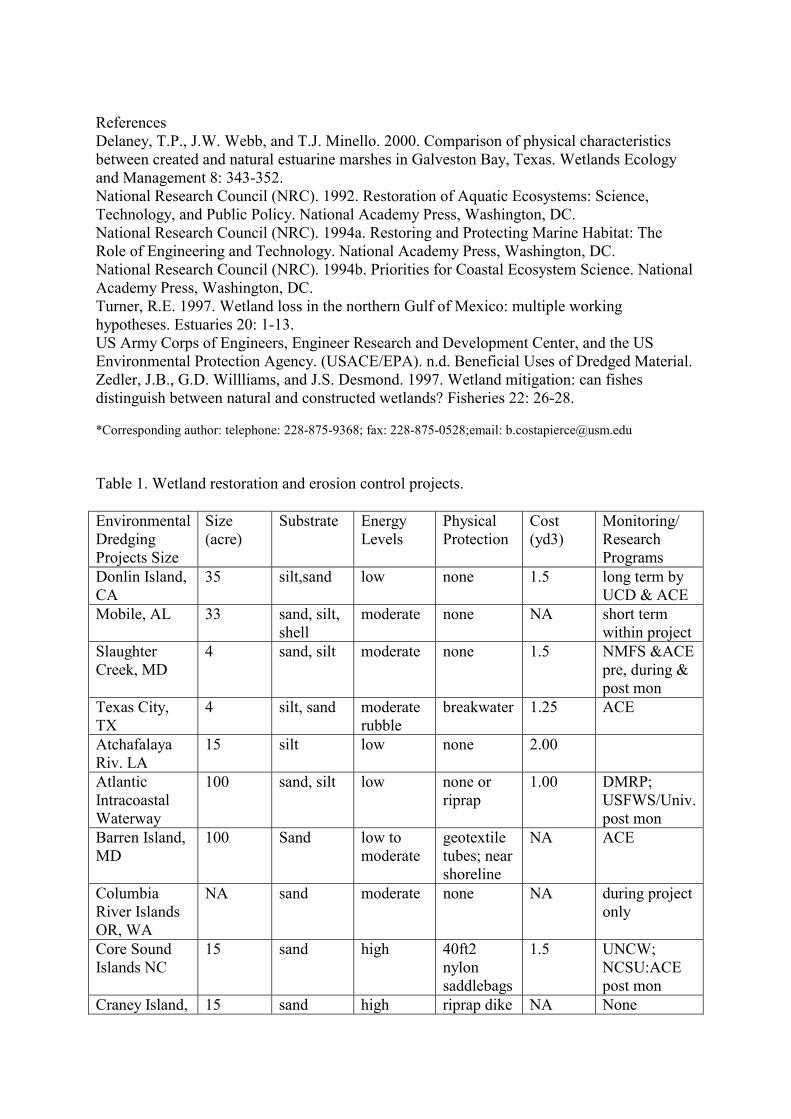
References Delaney, T.P., J.W. Webb, and T.J. Minello. 2000. Comparison of physical characteristics between created and natural estuarine marshes in Galveston Bay, Texas. Wetlands Ecology and Management 8: 343-352. National Research Council (NRC). 1992. Restoration of Aquatic Ecosystems: Science, Technology, and Public Policy. National Academy Press, Washington, DC. National Research Council (NRC). 1994a. Restoring and Protecting Marine Habitat: The Role of Engineering and Technology. National Academy Press, Washington, DC. National Research Council (NRC). 1994b. Priorities for Coastal Ecosystem Science. National Academy Press, Washington, DC. Turner, R.E. 1997. Wetland loss in the northern Gulf of Mexico: multiple working hypotheses. Estuaries 20: 1-13. US Army Corps of Engineers, Engineer Research and Development Center, and the US Environmental Protection Agency. (USACE/EPA). n.d. Beneficial Uses of Dredged Material. Zedler, J.B., G.D. Willliams, and J.S. Desmond. 1997. Wetland mitigation: can fishes distinguish between natural and constructed wetlands? Fisheries 22: 26-28. *Corresponding author: telephone: 228-875-9368; fax: 228-875-0528;email: [email protected] Table 1. Wetland restoration and erosion control projects. Environmental Dredging Projects Size
Size (acre)
Substrate Energy Levels
Physical Protection
Cost (yd3)
Monitoring/ Research Programs
Donlin Island, CA
35 silt,sand low none 1.5 long term by UCD & ACE
Mobile, AL 33 sand, silt, shell
moderate none NA short term within project
Slaughter Creek, MD
4 sand, silt moderate none 1.5 NMFS &ACE pre, during & post mon
Texas City, TX
4 silt, sand moderate rubble
breakwater 1.25 ACE
Atchafalaya Riv. LA
15 silt low none 2.00
Atlantic Intracoastal Waterway
100 sand, silt low none or riprap
1.00 DMRP; USFWS/Univ. post mon
Barren Island, MD
100 Sand low to moderate
geotextile tubes; near shoreline
NA ACE
Columbia River Islands OR, WA
NA sand moderate none NA during project only
Core Sound Islands NC
15 sand high 40ft2 nylon saddlebags
1.5 UNCW; NCSU:ACE post mon
Craney Island, 15 sand high riprap dike NA None
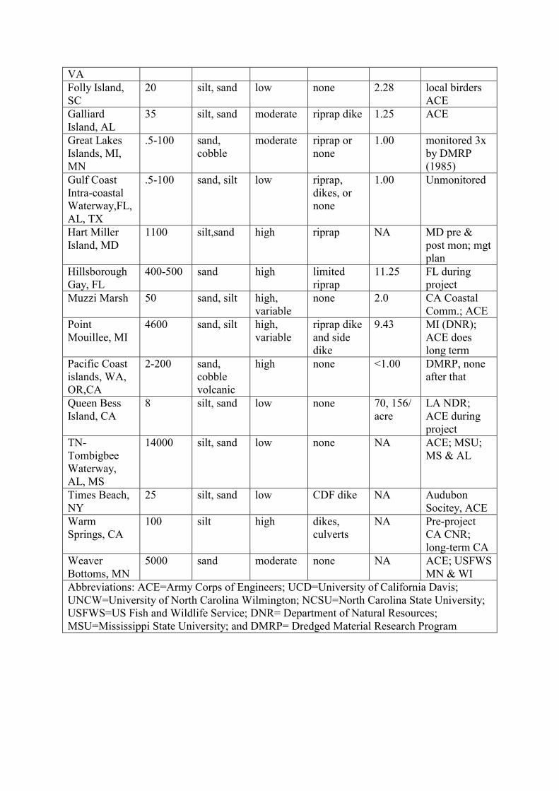
VA Folly Island, SC
20 silt, sand low none 2.28 local birders ACE
Galliard Island, AL
35 silt, sand moderate riprap dike 1.25 ACE
Great Lakes Islands, MI, MN
.5-100 sand, cobble
moderate riprap or none
1.00 monitored 3x by DMRP (1985)
Gulf Coast Intra-coastal Waterway,FL, AL, TX
.5-100 sand, silt low riprap, dikes, or none
1.00 Unmonitored
Hart Miller Island, MD
1100 silt,sand high riprap NA MD pre & post mon; mgt plan
Hillsborough Gay, FL
400-500 sand high limited riprap
11.25 FL during project
Muzzi Marsh 50 sand, silt high, variable
none 2.0 CA Coastal Comm.; ACE
Point Mouillee, MI
4600 sand, silt high, variable
riprap dike and side dike
9.43 MI (DNR); ACE does long term
Pacific Coast islands, WA, OR,CA
2-200 sand, cobble volcanic
high none <1.00 DMRP, none after that
Queen Bess Island, CA
8 silt, sand low none 70, 156/ acre
LA NDR; ACE during project
TN-Tombigbee Waterway, AL, MS
14000 silt, sand low none NA ACE; MSU; MS & AL
Times Beach, NY
25 silt, sand low CDF dike NA Audubon Socitey, ACE
Warm Springs, CA
100 silt high dikes, culverts
NA Pre-project CA CNR; long-term CA
Weaver Bottoms, MN
5000 sand moderate none NA ACE; USFWS MN & WI
Abbreviations: ACE=Army Corps of Engineers; UCD=University of California Davis; UNCW=University of North Carolina Wilmington; NCSU=North Carolina State University; USFWS=US Fish and Wildlife Service; DNR= Department of Natural Resources; MSU=Mississippi State University; and DMRP= Dredged Material Research Program
USE OF PHOSPHORUS TO STABILIZE HEAVY METALS IN CONTAMINATED SEDIMENTS
B. Crannell1*, T. Eighmy1, L. Butler2, E. Emery2, and F. Cartledge
1Environmental Research Group, Kingsbury Hall, University of New Hampshire, Durham,
New Hampshire 03824 USA; 2Chemistry Department, 646 Choppin, Louisiana State University, Baton Rouge, Louisiana 70803 USA
Key words: phosphorus, contaminated sediments, lead, cadmium, zinc, stabilization, leaching Heavy metals are a prevalent and tenacious contaminant in many sediments and dredged materials. The management of these sediments requires innovations that will provide affordable technologies to coastal decision-makers. Phosphorus has been used for decades to stabilize heavy metal-contaminated wastes in industrial and terrestrial environments, but the application of this technology to contaminated sediments is relatively new. In a laboratory scale project, three heavy metal contaminated sediments from Providence Harbor, Rhode Island, Newtown Creek, New York, and Cocheco River, New Hampshire were treated with 10% phosphorus and lime. The source of phosphorus is a calcium apatite mineral mined in Florida. Results of the treatment were analyzed using pH dependent leaching experiments, geochemcial modeling, X-ray powder diffraction analysis, and X-ray photoelectron spectroscopy. The treatment successfully reduced the solubilities of lead by 77%, cadmium by 54%, and zinc by 46%. Spectroscopic analysis indicated the presence of several apatite minerals that had incorporated heavy metals into their structures. The use of phosphorus is shown to be an effective technology for reducing the solubility of heavy metals in contaminated sediments through the formation of insoluble metal phosphate minerals. *Corresponding author: telephone: (603) 862-2440; fax: (603)862-2364; email: [email protected]

BENEFICIAL USES OF DREDGED MATERIAL: PART OF THE SOLUTION TO RESTORATION OF LOUISIANA'S COASTAL WETLANDS
E. Creef*, S. Hennington, and L. Mathies
USACE, New Orleans, CEMVN-OD-T, Post Office Box 60267, New Orleans,
Louisiana 70160-0267 USA Key words: dredged material, beneficial use, wetland restoration, Louisiana land loss The USACE, New Orleans District annually removes 70,000,000 to 90,000,000 cubic yards of shoal material from discontinuous reaches of 10 Federal navigational channels in coastal Louisiana. Since 1974, whenever feasible, the dredged material from routine maintenance has been used beneficially to create, restore, nourish, and protect coastal wetland habitats. Hydraulic cutterhead pipeline dredges place the dredged material into shallow, open water areas adjacent to the navigational channels in a manner conducive to wetlands development. In the mid-1980s when the magnitude of coastal wetland loss in Louisiana became apparent, the State of Louisiana looked to the District as a partner in the effort to thwart this catastrophic land loss. The state saw the dredged material from the District's maintenance dredging program as a valuable resource to be used to create and restore coastal wetland habitats. Approximately 7000 acres of wetlands have been created and/or restored through the beneficial use of dredged material since 1985. The State contends that a significant portion of Louisiana's coastal wetlands could be restored annually if all of the dredged material from the District's maintenance dredging program were used in a beneficial manner. However, in addition to the Corps of Engineers' policy relative to a "Federal Standard", a number of other factors limit the amount of coastal wetlands restoration that can be accomplished using dredged material from maintenance of Federal navigational channels. Among these factors are: 1) logistics; 2) chemical and physical characteristics of the dredged material; 3) channel dynamics; and 4) lands, easements, rights-of-way, relocations and disposal areas. Changes in the Corps' policy would not remove all limitations imposed by these factors; therefore, beneficial uses of dredged material from the District's maintenance dredging program will remain only part of the solution to restoration of Louisiana's coastal wetlands. *Corresponding author: telephone: 504-862-2521;fax: 504-862-2317;email: [email protected]

REVIEW OF COMPARATIVE RISK ASSESSMENT METHODS AND THEIR APPLICABILITY TO DREDGED MATERIAL MANAGEMENT DECISIONS
J. Cura1* and T. Bridges2
1Menzie-Cura & Associates, Inc., 1 Courthouse Lane, Suite 2, Chelmsford, MA, 01824 USA;
2US Army Corps of Engineers Waterways Experiment Station The purpose of this paper is to review the status of comparative risk assessment within the context of environmental decision-making, to evaluate its potential application as a decision-making framework for selecting alternative technologies for dredged material management, and to make recommendations for implementing such a framework. We provide the various definitions of comparative risk assessment, review the relevant literature concerning its application, or more often, suggested application, in policy development, regulatory prioritization, technology selection, and chemical hazard comparisons. We summarize the various methods and critiques of comparative risk assessment, and suggest its potential application in helping to select among various technology options for dredged material management. This review demonstrates that comparative risk assessment has not found a successful universally applied methodology or approach. Rather, the literature largely offers comparisons of specific chemicals based on current risk assessment approaches, descriptions of specific applications that are variations on an EPA theme for setting policy agendas, or critiques of methodology with the hope that it may find an application. One of the most important points from this review for the United States Army Corps of Engineers (USACE) is that comparative risk assessment, however conducted, is an inherently subjective, value-laden process. There is some objection to this lack of total scientific objectivity (refereed to as the "hard version" of comparative risk assessment). However, the "hard versions" provide little help in suggesting a method that surmounts the psychology of choice in any decision making scheme. The application of comparative risk assessment in the decision making process at dredged material management facilities will have to an element of value and professional judgement in the process. The literature suggests that the best way to incorporate this subjectivity and still maintain a defensible comparative framework is to develop a method that carefully selects the basis for comparisons and is inclusive of various perspectives. The method must be logically consistent and allow for uncertainty by comparing risks on the basis of more than one set of criteria, more than one set of categories, and more than one set of experts. It should incorporate a probabilistic approach where necessary and possible, based on management goals. The general opinion is that iteration within the comparative risk framework lends some sense of the range of outcomes to an inherently subjective analysis. *Corresponding author: telephone: 978-453-4300;fax: 978-453-7260; email: [email protected]
DREDGING IN THE NEW YORK HARBOR: FROM CRISIS TO MANAGEMENT
S. Dietrick*
New Jersey Department of Environmental Protection, Office of Dredging and Sediment Technology,
P.O. Box 028, Trenton, New Jersey 08625 USA
Key words: dredged material disposal, beneficial use, dredging policy The New York/New Jersey Harbor is naturally shallow with a reported natural depth of about 18 feet. The Harbor has been dredged since the late 1800's to provide sufficient draft for vessels of increasing size. Currently, channel depths in the Port of New York and New Jersey are as deep as -40 feet below the plane of mean low water (MLW). Additional deepening of the channels has recently begun to bring their depths to -45 MLW and studies are on going which could further increase channel depths to -50 MLW. Since dredging in the New York Harbor began, dredged material has been disposed of in the ocean about six miles off the coast of New Jersey. In the early 1990s, New Jersey's philosophy concerning dredged material management began to shift away from mere disposal of dredged material to a comprehensive management strategy centered on the beneficial use of dredged material. In 1997, the Mud Dump, which had for years been used to dispose of millions of cubic yards of dredged material from the Port of New Jersey and New York, was officially closed which left the largest port on the Eastern Seaboard with virtually no dredged material disposal alternatives. Consequently, the transition to beneficial use took on new urgency in 1997. In response to the impending crisis, the New Jersey Department of Environmental Protection and private sector partners began an innovative program aimed at using dredged material from the New York Harbor to facilitate the closure of abandoned landfills and the remediation of brownfield sites in the metropolitan region. The primary goal of the program is to successfully manage dredged material in a manner that is protective of human health and the environment. An added benefit of the program is the remediation of contaminated upland sites in urban areas and their restoration to economic use. The first site to be successfully remediated using dredged material was the Elizabeth Landfill, now home of the Jersey Gardens Mall. This management strategy is presently being expanded to other areas of the State including the Delaware River, thereby renewing capacity at existing confined disposal facilities and eliminating the need to expand or site new facilities. This paper will provide a brief chronicle of the emergence of New Jersey's dredged material management policy and its implementation through existing regulatory programs, and the development of New Jersey's dredging technical manual. The paper will focus on regulatory considerations for determining acceptable uses for dredged material including sampling frequency, testing protocols and choosing appropriate evaluative criteria, and will present an upland beneficial use case study of a currently active brownfield redevelopment. Lastly, the paper will discuss impediments to the success of the program and on-going research initiatives intended to address outstanding questions including the volatility of contaminants. *Corresponding author: telephone (609) 292-9203; fax: (609)777-1914; email: [email protected]

SEDIMENT TOXICITY PREDICTION D. Di Toro1,2* and D. O'Connor1
1Manhattan College, Riverdale New York, Manhattan College, Riverdale, New York, 2
HydroQual, Inc., Mahwah, New Jersey The Equilibrium Partitioning (EqP) model is the basis for our current ability to understand and predict the causes of toxicity in sediments. It also forms the framework for toxicity identification evaluations (TIEs) in sediments. The data that support the assumptions in the model will be reviewed for both organic chemicals and metals. Recent applications of EqP to predicting the toxicity of mixtures of polycyclic aromatic hydrocarbons (PAHs) in sediments using narcosis theory will be presented. An extension of the simultaneous extracted metal-acid-volatile sulfides (SEM-AVS) model to improve the prediction of toxicity of metals in sediments - in addition to its already demonstrated ability to predict the lack of toxicity - will also be discussed. Finally the limitations of the EqP model for organic chemicals and metals will be examined, particularly from the point of view of evaluating dredged materials. *Corresponding author: [email protected]
CREATIVE SOLUTIONS TO DREDGED MATERIALS MANAGEMENT - THE NEW JERSEY EXPERIENCE
W. Douglas*
New Jersey Maritime Resources, Department of Transportation, Trenton, New Jersey USA
Key words: beneficial use, contaminated sediments, dredging, decontamination, stabilization Faced with a dredged materials backlog of almost 6 million cubic yards and an impending navigational crisis, the State of New Jersey instituted widespread changes on regulatory, legal and policy levels in the way dredged materials are managed throughout the State. Two completely new offices were created to successfully implement this innovative new program, which emphasized dredged materials as a resource rather than a waste. Upland beneficial reuse was essentially unproven, however, and the regulated community was not optimistic about its ability to perform in a manner consistent with project goals and objectives. Over $250 million in combined funding from the Port Authority of New York and New Jersey and a statewide referendum provided the resources necessary to perform pilot and demonstrations of new technologies. Projects were chosen for testing based on their ability to meet objectives on sediment reduction, contaminant reduction, and beneficial reuse reduction potential. Beneficial use projects were shown to result in not only increased disposal capacity, but also remediation and reclamation of abandoned industrial properties. An extensive contaminant monitoring and source trackdown program is underway to and will result in a plan to reduce the amount of contaminated materials that must be managed. Sediment decontamination technology demonstrations, following the groundbreaking work of the USEPA/WRDA program have been initiated and if successful may provide additional reuse capacity as well as a cost- effective manner for treatment of highly contaminated sediments. The overall progress of these programs will be discussed as well as lessons learned and a blueprint for future efforts. *Corresponding author: telephone: 609-984-8564; fax: 609-984-1468; email: [email protected]

COMPARATIVE EVALUATION OF RISKS FROM ALTERNATIVES FOR DREDGED MATERIAL MANAGEMENT IN NEW YORK/NEW JERSEY HARBOR
S. Driscoll1*, W. Wickwire1, J. Cura1, D. Vorhees1, C. Butler1, L. Williams1, D. Moore2, and
T. Bridges2
1Menzie-Cura & Associates, Inc., Chelmsford, Massachusetts USA; 2United States Army Corps of Engineers Waterways Experiment Station, Vicksburg, Mississippi USA
Managers in New York and New Jersey Harbor are developing strategies to dispose and manage large volumes of sediments that must be dredged in order to maintain passable waterways. A number of alternatives are available including aquatic containment facilities, upland containment, treatment, and beneficial reuse. An important consideration in the selection of an appropriate alternative is the evaluation of potential risks to ecological and human receptors. This study presents the results of a prospective screening-level ecological and human health risk assessment that compares risks associated with management alternatives for contaminated dredged materials. The major objectives of the work were to identify exposures that show the potential for risk and cause for concern, develop a framework for a comparative risk assessment, and compare relative potential risks among eight management alternatives. The results can be used by managers to identify specific characteristics of the placement/treatment alternatives that may increase the potential for risk, chose one alternative over another for sediments with high concentrations of certain contaminants, implement controls that mitigate risk, or identify the need to a more comprehensive site-specific risk assessment. *Corresponding author: telephone: 978-453-4300; email: [email protected]; fax: 978-453-7260

DREDGING AND DEWATERING OF HAZARDOUS IMPOUNDMENT SEDIMENT USING THE DRY DREDGETM AND GEOTUBES
M. Duke1, J. Fowler2*, M. Schmidt3 , and A. Askew4
1DRE Technologies, Inc., 6124 Chickering Court, Nashville, Tennesee 37215 USA; 2Geotec Associates, 5000 Lowery Rd, Vicksburg, Mississippi 39180 USA; 3URS Greiner Woodward
Clyde, Inc., 30775 Bainbridge Rd, Suite 200, Solon, Ohio 44139 USA; 4DRE Technologies, Inc., deceased
Key words: geotextile containers, dewatering, impoundment sediment The purpose of this paper is to describe the application of the Dry DREdge™ technology coupled with Geotubes in the dredging and dewatering of hazardous sediments. The paper describes the project objectives, the Dry DREdge™ and Geotube technologies, and the results of applying this technique. The Dry DREdge™ was jointly developed and tested by DRE and the U.S Army Corps of Engineers, Waterways Experiment Station (WES), Vicksburg, MS, under the Corps of Engineers Construction Productivity Research Program (CPAR). TC Mirafi and WES also developed the use of geotubes to contain fine dredged sediments under the CPAR program. The fine-grained hazardous sediments were dewatered and passed the paint filter test by the third week after dredging and filling the geotubes. This project resulted in a one million dollar savings to the client. *Corresponding author: telephone: 601-636-5475

AQUATIC SEDIMENTS IN THE NETHERLANDS
H. Eenhoorn* and W. van der Sluijs
Dutch Ministry of Transport, Public Works and Water Management, Aquatic Sediment Expert Centre (AKWA), P.O. Box 20.000, 3502 LA Utrecht, The Netherlands
'Sludge from the Rhine': that's what Napoleon Bonaparte called the Netherlands back then. Although intended as an insult, this is an apt description of the Dutch landscape, given the enormous deposits of sediment in the 'settling basin' that the Netherlands just happens to be. The figure below shows the close relation between land and water in the Netherlands. Although the quality of this sediment is now somewhat better, in the seventies and eighties it was anything but clean. As a heritage from the past, we expect that for the period from 2000 to 2010 alone, about 200 million m³ of heavily polluted sediment will be dredged. These sediments originate both from environmental (remediation) as well as maintenance cases. Does this mean that nothing has ever been done about this problem before? Certainly not. Since the nineties, major progress has been made together with many national and international partners in tackling and improving our knowledge of contaminated sediments. Together, we have conducted extensive research, formulated policy, set guidelines, built large-scale disposal sites, performed remediation and reused dredged material within its area of origin. The Dutch Ministry of Transport, Public Works and Water Management plays a major role concerning the removal and disposal of contaminated sediment. Recently a large-scale study involving an evaluation (cost and environment) of sediment treatment and disposal options showed once again the necessity of regional disposal sites. The same study also concluded that about 30% of the disposed contaminated sediments could be reused using simple techniques like sedimentation basins. Other recent studies have shown the feasibility of the use of local pits for the long-term storage of contaminated sediments. *Corresponding author: telephone +31 (30) 2858074 ; email: [email protected]

THE CAPPING PROPOSAL FOR CELL 1, TOMMY THOMPSON PARK - A WETLAND CREATION OPPORTUNITY ON THE TORONTO WATERFRONT
L. Field1, G. MacPherson* and K. Lundy2
1The Toronto and Region Conservation Authority, 5 Shoreham Drive, Downsview, Ontario,
Canada, M3N 1S4; 2Toronto Port Authority, 60 Harbour Street, Toronto, Ontario, Canada M5J 1B7
Key words: wetland creation, Toronto, contained disposal facility The Confined Disposal Facility (CDF) for the Port of Toronto is operated by the Toronto Port Authority and consists of three disposal cells (49 ha. In size), within Tommy Thompson Park (TTP). Tommy Thompson Park is a spit of land on the central Toronto Waterfront that extends southwest into Lake Ontario for 5 km. Since 1982, the park has been the repository for sediments dredged from the mouth of the Don River and other locations within the Toronto Harbour. Dredging and disposal operations were approved under the Provincial Environmental Assessment Act, subject to a number of conditions. One condition dictates that the cells within the CDF "be topped off and capped in a manner which restricts biological uptake and mobility of contaminants." The Toronto and Region Conservation Authority (TRCA) is the government organization responsible for determining the long-term use of the CDF site. Following extensive studies of the existing environmental conditions within Cell 1 and after evaluation of the economic and engineering considerations of the project, the TRCA and the Toronto Port Authority is proposing the use of a sub-aqueous clean-fill cap and wetland creation at the site. To test the feasibility of a cap and wetland the TRCA developed a similar proposal for the Triangle Pond area within TTP. The triangle pond is a one-hectare water body centrally located within the park that was constructed in the early 70's to test the feasibility of developing a large scale CDF for the harbour. The capping construction was completed over the course of six months in 1999 and a variety of wetland vegetation has been established through plantings and colonization over the past growing season. The wetland at Triangle Pond and our proposed wetland at Disposal Cell one will enhance opportunities for public education and recreation, wildlife habitat improvement, and increase ecosystem diversity. In addition, our use of a Clean-fill/Wetland at Tommy Thompsonm Park may demonstrate what can be achieved in the way of wetland creation at other Great Lakes CDFs. *Corresponding author: telephone: 4116-661-6600 x5246; email: [email protected]

A REVIEW OF THE RISK ASSESSMENT METHODS USED TO ESTABLISH PERMITTING CRITERIA FOR OPEN OCEAN DISPOSAL OF DREDGED NEW
YORK/NEW JERSEY HARBOR SEDIMENTS
B. Finley1* and S. Su2
1Exponent, 1970 Broadway, Suite 250, Oakland, California 94612 USA; 2Exponent, 420 Lexington Ave, Suite 408, New York, New York 10170 USA
Key words: risk, sediment quality criteria, open ocean disposal Every year, approximately 4 million cubic yards of sediment are dredged for maintenance of the New York/New Jersey channels and Newark Bay. The U.S. Army Corps of Engineers (U.S.ACE) employs a framework of sediment quality criteria (SQC) to determine whether the contaminant levels in the sediments are suitable for open ocean disposal (i.e., would not pose a health risk) or whether more extensive and costly disposal methods are required. The SQC have been developed over a period of several years, using a variety of different risk assessment methods. The purpose of our analysis was to assess the degree of consistency in the risk assessment methods used to derive the SQC, and to determine whether a single, refined approach might yield significantly different SQC. We also reviewed 15 permitting decisions over the last 10 years and determined whether different disposal decisions would have been reached using a single set of consistently derived SQC. Our findings may be summarized as follows: First, the risk assessment methods vary significantly across the approximately 30 chemicals for which SQC exist. While some SQC are classically "risk-based", others are based on historical background concentrations, some are based on U.S. Food and Drug Administration (U.S.FDA) action levels, and some are based on limits of detection (dioxin). Hence, the degree of conservatism and health protection in the SQC is quite different for different chemicals. Second, consistent application of the "risk-based" methods developed by U.S. ACE and U.S. Environmental Protection Agency (U.S. EPA) Region II to all chemicals yields very different SQC for some constituents, and this can have a significant impact on the decision-making process. Specifically, we found that, if purely "risk-based" criteria had been used over the last 10 years, then: 1) at least 40,000 cubic yards that were granted open ocean disposal would have failed one or more "risk-based" SQC, 2) at least 150,000 cubic yards that were denied open ocean disposal would have been considered suitable for this option, and 3) at least 700,000 cubic yards that were denied open ocean disposal due to trace levels of dioxin would have "passed" a risk-based SQC for dioxin. These findings further illustrate the need for a consistent, valid, and risk-based approach for contaminated sediment management decisions. *Corresponding author: telephone: 707-535-0492; fax: 707-535-0489; email: [email protected]

USE OF AN INTERACTIVE GIS TO FACILITATE AN IMPROVED DECISION MAKING METHODOLOGY
S. FitzGerald1* and J. Pederson2
1Daylor Consulting Group, 10 Forbes Road, Braintree Massachusetts 02184 USA; 2MIT Sea
Grant College Program, 292 Main Street, Cambridge, Massachusetts 02139 USA Key words: Geographic Information Systems (GIS), decision making methodologies, dredging, interactive, site selection, Boston Harbor, consensus building, adaptive management Each year regulators, scientists, environmentalists, and citizens who affect the quality of our environment make thousands of decisions. While most of these decisions are made on the basis of the best available information and with good intentions current decision-making methodologies leave much to be desired. Current Decision-Making Methodologies are limited by: A-Priori Decisions Lack of Public and Scientific Input Early in the Process Inadequate Documentation of Assumptions Lack of a Holistic View Inadequate Consensus Among Stakeholders The Inability to Review, Revise and Adapt Decision on the Basis of New Information With this in mind, a new Decision-Making Methodology was developed that utilizes Geographic Information Systems (GIS) as an implementation tool. This methodology was examined using the case study of locating dredged material disposal sites in Boston Harbor. Site selection is an inherently political process based on interpretations and perceptions of the underlying science. To address this a two-part process for evaluating, ranking, and weighting the information that leads to a decision was adopted. In the first part data are presented as ranked GIS layers based on expert scientific knowledge. Subsequently, the public, stakeholders, and decision makers weight, combine and evaluate all of the available information (presented as GIS layers) leading to a consensus decision. This allows for public involvement and decision making to build upon good science and scientific interpretation of data. The development of an interactive GIS provides the tools needed to implement this methodology. The use of visual analysis, a holistic approach, and better documentation of the assumptions inherent in any decision contribute to the adaptive management approach of this process. In addition, the interactive capability of GIS allows 'what if' scenarios to be examined and allows users to immediately understand the various factors and tradeoffs involved in any decision.
This new Interactive GIS-based methodology has several advantages over conventional methodologies. The advantage of the new methodology is that: It's an interactive and user friendly process Decisions are based on a solid scientific foundation Inclusion of a universe of information is possible with few spatial constraints A collaborative, consensus building process can be facilitated Results are immediately available, repeatable, and can be revised on the basis of new information. Assumptions are visible and documented Feedback from public demonstrations of the proposed methodology confirms that this approach to decision-making is an improvement over current methods. Because it aids consensus building and fosters an interactive, adaptive management approach, this methodology has the potential to allow decisions to be reached in less time, with less cost, and with greater numbers of stakeholders, citizens and decision makers satisfied that a good and proper decision was reached. *Corresponding author: telephone: (781) 849-7070 x 290; fax:(781) 849-0096; email: [email protected]

HABITAT CREATION AND THE BENEFICIAL USE OF MUDDY DREDGED MATERIAL IN THE UK
C. Fletcher1*, M. Dearnaley, A. Nottage, J. R. Stevenson, N. G. Feates,
and T. N. Burt
1HR Wallingford Ltd, Howbery Park, Wallingford, Oxon, OX10 8BA, UK Key words: mud, sediments, dredging, beneficial use, habitats, sustainability, coastline The shape of our coastline is constantly changing due to the impact of natural processes and man made influences. Coastal areas are under threat from flooding and in many regions sea defences are eroding. Traditionally, heavy engineering has been used to protect coastal areas and high costs have been encountered. New schemes and trials, which combat the changes and impacts on our coastlines have started to be undertaken throughout Europe on a small scale and these have been termed coastal realignment schemes. Coastal realignment schemes are a relatively new approach and may involve letting existing land flood and setting the coastline back, more commonly termed managed retreat, or placing material in front of coastal walls and sea defences and building forward. This paper focuses on the placement of dredged material for building forward of coastal sea walls and sea defences. HR Wallingford undertakes a number of projects dealing with the beneficial use of dredged material in the marine environment. Of particular interest is the increase requirement to explore the practical, technical and socially acceptable use of muddy dredged material. HR Wallingford are shortly to complete a Ministry of Agriculture, Fisheries and Food (MAFF) funded project which involved monitoring schemes where muddy (maintenance dredged material) is placed at estuary sites. This paper reviews the process in the UK for undertaking such projects and practicalities involved. It will summarise the lessons learnt from a number of sites where dredged material has been used beneficially for habitat creation. Case studies include salt marsh recharge, mud flat creation and trickle charge feeding of sediments into the estuary system via water column and sub-tidal placements. *Corresponding author: telephone: +44 (0)1491 835381; fax: +44 (0)1491 832233; email: [email protected]

GEOTEXTILE CONTAINED CONTAMINATED DREDGED MATERIAL, MARINA DEL REY, LOS ANGELES AND PORT OF OAKLAND, CALIFORNIA
J. Fowler1*, D. Toups2, and P. Gilbert3
1Geotec Associates, 5000 Lowery Road, Vicksburg, Mississippi, 39180; 2Nicolon
Corporation, Erosion Control Products, 3500 Parkway Lane, Suite 500, Norcross, Georgia, 30092; 3Waterways Experiment Station, 3909 Halls Ferry Road, Vicksburg, Mississippi,
39180-6199, USA Key words: geotextile containers, fine grained dredged material, split hull bottom dump scows, shallow water habitat (SWH), confined aquatic disposal (CAD) Approximately 42,000 m3 (55,000 cubic yards, cy) of contaminated maintenance dredged material has been successfully contained in geotextile containers and placed with split hull bottom dump barges in a shallow water habitat and capped with a layer of clean sandy dredged material. The dredged materials contained about 7 to 8 percent fine grained soil and were contaminated with lead, zinc and copper. The materials were mechanically dredged with a clamshell bucket and placed in geotextile containers. The containers were sewn closed and placed within the Port of Los Angeles' (POLA) Shallow Water Habitat (SWH) Confined Aquatic Disposal (CAD) site. Forty-four geotextile containers were filled with an average of about 992 m3 (1300 cy) of contaminated maintenance dredged material from the Marina Del Rey, California, channel entrance and the Ballona Flood Control Channel, Los Angeles, California. Dredging began November 10, 1994 and was completed December 18, 1994. An average of 1.5 containers or 1527 m3 (2000 cy) were placed each day using a Differential Global Positioning system. This was the first project of its kind in the world where contaminated dredged material was successfully contained in geotextile containers, placed, and capped with a sand layer. At the same time as the Marina Del Rey project, the Port of Oakland, California, was in mechanically excavating contaminated maintenance dredged material into a holding barge and then pumping it into geotextile tubes for dewatering and subsequent landfill disposal. Geotextile tubes were successfully filled with contaminated dredged material and allowed to drain to about 40 to 65 percent of their original volume prior to landfill placement. As a result of these two demonstration projects, there are several similar projects being designed by the New York-New Jersey Port Authority, New York, New York and the Massachusetts Port Authority, Boston, Massachusetts. These new and innovative concepts of containing contaminated dredged material in geotextile containers have proven to be constructably practical, technically and economically feasible and environmentally acceptable compared to other disposal alternatives. *Corresponding author: telephone: 601-636-5475

DEWATERING SEWAGE SLUDGE WITH GEOTEXTILE TUBES
J. Fowler1*, R. Bagby2, and E. Trainer3
1GEOTEC Associates, 5000 Lowery Road, Vicksburg, Mississippi 39180 USA; 2City of Vicksburg Water Pollution Control Center, Vicksburg, Mississippi, 39180 USA; 3Nicolon
Corporation, Erosion Control Group, 3500 Parkway Lane, Suite 500, Norcross, Georgia 30092 USA
Key words: geotextile, containers, geotubes, dewater, contaminants, beneficial uses Municipal sewage sludge was place in geotextile bags for the purpose of evaluating the dewatering and consolidation capabilities of large geotextile tubes and effluent water quality. A proposed ASTM test method for determining the flow rate of suspended solids from a geotextile containment system for dredged material was used to conduct tests to determine the efficiency of different combinations of geotextile filters. Prior to filling the large geotextile tube, two small geotextile bags 48 inches in circumference and 70 inches long were supported vertically in a wooden frame and filled to a depth of about 60 inches or about 48 gallons of sewage sludge from the primary sludge digester. As water passed through the geotextile bag, samples were collected during, immediately after and for several days to determine the total percent suspended solids (TSS), heavy metals, and bacterial count. The test results indicated significant consolidation or reduction in the volume of the sludge volume in the bag. There was also a significant reduction in the TSS, heavy metals, and bacterial count in the effluent water. These test results led to filling a large geotextile tube 15 ft wide, 30 ft long and filled to a height of 5 ft with sewage sludge. The quality of pore water or effluent passing through the geotextile container systems proved to be environmentally acceptable for subsequent discharge into the Mississippi River and/or return to the treatment plant. This new and innovative technology has been successfully used to dewater fine grained, contaminated dredged material that contained dioxins, PCBs, PAHs, pesticides and heavy metals for Miami River and the Port of Oakland, California. This is the first successful use of geotextile tubes for dewatering sewage sludge for beneficial uses in the United States. Research using this process for dewatering pork and dairy farming waste, paper mill waste, fly ash, mining waste, chemical sludge lagoons and several other waste streams are being conducted. This concept of containing sewage sludge has proven to be construction-practical, technically and economically feasible and environmentally acceptable. *Corresponding author: telephone: 601-636-5475

DREDGED MATERIAL FILLED GEOTUBES, SAN ANTONIO INLET CONTAINMENT ISLAND, BUENAVENTURA BAY, COLOMBIA
J. Fowler1*, E. Martinez2, N. Ruiz3, and C. Ortiz4
1Geotec Associates, 5000 Lowery Rd, Vicksburg, MS 39180 USA; 2Dragados Hidraulicos,
Calle 13 No. 43-33, Bogota, Colombia; 3TC Mirafi, Carrera 12 No. 118-42, Bogota, Colombia; 4Geofort Limited, Carrera 12 No. 118-42, Bogota, Colombia
One of the first Geotube applications in Colombia was for construction of confined disposal area islands that will be used for containment and dewatering of fine-grained maintenance dredged materials. The project is located on the San Antonio Inlet, Buenaventura Colombia. The dredged material containment area is the first of two oval shaped islands planned in this riverine and tidal environment. This new and innovative construction methodology involved hydraulically filling geotubes with a sandy fill material. Geotubes are simply an assemblage of geotextile fabric panels sewn to form long tubes for containment of dredged material. The geotubes were positioned end to end to provide a perimeter dike for dredged material containment in tidal variations of 4-meters twice a day. After the oval shaped islands are completed they will serve as dredged material containment facilities until they are filled and stabilized. After they are stabilized they will be planted in Mangrove trees and other native vegetation and will be used exclusively for environmental purposes. *Corresponding author: telephone: 601-636-5475

CONFINED AQUATIC DISPOSAL (CAD) CELLS IN BOSTON HARBOR: MANAGEMENT CHANGES IN RESPONSE TO EMPIRICAL MONITORING RESULTS
T. Fredette*
U.S. Army Corps of Engineers, New England District, 696 Virginia Road,
Concord, Massachusetts 01742-2751 USA Key words: Confined Aquatic Disposal (CAD), capping, dredged material disposal, monitoring The dredging, filling, and capping of nine Confined Aquatic Disposal (CAD) cells for the Boston Harbor Navigation Improvement Project provided an ideal opportunity to improve construction methods and monitoring approaches for this emerging management approach. Working with the project Technical Advisory Committee and the Massachusetts regulatory agencies, we modified CAD design requirements based on experiences gained in each successive phase of the project. In 1997, the use and monitoring of a single CAD cell lead to construction changes in cap placement for the Phase II in-channel disposal cells. Additional experience with the first three, larger Phase II cells in 1998 resulted in adoption of recommendations to increase consolidation time to times spanning four to six months prior to capping and minimize the use of the props on the hopper dredge during capping. These approaches were applied to the last five cells created by the project in 1999/2000 resulting in even higher levels of success than in the earlier cells. CAD cells can provide a practicable alternative for contaminated sediment management. The success and experience gained from projects such as the Boston Harbor Navigation Improvement Project will certainly increase the environmental acceptability of CAD cells as a management alternative. *Corresponding author: telephone: 978-318-8291; fax: 978-318-8303; email: [email protected]

BENEFICIAL USE OF DREDGED SEDIMENTS AS A FEEDSTOCK IN CONVENTIONAL PORTLAND CEMENT PRODUCTION
K. Gardner*, B. Magee, J. Dalton, and S. Dronamraju
Environmental Research Group, Department of Civil Engineering, University of New
Hampshire, Durham, New Hampshire 03824 USA Key words: contaminated sediments, beneficial use, cement Sediments contain a significant amount of a valuable commodity that is actively mined in this country on a massive scale: quartz (SiO2). With rapidly depleting natural quantities of SiO2, industries like the Portland cement manufacturing industry are constantly seeking alternative sources. Against this background, the primary goal of the sediment management approach being proposed is to capitalize on the inherent properties of dredged sediments to produce a valuable and marketable commodity: Portland cement (Portland cement is an extremely fine, gray powder manufactured from some of the earth's minerals. After mixing with water, Portland cement is the glue that binds sand and gravel together into the rock-like mass known as concrete). This research project is progressing along two fronts: First, study of cement manufacture using contaminated sediments as a partial feedstock is being conducted, and the resulting cement characteristics are being investigated. Second, the fate of organic and inorganic contaminants initially present in the sediments is being investigated, particularly the mineralogical form of heavy metals that remain in the cement matrix and the concomitant leaching properties. This presentation will focus on the justification for this approach, including an economic analysis that will highlight the conditions (e.g. transportation situation, tipping fees, sediment water content) for which this approach may be feasible. Preliminary cement mix ratios, cement quality, and pH-dependent leaching results will also be presented based on work using sediments from NEW YORK Harbor. *Corresponding author: 603-862-4334; fax: 603-862-3957 ; email: [email protected]

SITING A CONFINED DISPOSAL AND TREATMENT FACILITY WITHIN A REGIONAL FRAMEWORK FOR MANAGING CONTAMINATED SEDIMENT:
LESSONS LEARNED AND REMAINING CHALLENGES T . Gries*, S. Babcock, J. Dohrmann, T. Goodman, E. Johnson, J. Malek, S. Martin and F.
Seavey
Washington Department of Ecology, Sediment Management Unit, P.O. Box 47600, Olympia, Washington 98504-7600USA
Key words: confined disposal, contaminated sediment, treatment The need for a comprehensive sediment management program in the Puget Sound region was recognized more than twenty years ago. A cooperative program to effectively manage cleaner dredged material was established in 1988. Sediment management standards promulgated in 1991 define requirements for cleaning up contaminated sediment and controlling continued discharges. However, remediation of contaminated sites identified since 1996 has often been delayed because of inadequate regional confined disposal capacity. Seven federal, state and quasi-public parties are now participating in a joint effort to site and build regional capacity to manage contaminated dredged material by a combination of beneficial uses, treatment and disposal. Thus, challenges encountered in the multi-user disposal site or "MUDS" project include funding feasibility studies, reaching consensus on technical and policy issues, generating public interest prior to choosing preferred types of facilities and sites, and identifying a willing facility owner. Many of these challenges have been or are in the process of being resolved, but other significant hurdles remain. Key issues remaining include demonstrating a reliable flow of contaminated material, identifying methods to accelerate cleanup activities, determining the appropriateness of using public lands for aquatic disposal and evaluating the long-term safety and liability of products manufactured from sediment treatment processes. The authors also describe the need to create a public entity with all the legal authorities needed to form a partnership with one or more private companies to develop confined disposal and treatment capacity. This "MUDS authority" will need to cooperatively define the optimum partnership, secure adequate funding, obtain technical and policy assistance, generate legislative interest and public acceptance in order to select, design, build and permit a regional facility. *Corresponding author: telephone: 360-407-7536 ; fax: 360-407-7154; email: [email protected]

ETHEC CONTAMINATED SEDIMENT TREATMENT A. Gurfinkel
11 Camelot Court, #1A, Boston, Massachusetts 02135 USA
Key words: hazardous cleanup, recyclable Technology Description: ETHEC technology integrates electrical, thermal, and chemical techniques for economical treatment and recycling of contaminated marine sediment, hazardous sludge or water/solid compositions. Contaminated and hazardous waste are used, as a raw material for ETHEC's products manufacturing and are cleaned up using energy accumulated in the processed materials and system. During this process ETHEC cleans up and recycles the waste material and also the contaminants themselves (i.e. integrated organic and/or inorganic contaminants). ETHEC modular systems are configured for one stage, two stage, or three stage operation. During stage 1 ETHEC efficiently concentrates on water the solid residue by extracting water in vapor form from marine sediment. During Stage 2 the solidified, organically contaminated residue, is cleaned up using, again, thermal energy for extracting the organics in vapor. Hazardous organics, such as PCBs, dioxin, carbon disulfide, etc. are vaporized for further treatment. Nonhazardous petroleum-based organics are condensed into fuel products. During Stage 3 the heavy metals are stabilized by a thermo-chemical reaction, as a result of high temperature processing. High temperature heating is a part of ETHEC manufacturing process which converts organic-free sediment (solid) into baked construction filler, or cementitious (pozzolanic) material. The vaporized hazardous organics are on-site thermally decomposed into industrial chemicals. Environmental Benefits includes both on-site waste processing, and in-line recycling of the treated material and contaminants provide the zero-discharge operation. Integrating the ETHEC systems into industrial-type production lines, using waste heat, as energy source, and using closed loop system configuration prevents pollution. Application may include contaminated marine sediment, technological sludge, ground water and soil, wastewater, and mineral solid waste compositions. Depending on the required beneficial products, the necessary ETHEC stages are the following: - Stage 1: concentrated solid residue, distilled water-dewatering (volume reduction) - Stage 2: organics free solid (soil) _ vapor extraction and recovery of nonhazardous organics - Stage 3: baked fill and aggregate materials, cementitious (pozzolanic ) material, industrial chemicals_thermo-chemical stabilization of heavy metals and thermal decomposition of hazardous organics.

CLAREMONT CHANNEL DEEPENING: A PUBLIC PRIVATE PARTNERSHIP SUCCESS STORY
J. Henningson*
Hart Crowser, Inc., 75 Montgomery Street, Jersey City, NJ 07302 USA Key words: beneficial use, public-private partnership, capping, brownfield, abandoned mine The Claremont Channel Deepening project is a partnership between the State of New Jersey, the City of Jersey City, Hugo Neu Schnitzer East (HNSE), Consolidated Technologies Inc. (CTI) and Liberty National Development Corporation. The project encompasses: · major site improvements in the Hugo Neu Schnitzer East metal scrap processing facility on the Claremont Channel in Jersey City, NJ; · the dredging of 1.25 million CY from the Channel to increase the depth from the current 26 feet to 32 feet (plus 2 ft overdredge); · the construction of a multi-project dredged material processing facility to serve NY-NJ Harbor; · the use of an innovative mixture of dredged material with PROPAT®, a recycled product manufactured by HNSE, for the bulk fill and grading of a new golf course at Port Liberte, a residential development adjacent to the Channel; · the use of amended dredged material for capping and grading additional acres of the golf course; · filling portions of an abandoned mine in Pennsylvania with amended dredged material; · the use of dredged to construct an intertidal habitat at the head of the channel; and · disposal at the Newark Bay Confined Disposal Facility. The estimated cost of this project is approximately $52 million. Hugo Neu Schnitzer East's contribution will be $30.5 million, or 60% of the total cost. The dredging and beneficial use have an estimated cost of approximately $40 million or $32 per CY. This is comparable to other disposal options in NY Harbor, such as the CDF in Newark Bay. *Corresponding author: 201-985-8100 ; fax: 201-985-8182; email: [email protected]
IDENTIFICATION AND EVALUATION OF STRESSORS IN TOXIC SEDIMENTS AND DREDGED MATERIALS
K. Ho*
U.S. Environmental Protection Agency, Atlantic Ecology Division, Narragansett, Rhode Island 02882, USA
Identification of stressors in aquatic systems is critical to sound assessment and management of our nation's waterways for a number of reasons. Identification of specific classes of toxicants (or stressors) can be useful in designing effective sediment remediation methods and reasonable options for sediment disposal. Knowledge of which stressors affect benthic systems allows managers to link stressors to specific dischargers and prevent further release of the toxicant. In addition, identification of major causes of toxicity in sediments may guide programs such as sediment quality guidelines and pesticide registration, while knowledge of the causes of toxicity which drive ecological changes such as community structure would be useful in performing ecological risk assessments. To this end, the US Environmental Protection Agency has developed tools (Toxicity Identification and Evaluation (TIE)) that allow researchers to characterize and identify chemical causes of acute toxicity in sediments and dredged materials. Development of these methods for both interstitial waters and whole sediments is nearly complete, and a guidance document is expected by the end of 2001. To date, most sediment TIEs have been performed on interstitial waters. Preliminary evidence from the use of interstitial water TIEs reveals certain patterns in causes of sediment toxicity. First, among all sediments tested, there is no one predominant cause of toxicity; metals, organics and ammonia all play a role in about equal amounts in causing toxicity. Second, within single sediment there are usually multiple causes of toxicity; not just one chemical class is present. Finally, if sediments are divided into marine or freshwater sediments, TIEs performed on freshwater sediments indicate a variety of toxicants in fairly equal proportions, while TIEs performed on marine sediments have identified only ammonia and organics as toxicants, with metals playing a minor role. However, it is necessary to keep in mind that a very small number of interstitial water TIEs have been performed, and these trends may change as larger numbers of TIEs (both interstitial and whole sediment) are performed. Results from interstitial water TIEs will be discussed. Methodology and results from whole sediment TIEs will also be discussed along with advantages, limitations and application of these methods. *Corresponding author: telephone: 401-782-3196; fax: 401-782-3030; top email: [email protected]
DREDGING AND DISPOSAL OF CONTAMINATED SEDIMENTS IN THE NETHERLANDS G. Hoogewerff*
Royal Boskalis Westminster, The Netherlands
Key words: Netherlands, remediation, dredging, separation, CDF The results of the Dutch research program on the development of remediation techniques for contaminated sediments (POSW) were published in 1997. One of the key conclusions was that complete processing of contaminated sediments to re-usable products was not economically feasible at that moment. Based on the results of this program politics decided to focus remediation on dredging and storage of the contaminated sediments in regional Contained Disposal Facilities (CDF). The first priority based on the available budgets is to remove the contaminated sediments out of the water system and to store them safely in these CDFs. Dredging techniques have been developed to dredge selectively the contaminated sediments with minimal negative impact on the surrounding environment. Optimization of the use of the CDF by minimizing the volumes to be finally stored is a key item. This will be achieved by a combination of surgical dredging of the contaminated sediments and the use of low-cost treatment techniques such as sand separation, ripening, land farming and CDF-management. Actually CDFs are in different stages of development between operation, construction and design in combination with public outreach programs. In order to optimize the total remediation process, it is essential that all stages between pre investigation, dredging, treatment and final storage fit together. For each project the aspects of importance must be recognized and implemented in the selection of the working method. Based on the experiences with the execution of various remediation projects key items of this process will be addressed. *Corresponding author: telephone -31-78-6969545; email: [email protected]
EVALUATION OF DREDGING TECHNOLOGIES FOR PROJECT SPECIFIC NEEDS J. Lally and A. Ikalainen*
Foster Wheeler Environmental Corporation, 133 Federal Street 6th Floor; Boston, Massachusetts 02110 USA
Key words: contaminated sediments, dredging technology, pilot studies, performance parameters, environmental monitoring, dredged material disposal The ongoing remedial design for sediment dredging and disposal at the New Bedford Harbor Superfund site will be based on prior site characterization and pilot dredging and disposal studies. From these it has been learned that selection of the dredging technology must address needs for accurate dredging, high production, and minimal resuspension of sediments during dredging. Also, for successful completion of the project it is important to dredge and transport sediments minimizing water addition to the waste stream and to dredge efficiently in water depths from zero to three feet. To develop current information on the capabilities of state of the art dredging equipment and verify the performance of the equipment a detailed technology evaluation was performed. New Bedford specific screening criteria were used in the technology evaluation. Two types of dredge systems were selected from the technology screening . It was decided to perform an on-site pilot dredging study of one of the dredge systems to monitor and verify dredging performance. The dredging study included monitoring of the dredging for performance parameters and environmental affects. Monitoring was done for sediment resuspension and transport (water quality), air emissions from dredging and disposal, and confirmation of clean-up goals. Mass balance calculations were performed to develop full-scale dredging performance parameters and to evaluate alternatives for dredged material disposal. *Corresponding author; telephone: 617-457-8234; fax: 617-457-8498; email: [email protected]

MODEL OF PAH AND PCB BIOACCUMULATION IN MYA ARENARIA AND APPLICATION FOR SITE ASSESSMENT
R. Levine1*, P. Gschwend1, J. Pederson2, J. McDowell3
1Massachusetts Institute of Technology, Cambridge, Massachusetts 02139 USA; 2MIT Sea Grant College Program, Cambridge, Massachusetts 02139 USA; 3WHOI Sea Grant College
Program, Woods Hole, Massachusetts 02543 USA In areas of sediment contamination, quality guidelines are often used for remediation and/or restoration decisions. To supplement each set of sediment quality guidelines, bioaccumulation models have been used to estimate higher trophic level contamination. Although various models address the bioaccumulative property of contaminants, none are both accurate and easily implemented. To address this issue, a new bioaccumulation model for polycyclic aromatic hydrocarbons (PAHs) and polychlorinated biphenyls (PCBs) from sediment to Mya arenaria was developed. Basic equilibrium partitioning theory, i.e. contaminant partitioning between organism lipid and sediment organic carbon (Bierman 1990) was used as the model foundation. The model was then augmented by adding PAH and PCB partitioning into mollusc protein and PAH partitioning into the sedimentary soot fraction. Data on the PCB and PAH concentrations in sediment and M. arenaria from Massachusetts Bay, along with estimates of animal protein and sediment soot content were used to test this new model. The model predicts PCB concentrations in M. arenaria with only a slight variation from observed data. Predicted PAH concentrations are more accurate than concentrations predicted by other model types, but organism burdens still remain slightly greater than observed concentrations. To determine its accuracy, the model should be tested with data sets in which all parameters are measured. Bierman, V. 1990. Equilibrium Partitioning and Biomagnification of Organic Chemicals in Benthic Animals. Environmental Science and Technology 24(9):1407-1412 *Corresponding author: current address: Industrial Economics, Inc., 2067 Mass Avenue, Cambridge, Massachusetts 02140 USA; telephone: (617) 354-0074; email: [email protected]

RISK-BASED DECISIONS FOR DREDGED MATERIALS MANAGEMENT: CONSIDERATION OF SPATIAL AND TEMPORAL PATTERNS IN EXPOSURE
MODELING I. Linkov*, D. Burmistrov1, J. Cura1, and T. Bridges2
1Menzie-Cura & Associates, Inc., 1 Courthouse Lane, Suite 2, Chelmsford, Massachusetts
01824; 2Waterways Experimental Station, Vicksburg Mississippi USA This paper addresses the interactions of various aspects of foraging behavior, habitat characteristics, site characteristics, and the spatial distribution of contaminants in developing exposure of winter flounder to PCBs from a hypothetical open water dredged material management site in the coastal waters of New York and New Jersey (NY-NJ). It then considers the implications of these interactions on human health risk estimates for local recreational anglers who fish for and eat those flounder. We also address the advantages of such spatially explicit modeling in environmental decision making at dredged material management sites. The models implemented in this study are a spatial model to account for realistic exposures and a probabilistic adaptation of the Gobas bioaccumulation model that accounts for temporal variations of concentrations of hydrophobic contaminants in sediment and water. We estimated the geographic extent of a winter flounder sub-population offshore of NY-NJ based on the species biology and its vulnerability to local recreational fishing, the foraging area of individual fish, and their migration patterns. We incorporated these parameters and an estimate of differential attraction to a management site into a spatially explicit model to assess the range of exposures within the population. The output of this exposure model, flounder PCB tissue concentrations, provided exposure point concentrations for an estimate of human health risk through ingestion of locally caught flounder. The analysis shows that for the model to obtain median risks close to the prediction for the spatially non-explicit case, all spatial parameters would have to be taken at conservative extremes simultaneously. This practice "defaulting" to certain conservatism in the face of uncertainty ill serves the decision-making process. Consideration of realistic spatial and temporal scales in food chain models can help support management decisions regarding dredged material disposal by providing a quantitative expression of the confidence in risk estimates. *Corresponding author: telephone: 978-453-4300; fax: 978-453-7260; email: [email protected]
EVALUATION OF ENVIRONMENTAL EFFECTS ON METAL TRANSPORT FROM CAPPED CONTAMINATED SEDIMENT UNDER CONDITIONS OF SUBMARINE
GROUNDWATER DISCHARGE
C. Liu*, J. Jay, and T. Ford
Environmental Science and Engineering Program, Department of Environmental Health, Harvard School of Public Health, 655 Huntington Ave., Boston, MA 02115 USA
Previous studies conducted in our laboratories have shown that submarine groundwater discharge (SGD) can significantly increase metal fluxes from capped contaminated sediment to the overlying water. Five columns were set up in the laboratory to evaluate the effects of environmental factors such as groundwater pH, sediment depth, and groundwater flow rate on metal transport from capped contaminated sediment under conditions of SGD. Acidified groundwater discharge was shown to enhance the mobility of all metals tested except Mo. Although much of the released metal was adsorbed by the capping material, increased metal fluxes to the overlying water were observed for all other metals except Cr, and Cd. Additional sediment depth enhanced fluxes for all of the metals except Cd and Pb, due to speciation changes resulting from the lowered redox condition. Increased SGD rates did not significantly decrease the volume-normalized fluxes for all the metals except for Cr and Mo. However, all metal releases were higher due to the greater flow at increased SGD rates. The residence time and the redox conditions may be important in evaluating capping efficiency under different combinations of environmental effects. *Corresponding author; current address: 1575 Tremont Street, Apt 406, Boston, MA 02120 USA; telephone: 617-738-1951(H); fax: 509-691-2024; email: [email protected]

CAPPING EFFICIENCY FOR METAL-CONTAMINATED MARINE SEDIMENT UNDER CONDITIONS OF SUBMARINE GROUNDWATER DISCHARGE
C. Liu1*, J. Jay1, R. Ika2, J. Shine1, and T. Ford1
1Environmental Science and Engineering Program, Department of Environmental Health,
Harvard School of Public Health, 655 Huntington Ave., Boston, Massachusetts 02115 USA; 2Envitec Corporation, Boston, Massachusetts USA
Theoretical estimations and laboratory studies suggest that capping can effectively retard contaminant transport under undisturbed conditions. However, contaminated near-shore areas, commonly selected as capping sites, are frequently subjected to Submarine Groundwater Discharge (SGD). Four columns were set up in the laboratory to simulate metal transport through sediment and capping material in the presence and absence of SGD. In the absence of SGD, capping enhanced Mo flux and initial Mn flux while having no effect in retarding Fe flux, presumably due to altered redox conditions. This effect was more pronounced in the presence of SGD (4.7´10-4 m/hr specific discharge). Capping enhanced Cd flux and initial fluxes of Ni, Cu, and Zn under conditions of simulated SGD, which may be caused by co-transport with Mn and Fe and oxidation of sulfide. Capping retarded Cr and Pb fluxes and steady-state Ni, Cu, Zn, and Fe fluxes in the presence of simulated SGD. However, capping efficiency decreased relative to no SGD. Elevated Mn concentration was detected at the capping surface with simulated SGD. Results indicate that advective flow may lead to significantly higher metal fluxes than under undisturbed conditions. *Corresponding author: current address: 1575 Tremont Street, Apt 406, Boston, Massachusetts 02120 USA: telephone: 617-738-1951(H); fax: 509-691-2024; email: [email protected]

CORE ANALYSIS: IS IT A GOOD INDICATOR OF METAL RELEASE AND CAPPING EFFICIENCY?
C. Liu*, J. Jay, and T. Ford
Environmental Science and Engineering Program, Department of Environmental Health,
Harvard School of Public Health, 655 Huntington Ave., Boston, Massachusetts 02115 USA Analysis of core samples is commonly used to detect contaminant transport from capped sediments. This paper evaluates the effectiveness of the core analysis technique as an indicator of metal release and capping efficiency. The first set of experiments evaluated metal concentration in capping material as a function of time and depth under the minimal disturbance. The results suggested that the metal concentration gradient in sediment pore water may not be easily recovered by analyzing the metal concentrations in the sediment. No significant metal concentration change was detected over time in the experimental range. The second set of experiments was designed to evaluate the metal concentration profile in the capped sediment and capping material in relation to the metal flux to the overlying water. Results suggested that metal concentration gradients in the sediment or capping material may not be good indicators of metal transport under conditions of advective flow. Direct measurement of contaminant fluxes is needed to better evaluate contaminant release and capping efficiency. *Corresponding author: current address: 1575 Tremont Street, Apt 406, Boston, Massachusetts 02120 USA telephone: 617-738-1951(H); fax: 509-691-2024; email: [email protected]

NUMERICAL SEDIMENT QUALITY GUIDELINES: HOW WELL DO THEY ACCURATELY PREDICT ACUTE TOXICITY AND BENTHIC EFFECTS IN
SALTWATER? E. Long*
National Centers for Coastal Ocean Science, National Oceanic & Atmospheric Administration, 7600 Sand Pt. Way NE, Seattle, Washington. 98115 USA
Key words: sediment quality guidelines, contaminated sediments, sediment toxicity, benthic infauna Data were compiled from chemical analyses and acute toxicity tests of 1513 saltwater sediment samples to evaluate the performance of empirically-derived sediment guidelines. The purpose of the study was to objectively quantify the degree to which sediment guidelines accurately predicted either toxic or non-toxic responses in laboratory tests. Data were analyzed to both determine the percentages of samples in which acute toxicity was observed and calculate average survival within ranges in the numbers of sediment quality guidelines (SQGs) exceeded and mean SQG quotients. Within four ranges in contamination, the percentages of samples that were toxic were: <10%, 20-30%, 50-60%, and =75%. Average percent amphipod survival in the same samples decreased sequentially from =92%, to 79-88%, to 59-70%, and to 37-46%. Numerous other data sets were compiled to also determine how frequently benthic infaunal communities were altered when the SQGs were exceeded. The data analyses indicated that adverse alterations to the infauna occurred at concentrations approximately an order of magnitude lower than those associated with acute toxicity. Therefore, the data indicated that numerical guidelines for saltwater sediments are useful in estimating the probabilities that future samples would be toxic either in laboratory tests or in nature. *Corresponding author: telephone: (206)526-6338; email: [email protected]

CONSOLIDATION SETTLEMENT OF DREDGED SEDIMENT IN A CONFINED DISPOSAL FACILITY E. Marciano1*, P. Dunlop2, and G. Matthews1
1Malcolm Pirnie, Inc., 104 Corporate Park Drive, Box 751, White Plains, NEW YORK 10602-0751, USA; 2The Port Authority of New York & New Jersey, New Jersey USA
Key words: consolidation, confined aquatic disposal facility, New York/New Jersey ports As part of a study of the Newark Bay Confined (aquatic) Disposal Facility (NBCDF), numerical analyses of the consolidation settlement of the deposited sediment were performed and the results compared to actual settlement data. The consolidation parameters for the sediments were estimated using existing data for sediments from dredged sites within the New York and New Jersey port area and by inference from measurements of the in situ void ratios of the placed sediment in the NBCDF. In addition, approximate analyses were performed using Terzaghi's Fourier series solution for one-dimensional rate of consolidation of a single, homogeneous soil layer. In the approximate analyses, the effect of large strain on the rate of consolidation of the layer of placed sediments was accounted for using the suggestion by Olson (1998), for which he obtained close agreement between Terzaghi's Fourier series solution and a numerical solution. Nonlinear compression was taken into account by using the void ratio versus effective stress relationship, taken for the sediment, directly and thus introducing no additional error into the analysis. The coefficient of consolidation (cv) versus effective stress was calculated from the permeability versus effective stress and the void ratio versus effective stress relationships taken for the sediments, and a suitable "average" value of CV was used for the approximate analysis. The settlement data and both the numerical analysis results and the approximate analysis results are similar in magnitude. Comparison of the data and the results is used to discuss the degree of accuracy obtainable in prediction of settlements of sediments deposited below water. *Corresponding author: telephone: 914-641-2796; fax 914-641-2455; email: [email protected]

DESIGN AND PERMITTING OF A NEARSHORE CONFINED DISPOSAL FACILITY IN PORTLAND, OREGON
K. Marcus* and J. Moore
URS Corporation, 111 SW Columbia, Suite 900, Portland, Oregon 97201
Key words: contaminated sediments, site selection, confined disposal facility, clay linen, capping The Columbia and Willamette River Systems of Oregon and Washington support a variety of commercial and recreational navigational interests including deep-draft access to the ports of Portland, Oregon and Vancouver, Washington. In this metropolitan area of approximately 1.5 million people, there are more than fifty marinas with moorage for thousands of vessels and numerous point and non-point source discharges of waste water and storm water run-off that impact sediment and water quality. Over the 100 years of river usage, pollutants from these sources such as heavy metals, petroleum hydrocarbons, pesticides, herbicides, organo-tins, polychlorinated biphenyls (PCBs), volatile- and semi-volatile organic compounds have rendered certain sections of this watershed potentially harmful to human health and the environment. This has led to the proposed listing of a 6.5 mile section of the Willamette River known as the Portland Harbor under the U.S. Environmental Protection Agency's (US EPA) Comprehensive Environmental Response, Compensation, and Liability Act (CERCLA a.k.a. Superfund program.) In addition, the National Marine Fisheries Service (NMFS) has recently listed as threatened under the Endangered Species Act (ESA), several species of salmonids that utilize this vital watershed. These events, along with ever increasing public awareness have set forth a genuine need for viable solutions to maintain the navigational and ecological integrity of the region. This paper addresses the history of events in Oregon and what has lead to the planning of a nearshore confined disposal facility (CDF) and the process (legal, technical, political) that is currently being undertaken. The site is a 22-acre island parcel originally excavated for the construction of a marina. The proposed CDF design will provide a disposal capacity of approximately 1.2 million cubic yards of non-hazardous contaminated sediments dredged from the Columbia and Willamette Rivers. The challenges of locating and permitting a CDF in a state that has never had one and in a freshwater environment where effects based sediment quality criteria have not been established are formidable. Design efforts have included containment berm seismic stability improvements, and the use of a geosynthetic clay liner (GCL) installed in 20 to 25 feet of water as additional security to prevent contaminant migration off-site. The completed CDF will be capped, contoured, and revegetated as open space and riparian habitat. *Corresponding authors: telephone: 503-948-7225 and 503-948-7211, respectively; fax: 503-222-4292; email: [email protected] and [email protected]

MANAGING PCB EMISSIONS FROM CONTAMINATED SEDIMENT REMEDIATION OPERATIONS: A RISK-BASED CHRONIC EXPOSURE BUDGET APPROACH FOR
PROTECTING THE PUBLIC
R. Marnicio1* and M. Bilello2
1Foster Wheeler Environmental Corporation, 133 Federal Street, 6th Floor, Boston, Massachusetts 02110 USA; 2Foster Wheeler Environmental Corporation, Technology Park,
302 Research Drive, Norcross, Georgia 30092-2925 USA Key words: air action levels, PCBs, sediment, risk-based management, air monitoring The remediation of contaminated sediments is often accomplished by dredging the contaminated material and transporting it to a confined disposal facility. While these actions lead to a long term improvement in the quality of the local sediment and surface water, a short term increase in ambient air PCB concentrations may result during the implementation of the remedial construction activities. Volatile PCB compounds and congeners may be released during dredging, materials handling and transport, dewatering and water treatment, and disposal facility filling operations. These releases contribute to increased ambient air concentrations above background levels at downwind locations where residents or commercial workers in the public may be exposed. The airborne concentrations at the points of public exposure are influenced by: the type, magnitude, timing and spatial distribution of the emission sources (e.g., dredges and disposal facilities); the level of sediment contamination present; and the local meteorology and air dispersion patterns between the sources and the public receptors. Maximum ambient concentrations of airborne PCBs may be calculated to meet target risk goals given prescribed exposure and remediation production scenarios. Taken together, calculated risk-based exposure point concentrations may be combined with local dispersion behavior to develop a cumulative exposure budget relationship that can be compared to actual monitoring data to ensure that air concentrations at public exposure points would not exceed risk-based target values over the course of the project. This relationship can be identified for different points in time as the location of dredging operations and the quality of the contaminated sediments change. A program of air action levels, monitoring objectives, and management triggers and required responses that is built around such a chronic exposure budget can be demonstrated to be protective of all members of the potentially affected public. An approach for establishing a program for risk-based management of PCB emissions from contaminated sediment remedial construction activities is presented and discussed. *Corresponding author: telephone 617-457-8262; fax: 617-457-8499; email: [email protected]
OPERATING THE NEWARK BAY CONFINED DISPOSAL FACILITY
G. Matthews1*, J. Iacone2, and T. Wakeman, III2
1Malcolm Pirnie, Inc., White Plains, New York USA and 2The Port Authority of New York and New Jersey, Dredging Division, 1 WTC, New York, New York 10048 USA
Key words: sediment, New York/New Jersey Harbor, bathymetric, subaqueous disposal, confined disposal facility The Port Authority of New York and New Jersey has constructed and is operating a subaqueous confined disposal facility at Port Newark, New Jersey since November of 1997. The Newark Bay Confined Disposal Facility (NBCFD) is a 1.5 million cubic yard subaqueous "pit" excavated from the bottom of Newark Bay. Malcolm Pirnie, Inc. was retained by the Port Authority to develop an Operations and Management Plan and manage the facility. The NBCDF is a much-needed disposal site for dredged materials that are deemed unsuitable for ocean disposal at the federally designated Historic Area Remediation Site (HARS) off of Sandy Hook, New Jersey. Over the past three years, nine disposal projects have been successfully completed. Operation of the facility includes visual observation during every disposal event, water quality monitoring, and periodic bathymetric surveying. Operations and monitoring has shown that no release of sediments from the facility has occurred. In addition, a sediment sampling program was implemented to help better understand how material behaves once it is deposited in the facility. *Corresponding author: telephone: 914-694-2100; email: [email protected]

GULF OF MEXICO CASE STUDY
S. Mathies* Battelle
Abstract not submitted.

ALTERNATIVE APPROACHES TO SEDIMENT TOXICITY TESTING: REVERSE- TIE AND CRITICAL BODY RESIDUES
A. McElroy* and B. Brownawell Marine Sciences Research Center, SUNY at Stony Brook,
Stony Brook, New York 11794 USA The presence of contaminated sediments in urban harbors raises management concerns with regards to dredging and dredge disposal, seafood safety, and the health of aquatic organisms. Elevated levels of a wide range of persistent organic contaminants and a handful of metals have been documented nationwide, yet many of these compounds have limited bioavailability. Determining which chemicals in urban sediments are contributing most to toxic effects will help focus enforcement and source reduction activities. There are a number of approaches for evaluating sediment toxicity. Methods that involve selective removal of contaminants (i.e., ammonia, selected metals, relatively hydrophobic organic contaminants) are typically referred to as toxicity identification evaluation (TIE), and have been most frequently employed in effluent testing. More recently the TIE approach has been extended to evaluate sediment pore water or whole sediments (e.g., mixing of sediment with selective sorbent materials). Pore water TIE tests have fundamental limitations for highly bioaccumulative chemicals such as hydrophobic organic chemicals (HOCs) and mercury. The small solution volumes typically used in static pore water assays severely limit the exposure concentrations of contaminants with bioconcentration factors (BCFs) of >103 - 104. Under these conditions, most of the contaminant in solution is quickly accumulated by the test organisms. Exposure levels may be lowered further by contaminant loss to volatilization or sorption to container surfaces. Whole sediment TIE methods have only recently begun to be developed. In this paper we discuss recent work taking two alternative approaches to sediment toxicity assessment. In the first we used Amberlite resins to isolate easily desorbable HOCs from highly contaminated urban sediment. This material was then amended this material onto reference sediment to assess toxicity using tests with the amphipod Ampelisca abdita. We term this approach "reverse-TIE" as instead of inferring toxicity by selective removal of contaminants as in done in conventional TIE, the actual toxicity of specific fractions can be tested directly. Another advantage of this approach is that material isolated can be chromatographically separated into compound or compound-class specific fractions, and these testing independently. A second approach employing a micro-extraction techniques measuring critical body residues (the body burden of contaminant at 50% mortality, LD50) was also used to assess sediment toxicity. In these experiments, LD50s for Ampelisca exposed to a suite of standard organic toxicants were compared with contaminant body burdens in animals exposed to sediments from US Environmental Protection Agency's (US EPA) Regional Environmental Monitoring and Assessment Program (REMAP) study of the New York/New Jersey Harbor Complex in 1998. The results of this work provide insight on which chemical classes may or may not be causing toxicity observed in standard tests with New York/New Jersey Harbor sediments, and provide promising approaches that compliment more traditional approaches to sediment toxicity evaluation. *Corresponding author: email: [email protected]

THE USE OF SEDIMENT TREND ANALYSIS (STA®) IN DREDGED MATERIAL MANAGEMENT
P. McLaren*
Geosea Consulting (Canada) Ltd., 789 Saunders Lane, Brentwood Bay,
British Columbia V8M 1C5, Canada Key words: sediment transport, dredged material management, trend analysis Sediment trend analysis (STA) is a technique that enables patterns of net sediment transport to be determined by relative changes in grain-size distributions of all naturally occurring sediments. In addition, STA can determine the dynamic behavior of bottom sediments with respect to erosion, accretion or dynamic equilibrium. Invented by GeoSea Consulting, STA has been used in dredging and harbor management concerns in over 70 projects worldwide. The data requirements are sediment grab samples collected at a regular spacing that is determined by the area under consideration. The samples are analyzed for their complete grain-size distribution using a laser technique. Transport pathways are then determined by searching for sample sequences whose distributions change according to the "rules of transport." STA has been particularly useful in many dredged material management issues including (i) locating disposal sites to minimize environmental impact, (ii) predicting the fate of dredged material. (iii) locating CAD sites to ensure minimum disturbance, (iv) providing alternative routes for navigation channels to minimize dredging, (v) directing numerical models (vi) planning habitat restoration projects, (vii) assessing remediation options for contaminated sites, and (viii) providing a fundamental data base for all environmental concerns. This talk will describe briefly the theory of STA, which will then be followed by a presentation of a number of specific studies undertaken in Europe, Canada and the United States demonstrating its use in all the above described dredged material management issues. *Corresponding author: telephone: 250-652-1334; fax: 250-652-1334; email: [email protected]

USE OF DYNAMIC PENETROMETERS TO DETERMINE FLUID MUD PROPERTIES
J. Melton*, J. Clausner, H. Christian and A. Furlong
US Army Corps of Engineers, CEERD-HC-S3909 Halls Ferry Road, Waterways Experiment Station, Vicksburg, Mississippi 39180 USA
Key words: CPT, cone penetrometer, sediment, capping During early capping operations at the Boston Harbor Confined Aquatic Disposal Project layers of fluidized mud and suspended sediments were found on the cap sand at some locations. At issue are the physical and mechanical properties of these sediments as well as the thickness of the individual mud layers. These data are needed to assist in determining how much, if any, disposal material is transported into the water column due to the passage of ships A technology that shows potential for addressing these problems is the Free Fall Cone Penetrometer (FFCPT) concept. A cone penetrometer (CPT) trailing a data/recovery wire falls through the water column, impacts the bottom and penetrates a meter or more into the sediment. Variations in sediment grain size, shear strength, dynamic stiffness and stress state are reflected in the deceleration history recorded by the sensor package in the FFCPT. The sediment pore pressure response during the penetration of the probe into the bottom provides an independent measure of shear strength and permits sediment classification in a quantitative manner. An Optical Backscatter Sensor (OBS) provides data about the amount of sediment suspended in the water column and is useful for determining the boundaries of fluff or mud layers. Bulk sediment properties such as the void ratio, porosity, water content and density can be inferred from the results when the sediment composition is known. After the CPT has stopped it is retrieved and deployed again. A FFCPT is being beta tested at the Engineer Research and Development Center (ERDC) in Vicksburg, MS. The experiments will examine the response of the FFCPT when dropped into sand and sediment with known physical properties. The data obtained with the FFCPT will be presented with the results from other traditional sediment characterization techniques. *Corresponding author: telephone: 601-634-4035; fax: 601-634-3080; email: [email protected]

DETRIMENTAL EFFECTS OF SEDIMENTATION ON MARINE BENTHOS: WHAT CAN BE LEARNED FROM NATURAL PROCESSES AND RATES?
D. Miller*, C. Muir and O. Hauser
Graduate College of Marine Studies, University of Delaware, 700 Pilottown Road,
Lewes, Delaware 19958-1298 USA Key words: sedimentation, erosion, sand storage, site selection, benthic communities Sediment movement, erosion, and deposition are natural processes to which benthic organisms are adapted. Benthic infauna burrow upwards and downwards with these events to maintain an ideal position in the sediment. Laboratory studies have cataloged the range of responses to flow and sediment movement that allow benthos to survive under intense storm-generated conditions including resilience to sandblasting by bedload transport. Sedimentation patterns are often altered significantly with commercial and recreational modifications of the marine environment. While the scales of these alterations greatly exceed that of natural occurrences, there is little quantitative information vital for predicting how materials placement will affect the ecology of these environments. If biological effects are appropriately parameterized, is it possible to predict disturbances and to design management projects that will minimize these disturbances while still maximizing the benefits? In Delaware Bay, we are using several approaches to determine what rates and frequencies of sediment movement are natural events, and further, what rates and frequencies are detrimental to representative benthic species, developmental stages and functional groups. Transects for determining erosion and deposition rates were established at four beach sites along lower Delaware Bay. Concurrently, we are using a lab approach to establish what sedimentation rates and frequencies are detrimental to infauna, epifauna, and functional groups. Laboratory burial experiments include measurements of limiting depth and frequency of sedimentation. We are also investigating the susceptibility of the Bay's hard-bottom epifauna to natural disturbances using side scan sonar and a laboratory water tunnel. These results are intended to address the ecological aspects of dredge materials placement and site selection. Quantifying natural sedimentation rates and the susceptibility of macrofaunal functional groups is one approach towards predicting environmental impacts. If materials placement can be planned to be analogous to natural events, then community responses will follow natural seasonal and successional trends. When sedimentation exceeds natural thresholds, ensuing impacts will likely involve total loss of the community and subsequent colonization by pioneer species. Thus an entirely different suite of ecological processes will drive impacts and recovery, potentially leading to dramatically altered benthic communities. *Corresponding author: telephone: 302-645-4277; fax: 302-645-4007; email: [email protected]

CONFINED DISPOSAL FACILITIES (CDFS): GREAT LAKES EXPERIENCE
J. Miller
U.S. Army Corps of Engineers, Great Lakes & Ohio River Division, Chicago, Illinois USA Confined disposal facilities, or CDFs have been used for the management of dredged material from Great Lakes sites that is contaminated and not suitable for open water disposal. Confined disposal is used for about one-half of the sediments dredged to maintain Great Lakes navigation channels, which is approximately 2 million cubic yards per year. Forty-four CDFs have been constructed by the Corps of Engineers in cooperation with state and local partners to manage contaminated sediments from Great Lakes ports and channels since the late 1960's. Confined disposal has also been used at the vast majority of sediment remediation projects around the Great Lakes, of which there have been about 40 in the past fifteen years. The Great Lakes CDFs have had their share of controversy. Among the most common environmental concerns raised about CDFs are the significance of long-term releases of contaminants through CDF dikes and the biouptake of contaminants by plants and animals that inhabit the CDFs. The Corps and EPA have collaborated on several interagency working groups and special studies to address public and agency concerns about contaminated sediment management and CDFs. These studies included contaminant loss modeling, biomonitoring and risk analysis. Federal and state agencies have partnered to form the Great Lakes Dredging Team, which is facilitating public outreach on regional dredging issues and actively promoting the beneficial use of dredged material as an alternative to new CDFs. The Corps and EPA are conducting a number of demonstrations of technologies to reclaim beneficial materials from Great Lakes CDFs. The Corps and EPA are currently working on a joint report to Congress on Great Lakes confined disposal facilities. This report will summarize the history of the CDF program, coordination, outreach, and special investigations, and provide an analysis of the overall impacts of these facilities on the Great Lakes environment.

COMPARATIVE SUMMARY OF SELECTED CONTAMINATED SEDIMENT ASSESSMENT PROGRAMS IN THE UNITED STATES
K. Milligan* and L. Kowalchuk
Clean Ocean Action, P.O. Box 505, Sandy Hook, New Jersey, 07732 USA
Key words: contaminated sediments, assessment, management, dredging Over the past decade, regulatory programs have been developed to evaluate the magnitude and extent of sediment contamination and manage contaminated sediments. Comparative reviews of assessment programs within and between states and/or regions are rare. Yet, this type of review is essential for management areas to further develop sediment quality assessment programs. Three state programs (Florida, California, and Washington) were selected for review and comparison. These programs were selected because they have a demonstrated history, use multiple and different assessment tools, or set a precedent for evaluative systems elsewhere. Information was collected from guidance and regulatory documents and by interviews with program managers. Points reviewed include program objectives, research and development, testing, criteria, regional specificity, and degree of integration with the federal dredged material management program. One finding was that there is discordance between the state programs used for site assessments in Florida and California and the federal program used for screening of dredged material in those regions. The program in Washington State includes integration with the federal program for managing dredged material in that region. Each program will be described and implications of the differences between state assessment programs and the federal dredged material management program will be discussed. *Corresponding author; telephone: 732-872-0111; fax: 732-872-8041; email: [email protected]
ENGINEERING ISSUES FOR THE DEVELOPMENT OF WETLAND CELLS AT POPLAR ISLAND RESTORATION PROJECT, CHESAPEAKE BAY
R. Mohan* and D. Urso
Gahagan & Bryant Associates, Inc., 9008-0 Yellow Brick Road,
Baltimore, Maryland 21237, USA; Poplar Island is located in Chesapeake Bay about 32 miles southeast of Baltimore-Washington International Airport and 35 miles east of Washington D.C. The concept to restore Poplar Island (to the approximate 1890 footprint of 1,100 acres) using clean dredged material was developed by Maryland Port Administration (MPA) in cooperation with the U.S. Army Corps of Engineers, Baltimore District (CENAB), Maryland Environmental Service (MES), state agencies, federal agencies and private organizations. The restored island will be used as a placement site for dredged material from the outer approach channels to the Port of Baltimore. With a projected site capacity of about 40 mcy, the operational life of the Poplar Island site is estimated to be approximately 15 to 20 years, depending on the actual annual yardage placed. As part of the Site Development Plan (SDP) for managing the filling of Poplar Island, CENAB, MPA and MES have initiated several engineering and design programs to plan and monitor the development of this project. Gahagan & Bryant Associates, Inc. (GBA) was retained by CENAB and MPA through MES for assistance in this regard. There are several engineering issues with regard to the successful development of wetland cells at Poplar Island: (a) How much material should be placed from the dredging projects to obtain the final desired wetland elevation? (b)How long will it take for full consolidation of placed material? (c) How would placement from multiple dredging projects (with potentially different material characteristics) affect the consolidation properties of the material once placed in the wetland cell? (d) What should be the specific inflow sequence for material placement at the site? (e) How should the site be dewatered and managed, given the final objective of wetland creation? (f) What should be the internal channel layout for flushing the wetland cell? (g) How many breaches would be required and how to size them? (h) When is the right time to plant the cell? (i) How would the success of vegetation be monitored? and (j) What are the construction and cost considerations? This paper will address the key engineering issues and outline the methodology used to solve the issues (including laboratory tests, engineering analyses and numerical modeling of hydraulics and material placement). In addition, details on the planning and construction of a site development "test" cell will also be outlined. Finally, a status report on this unique environmental restoration project of national interest will be provided. *Corresponding author: telephone: 410-682-5595; fax: 410-682-2175; email: [email protected]

TOXICITY TESTING, RISK ASSESSMENT, AND OPTIONS FOR DREDGED MATERIAL MANAGEMENT
W. Munns, Jr.1*, W. Berry1, and T. DeWitt2
1U.S. Environmental Protection Agency, National Health and Environmental Effects
Research Laboratory, 27 Tarzwell Drive, Narragansett, Rhode Island 02882 USA; 2U.S. Environmental Protection Agency, National Health and Environmental Effects Research
Laboratory, 2111 SE Marine Science Drive, Newport, Oregon 97365 USA Key words: disposal, toxicity testing, risk assessment, risk management The U.S. Environmental Protection Agency (U.S. EPA), in conjunction with the U.S. Army Corps of Engineers (U.S. ACE), has lead responsibility for developing guidelines that provide environmental criteria for evaluating proposed discharges of dredged material into U.S. waters. To comply with these guidelines, proposed discharges must: a) present the least environmentally damaging, practicable management alternative; b) comply with established legal standards; 3) not result in significant degradation of the aquatic environment; and 4) utilize all practicable means to minimize adverse environmental impacts. In the "Inland Testing Manual" (ITM) and the "Green Book", the U.S. EPA and U.S. ACE described a testing and analysis protocol to be used to evaluate whether guideline criteria are met for dredged material disposal in inland waters and open ocean waters, respectively. The evaluation programs described in the ITM and Green Book were designed to support informed management decisions about the placement of dredged sediments. They specify a tiered testing and evaluation approach that includes performance of bioassays to assess toxicity of the dredged sediments to species inhabiting the disposal site. Both water column and bedded sediment toxicity tests are incorporated, and sediment bioaccumulation tests are specified when bioaccumulative chemicals are present in the dredged material at sufficiently high levels. Early tier toxicity tests focus on acute responses, whereas later tier testing (when required) can employ longer test exposures and sublethal endpoints. In all cases, the toxicity of dredged material proposed for disposal is evaluated against toxicity measured in a suitable reference sediment. As part of this talk, we will describe toxicity tests currently used in dredged material evaluations, and will suggest ways to improve the battery of tests. Although current U.S. evaluation protocols incorporate both exposure (sediment chemistry and bioaccumulation) and effects (toxicity) components, and therefore reflect to some degree the toxicological risks associated with disposal activities, the focus of analysis activities is limited to the sediments of each dredging project separately. Thus cumulative risks to water column and benthic organisms at and near the designated disposal site are difficult to assess. An alternate approach is to focus attention on the disposal site, with the goal of understanding more directly the risks of multiple disposal events to receiving ecosystems. Here we review an application of ecological risk assessment that allows specification of disposal site receptors and assessment endpoints, recognition of variation in exposure conditions (including the discharge sequence of sediments from different projects), and consideration of the temporal and spatial components of risk. When expanded to include other disposal options (upland, wetland), this approach to assessing risks to receiving ecosystems can provide the basis for holistic management of dredged material disposal. This presentation does not necessarily reflect the position or the policy of the U.S. EPA, and no official endorsement should be inferred. *Corresponding author: telephone 401.782.3017; fax: 401.782.3030; email: [email protected]

RISKS OF POLLUTED SEDIMENT DISPOSAL AT SEA
T. O'Connor* National Oceanic and Atmospheric Administration NOS, 1305 East West Highway, Silver Spring, Maryland 20910-3282 USA
Dredged sediment in the United States cannot be dumped at sea if whole sediment is toxic to test organisms or if certain chemicals are bioaccumulated from it. However, risks to individual human consumers of seafood, risks to individual members of endangered populations, and risks to populations of marine organisms depend more on the location and size of a dumpsite than on intrinsic characteristics of sediment. For example, since an ocean dumpsite occupies less than 0.1% of the area required by a living marine resource, a fish taken at a dumpsite would represent a very small fraction of any person's seafood intake. Such considerations are central to estimates of risk of sewage-sludge applied to gardens and farms, where allowable levels of chemical contamination are well in excess of what is found in dredged sediment, and should apply to sediment disposal. Biological changes at a dumpsite are inevitable just as they are for disposal at any terrestrial or aquatic location. By obvious choice, no site designated for dredged material dumping is in a uniquely important area where, for example, populations congregate to spawn or early life stages find refuge from predation. By recognizing that local biological effects are inevitable and that risks to humans from local contaminant accumulation by fish and shellfish are diminished by the widespread distribution of seafood, judgments on ocean disposal of dredged material can be based on wider considerations than just characteristics of the material. The crux of the issue is to assess the risk to marine populations and to public health posed by the movement of contamination away from a dumpsite. Biological tests on whole sediment are of little use in that regard. *Corresponding author: telephone: (301) 713-3028 x151; email: [email protected]

EXPERIMENTAL INVESTIGATION OF STRENGTH DEVELOPMENT IN DREDGED MARINE SEDIMENTS
S. Pahuja*, J. Germaine, and O. Madsen
Department of Civil and Environmental Engineering, Massachusetts Institute of Technology,
Cambridge, MA 02139 USA Key words: dredged materials, capping, shear strength of weak sediments Placement of a sand cap imposes impact and static loads on the underlying dredged material. Successful capping requires that the dredged materials consolidate for a time sufficient to develop the necessary strength to support the cap. Hence it is of critical importance to understand the process of shear strength development in weak sediments. The research effort presented here is designed to investigate the consolidation and strength development behavior of the Boston Harbor sediment in different effective stress regimes. The tests are performed on the sediment extracted from Reserved Channel, with natural water content of about 160%. The range of effective stress spans from 0.1 g/cm2 to 3000 g/cm2, which corresponds to the depth range from zero to 300 feet in a sub-aqueous deposit of the dredged material. Consolidation is progressively carried out under self-weight conditions, surcharge conditions, and finally in a Constant Rate of Strain (CRS) Test. The Automated Fall Cone Device is used to measure the shear strength of the sediment. The results show that above a certain value of effective stress, the shear strength at a given effective stress is independent of the thixotropic effect and the initial water content. Below this value of effective stress, a consolidation model may be used in conjunction with our data to estimate the shear strength for a dredged material as a function of consolidation time and initial water content. This method for the estimation of shear strength provides a basis for developing the guidelines for the optimal timing of cap placement. *Corresponding author: telephone: 617-253-2306; email: [email protected]

DESIGN REQUIREMENTS FOR CONTAINED AQUATIC DISPOSAL (CAD) PITS
M. Palermo
Director, Center for Contaminated Sediments, U.S. Army Engineer Research and Development Center, Waterways Experiment Station, Vicksburg, MS USA
Key words: subaqueous capping, contained aquatic disposal, contaminated sediments, consolidation, modeling Contained Aquatic Disposal (CAD) is an option for placement of contaminated sediments in existing or constructed subaqueous pits or other features providing lateral containment followed by placement of a cap of clean isolating material. The design of a CAD project requires a specific sequence of evaluations to ensure the project can be contained at the site and that water quality and cap effectiveness is maintained in the long term. Sizing of the pits with respect to volume, excavated depth, surface area and dimensions is a critical design requirement for this option. Constraints with respect to erosion, consolidation, and cap design all influenced the long term effectiveness. A variety of evaluation methods are applicable for CAD design to include laboratory testing of the materials and the application of several types of computer models. This presentation summarizes the recommended design approach for CAD projects to include these considerations: Site selection - Site conditions have major implications for the design and costs of a CAD option. Design objectives - An overall design objective for CAD is to provide sufficient volumetric capacity to accommodate the required volume of dredged material and to isolate the material from the aquatic environment. Geometry - Size and orientation of the depression forming the CAD will influence the storage volume, ability to retain materials within the site during placement, water quality, and the long-term stability of the site. Fill sequencing - The sequence of excavation, use of excavated material, placement sequence of contaminated sediment layers, interim and final caps, and long term fill requirements will influence the overall effectiveness of the CAD for contaminant retention. Placement operations - Conventional discharge from barges, hopper dredges, and pipelines is appropriate for many CAD applications. Diffusers, tremie approaches, submerged discharge, spreading techniques, or other control measures may be considered, but these could substantially add to costs. Dispersion and retention during placement - The contaminated materials must be placed in the CAD pit such that water column impacts from releases of contaminants during placement are acceptable and the material is effectively retained within the site. Cap design - The composition and dimensions (thickness) of the cap must be compatible with available construction and placement techniques. Cap design must account for bioturbation, erosion, consolidation, and long term chemical isolation.

Monitoring - Monitoring is required to ensure the design objectives are met and should include physical, chemical, and biological components to address the processes of concern. *Corresponding author: telephone: (601)-634-3753; fax: (601)-634-3707 or 4263; email: [email protected]

DISPOSAL OF BOSTON HARBOR SEDIMENTS IN IN-HARBOR CADS: MINIMAL WATER QUALITY EFFECTS
A. Pembroke* and J. Bajek
Normandeau Associates, Inc., 25 Nashua Rd., Bedford, New Hampshire 03110 USA
Key words: confined aquatic disposal, water quality monitoring, turbidity plume, impact assessment, contaminated sediments Maintenance and improvement dredging of portions of the federal channels servicing Boston Harbor (MA) as well as adjacent berth areas occurred from summer 1998 until spring 2000. Maintenance material (approximately 1,000,000 cy) was determined to be unsuitable for unconfined open water disposal during the environmental impact assessment process. Assessment of disposal alternatives identified areas within the footprint of the federal navigation channel upstream of subsurface obstructions (vehicular tunnels) as the preferred option for constructing deep cells for containing the dredged silt material. Water quality modeling, using worst case assumptions, during the environmental impact assessment process indicated that this type of disposal could be accomplished with minimal water quality impacts. Permit requirements were developed to include a water quality monitoring program that tested the various disposal scenarios that were anticipated to arise. This paper details the results of the monitoring program. The monitoring program included tracking of the turbidity plume that was predicted to result from disposal from each scow. In addition, various sediment sources (specific channels and berths) and disposal locations were targeted for turbidity and chemical analysis. These scenarios were selected to be representative of the typical project conditions as well as the worst case conditions. In most cases, the disposal plume was so negligible that it was difficult to identify. No parameters tested were found to exceed applicable water quality criteria. It is concluded, therefore, that, true to the predictions, maintenance dredging of portions of Boston Harbor was accomplished with no substantial water quality effects. *Corresponding author: telephone: 603-472-5191; fax: 603-472-5072; email: [email protected]

DREDGED MATERIALS AND ENVIRONMENTAL RESTORATION: A WIN-WIN STORY?
D. Reed*
Department of Geology and Geophysics, University of New Orleans New Orleans LA 70148 USA
Keywords: dredging, dredged material, Louisiana, environmental management, planning The use of dredged material in environmental restoration or rehabilitation programs represents an almost unique circumstance where two types of problems are solved with a single action. The need for dredging may be initially prompted by a societal need for continued or new economic development, while the availability of material for new substrate in or near coasts and waterways can produce environmental effects increasing the overall societal benefit associated with the project. Individual projects can move hundreds of thousands of cubic yards of material and result in hundreds of acres of new or rehabilitated wetlands. In Louisiana, even dredging projects in the Chenier Plain remote from the continually dredged Mississippi River, have created almost 500 acres of wetlands within the last several years. However, such 'beneficial uses' do not come easily and require exceptional cooperation among state, federal and local governmental agencies as well as landowners and others interested in solving environmental problems. The movement of large volumes of sediment from one location to another disrupts existing 'habitats' at both the dredging location and the disposal site. Consequently, the environmental effects must be carefully evaluated in the light not just of the proposed benefit for one particular restoration goal but in terms of the habitats that are lost or replaced by the dredging or material placement. Dedicated dredging for environmental benefits involves the same kind of trade-offs. While many may recognize the need for greater wetland acreage to offset losses associated with development, commercial harvesters who live from catch to catch will not always accept changes in depth and character of dredged waterbodies as well as increased turbidity associated with dredging activities. Education concerning the long-term need to sustain ecosystems to support harvestable species is frequently seen as the solution - more pragmatically, compensation for losses included as part of project costs may be the best short-term solution. Despite these challenges to implementation, all over the world dredged material is being used to rebuild lost substrate, kick-start restoration projects, and provide habitat for important species. Economic growth and environmental restoration are frequently incompatible objectives in planning and management. Beneficial use of dredged material is an issue where societal and environmental needs can converge - the challenge is in planning material use such that worthwhile environmental projects can be implemented at the time and in the place where the dredging must take place. *Corresponding author: telephone: (504) 280-7395; e-mail: [email protected]
BENEFICIAL USES OF DREDGED MATERIAL FOR HABITAT CREATION, ENHANCEMENT AND RESTORATION IN NY/NJ HARBOR
J. Rhoads1*, D. Yozzo1, P. Wilber2, W. Nuckols2, L. Hollen2,
and R. Will3.
1Barry A. Vittor & Associates, Inc., Kingston, New York USA; 2NOAA-CSC, Charleston, South Carolina USA; 3U.S. Army Corps of Engineers, New York District, New York, New
York USA Key words: beneficial use, placement alternatives, contaminated sediments The dredging of ports and harbors is an economic necessity that cannot be avoided. Historically, dredged materials have been used as fill to create upland habitats or placed offshore. Upon realization that filling aquatic habitats with dredged materials was significantly impacting species abundances and environmental quality, finding acceptable disposal options for dredged material became a top priority. The Dredged Material Management Plan (DMMP) has been initiated by the U.S. Army Corps of Engineers, New York District (USACE-NYD), in cooperation with the Port Authority of New York/New Jersey, to investigate cost-effective and environmentally acceptable alternatives for the placement and disposal of contaminated and non-contaminated dredged materials. USACE-NYD produced a technical report under the DMMP describing potential beneficial uses of dredged material from the NY/NJ Harbor for habitat creation and enhancement. The advantages, disadvantages, potential volumes, and estimated costs associated with each creation/enhancement option are analyzed. While beneficial use options in NY/NJ Harbor will not consume all of the material being produced by maintenance dredging, the potential of consuming significant amounts of dredged material in the future, while enhancing the overall environmental quality of the Harbor has become a top priority. *Corresponding author: telephone 845-338-6093; fax: 845-338-6134;email: [email protected]

DYNAMICS OF PARTICLE CLOUDS RELATED TO OPEN-WATER SEDIMENT DISPOSAL: 1. MEASUREMENTS OF ENTRAINMENT, DRAG AND ADDED MASS
COEFFICIENTS
G. Ruggaber and E. Adams*
Dept of Civil & Environmental Engineering, Massachusetts Institute of Technology 48-325, Cambridge, Massachusetts 02139 USA
Instantaneously released sediments form axisymmetric "clouds" resembling self-similar thermals. Current particle cloud models employ thermal theory and an integral approach using constant entrainment (a), drag (Cd) and added mass (k) coefficients. Our aim was to investigate how real sediment characteristics (particle size, water content and initial momentum) affect cloud behavior and hence time variations in a, CD, and k. Flow visualization experiments were conducted using a deep glass-walled tank, a quick-opening sediment release mechanisms, and various cohesive and non-cohesive particles. Particle sizes were scaled to real-world dimensions through the cloud number (Nc) defined as the ratio of the particle settling velocity to the characteristic cloud velocity. An "inverse" integral model was developed in which conservation equations were solved for a, CD, and k using measured velocity and radius data. The non-cohesive sediments rapidly formed "turbulent thermals" with asymptotic deceleration and large growth rates (a = 0.2-0.3). These turbulent thermals eventually evolved into "circulating thermals" with linear growth rates obeying buoyant vortex ring theory. In this latter phase, large particles (NC> 10-4) produced laminar-like vortex rings with smaller a (0.1 to 0.2). Compared to the cohesive sediments, which exhibited a wide range of growth rates, changes in water content and initial momentum of the non-cohesive particles produced only a 10-20 % variation in a. Inverse integral model results suggest that CD and k are near zero within the "thermal" phase. In the "circulating thermal" phase, the reduction in a caused by the large particles (NC> 10-4) increased k to a value similar to that of a solid sphere. Integral model results confirm the suitability of using constant coefficients for modeling particle clouds with NC< 10-4, while for NC> 10-4, time-varying a and k are required to properly simulate cloud behavior in the circulating thermal regime. *Corresponding author: telephone: 617-253-6595; email: [email protected]

DYNAMICS OF PARTICLE CLOUDS RELATED TO OPEN-WATER SEDIMENT DISPOSAL: 2. LOSS OF MATERIAL DURING CONVECTIVE DESCENT
G. Ruggaber and E. Adams*
Dept of Civil & Environmental Engineering, Massachusetts Institute of Technology,
48-325, Cambridge, Massachusetts 02139 USA Open-water disposal and capping are promising solutions for disposal of the 14 to 28 million m3 of contaminated sediment dredged annually in the United States. However, such practices raise concerns about the feasibility of accurately placing the material in a targeted area and the loss of material to the environment during disposal. To investigate the question of sediment loss during disposal, laboratory experiments were conducted in a deep glass-walled tank using a quick-opening sediment release mechanism and a specially-designed curtain shade serving as a "sediment "trap". Both non-cohesive and cohesive sediments were utilized under a variety of release conditions (varying initial momentum, water content, initial stirring, etc.). Data consisted of digital images of particle clouds illuminated by laser-induced fluorescence, and measurement of sediment mass captured on the trap at various stages of cloud descent. Despite the fact that sediment was released nearly instantaneously, much of the material was never incorporated into the cloud. Most such material formed a narrow "stem" behind the cloud, with the stem containing as much as 30% of the original mass depending on the release conditions. Much of the stem material either re-entered the cloud later in descent or reached the bottom shortly after the cloud. Material not incorporated into either the stem or the cloud could easily be advected off-target by ambient currents. However such material was found to account for less than 1% of the original mass. *Corresponding author: telephone: 617-253-6595; email: [email protected]
PILOT IN-SITU CAPPING PROJECT AT THE PALOS VERDES SHELF
F. Schauffler*
Superfund Division (SFD-7-1), US Environmental Protection Agency, 75 Hawthorne Street, San Francisco, California 94105 USA
Key words: capping, Palos Verdes shelf, DDT, PCB, superfund In July 1996, the US Environmental Protection Agency (U.S.EPA) began a Superfund investigation of the 43-square kilometer area of dichloro-diphenyl-trichloroethane (DDT)- and polychlorinated biphenyl (PCB)-contaminated sediments in an area known as the Palos Verdes Shelf near Los Angeles, California. The sediments, termed effluent-affected, are present as a result of discharges from the ocean outfall system operated by the Los Angeles County Sanitation Districts. US EPA's investigation has included an evaluation of human health and ecological risks posed by the DDT- and PCB-contaminated sediments, as well as an evaluation of potential clean-up actions. US EPA looked at a number of options for sediment restoration and identified in-situ capping as the most feasible cleanup action that could be taken in the near term to address human health and ecological risks at the site. As part of its ongoing evaluation of in situ capping, US EPA undertook a pilot capping project at the site in the summer of 2000. This demonstration project consisted of capping all or a portion of three 0.18 square kilometer (45-acre) cells at water depths ranging from approximately 40 to 60 meters. Two types of cap material were used in the pilot project (a fine-grained sediment and a coarser-grained sand) and a variety of sediment disposal (i.e., cap placement) methodologies were tested. The overall objective of the field pilot study is to demonstrate that a cap can be placed on the Palos Verdes Shelf and to obtain field data on the short-term processes and behavior of the cap as placed. An extensive environmental monitoring program collected data before, during and after cap placement that will be used by US EPA to address key short and intermediate term questions relative to capping on the Palos Verdes Shelf. *Corresponding author: telephone: (415) 744-2359; fax: (415)744-2180; email: [email protected]
THE NATIONAL RESEARCH COUNCIL'S ENVIRONMENTAL DREDGING WINDOWS PROJECT: SEEKING INPUT
J. Schubel*
Chair of the NRC Committee, New England Aquarium, Central Wharf,
Boston, MA 02110-3399, USA Key words: dredging windows, environmental windows, dredging, disposal, dredged material management Environmental dredging windows are a management tool for reducing the environmental impacts of dredging and disposal operations on living resources, aesthetics, and recreation and tourism. Dredging windows are one of a number of management and technological tools that can be used individually or in different combinations to reduce undesirable impacts of dredging and disposal operations. The National Research Council Transportation Research Board's Marine Board, and the Ocean Studies Board are conducting a project on the application of environmental dredging windows in Federal Navigation Projects and is seeking information. The goals of the NRC project are to review the process by which environmental windows are set, applied, and managed and to recommend ways to improve the process and the effectiveness of environmental windows as one of a set of management and technological tools used in managing dredging and disposal operations. In the case studies being presented, we are interested in knowing whether, or not, environmental windows were used. If not, were they considered and, if so, why were they rejected? If they were used, what were the driving forces? What resources were threatened? What was the nature of the threat? Did the US Army Corps of Engineers and other Federal and state agencies involved draw upon the best scientific and technological information in setting the windows? Did they agencies cooperate in establishing the windows? I will distribute a short survey instrument to elicit information and recommendations. *Corresponding author: telephone: 617-973-5238; fax: 617-973-0276; email: [email protected]
SORPTION AND TRANSPORT OF HYDROPHOBIC CONTAMINANTS THROUGH SEDIMENT CAPS: INCORPORATING THE EFFECTS OF BENTHIC INFAUNA
D. Shull1 and E. Gallagher2
1University of Maine, Darling Marine Center, 193 Clark's Cove Road, Walpole, Maine 04573
USA and 2Univeristy of Massachusetts, ECOS, Boston, Massachusetts 02025 USA Capping is a commonly used method for confining contaminated sediments. However, quantitative theories for determining optimal cap thickness that include the effects of mixing by benthic organisms are lacking. The goal of this study was to develop a mathematical model to predict the fate and transport of contaminants within a sediment cap due to bioturbation by organisms colonizing the capped sediments. The model was used to predict the cap thickness required to isolate contaminants from surface sediment and the water column. Benthic biological data collected in Boston Harbor were used to predict the minimum cap thickness required for a capping project in Boston Harbor. The biological data were collected from a sub-tidal site near the capping area that possessed sandy sediments. Thus, the potential existed for the sand caps to be colonized by a community similar to the one at the nearby sampling site. The model predicted that a 20-cm thick cap would be sufficient to contain hydrophobic contaminants possessing an organic carbon-water partition coefficient (koc) greater than 106. For contaminants with lower values of koc, a cap as thin as 5 cm would be sufficient to limit surface sediment concentrations. *Corresponding author: telephone: 207-563-3146 ext. 238; [email protected]

CANONICAL ANALYSIS BENTHIC COMMUNITIES IN BOSTON HARBOR: ANY CHANGES SINCE THE INITIATION OF CLEANUP EFFORTS?
D. Shull1 and E. Gallagher2
1University of Maine, Darling Marine Center, 193 Clark's Cove Road, Walpole, Maine 04573
USA and 2Univeristy of Massachusetts, ECOS, Boston, Massachusetts 02025 USA
Steep gradients in sediment type and contaminant concentrations in Boston Harbor have resulted in strong gradients in benthic community structure. Furthermore, contaminant loadings have changed greatly since the initiation of cleanup efforts in 1991. If benthic communities were responding to these environmental changes, we would expect to observe strong temporal changes in the benthos as well. We have applied a new variation on a statistical technique broadly referred to as canonical analysis to the MWRA benthic dataset (1991-1998) to examine the spatial and temporal patterns in benthic community structure. The analysis identified the most important environmental factors that determine the observed spatial patterns. We also found that changes in community structure following the initiation of cleanup efforts have been comparatively small. *Corresponding author: telephone: 207-563-3146 ext. 238; [email protected]

MONITORING PCBS IN BENTHIC MARINE FISHERY RESOURCES
J. Schwartz*, N. Duston, C. Batdorf, W. Sullivan, and P. Kelliher
Massachusetts Division of Marine Fisheries, Annisquam River Marine Fisheries Station, 30 Emerson Avenue, Gloucester, Massachusetts 01930, USA
Key words: PCBs, lobster, flounder, Massachusetts, site assessment Coastal dredging projects are necessary in urban harbors to provide safe navigation for ships used for commerce, national defense and recreation, and to support urban redevelopment projects. These projects typically require disposing of harbor sediments laden with chemical contaminants accumulated from many decades of industrial activity. The process of deciding how, when, and where to dispose of such material is difficult because consideration is needed for multiple environmental and societal concerns including adverse effects of contaminants on fishery resources and habitats, economic impacts to those who derive benefits from these resources, and degradation of ecosystems from pre-existing conditions. Contaminant information for preexisting resources in areas considered to receive dredge disposal material is necessary to determine disposal safeguards before a project begins. We used two benthic marine fishery resources, the American lobster and winter flounder, to monitor contaminants and report concentrations of polychlorinated biphenyls (PCBs) in samples collected over the past several years in most Massachusetts bays and two urban harbors. These species accumulate PCBs by eating and living on surface sediment, and provide a picture of existing PCB contamination in many areas. Recent trends show PCB levels have been fairly constant and relatively low. Both harbors show signs that PCB accumulation is not increasing and possibly declining, a finding consistent with national trends. Assessments such as this can be useful for determining preexisting conditions at candidate sites for dredge material disposal and aid in the design of control measures necessary to protect fishery resources and their habitat. *Corresponding author: telephone: 978-282-0308; fax: 617-727-3337; email: [email protected]

PROPWASH MODELING FOR CAD DESIGN
V. Shepsis* and D. Simpson
Pacific International Engineering, 144 Railroad Avenue, Suite 310, Edmonds, Washington 98020 USA
Confined Aquatic Disposal (CAD) sites are often located in open water and are usually subjected to effects of passing deep draft vessels, tugs, and small craft. Evaluating the hydrodynamic forces on surface sediment and the sediment cap is critical to CAD design. Integrity of the sediment cap is essential to the success of a Confined Aquatic Disposal (CAD) site in preventing dispersal of sediments contained within the CAD. The presentation will discuss the development and application of a numerical tool for calculating near-bed velocities generated by a ship's propulsion and the resulting scour of bottom sediments. A numerical model was developed that simulates the velocity field behind a propeller. The model was applied to CAD designs and analyses of sensitive habitat. The model incorporates three separate approaches to calculating initial velocity (directly behind the propeller), requiring various ship and propulsion details as model input for each approach. The shape of the momentum jet aft of the propeller is described in the model according to the theoretical studies of Albertson et al. (1948). The formulation is supplemented with results of studies by Verhey, (1983) and Fuehrer and Roemisch (1987), and includes stochastic processes specific to propeller-generated jets. Intersection of the jet with the bottom boundary causes an increase in the near-bottom velocity, which is calculated in a manner similar to the method of images. Depth of bottom scour is calculated with relationships developed from studies of Hamill (1988), which account for duration of the bottom velocity and a characteristic particle size composing the bed. Relationships of Cheng and Chiew (1999) are employed for determining the potential for bed sediment particles to become suspended by near-bottom velocity, when the objective is to estimate whether a vessel causes disruption of the bottom surface material. The full presentation will describe the theoretical background of the propwash/jetwash model, calibration and verification with field measurements, and results of model application for a sediment re-contamination study and a study of habitat disturbance resulting from propulsion-generated sediment suspension. *Corresponding author: telephone: (425) 921-1703; fax: (425) 744-1400; email: [email protected]
PAST AND POTENTIAL ROLE OF DREDGED MATERIALS IN WETLANDS CREATION AND RESTORATION IN THE PACIFIC NORTHWEST
C. Simenstad1, P. Cagney2, J. Barton3
1Wetland Ecosystem Team, School of Aquatic and Fishery Sciences, University of Washington, Seattle, Washington USA; 2U.S. Army Corps of Engineers-Seattle District, Seattle, Washington USA; 3U.S. Environmental Protection Agency-Region 10 Seattle,
Washington USA Dredge material has not been used extensively for enhancement or creation of wetlands in the Pacific Northwest region, where (1) dredging volumes are comparatively low compared to other regions, (2) deep-water disposal is typically the more economically acceptable practice, and (3) erosive environments threaten long-term sustainability of fill projects. Except where justified for sediment remediation (e.g., capping), habitat creation proposals that involve trade-offs between subtidal and intertidal resources tend to be poorly justified and untested, and the few cases studies have shown the danger of taking single-resource (e.g., fisheries habitat) approaches in dynamic estuarine ecosystems. Several of these case studies illustrate disposal projects intended to provide intertidal or shallow-water habitat, where shallow-water/intertidal habitat for juvenile salmon is typically the primary target. Some dredge material projects in the region have demonstrated the feasibility of creating or contributing to fisheries habitat, but many have resulted in marginal habitat or even counterproductive ecosystem responses. However, compelling pressures for restoration of tidal wetlands to support recovery of Endangered Species Act (ESA)-listed salmon presents increased opportunities for dredge material use, such as in sediment supplementation of breached-dike restoration projects and beach nourishment. Historically diked estuarine wetlands typically undergo subsidence, which in this region may be on the order of 0.75-1.5 m that will likely require decades to restore the pre-dike marsh plain. Acceleration of marsh revegetation and marsh progradation could be enhanced by thin-layer distribution of uncontaminated dredged sediments to raise the base elevation upon which natural sedimentation can occur. Beach nourishment of marine shoreline restoration sites may also provide the means to enhance or accelerate redevelopment of shoreline drift sectors starved of natural sediment inputs and enhance or restore potential eelgrass (Zostera marina) habitat. In all cases, use of dredged material must be used as an intermediate step that will promote natural sedimentation and revegetation processes, rather than as an engineered ecological "endpoint" of questionable sustainability and ecosystem contribution. *Corresponding author: telephone: 206-543-7185; email:[email protected]

NEW CONCEPTS IN ECOLOGICAL RISK ASSESSMENT: WHERE DO WE GO FROM HERE?
K. Solomon*
Centre for Toxicology and Department of Environmental Biology, University of Guelph,
Guelph, Ontario, N1G 2W1, Canada Key words: ecotoxicology, environmental risk assessment, new approaches Since the first use of the term ecotoxicology in 1969, this science has evolved to serve the needs of environmental risk assessment. Although risk assessment involves characterization of both effects and exposures, the dominance of biomedical approaches to hazard and risk assessment resulted in similar uses of single-species test data as surrogates for the purposes of environmental risk assessment. Through the use of safety factors, this approach was adequate for use in protective hazard assessments and criteria setting but, because it does not consider the presence of multiple species each with a particular sensitivity or the interactions that can occur between these species in a functioning community, it was ill-suited to environmental risk assessment. Significant functional redundancy occurs in most ecosystems but this is poorly considered in single-species tests conducted under laboratory conditions. A significant advance in effects assessment was the use of the microcosm as a unit within which to test interacting populations of organisms. The microcosm has allowed the measurement of the environmental effect measures such as the NOAEC community under laboratory or field conditions and the application of this and other similarly derived measures to ecological risk assessment. More recently, distributions of single-species laboratory test data have been used for criteria setting and, combined with distributions of exposure concentrations, for risk assessment. Thus, lower percentiles of distributions of species sensitivity values have been used in an a priori way for setting environmental quality criteria such as the FAV, FCV, and HC5. Similar distributional approaches have been combined with modeled or measured concentrations to produce estimates of the joint probability of a single species being affected or that a proportion of organisms in a community will be impacted in a posteriori risk assessments. These approaches have recently been incorporated in new recommendations for ecological risk assessment for pesticides as suggested through the ECOFRAM process. While some of these developments have addressed risk assessments of toxic substances in sediments, the use of the techniques has not been widely applied for risk assessment of dredged materials. This paper will chronicle these developments in ecotoxicology in the larger framework of the developing science of ecological risk assessment and draw attention to components of the process that could be applied to risk assessment for sediments, dredged material and other similar matrices. *Corresponding author: telephone: 519-837-3320;fax: 519-837-3861; email: [email protected]
USING A DYNAMIC STRATEGIC PLANNING APPROACH FOR MANAGING RISK OF CONTAMINATED SEDIMENTS: EXAMINATION OF THE RISKS ASSOCIATED
WITH CAPPING OR NOT CAPPING CONTAMINATED SEDIMENTS
L. Sommaripa1 and J. Pederson2
1 Massachusetts Institute of Technology, Cambridge, MA 02139, USA and 2MIT Sea Grant College Program, 292 Main Street, Cambridge, Massachusetts 02139 USA
The Boston Harbor Navigation Improvement Project is using confined aquatic disposal (CAD) cells as a method for isolating contaminated dredged materials. The additional cost of capping the cells is approximately $6-10,000,000 for the approximately 1,000,000 cubic yards of contaminated sediments. Because of the additional costs, the issue of the added environmental benefit of capping is questioned. We are using a dynamic strategic planning approach to evaluate ecological risk of capping or not capping contaminated sediments placed in CAD cells. As part of this approach, decision trees are used for treatment of uncertainty. One of the major values of constructing decision trees is the opportunity to discuss with experts and the public the assumptions made in treatment of uncertainty. The approach also encourages multistage implementation plans that incorporate lessons learned from earlier stages (which reduce uncertainty) to determine the preferred option in later stages. The challenge in this project is to attempt to value ecological benefits. Based on bioaccumulation alone and a number of assumptions about uncertainty, the value of ecosystem benefits, and different capping scenarios, one outcome is the recommendation that a 1.5 m cap is needed to protect marine life from polychlorinated biphenyls (PCB) and a 1.0 m cap is needed for polycyclic aromatic hydrocarbons (PAH). We will present other scenarios and discuss how the outcome changes based on different uncertainty analyses. *Corresponding author: current address: Malcolm Pirnie, Inc., 104 Corporate Park Dr. White Plains, New York 10602-0751 USA telephone: 914 641-2799; email: [email protected]

EVALUATION OF FIVE CAPPED AQUATIC DISPOSAL CELLS IN PORTLAND, OREGON
P. Spadaro*
Hart Crowser, Inc., 1910 Fairview Avenue East, Seattle, Washington 98102 USA
Key words: capped aquatic disposal, contaminant mobility, contaminated sediments During the 1990s, the Port of Portland, Oregon, disposed of dredged material in five capped aquatic disposal (CAD) cells within Ross Island Lagoon, an active aggregate dredging facility in the Willamette River at Portland, Oregon. The cells contain between a few thousand and nearly one hundred thousand cubic yards of contaminated sediment. Regulatory and public interest concern in the late 1990s led the Port to evaluate these five cells to address questions of human and environmental health and safety. The site investigation of the five cells was focused on establishing fundamental physical, chemical, and biological parameters for the CAD cells. In addition, the potential human health and environmental exposure pathways were carefully modeled to evaluate risk. The five disposal cells were extensively investigated during late 1999 and early 2000. Several innovative investigation techniques including deployment of flux chambers and in water piezometers were employed to thoroughly evaluate contaminant mobility. The results of the site investigation were made available to the public in mid-2000. Conclusions about contaminant transport and potential exposure indicate that the five CAD cells are functioning as expected and are safe with the exception of a slope stability issue caused by recent mining activities. Our presentation provides an overview of the engineering attributes of the five CAD cells, innovate investigation techniques, and conclusions as to human health and environmental risk. These observations may have applicability to CAD site engineering design, construction, and monitoring in other regions. *Corresponding author: telephone: 206-324-9530; fax: 206-328-5581; email: [email protected]
DECONTAMINATION AND BENEFICIAL USE OF DREDGED MATERIALS*
E. Stern1*, J. Lodge2, K. Jones3, N. Clesceri4, H. Feng5, and W. Douglas6
1U.S. Environmental Protection Agency - Region 2, 290 Broadway, New York, New York 10007-1866 USA; 2US Army Corps of Engineers, New York District, 26 Federal Plaza, New
York, New York 10278-0090 USA; 3Brookhaven National Laboratory, Department of Environmental Science, Upton, New York 11973-5000 USA; 4Rensselaer Polytechnic
Institute, Environmental & Energy Engineering Department, Troy, New York 12180-3590 USA; 5Montclair State University, Department of Earth and Environmental Studies, Upper
Montclair, New Jersey 07043 USA; 6New Jersey Maritime Resources, Department of Transportation, 28 West State Street, Trenton, New Jersey 08625-0837 USA
Key words: dredged material, contaminants, decontamination, beneficial use Our Group is leading a large-scale demonstration of dredged material decontamination technologies for the NY/NJ Harbor. The goal of the project is to assemble a complete system for economic transformation of contaminated dredged material into an environmentally benign material used in the manufacture of a variety of beneficial use products. This requires the integration of scientific, engineering, business, and policy issues on matters that include basic knowledge of sediment properties, contaminant distribution visualization, sediment toxicity, dredging and dewatering techniques, decontamination technologies, and product manufacturing technologies and marketing. A summary of the present status of the system demonstrations that includes the use of both existing and new manufacturing facilities will be given. These decontamination systems should serve as a model for use in dredged material management plans of regions other than New York/New Jersey Harbor, such as Long Island Sound, where new approaches to the handling of contaminated sediments are desirable. *Work supported through the Water Resources Development Acts of 1990 (Section 412), 1992 (Section 405C), and 1996 (Section 226); the U.S. Department of Energy under Contract No. DE-AC02-98CH10886; and through Interagency Agreement DW89941761-01-1 between the US EPA and the US DOE. *Corresponding author; telephone: 212-637-3806; email: [email protected]

CREATING AND RESTORING WETLANDS WITH DREDGED MATERIAL: A SUMMARY OF APPROACHES AND ISSUES
W. Streever*, T. Patin, and J. Davis
US Army Engineer Research and Development Center, Waterways Experiment Station
Vicksburg, Mississippi 39180 USA After three decades of experience, environmental managers continue to question the use of dredged material for creation and restoration of wetlands. Different uses of the term "success," poor recognition of the limitations of research design, and poor understanding of wetland development over time (trajectories) have contributed to confusion. Through a series of case studies and summaries of ongoing research, this presentation provides an overview of methods used to create wetlands with dredged material, focusing primarily on standard methods using hydraulically dredged material pumped through pipelines but also covering other methods, such as thin-layer placement. Case studies illustrate innovative approaches to working within the context of natural geomorphology, creation of tidal creeks and pools, and construction of protective structures. Data from a number of sources show that some characteristics of dredged material wetlands are indistinguishable from those of nearby natural wetlands, while other characteristics are clearly different. Data from recently completed studies show that trajectories of increased similarity over time between dredged material wetlands and natural wetlands can be observed for some variables and under some circumstances, but not for others. Information from this presentation is intended to improve understanding among natural resource managers, biologists, planners, and engineers involved with dredged material wetland projects. *Corresponding author: email: [email protected]

AVAILABILITY AND BIOTREATMENT OF POLYCYCLIC AROMATIC HYDROCARBONS IN SEDIMENTS
J. Talley1*, U. Ghosh2 and R. Luthy2
1Environmental Laboratory, U.S. Army Engineer Research and Development Center
(ERDC)Waterways Experiment Station, 3909 Halls Ferry Road (CEERD-EE-R), Vicksburg, MS, 39180, USA; 2Department of Civil and Environmental Engineering, Terman
Engineering Center, Room M21, Santa Teresa St. and Morris Way, Stanford University, Stanford, California 94305-4020, USA
Key words: availability, biotreatment, contaminated sediments, CDF, PAH This work applied new investigative techniques to assess the locations, distributions, and associations of polycyclic aromatic hydrocarbons (PAHs) in dredged harbor sediment. Dredged materials from the Milwaukee Confined Disposal Facility were collected and homogenized to provide sufficient sample for four month bioslurry treatment testing and for PAH analyses on various size and density fractions before and after biotreatment. Sediment PAH analyses included both whole-sample measurements and, most importantly, the determination of PAH distribution by sediment particle size and type. Physicochemical analyses included room temperature Tenax bead aqueous desorption experiments and thermal program desorption-MS studies to assess PAH binding energies on sediment particle types. Thermal programmed desorption-MS experimental protocols and data reduction techniques were developed to evaluate apparent PAH binding activation energies on sediment particles. Microbial ecology testing used polar lipid fatty acid (PLFA) and DNA procedures and radiolabel microcosm studies. Earthworm bioassays studied the acute toxicity effects and PAH bioaccumulation from untreated and biotreated PAH-impacted dredged materials. Overall, the results were used to synthesize and correlate data to assess the availability and treatability of PAHs in dredged sediments. The significant findings of this work were: the release of PAHs is dependent both on PAH molecular weight and the character of the sediment sorbent material; two principle sediment particle classes dominated the distribution and release of PAHs - clay/silt and coal-derived; PAHs were found preferentially on coal-derived particles; clay/silt particles released PAHs more readily than coal-derived particles; bioslurry treatment reduced PAHs on the clay/silt fraction but not the coal-derived fraction; PAH reduction in clay/silt fractions by biotreatment resulted in significant reduction in earthworm PAH bioaccumulation; PAHs on coal-derived particles were associated with high binding activation energies; and changes in the phenotype and genetic potentials of the extant microbiota can be used to assess intrinsic biodegradative potential. The benefits of this work include: improved assessment of toxicity and risk for PAH contaminants in sediments by use of particle-scale techniques to assess PAH distribution and behavior; improved assessment for the potential success of biotreatment through understanding of factors contributing to available and unavailable PAH fractions; improved decision making regarding sediment quality criteria for PAHs and the biotreatment of PAH-impacted sediments; and reduced treatment costs and greater likelihood for reuse of dredged sediments through knowledge of the underlying processes affecting PAH locations, availability, treatability, and toxicity. *Corresponding author: telephone: 601-634-2856; fax: 601-634-4844; email: [email protected]

USE OF SEAFLOOR VISUALIZATION TOOLS FOR DREDGED MATERIAL MONITORING AND MANAGEMENT
R. Valente* and B. Andrews
Science Applications International Corporation, 221 Third Street, Newport, RI 02840 USA
Key words: seafloor visualization, dredged material management, monitoring, GIS, confined aquatic disposal Efforts to evaluate the physical and environmental effects of dredged material placement on the seafloor traditionally have been hampered by the inability to visualize the affected environment. A variety of seafloor monitoring/remote sensing techniques, such as high-resolution bathymetry, sidescan sonar, subbottom profiling, and sediment-profile imaging, have been developed and refined in response to the need for more effective visualization tools. The emergence of Geographic Information Systems (GIS) software for the desktop PC represents a much-needed advancement in the state-of-the art by facilitating easy organization, manipulation, and widespread access to the results of remote sensing surveys. The purpose of this presentation is to demonstrate how various seafloor remote sensing techniques, combined with GIS-based visualization tools, have proven effective for monitoring and managing dredged material placement in coastal environments. We will present results from recent studies in which clean sand has been used to cap contaminated dredged material at open-water disposal sites in both New England and New York, as well as results from monitoring the placement and capping of dredged material in in-channel confined aquatic disposal (CAD) cells in Boston Harbor. *Corresponding author: telephone: 401-847-4210; fax: 401-849-1585; email: [email protected]

THE DIFFICULTIES OF DREDGING AND PLACEMENT FOR BENEFICIAL USE PROJECTS
T. Wakeman, III*
Port Commerce Department, Port Authority of New York and New Jersey
One World Trade Center, 34 South, New York, New York 10048-0682 Key words: dredging, beneficial uses, contaminated sediments, disposal, ports. The Port of New York and New Jersey's goal of being the Northeast Hub Port for the 21st century will be achieved only if it can provide 15-meter channels to service the new 6000 TEU, and larger, post-panamax vessels. However the Port is naturally shallow (6 meters deep) and must dredge its channels and berths to serve these deep-draft vessels. Annual maintenance dredging requirements are approximately 1.5 million cubic meters (0.9 million contaminated and 600,000 uncontaminated). New channel construction for 12.5, 13.7 and 15-meter projects will require the additional excavation of 7.6 million cubic meters of contaminated sediment, 31 million of clean sediment, and 6.5 million of rock during the next 12 years. Clean dredged materials, including rock, sand, clay and silts/clays mixtures, are currently used beneficially at the Historic Area Remediation Site (HARS) and at offshore fishing-reef locations. Contaminated sediments currently are being beneficially used at upland sites in New Jersey or Pennsylvania or, in some limited cases, disposed at the Newark Bay Confined Disposal Facility. New York is developing an upland demonstration project at the Pennsylvania landfill. The dredging and disposal processes are changing in character since material has been directed to HARS and upland locations for beneficial use. A number of areas of difficulty have arisen during the dredging and material processing, specifically: regulatory uncertainty, shallow cuts, debris, water management, low production rates, heavy vessel traffic, discontinuous operational requirements and public opposition. These problems are causing dredging costs to rise and project schedules to be threatened. Resolving these and other issues are critical to the Port's ability to deliver the promise of 15-meter channels and to maintain these channels in the future. This paper describes the Port Authority of New York and New Jersey's activities to ameliorate or to resolve each of these difficulties in concert with its dredging contractors and ocean carrier customers. *Corresponding author: telephone: 212-435-6618; fax: 212-435-2234; email: [email protected]

PLACEMENT OF SEDIMENTS FROM CHANNEL DEEPENING IN SUB-CHANNEL CELLS
T. Wakeman* and L. Knutson
Port Commerce Department, Port Authority of New York and New Jersey, One World Trade
Center, 34South, New York, New York 10048-0682 Key words: dredging, beneficial use, contaminated sediments, disposal, ports Historically, about 5.5 million m3 of sediment have been dredged annually to maintain and to improve the navigable waterways and berthing facilities in the Port of New York and New Jersey. Some of these estuarine sediments contain contaminants introduced by upstream or local industrial, municipal, or stormwater discharges. Since 1914, the Port has depended almost exclusively on a single disposal site for placement of its dredged material. This site, the Mud Dump, was located approximately 10 kilometers off the New Jersey Coast. In September 1997, the disposal site was closed, and a new kind of site was opened -- the Historic Area Remediation Site (HARS). Discharges at the HARS are limited to the placement of uncontaminated material suitable for remediating the former disposal site. During this same period, the ships carrying oceanborne cargo have increased in overall size and depth of draft. The requirement to dredge deeper channels to accommodate these new ships is a pressing need for the economic life of the Port. In order to dredge new channels, however, disposal sites must be identified and available for all excavated material, both HARS suitable and contaminated. The first site to open (1996) was the Newark Bay Confined Aquatic Disposal (CAD) facility for contaminated sediment unsuitable for placement at the HARS. Several upland sites have opened since then that beneficially use the sediment for construction purposes. Approximately 2 million m3 have been placed in upland areas. Beneficial use is the preferred regional approach for placement of dredged materials. Another potential option, although not a beneficial use option, is the construction of CAD facilities under the channels to be deepened. This approach has been designated the sub-channel cell alternative and is proposed as an option for the Kill Van Kull/ Newark Bay deepening project. Approximately 10 million m3 of material will be removed. The sub-channel cell concept is being investigated as a contingency when beneficial use options are not available or appropriate for contaminated sediment from the project. Initial evaluations suggest that the construction of cells could lower the project cost and shorten the construction time frame over upland options. This paper explores the application of the sub-channel cell concept for providing disposal capacity for channel deepening projects in the Port of New York and New Jersey. *Corresponding author: telephone: 212-435-6618; fax: 212-435-2234; email: [email protected]

EVALUATING DREDGED MATERIAL IN A SUB-CHANNEL CONFINED AQUATIC DISPOSAL ENVIRONMENT: EXPERIENCE FROM THE BOSTON HARBOR
NAVIGATION IMPROVEMENT PROJECT
P. Walter1*, P. Myre2, and B. Andrews1
1 Science Applications International Corporation, 221 Third Street, Newport, Rhode Island 02840 USA; 2EVS Environment Consultants, 200 West Mercer Street, Suite 403, Seattle,
Washington 98119, USA Key words: confined aquatic disposal (CAD), consolidation, shear strength, bulk density, core logger, geographic information systems (GIS) The Boston Harbor Navigation Improvement Project (BHNIP) provided an opportunity to evaluate the efficacy of capping dredged material considered unsuitable for offshore disposal in a confined in-channel environment. One of the main challenges of the project was to maximize cap coverage of coarse-grained sand over fluid dredged material excavated by an environmental bucket. Sequential monitoring surveys were conducted and used by the Technical Advisory Committee to modify operational methods of cap placement to improve cap coverage during each successive phase of the project. An intensive geotechnical study was conducted to evaluate the impact of consolidation time on the resulting capped deposit during phase II. Sediment samples were collected from one of the Boston Harbor in-channel confined aquatic disposal (CAD) cells prior to and after cap placement. A suite of physical properties was measured that would allow assessment of the change in strength of material resulting both from self-weight consolidation, and the overlying load of the sand cap. In addition to the geotechnical study a series of multibeam surveys were collected at the different stages of capping. These data combined with current Geographic Information Systems (GIS) applications provide a clearer understanding of CAD cell functions. The data indicated that the in situ cohesion and strength of the sediment was altered by the dredging process, resulting in sediment with high water content and low shear strength. In the short-term, results were used to develop field protocols to assess sediment strength in future CAD projects. In the long-term the data will be useful in developing quantitative guidelines for assessing geotechnical "cap-readiness" of disposed dredged material in a confined environment. *Corresponding author: telephone: 401-847-4210; fax: 401-847-1585; email: [email protected]

BENEFICIAL USE OF DREDGED MATERIAL TO ENHANCE THE RESTORATION TRAJECTORIES OF FORMERLY DIKED LANDS
M. Weinstein1* and L. Weishar2
1New Jersey Marine Sciences Consortium, Sandy Hook Field Station, Building #22, Fort
Hancock, New Jersey 07732 USA; 2Woods Hole Group, 81 Technology Park, East Falmouth, Massachusetts 02536 USA
Throughout the United States, coastal wetlands are being restored from formerly diked lands, whether salt hay farms, impoundments, or lands drained for agriculture. A common problem with the restoration of these sites is their low elevation associated with long-term lack of tidal inundation and sediment accretion, compaction by heavy equipment, and oxidation associated with exposure to the atmosphere. When sites have been diked for extended periods, elevations may subside by several meters, and with the reintroduction of tidal flow, these areas may become open water and tidal flats for a century or more before they return to wetland habitat. Different levels of subsidence also result in a wide range of marsh planforms with little or no semblance to the geomorphology of natural systems. The potential use of dredged materials for several aspects of the marsh restoration process -- enhancing the sediment budget at low elevations, accelerating the restoration trajectories toward acceptable endpoints, improving the geomorphology of the marsh planform, remediating contaminated areas, providing high marsh elevations for species that depend on this habitat type for survival, reestablishing upland dike elevations for off-site protection of people and property, and stabilizing shorelines to reduce erosion rates -- are the subjects of this paper. The abundance of dredged materials from channel deepening projects that will occur nation-wide, the maintenance dredging of major ports, and other projects provide a wealth of opportunities to combine dredging needs with coastal marsh rehabilitation and restoration. *Corresponding author: telephone: (732) 872-1300 x 21; fax:(732) 872-9573; email: [email protected]

CASE STUDY - USE OF SEDIMENT TOXICITY TESTING METHODS TO EVALUATE DREDGED MATERIAL MANAGEMENT GUIDELINES AT PORTO MARGHERA,
VENICE, ITALY
R. Wenning1*, D. Moore2, and D. Woltering3
1The Weinberg Group, One Market St., San Francisco, California 94105 USA; 2MEC Analytical Systems Inc, 2433 Impala Drive, Carlsbad, California 92009 USA; 3The Weinberg
Group, 1220 Nineteenth St. NW, Washington, D.C. 20036 USA Key words: sediment quality guidelines, Venice, dredged material management, effects-based testing The current system of dredged material assessment/management at port facilities located at Porto Marghera in Venice, Italy is based on numerical sediment quality criteria. Dredged material is classified into one of three categories (A, B, or C) depending upon the concentrations of heavy metals, total PAHs, total PCBs and organochlorines. Dredged material containing chemical concentrations less than or equal to those identified under category 'A' may be removed and disposed in open water without restriction. Dredged material classified as category 'B' is managed in the aquatic environment subject to management restrictions (e.g., silt curtains, confined aquatic disposal, etc.). Dredged material classified as category 'C' must be disposed in a properly managed confined disposal facility. It is anticipated that future assessments of dredged material in Italy will likely use the Venetian numeric-based approach. To assess the potential implications of shifting from the current numeric-based approach to effects-based testing on dredged material management activities, a comparative evaluation was conducted between the Venetian numerical-based approach and the U.S. effects-based approach. Sediments representing each of the three dredged material management categories were collected from navigation channels within the Port of Venice. Sediment from an aquatic disposal site located in the Lagoon was collected as reference material. Sediments were analyzed for bulk sediment chemistry and evaluated using Tier III testing procedures described in the U.S. Inland Testing Manual. Results of Tier III sediment toxicity and bioaccumulation testing were compared to the Venetian numeric-based approach. The degree of concordance between the numeric classification and the observed effects/bioaccumulation in each category of dredged material are discussed in light of the potential implications for future dredging and dredged material management in the Venice Lagoon. *Corresponding author: telephone: 415-357-1123; fax: 415-357-3660; email: [email protected]

USE OF ECOLOGICAL RISK ASSESSMENT METHODS TO EVALUATE DREDGED MATERIAL MANAGEMENT OPTIONS
R. Wenning1* and D. Woltering2
1The Weinberg Group, One Market St., San Francisco, California 94105 USA; 2The
Weinberg Group, 1220 Nineteenth St. NW, Washington, D.C. 20036 USA Key words: ecological risk assessment, sediment assessment The environmental quality and disposal options for sediments dredged from navigational channels has been judged by use of some combination of physical, chemical, and biological analyses for over 30 years. Early approaches used chemical-specific numerical criteria to evaluate each chemical or class of chemicals found in sediment. This approach has often been criticized as either overly conservative or providing insufficient environmental protection, because several site-specific geochemical and biological factors were typically excluded from the decision-making process. Consequently, an "effects-based" approach, which weighs the preponderance of evidence derived from biological, physical, and chemical assessments, has been increasingly used in the United States to evaluate sediment management options. The current state of the science in ecological risk assessment is predicated on the use of a weight of evidence approach similar to that used in effects-based sediment toxicity testing. In fact, sediment toxicity testing and ecological risk assessment have been described as complimentary components of a sediment assessment framework. By consideration of both benthic toxicity and bioaccumulation potential in aquatic food webs, the volume and associated costs for dredging and disposal of sediment can be properly quantified and managed. However, several sediment assessment methodologies have evolved in the United States and elsewhere using a variety of approaches with wide ranges of scientific uncertainty and predictability. This paper reviews the useful elements and the limitations associated with the application of a sediment toxicity testing and ecological risk assessment framework to characterize and evaluate the potential hazards of sediment-bound chemicals on aquatic biota and identify disposal options. Examples of sediment assessments conducted in the United States, Australia, and Western Europe are used to demonstrate the key advantages and limitations. *Corresponding author: telephone: 415-357-1123; fax 415-357-3660; email: [email protected]

CONTAMINATED SEDIMENT MANAGEMENT OPTIONS IN SAN FRANCISCO BAY, CALIFORNIA
P. White1*, E. Pimentel2 and M. Pound3
1Battelle, 359 Dana Street, Fremont, California 94539 USA; 2Tetra Tech EM Inc., San
Francisco, California USA; 3Southwest Division Naval Facilities Engineering Command, San Diego, California USA
Key words: remediation, contaminated sediment, disposal, wetlands creation, San Francisco Bay To date, few contaminated sediment cleanups have been completed in San Francisco Bay, California and remediation approaches have been limited to dredging and upland disposal either near the dredge site or at permitted landfills. Dredge and fill projects must be approved by the Bay Conservation and Development Commission (BCDC), a local agency with a legislative mandate to minimize fill in the Bay. Sediment capping proposals have not been approved by BCDC, and nearshore confined disposal and contained aquatic disposal have not been implemented in the Bay. Although beneficial reuse (wetlands creation) projects have been initiated, a long lead time is required because of the complex and lengthy permitting process and active public participation in project development. Additionally, wetlands creation projects have limitations on the quality of material that they can accept. Given these constraints, cost effective remedies for sediments are not always available. Future cleanup is expected at a number of sites around the Bay. The San Francisco Bay area would benefit from a regional initiative to develop contaminated sediment management options for these sites. *Corresponding author: telephone: 510-226-8663; fax: 510-226-8663; email: [email protected]

CRUST MANAGEMENT BENEFITS PROVIDE HIGHER PLACEMENT CAPACITY AT MARYLAND PORT ADMINISTRATION CONTAINMENT FACILITY
K. Wikar*
M.E.S., Annapolis, MD
Key words: trenching, water content, sump, bench, spillway Hart-Miller Island dredge material containment facility (DMCF) is operated to store dredged material from the Port of Baltimore and it's Chesapeake Bay approach channels. The facility operates under two primary missions: to safely contain dredged material ensuring quality effluent is released to the receiving waters and to use crust management practices to maximize storage. The island also provides numerous social benefits to the surrounding communities. Hart-Miller Island operates on a two-season approach. Dredged material is placed on the island within the North Cell containment area, typically between October and March and active dewatering of the dredged material occurs from April through September. These seasons are commonly termed inflow and crust management, respectively. Environmental Monitoring at HMI encompasses the control of effluent discharge from the spillways from the containment facility area. The discharge of effluent from HMI is regulated by a state discharge permit issued by the Maryland Department of the Environment. A recent agreement to reduce nutrients to improve the health of the Chesapeake Bay has implied stricter effluent discharge criteria. Crust Management is that portion of operation at HMI in which the maximum effort is made to dewater and consolidate the dredged material. Numerous methods are undertaken to create drainage paths for the dewatering of the material. The management plan is broken into three parts. Phase I, soon after the sedimentation pond is dewatered, a pontoon long-reach excavator begins tracking through the cell to create drainage depressions in the freshly placed dredged material. And a perimeter drainage ditch is dug to get effluent to the spillway sumps. Phase II, once a crust is formed, low ground pressure equipment is utilized to form drainage paths for water to exit the cell. And Phase III, immediately before inflow begins again, all sumps and perimeter trenches are backfilled with dried material to facilitate easier excavation the following year. At HMI, this cycle has been utilized since 1993. *Corresponding author: telephone: 410-974-7261; fax: 410-974-7236; email:[email protected]
RESTORATION OF NORTON BASIN AND LITTLE BAY: BENEFICIAL USE OF DREDGED MATERIALS IN JAMAICA BAY, NEW YORK.
R. Will1*, D. Yozzo2, and J. Rhoads2
1U.S. Army Corps of Engineers, New York District, CENAN-PL-ES, 26 Federal Plaza, New York, New York 10278 USA; 2Barry A. Vittor & Associates, Inc., 656 Aaron Court, Bldg. 6,
Kingston, New York 12401 USA Key words: beneficial use, Jamaica Bay, habitat restoration The goal of the Norton Basin/Little Bay Project is to demonstrate the efficacy of habitat restoration of Norton Basin, in Jamaica Bay, Far Rockaway, NY, by filling two borrow pits (55 and 64 ft. deep respectively) located at the southern end of the basin using dredged material to a general depth of approximately 15 ft mean low water (MLW). Preliminary biological and hydrographic sampling in the Norton Basin borrow pit, conducted by the USACE, New York District, in 1998 and 1999 indicated severely degraded conditions. Side slopes in both pits are nearly vertical, and hydrodynamic isolation has apparently resulted in low mixing rates among the deeper layers of water. Preliminary benthic grab and sediment profile imagery (SPI) samples indicate an impoverished benthic community. Basin sediments are highly aqueous/organic and black in color, with no discernable redox discontinuity layer (RPD). Additional indicators of degraded sediments are a high gas void content in SPI samples, a strong odor of hydrogen sulfide, and the seasonal presence of sulfur bacteria mats. Preliminary trawl and fisheries hydro-acoustics data indicate little utilization of borrow pits by fish. The few fish which apparently do use them are presumably small schooling forage species (e.g. bay anchovies, Atlantic silversides) which do not rely on the structure of the pits as essential habitat. Norton Basin and Little Bay are among the deepest locations in Jamaica Bay, including all other pits, and scoured channels. Both basins are isolated from Jamaica Bay proper by a sill at the entrance channel to Norton Basin. The steep configuration of the pit walls is ideal for the placement of dredged material. Filling the pits to return them to more historic depths could dramatically improve hydrodynamic exchange rates, which would improve sediment quality and benthic habitats. *Corresponding author: telephone: 212-264-2165; fax: 212-264-0961; email: [email protected]

THE EXPERIENCE OF TIDAL WETLAND RESTORATION USING DREDGED MATERIALS IN SAN FRANCISCO BAY -ITS
IMPLICATIONS FOR FUTURE RESTORATION PLANNING
P. Williams
Philip Williams & Associates, 770 Tamalpais Drive, Suite 401, Corte Madera, CA 94925 USA
Key words: wetlands, tidal habitats, beneficial use Over the last 150 years the San Francisco Bay Estuary has lost approximately 95% of its 200,000 ha of intertidal marshes primarily by diking and conversion to agricultural uses. This loss of habitat has resulted in the decline of important ecosystem functions and populations of listed species. Over the last three decades government agencies and non-profits have embarked on a program to restore tidal wetland habitat. There are now active plans to restore more than 15,000 ha of diked former tidal marshes at various locations throughout the estuary. Almost all of these sites have subsided between 0.5 and 4 meters and therefore will rely either on relatively slow rates of estuarine sedimentation or on filling with dredged material to evolve into vegetated tidal marshes once tidal action is reintroduced. The 28 year restoration history within the estuary has provided a valuable learning curve that can guide the planning of large-scale restoration projects now being considered. The first restoration projects implemented in the 1970's were on diked sites that had been used for dredged material disposal. Unfortunately, it was not until the late 1980's that systematic monitoring started to be carried out to determine how these sites had evolved. Based on this information design parameters were developed for the first 'second generation' restoration project using dredged material -the 120 ha Sonoma Baylands project implemented in 1996. In this project ecosystem restoration objectives dictated amounts and placement of dredged material rather than disposal requirements. The US Army Corps of Engineers is now funding monitoring of Sonoma Baylands that will guide 'third generation' designs such as now being planned at the 1100 ha Hamilton Air Force base restoration site. The feasibility analysis for the Hamilton project provides a practical example of the benefits of using dredged material in tidal wetland restoration. In comparison to an alternative design that relied only on natural sedimentation the dredged material alternative was selected because of the desire to accelerate the evolution to vegetated marsh, and concerns over potential wind wave erosion, scouring of large tidal channels and opportunities to create a gradient of habitat types around the perimeter of the site. A further factor that will be influencing decisions on whether to use dredged materials on large restoration sites in San Francisco Bay is the potential impact of large-scale restoration on the sediment budget and sediment dynamics of San Francisco Bay. For example the sediment sink created by simultaneously restoring 15,000 ha of subsided diked former marshes to tidal action is one to two orders of magnitude larger than average annual sediment inputs to the estuary. As the estuary becomes sediment limited it is likely that our perception of the use of dredged material for wetland creation will shift from it being a valuable -to an essential resource. *Corresponding author: telephone: (415) 945-0600; fax: (415)-945-0606; email:[email protected]
OVERVIEW OF THE BOSTON HARBOR NAVIGATION IMPROVEMENT PROJECT
S. Wolf
ENSR, 35 Nagog Park, Acton, Massachusetts 01720 USA
CONTAMINATED SEDIMENTS IN THE GREAT LAKES
S. Yaksich*
U.S. Army Corps of Engineers, Great Lakes Region, Key words: PCB, Great Lakes, 3-D model Contaminated sediments in the Great Lakes are a long-standing problem with major impacts on dredging and water commerce. Many rivers and harbors in the region are not dredged for long periods of time due to the lack of disposal areas to contain contaminated sediments and uncertainty regarding the location and extent of contamination. This paper will discuss a potential solution for the Ashtabula River in Ashtabula, Ohio. Focused sampling was completed on locations in the river where data gaps were identified from previous sampling activities. The main purpose of this effort was to more clearly define the areas of the river where Polychlorinated Biphenyl (PCB) levels in the sediment exceed 50 mg/kg. Sediments with this level of contamination are subject to regulation under the Toxic Substances Control Act (TSCA), which mandates specific requirements for handling and disposal of the dredged material. These requirements add significant costs to the project and can reduce the economic viability of removing and disposing of the sediments. The results of the sampling event were used to create a three dimensional model, using the Department of Defense's Groundwater Modeling System (GMS), representing the PCB contamination in the river. This innovative approach resulted in an almost 50% reduction in the volume of sediments considered regulated under TSCA, as compared with previous estimates, and will result in significant cost savings. The model was also used to develop alternative dredging scenarios that attempt to maximize the mass of PCBs removed while minimizing the volume of sediment removed and the post-dredging surface area weighted PCB concentration. This approach helped define an alternative dredging plan, accepted by regulatory agencies and the community, that has the potential for further reducing the costs of the project by at least $16 million. *Corresponding author: telephone: 716-879-4272; fax: 716-879-4355; email: [email protected]

DESIGN PLANNING FOR SALT MARSHES CREATED FROM DREDGED MATERIALS:
A CASE STUDY IN GALVESTON BAY, TEXAS
R. Zimmerman and L. Rozas
National Marine Fisheries Service, 4700 Avenue U Galveston, Texas 77551 USA
Very little information is available on design criteria of salt marshes created with dredge material. Ideally, a created marsh should replicate the variety of environmental conditions and topographic features that allow natural processes and functions to occur. Developing design criteria to insure that constructed marshes will be ecologically functional is a challenge. Our case study in Galveston Bay incorporates measurement of animal utilization in natural marshes and mapping of geomorphology and topography to provide useful information for design ecologically functional created marshes. Our approach was to quantify and compare nekton densities among vegetated (edge Spartina alterniflora, inner Spartina alterniflora, Scirpus martimus, Juncus roemerianus, and Spartina patens marsh) and shallow nonvegetated (pond, channel, cove and bare intertidal) habitat types in selected marshes of Galveston Bay. We collected 267 nekton samples using a 1- m2 sampler during two seasons of known high nekton abundance. We also surveyed and mapped major habitat types in each marsh system. Within vegetated habitat types, two factors, elevation and proximity to open water, were most important in influencing the distribution of nekton. Outer marsh consisting of Spartina alterniflora or Scirpus maritimus was used most by brown shrimp, blue crab, and daggerblade grass shrimp. Gulf killifish and sheepshead minnow were most abundant within inner S. alterniflora marsh or S. patens marsh. White shrimp and striped mullet used both the outer and inner marsh. Nonvegetated habitat types adjacent to marsh were predominantly used by gulf menhaden and bay anchovy (marsh channels), spot (marsh ponds), and blackcheek tonguefish and Atlantic croaker (coves). Overall, the vegetated and nonvegetated habitat types within, and contiguous with, the marsh system contained higher densities of most nekton that did the nearby shallow bay. Because nekton-habitat associations are species specific, constructing a variety of habitat types in a marsh will improve biodiversity. Based on our results, we recommend that created marshes be designed with the variety of vegetated and non-vegetated habitat types that occur in natural marshes. We also recommend that design criteria provide for large areas of low marsh interspersed with numerous channels and interconnected ponds to maximize habitat for fishery species. *Corresponding author: telephone: (409)766-3500; fax: (409)766-3508; email: [email protected]