naval oceanographic office launches enterprise …/media/files/pdfs/industries/defense/pdfs/... ·...
TRANSCRIPT
The Naval Oceanographic Office (NAVOCEANO), based at the John C. Stennis Space Center in Mississippi, continually collects oceanographic data around the globe. NAVOCEANO uses that data to produce a wide variety of oceanographic products and services for the United States Department of Defense (DoD), along with other US government and international customers including civilian organizations. NAVOCEANO’s top priority, however, is to provide the best available oceanographic, coastal, and shoreline information to US warfighters.
Oceanographers, cartographers, and geographic information system (GIS) professionals collect and analyze data from commercial and US government remote-sensing satellites and NAVOCEANO’s fleet of ships, seaborne buoys, gliders, and lidar-equipped aircraft. They then turn the data into tailored oceanographic, hydrographic, bathymetric, geophysical, and acoustic products and services. These include bathymetric data for navigation; ocean measurements; and forecast properties such as tides, salinity, temperatures, wave height, swell periods, current direction and speed, optical visibility, mine detection, and
Naval Oceanographic Office Launches Enterprise Geospatial Data ServicesGeospatial Technology Delivers Oceanographic Information to Warfighters and Civilians
NA
VO
CE
AN
O
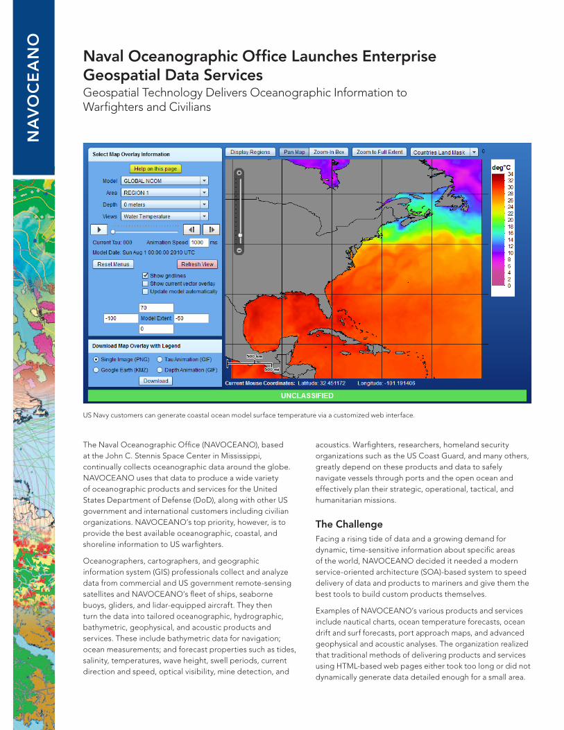
US Navy customers can generate coastal ocean model surface temperature via a customized web interface.
acoustics. Warfighters, researchers, homeland security organizations such as the US Coast Guard, and many others, greatly depend on these products and data to safely navigate vessels through ports and the open ocean and effectively plan their strategic, operational, tactical, and humanitarian missions.
The ChallengeFacing a rising tide of data and a growing demand for dynamic, time-sensitive information about specific areas of the world, NAVOCEANO decided it needed a modern service-oriented architecture (SOA)-based system to speed delivery of data and products to mariners and give them the best tools to build custom products themselves.
Examples of NAVOCEANO’s various products and services include nautical charts, ocean temperature forecasts, ocean drift and surf forecasts, port approach maps, and advanced geophysical and acoustic analyses. The organization realized that traditional methods of delivering products and services using HTML-based web pages either took too long or did not dynamically generate data detailed enough for a small area.
The SolutionNAVOCEANO contracted with Radiance Technologies, Inc., an Esri partner headquartered in Huntsville, Alabama, to develop NAVOCEANO Geospatial Data Services (NGDS). The geospatial technology-based enterprise SOA serves oceanographic data, models, and products quickly and provides an easy-to-use interface for finding information and requesting advanced analysis. The geospatial technology used was Esri’s ArcGIS® Server. The NGDS also manages workflow processes, enforces DoD metadata standards, and stores data in a centralized geodatabase.
NAVOCEANO can now provide US Navy coastal ocean models (NCOMs) on demand through a customized web interface that accesses Open Geospatial Consortium, Inc.® (OGC ®), Web Map Services (WMS). These services now replace the generation of 15,000 soft-copy regional NCOM maps daily. This saves valuable high-performance computing time, allowing NAVOCEANO to run its complex ocean models more often. Using these web services and interfaces, DoD warfighters, researchers, and customers can customize the ocean model output display by defining their area of interest, selecting the desired ocean properties by depth and time period, and generating a product image. Using this interface, they can also download the image in various formats, including .png, .gif, animated .gif, or .kml. The final output of ocean current direction vector arrows overlaid on a surface temperature model image can then be incorporated into briefing presentations or GIS technologies.
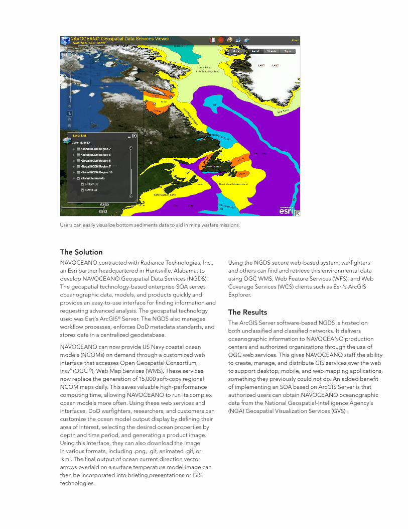
Users can easily visualize bottom sediments data to aid in mine warfare missions.
Using the NGDS secure web-based system, warfighters and others can find and retrieve this environmental data using OGC WMS, Web Feature Services (WFS), and Web Coverage Services (WCS) clients such as Esri’s ArcGIS Explorer.
The ResultsThe ArcGIS Server software-based NGDS is hosted on both unclassified and classified networks. It delivers oceanographic information to NAVOCEANO production centers and authorized organizations through the use of OGC web services. This gives NAVOCEANO staff the ability to create, manage, and distribute GIS services over the web to support desktop, mobile, and web mapping applications, something they previously could not do. An added benefit of implementing an SOA based on ArcGIS Server is that authorized users can obtain NAVOCEANO oceanographic data from the National Geospatial-Intelligence Agency’s (NGA) Geospatial Visualization Services (GVS).

NGDS Services Available NowThe new NGDS disseminates more than 80 services that include
• Deep ocean forecasts of temperature, salinity, current direction and speed, and sea surface height
• Wave forecasts of significant wave height, mean wave direction, mean wave period, peak wave period, and height (tides)
• Sea surface temperatures derived from satellites
• Digital Bathymetric Database—Variable resolution (DBDB-V)
• Bottom characteristics important for mine warfare such as sediments, seafloor clutter, and bottom type
Services currently being developed include
• Nearshore ocean forecasts of temperature, salinity, currents, and tides
• Derived acoustic properties from NCOM
• Ocean drift and surf forecasts
• Ocean horizontal and vertical visibility
• Acoustic performance surfaces
The NAVOCEANO Esri® ArcGIS Server software-based NGDS system proved to be integral in planning the navigation routes during the US government’s massive response to deliver aid to the victims of the earthquake in Haiti in January 2010. NAVOCEANO production teams tapped into their geospatial databases to produce ingress/egress navigation routes for US hospital and supply ships that needed to deliver care and supplies to Haiti.
Contact Information Jennifer Hailes, Program Manager NAVOCEANO Geospatial Data Services
Naval Oceanographic Office 1002 Balch Boulevard Stennis Space Center, MS 39522 t 228-688-5682 [email protected]
Keith Jester, Assistant Vice President, Intelligence/Geospatial Systems
Radiance Technologies 1103 Balch Boulevard Stennis Space Center, MS 39529 t 228-688-3535 [email protected]
Quick and easy tools in the viewer can be used to calculate and visualize global NCOM data.
“It took four hours to produce one [navigation aid] product simply because the data was already in the system,” said one production manager. He simply had to pull out and reuse existing data that was required for analysis and navigation planning. Without the system, it would have taken one or two days to produce the same navigational aid product.