naugatuck connecticut brownfield remediation assessment, 2010
DESCRIPTION
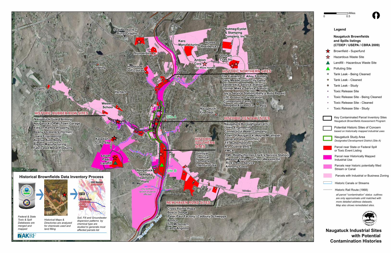
The Borough of Naugatuck, former home to one of Connecticut’s largest concentration of rubber industries, retained AKRF Environmental Planners to prioritize pollution remediation activities for now abandoned riverfront sites targeted for a downtown revitalization program. Using State and Federal Toxic Databases, historical reports, commercial directories, factory blueprints and historical maps, Eymund integrated various data formats into a common pollution history mapping database linked to Naugatuck’s Geographic Information System of Borough parcels. Created using optical character recognition, Excel, Access, Photoshop, Digital Elevation Model Flow Analysis, ArcGIS and Adobe Illustrator.TRANSCRIPT
0 0.5Miles
Historical Brownfields Data Inventory Process
Amoco
Rogers
NEW HAVEN ROAD SITES
Bosco Dodge
Chemtura Usa
Pelz
Cathy Angilillo
Donham Craft Inc
HISTORIC RUBBER ROW SITES
Cross Pointe Plaza
Kaladish Dump Site
Laurel Park
Landfill
YMCA
Thunderbird Dr
Herbert
Tim McGovern
Anthony Costa
Dowling
Cumberland Farms
Avenue Auto BodyLewis Engineering
Lewis Engineering
R.J. Guerrera Inc.
Naugatuck Glass Co.
Rick's Auto Service
Hopbrook Golf Course
Naugatuck (DPW) Town Garage
T.F. Butterfield Inc.
Edison Ramos Property
Wesson Texaco Station / Wesson Oil
Humes Residence
Naugatuck Guard Armory
General Datacomm, Inc.
Karo Manufacturing
GTE Products Corporation
Naugatuck Fire Dept.
Beany's Cleaners (former) Connecticut Water Company
Uniroyal Chemical Company
Gary Meade Union City Getty
Naugatuck Borough "parcel C"
The Eastern Co. Alloy Foundry
Seal Products / Bunzl Graphic
Naugatuck Sewage
Treatment Plant
Risdon ManufacturingFabricated Metal Products
Town Of Naugatuck, Wayne Mcallister
WesternSchool
Peter Paul Factory / Cadbury/Schwepps
Nutmeg Eyelet & Stamping Company, Inc.
Jay's Service Station (Kelly's Auto Repair)
TMC Realty (former Clark's Service Station)
Swiderski's Service Station (former Mike's Service Station)
State Hwy 8
Ans
onia
Der
by
State Hwy 68
Elm
New Haven
Prospect
Main
State Hwy 63
Millville
Straits
Scott
Hill
Great Hill
Rad
o
Union City
Bioski
Black Forest
Cross
Sprin
g La
ke
Andrew Mountain
Litchfield
Sheridan
Lew
is
Krodel
Cla
rk
Highlan
d
Wat
erbu
ry
Wat
er
War
d
Aetna
Andrew
Pine
Bridge
Mea
dow
Old
Ray
tkw
ich
Curti
ss
Platts Mills
Heritage Miller
Schoo
l
Perock
Terr
ace
Industrial
Exit
25
Phyllis
Manners
Platts Mill
Van
Oak
Adella
Gus
Mallane
Crofut
Exit 28
Warren
June
Andrasko
Arc
h
Irving
Galpin
Carroll
Village
Alison
Eagl
e
Woodbine
Plea
sant
Weid
Exit
27
Westover
Bow
man
Exit 29
Haze
l
Nicole
Brittany
Cold S
pring
s
Laur
el
High Ridge
Ann
Exit 26
Rayron
Trac
kson Fairwood
Amanda
Pearl
Patricia
Munici
pal
Woodruff
Roc
kwel
l
Homestead
Buckingham
Old
Fire
hous
e
Sharon
Pass
eck
Risdon
Crown
Fox
Hill
Picture
Tollgate
Valentine
Harlow
Win
thro
p
Gree
nwoo
dB
urrit
t
Pond
Golden
Neville
Donna
North
I 84
Exit
28
Cherry
Stat
e H
wy
8
Park
Dunn
HISTORIC CENTRAL SITES
HISTORIC NORTHERN SITES
AmbionCorp(Haz Waste Handler)
only northernsection of parcel
affected
Federal & StateToxic & SpillDatabases are merged andmapped
Historical Maps &Directories are analyzedfor chemicals used and land filling
Soil, Fill and Groundwaterdispersion patterns by chemical type are studied to generate most affected parcels list
SITE
1896 SanbornMetal PlaterMetal Plater
Methyl ethylketonedumping area
1956 Sanborn
Naugatuck River
Rail Station
Rail Line
hist
oric
rail
HISTORIC SOUTHERN SITES
Site B
Site A
Naugatuck Brownfields and Spills listings (CTDEP / USEPA / CBRA 2009)
Legend
Brownfield - Superfund
Landfill - Hazardous Waste Site
Hazardous Waste Site
Polluting Site
Tank Leak - Being Cleaned
Tank Leak - Cleaned
Tank Leak - Study
Toxic Release Site
Toxic Release Site - Being Cleaned
Toxic Release Site - Cleaned
Toxic Release Site - Study
Key Contaminated Parcel Inventory SitesNaugatuck Brownfields Assessment Program
Potential Historic Sites of Concernbased on historically mapped industrial uses
Naugatuck Study Area Designated Development District (Site A)
Historic Canals or Streams
Parcel near State or Federal Spill or Toxic Event Listing
Parcel near Historically Mapped Industrial Use
Parcels near historic potentially filled Stream or Canal
all parcel “contamination” status outlinesare only approximate until matched with more detailed address datasets.Map also shows remediated sites.
Parcels with Industrial or Business Zoning
Historic Rail Route (1868)
Naugatuck Industrial Siteswith Potential
Contamination Histories
Elm
Cherry
Ans
onia
Der
by
Main
Scott
Wat
er
63
Chu
rch
Millville
Rubber
Cliff
Ward
Mea
dow
New Haven
Maple
Gorm
an
Aetna
Hill
side
Fairview Carroll
Manners
Arch
Andr
ew
Oak
Nixon
Ann
Beebe
Terr
ace
Plea
sant
Cen
tral
Moore
Good
year
Cedar
Nettl
eton
Calvin
Risdon
Riv
ersi
de
Cha
rles
Hotchkiss
Sweeney
Tolles
Woo
dlaw
n
Vine
Russ
ell
Ther
esa
Divison
Curti
ss
Pond
Southview
Pleasant View
Le Clair
Winslow
Lynn
Rubber
Mai
n
Forest
Spencer
Park
Main
Ramp
Old
Fire
hous
e
Elm
Scott
Cherry
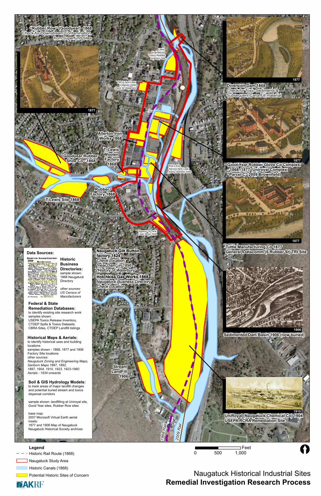
Naugatuck Historical Industrial SitesRemedial Investigation Research Process
Data Sources:
Federal & State Remediation Databases:to identify existing site research worksamples shown:USEPA Toxics Release Inventory, CTDEP Spills & Toxics Datasets, CBRA Sites, CTDEP Landfill listings
Historic Business Directories:sample shown: 1868 Naugatuck Directory
other sources:US Census of Manufacturers
Historical Maps & Aerials:to identify historical uses and building locationssamples shown - 1868, 1877 and 1906Factory Site locationsother sources: Naugutuck Zoning and Engineering Maps, Sanborn Maps 1887, 1892, 1897, 1904, 1910, 1923, 1923-1960Aerials - 1934 onwards
Soil & GIS Hydrology Models:to track areas of major landfill changes and potential buried stream and toxics dispersal corridors
sample shown: landfilling at Uniroyal site,Good Year sites, Rubber Row sites
base map:2007 Microsoft Virtual Earth aerialinsets:1877 and 1906 Map of NaugatuckNaugatuck Historical Society archives
Historic Canals (1868)
Potential Historic Sites of Concern
Naugatuck Study Area
Historic Rail Route (1868)Legend
1910
1906
1877
1877
1877
1877
0 500 1,000Feet
T Lewis Site 1868
UniRoyal (Naugatuck Chemical Co) 1904 USEPA RCRA Remediation Site
Stream LandFill
1906
Goodyear Rubber Shoe Co - 1868
Sedimented Dam Basin 1906 (now buried)
Lewis Engineering
Toxics ReleaseInventory Site
Rick's Auto Service Tank Leak (beng cleaned) 2008
Rubber Factory 1868
Tuttle Manufacturing Co 1877 General Datacomm (6 Rubber St) TRI Site
T. Lewis Woolen Factory
1868
Wesson Oil Tank Leak Study 2008
YMCA Tank Leak (Cleaned 2008)
check for dispersion
Good Year Rubber Glove Co Complex - 1868 /1877 (Uniroyal Complex "Parcel C" 2009 Brownfield)
Diversion Dam 1868Check for Toxic Sediments & Subsequent Cana Fill material
Allerton Iron Works 1868
Naugatuck Gilt Button factory 1824 Check Location:“near Dam” in 1896 “History of Waterbury”
Naugatuck Gilt Button factory 1824 Check Location:“near Dam” in 1896 “History of Waterbury”Hotchkiss Gas Works 1868 Naugatuck Business DirectoryCheck Location
Hotchkiss Gas Works 1868 Naugatuck Business DirectoryCheck Location
“Rubber Row” (Goodyear) 1868Check for Downstream Contamination
from Superfund Sites
2009
Rai
l
1868
Rai
l
Main
Cliff
Rubber
Mea
dow
State Hw
y 8Maple
ScottState Hw
y 63
Ans
onia
Der
by
Wat
er
Aetna
Elm
Oak
Carroll
Andr
ew
Arch
Exit
27
Cherry
Moore
Hill
side
Cen
tral
Beebe
Nettle
ton
Old
Fire
hous
e
Risdon
Terr
ace
Chu
rch
Tolles
Hotchkiss
PondEx
it 26
Edward Southview
Summit
Division
Lynn
Winslow
Stat
e H
wy
8
State Hwy 63
Park
Exit 26
0 200 400Feet
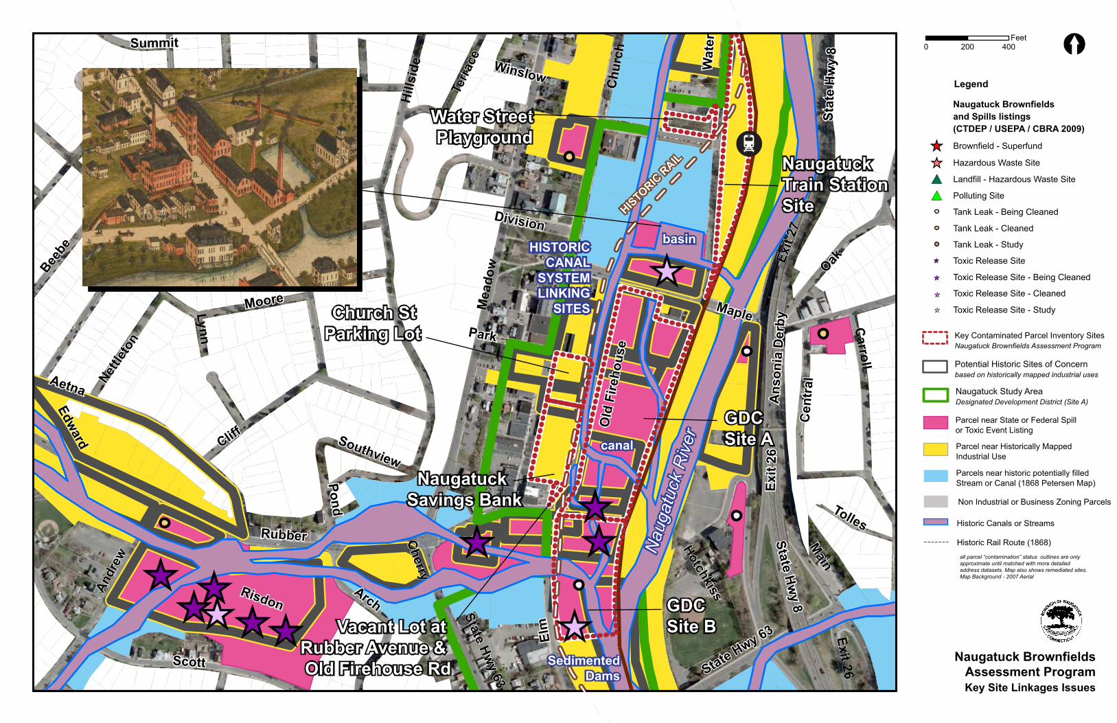
Naugatuck Brownfields and Spills listings (CTDEP / USEPA / CBRA 2009)
Legend
Brownfield - Superfund
Landfill - Hazardous Waste Site
Hazardous Waste Site
Polluting Site
Tank Leak - Being Cleaned
Tank Leak - Cleaned
Tank Leak - Study
Toxic Release Site
Toxic Release Site - Being Cleaned
Toxic Release Site - Cleaned
Toxic Release Site - Study
Key Contaminated Parcel Inventory SitesNaugatuck Brownfields Assessment Program
Potential Historic Sites of Concernbased on historically mapped industrial uses
Naugatuck Study Area Designated Development District (Site A)
Historic Canals or Streams
Parcel near State or Federal Spill or Toxic Event Listing
Parcel near Historically Mapped Industrial Use
Parcels near historic potentially filled Stream or Canal (1868 Petersen Map)
all parcel “contamination” status outlines are only approximate until matched with more detailed address datasets. Map also shows remediated sites.Map Background - 2007 Aerial
Non Industrial or Business Zoning Parcels
Historic Rail Route (1868)
Naugatuck BrownfieldsAssessment ProgramKey Site Linkages Issues
GDC Site A
GDC Site B
Naugatuck Train StationSite
Naugatuck Savings Bank
Church St Parking Lot
Water Street Playground
Vacant Lot at Rubber Avenue & Old Firehouse Rd
HISTORICCANAL
SYSTEMLINKING
SITES
HISTORIC R
AIL
basin
Nau
gatu
ck R
iver
SedimentedDams
canal

Elm
Mai
n
State Hw
y 8
Mea
dow
Wat
er
Stat
e H
wy
63
Ansonia Derby
Maple
Scott
Fairview
Oak
Hills
ide
Cherry
Arch
Ram
p
Rubber
Terr
ace
Exit
27
Carroll
Chu
rch
Central
Exit 26
Cedar
Old
Fire
hous
e
Park
Lewi
s
Hotchkiss
Cliff
Ward
Gorman
Tolles
Sweeney
Nixon
Division
Southview
Millville
Elm
hurs
t
Elmwood
George
Pleasant View
Frederick
Barnum
Winslow
Manners
Parking Lot
State Hwy 8
Ramp
Ramp
Ramp
Exit
27
Ansonia Derby
Cher
ry
Exit
26
Nixon
Historic Canals 1959 Naugatuck Rubber Factories Complex Survey0 100 20050Feet
B-8
B-9
B-3
B-4
B-7
B-5
B-8
B-2
B-1
AK-9
AK-8
AK-8
AK-7
AK-6AK-6
AK-5
AK-4
AK-3
AK-2AK-1
B-11
B-12
B-10
TP-7
TP-8
TP-9
TP-6
TP-5
TP-1
TP-4
TP-3
TP-2
AK-23
AK-22
AK-21
AK-20
AK-19
AK-18
AK-17
AK-16
AK-16
AK-15
AK-14
AK-13
AK-12
AK-12
AK-11
AK-10
TP-10
Grinding BuildingGrinding Building
1959 - Fuel Company1959 - Fuel Company
HeatersHeaters
1887 - Goodyear India Rubber Glove manufacturing Co1887 - Goodyear India Rubber Glove manufacturing Co
Culvert Outfall to Naugatuck RiverCulvert Outfall to Naugatuck River
DrugsDrugs
2010 - Filled Stream Bed2010 - Filled Stream Bed
Historic Filled CanalHistoric Filled Canal
1968 - Heater Varnish Building1968 - Heater Varnish Building
2010 - Piped Stream downstream from Superfund site2010 - Piped Stream downstream from Superfund site
1968 - Tin Shop1968 - Tin Shop
DynamosDynamos
1923 Engine House1923 Engine House
1910 - Varnish Room1910 - Varnish Room
1907 - Rail Depot1907 - Rail Depot
1910 - Acid House1910 - Acid House
1968 - Transformer Building1968 - Transformer Building
1968 - Heater Varnish Building1968 - Heater Varnish Building
1923 - Naphta Tanks1923 - Naphta Tanks
Hose & H & L Co (Fire Department ?)Hose & H & L Co (Fire Department ?)
Drugs & Dentist OfficeDrugs & Dentist Office
Intake or Discharge Pipe ?Intake or Discharge Pipe ?
Grinding Building, 1923 Pump RoomGrinding Building, 1923 Pump Room
1910 Heaters1910 Heaters
1923 Engine & Dynamo Room1923 Engine & Dynamo Room
1923 - Lamp Black Storage1923 - Lamp Black Storage
1887 - Laundry1887 - Laundry
Concrete TunnelConcrete Tunnel
1910 - Naugatuck Fire Department1910 - Naugatuck Fire Department
1968 - Power House1968 - Power House
1904 Fuel Tanks ?1904 Fuel Tanks ?
historic filled streamhistoric filled stream
1959 - Flammable
Liquids Storage Contol Building
1959 - Flammable
Liquids Storage Contol Building
1923 - Fire Department Chemical Engine1923 - Fire Department Chemical Engine
1968 - Battery Service1968 - Battery Service
1910 Engine Room1910 Engine Room
1887 - Printing1887 - Printing
1968 - Vulcanizing Building, 1923 Boiler House - 1910 Boilers1968 - Vulcanizing Building, 1923 Boiler House - 1910 Boilers
1968 - Vulcanizing Building, 1923 Dynamo Engine1968 - Vulcanizing Building, 1923 Dynamo Engine
Cement ShopCement Shop
1910 600 gallon tank1910 600 gallon tank
Jewelry (Store or Manufacturing?) 1910
Jewelry (Store or Manufacturing?) 1910
Electrical Pump & MotorElectrical Pump & Motor
Heater BuildingHeater Building
1923 - R.R.W.T. (to decode)Rail Road Water Tank ?
1923 - R.R.W.T. (to decode)Rail Road Water Tank ?
1904 - Benzine Storage1904 - Benzine Storage
1968 - Power House1968 - Power House
1968 - Paint shop1968 - Paint shop
1959 - Outfall to Naugatuck River1959 - Outfall to Naugatuck River
Dust CollectorDust Collector
1910 - Paint House1910 - Paint House
1968 - Engine House - Main Motor Room1968 - Engine House - Main Motor Room
1959 - Flammable Liquids Storage Contol Building?1959 - Flammable Liquids Storage Contol Building?
1960 - Gasoline Tank1960 - Gasoline Tank
1959 - Outfall to Naugatuck River1959 - Outfall to Naugatuck River
1904 Fuel Tank ?1904 Fuel Tank ?
Dynamo (?) HouseDynamo (?) House
1910 Electrical Supplies1910 Electrical Supplies
1959 - 3000 Gallon Plasticizer Tank1959 - 3000 Gallon Plasticizer Tank
1968 - Power House / Laquer Tanks (1960)1968 - Power House / Laquer Tanks (1960)
1923 Engine Rook Cistern1923 Engine Rook Cistern
1959 - 2000 Gallon Plasticizer1959 - 2000 Gallon Plasticizer
1959 - 2000 KVA Transformers ?1959 - 2000 KVA Transformers ? 1968 - Paint shop1968 - Paint shop
1923 Pump House1923 Pump House
1904 - Knowles 500 Gallon Tank ?1904 - Knowles 500 Gallon Tank ?
1959 - 550 Gallon Alcohol Tank1959 - 550 Gallon Alcohol Tank
1959 - 550 Gallon Alcohol Tank1959 - 550 Gallon Alcohol Tank
1959 - Air Tank Storage1959 - Air Tank Storage1959 - Air Tank Storage1959 - Air Tank Storage
1968 - 100,000 Gallon Steel Tank on Tower1968 - 100,000 Gallon Steel Tank on Tower
1959 - Four 2000 KVA Transformers ?1959 - Four 2000 KVA Transformers ?
1959 - Potential Tank Location1959 - Potential Tank Location
1960 - Fuel Oil Tank1960 - Fuel Oil Tank
1923 Boiler House - 1904 Chimneys1923 Boiler House - 1904 Chimneys
1960 - Kerosine Tank1960 - Kerosine Tank
1923 - Glove Dryer1923 - Glove Dryer
1959 - 6000 Gallon Processing Oil1959 - 6000 Gallon Processing OilElectric PumpElectric Pump
Hose OutletHose Outlet
1968 - Battery Service / 1923 Pump House1968 - Battery Service / 1923 Pump House
1959 - 3000 Gallon Plasticizer Tank1959 - 3000 Gallon Plasticizer Tank
1959 - 3000 Gallon Gasoline Tank1959 - 3000 Gallon Gasoline Tank1959 - 3000 Gallon Plasticizer Tank1959 - 3000 Gallon Plasticizer Tank
1959 - 70,000 Gallon Fuel Oil Tank1959 - 70,000 Gallon Fuel Oil Tank
1904 100 foot Chimney1904 100 foot Chimney
1959 - 3000 Gallon Plasticizer Tank1959 - 3000 Gallon Plasticizer Tank
1960 - Fuel Pump House1960 - Fuel Pump House
CisternCistern
1959 - 2000 Gallon Sovasol1959 - 2000 Gallon Sovasol
1904 80 foot Chimney1904 80 foot Chimney
1959 - 2000 KVA Transformers ?1959 - 2000 KVA Transformers ?
1959 - 8000 Gallon Paraffin Tank1959 - 8000 Gallon Paraffin Tank
1897 - Stack ?1897 - Stack ?
Dust CollectorDust Collector
1959 - Air Tank Storage1959 - Air Tank Storage
1959 - Air Tank Storage1959 - Air Tank Storage
Elm
Elm
Mai
nM
ain
MapleMaple
Ram
pR
amp
Chu
rch
Chu
rch
Stat
e H
wy
63St
ate
Hw
y 63
Old
Fire
hous
eO
ld F
ireho
use
Hotchkiss
Hotchkiss
Exit
26Ex
it 26
ParkPark
Wat
erW
ater
RubberRubber
Exit
27Ex
it 27
BarnumBarnum
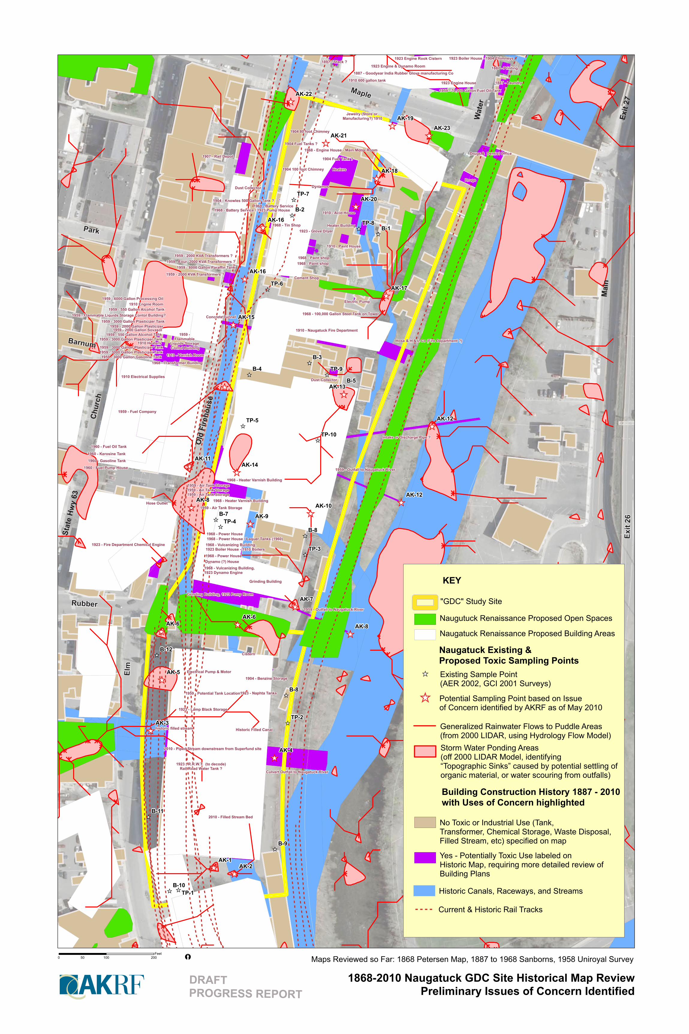
1868-2010 Naugatuck GDC Site Historical Map ReviewPreliminary Issues of Concern Identified
"GDC" Study Site
Naugutuck Renaissance Proposed Open Spaces
Naugatuck Renaissance Proposed Building Areas
Naugatuck Existing & Proposed Toxic Sampling Points
KEY
Existing Sample Point (AER 2002, GCI 2001 Surveys)
Potential Sampling Point based on Issue of Concern identified by AKRF as of May 2010
Generalized Rainwater Flows to Puddle Areas (from 2000 LIDAR, using Hydrology Flow Model)Storm Water Ponding Areas (off 2000 LIDAR Model, identifying “Topographic Sinks” caused by potential settling oforganic material, or water scouring from outfalls)
Building Construction History 1887 - 2010 with Uses of Concern highlighted
No Toxic or Industrial Use (Tank, Transformer, Chemical Storage, Waste Disposal, Filled Stream, etc) specified on map
Yes - Potentially Toxic Use labeled on Historic Map, requiring more detailed review ofBuilding Plans
Historic Canals, Raceways, and Streams
Maps Reviewed so Far: 1868 Petersen Map, 1887 to 1968 Sanborns, 1958 Uniroyal Survey 0 100 20050Feet
DRAFTPROGRESS REPORT
Current & Historic Rail Tracks