nature . conservancy council earth science conservat·on
TRANSCRIPT

iN NATURE .
CONSERVANCY COUNCIL
Earth science conservat·on
~-------------- No. 26 December 1988--------------
.. ~ ' .. ". '. : ,'4' ~,
'-- t• < ;). . r" " .. .. .:.. ..

Earth science conservation is the journal of the Earth Science Division of the Nature Conservancy CounciL Correspondence and comments should be addressed to Dr Des O'Halloran, The Editor, Earth Science Division, Nature Conservancy Council, Northminster House, Peterborough PE 1 1UA. Telephone (0733) 40345.
The Nature Conservancy Council would like to thank all those who have assisted in the task of promoting earth science conservation.
The opmions expressed by the contributors to Earth science conservation are not necessarily those of the Nature Conservancy CounciL
Contents Eclitoral 5
General features
New Head of Earth Science Division appointed 7 Recent staff changes 7 Acid rain, Flue Gas Desulphurisation and Britain's limestone resources 7 Radioactive waste disposal- new proposals from NIREX 12 The Severn Barrage and geological conservation 16
Invited features
Urban renewal- geologists to the rescue? 19 Early life on land - the East Kirkton discoveries 22
Regional focus
Geological conservation in the West Midlands 29 Cheddar Gorge and the scrub control project 36
Geological Conservation Review
Progress on GCR site selection 40 Publication plans for the GCR 41
SSSI notification and denotification
Progress on SSSI notification 43 The rationale for denotifying SSSIs 43 Supplementary list of proposed geological denotifications 45
Major casework
Conservation success at Parys Mountain 47 Afforestation threat to classic Arran site 49 Spoil disposal near Shakespeare Cliff, Dover 52 Casework update 52
Site management
Rescue collecting at Scottish gem locality 53 Spittal Action Centre launched 54 Rescue collection of dinosaur remains 54 Site access 55
Site related research
Commissioned research and the NCe an overview 56 Commissioned research report geological conservation in quarries 58
Field education
New GCSE geology manual 62 Education working group to continue 62 Nature conservation points of view - new leaflets from the NCC 62
Readers' forum
Educational uses of Tedbury Camp Quarry - a personal view 63
Conservation news
Earth science conservation in New Zealand 65 First international meeting on geological conservation 65

Editorial It is just over a year since Earth science conservation was relaunched in its revised format as a subscription journal. In that time it has attracted a subscribing readership of over 1,000, almost half of whom are members of the general public this is an encouraging performance in comparison with other topical journals in the earth science field. As the journal becomes an established and recognised feature on the geological scene we hope to see our readership expand still further over the next few years. It has also occurred to us that readers might care to know what company they are keeping l The six main readership groups are as follows-
General public 477 Universities and polytechnics 234 Schools and colleges 160 Local and central government 66 Overseas readers 66 Commercial interests 20
One consequence of having such a diverse readership is the need to keep the contents of the journal sufficiently varied to appeal to all categories of reaefer, This may prove an impossible task but that won't stop us trying l In this issue we introduce two new sections, 'Regional Focus' is intended to put the spotlight on grassroots issues ofregional and county interest, and remind us all of the commitment needed to further the earth science conservation movement at grassroots levels. 'Readers forum' gives you, the reader, an opportunity to comment and offer feedback not just to the NCC, but equally importantly, to other readers. We hope it will in time evolve into a lively forum for . constructive debate on the issues facing the earth science conservation movement. One absentee feature this time around is our 'Public Inquiries' section as none of our current casework items are presently the subject of a Public Inquiry.
One of the most satisfying aspects of editing this particular issue has been to see inputs coming in from a wider range of NCC staff than hitherto, Two of our Headquarters biological staff, Dr Nick Davidson and Dr Sarah Woodin, contributed to the article on acid rain and their efforts are much appreciated, Star billing must however go to the two Assistant Regional Officers, Dr John Box and Bob Corns, whose enthusiasm and co-operation have made 'Regional focus' a success. We hope you will agree.
Dr DesO'Halloran Editor
4 5

General features ,
New Head of Earth Science Division appointed
Many readers will have seen the advertisement for this post in New Scientist earlier this year, following the promotion of Dr Keith Duff to the post of Assistant Chief Scientist. An appointment has now been made, and the new incumbent, Mr Christopher Stevens, started work on 10 October 1988,
Mr Stevens comes to the NCC from his previous post as Chief Geologist at Sir Alexander Gibb & Partners, one of Britain's larger firms of consulting engineers, He is 34 years old and graduated from Imperial College with a B,Sc, in geology in 1975, He started work for Sir Alexander Gibb & Partners immediately after graduation and has remained with them since, save for a 9 month break in 1977/78 when he returned to Imperial to gain an MSc in soil mechanics, He is a member of the Institution of Geologists, and served on its Council from 1983 to 1986; during part of this time he was Secretary of their External Relations Committe
During his time with Gibb, Mr Stevens has worked on a wide range of geological issues, extending from igneous and metamorphic geology through to periglacial features, both in Britain and also in Africa, the Middle East and Sri Lanka, He was the Project Leader for the NCC commissioned research project to investigate the key factors controlling the safeguard of geological features in quarries, undertaken by Gibb (see elsewhere in this issue), and has also advised the NCC on cliff stability and remedial works to safeguard the interest of part of the Durlston Bay SSSI in Dorset. He is an active caver, and we look forward to making full use of his practical experience in this rather specialised area of earth science conservation, We are pleased to welcome Mr Stevens to the NCC, and wish him every success in his new post.
Recent staff changes
A number of changes in staff responsibilities within the Earth Science Division have recently taken place, and these are summarised below.
Since September 1986, Bill Wimbledon has been responsible not just for acting as Editor-in-Chief of the
GCR, but also for heading the Stratigraphy and Palaeontology Branches, As from 1September 1988 Dr David Norman has been appointed as Acting Head of Palaeontology Branch, thereby relieving Dr Wimbledon of part of his heavy workload, Recruitment of a new Head of Stratigraphy Branch is again in hand, following an unsuccessful advertisement of this post earlier in 1988, which generated only a small number of applications, In the meantime, Dr Colin Prosser has started work on a three-year contract appointment in the Stratigraphy Branch, to provide support in site safeguard and documentation; this post is in addition to the Head of Branch post which is being readvertised,
Acid rain, Flue Gas Desulphtuisation and Britain's limestone resources
Introduction
In the last ten years the environmental damage caused by acid rain has become widely acknowledged. The issue is one which crosses national boundaries and it has become a shared European problem which car. only be tackled through increased inter-governmental co-operation. Recent moves in that direction are therefore to be welcomed,
In this article we look at the measures to curb acid rain being proposed in the UK, and whilst fully endorsing the objective, ask whether the 'knock-on' environmental impacts have been adequately assessed, In particular we focus on the likely impact on our countryside of an increased demand for limestone and emphasise the need for indirect impacts such as this to be thoroughly examined in environmental assessments,
The acid rain problem
Acid rain is a product of industrial society, rain becoming acidic when sulphur dioxide and nitrogen oxides dissolve in it. These gases do occur naturally, but in the western world they originate mainly from the combustion of fossil fueL In Britain over 70% of sulphur dioxide emissions and approximately 40% of nitrogen oxide emissions arise from power stations; the remainder being produced by industrial, transport, domestic and other sources,
The acidification of ecosystems by air pollutants was first discovered by Scandinavian scientists in the early
7 6

1970s. Since then it has become increasingly apparent that gases produced by fossil fuel combustion are being transported for hundreds of kilometres in the atmosphere before being deposited in acid rain. In this way soil and water in ecosystems which are very remote from industry are being acidified, and associated plant and animal populations are being damaged and, in some cases, destroyed. British emissions contribute to acidification in Norway and Sweden and, in recent years, scientists have demonstrated widespread damage in Britain for which our own emissions are largely responsible. Scientists studying tolerance thresholds of ecosystems to pollution are able to calculate 'critical loads' of pollutants. The critical load of a pollutant is the highest load which will not cause chemical or biological changes leading to long-term harmful effects on the most sensitive ecological systems. In many areas of Britain and northern Europe it is estimated that acid deposition needs to be reduced by as much as 70% in order to fall below the critical load. Emissions of sulphur dioxide and nitrogen oxides need to be reduced if sensitive ecosystems, wildlife and vegetation are to be protected. A reduction of pollutant emissions in Britain will help alleviate the problem in Scandinavia and is also vital for the protection of our own natural environment.
The need for large reductions m emissions of sulphur dioxide and nitrogen oxide for the protection of nature is recognised by the NCC and in recent evidence given to the House of Commons Environment Committee we called for a reduction of at least 70% in emissions of these gases. The NCC is also concerned that the emission reduction strategies to be adopted are appropriate,.and do not themselves generate 'knockon' environmental problems.
The initial response of the Government and of the Central Electricity Generating Board (CEGB) to claims that British power station emissions were causing ecological damage in Scandinavia and in Britain was cautious. Rather than making an immediate commitment to the expensive process of reducing emissions, money was made available for detailed research into the nature and effects of acid rain. On the basis of evidence arising from this research the CEGB announced in 1986 that it would be fitting sulphur dioxide 'clean-up' technology to three existing power stations, and to all coal-fired stations built in the future. Technology to reduce nitrogen oxide emissions is also to be fitted at 12 coal-fired stations.
The CEGB has chosen to reduce its sulphur dioxide emissions by means of flue gas desulphurisation (FGD), which involves the gases produced by coal burning being 'scrubbed' with a sulphur dioxide reagent. There are over 30 different types of FGD system in commercial use or commercially available. The CEGB is currently planning to use two types; the limestone-
gypsum and the Wellman-Lord methods. Before looking in detail at these methods we need first to examine the planned role of FGD technology in CEGB's future energy strategy.
CEGB strategy on power generation and FGD
The CEGB are currently examining a wide range of future options in generating electricity, including further nuclear power stations, coal-fired power stations, and various renewable power sources, in particular tidal power barrages and both land-based and offshore wind turbines. The UK Government holds the view that to meet predicted power demands in the next 20 years, power should be generated by a mixture of the available methods. The CEGB currently has a programme for building Pressurised Water Reactor (PWR) nuclear power stations, the first of which (Sizewell 'B') is under construction; the planning application for the second (Hinckley Point 'C') will go to Public Inquiry late in 1988.
However, nuclear and renewable energy sources will not be able to provide the bulk of the predicted power generation needs, and the CEGB views coal as continuing to provide a major contribution to Britain's power demands. Accordingly, in 1986, the CEGB announced plans to build a new generation of up to eight large coal-fired power stations. These stations are planned to operate as base-load stations, which can generate power for much of the time. The eight sites identified by CEGB as suitable were Inswork Point (Cornwall), Fawley (Hampshire), Marchwood (Hampshire), Kingsnorth (Kent), Barking (Greater London), West Burton (Nottinghamshire), Hams Hall (West Midlands) and Killingholme (Humberside). Each power station will have two 900MW generating units considerably larger than the 660MW units that are the largest currently operating in the UK. The CEGB believe that power stations are needed particularly in southern England to provide for an anticipated shortfall in generation capacity by the end of the century.
The CEGB have now made applications to the Department of Energy under Section 2 of the Electric Lighting Act (1909) for consent to build the first two of these power stations, Fawley 'B' and West Burton 'B'. Applications for the next station, at Kingsnorth, is expected to be made this autumn.
As part of the UK Government's commitment to reducing atmospheric pollution, each of the new coal-fired power stations will be fitted witha FGD plant to reduce S02 emissions, and low NOx burners in the boilers. The FGD plants proposed for Fawley 'B', West Burton 'B' and Kingsnorth are of the limestone-gypsum type.
In addition to fitting the new generation of power
8
stations with FGD, the CEGB have also made a Section 2 application to fit FGD plant to the existing 4000MW coal-fired power stations at Drax in West Yorkshire. This FGD plant will also be of the limestone-gypsum type The CEGB have further announced that they intend to retrofit FGD to another existing coal-fired power station at Fiddlers Ferry on the Mersey. Here the plans are for a Wellman-Lord plant, although this application has yet to be submitted. Further retrofits are to be expected soon as a consequence of the UK Government's agreement to implement the EC
Flue gas desulphurisation (FGD) systems
Water > I
Limestone Ground slurry limestone preparation
I :> lio... ...
•S02 absorber
Contaminated gas from power station >
I
Ground
r
limestone > Wash liquid
I :>
Waste water containing
calcium chloride
Directive on large combustion plants. This aims for a 20% reduction in sulphur dioxide emissions by 1993, 40% by 1998 and 60% by 2003, based on 1980 emissions. The target of 20% reduction by 1993 includes the contributions from retrofits at Drax and Fiddlers Ferry, although these were planned in advance of the targets being agreed. To meet the targets in full, however, a further 3 to 6 existing stations will need to be retrofitted, and the CEGB are currently examining candidate stations. Many, if not all, are expected to have the limestone-gypsum system fitted.
• Thickener andOxidiser Gypswncentrifuge
Schematic representation of the limestone-gypsum system
Contaminated gas from power station ...
~ ~
Ground limestone
I > Wash liquid
~ ..
Sulphuric acid ... H2S04Cleaned gas or .. orSelI1lSSlon sulphur plant
•
•.... ....JII"" Regenerator ,..
~
.. ~ S02NaHS03 S02 + H2O
Pre-scrubber .... •SO. Condenserto remove ,.. Absorberchloride
•A>. re- II RecycledNa2S03 Recycled
water ~
~ ~
Waste water • Na2S03 + SO. + H20 ---> 2NaHS03containing calCium chlonde
• 2NaHS03---> Na.S03 + SO. + H.O
SchematiC representation of the Wellman-Lord system

The CEGB choice of FGD systems
In this section we examine relative merits for nature conservation of the two methods being adopted by the CEGB to reduce pollutant emissions from coal-fired stations.
Fundamental differences exist between the limestonegypsum and Wellman-Lord methods of FGD. The limestone-gypsum method uses limestone to absorb sulphur dioxide, and the end product of this process is gypsum, It is a 'throwaway' system in which the reagent is used only once, The limestone requirement of this method is also far greater than that of Wellman-Lord process, Wellman-Lord technology uses limestone to remove hydrochloric and hydrofluoric acid from the gas before sulphur dioxide is absorbed by sodium sulphite. This process is 'regenerative', the reagent being recycled, and the end product can be sulphuric acid or sulphur.
Three major considerations in the choice of FGD technology are economic feasibility, technical feasibility and efficiency. The Wellman-Lord system is approximately 20% more expensive than the limestonegypsum system in terms of both installation and running costs, A further advantage of the limestone-gypsum technology from the industrial point of view is that its feasibility is well proven; 48% of FGD plants in use in the world are of this type, Regenerative processes such as Wellman-Lord are used in only 4% of world FGD plant and have presented some operational difficulties. Regenerative systems involve chemical engineering plant which is far more complex than that required for the limestone-gypsum method,
, Both of the FGD methods under consideration reduce the overall efficiency of the power station by about 10%, due to the energy requirements of the processes and other factors, However, both systems are very effective at removing sulphur dioxide from the flue gases, with mean removal efficiencies of 90% being predicted.
Environmental impacts
The limestone-gypsum and Wellman-Lord FGD systems differ greatly in terms of raw material requirements and waste by-products, both of which may have significant environmental consequences. We examine these aspects in turn below
Raw materials The limestone-gypsum and WellmanLord systems have very different requirements for raw materials, most notably limestone.
In the case of the Wellman-Lord system, the only limestone requirement is for 'pre-scrubbing' or purification of the flue gases to remove hydrochloric and hydrofluoric acids. There is no particular requirement for the limestone to be of a high purity and
the quantities involved are of the order of 27,000 tonnes per annum for every 2000MW power station,
In contrast, the limestone-gypsum system consumes considerable quantities of limestone. The application made by the CEGB for the two stations at Drax, in Yorkshire, quotes a joint requirement of 700,000 tonnes of limestone for every year of their projected 50-year life, If the CEGB want a saleable gypsum end-product then high purity limestone would need to be used, Operators of such systems abroad usually demand a minimum of 95% pure calcium carbonate, Moreover, some observers suggest that the actual requirement will exceed 700,000 tonnes, because an additional requirement is that the limestone be in a very specific form: in the case of Drax and West Burton 'B' as chippings in the size range 6-28mm, To produce such material a large amount of waste is also necessarily produced. The actual quantity of raw limestone needed is accordingly unclear, but it has been suggested that the quoted 700,000 tonnes may need to be significantly exceeded to arrive at the tonnage required from the quarry face. Using the CEGB figure of 350,000 tonnes per 2000 MW station the combined needs of stations at Drax, Fawley and West Burton would be 1,400,000 tonnes of limestone each year. Total UK production of limestone is of the order of 100 million tonnes each year and the FGD requirement would amount to approximately 1.5% of this If other new power stations are also fitted with the limestone-gypsum systems this figure would rise to between 4-5%.
The question then is where can such vast quantities of limestone be found? Initially, the increased demand for limestone may be accommodated by taking up extant permissions for mineral working and fully utilising them The point will soon be reached however when new permissions to extract will be required to meet the demand. Mindful of this likelihood, the Department of the Environment has a research programme which is investigating the distribution and availability of limestone sources, but in advance of the results of this work the implications for limestone resources remain unclear. The obvious sources would include the Carboniferous Limestone of the Yorkshire Dales, or the White Peak of Derbyshire, However, large parts of these areas are within National Parks and the CEGB has already stated that the necessary limestone would not be recovered from within their boundaries. While this decision is to be welcomed, it does mean that there will be an increased pressure on limestone landscapes outwith the Parks, parts of which are likely to be of high nature conservation value in their own right. The CEGB is also considering importation of limestone from abroad.
Waste products It would clearly be desirable if both FGD systems could produce a marketable product, as against unwanted waste, at the end of the FGD process. The limestone-gypsum system produces gypsum. If the
10
limestone used is of sufficient purity the gypsum can be sold for plasterboard and other more minor uses, The annual gypsum production of FGD at one 2000MW power station would be 550,000 tonnes and would amount to 15% of the total existing British market. It is clear that agreement by the gypsum industry to buy gypsum from the CEGB is essential if a dumping problem is to be avoided. Gypsum is partially soluble and if dumped could release sulphur and metals into drainage waters, If any gypsum were produced which was below required purity levels it would have to be dumped and would present an even greater problem of toxic substance release.
The Wellman-Lord system can produce either sulphur or concentrated sulphuric acid, Both these products could in theory be marketed However, sulphur production incurs a fairly high cost penalty over sulphuric acid production and has a large natural gas requirement. 90% of sulphur used in Britain is imported but most of it is used in sulphuric acid production The sulphuric acid market is restricted as many chemical industries produce it themselves as an integrated part of their operations. Since storage oflarge quantities of concentrated acid is impractical, an acid-producing FGD plant needs to have a guaranteed and sustained market for its acid. The CEGB estimate that the market could only absorb the sulphuric acid produced by two major power stations. Any excess acid produced would have to be neutralised, and could well be neutralised with limestone to produce gypsumI
Both FGD processes would produce an estimated two million tonnes ofwaste water per annum for every 2000 MW power station. Water Authority consents have to be obtained for discharge of this water. The major contaminant is calcium chloride, but other contaminants include calcium sulphate, calcium fluoride and metals, The treatment of waste water to reduce contaminants to a level acceptable for discharge produces a thixotropic sludge which would, presumably, have to be disposed of in industrial lagoons. Due to the smaller amount of limestone used in the Wellman-Lord process, it would produce 15,000 tonnes of sludge per 2000 MW power station as compared to 40,000 tonnes per annum for the limestone-gypsum method,
The two FGD processes each produce 60,000 tonnes of calcium chloride per annum for every 2,000 MW station. This may be disposed of in water or on land, but either way may cause environmental problems, Sodium sulphite is periodically removed from the WellmanLord system and as this is very water soluble it also poses disposal problems The estimated figure is 46,000 tonnes per annum for a 2,000 MW station.
The impact on conservation
The NCC is concerned that the CEGB plans for FGD do not adequately address the indirect effects upon the
environment. Our concern is focused on. two areas: the winning of limestone and the disposal of by-products,
If the limestone-gypsum method is adopted as presently intended, then a major impact on our limestone landscapes may be anticipated. Significant damage to woodland, grassland and wetland habitats, as well as a decrease in amenity and landscape value could result from a major increase in quarrying. Cave scientists and caving groups are, moreover, already alarmed at the prospect of the destruction of, or damage to, cave systems not presently under threat from extraction. On the other hand, many geologists would welcome the new exposures created by increased quarrying,
The other major environmental issue is the disposal of waste products arising from the process, principally gypsum and waste water. Although the CEGB are confident that most of the gypsum, or the calcium sulphate by-product, can be taken up in the plaster industry, some observers fear that if demand is less than expected, then the materials would need to be dumped in landfill sites, Dumping would add to the already heavy landfill pressures on Britain's quarries pressures which are already threatening many geological SSSIs located in disused quarries. The immediacy of the problem is illustrated by the fact that, as part of the environmental assessment for the proposed Fawley coal-frred station, an SSSI oflongstanding in Avon has already been shortlisted as a potehtial disposal site for pulverised fly ash and gypsum waste,
The need for environmental assessment
The NCC believe that, welcome as the CEGB plans for FGD are, they raise a number of environmental questions. The following recent developments should prove helpful in this regard
• In making consent applications for the Drax FGD plants and for the Fawley and West Burton power stations the CEGB, although under no legal obligation to do so, chose to provide environmental assessments with the applications, These statements go a long way towards describing the direct environmental impacts of the proposed developments, and in this regard are constructive and commendable, However, some issues, particularly those concerning indirect impacts, receive scant attention. No doubt this reflects a lack of readily available information and the fact that assessment in some areas had not been completed at the time of the submissions, This is particularly noticeable on the questions of sources of limestone, the impact of quarrying on the landscape and waste disposal.
• The Department of the Environment research programme on the availability of high purity limestone, briefly referred to previously, should provide a sound
11

datum for fuhlIe discussion and assessment. The programme is in two stages. The first stage, an appraisal of the extent and availability of limestone, has already been contracted out to the British Geological Survey and should be completed within twelve months. The second part will examine the needs, uses and demands for limestone for non-aggregate purposes and is currently being offered for tender. The programme is discussed further by Patrick (1988). The DoE initiative is to be welcomed as it will provide a datum for future discussion and assessment.
• In July 1988 a European Community Directive (number 85/337) on environmental assessment was implemented in Britain. The Directive requires a developer to undertake an environmental assessment where a proposed development is likely to have significant environmental effects. It requires that a written Environmental Statement should accompany the submission of a consent application. The intention is to clarify at an early stage the likely implications of a development, as an aid to decision making. It also encourages project design to take into account, and minimise, the environmental impacts. The Directive lists coal-fired power stations as a category of development for which an Environmental Statement is mandatory. Most importantly in the present context is the requirement that indirect effects, as well as the more obvious direct effects, should be addressed in the assessment. This means that fuhlIe CEGB applications for FGD and new power stations will have to be accompanied by comprehensive environmental assessments.
The NCC believes that environmental assessments offer a way of thoroughly assessing the wide range of environment'al effects arising from FGD technologies and a means of ensuring that the most environmentally acceptable strategies are adopted in the UK's battle to reduce atmospheric pollution.
Further reading
Patrick, C. (1988). High and very high purity limestone resources: an appraisal of the DoE research programme Mineraj Planmng 35, p22-27.
Woodin, S.J. (1988). Acid rain and nature conservation in Britain. Nature Conservancy Council This leaflet is an easily understandable introduction to the problem of acid rain aimed at the general public. Copies of this 16 page A5 booklet may be obtained, priced 55p, from PSB, NCC, Northminster House, Peterborough PEl lUA.
12
Radioactive waste disposal- new proposals fromNIREX
The safe disposal of radioactive nuclear waste is one of the major concerns of our time. For the past four decades Britain has been producing nuclear waste which has, for the most part, been stored above ground awaiting more permanent disposal.
The Nuclear Industry Radioactive Waste Executive (NIREX) was formed in 1982, in conjunction with British Nuclear Fuels plc, the Central Electricity Generating Board, the South of Scotland Electricity Board and the UK Atomic Energy Authority, to act as a centralised agency with a nationwide mandate for the safe management and disposal of nuclear waste.
The last ten years
The last decade has seen various initiatives on the part of the Government to address the question of radwaste disposal. In the late 1970s the Government initiated a research programme to investigate the feasibility of underground dispOSal of highly radioactive waste, as part of an EEC programme to identify the most suitable host rock-types. In the UK this early work focussed mainly on igneous rocks, such as granite, but was later extended to include other rock types. In 1981 this preliminary drilling programme was discontinued. Since 1976, however, successive governments have endorsed the view that a national radwaste disposal facility was needed, and it was clear that the suspension of exploratory work would merely be temporary.
The issue came to life again in 1985, when the Government announced their intention to approve planning permission for NIREX to carry out geolOgical investigations at four locations - Elstow in Bedfordshire, Fulbeck in Lincolnshire, Bradwell in Essex and South Killingholme in Humberside. It was hoped that, if the feasibility studies were encouraging, at least one of the sites would be developed as a shallow repository for low-level radwaste In the event, public hostility to the feasibility studies was intense and in 1987 the Government abandoned the search for a shallow waste site, opting instead for a multi-purpose deep site which would accommodate both low- and intermediate-level waste. NIREX are now actively pursuing this objective and plan to present a shortlist of preferred sites to the Government by the end of 1988. In view of the intense hostility and suspicion from the general public which has met their earlier initiatives, NIREX have issued a discussion document entitled The Way Forward which has been distributed widely to interested parties NIREX hope that the document will stimulate informed discussion on the main issues.
Geological environments potentially suitable for deep disposal of intermediate- and low-level radwaste.
Q
(}if$i:1j' ~.
~1:I:i:lll::~ :]~~:~~~I~~ ::I~~fot~ ~:~.
.~
t::::.:.::::jjl ~;~f~~~t~~ti~~~~ii~~~table ~ Area of low permeability ~ basement with sediment cover
Potentially suitable e-I) small island
.V
if \) 'f!J
.~
13

What 15 radwaste?
Before examining the latest NIREX proposals it may help the reader to know exactly what is meant by high-, intermediate- and low-level waste.
High-level waste (HLW) HLW is that which results from the reprocessing of spent nuclear fuel and it contains over 95% of the total radioactivity produced by the nuclear industry's waste products. Some 1, 100m3 of HLW have been produced to date in Britain and this is at present stored above ground at Sellafield. The management of HLW has been specifically excluded from NIREX's remit and there is, at present, no public programme which addresses the long-term disposal of this material.
Intermediate-level waste (ILW) ILW includes a range of solid and liquid materials, such as fuel cladding, used reactor components and sludge from effluent treatment systems. NIREX estimate that between 2,500m3 and 5,000m3 of lLW are produced in Britain each year.
Low-level waste (LLW) LLW consists of all solids and liquids which have been slightly contaminated by radioactivity. A wide range of materials fall into this category including air filters, rubber gloves, chemical sludges and the like. The amount of LLW far exceeds the volumes of ILWand HLW, with some 40,000m3
being produced annually.
The latest NIREX proposals
In The Way Forward NIREX takes the view that disposal of LLWand ILW poses no insurmountable technical or logistical problems and that public acceptability is the major stumbling block. Shallow disposal of LLW has taken place at Drigg in Cumbria for many years. NIREX aims to ensure that a new repository is brought on-line as Drigg reaches capacity Unlike Drigg, however, the new facility will be deep underground, linked to the surface by access shafts or adits. The facility could either be underground, or under the seabed, as shown in the accompanying diagrams, but in either case it will be buried to a depth of at least lOOm, so placing a massive barrier between the radwaste and the biosphere. Radwaste would be stored in the repository until such time as the radioactivity decays naturally to safe background levels. With ILW the half-lives of some of the contammants can be thousands of years. Within the concrete shell of the repository the radioactive materials would be stored in steel drums or concrete containers.
Where would the facility be located?
NIREX considers that approximately 25% of Britain is underlain by rock formations which are theoretically suitable for siting a radwaste disposal facility. Three preferred environments are currently bemg studied, all
Geological environments suitable for siting of radwaste repository I i
Small island Hard rock, low reliefterram (coastal environment,
, Sea \T- ~, \vV;V Sea
~ tJ ", s -Fresl1,. " , I ",' ,._ • I I" .----. I s Saline I I " =i.-J I, S I
~,
,/
s •,I I
,, I,
s Repcsitory
Fault
Near-stagnant groW1d water
Sea
s
D
Sea dipping and offshore sediments
Water flow
Major flow
Minor flow--+
..
~
being characterised by limited groundwater flow regimes, as follows
-Small offshore islands.
- Hard rock, such as granite, in low relief terrain.
-Seaward djpping and offshore sediments
An under-seabed repository accessed from a drilling platform
A deep underground lr.md-based repository.
An under-seabed repository accessed by tunnel from on shore.
~
NIREX, on the basis of a thorough desk study, will present a shortlist of sites to the Government by the end of 1988. If approved, site investigations will then take place over as long as four years and will include environmental assessments. Construction of the repository would also take a number of years, so that the final site is unlikely to be in use before the year 2000.
The NCC's response on radwaste
The NCC and NIREX have had discussions recently and the NCC has expressed its concern over a number of issues
-The NCC's foremost concern is to ensure that Sites of Special Scientific Il}terest (SSSIs) and National Nature Reserves (NNRs) are excluded from the areas of search for a waste disposal site. To date such an assurance has not been forthcoming from NIREX, although the National Parks are exempt The NCC will continue to argue strongly that Britain's foremost sites of nature conservation interest - the SSSI network - should be equally protected
-The NCC also has a wider responsibility in protecting the environment at large, and it has conveyed its views to NIREX. If a repository is to be built, then the NCC considers that it should be sited on land of low nature conservation value, and that such a consideration should be taken on board in the earliest stages of evaluation of possible sites. The long-term possibility of
14 15

accidental leakage of contamination into the biosphere must be critically evaluated, especially in the light of the paucity of studies on the possible harmful effects of low-level radioactivity on plants and animals, The NCC has already commissioned a study of the available literature, with a view to developing an informed policy stance, and to identifying areas where further study should be focussed,
- It is important to realise that, leaving aside the question of containment of radioactive emissions, the building of a repository will be a major engineering project, and will involve major environmental disturbances of a conventional character. These will include the disposal of spoil from excavations; major construction works on site; the provision of road and rail access and air pollution resulting from increased traffic, The NCC is particularly concerned over the impacts on the marine environment should a sub-seabed facility be built using unproven technology,
-On the earth science front the major issue will be disposal of spoil. Preliminary estimates put the amount of spoil likely to be generated by the repository construction at as high as 7 million cubic metres, which is well in excess of the figure for the Channel Tunnel. Many geological SSSIs are in quarries and clearly such sites could come under pressure from those faced with the problem of disposing of the repository spoil.
All these concerns have been made clear to NIREX and it is to be hoped that they will be taken into account We plan to return to this topic in the future to examine the specific implications for nature conservation of the particular sites selected by NIREX.
Further information
Copies of the NIREX discussion document The Way Forward and other explanatory material can be obtained from Peter Curd, Head of Information, UK NIREX Limited, Curie Avenue, Harwell, Didcot OXll ORH or by telephoning 0235-833009.
The Severn Barrage and geological conservation
The Severn Estuary, with its high tidal range and large volume of water, is the prime UK candidate site for an electricity generating tidal barrage, A number of schemes to build such a barrage have been put forward this century but it has often been unclear whether they were technologically feasible, The Severn Barrage Committee (SBC), under the chairmanship of Sir Hermann Bondi, was set up in 1978 by the Secretary of State for Energy to assess the feasibility of a barrage, The Report of the Committee, published in 1981, proved a landmark by clearly finding that
-The technical feasibility of constructing a barrage was not in doubt
-The economic Justification for a barrage, although greatly dependent on a number of variables - such as the future price of coal, and the extent of nuclear generation of electricity - was more cost-attractive than hitherto supposed,
-The environmental impacts would be so wide ranging that they merited more in-depth investigation.
-A barrage linking Cardiff (Lavernock Point) and Weston-super-Mare (Brean Down), based on an ebbgeneration mode of operation, was the most feasible option,
The positive tone of the Bondi Report prompted renewed commercial interest in the venture and in 1983 a private sector consortium, consiting of six major engineering and construction companies, was set up as the Severn Tidal Power Group (STPG), to further evaluate a barrage proposal under a Joint funding arrangement with the Department of Energy, The STPG, in its 1986 Report, proposed further detailed evaluation of the Cardiff-Weston line and the Government agreed to provide funds of an estimated £18 million, of which about £1 million would be allocated for environmental studies. These studies are now in progress and NCC staff members sit on two of the STPG steering committees.
Much of the environmental concern to date has focussed on the biological impacts of the barrage, The tidal range behind the barrier could fall by as much as half thereby compressing the intertidal zone into a narrower band Most of the intertidal flats at present below mean tide level would become permanently covered by water and hence inaccessible to feeding birds. A lowering of the high-water mark would cause the tops of saltmarshes to dry out Changes in the sediment regime and salinity would affect the populations of benthic and planktonic organisms, The
16
Earth science sites on the Seven Estuary and Bristol Channel
Extent of larger sites .-- --------Exposed at low tide (abOve 5m OD)
Proposed line of Severn Estuary Barrage
o 20kms I I
o 1'0 miles
A
17
Watchet
Based on the 1984 Ordnance Survey 1:250,000 map, Crown Copyright reserved
implications of these changes could be considerable, but are difficult to evaluate with any certainty, and the NCC will await the outcome of the present STPG researches before commenting further.
The clearest threat at present to conservation interests, however, is that to geolOgical sites The GeolOgical Conservation Review has identified 30 localities of national or international importance along the shoreline of the estuary, covering a wide range of interests. Construction of a barrage would have an impact upon these sites in a variety of ways and to varying degrees. The major concerns are
Modified tidal regime Upstream of the barrage, the tidal range would be roughly halved, the low tide not falling below about mean sea level, and there would be a 'stand' at high water while the tide seaward of the barrage fell allowing an adequate difference of head to be established across the turbines before generation started The implications for intertidal exposures at GCR sites upstream of the barrage are alarming. At Aust Cliff, where the classic cliff section exposes the base of the Lower Lias and provides a full sequence through the Rhaetic and topmost Keuper beds, much of the interest in the intertidal area would become
N
I Southerndown 9 Wamlode Chif 2 Monknash Coast 10 Garden ChIT 3 Hayes Point - Bendrick I1 'I'Hes PaInI
Rock - 12 AUSI Cliff 4 Sully Island 13 Pomshead 5 Penarth Coast 14 MIddle Hope 601ler Hole 15 Spnng Cove 7 Lancaul Cliffs 16 Brean Down 8 Lydney 17 Blue Anchor - Lilstock
permanently submerged. Most at risk would be the unconformity between the Carboniferous and Trias which is only exposed in the intert.i-dal zone, At Garden Cliff, another Rhaetic site, the loss of outcrop would be less, but access, which at present is only possible at certain states of the tide, would become even more difficult
Modified sedimentary regime The Severn Estuary is notorious for the high concentration of muddy sediment, particularly in the I}ridgwater Bay area. During the highest spring tides, when currents are strongest, in excess of 30 million tonnes of fine sediment become suspended, Construction of the barrage would reduce water velocities on the upstream side of the barrage, and the degree to which sediment is mobilised would accordingly be lessened, However, areas which are currently eroding may experience sediment accretion, with a consequent loss of exposure in the lower part of the beach profiles. Seaward of the barrier local changes in the pattern of erosion and sedimentation could result in sediment accumulation at cliff bases to the detriment of geological exposure. As pointed out by the Bondi Report in 1981 it is extremely difficult to predict precisely what changes in sediment transportation would result from the barrage and the
17

The Cardill-Weston Barrage a proposed design
Seaward elevation
16.3 km •4
1 gn(""'-/1" 1\rrb"e, "I I' @"", "I
~' ~}:._:):,.:;:~_:.~.>~:< ....~.~
I Rockhead
4kms I i I
0 2 miles
Barrage Flat Basin
Holm
~ l:l
Contous shown depth to rockhead in metres below Ordnance Datum
earth science conservation impacts are equally difficult to forecast
Landfalls The term landfall refers to the point(s) on the coast where the barrage comes ashore. The proposed Cardiff landfall would affect the Lavernock Point SSSI, which includes a through-sequence from the Keuper to the Lower Sinemurian Clearly the scale of construction works associated with the landfall would be of concern to the NCe. In the past, Brean Down SSSI, a classic Pleistocene site, has been suggested as the Weston landfall, but thankfully is no longer considered as an option
Construction materials The volume of construction materials required in building the barrage would be substantiaL However i:1 the absence of detailed proposals for the mining of sand and gravel, the impact on the quarrying industry is difficult to assess.
At present, although tte Government's commitment to privatising the electricity industry is firm, it is unclear how the privatisation will be structured. The future of the industry and the prospects for the Severn Barrage are closely linked and it is not possible to say if the
·20
Open sea
barrage will ever be constructed. The STPG, in liaison with the Department of Energy and the CEGB, are continuing their studies, with much emphasis being placed on predicting the redistribution of sediments in the post-barrage regime. Also being included, as a result of advice given by the NCC, is an assessment of the impact of the barrage upon the intertidal geological interest The NCC will continue to evaluate barrage studies and proposals from an environmental point of view, as it has done since its original submissions to the SBC in the 1970s
References
Tidal power from the Severn Estuary (1981). Department ofEnergy. Energy Paper Number 46
Tidal power from the Sevem - Report (1986). Severn Tidal Power Group.
Invited features
Editorial comment
Readers will no doubt be familiar with the longestablished, and well-publicised, activities of archaeologists who conduct rescue digs - often at a hectic pace - on urban redevelopment sites prior to the developers moving on-site in earnest. Sadly, geologists are often much slower to avail themselves of such opportunities - to the detriment of our understanding of the geological record concealed beneath our city streets. An exception is Dr Eric Robinson who, in the personal experiences recounted below, aims to persuade fellow geologists to make amends and maximise future opportunities.
In the second article, Ian Rolfe reports on the exciting finds being made at the East Kirkton palaeontological site. The NCC first became involved in 1985 when we funded a preliminary dig. The current programme of research will run from 1987 until 1992 and the NCC is funding the excavation side of the work. The designation of the site as an SSSI is currently in hand, and the logic of protecting the site is being reinforced by the new finds which are coming to light. East K'kton is an excellent illustration of the relevance of the SSSI network to the advancement of scientific knowledge.
The East Kirkton article draws heavily upon unpublished information from a range of researchers. To avoid the need to interrupt the text with frequent acknowledgements, we employ a numerical superscript system directing readers to specific acknowledgements at the end of the art.icle.
Urban renewal- geologists to the rescue?
Eric Robinson, Librarian, The Geologists' Association
Is this the Saxon river front?
The site was the old Hays Wharf ground, to the north of Tooley Street, Southwark in the winter of 1987. The question was posed by archaeologists. In an area cleared of the Victorian warehouses and the wharf frontage to the Thames opposite the Tower of London, archaeolOgiSts from the Museum of London were speculating upon ancient courses of the river predating the skilful embankment devised by Bazalgette in
1855 (Cherry & Pevsner, 1983, p. 120). Probings of the ground and the study of old maps had revealed a fleeting pattern on the ground which could have been a south-bending loop of the Thames, and which invited further investigation.
In the course of a day, a lCB excavator had scooped out a trial trench which cut down through a thin layer of 'made-ground' into a dark, blue-grey clay (circa 1.5m), a thin organic layer (circa.1O-15cms), and a further thickness of blue-grey clay (circa.lm). Nothing directly archaeolOgical was found in the clays or the organic band, but there was much discussion between a sedimentologist who thought that it wasn't an expected profile for a river channel, and two palaeontologists who were trying to trace evidence of fauna or flora which might have a bearing upon the same question. One was a diatom specialist, the other an ostracod micropalaeontologist and both needed to take away their samples for scrutiny in the laboratory before they could offer any persuasive evidence one way or the other. A palaeobotanist, also present on site, was however able to confirm that the organic layer was indeed a peat grown in place and pointed out rootle: traces penetrating the clay below. This was field evidence on which we could all agree, to the slight surprise of the archaeologists!
The outcome of all this? Sadly, there were no diatoms, possibly because of acid-diagenesis of the sulphiderich clay, but the ostracods indicated a still-water lake environment, as none of the species found were capable of swimming against any measurable current flow. We were able to conclude that we were dealing with the site of a channel, which had been later filled with flood waters to create a South Bank mere. The peat was more positive as to date, Tilbury IV, circaAOOO BC by comparison with marsh growth elsewhere in the lower estuary.
This is a typical scenario from my experience attending archaeological sitework - a collaboration which I can heartily commend to my geological colleagues. Archaeologists these days are often granted dispensations of time, and sometimes funds, by developers to carry out 'rescue digs' while the opportunity is available, and before deep-piling destroys the prospect for future generations. Whilst primarily intent upon working out the outline and fabric of structures on site, archaeolOgists are increasingly concerned these days to establish a 'context' for their work. This is nothing more nor less than the recognition of the conditions of sedimentation during a time
18 19

Based on the 1979 Ordnance Survey 1:25.000 map
A N
o I !I o "r:1ll",
~ _ Area trenched during. recent work
%
interval, combined with some sense of the duration if that is determinable. Both are eminently geological exercises, and if you are lucky, the questions can be partly answered by a relatively swift on-site examination, backed up by some straightforward analysis of samples taken away and studied in the quiet of the laboratory. AB often proves to be the case, the innocent question, "was this a river channel?" may make you realise that precisely that environment is not part of your experience; in which case, you hedge a bit, but then do your best to d:scover just what does occupy the present day Thames, Severn, or Humber, so that eventually you can assert that this present could be the key to that particular past.
Is this an old Thames course?
AB it happened, but a few weeks after the experience described above, a fuller and more complete set of exposures added further field evidence on to the Hays Wharf interpretation. =t came through 'rescue digging' upon the large acreages of the old Goods Yard of Bricklayer's Arms in Bermondsey during 1987-88.
20
Again, this was a project being tackled by an active service unit of the Museum of London, working in advance of a developer intent on transforming what had become an open space of some 12'.5 hectares into a housing project. The rescue team consisted of a graduate archaeologist in charge of a workforce of four students with the assistance of machines, provided by the contractor, for the excavation of trenches. Providing specialist support were museum-based groups with a wide range of specialisms - animal bone, wood and worked timber experts, as well as the fullest range of scientists experienced in the recognition of artefacts.
Historically, Bricklayer's Arms Goods Yard dates back to 1834 and was linked with the very early railway line which ran directly from London Bridge to Deptford, following a belt of low ground between a slightly elevated Bermondsey Eyot to the north, and the drier gravel ridge followed by the Old Kent Road to the south Games, 1983). Taken up and developed by the South East &Chatham Railway in 1845, the Yard closed in 1962, and the rails were taken up in 1984, to create one of the most interesting industrial wasteland nature reserves, much coveted by London Wildlife for its
Trench floored by gravels which rise in the facing slope:"'I'he peat layer can be seen in the side walls separating lake clays above and below. Bricklayers Arms site
linnets, black redstarts, and ten species of butterfly (Greater London Ecology Unit, 1986, p.18; Goode, 1986).
Four wide trenches running north and south across the low ground quickly revealed a straightforward pattern of outcrop, but it took all four to piece together the full sequence of events. East and west walls of the tr.enches showed, beneath the made ground (everywhere relatively thin), grey-blue clay split at mid-height by a substantial layer of peat. The clays bottomed on flint gravel which in places had 'intruded' upwards into the base of the clay. Alarming to an archaeologist meticulously recording small changes of lithology and corrunendably worrying about events within a time sequence, much of the disturbance could be accepted by a geologist as either dewatering adjustments or loading response in wet sediment. No problem!
Northwards towards Bermondsey, the gravels were seen to rise and cut out much of the clay beneath the peat, which acted like a datum plane within the sequence. This cut out would seem to define a northern limit to the channel quite conveniently
AB at Hays Wharf, the question uppermost was "was this the Thames, and at what time?". Clay samples from the
21
channel yielded too few shells to be certain, but once again, the ostracod species indicated still waters of a lake body rather than the moving current of an impelled flow. Fish scales and fin rays seemed to indicate perch and tench, which might confirm a lake characterised by growth of water weed on a soft muddy bottom - just the environment for the ostracods. So, a Southwark 'mere' formerly stretched from roughly Tower Bridge directly across the neck of the Rotherhithe loop to Deptford.
Once again, it was the peat which offered a possible date for the mere; or rather the time when it became choked with weed and a fen-carr extended across it to produce the plant debris needed for the in situ peat formation - the date could be Tilbury IV once again. The channel form predates all this, and would appear to represent an ancient Thames course, much more direct than the present one. From that time, we have the basal gravel now preserved as a bed-load deposit. The channel itself subsequently became the mere when the river meandered northwards, and its old direct course became closed off from the tidal Thames by gravel bars thrown up on the slip-off slopes of curves. Irrunediately at the end of the peat forming period, one of these bars must have been breached at some stage, because in one or two samples taken from just above the peat, saline-water foraminifera and brackish-water ostracods of a kind which you would find in the present tidal Thames, seem to make it clear that plant life was droWned by this saline invasion. To a geologist, the parallels with the marine bands of the Coal Measure swamp cycles seem very appropriate for these events of circa 4000 BC and help to make archaeology seem just an extension of the familiar. For an interdisciplinary exercise it hardly stretches anyone from their customary approach or practice, and makes the appreciation of your contribution seem unwarranted. Interestingly, much of the picture painted here was predicted in a geomorphological thesis of some five years ago (Nunn, 1983). What the present work has added, through the discovery of fossils, is simply factual proof for some of the details At the time of the rescue, it would have been very helpful to have had the comments of a sedimentologist, a geomorphologist experienced in river channel form and a clay mineralogist to check the salinity changes suspected. In a situation like this, there is a role for anyone who is prepared to volunteer.
The benefits for geology
By chance, the examples of collaboration described above came from London, but it could have been anywhere. In recent years, such has been the pace of redevelopment in the London areas of Docklands or the City, that there has been an embarassment of options to follow up. With urban renewal so much to the fore in the minds of planners and developers, and the funds seemingly available, it is likely that all our major cities

and industnal areas of the last century will undergo similar demolition and deeper probing site work in preparation for new building Herein lies tremendous scope for desk-bound amateurs or professionals, able to offer weekend or evening voluntary attendance, to try to umavel the 'context' for our archaeological friends.
With experience and the credentials of work well-done (a matter of some importance to archaeologists, and rightly so), you may graduate to higher things, namely site work on prestigious digs at Roman sites or well-known historic monuments. These are not only respectable ambitions for your own prestige, but at the same time a service to your science. It is sadly true that in handling stone and naming stone objects some accounts of quite respected archaeological authors leave much to be desired. To call something 'marble' and then posit some distant trading to bring it to where it was found, may prove quite unnecessary if it can be shown that just that kind. of limestone could have been drawn from quarries close at hand. As much is true of implements of igneous rock which might quite easily have been derived from well-known trains of boulder clay transporting them from distant sources. Courtesy demands silence on such cases, but suffice it to say that a competent geologist on site could do much to forestall such gaffes. For this reason, and the sense of satisfaction which can come from site work as an extension of normal geology, I recommend a contact with your local museum or the volunteers who carry out so much of the rescue work in field archaeology. We will need all such contacts that can be aCquired to broaden the impact of geology in the coming years.
References
Cherry, B. and Pevsner, N. (1983). London 2. South, Buildings ofEngland, Penguin. 813pp.
Goode, D. (1986). Wild in London, Michael ]oseph, 186pp.
Greater London Ecology Unit (1986). A Nature Conservation Strategy for London: Woodland, Wasteland, the tidal Thames and two London Boroughs, Ecology Handbook 4, Greater London Council, London, 92pp.
lames, L, (1983). A chronology of the construction of Britain's Railways, 1778-1955, Ian Allan, London, 120pp.
Nunn, P, (1983), The development of the River Thames in Central London during the Flandrian, Transactions of the Institute ofBritish Geographers 8, 187-213
Early life on land - the East Kirkton discoveries Ian Rolfe, Keeper of Geology, National Museums of Scotland
See editorial comment at the start of this section
Introduction
East Kirkton is a disused limestone quarry, 27km west of Edinburgh, in rocks of the early Carboniferous Oil Shale Group, It has long been known to geologists and was compared by Hibbert (1836) with rocks from the Auvergne district of France in showing features of hot spring deposition, This interpretation has survived to this day (Muir and Walton, 1957) Until very recently, the only fossils known from this quarry, which ceased operation before 1840, were a few fossil plantsincluding the type of Sphenopteris hibberti Lindley and Hutton, ostracods and the unusual eurypterid Hibbertopterus scouleri (Hibbert) redescribed by Waterston (1957), Despite the attention of eminent Geological Survey geologists such as Geikie, Bailey and Cadell, it was not until 1984 that other fossils were found which were to make this site internationally significant.
In that year, Stan Wood, the outstandingly successful Scottish fossil collector, discovered a remarkable series of early amphibians and other apparently terrestrial fossils (see Durant et al., in press, and Milner et al., 1986 for fuller bibliographic listings) These include the oldest complete, fully land-going amphibians known, belonging to at least five major groups. Among them are the oldest temnospondyls (the group from which frogs and salamanders are descended) and the oldest member of the group from which reptiles are thought to have evolved (the anthracosaurs). These finds alter the whole picture of the evolution of amphibians on to land Most previously known early fossil amphibians were aquatic forms that lived in coal swamps, East Kirkton provides evidence of several fully land-going amphibians much earlier than had been thought possible, The earliest known harvestman spider has also been found here, together with millipedes, and evidence that true scorpions were also land-dwellersagain much earlier than previously thought.
One drawback of the material collected by Stan Wood was that it came from loose slabs - either from spoil-heaps in the quarry, or from old walls nearby, It was clear that more detailed site investigation was needed to relate such slabs to the stratigraphic sequence in the quarry and the Nature Conservancy Council agreed to fund such a site assessment. Preliminary results of the 1987 work are given here, but much remains to be reported on by the 38-strong team of researchers in the UK, France and USA that have agreed to collaborate in this project. Many of the comments that appear in this preliminary report derive
from the work of these collaborators, who are acknowledged at the end of this article, Other information comes from specimens collected by Stan Wood and now in the National Museums of Scotland, Edinburgh,
Geological setting The East Kirkton Limestone is one of four limestones of the Upper Oil Shale Group and Lower and Upper Limestone Groups which interfinger with the basalt lava pile that forms the Bathgate Hills a few kilometres north of the quarry. This relationship, together with the presence of boles, indicates both subaerial weathering and repeated inundation of recently active volcanoes by shallow seas, There is no evidence of submarine eruption, however, and for much of the time the lava pile acted as a ridge, separating eastern and western
GeolOgical setting of the East Kirkton Limestone (after Cadelll925)
o 2kms I----r' o 1mDe
\
\A N
Conjectural limit of area affected by volcanic eruptions
LavasIII ~~~·Xt~ Ash beds.~..~~.;,:~:
Levenseat Limestone
Calrny Limestone
Index Limestone
Petershill Limestone
Hurtlet Limestone
depositional basins, Rarely, as in the case of the West Kirkton Limestone, distantly erupted volcanic ash was deposited in the sea, and was responsible for preserving, and perhaps killing, burrowing organisms in life position (Craig, 1956), The lavas were probably erupted from several vents around the Linlithgow area, since the pile is thickest there, but individual vents were probably only a few hundred feet high (B] Upton, pers comm,),
The East Kirkton Limestone differs from the extensive marine limestones of this part of the sequence, not only in lacking any trace of marine fauna, but in being of very local occurrence - it may extend only 600 metres laterally. Taken together, the unusual terrestrial biota, the evidence for hot-spring activity and the local nature of the deposit suggest that the East Kirkton Limestone accumulated in a small lake in volcanic terrain or in a lagoonal embayment of Lake Cadell
The excavation The East Kirkton Limestone is an approximately 14m thick complex of limestones, shales and cherts separated by bands of tuff and occurring within a thick sequence of olivine basaltic lavas and tuffs, near the top of the Upper Oil Shale Group, of Brigantian age (Upper Visean). A generalised sequence is illustrated in the accompanying diagram, although in detail there is much lateral variation.
A bed-by-bed excavation was started in 1987, and is continuing in 1988, Much shifting of old quarry debris, upgrading of access roads and new fencing were required to comply with the terms under which the National Museums of Scotland assumed temporary managership of the quarry. This work would have been impossible without NCC funding, which is gratefully acknowledged. In addition, two bore holes were sunk and cored, principally to provide fresh, continuous sections through the laminated limestone I but also to document the lateral variation,
Despite the difficulty of correlating from one core to another, it has been possible to recognise in both cores a thin black shale horizon that had been found loose in quarry spoil, and which was known to contain unusually well-preserved amphibians Mr Wood cleared spoil from the north end of the quarry in early 1988, and showed that this black shale floors part of the quarry. He will be lifting that unit and collecting from it throughout 1988, and has already made significant new finds.
To obtain a representative collection from each horizon, and to increase the chance of finding fragments of the very rare amphibians in the trial section, an area of 1,25 square metres was sampled In 1987, six metres of section was collected from the green and brown tuff and black shale with ironstone ribs, The main observations made to date are swnmarised below for
2322

------
the main lithologies from top to bottom of the sequence - the order in which the excavations are being made,
The green and brown tuff
Previous accounts recording the biota (Geikie, 1861, Bailey in Peach et a1191 0) have lumped together material from this and the underlying unit. Only plants have hitherto been recorded, and Bailey had difficulty in locating and collecting the "great numbers" of beautifully preserved plants reported by Geikie, Recent research has found, however, that the floras of these upper two units are distinct, and differ in turn from those of underlying units2
, The tufts are characterised by lycopods including Lepidodendron and Lepldoph1oios. Their stigmarian rootlets were found in situ at the top of the 4, 18m of tuft in the sampled section
Quite unexpected, however, was the occurrence of palaeoniscoid fish scales at six horizons within the tuft, These are sometimes accompanied by poorly preserved ostracod strews, identified as paraparchitiets3, and by the bivalve Curvirlmula4
Generalised succession at East Kirkton (not to scale)
Green and brown tuff
•--Black shale with ~-ironstone ribs -
Limestone with contorted laminae
Laminated limestone
Dark limestone with chert bands
Laminated limestone
Tuff with calcareous nodules 11:lil·:::~!I:.!\~:::
Limestone
Tuff
--'
Massive limestone
Thin tuffs have been omitted but occur throughout
Taken together with the bedded nature of the tuft, the evidence suggests that volcanic ash was secondarily water-laid, probably washed from the flanks of nearby volcanoes into fresh and brackish pools, lakes and lagoonal embayments.
This unit, which contams ironstone ribs and nodules, reaches a maximum thickness of 1. 5m at the site of the sampled section, but thins out rapidly northward. It is not to be confused with the amphibian-rich thin black shale, mentioned above, which occurs lower in the sequence, The flora is chiefly Sphenopterls, including S, (? = Te1angium) afflnls, a widespread form at this stratigraphic level.
Poorly preserved ostracods occurring on at least four horizons within this unit have been identified as paraparchitids3
, Such monospecific bedding plane strews elsewhere usually indicate brackish water. The general lack of species diversity, and dominance of one species characterises present day estuaries and heads of bays with salinities of about 5-8%. Species diversity increases into both fresh-water and marine environments. Smooth cyprids of Carbonita spp. are commoner in this horizon, which may indicate fresher water than that in which the overlying tuffs were deposited, The observations from ostracods must however remain tentative until better preserved samples are forthcoming for analysis.
Bivalves, scorpion cuticles and "palaeoniscoid", rhizodont and acanthodian fish occur throughout this unit, as do spines of the sharks Trlstychius and a xenacanthid, These forms are characteristic of nonmarine environments, and indeed are typical of the Oil Shale fauna, Altogether, the fauna indicates that this unit was deposited under conditions ranging from fresh to brackish water,
The laminated limestone
Previous authors commented upon the remarkable Imm or less lamination present in the Srn thick limestone exposed in the lower half of the quarry. Hibbert (1836) compared the banding with that of volcanic strata in the Auvergne, and subsequent authors have accepted a volcanic, hot-spring influence on the origin of this striking unit. Alternating dark and light laminae are composed of a variety of lithologies calcite silts and allochems, dolomite, chert and volcanic ash I. A possible mechanism for the origin of such lamination9
, is the precipitation of silica by acidification when hot spring waters entered a very local, freshwater lake, whilst the calcium carbonate was precipitated from surface water at times of increased temperature and reduced acidity, Such precipitates covered wide areas of the lake floor, and the fossils lying on it, and it is from them that most of the very rare amphibians have been collected, The lack of disruption
24
of many of the skeletons in this laminate is probably due to rapid entombment in the substrate in an environment lacking in and probably inimical to macrobiota. There is no trace of fossil fishes, for example, in these beds, and the 1988 excavation has already proved that coprolites are noticeably absent from much of this unit, in contrast to the very top of the unit and the overlying shales, Fuller, but preliminary, accounts of these important fossils can be found elsewhere (see Milner et a1, 1986). Since this unit and the lower part of the sequence is currently being excavated, there is little that can yet be said of the distribution of fossils within it.
The laminae are sometimes strongly deformed by convolutions and it seems that the upper 2m of this unit, and perhaps the overlying volcaniclastics and lava, moved approximately south-eastwards as a semicoherent block over the lower part of the unit5, This movement occurred prior to deep burial and lithification, but after some compaction and dewatering. Wholescale slumping of individual beds has been recently discovered, with completely contorted beds thickening rapidly down-slump. Such slides are likely to have been triggered by seismic instability associated with the volcanic activity
Characteristic of these laminites are spheroids 0.1-1mm in diameter, composed of radial calcite fibres, sometimes with growth banding, which appear to be of algal or bacterial origin larger spheroids may have formed around other plant fragments The structure of the spheroids is compared by Walkden (in Durant et a1, in press) with smaller Mesozoic spheroids precipitated rapidly in suspension on the flash boiling of supersaturated water, Some spheroids are broken and others form graded beds, suggesting transport into the depositional area,
.\; C'arJ~~l- '1='~ ~~."\-?_ '
Preliminary reconstruction of the hot springs environment which produced the East Kirkton Limestone and its fossils The temnospondyl is shown in the left foreground, the eurypterid Hibbertopterus in the centre-right foreground with an Eoherpeton-lil<e anthracosaur behind It, next to a fumarale. A harvestman spider is visible at the base of a sphenopsid plant stem. The fern-like pteridosperrn Sphenopteris is shown at the bottom-left corner, below the spider. After Milner et aJ 1986
Concentric masses, up to more than Im in diameter, are thought to be stromatolites which probably grew in situ. Although many loose masses have been found as spoil, they have so far only been found in sequence in the lower massive limestone where one is immediately overlain by, and was perhaps killed off by, volcanic ash. A new gymnosperm plant occurs at the centre of one such mass, The anatomical preservation of the plants in such "stromatolitic" nodules is excellent, and this may enable the correlation of taxa only previously known separately, either as compressions or permineralisations, At present, there is no completely reconstructed Dinantian plant. The new material may also permit closer comparison with other floras of this age, such as that at Pettycur in Fife (Rex and Scott, 1987),
Lenses of massive limestone occur within the laminated limestone, and a large scorpion was found in situ in the centre of such a lens, The three-dimensionally preserved "Scouler's heids" - heads of the unusual eurypterid Hlbbertopterus scouleri (Hibbert) - show accretionary carbonate, and they may also have been derived from such a setting, but are only known from loose specimens collected before 1836. At least two eurypterids occur in the laminated limestones:
Hibbertopterus and Cyrtoctenus (Milner et al., 1986; Selden, 1985; Waterston et al., 1985). Large tergites indicate that one of the eurypterids was several metres long
The most abundant arthropods in the limestone are proving to be scorpions and the small specimens, less than 5cm long, are immature forms of at least two species oflobostern scorpion6 A much larger scorpion, perhaps up to 30cm in length Gigantoscorpio, also occurs, and possible book-lungs in both this and a
25

smaller specimen make them the oldest known proven terrestrial scorpions. The excellence of scorpion preservation may be due to their distinctive and resistant cuticle
A new chilognathan millipede is one of several diplopods to be described from these laminites, and is the oldest known diplopod to show spiracles or respiratory pores proving the terrestrial nature of this animal? A large spinose body ring of another millipede may represent the earliest euphoberiid known Unlike living millipedes, these spiny forms lived above ground, and may even have been arboreal.
The first described plant from East Kirkton, Sphenopteris hlbbertl Lindley & Hutton, 1836, came from this unit Kidston (1923) subsequently suggested this was only a variant of the Oil Shale seedfern Spathulopteris obovata (L. &H.) It should prove possible to clarify such long standing questions from the new material currently being collected. Sphenoptendlum , Sphenopterls and Rhodea are the most abundant genera recorded
2.
Large fragments of wood may show vitrainite cores preserving highly lignified tissue with cell structure, and remains of fungi and bacteria Both morphologically and geochemically the wood is of low maturity, containing combustion-derived aromatics similar to those in woods and vitrains that have been exposed to volcanic activityB Other fragments of wood show plastic deformation, whilst fusain, gymnosperm wood and pteridosperm leaves prove the presence ofwildfires
The lower limestones
Only a small part of th~s section IS normally available, although more has been exposed this year in excavations by Stan Wood. The following comments, therefore, derive from work based mostly on loose blocks9
The massive limestone may show spheroidal texture, with margins convex-m to vugs representing original interstitial spaces. Replacement textures of carbonate replacing chert suggest dissolution, remobilisation and reprecipitation of carbonate and silica by hydrothermal solutions percolating through a carbonate-silica mound. Preliminary oxygen isotope analyses of silica and carbonate are consistent with the precipitation of silica from very hot hydrothermal solution10 Such permeating solutions may have led to the early diagenetic permineralisation of fossil tissues, although elsewhere such preservation has been attributed to solutions resulting from the weathering of lavas and pyroclastics (Scott and Rex, 1987). Although native silver is associated with niccolite at the Hilderstone mine, only 2km north, careful search at East Kirkton did not yield any base metal sulphides or exotic minerals that would be expected to occur in such an environment.
The lower and intercalated tuffs
Thin tuffs and lapilli tuffs occur throughout the limestone succession and may be of air-fall or epiclastic origin. In most volcanic environments the quiescent periods between eruptions are dominated by epiclastic surface processes which require erosion, redistribution and deposition of volcanic fragments, possibly from the flanks of nearby volcanoes Preliminary bedform analysis suggests that individual tuff horizons vary greatly in thickness laterally, which may reflect sediment being washed into existing hollows 11
Earliest known temnospondyl amphibian, from a thin black shale horizon near the base of the East Kirkton succession. Specimen V2051 Hunterian Museum.
Practically complete skeleton of an Eoherpeton-like anthracosaur amphibian from the laminated limestone specimen NMSG 1986.39.1 214mrn long.
Young bilobostem scorpion, 17mm long, etched free and removed in 38 pieces from the laminated limestone
26
Future work
The immediate need is to continue the bed-by-bed analysis to as deep in the quarry section as 18 consistent with safety. In 1988 further shallow drilling will be undertaken to determine the extent along strike of the East Kirkton Limestone.
The project'airns to conclude with a major conference and publication in 1992. The rarity of such early terrestrial biotas in the geological column will ensure that research continues thereafter and that East Kirkton will be designated an SSSI. The author would welcome enquiries from researchers who would care to become involved. A regular newsletter listing current members of the research team and their interests is available on request from the author, at the National Museums of Scotland, Chambers Street, Edinburgh EHl llF
Acknowledgements
I thank East Kirkton research team members for contributing the preliminary results of research featured in this account, particularly Stan Wood and Tim Smithson. The 1987 excavations at East Kirkton were generously permitted by West Lothian District Council, Mr Stan Wood and Mr W R Lawson, and carried out with funding from the Nature Conservancy Council. National Museums of Scotland (NMS) staff Messrs R Reekie, W Baird, C Chaplin and Dr R LPaton are thanked for their work on site which was supported by the NMS. Messrs A Gunning and R Sutcliffe of Glasgow City Museum and J Campbell of Bennie Museum, Bathgate are thanked for collaborating during the excavations. Other researchers who have kindly permitted me to mention the fruits of their work are Prof:D G Murchison, Drs J Pollard, E Robinson, G Walkden, A Scott, R M C Eagar, R BWilson, J Cater, A Hall, A E Fallick, G Durant and Mr D Large. Dr J KIngham, Dr J Almond, Mr A Jeram, the Hunterian Museum and Modern Geology are thanked for the use of their copyright illustrations. The volume of collecting from the often intractable limestone would not have been possible without the help of the following volunteers, who made a regular commitment of time to collect on site under NMS supervision G Baird, D Beaumont, S Brown, M C Drumrnond, M Ford, M Fothergill, J Freeman, A Henderson, W Hill, M T Hutchison, A Lee, F Lindsay, S Macdonald, R Taylor, S McLean and N Wyber.
I would like to further acknowledge the following for providing unpublished information, as indicated by superscript numbers at various points in the text.
(1) Borehole information supplied by Dr G Walkden
(2) Information supplied by Dr A Scott.
27
New genus of chilognathan millipede (specimen 19mm long); latex cast showing oldest-known evidence of millipede spiracles - see inset for enlargement. Specimen NMS 1985.4 70
Local visitors to the East Kirkton site in 1987, showing, in the backgrOlmd, the bed-by-bed excavation by NMS staff
. (3) Paraparchitids identified by Drs J Pollard and E Robinson.
(4) Bivalve identified independently by Drs R M C Eagar and R BWilson.
(5) Structural interpretation provided by Dr J Cater.
(6) Scorpion information provided by Mr A Jeram.
(7) Millipede information provided by Dr J Almond.
(8) Information provided by Professor D G Murchison.
(9) Based on the work of Dr A Hall and Mr D Large.

(10) Isotope studies conducted by Dr A E Fallick.
(11) Information from Dr G Durant.
References
Cadell, H.M, (1925), The rocks of West Lothian. Oliver and Boyd, Edinburgh. 390p,
Craig, GY, (1956), The mode oflife of certain Carboniferous animals from the West Kirkton quarry, near Bathgate, Transactions ofthe Edinburgh Geological Society, 16, 272-279,
Durant, GP" Fallick, AE" Hall, AJ, Large, DJ, Rolfe, WD,I., Scott, AG, Smithson, T,R and Walkden, GM, (in press), An early terrestrial biota preserved by Visean vulcanicity in Scotland In Lockley, M and A Rice (eds), Vo1canism and fossil biotas, Special Paper GeologIcal Society ofAmerica.
Geikie, A, (1861), In Howell, H.H. and Geikie, A The geology of the neighbourhood ofEdinburgh. Memoirs of the Geological Survey of the United Kingdom.
Hibbert, S" (1836), On the fresh-water limestone of Burdiehouse Transactions ofthe Royal Society of Edinburgh. 13, 169-282.
Kidston, R, (1923) Fossil plants-of the Carboniferous rocks ofGreat Britain. Memoir of the Geological Survey, Palaeontology, 2, 376p
Milner, AR, Smithson, T.R, Milner, AG, Coates, MI. and Rolfe, W.D.I., (1986), The search for early tetrapoclS: Mocj.ern Geology, 10, 1-28,
Muir, RO., and Walton, E.K., (1957), The East Kirkton Limestone: Transactions of the Geological Society of Glasgow. 12, 157-168.
Peach, B.N.; Clough GT.; Hinxman, L,W,; Grant Wilson j.S,; Crampton GB.; Mause, H.B, and Bailey, E,B. (1910) The geology of the neighbourhood ofEdinburgh. Memoir of the GeologIcal Survey of Scotland,
Rex, GM and Scott, AG, (1987) The sedimentology, palaeoecology and preservation of the Lower Carboniferous plant deposits at Pettycur, Fife, Scotland. Geological Magazine. 124,43-66.
Scott, AG & Rex, GM., (1987) The accumulation and preservation of Dinantian plants from Scotland and its borders, In Miller,]., Adams, AE. & Wright, VP., eds., European Dinantian Environments. GeologicalJournal Special Issue 12. 329-344, John Wiley.
Selden, P.A., (1985). Eurypterid respiration: Philosophical Transactions of the Royal Society, Series B. 309, 219-226.
28
Waterston, GD., (1957). The Scottish Carboniferous Eurypterids. Transactions of the Royal Society of Edlnburgh. 63, 265-288,
Waterston, GD., Oelofsen, B,W. and Oosthuizen, RD.F" (1985), Cyrtoctenus wittebergensis sp, nov (Chelicerata: Eurypterida) a large sweep feeder from the Carboniferous of South Africa: Transactions of the Royal Society ofEdinburgh, Earth Sciences, 76, 339-358,
Regional focus
Editorial comment
'Regional focus' is a new part of the journal making its debut in this issue. In it we will attempt to narrow the focus down to a regional scale by featuring items of particular regional or county interest. Over a quarter of our subscribing readership consists of members of the general public and we plan to bring them news of issues and activities at grassroots level and point out ways in which they may participate.
'Regional focus' also provides a much-needed opportunity to publicise the work of the NCe's frontline staff- the Assistant Regional Officers (AROs). Based at NCC offices scattered about the country, the AROs have the job of day-to-day safeguarding of sites and dealing with landowners and occupiers, local authorities and developers. Their job is a demanding one, often requiring attendance at meetings in evenings after a hard day's work, and other voluntary out-of-hours work. Although the majority of AROs have a biological background, and are very dependent on advice ~m
Earth Science Division staff, when it comes to geological sites they can make a major contribution to earth science conservation in their 'patch' when they link up with local geological societies and trusts. A case in point is illustrated in the first article below in which Dr John Box, the ARO for the West Midlands, and Mr Alan Cutler, Chairman of the Black Country Geological Society, tell us of the efforts being made for geological conservation in the West Midlands,
In the second article below Bob Corns, the NCC Assistant Regional Officer for Somerset, reviews the scientific interest of the Cheddar Gorge SSSI and puts the current scrub removal proposals into context,
Early in 1988 plans, involving the NCC, to selectively control the encroachment of scrub over parts of Cheddar Gorge received widespread publicity, Perhaps the most surprising aspect of this was the extent of the coverage received in the national press and on prime-time television. The SSSI is of joint biolOgical and geological interest, but there can be little doubt that it is Cheddar Gorge as a landform which accounts for the grip Cheddar has on the public imagination, and for the affection the Gorge inspires - it is a quintessential landscape image of the "green and pleasant land" of England Considerations such as these may well explain the high degree of public interest in the scrub removal proposals. If so, there is a salutory and encouraging lesson to be learnt by all those
committed to the conservation of our earth science heritage. It is often argued that geological conservation will always be the poor cousin of the biological conservation movement as it can never hope to marshall the same degree of support and interest from the general public, If ever a case can be made to refute such a line of argument then it must surely be that of Cheddar Gorge, which attracts well over one million visitors every year,
Geological Conservation in the West Midlands
John Box and Alan Cutler
Introduction
The former West Midlands County Council was established in 1974 from an amalgamation of parts of south Staffordshire and north Worcestershire (the Black Country), the cities of Birmingham and Coventry, and the intervening parts of Warwickshire. The predominantly urban county was faced with a chronic waste disposal problem and considerable tracts of derelict land in urgent need of redevelopment, with consequent pressures on sites of geological interest. When the County Council was abolished in 1986, planning controls passed to seven metropolitan district councils (Wolverhampton, Walsall, Dudley, Sandwell, Birmingham, Solihull and Coventry) leaving the Nature Conservancy Council as the only body with an overview of nature conservation in the county,
Past mining and qilarrying activities and the resultant infrastructure of canals, railways and roads have revealed a wealth of geological exposures, and a great many are still extant despite increasing urbanisation over the last 40 years. The conservation of the best of these sites is of concern to both the NCC and the many local geologists. The sites are used by schools, the Universities of Birmingham and Aston, as well as other institutions and visiting societies from much further afield.
The geology of the West Midlands County is surprisingly varied. In fact, every period from the Cambrian to the Jurassic, apart from the Ordovician, is represented. Birmingham and Solihull lie, for the most
29

part, on the Triassic Sherwood Sandstone and Mercia Mudstone Groups of the Midland Plain. East and west of this central area lie the horsts of the Warwickshire and South Staffordshire Coalfields. Coventry lies on the southern part of the Warwickshire Coalfield dominated by the barren Upper Coal Measures and Enville Beds, The South Staffordshire Coalfield underlies most of the remaining districts in the west of the county which have the most varied geology both structurally and stratigraphically. The two principal structural features of the South Staffordshire Coalfield, the Dudley-Sedgley anticline and the Netherton anticline, are responsible for the Siluro-Devonian inliers which are of considerable regional and historical interest and include the well-known en echelon group of Castle Hill, Wren's Nest Hill and Hurst Hill. In the south-eastern corner of the coalfield, but lying on the Dudley-Sedgley axis, Llandovery and Wenlock rocks crop out At Rubery, the Upper Llandovery Rubery Shale and Sandstone unconforrnably rest on Cambrian Quartzite. There are several exposures of intrusive basalt within the Coal Measures with the largest outcrop forming the Rowley Hills. Localised deposits of boulder clay and fluvio-glacial sands complete an extremely varied and interesting geological story in a comparatively small area which has attracted attention from geologists for at least 300 years,
Geological conservation
Geological conservation in the county began in the 1950s with the establishment of a National Nature Reserve (NNR) and several Sites of Special Scientific Interest (SSSIs): Wren's Nest (Silurian), Dudley Castle Hill Canal Basin.(Silurian), Doulton's Claypit (Carboniferous), Brewin's Canal Section (Silurian and Carboniferous), Beaconhill Quarry (Silurian), Turner's Hill (Silurian), Rubery Cutting & Leach Green Quarries (Cambrian and Silurian). Recently, a number of new SSSIs have been declared: Daw End Railway Cutting (Silurian), Hay Head Quarries (Silurian), and Webster's Claypit (Carboniferous).
Wren's Nest The most important of the localities listed above is the Wren's Nest which was declared a National Nature Reserve in 1956 with the Mons Hill extension being added in 1957. The Wren's Nest is one of the most notable geo~ogicallocalitiesin the British Isles and was the first NNR to be declared for geological reasons. It comprises an elongated faulted dome of richly fossiliferous Wenlock Shales, the Wenlock (Dudley) Limestone and Lower Ludlow Shales. It is of exceptional palaeontological importance for rocks of Wenlock age, This internationally famous locality has yielded excellently preserved macro- and micro-fossils of great variety and in great abundance, including trilobites, crinoids and corals. Museums in the British Isles as well as foreign institutions boast collections of excellent material from the Wren's Nest
30
The name of Dudley has become synonymous worldwide with Wenlock Limestone fossils of outstanding quality. The trilobite Calymene blumenbachii appear on Dudley's coat of arms where locally it is known as the Dudley Locust or the Dudley Bug. Fossils from the Wren's Nest have been discussed and figured in scores of publications from the 18th Century onwards and have allowed the recognition of many species new to science, for which this is their type locality.
Two new sections were cut in 1977 and are described in the GeolOgical Handbook for the Wren's Nest NNR (Harnblin et al, 1978). They show an almost complete sequence from the basement beds below the Lower Quarried Limestone, through to the gradational junction of the Upper Quarried Limestone and the Lower Ludlow Shales. The Lower Ludlow Shales have a typical shelly fauna and a well preserved and diverse acritarch microflora.
The NNR has had more than its fair share of vandalism not only from the neighbouring housing estates but also from over-zealous fossil collectors Fly-tipping and itinerants have also contributed to the untidiness of the site in the past One of the trenches was used as a tip for a time until local objections forced an end to the practice, Subsidence and consequent remedial actions have also taken their toll and some parts of the Reserve described in the original Trail Guide are now inaccessible. In recent years, the use of Manpower Services Comrnisssion teams in conjunction with the British Trust for Conservation Volunteers (BTCV) and temporary wardens has resulted in a transformation of the site, with the creation of new paths and the removal of accumulated rubbish. There is undoubtedly a very positive attitude towards geological conservation within Dudley Metropolitan Borough Council, which is reflected in a new nature reserve agreement just signed between the Council and the Nee. Arising from this new agreement, the NCC and Dudley are jointly funding a senior warden, who will be responsible for three wardens funded by Dudley Council.
The management of the Wren's Nest is principally directed towards its geological interest, although there is also a significant biological interest This includes a large area of limestone grassland, with rarities such as autumn gentian (Gentianella amarella) and small scabious (Scabiosa columbana), and some ash and wych elm woodland. The framework for future management will be provided by a management plan which is being jointly written by the NCC and Dudley
Interpretation of the Wren's Nest has been covered in the past by two publications: the Wren's Nest Geological Trail Guide and the Geological Handbook for the Wren's nest NNR. These were essentially written for people with some appreciation or knowledge of geology and details of how to obtain copies are given at the end of this issue. Recently,
The entrance to the Seven Sisters Cavern, Wren's Nest NNR.
Middle Coal Measures strata exposed in Doulton's Claypil, in SaJtwells LNR
31

====-~
~~tSj
A N
o lOkms I Ii o Smiles
Based on the 1979 Ordnance Survey 1:526,000 Geology map. CrOWD Copynght reserved
~~~ MerCla Mudstone (Triassic)
D Enville and Sherwood Sandstones (CarblTriassic)
D Ccal Measures (Carboniferous)
Outlme of West Midland Ccunty
I Wren's Nest NNR 2 Dudley Castle Hill Canal Basin 3 BeaconhillQuarry 4 Turner's Hill
Dudley has produced a simple leaflet for the general public entitled The Geology ofthe Wren's Nest National Nature Reserve which is illustrated with colour photographs and line drawings. There are plans for further leaflets on the ecology and industrial history of Wren's Nest as well as revisions of the original publications to bring bem up to date.
There is no doubt that Dudley COllllCil is giving a higher profile to the many geological features in the borough. This is further exemplified by the appointment in early 1987 of a geological curator to the Dudley Museum after
32
"":"':'::;::):: Devonian .:.;:::.:~ ~ D Cambrian and Silurian
r;;-t~'J Igneous rocks _ .• 1 _1_
5 Doulton's Claypit 6 Rubery Cutting and Leach Green Quarries 7 Hay Head Quarries and Daw End Railway Cutting 8 Webster's Claypit
much lobbying by the Black Country Geological Society The higher profile is also designed to attract more visitors to the sites which have taken on a tourist value, This highlights the increased importance of a full-time warden and a formal management plan in order that the Wren's Nest can be protected from the demands of increased use and access.
Saltwells Another extremely important site in the county is Saltwells Local Nature Reserve (LNR) in Dudley which was the first LNR declared in the county, in 1981, and encompasses the well-known Doulton's
Claypit SSSI, Saltwells Wood, and some small strips of adjoining land. Recently, the boundary has been extended to include the tramway and canal basin part of Brewin's Canal Section SSSI. The actual Brewin's Section showing the Silurian/Carboniferous unconformity remains in British Waterways Board ownership. The idea for Saltwells LNR came originally from the NCC and the Landscape Institute and ultimately became Dudley's contribution to the European Campaign for Urban Renaissance, The nature reserve is located in the Blackbrook Valley which also includes housing as well as part of Dudley's Enterprise Zone, which was set up at the same time The LNR now has an international reputation for its successful establishment in close proximity to urban housing and industrial development.
Doulton's Claypit SSSI is well-known to Midlands geologists as one of the few remaining sites where practically all the different lithologies of the productive Coal Measures (Westphalian A and B) can still be seen. Over the last 30 years, a remarkable transformation and recolonisation in the base of the claypit has taken place and the site now attracts considerable biological attention - indeed we have to continually remind our colleagues that it is primarily a geological SSSII Dudley Council has appointed a Senior Warden and assistants who have contributed greatly to the overall management and development of the nature reserve, Occasionally, there have been minor conflicts of interest. Parties of visiting geologists were apt to trample through the wetlands as a short cut to the geological exposures. Once the situation was explained, and some duck boarding installed, the problem seems to have been solved It is common practice to notify the Senior Warden, in advance, if parties of geologists wish to visit the site and go into the claypit. This is a small inconvenience to pay in the reassuring knowledge that Doulton's Claypit and Brewin's Canal Section are being well looked after,
The success of Saltwells LNR has led to a growing conviction locally that LNR status is well-worth pursuing. LNRs are statutory nature reserves declared by local authorities, Nature reserves capture the public imagination and backing but it has to be admitted that LNRs are more likely to be established where there is a biological as well as a geological interest.
Webster's Claypit SSSI The SSSI system, set within the framework of the Wildlife & Countryside Act 1981, provides a welcome degree of protection to the best of the geological resource of the county. Unfortunately, there are always cases where the system cannot provide the protection required by specific sites, and it is worth examining the only geolOgical SSSI in the county whose future is currently threatened. Webster's Claypit SSSI, in Coventry, shows a sequence of sandstones and mudstones belonging to the Upper Carboniferous Enville Formation which occurs over
much of the Midlands from Shropshire to Warwickshire, It is here rather different from the formation as represented at most other sites owing to the absence of coarse grits and conglomerates and the presence of fossil plants. This is a quite distinctive flora consisting exclusively of conifers and is different to floras of similar age found elsewhere - Scotland, Central Europe, and the Iberian Peninsula - where they reflect more humid conditions and are dominated by ferns and pteridosperms,
The claypit has been worked for many years to supply the adjacent brickworks, It was identified by Coventry City Council as being able to provide valuable, and much needed, public open space once it had been filled and restored. Unfortunately, the site was not notified as a SSSI until 1986, after planning permission had been granted for restoration to public open space, The original exposure proposed for the SSSI was substantially reduced to try to take account of Coventry's proposals for sports pitches. Discussions have taken place between the NCC and Coventry City Council officers in a lengthy attempt to see whether an imaginative scheme proposed by the NCC to retain the most valuable exposure could be incorporated as part of the landscaping scheme surrounding the sports pitches. Difficulties have arisen over the loss of tipping space, the need to make provision for drainage, and the need for a safety fence around the site, Eventually, Coventry City Council, as local planning authority, decided that the pressing local need for sports pitc!1es and public open space outweighed the national importance of the SSSI and have decided to completely infill the pit. The site will, however, be available for research over the next few years.
The wider envirorunent
The West Midlands County also possesses a great many less well-known sites which are nevertheless of high regional or local significance, These sites are normally without any statutory protection and pose a great challenge to those who wish to see their retention for educational and research use in the future. Unfortunately, the importance of these sites is not universally acknowledged, even within the geological community It is clear, however, that teaching would suffer greatly without these sites because SSSIs alone cannot meet the needs for training geologists in the field, In 1975, the Black Country Geological Society (BeGS) embarked on its conservation programme in the face of growing pressure for waste disposal sites and housing developments. Initially, these conservation activities were very much in the nature of 'fire-fighting' exercises which met with little success. It emerged that pre-existing planning permissions were one of the major problems. One early success, however, was a compromise worked out with the former West Midlands County Council to preserve a small but
33

significant exposure at the southern end of Poul< Hill quarry at Bentley, near Walsall. This former dolerite quarry lies a few miles north of the main Rowley Hills outcrop and was used by Walsall schools for fieldwork. It was also of interest in that the dolerite intrusion occurred in Lower Coal Measures (Westphalian A), whereas at Rowley and the other major outcrops the dolerite intrudes into the Etruria Marl (Westphalian C). The site has also yielded fish remains including at least one complete specimen.
In 1977, the BCGS resolved to survey as much of the county as possible and to draw up a list of sites of conservation value. By the end of 1978, a list of over 90 sites of geological interest had been compiled from a combination of field work and postal questionnaires. Of these sites, 59 were in Dudley and, although this area has by far the greatest geological interest in the county, it indicated some unevenness in the survey. Nonethless it was an important start and the list was supplied to planning and leisure services departments at both county and district level. These departments took an interest in the geological sites and referred a number of planning applications to the BCGS for comment
The information gleaned during this period was ultimately transferred to the standard record forms of the National Scheme for Geological Site Documentation under the auspices of the Geological Curators Group and lodged at Stoke City Museum, which was the nearest record centre. The value of this type of local conservation work was illustrated during the NCe's Geological Conservation Review. Chris Cleal, who was working on the Midlands Westphalian sites, requested details of suitable sites known to the BCGS - two of these sites are now proposed as new SSSI.s
In 1977 the West Midlands County Council requested the NCC to draw up a list of sites within the county which had a nature conservation value but which were not of SSSI standard This exercise was an element in the formulation of the county Structure Plan and the subsequent Nature Conservation Strategy, both of which recognise the importance of retaining 'green' areas in the urban environment These non-statutory sites are known as Sites of Importance for Nature Conservation (SINCs) and were only biological sites The omission of geological sites from these lists of SINCs at that time was symptomatic of a fundamental problem which the authors believe still affects geological conservation in that it is not widely perceived as an integral part of nature conservation. However, the balance is now beginning to be redressed within the West Midlands.
In anticipation of the abolition of the West Midlands County CounciL Dudley Council initiated in 1985 what is now known as the Nature Conservation Consultative Group (NCCG). This is an advisory body comprising officers of both planning and leisure services
34
departments, local councillors and representatives of local conservation organisations such as BTCV, the Urban Wildlife Group, and the Dudley Natural History Society The-NCC and Dudley's Science Advisory teacher are also included Significantly, the Black Country Geological Society was one of the original constituents of the group and apart from the NCC is the only organisation representing geology. The NCCG meets several times a year and considers a wide variety of conservation and management topics. In addition, it makes recommendations on planning applications which impinge on sites with nature conservation value. The NCCG is, of course, only an advisory body but the Council's Planning and Leisure Services Committees take its views seriously and for the most part follow its advice The BCGS believes that its membership of the group is highly significant and has been instrumental in helping to raise the profile of geological conservation in the area. It has also provided an ideal forum for promoting geological conservation needs with the other conservation organisations, and in encouraging mutual co-operation, which is desirable in any event but particularly so with the non-statutory sites.
The SINC schedules are now being revised and geological sites will be included for the first time. Each site selected has been supported by descriptive material including stratigraphic, palaeontological, or structural information. The record forms of the National Scheme for Geological Site Documentation were utilised and a comprehensive literature search gave additional bibliographical information. It is worth noting that the two geological SSSIs which have been denotified in recent years were made into SINCs at the same time and the relevant local authorities informed. One site was the canal basin at the north end of Dudley Castle Hill where the sides of the basin expose a richly fossiliferous coral reef within the nodular beds of the Wenlock Limestone. The other was Rubery Cutting & Leach Green Quarries, south of Birmingham, where the Rubery Sandstone series of Upper Llandovery age is exposed. It comprises the Rubery Shale, which has yielded graptolites, overlying the red Rubery Sandstone which rests unconformably on Lickey Hill Quartzite of Cambrian age.
It was decided to approach the task of preparing the geological SINC schedule on a district by district basis starting with Dudley. This was carried out during 1987 by the Black Country Geological Society and 25 sites were selected. In selecting these sites, several factors were taken into account including educational value; historical associations; unique qualities in the local or regional context; suitability as alternatives to classic sites for SSSIs, as well as any intrinsic scientific interest. SINCs are taken very seriously in Dudley and are afforded protection through policy NC 3 of Dudley's draft Recreation &Open Space Subject Plan which states that "there will be a presumption against
development which would umeasonably prejudice the nature conservation value of designated Sites of Importance for Nature Conservation". The BCGS believes that the incorporation of a list of non-statutory sites into a formal Local Plan or Structure Plan gives real meaning, at last, to the much vaunted 'second-tier' sites and one which local authorities can understand, recognise and be willing to implement
The long-term protection of sites of geological importance needs public support for its success. Many sites are under pressure from land-fill needs or reclamation and development The educational and research value of geological sites, and the historical links which many have with past industrial activity or early research workers, are cogent reasons for their protection. There is a groundswell of public opinion in favour of wildlife conservation which politicians recognise Linking geology with other branches of natural history is working well in the West Midlands and certainly does not diminish the subject as a science. Rather, it promotes a greater understanding of nature conservation, and makes complete an appreciation of the environment
Reference
Hamblin Rj.O, Warwick GT, and nE. White (1978). Geological Handbook for the Wren's Nest National Nature Reserve. Nature Conservancy Council.
Access
Arrangements to visit Wren's Nest NNR should be made by contacting Nick Williams, Senior Warden, Leisure and Recreation Services, Dudley Metropolitan Borough CounciL 5 Ednam Road, Dudley DY 1 lHL or by telephoning 0384-456000.
Arrangements to visit Doultons Claypit, which lies within Saltwells LNR, should be made with Tony Post, Senior Warden. Telephone 0384-261572 between 100 and 1.30 pm only.
Geologists wishing to visit other West Midlands County SSSIs should contact John Box, Assistant Regional Officer, West Midlands Region, Nature Conservancy CounciL Attingham Park, Shrewsbury, Shropshire, S74 4TW or by telephone 074-377-611. A number of these SSSIs are in private ownership and trespass will prejudice future good relations between the NCC and the owners. Existing access arrangements can, of course, continue assuming that the owner is informed in advance of any proposed visit
Furtherinforrnatlon
Further information concerning geological studies and geological conservation in the West Midlands can be obtained from:
Paul Shilston Honorary Secretary Black Country Geological Society 16 St Nicolas Gardens King's Norton Birmingham B38 8TW.
Museums in the area contain fine collections documenting the geological history of the area. In some instances they also organise or participate in outdoor geological activities. Further information can be obtained from
• Colin Reid, Keeper of Geology, Dudley Museum and Art Gallery, St James' Road, Dudley DY1 1HU Telephone 0384-456000 Extension 5574. The Museum houses a definitive collection of Silurian Wenlock fossils
• David Walker, Deputy Keeper of Natural History, Birmingham Museum and Art Gallery, Chamberlain Square, Birmingham B3 3DH. Telephone 021-235-2929. The Museum has good collections of minerals, rocks and fossils. The gemstone collection is one of the best in the country.
• Rosemary Roden, Peripatetic Curator, Wolverhampton Art Gallery and Museum, Lichfield Street, Wolverhampton WVl mu Telephone 0902312032. The Museum houses the recently rescued 19th century John Fraser collection of British fossils.
• Don Steward, Assistant Keeper of Natural History, Stoke City Museum and Art Gallery, Hanley, Stoke-onTrent ST13DW. Telephone 0782-202173. There is a good Carboniferous collection, featuring the 19th century John Ward collection of fossil fish. Also of interest is the 20th century Sarjeant collection of north Midlands minerals.
• John Crossling, Keeper of Geology, Warwickshire Museum, Market Place, Warwick CV34 4SA Telephone 0926-410410. Of particular interest is the fine collection of Triassic reptile and amphibian remains.
35

Cheddar Gorge and the scrub control project
RGCorns
See editorial comment at the start ofthls section
Introduction
Cheddar Gorge, in Somerset, is one of the most important landscape features in Britain, attracting over one million visitors each year. The modern tourist joins a time-honoured tradition as the Gorge has been visited by the curious traveller for many hundreds of years. One of the first written references to a visit to the Gorge concerns the visit of Henry of Huntingdon who came to Cheddar in 1170 and described the Gorge as "one of the four wonders of England". It was not until the 'romantic' era, of the 18th and early 19th centuries, however, when 'tourism' became increasingly fashionable amongst the well-to-do, that a dramatic increase in the numbers of visitors occurred.
Access was made easier by an improving road network which allowed visitors to travel by carriage rather than on horseback as had the earlier stalwarts. The attraction of Cheddar Gorge at that time was simply the landscape, but the discovery of Coxes Caves during roadwidening in 1837 added a new attraction. The next major change to occur was the arrival of the railway to the Mendips in 1850. This opened the area to a much wider range of visitors, including the first of the 'day trippers'.~Cheddar Station was built on a grand scale, and gives measure of the large amount of tourist traffic that was anticipated over the line In 1890 Gough's Cave was discovered and provided a further tourist attraction. A new element in the picture was the initiation, in 1920, of a regular coach service between Cheddar, Weston-super-Mare and Bristol Coach transport expanded rapidly and by far the greatest number of tourists were to arrive by coach during the inter-war period. The service was actively promoted and the day-trip to Cheddar became an important factor in the developing tourist industry based on the Somerset coast resorts.
Nowadays, with the demise of the railways, most visitors reach Cheddar by coach or private car and this has led to increased traffic pressure, with attendant problems for those wishing to enJoy the marvellous scenery on foot A number of visitor surveys have been undertaken and it would appear that the majority of tourists come to see the Gorge and its two show caves as a combined package. Three quarters of a million people visit the caves which must make them the most visited cave systems in Britain, It is unlikely, however, that such a level of tourism could be sustained without the added attraction of the Gorge itself.
In Cheddar, to put it simply, we have a nationally important SSSI which is a focal point for a tourist indUStry earning millions of pounds per year, The site now offers excellent facilities for informal recreation away from the tourist 'traps' at the bottom of the gorge, and is extensively used for the teaching of ecology and geology by local and more distant schools and colleges
The scientific interest
The Cheddar Gorge SSSI contains a diversity of scientific features, both geological and biological, within its boundaries,
Geology Cheddar Gorge is Britain's largest gorge, entirely cut in Carboniferous Limestone, It is more than 2lan long from Black Rock to the mouth, and over the distance the floor falls some l30m in elevation. The cliffs on the south side are close to vertical, rising to over lOOm in height Due to a southerly dip of about 20 degrees, the north slope is mainly cut back to steep bedding-plane slabs, Although commonly incorrectly described as a collapsed cavern, the Gorge is a fluvial feature dating back over 1million years. Its history spans the cold phases of the late Pleistocene, when periglacial conditions would have prevailed and underground drainage would have ceased due to freezing of the groundwater or other blockages, On the surface at that time, fluvial and glacial meltwater must have played a major role in modifying the shape of the Gorge to its present form. Upstream of Black Rock are three fine examples of dry valley - 'Cliff Road', Longwood and Velvet Bottom - developed by fluviokarst processes,
The Gorge is known for its numerous caves which include fossil passages flanking the edges and active systems beneath the present-day floor The fossil systems provide evidence, in terms of both sediments and cave morphology, of the development of the Gorge over time Sun Hole Cave is a GCR site for its late Devensian fauna which includes remains of arctic lemming, brown bear, horse and reindeer The active cave system is one of the most intensely studied karst systems in Britain as regards hydrology,
The Charterhouse Lead Orefield is another GCR site, lying within the SSSI The orefield is the finest remaining example of the lead orefields of the Mendips,
Biology The Gorge and environs support a wide range of semi-natural habitats including unimproved grassland, heathland, broadleaved woodland and scrub, The unimproved acidic grassland is developed on acidic loess soils, in contrast to the calcareous grasslands which flourish on locally derived soils, The two grasslands support contrasting floras, and are geographically intermixed forming a complex mosaic
36
SI
SSSIboundary
rdJ'!.;.,if Rock features
A N
o IOOOm I ,
Based on the 1983 Ordnance Survey 1:25,000 map Crown Copyright reserved
Such mosaics have a restricted distribution ill Britain and are of particular interest In a wider context, t~ grasslands at Cheddar form a link in a chain of Mendip grassland SSSIs extending from Brean Down in the west to Wells in the east Most of the sites are Nature Conservation Review sites indicating that they are of national importance, In most cases it can be shown that they have had comparable histories of management, but they nonetheless show considerable local variation in species composition, This reflects a climatic influence with plants such as the Somerset grass, white rock-rose and honewort disappearing progress.ively eastwards as the climate loses its maritime character,
Cheddar Gorge is nationally renowned for a number of plant species, Four 'Red Data Book' plants occur, including the famous Cheddar pink together with 15 others which are nationally rare, Indeed the Cheddar pink and Cheddar bedstraw are unknown in Britain outside the Mendips, The Cheddar pink is an example of a plant species best developed in southern Europe, and is at its northern limit in Britain In contrast mossy saxifrage and the lesser meadow-rue belong to a northern European flora, and in Cheddar are at the southern edge of their range in Britain, It is the combination of such contrasting species that makes Cheddar Gorge a quite unique botanical locality in . Britain.
A significant zoological interest complements the botanical interest. The site supports a rich invertebrate
faUl)a including 29 resident species of butterfly - over half the British list l Bats and dormice, both threatened groups, are also well represented.
A managed landscape through history
There is considerable evidence that the Mendip Plateau, including the Cheddar area, has been an unwooded, managed landscape since very early times, The large number of rare plant species support this view as does the archaeological evidence which suggests that it was a farmed environment from the Bronze Age onwards with woodland, such as it was, confined to the slopes, In this regard, the title of Royal Forest of Mendip, which long predates the Norman Conquests, is something of a misnomer The ecclesiastical estates of the mediaeval period were largely devoted to sheep grazing and it is likely that any woods in Cheddar Gorge would have declined further as a consequence of that practice, This regime seems to have continued down to recent times as evidenced by prints, paintings and, more recently, photographs of the Gorge, The grazing of sheep declined until it ceased entirely in the 1930s during a period of agricultural depression. All significant grazing ceased in 1954 when the rabbit population was wiped out by myxomatosis. As a consequence, scrub growth has developed since then unchecked, A series of air and ground photographs taken from the 1950s onwards testify to this spread and suggest that virtually the whole
37

Cheddar Gorge in the 1880's.
area could be covered by early in the next century. This is the context in which the NCC and the National Trust began to examine the possibility of a scrub control project.
The scrub control project
The National Trust owns the whole of the northern side of Cheddar Gorge, from Lion Rock to Wellington Farm. For many years, the NCC and the Trust have been discussing the possibility of scrub control. Since the 1930s approximately half of the Gorge's grassland and screes have been overtaken, and the reality was that a landscape consistently managed by grazing for over 500 years, was being rapidly and dramatically changed. Some early attempts were made to control scrub growth on selected ledges and cliff edges principally to benefit the Cheddar pink and other herbaceous species which were being displaced. These efforts were on a very small scale, however, and had little impact. A policy of not using herbicides to control regrowth further limited their effectiveness and little evidence can be found, seven years on, that any control was ever imposed.
In 1986 the National Trust appointed a Mendips Area Warden, and momentwn began to gather to mount a more serious attempt at scrub control. The Trust and the NCC decided to selectively clear about half the scrub presently obscuring the northern side of the Gorge. The prospect ofreturning the Gorge to its fonner largely unwooded state was welcomed by NCC geological staff. All interested parties were contacted and the nature of the clearance explained to them. A large measure of agreement was found to exist, and the pilot scheme went ahead in February 1988. It was at this stage that widespread publicity in the media took place, and comment was, on the whole, favourable.
The experience gained from the pilot exercise has been incorporated into planning the main project. It has been decided that the project will run for between one and three years, depending on progress, at an estimated cost of £45,000 per annwn. A small team of specialist climbers has been recruited and detailed mapping of the scrub cover has been undertaken to identify priority areas. Work will commence in October 1988 at the bottom end of the Gorge and will involve
• The selective clearance of scrub and small trees from ledges and grassy slopes.
• The treatment of cut stwnps with a herbicide to prevent regrowth.
• The survey of all rock faces to check for instability an'd to remove unstable material where appropriate.
Progress with the project will be renewed after twelve months, and a decision will be taken on the need for further work. The National Trust and the NCC are optimistic that the scrub control programme will go a long way to restoring the Gorge to the pristine state of towering cliffs, grassy slopes and ledges and very few trees which characterise early prints and paintings of the area. To maintain the Gorge in such a state will require the reinstatement of the grazing regime using goats and sheep and longer tenn plans to do this are in hand.
Cheddar Gorge in the 1980's
38 39

Geological Conservation Review
Progress on GCR site selection 31 August 1988
In the last issue of this journal we reported on the GCR site selection position as at 18 January 1988, when 87% site selection had been achieved. Since then the total number of sites selected has risen to 3,014, with a further 119 sites still to be delivered from contractors, giving a projected final total of 3,133 sites We have therefore now reached 96% selection, and the remaining sites are due for delivery by late 1988 We
Stratigraphic blocks
Sites Sites GCRblock selected outstanding
Neogene 15 -
Palaeogene 31 -
Cenomanian-Maastrichtian 34 -
Aptian-Albian 33 -Berriasian-Barremlan 12 2 Wealden 53 -Portlandian 29 3 Kimmeridgian 13 -Oxfordian 32 -Callovian 8 8 Bathonian 48 2 Aalenian-Bajocian 49 -Toarcian 16 -Hettangian-Pliensbachian 28 -
Rhaetian 13 -Permo-Trias 46 -
Permian 'marine' 18 -
Westphalian 66 1 Namurian England and Wales 49 -
Dinantian N England and N Wales 66 -
Dinantian Devon and Cornwall 9 -DinantIan S England and S Wales 30 -
Dinantian Scotland 33 -
Devoman marine 55 -
Devonian non-marine 39 -Ludlow 32 -
Wenlock 43 -Llandovery 34 -Caradoc-Ashgill 36 -
Llandeilo - 20 Arenig-Llanvirn 35 -Tremadoc-Carnbrian 39 -Torridonian II 2 Precambrian England and Wales 26 -
Dalradian 81 -
Moine 95 -Lewisian 35 -Total 37 blocks 1,294 38
still intend to continue the process of periodic review of new work in the future, to amend the GCR coverage as new discoveries or interpretations are made, but this will be on a limited scale at least until the GCR publication programme is approaching its conclusion. The detailed current position on site selection is set out in the table below.
We would like to take this opportunity to thank all those who have been involved in the GCR site selection exercise, and whose efforts have resulted in a site coverage which comprises the most important geological and geomorphological sites in Britain. The fruits of their labours are being safeguarded as quickly as possible through their notification as SSSIs, and the detailed assessments and site descriptions will soon begm to appear in the published GCR volumes, due to become available from early 1989 onwards.
Palaeontology blocks
Sites Sites GCR block selected outstanding
Palaeobotany Tertiary 27 -
Palaeobotany Mesozoic 25 -Palaeobotany Palaeozoic 41 1 Silurian-Devonian Chordata 54 5 Permo-Carboniferous Fish!Arnphibia 11 -Mesozoic-Tertiary Fish!Arnphibia 24 10 Birds 8 -
Mesozoic Mammalia 11 -
Tertiary Mammalia 8 -Pleistocene Vertebrata 42 -
Permo-Trias Reptilia 17 -
Jurassic-Cretaceous Reptilia 28 -
Tertiary Reptilia 5 -Palaeoentomology 18 1 Arthropoda 15 -
Precambrian Palaeontology 5 -
Total 16 blocks 339 17
Structural blocks
Sites Sites GCRblock selected outstanding
Alpine of S England 11 -
Variscan of SW England 23 18 Variscan ofS Wales and Mendips 14 -
Caledonian of Wales 19 -
Caledonian of the Lake District 11 -
Caledonian of the S Uplands 7 -
Total 6 blocks 85 18
40
Igneous and mineralogy blocks
Sites SitesGCRblock selected outstanding Tertiary Igneous 52 -SW England Igneous 53 -Perrno-Carboniferous Igneous 41 2 Old Red sandstone Igneous 16 -Caledonian Igneous 55 -Ordovician Igneous 59 1 Mineralogy of Scotland 45 2 Mineralogy of SW England 26 9 Mineralogy of England* 30 3 Mineralogy of the Lake District 19 -Mineralogy of Wales 19 1 Mineralogy of the Pennines 15 4 *excluding Lake District, the Pennines and SW England
Total 12 blocks 430 22
Quaternary and geomorphology blocks
Sites Sites GCRblock selected outstanding
Quaternary of Scotland 134 -Quaternary of Wales 69 -Quaternary of NE England 9 -Quaternary of E England 20 ,AI 3 Quaternary of Cumbria 13 -Quaternary of the Pennines 21 -Quaternary of the Midlands
and Avon 20 3 Quaternary of the Thames 46 -
Quaternary of Somerset 22 -
Quaternary of SE England 19 -
Quaternary of South and Central England 19 -
Quaternary of SW England 37 1 Pleistocene of E Anglia 57 2 Holocene Sea Levels 40 25 Pollen 27 -
Rivers 79 4 Tufa 11 5 Coastal Geomorphology of Scotland 36 -
Coastal Geomorphology of England 39 -
Coastal Geomorphology of Wales 12 -
Mass Movement 27 -
Caves 48 -
Karst 40 -
Saltmarsh Geomorphology 13 -
Total 24 blocks 858 43
Overall total m 95 blocks 3,006 138
Publication plans for the GCR
Since we last reported on progress towards publication of the GCR series of volumes, events have moved forward on a broad front, and we have the prospect of the first GCR volumes appearing in print before March 1989. Work is also due to start very soon on the vital Introductory Volume to the GCR, which will explain all-important issues such as the thinking behind GCR site selection, and the methods and criteria employed. The current situation is summarised below.
Volumes nearing completion
Work is now well advanced on a number of volumes, two of which are now nearing completion. The Tertiary Igneous volume is now with its referee, and it is hoped that editorial and refereeing comments will be incorporated into the finalised text by the end of October, with publication before March 1989. The Welsh PleistoceneIHolocene volume is similarly well advanced. Stewart Campbell's completed volume is now in the final stages of editing. Text figures are being redrafted, and the volume should be totally completed, except for refereeing, by the end of September These two volumes will be the first in the series to be published.
Volumes well advanced
A number of other volumes are not too far behind. The Scottish PleistocenelHolocene volume is now well advanced. The introduction to the volume is in the course of production by Dr Sutherland; site descriptions are already complete, and it is hoped that text will be finalised during August-September. The text of the Caledonian Structures volume has been written under the direction ofJack Treagus, and is on its way to the referee. Scientific refereeing is due to be completed by the _end of August. Then, once editorial changes have been incorporated, we hope, by the end of October, to start the compilation of the finalised volume. Writing is well under way with the South West England Igneous volume and due for completion by Drs Exley and FJoyd by the end of the year. Writing continues on the Thames Pleistocene volume, also the Oxfordian part of the OxfordianlKimmeridgian volume due for finalisation by Chris Makinson by December. Text production progresses on the Metallogenesis volume by Dr Lawrence Haynes at Imperial College
41

Plans for future volumes
A rolling progranillle, desigIled to bring work on a further series of volumes on stream, is well under way.
A research assistant has started work, under Dr Tony Waitham, on the writing and revision of the existing text for the Caves volume, now considerably out of date and in need of refinements to make it conform to the guidelines. Arrangements are also being finalised on a number of other volumes as follows -
Palaeobotany Dr Barry Thomas has agreed to edit this volume, which will be written by Dr Chris Cleal. Work is due to start in September of this year.
Marine Permian work will start in November; the volume will be written and edited by Dr Denys Smith.
Lower ]urassic Dr John Cope, the editor of this volume is planning to commence work in January 1989.
Reptiles work will commence, with Dr Mike Benton as editor, in July 1989.
Longer term plans are also being pursued. It has been decided that the two Coastal Geomorphology volumes are to be combined, under the overall editorship of Dr Vincent May. Arrangements on a starting date for this volume are well advanced. Discussions are continuing on a number of other volumes, in particular the Fish 1, Marine Cretaceous, Aalenian-Bajocian, PermianTriassic, Marine Devonian, Non-marine Devonian, Lewisian, Caledonian Igneous, Fluvial and Mass Movement volumes.
SSSI notification and denotification
Progress on SSSI notification
The latest statistics recording progress on notifying GCR sites as SSSIs are presented in the accompanying table. The figures show a substantially improved position on (re)notification, with 1,123 earth science sites (re)notified under the Wildlife and Countryside Act 1981, an increase of 221 over the January figure. A small part of this increase is accounted for by the steady progress of the site (re)notification programme However, the bulk of the increase results from a comprehensive updating of records held in the Earth Science Division of the NCC, carried out during the recent computerisation of our records. The updating showed that our records of notified sites were incomplete, usually as a result of communication delays between outlying NCC offices and Headquarters. The(re)notification process is inevitably lengthy. Boundaries have to be checked in the field, land
The rationale for denotifying SSSIs
Editorial comment
In the last issue of Earth science conservation we provided a list of geological and geomorphological SSSIs recommended for denotification. This list prompted a number of readers to write to us asking for further details on the rationale behind such denotifications. Dr Bill Wimbledon, who has been
owners consulted, and the list of Potentially Damaging Operations (PDO's) which should apply to a particular site has to be decided Where more than one landowner or occupier is involved the process also becomes necessarily repetitive. Anomalies often come to light and need to be resolved, either by a special visit to the site, or through consultation with the original GCR specialist who selected the site The provision of such advice is usually undertaken voluntarily by the specialist concerned, and such gestures of continuing commitment to the conservation of sites are greatly appreciated by the NCe.
The site selection phase of the GCR is now 96% complete, and increased efforts are now being made to effect more rapid renotification of GCR sites. Geological staff within the NCC are liaising closely with Country and Regional staff to agree targets, and the (re)notification programme is giving priority to sites which will feature in the first wave of GCR volumes to be published.
responsible for directing the Geological Conservation Review (GCR) at the NCC, sets out below a further explanation of how and why SSSIs are identified for denotification
The rationale for denotifying SSSIs
When the Geological Conservation Review (GCR) was started in 1977 its main aim was the production of a publication which would be the geological counterpart
43
GCR site (re)notification position: 31 August 1988 ~ .
Number of Number of (equivalent Number of (equivalent GCR sites notification number of geological SSSls number of processed packages sent to GCR sites) which have been GCR sites)
NCC regional staff (re)notified under 1981 Act
England 1541 1056 (1383) 695 .
(933)
Scotland 758 459 (625) 280 (345)
Wales 393 259 (322) 148 (178)
Totals 2692 1774 (2330) 1123 (1456)
Increase in total since January 1988
+232 + 113 (+ 168) +221 (+322)
42

to the Nature Conservation Review (Ratcliffe 1977). As staff were recruited it was apparent that our first task would be to assess the site coverage already in existence as SSSIs notified under the National Parks and Access to the Countryside Act 1949. We set to work assessing and revising the site coverage for each GCR topic, bringing in new sites and discarding those 'old'
previously well known for their ammonites and arthropods respectively, have been worked to their ownership boundaries and no significant finds are to be expected in future, because fossils were only found in the past when substantial amounts of rock were turned over during active quarrying.
consistent application of the 'network' method of selection. In so doing we have got away from past methods of site selection, whereby sites were often chosen singly and largely in isolation from a context and other related localities; a glacial erratic here, a sarsen or Chalk with paramoudras there.
Cornwall Crousa Downs
Cumbria Bolton Head Farm Crag Christianbury Crags
sites which were no longer regarded as forming an essential part of the topic network. Our first step had to be the categorisation of sites into topics: stratigraphical, mineralogical, palaeontological, igneous and other
One cause of concern has been the exclusion of educational sites from the GCR Regionally or locally interesting sites, used singly or collectively, are not covered by the criteria used for GCR selection That is
We would li~e to take this opportunity to thank all those who have written in with helpful comment on the previously published list of deletions, and we look forward to future communications.
Derbyshire Hockley Quarry, Ashover The Roosedyche
thematic blocks. Since the inception of the GCR it has been intended that pre-GCR SSSIs not reaching GCR standard would be denotified and since 1979 the process of GCR deletions has gone on in parallel with site selection. Block by block we have put together a site network of more than 3000 sites, including many 1949.Act SSSIs, and deleted over 350 non-GCR standard sites. In examining a specific denotification this context should be borne in mind. The denotified sites fall within
not to say that many of the classic areas for field education are not included in the GCR coverage. It does however mean that multiple sites like the Clandon Traverse in Surrey, made up of a number of locally very useful single sites, are not covered. It is hoped that some means of plugging this educational 'loophole' will be found, and we are currently reviewing possible options within the NCe.
Reference
Ratcliffe DA. ed (1977) A Nature Conservation Review 2 Vols. Cambridge, Cambridge University Press.
Supplementary list of proposed geological denotifications
Devon Haldon Hill Sand Pits Ugbroke Park
Durham Copt Hill Quarry
Gloucestershire
many GCR topics, and the reasons for their exclusion may be complex, the deliberation over their deletion having taken some considerable time.
In some of the simplest cases the decision has more or
Because of the refinement of our methods, and our preoccupation with justifying each and every site as part of a related network which avoids duplication, some very good sites which have been SSSIs for many years have been recommended for deletion A site
In Earth science conservation 24, pages 29-33, we provided lists of 'old' geological sites which are no longer considered to merit SSSI designation and which accordingly have been selected for denotification. We
Roundhill Railway Cuttings The Quarry, Dursley (Newnham Quarry)
Greater London Hampstead Heath
less been made for us by circwnstances. For instance, a site may have had its main interest removed by quarrying (eg Mundays Hill Quarry), or it may have
such as Rubery Cutting and Leach Green Quarry is a good example. Showing unfossiliferous Cambrian sandstones beneath unfossiliferous Lower Silurian
provide below a supplementary list of sites newly proposed for denotification, although their SSSI designations have not yet been rescinded. Many of the
Hertfordshire Redbournbury Chalk Pit
been buried beyond retrieval by tipping (eg Tattle Bank in part, Tealing Quarry, and East Thickley). Weldon Stone Quarry was removed bodily by the lateral movement of an ironstone gullet.
sandstones, it demonstrates a regionallY significant unconformable relationship between the rocks of these two systems. Assessed in the course of both the Cambrian and the Llandovery blocks of the GCR the site was not regarded as essential to show the interest
sites proposed for deletion on geolOgical grounds are combined geologicallbiological sites and in these cases the SSSI notification is not likely to be withdrawn, lJifless the biological interest has also been reassessed as being of sub-SSSI standard. Instead, the site notification
Isles of Scilly Annet Big Pool and Brawthaw Point, St Agnes Wing1etang Downs, St Agnes
l I
l ~ I
Some sites have been replaced by localities showing a comparable or better section. Middridge Quarry shows a section linencwnbered with tip and with a rich Marl Slate fauna, as an alternative to East Thickley, mentioned above Stairfoot Brickworks shows a Coal Measures section including the base of Westphalian C marked by the Aegiranum Marine Band. This site had been proposed as the stratotype for this boundary, but its adoption had been precluded by the finding of a much more fossiliferous stream section in the River Doe Lea, near Bolsover in Derbyshire. The Stairfoot site had been the subject of casework for some years prior to the discovery of the Doe Lea section. Efforts to protect it from excavation and infill with refuse can now be
of either time period. There were other, fossiliferous sections which have done more to advance our knowledge and correlations of both units in the West Midlands.
Other sites, such as Rosebrae in Moray fall into the same category. It, like other sites near Elgin, shows New Red Sandstone (Permian-Triassic) on Old Red Sandstone (Devonian), and this area was the subject of heated debate when the realisation dawned that such was the case. The Old Red Sandstone in the quarry formerly yielded interesting fish fossils, but from an horizon buried perhaps 15 metres below the existing face. The critical unconformity is seen in the much
will usually be revised, and the site boundary redrawn to cover the biological interest alone. Again, we would welcome comments from our readers on any of the sites listed.
We are currently pressing ahead with completion of our renotification work, and we need to receive any comments, as a matter of urgency, by 31 December 1988. In the absence of any detailed information to justify there retention, these sites will be put forward for denotification in mid-January 1989.
Supplementary list of geological and geomorphological SSSIs recommended for denotification by the GCR
Isle of Wight Tapnell Quarry
Norfolk Ringstead Downs
Northumberland Biddlestone Quarries Fame Islands
Nottinghamshire Stonish Hill
Peak District relaxed because a better alternative has been found.
One of the aims in assessing sites for inclusion in the GCR has been to identify sites with potential for future research and finds. For this reason a number of
more famous Cutties Hillock quarry nearby, and that site in addition yields the unique Elgin Triassic reptile fauna which precludes the Devonian age once inferred; it was decided accordingly, that Rosebrae should be deleted
England
Avon Wick Quarry
Bedfordshire
Alport Tufa Exposure Low Moor Silica Sand Pit Parwich Moor
Shropshire
localities have been dropped because they have very Arlesey Brick Pits Sharpestone Hill Quarry limited or no potential for future research or collecting Dura Den and Gaddesden Brickpit are two such sites, where the beds of interest appear to have been worked out in the course of previous digs. Other
It has to be said that in the course of the Geological Conservation Review we have assessed many thousands of sites, including numerous interests for which no site coverage previously existed. Most of our
Buckinghamshire High Wycombe Pit
Somerset Berrow Dunes Bridgewater Bay
matters may be relevant which impose strict limitations on the practical use that may be made of the site. The Chipping Norton Quarry and the Rockhill Quarry,
palaeontological and mineralogical coverage is entirely new. We have dramatically increased the site numbers and systematically justified their selection by the
Cheshire Dee Cliffs, Farndon Helsby Hill
Surrey Compton Pit Devils Punch Bowl
44 45

Warwickshire Hill Cottage Quarry Napton Hill Quarry Rowington Canal Cutting
West Midlands Beacon Hill Quarry
North Yorkshire Fewston Bents Quarry
Scotland
Angus Kelly Den
Argyll and Bute Balephetrish Bridge of Awe, Pass of Brander Colonsay and Oronsay Kerrera Island (North)
Badenoch and Strathspey Craigellachie
Clydesdale Lee Valley
Cunninghame High Smithstone Quarry
East Lothian Aberlady- Bay Gullane to Broad Sands
Ettrick and Lauderdale Kirkhope Linns - Ettrick Bridge
Kyle and Carrick Bougang Quarry Kirkdominae, Doularg and Auchensoul Minuntion Quarry
Lochaber Loch Linnhe
Orkney Bu (Burray)
Ross and Cromarty Inchbae
Shetland Norwick
Stewartry Auchencairn Bay
Sutherland An Sithean Foinaven Loch Laxford Smoo Caves
Tweedale Cowpeel Bridge, Paddy Slack Pirn Quarry, Innerleithan
Wigtown Corsewall Point - Milleur Point Crailloch Burn Morroch Bay Portayew Bay
Wales
Gwynedd Beddmanarch Cyv,ryram Coed Tremadog
Powys Llyfnant Valley
Major casework
Conservation success at parys MOW1tain
Great Opencast, Parys Mountain and Morfa Ddu SSSIs, Anglesey
The Great Opencast at Parys Mountain is the site of a large disused copper mine Although evidence points to mining activity as far back as Roman times, and possibly earlier, the great heyday of the mine was between 1760 and 1900, when exploitation of the Great Lode and the Northern Lodes made Parys Mountain the largest copper producer in Europe. Thereafter production declined and finally ceased in 1954.
The site records a great era of mining on Anglesey and the Great Opencast is arguably a vast industrial archaeological monument to that period. It is probably the most famous mineralised site in Wales and has been visited by generations of geological undergraduates as part of their training The scientific interest of the site, however, is by no means simply historical and the mineralisation at Parys Mountain continues to be a.Jihe forefront of research.
Parys Mountain, Great Opencast SSSI
rw
.• J Cliffs and exposed rock
Component area boundaries of the SSSI
Coarse-grained pyrite ore found disseminated in
and cross cutting volcanic rocks
09\. Flow-banded O'ge~
rhyolite lava flow Gi"e-o.\,
The mineralisation is found near the axis of an overturned syncline in a Lower Palaeozoic sequence. The principal host rocks are the Ordovician parys Mountain Volcanics which comprise rhyolitic and dacitic lavas and pyroclastic rocks, together with siliceous sinter, cherts and shales Until the 1970's it was generally accepted that the ores were epigenetic, that is to say that they were younger than the host rocks. A new study undertaken at that time, however, came to a radically new conclusion. It suggested that the primary mineralisation was syngenetic and that the original ores were formed at the same time as the host volcanic rocks. On such a model Parys Mountain is the only Kuroko-type deposit in the UK, and the mineralisation was related to furnarolic hot-spring deposition of sulphides which accompanied the Ordovician volcanic activity. The primary mineralisation occurs at the base of the volcanics as disseminations and lenses associated with the Carreg-y-doll and Morfa Ddu siliceous sinters - hot-spring deposits; and at the top of the volcanics as a series of lenses in shales and chertsthe Great Lode. The sulphide mineralogy consists of dominant pyrite with chalcopyrite, sphalerite and galena Later on, during the Caledonian orogeny the deposit was partly remobilised and the sulphides were
I ,
Crown Copynghl reserved
AIea of slumped mineralised cherts
Main axis of Parys Mountain
Syncline
47
Fossiliferous Silurian rocks in synclinal fold core
Chertswith sulphide ores
along bedding planes A N
o 200 m
46

redeposited with quartz and chlorite in cross-cutting epigenetic fissure veins,
The interpretation of Parys Mountain as a Kuroko deposit has had a profound impact on metallogenetic studies in the UK and prompted a renewed interest in Parys Mountain from both the economic and scientific points of view, In the early 1980s the NCC selected the Great Opencast as a GCR site and almost simultaneously a new drilling programme was commenced by commercial interests, In 1984 the Anglesey Mining Company CAMC), a subsidiary of the Canadian Imperials Metals Corporation, acquired the lease and mineral rights to the property, The drilling established that an economically recoverable copperlead-zinc deposit, with associated gold and silver, was present at depth with a tonnage of something like 5 million tonnes AMC lodged an application for planning permission with Gwynedd County Council in 1985 to develop a deep mine and milling complex, The development would cost an estimated £20 million and offered the prospect of 150 new jobs for the area,
Although it was clear that the major aspects of the development of the mine itself would lie outside of the Great Opencast and Morfa Ddu SSSIs it was immediately clear that they could nevertheless have major impacts on the sites, There were two principal areas of concern for the NCC as follows
• The development would involve large-scale landfill of the western end of the Great Opencast with coarse rock waste from the mining operation,
• The main mine shaft, although outf'ide of the Morfa Ddu site, would be in close proximity to it
In view of these threats the NCC formally objected to the proposal. At the same time we realised that an inflexible attitude to the development, which would have major socio-economic benefits for Anglesey, could provoke the planning authority to ignore the conservation aspects in their decision on the planning application, The NCC decided therefore to critically re-examine its position to make sure that it was scientifically watertight In consultation with geologists who knew the site in detail it proved possible to define the GCR site boundaries more tightly as follows
• At Morfa Ddu the boundary was narrowed down to enclose those outcrops which best displayed the silicous sinter deposit
• In the Great Opencast, which contains large areas that are not critical to understanding the mineralisation, 5 key areas were identified for conservation as shown on the accompanying map,
The redefined areas were notified as SSSIs in
The Great Opencast. Parys Mountain,
December 1987. Over the last two years the NCC has had a number of meetings on-site with representatives of AMC and the County Council to discuss the conservation requirements of the SSSIs, and we were able to present a well-argued case based on our earlier surveys of the interest It did not prove possible to agree all points with AMC but the County Council clearly understood the respective positions of AMC and the NCC as a result of the discussions,
In May 1988 Gwynedd County Council granted AMC planning permission to proceed with the development subject to 68 specific conditions The most important of these for the NCC relates to the question of coarse waste disposal and requires that AMC submit detailed schemes for approval before any dumping takes place in the Great Opencast The condition specifies that "the schemes shall include for: conserving identified features of geological significance with particular reference to those areas shown on the attached plan", These areas are the 5 key areas that make up the Great Opencast SSSI, and the inclusion of this reference ensures that the NCC's views will be embodied in any scheme for dumping which AMC put forward in due course,
AMC have recently appointed Hydro-Technica, a firm of environmental consultants, to assess how to incorporate the geological and other environmental considerations into their proposals, and the NCC look forward to assisting in this task in the near future,
The planning decision safeguards the mineralisation interest of the two SSSIs, and is warmly welcomed by the NCe. It confirms that the geological interest is a proper consideration in any development planning for the area, It also shows, as the NCC has consistently argued, that development of the mine and conservation of the mineralogical features can be reconciled, In this regard we view the planning decision not such much as a victory over the developers, but as a major success in bringing both sides towards a constructive coexistence,
Afforestation threat to classic Arran site
Ard Bheinn SSSI, Arran
Introduction
The spreading blanket of large-scale afforestation over parts of the landscape is one of the realities of present day Scotland, and indeed is one of the boom industries in the Highland areas, The NCC has received in the last year much publicity, and indeed public criticism, for its opposition to planting schemes in the Flow Country of
48
Caithness and Sutherland where vast peatland expanses are disappearing under commercial forestry. The principal threat there is to the vegetation and wildlife but afforestation can also threaten geological sites, Clearly bare outcrop cannot be planted, but afforestation can easily make it inaccessible, and it can also totally obscure topographic expression of geological features such as lithological contacts, A case in point is an afforestation scheme proposed by the owners of Ard Bheinn SSSI, noted for its exposures of the Tertiary Central Igneous Complex of Arran.
The geology of Ard Bheinn
The Central Igneous Complex has long been recognised as an area of highly diverse geology, The volcanic nature of the complex, and the occurrence of the now famous remanie blocks within it, were recognised in 1900 but a proper appreciation of the complexity of the geology was not available until the classic and seminal study of the late Professor Basil King who, in the 1950's, mapped the best exposed area, near Ard Bheinn, as part of his PhD dissertation, King's 1955 paper was highly influential, setting new standards of excellence in the mapping and interpretation of volcanic rocks, and remains the definitive work on the complex to the present day. It is difficult to do justice to the site in a short summary, such is the diversity of the lithologies, but salient features include the following
• Pre-caldera rocks preserved as remanie blocks occur at several localities, They consist of Mesozoic sediments which are in places fossiliferous, and remnants of Tertiary plateau-type basalts, The sediments give a critical insight into the pre-Tertiary geology of the island as well as derponstrating the Tertiary age of the complex, Plateau basalts are not found elsewhere on Arran, and the occurrences within Ard Bheinn are the sole testimony that presumably extensive lava fields formerly existed in the area,
• Many of the rock types are disposed in arcuate masses reflecting the influence of ring-faulting upon either emplacement or, in the case of the pyroclastic rocks, their preserVation
• One of the principal achievements of Professor King was the demonstration that the higher ground contains the remnants of four volcanic cones and their products which are superimposed upon the earlier rocks, and mark overlapping centres of renewed volcanic activity on the floor of the caldera As the accompanying diagram shows these centres correspond to the topographic summits of Creag an Fheidh, Creag Dhubh, Binneinn na h-Uaimh, and AId Bheinn in a quite remarkable way, Comparable high-level caldera structures are either lacking, or are poorly exposed, in other Tertiary centres making Ard Bheinn unique in this respect.
49

AN
, I
I
",,'"~,,~
,~'
... ArdBheinn
512m
• Binnein na h-Uaimh
434 m I I I I I I \ "\ ",....-
\ ~\,
~ 0 1000 m'... .--- ......
AllI Rol1Jcan ...~
Based on the 1985 Ordnance Survey 1.25.000 map. Crown Copyright reserved
- - Boundary of Ard Bheinn SSSI
.... Triangulation station
• Spot height
D Area of proposed afforestation
Area deemed unplantable by Forestry Cormnission
F~;;(/.I Area deemed plantable but over which :.....,:..;:: the NCC contmues to hold an objectIon
The forestry proposal
In 1986 the Arran Estate who own a large part of the SSSI, informed the NCC that the farm involved, Derneneach, would need to diversify to remain a viable agricultural unit and that the prospect of leasing part of the land to a private forestry concern was being seriously considered. The area in question covers approximately one-third of the SSSI, lying to the south-west of Glen Craigag and including the volcanic centres of Creag an Fheidh and Creag Dhubh. The Arran Estate asked the NCC to revise the SSSI boundary to exclude this area, but as this would exclude areas of critical scientific interest the NCC could not agree to this. When the Estate confirmed its intention to submit the forestry proposal to the Forestry Commission for grant-aid, it became clear that the NCC needed a more informed and detailed defence of its position
50
The NCC response
The principal need was for information on the location and extent of outcrop within the proposal area, Basil King's map provided a highly detailed geological and topographic base map but contained only limited outcrop information. An outcrop map was produced, however, by using King's map in conjunction with an air-photo interpretation and field survey of the ground. Interestingly, Professor King's map proved a more useful topographic guide, with more streams and cols marked on it, than the most recent Ordnance Survey mapsl The exercise showed that within the SSSI large areas with little or no outcrop existed and that defending these against planting would be difficult to justify,
The NCC therefore decided to draft a counter proposal, and sought advice and comment from a number of igneous petrolOgists familiar with the site, The reaction to the planting scheme from geologists was hostile in general but it was appreciated that the NCC needed to adopt a stance which could be convincingly argued on strictly geological grounds, Accordingly critical areas were identified where planting would be f\1l1y opposed, These consisted of areas where exposure and geological interest were at a premium, and also stream courses which often gave the only significant exposures on the lower ground, A map showing these areas was drafted and showed that to meet the conservation needs of the site, the proposed area of planting would need to be reduced by half.
The NCC accepted at this point that it would need to negotiate a management agreement with the Arran Estate to compensate them for loss of income by not planting, However, compensation would only apply to areas approved as plantable by the Forestry Commission (FC). The Commission would not, for example, grant-aid planting on the very high ground where wind attrition would be a factor; nor does it normally approve planting within 10 m of water courses, In the event the FC decision in June 1988 indicated that they considered the southern part of the proposal area unplantable as well as the high ground near Creag an Fheidh. The NCC welcomes this conclusion, although as the accompanying map shows, there is still an area where the NCC opposes planting but where the FC would support it. Negotiations between the NCC and the Arran Estate are continuing over this area,
Conclusion
The NCC believes that it has adopted the best approach to defending the geological interest of the site, bearing in mind that total opposition, which might be justified in terms of the traditional landscape character of Arran, was not possible on strictly
Diagrammatic reconstruction of the Ard Bheinn caldera (after King 1954)
Creagan Fheidh
['ID
AId Bheinn
,,~'
;",..r'
Binnein na h-Uaimh
--~®~
~~~ :,:::;;,c ,0 '/"/JI\~", ..t.' n'
."'. ""'f '::7%/1~1. ·.·.·.. ····\·\\If??~---:::::: 'c'"\\\, "'. . . ''''-\~ ~-"\'B'f,jj)<' .~ ,,'f!? ~ ~~.\
·~;/i\,\~~IF\ ~~.,.~J\\~!l~~~;··\:~"'
\, ,.,,, , ~ IJI" .-r,,\ I ,
~~
geological grounds, The present scheme, if agreed, would protect the principal exposures which are found on the higher ground and planting will be prohi~ited
near the streams which are the main source of outcrop on the lower ground, A further issue which will need to be agreed concerns the question of fencing Arran Estate wish to entirely fence off the area finally planted in order to keep sheep safely away from it. The NCC would wish that reasonable access routes and stiles are incorporated within the final scheme,
We will keep readers informed of the outcome of the negotiations in future issues of the journal. The NCC would like to thank the Arran Estate for their cooperation over the last two years in permitting NCC staff to repeatedly visit the site, and in exploring compromise solutions on the question of afforestation. Visitors to the site, and to other localities on Arran Estates ground, are reminded that it is essential to seek permission in writing from the Arran Estate Office, Brodick, Isle of Arran KA27 8E], in advance of any planned visit.
51
Creag Dhubh
/500 m
o
Reference
King B. C. (1955), The Ard Bheinn area of the Central Igneous Complex of Arran. QuarterlyJournal of the Geological Society ofLondon, 110323-354,

Spoil disposal near Shakespeare Cliff, Dover
Folkestone Warren SSSI, Kent
Shakespeare Cliff is part of the "White Cliffs of Dover" which provide an internationally important stratigraphic reference site with extensive and nearcontinuous cliff and shoreline exposures of the Cenomanian, Turonian and Coniacian Stages of the Upper Cretaceous, The site is also historically very important as many geological principles, such as biostratigraphic zonation, were tested here during the early development of geology,
The construction of the Channel Tunnel will result in the production of an estimated 3 million tonnes of chalk spoil, Numerous possible methods of disposal were investigated at an early stage by Eurotunnel. However, it has been decided that spoil will be disposed of to the west of Shakespeare Cliff, despite consistent warnings from the NCC that this option could be damaging to the geological interest of the cliffs and also have consequences for the marine environment.
The proposed design from Eurotunnel concentrates the spoil disposal in front of the existing sea defences between the Abbotts Cliff Tunnel and Akers Steps, The design is in the form of a broad platform, extending between 300m and 600m from the existing sea defences, although the exact shape has yet to be determined
Eurotunnei'commissioned Hydraulics Research Ltd, to investigate the existing beach transport regime, and make predictions as to the effects of the spoil disposal platform on both the transportation of material along the cliff frontage and the effects upon erosion of the cliffs themselves, The study predicts that a build-up of shingle will occur to the west of the platform, thereby interrupting the supply of shingle to the east of the platform for between 90 and 170 years
This will have two important implications for the geological sections of the unprotected cliffs, Firstly, the build-up of shingle to the west will mask the toe and foreshore exposures in the Cenomanian, Secondly, incrased erosion to the east of the platform resulting from the interruption of the shingle supply could result in a threat to the railway line present in the cliff. No doubt in the future British Rail will wish to protect the line through sea defences, The foreshore in this area is critical for exposures of the LowerlMiddle Chalk boundary,
The NCC is continuing to make representations to ensure that the final design minimises the effects on both areas of interest.
52
Casework update
Durlston Bay, Dorset
In ESC 24 pages 35-36 we outlined a cliff stabilisation proposal which threatened the geological interest. After discussions with Purbeck District Council and their engineering consultants, a significant modification to the coastal protection works has been agreed which will effectively safeguard the geological interest. The important cliff exposures at sea level are to be left intact with the proposed works being restricted entirely to the landslipped area,
Sandy Bay, Northumberland
As described in ESC 24, page 37, there was a conflict between the need for coastal protection and the conservation interest. A compromise solution, allowing for a boulder revetment to be constructed at a distance of between 5 and 10 m from the cliffs, has now been reached, This should slow down the rate of erosion whilst permitting the exposures of till to remain fresh, The scheme has received planning permission,
Nith Bridge, Curnnock and Doon
At this site river erosion threatened a minor road, as described in ESC 24, page 37, Stabilisation of the river bank would have damaged the Quaternary till deposits in the SSSI. Strathclyde Regional Council have now provided details of their alternative proposal to divert the River Nith, which will leave the till exposures intact.
Site management
Rescue collecting at Scottish gem locality
In March of this year the National Musuems of Scotland (NMS) undertook a rescue collecting operation at an important monchiquite dyke of Tertiary age at Loch Roag, on the Isle of Lewis, Scotland, Rescue collecting was necessary as the dyke is slowly being removed as contractors dig into it to obtain gravel and hardcore for building rough tracks,
The dyke intrudes almost vertically through rocks of the Lewisian basement complex and is characterised by diverse suites ofmafic and ultramafic xenoliths and megacryst assemblages, The major xenolithic lithologies are mafic granulites, peridotites, pyroxenites, and wehrlites, whilst the megacrysts comprise clinopyroxene, mica, magnetite, rutile, apatite, sanidine, anorthoclase, corundum and zircon,
There are several reasons why the dyke is important. The most significant is that the inclusions provide
evidence on the character of the deep crust and upper mantle rocks underlying the Lewisian block, There are also notable occurrences of both a mineralogical and gemmological character, The dyke is only the second authenticated occurrence of the rare Scottish zeolite, Ij
phillipsite: the corundum and apatite crystals are !!I
fractured, but a fracture-free stone of2,9 carats was cut from a crystal fragment and is the largest faceted British sapphire, ;,~
The rescue collecting by the NMS was from the talus slope at the foot of the dyke and, by using a JCB, from dyke material which had been extracted and used as hardcore, and which was now forming a nearby rough track that leads to peat diggings, No specimens were collected from the remaining outcrop in order that the field relationships can be preserved for future study,
In order to preserve this unique exposure the outcrop is to be designated as an SSSI. Thereafter the collecting of specimens will be listed as a Potentially Damaging Operation and will be prohibited, The NCC is not opposed in principle to mineral specimen collecting, We :r;,ecognise that important finds are made by
The monchiquite dyke cutting through the Lewisian country rocks in an irregular fashion Loch Roag, Isle of Lewis,
53

collectors; their activities can make a significant contribution to scientific knowledge, However a small number of sites, where the mineralogical interest is of very restricted occurrence, can be destroyed by any collecting, and the Isle of Lewis locality is just such an instance, In such cases the NCC canvasses mineralogical opinion, especially in the national museums, before seeking to restrict collecting,
The rescue collecting was funded by the National Museums of Scotland, and the NCC assisted in establishing contact with the landowner and crofters,
Spittal Action Centre launched
Spittal Quarry SSSI, Caithness
The Middle Devonian lacustrine flagstones of Spittal Quarry are renowned for their fossil fish remains, The last time Spittal featured on the pages of this journal (ESC 25 p23) it was to report on the outcry over proposals to infill part of the site, At that time we set the record straight on the NCe's role in the affair, and were able to report that the infill proposals had been abandoned This time around it is a pleasure to be able to report good news on plans for creative management of the site for geological purposes,
During the past twelve months there has been a great deal of activity at Spittal. Under the leadership of Mairiead MacLennan, the successful local campaign Spittal Against the Dump (SAD) - to prevent the quarry being used as a rubbish dump, has been transformed into the Spittal Action Centre (SAC), SAC is a registered charity dedicated to promote development of the village in order to improve the general amenity of the area and protect its heritage,
A meeting will:> held in January 1988 which formally launched the campaign of the Spittal Action Centre, The broad aim of this venture is to provide a much needed tourist attraction to this part of the Highlands which is seen by some, rather urifairly, as simply a through-route from the Highlands to the Orkneys, The meeting was well attended by representatives of the Scottish Tourist Board, the Development Department, Caithness District COlll1cil, Community Education Service, Castletown Heritage Society, Pentland Canoe Club and the NCe. It was revealed that quite extensive plans have been drawn up in order to establish a museum based on the flagstone industry of Caithness and an educational field centre,
The museum is envisaged as a purpose-built structure adjacent to Spittal Quarry, which lies conveniently close to the main road through Spittal village, It would house displays covering the history of the area, with special reference to the flagstone industry; and, of particular interest to the NCC, the plan includes a
proposal to use the SSSI as an extended exhibition area and teaching facility to explain the geology of the area Fossils and fossil replicas as well as photographic displays would be provided and excursions are planned to both Spittal and the nearby Achanarras National Nature Reserve The intention is to employ a full-time geologist/curator at Spittal who would be responsible for the maintenance of the quarry and will supervise the visits to Achanarras, It is also proposed to provide some research facilities at Spittal for use on material collected at either Spittal or Achanarras,
All these plans bode well for the area and are being actively supported by NCC both regionally and from the Headquarters at Peterborough, Detailed information sheets on the fossil fish fauna of the area have already been forwarded for use in future displays at the proposed Museum, At the present the Village Hall is serving as an information centre at Spittal and a publicity flier has already been sent out proclaiming Spittal as the "Heart of Caithness - miles from nowhere", publicising some events for this year and outlining the breadth of the heritage of the area, With the energetic lead of Mairiead MacLennan and the active support of the Caithness District Council, the Highland and Islands Development Board and the Nature Conservancy Council, it seems very probable that this scheme will come to fruition, It should be added that the prospect of getting a full-time curator/geologist based at Spittal is obviously extremely attractive to the NCC given the number of important SSSIs in the area,
Readers wishing to find out more about SAC or lend support to its activities should contact Mairiead MacLennan, SAC, Knockglass Cottage, Watten, Caithness,
Rescue collection of dinosaur remains
Snowshill Hill Quarry SSSl, Gloucestershire
Snowshill Hill Quarry, also known as Hornsleasow Quarry, exposes a richly-fossiliferous Middle Jurassic sequence, The Bajocian Clypeus Grit is overlain by 3athonian oolitic limestones and clays, Well preserved coral, gastropod, and ammonite faunas are found and the site is also of sedimentological interest for its cross-bedded limestones,
Snowshill Hill was disused when notified as an SSSI in 1974 but the planning permission for quarrying was still extant and the site has been intermittently worked since,
Blasting in 1987 revealed a fossiliferous clay lens and an amateur fossil collector discovered a large quantity of disarticulated dinosaur remains, These were the first vertebrate fmds reported from the site, The remains,
54
mostly of a sauropod - a large herbivorous dinosaur not unlike Diplodocus - have been provisionally referred to as Cetiosaurus, Urgent work was needed to fully investigate the lens before further blasting would destroy it, and the NCC provided funds to assist a team of researchers from Gloucester Museum, Bristol University, Oxford University Museum, Leicester Museum and the Crickley Hill Archaeological 'rrust to undertake a rescue collection The work was made easier by the assistance of the quarry operators, who provided heavy machinery to remove 2-3 metres of limestone overburden, During the spring of 1988 a large quantity of fossiliferous material was removed So far it has revealed a variety of dinosaur remains, principally teeth and a few larger bones belonging to a wide size range of carnivorous dinosaurs - theropods as well as a sauropod tooth which may belong to Cetiosaurus, and some ornithischian dinosaur remains, In addition there are abundant remains of crocodiles, small lizard, turtles and a few mammalian teeth, The discoveries are particularly interesting as the fauna is similar in type to other finds made at Chicksgrove and near SW3J1age in recent years, and will enable comparative studies to be made,
David Dartnall, Keeper of Natural History at Gloucester Museum, is co-ordinating the work and hopes to put the best material on display in the Museum, The NCC would like to thank all those who are assisting with the project and, in particular, the quarry operators, Huntsman Quarries Ltd,
Site access
Betton Farm Quarries SSSI. North Yorkshire
The best coral reef sections in the Scarborough area are to be seen in Betton Farm Quarries at East Ayton, The quarries provide the best exposures of patch' reefs in the Yorkshire Corallian Oolite Formation of Oxfordian age, The Thamnasteria reefs consist of tabular patches, up to lOm in length, enclosed in shellY oolite, and have a rich associated mOlluscan fauna, notably gastropods,
The quarries are the property of the Hardy family, who have farmed at East Ayton for several generations, The quarry north of the A170 road is easily accessible and is much used as a teaching locality, The Hardy family have never objected to such usage, but have felt aggrieved that visiting parties rarely bothered to observe the courtesy of seeking permission to visit the site. In 1987 the Hardys informed the NCC that they were reconsidering how best to use the quarries, As a result of subsequent discussions, an imaginative conservation package was devised for the northern quarry, integrating it into a planned farm trail. Site
clearance work has been undertaken, which has greatly improved the exposures, and signs explaining the geological interest and specifying access conditions are currently being installed, The NCC is very grateful to the Hardy family for their support of these measures, and would like to remind all visiting groups and individuals to obtain permission before entering the quarry, This can be done by writing, in advance, to Mr R Hardy, Betton Farm, East Ayton, Scarborough, North Yorkshire, or by calling at the farm We hope that geologists will respectthese new arrangements,
Browgill and Stockdale Becks SSSI, Cumbria
These two stream sections, at the head of Longsleddale to the north of Kendal, form a famous area for the Silurian geology of the Lake District.
Browgill Beck exposes a Llandovery sequence from the Stockdale Shales through the Browgill Beds to the Brathay Flags above, It includes the type localities for the Brathay Flags and the Monograptus turriculatus and M crispus biozones. Underlying these sedimentary rocks is the Stockdale (or Yarlside) Rhyolite, exposed in Stockdale Beck and on the fellside to the west. The rhyolite is a rheomorphic ignimbrite, composed of several units, It is the only well-developed volcanic feature in the Lake District which postdates the Borrowdale Volcanic Group, and is a surface expression of the igneous activity which produced the Eskdale and Ennerdale Granites,
The Browgill Beck section lies on land owned by the Simpson family, and over the years relations between visitors and the family have been, in, general, cordial. In recent years, however, problems have arisen, There have been many incidents of trespass; gates have been left open and, most annoyingly for the Simpsons, there have been cases of large-scale collecting involving substantial excavation of the stream banks,
The Simpsons have asked the NCC to state that all geologists wishing to visit Browgill Beck should apply, in advance, by writing to Mr RJ Simpson, High Swinklebank Farm, Longlesddale, Cumbria, or by calling in at the farm It is also important to indicate whether or not collecting is intended and, if so, on what scale,
The NCC and the Lake District Special Planning Board are also planning to install route signs on the site The site will henceforth be visited from time to time by the National Park Ranger Service, We strongly urge geolOgists to act responsibly at this locality by complying with the new arrangements,
55
~ I


Commissioned research report: geological conselVation in quarries
Introduction
In 1986 the NCC commissioned a firm of consulting engineers, Sir Alexander Gibb and Partners, to carry out a study on the factors affecting the conservation of features of earth science interest in quarries, The research brief was widely drawn to include both active and disused quarries covering a wide variety of geological environments ranging from hard rock sites to unconsolidated gravel deposits,
The study involved visits to III localities selected by the Geological Conservation Review (GCR) and detailed survey of 13 of them. Close liaison was maintained with academic researchers, representatives of the extractive mineral industry and specialist civil engineering contractors, The intention was to produce an informed synthesis of the geotechnical factors affecting conservation of geological features in quarries and to identify appropriate conservation measures which could be adopted for their long-term safeguard, In terms of the study conservation was taken to include the following
• Preservation of existing features by preventing future degradation,
• Improvement of exposures where these have degraded or are inadequately exposed,
• Provision of safe access to features so that they may be studied
Account was taken of the differing needs of academic researchers and educational parties when visiting sites as regards which features would be of interest; access to such features; safe conduct on site and the collection of samples,
Methodology
Sites to be visited were selected from a total of 260 sites considered, so as to achieve an appropriate blend of geological conditions, geographical location and types of quarry face present. 62 disused quarries in rock, 25 disused soft sediment quarries and 24 active quarries and pits were visited These visits were used to select 13 representative sites for more detailed study, with the aim of categorising sites into groups requiring a similar range of conservation measures, Intrinsic to the study was a costing exercise designed to produce a simple estimating guide whereby the NCC could budget for the full range of conservation options identified,
Factors affecting conservation
Quarry SSSIs are subject to a number of developments which can threaten their very existence, Regular readers of Earth science conservation will be familiar with instances where use of a site for landfill can largely, if not totally, destroy the geological interest. Active extraction obviously destroys features as it proceeds, Over the years the NCC has established considerable expertise in dealing with these issues, where possible ensuring that conservation needs are incorporated in planning consents, Although in certain instances the NCC will object outright to extraction, particularly on vulnerable geomorphological sites, by and large it is accepted that extraction creates new exposure and our emphasis is on ensuring that representative exposures are retained for posterity at the site restoration stage,
The Gibb report, however, found that poor access and visibility of features were the most common factors affecting conservation at SSSIs, These difficulties were far more common than large-scale threats to the integrity of the deposits themselves, Thus, out of the total of III sites visited, while 12 were threatened by landfill and 4 by deep flooding, no less than 59 showed faces which were inaccessible because of rock or soil instability At 46 sites there were faces which could not be accessed because of height and steepness, A full listing of the key factors identified is presented in the accompanying table,
The statistics are dramatic and show that passive physical protection of sites does not always suffice to effect their conservation in any meaningful sense There is a clear implication that research and educational use of sites is being severely hindered, and that the scientific potential of the sites is subject to gradual and continuing degradation,
Danger from quarry face instability Over half of the active and disused quarries were shown to pose an unacceptable safety hazard to researchers working at the face even with protective clothing, The danger arises principally from loose rock falling from high on faces, The causes of loosening include blast damage, natural fracturing of the rock by stress relief, and oepning along joints, The hazards in soft sediment sites were less than might be expected, although they were considered serious in 8 of the 25 sites visited,
Inaccessibility because of steepness and height This difficulty, which is self-explanatory, is most typically associated with modem faces arising from the production-blasting techniques adopted in the last twenty years or so,
Burial by talus and vegetation Significant loss of exposure through landslides, in conjunction with
58
Key factors affecting access to, and visibility of, rock faces
Type and number of sites
Disused rock quarnes 62 sites
Disused soft sediment quarries
25 sites
Active quarries 24 sites
Total III
sites
Faces inaccessible because of instability
36 7 16 59
Faces inaccessible because of height and steepness
24 8 14 46
Exposures buried by talus and/or vegetation
15 18 8 41
Faces inaccessible because of standing water
14 8 0 22
Faces obscured by lichen 5 0 0 5
Fly tipping obscuring exposure 3 1 0 4
Right of access not forthcoming
4 1 4
2. 0 6
encroachment by vegetation was found to affect 75% of sites in soft sediment, but only 25% of those in rock.
Other factors Shallow flooding in quarries if often an inconvenience rather than a major threat. Obscuring of rock faces by growth of lichen, algae or moss, although widespread, was found to be a serious problem in only 5 quarries, The effects in these cases were howeyer very severe, Burial by fly-tipping does not normally cause major problems, but in one instance did severely obscure a deposit.
In considering the statistics presented one should remember that several problems can be present in any one quarry, and that they can often be inter-related,
Proposed conservation measures
One of the most useful aspects of the Gibb report is the attention it gives to identifying remedial measures which could be undertaken to address the problems identified. Some of the measures are as follows-
Scaling down of rock faces This involves the removal not only of loose surface boulders, but blasted areas to a depth of 1 to 2 m depending on the lithology The aim
is to expose unloosened rock. Removal could be undertaken by machine on faces up to 10 m in height at comparatively low cost.
Reprofiling of faces Reprofiling of rock faces to cut new benches and to reduce face angles is an option in cases of major instability, and when dealing with very high faces, The report details desirable bench heights and widths taking into account both stability and safety considerations For most purposes a rock profile with a face height of 5 m, and face angles of 4 V: 1 H or 5 V are appropriate to prevent overhangs and minimise future loosening of rock. With faces in soft sediment reprofiling to angles of 40° to 50° at a maximum height of 8 m, together with periodic recleaning of faces, offers the best prospect of maintaining exposures, In most instances reprofiling does not neccessitate blasting - it can be achieved by using an hydraulic breaker and excavator, With very hard, massive rock the technique known as smooth blasting may be required to obtain a satisfactory profile, These techniques are reminiscent of the concept of restoration blasting (see ESC 24, page 12), but there are important differences, Restoration blasting aims to mimic a natural daleside landscape and incorpates the deliberate creation of ragged faces that will degrade in the future, Reprofiling in contrast is designed to produce stable faces and remove overhangs,
59
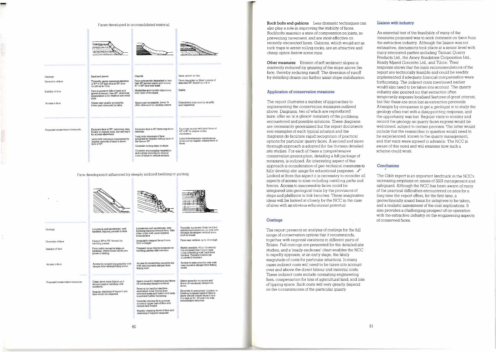
Rock bolts and gabions Less dramatic techniques can also play a role in improving the'stability of faces, Rockbolts maintain a state of compression on joints, so preventing movement, and are most effective on recently-excavated faces, Gabions, which would act as rock traps to arrest rolling rocks, are an attractive and cheap option below scree runs,
Other measures Erosion of soft sediment slopes is markedly reduced by grassing of the slope above the face, thereby reducing runoff, The diversion of runoff by installing drains can further assist slope stabilisation,
Application of conservation measures
The report illustrates a number of approaches to implementing the conservation measures outlined above, Diagrams, two of which are reproduced here, offer an 'at a glance' summary of the problems encountered and possible solutions These diagrams are necessarily generalised but the report documents real examples of each typical situation and the diagrams do facilitate rapid recognition of practical options for particular quarry faces, A second and more thorough approach is adopted for the thirteen detailed site studies For each of these a comprehensive conservation prescription, detailing a full package of measures, is outlined. .An interesting aspect of this approach is consideration of geo-technical measures to fully develop site u,sage for educational purposes, Looked at from this aspect it is necessary to consider all aspects of access to sites including installing paths and fences, Access to inaccessible faces could be integrated into geological trails by the provisions of steps and platforms to link benches, These imaginative ideas will be looked at closely by the NCC in the case of sites with an obvious educational potential.
Costings
The report presents an analysis of costings for the full range of conservation options that it recommends, together with regional variations in different parts of Britain, Full costings are presented for the detailed site studies, and a 'ready-reckoner' chart enables the NCC to rapidly appraise, at an early stage, the likely magnitude of costs for particular situations, In many cases indirect costs will need to be taken into account over and above the direct labour and material costs These indirect costs include consulting engineering fees, compensation for loss of agricultural land, and loss of tipping space, Such costs will very greatly depend on the circumstances of the particular quarry,
Liaison with industry
.An essential test of the feasibility of many of the measures proposed was to seek comment on them from the extractive industry, Although the liaison was not exhaustive, discussions took place at a senior level with many interested parties including Tarmac Quarry Products Ltd" the Amey Roadstone Corporation Ltd., Ready MJ,xed Concrete Ltd" and Tilcon, Their response shows that the main recommendations of the report are technically feasible and could be readily implemented ifadequate financial compensation were forthcoming, The indirect costs mentioned earlier would also need to be taken into account The quarry industry also pointed out that extraction often temporarily exposes localised features of great interest, but that these are soon lost as extraction proceeds, Attempts by companies to get a geologist in to study the geology often met with a disappointing response, and the opportunity was lost Regular visits to monitor and record the geology as quarry faces regress would be welcomed, subject to certain provisos, The latter would include that the researcher in question would need to be experienced, known to the quarry management, and that visits were agreed in advance, The NCC is aware of this need and will examine how such a scheme could work.
Conclusions
The Gibb report is an important landmark in the NCC's increasing emphasis on issues of SSSI management and safeguard. Although the NCC has been aware of many of the practical difficulties encountered on sites for a long time the report offers, for the first time, a geotechnically sound basis for initi'!:tives to be taken, and a realistic assessment of the cost implications It also provides a challenging prospect of co-operation with the extractive industry on the engineering aspects of conserved faces,
Faces developed in unconsolidated material.
Geology Sand and graveL
Geometry of face 1YPically upper exposure standUlg 3t 4l)O'0 7rJ' and talus al 35': face hetght up to 10 m
Face is prone to falIs of sand and gravel il steeper than 60", otherwise degradation is by washout and small slips.
Stability of face
Upper part usually accessible, lower part obscured by talus.
Access 10 face
Proposed conservation measures. Excavate face to 50', removing talus locally to expose base, but leaving it for access elsewhere.
Long term exposure mamtained by regular removal of talus to leave face at 5()'.
~~
Clay/till
Face extenstvely degraded to less L'mn 3(), except upper par! where 40' (0 00' face may exist
Mudslides and circular slips occur over most ef the slope.
Upper part accessible; lower 'I, often obscured by landslip debris.
Excavate face to 45' removmg loose material
Long term exposure of face achIeved by regular cutung back of the face at 45'.
ConsIder cutting steps in slope.
Consider encouraging vegetation' and cutting mterceptor drain at crest of slope to reduce erosion.
Sand. gravel or clay.
Face degraded or filled to angle of less than 35', height up to 8 m.
Stable
Complelely obscured by taluslfill and vegetatlon.
Excavate recess WIth back faces of 40' to SO' to expose entire succession
Long term expostUe maintenance aclueved by regular cutting back of faces.
Face development influenced by steeply inclined bedding or jointing,
Geology
Geometry of face
Stability offace
Access 10 face
Proposed conservation measuIes.
Limestone and sandstones, well bedded, dipping parallel to face.
Face at 30'to 70', formed by beddUlg planes.
Face stable except at steps m bedding, where loose blocks are prone to sliding.
Access by scramblmg possible with danger from sliding/rolling rocks.
Glean down loose blocks and secure steps in beddUlg with rockboll£
kegular checking of support and face would be requrred
Typically horizontal thmly bedded sandstoneslli.rnestones, or rock With strongly developed vertical jomts such as basalt.
Face near vertical, up to 10 m lugh.
Highly unstable. Major loosening has occtuTed resu]ling in open JOInts, extendUlg weU back from the face. Topping fallures (as ~Iustrafed) common
Access to base possible only WIth unacceptable danger from fallmg rocks.
Select areas for treatment and fence off remaining dangerous faces.
Excavate by pnewnatlc breaker or blasting loosened parts of face to leave smooth biased faces 3 m to 5 m Iugh at 3V: IH with 3 m wde inlermediate benches.
6160
L1ll1estones and sandstones, WIth bedding dipping towards face. Also other rocks with JOInts dippmg towards face.
Irregularly stepped faces 5 m to 20 m in height.
Frequent large blocks loosened on bedding planes; falls common.
Access by scrambling possible but with unacceptable danger from fallIng rock
select areas for treannent and fence off remaining dangerous faces.
Remove by hand or maclune excavation loose blocks from selected areas and install rock bolts to prevent further loosening
ConsIder placing fLU 10 proVlde access to upper part of face and reduce face height.
Regular cleanIng down of face and checking of support requrred.

Field education
New GCSE geology manual
A new manual, Earth science fieldwork in the secondary school curriculum was published by the NCC in April of this year. Written by John Fisher of the University of Bath, and edited by Mike Harley of the NCC, the 36-page booklet is a timely source of guidance for science teachers involved in geology teaching. The manual (see ESC 23, p44) has been designed to assist teachers adapt their teaching practices in the light of the new thinking on science education which lies behind the introduction of the GCSE examination, the national curriculum and the concept of a core science education.
The booklet starts by introducing the NCC's role in earth science conservation, and offers practical advice on matters such as access to sites, safe and appropriate conduct on site, and the collection and curation of geological samples. The bulk of the text deals with three case studies, which follow the efforts of three fictitious school teachers in planning an earth science topic involving a site visit It is emphasised that attention should be given at the outset to deciding assessment objectives in line with the national GCSE criteria for science. The next important stage in the process is selecting tfie right field site for the purpose and, by making a preliminary visit, deciding precisely how it could be used for the exercise in hand. A series of activities, both on- site and back in the school laboratory, can then be devised and the exercise can be staged. The emphasis in the manual is very much on the practicalities of running such exercises and helpful tips abound. Perhaps one of the most useful features is a regional directory of organisations who can be approached to provide teachers with information on local field sites.
Copies of the manual were distributed free of charge to Heads of Science in secondary schools and further education colleges; science and geography advisors in local education authorities; teacher training centres offering science and geography courses; geology/ geography/science subject officers in examination groups and also to field study centres. Details of how to obtain your copy, at a cost of £2.00, are given at the end of this issue.
62
Education working group to continue
A working group, comprising representatives from organisations with an interest in earth science conservation and education, was set up by the NCC in 1987, to oversee the preparation of the GCSE manual described in the preceeding item It became clear that there was a continuing need for a working group to maintain a watch on developments in this area, and advise the NCe. The working group will therefore continue to meet periodically and we will, in the future, keep our readers up to date with their activities.
Nature conservation points of view - new leaflets from the NCC
A new series of free leaflets have been launched by the NCC entitled Nature conservation points ofview. Aimed at schools and the general public, the leaflets each examine a currently controversial issue of conservation importance. Each leaflet sets the scene with some basic facts and figures and then sets out two opposing points of view as a starting point for enquiry and debate. The views expressed are not necessarily those of the NCC or any other organisation but are simply designed to stimulate debate. The reader is encouraged, by means of a further reading list, to explore each topic in greater depth, and to reach their own conclusions.
Two titles in the series, The Channel Tunnel and Tidal Power Barrages, refer to earth science conservation issues and are recommended to the interested reader. There is also a four-page guidance note, available upon request to assist teachers in using the leaflets in the classroom
Single copies of the leaflets, and a full listing of other titles in the series, can be obtained free of charge from the Environmental Education Officer, NCC, Northminster House, Peterborough PEl lUA.
Readers' Forum Editorial comment
Although the NCC has various statutory obligations in the area of earth science conservation, we are well aware that the long-term success of our efforts are greatly dependent on the expansion of grassroots support amongst the geological cOl7lfI1unity and general public at large. With this in mind we introduce here a new feature in the journal. It is our hope that 'Readers forum' will offer readers a chance to comment on their personal experiences of conservation and communicate their opinions to the readership
Educational uses of Tedbury Camp Quarry - a personal view
Dear Editor
Tedbury Camp Quarry, near Frome in Somerset, is one of the sites described in the NCe's guide New sites for old a students guide to the geology of the east Mendips (1985). I have since used if for different educational activities. I first visited the quarry with Mike Harley of the NCC and thought then that it was a marvellous teaching location. The site was cleared by the NCC about 5 years ago and is one of three sites owned by Amey Roadstone Corporation Ltd. which are detailed in the book. It shows an extensive Bajocian hardground on tilted Carboniferous Limestone (Clifton Down Group), unconformably overlain at the western end by horizontal, fosslliferous Inferior Oolite. The book gives geological details of the site, illustrated with environmental reconstructions and photographs. I would like to describe three very different visits which I have led to the site.
On the first occasion a free-lance exhibition designer asked me to recommend a limestone quarry where he would be able to make a cast of a sequence of strata. The idea was to reproduce a rock face to surround displays for a new exhibition gallery at a museum in Taiwan. This was such an unusual enquiry that I was keen to find a suitable site and be involved in the project I took Mr Gilham to Tedbury Camp Quarry and he was fascinated. He selected an area which illustrated the features he wanted and I arranged with ARC for him to return in order to take a latex cast This was successful and the last I heard was that the fibre-glass copies had been shipped to Taiwan.
My second visit was a more traditional one involving a
small party of geology 'A' level students from a local school. The group included 2 students taking the exam this year and 8 next year. They all had very little experience of geological fieldwork so the exercises suggested in the book were felt to be too advanced. After a general discussion about what they could actually see they divided into two groups to measure sections of the strata. One group began on a Carboniferous sequence and the other on the Inferior Oolite.
The first group got on very well measuring units and noting any features. The exercise was not so straight forward for the group working on the Inferior Oolite. They found that the bedding planes were less distinct and less accessible as the sequence there is horizontal. Climbing, to gather information became hazardous. It was easier to collect fossils from these units, so some of the students were assigned this task; an extra activity for this group. Their initial confusion about how to tackle the exercise was partly due to their lack of experience and also I settled the other group first and was delayed helping this group start After 30 minutes the groups swaQped over, the idea being to measure as much of each sequence as possible and for the groups to share the information. One girl, who was particularly keen on photography, took shots of different units to add to their record of the site. It was intended that the write up of the site would include specimens of the rocks, fossils and photographs as well as a measured section.
This project occupied the morning and although I left them at midday, they were intending to spend the afternoon visiting the other sites in Vallis Vale. So this proved a very full educational day for the students involved.
The third visit was a fossil collecting trip held in February 1988 and anyone was welcome to come along. It was the second collecting trip that I have arranged and I was encouraged to organise a second on the overwhelming response to the first one. Writhlington coal tip, near Radstock was the location for this first trip and I imagined it would attract 50 children. On the day 120 turned up and all of them went home laden with precious finds.
To select a site for the second trip I decided to look through New sites for old and I chose Tedbury Camp as a possibility I visited the site to check how fossiliferous the Jurassic rocks are, as a successful trip depends on each child finding a fossil within the first few minutes. The sites also had to be within easy reach of Bath, large, safe for a party of children, easily accessible and able
63

to offer ample parking space, Tedbury Camp Quarry fitted the bill and with permission from ARC I went ahead with planning the trip,
A letter was sent round to about 150 families on my mailing list and to local schools, Within two days of the notice going out I had taken bookings from 150 children and 25 adults, This filled two 53 seater coaches (under 14 years olds sitting 3 to a seat), I also gave details to families of how to make their own way there and I took about 30 bookings this way, I gave up trying to count at this stage and seriously considered taking a day's leave I
I informed the local newspaper, radio and television about the excursion and I asked for Police assistance with directing cars at the site, Unfortunately it was not possible for a constable to be released from other duties,
On the day I made arrangements for a gate to be unlocked, made sure I had a first aid kit and distributed an information sheet of illustrations of the most common fossils to everyone,
Once everyone was on site there must have been 200 children and 50 adults, ranging from grandfathers with walking sticks to a babe in arms, The sun was shining and everyone was keen to find treasures to take home, I asked a local geology teacher to come along and help with identifications but it was soon clear that I should have had more experts on hand as with that many people it was impossible to look at all the fossils and talk to everyone, I should add that I had invaluable help from 4 other adults with ticking children off as they arrived, taking money (I charged £1 to cover the coach hire) and shepherding everyone to and from the site, I also know new to take up a central position and not to wander round; a megaphone might have been useful! The letter had told people not to bring hammers as there would be plenty to collect from loose material, Which there was, and I don't think anyone went home disappointed, Photographers from two local papers turned up and just as we were about to leave a free-lance camera-man for HTV arrived to record the visit. The newspaper reports and the TV broadcast came out the following day, I was very pleased to receive this much coverage,
The day went very well and even though we spent less than an hour at the quarry everyone enjoyed it and they were anxious to know when the next one would be, I have since been to other locations which haven't attracted such large numbers but there is still an enormous amount of interest. Unfortunately, these local geological trips and indoor workshops that I hold will be finishing, At the end of of September I leave Bath to become Curator of Haslemere Educational Museum and I am told it is unlikely that I will be replaced in the foreseeable future I
64
I have used New sites for old a great deal and I look forward to seeing similar books covering other parts of the country,
Diana M Smith Curator, Bath Geology Museum,
Conservation news
Earth science conservation in New Zealand
Dr Bruce Hayward, of the New Zealand Geological Survey has written to the journal with news of interesting developments in the area of earth science conservation,
It is widely acknowledged in New Zealand that population pressures and modern technology are having a detrimental effect on the flora and fauna, Less readily appreciated is the parallel damage to landforms, soils and geological features, This situation is closely comparable to that facing earth science conservation in Britain, Public awareness in both countries of the threat to the earth science heritage lags far behind the appreciation of the ecological damage that is taking place, It is interesting to hear therefore of two initiatives being undertaken down under to redress the situation,
A grouping of New Zealand learned and profession~
societies, including the NZ GeolOgical and Geographical Societies and the Geomorphological Group, has been formed and are compiling a Geopreservation Inventory, A small number of scientifically important or obviously spectacular , features are now legally protected under New Zealand law, but no systematic regional or national assessment has been made of where they are; how many others are threatened, and how many need further protection, The inventory will list such sites and rate them in terms of scientific and educational value, and vulnerability to modification or destruction by human activity,
The second interesting development is the publication by New Zealand's Nature Conservation Council of an information booklet entitled Landforms and geological features: a case for preservation. The 16-page booklet describes how the land that became New Zealand was formed, outlines its major landforms and geolOgical features, and discusses their value, The booklet is aimed at the general public, and combines a light, readable text with numerous splendid photographs and a convincing espousal of the need for conservation, Ccpies of the booklet can be obtained from the Nature Ccnservation Ccuncil, PO Box 12200, Thorndon, Wellington, New Zealand, at a cost of NZ $6,00 which includes surface mailing,
First international meeting on earth science conservation
In May 1988 the first international meeting on earth science conservation was held under the auspices of the Rijksinstituut voor Natuurbeheer (RIN) - the Dutch Research Institute for Nature Management. The meeting was organised by Dr Gerard Gonggrijp, the co-ordinator of the Gea Project - a long-term project concerned with protecting localities of earth science importance in the Netherlands (ESC 12, p2-6),
The meeting was based at the RIN Headquarters in Leersum, and was attended by 12 earth science conservationists from Britain, the Republic of Ireland, the Netherlands, Austria, Norway, Finland and Denmark. Dr Keith Duff and Dr Bill Wimbledon represented the NCC at the meeting; other British representatives were Dr George Black, who acted as Chairman, and Dr Eric Robinson,
The aims of the meeting included
• To exchange information on progress in earth science conservation efforts in the various countries represented and to compare the different approaches and practices being employed,
• To explore the possibility of establishing a formal international body to promote and develop earth science conservation.
The discussions confirmed that there was tremendous scope for future co-operation in pursuing these aims, It was agreed that, in the short-term, a European focus should be adopted and a European Working Group on Earth Science Conservation be established, The next meeting of the Group will take place in Austria in May 1989, It is important that the views of the geological communities in each country are represented effectively within the Working Group, and to ensure this the various national representatives agree to undertake a broad canvass of opinion in their respective home countries, In Britain, it is hoped that this canvass will be carried out via the Conservation Ccmrnittee of the Geological Society of London. In the meantime readers are invited to make their views known by contacting either Keith Duff or Bill Wimbledon at the NCC Headquarters in Peterborough,
65

Earth science publications from the Nee Acknowledgements
Priced items listed below are available post-free from Publications, NCC, Peterborough, PEl lUA Payments should be made by cheque or postal order payable to the Nature Conservancy Council.
Geology teaching trails pages pnce
Wren's Nest NNR: geological trail 24pp 15p Wren's Nest NNR: geological handbook 24pp 20p Staple Edge geology teaching trail:
booklet 28pp 60p Staple Edge geology teaching trail:
student's worksheet (x3) 15p Salthill Quarry geology trail 28pp 60p Mortimer Forest geological trail 28pp 50p Btmator Dartmoor landform trail 24pp £1.50 Wenlock Edge geology teaching trail 24pp £1.50
Field-guides
Tertiary igneous rocks of Rhum (C H Emeleus and R M Forster, 1979) 44pp 60p
New sites for old: a student's guide to the geology of the east Mendips (edited by KL Duff; A P McKirdy and M JHarley, 1985) 192pp £8.50
Earth sciem;e conservation
A limited number of back issues of Earth science conservation numbers 1 to 22 (1968-1985) are available free of charge direct from the Earth Science Division. Numbers 1 to 14 were originally issued under the title Information circular. Back issues of numbers 23 and 24 are also available, cost £2.00.
Teaching manual
Earth science fieldwork in the pages pnce secondary school ctmiculum 36pp £2.00
Photographs oftemnospondyl amphibian and Eoherpeton-like anthracosaur reproduced courtesy of Dr JK Ingham.
Photograph of bilobostern scorpion reproduced courtesy of Mr A Jeram.
Photograph of chilognathan millipede reproduced courtesy of Dr JAlmond.
Comparative photographs of Cheddar Gorge in the 1880's and 1980's supplied by Bob Bowen, Photographer, Wrington, Bristol.
Loch Roag monchiquite photograph reproduced courtesy of the National Museum of Scotland.
We are indebted to UK NIREX Ltd, and the British GeolOgical Survey, for permission to reproduce, from various NIREX and BGS publications, the illustrations and hydrogeological environments map used in the feature on NIREX.
We thank the Severn Tidal Power Group for permission to reproduce figure 2.7 of the STPG 1986 Report entitled Tidal Power from the Sevem.
We thank the Hunterian Museum and Modem Geology for permission to reproduce the reconstruction of the environment of the East Kirkton Limestone.
66