natural channel design, bk p dbank processes, and
TRANSCRIPT

Natural Channel Design, B k P dBank Processes, and
Potential Performance Standards
1Prepared by U.S. EPA for 9/20/12 technical discussions with MA, CT and General Electric
d i d b ll
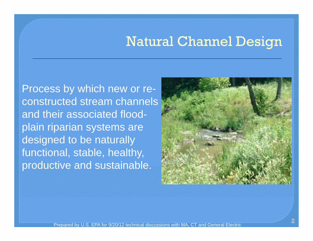
Natural Channel DesignNatural Channel Design
Process by which new or re-constructed stream channels and their associated flood-plain riparian systems are designed to be naturally functional, stable, healthy, productive and sustainableproductive and sustainable.
2Prepared by U.S. EPA for 9/20/12 technical discussions with MA, CT and General Electric

River Stability River stability (equilibrium or quasi-equilibrium) is defined as,
y
“the ability of a river, over time, in the present climate to transport the flows and sediment produced by its watershed in such a manner that the stream maintains its dimension, pattern and profilep p without either aggrading or degrading” (Rosgen, 1994)
33 Prepared by U.S. EPA for 9/20/12 technical discussions with MA, CT and General Electric

( ti )
River Components
• Channel Dimension (cross-section)
44 Source: Stream Corridor Restoration: Principles, Processes, and Practices; October 1998
Prepared by U.S. EPA for 9/20/12 technical discussions with MA, CT and General Electric

River Components • Channel Dimension (cross-section) • Meander Pattern (plan form)
55
Straightened Walla Walla River in Washington Returns to Meandering Stream During Major Flooding – Source: Wildland Hydrology.
Prepared by U.S. EPA for 9/20/12 technical discussions with MA, CT and General Electric

RR
River Components
Ch l Di i RiffleRiffle PoolPool• Channel Dimension (cross-section)
RiffleRiffle PoolPool
GlideGlideRunRun )
• Meander Pattern (plan form)
• Channel Profile
RiffleRiffle
66PoolPool
RunRun GlideGlide
Prepared by U.S. EPA for 9/20/12 technical discussions with MA, CT and General Electric

River Components
• Meander Pattern (plan f )form)
• Channel Dimension (cross(cross-section)
• Channel Profile
River that is disconnected from its floodplain results in increased shear stress and mass bank wasting
• Floodplain Connectivityy (really a component of Dimension) River with good floodplain connection
typically has stable banks and good
77
habitat
Prepared by U.S. EPA for 9/20/12 technical discussions with MA, CT and General Electric
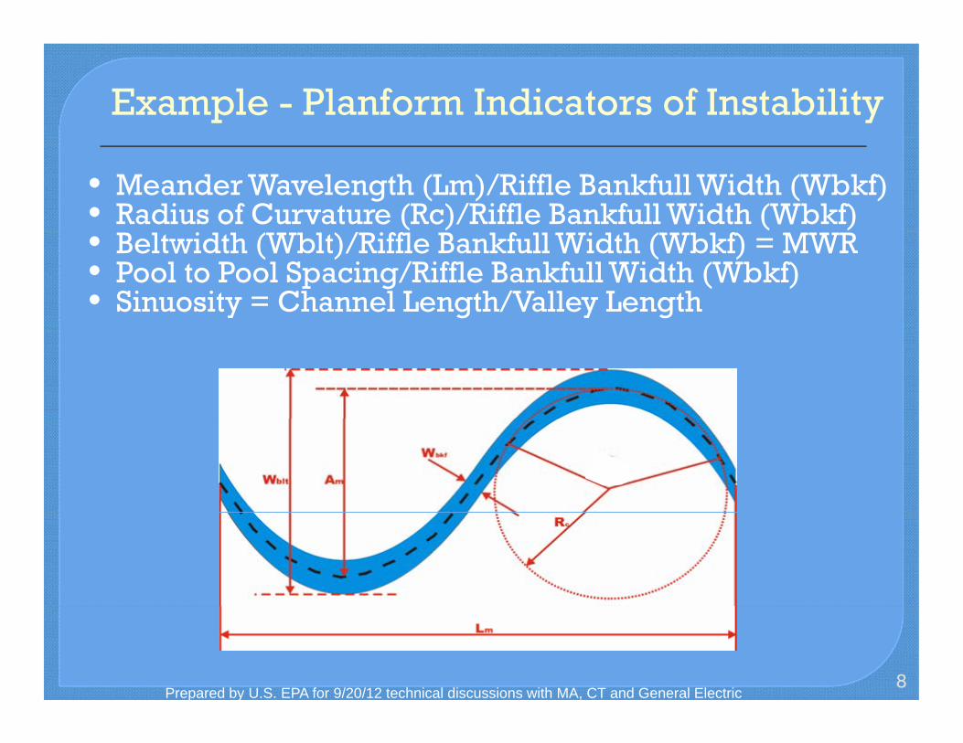
Example - Planform Indicators of Instability
• Meander Wavelength (Lm)/Riffle Bankfull Width (Wbkf) • Radius of Curvature (Rc)/Riffle Bankfull Width (Wbkf) • Beltwidth (Wblt)/Riffle Bankfull Width (Wbkf) = MWR • Pool to Pool Spacing/Riffle Bankfull Width (Wbkf) • Sinuosity = Channel Length/Valley Length
8Prepared by U.S. EPA for 9/20/12 technical discussions with MA, CT and General Electric

vature
/ f 2 4
C ff
Planform Indicators of Instability
Example - Radius of CurCurvature
• Reference Ranges of Rc/Wbkf = 2 to 4
• Erosion Initiated at Values < 2.5
• Severe Erosion Tends to Develop on Lower 1/3 of BendBend
• Lateral Migration • Formation of Chute
99
Cutoffs
Prepared by U.S. EPA for 9/20/12 technical discussions with MA, CT and General Electric

1886 2006 @ N L R d1886 2006 @ WWTP
Housatonic RiverHousatonic River
River Changes
1010
1886 - 2006 @ New Lenox Road1886 - 2006 @ WWTP
Prepared by U.S. EPA for 9/20/12 technical discussions with MA, CT and General Electric

Housatonic River Instability
On-going adjustments are occurring in the Rest of River
Contaminated bankContaminated bank erosion in 5A and 5B accounts for ~45%accounts for 45% of PCBs currently entering the river
1111Prepared by U.S. EPA for 9/20/12 technical discussions with MA, CT and General Electric

Housatonic RiverHousatonic River
Channel Widening – Bank Erosion
Source: Stream Corridor Restoration:Source: Stream Corridor Restoration: Principles, Processes, and Practices; October 1998
1212
Bank Erosion - High Terrace
Prepared by U.S. EPA for 9/20/12 technical discussions with MA, CT and General Electric

Housatonic RiverHousatonic River Horizontal Migration – Bank Erosion & AggradationAggradation
Source: Stream Corridor Restoration: Principles, Processes, and Practices; October 1998
1313 Bank Erosion - Floodplain Deposition
Prepared by U.S. EPA for 9/20/12 technical discussions with MA, CT and General Electric

Bank Erosion Bank erosion is caused when the force applied to the bank exceeds the ability of the bank to resist deformationdeformation
Elkhead Creek Colorado
1414 Housatonic River – Reach 5A
Prepared by U.S. EPA for 9/20/12 technical discussions with MA, CT and General Electric

g
y
BANCS Model
• Bank erosion prediction for the Rest of River Solids loadings
• Bank Erosion Hazard Index (BEHI)
• Near-Bank Stress (NBS)
• Developed as part of EPA’s WARSSS – Watershed Assessment for River Stability and Sediment Supply
1515Prepared by U.S. EPA for 9/20/12 technical discussions with MA, CT and General Electric

!Process to d'etermine the Bank Erosio1111 lfaz:ard lnde.x.IBEHij·
-- - -Meas•ne Mi!:asure MYsure lllankfll l Root Root Helg1lt Depth IDeliSi\y
(8) CDI (f)
Mefiure Ml'aswre lhunlt Surfll;ee
,MI. DIA Fl<[DIA!· Angle Protection ~ i'll
Bank Erosion Hazard Index (BEHI)
BEHI Matrix
Prepared by U.S. EPA for 9/20/12 technical discussions with MA, CT and General Electric 1616

R t D it
BEHI Variables
Study Bank Height / Bankfull Height (C)
3
3.5
heig
ht /
eigh
t
Root Depth / Study Bank Height (E)
0.7 0.8 0.9
1
/ ban
k t• Bank Height
1
1.5
2
2.5
0 2 4 6 8 10
BEHI rating
Stu
dyba
nkh
bank
full
he
Very Low
Low
Mod
High 9
Extrem
e
Very
High
0 0.1 0.2 0.3 0.4 0.5 0.6
0 2 4 6 8 10
BEHI rating
Roo
t dep
th/
heig
ht
Very Low
Low
Mod
High
Very H
igh
9
Extrem
e
• Bank Height • Root Depth
Weighted Root Density (G)
0
20
40
60
80
100
Wei
ghte
d ro
otde
nsity
%
Bank Angle (H)
0
20
40
60
80
100
120
Deg
rees
• Root Density • Surface Protection
0 0 2 4 6 8 10
BEHI rating
VeryL
ow
Low
Mod
High
Very H
igh
9 Extrem
e
0 0 2 4 6 8 10
BEHI rating
Very
Low
Low
Mod
High
Very H
igh
9
Extrem
e
Surface Protection (I)
80
100
nt
• Bank Angle • Bank Material
0
20
40
60
0 2 4 6 8 10
BEHI rating
Perc
en
VeryL
ow
Low
Mod
High
VeryH
igh
9
Extrem
e
• Stratification
1717Prepared by U.S. EPA for 9/20/12 technical discussions with MA, CT and General Electric

ver
Bank Erosion Hazard Index (BEHI)
BEHI = Very High Housatonic River
BEHI = Low Housatonic Ri
1818
Housatonic River
Prepared by U.S. EPA for 9/20/12 technical discussions with MA, CT and General Electric
As summarized in Stantec 2009

• Force Exerted on the Stream Bank in the Near Bank Region (Near Bank 1/3 Width)Bank Region (Near Bank 1/3 Width)
• Various Methods to Determine NBS
1919Prepared by U.S. EPA for 9/20/12 technical discussions with MA, CT and General Electric

Housatonic River Reach 5A
2020
Wiemenuch Creek, CO
Prepared by U.S. EPA for 9/20/12 technical discussions with MA, CT and General Electric

Housatonic River Reach 5A
2121
Wiemenuch Creek, CO
Prepared by U.S. EPA for 9/20/12 technical discussions with MA, CT and General Electric

para
Rest of River Bank Erosion and Meander Study
• Performed for use in the conceptual model and EFDC meterizationparameterization
• Comparison of aerial photos 19521952 1972 1990 2001
• Focused on movement on outside meander bends
• Short-term Erosion Study 15 Sites Surveyed (Nov. 2001 – June 2002)
2222Prepared by U.S. EPA for 9/20/12 technical discussions with MA, CT and General Electric

Aerial Imagery 1952 - 2001
Prepared by U.S. EPA for 9/20/12 technical discussions with MA, CT and General Electric 23

Short–term Erosion Study
Site ER-10: Example of woody debris deflecting flow into the bank causing erosion.
24
Site ER-9: Example of Bank slumping erosion.
Prepared by U.S. EPA for 9/20/12 technical discussions with MA, CT and General Electric

Reach 5AReach 5A Estimate of one-third of banks derived from:
• Assumptions made for EFDC modeling based on Assumptions made for EFDC modeling based on Short-term Bank Erosion Study
• Preliminary BEHI estimates (Stantec 2009)
25Prepared by U.S. EPA for 9/20/12 technical discussions with MA, CT and General Electric

High Very High
High Mod
High
-- Mod High •••••••••••••••••• -- Mod
-- Mod Low
--- Low
-- Low Mod
-- very Low
-- Very Low Low
W 1 ppm Boundary
0 River/Ponds
Prepared by U.S. EPA for 9/20/12 technical discussions with MA, CT and General Electric 26

Reach 5A Sediment removal and subsequent capping shall
result in a final grade consistent with the original grade or with modifications as needed considering Natural Channel Design considering Natural Channel Design …
27Prepared by U.S. EPA for 9/20/12 technical discussions with MA, CT and General Electric

- -
Consider the three river components, e.g.:Consider the three river components, e.g.: • Reduce severe radius of curvatures to lower the likelihood of
future chute cutoffs • Construct channel cross-section and profile to reduce near-• Construct channel cross section and profile to reduce near
bank sheer stress • Reconnect high flow channel to floodplain
28Prepared by U.S. EPA for 9/20/12 technical discussions with MA, CT and General Electric

Example
Example: Planform Instability – Tight Radius of CurvatureRadius of Curvature
2929
Bank Erosion – Lower 1/3 of Meander Bend
Prepared by U.S. EPA for 9/20/12 technical discussions with MA, CT and General Electric
co ta s 5 o eate o t C s
d
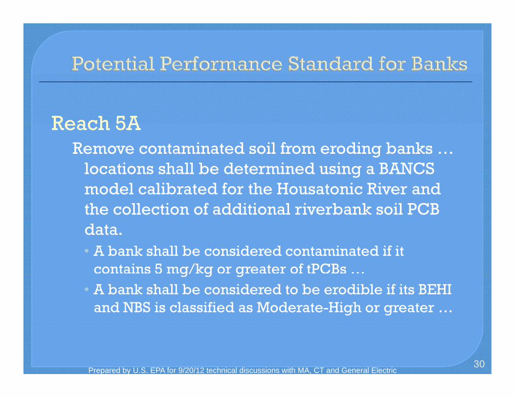
Reach 5AReach 5A Remove contaminated soil from eroding banks …
locations shall be determined using a BANCSlocations shall be determined using a BANCS model calibrated for the Housatonic River and the collection of additional riverbank soil PCB data. • A bank shall be considered contaminated if it
contains 5 mg/kg or greater of tPCBs …g/ g g • A bank shall be considered to be erodible if its BEHI
and NBS is classified as Moderate-High or greater …
30Prepared by U.S. EPA for 9/20/12 technical discussions with MA, CT and General Electric

EXTREME BEHI BER = 0.0642e0.9391NBS
10
Site-specific validation is needed
11
n R
ate
(BER
) in
ft / y
r
MODERATE BEHI BER = 0.0556e0.5057(NBS)
HIGH & VERY HIGH BEHI
BER = 0.109e0.4159(NBS)
0.1Ban
k Er
osio
n
LOW BEHI BER = 0.0082e0.7349(NBS)
3131
Low Moderate High ExtremeVery Low Very High0.01 0 1 2 3 4 5 6 7
Near-Bank Stress (NBS)
Prepared by U.S. EPA for 9/20/12 technical discussions with MA, CT and General Electric

v r ve econstr to
q ;
Reach 5A Exca ated i rbanks shall be r uctedExcavated riverbanks shall be reconstructed to
minimize erosion considering the principles of Natural Channel Design … This will allow the maximum use of bioengineering methods in restoring riverbanks. Riverbank reconstruction shall follow a hierarchy ofyapproaches as follows:
a) Reconstruct disturbed banks with bioengineering restoration techniques;
b) Reconstruct disturbed banks with a cap layer extending into the riverbank placed under a bioengineering layer; or,
32
c) Place riprap layer or hard armoring on surface of banks (e.g. where needed for protection of adjacent infrastructure).
Prepared by U.S. EPA for 9/20/12 technical discussions with MA, CT and General Electric

Bioengineering
The use of living and non-living materials to provide soil reinforcement and prevent erosion
33Prepared by U.S. EPA for 9/20/12 technical discussions with MA, CT and General Electric

Example - Channel Dimension and Bioengineering Reducing Near Bank Shear StressBioengineering Reducing Near-Bank Shear Stress
34
Source: Wildland Hydrology
Prepared by U.S. EPA for 9/20/12 technical discussions with MA, CT and General Electric

t t
Example -St R d N B k Sh StStructures to Reduce Near-Bank Sheer Stress
3535
Source: Wildland Hydrology
Prepared by U.S. EPA for 9/20/12 technical discussions with MA, CT and General Electric

Example – Cap in River With Bioengineering on BanksWith Bioengineering on Banks
3636Prepared by U.S. EPA for 9/20/12 technical discussions with MA, CT and General Electric

Example – Cap with Overlying BioengineeringOverlying Bioengineering
3737Prepared by U.S. EPA for 9/20/12 technical discussions with MA, CT and General Electric

38
Questions?
Prepared by U.S. EPA for 9/20/12 technical discussions with MA, CT and General Electric