native american heritage in arkansas
DESCRIPTION
ÂTRANSCRIPT

Native American Heritage in Arkansas
H I S T O r Y H A p p E N E D H E r E

rkansas’s fi rst inhabitants knew well the rich resources and beauty of the land we call The Natural State. The Native Americans who occupied the region hunted and fi shed in its rivers, lakes and forests, just as we can today. They built shelters and se� lements from its trees, earth and stones, and we are still able to visit and honor those sites. They fashioned beautiful artifacts from its clay, and some of the largest collections of enduring Native American cra� s and art can be found in the state.
As in many other parts of the country, the history of Native American interaction with European explorers and American homesteaders is o� en painful but worthy of remembrance. By following in their footsteps and discovering who they were through the wealth of sites and museums all around the state, we live their past in the present, celebrating the glory of their accomplishments and imagining their noble history.
"history has a way of intruding upon the present, and perhaps those who read it will have a clearer understanding of what the American Indian is, by knowing what he was."
— From Arkansas writer Dee Brown's classic best-seller Bury My Heart at Wounded Knee: An Indian History of the American West.
A rkansas’s fi rst inhabitants knew well the rich resources and A rkansas’s fi rst inhabitants knew well the rich resources and

table of contents
Native American Heritage Sites • • • • • • • • • • • 3
Histories of the tribes • • • • • • • • • • • • • • • • 14prehistoric • • • • • • • • • • • • • • • • • • • • • • • 15the caddos • • • • • • • • • • • • • • • • • • • • • • • 16the quapaws • • • • • • • • • • • • • • • • • • • • • • 17the osages • • • • • • • • • • • • • • • • • • • • • • • 18the cherokees • • • • • • • • • • • • • • • • • • • • 19
Trail of Tears • • • • • • • • • • • • • • • • • • • • • • • 20
a timeline of Arkansas's first peoples • • • • 22
resources/credits • • • • • • • • • • • • • • • • • • • 29
2
upper deltaParkin Archeological State ParkHampson Archeological Museum State ParkArkansas State University Museum
lower deltaArkansas Post National Memorial
North CentralIndian Rock Cave and TrailBu� alo National River, Indian Rockhouse Cave
8910
11
2122
40
49
49
49
40
40
30
30
30
30
40
40
40
55
55
5300
530530
530530
44006300
430430
7
7
7
7
7
7
7
7
62
64
64
64
62
62
62 62
626267
67
67
67
64 64
6361
63
63
63
67
62
71
71
71
71
71
70
70
70
71
71
82
79
67
67
67
63
63
63
63
79
79
79
79
79
79
70
70
49
49
49
49
49
49
82
82
82
82
65
65
65
65
65
65
6571
412412
412
412412 412
371
371
371
371
165
165
165
165
425
425
278
167
167
167
167
167
167
167
278
278278278
278
278
270
270
270
270
270 270
278
425
63
67167
Gillett
JeromJerome
10
1010
10
10
26
2626
26
278
371
27
27
5
5
5
5
27
Bella Bella Vista
BentonvilleBentonville
Rogers
PePea Ridga Ridge
Mountainburg
Greenwood
HackettBooneville
Altus
OzarkOzark
ParisSubiaco
Centerville
Dardanelle
Pottsville
WiederkehrVillageVillageVillage
PrairieGrove
West Forkork
BeaverBeaver
BerryvilleGarfield
HuntsvilleHuntsville
SpringdaleSiloam Siloam Siloam SpringSpringSprings
Fayettevilleyetteville
AlmaAlmaAlma
Van BurenFFort Smithort Smithort Smithort SmithClarksville
Russellville
MorriltonMorrilton
ConwayConwayConway
Little Little Little RockRock
Bryant
ArkadelphiaArkadelphia
MalvernMalvernSheridanSheridan
Prescott
Hope
NashvilleNashville
DierksDierks
WickesWickes
Mena
De Queen
Ashdown
TTexarkanaexarkanaTexarkanaT
Magnolia
McGeheeMcGehee
Stuttgart
JonesboroJonesboro
Walnut RidgeRidgeRidge
DeValls BluffBluffBluffBluff
Brinkley
Marianna
Helena-West Helenaest Helenaest Helena
Forrest City
Blytheville
West MemphisMemphisMemphisMemphis
Lake Lake Lake Lake VillagVillagVillage
Tillar
DumasDumas
Pine BluffPine BluffPine BluffPine BluffPine Bluff
HamptonHamptonHamptonHamptonHampton
WarrenrrenMonticelloMonticello
HamburgHamburgHamburg
CrossettCrossett
El Dorado
Camden
Junction City
MurfreesboroMurfreesboro
North North North Little RockLittle RockLittle RockLittle RockLittle RockLittle RockLittle Rock
BentonHot SpringHot SpringHot SpringHot Springs
Glenwood
JasperJasper
HarrisoHarrison
Eureka Springs
Clinton
OsceolaOsceolaOsceolaOsceolaOsceola
Jacksonville
SearSearcy
Mountain Home
Mammoth Spring
Ash Flat
CherokeeVillage
Batesville
Mountain View
Newport
Paragouldaragould
RectorPocahontasPiggott
Bald Knob Wynne
Boxley
Ponca
Bull Shoals
Lakeview
Cotter
Gilbert
Leslie
Marshall
Flippin
YellvilleYellvilleYCalico Rock
Norfork
JacksonportJacksonport
HardHardy
Gamaliel
Salem
Heber Springs
Fairfield Bay
Powhatan
St. Francis
Corning
Mulberry
Perryville
RoyalBauxite
Mountain Pine
Ola
KirbyDaisyy
Mount Ida
Pine Ridge
Waldron
Norman
Bismarck
Dover
Pelsor
Magazine
Mansfield
AltheimerAltheimer
Bradley
Washingtonashington
Emerson
Fordyce
JerseyJerseyMcNeil
Smackover
Arkansas CityArkansas City
Rohwer
Star CityStar City
Wilmot
Des ArcArc
Hazen
Augusta
McCrory
England
Scott
Lonoke
Barton
St. Charles
Eudora
Dyess WilsonWilsonWilsonWilsonLepanto
Marked TreeTreeTHarrisburg
TurrellTurrellT
Madison
EarleParkin
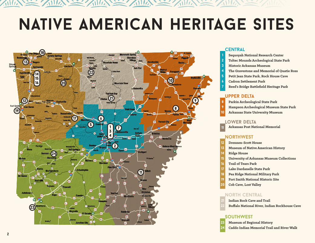
Native American Heritage Sites
NorthwestDrennen-Sco� HouseMuseum of Native American HistoryRidge HouseUniversity of Arkansas Museum CollectionsTrail of Tears Park Lake Dardanelle State ParkPea Ridge National Military ParkFort Smith National Historic SiteCob Cave, Lost Valley
SouTHWESTMuseum of Regional HistoryCaddo Indian Memorial Trail and River Walk
centralSequoyah National Research CenterToltec Mounds Archeological State ParkHistoric Arkansas MuseumThe Gravestone and Memorial of Quatie RossPetit Jean State Park, Rock House Cave Cadron Se� lement ParkReed’s Bridge Ba� lefi eld Heritage Park
121314151617181920
2324
1234567
2
56
21
22
20
17
7
8
9
10
11
12
13
18
19
23
24
134
141516

3
Native American Heritage SitesCENTrAL
toltec mounds archeological state park490 Toltec Mounds Road, Scott501-961-9442 arkansasstateparks.com/toltecmounds
The 185-acre National Historic Landmark, cooperatively managed by Arkansas State Parks and the Arkansas Archeological Survey, preserves the site of a mound-building culture known as the Plum Bayou people, who inhabited the surrounding area and used the site for ceremonies and civic events during AD 650 to 1050. Three mounds remain where 18 once stood, in alignment with solstice and equinox, and are surround-ed by an earthen embankment 8 to 10 feet in height, a portion of which is still visible today. Two barrier-free trails with interpretive panels wind through the impressive grounds, including a boardwalk over Mound Pond. An exciting new feature of the park is the Plum Bayou Garden, a living demonstration of the plants and raw materials the ancient culture drew upon for their sustenance. Extensive exhibits inside the visitor center provide further history of this fascinating glimpse into the distant past.
sequoyah national research center
2801 South University Avenue, Little Rock501-569-8336http://ualr.edu/sequoyah
Located on the University of Arkansas at Li� le Rock campus, the center is the largest assemblage of Native American expression in the world, including tribal newspapers, poetry, history books and art. The mission of the program is to acquire and preserve the writings and ideas of Native North Americans. The center is open to the public Monday-Friday, 8 a.m.-5 p.m. In ad-dition to archived materials for research, there’s an adjacent art gallery with rotating exhibits. Not far from the center is Trail of Tears Park, with commemorative plaques explaining the site’s relevance for the removal of Choctaw and Chickasaw, and planted with native grasses and plants they may have seen on the trail.
2
1
(Arkansas History Commission)

4
Historic Arkansas Museum200 East Third Street, Little Rock501-324-9351Historicarkansas.org
A trove of Arkansas’s historical artifacts and information concentrating on the pre-Civil War era, Historic Arkansas Museum has a permanent exhibit devoted to Native American life in The Natural State called “We Walk in Two Worlds: The Caddo, Osage & Quapaw in Arkansas.” The exhibition contains 158 objects, such as po� ery, clothing and weapons, but most important is the dominant presence of the Native American voice, from each of Arkansas’s three prominent tribes, who were extensively consulted and interviewed.
CENTrAL
3
The Gravestone and Memorial of quatie ross
1200 South Broadway, Little Rock501-376-1843Mounthollycemetery.com
Much myth and mystery surround the life of Quatie Ross, the wife of Cherokee chief John Ross. According to reports, she died near Li� le Rock on February 1, 1839, during the forced march of the Trail of Tears, reputedly freezing to death when she gave her covering to warm a child. Her original marker was thought lost until discovered in Li� le Rock’s historic Mount Holly Cemetery. The original stone is preserved now in Historic Arkansas Museum, and a replica is in Mount Holly, along with a memorial, where visitors o� en leave tokens in the American Indian tradition.
4
Tripod bo� leClay, red slip, handbuilt, Caddo
1200-1500 C.E.(Historic Arkansas Museum)
concentrating on the pre-Civil War era, Historic Arkansas Museum has a permanent exhibit

5
Cadron settlement park6200 Highway 319 West, ConwayConwayparks.com/Cadron.html
Cadron Se� lement Park is on the National Register of Historic Places and played a signifi cant role in the Trail of Tears for Native Americans. In 1834, a group of Cherokees emigrating to Oklahoma were felled by a cholera epidemic when stopped here. The Faulkner County Historical Society conducted a cemetery census in 1991 and identifi ed almost 50 Native American graves and more that were unidentifi able.
petit jean state pArkrock house cave
1285 Petit Jean Mountain Road, Morrilton501-727-5441Petitjeanstatepark.com
Not a true cave but a large rock shelter, the walls here contain more than 100 spectacular examples of prehistoric rock art by Native Americans, accessed by an easy .25-mile trail. The site was occupied o� and on from the late Paleoindian period (8000 BC) to the Mississippi era (AD 900-1600), but the exact date of the art has not been determined.
6
5
CENTrAL
Portal symbolHorned animal head and bison
Courtesy of Mike Hall and hallimages.com
Paddlefi sh and trap

6
reed's bridge battlefield heritage park
Arkansas Highway 161, Jacksonville501-241-1943Reedsbridgebattlefi eld.com
This park encompasses a ba� lefi eld of the 1863 Li� le Rock campaign during the Civil War, but the military highway through it was also a route of the Trail of Tears. Narrative historical markers highlighting the site’s interest for Native Americans include information about the crossing by the John Bell detachment of some 660 Cherokees in December of 1838.
CENTrAL upper delta
parkin archeological state park60 Highway 184 North, Parkin870-755-2500 Arkansasstateparks.com/parkinarcheological
This signifi cant historical site is believed by many scholars to be the Native American village of Casqui, mentioned in reports from members of the de Soto expedition in the summer of 1541. Over the 17 acres along the St. Francis River, a large platform mound has been preserved, and visitors can walk a three-quarter-mile trail with interpretive panels and imagine what life was like when the village was active from AD 1000 to 1600. A station for the Arkansas Archeological Survey allowsvisitors to see and experience how archeologists conduct research and work.
8
7

7
upper delta
arkansas state university museum320 University Loop Circle, Jonesboro870-972-2074AState.edu/museum
Among the exhibits in Arkansas State University Museum is “Portals of the Soul: Ancient Peoples of Northeast Arkansas” in the Native American Gallery, which opened in 2009. It presents the story of Arkansas’s fi rst civilization – the Native American artisans who poured out their creativity and honored the spirits with powerful and beautiful designs in artifacts of po� ery, shell, copper and stone.
10
hampson archeological museum state park
2 Lake Drive, Wilson 870-655-8622Arkansasstateparks.com/hampsonmuseum
This park exhibits a nationally renowned collection from the Nodena site, a 15-acre palisaded village that once thrived near the Mississippi River in what is today Mississippi County. The home of a farming-based civilization that lived there from AD 1400 to 1650, the area has yielded many remarkable archeological fi nds, including colorfully painted po� ery and vessels, and stone tools. The park is located on the north edge of Wilson on U.S. Highway 61 and Lake Drive.
9A state-of-the-art museum will open on the town square in 2017.
Nodena village re-creation

8
Drennen-Scott House222 North Third Street, Van Buren479-262-6020Class.uafs.edu/history/drennen-scott-house
John Drennen, one of the founders of the town of Van Buren, built this house overlooking the Arkansas River in 1838, and it has been converted to a history museum under the leadership of the University of Arkansas at Fort Smith. Important to those interested in Native American history is Drennen’s role as an Indian agent on the frontier, including his oversight of the eligibility process for se� lement payments for the Cherokees who had been relocated to the Indian Territory in what is now Oklahoma.
arkansas post national memorial
1741 Old Post Road, Gillett870-548-2207nps.gov/arpo
Henri de Tonti, a French fur trapper and trader, established this post in 1686 at the Quapaw village of Osotouy, near the confl uence of the Arkansas and Mississippi rivers, to do busi-ness with the tribe. The thriving village became a part of the United States with the Louisiana Purchase in 1803 and was the fi rst territorial capital of Arkansas. The Menard-Hodges site nearby, under the auspices of the memorial, holds Native American mounds and was listed as a National Historic Landmark in 1989. The Quapaw tribe is cooperating with the National Parks Service on preserving and interpreting the site.
Lower Delta
11
12
northwest

ridge house230 West Center Street, Fayetteville 479-521-2970WashCoHistoricalSociety.org
This house contains the log walls of the original structure from the 1830s. In 1840, it was sold to Sarah Ridge, the widow of John Ridge, a leader of the Cherokees who was instrumental in promoting and signing the Treaty of New Echota in 1835, which it was hoped would encourage Cherokees to accept a voluntary move to Indian Territory. Most Cherokees rejected the treaty, and the government began forced removal, leading to the Trail of Tears. John Ridge was murdered in 1839, and his wife moved to Faye� eville, where she lived until her death in 1856. Now owned by the Washington County Historical Society, the house is open by appointment.
Museum of Native American History202 Southwest O Street, Bentonville479-273-2456Monah.us
Take a 14,000-year journey through Arkansas’s and America’s past. Exhibits follow chronological order, starting with the fi rst peoples through the 20th century. Artifacts, tools, beautiful cra� s and art abound: arrowheads, po� ery, clothing and blankets give a rich history of Native American life over the centuries. The Sweetwater Biface is a particularly famous work of Caddoan stonework. Audio wands are available for self-guided tours.
“The Bailey Family” – 3 Caddo (Bailey Variety) human e� gy bo� les that were found together at the Hughes Mound in Arkansas. They are 2 males and 1 female and are thought to represent a father, mother and son.
13
14
northwest northwest
9

university of arkansas museum collections2475 North Hatch Avenue, Fayetteville479-575-3556Archeology.uark.edu
The University of Arkansas Museum Collection houses more than 7,000 catalogued Native American whole po� ery vessels – the largest single collection of late prehistoric and protohistoric period whole po� ery vessels from Arkansas. In addition to the whole po� ery vessels, the collections include hundreds of thousands of artifacts that come from all parts of Arkansas, and that range in age from the oldest Native-made tools more than 10,000 years in age to historic period objects. The collection resides in the headquarters of the Arkansas Archeological Survey on the campus of the University of Arkansas. The Survey also coordinates excavations and research at state parks like Toltec and Parkin, and throughout the state of Arkansas. The secure curation area, where most artifacts are held, is visible through the foyer of the survey headquarters. Access to the collections for research and other purposes can be arranged through the o� ces.
trail of tears park1100 West Martin Luther King, Jr. Boulevard (at the northwest corner of Stadium Drive) Fayettevillehttp://www.historicwashingtoncounty.org/totpark.html
This site on the campus of the University of Arkansas commemorates a spot on the Trail of Tears where a group of 1,100 Cherokees led by John Benge passed through the frontier village of Faye� eville on January 18, 1839. A plaque and a native stone sculpture stand near the site of the party’s encampment.
lake dardanelle state park100 State Park Drive, Russellville479-967-5516Arkansasstateparks.com/lakedardanelle
Lake Dardanelle State Park is located along the water route of the Trail of Tears and is one of only two sites along the trail where members of all southeastern tribes (Cherokee, Chickasaw, Creek, Choctaw and Seminole) passed in their forced journey west to Indian Territory. Long before tribes moved through this area along the Trail of Tears, this area was Cherokee land beginning in the late 1700s. The Cherokees built towns and farms in this fertile river valley.
northwest
16
17
15
10

Fort Smith National Historic Site301 Parker Avenue, Fort Smith479-783-3961Nps.gov/fosm
This site, devoted to a raucous frontier history – the original fort was founded to keep peace between warring tribes, and a later one became the province of Isaac Parker, the “Hanging Judge” – includes a walk to the Trail of Tears Overlook, where interpretive panels tell the story of the fi ve tribes who were removed to Indian Territory. That viewpoint looks out on the confl uence of the Arkansas and Poteau rivers, and a path marker indicates the border between Arkansas and Indian Territory.
pea ridge national military park
15930 East Highway 62, Garfi eld479-451-8122Nps.gov/peri
The site of a ba� le on the western frontier of the Civil War, the park o� ers visitors a wealth of information about the Native American participation on this front of the war, including the story of Stand Watie, a Cherokee supporter of the 1835 Treaty of Echota who became a general in the Confederate army and commanded the 2nd Cherokee Mounted Rifl es during the ba� le. In June 1865, Watie was the last Southern general to surrender to the Federals. Also in the park is Elkhorn Tavern, a stop along the Trail of Tears; the Cherokees camped nearby, and soldiers escorting them likely stayed in the tavern. A historical marker explains the signifi cance of the site for those who su� ered on the trail. “This is an amazing place,” said John McLarty, president of the Arkansas chapter of the Trail of Tears Association. “When you stand at the Elkhorn Tavern, you are literally on the Trail of Tears.”
19
18
northwest
Pea Ridge Ba� lefi eld
11
Elkhorn Tavern, Pea Ridge National Military Park

12
Cob CaveBuffalo National River, 402 N. Walnut, Suite 136, Harrison870-365-2700
Located on the Lost Valley Trail (2.3 miles round trip), one of the Bu� alo National River’s most popular trails, Cob Cave is a blu� shelter believed to have been inhabited seasonally by Native Americans between AD 1100 and 1400. When the cave was explored o� cially in the 1930s, archeologists from the University of Arkansas found pictographs and petroglyphs, woven bags and cultivated plants. The trailhead can be found about a half a mile o� Arkansas Route 43, 1.5 miles south of Ponca.
20Cob Cave
20Cob Cave
INDIAn rock cave and trail335 Snead Drive, Fairfi eld Bay501-884-4899
This 100-foot-wide, 90-foot-deep and 90-foot-high formation, carved by springs for centuries out of the sandstone cli� , contains petroglyphic evidence of Native American presence generations ago. A three-quarter-mile trail behind the Old Log Cabin accessible from the parking lot of the Indian Hills Country Club leads to the site.
2121
buffalo national river, indian rockhouse Cave
Buffalo National River, 402 N. Walnut, Suite 136, Harrison870-365-2700 Nps.gov/buff/index.htm
Indian Rockhouse Trail (3.5 miles round trip, rated moderate to strenuous) leads to its namesake, one of the largest blu� shelters in the Ozarks, which was used by Native Americans some 4,000 years ago. This trail is located at Bu� alo Point, 14 miles south of Yellville on Highway 14, then three miles east on Highway 268.
22
northwest north central

Museum of regional history219 North State Line Avenue, Texarkana903-793-4831TexarkanaMuseums.org
Housed in the town’s oldest brick building, Texarkana’s Museum of Regional History has a newly renovated and reworked gallery devoted to its large collection of Caddoan po� ery and artifacts. The Caddo confederation resided in part at the bend of the Red River nearby.
Caddo Indian Memorial Trail and river Walk
NormanTwenty-one interpretive panels on a one-quarter-mile trail describe the history of the Caddo people and this historic burial ground, along with a wildfl ower garden. Excavations by the Arkansas Archeological Survey discovered Caddoan artifacts, including tools and weapon points, and the Caddo tribe conduct-ed a religious ceremony there in 1989 to honor the dead buried in this place.
southwest
23
24
Photo courtesy of Mary B. Lysobey13

istorians and archeologists estimate that Native Americans have inhabited the lands now comprising the state of Arkansas for almost 14,000 years. We are able to gain a clearer picture of the peoples who made their homes here and distinguish among di� erent tribes from the historical records that begin with Hernando de Soto’s expedition in 1541-43 and from other explorers who followed him. Those most prevalent in Arkansas included the Caddos, Quapaws, Osages and later, Cherokees, as they traveled through Arkansas on the Trail of Tears to present day Oklahoma.
H istorians and archeologists estimate that Native Americans have H istorians and archeologists estimate that Native Americans have
histories of the tribes
Caddo
Quapaw
Osage
Li� le Maumelle River, Pinnacle Mountain, Li� le Rock
14

he Paleoindian peoples, as archeologists call them, entered the area of Arkansas in groups of less than 50 before se� ling in small communities. There, they found plentiful chert, or fi ne-grained quartz, from which to make sharpened points for hunting. You can see examples of these early tools at the Museum of Native American History in Bentonville, the Parkin Arche-ological State Park and Toltec Mounds Archeological State Park near Sco� .
In the Archaic Period, between approximately 9500 and 650 BC, the Native Americans in Arkansas adapted to the transforming, more fecund environ-ment, which was warming a� er the “ice age” and producing more plentiful plant and animal life. They began forming larger communities and engaging in domesticating plants; nuts and plants became more important to their diets.
These peoples hunted Ice Age animals such as mastodons, and as extinction changed the fauna available, they pursued deer, elk and other smaller mammals for their meat and hides. The Dalton point, a sharpened stone a� xed to the end of a stick sited in a hurling mechanism, proved an e� ective hunting tool. In addition, the Dalton culture at the Sloan site (near Crowley’s Ridge State Park but not open to visitors) has given archeologists the oldest example of a ceremonial burial ground in the Western Hemisphere.
By 600 BC, po� ery was being used for cooking and storage of grain, nuts and seeds, and the bow and arrow became a widely used hunting tool by the end of the Hopewell era, around 500 AD. With further cultivation came a more stable village life, and the use of salt for preservation and for trade encouraged se� lement in the saline springs of southwest Arkansas.
Toltec Mounds Archeological State Park provides a stunning example of early mound-building practices among a native tribe known as the Plum Bayou Indians. Their use remains somewhat of a puzzle, but shows an alignment with solstice and equinox lines.
The Mississippi era, beginning around 900 AD, was characterized by further developments in farming and trade, with the Parkin site, now a state park, showing a se� lement of several mounds and dozens of houses. Some scholars believe it to be the city of Casqui, identifi ed in accounts from de Soto’s party.
prehistoricHistories of the Tribes
T Toltec Mounds, artwork carved by David Thompson. (Toltec Mounds Archeological State Park)
Ted Morris,artist. (Parkin Archeological State Park)
Parkin site drawing(Parkin Archeological State Park)
15
histories of the tribes
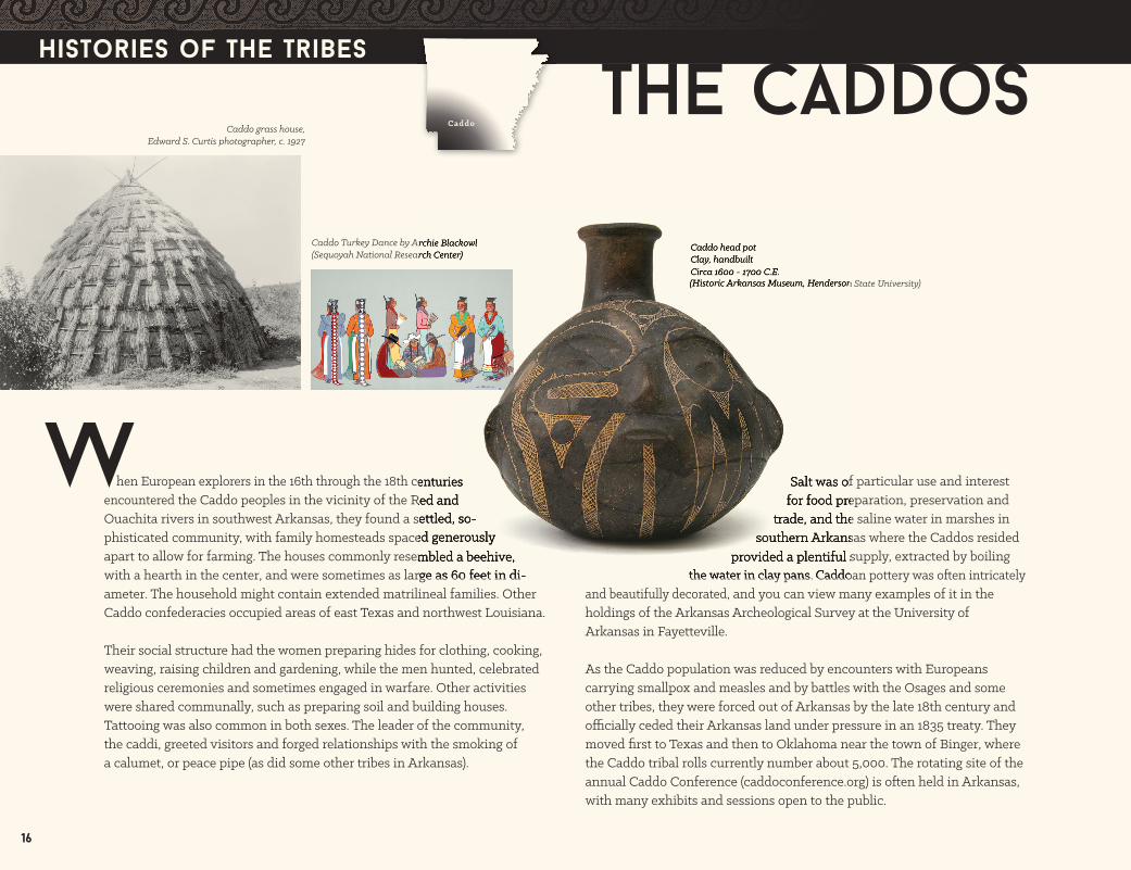
The Caddos
16
Histories of the Tribes
hen European explorers in the 16th through the 18th centuries encountered the Caddo peoples in the vicinity of the Red and Ouachita rivers in southwest Arkansas, they found a se� led, so-phisticated community, with family homesteads spaced generously apart to allow for farming. The houses commonly resembled a beehive, with a hearth in the center, and were sometimes as large as 60 feet in di-ameter. The household might contain extended matrilineal families. Other Caddo confederacies occupied areas of east Texas and northwest Louisiana.
Their social structure had the women preparing hides for clothing, cooking, weaving, raising children and gardening, while the men hunted, celebrated religious ceremonies and sometimes engaged in warfare. Other activities were shared communally, such as preparing soil and building houses. Ta� ooing was also common in both sexes. The leader of the community, the caddi, greeted visitors and forged relationships with the smoking of a calumet, or peace pipe (as did some other tribes in Arkansas).
Salt was of particular use and interest for food preparation, preservation and
trade, and the saline water in marshes in southern Arkansas where the Caddos resided
provided a plentiful supply, extracted by boiling the water in clay pans. Caddoan po� ery was o� en intricately
and beautifully decorated, and you can view many examples of it in the holdings of the Arkansas Archeological Survey at the University of Arkansas in Faye� eville.
As the Caddo population was reduced by encounters with Europeans carrying smallpox and measles and by ba� les with the Osages and some other tribes, they were forced out of Arkansas by the late 18th century and o� cially ceded their Arkansas land under pressure in an 1835 treaty. They moved fi rst to Texas and then to Oklahoma near the town of Binger, where the Caddo tribal rolls currently number about 5,000. The rotating site of the annual Caddo Conference (caddoconference.org) is o� en held in Arkansas, with many exhibits and sessions open to the public.
Caddo Turkey Dance by Archie Blackowl (Sequoyah National Research Center)
Caddo grass house, Edward S. Curtis photographer, c. 1927
Caddo head potClay, handbuiltCirca 1600 - 1700 C.E.(Historic Arkansas Museum, Henderson State University)
W
Caddo
hen European explorers in the 16th through the 18th centuries the Caddo peoples in the vicinity of the Red and
Ouachita rivers in southwest Arkansas, they found a se� led, so-phisticated community, with family homesteads spaced generously apart to allow for farming. The houses commonly resembled a beehive, with a hearth in the center, and were sometimes as large as 60 feet in di-
Salt was of particular use and interest for food preparation, preservation and
trade, and the saline water in marshes in southern Arkansas where the Caddos resided
provided a plentiful supply, extracted by boiling the water in clay pans. Caddoan po� ery was o� en intricately
Caddo Turkey Dance by Archie Blackowl (Sequoyah National Research Center)
Caddo head potClay, handbuiltCirca 1600 - 1700 C.E.(Historic Arkansas Museum, Henderson State University)
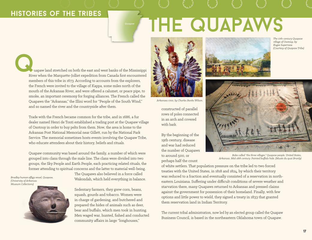
The quapaws
uapaw land stretched on both the east and west banks of the Mississippi River when the Marque� e-Jolliet expedition from Canada fi rst encountered members of this tribe in 1673. According to accounts from the explorers, the French were invited to the village of Kappa, some miles north of the mouth of the Arkansas River, and were o� ered a calumet, or peace pipe, to smoke, an important ceremony for forging alliances. The French called the Quapaws the “Arkansas,” the Illini word for “People of the South Wind,” and so named the river and the countryside a� er them.
Trade with the French became common for the tribe, and in 1686, a fur dealer named Henri de Tonti established a trading post at the Quapaw village of Osotouy in order to buy pelts from them. Now, the area is home to the Arkansas Post National Memorial near Gille� , run by the National Park Service. The memorial sometimes hosts events involving the Quapaw Tribe, who educate a� endees about their history, beliefs and rituals.
Quapaw community was based around the family, a number of which were grouped into clans through the male line. The clans were divided into two groups, the Sky People and Earth People, each practicing related rituals, the former a� ending to spiritual concerns and the la� er to material well-being.
The Quapaws also believed in a force called Wakondah, which held everything in balance.
Sedentary farmers, they grew corn, beans, squash, gourds and tobacco. Women were in charge of gardening, and butchered and prepared the hides of animals such as deer, bear and bu� alo, which men took in hunting. Men waged war, hunted, fi shed and conducted community a� airs in large “longhouses,”
constructed of parallel rows of poles connected in an arch and covered with bark.
By the beginning of the 19th century, disease and war had reduced the number of Quapaws to around 500, or perhaps half the count of white se� lers. That population pressure on the tribe led to two forced treaties with the United States, in 1818 and 1824, by which their territory was reduced to a fraction and eventually consisted of a reservation in north-eastern Louisiana. Su� ering under di� cult conditions of severe weather and starvation there, many Quapaws returned to Arkansas and pressed claims against the government for possession of their homeland. Finally, with few options and li� le power to wield, they signed a treaty in 1833 that granted them reservation land in Indian Territory.
The current tribal administration, now led by an elected group called the Quapaw Business Council, is based in the northeastern Oklahoma town of Quapaw.
Histories of the Tribes
q
Wakondah, which held everything in balance.
bear and bu� alo, which men took in hunting.
The 17th-century Quapaw village of Osotouy, by Kugee Supernaw. (Courtesy of Quapaw Tribe)
Robe called “the three villages.” Quapaw people. United States, Arkansas. Mid-18th century. Painted bu� alo hide. (Musée du quai Branly)
Quapaw
Bradley human e� gy vessel, Quapaw,(University of Arkansas Museum Collections)
17
Arkansea 1700, by Charles Banks Wilson.

hough they primarily resided in present-day southern Missouri, the Osages frequently made hunting forays into northern Arkansas and were fi ercely defensive about protecting their land.
As was the case with the Quapaws, the Osage tribe was a member of the Siouan language family, acknowledged a spirit force called Wakondah, divided its popula-tion into Sky People and Earth People, and organized its society by clans through the father’s line. Their dwellings – long, rectan-gular structures with bark covering – were also similar to Quapaw longhouses.
The tribe was divided into fi ve groups, organized in separate villages, overseen by a group of elders called the Li� le Old
Men. The process of becoming one of these elders was arduous and long, with instruction beginning in childhood.
Hunting was an important ritual and sustaining activity, providing clothing, food and other valuable materials from the spoils. During the summer, Osage men, notable for the lone scalplock extending from their shaved heads, le� their villages and ranged widely into Nebraska and Kansas to hunt bu� alo. Women were responsible for gardening, gathering and storing nuts and plants, and providing utensils and furnishings for the home.
Once Euro-Americans began exploring areas where the Osages lived, the two groups began to engage in trade, and the tribe forged important alliances with the French and Spanish that allowed them to expand their sphere of infl uence. They supplied information about the land and other peoples to the Euro-Americans and in turn received goods, including horses and fi rearms, that allowed them to thrive militarily throughout the 18th century over other tribes. “While the Quapaws sought to accommodate and channel change,” writes historian Kathleen DuVal, “the Osages went looking for it.” This led to confl icts with the Cherokees of such violence that the government established Fort Smith in 1817 to quell the warring, a story told at the Fort Smith National Historic Site.
Once the United States acquired the land of the Louisiana Purchase and sought further se� lement rather than trade, Osage infl uence waned. In a series of treaties in the early 19th century, culminating in an 1825 pact, the Osages ceded their land to the government and moved to Oklahoma, though the tribe kept some Arkansas land north of the Arkansas River.
The la� er part of the century saw the federal government pass measures to squelch Indian cultural heritage in general and restructure their societies more along Euro-American lines, and the Osages formed the Native American Church, a combination of Christian and traditional Native American beliefs.
The Osage Nation now has its government in Pawhuska, Oklahoma.
The osagesHistories of the Tribes
Osage Native Americans, Lithograph by Luther L. Brand1820-1840 (Historic Arkansas Museum)
Osage warrior of the Wha-sha-she band (a subdivision of Hunkah), by George Catlin in 1834.
The Osage village (Arkansas Archeological Survey)
T
with the Cherokees of such violence that the government established Fort Smith in 1817 to quell the warring, a story
Once the United States acquired the land of the Louisiana Purchase
The osagesOsage Woman’s “Prairie Thistle” outfi t, early 1900s. The Prairie Thistle blanket was reserved for the prominent, and this blanket came from Chief/Mayor General Tinker’s family. The selvage (yellow and red stripes) is a traditional Osage design and is considered a symbol of wealth.(Museum of Native American History)
Osage
18

embers of the Cherokee tribe began to immigrate to areas of current-day Arkansas in the mid- to late 1700s, as Euro-American se� lers began occupying their homeland in the areas comprising current-day western North and South Carolina, northern Georgia, northeastern Alabama, and northeastern Tennessee. This brought them into confl ict with the Osages, who were already established there, but the Osage treaty of 1808 with the United States (in the a� ermath of the Louisiana Purchase) ceded lands that would eventually be se� led by the Cherokees. The founding of Fort Smith primarily arose as a way for the government to manage a� acks on the Cherokees by the Osages.
Historians estimate that by the early 1800s, as many as 3,000 Cherokees were living in the area along the St. Francis River in northeast Arkansas (and southeast Missouri), and along Illinois Bayou and the Arkansas River in Pope County. By that time, because of interaction with Europeans over the previous centuries, the Cherokees had adapted many of the practices of the white se� lers, including subsistence farming, animal husbandry, and dress and shelter resembling American frontier life. Native customs, however, were still very important to the Cherokees, including the Green Corn ceremony, which united the sometime distant homesteads and villages. One famous Cherokee resident of Arkansas during this time was Sequoyah, the inventor of the Cherokee syllabry.
The founding of Dwight Mission on Illinois Bayou demonstrated the Cherokees’thirst for knowledge. John Jolly, a Cherokee leader and an advocate for education among the tribe, welcomed and facilitated the building of the missioncommunity that grew to include some 36 structures, including mills, barns and residences, and served some 60 children by the time it closed in 1829. At that
time, the mission moved to present day Oklahomaas the tribe ceded land under a treaty in 1828. The site is marked now by a sign on Highway 64 at a boat ramp to Lake Dardandelle, which
covered the site when it was created. A previous treaty between the Cherokees and Acting Governor Cri� enden near what is known as Council Oak in Dardanelle had resulted in the surrender of all Cherokee lands south of the Arkansas River.
That treaty ended signifi cant occupation of the Cherokees in Arkansas, but their imprint on the state remains through the land’s place on the Trail of Tears, as well as their participation in the Civil War. The National Park Service’s site at Pea Ridge tells the story of Stand Watie, who led the Confederate 2nd Cherokee Mounted Rifl es and commanded the regiment at the ba� le there. The park also has one of the best-preserved routes of the Trail of Tears, where Elkhorn Tavern stands.
That tragic forced removal of the Eastern Cherokees to the west in 1838-39 brought many of the tribe to northeastern Oklahoma and the town of Tahlequah, where the tribal headquarters stands today. Subsequent allotment policies ended the pratice of holding land in common and the operation of the Cherokee Republic. Tribal leaders have sought to preserve and reinvigorate some of the traditions of the tribe lost or neglected during assimilation with Euro-American culture.
The cherokees
Sequoyah with a tablet depicting his writing system for the Cherokee language. 19th-century print of a painting.
Cherokee Floral Purse, 2008by Lisa Rutherford (Sequoyah National Research Center)
Tennessee. This brought them into confl ict with the Osages, who were already
time, the mission moved to present day Oklahomaas theThe site is marked now by a sign on Highway 64 at a boat ramp to Lake Dardandelle, which
Cherokee Floral Purse, 2008by Lisa Rutherford (Sequoyah National Research Center)
Sequoyah with a tablet depicting his writing system for the Cherokee language. 19th-century print of a painting. M
19
Cherokee Weaver, 2006 by Joan Brown (Sequoyah National Research Center)
Old Style Cherokee Stamped Bowl, 2004 by Sean Grayson (Sequoyah National Research Center)
Histories of the Tribes

s a new state admi� ed to the union in 1836, with a long western border separating it from Indian Territory, Arkansas became an important throughway for the forced relocation of Native Americans who were traveling there, particularly during the winter of 1838-39.
Though the confl icts over Indian land began almost as soon as the fi rst European se� lers arrived on the continent, the immediate origins of relocation began in 1830 when the U.S. Congress passed the Indian Removal Act (IRA) and President Andrew Jackson signed it into law. It provided for an “exchange of lands” with Indians in the east and decreed their “removal west of the river Mississippi.” Some Native Americans had voluntarily moved previously as se� lers encroached in the east (a group of about 1,000 Cherokees moved to Arkansas in 1810-11), but a� er the IRA passed, government agents enforced the law. The tribes forcibly removed included the Choctaw from Mississippi, Muscogee Creeks from Alabama and Georgia, Chickasaw from Tennessee, Seminoles from Florida and Cherokees from the Appalachian Mountains in Georgia, the Carolinas and Tennessee.
A minority of Cherokees followed John Ridge, one of the architects of the Treaty of New Echota in 1835-36, which called for voluntary removal to Indian Territory within two years. (His wife, Sarah Ridge, moved to Faye� eville a� er his death, where her house, the oldest in Faye� eville, is still partly standing.)
When few Cherokees chose to move, the U.S. government sent soldiers to enforce the treaty and compel the tribe to undertake the journey west. A� er early tragic losses to disease on the water routes, John Ross, the Cherokee principal chief, petitioned to let the Cherokees control their own removal. Over the course of the winter of 1838-39, many hundreds of the 15,000 tribe members lost their lives en route.
The Northern Route was followed by most Cherokees and eventually traversed southern Missouri and entered Arkansas on a road that passed Elkhorn Tavern in what is now Pea Ridge National Military Park before continuing south to Faye� eville and then west into Oklahoma and Tahlequah.
A path farther south, the Benge Route, consisted of a detachment led by Cherokee leader John Benge and started in Alabama, headed north to near Cape Girardeau, Missouri, then dipped down into Arkansas through Batesville and across the north central part of the state along the White River to Faye� eville and beyond.
The Bell Route followed the old Memphis to Li� le Rock military road through what is now Village Creek State Park in Wynne on to North Li� le Rock, Conway, Russellville and Evansville on the Oklahoma border. This detachment, headed by John Bell, was made up of 660 Cherokees who had favored the Treaty of New Echota and thus took a di� erent path to Indian Territory than did the groups organized by John Ross.
trail of tears
AA Place Not Our Home, by Manyi-Ten, 1988 (Sequoyah National Research Center)
Hundreds of Indian men, women and children were transported up the Arkansas River by steamboats in the 1830s. Among the last 288 Indians was the Cherokee Chief John Ross whose wife Quatie died on the journey and was buried in Li� le Rock at Mount Holly Cemetery.Watercolor by Robert Gan� Steele (La Petite Roche Plaza, Li� le Rock)
National Historic Trail Marker
Elkhorn Tavern, circa 1880s(Pea Ridge National Military Park)
Trail of Tears Marker, Sebastian County
20

21
Trail of Tears map
Trail of Tears, Village Creek State Park
The Bell detachment was disbanded in Arkansas on January 7, 1839, to avoid any encounters with the anti-treaty Cherokee detachments in the Indian Territory.
In the 1830s, the Creek, Chickasaw and Choctaw also followed this route to the Indian Territory. A 2-mile trail in Village Creek State Park is an extended preserved stretch of the road, and the National Park Service has called it “the most dramatic remaining section of the Trail of Tears.” A historic marker in Marion, Arkansas, from 1931, believed to be the oldest site on the route, acknowledges the use of the military road as a means to transport Choctaw and Chickasaw tribe members to the Indian Territory. Other informational displays can be found in the Delta Cultural Center in Helena-West Helena and the Village Creek State Park visitors’ center.
While most Cherokees traveled the Northern Route, the contingent carrying John Ross’s family took the Water Route, which included a journey up the Arkansas River from its mouth at the Mississippi. His wife, Elizabeth (or Quatie), died on a steamboat and was buried in Li� le Rock. A memorial to her stands in the city’s Mount Holly Cemetery. The Water Route also was traveled by other removed Indians, including the Chickasaw, Choctaw, Muscogee and Seminole, and many of them passed through Li� le Rock and the north bank of the river; interpretive markers now line North Li� le Rock’s Riverfront Park, explaining the route.
Historic Washington State Park in Hempstead County also has interpretive panels relating to the Choctaw.
Scholarship and research on the Trail of Tears in Arkansas is ongoing. The Trail of Tears Association is headquartered in Li� le Rock and works with the Cherokee Nation, the Trail of Tears National Historic Trail and the National Park Service to uncover new information and extend interpretation. The Sequoyah Research Center at the University of Arkansas at Li� le Rock has an enormous collection of documents related to removal. Extensive driving directions for following the various routes of the Trail of Tears and more information can be found through the Arkansas Heritage Trails division of the Arkansas Department of Parks and Tourism at arkansasheritagetrails.com/Tears.
Through the work of many who wish to honor those who su� ered and help inform those who wish to learn about this painful history, Arkansas provides a rich, moving and educational experience of the Trail of Tears.
kansas Missouriillinois
kentucky virginia
tennessee
oklahomaarkansas
mississippi alabama georgia
south carolina
north carolina
Hopkinsville
Nashville Charleston
Cha�anooga
New Echotw Echotw aFort
Payne
Memphis
Li�leRock
Fort Smith
CapeGirardeauSpringfield
Faye�evilleTahlequahEvansville
Arkrkr ansas River
Mi
Mi
Mss
issip
piRiv
er
TeTeT nnesese se e River
Trail of TTrail of TTrail of ears N Tears N T ational Historic ears National Historic ears N Trail: Land Route Water Route Other Mther Mther ajor Major M Rajor Rajor outes Historic Washington State Park Delta Cultural Center, Helena-West Helena

The Poverty Point culture in what is now Arkansas and northern Louisiana begins to establish trade networks and introduced new cra� s, including e� gy beads.
22
The Marksville culture, with evidence at a site near Helena-West Helena, Arkansas, practices burial rituals and cere-monial commemoration of the dead.
In response to the end of the “ice age,” the Dalton culture adapts to the new environment, developing the Dalton point, a sharpened stone used for hunting as part of a stick-and-dart hurling weapon. It also is responsible for the oldest cemetery in the Western Hemisphere in Greene County, Arkansas, at the Sloan site.
Small groups of hunters and gatherers archeologists call Paleoindians se� le in what is now eastern Arkansas.
8500 BC
7000-2500 BC
2000-500 BC
600 BC
Around11,650 BC
2000-500 BC
At the beginning of what archeologists designate the Woodland Period, extending to approximately AD 1000, the manufacture of po� ery, fi red from clay, aids in the cooking and storage of food, which people learned to domesticate during the Archaic Period.
Dalton point examples(Arkansas Archeological Survey)
Mastodon skeleton replica based on bones dating ca. 10,000 BC (Arkansas State University Museum)
Nodena po� ery, 1400-1600(Hampson Archeological Museum State Park)
A timeline of arkansas's first peoples
500 BC-AD 500
As the climate began to warm from the “ice age,” changes in the environment led Archaic Period Indians in Arkansas to cultivate plants, refi ne hunting strategies and fashion tools. There’s some evidence that they also built mounds and engaged in trade with resources like novaculite.
7.75” Dalton point made from novaculite 6000-7800 BC (Museum of Native American History)

a timeline of arkansas's First peoples
ad 900-1600
Plum Bayou Garden at Toltec Mounds Archeological State Park
grows squash, sunfl owers, beans and other plants cultivated
by Native Americans over 1000 years ago.
Hernando de Soto by Telfer and Sartain, engraved before 1858.
The bow and arrow begins to replace the spear for hunting.
De Soto dies in present-day Arkansas. His two-year expedition across the region introduced catastrophic diseases and provoked confl icts with the native peoples. It would be 131 years before another European explorer would venture to the area, but the wri� en records de Soto and his company le� behind would end the prehistoric and begin the historic era in Arkansas.
1542
The Spaniards traded tiny chevron glass beads made of seven layers of glass. This bead was found on the Parkin site.
Casqui village re-creation
23
French explorers Jacques Marque� e and Louis Jolliet encounter members of the Quapaw tribe on the Mississippi River who take them to their town on Kappa, a few miles north of where the Arkansas River fl ows into the Mississippi. There, they fed the French party with dishes made of corn and shared with them a calumet, or peace pipe.
1673
Jacques Marque� e addressing the Quapaw Indians in June 1673, while fellow explorer Louis Jolliet looks on; taken from John Hugh Reynolds’ Makers of Arkansas History.
In the Mississippi Era, communities of Indians all across the Southeast construct large towns with highly developed trade and economic structures, cultivation of maize and strong leaders. This society can be experienced at Parkin Archeological State Park, where excavations revealed a fortifi ed city with dozens of houses. Scholars believe this site may be Casqui, mentioned in accounts of Hernando de Soto’s explorations of the area in 1541, the fi rst European to arrive in the region. In southwest Arkansas (as well as nearby Louisiana, Texas and Oklahoma), the Caddo culture was also developing skills in po� ery, salt making and mound building.
500 BC-AD 500
AD 500
Arrowheads (Toltec Mounds Archeological State Park)
The Quapaws welcome to Kappa the French explorer La Salle, with whom they a� empt to establish trade.
Statue of Father Jacques Marque� e in Helena-West Helena (Phillips County) commemorating the Marque� e-Joliet Expedition; 2012.
Explorer René-Robert Cavelier, Sieur de La Salle, who reached Arkansas in 1682 and stopped with his men at the Quapaw village of Kappa, a se� lement located on the Mississippi River approximately 20 miles south of the mouth of the White River.
1682
Toltec Mounds Archeological State Park, Sco�
AD 650–1050
Native Americans known as the Plum Bayou Indians near Sco� , Arkansas, build fl at-topped mounds for ceremonial gatherings of widely sca� ered groups. These mounds,excavated and preserved as Toltec Mounds Archeological State Park, were surrounded by an embankment and ditch, and were arranged to align with the solstice and equinox. The state park hosts special programs at those times for contemporary visitors to experience what those who built them did. For unknown reasons, the inhabitants le� the site in 1050 AD.

a timeline of arkansas's First peoples
The French transfer the Louisiana territory to the Spanish in the a� ermath of the Seven Years’ War.
The Osages, based primarily south of the Missouri River but with extended hunting grounds in Arkansas, acquire their own French trading post.
Osage traders, by Charles Banks Wilson.
24
Speakers of the Tunican language who had lived in southeast Arkansas move to the Yazoo River in Mississippi.
Henri de Tonti, a French fur trader, founds a post at the mouth of the Arkansas River.
A� er an original encounter with de Soto’s expedition, the next meeting of the Europeans and the Caddos was with Frenchman Henri Joutel, whose party found communities on the Red River and near present-day Camden, Arkansas.
Because of smallpox and other diseases carried by the French, the Quapaw population drops from 5,000 to 2,000 in 20 years.
1686
1687
1690
1700
16th-century drawing from Florentine Codex, depicting smallpox outbreak.
Henri de Tonti, Portrait by Ben Brantly, 1935 (Arkansas History Commission)
Depiction of Arkansas Post in 1689, copied from the original by Annie Hatley in 1904. (Arkansas History Commission)
17221763

1790s
1808
1811-1812
18171818
1819
The U.S. acquires the Louisiana territory.
The government establishes a reservation for the Cherokees in Arkansas, on land the Osages ceded, against the Osage understanding of the treaty of 1808, exacerbating confl ict between the tribes. Also in 1817, the U.S. founds Fort Smith, with the purpose of preventing ba� les among the Indian tribes.
The New Madrid earth-quakes strike northeastern Arkansas, killing an unknown number of Native Americans. Shawnee chief Techumseh is said to have prophesied the event.
The Cherokees, ousted from the Carolinas and the surrounding area by encroaching se� lement from Europeans, begin to move to Arkansas, eventually occupying land near Russellville and Dardanelle.
Louisiana Purchase Marker, Louisiana Purchase State Park, Brinkley
25
The U.S. designates the lands of Arkansas as a separate territory.
Arkansas Quapaws, with a population of 400 and under pressure from incursion by se� lers, sell to the U.S. 90 percent of the land they claimed in 1803.
Osage cession map, June 1808 (Arkansas History Commission)
Osage chief Pawhuska signs a treaty with the U.S., despite internal tribal strife, ceding land between the Arkansas and Missouri rivers.
Quapaw treaty, November 15, 1824 (Arkansas History Commission)
1803

a timeline of arkansas's First peoples
Non-Indian se� lers in Arkansas number 30,000, more than doubling that population in a decade. The U.S. Congress passes the Indian Removal Act.
Arkansas Cherokees removed to Indian Territory.
Pressured by increasing incursion by se� lers on the Red River, the Caddos sell their remaining land to the U.S.
Markers and monuments, Cherokee Village, Arkansas(Arkansas History Commission)
Trail of Tears, Village Creek State Park, Wynne
26
The U.S., which had taken Osage land in Arkansas and Missouri in the 1810s, establishes an Osage reservation in Kansas.
The Arkansas territorial government, with the cooperation of the federal government, forces Quapaws to cede remaining land, provoking them to move farther south to Louisiana.
Sequoyah, who developed a writing system for the Cherokee language, moved to Arkansas in 1824, living in the vicinity of Ilinois Bayou in Pope County before moving west of Fort Smith in 1828.
Dwight Mission, near the Arkansas River on Illinois Bayou, is established to provide education and reli-gious services for the Cherokee.
Dwight Mission (Arkansas History Commission)
1820 1824
1825
18281830
1835
Cherokee spoons (University of Arkansas Museum Collections)
The Cherokee Phoenix was an early publication to use the Cherokee syllabary. Front page May 21, 1828

1838
1838-39
A harsh winter and disease-ridden conditions among the Cherokees lead to hundreds of deaths on the route west, known later as the Trail of Tears, through Arkansas and other states to Indian Territory.
The eastern Cherokees’ resistance to the Indian Removal Act and the 1835 Treaty of New Echota, which gave the tribe members two years in which to voluntarily move, ends with expulsion from their land in the Carolinas, Georgia and Tennessee under military force.
John Ross, Cherokee chief (October 3, 1790 - August 1, 1866)
John Ross, also known as Koo-wi-s-gu-wi, was Principal Chief under the Cherokee Nation Constitution of 1839, serving from 1839 until his death in 1866. During his service to the Cherokee people in that role, he witnessed devastation by both the Indian removals and the U.S. Civil War.
Cherokee Wooden “Booger” mask, carved from eastern cedar (Juniper) in the 18th century. It was abandoned by its Cherokee owners on the trek to Oklahoma on the Trail of Tears. Booger masks portray and mock bad-mannered people.(Museum of Native American History)
27
1845
When Texas becomes a state, the Caddos are granted a reservation on the Brazos River.
Unidentifi ed Native Americans work with leather, undated.(UALR Center for Arkansas History and Culture)
1859
Having su� ered from crop failures and hostile white residents in Texas, the Caddos move to a reservation in Indian Territory.
18871879-1884
The Dawes Act, or Indian Allotment Act, passes in the U.S. Congress, dividing tracts of Indian land into individual parcels and assigning them to families, thus breaking up large communally held properties.
Edward Palmer and Edwin Curtiss excavate Native American archeological sites in northeast Arkansas for the Smithsonian Institution and Peabody Museum at Harvard University, respectively, removing thousands of artifacts in the process.
A� er years of policies from the federal government designed to promote assimilation, the Indian Reorganization Act was passed to reverse those measures and aid tribal autonomy and civil rights.
Osage Club, ca. 1850sThe cutout in the handle could be of French infl uence. The club is carved from a solid piece of wood and decorated with green paint and brass tacks. (Museum of Native American History)
Drawing by Henry Jackson Lewis (freed slave), published May 26,
1883 in Frank Leslie’s Illustrated Newspaper. (Arkansas History
Commission)
Indian lacrosse players, U.S. Arsenal, Li� le Rock, 1870. (Butler Center for Arkansas Studies, Arkansas Studies Institute)
1934

1978
19911991
1996
present day
1967
The Eaker site in Mississippi County is designated as a National Historic Landmark. It is considered the largest and most intact Late Mississippian Nodena site in the central Mississippi valley.
Exploration and research into Native American culture continues today around the country. In Arkansas, the collections of the University of Arkansas at Li� le Rock’s Sequoyah National Research Center constitute the largest assemblage of Native American expression in the world.
The Toltec mounds site, now the Toltec Mounds Archeological State Park in Lonoke County, gains National Historic Landmark status.
Arkansas Act 59 protects archeological sites on state lands.
The Menard-Hodges site in Arkansas County near Lake Dumond, believed to once have been a Quapaw village, is dedicated as a National Historic Landmark.
Arkansas Act 753 makes it illegal to dig for remains and grave items such as po� ery on Indian burial grounds and to sell the excavated items.
Arkansas Democrat-Gaze� e article, December 28, 1986Toltec Mounds Archeological State Park, Sco�
a timeline of arkansas's First peoples
1964
The Parkin site in Cross County, now the Parkin Archeo-logical State Park, is designated a National Historic Landmark.
Group of Native Americans from Indian Territory stand outside of the reserve in Fort Smith, Arkansas, 1884. (UALR Center for Arkansas History and Culture)
Charlie Quapaw (UALR Center for Arkansas History and Culture)
Parkin Archeological State Park
28

present day
organizations and Websites
American Indian Center of Arkansas (arindianctr.org)
Arkansas Archeological Survey (archeology.uark.edu), a division of the University of Arkansas System
Arkansas Department of Parks & Tourism (arkansas.com and arkansasstateparks.com)
Hampson Archeological Museum State Park (arkansasstateparks.com/hampsonmuseum)
Lake Dardanelle State Park (arkansasstateparks.com/lakedardanelle)
Parkin Archeological State Park (arkansasstateparks.com/parkinarcheological)
Petit Jean State Park (petitjeanstatepark.com)
Toltec Mounds Archeological State Park (arkansasstateparks.com/toltecmounds)
Village Creek State Park (arkansasstateparks.com/villagecreek)
Arkansas History Commission (ark-ives.com)
Arkansas Post National Memorial (h� p://www.nps.gov/arpo)
Arkansas State University Museum (AState.edu/museum)
Butler Center for Arkansas Studies, Arkansas Studies Institute (butlercenter.org)
The Department of Arkansas Heritage (arkansasheritage.com)
The Encyclopedia of Arkansas History & Culture (encyclopediaofarkansas.net), a project of the Butler Center for Arkansas Studies at the Central Arkansas Library System
Fort Smith National Historic Site (nps.gov/fosm)
Historic Arkansas Museum (historicarkansas.org)
Museum of Native American History (monah.us)
Pea Ridge National Military Park (nps.gov/peri)
Sequoyah National Research Center at the University of Arkansas at Little Rock (ualr.edu/Sequoyah), Dr. Daniel F. Li� lefi eld, Director
Trail of Tears Association (nationaltota.org)
Trail of Tears National Historic Trail (nps.gov/trte)
University of Arkansas Museum, Fayetteville (washcohistoricalsociety.org)
The Washington County Historical Society (washcohistoricalsociety.org)
Books
DuVal, Kathleen, The Native Ground: Indians and Colonists in the Heart of the Continent (Philadelphia: University of Pennsylvania Press, 2006)
Sabo III, George, Paths of Our Children: Historic Indians of Arkansas (Faye� eville, Ark.: Arkansas Archeological Survey, 1992, revised ed. 2001)
Sabo III, George and Deborah Sabo, eds., Rock Art in Arkansas (Faye� eville, Ark.: Arkansas Archeological Survey, 2005)
Individuals
Dr. Paul Austin, Executive Director, Arkansas Humanities Council Lois Bethards, Executive Director, American Indian Center of ArkansasDr. Jamie Brandon, Research Station Archeologist, Arkansas Archeological SurveyRebecca L. Brave, Cultural Program Coordinator and Librarian,
Wah-Zha-Zhi Cultural Center, Osage Nation Troy Poteete, Executive Director, Trail of Tears Association
Tribes
Caddo Nation of Oklahoma (caddonation-nsn.gov)Cherokee Nation (cherokee.org)Osage Nation (osagenation-nsn.gov)Quapaw Tribe (Oh-Gah-Pah) of Oklahoma (quapawtribe.com)
photo credits:
Front Cover: Stouts Point on Petit Jean Mountain, photography by Josue EnriquezIntroduction Page: The Li� le Red River and Sugarloaf MountainCharlie Quapaw (UALR Center for Arkansas History and Culture)Making of a Cherokee Basket by Virginia Stroud, 2005 (Sequoyah National Research Center)Head E� gy Vessel (Hampson Archeological State Park)Native American Percussion Instruments (Arkansas State University Museum)
This booklet is not meant to be a comprehensive resource of Native American sites, information and history in Arkansas, but a selection – and a place to begin. The visitor is encouraged to further pursue the subject by exploring in depth the places identifi ed here. Also, sign on to Arkansas.com/NativeAmericanHeritage
resources, Credits Information on Native American Heritage in Arkansas was compiled from the following sources:
29
