national register of historic places multiple - history colorado
TRANSCRIPT

NPS Form 10-900-b OMB No. 1024-0018(Revised March 1992)
United States Department of the InteriorNational Park Service
National Register of Historic PlacesMultiple Property Documentation FormThis form is used for documenting multiple property groups relating to one or several historic contexts. See instructions in How toComplete the Multiple Property Documentation Form (National Register Bulletin 16B). Complete each item by entering the requestedinformation. For additional space, use continuation sheets (Form 10-900-a). Use a typewriter, word processor, or computer, tocomplete all items.
New Submission XX Amended Submission
A. Name of Multiple Property Listing
Highway Bridges in Colorado
B. Associated Historic Contexts
The Historical and Technological Evolution of Colorado’s Bridges 1880 - 1958Early Bridge Construction by the Railroads and Local GovernmentEarly Bridge Construction by the StateEarly Transcontinental HighwaysDepression-Era Bridge ConstructionInterstate Highways
C. Form Prepared by
name/title Clayton B. Fraser, Principal
organization Fraserdesign date 30 March 2000
street & number 420 South County Road 23E telephone 970-669-7969
city or town Loveland state Colorado zip code 80537
D. Certification
I hereby certify that this multiple property documentation form has been approved by the National Register as a basis for evaluatingrelated properties for listing in the National Register.
Signature of the Keeper Date of Action
As the designated authority under the National Historic Preservation Act of 1966, I hereby certify that this documentation form meetsthe National Register documentation standards and sets forth requirements for listing of related properties consistent with the NationalRegister criteria. This submission meets the procedural and professional requirements set forth in 36 CFR Part 60 and the Secretaryof the Interior's Standards and Guidelines for Archaeology and Historic Preservation.(See continuation sheet for additional comments [ ].)
State Historic Preservation Officer Signature and title of certifying official Date
Office of Archaeology and Historic Preservation, Colorado Historical Society State or Federal agency and bureau

Highway Bridges in Colorado Colorado Name of Multiple Property Listing State
Table of Contents for Written NarrativeProvide the following information on continuation sheets. Cite the letter and the title before each section of the narrative. Assign page numbers according to the instructions for continuation sheet in How to Complete the Multiple PropertyDocumentation Form (National Register Bulletin 16B). Fill in page numbers for each section in the space below.
page number
E. Statement of Historic Contexts
The Historical and Technological Evolution of Colorado’s Bridges 1880 - 19581. Introduction: Bridge Development in America................................................................... 12. Early Bridge Construction by the Railroads and Local Government.................................. 73. Early Bridge Construction by the State ........................................................................... 214. Early Transcontinental Highways.................................................................................... 335. Depression-Era Bridge Construction .............................................................................. 406. Interstate Highways........................................................................................................ 42
F. Associated Property Types
Timber stringer and truss bridges............................................................................................. 62Concrete slab and girder bridges ............................................................................................. 68Concrete, stone, and steel arch bridges .................................................................................. 73Concrete rigid frame bridges.................................................................................................... 83Steel stringer and girder bridges ............................................................................................. 86Iron and steel truss bridges...................................................................................................... 92Glossary................................................................................................................................. 100
G. Geographical Data ............................................................................................................... 116
H. Summary of Identification and Evaluation Methods.......................................................... 117(Discuss the methods used in developing the multiple property listing.)
I. Major Bibliographical References....................................................................................... 118State Historic Preservation Office, other State agency, Federal agency, localgovernment, university, or other, specifying repository.)
Primary location of additional data:[ ] State Historic Preservation Office[ ] Other State Agency[ ] Federal Agency[ ] Local Government[ ] University[X] Other
Name of repository: Colorado Department of Transportation
Paperwork Reduction Act Statement: This information is being collected for applications to the National Register of Historic Places tonominate properties for listing or determine eligibility for listing, to list properties, and to amend existing listings. Response to this request isrequired to obtain a benefit in accordance with the National Historic Preservation Act, as amended (16 U.S.C. 470 et seq.).
Estimated Burden Statement: Public reporting burden for this form is estimated to average 120 hours per response including time forreviewing instructions, gathering and maintaining data, and completing and reviewing the form. Direct comments regarding this burdenestimate or any aspect of this form to the Chief, Administrative Services Division, National Park Service, P.O. Box 37127, Washington, DC20013-7127; and the Office of Management and Budget, Paperwork Reductions Projects (1024-0018), Washington, DC 20503.

NPS Form 10-900-a OMB Approval No. 1024-0018(8-86)
United States Department of the InteriorNational Park Service
National Register of Historic PlacesContinuation Sheetsection number E page 1 H I G H W A Y B R I D G E S I N C O L O R A D O
1 Introduction: Bridge Development in America
Bridges, as integral elements of a developing transportation network, have played a pivotal part in the developmentof America. Generally the most sophisticated components of any overland transportation system, they are also themost prominent. Not merely gauges of technological advancement in design and construction, bridges reflect thetenets, values, and ambitions of the people who erected them. “There can be little doubt that in many ways the storyof bridgebuilding is the story of civilization,” Franklin Roosevelt stated in 1931. “By it we can readily measure animportant part of a people’s progress.” While descriptive of the country in general, this was especially true forColorado, a state in which overland transportation forms a central historical theme. From the earliest wooden spansput up during the first gold boom to the later iron and steel trusses erected on wagon roads and multiple-span urbanviaducts for vehicular and tramway use, bridges have facilitated, and in some instances created, settlement acrossthe state.
A plethora of bridge forms, variously employing such materials as stone, timber, iron, steel, and concrete, weredeveloped through centuries of empirical usage. By the time America was undergoing initial settlement on the EastCoast, most of the principal bridge types and materials had been used or at least experimented with in other countries.What remained over the last two centuries has been a process of refinement revolving principally around theintroduction and proliferation of structural metals and concrete as building materials.
The first wooden bridges were merely plank structures—the equivalent of a log thrown across the stream. Limitedin span to the wooden beam’s length and carrying capacity, they were used for only the shortest crossings. Withoutproper support, they became unduly strained by bending moment forces, leading to failure: the log broke. Anadvancement over this was the first significant bridge form in America, the pier bridge, also called the pike-and-beambridge. Another ancient bridge type, it consisted of timber or log stringers spanning between timber pile bent piers,spaced at intervals of between 10 and 30 feet. In places where loose or shifting sediment proved unsuitable or wastoo deep for stone foundations, wooden piles were driven into the river to support the roadwork. A variation on thepile design, the crib bridge, used stacked logs for the piers. Timber stringer bridges were used extensively on the EastCoast and further inland, as the settlement line moved westward. Consisting of multiple short spans of timber beamsresting on pile bents or cribs, timber bridges were impractical across wide, deep rivers, and many were eventuallyreplaced by timber trusses in the late 18th century. Nonetheless, timber stringer bridges continue to be the mostcommonly built vehicular bridge type, one that continues to be built for minor crossings.
The use of stone as a building material was also transferred to America from Europe. Long known for its compressivestrength, stone (or more specifically the mortar joints between the stones) has virtually no tensile strength and mustrely on compressive forces through arching. Although used extensively in Europe, stone was largely eschewed in thiscountry in favor of timber and was used only marginally for bridge superstructures. While some stone bridges werebuilt in situations in which strength and permanence outweighed the importance of initial cost, the use of stone wasgenerally restricted to substructural work. Its rigidity and resistance to scouring from water made it the preferredmaterial for piers and abutments until early in the 20th century.

NPS Form 10-900-a OMB Approval No. 1024-0018(8-86)
United States Department of the InteriorNational Park Service
National Register of Historic PlacesContinuation Sheetsection number E page 2 H I G H W A Y B R I D G E S I N C O L O R A D O
hough by far the most common bridge type, the timber stringer was not really verysophisticated. More technologically innovative was a bridge type that has been termed “primarily an Americanachievement”—the truss. The introduction of the truss marked the beginning of more involved bridge design inAmerica. As with other structural types, the truss form had been imported from Europe. First employed in ancientGreece and Rome as a roof support, the truss was not formally associated with bridge design in Europe until the Ren-aissance. But while the first timber trusses were erected there, the greater development of truss design occurred inAmerica during the 19th century.
The extent of European influence on American designers is not known. In 1570 Italian architect Andrea Palladiodescribed three simple truss bridges in his general treatise on architecture, I quattro libri della architettura, attributingtheir origins to well-established antecedents. Using Palladio's work (translated into English in 1742) and their ownempirical designs, early American carpenters constructed wooden trusses throughout the East. “It is probable thatmost literate men among them were aware of European developments,” historian David Plowden states. “It is alsoconceivable, however, that the truss, such an obvious device to anyone familiar with the rudiments of roof framing,may have evolved independently in America.”1 Prior to 1840 most of the evolution in this country involved continuallymore sophisticated wooden trusses and arches. In only 50 years the kingpost, the most basic form of truss, consistingof an A-frame with a central support, had developed into several more complex configurations. At the forefront oftimber bridge construction in America was New England carpenter Theodore Burr, who was the first to design andbuild a covered bridge—the Waterford Bridge over the Hudson River in 1804. Two years later Burr patented a trussdesign that featured straight upper and lower chords with an arch superimposed for additional strength. Named theBurr arch-truss, it gained widespread use in America.
Between the years 1820 and 1850, truss design evolved into a more precise science. Several major truss patentswere taken out during this period, a fact directly attributable to railroad development and the concurrent need forbridges of increased strength, capacity, and rigidity. The Town lattice, a lattice truss patented by architect Ithiel Townin 1820, represented the first truly American development.2 The Long truss, patented in 1830 and 1839 by ColonelLong, was the first to incorporate panel counter-bracing systematically. Massachusetts millwright William Howe’scontribution, patented in 1840, was a truss design that used timbers for upper and lower chords and diagonalcompression members, but it substituted wrought iron for wood in the vertical tension members. The combinationwood/iron Howe truss design constituted an improvement in spanning and carrying capacity over its all-timberpredecessors. Because of its greater strength and uncomplicated erection, it became the standard timber railroadtruss in America before 1850.
The structural type that became the first all-metal standard for vehicular spans was the bowstring arch-truss. NewYork inventor Squire Whipple patented his “Iron Bowstring Bridge” in 1841.3 Resembling a large archery bow,Whipple's design featured a curved, wrought iron upper chord that was tied at its ends by an iron-bar lower chordacting in tension. Like most successful inventions, his bridge design spawned numerous variations, most of whichdeviated from his patent just enough to avoid charges of infringement. Over the next 35 years dozens of patents wereissued for improvements on Whipple’s design. These included such configurations as the triangular, tubular wroughtiron arch patented by Cincinnati inventor Thomas Moseley in 1857, the square, tubular wrought iron arch patented byCleveland inventor Zenas King in 1861, the parallel-plate arch patented by Wilmington, Ohio, inventors Jonathan and
NPS Form 10-900-a OMB Approval No. 1024-0018(8-86)
United States Department of the InteriorNational Park Service
National Register of Historic PlacesContinuation Sheetsection number E page 3 H I G H W A Y B R I D G E S I N C O L O R A D O
Zimbi Wall in 1874, and several arch configurations patented by Canton, Ohio, bridge manufacturer David Hammondin the 1870s. In his 1874 Book of Designs, Hammond summarized bridge development to that point:
The building of highway iron bridges, begun by Whipple in 1846-50, was carried on to a limited extent until 1861.. . . Wrought iron bridge work for highway purposes has made rapid progress from that date to the present time,almost supplanting cast iron, as was the case with railroad bridges, and forcing the public to concede itssuperiority over wood or cast iron, wherever they were brought into comparison. Starting in New York in 1845,iron highway bridges have grown in public favor until they are now found in almost every State in the Union, andeven those States, such as Maine, New Hampshire and Michigan, whose facilities for building wooden bridgesare unrivaled, are abandoning wooden for iron bridges.4
Patented in 1844 by Thomas and Caleb Pratt, the Pratt truss was similar to the Howe, except the verticals were thecompression members and the diagonals tension. The first Pratt trusses, like Howe’s, used a combination of woodfor compression members and iron for tension. Because of its greater use of metal components, however, the Pratttruss did not gain the popularity of the Howe until the 1870s and 1880s, when the improved quality and decreased costof iron made feasible the construction of all-metal trusses. A variation of the Pratt, patented in 1847 by SquireWhipple, featured diagonals that extended across two panels, thus providing additional lateral support for long, deeptrusses. This added rigidity made the Whipple truss especially suitable for railroad use, and, due largely to the effortsof engineer George Morison, a series of long-span Whipples was built over the Missouri River in the 1880s. Anotherimportant truss type patented during this period was the Warren truss, introduced by two British engineers in 1848,and quickly adopted in America. Triangular in outline, the Warren in its classic form included only diagonal membersthat carried both compressive and tensile forces. Its straightforward design made it one of the standard forms for laterall-metal trusses.
In the late 19th century several new truss designs were patented. The Howe, Pratt, Whipple, and Warren con-figurations had by that time become the mainstays of the profession for both railroad and vehicular use. The basicPratt design was then split into a variety of sub-types—the Parker, with its polygonal upper chord; the Pennsylvania,so named for its extensive use by the Pennsylvania Railroad; the Baltimore, used by the B&O Railroad; theCamelback, described by Waddell as “uncompromisingly ugly”; the Kellogg; and the Lenticular truss—which as agroup constituted the vast majority of vehicular trusses fabricated in the 19th century. Several other designs were alsopatented—the Pegram, Fink, Bollman, Stearns, Greiner, and Thacher among them. Esoteric, and in some casesstructurally questionable, these never received wide-scale use as did the Pratts and Warrens. During this period, all-metal trusses came into far greater use, first employing cast iron, then wrought iron, then steel.
The evolution of truss components and connections in America paralleled that of truss design. Cylindrical pins werefirst used to connect metal truss members on a Lehigh Valley Railroad bridge in 1859. Two years later acomplementary truss member—the forged iron eyebar—was introduced. Steel eyebars, made using the Bessemerand open-hearth forging processes, appeared in the 1870s. Pinned connections, assembled in what was termed the“American style” of truss construction, allowed quick erection, but they lacked rigidity and could loosen fromvibrations caused by traffic and wind. Riveting created stronger, sturdier connections but was not practical in the fieldbefore portable pneumatic riveters became available in the late 1880s.5
After the turn of the 20th century, the pattern was well-set: steel was the material to use, and no new truss designsof significance were patented. Truss design was by then a matter of refinement and expansion of existing ideas. Theonly major change in truss erection occurred around 1910, when rigid connections began to supersede pinned. Bridge

NPS Form 10-900-a OMB Approval No. 1024-0018(8-86)
United States Department of the InteriorNational Park Service
National Register of Historic PlacesContinuation Sheetsection number E page 4 H I G H W A Y B R I D G E S I N C O L O R A D O
companies used both connection methods—occasionally combining the two on a single structure—during thetransitional period in the early 1910s. By 1920 erection of pin-connected bridges had virtually ceased. Concurrentwith this was the emergence of the Warren truss for vehicular use. Pratt trusses were inherently better suited toAmerican style erection, but Warren trusses proved more difficult to assemble in the field using pinned connections.When rigid-connected trusses became more feasible in the 1910s, Warrens came into their own, receiving morewidespread acceptance among American bridge engineers.
lthough the truss received much of the attention from the engineering profession, othertypes of metal bridges were undergoing simultaneous development in the 19th century. One of these was the girder.An elaboration on the simple stringer bridge, with two to six main spanning beams to which floor beams are attachedperpendicularly, the girder form was associated primarily with railroad construction. The first patent for an all-ironbridge was taken out by August Canfield in 1833, and as early as 1846 an iron plate girder railroad bridge had beenerected. As the cost of wrought iron decreased, girders began to proliferate during the 1870s and 1880s. With theirdeep profiles made up of iron or steel plates to which rolled metal flanges and web stiffeners were riveted, girders wereideally suited for railroad use because of their inherent rigidity and relative ease of construction. Their drawbacks werethat they weighed more than similar-length trusses and they were typically built in-shop and hauled assembled to thesites, limiting their effective span to the length of a railroad flatcar. Nonetheless, deep-profile girders were usedextensively for short- to medium-span railroad bridges from the 1880s to the 1920s. Although roadway girders werealso built at that time, they tended to be significantly less economical than other bridge types and were employedprincipally for special-use situations, such as heavily trafficked urban bridges and viaducts.
Two other metal bridge types that received some use in the 19th century were suspension and cantilever bridges. Thefirst suspension bridge in America was built in 1786, and by 1808 over 40 had been built.6 Used only intermittentlyby the railroads due to their inherent lack of rigidity, suspension spans received increasing vehicular use through theend of the 19th century and the beginning of the 20th century. The Kentucky River Bridge at Dixville, Kentucky, builtin 1876, marked the beginning of long-span modern cantilever construction. Like the suspension bridge, it is a designthat received intensive use in the early 20th century.
fter the turn of the 20th century, another major structural form—the reinforced concretearch—began to receive widespread usage among American engineers. Concrete arches relied on two ancienttechnologies—concrete construction and the arch form—to allow a material that ordinarily acts poorly in tension tocarry loads over long spans. The first use of Portland cement in America is attributed to David O. Saylor, who patentedhis own type of Portland cement in 1871 and built the country's first cement manufacturing plant (built in 1866) nearCoplay, Pennsylvania.7 The first documented use of concrete on an American bridge was in the foundations of theErie Railroad’s Starrucca Viaduct, completed in 1848.8 John Goodrich was probably the first in this country to useconcrete in a bridge superstructure, in 1871. He was soon followed by others, so that by the turn of the century some150 concrete arches had been built in America.9

NPS Form 10-900-a OMB Approval No. 1024-0018(8-86)
United States Department of the InteriorNational Park Service
National Register of Historic PlacesContinuation Sheetsection number E page 5 H I G H W A Y B R I D G E S I N C O L O R A D O
These early structures were built of unreinforced, or mass, concrete. In 1871 W.E. Ward was the first to embed steelbars in a concrete bridge to add tensile strength. After the turn of the century, engineers began building ever longerreinforced concrete arch structures, extending over 250 feet in span by 1908. Both open- and filled-spandrel concretearch bridges were ideally suited for the memorial bridges being built by cities across the country to replace earlier irontrusses. As indicated by an article in Engineering Record, the truss was by then considered an eyesore on the urbanlandscape:
There is one feature of city bridge building that still remains in the dark ages, and engineers ought to give itmore attention. The usual criticism of our public works is that they are needlessly utilitarian and consequentlyugly. Now it must be admitted that an ordinary highway truss bridge is not so charming as a well proportionedmasonry arch.10
To conceal the stark concrete planes of their bridges, engineers often covered them with facades of real or imitationstone or formed and textured the concrete to resemble coursed masonry. Ransome had chosen to disguise the AlvordLake Bridge, a structure at the forefront of technological innovation, with a veneer of imitation stone. “As often asnot, the results were less pleasing than the structures they replaced,” Plowden states. “These bogus structuressatisfied the aesthetic requirements of the turn of the century and cost much less to build than an all-stone bridge,despite the over ornamentation some of them received.”11
fter 1905 concrete bridge construction experienced a marked increase, due largely tothe efforts of one engineer—Daniel B. Luten of Indianapolis. Using a series of wide-ranging patents taken out between1900 and 1906 for reinforced concrete arches, Luten absolutely controlled the concrete bridge industry in America.His lawsuits for patent infringement were routinely upheld in the courts, forcing virtually all arch builders to pay patentroyalties to Luten. Luten’s arches were innovative. Featuring sometimes highly elliptical profiles, they weresophisticated in their dependence on steel reinforcing and allowed relatively thin concrete sections at midspan. Termed Luten arches—or horseshoe arches for their distinctive profile—they were built extensively from 1905 throughthe mid-1920s.
Luten’s stranglehold on the industry was finally broken in January 1918, when a Des Moines judge ruled that thebroadly worded patents were invalid.12 The Iowa location was significant, for the suit challenging Luten’s patents wasinitiated by America’s other most significant concrete bridge designer, James B. Marsh of Des Moines. The rulingopened up arch building in the country, and the concrete arch received increased use as a vehicular bridge type. Marsh himself had patented a reinforced concrete arch design in 1912, called the Marsh, or rainbow, arch. Marsharches were essentially steel bridges sheathed in concrete, with the deck carried between two parallel arches. Costlyto construct, they were built sparingly for highway use until Marsh’s death in 1936.13
The dull color of concrete bridges and the enormity of steel trusses sparked debate within the bridge profession onaesthetics and scale. To engineers interested in technological achievement, the monumental skeletal structures ofsteel illustrated perfectly the relationship of form and function. Moreover, those such as Thomas Clarke saw utility andnot sculptural art as of primary importance. “Where so many bridges had to be built in a short period of time,aesthetic considerations are little regarded,” he stated. “Utility alone governs their design. So long as they arestrong enough, few care about how they look.”14

NPS Form 10-900-a OMB Approval No. 1024-0018(8-86)
United States Department of the InteriorNational Park Service
National Register of Historic PlacesContinuation Sheetsection number E page 6 H I G H W A Y B R I D G E S I N C O L O R A D O
On the other side were those that held the arched form to be the highest kind of bridge design. Concrete archesprovided the opportunity for applied ornamentation in the form of incised panels or classical balustrades that the starklyfunctional trusses did not. Moreover, proponents argued that the arch was structurally superior, more rigid under trafficand more resistant to flooding. Ultimately, however, the decision to build a concrete or steel bridge was often aneconomic one, and in most applications concrete cost more than steel.
common thread that ran through all the major bridge types was the method of theirconstruction. With the rise of industrialization, the settlement of the West, and the resultant proliferation of overlandtransportation networks, a new industry—bridge fabrication—sprang up in 19th century America. A number ofcompanies formed after 1850 to fill the demand for roadway and railroad truss bridges. After the Civil War their num-bers jumped from a total of just five in 1860, to 75 in 1870, 137 in 1890, and almost 200 by 1900. Few bridge engin-eers at the time fully understood stress analysis and truss design, allowing national firms such as the King BridgeCompany and the Wrought Iron Bridge Company to gain power in a rapidly expanding market.15
These firms often published catalogues of standard structural types and bid competitively on construction contractslet by the counties and municipalities. Several firms in the Midwest and the Ohio River Valley specialized in bridgefabrication and erection. Constantly on the road, their salesmen contacted counties where rapid population growthproduced a demand for large numbers of bridges. When an order for a bridge was received, its components wereassembled at the fabrication plant. Bridge fabricators sometimes erected the parts at the site as well. Other firms,particularly local ones, received county bridge contracts but were responsible for erection only, purchasing steelsuperstructures from fabricators such as the Minneapolis Steel & Machinery Company.
In 1900 the complexion of the industry changed radically. That year financier J.P. Morgan created the enormousAmerican Bridge Company by consolidating two dozen smaller firms, including the Wrought Iron Bridge Company(Canton, OH), the Edge Moor Bridge Works (Wilmington, DE), the Gillette-Herzog Manufacturing Company(Minneapolis, MN), the Milwaukee Bridge & Iron Works (Milwaukee, WI), the Groton Bridge & Manufacturing Company(New York, NY), and the Youngstown Bridge Company (Youngstown, OH). This effectively molded most of thecompeting firms into one gargantuan company, which then fabricated and erected thousands of railroad and vehicularbridges across the country. Against this giant of the industry, several smaller firms still managed to compete, mostlyfrom bases in the West and Midwest. These included companies such as the Missouri Valley Bridge & Iron Works(Leavenworth, KS), the Kansas City Bridge Company (Kansas City, MO), and the Midland Bridge Company (KansasCity, MO), as well as the Colorado-based Pueblo Bridge Company and the Charles G. Sheely Construction Companyof Denver.16
After 1900 the bridge companies had two more decades of intense activity before the industry again changed. Following the passage of the Federal Aid Road Act in 1916, bridge design generally fell to the state highway depart-ments, and contracting became more localized. National bridge firms offering design/build services to the countiescould no longer remain competitive in this changing market. The industry change also marked the shift from thedesign of wagon bridges to those intended specifically for automobile use.

NPS Form 10-900-a OMB Approval No. 1024-0018(8-86)
United States Department of the InteriorNational Park Service
National Register of Historic PlacesContinuation Sheetsection number E page 7 H I G H W A Y B R I D G E S I N C O L O R A D O
2 Early Bridge Construction by Railroads and Local Government
As the East was experiencing the nation's greatest surge in bridge innovation in the 1840s, Colorado received onlya trickle of emigrants passing through on the way to other places. The eastern half of Colorado had first entered theUnion as part of the Louisiana Purchase. At the time of the land transfer, neither Napoleon Bonaparte, who sold it,nor Thomas Jefferson, who bought it, knew exactly where the western border of the purchase lay. The issue wasrendered moot when western Colorado came into the Union after the conclusion of the war with Mexico in 1848. Native Americans, Spanish explorers, fur trappers, and scouts traveled Colorado territory on foot and on horseback,blazing trails through the mountains and plains, long before the development of a formal road system. Many of theroutes forged by these early explorers were used as later wagon roads and eventually highways. This is hardlysurprising given that the early routes sought the easiest way to pass through the country and frequently followed riversand natural byways, seeking the path of least resistance.
Prior to the 1859 Colorado gold rush, Anglo explorers produced most of the written descriptions of Colorado. In 1806Zebulon Pike led an expedition to the southern part of the Louisiana Purchase, exploring into Colorado along theArkansas River and part of the way up his namesake peak. In 1820 Lt. Stephen Long of the U.S. Topographical Corpsled an expedition that followed the South Platte to the site of present-day Denver and then, failing to find a passthrough the mountains, south toward New Mexico. Long's expedition is most famous for its leader's damning charac-terization of the eastern plains of Colorado and the entire region of the Central Plains as the “Great AmericanDesert”—a place “almost wholly unfit for cultivation.” For years the problems of a high, treeless and arid regionproved too novel a situation for the first droves of pioneers bound for the West Coast. Possessing an Eastern biasagainst a country not covered with trees, most believed the soil to be worthless because it did not support lush foliage.Washington Irving, in his 1836 account of the fur trade, Astoria, characterized the High Plains as “undulating andtreeless plains, and sandy wastes, wearisome to the eye from their extent and monotony.” The region was generallyconsidered to be an obstacle or barrier to be crossed quickly. Additionally, its daunting north-south chain of mountainseffectively diverted emigrant traffic to either side of the Colorado region.
The only major route to cross Colorado from the 1820s through the 1840s was the Santa Fe Trail. Linking St. Louisand Santa Fe, the northern branch extended along the Arkansas River to Bent's Fort, and then south over Raton Passto Santa Fe. Fur trappers and traders forged several other early overland routes through the state. The Trappers (orTaos) Trail ran between Laramie, Wyoming, and Taos, New Mexico, following the Front Range of the Rocky Moun-tains, over Sangre de Cristo Pass, through the San Luis Valley, and then along the Rio Grande to Taos. The SmokyHill Trail followed the “Golden Belt” route to Oakley, Kansas, then traced the Kansas River west to the Smoky HillRiver, past present-day Cheyenne Wells, Limon, and Denver. This route was later used by D.A. Butterfield for hisstage line to Denver and Salt Lake City.17
Another trail entered the region from the northeast and followed the South Platte River to a point near Greeley, whereit branched westward and northward to La Porte, Virginia Dale, and up into Wyoming. Called the Overland Trail afterthe stage line that improved and used it in the early 1860s, it also branched off toward Denver at three locations—oneacross the plains near Fort Morgan, one at Latham, and one at La Porte near Fort Collins. Cherokee gold seekersen route to California in 1849 created the Cherokee Trail, following the Arkansas River to El Pueblo, later Pueblo, andthen taking the Trappers Trail north to the Overland Trail.18

NPS Form 10-900-a OMB Approval No. 1024-0018(8-86)
United States Department of the InteriorNational Park Service
National Register of Historic PlacesContinuation Sheetsection number E page 8 H I G H W A Y B R I D G E S I N C O L O R A D O
This latter group is credited with the discovery of gold along the Platte River in Colorado. The Cherokees had minedgold on their ancestral lands in northern Georgia before the government drove them out. Some prospected as theymade their way west to California, and William Green Russell heard about Colorado gold from Cherokee prospectorswhile he was in Sacramento. Disappointed by the yields in California, Russell in 1858 organized a small party toventure to Colorado. There, just north of the confluence of Cherry Creek and the South Platte River, Russell and hisgroup discovered placer gold. Additional gold discoveries followed on the heels of the first, as others found gold upBoulder Canyon near present-day Gold Hill, up Clear Creek Canyon near Idaho Springs, and near Black Hawk.19
ews of the gold strikes spread rapidly, spawning the legendary gold rush of 1859. Onehundred thousand gold seekers are said to have set out for Colorado that spring from Missouri River towns such asAtchison, Kansas City, and Leavenworth. Of those that started out, about half either quit or died along the way. Ofthe 50,000 who made the trip, probably half gave up and headed home soon after arriving at Cherry Creek. Travelingin both directions, many followed the older trails: the Overland Trail along the Platte and then south on the oldCherokee or Trappers Trails, or the Santa Fe Trail up the Arkansas and then north to the gold fields. Some took newoverland routes that had been discovered during the explorations of the last several decades.20 Travelers from KansasCity often followed the Kansas and Smoky Hill Rivers across Kansas and then struck out across the eastern Coloradoplains to Denver. This was the shortest route, but also the most dangerous, most difficult, and the one with thescarcest water supply. A few adventurers forged a new trail west from Leavenworth along the Platte River Route,bearing west along the Republican River and then across the plains to Denver. This was the least popular route. Once in Colorado, prospectors clustered in the new towns at the mouths of placer-rich canyons and then blazed trailsup the mountain canyons to the mines by foot, ox cart, and horseback. Many of these new pathways would laterbecome public roads.21
Colorado's first cities grew up along the foothills where avenues into the diggings crossed the main north-south trail,the Cherokee Trail, or the Trappers Trail. Denver, Golden, Boulder, Colorado City, and Pueblo all provided gatheringplaces for gold rushers. Golden was well situated at the mouth of Clear Creek, the gateway to both Idaho Springs andthe Black Hawk/Golden strikes. Boulder provided access up Boulder Canyon to Gold Run (near present-day Gold Hill)as well as a second avenue to Black Hawk. Pueblo, the only one of the “new” towns that was relatively less new(it had been founded in the early 1840s), stood where the Santa Fe trail intersected the Cherokee and Trappers Trails.Denver was perhaps the best situated, located where the Cherokee Trail crossed the South Platte. It was theeasternmost supply center and therefore often the first city encountered by travelers from the east.22
Initially named St. Charles, Denver had been founded on the east side of Cherry Creek by a group of prospectors fromLawrence, Kansas. As other prospectors began pouring into the Cherry Creek area in autumn 1858, a second townwas platted by the Auraria Town Company immediately across Cherry Creek from St. Charles. When General WilliamLarimer and his group arrived in mid-November, they took over the St. Charles townsite and renamed it Denver Cityafter the governor of Kansas Territory, Gen. James W. Denver.
he location of Auraria, Denver, and a third townsite named Highlands around theconfluence of Cherry Creek and the South Platte River dictated that bridges be built to link the three communities.

NPS Form 10-900-a OMB Approval No. 1024-0018(8-86)
United States Department of the InteriorNational Park Service
National Register of Historic PlacesContinuation Sheetsection number E page 9 H I G H W A Y B R I D G E S I N C O L O R A D O
While officials from Auraria and Denver haggled over bridge building, a charter was granted by the Kansas TerritorialLegislature in February 1859 to some of the founders of Auraria to operate a ferry across the Platte at the mouth ofCherry Creek.23 The charter soon passed to Kentuckian Thomas Warren, who operated a rope ferry, consisting ofa heavy rope tied to trees on either bank to which a flatboat was attached through a series of pulleys. Charging $1per wagon and team, Warren turned a handsome profit. The first bridge of record in Denver (and probably Colorado)appeared in the “Local News” section of the June 8, 1859, Rocky Mountain News: “Messrs. Smith, Chubbuck &Co. have recently completed a substantial bridge over the Platte at this place.” Smith et al. owned the “PioneerFarm” across the river from which they planned to raise and sell produce. At the same time a bridge was underwayover Clear Creek near Golden.24
Denver's first timber span was followed by two others early in 1860. In January E. Karczewsky, an Iowan who waslater a partner in Denver's first bakery, constructed a bridge across the Platte at Ferry Street (now 11th Street). Andin April another bridge was built across the Platte from Auraria, at the west end of Larimer Street. According to Denverhistorian Jerome Smiley, it was “not a very substantial affair, but the Auraria Directors took it off the builders’ hands,giving them ‘60 lots at $10 each,’ for it.”25 The first contracted bridge was to have been built by Thomas Bayaudlate in 1859. In September Bayaud approached the Denver town managers with an offer to erect a bridge over thePlatte, and the following month he was contracted to build it for $2500. But problems arose, and when Bayaud hadnot yet begun the work the next spring because of financial disagreements, Sam Curtis, an old friend, convinced himto continue. “As I had again become connected with the Denver Town Company,” Curtis recalled, “I was on acommittee to settle with T.J. Bayaud for building a bridge over the South Platte river at the foot of Fifteenth street. After many evenings, and drinking many of his whiskey punches, we finally reached a settlement.” Another bridgewas apparently completed in 1860 over Cherry Creek at Larimer Street.26
As Auraria merged with Denver and the city developed, the web of bridges over the river and creek continued to grow,until a flood in May 1864 washed them all away. According to Smiley:
From the beginning of things here in 1858 until May, 1864, historic Cherry creek had been an inoffensive littlestream in certain seasons of the years, and an invisible one in the other seasons with its broad sandy bed hotand dry. After midnight the creek suddenly became an angry, roaring torrent that exercised its long-reservedpowers of devastation without warning. Wreckage piling against the creek bridges, low, wooden affairs, hadearly in the proceedings loosened them from their bearings and away they had gone. The South Platte hadrisen to an unprecedented stage, flooding far beyond its nominal limits, and had quickly demolished the bridgeat the foot of Eleventh street and another at the foot of Fifteenth.27
Bayaud's 15th Street Bridge and Karczewsky's 11th Street Bridge were soon reconstructed with the others. Theywashed away again in July 1875. Reconstructed, they were washed away once more in May 1878:
The creek again asserted its destructive power by carrying out most of the bridges in its way and flooding thedistricts in the lower part of the city. Within two hours each bridge in the city was made a flooding dam and thensuccessively carried away. They were cheap wooden affairs with their supports in the creek bed, and were laterreplaced by properly constructed iron ones.28
By that time Colorado had been admitted into the union and Denver had grown into a respectably sized city. Theflimsily constructed wooden pile bridges began to give way to far more substantial iron (and later steel) trusses for themore heavily trafficked crossings of the Platte within a couple of years after the 1878 flood. In 1887 the first of the

NPS Form 10-900-a OMB Approval No. 1024-0018(8-86)
United States Department of the InteriorNational Park Service
National Register of Historic PlacesContinuation Sheetsection number E page 10 H I G H W A Y B R I D G E S I N C O L O R A D O
great iron/steel viaducts was constructed over 23rd Street to connect Denver with property that was being promotedby the Denargo Land Company as suitable for industrial use.29
The following year the City of Denver contracted with the Missouri Valley Bridge and Iron Company to erect a two-spaniron truss over the Platte River at 19th Street. Costing $25,000, the 19th Street Bridge [5DV535] replaced a ten-year-old timber structure, built immediately after the 1878 flood. It is today the oldest originally situated vehicular bridgein Colorado. That same year the Denver Tramway Company was given a charter to operate cable cars within the city.Construction was soon begun on two steel girder viaducts to elevate the company's cars over 16th and Larimerstreets. Completed in 1889, they were described by Smiley in 1901:
The Larimer Street Viaduct, beginning at 7th Street and by a sharp grade rising to the level of the tops of three-story buildings, crossing streets, railroad tracks and the Platte river . . . , is 3,600 feet long; constructed . . . ata cost of about $125,000. It is for [cable] car purposes only, but could be adapted to vehicle traffic and for foottravel. The Sixteenth street viaduct, from Wazee street, near Union Station, crossed railway tracks and thePlatte river to Platte street in ‘North Denver.’ It is 3,600 feet long . . . and cost about $180,000.30
In 1895 the cities of Denver and Highlands formed the 14th Street Improvement District to raise money for theconstruction of the 14th Street Viaduct. Construction was began later that year by the Youngstown Bridge Companyand finished in 1898 for an aggregate cost of $367,068—by far the most costly bridge in the state to date. With 63spans totaling 1467 feet, it was the last of the original 19th century viaducts designed to carry wagons, trams andpedestrians.
s Denver expanded, settlement throughout the rest of Colorado followed suit. Be-ginning in 1859, the gold-hunting mania extended up the mountain valleys to form the mining towns of Aspen, CentralCity, Black Hawk, Breckenridge, Georgetown, Idaho Springs and Silver Plume, among many others. These were virtu-ally all accessed by toll roads that had been snaked up into the mountains by private road companies. Placer miningsoon exhausted the easily gathered gold from the streams and sandbars, however, and was being replaced by deep-rock mining, which required considerably greater manpower and equipment. It soon became apparent that moresubstantial transportation networks than the narrow, winding mountain trails were needed, and that these networksshould be railroads.
Railroading and mining were about as well suited for each other as two large-scale industries could be. Mininginvolved the shipment of large, cumbersome loads—heavy equipment in, heavy ores out—over precipitous terrain.Although horses and wagons or mules could carry the loads, and many of Colorado's mines relied on horse-drawntransportation to some extent throughout their producing years, the wagons’ capacity was dwarfed by that of thetrains. Furthermore, horse-drawn transportation was slower and more susceptible to weather-caused interruptionsthan railroads. Because of their continuous need for the type of massive hauling power that trains were best suitedto deliver, mines and smelters proved ideal customers for railroads. Districts served by railroads tended to prospermore and last longer than those dependent solely on horse-drawn transportation, and railroads that served prosperousmining districts could generally remain solvent. For this reason, mining districts and railroads sought out each otherwith almost equal fervor. Historian Rodman Paul, in his study of the mining frontier, stated that no factor signaled theend of the frontier phase of mining in the West more than the arrival of rail transportation.31

NPS Form 10-900-a OMB Approval No. 1024-0018(8-86)
United States Department of the InteriorNational Park Service
National Register of Historic PlacesContinuation Sheetsection number E page 11 H I G H W A Y B R I D G E S I N C O L O R A D O
When Congress passed the Pacific Railway Act in July 1862 to charter the first transcontinental railroad, boosters inthe Pikes Peak region were elated. This later turned to disappointment when the Union Pacific was routed, not throughColorado, but across southern Wyoming in 1867 and 1868. Businessmen and miners in the territory immediatelylooked to two railroads for possible help—W.A.H. Loveland's Colorado Central, which would ostensibly drop down toGolden from the Union Pacific line in Wyoming, and the Kansas Pacific, which would cross the eastern plains alongthe Smoky Hill route to Denver.
In late 1867, when the Kansas Pacific sputtered short of the territorial border out of money, and the Colorado Centralwas having construction problems of its own, a third possibility—the Denver Pacific—was planned. Extending fromthe Union Pacific railhead at Cheyenne, it reached Denver in June 1870—the first completed railroad into the state.Two months later the Kansas Pacific, flush with cash from generous federal land grants, also reached Denver fromthe east. The Colorado Central was the first railroad to build to the gold districts. In 1872 the CC laid narrow-gaugetracks from Golden to Black Hawk, up the “tortuous and steep-walled canyon” carved by Clear Creek. Therailroad's effect on Black Hawk was nearly as dramatic as that of the new smelter, built in 1868. After rails reachedBlack Hawk, the expense of machinery fell, and the price of food, clothing and fuel dropped, allowing wages also todrop. All of this resulted from the lower freight rates that the Colorado Central could offer. While freight rates fell, theprecious metals exported from Black Hawk maintained their value, further increasing the railroad's value. TheColorado Central also planned to reach Central City, Idaho Springs and Georgetown and laid additional track up ClearCreek Canyon toward the latter two mining areas before the Panic of 1873 halted construction. It would take therailroad until 1878 to reach Central City, barely three miles from Black Hawk.32
The Colorado Central was soon eclipsed by another rail company seeking to tap into the wealth produced byColorado’s mining districts. Founded in October 1870 by General William Jackson Palmer, formerly of the KansasPacific Railroad, the Denver & Rio Grande Railroad would become one of the most important players in the develop-ment of the region's mines, literally changing the shape of railroading in Colorado. Using a narrow-gauge line, theD&RG laid its first tracks in 1871 south from Denver to Colorado Springs, a town it had created and colonized tosupport the railroad. The following year the D&RG's narrow tracks reached Pueblo. Passengers could ride fromDenver to Pueblo, a distance of 118 miles, in eight hours. Although the railroad did not have to create Pueblo as ithad Colorado Springs, it did expand the town. Built by a D&RG subsidiary, the Central Colorado ImprovementCompany, a new settlement called South Pueblo “rose like magic” south of the Arkansas River. In South PuebloPalmer built the Colorado Fuel & Iron plant to produce materials for his expanding railroad empire. From Pueblo,Palmer executed a three-pronged attack, with lines extending south to Santa Fe via Raton Pass, southwest to the SanLuis Valley via La Veta Pass, and west to Salida via the Arkansas River gorge.33 The D&RG spent the next 40 yearsbuilding tracks throughout Colorado, linking towns such as Leadville, Creede, Durango, Montrose, Glenwood Springs,Rifle and Craig with its narrow-gauge rails. By 1917 the company had laid some 2500 miles of track in Colorado andUtah.34
he 1880s marked Colorado's most prolific decade of railroad construction, as the RioGrande and other companies such as the Colorado Midland, the Colorado Southern and the Denver, South Park &Pacific snaked tracks through the mountains. In three years—from 1880 to 1883—more track was added than hadbeen built during the preceding thirteen years. Construction then slowed during the middle of the decade, only to re-bound with its biggest single year ever in 1887. By the end of the decade, Colorado had three times the railroad

NPS Form 10-900-a OMB Approval No. 1024-0018(8-86)
United States Department of the InteriorNational Park Service
National Register of Historic PlacesContinuation Sheetsection number E page 12 H I G H W A Y B R I D G E S I N C O L O R A D O
mileage it started with in 1880. The state’s population growth and economic development were tied directly with thisexpanding railroad network. In 1860 the population for the Colorado portion of Kansas Territory was listed as 34,277and consisted almost entirely of prospectors and camp followers. That number increased by only about 5600 overthe next decade. With the coming of the railroads, the 1870s marked a time of intense growth, as the state’spopulation more than quadrupled to 195,000. By 1890 the population had burgeoned to 413,000, and over theprevious decade assessed property valuation had tripled and there were four times as many farms and six times asmuch capital invested in manufacturing.35
By 1890 track traversed Colorado, crossed the continental divide numerous times, tunneled through the divide, andreached beyond state borders not only to the east and north, but also west into Utah and south toward the Gulf ofMexico. Leadville, Gunnison, Aspen, Durango, Silverton, Creede—all of these formerly remote locations now hadregular rail connections, and some locations boasted more than one line. Although still not on a true transcontinentalline, Denver was firmly linked to Nebraska and points east, and its traffic no longer depended on the Union Pacificalone as its eastern carrier. A route south through Texas to the Gulf of Mexico provided sea-lane access to theeastern markets as well. And a winding, narrow-gauge route climbed west through the mountains to link Denver withUtah and points west.
The mines and their explosion of silver, gold, lead and other minerals provided the magnet that drew the railroads intothe mountains. For twenty years, from about 1880 to the end of the century, Colorado's mineral production never fellbelow $21 million a year. Colorado railroads were criticized in the press. They were frequently financially unstableand would sometimes go bankrupt. They would war with each other, and their trains would often derail. But they werealso highly sought after. Every mine, every agricultural settlement, every smelter, everyone in Colorado, it seems,wanted rail connections. As people in the mining towns conducted a lively commerce down the mountains, the supplytowns of the front range flourished as well. And tourists found their way to Colorado in increasing numbers, drawnpartly by the marketing efforts of the railroads.
ll of this heavy mountain construction meant that the railroads were compelled to buildbridges by the hundreds. With the mountains full of available softwood trees and ample stands of cottonwood andpine on the eastern plains and western slope, timber was an ideal material for heavy construction. Compared withalternative materials—primarily stone, steel and concrete—timber was by far the most economical resource with whichto build bridges in the 19th century. The high cost of manufacturing and shipping iron from the eastern rolling mills,added to the physical inaccessibility of many areas in Colorado, made iron and steel construction generally too expen-sive for bridge use. Similarly, concrete, which relied on Portland cement produced in eastern mills, was prohibitivelyexpensive for all but the most limited uses.
Made up of many relatively small parts nailed or bolted together, timber bridges could be built relatively quickly, whichwas a decided advantage for railroads rushing to reach booming mining districts. Moreover, timber construction wasreadily understood by virtually everyone in the building trades. Carpenters using pattern books or empirical knowledgecould build all manners of timber bridges with limited tools and only a rudimentary degree of craftsmanship. Steelwork, on the other hand, required more specialized equipment and training. And concrete bridge technology did notdevelop to the point where it could be used economically for bridge superstructures until after the turn of the 20thcentury.

NPS Form 10-900-a OMB Approval No. 1024-0018(8-86)
United States Department of the InteriorNational Park Service
National Register of Historic PlacesContinuation Sheetsection number E page 13 H I G H W A Y B R I D G E S I N C O L O R A D O
It was not surprising, then, that the railroads relied heavily on timber construction in the 19th century. The mostcommonly built railroad bridge in Colorado was the timber trestle, also called the timber pile or timber stringer bridge.The timber trestle was made up of timber beam or stringer spans supported by heavy timber plates atop timber pilebent piers and abutments. The individual spans were never very long, rarely exceeding 25 feet in length. Eachconsisted of a series of timber beams placed in rows parallel with the tracks, over which a ballast bed was laid or asecond row of perpendicular ties was bolted. One of the advantages of timber pile bridges was their flexibility. Theycould be built in single-span configurations over minor streams, or large numbers of spans could be linked togetherto cross major rivers with wide flood plains.
Timber stringer bridges in single- and multiple-span configurations were built in abundance in both the flatlands andthe mountains, but the mountain bridges have proved more notable. Without question the most spectacular use oftimber in railroad bridge construction in Colorado occurred on the Rio Grande Southern, built in the early 1890sbetween Durango and Ridgway. The Southern as originally built had some 142 bridges scattered along 172 miles ofmainline track, for an aggregate structure length of over two miles. Comprised primarily of cedar timbers, thesebridges extended as long as 575 feet, many spanning perilously deep gorges. Spindly mountain trestles such as thoseerected at Ophir made the mountainside look like a roller coaster. With their successive steps of trestlework built highover the precipitous canyons, they provided as much passenger interest, if not out-and-out terror, as the spectacularscenery in which they were built.36
Though by far the most common bridge type, the timber stringer was not particularly sophisticated and was limited tocrossings that permitted the use of relatively short spans. For crossings that required longer spans, the railroadstypically employed timber/iron combination trusses. Howes and Pratts were by far the most common of the railroadtruss designs, accounting for over 95 percent of railroad trusses built in Colorado. Narrow-gauge railroads such asthe Rio Grande Southern and the Denver & Rio Grande used them extensively in the mountains wherever the streamconditions precluded the use of trestles.
As flexible and economical as timber was for railroad bridge construction, it carried liabilities of its own. The mostserious of these was its vulnerability to the elements. Wooden bridges were susceptible to fire, and, although railroadstypically stationed barrels of water or sand nearby for fire-fighting, trestles and trusses were frequently destroyed bysparks from passing trains. Wooden bridges also aged quickly, especially in the mountain environment, requiringperiodic rehabilitation to keep them serviceable. Even with continuous maintenance, wooden trestles were generallyexpected to last only 20 to 30 years. The pile bents were also more vulnerable to scour at stream level than concreteor stone substructures, causing frequent washouts. Finally, timber bridges lacked the structural rigidity thatcharacterized steel or concrete structures. With hundreds or thousands of individual boards connected by bolts—andeach bolt hole subject to crushing of the wood fibers—timber trestles tended to “loosen up” over time under thepounding of the massive locomotives.
he temporary nature of these bridges reflected an overarching philosophy then held bythe majority of the state’s railroads. The difficulty of raising financing plagued virtually every railroad that had laid trackto date in Colorado, with the possible exception of the Union Pacific. As a result, the funds raised were stretched asfar as possible. Wherever railroads could shave costs in material or construction, they did. As a result, railroads inColorado were not built to last. A railroad entrepreneur told potential Paris investors that initial building costs per mile

NPS Form 10-900-a OMB Approval No. 1024-0018(8-86)
United States Department of the InteriorNational Park Service
National Register of Historic PlacesContinuation Sheetsection number E page 14 H I G H W A Y B R I D G E S I N C O L O R A D O
were significantly lower in Colorado than those in Europe, partly because construction was expected to last only tenyears. Operating profits were expected to pay for subsequent upgrades and replacement costs.37
The strategy of building cheaply and deferring permanent construction has been called “placer railroading.” It mayhave been the only way to finance railroad construction in the West, but it came at a price. While placer railroadsthemselves risked bankruptcy and takeover, their passengers and freight faced more immediate physical danger. Placer railroads were often overcapitalized and frequently failed to pay dividends. Railroad directors knew this andoften secured their profits during construction. This left railroads strapped for both construction and operating fundsand vulnerable to takeover. On the engineering side, steep grades, sharp turns and generally cut-rate bridgeconstruction resulted in a distressing number of derailments and train wrecks.38
There were notable exceptions to this, of course. When the Colorado Central Railroad needed to climb a steep, narrowcanyon at Devil’s Gate just west of Georgetown, it employed Union Pacific engineer Robert Blickenderfer to designan ingenious solution: a 300-foot-long trestle that would allow the track to ascend in a more feasible grade by doublingback over itself in an engineered loop. Combined with miles of curves surveyed over the canyon's landforms, theGeorgetown Loop [5CC9] would allow the train to traverse the two miles to the next mining camp of Silver Plume ona steep, but feasible, 4 percent grade. Construction supervisor Robert Brewster Stanton ordered the wrought irontrestle towers fabricated by contractors Clark Reeves and Company of Phoenixville, Pennsylvania, a company thatwould later incorporate as the Phoenix Bridge Company, one of the country's premier bridge fabricators. Thecontractors initially installed the towers backwards over the stone pedestals so that the trestle ran downhill instead ofuphill. After Stanton rejected the initial installation, they hastily reconstructed the trestle in the right configuration. Stanton also found riveting problems, which Clark Reeves fixed, attributing it to the difficulty of convincing skilled rivet-ers to scale the dizzying structure over the rocky canyon and rushing waters of Clear Creek. Finally in 1884 trainssteamed from Georgetown, over the “High Bridge” and into Silver Plume.
The Colorado Midland Railroad encountered similar difficulties with its own steel viaduct over Maroon Creek just westof Aspen. To design the immense 650-foot-long structure, the CM hired respected civil engineer George S. Morison.Morison used a structural configuration that he had pioneered in 1875 on the Portage Viaduct in New York and hadlater used for the Boone Viaduct in Iowa and the Marent Viaduct in Montana. He delineated a structure with 20 plategirder spans supported high above the valley on a series of nine tapered steel piers. Each pier was made up of twobents—Morison’s innovation, which had since been adopted as the industry standard—each of the four legs madeup of two back-to-back steel channels with cover plate and double lacing. The bent legs were braced laterally by tiersof compression beams and tension eyebars and were supported by massive stone masonry piers. The railway deckwas carried on two deep deck girders, each made up of iron plate webs, riveted angle flanges and web stiffeners. Morison’s viaduct was to have arrived at Aspen in pieces for assembly by railroad steelworkers late in 1887. The millwas late in delivering the material, however, and when the Midland tracks reached the valley in December 1887, therailroad was stopped cold. After building nearly 250 miles of standard-gauge track into the mountains in a single year,the Midland was forced to wait frustratingly close to its goal as the trestle's superstructural steel was delayed from thefabricator in the East. The steel for the Maroon Creek Viaduct reached Colorado later in December, and thesteelworkers labored through the bitter winter to erect the immense trestle. Working at breakneck pace, theycompleted the Maroon Creek Viaduct [5PT136] in early February 1888.39
Both structures could have been built using timber trestles; timber bridges had been built by other railroads undersimilar circumstances. Timber construction would have avoided the fabrication and erection problems that theengineers encountered at both sites. Instead, their all-metal superstructures and pier legs distinguished them among

NPS Form 10-900-a OMB Approval No. 1024-0018(8-86)
United States Department of the InteriorNational Park Service
National Register of Historic PlacesContinuation Sheetsection number E page 15 H I G H W A Y B R I D G E S I N C O L O R A D O
Colorado’s early bridges. The Georgetown Loop in particular became famous as a Gilded Age tourist destination, afterWilliam Henry Jackson photographed the breathtakingly tall trestle and the railroad advertised it. From 1884 throughthe end of the century, tourists came to “do the loop.”40
While Colorado’s railroads did little to advance the science of civil engineering, other railroads in America could claimcredit for nearly all innovation in bridge design and construction in the 19th century. “The introduction of railroadsin the United States came in 1829,” J.A.L. Waddell stated, “and with it began the real development of bridgeengineering.” Railroads pioneered the use of steel for bridge construction, devising new ways to take advantage ofthe material’s potential. Railroads also were first to use concrete for bridge piers. Additionally, railroad companiesat the turn of the century experimented with deck surfaces, such as creosoted wood, and were soon copied by highwaybridge engineers. An engineer in 1929 proclaimed: “There is no doubt that twenty years ago the science and art ofbridge design had found their highest expression in railway bridges. Specifications were more adequate, inspectionmore rigid . . . than in the highway field.”41
olorado's peak railroad period—from 1893 to 1913— began with a severe financialdepression and ended with the state at the height of its operated railroad mileage. In 1890 some 1570 miles of railroadextended across Colorado; by 1910 there would be 5532, climbing just a bit higher by 1913 before beginning the slowdecline to the present. At the turn of the century, silver was no longer the economic driving force behind railroadconstruction; gold, coal, lumber, stone, agricultural products and tourists were instead responsible for the stimulationof new construction. Much of the state's rail-building at that time entailed filling gaps in the system. Fewer new linesincorporated and built track, although one—the Moffat Road—built substantial mileage over difficult terrain withtranscontinental ambitions. Three or four big railroad powers then dominated the state. The Union Pacific, Denver& Rio Grande, and the Chicago, Burlington & Quincy, through its subsidiary the Colorado & Southern, became themajor railroad powers in Colorado. Each of these big players was transformed during this period, and none lookedthe same at the end of the period as it had in the early 1890s.
Neither, of course, did Colorado itself. The state's population had doubled between 1890 and 1910. In 1890 Colora-do's population numbered 413,249; it was 539,700 by 1900. After a surge during the first decade of the 20th century,the 1910 census counted almost 800,000 residents. During the same period irrigated acreage nearly tripled, thenumber of people working in agriculture doubled and the number of people working in manufacturing grew 2½ times.Throughout all this, railroads remained a pivotal part of the state's growth.42
y 1913 a fully developed system of railroads traversed the mountains and plains ofColorado. Standard gauge dominated track width, although narrow gauge still held sway in the mountains, and oddwidths could be found on some specialty lines. Colorado's big three—Union Pacific, Burlington and Rio Grande—
controlled much of the state's rail traffic. The three essentially stayed out of each other's way; Union Pacific countrylay north of Denver, the Burlington dominated north-south traffic along the front range and its own connections east,and the D&RG still held the mountains. These patterns would hold to the end of the 20th century.

NPS Form 10-900-a OMB Approval No. 1024-0018(8-86)
United States Department of the InteriorNational Park Service
National Register of Historic PlacesContinuation Sheetsection number E page 16 H I G H W A Y B R I D G E S I N C O L O R A D O
Colorado railroads, at the peak of their operating influence, carried the seeds for their own decline. The expense anddifficulty of building and operating railroads coupled with the undeniable advantage that railroad access gave to anycommunity it reached had combined to make the rail companies powerful. Any community served by only one railroadcould almost count on paying higher freight rates than areas where two or more railroads competed for passengersand freight, as railroads used their advantage to the fullest. This practice angered and frustrated people who weredependent on railroads to ship their products to market, and who despaired of getting the best return because higherfreight rates made their products less competitive. In addition, railroads were notorious for giving favorable freightrates to high-volume shippers, often in the form of rebates, further frustrating small-scale shippers who found it hardto compete with larger enterprises. Railroad laborers also began to band together to negotiate for safer workingconditions, better pay and shorter days. All of these changes at the turn of the century meant that railroads, althoughcritical to Colorado's communications and commerce, had garnered little good will in the hearts of the people depen-dent upon them. This climate of resentment set the stage for shippers to embrace a different form of transportation—
the automobile—as soon as the technology presented itself.
he railroads had spawned an unprecedented period of economic growth in Coloradoduring the 19th century. As towns sprang up along rivers, rail lines and almost everywhere else across the landscape,impromptu systems of overland roads began to develop to link them together. Vehicular road and bridge constructionduring the territorial and early state period was ostensibly the responsibility of the individual counties. Rarely followinga premeditated plan, county commissioners would authorize the surveying and clearing of roads and construction ofbridges as needed, usually in response to urgent local petitions. In the sparsely populated areas outside of the majorcities, however, with minimal government revenues, relatively few vehicular bridges were built before the 1890s. Littleis known about bridge construction practices of the territorial era. No bridges survive from this period and evendocumentary evidence is rare. It appears fairly certain, however, that early design and construction were undertakenempirically and that the bridges varied widely in their structural soundness.
The inability of the local governments to keep up with the burgeoning demand for roads and bridges, especially inareas with difficult mountain terrain, led to the proliferation of privately operated toll roads and ferries. The state’s firsttoll road was reportedly built in 1863 between Bijou Creek near Fort Morgan and Denver via Watkins and Bennett.Three years later Uncle Dick Wootten opened a toll road in the southern part of the state. After first obtaining chartersfrom both Colorado and New Mexico, he built a route over Raton Pass that roughly followed the Old Mountain Branchof the Santa Fe Trail.43 Others of varying length and quality were operated intermittently throughout the state, but notoll collector functioned on a scale to rival that of Otto Mears, the “Pathfinder of the San Juan.” Beginning with asupply road from Saguache to Nathrop built in 1867, Mears amassed a network of wagon roads and narrow gaugerailroads between the mining camps and towns of the San Juan Mountains, eventually controlling more than 383 milesof toll wagon roads. The most famous of Mears' roads was the route between Silverton and Ouray over Red MountainPass known as the “Million Dollar Highway.” Routed up the Uncompahgre River Canyon south of Ouray in 1878,the road was completed in 1883 after monumental cutting and filling through solid stone at a reported cost of $40,000per mile.44
Other early roads were built and maintained by the stage companies or by the mining communities that they served,but few were of more than minimal quality. There was little incentive to encourage excellence in road construction,and the toll road operators tried to avoid bridge building as an unnecessary expense. The bridges that were built rarely

NPS Form 10-900-a OMB Approval No. 1024-0018(8-86)
United States Department of the InteriorNational Park Service
National Register of Historic PlacesContinuation Sheetsection number E page 17 H I G H W A Y B R I D G E S I N C O L O R A D O
lasted beyond the statutory limits of the franchises. Poorly constructed and unevenly maintained, these rudimentarytimber or masonry structures typically washed out in floods or collapsed under load. Ferries also profited at popularriver crossings. Charging an average of $1.00 per wagon and team, they provided safer alternatives than fording riverswithout bridges. Many later bridges were built at ferry sites. The Black Bridge in Mesa County was built in 1891 atthe primary ferry site over the Gunnison River servicing Grand Junction. Similarly, the South Cañon crossing of theColorado River to the Boston-Colorado Coal Company mines west of Glenwood Springs depended on a ferry foreleven years before the South Cañon Bridge [5GF384] was erected in 1914.
ypically, intrastate travelers of the time had to rely on private ferries or bridges, or theysimply encountered no bridges at all and were forced to ford the watercourses. Before about 1890, the bridges thatwere put up at rural crossings were almost universally timber structures, either stringer bridges on piles or cribs or rudi-mentary kingpost or queenpost trusses. The Dotsero crossing of the Colorado River was one of the most importantin the state, funneling most of the west-bound traffic from Denver through Glenwood Canyon. But despite its pivotalposition, the bridge that crossed it consisted of a line of log, kingpost, pony trusses until a steel, two-span Pratt trusswas erected here in 1900.
It was not until about 1890 that any concerted bridge building effort by the counties began to appear in the state. Ifthe county seat was situated on a river, the first major bridge usually went up there. One of the first things that newlyformed Morgan County did in 1889 was to move the Duell Bridge to the crossing just north of Fort Morgan. It was laterreplaced by the Rainbow Arch Bridge [5MR471]. Cañon City, county seat of Fremont County, built its first major spanover the Arkansas River in the center of town on 9th Street. It soon followed with a second truss, the Fourth StreetBridge [5FN104]. Similar scenarios occurred in La Junta, Lamar and Las Animas in the Arkansas River Valley. Manyof the earliest county-built bridges, like those on the toll roads, tended more to the flimsy than the substantial. Someconsisted of little more than parallel boards laid across a streambed. Often made up of wood stringer spans on timberpiles or crude concrete abutments and piers, these questionable structures failed with distressing regularity. Only ahandful proved more permanent. None have survived to the present.
ridge building in Colorado began to take on real importance at the end of the century.Colorado's population had climbed to 540,000 by 1900 and to over 700,000 ten years later. As steel trusses weremore commonly erected over rivers and streams, the state's incipient bridge contracting industry began to grow. Theemergence of the automobile at the turn of the century provided a tremendous impetus to county bridge programs.The first car, a Waverly electric, was reportedly introduced in Denver in 1899 by D.W. Brunton. The following yearthe first Locomobiles were sold in the city, and in 1903 the Denver Chapter of the Colorado Auto Club was founded.As people gained more mobility between towns that had previously been isolated, and, perhaps more importantly, asmerchants began to gauge the value of the tourists that streamed into the region in autos and excursion buses, countycommissioners felt increasing pressure from their constituents for more and better roads and bridges. The greatertax base from increased population allowed for more ambitious bridge building programs. The first decade of thecentury marked a dramatic increase in truss building projects in the state. Pin-connected steel trusses, such as theRifle Bridge [5GF457], the Miner Street Bridge [5CC231] in Idaho Springs, and the Smith Hollow Bridge [5OT794] inOtero County became commonplace products of county-funded programs.

NPS Form 10-900-a OMB Approval No. 1024-0018(8-86)
United States Department of the InteriorNational Park Service
National Register of Historic PlacesContinuation Sheetsection number E page 18 H I G H W A Y B R I D G E S I N C O L O R A D O
For counties contemplating construction of a major vehicular bridge, the decision was a serious one. Strapped forfunds, as most perennially were, the counties could usually afford to fund no more than a half-dozen—and often nomore than one—truss per fiscal year. Costing several thousand dollars each, the bridges soon depleted road andbridge budgets. Frequently a county would issue certificates of indebtedness— official IOUs—when it had run out ofcash. Or it would delay construction of bridge projects because all of the available funds for the year had beenexpended. When Mesa County found in 1911 that it could not afford both the Clifton and Main Street bridges despitea special levy approved in 1909, it postponed building the six-span Main Street Bridge, hoping for help from the statelegislature, and contracted for the Clifton Bridge that year. The state funding was approved, and the Main StreetBridge was built the following year. Typically, payments to a bridge contractor were the largest line items in a county'sexpense record, approached in size only by payments to the local bank for retirement of bonds (which may have beenissued to fund bridge construction).
Although competitive bidding for bridges was the norm, counties acquired bridges from other sources as well. Onefeature that the steel truss types shared, and which endeared them to the hearts of penurious county officials, wastheir versatility. Quickly erected, they could also be dismantled and moved if expedient. Many county bridges inColorado had begun service as railroad spans, sold or given to the counties after they were no longer functional forthe heavier railroad loads. In several instances, not only the bridge but the entire right-of-way was transferred fromrailway to roadway as entire lines were abandoned. In this way railroad history is merged with highway history, andsome of the state's most spectacular railroad spans have been preserved. The Denver, South Park & Pacific narrowgauge railroad between Nathrop and the Alpine Tunnel was laid in 1880-1881 and now serves as State Highway162/County Road 295A. Located on the line near St. Elmo is the Morley Bridge [5CF1061], the only wrought iron decktruss in the inventory.
Two other abandoned railroads have yielded the state's most striking trestles. The Florence & Cripple Creek Railroadwas a narrow gauge line routed through Phantom Canyon to the Cripple Creek gold district in 1894. It was convertedto a county road after the closure of the railroad in 1912, leaving two early tunnels and a three-span steel bridge[5FN1704] built in 1894. The Colorado Midland was a standard gauge line that was routed into Aspen in 1888. TheMaroon Creek Viaduct [5PT136], a 20-span high trestle just west of Aspen, was built with the original line in 1888 andnow is on State Highway 82.
Similarly, early wagon trusses that had become unsuitable to handle increased traffic could be moved to less-traveledcrossings. One state bridge that was moved was the Saxton Bridge in Delta County. In 1890 the legislatureappropriated $20,000 for a wagon bridge over the Gunnison River near Delta. The state engineer contracted with theBullen Bridge Company of Pueblo to erect an unequal-two-span Camelback through truss, and the bridge wascompleted later that year. In 1908 local residents formed a co-op called the Union Bridge Company and engagedBullen's son to move the trusses to another crossing of the Gunnison near Read. Around 1938 it was reportedlywashed out, salvaged, dismantled and moved to sparsely traveled Escalante Canyon. As bridges became obsoleteor too deteriorated to save, they were replaced. Many of the bridges in the inventory were second- or third-generationspans, sometimes built over the abutments of previous bridges. Most of the reinforced concrete arches in theinventory have replaced timber or steel trusses. The F Street Bridge [5CF406.75] in Salida and the Huerfano Bridge[5PE3979] in Pueblo County, for example, are both replacement arches built by the Pueblo Bridge Company.

NPS Form 10-900-a OMB Approval No. 1024-0018(8-86)
United States Department of the InteriorNational Park Service
National Register of Historic PlacesContinuation Sheetsection number E page 19 H I G H W A Y B R I D G E S I N C O L O R A D O
he decision to build a bridge usually would be made in the late spring or summer, afterflooding washed away existing timber spans, or in the late autumn, when riverbeds were dry and foundations andfalsework could be built economically. The usual procedure was for the county clerk or surveyor to advertise forcompetitive bids, often giving only the location and span length of the proposed bridge and requiring the contractorsto submit their own designs. For cities and counties with a population base to support a staff engineer, the designswere produced in-house, and plans and specifications were issued to competing bridge firms. After solicitation andreceipt of proposals, the construction contract was then awarded to the lowest bidder. Separate bids for substructureand superstructure were often given, as were proposals for alternate designs. The Granite Bridge [5CF1091] was builtfrom separate contracts for the bridge and abutments. The tremendous urban viaducts in Denver and Pueblo ofteninvolved separate contracts for superstructure, substructure, decking and lighting, and so forth.
When money and circumstances permitted, most or all of the bridges built by a county for the year were let out in asingle bidding. Some of the bridges in the inventory, such as the Paonia Bridge [5DT1236] in Delta County, came frommulti-bridge contracts. In April 1909 a citizens’ committee from the Paonia area petitioned the county board ofcommissioners for a new bridge to replace the deteriorated existing structure. Although the county waited 2½ yearsbefore acting on the petition, in October 1911 the commission solicited competitive proposals for new bridges overthe Gunnison at Paonia and Hotchkiss. The county had plans for both structures—Paonia to be a 125-foot truss andHotchkiss a 150-foot truss—but it also asked that bidders provide schemes for “different styles of construction.”At the end of the month the commission received proposals from the state’s four principal bridge builders: Charles G.Sheely, M.F. Levy, M.J. Patterson and Fred Bullen’s Pueblo Bridge Company. With a bid of $12,990 for both bridges,Pueblo was awarded the contract. By year’s end construction had begun, and the Paonia Bridge was completed thefollowing summer.
A typical solicitation for bids in the local newspapers and professional engineering journals would be answered by ahandful of national or regional bridge contractors, with an occasional local contractor submitting a proposal. The majorsteel foundries were in the steel towns of Illinois and Pennsylvania. They supplied rolled steel sections to bridgefabricators such as Hansell-Elcock or the American Bridge Company of Chicago, the Omaha Structural Steel Worksof Nebraska, Minneapolis Steel and Machinery Company of Minnesota, or the Denver-based Midwest Steel and IronWorks. The fabricators in turn marketed complete trusses to bridge companies that would erect them on-site. Manyof the companies fielded local representatives in the state to keep up with city and county bridge projects.
mong the national and regional firms that bid regularly on Colorado's bridges were theYoungstown Bridge Company of Youngstown, Ohio; the Missouri Valley Bridge & Iron Works of Leavenworth, Kansas;the Wrought Iron Bridge Company of Canton, Ohio; the King Iron Bridge Company of Cleveland; and the Kansas CityBridge Company of Kansas City. In an advertising brochure issued around 1888, for instance, the King Iron BridgeCompany listed four bridges that it had erected in Colorado since 1874—125-foot and 150-foot through trusses inDenver and 102-foot and 122-foot through trusses in Pueblo. A similar brochure issued by the Wrought Iron BridgeCompany in 1885 also listed four bridges that the company had built since 1874—a 105-foot span in Trinidad, a 50-footspan in Boulder, an 81-foot span in La Porte and a 57-foot span in Golden.45

NPS Form 10-900-a OMB Approval No. 1024-0018(8-86)
United States Department of the InteriorNational Park Service
National Register of Historic PlacesContinuation Sheetsection number E page 20 H I G H W A Y B R I D G E S I N C O L O R A D O
Three major in-state bridge contractors were in constant competition for bridge work during the late 19th and early 20thcenturies: M.J. Patterson, Charles G. Sheely and Joseph A. Bullen. Marcus J. Patterson was born in Chatham,Massachusetts, in 1862. After graduating from the Worchester Polytechnic Institute in 1885, he worked as a bridgeengineer, first for the Chicago extension of the Santa Fe Railroad and then for the Edge Moor Bridge Company inWilmington, Delaware. In 1890 he moved to Denver as the local representative for the Lane Bridge Company ofChicago, and in 1895 he formed the M.J. Patterson Bridge Company. In 1900 Patterson was joined by Karl Burghardt,a Minnesota-born engineer who had come to Denver that year after working for the mammoth Gillette-Herzog IronWorks of Minneapolis, the L. Schreiber & Sons Company of Cincinnati, and the Colorado Fuel and Iron Works ofPueblo. Later known as the Patterson-Burghardt Construction Company, the firm designed and erected steel bridges.Patterson-Burghardt also contracted for construction of steel buildings, designing and erecting the steel frameworkfor structures such as the Daniels and Fisher tower in Denver. W.F. Stone described the firm in his 1918 History ofColorado:
They rank with the most prominent in their line in the west, their operations exceeding in volume and importancethose of a great majority of firms in the same line in the state. Progressive methods, keen business insight,close application and indefatigable energy on the part of Mr. Patterson have contributed largely to the resultachieved.46
Among Patterson-Burghardt's more noteworthy commissions were the Lacombe and the Metropolitan buildings inDenver, steel work for the State Capitol and the City Park museum, as well as head frames for several Cripple Creekmines and numerous railroad and vehicular bridges, including the Fruita Bridge [5ME4532].
Like Patterson, Charles G. Sheely designed and erected steel bridges and building superstructures from a Denverbase. Not as much is known about his life, however. Born in Redfield, Iowa, in 1871, he formed the Charles G. SheelyConstruction Company sometime after moving to Denver around 1905. General contractor for the Gas and ElectricBuilding, he built with reinforced concrete as well as steel and contracted for the Halligan Dam and several road pavingprojects in Arapahoe and Weld counties. Sheely, who lived in Bear Creek Canyon, also built the highway betweenDenver and Morrison. He died in 1934 of appendicitis in his winter home in San Antonio, Texas, and is buried in FortCollins. Several of Sheely's early spans still remain in use and are included in the inventory. The Rifle Bridge[5GF457], a long-span truss erected in 1909, and the Una Bridge [5GF2733], built in 1910 over the Colorado River,are his most outstanding surviving steel bridges. The Una and Lacy bridges in Garfield County proved pivotal toSheely's career, for it was their structural failures and the ensuing litigation that led to the reorganization of his firminto the Colorado Bridge and Construction Company. Colorado Bridge continued building concrete and steel roadwayspans through the 1910s and 1920s. The last major span built by Sheely in Colorado was the Rainbow Arch Bridge[5MR471] in Fort Morgan, the longest Marsh arch bridge in the world at the time of its completion.47
he third early Colorado-based company was the oldest and by far the most prolific,involving the careers of founder Joseph A. Bullen and three succeeding generations. Bullen was born in Maine andfirst came west during the California gold rush of 1849. He returned to the East, moving to St. Paul, Minnesota, wherehe worked as a surveyor and construction supervisor. Around 1873 Bullen was employed as general superintendentof the Dallas and Wichita Railroad, but the Panic of 1873 forced the closure of the line after only 40 miles of track hadbeen laid. After moving to Leavenworth, he began building a few modest wagon bridges in the eastern part of the state

NPS Form 10-900-a OMB Approval No. 1024-0018(8-86)
United States Department of the InteriorNational Park Service
National Register of Historic PlacesContinuation Sheetsection number E page 21 H I G H W A Y B R I D G E S I N C O L O R A D O
in 1875, and as settlement expanded westward so did his business. In 1884 he formed the Bullen Bridge Company,marking an expansion into other states, including Colorado. In 1887 Bullen erected the first iron bridge in Pueblo, andhe moved to that southern Colorado city five years later. From its Colorado base the company began building steelhighway bridges throughout the West and Midwest. The Bullen Bridge Company built the first steel bridge over theWillamette River in Oregon in 1893; soon afterward a west coast office of the company was opened in Portland.48
After Joseph Bullen's death around 1900, control of the company was assumed by his son, Fredrick H. Bullen. FredBullen was born in 1867 in Leavenworth and had worked for his father designing and erecting trusses in the 1880sand 1890s. One of the first things that he did was to change the name of the company to the Pueblo Bridge Company,naming himself as president and H.L. Hollister as secretary. Pueblo Bridge continued at the same pace as itspredecessor, putting up steel trusses at a prodigious rate across the West. Fred's son, named Joseph A. Bullen afterhis grandfather, was born in Pueblo in 1896 and, like his father, began working for the company. In 1913 the youngerBullen opened the Fountain Sand and Gravel Company at the same time the Pueblo Bridge Company was awardedthe contract for a major three-span bridge over the Arkansas River at Avondale [5PE300].
Although the Bullens had built reinforced concrete arches using Daniel Luten's patented design as early as the 1907F Street Bridge [5CF406.75] in Salida, and had consulted with the inventor himself in Pueblo, they were primarily steeltruss builders. This new diversification marked the beginning of a subsidiary branch for the company. While Freddealt primarily with the steel construction, Joseph managed the construction of the arches, and the Pueblo BridgeCompany was busier than ever during the 1910s. Both father and son frequently visited with city and county officialsaround the state, consulting on bridge design and construction and praising the values of the Luten arch. As a resultmany Luten examples, ranging in span from 54 feet to 100 feet and almost all constructed by Pueblo, are stillfunctioning in the state. The Bullens' hold on bridge building in Colorado was so absolute that in some regions of thestate—primarily the south and the Arkansas River Valley—they were virtually the only contractors to put up majorspans from 1890 through the 1910s. Today, over two dozen Bullen-built bridges are still standing in Colorado,including the Fourth Street Bridge [5FN104], the oldest Bullen structure in the state; the Butte Valley Bridge [5HF1907]in Huerfano County; the Prowers Bridge [5BN374] in Bent County; the Wolcott Bridge [5EA1614] in Eagle County; theApishapa Bridge [5OT806] in Otero County; and the three Beulah Bridges [5PE3993, 5PE3994, and 5PE4005] inPueblo County.
3 Early Bridge Construction by the State
The counties were geared toward road and bridge construction on a local level, but it eventually became apparent tothe Colorado State Legislature that broader-based planning was needed as well in order to create a comprehensivenetwork of wagon routes. To augment the counties' civil construction projects, the legislature initiated the InternalIncome Fund in 1881. Within the framework of the fund, the legislature could make appropriations for specific projectsto improve the state’s infrastructure. These could include construction of roads, bridges, irrigation canals and artesianwells, to name a few. Design and supervision of the construction projects was delegated to the State Engineer'sOffice, also created in 1881. Eugene K. Stimson was appointed the first Colorado State Engineer in June, succeededby twelve others by 1917.49 Stimson had little money with which to work and consequently did little. His successor,Edwin Nettleton, was responsible for designing and building the state’s first major bridge—a multiple-span, wrought

NPS Form 10-900-a OMB Approval No. 1024-0018(8-86)
United States Department of the InteriorNational Park Service
National Register of Historic PlacesContinuation Sheetsection number E page 22 H I G H W A Y B R I D G E S I N C O L O R A D O
iron truss bridge over the Colorado River in Grand Junction. The Grand Junction Bridge was comprised of five Prattthrough trusses supported by stone masonry abutments and piers. Each truss span extended 142 feet, creating anoverall bridge length of 740 feet. The state appropriated $25,000 toward construction of the bridge, and Mesa Countyfunded $15,000. The structure was erected in 1886 for a cost of almost $45,000.50
Appropriations from the Internal Income Fund grew from a few thousand dollars in the early years to over $340,000in 1889-1890. That biennium marked the state’s first large-scale involvement with road and bridge construction,involving eleven separate projects located primarily on the Western Slope. Included in this work were the Trinidad-Stonewall Wagon Road, which entailed construction of some 40 wooden bridges; combination trusses over the TenMile River in Summit County, the Grand (Colorado) River in Eagle County and the Bear River in Routt County; andan immense five-span steel deck truss over the Grand River at Glenwood Springs. During the 1891-1892 biennium,State Engineer James Maxwell erected five more major truss bridges and scores of minor drainage structures builtover 170 miles of new roads. Like the counties, the State Engineer’s Office contracted for fabrication and constructionof these bridges using competitive bidding. The 1890-1891 bridges were built by the major truss manufacturers thenworking in the state—the Wrought Iron Bridge Company, King Bridge and Manufacturing Company, Missouri ValleyBridge & Iron Works, Bullen Bridge Company and St. Joseph Bridge & Boiler Works.51
tate Bridges, as they were called, were usually sited at rural crossings. Because theytended to be more substantial than their locally funded counterparts, they became heavily used as regionally importantcrossings and, in some cases, even created adjacent settlements. The third state bridge funded by the legislaturespanned the Colorado River. Budgeted at $6000 in 1889, it was tentatively sited on the existing road at McCoy'sFerry. When the road was found unfit for heavy loads, the site was moved upriver, and the adjoining counties builtnew roads to it. The construction contract was awarded in February 1890 to the Missouri Valley Bridge and IronCompany. Using wrought iron and native timbers, the company completed a two-span Howe truss in October. Thebridge formed a pivotal crossing along the principal east-west route through the center of Colorado, and soon a smallcommunity named State Bridge grew around it. Other pivotal state bridges were the Saxton Bridge, built over theGunnison River in 1890; the Dotsero Bridge, built in 1900; the Hay’s Ranch Bridge [5RB2376], 1900; the Fruita Bridge[5ME4532], built in 1907; the Brown’s Cañon Bridge [5CF1058], built in 1908; and the San Luis Bridge [5CT141], builtin 1911.
Typically, the State Engineer visited the proposed site to take soundings of the river bottom, consulted with the localcounty commission and county surveyor, prepared construction drawings and specifications, let the project out for bids,awarded the construction contract and supervised the work. Bridge designs from the office tended to be varied, asthe engineers experimented with timber, steel and concrete structural configurations. If the cost of the bridgeexceeded the state's appropriation, the county was required to make up the difference. Because of the egalitariannature in the way the legislature distributed projects under the Internal Improvement Fund, the regions of the stateoutside of Denver, Colorado Springs and Pueblo advanced at similar rates in bridge construction. Among Colorado'scounties, Garfield benefitted most from state-funded bridge construction under the State Engineer's Office. Statebridges were built at Glenwood Springs (1890), Balzac (1904), Silt (1908), Una (1910), and Lacy (1910 and 1912),totaling almost $120,000 in erection costs.
NPS Form 10-900-a OMB Approval No. 1024-0018(8-86)
United States Department of the InteriorNational Park Service
National Register of Historic PlacesContinuation Sheetsection number E page 23 H I G H W A Y B R I D G E S I N C O L O R A D O
One outstanding state bridge in southern Colorado was the Costilla Crossing Bridge [5CN909]. Budgeted at $10,000in 1891, it was to serve as an important crossing over the Rio Grande River between Conejos and Costilla counties.Rather than design the bridge as usual, the State Engineer solicited plans and specifications with the bids from bridgecompanies. The response was unprecedented: 38 proposals were received from almost all of the major national trussfabricators. In February 1892 the construction contract was awarded to the Wrought Iron Bridge Company of Ohio.Using wrought and cast iron and steel components, the contractor erected a two-span Thacher truss that year. TheThacher design was an unusual one, and WIBCo was apparently the only firm to manufacture all-metal versions ofit. As the last unaltered Thacher truss left in America, the Costilla Crossing Bridge is one of Colorado's mosttechnologically significant structures.52
ver succeeding years the Internal Improvement Fund grew in popularity, as thecounties viewed it as an expedient way to fund much-needed roads and bridges. Individual road, bridge and irrigationprojects were selected for funding by the legislature from around the state. Ostensibly chosen on the basis of publicneed, the projects soon became enmeshed in partisan politics. The program eventually became alternately knownas the “Pork Barrel Fund.” Hobbled by limited funds and political maneuvering, the state engineer approached roadconstruction tentatively, undertaking only small sections at a time at the direction of the legislature.
By 1899 this strategy had produced mixed results, but the program was still inundated by requests for individualprojects. That year the 12th General Assembly was flooded with bills calling for appropriations aggregating three timesthe amount available. Rather than fund a few well-chosen projects, the legislature chose the politically expedient route,funding them all but reducing the amount of money available to each. This strategy put the legislature and the stateengineer at cross purposes: the legislators were seeking to appease a demanding constituency and the state engineerwas seeking to craft a comprehensive transportation network. “It is hardly proper to criticize the actions of thelegislature in this matter,” State Engineer Addison McCune stated, “for this fund is properly regarded as belongingto the entire state, and each district is entitled to such proportion as may be obtainable for the needs of that district.”He continued:
Yet, instead of touching a spot here and there over the state, it would seem wise to plan comprehensivesystems of roads in the parts of the state most needing aid, and make appropriations from time to time, as themoney became available, for the improvement of certain portions of each system. The improvements thusmade would be of much more substantial character. It is not claimed that this plan will appear practicable fromthe standpoint of the politician, but from the standpoint of an engineer it would be much more satisfactory, andin the end, we think, much better.
Many of the appropriations were entirely inadequate for the work contemplated, but on the theory that a poorroad or bridge is better than none at all, the people interested demanded that the money be spent. Nearly allof the road appropriations were for the purpose of repairing or improving existing roads. As there was in nocase money enough to rebuild the whole line, the question confronting the different boards of construction [fromthe individual counties] was how to distribute the work so as to get the most benefit from it. This question was,perhaps, not settled satisfactorily to all parties interested, but the boards of construction in all cases workedconscientiously, and in the main satisfactory results were obtained.
In several instances appropriations were made to repair roads already built by the state and turned over to thevarious counties with the proviso that the same should be kept in repair by said counties. This action of the

NPS Form 10-900-a OMB Approval No. 1024-0018(8-86)
United States Department of the InteriorNational Park Service
National Register of Historic PlacesContinuation Sheetsection number E page 24 H I G H W A Y B R I D G E S I N C O L O R A D O
legislature has been sharply criticized, yet it is better, perhaps, to improve existing roads, if properly located,than to multiply roads in communities that are unable to properly maintain what they already have. This officewas considerably handicapped by the fact that at the beginning of the term much of the fund appropriated wasnot available, so that work had to be taken up in the order in which the bills were approved; this prevented theplanning of the work to suit the location, much of the road work, especially, being at high altitude, whichprevented the prosecution of it during winter months. This was the cause of many vexatious delays. The highprice of steel interfered with the procuring of advantageous contracts during the year 1899, and in one instancea combination bridge had to be accepted, when under a more favorable market the appropriation was sufficientfor a steel bridge.53
espite these formative attempts at regional transportation planning, little had changedin the way roads were built in Colorado by the turn of the century. There was no systematic plan for road routing orconstruction. The state's road system was still a hodge-podge of dissimilar routes, making travel difficult to all but afew destinations. The advent of automobiles and the emergence of the good roads movement at that time, however,provided an impetus for a more methodical approach to road construction. “We do not advocate state control ofroads, neither do we advocate the multiplication of our offices,” State Engineer E.S. Nettleton wrote in 1902. “Weare yet too poor and our country too sparsely settled to enter upon any extravagant or expensive era of road building.But it is believed that some plan might be worked out by which this Department could co-operate with the differentcounties very profitably and at little expense to the state.” Nettleton continued:
Our present system of flimsy construction, characteristic of all new countries, was especially excusable in astate like ours, having long stretches of uninhabited mountainous country, through which roads had to be builtto connect settlements in isolated valleys or mining camps. But we have now advanced sufficiently in wealthand population to inaugurate a new policy. The configuration of the country is such that road systems shouldbe planned out with reference to sections embracing more than one county. Counties should co-operate witheach other and with the state in the planning of the main thoroughfares connecting different sections of thestate, especially in the mountainous sections.54
Others around the state agreed with Nettleton. As early as 1906 a state highway system was being plotted by a groupof county commissioners that hoped to coordinate the Internal Income Fund into something more comprehensive andless politicized. The following year the Colorado Association of County Commissioners was formally organized. By1902 the Colorado Auto Club had been formed in Denver. And by 1905 the first statewide Good Roads Conventionhad been held. All of this activity served to point out the growing role of automobile transportation and the need withinColorado for a well-maintained highway system. At the 1906 convention of the Good Roads Association, a bill waspresented to the legislature that would create a state highway commission. It did not make it far. The 1907 legislaturewas even less receptive.
In 1908 the Good Roads Association, Colorado Auto Club and the Rocky Mountain Highway Association combinedlobbying efforts, and in January 1910 the legislature passed the Taylor Bill establishing the Colorado State HighwayCommission. Presumably, the commission would be less politicized than the legislature had been in approving roadand bridge construction projects, and it would take a more organized approach to highway planning. James E.Maloney was appointed the first engineer by the governor. Comprised of three members, Maloney and a stenogra-

NPS Form 10-900-a OMB Approval No. 1024-0018(8-86)
United States Department of the InteriorNational Park Service
National Register of Historic PlacesContinuation Sheetsection number E page 25 H I G H W A Y B R I D G E S I N C O L O R A D O
pher, the Commission's first goal was the designation of a statewide road system to link the county seats and morepopulous towns. It started out by requesting maps from the counties that traced roads within their boundaries andindicated those most heavily traveled. “Many counties did not have any maps; so surveys were necessary,” MarionWiley stated in The High Road. “However, 33 counties did send in maps that first year, and the commissionestablished the first system of state primary roads covering 1,643.5 miles.” A system in only the most general terms,this loosely knit network was initially comprised of existing roads and streets.55
he first of these proto-highways extended from the western edge of Denver to Goldenin Jefferson County. Before designating it as State Primary Road No. 1, the Commission first graded and rolled theroad over its nine-mile length. The Highway Commissioners designated other routes similarly, first traversing themover their length by automobile before accepting them as state highways. The trips were often arduous, involvingimpromptu roadwork simply to get the touring car through. One such inspection tour began at the State Capitol onthe morning of April 25, 1910. The commissioners motored east on Colfax Avenue out to Watkins, then throughBennett to the Adams County line. They dined with an Adams County commissioner before returning to Denver thatnight.56
Undoubtedly the most difficult of these early excursions took place in the summer of 1910, when the commissionersembarked on a four-week odyssey across the Western Slope. C.P. Allen, T.H. Tulley, J.E. Maloney, and J.C. Allenleft Denver early on June 24 and drove through Hartsel, Buena Vista, Granite and Leadville. Two days later theymotored over Tennessee Pass “and down west slope past Mitchell into Redcliff for dinner, then past Gilman, Minturn,Allenton, Wolcott, Eagle, Gypsum, River Junction, Shoshone and to Glenwood Springs for the night.” FromGlenwood they traveled west to Grand Junction. There one of the Allens sprained his knee and was left behind asthe others continued southeast through Delta, Montrose, Ridgway, Ouray and Placerville.
On July 4 the men “left Placerville and went to Norwood then around Lone Cove Mtn. by way of DisappointmentCreek, stayed at Woods ranch all night, five beds on a porch.” The next day, after being pulled over a divide by ahorse team, they mired the car in a large mudhole. “Tulley left to hunt teams,” their journal noted, “and Carlin andMaloney dug machine out of hole—camped at night by the machine.” The touring company then went throughDolores, Cortez, Mancos, Durango, and Silverton. At Durango they had the poor car overhauled before driving eastover Wolf Creek Pass, through Pagosa Springs, Alamosa, La Veta and Walsenburg. They returned to Denver on July20.57
That first year the Commission designated 20 state primary roads throughout the state. Three of these first routesformed contiguous legs of the North-South Road that extended along the front range from Trinidad to Fort Collins.State Primary Road No. 2 ran from Denver to Fort Collins (and later extended to the Wyoming state line); StatePrimary Road No. 3 from Denver to Colorado Springs; and State Primary Road No. 4 from Colorado Springs toPueblo.58 During the next biennium State Primary Road No. 26 was designated between Pueblo and the New Mexicostate line via Walsenburg and Trinidad.59
Other primary roads established in the first year included Road 9, a 112-mile route between Ft. Morgan and theNebraska state line; Road 11, a 104-mile route between Glenwood Springs and Grand Junction; Road 15, a 145-mileroute between Durango and Alamosa; and Road 20, a 140-mile route between Gunnison and the Utah state line.

NPS Form 10-900-a OMB Approval No. 1024-0018(8-86)
United States Department of the InteriorNational Park Service
National Register of Historic PlacesContinuation Sheetsection number E page 26 H I G H W A Y B R I D G E S I N C O L O R A D O
State Primary Road No. 10 began at Leadville and ran northward, “following the main traveled road to [the] countyroad over Tennessee Pass, thence down the Eagle river, through Redcliff, Gilman, Minturn, Eagle, Gypsum, Shoshoneto Glenwood Springs.” Virtually all of these earliest routes were in use before their designation as state roads, andtheir upkeep still lay in the hands of the counties through which they passed.60
The three-man commission undertook its responsibility conscientiously, as stated by Wiley in The High Road:
The first commission accomplished a great deal in spite of its major problem, then as now, inadequate fundingfor the job that needed to be done. Knowing that good roads are essential to the economic development of acommunity, the commission was very careful where it allotted its money. Counties were required to matchhighway funds two-for-one, but more than that, the commission selected carefully those locations where thecounty agreed to improve standards of design, cutting down steep grades, straightening sharp curves, wideningthe roadbed, and above all, providing the best possible roadway for use by the greatest number of people. Thatpolicy has motivated every highway commission from that day to this. By the end of the year 1910, thecommission had allotted $46,500 to counties, spent $9,425.77 for salaries and expenses, and had the entirebalance of $74.23 to start the new year.61
The Highway Commission immediately addressed the issue of inconsistent bridge construction in the state. Eschewing timber construction as too impermanent, the Commission drew plans and specifications for severalreinforced concrete spans. The first two bridges delineated by Maloney were not bridges at all, in the true sense, butrather low water crossings. Essentially multiple-span concrete slabs laid across the streambeds, these structuresspanned Kiowa Creek and Box Elder Creek in Adams County on State Primary Road No. 7 between Denver and FortMorgan. “The Box Elder and Kiowa creek crossings have for years been an eye sore to the ranchers and others liv-ing on this main artery to the northeast country,” the Commission stated in its first biennial report. The report con-tinued:
The sand conditions were so bad that a decent load could not be hauled through the creeks without extra teamsor an automobile could not get through without animated assistance. As these crossings are over creeks thatseldom flow but are subject to heavy floods, concrete flush bridges resting upon wooden piling sunk to the waterlevel, about six feet below surface, were constructed. They much resemble a concrete street crossing, are eachfour hundred feet long, and cost four thousand dollars for one and thirty-five hundred dollars for the other. Raised bridges would have cost fifteen thousand dollars each and owing to the floods would be in great dangerof destruction, whereas the water passes over the flush bridges without any damage or obstruction.62
For a crossing of Bijou Creek further up the road, the Commission designed a more conventional concrete deck girderstructure, supported by concrete pile foundations.63 In addition to these three large-scale structures, the HighwayCommission also drafted plans for small-scale concrete slab bridges in Douglas, Arapahoe and Montezuma counties.It also reviewed plans for several reinforced concrete bridges in Douglas and El Paso counties that had been producedby Charles G. Sheely.64
he next biennium produced embarrassment for the Highway Commission. “The pasttwo years with the State Highway Commission of Colorado have been a series of handicaps and disappointments,”Maloney stated in 1912. The state legislature expanded the Commission’s discretionary privileges with regard to theconstruction projects it undertook, but failed to appropriate adequate funds with which to undertake these projects.

NPS Form 10-900-a OMB Approval No. 1024-0018(8-86)
United States Department of the InteriorNational Park Service
National Register of Historic PlacesContinuation Sheetsection number E page 27 H I G H W A Y B R I D G E S I N C O L O R A D O
Moreover, the authorizing legislation proved to be flawed in its wording. Several counties had undertaken constructionprojects under the assumption that they would be reimbursed by the state, only to find out that state moneys were notforthcoming. The episode left a bad taste in everyone's mouth, tarnishing the reputation of the Commission.
Despite these problems, the Highway Commission designated an additional 29 state primary roads aggregating 2647miles. These included State Primary Road No. 22, a 122½-mile route between Colorado Springs and Salida; RoadNo. 29, an 82¼-mile route between La Junta and Trinidad; Road No. 30, a 176¼-mile route between Colorado Springsand Limon and the state line; Road No. 36, a 170½-mile route from Poncha Pass to Monte Vista; and Road No. 42,a 158-mile route between Rifle and Meeker. The Commission issued bulletins detailing rules for road constructionand state road laws, had its first state road map printed by the Clason Map Company of Denver, Colorado, anddeveloped its first bridge standards. Delineating reinforced concrete slab and concrete girder bridges up to 55 feetin span, these drawings were distributed to the counties for use on their bridge construction projects.65
The Highway Commission had by this time begun to undertake more widespread bridge design and construction. In1911-1912 Maloney produced plans for structures of varying size in Delta, Adams, Arapahoe, Morgan, Otero, El Paso,Sedgwick, Rio Grande and Eagle counties. Additionally the Commission funded construction of major concretebridges over Hogan’s Hollow and Steele Hollow on the North-South Road between Pueblo and Colorado Springs. Butthe largest structure then undertaken by the Commission was a seven-span concrete arch bridge over the ArkansasRiver at La Junta. Completed in 1914, it was by far the largest bridge built under Highway Commission supervisionin its formative years. The state engineer was still building bridges using Internal Improvement funds, but the programwas beginning to wind down by this time. The long-span truss over the Colorado River at Una [5GF2733], completedin 1910, was among the last bridges undertaken by the state engineer.
The 1913-1914 biennium marked a continuation of the work from previous years. Up until now the Commission hadbeen poorly funded by the state legislature. It was not until intense lobbying from the Good Roads Association turnedthe legislature around that budgets began to allow much activity. In 1913 the Highway Act was passed, creating theposition of highway commissioner and a five-person advisory board. Funding was changed from a 33:67 match withthe counties to 50:50. This allowed the Commission to undertake more ambitious bridge construction projects—
including several steel trusses and concrete arches—on the state primary roads. Of these, the Lado Del Rio Bridge[5AA287] in Archuleta County is the earliest traceable example.66 In April 1914, the Commission issued BulletinNo. 4, which detailed standard plans and specifications for several concrete bridge types. Addressed to countycommissioners, the bulletin began:
This bulletin is sent out with the idea of assisting you in the work of road improvements, and the structuresincidental hereto. The plans and forms presented are suggestive and, it is hoped, will be of material assistanceto all engaged in road work. . . The plans for culverts and bridges are submitted with the view of standardizingas much as possible the construction of these structures. As noted, foundations are of extreme importanceand should be most carefully considered.67
The bulletin delineated concrete slab bridges with spans ranging from 8 to 20 feet, concrete deck girder bridges withspans from 24 to 52 feet and steel stringer bridges (called “I-beam bridges”) for spans between 16 and 32 feet. Thesteel beams on the latter structures were completely encased in concrete, giving the bridges an all-concreteappearance.68 The Highway Commission had hoped to standardize bridge construction throughout the state, but thecounties were reluctant to adopt the new designs. With their large dependence on reinforced concrete and generallyheavy construction, these bridges were more expensive to build than the structures the counties were used to getting

NPS Form 10-900-a OMB Approval No. 1024-0018(8-86)
United States Department of the InteriorNational Park Service
National Register of Historic PlacesContinuation Sheetsection number E page 28 H I G H W A Y B R I D G E S I N C O L O R A D O
from the bridge companies. As a result, state-designed bridges tended to be limited to state-funded roads, and onthe other roads the designs varied widely.
uring the 1910s automobiles and excursion buses began streaming into the statebearing vacationers to such destinations as Rocky Mountain National Park (est. 1915), Dinosaur National Monument(est. 1915), Colorado National Monument (est. 1911), and mountain resorts around the state. “The results as usualwere increased interest in getting more roads,” F.L. Bartlett stated in his “History of Road Building in Colorado”
in 1918. “Auto travel had increased, other states were sending thousands of autoists into Colorado. Theirenthusiasm bid fair to make an endless chain of automobile tourists coming into Colorado to spend the summermonths in our scenic mountains.”69 To accommodate this increase in traffic, the Commission by 1916 haddesignated some 7083 miles of state primary roads.
At this time several counties had begun using convict labor on road projects. “In the past two years there have beenfive convict camps in operation in this state,” the Commission stated in 1917, “most of the time on the constructionof the state highways; part of the time on county roads. These camps employ 250 men from the State Penitentiary,and have been successfully worked under the terms of the ‘Lewis Law’ and under the direction of the Warden, Mr.Thomas J. Tynan, and his Superintendents.” Used to varying degrees over the next 30 years, convict labor was usedto stretch the construction budgets of the counties. It came at a price, however, as paid laborers complained bitterlyabout the unfair competition.70
The Highway Commission in 1915-1916 built some 275 bridges at an average cost of almost $1000 per bridge. Thelargest structure undertaken during this time was a 612-foot bridge over the South Platte River at Sterling. The Com-mission continued its campaign to standardize bridge construction with substantial steel/concrete spans, stating: “Some few bridges were washed out by floods during the past two years. They were all old wooden or combinationwood structures that had served their purpose. All that were on the state highways have been replaced with first-classstructures of steel and concrete, on good foundations.”71
uring this formative period for the Highway Commission, the federal government wasbeginning to take a more active role in road and bridge construction as well. In 1912 Congress passed the Post OfficeAppropriation Act, dedicating $500,000 toward construction of rural roads to facilitate mail delivery. Seventeen statestook advantage of this opportunity, resulting in 425 miles of improved roads. This mileage, however, represented onlya very small step in the right direction.72
Four years later the government took a much larger step, when President Woodrow Wilson signed the Federal AidHighway Act on July 11, 1916, to usher in a new level of federal commitment to road building. Part of the impetuscame from the postal service, which had difficulty delivering mail in many rural areas because of the poor roads. Business leaders also promoted the legislation, citing the need for reliable roads to get farm commodities to market.The legislation was intended to develop an interconnected network of well-built and well-maintained roads throughoutthe country. Seventy-five million dollars were initially available to states, apportioned by a ratio based on area,population and miles of rural postal roads. Matched dollar-for-dollar by the states, the allotments could be used only

NPS Form 10-900-a OMB Approval No. 1024-0018(8-86)
United States Department of the InteriorNational Park Service
National Register of Historic PlacesContinuation Sheetsection number E page 29 H I G H W A Y B R I D G E S I N C O L O R A D O
on projects approved by the U.S. Bureau of Public Roads [BPR], predecessor to today's Federal HighwayAdministration. Expenditures could not exceed $10,000 per mile, exclusive of bridge costs. The latter were paid bycounties, sometimes with state assistance. Federal funds were to be used on rural roads, or on roads in communitieswith under 2500 residents, but they could not be used on projects involving convict labor.
The act stipulated certain organizational requirements for state highway departments. As one of 15 states that didnot initially comply with these requirements, Colorado was compelled to restructure its highway commission. In 1917the legislature passed the Highway Act, which transformed the Colorado Highway Commission into the ColoradoHighway Department (CHD). Wiley describes the functional changes involved in this:
The commissioner remained in office under the same title. However, the five-man Advisory Board was changedto a five-man Highway Commission. This time the duties were to be responsible for general overall supervisionof the department through the commissioner. State routes were defined as any road in the state open for publicuse, and state highways were those designated by the commission as a part of the state system to be firstimproved. The commission could add to or delete from the system and was responsible for preparing an annualdepartment budget for approval by the governor. This covered all construction projects for the year as well asall salaries and other expenses. Meetings during the course of the year permitted the adjustment of projectsas conditions warranted. Fundamentally, except for the number of commissioners, this is the same generalorganizational structure that exists today.73
ith the funding mechanism now in place, the state could receive federal aid grantsfrom the Bureau of Public Roads. On December 6, 1917, the Highway Department designated its first six federal aidprojects. Federal Aid Project No. 1 involved construction of almost four miles of concrete paving on Santa Fe Drivebetween Denver and Littleton. Under the first direct agreement executed between CHD and a private contractor,Charles Connor of Denver began the work in December 1917 and completed the project the following November. Federal Aid Project 2 involved construction of the North-and-South Highway between Pueblo and Trinidad in Puebloand Las Animas counties. Covering almost 65 miles, the work was divided for administrative purposes into severalshorter segments and let under separate contracts.
The other four projects included work on State Primary Road No. 17 between Granite and Twin Lakes, on Road No.42 between Rifle and Meeker, on Road No. 44 between Placerville and Norwood, and on Road No. 34 between Lamarand Springfield. All of these early projects involved roadway building and construction of minor drainage structures—
primarily concrete culverts and small-scale slab or girder bridges. The first federal aid project developed specificallyfor bridge construction was FAP 41, which involved construction of a bridge over the South Platte River on Road No.9 between Sterling and Merino.74
As these first projects were underway in the 1910s, the Highway Department refined its standard bridge designs foruse on state and county roads. The Department continued its support for concrete over timber for bridge construction,publishing photographs of concrete bridges that replaced earlier timber structures in its house magazine, ColoradoHighways Bulletin. “Thousands of dollars will be lost to the state this year as a result of the faulty construction ofbridges in the past,” CHD stated in a July 1918 article entitled “Rigid Standards Needed in Good BridgeConstruction.” “The abnormally high waters of the Arkansas , Gunnison and Grand Rivers have swept out manybridges which must be replaced without delay and in many instances the loss is due to economy in construction where

NPS Form 10-900-a OMB Approval No. 1024-0018(8-86)
United States Department of the InteriorNational Park Service
National Register of Historic PlacesContinuation Sheetsection number E page 30 H I G H W A Y B R I D G E S I N C O L O R A D O
the expenditure of comparatively small additional sums would have served to obviate danger of washouts.” Thearticle concluded: “It is poor economy to build a bridge which is inadequate in any of these respects and we shouldhave a law requiring that all bridges and culverts should be built in conformity to a rigid standard design with plans andspecifications to fit each location.”75
In November 1919 CHD published standard designs for concrete slab bridges with spans ranging from 8 to 20 feet.The designs featured concrete post-and-beam guardrails and arched haunches where the slab joined with theabutments. “The form work for this type [of bridge] is simple in construction; the reinforcement of square twistedsteel. The steel is generally available from stock material.” James Maloney, whose title was by this time State ChiefEngineer, also delineated standard plans for similarly detailed concrete girder and steel I-beam stringer bridges. Among the first bridges to use these designs were the two-span Bear Creek Bridge [5JF2303] in Jefferson County andtwo small-scale structures on State Primary Road No. 32 in Lincoln County. Spanning Coon Creek [5LN271] andSchool House Gulch [5LN275], these latter structures featured concrete deck girder superstructures, supported byconcrete abutments with angled wingwalls.76
lowly, bridge construction in Colorado began to take on a 20th century character, astimber trusses and trestles built in the 19th century were replaced with more substantial concrete/steel structures. TheHighway Department was gradually taking control of the state’s roads, a process that was accelerated in 1920 and1922, when voters approved $5 million and $6 million bond issues to match federal construction funds. Two eventsin 1921—one natural, the other man-made—changed the complexion of bridge construction in the state. The firstoccurred on the night of June 3, 1921, when floodwaters roared down the Arkansas and St. Charles rivers and theirtributary streams throughout Pueblo County. A wall of water some 13 feet high swept through Pueblo’s downtown,killing almost 300 people and causing $10 million in property damage in Pueblo and an additional $15 million indamage further down along the Arkansas River to the state line. Most of the existing vehicular and railroad bridgesin the county and virtually all of the major bridges in the city were severely damaged, destroyed or washed away com-pletely. “When dawn streaked the eastern skies on the morning of June 4, 1921, Puebloans saw human lives andproperty drifting down the mile-wide stream of thick, muddy waters of the Arkansas,” Pueblo Star-Journal staff writerRalph Taylor reported. “While the nightmare of a dozen uncontrollable fires lighted up the vast stream of destructionwhich was filled with screaming and terror-stricken men, women and children, man became serious as never before.It was unanimously agreed that the Pueblo flood should never recur.”77
The city quickly began to regroup and consider an appropriate course of action. “Pueblo’s great flood throws uponthe people of this city the necessity of rebuilding about one-seventh of its present area,” the Pueblo Chieftain stated.“The choice lies between indefinite and purposeless reconstruction and building in accordance with a definite purposeand plan.” In September the city council hired the Dayton Morgan Engineering Company of Dayton, Ohio, to preparea comprehensive study of flood control measures. That winter the city undertook stopgap repairs while the studieswere underway.
The extent of flood damage to Pueblo was well beyond the city’s means to repair, so in April 1922 Colorado GovernorOliver Shoup convened a special session of the state legislature to plot the state’s participation in the relief efforts. Thelegislature approved the establishment of the Pueblo Conservancy District to build an extensive flood control systemin and around Pueblo. As a sop to constituents in the northern part of the state, the legislature also approved
NPS Form 10-900-a OMB Approval No. 1024-0018(8-86)
United States Department of the InteriorNational Park Service
National Register of Historic PlacesContinuation Sheetsection number E page 31 H I G H W A Y B R I D G E S I N C O L O R A D O
construction of the Moffat Tunnel, a project that had previously failed to win funding—in large part due to theprotestations of constituents in the Southern part of the state. Despite vocal opposition against the ConservancyDistrict and the flood control strategy, plans continued for its implementation. In March 1923 Dayton Morgan issuedits “Official Plan” for flood control, which called for extensive channelization of the river in a concrete-lined canal.Under Morgan’s plan, the bridges destroyed by the flood would be reconstructed over the new channel.78
Pueblo County was in much the same fix as the city. Lacking the financial resources to rebuild the ruined structuresall at once, the county undertook their reconstruction one-by-one over the next three years. With $160,000 of federalaid funds diverted by the state for the project, the county soon began rebuilding bridges. According to Taylor:
Bridges to weather the wrath of floods, substantial structures which cannot be undermined and which afford anabundance of clearance, has been the aim of county and state officials in the rebuilding program. Toaccomplish this, longer bridges with as few spans as possible have been erected. Suspension bridges wereconsidered, but none have been built, largely because contractors could not be found who would bid on thattype of work.79
By 1925 almost all of the major bridges in the county had been replaced. Included in the massive reconstructionproject were the Santa Fe Avenue Bridge [5PE3938], a long-span steel truss over the Arkansas River in downtownPueblo; the Union Avenue Viaduct [5PE822], a combination steel truss/concrete viaduct structure; the Eleventh StreetBridge [5PE4016], an unusual hybrid bridge built onto the side of an adjacent railroad structure; the Huerfano Bridge[5PE3979], a five-span concrete arch bridge which was billed as the longest concrete bridge in the state; the St.Charles Bridge [5PE301] and Nicholson Bridge [5PE4011], both massive, three-span concrete Luten arches; and theNyberg Bridge [5PE4003], a long-span steel truss over the Arkansas River. The result of all of this construction wasthat the city and county of Pueblo were served by a series of modern concrete/steel bridges where an uneven accum-ulation of timber, iron and steel structures had once stood. It represented the first such comprehensive bridgereplacement effort in Colorado.
he second event in 1921, though less reported in the newspapers, had a more wide-reaching effect on the state. That year the legislature passed the Highway Act, again reorganizing the HighwayDepartment to conform with BPR policy. Major L.D. Blauvelt was appointed the State Highway Engineer in May, anda month later R.H. Higgins was picked to head the newly created maintenance division. Creation of this latter divisionwas critical to the state’s highway development. Heretofore CHD had been responsible for road construction only;subsequent maintenance remained under the purview of the individual counties, and the roads were accuratelyconsidered to be county roads, despite their designation as state primary roads. The 1921 law placed Colorado’sroads under the continued supervision of the State Highway Department. The result was that Colorado for the firsttime could be said to have a state highway system. CHD began building a bureaucracy to handle the newly delegatedresponsibilities. According to Wiley:
An engineering division was established under the supervision of the assistant highway engineer. Highwaylocation crews were set up to make the initial surveys. Crews were assigned to make the final engineeringsurveys, obtaining the necessary field data, with the headquarters engineering division preparing constructionplans and specifications in order to bridge the project to contract. Later on, division engineers were stationed

NPS Form 10-900-a OMB Approval No. 1024-0018(8-86)
United States Department of the InteriorNational Park Service
National Register of Historic PlacesContinuation Sheetsection number E page 32 H I G H W A Y B R I D G E S I N C O L O R A D O
at various locations over the state, but until then, all work was supervised directly from Denver headquarters.in remote areas had to use their own judgment, resourcefulness, and ingenuity as a matter of necessity.80
With its new responsibilities and its new organization, the Highway Department spent the 1920s consolidating thestate’s patchwork road system into an integrated network of graded and paved highways. Many of these functionedas transcontinental routes, as discussed in the next section. By 1922 the state had a total of 48,000 miles of roads,8,135 of which had been designated as state primary roads under the aegis of CHD. Of those, about 1,100 miles hadbeen improved to some extent, and an additional 220 miles were under construction.81
In 1925-1926 the Highway Department undertook its first bridge inventory, listing all of the structures in the state andgiving their structural description. “To date 1,250 structures have been located,” CHD bridge engineer Paul Baileyreported in January 1926, “and it is estimated there are from 1,800 to 2,000 bridges in use over the state of twenty-foot span or greater. At first glance, this seems a high number but when you remember that the State, known as the“Mother of Western Rivers,” has probably the largest number of tributary streams of any state in the union, it does notseem so high.”82
The 1921 Highway Act stipulated that the State Highway Department was to furnish designs to the counties for bridgesover 20 feet in length, when requested. In addition to designing bridges on its own highways, therefore, theDepartment offered design services to the counties for their secondary road structures. “The bridge departmentwishes to co-operate with the counties in their bridge construction,” CHD bridge engineer R.S. DuBois stated in 1923.“It offers to the counties its services in all phases of bridge design, repair and strengthening. It will prepare plansfor a structure, or will examine a proposed plan, report upon the adequacy of the design shown, and note any changesin design when modification is considered preferable, or will inspect existing bridges and report upon repairs oralterations considered advisable, or estimate quantities of material involved, and prepare estimates of the cost ofconstruction.” The legislature had made it clear that the Highway Department’s role on county-built bridges was atthe discretion of the counties. The records do not indicate the extent to which the counties availed themselves of thisservice, but it is clear that compliance with state bridge standards varied considerably from county to county.83
During the 1920s the Highway Department continued to upgrade its standard bridge designs. Since introducing themin the 1910s, the agency had occasionally updated its plans for box culverts, concrete slabs and girders and steel I-beam stringers to reflect the changing standards of the Bureau of Public Roads and the American Association of StateHighway Officials. These changes generally involved wider roadway widths and heavier carrying capacities. Reflectiveof CHD bridge design policy of the 1920s, most of the Department’s bridges that remain intact from this formativeperiod employ standard concrete or steel beam designs. These include such noteworthy structures as the GranerosCreek Bridge [5PE4012], Muddy Creek Bridge [5PE4013] and Gonzales Canyon Bridge [5LA8094], all three-spanconcrete girder bridges built in the mid-1920s in Pueblo and Las Animas counties; the Spring Creek Bridge [5KC168],a multiple-span concrete girder bridge in Kit Carson County; the South Platte River Bridge [5PA1250], a two-spanconcrete girder bridge in Park County; the Bear Creek Bridge [5FN1689], a four-span concrete slab bridge in FremontCounty; and the West Salt Wash Bridge [5ME11846], a six-span steel stringer bridge in Mesa County.
During the 1920s the Department introduced standard designs for rigid-connected Pratt through trusses, ranging from100 to 140 feet in length. Four of these early trusses remain in place today: the Timpas Bridge [5OT803] in OteroCounty, the Hardwick Bridge [5GF2734] in Garfield County and the two Gunnison River Bridges [5GN3321 and5GN3322] in Gunnison County. CHD also experimented briefly with a Parker pony truss configuration in the mid-
NPS Form 10-900-a OMB Approval No. 1024-0018(8-86)
United States Department of the InteriorNational Park Service
National Register of Historic PlacesContinuation Sheetsection number E page 33 H I G H W A Y B R I D G E S I N C O L O R A D O
1920s, building a handful of these long-span trusses before adopting the rigid-connected Camelback as its standardpony truss. Two of these early Parkers remain in use: the Slate Creek Bridge [5ST324] and the Beaver Creek Bridge[5FN1710] in Fremont County. At this time CHD developed standards for long-span Parker through trusses with rigidconnections. In 1922-1923 it erected its first Parkers over the Rio Grande River near Monte Vista, over the ArkansasRiver at Las Animas, and over Fountain Creek at Buttes, south of the town of Fountain. Several examples of standard-plan Parker trusses can still be found, including the two Eagle River Bridges [5EA1590 and 5EA1608] in Eagle County,the Black Squirrel Creek Bridge [5EP3561] in El Paso County, and the Colorado River Bridge [5ME11803] in MesaCounty.
During the 1920s the Highway Department also experimented briefly with cantilevered concrete girder construction,building several of these long-span structures for bridges and grade separations. Four of these distinctive bridgesremain in place: the Raton Creek Bridge [5LA8188] and the C&S Railroad Overpass [5LA8185] in Las Animas County,the Cottonwood Creek Bridge [5EP972] in El Paso County, and the Rio Grande Railroad Viaduct [5FN1693] in FremontCounty. In addition to its standard-plan bridges, CHD built a small number of singular designs in both concrete andsteel. These include the Sapinero Arch, a long-span steel deck arch bridge; and the Huerfano Bridge [5PE3979], amultiple-span concrete arch bridge. For both its standard and custom designs, the Department generally used simplysupported spans with well-tested superstructural types. Even such continuously supported structural types ascantilevered girders and rigid frames followed industry standards developed elsewhere. The ingenuity attributed byWiley to the Department apparently did not extend to bridge engineering. In fact, little in the way of structural inno-vation could be credited to CHD during the next 20 years.84
4 Early Transcontinental Highways
The search for an east-west overland route through the central Rocky Mountains has provided a defining themethroughout Colorado history. The Rockies extend through the state from north to south in a high, wide band,presenting what historian Robert Ormes has called a “geographical irony.” Mineral wealth resided in the mountains,drawing prospectors and populating the territory. At the same time the forbidding terrain, steep canyons, deep rivergorges and rough, rocky landscape thwarted many early efforts to build wagon roads and railroads through the moun-tains.85
Beginning with the 19th century stage routes, and continuing with the first transcontinental railroad and the firsttranscontinental highway, transcontinental travel has played a defining role in Colorado transportation The firstregional route to enter the state was the Santa Fe Trail, which cut across the extreme southeastern corner of whatwould become Colorado. As discussed in an earlier section, other trails such as the Overland Trail, the Smoky HillTrail and the Cherokee Trail eventually stretched across the state. Wagon caravans traversing these early routesundertook their own road improvements and forded the rivers and streams that they encountered along the way. When the rivers were flooded, they simply waited for the waters to subside before attempting the crossing.
When surveyors ranged westward in the 1850s searching for a route for a transcontinental railroad, they concludedthat a railroad could be built through the Colorado Rockies only via a difficult, circuitous route and by blasting at leastone major tunnel beneath the Continental Divide. When the Union Pacific began actual construction of thetranscontinental line in the 1860s, it dispatched its own surveyors to Colorado. They too failed to find a suitable course

NPS Form 10-900-a OMB Approval No. 1024-0018(8-86)
United States Department of the InteriorNational Park Service
National Register of Historic PlacesContinuation Sheetsection number E page 34 H I G H W A Y B R I D G E S I N C O L O R A D O
through the mountains. By early 1867 UP directors reported to the Secretary of the Interior that “the topography ofthis mountainous region forbids the passage of this national thoroughfare directly through the mining regions ofColorado.” The Union Pacific instead routed the line through southern Wyoming to avoid the precipitous mountainrange, to the everlasting dismay of Denver businessmen.86
Being bypassed by the Union Pacific was a major blow to Colorado, but other railroads soon sprang up to fill the void.The most significant of these early Colorado lines was the Denver & Rio Grande, established by General WilliamPalmer in 1870. Using an innovative three-foot-wide track gauge, the D&RG built aggressively through the Coloradomountains to serve such booming mining towns as Aspen, Creede and Leadville, with the ultimate goal to forge atranscontinental link that would pass through Colorado. The Rio Grande built tracks to Leadville in 1880. From heretracklayers continued northward to the mining districts at Tennessee Pass and Redcliff. By the end of 1881 they hadpassed through Redcliff, laying track along each side of the Eagle River to its confluence with the Grand River atDotsero. Called the Eagle River Extension, this route was well suited to railroad construction. Not only was the EagleRiver Valley relatively broad and straight—in mountain terms, anyway—but its gradient was among the gentlest ofPalmer's narrow-gauge mountain lines.87
As often happened, the Eagle River Extension had followed the route of an earlier wagon road. In mountainous terrainwagon roads were more quickly and more easily constructed than railroads. They could be snaked through ruggedcanyons and routed over passes using grades impossible for trains to make. As a result, an impromptu network ofoverland roads developed in the 19th century to link those mining towns in the Colorado mountains that the railroadscould not reach. The railroads that were built often followed directly over or close to the rights-of-way of precedingwagon roads.
n May 3, 1899, the 12th General Assembly approved Senate Bill No. 1, whichestablished a road across the state from Denver to Grand Junction. According to the act, “the most practicable routeand the more definite location of said road and the branches thereof along the general course above indicated shallbe determined by the State Engineer, and which route shall, so far as practicable, be along the lines of regularlyestablished and existing county roads.” The first east-west route designated by the state, its routing was determinedby a board comprised of the governor, the state engineer and commissioners of the counties through which it passed.The road would generally follow the D&RG's Eagle River Extension over Tennessee Pass and along the river throughRedcliff, Wolcott, Eagle and Gypsum to the river's mouth at Dotsero.88
In 1900 the state engineer’s office erected a two-span steel bridge to carry the Denver-Grand Junction Road over theColorado River at Dotsero. Three years later the state contracted for 20 miles of grading on the road in Mesa County.And in 1905 the legislature directed additional construction in sections between Tennessee Pass and DeBeque. Inresponse to this last appropriation, State Engineer T.W. Jaycox toured the route with commissioners of Eagle andGarfield counties in May 1906. “As a result of the trip of inspection,” Jaycox later reported, “it was decided to usethe money in [seven separate] places.” Sections of the road would be improved near Hawley's Ranch in EagleCounty: two miles east of Minturn; five miles east of Eagle at Ortega Siding; six miles west of Glenwood Springs atHell Gate; and at Webster Hill six miles west of Rifle. Additionally, a concrete bridge would be built at Cañon Creekeight miles west of Glenwood Springs. The state let contracts for the construction in August; by the end of the year

NPS Form 10-900-a OMB Approval No. 1024-0018(8-86)
United States Department of the InteriorNational Park Service
National Register of Historic PlacesContinuation Sheetsection number E page 35 H I G H W A Y B R I D G E S I N C O L O R A D O
work was complete. In October 1910 the state contracted for additional roadwork on three sections in Eagle County,costing $7,500.89
That year the State Highway Commission designated the Eagle Valley Road as State Primary Road No. 10. “Startingfrom the northern city limits of Leadville,” its description read, “and following the main traveled road to [the] countyroad over Tennessee Pass, thence down the Eagle river, through Redcliff, Gilman, Minturn, Eagle, Gypsum andShoshone to Glenwood Springs.” State Primary Road 10 thus incorporated part of the earlier Denver-Grand JunctionRoad, which had followed the Eagle County road, which, in turn, had started out as a private toll road.90
lthough the focus of these early trails and roads was primarily east-west, none wasmore important to Colorado's development than the north-south route that stretched along the front range. Called theGreat North and South Highway, it linked many of the state’s most important cities—Fort Collins, Denver, ColoradoSprings, Pueblo, Trinidad—along a single strand from New Mexico to Wyoming. The origins of this road are obscure.Undoubtedly sections of it were in use during initial settlement of the territory in the early 1860s; Colorado's first stageline began operating on the road between Denver and Pueblo as early as 1862. The North-South Road—particularlythe stretch from Denver south to Colorado Springs and Pueblo—was already under heavy usage when the state legis-lature established the Internal Income Fund in 1881. During the 19th century, the state engineer did little to improvethis route, because, compared with the poor state of road construction elsewhere in Colorado, it was in relatively goodcondition.91
The North-South Road had up until then been developed on a piecemeal basis as a series of separate segments. Littlehad been done either by the state or by the individual counties and municipalities to coordinate construction andmaintenance efforts. This began to change in 1907, when the state legislature authorized “the construction of ahighway beginning at the southern boundary of the state and running north through Trinidad, Walsenburg, Pueblo,Colorado Springs, Denver, Longmont, Loveland and Fort Collins to the Wyoming line.” As stipulated in the act, thestate engineer was responsible for locating and surveying the road, designing it, approving plans for all bridges on it,and supervising its construction. The legislature ordered the road built by convict labor and appropriated $10,000 todefray the costs for equipment and extra men to guard the prisoners.92
In March 1908 the commissioners for the counties through which the road would extend met to plan its construction.They agreed that work should begin at the south end near Trinidad and progress northward in stages. A surveyingcrew began fieldwork on April 1, and actual construction began on May 13. Las Animas County supplied the materialsfor road and bridge construction; the convicts supplied the labor. When funds from the original appropriation ran outon September 7, Trinidad businessmen were able to keep the work going with private subscriptions of money. Although this initial construction addressed only a small portion of the road in Las Animas County, State EngineerThomas W. Jaycox judged the project a success. “Aside from the moral and physical influence upon the convictsof an out of door life,” he stated, “under a camp managed entirely on the honor system, and the advertising whichthis State is receiving on this account throughout the country, it would appear that the experiment has been a verysuccessful one.” This work was completed by the end of 1908.93

NPS Form 10-900-a OMB Approval No. 1024-0018(8-86)
United States Department of the InteriorNational Park Service
National Register of Historic PlacesContinuation Sheetsection number E page 36 H I G H W A Y B R I D G E S I N C O L O R A D O
he following year the legislature mandated further improvements on the highway—thistime authorizing “construction of a driveway from the south side of the limits of the City and County of Denver to thenorth side of the limits of Colorado Springs.” After consulting with the El Paso County Commissioners, StateEngineer Charles Comstock divided the work into seven relatively short sections between Colorado Springs andPalmer Lake. The construction was completed by the end of 1910 for a cost of $18,000, which was divided equallybetween the state and the county. That year the state engineer spent an additional $3,500 repairing the existingwagon road between Loveland and Fort Collins.94
When the State Highway Commission first began designating state primary routes in 1910, three of the first routesformed contiguous legs of the North-South Road. State Primary Road No. 2 ran from Denver to Fort Collins (and laterextended to the Wyoming state line); State Primary Road No. 3 from Denver to Colorado Springs; and State PrimaryRoad No. 4 from Colorado Springs to Pueblo.95 During the next biennium State Primary Road No. 26 was designatedbetween Pueblo and the New Mexico state line via Walsenburg and Trinidad.96 During the 1910s the HighwayCommission funded incremental improvements to both the east-west and the north-south highways. Eagle Countybuilt substantial concrete arch bridges over the Eagle River at Sherwood Ranch [5EA1631] in 1912, at Gypsum[5EA1628] in 1914 and at Wolcott [5EA1614] in 1916.97 Douglas and El Paso counties soon began improving theirsections of the Denver-Colorado Springs road as well. The roadway here was graded and rerouted in a fewtroublesome spots, and eight small concrete bridges were built. “We have been highly complimented on the changeseffected in this road,” the Commission reported in 1911, “such as overcoming excessive grades and abolishingcurves.”98
In 1913 the Commission could report: “On the Great North and South Highway, Larimer, Boulder, Arapahoe, El Paso,Pueblo, and Las Animas Counties have done a great deal of work in road- and bridge-building during the past twoyears.”99 Four years later the Commission listed additional highway improvements:
The North and South Highway runs from Cheyenne, Wyoming, through Fort Collins, Loveland, Longmont,Denver, Littleton, Castle Rock, Palmer Lake, Monument, Colorado Springs, Pueblo, Walsenburg and Trinidad,to Raton, New Mexico. The road was graded, surfaced and has permanent bridges for 266 miles of the entire326 miles within Colorado. Larimer, Boulder, Adams, Arapahoe, Douglas, El Paso and Pueblo Counties havethis road surfaced. Huerfano has finished a fine concrete bridge over the Huerfano River and graded part oftheir road, and Las Animas County has built a number of concrete culverts and bridges and surfaced a portionof the road. There remains about 60 miles to be surfaced.100
The Commission began using the North-South Road as the principal trunk line through the state, to which east-westfeeder routes would be connected. Although Colorado actively lobbied to have national east-west highways routedthrough the state, in truth the North-South Road formed a more authentic interstate highway.
ost of the pressure for highways into and through Colorado came from the east, notthe south. Some 2.5 million miles of roadway had been laid in the country, but less than 7 percent of these had beenimproved by grading or graveling. Only a few hundred miles had been paved with bricks, and concrete was as yetuntested as a construction material. Moreover, the roads that did exist lacked any coordination from state to state or

NPS Form 10-900-a OMB Approval No. 1024-0018(8-86)
United States Department of the InteriorNational Park Service
National Register of Historic PlacesContinuation Sheetsection number E page 37 H I G H W A Y B R I D G E S I N C O L O R A D O
even from county to county. With the number of automobiles growing geometrically and their drivers becomingincreasingly more adventurous, the transcontinental route was an idea whose time had come.101
During the 1910s several quasi-public organizations formed to promote specific transcontinental or trans-regionalroutes. The first of these to affect Colorado was established in 1911. That May representatives from towns alongthe Chicago, Burlington & Quincy Railroad in Nebraska and northeastern Colorado met in Holdrege, Nebraska, todiscuss the formation of a regional highway between Omaha and Denver. They named their group the Omaha-DenverTranscontinental Route Association and the highway the Omaha-Lincoln-Denver, or OLD Highway. To garner publicityfor the new road, they organized a caravan from Omaha to Denver that summer. Joining the group was H.E.Huebinger of the Iowa Publishing Company, who was under contract to write a guidebook for the highway.
The caravan traveled at a leisurely pace, taking 10 days to travel the 632-mile route. “The first survey of a continuoushighway between the Missouri River and the Rocky Mountains, for the sole purpose of promoting vehicle travelbetween the two points, was completed yesterday afternoon,” the Denver Post reported on July 27, 1911. HistorianCarol Ahlgren described the trip: “At towns and rural stops along the way, the automobiles were greeted by wavingcrowds, local bands, and Main Streets decorated for the occasion. Association members gave speeches about theimportance of good roads and the OLD, which they claimed was the road to take to Denver, ‘no matter how one hasreached Omaha or Lincoln.’”
102
year later Carl Fisher, founder of the Prest-O-Light headlight company, began boostingwhat he called the Coast-to-Coast Rock Highway, a continuous line that extended from New York to San Francisco.In September 1912 Fisher sponsored a banquet for members of the Indianapolis auto industry to solicit help andmoney for his project. Fisher wanted $10 million for road-building materials; the labor and machinery, he reasoned,would be provided by cities and counties along the route. “The highways of America,” Fisher enthused, “are builtchiefly of politics, whereas the proper material is crushed rock or concrete.” The response was immediate. Goodyear president Frank Seiberling offered $300,000 that night. Within a month Fisher had $1 million in pledges.The road was soon renamed the Lincoln Highway, and in June 1913 the Lincoln Highway Association was formed topromote it.103
In 1913 Fisher organized the “Hoosier Tour,” which, like the OLD tour two years before, would ostensibly follow thegeneral route of the proposed road. Although Fisher was careful to differentiate the Hoosier Tour from the actualhighway route, he all but promised the governors of Colorado and Kansas that his new highway would pass throughtheir states. According to Lincoln Highway historian Drake Hokanson:
Fisher was under considerable pressure to decree the highway route to be the same as the route of the HoosierTour, what with banquets, speeches, free gasoline, promises of great road improvement, and strong hand-shakes from Governors Hodges of Kansas and Ammons of Colorado. Carl Fisher even supported the formationof Lincoln Highway booster clubs in the towns they passed through. How enthusiastic would people have beenfor this highway if they didn’t believe that it would pass through their towns? By this time the pressure to selectthe route was so great that almost everyone, including Carl Fisher, believed or wanted to believe that theHoosier Tour was laying out the Lincoln Highway.104

NPS Form 10-900-a OMB Approval No. 1024-0018(8-86)
United States Department of the InteriorNational Park Service
National Register of Historic PlacesContinuation Sheetsection number E page 38 H I G H W A Y B R I D G E S I N C O L O R A D O
Responsibility for actual mapping of the highway fell not to Fisher but to Henry B. Joy, president of the Packard autocompany. Joy remembered an earlier trip across Colorado in which the car barely made it over Berthoud Pass. WithDenver as its western terminus, the OLD Highway did not have to contend with the Rocky Mountains, but organizersof the Lincoln Highway were gravely concerned about the prospect of crossing the Continental Divide on the way toSan Francisco. To the bitter dismay of Coloradans, Joy elected to follow the original transcontinental railroad acrosssouthern Wyoming to avoid Colorado’s Rockies. As a sop to Governor Ammons, the Association agreed to doglegthe highway from Big Springs, Nebraska, along the OLD route to Denver, and back up to Cheyenne. Thegerrymandered route added considerable mileage to the highway, however, and it was quietly dropped by the HighwayAssociation in subsequent years.
The disappointment of being bypassed by a transcontinental highway lingered, and Colorado had to content itself withthe original OLD road, which had by then been renamed the DLD for Detroit-Lincoln-Denver. In 1910 the ColoradoHighway Commission had designated the route between Julesburg and Ft. Morgan as State Primary Road No. 9. During the next biennium it established the route between Sterling and Holyoke, where the original OLD branchedeastward from the South Platte River, as Primary Road 23. The Lincoln Highway subsequently pulled much of thetraffic from the DLD in western Nebraska, and as a result, the principal entrance into Colorado from this directionbecame Julesburg, not Holyoke.
everal other privately designated, sometimes overlapping highways soon sprang up. By 1922 eight other transcontinental highways had been routed across America, including the Theodore RooseveltInternational Highway between Portland, Maine, and Portland, Oregon; the Yellowstone Trail between Boston andSeattle; the Bankhead Highway between Washington, D.C., and San Diego; and the Old Spanish Trail between St.Augustine and San Diego. Four of these routes crossed Colorado. Formed immediately after the debacle of theHoosier Tour, the Midland Trail crossed Colorado and Kansas on its way between Washington, D.C., and Los Angeles.The Midland did not follow a single line through the state, however. It entered Colorado at Burlington and ran westwardalong State Primary Road No. 30 to Colorado Springs. There it split into at least three different routes through themountains and left the state on Primary Roads 11 and 41 and a road that had not even been designated by theHighway Commission.
The Pikes Peak Ocean-to-Ocean Highway also crossed Colorado on its way between New York and Los Angeles. Itgenerally followed the Mountain Branch of the Santa Fe Trail through Colorado to Colorado Springs, where it followedthe Midland’s central route through Leadville, Wolcott, Glenwood Springs and Meeker on its way to the Utah state line. The National Old Trails Road crossed the southern part of the state on its way from Baltimore to Los Angeles. Entering Colorado at Holly, it followed the Arkansas River Valley through La Junta, Pueblo, Cañon City, and paralleledone of the Midland’s branches west out of the state.105
The last transcontinental road was the Victory Highway, which like the Lincoln extended from New York to SanFrancisco. Named to memorialize the veterans of World War I, it too crossed over Colorado’s central mountains. “Across Colorado, the Victory Highway essays the Continental Divide over Berthoud and Rabbit Ear passes on agovernment built road which supplies a wide and safe line of easy grade through the most inspiring scenery to befound on any cross country highways topping a region between Denver and Salt Lake.” The Victory Highwaycompeted directly with the Lincoln for usage. “It is the shortest line across, the most scenic and supplies today the

NPS Form 10-900-a OMB Approval No. 1024-0018(8-86)
United States Department of the InteriorNational Park Service
National Register of Historic PlacesContinuation Sheetsection number E page 39 H I G H W A Y B R I D G E S I N C O L O R A D O
maximum of pavement,” stated Ben Blow, vice-president of the Victory Highway Association. “It has been selectedas the only New York-San Francisco line which will be developed in its entirety by Federal Aid, and passing throughthe heart of America in the grain fields of Kansas it ties the east and west together into that unity of interest which isonly to be achieved when barriers of nature are conquered by the engineers’ transit and travel may flow back andforth over good roads.”106 Other, lesser routes such as the Utah and Colorado Transcontinental Route enjoyed briefpopularity in the 1910s, but it was the Lincoln Highway that still carried most of the traffic into Colorado from the east.
one of these highway organizations had the financial wherewithal to undertake actuallarge-scale construction, however. Road and bridge construction in Colorado was still the responsibility of the stateand the counties in the 1910s. In October 1922 the Bureau of Public Roads approved Colorado's federal aid system.Using the BPR’s seven-percent rule, the state was allowed to designate 3360 miles as federal aid highways from itstotal of 48,000 miles of roads. At this time CHD changed the designation of the routes from state primary roads tostate highways. These were renumbered loosely on the basis of relative importance to state transportation. Underthe new system the North-and-South Highway became Colorado State Highway 1. The Lincoln Highway betweenDenver and Julesburg was renumbered State Highway 2; this was extended beyond Denver westward into themountains through Hot Sulphur Springs, Steamboat Springs, and Craig to the Utah state line. The road from Greeleynorth to Cheyenne was designated State Highway 3. State Highway 4 was the old east-west road formed by thelegislature in 1899. It started at Burlington on the Kansas state line and ran through Limon, Colorado Springs, BuenaVista, Leadville, Eagle, Glenwood Springs and Grand Junction to the Utah state line. State Highway 5 was a shortspur route that connected Highways 1 and 3 through Carr. And State Highway 6 followed the National Old Trails Roadfrom Holly to Pueblo and into the mountains through Salida, Gunnison, Montrose, Delta and Grand Junction.
Designation of state highways served to integrate Colorado’s road system, but it did little to tie the state’s roads withthose of adjacent states. This problem was national in scope, begging for a national system of highway numbering.In 1924 the American Association of State Highway Officials Committee on Administration began working on just sucha system. Late the following year the Secretary of Agriculture approved the new system. Under this plan east-westhighways would be given even-numbered designations; north-south highways, odd-numbered. Diagonal highwayswould receive special designations. In Colorado State Highway 1 became U.S. Highway 85 between Trinidad andDenver and 285 north of Denver. State Highways 2 and 3 between Denver and the Wyoming state line became U.S.85. U.S. Highway 40, which extended east-west across the state, was divided like the old Midland Trail into north andsouth branches. The north branch followed State Highway 4 from the Kansas state line to Denver and then StateHighway 2 over the mountains to Craig. U.S. Highway 40 South followed State Highway 8 from Cheyenne Wells toColorado Springs and then State Highway 4 over the mountains to Grand Junction. State Highway 50 followed theold Santa Fe Trail from Holly to Pueblo and then through Salida, Montrose and Grand Junction on its way to the Utahstate line.
All of this designation and consolidation of transcontinental routes had little effect on bridge construction in Coloradoother than to prioritize the work on the more heavily trafficked routes. Several concrete structures remain from thisformative period in Colorado highway history, the most noteworthy of which include the Road Canyon Bridge [5LA8163]in Las Animas County and the Butte Valley Bridge [5HF1907] in Huerfano County, the two oldest remaining bridgesfrom the North-and-South Highway, built in 1912 and 1916, respectively; and the Harmony Canal Bridges [5LO229

NPS Form 10-900-a OMB Approval No. 1024-0018(8-86)
United States Department of the InteriorNational Park Service
National Register of Historic PlacesContinuation Sheetsection number E page 40 H I G H W A Y B R I D G E S I N C O L O R A D O
and 5LO422] in Logan County and the Cottonwood Creek Bridge [5SW70] in Sedgwick County, the three remainingintact bridges from the Lincoln Highway.
5 Depression-Era Bridge Construction
During the 1930s the Great Depression devastated the nation’s economy, leaving millions jobless and homeless. By1933 more than 13 million workers were unemployed and more than a thousand homes were being foreclosed uponeach day. In an effort to alleviate the financial distress, at least in part, President Franklin Roosevelt established avariety of federal agencies whose primary purpose was to funnel billions of dollars of relief money to the destitutecitizenry. A favored way of distributing funds to the unemployed was by means of so-called make-work projects—
maintaining national forests and parks, producing artwork for public places, writing tourist guides, documenting historicsites, constructing buildings, irrigation works, dams, roads and bridges, etc. While devastating much of the UnitedStates, the Great Depression proved to be a boon to the nation’s road system. One of the first relief agenciesestablished by the Roosevelt Administration was the National Recovery Administration. Started in 1933 (and foundto be unconstitutional by the Supreme Court in 1935), the NRA allocated funds for specific projects that were designedsolely to put men to work at predetermined wage rates. According to Wiley:
Originally the limit was 24 hours a week at a minimum of 30 cents per hour. Later it was raised to 50 cents anhour. Income from gas tax dropped in 1932 to $3.7 million, and federal aid was way down to $2.1 million. Usinghundreds of men at manual labor all over the state naturally reduced the value of work completed, and the totalthat year was only $4.2 million.107
In 1932 Congress also passed the Federal Emergency Relief and Construction Act. Under this Colorado receiveda grant of $3.5 million in 1934. Designated for road and bridge construction, the legislation stipulated that not morethan half of the millions of dollars allotted under this program was to be used on the federal aid highway system andnot less than 25 percent could be directed to extensions of the federal aid system into and through municipalities. While the act initially required states to match funds, that provision was later rescinded, setting a precedent for fullfederal subsidies. The act also reversed previous restrictions on the use of appropriations for urban highwayconstruction. Not only did the cities need the improvements, but most of the unemployed were concentrated in urbanareas. Subsequent legislation encouraged construction of urban grade separations, bridge widenings, and thedevelopment of a feeder road network.108
Because employment was as important a goal as construction, federal funds came with some unusual requirements,in effect turning the clock back to the days before many labor-saving machines were available. “Cement andreinforcing steel shall be unloaded by hand labor methods,” one specification read. “Finishing of structural concretesurfaces shall be done by hand rubbing or other labor methods. . . Carpenter work and form work shall be done byhand labor methods and the use of mechanical saws will not be permitted at the bridge site. . . All painting shall bedone without the use of mechanical equipment.” Civil Works Administration projects permitted not more than 10percent of funds be used for equipment or materials, so the state was forced to supply these on most projects. Bythe mid-1930s the Federal Emergency Relief Administration had corrected this overzealous rule and allowed greaterexpenditure for materials.

NPS Form 10-900-a OMB Approval No. 1024-0018(8-86)
United States Department of the InteriorNational Park Service
National Register of Historic PlacesContinuation Sheetsection number E page 41 H I G H W A Y B R I D G E S I N C O L O R A D O
During this time the regular federal aid grants continued from the Bureau of Public Roads. Colorado received $2.3million in federal aid in 1934 and again in 1935. This was apportioned in the usual way to federal aid projects devotedto road and bridge construction, using the competitive bidding process among private contractors. Bridges weredesigned, as they had been in the 1920s, by the Highway Department, typically using standard plans. In 1935 thescope of work increased substantially when the state approved a $25 million bond issue, to take effect the followingyear. In 1936 Colorado spent almost $12.5 million for road and bridge construction, $18.8 million the year after and$13.7 million in 1938. This massive influx of money helped many in the state who were living on the verge ofinsolvency.109
Like the bridges built by CHD in the 1920s, the structures from the 1930s typically featured standard designs. Themost noteworthy of these are today distinguished either by their high degree of physical integrity or by their deviancefrom standard-plan design. Some examples from the first group include the Gunnison River Bridge [5DT1229], athree-span Camelback pony truss in Delta County; the Dotsero Bridge [5EA1604], a long-span Parker truss in EagleCounty; the Spring Creek Bridge [5FN1652] and the Rocky Ford Highline Canal Bridge [5PE3985], two concrete-filledspandrel arches in Fremont and Pueblo counties; the Rocky Ford Bridge [5OT758], a multiple-span steel stringerbridge over the Arkansas River in Otero County; and the Platte Avenue Subway [5EP3673], a group of three small-scale spans that make up an urban grade separation in Colorado Springs. Those from the second group include theBeaver Creek Bridge [5WN51], a multiple-span steel plate girder structure in Washington County; two railroadunderpasses [5AM1373 and 5AM1374] in Commerce City; the Arkansas River Bridge [5CF416] and the SevenmileBridge [5ML27], steel deck trusses in Chaffee and Mineral counties; and the Colorado River Bridge [5GA2324], a long-span steel girder bridge in Grand County.
n addition to programs administered through the state highway departments, the federalgovernment undertook road construction projects through one of its own agencies, the Works Progress Administration(later renamed the Work Projects Administration). Created by executive order in 1935, this agency was responsiblefor numerous small-scale projects around the country. About 75 percent of these projects involved construction ofsome sort. The majority were planned, initiated and sponsored by cities, counties or other public agencies, with localmatch of funds that ranged from 10 to 30 percent. One of the favored venues of WPA work was road and bridgeconstruction. “WPA is doing its share to cut down the tragic toll of sudden death on America’s highway,” The WPAWorker reported in July 1936. “Under the Emergency Program, workers from relief rolls have replaced thousandsof narrow and dangerous bridges. They have built 11,000 new bridges in addition to repairing 17,000 others.”110
In Colorado the WPA employed as many as 43,000 workers at one time on projects that ranged from sewing andwriting to landscaping urban parks, constructing libraries and hospitals and grading roads. According to The WPAWorker, “The vast panorama of roads and bridges, of new school houses and additions, or sidewalks and curbs, ofunsightly trash holes covered and landscaped into scenic spots, of new camping nooks in the mountains, of floodprotection in retaining walls and rip-rapping, altogether have set this state ahead by many decades.”111 By March1936 the WPA had undertaken 158 road and bridge construction projects in Colorado aggregating $5.3 million in costs.State WPA director Ralph J. O’Rourke explained the purpose and operation of the WPA:
It should be understood that the primary responsibility of W.P.A. projects is the employment of able bodied butdestitute workers. With this responsibility in mind W.P.A. is exerting every effort to conduct projects along

NPS Form 10-900-a OMB Approval No. 1024-0018(8-86)
United States Department of the InteriorNational Park Service
National Register of Historic PlacesContinuation Sheetsection number E page 42 H I G H W A Y B R I D G E S I N C O L O R A D O
economical and efficient lines. Wherever possible W.P.A. has developed the type of work which will react tothe benefit of the community in which the work is being performed, and it is believed that a large part of thefunds expended on these projects will be returned to the community through improved conditions, eliminationof dangerous roads, and the stabilization of existing highways by improved drainage facilities. Experiencedpersonnel has been assigned to inspect the conduct and progress of the work. It is the responsibility of thesponsor of a project to provide plans and specifications for work which is to be conducted under the W.P.A.;however, W.P.A. field engineers are instructed to confer with the sponsors about changes when soundengineering principals have not been followed in the preparation of plans.112
n September 1935 the WPA budgeted $1 million to reconstruct scores of bridges insoutheastern Colorado that had been damaged or destroyed by floods on May 30 and June 1. With little time beforethe roads were needed for harvest season, the WPA adopted CHD standards for the bridges’ construction. WPAcrews in Prowers, Las Animas, Bent and Baca counties rebuilt some 300 structures that fall. Only three of thesebridges employed steel superstructures; the remainder were relatively small-scale structures built of timber and stone.In August 1936 the WPA completed its longest bridge in the state, a 74-span structure over Bijou Creek in MorganCounty, as well as major timber trestles over the Arikaree River in Yuma and Washington counties. The WPAcontinued to build roads and bridges in southern Colorado through the late 1930s, although no subsequent years couldcompare with 1936 in terms of productivity. During this period WPA stonemasons constructed such noteworthystructures as the two arch bridges over North Butte Creek [5PW130 and 5PW133] in Prowers County; the BurroCañon Bridge [5LA1825] and the Zaracillo Canyon Bridge [5LA8103] in Las Animas County; the Rito Seco CreekCulvert [5CT322] in Conejos County; the Little Fountain Creek Bridges [5EP530.69 and 5EP530.70] in El Paso County;and what was perhaps the WPA’s best work in Colorado, the Douglas Crossing Bridge [5PW44] over Two Butte Creekin Prowers County.
The WPA program wound down as the United States entered World War II, ceasing operations altogether in 1943.Between 1935 and 1943, it had employed some 8½ million people (with over 30 million dependents), who performednearly 19 billion hours of work for $9 billion in subsistence wages. The resulting public works projects completed bythe WPA changed the physical fabric of America, if for no other reason than their sheer numbers. In its nine yearsof service the WPA was responsible for construction or repair of 650,000 million miles of roads and tens of thousandsof bridges; construction of 40,000 new public buildings and improvement to 85,000 others; construction of thousandsof public parks, playgrounds, swimming pools and tennis courts; construction or improvement of thousands ofmunicipal airports; construction of sanitation and water works, flood control systems and irrigation systems; andpreservation of numerous historic buildings, including Independence Hall in Philadelphia and Faneuil Hall in Boston.By all accounts the program was successful. Work for the unemployed, WPA Director Harry L. Hopkins stated,“preserves a man’s morale. It saves his skill. It gives him a chance to do something socially useful.”113
6 Interstate Highways
By the 1940s Colorado had been crossed by all manners of transcontinental highways running east-west, but the firsttrue limited-access interstate route—the Valley Highway through Denver—extended north-south. The Valley Highway

NPS Form 10-900-a OMB Approval No. 1024-0018(8-86)
United States Department of the InteriorNational Park Service
National Register of Historic PlacesContinuation Sheetsection number E page 43 H I G H W A Y B R I D G E S I N C O L O R A D O
was built between 1948 and 1958, but planning for the new freeway had begun decades earlier. The volume ofautomobile traffic had concerned city planners almost from the time that there were autos on Denver's streets. Duringthe 1920s and 1930s Santa Fe Drive was the main entrance to the city from Colorado Springs. This was reinforcedin 1928 by the completion of the last concrete paving on the Denver-Colorado Springs Highway (U.S. 85), whichentered the city on South Santa Fe. From Santa Fe north, however, traffic often slowed to a crawl. The same thingoccurred along Federal Boulevard and Washington Street, the city's main access from the north.
To help alleviate the congestion, Denver tried to organize a highway in 1938 that followed the South Platte Rivercorridor north from Santa Fe. Called the Platte Valley Drive Road, the proposed route was designed in anticipationof a Public Works Administration grant. But the local organization fell through, and the highway never got off of thedrawing board. Parts of the four-lane road were later built by the WPA in 1939-1940. One section extended fromsouth Denver to about the Colfax Avenue Viaduct; a second section was built from Denargo Market to 38th Avenue.The center section through the industrial area and the railroad yards was left to the future. This four-lane street wouldbe the precursor to the Valley Highway.114
During the late 1930s and early 1940s, the city and the State Highway Department had been seriously contemplatingthe traffic problem. A major study of Denver traffic occurred in 1942, when the City Club of Denver took a compre-hensive look at cars in the city. The resulting report by the City and Regional Planning Committee was titledSuggestions and Recommendations to Stimulate the Movement and Parking of Vehicles in Denver and AdjacentAreas. “Denver has experienced in the first third of the twentieth century, along with many other large metropolitancenters, a population growth greater than the national average for rural areas,” the report began, “and an increasein vehicular registration even greater than the population growth. Our streets and highways were built for the horseand buggy era and, without much change, are expected to carry the traffic created by this population and vehiculargrowth.” The report offered little in the way of concrete solutions, instead calling for new legislation, new zoning andmore studies on traffic patterns.
The study did suggest the designation of major arterials in and around Denver. To speed traffic, the committeeproposed developing two belt line systems of streets—an “Inner Belt Line System,” which passed through thecentral business district, and an “Outer Belt Line System.” The inner belt line would run along existing streets:Broadway, Lawrence, Market, Speer and Colfax. The outer belt line—consisting of Colorado Boulevard, EvansAvenue, Federal Boulevard and 46th Avenue—would form a perimeter around the city's center. “Since the functionof a belt line is to move traffic,” the report stated, “the streets suggested are of comparatively adequate width andas free as possible from mass transportation facilities. Traffic should, therefore, be encouraged to maintain the speednecessary to move the volume of traffic imposed upon such streets.”115
The intent of the City Club's plan was to define arterial streets that would relieve traffic congestion. But these belt lineswould still be city streets, with traffic signals, streetside parking and unregulated access from side streets. Trafficmight have been eased to an extent under the plan, but the arterials could hardly be called highways. Clearly, whatwas needed was a more radical approach to transportation planning. What was needed was a limited-access highwaysimilar to Detroit’s Davison Freeway, one of America’s first limited-access expressways. Charles D. Vail, the ColoradoState Highway Engineer, had just such a thoroughfare in mind when he convinced the state legislature to pass theFreeway Act in 1941. Strengthened two years later, the legislation enabled the Highway Department to declare asection of road or right-of-way to be a freeway with controlled access.116

NPS Form 10-900-a OMB Approval No. 1024-0018(8-86)
United States Department of the InteriorNational Park Service
National Register of Historic PlacesContinuation Sheetsection number E page 44 H I G H W A Y B R I D G E S I N C O L O R A D O
ith the legislative wherewithal to build a freeway, Vail could begin large-scale planningfor its routing through the city. World War II would prevent actual construction, but Vail was already beginning to thinktoward the peacetime ahead. In September 1944 he commissioned Denver consulting engineers Herbert S. Crockerand Alfred J. Ryan to study the feasibility of what the Colorado Highway Department termed “the Denver Project”—anorth-south limited-access highway through the city. Unlike the City Club's study two years earlier, Crocker andRyan's report offered an exceedingly specific plan for a Denver freeway. Titled The Valley Highway: A North-SouthLimited-Access Highway through Denver, the report marked the first use of the name “Valley Highway.” Crockerand Ryan began with a brief history of the Denver Project:
For a number of years studies to improve the highways approaching Denver have been carried on by both theColorado Highway Department and the Public Roads Administration. One result was the construction ofextensive stretches of four-lane road, but the need for more radical improvement in the near future wasrecognized. Within the past two years the studies were accelerated by the necessity of developing definiteplans for post-war resumption of highway improvement suspended at the outbreak of hostilities.
At the time the present work was initiated it had been concluded, with the approval of Governor Vivian, that thisnorth-south route should be given a primary place in the state's post-war highway plans, because of its urgencyas a means of relieving the existing pressure of traffic as well as because of its interregional function. Surveysdetermined that the improvement should be a limited-access highway located on a new alignment approachingDenver on the north along a line lying between the present U.S. Highway 87 and State 185, and on the southalong the valley of Cherry Creek. This determination rendered it imperative that an efficient means of passingthrough the city be developed.117
Unsurprisingly, the consultants concluded that a limited-access highway was vital to Denver's future. In the report theystated the strongest rationale to date for the highway:
A transportation facility adequate for present and coming requirements obviously should be freed of thethrottling effect of Denver's street traffic. This is not to be accomplished merely by widening an existing streetor laying out a new street; instead, a traffic-way must be opened which will be independent of the cross-flowof city traffic and will serve as an artery of unimpeded transport while at the same time providing fully fordistribution and reception of traffic destined to or from Denver.
It is clear, also, that a vital facility of this kind must be planned for enduring service. Its function is to carry notmerely the traffic of today or of the next few years but that of the future, so far as it can be foreseen.118
rocker and Ryan studied four alternative routes: Colorado Boulevard, Broadway,Federal and the Valley route. The Valley Route would follow the Platte River Drive from about 52nd Avenue at thecity's northern edge, along a broad bend of the South Platte River to Alameda Avenue. South of Alameda, theproposed valley route would swing along a southeasterly line to University Boulevard.119 It was, they concluded, thebest of the four alternatives. They concluded:
We find that a valley location is outstandingly superior. All others either are more costly by reason of existingoccupancy and property uses, or they do not afford equally efficient traffic service, or they involve an extent of

NPS Form 10-900-a OMB Approval No. 1024-0018(8-86)
United States Department of the InteriorNational Park Service
National Register of Historic PlacesContinuation Sheetsection number E page 45 H I G H W A Y B R I D G E S I N C O L O R A D O
disruption of city business and established city districts that renders them unacceptable at the present time. .. . The valley route proves on detailed study to satisfy all the criteria of desirable route selection. The serviceas well as the cost factors are strongly in its favor. It is markedly superior to alternative routes in respect todistribution, as its central location gives most direct access to the objective points of traffic and facilitatesinterchange with transverse thoroughfares. Its physical conditions result in low right-of-way cost andeconomical construction, and its directness assures low operating cost.120
With its cost projected at $14.5 million, including acquisition of right-of-way, the Valley route was also the least ex-pensive of the four alternatives.121
In their report, the consultants described the valley route in great detail. It would be unlike any other highway built todate in Colorado. The report explained:
The Valley Highway . . . is designed to be a dual highway segregated from adjoining property, accessible onlyat special access or interchange points, and with opposing and conflicting traffic fully separated. Its two 2-laneroadways, which are in effect distinct highways independent as to alignment and grade, are divided by a medianstrip 44 feet wide, unbroken by connecting passages. Wide right of way, enclosed by fencing, protects thehighway from lateral trespass, and planting in the median and side strips serves to screen the two roadwaysfrom each other and from outside property, minimizing glare interference and noise transmission. The widemedian strip allows space for adding a third lane in each direction when required; it is to be built on the innerside of the initial roadways, leaving an ultimate median strip 20 feet wide. Full lighting of the highway is planned,in the interests of traffic safety and free flow.122
he highway would be built with four lanes over most of its length, but it was designed toaccommodate six lanes by subsequent widening. Each lane was 12 feet wide and paved with concrete with an asphaltoverlay. A three-foot-wide curb strip would adjoin the inner edge of pavement, and a five-foot-wide lip gutter wouldbound the outer edge. Beyond this gutter would be additional paving to provide a shoulder for disabled vehicles. Interchange configurations were based upon the volume of traffic that they would carry and the geometry of the citystreet crossing. Cloverleafs were used at the major intersections; simple ramp connections would suffice for minorinterchanges. The Downing Street interchange featured the only rotary interchange in Crocker and Ryan's plan.123
The engineers had envisioned portions of the Valley Highway as a boulevard of sorts, featuring aestheticallyproportioned overpass structures integrated in a park-like setting with planted landscaping: like a high-speed versionof the divided parkways of Kansas City. “Landscaping is planned as an integral element of the highwayconstruction,” they stated. A ten-foot-wide strip along the roadway in the median would be planted with grass, andthe area between these grassy strips would be planted with shrubs and low trees to function as a barrier againstheadlight glare and noise from opposing lanes. In residential areas, taller trees and shrubs would be planted alongthe right-of-way edges to buffer the surrounding neighborhoods from the din and glare of the freeway. Additionalplanting at grade separations would help to integrate the structures with the surrounding landscaping. To sustain allof this planting, a sprinkling system would be installed. To illuminate the highway, light standards would be spacedat 225-foot intervals along its length.124

NPS Form 10-900-a OMB Approval No. 1024-0018(8-86)
United States Department of the InteriorNational Park Service
National Register of Historic PlacesContinuation Sheetsection number E page 46 H I G H W A Y B R I D G E S I N C O L O R A D O
rocker and Ryan delivered their report to Charles Vail in December 1944. Vail died amonth later without having acted on it. Over the next four years, the Valley Highway proposal would languish inbureaucratic limbo, as commissions, agencies and citizens' groups took aim at the Denver Plan. The first broadsidecame in March 1945, when the Highway Advisory Board instructed Vail's successor, Acting State Highway EngineerA.F. Hewitt, to terminate Crocker and Ryan's contract. The unsettled state of post-war finances made constructionof the freeway unlikely, they reasoned, and in May Hewitt complied with their directive. Early the next year Mark U.Watrous succeeded Hewitt and, after waging a court battle opposing his appointment, convinced the Advisory boardto reactivate the engineers’ contract. Crocker and Ryan began working on detailed construction drawings thatsummer.125
One year later, in August 1948, the State Highway Department finally let the first construction contract for work on theValley Highway. Awarded to Colorado Constructors, Inc., for $284,000, this project entailed reconstruction of a large-capacity sewer line and irrigation ditch at the point where the freeway would cross West 48th Avenue. A second,smaller contract was granted to build a drain under the Colorado & Southern Railroad nearby. In October CHDawarded the first major contract for construction of the highway itself to the Northwestern Engineering Company ofDenver. At $2.2 million it was the largest single highway project then undertaken by the Department. Northwesternwould build the northernmost section of the highway, beginning at West 52nd Avenue and extending 2¼ milessouthward to West 36th Avenue. Ground was broken ceremoniously on November 16, 1948, marking the beginningof an immense construction campaign that would take ten years and some $33 million to complete.126
Under a tripartite agreement, the City of Denver would pay for acquisition of the right of way for the highway and feederstreets, and the Colorado Department of Highways and the U.S. Bureau of Roads would provide equal funding forhighway construction. In 1947 and 1948 the city had spent $1 million purchasing properties in the highway's path, withanother $6 million anticipated. By the time the first construction contracts were let in 1948, however, the city hadalready exhausted its land acquisition fund. The agreement was later modified to allow the Highway Department topurchase the land, with the city reimbursing the state as funds became available.127
Through 1949 construction of the freeway proceeded steadily southward. “The Northwestern Construction Co. hasbeen speeding erection of steel-and-concrete masses which are the first projects of a cross-town road system thatwill provide safe, fast transportation through Denver,” reported the Rocky Mountain News. By the time thecontractors quit for the winter in mid-December, they had partially completed the two northernmost interchanges atWest 48th Avenue and West 38th Avenue. “They left, too, an intricate pattern of sweeping designs and elevationsthat will smooth into sleek super-highways and fast loops that link into crosstown traffic lanes.” The contractors hadsubstantially completed overpasses over West 44th Avenue and the tracks of the Colorado & Southern Railroad andhad graded much of the highway between West 52nd Avenue and the railroad.128
While the contractors waited for the weather to improve early in 1950, city, state and federal officials were negotiatingchanges in the right-of-way acquisition process. It had become apparent that Denver could not afford the projected$7 million price tag to acquire some 500 separate properties. Moreover, the city's slow-paced acquisition wouldimpede the construction process. In a compact made that February, the state agreed to purchase a portion of theproperty, assisted by federal funding. This arrangement would speed the acquisition process and allow the city tospread its expenses over a longer period of time, and, most importantly, it would reduce the city's bill for the highway

NPS Form 10-900-a OMB Approval No. 1024-0018(8-86)
United States Department of the InteriorNational Park Service
National Register of Historic PlacesContinuation Sheetsection number E page 47 H I G H W A Y B R I D G E S I N C O L O R A D O
by about $3 million. Like the construction, land acquisition was subdivided into sections. Procurement of the firstsection, involving the northernmost section of highway, had already been completed, with subsequent sections dueto be cleared later in 1950 and 1951.129
arge-scale construction recommenced in April 1950 but was halted a few weeks laterby a general strike of the Denver building trades union. That summer the work again resumed in earnest, and byNovember the first short section of highway was opened to traffic. Navigating the new type of thoroughfare proveda novel experience for Denver drivers. Motorists unaccustomed to freeway driving struggled at first with the dizzyingspeed and serpentine interchanges. “There were reports citizens had been lost for hours in that maze of asphalt andconcrete,” the News reported with tongue in cheek. “There was talk that some DU psychiatrists were using thehighway as a gigantic laboratory maze to see how much people can take before they go crazy.” The Rocky MountainAuto Club attributed the greatest hazard of freeway driving to “the heavy footed driver who refuses to let up slightlyon his accelerator so that a car can enter from a ramp.” To assist freeway novices, the AAA published a “Guideto the Valley Highway,” giving tips for high-speed driving. The guide explained:
The danger caused by motorists who “do not know how to drive on freeways or who are totally indifferent tothe rights of others on the highway.”
What to do when encountering signs reading “Yield” and “Merging Traffic.”
That there is a difference between an “Upcoming Exit” sign and a “Must Exit” sign, which many peopleare having trouble understanding.
That the word “cloverleaf” denotes a spaghetti-like intersection of the Valley Highway with another majorroadway. Cloverleafs are so named because they look like a cloverleaf from above, and they are good ideasbecause they enable two major roadways to intersect without the usual stoplights.
That it generally is not necessary to stop when entering a limited-access freeway in the manner that one stopswhen entering a regular sort of street.
That slow drivers on a freeway are as dangerous as fast drivers.130
very interchange and all intersections where city streets or railroads carried across thefreeway required overpasses and underpasses to be built to separate the traffic flow. Additionally, the freeway crossedthe South Platte River near Wazee Street, necessitating construction of a major span to carry the highway. As a result,a total of 62 structures were built over the highway's 11-mile length. For the Platte River crossing and the lengthyelevated viaduct at Broadway, Crocker and Ryan delineated riveted steel girder superstructures. For the smaller gradeseparations, they specified reinforced concrete. “Development of general designs for the structures of the ValleyHighway has been worked out with regard to both economy and satisfactory appearance, in addition to the primaryrequisites of strength and permanence,” they stated in their 1944 master plan. “All interchange structures areplanned to be of rigid-frame construction of concrete, while the river bridge and the bridges carrying the main-linerailroad tracks over the Highway have been designed as steel plate-girder structures on concrete substructures. Allhave been designed for a loading corresponding to most advanced modern traffic conditions.”131

NPS Form 10-900-a OMB Approval No. 1024-0018(8-86)
United States Department of the InteriorNational Park Service
National Register of Historic PlacesContinuation Sheetsection number E page 48 H I G H W A Y B R I D G E S I N C O L O R A D O
The overpasses that Crocker and Ryan had designed for the Valley Highway were typically comprised of pairedidentical structures. In this they employed an architectural formality that was as much aesthetic as practical. “Thebridges which carry the Valley Highway over streets or railway tracks are planned to be dual, consisting of two parallelbridges each carrying a one-direction roadway, including any speed-change lanes that reach or traverse the bridge.The space between the parallel bridges would be left open. Underpass bridges are single structures.” Crocker andRyan's master plan illustrated their pared-back aesthetic for the overpasses and underpasses. “A plain form ofdesign has been adopted,” they stated, “devoid of special architectural organization or ornament, in the belief thatthe simplicity of such construction and its direct expression of function will have full esthetic value.” In this they werehewing to the emerging modernist aesthetic that held structural expression as a virtue and applied ornamentation asa vestigial remnant of past design. Still, the engineers had hedged their bets in 1944, stating, “In the course of detaildesign fuller consideration will undoubtedly be given to the esthetic possibilities and requirements of thesestructures.”132
True to their original design, the structures built along the highway in the 1940s and 1950s were left unornamented.The only architectural expression in the concrete construction took the form of battered bulkheads at the abutments.Guardrails on the overpasses and underpasses were similarly kept simple, featuring modestly decorative steel post-and-beam configurations. This simple design, while coordinated with the clean profile of the structures, would alsofacilitate maintenance. “In view of the snow conditions likely to prevail in the Denver region in winter, open railingsare believed to be necessary to prevent accumulation of snow in storms. For this purpose as well as the interests ofeconomy and simplicity, a simple open metal railing is suggested.”
Like many state highway departments, CHD had used rigid-frame bridges sparingly during the 1930s and 1940s,reserving their use for limited applications. The Valley Highway, with its numerous rigid-frame overpasses,represented a significant change in philosophy for the agency and marked the first concerted use of rigid-framehighway construction in Colorado.
Work on the highway continued in relatively small pieces southward from the originalsection through 1950 and 1951. When problems with right-of-way acquisition threatened to stall progress late in 1950,the Department hired contractor Peter Seerie to begin work on the twin steel arches over the Platte [5DV7051], furthersouth. Completed by the following August, the Platte River bridges stood isolated for months until the highwayeventually reached their location. By then work had been undertaken to varying degrees in three of the first fivesections between West 52nd Street and West 10th Avenue.133
Additional problems with funding and right-of-way procurement in 1951 prompted the Highway Department toreconsider its contiguous north-to-south strategy. Rather than continue southward through the Platte Valleycommercial/industrial district, where property values were relatively high, the agency opted instead to skip to theColorado Boulevard interchange near the highway's south end, where most of the land was already in the city’spossession. As the southernmost cloverleaf on the Valley Highway, the Colorado Boulevard interchange was pivotalto the highway’s connection with the proposed upgrading of the Colorado Springs Highway into a limited-accessfreeway. According to Watrous, the Highway Department would complete the freeway as far south as the SixthAvenue interchange in 1952 before shifting operations south to Colorado Boulevard. “Purchase of rights-of-way fromSouth Colorado Boulevard to South Downing Street—roughly along the present site of Buchtel Boulevard—will cost

NPS Form 10-900-a OMB Approval No. 1024-0018(8-86)
United States Department of the InteriorNational Park Service
National Register of Historic PlacesContinuation Sheetsection number E page 49 H I G H W A Y B R I D G E S I N C O L O R A D O
comparatively little,” he stated, “but those expenses are expected to zoom when the project enters industrial andbusiness districts.”134
The Highway Department was by this time staggering construction on the freeway's component parts. Contracts forbridge construction were let in advance of adjacent road grading so that both could be completed at about the sametime. Consulting engineer Clifford Price was engineering the structures in the southern section, using the concreterigid-frame design developed by Crocker and Ryan. Using this method, the underpasses and overpasses betweenColorado Boulevard and Logan Street were designed and built.
Early in 1953 the Highway Department began work on the first of these structures by contracting with the LawrenceConstruction Company to construct a twin-span underpass at Steele Street [5DV6033.8], immediately north ofColorado Boulevard. CHD hired James B. Kenney to build similar structures at Franklin [5DV6033.6] and SouthDowning [5DV6033.5] streets. The latter crossing had by then been downsized from its original rotary configurationto a simple ramped interchange. By August the Steele Street underpass was complete and the Downing and Franklinstructures were underway. The contract for the Colorado Boulevard interchange [5DV7089]had been awarded to theLowdermilk Brothers for about $550,000, and Lawrence had been hired to build the University Boulevard interchange[5DV6033.7]. Grade separations at both of the interchanges were completed in 1954.135
he freeway was about half finished by then, and several sections had been opened totraffic. In June 1954, with the underpass at Colorado and the overpass at University completed, the HighwayDepartment looked forward to continuing work northward at the deliberate pace it had used for the previous four years.The Post reported: “The Valley Highway work will involve construction of the road from the interchange on S.Colorado Blvd. to S. Emerson St. A total of $1,300,000 is contained in the new budget for this project.” But landacquisition again threatened to slow the construction pace. “Unless the state takes over right-of-way buying for therest of the cross-town freeway, Valley Highway construction will grind to a halt in about 18 months,” city officialThomas Campbell told the State Highway Commission in December. “Unless Denver receives additional [financial]relief, there is grave danger that the very purpose for which the Valley Highway was intended—the movement of trafficin and through the capital city—will be greatly diminished.”136
Construction did almost grind to a halt in 1955, with completion of the 2¼-mile stretch through the residential areabetween Colorado and Emerson representing the only real progress on the highway. Costing about $2.5 million, thissection was opened to traffic in November, but parts still remained unfinished. The Colorado Boulevard interchangewas then operational, and the grade separation at University carried traffic under the highway, although thesurrounding cloverleaf here had yet to be completed. The underpasses at Steele, Downing and Franklin had beencompleted, with other underpasses remaining to be built at Emerson, Louisiana, Logan and Washington.137
Revival of large-scale construction on the Valley Highway came from the federal government in 1956. That JuneCongress passed the Federal Highway Act, which injected huge amounts of federal monies into the newly establishedinterstate highway system. Acting on President Eisenhower's recommendation, Congress authorized $33.5 billion forconstruction of over 41,000 miles of superhighways throughout the country over the next sixteen years. Thisrepresented by far the most ambitious public works program ever undertaken by the U.S. For Denver, the newprogram was a boon: the Valley Highway became immediately eligible for extensive federal funding.

NPS Form 10-900-a OMB Approval No. 1024-0018(8-86)
United States Department of the InteriorNational Park Service
National Register of Historic PlacesContinuation Sheetsection number E page 50 H I G H W A Y B R I D G E S I N C O L O R A D O
In June 1956 the Highway Department contracted with C.L. Hubner and Company to build an underpass at EvansAvenue [5DV6033.10], the highway's southern terminus, and a three-span plate girder structure to carry the Colorado& Southern Railroad [5DV6033.9] over the highway. The new project, which commenced that month, was only oneof several sections of the highway then underway. Elsewhere, contractors were busy building the Speer Boulevardinterchange [5DV7052 and 5DV7054], a pair of bridges over the railroad tracks at West Myrtle Place, and other bridgesat West 13th and West 6th avenues. The highway was then complete on the northern end from West 52nd Avenueto 16th Street and on the southern end from Colorado Boulevard to Downing. Massive twin viaducts at Broadway wereon Johnson's drawing board.138
In late 1956 and early 1957, flush with the promise of new federal funds, CHD granted contracts worth $3.5 millionfor construction of the Alameda Avenue interchange [5DV7074], the Broadway Viaducts [5DV7070 and 5DV7071],a railroad overpass near 6th Avenue, and an underpass at Logan Street [5DV6033.1]. This constituted the largestgroup of contracts awarded for Valley Highway construction and formed a distinct contrast with previous years'contracts, which had dwindled markedly. More projects were initiated that summer, and by January 1958 contractorswere pushing the work on eight separate sections worth $8.4 million. This included concrete underpasses atWashington Street [5DV6033.2], Louisiana Avenue [5DV6033.2], and Emerson Street [5DV6033.3]. A month laterthe Highway Department let the contract for the final two miles of grading and paving between West 3rd Avenue andEmerson. In a fitting act of symmetry, the project was granted to Colorado Constructors, Inc., the firm that had wonthe first highway contract ten years earlier.139
onstruction was hurried through 1958 in an effort to complete the highway by the endof the year—the symbolic tenth anniversary of its start. In October the News could report that the freeway was nearcompletion. “Denver's Valley Highway, the biggest single road project in state history, will be completed in about fourweeks,” the newspaper stated. The Highway Department staged a formal ribbon-cutting opening on November 23,1958, almost ten years to the day after the opening ceremony staged in 1948. Lt. Governor Frank Hays and ColoradoSupreme Court Justice Albert Frantz cut a ribbon on the northbound lane of the Broadway Viaduct, while Acting MayorRichard Batterton and City Councilman George Cavender simultaneously cut another on the southbound lane. Barricades were removed, and the highway was opened over its entire length. Denver Mayor Nicholson suggestedrenaming the highway the Falcon Freeway, saying, “The Valley Highway, in itself, really does not connote anythingoutstanding. As a matter of fact, the highway does not run in a valley, it runs through the city and beyond the city limitson the plains.” Fortunately, no one took Nicholson's suggestion seriously; the Valley Highway moniker stuck.140
With the new freeway complete, the Highway Department could take stock of its constituent parts. The 11.2-milehighway contained thirteen major interchanges, four minor ones and a total of 62 bridges and grade separations. These structures, along with gutter and pavement inlets, consumed 130,000 cubic yards of concrete and hundredsof thousands of tons of structural and reinforcing steel. Embankment construction involved moving some five millioncubic yards of earth. Conduits for lighting wiring extended about 100 miles. Highway construction involved placingmore than 73 miles of pipe ranging in size from 1½ to 78 inches in diameter. The largest grade separation—and themost expensive highway structures built to date in the state— were the twin steel viaducts at Broadway. Costing $2.3million, the Broadway Viaducts [5DV7070 and 5DV7071] extended 1,733 feet and required 10,693 cubic yards ofconcrete, 1.3 million pounds of reinforcing steel and 3.6 million pounds of structural steel.141

NPS Form 10-900-a OMB Approval No. 1024-0018(8-86)
United States Department of the InteriorNational Park Service
National Register of Historic PlacesContinuation Sheetsection number E page 51 H I G H W A Y B R I D G E S I N C O L O R A D O
As conceived by the Highway Department and as built, the Valley Highway would join withthe re-configured Colorado Springs Highway on its southern end. By the time that the Valley Highway through Denverwas ceremoniously opened to traffic in November 1958, CHD had already begun construction to upgrade the ColoradoSprings Highway into a limited-access freeway and link it with the Valley Highway. The new interstate would extendsoutheast from Evans Avenue, past Hampden Avenue and Arapahoe Road on its way to the Arapahoe County line.From there it swung southward through Castle Rock to Colorado Springs.
In Colorado Springs, as it had in Denver, the Highway Department had been working to upgrade the central routethrough the city since the 1940s. In 1944 CHD District Engineer James D. Bell began plotting the highway’s paththrough Colorado Springs. The city commissioned a study of its own, which was incorporated into a report that CHDUrban Planner Dan Ormsbee produced in 1947. Ormsbee's report outlined three possible routes for the proposedhighway: the Union Avenue Line at the extreme eastern edge of the city; the Shooks Run Line, which followed theSanta Fe Railroad through the eastern part of the city; and the Walnut Street Line, which cut through the center of thecity. “The selected route must serve the best interest of the traveling public,” Ormsbee stated, “as related tothrough traffic, local traffic and vehicular movement within the city.” The Highway Advisory Board eventually agreedthat the Walnut Street route was the most suitable, but limited funding delayed construction for another seven years.Early in 1954 CHD completed construction drawings for the roadway and structures along its route. The new highway,like the Valley Highway in Denver, would be built to conform with new interstate highway standards, with four unin-terrupted lanes with cloverleaf entrances and exits.142
The Highway Department let the initial construction contract for the Monument Valley Freeway in November 1955.Costing $1.9 million, it entailed grading of 12.7 miles of highway from the south end of Nevada Avenue south toFountain. A month later CHD awarded the second contract, costing $510,000, for construction of major structures.According to CHD:
The first contract for work on the freeway proper, between Nevada Avenue and Cimarron Street, was awardedon November 1, 1957, and represented an investment of $2,250,000. Ten additional projects were let, includingthe one now under construction which extends the Freeway northward to the Woodman Road Interchange . .. . As quickly as a section of the Freeway was completed, it was opened to traffic to permit use of the facilityby the public as soon as possible. The thought, ingenuity, labor and vision of many men have gone into theconstruction of the Monument Valley Freeway, together with the power of hundreds of machines and thestrength of thousands of tons of gravel, asphalt, concrete and steel.143
The Monument Valley Freeway was opened ceremoniously on July 1, 1960. Taking five years to build and costing$12.2 million, it extended 11.9 miles through the center of the city to connect with the North-South Highway on bothends. The new freeway contained 22.6 miles of two-lane roadway, 10.4 miles of ramps and 6.5 miles of frontageroads. It required excavation of 4.9 million cubic yards of earth and placement of 29,520 cubic yards of structuralconcrete, 223 million pounds of asphalt and almost 20 miles of buried pipe and conduit. When finished, the new routecontained 38 bridges and grade separations.

NPS Form 10-900-a OMB Approval No. 1024-0018(8-86)
United States Department of the InteriorNational Park Service
National Register of Historic PlacesContinuation Sheetsection number E page 52 H I G H W A Y B R I D G E S I N C O L O R A D O
similar scenario played out in Pueblo during this same time. In 1949 Ira K. Young, aPueblo resident and member of the Colorado Highway Advisory Board, began lobbying for construction of a majorhighway through Pueblo to ease the congestion of motor traffic on U.S. 85 through the city. Patterned after theproposed limited-access highways in Denver and Colorado Springs, the route that Young had envisioned was one thathad been surveyed in January 1941 by CHD Resident Engineer Ralph Tillson. As a precursor to Young’s freeway,the Highway Department in 1949 undertook construction of 3¼ miles of the route above 40th Street and a gradeseparation between U.S. 85 and U.S. 50. It would not be until seven years later, when Congress enacted the FederalHighway Act of 1956, however, that the Department began large-scale planning for a limited-access highway thatwould extend through the heart of the city. CHD first re-surveyed the proposed route. “When a definite line was de-cided upon, east of the CF&I plant and largely through a blighted area,” the Highway Department later reported,“most of the appropriations were utilized for the acquisition of right of way.” With the route designated and propertyacquired, the Department could begin actual construction. For logistical purposes, CHD divided the work into 20separate contracts, opening sections of the interstate to traffic along the way as they were completed.144
In the summer of 1959 the Pueblo Freeway was finished. Extending 9.2 miles and costing $10.6 million, the newhighway involved some 1.8 million cubic yards of excavation work, and it consumed 19,000 cubic yards of concrete,80,000 tons of asphalt, 25.5 miles of pipe and 19 miles of electrical conduit. Included in this construction were 35bridges and grade separations, ranging in size from small-scale culverts to two multiple-span steel railroad viaducts,944 feet and 1069 feet long.
Elsewhere in the state the Highway Department was planning or building other legs of the new interstate highwaysthrough the mountains and across the plains. Interstate Highway 70 west of Denver began to take shape in 1959when the Highway Department engaged the E. Lionel Pavlo Engineering Company of New York to reconnoiter the bestroute for a freeway through the mountains. Pavlo's report, issued in April 1960, covered the 100-mile route betweenDotsero and Empire Junction, focusing on a shorter route between Wolcott and Empire that would involve constructionof a major tunnel beneath the continental divide. Pavlo recommended that the proposed route follow the existing U.S.6 corridor from Dotsero up the Eagle River Valley to a point about 14 miles east of Wolcott. Beyond this point it wouldextend eastward over Vail Pass, through Frisco and Silverthorne to the proposed tunnel and down the other side toEmpire.
Construction on Interstate 70 through the mountains followed in the 1960s, culminating with the completion of the firstbore of the Eisenhower Tunnel in 1973.145 Interstate Highway 25 between Denver and the Wyoming state line wascompleted in October 1964 at about the same time that the highway between Pueblo and Colorado Springs opened;I-25 between Trinidad and the New Mexico was opened in 1967. The last leg of I-25— between Walsenburg andTrinidad—opened two years later. In 1979 the Highway Department finished Interstate 70 between Denver and theKansas state line, the second bore of the Eisenhower Tunnel and the Vail Pass section of I-70. The last section ofinterstate highway completed in Colorado was the torturous section of I-70 through Glenwood Canyon, which wasfinally opened to traffic in 1992 after years of rancorous debate over its design.146

NPS Form 10-900-a OMB Approval No. 1024-0018(8-86)
United States Department of the InteriorNational Park Service
National Register of Historic PlacesContinuation Sheetsection number E page 53 H I G H W A Y B R I D G E S I N C O L O R A D O
1David Plowden, Bridges: The Spans of North America (New York: The Viking Press, 1974), 34.
2J.A.L. Waddell, Bridge Engineering (New York: John Wiley and Sons, Inc., 1916), 35.
3Plowden, 61.
4Wrought Iron Bridge Company, Book of Designs of Wrought Iron Bridges Built by the Wrought Iron Bridge Company of Canton,
Ohio (Canton: Hartzell & Saxton, 1874), 9.
5Waddell, Bridge Engineering, 23-27; Donald C. Jackson, Great American Bridges and Dams (Washington, D.C.: Preservation
Press, 1988), 28-29.
6“A Note on Early American Suspension Bridges,” Engineering News, 16 March 1905, 269.
7Caleb Hornbostel, Construction Materials: Types, Uses and Applications (New York: John Wiley and Sons, 1978), 205; Pedro
Guedes, Encyclopedia of Architectural Technology (New York: McGraw-Hill Book Company, 1979), 253-255.
8Plowden, Bridges, 297.
9Ibid.; “The Present Status of Reinforced Concrete Bridges,” Engineering Record (13 August 1910): 169-170; Henry S. Jacoby,
“Recent Progress in American Bridge Construction,” Scientific American Supplement, 19 July 1902, 22199.
10“City Bridges,” Engineering Record, 3 June 1911.
11Plowden, 298.
12Thomas H. MacDonald, “Bridge Patent Litigation in Iowa,” The Iowa Engineer 18:4 (January 1918), n.p.
13“J.B. Marsh Is Dead at 60,” Des Moines Tribune, 26 June 1936.
14As quoted in Plowden, Bridges, 166.
15Secretary of the Interior, Manufacturers of the United States in 1860, Compiled from the Original Returns of the Eighth Census,
Under the Direction of the Secretary of Interior (Washington, D.C.: Government Printing Office, 1865), 734; The Statistics of the Wealth andIndustry of the United States . . . (Washington, D.C.: Government Printing Office, 1872), 394; Compendium of the Tenth Census . . . Part II(Washington, D.C.: Government Printing Office, 1883), 932; Abstract of the Eleventh Census: 1890 (Washington, D.C.: Government PrintingOffice, 1896), 144; Abstract of the Twelfth Census of the United States, 3rd ed. (Washington, D.C.: Government Printing Office, 1904), 304.
16“Organization of the American Bridge Company,” Electrical World and Engineer 36:1 (7 July 1900), 38.
17Thomas J. Noel, Paul F. Mahoney, and Richard E. Stevens, Historical Atlas of Colorado (Norman: University of Oklahoma Press,
1994), 25.
18F.L. Bartlett, “The History of Road Building in Colorado,” Colorado Highways 5:3 (March 1926), 4.
19Forest Crossen, The Switzerland Trail of America (Boulder: Pruett Press, Inc., 1962), 1-2.
NPS Form 10-900-a OMB Approval No. 1024-0018(8-86)
United States Department of the InteriorNational Park Service
National Register of Historic PlacesContinuation Sheetsection number E page 54 H I G H W A Y B R I D G E S I N C O L O R A D O
20Carl Ubbelohde, Maxine Benson and Duane A. Smith, ed., A Colorado History (Boulder: Pruett Publishing Company, 1972), 66.
21Noel (1994), 26.
22Samuel David Mock, “Railroad Development in the Colorado Region to 1880,” Ph.D. dissertation, University of Nebraska,
Lincoln, 1938, 21; Wilson, 2.
23Dan Hopkins, “Troubled Bridges over Denver’s Waters,” Rocky Mountain Motorist, May 1982, 12.
24“Local Items,” Rocky Mountain News, 18 June 1859.
25Jerome Smiley, History of Denver (Denver: Denver Times Publishing Company, 1901).
26Hopkins, 13.
27Smiley, History of Denver.
28Ibid.
29“Denver Has $1,500,000 Invested in Bridge and Viaducts,” Denver Municipal Facts 1:11 (November 1909), 3.
30Smiley, History of Denver.
31Rodman Paul, Mining Frontiers of the Far West: 1848-1880 (New York: Holt, Rinehart and Wilson, 1963), 9.
32Paul, 125; Frank R. Hollenback, The Gilpin Tram (Denver: Sage Books, 1958), 10.
33Wilson, 12, 17-23.
34Donald B. Robertson, Encyclopedia of Western Railroad History Volume 2: The Mountain States (Dallas: Taylor Publishing
Company, 1991), 101-109.
35Ubbelohde et al., 205-206.
36Robert A. LeMassena, Colorado’s Mountain Railroads (Denver: Sundance Publications, 1984), 311; Josie Moore Crum, The Rio
Grande Southern Railroad (Durango: San Juan History, 1961), 1-2.
37Wilson, 26; Riegel, Robert Edgar, The Story of the Western Railroads (Lincoln: University of Nebraska Press, 1926), 6.
38Riegel, 21-22. Western railroad financing is an extremely complex topic. Robert Riegel devoted a chapter in his excellent book,
The Story of the Western Railroads, to railroad finance and the Panic of 1873. George Taylor deals with the subject with a less strictly westernfocus in his classic The Transportation Revolution.
39Edward M. McFarland, The Midland Route: A Colorado Midland Guide and Field Book (Boulder: Pruett Publishing Company,
1980); Lucius M. Beebe and Charles Clegg, Hear the Train Blow (New York: E.P. Dutton & Company, Inc., 1952).

NPS Form 10-900-a OMB Approval No. 1024-0018(8-86)
United States Department of the InteriorNational Park Service
National Register of Historic PlacesContinuation Sheetsection number E page 55 H I G H W A Y B R I D G E S I N C O L O R A D O
40Walter R. Borneman, “Ride the Historic Georgetown Loop: Relive Colorado Mining-Glory Days,” American West (Issue 3,
1987): 42-44.
41Waddell, 21; H.S. Kesner, “Some Recent Missouri River Bridges,” Nebraska Blue Print 28 (May 1929), 9.
42Carl Abbott, Stephen J. Leonard and David McComb, Colorado: A History of the Centennial State (Boulder: Colorado Associated
University Press, 1982), 5-7. 335-336
43Bartlett, “The History of Road Building in Colorado,” 5.
44Russ Collman and Dell A. McCoy, The R.G.S. Story, v.2 (Denver: Sundance Books, 1991), 11-12.
45King Iron Bridge and Manufacturing Company, Iron, Steel and Combination Bridges, Girders and Struc-tural Work (Cleveland,
Ohio: n.p., ca.1888); Wrought Iron Bridge Company, Illustrated Pamphlet of Wrought Iron Bridges Built by Wrought Iron Bridge Company,Canton, Ohio (Canton, Ohio: Canton Repository, 1885).
46Wilbur Fiske Stone, History of Colorado vol. 2 (Chicago: S.J. Clarke Publishing Company, 1918), 651-652.
47“Charles G. Sheely, Contractor, Dies,” Denver Post, 18 December 1934.
48Biographical information for the Bullen family is from an oral interview with Joseph A. Bullen, Jr.
49The State Engineers were: Eugene K. Stimson (1881-1883); Edwin S. Nettleton (1883-1887); J. Sire Greene (1887-1889); James
P. Maxwell (1889-1893); Charles B. Cramer (1893-1895); Horace A. Sumner (1895-1897); John E. Field (1897-1899); Addison J. McCune(1899-1903); Louis G. Carpenter (1903-1905); Thomas W. Jaycox (1905-1909); Charles W. Comstock (1909-1913); John E. Field (1913-1915); and Albert A. Weinland (1915-1917).
50The Grand Junction Bridge was replaced in 1933 by the Colorado Highway Department. One of the spans was moved to a remote
crossing of the San Miguel River [5MN4984] in Montrose County, where it remains today.
51Colorado State Engineer. “Abstract of Projects for Which Internal Improvement Income or Permanent Funds Have Been
Appropriated,” 1907.
52Sixth Biennial Report of the State Engineer to the Governor of Colorado, 1891-1892 (Denver: Smith-Brooks Printing Company,
1892).
53Tenth Biennial Report of the State Engineer to the Governor of Colorado, 1899-1900 (Denver: Smith-Brooks Printing Company,
1901), 25-26.
54Eleventh Biennial Report of the State Engineer to the Governor of Colorado, 1901-1902 (Denver: Smith-Brooks Printing
Company, 1902), 46-47. In so stating, Nettleton made specific recommendations for road improvement:
More care should be shown in locations where roads are to be permanent. It will pay to hire the services of a competent road engineer in mostinstances. More care should be shown in the location and construction of the culverts and small bridges, as well as large ones. At least a part of thecounty funds should be put into permanent work each year . . . In this age of concrete, many small bridges and culverts that are now built of lumbercould be built of concrete, or steel and concrete. In most cases for concrete work all the material, except cement, is close at hand, and the differenceof cost between the permanent structure and the flimsy one is surprisingly small.

NPS Form 10-900-a OMB Approval No. 1024-0018(8-86)
United States Department of the InteriorNational Park Service
National Register of Historic PlacesContinuation Sheetsection number E page 56 H I G H W A Y B R I D G E S I N C O L O R A D O
Of course, we can not afford expensive road construction, in the way of macadam roads, neither do we need it in this dry country. What we need is toput our roads on the proper grade; to give them proper protection from wash by storm waters, and in the valley and prairie countries to grade them up,so as to give them drainage and provide necessary culverts. In this country of irrigating ditches many unsightly “humps” are seen in the roadswhere laterals cross them at a higher grade than the general level of the road. This should be remedied by siphoning the water under the road. Somewill say this is not practicable, on account of the filling in of such conduits with weeds, but, we think, with proper construction and proper care, theplan can be worked out successfully.
55Marion C. Wiley, The High Road (Denver: Colorado Highway Department, 1976), 11; State Highway Commission Proceedings 1
(17 May 1910): 19-24, located at the Colorado Department of Transportation, Denver, Colorado.
56“Beginning at the eastern limits of the City and County of Denver, on East Colfax avenue, thence in a general easterly direction
to the town of Bennett, thence in a general north easterly direction to, or near the town of Wiggins . . . , thence to the City of Fort Morgan,being designated as State Primary Road No. 7.” Proceedings, 1 (17 May 1910): 24.
57State Highway Commission Proceedings 1 (24 June - 20 July 1910): 37-40.
58State Highway Commission Proceedings 1 (17 May 1910): 19-24.
59State Highway Commission, Second Biennial Report, 1912 (Denver: Smith-Brooks Printing Company, 1912): 19.
60State Highway Commission Proceedings 1 (20 July 1910): 49.
61Wiley, The High Road, 11-12.
62State Highway Commission, First Biennial Report, 1910 (Denver: Smith-Brooks Printing Company, 1910), 17-18.
63Ibid., 19.
64Ibid., 17.
65Colorado State Highway Commission, Second Biennial Report, 1912 (Denver: Smith-Brooks Printing Company, 1912), n.p.
66Colorado State Highway Commission, Third Biennial Report, 1913-1914 (Denver: Smith-Brooks Printing Company, 1915), 1-6.
67State Highway Commission, Bulletin No. 4, Containing General Forms, Specifications, Notes, Plans and Rules (Denver: Smith-
Brooks Printing Company, 1914), 5.
68Colorado State Highway Commission, Third Biennial Report, 1-6.
69F.L. Bartlett, “The History of Road Building in Colorado,” Colorado Highways Bulletin 1:5 (October 1918), 10. Bartlett’s
conclusion today seems ironic, given the developmental pressure Colorado’s mountains are currently experiencing: “Who can foresee theultimate results? All that we are sure of is that our mountains are large enough to accommodate [all the visitors] without crowding.”
70Colorado State Highway Commission, Fourth Biennial Report 1915-1916 (Denver: Eames Bros., 1917), 1-7.
71Ibid.
72George E. Koster, “A Story of Highway Development in Nebraska,” typewritten manuscript, 1986, 7.

NPS Form 10-900-a OMB Approval No. 1024-0018(8-86)
United States Department of the InteriorNational Park Service
National Register of Historic PlacesContinuation Sheetsection number E page 57 H I G H W A Y B R I D G E S I N C O L O R A D O
73Wiley, 14.
74Wiley, 16-17; L.E. Edwards, “Federal Aid Projects in Eastern Colorado,” Colorado Highways Bulletin 2:12 (December 1919),
22-23; “State’s 117 Federal Projects in Detail,” Colorado Highways Bulletin 2:11 (November 1919), 8; “Completed Federal AidProjects,” Colorado Highways 1:1 (April 1922), 12.
75“Rigid Standards Needed in Good Bridge Construction,” Colorado Highways Bulletin 1:4 (July 1918), 5.
76“Standard Bridge Plans,” Colorado Highways Bulletin 2:11 (November 1919), 12-13, 17; “Standard I-Beam Bridges,”
Colorado Highways Bulletin 2:12 (December 1919), 12-13.
77“Associated and United Press Tell World of Pueblo’s Flood Prevention,” Pueblo Star-Journal, 3 June 1926.
78Ralph C. Taylor, “Pueblo Completes Bridge Program,” Colorado Highways 4:4 (April 1925); “Pueblo’s Problem of City
Rebuilding,” Pueblo Chieftain, 10 June 1921.
79Ralph C. Taylor, “Pueblo Completes Bridge Program.”
80Wiley, 17-18.
81“Editorial Comment,” Colorado Highways 1:1 (April 1922), 4.
82Paul S. Bailey, “Bridge Construction in Colorado Year 1925,” Colorado Highways 5:1 (January 1926), 9.
83R.S. Du Bois, “Standard Bridge Designs Furnished County Highway Officials Without Cost,” Colorado High-ways, 2:3 (March
1923), 8.
84Paul S. Bailey, “Activities of Bridge Department.” Colorado Highways 6:1 (January 1927), 6.
85Robert M. Ormes, Railroads and the Rockies (Denver: Sage Books, 1963), 15.
86Wesley S. Griswold, A Work of Giants: Building the First Transcontinental Railroad (New York: McGraw-Hill Book Company,
1962), 163; Samuel David Mock, “Railroad Development in the Colorado Region to 1880,” (Ph.D. dissertation, University of Nebraska,Lincoln, 1938), 15-16.
87Wilson, The Denver and Rio Grande Project, 90; Beebe and Clegg, Hear the Train Blow, 227.
88Thirteenth Biennial Report of the State Engineer to the Governor of Colorado 1905-1906 (Denver: Smith-Brooks Printing
Company, 1907), 92.
89Tenth Biennial Report of the State Engineer to the Governor of Colorado 1899-1900 (Denver: Smith-Brooks Printing Company,
1901), 345; Thirteenth Biennial Report... 1905-1906, 95-97; Fifteenth Biennial Report of the State Engineer to the Governor of Colorado1909-1910 (Denver: Smith-Brooks Printing Company, 1911), 156.
90State Highway Commission Proceedings 1 (20 July 1910): 49.
91Bartlett, 4.

NPS Form 10-900-a OMB Approval No. 1024-0018(8-86)
United States Department of the InteriorNational Park Service
National Register of Historic PlacesContinuation Sheetsection number E page 58 H I G H W A Y B R I D G E S I N C O L O R A D O
92Fourteenth Biennial Report of the State Engineer to the Governor of Colorado 1907-1908 (Denver: Smith-Brooks Printing
Company, 1909), 80-81.
93Fourteenth Biennial Report, 81.
94Fifteenth Biennial Report of the State Engineer to the Governor of Colorado 1909-1910 (Denver: Smith-Brooks Printing
Company, 1909), 153, 159.
95State Highway Commission Proceedings 1 (17 May 1910): 19-24.
96Second Biennial Report of the State Highway Commission 1912-1913 (Denver: Smith-Brooks Printing Company, 1913), n.p.
97Second Biennial Report, n.p.; Third Biennial Report of the State Highway Commission (Denver: Smith-Brooks Printing Company,
1915), n.p.; Fourth Biennial Report of the State Highway Commission (Denver: Smith-Brooks Printing Company, 1917), n.p.; Eagle CountyCommissioners’ Record, Book 5 (2 April 1912), 347; (3 Septem-ber 1912), 361; (15 September 1914), 458; (11 November 1914), 469; (14December 1914), 471; Book 6 (11 January 1915), 3; (16 November 1915), 27; (17 April 1916), 45; (5 September 1916), 53; (3 October 1916),58; (11 November 1916), 70-71; (27 November 1916), 65; (5 March 1917), 77; (7 May 1917), 83. Located at Eagle County Clerk’s Office,Eagle, Colorado. All three bridges were built by the Pueblo Bridge Company using the patented design of Daniel Luten. All remain in placetoday, but the Wolcott Bridge is the only one still carrying vehicular traffic.
98First Biennial Report of the State Highway Commission 1910-1911 (Denver: Smith-Brooks Printing Company, 1911), n.p.
99Second Biennial Report, n.p.
100Fourth Biennial Report of the State Highway Commission 1916-1917 (Denver: Eames Brothers, 1917), n.p.
101Warren James Belasco, Americans on the Road: From Autocamp to Motel, 1910-1945 (Cambridge, Massachusetts: MIT Press,
1981).
102“First Survey of Denver-Omaha Auto Highway Is Completed,” Denver Post, 27 July 1911; Carol Ahlgren, “Dry, Long and
Dusty: The Detroit-Lincoln-Denver (DLD) Highway in Nebraska.” Society for Commercial Archeology Journal 15:2 (Fall 1997).
103Drake Hokanson, The Lincoln Highway: Main Street Across America (Iowa City, Iowa: University of Iowa Press, 1988), 6.
104Ibid., 12.
105Ed Orazem, “National Old Trails Highway,” Colorado Highways, 3:8 (August 1924), 14.
106Hokanson, 95; “Colorado Road Map” (Chicago: Geographical Publishing Company, 1911); Ben Blow, “The Victory
Highway,” Colorado Highways 4:12 (December 1925), 6-7.
107Wiley, 25.
108Wiley, 25-26.
109Ibid.

NPS Form 10-900-a OMB Approval No. 1024-0018(8-86)
United States Department of the InteriorNational Park Service
National Register of Historic PlacesContinuation Sheetsection number E page 59 H I G H W A Y B R I D G E S I N C O L O R A D O
110“Bridges.” The WPA Worker 1:2 (July 1936).
111“A Grand Panorama of Colorado Through Works Progress Administration.” The WPA Worker 1:3 (August 1936).
112Ralph J. O’Rourke, “Works Progress Administration Highway Projects in Colorado.” University of Colorado Highway
Conference, March 1936, n.p.
113Lois Craig, The Federal Presence: Architecture, Politics, and Symbols in United States Government Buil-ding (Cambridge,
Massachusetts: MIT Press, 1978), 353.
114“Ceremonies Mark Opening of Denver-Colorado Springs Pavement,” Colorado Highways 7:8 (August 1928): 3-4, 11; Marion
C. Wiley, The High Road (Denver: Colorado Department of Highways, n.d), 41.
115John E. Furlong, ed., Suggestions and Recommendations to Stimulate the Movement and Parking of Vehicles in Denver and
Adjacent Areas (Denver: City Club of Denver, 1942), 6, 22-28.
116Wiley, 41; Clark Secrest, “The Valley Highway: The Road That Colorado Loves to Hate.” Colorado Heritage, 1995: 37-48.
117Crocker and Ryan, Consulting Engineers, The Valley Highway: A North-South Limited-Access Highway through Denver
(Denver: Crocker and Ryan, 1944), 13.
118Ibid., 2-3.
119Ibid., 18-21.
120Ibid., 21.
121Ibid., 23.
122Ibid., 43.
123Ibid., 43-44, 50-60. Crocker and Ryan stated:
The more common type of interchange is the one known as the cloverleaf. This type of construction makes possible the elimination of left turns onboth highways with the use of only one structure. For this reason it is usually the least expensive type of interchange for two major highways. Foreffective operation all ramps should consist of a single lane only and because of this the intensity of turning movements that can be accommodated islimited.
124Ibid., 49-50.
125Wiley, 43; “Plans for Postwar Superhighways Are Outlined by Denver,” Denver Post, 12 July 1945.
126Wiley, 43; Secrest, 40; “$2,230,221 Lowest Bid Submitted for Building First Leg of Valley Road,” Denver Post, 19 October
1948; “Low Bid Announced for Valley Highway,” Rocky Mountain News, 22 October 1948; “Contract OK'd for First Leg of ValleyHighway,” Denver Post, 25 October 1948.
127Wiley, 43; “U.S. Aid Sought on Valley Road,” Denver Post, 5 July 1949; “City Saves 2½ Millions on Road,” Denver
Post, 29 July 1949; “U.S. Funds Diverted to City,” Denver Post, 29 July 1949.

NPS Form 10-900-a OMB Approval No. 1024-0018(8-86)
United States Department of the InteriorNational Park Service
National Register of Historic PlacesContinuation Sheetsection number E page 60 H I G H W A Y B R I D G E S I N C O L O R A D O
128Sam Lusky, “Two Big Valley Highway Projects Take Shape,” Rocky Mountain News, 11 December 1949. Lusky reported:
Goals of the system, as outlined by its engineers, are the free flow of traffic with no interruption from slowdowns, stops and bottlenecks; maintenanceof a high average speed; elimination of congestion and road hazards. Free-flow access will be provided at all major intersections, with less completefacilities at intermediate points; traffic alongside the highway will be accommodated by service roads; off-highway provisions will be made foremergency stops, service needs and terminal facilities, and the way will be left open for future increases in traffic needs.
129Ed Oschmann, “Right-of-Way Compact Speeds Valley Road,” Rocky Mountain News, 12 February 1950; John W. Buchanan,
“$3-Million Savings Seen in Valley Highway Cost,” Denver Post, 12 February 1950.
130“Air View of Valley Highway.” Rocky Mountain News, 4 July 1950; Bill Brenneman, “Feel Brave? Try Traveling Valley
Highway!” Rocky Mountain News, 27 November 1950; Secrest, 41.
131Crocker and Ryan, 60.
132Ibid., 60.
133Commemorating the Opening of the Denver Valley Highway, November 23, 1958 (Denver: Colorado Department of Highways,
1958), 10; “New River Span Makes Beautiful Picture,” Rocky Mountain News, 31 December 1950; John W. Buchanan, “Engineers O.K.Start in Section in South Denver,” Denver Post, 9 August 1951.
134“Valley Highway's South Unit Next, Watrous Says,” Rocky Mountain News, 11 April 1951.
135Wiley, 44; Nello Cassal, “Colorado Blvd. Cloverleaf Next Valley Highway Unit,” Denver Post, 12 July 1953; “Valley
Highway Section Opens on Colorado,” Rocky Mountain News, 21 May 1954.
136“Bids for Valley Highway Extension Sought by State,” Denver Post, 30 September 1954; Tom Gavin, “Denver Asks $28
Million State Road Aid,” Rocky Mountain News, 1 December 1954; “Dream Come True: Denver's Valley Highway Is Completed,” TheEngineers' Bulletin 42:12 (December 1958): 8-10.
137“Newest Valley Highway Link Completion Due in 2 Months,” Denver Post, 24 July 1955; “New Valley High-way Overpass
Open to Traffic,” Denver Post, 9 September 1955; “Valley Highway Section to Open,” Rocky Mountain News, 9 November 1955; “Stateto Open Newest Part of Valley Highway Nov. 10,” Rocky Mountain News, 23 October 1955. A News reporter drove along the newly openedstretch and “found smooth surface, gentle curves and scarcely noticeable grades. The access roads were easy to get onto from the main strip,and even without the signs common to other sections of the Valley Highway they were easy to distinguish from the main road.”
138David Stolberg, “Valley Highway Contract Approved,” Rocky Mountain News, 23 May 1956; Tom Hutton, “Major Contract
Let for Denver's Big Valley Highway,” Denver Post, 6 June 1956.
139Reva Cullen, “$8.5 Million Outlay Cuts Year Off Valley Highway Finish,” Denver Post, 29 November 1956; Tom Gavin,
“$33 Million Valley Highway Near Finish after 10 Years,” Rocky Mountain News, 19 January 1958; David Stolberg, “Valley HighwayNear Completion,” Rocky Mountain News, 26 October 1958.
140Wiley, 45; David Stolberg, “Valley Highway Near Completion,” Rocky Mountain News, 26 October 1958; Maxine Lowry,
“Ceremonies Mark Valley Highway Completion,” Denver Post, 24.141
Wiley, 44-45; Secrest, 41-42; Commemorating..., 2; Tom Gavin, “$33 Million Valley Highway Near Finish after 10 Years,”
Rocky Mountain News, 19 January 1958.

NPS Form 10-900-a OMB Approval No. 1024-0018(8-86)
United States Department of the InteriorNational Park Service
National Register of Historic PlacesContinuation Sheetsection number E page 61 H I G H W A Y B R I D G E S I N C O L O R A D O
142Colorado Highway Department, Commemorating the Opening of the Monument Valley Freeway, Colorado Springs, July 1,
1960.
143Ibid.
144Colorado Department of Highways, Commemorating the Opening of the Pueblo Freeway, July 1, 1959.
145Wiley, 50-51.
146Colorado Department of Highways, Commemorating the Opening of the Colorado-Wyoming Link of Interstate 25. October 11,
1964; Joe Garner, “Interstates Split the Divide,” Rocky Mountain News, 12 March 2000.

NPS Form 10-900-a OMB Approval No. 1024-0018(8-86)
United States Department of the InteriorNational Park Service
National Register of Historic PlacesContinuation Sheetsection number F page 62 H I G H W A Y B R I D G E S I N C O L O R A D O
Property Type: Timber stringer and truss bridges
Description: Timber has been used for bridge construction in Colorado for as long as there have been bridges. Therailroads used timber extensively when building through the mountains in the 19th century, constructing spindly,multiple-span trestles when stream conditions allowed for many pile bent piers, or erecting timber/iron combinationtrusses when longer spans were required. Bridges built for roadway use followed the same structural principals andtook many of the same forms as railroad bridges. Like the railroads, early Colorado vehicular roads made extensiveuse of timber stringer bridges, and for the same reasons. Early toll-road operators and county road crews typicallyavoided building bridges when they could, but when they could not, they built as cheaply as possible, and timber pilebridges were the cheapest and most quickly completed structures that could be built in the 19th and early 20th cen-turies.
During the 1910s the Colorado Highway Commission generally eschewed timber trestles in favor of concrete and steelconstruction, and the Commission attempted to direct the counties away from timber construction as well. By the1920s, however, when the Highway Department needed to build numerous small-scale drainage structures overthousands of miles of newly designated highways, the SHD embraced timber work, if not enthusiastically, then certainlycomprehensively. During the Depression, when labor was more plentiful than materials, and during World War II,when strategic materials such as concrete and steel were embargoed by the government, timber was used extensivelyby the Highway Department for bridge construction. The trend continued into the 1950s, and timber pile bridgescontinue to be built today, but primarily at secondary locations such as forest roads.
Wagon bridges were configured similarly to railroad structures, with parallel lines of wooden beams laid over the piersand abutments in single- or multiple-span configurations. The substructures were typically timber pile bents, but stonemasonry, concrete, steel pile bents, or log cribs were used as well. Like railroad bridges, timber stringer structuresfor wagon use rarely exceeded 30 feet in length. Those stringer bridges with longer spans were sometimes reinforcedwith metal tension rods attached under the beams to form what were called “jack trusses.” The decks andguardrails of timber trestles were almost always made up of wooden members.
The primary difference between railroad bridges and wagon bridges lay in the stoutness of their construction. Railroadbridges were engineered and built to carry heavy loads while maintaining a high degree of rigidity. Wagon bridgeswere required to carry far lighter loads and did not need to be as unyielding as railroad structures. Virtually all of theearliest roadway structures in Colorado were built of timber, and many were dangerously flimsy. Often poorlyconstructed and unevenly maintained, these rudimentary timber structures typically washed out in floods or collapsedunder load. Thousands of timber trestles were built in Colorado to cross everything from irrigation ditches to theArkansas and Platte rivers. So ubiquitous were timber stringer structures, that they have historically been the mostcommon bridge type built in Colorado by a wide margin.

NPS Form 10-900-a OMB Approval No. 1024-0018(8-86)
United States Department of the InteriorNational Park Service
National Register of Historic PlacesContinuation Sheetsection number F page 63 H I G H W A Y B R I D G E S I N C O L O R A D O
Figure 1. Example of timber stringer bridge. Big Sandy Creek Bridge [5CH157], Cheyenne County, Colo. (Colorado Dept. of Transportation).
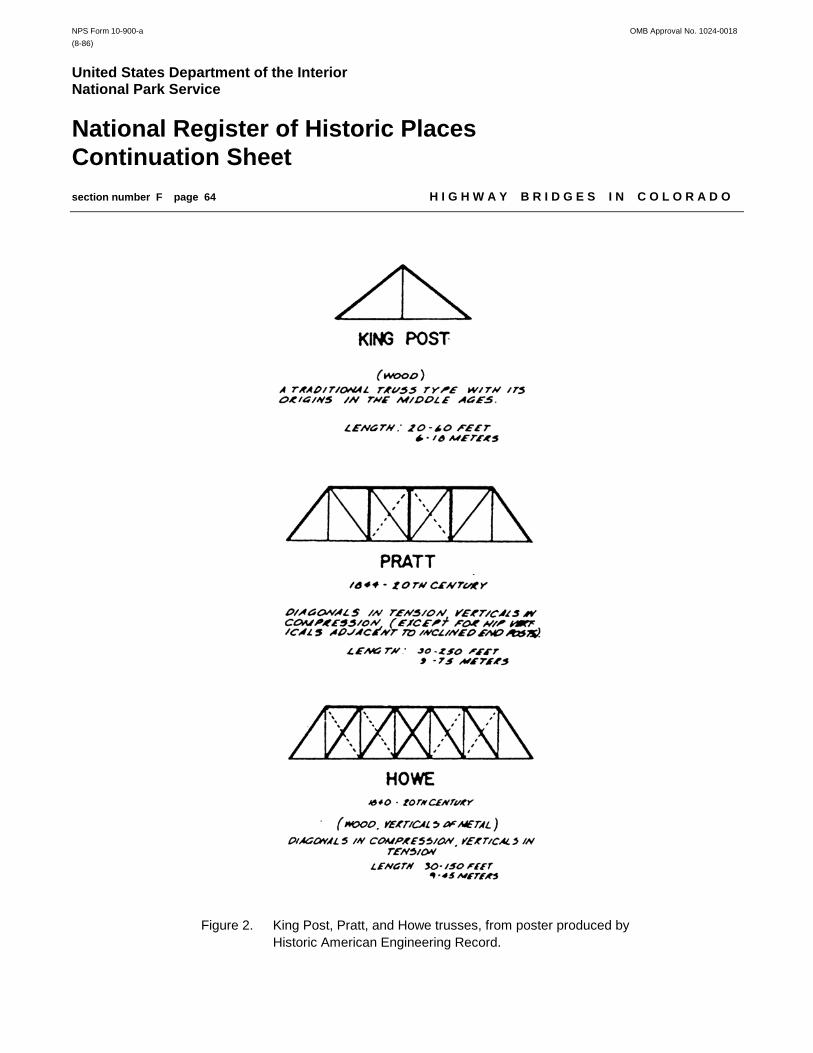
NPS Form 10-900-a OMB Approval No. 1024-0018(8-86)
United States Department of the InteriorNational Park Service
National Register of Historic PlacesContinuation Sheetsection number F page 64 H I G H W A Y B R I D G E S I N C O L O R A D O
Figure 2. King Post, Pratt, and Howe trusses, from poster produced byHistoric American Engineering Record.

NPS Form 10-900-a OMB Approval No. 1024-0018(8-86)
United States Department of the InteriorNational Park Service
National Register of Historic PlacesContinuation Sheetsection number F page 65 H I G H W A Y B R I D G E S I N C O L O R A D O
Because of their inherently short life spans, no timber trestles for vehicular use are known to have survived from the19th or early 20th centuries. The timber bridges found today on Colorado’s roads typically date from the 1930s, 1940sand 1950s. The superstructural technology between the early and later bridges has remained essentially unchanged,with the only difference being the sizes of the members. The bridges of the mid-20th century tend to have more sub-stantial substructures, however, relying more on concrete or steel substructures than their predecessors. Depression-era agencies such as the Works Progress Administration and the Civilian Conservation Corps worked extensively intimber, for reasons of both economy and aesthetics. During the 1930s timber was still relatively easy to obtain andtreat against decay, and it was an ideal construction material for use by gangs of sometimes poorly trained men. Moreover, it fit well within the rustic design aesthetic embraced by these agencies and could be fashioned intoarchitecturally expressive forms with only rudimentary skills. The WPA in Colorado built a wide range of woodenstructures, ranging from the massive trestles over the rivers of the northeast to single- or double-span structures withartistic stone substructures and decorative guardrails. In addition, a great many other timber pile bridges were builtby the Highway Department in the 1930s, using traditional bidding and contracting procedures.
Though by far the most common bridge type, the timber stringer was not particularly sophisticated and was limited tocrossings that permitted the use of relatively short spans. More technologically innovative was a bridge class that hasbeen termed “primarily an American achievement”—the truss. Wood was used on the first railroad trusses inColorado, combined with wrought iron rods to form Howe combination trusses. Patented by William Howe of Massa-chusetts in 1840, the Howe truss featured wooden diagonals that acted in compression and iron verticals in tension.Another important truss design, patented by Thomas and Caleb Pratt in 1844, was characterized by upper chords andvertical members acting in compression and lower chords and diagonals that acted in tension. Howes and Pratts wereby far the most common of the railroad truss designs, accounting for over 95 percent of railroad trusses built inColorado. Narrow-gauge railroads such as the Rio Grande Southern and the Denver & Rio Grande used themextensively in the mountains wherever the stream conditions precluded the use of trestles.1
Howes and Pratts were used extensively for wooden wagon bridges as well, in both pony and through configurations.Like the railroad trusses, they typically featured timber compression members and iron or steel tension rods. Themost common timber truss type in Colorado, though, was the kingpost. With its inclined endposts, straight lower chordand single vertical at mid-span, the kingpost formed a simple triangular web comprised of two equal panels. Whenthe roadway was carried beneath the truss in a through configuration, the endposts acted in compression and thevertical and lower chords in tension.
The kingpost's origins are ancient and obscure. Its symmetrical triangular form lent itself naturally to timber roofframing, where the truss was first used in the Middle Ages. In 1570 Italian architect Andrea Palladio described asimple kingpost truss bridge in his general treatise on architecture, I quattro libri della architettura; he attributed itssource to well-established antecedents.2 Using Palladio's work (translated into English in 1742) and their ownempirical designs, early American carpenters constructed kingpost bridges at minor crossings throughout the East.The technology spread westward with the pioneers in the late 18th and early 19th centuries. As a result, uncountedtimber kingposts were built on the region's early roads. The truss form remained unchanged as its constructionevolved from the vernacular to the industrial in the 19th century, with the principle changes involving the materialsused: timber, timber/iron, iron, steel.
1T. Allen Comp and Donald Jackson, “Bridge Truss Types: A Guide to Dating and Identifying,” Technical Leaflet 95 (Nashville,
Tennessee: American Association for State and Local History, 1977).
2David Plowden, Bridges: The Spans of North America (New York, New York: W.W. Norton and Company, 1974), 34-35.

NPS Form 10-900-a OMB Approval No. 1024-0018(8-86)
United States Department of the InteriorNational Park Service
National Register of Historic PlacesContinuation Sheetsection number F page 66 H I G H W A Y B R I D G E S I N C O L O R A D O
The kingpost's simplicity and straightforward determination of stresses in the individual members made it an idealsubject to illustrate bridge design. Squire Whipple delineated a kingpost truss in his 1847 essay on bridge building,the first such work to rationalize bridge design using scientific principles. Similarly, Merriman and Jacoby, in their Text-Book on Roofs and Bridges [1906], and J.A.L. Waddell, in his Bridge Engineering [1916]—two of the most influentialbridge engineering texts of their time, employed the kingpost to illustrate the principals of static design. “The secretof economical and efficient truss arrangement lies in the panel system,” stated Merriman and Jacoby, “which maybe regarded as having been developed from the king-post truss.”3 Timber trusses suffer from the same structuralshortcomings that timber trestles did, and their numbers have been decimated by replacement. As a result, only afew remain in place today of what amounted to hundreds of such structures in Colorado.
Significance: Timber stringer and truss bridges in Colorado may be eligible for listing in the National Register underCriterion A for their association with events that have made a significant contribution to the broad historical patternsof the country, the state, or the region. Specifically, this includes those bridges that have played an important role inthe development of the state’s highway transportation system and, hence, in the settlement of the area. For example,a structure might be significant for its association with a particular route, such as the Greeley-Denver Road, becauseit was built with assistance from the State Highway Commission in its formative years, or because it was built by aFederal Depression-era relief program. A bridge may, in addition, be eligible under Criterion B for its association witha significant person, as long as the “significant person” was not the designer or builder of the bridge. A bridge canbe eligible by virtue of its designer or builder, but this falls under Criterion C. Indeed, most eligible bridges in Coloradoqualify under Criterion C as structures of engineering significance. This can encompass a broad range ofconsiderations. For instance, a bridge can qualify under Criterion C as a well-preserved example of a common type,or as an important variation.
Timber stringer bridges are sufficiently common in Colorado that to be considered eligible for listing in the NationalRegister under Criterion C, a structure from this property type must have definitive historical documentation and somesuperlative feature that distinguishes it from its peers. Some examples of this are notably early construction date,exceptionally long span length, unusually high span number, or well-executed architectural design.
Registration Requirements: The period of significance for timber stringer and truss bridges in Colorado begins in1880, the earliest construction date covered in this MPDF. The period of significance ends in 1952, the fifty-year dateafter which bridges must possess exceptional significance. Alterations made during the period of significance maybe considered part of the bridge’s historic fabric. Such changes may or may not be in keeping with the bridge’s originaldesign. Integrity of the structure’s historic materials and design is essential for the bridge to qualify for the NationalRegister under any criterion. Since timber stringer bridges are rarely moved, integrity of location is a given. Timberbridges may be eligible for the National Register under Criterion B for their association with a significant person, butthis is rare. Most often, these bridges will have significance under Criteria A or C.
3Squire Whipple, A Work on Bridge Building: Consisting of Two Essays, One Elementary and General, the Other Giving Original
Plans, and Practical Details for Iron and Wooden Bridges (Utica, New York: H.H. Curtis, 1847), pages 6-7; Mansfield Merriman and Henry S.Jacoby, A Text-Book on Roofs and Bridges, 3 volumes (New York New York: John Wiley and Sons, 1906), page 6.

NPS Form 10-900-a OMB Approval No. 1024-0018(8-86)
United States Department of the InteriorNational Park Service
National Register of Historic PlacesContinuation Sheetsection number F page 67 H I G H W A Y B R I D G E S I N C O L O R A D O
Specific requirements under Criterion A:
1. Early and/or prominent product of the Colorado State Engineer’s Office or Colorado Highway Department:In 1881 the Colorado State Legislature established the State Engineer’s Office and funded specific bridge constructionprojects under the Internal Income Fund. Many of these bridges were timber trestles or trusses, although none areknown to remain today. In 1910 the state legislature formed the Colorado Highway Commission (and its successor,the Colorado Highway Department). Numerous timber stringer bridges—but no trusses—were designed by theHighway Commission in the 1910s, although none are known to remain today.
2. Outstanding example of product of a Federal work relief program of the Depression era:Federal work programs in the 1930s and early 1940s, particularly those funded by the WPA, led to construction of anumber of timber stringer bridges in the state. The most significant display careful craftsmanship and creative design.
3. Association with a significant route or event (regional or statewide):If the construction of or improvements to a route or highway helped open up a region for travel and commerce, orcontributed to increased development and prosperity in nearby communities, the route or highway might be consideredeligible under Criterion A. The bridges along this route, if unaltered from the period of significance, may also be eligibleunder Criterion A for their association with significant events. Similarly, if a bridge was built as part of a significantevent, such as when the State Highway Department launched a campaign to improve the safety of bridge crossingsover railroad features, it may be eligible under Criterion A for its association with that specific campaign.
4. Association with civic improvement projects, such as the City Beautiful movement:Bridges built as part of a specific aesthetic or planning initiative in a community might be considered significant underCriterion A as local expressions of a national movement.
Specific requirements under Criterion C:
1. Early and/or representative multiple-span timber stringer bridges:Timber stringer bridges built before 1920 are sufficiently rare in Colorado that any example that has maintainedphysical integrity is considered eligible for the National Register. Additionally, although Colorado once had numerousmulti-span timber bridges, only eleven such structures with ten or more spans have been identified from the historicperiod by the statewide historic bridge inventory. These are considered the most significant examples of their type.
2. Representative example of timber truss:Timber truss bridges are sufficiently rare that any extant example, regardless of structural integrity, is consideredeligible for the National Register.
3. Bridge with exceptional aesthetic merit:Most bridges built in the state, particularly timber structures, are strictly utilitarian. Occasionally, however, a structurestands out by virtue of its design or because of the quality displayed in its construction. The interrelationship of abridge and its site can also have aesthetic value as well, if the bridge demonstrates a significant engineeringachievement due to topographical conditions or constraints.

NPS Form 10-900-a OMB Approval No. 1024-0018(8-86)
United States Department of the InteriorNational Park Service
National Register of Historic PlacesContinuation Sheetsection number F page 68 H I G H W A Y B R I D G E S I N C O L O R A D O
Property Type: Concrete slab and girder bridges
Description: With its deck and superstructure poured integrally in a single flat sheet over steel reinforcing, the simpleconcrete slab is the most rudimentary of the concrete bridge types. A concrete girder bridge looks something like aslab and features parallel lines of concrete beams poured integrally with the deck slab. Girder structures were gen-erally built with the beams aligned beneath the roadway, but they could be configured with deep girders flanking theroadway on both sides, much like thick guardrails. A step up from the slab in terms of technological advancement,girders in either deck or through configurations could economically reach longer spans than slabs. Both structuraltypes were built in single-span configurations with simply supported bearing, or with multiple spans strung togethereither simply or continuously over concrete piers. Because concrete acts well under compressive loading but poorlyunder tension, concrete slabs and girders rely heavily on steel reinforcing along their lower surfaces, where the tensilestresses are greatest. This reinforcing typically takes the form of square, twisted, or deformed reinforcing bars thatextend the length of the span. Concrete slabs are generally limited to span lengths of 30 feet or less; girders can bebuilt with spans in excess of 100 feet, but in Colorado girders built before the mid-1950s rarely exceeded 50 feet.
The first reinforced concrete girder bridge was built in France in 1893. Spans of up to 85 feet appeared by 1904 inEurope, the leader in this design, and in America concrete girders began to receive acceptance for highway use be-tween 1900 and 1910. A few concrete slab or girder bridges were built in Colorado by the counties, the railroads, andthe larger cities after the turn of the century. Between 1905 and 1911 the State Engineer’s Office erected severalconcrete girder structures, two of which—the Brown’s Cañon Bridge in Chaffee County and the Capulin Bridge inConejos County—are still in place as the oldest intact examples of their type in the state. Their use was relativelylimited, however, until the Colorado Highway Commission began designing bridges in 1910. Most of the Commission’sfirst bridges that year were concrete slab or girder structures. In addition to 20-foot-span slabs in Arapahoe and Doug-las counties and a 30-foot girder in Montezuma County, the agency designed and built multiple-span structures overKiowa and Box Elder creeks in Adams County and Bijou Creek in Morgan County.4 With a few exceptions, thecounties were slow in accepting concrete construction, however. This began to change gradually around 1917, whenthe Commission issued its first standard plans for reinforced concrete slab and girder bridges. Widely distributedamong the counties, these designs featured haunches that were angled or arched to decrease the effective spanlength by cantilevering, and their roadways were bounded on both sides by solid concrete parapets or concrete post-and-beam guardrails.5
4Colorado State Highway Commission, First Biennial Report 1910-1911 (Denver: Smith-Brooks Printing Company, 1911); Second
Biennial Report 1911-1912 (Denver: Smith-Brooks Printing Company, 1912).
5Colorado State Highway Commission, Third Biennial Report 1913-1914 (Denver: Smith-Brooks Printing Company, 1915); FourthBiennial Report 1915-1916 (Denver: Eames Brothers, 1917); J.E. Maloney, “Standard Bridge Plans,” Colorado Highways Bulletin 2:11(November 1919).

NPS Form 10-900-a OMB Approval No. 1024-0018(8-86)
United States Department of the InteriorNational Park Service
National Register of Historic PlacesContinuation Sheetsection number F page 69 H I G H W A Y B R I D G E S I N C O L O R A D O
Figure 3. Example of concrete slab bridge. Spring Creek Bridge [5KC168], Kit Carson County, Colo. (Colorado Dept. of Transportation).

NPS Form 10-900-a OMB Approval No. 1024-0018(8-86)
United States Department of the InteriorNational Park Service
National Register of Historic PlacesContinuation Sheetsection number F page 70 H I G H W A Y B R I D G E S I N C O L O R A D O
Figure 4. Example of concrete deck girder bridge. South Arkansas River Bridge[5CF1054], Chaffee County, Colo. (Colorado Dept. of Transportation).

NPS Form 10-900-a OMB Approval No. 1024-0018(8-86)
United States Department of the InteriorNational Park Service
National Register of Historic PlacesContinuation Sheetsection number F page 71 H I G H W A Y B R I D G E S I N C O L O R A D O
Concrete slab and deck girder bridges received more widespread use in the 1920s and 1930s, as the Highway Depart-ment assumed more responsibility for bridge construction in the state. One type used on a tentative basis in the 1920swas the cantilevered concrete girder bridge, with arched haunches. Noteworthy examples of this can still be foundin El Paso, Fremont and Las Animas counties. The main advantages of concrete slabs and girders were structuralrigidity under load and the capability for subsequent widening by adding onto one or both sides of the roadway. Despite these advantages, slabs or girders were never built in abundance in Colorado, because the HighwayDepartment preferred steel stringer construction to concrete girders.
There were no noteworthy technological advancements made on these structural types during the 1940s. In the 1950sthe concrete deck girder experienced a notable resurgence in popularity, as the Highway Department built scores offlat-beamed girders at crossings throughout the state. Additionally, at this time CHD introduced a new type of long-span concrete girder design, with the beams arched parabolically over their span and supported by concrete spill-through piers. First used at a few isolated locations around the state, including along SH 119 in Boulder County, thesebecame the standard design for highway overpasses and underpasses when Colorado built its interstate highwaysystem in the late 1950s and 1960s.
Significance: Concrete slab or girder bridges in Colorado may be eligible for listing in the National Register of HistoricPlaces under Criterion A for their association with events that have made a significant contribution to the broadhistorical patterns of the country, the state, or the region. Specifically, this includes those bridges that have playedan important role in the development of the state’s highway transportation system and, hence, in the settlement of thearea. For example, a structure might be significant for its association with a particular route, such as the Pueblo-Colorado Springs Highway, because it was built with assistance from the State Highway Commission in its formativeyears, or because it was built by a Federal Depression-era relief program. A bridge may, in addition, be eligible underCriterion B for its association with a significant person, as long as the “significant person” was not the designer orbuilder of the bridge. A bridge can be eligible by virtue of its designer or builder, but this falls under Criterion C. Indeed, most eligible bridges in Colorado qualify under Criterion C as structures of engineering significance. This canencompass a broad range of considerations. For instance, a bridge can qualify under Criterion C as a well-preservedexample of a common type, or as an important variation.
Concrete slab and deck girder bridges are sufficiently common in Colorado that to be considered eligible for listing inthe National Register under Criterion C, structures from these property types must have definitive historicaldocumentation and some superlative feature that distinguish them from their peers. Some examples of this arenotably early construction date, exceptionally long span length, unusually high span number, or well-executedarchitectural design.
Registration Requirements: The period of significance for concrete slab and girder bridges in Colorado begins in1900, the approximate date for the state’s earliest examples of these structural types. The period of significance endsin 1952, the fifty-year date after which bridges must possess exceptional significance. Alterations made during theperiod of significance are considered part of the bridge’s historic fabric. Such changes may or may not be in keepingwith the bridge’s original design. Integrity of the structure’s historic materials and design is essential for the bridge toqualify for the National Register under any criterion. Since concrete slab and girder bridges are rarely moved, integrityof location is a given. Slab and girder bridges may be eligible for the National Register under Criterion B for theirassociation with a significant person, but this is rare. Most often, these bridges will have significance under CriteriaA or C.

NPS Form 10-900-a OMB Approval No. 1024-0018(8-86)
United States Department of the InteriorNational Park Service
National Register of Historic PlacesContinuation Sheetsection number F page 72 H I G H W A Y B R I D G E S I N C O L O R A D O
Specific requirements under Criterion A:
1. Early and/or prominent product of the Colorado State Engineer’s Office or Colorado Highway Department:In 1881 the Colorado State Legislature established the State Engineer’s Office and funded specific bridge constructionprojects under the Internal Income Fund. Some of the later bridges built under this program were concrete structures,and two are known to remain today. In 1910 the state legislature formed the Colorado Highway Commission (and itssuccessor, the Colorado Highway Department). Numerous concrete slab and deck girder were designed by theHighway Commission in the 1910s and early 1920s, and a few remain in place today.
2. Outstanding example of product of a Federal work relief program of the Depression era:Federal work programs in the 1930s and early 1940s, particularly those funded by the Works Progress Administration,led to construction of a number of concrete slab and deck girder bridges in the state. The most significant displaycareful craftsmanship and creative design.
3. Association with a significant route or event (regional or statewide):If the construction of or improvements to a route or highway helped open up a region for travel and commerce, orcontributed to increased development and prosperity in nearby communities, the route or highway might be consideredeligible under Criterion A. The bridges along this route, if unaltered from the period of significance, may also be eligibleunder Criterion A for their association with significant events. Similarly, if a bridge was built as part of a significantevent, such as when the State Highway Department launched a campaign to improve the safety of bridge crossingsover railroad features, it may be eligible under Criterion A for its association with that specific campaign.
4. Association with civic improvement projects, such as the City Beautiful movement:Bridges built as part of a specific aesthetic or planning initiative in a community might be considered significant underCriterion A as local expressions of a national movement.
Specific requirements under Criterion C:
1. Early and/or representative concrete slab and deck girder bridges:Concrete slab and deck girder bridges built before 1920 are sufficiently rare in Colorado that any example that hasretained structural integrity is considered significant. Those built after 1920 with definitive documentation areconsidered significant on the basis of superlative features (i.e., exceptionally long span length, unusual number ofspans, uncommonly good state of preservation). Concrete slabs or parabolic concrete girders built after 1952 areconsidered exceptionally significant if they were prototypes for this structural configuration.
2. Representative example of concrete through girder:Concrete through girder bridges are sufficiently rare in Colorado that any intact example is considered significant.
3. Bridge with exceptional aesthetic merit:Most bridges built in the state are strictly utilitarian. Occasionally, however, a structure stands out by virtue of itsdesign or because of the quality displayed in its construction. This does not include standard-design concreteguardrails by the Highway Department, however. The interrelationship of a bridge and its site can also have aestheticvalue as well, if the bridge demonstrates a significant engineering achievement due to topographical conditions orconstraints.

NPS Form 10-900-a OMB Approval No. 1024-0018(8-86)
United States Department of the InteriorNational Park Service
National Register of Historic PlacesContinuation Sheetsection number F page 73 H I G H W A Y B R I D G E S I N C O L O R A D O
Property Type: Concrete, stone, and steel arch bridges
Description: The concrete arch relies on two ancient technologies—concrete construction and the arch form—whichdate to Roman precedents. Although the Romans had developed a form of hydraulic cement, there is no evidenceto suggest that they used it for bridge construction. After Rome fell, concrete technology was lost for over a thousandyears, until it later reappeared in England. British engineer George Semple was apparently the first to use hydrauliccement for bridge construction, on pier foundations for the Essex Bridge in Dublin, built in the mid-16th century. In1824 Englishman Joseph Aspdin developed an artificial cement composed of a calcinate mixture of limestone andclay. Aspdin called his concoction Portland cement after Portland on Devonshire, the source for his limestone. Almost50 years later, American David O. Saylor patented his own type of Portland cement in 1871 and built the country's firstcement manufacturing plant near Coplay, Pennsylvania.6
The first documented use of concrete on an American bridge, like Semple's Essex Bridge, was not for a superstructureat all but for the foundations of the Erie Railroad’s Starrucca Viaduct, completed in 1848.7 John Goodrich was probablythe first in this country to use concrete as the principal material for the spans of a bridge. A modest 31-foot structurebuilt in 1871, his Cleft Ridge Park Bridge in Brooklyn’s Prospect Park used concrete because it was intended to bean ornamental structure and concrete was cheaper than stone. Soon other concrete spans began to appear in thiscountry. From 1890 to 1900, over 150 reinforced concrete spans were built on scales ranging from minimal tomonumental.8
These early structures were built of unreinforced, or mass, concrete, which has the same structural properties asstone. Although far stronger than either iron or wood in compression, unreinforced concrete has virtually no tensilestrength. Its use in bridge work was therefore limited to an ancient structural form derived from stone masonry—thearch. The arch rib or ring functioned essentially as an extended curved column, under compression over its entirelength. Further, as a beam, it had to resist the bending and shear stresses caused by shifting live loads applied to thebridge deck and differential expansion and contraction caused by the weather. “It was a comparatively easy changefrom the stone voussoir arch to concrete monolithic or voussoir construction,” engineer Frank Barber stated in 1911.9
It would not be until the end of the 19th century that engineers would begin to understand and develop the plasticproperties of concrete and use it as something more than just a cheap imitation of stone. To address concrete'sinherent tensile shortcoming, American engineer W.E. Ward demonstrated in 1871 that the material could bestrengthened to resist tension by embedding iron bars in it. Such a composite configuration would combine thecompressive strength of concrete with the tensile properties of iron. The concrete would thus protect the reinforcingfrom corrosion and would provide an economical and technological alternative to an all-metal solution by reducing theamount of iron needed to bear the weight.
6Caleb Hornbostel, Construction Materials: Types, Uses and Applications (New York: John Wiley and Sons, 1978), 205; Pedro
Guedes, Encyclopedia of Architectural Technology (New York: McGraw-Hill Book Co., 1979), 253-255.
7Plowden, Bridges, 297.
8Ibid.; “The Present Status of Reinforced Concrete Bridges,” Engineering Record (13 August 1910): 169-170; Henry S. Jacoby,
“Recent Progress in American Bridge Construction,” Scientific American Supplement, 19 July 1902, 22199.
9Frank Barber, “Characteristics of Long-Span Concrete Bridges,” Engineering Record (8 April 1911): 397.

NPS Form 10-900-a OMB Approval No. 1024-0018(8-86)
United States Department of the InteriorNational Park Service
National Register of Historic PlacesContinuation Sheetsection number F page 74 H I G H W A Y B R I D G E S I N C O L O R A D O
The application of this discovery to large-scale bridge construction should have been immediately apparent, but it wasnot until ten years later that S. Bissel received the first American patent for concrete reinforcing. The first reinforcedconcrete bridge built in this country was the Alvord Lake Bridge in San Francisco’s Golden Gate Park, completed in1889. Designed by Ernest Ransome with a modest 35-foot span, it was an otherwise unremarkable structure and stillstands today. It was only after the turn of the century that concrete began to rival stone for long-span archbuilding.Engineers by then had begun to stretch the technological limits of concrete construction dramatically with new methodsof forming, centering, and reinforcing the arches. In 1904 a bridge in Grunwald, Germany, was built with a span ofalmost 230 feet. In 1908 E. Morsh completed a 259-foot bridge over the gorge of the Gmundertobelbruke inSwitzerland. That same year American engineer George Webster completed the Walnut Lane Bridge in Philadelphia.Called the largest concrete arch in the world at its completion, it featured an unreinforced 233-foot main arch. By theend of 1910, 19 concrete arches had been built in the world with spans in excess of 150 feet.10 In 1910 EngineeringRecord described the progress that American engineers had made in concrete bridge construction:
When it is considered that the first reinforced concrete arch bridge in the United States was built only 21 yearsago, the development which has taken place in the design and construction of bridges of this type seems veryremarkable. Moreover, the greater part of this growth has been brought about in the last decade. That thismovement is still going on is shown by the fact that at frequent intervals descriptions appear in the engineeringpress of structures which embody new ideas or material modifications of old ones. It is interesting to watchthis progress, and especially to see the influence which the materials used have had on the development.11
10Charles S. Whitney, Bridges: Their Art, Science and Evolution (New York: Crown Publishers, 1983), 288; Barber,
“Characteristics. . .,” 397; “The Walnut Lane Bridge Completed,” Engineering News (5 November 1908): 497.
11 “The Present Status of Reinforced Concrete Bridges,” 169-170.
One aspect that all long-span concrete arches shared was their open-spandrel design. For shorter spans, engineerstypically employed filled-spandrel arches, with the roadway supported by earth fill poured over the continuous concretearch ring. But these would be inordinately heavy over long spans, so engineers used open-spandrel arches, whichsubstituted a series of concrete columns for the earth fill, on longer spans. The earliest open-spandrel archesemployed single, relatively thin arch ribs that extended continuously over the width of the bridge. Around 1910engineers began to experiment with multi-rib arches that used several individual ribs in lieu of continuous ribs. Therewere several advantages to this new structural form. First, less material was used in the individual ribs. Additionally,the floor of a multi-rib bridge could be supported by a single row of columns on each rib, whereas on a continuous-ribdesign, several rows of columns or even continuous walls were necessary to distribute the weight of the deck evenlyover the arch rib. Finally, on ribbed-arch bridges, the outer edge of the floor could be cantilevered beyond the outsideribs, allowing for narrower sub-deck configurations with narrower, more economical abutments.
Colorado generally followed national trends in the construction of its reinforced concrete arches. The first arches ap-peared in the state around the turn of the century in the urban areas, where rigidity under heavy traffic was important.These earliest structures almost all employed filled-spandrel designs. One of the first concrete arches built in Colorado

NPS Form 10-900-a OMB Approval No. 1024-0018(8-86)
United States Department of the InteriorNational Park Service
National Register of Historic PlacesContinuation Sheetsection number F page 75 H I G H W A Y B R I D G E S I N C O L O R A D O
was the Commercial Street Bridge in Trinidad, completed in 1905 by Des Moines contractor and engineer JamesMarsh. Spanning the Purgatoire River, it featured two 70-foot arches and used a design patented that year byIndianapolis engineer Daniel B. Luten. Patterned after an arch reinforcing scheme developed by Austrian engineerJosef Melan, Luten’s filled-spandrel arch was the most widely built of the proprietary arch types in America.
Luten’s arch was later promoted to Colorado’s counties by Fred M. Bullen and his son Joseph, who as proprietors ofthe Pueblo Bridge Company functioned as licensees to Luten. Operating under a patent royalty agreement to Luten,Pueblo Bridge designed and built Luten arches around the state, particularly in the Arkansas River Valley. PuebloBridge extensively promoted Luten’s trademark elliptical arch—often called a horseshoe arch because of its distinctiveprofile—and bid frequently for county bridge contracts. Pueblo Bridge’s unceasing self-promotion distinguished thefirm as Colorado’s most prolific bridge builder in the first two decades of the 20th century. The company built scoresof Luten arches of varying sizes in Colorado during the 1900s and 1910s. Of these, 16 remain in place today.
The other proprietary arch design found in Colorado was patented in 1910 by James Marsh, the builder of theCommercial Street Bridge. In contrast with the Luten arch, Marsh’s structure carried its deck in a through configurationbetween two open-spandrel, overhead arches. The arches—called rainbow arches due to their distinctive profile—actin compression, but the hangers and floor beams carry the deck in tension. To make the concrete thus act againstits nature, Marsh inserted large amounts of structural steel. His bridges may look like concrete spans, but the archribs and hangers carry such heavy, complicated reinforcing that they are, in reality, steel structures encased inconcrete. Only one Marsh arch was ever built in Colorado—the Fort Morgan Bridge over the South Platte River, an11-span structure completed by the Colorado Bridge and Construction Company in 1923.
The Rainbow Bridge and the Luten arches built by Pueblo Bridge were all engineered and based upon patenteddesigns. Other, small-scale concrete arches were built in the state that were more casually derived, using designsthat were more empirical in their origin. Perhaps the most noteworthy pocket of arches designed and built by a localcontractor was located in Fremont County. Beginning in 1908 Florence-based contractor H.M. Fox built several filled-spandrel concrete arches in town and around the surrounding county, using his own designs. Other such locallydesigned arches were built in small numbers elsewhere in the state by other contractors during the 1910s and early1920s.
Around 1917 the Colorado Highway Commission developed its own filled-spandrel arch design and distributedstandard plans for it to the county road agencies. Like the reinforced concrete slab and girder bridge standards,though, these arches did not receive widespread acceptance around the state. The Highway Department constructeda number of filled-spandrel arches in the 1920s and 1930s, but this structural type was never built in abundance. Inthe early 1930s the Highway Department experimented with two-rib, open-spandrel arches at crossings where it wouldordinarily have built long-span through trusses. But like filled-spandrel arches, these structures were used sparingly.Arch construction essentially ceased during World War II, with its severe limitations in the use of concrete. After thewar the Highway Department began using more efficient concrete bridge designs. The most notable exception to thislast trend was the bridge over Cherry Creek in Douglas County, an open-spandrel arch built in 1948 with a span of 232feet.
Although stone for heavy construction was readily available in Colorado, stone arch bridges were rarely built on thestate’s wagon roads during the 19th and early 20th centuries. The most noteworthy exception to this is the Main StreetBridge in Durango, a three-span stone arch structure built in 1906. During the 1930s, however, the Works ProgressAdministration constructed scores of arch structures on roads, particularly in the southeast corner of the state. The
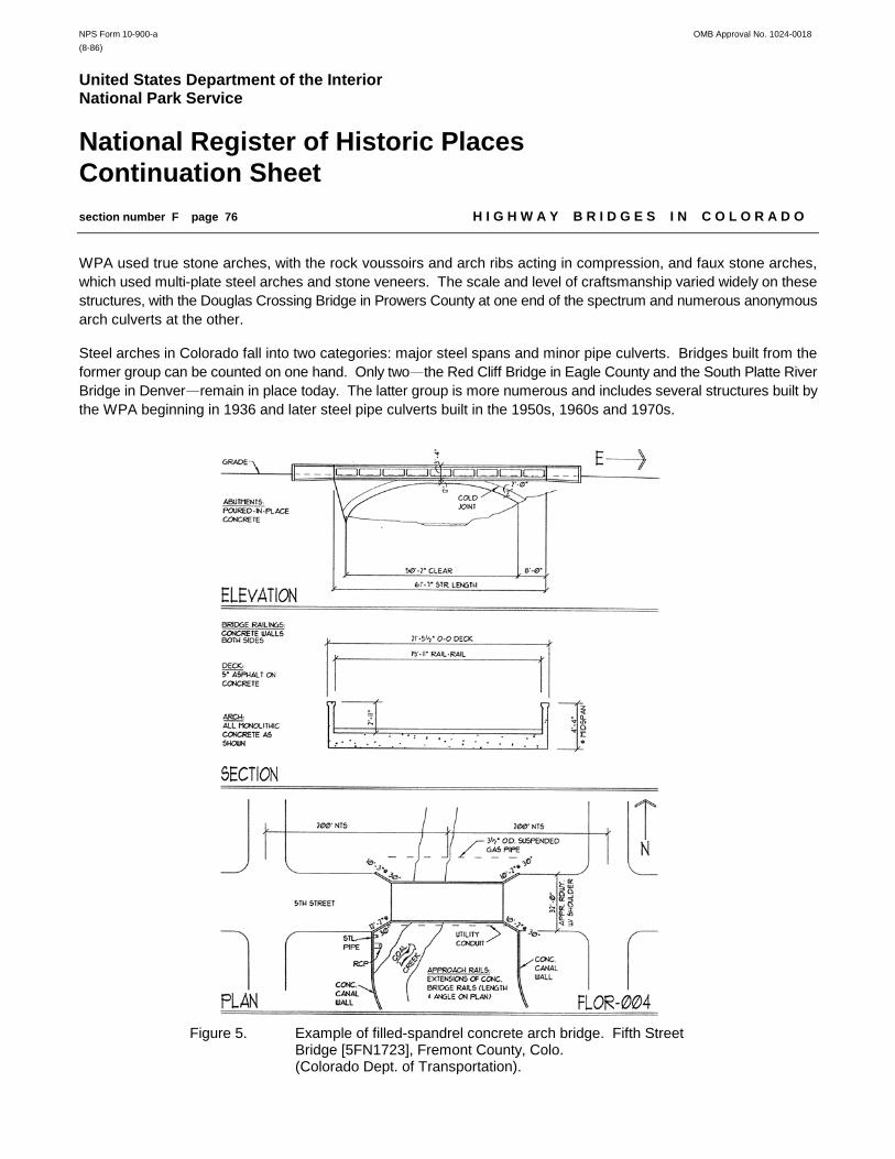
NPS Form 10-900-a OMB Approval No. 1024-0018(8-86)
United States Department of the InteriorNational Park Service
National Register of Historic PlacesContinuation Sheetsection number F page 76 H I G H W A Y B R I D G E S I N C O L O R A D O
WPA used true stone arches, with the rock voussoirs and arch ribs acting in compression, and faux stone arches,which used multi-plate steel arches and stone veneers. The scale and level of craftsmanship varied widely on thesestructures, with the Douglas Crossing Bridge in Prowers County at one end of the spectrum and numerous anonymousarch culverts at the other.
Steel arches in Colorado fall into two categories: major steel spans and minor pipe culverts. Bridges built from theformer group can be counted on one hand. Only two—the Red Cliff Bridge in Eagle County and the South Platte RiverBridge in Denver—remain in place today. The latter group is more numerous and includes several structures built bythe WPA beginning in 1936 and later steel pipe culverts built in the 1950s, 1960s and 1970s.
Figure 5. Example of filled-spandrel concrete arch bridge. Fifth StreetBridge [5FN1723], Fremont County, Colo. (Colorado Dept. of Transportation).

NPS Form 10-900-a OMB Approval No. 1024-0018(8-86)
United States Department of the InteriorNational Park Service
National Register of Historic PlacesContinuation Sheetsection number F page 77 H I G H W A Y B R I D G E S I N C O L O R A D O
Figure 6. Example of Luten filled-spandrel concrete arch bridge. Butte ValleyBridge [5HF1907], Huerfano County, Colo. (Colorado Dept. ofTransportation).

NPS Form 10-900-a OMB Approval No. 1024-0018(8-86)
United States Department of the InteriorNational Park Service
National Register of Historic PlacesContinuation Sheetsection number F page 78 H I G H W A Y B R I D G E S I N C O L O R A D O
Figure 7. Example of open-spandrel concrete arch bridge. San Luis Bridge [5CT141],Costilla County, Colo. (Colorado Dept. of Transportation).

NPS Form 10-900-a OMB Approval No. 1024-0018(8-86)
United States Department of the InteriorNational Park Service
National Register of Historic PlacesContinuation Sheetsection number F page 79 H I G H W A Y B R I D G E S I N C O L O R A D O
Figure 8. Example of stone arch bridge. Burro Canyon Bridge [5LA8115], Las AnimasCounty, Colo. (Colorado Dept. of Transportation).

NPS Form 10-900-a OMB Approval No. 1024-0018(8-86)
United States Department of the InteriorNational Park Service
National Register of Historic PlacesContinuation Sheetsection number F page 80 H I G H W A Y B R I D G E S I N C O L O R A D O
Figure 9. Example of steel arch bridge. South Platte River Bridge [5DV7072], Denver County, Colo. (Colorado Dept. of Transportation).

NPS Form 10-900-a OMB Approval No. 1024-0018(8-86)
United States Department of the InteriorNational Park Service
National Register of Historic PlacesContinuation Sheetsection number F page 81 H I G H W A Y B R I D G E S I N C O L O R A D O
Significance: Concrete, stone and steel arch bridges in Colorado may be eligible for listing in the National Registerof Historic Places under Criterion A for their association with events that have made a significant contribution to thebroad historical patterns of the country, the state, or the region. Specifically, this includes those bridges that haveplayed an important role in the development of the state’s highway transportation system and, hence, in the settlementof the area. For example, a structure might be significant for its association with a particular route, such as theOmaha-Lincoln-Denver Highway, because it was built with assistance from the State Highway Commission in itsformative years, or because it was built by a Federal Depression-era relief program. A bridge may, in addition, beeligible under Criterion B for its association with a significant person, as long as the “significant person” was notthe designer or builder of the bridge. A bridge can be eligible by virtue of its designer or builder, but this falls underCriterion C. Indeed, most eligible bridges in Colorado qualify under Criterion C as structures of engineeringsignificance. This can encompass a broad range of considerations. For instance, a bridge can qualify under CriterionC as a well-preserved example of a common type, or as an important variation.
Registration Requirements: The period of significance for concrete, stone and steel arch bridges in Colorado beginsin 1900, the approximate date for the state’s earliest examples of these structural types. The period of significanceends in 1951, the fifty-year date after which bridges must possess exceptional significance. Alterations made duringthe period of significance are considered part of the bridge’s historic fabric. Such changes may or may not be inkeeping with the bridge’s original design. Integrity of the structure’s historic materials and design is essential for thebridge to qualify for the National Register under any criterion. Since arch bridges are rarely moved, integrity of locationis a given. Arch bridges may be eligible for the National Register under Criterion B for their association with asignificant person, but this is rare. Most often, these bridges will have significance under Criteria A or C.
Specific requirements under Criterion A:
1. Early and/or prominent product of the Colorado State Engineer’s Office or Colorado Highway Department:In 1881 the Colorado State Legislature established the State Engineer’s Office and funded specific bridge constructionprojects under the Internal Income Fund. Some of the later bridges built under this program were concrete archstructures, and one is known to remain today. In 1910 the state legislature formed the Colorado Highway Commission(and its successor, the Colorado Highway Department). Several concrete arches were designed by HighwayDepartment in the 1920s and 1930s, and a few remain in place today.
2. Outstanding example of product of a Federal work relief program of the Depression era:Federal work programs in the 1930s and early 1940s, particularly those funded by the Works Progress Administration,led to construction of a number of stone and multi-plate arch bridges in the state. The most significant display carefulcraftsmanship and creative design.
3. Association with a significant route or event (regional or statewide):If the construction of or improvements to a route or highway helped open up a region for travel and commerce, orcontributed to increased development and prosperity in nearby communities, the route or highway might be consideredeligible under Criterion A. The bridges along this route, if unaltered from the period of significance, may also be eligibleunder Criterion A for their association with significant events. Similarly, if a bridge was built as part of a significantevent, such as when the State Highway Department launched a campaign to improve the safety of bridge crossingsover railroad features, it may be eligible under Criterion A for its association with that specific campaign.

NPS Form 10-900-a OMB Approval No. 1024-0018(8-86)
United States Department of the InteriorNational Park Service
National Register of Historic PlacesContinuation Sheetsection number F page 82 H I G H W A Y B R I D G E S I N C O L O R A D O
4. Association with civic improvement projects, such as the City Beautiful movement:Bridges built as part of a specific aesthetic or planning initiative in a community might be considered significant underCriterion A as local expressions of a national movement.
Specific requirements under Criterion C:
1. Early and/or representative concrete, stone, or steel arch bridge:Although they are generally considered among the highest forms of bridge design, concrete and stone arches werenever built in abundance in Colorado, and only a handful of steel highway bridges are known to have been erected.Those arch bridges with spans in excess of 30 feet (i.e., true bridges and not arch culverts) that remain with a highdegree of structural integrity are sufficiently rare and noteworthy that most are considered significant.
2. Representative example by an important engineer, architect, or firm:Proprietary concrete arch designs, such as those developed by Daniel Luten and James Marsh, are consideredsignificant aspects of bridge design of the early 20th century. Accordingly, bridges constructed using these designsare considered significant.
3. Bridge with exceptional aesthetic merit:Most bridges built in the state are strictly utilitarian. Occasionally, however, a structure stands out by virtue of itsdesign or because of the quality displayed in its construction. Highway Department standard-design concrete guardrailis not considered exceptional as a stand-alone feature, but can contribute to the overall significance of a bridge if itis an integral part of the original design. The interrelationship of a bridge and its site can also have aesthetic valueas well, if the bridge demonstrates a significant engineering achievement due to topographical conditions orconstraints.

NPS Form 10-900-a OMB Approval No. 1024-0018(8-86)
United States Department of the InteriorNational Park Service
National Register of Historic PlacesContinuation Sheetsection number F page 83 H I G H W A Y B R I D G E S I N C O L O R A D O
Property Type: Concrete rigid frame bridges
Description: The first concrete rigid frame bridge in America was designed in 1922 by engineer Arthur G. Haydenfor the park commission of Westchester County, New York. Comprised of a concrete beam superstructure tied rigidlyto the abutments with steel reinforcing bars, rigid frame bridges differed materially from conventional simply supportedspans. “A clear conception of a typical rigid frame concrete bridge may be obtained by first visualizing an ordinarysimple span bridge supported by bearing on two abutments,” a 1935 concrete manual stated. “If the bearing isreplaced with concrete that continues monolithically from the abutments to the deck, the altered structure becomesa frame with rigid corners—a structure generally called a rigid frame concrete bridge.” Because its construction wasrelatively labor-intensive, this bridge configuration became popular for Federal relief projects during the 1930s. Bothpicturesque and practical, the flat-arch design appealed to proponents of urban beautification, and rigid frames foundwidespread use in city parks and landscaped boulevards. By 1935 more than 300 rigid frames had been built inAmerica, most in urban areas. Early rigid frame bridges were limited in span length, but by 1937 the Schmitz ParkBridge in Seattle featured a single 175-foot span.12
Concrete rigid frame bridges were well suited to urban applications with large traffic volumes and moderate spanlengths, where rigidity under load was of prime importance. Their design could be easily changeable as well. Usinga standard profile and reinforcing configuration, a series of bridges could be built over a fairly wide range of spanlengths. They could be readily skewed to accommodate angled intersections. Their flat or slightly arched undersidesprovided adequate under-bridge clearance. And they could be subsequently widened to accommodate increasedtraffic. Further, the bridges could be cast plainly or adorned with a variety of applied concrete or metal ornamentation.
The City of Denver was the first government entity known to construct rigid frame bridges in Colorado, with a few two-span structures over Cherry Creek built in the 1920s. In the late 1930s the Colorado Highway Department exper-imented with rigid frame design, building relatively small-scale structures at rural locations around the state. The firstconcerted use of rigid frame overpasses occurred in 1944, with the design of the Valley Highway through Denver byconsulting engineers Crocker and Ryan. Built in the 1950s, the Valley Highway employed numerous two-span rigidframe structures at the grade separations with city streets. Despite the suitability of rigid frame structures for urbanuse, they were built only sparingly elsewhere in the state.
12Analysis of Rigid Frame Concrete Bridges (Chicago: Portland Cement Association, 1935), 5; A.L. Cerveny, A.L. “Rigid Frame
Bridges.” University of Colorado Highway Conference. March 1939, 33-34.

NPS Form 10-900-a OMB Approval No. 1024-0018(8-86)
United States Department of the InteriorNational Park Service
National Register of Historic PlacesContinuation Sheetsection number F page 84 H I G H W A Y B R I D G E S I N C O L O R A D O
Figure 10. Example of concrete rigid frame bridge. Eleventh Avenue Bridge[5DV7096], Denver County, Colo. (Colorado Dept. of Transportation).

NPS Form 10-900-a OMB Approval No. 1024-0018(8-86)
United States Department of the InteriorNational Park Service
National Register of Historic PlacesContinuation Sheetsection number F page 85 H I G H W A Y B R I D G E S I N C O L O R A D O
Significance: Concrete rigid frame bridges in Colorado may be eligible for listing in the National Register of HistoricPlaces under Criterion A for their association with events that have made a significant contribution to the broadhistorical patterns of the country, the state, or the region. Specifically, this includes those bridges that have playedan important role in the development of the state highway transportation system and, hence, in the settlement of thearea. For example, a structure might be significant for its association with a particular route, such as the ValleyHighway. A bridge may, in addition, be eligible under Criterion B for its association with a significant person, as longas the “significant person” was not the designer or builder of the bridge. A bridge can be eligible by virtue of itsdesigner or builder, but this falls under Criterion C. Indeed, most eligible bridges in Colorado qualify under CriterionC as structures of engineering significance. This can encompass a broad range of considerations. For instance, abridge can qualify under Criterion C as a well-preserved example of a common type, or as an important variation.
Concrete rigid frame bridges are sufficiently common in Colorado that to be considered eligible for listing in the Nation-al Register under Criterion C, a structure from this property type must have some superlative feature about it thatdistinguishes it from its peers. Some examples of this are notably early construction date, exceptionally long spanlength, unusually high span number, or well-executed architectural design.
Registration Requirements: The period of significance for concrete rigid frame bridges in Colorado begins in 1925,the construction date for the state’s earliest examples of this structural type. The period of significance ends in 1952,the fifty-year date after which bridges must possess exceptional significance. Alterations made during the period ofsignificance are considered part of the bridge’s historic fabric. Such changes may or may not be in keeping with thebridge’s original design. Integrity of the structure’s historic materials and design is essential for the bridge to qualifyfor the National Register under any criterion. Since concrete rigid frame bridges cannot be moved, integrity of locationis a given. Rigid frame bridges may be eligible for the National Register under Criterion B for their association witha significant person, but this is rare. Most often, these bridges will have significance under Criteria A or C.
Specific requirements under Criterion A:
1. Early and/or prominent product of the Colorado Highway Department:In the 1930s the Highway Department began using concrete rigid frames for bridges and grade separations. Severalremain in place today.
2. Association with a significant route or event (regional or statewide):If the construction of or improvements to a route or highway helped open up a region for travel and commerce, orcontributed to increased development and prosperity in nearby communities, the route or highway might be consideredeligible under Criterion A. The bridges along this route, if unaltered from the period of significance, may also be eligibleunder Criterion A for their association with significant events. Similarly, if a bridge was built as part of a significantevent, such as when the State Highway Department launched a campaign to improve the safety of bridge crossingsover railroad features, it may be eligible under Criterion A for its association with that specific campaign.
3. Association with civic improvement projects, such as the City Beautiful movement:Bridges built as part of a specific aesthetic or planning initiative in a community might be considered significant underCriterion A as local expressions of a national movement.
NPS Form 10-900-a OMB Approval No. 1024-0018(8-86)
United States Department of the InteriorNational Park Service
National Register of Historic PlacesContinuation Sheetsection number F page 86 H I G H W A Y B R I D G E S I N C O L O R A D O
Specific requirements under Criterion C:
1. Early and/or representative concrete rigid frame bridges:Concrete rigid frame bridges are considered significant if they can be definitively documented and they exhibit super-lative features (i.e., exceptionally long span length, unusual number of spans, uncommonly good state of preservation).
2. Bridge with exceptional aesthetic merit:Most bridges built in the state are strictly utilitarian. Occasionally, however, a structure stands out by virtue of itsdesign or because of the quality displayed in its construction. Highway Department standard-design concrete guardrailis not considered exceptional as a stand-alone feature, but can contribute to the overall significance of a bridge if itis an integral part of the original design. The interrelationship of a bridge and its site can also have aesthetic valueas well, if the bridge demonstrates a significant engineering achievement due to topographical conditions orconstraints.
Property Type: Steel stringer and girder bridges
Description: Steel stringer bridges are the most rudimentary type of all-metal spans. Comprised of parallel rows ofrelatively shallow, rolled I-beams laid over piers and abutments, steel stringer bridges were used in abundance byColorado railroads in the late 19th and early 20th centuries. Their spans were generally limited to less than 30 feet;beyond that the railroads typically employed riveted plate girder spans. Steel stringers began to replace short-spantrusses for county roadway use in Colorado after the turn of the 20th century. Although they were routinely built, fewof these earliest I-beam spans remain in place in the state. The decks for these early stringer structures typicallyfeatured timber planks or concrete slabs, although a modified concrete deck, poured over steel arch forms called“jack arches”, was sometimes employed. Substructures for steel stringer bridges ran the gamut from stonemasonry or concrete abutments to timber or steel pile bents. Like timber stringers, steel stringer bridges could consistof single-span structures over minor watercourses, or the spans could be multiplied over piers to cross rivers with wideflood plains. And like timber stringers, they could be designed and built using standard tables or empirical judgment,without the need for extensive engineering.
To assist the counties in building bridges on the newly formed state road system, the Colorado Highway Commissionpublished its first design standards for steel stringer bridges in 1914. These early structures featured I-beam stringerswith depths ranging from 12 to 24 inches, which could cover a range of spans between 16 and 36 feet.13 The stringerswere sheathed completely with concrete to protect them from weathering, giving the bridges an all-concreteappearance. The Highway Commission’s sheathed stringer bridge proved unnecessarily expensive to build, however,and the concrete sheathing was soon eliminated, reducing the superstructure to its bare necessities. Since then steelbeam bridges have enjoyed inconsistent popularity with Highway Department and county engineers, depending largelyon the price of steel at the time. Steel shortages caused by World War I curtailed the use of stringer bridges duringthe 1910s. As prices fell in the 1920s, though, CHD resumed its reliance on rolled steel beams for bridge construction.
13Robert DuBois, “Standard I-Beam Bridges,” Colorado Highways Bulletin 2:12 (December 1919), 6.

NPS Form 10-900-a OMB Approval No. 1024-0018(8-86)
United States Department of the InteriorNational Park Service
National Register of Historic PlacesContinuation Sheetsection number F page 87 H I G H W A Y B R I D G E S I N C O L O R A D O
Perhaps more than any other bridge type, steel stringer technology has depended heavily on the capacity of rollingmills that provided the steel. Dependent upon the mills’ output of shallow beams, early CHD stringer bridges werelimited to spans shorter than 50 feet. It was necessary, therefore, to use other structural types such as steel plategirders, trusses, or concrete arches for crossings requiring greater spans. The Highway Department was able toincrease these spans to 75 feet when the mills began to roll 33- to 36-inch-deep beams in 1928. The longer spansmade steel bridges more economical than concrete, hence greatly increasing the number of long-span steel beambridges built in Colorado in the 1930s. Even more than timber stringer or concrete girder bridges, steel stringerstructures were flexible in span length, span number, roadway width, and substructure configuration. They could bebuilt with simply supported bearing conditions or with the beams extending continuously over the piers. Moreover, theycould be subsequently widened simply by extending the piers and abutments to the sides and adding more stringersoutside of the original ones. So suitable were steel stringers to widening that they have often been used to widen thedecks on other structural types such as concrete arches and slabs. As a result of this flexibility and economy, steelstringer bridges received widespread acceptance on Colorado highways in the 1920s, 1930s, and 1940s. The trendhas continued to the present. Built in profusion by the Highway Department, by the cities, and by the counties, steelstringers today represent by far the most populous structural type among Colorado’s highway bridges.
Steel girders employ a technology similar to that of stringers, substituting two or more deep-profile beams for the rowof relatively shallow stringers. Like concrete girder structures, they could be configured with several beams locatedbeneath the roadway (called deck girders) or two relatively deep beams on both sides of the roadway (through girders).With their more complicated bearing condition, beam arrangement, and floor system connections, steel girder bridgesmark a step up the technological scale from stringers. It was this increased technology—along with relatively heavysuperstructural weight and the physical limitation of transporting heavy, factory-fabricated girders—that limited theapplication of steel girders for highway use in America in the early 20th century. Railroads were well-suited for girderconstruction, however, because they constituted their own transportation system capable of carrying large, heavyloads. As a result, virtually all of Colorado’s early girder bridges started out as railroad structures. These were laterconverted to highway use, either by using the bridge in place or by salvaging the girders and moving them to differentlocations.
During the 1920s and 1930s the Highway Department began building its own steel deck girder structures. These weredetailed similarly to their railroad-designed predecessors, typically with two deep steel plates, each of which featuredsteel angle flanges and web stiffeners riveted in place. CHD engineers preferred steel trusses to deck girders for longspans and concrete girders or steel stringers for short spans. As a result, girders were not built in abundance aroundthe state. Those that remain tend to be from highway construction of the late 1940s and 1950s.
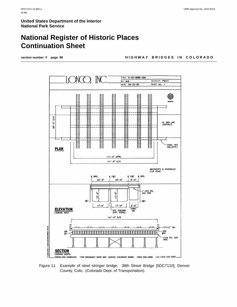
NPS Form 10-900-a OMB Approval No. 1024-0018(8-86)
United States Department of the InteriorNational Park Service
National Register of Historic PlacesContinuation Sheetsection number F page 88 H I G H W A Y B R I D G E S I N C O L O R A D O
Figure 11. Example of steel stringer bridge. 38th Street Bridge [5DC7110], DenverCounty, Colo. (Colorado Dept. of Transportation).

NPS Form 10-900-a OMB Approval No. 1024-0018(8-86)
United States Department of the InteriorNational Park Service
National Register of Historic PlacesContinuation Sheetsection number F page 89 H I G H W A Y B R I D G E S I N C O L O R A D O
Figure 12. Example of steel girder bridge. Eight Mile Creek Bridge [5FN1701],Fremont County, Colo. (Colorado Dept. of Transportation).

NPS Form 10-900-a OMB Approval No. 1024-0018(8-86)
United States Department of the InteriorNational Park Service
National Register of Historic PlacesContinuation Sheetsection number F page 90 H I G H W A Y B R I D G E S I N C O L O R A D O
Significance: Steel stringer or girder bridges in Colorado may be eligible for listing in the National Register of HistoricPlaces under Criterion A for their association with events that have made a significant contribution to the broadhistorical patterns of the country, the state, or the region. Specifically, this includes those bridges that have playedan important role in the development of the state’s highway transportation system and, hence, in the settlement of thearea. For example, a structure might be significant for its association with a particular route, such as the Ocean-to-Ocean Highway, because it was built with assistance from the State Highway Commission in its formative years, orbecause it was built by a Federal Depression-era relief program. A bridge may, in addition, be eligible under CriterionB for its association with a significant person, as long as the “significant person” was not the designer or builderof the bridge. A bridge can be eligible by virtue of its designer or builder, but this falls under Criterion C. Indeed, mosteligible bridges in Colorado qualify under Criterion C as structures of engineering significance. This can encompassa broad range of considerations. For instance, a bridge can qualify under Criterion C as a well-preserved exampleof a common type, or as an important variation.
Steel stringer and girder bridges are sufficiently common in Colorado that to be considered eligible for listing in theNational Register under Criterion C, a structure from this property type must have definitive historical documentationand some superlative feature that distinguishes it from its peers. Some examples of this are notably early constructiondate, exceptionally long span length, unusually high span number, or well-executed architectural design.
Registration Requirements: The period of significance for steel stringer and girder bridges in Colorado begins in1880, the approximate date for the state’s earliest examples of these structural types. The period of significance endsin 1952, the fifty-year date after which bridges must possess exceptional significance. Alterations made during theperiod of significance are considered part of the bridge’s historic fabric. Such changes may or may not be in keepingwith the bridge’s original design. Integrity of the structure’s historic materials and design is essential for the bridge toqualify for the National Register under any criterion. Stringer and girder bridges may be eligible for the NationalRegister under Criterion B for their association with a significant person, but this is rare. Most often, these bridges willhave significance under Criteria A or C.
Specific requirements under Criterion A:
1. Early and/or prominent product of the Colorado State Engineer’s Office or Colorado Highway Department:In 1881 the Colorado State Legislature established the State Engineer’s Office and funded specific bridge constructionprojects under the Internal Income Fund. Some of the later bridges built under this program were steel beamstructures. In 1910 the state legislature formed the Colorado Highway Commission (and its successor, the ColoradoHighway Department). Numerous steel stringer and girder bridges were designed by the Highway Commission in the1910s and early 1920s, and a few remain in place today.
2. Outstanding example of product of a Federal work relief program of the Depression era:Federal work programs in the 1930s and early 1940s, particularly those funded by the Works Progress Administration,led to construction of a number of steel beam bridges in the state. The most significant display careful craftsmanshipand creative design.
3. Association with a significant route or event (regional or statewide):If the construction of or improvements to a route or highway helped open up a region for travel and commerce, orcontributed to increased development and prosperity in nearby communities, the route or highway might be considered

NPS Form 10-900-a OMB Approval No. 1024-0018(8-86)
United States Department of the InteriorNational Park Service
National Register of Historic PlacesContinuation Sheetsection number F page 91 H I G H W A Y B R I D G E S I N C O L O R A D O
eligible under Criterion A. The bridges along this route, if unaltered from the period of significance, may also be eligibleunder Criterion A for their association with significant events. Similarly, if a bridge was built as part of a significantevent, such as when the State Highway Department launched a campaign to improve the safety of bridge crossingsover railroad features, it may be eligible under Criterion A for its association with that specific campaign.
4. Association with civic improvement projects, such as the City Beautiful movement:Bridges built as part of a specific aesthetic or planning initiative in a community might be considered significant underCriterion A as local expressions of a national movement.
Specific requirements under Criterion C:
1. Early and/or representative steel stringer and girder bridges:Steel beam bridges built before 1920 are sufficiently rare in Colorado that any example that has retained structuralintegrity is considered significant. Those built after 1920 with definitive documentation are considered significant onthe basis of superlative features (i.e., exceptionally long span length, unusual number of spans, uncommon state ofpreservation). Steel beam bridges built after 1951 are considered exceptionally significant if they were prototypes fortheir respective structural configuration.
2. Bridge with exceptional aesthetic merit:Most bridges built in the state are strictly utilitarian. Occasionally, however, a structure stands out by virtue of itsdesign or because of the quality displayed in its construction. The interrelationship of a bridge and its site can alsohave aesthetic value as well, if the bridge demonstrates a significant engineering achievement due to topographicalconditions or constraints.

NPS Form 10-900-a OMB Approval No. 1024-0018(8-86)
United States Department of the InteriorNational Park Service
National Register of Historic PlacesContinuation Sheetsection number F page 92 H I G H W A Y B R I D G E S I N C O L O R A D O
Property Type: Iron and steel truss bridges
Description: Beginning in the late 1870s, the pin-connected wrought iron truss was the roadway bridge of choice formedium- and long-span crossings in America. Made up of numerous built-up metal members connected to formseries of triangles in a variety of web configurations, trusses functioned as complex, long-span beams. They carriedtraffic in three positions: the through configuration, with the roadway positioned between two tall webs and overheadstruts spanning between the webs; the pony configuration, with the roadway positioned between two relatively shortwebs, without overhead struts; and the deck configuration, with the roadway carried completely on top of the trusswebs. In the 19th century trusses underwent an evolution of form that reflected other technological advancements.For instance, cylindrical pins were first used to connect metal truss members in 1859. Two years later, acomplementary truss member—the forged iron eyebar—was introduced. Steel eyebars appeared in the 1870s. Production of Bessemer and open-hearth steel improved in both quality and economy in the 1880s, and by 1890 all-steel bridges had largely superseded wrought iron structures.
Trusses were typically fabricated by manufacturers in large-scale shops, purchased by government entities throughcompetitive bidding, shipped in pieces to the bridge sites, and assembled over temporary wooden falsework. Thebridge companies that proliferated through the Midwest and Ohio River Valley competed enthusiastically for countybridge business, marketing an ever-changing array of truss types through networks of regional sales representatives.Both patented in the 1840s, the Pratt and Warren web configurations—with their various subtypes—formed the basisfor the overwhelming majority of all-metal trusses built in Colorado in the late 19th and early 20th centuries. Thesestructures were fabricated by such national firms as the King Iron Bridge Company and the Wrought Iron BridgeCompany of Ohio, and such regional firms as the Midland Bridge Company of Kansas City, the Missouri Valley Bridgeand Iron Works of Leavenworth, Kansas, and the Bullen Bridge Company and Denver Bridge Company of Colorado.
The earliest truss bridges featured pinned and bolted connections in some combination. These were largely super-seded by all-pinned trusses in the 1880s. Because of their relatively quick erection and easy fabrication, pin-connectedtrusses dominated the market until well into the 20th century. But they lacked rigidity and could loosen from vibrationscaused by traffic and the wind. Rigid connections in trusses, with stiffening gusset plates at the joints, createdstronger, sturdier connections, but field riveting was not practical before portable pneumatic riveters became availableafter the turn of the century. In Colorado rigid-connected trusses began to overshadow pinned for highway spansaround 1910.
Without question the most popular truss type of the period was the Pratt truss. Patented in 1844 by Thomas andCaleb Pratt, the Pratt design was characterized by upper chords and vertical members acting in compression and low-er chords and diagonals that functioned in tension. Its parallel chords and equal panel lengths resulted in standardizedsizes for the verticals, diagonals, and chord members, making fabrication and assembly relatively easy. “The Pratttruss is the type most commonly used in America for spans under two hundred and fifty feet in length,” noted bridgeengineer J.A.L. Waddell wrote in his influential Bridge Engineering. “Its advantages are simplicity, economy of metal,and suitability for connecting to the floor and lateral systems.”14
In the highly competitive bridge manufacturing industry, in which efficiency equated with profit, Pratt trusses receivedalmost universal use. Virtually all of the major regional fabricators manufactured Pratt trusses and marketed themextensively to Colorado’s counties in the late 19th and early 20th centuries. As a result, the Pratt truss was the
14J.A.L. Waddell, Bridge Engineering (London: John Wiley and Sons, 1916), 468.

NPS Form 10-900-a OMB Approval No. 1024-0018(8-86)
United States Department of the InteriorNational Park Service
National Register of Historic PlacesContinuation Sheetsection number F page 93 H I G H W A Y B R I D G E S I N C O L O R A D O
structure of choice in the state for medium- and long-span wagon bridges. More Pratt trusses were built in Coloradoduring the period than all other truss types combined.
From the straight-chorded Pratt design arose a variety of structural subtypes in the 19th century. Another Pratt sub-type built in the 19th century was called the Pratt half-hip truss. The half-hip’s advantage was that, by eliminating thevertical members at the hip connections, it was more materially conservant than the standard Pratt. Its disadvantagewas that it was generally limited to short-span applications. The most common Pratt subtype was the Parker truss.Developed in the 19th century by C.H. Parker, the Parker truss was characterized by upper chords and verticalmembers that acted in compression and lower chords and diagonals acting in tension. In this it resembled thevenerable Pratt and was, in fact, universally regarded by civil engineers as a Pratt subtype. Waddell gave the Parkeronly passing mention in his book, stating: “[The Pratt’s] chords are not necessarily parallel, but may be inclined. Thislatter form is frequently known as the Parker truss.”15
The inclined upper chords of the Parker afforded a degree of efficiency on long-span trusses, where bending stressesat mid-span greatly exceed the shear stresses at the ends. As literal manifestations of stress analysis, polygonal-chorded trusses placed the heaviest amount of metal at the point where the stresses were the greatest: in the middle.The Parker’s drawback was that, unlike the straight-chorded Pratt truss, the polygonal chords necessitated different-length verticals and diagonals at each panel, increasing its fabrication and erection costs somewhat. Because trusseswere generally priced on the basis of their superstructural steel weight, the lighter overall weight of a polygonal-chordtruss more than offset the slight increase in fabricating costs in spans greater than 150 feet.
15Waddell, Bridge Engineering, 469.
A Camelback truss is a Parker with exactly five facets in its upper chord. With its distinctive profile, the Camelbackconfiguration was disdained by many engineers for its ungainly appearance and its tendency under certain conditionsto reverse compressive and tensile forces acting on individual members. As a result, Camelback trusses neverreceived widespread acceptance in the 19th and early 20th centuries. The Whipple truss resembles the Pratt in itsarray of compression and tension members. Its primary difference lies in its diagonals, which extend over two panels.Patented in 1847 by esteemed civil engineer Squire Whipple, this eponymous truss was a popular choice for longer-span crossings—generally in excess of 150 feet—between 1850 and 1900. Although more costly than the single-paneled Pratt, this variation provided greater lateral support for the diagonals, a critical consideration in deep, long-span trusses. As the Whipple represents a sub-divided Pratt, the Pennsylvania truss is a subdivided Parker.
In Colorado, the Pratt and its various modified designs rode a wave of popularity well into the 20th century. The otherprincipal truss category that competed with the Pratt in the late 19th and early 20th centuries was the Warren truss.Patented in 1848 by Captain James Warren and Theobald Monzani, the Warren truss in its classic form features aweb configuration that relies on simple triangulation for its rigidity. Warrens were built sparingly in the 19th century,a period in which the pin-connected Pratt dominated the bridge industry. After about 1910, however, rigid-connectedWarren pony trusses began to compete with earlier Pratt configurations for use on short- to intermediate-span highwaybridges. Although these bridges displayed variations in their web configurations (some were “pure” Warrens withoutverticals, others had verticals at all or alternating panel points), virtually all of these early Warrens featured straightupper chords.

NPS Form 10-900-a OMB Approval No. 1024-0018(8-86)
United States Department of the InteriorNational Park Service
National Register of Historic PlacesContinuation Sheetsection number F page 94 H I G H W A Y B R I D G E S I N C O L O R A D O
Colorado’s counties erected a typical array of truss types but concentrated primarily on the Pratt and its subtypes inthe late 19th and early 20th centuries. The earliest Pratts featured pinned connections in what was known as the“American style” of truss assembly. Concurrent with the development of more portable riveting equipment, theswitch from pinned connections to the inherently stronger riveted connections for vehicular trusses occurred after1910. The Colorado State Engineer’s office preferred straight-chorded trusses to polygonal-chorded trusses in thelate 19th and early 20th centuries, largely because the majority of bridges it was building did not require particularlylong spans. There were noteworthy exceptions to this, however. Among the first polygonal-chorded trusses built bythe state was the single-span structure over the Colorado River at Silt, completed in 1908. Comprised of a pin-con-nected Pennsylvania truss, its 252-foot span ranked among the longest of Colorado's wagon bridges. Other, shorterspans followed, and as late as 1919 the state was still erecting pin-connected Parker trusses at its long-spancrossings.16
16Fourteenth Biennial Report of the State Engineer to the Governor of Colorado 1907-1908 (Denver: Smith-Brooks Printing
Company, 1909), 105-106.
Figure 13. Example of steel through truss bridge. Nineteenth Street Bridge [5DV535], Denver County,Colo. (Historic American Engineering Record, National Park Service).

NPS Form 10-900-a OMB Approval No. 1024-0018(8-86)
United States Department of the InteriorNational Park Service
National Register of Historic PlacesContinuation Sheetsection number F page 95 H I G H W A Y B R I D G E S I N C O L O R A D O
Around 1920 the State Highway Commission formulated its first standard plans for rigid-connected trusses, with thedesign for a short-span Pratt pony truss. When it formulated its standards for longer rigid-connected trusses in theearly 1920s, the Highway Department adopted the straight-chorded Pratt for through truss spans between 100 and140 feet and the polygonal-chorded Parker for longer spans. Among the first Parker through trusses built from CHDstandard plans were the single-span structure over the Rio Grande River near Monte Vista; the Las Animas Bridge,a five-span structure over the Arkansas River; and the Buttes Bridge, a two-span structure over Fountain Creek in ElPaso County. Erected in 1922-1923, these bridges all used eight-panel, 150-foot trusses, with only minor variationsin their portal struts and web members.17
17"Improved Roads Help Farmers," Colorado Highways 1:4 (July 1922): 9; John S. Means, "Road Construction of Different Types
During Recent Years," Colorado Highways 1:6 (September 1922): 6; R.S. Du Bois, "Las Animas Bridge Open to Travel," Colorado Highways1:9 (December 1922): 3, 16; R.S. Du Bois, "Buttes Bridge Open to Traffic," Colorado Highways 2:2 (February 1923): 7.
Figure 14. Example of steel through truss bridge. CostillaCrossing Bridge [5CN909], Conejos County, Colo. (Colorado Dept. of Transportation).

NPS Form 10-900-a OMB Approval No. 1024-0018(8-86)
United States Department of the InteriorNational Park Service
National Register of Historic PlacesContinuation Sheetsection number F page 96 H I G H W A Y B R I D G E S I N C O L O R A D O
The Highway Department experimented briefly with the Parker configuration for long-span pony trusses, building alimited number of these spans in the mid-1920s before settling on the Camelback as its long-span pony truss standard.Rigid connections, which eliminated its negative structural proclivities, made the Camelback more palatable forhighway engineers of the 1920s. The Colorado Highway Department and its predecessors had been using Pratts andtheir sub-types since the 1880s, and the Camelback was a logical choice for its standard long-span pony truss. CHDdelineated Camelback ponies in 80-foot, 100-foot, and 125-foot span lengths, with a range of roadway widths, and builthundreds of them around the state during the 1920s, 1930s, and 1940s. Most of these were single-span iterations,but CHD also constructed Camelbacks in groups of two or more trusses. More than any other structural type, steeltrusses have suffered a terrible attrition through subsequent bridge replacements. Today only a small number remainsfrom the thousands of trusses that once stood in the state.
Significance: Iron and steel truss bridges in Colorado may be eligible for listing in the National Register of HistoricPlaces under Criterion A for their association with events that have made a significant contribution to the broadhistorical patterns of the country, the state, or the region. Specifically, this includes those bridges that have playedan important role in the development of the state’s highway transportation system and, hence, in the settlement of thearea. For example, a structure might be significant for its association with a particular route, such as the Midland Trail,because it was built with assistance from the State Highway Commission in its formative years, or because it was builtby a Federal Depression-era relief program. A bridge may, in addition, be eligible under Criterion B for its associationwith a significant person, as long as the “significant person” was not the designer or builder of the bridge. A bridgecan be eligible by virtue of its designer or builder, but this falls under Criterion C. Indeed, most eligible bridges inColorado qualify under Criterion C as structures of engineering significance. This can encompass a broad range ofconsiderations. For instance, a bridge can qualify under Criterion C as a well-preserved example of a common type,or as an important variation.
Although their numbers are substantially diminished by attrition, metal trusses are still sufficiently common in Coloradothat to be considered eligible for listing in the National Register, a structure from this property type must have definitivehistorical documentation.
Registration Requirements: The period of significance for iron and steel truss bridges in Colorado begins in 1880,the approximate date for the state’s earliest examples of these structural types. The period of significance ends in1952, the fifty-year date after which bridges must posses exceptional significance. Alterations made during the periodof significance are considered part of the bridge’s historic fabric. Such changes may or may not be in keeping withthe bridge’s original design. The definition of integrity may vary, however, depending on the criterion. Becauselocation is of primary importance under Criterion A, a structure will rarely qualify under this criterion if it does not remainon its original site. Location can also have significance under Criterion B, but the correlation is not as universal. Whenfocusing on engineering significance under Criterion C, the mobility of metal trusses is an important trait, since thestructures were actually designed to be moved. Movement of the truss superstructure under this criterion might notnecessarily detract from its historic integrity. On the other hand, structural integrity is of vital importance for thosebridges considered under Criterion C. In engineering terms, a truss bridge is considered to be comprised of a groupof distinct structural subsystems, rather than a single entity. These systems, in general order of importance underCriterion C, are the superstructure, the substructure, the floor, and the approach spans, if any. The super- andsubstructure of a bridge, for instance, may have retained a high degree of physical integrity, while the floor system andapproach spans may have been altered, replaced, or even removed, and the bridge may still be considered eligiblefor registration. Loss of physical integrity may also be mitigated by technological significance for unique or rarestructural types.

NPS Form 10-900-a OMB Approval No. 1024-0018(8-86)
United States Department of the InteriorNational Park Service
National Register of Historic PlacesContinuation Sheetsection number F page 97 H I G H W A Y B R I D G E S I N C O L O R A D O
Specific requirements under Criterion A:
1. Early and/or prominent product of the Colorado State Engineer’s Office or Colorado Highway Department:In 1881 the Colorado State Legislature established the State Engineer’s Office and funded specific bridge constructionprojects under the Internal Income Fund. Many of the bridges built under this program were steel truss structures.In 1910 the state legislature formed the Colorado Highway Commission (and its successor, the Colorado HighwayDepartment). Numerous steel trusses were designed by the Highway Commission in the 1910s and 1920s, and a fewremain in place today.
2. Outstanding example of product of a Federal work relief program of the Depression era:Federal work programs in the 1930s and early 1940s, particularly those funded by the Works Progress Administration,led to construction of a number of steel beam bridges in the state. The most significant display careful craftsmanshipand creative design.
3. Association with a significant route or event (regional or statewide):If the construction of or improvements to a route or highway helped open up a region for travel and commerce, orcontributed to increased development and prosperity in nearby communities, the route or highway might be consideredeligible under Criterion A. The bridges along this route, if unaltered from the period of significance, may also be eligibleunder Criterion A for their association with significant events. Similarly, if a bridge was built as part of a significantevent, such as when the State Highway Department launched a campaign to improve the safety of bridge crossingsover railroad features, it may be eligible under Criterion A for its association with that specific campaign.
4. Association with civic improvement projects, such as the City Beautiful movement:Bridges built as part of a specific aesthetic or planning initiative in a community might be considered significant underCriterion A as local expressions of a national movement.
Specific requirements under Criterion C:
1. Early and/or representative iron and steel truss bridges: In the late 19th and early 20th centuries, metal truss bridges displayed a wide diversity of designs. This variety beganto disappear by the 1910s, in part due to the influence of standard designs distributed by CHD. Since cast andwrought iron bridge members were virtually eliminated due to the availability of steel by the 1890s, these bridges areextremely rare and significant. Similarly, truss bridges built before 1910 are sufficiently rare that all documentedexamples that retain structural integrity are considered significant. Highway Department standard trusses—renderedrare by subsequent attrition—are also considered generally significant. The lone exception to this are Camelback ponytrusses, which are sufficiently common that only superlative examples are considered significant.
2. Exceptional example of work by an important engineer, architect or firm:This includes local, regional, and national companies and designers.
3. Bridge with exceptional aesthetic merit:Most bridges built in the state are strictly utilitarian. Occasionally, however, a structure stands out by virtue of itsdesign or because of the quality displayed in its construction. This does not include standard-design concreteguardrails by the Highway Department, however. The interrelationship of a bridge and its site can also have aestheticvalue as well, if the bridge demonstrates a significant engineering achievement due to topographical conditions orconstraints.

NPS Form 10-900-a OMB Approval No. 1024-0018(8-86)
United States Department of the InteriorNational Park Service
National Register of Historic PlacesContinuation Sheetsection number F page 98 H I G H W A Y B R I D G E S I N C O L O R A D O
Figure 15. Truss bridge types, from poster produced by Historic American Engineering Record.

NPS Form 10-900-a OMB Approval No. 1024-0018(8-86)
United States Department of the InteriorNational Park Service
National Register of Historic PlacesContinuation Sheetsection number F page 99 H I G H W A Y B R I D G E S I N C O L O R A D O
Figure 16. Truss bridge types, from poster produced by Historic American Engineering Record.

NPS Form 10-900-a OMB Approval No. 1024-0018(8-86)
United States Department of the InteriorNational Park Service
National Register of Historic PlacesContinuation Sheetsection number F page 100 H I G H W A Y B R I D G E S I N C O L O R A D O
Glossary
This reference glossary contains numerous terms not included in the body of this document. Many of the definitionsare from the Federal Highway Administration Bridge Inspector's Training Manual.
A
Abutment - A substructure supporting the end of a single span or the extreme end of a multi-span superstructure and,in general, retaining or supporting the approach embankment.
Alloy - A mixture of two or more metals to form a new base metal.
Anchorage - The complete assemblage of members and parts designed to hold in correct position the anchor spanof a cantilever bridge, the end suspension span cable, or a suspension span backstay; the end of a restrainedbeam, girder, or truss span; a retaining wall, bulkhead, or other portion or part of a structure.
Anchor Span - The span that counterbalances and holds in equilibrium the fully cantilevered portion of an adjacentspan; see Cantilever Beam, Girder, or Truss.
Angle - A rolled member of steel or iron forming an "L" shape.
Arch - A curved structural element primarily in compression, producing at its supports reactions having both verticaland horizontal components.
Figure 17. Terms used in arches. Taken from: A Span of Bridges (Newton Abbot, Great Britain: David andCharles Limited, 1970): 16.

NPS Form 10-900-a OMB Approval No. 1024-0018(8-86)
United States Department of the InteriorNational Park Service
National Register of Historic PlacesContinuation Sheetsection number F page 101 H I G H W A Y B R I D G E S I N C O L O R A D O
Arch Barrel - A single arch member that extends the width of the structure.
Arch Rib - The main support element used in open - spandrel arch construction; also known as arch ring.
B
Backstay - Cable or chain attached at the top of a tower and extending to and secured upon the anchorage to resistoverturning stresses exerted upon the tower by a suspended span.
Backwall - The topmost portion of an abutment above the elevation of the bridge seat, functioning primarily as aretaining wall with a live-load surcharge; it may serve also as a support for the extreme end of the bridge deckand the approach slab.
Batten - A narrow strip of metal used to fasten other pieces together in a built-up member.
Batter - The inclination of a surface in relation to a horizontal or a vertical plane, the angle is commonly designatedon bridge detail plans as number of feet to 1 foot.
Beam - A linear structural member designed to span from one support to another.
Bearing - A support element transferring loads from superstructure to substructure, capable of permitting limitedmovement.
Bent - A substructure unit made up of two or more column or column-like members connected at their top most endsby a cap, strut, or other member holding them in their correct positions.
Box Beam - A hollow structural beam with a square, rectangular, or trapezoid cross section.
Bracing - A system of tension or compression members, or a combination of these, that maintains the geometricconfiguration of primary members. It transfers wind, dynamic, impact, and vibratory stresses and gives rigiditythroughout the complete assembly.
Breastwall - The portion of an abutment between the wings and beneath the bridge seat; the breastwall supports thesuperstructure loads and retains the approach fill.
Bridge - A structure spanning and providing passage over a river, chasm, road, etc.
Built-Up - Forming a bridge member (such as a chord or a vertical) from smaller pieces (such as angles or channels)by riveting or welding them together.
Built-Up Member - A column or beam composed of plates and angles or other structural shapes united by bolting,riveting, or welding.
Bulkhead - A retaining wall-like structure commonly composed of driven piles supporting a wall or a barrier of woodentimbers or reinforced concrete members.

NPS Form 10-900-a OMB Approval No. 1024-0018(8-86)
United States Department of the InteriorNational Park Service
National Register of Historic PlacesContinuation Sheetsection number F page 102 H I G H W A Y B R I D G E S I N C O L O R A D O
Buttress - A bracket-like wall, of full or partial height, projecting from another wall; the buttress strengthens and stiffensthe wall against overturning forces; all parts of a buttress act in compression.
Buttressed Wall - A retaining wall designed with projecting buttresses to provide strength and stability.
C
Cable - A tension member comprised of numerous individual steel wires twisted and wrapped in such a fashion asto form a rope of steel; see Suspension Bridge.
Cable-Stayed Bridge - A bridge in which the superstructure is directly supported by cables or stays, passing over orattached to towers located at the main piers.
Camber - The slightly arched form or convex curvature provided in beams to compensate for dead-load deflection;in general, a structure built with perfectly straight lines appears slightly sagged.
Cantilever - A structural member which has a free end projecting beyond its supporting wall or column; length of spanoverhanging the support.
Cantilever Abutment - An abutment that resists the lateral thrust of earth pressure through the opposing cantileveraction of a vertical stem and horizontal footing.
Cantilever Bridge - A general term applying to a bridge having a superstructure utilizing cantilever design.
Cantilever Span - A superstructure span composed of two cantilever arms, or a suspended span supported by oneor two cantilever arms.
Cap - The topmost piece of a pier or pile bent serving to distribute the loads upon the columns or piles and to holdthem in their proper relative positions; see Pier Cap, Pile Cap.
Capstone - The topmost stone of a masonry pillar, column, or other structure requiring the use of a single cappingelement.
Cast-In-Place - The act of placing and curing concrete within formwork to construct a concrete element in its finalposition.
Cast Iron - Relatively pure iron, smelted from iron ore, containing 1.8 to 4.5 percent free carbon, and cast to shape.
Catenary - The curve obtained by suspending a uniform rope or cable between two points.
Cement - A powder that hardens when mixed with water; an ingredient used in concrete.

NPS Form 10-900-a OMB Approval No. 1024-0018(8-86)
United States Department of the InteriorNational Park Service
National Register of Historic PlacesContinuation Sheetsection number F page 103 H I G H W A Y B R I D G E S I N C O L O R A D O
CCC (Civilian Conservation Corps) - A work program established by the Federal government during the GreatDepression (1929-1938) existing from 1933 to 1942. The CCC built roads, bridges, and structures andcompleted many conservation projects throughout the United States. Many CCC constructed structures arehistorically significant.
Cement Mortar - A mixture of four parts sand to one part cement with enough water added to make it plastic.
Channel - A rolled member of steel or iron forming a squared "C" shape.
Chord - The upper and lower horizontal components of the truss, forming the top and bottom of the truss webbing. The upper chord is in compression, the lower chord, in tension.
Clear Span - The unobstructed space or distance between support elements of a bridge or bridge member.
Coating - A material that provides a continuous film over surface; a film formed by the material.
Collision Strut - A diagonal member placed at the end panels of a truss bridge with inclined endposts to protect thelatter from buckling if hit (as in a vehicle collision).
Component - A general term reserved to define a bridge deck, superstructure, or substructure; subcomponents, e.g.,floor beams are considered elements.
Compression Members - Stiff, heavy members that withstand the pressure which tends to push them together.
Concrete - A mixture of aggregate, water, and a binder, usually portland cement, that hardens to a stone-like mass.
Continuous Beam - A general term applied to a beam that spans uninterrupted over one or more intermediatesupports.
Continuous Bridge - A bridge designed to extend without joints over one or more interior supports.
Continuous Spans - Spans designed to extend without joints over one or more intermediate supports.
Continuous Truss - A truss having its chord and web members arranged to continue uninterrupted over one or moreintermediate points of support.
Coping - A course of stone laid with a projection beyond the general surface of the masonry below it and forming thetopmost portion of a wall; a course of stone capping the curved or V-shaped extremity of a pier, providing atransition to the pier head proper; when so used, it is commonly termed the "starling coping," "nose coping,"the "cutwater coping," or the "pier extension coping."
Corbel - A piece constructed to project from the surface of a wall, column, or other portion of a structure to serve asa support for another member, or as a decorative element.

NPS Form 10-900-a OMB Approval No. 1024-0018(8-86)
United States Department of the InteriorNational Park Service
National Register of Historic PlacesContinuation Sheetsection number F page 104 H I G H W A Y B R I D G E S I N C O L O R A D O
Counter - A diagonal member designed to limit the reversal of stress in the diagonals. Counters are smaller thandiagonals and run in the opposite direction.
Counterfort - A bracket-like wall projecting from a retaining wall on the side of the retained material to stabilize itagainst overturning-, a counterfort, as opposed to a buttress, acts entirely in tension.
Counterforted Abutment - An abutment which develops resistance to bending moment in the stem by use ofconterforts; this permits the breast wall to be designed as a horizontal beam or slab spanning betweencounterforts, rather than as a vertical cantilever slab.
Counterweight - A weight which is used to balance the weight of a movable member; in bridge applications,counterweights are used to balance a movable span so that it rotates or lifts with minimum resistance.
Cover Plate - A metal plate used to fasten other pieces together in a built-up member.
Covered Bridge - An indefinite term applied to a wooden bridge having its roadway protected by a roof and enclosedsides.
Crib - A structure consisting of a foundation grillage combined with a superimposed framework providingcompartments or coffers which are filled with gravel, concrete, or other material, satisfactory for supportingthe structure to be placed thereon.
Cross Bracing - Transverse bracings between two main longitudinal members; see Diaphragm.
Cross Girders - Girders that supply transverse support for longitudinal beams or girders.
Crown of the Roadway - The vertical dimension describing the total amount of the surface that is convex or raised fromgutter to centerline; this is sometimes termed the cross fall of the roadway.
Curb - A short barrier paralleling the outside edge of the roadway to guide the movement of vehicle wheels andsafeguard constructions and pedestrian traffic existing outside the roadway limit from collision with vehiclesand their loads.
D
Deck - The portion of a bridge that provides direct support for vehicular and pedestrian traffic.
Deck Bridge - A bridge in which the supporting members are all beneath the roadway.
Diagonal - A sloping structural member of a truss or bracing system.
Diagonal Stay - A cable support in a suspension bridge extending diagonally from the tower to the roadway systemto add stiffness to the structure and diminish the deformations and undulations resulting from traffic service.
Diagonal Tension - The principal tensile force due to horizontal and vertical shear in a beam.

NPS Form 10-900-a OMB Approval No. 1024-0018(8-86)
United States Department of the InteriorNational Park Service
National Register of Historic PlacesContinuation Sheetsection number F page 105 H I G H W A Y B R I D G E S I N C O L O R A D O
Diaphragm Wall - A wall built transversely to the longitudinal centerline of a spandrel arch serving to tie together andreinforce the spandrel walls and providing a support for the floor system in conjunction with the spandrel walls;also known as cross wall.
E
Embankment - A bank of earth constructed above the natural ground surface to carry a road or to prevent water frompassing beyond desirable limits; also known as bank.
End Post - The end compression member of a truss, either vertical or inclined in position and extending from the topchord to the bottom chord.
Expansion Joint - A joint designed to provide means for expansion and contraction movements produced bytemperature changes, load, or other forces.
Extrados - The upper or exterior curve of an arch.
Eyebar - A member consisting of a rectangular or round bar with enlarged forged or stamped ends having holesthrough them for engaging connecting pins.
F
Fascia - An outside covering member designed on the basis of architectural effect rather than strength and rigidity,although its function may involve both.
Filled-Spandrel Arch - A stone or reinforced-concrete arch span having spandrel walls to retain the spandrel fill or toeither entirely or in part support the floor system of the structure when the spandrel is not filled.
Fish Belly - A term applied to a girder or a truss having its bottom flange or its bottom chord constructed eitherhaunched or bow-shaped with the convexity downward; see Lenticular Truss.
Flange - The horizontal parts of a rolled I- beam or built-up girder extending transversely across the top and bottomof the web.
Footing - The enlarged, lower portion of a substructure that distributes the structure load either to the earth or tosupporting piles; the most common footing is the concrete slab; footer is a local term for footing.
Foundation - The supporting material upon which the substructure portion of a bridge is placed.
Frame - A structure having its parts or members arranged and secured so that the entire assemblage is not distortedwhen supporting the loads, forces, and physical pressures considered in its design.
G
Gauge - The distance between parallel lines of rails, rivet holes, etc; a measure of thickness of sheet metal, or wire;also known as gage.
NPS Form 10-900-a OMB Approval No. 1024-0018(8-86)
United States Department of the InteriorNational Park Service
National Register of Historic PlacesContinuation Sheetsection number F page 106 H I G H W A Y B R I D G E S I N C O L O R A D O
Girder - A flexural member that is the main or primary support for the structure and usually receives loads from floorbeams and stringers; any large beam, especially if built up.
Girder Bridge - A bridge whose superstructure consists of two or more girders supporting a separate floor system, asdifferentiated from a multi-beam bridge or a slab bridge.
Gravity Abutment Wall - A heavy abutment wall which resists horizontal earth pressure through its own deadweight.
Grid Flooring - A steel floor system comprising a lattice pattern that may or may not be filled with concrete.
Groin - A wall built out from a river bank to check scour.
Grout - A mortar having a sufficient water content to render it a free-flowing mass, used for filling (grouting) the jointsin masonry, for fixing anchor bolts, and for filling cored spaces where water may accumulate.
Guardrail - A structural element designed to redirect an errant vehicle onto the roadway (guiderail).
Gusset - A plate connecting the members of a structure and holding them in correct position at a joint.
H
Half-Hip - A truss with inclined end posts that do not extend the length of a full panel.
Hammerhead Pier - A pier with a single cylindrical or rectangular shaft and a relatively long, transverse cap; also knowas a tee pier.
Hand Rail - Commonly applied only to sidewalk railing having a latticed, barred, balustered, or other open webconstruction.
Hanger - A tension member serving to suspend an attached member.
Haunch - An increase in the depth of a member usually at points of support; the outside areas of a pipe between thespring line and the bottom of the pipe.
H-Beam - A rolled steel member having an H-shaped cross section and commonly used for piling; also known asH-pile.
Hinge - A point in a structure at which a member is free to rotate.
Hinged Joint - A joint constructed with a pin, cylindrical segment, spherical segment, or other device permittingmovement by rotation.
Howe Truss - A type of bridge truss, having parallel chords, vertical (tension) rods at the panel points, and diagonalsforming an X-pattern.

NPS Form 10-900-a OMB Approval No. 1024-0018(8-86)
United States Department of the InteriorNational Park Service
National Register of Historic PlacesContinuation Sheetsection number F page 107 H I G H W A Y B R I D G E S I N C O L O R A D O
I
I-Beam - A structural member with a cross-sectional shape similar to the capital letter "I."
Integral Abutment - An abutment cast monolithically with the end diaphragm of the deck; such abutments usuallyencase the ends of the deck beams and are pile supported.
Integral Deck - A deck designed to share the load-carrying capabilities of the bridge with the superstructure and notmerely to transfer loads to the superstructure.
Intrados - The inner or inside curve of an arch.
Iron - A metallic element used in cast or wrought iron and steel.
J
Joint - In stone masonry, the space between individual stone; in concrete, a division in continuity of the concrete; ina truss, the point at which members of a truss frame are joined.
K
Keystone - The symmetrically shaped, wedge-like stone located in the head ring at the crown of an arch; the final stoneplaced, thereby closing the arch.
King Post Truss - Two triangular panels with a common center vertical; the simplest design for a triangular truss.
Kip - A unit of weight equal to 1,000 pounds; convenient unit for structural calculations.
Knee Brace - A short member engaging two other members at its ends that are joined to form a right angle or anear-right angle to strengthen and stiffen the connecting joint.
L
Lacing - A zig-zag pattern, often used for battens when constructing a built-up truss member.
Laminated Timber - Small timber planks glued together to form a larger member.
Lateral Bracing - The bracing assemblage engaging a member perpendicular to the plane of the member-, intendedto resist lateral movement and deformation; also provides resistance against raking of primary parallelelements in truss bridges and girder bridges; see Bracing.
Lattice - A crisscross assemblage of diagonal bars, channels, or angles on a truss. Also known as latticing.
Lenticular Truss - A truss having parabolic top and bottom chords curved in opposite directions with their ends meetingat a common joint.

NPS Form 10-900-a OMB Approval No. 1024-0018(8-86)
United States Department of the InteriorNational Park Service
National Register of Historic PlacesContinuation Sheetsection number F page 108 H I G H W A Y B R I D G E S I N C O L O R A D O
Lower Chord - The bottom horizontal component of a truss.
M
Macadam - Uniformly sized stones rolled to form a road. Sometimes mixed with tar before application.
Main Beam - A beam which supports the span and bears directly onto a column or wall.
Masonry - That portion of a structure composed of stone, brick, or concrete block placed in layers and in some casescemented with mortar.
Materials - The elements originally combined to make the structure.
Member - An individual angle, beam, plate, or built piece intended to become an integral part of an assembled frameor structure.
Monolithic - A single mass formed without joints.
Mortar - A paste of cement, sand, and water laid between bricks, stones, or blocks.
O
Open-Spandrel Arch - A bridge having open spaces between the deck and the arch members allowing "open" visibilitythrough the bridge.
Open Spandrel Ribbed Arch - A structure in which two or more comparatively narrow arch rings, called ribs, functionin the place of an arch barrel; the ribs are rigidly secured in position by arch rib struts located at intervals alongthe length of the arch-, the arch ribs support the columns that support the floor system and its loads.
Overpass - A bridge structure where the major thoroughfare is the upper roadway; see Underpass.
P
Panel - The portion of a truss span between adjacent points of intersection of web and chord members.
Panel Point - The point of intersection of primary web and chord members of a truss.
Parabolic Arch - An arch in which the inside surface is a segment of a symmetric parabola (common in concretearches).
Parabolic Truss - A polygonal truss having its top chord and end post vertices coincident with the arc of a parabola,its bottom chord straight and its web system either triangular or quadrangular; also known as a parabolicarched truss.
Parapet - A low wall along the outmost edge of the roadway of a bridge to protect vehicles and pedestrians.

NPS Form 10-900-a OMB Approval No. 1024-0018(8-86)
United States Department of the InteriorNational Park Service
National Register of Historic PlacesContinuation Sheetsection number F page 109 H I G H W A Y B R I D G E S I N C O L O R A D O
Phoenix Column - A built-up member made from curved pieces of iron riveted together to form a column. A patenteddesign used for compression members.
Pier - A substructure unit that supports the spans of a multi-span superstructure at an intermediate location betweenits abutments.
Pier Cap - The topmost portion of a pier that distributes the concentrated loads from the bridge uniformly over the pier.
Pile - A shaft-like linear member that carries loads through weak layers of soil to those which are capable of supportingsuch loads.
Pile Bent - A row of driven or placed piles with a pile cap to hold them in their correct positions; see Bent.
Pile Bridge - A bridge resting on piles or pile bents.
Pile Cap - The uppermost portion of a pile that acts to secure the piles in position and provides a bridge seat to receiveand distribute superstructure loads.
Pin - A cylindrical bar used to connect.
Pin-Connected Truss - A general term applied to a truss of any type having its chord and web members connectedat the panel points by pins.
Plain Concrete - Concrete with no structural reinforcement except light steel to reduce shrinkage andtemperature-related cracking.
Plate Girder - A large I-beam composed of a solid web plate with flange plates attached to the web plate by flangeangles or fillet welds.
Polygonal - A general term applied to a truss of any type having a polygonal arrangement of its top chord members,coupled with a horizontal lower chord. Many polygonal truss types have their own names (e.g., Parker,Pennsylvania).
Pony Truss - A through truss having insufficient height to use a top chord system of lateral bracing.
Portal - The clear, unobstructed space of a through-truss bridge forming the entrance to the structure.
Portal Bracing - Diagonal bracing found at the edge of a through truss, designed to resist horizontal forces; see SwayBracing.
Pratt Truss - A truss with parallel chords and a web system composed of vertical posts with diagonal ties inclinedoutward and upward from the bottom-chord panel points toward the ends of the truss.
Precast Concrete - Concrete members which are cast and cured before being placed into their final position on aconstruction site.

NPS Form 10-900-a OMB Approval No. 1024-0018(8-86)
United States Department of the InteriorNational Park Service
National Register of Historic PlacesContinuation Sheetsection number F page 110 H I G H W A Y B R I D G E S I N C O L O R A D O
Prestressed Concrete - Concrete in which cracking and tensile forces are greatly reduced by compressing it withtensioned cables or bars.
Q
Queen-Post Truss - A parallel-chord type of truss having three panels with the top chord occupying only the length ofthe center panel; unless center panel diagonals are provided, it is a trussed beam.
R
Railing - A fence-like construction built at the outermost edge of the roadway or the sidewalk portion of a bridge toprotect pedestrians and vehicles; see Handrail.
Reinforced Concrete - Concrete with steel reinforcing bars bonded within it to supply increased tensile strength anddurability.
Reinforcement - Rods or mesh embedded in concrete to strengthen it.
Retaining Wall - A structure designed to restrain and hold back a mass of earth.
Rib - Curved structural member supporting a curved shape or panel.
Rigid-Frame Bridge - A bridge with moment resistant connections between the superstructure and the substructureto produce an integral, elastic structure.
Rip-Rap - Gabions, stones, blocks of concrete, or other protective covering material of like nature deposited upon riverand stream beds and banks, lake, tidal, or other shores to prevent erosion and scour by water flow, wave, orother movement.
Rivet - A metal fastener used in pre-1970 construction; made with a rounded preformed head at one end and installedhot into a predrilled or punched hole; the other end was hammered into a similar shaped head, therebyclamping the adjoining parts together.
Riveted Connection - A rigid connection of metal bridge members that replaced pin connections using rivets. Theriveted connection increases the strength of the structure.
Roadway - The portion of the road intended for the use of vehicular traffic.
Rocker - A type of bearing used to provide longitudinal movement.
Rolled-Steel Section - Any hot-rolled steel section including wide flange shapes, channels, angles, etc.
Roller - A steel cylinder intended to provide longitudinal movements by rolling contact. Ball bearings can substitutefor steel cylinder.

NPS Form 10-900-a OMB Approval No. 1024-0018(8-86)
United States Department of the InteriorNational Park Service
National Register of Historic PlacesContinuation Sheetsection number F page 111 H I G H W A Y B R I D G E S I N C O L O R A D O
S
Saddle - A member located upon the topmost portion of the tower of a suspension bridge that acts as a bearingsurface for the catenary cable passing over it.
Scupper - An opening in the floor portion of a bridge to provide means for rain or other water accumulated upon theroadway surface to drain through it into the space beneath the structure.
Seat - A base on which an object or member is placed.
Secondary Member - A member that is carried by other members and does not resist traffic loads.
Segmental - Constructed of individual pieces or segments that are collectively joined to form the whole.
Simple Span - The span of a bridge or element that begins at one support and ends at an adjacent support.
Slab Bridge - A bridge having a superstructure composed of a glue-laminated timber slab or a reinforced concrete slabconstructed either as a single unit or as a series of narrow slabs placed parallel to the roadway and spanningthe space between the supporting abutments.
Soldier Beam - A timber or steel pile driven into the earth with its projecting butt end used as a cantilever beam.
Span - The distance between piers, towers, or abutments.
Spandrel - The space bounded by the arch extrados and the horizontal member above it.
Spandrel Column - A column constructed on the rib of an arch span and serving as a support for the deck constructionof an open spandrel arch; see Open-Spandrel Arch.
Spur Dike - A projecting jetty-like construction placed upstream and adjacent to an abutment to prevent stream scourand undermining of the abutment foundation and to reduce the accumulation of stream debris against theupstream side of the abutment.
Stay-In-Place Forms - A prefabricated metal concrete deck form that will remain in place after the concrete has set.
Steel - An alloy of iron, carbon, and various other elements and metals.
Stiffening Girder - A girder incorporated into a suspension bridge to distribute the traffic loads uniformly among thesuspenders and to reduce local deflections; see Girder.
Stiffening Truss - A truss incorporated into a suspension bridge to distribute the traffic loads uniformly among thesuspenders and to reduce local deflections; see Truss.
Stirrup - U-shaped bar providing a stirrup-like support for a member in timber and metal bridges; U-shaped bar placedin concrete construction to resist diagonal tension (shear) stresses.

NPS Form 10-900-a OMB Approval No. 1024-0018(8-86)
United States Department of the InteriorNational Park Service
National Register of Historic PlacesContinuation Sheetsection number F page 112 H I G H W A Y B R I D G E S I N C O L O R A D O
Stone Masonry - The portion of a structure composed of stone.
Stub Abutment - A short abutment often supported upon piles or on gravel fill, the embankment, or natural ground
Stringer - A longitudinal beam supporting the bridge deck.
Structural Member - An individual piece, such as a beam or strut, that is an integral part of a structure.
Structure - Something, such as a bridge, that is built and designed to sustain a load.
Strut - A piece or member acting to resist compressive stress.
Subdivided Panels - Panels in a truss bridge with intermediate diagonals and/or verticals to provide additional support,as in a Baltimore or Pennsylvania truss.
Superelevation - The difference in elevation between the inside and outside edges of a roadway in a horizontal curve;required to counteract the effects of centripetal force.
Superstructure - The entire portion of a bridge structure that primarily receives and supports traffic loads and in turntransfers these loads to the bridge substructure.
Suspended Span - A simple span supported from the free ends of cantilevers.
Suspender - A wire cable, a metal rod, or bar connecting to a catenary cable of a suspension bridge at one end andthe bridge floor system at the other, thus transferring loads from the road to the main suspension members.
Suspension Bridge - A bridge in which the floor system is supported by catenary cables that are supported upon towersand are anchored at their extreme ends.
Suspension Cable - A catenary cable that is one of the main members upon which the floor system of a suspensionbridge is supported.
Sway Anchorage - A guy, stay cable, or chain attached to the floor system of a suspension bridge and anchored uponan abutment or pier to increase the resistance of the suspension span to lateral movement; also know assway cable.
Sway Bracing - Diagonal bracing located at the top of a through truss, perpendicular to the truss itself, usually in avertical plane, and designed to resist horizontal forces.
T
Tendon - A prestressing cable, strand, or bar.
Tension Members - Slender members of a bridge that resist forces that pull them apart.

NPS Form 10-900-a OMB Approval No. 1024-0018(8-86)
United States Department of the InteriorNational Park Service
National Register of Historic PlacesContinuation Sheetsection number F page 113 H I G H W A Y B R I D G E S I N C O L O R A D O
Three-Hinged Arch - An arch that is hinged at each support and at the crown.
Through Bridge - A bridge where the floor elevation is nearly at the bottom of the superstructure and traffic travels"through" the supporting parts.
Tie - A member carrying tension.
Timber - Wood suitable for building purposes.
Tower - A pier or frame supporting the catenary cables of a suspension bridge.
Travel Way - The roadway.
Trestle - A bridge structure consisting of spans supported upon frame bents.
Truss - A jointed structure made up of individual members arranged and connected, usually in a triangular pattern,so as to support longer spans.
Truss Bridge - A bridge having a pair of trusses for the superstructure.
Trussed Beam - A beam stiffened to reduce its deflection by a steel tie-rod that is held at a short distance from thebeam by struts.
Tunnel - An underground passage open to daylight at both ends.
Turnbuckle - A long, cylindrical, internally threaded nut used to connect the elements of adjustable rods and barmembers.
Two-Hinged Arch - A rigid frame that may be arch-shaped or rectangular but is hinged at both supports.
U
U-Bolt - A bar bent in the shape of the letter "U" and fitted with threads and nuts at its ends.
Underpass - A bridge structure where the principal, or subject, transportation facility is the lower roadway; seeOverpass.
Upper Chord - The top longitudinal component of a truss.

NPS Form 10-900-a OMB Approval No. 1024-0018(8-86)
United States Department of the InteriorNational Park Service
National Register of Historic PlacesContinuation Sheetsection number F page 114 H I G H W A Y B R I D G E S I N C O L O R A D O
V
Vertical - A member resisting compressive stresses located vertical to the bottom chord of a truss and common totwo-truss panels-, sometimes used synonymously with vertical column.
Viaduct - A series of spans carried on piers at short intervals.
Voussoir - One of the truncated wedge-shaped stones of which a stone arch is built; also known as a ring stone.
Voussoir Arch - An arrangement of wedge-shaped blocks set to form an arched bridge.
Figure 18. Diagram of a bridge truss. Historic American Engineering Record.

NPS Form 10-900-a OMB Approval No. 1024-0018(8-86)
United States Department of the InteriorNational Park Service
National Register of Historic PlacesContinuation Sheetsection number F page 115 H I G H W A Y B R I D G E S I N C O L O R A D O
W
Warren Truss - A triangular truss consisting of sloping members between the top and bottom chords, with or withoutvertical members; members form the letter W.
Waterway - The available width for the passage of water beneath a bridge.
Wearing Surface - The topmost layer of material applied upon a roadway to receive traffic loads and to resist theresulting disintegrating action; also known as wearing course.
Web - The portion of a beam located between and connected to the flanges; the stem of a dumbbell pier.
Web Members - The intermediate members of a truss, not including the end posts, usually vertical or inclined.
Welded Bridge Structure - A structure whose metal elements are connected by welds.
Welded Joint - A joint in which the assembled elements and members are united through fusion of metal.
Wheel Guard - A raised curb along the outside edge of traffic lanes to safeguard constructions outside the roadwaylimit from collision with vehicles.
Whipple Truss - A double-intersecting through Pratt truss where the diagonals extend across two panels.
Wide Flange - A rolled, I-shaped member having flange plates of rectangular cross section, differentiated from anS-beam (American Standard) in that the flanges are not tapered.
Wind Bracing - The bracing systems that function to resist the stresses induced by wind forces.
Wingwall - The retaining wall extension of an abutment intended to restrain and hold in place the side-slopematerial of an approach roadway embankment.

NPS Form 10-900-a OMB Approval No. 1024-0018(8-86)
United States Department of the InteriorNational Park Service
National Register of Historic PlacesContinuation Sheetsection number G page 116 H I G H W A Y B R I D G E S I N C O L O R A D O
Geographic Data; State of Colorado (see map)
Dots represent 2,158 bridges surveyed

NPS Form 10-900-a OMB Approval No. 1024-0018(8-86)
United States Department of the InteriorNational Park Service
National Register of Historic PlacesContinuation Sheetsection number H page 117 H I G H W A Y B R I D G E S I N C O L O R A D O
Summary of Identification and Evaluation Methods
The Colorado Historic Bridge Inventory, which formed the basis for this Multiple Property Documentation Form, wasproduced for the Colorado Department of Transportation by Fraserdesign of Loveland, Colorado. The study wasundertaken with the cooperation of the Colorado State Historic Preservation Office, a division of the Colorado HistoricalSociety. This inventory was a sequel to an earlier study completed in the early 1980s by Fraserdesign that focusedprimarily on identifying National Register-eligible bridges constructed before 1945 from four major categories: trusses,arches, concrete girders and steel girders. This follow-up study broadened the scope of the original inventory toinclude highway bridges of all structural types, and it lengthened the time frame to examine bridges built before 1959.The study inventoried and evaluated highway bridges and grade separations currently in use on the state, county, andcity road systems. Generally not included were railroad bridges, bridges in private ownership, and those that havebeen dismantled or permanently closed to vehicular traffic. There were exceptions to this, however, and severalabandoned and/or privately owned structures of special importance were included.
By inventorying structures on a statewide basis, the study provided a database and the contextual background bywhich individual structures could be evaluated for historical and technological significance. This information will aidlong-range policy and funding decisions at the outset of the planning process and allow enlightened, streamlinedreview of proposed maintenance, rehabilitation, and replacement projects. Additionally, it will help to guide mitigationmeasures for future construction projects that affect eligible structures.
The inventory began with production of a customized computer database from the CDOT Structure Inventory andAppraisal general database. With the general list of bridges in hand, the next step was to conduct research that wouldestablish a historical context and would delineate important historical and technological trends to provide a point ofcomparison for evaluation of individual structures. Preparation of the historical context required extensive researchat a number of repositories, including the CDOT files, archives, and library, public libraries around the State, and cityand county record centers. Contextual information relating to Criteria A and C provided the parameters for sorting thebridge database to identify a cross-section of potentially eligible bridges that merited field survey. The survey list wasfurther refined by a review of photographs of every bridge built prior to 1959. This review eliminated bridges withobvious integrity problems and added bridges to the list with aesthetic features that could not be identified by thecomputer database. Out of a total of 2158 pre-1959 bridges in the State, some 420 were included this way in thesurvey sample.
Surveyors visited every bridge in the survey sample, recording each bridge with field notes, 35mm color slides, andmedium-format black-and-white photographs. They also completed additional research, when necessary, at localarchives and record centers. For every one of the 2158 bridges in the inventory a one-page inventory form wasprepared, presenting locational, structural, and historical information, as well as a location map. For each of the 420bridges recommended by the consultants as potentially eligible for the National Register, an expanded form wasproduced, which presented a more detailed construction history, statement of significance and list of references. Twoor more photographs of the structure were attached to each of the expanded inventory forms.
National Register eligibility for each bridge was evaluated according to registration requirements outlined in SectionF of this MPDF. Using these criteria for significance and integrity, 181 structures were identified as eligible for theNational Register. Additionally, 37 structures were identified as having been previously listed in the National Registeras part of the original bridge inventory. As a last step in the process, the list of structures recommended for NationalRegister eligibility was presented to a Historic Bridge Advisory Board in September 2000.

NPS Form 10-900-a OMB Approval No. 1024-0018(8-86)
United States Department of the InteriorNational Park Service
National Register of Historic PlacesContinuation Sheetsection number I page 118 H I G H W A Y B R I D G E S I N C O L O R A D O
Major Bibliographic References
Abbott, Carl; Leonard, Stephen J.; and McComb, David. Colorado: A History of the Centennial State. Boulder:Colorado Associated University Press.
Adams County Commissioners’ Proceedings. Adams County Government Building, Brighton, Colorado.
Ahlgren, Carol. “Dry, Long, and Dusty: The Detroit-Lincoln-Denver (DLD) Highway in Nebraska.” Society forCommercial Archeology Journal 15:2 (Fall 1997).
“Airline Route Designated as State Highway.” Colorado Highways 1:1 (April 1922).
Allen, B.B. “Colorado Needs More Improved Highways.” Colorado Highways 8:1 (January 1929).
Allie, Clarence G. “A Difficult Winter Bridge Project.” Colorado Highways 10:3 (March 1931).
Altvater, Herbert George. “Grade Separations.” The Colorado Engineer, November 1931.
American Society of Civil Engineers. American Wood Bridges. New York: American Society of Civil Engineers,1976.
Analysis of Rigid Frame Concrete Bridges. Chicago: Portland Cement Association, 1935.
“Annual Budget for the Year 1931.” Colorado Highways 10:2 (February 1931).
Arapahoe County Commissioners’ Proceedings. State Archives, Denver, Colorado.
Archuleta County Commissioners’ Proceedings. Archuleta County Courthouse, Pagosa Springs, Colorado.
“Arkansas Valley Commissioners Hold Road Meeting in Pueblo.” Colorado Highways 1:3 (June 1922).
“Assembly Passes Eight Road Bills.” Colorado Highways 2:5 (May 1923).
“Associated and United Press Tell World of Pueblo’s Flood Prevention.” Pueblo Star-Journal, 3 June 1926.
Baca County Commissioners’ Proceedings. Baca County Courthouse, Springfield, Colorado.
Bailey, Paul S. “Activities of Bridge Department.” Colorado Highways 6:1 (January 1927).
____________. “Bridge Construction In Colorado Year 1925.” Colorado Highways 5:1 (January 1926).
____________. “Relation of Foundation to Type of Bridge.” University of Colorado Highway Conference. February 1927.
Barber, Frank. “Characteristics of Long-Span Concrete Bridges,” Engineering Record (8 April 1911).
Bardwell, Rodney J. “Constitutional Amendment.” Colorado Highways 1:4 (July 1922).
Bartlett, F.L. “The History of Road Building in Colorado.” Colorado Highways Bulletin 1:2 (July 1918).
Bartlett, F.L. “History of Road Building in Colorado.” Colorado Highways 5:3 (March 1926).
Beach, David M. “The Nation’s Highways.” The Colorado Engineer, March 1941.

NPS Form 10-900-a OMB Approval No. 1024-0018(8-86)
United States Department of the InteriorNational Park Service
National Register of Historic PlacesContinuation Sheetsection number I page 119 H I G H W A Y B R I D G E S I N C O L O R A D O
Beebe, Lucius M., and Clegg, Charles. Hear the Train Blow. New York: E.P. Dutton & Company, 1952.
Beerbower, L.D. “The Construction of the Alameda Subway, Denver, Colorado.” Colorado Journal ofEngineering 8 (May 1912).
Belasco, Warren James. Americans on the Road: From Autocamp to Motel, 1910-1945. Cambridge,Massachusetts: MIT Press, 1981.
Bender, Charles B. Principles of Economy in the Design of Metallic Bridges. New York: John Wiley & Sons, 1885.
Bent County Commissioners’ Proceedings. Bent County Courthouse, Las Animas, Colorado.
Bergendoff, R.N. “Notable Bridges in the United States.” Civil Engineering 7:5 (May 1937).
“Bids Are Sought for Clear Creek Road Project.” Denver Post, 16 September 1937.
“Big Road Mileage Completed in Colorado.” Colorado Highways 6:7 (July 1927).
“Big Sum Apportioned for Victory Highway.” Colorado Highways 9:4 (April 1929).
“Big Thompson Route Open Today.” Rocky Mountain News, 30 May 1920.
Blair, Frank H. “Economic Value of Highways.” Colorado Highways 5:5 (May 1926).
Blaney, Norman M. “Planning County Roads.” Colorado Highways 9:9 (September 1930).
Blauvelt, L.D. “Modern Business Methods Employed.” Colorado Highways 1:1 (April 1922).
___________. “Report of State Road Progress.” Colorado Highways 3:2 (February 1924).
Blow, Ben. “The Victory Highway.” Colorado Highways 4:12 (December 1925).
Boase, A.J. “The Use of Rigid Frame Bridges in Grade Crossing Eliminations.” University of Colorado HighwayConference. March 1934.
“A Boon to Colorado-Wyoming Travelers.” The W.P.A. Worker 1:4 (September 1936).
Boulder City Council Proceedings. Municipal Building, Boulder, Colorado.
Bowlby, H.L. “History of Road Building.” Colorado Highways 1:8 (November 1922).
Boyer, Warren E. “Colorado’s Tented Cities.” Colorado Highways 1:6 (September 1922).
Boyer, Warren E. “Highways Bring Two-Fold Returns.” Colorado Highways 1:1 (April 1922).
_______________. “Motor Lariating Scenic Colorado.” Colorado Highways 5:4 (April 1926).
_______________. “Trails and Tourist Camps.” Colorado Highways 2:6 (June 1923).
“Bridge Builder Uses New Method.” Colorado Highways 3:7 (July 1924).
“Bridges.” The W.P.A. Worker 1:2 (July 1936).
“Bridges Are the Sign Posts Along the Highway of Motor Transportation.” Colorado Highways Bulletin 2:1(January 1919).
NPS Form 10-900-a OMB Approval No. 1024-0018(8-86)
United States Department of the InteriorNational Park Service
National Register of Historic PlacesContinuation Sheetsection number I page 120 H I G H W A Y B R I D G E S I N C O L O R A D O
Brownlee, James L. “Forest Highway Program.” Colorado Highways 8:1 (January 1929).
________________. “Forest Roads.” University of Colorado Highway Conference. May 1929.
Bryan, C.W.; Turneaure, F.E.; and Johnson, F.E. The Theory and Practice of Modern Framed Structures. NewYork: John Wiley and Sons, Inc., 1926.
“Building for Permanence and Safety.” The W.P.A. Worker 1:2 (July 1936).
Burghardt, King. “Construction of Redcliff Arch Bridge.” Roads and Streets, May 1941.
Burhans, Harry N. “Colorado: The Motorists’ State.” Colorado Highways Bulletin 1:1 (June 1918).
“Buttes Bridge Work Under Full Swing.” Colorado Highways 1:4 (July 1922).
“Canon City Items,” Rocky Mountain News, 26 May 1871.
“Ceremonies Mark Opening of Denver-Colorado Springs Pavement.” Colorado Highways 7:8 (August 1928).
Cerveny, A.L. “Rigid Frame Bridges.” University of Colorado Highway Conference. March 1939.
Chaffee County Commissioners’ Proceedings. Chaffee County Courthouse, Salida, Colorado.
Chapin, Roy D. “National Highways and the Missing Links.” Colorado Highways Bulletin 2:2 (February 1919).
“Charles G. Sheely, Contractor, Dies.” Denver Post, 18 December 1934.
Chatfield, C.L. “Cost of Highway Engineering.” Colorado Highways 3:3 (March 1924).
Cheney, J.R. “The D.S.O. Romance.” Colorado Highways 3:7 (July 1924).
Christensen, Erin. “Lifelines: The Story of Colorado's Public Road System.” Colorado Heritage, Fall 1987.
“City Bridges.” Engineering Record, 3 June 1911.
Clay, J.A. “Dusty Pages of Past Revealed in History of Million Dollar Highway.” Colorado Highways 6:4 (April1927).
“Clear Creek Road Opened with Elaborate Ceremony.” Denver Post, 23 June 1952.
“Clear Creek Road to be Built as Result of Compromise.” Denver News, 16 February 1940.
Collins, A.B. “Federal Aid Projects Efficiently Constructed.” Colorado Highways 8:2 (February 1929).
“Colorado Adopts Standard Road Signs.” Colorado Highways 2:3 (March 1923).
“Colorado Completes Record Mileage.” Colorado Highways 2:12 (December 1923).
Colorado Department of Transportation. Bridge Kardex File. CDOT Bridge Division, Denver, Colorado.
“Colorado Faces Serious Problem; Road Funds Must Be Raised.” Colorado Highways 5:9 (September 1926).
“Colorado Highway Department Completes Many Jobs in 1928.” Colorado Highways 7:12 (December 1928).

NPS Form 10-900-a OMB Approval No. 1024-0018(8-86)
United States Department of the InteriorNational Park Service
National Register of Historic PlacesContinuation Sheetsection number I page 121 H I G H W A Y B R I D G E S I N C O L O R A D O
Colorado Highway Department. “Commemorating the Opening of the Monument Valley Freeway, ColoradoSprings: July 1, 1960.”
“Colorado 7% Road System Selected.” Colorado Highways 1:2 (May 1922).
Colorado State Engineer. “Abstract of Projects for Which Internal Improvement or Permanent Funds Have BeenAppropriated,” 1907.
______________________. Fifth Biennial Report 1889-1890. Denver: Collier and Cleaveland Lith. Co., 1891.
______________________. Eighth Biennial Report 1895-1896. Denver: Smith-Brooks Printing Co., 1897.
______________________. Tenth Biennial Report 1899-1900. Denver: Smith-Brooks Printing Co., 1901.
______________________. Eleventh Biennial Report 1901-1902. Denver: Smith-Brooks Printing Co., 1902.
______________________. Thirteenth Biennial Report 1905-1906. Denver: Smith-Brooks Printing Co., 1907.
______________________. Fourteenth Biennial Report 1907-1908. Denver: Smith-Brooks Printing Co., 1909.
______________________ . Fifteenth Biennial Report 1909-1910. Denver: Smith-Brooks Printing Co., 1911.
______________________. Sixteenth Biennial Report 1911-1912. Denver: Smith-Brooks Printing Co., 1913.
Colorado State Highway Commission. General Forms, Specifications, Notes, Plans and Rules. Bulletin No. 4,April 1914.
Colorado State Highway Commission. Proceedings. Located at CDOT Archives, Denver, Colorado.
Colorado State Highway Commission. First Biennial Report 1910-1911. Denver: Smith-Brooks Printing Company,1911.
_________________________________. Second Biennial Report 1911-1912. Denver: Smith-Brooks PrintingCompany, 1912.
_________________________________. Third Biennial Report 1913-1914. Denver: Smith-Brooks PrintingCompany, 1915.
_________________________________. Fourth Biennial Report 1915-1916. Denver: Eames Brothers, 1917.
“Colorado To Rebuild Idaho Springs Bridge.” Rocky Mountain News, 4 July 1956.
“Colorado’s 1923 Highway Program.” Colorado Highways 2:5 (May 1923).
“Colorado’s 1938 Road Budget Set Up.” Rocky Mountain Contractor, 11 May 1938.
Commemorating the Opening of the Denver Valley Highway, November 23, 1958. Denver: Colorado Depart-ment of Highways, 1958.
Commemorating the Opening of the Pueblo Freeway, July 1, 1959. Denver: Colorado Department of Highways,1958.

NPS Form 10-900-a OMB Approval No. 1024-0018(8-86)
United States Department of the InteriorNational Park Service
National Register of Historic PlacesContinuation Sheetsection number I page 122 H I G H W A Y B R I D G E S I N C O L O R A D O
Comp, T. Allen, and Jackson, Donald. “Bridge Truss Types: A guide to Dating and Identifying.” TechnicalLeaflet 95. Nashville, Tennessee: American Association for State and Local History, 1977.
“Compare These Types of Colorado Bridges.” Colorado Highways 1:6 (September 1922).
Condit, Carl W. American Building. Chicago: University of Chicago, 1982.
Corn, Ernest W. “Worthwhile Achievement Past—A Hope for Greater Things to Come.” The W.P.A. Worker1:1 (June 1936).
_____________. “It’s Up to Us.” The W.P.A. Worker 1:2 (July 1936).
Courter, J.W. “Railroad Grade Crossing Elimination in Colorado, Wyoming and New Mexico.” University ofColorado Highway Conference. February 1937.
Cowden, R.E. “Location of Bear Creek Canon Highway.” University of Colorado Highway Conference. March1934.
Craig, Lois. The Federal Presence: Architecture, Politics and Symbols in United State Government Building. Cambridge, Massachusetts: MIT Press, 1978.
“Crew Toils 6 Months to Blast Out One Mile of Clear Creek Highway.” Rocky Mountain News, 22 April 1948.
Crocker and Ryan. The Valley Highway: A North-South Limited-Access Highway through Denver. Denver: Crock-er and Ryan, 1944.
Crossen, Forest. The Switzerland Trail of America. Boulder: Pruett Press, 1962.
Crowley County Commissioners’ Proceedings. Crowley County Courthouse, Ordway, Colorado.
Crum, Josie Moore. The Rio Grande Southern Railroad. Durango: San Juan History, 1961.
“A Day in Evans.” Rocky Mountain News, 5 August 1871.
Dayton Morgan Engineering Company. “Official Plan in Five Parts.” Report submitted to Pueblo ConservancyDistrict.” 1923.
“Death of H.A. Edmonds Brings Big Loss to Good Roads Cause.” Colorado Highways 3:10 (October 1924).
“Decision of U.S. District Court of Iowa on Certain Luten Patents for Concrete Bridges.” Engineering andContracting 49:4 (23 January 1918).
Delta County Commissioners’ Proceedings. Delta County Courthouse, Delta, Colorado.
Denver, City and County Municipal Ordinances. City and County Building, Denver, Colorado.
“Denver Has $1,500,000 Invested in Bridges and Viaducts.” Denver Municipal Facts 1:11 (November 1909).
“Denver-Morrison Paved Road.” Colorado Highways 3:11 (November 1924).
“Denver-Salt Lake Highway Assured.” Denver Post, 11 December 1912.
“Difficult Road Project Completed.” Colorado Highways 1:7 (October 1922).
NPS Form 10-900-a OMB Approval No. 1024-0018(8-86)
United States Department of the InteriorNational Park Service
National Register of Historic PlacesContinuation Sheetsection number I page 123 H I G H W A Y B R I D G E S I N C O L O R A D O
“D.L.D. Delegates Ask for Gravel Surfacing on Roads.” Colorado Highways 2:6 (June 1923).
Downing, R.L. “Highways and National Defense.” University of Colorado Highway Conference. March 1941.
Doyle, Gerald F. “Colorado Forest road System.” Colorado Highways 2:11 (November 1923).
______________. “Federal Aid Road Progress.” Colorado Highways 5:1 (January 1926).
“D.S.O. Road to be Opened in July.” Colorado Highways 2:5 (May 1923).
Du Bois, Robert. “Buttes Bridge Open to Traffic.” Colorado Highways 2:2 (February 1923).
_____________. “Las Animas Bridge Open to Travel.” Colorado Highways 1:9 (December 1922).
_____________. “Longest Concrete Bridge in Colorado.” Colorado Highways 1:2 (May 1922).
Du Bois, Robert. “Standard Bridge Designs Furnished County Highway Officials Without Costs.” ColoradoHighways 2:3 (March 1923).
_____________. “Standard I-Beam Bridges.” Colorado Highways Bulletin 2:12 (December 1919).
Eagle County Commissioners’ Proceedings. Eagle County Courthouse, Eagle, Colorado.
Eaton, William R. “Across the Continental Divide Three Times in One Day.” Colorado Highways 4:10 (October1925).
Eckel, C.L. “The Development of Simple Types of Bridge Structures in the United States.” The Colorado Engineer, November 1928.
“Ed Defends Highway Department on Bridge, Overpass at Trinidad.” Rocky Mountain News, 30 May 1955.
Edwards, James G. “Road Building in Larimer County.” Colorado Highways 2:12 (December 1923).
Eichler, George R. Colorado Place Names. Boulder: Johnson Publishing Company, 1977.
Elbert County Commissioners’ Proceedings. Elbert County Courthouse, Kiowa, Colorado.
El Paso County Commissioners’ Proceedings. El Paso County Government Building, Colorado Springs,Colorado.
Emmons, W.H. “Good Roads and County Commissioners.” Colorado Highways Bulletin 2:2 (February 1919).
Emmons, W.H. “West Needs Interstate Military Highway.” Colorado Highways Bulletin 1:2 (July 1918).
“Engineer Honored for Bridge Design.” Rocky Mountain News, 3 June 1958.
“Federal Aid in Colorado During 1928.” Colorado Highways 7:10 (October 1928).
“Federal Aid Law Under Fire.” Colorado Highways 4:9 (September 1925).
“Federal Aid Must Continue.” Colorado Highways 4:12 (December 1925).
“Fete Will Open 280-Mile Road.” Rocky Mountain News, 26 July 1931.
“Fifty-Three Projects Contracted.” Colorado Highways 2:8 (August 1923).

NPS Form 10-900-a OMB Approval No. 1024-0018(8-86)
United States Department of the InteriorNational Park Service
National Register of Historic PlacesContinuation Sheetsection number I page 124 H I G H W A Y B R I D G E S I N C O L O R A D O
“First State Highway Made of Concrete Under Construction.” Denver Times, 4 April 1918.
“First Survey of Denver-Omaha Auto Highway Is Completed.” Denver Post, 27 July 1911.
“$5-Million Clear Creek Road to be Dedicated June 22.” Denver Post, 14 June 1952.
Fleming, A.P.M., and Blocklehurst, H.L. A History of Engineering. London: A&C Black, Ltd., 1925.
“Flood Destroyed Structures Replaced by WPA.” The W.P.A. Worker 1:7 (December 1936).
“Flying Span Bridges Royal Gorge.” Colorado Highways 9:1 (January 1930).
Ford, Howard C. “A Reinforced Concrete Arch.” Colorado Journal of Engineering 3 (1 May 1907).
“Fourteen Road Contracts Awarded.” Colorado Highways 3:5 (May 1924).
Franklin, F.H. “Trend in Modern Steel Bridge Design.” The Canadian Engineer, 1 October 1929.
“Freeway Dedicated at Pueblo.” Denver Post, 1 July 1959.
Fremont County Commissioners’ Proceedings. Fremont County Courthouse, Cañon City, Colorado.
“From Four Miles an Hour to Forty.” Colorado Highways 4:5 (May 1925).
Furlong, John E., ed. Suggestions and Recommendations to Stimulate the Movement and Parking of Vehicles inDenver and Adjacent Areas. Denver: City Club of Denver, 1942.
Garfield County Commissioners’ Proceedings. Garfield County Courthouse, Glenwood Springs, Colorado.
Gies, Joseph. Bridges and Men. Garden City, New York: Doubleday and Company, 1963.
“Governor Carr to Dedicate Redcliff High Bridge.” Rocky Mountain News, 1 August 1941.
“Grade Separations—No Left Turns.” Colorado Highways 6:12 (December 1927).
Grand County Commissioners’ Proceedings. Grand County Courthouse, Hot Sulphur Springs, Colorado.
“A Grand New Panorama of Colorado Through Works Progress Administration.” The W.P.A. Worker 1:3(August 1936).
Greiner, J.E. “Essentials Necessary for Successful Practice in Bridge Engineering.” Engineering News, 9 April1903.
Griswold, Wesley S. A Work of Giants: Building the First Transcontinental Railroad. New York: McGraw-Hill BookCompany, 1962.
Guedes, Pedro. Encyclopedia of Architectural Technology. New York: McGraw-Hill Book Company, 1976.
Gunnison County Commissioners’ Proceedings. Gunnison County Courthouse, Gunnison, Colorado.
“Half Million for State Projects.” Colorado Highways 2:12 (December 1923).
Hardenbergh, W.A. “Public Works and Unemployment.” Colorado Highways 10:2 (February 1931).

NPS Form 10-900-a OMB Approval No. 1024-0018(8-86)
United States Department of the InteriorNational Park Service
National Register of Historic PlacesContinuation Sheetsection number I page 125 H I G H W A Y B R I D G E S I N C O L O R A D O
“Harding Memorial Highway.” Colorado Highways 4:12 (December 1925).
Harrison. J.L. “Bridges Must Be Safe.” Public Roads 2 (January 1919).
Hayden, Martin. The Book of Bridges. New York: Galahad Books, 1976.
Herrington, Cass E. “Good Roads and Development of Colorado.” Colorado Highways Bulletin 1:7 (December1918).
“The Highway Bridge of the Future.” Engineering News, 2 June 1890.
“Highway Bridge Plans.” Colorado Highways 3:12 (December 1924).
“Highway Accomplishments in Colorado in Seven Years.” Colorado Highways 8:4 (April 1929).
“Highway Engineer Reports on Road Work Done in 1924.” Colorado Highways 4:1 (January 1925).
“Highways Aid Colorado Industry.” Colorado Highways 4:8 (August 1925).
Hill, Fred C. “U.S. Opens New Scenic Wonderland.” Colorado Highways 4:5 (May 1925).
Historic Bridges—Criteria for Decision Making. Washington, D.C.: Transportation Research Board, 1982.
“Historic Road Gets Federal Aid.” Colorado Highways 1:1 (April 1922).
“History and Romance Along Colorado Highways.” Colorado Highways 8:3 (March 1929).
“History and Romance Along Colorado Highways.” Colorado Highways 8:6 (June 1929).
“History and Romance Along Colorado Highways.” Colorado Highways 9:3 (March 1929).
History of Colorado. Chicago: S.J. Clarke Publishing Company, 1918.
“History of State Highway Department.” Colorado Highways 2:5 (May 1923).
Hokanson, Drake. The Lincoln Highway: Main Street Across America. Iowa City: University of Iowa Press, 1988.
Hollenback, Frank R. The Gilpin Tram. Denver: Sage Books, 1958.
Holmes, Howard M. “Economy and Efficiency in Modern Highway Bridge Building.” Engineering News, 16February 1922.
Hoover, Edwin Hunt. “The Smoky Hill Route.” Colorado Highways 4:4 (April 1925).
Hopkins, Dan. “Troubled Bridges over Denver’s Water.” Rocky Mountain Motorist, May 1983.
Hopkins, H.J. A Span of Bridges: An Illustrated History. New York: Praeger Publishers, 1970.
Hornbostel, Caleb. Construction Materials: Types, Uses and Applications. New York: John Wiley and Sons.
Housecroft, Maurice. “Developments in Western Bridge Engineering.” Civil Engineering 10:12 (December1940).
“How Highways Are Located.” Colorado Highways 1:4 (July 1922).

NPS Form 10-900-a OMB Approval No. 1024-0018(8-86)
United States Department of the InteriorNational Park Service
National Register of Historic PlacesContinuation Sheetsection number I page 126 H I G H W A Y B R I D G E S I N C O L O R A D O
“How Pueblo County Saved Old Bridge.” Colorado Highways 3:3 (March 1924).
Howard, Homer D. “Automobile Accidents at Railroad Crossings.” Colorado Highways 7:9 (September 1928).
Huerfano County Commissioners’ Proceedings. Huerfano County Courthouse, Walsenburg, Colorado.
Huntington, W.C. “Concrete Slab Trestles.” Colorado Journal of Engineering 12:4 (June 1916).
Idaho Springs City Council Proceedings. City Hall, Idaho Springs, Colorado.
“Improved Roads Help Farmers.” Colorado Highways 1:4 (July 1922).
Jackson, Donald C. Great American Bridges and Dams. Washington, D.C.: Preservation Press, 1988.
Jackson, E.E. “Paved Roads Draw Tourists.” Colorado Highways 1:3 (June 1922).
Jacobs, David, and Neville, Anthony. Bridges, Canals and Tunnels. New York: American Heritage PublishingCompany, 1968.
Jacoby, Henry S. “Recent Progress in American Bridge Construction.” Scientific American Supplement, 19 July1902.
James, Leland F. “Fort Morgan Bridge Opened.” Colorado Highways 2:8 (August 1923).
Jamison, F.R. “D.C.D. One of Best Highways into State.” Colorado Highways Bulletin 1:4 (September 1918).
“J.B. Marsh Is Dead at 60.” Des Moines Tribune, 26 June 1936.
Jefferson County Commissioners’ Proceedings. Jefferson County Courthouse, Golden, Colorado.
Jeffrey, W.M. “Road Building by the United States Forest Service.” Colorado Journal of Engineering 12:2(February 1916).
“A Job That Made Men Proud.” The W.P.A. Worker 1:1 (June 1936).
Keck, C.M. “The Midland Highway.” Colorado Highways 3:9 (September 1924).
Ketchum, Milo S. “Concentrated Live Loads for Highway Bridges.” Colorado Journal of Engineering 13:1 (October 1916).
______________. The Design of Highway Bridges. New York: McGraw-Hill Book Company, 1908.
King Iron Bridge and Manufacturing Company. Iron, Steel and Combination Bridges, Girders and Structural Work. Cleveland: n.p., 1888.
Knous, Lee. “Our Roads Rich in Historic Lore.” Colorado Highways 10:5 (May 1931).
Knowles, Worth C. “Gypsum-Dotsero Road Wins Praise.” Colorado Highways 4:5 (May 1925).
Koster, George E. “A Story of Highway Development in Nebraska.” Typewritten manuscript, 1986.
La Plata County Commissioners’ Proceedings. La Plata County Courthouse, Durango, Colorado.
Larimer County Commissioners’ Proceedings. Larimer County Courthouse, Fort Collins, Colorado.

NPS Form 10-900-a OMB Approval No. 1024-0018(8-86)
United States Department of the InteriorNational Park Service
National Register of Historic PlacesContinuation Sheetsection number I page 127 H I G H W A Y B R I D G E S I N C O L O R A D O
Las Animas County Commissioners’ Proceedings. Las Animas County Courthouse, Trinidad, Colorado.
Lautz, G.H. “Forest Road Construction.” Colorado Highways 7:5 (May 1928).
Lawson, Jack F. “How El Paso County Maintains Roads.” Colorado Highways 2:6 (June 1923).
LeMassena, Robert A. Colorado’s Mountain Railroads. Denver: Sundance Publications, 1984.
Leeson, R.V. “Concrete Bridges.” Transactions of Kansas Engineering Society. 1912.
Lewis, Tom. Divided Highways: Building the Interstate Highways, Transforming American Life. New York:Penguin Books, 1997.
Littlefield, V.H. “Colorado Springs—Breed Paving.” Colorado Highways 2:11 (November 1923).
Logan County Commissioners’ Proceedings. Logan County Courthouse, Sterling, Colorado.
“Longest WPA Bridge in State.” The W.P.A. Worker 1:3 (August 1936).
“Loveland and Big Thompson Canon’s New Highway.” Denver Post, 8 June 1937.
Loveland City Council Proceedings. City Hall, Loveland, Colorado.
Luten, Daniel B. “Arch Design; Specialization and Patents.” Journal of the Western Society of Engineers 17:7(September 1912).
MacDonald, Thomas H. “Bridge Patent Litigation in Iowa.” The Iowa Engineer 18 (January 1918).
____________________. “Federal and State Policies in the Construction of the Federal Aid Highway System.”Colorado Highways 3:4 (April 1924).
Maloney, J.E. “Is the State Highway Department Over-Engineered.” Colorado Highways 3:2 (February 1924).
___________. “Colorado Federal aid Project No. 1.” Colorado Highways 3:3 (March 1924).
Maloney, J.E.. “History of Highway Progress in Colorado.” Colorado Highways 9:1 (January 1930).
___________. “Some Major Activities of the State Highway Department.” Colorado Highways 5:1 (January1926).
___________. “Some Major Activities of the State Highway Department.” Colorado Highways 6:1 (January1927).
___________.”Standard Bridge Plans.” Colorado Highways Bulletin 2:11 (November 1919).
Maloney, Martin F. “Recent Developments in the Design of Timber and Concrete Highway Structures.”University of Colorado Highway Conference. March 1938.
Manitou Springs City Council; Proceedings. City Hall, Manitou Springs, Colorado.
“Marked Progress Made in 1928 in Colorado Highway Work.” Colorado Highways 8:2 (February 1929).
Martin, J.W. “Yuma County Builds Boulevards.” Colorado Highways 3:1 (January 1924).

NPS Form 10-900-a OMB Approval No. 1024-0018(8-86)
United States Department of the InteriorNational Park Service
National Register of Historic PlacesContinuation Sheetsection number E page 128 H I G H W A Y B R I D G E S I N C O L O R A D O
Means, John S. “Road Construction of different Types During Recent Years.” Colorado Highways 1:6(September 1922).
Merriman, Mansfield, and Jacoby, Henry S. A Text-Book on Roofs and Bridges, 3 volumes. New York: John Wileyand Sons, 1906.
McFarland, Edward M. The Midland Route: A Colorado Midland Guide and Field Book. Boulder: Pruett PublishingCompany, 1980.
Mesa County Commissioners’ Proceedings. Mesa County Courthouse, Grand Junction, Colorado.
“The Missing Link on the Denver-Pueblo Paving Being Placed.” Colorado Highways 9:7 (July 1929).
Mitchell, Edwin. “New Roads Without More Taxes.” Colorado Highways 1:3 (June 1922).
Mock, Samuel David. “Railroad Development in the Colorado Region to 1880.” Ph.D. dissertation, University ofNebraska, Lincoln, 1938.
Moffat County Commissioners’ Proceedings. Moffat County Courthouse, Craig, Colorado.
Monahan, G.M. “The Corrugated Metal Culvert.” Colorado Highways 2:3 (March 1923).
______________. “Modern Highway Drainage.” Colorado Highways 2:6 (June 1923).
Monell, T.W. “History of the Highway Department.” Colorado Highways 3:1 (January 1924).
Montrose County Commissioners’ Proceedings. Montrose County Courthouse, Montrose, Colorado.“MontroseCounty Sets Road Budget.” Colorado Highways 1:4 (July 1922).
Morgan County Commissioners’ Proceedings. Morgan County Courthouse, Fort Morgan, Colorado.
Morgan, N.D. “Some Problems of the Highway Bridge Engineer.” The Colorado Engineer 23:11 (November1925).
Morgan, N.W. “Recent Developments in the Design and Construction of highway Bridges.” The ColoradoEngineer, November 1935.
“Morrison Paved Road Complete.” Colorado Highways 3:11 (November 1924).
“Motoring Made Safer by WPA Bridges.” The W.P.A. Worker 1:6 (November 1936).
“Mountain Roads Inspected by Commissioner.” Colorado Highways Bulletin 2:10 (October 1919).
Mueser, William. “The Development of Reinforced Concrete Bridge Construction.” Cornell Civil Engineer 33:8(May 1925).
Napier, Elmer. “Rigid-Frame Bridges.” Roads and Bridges, April 1940.
National Bridge Company. Reinforced Concrete Bridges. Indianapolis: National Bridge Company, 1907.
“Nebraska Developing Gateways to Colorado.” Colorado Highways Bulletin 1:7 (December 1918).
“New Highway Over Midland Roadbed.” Colorado Highways 1:7 (October 1922).

NPS Form 10-900-a OMB Approval No. 1024-0018(8-86)
United States Department of the InteriorNational Park Service
National Register of Historic PlacesContinuation Sheetsection number E page 129 H I G H W A Y B R I D G E S I N C O L O R A D O
“New Bridge at Almont Now Open to Traffic.” Colorado Highways 2:1 (January 1923).
“New Bridge Spans Box Elder Creek.” Colorado Highways 2:11 (November 1923).
“New Bridges Eliminate Highway Dangers.” The W.P.A. Worker 1:9 (February 1937).
“New Road Up Canon Makes Loveland Area Important.” Denver Post, 7 June 1938.
“New Steel Bridge at Almont Under Way.” Colorado Highways 1:7 (October 1922).
“No Depression in Road Building Industry.” Colorado Highways 9:9 (September 1929).
Noel, Thomas J., Mahoney, Paul F., and Stevens, Richard E. Historical Atlas of Colorado. Norman: University ofOklahoma Press, 1994.
“A Note on Early American Suspension Bridges.” Engineering News, 16 March 1905.
“Ocean-to-Ocean Cement Highways Are Urged.” Colorado Highways Bulletin 2:4 (April 1919).
“Officials Engage in Heated Debate over Merits of Concrete.” Colorado Highways 2:5 (May 1923).
“Old Roads Reminders of Progress in Highway Work.” Colorado Highways 8:4 (April 1929).
Orazem, Ed. “National Old Trails Highway.” Colorado Highways 3:8 (August 1924).
“Organization of the American Bridge Company.” Electrical World and Engineer 36:1 (7 July 1900).
Ormes, Robert M. Railroads and the Rockies. Denver: Sage Books, 1963.
O’Rourke, Ralph J. “Works Progress Administration Highway Projects in Colorado.” University of ColoradoHighway Conference. March 1936.
Orrock, John W. Railroad Structures and Estimates. New York: Wiley Company, 1918.
Otero County Commissioners’ Proceedings. Otero County Courthouse, La Junta, Colorado.
Ouray County Commissioners’ Proceedings. Ouray County Courthouse, Ouray, Colorado.
“Over Nine Million for Colorado Roads.” Colorado Highways 2:1 (January 1923).
“Over the Front Range on Railroad Grade!” Colorado Highways Bulletin 1:5 (October 1918).
Palen, A.E. “How U.S. Bureau Plans Road Work.” Colorado Highways 10:5 (May 1931).
Park County Commissioners’ Proceedings. Park County Courthouse, Fairplay, Colorado.
Parker, R.G. “National Park-to-Park Highway.” Colorado Highways 5:5 (May 1926).
Paul, Rodman. Mining Frontiers of the Far West. New York: Holt, Rinehart and Wilson, 1963.
“ ‘Pay As We Go.’” Colorado Highways 5:1 (January 1926).
Peck, Allen S. “National Forest Roads.” Colorado Highways 5:1 (January 1926).____________. “United States Forest Roads.” Colorado Highways 3:7 (July 1924).

NPS Form 10-900-a OMB Approval No. 1024-0018(8-86)
United States Department of the InteriorNational Park Service
National Register of Historic PlacesContinuation Sheetsection number E page 130 H I G H W A Y B R I D G E S I N C O L O R A D O
____________. “U.S. Forest Roads.” Colorado Highways 1:5 (August 1922).
“Petitions to Finance Road Development.” Colorado Highways 5:5 (May 1926).
“Phantom Canon Road to Open.” Denver Times, 14 December 1921.
“Phantom Canon Will be Opened for Travelers.” Denver Post, 7 June 1938.
Phelps, Howard E. “Opportunities in Highway Engineering.” The Colorado Engineers’ Magazine 4:2 (January1915).
“Piers on Fort Morgan Bridge Over Platte Are Laid.” Colorado Highways 2:3 (March 1923).
Pitkin County Commissioners’ Proceedings. Pitkin County Courthouse, Aspen, Colorado.
“Plains District of Colorado Transformed by Highways.” Colorado Highways 8:3 (March 1929).
“Plans for Postwar Superhighways Are Outlined by Denver.” Denver Post, 12 July 1945.
“Plans Out Soon on Four 1937 Budget Bridges.” Rocky Mountain Contractor 20:4 (23 February 1938).
Plowden, David. Bridges: The Spans of North America. New York: Viking Press, 1974.
Pratt, R.E. “Forest Service Road Problems.” Colorado Highways Bulletin 1:1 (June 1918).
“Preparations Completed for Big Thompson Road Dedication.” Denver Post, 27 May 1938.
“The Present Status of Reinforced Concrete Bridges.” Engineering Record (13 August 1910).
“Progress on the D-C-D Highway.” Colorado Highways Bulletin 2:5 (May 1919).
“Prospects for Lincoln Highway Are Better.” Colorado Highways Bulletin 2:8 (August 1919).
Prowers County Commissioners’ Proceedings. Prowers County Courthouse, Lamar, Colorado.
“Pueblo Bridge Company.” The Colorado Journal of Industry. N.p.: n.d.
Pueblo County Commissioners’ Proceedings. Pueblo County Courthouse, Pueblo, Colorado.
“Pueblo Flood Prevention Bill Is Signed by Governor Shoup.” Pueblo Star-Journal, 29 April 1922.
Pueblo’s Problem of City Rebuilding.” Pueblo Chieftain, 10 June 1921.
Purdon, C.D. “Early Truss Bridges of Wood and Iron.” Civil Engineering 3:7 (July 1933).
Randall, Roy J. “Drainage Aid to Better Roads.” Colorado Highways 1:5 (August 1922).
_____________. “Highway Contracts Let in 1926 Totaled 3 Million Dollars.” Colorado Highways 6:1 (January 1927).
“Record Road Mileage Completed.” Colorado Highways 3:7 (July 1924).
Reedy, Oliver T. “Highway Building As a Business Enterprise.” Colorado Highways 8:1 (January 1929).
______________. “Officials Discuss Road Plans.” Colorado Highways 1:6 (September 1922).

NPS Form 10-900-a OMB Approval No. 1024-0018(8-86)
United States Department of the InteriorNational Park Service
National Register of Historic PlacesContinuation Sheetsection number E page 131 H I G H W A Y B R I D G E S I N C O L O R A D O
Reno, Horace T. “The Sapinero Arch.” Colorado Highways 3:6 (June 1924).
Richardson, Ben M. “Recent Developments in Steel Highway Bridges.” University of Colorado HighwayConference. March 1938.
Riegel, Robert Edgar. The Story of the Western Railroads. Lincoln: University of Nebraska Press, 1926.
Ridgway, A.O. “A Program of Grade Separation Structures for Colorado.” University of Colorado HighwayConference. March 1936.
“Rigid Standards Needed in Good Bridge Construction.” Colorado Highways Bulletin 1:2 (July 1918).
Rio Blanco County Commissioners’ Proceedings. Rio Blanco County Courthouse, Meeker, Colorado.
Rio Grande County Commissioners’ Proceedings. Rio Grande County Courthouse, Del Norte, Colorado.
“Road Building for Jobless.” Colorado Highways 11:2 (February 1932).
“Road Mileage Shows Big Gain.” Colorado Highways 1:9 (December 1922).
“Road ‘On Edge of Nowhere’ Bows Out.” Rocky Mountain News, 20 July 1941.
“Roads Keep Pace with State’s Development.” Colorado Highways Bulletin 2:7 (July 1919).
“Roads of the San Luis Valley.” Colorado Highways 3:5 (May 1924).
“Road Work Relieves Unemployment Situation in Colorado.” Colorado Highways 9:9 (September 1930).
Robinson, A.F. “Pile and Trestle Bridges.” Engineering News, 7 April 1888.
“Rough Ride in an Automobile.” Denver Times, 7 September 1902.
“Route 40 Traces Path of Pioneers.” Colorado Highways 7:6 (June 1928).
Routt County Commissioners’ Proceedings. Routt County Courthouse, Steamboat Springs, Colorado.
Salida City Council Proceedings. City Hall, Salida, Colorado.
“Sapinero Bridge Over Gunnison to be Opened June 24.” Denver Post, 24 May 1924.
“The Santa Fe Avenue Bridge.” Pueblo Daily Chieftain, 5 November 1874.
“Score of Big Road Projects Completed by State in 1927.” Colorado Highways 7:1 (January 1928).
Sethman, Harvey T. “The Denver-Greeley Highway.” Colorado Highways 3:10 (October 1924).
“Seven Bridges Erected in Huerfano County by Flood Repairs Project.” The W.P.A. Worker 1:11 (May 1937).
“Several F.A. Roads Already Completed.” Colorado Highways Bulletin 2:9 (September 1919).
Smiley, Jerome. The History of Denver. Denver: Denver Times Publishing Company, 1901.
“State ‘Boner’ Seen in Flood Toll.” Denver Post, 23 May 1955.
“State Crew Will Build Bridge Near La Veta.” Rocky Mountain News, 17 January 1947.

NPS Form 10-900-a OMB Approval No. 1024-0018(8-86)
United States Department of the InteriorNational Park Service
National Register of Historic PlacesContinuation Sheetsection number E page 132 H I G H W A Y B R I D G E S I N C O L O R A D O
“State Highway Bonds Bring Premium.” Colorado Highways 1:4 (July 1922).
“State Highway Forces Rush Work in 1926 Road Projects.” Colorado Highways 5:8 (August 1926).
“State Lets Contracts for 120 Miles of New Roads Since January First.” Colorado Highways 9:5 (May 1929).
“State Road is Being Built by Convicts.” Denver Times, 25 June 1899.
“State to Spend Six Million Dollars in 1930 for Improved Highways.” Colorado Highways 9:2 (February 1930).
“Steel Bridge Erected at Colorado Springs.” The W.P.A. Worker 1:9 (February 1937).
Steinman, David. “Bridges.” Scientific American 192 (November 1954).
_______________. “Fifty Years of Progress in Bridge Engineering.” Colorado Highways 11:1 (January 1932).
Stone, A.W. “Half Million Dollars for Forest Roads.” Colorado Highways 2:5 (May 1923).
Stone, Wilbur Fiske. History of Colorado. Chicago: S.J. Clarke Publishing Company, 1918.
“Stonewall-San Luis Road Survey.” Colorado Highways 4:3 (March 1925).
“Storms Damage Lincoln County Roads.” Colorado Highways 1:3 (June 1922).
Sullivan, Howard D. “Roads Increase Farm Values.” Colorado Highways 1:3 (June 1922).
“Surveyors Open New Scenic Highway.” Colorado Highways 1:2 (May 1922).
Tatlow, Richard H. “Bridge Engineering as Practiced by Consulting Engineers.” The Colorado Engineer, March1938.
Taylor, Ralph C. “Future Colorado Paving Plans.” Colorado Highways 6:8 (August 1927).
______________. “Pueblo Completes Bridge Program.” Colorado Highways 4:4 (April 1925).
______________. “Pueblo County Highways.” Colorado Highways 2:8 (August 1923).
______________. “Pueblo County Returns Bridge Borrowed from Sister County after Flood Disaster.”ColoradoHighways 2:6 (June 1923).
______________. “The Santa Fe Trail.” Colorado Highways 6:3 (March 1927).
“Ten Projects to be Contracted.” Colorado Highways 2:10 (October 1923).
“‘Then and Now’—Motoring Across Colorado.” Colorado Highways 8:2 (February 1929).
Thoman, W.H. “Economical Use of Concrete in Highway Structures.” University of Colorado HighwayConference. March 1938.
“Thirty Road Jobs Under Contract.” Colorado Highways 4:6 (June-July 1925).
“Three Highway Projects Complete.” Colorado Highways 2:9 (September 1923).
“Three Span Steel Bridge Built over Apishapa River.” The W.P.A. Worker 2:1 (June 1937).

NPS Form 10-900-a OMB Approval No. 1024-0018(8-86)
United States Department of the InteriorNational Park Service
National Register of Historic PlacesContinuation Sheetsection number E page 133 H I G H W A Y B R I D G E S I N C O L O R A D O
“$3,000,000 for Federal Aid Roads.” Colorado Highways 3:1 (January 1924).
“Through Big Thompson Canon.” Rocky Mountain News, 11 June 1938.
“To Leadville by Automobile.” Denver Times, 1 September 1902.
“Tom Tully Talks About Early Struggles for Highways.” Colorado Highways 8:4 (April 1929).
“Tourists Flock to Scenic Centers.” Colorado Highways 1:2 (May 1922).
“Traffic Shows Big Increase.” Colorado Highways 3:11 (November 1924).
“Travel on Typical Colorado Highways During August, 1918.” Colorado Highways Bulletin 1:5 (October 1918).
“The $20,000,000 Highway Bond Issue.” Colorado Highways Bulletin 2:1 (January 1919).
Tullock, H.S. “The Horse-and-Buggy Days of Bridge Building.” Civil Engineering 10:9 (September 1940).
“Twenty-Three Crossings Eliminated.” Colorado Highways 3:5 (May 1924).
Tyrell, Henry Gratten. History of Bridge Engineering. Chicago: by the author, 1911.
Ubbelohde, Carl; Benson, Maxine; and Smith, Duane, ed. A Colorado History. Boulder: Pruett PublishingCompany, 1972.
“Uniform Road Marker System Planned.” Colorado Highways 4:5 (May 1925).
“Unusual Engineering Feat Staged in Construction of Beaver Creek Bridge.” Colorado Highways 3:6 (June1924).
“U.S. Bureau of Roads Report.” Colorado Highways 4:3 (March 1925).
Van Arnsdall, L.B. “A Brief History of Bridge Building.” The Colorado Engineer 6:3 (1917).
Van De Greyn, E.B. “Present Trends in Highway Bridge Construction.” University of Colorado HighwayConference. March 1932.
Vandemoer, John J. “Fruita-Rangely Road Project.” Colorado Highways 2:12 (December 1923).
Vivian, C.H. “Boulder County Highways.” Colorado Highways 3:3 (March 1924).
Waddell, J.A.L. Bridge Engineering. New York: John Wiley and Sons, 1916.
Waddell, J.A.L. “Suitability of the Various Types of Bridges for the Different Conditions Encountered at Cros-sings.” Journal of the Western Society of Engineers 32:9 (October 1927).
Washington County Commissioners’ Proceedings. Washington County Courthouse, Akron, Colorado.
Weaver, Wayne L. “The Bailey Military Bridge.” The Colorado Engineer, November 1945.
Weitzman, David. Traces of the Past: A Field Guide to Industrial Archaeology. New York: Charles Scribner & Sons, 1980.
Weld County Commissioners’ Proceedings. Weld County Courthouse, Greeley, Colorado.

NPS Form 10-900-a OMB Approval No. 1024-0018(8-86)
United States Department of the InteriorNational Park Service
National Register of Historic PlacesContinuation Sheetsection number E page 134 H I G H W A Y B R I D G E S I N C O L O R A D O
“What Does the $6,000,000 Highway Bond Issue Mean?” Colorado Highways 1:6 (September 1922).
Whipple, Squire. A Work on Bridge Building: Consisting of Two Essays, One Elementary and General, the OtherGiving Original Plans, and Practical Details for Iron and Wooden Bridges. Utica, New York: H.H. Curtis,1847).
Whittaker, James A. “Federal Aid Act and Projects in Colorado.” Colorado Highways Bulletin 1:1 (June 1918).
Whittaker, John S. “Common Drainage Problems.” Colorado Highways Bulletin 2:2 (February 1919).
Whitney, Charles S. Bridges: A Study in Their Art, Science and Evolution. New York: W.E. Rudge, 1929.
Wiley, Marion C. The High Road. Denver: Colorado Highway Department, 1976.
Williams, C.C. “Raising a Viaduct Under Traffic.” Colorado Journal of Engineering 7 (1910-1911).
Wilson, Josh. “On the Trail in Colorado.” Colorado Highways 3:8 (August 1924).
Wilson, O. Meredith. The Denver & Rio Grande Project, 1870-1901: A History of the First Thirty Years of the Den-ver and Rio Grande Railroad. Salt Lake City: Howe Brothers, 1982.
Wood, De Volson. Treatise on the Theory of the Construction of Bridges and Roofs. New York: John Wiley andSons, 1893.
“Work on Highway Bridge Rushed by State.” Colorado Highways 1:8 (November 1922).
Wrought Iron Bridge Company. Book of Designs of Wrought Iron Bridges Built by the Wrought Iron BridgeCompany of Canton, Ohio. Canton: Hartzell & Saxton, 1874.
Zahn, J.E. “Along the Victory Highway.” Colorado Highways 1:3 (June 1922).