n transportation and communication networks
TRANSCRIPT
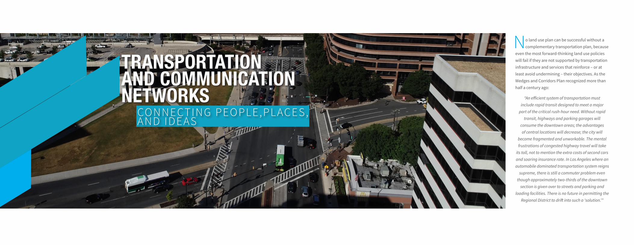
No land use plan can be successful without a complementary transportation plan, because
even the most forward-thinking land use policies will fail if they are not supported by transportation infrastructure and services that reinforce – or at least avoid undermining – their objectives. As the Wedges and Corridors Plan recognized more than half a century ago:
“An efficient system of transportation must include rapid transit designed to meet a major
part of the critical rush-hour need. Without rapid transit, highways and parking garages will
consume the downtown areas; the advantages of central locations will decrease; the city will
become fragmented and unworkable. The mental frustrations of congested highway travel will take
its toll, not to mention the extra costs of second cars and soaring insurance rate. In Los Angeles where an automobile dominated transportation system reigns
supreme, there is still a commuter problem even though approximately two-thirds of the downtown
section is given over to streets and parking and loading facilities. There is no future in permitting the
Regional District to drift into such a ‘solution.’”
TRANSPORTATION AND COMMUNICATION NETWORKS
CONNECTING PEOPLE,PL ACES, AND IDEAS
77 78Tr a n s p o r t a t i o n a n d C o m m u n i c a t i o n N e t w o r k s Tr a n s p o r t a t i o n a n d C o m m u n i c a t i o n N e t w o r k s 78
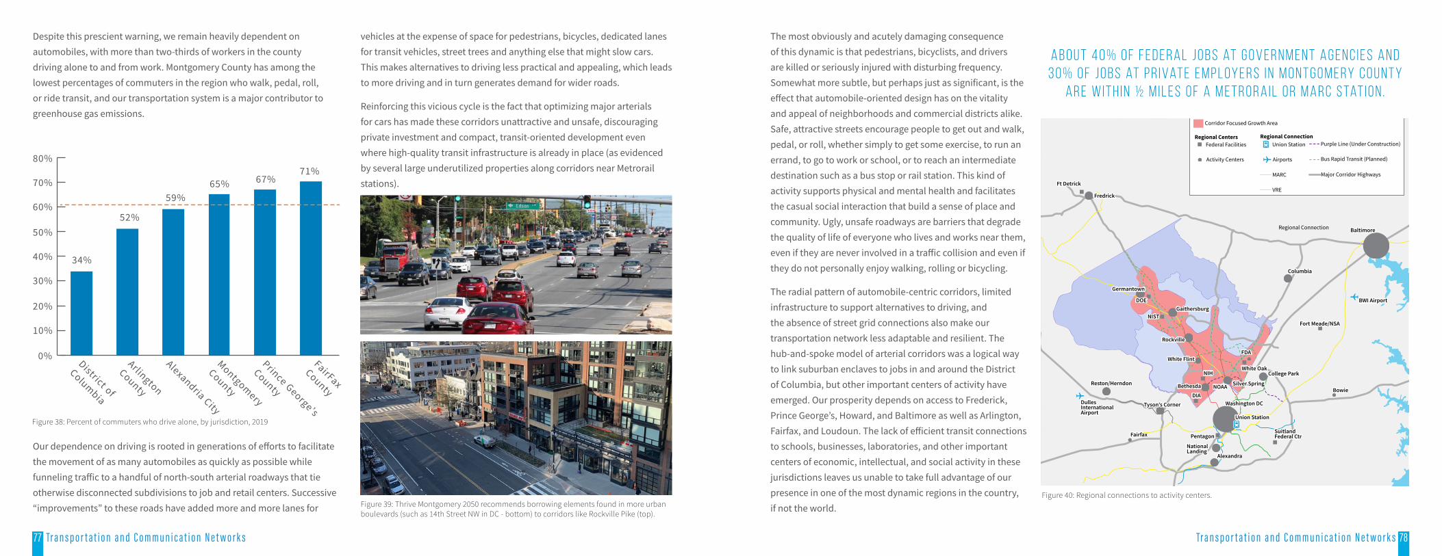
The most obviously and acutely damaging consequence of this dynamic is that pedestrians, bicyclists, and drivers are killed or seriously injured with disturbing frequency. Somewhat more subtle, but perhaps just as significant, is the effect that automobile-oriented design has on the vitality and appeal of neighborhoods and commercial districts alike. Safe, attractive streets encourage people to get out and walk, pedal, or roll, whether simply to get some exercise, to run an errand, to go to work or school, or to reach an intermediate destination such as a bus stop or rail station. This kind of activity supports physical and mental health and facilitates the casual social interaction that build a sense of place and community. Ugly, unsafe roadways are barriers that degrade the quality of life of everyone who lives and works near them, even if they are never involved in a traffic collision and even if they do not personally enjoy walking, rolling or bicycling.
The radial pattern of automobile-centric corridors, limited infrastructure to support alternatives to driving, and the absence of street grid connections also make our transportation network less adaptable and resilient. The hub-and-spoke model of arterial corridors was a logical way to link suburban enclaves to jobs in and around the District of Columbia, but other important centers of activity have emerged. Our prosperity depends on access to Frederick, Prince George’s, Howard, and Baltimore as well as Arlington, Fairfax, and Loudoun. The lack of efficient transit connections to schools, businesses, laboratories, and other important centers of economic, intellectual, and social activity in these jurisdictions leaves us unable to take full advantage of our presence in one of the most dynamic regions in the country, if not the world.
Regional Connection
Ft Detrick
Fredrick
Germantown
DOE
NISTGaithersburg
Rockville
White Flint
Bethesda
NIH
NOAA Silver Spring
College ParkWhite Oak
FDA
DIATyson’s Corner
Reston/Herndon
DullesInternationalAirport
Fairfax Pentagon
NationalLanding
Alexandra
SuitlandFederal Ctr
Washington DC
Union Station
Bowie
Fort Meade/NSA
BWI Airport
Columbia
Baltimore
Corridor Focused Growth Area
Regional Centers Regional ConnectionFederal Facilities Union Station
Airports
MARC
Purple Line (Under Construction)
Bus Rapid Transit (Planned)
Major Corridor Highways
Activity Centers
VRE
Figure 40: Regional connections to activity centers.
A b o u t 4 0 % o f f e d e r a l j o b s at g o v e r n m e n t a g e n c i e s a n d 3 0 % o f j o b s at p r i vat e e m p l oy e r s i n M o n t g o m e r y C o u n t y
a r e w i t h i n ½ m i l e s o f a M e t r o r a i l o r M A R C s tat i o n .
Despite this prescient warning, we remain heavily dependent on automobiles, with more than two-thirds of workers in the county driving alone to and from work. Montgomery County has among the lowest percentages of commuters in the region who walk, pedal, roll, or ride transit, and our transportation system is a major contributor to greenhouse gas emissions.
34%
52%
59%65% 67%
71%
0%
10%
20%
30%
40%
50%
60%
70%
80%
District of
Columbia
Arlington
County
Alexandria City
Montgomery
County
Prince George’s
County
FairFaxCounty
Our dependence on driving is rooted in generations of efforts to facilitate the movement of as many automobiles as quickly as possible while funneling traffic to a handful of north-south arterial roadways that tie otherwise disconnected subdivisions to job and retail centers. Successive “improvements” to these roads have added more and more lanes for
vehicles at the expense of space for pedestrians, bicycles, dedicated lanes for transit vehicles, street trees and anything else that might slow cars. This makes alternatives to driving less practical and appealing, which leads to more driving and in turn generates demand for wider roads.
Reinforcing this vicious cycle is the fact that optimizing major arterials for cars has made these corridors unattractive and unsafe, discouraging private investment and compact, transit-oriented development even where high-quality transit infrastructure is already in place (as evidenced by several large underutilized properties along corridors near Metrorail stations).
Figure 39: Thrive Montgomery 2050 recommends borrowing elements found in more urban boulevards (such as 14th Street NW in DC - bottom) to corridors like Rockville Pike (top).
Figure 38: Percent of commuters who drive alone, by jurisdiction, 2019
79 80Tr a n s p o r t a t i o n a n d C o m m u n i c a t i o n N e t w o r k s Tr a n s p o r t a t i o n a n d C o m m u n i c a t i o n N e t w o r k s 80
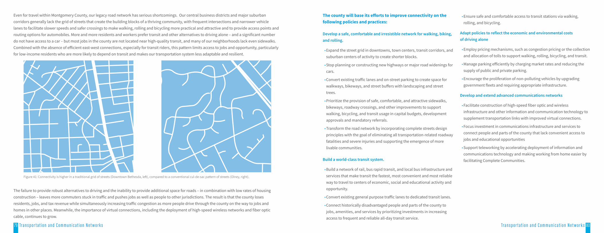
Even for travel within Montgomery County, our legacy road network has serious shortcomings. Our central business districts and major suburban corridors generally lack the grid of streets that create the building blocks of a thriving community, with frequent intersections and narrower vehicle lanes to facilitate slower speeds and safer crossings to make walking, rolling and bicycling more practical and attractive and to provide access points and routing options for automobiles. More and more residents and workers prefer transit and other alternatives to driving alone – and a significant number do not have access to a car – but most jobs in the county are not located near high-quality transit, and many of our neighborhoods lack even sidewalks. Combined with the absence of efficient east-west connections, especially for transit riders, this pattern limits access to jobs and opportunity, particularly for low-income residents who are more likely to depend on transit and makes our transportation system less adaptable and resilient.
The failure to provide robust alternatives to driving and the inability to provide additional space for roads – in combination with low rates of housing construction – leaves more commuters stuck in traffic and pushes jobs as well as people to other jurisdictions. The result is that the county loses residents, jobs, and tax revenue while simultaneously increasing traffic congestion as more people drive through the county on the way to jobs and homes in other places. Meanwhile, the importance of virtual connections, including the deployment of high-speed wireless networks and fiber optic cable, continues to grow.
The county will base its efforts to improve connectivity on the following policies and practices:
Develop a safe, comfortable and irresistible network for walking, biking, and rolling.
• Expand the street grid in downtowns, town centers, transit corridors, and suburban centers of activity to create shorter blocks.
• Stop planning or constructing new highways or major road widenings for cars.
• Convert existing traffic lanes and on-street parking to create space for walkways, bikeways, and street buffers with landscaping and street trees.
• Prioritize the provision of safe, comfortable, and attractive sidewalks, bikeways, roadway crossings, and other improvements to support walking, bicycling, and transit usage in capital budgets, development approvals and mandatory referrals.
• Transform the road network by incorporating complete streets design principles with the goal of eliminating all transportation-related roadway fatalities and severe injuries and supporting the emergence of more livable communities.
Build a world-class transit system.
• Build a network of rail, bus rapid transit, and local bus infrastructure and services that make transit the fastest, most convenient and most reliable way to travel to centers of economic, social and educational activity and opportunity.
• Convert existing general purpose traffic lanes to dedicated transit lanes.
• Connect historically disadvantaged people and parts of the county to jobs, amenities, and services by prioritizing investments in increasing access to frequent and reliable all-day transit service.
• Ensure safe and comfortable access to transit stations via walking, rolling, and bicycling.
Adapt policies to reflect the economic and environmental costs of driving alone
• Employ pricing mechanisms, such as congestion pricing or the collection and allocation of tolls to support walking, rolling, bicycling, and transit.
• Manage parking efficiently by charging market rates and reducing the supply of public and private parking.
• Encourage the proliferation of non-polluting vehicles by upgrading government fleets and requiring appropriate infrastructure.
Develop and extend advanced communications networks
• Facilitate construction of high-speed fiber optic and wireless infrastructure and other information and communication technology to supplement transportation links with improved virtual connections.
• Focus investment in communications infrastructure and services to connect people and parts of the county that lack convenient access to jobs and educational opportunities
• Support teleworking by accelerating deployment of information and communications technology and making working from home easier by facilitating Complete Communities.
Figure 41: Connectivity is higher in a traditional grid of streets (Downtown Bethesda, left), compared to a conventional cul-de-sac pattern of streets (Olney, right).
82Tr a n s p o r t a t i o n a n d C o m m u n i c a t i o n N e t w o r k s 8281 Tr a n s p o r t a t i o n a n d C o m m u n i c a t i o n N e t w o r k s
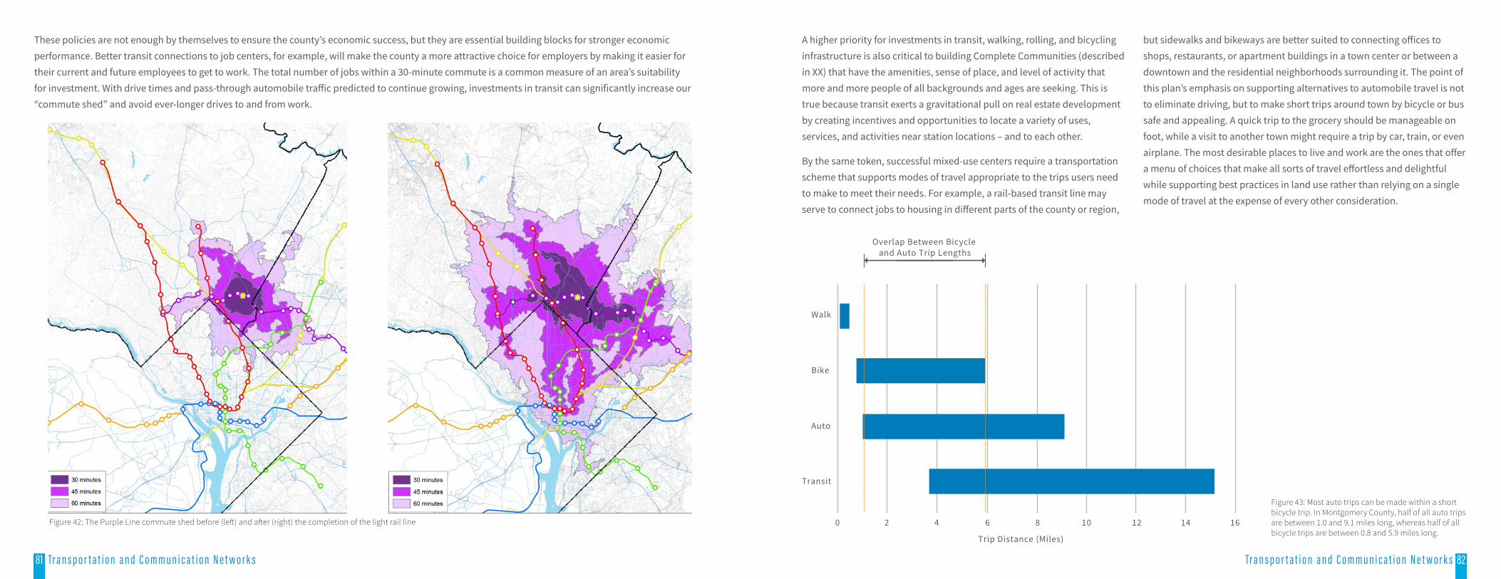
These policies are not enough by themselves to ensure the county’s economic success, but they are essential building blocks for stronger economic performance. Better transit connections to job centers, for example, will make the county a more attractive choice for employers by making it easier for their current and future employees to get to work. The total number of jobs within a 30-minute commute is a common measure of an area’s suitability for investment. With drive times and pass-through automobile traffic predicted to continue growing, investments in transit can significantly increase our “commute shed” and avoid ever-longer drives to and from work.
A higher priority for investments in transit, walking, rolling, and bicycling infrastructure is also critical to building Complete Communities (described in XX) that have the amenities, sense of place, and level of activity that more and more people of all backgrounds and ages are seeking. This is true because transit exerts a gravitational pull on real estate development by creating incentives and opportunities to locate a variety of uses, services, and activities near station locations – and to each other.
By the same token, successful mixed-use centers require a transportation scheme that supports modes of travel appropriate to the trips users need to make to meet their needs. For example, a rail-based transit line may serve to connect jobs to housing in different parts of the county or region,
but sidewalks and bikeways are better suited to connecting offices to shops, restaurants, or apartment buildings in a town center or between a downtown and the residential neighborhoods surrounding it. The point of this plan’s emphasis on supporting alternatives to automobile travel is not to eliminate driving, but to make short trips around town by bicycle or bus safe and appealing. A quick trip to the grocery should be manageable on foot, while a visit to another town might require a trip by car, train, or even airplane. The most desirable places to live and work are the ones that offer a menu of choices that make all sorts of travel effortless and delightful while supporting best practices in land use rather than relying on a single mode of travel at the expense of every other consideration.
Figure 43: Most auto trips can be made within a short bicycle trip. In Montgomery County, half of all auto trips are between 1.0 and 9.1 miles long, whereas half of all bicycle trips are between 0.8 and 5.9 miles long.
Trip Distance (Miles)
Overlap Between Bicycle and Auto Trip Lengths
Walk
Bike
Auto
Transit
0 2 4 6 8 10 12 14 16Figure 42: The Purple Line commute shed before (left) and after (right) the completion of the light rail line
83 84Tr a n s p o r t a t i o n a n d C o m m u n i c a t i o n N e t w o r k s Tr a n s p o r t a t i o n a n d C o m m u n i c a t i o n N e t w o r k s 84
Thrive Montgomery’s 2050’s focus on compact growth and infill – along with the limited availability of land for expanding rights-of-way – makes it essential that we decisively reject the impulse to make sure that driving remains as easy and convenient as possible in favor of making walking, rolling, bicycling, and transit the most practical and attractive ways of getting from one place to another. Even with autonomous capabilities, cars require much more space per passenger than buses and trains, and walking, rolling, and bicycling are the most spatially efficient forms of travel of all. The addition of new highways, travel lanes and grade-
separated interchanges may help to relieve congestion in the short term, but new highways, wide roads, and high-speed access ramps are fundamentally at odds with efforts to design neighborhoods and districts to encourage human interaction and foster a sense of place. This makes it imperative to embrace the long-term economic, environmental, and social benefits of transit-served, walkable and bikeable neighborhoods and avoid undercutting our land use goals with auto-dominated road design and transportation infrastructure.
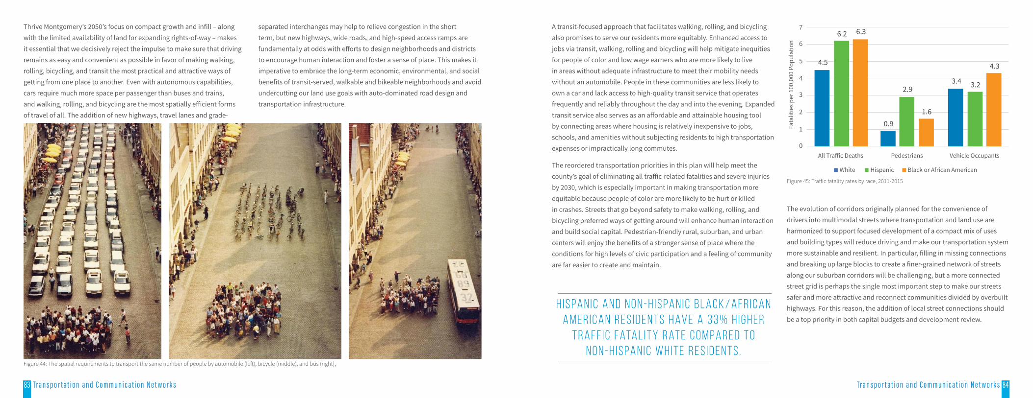
A transit-focused approach that facilitates walking, rolling, and bicycling also promises to serve our residents more equitably. Enhanced access to jobs via transit, walking, rolling and bicycling will help mitigate inequities for people of color and low wage earners who are more likely to live in areas without adequate infrastructure to meet their mobility needs without an automobile. People in these communities are less likely to own a car and lack access to high-quality transit service that operates frequently and reliably throughout the day and into the evening. Expanded transit service also serves as an affordable and attainable housing tool by connecting areas where housing is relatively inexpensive to jobs, schools, and amenities without subjecting residents to high transportation expenses or impractically long commutes.
The reordered transportation priorities in this plan will help meet the county’s goal of eliminating all traffic-related fatalities and severe injuries by 2030, which is especially important in making transportation more equitable because people of color are more likely to be hurt or killed in crashes. Streets that go beyond safety to make walking, rolling, and bicycling preferred ways of getting around will enhance human interaction and build social capital. Pedestrian-friendly rural, suburban, and urban centers will enjoy the benefits of a stronger sense of place where the conditions for high levels of civic participation and a feeling of community are far easier to create and maintain.
4.5
0.9
3.4
6.2
2.9 3.2
6.3
1.6
4.3
0
1
2
3
4
5
6
7
All Tra�ic Deaths Pedestrians Vehicle Occupants
Fata
litie
s per
100
,000
Pop
ulat
ion
White Hispanic Black or African American
Figure 45: Traffic fatality rates by race, 2011-2015
The evolution of corridors originally planned for the convenience of drivers into multimodal streets where transportation and land use are harmonized to support focused development of a compact mix of uses and building types will reduce driving and make our transportation system more sustainable and resilient. In particular, filling in missing connections and breaking up large blocks to create a finer-grained network of streets along our suburban corridors will be challenging, but a more connected street grid is perhaps the single most important step to make our streets safer and more attractive and reconnect communities divided by overbuilt highways. For this reason, the addition of local street connections should be a top priority in both capital budgets and development review.
H i s pa n i c a n d N o n - H i s pa n i c B l a c k / A f r i c a n A m e r i c a n r e s i d e n t s h av e a 3 3 % h i g h e r
t r a f f i c fata l i t y r at e c o m pa r e d t o N o n - H i s pa n i c W h i t e r e s i d e n t s .
Figure 44: The spatial requirements to transport the same number of people by automobile (left), bicycle (middle), and bus (right),

85 Tr a n s p o r t a t i o n a n d C o m m u n i c a t i o n N e t w o r k s
Investing in pedestrian, bicycling, and transit infrastructure will make active transportation a viable alternative to many vehicle trips. Bicycling has especially strong potential as a substitute for automobile trips of less than 3 miles, which comprise about half of all trips taken in the region. Survey research demonstrates that bicyclists are much more likely to say they enjoy their commute than people who use other modes to get to work. Integrating pedestrian and bicycling infrastructure in parks and open spaces will extend the transportation network and expose more residents to nature on a daily basis, boosting mental and physical health. An interconnected grid system will increase choice of modes, provide multiple routes for travel, and be better equipped to handle extreme weather and other disruptions.
0.5 1.0 1.5 2.0
20
15
10
5
Time(minutes)
Distance(miles)
Total Trip = 10 minutes
Total Trip = 20 minutes
Ride Bus
Bike Ride
Walk
Wai
t
Reducing the supply of parking – and the amount of land allocated to parking spaces – over time will increase the amount of space available for economically productive activity, reduce the cost of development, and relieve pressure on undeveloped land, all of which will enhance the county’s economic and environmental performance. Shared parking
strategies promote mixed-use development, improve pedestrian-friendly design, and encourage social interaction, while redevelopment of parking lots into higher and better uses improves environmental sustainability by creating opportunities to add tree cover, incorporate infrastructure for stormwater management, and create more landscaped areas that provide habitat for local pollinators, birds, and animals.
Finally, robust investment in the county’s digital infrastructure will better connect residents to online job opportunities, encourage continued teleworking to reduce commuting trips, dilute rush-hour traffic, enhance worker productivity and improve quality of life, increasing the county’s overall attraction and competitiveness.
In assessing proposals related to transportation and communications and measuring the success or failure of the approaches recommended in this plan, relevant measures may include:
• Vehicle Miles Traveled (VMT): Down
• Non-Auto Driver Mode Share (NADMS): Up
• Person Trip accessibility for pedestrians and bicyclists: Up
• Number of traffic-related severe injuries and fatalities: Down
• Transportation system’s GHG emissions: Down
• Miles of auto travel lanes per capita: Down
• Teleworking: Up
• Motor vehicle parking per unit of development: DownFigure 46: Total trip time for short trips - bicycling v bus.