murrumbidgee long-term water plan part b planning units
TRANSCRIPT
DEPARTMENT OF PLANNING, INDUSTRY & ENVIRONMENT
Murrumbidgee Long Term Water Plan
Part B: Murrumbidgee planning units
environment.nsw.gov.au

© 2020 State of NSW and Department of Planning, Industry and Environment
With the exception of photographs, the State of NSW and Department of Planning, Industry and Environment are pleased to allow this material to be reproduced in whole or in part for educational and non-commercial use, provided the meaning is unchanged and its source, publisher and authorship are acknowledged. Specific permission is required for the reproduction of photographs.
The Department of Planning, Industry and Environment (DPIE) has compiled this report in good faith, exercising all due care and attention. No representation is made about the accuracy, completeness or suitability of the information in this publication for any particular purpose. DPIE shall not be liable for any damage which may occur to any person or organisation taking action or not on the basis of this publication. Readers should seek appropriate advice when applying the information to their specific needs.
All content in this publication is owned by DPIE and is protected by Crown Copyright, unless credited otherwise. It is licensed under the Creative Commons Attribution 4.0 International (CC BY 4.0), subject to the exemptions contained in the licence. The legal code for the licence is available at Creative Commons.
DPIE asserts the right to be attributed as author of the original material in the following manner: © State of New South Wales and Department of Planning, Industry and Environment 2020.
Cover photo: Twin Bridges, Yanga National Park, showing native water primrose, milfoil and tall spike-rush. Photo Paul Doyle/DPIE
Published by:
Environment, Energy and Science Department of Planning, Industry and Environment 4 Parramatta Square, 12 Darcy Street, Parramatta NSW 2150 Phone: +61 2 9995 5000 (switchboard) Phone: 1300 361 967 (Environment, Energy and Science enquiries) TTY users: phone 133 677, then ask for 1300 361 967 Speak and listen users: phone 1300 555 727, then ask for 1300 361 967 Email: [email protected] Website: www.environment.nsw.gov.au
Report pollution and environmental incidents Environment Line: 131 555 (NSW only) or [email protected] See also www.environment.nsw.gov.au
ISBN 978-1-925974-00-3 EES 2020/0079 July 2020
Find out more about your environment at:
www.environment.nsw.gov.au

iii
Contents
Acknowledgement of Traditional Owners vii
Abbreviations viii
Glossary: for general text x
Glossary: Explanatory text for EWRs xv
1. Introduction 1
1.1 Aboriginal Cultural Values 1
1.2 Planning units 1
1.3 Methods for determining flow rate thresholds 3
1.4 Information sources for ecological values occurring within priority environmental assets 4
1.5 Selection of recommended management strategies 5
2. Planning units that are regulated or that can be affected by regulated water 9
PU1: Upper Murrumbidgee River – Tantangara to Burrinjuck 9
PU2: Tumut River below Blowering Dam 20
PU3: Murrumbidgee River – Burrinjuck to Tumut Junction 33
PU4: Murrumbidgee River – Tumut River Junction to Berembed Weir 41
PU5: Murrumbidgee River – Berembed Weir to Gogeldrie Weir 53
PU6: Murrumbidgee River – Gogeldrie Weir to Maude Weir 65
PU7: Lower Murrumbidgee Floodplain 81
PU8: Murrumbidgee River – Balranald to Murray 104
PU9: Beavers and Old Man’s Creek 118
PU10: Upper Yanco Creek 130
PU11: Colombo & Billabong Creeks 143
PU12: Lower Yanco Creek to Lower Billabong Creek 160
PU13: Lower Billabong and Intersecting Streams 174
PU14: Murrumbidgee Infrastructure Dependent Floodplain Wetlands 192
3. Unregulated planning units 197
PU15: Lake George 197
PU16: Tantangara 199
PU17: Monaro tributaries 201
PU18: Murrumbidgee tributaries – ACT to Burrinjuck Dam 207
PU19: Yass River 210
PU20: Goodradigbee 213
PU21: Upper Tumut River above Blowering Dam 216
PU22: Tumut River tributaries below Blowering Dam 218
PU23: Murrumbidgee tributaries – Burrinjuck to Tumut River Junction 223

iv
PU24: Murrumbidgee tributaries – Tumut River to Berembed Weir 226
PU25: Murrumbidgee North 233
PU26: Upper Billabong Creek 236
PU27: Murrumbidgee tributaries – Berembed Weir to Gogeldrie Weir 241
PU28: Urana 244
PU29: Wangamong Creek 246
References 249
List of tables
Table 1 Key to hydrological alteration used in this document 2
Table 2 Recommended management strategies proposed for unregulated planning units 5
Table 3 Upper Murrumbidgee River @ Mittagang 410033 (gauge data began in 1926) (SOME FLOWS STILL TO BE FINALISED) 13
Table 4 Tumut River (from Blowering Dam to junction with Murrumbidgee) (as measured at Tumut town gauge - 410006) – gauge data began in 1909 23
Table 5 LTWP EWRs for the Murrumbidgee River between Burrinjuck to Tumut Junction as measured at downstream Burrinjuck gauge (410008). Gauge data began in 1913 36
Table 6 Murrumbidgee River from Tumut Junction to Berembed Weir (as measured at Wagga gauge - 410001) – gauge data began in 1895 44
Table 7 Murrumbidgee (from Berembed Weir to Gogeldrie Weir) (as
measured at Narrandera gauge − 410005) – gauge data began in 1914 56
Table 8 Murrumbidgee (from Gogeldrie Weir to Maude Weir) (as measured at Darlington Point gauge - 410021) – gauge data began in 1914 68
Table 9 Murrumbidgee (from Maude Weir to Balranald) (as measured at downstream Maude gauge - 410040) – gauge data began in 1936 85
Table 10 Environmental water requirements for the Lower Murrumbidgee River Floodplain from MBDA (2012) 98
Table 11 Environmental water requirements for the portion of the Lower Murrumbidgee Floodplain that can be watered from regulators off Maude and Redbank weirs, showing water use through those regulators 98
Table 12 Murrumbidgee (from Balranald to Murray Junction) (as measured at downstream Balranald Weir gauge) – gauge data began in 1907 107
Table 13 Beavers and Old Man Creek (as measured at Old Man Creek @
Kywong: 410093) −gauge data began in 1976 121

v
Table 14 Upper Yanco Creek (as measured at Yanco Creek @ Offtake:
410007) − gauge data began in 1913 133
Table 15 Colombo and Middle Billabong Creeks (as measured at Colombo @ Morundah: 410014) Gauge data began in 1978 and at Billabong at Jerilderie (Gauge: 410016) gauge data began in 1912 147
Table 16 Lower Yanco Creek (as measured at Yanco Creek @ Morundah:
410015) − gauge data began in 1913 163
Table 17 Lower Billabong Creek (as measured at Billabong Creek @ Darlot:
410134) − gauge data began in 1978 178
Table 18 Environmental water requirements for wetlands watered from Murrumbidgee Irrigation Area or related infrastructure 195
Table 19 Potential wetlands for watering in or related to the Coleambally Irrigation Area 196
List of figures
Figure 1 Planning units in the Murrumbidgee catchment 3
Figure 2 Map of Upper Murrumbidgee River – Tantangara to Burrinjuck PU 9
Figure 3 Map of Tumut River below Blowering Dam PU. 20
Figure 4 Map of Upper Murrumbidgee River – Burrinjuck to Tumut Junction PU. 33
Figure 5 Map of Upper Murrumbidgee River – Tumut River Junction to Berembed Weir PU. 41
Figure 6 Map of Murrumbidgee River – Berembed Weir to Gogeldrie Weir PU. 53
Figure 7 Map of Murrumbidgee River – Gogeldrie Weir to Maude Weir PU. 65
Figure 8 Map of Lower Murrumbidgee Floodplain PU. 81
Figure 9 Map of Murrumbidgee River - Balranald to Murray PU. 104
Figure 10 Map of Beavers & Old Man’s Creek PU. 118
Figure 11 Map of Upper Yanco Creek PU. 130
Figure 12 Map of Colombo & Billabong Creeks PU. 143
Figure 13 Map of Lower Yanco Creek to Lower Billabong Creek PU. 160
Figure 14 Map of Lower Billabong Intersecting Stream PU. 174
Figure 15 Map of Murrumbidgee Infrastructure Dependent Floodplain Wetlands PU. 192
Figure 16: Map of Lake George PU 197
Figure 17: Map of Tantangara PU 199
Figure 18 Map of Monaro Tributaries PU 201

vi
Figure 19 Map of Murrumbidgee Tributaries – ACT to Burrinjuck PU 207
Figure 20 Map of Yass River PU 210
Figure 21 Map of Goodradigbee PU 213
Figure 22 Map of Upper Tumut River PU 216
Figure 23 Map of Tumut River tributaries below Blowering Dam PU 218
Figure 24 Map of Murrumbidgee tributaries – Burrinjuck to Tumut River Junction PU 223
Figure 25: Map of Murrumbidgee tributaries – Tumut River to Berembed Weir PU 226
Figure 26 Map of Murrumbidgee North PU 233
Figure 27 Map of Upper Billabong Creek PU 236
Figure 28 Map of Murrumbidgee tributaries – Berembed Weir to Gogeldrie Weir PU 241
Figure 29 Map of Urana PU 244
Figure 30 Map of Wangamong Creek PU 246

Murrumbidgee Long Term Water Plan Part B: Murrumbidgee planning units
vii
Acknowledgement of Traditional Owners
The NSW Department of Planning, Industry and Environment pays its respect to the Traditional Owners and their Nations of the Murray-Darling Basin. The contributions of earlier generations, including the Elders, who have fought for their rights in natural resource management are valued and respected.
In relation to the Murrumbidgee Water Resource Plan Area, the NSW Department of Planning, Industry and Environment pays its respects to the Traditional Owners—the Barapa Barapa, Mutthi Mutthi, Nari Nari, Ngarigo, Ngunnawal, Nyeri Nyeri, Wadi Wadi, Wolgalu, Wemba Wemba, Weki Weki and Wiradjuri Nations—past, present and future. We look forward to building upon existing relationships to improve the health of our rivers, wetlands and floodplains including in recognition of their traditional and ongoing cultural and spiritual significance.

Murrumbidgee Long Term Water Plan Part B: Murrumbidgee planning units
viii
Abbreviations
AER NSW DPIF Aquatic Ecosystems Research (database) of catch data
AHIMS Aboriginal Heritage Information Management System
ARI Annual recurrence interval
Basin Plan Murray-Darling Basin Plan 2012
BF Baseflow
BK Bankfull
BPEOM Basin Plan Environmental Outcome Monitoring
BWS Basin-wide environmental watering strategy (MDBA 2014)
CAG Customer Advisory Group
CAMBA China-Australia Migratory Bird Agreement
CEWO Commonwealth Environmental Water Office
CtF Cease-to-flow
CtP Cease-to-pump
DO Dissolved oxygen
DOC Dissolved organic carbon
DPIE NSW Department of Planning, Industry and Environment
DPIE–BC NSW Department of Planning, Industry and Environment – Biodiversity and Conservation Division
DPIE-Water NSW Department of Planning, Industry and Environment – Water
DPI Fisheries NSW Department of Primary Industries Fisheries
EEC Endangered ecological community
EWA Environmental water allowance
EWAG Environmental Water Advisory Group
EWR Environmental water requirement
FFDI Forest Fire Danger Index
GCM Global Climate Model
GDE Groundwater-dependent ecosystem
GL/yr gigalitres per year
ha hectares
HEW Held environmental water
JAMBA Japan-Australia Migratory Bird Agreement
LF Large fresh
LLS Local Land Services (NSW)
LTIM Long-Term Intervention Monitoring
LTWP Long Term Water Plan
m/s metres per second
MDBA Murray-Darling Basin Authority
MER Monitoring, evaluation and reporting

Murrumbidgee Long Term Water Plan Part B: Murrumbidgee planning units
ix
mg/L milligrams per litre
ML megalitre
NPWS NSW National Parks and Wildlife Services
NRAR Natural Resources Access Regulator
NSW New South Wales
OB Overbank
OEH Office of Environment and Heritage, former government agency whose functions are now undertaken by DPIE-BC
PCT Plant community type
PEW Planned environmental water
PU Planning unit
RAS Resource availability scenario
RCM Regional Climate Model
ROKAMBA Republic of Korea-Australia Migratory Bird Agreement
SDL Sustainable diversion limit
SF Small fresh
UMDR Upper Murrumbidgee Demonstration Reach
VLF Very low flow
WL Wetland inundating flow
W-LF Wetland connecting large fresh
WQA Water quality allowance
WQMP Water quality management plan
WRP Water resource plan
WRPA Water resource plan area
WSP Water sharing plan

Murrumbidgee Long Term Water Plan Part B: Murrumbidgee planning units
x
Glossary: for general text
Actively managed flowpaths
The area of channels, floodplains and wetlands that can be inundated by flows from regulated rivers (see ‘Regulated river’).
Adaptive management A procedure for implementing management while learning about which management actions are most effective at achieving specified objectives.
Allocation The volume of water made available to water access licence or environmental water accounts in a given year by DPIE-Water, which is determined within the context of demand, inflows, rainfall forecasts and stored water.
Allochthonous Organic material (leaf litter, understory plants, trees) derived from outside rivers, including riparian zones, floodplains and wetlands.
Alluvial Comprised of material deposited by water.
Annual recurrence interval (ARI)
The expected frequency (in years) between exceedances of a given flow rate (in ML/d).
Autochthonous Organic material derived from photosynthetic organisms (algal and macrophyte growth) within rivers.
Bankfull flow River flows at maximum channel capacity with little overflow to adjacent floodplains. These flows engage the riparian zone, anabranches, flood runners and wetlands located within the meander train. They inundate all in-channel habitats including benches, snags and backwaters.
Baseflow (BF) Reliable background flow levels within a river channel that are generally maintained by seepage from groundwater storage, but also by surface inflows. They typically inundate geomorphic units such as pools and riffle areas.
Murray-Darling Basin Plan (Basin Plan)
The Basin Plan as developed by the Murray-Darling Basin Authority under the Water Act 2007.
Basin Plan Environmental Outcome Monitoring (BPEOM) zone
For the Basin Plan, DPIF has broken up the catchments of the Murray Darling Basin into smaller zones for the monitoring of environmental outcomes for fish. These zones are known as BPEOM zones.
Biota The organisms that occupy a geographic region.
Blackwater Occurs when water moves across the floodplain and releases organic carbon from the soil and leaf litter. The water takes on a tea colour as tannins and other carbon compounds are released from the decaying leaf litter. The movement of blackwater plays an important role in transferring essential nutrients from wetlands into rivers and vice versa. Blackwater carries carbon which is the basic building block of the aquatic food web and an essential part of a healthy river system.
Carryover Water allocated to water licences or environmental water accounts that remains unused in storage at the end of the water year, which, under some circumstances, may be held over and used in the following water year.
Catch per unit effort (CPUE)
An indirect measure of the abundance of a target species.
Cease-to-flow (CtF) The absence of flowing water in a river channel that leads to partial or total drying of the river channel. Streams contract to a series of isolated pools.
Murrumbidgee Long Term Water Plan Part B: Murrumbidgee planning units
xi
Cease-to-pump (access rule in WSP)
Pumping is not permitted:
• from in-channel pools when the water level is lower than its full capacity
• from natural off-river pools when the water level is lower than its full capacity
• from pump sites when there is no visible flow.
These rules apply unless there is a commence-to-pump access rule that specifies a higher flow rate that licence holders can begin pumping.
Cold water pollution The artificial lowering of water temperature that occurs downstream of dams. In older dams, particularly those with a depth greater than 15 metres, water is typically released from the bottom of the dam where water temperatures can be significantly lower than surface readings. For native fish, that respond to temperature cues to breed, the effects of cold-water pollution can be particularly harmful. Cold water pollution can reduce the availability of food, increase fish mortality and reduce the frequency and success of breeding events. The impact of cold water pollution can extend for hundreds of kilometres along the river from the point of release.
Constraints The physical or operational constraints that affect the delivery of water from storages to extraction or diversion points. Constraints may include structures such as bridges that can be affected by higher flows, the volume of water that can be carried through the river channel, or scheduling of downstream water deliveries from storage.
Consumptive water Water that is removed from available supplies without return to a water resource system (such as water removed from a river for agriculture).
Cultural water-dependent asset
A place that has social, spiritual and cultural value based on its cultural significance to Aboriginal people. Related to the water resource.
Cultural water-dependent value
An object, plant, animal, spiritual connection or use that is dependent on water and has value based on its cultural significance to Aboriginal people.
Discharge The amount of water moving through a river system, most commonly expressed in megalitres per day (ML/d).
Dissolved Organic Carbon (DOC)
A measurement of the amount of carbon from organic matter that is soluble in water. DOC is transported by water from floodplains to river systems and is a basic building block available to bacteria and algae that are food for microscopic animals that are in turn consumed by fish larvae, small bodied fish species, yabbies and shrimp. DOC is essential for building the primary food webs in rivers and ultimately generates a food source for large bodied fish like Murray cod and golden perch and predators such as waterbirds.
Ecological function The resources and services that sustain human, plant and animal communities and are provided by the processes and interactions occurring within and between ecosystems.
Ecological objective The defined goal for a state, condition or characteristic of an ecological asset or function.
Ecological target Level of measured performance that must be met in order to achieve the defined objective. The targets in this long term water plan are SMART (Specific/Measurable/Achievable/Realistic/Time-bound).
Ecological value An object, plant or animal which has value based on its ecological significance.
Ecosystem A biological community of interacting organisms and their physical environment. It includes all the living things in that community, interacting with their non-living environment (weather, earth, sun, soil, climate and atmosphere) and with each other.

Murrumbidgee Long Term Water Plan Part B: Murrumbidgee planning units
xii
Environmental water Water for the environment. It serves a multitude of benefits to not only the environment, but communities, industry and society. It includes water held in reservoirs (held environmental water) or protected from extraction from waterways (planned environmental water) for the purpose of meeting the water requirements of water-dependent ecosystems.
Environmental water allowance (EWA)
Discretionary planned environmental water that accrues to accounts under rules outlined in the Murrumbidgee WSP. This water is managed by DPIE-BC.
Environmental water requirement (EWR)
The water required to support the completion of all elements of a lifecycle of an organism or group of organisms (taxonomic or spatial), consistent with the objective/target, measured at the most appropriate gauge. It includes all water in the system including natural inflows, held environmental water and planned environmental water.
Flow category The type of flow in a river defined by its magnitude (e.g. bankfull).
Flow regime The pattern of flows in a waterway over time that will influence the response and persistence of plants, animals and their ecosystems.
Freshes Temporary in-channel increased flow in response to rainfall or release from water storages.
General security A form of Entitlement, pertaining to a Regulated River for which Water Orders are accepted subject to storage / demand circumstances.
Groundwater Water that is located below the earth’s surface in soil pore spaces and in the fractures of rock formations. Groundwater is recharged from, and eventually flows to, the surface naturally.
Held environmental water (HEW)
Water available under a water access right, a water delivery right, or an irrigation right for the purposes of achieving environmental outcomes (including water that is specified in a water access right to be for environmental use).
Hydrograph A graph showing the rate of flow and/or water level over time past a specific point in a river. The rate of flow is typically expressed in megalitres per day (ML/d).
Hydrological connectivity The link of natural aquatic environments.
Hydrology The occurrence, distribution and movement of water.
Hypoxic Blackwater Occurs when dissolved oxygen (DO) levels fall below the level needed to sustain native fish and other water dependent species. Bacteria that feed on dissolved organic carbon use oxygen in the water. When they multiply rapidly their rate of oxygen consumption can exceed the rate at which oxygen can be dissolved in the water. As a result oxygen levels fall and a hypoxic (low oxygen) condition occurs.
Dissolved oxygen is measured in milligrams per litre (mg/L). Generally native fish begin to stress when DO levels fall below 4 mg/L. Fish mortality occurs when DO levels are less than 2 mg/L.
Key ecological value A species or community that is identified for its special conservation significance based on selected temporal and spatial criteria. Examples include Murray cod or river red gum woodlands.
Large fresh (LF) High-magnitude flow pulse that remains in-channel. These flows may engage flood runners with the main channel and inundate low-lying wetlands. They connect most in-channel habitats and provide partial longitudinal connectivity, as some low-level weirs and other in-channel barriers may be drowned out.
Lateral connectivity The flow linking rivers channels and the floodplain.
Longitudinal connectivity The consistent downstream flow along the length of a river.

Murrumbidgee Long Term Water Plan Part B: Murrumbidgee planning units
xiii
Long Term Water Plan (LTWP)
A component of the Basin Plan. Long term water plans give effect to the Basin-wide environmental watering strategy (MDBA 2014) relevant for each river system and will guide the management of water over the longer term. These plans will identify the environmental assets that are dependent on water for their persistence, and match that need to the water available to be managed for or delivered to them. The plan will set objectives, targets and watering requirements for key plants, waterbirds, fish and ecosystem functions. DPIE-BC is responsible for the development of nine plans for river catchments across NSW, with objectives for five, 10 and 20-year timeframes.
Montane Relating to mountainous country.
Overbank flow (OB) Flows that spill over the riverbank or extend to floodplain surface flows.
Planned environmental water (PEW)
Water that is committed by the Basin Plan, a WRP or a plan made under state water management law to achieving environmental outcomes.
Planning Unit (PU) A division of a WRP area based on water requirements (in catchment areas in which water is actively managed), or a sub-catchment boundary (all other areas).
Population structure A healthy population structure has individuals in a range of age and size classes. These populations demonstrate regular recruitment and good numbers of sexually mature individuals.
Priority ecological asset In the context of this plan, is a place of particular ecological significance that contains values and functions that are water-dependent and can be influenced by environmental water.
Priority ecological function In the context of this plan, is a water-dependent ecological function that can be influenced by environmental water.
Ramsar Convention An international treaty to maintain the ecological character of key wetlands.
Recruitment Successful development and growth of offspring; such that they have the ability to contribute to the next generation.
Refuge An area in which a population of plants or animals can survive through a period of decreased water availability.
Regulated river A river that is gazetted under the NSW Water Management Act 2000. Flow is largely controlled by major dams, water storages and weirs. River regulation brings more reliability to water supplies but has interrupted the natural flow characteristics and regimes required by native fish and other plant and animal to breed, feed and grow.
Riffle A rocky or shallow part of a river where river flow is rapid and broken.
Riparian The part of the landscape adjoining rivers and streams that has a direct influence on the water and aquatic ecosystems within them.
Risk management strategy
A plan of management to overcome risks to achieving environmental outcomes.
Small fresh (SF) Low-magnitude in-channel flow pulse. Unlikely to drown out any significant barriers but can provide limited connectivity and a biological trigger for animal movement.
Small-scale colonial bird breeding event
Event with 50–250 nests/adult pairs
Stochastic Relating to or characterised by random chance.
Substrate A habitat surface such as a stream bed.
Supplementary access A category of water entitlement where water is made available to licence holder accounts during periods of high river flows that cannot

Murrumbidgee Long Term Water Plan Part B: Murrumbidgee planning units
xiv
otherwise be controlled by river operations. Water can be taken and debited from licence accounts during a declared period of high flow.
Surface water Water that exists above the ground in rivers, streams creeks, lakes and reservoirs. Although separate from groundwater, they are interrelated and over extraction of either will impact on the other.
Sustainable diversion limit (SDL)
The grossed-up amount of water that can be extracted from Murray-Darling Basin rivers for human uses while leaving enough water in the system to achieve environmental outcomes.
Unregulated river A waterway where flow is mostly uncontrolled by dams, weirs or other structures.
Water order The requisitioning of water in accordance with the terms specified in the Licence Conditions applicable to the Licence under Water Management Act 2000 and Water Act 1912.
Very low flow (VLF) Small flow in the very-low flow class that joins river pools, thus providing partial or complete connectivity in a reach. These flows can improve DO saturation and reduce stratification in pools.
Water quality management plan (WQMP)
A document prepared by state authorities and accredited by the Commonwealth under the Basin Plan. It forms part of a WRP and aims to provide a framework to protect, enhance and restore water quality in each WRPA.
Water resource plan (WRP)
A document prepared by state authorities and accredited by the Commonwealth under the Basin Plan. The document describes how water will be managed and shared between users in an area.
Water resource plan area (WRPA)
Catchment-based divisions of the Murray–Darling Basin defined by a WRP.
Water sharing plan (WSP) A plan made under the NSW Water Management Act 2000 that sets out specific rules for sharing and trading water between the various water users and the environment in a specified water management area. It forms part of a WRP.
Water source Under the WSPs for the unregulated water sources of the Murrumbidgee River, the catchments have been divided into smaller areas called water sources. Each of these water sources has listed access and trading rules.
Water-dependent system An ecosystem or species that depends on periodic or sustained inundation, waterlogging or significant inputs of water for natural functioning and survival.
Wetland inundation flow (WL)
Flows that fill wetlands via regulating structures below bankfull over weeks or sometimes months (i.e. longer than a typical fresh/pulse), or flows that are required to inundate wetlands in areas where there are very shallow channels or no discernible channels exist (e.g. terminal wetlands).

Murrumbidgee Long Term Water Plan Part B: Murrumbidgee planning units
xv
Glossary: Explanatory text for EWRs
Flow category Flows in rivers vary over time in response to rainfall, river regulation, extractions and other factors. The sequence of flows over time can be considered as a series of discrete events. These events can be placed into different flow categories (e.g. baseflows, freshes, bankfull, overbank and wetland flows) according to the magnitude of flow discharge or height within a watercourse, and the types of outcomes associated with the events (e.g. inundation of specific features such as channel benches, riparian zones or the floodplain). Flow categories used in LTWPs are illustrated and defined in Figure 9 and Table 7 in Part A of each LTWP.
Environmental water requirement (EWR)
An environmental water requirement (EWR, singular) describes the characteristics of a flow event (e.g. magnitude, duration, timing, frequency, and maximum dry period) within a particular flow category (e.g. small fresh), that are required for that event to achieve a specified ecological objective or set of objectives (e.g. to support fish spawning and in-channel vegetation).
There may be multiple EWRs defined within a flow category, and numerous EWRs across multiple flow categories within a Planning Unit (PU). Achievement of each of the EWRs will be required to achieve the full set of ecological objectives for a PU.
EWR code Each EWR is given a specific code that abbreviates the EWR name (e.g. SF1 for small fresh 1). This code is used to link ecological objectives and EWRs.
Gauge The flow gauging station that best represents the flow within the PU, for the purpose of the respective EWR and associated ecological objective(s). To assess the achievement of the EWR, flow recorded at this gauge should be used.
Flow rate or flow volume The flow rate (typically ML/d) or flow volume (typically GL over a defined period of time) that is required to achieve the relevant ecological objective(s) for the EWR. Most EWRs are defined using a flow rate, whilst flow volumes are used for EWRs that represent flows into some large wetland systems.
Timing The required timing (or season, typically expressed as a range of months within the year) for a flow event to achieve the specified ecological objective(s) of the EWR.
In some cases, a preferred timing is provided, along with a note that the event may occur at ‘anytime’. This indicates that ecological objectives may be achieved outside the preferred timing window, but perhaps with sub-optimal outcomes. In these instances, for the purposes of managing and delivering environmental water, the preferred timing should be used to give greater confidence in achieving ecological objectives. Natural events may occur at other times and still achieve ecological objectives.
When delivering water consideration should be given to ensuring that an appropriate drying regime is maintained in wetlands following a wet sequence of years. Consideration should also be given to minimising evaporation loses by preferentially delivering during cooler seasons within the overall timing window.
Duration The duration for which flows must be above the specified flow rate for the flow event to achieve the specified ecological objective(s) of the EWR. Typically this is expressed as a minimum duration. Longer durations will often be desirable and deliver better ecological outcomes.
Some species may suffer from extended durations of inundation, and where relevant a maximum duration may also be specified.

Murrumbidgee Long Term Water Plan Part B: Murrumbidgee planning units
xvi
Flows may persist on floodplains and within wetland systems after a flow event has passed. Where relevant a second duration may also be specified, representing the duration for which water should be retained within floodplain and wetland systems.
Frequency The frequency at which the flow event should occur to achieve the ecological objective(s) associated with the EWR. Frequency is expressed as the number of years that the event should occur within a 10-year period.
In most instances, more frequent events will deliver better outcomes, and maximum frequencies may also be specified, where relevant.
Clustering of events over successive years can occur in response to climate patterns. Clustering can be ecologically desirable for the recovery and recruitment of native fish, vegetation and waterbirds populations, however extended dry periods between clustered events can be detrimental. Achieving ecological objectives will require a pattern of events over time that achieves both the frequency and maximum inter-flow period, and the two must be considered together when evaluating outcomes or managing systems.
Where a range of frequencies is indicated (e.g. 3–5 years in 10), the range reflects factors including the natural variability in population requirements, uncertainty in the knowledge base, and variability in response during different climate sequences (e.g. maintenance of populations during dry climate sequences at the lower end of the range, and population improvement and recovery during wet climate sequences at the upper end of the range).
The lower end of the frequency range (when applied over the long term) may not be sufficient to maintain populations and is unlikely to achieve any recovery or improvement targets. As such, when evaluating EWR achievement over the long-term through statistical analysis of modelled or observed flow records, the LTWP recommends using a minimum long-term average (LTA) target frequency that is at least the average of the recommended frequency range but may be higher than the average where required to achieve objectives.
For example, for a recommended frequency range of 3-5 years in 10, the minimum LTA frequency should be at least 40% of years but may be up to 50% of years at sites where a higher frequency should be targeted over the long term to ensure recovery in certain species/populations. Whilst these higher frequencies may exceed modelled natural event frequency in some cases, recovery in particularly degraded systems will be unlikely should lower (i.e. average) frequencies be targeted.
Minimum LTA target frequencies in this LTWP are reported predominantly as the average of the recommended frequency range, however this may be refined during implementation of the LTWP and in future revisions of the LTWP based on the results of ongoing ecological monitoring.
Maximum inter-flow or inter-event period
The maximum time between flow events before a significant decline in the condition, survival or viability of a particular population is likely to occur, as relevant to the ecological objective(s) associated with the EWR.
This period should not be exceeded wherever possible.
Annual planning of environmental water should consider placing priority on EWRs that are approaching (or have exceeded) the maximum inter-event period, for those EWRs that can be achieved or supported by the use of environmental water or management.

Murrumbidgee Long Term Water Plan Part B: Murrumbidgee planning units
xvii
Additional requirements and comments
Other conditions that should occur to assist ecological objectives to be met – for example rates of rise and fall in flows.
Also comments regarding limitations on delivering environmental flows and achieving the EWR.
Murrumbidgee Long Term Water Plan Part B: Murrumbidgee planning units
1
1. Introduction
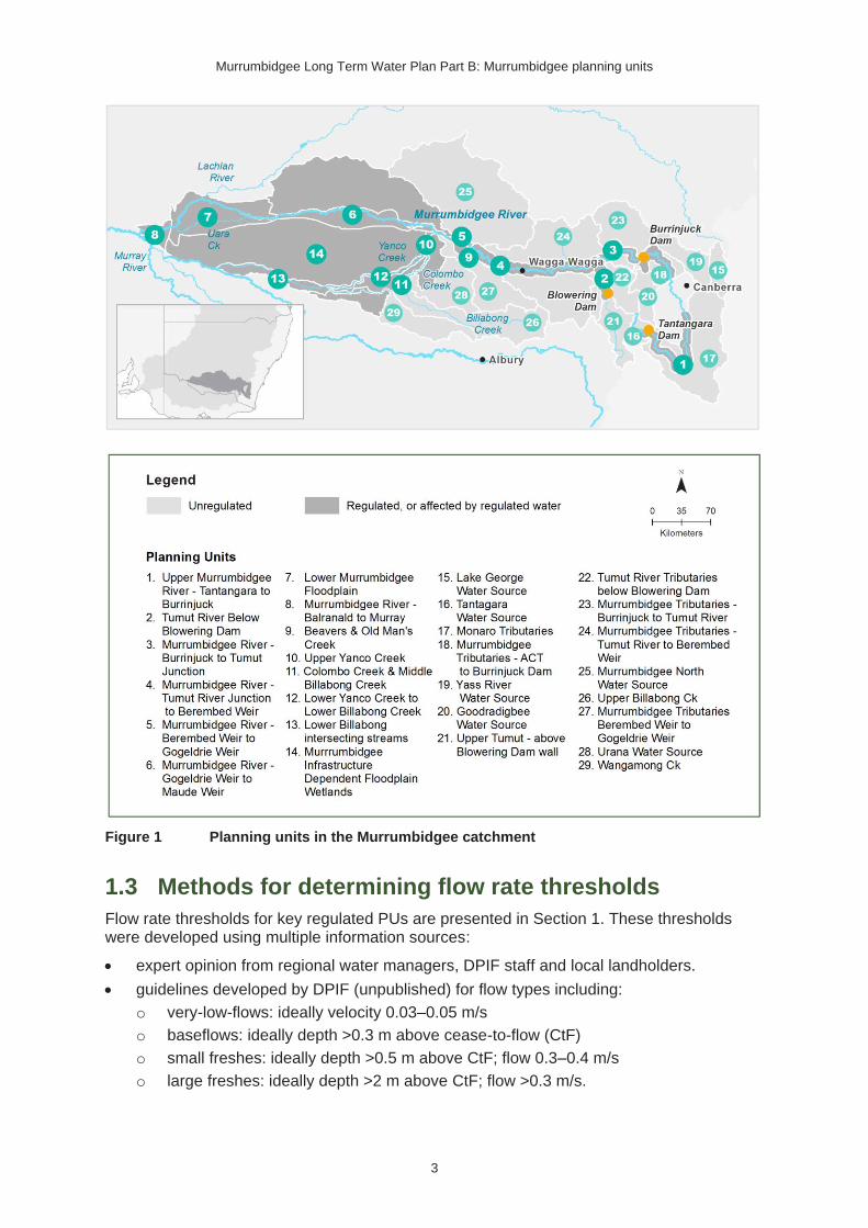
To manage the complexity of the Murrumbidgee Water Resource Plan Area (WRPA), the Murrumbidgee Long Term Water Plan (LTWP) has been divided into 29 planning units (PUs) (Figure 1). This document, which forms Part B of the LTWP, provides the following local-scale information for each PU:
• the location of priority environmental assets identified as part of LTWP development.
• the ecological values, including native fish and waterbird species1, and native vegetation communities that occur within the PUs priority environmental assets.
• objectives for native fish, showing relevant species. The objectives for each PU are outlined in Part A of the LTWP (Appendix A). Only native fish objectives are shown in Part B as these objectives are highly species specific. That is, the fish objectives in Part A of the LTWP (Appendix A) only note the relevant fish flow guilds and it is not stated which species they relate to for any particular PU. Hence, the fish species are listed with the objectives here in Part B. For other objective themes the relevant species are either clear from the objective itself (e.g. where the objective is to maintain/improve river red gum) or the species itself if less relevant (e.g. where a broader group is targeted and factors like preferred water temperature, etc are less relevant).
• for key PUs that are regulated or that can be affected by regulated water, environmental water requirements (EWRs) to support key ecological values and related LTWP objectives and targets that are presented for representative gauge/s in the PU.
• for PUs that are unregulated, an evaluation of the impact of water resource development on local hydrology and recommended management strategies for mitigating these changes to meet LTWP objectives and targets.
1.1 Aboriginal cultural values
NSW LTWPs recognise the importance of rivers and wetlands to Aboriginal culture. For First Nations People, water is a sacred source of life. The natural flow of water sustains aquatic ecosystems that are central to their spirituality, culture and wellbeing. Rivers are described as ‘the veins of Country’, carrying water to sustain all parts of their sacred landscape, and the wetlands described as the ‘kidneys’, filtering the water as it passes through the land (National Cultural Flows Research Project, 2019).
Aboriginal cultural values are related to specific places, plants and animals and to the landscape as a whole. Water-dependent Aboriginal cultural values identified in the Murrumbidgee WRPA include Aboriginal ceremony and dreaming sites, fish traps and sites of resource collection, scarred or modified trees, artefact sites, occupation sites and water holes. Due to the sensitive nature of this information site locations will not be published in this document.
1.2 Planning units
The PU boundaries typically align with water source area boundaries in the Murrumbidgee Water Resource Plan (WRP). However, some of these water sources have been amalgamated or split depending on how water management for the environment can be implemented. Where there are similarities between water sources they have been
1 The waterbird species that are listed in each PU are primarily informed by spot records, which are influenced by inconsistent survey effort across the WRPA. Therefore, caution should be used in interpreting this information. Future work should focus on more rigorous monitoring or the development of models to predict species occurrence.

Murrumbidgee Long Term Water Plan Part B: Murrumbidgee planning units
2
amalgamated; and where there are differences, they have been split. When amalgamating and splitting, we have also aligned, where possible, PUs with the boundaries of the Basin Plan Environmental Outcomes Monitoring (BPEOM) zones of the NSW Department of
Primary Industries − Fisheries (DPIF).
PUs may be regulated or unregulated, however, the PU ‘Murrumbidgee Infrastructure Dependent Floodplain Wetlands’ has some overlap in terms of its management. This PU is downstream of the key regulating structures, but its wetlands are generally outside the reach of normal river flows. Subsequently, no stream flow EWRs have been developed for this PU, but there are many wetlands that can be watered using irrigation and other infrastructure.
In regulated parts of the catchment, discretionary environmental water can be delivered to help meet the EWRs of priority environmental assets and functions. In unregulated areas, where there are no major upstream dams and water cannot be delivered, the primary means of protecting environmentally important flows is through pumping access rules, restriction of trades into the water source and no creation of new entitlement.
The PUs are presented in two sections in this document:
• Section 1 contains PUs 1–14, which are regulated or can be affected by regulated water.
• Section 2 contains PUs 15–29 that are unregulated and unable to be influenced by regulated water deliveries.
For the PUs in Section 2 that contain unregulated river reaches, the management of pumping access rules remains vital for protecting important flows. Recommended management strategies that could be implemented to ensure important flows are protected are outlined in Part A, Section 6.2 of the LTWP2.
For each PU that is unregulated or has significant unregulated sections, information is presented on the hydrology3 and the degree of alteration, as determined by DPIE-Water in their Murrumbidgee Water Resource Plan Risk Assessment (DPIE-Water 2019), by comparing flows under modelled near natural conditions (with no dams or water extractions) and flows under modelled current (post development) conditions. Table 1 describes how the hydrology changes are presented for each PU.
Table 1 Key to hydrological alteration used in this document
Key from NSW DPIE-Water, 2019
L = Low: less than 20% difference (+/-) from pre-development for each hydrologic metric
M = Medium: 20–50% difference (+/-); from pre-development for each hydrologic metric
H = High: greater than 50% difference (+/-) from pre-development for each hydrologic metric
N/A = no risk outcome or modelling available due to no hydrological data available
+ increase from near-natural condition
- decrease from near-natural condition
0 no change from near-natural condition
2 To improve the specificity of rule change recommendations, improved modelling, a better understanding of the actual total amount of take and the individual water access licence conditions is often required. 3 The hydrology is presented as percentiles and ARIs (average recurrence intervals) as determined by pre-development modelling.
Murrumbidgee Long Term Water Plan Part B: Murrumbidgee planning units
3
Figure 1 Planning units in the Murrumbidgee catchment
1.3 Methods for determining flow rate thresholds
Flow rate thresholds for key regulated PUs are presented in Section 1. These thresholds were developed using multiple information sources:
• expert opinion from regional water managers, DPIF staff and local landholders.
• guidelines developed by DPIF (unpublished) for flow types including:
o very-low-flows: ideally velocity 0.03–0.05 m/s
o baseflows: ideally depth >0.3 m above cease-to-flow (CtF)
o small freshes: ideally depth >0.5 m above CtF; flow 0.3–0.4 m/s
o large freshes: ideally depth >2 m above CtF; flow >0.3 m/s.

Murrumbidgee Long Term Water Plan Part B: Murrumbidgee planning units
4
• flow percentiles described in Alluvium (2010):
o the 20th percentile flow4 as an indicator of the baseflow
o the 40th percentile flow as an indicator the ‘low-flow-season fresh’, which may be taken as similar to our ‘small fresh’
o the 87th percentile flow as an indicator the ‘high-flow-season fresh’, which may be taken as similar to our ‘large fresh’. We looked at both the 80th and 90th percentile.
• the approach used by the Stewardson and Guarino (2017) based on at-a-station hydraulic geometry equations (Stewardson 2005). They determined ‘low freshes’ as water levels at least one-eighth of the height of the bank above the baseflow level. They determined ‘high freshes’ as flow spells that raise water levels at least half of the height of the bank above the baseflow.
• several methods were used to help indicate the bank full level:
o finding the point where the width to depth ratio is at a minimum ((Wolman 1955 and Pickup and Warner 1976 – cited in Copeland et al. 2000)
o finding the point of inflection in the stage (gauge height) to discharge rating curve (Copeland et al. 2000). Where the flow compared to height increases rapidly this indicates the flow is breaking out of the channel.
o identifying the level in a channel cross section where the channel widens out to a floodplain (Wolman and Leopold 1957 and Nixon 1959 cited in Copeland et al, 2000). This point is not, however, always clear-cut.
• analysis of these flow rates to ensure they occurred under modelled or observed conditions. Analysis included checking against the required frequency of events and 95th percentile duration between events.
1.4 Information sources for ecological values occurring
within priority environmental assets
Native fish species occurrence in PUs was determined from a range of sources including:
• the NSW Department of Primary Industries (DPI) Aquatic Ecosystem Research (AER) database (the database includes a range of site-specific catch data and information from various fish related projects in NSW from 1970 through to the present depending on the project and location)
• threatened and common species distribution models (MaxEnt 3.3.3)
• expert opinion from DPIF officers where applicable.
Water (flow)-dependent native vegetation communities were identified from a collated water (flow)-dependent vegetation map for the Murrumbidgee WRPA developed by DPIE-BC as part of LTWP development. This collated map is based on best available vegetation mapping, including Plant Community Type (PCT) mapping.
Water (flow)-dependent bird and waterbird species records were collated from:
• NSW (Bionet – Atlas of NSW Wildlife 1980-2016) and Commonwealth (Australian Living
Atlas) Government databases (1977−2015)
• University of New South Wales (UNSW) aerial survey datasets (1983−2016)
• NSW OEH ground surveys (2007−16).
Significant Aboriginal cultural water dependent sites that are registered in the NSW Aboriginal Heritage Information Management System (AHIMS) were also included as water-
4 That is 80th percentile exceedance. Other percentiles are similarly percentiles of occurrence rather than exceedance.

Murrumbidgee Long Term Water Plan Part B: Murrumbidgee planning units
5
dependent assets in the LTWP. This includes areas such as Aboriginal ceremony and dreaming sites, fish traps, scar trees and waterholes.
1.5 Selection of recommended management strategies
Table 2 Recommended management strategies proposed for unregulated planning units
Management strategy Purpose & description For consideration in PUs where:
1 Investigate opportunities to reduce extraction pressure on in-channel flows in the water source within five years.
Identification step for PUs which have moderate or greater impact and are ecologically important. Relevant management strategies (1A to 1H below) are then selected)
Medium or High degree of alteration to CtF, low flow/baseflows or freshes from NSW DPIE-Water (2019), AND
• Medium or greater consequence score in the NSW DPIE-Water (2019), OR
• Supports endangered native fish species OR
• Has native fish objectives NF7-NF9
1A: Consider reviewing existing rules to ensure that visible flow is maintained downstream of extraction points.
To help relieve CtF periods across the water source.
Currently, in many cases, extraction can occur until there is no visible flow (i.e. until the stream stops flowing).
This change should be considered both for licences with cease-to-pump (CtP) rules and those that only have the ‘no visible flow’ CtP rules.
For licences that have CtP rules, these rules are sometimes referenced to a gauge that is distant from the pump site, so flow may cease at the pump site even when the reference gauge has flow.
Criteria for (1) are met AND
• CtF or low flows/baseflows have a Medium or High degree of alteration
1B: Where a CtP rule currently exists, consider reviewing the threshold.
To help relieve unnatural/detrimental CtF periods and support more ecologically relevant low flow/baseflows
Criteria for (1) are met AND
• CtP rule already exists AND
• CtF or low flows/baseflows have a Moderate or High degree of alteration
1C: Where no CtP rule currently exists, consider introducing a CtP rule (relating to a flow or water level gauge)
To help relieve unnatural CtF periods and support more ecologically relevant low flow/baseflows
Criteria for (1) are met AND
• No CtP rule exists AND
• CtF or low flows/baseflows have a Moderate or High degree of alteration

Murrumbidgee Long Term Water Plan Part B: Murrumbidgee planning units
6
Management strategy Purpose & description For consideration in PUs where:
1D: Consider implementing a commence-to-pump threshold that is higher than cease-to-pump (CtP) threshold.
This protects the initial flow to allow water quality to improve and provide movement and breeding opportunities for native fish and other aquatic biota.
Criteria for (1) are met AND
• Freshes have a Moderate or High degree of alteration
1E: Consider installing water level gauges at or near extraction sites
Improve monitoring, compliance and effectiveness of rules in the Unregulated WSP.
May also improve equity of water sharing provisions across all WAL holders.
Enables flows to be set with a rule other than just the ‘visible flow’ rule.
Criteria for (1) are met AND
• No gauge OR
• gauge in inappropriate location
1F: Consider installing river flow gauge
Criteria for (1) are met AND
• No gauge; AND
• High degree of alteration
Median flow >10 ML/day
1G: Consider rostering landholder water access
Rostering take could involve an ‘odds and evens’ arrangement where a half of licence holders are able to access water on one day and the other half on the next. This is to reduce the daily extraction pressure on smaller flows where a significant proportion of the daily flow could be pumped if all pumps were activated simultaneously. Allowance would have to be made for travel times along longer systems.
Individual daily extraction limits (IDELs) would limit the amount of water a licence holder could take on any one day. Total daily extraction limits (TDELs) would limit the daily take for the zone. These limits could be set at different levels for different flow sizes, so the proportion of any flow taken is able to be better managed and highly impacted and important flow types could be preserved.
Criteria for (1) are met AND
• WALs are concentrated along one stream or in a particular reach of a stream.
(Not relevant where WALs are distributed across different creek systems in the water source) 1H:
Consider Individual and/or Total Daily Extraction Limits (IDELS / TDELS)
2 Ensure compliance with water access licence conditions including through metering of all licensed extraction.
To ensure all flows are protected from unauthorised extraction for the environment and other users.
All PUs
3 As a minimum, maintain existing rules in the WSP for the Murrumbidgee Unregulated Water Sources that protect environmental assets and values.
These rules include trade rules and extraction rules.
This strategy is to ensure no reduction in protection. Changes may be made where recommended to increase protection.
All PUs
4 Monitor for changes in water demand and review access rules if current
Patterns of usage and demand may change with changing crop choices and practices. This may alter the seasonality and volume of
All PUs

Murrumbidgee Long Term Water Plan Part B: Murrumbidgee planning units
7
Management strategy Purpose & description For consideration in PUs where:
usage is high or if the pattern of use changes.
take and have differing impacts on different flows.
5 Consider introducing cease-to-pump and commence-to-pump rules (and any associated required amendments to WAL conditions) that protect held environmental water and water from the EWAs entering unregulated streams and off-channel pools (wetlands). This is in-line with the Basin Plan (Section 7.15(2)) requirement for implementation of prerequisite policy measures which provide for delivered environmental water to be protected. It is also recommended by the Matthews reports (2017a,b).
To protect all flow sizes and provide connectivity downstream of watered areas. Environmental water releases may trigger responses such as fish spawning and productivity increases, which makes the protection of this water downstream more valuable.
The Matthews reports (2017a) noted that the protection of environmental flows is ‘a pre-condition if the anticipated environmental benefits of the [Basin] plan are to be delivered.
The Basin Plan (Section 7.15(2)) provides for the implementation of prerequisite policy measures including those that credit environmental water downstream of its initial use.
The Water Sharing Plan for the Murrumbidgee Regulated River Source states that releases from EWA1, EWA2 and EWA3 must not be used to meet water orders for access licences.
Held environmental water and water from the EWAs enters unregulated streams, wetlands or lakes
6 For lagoon licences that are the target of environmental water, consider water access licence purchases from willing sellers or the negotiation of enduring agreements with licence holders.
More effective and efficient use of environmental water in lagoons.
Less complex monitoring and compliance requirements.
off-channel pools are filled with environmental flows, AND
• the off-channel pool is considered of high value, AND
• compliance and monitoring requirements are highly complicated and purchase would reduce the need for this, AND
• the licence holder is willing to sell or negotiate.
7 Review conditions on larger in-stream storages. This should include consideration of the need for environmental releases.
This review would determine if the impacts on flows downstream of dams could be mitigated and the potential costs and benefits of any changes.
Low level weirs or dams impacting on threatened fish populations
there is a storage of 1,000 ML or greater; AND
• DPIE (2019) has assessed the PU to be of high or very high environmental significance; or the LTWP has identified the PU for improvement in populations of key fish species (objectives NF7-9 of the LTWP); AND

Murrumbidgee Long Term Water Plan Part B: Murrumbidgee planning units
8
Management strategy Purpose & description For consideration in PUs where:
• DPIE-Water (2019) have determined that CtFs, low flows/baseflows, freshes or small overbanks have been moderately or highly impacted.

Murrumbidgee Long Term Water Plan Part B: Murrumbidgee planning units
9
2. Planning units that are regulated or that
can be affected by regulated water
PU1: Upper Murrumbidgee River – Tantangara to
Burrinjuck
The Upper Murrumbidgee River – Tantangara to Burrinjuck PU is situated within the Murrumbidgee I Water Source, Murrumbidgee II Water Source, Murrumbidgee III Water Source, and Burrinjuck Dam Catchment Water Source.
This section of the Murrumbidgee is regulated by Tantangara Dam. The dam regulates 99% of inflows. The Snowy Montane Rivers Increased Flows initiative now provides an average of 27 GL per year (around 30% of mean annual natural flows) of these regulated flows downstream environmental flows. However, this volume varies from year to year depending on water allocations (Snowy Scientific Committee 2010). The PU receives flows from several tributaries.
Figure 2 Map of Upper Murrumbidgee River – Tantangara to Burrinjuck PU
Area outside of PU has been faded. Significant gauges relevant to the PU are Murrumbidgee @ Mittagang Crossing (410033), Murrumbidgee @ Billilingra (410050), Murrumbidgee @ Lobbs Hole (410761), Murrumbidgee @ Mt McDonald (410738), Murrumbidgee @ Halls Crossing (410777).

Murrumbidgee Long Term Water Plan Part B: Murrumbidgee planning units
10
Key ecological values
(CE = Critically Endangered, E = Endangered, V = Vulnerable, EP= Endangered Population in MDB, C = CAMBA, J = JAMBA, R = ROKAMBA, X = species recorded in this planning unit via catch records and or Australian Museum Records where they exist, Y = species expected to occur based on MaxEnt modelling, Z = based on expert DPI Fisheries opinion)
Native fish
• Alpine crayfishY
• Australian smelt X
• freshwater catfish (E) Y
• golden perch X
• Macquarie perch (E) Y
• Mountain galaxias z
• Murray cod (V) X
• Murray crayfish (V) z
• silver perch (V) Y
• trout cod (E) Y
• two-spined blackfish Z
• western carp-gudgeon z
Waterbirds 34 waterbird species recorded
Native vegetation
829 ha of water-dependent native vegetation communities including 457 ha of non-woody wetland vegetation
Riparian vegetation types include tableland aquatic and fringing vegetation complex, river bottlebrush/ burgan tableland shrubland, ribbon gum (in and upstream of the ACT) and river she-oak (in and downstream of the ACT) (ACT Government 2010).
Significant other fauna
Platypus, native water rats (rakali), eastern long necked turtles, Murray River turtles
Native fish objectives
NF1 No loss of native fish species
NF2 Increase the distribution & abundance of short to moderate-lived generalists: Australian smelt, western carp-gudgeon, obscure galaxias, mountain galaxias
NF4 Improve population structure for moderate to long-lived flow pulse specialists: golden perch, silver perch
NF5 Improve population structure for moderate to long-lived riverine specialists: Murray cod, two-spined blackfish, trout cod, Macquarie perch
NF6 A 25% increase in abundance of mature (harvestable sized): golden perch, Murray cod
NF8 Increase the prevalence &/or expand the population of key moderate to long-lived riverine species into new areas (within historical range): Macquarie perch (range expansion above Cooma in Murrumbidgee River), trout cod
Hydrology
Other hydrology information
Section 4.6 of Part A of the Murrumbidgee LTWP provides information about changes in hydrology in this PU
Relevant rules from WSP
There are currently no specific restrictions on the extraction of environmental water released under the Snowy Montane Rivers Increased Flows initiative. See recommended strategy MS5 below regarding the protection of such flows. See also Part one of the Murrumbidgee LTWP which includes in Table 24 (recommended projects to improve environmental water outcomes) the project Protection of environmental flows, including in (but not limited to) the upper Murrumbidgee.
Murrumbidgee I Water Source:
Access rules for rivers & creeks* (reference point gauge 410033 Murrumbidgee River at Mittagang Crossing): Very Low Flow Class: CtP when there is 33 ML/d at the gauge. A Class: More than 33 ML/d
Trading rules:
INTO water source: No trade allowed
WITHIN water source: Allowed
Murrumbidgee II Water Source:

Murrumbidgee Long Term Water Plan Part B: Murrumbidgee planning units
11
Access rules for rivers & creeks* (reference point gauge 410050 Murrumbidgee River at Billilingra): Very Low Flow Class: CtP when there is 27 ML/d at the gauge. A Class: More than 27 ML/d
Trading rules:
INTO water source: No trade allowed
WITHIN water source: Allowed
Murrumbidgee III Water Source:
Access rules for rivers & creeks* (reference point 410777-gauge Murrumbidgee River at Hall's Crossing): Very Low Flow Class: CtP when there is 87 ML/d at the gauge. A Class: More than 87 ML/d & less than or equal to 459 ML/d. B Class: More than 459 ML/d
Trading rules
INTO water source: No trade into the tributaries of the Murrumbidgee River. Trade into the Murrumbidgee River proper is allowed for access above 459 ML/d at gauge 410777 provided the total shares in the water source do not exceed 16,500 units.
WITHIN water source: Trade is allowed from the tributaries to the Murrumbidgee River but not from the Murrumbidgee River to the tributaries.
Burrinjuck Dam Catchment Water Source:
Access rules for rivers & creeks* (reference point Individual natural pool): pumping is not permitted from natural pools when the water level in the pool is lower than its full capacity.
Trading rules:
INTO water source: No trade allowed
WITHIN water source: Allowed, but no trade into off river pools.
*Note: These access rules do not apply:
1. if the existing Water Act 1912 entitlement had more stringent access licence conditions
2. to major water utility, local water utility or unregulated river (town water supply) access licences
3. to water taken for domestic consumption by stock & domestic access licences
4. for the first 5 years of the plan to water taken for stock watering by stock & domestic access licences
5. to water taken from existing dams. Any existing licence conditions associated with a dam will be carried forward under the plan.
There are 36 very small (<250 ML), 3 medium (500−1000 ML) & 4 large (1000−2500 ML) unregulated water access licences distributed throughout the PU. The total volume of unregulated entitlements for the PU is 9536 ML of which 7323 ML is allocated for irrigation (rather than stock & domestic or town water supply).
Note, the ACT Government policy is not to take known environmental water releases from NSW (ACT 2018).
Recommended management strategies
MS2: Ensure compliance with water access licence conditions including through metering of all licensed extraction.
MS3: As a minimum, maintain existing rules in the WSP for the Murrumbidgee Unregulated Water Sources that protect environmental assets and values.
MS4: Monitor for changes in water demand and review access rules if current usage is high or if the pattern of use changes.
MS5: Consider introducing cease-to-pump and commence-to-pump rules (and any associated required amendments to WAL conditions) that protect held environmental water and water from the EWAs entering unregulated streams and off-channel pools (wetlands), In-line with the Basin Plan (Section 7.15(2)) requirement for implementation of prerequisite policy measures which provide for delivered environmental water to be protected.

Murrumbidgee Long Term Water Plan Part B: Murrumbidgee planning units
12
Additional mechanisms:
To ensure the ACT can implement its policy of not taking known environmental releases, establish a formal mechanism to inform ACT agencies of the timing and size of NSW environmental releases upstream of the ACT.
Develop a monitoring strategy and implement on an ongoing basis. Under the Snowy Water Initiative Outcomes Implementation Deed (SWIOID 2002), New South Wales agreed to measure the environmental benefits of the Snowy Montane Rivers Increased Flows (including in the Upper Murrumbidgee River) on an ongoing basis. This is not currently occurring.
Undertake work to establish and refine flow threshold estimates and the better identify the ecological benefits that can be provided with the flows available in the Upper Murrumbidgee.
Investigate mechanisms to improve flexibility in flow release timing to allow releases from Tantangara to coincide with tributary flow events where this is beneficial.
Work with Snowy Hydro Limited to better coincide peak releases with periods when Tantangara Dam levels are high and consequently release capacity is greatest.
Investigate novel mechanisms to increase flow deliveries via Tantangara (see LTWP, Part A, Table 26).
Murrumbidgee Long Term Water Plan Part B: Murrumbidgee planning units
13
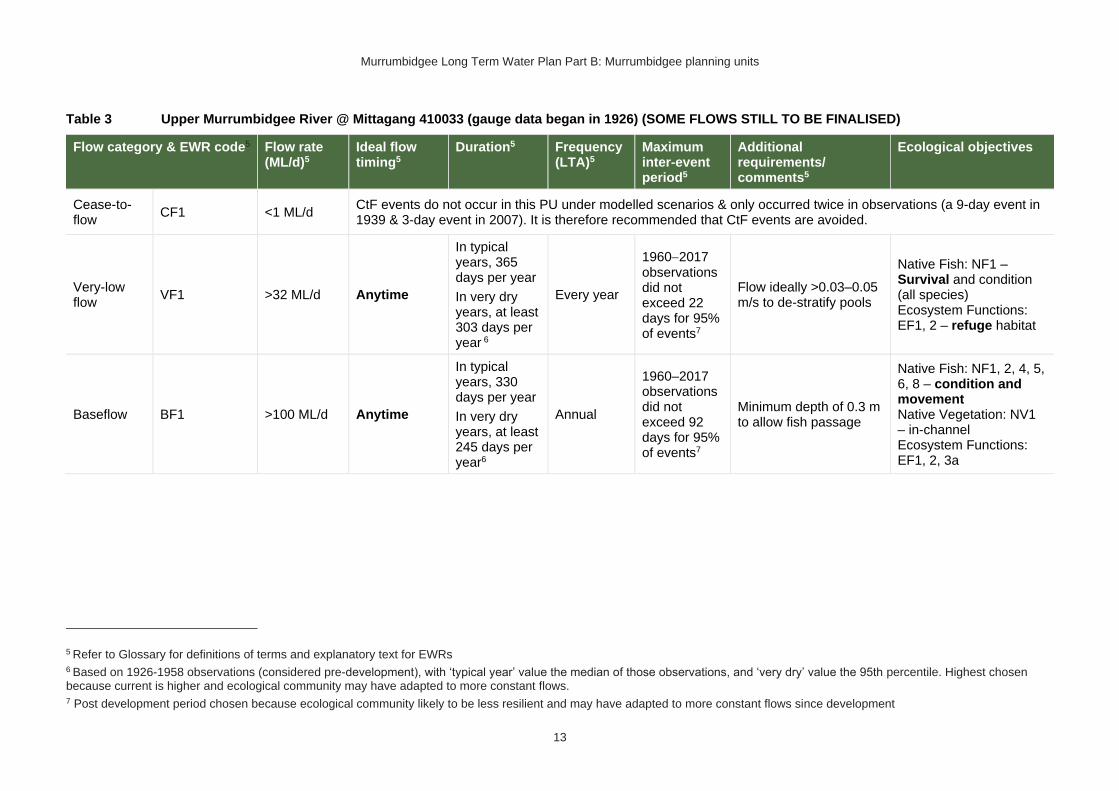
Table 3 Upper Murrumbidgee River @ Mittagang 410033 (gauge data began in 1926) (SOME FLOWS STILL TO BE FINALISED)
Flow category & EWR code5 Flow rate (ML/d)5
Ideal flow timing5
Duration5 Frequency (LTA)5
Maximum inter-event period5
Additional requirements/ comments5
Ecological objectives
Cease-to-flow
CF1 <1 ML/d CtF events do not occur in this PU under modelled scenarios & only occurred twice in observations (a 9-day event in 1939 & 3-day event in 2007). It is therefore recommended that CtF events are avoided.
Very-low flow
VF1 >32 ML/d Anytime
In typical years, 365 days per year
In very dry years, at least 303 days per year 6
Every year
1960−2017 observations did not exceed 22 days for 95% of events7
Flow ideally >0.03–0.05 m/s to de-stratify pools
Native Fish: NF1 – Survival and condition (all species) Ecosystem Functions: EF1, 2 – refuge habitat
Baseflow BF1 >100 ML/d Anytime
In typical years, 330 days per year
In very dry years, at least 245 days per year6
Annual
1960–2017 observations did not exceed 92 days for 95% of events7
Minimum depth of 0.3 m to allow fish passage
Native Fish: NF1, 2, 4, 5, 6, 8 – condition and movement Native Vegetation: NV1 – in-channel Ecosystem Functions: EF1, 2, 3a
5 Refer to Glossary for definitions of terms and explanatory text for EWRs 6 Based on 1926-1958 observations (considered pre-development), with ‘typical year’ value the median of those observations, and ‘very dry’ value the 95th percentile. Highest chosen because current is higher and ecological community may have adapted to more constant flows. 7 Post development period chosen because ecological community likely to be less resilient and may have adapted to more constant flows since development

Murrumbidgee Long Term Water Plan Part B: Murrumbidgee planning units
14
Flow category & EWR code5 Flow rate (ML/d)5
Ideal flow timing5
Duration5 Frequency (LTA)5
Maximum inter-event period5
Additional requirements/ comments5
Ecological objectives
Nesting Support
NestS1 To be determined8
1 Oct − 31 Dec for cod
(Only apply EWR if flows are in the BF or SF range at start of period)
60 days minimum
5–10 years in 10
(75% of years)
2 years
Allow variable flows but avoid large sudden decreases in water level to prevent loss of nesting sites. Flow decreases not to exceed 20th percentile of modelled natural rate of fall (the fastest 20% of natural rates of fall - calculated from the modelled 'without-development' flow data).
For Macquarie perch and Murray and trout cod breeding
Native Fish NF5, 6, 8 - Nesting of riverine specialists (protect nesting sites by avoiding rapid changes in water levels)
Native Vegetation: NV1 – in-channel & riparian
Small fresh SF1 To be determined8
Anytime – but ideally Oct
− Apr, & ideally 2–3 weeks after ‘LF2’
10 days minimum
2 events per year
1 year
>20°C for Oct – Apr (for native fish); for Macquarie perch>16°C; for Murray cod Sept to Dec >18°C
Minimum depth of 0.5 m to allow movement of large fish
Rate of fall: No faster than 5th percentile of natural
Native Fish: NF1, 2, 4, 5, 6, 8 – Dispersal/condition (all species) Native Vegetation: NV1 – in-channel Ecosystem Functions: EF1, 2, 3a, 4, 5
8 The estimate of these thresholds is subject to further work

Murrumbidgee Long Term Water Plan Part B: Murrumbidgee planning units
15
Flow category & EWR code5 Flow rate (ML/d)5
Ideal flow timing5
Duration5 Frequency (LTA)5
Maximum inter-event period5
Additional requirements/ comments5
Ecological objectives
Flow ideally up to
0.3−0.4 m/s (depending on channel form)
SF2 To be determined8
15 Sept − Apr 14 days minimum
5–10 years in 10
(75% of years)
2 years
>20°C for Oct – Apr (for native fish); for Macquarie perch>16°C; for Murray cod Sept to Dec >18°C Minimum depth of 0.5 m to allow movement of large fish
Rate of fall: No faster than 5th percentile of natural
Flow ideally up to
0.3−0.4 m/s (depending on channel form)
Native Fish: NF1, 2, 5, 6, 8 – Spawning (river specialists, generalists) Native Vegetation: NV1 – in-channel Ecosystem Functions: EF1, 2, 3, 4, 5
SF3 To be determined8
Aug-1 Oct (ideally with other events through the year)
2 days minimum
Annual, ideally multiple events per year
2 years
Macquarie perch release eggs that lodge in riffle gravels and cobbles, therefore require clean riffle gravels prior to spawning
Native Fish: NF1, 5, 8 – Spawning (river specialists)
Ecosystem Functions: EF2, 3, 4, 5 – Flushing riffle habitat
Large fresh LF1 To be determined8
Anytime – but ideally
July − Sept
Consider delivery outside cod breeding season to
5 days minimum
5–10 years in 10
(75% of years)
2 years
Minimum depth of 2 m to cover in-stream features & trigger response from fish
Flow ideally 0.3−0.4 m/s (depending on channel form)
Native Fish: NF1, 2, 4, 5, 6, 8 – dispersal/condition (all species) Native Vegetation: NV1 – in-channel/ riparian Ecosystem Functions: EF2, 3a, 4, 5, 6

Murrumbidgee Long Term Water Plan Part B: Murrumbidgee planning units
16
Flow category & EWR code5 Flow rate (ML/d)5
Ideal flow timing5
Duration5 Frequency (LTA)5
Maximum inter-event period5
Additional requirements/ comments5
Ecological objectives
avoid flushing of nests.
Rate of fall: No faster than 5th percentile of natural
LF2 To be determined8
Oct − Apr
Consider delivery outside cod breeding season to avoid flushing of nests.
5 days minimum
6–7 years in 10
(65% of years)
2 years
Minimum depth of 2 m to cover in-stream features & trigger response from fish
Flow ideally 0.3−0.4 m/s (depending on channel form)
Rapid rise (comparable to natural rates) >17°C
Ideally follow 2–3 weeks later with SF1 for improved fish recruitment, productivity and dispersal.
Rate of fall: No faster than 5th percentile of natural
Native Fish: NF1, 4, 6 – spawning (flow pulse specialists) Native Vegetation: NV1 – in-channel Ecosystem Functions: EF2, 3, 4, 5, 6
LF3 To be determined8
15 July - 1 Oct
ideally deliver outside cod/ Macquarie perch breeding season to avoid flushing of eggs.
2 days minimum
5–10 years in 10
(75% of years)
2 years
For the flushing of pools. Macquarie perch prefer deep, rocky pools.
Native Fish: NF1, 5, 8 – Habitat maintenance (river specialists)
Ecosystem Functions: EF2, 3, 4, 5 – Flushing pool habitats
W-LF4 (core wetland & off-
Not applicable – limited off-channel wetlands below bank full in this PU

Murrumbidgee Long Term Water Plan Part B: Murrumbidgee planning units
17
Flow category & EWR code5 Flow rate (ML/d)5
Ideal flow timing5
Duration5 Frequency (LTA)5
Maximum inter-event period5
Additional requirements/ comments5
Ecological objectives
LF with wetland connection
(below bankfull: in the upper part of the ‘LF’ band)
channel fish refuge)
W-LF5 (Floodplain specialist fish spawning)
W-LF6 (Fish dispersal & condition)
W-LF7 (Non- woody veg zone – also for frog recruitment)
W-LF8 (fish connect flow)
Floodplain Connection Flow (Overbank Small 1)
(Floodplain specialist fish)
OB-Small 1 (Floodplain specialist fish)
Not applicable: The specific objectives for floodplain specialist fish (NF3, NF7) are not prioritised for this PU.
Floodplain Connection Flow (Overbank Small 2)
OB-Small 2 (fringing veg of the bank crest – river she-oak (Casuarina cunninghamia & other native
5000 ML/d Aug − Feb, with benefits also outside that period.
Consider potential effects on platypus from
In line with natural median duration for fish dispersal & riparian communities.
5–10 years in 10
(75% of years)
4 years The provision of periods of successive flows will also increase potential to improve the recovery & condition of existing riparian vegetation.
Native Fish: NF1, 2, 4, 5, 6, 8 – dispersal and condition (all species)
Native Vegetation: NV2, river red gum (riparian and floodplain wetland)
Ecosystem Functions: EF2, 3a, 4, 5, 6 –

Murrumbidgee Long Term Water Plan Part B: Murrumbidgee planning units
18
Flow category & EWR code5 Flow rate (ML/d)5
Ideal flow timing5
Duration5 Frequency (LTA)5
Maximum inter-event period5
Additional requirements/ comments5
Ecological objectives
(River red gum zone)
9*
veg in this PU))
bankfull flows from late Nov to early Jan10
For streamside areas, only duration to fill the soil profile, depressions required.
The median observed duration for flows of this size is around 2 days. We analysed for cumulative flows of 2 days duration, made up of individual events of a minimum of 1 day within season11
channel forming, lateral connectivity, productivity
Large Floodplain
OB Large 1 Not applicable – Black box & colonial waterbird breeding not a feature of this PU.
9 Grey background (and * in the first column of the row) denotes flows of this size may not be able to be delivered as environmental water deliveries in the river. They require tributary rainfall events or dam spills, although timely deliveries ‘piggy backed’ on top of moderate unregulated events may reach the threshold. Note that flows to this zone can be delivered, but this is limited by the need to avoid unacceptable impacts on third parties
10 See Serena and Grant (2017): bankfull flows from late November to early January, when juvenile platypus are confined to the nesting burrow, reduces recruitment
11 The information in italics is not meant to be prescriptive. It notes the median duration of past flow events of this size as a guideline. Where cumulative durations are noted, the minimum duration of individual events which make up that cumulative total (again only provided for guidance) is based on the 25th percentile duration of events of this size.
Murrumbidgee Long Term Water Plan Part B: Murrumbidgee planning units
19
Flow category & EWR code5 Flow rate (ML/d)5
Ideal flow timing5
Duration5 Frequency (LTA)5
Maximum inter-event period5
Additional requirements/ comments5
Ecological objectives
Connection Flow (Overbank Large 1)
(Black box zone)

Murrumbidgee Long Term Water Plan Part B: Murrumbidgee planning units
20
PU2: Tumut River below Blowering Dam
The Tumut River below Blowering Dam is situated within the Murrumbidgee Central (Burrinjuck to Gogeldrie) Water Source. It is regulated by Blowering Dam & receives flows from several tributaries. There is a constraint on deliveries of 9,300 ML/day at Tumut to avoid unwanted inundation.
Figure 3 Map of Tumut River below Blowering Dam PU. Area outside of PU has been faded. Significant gauges relevant to the PU are Tumut @ Tumut (410006) and Tumut @ Brungle Bridge (410039)
Key ecological values
(CE = Critically Endangered, E = Endangered, V = Vulnerable, EP= Endangered Population in MDB, C = CAMBA, J = JAMBA, R = ROKAMBA, X = species recorded in this planning unit via catch records and or Australian Museum Records where they exist, Y = species expected to occur based on MaxEnt modelling, Z= based on expert DPI Fisheries opinion)
Native fish
• Australian smelt X
• carp-gudgeon species complex X
• dwarf flat-headed gudgeon Z
• flat-headed galaxias (CE) Y
• flat-headed gudgeon X
• golden perch X
• Macquarie perch (E) Y
• mountain galaxias X
• Murray cod (V) Z
• Murray crayfish (V)X
• northern river blackfish X
• obscure galaxias Z
• riffle galaxias Z
• silver perch (V) Y
• southern pygmy perch (E) X
• trout cod (E) Y
• two-spined blackfish Z
• unspecked hardyhead Y

Murrumbidgee Long Term Water Plan Part B: Murrumbidgee planning units
21
Waterbirds 28 waterbird species recorded including Latham's snipe (J,K)
Native vegetation 1465 ha of water-dependent native vegetation communities including 1238 ha of river red gum & 3 ha non-woody wetland vegetation
Native fish objectives
NF1 No loss of native fish species
NF2 Increase the distribution & abundance of short to moderate-lived generalists: Australian smelt, carp-gudgeon species complex, flat-headed gudgeon, dwarf flat-headed gudgeon, mountain galaxias, obscure galaxias, riffle galaxias
NF4 Improve population structure for moderate to long-lived flow pulse specialists: golden perch
NF5 Improve population structure for moderate to long-lived riverine specialists: Murray Cod, river blackfish, two-spined blackfish, southern pygmy perch
NF6 A 25% increase in abundance of mature (harvestable sized): golden perch, Murray Cod
NF7 Increase the prevalence &/or expand the population of key short to moderate-lived floodplain specialist native fish species into new areas (within historical range): flat-headed galaxias, southern pygmy perch
Hydrology
Hydrological alteration
See Table 1 for key
Regulated river reach
CtF Low flow & baseflow
Freshes High & infrequent flows
1.5ARI 2.5ARI 5ARI
Tumut River at Oddys Bridge
N/A H+ H+ M- H- H-
Other hydrology information
Section 4.6 of Part A of the Murrumbidgee LTWP provides information about changes in hydrology in this PU
Relevant rules from WSP
Murrumbidgee Central (Burrinjuck to Gogeldrie) Water Source:
Access rules*:
Rivers & creeks: pumping is not permitted from natural pools when the water level in the pool is lower than its full capacity.
Note: Some licences in this water source have a different CtP. Please see schedules 2 & 3 of the WSP.
Natural off-river pools: pumping is not permitted from an off-river pool or an off-river dam pool when the volume of water in that pool is less than 80% of the full capacity of the natural pool that existed prior to any augmentation works.
Trading rules:
INTO water source: No trade allowed
WITHIN water source: Allowed, but no trade into off river pools
*Note: These access rules do not apply:
1. if the existing Water Act 1912 entitlement had more stringent access licence conditions.
2. to major water utility, local water utility or unregulated river (town water supply) access licences
3. to water taken for domestic consumption by stock & domestic access licences
4. for the first 5 years of the plan to water taken for stock watering by stock & domestic access licences
5. to water taken from existing dams. Any existing licence conditions associated with a dam will be carried forward under the plan.
There are 12 very small (<250 ML) & 1 small (250–500 ML) unregulated water access licences distributed throughout the PU. The total volume of unregulated entitlements for the PU is 906 ML of which 899 ML is allocated for irrigation (rather than stock & domestic or town water supply).
Recommended management strategies
MS2: Ensure compliance with water access licence conditions including through metering of all licensed extraction.

Murrumbidgee Long Term Water Plan Part B: Murrumbidgee planning units
22
MS3: As a minimum, maintain existing rules in the WSP for the Murrumbidgee Unregulated Water Sources that protect environmental assets and values.
MS4: Monitor for changes in water demand and review access rules if current usage is high or if the pattern of use changes.
Note: Section 7.2 of Part A of the Murrumbidgee LTWP also identifies the investigation of modifications to Blowering Dam to reduce thermal (cold water) pollution as a priority investment opportunity
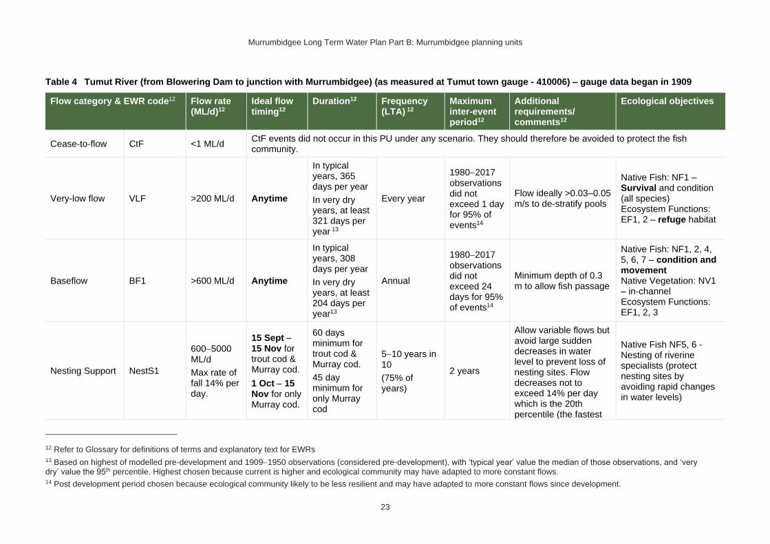
Murrumbidgee Long Term Water Plan Part B: Murrumbidgee planning units
23
Table 4 Tumut River (from Blowering Dam to junction with Murrumbidgee) (as measured at Tumut town gauge - 410006) – gauge data began in 1909
Flow category & EWR code12 Flow rate (ML/d)12
Ideal flow timing12
Duration12 Frequency (LTA) 12
Maximum inter-event period12
Additional requirements/ comments12
Ecological objectives
Cease-to-flow CtF <1 ML/d CtF events did not occur in this PU under any scenario. They should therefore be avoided to protect the fish community.
Very-low flow VLF >200 ML/d Anytime
In typical years, 365 days per year
In very dry years, at least 321 days per year 13
Every year
1980−2017 observations did not exceed 1 day for 95% of events14
Flow ideally >0.03–0.05 m/s to de-stratify pools
Native Fish: NF1 – Survival and condition (all species) Ecosystem Functions: EF1, 2 – refuge habitat
Baseflow BF1 >600 ML/d Anytime
In typical years, 308 days per year
In very dry years, at least 204 days per year13
Annual
1980−2017 observations did not exceed 24 days for 95% of events14
Minimum depth of 0.3 m to allow fish passage
Native Fish: NF1, 2, 4, 5, 6, 7 – condition and movement Native Vegetation: NV1 – in-channel Ecosystem Functions: EF1, 2, 3
Nesting Support NestS1
600−5000 ML/d
Max rate of fall 14% per day.
15 Sept − 15 Nov for trout cod & Murray cod.
1 Oct − 15 Nov for only Murray cod.
60 days minimum for trout cod & Murray cod.
45 day minimum for only Murray cod
5−10 years in 10
(75% of years)
2 years
Allow variable flows but avoid large sudden decreases in water level to prevent loss of nesting sites. Flow decreases not to exceed 14% per day which is the 20th percentile (the fastest
Native Fish NF5, 6 - Nesting of riverine specialists (protect nesting sites by avoiding rapid changes in water levels)
12 Refer to Glossary for definitions of terms and explanatory text for EWRs
13 Based on highest of modelled pre-development and 1909−1950 observations (considered pre-development), with ‘typical year’ value the median of those observations, and ‘very dry’ value the 95th percentile. Highest chosen because current is higher and ecological community may have adapted to more constant flows. 14 Post development period chosen because ecological community likely to be less resilient and may have adapted to more constant flows since development.

Murrumbidgee Long Term Water Plan Part B: Murrumbidgee planning units
24
Flow category & EWR code12 Flow rate (ML/d)12
Ideal flow timing12
Duration12 Frequency (LTA) 12
Maximum inter-event period12
Additional requirements/ comments12
Ecological objectives
(Only apply EWR if flows are in the BF or SF range at start of period)
20%) of fall - calculated from observed ‘pre-development' flow data (1909-1950)
Native Vegetation: NV1,3 – in-channel & riparian
Small fresh SF1 >1400 ML/d
Anytime − but ideally
Oct − Apr, &
ideally 2−3 weeks after ‘LF2’
10 days minimum
2 events per year
1 year
>20°C for Oct – Apr (for native fish); for river blackfish >16°C; for Murray cod Sept to Dec >18°C
Minimum depth of 0.5 m to allow movement of large fish
Rate of fall: No faster than 26% per day15
Flow ideally up to
0.3−0.4 m/s (depending on channel form)
Note flows of small fresh & LF size have become more constant & less in line with natural season. There would be some benefit from having gaps in these flows & drying of banks & benches at appropriate times,
Native Fish: NF1, 2, 3, 4, 5, 6, 7 – Dispersal/condition (all species) Native Vegetation: NV1 – in-channel Ecosystem Functions: EF1, 2, 3, 4, 5
15 The 5th percentile (fastest 5% of rates of fall) of ‘pre-development’ 1909-1950 observed flows
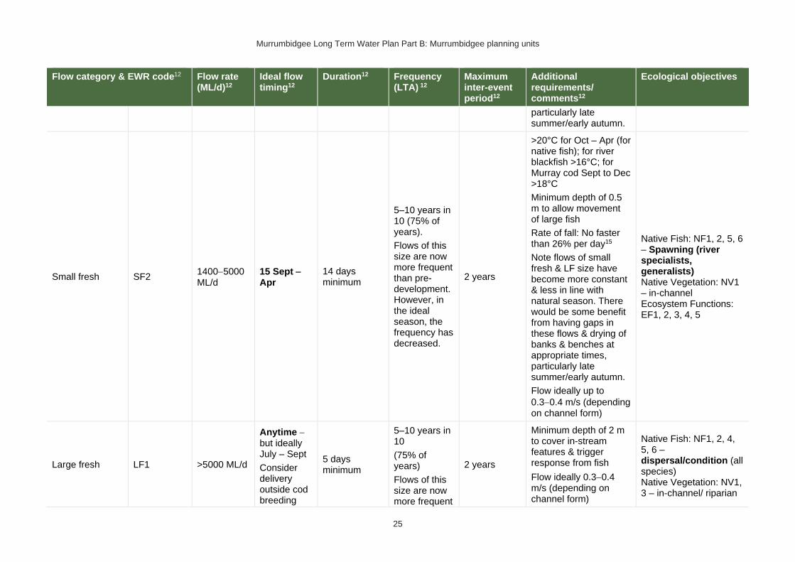
Murrumbidgee Long Term Water Plan Part B: Murrumbidgee planning units
25
Flow category & EWR code12 Flow rate (ML/d)12
Ideal flow timing12
Duration12 Frequency (LTA) 12
Maximum inter-event period12
Additional requirements/ comments12
Ecological objectives
particularly late summer/early autumn.
Small fresh SF2 1400−5000 ML/d
15 Sept − Apr
14 days minimum
5–10 years in 10 (75% of years).
Flows of this size are now more frequent than pre-development. However, in the ideal season, the frequency has decreased.
2 years
>20°C for Oct – Apr (for native fish); for river blackfish >16°C; for Murray cod Sept to Dec >18°C
Minimum depth of 0.5 m to allow movement of large fish
Rate of fall: No faster than 26% per day15
Note flows of small fresh & LF size have become more constant & less in line with natural season. There would be some benefit from having gaps in these flows & drying of banks & benches at appropriate times, particularly late summer/early autumn.
Flow ideally up to
0.3−0.4 m/s (depending on channel form)
Native Fish: NF1, 2, 5, 6 – Spawning (river specialists, generalists) Native Vegetation: NV1 – in-channel Ecosystem Functions: EF1, 2, 3, 4, 5
Large fresh LF1 >5000 ML/d
Anytime − but ideally July – Sept
Consider delivery outside cod breeding
5 days minimum
5–10 years in 10
(75% of years)
Flows of this size are now more frequent
2 years
Minimum depth of 2 m to cover in-stream features & trigger response from fish
Flow ideally 0.3−0.4 m/s (depending on channel form)
Native Fish: NF1, 2, 4, 5, 6 – dispersal/condition (all species) Native Vegetation: NV1, 3 – in-channel/ riparian

Murrumbidgee Long Term Water Plan Part B: Murrumbidgee planning units
26
Flow category & EWR code12 Flow rate (ML/d)12
Ideal flow timing12
Duration12 Frequency (LTA) 12
Maximum inter-event period12
Additional requirements/ comments12
Ecological objectives
season to avoid flushing of nests.
than pre-development. However, in the ideal season, the frequency has decreased.
Rate of fall: No faster than 29% per day15
Note flows of SF & LF size have become more constant & less in line with natural season. There would be some benefit from having gaps in these flows & drying of banks & benches at appropriate times, particularly late summer/early autumn.
Ecosystem Functions: EF2, 3, 4, 5, 6
Large fresh LF2 >5000 ML/d
Oct − Apr
Consider delivery outside cod breeding season to avoid flushing of nests.
5 days minimum
6–7 years in 10
(65% of years)
Flows of this size are now more frequent than pre-development.
2 years
Minimum depth of 2 m to cover in-stream features & trigger response from fish
Flow ideally 0.3−0.4 m/s (depending on channel form)
Rapid rise (comparable to natural rates) >17°C
Ideally follow 2–3 weeks later with SF1 for improved fish recruitment, productivity and dispersal.
Rate of fall: No faster than 29% per day15
Note flows of SF & LF size have become
Native Fish: NF1, 4, 6 – spawning (flow pulse specialists) Native Vegetation: NV1 – in-channel Ecosystem Functions: EF2, 3, 4, 5, 6

Murrumbidgee Long Term Water Plan Part B: Murrumbidgee planning units
27
Flow category & EWR code12 Flow rate (ML/d)12
Ideal flow timing12
Duration12 Frequency (LTA) 12
Maximum inter-event period12
Additional requirements/ comments12
Ecological objectives
more constant & less in line with natural season. There would be some benefit from having gaps in these flows & drying of banks & benches at appropriate times, particularly late summer/early autumn.
Large fresh with wetland connection16,17#
(below bankfull: in the upper part of the ‘LF’ band)
W-LF4 (core wetland & off-channel fish refuge)
>11,000 ML/d – not deliverable
Anytime – but ideally July – Feb for non-woody vegetation
7−12 months water retention for non-woody vegetation. Permanent for key floodplain specialist refuge pools.
The median modelled natural duration for flows of this size is around 3 days. We analysed for cumulative
8–10 years in 10
(90% of years)
18 months (but no drying out of refuge pools for floodplain specialist native fish)
In dry years maintaining refuge pools for floodplain specialist native fish may require pumping.
Native Fish: NF1, 5 – Habitat maintenance (river specialists)
Ecosystem Functions: EF2, 3, 4, 5 – Flushing pool habitats
16 In other catchments, connection to major wetlands systems would generally occur at and above bankfull level. The geomorphology of the Murrumbidgee system is such that major billabong, anabranch and other off-channel wetland systems are connected below bankfull level. Hence the category of ‘wetland connecting flow is used in the Murrumbidgee. 17 Grey background (and # in the 1st column of the row) denotes flows of this size are not able to be delivered in the river. The flows occur due to tributary rainfall events or dam spills. Deliveries to these areas are only possible with pumping or where other infrastructure exists to divert water to the floodplain. In such cases carp exclusion devices should be used where possible.

Murrumbidgee Long Term Water Plan Part B: Murrumbidgee planning units
28
Flow category & EWR code12 Flow rate (ML/d)12
Ideal flow timing12
Duration12 Frequency (LTA) 12
Maximum inter-event period12
Additional requirements/ comments12
Ecological objectives
flows of 3 days duration, made up of individual events of a minimum of 1 day within season
W-LF5 (Floodplain specialist fish spawning)
Not relevant as a river flow because the required frequency of 10-day flows in 50% to 70% of years is not met in this PU in the pre-development modelled scenario or in pre-1950s observations. However, there may be target sites for filling with infrastructure (where possible with carp screens or other exclusion devices) where populations of flat-headed galaxias and southern pygmy perch can be re-established.
W-LF6
(Fish dispersal & condition)
>11,000 ML/d – not deliverable
Anytime – but ideally Sept – Feb
5 days minimum for fish dispersal
2−3 years in 10
(1 every 3−5 years)
(25% of years)
5 years
Native Fish: NF1, 2, 4, 5, 6, 7 – dispersal & condition (all species) Native Vegetation: NV1, 2, 3 – riparian river red gum communities Ecosystem Functions: EF2, 3, 4, 5, 6 – lateral floodplain, productivity, bench and pool forming
W-LF7 (Non- woody veg zone – also for frog recruitment)
>11,000 ML/d – not deliverable
July − Feb flow timing.
There are benefits also outside that period including by providing bird foraging habitat
3−10 months. Refers to the persistence of standing water (minimum 3-7 months depending on vegetation community)
6-8 years in 10
(70% of years)
2 years
For best benefits duration of standing water of at least 90 days is required during the growing season (from Sept on). Also note that some frog species are summer breeders so will need at least 3 months from Oct.
Native Fish: NF1, 2, 4, 5, 6, 7 – dispersal & condition (all species)
Native Vegetation: NV2, 3, 4 – Non-woody vegetation in wetlands, river red gum forest fringing wetlands/channels
Ecosystem Function: EF1, 2, 3, 4, 5, 6 – core

Murrumbidgee Long Term Water Plan Part B: Murrumbidgee planning units
29
Flow category & EWR code12 Flow rate (ML/d)12
Ideal flow timing12
Duration12 Frequency (LTA) 12
Maximum inter-event period12
Additional requirements/ comments12
Ecological objectives
The median modelled natural duration for flows of this size is around 3 days. We analysed for cumulative flows of 3 days duration, made up of individual events of a minimum of 1 day within season
To increase cover & extent of non-woody vegetation communities
− clustered, sequenced flows (i.e. annual flows
over 2−3 years) are required.
The provision of periods of higher flow magnitude & successive flows also has the potential to increase non-woody vegetation cover & extent &/or limit encroachment of woody species (if desired).
wetland habitats, lateral connectivity, productivity
W-LF8 (fish connect flow)
>11,000 ML/d – not deliverable
Anytime18, but triggered by significant fish breeding in off-channel wetlands
Flow 3–18 months after breeding occurs
Flow must occur before
5 days
3 years in 10 or as required by breeding triggers
(30% of years)
5 years
Ideally provide a protracted recession to promote exit to the river.
This is for within 3−18 months so long as sufficient habitat (depth, cover) is maintained in the wetland to support the strong 0+ cohort until
re-connection occurs −
Native Fish: NF1, 2, 4, 5, 6, 7 – dispersal from off channel wetlands (all species) Native Vegetation: NV1, 2, 3 Ecosystem Functions: EF2, 3, 4, 5, 6 – connectivity
18 Return movement may vary seasonally, so future research will inform any necessary refinement in the timing of this.

Murrumbidgee Long Term Water Plan Part B: Murrumbidgee planning units
30
Flow category & EWR code12 Flow rate (ML/d)12
Ideal flow timing12
Duration12 Frequency (LTA) 12
Maximum inter-event period12
Additional requirements/ comments12
Ecological objectives
habitat (depth, cover, water quality) of waterbody is lost by drying
may be wetland specific
Trigger is verified breeding event. Where there has been insufficient monitoring to confirm/deny this, the trigger is a long duration wetland connecting LF (W-LF5) or an overbank (OB-S1, OB-S2 or OB-L1) in those PUs where these have been shown to produce significant breeding responses. The 3+ month delay following the breeding event is to allow recruits to use the nursey to move into the river & reach sufficient maturity to move into the river
#Floodplain Connection Flow (Overbank Small 1)17
(Floodplain specialist fish)
OB-Small 1 (Floodplain specialist fish)
Not relevant as a river flow because the required frequency of 10-day flows in 50% to 70% of years is not met in this PU in the pre-development modelled scenario or in pre-1950s observations. However, there may be target sites for filling with infrastructure (where possible with carp screens or other exclusion devices) where populations of flat-headed galaxias and southern pygmy perch can be re-established.
#Floodplain Connection Flow (Overbank Small 2)
OB-Small 2 River red gum zone)
18,000 ML/d – not deliverable
Aug − Feb, with benefits also outside that period including by
In line with natural median duration for fish dispersal
5−10 years in 10
(75% of years)
4 years To support river red gum flowering, seed set and seedling
establishment − clustered, sequenced
Native Fish: NF1, 2, 4, 5, 6, 7– dispersal and condition (all species)

Murrumbidgee Long Term Water Plan Part B: Murrumbidgee planning units
31
Flow category & EWR code12 Flow rate (ML/d)12
Ideal flow timing12
Duration12 Frequency (LTA) 12
Maximum inter-event period12
Additional requirements/ comments12
Ecological objectives
(River red gum zone)17
providing bird foraging habitat
& riparian river red gum communities.
For wetlands
3−7 months’ persistence of standing water. For streamside areas, only duration to fill the soil profile, depressions/ billabongs required.
The median observed duration for flows of this size is around 2 days. We analysed for cumulative flows of 2 days duration, made up of individual events of a minimum of 1 day within season19
flows (i.e. annual flows
over 2−3 years) are required. The provision of periods of successive flows will also improve the condition of existing river red gum.
For timing: flow can occur earlier, but for best benefits, duration of standing water of at least 90 days is required from Sept on to fit with vegetation growing season & bird breeding seasonality. Also note that some frog species are summer breeders, which, when a target for flows, will need at least 3 months from Oct.
Native Vegetation: NV2, 3, 4a, 4b, river red gum (riparian and floodplain wetland)
Ecosystem Functions: EF2, 3, 4, 5, 6 – channel forming, lateral connectivity, productivity
19 The information in italics is not meant to be prescriptive. It notes the median duration of past flow events of this size as a guideline. Where cumulative durations are noted, the minimum duration of individual events which make up that cumulative total (again only provided for guidance) is based on the 25th percentile duration of events of this size.

Murrumbidgee Long Term Water Plan Part B: Murrumbidgee planning units
32
Flow category & EWR code12 Flow rate (ML/d)12
Ideal flow timing12
Duration12 Frequency (LTA) 12
Maximum inter-event period12
Additional requirements/ comments12
Ecological objectives
Large Floodplain Connection Flow (Overbank Large 1)
(Black box zone)
OB Large 1 (Black box zone)
Not applicable – Black box & colonial waterbird breeding not a feature of this PU

Murrumbidgee Long Term Water Plan Part B: Murrumbidgee planning units
33
PU3: Murrumbidgee River – Burrinjuck to Tumut Junction
The Murrumbidgee River – Burrinjuck to Tumut Junction PU is situated within the Murrumbidgee Central (Burrinjuck to Gogeldrie) Water Source.
This section of the Murrumbidgee River is regulated by Burrinjuck Dam and receives unregulated inflows from tributary streams.
Figure 4 Map of Upper Murrumbidgee River – Burrinjuck to Tumut Junction PU. Area outside of PU has been faded. Significant gauge relevant to the PU is Murrumbidgee @ Gobarralong (410195)
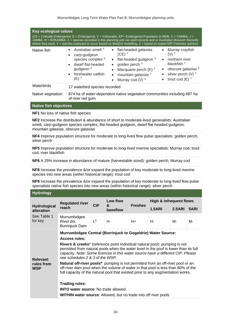
Murrumbidgee Long Term Water Plan Part B: Murrumbidgee planning units
34
Key ecological values
(CE = Critically Endangered, E = Endangered, V = Vulnerable, EP= Endangered Population in MDB, C = CAMBA, J = JAMBA, R = ROKAMBA, X = species recorded in this planning unit via catch records and or Australian Museum Records where they exist, Y = species expected to occur based on MaxEnt modelling, Z = based on expert DPI Fisheries opinion)
Native fish • Australian smelt X
• carp-gudgeon species complex X
• dwarf flat-headed gudgeon Z
• freshwater catfish (E) Y
• flat-headed galaxias (CE) Y
• flat-headed gudgeon X
• golden perch X
• Macquarie perch (E) Y
• mountain galaxias Y
• Murray cod (V) X
• Murray crayfish (V) Z
• northern river blackfish Y
• obscure galaxias Z
• silver perch (V) Y
• trout cod (E) Y
Waterbirds 17 waterbird species recorded
Native vegetation 874 ha of water-dependent native vegetation communities including 687 ha of river red gum
Native fish objectives
NF1 No loss of native fish species
NF2 Increase the distribution & abundance of short to moderate-lived generalists: Australian smelt, carp-gudgeon species complex, flat-headed gudgeon, dwarf flat-headed gudgeon, mountain galaxias, obscure galaxias
NF4 Improve population structure for moderate to long-lived flow pulse specialists: golden perch, silver perch
NF5 Improve population structure for moderate to long-lived riverine specialists: Murray cod, trout cod, river blackfish
NF6 A 25% increase in abundance of mature (harvestable sized): golden perch, Murray cod
NF8 Increase the prevalence &/or expand the population of key moderate to long-lived riverine species into new areas (within historical range): trout cod
NF9 Increase the prevalence &/or expand the population of key moderate to long-lived flow pulse specialists native fish species into new areas (within historical range): silver perch
Hydrology
Hydrological alteration
See Table 1 for key
Regulated river reach
CtF Low flow & baseflow
Freshes High & infrequent flows
1.5ARI 2.5ARI 5ARI
Murrumbidgee River d/s Burrinjuck Dam
L0 H- H+ H- M- M-
Relevant rules from WSP
Murrumbidgee Central (Burrinjuck to Gogeldrie) Water Source:
Access rules:
Rivers & creeks* (reference point Individual natural pool): pumping is not permitted from natural pools when the water level in the pool is lower than its full capacity. Note: Some licences in this water source have a different CtP. Please see schedules 2 & 3 of the WSP.
Natural off-river pools*: pumping is not permitted from an off-river pool or an off-river dam pool when the volume of water in that pool is less than 80% of the full capacity of the natural pool that existed prior to any augmentation works.
Trading rules:
INTO water source: No trade allowed
WITHIN water source: Allowed, but no trade into off river pools

Murrumbidgee Long Term Water Plan Part B: Murrumbidgee planning units
35
*Note: These access rules do not apply:
1. if the existing Water Act 1912 entitlement had more stringent access licence conditions
2. to major water utility, local water utility or unregulated river (town water supply) access licences
3. to water taken for domestic consumption by stock & domestic access licences
4. for the first 5 years of the plan to water taken for stock watering by stock & domestic access licences
5. to water taken from existing dams. Any existing licence conditions associated with a dam will be carried forward under the plan
There is one very small (<250 ML) unregulated water access licences distributed throughout the PU. The total volume of unregulated entitlements for the PU is 18 ML of which 18 ML is allocated for irrigation (rather than stock & domestic or town water supply).
Recommended management strategies
MS2: Ensure compliance with water access licence conditions including through metering of all licensed extraction.
MS3: As a minimum, maintain existing rules in the WSP for the Murrumbidgee Unregulated Water Sources that protect environmental assets and values.
MS4: Monitor for changes in water demand and review access rules if current usage is high or if the pattern of use changes.
Note: Section 7.2 of Part A of the Murrumbidgee LTWP also identifies the investigation of modifications to Burrinjuck Dam to reduce thermal (cold water) pollution as a priority investment opportunity
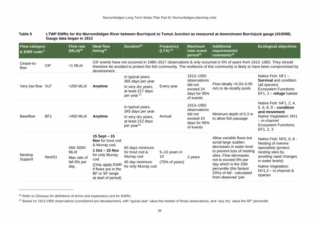
Murrumbidgee Long Term Water Plan Part B: Murrumbidgee planning units
36
Table 5 LTWP EWRs for the Murrumbidgee River between Burrinjuck to Tumut Junction as measured at downstream Burrinjuck gauge (410008). Gauge data began in 1913
Flow category
& EWR code20
Flow rate (ML/d)20
Ideal flow timing20
Duration20 Frequency (LTA) 20
Maximum inter-event period20
Additional requirements/ comments20
Ecological objectives
Cease-to-flow
CtF <1 ML/d CtF events have not occurred in 1980–2017 observations & only occurred in 5% of years from 1913−1950. They should therefore be avoided to protect the fish community. The resilience of this community is likely to have been compromised by development.
Very low flow VLF >250 ML/d Anytime
In typical years, 365 days per year
In very dry years, at least 217 days per year 21
Every year
1913–1950 observations did not exceed 24 days for 95% of events
Flow ideally >0.03–0.05 m/s to de-stratify pools
Native Fish: NF1 – Survival and condition (all species) Ecosystem Functions: EF1, 2 – refuge habitat
Baseflow BF1 >450 ML/d Anytime
In typical years, 345 days per year
In very dry years, at least 212 days per year21
Annual
1913–1950 observations did not exceed 24 days for 95% of events
Minimum depth of 0.3 m to allow fish passage
Native Fish: NF1, 2, 4, 5, 6, 8, 9 – condition and movement Native Vegetation: NV1 – in-channel Ecosystem Functions: EF1, 2, 3
Nesting Support
NestS1
450–5000 ML/d
Max rate of fall 9% per day.
15 Sept – 15 Nov for trout cod & Murray cod.
1 Oct – 15 Nov for only Murray cod.
(Only apply EWR if flows are in the BF or SF range at start of period)
60 days minimum for trout cod & Murray cod
45 day minimum for only Murray cod
5–10 years in 10
(75% of years)
2 years
Allow variable flows but avoid large sudden decreases in water level to prevent loss of nesting sites. Flow decreases not to exceed 9% per day which is the 20th percentile (the fastest 20%) of fall - calculated from observed ‘pre-
Native Fish: NF5, 6, 8 - Nesting of riverine specialists (protect nesting sites by avoiding rapid changes in water levels)
Native Vegetation: NV1,3 – in-channel & riparian
20 Refer to Glossary for definitions of terms and explanatory text for EWRs 21 Based on 1913-1950 observations (considered pre-development), with ‘typical year’ value the median of those observations, and ‘very dry’ value the 95th percentile.

Murrumbidgee Long Term Water Plan Part B: Murrumbidgee planning units
37
Flow category
& EWR code20
Flow rate (ML/d)20
Ideal flow timing20
Duration20 Frequency (LTA) 20
Maximum inter-event period20
Additional requirements/ comments20
Ecological objectives
development' flow data (1913-1950)
Small fresh SF1 >1300 ML/d
Anytime – but ideally Oct to Apr, & ideally 2–3 weeks after ‘LF2’
10 days minimum 2 events per year
1 year
>20°C for Oct – Apr (for native fish); for river blackfish >16°C; for Murray cod Sept to Dec >18°C
Minimum depth of 0.5 m to allow movement of large fish
Rate of fall: No faster than 12% per day22
Flow ideally up to
0.3−0.4 m/s (depending on channel form)
Native Fish: NF1, 2, 4, 5, 6, 8, 9 – Dispersal/condition (all species) Native Vegetation: NV1 – in-channel Ecosystem Functions: EF1, 2, 3a, 4, 5
Small fresh SF2 1300−5000 ML/d
15 Sept − Apr 14 days minimum
5–10 years in 10
(75% of years)
2 years
>20°C for Oct to Apr (for native fish); for river blackfish >16°C; for Murray cod Sept to Dec >18°C
Native Fish: NF1, 2, 5, 6, 8 – Spawning (river specialists, generalists) Native Vegetation: NV1 – in-channel Ecosystem Functions: EF1, 2, 3a, 4, 5
22 The 5th percentile (fastest 5% of rates of fall) of ‘pre-development’ 1913-1950 observed flows
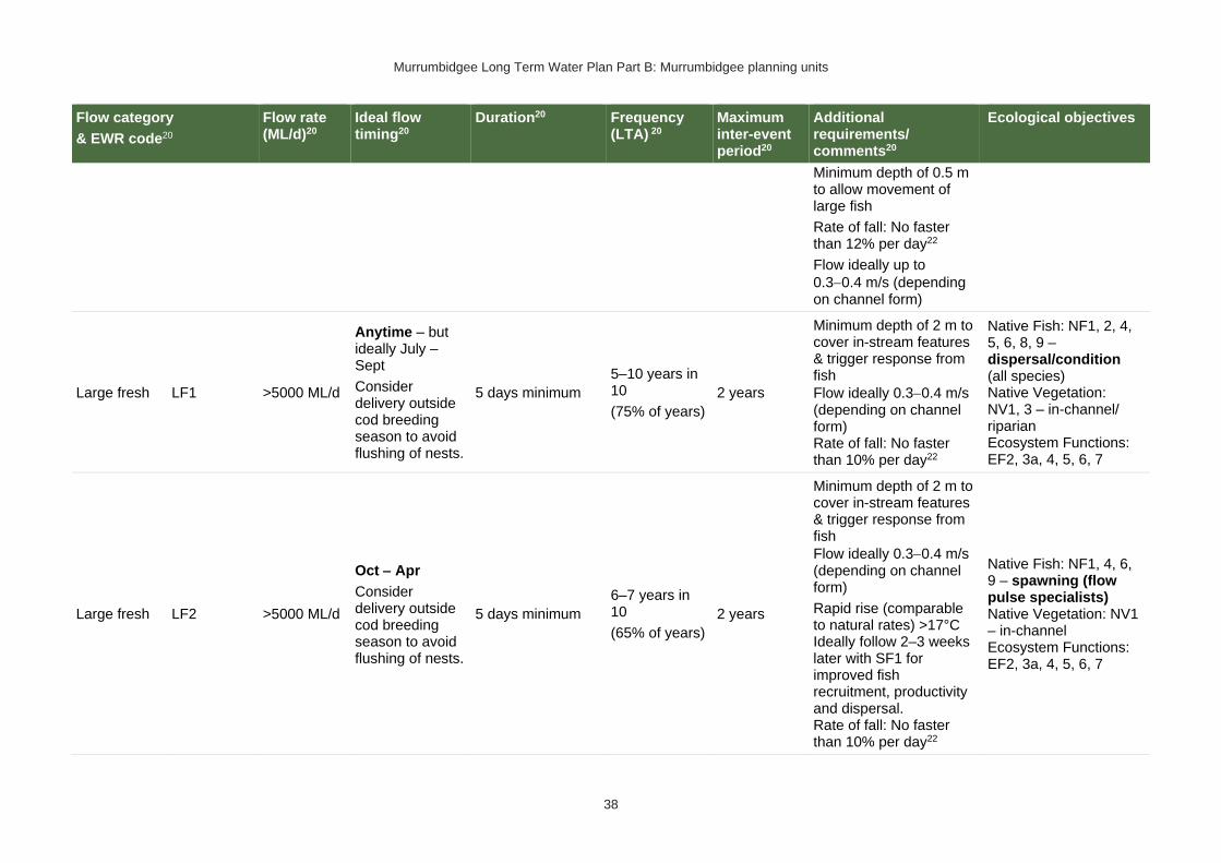
Murrumbidgee Long Term Water Plan Part B: Murrumbidgee planning units
38
Flow category
& EWR code20
Flow rate (ML/d)20
Ideal flow timing20
Duration20 Frequency (LTA) 20
Maximum inter-event period20
Additional requirements/ comments20
Ecological objectives
Minimum depth of 0.5 m to allow movement of large fish
Rate of fall: No faster than 12% per day22
Flow ideally up to
0.3−0.4 m/s (depending on channel form)
Large fresh LF1 >5000 ML/d
Anytime – but ideally July – Sept
Consider delivery outside cod breeding season to avoid flushing of nests.
5 days minimum
5–10 years in 10
(75% of years)
2 years
Minimum depth of 2 m to cover in-stream features & trigger response from fish
Flow ideally 0.3−0.4 m/s (depending on channel form) Rate of fall: No faster than 10% per day22
Native Fish: NF1, 2, 4, 5, 6, 8, 9 – dispersal/condition (all species) Native Vegetation: NV1, 3 – in-channel/ riparian Ecosystem Functions: EF2, 3a, 4, 5, 6, 7
Large fresh LF2 >5000 ML/d
Oct − Apr
Consider delivery outside cod breeding season to avoid flushing of nests.
5 days minimum
6–7 years in 10
(65% of years)
2 years
Minimum depth of 2 m to cover in-stream features & trigger response from fish
Flow ideally 0.3−0.4 m/s (depending on channel form)
Rapid rise (comparable to natural rates) >17°C Ideally follow 2–3 weeks later with SF1 for improved fish recruitment, productivity and dispersal. Rate of fall: No faster than 10% per day22
Native Fish: NF1, 4, 6, 9 – spawning (flow pulse specialists) Native Vegetation: NV1 – in-channel Ecosystem Functions: EF2, 3a, 4, 5, 6, 7

Murrumbidgee Long Term Water Plan Part B: Murrumbidgee planning units
39
Flow category
& EWR code20
Flow rate (ML/d)20
Ideal flow timing20
Duration20 Frequency (LTA) 20
Maximum inter-event period20
Additional requirements/ comments20
Ecological objectives
Large fresh with wetland connection
(below bankfull: in the upper part of the ‘LF’ band)
W-LF4 (core wetland & off-channel fish refuge)
Not applicable – limited off-channel wetlands below bank full in this PU
W-LF5
(Floodplain specialist fish spawning)
W-LF6
(Fish dispersal & condition)
W-LF7 (Non- woody veg zone – also for frog recruitment)
W-LF8 (Fish connect flow)
Floodplain Connection Flow (Overbank Small 1)
(Floodplain specialist fish)
OB-small 1 (Floodplain specialist fish)
Not applicable: The specific objectives for floodplain specialist fish (NF3, NF7) are not prioritised for this PU.

Murrumbidgee Long Term Water Plan Part B: Murrumbidgee planning units
40
Flow category
& EWR code20
Flow rate (ML/d)20
Ideal flow timing20
Duration20 Frequency (LTA) 20
Maximum inter-event period20
Additional requirements/ comments20
Ecological objectives
Floodplain Connection Flow (Overbank Small 2)
(River red gum zone)
23#
OB-small 2 (River red gum)
Note this flow is well below bank full in this PU24
28,000 ML/d – not deliverable under current constraints
Anytime25, but ideally Aug – Feb
In line with natural median duration for fish dispersal & riparian river red gum communities.
The median modelled natural duration for flows of this size is around 3 days. We analysed for cumulative flows of 3 days duration, made up of individual events of a minimum of 2 days within season
5–10 years in 10
(75% of years)
4 years
To support river red gum flowering, seed set and seedling establishment – clustered, sequenced flows (i.e. annual flows over 2–3 years) are required. The provision of periods of successive flows will also improve the condition of existing river red gum
Native Fish: NF1, 2, 4, 5, 6, 8, 9 – dispersal and condition (all species)
Native Vegetation: NV2, 3, 4a, 4b river red gum (riparian and floodplain wetland)
Ecosystem Functions: EF2, 3a, 4, 5, 6 – channel forming, lateral connectivity, productivity
Large Flood-plain Connection Flow (Over-bank Large 1)
(Black box zone)
OB Large 1 Not applicable – Black box & colonial waterbird breeding not a feature of this PU
23 Dark grey background (and # in 1st column of the row) denotes flows of this size are not able to be delivered as environmental water deliveries in the river. They occur due to tributary rainfall events or dam spills. Deliveries to these areas are only possible with pumping or where other infrastructure exists to divert water to the floodplain. In such cases carp exclusion devices should be used where possible. 24 In this planning unit the flow provides benefits to fringing river red gum and functional benefits such providing productivity from organic matter on higher banks and some channel forming. The floodplain is limited in this planning unit so was not targeted for this EWR and the required frequencies for this flow were not achieved above this flow threshold. 25 Analysis of flow frequencies shows flows of median natural duration do not occur at the required frequency when only flows in the ideal season are counted. Therefore, this flow is considered as applicable to river red gum (which may benefit from events in any season, though ‘in season’ flows are preferred) but not necessarily for water bird breeding.

Murrumbidgee Long Term Water Plan Part B: Murrumbidgee planning units
41
PU4: Murrumbidgee River – Tumut River Junction to Berembed Weir
The Murrumbidgee River – Tumut River Junction to Berembed Weir PU is situated within the Murrumbidgee Central (Burrinjuck to Gogeldrie) Water Source.
Figure 5 Map of Upper Murrumbidgee River – Tumut River Junction to Berembed Weir PU. Area outside of PU has been faded. Significant gauges relevant to the PU are Murrumbidgee @ Wagga (410001), Murrumbidgee @ Gundagai (410004)
Key ecological values
(CE = Critically Endangered, E = Endangered, V = Vulnerable, EP= Endangered Population in MDB, C = CAMBA, J = JAMBA, R = ROKAMBA, X = species recorded in this planning unit via catch records and or Australian Museum Records where they exist, Y = species expected to occur based on MaxEnt modelling, Z = based on expert DPI Fisheries opinion)
Native fish
• Australian smelt X
• bony herring X
• carp-gudgeon species complex X
• dwarf flat-headed gudgeon Z
• flat-headed galaxias (CE) Y
• flat-headed gudgeon X
• golden perch X
• mountain galaxias X
• Murray cod (V) X
• Murray crayfish (V) X
• Murray-darling rainbowfish X
• northern river blackfish X
• obscure galaxiasZ
• silver perch (V) X
• trout cod (E) X
• unspecked hardyhead X
• western carp-gudgeon X

Murrumbidgee Long Term Water Plan Part B: Murrumbidgee planning units
42
Waterbirds 49 waterbird species recorded including blue-billed duck (V), common greenshank (C,J,K), freckled duck (V), Latham's snipe (J,K) & sharp-tailed sandpiper (C,J,K)
Native vegetation 13,320 ha of water-dependent native vegetation including 246 ha of non-woody wetland & 4547 ha of river red gum.
Native fish objectives
NF1 No loss of native fish species
NF2 Increase the distribution & abundance of short to moderate-lived generalists: Australian smelt, carp-gudgeon species complex, flat-headed gudgeon, dwarf flat-headed gudgeon, bony herring, Murray-Darling rainbowfish, mountain galaxias, obscure galaxias
NF4 Improve population structure for moderate to long-lived flow pulse specialists: golden perch, silver perch
NF5 Improve population structure for moderate to long-lived riverine specialists: Murray cod, trout cod, river blackfish
NF6 A 25% increase in abundance of mature (harvestable sized): golden perch, Murray cod
NF7 Increase the prevalence &/or expand the population of key short to moderate-lived floodplain specialist native fish species into new areas (within historical range): Flat-headed galaxias
NF8 Increase the prevalence &/or expand the population of key moderate to long-lived riverine species into new areas (within historical range): Trout cod
NF9 Increase the prevalence &/or expand the population of key moderate to long-lived flow pulse specialists native fish species into new areas (within historical range): silver perch
Hydrology
Hydrological alteration
See Table 1 for key
Regulated river reach
CtF Low flow & baseflow
Freshes High & infrequent flows
1.5ARI 2.5ARI 5ARI
Murrumbidgee River at Wagga Wagga
N/A H+ H+ L- M- M-
Relevant rules from WSP
Murrumbidgee Central (Burrinjuck to Gogeldrie) Water Source
Access rules*:
Rivers & creeks (reference point Individual natural pool): pumping is not permitted from natural pools when the water level in the pool is lower than its full capacity.
Note: Some licences in this water source have a different CtP. Please see schedules 2 & 3 of the WSP.
Natural off-river pools: pumping is not permitted from an off-river pool or an off-river dam pool when the volume of water in that pool is less than 80% of the full capacity of the natural pool that existed prior to any augmentation works.
Trading rules:
INTO water source: No trade allowed
WITHIN water source: Allowed, but no trade into off river pools
*Note: These access rules do not apply:
1. if the existing Water Act 1912 entitlement had more stringent access licence conditions.
2. to major water utility, local water utility or unregulated river (town water supply) access licences
3. to water taken for domestic consumption by stock & domestic access licences
4. for the first 5 years of the plan to water taken for stock watering by stock & domestic access licences 5. to water taken from existing dams. Any existing licence conditions associated with a dam will be carried forward under the plan.

Murrumbidgee Long Term Water Plan Part B: Murrumbidgee planning units
43
There are 16 very small (<250 ML), 1 medium (500−1,000 ML) unregulated water access licences distributed throughout the PU. The total volume of unregulated entitlements for the PU is 1298 ML of which 1271 ML is allocated for irrigation (rather than stock & domestic or town water supply).
Recommended management strategies
MS2: Ensure compliance with water access licence conditions including through metering of all licensed extraction.
MS3: As a minimum, maintain existing rules in the WSP for the Murrumbidgee Unregulated Water Sources that protect environmental assets and values.
MS4: Monitor for changes in water demand and review access rules if current usage is high or if the pattern of use changes.
MS5: Consider introducing cease-to-pump and commence-to-pump rules (and any associated required amendments to WAL conditions) that protect held environmental water and water from the EWAs entering unregulated streams and off-channel pools (wetlands), In-line with the Basin Plan (Section 7.15(2)) requirement for implementation of prerequisite policy measures which provide for delivered environmental water to be protected.
MS6: For lagoon licences that are the target of environmental water, consider water access licence purchases from willing sellers or the negotiation of enduring agreements with licence holders.
Note: Section 7.2 of Part A of the Murrumbidgee LTWP also identifies as priority investment opportunities:
• Implement the constraints management strategy
• Seek arrangements to reduce take from the peak of wetland connecting events by negotiating for extraction to occur at other times
• Investigate modifications to Blowering and Burrinjuck dams to reduce thermal (cold water) pollution
• Investigate infrastructure to fill wetlands

Murrumbidgee Long Term Water Plan Part B: Murrumbidgee planning units
44
Table 6 Murrumbidgee River from Tumut Junction to Berembed Weir (as measured at Wagga gauge - 410001) – gauge data began in 1895
Flow category & EWR code26 Flow rate (ML/d)26, 27
Ideal flow timing26
Duration26 Frequency (LTA) 26
Maximum inter-event period26
Additional requirements/ comments26
Ecological objectives
Cease-to-flow CtF <1 ML/d CtF events only occurred in 2% of years in the modelled pre-development scenario & did not occur in any other scenario in this PU. They should therefore be avoided to protect the fish community. The resilience of this community is likely to have been compromised by development.
Very low flow VLF >250 ML/d
1980−2017 observations showed no flows below the very low flow threshold. Flows should not fall below this threshold because ecological community may have adapted to more constant flows since development
Flow ideally >0.03–0.05 m/s to de-stratify pools
Native Fish: NF1 – Survival and condition (all species) Ecosystem Functions: EF1, 2 – refuge habitat
Baseflow BF1 >1400 ML/d Anytime
In typical years, 365 days per year
In very dry years, at least 329 days per year28
Every year
1895−1950 observations did not exceed 24 days for 95% of events13
Minimum depth of 0.3 m to allow fish passage
Native Fish: NF1, 2, 4, 5, 6, 7, 8, 9 – condition and movement Native Vegetation: NV1 – in-channel Ecosystem
Nesting Support
NestS1
1400−16,000 ML/d
Max rate of fall 10% per day.
15 Sept − 15 Nov for trout cod & Murray cod.
1 Oct − 15 Nov for
60 days minimum for trout cod & Murray cod.
45 day minimum for only Murray cod
5−10 years in 10
(75% of years)
2 years
Allow variable flows but avoid large sudden decreases in water level to prevent loss of nesting sites. Flow decreases not to exceed 10% per day which is the 20th percentile (the fastest
Native Fish NF5, 6, 8 - Nesting of riverine specialists (protect nesting sites by avoiding rapid changes in water levels)
26 Refer to Glossary for definitions of terms and explanatory text for EWRs
27 These minimums are where the benefits of flow categories are likely to begin manifesting. Further substantial benefits occur, particularly for wetland connecting large freshes and overbanks, as flows increase in size. These thresholds SHOULD NOT be used to indicate that constraints only need to be raised to achieve these minimums.
28 Based on 1895-1950 observations (considered pre-development), with ‘typical year’ value the median of those observations, and ‘very dry’ value the 95th percentile.

Murrumbidgee Long Term Water Plan Part B: Murrumbidgee planning units
45
Flow category & EWR code26 Flow rate (ML/d)26, 27
Ideal flow timing26
Duration26 Frequency (LTA) 26
Maximum inter-event period26
Additional requirements/ comments26
Ecological objectives
only Murray cod.
(Only apply EWR if flows are in the BF or SF range at start of period)
20%) of fall - calculated from observed ‘pre-development' flow data (1895-1950)
Native Vegetation: NV1,3 – in-channel & riparian
Small fresh SF1 >5000 ML/d
Anytime − but ideally
Oct − Apr &
ideally 2−3 weeks after ‘LF2’
10 days minimum
2 events per year
1 year
>20°C for Oct – Apr (for native fish); for river blackfish >16°C; for Murray cod Sept to Dec >18°C
Minimum depth of 0.5 m to allow movement of large fish
Rate of fall: No faster than 20% per day29
Flow ideally up to
0.3−0.4 m/s (depending on channel form)
Native Fish: NF1, 2, 4, 5, 6, 7, 8, 9 – Dispersal/condition (all species) Native Vegetation: NV1 – in-channel Ecosystem Functions: EF1, 2, 3a, 4, 5
Small fresh SF2 5000−16,000 ML/d
15 Sept − Apr
14 days minimum
5–10 years in 10
(75% of years)
2 years
>20°C for Oct − Apr (for native fish); for river blackfish >16°C; for Murray cod Sept to Dec >18°C
Minimum depth of 0.5 m to allow movement of large fish
Native Fish: NF1, 2, 5, 6, 8 – Spawning (river specialists, generalists) Native Vegetation: NV1 – in-channel Ecosystem
29The 5th percentile (fastest 5% of rates of fall) of ‘pre-development’ 1895-1950 observed flows

Murrumbidgee Long Term Water Plan Part B: Murrumbidgee planning units
46
Flow category & EWR code26 Flow rate (ML/d)26, 27
Ideal flow timing26
Duration26 Frequency (LTA) 26
Maximum inter-event period26
Additional requirements/ comments26
Ecological objectives
Rate of fall: No faster than 20% per day29
Flow ideally up to 0.3 –0.4 m/s (depending on channel form)
Note flows of SF size have become more constant & less in line with natural season. There would be some benefit from having gaps in these flows & drying of banks & benches at appropriate times, particularly late summer/early autumn.
Functions: EF1, 2, 3a, 4, 5
Large fresh LF1 >16,000 ML/d
Anytime − but ideally
July − Sept
Consider delivery outside cod breeding season to avoid flushing of nests.
5 days minimum
5–10 years in 10
(75% of years)
2 years
Minimum depth of 2 m to cover in-stream features & trigger response from fish
Flow ideally 0.3−0.4 m/s (depending on channel form)
Rate of fall: No faster than 26% per day29
Note flows of SF & LF size have become more constant & less in line with natural season. There would be some benefit from having gaps in these flows & drying of banks & benches at appropriate times,
Native Fish: NF1, 2, 4, 5, 6, 8, 9 – dispersal/condition (all species) Native Vegetation: NV1, 3 – in-channel/ riparian Ecosystem Functions: EF2, 3a, 4, 5, 6

Murrumbidgee Long Term Water Plan Part B: Murrumbidgee planning units
47
Flow category & EWR code26 Flow rate (ML/d)26, 27
Ideal flow timing26
Duration26 Frequency (LTA) 26
Maximum inter-event period26
Additional requirements/ comments26
Ecological objectives
particularly late summer/early autumn.
Large fresh LF2 >16,000 ML/d
Oct − Apr
Consider delivery outside cod breeding season to avoid flushing of nests.
5 days minimum
6–7 years in 10
(65% of years)
Flows of this size are now more frequent than pre-development.
2 years
Minimum depth of 2 m to cover in-stream features & trigger response from fish
Flow ideally 0.3−0.4 m/s (depending on channel form)
Rapid rise (comparable to natural rates) >17°C
Ideally follow 2–3 weeks later with SF1 for improved fish recruitment, productivity and dispersal.
Rate of fall: No faster than 26% per day29
Native Fish: NF1, 4, 6, 9 – spawning (flow pulse specialists) Native Vegetation: NV1 – in-channel Ecosystem Functions: EF2, 3a, 4, 5, 6
Large fresh with wetland connection30,31 *
(below bankfull: in the upper
W-LF4 (core wetland & off-channel fish refuge)
Not relevant as a river flow because the required frequency of flows in 90% of years is not achieved in this PU in the pre-development modelled scenario or in pre-1950s observations. However, there may be target sites for filling with infrastructure (where possible with carp screens or other exclusion devices) where refuges could be maintained.
W-LF5
(Floodplain specialist
Not relevant as a river flow because the required frequency of 10-day flows in 70% of years is not met in this PU in the pre-development modelled scenario or in pre-1950s observations. However, there may be target sites for filling with infrastructure (where possible with carp screens or other exclusion devices) where populations of flat-headed galaxias can be re-established.
30 In other catchments, connection to major wetlands systems would generally occur at and above bankfull level. The geomorphology of the Murrumbidgee system is such that major billabong, anabranch and other off-channel wetland systems are connected below bankfull level. Hence the category of ‘wetland connecting flow is used in the Murrumbidgee. 31 Light grey background (and an * in 1st column of row) denotes that flows to this zone are currently difficult to deliver due to potential impacts on third parties. Implementation of the constraints management strategy would alleviate this. In the meantime, deliveries to these areas may only be possible with pumping or where other infrastructure exists to divert water to the floodplain. In such cases carp exclusion devices should be used where possible.

Murrumbidgee Long Term Water Plan Part B: Murrumbidgee planning units
48
Flow category & EWR code26 Flow rate (ML/d)26, 27
Ideal flow timing26
Duration26 Frequency (LTA) 26
Maximum inter-event period26
Additional requirements/ comments26
Ecological objectives
part of the ‘LF’ band)
fish spawning)
W-LF6
(Fish dispersal & condition)
>28,000 ML/d – difficult to deliver under current constraints
Anytime – but ideally Sept –Feb
5 days minimum for fish dispersal
2−3 years in 10
(1 every 3−5 years)
(25% of years)
5 years
Native Fish: NF1, 2, 4, 5, 6, 7, 8, 9 – dispersal & condition (all species) Native Vegetation: NV1, 2, 3 – riparian river red gum communities Waterbirds: WB1, 2, 5 – habitat Ecosystem Functions: EF2, 3a, 4, 5, 6 – lateral floodplain, productivity, bench and pool forming
Other Species (Frogs): OS1 – habitat
W-LF7 (Non- woody veg zone – also for frog recruitment)
>28,000 ML/d – difficult to deliver under current constraints
July − Feb flow timing.
There are benefits also outside that period including by providing bird foraging habitat
3−10 months. Refers to the persistence of standing water (minimum 3-7 months depending on vegetation community)
The median observed duration for flows of this size
6−8 years in 10
(70% of years)
2 years
Ideally maintain stable water levels in active waterbird colony sites and provide slow drawdown for shallow muddy edges for bird foraging habitat.
For best benefits duration of standing water of at least 90 days is required during the growing season (from Sept on). Also note that
Native Fish: NF1, 2, 4, 5, 6, 7, 8, 9 – dispersal & condition (all species)
Native Vegetation: NV2, 3, 4 – Non-woody vegetation in wetlands, river red gum forest fringing wetlands/channels

Murrumbidgee Long Term Water Plan Part B: Murrumbidgee planning units
49
Flow category & EWR code26 Flow rate (ML/d)26, 27
Ideal flow timing26
Duration26 Frequency (LTA) 26
Maximum inter-event period26
Additional requirements/ comments26
Ecological objectives
is around 5 days. We analysed for cumulative flows of 5 days duration, made up of individual events of a minimum of 3 days within season32
some frog species are summer breeders so will need at least 3 months from Oct.
To increase cover & extent of non-woody vegetation communities - clustered, sequenced flows (i.e. annual flows
over 2−3 years) are required.
The provision of periods of higher flow magnitude & successive flows also has the potential to increase non-woody vegetation cover & extent &/or limit encroachment of woody species (if desired).
W-LF8 (fish connect flow)
>28,000 ML/d
−difficult to deliver under current constraints
Anytime33, but triggered by significant fish breeding in off-channel wetlands.
5 days
3 years in 10 or as required by breeding triggers
(30% of years)
5 years
Ideally provide a protracted recession to promote exit to the river.
This is for within 3−18 months so long as sufficient habitat (depth, cover) is maintained in the wetland to support the strong 0+ cohort until
Native Fish: NF1, 2, 4, 5, 6, 7, 8, 9 – dispersal from off channel wetlands (all species) Native Vegetation: NV1, 2, 3
Waterbirds: WB1, 5 Ecosystem
32 The information in italics is not meant to be prescriptive. It notes the median duration of past flow events of this size as a guideline. Where cumulative durations are noted, the minimum duration of individual events which make up that cumulative total (again only provided for guidance) is based on the 25th percentile duration of events of this size.
33 Return movement may vary seasonally, so future research will inform any necessary refinement in the timing of this.

Murrumbidgee Long Term Water Plan Part B: Murrumbidgee planning units
50
Flow category & EWR code26 Flow rate (ML/d)26, 27
Ideal flow timing26
Duration26 Frequency (LTA) 26
Maximum inter-event period26
Additional requirements/ comments26
Ecological objectives
Flow 3–18 months after breeding occurs.
Flow must occur before habitat (depth, cover, water quality) of waterbody is lost by drying.
re-connection occurs - may be wetland specific.
Trigger is verified breeding event. Where there has been insufficient monitoring to confirm/deny this, the trigger is a long duration wetland connecting LF (W-LF5) or an overbank (OB-S1, OB-S2 or OB-L1) in those PUs where these have been shown to produce significant breeding responses. The 3+ month delay after the breeding event is to allow recruits to use the nursey to move into the river & reach sufficient maturity to move into the river.
Functions: EF2, 3a, 4, 5, 6 – connectivity
Other Species (Frogs): OS1
Floodplain Connection Flow
OB-Small 1 Not relevant as a river flow because the required frequency of 10-day flows in 70% of years is not met in this PU in the pre-development modelled scenario or in pre-1950s observations. However, there may be target sites for filling with infrastructure (where possible with carp screens or other exclusion devices) where populations of flat-headed galaxias can be re-established.

Murrumbidgee Long Term Water Plan Part B: Murrumbidgee planning units
51
Flow category & EWR code26 Flow rate (ML/d)26, 27
Ideal flow timing26
Duration26 Frequency (LTA) 26
Maximum inter-event period26
Additional requirements/ comments26
Ecological objectives
(Overbank Small 1) 34 #
(Floodplain specialist fish)
#Floodplain Connection Flow (Overbank Small 2) 34
(River red gum zone)
OB-Small 2
>48,000 ML/d
− not deliverable
Anytime35, but ideally Aug –Feb
In line with natural median duration for fish dispersal & riparian river red gum communities
For wetlands 3–7 months’ persistence of standing water
For streamside areas, only duration to fill the soil profile, depressions/ billabongs required
5 years in 10
(50% of years)
4 years
Ideally maintain stable water levels in active waterbird colony sites and provide slow drawdown for shallow muddy edges for bird foraging habitat.
To support establishment of river red gum – clustered, sequenced flows (i.e. annual flows over 2–3 years) are required. The provision of periods of successive flows will also improve the condition of existing river red gum.
Native Fish: NF1, 2, 4, 5, 6, 7, 8, 9 – dispersal and condition (all species)
Native Vegetation: NV2, 3, 4a, 4b river red gum (riparian and floodplain wetland)
Waterbirds: WB1, 2, 3, 4, 5 – habitat and potential small-scale breeding
Ecosystem Functions: EF2, 3a, 4, 5, 6 – channel forming, lateral
34 Dark grey background (and # in 1st col of row) denotes flows of this size cannot be delivered in the river. The flows occur due to tributary rainfall events or dam spills. Deliveries to these areas are only possible with pumping or where other infrastructure exists to divert water to the floodplain. In such cases carp exclusion devices should be used where possible. 35 Analysis of flows of this size indicates that they occur in the required frequency of 50% of years only when events in any season are accepted. Therefore, this flow is considered as applicable to river red gum (which may benefit from events in any season, though ‘in season’ flows are preferred) but not necessarily for water bird breeding. Events that do occur in the ideal season may still be beneficial to waterbird breeding.

Murrumbidgee Long Term Water Plan Part B: Murrumbidgee planning units
52
Flow category & EWR code26 Flow rate (ML/d)26, 27
Ideal flow timing26
Duration26 Frequency (LTA) 26
Maximum inter-event period26
Additional requirements/ comments26
Ecological objectives
The median modelled natural duration for flows of this size is ~4 days. We analysed for cumulative flows of 4 days duration, made up of individual events of a minimum of 2 days within season
For timing: flow can occur earlier, but for best benefits, duration of standing water of at least 90 days is required from Sept on to fit with vegetation growing season & bird breeding seasonality. Also note that some frog species are summer breeders, which, when a target for flows, will need at least 3 months from Oct.
connectivity, productivity
Other Species (Frogs): OS1, 2 – recruitment
Large Floodplain Connection Flow (Overbank Large 1) (Black box zone)
OB Large 1 Not applicable – Black box & large-scale colonial waterbird breeding not a feature of this PU.
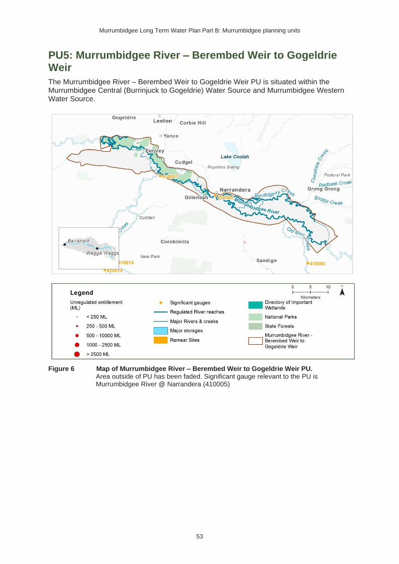
Murrumbidgee Long Term Water Plan Part B: Murrumbidgee planning units
53
PU5: Murrumbidgee River – Berembed Weir to Gogeldrie Weir
The Murrumbidgee River – Berembed Weir to Gogeldrie Weir PU is situated within the Murrumbidgee Central (Burrinjuck to Gogeldrie) Water Source and Murrumbidgee Western Water Source.
Figure 6 Map of Murrumbidgee River – Berembed Weir to Gogeldrie Weir PU. Area outside of PU has been faded. Significant gauge relevant to the PU is Murrumbidgee River @ Narrandera (410005)
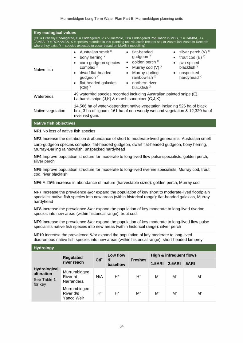
Murrumbidgee Long Term Water Plan Part B: Murrumbidgee planning units
54
Key ecological values
(CE = Critically Endangered, E = Endangered, V = Vulnerable, EP= Endangered Population in MDB, C = CAMBA, J = JAMBA, R = ROKAMBA, X = species recorded in this planning unit via catch records and or Australian Museum Records where they exist, Y = species expected to occur based on MaxEnt modelling)
Native fish
• Australian smelt X
• bony herring X
• carp-gudgeon species complex X
• dwarf flat-headed gudgeon Y
• flat-headed galaxias (CE) Y
• flat-headed gudgeon Y
• golden perch X
• Murray cod (V) X
• Murray-darling rainbowfish X
• northern river blackfish X
• silver perch (V) X
• trout cod (E) X
• two-spined blackfish Y
• unspecked hardyhead X
Waterbirds 49 waterbird species recorded including Australian painted snipe (E), Latham's snipe (J,K) & marsh sandpiper (C,J,K)
Native vegetation 14,566 ha of water-dependent native vegetation including 526 ha of black box, 3 ha of lignum, 161 ha of non-woody wetland vegetation & 12,320 ha of river red gum.
Native fish objectives
NF1 No loss of native fish species
NF2 Increase the distribution & abundance of short to moderate-lived generalists: Australian smelt
carp-gudgeon species complex, flat-headed gudgeon, dwarf flat-headed gudgeon, bony herring, Murray-Darling rainbowfish, unspecked hardyhead
NF4 Improve population structure for moderate to long-lived flow pulse specialists: golden perch, silver perch
NF5 Improve population structure for moderate to long-lived riverine specialists: Murray cod, trout cod, river blackfish
NF6 A 25% increase in abundance of mature (harvestable sized): golden perch, Murray cod
NF7 Increase the prevalence &/or expand the population of key short to moderate-lived floodplain specialist native fish species into new areas (within historical range): flat-headed galaxias, Murray hardyhead
NF8 Increase the prevalence &/or expand the population of key moderate to long-lived riverine species into new areas (within historical range): trout cod
NF9 Increase the prevalence &/or expand the population of key moderate to long-lived flow pulse specialists native fish species into new areas (within historical range): silver perch
NF10 Increase the prevalence &/or expand the population of key moderate to long-lived diadromous native fish species into new areas (within historical range): short-headed lamprey
Hydrology
Hydrological alteration
See Table 1 for key
Regulated river reach
CtF Low flow & baseflow
Freshes High & infrequent flows
1.5ARI 2.5ARI 5ARI
Murrumbidgee River at Narrandera
N/A H+ H+ M- M- M-
Murrumbidgee River d/s Yanco Weir
H- H+ M+ M- M- M-

Murrumbidgee Long Term Water Plan Part B: Murrumbidgee planning units
55
Relevant rules from WSP
Murrumbidgee Central (Burrinjuck to Gogeldrie) Unregulated Water Source
Access rules*: Rivers & creeks (reference point Individual natural pool): pumping is not permitted from natural pools when the water level in the pool is lower than its full capacity.
Note: Some licences in this water source have a different CtP. Please see schedules 2 & 3 of the WSP.
Natural off-river pools: pumping is not permitted from an off-river pool or an off-river dam pool when the volume of water in that pool is less than 80% of the full capacity of the natural pool that existed prior to any augmentation works.
Trading rules:
INTO water source: No trade allowed
WITHIN water source: Allowed, but no trade into off river pools
Murrumbidgee Western Water Source:
Access rules*: Rivers & creeks: no pool drawdown.
Off-river pools: pumping is not permitted from an off-river pool or an off-river dam pool when the volume of water in that pool is less than 80% of the full capacity of the natural pool that existed prior to any augmentation works
Trading rules: INTO water source: no trade allowed.
WITHIN water source: allowed, but no trade into off-river pools or onto Talpee Creek.
*Note: These access rules do not apply:
1. if the existing Water Act 1912 entitlement had more stringent access licence conditions.
2. to major water utility, local water utility or unregulated river (town water supply) access licences
3. to water taken for domestic consumption by stock & domestic access licences
4. for the first 5 years of the plan to water taken for stock watering by stock & domestic access licences
5. to water taken from existing dams. Any existing licence conditions associated with a dam will be carried forward under the plan.
There are 4 very small (<250 ML) unregulated water access licences distributed throughout the PU. The total volume of unregulated entitlements for the PU is 286 ML. All of this entitlement is allocated for irrigation (rather than stock & domestic or town water supply).
Recommended management strategies
MS2: Ensure compliance with water access licence conditions including through metering of all licensed extraction.
MS3: As a minimum, maintain existing rules in the WSP for the Murrumbidgee Unregulated Water Sources that protect environmental assets and values.
MS4: Monitor for changes in water demand and review access rules if current usage is high or if the pattern of use changes.
MS5: Consider introducing cease-to-pump and commence-to-pump rules (and any associated required amendments to WAL conditions) that protect held environmental water and water from the EWAs entering unregulated streams and off-channel pools (wetlands), In-line with the Basin Plan (Section 7.15(2)) requirement for implementation of prerequisite policy measures which provide for delivered environmental water to be protected.
MS6: For lagoon licences that are the target of environmental water, consider water access licence purchases from willing sellers or the negotiation of enduring agreements with licence holders.
Note: Section 7.2 of Part A of the Murrumbidgee LTWP also identifies as priority investment opportunities:
• Implement the constraints management strategy
• Seek arrangements to reduce take from the peak of wetland connecting events by negotiating for extraction to occur at other times
• Investigate infrastructure to fill wetlands

Murrumbidgee Long Term Water Plan Part B: Murrumbidgee planning units
56
Table 7 Murrumbidgee (from Berembed Weir to Gogeldrie Weir) (as measured at Narrandera gauge − 410005) – gauge data began in 1914
Flow category & EWR code36 Flow rate (ML/d)36, 37
Ideal flow timing36
Duration36 Frequency (LTA)36
Maximum inter-event period36
Additional requirements/ comments36
Ecological objectives
Cease-to-flow CtF <1 ML/d
CtF events only occurred in 6% & 1% of years in the modelled pre-development & post development scenarios
respectively. They did not occur in observed data (1914−2017) in this PU. They should therefore be avoided to protect the fish community. The resilience of this community is likely to have been compromised by development.
Very low flow VLF >230 ML/d
1980−2017 observations showed no flows below the very low flow threshold. Flows should not fall below this threshold because ecological community may have adapted to more constant flows since development
Flow ideally >0.03–0.05 m/s to de-stratify pools
Native Fish: NF1 – Survival and condition (all species) Ecosystem Functions: EF1, 2 – refuge habitat
Baseflow BF1 >1000 ML/d Anytime
In typical years, 344 days per year
In very dry years, at least 168 days per year38
Every year
1914−1950 observations did not exceed 44 days for 95% of events38
Minimum depth of 0.3 m to allow fish passage
Native Fish: NF1, 2, 4, 5, 6, 7, 8, 9, 10 – condition and movement Native Vegetation: NV1 – in-channel Ecosystem Functions: EF1, 2, 3a
Nesting Support
NestS1
1000−14,000 ML/d
Max rate of fall 13% per day.
15 Sep − 15 Nov for trout cod & Murray cod.
1 Oct − 15 Nov for only Murray cod.
60 days minimum for trout cod & Murray cod.
45 day minimum for only Murray cod
5−10 years in 10
(75% of years)
2 years
Allow variable flows but avoid large sudden decreases in water level to prevent loss of nesting sites. Flow decreases not to exceed 13% per day which is the 20th percentile (the fastest
Native Fish NF5, 6, 8 - Nesting of riverine specialists (protect nesting sites by avoiding rapid changes in water levels)
36 Refer to Glossary for definitions of terms and explanatory text for EWRs
37 These minimums are where the benefits of flow categories are likely to begin manifesting. Further substantial benefits occur, particularly for wetland connecting large freshes and overbanks, as flows increase in size. These thresholds SHOULD NOT be used to indicate that constraints only need to be raised to achieve these minimums.
38 Based on 1914-1950 observations (considered pre-development), with ‘typical year’ value the median of those observations, and ‘very dry’ value the 95th percentile.

Murrumbidgee Long Term Water Plan Part B: Murrumbidgee planning units
57
Flow category & EWR code36 Flow rate (ML/d)36, 37
Ideal flow timing36
Duration36 Frequency (LTA)36
Maximum inter-event period36
Additional requirements/ comments36
Ecological objectives
(Only apply EWR if flows are in the BF or SF range at start of period)
20%) of fall - calculated from observed ‘pre-development' flow data (1914-1950)
Native Vegetation: NV1,3 – in-channel & riparian
Small fresh SF1 >4000 ML/d
Anytime - but ideally Oct to Apr, & ideally
2−3 weeks after ‘LF2’
10 days minimum
2 events per year. Flows of this size are now more frequent than pre-development.
1 year
>20°C for Oct – Apr (for native fish); for river blackfish >16°C; for Murray cod Sept to Dec >18°C
Minimum depth of 0.5 m to allow movement of large fish
Rate of fall: No faster than 21% per day39
Flow ideally up to
0.3−0.4 m/s (depending on channel form)
Note flows of SF size have become more constant & less in line with natural season. There would be some benefit from having gaps in these flows & drying of banks & benches at appropriate times, particularly late
Native Fish: NF1, 2, 4, 5, 6, 7, 8, 9, 10 – Dispersal/condition (all species) Native Vegetation: NV1 – in-channel Ecosystem Functions: EF1, 2, 3a, 4, 5
39 The 5th percentile (fastest 5% of rates of fall) of ‘pre-development’ 1914-1950 observed flows
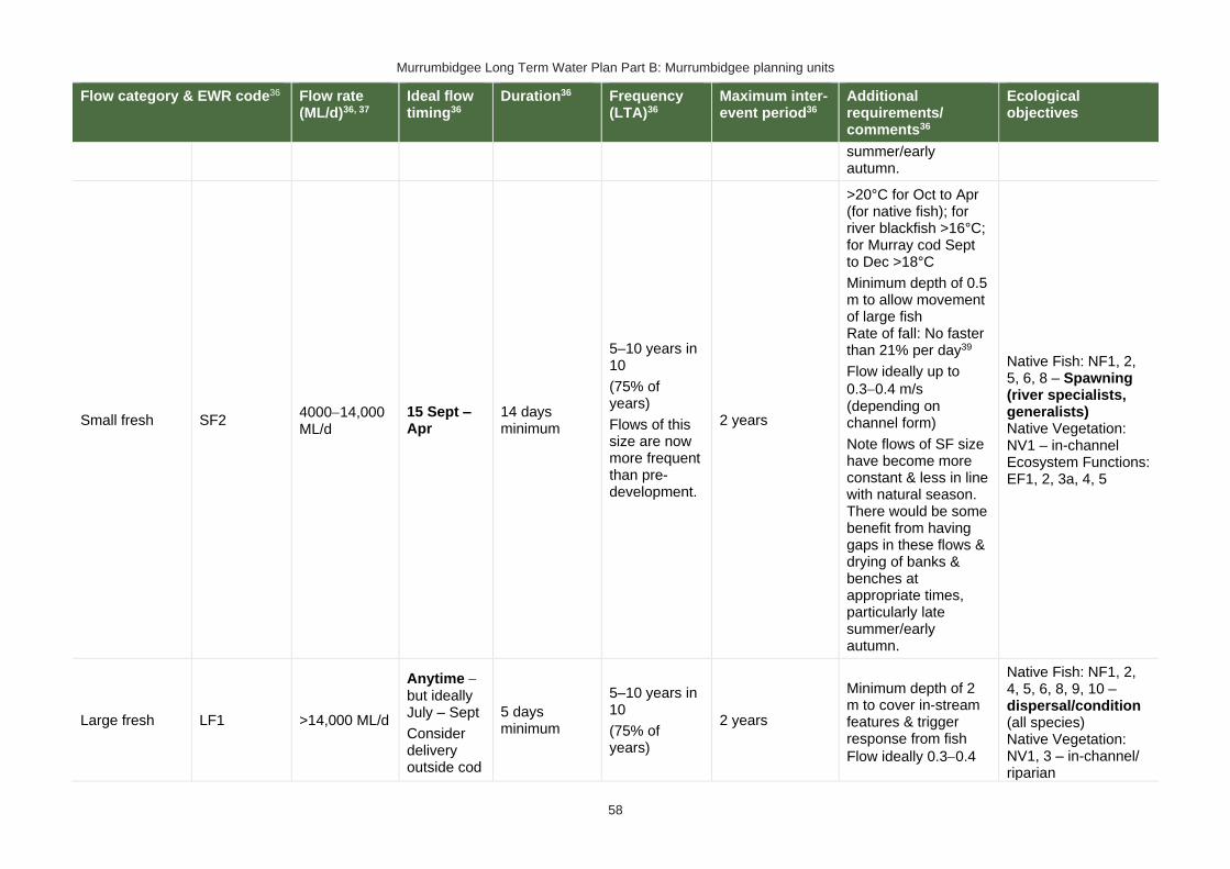
Murrumbidgee Long Term Water Plan Part B: Murrumbidgee planning units
58
Flow category & EWR code36 Flow rate (ML/d)36, 37
Ideal flow timing36
Duration36 Frequency (LTA)36
Maximum inter-event period36
Additional requirements/ comments36
Ecological objectives
summer/early autumn.
Small fresh SF2 4000−14,000 ML/d
15 Sept – Apr
14 days minimum
5–10 years in 10
(75% of years)
Flows of this size are now more frequent than pre-development.
2 years
>20°C for Oct to Apr (for native fish); for river blackfish >16°C; for Murray cod Sept to Dec >18°C
Minimum depth of 0.5 m to allow movement of large fish Rate of fall: No faster than 21% per day39
Flow ideally up to
0.3−0.4 m/s (depending on channel form)
Note flows of SF size have become more constant & less in line with natural season. There would be some benefit from having gaps in these flows & drying of banks & benches at appropriate times, particularly late summer/early autumn.
Native Fish: NF1, 2, 5, 6, 8 – Spawning (river specialists, generalists) Native Vegetation: NV1 – in-channel Ecosystem Functions: EF1, 2, 3a, 4, 5
Large fresh LF1 >14,000 ML/d
Anytime − but ideally July – Sept
Consider delivery outside cod
5 days minimum
5–10 years in 10
(75% of years)
2 years
Minimum depth of 2 m to cover in-stream features & trigger response from fish
Flow ideally 0.3−0.4
Native Fish: NF1, 2, 4, 5, 6, 8, 9, 10 – dispersal/condition (all species) Native Vegetation: NV1, 3 – in-channel/ riparian

Murrumbidgee Long Term Water Plan Part B: Murrumbidgee planning units
59
Flow category & EWR code36 Flow rate (ML/d)36, 37
Ideal flow timing36
Duration36 Frequency (LTA)36
Maximum inter-event period36
Additional requirements/ comments36
Ecological objectives
breeding season to avoid flushing of nests
m/s (depending on channel form)
Rate of fall: No faster than 19% per day39
Ecosystem Functions: EF2, 3a, 4, 5, 6, 7
Large fresh LF2 >14,000 ML/d
Oct to Apr
Consider delivery outside cod breeding season to avoid flushing of nests
5 days minimum
6–7 years in 10
(65% of years)
2 years
Minimum depth of 2 m to cover in-stream features & trigger response from fish
Flow ideally 0.3−0.4 m/s (depending on channel form)
Rapid rise (comparable to natural rates) >17°C
Ideally follow 2–3 weeks later with SF1 for improved fish recruitment, productivity and dispersal.
Rate of fall: No faster than 19% per day39
Native Fish: NF1, 4, 6, 9 – spawning (flow pulse specialists) Native Vegetation: NV1 – in-channel Ecosystem Functions: EF2, 3a, 4, 5, 6, 7
Large fresh with wetland connection40,41 *
W-LF4 (core wetland & off-channel fish refuge)
Not relevant as a river flow because the required frequency of flows in 90% of years is not achieved in this PU in the pre-development modelled scenario or in pre-1950s observations. However, there may be target sites for filling with infrastructure (where possible with carp screens or other exclusion devices) where refuges could be maintained.
40 In other catchments, connection to major wetlands systems would generally occur at and above bankfull level. The geomorphology of the Murrumbidgee system is such that major billabong, anabranch and other off-channel wetland systems are connected below bankfull level. Hence the category of ‘wetland connecting flow is used in the Murrumbidgee. 41 Light grey background (and * in 1st column of row) denotes that flows to this zone are currently difficult to deliver due to potential impacts on third parties. Implementation of the constraints management strategy may alleviate this. In the meantime, deliveries to these areas may only be possible with pumping or where other infrastructure exists to divert water to the floodplain. In such cases carp exclusion devices should be used where possible.

Murrumbidgee Long Term Water Plan Part B: Murrumbidgee planning units
60
Flow category & EWR code36 Flow rate (ML/d)36, 37
Ideal flow timing36
Duration36 Frequency (LTA)36
Maximum inter-event period36
Additional requirements/ comments36
Ecological objectives
(below bankfull: in the upper part of the ‘LF’ band)
W-LF5
(Floodplain specialist fish spawning)
Not relevant as a river flow because the required frequency of 10-day flows in 70% of years is not met in this PU in the pre-development modelled scenario or in pre-1950s observations. However, there may be target sites for filling with infrastructure (where possible with carp screens or other exclusion devices) where populations of flat-headed galaxias and Murray hardyhead can be re-established.
W-LF6
(Fish dispersal & condition)
>25,000 ML/d – not deliverable under current constraints
Anytime – but ideally Sept – Feb
5 days minimum for fish dispersal
2−3 years in 10
(1 every 3−5 years)
5 years
Native Fish: NF1, 2, 4, 5, 6, 7, 8, 9, 10 – dispersal & condition (all species) Native Vegetation: NV1, 2, 3 – riparian river red gum communities Waterbirds: WB1, 2, 5 – habitat Ecosystem Functions: EF2, 3, 4, 5, 6, 7 – lateral floodplain, productivity, bench and pool forming
Other Species (Frogs): OS1 – habitat
W-LF7 (Non- woody veg zone – also for frog recruitment)
>25,000 ML/d – not deliverable under current constraints
July − Feb flow timing. There are benefits also outside that period including by providing bird foraging habitat
3−10 months. Refers to the persistence of standing water (minimum 3-7 months depending on vegetation community)
6−8 years in 10
(70% of years)
2 years
Ideally maintain stable water levels in active waterbird colony sites and provide slow draw down for shallow muddy edges for bird foraging habitat.
For best benefits duration of standing water of at least 90
Native Fish: NF1, 2, 4, 5, 6, 7, 8, 9 – dispersal & condition (all species)
Native Vegetation: NV2, 3, 4 – Non-woody vegetation in wetlands, river red gum forest fringing wetlands/channels
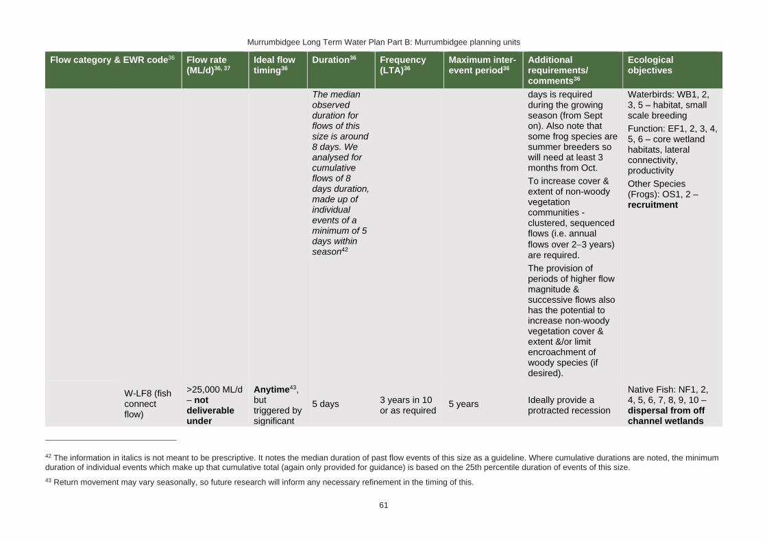
Murrumbidgee Long Term Water Plan Part B: Murrumbidgee planning units
61
Flow category & EWR code36 Flow rate (ML/d)36, 37
Ideal flow timing36
Duration36 Frequency (LTA)36
Maximum inter-event period36
Additional requirements/ comments36
Ecological objectives
The median observed duration for flows of this size is around 8 days. We analysed for cumulative flows of 8 days duration, made up of individual events of a minimum of 5 days within season42
days is required during the growing season (from Sept on). Also note that some frog species are summer breeders so will need at least 3 months from Oct.
To increase cover & extent of non-woody vegetation communities - clustered, sequenced flows (i.e. annual
flows over 2−3 years) are required.
The provision of periods of higher flow magnitude & successive flows also has the potential to increase non-woody vegetation cover & extent &/or limit encroachment of woody species (if desired).
Waterbirds: WB1, 2, 3, 5 – habitat, small scale breeding
Function: EF1, 2, 3, 4, 5, 6 – core wetland habitats, lateral connectivity, productivity
Other Species (Frogs): OS1, 2 – recruitment
W-LF8 (fish connect flow)
>25,000 ML/d – not deliverable under
Anytime43, but triggered by significant
5 days 3 years in 10 or as required
5 years Ideally provide a protracted recession
Native Fish: NF1, 2, 4, 5, 6, 7, 8, 9, 10 – dispersal from off channel wetlands
42 The information in italics is not meant to be prescriptive. It notes the median duration of past flow events of this size as a guideline. Where cumulative durations are noted, the minimum duration of individual events which make up that cumulative total (again only provided for guidance) is based on the 25th percentile duration of events of this size.
43 Return movement may vary seasonally, so future research will inform any necessary refinement in the timing of this.

Murrumbidgee Long Term Water Plan Part B: Murrumbidgee planning units
62
Flow category & EWR code36 Flow rate (ML/d)36, 37
Ideal flow timing36
Duration36 Frequency (LTA)36
Maximum inter-event period36
Additional requirements/ comments36
Ecological objectives
current constraints
fish breeding in off-channel wetlands
Flow 3−18 months after breeding occurs
Flow must occur before habitat (depth, cover, water quality) of waterbody is lost by drying
by breeding triggers
to promote exit to the river.
This is for within 3−18 months so long as sufficient habitat (depth, cover) is maintained in the wetland to support the strong 0+ cohort until re-connection occurs - may be wetland specific.
Trigger is verified breeding event. Where there has been insufficient monitoring to confirm/deny this, the trigger is a long duration wetland connecting LF (W-LF5) or an overbank (OB-S1, OB-S2 or OB-L1) in those PUs where these have been shown to produce significant breeding responses. The 3+ month delay following the breeding event is to allow recruits to utilize the nursey to move into the river & reach sufficient maturity to move into the river.
(all species) Native Vegetation: NV1, 2, 3
Waterbirds: WB1, 5 Ecosystem Functions: EF2, 3, 4, 5, 6 – connectivity
Other Species (Frogs): OS1
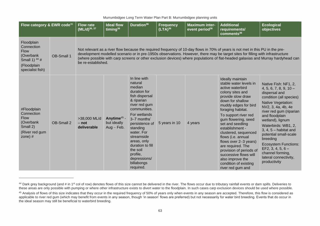
Murrumbidgee Long Term Water Plan Part B: Murrumbidgee planning units
63
Flow category & EWR code36 Flow rate (ML/d)36, 37
Ideal flow timing36
Duration36 Frequency (LTA)36
Maximum inter-event period36
Additional requirements/ comments36
Ecological objectives
Floodplain Connection Flow (Overbank Small 1) 44 #
(Floodplain specialist fish)
OB-Small 1
Not relevant as a river flow because the required frequency of 10-day flows in 70% of years is not met in this PU in the pre-development modelled scenario or in pre-1950s observations. However, there may be target sites for filling with infrastructure (where possible with carp screens or other exclusion devices) where populations of flat-headed galaxias and Murray hardyhead can be re-established.
#Floodplain Connection Flow (Overbank Small 2)
(River red gum zone) #
OB-Small 2 >38,000 ML/d – not deliverable
Anytime45 - but ideally
Aug − Feb.
In line with natural median duration for fish dispersal & riparian river red gum communities.
For wetlands
3−7 months’ persistence of standing water. For streamside areas, only duration to fill the soil profile, depressions/ billabongs required.
5 years in 10 4 years
Ideally maintain stable water levels in active waterbird colony sites and provide slow draw down for shallow muddy edges for bird foraging habitat.
To support river red gum flowering, seed set and seedling establishment - clustered, sequenced flows (i.e. annual
flows over 2−3 years) are required. The provision of periods of successive flows will also improve the condition of existing river red gum and
Native Fish: NF1, 2, 4, 5, 6, 7, 8, 9, 10 – dispersal and condition (all species)
Native Vegetation: NV2, 3, 4a, 4b, 4e river red gum (riparian and floodplain wetland), lignum
Waterbirds: WB1, 2, 3, 4, 5 – habitat and potential small-scale breeding
Ecosystem Functions: EF2, 3, 4, 5, 6 – channel forming, lateral connectivity, productivity
44 Dark grey background (and # in 1st col of row) denotes flows of this size cannot be delivered in the river. The flows occur due to tributary rainfall events or dam spills. Deliveries to these areas are only possible with pumping or where other infrastructure exists to divert water to the floodplain. In such cases carp exclusion devices should be used where possible. 45 Analysis of flows of this size indicates that they occur in the required frequency of 50% of years only when events in any season are accepted. Therefore, this flow is considered as applicable to river red gum (which may benefit from events in any season, though ‘in season’ flows are preferred) but not necessarily for water bird breeding. Events that do occur in the ideal season may still be beneficial to waterbird breeding.

Murrumbidgee Long Term Water Plan Part B: Murrumbidgee planning units
64
Flow category & EWR code36 Flow rate (ML/d)36, 37
Ideal flow timing36
Duration36 Frequency (LTA)36
Maximum inter-event period36
Additional requirements/ comments36
Ecological objectives
The median observed duration for flows of this size is around 8 days. We analysed for cumulative flows of 8 days duration, made up of individual events of a minimum of 4 days within season46
reduce unwanted river red gum recruitment.
For timing: flow can occur earlier, but for best benefits, duration of standing water of at least 90 days is required from Sept on to fit with vegetation growing season & bird breeding seasonality. Also note that some frog species are summer breeders, which, when a target for flows, will need at least 3 months from Oct.
Other Species (Frogs): OS1, 2 – recruitment
OB Large 1 (Black box zone)
Not applicable - black box is not prevalent in this area, only seen in the western portion of the PU where Darlington Point flows may be more relevant. Large-scale bird breeding not a feature of this PU.
46 The information in italics is not meant to be prescriptive. It notes the median duration of past flow events of this size as a guideline. Where cumulative durations are noted, the minimum duration of individual events which make up that cumulative total (again only provided for guidance) is based on the 25th percentile duration of events of this size.

Murrumbidgee Long Term Water Plan Part B: Murrumbidgee planning units
65
PU6: Murrumbidgee River – Gogeldrie Weir to Maude Weir
The Murrumbidgee River – Gogeldrie Weir to Maude Weir PU is situated within the Murrumbidgee (Gogeldrie to Waldaira) Water Source.
Figure 7 Map of Murrumbidgee River – Gogeldrie Weir to Maude Weir PU. Area outside of PU has been faded. Significant gauges relevant to the PU are Murrumbidgee River @ Darlington Point (410021) and Murrumbidgee River @ Hay Weir (410136).

Murrumbidgee Long Term Water Plan Part B: Murrumbidgee planning units
66
Key ecological values
(CE = Critically Endangered, E = Endangered, V = Vulnerable, EP= Endangered Population in MDB, C = CAMBA, J = JAMBA, R = ROKAMBA, X = species recorded in this planning unit via catch records and or Australian Museum Records where they exist, Y = species expected to occur based on MaxEnt modelling)
Native fish
• Australian smelt X
• bony herring X
• carp-gudgeon species complex X
• dwarf flat-headed gudgeon Z
• flat-head galaxias (CE) Y
• flat-headed gudgeon X
• golden perch X
• Murray cod (V) X
• Murray crayfish (V) X
• Murray-darling rainbowfish X
• northern river blackfish Z
• silver perch (V) X
• trout cod (E) X
• unidentified maccullochella cod X
• unspecked hardyhead X
• western carp-gudgeon X
Waterbirds 56 waterbirds recorded including caspian tern (J), blue-billed duck (V), brolga (V), freckled duck (V), magpie goose (V)
Native vegetation
161,451 ha of water-dependent native vegetation including 20,581 ha of black box, 3944 of lignum, 213 ha of non-woody wetland vegetation & 26,787 ha of river red gum.
Native fish objectives
NF1 No loss of native fish species
NF2 Increase the distribution & abundance of short to moderate-lived generalists: Australian smelt, carp-gudgeon species complex, flat-headed gudgeon, dwarf flat-headed gudgeon, bony herring
Murray-Darling rainbowfish, unspecked hardyhead
NF4 Improve population structure for moderate to long-lived flow pulse specialists: golden perch, silver perch
NF5 Improve population structure for moderate to long-lived riverine specialists: Murray cod, trout cod, river blackfish
NF6 A 25% increase in abundance of mature (harvestable sized): golden perch, Murray cod
NF7 Increase the prevalence &/or expand the population of key short to moderate-lived floodplain specialist native fish species into new areas (within historical range): Flat-headed galaxias
NF8 Increase the prevalence &/or expand the population of key moderate to long-lived riverine species into new areas (within historical range): trout cod
NF9 Increase the prevalence &/or expand the population of key moderate to long-lived flow pulse specialists native fish species into new areas (within historical range): silver perch
NF10 Increase the prevalence &/or expand the population of key moderate to long-lived diadromous native fish species into new areas (within historical range): short-headed lamprey
Hydrology
Hydrological alteration
See Table 1 for key
Regulated river reach
CtF Low flow & baseflow
Freshes High & infrequent flows
1.5ARI 2.5ARI 5ARI
Murrumbidgee River at Darlington Point
N/A H+ M- M- M- M-
Relevant rules from WSP
Murrumbidgee (Gogeldrie to Waldaira) Water Source
Access rules*:
Rivers & creeks: pumping is not permitted from natural pools when the water level in the pool is lower than its full capacity.
Natural off-river pools: pumping is not permitted from an off-river pool or an off-river dam pool when the volume of water in that pool is less than 80% of the full capacity of the natural pool that existed prior to any augmentation works.

Murrumbidgee Long Term Water Plan Part B: Murrumbidgee planning units
67
Trading rules:
INTO water source: No trade allowed
WITHIN water source: Allowed, but no trade into off river pools
There are 8 very small (<250 ML), 2 small (250−500), 1 medium (500−1000 ML) & 2 very large (>2500 ML) unregulated water access licences distributed throughout the PU. The total volume of unregulated entitlements for the PU is 15,102 ML of which 15,063 ML is allocated for irrigation (rather than stock & domestic or town water supply).
*Note: These access rules do not apply:
1. if the existing Water Act 1912 entitlement had more stringent access licence conditions.
2. to major water utility, local water utility or unregulated river (town water supply) access licences
3. to water taken for domestic consumption by stock & domestic access licences
4. for the first 5 years of the plan to water taken for stock watering by stock & domestic access licences
5. to water taken from existing dams. Any existing licence conditions associated with a dam will be carried forward under the plan.
Recommended management strategies
MS2: Ensure compliance with water access licence conditions including through metering of all licensed extraction.
MS3: As a minimum, maintain existing rules in the WSP for the Murrumbidgee Unregulated Water Sources that protect environmental assets and values.
MS4: Monitor for changes in water demand and review access rules if current usage is high or if the pattern of use changes.
MS5: Consider introducing cease-to-pump and commence-to-pump rules (and any associated required amendments to WAL conditions) that protect held environmental water and water from the EWAs entering unregulated streams and off-channel pools (wetlands), In-line with the Basin Plan (Section 7.15(2)) requirement for implementation of prerequisite policy measures which provide for delivered environmental water to be protected.
MS6: For lagoon licences that are the target of environmental water, consider water access licence purchases from willing sellers or the negotiation of enduring agreements with licence holders.
Note: Section 7.2 of Part A of the Murrumbidgee LTWP also identifies as priority investment opportunities:
• Implement the constraints management strategy
• Seek arrangements to reduce take from the peak of wetland connecting events by negotiating for extraction to occur at other times
• Investigate infrastructure to fill wetlands
• Improve information and tools available for managing periods when there is a high risk of fish death events
• Improve water quality monitoring to avoid fish deaths
• Investigate opportunities to temporarily remove (or lower) weir gates to improve connectivity and improve habitat for native fish. Implement once investigated.
• Consider options for managing rainfall rejections in weir pools when risk of fish death events is high

Murrumbidgee Long Term Water Plan Part B: Murrumbidgee planning units
68
Table 8 Murrumbidgee (from Gogeldrie Weir to Maude Weir) (as measured at Darlington Point gauge - 410021) – gauge data began in 1914
Flow category & EWR code47
Flow rate (ML/d)47, 48
Ideal flow timing47
Duration47 Frequency (LTA) 47
Maximum inter-event period47
Additional requirements/ comments47
Ecological objectives
Cease-to-flow CtF <1 ML/d
CtF events only occurred in 8% & 1% of years in the modelled pre-development & post development scenarios
respectively. They did not occur in observed data (1914−2017) in this PU. They should therefore be avoided to protect the fish community. The resilience of this community is likely to have been compromised by development.
Very low flow VLF >170 ML/d Anytime
In typical years, 365 days per year
In very dry years, at least 320 days per year 49
Every year
1980−2017 observations did not exceed 6 days for 95% of events50
Flow ideally >0.03–0.05 m/s to de-stratify pools
Native Fish: NF1 – Survival and condition (all species) Ecosystem Functions: EF1, 2 – refuge habitat
Baseflow BF1 >800 ML/d Anytime
In typical years, 338 days per year
In very dry years, at least 227 days per year49
Every year
1980−2017 observations did not exceed 25 days for 95% of events50
Minimum depth of 0.3 m to allow fish passage
Native Fish: NF1, 2, 4, 5, 6, 7, 8, 9, 10 – condition and movement Native Vegetation: NV1 – in-channel Ecosystem Functions: EF1, 2, 3a
Destratifying flow
DSF1 >1000 ML/d51 (further work required to confirm)
Nov-Mar 2 days of flow above mixing threshold flow rate
Whenever Hay and Maude weir pools
Period should not exceed time required for
Monitoring required to determine if pools are stratifying and the bottom
Native Fish: NF1, 2, 4, 5, 6, 7, 8, 9, 10 – condition Ecosystem Functions:
47 Refer to Glossary for definitions of terms and explanatory text for EWRs
48 These minimums are where the benefits of flow categories are likely to begin manifesting. Further substantial benefits occur, particularly for wetland connecting large freshes and overbanks, as flows increase in size. These thresholds SHOULD NOT be used to indicate that constraints only need to be raised to achieve these minimums.
49 Based on highest of modelled ‘pre-development’ and 1914−1950 observations (considered pre-development), with ‘typical year’ value the median of those observations, and ‘very dry’ value the 95th percentile. Highest chosen because current is higher and ecological community may have adapted to more constant flows. 50 Post development period chosen because ecological community may have adapted to more constant flows since development.
51 Based on work for Maude Weir pool by Webster et al. (2000).

Murrumbidgee Long Term Water Plan Part B: Murrumbidgee planning units
69
Flow category & EWR code47
Flow rate (ML/d)47, 48
Ideal flow timing47
Duration47 Frequency (LTA) 47
Maximum inter-event period47
Additional requirements/ comments47
Ecological objectives
(Weir pool mixing pulse)
thermally stratify and lower layer is expected to become hypoxic. Deliver before bottom layer becomes hypoxic. Likely to be required multiple times in such years.
pools to stratify and the bottom layer to become hypoxic
layer is becoming hypoxic.
Requires further research to refine triggers.
Flow also reduces excessive blue green algal growth.
Lowering or removing weir gates may reduce or negate the need for this flow.
As these flows are to maintain water quality, weir level management, natural and rain rejection flows, operational water and non-discretionary environmental water should be used in the first instance before considering the use of discretionary environmental water.
EF1, 2 – maintain refuge and habitat quality
Nesting Support
NestS1 800-12,000 ML/d
15 Sep − 15 Nov for trout cod &
60 days minimum for trout cod & Murray cod.
5−10 years in 10
(75% of years)
2 years
Allow variable flows but avoid large sudden decreases in water level to
Native Fish NF5, 6, 8 - Nesting of riverine specialists (protect nesting sites by avoiding

Murrumbidgee Long Term Water Plan Part B: Murrumbidgee planning units
70
Flow category & EWR code47
Flow rate (ML/d)47, 48
Ideal flow timing47
Duration47 Frequency (LTA) 47
Maximum inter-event period47
Additional requirements/ comments47
Ecological objectives
Max rate of fall 13% per day.
Murray cod.
1 Oct − 15 Nov for only Murray cod.
(Only apply EWR if flows are in the BF or SF range at start of period)
45 day minimum for only Murray cod
prevent loss of nesting sites.
Flow decreases not to exceed 13% per day which is the 20th percentile (the fastest 20%) of fall - calculated from observed ‘pre-development' flow data (1914-1950)
rapid changes in water levels)
Native Vegetation: NV1,3 – in-channel & riparian
Small fresh SF1 >4000 ML/d
Anytime - but ideally Oct to Apr, & ideally
2−3 weeks after ‘LF2’
10 days minimum 2 events per year
1 year
>20°C for Oct – Apr (for native fish); for river blackfish >16°C; for Murray cod Sept to Dec >18°C
Minimum depth of 0.5 m to allow movement of large fish
Rate of fall: No faster than 18% per day52
Flow ideally up to
0.3−0.4 m/s (depending on channel form)
Native Fish: NF1, 2, 4, 5, 6, 7, 8, 9, 10 – Dispersal/condition (all species) Native Vegetation: NV1 – in-channel Ecosystem Functions: EF1, 2, 3a, 4, 5
52 The 5th percentile (fastest 5% of rates of fall) of ‘pre-development’ 1914-1950 observed flows
Murrumbidgee Long Term Water Plan Part B: Murrumbidgee planning units
71
Flow category & EWR code47
Flow rate (ML/d)47, 48
Ideal flow timing47
Duration47 Frequency (LTA) 47
Maximum inter-event period47
Additional requirements/ comments47
Ecological objectives
Small fresh SF2 4000−12,000 ML/d
15 Sep − Apr
14 days minimum
5–10 years in 10
(75% of years)
2 years
>20°C for Oct to Apr (for native fish); for river blackfish >16°C; for Murray cod Sept to Dec >18°C
Minimum depth of 0.5 m to allow movement of large fish
Rate of fall: No faster than 18% per day52
Flow ideally up to
0.3−0.4 m/s (depending on channel form)
Native Fish: NF1, 2, 5, 6, 8 – Spawning (river specialists, generalists) Native Vegetation: NV1 – in-channel Ecosystem Functions: EF1, 2, 3a, 4, 5
Large fresh LF1 >12,000 ML/d
Anytime − but ideally Jul–Sept
Consider delivery outside cod breeding season to avoid flushing of nests.
5 days minimum
5–10 years in 10
(75% of years)
2 years
Minimum depth of 2 m to cover in-stream features & trigger response from fish
Flow ideally 0.3−0.4 m/s (depending on channel form)
Rate of fall: No faster than 21% per day52
Native Fish: NF1, 2, 4, 5, 6, 8, 9, 10 – dispersal/condition (all species) Native Vegetation: NV1, 3 – in-channel/ riparian Ecosystem Functions: EF2, 3a, 4, 5, 6, 7
Large fresh LF2 >12,000 ML/d
Oct − Apr
Consider delivery outside
5 days minimum
6–7 years in 10
(65% of years)
2 years
Minimum depth of 2 m to cover in-stream features & trigger response from fish
Native Fish: NF1, 4, 6, 9 – spawning (flow pulse specialists) Native Vegetation: NV1 – in-channel

Murrumbidgee Long Term Water Plan Part B: Murrumbidgee planning units
72
Flow category & EWR code47
Flow rate (ML/d)47, 48
Ideal flow timing47
Duration47 Frequency (LTA) 47
Maximum inter-event period47
Additional requirements/ comments47
Ecological objectives
cod breeding season to avoid flushing of nests.
Flow ideally 0.3−0.4 m/s (depending on channel form)
Rapid rise (comparable to natural rates) >17°C Ideally follow 2–3 weeks later with SF1 for improved fish recruitment, productivity and dispersal.
Rate of fall: No faster than 21% per day52
Ecosystem Functions: EF2, 3a, 4, 5, 6, 7
Large fresh with wetland connection53,54 *
(below bankfull: in the upper part of the ‘LF’ band)
W-LF4 (core wetland & off-channel fish refuge)
>15,500 ML/d – Difficult to deliver this minimum under current constraints
Anytime – but ideally July- Feb for non-woody vegetation
7−12 months water retention for non-woody vegetation. Permanent for key floodplain specialist refuge pools.
The median observed & modelled natural duration for flows of this size is around 9 days. We analysed for
8–10 years in 10
(90% of years)
18 months (but no drying out of refuge pools for floodplain specialist native fish)
In dry years maintaining refuge pools for floodplain specialist native fish may require pumping.
Native Fish: NF1, 7 – refuge pools for floodplain specialists Native Vegetation: NV1, 2 – wetland non-woody vegetation Waterbirds: WB1, 2, 5 Ecosystem Functions: EF1 – protection of core wetland areas
53 In other catchments, connection to major wetlands systems would generally occur at and above bankfull level. The geomorphology of the Murrumbidgee system is such that major billabong, anabranch and other off-channel wetland systems are connected below bankfull level. Hence the category of ‘wetland connecting flow is used in the Murrumbidgee. 54 Grey background (and * in 1st column of row) denotes that flows to this zone are currently difficult to deliver due to potential impacts on third parties, particularly in upstream planning units. The constraints management strategy may alleviate this.

Murrumbidgee Long Term Water Plan Part B: Murrumbidgee planning units
73
Flow category & EWR code47
Flow rate (ML/d)47, 48
Ideal flow timing47
Duration47 Frequency (LTA) 47
Maximum inter-event period47
Additional requirements/ comments47
Ecological objectives
cumulative flows of 9 days duration, made up of individual events of a minimum of 4 days within season55
Other Species (Frogs): OS1
W-LF5
(Floodplain specialist fish spawning)
>15,500 ML/d – Difficult to deliver this minimum under current constraints
Oct − Apr
10 days minimum56
The median modelled natural duration for flows of this size is around 10 days. We analysed for cumulative flows of 10 days duration, made up of individual events of a minimum of 5 days within season
5 years in 10
(50% of years)
2 years
For floodplain specialist fish – ideally >22°C.
Ideally, follow 2-4 weeks later with flow that maintains or reconnects off-channel habitat to enhance recruitment and dispersal opportunities.
In very dry periods deliver to discrete wetlands via infrastructure to protect populations where required & feasible.
Note floodplain specialist fish are
Native Fish: NF1, 7 – Spawning (floodplain specialists) Native Vegetation: NV1, 2, 3, 4 – non-woody wetland vegetation, riparian river red gum Waterbirds: WB1, 2, 5 – habitat Ecosystem Functions: EF2, 3a, 4, 5, 6, 7 – connectivity, productivity Other Species (Frogs): OS1 – habitat
55 The information in italics is not meant to be prescriptive. It notes the median duration of past flow events of this size as a guideline. Where cumulative durations are noted, the minimum duration of individual events which make up that cumulative total (again only provided for guidance) is based on the 25th percentile duration of events of this size.
56 10 days is minimum to promote productivity and food production in a wetland and support spawning/nesting and hatching. There may be cases where populations of floodplain specialists can be supported with shorter flows (i.e., substantial habitat already exists, and small inflows promote additional productivity and food supply). In non-permanent wetlands a follow up reconnecting flow may be required within 12 months or water levels in the wetland will need to be maintained with infrastructure until the next re-connection. Hence events of 5 days are considered acceptable, but would need a follow up event of at least 5 days

Murrumbidgee Long Term Water Plan Part B: Murrumbidgee planning units
74
Flow category & EWR code47
Flow rate (ML/d)47, 48
Ideal flow timing47
Duration47 Frequency (LTA) 47
Maximum inter-event period47
Additional requirements/ comments47
Ecological objectives
currently believed to be locally extinct in this PU. This EWR is relevant should they be re-introduced.
W-LF6
(Fish dispersal & condition)
>15,500 ML/d – Difficult to deliver this minimum under current constraints
Anytime – but ideally Sept – Feb
5 days minimum for fish dispersal
2−3 years in 10
(1 every
3−5 years)
(25% of years)
5 years
Native Fish: NF1, 2, 4, 5, 6, 7, 8, 9, 10 – dispersal & condition (all species) Native Vegetation: NV1, 2, 3 – riparian river red gum communities Waterbirds: WB1, 2, 5 – habitat Ecosystem Functions: EF2, 3a, 4, 5, 6, 7 – lateral floodplain, productivity, bench and pool forming
Other Species (Frogs): OS1 – habitat
W-LF7 (Non- woody veg zone – also for frog recruitment)
>15,500 ML/d – Difficult to deliver this minimum under current constraints
July − Feb flow timing
There are benefits also outside that period including by providing bird
3−10 months. Refers to the persistence of standing water (minimum 3-7 months depending on vegetation community)
The median modelled natural duration for flows of this size is around 9 days. We analysed for cumulative flows of 9 days duration, made
6-8 years in 10
(70% of years)
2 years
Ideally maintain stable water levels in active waterbird colony sites and provide slow draw down for shallow muddy edges for bird foraging habitat.
For best benefits duration of standing water of at least 90 days is required
Native Fish: NF1, 2, 4, 5, 6, 7, 8, 9 – dispersal & condition (all species)
Native Vegetation: NV2, 3, 4 – Non-woody vegetation in wetlands, river red gum forest fringing wetlands/channels
Waterbirds: WB1, 2, 3, 5 – habitat, small scale breeding

Murrumbidgee Long Term Water Plan Part B: Murrumbidgee planning units
75
Flow category & EWR code47
Flow rate (ML/d)47, 48
Ideal flow timing47
Duration47 Frequency (LTA) 47
Maximum inter-event period47
Additional requirements/ comments47
Ecological objectives
foraging habitat
up of individual events of a minimum of 4 days within season55
during the growing season (from Sept on). Also note that some frog species are summer breeders so will need at least 3 months from Oct.
To increase cover & extent of non-woody vegetation communities - clustered, sequenced flows (i.e. annual flows
over 2−3 years) are required.
The provision of periods of higher flow magnitude & successive flows also has the potential to increase non-woody vegetation cover & extent &/or limit encroachment of woody species (if desired).
Function: EF1, 2, 3a, 4, 5, 6, 7 – core wetland habitats, lateral connectivity, productivity
Other Species (Frogs): OS1, 2, 3 – recruitment
W-LF8 (fish connect flow)
>15,500 ML/d – Difficult to
Anytime57, but triggered
5 days 3 years in 10 or as required by
5 years Ideally provide a protracted recession to
Native Fish: NF1, 2, 4, 5, 6, 7, 8, 9, 10 – dispersal from off
57 Return movement may vary seasonally, so future research will inform any necessary refinement in the timing of this.
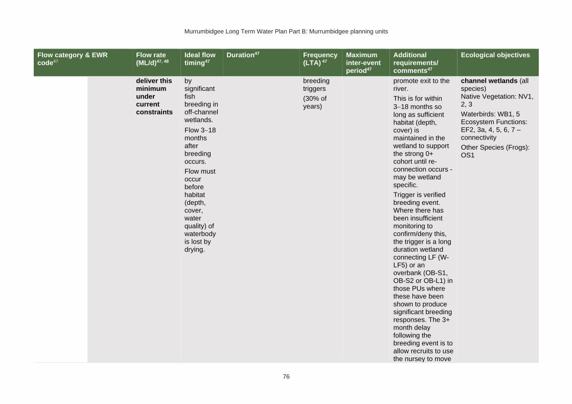
Murrumbidgee Long Term Water Plan Part B: Murrumbidgee planning units
76
Flow category & EWR code47
Flow rate (ML/d)47, 48
Ideal flow timing47
Duration47 Frequency (LTA) 47
Maximum inter-event period47
Additional requirements/ comments47
Ecological objectives
deliver this minimum under current constraints
by significant fish breeding in off-channel wetlands.
Flow 3−18 months after breeding occurs.
Flow must occur before habitat (depth, cover, water quality) of waterbody is lost by drying.
breeding triggers
(30% of years)
promote exit to the river.
This is for within
3−18 months so long as sufficient habitat (depth, cover) is maintained in the wetland to support the strong 0+ cohort until re-connection occurs - may be wetland specific.
Trigger is verified breeding event. Where there has been insufficient monitoring to confirm/deny this, the trigger is a long duration wetland connecting LF (W-LF5) or an overbank (OB-S1, OB-S2 or OB-L1) in those PUs where these have been shown to produce significant breeding responses. The 3+ month delay following the breeding event is to allow recruits to use the nursey to move
channel wetlands (all species) Native Vegetation: NV1, 2, 3
Waterbirds: WB1, 5 Ecosystem Functions: EF2, 3a, 4, 5, 6, 7 – connectivity
Other Species (Frogs): OS1

Murrumbidgee Long Term Water Plan Part B: Murrumbidgee planning units
77
Flow category & EWR code47
Flow rate (ML/d)47, 48
Ideal flow timing47
Duration47 Frequency (LTA) 47
Maximum inter-event period47
Additional requirements/ comments47
Ecological objectives
into the river & reach sufficient maturity to move into the river.
Floodplain Connection Flow 58 # (Overbank Small 1)
(Floodplain specialist fish)
OB-Small 1
Not relevant as a river flow this size (that inundates the floodplain ‘proper’) because the required frequency of 10-day flows in 70% of years is not met in this PU in the pre-development modelled scenario or in pre-1950s observations. However, there may be target sites for filling with infrastructure (where possible with carp screens or other exclusion devices) where populations of flat-headed galaxias can be re-established.
#Floodplain Connection Flow (Overbank Small 2)
(River red gum zone) 58
OB-Small 2 28,000 ML/d – not deliverable
Aug − Feb, with benefits also outside that period including by providing bird foraging habitat
In line with natural median duration for fish dispersal & riparian river red gum communities.
For wetlands 3−7 months persistence of standing water. For streamside areas, only duration to fill the soil profile, depressions/billabongs required.
The median modelled natural duration for flows of this size is ~10 days. We analysed for
5 years in 10
(50% of years)
4 years
Ideally maintain stable water levels in active waterbird colony sites and provide slow draw down for shallow muddy edges for bird foraging habitat.
To support river red gum flowering, seed set and seedling establishment & to encourage vegetative growth of lignum stands and lignum seedling
Native Fish: NF1, 2, 4, 5, 6, 7, 8, 9, 10 – dispersal and condition (all species)
Native Vegetation: NV2, 3, 4a, 4b, 4e river red gum (riparian and floodplain wetland), lignum
Waterbirds: WB1, 2, 3, 4, 5 – habitat and potential small-scale breeding
Ecosystem Functions: EF2, 3a, 4, 5, 6, 7 – channel forming, lateral connectivity, productivity
58 Dark grey background (and # in 1st column of row) denotes flows of this size cannot be delivered in the river. The flows occur due to tributary rainfall events or dam spills. Deliveries to these areas are only possible with pumping or where other infrastructure exists to divert water to the floodplain. In such cases carp exclusion devices should be used where possible.

Murrumbidgee Long Term Water Plan Part B: Murrumbidgee planning units
78
Flow category & EWR code47
Flow rate (ML/d)47, 48
Ideal flow timing47
Duration47 Frequency (LTA) 47
Maximum inter-event period47
Additional requirements/ comments47
Ecological objectives
cumulative flows of 10 days duration, made up of individual events of a minimum of 5 days within season
germination and
establishment− clustered, sequenced flows (i.e. annual flows
over 2−3 years) are required. This also benefits river cooba. The provision of periods of successive flows will also improve the condition of existing river red gum, lignum & river cooba and reduce unwanted river red gum recruitment.
For timing: flow can occur earlier, but for best benefits, duration of standing water of at least 90 days is required from Sept on to fit with vegetation growing season & bird breeding seasonality. Also note that some frog species are summer breeders, which, when a target for flows, will need at least 3 months from Oct.
Other Species (Frogs): OS1, 2, 3 – recruitment

Murrumbidgee Long Term Water Plan Part B: Murrumbidgee planning units
79
Flow category & EWR code47
Flow rate (ML/d)47, 48
Ideal flow timing47
Duration47 Frequency (LTA) 47
Maximum inter-event period47
Additional requirements/ comments47
Ecological objectives
#Large Floodplain Connection Flow (Overbank Large 1)58
(Black box zone)
OB Large 1 40,000 ML/d – not deliverable
Anytime59, though ideally
Sept − Mar.
There are benefits also outside that period including by providing bird foraging habitat
2−6 months for black box & lignum in
wetlands. 3−6 months for bird breeding.
Refers to the persistence of standing water, flow can be shorter. For streamside areas, only duration sufficient to fill the soil profile, depressions/ billabongs required.
The median modelled natural duration for flows of this size is around 8 days. We analysed for cumulative flows of 8 days duration, made up of individual events of a minimum of 5 days within season
2−3 years in 10
(25% of years)
5 years (up to 10 years for outer black box areas)
Ideally slow draw down for shallow muddy edges for bird foraging habitat.
To support black box flowering and seedling establishment, to encourage vegetative growth of lignum stands & lignum seedling establishment- clustered, sequenced flows (i.e. annual flows
over 2−3 years) are required. This also benefits river cooba. The provision of periods of successive flows will also increase the potential for recovery of existing river red gum, lignum & river cooba communities. Also
Native Fish: NF1, 7, 10
Native Vegetation: NV2, 3, 4a, 4b, 4c, 4e – black box & lignum & river red gum woodland high on floodplain Waterbirds: WB1, 2, 3, 4, 5 – large-scale breeding (colonial and non-colonial) and habitat Ecosystem Functions: EF2, 3a, 4, 5, 6, 7 – lateral connectivity, productivity
Other Species (Frogs): OS1, 2, 3 – recruitment
59 Analysis of flows of this size indicates that they only occur in the required frequency and within the maximum allowable gap between events when events in any season are accepted. Therefore, this flow is considered as applicable to black box (which may benefit from events in any season, though ‘in season’ flows are preferred) but not necessarily for water bird breeding. Events that do occur in the ideal season may still be beneficial to waterbird breeding.

Murrumbidgee Long Term Water Plan Part B: Murrumbidgee planning units
80
Flow category & EWR code47
Flow rate (ML/d)47, 48
Ideal flow timing47
Duration47 Frequency (LTA) 47
Maximum inter-event period47
Additional requirements/ comments47
Ecological objectives
note that some frog species are summer breeders, which, when a target for flows, will need at least 3 months from Oct.

Murrumbidgee Long Term Water Plan Part B: Murrumbidgee planning units
81
PU7: Lower Murrumbidgee Floodplain
The Lower Murrumbidgee Floodplain PU is situated within the Murrumbidgee (Gogeldrie to Waldaira) Water Source and Murrumbidgee Western Water Source. It includes the Lowbidgee Area which is a specific exclusion from the WSP for the Murrumbidgee Unregulated and Alluvial Water Sources. This area is covered in the WSP for the regulated Murrumbidgee. There are unregulated licences on Tala Lake, but these are considered as part of the Murrumbidgee Western Water Source.
Maude and Redbank weirs enable water to be directed onto the floodplain in the Nimmie-Caira & the South Redbank (Yanga) and North Redbank areas.
Figure 8 Map of Lower Murrumbidgee Floodplain PU. Area outside of PU has been faded. Significant gauge relevant to the PU is Murrumbidgee River @ Maude Weir (410040)

Murrumbidgee Long Term Water Plan Part B: Murrumbidgee planning units
82
Key ecological values
(CE = Critically Endangered, E = Endangered, V = Vulnerable, EP= Endangered Population in MDB, C = CAMBA, J = JAMBA, R = ROKAMBA, X = species recorded in this planning unit via catch records and or Australian Museum Records where they exist, Y = species expected to occur based on MaxEnt modelling)
Native fish
• Australian smelt X
• bony herring X
• carp-gudgeon species complex X
• dwarf flat-headed gudgeon Y
• flat-headed galaxias (CE) Y
• flat-headed gudgeon X
• golden perch X
• Murray cod (V) X
• Murray-Darling rainbowfish X
• olive perchlet Y
• silver perch (V) X
• trout cod (E) X
• unspecked hardyhead X
• western carp-gudgeon X
Waterbirds
77 waterbird species recorded including Australasian bittern (E), Australian painted snipe (E), black-tailed godwit, (V, C,J,K), common greenshank (C,J,K), marsh sandpiper (C,J,K), red-necked stint (C,J,K), ruddy turnstone (C,J,K), sharp-tailed sandpiper (C,J,K), wood sandpiper (C,J,K), curlew sandpiper (CE, C,J,K), Caspian tern (J) Latham's snipe (J,K), pectoral sandpiper (J,K), blue-billed duck (V), brolga (V), freckled duck (V) & magpie goose (V)
Native vegetation 188,784 ha of water-dependent native vegetation including 31,714 ha of black box, 52,769 ha of lignum, 2940 ha of non-woody wetland vegetation & 57,412 ha of river red gum.
Native fish objectives
NF1 No loss of native fish species
NF2 Increase the distribution & abundance of short to moderate-lived generalists: Australian smelt, carp-gudgeon species complex, flat-headed gudgeon, dwarf flat-headed gudgeon, bony herring, Murray-Darling rainbowfish, unspecked hardyhead
NF4 Improve population structure for moderate to long-lived flow pulse specialists: golden perch, silver perch
NF5 Improve population structure for moderate to long-lived riverine specialists: Murray cod, trout cod
NF6 A 25% increase in abundance of mature (harvestable sized): golden perch, Murray cod
NF7 Increase the prevalence &/or expand the population of key short to moderate-lived floodplain specialist native fish species into new areas (within historical range): olive perchlet
NF9 Increase the prevalence &/or expand the population of key moderate to long-lived flow pulse specialists native fish species into new areas (within historical range): silver perch
NF10 Increase the prevalence &/or expand the population of key moderate to long-lived diadromous native fish species into new areas (within historical range): short-headed lamprey
Hydrology
Hydrological alteration
See Table 1 for key
Regulated river reach
CtF Low flow & baseflow
Freshes High & infrequent flows
1.5ARI 2.5ARI 5ARI
Murrumbidgee River d/s Maude Weir
N/A H- M- M- M- M-
Relevant rules from WSP
Murrumbidgee (Gogeldrie to Waldaira) Water Source
Access rules*:
Rivers & creeks: pumping is not permitted from natural pools when the water level in the pool is lower than its full capacity.

Murrumbidgee Long Term Water Plan Part B: Murrumbidgee planning units
83
Natural off-river pools: pumping is not permitted from an off-river pool or an off-river dam pool when the volume of water in that pool is less than 80% of the full capacity of the natural pool that existed prior to any augmentation works.
Trading rules:
INTO water source: No trade allowed
WITHIN water source: Allowed, but no trade into off river pools
Murrumbidgee Western Water Source:
Access Rules*:
Rivers & creeks: No pool drawdown.
Off-river pools: Pumping is not permitted from an off-river pool or an off-river dam pool when the volume of water in that pool is less than 80% of the full capacity of the natural pool that existed prior to any augmentation works
Current Trade Rules:
INTO water source: No trade allowed.
WITHIN water source: Allowed, but no trade into off-river pools or onto Talpee Creek.
*Note: These access rules do not apply:
1. if the existing Water Act 1912 entitlement had more stringent access licence conditions.
2. to major water utility, local water utility or unregulated river (town water supply) access licences
3. to water taken for domestic consumption by stock & domestic access licences
4. for the first 5 years of the plan to water taken for stock watering by stock & domestic access licences
5. to water taken from existing dams. Any existing licence conditions associated with a dam will be carried forward under the plan.
There are 9 very small (<250 ML), 1 small, 1 large (1000−2500 ML) & 2 very large (>2500 ML) unregulated water access licences distributed throughout the PU. The total volume of unregulated entitlements for the PU is 12,106 ML of which 12,037 ML is allocated for irrigation (rather than stock & domestic or town water supply).
Recommended management strategies
MS2: Ensure compliance with water access licence conditions including through metering of all licensed extraction.
MS3: As a minimum, maintain existing rules in the WSP for the Murrumbidgee Unregulated Water Sources that protect environmental assets and values.
MS4: Monitor for changes in water demand and review access rules if current usage is high or if the pattern of use changes.
MS5: Consider introducing cease-to-pump and commence-to-pump rules (and any associated required amendments to WAL conditions) that protect held environmental water and water from the EWAs entering unregulated streams and off-channel pools (wetlands), In-line with the Basin Plan (Section 7.15(2)) requirement for implementation of prerequisite policy measures which provide for delivered environmental water to be protected.
MS6: For lagoon licences that are the target of environmental water, consider water access licence purchases from willing sellers or the negotiation of enduring agreements with licence holders.
Note: Section 7.2 of Part A of the Murrumbidgee LTWP also identifies as priority investment opportunities:
• Implement the constraints management strategy
• Improve information and tools available for managing periods when there is a high risk of fish death events
• Improve water quality monitoring to avoid fish deaths
• Investigate opportunities to temporarily remove (or lower) weir gates to improve connectivity and improve habitat for native fish. Implement once investigated.
• Consider options for managing rainfall rejections in weir pools when the risk of fish death events is high
• Construct escapes in Lowbidgee levees

Murrumbidgee Long Term Water Plan Part B: Murrumbidgee planning units
84
Environmental water requirements
For the Lower Murrumbidgee PU there are not only the EWRs for river flows which are presented in Table 9. Because the inundation of the widespread wetlands of the Lowbidgee are driven by total event volumes (not just peak flows), there are also total event volume EWRs which were developed by the MDBA (2012). These are presented in Table 10.
In the Lowbidgee Floodplain, Maude and Redbank weirs in conjunction with a number of regulators, enable flows to be directed onto parts of the floodplain. Table 11 provides information about the estimated EWRs for delivery through those regulators. Those EWRs have been separated into the components that can be managed through the regulators – that is:
• the Nimmie-Caira system (off Maude Weir)
• the Yanga system (from channels to the south of Redbank Weir pool and also from flows through the Nimmie-Caira)
• the North Redbank system (off Redbank Weir)
• the Western Lakes (supplied via the North Redbank system).
The EWR estimates in Table 11 were determined using information and modelling from NSW DPIE-Water (2019) (for the Nimmie-Caira area) and information from wetland managers and environmental water managers.

Murrumbidgee Long Term Water Plan Part B: Murrumbidgee planning units
85
Table 9 Murrumbidgee (from Maude Weir to Balranald) (as measured at downstream Maude gauge - 410040) – gauge data began in 1936
Flow category & EWR code60 Flow rate (ML/d)60, 61
Ideal flow timing60
Duration60 Frequency (LTA) 60
Maximum inter-event period60
Additional requirements/ comments60
Ecological objectives
Cease-to-flow CtF <1 ML/d
CtF events occurred in 16%, 3% & 7% of years in the modelled pre-development & post development scenarios &
1936−1950 observations respectively. They did not occur in post development observed data (1980−2017) in this PU. Because the post development ecosystem is likely to be less resilient than in pre-development times & it may have adapted to the more constant flow conditions CtF periods are not recommended.
Very low flow VLF >170 ML/d Anytime
In typical years, 365 days per year
In very dry years, at least 294 days per year 62
Every year
1980−2017 observations did not exceed 26 days for 95% of events63
Flow ideally >0.03–0.05 m/s to de-stratify pools
Native Fish: NF1 – Survival and condition (all species) Ecosystem Functions: EF1, 2 – refuge habitat
Baseflow BF1 >600 ML/d Anytime
In typical years, 340 days per year
In very dry years, at least 229 days per year62
Every year
1980−2017 observations did not exceed 48 days for 95% of events63
Minimum depth of 0.3 m to allow fish passage
Native Fish: NF1, 2, 4, 5, 6, 7, 9, 10 – condition and movement Native Vegetation: NV1 – in-channel Ecosystem Functions: EF1, 2, 3
60 Refer to Glossary for definitions of terms and explanatory text for EWRs
61 These minimums are where the benefits of flow categories are likely to begin manifesting. Further substantial benefits occur, particularly for wetland connecting large freshes and overbanks, as flows increase in size. These thresholds SHOULD NOT be used to indicate that constraints only need to be raised to achieve these minimums.
62 Based on modelled pre-development with ‘typical year’ value the median of those observations, and ‘very dry’ value the 95th percentile. Observed ‘pre-development’ not used as data only goes from 1936.
63 Post development period chosen because ecological community may have adapted to more constant flows since development and is likely to be less resilient than pre-development times
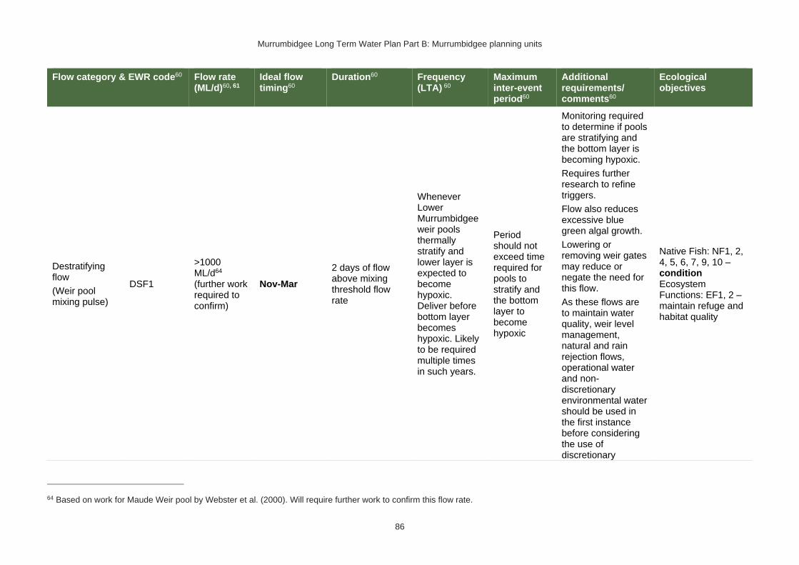
Murrumbidgee Long Term Water Plan Part B: Murrumbidgee planning units
86
Flow category & EWR code60 Flow rate (ML/d)60, 61
Ideal flow timing60
Duration60 Frequency (LTA) 60
Maximum inter-event period60
Additional requirements/ comments60
Ecological objectives
Destratifying flow
(Weir pool mixing pulse)
DSF1
>1000 ML/d64 (further work required to confirm)
Nov-Mar
2 days of flow above mixing threshold flow rate
Whenever Lower Murrumbidgee weir pools thermally stratify and lower layer is expected to become hypoxic. Deliver before bottom layer becomes hypoxic. Likely to be required multiple times in such years.
Period should not exceed time required for pools to stratify and the bottom layer to become hypoxic
Monitoring required to determine if pools are stratifying and the bottom layer is becoming hypoxic.
Requires further research to refine triggers.
Flow also reduces excessive blue green algal growth.
Lowering or removing weir gates may reduce or negate the need for this flow.
As these flows are to maintain water quality, weir level management, natural and rain rejection flows, operational water and non-discretionary environmental water should be used in the first instance before considering the use of discretionary
Native Fish: NF1, 2, 4, 5, 6, 7, 9, 10 – condition Ecosystem Functions: EF1, 2 – maintain refuge and habitat quality
64 Based on work for Maude Weir pool by Webster et al. (2000). Will require further work to confirm this flow rate.

Murrumbidgee Long Term Water Plan Part B: Murrumbidgee planning units
87
Flow category & EWR code60 Flow rate (ML/d)60, 61
Ideal flow timing60
Duration60 Frequency (LTA) 60
Maximum inter-event period60
Additional requirements/ comments60
Ecological objectives
environmental water.
Nesting Support
Nests1
600-6000 ML/d
Max rate of fall 13% per day.
15 Sep − 15 Nov for trout cod & Murray cod.
1 Oct − 15 Nov for only Murray cod.
(Only apply EWR if flows are in the BF or SF range at start of period)
60 days minimum for trout cod & Murray cod.
45 day minimum for only Murray cod
5−10 years in 10
(75% of years)
2 years
Allow variable flows but avoid large sudden decreases in water level to prevent loss of nesting sites. Flow decreases not to exceed 13% per day which is the 20th percentile (the fastest 20%) of fall - calculated from observed ‘pre-development' flow data (1936-1950)
Native Fish NF5, 6 - Nesting of riverine specialists (protect nesting sites by avoiding rapid changes in water levels)
Native Vegetation: NV1,3 – in-channel & riparian
Small fresh SF1 >2500 ML/d
Anytime - but
ideally Oct − Apr, & ideally
2−3 weeks after ‘LF2’
10 days minimum 2 events per year
1 year
>20°C for Oct to Apr (for native fish); for
Murray cod Sept − Dec >18°C
Minimum depth of 0.5 m to allow movement of large fish
Rate of fall: No faster than 18% per day65
Flow ideally up to
0.3−0.4 m/s
Native Fish: NF1, 2, 4, 5, 6, 7, 9, 10 – Dispersal/condition (all species) Native Vegetation: NV1 – in-channel Ecosystem Functions: EF1, 2, 3, 4, 5
65 The 5th percentile (fastest 5% of rates of fall) of ‘pre-development’ 1936-1950 observed flows

Murrumbidgee Long Term Water Plan Part B: Murrumbidgee planning units
88
Flow category & EWR code60 Flow rate (ML/d)60, 61
Ideal flow timing60
Duration60 Frequency (LTA) 60
Maximum inter-event period60
Additional requirements/ comments60
Ecological objectives
(depending on channel form)
Small fresh SF2 2500−6000 ML/d
15 Sep − Apr 14 days minimum
5–10 years in 10
(75% of years)
2 years
>20°C for Oct − Apr (for native fish); for
Murray cod Sept − Dec >18°C
Minimum depth of 0.5 m to allow movement of large fish
Rate of fall: No faster than 18% per day65
Flow ideally up to
0.3−0.4 m/s (depending on channel form)
Native Fish: NF1, 2, 5, 6 – Spawning (river specialists, generalists) Native Vegetation: NV1 – in-channel Ecosystem Functions: EF1, 2, 3, 4, 5
Large fresh LF1 >6000 ML/d
Anytime - but
ideally July − Sept
Consider delivery outside cod breeding season to avoid flushing of nests
5 days minimum
5–10 years in 10
(75% of years)
2 years
Minimum depth of 2 m to cover in-stream features & trigger response from fish
Flow ideally 0.3−0.4 m/s (depending on channel form)
Rate of fall: No faster than 21% per day65
Native Fish: NF1, 2, 4, 5, 6, 9, 10 – dispersal/condition (all species) Native Vegetation: NV1, 3 – in-channel/ riparian Ecosystem Functions: EF2, 3, 4, 5, 6
Large fresh LF2 >6000 ML/d
Oct to Apr
Consider delivery outside cod breeding season to
5 days minimum 6–7 years in 10
(65% of years) 2 years
Minimum depth of 2 m to cover in-stream features & trigger response from fish
Flow ideally 0.3−0.4
Native Fish: NF1, 4, 6, 9 – spawning (flow pulse specialists) Native Vegetation: NV1 – in-channel

Murrumbidgee Long Term Water Plan Part B: Murrumbidgee planning units
89
Flow category & EWR code60 Flow rate (ML/d)60, 61
Ideal flow timing60
Duration60 Frequency (LTA) 60
Maximum inter-event period60
Additional requirements/ comments60
Ecological objectives
avoid flushing of nests
m/s (depending on channel form)
Rapid rise (comparable to natural rates) >17°C
Ideally follow 2–3 weeks later with SF1 for improved fish recruitment, productivity and dispersal.
Rate of fall: No faster than 21% per day65
Ecosystem Functions: EF2, 3, 4, 5, 6
Large fresh with wetland connection66,67 *
(below bankfull: in the upper part of the ‘LF’ band)
W-LF4 (core wetland and off-channel fish refuge)
>12,500 ML/d – Difficult to deliver this minimum under current constraints
Anytime – but
ideally July − Feb for non-woody vegetation
7−12 months water retention for non-woody vegetation. Permanent for key floodplain specialist refuge pools.
The median observed duration for flows of this size is ~12 days. We
8–10 years in 10
(90% of years)
18 months (but no drying out of refuge pools for floodplain specialist native fish)
In dry years maintaining refuge pools for floodplain specialist native fish may require pumping.
Native Fish: NF1, 7 – refuge pools for floodplain specialists Native Vegetation: NV1, 2 – wetland non-woody vegetation Waterbirds: WB1, 2, 5 Ecosystem Functions: EF1 – protection of core wetland areas
66 In other catchments, connection to major wetlands systems would generally occur at and above bankfull level. The geomorphology of the Murrumbidgee system is such that major billabong, anabranch and other off-channel wetland systems are connected below bankfull level. Hence the category of ‘wetland connecting flow is used in the Murrumbidgee. 67 Light grey background (and * in 1st column of row) denotes that flows to this zone are currently difficult to deliver due to potential impacts on third parties, particularly in upstream planning units. The constraints management strategy may alleviate this.

Murrumbidgee Long Term Water Plan Part B: Murrumbidgee planning units
90
Flow category & EWR code60 Flow rate (ML/d)60, 61
Ideal flow timing60
Duration60 Frequency (LTA) 60
Maximum inter-event period60
Additional requirements/ comments60
Ecological objectives
analysed for cumulative flows of 12 days duration, made up of individual events of a minimum of 7 days within season68
Other Species (Frogs): OS1
W-LF5
(Floodplain specialist fish spawning)
>12,500 ML/d – Difficult to deliver this minimum under current constraints
Oct to Apr (preferably early in that period to limit evaporative losses and allow autumn drying following a wet sequence of years)
10 days minimum69
The median observed duration for flows of this size is around 10 days. We analysed for cumulative flows of 10 days duration, made up of individual events of a minimum of 5 days within season
5 years in 10
(50% of years)
2 years
For floodplain specialist fish – ideally >22°C.
Ideally, follow 2-4 weeks later with flow that maintains or reconnects off-channel habitat to enhance recruitment and dispersal opportunities.
In very dry periods deliver to discrete wetlands via infrastructure to protect populations
Native Fish: NF1, 7 – Spawning (floodplain specialists) Native Vegetation: NV1, 2, 3, 4 – non-woody wetland vegetation, riparian river red gum Waterbirds: WB1, 2, 5 – habitat Ecosystem Functions: EF2, 3, 4, 5, 6 – connectivity, productivity Other Species (Frogs): OS1 – habitat
68 The information in italics is not meant to be prescriptive. It notes the median duration of past flow events of this size as a guideline. Where cumulative durations are noted, the minimum duration of individual events which make up that cumulative total (again only provided for guidance) is based on the 25th percentile duration of events of this size.
69 10 days is minimum to promote productivity and food production in a wetland and support spawning/nesting and hatching. There may be cases where populations of floodplain specialists can be supported with shorter flows (i.e., substantial habitat already exists, and small inflows promote additional productivity and food supply). In non-permanent wetlands a follow up reconnecting flow may be required within 12 months or water levels in the wetland will need to be maintained with infrastructure until the next re-connection. Hence events of 5 days are considered acceptable, but would need a follow up event of at least 5 days

Murrumbidgee Long Term Water Plan Part B: Murrumbidgee planning units
91
Flow category & EWR code60 Flow rate (ML/d)60, 61
Ideal flow timing60
Duration60 Frequency (LTA) 60
Maximum inter-event period60
Additional requirements/ comments60
Ecological objectives
where required & feasible.
Note floodplain specialist fish are currently believed to be locally extinct in this PU. This EWR is relevant should they be re-introduced.
W-LF6
(Fish dispersal & condition)
>12,500 ML/d – Difficult to deliver this minimum under current constraints
Anytime – but
ideally Sept − Feb (preferably early in that period to limit evaporative losses and allow autumn drying following a wet sequence of years)
5 days minimum for fish dispersal
2−3 years in 10
(1 every 3-5 years)
(25% of years)
5 years
Native Fish: NF1, 2, 4, 5, 6, 7, 9, 10 – dispersal & condition (all species) Native Vegetation: NV1, 2, 3 – riparian river red gum communities Waterbirds: WB1, 2, 5 – habitat Ecosystem Functions: EF2, 3, 4, 5, 6 – lateral floodplain, productivity, bench and pool forming

Murrumbidgee Long Term Water Plan Part B: Murrumbidgee planning units
92
Flow category & EWR code60 Flow rate (ML/d)60, 61
Ideal flow timing60
Duration60 Frequency (LTA) 60
Maximum inter-event period60
Additional requirements/ comments60
Ecological objectives
Other Species (Frogs): OS1 – habitat
W-LF7 (Non- woody veg zone – also for frog recruitment)
>12,500 ML/d – Difficult to deliver this minimum under current constraints
July − Feb flow timing (preferably early in that period to limit evaporative losses and allow autumn drying following a wet sequence of years). There are benefits also outside that period including by providing bird foraging habitat
3−10 months. Refers to the persistence of standing water (minimum 3-7 months depending on vegetation community)
The median observed duration for flows of this size is around 12 days. We analysed for cumulative flows of 12 days duration, made up of individual events of a minimum of 7 days within season68
6−8 years in 10
(70% of years)
2 years Ideally maintain stable water levels in active waterbird colony sites and provide slow draw down for shallow muddy edges for bird foraging habitat.
For best benefits duration of standing water of at least 90 days is required during the growing season (from Sept on). Also note that some frog species are summer breeders so will need at least 3 months from Oct.
To increase cover & extent of non-woody vegetation communities - clustered, sequenced flows (i.e. annual flows
over 2−3 years) are required.
The provision of periods of higher flow magnitude &
Native Fish: NF1, 2, 4, 5, 6, 7, 9 – dispersal & condition (all species)
Native Vegetation: NV2, 3, 4 – Non-woody vegetation in wetlands, river red gum forest fringing wetlands/channels
Waterbirds: WB1, 2, 3, 5 – habitat, small scale breeding
Function: EF1, 2, 3, 4, 5, 6 – core wetland habitats, lateral connectivity, productivity
Other Species (Frogs): OS1, 2, 3 – recruitment

Murrumbidgee Long Term Water Plan Part B: Murrumbidgee planning units
93
Flow category & EWR code60 Flow rate (ML/d)60, 61
Ideal flow timing60
Duration60 Frequency (LTA) 60
Maximum inter-event period60
Additional requirements/ comments60
Ecological objectives
successive flows also has the potential to increase non-woody vegetation cover & extent &/or limit encroachment of woody species (if desired).
W-LF8 (fish connect flow)
>12,500 ML/d – Difficult to deliver this minimum under current constraints
Anytime70, but triggered by significant fish breeding in off-channel wetlands.
Flow 3−18 months after breeding occurs.
Flow must occur before habitat (depth, cover, water quality) of waterbody is lost by drying.
5 days 3 years in 10 or as required by breeding triggers
(30% of years)
5 years Ideally provide a protracted recession to promote exit to the river.
This is for within
3−18 months so long as sufficient habitat (depth, cover) is maintained in the wetland to support the strong 0+ cohort until re-connection occurs - may be wetland specific.
Trigger for flow to be required is a verified breeding event. Where there has been insufficient monitoring to confirm/deny a breeding event, the
Native Fish: NF1, 2, 4, 5, 6, 7, 9, 10 – dispersal from off channel wetlands (all species) Native Vegetation: NV1, 2, 3
Waterbirds: WB1, 5 Ecosystem Functions: EF2, 3, 4, 5, 6 – connectivity
Other Species (Frogs): OS1
70 Return movement may vary seasonally, so future research will inform any necessary refinement in the timing of this.

Murrumbidgee Long Term Water Plan Part B: Murrumbidgee planning units
94
Flow category & EWR code60 Flow rate (ML/d)60, 61
Ideal flow timing60
Duration60 Frequency (LTA) 60
Maximum inter-event period60
Additional requirements/ comments60
Ecological objectives
trigger is a long duration wetland connecting LF (W-LF5) or an overbank (OB-S1, OB-S2 or OB-L1) in those PUs where these have been shown to produce significant breeding responses (to be determined). The 3+ month delay following the breeding event is to allow recruits to utilize the nursey to reach sufficient maturity to move into the river.
#Floodplain Connection Flow (Overbank Small 1)71
(Floodplain specialist fish)
OB-Small 1 (Floodplain specialist fish)
>15,000 ML/d – Not deliverable under current constraints
Oct − Apr for floodplain specialist fish spawning (preferably early in that period to limit evaporative losses and allow autumn drying
10 days min for floodplain specialist fish69
The median observed duration for flows of this size is around 10 days. We analysed for cumulative flows of 10 days
5 years in 10
(50% of years)
4 years For floodplain specialist fish – ideally >22°C
Ideally, follow 2-4 weeks later with flow that maintains or reconnects off-channel habitat to enhance recruitment and dispersal opportunities.
Native Fish: NF1, 2, 4, 5, 6, 7, 9, 10 – spawning (floodplain specialists)
Native Vegetation: NV2, 3, 4a, 4b, 4e
Waterbirds: WB1, 2, 3, 4, 5
71 Dark grey background (and # in 1st column of row) denotes flows of this size cannot currently be delivered in the river. These flows occur due to tributary rainfall events or dam spills. Deliveries to these areas are currently only possible with pumping or where other infrastructure exists to divert water to the floodplain. The key constraints are the restriction in the delivery of larger flows upstream of this planning unit. The constraints management strategy may alleviate this.

Murrumbidgee Long Term Water Plan Part B: Murrumbidgee planning units
95
Flow category & EWR code60 Flow rate (ML/d)60, 61
Ideal flow timing60
Duration60 Frequency (LTA) 60
Maximum inter-event period60
Additional requirements/ comments60
Ecological objectives
following a wet sequence of years)
duration, made up of individual events of a minimum of 5 days within season
In very dry periods deliver to discrete wetlands via infrastructure to protect populations where required & feasible.
Note floodplain specialist fish are currently believed to be locally extinct in this PU. This EWR is relevant should they be re-introduced.
Ecosystem Functions: EF2, 3, 4, 5, 6
Other Species (Frogs): OS1, 2, 3
#Floodplain Connection Flow (Overbank Small 2)71
(River red gum zone)
OB-Small 2 15,000 ML/d – Not deliverable under current constraints
Aug − Feb, with benefits also outside that period including by providing bird foraging habitat (preferably early in that period to limit evaporative losses and allow autumn drying following a wet sequence of years)
In line with natural median duration for fish dispersal & riparian river red gum communities
For wetlands 3−7 months’ persistence of standing water. For streamside areas, only duration to fill the soil profile, depressions/ billabongs required
The median observed duration for flows
5 years in 10
(50% of years)
4 years Ideally maintain stable water levels in active waterbird colony sites and provide slow draw down for shallow muddy edges for bird foraging habitat.
To support river red gum flowering, seed set and seedling establishment & to encourage vegetative growth of lignum stands and lignum seedling germination and establishment- clustered, sequenced flows
Native Fish: NF1, 2, 4, 5, 6, 7, 9, 10 – dispersal and condition (all species)
Native Vegetation: NV2, 3, 4a, 4b, 4e river red gum (riparian and floodplain wetland), lignum
Waterbirds: WB1, 2, 3, 4, 5 – habitat and potential small-scale breeding
Ecosystem Functions: EF2, 3, 4, 5, 6 – channel forming, lateral

Murrumbidgee Long Term Water Plan Part B: Murrumbidgee planning units
96
Flow category & EWR code60 Flow rate (ML/d)60, 61
Ideal flow timing60
Duration60 Frequency (LTA) 60
Maximum inter-event period60
Additional requirements/ comments60
Ecological objectives
of this size is around 11 days. We analysed for cumulative flows of 11 days duration, made up of individual events of a minimum of 6 days within season68
(i.e. annual flows
over 2−3 years) are required. This also benefits river cooba. The provision of periods of successive flows will also improve the condition of existing river red gum, lignum & river cooba and reduce unwanted river red gum recruitment.
For timing: flow can occur earlier, but for best benefits, duration of standing water of at least 90 days is required from Sept on to fit with vegetation growing season & bird breeding seasonality. Some frog species are summer breeders, which will need at least 3 months from Oct.
connectivity, productivity
Other Species (Frogs): OS1, 2, 3 – recruitment
#Large Floodplain Connection Flow
OB Large 1 >22,000 ML/d – Not deliverable
Sept − Mar, with benefits also outside that period including by
2−6 months for black box & lignum in
wetlands. 3−6
2 to 3 years in 10
(25% of years)
5 years (up to 10 years for outer black box areas)
Ideally slow draw down for shallow muddy edges for bird foraging habitat
Native Fish: NF1, 7, 10
Native Vegetation: NV2, 3, 4a, 4b, 4c, 4e – black box &

Murrumbidgee Long Term Water Plan Part B: Murrumbidgee planning units
97
Flow category & EWR code60 Flow rate (ML/d)60, 61
Ideal flow timing60
Duration60 Frequency (LTA) 60
Maximum inter-event period60
Additional requirements/ comments60
Ecological objectives
(Overbank Large 1)71
(Black box zone)
providing bird foraging habitat
months for bird breeding
Refers to the persistence of standing water, flow can be shorter. For streamside areas, only duration sufficient to fill the soil profile, depressions/ billabongs required
The median modelled natural duration for flows of this size is around 12 days. We analysed for cumulative flows of 12 days duration, made up of individual events of a minimum of 7 day within season68
To support black box flowering and seedling establishment, to encourage vegetative growth of lignum stands & lignum seedling
establishment− clustered, sequenced flows (i.e. annual flows
over 2−3 years) are required. This also benefits river cooba. The provision of periods of successive flows will also increase the potential for recovery of existing river red gum, lignum & river cooba communities
Some frog species are summer breeders, which will need at least 3 months from Oct.
lignum & river red gum woodland high on floodplain Waterbirds: WB1, 2, 3, 4, 5 – large-scale breeding (colonial and non-colonial) and habitat Ecosystem Functions: EF2, 3, 4, 5, 6 – lateral connectivity, productivity
Other Species (Frogs): OS1, 2, 3 – recruitment

Murrumbidgee Long Term Water Plan Part B: Murrumbidgee planning units
98
Table 10 Environmental water requirements for the Lower Murrumbidgee River Floodplain from MBDA (2012)
Volumes are for flows from days with minimum flow rates of 5,000 ML/d.
Event (flows gauged at Maude Weir) Frequency-proportion of year’s event required to achieve ecological target (%)
Proportion year’s event occurred in modelled baseline conditions (%)
Related River flow EWR (see Table 9)
Total inflow required (GL) Timing Low uncertainty
High uncertainty
175 July–Sept 75 70 68 W-LF7
270 July–Sept 70 60 57 W-LF7
400 July–Oct 60 55 52 W-LF7 & OB-S2
800 July–Oct 50 40 39 OB-S2
1,700 July––Nov 25 20 18 OB-L1
2,700 May–Feb 15 10 9 OB-L2
Table 11 Environmental water requirements for the portion of the Lower Murrumbidgee Floodplain that can be watered from regulators off Maude and Redbank weirs, showing water use through those regulators
Flow Category
Planning sub-unit
Gauge Flow (ML/d)
Duration (days)
Timing Frequency Max inter-event period
Notes Estimated volume (ML)
W-LF4 – wetland connecting flow – for core
Nimmie-Caira
Eulimbah ≥200
12−15
Anytime (but ideally
July − Feb)
8−10 years in 10
18 months (but no drying out of refuge pools for floodplain
For refuge creeks
In dry years, providing channel deliveries may require operating weir pools during times of potential stratification
6750
This is the combination of Eulimbah & Nimmie Creek flows for the minimum duration
Nimmie Creek
≥250

Murrumbidgee Long Term Water Plan Part B: Murrumbidgee planning units
99
Flow Category
Planning sub-unit
Gauge Flow (ML/d)
Duration (days)
Timing Frequency Max inter-event period
Notes Estimated volume (ML)
wetland & refuge
Yanga (South Redbank)
1AS ≥500 >20
specialist native fish)
Assumes no contribution via Nimmie-Caira
This is flow from 1AS to Piggery Lake (flows to Breer provided by reconnection flows from river). Also provides watering to Mercedes Swamp via backflow.
10,000
North Redbank
Glen Dee ≥300 10 Watering of Narwie & Steam Engine swamps
7,000
Pattos Pipe
≥100 15 Glen Dee Swamp
Bills Pipe ≥100 10 Paul Coates Swamp
Pump direct from river
≥30 50 Deep water refuge habitat in lagoons of Moola/Baupie/ Balranald Common
W-LF7 – wetland connecting flow - non-woody veg
Nimmie-Caira
Eulimbah ≥200
25 July − Feb (preferably early in that period to limit evaporative losses and allow autumn drying following a wet sequence of years)
6−8 years in 10
2 years
11,250 Nimmie Creek
≥250
Yanga (South Redbank)
1AS ≥500 20
Assumes no contribution via
Nimmie−Caira.
Flows from 1AS to Piggery Lake (flows to Breer provided by reconnection flows)
10,000
North Redbank
Glen Dee ≥500 >20 Water provided from Athen to Murrundi and top up lake on Lake Marimley
14,000 Pattos Pipe
≥100 15 Glen Dee Swamp
Bills Pipe ≥100 10 Paul Coates Swamp

Murrumbidgee Long Term Water Plan Part B: Murrumbidgee planning units
100
Flow Category
Planning sub-unit
Gauge Flow (ML/d)
Duration (days)
Timing Frequency Max inter-event period
Notes Estimated volume (ML)
Western Lakes
Glen Dee ≥20 50
In addition to above Glen Dee volume
Dependent on installation of infrastructure to get to target of Paika Creek/ Dundamallee Reserve areas adjacent to Paika Lake including the Reed Bed Reserve
1000
OB-S2 - overbank small (50%) for river red gum & small-scale bird breeding
Nimmie-Caira
Eulimbah ≥1,200
35−42
Aug − Feb (preferably early in that period to limit evaporative losses and allow autumn drying following a wet sequence of years)
5 years in 10
4 years
Flows through Nimmie-Caira reach southern Yanga.
60,900 − Combined flows at both gauges Nimmie
Creek ≥250
Yanga (South Redbank)
Combined 1AS + 1ES
≥800 80 Assumes water via Nimmie-Caira (above)
64,000
North Redbank
Glen Dee ≥800 75 Juanbung through to Balranald Common
60,000
Western Lakes
Glen Dee ≥300 30
In addition to above Glen Dee volume.
Partial top up of Paika Lake. There may be sequences of years where this will not be required where a drying down of the lake is desired.
Watering will be via Narwie West and Yarrawol Ck and provide benefits there.
9000
OB-L1 - overbank large (25%)
Nimmie-Caira
Eulimbah ≥2000 fill / ≥200
Sept − Mar (preferably early in that
2−3 years in 10
5 years 83,700
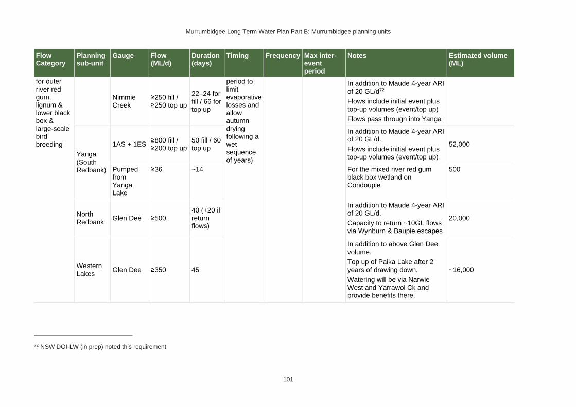
Murrumbidgee Long Term Water Plan Part B: Murrumbidgee planning units
101
Flow Category
Planning sub-unit
Gauge Flow (ML/d)
Duration (days)
Timing Frequency Max inter-event period
Notes Estimated volume (ML)
for outer river red gum, lignum & lower black box & large-scale bird breeding
Nimmie Creek
≥250 fill / ≥250 top up
22−24 for fill / 66 for top up
period to limit evaporative losses and allow autumn drying following a wet sequence of years)
In addition to Maude 4-year ARI of 20 GL/d72
Flows include initial event plus top-up volumes (event/top up)
Flows pass through into Yanga
Yanga (South Redbank)
1AS + 1ES ≥800 fill / ≥200 top up
50 fill / 60 top up
In addition to Maude 4-year ARI of 20 GL/d.
Flows include initial event plus top-up volumes (event/top up)
52,000
Pumped from Yanga Lake
≥36 ~14 For the mixed river red gum black box wetland on Condouple
500
North Redbank
Glen Dee ≥500 40 (+20 if return flows)
In addition to Maude 4-year ARI of 20 GL/d.
Capacity to return ~10GL flows via Wynburn & Baupie escapes
20,000
Western Lakes
Glen Dee ≥350 45
In addition to above Glen Dee volume.
Top up of Paika Lake after 2 years of drawing down.
Watering will be via Narwie West and Yarrawol Ck and provide benefits there.
~16,000
72 NSW DOI-LW (in prep) noted this requirement

Murrumbidgee Long Term Water Plan Part B: Murrumbidgee planning units
102
Flow Category
Planning sub-unit
Gauge Flow (ML/d)
Duration (days)
Timing Frequency Max inter-event period
Notes Estimated volume (ML)
OB-L2 - overbank large (15%) for black box & large-scale bird breeding
Nimmie-Caira
Eulimbah ≥100
60
Anytime, but preferably
Aug − Mar for bird & frog breeding benefits (preferably early in that period to limit evaporative losses and allow autumn drying following a wet sequence of years)
1−2 years in 10
10 years
In addition to Maude 7-year ARI of ~25GL/d.73
To support active major waterbird colonies which have been initiated by natural large floods events.
Flows include initial event plus top-up volumes (event/top up).
Flows pass through Nimmie-Caira & into Yanga.
These deliveries may coincide with in-channel fish refuge flows to offset negative impacts of hypoxic blackwater.
12,000
Nimmie Creek
≥100
Yanga (South Redbank)
1AS + 1ES ≥200 60
In addition to Maude 7-year ARI of ~25GL/d.
Flows include initial event plus top-up volumes (event/top up).
12,000
Pump from Yanga Lake
≥36 ~42 For the three black box wetlands of Condoulpe.
1,500
North Redbank
Glen Dee
≥400
[200 for rookeries; 2x100 for return flows]
60 fill / 30 top up
In addition to Maude 7-year ARI of ~25GL/d.
Flows include initial event plus top-up volumes (event/top up).
18,000
73 Based on notes in NSW DOI-LW (in prep) that delivery should be in conjunction with flow uncontrolled flood events of the order of 14% AEP which is approximately a 7 year ARI. A 7 year ARI equates to around 25,000 ML/d.

Murrumbidgee Long Term Water Plan Part B: Murrumbidgee planning units
103
Flow Category
Planning sub-unit
Gauge Flow (ML/d)
Duration (days)
Timing Frequency Max inter-event period
Notes Estimated volume (ML)
Western Lakes
Glen Dee ≥350 70
In addition to above Glen Dee volume.
For the filling of Paika Lake, Hobblers Lake & Penarie Ck.
~24,000

Murrumbidgee Long Term Water Plan Part B: Murrumbidgee planning units
104
PU8: Murrumbidgee River – Balranald to Murray
The Murrumbidgee River – Balranald to Murray PU is situated within the Murrumbidgee (Gogeldrie to Waldaira) Water Source.
Figure 9 Map of Murrumbidgee River - Balranald to Murray PU.
Area outside of PU has been faded. Significant gauge relevant to the PU is Murrumbidgee River @ Balranald Weir (410130)
Key ecological values
(CE = Critically Endangered, E = Endangered, V = Vulnerable, EP= Endangered Population in MDB, C = CAMBA, J = JAMBA, R = ROKAMBA, X = species recorded in this planning unit via catch records and or Australian Museum Records where they exist, Y = species expected to occur based on MaxEnt modelling)
Native fish
• Australian smelt X
• bony herring X
• carp-gudgeon species complex X
• dwarf flat-headed gudgeon Y
• freshwater catfish (E) Y
• flat-headed galaxias (CE) Y
• flat-headed gudgeon X
• golden perch X
• Murray cod (V) X
• Murray-Darling rainbowfish X
• olive perchlet Y
• silver perch (V) Y
• spangled perch X
• unspecked hardyhead X
Waterbirds 42 waterbird species recorded including Caspian tern (J)
Native vegetation
11,830 ha of water-dependent native vegetation including 1371 ha of black box, 518 ha of lignum, 565 ha of non-woody wetland vegetation & 7734 ha of river red gum

Murrumbidgee Long Term Water Plan Part B: Murrumbidgee planning units
105
Native fish objectives
NF1 No loss of native fish species
NF2 Increase the distribution & abundance of short to moderate-lived generalists: Australian smelt, carp-gudgeon species complex, flat-headed gudgeon, dwarf flat-headed gudgeon, bony herring, Murray-Darling rainbowfish, unspecked hardyhead
NF4 Improve population structure for moderate to long-lived flow pulse specialists: golden perch
NF5 Improve population structure for moderate to long-lived riverine specialists: Murray cod
NF6 A 25% increase in abundance of mature (harvestable sized) golden perch, Murray cod
NF9 Increase the prevalence &/or expand the population of key moderate to long-lived flow pulse specialists native fish species into new areas (within historical range): silver perch
NF10 Increase the prevalence &/or expand the population of key moderate to long-lived diadromous native fish species into new areas (within historical range): short-headed lamprey
Hydrology
Hydrological alteration
See Table 1 for key
Regulated river reach
CtF Low flow & baseflow
Freshes High & infrequent flows
1.5ARI 2.5ARI 5ARI
Murrumbidgee River d/s Balranald Weir
H- H- H- M- M- M-
Relevant rules from WSP
Murrumbidgee (Gogeldrie to Waldaira) Unregulated Water Source
Access rules*:
Rivers & creeks: pumping is not permitted from natural pools when the water level in the pool is lower than its full capacity.
Natural off-river pools: pumping is not permitted from an off-river pool or an off-river dam pool when the volume of water in that pool is less than 80% of the full capacity of the natural pool that existed prior to any augmentation works.
Trading rules:
INTO water source: No trade allowed
WITHIN water source: Allowed, but no trade into off river pools
*Note: These access rules do not apply:
1. if the existing Water Act 1912 entitlement had more stringent access licence conditions.
2. to major water utility, local water utility or unregulated river (town water supply) access licences
3. to water taken for domestic consumption by stock & domestic access licences
4. for the first 5 years of the plan to water taken for stock watering by stock & domestic access licences
5. to water taken from existing dams. Any existing licence conditions associated with a dam will be carried forward under the plan
There are no unregulated water access licences in this PU.
Recommended management strategies
MS2: Ensure compliance with water access licence conditions including through metering of all licensed extraction.
MS3: As a minimum, maintain existing rules in the WSP for the Murrumbidgee Unregulated Water Sources that protect environmental assets and values.
MS4: Monitor for changes in water demand and review access rules if current usage is high or if the pattern of use changes.
Note: Section 7.2 of Part A of the Murrumbidgee LTWP also identifies as priority investment opportunities:
• Implement the constraints management strategy
• Investigate infrastructure to fill wetlands
• Improve information and tools available for managing periods when there is a high risk of fish death events
• Improve water quality monitoring to avoid fish deaths

Murrumbidgee Long Term Water Plan Part B: Murrumbidgee planning units
106
• Investigate opportunities to temporarily remove (or lower) weir gates to improve connectivity and improve habitat for native fish. Implement once investigated.
• Consider options for managing rainfall rejections in weir pools when the risk of fish death events is high

Murrumbidgee Long Term Water Plan Part B: Murrumbidgee planning units
107
Table 12 Murrumbidgee (from Balranald to Murray Junction) (as measured at downstream Balranald Weir gauge - 410130) – gauge data began in 1907
Flow category & EWR code74 Flow rate (ML/d)74, 75
Ideal flow timing74
Duration74 Frequency (LTA) 74
Maximum inter-event period74
Additional requirements/ comments74
Ecological objectives
Cease-to-flow CtF <1 ML/d
CtF events occurred in 26%, 2% and 2% of years in the modelled pre-development and post development
scenarios and 1907−1950 observations respectively. They did not occur in post development observed data
(1980−2017) in this PU. They should therefore be avoided to protect the fish community. The resilience of the fish community is likely to have been compromised by development.
Very low flow VLF >170 ML/d Anytime
In typical years, 365 days per year
In very dry years, at least 284 days per year 76
Every year
1980−2017 observations did not exceed 30 days for 95% of events77
Flow ideally >0.03–0.05 m/s to de-stratify pools
Native Fish: NF1 – Survival and condition (all species) Ecosystem Functions: EF1, 2 – refuge habitat
Baseflow BF1 >500 ML/d Anytime
In typical years, 358 days per year
In very dry years, at least 228 days per year76
Every year
1907−1950 observations did not exceed 76 days for 95% of events77
Minimum depth of 0.3 m to allow fish passage
Native Fish: NF1, 2, 4, 5, 6, 9, 10 – condition and movement Native Vegetation: NV1 – in-channel Ecosystem Functions: EF1, 2, 3
Destratifying flow
DSF1 To be determined
Nov-Mar 2 days of flow above mixing
Whenever Balranald Weir pools thermally
Period should not exceed time
Monitoring required to determine if pools are stratifying and
Native Fish: NF1, 2, 4, 5, 6, 9, 10 – condition
74 Refer to Glossary for definitions of terms and explanatory text for EWRs
75 These minimums are where the benefits of flow categories are likely to begin manifesting. Further substantial benefits occur, particularly for wetland connecting large freshes and overbanks, as flows increase in size. These thresholds SHOULD NOT be used to indicate that constraints only need to be raised to achieve these minimums.
76 Based on highest of modelled pre-development and 1907-1950 observations (considered pre-development), with ‘typical year’ value the median of those observations, and ‘very dry’ value the 95th percentile. Highest chosen because post development ecological community is likely to be less resilient. 77Lowest of post development and pre-development observed data chosen because post development ecological community is likely to be less resilient.

Murrumbidgee Long Term Water Plan Part B: Murrumbidgee planning units
108
Flow category & EWR code74 Flow rate (ML/d)74, 75
Ideal flow timing74
Duration74 Frequency (LTA) 74
Maximum inter-event period74
Additional requirements/ comments74
Ecological objectives
(Weir pool mixing pulse)
threshold flow rate
stratifies and lower layer is expected to become hypoxic. Deliver before bottom layer becomes hypoxic. Likely to be required multiple times in such years.
required for pools to stratify and the bottom layer to become hypoxic
the bottom layer is becoming hypoxic.
Requires further research to refine triggers.
Flow also reduces excessive blue green algal growth.
Lowering or removing weir gates may reduce or negate the need for this flow.
As these flows are to maintain water quality, weir level management, natural and rain rejection flows, operational water and non-discretionary environmental water should be used in the first instance before considering the use of discretionary environmental water.
Ecosystem Functions: EF1, 2 – maintain refuge and habitat quality
Nesting Support
NestS1 500-6000 ML/d
15 Sep − 15 Nov for trout cod & Murray cod.
60 days minimum for trout cod & Murray cod.
5-10 years in 10
(75% of years)
2 years
Allow variable flows but avoid large sudden decreases in water level to prevent loss of
Native Fish NF5, 6 - Nesting of riverine specialists (protect nesting sites by avoiding rapid

Murrumbidgee Long Term Water Plan Part B: Murrumbidgee planning units
109
Flow category & EWR code74 Flow rate (ML/d)74, 75
Ideal flow timing74
Duration74 Frequency (LTA) 74
Maximum inter-event period74
Additional requirements/ comments74
Ecological objectives
Max rate of fall 9% per day.
1 Oct − 15 Nov for only Murray cod.
(Only apply EWR if flows are in the BF or SF range at start of period)
45 day minimum for only Murray cod
nesting sites. Flow decreases not to exceed 9% per day which is the 20th percentile (the fastest 20%) of fall - calculated from observed ‘pre-development' flow data (1907-1950)
changes in water levels)
Native Vegetation: NV1,3 – in-channel & riparian
Small fresh SF1 >2500 ML/d
Anytime − but
ideally Oct − Apr, & ideally
2−3 weeks after ‘LF2’
10 days minimum 2 events per year
1 year
>20°C for Oct − Apr (for native fish); for
Murray cod Sept − Dec >18°C
Minimum depth of 0.5 m to allow movement of large fish
Rate of fall: No faster than 12% per day78
Flow ideally up to
0.3−0.4 m/s (depending on channel form)
Native Fish: NF1, 2, 4, 5, 6, 9, 10 – Dispersal/condition (all species) Native Vegetation: NV1 – in-channel Ecosystem Functions: EF1, 2, 3, 4, 5
Small fresh SF2 2500−6000 ML/d
15 Sep − Apr 14 days minimum 5–10 years in 10
2 years79 >20°C for Oct − Apr (for native fish); for
Native Fish: NF1, 2, 5, 6 – Spawning
78 The 5th percentile (fastest 5% of rates of fall) of ‘pre-development’ 1907-1950 observed flows
79 Analysis indicates the maximum 2 year period is exceeded when only flows that remain within band are counted. When flows that exceed 6000 ML/d are counted the 95th percentile of events remains below 2 years for WOD modelled data and pre-development observed (1907-1950). In this case exceedance is considered acceptable because of the slower velocities of flows in this planning unit

Murrumbidgee Long Term Water Plan Part B: Murrumbidgee planning units
110
Flow category & EWR code74 Flow rate (ML/d)74, 75
Ideal flow timing74
Duration74 Frequency (LTA) 74
Maximum inter-event period74
Additional requirements/ comments74
Ecological objectives
(75% of years) Murray cod Sept to Dec >18°C Minimum depth of 0.5 m to allow movement of large fish
Rate of fall: No faster than 12% per day78
Flow ideally up to
0.3−0.4 m/s (depending on channel form)
(river specialists, generalists) Native Vegetation: NV1 – in-channel Ecosystem Functions: EF1, 2, 3, 4, 5
Large fresh LF1 >6000 ML/d
Anytime − but
ideally July − Sept
Consider delivery outside cod breeding season to avoid flushing of nests.
5 days minimum
5–10 years in 10
(75% of years)
2 years
Minimum depth of 2 m to cover in-stream features & trigger response from fish
Flow ideally 0.3−0.4 m/s (depending on channel form)
Rate of fall: No faster than 10% per day78
Native Fish: NF1, 2, 4, 5, 6, 9, 10 – dispersal/condition (all species) Native Vegetation: NV1, 3 – in-channel/ riparian Ecosystem Functions: EF2, 3, 4, 5, 6, 7
Large fresh LF2 >6000 ML/d
Oct − Apr
Consider delivery outside cod breeding season to avoid flushing of nests.
5 days minimum 6–7 years in 10
(65% of years) 2 years
Minimum depth of 2 m to cover in-stream features & trigger response from fish
Flow ideally 0.3−0.4 m/s (depending on channel form)
Rapid rise (comparable to natural rates) >17°C
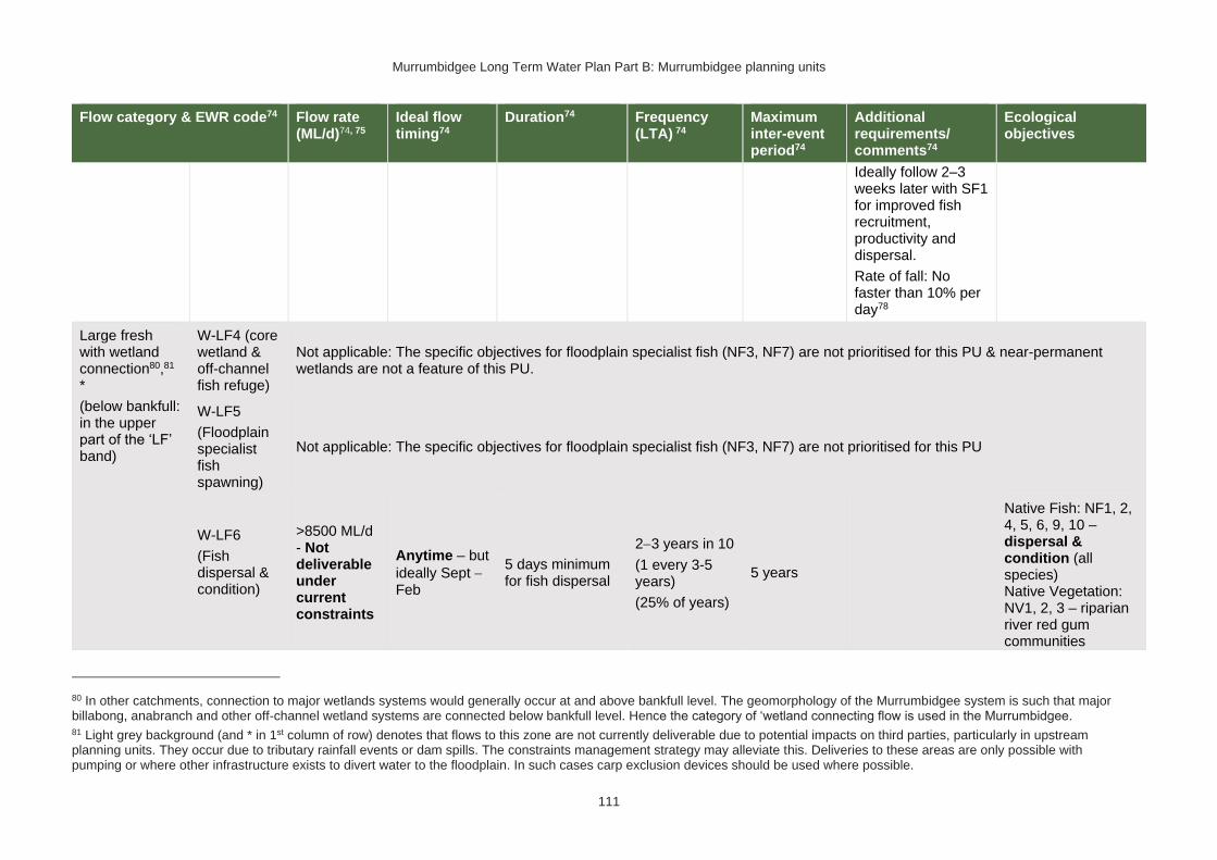
Murrumbidgee Long Term Water Plan Part B: Murrumbidgee planning units
111
Flow category & EWR code74 Flow rate (ML/d)74, 75
Ideal flow timing74
Duration74 Frequency (LTA) 74
Maximum inter-event period74
Additional requirements/ comments74
Ecological objectives
Ideally follow 2–3 weeks later with SF1 for improved fish recruitment, productivity and dispersal.
Rate of fall: No faster than 10% per day78
Large fresh with wetland connection80,81 *
(below bankfull: in the upper part of the ‘LF’ band)
W-LF4 (core wetland & off-channel fish refuge)
Not applicable: The specific objectives for floodplain specialist fish (NF3, NF7) are not prioritised for this PU & near-permanent wetlands are not a feature of this PU.
W-LF5
(Floodplain specialist fish spawning)
Not applicable: The specific objectives for floodplain specialist fish (NF3, NF7) are not prioritised for this PU
W-LF6
(Fish dispersal & condition)
>8500 ML/d - Not deliverable under current constraints
Anytime – but
ideally Sept − Feb
5 days minimum for fish dispersal
2−3 years in 10
(1 every 3-5 years)
(25% of years)
5 years
Native Fish: NF1, 2, 4, 5, 6, 9, 10 – dispersal & condition (all species) Native Vegetation: NV1, 2, 3 – riparian river red gum communities
80 In other catchments, connection to major wetlands systems would generally occur at and above bankfull level. The geomorphology of the Murrumbidgee system is such that major billabong, anabranch and other off-channel wetland systems are connected below bankfull level. Hence the category of ‘wetland connecting flow is used in the Murrumbidgee. 81 Light grey background (and * in 1st column of row) denotes that flows to this zone are not currently deliverable due to potential impacts on third parties, particularly in upstream planning units. They occur due to tributary rainfall events or dam spills. The constraints management strategy may alleviate this. Deliveries to these areas are only possible with pumping or where other infrastructure exists to divert water to the floodplain. In such cases carp exclusion devices should be used where possible.

Murrumbidgee Long Term Water Plan Part B: Murrumbidgee planning units
112
Flow category & EWR code74 Flow rate (ML/d)74, 75
Ideal flow timing74
Duration74 Frequency (LTA) 74
Maximum inter-event period74
Additional requirements/ comments74
Ecological objectives
Ecosystem Functions: EF2, 3, 4, 5, 6, 7 – lateral floodplain, productivity, bench and pool forming
W-LF7 (Non- woody veg zone – also for frog recruitment)
>8500 ML/d - Not deliverable under current constraints
July − Feb flow timing. There are benefits also outside that period including by providing bird foraging habitat
3−10 months. Refers to the persistence of standing water (minimum 3-7 months depending on vegetation community)
The median modelled natural duration for flows of this size is ~26 days. We analysed for cumulative flows of 26 days duration, made up of individual events of a minimum of 8 day within season
6-8 years in 10
(70% of years) 2 years
Ideally maintain stable water levels in active waterbird colony sites and provide slow draw down for shallow muddy edges for bird foraging habitat.
For best benefits duration of standing water of at least 90 days is required during the growing season (from Sept on). Also note that some frog species are summer breeders so will need at least 3 months from Oct.
To increase cover & extent of non-woody vegetation communities - clustered, sequenced flows (i.e. annual flows
over 2−3 years) are required.
Native Fish: NF1, 2, 4, 5, 6, 9 – dispersal & condition (all species)
Native Vegetation: NV2, 3, 4 – Non-woody vegetation in wetlands, river red gum forest fringing wetlands/channels
Ecosystem Function: EF1, 2, 3, 4, 5, 6, 7 – core wetland habitats, lateral connectivity, productivity

Murrumbidgee Long Term Water Plan Part B: Murrumbidgee planning units
113
Flow category & EWR code74 Flow rate (ML/d)74, 75
Ideal flow timing74
Duration74 Frequency (LTA) 74
Maximum inter-event period74
Additional requirements/ comments74
Ecological objectives
The provision of periods of higher flow magnitude & successive flows also has the potential to increase non-woody vegetation cover & extent &/or limit encroachment of woody species (if desired).
W-LF8 (fish connect flow)
>8500 ML/d – Not deliverable under current constraints
Anytime82, but triggered by significant fish breeding in off-channel wetlands.
Flow 3−18 months after breeding occurs.
Flow must occur before habitat (depth, cover, water quality) of waterbody is lost by drying.
5 days
3 years in 10 or as required by breeding triggers
(30% of years)
5 years
Ideally provide a protracted recession to promote exit to the river.
This is for within
3−18 months so long as sufficient habitat (depth, cover) is maintained in the wetland to support the strong 0+ cohort until re-connection occurs - may be wetland specific.
Trigger is a verified breeding event. Where there has been insufficient monitoring to
Native Fish: NF1, 2, 4, 5, 6, 9, 10 – dispersal from off channel wetlands (all species) Native Vegetation: NV1, 2, 3 Ecosystem Functions: EF2, 3, 4, 5, 6, 7 – connectivity
82 Return movement may vary seasonally, so future research will inform any necessary refinement in the timing of this.
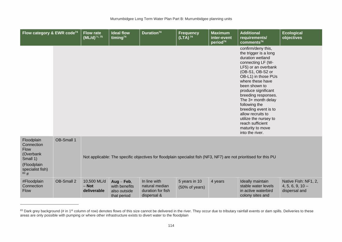
Murrumbidgee Long Term Water Plan Part B: Murrumbidgee planning units
114
Flow category & EWR code74 Flow rate (ML/d)74, 75
Ideal flow timing74
Duration74 Frequency (LTA) 74
Maximum inter-event period74
Additional requirements/ comments74
Ecological objectives
confirm/deny this, the trigger is a long duration wetland connecting LF (W-LF5) or an overbank (OB-S1, OB-S2 or OB-L1) in those PUs where these have been shown to produce significant breeding responses. The 3+ month delay following the breeding event is to allow recruits to utilize the nursey to reach sufficient maturity to move into the river.
Floodplain Connection Flow (Overbank Small 1)
(Floodplain specialist fish) 83 #
OB-Small 1
Not applicable: The specific objectives for floodplain specialist fish (NF3, NF7) are not prioritised for this PU
#Floodplain Connection Flow
OB-Small 2 10,500 ML/d – Not deliverable
Aug − Feb, with benefits also outside that period
In line with natural median duration for fish dispersal &
5 years in 10
(50% of years)
4 years Ideally maintain stable water levels in active waterbird colony sites and
Native Fish: NF1, 2, 4, 5, 6, 9, 10 – dispersal and
83 Dark grey background (# in 1st column of row) denotes flows of this size cannot be delivered in the river. They occur due to tributary rainfall events or dam spills. Deliveries to these areas are only possible with pumping or where other infrastructure exists to divert water to the floodplain

Murrumbidgee Long Term Water Plan Part B: Murrumbidgee planning units
115
Flow category & EWR code74 Flow rate (ML/d)74, 75
Ideal flow timing74
Duration74 Frequency (LTA) 74
Maximum inter-event period74
Additional requirements/ comments74
Ecological objectives
(Overbank Small 2)
(River red gum zone)83
including by providing bird foraging habitat
riparian river red gum communities.
For wetlands 3−7 months’ persistence of standing water. For streamside areas, only duration to fill the soil profile, depressions/ billabongs required.
The median modelled natural duration for flows of this size is around 49 days. We analysed for cumulative flows of 49 days duration, made up of individual events of a minimum of 8 days within season
provide slow draw down for shallow muddy edges for bird foraging habitat.
To support river red gum flowering, seed set and seedling establishment & to encourage vegetative growth of lignum stands and lignum seedling germination and establishment- clustered, sequenced flows (i.e. annual flows
over 2−3 years) are required. This also benefits river cooba. The provision of periods of successive flows will also improve the condition of existing river red gum, lignum & river cooba and reduce unwanted river red gum recruitment.
For timing: flow can occur earlier, but for best benefits, duration of standing water of at least 90 days is required
condition (all species)
Native Vegetation: NV2, 3, 4a, 4b, 4e river red gum (riparian and floodplain wetland), lignum
Ecosystem Functions: EF2, 3, 4, 5, 6, 7 – channel forming, lateral connectivity, productivity

Murrumbidgee Long Term Water Plan Part B: Murrumbidgee planning units
116
Flow category & EWR code74 Flow rate (ML/d)74, 75
Ideal flow timing74
Duration74 Frequency (LTA) 74
Maximum inter-event period74
Additional requirements/ comments74
Ecological objectives
from Sept on to fit with vegetation growing season & bird breeding seasonality. Some frog species are summer breeders, which will need at least 3 months from Oct.
#Large Floodplain Connection Flow83
(Overbank Large 1)
(Black box zone)
OB Large 1 20,000 ML/d – Not deliverable
Anytime84, though ideally
Sept − Mar. There are benefits also outside that period including by providing bird foraging habitat
2−6 months for black box & lignum in
wetlands. 3−6 months for bird breeding. Refers to the persistence of standing water, flow can be shorter. For streamside areas, only duration sufficient to fill the soil profile, depressions/ billabongs required.
The median observed
2−3 years in 10
(25% of years)
5 years (up to 10 years for outer black box areas)
Ideally slow draw down for shallow muddy edges for bird foraging habitat.
To support black box flowering and seedling establishment, to encourage vegetative growth of lignum stands & lignum seedling establishment- clustered, sequenced flows (i.e. annual flows
over 2−3 years) are required. This also benefits river cooba. The provision of
Native Fish: NF1, 10
Native Vegetation: NV2, 3, 4a, 4b, 4c, 4e – black box & lignum & river red gum woodland high on floodplain Ecosystem Functions: EF2, 3, 4, 5, 6, 7 – lateral connectivity, productivity
84 While analysis shows the required frequency of years was achieved historically, the maximum period between events is exceeded when only events in the ideal season are counted. Hence events in this planning unit are accepted ‘anytime’. This also aligns with the fact that large-scale bird breeding events are not a key objective in the is planning unit, whereas the maintenance of Black Box communities (which are more tolerant of timing) is.

Murrumbidgee Long Term Water Plan Part B: Murrumbidgee planning units
117
Flow category & EWR code74 Flow rate (ML/d)74, 75
Ideal flow timing74
Duration74 Frequency (LTA) 74
Maximum inter-event period74
Additional requirements/ comments74
Ecological objectives
duration for flows of this size is around 23 days. We analysed for cumulative flows of 23 days duration, made up of individual events of a minimum of 10 days within season85
periods of successive flows will also increase the potential for recovery of existing river red gum, lignum & river cooba communities.
Some frog species are summer breeders, which will need at least 3 months from Oct.
85 The information in italics is not meant to be prescriptive. It notes the median duration of past flow events of this size as a guideline. Where cumulative durations are noted, the minimum duration of individual events which make up that cumulative total (again only provided for guidance) is based on the 25th percentile duration of events of this size.
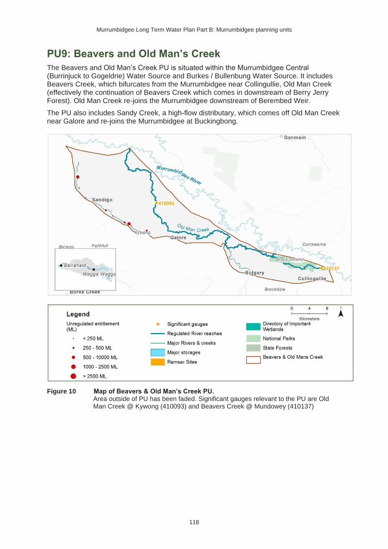
Murrumbidgee Long Term Water Plan Part B: Murrumbidgee planning units
118
PU9: Beavers and Old Man’s Creek
The Beavers and Old Man’s Creek PU is situated within the Murrumbidgee Central (Burrinjuck to Gogeldrie) Water Source and Burkes / Bullenbung Water Source. It includes Beavers Creek, which bifurcates from the Murrumbidgee near Collingullie, Old Man Creek (effectively the continuation of Beavers Creek which comes in downstream of Berry Jerry Forest). Old Man Creek re-joins the Murrumbidgee downstream of Berembed Weir.
The PU also includes Sandy Creek, a high-flow distributary, which comes off Old Man Creek near Galore and re-joins the Murrumbidgee at Buckingbong.
Figure 10 Map of Beavers & Old Man’s Creek PU. Area outside of PU has been faded. Significant gauges relevant to the PU are Old Man Creek @ Kywong (410093) and Beavers Creek @ Mundowey (410137)

Murrumbidgee Long Term Water Plan Part B: Murrumbidgee planning units
119
Key ecological values
(CE = Critically Endangered, E = Endangered, V = Vulnerable, EP= Endangered Population in MDB, C = CAMBA, J = JAMBA, R = ROKAMBA, X = species recorded in this planning unit via catch records and or Australian Museum Records where they exist, Y = species expected to occur based on MaxEnt modelling)
Native fish
• Australian smelt X
• bony herring X
• carp-gudgeon species complex X
• flat-headed galaxias (CE) Y
• flat-headed gudgeon X
• golden perch X
• Murray cod (V) X
• Murray-Darling rainbowfish X
• northern river blackfish X
• silver perch (V) X
• southern pygmy perch (E) Y
• trout cod (E) Y
• trout cod/Murray cod hybrid X
• unspecked hardyhead X
• western carp-gudgeon X
Waterbirds 42 waterbird species recorded, including brolga (V) & sharp-tailed sandpiper (J, C, K)
Native vegetation 5960 ha of water-dependent native vegetation including 5 ha of lignum, 208 ha of non-woody wetland vegetation & 5460 ha of river red gum.
Native fish objectives
NF1 No loss of native fish species
NF2 Increase the distribution & abundance of short to moderate-lived generalists: Australian smelt
carp-gudgeon species complex, flat-headed gudgeon, bony herring, Murray-Darling rainbowfish, unspecked hardyhead
NF4 Improve population structure for moderate to long-lived flow pulse specialists: golden perch, silver perch
NF5 Improve population structure for moderate to long-lived riverine specialists: Murray cod, river blackfish
NF6 A 25% increase in abundance of mature (harvestable sized): golden perch, Murray cod
NF9 Increase the prevalence &/or expand the population of key moderate to long-lived flow pulse specialists native fish species into new areas (within historical range): silver perch
Hydrology
Hydrological alteration
See Table 1 for key
Regulated river reach
CtF Low flow & baseflow
Freshes High & infrequent flows
1.5ARI 2.5ARI 5ARI
Beavers Creek at Mundowey
H- H+ H+ L- L- L-
Old Man Creek at Kywong (Topreeds)
H- H+ H+ L- L- L0
Relevant rules from WSP
Murrumbidgee Central (Burrinjuck to Gogeldrie) Water Source
Access rules*:
Rivers & creeks (reference point Individual natural pool): pumping is not permitted from natural pools when the water level in the pool is lower than its full capacity.
Note: Some licences in this water source have a different CtP. Please see schedules 2 & 3 of the WSP.
Natural off-river pools: pumping is not permitted from an off-river pool or an off-river dam pool when the volume of water in that pool is less than 80% of the full capacity of the natural pool that existed prior to any augmentation works.
Trading rules:
INTO water source: No trade allowed

Murrumbidgee Long Term Water Plan Part B: Murrumbidgee planning units
120
WITHIN water source: Allowed, but no trade into off river pools
Burkes / Bullenbung Water Source:
Access rules for rivers & creeks* (reference point - individual natural pool): pumping is not permitted from natural pools when the water level in the pool is lower than its full capacity.
Trading rules:
INTO water source: Trade in is allowed provided the total shares in the water source do not exceed 700 units.
WITHIN water source: Allowed, but no trade into off river pools.
*Note: These access rules do not apply:
1. if the existing Water Act 1912 entitlement had more stringent access licence conditions.
2. to major water utility, local water utility or unregulated river (town water supply) access licences
3. to water taken for domestic consumption by stock & domestic access licences
4. for the first 5 years of the plan to water taken for stock watering by stock & domestic access licences5. to water taken from existing dams. Any existing licence conditions associated with a dam will be carried forward under the plan.
There are 5 very small (<250 ML), 2 small (250−500 ML) & 1 medium (500−1,000 ML) unregulated water access licences distributed throughout the PU. The total volume of unregulated entitlements for the PU is 2410 ML of which 2,370 ML is allocated for irrigation (rather than stock & domestic or town water supply).
Recommended management strategies
MS2: Ensure compliance with water access licence conditions including through metering of all licensed extraction.
MS3: As a minimum, maintain existing rules in the WSP for the Murrumbidgee Unregulated Water Sources that protect environmental assets and values.
MS4: Monitor for changes in water demand and review access rules if current usage is high or if the pattern of use changes.
Note: Section 7.2 of Part A of the Murrumbidgee LTWP also identifies as priority investment opportunities:
• Implement the constraints management strategy
• Seek arrangements to reduce take from the peak of wetland connecting events by negotiating for extraction to occur at other times
• Investigate infrastructure to fill wetlands

Murrumbidgee Long Term Water Plan Part B: Murrumbidgee planning units
121
Table 13 Beavers and Old Man Creek (as measured at Old Man Creek @ Kywong: 410093) −gauge data began in 1976
Flow category & EWR code86
Flow rate (ML/d)86, 87
Ideal flow timing86
Duration86 Frequency (LTA) 86
Maximum inter-event period86
Additional requirements/ comments86
Ecological objectives
Cease-to-flow
CtF <1 ML/d
Naturally occurred in summer
However, CtF should now be avoided because summer CtF events are now rare & hypoxic events are more likely in summer.
In typical years, 0 days per year
In very dry years, a maximum of 39 days per year88, how-ever, to support the fish community CtF events should not exceed 9 days even in dry years. 88
Should not occur in more than 42% of years88
NA – this refers to the period between CtF events, which is ideally as long as possible.
CtF events occurred in 89%, 68% & 42% of years in the modelled pre & post development scenarios &
1980−2017 observations respectively.
Native Fish: NF1 – Survival (all species) Ecosystem Functions: EF1, 2 – refuge habitat
Very low flow VLF >50 ML/d Anytime
In typical years, 314 days per year
Every year
1980−2017 observations did not exceed 35
Flow ideally >0.03–0.05 m/s to de-stratify pools
Native Fish: NF1 – Survival and condition (all species) Ecosystem Functions: EF1, 2 – refuge habitat
86 Refer to Glossary for definitions of terms and explanatory text for EWRs
87 These minimums are where the benefits of flow categories are likely to begin manifesting. Further substantial benefits occur, particularly for wetland connecting large freshes and overbanks, as flows increase in size. These thresholds SHOULD NOT be used to indicate that constraints only need to be raised to achieve these minimums.
88 Based on 1980−2017 observations. There are no ‘pre-development’ observations and the model is less well developed as that on the main Murrumbidgee, so has not been used here. For duration of CtF events the typical year is based on the median observed duration. The ‘very dry year’ is based on the 95th percentile duration. This has been reduced to 9 days, which is the 75th percentile duration to protect the fish community and note that its resilience is likely to have been compromised by development.

Murrumbidgee Long Term Water Plan Part B: Murrumbidgee planning units
122
Flow category & EWR code86
Flow rate (ML/d)86, 87
Ideal flow timing86
Duration86 Frequency (LTA) 86
Maximum inter-event period86
Additional requirements/ comments86
Ecological objectives
In very dry years, at least 210 days per year 88
days for 95% of events88
Baseflow BF1 >100 ML/d Anytime
In typical years, 291 days per year
In very dry years, at least 157 days per year88
Every year
1980−2017 observations did not exceed 47 days for 95% of events88
Minimum depth of 0.3 m to allow fish passage
Native Fish: NF1, 2, 4, 5, 6, 9 – condition and movement Native Vegetation: NV1 – in-channel Ecosystem Functions: EF1, 2, 3
Nesting Support
NestS1
100−2000 ML/d
Max rate of fall 20% per day.
15 Sep − 15 Nov for trout cod & Murray cod.
1 Oct − 15 Nov for only Murray cod.
(Only apply EWR if flows are in the BF or SF range at start of period)
60 days minimum for trout cod & Murray cod.
45 day minimum for only Murray cod
5−10 years in 10
(75% of years)
2 years
Allow variable flows but avoid large sudden decreases in water level to prevent loss of nesting sites.
Flow decreases not to exceed 20%, which is the 20th percentile of modelled natural rate of fall (the fastest 20% of natural
rates of fall −- calculated from the modelled 'without-development' flow data).
Native Fish NF5, 6 - Nesting of riverine specialists (protect nesting sites by avoiding rapid changes in water levels)
Native Vegetation: NV1,3 – in-channel & riparian
Small fresh
SF1 >500 ML/d
Anytime - but ideally
Oct − Apr, & ideally
10 days minimum
2 events per year
1 year >20°C for Oct – Apr (for native fish); for river blackfish >16°C; for
Native Fish: NF1, 2, 4, 5, 6, 9 – Dispersal/condition (all species) Native Vegetation: NV1 – in-channel

Murrumbidgee Long Term Water Plan Part B: Murrumbidgee planning units
123
Flow category & EWR code86
Flow rate (ML/d)86, 87
Ideal flow timing86
Duration86 Frequency (LTA) 86
Maximum inter-event period86
Additional requirements/ comments86
Ecological objectives
2−3 weeks after ‘LF2’
Murray cod Sept − Dec >18°C
Minimum depth of 0.5 m to allow movement of large fish
Rate of fall: No faster than 36% per day89
Flow ideally up to 0.3−0.4 m/s (depending on channel form)
Ecosystem Functions: EF1, 2, 3, 4, 5
SF2 500−2500 ML/d
15 Sep − Apr
14 days minimum
5–10 years in 10
(75% of years)
2 years
>20°C for Oct – Apr (for native fish); for river blackfish >16°C; for
Murray cod Sept − Dec >18°C
Minimum depth of 0.5 m to allow movement of large fish
Rate of fall: No faster than 36% per day89
Flow ideally up to 0.3−0.4 m/s (depending on channel form)
Native Fish: NF1, 2, 5, 6 – Spawning (river specialists, generalists) Native Vegetation: NV1 – in-channel Ecosystem Functions: EF1, 2, 3, 4, 5
Large fresh LF1 >2500 ML/d
Anytime − but ideally July – Sept
Consider delivery outside cod
5 days minimum
5–10 years in 10
(75% of years)
2 years
Minimum depth of 2 m to cover in-stream features & trigger response from fish
Flow ideally 0.3−0.4 m/s (depending on channel form)
Native Fish: NF1, 2, 4, 5, 6, 9 – dispersal/condition (all species) Native Vegetation: NV1, 3 – in-channel/ riparian
89 The 5th percentile (fastest 5% of rates of fall) of ‘pre-development’ modelled flows

Murrumbidgee Long Term Water Plan Part B: Murrumbidgee planning units
124
Flow category & EWR code86
Flow rate (ML/d)86, 87
Ideal flow timing86
Duration86 Frequency (LTA) 86
Maximum inter-event period86
Additional requirements/ comments86
Ecological objectives
breeding season to avoid flushing of nests.
Rate of fall: No faster than 31% per day89
Ecosystem Functions: EF2, 3, 4, 5, 6
Large fresh LF2 >2500 ML/d
Oct − Apr
Consider delivery outside cod breeding season to avoid flushing of nests.
5 days minimum
6–7 years in 10
(65% of years)
2 years
Minimum depth of 2 m to cover in-stream features & trigger response from fish
Flow ideally 0.3−0.4 m/s (depending on channel form)
Rapid rise (comparable to natural rates) >17°C
Ideally follow 2–3 weeks later with SF1 for improved fish recruitment, productivity and dispersal. Rate of fall: No faster than 31% per day89
Native Fish: NF1, 4, 6, 9 – spawning (flow pulse specialists) Native Vegetation: NV1 – in-channel Ecosystem Functions: EF2, 3, 4, 5, 6
Large fresh with wetland connection90,
91 *
W-LF4 (core wetland & off-channel fish refuge)
Not applicable: events do not occur of this size at the required frequency. The specific objectives for floodplain specialist fish (NF3, NF7) are not prioritised for this PU. Permanent wetlands are not expected.
90 In other catchments, connection to major wetlands systems would generally occur at and above bankfull level. The geomorphology of the Murrumbidgee system is such that major billabong, anabranch and other off-channel wetland systems are connected below bankfull level. Hence the category of ‘wetland connecting flow is used in the Murrumbidgee. 91 Light grey background (and * in 1st column of row) denotes that flows to this zone are currently difficult to deliver due to potential impacts on third parties. Implementation of the constraints management strategy may alleviate this. Deliveries to these areas may only be possible with pumping or where other infrastructure exists to divert water to the floodplain. In such cases carp exclusion devices should be used where possible.

Murrumbidgee Long Term Water Plan Part B: Murrumbidgee planning units
125
Flow category & EWR code86
Flow rate (ML/d)86, 87
Ideal flow timing86
Duration86 Frequency (LTA) 86
Maximum inter-event period86
Additional requirements/ comments86
Ecological objectives
(below bankfull: in the upper part of the ‘LF’ band)
W-LF5
(Floodplain specialist fish spawning)
Not applicable: The specific objectives for floodplain specialist fish (NF3, NF7) are not prioritised for this PU.
W-LF6
(Fish dispersal & condition)
>5800 ML/d – Not deliverable under current constraints
Anytime – but ideally Sept – Feb
5 days minimum for fish dispersal
2−3 years in 10
(1 every
3−5 years)
(25% of years)
5 years
Native Fish: NF1, 2, 4, 5, 6, 9 – dispersal & condition (all species) Native Vegetation: NV1, 2, 3 – riparian river red gum communities Waterbirds: WB1, 2, 5 – habitat Ecosystem Functions: EF2, 3, 4, 5, 6, 7 – lateral floodplain, productivity, bench and pool forming
Other Species (Frogs): OS1 – habitat
W-LF7 (Non- woody veg zone – also for frog recruitment)
>5800 ML/d – Not deliverable under current constraints
July − Feb flow timing. There are benefits also outside that period including by providing bird foraging habitat
3−10 months. Refers to the persistence of standing water (minimum 3-7 months depending on vegetation community)
The median observed duration for flows of this
6−8 years in 10
(70% of years)
2 years
Ideally maintain stable water levels in active waterbird colony sites and provide slow draw down for shallow muddy edges for bird foraging habitat.
For best benefits duration of standing water of at least 90 days is required during the growing season (from Sept on). Also note that some frog species are summer breeders so will need at least 3 months from Oct.
Native Fish: NF1, 2, 4, 5, 6, 9 – dispersal & condition (all species)
Native Vegetation: NV2, 3, 4 – Non-woody vegetation in wetlands, river red gum forest fringing wetlands/channels
Waterbirds: WB1, 2, 3, 5 – habitat, small scale breeding
Ecosystem Function: EF1, 2, 3, 4, 5, 6, – core wetland habitats, lateral connectivity, productivity
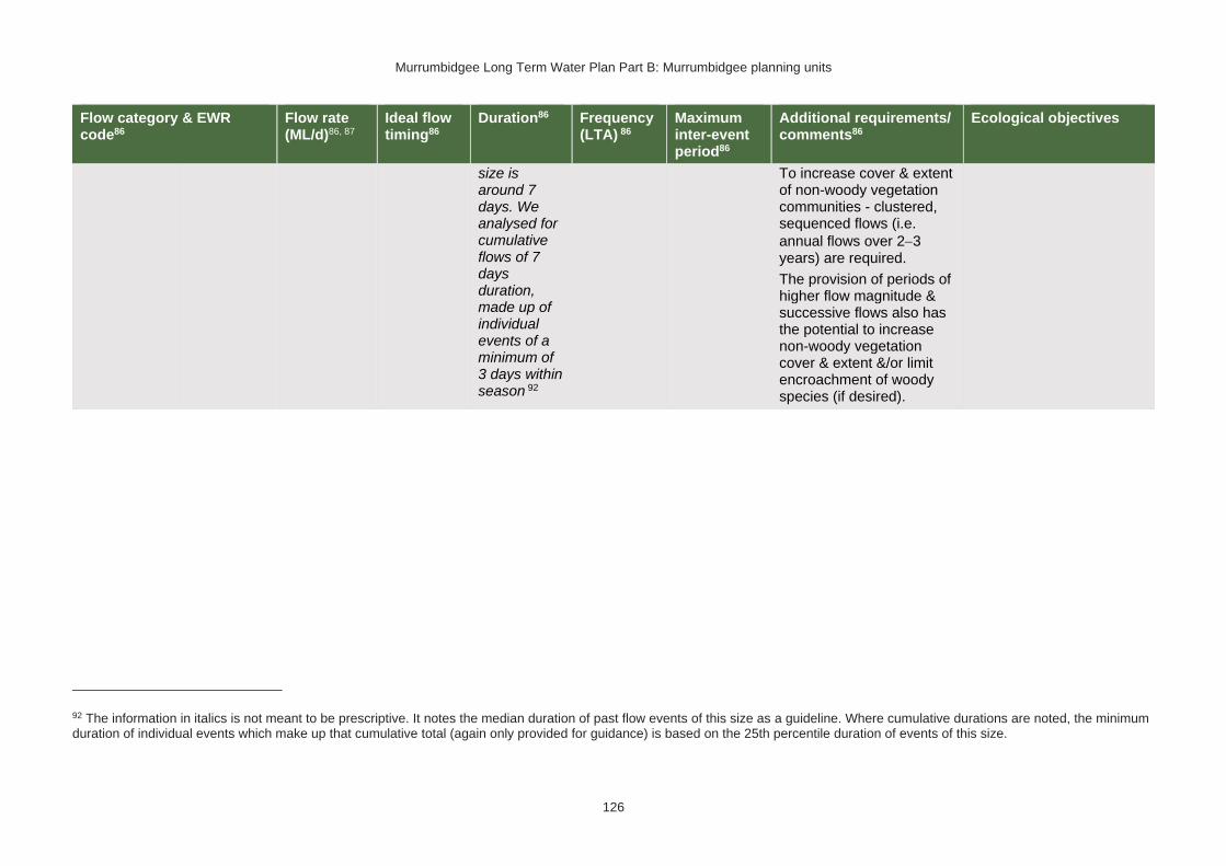
Murrumbidgee Long Term Water Plan Part B: Murrumbidgee planning units
126
Flow category & EWR code86
Flow rate (ML/d)86, 87
Ideal flow timing86
Duration86 Frequency (LTA) 86
Maximum inter-event period86
Additional requirements/ comments86
Ecological objectives
size is around 7 days. We analysed for cumulative flows of 7 days duration, made up of individual events of a minimum of 3 days within season 92
To increase cover & extent of non-woody vegetation communities - clustered, sequenced flows (i.e.
annual flows over 2−3 years) are required.
The provision of periods of higher flow magnitude & successive flows also has the potential to increase non-woody vegetation cover & extent &/or limit encroachment of woody species (if desired).
92 The information in italics is not meant to be prescriptive. It notes the median duration of past flow events of this size as a guideline. Where cumulative durations are noted, the minimum duration of individual events which make up that cumulative total (again only provided for guidance) is based on the 25th percentile duration of events of this size.

Murrumbidgee Long Term Water Plan Part B: Murrumbidgee planning units
127
Flow category & EWR code86
Flow rate (ML/d)86, 87
Ideal flow timing86
Duration86 Frequency (LTA) 86
Maximum inter-event period86
Additional requirements/ comments86
Ecological objectives
W-LF8 (fish connect flow)
>5800 ML/d – Not deliverable under current constraints
Anytime93, but triggered by significant fish breeding in off-channel wetlands
Flow 3−18 months after breeding occurs
Flow must occur before habitat (depth, cover, water quality) of waterbody is lost by drying
5 days
3 years in 10 or as required by breeding triggers
(30% of years)
5 years
Ideally provide a protracted recession to promote exit to the river.
This is for within 3−18 months so long as sufficient habitat (depth, cover) is maintained in the wetland to support the strong 0+ cohort until re-
connection occurs − may be wetland specific.
Trigger is verified breeding event. Where there has been insufficient monitoring to confirm/deny this, the trigger is a long duration wetland connecting LF (W-LF5) or an overbank (OB-S1, OB-S2 or OB-L1) in those PUs where these have been shown to produce significant breeding responses. The 3+ month delay following the breeding event is to allow recruits to use the nursey to move into the river & reach sufficient maturity to move into the river.
Native Fish: NF1, 2, 4, 5, 6, 9 – dispersal from off channel wetlands (all species) Native Vegetation: NV1, 2, 3
Waterbirds: WB1, 5 Ecosystem Functions: EF2, 3, 4, 5, 6 – connectivity
Floodplain Connection
OB-Small 1 Not applicable: The specific objectives for floodplain specialist fish (NF3, NF7) are not prioritised for this PU.
93 Return movement may vary seasonally, so future research will inform any necessary refinement in the timing of this.

Murrumbidgee Long Term Water Plan Part B: Murrumbidgee planning units
128
Flow category & EWR code86
Flow rate (ML/d)86, 87
Ideal flow timing86
Duration86 Frequency (LTA) 86
Maximum inter-event period86
Additional requirements/ comments86
Ecological objectives
Flow (Overbank Small 1)
(Floodplain specialist fish) 94 #
#Floodplain Connection Flow (Overbank Small 2)
(River red gum zone)
OB-Small 2 >6500 ML/d – Not deliverable
Aug − Feb, with benefits also outside that period including by providing bird foraging habitat
In line with natural median duration for fish dispersal & riparian river red gum communities.
For wetlands 3-7 months persistence of standing water. For streamside areas, only duration to fill the soil profile, depressions/ billabongs required.
The median observed duration for
5 years in 10
(50% of years)
4 years
Ideally maintain stable water levels in active waterbird colony sites and provide slow draw down for shallow muddy edges for bird foraging habitat.
To support river red gum flowering, seed set and
seedling establishment − clustered, sequenced flows
(i.e. annual flows over 2−3 years) are required. The provision of periods of successive flows will also improve the condition of existing river red gum and reduce unwanted river red gum recruitment.
For timing: flow can occur earlier, but for best benefits, duration of standing water of at least 90 days is required from Sept on to fit with
Native Fish: NF1, 2, 4, 5, 6, 9 – dispersal and condition (all species)
Native Vegetation: NV2, 3, 4a, 4b river red gum (riparian and floodplain wetland)
Waterbirds: WB1, 2, 3, 4, 5 – habitat and potential small-scale breeding
Ecosystem Functions: EF2, 3, 4, 5, 6 – channel forming, lateral connectivity, productivity
94 Dark grey background (and # in 1st column of row) denotes flows of this size cannot be delivered in the creek. The flows occur due to tributary rainfall events or dam spills. Deliveries to these areas are only possible with pumping or where other infrastructure exists to divert water to the floodplain. In such cases carp exclusion devices should be used where possible.
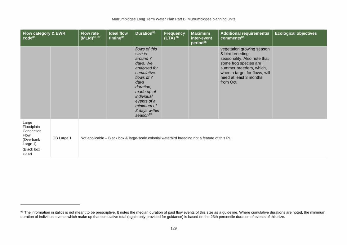
Murrumbidgee Long Term Water Plan Part B: Murrumbidgee planning units
129
Flow category & EWR code86
Flow rate (ML/d)86, 87
Ideal flow timing86
Duration86 Frequency (LTA) 86
Maximum inter-event period86
Additional requirements/ comments86
Ecological objectives
flows of this size is around 7 days. We analysed for cumulative flows of 7 days duration, made up of individual events of a minimum of 3 days within season95
vegetation growing season & bird breeding seasonality. Also note that some frog species are summer breeders, which, when a target for flows, will need at least 3 months from Oct.
Large Floodplain Connection Flow (Overbank Large 1)
(Black box zone)
OB Large 1 Not applicable – Black box & large-scale colonial waterbird breeding not a feature of this PU.
95 The information in italics is not meant to be prescriptive. It notes the median duration of past flow events of this size as a guideline. Where cumulative durations are noted, the minimum duration of individual events which make up that cumulative total (again only provided for guidance) is based on the 25th percentile duration of events of this size.

Murrumbidgee Long Term Water Plan Part B: Murrumbidgee planning units
130
PU10: Upper Yanco Creek
The Upper Yanco Creek PU is situated within the Murrumbidgee Western Water Source. Flows into the Yanco Creek system go through the Yanco offtake cutting. Flows are controlled by altering the height of Yanco Weir on the Murrumbidgee River downstream of the cutting.
Figure 11 Map of Upper Yanco Creek PU. Area outside of PU has been faded. Significant gauge relevant to the PU is Yanco Creek @ Offtake (410007)
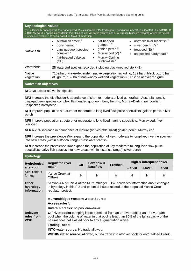
Murrumbidgee Long Term Water Plan Part B: Murrumbidgee planning units
131
Key ecological values
(CE = Critically Endangered, E = Endangered, V = Vulnerable, EP= Endangered Population in MDB, C = CAMBA, J = JAMBA, R = ROKAMBA, X = species recorded in this planning unit via catch records and or Australian Museum Records where they exist, Y = species expected to occur based on MaxEnt modelling)
Native fish
• Australian smelt X
• bony herring Y
• carp-gudgeon species complex X
• flat-headed galaxias (CE) Y
• flat-headed gudgeon Y
• golden perch X
• Murray cod (V) X
• Murray-Darling rainbowfish X
• northern river blackfish Y
• silver perch (V) X
• trout cod (E) Y
• unspecked hardyhead X
Waterbirds 28 waterbird species recorded including black-necked stork (E)
Native vegetation
7102 ha of water-dependent native vegetation including, 139 ha of black box, 5 ha of lignum, 152 ha of non-woody wetland vegetation & 3012 ha of river red gum
Native fish objectives
NF1 No loss of native fish species
NF2 Increase the distribution & abundance of short to moderate-lived generalists: Australian smelt, carp-gudgeon species complex, flat-headed gudgeon, bony herring, Murray-Darling rainbowfish, unspecked hardyhead
NF4 Improve population structure for moderate to long-lived flow pulse specialists: golden perch, silver perch
NF5 Improve population structure for moderate to long-lived riverine specialists: Murray cod, river blackfish
NF6 A 25% increase in abundance of mature (harvestable sized) golden perch, Murray cod
NF8 Increase the prevalence &/or expand the population of key moderate to long-lived riverine species into new areas (within historical range): freshwater catfish
NF9 Increase the prevalence &/or expand the population of key moderate to long-lived flow pulse specialists native fish species into new areas (within historical range): silver perch
Hydrology
Hydrological alteration
See Table 1 for key
Regulated river reach
CtF Low flow & baseflow
Freshes High & infrequent flows
1.5ARI 2.5ARI 5ARI
Yanco Creek at Offtake
H- H- H- H- H- H-
Other hydrology information
Section 4.6 of Part A of the Murrumbidgee LTWP provides information about changes in hydrology in this PU and potential issues related to the proposed Yanco Creek regulator project.
Relevant rules from WSP
Murrumbidgee Western Water Source:
Access rules*:
Rivers & creeks: no pool drawdown.
Off-river pools: pumping is not permitted from an off-river pool or an off-river dam pool when the volume of water in that pool is less than 80% of the full capacity of the natural pool that existed prior to any augmentation works
Trading Rules:
INTO water source: No trade allowed.
WITHIN water source: Allowed, but no trade into off-river pools or onto Talpee Creek.

Murrumbidgee Long Term Water Plan Part B: Murrumbidgee planning units
132
*Note: These access rules do not apply:
1. if the existing Water Act 1912 entitlement had more stringent access licence conditions.
2. to major water utility, local water utility or unregulated river (town water supply) access licences
3. to water taken for domestic consumption by stock & domestic access licences
4. for the first 5 years of the plan to water taken for stock watering by stock & domestic access licences
5. to water taken from existing dams. Any existing licence conditions associated with a dam will be carried forward under the plan
There is 1 large (1,000−2,500 ML) water access licence in the PU. The total volume of unregulated entitlements for the water source is 1,000 ML. All of this entitlement is allocated for irrigation (rather than stock & domestic or town water supply).
Recommended management strategies
MS2: Ensure compliance with water access licence conditions including through metering of all licensed extraction.
MS3: As a minimum, maintain existing rules in the WSP for the Murrumbidgee Unregulated Water Sources that protect environmental assets and values.
MS4: Monitor for changes in water demand and review access rules if current usage is high or if the pattern of use changes.
Note:
Section 4.6 of Part A of the Murrumbidgee LTWP provides information about potential Sustainable Diversion Limit Adjustment Mechanism projects related to the Yanco Creek system. Section 4.6 outlines a number of potential issues with these projects which will need to be considered should they proceed. Section 5.1 (Risks) of Part A also refers to risks with these projects.
Section 7.2 of Part A also identifies as priority investment opportunities:
• Implement the constraints management strategy
• Seek arrangements to reduce take from the peak of wetland connecting events by negotiating for extraction to occur at other times
• Investigate infrastructure to fill wetlands
Potential wetlands for watering96 Values
Molleys Lagoon Refuge, riparian river red gum
Dry Lake Riparian river red gum, waterbirds
Gum Hole Riparian river red gum
96 This is a provisional listing which is the subject of further work.

Murrumbidgee Long Term Water Plan Part B: Murrumbidgee planning units
133
Table 14 Upper Yanco Creek (as measured at Yanco Creek @ Offtake: 410007) − gauge data began in 1913
Flow category & EWR code97 Flow rate (ML/d)97, 98
Ideal flow timing97
Duration97 Frequency (LTA) 97
Maximum inter-event period97
Additional requirements/ comments97
Ecological objectives
Cease-to-flow CtF <1 ML/d
CtF events have not been observed in the post development period
(1980−2017). They should therefore be avoided to protect the fish community. The resilience of this community is likely to have been compromised by development.
CtF events occurred in 100%, 1%, 61% & 0% of years in the modelled pre & post development scenarios &
1913−1950 &
1980−2017 observations respectively
Native Fish: NF1 – Survival (all species) Ecosystem Functions: EF1, 2 – refuge habitat
Very low flow VLF >80 ML/d Anytime
In typical years, 365 days per year
In very dry years, at least 354 days per year 99
Every year
1980−2017 observations did not exceed 4 days for 95% of events99
Flow ideally >0.03–0.05 m/s to de-stratify pools
Native Fish: NF1 – Survival and condition (all species) Ecosystem Functions: EF1, 2 – refuge habitat
Baseflow BF1 >250 ML/d Anytime
In typical years, 360 days per year
In very dry years, at least 213 days per year99
Every year
1980−2017 observations did not exceed 58 days for 95% of events99
Minimum depth of 0.3 m to allow fish passage
Native Fish: NF1, 2, 4, 5, 6, 8, 9 – condition and movement Native Vegetation: NV1 – in-channel
97 Refer to Glossary for definitions of terms and explanatory text for EWRs
98 These minimums are where the benefits of flow categories are likely to begin manifesting. Further substantial benefits occur, particularly for wetland connecting large freshes and overbanks, as flows increase in size. These thresholds SHOULD NOT be used to indicate that constraints only need to be raised to achieve these minimums.
99 Based on 1980−2017 observations, with ‘typical year’ value the median of those observations, and ‘very dry’ value the 95th percentile. Post development observations are chosen because they are higher than pre-development. These higher values place less risk on the ecological community which in the Murrumbidgee catchment is likely to be less resilient. The pre-development modelled scenario is not comparable to the current situation in the Yanco/Billabong Creek system because the Creeks are now perennial systems.

Murrumbidgee Long Term Water Plan Part B: Murrumbidgee planning units
134
Flow category & EWR code97 Flow rate (ML/d)97, 98
Ideal flow timing97
Duration97 Frequency (LTA) 97
Maximum inter-event period97
Additional requirements/ comments97
Ecological objectives
Ecosystem Functions: EF1, 2, 3
Nesting Support NestS1
250-1,000 ML/d
Max rate of fall 11% per day.
15 Sep − 15 Nov for trout cod & Murray cod
1 Oct − 15 Nov for only Murray cod
(Only apply EWR if flows are in the BF or SF range at start of period)
60 days minimum for trout cod & Murray cod.
45 day minimum for only Murray cod
5−10 years in 10
(75% of years)
2 years
Allow variable flows but avoid large sudden de-creases in water level to prevent loss of nesting sites. Flow decreases not to exceed 11% per day which is the 20th percentile (the fastest 20%) of fall - calculated from observed ‘post-development' (1960-2017) flows
Native Fish NF5, 6, 8 - Nesting of riverine specialists (protect nesting sites by avoiding rapid changes in water levels)
Native Vegetation: NV1,3 – in-channel & riparian
Small fresh SF1 >450 ML/d
Anytime - but
ideally Oct − Apr, & ideally
2−3 weeks after ‘LF2’
10 days minimum 2 events per year
1 year
>20°C for Oct to Apr (for native fish); for river blackfish >16°C; for Murray cod Sept to Dec >18°C
Minimum depth of 0.5 m to allow movement of large fish
Rate of fall: No faster than 18% per day100
Flow ideally up to
0.3−0.4 m/s
Native Fish: NF1, 2, 4, 5, 6, 8, 9, 10 – Dispersal/condition (all species) Native Vegetation: NV1 – in-channel Ecosystem Functions: EF1, 2, 3, 4, 5
100 The 5th percentile (fastest 5% of rates of fall) of ‘post-development’ 1980-2017 observed flows
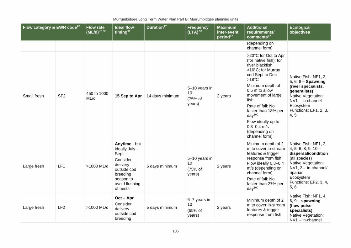
Murrumbidgee Long Term Water Plan Part B: Murrumbidgee planning units
135
Flow category & EWR code97 Flow rate (ML/d)97, 98
Ideal flow timing97
Duration97 Frequency (LTA) 97
Maximum inter-event period97
Additional requirements/ comments97
Ecological objectives
(depending on channel form)
Small fresh SF2 450 to 1000 ML/d
15 Sep to Apr 14 days minimum
5–10 years in 10
(75% of years)
2 years
>20°C for Oct to Apr (for native fish); for river blackfish >16°C; for Murray cod Sept to Dec >18°C
Minimum depth of 0.5 m to allow movement of large fish
Rate of fall: No faster than 18% per day100
Flow ideally up to
0.3−0.4 m/s (depending on channel form)
Native Fish: NF1, 2, 5, 6, 8 – Spawning (river specialists, generalists) Native Vegetation: NV1 – in-channel Ecosystem Functions: EF1, 2, 3, 4, 5
Large fresh LF1 >1000 ML/d
Anytime - but
ideally July − Sept
Consider delivery outside cod breeding season to avoid flushing of nests
5 days minimum
5–10 years in 10
(75% of years)
2 years
Minimum depth of 2 m to cover in-stream features & trigger response from fish
Flow ideally 0.3−0.4 m/s (depending on channel form)
Rate of fall: No faster than 27% per day100
Native Fish: NF1, 2, 4, 5, 6, 8, 9, 10 – dispersal/condition (all species) Native Vegetation: NV1, 3 – in-channel/ riparian Ecosystem Functions: EF2, 3, 4, 5, 6
Large fresh LF2 >1000 ML/d
Oct − Apr
Consider delivery outside cod breeding
5 days minimum
6–7 years in 10
(65% of years)
2 years
Minimum depth of 2 m to cover in-stream features & trigger response from fish
Native Fish: NF1, 4, 6, 9 – spawning (flow pulse specialists) Native Vegetation: NV1 – in-channel
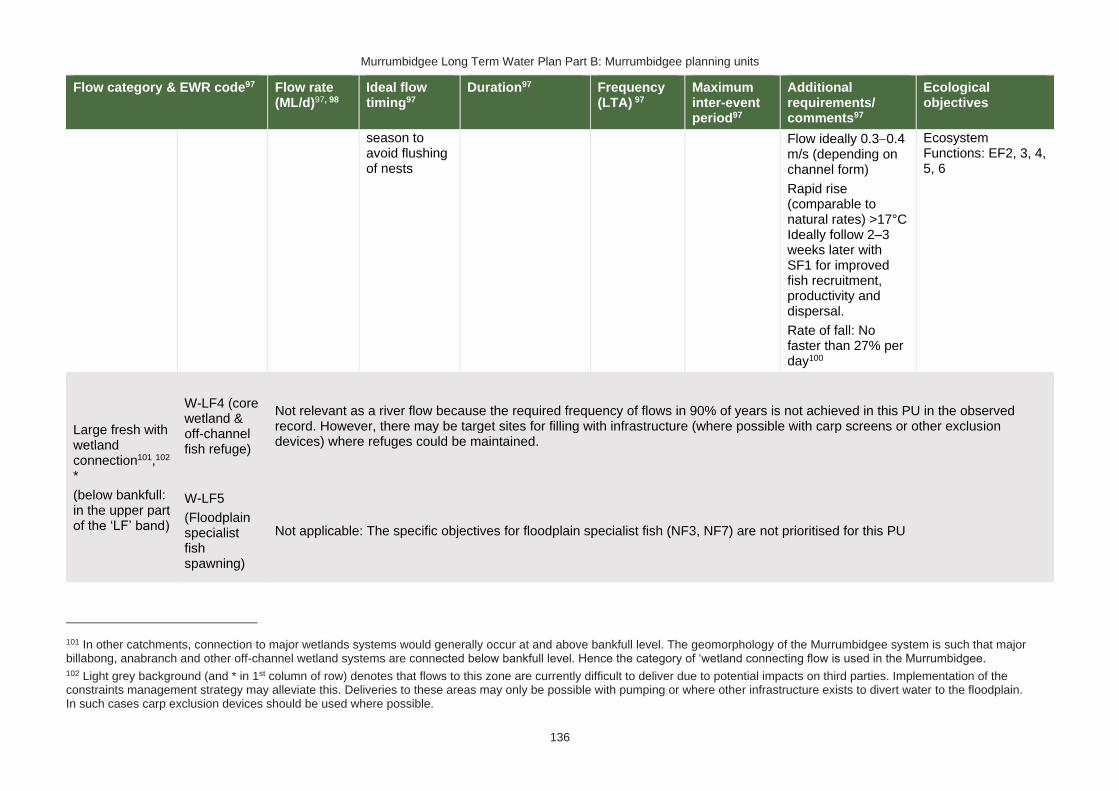
Murrumbidgee Long Term Water Plan Part B: Murrumbidgee planning units
136
Flow category & EWR code97 Flow rate (ML/d)97, 98
Ideal flow timing97
Duration97 Frequency (LTA) 97
Maximum inter-event period97
Additional requirements/ comments97
Ecological objectives
season to avoid flushing of nests
Flow ideally 0.3−0.4 m/s (depending on channel form)
Rapid rise (comparable to natural rates) >17°C Ideally follow 2–3 weeks later with SF1 for improved fish recruitment, productivity and dispersal.
Rate of fall: No faster than 27% per day100
Ecosystem Functions: EF2, 3, 4, 5, 6
Large fresh with wetland connection101,102 *
(below bankfull: in the upper part of the ‘LF’ band)
W-LF4 (core wetland & off-channel fish refuge)
Not relevant as a river flow because the required frequency of flows in 90% of years is not achieved in this PU in the observed record. However, there may be target sites for filling with infrastructure (where possible with carp screens or other exclusion devices) where refuges could be maintained.
W-LF5
(Floodplain specialist fish spawning)
Not applicable: The specific objectives for floodplain specialist fish (NF3, NF7) are not prioritised for this PU
101 In other catchments, connection to major wetlands systems would generally occur at and above bankfull level. The geomorphology of the Murrumbidgee system is such that major billabong, anabranch and other off-channel wetland systems are connected below bankfull level. Hence the category of ‘wetland connecting flow is used in the Murrumbidgee. 102 Light grey background (and * in 1st column of row) denotes that flows to this zone are currently difficult to deliver due to potential impacts on third parties. Implementation of the constraints management strategy may alleviate this. Deliveries to these areas may only be possible with pumping or where other infrastructure exists to divert water to the floodplain. In such cases carp exclusion devices should be used where possible.

Murrumbidgee Long Term Water Plan Part B: Murrumbidgee planning units
137
Flow category & EWR code97 Flow rate (ML/d)97, 98
Ideal flow timing97
Duration97 Frequency (LTA) 97
Maximum inter-event period97
Additional requirements/ comments97
Ecological objectives
W-LF6
(Fish dispersal & condition)
>1500 ML/d – Difficult to deliver under current constraints
Anytime – but
ideally Sept − Feb
5 days minimum for fish dispersal
2−3 years in 10
(1 every 3−5 years)
(25% of years)
5 years
Native Fish: NF1, 2, 4, 5, 6, 8, 9 – dispersal & condition (all species) Native Vegetation: NV1, 2, 3 – riparian river red gum communities Ecosystem Functions: EF2, 3, 4, 5, 6 – lateral floodplain, productivity, bench and pool forming
W-LF7 (Non- woody veg zone – also for frog recruitment)
>1500 ML/d - Difficult to deliver under current constraints
July − Feb for flow timing required. There are benefits also outside that period including by providing bird foraging habitat
3−10 months. Refers to the persistence of standing water (minimum 3-7 months depending on vegetation community)
The median pre-1950 duration for flows of this size is 5 days. We analysed for cumulative flows of this duration, made up of individual events of a minimum of 3 days length within season.
6−8 years in 10
(70% of years)
2 years
Ideally maintain stable water levels in active waterbird colony sites and provide slow draw down for shallow muddy edges for bird foraging habitat.
For best benefits duration of standing water of at least 90 days is required during the growing season (from Sep on). Also note that some frog species are summer breeders so will need at least 3 months from Oct.
Native Fish: NF1, 2, 4, 5, 6, 8, 9 – dispersal & condition (all species)
Native Vegetation: NV2, 3, 4 – Non-woody vegetation in wetlands, river red gum forest fringing wetlands/channels
Function: EF1, 2, 3, 4, 5, 6 – core wetland habitats, lateral connectivity, productivity
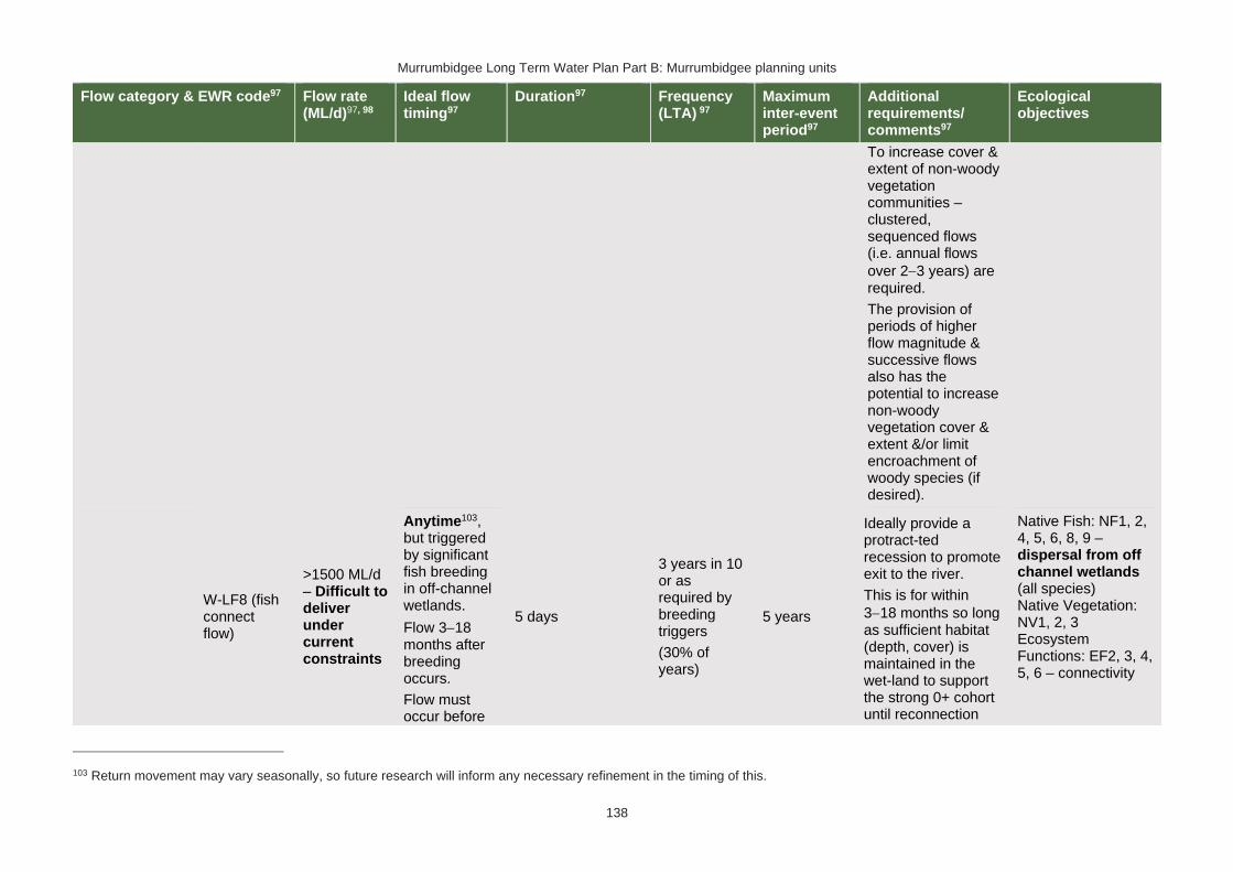
Murrumbidgee Long Term Water Plan Part B: Murrumbidgee planning units
138
Flow category & EWR code97 Flow rate (ML/d)97, 98
Ideal flow timing97
Duration97 Frequency (LTA) 97
Maximum inter-event period97
Additional requirements/ comments97
Ecological objectives
To increase cover & extent of non-woody vegetation communities – clustered, sequenced flows (i.e. annual flows
over 2−3 years) are required.
The provision of periods of higher flow magnitude & successive flows also has the potential to increase non-woody vegetation cover & extent &/or limit encroachment of woody species (if desired).
W-LF8 (fish connect flow)
>1500 ML/d – Difficult to deliver under current constraints
Anytime103, but triggered by significant fish breeding in off-channel wetlands.
Flow 3−18 months after breeding occurs.
Flow must occur before
5 days
3 years in 10 or as required by breeding triggers
(30% of years)
5 years
Ideally provide a protract-ted recession to promote exit to the river.
This is for within
3−18 months so long as sufficient habitat (depth, cover) is maintained in the wet-land to support the strong 0+ cohort until reconnection
Native Fish: NF1, 2, 4, 5, 6, 8, 9 – dispersal from off channel wetlands (all species) Native Vegetation: NV1, 2, 3 Ecosystem Functions: EF2, 3, 4, 5, 6 – connectivity
103 Return movement may vary seasonally, so future research will inform any necessary refinement in the timing of this.

Murrumbidgee Long Term Water Plan Part B: Murrumbidgee planning units
139
Flow category & EWR code97 Flow rate (ML/d)97, 98
Ideal flow timing97
Duration97 Frequency (LTA) 97
Maximum inter-event period97
Additional requirements/ comments97
Ecological objectives
habitat (depth, cover, water quality) of waterbody is lost by drying.
occurs – may be wetland specific.
Trigger is verified breeding event. Where there has been insufficient monitoring to confirm/ deny this, the trigger is a long duration wetland connecting LF (W-LF5) or an overbank (OB-S1, OB-S2 or OB-L1) in those PUs where these have been shown to produce significant breeding responses. The 3+ month delay following the breeding event is to allow recruits to utilise the nursery to reach sufficient maturity to move into the river
Floodplain Connection Flow (Over-bank Small 1)
OB-Small 1 (Floodplain specialist fish)
Not applicable: The specific objectives for floodplain specialist fish (NF3, NF7) are not prioritised for this PU
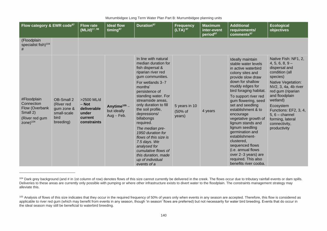
Murrumbidgee Long Term Water Plan Part B: Murrumbidgee planning units
140
Flow category & EWR code97 Flow rate (ML/d)97, 98
Ideal flow timing97
Duration97 Frequency (LTA) 97
Maximum inter-event period97
Additional requirements/ comments97
Ecological objectives
(Floodplain specialist fish)104 #
#Floodplain Connection Flow (Overbank Small 2)
(River red gum zone)104
OB-Small 2 (River red gum zone & small-scale bird breeding)
>2500 ML/d – Not deliverable under current constraints
Anytime105 − but ideally
Aug − Feb.
In line with natural median duration for fish dispersal & riparian river red gum communities.
For wetlands 3−7 months’ persistence of standing water. For streamside areas, only duration to fill the soil profile, depressions/ billabongs required.
The median pre-1950 duration for flows of this size is 7.5 days. We analysed for cumulative flows of this duration, made up of individual events of a
5 years in 10
(50% of years)
4 years
Ideally maintain stable water levels in active waterbird colony sites and provide slow draw down for shallow muddy edges for bird foraging habitat.
To support river red gum flowering, seed set and seedling establishment & to encourage vegetative growth of lignum stands and lignum seedling germination and establishment- clustered, sequenced flows (i.e. annual flows
over 2−3 years) are required. This also benefits river cooba.
Native Fish: NF1, 2, 4, 5, 6, 8, 9 – dispersal and condition (all species)
Native Vegetation: NV2, 3, 4a, 4b river red gum (riparian and floodplain wetland)
Ecosystem Functions: EF2, 3, 4, 5, 6 – channel forming, lateral connectivity, productivity
104 Dark grey background (and # in 1st column of row) denotes flows of this size cannot currently be delivered in the creek. The flows occur due to tributary rainfall events or dam spills. Deliveries to these areas are currently only possible with pumping or where other infrastructure exists to divert water to the floodplain. The constraints management strategy may alleviate this.
105 Analysis of flows of this size indicates that they occur in the required frequency of 50% of years only when events in any season are accepted. Therefore, this flow is considered as applicable to river red gum (which may benefit from events in any season, though ‘in season’ flows are preferred) but not necessarily for water bird breeding. Events that do occur in the ideal season may still be beneficial to waterbird breeding.
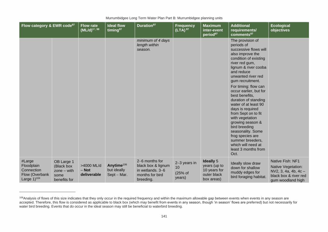
Murrumbidgee Long Term Water Plan Part B: Murrumbidgee planning units
141
Flow category & EWR code97 Flow rate (ML/d)97, 98
Ideal flow timing97
Duration97 Frequency (LTA) 97
Maximum inter-event period97
Additional requirements/ comments97
Ecological objectives
minimum of 4 days length within season.
The provision of periods of successive flows will also improve the condition of existing river red gum, lignum & river cooba and reduce unwanted river red gum recruitment.
For timing: flow can occur earlier, but for best benefits, duration of standing water of at least 90 days is required from Sept on to fit with vegetation growing season & bird breeding seasonality. Some frog species are summer breeders, which will need at least 3 months from Oct.
#Large Floodplain Connection Flow (Overbank Large 1)104
OB Large 1 (Black box zone – with some benefits for
>4000 ML/d – Not deliverable
Anytime106 but ideally
Sept − Mar.
2−6 months for black box & lignum
in wetlands. 3−6 months for bird breeding.
2−3 years in 10
(25% of years)
Ideally 5 years (up to 10 years for outer black box areas)
Ideally slow draw down for shallow muddy edges for bird foraging habitat.
Native Fish: NF1
Native Vegetation: NV2, 3, 4a, 4b, 4c – black box & river red gum woodland high
106Analysis of flows of this size indicates that they only occur in the required frequency and within the maximum allowable gap between events when events in any season are accepted. Therefore, this flow is considered as applicable to black box (which may benefit from events in any season, though ‘in season’ flows are preferred) but not necessarily for water bird breeding. Events that do occur in the ideal season may still be beneficial to waterbird breeding.
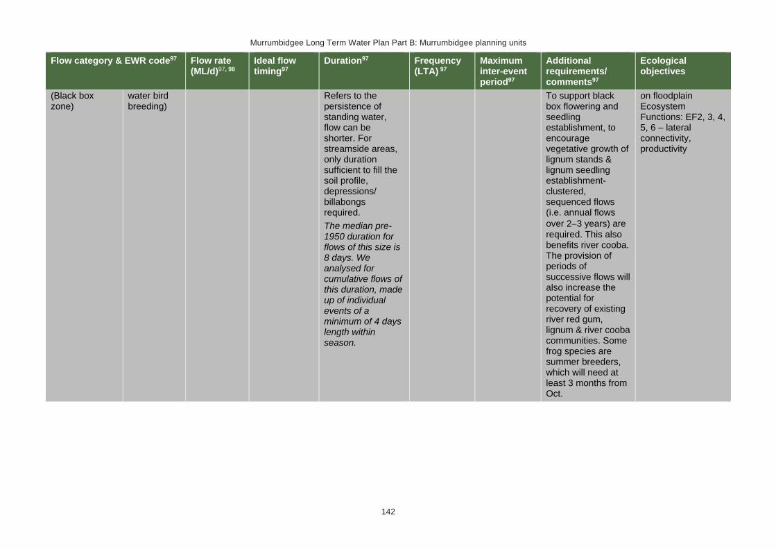
Murrumbidgee Long Term Water Plan Part B: Murrumbidgee planning units
142
Flow category & EWR code97 Flow rate (ML/d)97, 98
Ideal flow timing97
Duration97 Frequency (LTA) 97
Maximum inter-event period97
Additional requirements/ comments97
Ecological objectives
(Black box zone)
water bird breeding)
Refers to the persistence of standing water, flow can be shorter. For streamside areas, only duration sufficient to fill the soil profile, depressions/ billabongs required.
The median pre-1950 duration for flows of this size is 8 days. We analysed for cumulative flows of this duration, made up of individual events of a minimum of 4 days length within season.
To support black box flowering and seedling establishment, to encourage vegetative growth of lignum stands & lignum seedling establishment- clustered, sequenced flows (i.e. annual flows
over 2−3 years) are required. This also benefits river cooba. The provision of periods of successive flows will also increase the potential for recovery of existing river red gum, lignum & river cooba communities. Some frog species are summer breeders, which will need at least 3 months from Oct.
on floodplain Ecosystem Functions: EF2, 3, 4, 5, 6 – lateral connectivity, productivity

Murrumbidgee Long Term Water Plan Part B: Murrumbidgee planning units
143
PU11: Colombo & Billabong Creeks
The Colombo & Billabong Creeks PU is situated within the Murrumbidgee Western Water Source and Lower Billabong Anabranch Water Source. It begins where Colombo Creek bifurcates from Yanco Creek near Morundah. The division of flows between Colombo Creek and Lower Yanco Creek is controlled by Tarabah Weir. Colombo Creek flows into Billabong Creek upstream of Jerilderie. Upstream of this junction, Billabong Creek is unregulated. The PU ends where Lower Yanco Creek joins Billabong Creek.
Figure 12 Map of Colombo & Billabong Creeks PU. Area outside of PU has been faded. Significant gauges relevant to the PU are Colombo Ck @ Morundah (410014) and Billabong Ck @ Jerilderie (410016)

Murrumbidgee Long Term Water Plan Part B: Murrumbidgee planning units
144
Key water-dependent values (CE = Critically Endangered, E = Endangered, V = Vulnerable, EP= Endangered Population in MDB, C = CAMBA, J = JAMBA, R = ROKAMBA, X = species recorded in this planning unit via catch records and or Australian Museum Records where they exist, Y = species expected to occur based on MaxEnt modelling)
Native fish
• Australian smelt X
• bony herring X
• carp-gudgeon species complex X
• dwarf flat-headed gudgeon Y
• flat-headed galaxias Y
• flat-headed gudgeon Y
• freshwater catfish (EP) X
• golden perch X
• Murray cod (V) X
• Murray-Darling rainbowfish X
• northern river blackfish Y
• silver perch (V) Y
• southern pygmy perch (E) Y
• unspecked hardyhead X
Waterbirds 38 waterbird species recorded including, Australian painted snipe (E), brolga (V) & Latham's snipe (J,K).
Native vegetation
20,243 ha of water-dependent native vegetation including 4368 ha of black box, 370 ha of lignum, 967 ha of non-woody wetland vegetation & 4331 ha of river red gum.
Native fish objectives
NF1 No loss of native fish species
NF2 Increase the distribution & abundance of short to moderate-lived generalists: Australian smelt, carp-gudgeon species complex, flat-headed gudgeon, dwarf flat-headed gudgeon, bony herring
Murray-Darling rainbowfish, unspecked hardyhead
NF4 Improve population structure for moderate to long-lived flow pulse specialists: golden perch
NF5 Improve population structure for moderate to long-lived riverine specialists: Murray cod, river blackfish, freshwater catfish
NF6 A 25% increase in abundance of mature (harvestable sized): golden perch, Murray cod
NF8 Increase the prevalence &/or expand the population of key moderate to long-lived riverine species into new areas (within historical range): freshwater catfish
NF9 Increase the prevalence &/or expand the population of key moderate to long-lived flow pulse specialists native fish species into new areas (within historical range): silver perch
Hydrology
Hydrological alteration
See Table 1 for key
Regulated river reach
CtF Low flow & baseflow
Freshes
High & infrequent flows
1.5ARI 2.5ARI 5ARI
Colombo Creek at Morundah
H- H+ H+ L+ M- L0
Billabong Creek d/s Hartwood Weir
H- H+ H+ L+ L+ L+
Other hydrology information
Section 4.6 of Part A of the Murrumbidgee LTWP provides information about changes in hydrology in this PU and potential issues related to the proposed Yanco Creek regulator project.
Relevant rules from WSP
Murrumbidgee Western Water Source:
Access rules*:
Rivers & creeks: no pool drawdown.
Off-river pools: pumping is not permitted from an off-river pool or an off-river dam pool when the volume of water in that pool is less than 80% of the full capacity of the natural pool that existed prior to any augmentation works
Trading Rules:

Murrumbidgee Long Term Water Plan Part B: Murrumbidgee planning units
145
INTO water source: no trade allowed.
WITHIN water source: allowed, but no trade into off-river pools or onto Talpee Creek.
Lower Billabong Anabranch Water Source
Access Rules*:
Rivers & creeks*: Pumping is not permitted from natural pools when the water level in the pool is lower than its full capacity.
Natural off-river pools: pumping is not permitted from an off-river pool or an off-river dam pool when the volume of water in that pool is less than 80% of the full capacity of the natural pool that existed prior to any augmentation works.
Trading rules:
INTO water source: No trade allowed
WITHIN water source: Allowed, but no trade into off river pools
*Note: These access rules do not apply: 1. if the existing Water Act 1912 entitlement had more stringent access licence conditions. 2. to major water utility, local water utility or unregulated river (town water supply) access licences 3. to water taken for domestic consumption by stock & domestic access licences 4. for the first 5 years of the plan to water taken for stock watering by stock & domestic access licences 5. to water taken from existing dams. Any existing licence conditions associated with a dam will be carried forward under the plan. Water Sharing Plan for the Murrumbidgee Unregulated & Alluvial Water Sources
There are no recorded licences within this PU
Recommended management strategies
MS2: Ensure compliance with water access licence conditions including through metering of all licensed extraction.
MS3: As a minimum, maintain existing rules in the WSP for the Murrumbidgee Unregulated Water Sources that protect environmental assets and values.
MS4: Monitor for changes in water demand and review access rules if current usage is high or if the pattern of use changes.
Note: Section 7.2 of Part A of the Murrumbidgee LTWP also identifies as priority investment opportunities:
• Implement the constraints management strategy
• Seek arrangements to reduce take from the peak of wetland connecting events by negotiating for extraction to occur at other times
• Investigate infrastructure to fill wetlands
• Improve information and tools available for managing periods when there is a high risk of fish death events
• Improve water quality monitoring to avoid fish deaths
• Investigate opportunities to temporarily remove (or lower) weir gates to improve connectivity and improve habitat for native fish. Implement once investigated.
• Consider options for managing rainfall rejections in weir pools when the risk of fish death events is high
Potential wetlands for watering107 Values
Old Coree Black box lignum swamp
Six Mile (Coonong) Anabranch of Colombo Creek. Supports river red gum and black box
Cocketgedong River red gum – cumbungi. High aquatic vegetation diversity (Walcott et al 2018).
Hartwood Woolshed Wetland River red gum
107 This is a provisional listing which is the subject of further work.

Murrumbidgee Long Term Water Plan Part B: Murrumbidgee planning units
146
Sheepwash Anabranch River red gum – cumbungi. High aquatic vegetation diversity (Walcott et al 2018).
Wangamong Creek Black box, nitre goosefoot and cumbungi. High aquatic vegetation diversity (Walcott et al 2018).

Murrumbidgee Long Term Water Plan Part B: Murrumbidgee planning units
147
Table 15 Colombo and Middle Billabong Creeks (as measured at Colombo @ Morundah: 410014) gauge data began in 1978 and (by exception as noted) at Billabong at Jerilderie (Gauge: 410016) gauge data began in 1912
Flow category & EWR code108 Flow rate (ML/d)108, 109
Ideal flow timing108
Duration108 Frequency (LTA) 108
Maximum inter-event period108
Additional requirements/ comments108
Ecological objectives
Cease-to-flow CtF
<1 ML/d at Jerilderie and Morundah
CtF events have not been observed in the post-development period
(1980−2017) at Colombo Creek at Morundah
At Billabong Creek at Jerilderie CtF events were only recorded in 2
years since 1980 & these events were only of 1−2 day durations
CtF events should therefore be avoided to protect the fish community. The resilience of this community is likely to have been compromised by development.
At Morundah CtF events occurred in 100%, 1% & 0% of years in the modelled pre & post-development scenarios &
1980−2017 observations respectively. There are no ‘pre-development’ observations at this gauge
For Jerilderie it was 5%, 1%, 65%, & 6% of years in the modelled pre & post-development scenarios &
1912−1950 &
1980−2017 observations respectively
Native Fish: NF1 – Survival (all species) Ecosystem Functions: EF1, 2 – refuge habitat
108 Refer to Glossary for definitions of terms and explanatory text for EWRs
109 These minimums are where the benefits of flow categories are likely to begin manifesting. Further substantial benefits occur, particularly for wetland connecting large freshes and overbanks, as flows increase in size. These thresholds SHOULD NOT be used to indicate that constraints only need to be raised to achieve these minimums.

Murrumbidgee Long Term Water Plan Part B: Murrumbidgee planning units
148
Flow category & EWR code108 Flow rate (ML/d)108, 109
Ideal flow timing108
Duration108 Frequency (LTA) 108
Maximum inter-event period108
Additional requirements/ comments108
Ecological objectives
Very low flow
VLF
>40 ML/d at Morundah
Anytime
In typical years, 365 days per year
In very dry years, at least 365 days per year 110
Every year
1980−2017 observations did not exceed 1 day for 95% of events110 Flow ideally >0.03–
0.05 m/s to de-stratify pools
Native Fish: NF1 – Survival and condition (all species) Ecosystem Functions: EF1, 2 – refuge habitat >50 ML/d at
Jerilderie
In typical years, 365 days per year
In very dry years, at least 308 days per year 110
1980−2017 observations did not exceed 20 days for 95% of events110
Baseflow BF1
>70 ML/d at Morundah
Anytime
In typical years, 365 days per year
In very dry years, at least 333 days per year110
Every year
1980−2017 observations did not exceed 10 days for 95% of events110 Minimum depth of
0.3 m to allow fish passage
Native Fish: NF1, 2, 4, 5, 6, 8, 9 – condition and movement Native Vegetation: NV1 – in-channel Ecosystem Functions: EF1, 2, 3
>70 ML/d at Jerilderie
In typical years, 365 days per year
In very dry years, at least 271 days per year110
1980−2017 observations did not exceed 29 days for 95% of events110
Destratifying flow
(Weir pool mixing pulse)
DSF1 To be determined
Nov-Mar 2 days of flow above mixing
Whenever weir pools thermally stratify and lower layer is
Period should not exceed time required for
Monitoring required to determine if pools are stratifying and
Native Fish: NF1, 2, 4, 5, 6, 8, 9 – condition Ecosystem
110Based on 1980−2017 observations, with ‘typical year’ value the median of those observations, and ‘very dry’ value the 95th percentile. Post development observations are chosen because they are higher than pre-development. These higher values place less risk on the ecological community which in the Murrumbidgee catchment is likely to be less resilient. The pre-development modelled scenario is not comparable to the current situation in the Yanco/Billabong Creek system because the Creeks are now perennial systems.

Murrumbidgee Long Term Water Plan Part B: Murrumbidgee planning units
149
Flow category & EWR code108 Flow rate (ML/d)108, 109
Ideal flow timing108
Duration108 Frequency (LTA) 108
Maximum inter-event period108
Additional requirements/ comments108
Ecological objectives
threshold flow rate
expected to become hypoxic. Deliver before bottom layer becomes hypoxic. Likely to be required multiple times in such years. Further work required to determine risk of fish death events from hypoxia, which may be significantly lower than for far deeper Murrumbidgee weir pools
pools to stratify and the bottom layer to become hypoxic
the bottom layer is becoming hypoxic.
Requires further research to refine triggers.
Flow also reduces excessive blue green algal growth.
Lowering or removing weir gates may reduce or negate the need for this flow.
As these flows are to maintain water quality, weir level management, natural and rain rejection flows, operational water and non-discretionary environmental water should be used in the first instance before considering the use of discretionary environmental water.
Functions: EF1, 2 – maintain refuge and habitat quality
Nesting Support NestS1 70-400 ML/d at Morundah
15 Sep −15 Nov for trout
60 days minimum for trout cod & Murray cod.
5-10 years in 10
(75% of years)
2 years
Allow variable flows but avoid large sudden decreases in water
Native Fish NF5, 6, 8 - Nesting of riverine specialists (protect nesting sites

Murrumbidgee Long Term Water Plan Part B: Murrumbidgee planning units
150
Flow category & EWR code108 Flow rate (ML/d)108, 109
Ideal flow timing108
Duration108 Frequency (LTA) 108
Maximum inter-event period108
Additional requirements/ comments108
Ecological objectives
Max rate of fall 14% per day.
cod & Murray cod.
1 Oct − 15 Nov for only Murray cod.
(Only apply EWR if flows are in the BF or SF range at start of period)
45 day minimum for only Murray cod
level to prevent loss of nesting sites. Flow decreases not to exceed 7% per day which is the 20th percentile (the fastest 20%) of fall - calculated from observed ‘post-development' flow data (1980-2017)
by avoiding rapid changes in water levels)
Native Vegetation: NV1,3 – in-channel & riparian
Small fresh SF1 >250 ML/d at Morundah
Anytime - but
ideally Oct − Apr, & ideally
2−3 weeks after ‘LF2’
10 days minimum 2 events per year
1 year
>20°C for Oct to Apr (for native fish); for river blackfish >16°C; for Murray cod Sept to Dec >18°C Minimum depth of 0.5 m to allow movement of large fish Rate of fall: No faster than 13% per day111
Flow ideally up to
0.3−0.4 m/s (depending on channel form)
Native Fish: NF1, 2, 4, 5, 6, 8, 9 – Dispersal/condition (all species) Native Vegetation: NV1 – in-channel Ecosystem Functions: EF1, 2, 3, 4, 5
111 The 5th percentile (fastest 5% of rates of fall) of ‘post-development’ 1980-2017 observed flows

Murrumbidgee Long Term Water Plan Part B: Murrumbidgee planning units
151
Flow category & EWR code108 Flow rate (ML/d)108, 109
Ideal flow timing108
Duration108 Frequency (LTA) 108
Maximum inter-event period108
Additional requirements/ comments108
Ecological objectives
Small fresh SF2 250 to 400 ML/d at Morundah
15 Sep − Apr 14 days minimum
5–10 years in 10
(75% of years)
2 years
>20°C for Oct to Apr (for native fish); for river blackfish >16°C; for Murray cod Sept to Dec >18°C Minimum depth of 0.5 m to allow movement of large fish Rate of fall: No faster than 13% per day111
Flow ideally up to
0.3−0.4 m/s (depending on channel form)
Native Fish: NF1, 2, 5, 6, 8 – Spawning (river specialists, generalists) Native Vegetation: NV1 – in-channel Ecosystem Functions: EF1, 2, 3, 4, 5
Large fresh LF1 >400 ML/d at Morundah
Anytime − but
ideally July − Sept
Consider delivery outside cod breeding season to avoid flushing of nests.
5 days minimum
5–10 years in 10
(75% of years)
2 years
Minimum depth of 2 m to cover in-stream features & trigger response from fish Flow ideally
0.3−0.4 m/s (depending on channel form) Rate of fall: No faster than 11% per day111
Native Fish: NF1, 2, 4, 5, 6, 8, 9 – dispersal/condition (all species) Native Vegetation: NV1, 3 – in-channel/ riparian Ecosystem Functions: EF2, 3, 4, 5, 6

Murrumbidgee Long Term Water Plan Part B: Murrumbidgee planning units
152
Flow category & EWR code108 Flow rate (ML/d)108, 109
Ideal flow timing108
Duration108 Frequency (LTA) 108
Maximum inter-event period108
Additional requirements/ comments108
Ecological objectives
Large fresh LF2 >400 ML/d at Morundah
Oct − Apr
Consider delivery outside cod breeding season to avoid flushing of nests.
5 days minimum 6–7 years in 10
(65% of years) 2 years
Minimum depth of 2 m to cover in-stream features & trigger response from fish Flow ideally
0.3−0.4 m/s (depending on channel form)
Rapid rise (comparable to natural rates) >17°C Ideally follow 2–3 weeks later with SF1 for improved fish recruitment, productivity and dispersal. Rate of fall: No faster than 11% per day111
Native Fish: NF1, 4, 6, 9 – spawning (flow pulse specialists) Native Vegetation: NV1 – in-channel Ecosystem Functions: EF2, 3, 4, 5, 6
Large fresh with wetland connection112,113 *
W-LF4 (core wetland & off-channel fish refuge)
Not relevant as a river flow because the required frequency of flows in 90% of years is not achieved in this PU in the observed record. However, there may be target sites for filling with infrastructure (where possible with carp screens or other exclusion devices) where refuges could be maintained.
W-LF5 Not applicable: The specific objectives for floodplain specialist fish (NF3, NF7) are not prioritised for this PU.
112 In other catchments, connection to major wetlands systems would generally occur at and above bankfull level. The geomorphology of the Murrumbidgee system is such that major billabong, anabranch and other off-channel wetland systems are connected below bankfull level. Hence the category of ‘wetland connecting flow is used in the Murrumbidgee. 113 Light grey background (and * in 1st column of row) denotes that flows to this zone are currently difficult to deliver due to potential impacts on third parties, particularly in upstream planning units. Implementation of the constraints management strategy may alleviate this. Deliveries to these areas may only be possible with pumping or where other infrastructure exists to divert water to the floodplain. In such cases carp exclusion devices should be used where possible.
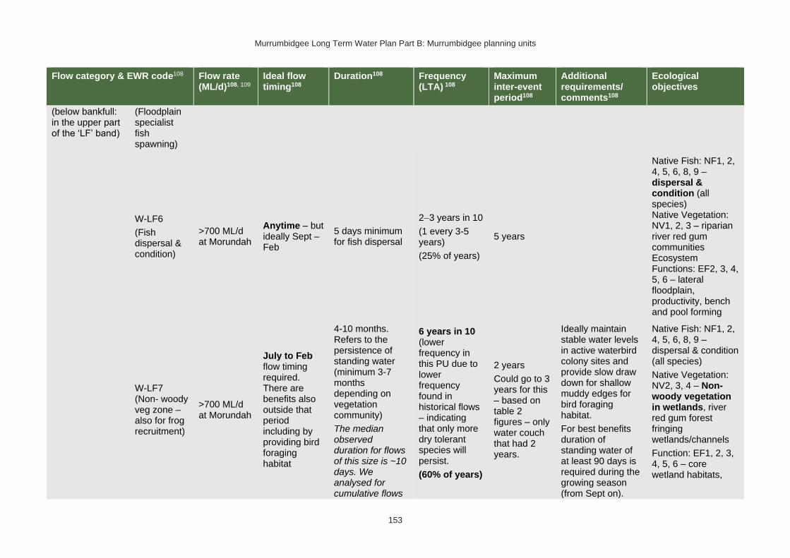
Murrumbidgee Long Term Water Plan Part B: Murrumbidgee planning units
153
Flow category & EWR code108 Flow rate (ML/d)108, 109
Ideal flow timing108
Duration108 Frequency (LTA) 108
Maximum inter-event period108
Additional requirements/ comments108
Ecological objectives
(below bankfull: in the upper part of the ‘LF’ band)
(Floodplain specialist fish spawning)
W-LF6
(Fish dispersal & condition)
>700 ML/d at Morundah
Anytime – but ideally Sept – Feb
5 days minimum for fish dispersal
2−3 years in 10
(1 every 3-5 years)
(25% of years)
5 years
Native Fish: NF1, 2, 4, 5, 6, 8, 9 – dispersal & condition (all species) Native Vegetation: NV1, 2, 3 – riparian river red gum communities Ecosystem Functions: EF2, 3, 4, 5, 6 – lateral floodplain, productivity, bench and pool forming
W-LF7 (Non- woody veg zone – also for frog recruitment)
>700 ML/d at Morundah
July to Feb flow timing required. There are benefits also outside that period including by providing bird foraging habitat
4-10 months. Refers to the persistence of standing water (minimum 3-7 months depending on vegetation community)
The median observed duration for flows of this size is ~10 days. We analysed for cumulative flows
6 years in 10 (lower frequency in this PU due to lower frequency found in historical flows – indicating that only more dry tolerant species will persist.
(60% of years)
2 years
Could go to 3 years for this – based on table 2 figures – only water couch that had 2 years.
Ideally maintain stable water levels in active waterbird colony sites and provide slow draw down for shallow muddy edges for bird foraging habitat.
For best benefits duration of standing water of at least 90 days is required during the growing season (from Sept on).
Native Fish: NF1, 2, 4, 5, 6, 8, 9 – dispersal & condition (all species)
Native Vegetation: NV2, 3, 4 – Non-woody vegetation in wetlands, river red gum forest fringing wetlands/channels
Function: EF1, 2, 3, 4, 5, 6 – core wetland habitats,
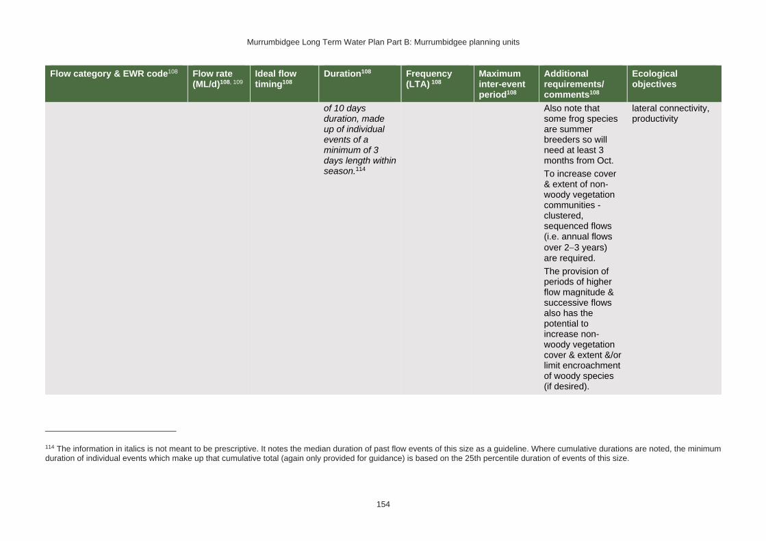
Murrumbidgee Long Term Water Plan Part B: Murrumbidgee planning units
154
Flow category & EWR code108 Flow rate (ML/d)108, 109
Ideal flow timing108
Duration108 Frequency (LTA) 108
Maximum inter-event period108
Additional requirements/ comments108
Ecological objectives
of 10 days duration, made up of individual events of a minimum of 3 days length within season.114
Also note that some frog species are summer breeders so will need at least 3 months from Oct.
To increase cover & extent of non-woody vegetation communities - clustered, sequenced flows (i.e. annual flows
over 2−3 years) are required.
The provision of periods of higher flow magnitude & successive flows also has the potential to increase non-woody vegetation cover & extent &/or limit encroachment of woody species (if desired).
lateral connectivity, productivity
114 The information in italics is not meant to be prescriptive. It notes the median duration of past flow events of this size as a guideline. Where cumulative durations are noted, the minimum duration of individual events which make up that cumulative total (again only provided for guidance) is based on the 25th percentile duration of events of this size.

Murrumbidgee Long Term Water Plan Part B: Murrumbidgee planning units
155
Flow category & EWR code108 Flow rate (ML/d)108, 109
Ideal flow timing108
Duration108 Frequency (LTA) 108
Maximum inter-event period108
Additional requirements/ comments108
Ecological objectives
W-LF8 (fish connect flow)
>700 ML/d at Morundah
Anytime115, but triggered by significant fish breeding in off-channel wetlands.
Flow 3−18 months after breeding occurs.
Flow must occur before habitat (depth, cover, water quality) of waterbody is lost by drying.
5 days
3 years in 10 or as required by breeding triggers
(30% of years)
5 years
Ideally provide a protracted recession to promote exit to the river.
This is for within
3−18 months so long as sufficient habitat (depth, cover) is maintained in the wetland to support the strong 0+ cohort until re-connection occurs - may be wetland specific.
Trigger is verified breeding event. Where there has been insufficient monitoring to confirm/deny this, the trigger is a long duration wetland connecting LF (W-LF5) or an overbank (OB-S1, OB-S2 or OB-L1) in those PUs where these have been shown to
Native Fish: NF1, 2, 4, 5, 6, 8, 9 – dispersal from off channel wetlands (all species) Native Vegetation: NV1, 2, 3 Ecosystem Functions: EF2, 3, 4, 5, 6 – connectivity
115 Return movement may vary seasonally, so future research will inform any necessary refinement in the timing of this.

Murrumbidgee Long Term Water Plan Part B: Murrumbidgee planning units
156
Flow category & EWR code108 Flow rate (ML/d)108, 109
Ideal flow timing108
Duration108 Frequency (LTA) 108
Maximum inter-event period108
Additional requirements/ comments108
Ecological objectives
produce significant breeding responses. The 3+ month delay following the breeding event is to allow recruits to utilize the nursey to move into the river & reach sufficient maturity to move into the river.
Floodplain Connection Flow (Overbank Small 1)
(Floodplain specialist fish)
OB-Small 1 Not applicable: The specific objectives for floodplain specialist fish (NF3, NF7) are not prioritised for this PU.
*Floodplain Connection Flow (Overbank Small 2)
(River red gum zone)113
OB-Small 2 >1000 ML/d at Morundah – Difficult to deliver under current constraints
Anytime116 −
but ideally Aug to Feb.
In line with natural median duration for fish dispersal & riparian river red gum communities.
For wetlands 3−7 months’ persistence of standing water.
3−4 years in 10
(35% of years)
5 years Ideally maintain stable water levels in active waterbird colony sites and provide slow draw down for shallow muddy edges for bird foraging habitat.
To support river red gum flowering,
Native Fish: NF1, 2, 4, 5, 6, 8, 9 – dispersal and condition (all species)
Native Vegetation: NV2, 3, 4a, 4b, 4e river red gum (riparian and
116 Analysis of flows of this size indicates that they only occur in the required frequency for river reg gum woodlands (as opposed to forests) and only when events in any season are accepted. Therefore, this flow is considered as applicable to river red gum woodlands (which may benefit from events in any season, though ‘in season’ flows are preferred) but not necessarily for water bird breeding. Events that do occur in the ideal season may still be beneficial to waterbird breeding.
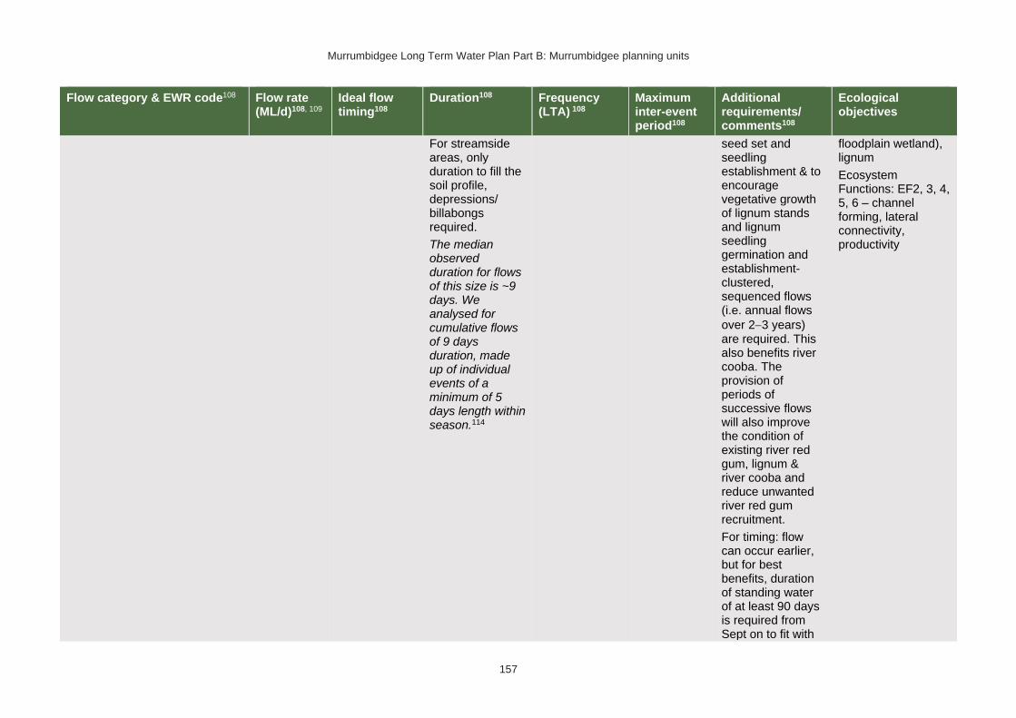
Murrumbidgee Long Term Water Plan Part B: Murrumbidgee planning units
157
Flow category & EWR code108 Flow rate (ML/d)108, 109
Ideal flow timing108
Duration108 Frequency (LTA) 108
Maximum inter-event period108
Additional requirements/ comments108
Ecological objectives
For streamside areas, only duration to fill the soil profile, depressions/ billabongs required.
The median observed duration for flows of this size is ~9 days. We analysed for cumulative flows of 9 days duration, made up of individual events of a minimum of 5 days length within season.114
seed set and seedling establishment & to encourage vegetative growth of lignum stands and lignum seedling germination and establishment- clustered, sequenced flows (i.e. annual flows
over 2−3 years) are required. This also benefits river cooba. The provision of periods of successive flows will also improve the condition of existing river red gum, lignum & river cooba and reduce unwanted river red gum recruitment.
For timing: flow can occur earlier, but for best benefits, duration of standing water of at least 90 days is required from Sept on to fit with
floodplain wetland), lignum
Ecosystem Functions: EF2, 3, 4, 5, 6 – channel forming, lateral connectivity, productivity
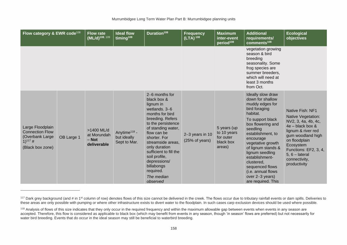
Murrumbidgee Long Term Water Plan Part B: Murrumbidgee planning units
158
Flow category & EWR code108 Flow rate (ML/d)108, 109
Ideal flow timing108
Duration108 Frequency (LTA) 108
Maximum inter-event period108
Additional requirements/ comments108
Ecological objectives
vegetation growing season & bird breeding seasonality. Some frog species are summer breeders, which will need at least 3 months from Oct.
Large Floodplain Connection Flow (Overbank Large 1)117 #
(Black box zone)
OB Large 1
>1400 ML/d at Morundah – Not deliverable
Anytime118 - but ideally Sept to Mar.
2−6 months for black box & lignum in
wetlands. 3−6 months for bird breeding. Refers to the persistence of standing water, flow can be shorter. For streamside areas, only duration sufficient to fill the soil profile, depressions/ billabongs required.
The median observed
2−3 years in 10
(25% of years)
5 years (up to 10 years for outer black box areas)
Ideally slow draw down for shallow muddy edges for bird foraging habitat.
To support black box flowering and seedling establishment, to encourage vegetative growth of lignum stands & lignum seedling establishment- clustered, sequenced flows (i.e. annual flows
over 2−3 years) are required. This
Native Fish: NF1
Native Vegetation: NV2, 3, 4a, 4b, 4c, 4e – black box & lignum & river red gum woodland high on floodplain Ecosystem Functions: EF2, 3, 4, 5, 6 – lateral connectivity, productivity
117 Dark grey background (and # in 1st column of row) denotes flows of this size cannot be delivered in the creek. The flows occur due to tributary rainfall events or dam spills. Deliveries to these areas are only possible with pumping or where other infrastructure exists to divert water to the floodplain. In such cases carp exclusion devices should be used where possible.
118 Analysis of flows of this size indicates that they only occur in the required frequency and within the maximum allowable gap between events when events in any season are accepted. Therefore, this flow is considered as applicable to black box (which may benefit from events in any season, though ‘in season’ flows are preferred) but not necessarily for water bird breeding. Events that do occur in the ideal season may still be beneficial to waterbird breeding.

Murrumbidgee Long Term Water Plan Part B: Murrumbidgee planning units
159
Flow category & EWR code108 Flow rate (ML/d)108, 109
Ideal flow timing108
Duration108 Frequency (LTA) 108
Maximum inter-event period108
Additional requirements/ comments108
Ecological objectives
duration for flows of this size is around 6 days. We analysed for cumulative flows of 6 days duration, made up of individual events of a minimum of 2 days length within season.114
also benefits river cooba. The provision of periods of successive flows will also increase the potential for recovery of existing river red gum, lignum & river cooba communities. Some frog species are summer breeders, which will need at least 3 months from Oct.
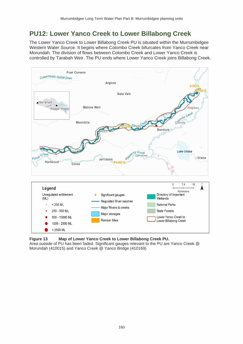
Murrumbidgee Long Term Water Plan Part B: Murrumbidgee planning units
160
PU12: Lower Yanco Creek to Lower Billabong Creek
The Lower Yanco Creek to Lower Billabong Creek PU is situated within the Murrumbidgee Western Water Source. It begins where Colombo Creek bifurcates from Yanco Creek near Morundah. The division of flows between Colombo Creek and Lower Yanco Creek is controlled by Tarabah Weir. The PU ends where Lower Yanco Creek joins Billabong Creek.
Figure 13 Map of Lower Yanco Creek to Lower Billabong Creek PU. Area outside of PU has been faded. Significant gauges relevant to the PU are Yanco Creek @ Morundah (410015) and Yanco Creek @ Yanco Bridge (410169)

Murrumbidgee Long Term Water Plan Part B: Murrumbidgee planning units
161
Key water-dependent values (CE = Critically Endangered, E = Endangered, V = Vulnerable, EP= Endangered Population in MDB, C = CAMBA, J = JAMBA, R = ROKAMBA X = species recorded in this planning unit via catch records and or Australian Museum Records where they exist, Y = species expected to occur based on MaxEnt modelling)
Native fish
• Australian smelt X
• bony herring Y
• carp-gudgeon species complex X
• dwarf flat-headed gudgeon Y
• flat-headed galaxias (CE) Y
• flat-headed gudgeon Y
• golden perch Y
• Murray cod (V) X
• Murray-Darling rainbowfish Y
• northern river blackfish Y
• silver perch (V) Y
• trout cod (E) Y
• unspecked hardyhead Y
Waterbirds 34 waterbird species recorded
Native vegetation
25,426 ha of water-dependent native vegetation including 175 ha of black box, 356 ha of lignum, 199 ha of non-woody wetland vegetation & 13,360 ha of river red gum.
Native fish objectives
NF1 No loss of native fish species
NF2 Increase the distribution & abundance of short to moderate-lived generalists: Australian smelt, carp-gudgeon species complex, flat-headed gudgeon, dwarf flat-headed gudgeon, bony herring, Murray-Darling Rainbowfish
NF4 Improve population structure for moderate to long-lived flow pulse specialists: golden perch
NF5 Improve population structure for moderate to long-lived riverine specialists: Murray cod, river blackfish
NF6 A 25% increase in abundance of mature (harvestable sized): golden perch, Murray cod
NF8 Increase the prevalence &/or expand the population of key moderate to long-lived riverine species into new areas (within historical range): freshwater catfish
NF9 Increase the prevalence &/or expand the population of key moderate to long-lived flow pulse specialists native fish species into new areas (within historical range): silver perch
Hydrology
Hydrological alteration
See Table 1 for key
Regulated river reach
CtF Low flow & baseflow
Freshes High & infrequent flows
1.5ARI 2.5ARI 5ARI
Yanco Creek at Yanco Bridge
H- H+ H+ L- L- L-
Other hydrology information
Section 4.6 of Part A of the Murrumbidgee LTWP provides information about changes in hydrology in this PU and potential issues related to the proposed Yanco Creek regulator project.
Relevant rules from WSP
Murrumbidgee Western Water Source:
Access rules*:
Rivers & creeks: no pool drawdown.
Off-river pools: pumping is not permitted from an off-river pool or an off-river dam pool when the volume of water in that pool is less than 80% of the full capacity of the natural pool that existed prior to any augmentation works
Trading Rules:
INTO water source: no trade allowed.
WITHIN water source: allowed, but no trade into off-river pools or onto Talpee Creek.
*Note: These access rules do not apply:
1. if the existing Water Act 1912 entitlement had more stringent access licence conditions.

Murrumbidgee Long Term Water Plan Part B: Murrumbidgee planning units
162
2. to major water utility, local water utility or unregulated river (town water supply) access licences
3. to water taken for domestic consumption by stock & domestic access licences
4. for the first 5 years of the plan to water taken for stock watering by stock & domestic access licences
5. to water taken from existing dams. Any existing licence conditions associated with a dam will be carried forward under the plan.
There are no recorded licences within this PU
Recommended management strategies
MS2: Ensure compliance with water access licence conditions including through metering of all licensed extraction.
MS3: As a minimum, maintain existing rules in the WSP for the Murrumbidgee Unregulated Water Sources that protect environmental assets and values.
MS4: Monitor for changes in water demand and review access rules if current usage is high or if the pattern of use changes.
Note: Section 7.2 of Part A of the Murrumbidgee LTWP also identifies as priority investment opportunities:
• Implement the constraints management strategy
• Seek arrangements to reduce take from the peak of wetland connecting events by negotiating for extraction to occur at other times
• Investigate infrastructure to fill wetlands
• Improve information and tools available for managing periods when there is a high risk of fish death events
• Improve water quality monitoring to avoid fish deaths
• Investigate opportunities to temporarily remove (or lower) weir gates to improve connectivity and improve habitat for native fish. Implement once investigated.
• Consider options for managing rainfall rejections in weir pools when the risk of fish death events is high
Potential wetlands for watering119 Values
Silver Pines River red gum wetland, frogs, waterbirds
Bundure River red gum. Southern bell frog recorded in 2017/18 (Walcott et al 2018). High aquatic vegetation diversity (Walcott et al 2018).
Arrawidgee Riparian river red gum
Wilson Anabranch River red gum and waterbirds
Mundoora Anabranch Frogs, wetland fishes
Broome River red gum. Southern bell frog recorded in 2017/18 and site had high frog species diversity (Walcott et al 2018)
The Yanko River red gum and black box
119 This is a provisional listing which is the subject of further work.

Murrumbidgee Long Term Water Plan Part B: Murrumbidgee planning units
163
Table 16 Lower Yanco Creek (as measured at Yanco Creek @ Morundah: 410015) − gauge data began in 1913
Flow category
& EWR code120
Flow rate (ML/d)120, 121
Ideal flow timing120
Duration120 Frequency (LTA) 120
Maximum inter-event period120
Additional requirements/ comments120
Ecological objectives
Cease-to-flow CtF <1 ML/d
CtF events have not been observed in the post development period
(1980−2017). They should therefore be avoided to protect the fish community. The resilience of this community is likely to have been compromised by development.
CtF events occurred in 100%, 0% & 0% of years in the modelled pre & post development scenarios &
1995−2017 observations respectively. There are no ‘pre-development’ observations at this gauge
Native Fish: NF1 – Survival (all species) Ecosystem Functions: EF1, 2 – refuge habitat
Very low flow VLF >40 ML/d Anytime
In typical years, 365 days per year
In very dry years, at least 346 days per year 122
Every year
1980−2017 observations did not exceed 14 days for 95% of events122
Flow ideally >0.03–0.05 m/s to de-stratify pools
Native Fish: NF1 – Survival and condition (all species) Ecosystem Functions: EF1, 2 – refuge habitat
Baseflow BF1 >130 ML/d Anytime In typical years, 339 days per year
Every year 1980−2017 observations did not
Ideally minimum depth of 0.3 m to allow fish passage
Native Fish: NF1, 2, 4, 5, 6, 8, 9 – condition and movement
120 Refer to Glossary for definitions of terms and explanatory text for EWRs
121 These minimums are where the benefits of flow categories are likely to begin manifesting. Further substantial benefits occur, particularly for wetland connecting large freshes and overbanks, as flows increase in size. These thresholds SHOULD NOT be used to indicate that constraints only need to be raised to achieve these minimums.
122 Based on 1980−2017 observations, with ‘typical year’ value the median of those observations, and ‘very dry’ value the 95th percentile. Post development observations are chosen because they are likely to be higher than pre-development, and for this gauge there is no pre-development data. These higher values place less risk on the ecological community which in the Murrumbidgee catchment is likely to be less resilient. The pre-development modelled scenario is not comparable to the current situation in the Yanco/Billabong Creek system because the Creeks are now perennial systems.

Murrumbidgee Long Term Water Plan Part B: Murrumbidgee planning units
164
Flow category
& EWR code120
Flow rate (ML/d)120, 121
Ideal flow timing120
Duration120 Frequency (LTA) 120
Maximum inter-event period120
Additional requirements/ comments120
Ecological objectives
In very dry years, at least 192 days per year122
exceed 65 days for 95% of events122
Native Vegetation: NV1 – in-channel Ecosystem Functions: EF1, 2, 3
Destratifying flow
(Weir pool mixing pulse)
DSF1 To be determined
Nov-Mar 2 days of flow above mixing threshold flow rate
Whenever weir pools thermally stratify and lower layer is expected to become hypoxic. Deliver before bottom layer becomes hypoxic. Likely to be required multiple times in such years. Further work required to determine risk of fish death events from hypoxia, which may be significantly lower than for far deeper Murrumbidgee weir pools
Period should not exceed time required for pools to stratify and the bottom layer to become hypoxic
Monitoring required to determine if pools are stratifying and the bottom layer is becoming hypoxic.
Requires further research to refine triggers.
Flow also reduces excessive blue green algal growth.
Lowering or removing weir gates may reduce or negate the need for this flow.
As these flows are to maintain water quality, weir level management, natural and rain rejection flows, operational water and non-discretionary environmental water should be used in the first instance before considering the use of discretionary
Native Fish: NF1, 2, 4, 5, 6, 8, 9 – condition Ecosystem Functions: EF1, 2 – maintain refuge and habitat quality

Murrumbidgee Long Term Water Plan Part B: Murrumbidgee planning units
165
Flow category
& EWR code120
Flow rate (ML/d)120, 121
Ideal flow timing120
Duration120 Frequency (LTA) 120
Maximum inter-event period120
Additional requirements/ comments120
Ecological objectives
environmental water.
Nesting Support NestS1
130-400 ML/d
Max rate of fall 9% per day.
15 Sep − 15 Nov for trout cod & Murray cod.
1 Oct − 15 Nov for only Murray cod.
(Only apply EWR if flows are in the BF or SF range at start of period)
60 days minimum for trout cod & Murray cod.
45 day minimum for only Murray cod
5−10 years in 10
(75% of years)
2 years
Allow variable flows but avoid large sudden decreases in water level to prevent loss of nesting sites. Flow decreases not to exceed 9% per day which is the 20th percentile (the fastest 20%) of fall - calculated from observed ‘post-development' flow data (1980-2017)
Native Fish NF5, 6, 8 - Nesting of riverine specialists (protect nesting sites by avoiding rapid changes in water levels)
Native Vegetation: NV1,3 – in-channel & riparian
Small fresh SF1 >250 ML/d
Anytime - but
ideally Oct − Apr, & ideally
2−3 weeks after ‘LF2’
10 days minimum
2 events per year
1 year
>20°C for Oct to Apr (for native fish); for river blackfish >16°C; for Murray cod Sept to Dec >18°C
Minimum depth of 0.5 m to allow movement of large fish
Rate of fall: No faster than 15% per day123 Flow ideally
up to 0.3−0.4 m/s
Native Fish: NF1, 2, 4, 5, 6, 8, 9 – Dispersal/condition (all species) Native Vegetation: NV1 – in-channel Ecosystem Functions: EF1, 2, 3, 4, 5
123 The 5th percentile (fastest 5% of rates of fall) of ‘post-development’ 1980-2017 observed flows

Murrumbidgee Long Term Water Plan Part B: Murrumbidgee planning units
166
Flow category
& EWR code120
Flow rate (ML/d)120, 121
Ideal flow timing120
Duration120 Frequency (LTA) 120
Maximum inter-event period120
Additional requirements/ comments120
Ecological objectives
(depending on channel form)
Small fresh SF2 250−400 ML/d
15 Sep − Apr 14 days minimum
5–10 years in 10
(75% of years)
2 years
>20°C for Oct to Apr (for native fish); for river blackfish >16°C; for Murray cod Sept to Dec >18°C
Minimum depth of 0.5 m to allow movement of large fish
Rate of fall: No faster than 15% per day123 Flow ideally
up to 0.3−0.4 m/s (depending on channel form)
Native Fish: NF1, 2, 5, 6, 8 – Spawning (river specialists, generalists) Native Vegetation: NV1 – in-channel Ecosystem Functions: EF1, 2, 3, 4, 5
Large fresh LF1 >400 ML/d
Anytime - but
ideally July − Sept
Consider delivery outside cod breeding season to avoid flushing of nests
5 days minimum
5–10 years in 10
(75% of years)
2 years
Minimum depth of 2 m to cover in-stream features & trigger response from fish
Flow ideally 0.3−0.4 m/s (depending on channel form)
Rate of fall: No faster than 26% per day123
Native Fish: NF1, 2, 4, 5, 6, 8, 9 – dispersal/condition (all species) Native Vegetation: NV1, 3 – in-channel/ riparian Ecosystem Functions: EF2, 3, 4, 5, 6
Large fresh LF2 >400 ML/d
Oct − Apr
Consider delivery outside cod breeding season to
5 days minimum 6–7 years in 10
(65% of years) 2 years
Minimum depth of 2 m to cover in-stream features & trigger response from fish
Native Fish: NF1, 4, 6, 9 – spawning (flow pulse specialists) Native Vegetation: NV1 – in-channel

Murrumbidgee Long Term Water Plan Part B: Murrumbidgee planning units
167
Flow category
& EWR code120
Flow rate (ML/d)120, 121
Ideal flow timing120
Duration120 Frequency (LTA) 120
Maximum inter-event period120
Additional requirements/ comments120
Ecological objectives
avoid flushing of nests
Flow ideally 0.3−0.4 m/s (depending on channel form)
Rapid rise (comparable to natural rates) >17°C
Ideally follow 2–3 weeks later with SF1 for improved fish recruitment, productivity and dispersal.
Rate of fall: No faster than 26% per day123
Ecosystem Functions: EF2, 3, 4, 5, 6
Large fresh with wetland connection124,125 *
(below bankfull: in the upper part of the ‘Large fresh’ band)
W-LF4 (core wetland & off-channel fish refuge)
Not relevant as a river flow because the required frequency of flows in 90% of years is not achieved in this PU in the observed record. However, there may be target sites for filling with infrastructure (where possible with carp screens or other exclusion devices) where refuges could be maintained.
W-LF5
(Floodplain specialist fish spawning)
Not applicable: The specific objectives for floodplain specialist fish (NF3, NF7) are not prioritised for this PU.
W-LF6 >800 ML/d Anytime – but ideally Sept – Feb
5 days minimum for fish dispersal
2−3 years in 10 5 years Native Fish: NF1, 2, 4, 5, 6, 8, 9 – dispersal &
124 In other catchments, connection to major wetlands systems would generally occur at and above bankfull level. The geomorphology of the Murrumbidgee system is such that major billabong, anabranch and other off-channel wetland systems are connected below bankfull level. Hence the category of ‘wetland connecting flow is used in the Murrumbidgee. 125 Light grey background (and * in 1st column of row) denotes that flows to this zone are currently difficult to deliver due to potential impacts on third parties, particularly in upstream planning units. The constraints management strategy may alleviate this. Deliveries to these areas may only be possible with pumping or where other infrastructure exists to divert water to the floodplain. In such cases carp exclusion devices should be used where possible.
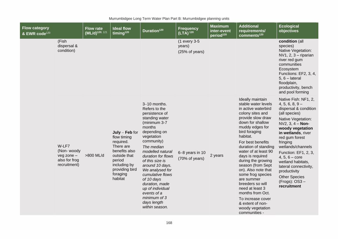
Murrumbidgee Long Term Water Plan Part B: Murrumbidgee planning units
168
Flow category
& EWR code120
Flow rate (ML/d)120, 121
Ideal flow timing120
Duration120 Frequency (LTA) 120
Maximum inter-event period120
Additional requirements/ comments120
Ecological objectives
(Fish dispersal & condition)
(1 every 3-5 years)
(25% of years)
condition (all species) Native Vegetation: NV1, 2, 3 – riparian river red gum communities Ecosystem Functions: EF2, 3, 4, 5, 6 – lateral floodplain, productivity, bench and pool forming
W-LF7 (Non- woody veg zone – also for frog recruitment)
>800 ML/d
July − Feb for flow timing required. There are benefits also outside that period including by providing bird foraging habitat
3−10 months. Refers to the persistence of standing water (minimum 3-7 months depending on vegetation community)
The median modelled natural duration for flows of this size is around 10 days. We analysed for cumulative flows of 10 days duration, made up of individual events of a minimum of 3 days length within season.
6−8 years in 10
(70% of years) 2 years
Ideally maintain stable water levels in active waterbird colony sites and provide slow draw down for shallow muddy edges for bird foraging habitat.
For best benefits duration of standing water of at least 90 days is required during the growing season (from Sept on). Also note that some frog species are summer breeders so will need at least 3 months from Oct.
To increase cover & extent of non-woody vegetation communities -
Native Fish: NF1, 2, 4, 5, 6, 8, 9 – dispersal & condition (all species)
Native Vegetation: NV2, 3, 4 – Non-woody vegetation in wetlands, river red gum forest fringing wetlands/channels
Function: EF1, 2, 3, 4, 5, 6 – core wetland habitats, lateral connectivity, productivity
Other Species (Frogs): OS3 – recruitment

Murrumbidgee Long Term Water Plan Part B: Murrumbidgee planning units
169
Flow category
& EWR code120
Flow rate (ML/d)120, 121
Ideal flow timing120
Duration120 Frequency (LTA) 120
Maximum inter-event period120
Additional requirements/ comments120
Ecological objectives
clustered, sequenced flows (i.e. annual flows
over 2−3 years) are required.
The provision of periods of higher flow magnitude & successive flows also has the potential to increase non-woody vegetation cover & extent &/or limit encroachment of woody species (if desired).
W-LF8 (fish connect flow)
>800 ML/d
Anytime126, but triggered by significant fish breeding in off-channel wetlands.
Flow 3−18 months after breeding occurs.
Flow must occur before habitat (depth, cover, water quality) of waterbody
5 days
3 years in 10 or as required by breeding triggers
(30% of years)
5 years
Ideally provide a protracted recession to promote exit to the river.
This is for within
3−18 months so long as sufficient habitat (depth, cover) is maintained in the wetland to support the strong 0+ cohort until re-connection occurs -
Native Fish: NF1, 2, 4, 5, 6, 8, 9 – dispersal from off channel wetlands (all species) Native Vegetation: NV1, 2, 3 Ecosystem Functions: EF2, 3, 4, 5, 6 – connectivity
126 Return movement may vary seasonally, so future research will inform any necessary refinement in the timing of this.

Murrumbidgee Long Term Water Plan Part B: Murrumbidgee planning units
170
Flow category
& EWR code120
Flow rate (ML/d)120, 121
Ideal flow timing120
Duration120 Frequency (LTA) 120
Maximum inter-event period120
Additional requirements/ comments120
Ecological objectives
is lost by drying.
may be wetland specific.
Trigger is verified breeding event. Where there has been insufficient monitoring to confirm/deny this, the trigger is a long duration wetland connecting LF (W-LF5) or an overbank (OB-S1, OB-S2 or OB-L1) in those PUs where these have been shown to produce significant breeding responses. The 3+ month delay following the breeding event is to allow recruits to utilize the nursey to move into the river & reach sufficient maturity to move into the river.
*Floodplain Connection Flow (Overbank Small 1) 125
(Floodplain specialist fish)
OB-Small 1 (Floodplain specialist fish) Not applicable: The specific objectives for floodplain specialist fish (NF3, NF7) are not prioritised for this PU
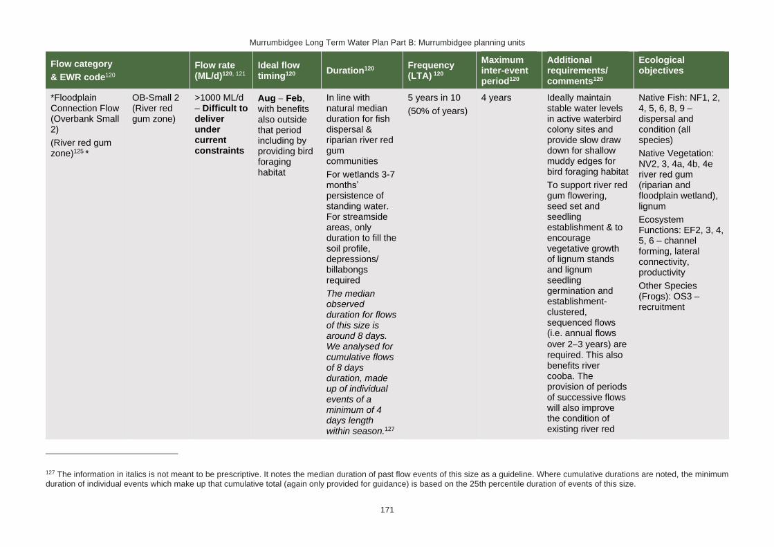
Murrumbidgee Long Term Water Plan Part B: Murrumbidgee planning units
171
Flow category
& EWR code120
Flow rate (ML/d)120, 121
Ideal flow timing120
Duration120 Frequency (LTA) 120
Maximum inter-event period120
Additional requirements/ comments120
Ecological objectives
*Floodplain Connection Flow (Overbank Small 2)
(River red gum zone)125 *
OB-Small 2 (River red gum zone)
>1000 ML/d – Difficult to deliver under current constraints
Aug − Feb, with benefits also outside that period including by providing bird foraging habitat
In line with natural median duration for fish dispersal & riparian river red gum communities
For wetlands 3-7 months’ persistence of standing water. For streamside areas, only duration to fill the soil profile, depressions/ billabongs required
The median observed duration for flows of this size is around 8 days. We analysed for cumulative flows of 8 days duration, made up of individual events of a minimum of 4 days length within season.127
5 years in 10
(50% of years)
4 years Ideally maintain stable water levels in active waterbird colony sites and provide slow draw down for shallow muddy edges for bird foraging habitat
To support river red gum flowering, seed set and seedling establishment & to encourage vegetative growth of lignum stands and lignum seedling germination and establishment- clustered, sequenced flows (i.e. annual flows
over 2−3 years) are required. This also benefits river cooba. The provision of periods of successive flows will also improve the condition of existing river red
Native Fish: NF1, 2, 4, 5, 6, 8, 9 – dispersal and condition (all species)
Native Vegetation: NV2, 3, 4a, 4b, 4e river red gum (riparian and floodplain wetland), lignum
Ecosystem Functions: EF2, 3, 4, 5, 6 – channel forming, lateral connectivity, productivity
Other Species (Frogs): OS3 – recruitment
127 The information in italics is not meant to be prescriptive. It notes the median duration of past flow events of this size as a guideline. Where cumulative durations are noted, the minimum duration of individual events which make up that cumulative total (again only provided for guidance) is based on the 25th percentile duration of events of this size.

Murrumbidgee Long Term Water Plan Part B: Murrumbidgee planning units
172
Flow category
& EWR code120
Flow rate (ML/d)120, 121
Ideal flow timing120
Duration120 Frequency (LTA) 120
Maximum inter-event period120
Additional requirements/ comments120
Ecological objectives
gum, lignum & river cooba and reduce unwanted river red gum recruitment.
For timing: flow can occur earlier, but for best benefits, duration of standing water of at least 90 days is required from Sept on to fit with vegetation growing season & bird breeding seasonality. Some frog species are summer breeders, which will need at least 3 months from Oct.
Large Floodplain Connection Flow (Overbank Large 1)128 #
(Black box zone)
OB Large 1 (Black box zone)
>2000 – Not deliverable
Anytime129 - but ideally Sept to Mar.
2−6 months for black box & lignum in
wetlands. 3−6 months for bird breeding. Refers to the persistence of standing water,
2−3 years in 10
(25% of years)
5 years (up to 10 years for outer black box areas)
Ideally slow draw down for shallow muddy edges for bird foraging habitat.
To support black box flowering and seedling establishment, to encourage
Native Fish: NF1
Native Vegetation: NV2, 3, 4a, 4b, 4c, 4e – black box & lignum & river red gum woodland high on floodplain Ecosystem Functions: EF2, 3, 4,
128 Dark grey background (and # in 1st column of row) denotes flows of this size cannot be delivered in the creek. The flows occur due to tributary rainfall events or dam spills. Deliveries to these areas are only possible with pumping or where other infrastructure exists to divert water to the floodplain. In such cases carp exclusion devices should be used where possible.
129 Analysis of flows of this size indicates that they only occur in the required frequency and within the maximum allowable gap between events when events in any season are accepted. Therefore, this flow is considered as applicable to black box (which may benefit from events in any season, though ‘in season’ flows are preferred) but not necessarily for water bird breeding. Events that do occur in the ideal season may still be beneficial to waterbird breeding.

Murrumbidgee Long Term Water Plan Part B: Murrumbidgee planning units
173
Flow category
& EWR code120
Flow rate (ML/d)120, 121
Ideal flow timing120
Duration120 Frequency (LTA) 120
Maximum inter-event period120
Additional requirements/ comments120
Ecological objectives
flow can be shorter. For streamside areas, only duration sufficient to fill the soil profile, depressions/ billabongs required.
The median observed duration for flows of this size is around 8 days. We analysed for cumulative flows of 8 days duration, made up of individual events of a minimum of 5 days length within season.127
vegetative growth of lignum stands & lignum seedling establishment- clustered, sequenced flows (i.e. annual flows
over 2−3 years) are required. This also benefits river cooba. The provision of periods of successive flows will also increase the potential for recovery of existing river red gum, lignum & river cooba communities.
Some frog species are summer breeders, which will need at least 3 months from Oct.
5, 6– lateral connectivity, productivity
Other Species (Frogs): OS3 – recruitment
.

Murrumbidgee Long Term Water Plan Part B: Murrumbidgee planning units
174
PU13: Lower Billabong and Intersecting Streams
The Lower Billabong and Intersecting Streams PU is situated within the Lower Billabong Anabranch Water Source.
Figure 14 Map of Lower Billabong Intersecting Stream PU. Area outside of PU has been faded. Significant gauge relevant to the PU is Billabong Creek @ Darlot (410134)

Murrumbidgee Long Term Water Plan Part B: Murrumbidgee planning units
175
Key water-dependent values (CE = Critically Endangered, E = Endangered, V = Vulnerable, EP= Endangered Population in MDB, C = CAMBA, J = JAMBA, R = ROKAMBA, X = species recorded in this planning unit via catch records and or Australian Museum Records where they exist, Y = species expected to occur based on MaxEnt modelling, Z = based on expert DPI Fisheries opinion)
Native fish
• Australian smelt X
• bony herring X
• carp-gudgeon species complex X
• dwarf flat-headed gudgeon Z
• flat-headed galaxias Y
• flat-headed gudgeon Z
• freshwater catfish (EP) X
• golden perch X
• Murray cod (V) X
• Murray-Darling rainbowfish X
• silver perch (V) Y
• unspecked hardyhead y
Waterbirds
62 waterbird species recorded including Australasian bittern (E), Australian painted snipe (E), blue-billed duck (V), brolga (V), common greenshank (C,J,K), freckled duck (V), Latham's snipe (J,K), marsh sandpiper (C,J,K), pectoral sandpiper (J,K), sharp-tailed sandpiper (C,J,K) & wood sandpiper (C,J,K)
Native vegetation
97,057 ha of water-dependent native vegetation including 14,869 ha of black box, 8999 ha of lignum, 712 ha of non-woody wetland vegetation & 3080 ha of river red gum
Native fish objectives
NF1 No loss of native fish species
NF2 Increase the distribution & abundance of short to moderate-lived generalists: Australian smelt,
flat-headed gudgeon, dwarf flat-headed gudgeon, bony herring, Murray-Darling rainbowfish
NF4 Improve population structure for moderate to long-lived flow pulse specialists: golden perch
NF5 Improve population structure for moderate to long-lived riverine specialists: Murray cod, freshwater catfish
NF6 A 25% increase in abundance of mature (harvestable sized): golden perch, Murray cod
NF7 Increase the prevalence &/or expand the population of key short to moderate-lived floodplain specialist native fish species into new areas (within historical range): southern pygmy perch
NF8 Increase the prevalence &/or expand the population of key moderate to long-lived riverine species into new areas (within historical range): freshwater catfish
NF9 Increase the prevalence &/or expand the population of key moderate to long-lived flow pulse specialists native fish species into new areas (within historical range): silver perch
Hydrology
Hydrological alteration
See Table 1 for key
Regulated river reach
CtF Low flow & baseflow
Freshes High & infrequent flows
1.5ARI 2.5ARI 5ARI
Billabong Creek at Darlot
H- H+ H+ M+ L+ L-
Other hydrology information
Section 4.6 of Part A of the Murrumbidgee LTWP provides information about changes in hydrology in this PU
Relevant rules from WSP
Lower Billabong Anabranch Water Source
Access Rules*:
Rivers & creeks: pumping is not permitted from natural pools when the water level in the pool is lower than its full capacity.
Natural off-river pools: pumping is not permitted from an off-river pool or an off-river dam pool when the volume of water in that pool is less than 80% of the full capacity of the natural pool that existed prior to any augmentation works.
Trading rules:
INTO water source: no trade allowed
WITHIN water source: allowed, but no trade into off river pools

Murrumbidgee Long Term Water Plan Part B: Murrumbidgee planning units
176
*Note: These access rules do not apply:
1. if the existing Water Act 1912 entitlement had more stringent access licence conditions.
2. to major water utility, local water utility or unregulated river (town water supply) access licences
3. to water taken for domestic consumption by stock & domestic access licences
4. for the first 5 years of the plan to water taken for stock watering by stock & domestic access licences
5. to water taken from existing dams. Any existing licence conditions associated with a dam will be carried forward under the plan.
Water Sharing Plan for the Murrumbidgee Unregulated & Alluvial Water Sources
There are 2 very small (<250 ML), & 1 small (250−500) unregulated water access licences distributed throughout the PU. The total volume of unregulated entitlements for the PU is 443 ML of which 436 ML is allocated for irrigation (rather than stock & domestic or town water supply).
Recommended management strategies
MS2: Ensure compliance with water access licence conditions including through metering of all licensed extraction.
MS3: As a minimum, maintain existing rules in the WSP for the Murrumbidgee Unregulated Water Sources that protect environmental assets and values.
MS4: Monitor for changes in water demand and review access rules if current usage is high or if the pattern of use changes.
MS5: Consider introducing cease-to-pump and commence-to-pump rules (and any associated required amendments to WAL conditions) that protect held environmental water and water from the EWAs entering unregulated streams and off-channel pools (wetlands), In-line with the Basin Plan (Section 7.15(2)) requirement for implementation of prerequisite policy measures which provide for delivered environmental water to be protected.
Note: Section 7.2 of Part A of the Murrumbidgee LTWP also identifies as priority investment opportunities:
• Seek arrangements to reduce take from the peak of wetland connecting events by negotiating for extraction to occur at other times
• Investigate infrastructure to fill wetlands
• Improve information and tools available for managing periods when there is a high risk of fish death events
• Improve water quality monitoring to avoid fish deaths
• Investigate opportunities to temporarily remove (or lower) weir gates to improve connectivity and improve habitat for native fish. Implement once investigated.
• Consider options for managing rainfall rejections in weir pools when the risk of fish death events is high
• Assess the need for establishing environmental water requirements for the Forest Creek system
Potential wetlands for watering130 Values
Quiamong River red gum
Forest Creek (see notes below table) Anabranch for waterbirds and black box
Wanganella Swamp/ Clarkes Creek Waterbirds, nitre goosefoot, cane-grass (Eragrostis australasica) and lignum. High frog diversity (Walcott et al 2018).
Rhyola Swamp Waterbirds, black box and lignum
Zara Swamp Waterbirds, black box and lignum
Sheepwash and Browns Creeks Anabranch for waterbirds and black box
Two Mile Creek Anabranch for waterbirds and black box
130 This is a provisional listing which is the subject of further work.

Murrumbidgee Long Term Water Plan Part B: Murrumbidgee planning units
177
Black Swamp Water birds, vegetation and frogs
Swamps on Windouran Station Cane-grass
Swamps on Mooroolbark Cane-grass
Note on environmental flow requirements of the Forest Creek system including
Wanganella Swamp
Table 17 provides EWRs for the Billabong Creek at Darlot. Table 26 of Part A (Further investment opportunities and projects) recommends investing the development of EWRs for the Forest Creek system. In the absence of these EWRs, the flow requirements outlined in Alluvium (2013) for the unregulated Forest Creek (Forest Creek at downstream Warriston Weir gauge) and Webster and Davidson (2010) for Wanganella Swamp.

Murrumbidgee Long Term Water Plan Part B: Murrumbidgee planning units
178
Table 17 Lower Billabong Creek (as measured at Billabong Creek @ Darlot: 410134) − gauge data began in 1978
Flow category & EWR code131
Flow rate (ML/d)131, 132
Ideal flow timing131
Duration131 Frequency (LTA)131
Maximum inter-event period131
Additional requirements/ comments131
Ecological objectives
Cease-to-flow CtF <1 ML/d CtF events are now rare & should therefore be avoided to protect the fish community. The resilience of this community is likely to have been compromised by development.
CtF events occurred in 100%, 0% & 8% of years in the modelled pre & post development scenarios &
1980−2017 observations respectively. There are no ‘pre-development’ observations at this gauge.
Native Fish: NF1 – Survival (all species) Ecosystem Functions: EF1, 2 – refuge habitat
Very low flow VLF >30 ML/d Anytime
In typical years, 365 days per year
In very dry years, at least 327 days per year 133
Every year
1980−2017 observations did not exceed 18 days for 95% of events133
Flow ideally >0.03–0.05 m/s to de-stratify pools
Native Fish: NF1 – Survival and condition (all species) Ecosystem Functions: EF1, 2 – refuge habitat
131 Refer to Glossary for definitions of terms and explanatory text for EWRs
132 These minimums are where the benefits of flow categories are likely to begin manifesting. Further substantial benefits occur, particularly for wetland connecting large freshes and overbanks, as flows increase in size. These thresholds SHOULD NOT be used to indicate that constraints only need to be raised to achieve these minimums.
133 Based on 1980−2017 observations, with ‘typical year’ value the median of those observations, and ‘very dry’ value the 95th percentile. Post development observations are chosen because they are likely to be higher than pre-development, and for this gauge there is no pre-development data. These higher values place less risk on the ecological community which in the Murrumbidgee catchment is likely to be less resilient. The pre-development modelled scenario is not comparable to the current situation in the Yanco/Billabong Creek system because the Creeks are now perennial systems.

Murrumbidgee Long Term Water Plan Part B: Murrumbidgee planning units
179
Flow category & EWR code131
Flow rate (ML/d)131, 132
Ideal flow timing131
Duration131 Frequency (LTA)131
Maximum inter-event period131
Additional requirements/ comments131
Ecological objectives
Baseflow BF1 >50 ML/d Anytime
In typical years, 365 days per year
In very dry years, at least 275 days per year133
Every year
1980−2017 observations did not exceed 32 days for 95% of events133
Minimum depth of 0.3 m to allow fish passage
Native Fish: NF1, 2, 4, 5, 6, 7, 8, 9 – condition and movement Native Vegetation: NV1 – in-channel Ecosystem Functions: EF1, 2, 3
Destratifying flow
(Weir pool mixing pulse)
DSF1 To be determined
Nov-Mar 2 days of flow above mixing threshold flow rate
Whenever weir pools thermally stratify and lower layer is expected to become hypoxic. Deliver before bottom layer becomes hypoxic. Likely to be required multiple times in such years. Further work required to determine risk of fish death events from hypoxia, which may be significantly lower than for far deeper Murrumbidgee weir pools
Period should not exceed time required for pools to stratify and the bottom layer to become hypoxic
Monitoring required to determine if pools are stratifying and the bottom layer is becoming hypoxic.
Requires further research to refine triggers.
Flow also reduces excessive blue green algal growth.
Lowering or removing weir gates may reduce or negate the need for this flow.
As these flows are to maintain water quality, weir level management, natural and rain rejection flows, operational water and non-discretionary
Native Fish: NF1, 2, 4, 5, 6, 7, 8, 9 – condition Ecosystem Functions: EF1, 2 – maintain refuge and habitat quality

Murrumbidgee Long Term Water Plan Part B: Murrumbidgee planning units
180
Flow category & EWR code131
Flow rate (ML/d)131, 132
Ideal flow timing131
Duration131 Frequency (LTA)131
Maximum inter-event period131
Additional requirements/ comments131
Ecological objectives
environmental water should be used in the first instance before considering the use of discretionary environmental water.
Nesting Support NestS1
50-700 ML/d
Max rate of fall 9% per day.
15 Sep − 15 Nov for trout cod & Murray cod.
1 Oct − 15 Nov for only Murray cod.
(Only apply EWR if flows are in the BF or SF range at start of period)
60 days minimum for trout cod & Murray cod.
45 day minimum for only Murray cod
5−10 years in 10
(75% of years)
2 years
Allow variable flows but avoid large sudden decreases in water level to prevent loss of nesting sites. Flow decreases not to exceed 9% per day which is the 20th percentile (the fastest 20%) of fall - calculated from observed ‘post-development' flow data (1980-2017)
Native Fish NF5, 6, 8 - Nesting of riverine specialists (protect nesting sites by avoiding rapid changes in water levels)
Native Vegetation: NV1,3 – in-channel & riparian
Small fresh SF1 >200 ML/d
Anytime - but ideally Oct to Apr, & ideally
2−3 weeks after ‘LF2’
10 days minimum 2 events per year
1 year
>20°C for Oct to Apr (for native fish); for Murray cod Sept to Dec >18°C
Minimum depth of 0.5 m to allow movement of large fish Rate of fall: No
Native Fish: NF1, 2, 4, 5, 6, 7, 8, 9 – Dispersal/condition (all species) Native Vegetation: NV1 – in-channel Ecosystem Functions: EF1, 2, 3, 4, 5

Murrumbidgee Long Term Water Plan Part B: Murrumbidgee planning units
181
Flow category & EWR code131
Flow rate (ML/d)131, 132
Ideal flow timing131
Duration131 Frequency (LTA)131
Maximum inter-event period131
Additional requirements/ comments131
Ecological objectives
faster than 12% per day134
Flow ideally up to
0.3−0.4 m/s (depending on channel form)
Small fresh SF2 200−700 ML/d
15 Sep − Apr 14 days minimum
5–10 years in 10
(75% of years)
2 years
>20°C for Oct to Apr (for native fish) for Murray cod Sept to Dec >18°C Minimum depth of 0.5 m to allow movement of large fish
Rate of fall: No faster than 12% per day134
Flow ideally up to
0.3−0.4 m/s (depending on channel form)
Native Fish: NF1, 2, 5, 6, 8 – Spawning (river specialists, generalists) Native Vegetation: NV1 – in-channel Ecosystem Functions: EF1, 2, 3, 4, 5
Large fresh LF1 >700 ML/d
Anytime - but
ideally July − Sept
Consider delivery outside cod breeding season to avoid flushing of nests
5 days minimum
5–10 years in 10
(75% of years)
2 years
Minimum depth of 2 m to cover in-stream features & trigger response from fish Flow ideally
0.3−0.4 m/s (depending on channel form)
Native Fish: NF1, 2, 4, 5, 6, 8, 9 – dispersal/condition (all species) Native Vegetation: NV1, 3 – in-channel/ riparian Ecosystem
134 The 5th percentile (fastest 5% of rates of fall) of ‘post-development’ 1980-2017 observed flows

Murrumbidgee Long Term Water Plan Part B: Murrumbidgee planning units
182
Flow category & EWR code131
Flow rate (ML/d)131, 132
Ideal flow timing131
Duration131 Frequency (LTA)131
Maximum inter-event period131
Additional requirements/ comments131
Ecological objectives
Rate of fall: No faster than 11% per day134
Functions: EF2, 3, 4, 5, 6, 7
Large fresh LF2 >700 ML/d
Oct − Apr
Consider delivery outside cod breeding season to avoid flushing of nests
5 days minimum 6–7 years in 10
(65% of years) 2 years
Minimum depth of 2 m to cover in-stream features & trigger response from fish
Flow ideally
0.3−0.4 m/s (depending on channel form)
Rapid rise (comparable to natural rates) >17°C
Ideally follow 2–3 weeks later with SF1 for improved fish recruitment, productivity and dispersal. Rate of fall: No faster than 11% per day134
Native Fish: NF1, 4, 6, 9 – spawning (flow pulse specialists) Native Vegetation: NV1 – in-channel Ecosystem Functions: EF2, 3, 4, 5, 6, 7
Large fresh with wetland
W-LF4 (core wetland & off-channel fish refuge)
>1000 ML/d – Difficult to deliver under current constraints
Anytime – but
ideally July − Feb for non-woody vegetation
7−12 months water retention for non-woody vegetation. Permanent for key floodplain specialist refuge pools.
8–10 years in 10
(90% of years)
18 months (but no drying out of refuge pools for floodplain specialist native fish)
In dry years maintaining refuge pools for floodplain specialist native fish may require pumping.
Native Fish: NF1, 7 – refuge pools for floodplain specialists Native Vegetation: NV1, 2 – wetland non-woody vegetation Ecosystem

Murrumbidgee Long Term Water Plan Part B: Murrumbidgee planning units
183
Flow category & EWR code131
Flow rate (ML/d)131, 132
Ideal flow timing131
Duration131 Frequency (LTA)131
Maximum inter-event period131
Additional requirements/ comments131
Ecological objectives
connection135,136 *
(below bankfull: in the upper part of the ‘LF’ band)
The median observed duration for flows of this size is over 10 days. We analysed for cumulative flows of 10 days duration, made up of individual events of a minimum of 5 days length within season.137
Functions: EF1 – protection of core wetland areas
135 In other catchments, connection to major wetlands systems would generally occur at and above bankfull level. The geomorphology of the Murrumbidgee system is such that major billabong, anabranch and other off-channel wetland systems are connected below bankfull level. Hence the category of ‘wetland connecting flow is used in the Murrumbidgee. 136 Light grey background (and * in 1st column of row) denotes that flows to this zone are currently difficult to deliver due to potential impacts on third parties, particularly in upstream planning units. Implementation of the constraints management strategy may alleviate this. Deliveries to these areas may only be possible with pumping or where other infrastructure exists to divert water to the floodplain. In such cases carp exclusion devices should be used where possible.
137 The information in italics is not meant to be prescriptive. It notes the median duration of past flow events of this size as a guideline. Where cumulative durations are noted, the minimum duration of individual events which make up that cumulative total (again only provided for guidance) is based on the 25th percentile duration of events of this size.

Murrumbidgee Long Term Water Plan Part B: Murrumbidgee planning units
184
Flow category & EWR code131
Flow rate (ML/d)131, 132
Ideal flow timing131
Duration131 Frequency (LTA)131
Maximum inter-event period131
Additional requirements/ comments131
Ecological objectives
W-LF5
(Floodplain specialist fish spawning)
>1000 ML/d – Difficult to deliver under current constraints
Oct to Apr
10 days minimum138
We analysed for cumulative flows of 10 days duration, made up of individual events of a minimum of 5 days length within season.
5 years in 10
(50% of years) 2 years
For floodplain specialist fish – ideally >22°C.
Ideally, follow 2-4 weeks later with flow that maintains or reconnects off-channel habitat to enhance recruitment and dispersal opportunities.
In very dry periods deliver to discrete wetlands via infrastructure to protect populations where required & feasible.
Note floodplain specialist fish are currently believed to be locally extinct in this PU. This EWR is relevant should they be re-introduced.
Native Fish: NF1, 7 – Spawning (floodplain specialists) Native Vegetation: NV1, 2, 3, 4 – non-woody wetland vegetation, riparian river red gum Ecosystem Functions: EF2, 3, 4, 5, 6, 7 – connectivity, productivity
138 10 days is minimum to promote productivity and food production in a wetland and support spawning/nesting and hatching. There may be cases where populations of floodplain specialists can be supported with shorter flows (i.e., substantial habitat already exists, and small inflows promote additional productivity and food supply). In non-permanent wetlands a follow up reconnecting flow may be required within 12 months or water levels in the wetland will need to be maintained with infrastructure until the next re-connection. Hence events of 5 days are considered acceptable, but would need a follow up event of at least 5 days

Murrumbidgee Long Term Water Plan Part B: Murrumbidgee planning units
185
Flow category & EWR code131
Flow rate (ML/d)131, 132
Ideal flow timing131
Duration131 Frequency (LTA)131
Maximum inter-event period131
Additional requirements/ comments131
Ecological objectives
W-LF6
(Fish dispersal & condition)
>1000 ML/d – Difficult to deliver under current constraints
Anytime – but ideally Sept – Feb
5 days minimum for fish dispersal
2−3 years in 10
(1 every 3-5 years)
(25% of years)
5 years
Native Fish: NF1, 2, 4, 5, 6, 7, 8, 9 – dispersal & condition (all species) Native Vegetation: NV1, 2, 3 – riparian river red gum communities Ecosystem Functions: EF2, 3, 4, 5, 6, 7 – lateral floodplain, productivity, bench and pool forming
W-LF7 (Non- woody veg zone – also for frog recruitment)
>1000 ML/d – Difficult to deliver under current constraints
July − Feb flow timing. There are benefits also outside that period including by providing bird foraging habitat
3−10 months. Refers to the persistence of standing water (minimum 3-7 months depending on vegetation community)
The median observed duration for flows of this size is over 10 days. We analysed for cumulative flows of 10 days duration, made up of individual events of a
6−8 years in 10
(70% of years) 2 years
Ideally maintain stable water levels in active waterbird colony sites and provide slow draw down for shallow muddy edges for bird foraging habitat.
For best benefits duration of standing water of at least 90 days is required during the growing season (from Sept on). Also note that some frog species are summer breeders so will
Native Fish: NF1, 2, 4, 5, 6, 7, 8, 9 – dispersal & condition (all species)
Native Vegetation: NV2, 3, 4 – Non-woody vegetation in wetlands, river red gum forest fringing wetlands/channels
Ecosystem Function: EF1, 2, 3, 4, 5, 6, 7 – core wetland habitats, lateral connectivity, productivity

Murrumbidgee Long Term Water Plan Part B: Murrumbidgee planning units
186
Flow category & EWR code131
Flow rate (ML/d)131, 132
Ideal flow timing131
Duration131 Frequency (LTA)131
Maximum inter-event period131
Additional requirements/ comments131
Ecological objectives
minimum of 5 days length within season.137
need at least 3 months from Oct.
To increase cover & extent of non-woody vegetation communities - clustered, sequenced flows (i.e. annual flows
over 2−3 years) are required.
The provision of periods of higher flow magnitude & successive flows also has the potential to increase non-woody vegetation cover & extent &/or limit encroachment of woody species (if desired).
W-LF8 (fish connect flow)
>1000 ML/d – Difficult to deliver under current constraints
Anytime139, but triggered by significant fish breeding in off-channel wetlands
Flow 3−18 months after
5 days
3 years in 10 or as required by breeding triggers
(30% of years)
5 years
Ideally provide a protracted recession to promote exit to the river
This is for within 3-18 months so long as sufficient habitat (depth, cover) is
Native Fish: NF1, 2, 4, 5, 6, 7, 8, 9 – dispersal from off channel wetlands (all species) Native Vegetation: NV1, 2, 3 Ecosystem
139 Return movement may vary seasonally, so future research will inform any necessary refinement in the timing of this.

Murrumbidgee Long Term Water Plan Part B: Murrumbidgee planning units
187
Flow category & EWR code131
Flow rate (ML/d)131, 132
Ideal flow timing131
Duration131 Frequency (LTA)131
Maximum inter-event period131
Additional requirements/ comments131
Ecological objectives
breeding occurs
Flow must occur before habitat (depth, cover, water quality) of waterbody is lost by drying
maintained in the wetland to support the strong 0+ cohort until re-connection occurs - may be wetland specific
Trigger is verified breeding event. Where there has been insufficient monitoring to confirm/deny this, the trigger is a long duration wetland connecting LF (W-LF5) or an overbank (OB-S1, OB-S2 or OB-L1) in those PUs where these have been shown to produce significant breeding responses. The 3+ month delay following the breeding event is to allow recruits to utilize the nursey to move into the river & reach sufficient maturity to move into the river.
Functions: EF2, 3, 4, 5, 6, 7 – connectivity

Murrumbidgee Long Term Water Plan Part B: Murrumbidgee planning units
188
Flow category & EWR code131
Flow rate (ML/d)131, 132
Ideal flow timing131
Duration131 Frequency (LTA)131
Maximum inter-event period131
Additional requirements/ comments131
Ecological objectives
Floodplain Connection Flow (Overbank Small 1)140 #
(Floodplain specialist fish)
OB-Small 1 >1,600 ML/d – Not deliverable
Oct − Apr for floodplain specialist fish spawning.
10 days min for floodplain specialist fish
Analysed as cumulative 10 days of flow at this level required from events of at least 5 days length.
5 years in 10
(50% of years) 4 years
For floodplain specialist fish.
Ideally, follow 2-4 weeks later with flow that maintains or reconnects off-channel habitat to enhance recruitment and dispersal opportunities.
In very dry periods deliver to discrete wetlands via infra-structure to protect populations where required & feasible.
Note floodplain specialist fish are currently believed to be locally extinct in this PU. This EWR is relevant should they be re-introduced.
Note this flow not ‘out of bank’ in this PU but provides flows to higher off channel wetlands
Native Fish: NF1, 2, 4, 5, 6, 7, 8, 9 – spawning (floodplain specialists)
Native Vegetation: NV2, 3, 4a, 4b, 4e
Ecosystem Functions: EF2, 3, 4, 5, 6, 7
140 Dark grey background (and # in 1st column of row) denotes flows of this size cannot be delivered in the river. The flows occur due to tributary rainfall events or dam spills. Deliveries to these areas are only possible with pumping or where other infrastructure exists to divert water to the floodplain. In such cases carp exclusion devices should be used where possible.

Murrumbidgee Long Term Water Plan Part B: Murrumbidgee planning units
189
Flow category & EWR code131
Flow rate (ML/d)131, 132
Ideal flow timing131
Duration131 Frequency (LTA)131
Maximum inter-event period131
Additional requirements/ comments131
Ecological objectives
#Floodplain Connection Flow (Overbank Small 2)
(River red gum zone)140
OB-Small 2 >1,600 ML/d – Not deliverable
Aug − Feb, with benefits also outside that period including by providing bird foraging habitat
In line with natural median duration for fish dispersal & riparian river red gum communities.
For wetlands 3-7 months’ persistence of standing water. For streamside areas, only duration to fill the soil profile, depressions/ billabongs required.
The median observed duration for flows of this size is over 10 days. We analysed for cumulative flows of 10 days duration, made up of individual events of a minimum of 5 days length within season.137
5 years in 10
(50% of years) 4 years
Ideally maintain stable water levels in active waterbird colony sites and provide slow draw down for shallow muddy edges for bird foraging habitat.
To support river red gum flowering, seed set and seedling establishment & to encourage vegetative growth of lignum stands and lignum seedling germination and establishment- clustered, sequenced flows (i.e. annual flows over 23 years) are required. This also benefits river cooba. The provision of periods of successive flows will also improve the condition of existing river red gum, lignum & river cooba and reduce
Native Fish: NF1, 2, 4, 5, 6, 7, 8, 9 – dispersal and condition (all species)
Native Vegetation: NV2, 3, 4a, 4b, 4e river red gum (riparian and floodplain wetland), lignum
Ecosystem Functions: EF2, 3, 4, 5, 6, 7 – channel forming, lateral connectivity, productivity

Murrumbidgee Long Term Water Plan Part B: Murrumbidgee planning units
190
Flow category & EWR code131
Flow rate (ML/d)131, 132
Ideal flow timing131
Duration131 Frequency (LTA)131
Maximum inter-event period131
Additional requirements/ comments131
Ecological objectives
unwanted river red gum recruitment.
For timing: flow can occur earlier, but for best benefits, duration of standing water of at least 90 days is required from Sept on to fit with vegetation growing season & bird breeding seasonality. Some frog species are summer breeders, which will need at least 3 months from Oct.
Note this flow not ‘out of bank’ in this PU but provides flows to higher off channel wetlands
#Large Floodplain Connection Flow (Overbank Large 1)140
(Black box zone)
OB Large 1 >3000 – Not deliverable
Sept to Mar, with benefits also outside that period including by providing bird foraging habitat
2-6 months for black box & lignum in wetlands. 3-6 months for bird breeding. Refers to the persistence of standing water, flow can be shorter. For streamside areas,
2 to 3 years in 10
(25% of years)
5 years (up to 10 years for outer black box areas). Note analysis shows that for flows of this size the maximum duration
Ideally slow draw down for shallow muddy edges for bird foraging habitat.
To support black box flowering and seedling establishment, to encourage vegetative growth
Native Fish: NF1, 7
Native Vegetation: NV2, 3, 4a, 4b, 4c, 4e – black box & lignum & river red gum woodland high on floodplain Ecosystem Functions: EF2, 3, 4, 5, 6, 7 – lateral

Murrumbidgee Long Term Water Plan Part B: Murrumbidgee planning units
191
Flow category & EWR code131
Flow rate (ML/d)131, 132
Ideal flow timing131
Duration131 Frequency (LTA)131
Maximum inter-event period131
Additional requirements/ comments131
Ecological objectives
only duration sufficient to fill the soil profile, depressions/ billabongs required.
The median observed duration for flows of this size is over 10 days. We analysed for cumulative flows of 10 days duration, made up of individual events of a minimum of 5 days length within season.137
between events is exceeded when only events in the ideal season are counted.
of lignum stands & lignum seedling establishment- clustered, sequenced flows (i.e. annual flows
over 2−3 years) are required. This also benefits river cooba. The provision of periods of successive flows will also increase the potential for recovery of existing river red gum, lignum & river cooba communities.
Some frog species are summer breeders, which will need at least 3 months from Oct.
Note this flow not ‘out of bank’ in this PU but provides flows to higher off channel wetlands
connectivity, productivity

Murrumbidgee Long Term Water Plan Part B: Murrumbidgee planning units
192
PU14: Murrumbidgee Infrastructure Dependent Floodplain Wetlands The Murrumbidgee Infrastructure Dependent Floodplain Wetlands PU is situated within the Murrumbidgee Western Water Source and Lower Billabong Anabranch Water Source. This PU includes the Ramsar-listed Fivebough and Tuckerbil wetlands near Leeton which support a rich diversity of waterbirds, including a number of threatened species.
Figure 15 Map of Murrumbidgee Infrastructure Dependent Floodplain Wetlands PU.
Area outside of PU has been faded.

Murrumbidgee Long Term Water Plan Part B: Murrumbidgee planning units
193
Key water-dependent values (CE = Critically Endangered, E = Endangered, V = Vulnerable, EP= Endangered Population in MDB, C = CAMBA, J = JAMBA, R = ROKAMBA, X = species recorded in this planning unit via catch records and or Australian Museum Records where they exist, Y = species expected to occur based on MaxEnt modelling)
Native fish
• Australian smelt X
• bony herring X
• carp-gudgeon species complex X
• dwarf flat-headed gudgeon Y
• flat-headed galaxais (CE) Y
• flat-headed gudgeon Y
• golden perch Y
• Murray cod (V) Y
• Murray-Darling rainbowfish Y
• northern river blackfish Y
• silver perch (CE) X
• southern pygmy perch (E) Y
• unspecked hardyhead X
Waterbirds
89 waterbird species recorded including, Australasian bittern (E), Australian painted snipe (E), bar-tailed godwit (C,J,K), black-necked stork (E), black-tailed godwit (C,J,K), blue-billed duck (V), brolga (V) Caspian tern (J), cattle egret (J), common greenshank (C,J,K), common sandpiper (C,J) curlew sandpiper (CE,C,J,K), grey plover (C,J,K), Latham's snipe (J,K), little curlew (C,J,K), long-toed stint (C,J,K), magpie goose (V), marsh sandpiper (C,J,K), oriental plover (C,J,K), oriental pratincole (C,J,K) pacific golden plover (C,J,K), pectoral sandpiper (J,K) red knot (C,J,K), red-necked stint (C,J,K), ruddy turnstone (C,J,K), ruff (C,J,K), sharp-tailed sandpiper (C,J,K), white-winged black tern (C,J) & wood sandpiper (C,J,K)
Native vegetation 135,2445 ha of water-dependent native vegetation including 74,589 ha of black box, 63,287 ha of lignum, 35,464 ha of non-woody wetland vegetation & 8101 ha of river red gum
Native fish objectives
NF1 No loss of native fish species
NF2 Increase the distribution & abundance of short to moderate-lived generalists: Australian smelt
carp-gudgeon species complex, flat-headed gudgeon, dwarf flat-headed gudgeon, bony herring, Murray-Darling Rainbowfish, unspecked hardyhead
NF4 Improve population structure for moderate to long-lived flow pulse specialists: golden perch, silver perch
NF5 Improve population structure for moderate to long-lived riverine specialists: Murray cod, river blackfish, southern pygmy perch
NF6 A 25% increase in abundance of mature (harvestable sized): golden perch, Murray cod
NF7 Increase the prevalence &/or expand the population of key short to moderate-lived floodplain specialist native fish species into new areas (within historical range): southern pygmy perch, olive perchlet
NF9 Increase the prevalence &/or expand the population of key moderate to long-lived flow pulse specialists native fish species into new areas (within historical range): silver perch
Hydrology
Relevant rules from WSP
Murrumbidgee Western Water Source:
Access rules*:
Rivers & creeks: no pool drawdown.
Off-river pools: pumping is not permitted from an off-river pool or an off-river dam pool when the volume of water in that pool is less than 80% of the full capacity of the natural pool that existed prior to any augmentation works
Trading Rules:
INTO water source: no trade allowed.
WITHIN water source: allowed, but no trade into off-river pools or onto Talpee Creek.
Lower Billabong Anabranch Water Source
Access Rules*:

Murrumbidgee Long Term Water Plan Part B: Murrumbidgee planning units
194
Rivers & creeks: pumping is not permitted from natural pools when the water level in the pool is lower than its full capacity.
Natural off-river pools: pumping is not permitted from an off-river pool or an off-river dam pool when the volume of water in that pool is less than 80% of the full capacity of the natural pool that existed prior to any augmentation works.
Trading rules:
INTO water source: no trade allowed
WITHIN water source: allowed, but no trade into off river pools
*Note: These access rules do not apply:
1. if the existing Water Act 1912 entitlement had more stringent access licence conditions.
2. to major water utility, local water utility or unregulated river (town water supply) access licences
3. to water taken for domestic consumption by stock & domestic access licences
4. for the first 5 years of the plan to water taken for stock watering by stock & domestic access licences
5. to water taken from existing dams. Any existing licence conditions associated with a dam will be carried forward under the plan.
Water Sharing Plan for the Murrumbidgee Unregulated & Alluvial Water Sources
There is 1 very small (<250 ML) & 1 small (250-500) water access licence distributed throughout the PU. The total volume of unregulated entitlements for the PU is 432 ML of which 432 ML is allocated for irrigation (rather than stock & domestic or town water supply).
Recommended management strategies
MS1: Investigate opportunities to reduce extraction pressure on in channel flows in the Water Source within five years.
1d: Consider implementing a commence-to-pump threshold that is higher than CTP threshold.
1e: Consider installing water level gauges at or near extraction sites.
1f: Consider installing river flow gauge.
1g: Consider rostering landholder water.
1h: Consider implementing IDELs and TDELs.
MS2: Ensure compliance with water access licence conditions including through metering of all licensed extraction.
MS3: As a minimum, maintain existing rules in the WSP for the Murrumbidgee Unregulated Water Sources that protect environmental assets and values.
MS4: Monitor for changes in water demand and review access rules if current usage is high or if the pattern of use changes.
MS5: Consider introducing cease-to-pump and commence-to-pump rules (and any associated required amendments to WAL conditions) that protect held environmental water and water from the EWAs entering unregulated streams and off-channel pools (wetlands), In-line with the Basin Plan (Section 7.15(2)) requirement for implementation of prerequisite policy measures which provide for delivered environmental water to be protected.
MS6: For lagoon licences that are the target of environmental water, consider water access licence purchases from willing sellers or the negotiation of enduring agreements with licence holders.

Murrumbidgee Long Term Water Plan Part B: Murrumbidgee planning units
195
Table 18 Environmental water requirements for wetlands watered from Murrumbidgee Irrigation Area or related infrastructure
Wetland Values Volume (ML) Flow component
How often Notes
Fivebough Ramsar wetland. Waterbird refuge, including for bitterns & waders
300 to 1000 W-LF4 – wetland connecting flow – for core wetland & refuge
9-10 years in 10
Provision of water based on request from the Fivebough & Tuckerbil Wetlands Advisory Committee & results of quarterly bird surveys.
Includes watering of larger gilgai area for wader habitat & summer top ups of the core permanent wetland area for waterbird refuge.
Tuckerbil Ramsar wetland. Waterbird refuge, including for bitterns & waders
450-550 9-10 years in 10
300-400 ML provided in autumn (MIA channels are often shut down in winter) to fill dam & wader habitat. Core refuge site & bittern habitat is a 7-hectare dam which is topped up 2-3 times in with ~50 ML before drying down in autumn.
Campbells Reed beds & waterbird refuge (inc. bitterns)
500 (for core wetlands) to 800 (for outer areas)
9-10 years in 10
Generally main delivery in spring with one to two top ups in summer
Turkey Flat Cumbungi wetland & bird refuge (inc. bitterns)
500-1500 9-10 years in 10
McCaugheys Lagoon (including Yarangerry Creek)
Spike rush & cumbungi wetland & bird refuge (inc. bitterns)
Up to 1000 9-10 years in 10
Delivery via Yarangerry Creek, benefits to creek en route.
Euwarderry Lagoon
Core refuge for native fish & turtles
100-200 9-10 years in 10
Koala Lagoon (to be confirmed)
Core refuge for native fish & turtles
200-400 9-10 years in 10
Watered off Bundidgerry Lagoon
Mantangary Lagoon
Core refuge for native fish & turtles in Mantangary
200 (potentially pumping direct from river using Kooba
9-10 years in 10
200 ML potentially provided as two separate top ups.

Murrumbidgee Long Term Water Plan Part B: Murrumbidgee planning units
196
Wetland Values Volume (ML) Flow component
How often Notes
Station infrastructure)
Mantangary is a small lagoon of the Gooragool complex
Gooragool Lagoon & Mantangary Lagoon
Southern bell frogs, river red gum & non-woody vegetation & colonial waterbird breeding
Up to 2000
(potentially pumping direct from river using Kooba Station infrastructure)
W-LF7 – wetland connecting flow - non-woody veg
6-8 years in 10
Watering Gooragool will also water the smaller Mantangary Lagoon
Nericon Bird refuge (including bitterns)
Average 500-600, up to 1000
6-8 years in 10
Shallower lagoon than Campbells, so holds water less well
Table 19 Potential wetlands for watering in or related to the Coleambally Irrigation Area
Potential wetlands for watering141 Values
Caroonboon To be confirmed
Cooneen Farm 8022 Black box
Gripps Swamp Farm 8016 Black box/nitre goosefoot/lignum, southern bell frog
Farm 8040 (Burraburoon) Southern bell frog
Bowner Swamp Goolgumblah Farm 8007 Nitre goosefoot
Pooginook 1 Farm 2005 Black box/nitre goosefoot
Landcare Coleambally (Crown Reserve) Black box/nitre goosefoot
Murrumbidgee Council Demo Farm: Farm 2026 (two wetlands)
Black box
Pooginook 3 Farm 2005 Black box/nitre goosefoot/lignum/spikerush
Werkenbergal Swamp Wargam Farm 8012 (Wargam East wetland)
Black box/lignum/nitre goosefoot, southern bell frog
Werkenbergal Swamp Wargam Farm 8012 (Wargam West wetland)
Black box/lignum/nitre goosefoot, southern bell frog
Pooginook 2 Farm 2005 Black box
Farm 2008 Black box
141 This is a provisional listing which is the subject of further work to assess and prioritise.

Murrumbidgee Long Term Water Plan Part B: Murrumbidgee planning units
197
3. Unregulated planning units
PU15: Lake George
This PU consists of the Lake George Water Source. This natural drainage basin is fed by 10 major tributaries. The northern part of the catchment is drained by Collector Creek, Tarago Creek and Currawang Creek, while the southern end of the catchment is drained by Butmaroo Creek and Turallo Creek.
Lake George is listed as a wetland of national significance in the Directory of Important Wetlands in Australia. When flooded it is an important habitat for waterbirds, as well as several threatened species. It is also of significant historical and cultural value.
Figure 16: Map of Lake George PU
Area outside of PU has been faded.

Murrumbidgee Long Term Water Plan Part B: Murrumbidgee planning units
198
Key water-dependent values (CE = Critically Endangered, E = Endangered, V = Vulnerable, EP= Endangered Population in MDB, C = CAMBA, J = JAMBA, R = ROKAMBA, X = species recorded in this planning unit via catch records and or Australian Museum Records where they exist, Y = species expected to occur based on MaxEnt modelling, Z = based on expert DPI Fisheries opinion)
Native fish
• mountain galaxias X
• obscure galaxias Z
• southern pygmy perch (E) Y
Waterbirds
55 waterbird species recorded including Australasian bittern (E), bar-tailed godwit (C, J, K), blue-billed duck (V), common greenshank (C,J,K), freckled duck (V), Latham's snipe (J,K), magpie goose (V), red-necked stint (C,J,K) & sharp-tailed sandpiper (C,J,K)
Native vegetation 221 ha of water-dependent native vegetation including 20 ha of non-woody wetland vegetation
Native fish objectives
NF1 No loss of native fish species
NF2 Increase the distribution & abundance of short to moderate-lived generalists: Australian smelt, carp gudgeon, mountain galaxias
Hydrology (DPIE-Water, 2019)
Lake George water source
80th percentile: N/A 50th percentile: N/A 20th percentile: N/A
1.5 ARI: N/A 2.5 ARI: N/A 5 ARI: N/A
Flows do not appear to be altered by more than 20% compared to the ‘without development’ model scenario as assessed by the Murrumbidgee WRPA Risk Assessment.
There are 10 very small unregulated water access licences distributed throughout the water source. The total volume of unregulated entitlements for the water source is 404 ML of which 377.5 ML is allocated for irrigation (rather than stock & domestic or town water supply).
Hydrological alteration
See Table 1 for key
CtF Low flow & baseflow
Freshes High & infrequent flows
1.5ARI 2.5ARI 5ARI
L0 L0 L0 L0 L0 L0
Relevant rules from WSP
Access rules*:
Rivers & creeks: pumping is not permitted from natural pools when the water level in the pool is lower than its full capacity.
Natural off-river pools: pumping is not permitted from an off-river pool or an off-river dam pool when the volume of water in that pool is less than 80% of the full capacity of the natural pool that existed prior to any augmentation works.
Trading rules:
INTO water source: no trade allowed
WITHIN water source: allowed, but no trade into off river pools
*Note: These access rules do not apply:
1. if the existing Water Act 1912 entitlement had more stringent access licence conditions.
2. to major water utility, local water utility or unregulated river (town water supply) access licences
3. to water taken for domestic consumption by stock & domestic access licences
4. for the first 5 years of the plan to water taken for stock watering by stock & domestic access licences
5. to water taken from existing dams. Any existing licence conditions associated with a dam will be carried forward under the plan.
Recommended management strategies
MS2: Ensure compliance with water access licence conditions including through metering of all licensed extraction.
MS3: As a minimum, maintain existing rules in the WSP for the Murrumbidgee Unregulated Water Sources that protect environmental assets and values.
MS4: Monitor for changes in water demand and review access rules if current usage is high or if the pattern of use changes.

Murrumbidgee Long Term Water Plan Part B: Murrumbidgee planning units
199
PU16: Tantangara
This PU consists of the Tantangara Water Source.
The natural flow regime of the Murrumbidgee River in the Tantangara water source has been altered by the construction of Tantangara Reservoir (storage capacity 254 GL). This severs connectivity between this PU and downstream areas.
Figure 17: Map of Tantangara PU Area outside of PU has been faded.
Key water-dependent values (CE = Critically Endangered, E = Endangered, V = Vulnerable, EP= Endangered Population in MDB, C = CAMBA, J = JAMBA, R = ROKAMBA, X = species recorded in this planning unit via catch records and or Australian Museum Records where they exist, Y = species expected to occur based on MaxEnt modelling, , Z = based on expert DPI Fisheries opinion)
Native fish • mountain galaxias Y • stocky galaxias (CE) z
Waterbirds 15 waterbird species recorded including Latham’s snipe (J,K)
Native vegetation 20 ha of water-dependent native vegetation including 20 ha of non-woody wetland vegetation
Native fish objectives
NF1 No loss of native fish species
NF2 Increase the distribution & abundance of short to moderate-lived generalists: mountain galaxias

Murrumbidgee Long Term Water Plan Part B: Murrumbidgee planning units
200
NF8 Increase the prevalence &/or expand the population of key moderate to long-lived riverine species into new areas (within historical range): Macquarie perch
Hydrology (DPIE-Water, 2019)
Tantangara water source
80th percentile: Not available 50th percentile: Not available 20th percentile: Not available
1.5 ARI: Not available 2.5 ARI: Not available 5 ARI: Not available
Flows do not appear to be altered by more than 20% compared to the ‘without development’ model scenario as assessed by the Murrumbidgee WRPA Risk Assessment.
There are no water access licences in the water source. The total volume of unregulated entitlements for the water source is 0 ML.
Hydrological alteration
See Table 1 for key
CtF Low flow & baseflow
Freshes High & infrequent flows
1.5ARI 2.5ARI 5ARI
L0 L0 L0 L0 L0 L0
Relevant rules from WSP
Access rules for rivers & creeks*: pumping is not permitted from natural pools when the water level in the pool is lower than its full capacity.
Trading rules:
INTO water source: No trade allowed
WITHIN water source: Allowed
*Note: These access rules do not apply:
1. if the existing Water Act 1912 entitlement had more stringent access licence conditions.
2. to major water utility, local water utility or unregulated river (town water supply) access licences
3. to water taken for domestic consumption by stock & domestic access licences
4. for the first 5 years of the plan to water taken for stock watering by stock & domestic access licences
5. to water taken from existing dams. Any existing licence conditions associated with a dam will be carried forward under the plan.
Recommended management strategies
MS2: Ensure compliance with water access licence conditions including through metering of all licensed extraction.
MS3: As a minimum, maintain existing rules in the WSP for the Murrumbidgee Unregulated Water Sources that protect environmental assets and values.
MS4: Monitor for changes in water demand and review access rules if current usage is high or if the pattern of use changes.

Murrumbidgee Long Term Water Plan Part B: Murrumbidgee planning units
201
PU17: Monaro tributaries
This PU consists of the following water sources:
• Molonglo water source
• Queanbeyan water source
• Bredbo water source
• Numeralla East water source
• Numeralla West water source
• Murrumbidgee I water source
• Murrumbidgee II water source
These water sources were amalgamated to align with the DPIF BPEOM zone of the same name
This PU includes the following tributaries of the Murrumbidgee Rivers: Cooma Back Creek, Brickklin Creek, Numeralla River, Strike a Light River, Bredbo River, Queanbeyan River and the Molonglo River.
Figure 18 Map of Monaro Tributaries PU Area outside of PU has been faded. Significant gauges include Murrumbidgee @ Mittagang (410033) and Murrumbidgee @ Billilingra (410050)
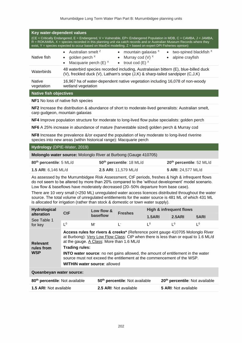
Murrumbidgee Long Term Water Plan Part B: Murrumbidgee planning units
202
Key water-dependent values
(CE = Critically Endangered, E = Endangered, V = Vulnerable, EP= Endangered Population in MDB, C = CAMBA, J = JAMBA, R = ROKAMBA, X = species recorded in this planning unit via catch records and or Australian Museum Records where they exist, Y = species expected to occur based on MaxEnt modelling, Z = based on expert DPI Fisheries opinion)
Native fish
• Australian smelt Z
• golden perch X
• Macquarie perch (E) X
• mountain galaxias X
• Murray cod (V) X
• trout cod (E) X
• two-spined blackfish X
• alpine crayfish
Waterbirds 48 waterbird species recorded including, Australasian bittern (E), blue-billed duck (V), freckled duck (V), Latham's snipe (J,K) & sharp-tailed sandpiper (C,J,K)
Native vegetation
16,967 ha of water-dependent native vegetation including 16,078 of non-woody wetland vegetation
Native fish objectives
NF1 No loss of native fish species
NF2 Increase the distribution & abundance of short to moderate-lived generalists: Australian smelt, carp gudgeon, mountain galaxias
NF4 Improve population structure for moderate to long-lived flow pulse specialists: golden perch
NF6 A 25% increase in abundance of mature (harvestable sized) golden perch & Murray cod
NF8 Increase the prevalence &/or expand the population of key moderate to long-lived riverine species into new areas (within historical range): Macquarie perch
Hydrology (DPIE-Water, 2019)
Molonglo water source: Molonglo River at Burbong (Gauge 410705)
80th percentile: 5 ML/d 50th percentile: 18 ML/d 20th percentile: 52 ML/d
1.5 ARI: 6,146 ML/d 2.5 ARI: 11,579 ML/d 5 ARI: 24,577 ML/d
As assessed by the Murrumbidgee Risk Assessment, CtF periods, freshes & high & infrequent flows do not seem to be altered by more than 20% compared to the ‘without development’ model scenario.
Low flow & baseflows have moderately decreased (20−50% departure from base case).
There are 10 very small (<250 ML) unregulated water access licences distributed throughout the water source. The total volume of unregulated entitlements for the water source is 481 ML of which 431 ML is allocated for irrigation (rather than stock & domestic or town water supply).
Hydrological alteration
See Table 1 for key
CtF Low flow & baseflow
Freshes High & infrequent flows
1.5ARI 2.5ARI 5ARI
L0 M- L- L0 L0 L0
Relevant rules from WSP
Access rules for rivers & creeks* (Reference point gauge 410705 Molonglo River at Burbong): Very Low Flow Class: CtP when there is less than or equal to 1.6 ML/d at the gauge. A Class: More than 1.6 ML/d
Trading rules:
INTO water source: no net gains allowed, the amount of entitlement in the water source must not exceed the entitlement at the commencement of the WSP.
WITHIN water source: allowed
Queanbeyan water source:
80th percentile: Not available 50th percentile: Not available 20th percentile: Not available
1.5 ARI: Not available 2.5 ARI: Not available 5 ARI: Not available

Murrumbidgee Long Term Water Plan Part B: Murrumbidgee planning units
203
As assessed by the Murrumbidgee WRPA Risk Assessment, CtF periods are highly altered (>50% departure from base case). CtF periods currently occur more frequently compared to the ‘without development’ model scenario.
There are 14 very small unregulated water access licences (<250 ML) distributed across the water source. The total volume of unregulated entitlements for the water source is 434 ML of which 431 ML is allocated for irrigation (rather than stock & domestic or town water supply).
Hydrological alteration
See Table 1 for key
CtF Low flow & baseflow
Freshes High & infrequent flows
1.5ARI 2.5ARI 5ARI
H+ L- L0 L0 L0 L0
Relevant rules from WSP
Access rules for rivers & creeks* (reference point gauge 410770 Queanbeyan at the ACT border): Very Low Flow Class: CtP when there is less than or equal to 1 ML/d at the gauge. A Class: More than 1ML/d
Trading rules:
INTO water source: no trade allowed
WITHIN water source: allowed
Bredbo water source: Strike-A-Light Creek at Jerangle Road (410076)
80th percentile: 0 ML/d 50th percentile: 9 ML/d 20th percentile: 63 ML/d
1.5 ARI: 4,786 ML/d 2.5 ARI: 9,271 ML/d 5 ARI: 13,019 ML/d
As assessed by the Murrumbidgee WRPA Risk Assessment, CtF periods, low flows & baseflows are highly altered (>50% departure from base case). CtF periods currently occur more frequently, & low flows & freshes occur less frequently compared to the ‘without development’ model scenario.
There are 4 very small unregulated water access licences (<250 ML) distributed throughout the water source. The total volume of unregulated entitlements for the water source is 231 ML of which 134 ML is allocated for irrigation (rather than stock & domestic or town water supply).
Hydrological alteration
See Table 1 for key
CtF Low flow & baseflow
Freshes High & infrequent flows
1.5ARI 2.5ARI 5ARI
H+ H- L- L0 L0 L0
Relevant rules from WSP
Access rules for rivers & creeks* (reference point Bredbo River at Monaro Highway Road Bridge): Low Flow Class: CtP when there is no visible flow at the reference point. A Class: Visible flow
Trading rules:
INTO water source: no trade allowed
WITHIN water source: allowed
Numeralla East water source: Numeralla River at Numeralla School (410062)
80th percentile: 8 ML/d 50th percentile: 70 ML/d 20th percentile: 310 ML/d
1.5 ARI: 13,200 ML/d 2.5 ARI: 27,404 ML/d 5 ARI: 51,604 ML/d
As assessed by the Murrumbidgee WRPA Risk Assessment, CtF periods have been moderately
altered (20−50% departure from base case) & low flows are highly altered (>50% departure from base case) CtF periods currently occur more frequently, & low flows occur less frequently compared to the ‘without development’ model scenario.
There are 39 very small (250 ML), 4 small (250−500 ML), & 1 medium (500−1000 ML) unregulated water access licences distributed throughout the water source (with the majority located along the Numeralla River). The total volume of unregulated entitlements for the water source is 4310 ML of which 4040 ML is allocated for irrigation (rather than stock & domestic or town water supply).

Murrumbidgee Long Term Water Plan Part B: Murrumbidgee planning units
204
Relevant rules from WSP
CtF Low flow & baseflow
Freshes High & infrequent flows
1.5ARI 2.5ARI 5ARI
M+ H- L- L0 L0 L0
Relevant rules from WSP
Access rules for rivers & creeks* (reference point gauge 41000206 Numeralla River at Rose Valley Road Bridge): Very Low Flow Class: CtP when there is 4.5 ML/d or 0.30 m at the gauge. A Class: More than 4.5 ML/d or 0.30 m at the gauge
INTO water source: no net gains allowed, the amount of entitlement in the water source must not exceed the entitlement at the commencement of the WSP.
WITHIN water source: allowed
Numeralla West water source: Numeralla River at Numeralla School (410062)
80th percentile: 3 ML/d 50th percentile: 23 ML/d 20th percentile: 103 ML/d
1.5 ARI: 4375 ML/d 2.5 ARI: 9083 ML/d 5 ARI: 17,104 ML/d
CtF periods & low flows are highly altered (>50% departure from base case) as assessed by the Murrumbidgee WRPA Risk Assessment. CtF periods currently occur more frequently, & low flows occur less frequently compared to the ‘without development’ model scenario.
There are 14 very small unregulated water access licences (<250 ML) distributed throughout the water source. The total volume of unregulated entitlements for the water source is 346 ML of which 333 ML is allocated for irrigation (rather than stock & domestic or town water supply).
Hydrological alteration
See Table 1 for key
CtF Low flow & baseflow
Freshes High & infrequent flows
1.5ARI 2.5ARI 5ARI
H+ H- L- L0 L0 L0
Relevant rules from WSP
Access rules for rivers & creeks*:
Cooma management zone (reference point gauge 410081 Cooma Creek at Cooma No.2 (The Grange)): Very Low Flow Class: CtP when there is 0.6 ML/d at the gauge. A Class: More than 0.6 ML/d
Bunyan management zone (reference point Cooma Creek at the Highway Bridge at Bunyan): Very Low Flow Class: CtP when there is no visible flow at the reference point. A Class: Visible flow
Trading rules:
INTO water source: no net gains allowed, the amount of entitlement in the water source must not exceed the entitlement at the commencement of the WSP.
WITHIN water source: allowed
Murrumbidgee I water source: Murrumbidgee River at Mittagang Crossing (410033)
80th percentile: 63 ML/d 50th percentile: 206 ML/d 20th percentile: 696 ML/d
1.5 ARI: 4860 ML/d 2.5 ARI: 7642 ML/d 5 ARI: 12,260 ML/d
CtF periods & freshes are highly altered (>50% departure from base case) & low flows & high &
infrequent flows moderately altered (20−50% departure from base case) as assessed by the Murrumbidgee WRPA Risk Assessment. CtF periods currently occur more frequently, & low flows, freshes & high flows occur less frequently.
There are 8 very small (<250 ML) & 2 medium (500−1000 ML) unregulated water access licences distributed throughout the water source. The total volume of unregulated entitlements for the water source is 4541 ML of which 1752.5 ML is allocated for irrigation (rather than stock & domestic or town water supply).
CtF Freshes High & infrequent flows
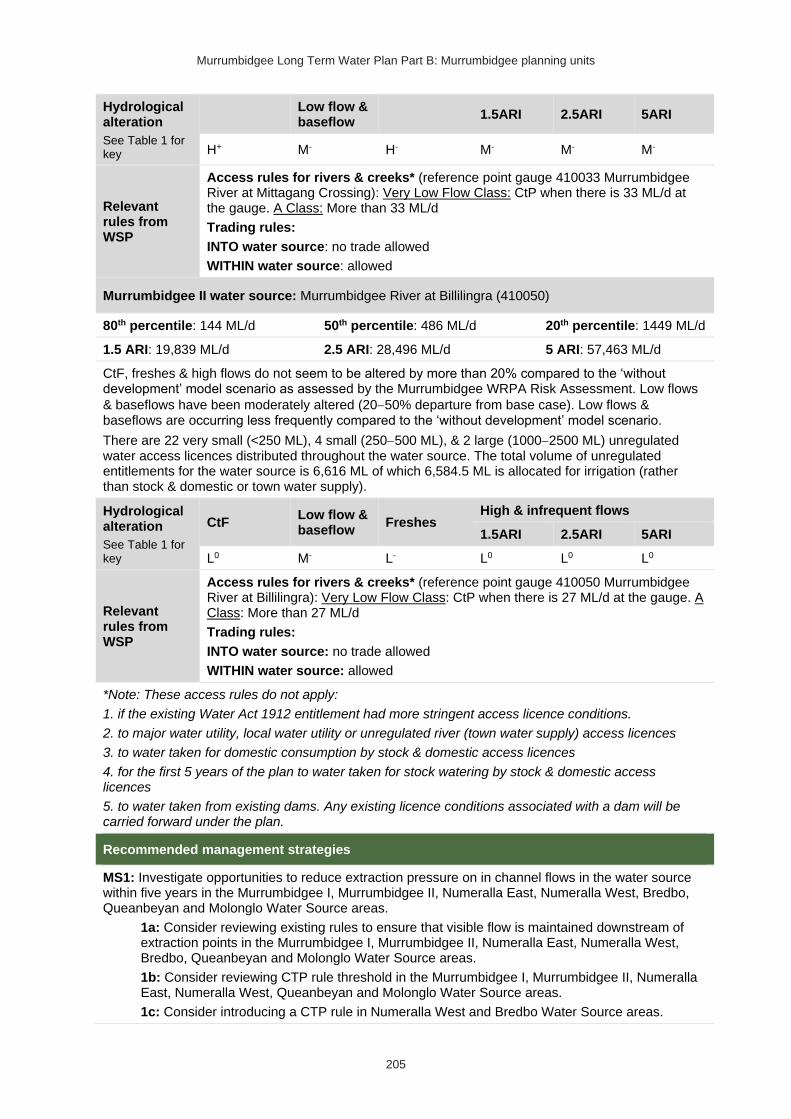
Murrumbidgee Long Term Water Plan Part B: Murrumbidgee planning units
205
Hydrological alteration
See Table 1 for key
Low flow & baseflow
1.5ARI 2.5ARI 5ARI
H+ M- H- M- M- M-
Relevant rules from WSP
Access rules for rivers & creeks* (reference point gauge 410033 Murrumbidgee River at Mittagang Crossing): Very Low Flow Class: CtP when there is 33 ML/d at the gauge. A Class: More than 33 ML/d
Trading rules:
INTO water source: no trade allowed
WITHIN water source: allowed
Murrumbidgee II water source: Murrumbidgee River at Billilingra (410050)
80th percentile: 144 ML/d 50th percentile: 486 ML/d 20th percentile: 1449 ML/d
1.5 ARI: 19,839 ML/d 2.5 ARI: 28,496 ML/d 5 ARI: 57,463 ML/d
CtF, freshes & high flows do not seem to be altered by more than 20% compared to the ‘without development’ model scenario as assessed by the Murrumbidgee WRPA Risk Assessment. Low flows
& baseflows have been moderately altered (20−50% departure from base case). Low flows & baseflows are occurring less frequently compared to the ‘without development’ model scenario.
There are 22 very small (<250 ML), 4 small (250−500 ML), & 2 large (1000−2500 ML) unregulated water access licences distributed throughout the water source. The total volume of unregulated entitlements for the water source is 6,616 ML of which 6,584.5 ML is allocated for irrigation (rather than stock & domestic or town water supply).
Hydrological alteration
See Table 1 for key
CtF Low flow & baseflow
Freshes High & infrequent flows
1.5ARI 2.5ARI 5ARI
L0 M- L- L0 L0 L0
Relevant rules from WSP
Access rules for rivers & creeks* (reference point gauge 410050 Murrumbidgee River at Billilingra): Very Low Flow Class: CtP when there is 27 ML/d at the gauge. A Class: More than 27 ML/d
Trading rules:
INTO water source: no trade allowed
WITHIN water source: allowed
*Note: These access rules do not apply:
1. if the existing Water Act 1912 entitlement had more stringent access licence conditions.
2. to major water utility, local water utility or unregulated river (town water supply) access licences
3. to water taken for domestic consumption by stock & domestic access licences
4. for the first 5 years of the plan to water taken for stock watering by stock & domestic access licences
5. to water taken from existing dams. Any existing licence conditions associated with a dam will be carried forward under the plan.
Recommended management strategies
MS1: Investigate opportunities to reduce extraction pressure on in channel flows in the water source within five years in the Murrumbidgee I, Murrumbidgee II, Numeralla East, Numeralla West, Bredbo, Queanbeyan and Molonglo Water Source areas.
1a: Consider reviewing existing rules to ensure that visible flow is maintained downstream of extraction points in the Murrumbidgee I, Murrumbidgee II, Numeralla East, Numeralla West, Bredbo, Queanbeyan and Molonglo Water Source areas.
1b: Consider reviewing CTP rule threshold in the Murrumbidgee I, Murrumbidgee II, Numeralla East, Numeralla West, Queanbeyan and Molonglo Water Source areas.
1c: Consider introducing a CTP rule in Numeralla West and Bredbo Water Source areas.

Murrumbidgee Long Term Water Plan Part B: Murrumbidgee planning units
206
1d: Consider implementing a commence-to-pump threshold that is higher than CTP threshold in the Murrumbidgee I Water Source.
1e: Consider installing water level gauges at or near extraction sites in all Water Source areas.
1f: Consider installing river flow gauge in the Queanbeyan Water Source.
1g: Consider rostering landholder water in the Murrumbidgee II, Numeralla East and Numeralla West Water Source areas.
1h: Consider implementing IDELs and TDELs in the Murrumbidgee I, Murrumbidgee II, Numeralla East, Numeralla West and Bredbo Water Source areas.
MS2: Ensure compliance with water access licence conditions, in all Water Source areas, including through metering of all licensed extraction.
MS3: As a minimum, maintain existing rules in the WSP for the Murrumbidgee Unregulated Water Sources that protect environmental assets and values, in all Water Source areas.
MS4: Monitor for changes in water demand and review access rules if current usage is high or if the pattern of use changes in all Water Source areas.
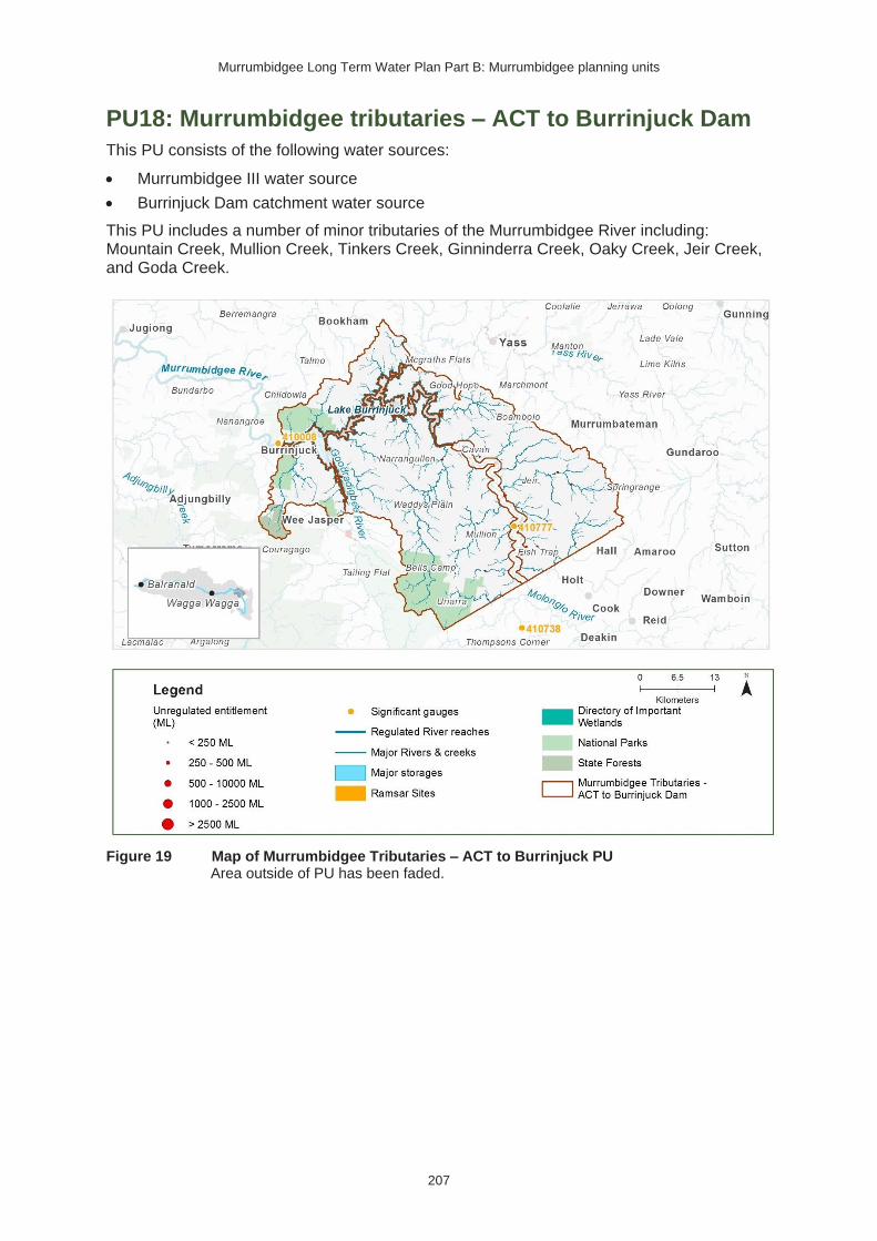
Murrumbidgee Long Term Water Plan Part B: Murrumbidgee planning units
207
PU18: Murrumbidgee tributaries – ACT to Burrinjuck Dam
This PU consists of the following water sources:
• Murrumbidgee III water source
• Burrinjuck Dam catchment water source
This PU includes a number of minor tributaries of the Murrumbidgee River including: Mountain Creek, Mullion Creek, Tinkers Creek, Ginninderra Creek, Oaky Creek, Jeir Creek, and Goda Creek.
Figure 19 Map of Murrumbidgee Tributaries – ACT to Burrinjuck PU
Area outside of PU has been faded.

Murrumbidgee Long Term Water Plan Part B: Murrumbidgee planning units
208
Key water-dependent values (CE = Critically Endangered, E = Endangered, V = Vulnerable, EP= Endangered Population in MDB, C = CAMBA, J = JAMBA, R = ROKAMBA, X = species recorded in this planning unit via catch records and or Australian Museum Records where they exist, Y = species expected to occur based on MaxEnt modelling)
Native fish
• Australian smelt X
• carp gudgeon species complex X
• freshwater catfish (EP) Y
• golden perch X
• mountain galaxias X
• Murray cod (V) X
• silver perch (V) X
Waterbirds 35 waterbird species recorded including blue-billed duck (V) & Latham's snipe (J,K)
Native vegetation 538 ha of water-dependent native vegetation including 2 ha of non-woody wetland vegetation
Native fish objectives
NF1 No loss of native fish species
NF2 Increase the distribution & abundance of short to moderate-lived generalists: Australian smelt, carp gudgeon, mountain galaxias, obscure galaxias
NF4 Improve population structure for moderate to long-lived flow pulse specialists: golden perch, silver perch
NF5 Improve population structure for moderate to long-lived riverine specialists: Murray cod, trout cod
NF6 A 25% increase in abundance of mature (harvestable sized) golden perch & Murray cod
Hydrology (DPIE-Water, 2019)
Murrumbidgee III water source:
80th percentile: Not available 50th percentile: Not available 20th percentile: Not available
1.5 ARI: Not available 2.5 ARI: Not available 5 ARI: Not available
Flows do not appear to be altered by more than 20% compared to the ‘without development’ model scenario as assessed by the Murrumbidgee WRPA Risk Assessment.
There are 30 very small (<250 ML), & 1 small (250−500 ML) unregulated water access licences distributed throughout the water source. The total volume of unregulated entitlements for the water source is 1,888 ML of which 1,842.7 ML is allocated for irrigation (rather than stock & domestic or town water supply).
Relevant rules from WSP
Access rules for rivers & creeks* (reference point 410777-gauge Murrumbidgee River at Hall's Crossing): Very Low Flow Class: CtP when there is 87 ML/d at the gauge. A Class: More than 87 ML/d & less than or equal to 459 ML/d. B Class: More than 459 ML/d
Trading rules:
INTO water source: No trade into the tributaries of the Murrumbidgee River. Trade into the Murrumbidgee River proper is allowed for access above 459 ML/d at gauge 410777 provided the total shares in the water source do not exceed. 16,500 units.
WITHIN water source: Trade is allowed from the tributaries to the Murrumbidgee River but not from the Murrumbidgee River to the tributaries.
Burrinjuck Dam catchment water source:
80th percentile: Not available 50th percentile: Not available 20th percentile: Not available
1.5 ARI: Not available 2.5 ARI: Not available 5 ARI: Not available
Flows do not appear to be altered by more than 20% compared to the ‘without development’ model scenario as assessed by the Murrumbidgee WRPA Risk Assessment. There is 1 very small (<250 ML) general security water access licence in the water source. The total volume of unregulated

Murrumbidgee Long Term Water Plan Part B: Murrumbidgee planning units
209
entitlements for the water source is 12 ML which is allocated for irrigation (rather than stock & domestic or town water supply).
Relevant rules from WSP
Access rules for rivers & creeks* (reference point Individual natural pool): pumping is not permitted from natural pools when the water level in the pool is lower than its full capacity.
Trading rules:
INTO water source: No trade allowed
WITHIN water source: Allowed, but no trade into off river pools.
*Note: These access rules do not apply:
1. if the existing Water Act 1912 entitlement had more stringent access licence conditions.
2. to major water utility, local water utility or unregulated river (town water supply) access licences
3. to water taken for domestic consumption by stock & domestic access licences
4. for the first 5 years of the plan to water taken for stock watering by stock & domestic access licences5. to water taken from existing dams. Any existing licence conditions associated with a dam will be carried forward under the plan.
Hydrological alteration
See Table 1 for key
CtF Low flow & baseflow
Freshes High & infrequent flows
1.5ARI 2.5ARI 5ARI
L0 L0 L0 L0 L0 L0
Recommended management strategies
MS2: Ensure compliance with water access licence conditions including through metering of all licensed extraction.
MS3: As a minimum, maintain existing rules in the WSP for the Murrumbidgee Unregulated Water Sources that protect environmental assets and values.
MS4: Monitor for changes in water demand and review access rules if current usage is high or if the pattern of use changes.
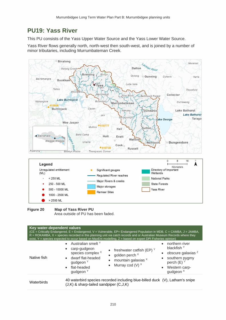
Murrumbidgee Long Term Water Plan Part B: Murrumbidgee planning units
210
PU19: Yass River
This PU consists of the Yass Upper Water Source and the Yass Lower Water Source.
Yass River flows generally north, north-west then south-west, and is joined by a number of minor tributaries, including Murrumbateman Creek.
Figure 20 Map of Yass River PU Area outside of PU has been faded.
Key water-dependent values (CE = Critically Endangered, E = Endangered, V = Vulnerable, EP= Endangered Population in MDB, C = CAMBA, J = JAMBA, R = ROKAMBA, X = species recorded in this planning unit via catch records and or Australian Museum Records where they exist, Y = species expected to occur based on MaxEnt modelling, Z = based on expert DPI Fisheries opinion)
Native fish
• Australian smelt Y
• carp-gudgeon species complex X
• dwarf flat-headed gudgeon Y
• flat-headed gudgeon Y
• freshwater catfish (EP) Y
• golden perch X
• mountain galaxias X
• Murray cod (V) X
• northern river blackfish Y
• obscure galaxias Z
• southern pygmy perch (E) Y
• Western carp-gudgeon X
Waterbirds 40 waterbird species recorded including blue-billed duck (V), Latham's snipe (J,K) & sharp-tailed sandpiper (C,J,K)

Murrumbidgee Long Term Water Plan Part B: Murrumbidgee planning units
211
Native vegetation 6 ha of water-dependent native vegetation (all non-woody wetland vegetation)
Native fish objectives
NF1 No loss of native fish species
NF2 Increase the distribution & abundance of short to moderate-lived generalists: Australian smelt, carp gudgeon, flat-headed gudgeon, dwarf flat-headed gudgeon, mountain galaxias, obscure galaxias
NF4 Improve population structure for moderate to long-lived flow pulse specialists: golden perch
NF5 Improve population structure for moderate to long-lived riverine specialists: Murray cod & river blackfish
NF6 A 25% increase in abundance of mature (harvestable sized) golden perch & Murray cod
Hydrology (DPIE-Water, 2019)
Yass Upper water source: Yass River at Yass (410026)
80th percentile: 0 ML/d 50th percentile: 23 ML/d 20th percentile: 133 ML/d
1.5 ARI: 7428 ML/d 2.5 ARI: 10,828 ML/d 5 ARI: 15,062 ML/d
As assessed by the Murrumbidgee WRPA Risk Assessment, CtF periods, low flows & baseflows are highly altered (>50% departure from base case). CtF periods currently occur more frequently, & low flows & freshes occur less frequently compared to the ‘without development’ model scenario.
There are 61 very small (< 250 ML) unregulated water access licences distributed throughout the Yass Upper water source. The total volume of unregulated entitlements for the Yass Upper water source is 1,662 ML of which 1,520.2 ML is allocated for irrigation (rather than stock & domestic or town water supply).
Hydrological alteration
See Table 1 for key
CtF Low flow & baseflow
Freshes High & infrequent flows
1.5ARI 2.5ARI 5ARI
H+ M-/H- L- L0 L0 L0
Relevant rules from WSP
Yass Upper Access Rules: Yass River upstream of Gundaroo gauge management zone: CtP at 1 ML/d, Yass River downstream of Gundaroo gauge management zone: CtP at 6 ML/d
Trading rules:
INTO water source: No trade allowed.
WITHIN water source: Allowed, but no trade into off-river pools
Yass Lower water source: Yass River at Yass (410026)
80th percentile: 1 ML/d 50th percentile: 32 ML/d 20th percentile: 181 ML/d
1.5 ARI: 10,107 ML/d 2.5 ARI: 14,733 ML/d 5 ARI: 20,494 ML/d
There are 14 very small (<250 ML) unregulated water access licences distributed throughout the Yass Lower water source. The total volume of unregulated entitlements for the Yass Lower water source is 2176 ML of which 447 ML is allocated for irrigation (rather than stock & domestic or town water supply).
Hydrological alteration
See Table 1 for key
CtF Low flow & baseflow
Freshes High & infrequent flows
1.5ARI 2.5ARI 5ARI
H+ M-/H- L- L0 L0 L0

Murrumbidgee Long Term Water Plan Part B: Murrumbidgee planning units
212
Relevant rules from WSP
Yass Lower Access Rules: No visible flow
Trading rules:
INTO water source: No trade allowed.
WITHIN water source: Allowed, but no trade into off-river pools
Recommended management strategies
MS1: Investigate opportunities to reduce extraction pressure on in channel flows in the Yass Upper water source within five years
1a: Consider reviewing existing rules in the Yass Upper Water Source to ensure that visible flow is maintained downstream of extraction points.
1b: Consider reviewing CTP rule threshold in the Yass Upper Water Source.
1e: Consider installing water level gauges at or near extraction sites in the Yass Upper and Yass Lower Water Source areas.
1f: Consider installing river flow gauge in the Yass Upper Water Source.
1g: Consider rostering landholder water in the Yass Upper Water Source.
1h: Consider implementing IDELs and TDELs in the Yass Upper Water Source.
MS2: Ensure compliance with water access licence conditions including through metering of all licensed extraction.
MS3: As a minimum, maintain existing rules in the WSP for the Murrumbidgee Unregulated Water Sources that protect environmental assets and values.
MS4: Monitor for changes in water demand and review access rules if current usage is high or if the pattern of use changes.

Murrumbidgee Long Term Water Plan Part B: Murrumbidgee planning units
213
PU20: Goodradigbee
This PU consists of the Goodradigbee Water Source. The Goodradigbee River drains the rugged area between the Fiery and Brindabella Ranges before flowing north directly into Burrinjuck Dam. The Goodradigbee River is a high yielding tributary to Burrinjuck Dam (Green et al. 2011). A small amount of flow in the headwaters of the Goodradigbee is diverted into Tantangara Reservoir by the Goodradigbee aqueduct.
Figure 21 Map of Goodradigbee PU Area outside of PU has been faded.
Key water-dependent values (CE = Critically Endangered, E = Endangered, V = Vulnerable, EP= Endangered Population in MDB, C = CAMBA, J = JAMBA, R = ROKAMBA, X = species recorded in this planning unit via catch records and or Australian Museum Records where they exist, Y = species expected to occur based on MaxEnt modelling, Z = based on expert DPI Fisheries opinion)
Native fish
• Alpine crayfish Y
• Australian smelt X
• Claytons crayfish Y
• freshwater catfish (EP)X
• golden perch X
• Macquarie perch (E) X
• mountain galaxias Y
• Murray cod (V) X
• Murray crayfish (V) X
• northern river blackfish Y
• obscure galaxias Z
• Rieks crayfish Y
• riffle galaxias Y
• two-spined blackfish X
• Suttons crayfish Y
Waterbirds 19 waterbird species recorded including Latham's snipe (J.K)

Murrumbidgee Long Term Water Plan Part B: Murrumbidgee planning units
214
Native vegetation 1659 ha of water-dependent native vegetation including 117 ha of non-woody wetland vegetation
Native fish objectives
NF1 No loss of native fish species
NF2 Increase the distribution & abundance of short to moderate-lived generalists: Australian smelt & obscure galaxias
NF4 Improve population structure for moderate to long-lived flow pulse specialists: golden perch
NF5 Improve population structure for moderate to long-lived riverine specialists: freshwater catfish, Murray cod, Macquarie perch, two-spined blackfish
NF6 A 25% increase in abundance of mature (harvestable sized) golden perch & Murray cod
NF8 Increase the prevalence &/or expand the population of key moderate to long-lived riverine species into new areas (within historical range): Macquarie perch
Hydrology (DPIE-Water, 2019)
Goodradidgee water source: Goodradigbee River at Wee Jasper (Kashmir) (410024)
80th percentile: 173 ML/d 50th percentile: 430 ML/d 20th percentile: 1226 ML/d
1.5 ARI: 7039 ML/d 2.5 ARI: 9929 ML/d 5 ARI: 16,728 ML/d
Flows do not appear to be altered by more than 20% compared to the ‘without development’ model scenario as assessed by the Murrumbidgee WRPA Risk Assessment.
There are 8 very small (<250 ML) & 1 medium (500−1000 ML) unregulated water access licences in the water source. The total volume of unregulated entitlements for the water source is 875 ML of which 874 is allocated for irrigation (rather than stock & domestic or town water supply).
Hydrological alteration
See Table 1 for key
CtF Low flow & baseflow
Freshes High & infrequent flows
1.5ARI 2.5ARI 5ARI
L0 L- L- L0 L0 L0
Relevant rules from WSP
Access rules for rivers & creeks* (reference point 410024-gauge Goodradigbee River at Wee Jasper (Kashmir)): Very Low Flow Class: CtP when there is less than or equal to 45 ML/d. A Class: Between 45ML/d & 78ML/d. B Class: More than 78 ML/d & less than or equal to 89 ML/d. C Class: More than 89 ML/d
Trading rules:
INTO water source: Trade in is allowed for access above 89ML/d at gauge 410024 provided the total shares in the water source do not exceed 3200 units.
WITHIN water source: Allowed
*Note: These access rules do not apply:
1. if the existing Water Act 1912 entitlement had more stringent access licence conditions.
2. to major water utility, local water utility or unregulated river (town water supply) access licences
3. to water taken for domestic consumption by stock & domestic access licences
4. for the first 5 years of the plan to water taken for stock watering by stock & domestic access licences
5. to water taken from existing dams. Any existing licence conditions associated with a dam will be carried forward under the plan.
Recommended management strategies
MS2: Ensure compliance with water access licence conditions including through metering of all licensed extraction.

Murrumbidgee Long Term Water Plan Part B: Murrumbidgee planning units
215
MS3: As a minimum, maintain existing rules in the WSP for the Murrumbidgee Unregulated Water Sources that protect environmental assets and values.
MS4: Monitor for changes in water demand and review access rules if current usage is high or if the pattern of use changes.

Murrumbidgee Long Term Water Plan Part B: Murrumbidgee planning units
216
PU21: Upper Tumut River above Blowering Dam
This PU consists of the Upper Tumut water source. The Tumut River rises on the northern face of Mount Jagungal in the Snowy Mountains and flows generally north by west, joined by a number of minor tributaries including the Doubtful Creek, Happy Jacks Creek, Blowering Creek, and Jounama Creek.
Figure 22 Map of Upper Tumut River PU Area outside of PU has been faded.
Key water-dependent values (CE = Critically Endangered, E = Endangered, V = Vulnerable, EP= Endangered Population in MDB, C = CAMBA, J = JAMBA, R = ROKAMBA, X = species recorded in this planning unit via catch records and or Australian Museum Records where they exist, Y = species expected to occur based on MaxEnt modelling, Z = based on expert DPI Fisheries opinion)
Native fish
• Australian smelt Z
• flat-headed gudgeon X
• golden perch X
• Macquarie perch (E) Y
• mountain galaxias X
• Murray cod (V) X
• Murray crayfish (V) X
• northern river blackfish X
• obscure galaxias Z
• Rieks crayfish Y
• riffle galaxias Z
• two-spined blackfish X
Waterbirds 40 waterbirds recorded including Latham's snipe (J,K), blue-billed duck (V)
Murrumbidgee Long Term Water Plan Part B: Murrumbidgee planning units
217
Native vegetation 2416 ha of water-dependent native vegetation including 1093 ha of non-woody wetland vegetation
Native fish objectives
NF1 No loss of native fish species
NF2 Increase the distribution & abundance of short to moderate-lived generalists: Australian smelt, flat-headed gudgeon, mountain galaxias, obscure galaxias, riffle galaxias
NF4 Improve population structure for moderate to long-lived flow pulse specialists: golden perch
NF5 Improve population structure for moderate to long-lived riverine specialists: Murray cod, river blackfish, two-spined blackfish
NF6 A 25% increase in abundance of mature (harvestable sized) golden perch & Murray cod
Hydrology (DPIE-Water, 2019)
Upper Tumut water source:
80th percentile: Not available 50th percentile: Not available 20th percentile: Not available
1.5 ARI: Not available 2.5 ARI: Not available 5 ARI: Not available
CtF, low flows, freshes & high flows have all been highly altered (>50% departure from base case), as assessed by the Murrumbidgee WRPA Risk Assessment. CtF & high flows have decreased in frequency & low flows & freshes have increased in frequency compared to the ‘without development’ model scenario.
There are 2 very small (<250 ML) unregulated water access licences distributed throughout the water source. The total volume of unregulated entitlements for the water source is 205 ML of which 45 ML is allocated for irrigation (rather than stock & domestic or town water supply).
Hydrological alteration
See Table 1 for key
CtF Low flow & Baseflow
Freshes High & infrequent flows
1.5ARI 2.5ARI 5ARI
H- H+ H+ H- H- H-
Relevant rules from WSP
Access rules for rivers & creeks*: pumping is not permitted from natural pools when the water level in the pool is lower than its full capacity.
Trading rules:
INTO water source: No trade allowed
WITHIN water source: Allowed
*Note: These access rules do not apply:
1. if the existing Water Act 1912 entitlement had more stringent access licence conditions.
2. to major water utility, local water utility or unregulated river (town water supply) access licences
3. to water taken for domestic consumption by stock & domestic access licences
4. for the first 5 years of the plan to water taken for stock watering by stock & domestic access licences
5. to water taken from existing dams. Any existing licence conditions associated with a dam will be carried forward under the plan.
Recommended management strategies
MS2: Ensure compliance with water access licence conditions including through metering of all licensed extraction.
MS3: As a minimum, maintain existing rules in the WSP for the Murrumbidgee Unregulated Water Sources that protect environmental assets and values.
MS4: Monitor for changes in water demand and review access rules if current usage is high or if the pattern of use changes.

Murrumbidgee Long Term Water Plan Part B: Murrumbidgee planning units
218
PU22: Tumut River tributaries below Blowering Dam
This PU consists of the following water sources:
• Goobarragandra water source
• Adjungbilly / Bombowlee / Brungle water source
• a portion of the Murrumbidgee Central (Burrinjuck to Gogeldrie) water source
• Gilmore / Sandy water source
Figure 23 Map of Tumut River tributaries below Blowering Dam PU
Area outside of PU has been faded.

Murrumbidgee Long Term Water Plan Part B: Murrumbidgee planning units
219
Key water-dependent values (CE = Critically Endangered, E = Endangered, V = Vulnerable, EP= Endangered Population in MDB, C = CAMBA, J = JAMBA, R = ROKAMBA, X = species recorded in this planning unit via catch records and or Australian Museum Records where they exist, Y = species expected to occur based on MaxEnt modelling)
Native fish
• Australian smelt X
• carp-gudgeon species complex X
• dwarf flat-headed gudgeon Y
• flat-headed galaxias (CE) Y
• flat-headed gudgeon X
• golden perch X
• Macquarie perch (E) Y
• mountain galaxias X
• Murray cod (V) Y
• Murray crayfish (V) X
• northern river blackfish X
• riffle galaxias Y
• obscure galaxias Y
• silver perch (V) Y
• southern pygmy perch (E) X
• southern purple-spotted gudgeon142 (EP)
• Suttons crayfish Y
• trout cod (E) Y
• two-spined blackfish Y
Waterbirds 42 waterbird species recorded including blue-billed duck (V), Latham's snipe (J,K) & sharp-tailed sandpiper (C,J,K)
Native vegetation
4028 ha of water-dependent native vegetation including 243 ha of non-woody wetland vegetation & 318 ha of river red gum
Native fish objectives
NF1 No loss of native fish species
NF2 Increase the distribution & abundance of short to moderate-lived generalists: carp gudgeon, dwarf flat-headed gudgeon, mountain galaxias, obscure galaxias, riffle galaxias
NF3 Increase the distribution & abundance of short to moderate-lived floodplain specialist native fish species: southern purple-spotted gudgeon
NF4 Improve population structure for moderate to long-lived flow pulse specialists: golden perch
NF5 Improve population structure for moderate to long-lived riverine specialists: Murray cod, Macquarie perch, river blackfish, two-spined blackfish, southern purple-spotted gudgeon
NF6 A 25% increase in abundance of mature (harvestable sized) golden perch & Murray cod
NF7 Increase the prevalence &/or expand the population of key short to moderate-lived floodplain specialist native fish species into new areas (within historical range): flat-headed galaxias, southern purple-spotted gudgeon
NF8 Increase the prevalence &/or expand the population of key moderate to long-lived riverine specialist native fish species into new areas (within historical range): Macquarie perch, southern purple-spotted gudgeon
Hydrology (DPIE-Water, 2019)
Goobarragandra water source: Goobarragandra River at Lacmalac (410057)
80th percentile: 217 ML/d 50th percentile: 529 ML/d 20th percentile: 1302 ML/d
1.5 ARI: 6195 ML/d 2.5 ARI: 8030 ML/d 5 ARI: 10,342 ML/d
Flows do not appear to be altered by more than 20% compared to the ‘without development’ model scenario as assessed by the Murrumbidgee WRPA Risk Assessment.
There are 22 very small (<250 ML) unregulated water access licences distributed throughout the water source. The total volume of unregulated entitlements for the water source is 1686 ML of which 1504 ML is allocated for irrigation (rather than stock & domestic or town water supply).
Hydrological alteration
See Table 1 for key
CtF Low flow & baseflow
Freshes High & infrequent flows
1.5ARI 2.5ARI 5ARI
L0 L- L- L0 L0 L0
142 Suggested by Basin wide watering strategy (BWS) (MDBA 2014)

Murrumbidgee Long Term Water Plan Part B: Murrumbidgee planning units
220
Relevant rules from WSP
Access rules for rivers & creeks* (reference point gauge 410057 Goobarragandra River at Lacmalac): Very Low Flow Class: CtP when there is less than or equal to 63 ML/d at the gauge. A Class: Pumping is only allowed at night (between sunset & sunrise) when flow is between 63 ML/d & 87 ML/d. B Class: More than 87 ML/d & equal to or less than 118 ML/d. C Class: More than 118 ML/d. Trading rules: INTO water source: Trade in is allowed for access above 118 ML/d at gauge 410057 provided the total shares in the water source do not exceed 4200 units. WITHIN water source: Allowed
Adjungbilly / Bombowlee / Brungle water source
CtF periods are highly altered (>50% departure from base case), as assessed by the Murrumbidgee WRPA Risk Assessment. CtF periods currently occur more frequently compared to the ‘without development’ model scenario.
There are 15 very small (<250 ML) unregulated water access licences distributed throughout the water source. The total volume of unregulated entitlements for the water source is 661 ML of which 545 ML is allocated for irrigation (rather than stock & domestic or town water supply).
Adjungbilly: Adjungbilly Creek at Darbalara (410038)
80th percentile: 45 ML/d 50th percentile: 105 ML/d 20th percentile: 296 ML/d
1.5 ARI: 2779 ML/d 2.5 ARI: 4269 ML/d 5 ARI: 5903 ML/d
Bombowlee: Bombowlee Creek at Bombowlee (410070)
80th percentile: 7 ML/d 50th percentile: 19 ML/d 20th percentile: 60 ML/d
1.5 ARI: 969 ML/d 2.5 ARI: 1245 ML/d 5 ARI: 1845 ML/d
Brungle: Brungle Creek at Red Hill (410071)
80th percentile: 8 ML/d 50th percentile: 21 ML/d 20th percentile: 67 ML/d
1.5 ARI: 934 ML/d 2.5 ARI: 1841 ML/d 5 ARI: 3499 ML/d
Killimcat Creek at Wyangle (410114)
80th percentile: 2 ML/d 50th percentile: 5 ML/d 20th percentile: 25 ML/d
1.5 ARI: 656 ML/d 2.5 ARI: 996 ML/d 5 ARI: 1613 ML/d
Hydrological alteration
See Table 1 for key
CtF Low flow & baseflow
Freshes High & infrequent flows
1.5ARI 2.5ARI 5ARI
H+ L- L- L0 L0 L0
Relevant rules from WSP
Adjungbilly Creek management zone access rules* (reference point gauge 410038 Adjungbilly Creek at Darbalara (The Elms)): Very Low Flow Class: CtP when there is less than or equal to 14.3 ML/d at the gauge. A Class: More than 14.3 ML/d & less than or equal to 20 ML/d at the gauge. B Class: More than 20 ML/d at the gauge. Trading rules: INTO water source: Trade in is allowed for access above the 80%ile (20 ML/d at gauge 410038) provided the total shares in the management zone do not exceed 700 units. WITHIN water source: Trade within the Management Zone is allowed. Trade from other Management Zones within this water source is allowed for access above the 80%ile (20 ML/d at gauge 410038) provided the total shares in the management zone do not exceed 700 units.

Murrumbidgee Long Term Water Plan Part B: Murrumbidgee planning units
221
Brungle Creek management zone access rules* (reference point Brungle Creek at the Gundagai Tumut Road Bridge): Very Low Flow Class: CtP when there is no visible flow at the reference point. A Class: Visible flow Trading rules: INTO water source: No net gains allowed, the amount of entitlement in these catchments must not exceed the entitlement at the commencement of the WSP. WITHIN water source: Trade within each management zone is allowed. Trade into the Brungle, & Bombowlee Management zones from other management zones within this water source is allowed if it does not exceed the entitlement of the management zone at the commencement of the WSP. Bombowlee Creek management zone access rules* (reference point gauge 410070 Bombowlee Creek at Bombowlee): Very Low Flow Class: CtP when there is less than or equal to 4 ML/d or 0.4m at the gauge. A Class: More than 4 ML/d Note: This rule applies to all extraction from rivers & creeks including natural in-river pools within the channels of rivers & creeks. Killimcat Creek management zone access rules* (reference point Killimicat Creek at the Gundagai - Tumut Road Bridge): Very Low Flow Class: CtP when there is no visible flow at the reference point. A Class: Visible flow Trading rules: INTO water source: No trade allowed WITHIN water source: Trade within each management zone is allowed. Trade is not allowed from another management zone into the Killimicat or Oak Creek management zones. Oak Creek management zone access rules*: pumping is not permitted from natural pools when the water level in the pool is lower than its full capacity.
Murrumbidgee Central (Burrinjuck to Gogeldrie) water source
80th percentile: Not available 50th percentile: Not available 20th percentile: Not available
1.5 ARI: Not available 2.5 ARI: Not available 5 ARI: Not available
Except for a moderate decrease in high flows, flows do not appear to be altered by more than 20% compared to the ‘without development’ model scenario as assessed by the Murrumbidgee WRPA Risk Assessment. Overbank 2.5 & 5.0 ARI’s occur less frequently compared to ‘without development’ model scenario.
There are 35 very small (<250 ML), 3 small (250-500 ML) & 2 medium (500-1000) unregulated water access licences distributed throughout the water source. The total volume of unregulated entitlements for the water source is 6511 ML of which 4733 ML is allocated for irrigation (rather than stock & domestic or town water supply).
Hydrological alteration
See Table 1 for key
CtF Low flow & baseflow
Freshes High & infrequent flows
1.5ARI 2.5ARI 5ARI
L0 L0 L+ L- M- M-
Relevant rules from WSP
Access rules* Rivers & creeks: Pumping is not permitted from natural pools when the water level in the pool is lower than its full capacity. Natural off-river pools: Pumping is not permitted from an off-river pool or an off-river dam pool when the volume of water in that pool is less than 80% of the full capacity of the natural pool that existed prior to any augmentation works. Trading rules: INTO water source: No trade allowed WITHIN water source: Allowed, but no trade into off river pools
Gilmore / Sandy water source: Gilmore Creek at Gilmore (410059)
80th percentile: 54 ML/d 50th percentile: 126 ML/d 20th percentile: 316 ML/d
1.5 ARI: 2179 ML/d 2.5 ARI: 3602 ML/d 5 ARI: 4949 ML/d

Murrumbidgee Long Term Water Plan Part B: Murrumbidgee planning units
222
Low flows & baseflows are moderately altered (20-50% departure from base case) as assessed by the Murrumbidgee WRPA Risk Assessment. Low flows & baseflows currently occur less frequently compared to the ‘without development’ model scenario.
There are 71 very small (<250 ML), 2 small (250 – 500 ML) & 1 medium (500-1000 ML) unregulated water access licences distributed throughout the water source. The total volume of unregulated entitlements for the water source is 5047 ML of which 4249.85 ML is allocated for irrigation (rather than stock & domestic or town water supply).
Hydrological alteration
See Table 1 for key
CtF Low flow & baseflow
Freshes High & infrequent flows
1.5ARI 2.5ARI 5ARI
L+ M- L- L0 L0 L0
Relevant rules from WSP
Access rules for rivers & creeks* (reference point 410059 (Gilmore Creek (Willows) gauge at Gilmore): Very Low Flow Class: CtP when there is less than or equal to 10 ML/d. A Class: More than 10 ML/d & less than or equal to 218 ML/d. B Class: More than 218 ML/d Trading rules: INTO water source: Trade in is allowed for access above the 30%ile (218 ML/d at gauge 410059) provided the total shares in the water source do not exceed 7800 units. WITHIN water source: Allowed
*Note: These access rules do not apply:
1. if the existing Water Act 1912 entitlement had more stringent access licence conditions.
2. to major water utility, local water utility or unregulated river (town water supply) access licences
3. to water taken for domestic consumption by stock & domestic access licences
4. for the first 5 years of the plan to water taken for stock watering by stock & domestic access licences
5. to water taken from existing dams. Any existing licence conditions associated with a dam will be carried forward under the plan.
Recommended management strategies
MS1: Investigate opportunities to reduce extraction pressure on in channel flows in the Adjungbilly / Bombowlee / Brungle and Gilmore / Sandy Creek Water Source areas within five years.
1a: Consider reviewing existing rules to ensure that visible flow is maintained downstream of extraction points in the Adjungbilly / Bombowlee / Brungle and Gilmore / Sandy Creek Water Source.
1b: Consider reviewing CTP rule threshold in the Adjungbilly / Bombowlee / Brungle and Gilmore / Sandy Creek Water Source areas.
1e: Consider installing water level gauges at or near extraction sites in the Adjungbilly / Bombowlee / Brungle and Gilmore / Sandy Creek Water Source areas.
1g: Consider rostering landholder water in the Gilmore / Sandy Creek Water Source.
1h: Consider implementing IDELs and TDELs in the Gilmore / Sandy Creek Water Source.
MS2: Ensure compliance with water access licence conditions including through metering of all licensed extraction.
MS3: As a minimum, maintain existing rules in the WSP for the Murrumbidgee Unregulated Water Sources that protect environmental assets and values.
MS4: Monitor for changes in water demand and review access rules if current usage is high or if the pattern of use changes.

Murrumbidgee Long Term Water Plan Part B: Murrumbidgee planning units
223
PU23: Murrumbidgee tributaries – Burrinjuck to Tumut River Junction
This PU consists of the following water sources:
• Jugiong water source
• a portion of the Murrumbidgee Central (Burrinjuck to Gogeldrie) water source.
Figure 24 Map of Murrumbidgee tributaries – Burrinjuck to Tumut River Junction PU Area outside of PU has been faded.

Murrumbidgee Long Term Water Plan Part B: Murrumbidgee planning units
224
Key water-dependent values (CE = Critically Endangered, E = Endangered, V = Vulnerable, EP= Endangered Population in MDB, C = CAMBA, J = JAMBA, R = ROKAMBA, X = species recorded in this planning unit via catch records and or Australian Museum Records where they exist, Y = species expected to occur based on MaxEnt modelling)
Native fish
• Australian smelt X
• carp-gudgeon species complex X
• dwarf flat-headed gudgeon Y
• flat-headed galaxias (CE)Y
• flat-headed gudgeon Y
• freshwater catfish (EP) Y
• golden perch X
• Macquarie perch (E)Y
• Murray cod (V) X
• Murray crayfish (V) Z
• mountain galaxias Y
• northern river blackfish Y
• obscure galaxias Z
• silver perch (CE) Y
• trout cod (E) Y
Waterbirds 47 waterbird species recorded including blue-billed duck (V), freckled duck (V), Latham's snipe (J,K) & sharp-tailed sandpiper (C,J,K)
Native vegetation
1485 ha of water-dependent native vegetation including 125 ha of non-woody wetland vegetation & 160 ha of river red gum.
Native fish objectives
NF1 No loss of native fish species
NF2 Increase the distribution & abundance of short to moderate-lived generalists: Australian smelt, carp gudgeon, dwarf flat-headed gudgeon, flat-headed gudgeon, mountain galaxias, obscure galaxias
NF4 Improve population structure for moderate to long-lived flow pulse specialists: golden perch, silver perch
NF5 Improve population structure for moderate to long-lived riverine specialists: Murray cod, trout cod, river blackfish
NF6 A 25% increase in abundance of mature (harvestable sized) golden perch & Murray cod
NF8 Increase the prevalence &/or expand the population of key moderate to long-lived riverine specialist native fish species into new areas (within historical range): trout cod
NF9 Increase the prevalence &/or expand the population of key moderate to long-lived flow pulse specialists native fish species into new areas (within historical range): silver perch
Hydrology (DPIE-Water, 2019)
Jugiong water source: Jugiong Creek at Jugiong (Inverlockie) (410025)
80th percentile: 7 ML/d 50th percentile: 50 ML/d 20th percentile: 235 ML/d
1.5 ARI: 4892 ML/d 2.5 ARI: 8462 ML/d 5 ARI: 14,544 ML/d
Low flows & baseflows are moderately altered (20-50% departure from base case) as assessed by the Murrumbidgee WRPA Risk Assessment. Low flows & baseflows currently occur less frequently compared to the ‘without development’ model scenario.
There are 22 very small (<250 ML) & 3 small (250-500 ML) unregulated water access licences distributed throughout the water source. The total volume of unregulated entitlements for the water source is 2294 ML of which 1949.6 ML is allocated for irrigation (rather than stock & domestic or town water supply).
Hydrological alteration
See Table 1 for key
CtF Low flow & baseflow
Freshes High & infrequent flows
1.5ARI 2.5ARI 5ARI
L0 M- L- L0 L0 L0
Relevant rules from WSP
Demondrille Creek management zone access rules* (reference point Demondrille Creek at the Huntleigh Road crossing: Very Low Flow Class: CtP when there is no visible flow at the reference point. A Class: Visible flow
Currawong Creek management zone access rules* (reference point Currawong Creek at Neill Street Crossing: Very Low Flow Class: CtP when there is no visible flow at the reference point. A Class: Visible flow

Murrumbidgee Long Term Water Plan Part B: Murrumbidgee planning units
225
Jugiong tributaries management zone access rules*: pumping is not permitted from natural pools when the water level in the pool is lower than its full capacity.
Trading rules:
INTO water source: No net gains allowed, the amount of entitlement in the water source must not exceed the entitlement at the commencement of the WSP.
WITHIN water source: Trade is allowed between & within Management Zones but no trade into off river pools.
Murrumbidgee Central (Burrinjuck to Gogeldrie) water source
80th percentile: Not available 50th percentile: Not available 20th percentile: Not available
1.5 ARI: Not available 2.5 ARI: Not available 5 ARI: Not available
High & infrequent flows are moderately altered (20-50% departure from base case) compared to the ‘without development’ model scenario, as assessed by the Murrumbidgee WRPA Risk Assessment. All other flows do not appear to be altered by more than 20 % from base case. Overbank 2.5 & 5.0 ARI’s occur less frequently compared to ‘without development’ model scenario.
There are 35 very small (<250 ML), 3 small (250-500 ML) & 2 medium (500-1000) unregulated water access licences distributed throughout the water source. The total volume of unregulated entitlements for the water source is 6511 ML of which 4733 ML is allocated for irrigation (rather than stock & domestic or town water supply).
Hydrological alteration
See Table 1 for key
CtF Low flow & baseflow
Freshes High & infrequent flows
1.5ARI 2.5ARI 5ARI
L0 L0 L+ L- M- M-
Relevant rules from WSP
Access rules*:
Rivers & creeks*: pumping is not permitted from natural pools when the water level in the pool is lower than its full capacity.
Note: Some licences in this water source have a different CtP. Please see schedules 2 & 3 of the WSP.
Natural off-river pools*: pumping is not permitted from an off-river pool or an off-river dam pool when the volume of water in that pool is less than 80% of the full capacity of the natural pool that existed prior to any augmentation works.
Trading rules:
INTO water source: No trade allowed
WITHIN water source: Allowed, but no trade into off river pools
*Note: These access rules do not apply:
1. if the existing Water Act 1912 entitlement had more stringent access licence conditions.
2. to major water utility, local water utility or unregulated river (town water supply) access licences
3. to water taken for domestic consumption by stock & domestic access licences
4. for the first 5 years of the plan to water taken for stock watering by stock & domestic access licences
5. to water taken from existing dams. Any existing licence conditions associated with a dam will be carried forward under the plan.
Recommended management strategies
MS2: Ensure compliance with water access licence conditions including through metering of all licensed extraction.
MS3: As a minimum, maintain existing rules in the WSP for the Murrumbidgee Unregulated Water Sources that protect environmental assets and values.
MS4: Monitor for changes in water demand and review access rules if current usage is high or if the pattern of use changes.

Murrumbidgee Long Term Water Plan Part B: Murrumbidgee planning units
226
PU24: Murrumbidgee tributaries – Tumut River to Berembed Weir
This PU consists of the following unregulated water sources:
• Muttama water source
• Billabung water source
• Houlaghans water source
• Adelong Creek water source
• Hillas water source
• Tarcutta Creek water source
• Kyeamba water source
• a portion of the Murrumbidgee Central (Burrinjuck to Gogeldrie) water source
Figure 25: Map of Murrumbidgee tributaries – Tumut River to Berembed Weir PU Area outside of PU has been faded.

Murrumbidgee Long Term Water Plan Part B: Murrumbidgee planning units
227
Key water-dependent values (CE = Critically Endangered, E = Endangered, V = Vulnerable, EP= Endangered Population in MDB, C = CAMBA, J = JAMBA, R = ROKAMBA, X = species recorded in this planning unit via catch records and or Australian Museum Records where they exist, Y = species expected to occur based on MaxEnt modelling)
Native fish
• Australian smelt X
• Bony herring Y
• carp-gudgeon species complex X
• dwarf flat-headed gudgeon Y
• flat-headed gudgeon Y
• flat-headed galaxias (CE) Y
• golden perch X
• mountain galaxias X
• Murray cod (V) X
• Murray crayfish (V) Y
• northern river blackfish X
• obscure galaxias Y
• olive perchlet (EP)143
• riffle galaxias Y
• silver perch (CE) X
• southern pygmy perch (E) Y
• trout cod (E) X
• two-spined blackfish Y
• western carp-gudgeon X
• unspecked hardyhead Y
Waterbirds
64 waterbird species recorded including Australasian bittern (E), Australian painted snipe (E), blue-billed duck (V), brolga (V), common greenshank (C,J,K), curlew sandpiper (CE,C,J,K), Latham's snipe (J,K), magpie goose (V), marsh sandpiper (C,J,K), red-necked stint (C,J,K) & sharp-tailed sandpiper (C,J,K)
Native vegetation
13,320 ha of water-dependent native vegetation including 246 ha of non-woody wetland vegetation & 4547 ha of river red gum.
Native fish objectives
NF1 No loss of native fish species
NF2 Increase the distribution & abundance of short to moderate-lived generalists: Australian smelt, carp gudgeon, dwarf flat-headed gudgeon, flat-headed gudgeon, mountain galaxias, obscure galaxias, riffle galaxias
NF4 Improve population structure for moderate to long-lived flow pulse specialists: golden perch, silver perch
NF5 Improve population structure for moderate to long-lived riverine specialists: Murray cod, trout cod, river blackfish, two-spined blackfish
NF6 A 25% increase in abundance of mature (harvestable sized) golden perch & Murray cod
NF7 Increase the prevalence &/or expand the population of key moderate to long-lived riverine specialists into new areas (within historical range): flat-headed galaxias, southern pygmy perch, olive perchlet
NF8 Increase the prevalence &/or expand the population of key moderate to long-lived riverine specialist native fish species into new areas (within historical range): trout cod
NF9 Increase the prevalence and/or expand the population of key moderate to long-lived flow pulse specialists native fish species into new areas (within historical range): silver perch
Hydrology (DPIE-Water, 2019)
Muttama water source: Muttama Creek at Coolac (410044)
80th percentile: 2 ML/d 50th percentile: 14 ML/d 20th percentile: 88 ML/d
1.5 ARI: 2137 ML/d 2.5 ARI: 4013 ML/d 5 ARI: 7045 ML/d
143 Suggested by BWS

Murrumbidgee Long Term Water Plan Part B: Murrumbidgee planning units
228
As assessed by the Murrumbidgee WRPA Risk Assessment, CtF periods, low flows & baseflows are highly altered (>50% departure from base case). CtF periods currently occur more frequently, and low flows and freshes occur less frequently compared to the ‘without development’ model scenario.
There are 13 very small (<250) unregulated water access licences distributed throughout the water source. The total volume of unregulated entitlements for the water source is 900 ML of which 755 ML is allocated for irrigation (rather than stock & domestic or town water supply).
Hydrological alteration
See Table 1 for key
CtF Low flow & baseflow
Freshes High & infrequent flows
1.5ARI 2.5ARI 5ARI
H+ H- L- L0 L0 L0
Access rules for rivers & creeks*: pumping is not permitted from natural pools when the water level in the pool is lower than its full capacity.
Trading rules:
INTO water source: No net gains allowed, the amount of entitlement in the water source must not exceed the entitlement at the commencement of the WSP.
WITHIN water source: Allowed
Billabung water source: Billabung Creek at Glenfield (Sunnyside No.3) (410080)
80th percentile: 0 ML/d 50th percentile: 0 ML/d 20th percentile: 2 ML/d
1.5 ARI: 614 ML/d 2.5 ARI: 885 ML/d 5 ARI: 1807 ML/d
Flows do not appear to be altered by more than 20% compared to the ‘without development’ model scenario, as assessed by the Murrumbidgee WRPA Risk Assessment.
There are 4 very small (<250) unregulated water access licences in the water source. The total volume of unregulated entitlements for the water source is 211 ML of which 191 ML is allocated for irrigation (rather than stock and domestic or town water supply).
Hydrological alteration
See Table 1 for key
CtF Low flow & baseflow
Freshes High and infrequent flows
1.5ARI 2.5ARI 5ARI
L0 L0 L0 L0 L0 L0
Access rules for rivers and creeks* (reference point gauge 4101705 Billabung Creek at Nangus Road water quality station): Very Low Flow Class: CtP when flow is at 0.6 m at the gauge. A Class: More than 0.6 m
Trading rules:
INTO water source: No net gains allowed, the amount of entitlement in the water source must not exceed the entitlement at the commencement of the WSP.
WITHIN water source: Allowed, but no trade into off river pools.
Houlaghans water source: Houlaghans Creek at Downside (410103)
80th percentile: 0 ML/d 50th percentile: 0 ML/d 20th percentile: 0 ML/d
1.5 ARI: 13 ML/d 2.5 ARI: 200 ML/d 5 ARI: 775 ML/d
Low flows and baseflows are highly altered (>50% departure from base case), as assessed by the Murrumbidgee WRPA Risk Assessment. Low flows and baseflows occur less frequently compared to the ‘without development’ model scenario.
There is 1 very small general security water access licence in the water source with entitlements of < 250 ML. The total volume of unregulated entitlements for the water source is 22 ML of which 10 ML is allocated for irrigation (rather than stock and domestic or town water supply).
Hydrological alteration
See Table 1 for key
CtF Low flow & baseflow Freshes High and infrequent flows
1.5ARI 2.5ARI 5ARI
L+ H- L- L- L0 L0

Murrumbidgee Long Term Water Plan Part B: Murrumbidgee planning units
229
Access rules for rivers and creeks*: pumping is not permitted from natural pools when the water level in the pool is lower than its full capacity.
Trading rules:
INTO water source: No net gains allowed, the amount of entitlement in the water source must not exceed the entitlement at the commencement of the WSP.
WITHIN water source: Allowed, but no trade into off river pools.
Adelong Creek water source: Adelong Creek at Batlow Road (410061)
80th percentile: 58 ML/d
50th percentile: 136 ML/d 20th percentile: 295 ML/d
1.5 ARI: 3369 ML/d 2.5 ARI: 5210 ML/d 5 ARI: 7724 ML/d
Flows do not appear to be altered by more than 20% compared to the ‘without development’ model scenario, as assessed by the Murrumbidgee WRPA Risk Assessment.
There are 46 very small (<250 ML) and 2 small (250−500 ML) unregulated water access licences distributed throughout the water source. The total volume of unregulated entitlements for the water source is 3876 ML of which 3650.8 ML is allocated for irrigation (rather than stock and domestic or town water supply).
Hydrological alteration
See Table 1 for key
CtF Low flow & baseflow
Freshes High and infrequent flows
1.5ARI 2.5ARI 5ARI
L0 L- L- L- L- L-
Access rules*
Rivers and creeks (reference point gauge 410061 Batlow road): Very low flow class: CtP when there is less than or equal to 12 ML/d at the gauge. A Class: More than 12ML/d at the gauge
Natural pools: pumping is not permitted when the water level in that natural pool is less than 80% of its full containment volume.
Trading rules:
INTO water source: Trade permitted into the Water Source providing it is from a water source in the same Extraction Management Unit or from the Murrumbidgee Regulated River
WITHIN water source: Permitted, subject to assessment
Hindmarsh Creek Trading Zone
INTO trading zone: Trade permitted into the trading zone provided the total share components in the trading zone do not exceed 1891 ML/yr
WITHIN trading zone: Permitted, subject to assessment
Hillas water source: Hillas Creek at Mount Adrah (410043)
80th percentile: 49 ML/d
50th percentile: 119 ML/d 20th percentile: 275 ML/d
1.5 ARI: 3880 ML/d 2.5 ARI: 6000 ML/d 5 ARI: 8869 ML/d
Low flows and baseflows are moderately altered (20−50% departure from base case) as assessed by the Murrumbidgee WRPA Risk Assessment. Low flows and baseflows currently occur less frequently compared to the ‘without development’ model scenario.
There are 15 very small (<250 ML) unregulated water access licences distributed throughout the water source. The total volume of unregulated entitlements for the water source is 1543 ML of which 1305.1 ML is allocated for irrigation (rather than stock and domestic or town water supply).
CtF Low flow & baseflow Freshes High and infrequent flows

Murrumbidgee Long Term Water Plan Part B: Murrumbidgee planning units
230
Hydrological alteration
See Table 1 for key
1.5ARI 2.5ARI 5ARI
L0 M- L- L0 L0 L0
Access rules for rivers and creeks* (reference point gauge 410043 Hillas Creek at Mount Adrah): Very Low Flow Class: CtP when there is less than or equal to 8 ML/d at the gauge. A Class: More than 8 ML/d and 87 ML/d or less. B Class: More than 87ML/d
Trading rules:
INTO water source: Trade in is allowed for access above 87ML/d at gauge 410043 provided the total shares in the water source do not exceed 3100 units.
WITHIN water source: Allowed
Tarcutta Creek water source: Tarcutta Creek at Old Borambola (410047)
80th percentile: 58 ML/d
50th percentile: 160 ML/d 20th percentile: 492 ML/d
1.5 ARI: 4932 ML/d 2.5 ARI: 8442 ML/d 5 ARI: 12,349 ML/d
As assessed by the Murrumbidgee WRPA Risk Assessment, CtF periods, low flows and baseflows are moderately to highly altered. CtF periods currently occur more frequently, and low flows and baseflows occur less frequently compared to the ‘without development’ model scenario.
There are 77 very small (<250 ML) and 2 small (250-500 ML) unregulated water access licences distributed throughout the water source. The total volume of unregulated entitlements for the water source is 5220 ML of which 5005 ML is allocated for irrigation (rather than stock and domestic or town water supply).
Hydrological alteration
See Table 1 for key
CtF Low flow & baseflow
Freshes High and infrequent flows
1.5ARI 2.5ARI 5ARI
M+ H- L- L0 L- L+
Borambola Management Zone access rules**
Rivers and creeks (reference point gauge 410047 Tarcutta Creek at Old Borambola): Very low flow class: CtP when there is less than or equal to 12 ML/d at the gauge on a falling river or less than or equal to 15 ML/d on a rising river. A class: More than 12 ML/d at the gauge on a falling river or more than 15 ML/d on a rising river
Natural pools: pumping is not permitted when the water level in that natural pool is less than 80% of its full containment volume.
Westbrook Management Zone access rules
Rivers and creeks (reference point 410058 Tarcutta Creek at Westbrook): Very low flow class: CtP when there is less than or equal to 18 ML/d at the gauge. A Class: More than 18ML/d at the gauge
Natural pools: pumping is not permitted when the water level in that natural pool is less than 80% of its full containment volume.
Umbango Management Zone access rules*
Rivers and creeks (reference point gauge 410058 Tarcutta Creek at Westbrook): Very low flow class: CtP when there is less than or equal to 18 ML/d at the gauge. A Class: More than 18ML/d at the gauge
Natural pools: pumping is not permitted when the water level in that natural pool is less than 80% of its full containment volume.
Trading rules:
INTO water source: Trade permitted into the Water Source providing it is from a water source in the same Extraction Management Unit or from the Murrumbidgee Regulated River
Murrumbidgee Long Term Water Plan Part B: Murrumbidgee planning units
231
WITHIN water source: Permitted, subject to assessment
Tarcutta Swamp Trading Zone: INTO trading zone permitted into the trading zone provided the total share components in the trading zone do not exceed 313ML
WITHIN trading zone: Permitted, subject to assessment
** These access rules do not apply:
Local water utility access licences;
Town water supply access licences;
Stock and Domestic (Stock) licences for the first 5 years of the plan (provided that extraction for stock purposes does not exceed 14 litres per hectare of graze-able area per day).
Stock and Domestic (Domestic) licences providing that the volume of water does not exceed 1 KL per house per day.
Water taken from in-river dams.
Water taken under a licence listed under Schedule 5 for any of the following purposes not exceeding 20 KL/d;
fruit washing,
cleaning of dairy plant and equipment for the purpose of hygiene,
poultry watering and misting, or
cleaning of enclosures used for intensive animal production for the purposes of hygiene.
On application, access licences may be granted exemption to the rule for off-river pools if they can demonstrate historical access to a pool below 80% of its full containment volume.
Kyeamba water source: Kyeamba Creek at Book Book (410156)
80th percentile: 0 ML/d 50th percentile: 4 ML/d 20th percentile: 86 ML/d
1.5 ARI: 2351 ML/d 2.5 ARI: 3695 ML/d 5 ARI: 7533 ML/d
Low flows and baseflows are highly altered (>50% departure from base case) as assessed by the Murrumbidgee WRPA Risk Assessment. Low flows and baseflows occur less frequently compared to the ‘without development’ model scenario.
There are 3 very small (<250 ML) unregulated water access licences distributed throughout the water source. The total volume of unregulated entitlements for the water source is 406 ML of which 338 ML is allocated for irrigation (rather than stock and domestic or town water supply).
Hydrological alteration
See Table 1 for key
CtF Low flow & baseflow
Freshes High and infrequent flows
1.5ARI 2.5ARI 5ARI
L+ H- L- L0 L0 L0
Access rules for rivers and creeks* (reference point 410048 gauge (Kyeamba Creek at Ladysmith): Very Low Flow Class: CtP when there is less than or equal to 1 ML/d. A Class: More than 1 ML/d. Note: This rule applies to all extraction from rivers and creeks including natural in-river pools within the channels of rivers and creeks.
Trading rules:
INTO water source: No net gains allowed, the amount of entitlement in the water source must not exceed the entitlement at the commencement of the WSP.
WITHIN water source: Allowed
Murrumbdigee Central (Burrinjuck to Gogeldrie) water source
80th percentile: Not available
50th percentile: Not available 20th percentile: Not available
1.5 ARI: Not available 2.5 ARI: Not available 5 ARI: Not available

Murrumbidgee Long Term Water Plan Part B: Murrumbidgee planning units
232
Except for a moderate decrease in high flows, flows do not appear to be altered by more than 20% compared to the ‘without development’ model scenario as assessed by the Murrumbidgee WRPA Risk Assessment. Overbank 2.5 and 5.0 ARI’s occur less frequently compared to ‘without development’ model scenario.
There are 35 very small (<250 ML), 3 small (250-500 ML) and 2 medium (500−1000) unregulated water access licences distributed throughout the water source. The total volume of unregulated entitlements for the water source is 6511 ML of which 4733 ML is allocated for irrigation (rather than stock and domestic or town water supply).
Hydrological alteration
See Table 1 for key
CtF Low flow & baseflow
Freshes High and infrequent flows
1.5ARI 2.5ARI 5ARI
L0 L0 L+ L- M- M-
Access rules*
Rivers and creeks: pumping is not permitted from natural pools when the water level in the pool is lower than its full capacity.
Natural off-river pools: pumping is not permitted from an off-river pool or an off-river dam pool when the volume of water in that pool is less than 80% of the full capacity of the natural pool that existed prior to any augmentation works.
Trading rules:
INTO water source: No trade allowed
WITHIN water source: Allowed, but no trade into off river pools
*Note: These access rules do not apply:
1. if the existing Water Act 1912 entitlement had more stringent access licence conditions.
2. to major water utility, local water utility or unregulated river (town water supply) access licences
3. to water taken for domestic consumption by stock and domestic access licences
4. for the first 5 years of the plan to water taken for stock watering by stock and domestic access licences
5. to water taken from existing dams. Any existing licence conditions associated with a dam will be carried forward under the plan.
Recommended management strategies
MS2: Ensure compliance with water access licence conditions including through metering of all licensed extraction.
MS3: As a minimum, maintain existing rules in the WSP for the Murrumbidgee Unregulated Water Sources that protect environmental assets and values.
MS4: Monitor for changes in water demand and review access rules if current usage is high or if the pattern of use changes.
MS5: Consider introducing cease-to-pump and commence-to-pump rules (and any associated required amendments to WAL conditions) that protect held environmental water and water from the EWAs entering unregulated streams and off-channel pools (wetlands), In-line with the Basin Plan (Section 7.15(2)) requirement for implementation of prerequisite policy measures which provide for delivered environmental water to be protected.
MS6: For lagoon licences that are the target of environmental water, consider water access licence purchases from willing sellers or the negotiation of enduring agreements with licence holders.

Murrumbidgee Long Term Water Plan Part B: Murrumbidgee planning units
233
PU25: Murrumbidgee North
This PU consists of Murrumbidgee North water source.
Figure 26 Map of Murrumbidgee North PU Area outside of PU has been faded.
Key water-dependent values (CE = Critically Endangered, E = Endangered, V = Vulnerable, EP= Endangered Population in MDB, C = CAMBA, J =
JAMBA, R = ROKAMBA, X = species recorded in this planning unit via catch records and or Australian Museum Records where they exist, Y = species expected to occur based on MaxEnt modelling)
Native fish
• Australian smelt Y
• bony herring Y
• carp-gudgeon species complex Y
• flat-headed galaxias (CE) Y
• flat-headed gudgeon Y
• golden perch Y
• Murray cod (V) Y
• Murray-Darling rainbowfish Y
• southern purple-spotted gudgeon (E) Y
• spangled perch Y
• southern pygmy perch (E) Y
• spangled perch Y
• unspecked hardyhead Y
Waterbirds
64 waterbird species recorded including Australasian Bittern (E), blue-billed duck (V), brolga (V), common greenshank (C,J,K), freckled duck (V), Latham's snipe (J,K), magpie goose (V), marsh sandpiper (C,J,K), sharp-tailed sandpiper (C,J,K) & wood sandpiper (C,J,K)
Murrumbidgee Long Term Water Plan Part B: Murrumbidgee planning units
234
Native vegetation 15,082 ha of water-dependent native vegetation including 10 ha of black box, 10 ha of lignum, 70 ha of non-woody wetland vegetation and 2849 ha of river red gum
Native fish objectives
NF1 No loss of native fish species
NF2 Increase the distribution & abundance of short to moderate-lived generalists: Australian smelt, bony herring, Murray–Darling rainbowfish & flat-headed gudgeon
NF4 Improve population structure for moderate to long-lived flow pulse specialists: golden perch
NF5 Improve population structure for moderate to long-lived riverine specialists: Murray cod
NF6 A 25% increase in abundance of mature (harvestable sized) golden perch & Murray cod
NF7 Increase the prevalence &/or expand the population of key moderate to long-lived riverine specialists into new areas (within historical range): flat-headed galaxias, southern pygmy perch, southern purple-spotted gudgeon
Hydrology (DPIE-Water, 2019)
North Murrumbidgee water source: Houlaghans Creek at Downside (410103)
80th percentile: 0 ML/d 50th percentile: 0 ML/d 20th percentile: 0 ML/d
1.5 ARI: 60 ML/d 2.5 ARI: 440 ML/d 5 ARI: 1647 ML/d
As assessed by the Murrumbidgee WRPA Risk Assessment, CtF periods, low flows and baseflows and high and infrequent flows are moderately to highly altered. CtF periods and high and infrequent flows currently occur more frequently, and low flows and freshes occur less frequently compared to the ‘without development’ model scenario.
There are 7 very small (<250 ML) unregulated water access licences and 1 small (250−500 ML) water access licence distributed throughout the water source. The total volume of unregulated entitlements for the water source is 689 ML. All of this entitlement is allocated for irrigation (rather than stock and domestic or town water supply).
Hydrological alteration
See Table 1 for key
CtF Low flow & baseflow
Freshes High and infrequent flows
1.5ARI 2.5ARI 5ARI
M+ H- L- H+ H+ H+
Relevant rules from WSP
Access rules*
Rivers and creeks: pumping is not permitted from natural pools when the water level in the pool is lower than its full capacity.
Natural off-river pools: pumping is not permitted from an off-river pool or an off-river dam pool when the volume of water in that pool is less than 80% of the full capacity of the natural pool that existed prior to any augmentation works.
Trading rules:
INTO water source: No trade allowed
WITHIN water source: Allowed, but no trade into off river pools
*Note: These access rules do not apply:
1. if the existing Water Act 1912 entitlement had more stringent access licence conditions.
2. to major water utility, local water utility or unregulated river (town water supply) access licences
3. to water taken for domestic consumption by stock and domestic access licences
4. for the first 5 years of the plan to water taken for stock watering by stock and domestic access licences
5. to water taken from existing dams. Any existing licence conditions associated with a dam will be carried forward under the plan.

Murrumbidgee Long Term Water Plan Part B: Murrumbidgee planning units
235
Recommended management strategies
MS1: Investigate opportunities to reduce extraction pressure on in channel flows in the water source within five years.
1A: Consider reviewing existing rules to ensure that visible flow is maintained downstream of extraction points.
1C: Consider introducing a CTP rule.
1E: Consider installing water level gauges at or near extraction sites.
MS2: Ensure compliance with water access licence conditions including through metering of all licensed extraction.
MS3: As a minimum, maintain existing rules in the WSP for the Murrumbidgee Unregulated Water Sources that protect environmental assets and values.
MS4: Monitor for changes in water demand and review access rules if current usage is high or if the pattern of use changes.

Murrumbidgee Long Term Water Plan Part B: Murrumbidgee planning units
236
PU26: Upper Billabong Creek
This PU consists of the following water sources:
• Upper Billabong water source
• Yarra Yarra water source
• Ten Mile water source
• Mountain water source
• Middle Billabong water source
• Lower Billabong water source
Figure 27 Map of Upper Billabong Creek PU Area outside of PU has been faded.
Murrumbidgee Long Term Water Plan Part B: Murrumbidgee planning units
237
Key water-dependent values (CE = Critically Endangered, E = Endangered, V = Vulnerable, EP= Endangered Population in MDB, C = CAMBA, J = JAMBA, R = ROKAMBA, X = species recorded in this planning unit via catch records and or Australian Museum Records where they exist, Y = species expected to occur based on MaxEnt modelling, Z = based on expert DPI Fisheries opinion)
Native fish
• Alpine crayfish Y
• Australian smelt X
• carp-gudgeon species complex X
• dwarf flat-headed gudgeon Z
• flat-headed gudgeon Z
• flat-headed galaxias (CE) Y
• golden perch X
• mountain galaxias X
• Murray cod (V) X
• northern river blackfish X
• obscure galaxias Z
• silver perch (V) X
• southern pygmy perch (E) X
• western carp-gudgeon x
Waterbirds
58 waterbird species recorded including Australasian Bittern (E), Australian painted snipe (E), blue-billed duck (V), brolga (V), Latham's snipe (J,K), marsh sandpiper (C,J,K), red-necked stint (C,J,K) & sharp-tailed sandpiper(C,J,K)
Native vegetation 17,716 ha of water-dependent native vegetation including 663 ha of lignum, 4422 ha of non-woody wetland vegetation and 5781 ha of river red gum
Native fish objectives
NF1 No loss of native fish species
NF2 Increase the distribution & abundance of short to moderate-lived generalists: Australian smelt, carp gudgeon, flat-headed gudgeon, dwarf flat-headed gudgeon, mountain galaxias, obscure galaxias
NF3 Increase the distribution and abundance of short to moderate-lived floodplain specialist native fish species: southern pygmy perch
NF4 Improve population structure for moderate to long-lived flow pulse specialists: golden perch & silver perch
NF5 Improve population structure for moderate to long-lived riverine specialists: Murray cod, river blackfish & southern pygmy perch
NF6 A 25% increase in abundance of mature (harvestable sized) golden perch & Murray cod
NF7 Increase the prevalence and/or expand the population of key short to moderate-lived floodplain specialist native fish species into new areas (within historical range): flat-head galaxias, southern pygmy perch
NF9 Increase the prevalence &/or expand the population of key moderate to long-lived flow pulse specialists native fish species into new areas (within historical range): silver perch
Hydrology (DPIE-Water, 2019)
Upper Billabong water source: Billabong Creek at Aberfeldy (410097)
80th percentile: 2 ML/d 50th percentile: 8 ML/d 20th percentile: 49 ML/d
1.5 ARI: 1008 ML/d 2.5 ARI: 1921 ML/d 5 ARI: 3149 ML/d
Flows do not appear to be altered by more than 20% compared to the ‘without development’ model scenario as assessed by the Murrumbidgee WRPA Risk Assessment
There are 3 very small unregulated water access licences with entitlements of <250 ML distributed throughout the Water Source. The total volume of unregulated entitlements for the water source is 337 ML of which 330 ML is allocated for irrigation (rather than stock and domestic or town water supply).

Murrumbidgee Long Term Water Plan Part B: Murrumbidgee planning units
238
Hydrological alteration
See Table 1 for key
CtF Low flow & baseflow
Freshes High and infrequent flows
1.5ARI 2.5ARI 5ARI
L+ L- L- L0 L0 L0
Relevant rules from WSP
Access rules*
Rivers and creeks (Headwater and Creek Management Zones) (reference point gauge 410097 Billabong Creek at Aberfeldy): Very low flow class: CtP when there is less than or equal to 2ML/d at the gauge. A Class: More than 2ML/d at the gauge
Natural pools: pumping is not permitted when the water level in that natural pool is less than 80% of its full containment volume.
Trading rules:
INTO water source: Trade permitted into the Water Source providing it is from a water source in the same Extraction Management Unit or from the Murrumbidgee Regulated River
WITHIN water source: Permitted, subject to assessment
Yarra Yarra water source: Yarra Yarra Creek at Yarra Yarra (410099)
80th percentile: 2 ML/d 50th percentile: 9 ML/d 20th percentile: 67 ML/d
1.5 ARI: 1503 ML/d 2.5 ARI: 2025 ML/d 5 ARI: 3546 ML/d
Flows do not appear to be altered by more than 20% compared to the ‘without development’ model scenario as assessed by the Murrumbidgee WRPA Risk Assessment.
There is 1 very small general security water access licence with entitlements of < 250 ML distributed throughout the Water Source. The total volume of unregulated entitlements for the water source is 32 ML of which 12 ML is allocated for irrigation (rather than stock and domestic or town water supply).
Hydrological alteration
See Table 1 for key
CtF Low flow & baseflow
Freshes High and infrequent flows
1.5ARI 2.5ARI 5ARI
L+ L- L0 L0 L0 L0
Relevant rules from WSP
N/A
Ten Mile water source: Mountain Creek at Thomond North (410096)
80th percentile: 4 ML/d 50th percentile: 15 ML/d 20th percentile: 65 ML/d
1.5 ARI: 1543 ML/d 2.5 ARI: 2856 ML/d 5 ARI: 3416 ML/d
Flows do not appear to be altered by more than 20% compared to the ‘without development’ model scenario as assessed by the Murrumbidgee WRPA Risk Assessment.
There are no water access licences in the Water Source. The total volume of unregulated entitlements for the water source is 0 ML.
Hydrological alteration
See Table 1 for key
CtF Low flow & baseflow
Freshes High and infrequent flows
1.5ARI 2.5ARI 5ARI
L0 L- L- L0 L0 L0
Relevant rules from WSP
Access rules for rivers and creeks* (reference point gauge 410186 Billabong Creek downstream of Ten Mile and Mountain Creeks): Very Low Flow Class: CtP when there is less than or equal to 1 ML/d
A Class: More than 1 ML/d
Trading rules:
INTO water source: No trade allowed

Murrumbidgee Long Term Water Plan Part B: Murrumbidgee planning units
239
WITHIN water source: Allowed
Mountain water source: Mountain Creek at Thomond North (410096)
80th percentile: 5 ML/d 50th percentile: 20 ML/d 20th percentile: 84 ML/d
1.5 ARI: 1991 ML/d 2.5 ARI: 3685 ML/d 5 ARI: 4408 ML/d
Flows do not appear to be altered by more than 20% compared to the ‘without development’ model scenario as assessed by the Murrumbidgee WRPA Risk Assessment
There are no unregulated water access licences in the water source. The total volume of unregulated entitlements for the water source is 7 ML.
Hydrological alteration
See Table 1 for key
CtF Low flow & baseflow
Freshes High and infrequent flows
1.5ARI 2.5ARI 5ARI
L+ L- L- L0 L0 L0
Relevant rules from WSP
Access rules for rivers and creeks* (reference point gauge 410186 Billabong Creek downstream of Ten Mile and Mountain Creeks): Very Low Flow Class: CtP when there is less than or equal to 1 ML/d at the gauge. A Class: More than 1 ML/d
Trading rules:
INTO water source: No net gains allowed, the amount of entitlement in the water source must not exceed the entitlement at the commencement of the WSP.
WITHIN water source: Allowed
Middle Billabong water source: Billabong Creek at Walbundrie (410091)
80th percentile: 18 ML/d 50th percentile: 64 ML/d 20th percentile: 261 ML/d
1.5 ARI: 3837 ML/d 2.5 ARI: 7173 ML/d 5 ARI: 14,269 ML/d
Flows do not appear to be altered by more than 20% compared to the ‘without development’ model scenario as assessed by the Murrumbidgee WRPA Risk Assessment
There are 10 very small unregulated water access licences with entitlements of < 250 ML, distributed throughout the Water Source. The total volume of unregulated entitlements for the water source is 379 ML of which 285 ML is allocated for irrigation (rather than stock and domestic or town water supply).
Hydrological alteration
See Table 1 for key
CtF Low flow & baseflow
Freshes High and infrequent flows
1.5ARI 2.5ARI 5ARI
L0 L- L- L0 L0 L0
Relevant rules from WSP
Access rules for rivers and creeks* (reference point gauge 410186 Billabong Creek downstream of Ten Mile and Mountain Creeks): Very Low Flow Class: CtP when there is less than or equal to 1 ML/d at the gauge. A Class: More than 1 ML/d
Trading rules:
INTO water source: No net gains allowed, the amount of entitlement in the water source must not exceed the entitlement at the commencement of the WSP.
WITHIN water source: Allowed
Lower Billabong water source: Billabong Creek at Cocketgedong (410012)
80th percentile: 0 ML/d 50th percentile: 22 ML/d 20th percentile: 202 ML/d
1.5 ARI: 1234 ML/d 2.5 ARI: 1894 ML/d 5 ARI: 2817 ML/d

Murrumbidgee Long Term Water Plan Part B: Murrumbidgee planning units
240
Flows do not appear to be altered by more than 20% compared to the ‘without development’ model scenario as assessed by the Murrumbidgee WRPA Risk Assessment
There are 22 very small (<250 ML), 1 small (250−500 ML), 3 medium (500−1000 ML) and 3 large
(1000−2500 ML) unregulated water access licences distributed throughout the water source. The total volume of unregulated entitlements for the water source is 10,336 ML of which 7907 ML is allocated for irrigation (rather than stock and domestic or town water supply).
Hydrological alteration
See Table 1 for key
CtF Low flow & baseflow
Freshes High and infrequent flows
1.5ARI 2.5ARI 5ARI
L+ L- L- L- L- L0
Relevant rules from WSP
Lower Billabong Creek management zone access rules for rivers and creeks* (reference point gauge 410091 Billabong Creek at Walbundrie): Very Low Flow Class: From 1 January to 30 June: Less than or equal to 80 ML/d on a rising river and less than or equal to 49 ML/d on a falling river. From 1 July to 31 December: Less than or equal to 66 ML/d on a rising river and less than or equal to 49 ML/d on a falling river.
A Class: From 1 January to 30 June: more than 80 ML/d on a rising river and more than 49 ML/d on a falling river. From 1 July to 31 December: more than 66 ML/d on a rising river and more than 49 ML/d on a falling river.
Nowranie Creek management zone access rules*
Rivers and creeks (reference point gauge 410091 Billabong Creek at Walbundrie): Very Low Flow Class: Less than or equal to 66 ML/d on a rising river and less than or equal to 60 ML/d on a falling river. A Class: More than 66 ML/d on a rising river and more than 60 ML/d on a falling river
Natural off-river pools: Pumping is not permitted from an off-river pool or an off-river dam pool when the volume of water in that pool is less than 80% of the full capacity of the natural pool that existed prior to any augmentation works.
Trading rules:
INTO water source: No net gains allowed, the amount of entitlement in the water source must not exceed the entitlement at the commencement of the WSP.
WITHIN water source: Allowed, but no trade into off river pools
*Note: These access rules do not apply:
1. if the existing Water Act 1912 entitlement had more stringent access licence conditions.
2. to major water utility, local water utility or unregulated river (town water supply) access licences
3. to water taken for domestic consumption by stock and domestic access licences
4. for the first 5 years of the plan to water taken for stock watering by stock and domestic access licences
5. to water taken from existing dams. Any existing licence conditions associated with a dam will be carried forward under the plan.
Recommended management strategies
MS2: Ensure compliance with water access licence conditions including through metering of all licensed extraction.
MS3: As a minimum, maintain existing rules in the WSP for the Murrumbidgee Unregulated Water Sources that protect environmental assets and values.
MS4: Monitor for changes in water demand and review access rules if current usage is high or if the pattern of use changes.

Murrumbidgee Long Term Water Plan Part B: Murrumbidgee planning units
241
PU27: Murrumbidgee tributaries – Berembed Weir to
Gogeldrie Weir
This PU consists of the following water sources:
• Burkes / Bullenbung water source
• a portion of the Murrumbidgee Central (Burrinjuck to Gogeldrie) water source
Figure 28 Map of Murrumbidgee tributaries – Berembed Weir to Gogeldrie Weir PU
Area outside of PU has been faded.

Murrumbidgee Long Term Water Plan Part B: Murrumbidgee planning units
242
Key water-dependent values (CE = Critically Endangered, E = Endangered, V = Vulnerable, EP= Endangered Population in MDB, C = CAMBA, J =
JAMBA, R = ROKAMBA, X = species recorded in this planning unit via catch records and or Australian Museum Records where they exist, Y = species expected to occur based on MaxEnt modelling)
Native fish
• Australian smelt Y
• carp-gudgeon species complex Y
• dwarf flat-headed gudgeon Y
• flat-headed gudgeon Y
• mountain galaxias Y
• obscure galaxias Y
• northern river blackfish Y
• southern pygmy perch (E) Y
Waterbirds 56 waterbird species recorded including Australian painted snipe (E), blue-billed duck (V), brolga (V), common greenshank (C,J,K) , Latham's snipe (J,K), marsh sandpiper (C,J,K), red-necked stint (C,J,K) & sharp-tailed sandpiper (C,J,K)
Native vegetation
14,566 ha of water-dependent native vegetation including 526 ha of black box, 3 ha of lignum, 161 ha of non-woody wetland vegetation and 12,320 ha of river red gum.
Native fish objectives
NF1 No loss of native fish species
NF2 Increase the distribution & abundance of short to moderate-lived generalists: Australian smelt, carp gudgeon, flat-headed gudgeon, dwarf flat-headed gudgeon, mountain galaxias, obscure galaxias
NF5 Improve population structure for moderate to long-lived riverine specialists: river blackfish
NF7 Increase the prevalence and/or expand the population of key short to moderate-lived floodplain specialist native fish species into new areas (within historical range): southern pygmy perch
Hydrology (DPIE-Water, 2019).
Burkes / Bullenbung water source: Bullenbung Creek above Old Man Creek (410087)
80th percentile: 0 ML/d 50th percentile: 0 ML/d 20th percentile: 23 ML/d
1.5 ARI: 965 ML/d 2.5 ARI: 3181 ML/d 5 ARI: 8574 ML/d
Flows do not appear to be altered by more than 20% compared to the ‘without development’ model scenario as assessed by the Murrumbidgee WRPA Risk Assessment
There are 7 very small (< 250 ML) unregulated water access licences distributed throughout the water source. The total volume of unregulated entitlements for the water source is 513 ML of which 472 ML is allocated for irrigation (rather than stock and domestic or town water supply).
Hydrological alteration
See Table 1 for key
CtF Low flow & baseflow
Freshes High and infrequent flows
1.5ARI 2.5ARI 5ARI
L0 L- L- L- L0 L0
Relevant rules from WSP
Access rules for rivers and creeks*: pumping is not permitted from natural pools when the water level in the pool is lower than its full capacity.
INTO water source: Trade in is allowed provided the total shares in the water source do not exceed 700 units.
WITHIN water source: Allowed, but no trade into off river pools.
Murrumbidgee Central (Burrinjuck to Gogeldrie) water source
80th percentile: Not available 50th percentile: Not available 20th percentile: Not available
1.5 ARI: Not available 2.5 ARI: Not available 5 ARI: Not available

Murrumbidgee Long Term Water Plan Part B: Murrumbidgee planning units
243
Except for a moderate decrease in high flows, flows do not appear to be altered by more than 20% compared to the ‘without development’ model scenario as assessed by the Murrumbidgee WRPA Risk Assessment. Overbank 2.5 and 5.0 ARI’s occur less frequently compared to ‘without development’ model scenario.
There are 35 very small (<250 ML), 3 small (250−500 ML) and 2 medium (500−1000) unregulated water access licences distributed throughout the water source. The total volume of unregulated entitlements for the water source is 6511 ML of which 4733 ML is allocated for irrigation (rather than stock and domestic or town water supply).
Hydrological alteration
See Table 1 for key
CtF Low flow & baseflow
Freshes High and infrequent flows
1.5ARI 2.5ARI 5ARI
L0 L0 L+ L- M- M-
Relevant rules from WSP
Access rules*
Rivers and creeks: pumping is not permitted from natural pools when the water level in the pool is lower than its full capacity.
Natural off-river pools: pumping is not permitted from an off-river pool or an off-river dam pool when the volume of water in that pool is less than 80% of the full capacity of the natural pool that existed prior to any augmentation works.
Trading rules:
INTO water source: No trade allowed
WITHIN water source: Allowed, but no trade into off river pools
*Note: These access rules do not apply:
1. if the existing Water Act 1912 entitlement had more stringent access licence conditions. These existing conditions will be carried forward under the plan and are included in appendix 3.
2. to major water utility, local water utility or unregulated river (town water supply) access licences
3. to water taken for domestic consumption by stock and domestic access licences
4. for the first 5 years of the plan to water taken for stock watering by stock and domestic access licences
5. to water taken from existing dams. Any existing licence conditions associated with a dam will be carried forward under the plan
Recommended management strategies
MS2: Ensure compliance with water access licence conditions including through metering of all licensed extraction.
MS3: As a minimum, maintain existing rules in the WSP for the Murrumbidgee Unregulated Water Sources that protect environmental assets and values.
MS4: Monitor for changes in water demand and review access rules if current usage is high or if the pattern of use changes.
MS5: Consider introducing cease-to-pump and commence-to-pump rules (and any associated required amendments to WAL conditions) that protect held environmental water and water from the EWAs entering unregulated streams and off-channel pools (wetlands), In-line with the Basin Plan (Section 7.15(2)) requirement for implementation of prerequisite policy measures which provide for delivered environmental water to be protected.
MS6: For lagoon licences that are the target of environmental water, consider water access licence purchases from willing sellers or the negotiation of enduring agreements with licence holders.

Murrumbidgee Long Term Water Plan Part B: Murrumbidgee planning units
244
PU28: Urana
This PU consists of Urana water source.
Figure 29 Map of Urana PU Area outside of PU has been faded.
Key water-dependent values (CE = Critically Endangered, E = Endangered, V = Vulnerable, EP= Endangered Population in MDB, C = CAMBA, J = JAMBA, R = ROKAMBA, X = species recorded in this planning unit via catch records and or Australian
Museum Records where they exist, Y = species expected to occur based on MaxEnt modelling)
Native fish
• Australian smelt Y
• carp-gudgeon species complex X
• dwarf flat-headed gudgeon Y
• flat-headed gudgeon Y
• flat-head galaxias (CE) Y
• golden perch X
• Murray cod (V) Y
• southern pygmy perch (E) Y
• unspecked hardyhead Y
Waterbirds 51 waterbird species recorded including Australasian bittern (E), Australian painted snipe (E), brolga (V), freckled duck (V) and sharp-tailed sandpiper (C,J,K)
Native vegetation 29,476 ha of water-dependent native vegetation including, 9 ha of lignum, 14,689 ha of non-woody wetland vegetation and 4783 ha of river red gum.
Native fish objectives
NF1 No loss of native fish species
NF2 Increase the distribution & abundance of short to moderate-lived generalists: Australian smelt, carp gudgeon, flat-headed gudgeon, dwarf flat-headed gudgeon

Murrumbidgee Long Term Water Plan Part B: Murrumbidgee planning units
245
NF4 Improve population structure for moderate to long-lived flow pulse specialists: golden perch
NF5 Improve population structure for moderate to long-lived riverine specialists: Murray cod
NF6 A 25% increase in abundance of mature (harvestable sized) golden perch and Murray cod
NF7 Increase the prevalence and/or expand the population of key short to moderate-lived floodplain specialist native fish species into new areas (within historical range): flat-head galaxias
Hydrology (DPIE-Water, 2019)
Urana water source: Bullenbung Creek above Old Man Creek (410087)
80th percentile: 0 ML/d 50th percentile: 0 ML/d 20th percentile: 100 ML/d
1.5 ARI: 4242 ML/d 2.5 ARI: 13,984 ML/d 5 ARI: 37,696 ML/d
Flows do not appear to be altered by more than 20% compared to the ‘without development’ model scenario as assessed by the Murrumbidgee WRPA Risk Assessment.
There are 6 very small (< 250 ML) unregulated water access licences distributed throughout the water source. The total volume of unregulated entitlements for the water source is 403 ML of which 205 ML is allocated for irrigation (rather than stock and domestic or town water supply).
Hydrological alteration
See Table 1 for key
CtF Low flow & baseflow
Freshes High and infrequent flows
1.5ARI 2.5ARI 5ARI
L+ L- L0 L0 L0 L0
Relevant rules from WSP
Access rules*
Rivers and creeks: pumping is not permitted from natural pools when the water level in the pool is lower than its full capacity.
Natural off-river pools: Pumping is not permitted from an off-river pool or an off-river dam pool when the volume of water in that pool is less than 80% of the full capacity of the natural pool that existed prior to any augmentation works.
Trading rules:
INTO water source: Trade in is allowed provided the total shares in the water source do not exceed 584 units.
WITHIN water source: Allowed, but no trade into off river pools
*Note: These access rules do not apply:
1. if the existing Water Act 1912 entitlement had more stringent access licence conditions.
2. to major water utility, local water utility or unregulated river (town water supply) access licences
3. to water taken for domestic consumption by stock and domestic access licences
4. for the first 5 years of the plan to water taken for stock watering by stock and domestic access licences
5. to water taken from existing dams. Any existing licence conditions associated with a dam will be carried forward under the plan.
Recommended management strategies
MS2: Ensure compliance with water access licence conditions including through metering of all licensed extraction.
MS3: As a minimum, maintain existing rules in the WSP for the Murrumbidgee Unregulated Water Sources that protect environmental assets and values.
MS4: Monitor for changes in water demand and review access rules if current usage is high or if the pattern of use changes.

Murrumbidgee Long Term Water Plan Part B: Murrumbidgee planning units
246
PU29: Wangamong Creek
This PU consists of the following water sources:
• Burrumbuttock water source
• Upper Wangamong water source
Figure 30 Map of Wangamong Creek PU
Area outside of PU has been faded.
Key water-dependent values (CE = Critically Endangered, E = Endangered, V = Vulnerable, EP= Endangered Population in MDB, C = CAMBA, J =
JAMBA, R = ROKAMBA, X = species recorded in this planning unit via catch records and or Australian Museum Records where they exist, Y = species expected to occur based on MaxEnt modelling)
Native fish
• Australian smelt Y
• carp-gudgeon species complex Y
• dwarf flat-headed gudgeon Y
• flat-headed galaxias (CE) Y
• flat-headed gudgeon Y
• mountain galaxias Y
• northern river blackfish Y
• obscure galaxias Y
• southern pygmy perch (E) Y
Waterbirds 53 waterbird species recorded including Australasian bittern (E), Australian painted snipe (E), blue-billed duck (V), brolga (V) Latham's snipe (J,K), sharp-tailed sandpiper (C,J,K)
Native vegetation
6821 ha of water-dependent native vegetation including 2 ha of black box, 187 ha of lignum, 3647 ha of non-woody wetland vegetation and 673 ha of river red gum

Murrumbidgee Long Term Water Plan Part B: Murrumbidgee planning units
247
Native fish objectives
NF1 No loss of native fish species
NF2 Increase the distribution & abundance of short to moderate-lived generalists: Australian smelt, flat-headed gudgeon, dwarf flat-headed gudgeon, mountain galaxias
NF5 Improve population structure for moderate to long-lived riverine specialists: river blackfish
NF7 Increase the prevalence and/or expand the population of key short to moderate-lived floodplain specialist native fish species into new areas (within historical range): flat-head galaxias, southern pygmy perch
Hydrology (DPIE-Water, 2019)
Burrumbuttock water source: Bowna Creek at Yambla (401015)
80th percentile: 0 ML/d 50th percentile: 0 ML/d 20th percentile: 7 ML/d
1.5 ARI: 501 ML/d 2.5 ARI: 1436 ML/d 5 ARI: 1972 ML/d
CtF periods, low flows and baseflows are moderately to highly altered, as assessed by the Murrumbidgee WRPA Risk Assessment. CtF periods currently occur more frequently, and low flows and freshes occur less frequently compared to the ‘without development’ model scenario.
There is 1 very small (< 250 ML) general security water access licence in this water source. The total volume of unregulated entitlements for the water source is 95 ML, which is entirely allocated for irrigation (rather than stock and domestic or town water supply).
Hydrological alteration
See Table 1 for key
CtF Low flow & baseflow
Freshes High and infrequent flows
1.5ARI 2.5ARI 5ARI
M+ H- L- L0 L0 L0
Relevant rules from WSP
Access rules for rivers and creeks*: Pumping is not permitted from natural pools when the water level in the pool is lower than its full capacity.
Trading rules:
INTO water source: trade in is allowed provided the total shares in the water source do not exceed 120 units.
WITHIN water source: allowed, but no trade into off river pools.
Upper Wangamong water source
80th percentile: Not available 50th percentile: Not available 20th percentile: Not available
1.5 ARI: Not available 2.5 ARI: Not available 5 ARI: Not available
Flows do not appear to be altered by more than 20% compared to the ‘without development’ model scenario as assessed by the Murrumbidgee WRPA Risk Assessment.
There are no water access licenses in the water source.
Hydrological alteration
See Table 1 for key
CtF Low flow & baseflow
Freshes High and infrequent flows
1.5ARI 2.5ARI 5ARI
L0 L0 L0 L0 L0 L0
Relevant rules from WSP
Access rules*:
Rivers and creeks: Pumping is not permitted from natural pools when the water level in the pool is lower than its full capacity.
Natural off-river pools: Pumping is not permitted from an off-river pool or an off-river dam pool when the volume of water in that pool is less than 80% of the full capacity of the natural pool that existed prior to any augmentation works.
Trading rules:

Murrumbidgee Long Term Water Plan Part B: Murrumbidgee planning units
248
INTO water source: No trade allowed
WITHIN water source: Allowed, but no trade into off river pools
*Note: These access rules do not apply:
1. if the existing Water Act 1912 entitlement had more stringent access licence conditions.
2. to major water utility, local water utility or unregulated river (town water supply) access licences
3. to water taken for domestic consumption by stock and domestic access licences
4. for the first 5 years of the plan to water taken for stock watering by stock and domestic access licences
5. to water taken from existing dams. Any existing licence conditions associated with a dam will be carried forward under the plan.
Recommended management strategies
MS2: Ensure compliance with water access licence conditions including through metering of all licensed extraction.
MS3: As a minimum, maintain existing rules in the WSP for the Murrumbidgee Unregulated Water Sources that protect environmental assets and values.
MS4: Monitor for changes in water demand and review access rules if current usage is high or if the pattern of use changes.
Murrumbidgee Long Term Water Plan Part B: Murrumbidgee planning units
249
References ACT Government 2010, Upper Murrumbidgee Demonstration Reach Implementation Plan, ACT Department of Territory and Municipal Services, Canberra.
Alluvium 2010, Key ecosystem functions and their environmental water requirements. Report by Alluvium for Murray–Darling Basin Authority, Canberra.
Alluvium 2013, Yanco Creek system environmental flow study (final report). Report prepared by Alluvium Consulting Australia for State Water, Leeton NSW
Copeland RR, Biedenharn DS & Fischenich JC 2000, Channel-Forming Discharge, US Army Corps of Engineers, Tech. Note, 5, 1–10.
Green D, Petrovic J, Moss P, Burrell M 2011, Water resources and management overview: Murrumbidgee catchment, NSW Office of Water, Sydney
MDBA 2012, Assessment of environmental water requirements for the proposed Basin Plan: Lower Murrumbidgee River Floodplain. Murray–Darling Basin Authority. MDBA Publication No. 39/12.
MDBA 2014, Basin-wide environmental watering strategy, MDBA Publication No 20/14. Murray-Darling Basin Authority for and on behalf of the Commonwealth of Australia, 2014.
Nixon M 1959, “A study of bankfull discharges of rivers in England and Wales,” Proceedings of the Institution of Civil Engineers, 12, 157-175.
NSW DPIE-Water 2019, Risk assessment for the Murrumbidgee Water Resource Plan Area (SW9), NSW Department of Planning, Industry and Environment -Water.
NSW Department of Primary Industries (DPI) 2015, NSW Fish Community Status Project. Final report prepared for the Commonwealth Government. NSW Department of Primary Industries, Wollongbar.
NSW Department of Primary Industries–Fisheries (DPIF) unpublished, Fish and flows in water planning activities. NSW Department of Primary Industries, Tamworth.
Pendlebury P 1997, Hydrology report to the upper Murrumbidgee River Expert Panel, Pages 28-45 in Pendlebury et al. 1997, Adequacy of Releases: Upper Murrumbidgee River 32.
Pendlebury P, Erskine WD, Olley J, Banks J, Marchant R and Brown P 1997, Expert Panel Environmental Flow Assessment of the Upper Murrumbidgee River, Prepared for the NSW Environmental Protection Authority, December 1997.
Pickup, G & Warner RF 1976, Effects of hydrologic regime on magnitude and frequency of
dominant discharge, Journal of hydrology, 29, 51−75.
Serena M and Grant TR 2017, Effect of flow on platypus (Ornithorhynchus anatinus) reproduction and related population processes in the upper Shoalhaven River. Australian Journal of Zoology, 65, 130–139.
Snowy Scientific Committee (2010). The adequacy of environmental flows to the upper Murrumbidgee River. Report SSC_4. Prepared by the Snowy Scientific Committee for the Water Administration Ministerial Corporation of New South Wales. Canberra. December 2010.
Stewardson MJ & Guarino F 2017, 2015–16 Basin scale evaluation of Commonwealth environmental water–Hydrology, Final report prepared for the Commonwealth Environmental Water Office by The Murray–Darling Freshwater Research Centre, MDFRC Publication 142/2017, October, 45pp plus annex.
Stewardson MJ 2005, Hydraulic geometry of stream reaches, Journal of Hydrology 306(1), 97–111.

Murrumbidgee Long Term Water Plan Part B: Murrumbidgee planning units
250
SWIOID 2002, Snowy Water Inquiry outcomes implementation deed. Document No. NWEWG 21 (Conformed Execution Version). NSW Treasury, Sydney.
Walcott A, Wolfenden B, Hall A & Wassens S 2018, Yanco-Billabong Creek Broad-scale Wetland Monitoring Project: Frog communities of the Yanco-Billabong creek system. Final Report prepared for Murray Local Land Services. Institute of Land Water and Society, Charles Sturt University, Albury
Webster IT, Sherman BS, Bormans M, and Jones G, 2000, Management strategies for cyanobacterial blooms in an impounded lowland river: Regulated Rivers: Research & Management [Regul. Rivers: Res. Manage.], vol. 16, no. 5, pp. 513-525, Oct 2000.
Webster R and Davidson I, 2010, Management Plan for Wanganella Swamp, Prepared for Water for Rivers, July 2010, Ecosurveys, Deniliquin.
Wolman MG 1955, “The natural channel of Brandywine Creek, Pennsylvania, U.S.,” Geological Survey Professional Paper, 271.
Wolman MG & Leopold LB 1957, “River flood plains: Some observations on their formation,” Geological Survey Professional Paper 282-C, U.S. Government Printing Office, Washington, DC.