mtc transit connectivity plan · final summary report mtc transit connectivity plan ... traffic...
TRANSCRIPT

Final Summary Report
MTC TRANSIT CONNECTIVITY PLAN
Wilbur Smith Associates
Kimley-Horn and Associates Moore Iacofano Goltsman, Inc
Harley & Associates
May 1, 2006

ACKNOWLEDGEMENTS
MTC TRANSIT CONNECTIVITY PLAN
TRANSIT CONNECTIVITY WORKING GROUP
Chris Augenstein Valley Transportation Authority
Michael Cunningham Bay Area Council
Corinne Goodrich Caltrain/Samtrans
Kellee Hopper Golden Gate Bridge, Highway and Transportation District
Christine Maley-Grubl Traffic Congestion Relief Alliance
Carter Mau San Francisco Bay Area Rapid Transit District
Christine Monsen Alameda County Transportation Authority
Ron Niewiarowski San Francisco Municipal Railway
Shanna O’Hare City of Oakland
Aaron Priven Alameda-Contra Costa Transit District
Elizabeth Richards Solano Transportation Authority
Charles Rivasplata City of San Francisco

ACKNOWLEDGEMENTS
MTC TRANSIT CONNECTIVITY PLAN
TRANSIT CONNECTIVITY WORKING GROUP
Connie Soper Project Manager Doug Kimsey Planning Director
CONSULTANT TEAM
Wilbur Smith Associates William Hurrell Peter Martin George Scheuring Carol Levine Andy Moulton Kimley-Horn and Associates Leyla Hedayat Mike Mowery Kevin Auigui Sue-Ellen Katz Margaret Cortes
Moore Iacofano Goltsman Inc. Carolyn Verheyen Joan Chaplick Beth Altshuler Harley & Associates Harley Goldstrom
TABLE OF CONTENTS
MTC TRANSIT CONNECTIVITY PLAN
Chapter Page
1 Introduction What is Connectivity?.................................................1-1 Purpose of the MTC Transit Connectivity Study..................1-2 Methodology............................................................1-3 Key Connectivity Issues...............................................1-6
2. Regional Network of Transit Hubs Selection of Regional Transit Network ............................2-1 Prototype Evaluation .................................................2-5 3. Findings and Recommendations Wayfinding..............................................................3-1 Customer Use of Transit Information ..............................3-5 Schedule Coordination.............................................. 3-10 Real-time Technology .............................................. 3-12 Last Mile Connecting Services..................................... 3-15 Hub Amenities and Infrastructure Improvements.............. 3-18 Fare Coordination ................................................... 3-20
Chapter Page
4. Implementation Guidelines Overview ...............................................................4-1 Implementation of Connectivity Recommendations ............4-3 Cost and Schedul ......................................................4-7 Appendix A – Performance Review Checklist/Toolkit Appendix B – Hub/Transit Operator Cost Estimates Appendix C – Technical Papers

CHAPTER 1 INTRODUCTION
MTC TRANSIT CONNECTIVITY PLAN 1 - 1
WHAT IS CONNECTIVITY?
The transit rider or the customer generally has one purpose in mind - getting from here to there on transit with the greatest ease and convenience possible. The customer’s ease of transferring from one transit system to another is “connectivity.” It is important to understand that connectivity is measured from the perspective of the customer. While the transit operators, the funding agencies, and others may have their views and measures of connectivity, the customer’s perception is the standard against which service quality should be determined. As noted in MTC’s Transit Connectivity Report issued in 2005, connectivity is an indicator of a customer’s ability to use more than one transit system for a single trip. When effective, “good” connectivity improves transit trips needing multiple operators to travel to work, school, government service centers, a shopping district or other destinations. By making a multioperator trip nearly as easy as a single operator trip, good connectivity can attract new transit riders — and retain existing riders. Good connectivity is reflected in a convenient
and ‘seamless’ transit system by reducing travel times, providing more reliable connections, making it easier to pay and ensuring that transfers are easy and safe. Poor connectivity, on the other hand, creates barriers that impede customers’ ability to make efficient multi-operator trips. When connectivity is poor, multi-operator transit trips are frustrating, time-consuming and costly, lowering service quality for users and making transit unattractive for new customers.

MTC TRANSIT CONNECTIVITY PLAN 1 - 2
PURPOSE OF THE MTC TRANSIT CONNECTIVITY STUDY
The San Francisco Bay Area has one of the best developed transit systems in the world. It is also one of the most complex, involving a large number of transit operators providing a variety of service types. The unique physical setting and geography of the region, the diverse nature of its cities, counties, and communities, and its rich history of transit and transportation system development have resulted in one of the most diverse combinations of transit modes and transit providers to be found. The diverse system has many attributes such as cable cars to climb the steep hills, ferries to span the bay, mass transit to link the suburbs with the city centers, light rail, commuter rail, express buses, shuttles and locally run bus services to meet community needs. These result in a system that is confusing and often inconvenient for the user or transit customer especially when transferring from one system to another. These transfers mainly occur at one of several transit hubs or nodes in the region. The purpose of the MTC Transit Connectivity Plan is to identify and implement ways to improve the quality of the linkages between transit systems for the transit customer. Public transit services in the San Francisco Bay Area are operated by more than 20 agencies, each with its own unique policies, procedures and operating practices best suited for their immediate service areas and not always appropriate for regional travel. As an initial step to improve regional transit connectivity, state legislation (e.g., Senate Bill 602 and Senate Bill 1474) has established responsibilities for the Metropolitan Transportation Commission to improve coordination among the various agencies. These responsibilities are documented in MTC’s Transit Coordination Implementation Plan (incorporated in MTC Resolution 3055). The Commission amended the plan in October 2002 to include a new connectivity initiative intended to make multi-operator trips easier for Bay Area transit riders. In response, the MTC’s Transit Connectivity Report was prepared in January 2005 to initially document the current status of transit connectivity in the Bay Area and to recommend ways to improve it. In light of voters’ March 2004 approval of Regional Measure 2 — which calls for better synchronizing transit systems’ routes, fares,
schedules and facilities — the RM2 MTC Transit Connectivity Plan was required by statute to consider and build upon the findings of previous studies to improve the quality of linkages between transit systems for the transit customer.

MTC TRANSIT CONNECTIVITY PLAN 1 - 3
METHODOLOGY
Connectivity is basic to using or providing transit services and therefore important to consider connectivity from the points of view of the customer (both new and experienced riders), non-transit users, transit operators, public agencies and organizations involved in funding and promoting transit. To gain this multi-view perspective, several techniques were used to involve a wide range of stakeholders in the discussion of deficiencies and potential improvements to transit connectivity. Findings of the in-depth analysis conducted as background to this study can be found in the following reports:
• Technical Memorandum 1 – Review of Other Planning Efforts
• Technical Memorandum 2 – Define a Regional Network of Transit Hubs
• Technical Memorandum 3A – Results of the Prototype Transit Hub Site Reviews
• Technical Memorandum 3B – Customer Research Summary Report
• Technical Memorandum 4 – Proposed Regional Wayfinding Signage Program
• Technical Memorandum 5 – Improve Customer Use of Transit Information Systems
• Technical Memorandum 6 – Schedule Coordination/Real-time Transit Information
• Technical Memorandum 7 – Plan for Last Mile Connecting Services

MTC TRANSIT CONNECTIVITY PLAN 1 - 4
Network of Regional Transit Hubs From a list of over 100 transit stations in the Bay Area, the network of regional transit hubs was identified. The selected hubs were intended to include those that provide connections between several different service operators, those which had very high levels of transferring between the services of different operators and those that have a prominent geographic or strategic location in a particular county or subregion. Twenty-one transit hubs are included in the regional network and are categorized by four typical transit hub types. The focus of the evaluation was on existing transit hubs. There will be new hubs coming on line in the future as part of MTC’s Regional Transit Expansion Program (Resolution No. 3434) that includes several new rail bus and ferry expansion projects totaling over $11 billion. Some of these new expansion project’s hubs will become part of the regional hub system and therefore will be subject to the same customer information guidelines developed as part of this study. Prototype Transit Hub Evaluations To conduct an in-depth investigation of connectivity at each of the twenty-one regional transit hubs would consume extensive resources and time. Because these transit hubs have significant similarities it was decided to utilize a set of ‘prototypical’ transit hubs or ‘prototypes’ for the evaluation of the hub’s current utility as a transit hub, and to confirm, from transit operator and customer points of view, perceived deficiencies and opportunities for improvement. Five prototype transit hubs were selected for this evaluation from the regional network. The prototypes represented different geographic areas of the region, various location types (i.e. urban, suburban and downtown) and each of the four transit hub types. The evaluation of the five prototype hubs included the following steps:
• A local hub task force of technical staff from the transit providers that serve the hub as well as staff from the jurisdiction(s) where the hub is located and representatives of other key stakeholders such as property owners, local social service or special interest groups, and advocacy groups.
• On-site inventory of the transit hub to quantify its current characteristics.
• Site review with the hub task force to review current conditions, review and identify problems and opportunities and develop recommendations.
Transit Hub Types
• Type A: Urban Hubs with Buses Loading On-street
• Type B: Urban Hubs with Off-street Bus Loading
• Type C: Bus Only Hubs
• Type D: BART with Off-street Bus Loading
Selected Prototype Stations
• San Francisco Ferry Terminal/Embarcadero BART Station (Type A);
• San Jose Diridon Station (Type B);
• San Rafael Transit Center (Type C);
• El Cerrito Del Norte BART Station (Type D);
• Dublin/Pleasanton BART Station (Type D).

MTC TRANSIT CONNECTIVITY PLAN 1 - 5
Focus Groups One unique element of this project is a three-part study of customer experience with transit connectivity. In Part A, focus groups of regular, multi-modal transit users were held at each of the five prototypical hubs. The objective of the focus group exercise was to learn from frequent users of transit the aspects of their trips that could be enhanced to improve transit connections throughout the Bay Region. Part A participants were recruited through intercept surveys at each of the five prototypical hubs. Part B included original research on the travel experience of non-transit users through the five prototype hubs using a travel diary methodology. Research participants were asked to travel along a designated route through one or more of the prototype hubs and complete a travel diary that collected specific written data about distinct phases of their experience: trip planning, actual travel, transit connections and interface with the transit hub. The impressions and experiences recorded in the travel diaries were shared with other participants during a focus group session. Participants were recruited through an on-line advertisement. To further test and supplement the findings of Parts A and B, Part C included three separate focus groups on the customer’s experience with information and signage. It specifically addressed the most effective ways to provide information to a transit user while they are in the hub. The use of printed materials, 511 phone and web services, real time transit information features, signage and other related sources were evaluated by a mix of frequent, infrequent and non-transit users. Participants were recruited through hub intercept surveys and on-line advertisement.
Transit Operator and Agency Interviews An important element of the study was direct communication with the transit operators to obtain information and to learn about their current procedures, practices and policies relative to the issue of connectivity. For each of the five prototype hubs, an informal “Hub Task Force” was created. This group included planning, operations, and marketing staff from each of the transit operators and representatives from the jurisdictions in which the hub was located. The operators represented by the hubs were contacted and interviewed during the study process. All members of the hub task forces were sent copies of the draft hub evaluation technical paper for review comment. The consultant team also worked closely with MTC’s staff involved in the regional transit information programs (511 and the regional transit information displays) and the real-time transit information systems program. The “Last Mile” transit access program conducted as part of this study not only incorporated Hub Task Force review and comments, it was also prepared in coordination with the the BayCAP Shuttle Network and the MTC Regional Pedestrian Advisory Committee.

MTC TRANSIT CONNECTIVITY PLAN 1 - 6
KEY CONNECTIVITY ISSUES
During the course of the study, several issues emerged as the primary factors affecting transit connectivity. These issues range from how transit schedule information is obtained to whether passengers have shelter from the rain while waiting for connections. Obviously, some issues are more critical to making the actual connection (i.e. can the passenger find the connecting bus stop or are schedules coordinated to minimize wait times) while others will contribute greatly to the passenger’s comfort, safety and willingness to use transit again to make this and other trips. These key connectivity issues also formed the basis for the hub prototype and focus group evaluations and development of recommendations. The issues are briefly described below; more detail on these issues can be found in Chapter 3 – Findings and Recommendations. Wayfinding Wayfinding is defined as the process which allows people to determine their location or destination, and develop and follow a path that will help take them from their location to their desired destination. Specifically the purpose of wayfinding and signage is to:
• Guide and direct transit passengers
• Guide transit employees in the operations and maintenance of the transit system
• Guide emergency personnel to protect the public and facilities
• Comply with associated code and regulatory requirements, i.e., Americans with Disabilities Act, and
• Provide additional sources of revenue through advertisements and concession-related activities.
Customer Use of Transit Information The Bay Area transit operators and MTC provide many different options to transit customers to find and use information concerning transit schedules, policies, fares, safety guidelines and more. Feedback from the customer surveys conducted as part of this project show that customers are using all of the available sources of transit information, but rely heavily on web sites, phone service and printed schedules for trip planning; printed schedules, posted materials, station agent and vehicle operators are primarily used for assistance during their trip. Schedule Coordination The coordination of connecting transit services is an important issue in the success of transit connectivity. Perceived or real disconnects in scheduling is a major source of customer dissatisfaction. While the dynamics and economics of transit operation make seamless time-coordinated transfers difficult to achieve, there are examples in the Bay Area where transit operators have demonstrated increased transit ridership through effective schedule coordination. Through the use of technology and improved operating practices and policies, it is possible to enhance the connectivity of system-to-system transfers. Transit service reliability can also be a major factor in determining the true degree of connectivity that the customer experiences. Real-time Technology Real-time transit information allows customers to know exactly when their next bus or train is arriving or departing. This tool is an important component of the Bay Area transit connectivity. Providing real-time and accurate transit information can not only enhance transit usage, but can also provide a more accurate means for the public to review transportation alternatives in the area, which could result in mode shifts to public transportation.

MTC TRANSIT CONNECTIVITY PLAN 1 - 7
‘Last Mile’ Connecting Transit Services Last mile connecting services are traditional and non-traditional transit and mobility methods that allow individuals to easily connect to or transfer to mainline (fixed-route) rail and bus lines either at the start or end of their trip including shuttles, pedestrian access, bicycle parking and taxis. Last mile services are dynamic and evolving services that are as varied as the stations themselves. They differ from other aspects of transit connectivity because these services are not always provided solely by a transit operator or other public agency. Often, they are established in response to a need from a specific customer market. In fact, for most last mile services to be implemented, collaboration is needed between transit operators, public agencies, local businesses, funding agencies, citizen organizations and non-profit groups.
Hub Amenities Although hub amenities may not be critical to making the actual transit connection, their availability will affect the customer’s overall experience in using transit. The quality of this experience will significantly determine whether transit is used again for this or other trips. The availability of amenities such as weather protection, seating, restrooms, public telephones, audio announcements and the opportunity to purchase transit tickets, snacks, flowers, or newspapers can enhance the passenger’s experience. The level of security and cleanliness of the facility are also important factors.

CHAPTER 2 REGIONAL TRANSIT HUBS
MTC TRANSIT CONNECTIVITY PLAN 2 - 1
The need to enhance a system of regional transit hubs is central to the issue of transit connectivity in the San Francisco Bay Area. The lack of a clearly designated hub system in much of the Bay Area has emerged as a barrier for customers whose trips involve more than one transit agency. Ultimately, a system of high-speed trains, express buses and ferries operating between designated regional hubs is the key to
developing a seamless Bay Area transit system. The concept of a regional network of transit hubs was initially defined in the 2004 MTC Transit Connectivity Report. The following discussion summarizes the process used to refine and revise the 2004 Report and select the regional network of transit hubs.
SELECTION OF REGIONAL TRANSIT NETWORK
The purpose of this selection process was to identify, from the long list of over 100 transit stations, those hubs that were truly regional in terms of the linkages they provide between the services of the transit operators. The selected hubs were intended to include those that provide connections between several different service operators, those that had very high levels of transferring between the services of different operators and those that have a prominent geographic or strategic location in a particular county or subregion. At least one of the first four criteria had to be met for a hub to qualify a part of the regional hub network. The fifth criterion was used to sort out those hubs that met some of the first four measures, but were in the same county as some of the other selected hubs.
Regional Hub Selection Criteria
1. Station/center connects three or more distinct transit services.
2. Station/center is the most important transit center in a county or subregion, as defined by local transit agencies.
3. Station/center has the ability to operate as a pulsed (time-transfer) operation.
4. Station/center has a significant volume of service as indicated by number of buses, trains or ferries per day.
5. Station/center has a significant volume of service as indicated by number of rail boardings per day.

MTC TRANSIT CONNECTIVITY PLAN 2 - 2
Figure 2-1

MTC TRANSIT CONNECTIVITY PLAN 2 - 3
Twenty-one regional transit hubs were selected using the criteria defined above and include at least one hub in each of the 9 Bay Area counties. Location of these hubs is shown in Figure 2-1. It’s important to note here that the focus of the evaluation was on existing transit hubs. There will be new hubs coming on line in the future as part of MTC’s Regional Transit Expansion Program (Resolution No. 3434) that includes several new rail bus and ferry expansion projects totaling
over $11 billion. Some of these new expansion projects include hubs that will become part of the regional hub system and therefore will be subject to the same customer information guidelines developed as part of this study. Lastly, its critical that the regional hub network transit information systems be linked to the Bay Area’s three international airports (San Francisco, San Jose, and Oakland).
Table 2-1
BAY AREA NETWORK OF REGIONAL TRANSIT HUBS
Transit Hub County Transit
Modes # Operators AM Peak Vehicles (all modes)
AM Peak Entries/Exits
(rail only)
1. Dublin/Pleasanton BART Alameda BART, Intercity Bus, Transit bus, Shuttles
6 171 7,527
2. Fremont BART Alameda BART, Transit Bus 3 179 9,028
3. Oakland City Ctr/12th St BART Alameda BART, Transit Bus 2 479 26,830
4. Coliseum Oakland Airport BART Alameda BART, Transit Bus 3 N/A N/A
5. Pleasant Hill BART Contra Costa BART, Transit Bus 5 169 11,633
6. El Cerrito Del Norte BART
Contra Costa BART, Transit Bus, Shuttles 5 280 19,013
7. Richmond BART/Amtrak Contra Costa BART, Intercity Rail, Transit Bus 5 132 7,506
8. San Rafael Transit Ctr. Marin Transit Bus, Intercity Bus, Airporter Shuttle, Shuttles 5 121 0
9. San Francisco Ferry Terminal/ Embarcadero BART
San Francisco
BART, Ferry, Intercity Bus, LRT, Streetcar, Cable Car, Transit Bus, Shuttles
8 1,275 100,756**
10. Montgomery BART/ Transbay Terminal
San Francisco
BART, Intercity Bus, LRT, Transit Bus, Streetcar
6 819 0**
11. Civic Center BART San Francisco BART, LRT Streetcar, Transit Bus 4 897 22,774**

MTC TRANSIT CONNECTIVITY PLAN 2 - 4
Table 2-1 BAY AREA NETWORK OF REGIONAL TRANSIT HUBS
Transit Hub County Transit
Modes # Operators AM Peak Vehicles (all modes)
AM Peak Entries/Exits
(rail only)
12. Caltrain Station 4th & King
San Francisco
Commuter Rail, LRT, Streetcar, Transit Bus, Amtrak Bus, Shuttles 4 376 6,848**
13. Millbrae BART San Mateo
BART, Commuter, Rail, Transit Bus, Shuttles 3 79 2,112
14. San Jose Diridon Station Santa Clara
Commuter Rail, Amtrak, LRT, Bus, Shuttles 6 276 5,822
15. Palo Alto Station Santa Clara Commuter Rail, Transit Bus, Shuttles 4 219 3,466*
16. Great America Santa Clara
Commuter Rail, LRT, Intercity Rail, shuttles 3 104 1,180
17. Mountain View Station Santa Clara
Commuter Rail, LRT, Transit Bus, Shuttles 2 87 3,199*
18. Vallejo Ferry Terminal Solano Ferry, Transit Bus 3 88 0
19. Santa Rosa Transit Center
Sonoma Transit Bus, Airporters 4 196 0
20. Napa Intermodal Napa Transit Bus 1 N/A 0
21. Fairfield Transp. Center Solano Transit Bus 2 N/A 0
* Figures are for Caltrain, BART, ACE and Amtrak only because the Connectivity Project was unable to obtain consistent, comparable and up-to-date data
across the region for bus and light rail entries/exits at transfer hubs. The addition of the bus and light rail numbers, which will provide a more complete description of each hub’s activity, will be accomplished during the Regional Measure 2 Connectivity Study in 2004-05. That study will also review similar data for other transfer points that have been suggested by transit agencies and other entities for inclusion in the Regional Transit Hub list.
** Passenger entries and exits for connecting Muni light rail, cable car, trolley bus and other bus lines for an average 24-hour period as follows: 4th and King-
13,651; Transbay Terminal-8,513; Ferry Terminal-4,674; Embarcadero-31,638; Civic Center-28,258. Note: The regional hub network will be linked to the three Bay Area international airports (San Francisco, San Jose, and Oakland).

MTC TRANSIT CONNECTIVITY PLAN 2 - 5
PROTOTYPE EVALUATION
Regional transit connectivity involves the interaction of transit services to permit passengers to transfer from one service to another and thereby travel to destinations beyond the range of their local transit service. As discussed in Chapter 1, making the connection between local transit and regional transit should be seamless to encourage the choice of transit because of its convenience and to insure mobility for those dependent on transit for work, school and other trips. In the Bay Area, transit service is provided by more than 20 separate agencies each with their own policies, procedures and operating practices. In addition, transit service is provided by a variety of modes (regional rail, light rail, bus and ferry) each with their own requirements and limitations in scheduling and physical infrastructure. It is a challenge to provide good connectivity in light of these differences. To conduct an in-depth investigation of connectivity at each of the twenty-one regional transit hubs would consume extensive resources and time. Because these transit hubs have significant similarities it was decided to utilize a set of ‘prototypical’ transit hubs or ‘prototypes’ for this evaluation.
Selection of ‘Prototype’ Hubs In order to better manage the process of evaluating the regional transit hubs, it was decided to categorize the list of the major regional transit hubs into groups representing the major types of hubs. The network of regional transit hubs were categorized into four transit hub types with each of the twenty-one hubs represented by one of these types as shown in Table 2-2. The transit hub types were defined as follows:
• Type A: Urban Hubs with Buses Loading On-street
• Type C: Bus Only Hubs
• Type B: Urban Hubs with Off-street Bus Loading
• Type D: BART with Off-street Bus Loading
The prototype hubs were selected to represent different geographic areas of the region, to represent various location types (i.e. urban, suburban and downtown) and to represent each of the four transit hub types identified during the process. In this way, the recommendations developed for the prototype hubs could be reasonably transferred to apply to the other hubs. The rationale behind selection of the prototype hubs is included in Table 2-3. The five selected prototype stations are:
• San Francisco Ferry Terminal/Embarcadero BART Station (Type A);
• San Jose Diridon Station (Type B);
• San Rafael Transit Center (Type C);
• Dublin/Pleasanton BART Station (Type D); and
• El Cerrito del Norte BART Station (Type D)
The Dublin/Pleasanton BART Station was chosen as a second Type D prototype hub because it is a relatively new design and because it presents some interesting BART-to-bus transfer challenges.

MTC TRANSIT CONNECTIVITY PLAN 2 - 6
Table 2-2 CATEGORIES OF TRANSIT HUB
Type A - Urban Hubs with Buses Loading On-street
1. Oakland City Center/12th St BART
2. S.F. Ferry Terminal /Embarcadero BART
3. Civic Center BART
4. Caltrain 4th St. & Townsend
5. Vallejo Intermodal Ferry
Type B - Urban Hubs with Off-street Bus Loading 1. Montgomery BART/Transbay Terminal
2. San Jose Diridon Station
3. Palo Alto Caltrain
4. Mountain View Caltrain
5. Great America Caltrain Type C - Bus Only Hubs
1. San Rafael Transit Center
2. Santa Rosa Transit Mall
3. Napa Intermodal
4. FairfieldTransit Center
Type D - BART with Off-street Bus Loading 1. Dublin/Pleasanton BART
2. Fremont BART
3. Coliseum/Oakland Airport BART
4. Pleasant Hill BART
5. El Cerrito del Norte BART
6. Richmond BART
7. Millbrae BART/Caltrain
Table 2-3 RATIONALE FOR PROTOTYPE HUB SELECTION
San Francisco Ferry Terminal/Embarcadero BART
• Ferry Mode Representative
• Most Transit Operators
• Paired Hub: Ferry Terminal, BART Station
• Represents San Francisco
San Jose Diridon Station
• Largest South Bay hub
• Hosts Caltrain, ACE, Amtrak & Capitol Corridor along with bus and LRT
• Adjacent to Sport Center
San Rafael Transit Center
• North Bay hub
• Represents a bus-only facility
El Cerrito del Norte BART Station
• Multi-operator hub: AC Transit, GGT, WestCAT, Vallejo
• Has HOV ramp access to I-80
• Along San Pablo BRT
• Contra Costa County hub
Dublin/Pleasanton BART Station
• Multi-operator hub: BART, WHEELS (LAVTA), County Connection, Modesto Area Express, Tri-Delta Transit, and San Joaquin Regional Transit
• Suburban hub
• Alameda County
• Relatively recent design

CHAPTER 3 FINDINGS AND RECOMMENDATIONS
MTC TRANSIT CONNECTIVITY PLAN 3 - 1
The evaluation of transit connectivity utilizing the methodology outlined in Chapter 1, identified the barriers to transit connectivity in the Bay Area. Recommendations for improvements to address these
deficiencies were developed. The issues which emerged as the primary factors affecting connectivity were the focus of the evaluation. The findings of the evaluation are described below.
WAYFINDING
To ensure seamless connectivity, transferring passengers and potential passengers need four types of information to determine if transit will connect their origin and destination for a trip. First, a general knowledge of the geography of the route(s) related to the origin and destination is needed. Second, a passenger should understand where the route operates in relation to the connecting routes or modes, and the location of stops, i.e., the geometry. Third, knowledge of the time of departure and arrival of each, as well as duration, is needed to schedule the trip on transit. Finally, transferring passengers need to know the fare, method of payment, and when and where to pay the fare for each. During a trip requiring connections, passengers rely upon a variety of sources for wayfinding information. The adjacent diagram illustrates the typical information needed by transferring passengers for each
segment of a trip, potential sources of information and the relative importance of information types. How important each component is depends upon the type of transferring passenger and service/mode combination undertaken.

WAYFINDING WAYFINDING
MTC TRANSIT CONNECTIVITY PLAN 3 - 2
Connectivity Barriers - Wayfinding The availability and the quality of the signage and graphics in and around the transit hubs was the number one concern of both the customers and the task force members. The following observations were noted:
• The transit hubs are difficult to recognize and identify from surrounding roadways and communities.
• The transit hubs lack signage to clearly direct passengers to connecting transit services, shuttles, taxis or bicycle and pedestrian pathways.
• Transit loading locations such as bus stops, rail platforms and ferry docks are not clearly identified by transit operator, route number or destination. This information is especially important when loading locations change from day-to-day because of schedule variations.
• The 511 information system describes bus stop locations based on their north, south, east or west orientation. Similar directional orientation signage is not provided at the transit hubs.
• The transit hubs lack signage that sequentially directs passengers to elevators, escalators, station exits, fare machines or other services.
Recommendations - Wayfinding The focus groups and the hub task force members were consistent in identifying a major need for improved wayfinding at the regional transit hubs. The following recommendations have been developed to address the specific issues that were identified. 1. Identification of the hub facility Better hub facility identification should improve connection wayfinding by making the facility itself and the entrance (via pedestrian or vehicle) more conspicuous. The use of the easily identifiable operator logos would reinforce the branding and identity of each service and promote awareness of the presence of transit and available transit services within the community or urban setting.

WAYFINDING WAYFINDING
MTC TRANSIT CONNECTIVITY PLAN 3 - 3
2. Wayfinding signage within the transit hub One way to make the transferring experience less confusing is to provide better wayfinding signage within the hub to the service choices available. Signage is necessary to direct passengers to connecting bus stops, shuttle stops, taxis stands or bicycle and pedestrian pathways to the surrounding community. In addition, signage is helpful to assist passengers in finding elevators, escalators, station exits, fare machine or other services. Wayfinding signage is especially important where transit services are located a distance from each other or when connections are made between modes. 3. Clear identification of transit loading platforms The use of operator logos and colors would help distinguish between the various bus, ferry and rail services available at transit hubs. Bus stops, ferry docks, and rail platforms should each be further distinguished by easily read route number and/or destination. This information is especially important if loading locations change from day-to-day or if a particular mode is provided by multiple operators or has multiple routes available.

WAYFINDING WAYFINDING
MTC TRANSIT CONNECTIVITY PLAN 3 - 4
4. Clear Identification of Local Transit Connections Most displays at transit hubs contain a collection of printed maps, schedules, and information about individual services. Generally these displays show a regional view of transit in the Bay Area. Although the regional transit picture is important (and is discussed in detail in the following section), the customer also has a need for more localized wayfinding. In addition to the wayfinding signage discussed above in Recommendation 2, clear and easy to read locator maps, posted in locations around the hub, would also help passengers orient themselves and find their connecting transit services and locations in the surrounding community. Displays should provide clear answers to the following:
• WHAT service do I use for the connection to reach my destination?
• WHERE do I find the stop?
• HOW do I pay for the connecting service and how much will it cost?
• WHEN does the connecting service arrive? 5. Up-to-date transit information Many of the displays at stations utilize maps and other information provided by connecting transit services as a convenience for customers using these facilities. It is important to the customer that signage and transit information is kept current in the transit hub.

MTC TRANSIT CONNECTIVITY PLAN 3 - 5
CUSTOMER USE OF TRANSIT INFORMATION
The Bay Area transit operators and MTC provide many different options to transit customers to find and use information concerning transit schedules, policies, fares, safety guidelines and more. Feedback from the customer surveys conducted as part of this project show that customers are using all of the available sources of transit information, releying heavily on web sites, phone service and printed schedules for trip planning. According to focus group responses, printed schedules, posted materials, station agent and vehicle operators are primarily used for assistance en-route. Each customer information medium has its own advantage or functionality based upon mobility, ease of use, real-time capability, and usefulness for pre-trip or en-route trip planning. Current Information Media and Sources The customer information media sources available in the Bay Area include:
• 511 telephone information system and web pages at 511.org
• Operator-specific websites and telephone services
• Regional transit information display cases
• Printed schedule materials
• Real-time information on signs, and on 511 phone and web
• Station agent, vehicle operators and other passengers 511 Program The 511 Program is a regional traveler information system operated and maintained to consolidate Bay Area transportation information into a one-stop resource available 24 hours a day, 7 days a week. 511 provides information on traffic, transit, rideshare and bicycling. The 511 Program includes both a phone service (dialed as 511) and a web service (accessed at 511.org). The 511 Program is managed by MTC.
511 Phone - Specific to transit, 511 Phone provides information on routes, schedules, fares, service announcements, lost-and-found and customer service to customers through a voice-activated automated system or by transferring calls to agency operators. Real-time transit arrivals information on some Muni routes is also available under a demonstration program. 511.org - 511.org is an on-line version of the service that provides route maps, transit schedules, fare information and paratransit information for the elderly and disabled as well as links to individual transit operator websites. Transit trip planning is supported by the 511 TakeTransit Trip Planner. Users enter trip starting and ending points and the

CUSTOMER USE OF TRANSIT INFORMATION CUSTOMER USE OF TRANSIT INFORMATION
MTC TRANSIT CONNECTIVITY PLAN 3 - 6
Trip Planner returns information on recommended transit routes for all relevant transit operators, including walking maps to and from the transit hub or stop. The 511 Popular Destinations on Transit feature offers information on how to travel to famous or familiar Bay Area sites using transit. Use of 511.org for transit information has generally trended up since its introduction in April 2004. There have been approximately 150,000 transit information user sessions per week since July of 2005. Regional Transit Information Display Cases Most regional transit hubs have a regional transit information display case providing regional and local transit information items such as regional system maps, printed schedules, and station maps. Information for service providers at that station and service connecting to other locations or hubs is generally included. These cases are typically located near the fare gates and provide an opportunity for the transit customer to get additional information or verify information received from pre-trip planning. The regional transit information display cases are currently maintained by MTC with some support from transit operator partners at each of the hubs. Printed Transit Information Materials Printed schedules, route maps, etc. have been the primary trip-planning tool for transit customers for decades. These materials are managed and produced by individual transit operators in the Bay Area, and are updated at varying frequencies. In addition, MTC produces and distributes a regional transit guide entitled “Getting There on Transit.”

CUSTOMER USE OF TRANSIT INFORMATION CUSTOMER USE OF TRANSIT INFORMATION
MTC TRANSIT CONNECTIVITY PLAN 3 - 7
Agency-Specific Websites and Telephone Service Almost all Bay Area transit operators host their own websites and provide telephone numbers for customer service inquiries. While the amount of information varies among sites, each typically contains general information about the transit agency, route listings and maps, fares for the operator’s service, and other related information and links. BART provides a trip planner for BART-only trips. The operator-specific websites are owned and maintained by the respective transit operators. Many customers obtain trip planning assistance and other transit service information by telephoning customer service representatives. These customer service representatives are employed by individual transit operators, and typically provide detailed information only for their specific system. Customer service center hours vary by operator. Transit riders can reach customer service centers by dialing operator-specific numbers, or by calling 511 and requesting a transfer to the appropriate agency. Other (Station Agents, Vehicle Operators and Other Passengers) Some rail transit hubs in the Bay Area are staffed by personnel to maintain security in stations and assist patrons having difficulty with fare payment equipment. In some cases, station agents provide information concerning transit schedules, fares, and information specific to that hub. They may also provide information concerning the community surrounding the hub. Currently, the largest operator at the hub funds the cost of this resource, and therefore each agent typically is educated primarily on the services of that operator. Vehicle operators and other passengers are typically a good source of information regarding a specific route or schedule but may not be able to provide accurate information on other services.
Connectivity Barriers – Customer Use of Transit Information Second only to wayfinding, the customers reported the following concerns about available transit information:
• In-station transit information displays are difficult to find, confusing to read and information is often out-dated. These displays are often available in only one location in the station.
• Transit information, maps and signage do not include a consistent easily recognizable format or logo adding to confusion when locating information about specific transit operators.
• Station layout maps showing the location of bus stops, shuttles and taxis are difficult to find, available in only limited locations and/or out-dated.
• Schedule, fare and connection information is not available or is not located in sufficient proximity to bus stops and loading platforms.
• Local area maps are not provided or are difficult to find and read.
• Schedule and transfer information (including maps) is not available in languages other than English.
• The noise levels of transit stations make it difficult to hear audio announcements and to use the voice recognition component of 511 information.
• Because transit operator telephone information center hours are not consistent, callers to 511 are at times unable to reach live transit operators. The customer service center hours of operation are provided on 511 before callers are transferred.
• Public telephones are not always available to potential 511 callers without personal cell phones.

CUSTOMER USE OF TRANSIT INFORMATION CUSTOMER USE OF TRANSIT INFORMATION
MTC TRANSIT CONNECTIVITY PLAN 3 - 8
• The website ‘511.org’ does not include station layout maps making it difficult for passengers to find connections when they arrive at their transfer hub.
• The transit information provided on 511.org is only as current as information provided by transit operators. Schedule changes may not be immediately reflected on the 511 website.
Recommendations – Customer Use of Transit Information 1. Provide transit information via a variety of dissemination
mechanisms to support pre-trip and enroute planning. Transit riders’ preferences and needs for accessing transit information are varied. In general, riders want the ability to plan their trips in advance, but also want accurate information at each step of their transit trip to provide reassurance and comfort as they travel. Transit information on the web has the advantage of being very visual (i.e. a good fit for map-based information), allowing for downloading and printing of information to take along, and being comprehensive. Transit information on the phone has the advantage of being accessible via cell phone or from pay phones enroute. Printed information is portable and can be posted in transit stations.
1. Continue to support, enhance, and promote the 511 phone
service as the number for transit information and encourage transition from individual operator phone services to 511. There are several transit operators that continue to incur expenses to market their own phone information systems that partially duplicate 511; in addition, 511 is a toll free call from anywhere in the region, including pay phones. Transit operators should market these benefits to their riders, and consider no longer marketing their own operator-specific local telephone number to save on operating costsMTC and transit operators should identify pay phones in and around stations as a means of accessing transit information from 511. MTC should continue to ensure that voice
recognition and call transfers are closely monitored for accuracy. In addition, MTC and the operators should encourage riders to access the 511 touch tone system when calling for transit information from environments with background noise (i.e. transit stations, streets.
3. Examine long-term options to simplify the 511 caller
experience for transit information. MTC should study the advantages and disadvantages of a consolidated regional call center. This study would examine problems with the current transit information phone services, such as the lack of standardized call center hours and different menu options among transit agencies. The study should consider a range of solutions, including automating reporting of schedule and fare changes and reporting transit service disruptions of regional significance
4. Continue to support, enhance, and promote 511.org as a one-
stop shop for transit information. MTC has invested in processes to collect transit information and in web development and development of the TakeTransit Trip PlannerSM to disseminate this information. Transit agency commitment to timely transfer of data updates to the regional database is key to continuing success of this tool and should be closely monitored by MTC. At a minimum, all transit agency web sites should include a prominent link to 511.org so that customers have easy access to multi operator information. Currently BART is the only major operator with its own trip planner that does not offer a link to 511.org. MTC will be processing a new trip planner to ensure that information provided via 511 phone and web is consistent with information provided by transit operators to evolve to meet customer expectations. MTC should continue to explore options to provide information in multiple languages and allow for varying ranges of customer sophistication in use and customization of preferences (these points are also relevant for 511 phone services.) Some focus group participants also specifically asked that address-matching capabilities of the trip planner be improved and station area maps

CUSTOMER USE OF TRANSIT INFORMATION CUSTOMER USE OF TRANSIT INFORMATION
MTC TRANSIT CONNECTIVITY PLAN 3 - 9
be provided on transit.511.org. MTC and transit operators should market 511 and 511.org and educate riders about how to use these resources to meet their specific needs.
5. Improve printed information in transit stations. The
importance of high quality printed information in transit stations should not be underestimated. Transit information displays should be well maintained, regularly updated and available in multiple locations around each hub. MTC should establish a consistent logo and format to improve recognition and transit rider comprehension and establish standards for the type of information in the displays including schedules for connecting services and service options, routes, maps (station layout and local area) and fares. When practical, providing information in multiple languages could also be considered. MTC and transit operators should clearly delineate responsibility for maintaining in-station information, particularly at hubs with multiple operators. MTC should continue to make materials with regional transit information (i.e. Getting There on Transit Guide) available for distribution by transit operators.
MTC TRANSIT CONNECTIVITY PLAN 3 - 10
SCHEDULE COORDINATION
Most transit schedules are designed to maximize the efficient use of transit vehicles. The schedules optimize the number of scheduled bus/train trips for the fleet and attempt to “best fit” service capacity to the volume of passenger demand. In general, this means operating the buses and trains as fast as possible with the minimum amount of transit fleet time spent not in passenger service. The ease of making a transfer connection between transit operators has a significant impact on the perceived quality of the overall trip and may determine if the passenger will use transit for this or other trips in the future. The issues of most concern to passengers are:
• The added cost and fare payment effort involved in transfers;
• Time added to door-to-door trip (out of vehicle wait times has been well documented as being considered more onerous than time spent on vehicles);
• Risk of missing connection, particularly if it is the last trip of the day or service period;
• Reliability of connection;
• Security and weather protection at transfer point;
• Complication and confusion (for occasional riders); and
• Inconvenience of boarding and deboarding vehicles an extra time (particularly for disabled riders).
The ability to coordinate schedules between transit services is dependent upon transit service headways, distance (and resulting walking time) between connecting transit stops, and service reliability due to congestion or other delays. Schedule coordination is further complicated by the frequency of schedule modifications by operators, differing schedules for school and non-school service and efforts to coordinate between different transit operators. Schedule coordination
between transit routes is most important when making the connection to a route with infrequent service such as ferries, intercity or long- distance buses, commuter or intercity rail, making a connection during off-peak service periods or when connecting to the last trip of the day. Connectivity Barriers – Schedule Coordination Schedule coordination was not cited as a major concern in the focus groups, possibility because service frequency at the major regional hubs tends to be quite good, but certain issues were noted:
• Service frequencies at the major regional transit hubs are generally good, minimizing the need for planned timed transfers and schedule coordination. However, during the off–peak periods and the early morning and late evening hours when some services are infrequent, schedule coordination is a concern. Some services such as ferries, intercity rail, commuter, and commuter buses are infrequent.
• Connections between transit providers are often missed due to traffic or schedule delays. Making these connections is especially important when connecting to services with infrequent headways or when connecting to the last trip of the day.
• The inconvenience and time taken to board and deboard vehicles and walk from one transit stop to another can result in missed connections, schedule delays and dissatisfaction with transit especially for elderly or disabled passengers.
• Transfer between operators requires payment of an additional fare or purchase of additional passes/tickets.
• The lack of security at the transfer location is a problem, especially when making transfers late at night.

SCHEDULE COORDINATION SCHEDULE COORDINATION
MTC TRANSIT CONNECTIVITY PLAN 3 - 11
Recommendations – Schedule Coordination 1. Focus coordination efforts on infrequent services and off-peak time period When and where services are infrequent, coordination of schedules can yield major benefits to the customer. At the major regional transit hubs, infrequent services (30 minute headways or more) generally only occur in the early mornings and late evenings, and on weekends. Of more critical concern is the coordination of the first services in the morning and the last services at night. Transit operators should focus on closely coordinating their services during these time periods. 2. Reduce physical separation of services in hubs through transfer surveys, reallocation of routes, and physical changes One of the major time factors in a transfer can be the walk time from one transit stop to another. At the Dublin/Pleasanton BART Station it can take as much as 10 minutes to walk from the BART platform to the most remote bus boarding berth. Physical modifications to reduce these walk distances would be desirable; periodic surveys of transfer activity between transit services can help to determine the number of transfers occurring between transit services and routes. This information can be used to move the highest volumes transfers closer together, reducing walking distances. 3. Institute schedule adherence/service reliability monitoring at the hubs using real time technology The reliability of transit service scheduling is very important to the customer, yet very little information is actually available as to how reliable the services at a given hub actually are in achieving the actual schedule. Many customers plan their trips based on printed schedule information, and can be greatly inconvenienced if the service does not arrive or depart at the expected time. Real-time information systems offer an opportunity to provide access to schedule reliability information that has not been available in the past. A program should be developed to provide periodic reports on service schedule reliability at each of the region’s major transit hubs.
4. Include clockface, pulsed scheduling as an objective for the regional rail program Ultimately, a system of high-speed trains, express buses and ferries operating between designated regional hubs is the key to developing a seamless Bay Area transit system. In Europe, where the regional and intercity rail networks are well developed, schedule connectivity is often given priority over travel times and service frequency as an objective. The Swiss railway system embodies this concept with a rail network specifically designed to provide train arrivals in the major hub cites every hour on the hour. The Bay Region is not in a position to provide such a high level of connectivity because existing intercity and commuter trains are infrequent and must share trackage with freight operations. Regardless, improvements to the regional rail system should place emphasis on the concept of creating timed connections between intercity and commuter rail services (and eventually high speed rail) at the region’s key rail hubs.

MTC TRANSIT CONNECTIVITY PLAN 3 - 12
REAL-TIME TECHNOLOGY
Real-time transit information in the Bay Area is currently provided by a few transit operators for select routes within their system. This information is disseminated primarily via dynamic message signs. The region’s transit operators are at varying stages of deploying technology to provide real-time transit data. Some operators have implemented Automatic Vehicle Location (AVL) systems, which can be a foundation for passenger information systems. Others have implemented technologies that generate vehicle arrival predictions without relying on AVL. 511 Phone provides real-time transit arrivals for a limited number of Muni routes as part of a demonstration project. The tools required to provide real-time transit information is a relatively new technology. Options for disseminating real-time transit information include:
• Dynamic message signs – These signs provide the customer with text-based messages that can be updated frequently. The signs come in many shapes and sizes and can be customized to fit the operating environment, including showing multi-agency predictions at transit hubs.
• Telephones – The 511 Phone provides real-transit information on voice or touch tone commands. Although 511 Phone currently provides only limited real-time information on a few Muni routes, it is anticipated that this information will be expanded in future years.
• Websites – Real-time information is also available on the same Muni routes via the 511.org link to the Muni website. With expansion of the real-time system, availability of this information on the web will also be expanded.
• Kiosks – – Kiosks can provide both text and graphical information in a customer interactive session and can include links to 511.org as well as other information such as location of tourist sites, important phone numbers, locations to get further information.
Connectivity Barriers – Real-time Technology Customers showed a strong interest in the availability of real-time information, citing it as being more important than actual schedule coordination.
• Real-time information at transit hubs is currently available only on a limited basis; frequent updates are often not provided, information covers only a few of the routes available at the stations and is provided in only a few locations.
• Some of the existing real-time signs are too small to be readable to customers, even though they are located in a logical area for information dissemination. It is very important to locate new real-time signs where they will be useful and readable to the transit customer. In some situations, customers may want to have real-time signs at each loading platform.
• Real-time information might not always be accurate. The accuracy of the real-time prediction information is very important for the transit customers.
• Because real-time transit information is often requested in noisy environments (i.e. streets, transit stations) the feasability of using 511 phone to obtain real-time updates will be limited. A mix of options for obtaining real-time updates may be necessary.
Regional Measure 2 Real Time Transit Program Regional Measure 2 provided $20 million for MTC to conduct a competitive grant program to provide real-time transit information via telephone, wireless, or Internet communication. The projects selected for funding under this program take advantage of operators’ existing investments in real-time transit systems as well as expands regional

MTC TRANSIT CONNECTIVITY PLAN 3 - 13
coverage of real-time technology. It is also a significant source of funding to begin the implementation of real-time information displays at the following major transit hubs. Caltrain Stations
• San Jose/Diridon • Santa Clara • Mountain View • Palo Alto • Millbrae • 4th/King, SF
BART Stations • Montgomery • Embarcadero • SF Civic Center • El Cerrito Del Norte • Dublin-Pleasanton
Transbay Terminal SF Ferry Terminal San Rafael Transit Center Santa Rosa Transit Center The goals of this real-time program are to provide real-time transit information to the public through a variety of dissemination methods (including 511 phone, 511.org, wireless devices, signage at rail and bus stations, and other innovative mechanisms) and to promote data sharing among transit agencies at transfer hubs to improve schedule coordination.
As a condition of receiving RM2 funding, MTC requires each of the transit agencies to transmit their real-time data in a standard format to a regional database. Data will be available from the database for integration into 511 and 511.org, for display on signs at transfer points and hubs, and to transit operators for connection protection or other coordination efforts. Grant recipients are required to participate in a regional real-time transit technical advisory committee. It is important to note that BART is not a recipient of RM2 funding under his program and has not committed to providing their real-time arrival and departure data to the regional real-time information system or the real-time transit signs at BART stations funded under the RM2 program. While the details of data transfer are worked out
among the operators and MTC (see below), securing BART’s commitment to provide such data should be a high priority for this program. Regional Real-Time Architecture MTC’s 511 Strategic Plan is currently developing the architecture for the regional real-time transit information system to ensure that the operators will be able to exchange real-time information with the 511 system. This effort will define:
• Requirements for the collection of real-time transit information from transit operators.
• Requirements for the dissemination of real-time transit information via phone, web and real-time sign.
• A framework for improving connectivity in the future through the use of Transfer Connection Protection (TCP). TCP involves the communication of real-time information between transit agencies to assure that connecting services hold for a specified time to coordinate with other services that may be arriving.
The chart below shows how the proposed investments will improve availability of real-time transit information in the region. Recommendations – Real-time Technology The following recommendations have been developed to reinforce the Commission’s existing requirements and to guide the further implementation of real-time information systems:
1. Provide real-time information for usable transit system segments. Usable segments are defined as routes that improve regional or intra-agency connectivity, routes that serve main arterials,

MTC TRANSIT CONNECTIVITY PLAN 3 - 14
express or limited-stop routes, or a subset of vehicle types within an agency (e.g. all light rail vehicles.)
2. Develop real-time performance accuracy standards.
Provide performance standards for real-time data accuracy that have been or will be established with the real-time system vendor and are being monitored.
3. Provide required real-time information to a regional
database for dissemination on 511 phone, 511.org and to other transit operators, if applicable, in a standard format. Required real-time information includes predicted arrival times for every stop, a date and time stamp for each prediction, and transit agency configuration data including routes, stop IDs and direction.
4. Real-time Information Displays should be consistent
among hubs. Ideally, real-time displays should be placed at various locations in the transit hub: directly outside the paid station area to enable decision-making prior to entering; within the station to direct passengers to the correct platform or stop (especially important if loading locations change frequently) and at the stop itself to provide real-time information as passengers wait and to assist in ensuring that they board the correct vehicle.
However, because of cost considerations, priority deployment should be given to locations outside the paid station area as identified in customer focus groups. The displays should be easy to read (amber is considered the most legible and visible) and provide continuous updates.

MTC TRANSIT CONNECTIVITY PLAN 3 - 15
LAST MILE CONNECTING SERVICES
Last mile connecting services are traditional and non-traditional transit and mobility methods that allow individuals to easily connect to or transfer to mainline (fixed-route) rail and bus lines either at the start or end of their trip. Last mile services are dynamic and evolving services that are as varied as the stations themselves. They differ from other aspects of transit connectivity because these services are not always provided solely by a transit operator or other public agency. Often, they are established in response to a need from a specific customer market. In most instances, private operators and businesses provide the service or are in partnership with public agencies. In fact, for most last mile services to be implemented, collaboration is needed between transit operators, public agencies, local businesses, funding agencies, and non-profit groups. Primary last mile services include shuttles, pedestrian access and bicycle access and parking. Secondary last mile services include taxis, electric commute options and innovative technology and programs. Each last mile service is briefly described below followed by recommendations for service improvement. Shuttles Shuttles are an important aspect of last mile services because they provide convenient and direct service to desired locations. Numerous public and private shuttles are available at the major regional transit hubs. The types of shuttles fall under three main categories: 1) city- supported and operated; 2) transit agency operated; and 3) employer- operated; these operators account for over 40 shuttle systems in the region. While the type of shuttle service and the need for shuttle service may vary from community to community, the evaluation shows that for shuttles services to be successful they should: (1) have secure start-up and ongoing funding arrangements; (2) be integrated and coordinated with fixed-route transit; (3) create a partnership between transit operator(s), local agencies, businesses and/or non-profit groups. Employer shuttles are one example of a successful shuttle. Certain demand-response bus services such as airporter, express or other bus
commute options are included in this category. Additionally, shuttles are cost effective compared to the cost of most fixed-route bus operations. Pedestrian access While pedestrian access, including provision of adequate sidewalks and safe intersections may be considered important by local agencies, there is not a consistent approach to provide such access at regional transit hubs. Good pedestrian access includes wayfinding signs to help pedestrians navigate their way to and from the transit hub, local maps in the transit hub, safe, secure and accessible sidewalks, intersection and crosswalk designs and amenities such as safety devices, adequate lighting, shelters and or benches, and a pleasant place to wait. For the most part, these improvements are available at transit hubs; however their provision is generally minimal and inconsistent. All hubs appeared to have ADA-compliant pathways which are defined as pathways, walkways and/or sidewalks which meet the accessibility requirements specified in 49 CFR Part 37 or other applicable Federal and/or State ADA regulations. Bicycle access and parking Most transit hubs were found to provide bicycle parking primarily with bicycle racks and bicycle lockers. A few transit hubs included Bikestations (valet bicycle parking) within their facility. Few stations have signage directing bicyclists to bicycle parking areas or to the local and/or regional bikeways in the vicinity of the station. Taxis Taxi services are available at all hub locations; however, signs directing to taxi stands are limited. In addition, hubs do not provide the means to contact the taxi services directly, although in some locations public telephones are available.
LAST MILE CONNECTING SERVICES LAST MILE CONNECTING SERVICES
MTC TRANSIT CONNECTIVITY PLAN 3 - 16
Electric commute options Numerous businesses throughout the Bay Area provide electric bikes, scooters and vehicles for commute purposes. Electric commute options are not currently available at any of the regional transit hubs and there is no information about such services. The bikestation at the Embarcadero BART Station has the potential to accommodate electric bicycles and/or scooters and is an excellent resource for electric commute options. In 2006, some electric commute options will be tested at the Pleasant Hill BART Station through a partnership between BART, Caltrans, BAAQMD and businesses in the Contra Costa Centre. Innovative technology and programs, e.g Guaranteed ride home programs and station cars/carsharing Guaranteed Ride Home programs have been in existence for several years in the Bay Area. These programs are generally sponsored by counties or cities for employees who work in that jurisdiction. The agency provides rides on an emergency basis from an employee’s work location to home or other destination. When an employee wants to take advantage of this service, they must contact the appropriate county program office. Programs currently exist in Alameda, Contra Costa, Santa Clara, San Francisco and San Mateo Counties. The providers of the service tend to be taxi operators who are contracted by the city or county agency. Guaranteed Ride Home programs are an excellent last mile connection particularly in the evening or at night when fixed-route train and bus services operate on a limited basis. Station cars and carsharing is a relatively new service in the Bay Area. The purpose of station cars and carsharing services is to provide members of the public access to an automobile without having to purchase or own it. In these programs, participants share vehicles (a single vehicle will have multiple users) and are encouraged to carpool. Station cars have been tested at the Dublin/Pleasanton and Fremont BART stations. There are currently three enterprises that provide carsharing vehicles in numerous locations throughout the Bay Area, several of which are at or near the regional transit hubs..
Connectivity Barriers – Last Mile Connecting Services The customers did not show strong concerns about the availability of last mile services at the transit hubs, nevertheless there were a number of issues noted:
• Transit hubs are not generally connected to surrounding bikeways.
• Transit hubs are often not easily accessible to bicyclists and pedestrians; many of the connections are poorly marked, not well lit at night and require difficult crossings of bus driveways or busy streets.
• Bicycle parking is usually adequate to meet demand but available parking facilities often do not provide the bicycle with adequate protection from theft, vandalism and weather.
• Shuttle stops are not well marked and they lack customer amenities; shuttle schedule and contact information is not available.
• Shuttle schedules, loading zones and contact information are generally not provided and some transit and shuttle operations do not have well coordinated schedules.
• Although most transit hubs provide a taxi stand, directional signage to these locations is lacking; direct taxi call phones and shelters are also not available.
• No information is provided at stations regarding electric commute options, guaranteed-ride-home and carsharing programs.
Recommendations – Last Mile Connecting Services 1. Customer Information Regarding Available Shuttle and Taxi Services: Each regional transit hub should provide customer information and links to shuttle connections. Shuttle stops should be well marked and should include shuttle schedule and contact information. Taxi service at the transit hub can be enhanced and conflicts with transit operators

LAST MILE CONNECTING SERVICES LAST MILE CONNECTING SERVICES
MTC TRANSIT CONNECTIVITY PLAN 3 - 17
minimized by establishing licensing rules, locating a designated taxi stop and installing a public telephone or direct dial taxi call-phone for potential taxi users. 2. Non-motorized access standards Bicycle and pedestrian access should be provided for between the transit hub and downtown areas, regional facilities, residential neighborhoods, business, community and government centers via safe and secure pedestrian pathways. Non-motorized access planning should be coordinated with local land use plans. Wayfinding signage that supports local needs and regional connectivity objectives, as discussed under the wayfinding recommendations, is an important aspect of pedestrian access. Sufficient bicycle parking should be installed at the transit hub providing protection for the bicycle from theft, vandalism and weather. 3. Alternative Commute Modes Encourage the use of electric vehicles, guaranteed ride home, station cars and carsharing alternatives for future last mile connections.

MTC TRANSIT CONNECTIVITY PLAN 3 - 18
HUB AMENITIES AND INFRASTRUCTURE IMPROVEMENTS
Although hub amenities may not be critical to making the actual transit connection, their availability will affect the customer’s overall experience in using transit. The quality of this experience will significantly determine whether transit is used again for this or other trips. The availability of amenities such as weather protection, seating, restrooms, public telephones, audio announcements and the opportunity to purchase transit tickets, snacks, flowers, or newspapers can enhance the passenger’s experience. The level of security and cleanliness of the facility are also important factors. Connectivity Barriers – Hub Amenities and Infrastructure Improvements The customers noted a number of concerns relative to the amenities available at the hubs:
• Weather protection at passenger waiting areas and along connections between modes is often inadequate to protect against wind and driving rain.
• Seating is generally available at the transit hub but is often not located convenient to the passenger loading area.
• Audio announcements of arrival and departure information are usually difficult to hear.
• Restrooms are usually provided but their location is not always well-marked, facilities are not always clean and some stations have locked bathrooms for security reasons.
• Fare gates, ticket machines, change machines, transfer machines and telephones are often out of service.
• Many transit hubs lack a station agent for schedule or ticket assistance.
• Not all transit hubs include facilities to purchase transit passes, snacks, or newspapers or stands to pickup transit schedules and maps.
• Some hubs involve significant walking distances between connecting services.
The barriers to connectivity that were identified by the customer focus groups and hub task force efforts were used to assist in the development of the following connectivity recommendations: Recommendations - Hub Amenities and Infrastructure Improvements 1. Connectivity Some hubs are characterized by long walking distances between the services of the different operators. Physical improvements and reorganization of existing bus-loading configurations should be examined to reduce walking distances and remove barriers that impede pedestrian flow. 2. Weather protection Shelters and overhangs at transit loading platforms should be designed to provide protection from wind and driving rain. Similar protection should also be provided along routes used to make connections between transit modes such as between rail, ferries and buses. 3. Seating areas Ample seating should be provided in close proximity to passenger loading areas. Seating should have protection from wind and rain and should be kept clean and in good repair. Lean-on railings might also be provided to supplement other passenger seating.

HUB AMENITIES HUB AMENITIES
MTC TRANSIT CONNECTIVITY PLAN 3 - 19
4. Audio announcements Audio announcements can be useful to inform passengers of upcoming arrivals, changes in loading platforms, or service delays. These announcements must be clear and loud enough for customers to hear and understand. 5. Restrooms Restrooms should be provided at all regional transit hubs for the comfort of transferring passengers. These facilities should be clearly located, and kept clean and safe for passenger use. Alternative facilities should be identified when restrooms are closed for maintenance or for security reasons. 6. Security Transit hub security is an important concern for passengers, especially during early morning and late night hours. The presence of a security guard, transit police or other security personnel will encourage passengers to make trips during the less busy hours and will discourage inappropriate behavior by non-passengers congregating at the station.

MTC TRANSIT CONNECTIVITY PLAN 3 - 20
FARE COORDINATION
Implementing a universal fare card has been a high priority for Bay Area residents for many years. To that end, MTC and the Bay Area’s transit operators are working together as the TransLink® Consortium to implement the TransLink® system regionwide. In 1999, MTC hired Motorola/ERG to serve as the prime contractor to design, build, operate, and maintain the TransLink® system. The full regional rollout of TransLink® throughout the Bay Area, is scheduled to begin in 2006. RM 2 provides planning funds for an Integrated Fare Structure program. The purpose of the Integrated Fare Program is to encourage greater use of the region’s transit network by making it easier and less costly for transit riders whose regular commutes involve regional travel and may involve transferring between two or more transit agencies. Per RM 2 requirements, the TransLink® consortium is required to evaluate multiple options for how to implement a multi-agency regional fare program made possible by the implementation of TransLink®. The plan will establish a monitoring program to evaluate the impact on the operating finances of the participating agencies. The Integrated Fare Program will explore ways to ensure that an equitable revenue sharing arrangement among the participating agencies exists. Connectivity Barriers – Fare Coordination
• TransLink® technology is proven and the program has been popular with users. This year’s Phase 2 rollout will begin with Golden Gate Transit and AC Transit followed by Muni and BART.
• The Integrated Fare Structure Program will require: 1) developing a fare program that best meets the needs of both transit riders and transit operators; and 2) developing an equitable revenue sharing
arrangement among the participating agencies that does not jeopardize the viability of the local or regional routes.
Recommendations – Fare Coordination 1. Continue with planned work to implement TransLink® on the
large operators by 2007/08 and the remaining operators by 2010. 2. TransLink® Consortium should proceed with the Integrated
Fare Program study in 2006.
MTC TRANSIT CONNECTIVITY PLAN 3 - 21
PERFORMANCE OBJECTIVES TO MONITOR PLAN IMPLEMENTATION
One of the findings of this study is that there is actually very little quantitative information available to measure the performance of transit operators serving each of the regional hubs Information such as the number of persons transferring from one service to another is not available. There is also limited or no information as to the actual arrival and departure times of transit services in comparison to the scheduled arrival times. As a result it is very difficult to evaluate or monitor the performance of the hubs relative to the quality of the connectivity they provide. The hub evaluations performed in this study proved to be a valuable and effective means of assessing the current status of connectivity at the region’s transit hubs. The tools developed through this process to assess the current quality of the connectivity at the hubs have been assembled and presented in the “Connectivity Toolbox.” (see Technical Memorandum #8) which is one of the products of this study. The toolbox includes a checklist that can be used to evaluate the connectivity status of any major transit hub. Recommendations – Applicable Performance Measures 1. Hub Evaluations At each of the regional major transit hubs, transit operators should establish an annual routine of conducting a hub evaluation using the checklist and the guidelines provided in the Connectivity Toolbox. This would involve forming a hub task force and arranging for all task force members to spend a couple of hours together at the hub to conduct the evaluation. The checklist includes a section for the summary of the actions items that the members of the task force would identify during the evaluation. Individual task force members would be assigned responsibility for each action item as appropriate. GOAL: Establish a method to evaluate the quality of connectivity between transit services at regional transit hubs that includes action items and recommendations.
Performance Objective #1: Work with the Transit Connectivity Working Group to develop a process using checklist and guidelines provided in the Connectivity Toolbox to evaluate major regional transit hubs on an annual basis. The checklist provides a performance evaluation of:
• Wayfinding
• Transit Information
• Schedule Coordination/Real-time Information
• Last Mile Services
• Hub Amenities and Infrastructure Performance Objective #2: Form Hub Task Forces to conduct, review and make connectivity improvement recommendations based on the evaluation. Reporting: Hub task forces would present periodic (e.g. annually or biannually) evaluation summaries to the Partnership Transit Marketing Committee.

PERFORMANCE OBJECTIVES TO MONITOR PLAN IMPLEMENTATION
MTC TRANSIT CONNECTIVITY PLAN 3 - 22
2. Wayfinding Improvements Operators managing each regional hub should use the wayfinding guidelines developed in this project as a tool to assist with the planning and implementation of in-station signage and displays. The existing wayfinding system should be assessed in terms of its ability to meet these guidelines and provide comprehensive wayfinding guidance to the customer. The proposed improvements should be defined in a manner which shows how they would support the wayfinding guidelines and principles developed in this project. GOAL: Establish the wayfinding sign guidelines developed in this Connectivity Study as regional uniform guidelines, per MTC direction under the SB1474 Plan. Performance Objective #1: Implementing agencies should use the regional wayfinding sign guidelines when making improvements or modifications at regional hubs. Performance Objective #2: The region, with transit operator assistance and input, should fund a wayfinding sign demonstration project at a regional transit hub. Reporting: Implementing agencies should present proposed wayfinding sign programs to the Partnership Transit Marketing Committee for review and comment.
3. Hub Activity An additional part of the annual hub review proposed above would be a periodic (e.g annual or biannual) survey of hub activity at the major regional transit hubs. This would involve transit operators working together to conduct a single day survey of passengers at selected hubs to determine the volume of passengers using the hub, the number of those passengers who transfer from one operator to another, and the detailed breakdown of the number of transfers from each individual transit line or route to another. The procedures for the conduct of this survey are provided in the Connectivity Toolbox. The survey results should be compared with those of past years to determine any changes or trends in transferring behavior by customers. These results should be reviewed by the members of the hub task force to assess the need for any changes in the location of services in the hub to accommodate the high volumes of transfers. GOAL: Conduct an annual or bi-annual hub activity survey and at the major regional transit hubs. Performance Objective #1: With coordination through MTC, transit operators would conduct a survey to determine the volume of passengers using the hub, the number of passengers who transfer between modes (fixed-route and last mile connections) and a breakdown of the number of transfers from each individual transit line or route to another. A second part of the survey would record schedules adherence and schedule coordination between modes. Reporting: The results should be reported to MTC and the Partnership Transit Marketing Committee.
PERFORMANCE OBJECTIVES TO MONITOR PLAN IMPLEMENTATION
MTC TRANSIT CONNECTIVITY PLAN 3 - 23
4. Schedule Coordination As real-time information systems become more prevalent it will become feasible for all the operators at a given hub to electronically record the arrival and departures times of their transit vehicles in comparison with the printed schedules. This information should be periodically shared with all the operators using the hub to provide a measure of overall service reliability and connectivity. Ideally this information would stimulate individual operators to adjust their schedules or to take other measures to address chronic reliability issues. GOAL: Provide improved schedule coordination through the use of real-time transit information at regional transit hubs in a phased implementation process. Performance Objective #1: Evaluate the demonstration of Muni real-time information on the 511 phone system. Performance Objective #2: Develop a real-time transit information system architecture to ensure that data can be shared among operators and disseminated on 511 phone, 511 web, and regional display signs. Performance Objective #3: Ensure consistency of information delivery to riders where appropriate (e.g. on signs at transit hubs) Performance Objective #4: Develop regional policies to support effective implementation and on-going operations of real-time transit technology Reporting: MTC will continue to work with transit operators and its Real-Time TAC to further develop these objectives.
5. Last Mile Services The development of last miles services at the regional transit hubs is an important means of expanding the accessibility of transit to a broader range of the region’s population. GOAL: Integrate shuttle planning and implementation into ongoing regional partner transit connectivity and station area planning. Performance Objective #1: Assess last mile service coordination and the development of new or expanded services as part of ongoing hub evaluations. Performance Objective #2: Using a group or process similar to the BayCAP Shuttle Network, incorporate shuttle coordination into 511 and other customer information services. Reporting: Would be incorporated into ongoing hub evaluation as part of Hub Activity monitoring. 6. Fare Coordination Fare coordination will be accommodated by full rollout of TransLink® to all Bay Area transit operators GOAL: Implement TransLink® on all major transit systems by 2008 Performance Objective #1: Phase 2 rollout before mid-2006 Performance Objective #1: Initiate Integrated Fare Study in 2006 Reporting: Continued coordination with the TransLink® Consortium

CHAPTER 4 IMPLEMENTATION PLAN
MTC TRANSIT CONNECTIVITY PLAN 4 - 1
OVERVIEW/RECOMMENDED IMROVEMENT STRATEGIES
This study has identified a series of recommendations related to the objective of improved transit system connectivity in the San Francisco Bay Region. As noted in the introduction to this report, Government Code Sec. 66516.5 authorizes MTC to recommend, in consultation with a regional transit coordinating council, the following:
• consolidation of certain functions to improve the efficiency of regional transit service; and
• improvements in service coordination and effectiveness in corridors of regional significance through reduction of duplicative service and institution of coordinated service across public transit service boundaries.
The Commission has adopted the Transit Coordination Implementation Plan (Resolution No. 3055, revised) that establishes the expectations for each transit agency and MTC to maintain coordinated services and programs that have already been achieved, and outlines the recommendations adopted by the Commission to be implemented as a condition of regional funding decisions.
The projects included in the Transit Coordination Implementation Plan focus on three coordination goals:
• Improve service to the transit customer;
• Increase system efficiency through coordination of specific functions; and
• Develop subregional coordination agreements between connecting agencies.
This study’s recommendations are focused on the following topics and organized as follows: Hub-related Improvements
1. Wayfinding Signage and Transit Information (printed materials and displays)
2. Real-Time Transit Information 3. Schedule Coordination 4. Last Mile Services and Programs 5. Amenities

MTC TRANSIT CONNECTIVITY PLAN 4 - 2
Systemwide Connectivity Improvements: 1. 511 Transit Information Program 2. Fare Coordination
The Transit Connectivity Study identifies specific recommendations for achieving the goals set forth in Resolution 3055, and proposes how these recommendations could be implemented and funded. The results of the customer focus group meetings and the Hub Task Force efforts resulted in some reasonably clear priorities in terms of the types of improvements that would be viewed as most beneficial to improved transit connectivity. This study sets priorities as to which types of projects should receive the most emphasis. Improvements at Regional Transit Hubs The implementation of connectivity improvements will focus on the 21 transit hubs that handle the highest passenger volumes and accommodate the highest number of connecting transit services among region’s transit operators, or are a prominent transfer center within a particular county or subregion. (see Table 4.1). The 21 hubs will be subject to the improvement strategies outlined on the following pages; these strategies will be incorporated into the Transit Coordination Implementation Plan set forth in MTC Resolution 3055. Regional Measure 2 stipulates that this connectivity plan be updated every three years; future plan updates may identify additional hubs that would be subject to the improvement strategies. In addition, the guidelines and standards included in this study should be incorporated into any new hubs that will be constructed as new transit extensions come on line.
Table 4.1 – Regional Transit Hubs
Hub (by order of AM Peak Vehicles Served)
AM Peak
Vehicles # of
Operators
Hub
Owner
Lead
Operator(s) San Francisco Ferry
Terminal/Embarcadero BART 1,275 8 BART, Port of San Francisco
BART, Muni, Golden Gate
Transit Civic Center BART 897 4 BART BART, Muni
Montgomery Street BART/Transbay Terminal 819 6 BART,
Caltrans BART, Muni, AC Transit
Oakland 12 Street BART 479 2 BART BART
4th & King Streets Caltrain Station 376 4 Caltrain Caltrain, Muni
El Cerrito Del Norte BART 280 5 BART BART, AC Transit
San Jose Diridon Station 276 5 Caltrain Caltrain, VTA
Oakland Coliseum BART 266 4 BART BART, AC Transit
Palo Alto Caltrain Station 219 4 Caltrain Caltrain, VTA
Santa Rosa Transit Center 196 4 Santa Rosa Santa Rosa
Fremont BART 179 3 BART BART
Dublin/Pleasanton BART 171 6 BART BART
Pleasant Hill BART 169 5 BART BART, CCCTA
Richmond BART/Amtrak 132 5 BART BART, AC Transit
San Rafael Transit Center 121 5 Golden Gate Transit
Golden Gate Transit
Great America 104 3 VTA VTA
Vallejo Ferry Terminal 88 3 Vallejo Vallejo
Mountain View Caltrain 87 2 Caltrain Caltrain, VTA
Millbrae Intermodal 79 3 BART BART, Caltrain
Fairfield Transp. Center 43 2 Fairfield Fairfield
Napa Intermodal 30 1 Napa Napa

MTC TRANSIT CONNECTIVITY PLAN 4 - 3
IMPLEMENTATION OF CONNECTIVITY RECOMMENDATIONS
The following parties would have shared responsibility for implementing recommended hub improvements at each hub:
• Owner – The agency or entity that is the actual owner of the transit hub facility and is responsible for facility maintenance.
• Lead or Primary Operator(s) – The transit operator that is the primary tenant of the hub. In most cases, the Lead Operator is the Owner of the hub.
• Other Operators – The other transit operators that provide connecting service to the hub.
The hub owner would have lead responsibility for making recommended hub improvements. However, other entities would be expected to cooperate with the hub owner to help implement these improvements.
The proposed regional hub findings and recommended improvement strategies should be implemented as follows:
1. Wayfinding Signage and Transit Information Wayfinding Signage
Finding: Customers and the transit operators were uniform in their agreement that improved signage and transit information displays are needed at the regional transit hubs. Improvement Strategy: Wayfinding signage improvements are easy to implement, involve relatively low initial costs at most hubs, and should not be not difficult to maintain. A key provision of the program would be that the planned wayfinding improvements would conform to the wayfinding guidelines developed as part of this project (see Appendices A-1 and A-4, Performance Review Checklist/Toolkit).
Implementation of the recommendations for wayfinding signage and transit information would involve the following elements:
1. The Wayfinding Guidelines, as presented in Appendices A-1 and A-4, would serve as a standard against which the current wayfinding signage at each of the hubs would be evaluated. The guidelines provide a checklist and evaluation guide that can be used to review the quality of the current wayfinding signage at each of the hubs.
2. MTC would conduct a performance review, in cooperation with Hub Task Forces, of the 21 hubs to determine how well the current wayfinding signage satisfies the guidelines.
3. MTC would provide the owner of each hub and the connecting operators with the results of the wayfinding performance review.
4. The hub owner, in coordination with MTC and the connecting operators, would develop an installation plan, cost estimate, funding plan and implementation schedule for the necessary wayfinding system improvements based on the performance review.
5. This implementation plan would be incorporated into the Transit Coordination Implementation Plan and the transit operators would be expected to comply with its provisions.
Transit Information
Finding: Customers indicated that the availability of transit information in printed form is of high importance. MTC has installed 144 display cases, Regional Transit Information Centers (RTICs), throughout the region. However, some cases are in disrepair and the process for keeping contents up-to-date has been ill-defined. Improvement Strategy: Many of the existing 144 RTICs need to be updated and improved. In addition, the study focus groups recommended that additional cases be installed at some hubs for more
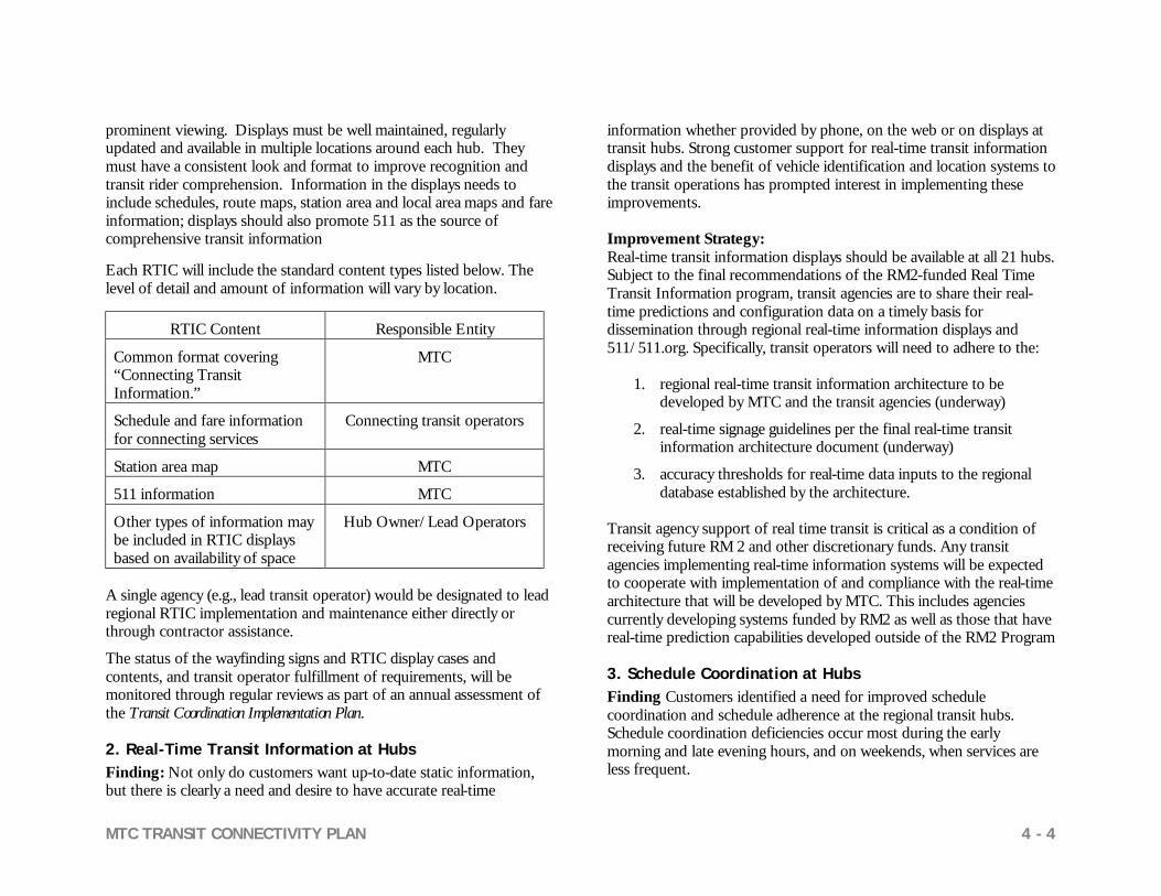
MTC TRANSIT CONNECTIVITY PLAN 4 - 4
prominent viewing. Displays must be well maintained, regularly updated and available in multiple locations around each hub. They must have a consistent look and format to improve recognition and transit rider comprehension. Information in the displays needs to include schedules, route maps, station area and local area maps and fare information; displays should also promote 511 as the source of comprehensive transit information Each RTIC will include the standard content types listed below. The level of detail and amount of information will vary by location.
RTIC Content Responsible Entity
Common format covering “Connecting Transit Information.”
MTC
Schedule and fare information for connecting services
Connecting transit operators
Station area map MTC
511 information MTC
Other types of information may be included in RTIC displays based on availability of space
Hub Owner/Lead Operators
A single agency (e.g., lead transit operator) would be designated to lead regional RTIC implementation and maintenance either directly or through contractor assistance.
The status of the wayfinding signs and RTIC display cases and contents, and transit operator fulfillment of requirements, will be monitored through regular reviews as part of an annual assessment of the Transit Coordination Implementation Plan. 2. Real-Time Transit Information at Hubs Finding: Not only do customers want up-to-date static information, but there is clearly a need and desire to have accurate real-time
information whether provided by phone, on the web or on displays at transit hubs. Strong customer support for real-time transit information displays and the benefit of vehicle identification and location systems to the transit operations has prompted interest in implementing these improvements. Improvement Strategy: Real-time transit information displays should be available at all 21 hubs. Subject to the final recommendations of the RM2-funded Real Time Transit Information program, transit agencies are to share their real-time predictions and configuration data on a timely basis for dissemination through regional real-time information displays and 511/511.org. Specifically, transit operators will need to adhere to the:
1. regional real-time transit information architecture to be developed by MTC and the transit agencies (underway)
2. real-time signage guidelines per the final real-time transit information architecture document (underway)
3. accuracy thresholds for real-time data inputs to the regional database established by the architecture.
Transit agency support of real time transit is critical as a condition of receiving future RM 2 and other discretionary funds. Any transit agencies implementing real-time information systems will be expected to cooperate with implementation of and compliance with the real-time architecture that will be developed by MTC. This includes agencies currently developing systems funded by RM2 as well as those that have real-time prediction capabilities developed outside of the RM2 Program 3. Schedule Coordination at Hubs Finding Customers identified a need for improved schedule coordination and schedule adherence at the regional transit hubs. Schedule coordination deficiencies occur most during the early morning and late evening hours, and on weekends, when services are less frequent.

MTC TRANSIT CONNECTIVITY PLAN 4 - 5
Improvement Strategy: The operators serving the 21 regional transit hubs must continue to work together to coordinate schedules and resolve any schedule adherence problems at these hubs.
Implementation of the recommendations for schedule coordination would involve the following elements:
1. Where connecting service headways are greater than 15 minutes, hub operators should work together to ensure maximum schedule coordination.
2. “Last trip of the day” transit stops should be synchronized with specific outbound regional transit trunk services.
3. The concept of a timed-transfer/pulsed regional rail network should be fully evaluated in the Regional Rail Plan funded under RM2.
Eventually, at those major regional transit hubs where real-time information systems will be implemented, schedule adherence information will be available to the connecting transit agencies to enable them to monitor and modify schedules as required to ensure schedule coordination.
Transit operators will monitor schedule adherence and coordination at the 21 major regional transit hubs and will provide schedule performance data for inclusion in MTC’s annual State of the System report. Hub operators will also need to ensure that schedule information is shared with each other on a regular basis to ensure maximum schedule coordination.
4. Last Mile Services Finding: These types of improvements complement bus, rail, and ferry services; encourage public – private partnerships and funding arrangements; and have a broad market and customer base. They provide an opportunity to address travel needs in a more flexible and innovative way. They are critical to expanding transit access to a broader range of the traveling public.
Improvement Strategy: At a minimum, connecting shuttle services should be incorporated into the wayfinding signage and transit information displays. Transit agencies should also provide for bicycle and pedestrian access and parking at hubs –funding for these types of improvements is available from the RM 2 $20 million “Safe Routes to Transit” (SR2T) program administered by the Transportation and Land Use Coalition and the East Bay Bicycle Coalition.
Implementation of the recommendations for last mile services would involve the following elements:
1. Shuttle information will be incorporated into wayfinding signage (at minimum, would include information where shuttles pick-up/drop off) and in RTICs.
2. Operators would be encouraged to provide access and parking spaces for other last mile services described in this report and in Appendix A-5 (bike parking, car share, etc.).
3. Operators would be encouraged to seek other grant opportunities to implement “last mile” improvements (e.g. SR2T, Transportation for Clean Air, Clean Air in Motion, and Transportation for Livable Communities program grants)
With the exception of incorporating shuttle wayfinding signage as described above, Last Mile services would not be assessed as part of the hub performance reviews and therefore would not be required as a condition of the SB1474 Transit Coordination Implementation Plan.
5. Hub Amenities Finding: Reduction of walking distances, enhanced comfort, weather protection, restrooms, and improved security were of high importance to the customers. The level of cleanliness of the facility is also an important factor. Improvement Strategy: The study lists several amenities that customers find important, and provides guidelines for their application (see Appendix A-5). Transit agencies should consider these amenities

MTC TRANSIT CONNECTIVITY PLAN 4 - 6
for regional transit hubs since they are important to customers. MTC would advise the hub owners of any significant observed need for hub improvements identified as part of the hub performance reviews. Newly built hubs funded by MTC’s Regional Transit Expansion Program would be expected to include the passenger amenities described in this report. Systemwide Connectivity Improvements
In addition to the hub-specific improvements that are described above, there are two key systemwide improvements that promote regional connectivity: transit information and regional fare coordination program. This study’s focus group effort and previous MTC public opinion polls demonstrate strong support for both of these programs and recommend that they be implemented on a regional basis. 1. 511 Transit Information Program Finding: There is strong customer support for coordination of regional transit information to eliminate barriers to understanding and using transit services. MTC is committed to funding the full operability of the 511 transit information system, but requires full participation of all the transit agencies to make it work. MTC has prepared a draft 511 Strategic Plan scheduled for Commission adoption in April 2006 that defines specific improvement strategies. Improvement Strategy: Implementation of the 511 program would involve the following elements and are consistent with MTC’s 511 Strategic Plan:
1. Deliver quality information for the 511 transit web site a. Advance transmittal of schedule and other transit service
change information. b. Review new service data after it is posted on 511 c. Report planned scheduling software changes
2. Deliver quality information for the 511 phone system a. Report changes in telephone information center hours,
schedules, fares, etc. b. Report transit service disruptions of regional significance c. Further evaluate a single regional telephone information
center to improve access to customers
3. Notify transit customers of the availability of 511 information a. on transit agency websites b. in printed materials c. at transit stops/stations and on vehicles
MTC will regularly monitor transit agencies for compliance with the above elements as part of its annual Transit Coordination Plan assessment pursuant to MTC Resolution 3055 (for specific 511 recommendations that will be incorporated into Res. 3055 see Appendix A-3), and will complete the regional call information center study in FY 2006/07.
Transit operators will have the opportunity to define a schedule for compliance and implement it subject to MTC’s satisfaction as a condition of receiving regional discretionary funds.
2. Fare Coordination Finding: Customers identified fare coordination as a critical need for improved transit connectivity and recognize the implementation of TransLink® as the key initiative in achieving this goal. Improvement Strategy: MTC and the operators need to push forward cooperatively to complete ongoing fare coordination efforts. Implementation of the recommendations for fare coordination would involve the following elements:
1. Continue with planned work to implement TransLink® on the large operators by 2007/08 and the remaining operators by 2010.
2. The TransLink® Consortium is required to complete the RM 2-funded Integrated Fare Program study by July 1, 2007.

MTC TRANSIT CONNECTIVITY PLAN 4 - 7
COST AND SCHEDULE
Implementation costs and schedules have been estimated for each of the connectivity elements described above. The costs that are shown are costs that are in excess of any funding that is currently committed for these programs as part of MTC’s Regional Transportation Plan (know as the Transportation 2030 Plan). The costs relate solely to bringing each of the identified 21 major regional transit hubs into conformance with the transit connectivity guidelines and standards developed for this project (see Appendix B for cost estimate details). Wayfinding Signage/Transit Information Cost The costs for the wayfinding signage programs at each of 21 hubs were developed based on the guidelines presented in Appendix A. The hubs were classified as large, medium or small; a cost estimate was then prepared for each hub type. The design, production, and installation of the signs is estimated to cost $7.2 million for all 21 hubs, and annual maintenance and replacement costs (e.g. cleaning, information display updates, needed replacement and repairs) would be an average $32,000 per hub or $680,000 for all 21 hubs per year (most of these costs would likely be accommodated within transit operator existing station maintenance budgets). These costs do not include real-time information display signs in the hubs (see next section). The costs of expanding the RTIC displays at hubs/airports consistent with the recommendations from this study are estimated at $770,000; annual maintenance and replacement costs are estimated to be about $180,000 for all 21 hubs and airports. Implementation Schedule It will be incumbent upon the transit operators to develop a wayfinding signage and regional transit information implementation plan. MTC and the operators will assess each plan and schedule to determine hub priorities and a funding plan to implement them. The schedule based on the hub performance reviews is as follows:
Wayfinding Signage/Transit Information Responsible Agency Milestone Completed by
MTC Hub Performance Review
January 2007
Hub Owner / Lead Agency
Wayfinding signage and regional displays implementation plan
June 2007
Hub Owner / Lead Agency
Complete activities June 2009
Real-Time Information Systems Cost There are three cost elements for providing real-time information at the 21 hubs:
• Regional real-time architecture needed to consolidate and display each transit agency’s real-time information.
• Installation of regional real-time transit information displays.
• Display maintenance at each of the hubs. The regional real-time architecture development is estimated to cost $280,000 and is included in the current 511 Strategic Plan budget; an additional $20,000 per year will be needed to monitor the real-time regional database and is also included in the 511 Strategic Plan budget. The purchases and installation costs for all or a portion of 12 of the 21 hubs are covered in the current RM2 Real-Time program. The cost of adding real-time displays at the remaining hubs/airports is estimated at $2.1 million; an estimated $250,000 per year (exclusive of long-term replacement needs) would be needed to maintain signs at all 21 hubs/airports. Real-time infrastructure and display technology will

MTC TRANSIT CONNECTIVITY PLAN 4 - 8
likely become obsolete over time and will need to be replaced. A $200,000 per year sinking fund would be needed to replace the real-time displays, assuming a ten-year life cycle. Implementation Schedule Real-time schedule displays will be rolled out at the nine RM2-funded hubs over the next 2-3 years. Implementation at the remaining hubs can be achieved in the same timeframe depending on the availability of funding. Real Time Information Systems Responsible Agency Milestone Completed by
MTC Develop real time system architecture
June 2007
Transit Operators Complete real time schedule displays at 12
RM2-funded hubs
June 2009
Transit Operators/MTC
Complete real time schedule displays at
remaining hubs
June 2009
Schedule Coordination Costs The costs of developing the regional real-time data base required to support automated schedule adherence monitoring are included under the real-time information architecture item – estimated at $280,000 for capital costs and $20,000 for maintenance costs – as discussed previously. Implementation Schedule The transit agencies would assess schedule coordination and adherence annually. Implementation of a regional database, depending on the availability of funding, would be implemented within 3-5 years.
Schedule Coordination Responsible Agency Milestone Completed by
MTC/Transit Operators
Develop regional database to monitor schedule adherence
June 2010
Fare Coordination Cost TransLink® has a full funding commitment in the Transportation 2030 Plan and rollout is underway; no additional funding is anticipated. The fare integration study is also fully funded by RM2 – costs to implement an integrated fare system will be determined by the study. Implementation Schedule TransLink® is expected to be fully implemented for the larger transit operators in 2007/08 and all the operators by 2010. The TransLink® Consortium is required by RM2 to complete the fare integration study by July 1, 2007. Last Mile Services and Hub Amenities Cost The cost to implement proposed Last Mile Services and Hub Amenities is not known. Operators will likely use existing and new funding sources for these programs. Some of the hub amenities could be costly and may not be financially feasible, at least in the near term. Shuttle information will be included in the customer information display cases as discussed previously Implementation Schedule The shuttle customer display and wayfinding signage information will be implemented in the near term as discussed previously. The other last mile services and hub amenities will be implemented on varying time frames, depending on operator priority and funding availability.

MTC TRANSIT CONNECTIVITY PLAN 4 - 9
INCORPORATION OF THE CONNECTIVITY IMPLEMENTATION PLAN INTO MTC’S TRANSIT COORDINATION IMPLEMENTATION PLAN
The Commission will need to revise MTC Resolution 3055 to incorporate the connectivity implementation plan requirements into its Transit Coordination Implementation Plan pursuant to Street and Highway Code Section 30914.5 (as promulgated by RM2) and Government Code Section 66516.5. (See Table 4.2) RM2 stipulates that the transit operators must comply with the connectivity plan in order to receive STA funds and RM2 funds identified for designated projects/operators. This plan recommends that MTC monitor compliance at the 21 hubs and implement all recommended improvement strategies within the next 5 years. Lastly, RM2 requires that the connectivity/coordination plan be updated “every three years by the Commission as part of the update to its regional transportation plan” (new federal law requires RTP updates every 4 years for this region – so this plan will be updated every 4 years). The coordination plan update will consider new improvements at major regional transit hubs and assess new hubs that should be included in the regional network. Transit Connectivity Working Group For preparation of the Transit Connectivity Report that was completed in January 2005, MTC established a Transit Connectivity Working Group comprised of representatives from transit agencies, cities, counties, congestion management agencies, business associations, and other stakeholders interested in improving transit connectivity in the Bay Area. This group continued to serve as the technical advisory committee for this Transit Connectivity Study. The Transit Connectivity Working Group has proven to be an effective means of moving the regional connectivity program forward. In the future this group should continue to meet and discuss ongoing connectivity related programs and issues. The group should also function as the initial review board for proposals from the operators to implement the recommendations included in this report. Maintaining this group would provide a vehicle for long-term continuity of the connectivity program.
Table 4.2
Summary Recommendations and Compliance Requirements
Connectivity Element
Subject to MTC Res. 3055 Compliance
Not Subject to MTC Res. 3055 Compliance
Wayfinding Signage
X
Regional Information Displays
X
Real-time Information - conformity regional architecture - display guidelines - data accuracy
X X X
Schedule Coordination
X
“Last Mile” Services-Programs
X
Hub Amenities - retrofit hubs - new hubs
X
X
511 Transit - quality data - web & phone - market 511 to riders
X X
Fare Coordination - TransLink® - Integrated Fare Study & Implementation
X X