msc program in urban management and development · msc program in urban management and development...
TRANSCRIPT

MSc Program in Urban Management and Development
Rotterdam, The Netherlands
September 2013
Thesis Title: Measuring the success of human settlements - The case of
Islamabad
Name: Saima Sabit Ali
UMD 9
Supervisor: Dr. Alonso Ayala

Measuring the success of human settlements- The case of Islamabad ii
MASTER’S PROGRAMME IN URBAN MANAGEMENT AND
DEVELOPMENT
(October 2012 – September 2013)
Measuring the success of human settlements-
The case of Islamabad
Saima Sabit Ali
Pakistan
Supervisor: Dr. Alonso Ayala
UMD 9- IPUS
Report number:
Rotterdam, September 2013
Measuring the success of human settlements- The case of Islamabad iii
Summary
Islamabad, a legacy of the post war urbanism, is the first planned city in Pakistan and one of
the largest new towns designed in Asia in 1959 by a Greek Architect and Planner,
Constantinos A. Doxiadis. The city is designed on the concept of the Dynapolis - city of the
future, a research project also conceived by Doxiadis in 1958, which gives a framework for
making models for city plans with capacity for adjustment that will be flexible enough to
accommodate the changing needs of time. The technique allows for calculations and
manipulations of variables at any given point in time to forecast future changes. The
precision of the forecasts can also be fine-tuned with the addition of various variables. The
city is designed on grid-iron plan, and is divided into five zones. The plan has a National Park
area allowing emergence and organic growth. Even though there have been considerable
arguments that cities cannot and should not be planned and the future cannot be forecasted,
Islamabad has flourished as a planned city of the future since 1958 and is one of the most
desirable cities in Pakistan to live in. Today fifty three years later, like other new towns of its
time, it needs to expand and address the needs of the present day while remaining true to the
original concept for the city of the future, the “Dynapolis”.
The city is expanding towards the semi urban area of Islamabad which has urban villages that
were deliberately accommodated by Doxiadis in the city plan to retain the cultural heritage of
the area as well as for the maintenance of sustainable balance providing the area as a backup
for the food needs of the city. The idea of Doxiadis of connecting the city directly to its
surroundings, leaving no gap between the city and the villages which results in a constant
fusion, as the city is planned for all, forms the reality for today’s Islamabad (Mahsud, 2007).
These urban villages have developed into towns and are in total visual contrast with the
Doxiadis designed sectors found in the Islamabad urban area. The shifting or transforming
spatial patterns in the context of Islamabad is hence studied in this research to understand the
urban morphology and the forces that influence and determine the future urban patterns in the
city of Islamabad.
Doxiadis’ ideas from his theory founded in 1942, “The Science of Human Settlements”
which is known as Ekistics, forms the basis of and is taken as a reference point to study the
emergent settlements in the Islamabad urban area. The five principles of Ekistics according
to Doxiadis, forms the basis of all human settlements and he states that they are actually an
extension of man’s biological characteristics and man has always shown obedience to these
five principles since ancient times.
This research is qualitative and exploratory case study based on in-depth interviews of the
planning experts form the Capital Development Authority and residents of G-6 (planned
settlement) and Bhara Kahu (unplanned settlement), questionnaires, observations (personal
and peoples) and photographic documentation. It assesses the settlements in Islamabad based
on four of the principles of Ekistics, and analyses the settlement outcomes through the fifth
principle to measure the success of the planned and unplanned human settlements. The
comparative study of the planned and the unplanned is taken to identify the elements that
define the success in human settlements. This success is however achieved when the needs of
the people pertaining to settlements are fulfilled in the settlements and promote happiness,
safety and satisfaction as explained by Doxiadis.
A comparative study used in parallel for the purpose is the CSIR guidelines for human
settlement planning and design (2000) generated recently but bears high resemblance and
similarity to the theory generated by Doxiadis in 1942. This study however provides a
framework for settlement making and calls the successful settlements as the positively

Measuring the success of human settlements- The case of Islamabad iv
performing settlements, and identifies six structural principles and four spatial principles
essential for the creation of well performing human settlements.
The research findings revealed that the needs, security and satisfaction were all defined
differently in both the planned and the unplanned settlement hence the success is defined
differently. The planning of Islamabad by Doxiadis has been highly admired and experienced
to be functional by the planning experts as well as the residents of the planned sectors of
Islamabad in general. However the freedom of choice exercised by the residents of unplanned
settlement has also proved to be functional for them and both settlements are found to be in
accordance with the Doxiadis definition of successful human settlements.
Keywords
Human settlements, planned, unplanned,
Islamabad, Doxiadis, Dynapolis, Ekistics

Measuring the success of human settlements- The case of Islamabad v
Acknowledgements
I cannot thank enough Almighty Allah for all His blessings and favours, for providing me
with this opportunity for knowledge and strength in the most difficult times.
I am grateful to Nuffic and the IHS faculty and staff for this great prospect, exposure and all
assistance throughout the course enriching the experience in such a short time.
I would like to thank everyone who co-operated and helped me conduct the research
including the interviewees and participants of survey who were not very comfortable with
being questioned but participated to help the research.
I extend a very special thanks to:
Dr. Alonso Ayala- my most respected supervisor, without whose guidance, patience
and encouragement, this research would not have been possible.
Sharon Welsh- A great teacher and a wonderful friend for the great moral support and
all help rendered in times of panic
The IHS course bureau team Ms Cocky Adams, Rene’ and Ruud
My friend and partner Ali for all support during the entire period
Last, but not the least, my parents, my most beloved mother whose prayers and love
have been a constant driving force in my life and my late father because of whom I
stand here today. My siblings who encouraged me and provided the most needed
moral support throughout the course.
Measuring the success of human settlements- The case of Islamabad vi
Foreword
The city is an expression and a replica of people’s social and cultural development with
respect to time. Cities are defined by the way of life of the citizens, their preferences and
choices, attitudes and perceptions, traditions, beliefs and culture.
The region of South East Asia has a known history of planning with the grid- iron planned1
cities of Harappa (Taxila) and Mohenjo-Daro dating from around 2600 BC from the ancient
Indus Valley civilization, cities that we still admire.
Human settlements are a product (by the man- for the man) and a reflection of the human
mind (Hillier, 2012). In order to understand the extent to which we need to plan requires a
thorough understanding of the laws of nature and different sciences like biology, psychology,
complexity, cognitive and social science, one does not only need to make links between the
different disciplines but one needs to evolve a synthesis in space and time (Doxiadis, 1970).
Since man is the centre of all debate in different roles and his creation the city is “actually an
extension of his biological characteristics” (Doxiadis, 1970), based on this I have directed the
research to finding that synthesis in space and time.
1 Grid-iron planning is a way of planning cities found from ancient times in which streets are planned
at right angles to each other forming a grid.

Measuring the success of human settlements- The case of Islamabad vii
Abbreviations
CDA Capital Development Authority
CIT Critical Incidence Technique
COF City of Future
CSIR The Council for Scientific and Industrial Research
ELS Ekistics Logarithmic Scale
ICT Islamabad Capital Territory
IHS Institute for Housing and Urban Development
Studies
KAP Knowledge Attitude and Practice
MPC Master Plan Cell
PIDE Pakistan Institute of Development Economics
RoW Right of way
Measuring the success of human settlements- The case of Islamabad viii
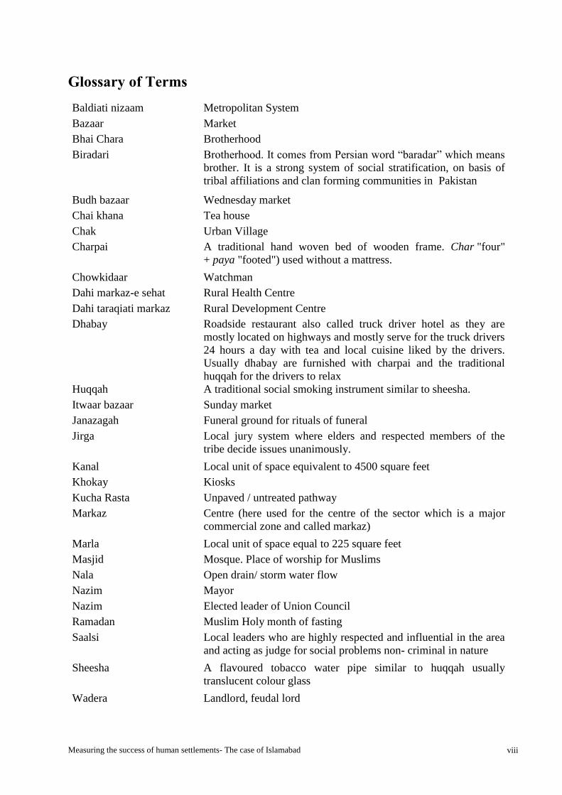
Glossary of Terms
Baldiati nizaam Metropolitan System
Bazaar Market
Bhai Chara Brotherhood
Biradari Brotherhood. It comes from Persian word “baradar” which means
brother. It is a strong system of social stratification, on basis of
tribal affiliations and clan forming communities in Pakistan
Budh bazaar Wednesday market
Chai khana Tea house
Chak Urban Village
Charpai A traditional hand woven bed of wooden frame. Char "four"
+ paya "footed") used without a mattress.
Chowkidaar Watchman
Dahi markaz-e sehat Rural Health Centre
Dahi taraqiati markaz Rural Development Centre
Dhabay Roadside restaurant also called truck driver hotel as they are
mostly located on highways and mostly serve for the truck drivers
24 hours a day with tea and local cuisine liked by the drivers.
Usually dhabay are furnished with charpai and the traditional
huqqah for the drivers to relax
Huqqah A traditional social smoking instrument similar to sheesha.
Itwaar bazaar Sunday market
Janazagah Funeral ground for rituals of funeral
Jirga Local jury system where elders and respected members of the
tribe decide issues unanimously.
Kanal Local unit of space equivalent to 4500 square feet
Khokay Kiosks
Kucha Rasta Unpaved / untreated pathway
Markaz Centre (here used for the centre of the sector which is a major
commercial zone and called markaz)
Marla Local unit of space equal to 225 square feet
Masjid Mosque. Place of worship for Muslims
Nala Open drain/ storm water flow
Nazim Mayor
Nazim Elected leader of Union Council
Ramadan Muslim Holy month of fasting
Saalsi Local leaders who are highly respected and influential in the area
and acting as judge for social problems non- criminal in nature
Sheesha A flavoured tobacco water pipe similar to huqqah usually
translucent colour glass
Wadera Landlord, feudal lord
Measuring the success of human settlements- The case of Islamabad ix
Table of Contents
Summary ................................................................................................................................. iii
Keywords ................................................................................................................................. iv
Acknowledgements .................................................................................................................. v
Foreword .................................................................................................................................. vi
Abbreviations ......................................................................................................................... vii
Glossary of Terms ................................................................................................................ viii
List of Boxes............................................................................................................................. xi
List of Tables ........................................................................................................................... xi
List of Charts ........................................................................................................................... xi
List of Figures ......................................................................................................................... xii
List of Photographs .............................................................................................................. xiii
Chapter 1 Introduction............................................................................................................ 1
1.1 Background ................................................................................................................................... 1 1.2 Problem Statement ........................................................................................................................ 4 1.3 Research Objectives ..................................................................................................................... 6 1.4 Research Questions ....................................................................................................................... 6 1.5 Significance of the Study .............................................................................................................. 7 1.6 Scope and Limitations .................................................................................................................. 7 1.7 Description of the research area ................................................................................................... 8
1.7.1 Brief history of formation of the planned and unplanned human settlements in Islamabad ................ 8 1.8 Thesis structure ........................................................................................................................... 17
Chapter 2 Theoretical framework ........................................................................................ 18
2.1 Introduction ................................................................................................................................ 18 2.1.1 Cities- Perceptions, images and metaphors ........................................................................................ 18 2.1.2 Cities- To plan or not to plan debate .................................................................................................. 18 2.1.3 Cities- Arguments in favour and against planning ............................................................................. 20 2.1.4 Cities- The middle path of co-existence ............................................................................................. 22
2.2 State of the Art of the Theories/Concepts of the Study .............................................................. 22 2.2.1 Urban Emergence and organic cities .................................................................................................. 22 2.2.2 Dynapolis- The city of the future (COF) ............................................................................................ 22 2.2.3 Ekistics theory -The science of human settlements ............................................................................ 29 2.2.4 CSIR guidelines for human settlement planning and design .............................................................. 33
2.3 The relationship and significance of the various concepts. ........................................................ 35 2.3.1 Morphogenesis, new forces and time ................................................................................................. 35 2.3.2 Cognitive science, complexity science and the emergent and organic cities ..................................... 36 2.3.3 Dynapolis/ COF, Ekistics, and the emergent and organic cities......................................................... 36 2.3.4 The Dynapolis, Principles of Ekistics and the spatial and structural principles for human settlement
planning and design CSIR (2000) ............................................................................................................... 36 2.3.5 “Successful Human Settlements” vs. “Positively Performing Settlements” ...................................... 38
2.4 Conceptual framework ............................................................................................................... 40
Chapter 3: Research Design and Methods .......................................................................... 43
3.1 Research design .......................................................................................................................... 43 3.1.1 Approach ............................................................................................................................................ 43
3.2 Operationalization: Variables, Indicators ................................................................................... 45 3.4 Data Collection Methods ............................................................................................................ 46
Measuring the success of human settlements- The case of Islamabad x
3.4.1 Sample Size and Selection ................................................................................................................. 47 3.4.2 The description of the sample ............................................................................................................ 48 3.4.2 Validity and Reliability ...................................................................................................................... 49
3.5 Data Analysis Methods ............................................................................................................... 49
Chapter 4: Research Findings and analysis ........................................................................ 51
4.1 The description of the case study................................................................................................ 51 4.1.1 Physical patterns of the planned and unplanned human settlements .................................................. 51
4.2 Presentation of findings in relation to the research question. ..................................................... 54 4.2.1 Processes and events .......................................................................................................................... 55 4.2.2 The Principles of Ekistics ................................................................................................................... 58
4.2.2.1 Principle 1 .................................................................................................................................. 58 4.2.2.2 Principle 2 .................................................................................................................................. 67 4.2.2.3 Principle 3 .................................................................................................................................. 70 4.2.2.4 Principle 4 .................................................................................................................................. 76
4.2.3 Summary of findings of G-6 and Bhara Kahu related to Ekistics principles: .................................... 84 4.3 Analysis of findings .................................................................................................................... 89
4.3.1 Analysis of findings related to the principles of Ekistics in G-6 and Bhara Kahu: ............................ 89 4.3.2 Outcomes of planned and unplanned settlements .............................................................................. 91 4.3.3 Elements that explain the success factors for the G-6 and Bhara Kahu ............................................. 93
Chapter 5: Conclusions and recommendations ................................................................ 102
5.1 Conclusions .............................................................................................................................. 102 5.3 Lessons Learnt .......................................................................................................................... 103
5.3.1 Myths falsified by research .............................................................................................................. 103 5.3.2 Interesting discoveries ...................................................................................................................... 104
5.4 Relevance with Literature ......................................................................................................... 107 5.5 Limitations Strength and Weaknesses of Research .................................................................. 108 5.6 Recommendations for further research ..................................................................................... 109
Bibliography ......................................................................................................................... 111
Annexes ................................................................................................................................. 114
Measuring the success of human settlements- The case of Islamabad xi
List of Boxes
Box 1: Critical incident Technique ....................................................................................................................................... 47
Box 2: Monuments in G-6 ..................................................................................................................................................... 56
Box 3: G- 6 places of social interaction ................................................................................................................................ 60
Box 4: Bhara Kahu- Places of social interaction ................................................................................................................. 65
List of Tables
Table 1: Summary of area of zones ...................................................................................................................................... 11
Table 2: Islamabad area distribution ................................................................................................................................... 12
Table 3: Islamabad zone IV sub divisions- Land use revision ........................................................................................... 13
Table 4: Dynapolis- distribution of community classes and provision of social and commercial facilities .................... 28
Table 5: Ekistics Logarithmic scale- ELS ............................................................................................................................ 32
Table 6: Operationalization .................................................................................................................................................. 45
Table 7: Resource persons for data collection ..................................................................................................................... 48
Table 8: Research Methodology ........................................................................................................................................... 50
Table 9: Distribution of facilities in sector G-6 and its sub sectors .................................................................................... 59
Table 10: Feeling of safety in the settlement ........................................................................................................................ 76
Table 11: Summary of findings of G-6 and Bhara Kahu related to principles of Ekistics .............................................. 84
Table 12: The outcomes in the broader context of the Dynapolis- City of the future Islamabad .................................... 92
Table 13: Need assessment- locational factors ..................................................................................................................... 95
Table 14: Results of satisfaction query in the planned and unplanned human settlements ............................................ 98
Table 15: Respondents ‘preference for relocation .............................................................................................................. 99
Table 16: Perception of safety within human settlements ................................................................................................ 100
Table 17: Time schedule for research ................................................................................................................................ 126
Table 18: G-6- Frequency of contact .................................................................................................................................. 139
Table 19: Bhara Kahu- Frequency of contact ................................................................................................................... 139
Table 20: Needs of people pertaining to settlements- G-6 ................................................................................................ 140
Table 21: Needs of people pertaining to settlements- Bhara Kahu .................................................................................. 140
List of Charts
Chart 1: Frequency of contact G-6 ....................................................................................................................................... 64
Chart 2: Frequency of contact Bhara Kahu ........................................................................................................................ 67
Chart 3: Feeling of safety for the residents within G-6 and Bhara Kahu ......................................................................... 76
Chart 4: Need Assessment- locational factors ..................................................................................................................... 96
Chart 5: Need assessment (perceived value of contacts) - G-6 ........................................................................................... 96
Chart 6: Need Assessment (perceived value of contacts) - Bhara Kahu ............................................................................ 97
Chart 7: Satisfaction with area and facilities ....................................................................................................................... 98
Chart 8: Respondents ‘preference for relocation ................................................................................................................ 99
Chart 9: Perception of safety within human settlements .................................................................................................. 100

Measuring the success of human settlements- The case of Islamabad xii
List of Figures
Figure 1: The Concept of Dynapolis for Islamabad .............................................................................................................. 3
Figure 2: The Original Master plan Of Islamabad ............................................................................................................... 5
Figure 3: Settlements existing at early development phase of Islamabad 1960 .................................................................. 9
Figure 4: Master Plan Islamabad 1991 ................................................................................................................................ 10
Figure 5: Master Plan with Zones of Islamabad Present Day ............................................................................................ 11
Figure 6: Sub Zones for Zone IV of Islamabad ................................................................................................................... 12
Figure 7: Islamabad satellite image of zones and for identification of unplanned human settlement ............................ 14
Figure 8: Zoomed in view of Bhara Kahu- Zone IV with the Korang River .................................................................... 16
Figure 9: Hierarchical structure of the Dynapolis .............................................................................................................. 26
Figure 10: Hierarchy of communities .................................................................................................................................. 27
Figure 11: Neighbourhood concept Original layout plan of subsector G-6- ¼ (community class III) ............................ 27
Figure 12: Ekistics- Five elements forming a system .......................................................................................................... 30
Figure 13: Ekistics and the sciences directly contributing to it .......................................................................................... 32
Figure 14: Conceptual Framework- ..................................................................................................................................... 42
Figure 15: The research design approach ............................................................................................................................ 44
Figure 16: Map G-6 ............................................................................................................................................................... 52
Figure 17: Part plan Sector G-6 showing sub sectors G-6/1 and G-6/4 (community class IV) ........................................ 52
Figure 18: Yaadgaar Chowk and ......................................................................................................................................... 56
Figure 19: Events a) Jamia Hafsa G-6 b) Lal Masjid before operation 2007 c) Lal Masjid rebuilt in 2010 d) Margallah
Towers 2005 ................................................................................................................................................................... 57
Figure 20: Different levels of public and community class III- V parks ........................................................................... 58
Figure 21: The Gossip squares of G- 6- Places of social interaction .................................................................................. 60
Figure 22: Public open spaces as places of social interaction ............................................................................................. 61
Figure 23: Bazaars Community class III ............................................................................................................................ 62
Figure 24: Different levels of housing units in sub sectors of G-6 ...................................................................................... 62
Figure 25: Play grounds- a) G-6 community ground in green belt on Ataturk avenue b & c) Public School play
grounds used as community grounds .......................................................................................................................... 63
Figure 26: Nature and views in the Bhara Kahu- a) view of Bhara Kahu before bridge, b) Korang Nala and the
settlement alongside c) open green fields d) Korang River bank .............................................................................. 65
Figure 27: Bhara Kahu- Dhabay- Places of social interaction in a traditional culture .................................................... 65
Figure 28: Sector G-6 Access and connectivity- Seventh Avenue from a bridge connecting sectors G-7 and G-6
leading to main Saddar road running at centre of G-6 .............................................................................................. 68
Figure 29: Influences- Use of nature .................................................................................................................................... 77
Figure 30: Master Plan Islamabad ..................................................................................................................................... 141
Figure 31: Master Plan Islamabad with zones .................................................................................................................. 141
Figure 32: Master Plan for Islamabad Metropolitan Area 1960 ..................................................................................... 141
Figure 33: Master Plan for Islamabad Capital Territory as revised and implemented ................................................. 141

Measuring the success of human settlements- The case of Islamabad xiii
List of Photographs
Photograph 2: Islamabad 1960s.......................................................................................................................................... 133
Photograph 3: Mosques in G-6 1960s ................................................................................................................................. 133
Photograph 4: Facilities development in G-6 1960s .......................................................................................................... 133
Photograph 5: Higher-order facilities development 1960s ............................................................................................... 133
Photograph 6: Nature .......................................................................................................................................................... 134
Photograph 7: Works of man .............................................................................................................................................. 134
Photograph 8: Commercial activity at different levels ..................................................................................................... 134
Photograph 9: Weekly bazaars and markets G-6 ............................................................................................................. 134
Photograph 10: Commercial activity in G-6 ...................................................................................................................... 135
Photograph 11: G-6- Accessibility options ......................................................................................................................... 135
Photograph 12: G-6 No through traffic streets and pedestrian paths providing inter street connection ..................... 135
Photograph 13: Mosques in different sub-sectors of G-6 ................................................................................................. 136
Photograph 14: Different academic institutes (public and private) in the sector G-6 .................................................... 136
Photograph 15: Public facilities G-6 ................................................................................................................................... 136
Photograph 16: Water filtration plants and overhead water tanks for the area ............................................................ 136
Photograph 17: Views of natural landscape dominant in Bhara Kahu ........................................................................... 137
Photograph 18: Commercial areas and markets Bhara Kahu ......................................................................................... 137
Photograph 19: Main Murree road approach to Bhara Kahu ......................................................................................... 137
Photograph 20: Street systems- vehicular and pedestrian only streets ........................................................................... 138
Photograph 21: Academic institutes (Public and Private) in the Bhara Kahu ............................................................... 138
Photograph 22: Public facilities institutions ...................................................................................................................... 138

Measuring the success of human settlements- The case of Islamabad 1
Chapter 1 Introduction
1.1 Background
Cities evolve and grow and as time passes sometimes new cities are born and sometimes the
pattern of growth of cites change. There is hardly any place where this is not an evident
phenomenon. The population of the world is constantly growing and pushing the boundaries
of the land and the skies to accommodate them.
There has been considerable debate on whether to plan or not to plan cities and let them
emerge and take their own course. There have been considerable debates but the latest ideas
somehow show the inability of spatial planning to deal with the issues of today and the
alternatives come from the participatory or citizens’ initiative which form the latest trends.
Spatial planning has been criticized by several for its demerits and applauded in some cases
by many for having its merits. Van Den Broeck, (2004) for example criticizes the traditional
planning or 'master planning' for being quite inert, land-use-oriented and mainly impractical
lacking calculation of limited resources, rapid change, time (change and uncertainty), having
no regard for the values or interests of people and often having only theoretical grounds
leading them far away from the realities, mostly referring to the garden city concepts and the
ideal city of the CIAM that was led by the famous Le Corbusier. Master planning is a product
of the twentieth century and realizing the differences from that time and now the contrast is
that the governments could somehow plan by predicting a logical future and plans could be
implemented in a technocratic way, which is unlike today where the situation and
circumstances are very different. As a reaction to the long term planning the disbelief in
planning gave rise to Lindblom’s (1959) science of muddling through (Van den Broeck,
2004). Louis Albrechts (2004) criticizes the traditional land use planning mainly for the
reasons of control through the zoning which he argues is rigid, uncompromising and not
adhering to the changing conditions and needs.
Post war urbanism (1950s-1960s) however brought many new towns which were developed
all over the world using traditional master planning, some of which still bear the testimony of
the time when they were built and the philosophies, intentions and motivations of their
makers (Malik, 2003). The ideas and trends flowed to the east and developing countries,
some still in the age of infancy and recently out of trauma of war and celebrating the new
independence like Pakistan, India and Bangladesh. The countries ambitiously and eagerly
imported architects from the west to set up symbols of modernism and prosperity and hence
new capitals for the countries were developed. In 1997 a critical comparative analysis of the
three new capitals of Pakistan, India and Bangladesh was undertaken to evaluate the success
or failure of the fundamental principles for the formation of the capitals in a two day
international seminar organized by the Edge Hill University College and the Department of
Civic Design at the University of Liverpool. The criticism received for the capitals of the
south east Asian region cities was mostly that the imported expertise did not understand the
regional and the cultural needs of the countries still in the age of infancy and unable to afford
the luxury of building new expensive capitals. All three capitals (Islamabad, Chandigarh and
Dhaka) were developed by foreign consultants to portray an exodus from the historic colonial

Measuring the success of human settlements- The case of Islamabad 2
past and present as symbols of independent new cultural and national identity in an attempt to
remove the shame of the label of backwardness and the lack of local experts to deal with
complexity of such scale (Malik, 2003). Ayyub Malik (2003) questions the validity of
representation of the urban planning and architecture of cities in the South Asian region
required for a better future and the criteria that can be used to explore the validity and success
of the same.
The new town of Islamabad, planned by Constantinos A. Doxiadis has been argued to be a
different case. The city had all the noticeable places designed by international signature
architects and planners in the 1960’s (Malik, 2003). Apart from the criticisms that usually
disagree with the master planning ideas, the city of Islamabad along with other cities
designed by Doxiadis has over the years been highly commended. Doxiadis approach was
unique; he took into account the factors of time (change and uncertainty), the changing needs,
and the limited resources and addressed every argument against planning. What makes him
different among the planners of his time was his ability to innovate and integrate all the
knowledge from various disciplines and sciences to form the basis of one science of human
settlements that he named Ekistics (Jagadisan and Fookes, 2009).
Ekistics (the science of human settlements), was developed from the studies of the ancient
cities which were still highly admired and the evolution of human settlements. What became
the base of the science was that man has always shown obedience to certain principles in
developing his settlements, which are based on primarily the physical, social and
psychological needs (Doxiadis, 1968) . The cities designed by Doxiadis, an accepted global
architect and planner of high intellect, are in more than 40 countries, the research however
focuses on the city of Islamabad, which has been commented as one of the best living
examples of new towns designed and actually implemented as planned. (Bogdanou, Myrto
Antonopoulou, 2003). The city was planned on and, on a grid- iron design and planned to be
developed in phases. Although forecasting for planning cities is one of the greatest criticisms
by writers (Van den Broeck, 2004) Myrto, Bogdanou (2003) highlights the successful use of
the forecasts for the city of Islamabad, calling it as a striking example that has developed
exactly as planned. However, Islamabad was originally planned as part of a large
metropolitan area by integrating the city of Islamabad and Rawalpindi as twin cities which
were highly dependent on each other for the overall urban development. The original master
plan (figure 2) was however not materialized and the two cities developed side by side,
Islamabad according to the Doxiadis grid and Rawalpindi an organic city. The cities today
are called the twin cities of Islamabad and Rawalpindi are termed as physically integrated and
institutionally disintegrated cities by Sajida M. Iqbal, (2006) who has explained the gaps and
reasons for the failure of total implementation of the metropolitan area plan of Doxiadis in
1960.
Doxiadis’ idea of urbanity for Islamabad was a dynamic linear growing city at the foot of the
Margallah hills, and set aside the city of Rawalpindi, representing an ambitious and modern
symbol of a progressive Islamic society, a symbol of national character and a leader among
cites (Mahsud, 2007). The grid iron geometric layout plan is considered in accordance with
the Islamic principles of design (Quaiyoom, 1997 in Malik Ayyub, 2003). The city of

Measuring the success of human settlements- The case of Islamabad 3
Islamabad marking a new era of modernization has thrived through years and is a testimony
of the fact that planning requires more wisdom (Hamdi, 2004)and a science (Doxiadis, 1968)
than just theories and also proves the allegations against the master planning as not fully
acceptable.
The fact that these new towns including Islamabad were built more than fifty years ago they
all today face problems of growth and are looking for ways to handle the development to
avoid disorder in the ordered cities. Like Chandigarh (in India) which was built around the
same era as Islamabad in Pakistan in 1959 and has a regional similarity and purpose of
development, Islamabad also faces similar challenges.
It is important to understand how the city has evolved and developed over a period of time,
how has it shaped or affected the environment (social, physical, economic etc.) and the
behavior of people and the potentials and externalities they have produced and which forces
are responsible for the change.
The information required to deal with the urban problems is often lacking or not given due
importance hence giving rise to chaotic or not strategically planned cities or ill-defined
planning. It is important to document and assemble all data relevant to the city, in order to
facilitate a well-defined planning strategy for the best possibilities of future of that area
(Portugali, 2011).
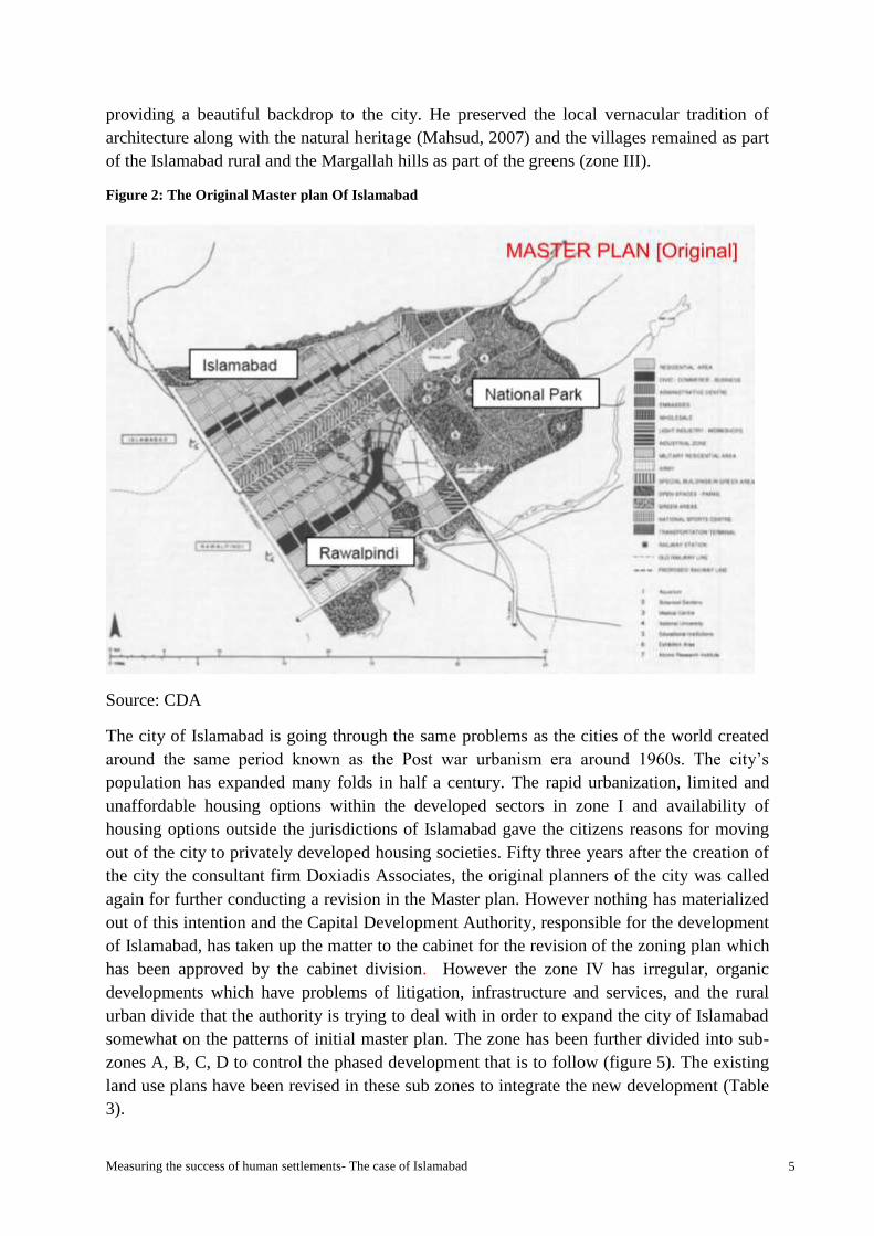
Source: CDA
Figure 1: The Concept of Dynapolis for Islamabad

Measuring the success of human settlements- The case of Islamabad 4
1.2 Problem Statement
The metropolitan area was divided into three distinct areas Islamabad, Rawalpindi and the
national park area to avoid intermingling of functions in the future (Doxiadis, 1960b) ( see
figure 2). The metropolitan plan did not materialize due to several factors and hence
Rawalpindi is not in the scope of the research area. Islamabad and the national park area
which fall under the Capital development Authority area are under consideration. Islamabad
is the federal capital and one of the major cities of Pakistan facing problem due to rapid
urbanization and urbanism. Although the planning of the city has been admired by
practitioners and theorists, for having maintained the urban character as planned for the city,
it is somehow gradually changing. David Derrick, (2008) in his blog “Islamabad and
Doxiadis”, has mentioned that the city of Islamabad was constructed on what now seems to
be rather dated ideas of the world city or Ecumenopolis. The city planning and Doxiadis
’approach has been much admired and mentioned by Toynbee in his travelogues who after
witnessing the change in the condition of Karachi and visiting the new capital Islamabad and
meeting Doxiadis credits him for being his third formal Greek education. The initial plan that
was laid out by Doxiadis in 1959 on the concept of “Dynapolis”, the city of the future, a
research project which was conceived in 1958 and launched in 1960 (Bogdanou,
2003).(figure 1- the concept is explained in section 1.7 the description of the research area).
The city of Islamabad however could be differentiated from a linear city in terms of absence
of size, dynamic in nature and unidirectional growth (Doxiadis, 1968). This idea has been
commended by Stephenson (1970) and Botka (1995) for long term benefit of the city as it
allows for city development according to the need and requirement. (Maria and Imran, 2006,)
The Master plan is being gradually amended as “new forces” (which Doxiadis explained as
the needs pertaining to the human settlements that affect the settlement form, which can be
technological change or any advancement, population growth etc.)(Doxiadis, 1970) and time
has changed the patterns of spatial development. The city has a regular finite pattern and is
defined by sector grids of 2 X 2 km in the developed zone 1. This is in accordance with the
original master plan (figure 2) by Doxiadis, which used the grid of this 2 X 2 km as an
optimum size forming a sector to deal with the problems and use the repetition of the same
sized block to expand the city further as and when required.
This however has been criticized by various writers like Pott (1964) who hoped it would only
be a graphical representation and Mier (1985) who criticized the hierarchical design for its
rigidity. Botka (1995) has admired the wide right of way (ROW) and has labeled it as a
strong identifying feature of Islamabad which is very suitable for a futuristic approach and to
be used as future utility corridors. The city however is claimed not to have achieved the
automobile per capita as planned. Taylor (1967) has also criticized the straight roads and
single story houses for monotonous and costly movements (Maria and Imran, 2006,).
However the under developed sectors of zone II are still following somewhat the grid pattern
but these are gradually changing. The major problem of the changed patterns is observed in
zone IV of Islamabad which is the largest of all zones and was initially intended to provide
backup for the city, with small urban villages and farms. Doxiadis admired the cultural and
natural landscape of Islamabad with these existing small settlements and Margallah hills
Measuring the success of human settlements- The case of Islamabad 5
providing a beautiful backdrop to the city. He preserved the local vernacular tradition of
architecture along with the natural heritage (Mahsud, 2007) and the villages remained as part
of the Islamabad rural and the Margallah hills as part of the greens (zone III).
Figure 2: The Original Master plan Of Islamabad
Source: CDA
The city of Islamabad is going through the same problems as the cities of the world created
around the same period known as the Post war urbanism era around 1960s. The city’s
population has expanded many folds in half a century. The rapid urbanization, limited and
unaffordable housing options within the developed sectors in zone I and availability of
housing options outside the jurisdictions of Islamabad gave the citizens reasons for moving
out of the city to privately developed housing societies. Fifty three years after the creation of
the city the consultant firm Doxiadis Associates, the original planners of the city was called
again for further conducting a revision in the Master plan. However nothing has materialized
out of this intention and the Capital Development Authority, responsible for the development
of Islamabad, has taken up the matter to the cabinet for the revision of the zoning plan which
has been approved by the cabinet division. However the zone IV has irregular, organic
developments which have problems of litigation, infrastructure and services, and the rural
urban divide that the authority is trying to deal with in order to expand the city of Islamabad
somewhat on the patterns of initial master plan. The zone has been further divided into sub-
zones A, B, C, D to control the phased development that is to follow (figure 5). The existing
land use plans have been revised in these sub zones to integrate the new development (Table
3).

Measuring the success of human settlements- The case of Islamabad 6
The land use zoning revision in the zone IV has reasons to accommodate the growing
population as well as the needs of the citizens of Islamabad whereas at the same time will
bring out externalities that may change the outcomes in the larger context of the Dynapolis.
The question here arises how can the contrasting patterns of planned and unplanned be fitted
together to produce a harmony in the spatial structure and eventually produce successful
human settlements as defined by the architect of the city of Islamabad? What future lies
ahead for the city of future?
1.3 Research Objectives
From the above mentioned problem statement the research aims to investigate the different
spatial structures (planned and unplanned) within Islamabad Capital Territory, their evolution
and development through time, to understand their dynamics.
It also investigates the theories, philosophies and influences behind spatial design, their
appropriateness (in terms of functionality) according to the location, concept, values and time
validity. It is important that theories which relate to the spatial designs must be timeless
because if they are time bound they will not work in isolation after the expiration of the
validity period. Hence they need to be adaptable and adjustable according to the changing
needs of time.
The study also aims to look at the problems and issues arising from certain patterns of cities,
and the successes and potentials of the same.
Objective
The objective of the research focuses on the understanding of the urban morphology and the
forces that change the patterns in the city of Islamabad to subsequently measure the success
of human settlements in time and to assess whether we are closer to the sort of
knowledge integration that Doxiadis has advocated.
1.4 Research Questions
This success is achieved when human needs pertaining to the human settlements are satisfied
as defined by Doxiadis. The ideas of the planned and the unplanned human settlements
brought up the following Research question and sub questions which lead to further literature
review:
Main Question
What factors determine the success of human settlement patterns in the context of the
Dynapolis- the city of future- of Islamabad?
The subsequent sub- questions are:
How have the physical, social, economic and political processes and events
influenced the formation and transformation of the planned and unplanned settlements
of Islamabad in time?

Measuring the success of human settlements- The case of Islamabad 7
How do the principles of Ekistics help in evaluating the formation and transformation
of patterns in the planned and the unplanned settlements in time?
Which are the outcomes that are identifiable in the human settlements under
consideration?
Which are the different elements that derive from the analysis that explain the success
factors for both plan and unplanned settlements and how do they score against each
other when compared?
1.5 Significance of the Study
The study is an essential step towards understanding the planned and the unplanned human
settlements, the patterns they have followed and the needs of people which provide a starting
point to understanding how to create a balance between man and the man-made environment
and produce successful human settlements. The case study helps in understanding the
capacity of the Master plan of Islamabad to deal with the needs, problems and issues
pertaining to the human settlements in time.
1.6 Scope and Limitations
The study covers both psychological and sociologic aspects of spatial planning. An
environment shape behavior and vice versa has empirical evidence in behavioral psychology.
The dynamics of spatial structure of cities remains as the main aspect and base for the
research to understand its contribution to the process of management and development. For
that matter two types of spatial structures are researched upon i.e. planned (i.e. according to
Doxiadis design) and unplanned (i.e. not Doxiadis designed and mostly emergent in nature).
This eventually will lead to ascertain the relationship between spatial planning theory and
practice and the extent to which it does or not. However, a correlation may not necessarily
mean causation.
The main aspect of spatial structure (built and natural environment) is looked upon from the
growth patterns and functionality of the human settlements. The research also looks into the
theories and philosophies behind the spatial planning, their appropriateness according to the
location, concept, values and impetus behind the development of the new settlements. Further
research can work on identifying the psychological and sociologic effects of the spatial
structures, the externalities they produce, the problems, issues and the limitations.
However the study only provides a base for policy makers and urban managers and may
provide a base for further deeper study on the cognition and complexity issues and on
developing visions for the areas under consideration. The limitations of the research are due
to time insufficiency to cover the subject in detail and due to the fact that the layout for
research area has not been covered in Islamabad plans (secondary data availability problem)
and only satellite images and observations have been used to identify the physical patterns.

Measuring the success of human settlements- The case of Islamabad 8
1.7 Description of the research area
The case study is conducted in the federal capital Islamabad, the only planned city of
Pakistan. The city was designed on the concept of Dynapolis- ‘City of the future’ (figure 1)
and is one of the largest planned capital cities of Asia of the twentieth century. Doxiadis´
imagined it as a theoretical project of urbanism and it was financed through Ford Foundation
for evolving an operational and design structure for an optimal urban settlement through
using the opportunity created by the new capital project. Ahmed Zaib K. (2009), argues that
Islamabad, besides representing the best illustration of his legacy, gives a view on the course
of 1950s-60s urbanism, specifically, embedded in its making is the transformation of
modernist ideas about the city and the development of the discourse of human settlements
(Mahsud, 2009).
Islamabad has been argued to be a city planned for the future and built for today by J. M.
Frantzeskakis, one of the team members of the initial builders of Islamabad. The city which is
planned for long term is characterized by hierarchical planning for residential, commercial
and also the movement systems (Frantzeskakis, n.d.)
The concept of Dynapolis for the city of Islamabad:
The City of the Future (COF) was the first Research Project launched by Constantinos A.
Doxiadis in 1960. The idea for a research on the future of cities was already conceived as
early as 1958. (Bogdanou, 2003) (The detail of the City of Future concept is covered in detail
in the chapter 2, literature review).
The city of Islamabad which was conceived in 1959 by a Greek architect and planner Dr. C.
A. Doxiadis on principles of Ekistics (the science of human settlements, which is a project of
the city of future) (Doxiadis, 1970) to serve as the federal capital of the country, covers an
area of 906 square kilometers has a population of 1.8 million and density of 1271/ sq.km. The
Islamabad capital territory is divided into eight (8) basic zones: administrative, diplomatic
enclave, residential, educational, industrial, commercial, rural and green areas. It is the seat of
the government and center of all diplomatic activity.
The city of Islamabad was divided into five major zones: Zone I, Zone II, Zone III, Zone IV,
and Zone V (Figure 4 & 5) and land uses were defined for these zones for easy management
and development of the city and at the same time providing the back up for the city for water,
food and other resources. The city was to function as an ecosystem while maintaining the
order in growth and managing the needs of the growing city. The city was thus also to
function as a sustainable city though the idea and the term was not popular when the city was
planned.
1.7.1 Brief history of formation of the planned and unplanned human
settlements in Islamabad
The review of the original master plan and program by Doxiadis associates (1960), the
subsequent revisions of the master plan and reviews are briefly discussed in this section
which has relevance to the study area.

Measuring the success of human settlements- The case of Islamabad 9
Early development phase of Islamabad in 1960 showed some existing clusters of settlements
that were deliberately accommodated by Doxiadis in the new capital development (Figure 3).
The settlements were predominantly villages which were left to grow organically without any
grid framing around them. It was suggested that with the passage of time and based on the
needs, land could be acquired for development and the villages to be preserved as model
villages. This led to the growth of the organic settlements which form the urban villages
throughout Islamabad today especially in the zone III and IV. One such settlement under
consideration is the unplanned human settlement of Bhara Kahu.
Figure 3: Settlements existing at early development phase of Islamabad 1960
Source: CDA
The sector G-6 is the one of the first residential sectors planned and developed in the 1960 in
Islamabad. This sector comprising mostly middle and low income groups was planned on
basis of self-contained human community catering for all socio-economic needs. All the
residential sectors or communities class V consists of four communities (Class IV) called
sub-sectors. The population of residential sectors varies in size, depending upon the income
group involved, the average being of order of twenty to forty thousand inhabitants. For each
sector the centre which remains equidistant from all parts of the sector is planned as a
principal civic and commercial centre with facilities like shops, stores, medical and health
care and facilities, local offices, banks, mosque, cinema etc. (CDA, Master Plan Cell-
Planning Wing, 1987)p.62. Similarly at the core of each subsector or neighbourhood
(community Class III) are also collective facilities like primary school, group of eight small
shops for every day needs, a small tea house and a mosque with small open space for public.
The hierarchical design excludes the through vehicular traffic as far as possible in the
neighbourhoods which facilitates the pedestrian traffic to schools and the shopping areas.
Major government studies, programs and plans for the area since 1960
Various studies mentioned below were undertaken since 1960 and efforts made by the
government for Islamabad that altered the patterns in different parts of the city.
Master plan 1960- DOX-PA 88
Dorsch/Gollwitzer Regional Planning Study of 1973 (the German Study)
CDA Study of Islamabad region- a general strategy for development undertaken by
K.A. Hassan 1971
Measuring the success of human settlements- The case of Islamabad 10
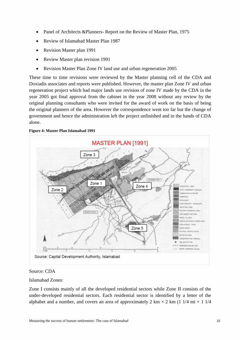
Panel of Architects &Planners- Report on the Review of Master Plan, 1975
Review of Islamabad Master Plan 1987
Revision Master plan 1991
Review Master plan revision 1991
Revision Master Plan Zone IV land use and urban regeneration 2005
These time to time revisions were reviewed by the Master planning cell of the CDA and
Doxiadis associates and reports were published. However, the master plan Zone IV and urban
regeneration project which had major lands use revision of zone IV made by the CDA in the
year 2005 got final approval from the cabinet in the year 2008 without any review by the
original planning consultants who were invited for the award of work on the basis of being
the original planners of the area. However the correspondence went too far but the change of
government and hence the administration left the project unfinished and in the hands of CDA
alone.
Figure 4: Master Plan Islamabad 1991
Source: CDA
Islamabad Zones:
Zone I consists mainly of all the developed residential sectors while Zone II consists of the
under-developed residential sectors. Each residential sector is identified by a letter of the
alphabet and a number, and covers an area of approximately 2 km × 2 km (1 1/4 mi × 1 1/4

Measuring the success of human settlements- The case of Islamabad 11
mi). The sectors are lettered from A to I, and each sector is divided into four numbered sub-
sectors. Zone III consist primarily the green zone with the Margallah Hills and Margallah
Hills National Park. Zone IV and V consist of Islamabad Park, and rural areas of the city.
Figure 5: Master Plan with Zones of Islamabad Present Day
Source: CDA
The zones according to the area allotted have been shown in table 1. The zone IV is the
largest and zone I which is fully developed zone is the second largest. The zone III, the third
largest is primarily the green zone with recreational areas some of which are being considered
to be maintained as the model villages. The small urban villages form a part of the city’s
reality to be maintained and retained as part of the city’s cultural heritage.
Table 1: Summary of area of zones
Source: CDA
ZONE ACRES KILOMETER(square)
I 54,958.25 222.4081
II 9,804.92 39.6791
III 50,393.01 203.9333
IV 69,814.35 282.5287
V 39,029.45 157.9466
Measuring the success of human settlements- The case of Islamabad 12
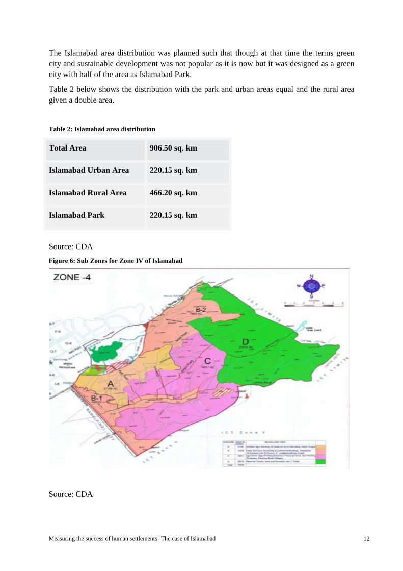
The Islamabad area distribution was planned such that though at that time the terms green
city and sustainable development was not popular as it is now but it was designed as a green
city with half of the area as Islamabad Park.
Table 2 below shows the distribution with the park and urban areas equal and the rural area
given a double area.
Table 2: Islamabad area distribution
Source: CDA
Figure 6: Sub Zones for Zone IV of Islamabad
Source: CDA
Total Area 906.50 sq. km
Islamabad Urban Area 220.15 sq. km
Islamabad Rural Area 466.20 sq. km
Islamabad Park 220.15 sq. km
Measuring the success of human settlements- The case of Islamabad 13
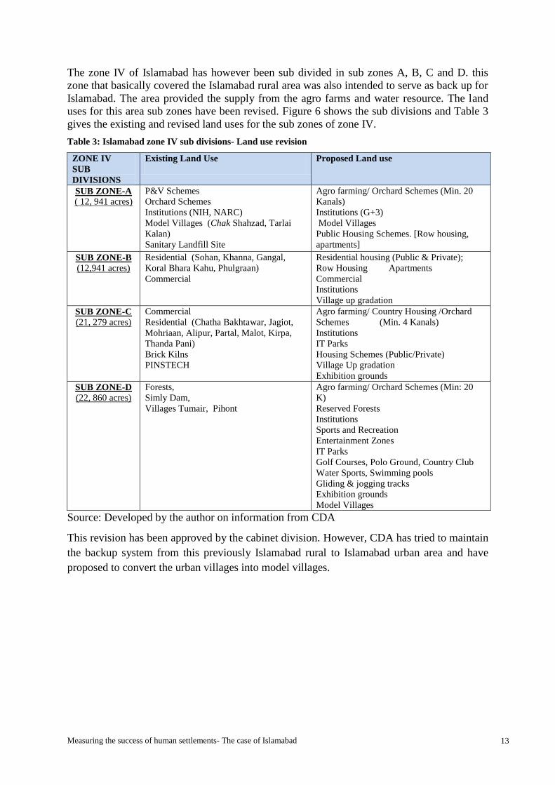
The zone IV of Islamabad has however been sub divided in sub zones A, B, C and D. this
zone that basically covered the Islamabad rural area was also intended to serve as back up for
Islamabad. The area provided the supply from the agro farms and water resource. The land
uses for this area sub zones have been revised. Figure 6 shows the sub divisions and Table 3
gives the existing and revised land uses for the sub zones of zone IV.
Table 3: Islamabad zone IV sub divisions- Land use revision
ZONE IV
SUB
DIVISIONS
Existing Land Use
Proposed Land use
SUB ZONE-A
( 12, 941 acres)
P&V Schemes
Orchard Schemes
Institutions (NIH, NARC)
Model Villages (Chak Shahzad, Tarlai
Kalan)
Sanitary Landfill Site
Agro farming/ Orchard Schemes (Min. 20
Kanals)
Institutions (G+3)
Model Villages
Public Housing Schemes. [Row housing,
apartments]
SUB ZONE-B (12,941 acres)
Residential (Sohan, Khanna, Gangal,
Koral Bhara Kahu, Phulgraan)
Commercial
Residential housing (Public & Private);
Row Housing Apartments
Commercial
Institutions
Village up gradation
SUB ZONE-C
(21, 279 acres)
Commercial
Residential (Chatha Bakhtawar, Jagiot,
Mohriaan, Alipur, Partal, Malot, Kirpa,
Thanda Pani)
Brick Kilns
PINSTECH
Agro farming/ Country Housing /Orchard
Schemes (Min. 4 Kanals)
Institutions
IT Parks
Housing Schemes (Public/Private)
Village Up gradation
Exhibition grounds
SUB ZONE-D
(22, 860 acres)
Forests,
Simly Dam,
Villages Tumair, Pihont
Agro farming/ Orchard Schemes (Min: 20
K)
Reserved Forests
Institutions
Sports and Recreation
Entertainment Zones
IT Parks
Golf Courses, Polo Ground, Country Club
Water Sports, Swimming pools
Gliding & jogging tracks
Exhibition grounds
Model Villages
Source: Developed by the author on information from CDA
This revision has been approved by the cabinet division. However, CDA has tried to maintain
the backup system from this previously Islamabad rural to Islamabad urban area and have
proposed to convert the urban villages into model villages.
Measuring the success of human settlements- The case of Islamabad 14
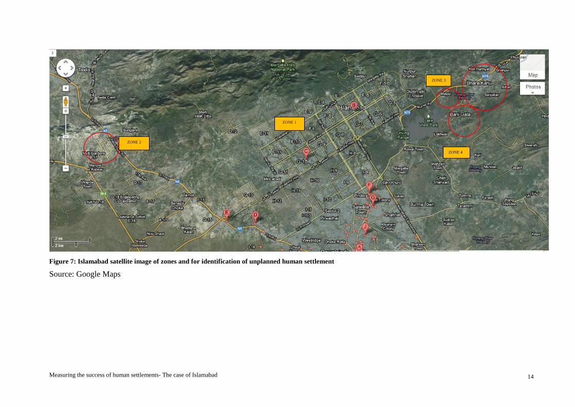
Figure 7: Islamabad satellite image of zones and for identification of unplanned human settlement
Source: Google Maps
ZONE 2
ZONE 4
ZONE 3
ZONE 1

Measuring the success of human settlements- The case of Islamabad 15
The research requires study of an unplanned area which is in total contrast with the Doxiadis
grid iron planned sectors of human settlements. For this purpose the three potential areas
looked from a satellite image appeared from zones II, III and IV. Figure 7 shows the circled
areas which form the potential study area for the unplanned category which do not have a
grid iron plan.
Zone III and IV was categorized by Doxiadis as the national park or the semi urban area of
Islamabad, and was excluded for the capital development site. However, The area having a
variety of landscape features, the Rawal Lake and the rivers Simly, Korang and Soan was
been highly admired for the great potentials as national park site (Doxiadis, 1960b).
Zone IV was planned for having educational institutions, the national university, the national
stadium, the academy of medical sciences, the atomic research institute and all other
institutes related to culture, research or national development. The agricultural areas were
also included in the national park area (Doxiadis, 1960b).
Taking a closer look on the area shows settlements without grid that are in sharp contrast with
the zone I, which has developed sectors in accordance with Doxiadis plan. This area is
characterised by a complex assembly of different components of emergent settlements which
are densely populated and have a terrain and topography that is very undulating.
The first instance of looking at the maps gives the chaos and disorderly impression of the
area. These urban villages have grown and consolidated over a long period of time (some
from even before the formation of Islamabad.
The Bhara Kahu (figure 8) which falls in the sub zone B2 of zone IV of Islamabad, however
is one of the most densely populated out of all four potential study areas initially marked and
is selected for the case study of unplanned human settlement. The area includes residential
colonies of certain organizations like the Pakistan Television, apart from other residential
areas. This area is also characterized by the feudal or the Biradari system.

Measuring the success of human settlements- The case of Islamabad 16
Figure 8: Zoomed in view of Bhara Kahu- Zone IV with the Korang River
Source: Google Earth

Measuring the success of human settlements- The case of Islamabad 17
1.8 Thesis structure
The thesis is structures in five broad sections. The first section covers the introduction to the
research, the problem statement, the objectives of the research, the research questions that
help the objective of the research, the significance of the study and the scope and limitations.
The second part of the report covers the literature reviewed to understand the phenomena
under study and what is already known in the field of planning of human settlements and
what is being explored and debated. In the end a theoretical framework is provided.
The third is related to the research methodology that is adopted to operationalize the concepts
into variables and identify indicators. The section covers the sample selection and data
collection and analysis methods and techniques. The fourth section is the findings and
analysis from the field work. The fifth and final section covers conclusions, lessons learnt and
recommendations for further research.

Measuring the success of human settlements- The case of Islamabad 18
Chapter 2 Theoretical framework
2.1 Introduction
In order to see the development phenomenon of cities, the review starts with the different
perceptions of the cities by researchers whose ideas further lead the study. It also relates to
how the human mind perceives the cities and how it leads to the understanding of the issues
our cities face today and hence their solutions out of this mental construct. The cities are said
to be a product of the human mind (Hillier, 2012) and hence they will be an image of what
values are given importance by the planner or the decision makers. The ideas of researchers
have been seen from the perspective of the latest trends of the twenty first century and the
science of human settlements derived from the ancient times and synthesised with the
sciences known today.
2.1.1 Cities- Perceptions, images and metaphors
Portugali (2011) explains cities as “huge artefacts ever produced by human”, and associates
the planning to be unique characteristic capability of humans alone. This shows the creative
dimension of the human and the city as a product of his creativity.
Marshall (2009, p.1) starts the introduction in his book “Cities design and evolution” by
saying “cities are ultimate human-made habitats, and yet- among all species- it is perhaps
only human who create habitats that are not fit to live in”. He argues cities cannot be seen as
buildings which are more like work of art or as organisms. They are more like an ecosystem
composed of multiple elements that are coevolving.
Doxiadis says we cannot call cities bodies or see them as organisms and calls cities as
biological individuals of higher order (due to their highly complex nature) that need
development of all kinds; social, economic, physical and so on. He acknowledges the multi-
dimensional nature of the subject and says it is difficult to give it a complete picture and a
problem how to present it.
2.1.2 Cities- To plan or not to plan debate
There has been an ever favorite debate on the topic, to plan or not to plan. This topic has
been explored by sociologists, psychologists, environmentalist apart from the built
environment professionals and academicians.
Cities are being increasingly planned and there are numerous cases of planning failures and
several reasons given by different authors like planners’ perception, knowledge, priorities
(Roy, 2009), lack of wisdom, skill and competences (Hamdi, 2004), lack of capacity of the
planning institutions and disparity between actuality and need (Turner, 1992) while some
argue there is no way in which large cities can be planned in detail (Turner, 1992) and prefer
a need to allow spontaneous and incremental development (Hamdi, 2004, Turner, 1992).
Alan Turner (1992) in his article “Urban planning in the developing world: lessons from

Measuring the success of human settlements- The case of Islamabad 19
experience”, mentions cases where practices on account of certain bad planning resulting in
failures has misguided and caused rejection of all planning.
There has been a long debate and questions regarding whether typically planned (Portugali,
2011) (Marshall, 2009) or unplanned sometimes referred to as organic (Portugali, 2011),
spontaneous or emergent, (Hamdi, 2004) spatial developments are the answer to the dilemma
of urban development and management and the growing complexity that urban areas are
facing today with the growing population and pushing boundaries. It intends to inquire what
constitutes spatiality. Spatiality takes different directions as it is a product of ways in which
different things, people and activities are brought together or kept apart (Mooney, Pile, et al.,
1999). The study looks at other arguments that deal with the human factor with his
capabilities, capacity or instincts or to say human behaviour that governs the patterns of
spatial development (Hillier, 2012). The urban development is composed of the process,
approach and outcome. The debate is, what is the right approach to development? What kind
of spatiality is produced and what are the outcomes?
The very existence of the possibility of a science of human settlements is evident by the cities
from ancient times that we admire even today (Doxiadis, 1970). The existence of cities is
taken as an indication of the existence of planning (Portugali, 2011) and it is hence common
to make a distinction between planned and unplanned or organic cities (Portugali, 2011). The
third view, however, is of the possibility of a co-existence as Hamdi Nabeel, (2004) in his
article, Small Change, highlights the importance of both, structures designed and those that
are enabled to emerge and calls for finding a balance between both. His claim is that human
organizations always contain both structures and says that planning must stay within self-
imposed limits. This leads to the question, to what extent should cities and towns be planned
(Marshall, 2009).
To begin with the answer of right or wrong, several texts suggest that there is no one way or
right way. Portugali, (1997, p.376) provides an answer, which is self- organization and terms
it as the 21st century “image” and “cognitive map” with which we closed the doors of the 20
th
century. According to him, limitations of human capacity and capability to plan ahead
involve a lot of complexity and this argument leads to the concept of self-organization
(Portugali, 2011). But how can self-organize patterns be used as an alternative to master
planning? (Marshall, 2011)
However, the study of human behaviour and instincts, the natural and social science relation
to theory, which led to the development of the theory of ekistics by Doxiadis and applied in
urban planning particularly in the context of Islamabad, in 1958 also, forms an important
building block of this research. The principles of ekistics which take into account all the
sciences, (discussed in detail in later text) form a secondary hypothesis for the study. It is
assumed that if the principles of Ekistics are the answer to spatial development as they are
based on the biological characteristics of humans, they should form the basis of all the spatial
developments whether typically planned or unplanned. These principles are assumed to be
timeless because the biological characteristics do not change unlike the society’s cultural and
social values, the meanings and the actions (Allmendinger, 2009) which keep changing with
context and time and hence require the separating of theory from society as it cannot be tested
Measuring the success of human settlements- The case of Islamabad 20
anymore (Allmendinger, 2009). As it is related to human instinct it is presumed to follow in
all the forms of development by the human initiatives though it may differ in organization
and order, which will have many probabilities and hence spatiality arising that takes different
forms and directions. (Mooney, Pile, et al., 1999)
The arguments arrive at a solution that is evolved out of the sociological, biological and
psychological dimensions.
2.1.3 Cities- Arguments in favour and against planning
Marshal, (2011) builds an argument on the statement against the creative production that “a
new modern planned and purpose-built city is not necessarily more attractive, functional or
successful than the other one” and favors the traditionally unplanned environments and
organic urbanism as compared to the modern planned urban environments that are often
perceived to be worse as they are anti-humanistic with “alienating environments, with ugly,
brutal concrete jungles, landscapes of barren tarmac, looming slab blocks and gloomy
undercrofts” (Marshall, 2009).
Believing in the evolution and organic growth of cities, Marshall (2011, p.) says “Cities have
evolved from things that were not cities, and cities will evolve in things this are not cities
too”. He uses the example of beehives to link the evolution and instincts arguments saying,
“one should take a good look at the principles that work in nature, for instance in beehives.
There’s no master planner bee, but the bees will instantly create one or more centers in the
hive themselves. Not because they have to, but because it’s the product of the individual
instincts of all bees involved” (Marshall, 2011). It is this individual instincts argument that
we will use contrary to Marshall’s anti planning argument using the same pretext but for
planning consideration taken by the Ekistics.
The other argument goes in favor of planning as, “There is a need for a science dealing with
human settlements, because otherwise we cannot view these settlements in a reasonable way”
(Doxiadis, 1970).
This brings us to the argument of the features of heterogeneity and homogeneity of cities
being the result of the ways of mixing and meeting of people and activities (Mooney, Pile, et
al., 1999) which principles of ekistics define through human behaviour argument, “that man,
in creating his settlements, obeys general principles and laws whose validity can be
demonstrated. These principles and laws are actually an extension of man's biological
characteristics, and in this respect we are dealing with a biology of larger systems”
(Doxiadis, 1970). This eventually led to the claim that urban plans can be consciously and
rationally produced and socially ordered (Mooney, Pile, et al., 1999). However,
complications follow with variety of perceptions and derivations of order and may even be in
clash with each other or with the existing spatial patterns (Mooney, Pile, et al., 1999).
The admiration of great ancient cities has been evident when writers and researcher start with
the evolution and history of formation of cities. Portugali’s statement of the cities’ existence
as proof of existence of planning, and terming the cities as “artifacts”, admitting the creative
abilities of humans and associating this quality only to humans(Portugali, 2011, Portugali,
Measuring the success of human settlements- The case of Islamabad 21
1997) depict the potential in humans for the planning. Since it is the humans who can do
cognitive planning and at the same time has limitations which according to him brought crisis
of planning and requires “complexity- cognitive approach to planning” (Portugali, 2011).
This is because the city dynamics are a product of and are affected by the behavior of humans
as cognitive planners, so cognitive science is important in consideration of the complexity
theories of the cities and urban models (Portugali, 2011). Yet at the same time the popularity
of the self-organizing concept that emerged out of the complexity science, termed as an
“image” and the limitations of the humans due to this complexity, that he sees the crucial
problems associated with planning.
The land use planning has been mainly rejected because of lack of flexibility to the changing
needs and time, limitations of the humans to forecast the future and the impossibility of total
conquering of urban development (Van den Broeck, 2004, Albrechts, 2004). As a result and
in reaction different ideas ranging from Lindblom’s science of muddling through and self-
organization have emerged.
The planning of cities is much more criticized as functions appear to be fitted in perfect
geometric forms making them rigid and the geometry does not actually satisfying the human
values. Since the beginning the forms of the cities have fluctuated between the geometric
ideas and the organic (Hillier, 2012). Cities cannot be designed in geometry or seen in
geometric forms and encasings like a house or buildings (Marshall, 2009, Lynch, 1981). A
list of objections placed in this regard by Kevin Lynch (1981), says cities cannot be designed
and insists that they should not be designed, as city form is sophisticated and complex like
the structure of human values and the city does not play a noteworthy role in the contentment
of human values which in turn are connected to the relation with the people. He comments on
the human limitation of capability to understand the city, its mechanisms and all the
complexity and how to change it. The city designs rather forms and the physical patterns that
may work in one culture and may even produce predictable effects may not be generalized to
other cultures. However the association of inclination of settlement forms has been apparent
(Lynch, 1981).
Marshall, (2011) argues that instead of planning rigid and finite forms for the cities, energies
should be focused to rather planning forms of intervention that permit the creation of urban
order through distinct constituents and their relationships (Marshall, 2011, Marshall, ).
(Marshall, 2011)
Marshall’s explanation brings us to the reactive evolution of self-organization due to multiple
failures of the strategic spatial planning with reasons largely associated to the government
controlled processes, government’s lack of adaptability to citizens initiatives and meagre or
no chances of civil society’s subtleties and interests (Boonstra and Boelens, 2011). So here
one criticism can be the reactive nature of the emergence of self-organization.
The other argument goes in favor of planning as, “There is a need for a science dealing with
human settlements, because otherwise we cannot view these settlements in a reasonable
way”. (Doxiadis, 1970)
Measuring the success of human settlements- The case of Islamabad 22
Doxiadis (1970, p.8) argues the quality of the cities in terms of a system of movement has
decreased because of the increasing complexity which we have not been able to handle and
reduce like the primitive man managed to do so by simply introducing a high degree of
simplicity.(Doxiadis, 1970)
Hence it is important to understand the basic science that underlies this field so as to produce
cities that can be admired in the future like we have admired the cities of the past.
2.1.4 Cities- The middle path of co-existence
Nabeel Hamdi’s (2004) arguments are the strongest and most convincing in the case of co-
existence. According to him we need a middle path which allows for the development as well
as emergent structures side by side. He insists on the need to understand the natural scales
and limits and the need to think much larger, more strategic and find a balance between both
the planned and the emergent. The importance of the fourth dimension and spontaneity with
the incremental building is as much as the understanding of the systems, networks, people,
places, politics and resources (Hamdi, 2004). This can be seen in the case of Islamabad too as
the planned and the emergent have co-existed and Doxiadis deliberately had accommodated
the emergent in the master plan.
2.2 State of the Art of the Theories/Concepts of the Study
From the above explanation of all the claims and ideas about the planning and against
planning of the cities that literature review and the context of my study provided me with I
explore the spatiality and the study hence deals with the concepts of complexity theory,
cognitive science, emergence, city dynamics, urban morphology and the concept of
Dynapolis- city of future and its planning theory in particular the Ekistics theory.
These concepts and the explanation of these claims as well as the evidence that supports the
explanations or shows that the claim is not true are discussed in detail for each concept.
2.2.1 Urban Emergence and organic cities
The emergence is a concept that comes from the co-evolution, one of the three key features of
the complexity theory (non- linearity, co-evolution and self-organization), which highlights
the influences of systems and sub systems on each other. Urban emergence is favoured by
many who reject the ideas of finite master planning. The argument here is that cities are
growing, moving and altering as a result of the movement and activities of people as
individuals and collectively (Doxiadis, 1968, Portugali, 2011, Marshall, 2009).
2.2.2 Dynapolis- The city of the future (COF)
Background
Myrto Antonopoulou-Bogdanon, (2003), who joined the COF in the very early time of his
career as a member of the research team and became the third project manager in 1965,
highly admires the project and calls it an invaluable idea conceived as a research project in
1958 by Greek architect and planner Constantinos A. Doxiadis and applied in 1960, as an on-

Measuring the success of human settlements- The case of Islamabad 23
going project reviewing and re-adjusting the suppositions and variables unceasingly. The
remarkable feature of the COF is its timelessness because of its validity in all times due to its
continuous updating and revisions of the frame of urbanization reference. This is done
through techniques and consideration of various qualitative and quantitative variables like
time and space factors, population (growth rates, densities, distribution), resources (according
to priority and significance, scarcity), habitable land with consideration of development cost
(climate, topography and drinkable water) and income, and to further refine the predictions
the use of further variables as education, health and so on (Bogdanou, 2003).
The goals, techniques and methodology
The main goals of COF project were to anticipate and put forward future alternative plans
and models for human settlements on a world-wide scale, the scope of which would not be
limited to theoretical sphere but also be used for practical implementation, for any place, any
time with the primary focus being the “ANTHROPOS and his well-being” (Bogdanou, 2003).
Based on these goals of setting probability, the techniques for the COF included inferring the
existing trends and setting the starting points for anticipating the near futures, use of
assumptions for predicting furthest futures in periods or phases of high, medium and low,
while providing the end points, and finally connecting these points with a probable curve.
The application of techniques to the different variables added precision and perfection to the
forecasts for the city of the future.
The on-going use of the discoveries during the project implementation increased the edge for
the future development in countries, e.g. Iran, Pakistan, and Greece.
The case of Islamabad, Pakistan is considered to be a success in the calculations of the
forecasts and their use in city planning as it came out to be exactly as planned (Bogdanou,
2003) .
The fact that modelling and the construction of the project is such that it can be updated at
any given point in time for any of the variables and the cross sections can be checked and
reconfigured or re adjusted with the relative points and curves makes it a timeless technique,
allowing for any momentum of the forecast to be checked even today for comparison
(Bogdanou, 2003, Doxiadis, 1965).
The ideal city of Doxiadis:
Doxiadis being aware of the problems of the cities that are the heritage from the past or are a
product of our own actions, focused and advocated considerations of the past, present and
future of our cities to be better prepared and plan ahead for the future. From here came the
idea of the city of future and the concept of Dynapolis that became the basis for many of his
cities around the globe.
He being a scientist and founder of theory of ekistics and Dynapolis has advocated and was
interested in finding the results of the same. The success of the cities depended on the
knowing the true nature of problems of our cities in the past, at present and the future. The
success is therefore measured in time according to him. Mapping the past, present and future
of our cities and problems becomes relevant for the success of our cities. Todays, failure

Measuring the success of human settlements- The case of Islamabad 24
means the problems becoming graver tomorrow and no longer will stand against the passage
of time (Doxiadis, 1960a)
He gave a formula for categorizing the problems in order to be able to foresee and understand
the requirements of what needs to be dealt with and defined the two categories as:
1. Problems common to all countries and areas of our era, and which will effect most of
our cities in similar ways.
2. Problems of development which only affect, countries, areas and cities which are in
the phase of development, insofar as changes occur in them which have not occurred
up to now. Where they occur such problems are different in nature in developed
countries and cities than in areas now developing and they may present a great variety
of phenomena (Doxiadis, 1960a)
He has credited the problems of our cities largely to three major developments over the years-
the population growth, the “machine” (transport, and modern technology) addition in our
lives, the change in the family setups (breaking up of the large patriarchal families), patterns
of living and socialization etc. which have contributed to the demand pressure for new human
settlements and has affected the size and the primary influence on the quality. The qualitative
effect of socialization has introduced essentials that were not known some time ago.
The units around which the cities are planned are also playing an important role in shaping
the city and the patterns.
The unit for thousands of years used to be the man while later the transport (machine)
replaced the man.
From the city of the past to the city of future:
The cities of the past were built to serve the needs of the past and for social and economic
systems very different from today. However the city of the future is designed by studying the
problems in the past and present in order to be able to deal with the problems that may be
encountered in the future. The city of future requires thought for the unprecedented
population growth, the economies, technology, all types of human communities and their
needs.
Dynapolis- City of the future:
The Dynapolis is described as a dynamic city having potentials of dynamic development as
opposed to the static city of the past and able to develop freely and naturally along a planned
and predetermined course (Doxiadis, 1960a).
The four (planning) principles of Dynapolis that considered important from the conception to
planning and design of city of the future are:
1- Unity of purpose
The first principle of a dynamic city is that it should be wide-ranging and include all social
and economic groups and all types of functions fulfilling all types of needs. It demands that
the project must be satisfactory economically, socially, politically, technically, culturally and
aesthetically. This principle provides an extensive base for provision for all human beings
and not for the privileged group.

Measuring the success of human settlements- The case of Islamabad 25
2- Hierarchy of functions
The second principle is concerned with provision of facilities in a hierarchy from a basic
settlement classification of minor shells (see Table 4 Ekistics Logarithmic Scale) and level
three of basic ekistics unit the dwelling to the second tier of classification the micro
settlements (units smaller than or as small as a traditional town where people achieve
walkable interconnections), and further way up to higher classifications of settlement (Meso
and the Macro settlements)
3- Freedom to develop dynamically-The four dimensions
The third principle of Dynapolis is the freedom to develop dynamically. This principle gives
due importance to the fourth dimension- the time, as compared to the other three dimensions.
Time was considered as an element of design that affects the concept and creation as well as
the physical manifestation. The time and growth rate population has changed tremendously.
The Dynapolis is considered to be a growing and expanding city and hence the forces of
expansion (due to population, new means of transportation, new technology etc.) will affect
the cities much more than the static forces. The time factor is thus considered as an important
element of design that will influence city of the future.
4- Built on various different scales- many masters and many scales
The fourth principle of the Dynapolis is that the city should be built on various scales, which
implies the elements that will determine the basic dimensions and proportions of the city.
This means the units around which cities are planned will increase in scale and time and
hence will affect the dimensions of the city. The earliest unit was the man and hence human
scaled cities, where as the introduction of machine (cars) made the cities to be built around
two scales that is man and cars. Later the cities would be built on three scales with man, car
and aeroplane as the units as the airfield playing major role in the life of the cities and further
four scales with the man, cars, aeroplanes and rocket.
Hierarchical structure of the Dynapolis
The division of the Dynapolis into different sizes was meant to correspond to the different
functions also meant to follow a hierarchy. The structure of the city was thus meant to avoid
muddle and disorder. The functions, buildings, roads, facilities etc. for the Dynapolis
according to Doxiadis were to be designed and built according to their hierarchy of
importance. So, the facilities for a sub-sector would be increased in the sector and further
increased to a higher order in the super sector and so on (Doxiadis, 1960a). Figure 9 shows
the hierarchical structure of the Dynapolis according to the community classes from I-VII and
basic facilities that correspond to the respective community classes which is further explained
in Table 4 also. Figure 10 shows physical hierarchy of communities as designed in the
sectors of Islamabad. Community class V is one sector within the 2 x 2 km grid boundary
with further subdivisions of the sector into subsector that correspond to community class IV
and similarly further down with community class III, II and I. Figure 11 shows the original
layout of concept of neighbourhood with community class III.

Measuring the success of human settlements- The case of Islamabad 26
Figure 9: Hierarchical structure of the Dynapolis
Source: D-GA 318, pg133, DOX-PA 88
Community class VI
Community class VII
Community class IV- Sector
Secondary school, religious
buildings, shopping centre
Community class V- Super
sector
Super market
Community class I-
Play grounds,
neighbourhood
meeting place
Community class II- Larger
Neighbourhood
Gardens, shopping corner
Community class III- Sector
Elementary school, play
grounds
Houses

Measuring the success of human settlements- The case of Islamabad 27
Source: Reproduced diagram by author (Original drawing- Review of Islamabad Master Plan,
1987); Courtesy: MPC- CDA
Figure 11: Neighbourhood concept Original layout plan of subsector G-6- ¼ (community class III)
Source: DOX-PA 168, 1962; Courtesy: CDA Library
The structure, form and size of the Dynapolis- city of the future (COF)
Class I
Class III
Class II
Class IV
Class V
Figure 10: Hierarchy of communities

Measuring the success of human settlements- The case of Islamabad 28
The ideal form of the city of future is considered to be a well-balanced development with
unidirectional movement and also expanding in the other three directions also slowly
incorporating the previous parts of the city.
The community sector forms the basic element and module defining the scale of the
Dynapolis. The sector comprises hundreds or thousands of dwellings (ELS-3), a number of
families and served by one or more types of central functions (elementary or secondary
schools, shopping centres, community centres, places of worship etc.) keeping the focus on
definition of Dynapolis- the city of future is dynamic and not static like the city of the past
and hence cannot be designed without considering an influx from the neighbouring areas and
hence future calculations.
Schematic scale of classification of hierarchical structure (refer to table 4) explains the
functions that correspond to the community class according to their importance from smallest
class I to further up and give a more permanent pattern for the Dynapolis.
Table 4: Dynapolis- distribution of community classes and provision of social and commercial facilities
Community
class
Families Persons Functions and facilities at
various levels
No. of units
per 10,000
inhabitants
I 15-20 75-100 - -
II 60-100 300-500 Kindergarten
Small shop (Kiosk)
-
-
III 300-400 1,500-2,000 Primary school
Local market
Firewood stalls
Local mosque and
Public open space
Tea house
Public toilets
4-5
4-5
4-5
4-5
4-5
2-3
IV 1,200-2,000 6,000-10,000 Secondary school
Food market
Mosque
Community centre
Local administration
Local police post
Tea house
Cinema
Dispensary
Health centre
Public baths
Public laundry
Public toilets
Petrol station
1-2
1
1
1
1
1
1
1
1
1
1
1
1
V 6,000-12,000 30,000-60,000 Mosque
Administrative buildings
Public services
Food market (open)
Shops and offices
Health centre
Theatre and cinema
Library, art gallery
Tea shops, restaurants
Hotel, hostel
-
-
-
-
-
-
-
-
-
-
Measuring the success of human settlements- The case of Islamabad 29
Public baths
Public toilets
-
-
-
VI 30,000-60,000 1,50,000-3,00,000
VII 1,50,000-3,00,000 9,00,000-15,00,000
Source: Table developed by author
Courtesy: Information MPC- CDA, p.63, 1987 provision of social and commercial facilities
in sector (community class V) Source: DOX-PA 90 Communities and Housing
2.2.3 Ekistics theory -The science of human settlements
Background
The Ekistics theory was floated by a Greek architect and urban planner, Constantinos A.
Doxiadis in 1942. The theory which is an off shoot of the Dynapolis- COF project and
evolved and influenced by the complexity theory, biology and the laws of nature, explains the
five principles of the ekistics ( mentioned in later) which are based on man’s biological
characteristics as cities are man-made environments made for the man.
The synopsis provided at the beginning of the article provides a background to the Ekistics
theory, “In order to create the cities of the future, we need to systematically develop a
science of human settlements. This science, termed Ekistics, will take into consideration the
principles man takes into account when building his settlements, as well as the evolution of
human settlements through history in terms of size and quality. The target is to build the city
of optimum size, that is, a city which respects human dimensions. Since there is no point in
resisting development, we should try to accommodate technological evolution and the needs
of man within the same settlement” (Doxiadis, 1970).
The Ekistics consideration of the fourth dimension and the morphogenesis balances the
convergence of the past, present and future in the human settlements and system. Hence it is
capable of dealing with the complexity of resent and future while dealing with the new forces
entering the system. It enables creative coping with the population growth, rapid change and
pressure of large scale high density settlements. Its multi-dimensional approach examines
built forms, interface of time, movements and systems in the built environment. Hence is
adaptable and capable of dealing with the advances in time, making links between different
disciplines.
Ekistics five elements forming a system
While explaining the complexity enshrined in the subject as a third case Doxiadis says, “The
whole range of human settlements, is a very complex system of five elements - nature, man,
society, shells (that is, buildings), and networks. It is a system of natural, social, and man-
made elements which can be seen in many ways - economic, social, political, technological,
and cultural. For this reason only the widest possible view can help us to understand it.”
(Doxiadis, 1970)

Measuring the success of human settlements- The case of Islamabad 30
These five elements have the man as the primary element, while the nature and society form
the secondary and the shells and the networks as the tertiary elements. (Figure 12)
Figure 12: Ekistics- Five elements forming a system
Source: Author
The five principles of Ekistics
According to Doxiadis, (1970, p. 2) “In shaping his settlements, man has always acted in
obedience to five principles”.
These five principles hence form the basis of ekistics, which are:
1. Maximization of man’s potential contacts with the elements of nature (such as water
and trees), with other people, and with the works of man (such as buildings and
roads).
2. Minimization of the effort required for the achievement of man's actual and potential
contacts. He always gives his structures the shape, or selects the route, that requires
the minimum effort.
3. Optimization of man's protective space, which means the selection of such a distance
from other persons, animals, or objects that he can keep his contacts with them (first
principle) without any kind of sensory or psychological discomfort.
4. Optimization of the quality of man's relationship with his environment, which consists
of nature, society, shells (buildings and houses of all sorts), and networks (ranging
from roads to telecommunications). This is the principle that leads to order,
physiological and aesthetic, and that influences architecture and, in many respects, art.
5. Finally, and this is the fifth principle, man organizes his settlements in an attempt to
achieve an optimum synthesis of the other four principles, and this optimization is

Measuring the success of human settlements- The case of Islamabad 31
dependent on time and space, on actual conditions, and on man's ability to create a
synthesis. (Doxiadis, 1970)
Ekistics as a tool to deal with complexity of cities
Doxiadis has explained the Ekistics as the science of human settlements required to deal with
the complexity of the cities as a tool, and has explained the logic behind each principle using
idea of forces entering the game and the value of the fourth dimension.
The idea of forces is coming from the needs of the humans pertaining to settlements that
affect the settlement form. Needs discussed here are generally reflected as the physical,
social and psychological which are explained as essential requirements of the humans relating
to the settlements. These three types of spatial needs are addressed in the principles of
ekistics. This includes elementary need for physical space engaged by people and space for
performing diverse activities and functions including their social needs for interactions and
privacy. The spatial needs of humans have a relation with the patterns of movement, living
and cognitive patterns and this affects the physical form of space and networks.
The multidimensional nature of the subject of human settlements requires a complete and
systematic picture with four dimensions, the importance of which should not be ignored
(Doxiadis, 1965) This fourth dimension consideration remains a very strong point for the
ekistics theory and which implies the theory has determinant nature and futuristic approach.
The biological analogy that underlies the ekistics theory is acknowledged by Doxiadis with a
caution: "There can be no doubt, I think, that human settlements are very complex biological
individuals. Human settlements can be neither cells nor bodies nor organisms. We are,
therefore, entitled to consider them as biological individuals of a higher order than cells or
organisms" (pp.41/42) Doxiadis- book ekistics. .
He terms cities as growing organisms and says they need to satisfy all types of development
whether social, political, aesthetics, economic and so on. The ekistics theory has thus
addressed this by knowledge integrated from various disciplines such as the economics,
social sciences, cultural disciplines, technical discipline, political sciences and the
administration. This has resulted in the theory addressing the complexity that arises from the
various subjects that cannot be separated from the human settlements development. (Figure
13)

Measuring the success of human settlements- The case of Islamabad 32
Figure 13: Ekistics and the sciences directly contributing to it
Source: Adapted from C.A. Doxiadis, Ekistics, 1968, p.55
Ekistics logarithmic scale- ELS
Doxiadis introduced a Logarithmic scale that is composed of 15 ekistics units for explaining
different scales of human settlements. The scale division is such that the basic or the
elementary unit of the scale is the man himself. The units then combine and the collection of
those units according to the population size develops into a hierarchy of the units. Doxiadis’
book Action for human settlements (p. 186, 1976) explains the ideal future ekistics units
which were calculated by him till the year 2100. This is seen as a remarkable work of
Doxiadis in the field of urban development. Table 5 shows the units, their respective
populations and the classification of the settlement.
Doxiadis suggests divisions of an optimal size which can best be dealt with are 2 X 2 km as
this is suitable for pedestrians. This size corresponds with the ideal range for pedestrian
movement which is ten to twelve minutes’ walk.
Table 5: Ekistics Logarithmic scale- ELS
No EKISTIC UNIT NAME POPULATION
SCALE
SETTLEMENT
CLASSIFICATION
4 TYPES
DESCRIPTION
1. Anthropos 1 MINOR SHELLS, Elementary units, man,
room and dwelling 2. Room 2
3. Dwelling 5
4. Dwelling group 40 MICRO-
SETTLEMENTS,
Units smaller than, or as
small as, the traditional
town where people used to
and still do achieve
interconnection by
walking.
5. Small neighbourhood (village) 250
6. Neighbourhood 1,500
7. Small polis (town) 10,000
8. Polis (city) 75,000 MESO-
SETTLEMENTS,
Between the traditional
town and the conurbation
within which one can
commute daily
9. Small metropolis 500,000
10. Metropolis 4 million
11. Small megalopolis/
conurbations
25 million
12. Megalopolis 150 million MACRO-
SETTLEMENTS
From the Megalopolis till
the largest possible
expression of
Ecumenopolis
13. Small eperopolis 750 million
14. Eperopolis 75,00 million
15. Ecumenopolis 50,000 million
EKISTICS THEORY
SOCIAL
SCIENCES
ECONOMICS
CULTURAL
DISCIPLINES
POLITICAL SCIENCE AND
ADMINISTRATION
TECHNICAL
DISCIPLINE

Measuring the success of human settlements- The case of Islamabad 33
Source: Developed by author based on Ekistics grid (Doxiadis, 1968)
2.2.4 CSIR guidelines for human settlement planning and design
The issue of human settlement development was taken up by the department of housing of
the South African CSIR (Council for Scientific and Industrial Research) building and
construction technology in form of the red book (renamed as the guidelines for human
settlement planning and design). The idea of the guidelines was to provide a framework for
settlement making to produce sustainable and vibrant human settlements.
The book considers a “human settlement” as any built environment where people live, work
and play, with the provision that only residential areas and other developments associated
therewith” (CSIR, 2000).
The contrast of the needs or hopes of communities are important to understand in order to
provide the settlements with sufficient and satisfactory services for positive performance in
order to make them a success.
The guidelines suggest that efficiency and habitability of the settlements are related to the
investments in the infrastructure. It promotes the incremental provision and development of
“sustainable and affordable levels of service” (CSIR, 2000)without compromising the
acceptability and functionality.
The scale and the order in the spaces signify the transition in the distribution of public and
private space. The public places according to this document become the points of contacts
with other people.
CSIR (2000) Principles for settlement planning and design
Six Structural principles
1- Principle of reinforcement
This principle provides for unified modes of movement brought together to a single passage
thus generating a range of structural opportunities in addition to providing prospective for
establishment of major activities point at stopping points for all modes.
2- Principle of continuity
Continuity of green space
People are said to function in a combination of landscape which is composed of the natural
and the man-made landscapes hence accessibility to both in their settlements is an essential
need. Continuity of green spaces hence turns out to be a vital element of the human
settlement which promotes ecological diversity in addition to fulfilling an important human
need. Two important points for the green spaces are that;
1- The green space should be productive space. It requires maintenance and has a
significant role to play in the support of the urban systems. The role of the green
space as an important additional source of nutrition and income for the people.
2- The green spaces can absorb outputs from the settlements.

Measuring the success of human settlements- The case of Islamabad 34
Continuity of movement
The principle relates to the patterns of movement, flow and accessibility of all sorts (people,
services etc.) brings dynamism to the network of the settlement. This movement hence
creates an order in the structure according to the degrees of exposure, the accessibility and the
links in the network. The reinforcement of certain areas is created by co-ordination of
different modes thus providing highest accessibility, hence “attracting and creating
opportunities for the clustering of activities”. The activities hence fit in the structural system
of the settlement according to the function, scale and formality etc. creating a land use pattern
which is highly “synergistic” and benefiting each other.
Continuity of built form
The principle relates to the scale dimension of the settlement and says that the conscious
breaking of continuity of the built form is essential to create ease of access to the natural and
man-made landscapes.
Continuity of public space
Public spaces are said to be made as continuous networks with enclosure and definition of the
public space.
3- Principle of discontinuity
The principle promotes breaking of the continuities of the components in the urban system
for certain benefits to the settlements.
Discontinuities of movement
Discontinuities along the major routes (higher-order routes) can create public spaces like
squares and parks which can correspond to greater community. The discontinuity can also be
used for the integration of natural and rural areas into urban landscape. Similarly
discontinuities along the lower-order routes can create an order of privacy and safety by
discouraging through traffic.
Discontinuities of built form
The break in the built form by adding parks or public open spaces enhances the quality of
space while creating variety in the built environment.
4- Principle of externalization
According to this principle the higher-order urban activities and social facilities should be
“externalised” and located along major and more continuous routes of movement. This
ensures the accessibility of the activities and facilities by wider communities and enhances
privacy of the residential areas.
5- Principle of concentration along routes
The principle suggests that the concentration along the routes is diversified as the points of
accessibility along the routes also differ. Hence the most accessible points will have a higher
tendency of concentration of activities and facilities.
6- Principle of accommodating sameness and diversity

Measuring the success of human settlements- The case of Islamabad 35
This principle says accommodation of sameness (homogeneity) and diversity (heterogeneity)
is what forms an important characteristic of successful human settlements. It means diversity
of cultural, economic and appearance. It also relates to the diversity in terms of creation of
different levels of privacy and exposure and hence creates an order in the space.
Four spatial principles
1. Definition of space
By the use of physical elements (manmade and natural) such as walls, plants etc. enclosures
can be created for space demarcation. It can be for the purpose of creating distinction
between private or public or even separation of spaces.
2. Scale
This principle especially corresponds to the human scale aspect of space. It involves
judgement about relationships such as size, distance and height which the humans feel
comfortable with.
3. Flexibility in spatial structures
Flexibility remains an important feature to allow and accommodate unforeseen or
unanticipated demands made over time.
4. Intensity of space use
Intensity of space use does not imply regulation of living conditions; in fact choice of living
environments is enabled in a number of ways which have positive spinoffs.
2.3 The relationship and significance of the various concepts.
The various concepts in the literature review relate to the human settlements making and
hence we see their relationship in the following text.
2.3.1 Morphogenesis, new forces and time
This idea of city’s development being a morphogenetic process and the new forces entering
the system which Doxiadis terms as “game” is also argument that underlies the ekistics city.
He claims that different patterns each of certain character and type evolve as several forces
enter the system but their relationships change from case to case, as a morphogenetic
property. The idea of morphogenesis in the urban development and emergence is also
explained by Portugali (2011) who says that when a planner or policymaker perceives cities
as such, according to Portugali ‘a new type of action in the city, a new type of city planning’
is needed, in order ‘not to control, but to participate’ in urban processes (Portugali, 2011);
(Boonstra and Boelens, 2011). “The outcomes of such processes manifest themselves in
specific urban forms and patterns (morphological or functional), physical growth or the
emergence of new socio-spatial groups as a result of certain geographical settings or
characteristics such as houses, lots and housing blocks (Portugali, 2011).
Measuring the success of human settlements- The case of Islamabad 36
2.3.2 Cognitive science, complexity science and the emergent and organic
cities
Michael Batty (2008) in his editorial “Very complex systems, very hard problems”
emphasises on the need for complexity science to embrace the issues of cognition more
firmly, to explore the notions of adaptation and so on.(Batty, 2008)
Juval Portugali (1997, 2011) has also expressed the need for having a “complexity- cognitive
approach to planning”, as the relation of the cognition of those who inhabit the city and
complexity arising from them is vital to understand for creating a synthesis of the same. So,
the perception and cognitive capability of humans, including the complexity understanding
are more important for dealing with the city planning. (Portugali, 2011)
Juval Portugali (1997) explains how the human brain sees and perceives patterns. The
physical or the material pattern is what he sees and creates a map in his mind. This creation
of map in the mind is the cognition property by which he makes a sense of the physical
world.
2.3.3 Dynapolis/ COF, Ekistics, and the emergent and organic cities
The Dynapolis- the city of future was the project on which hundreds of scientists and
theorists of that time worked. The futuristic project was meant to be timeless and adjustable
while providing a framework for the planners. The ekistics like the COF is a futuristic theory
for human settlements development. The basis in both cases is the man and his well-being.
Since the concepts of COF and Ekistics accommodate the open ended urban change and
allow for adaptability and flexibility it improves the chances of development meeting the
needs of the people with respect to changing times and preferences.
The complexity theory and the cognition science that gave emergent or organic cities
preference comes from the fact that futures are unpredictable and hence the urban change
should be allowed to emerge and grow as organic rather than into a finite design.
However, the open ended theme and the concept of new forces accommodation and
adaptation in time in the COF and the Ekistics show the complexity control and the cognitive
capability of humans that can attain a position of creating a science that is timeless and
address the needs of the man.
2.3.4 The Dynapolis, Principles of Ekistics and the spatial and structural
principles for human settlement planning and design CSIR (2000)
The six structural principles and four spatial principles of CSIR guidelines for human
settlement planning and design (2000) correspond to the five principles of ekistics and relate
to the theory of ekistics closely although the document does not provide any precedence or
acknowledgement of ideas from 1942. Hence the study bears relevance and aids in
understanding the nature of the settlements performance and the success.
According to the document the spatial structure of a human settlement is the outcome of
chemistry between the planned and the unplanned proportions. The concept of Dynapolis the
Measuring the success of human settlements- The case of Islamabad 37
city of the future Islamabad is based on such chemistry where the planned and the unplanned
have certain defined functions for the city to be self-sustainable.
The guidelines for human settlement planning and design (CSIR, 2000) differentiate the
planned and the unplanned or spontaneous settlement with quantitative and qualitative
qualities. The planned mostly necessitates the land use, development and engineering budgets
while the unplanned or spontaneous is mostly a reflection of the people’s preferences and
priorities and hence shape they give over time to the overall development to address their
needs while enriching their lives. While the planned settlements depend and are affected by
technology, levels of budgets and means, the spontaneous are not dependent on these to
function and perform well. However the planned settlement in case of Dynapolis functions on
the principle of sustainable development and has a high regard for the qualitative qualities to
enrich individuals and communal life.
According to CSIR (2000) “settlements are characterised by diversity”. This is based on the
distribution of spaces and the setting of boundaries for distinguishing the private and the
public realms serving miscellaneous people and activities.
The principles of Ekistics correspond to the structural and spatial principles of the CSIR and
help explain the success factors through the performance qualities in human settlements.
Principle 1 of the Ekistics which is maximization of man’s actual and potential contacts
corresponds to the “opportunity generation” quality of the CSIR (2000) for improvement of
personal welfare from spatial conditions in settlements. The settlements are thus seen from
the point of diversity, choices of places, activities and interaction opportunities they offer to
a wider homogenous and heterogeneous community in form of public places, public
institutions that are of utmost importance to the society like places of worship, academic
institutes, markets etc.
Spatial principle 4 of the CSIR, the intensity of space use, provides an indicator for the
frequency of use of the contacts.
Principle 2 of the Ekistics which is minimization of effort in maintaining the contacts
corresponds to the “convenience” and explains the forms of access that are essential in
promoting convenience. It also corresponds to the spatial principle 4 of the CSIR- the
intensity of space use, as one of the positive spin-offs it caters to is its contribution to the
compact environments with contrasts within the structural systems and reduced travelling
time and which aids ease of access. It also corresponds to the spatial principle 2 which is
scale (size, distance and height) as the human scale defined by the Ekistics and the CSIR is
one with which humans are comfortable with. This scale is related to movement patterns and
maximum distance achieved with ease is in ten minutes according to the theory of ekistics.
Principle 3 of the Ekistics which is optimization of protective space corresponds to the
“choice” and “space” factor in the settlements which provide “either-or choices” and relates
to the “degrees of privacy or exposure” ultimately defining the private and the public space.
This principle relates to “physical space” in the settlement, which is defined through the
psychological security. This means attainment of comfort level for the people in the
settlements for living, accessing and performing activities within socio-cultural parameters
Measuring the success of human settlements- The case of Islamabad 38
and norms of the settlements. The corresponding structural principle 6 of the CSIR (2000)
which accommodates homogeneity and heterogeneity relates to the definition of order in the
diversified space. The provision for contact in settlements in desired gradations of social
engagement and independence is what defines the protective space. It also relates to the
physical security by physical ordering of the space which is defined as physical safety
through hierarchy of spaces defining the public, private and transitional spaces and its
relation to the socio-cultural space definition for defining the psychological space definition
(boundaries of comfort zones). A parallel structural principle of CSIR (2000) that aids
protective space optimization is the principle of externalization (Structural Principle 4) which
enhances the privacy of the residential areas thus providing a physical and social protective
space ordering. The principle of discontinuity of the CSIR (2000) (structural principle 3) also
aids in creating different levels of public private space definition.
Principle 4 of the Ekistics which is the optimization of the quality of relationship of man with
his environment and it corresponds to the ideas of quality of place, sensory qualities and to an
extent the choice (CSIR, 2000). This is the principle that leads to order, physiological and
aesthetic, and that influences architecture and, in many respects, art as explained by Doxiadis.
Principle 5 of the Ekistics which is achieving an optimum synthesis of the first four principles
which is dependent on time, space and actual conditions and man’s ability to create synthesis
corresponds to the sustainability in the human settlements which reflects the timeless
qualities. The CSIR (2000) also provides a synthesis of the six structural and four spatial
principles which is important in establishing positive performance of the settlements thereby
leading to success. Spatial principle 3 which is flexibility directly corresponds to this principle
in terms of accommodation of unanticipated demands and changing needs over time which
Doxiadis calls forces.
2.3.5 “Successful Human Settlements” vs. “Positively Performing
Settlements”
The debate of plan or not to plan and the subsequent arguments in favour and against
planning lead to the main focus of the study which was what makes successful human
settlements?
The “success” which is otherwise difficult to define and measure in human settlements here
is restricted to the definitions from the main theme of the study Ekistics- “the science of
human settlements” and supportive document CSIR guidelines.
Doxiadis suggested that human settlements are successful when the needs of humans
pertaining to the human settlements are satisfied and they promote happiness and safety. He
also gave a formula for the needs satisfaction through compliance with the five principles of
Ekistics (Doxiadis, 1970). Hence this explanation is used to explore the indicators of
successful human settlements which are satisfaction of needs, feeling of safety and happiness
in the settlements.
Satisfaction of needs in relation to the principles of Ekistics is hence defined in parameters of
physical needs, the social needs and the psychological needs pertaining to the settlements.

Measuring the success of human settlements- The case of Islamabad 39
The needs in terms of preferences however can change over a period of time and hence
settlements need to be flexible enough to be able to accommodate the changes in time.
Happiness is however a difficult to measure indicator but the quality of relationship which is
the fourth principle of Ekistics is rather explanative of this indicator. Happiness is also taken
as a psychological state of well-being in the settlement and hence leads towards the
contentment and satisfaction of the psychological need. Since happiness can be a conscious
choice and also an automatic response, it may have different meaning to different people
living in different cultures and situations. Hence the principles of ekistics also help to
understand what makes the humans happy in their settlements. Happiness is related to the
cognitive evaluation of state of being in the settlements hence it requires seeking perceptions,
experiences and feelings of humans in relation to their settlements.
Safety is another state of human feeling by which man pursuit’s security and protection
against the physical, social and psychological or other types of conditions. The third principle
of Ekistics corresponds largely to this indicator and explains how much exposure or level of
risk a man is willing to take in his settlement. This is explained through the physical
boundaries that he defines for his protection and privacy sometimes guided by the religious or
social norms of the society. Safety may be perceived in different ways by different people
hence security and level of comfort in relation to their settlements are related concepts that
can be used to inquire people’s state of feeling. According to CSIR (2000), appropriate
design can contribute to crime reduction by ensuring visibility, multifunctional strategic
location of different land uses, well defined outdoor spaces encouraging social interaction
and clear definition of pedestrian routes etc.
Another characteristic of settlement growth which Doxiadis indicates and which may be
related to the success in the human settlements is that the settlements always grow in the
areas of greatest attraction and least resistance (Doxiadis, 1968, Doxiadis, 1970). Here the
attraction can be a meaningful indicator but to what extent the attraction corresponds to the
needs concerning the human settlements? This attraction can be defined by Doxiadis’ claim
of cities behaving as organisms that need to satisfy social, aesthetic and economic and other
needs. Hence attraction can be economic feasibility, social system or unique physical or
sensory qualities (CSIR, 2000) of elements in the settlement whether natural or man-made
that either satisfies the aesthetic needs or the convenience or security etc. that add to the
quality of life of the residents. However attraction too like safety and happiness is largely
dependent on and is differentiated by the perceptions and meanings people give to it.
The positive performance of settlements (CSIR, 2000) can contribute largely to attaining
happiness and satisfaction in the human settlements and hence another indicator and meaning
associated to the success is the performance quality of the human settlements. For this the
CSIR (2000) states three starting points which are seen to correspond with the principles of
Ekistics:
The importance of pedestrian movement which is largely associated with the scale
and hence the location of the contacts with respect to man which provides ease of
access by walking (Principle 2 of Ekistics).

Measuring the success of human settlements- The case of Islamabad 40
The importance of spatiality according to which public space is viewed as “highest
level of social infrastructure” (CSIR, 2000) which affects the quality of relationship
(Principle 4 of Ekistics) and hence the quality of life which in turn can affect the
happiness and satisfaction of people to define success of human settlements.
The third starting point is the minimalist approach to design which means allowing
spontaneity in a human settlement that makes settlements flexible and adaptable to
accommodate the changing needs in time (Doxiadis, 1968)an idea which is the soul of
Ekistics and the COF and corresponds to the fourth dimension of time and forces
entering the game.
The structural principle 6 of the CSIR (2000) defines the “successful human settlements” as
the ones “that reflect diversity in terms of areas of sameness, areas of diversity or mixed-use
development, areas of cultural homogeneity and areas of cultural diversity”(CSIR, 2000).
The continuity of movement (structural principle 2 of the CSIR, 2000), the principle of
externalization (structural principle 4 of the CSIR, 2000) and the principle of concentration
along the routes (structural principle 5 of the CSIR, 2000) creates a system that attracts and
creates opportunities for the clustering of activities works as an ecosystem where each part of
the system supports and benefits the other. This is in accordance with Doxiadis’ idea of
people tending to gravitate in areas of greatest attraction and least resistance and relates to the
importance of location of facilities.
2.4 Conceptual framework
The literature review guided the research in the direction that developed the following
conceptual framework.
The statement given by Hamdi Nabeel (2004) that we need both the planned and the
emergent which supports the actual situation of the Dynapolis of Islamabad, takes the lead in
the following research as there is a need to cater to both in the existing situation of problems
of our cities today and in context of Islamabad too.
Coming to Doxiadis’ (1970) claim of the need to create or have such a science to deal with
the development issue of human settlements and that it actually existed in the past which
Portugali (2011) and Marshall (2009) both have agreed upon, guide the research to finding
the right approach to dealing with the complexity of the situation using the science called
Ekistics, originated by Doxiadis himself in 1942. Does the co-existence as suggested by
Hamdi (2004) and worked in the Master plan of the Dynapolis produce a spatiality that
satisfies human needs (physical, social, psychological, economic etc.) and a spatiality that can
be managed and developed well solving the dilemma of our cities.
The conceptual framework (figure 14), comes from plan or not to plan debate and the idea of
co-existence of the planned and the spontaneous or emergent settlement because of
importance of both, the structures designed and that are enabled to emerge (Hamdi, 2004).
The resulting spatiality may take different forms (Mooney, Pile, et al., 1999) reflecting the
key features that characterize the complexity theory which produces a socially ordered
spatiality, which is the most sought after new image as termed by Portugali (1997) and which

Measuring the success of human settlements- The case of Islamabad 41
is taken as a complex adaptive system referred to as the emerging property of the self-
organization (Boonstra and Boelens, 2011). It also corresponds to the needs of humans. From
the principles of Ekistics given by Doxiadis (more than eighty years ago, which has been
practically used in urban planning in more than 40 countries all over the world, and taking
into account the concepts of complexity, with consideration to changing needs of time), my
assumption of the theory is that being extension of the biological characteristics of humans, it
should form the basis of most of human settlements as it is based on human instincts whether
planned or through ideas of emergence. All the arguments that have focused on emergence
use the metaphors like beehives (Marshall, 2009), and waves all that drive towards the
instincts and complexity due to chance factors (Gerrits, 2012). Hence the pattern of spatiality
may differ due to probability but the urban system arising will be harmonious and stable in
manner. Doxiadis (1970, p.3) talks of "successful human settlements" “that have achieved a
balance between man and his man-made environment, by complying with all five principles
of Ekistics” (Doxiadis, 1970). Hence, whatever the case may be, we see the intermediate
influencing chance factors that add to the complexity of the cities and may affect the
outcomes on the second category of ELS the micro-settlements and further in the larger
context of the third category of ELS the Meso-settlements. The assumption here is that since
the two types of settlements being researched upon belong to the two different categories i.e.
planned and the emergent and form a physical and social reality in the context of Islamabad
(as in many other new towns of the world facing similar problems), they have so far and will
further eventually co-exist according to Nabeel Hamdi’s (2004) idea of co-existence.
For better understanding of the sequence it has been illustrated in figure 14 below.

Measuring the success of human settlements- The case of Islamabad 42
Source: Developed by author
Figure 14: Conceptual Framework-
THE DYNAPOLIS- CITY OF THE FUTURE
EKISTICS THEORY Constantinos A. Doxiadis (1942)
PLANNED AND UNPLANNED
PLANNED vs. UNPLANNED
Van den Broeck (2004)
Albrechts (2004)
Boonstra, Boelens (2011)
Marshall Stephen (2009, 2011)
Juval Portugali (1997, 2011)
Mooney, Pile et al (1999)
Allmendinger (2009)
Alan Turner (1992)
Kevin Lynch (1981)
COEXISTENCE OF BOTH THE PLANNED AND THE
UNPLANNED
Nabeel Hamdi (2004)
Mooney, Pile et al (1999)
FACTORS DETERMINING THE SUCCESS OF HUMAN
SETTLEMENTS
SUCCESSFUL HUMAN SETTLEMENTS CHARACTERISED BY
SATIFACTION OF NEEDS
PROMOTION OF HAPPINESS AND SAFETY
BALANCE BETWEEN MAN AND
ENVIRONMENT
COMPLIANCE WITH THE 5 PRINCIPLES OF
EKISTICS 1. Maximization of man’s potential contacts
2. Minimization of effort for achieving contacts
3. Optimization of protective space- definition of territories
4. Optimization of quality of relationship with environment
(nature, society, shells and networks)
5. Synthesis of the other four principles dependent on time
and space, on actual conditions and man’s ability to create
synthesis.
STARTING
POINT-
THE DEBATE
THE MAIN
THEORY
PREREQUISITE
THE GOAL
OUTCOME
SUCCESSFUL HUMAN SETTLEMENTS

Measuring the success of human settlements- The case of Islamabad 43
Chapter 3: Research Design and Methods
3.1 Research design
This chapter explains the research methods used to answer the research question. It covers the
research question operationalization of the concepts through variables and indicators
identified through the literature. The instruments used, the sample size, the sources and the
approach is further discussed in the section. The chapter is divided into two main parts. The
first is the research design and the second the research methodology.
3.1.1 Approach
The research follows a comparative case study approach as the study tends to seek answers to
the success factors of both spatial structures (planned and unplanned) of human settlements.
It explores and explains the two contrasting spatial structures (planned and unplanned), their
relationship and impacts. For this examples of planned and unplanned human settlements
from Islamabad with similar sizes (equal to the size of one grid-iron planned sector which is
within 2 x 2 km) are studied to explore the wide range of possibilities and factors that affect
the relationship which may or may not be causation.
Literature review and secondary data helped obtain knowledge of the general concepts of
spatial patterns of the planned and the unplanned settlements under consideration and
development they have followed over time for a better understanding of the external forces
acting on the development.
The research type for this study on the basis of objectives is exploratory as it tends to find
the forces and impacts of the spatial patterns on the social, psychological and environmental
(physical and natural) development, and also the impacts of occurrences, incidents or events
in time. It is also explanatory in nature as it explains the relationship between the spatial
material patterns of cities and the cognitive patterns or perceptions. To some extent the study
is descriptive also as it entails all important details of the spatial planning, the physical aspect
and location factor, the history, master plans and the changing scenarios over time due to the
emerging trends and forces acting on the city.
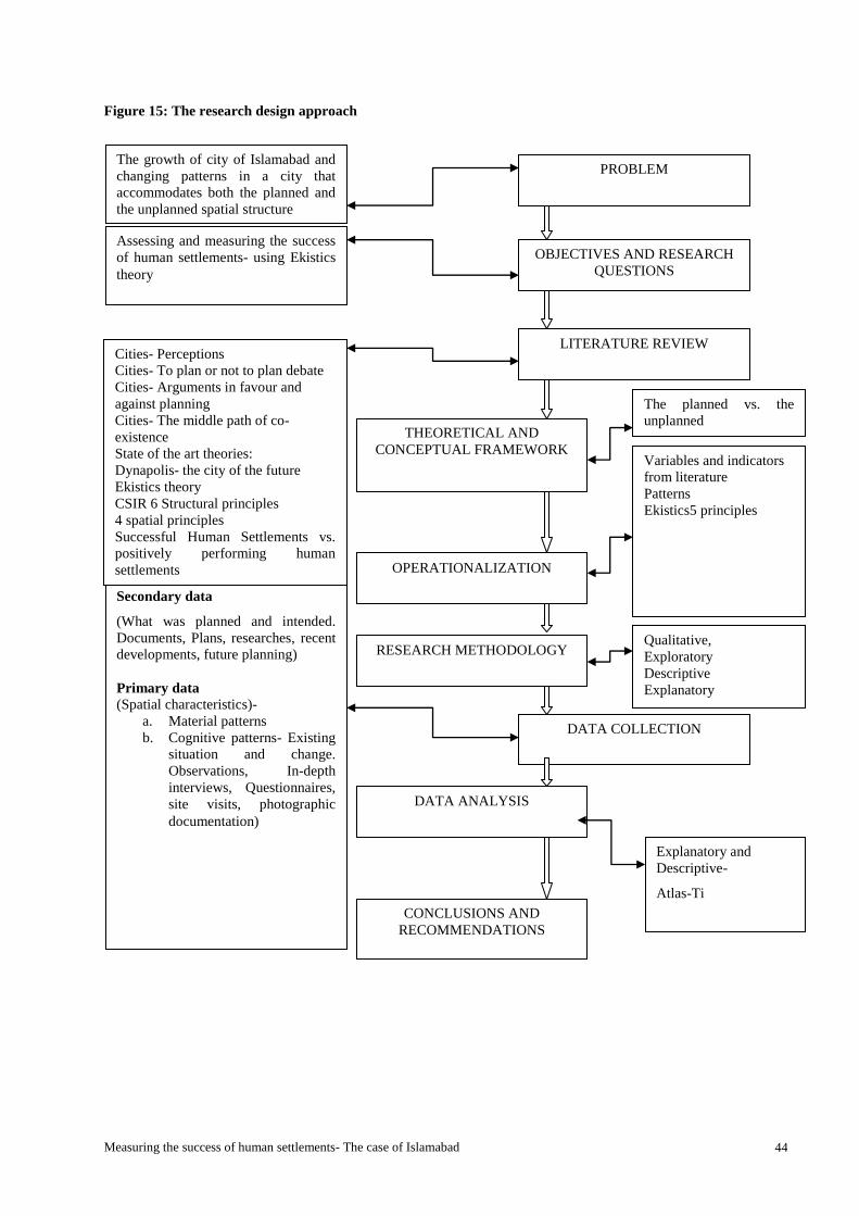
Measuring the success of human settlements- The case of Islamabad 44
Figure 15: The research design approach
RESEARCH METHODOLOGY
OBJECTIVES AND RESEARCH
QUESTIONS
LITERATURE REVIEW
DATA COLLECTION
DATA ANALYSIS
CONCLUSIONS AND
RECOMMENDATIONS
THEORETICAL AND
CONCEPTUAL FRAMEWORK
OPERATIONALIZATION
Variables and indicators
from literature
Patterns
Ekistics5 principles
Secondary data
(What was planned and intended.
Documents, Plans, researches, recent
developments, future planning)
Primary data (Spatial characteristics)-
a. Material patterns
b. Cognitive patterns- Existing
situation and change.
Observations, In-depth
interviews, Questionnaires,
site visits, photographic
documentation)
Cities- Perceptions
Cities- To plan or not to plan debate
Cities- Arguments in favour and
against planning
Cities- The middle path of co-
existence
State of the art theories:
Dynapolis- the city of the future
Ekistics theory
CSIR 6 Structural principles
4 spatial principles
Successful Human Settlements vs.
positively performing human
settlements
PROBLEM The growth of city of Islamabad and
changing patterns in a city that
accommodates both the planned and
the unplanned spatial structure
Assessing and measuring the success
of human settlements- using Ekistics
theory
The planned vs. the
unplanned
Explanatory and
Descriptive-
Atlas-Ti
Qualitative,
Exploratory
Descriptive
Explanatory
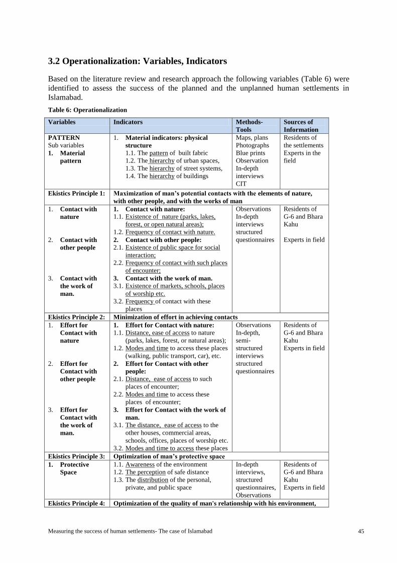
Measuring the success of human settlements- The case of Islamabad 45
3.2 Operationalization: Variables, Indicators
Based on the literature review and research approach the following variables (Table 6) were
identified to assess the success of the planned and the unplanned human settlements in
Islamabad.
Table 6: Operationalization
Variables Indicators Methods-
Tools
Sources of
Information
PATTERN Sub variables
1. Material
pattern
1. Material indicators: physical
structure
1.1. The pattern of built fabric
1.2. The hierarchy of urban spaces,
1.3. The hierarchy of street systems,
1.4. The hierarchy of buildings
Maps, plans
Photographs
Blue prints
Observation
In-depth
interviews
CIT
Residents of
the settlements
Experts in the
field
Ekistics Principle 1: Maximization of man’s potential contacts with the elements of nature,
with other people, and with the works of man
1. Contact with
nature
2. Contact with
other people
3. Contact with
the work of
man.
1. Contact with nature:
1.1. Existence of nature (parks, lakes,
forest, or open natural areas);
1.2. Frequency of contact with nature.
2. Contact with other people: 2.1. Existence of public space for social
interaction;
2.2. Frequency of contact with such places
of encounter;
3. Contact with the work of man.
3.1. Existence of markets, schools, places
of worship etc.
3.2. Frequency of contact with these
places
Observations
In-depth
interviews
structured
questionnaires
Residents of
G-6 and Bhara
Kahu
Experts in field
Ekistics Principle 2: Minimization of effort in achieving contacts
1. Effort for
Contact with
nature
2. Effort for
Contact with
other people
3. Effort for
Contact with
the work of
man.
1. Effort for Contact with nature:
1.1. Distance, ease of access to nature
(parks, lakes, forest, or natural areas);
1.2. Modes and time to access these places
(walking, public transport, car), etc.
2. Effort for Contact with other
people: 2.1. Distance, ease of access to such
places of encounter;
2.2. Modes and time to access these
places of encounter;
3. Effort for Contact with the work of
man.
3.1. The distance, ease of access to the
other houses, commercial areas,
schools, offices, places of worship etc.
3.2. Modes and time to access these places
Observations
In-depth,
semi-
structured
interviews
structured
questionnaires
Residents of
G-6 and Bhara
Kahu
Experts in field
Ekistics Principle 3: Optimization of man’s protective space
1. Protective
Space
1.1. Awareness of the environment
1.2. The perception of safe distance
1.3. The distribution of the personal,
private, and public space
In-depth
interviews,
structured
questionnaires,
Observations
Residents of
G-6 and Bhara
Kahu
Experts in field
Ekistics Principle 4: Optimization of the quality of man's relationship with his environment,
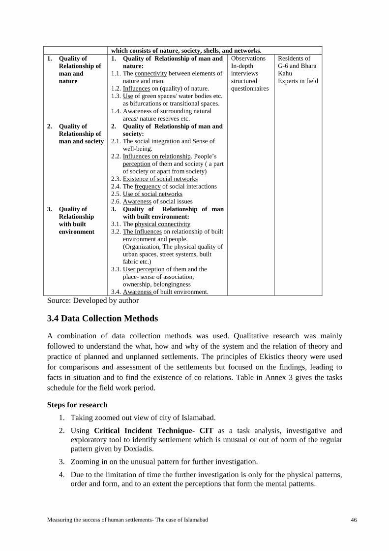
Measuring the success of human settlements- The case of Islamabad 46
which consists of nature, society, shells, and networks.
1. Quality of
Relationship of
man and
nature
2. Quality of
Relationship of
man and society
3. Quality of
Relationship
with built
environment
1. Quality of Relationship of man and
nature:
1.1. The connectivity between elements of
nature and man.
1.2. Influences on (quality) of nature.
1.3. Use of green spaces/ water bodies etc.
as bifurcations or transitional spaces.
1.4. Awareness of surrounding natural
areas/ nature reserves etc.
2. Quality of Relationship of man and
society:
2.1. The social integration and Sense of
well-being.
2.2. Influences on relationship. People’s
perception of them and society ( a part
of society or apart from society)
2.3. Existence of social networks
2.4. The frequency of social interactions
2.5. Use of social networks
2.6. Awareness of social issues
3. Quality of Relationship of man
with built environment: 3.1. The physical connectivity
3.2. The Influences on relationship of built
environment and people.
(Organization, The physical quality of
urban spaces, street systems, built
fabric etc.)
3.3. User perception of them and the
place- sense of association,
ownership, belongingness
3.4. Awareness of built environment.
Observations
In-depth
interviews
structured
questionnaires
Residents of
G-6 and Bhara
Kahu
Experts in field
Source: Developed by author
3.4 Data Collection Methods
A combination of data collection methods was used. Qualitative research was mainly
followed to understand the what, how and why of the system and the relation of theory and
practice of planned and unplanned settlements. The principles of Ekistics theory were used
for comparisons and assessment of the settlements but focused on the findings, leading to
facts in situation and to find the existence of co relations. Table in Annex 3 gives the tasks
schedule for the field work period.
Steps for research
1. Taking zoomed out view of city of Islamabad.
2. Using Critical Incident Technique- CIT as a task analysis, investigative and
exploratory tool to identify settlement which is unusual or out of norm of the regular
pattern given by Doxiadis.
3. Zooming in on the unusual pattern for further investigation.
4. Due to the limitation of time the further investigation is only for the physical patterns,
order and form, and to an extent the perceptions that form the mental patterns.

Measuring the success of human settlements- The case of Islamabad 47
5. Determining the factors responsible for the unusual pattern. Using the CIT as an
investigative and exploratory tool to identify the spatial patterns (material and
cognitive). Performance in usability -oriented context. Usability problems and design
flaws?
Box 1: Critical incident Technique
Source:
3.4.1 Sample Size and Selection
The research population comprises the sector G-6 (planned human settlement of Zone I) and
Bhara Kahu (unplanned human settlement from zone IV sub zone B2) of Islamabad. Ekistics
logarithmic scale (ELS) in Table 4 is used to define the sample size by categorizing and
scale. The population for the research belongs to category two which is the Micro-settlement
and the scale is between ELS 4-7. The population size of the unplanned human settlement of
Bhara Kahu is selected roughly equivalent to one planned sector of zone I in Islamabad and is
visibly in contrast with the grid iron planning of the sectors by Doxiadis. This population is
also being focused for the next phase of development for the expansion of Islamabad. The
land use for this zone has been revised and approved by the cabinet division (refer to Table
3). Considering this intention and looking at the settlement through satellite images using
Google Earth for the contrasting pattern, three potential settlements were identified for the
study: the Malpur in Zone III, Bani gala and Bhara Kahu in zone IV. However, the Bhara
Kahu forms the most potential area for the study.
Sampling is done by two methods. Purposive sampling is used and key informants were
selected for in-depth interviews and discussions. Second is snow ball sampling for interviews
of users. CIT is also intended to be used for cluster sampling for identifying settlements
within settlements with seemingly ordered, seemingly disordered and order within disordered
patterns occurs.
Table 7 shows the resource persons for data collection is composed of researcher, the
planning authority personnel and the residents of both settlements.
Critical Incidents Technique: CIT
The Critical Incidents Technique is a method of gathering facts from users in order to gain
knowledge on how to improve performance on a system or in any work related aspects. The
method takes the form of either (or a combination of) an open ended questionnaire,
retrospective data, Interviews.
The three stages of the CIT are:
Gather facts
Analyze the content
Infer how to improve performance based on the above.
The most important aspect in performing a CIT is to always ask user what lead up to the
event and what happened as a result of the event in order to ascertain ways of avoiding the
event (if negative) in the future.

Measuring the success of human settlements- The case of Islamabad 48
Table 7: Resource persons for data collection
EXPERTS IN
FIELD
RESEARCHERS CAPITAL
DEVELOPMENT
AUTHORITY
RESIDENTS OF G-6 AND
BHARA KAHU
Most relevant to
the area of study
Dr. Ahmed Zaib Khan
Mahsud
Associate Professor
Chair Sustainable Architecture
& Urbanism
Brussels School of
Engineering
Ar. Ali Abdullah (Director
Architecture)
Plnr. Ayub Tariq ( Director
Housing Societies, Planning
Wing)
Area leaders
Residents G-6
Residents Bhara Kahu
Topics for query Islamabad- Doxiadis’ legacy-
Past, present and future. View
of Success of human
settlements.
Mapping changes in patterns-
Original Master plan and
present situation of the
planned and unplanned
settlements-reasons, gaps,
solutions
Success of Dynapolis and
Ekistics with reference to
Islamabad
Future of Dynapolis- the
planned and the unplanned
Changes in patterns- (past,
present and future),
Influencing factors ,
Needs and preferences
pertaining to settlements,
Cultures of both planned and
unplanned settlements- human
behaviour and perceptions
Ekistics principles (assessment
of four principles)
Success (in terms of spatial
needs satisfaction defined by
Ekistics in both human
settlements)
Total sample size 1-Discussion 2- Structured interviews 22 respondents- G-6
24 respondents- Bhara Kahu
Structured questionnaires for
each (planned and unplanned)
settlement.
12 respondents - semi-
structured in-depth interviews
6 in each (planned and
unplanned) settlement
Source: Author
3.4.2 The description of the sample
The respondents were categorized as experts in the field who have been part of Islamabad,
the ekistics and Dynapolis research and development. These people consisted of the
planners, architects from the CDA planning wing and the residents of the case study areas of
G-6 and the Bhara Kahu. Questions for semi structured interviews conducted with the
planning experts (Annex-5) were set according to the theme of the research to measure the
success of the human settlements in Doxiadis Dynapolis.
The residents were studied to evaluate the relationship between the theory and practice and its
implications and relevance in the context. This category is the most relevant in the study to
understand the existing situation and measure the success by finding the satisfaction through
needs fulfilment identified by the theoretical principles of ekistics. This was done by
interactive (semi-structured interviews) (annex-4) and non- interactive communications
(questionnaires) Questions for semi structured interviews conducted with the residents and
questionnaires were set as per variables and indicators for the research.
The general characteristics of the sample:
The sample from users for the questionnaires consisted of 22 residents from the planned
sector of G-6 from zone I and 24 from unplanned settlement of Bhara Kahu from zone IV.
Measuring the success of human settlements- The case of Islamabad 49
The sample of users who were interviewed was six each from the G-6 and Bhara Kahu. The
residents belonged to different socio-economic groups, age groups, education level, tenure of
living in the settlement and gender. The mix and maximum variation was picked to
understand the needs of a heterogeneous community and evaluate the elements considered
important in settlements that promote safety, happiness and satisfaction and ultimately define
success of the human settlements.
3.4.2 Validity and Reliability
External validity is checked through the single embedded case studies which enabled to
discover and generalize the trends and the factors.
The internal validity is checked through triangulation of data to cross check the findings. The
information collected from the residents through in-depth interviews, questionnaires and
observation is validated by cross checking the interpretations, results and findings (primary
data) with key informants composed of experts in the field of planning. Also the secondary
data is used to confirm the findings.
Reliability is checked through the use different instruments and cross checking their validity
through triangulation. The process of research is open and transparent. For this purpose a
database was prepared for all collected data (interviews, questionnaires and observations etc.)
before processing.
3.5 Data Analysis Methods
The research is mainly qualitative (Exploratory, Explanatory and Descriptive in nature) and
makes use of the CIT (Critical Incident Technique) for investigative and exploratory
purposes. The technique is used in this research for the measurement and analysis of spatial
planning. The CIT used mostly communication process (Interactive and Non- interactive) in-
depth interviews and questionnaires, to explore opinions about issues, needs, values,
perceptions, opinions and judgement of patterns, (material and cognitive), to seek information
from the people rather than examining records only, to varying degrees. The CIT is initially
used in this study as the identifying tool for the settlement and focuses on specific incidents
or unusual or outside of norm for quick identification of problem or even opportunity.
The data analysis focused on the derivation of the following:
The forces influencing the transformation of patterns and the extent to which they are
influential
The events or processes that have contributed to the shift in material and cognitive
patterns
The evaluation of the outcomes using the principles of Ekistics and
Potentials, success and problems of the resulting patterns.
The following Table 8 summarises the research methodology and steps taken according to the
four stages:

Measuring the success of human settlements- The case of Islamabad 50
Table 8: Research Methodology
STAGE 1 STAGE 2 STAGE 3 STAGE 4
A. PREVIOUS
CONTEXT: HISTORY/
BACKGROUND
(IMPLEMENTATION
YEAR-1960)
B. MODIFIED
CONTEXT: PRESENT DAY
SITUATION
(CURRENT YEAR- 2013)
C. ANALYSIS THE
TRANSFORMATION
PROCESS
D. FUTURE
EXPECTATIONS LESSONS TO BE
LEARNED FROM
THE
TRANSFORMATION
PROCESS
STEPS TO
BE
TAKEN
A.1. Background and
history of the
development of
Islamabad master plan,
concepts and brief
about the theoretical
background.
A.2. Identification of
settlements in contrast
with the Doxiadis grid
iron planning but
falling within the
jurisdiction of the
master plan of
Islamabad. The
emergent settlements
not seen earlier as a
potential threat and that
evolved alongside the
city development.
A.3. Characterization of
the settlements
identified as per zones
General
characteristics
Physical
characteristics/
patterns
Natural and the
built fabric
Zone regulations
Intended land use
and beneficiaries
Revised land use
and beneficiaries
B.1. Data collection
B.1.1.Secondary data
What was planned and
intended and what is the
existing situation and
problem? (Newspaper
clippings and official
documents)
B.1.2 Primary data
Existing situation of
settlements (the visible
outcomes)
Physical: Site survey,
photographic
documentation of the
area, the physical
patterns, services,
infrastructure, ekistics
unit and level
identification.
Sampling design
• Clusters of ordered in
the seemingly
disordered settlements
• Identification of key
informants
The invisible / softer
outcomes
• Questionnaire
addressed to residents
and
• In-depth interviews
with residents in the
settlements
C.1. Data Analysis:
Explanatory and
Descriptive
C.2. Derivation of the
following:
The Forces
influencing the
transformation of
patterns and the
extent to which
they are influential
The events or
processes that
have contributed
to the shift in
material and
cognitive patterns
The evaluation of
the outcomes
using the
principles of
Ekistics
Potentials, success
and problems of
the same.
D.1. Conclusions and
summary of findings.
D.2. Recommendations
on:
Understanding and
using the
principles of
Ekistics for
predicting the
outcomes in time.
Extending the
scope and use of
Ekistics to cater to
the new forces that
have entered the
game, while
maintaining the
unique character
of the settlements
at micro-
settlement level
and the city at
Meso- settlement
level.
Findings of the
existing needs,
situation,
interpretations and
explanations.
Maintaining the
concept of
“Dynapolis” while
meeting the needs
of today.
Lessons learnt.
METHODS Literature review.
CIT
Secondary data
collection.
Interview of Experts in
the field (Government,
Academics)
Literature review.
Sampling design. CIT,
snowball
Settlement physical survey
Photographic
documentation.
Semi-structured Interview
of key informants
Questionnaires from the
residents
Experts for explanation of
situation
Literature review.
Comparative analysis
Planned Dynapolis vs.
Emergent Dynapolis).
Planned vs. the
unplanned
Literature review.
Source: Author (Adapted from Dr. Alonso Ayala’s Lecture/ Presentation, 2013)

Measuring the success of human settlements- The case of Islamabad 51
Chapter 4: Research Findings and analysis
Introduction
This chapter is divided into three parts: the description of the case study, the research findings
and data analysis regarding the research questions of the study.
The section covers the findings through the data collected in the field (secondary and primary
data- archival records, site visits, interactive and non-interactive communications, and
observations).
4.1 The description of the case study
4.1.1 Physical patterns of the planned and unplanned human settlements
The Islamabad master plan with the grid-iron planned sectors and the National park area
without the grid had functions for the areas were clearly defined by Doxiadis.
The national park area was observed to offer many advantages with a variety of landscape
features thus was proposed to accommodate all national functions such as sports centre,
national university, the national research institutes, the botanical and zoological gardens,
national health centre, exhibition grounds, and such agricultural and farming functions which
are necessary to serve the capital area including a lake formed by the Rawal Dam and
therefore be called semi urban area of Islamabad(CDA, Master Plan Cell- Planning Wing,
1987).
The spatial characteristics of the Sector G-6 (planned human settlement)
The pattern of built fabric
The Sector is divided into four sub sectors like all other sectors. However the sub-sector G-
6/1 is further sub divided into smaller modules of four subsectors G-6-1/1, G-6-1/2, G-6-1/3,
and G-6-1/4. Regardless of the subdivision of the G-6-1 subsector the basic module remains
the same with smaller bazaars and subsector markets with parks, schools, water filtration
plants, mosques etc. located around the central areas of the sub sector.
Figure 16 shows the sector G-6 and division of subsectors while figure 17 shows four
subdivisions (community class III) of one subsector G-6/1 and sub sector G-6/ 4 (community
class IV) with the facilities and road network distribution.

Measuring the success of human settlements- The case of Islamabad 52
Figure 16: Map G-6
Courtesy: CDA
Figure 17: Part plan Sector G-6 showing sub sectors G-6/1 and G-6/4 (community class IV)
Source: Developed by author

Measuring the success of human settlements- The case of Islamabad 53
The hierarchy of urban spaces
Right of way of 115 feet along the Fazl-e-Haq road in the north, 160feet -190feet wide in the
west along the Seventh Avenue, 375 feet along the Khayaban-e-Suharwardi in the south and
475 feet along the Atta Turk Avenue in the east, forms the largest collection of green areas
for the sector. It can be said that the sector is enveloped by the greens that act as transitional
space and buffers the sector while addressing the needs of a wider community for a public
open space. Other than this the sector has an international park the Argentina Park,
community class III, IV and V public parks, mosques, Janazagah and bazaars.
The hierarchy of street systems
The network of the roads and streets of the sectors are hierarchical. The main connection of
the number series is connected by avenues with 95 feet wide roads without meridians.
The network of streets follows a similar hierarchical system with the main connections within
the bigger community sector with double roads as wide as 100 feet (including central
meridian with green belt), single two way 80 feet wide roads (including 15 feet central
meridian/ green belt) reducing to 20 feet wide vehicular and finally the ten feet wide
pedestrian streets within the subsectors.
The hierarchy of buildings
There is a visible hierarchy in the buildings in the sector G-6. The residential buildings which
is the third unit of the Ekistics Logarithmic scale (ELS) and category of minor shells are
divided into government and private houses according to size of the plot. The government
accommodations have a hierarchy visible through the plot size and design of the house
according to the categories corresponding to the grades in government jobs. These are
defined through alphabets A-G2 and distributed in different sub sectors of G-6 (See table 10
for distribution of government and private accommodations in the G-6). The buildings other
than residential which are used by a wider range of community are agglomerated along the
main roads like the Khayaban-e Suharwardi towards the south in I and T centre called
Aabpara or along the Melody market in the markaz (centre) of G-6.
The spatial characteristics of Bhara Kahu (unplanned human settlement)
The pattern of built fabric
An important feature visible in the built fabric is the topography which is revealed by the
winding and sloping road networks and the buildings and landscapes at varying levels in the
Bhara Kahu.
The growth in Zone-IV of the ICT is characterised by uncontrolled and unplanned expansion
which is a result of the multi-ownership system and dual administrative control resulting in
weaker law enforcement. The area has improper and insufficient social facilities such as
2 The government accommodation is characterised by letters A-G, where A type is for grades 1-5 (plot size 20’x
40’) which is the lowest category, B type is for grades 6-9 (plot size 20’x 50’), C type for grades 10-16 (plot size
25’x 40’), D type is for grade 17 (plot size 30’x 80’), E type for grade 18 (plot size 50’x 120’), F type for grade
19 (plot size 70’x 120’)and G type for grade 20 (plot size 70’x 150’). The H type is for grades 21 and 22 which
are the highest grades in the Government of Pakistan but is not present in sector G-6.

Measuring the success of human settlements- The case of Islamabad 54
schools, colleges, hospitals, graveyards, parks and playgrounds. Another problem identified
is the shortage of infrastructure facilities i.e. roads, water supply, sewerage, drainage, etc.
Encroachments on nature reserves like Korang River, forests and buffer areas are a common
feature. The settlements observed in the area are informal and due to lack of monitoring the
area has grown into an uncontrolled and irreparable damage to the city scape as well as the
The hierarchy of urban spaces
The settlement of Bhara Kahu has major concentration of public spaces (markets, commercial
centre, health care, bazaars, banks etc.) in the area along the main corridor of Murree road
and then reducing down to Simly dam road. The facilities reduce further down to the
neighbourhood commercial areas which provide for the residential area around them and
keeping the neighbourhood privacy. The transitional spaces provide a hierarchy for the public
and private in the settlement.
The hierarchy of street systems
The road network in Bhara Kahu does not show a visible order and does not have avenues but
has a distinction very clear in the minds of the locals. The vehicular roads and pedestrian
streets however are defined on different levels with major trunk road as Murree road and
Simly dam road while vehicular link roads from small neighbourhoods connect with the main
roads. The pagdandian and kucha rasta or the trails provide easy access to the pedestrian
traffic to different areas.
The hierarchy of buildings
The hierarchy of residential buildings in Bhara Kahu is evident through various plot size but
not clearly defined as in the sector G-6. The houses are from 5 Marla3, 8 Marla and 10 Marla
for the smaller houses and in kanals4 for the bigger houses. The land which was basically
defined for agro farming is in acres5 and houses of various sizes can be seen in these plots.
The land is further divided into different sizes which are not consistent throughout the area as
they depend on the wishes of the owners.
The buildings like mosques have a hierarchy defined by the Jamia Masjid6 in the main areas
along the Simly dam road and the Murree road and smaller mosques within the
neighbourhoods and streets.
4.2 Presentation of findings in relation to the research question.
The findings regarding the research sub questions 1 and 2 are presented in this section.
3 Marla is local unit of space equal to 225 square feet
4 Kanal is local unit of space equal to 4500 square feet and equal to 20 Marla, 500 square yards
5 Acre is local unit of space equal to 8 kanals
6 Jamia Masjid is bigger mosque (place of worship for Muslims) where special Friday prayers are offered. It has
a house for the prayer leader, a library and a seminary and can be built double story.

Measuring the success of human settlements- The case of Islamabad 55
Sub-question 1- How have the physical, social, economic and political processes and events
influenced the formation and transformation of the planned and unplanned settlements of
Islamabad in time?
4.2.1 Processes and events
The section has tried to look into the minor or major fluctuations in the urban system due to
local instabilities coinciding in time. These involve the physical, social, economic and
political processes and events reported during the research that have had an influence on the
settlements patterns (in physical, social and psychological capacity as these form the
important aspects of the Ekistics principles).
Physical processes:
The physical process that was laid out in 1960 for planned settlement G-6 with planning and
implementation under the supervision of the consultants Doxiadis Associates has been a
major controlling factor in the settlement. Another control factor for the settlement has been
the CDA’s bye-laws, monitoring and the law enforcement.
The physical patterns of the Bhara Kahu settlement that have emerged as organic are a
product of the feudal system, multi-ownership and the land distribution which is also
influenced by the strong patriarchal system. The physical processes which are a product of
freedom exercised by the citizens in taking charge of their own settlement and shaping it as
per their needs, desires and ideas had to be legalized as the authorities could not take control
of the situation. The people have freely planned, divided and used the lands (revised the land
use), according to their needs, individual and sometimes collective preferences.
Social Processes:
The social system or network that evolved in the sector G-6 as a result of different families
brought in to settle together has grown stronger over the years. However the social processes
guided by strong traditional and cultural influences are dominant in the region of zone IV
Bhara Kahu. The biradari system (brotherhood), the wadera system (powerful landowner) is
the dominant factor responsible for the patterns in the area.
Economic processes:
The economic crisis that has affected peoples’ affordability has also affected the settlements
of Bhara Kahu and G-6 Sectors. The non-conforming use of the space in both the settlements
has increased and informal businesses in the residences have increased, causing
encroachments in the area. The land in the Bhara Kahu has been divided into smaller
divisions and the agro farming has been replaced by a more profitable substitute of property
business.
Political processes:
The political processes have a significant impact on the way the city was initially formed
(1960) and later through years has transformed. The ambitions and the intentions of the
leaders in power revealed through the focus on different sectors of development.

Measuring the success of human settlements- The case of Islamabad 56
Figure 18: Yaadgaar Chowk and
Argentina Park Monument of friendship
The ambitious development of the new capital city started by first military President Ayub
Khan, in 1958 the same period as pundit Jawaharlal Lal Nehru in India geared for the
development of Chandigarh. History shows examples of power architecture and the new
towns in case of the newly independent states of India Pakistan reveal power urbanism
whereby the leaders of both the countries wanted to show the cities as symbols of modernity,
strength and progress and a departure from the unpleasant past in which the two countries had
seen war.
The city has seen major changes in the military rules. The Lal masjid built in the 1965 gained
power during the third military rule under general Zia-ul Haq’s regime (1977-1988) who
brought the Islamization and allowed and supported the mosque to strengthen their base
against the soviet war in Afghanistan (1979- 1989) and hence over a period between 1965-
2006 the Lal masjid took over illegally many lands in the name of religion and constructed
mosques and seminaries. Major transformation have occurred in last decade in the rule of
fourth military ruler Gen. Musharraf who focused on improving the economic condition of
the country by bringing foreign direct investments and focused on improving and enhancing
infrastructure for access and improving tourism potential of the city in particular. The
development of the major avenues the 7th
(between sectors series 6 and 7) and 9th
avenues
and the Murree Expressway (Bhara Kahu) has provided ease of access to Murree and other
northern areas touristic spots in the Margallah Hills, which are a product of his political
epoch (1999-2007). However the Lal Masjid operation was also his political agenda which
has affected the transformation in the G-6 sector.
Enriching international political ties with other countries like Argentina resulted in a park
developed by the Government of Argentina with a monument marked as a symbolic
statement of the Pakistan-Argentina friendship for a memorable remembrance (figure 18).
Source: Author (2013)
Quality of place is also explained by the physical imprints made by
symbolic statements such as objects of remembrances that are
accommodated in the place. Two monuments in G-6 Yaadgaar
Chowk, built in 2008 to commemorate the bomb blast victims which
followed a year later of the Lal masjid event. A few yards away is the
Argentina Park with the monument built in 1960 symbolizing
Pakistan-Argentina friendship. The monument at Yaadgaar chowk is
located at a significant location in terms of movement networks and
reminds people of the unfortunate and unpleasant incident five years
ago.
Box 2: Monuments in G-6
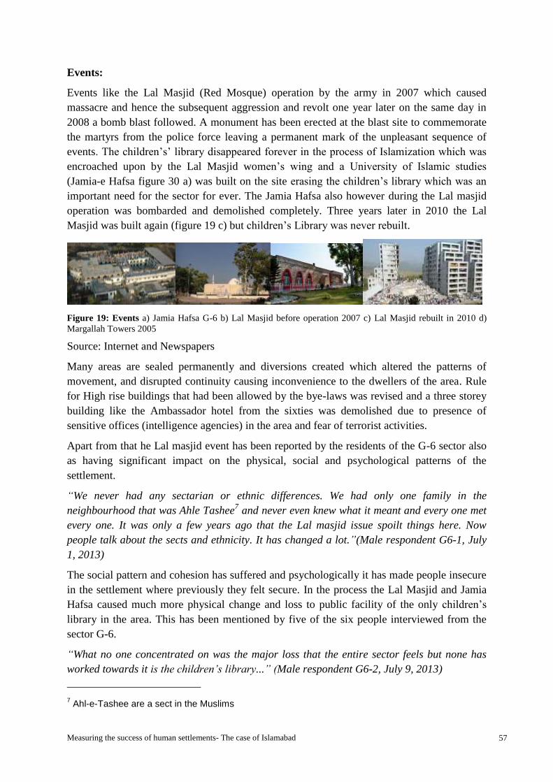
Measuring the success of human settlements- The case of Islamabad 57
Events:
Events like the Lal Masjid (Red Mosque) operation by the army in 2007 which caused
massacre and hence the subsequent aggression and revolt one year later on the same day in
2008 a bomb blast followed. A monument has been erected at the blast site to commemorate
the martyrs from the police force leaving a permanent mark of the unpleasant sequence of
events. The children’s’ library disappeared forever in the process of Islamization which was
encroached upon by the Lal Masjid women’s wing and a University of Islamic studies
(Jamia-e Hafsa figure 30 a) was built on the site erasing the children’s library which was an
important need for the sector for ever. The Jamia Hafsa also however during the Lal masjid
operation was bombarded and demolished completely. Three years later in 2010 the Lal
Masjid was built again (figure 19 c) but children’s Library was never rebuilt.
Figure 19: Events a) Jamia Hafsa G-6 b) Lal Masjid before operation 2007 c) Lal Masjid rebuilt in 2010 d)
Margallah Towers 2005
Source: Internet and Newspapers
Many areas are sealed permanently and diversions created which altered the patterns of
movement, and disrupted continuity causing inconvenience to the dwellers of the area. Rule
for High rise buildings that had been allowed by the bye-laws was revised and a three storey
building like the Ambassador hotel from the sixties was demolished due to presence of
sensitive offices (intelligence agencies) in the area and fear of terrorist activities.
Apart from that he Lal masjid event has been reported by the residents of the G-6 sector also
as having significant impact on the physical, social and psychological patterns of the
settlement.
“We never had any sectarian or ethnic differences. We had only one family in the
neighbourhood that was Ahle Tashee7 and never even knew what it meant and every one met
every one. It was only a few years ago that the Lal masjid issue spoilt things here. Now
people talk about the sects and ethnicity. It has changed a lot.”(Male respondent G6-1, July
1, 2013)
The social pattern and cohesion has suffered and psychologically it has made people insecure
in the settlement where previously they felt secure. In the process the Lal Masjid and Jamia
Hafsa caused much more physical change and loss to public facility of the only children’s
library in the area. This has been mentioned by five of the six people interviewed from the
sector G-6.
“What no one concentrated on was the major loss that the entire sector feels but none has
worked towards it is the children’s library...” (Male respondent G6-2, July 9, 2013)
7 Ahl-e-Tashee are a sect in the Muslims
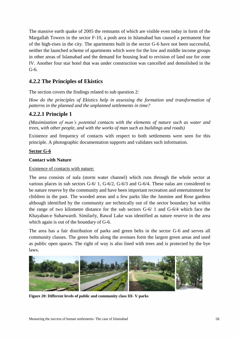
Measuring the success of human settlements- The case of Islamabad 58
The massive earth quake of 2005 the remnants of which are visible even today in form of the
Margallah Towers in the sector F-10, a posh area in Islamabad has caused a permanent fear
of the high-rises in the city. The apartments built in the sector G-6 have not been successful,
neither the launched scheme of apartments which were for the low and middle income groups
in other areas of Islamabad and the demand for housing lead to revision of land use for zone
IV. Another four star hotel that was under construction was cancelled and demolished in the
G-6.
4.2.2 The Principles of Ekistics
The section covers the findings related to sub question 2:
How do the principles of Ekistics help in assessing the formation and transformation of
patterns in the planned and the unplanned settlements in time?
4.2.2.1 Principle 1
(Maximization of man’s potential contacts with the elements of nature such as water and
trees, with other people, and with the works of man such as buildings and roads)
Existence and frequency of contacts with respect to both settlements were seen for this
principle. A photographic documentation supports and validates such information.
Sector G-6
Contact with Nature
Existence of contacts with nature:
The area consists of nala (storm water channel) which runs through the whole sector at
various places in sub sectors G-6/ 1, G-6/2, G-6/3 and G-6/4. These nalas are considered to
be nature reserve by the community and have been important recreation and entertainment for
children in the past. The wooded areas and a few parks like the Jasmine and Rose gardens
although identified by the community are technically out of the sector boundary but within
the range of two kilometre distance for the sub sectors G-6/ 1 and G-6/4 which face the
Khayaban-e Suharwardi. Similarly, Rawal Lake was identified as nature reserve in the area
which again is out of the boundary of G-6.
The area has a fair distribution of parks and green belts in the sector G-6 and serves all
community classes. The green belts along the avenues form the largest green areas and used
as public open spaces. The right of way is also lined with trees and is protected by the bye
laws.
Figure 20: Different levels of public and community class III- V parks

Measuring the success of human settlements- The case of Islamabad 59
a) Garden G-6/4 b) Argentina Park G-6/2 developed in1960s c) community park, G-6- The
shaded street with ROW with mandatory protection of trees protected by law
Source: Author (2013)
Table 9: Distribution of facilities in sector G-6 and its sub sectors
Sector G-6
Contacts
Quantity
existing
2013
Distribution
G-
6/1
G-
6/2
G-
6/3
G-
6/4
Markaz I & T
centre
Housing Units (Government) 3956 2056 1330 90 480 NA NA
Housing Units (Private) 837 338 200 126 173 NA NA
Open spaces, road, parking Y Y Y Y Y Y
Car parking in commercial
area
10 4 3 1 2 Y Y
Organized open spaces/ parks 12 4 2 3 3 Y
Organized open spaces- hubs 73 23 18 11 21
Nature 1 1 2 N
Play grounds 11 4 2 2 3 N N
Incidental open space
Planned Primary institution 9 4 3 1 1 N N
Secondary 5 1 2 1 1 N N
Tertiary /Colleges 2 - 1 1 - N N
Mosques 17 5 5 1 5 1
Janazagah 5 3 1 - 1 N N
Govt. Health institutions 7 4 3 - - N
Bazaars 8 4 3 0 1
Markets 5 1 0 1
Clubs 2 1 - - 1 N
Community centres 1 - - - 1 N
Cinema 1 - - - - 1 N
Food park 1 - - - - 1
Hotel (4 Star) 1 1 N
Restaurants Many Y
GPO/ Post office 5 1 1 - 1 1 Y
GTS 1 - - - - 1 N
Taxi stand 5 1 1 1 1 1 Y
Police station 1 - - - - 1 N

Measuring the success of human settlements- The case of Islamabad 60
Source: Developed by Author
Courtesy: Information CDA
Contact with other people:
Existence of Public space for social interaction:
The sector has a unique planning feature that is much appreciated by the residents of the area
in form of especially designed public spaces of social interaction termed as hubs (figure 21)
shows different hubs in G-6 by the residents. These spaces have been widely used according
to the residents and have provided the option for a much convenient and regular social
interaction (See box 3).
These hubs are located in every street of the sub sectors and after every ten to fifteen houses
depending on the type of house. They are restricted from commercial activity use and sale
purchase and are strictly for the use of the residents only.
Figure 21: The Gossip squares of G- 6- Places of social interaction
Source: Author (2013)
“There are small voids like empty plots in the entire sector. These are very nice places for
social interaction and I have never seen them without people in my whole life….many people
go to parks too….” (Male Respondent G6-1, July 1, 2013)
The residents also identified the other places of social interaction such as the khokay/ Kiosks,
masjid / mosques, courtyards in the bazaar (market community class III) in sub sectors and
Places of social interaction- “Gossip squares” of sector G-6- A feature that is
multipurpose and intensively used by the residents and has been a very productive space
that has developed a culture of enhanced social network providing the community with
an enhanced sense of protection in the area. These squares were, are and always will be a
requirement of this culture and making them a part of a well thought of design of
community space has been much appreciated by the users. These gossip squares are an
integrated social space found in the planning of Baghdad also by Dr. Doxiadis.
Apart from the gossip squares “chai khana” (tea houses) or cafes form an important
part of the G-6 sector as places of social interaction. The cafes (chai khana) were added
as an important need in the center of the sector and sub-sectors. The chai khana in the
covered market was perceived to be one such place of social interaction in the past
which came from an older tradition but with a modern touch for the people of the area in
1960.
Box 3: G- 6 places of social interaction
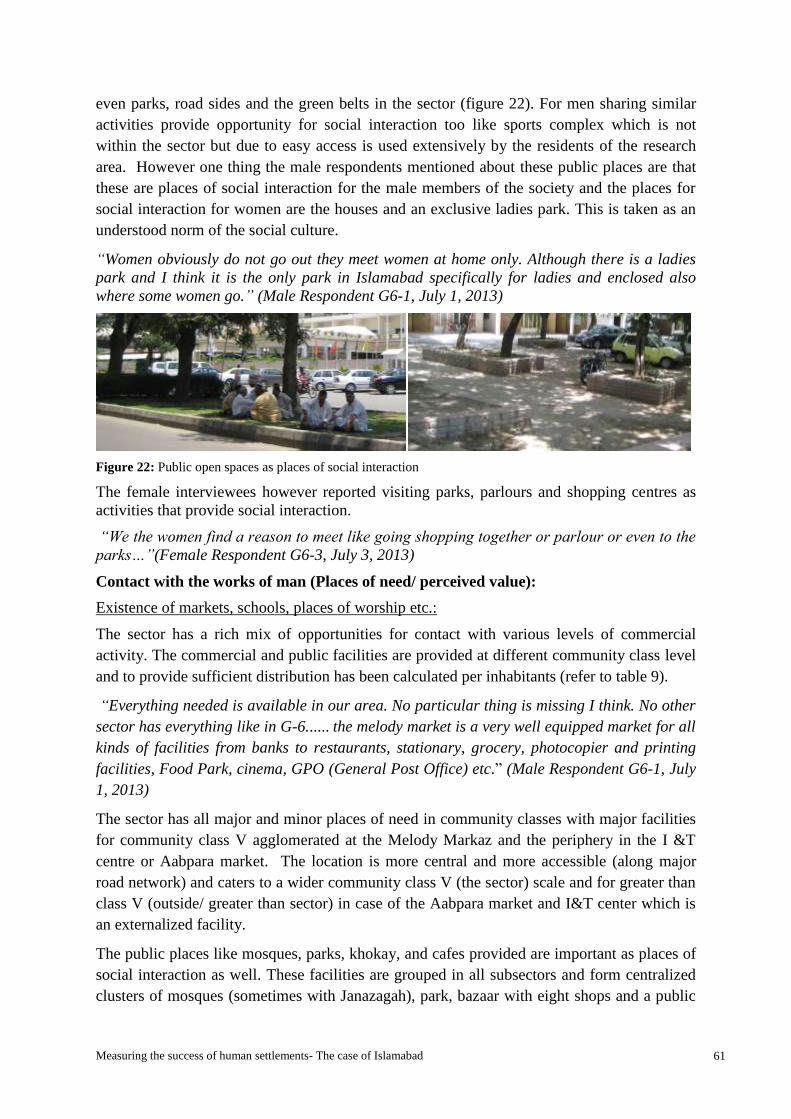
Measuring the success of human settlements- The case of Islamabad 61
even parks, road sides and the green belts in the sector (figure 22). For men sharing similar
activities provide opportunity for social interaction too like sports complex which is not
within the sector but due to easy access is used extensively by the residents of the research
area. However one thing the male respondents mentioned about these public places are that
these are places of social interaction for the male members of the society and the places for
social interaction for women are the houses and an exclusive ladies park. This is taken as an
understood norm of the social culture.
“Women obviously do not go out they meet women at home only. Although there is a ladies
park and I think it is the only park in Islamabad specifically for ladies and enclosed also
where some women go.” (Male Respondent G6-1, July 1, 2013)
Figure 22: Public open spaces as places of social interaction
The female interviewees however reported visiting parks, parlours and shopping centres as
activities that provide social interaction.
“We the women find a reason to meet like going shopping together or parlour or even to the
parks…”(Female Respondent G6-3, July 3, 2013)
Contact with the works of man (Places of need/ perceived value):
Existence of markets, schools, places of worship etc.:
The sector has a rich mix of opportunities for contact with various levels of commercial
activity. The commercial and public facilities are provided at different community class level
and to provide sufficient distribution has been calculated per inhabitants (refer to table 9).
“Everything needed is available in our area. No particular thing is missing I think. No other
sector has everything like in G-6...... the melody market is a very well equipped market for all
kinds of facilities from banks to restaurants, stationary, grocery, photocopier and printing
facilities, Food Park, cinema, GPO (General Post Office) etc.” (Male Respondent G6-1, July
1, 2013)
The sector has all major and minor places of need in community classes with major facilities
for community class V agglomerated at the Melody Markaz and the periphery in the I &T
centre or Aabpara market. The location is more central and more accessible (along major
road network) and caters to a wider community class V (the sector) scale and for greater than
class V (outside/ greater than sector) in case of the Aabpara market and I&T center which is
an externalized facility.
The public places like mosques, parks, khokay, and cafes provided are important as places of
social interaction as well. These facilities are grouped in all subsectors and form centralized
clusters of mosques (sometimes with Janazagah), park, bazaar with eight shops and a public

Measuring the success of human settlements- The case of Islamabad 62
open space with café. Figure 23 shows typical bazaar which is provided in community class
III. The design is typical and followed for all bazaars located in different sub sectors. Pictures
shows Bazaar number 8 currently been used by CDA offices with residential quarters on first
floor accessed from back side. The forecourt provides access with a public open space and
parking space shaded by trees. The purpose of this open space is also to provide a place for
social interaction. The 10’x10’ khokay or kiosks are distributed in the entire sector and
provide for the needs of people in addition to the markets and bazaars in the sector.
Figure 23: Bazaars Community class III
Source: Author (2013)
The different mosques in the area provide for a variety of communal groups and sects in the
sector and also are places of regular social interaction as observed.
Other places of perceived value are the health care facilities like dispensaries and hospitals,
educational and academic institutes, police station, General post office and water filtration
plants (Annex-6) which are also distributed in the sector. The sector has two major
government hospitals- the Capital hospital (Annex-6) and the Federal Government Polyclinic
institute (Annex-6), one of the oldest and best school- the ICB. The markaz has a cinema
which is no more functional.
Figure 24: Different levels of housing units in sub sectors of G-6
Source: Author (2013)
Figure 24 shows the different housing in the sector. The sector consists of government
accommodation which are categorized hierarchically from A- G type (see footnote 2) with
the concentration of A-C types in G-6/1, G-6/2 only, D type in G-6/1, G-6/2 and G-6/4 only,
E type in G-6/2 and G-6/4 only and F type in subsector G-6/3 and G-6/4 only and G type in
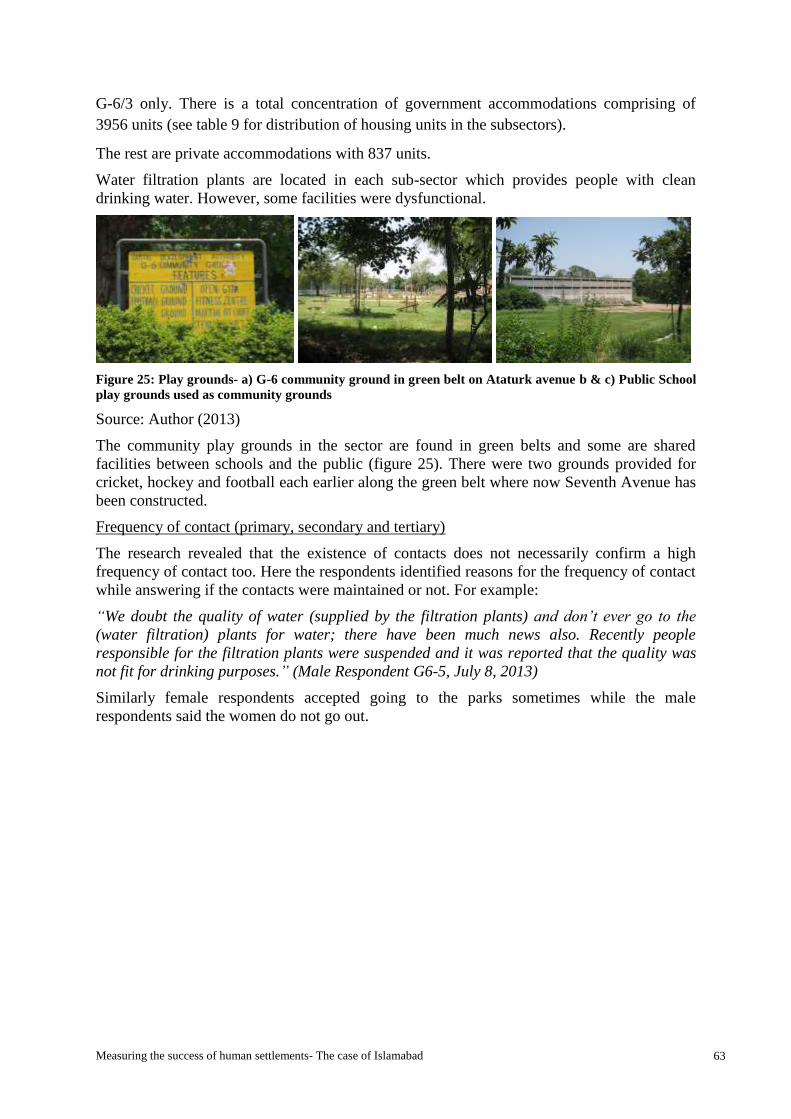
Measuring the success of human settlements- The case of Islamabad 63
G-6/3 only. There is a total concentration of government accommodations comprising of
3956 units (see table 9 for distribution of housing units in the subsectors).
The rest are private accommodations with 837 units.
Water filtration plants are located in each sub-sector which provides people with clean
drinking water. However, some facilities were dysfunctional.
Figure 25: Play grounds- a) G-6 community ground in green belt on Ataturk avenue b & c) Public School
play grounds used as community grounds
Source: Author (2013)
The community play grounds in the sector are found in green belts and some are shared
facilities between schools and the public (figure 25). There were two grounds provided for
cricket, hockey and football each earlier along the green belt where now Seventh Avenue has
been constructed.
Frequency of contact (primary, secondary and tertiary)
The research revealed that the existence of contacts does not necessarily confirm a high
frequency of contact too. Here the respondents identified reasons for the frequency of contact
while answering if the contacts were maintained or not. For example:
“We doubt the quality of water (supplied by the filtration plants) and don’t ever go to the
(water filtration) plants for water; there have been much news also. Recently people
responsible for the filtration plants were suspended and it was reported that the quality was
not fit for drinking purposes.” (Male Respondent G6-5, July 8, 2013)
Similarly female respondents accepted going to the parks sometimes while the male
respondents said the women do not go out.

Measuring the success of human settlements- The case of Islamabad 64
Chart 1: Frequency of contact G-6
Source: Author
Bhara Kahu
Existence of contacts (primary, secondary and tertiary)
The settlement does not have clearly marked plans to show clear signs of availability and
existence of contacts. However, the existence was physically seen in the field through and
observations. These were documented in the form of photographs and interviews as well as
questionnaires.
Contact with Nature:
Existence of nature:
The Zone IV is part of the National Park area that has nature reserves that provide the
Islamabad with an escape from the pressure of the city life. The area has natural springs,
rivers, pasture lands and agro farms that are a unique characteristic of the area. The Korang
River flows through many areas winding along in the Bhara Kahu. Other nature reserves in
the area of high value to the residents and hence highlighted are the Simly dam, Shadra,
Rawal lake and the greenery around in form of open green fields and the mountains
surrounding the area. However the Rawal Lake does not fall in the Bhara Kahu area but has
been mentioned due to close proximity to the lake. Figure 26 shows the views of nature
which is appreciated due to natural form. The Korang River remains a unique identifying
feature for the Bhara Kahu.

Measuring the success of human settlements- The case of Islamabad 65
Figure 26: Nature and views in the Bhara Kahu- a) view of Bhara Kahu before bridge, b) Korang Nala and
the settlement alongside c) open green fields d) Korang River bank
Source: Author 2013
Contact with other people:
Existence of public spaces for social interaction:
Bhara Kahu has a typical regional culture characterised by the biradari system. The area has
“dhabay” (Figure 27, Box 4) along the main roads which are mostly covered by trees and
form favourite and convenient places of social interaction for the “male” locals of the society.
Figure 27: Bhara Kahu- Dhabay- Places of social interaction in a traditional culture
Source: Author (2013)
The old locals of the area living there for generations had a sense of vast areas of land
available for social interaction due to biradari spread over vast area. According to the
respondents the biradari have as many as hundred to three hundred houses in the area.
“We have so many houses we can go anywhere in the area and socialize…..There are about a
group of seven to eight villages of our family/ biradari with 300 houses in the locality
belonging to my biradari (family) ….We have land for farming and that is also a way we
interact.” (Male respondent BK-1, July 8, 2013)
Places of social interaction are plenty for the men but are limited for women and the small
businesses or the houses of relatives and neighbours in the area serve for the purpose of
interaction.
“Men meet just anywhere. There is no problem for the men anywhere in the world. Although
there are no facilities in the area for women and children but women have small businesses
Bhara Kahu Places of social interaction- “Dhabay”
or small roadside restaurants where people chit chat
while enjoying traditional huqqah (smoking pipe) on
charpai (hand woven beds) mostly under thatched or
corrugated sheet roofs or under shades of trees. This
is a common culture and has been replicated in the
modern culture with cafes or chai khana (Tea House)
which serve the sheesha (Smoking pipe with water
and flavored coal) in similar environment and are the
most popular places of social interaction for youth.
Box 4: Bhara Kahu- Places of social interaction
Measuring the success of human settlements- The case of Islamabad 66
like someone has opened a parlour and some sell clothes etc. so that gives us a reason to visit
them frequently. (Female Respondent BK-4, July 8, 2013)
Contact with the work of man
Existence of markets, schools, places of worship etc.:
The major public facilities like the commercial area, markets, mosques, academic/
educational institutes, healthcare, police station, are concentrated along the main roads
(Murree road and Simly dam road). The area has arrangement for weekly market on
Wednesdays (Budh bazaar) which is a subsidized open market (Annex 6).
However, some public facilities that serve large numbers but are characterised by a lower
degree of public space in terms they correspond to certain communities are located in the
neighbourhood’s central places and streets like private schools, clinics and mosques. Smaller
markets are also located in the neighbourhoods with parchoon and rashan centres (utility
stores).
Another facility pointed out by key person in the area is the availability of facilities at the
doorstep in form of rerhi walay (push cart) and sabzi or phul walay (vegetable and fruit
sellers).
“Everything is there. Mosques, schools, markets, hotel everything is here”. (Male respondent
BK-1, July 8, 2013)
“Lately all famous stores, bakeries, banks, super markets, chemists etc. have been added to
Bhara Kahu in the main commercial area on the Murree road. This is a great facility for the
residents here so we do not need to go to Islamabad for the same. Mosques are situated in
all areas in Bhara Kahu. A very big park at the Rawal lake is situated close by. The quality
educational institutions like Bahria College on the main Simly road and the international
Islamic university on Murree road are in addition to the government schools and other
private schools in the houses. The hospitals and clinics are on the main Murree road as well
as the neighbourhoods…… Most needs are fulfilled in the neighbourhood shops and rest in
the main commercial area along the Murree road and the Simly road.” (Male respondent
BK-2, July 5, 2013)
Frequency of contact
The frequency of contact

Measuring the success of human settlements- The case of Islamabad 67
Chart 2: Frequency of contact Bhara Kahu
Source: Author
4.2.2.2 Principle 2
Minimization of the effort required for the achievement of man's actual and potential
contacts. He always gives his structures the shape, or selects the route, that requires the
minimum effort.
The distances, ease of access, modes and time to access the contacts were seen for this
principle in G-6 and Bhara Kahu.
Sector G-6
Effort for contact with nature:
Distance, ease of access, modes and time to access nature:
The avenue runs between 175 feet wide green belts on either side which are also used as
extensions of the greens provided within the sectors and the sub sectors. These greens are
accessible as they fall within the two kilometre boundary of the sector. The parks are also
falling within half a kilometre for the community class III, and maximum of one kilometre
for the community class IV. However, other identified areas of nature by the respondents like
the wooded area and Rose and Jasmine gardens also fall within easy access of two kilometres
range for people residing in subsectors G-6/1 and G-6/4. The Rawal Lake however is farther
away but due to preference of use and easy accessibility with transport is considered contact.

Measuring the success of human settlements- The case of Islamabad 68
Figure 28: Sector G-6 Access and connectivity- Seventh Avenue from a bridge connecting sectors G-7 and G-
6 leading to main Saddar road running at centre of G-6
Source: Author (2013)
The survey showed the residents of G-6 mostly accessed the parks within the sector by
walking. It is only by choice that they use private transport for accessing the parks within the
neighborhood. Out of six interviewees all accepted the easy access to all parks and green
areas (including green belts) within the sector by walking which takes a maximum time of ten
minutes. However the respondents also mentioned Rose and Jasmine gardens which are
outside sector to be within walkable distance but due to increased traffic on the avenues in
between they preferred using public or private transport now which takes ten minutes.
“The jungles near the rose and jasmine gardens and the Rawal Lake are nearest natural
areas….Mostly we access it by car which takes around ten minutes” (Male Respondent G6-1,
July 1, 2013)
Effort for contact with other people:
Distance, ease of access, modes and time to access places of social interaction:
The G-6 sector has voids designed specially as community space for social interaction and
this turns out to be multiple use space, for gatherings at different occasions like weddings,
funerals, play area and evening gatherings. These spaces or hubs created especially for the
residents have been used by all age male members of the society. These hubs termed as the
“gossip squares” after every ten to fifteen houses (Mahsud, 2010) are used extensively even
today after fifty three years and have replaced the generation of users.
“The hubs are in all streets and even the khokay and parks are within five minutes walking
distance…. People walk to these places unless they want to use the facilities of some other
sub sector.” (Respondent 1, July 1, 2013)
“…I mostly prefer meeting my friends at my friend’s khoka and since all the people in the
neighbourhood buy small daily items like eggs and bread from there as it is at walking
distance for everyone in our locality we get to say hello to them also.” (Male Respondent G6-
5, male, July 8, 2013)
All the points of interaction (parks, mosques, gossip square, green areas, khokay (kiosks) are
located at very comfortable walking distance within ten minutes.
Effort for contact with the work of man:
Distance, ease of access, modes and time to access works of man:

Measuring the success of human settlements- The case of Islamabad 69
The infrastructure in the sector G-6 is hierarchical with the avenues providing connection
between 6 and 7 series on one side and 5 and 6 series on the other. Figure 28 shows the
Seventh Avenue built in year 2007. These avenues are part of Doxiadis plan which were not
implemented as in the 1960 it was thought they were not needed. The ease of accessibility is
provided by van stops at various locations in the sector and pedestrian, motor bike and
bicycle bridge connecting the G-6 and G-7 sectors.
The field survey showed all major and minor contacts within the sector for example
commercial areas, markets, mosques, academic institutes, healthcare, water filtration plants to
be at an easy accessible walking distance and this was affirmed by the respondents. People,
who rely on access to free filtered drinking water, access the water plants located in each
subsector within half to one kilometer that provides citizens clean drinking water by walking
or even in private transport. Play grounds and parks are located in each subsector and fall
within half to one kilometer walking distance. People access these facilities by walking. The
markaz called Melody market is located at approximately one kilometer from the external
boundary of the sector, hence easily accessible by walk for the residents of all subsectors.
“Melody market is more convenient as it is in the centre ….Other than this there are
cooperative markets called the bazaars in the each subsector which are the closest and the
most convenient like within two to five minutes walking distance….” (Male Respondent G6-1,
July 1, 2013)
Other smaller bazaars or mini markets are available at the central locations of the subsectors
approximately half a kilometer distance at the most at two minutes walking distance. Apart
from this there are small kiosks located in the sub sectors, and the informal rerhis (stalls and
carts), which provide sufficient and convenient facilities.
Mosques are located with every mini market or bazaar of the sub sector apart from other
mosques in the streets and major mosques like the Lal masjid (red mosque).
The sector has been planned on a 2 X 2 kilometer grid which allows easy access to people to
all the public places within the sector. People reported they mostly walked to the places
within the subsector as they were usually at shorter distances within two to three minutes’
walk but sometimes used private transport to go to the markaz or I &T center and the
Aabpara market although the maximum time to access by walking is within ten minutes.
The survey showed the residents of G-6 mostly accessed the parks, schools, mosques,
markets and places of social interaction by walking. It is only by choice that they use private
transport for contacts within the neighborhood. Out of six interviewees all accepted the easy
access to all places of need by walking.
“Everything is near here and everyone can walk up to whatever one would need…..We
mostly walk to the bazaars as the distances are too short to go there in the car.” (Male
Respondent G6-1, July 1, 2013)
Bhara Kahu
Effort for contact with nature:
Distance, ease of access modes and time to access nature:

Measuring the success of human settlements- The case of Islamabad 70
The people who do not own a transport mostly either walk using the pagdandian8 (trails) or
use the public transport inform of the Suzuki pickup easily available in the area. The people
who own transport had a different point of view and the distance seemed to be shorter for
them for even Islamabad and thus preferred visiting parks in zone I and even lake in zone III.
Effort for contact with other people:
Distance, ease of access, modes and time to access places of social interaction:
The places of social interaction for the male members of the society dhabay are located along
the main routes on the Simly dam road and are easily accessible by walk. Family homes and
land are also venues for social interaction within the settlement. The social interaction for
women takes place within an easy distance of a few streets within the neighbourhood.
“…women have small businesses like someone has opened a parlour and some sell clothes
etc. so that gives us a reason to visit them frequently. It is just within our own mohalla/
neighbourhood and mostly two three streets around.”(Female respondent 4, July 8, 2013)
People mostly walk to the places of social interaction in the neighborhood like the dhabay
and the women also walk to the places which are within ten minutes walking distance.
Effort for contact with the work of man (Places):
Distance, ease of access, modes and time to access works of man:
The main commercial area has markets, banks, health care, academic institutes, mosques and
stretches far along the Murree road and Simly dam road is within two to three kilometers and
is easily accessible with public and private transport. However the commercial area has
“Dispensaries and hospitals are there but we use the government facility that doesn’t charge.
There is a hospital from the health directorate very far away in Bhara Kahu. This is within
two kilometres distance”. (Male respondent BK-1, July 8, 2013)
The modes of transport commonly available in the area and used are public transport in form
of Suzuki pick up vans. The people with private transport use it to commute to the markets in
the main commercial areas, banks, healthcare (Murree road and Simly dam road). For the
smaller markets or bazaars mostly in the neighborhood people walk to the places.
“If I need to go to the market I use the shops close by which I can walk to like within two
three minutes. The men in my family like my son or father go to the main commercial area for
shopping mostly.”(Female respondent 4, July 8, 2013)
4.2.2.3 Principle 3
(Optimization of man's protective space, which means the selection of such a distance from
other persons, animals, or objects that he can keep his contacts with them (first principle)
without any kind of sensory or psychological discomfort)
8 Pagdandian are local system of trails providing interconnection usually through the neighbourhoods
for shorter distances

Measuring the success of human settlements- The case of Islamabad 71
This principle required measurement of perceptions of safety for which awareness with the
environment, perception of safe distance for self and for other members of the family and the
distribution of private and public space were seen for G-6 and Bhara Kahu.
Sector G-6
Awareness of the environment
Four out of six people interviewed for this research are old residents of the sector, some even
born and brought up here. The fact that they have lived here for so long and went to schools
and shared activities in the same neighborhood, their awareness and sense of security is
increased many folds. The awareness of the neighborhood physically and people is what
defines their protective space in the neighborhood. For example a respondent reported:
“We have lived here for the past four to five decades. We know the place and the people.
There was nothing to be afraid of. Even the neighbours would watch children and report if
something needed attention. But yes over past few years new people have moved in and
maybe we are more careful now.” (Respondent 2, G-6, July 9, 2013)
Another respondent reported in a similar manner,
“I have been brought up here and am very comfortable in this area. We know many people
and all places. I think if one knows his surroundings well it makes them feel secure.”
(Respondent 5, G-6, July 8, 2013)
The survey also revealed that the awareness of the environment and social network provided
a much more reliable concept of protective space and reduced reliance on surveillance or
security institutions. The sharing of responsibility of protection is another feature identified.
“There is no special surveillance system but people know each other and apart from that if
they have watchmen they also keep an eye on suspicious activity”. (Respondent 1, G-6, July
1, 2013)
“We don’t have surveillance but we have not even felt the need”. (Respondent 2, G-6, July 9,
2013)
However informal surveillance availability is also reported in the area in form of chowkidaar9
and is appreciated as it provides a psychological relief to the residents.
“There is a chowkidaar coming every night around midnight and whistles while going on
cycle. He crosses every street whistling and that man is paid Rs10- 20 by each house. He is
hired by nobody but people pay him because his whistle is a great relief that someone is out
there watching.” (Respondent 2, G-6, July 9, 2013)
The awareness is also transferred to new settlers in the area by (social networks) people who
already know the surroundings and thus the experiences of safety. Similarly it is observed
that moving around independently and in company makes differences in the space perception.
In an interview with a private hostel warden her observations of the new comers to the area
and their safety perception is recorded as:
9 Chowkidaar: watchman
Measuring the success of human settlements- The case of Islamabad 72
“These girls are very bold and when they come and make friends here they take them and
introduce them to the places like the tailors etc. since they mostly go out in groups they do
not fear neither do I.” (Female Respondent 4, July 10, 2013)
Many respondents have pointed out the feeling of safety in groups including female
respondents.
“We used to walk to the school and were never accompanied by our parents. All children in
the streets in our neighbourhood were friends and used to walk together to school.” (Female
Respondent 3, G-6, July 3, 2013)
The perception of safe distance for self and other members of the family
The following statements are from female respondents who being aware of the social issue of
harassment have a strategy for dealing with the situation in order to protect themselves.
“Knowing the girls belong to hostel is always a problem. There are harassment cases too.
But the girls need to take care of themselves and not attract people too.” (Female Respondent
4, G-6, July 10, 2013)
“For women of course things are a bit different in our culture. But knowing the environment
one takes care of how to dress when going out and I never had problems earlier or even now
but still there is some difference.” (Respondent 3, G-6, July 3, 2013)
The solution to this is also seen in the settlement and also identified by the residents
themselves. Provision of facilities exclusively for the user group which has otherwise limited
options available is a solution for example the provision of Ladies Park in the G-6 sector.
“Women obviously do not go out they meet women at home only. Although there is a ladies
park and I think it is the only park in Islamabad specifically for ladies and enclosed also
where some women go.” (Respondent 1 G-6, July 1, 2013)
A female respondent also pointed this out,
“We have a ladies park here which is more comfortable to go to. Other parks are open and
then men come and stare at the women which make them uncomfortable.” (Respondent 3 G-
6, July 3, 2013)
The distribution of the personal, private, and public space
The sector has facilitated the users/ residents in definition of the private and public space with
the existing hierarchical distribution of spaces. Another feature of the distribution of space is
the social parameters for the gender and age by accepted norms of the masses in the society.
The hierarchy and the grid have provided physical security and safety.
“See when there are straight roads I know there is no one hiding as I would feel in an area
with haphazard or curvilinear roads. That is one big factor that is generating that feeling of
safety here….. Crime is negligible and we feel safe here” (Male Respondent 1, July 1, 2013)
“Crime is almost negligible here.” (Male Respondent 2, July 9, 2013)
Measuring the success of human settlements- The case of Islamabad 73
“You must have noticed there are houses which don’t even have a boundary wall and open
directly into the streets. And even some houses here that have some open space inside don’t
even have a boundary wall they just have a hedge”. (Male Respondent 1, July 1, 2013)
“…..my brother has children and we are really careful that they don’t go far if they are
playing outdoors they have to be in front of the house where they can be watched…”(female
Respondent 3,G-6, July 3, 2013)
It is apparent that people visual contact of the area aids feeling of security.
Bhara Kahu
Awareness of the environment
The respondents were mostly aware of the environment and the safety issues but somehow
hesitated and resisted volunteering information on the subject. The survey through open
ended questionnaires revealed complete reluctance on answering questions regarding
experiencing or even knowledge of issues related to harassment, drugs, and use of arms in the
area. The majority answered with vague statements like “police is there to take care of such
things”, “police is there to take care of such things” and “we will report it to police”.
However, after the recent (August 9, 2013) incident of terrorist attack on a mosque, the media
revealed the police to be irresponsive in the case and people showed discontent with the
security in the area. However two of the interviewees who were not locals of the area
revealed the sensitivity regarding the subject and said it was an unspoken but accepted
culture. The use of ammunition and naswaar10
(a kind of drug) is a common thing in the
locality.
“People here as in the locals mostly all have ammunition with them. It is a common feature
or say it is the culture here. A friend of mine was visiting me and took me to his friend’s farm
house also in Bhara Kahu. The host as a gesture of hospitality said let’s make you enjoy
firing and gave us guns to fire in the air. It was surprising as no one in the area is bothered
by such acts. It is considered chivalry to be able to have a good shot and they use firing as an
indication of celebration too… The pathans in the area use “naswaar” which is easily
available here. There are dacoits also in the area but they do not bother the locals. All these
are a matter of routine for the locals here who have been living through generations here.”
(Male respondent 2, July 5, 2013)
“..I have heard about groups of dacoits residing in the area and have heard gun shots quite a
few times. But I don’t know about drugs although there is a trend of using naswaar a lot
which is also a type of nasha/ addiction…. This is one thing that is not very comfortable for
me as my friends and cousin are also not very comfortable visiting me and have often
mentioned if God forbid something happens nobody can reach in time. For this they have
criticised my choice of living here a lot. As far as the question of feeling safe and secure is
concerned the place is not at all considered safe for females living alone like me but I guess
10
Naswaar is an intoxicant, addictive drug prepared with tobacco, mud and cannabis plant leaves ground together.

Measuring the success of human settlements- The case of Islamabad 74
I’m very bold, have lived here on my own and feel quite safe because of the background I
have.”(Female respondent 3, July 5, 2013)
It was also reported that cases of non-criminal nature were resolved through the area leader
called “Saalsi” who was most respectable in the neighbourhood and his verdict was obeyed.
“There is much stronger social backup system in the area even more than in urban area.
Urban areas have police station. In this area people go to saalsi first. If two groups had a
fight, even in marriages they are dealt with at this level. Saalsi has a baithak11
an upgraded
panchayat system12
who resolve issues through the informal court system but this is obeyed
and accepted by a vast majority and is backed by the area SHO. From the basic problems
starting within the house, whether marital problem, social problems, shops or land and street
fights, etc. all non-criminal act issues. There is no conflict or doubt about this system which
is very authentic and known fact.”(Male respondent 2, July 5, 2013)
The awareness of the local culture in terms of norms related to image and parameters for
women is one more thing defining the comfort level in the females.
“Although I do not really care or get bothered by it but it is a fact that the people of this area
have a different mentality. They see a working woman and a woman who drives alone
differently. This is something typical of our people in smaller towns so I understand and know
the culture.” (Female respondent 3, July 5, 2013)
The perception of safe distance for self and for other members of the family
The locality of Bhara Kahu mostly consists of large biradari spreading over a hundred to
three hundred houses in the area. The perception of safe distance and scale hence spreads to
the limits of the biradari for the locals of the area. The people although have a vast area
which they consider safe but have a protective space defined by the male dominating system
for the females of the biradari like in the G-6 sector. Local’s perception of safe distance for
self and family and need for surveillance was explained as:
“Oh yes our area is very safe. It is our own village why would we not feel safe...There is no
system of chowkidaar and we do not need one. We trust our Lord and leave it to Him… The
children know the area and the people and the people also know us so there is no problem.
The children go to school on their own and play in the streets or lands...” (Male respondent
1, July 8, 2013)
However, the perception of safe distance is different for the people who are not the locals and
they defined the boundaries of safe distance for the members of the family mostly the women
and children. One female respondent (interviewee) reported that she felt safe in the area
though they were not the locals but since her children grew in the area the safe distance
extended to the boundaries of the neighbourhood.
11
Baithak is a place for social interaction usually for meeting male members. It a kind of a drawing room normally with a direct entrance from outside to avoid interaction with females.
12 Panchayat is local system of court
Measuring the success of human settlements- The case of Islamabad 75
“I feel safe there is no problem in our area. We have been living here for the past nineteen
years and never encountered any problems… and feel I can survive alone also here…. Our
gates remain open we have never felt the need for surveillance… They (my children) have
grown up here so they have always been comfortable in the area and can go anywhere. In
fact they used to fetch groceries also for the home since they were young....” (Female
respondent 4, July 8, 2013)
People who are not locals have reported absence of system of surveillance in the area and
mostly have hired chowkidaar or staff for protection on personal level who do not perceive
safe distance beyond their dwelling. A female respondent though had a safety perception for
herself however defined the safe distance for her child to be within a close range with her.
“I have a full time servant for my safety that belongs to my hometown…. I would never let my
daughter out of sight. Letting her out in the neighbourhood is out of question. Even though I
have a full time maid hired especially for her…. and I even take her to my work
place.”(Female respondent 3, July 5, 2013)
A male respondent who is not a local and has been living in the settlement for the past eight
years had a similar perception about safety for the locals and his family and said;
“..Everyone is responsible for their own safety…Safety for children of the locals is much
more as they can go far away to different neighbourhoods by themselves. But the new
residents who have migrated from some other area, their children do not go far may be not
even out…..We do not let our son out alone. If most then just to the shops along the same
road but not even that too often… I do not have any problem with moving around but would
not be comfortable with my wife or son moving in the area by them. You will hardly see
women in the markets or moving around...” (Male respondent 2, July 5, 2013)
The distribution of the personal, private, and public space
The people have defined and distributed the private and public space according to the norms
prevailing in the feudal culture in the area. The private space however extends to the large
family area occupied in the settlement. This area is defined as the private space and
“allowable” space/ area for social interaction for the females of the family too. The comfort
level for children (male) however extends beyond the houses and they like any male member
of the family can access comfortably the broader neighbourhood. The private comfort space
is protected by walls higher than regular five feet height for privacy from public (roadside)
and neighbours who do not belong to the same biradari.
In response to question on safety “Do you feel safe and secure in your settlement?” which
was asked through questionnaires from both the settlements 91 % from the G-6 said they felt
safe in their neighbourhood. While 75% from Bhara Kahu replied they felt safe. None of the
respondents from G-6 said they did not feel safe. However 25 % from Bhara Kahu said they
did not feel safe in the settlement and these mostly were non-locals. Table 10 and chart 3
below give an overview of the findings from survey of both the settlements.

Measuring the success of human settlements- The case of Islamabad 76
Table 10: Feeling of safety in the settlement
Feeling of safety in settlement Sector G-6 % Bhara Kahu %
Yes 20 91 18 75
Neutral 1 5 0 0
No 0 0 6 25
Chart 3: Feeling of safety for the residents within G-6 and Bhara Kahu
Source: Aurthor 2013
4.2.2.4 Principle 4
(Optimization of the quality of man's relationship with his environment, which consists of
nature, society, shells (buildings and houses of all sorts), and networks ranging from roads to
telecommunications)
The quality of relationship for this principle was seen through the connectivity (physical,
social and psychological), the influences and uses of contacts etc.
Sector G-6
Quality of relationship of man and nature
The connectivity between elements of nature and man:
The nature which is mostly planned and cultivated now in the sector G-6 is all appreciated,
admired by the residents and protected by the Capital Development Authority’s Environment
Directorate. The neighbourhood at all levels (community classes) have green spaces available
and green belts and right of way is also used as extension of the private green space.
Influences:

Measuring the success of human settlements- The case of Islamabad 77
Nature has been the most appreciated feature of Islamabad. The sector has well distributed
greens with parks and 300-400 feet wide green belts that are used as an extension of the
greens outside the basic unit. The area has shaded streets with oldest trees in the
neighbourhood that have been preserved by the strict regulations of the CDA.
“The natural woods have reduced while the cultivated have increased but whatever the case
may be Islamabad is known for the greens.” (Male Respondent 1, July 1, 2013)
“The wide green belts along the avenues are also a source of pleasure to the eyes. I feel
refreshed and this is why I go hiking in the trails on the Margallah hills.” (Male Respondent
2, July 9, 2013)
Use of green spaces, water bodies etc.:
The wider green belts along the outer boundary of the sector towards the Seventh Avenue and
the Atta-Turk avenue are used as buffers and social public areas and have also improved the
micro climate of the area. The older houses (with allowed boundary walls) have green hedges
as the boundary walls. Houses that do not have boundary walls with doors opening directly
on streets use hedges as green screens and creating semi-public and semi-private areas.
Figure 29: Influences- Use of nature
“There was a storm water stream which we used to call a spring and play in that sometimes
in the summers even catch fish in it….. The nalay used to be clean once….the green belts also
serve as parks for many people and you will see a lot of people on the green belts spending
evenings and enjoying the weather or beating the heat along the seventh avenue and the Atta
Turk avenue or the Khayaban-e-Suharwardi” (Male Respondent 1, July 1, 2013)
The greens of Islamabad in general are a unique lasting impression of the city which people
are conscious of and consciously choose to have a physical and visual contact with the nature.
There is a conscious effort to protect the greens of the developed sectors and the conservation
has been appreciated and respected widely.
“The view of Margallah is the best view from almost all areas of the city” (Male respondent
5, July 8, 2013)
“The city is known for the greens and if the natural woods are reduced to create place for
development then new greens are also being added…. The best thing about living in
Islamabad is the nature whether natural or developed. View of the Margallah is what people
want to have wherever they live…”.” (Male Respondent 2, July 9, 2013)
Quality of relationship of man and society

Measuring the success of human settlements- The case of Islamabad 78
Social integration and the sense of well-being:
The social networks in the G-6 sector vary with the sub sector and neighborhood. But one
thing common in all subsectors is the social interaction parameters defined for women of the
area.
The value of social networks in providing a sense of security and support has been reflected
in what makes people stay connected with the neighborhoods physically and psychologically.
“The friendships we developed in the neighbourhood have been like family….. This is one
reason why we wouldn’t think of moving to any other neighbourhood as the social
relationships have developed over years here. Social ties are great support anywhere one
lives. We cannot live in isolation. It is not the culture we are used to.” (Male Respondent 2,
G-6, July 9, 2013)
The strong sense of association is reflected through people’s statements like,
“We didn’t have relatives living here when my father came but the people made a unique
relationship that is far stronger than usually one can think. They say blood is thicker than
water but I would say here water is purer. We have never felt our biradari is not here
although we do would be happier if they were here too.” (Male Respondent 1, G-6, July 1,
2013)
The frequency of social interactions:
“Women mostly meet women at home. We in our culture have not seen our mothers
socializing outdoors. Men have all the liberty to go out whenever and where ever they like so
they socialize more. While elderly either do not socialize much or if they have their age
fellows in the locality they also sometimes sit together. (Male Respondent 5, G-6, July 8,
2013)
We have friends we made over here during our childhood in this neighbourhood. Those are
real friendships. They are still living in the settlement though some moved away. We do not
have family here.” (Male Respondent 1, G-6, July 1, 2013)
Use of social networks:
The residents use social networks in the G-6 as support systems for collective action for the
protection and well-being.
Awareness of social issues, norms and social responsibility:
“There are no social issues. It is a mohalla13
and people in mohallas are like one entity.
Their sorrows are mutual and their happiness is also mutual.” (Female Respondent 4, G-6,
July, 2013)
One indication of people’s sense of belonging and living as a part of the neighborhood is the
social responsibility they take to maintain regard of the norms of the society.
13
Mohalla is Arabic and Urdu word for neighbourhood

Measuring the success of human settlements- The case of Islamabad 79
“Since I’m living in the mohalla I have to take care of the girls so there are no complaints
from the residents.” (Female Respondent 4, G-6, July, 2013)
People’s awareness of their neighbourhood social issues and peoples problems is part of the
social responsibility they share. One problem identified was the adjustment with the new
settlers in the area. The culture that has developed over a period of years according to the
residents has very little space for adjustments. The trust is higher with the older residents of
the area.
“They all face similar problems like adjusting with the strangers who have moved in the
area….” (Female Respondent 3, G-6, July 3, 2013)
Another respondent quoted,
“I am as much part of the community as any other and as much responsible as anyone
else…..We are all one. It is not possible for the neighbourhood not to know if someone is in
problem. They all come together. If there is a funeral we all will be there similarly on happy
occasions we all participate. People are support for each other.” (Male Respondent 1, G-6,
July 1, 2013)
Quality of relationship (of man with) built environment
The physical connectivity
The residents have a consensus on being ideally located and well connected to the
surroundings by a well-planned and laid out network of roads. The satisfaction is also
unanimous on the public facilities and pedestrian and vehicular hierarchical streets system
within the settlement according to community classes. The connection of each sector number
series is provided by main avenues like Seventh Avenue (between 6 and 7) and Ataturk
Avenue (between 5 and 6).
“Our sector is very well connected through vehicular and pedestrian networks to the
neighbouring areas. Recently Seventh Avenue was built between the 6 and 7 series with
pedestrian overhead bridge for pedestrians and the underpass built to connect the G-6 to F-6
is another facility.”(Male Respondent 2, G-6, July 9, 2013)
“The roads and streets are all marked well and if one knows the basic rule of orientation of
sectors in Islamabad he can never get lost.” (Male Respondent 2, G-6, July 9, 2013)
Central location is one feature that people feel is a plus point and the new infrastructure built
around 2007 like the Seventh Avenue, the pedestrian bridge over Seventh Avenue, the
underpass at China Chowk and the Kashmir highway all have a positive impact and
appreciation by the residents. Other than this the availability of public transport and points of
public transport within easy reach have aided the connectivity. The signage is another feature
highlighted by the users that makes navigation easier.
“There are many van stops everywhere and taxi stands also. One can go anywhere they want
to. The streets are marked so there is no problem locating a house.” (Female Respondent 4,
G-6, July 10, 2013)
Measuring the success of human settlements- The case of Islamabad 80
“It is very simple and clear. The main roads on all sides have street boards marked and one
can reach straight without difficulty…You can walk whether from the main roads or in
between the small streets to reach anywhere. It is very simple and very close too. Even the
farther ones are easy to locate.” (Female Respondent 3, G-6, July 3, 2013)
The Influences on relationship of built environment and people: (Organization, The physical
quality of urban spaces, street systems, built fabric etc.) Satisfaction
Social responsibility
Psychological connectivity- User perception of them and the place- sense of association,
ownership, and belongingness
It was interesting to observe and note the linguistic clues combined with the expressions and
tone during the interviews to find psychological connectivity of the residents in the area.
Most people used “our area”, “our sector”, and “hamara mohalla” (our neighborhood) when
narrating information and views on the settlement. The people carried pride, ownership and
sense of belongingness while talking about “their” area.
Respondents even mentioned not going back to the place of origin and considered the
settlement as “home”.
“We have become so used to here that this is our home now. We go to visit our relatives on
occasions but we would rather stay here. My children are also living under the same roof
with their families. The culture of extended family in my case has not changed by living in the
city.” (Male Respondent 2, G-6, July 9, 2013)
“We belong to Sargodha but this is where I was born and have studied and lived. This is my
home. I do not associate myself with Sargodha.” (Female Respondent 3, G-6, July 3, 2013)
The psychological connectivity is also seen to have been shaped by the comfort level
provided by the similarity to social culture in the neighbourhood.
“I come from a village. When I moved to this place I got comfortable soon as I liked the
village like compact neighbourhood system here. It is same life for me.” (Female Respondent
4, G-6, July10, 2013)
Awareness of built environment
The people’s familiarity and awareness with the built environment in the sector G-6 is found
to be 100 % from the interviews and the questionnaires. Regardless of years of living in the
area the residents are well versed with the built environment and the issues of built
environment. The people have appreciated the improvement of networks and their benefits.
The people are comfortable with navigation in the area.
Bhara Kahu
Quality of relationship of Man and nature
The connectivity between elements of nature and man:
The connectivity is of two natures physical and psychological. The physical connectivity is
also revealed to be a source of psychological connectivity and sometimes vice versa. Certain

Measuring the success of human settlements- The case of Islamabad 81
cases have reported a psychological connectivity with the elements of nature which have had
positive influences on the people and their adjustment in the locality.
“Our area is very nice, very beautiful…. All views are nice. Our eyes are used to these
views...It (nature surrounding the area) is the best. We work with nature we grow on our land
and eat pure food. That is life….” (Male respondent 1, BK, July 8, 2013)
Influences on (quality of) nature:
The nature in the area has been gradually deteriorated due to population growth and increase
in the construction activity with no regard for nature and no checks from the authorities’ in
charge. The old settlers of the area have recorded this as an observation of changes in the
natural environment.
“I see the new developments without any concern for nature………..The area would be an
ideal place to live if the sanctity of the place is preserved and maintained. This area is
blessed with a natural environment that is unique and needs to be preserved…This is one
thing I admire the most here and wish it would be preserved and people realize the
blessing.”(Female respondent 3, BK, July 5, 2013)
Use of green spaces and water bodies
The green belts are seen only on main Murree road and not in the settlement of Bhara Kahu.
However some houses in the Bhara Kahu which have the luxury of RoW outside are
maintained by the owner. This is a feature visible in houses in the PTV colony and bigger
house in the Shahpur.
The Korang River that flows through the settlement is used extensively for recreation,
washing and drinking water for the animals.
Awareness of surrounding natural areas/ nature
Awareness of nature reserves in the surroundings was higher even in new settlers whose
tenure of living was less than five years.
Amongst the top attractions for the area in general, the nature reserves ranked highest with
the Shadra, Korang and Simly besides the overall greenery of the area mentioned by the
respondents. A respondent to the question of greatest attraction in the area responded
“I think it is Shadra, Korang, and Simly besides the views with green mountains”. (Female
respondent-3, BK, July 5, 2013)
Quality of relationship of Man and society
Social integration and the sense of well-being:
The social integration and sense of well-being is greatly due to the biradari system. The
people who have a biradari in the locality have as many as 100- 300 houses under one
biradari.
“Living with biradari is our way of life and it solves a lot of our issues. We do not need to
depend on anyone. Unity is a big strength. We are stronger and happier because we share
Measuring the success of human settlements- The case of Islamabad 82
our moments of joy and sorrow together. It reduces the burden too on one. It is one big
family…” (Male respondent 1, BK, July 8, 2013)
Influences on relationship
People’s perception of them and society was sought in the survey to find if they feel a part of
society or apart from society and what were the factors influencing the relationship of man
with other people, and if awareness of the system had an impact.
Although the people who are not the natives of the area are very much aware of the
importance of the social network in form of biradari in the Bhara Kahu they do not associate
with the local biradari. People who belong to similar feudal backgrounds have shown
familiarity with the system and hence understand the system of the place.
“The local community is very strong. They stand by each other in times of need….I am not a
part of this community…..the system is much similar in our culture where respectable and
influential elders of the community or the biradari decide everything.” (Female respondent-
3, BK, July 5, 2013)
Existence of social networks
The social networks in the area are according to the ethnic and neighbourhood backgrounds.
For people who do not have family in the area have made networks with the closer
neighbours within the street and who have people from the same origin living in the area have
formed small networks. However the dominant ones are the local biradaris. The respondents
who were no the original natives of the area and did not form social network within the
settlement also acknowledged the need and benefits of social networks but somehow
refrained from developing networks for themselves.
“Yes may be it is better to have family or friends living around in this locality. But I’m much
more independent and I do not count on any one so it doesn’t really matter.” (Female
respondent 3, BK, July 5, 2013)
Another female respondent who felt comfortable in the area said she was living there for the
past nineteen years and called Bhara Kahu as her “gaon” (village) instead of her original
village.
“We have made our own small social network. (Female respondent 4, BK, July 8, 2013)
The frequency of social interactions:
The biradari system of the Bhara Kahu aids in the frequency of social interactions.
“We never leave any occasion and are supportive of our people in hard and good times. It
can happen to anyone. Today I don’t go at a funeral no one will attend mine. We sit
sometimes at my place or my brother’s place and other relatives place to have a chit chat,
and stay in touch so we know everyone’s problems and help each other…People gather on all
occasions whether happy or sad.”(Male respondent 1, BK, July 8, 2013)
Use of social networks:

Measuring the success of human settlements- The case of Islamabad 83
The social networks (biradari) are a strong tool for social support and changing the condition
of the area by use of a large vote bank. People have reported to have resolved problems by
asking their leaders/ wadera who mostly have political affiliations for improving the
conditions.
“We all live together. Whoever can help would help….Our sorrows and happiness are
saanjhi (shared). We help each other in times of need. Sometimes we turn to the leaders of
the area too. We have a lot of votes coming from one family and they cannot afford to lose
them…” (Male respondent 1, BK, July 8, 2013)
Awareness of social issues:
Strong social networks exist in the Bhara Kahu settlement of Islamabad. These networks are
the product of the cultural background. The biradari system (feudal system) prevailing in the
Bhara Kahu like most of the other settlements of zone III and IV and is strength of the area
that also keeps the people strongly bonded to the settlement.
Quality of (man’s) relationship (with) built environment
The physical connectivity
The area is connected with the main Murree road by link roads from the settlement while the
main link remains the Simly dam road. Other smaller roads and trails called “pagdandian”
are a common feature linking the area physically to the different towns and settlements.
However the missing element of the visible order has been reported to have been the major
problem causing navigation and orientation problems for the visitors in the area. People’s
physical connectivity within the settlements and to the outside the settlements has been
increased by the pagdandian or the trails which provide easy pedestrian access.
The Influences on relationship of built environment and people
The order and organization in Bhara Kahu is somehow clear to the natives of the area and
even the non-locals whose years of living are higher and for some whose navigation skills are
far more developed. Mostly the natives who owned bigger pieces of land have divided the
lands by their free choice making the smaller streets and connecting to the roads. This has led
to an order which is understandable by the locals mostly but deep observation reveals the
underlying order within the seemingly disordered organization.
The physical quality of urban spaces, street systems and built fabric etc. does not give a first
impression of Bhara Kahu as a developed urban area. Rather the impression is of a disordered
and under privileged area that lacks government attention for the provision of services. The
interviewees reported frequent inundation of the main connecting bridge (a continuation of
Simly dam road) over the Korang River in the past. This problem has been solved with new
higher bridge been built. The respondents reported of addition and improvement of facilities
and architecture in the area by the new arrivals.
“A petrol pump, a new bridge over the Korang nala, most famous stores from Islamabad
have come up which have added to the areas facilities. Many people have moved here over
this decade and many new constructions have come up from which the locals have borrowed
elements and the new constructions by the locals have a difference now…..The best thing
about the area as I mentioned earlier is the views created by the winding roads on the rising

Measuring the success of human settlements- The case of Islamabad 84
and falling topography. I do have preference (for views) but unfortunately I do not have one
from my house. These constructions are done by locals who mostly take the view for granted I
think and try to cover every inch of the land for construction. .”(Male respondent 2, BK, July
5, 2013)
User perception of them and the place
Sense of association, ownership and belongingness with the place was found greater in the
locals of the area and non-local who had more years of living in the settlement. Although
three out of six respondents were not part of the local biradari and did not associate with the
social community, they still showed some association developed with the place over a period
of time, due to individual choices and preferences of location which was credited to the
uniqueness of the place. Two female respondents who did not belong to the area originally
but belonged to a similar culture reported to have adjusted well with the area.
“…Well I would still like to live in some place like this. I belong to Khanewal and like the
village type life. I have lived in the States for five years and crave for our very own culture
and want to be closer to nature….” (Female respondent 3, BK, July 5, 2013)
The other female respondent justifying her association with the place and the reason of the
choice of living in the Bhara Kahu used a saying in her native language which she then
translated for me;
“There is a famous saying “Shehr howay paanway qeher howay” (it should be a city whether
it is hell). Means we should be living in a city whether we have to live miserably and whether
its hell. So living in cities is like a charm only. Shopping areas are a problem here. But living
is a lot easy. I only want to go to Islamabad as I have a job there otherwise I would not…..
We have become used to the area and feel this kind of village life is better than the city for a
lot of reasons. . We have bigger land here and open environment. We breathe fresh air here
away from the city traffic. People are very happy over here...” (Female respondent 4, BK,
July 8, 2013)
Awareness of built environment
People who are the locals know the area really well and the children too are aware of the
routes and short cuts within the Bhara Kahu. However it was found that even the non-locals
and the new settlers were aware of the surroundings whether they frequently had contact with
those places or not.
4.2.3 Summary of findings of G-6 and Bhara Kahu related to Ekistics
principles:
Table 11: Summary of findings of G-6 and Bhara Kahu related to principles of Ekistics
Ekistics
Principle 1:
Maximization of man’s potential contacts with the elements of nature (such as water and
trees), with other people, and with the works of man (such as buildings and roads).
Indicators G-6 Bhara Kahu
Contact
with nature
Contact with nature
Existence of nature
(parks, lakes, forest, or
open natural areas);
Frequency of contact
with nature.
Existence of contacts with fair
distribution of planned parks,
open natural areas in form of
storm water streams, natural
vegetation in all four subsectors
(community class III and IV).
Rawal lake rose and jasmine
Planned parks were non-existent
in the area but Rawal lake /lake
view park available within 3 km
range are considered as
available parks in the area.
Nature reserves are dominant
with Shadra, Korang river,

Measuring the success of human settlements- The case of Islamabad 85
gardens and wooded area across
the Khayaban-e-Suharwardi
within 2-3 km range is
considered to be within the area
for half sector G-6.
Green belts along the avenues
comprise the largest green areas
in the sector.
Availability of an exclusive
ladies park
Simly and open green fields
used for agro farming and
grazing land (People consider
these fields as parks)
Contact
with other
people
Contact with other
people Existence of public space
for social interaction;
Frequency of contact
with such places of
encounter;
Planned public spaces for social
interaction called gossip squares
after every 10-12 houses
Fair distribution of facilities
according to community classes
Bazaars have courts that are
functional places of social
interaction (for males only)
apart from green belts in the
area.
An exclusive ladies park is
available for females.
Public places provide places for
social interaction.
Dhabay are favourite cultural
places of social interaction for
male members of the
community.
The agro farming land is also
identified by the locals as places
of social interaction.
Social interaction of females
within houses and by sharing
activities.
Contact
with the
work of
man.
Contact with the work
of man.
Existence of markets,
schools, places of
worship etc.
Frequency of contact
with these places
Sector has planned public
facilities distribution according
to community classes with
mosques and Janazagah,
markets and bazaars, primary
and secondary schools, chai
khana, khokay, public open
spaces, healthcare, drinking
water filtration plants etc.
Higher order public facilities
(banks, cinema, community
centre, restaurants, GPO, GTS,
police station, petrol pump etc.)
are located along major
corridors of connectivity in the
markaz and Aabpara for wider
public use.
Distribution of major facilities
(petrol pumps, banks, market
and commercial area, public
health care, public schools,
weekly bazaar, police station
etc.) is along the Murree road
and the Simly dam road which
form the major corridors of
connectivity for wider public
use.
The neighbourhoods have
smaller commercial areas after
half to one kilometre with
smaller market and offices.
Mosques are distributed
generously in the area with one
to two in street and some places
after every street.
Private academies and schools
are located within 5-10 minutes
walking distance and are found
in most streets in the area.
Ekistics
Principle 2:
Minimization of the effort required for the achievement of man's actual and potential
contacts. He always gives his structures the shape, or selects the route, that requires the
minimum effort.
Effort for
Contact
with nature
Effort for Contact with
nature:
Distance/ ease of access
to nature (parks, lakes,
forest, or natural areas);
Modes and time
to access these places
(walking, public
transport, car), etc.
Parks and natural areas are
within easy access of half to two
kilometre range and can be
accessed by walk. The Rawal
lake rose and jasmine gardens
and wooded area across the
Khayaban-e-Suharwardi is
within 2-3 km and within ten to
twenty minutes walking
distance but mostly accessed by
public and private transport
which takes around ten minutes.
Nature surrounds the areas and
the Korang river and green
fields are within easy access by
walking. However the Shadra
and the Rawal lake are
accessible by public and private
transport which is within five to
ten minutes’ drive.

Measuring the success of human settlements- The case of Islamabad 86
Effort for
Contact
with other
people
Effort for Contact with
other people: Distance/ ease of access
to such places of
encounter;
Modes and time
to access these places of
encounter;
Gossip squares are located after
every 10-12 houses are found in
every street within 1-2 minutes
walking distance.
Bazaars with courts, parks and
mosques are also within 2-5
minutes walkable distance in
community class II and IV.
Kiosks are located in every
subsector at 2-5 minutes
walkable distances and are the
easiest and most convenient
locations for social interaction
after the gossip squares. The
green belts in the area and along
periphery of the sector are
located within the 2km
boundary of the sector and
walkable.
Ladies park is within ten
minutes walking distance from
the farthest dwelling in the
sector w.r.t. the park.
The area has biradari system
which comprises as many as
300 houses in the locality.
Easy access by walking to the
places of social interaction
(mostly the land and houses
owned by people of the biradari
and also the dhabay located
along the main roads).
Effort for
Contact
with the
work of
man.
Effort for Contact with
the work of man.
The distances/ ease of
access to the other
houses, commercial
areas, schools, offices,
places of worship etc.
Modes and time to
access these places
Mosques, Janazagah, markets,
bazaars, weekly bazaar, primary
and secondary schools, chai
khana, khokay, public open
spaces, healthcare, drinking
water filtration plants etc. are all
within maximum ten minutes
walking distance. These are
accessed by walking by the
majority.
Mosques are most conveniently
located in the main areas and in
the streets within 2-5 minutes
walking distance.
Health care in form private
clinics is located within 10
minutes walking distance but
the public health care services
are along the Simly dam road at
five minutes distance by public
transport.
Markets are within 5 minutes
walking distance within
neighbourhood and at the most
10 minutes on the Simly dam
road.
Major commercial area along
the Murree road is accessible by
transport which takes around ten
minutes.
Schools are also located within
walking distance and are
accessed by walk.
Ease of access is provided by
pagdandian or trails in the
locality.
Ekistics
Principle 3:
Optimization of man's protective space, which means the selection of such a distance from
other persons, animals, or objects that he can keep his contacts with them (first principle)
without any kind of sensory or psychological discomfort.
Protective
Space
Awareness of the
environment
The perception of safe
distance
The distribution of the
personal, private, and
public space
High level of awareness of the
physical and social environment
existed amongst the residents.
The perception of safety within
the sector for self and other
members of the family was
higher (reported 100%) till a
decade ago but has reduced (to
Locals had high level of
awareness of the physical and
social environment and issues
but were resistant to providing
information regarding the safety
issues and experiences relating
to use of drugs or arms in the
area. Non-locals were also
Measuring the success of human settlements- The case of Islamabad 87
91%) for children with the
growing and changing
community in the area.
Children were reported to walk
to their schools and move in the
sector without being
accompanied by parents earlier
from all subsectors. Females
and children are the protected
members of the society by the
males and safe boundaries for
women remain the private
dwelling if not in groups or
accompanied by the male
members of the family, while
for children safety is perceived
to be within the street.
Hierarchical network of roads
provide less traffic and allow
safe pedestrian movement
within the subsectors. Absence
of formal system of surveillance
was reported and existence and
dependence on private
chowkidaar by a few residents
but was considered not required.
aware of the physical
environment, norms and culture
of the society. Non-locals
reported use of naswaar and
arms was common in the area
and a part of the local culture.
The perception of safety was
found to be 100% amongst the
locals of the area for self and
members of the family. Comfort
level extended up to limits of
the biradari areas which extend
from 100-300 dwellings.
Children go to schools
unaccompanied by family.
Females of the biradari had
boundaries for movement in
public areas not because of
safety but because of the norms
of the society.
Perception of safety within the
non-locals was lower and
reported very low levels of
safety perception in their
visitors too. The major
concentration of the activity
zone limited to the main
corridors (Murree and Simly
dam roads) allows safe
pedestrian movement within the
neighbourhoods. Locals
considered no need of
surveillance while non-locals
considered it important.
Ekistics
Principle 4:
Optimization of the quality of man's relationship with his environment, which consists of
nature, society, shells, and networks.
Quality of
Relationship
of man and
nature
Quality of Relationship
of man and nature:
The connectivity
between elements of
nature and man.
Influences on (quality) of
nature.
Use of green spaces/
water bodies etc. as
bifurcations or
transitional spaces.
Awareness of
surrounding natural
areas/ nature reserves
etc.
The distribution of the green
spaces (developed and natural)
in the subsectors of G-6
provides physical connectivity
with the elements of nature for
all residents. The green belts(as
wide as 300-400 feet) and parks
are used as an extension of the
greens available within
dwellings and different levels of
community classes while acting
as transitional spaces with
different community classes and
functions. Greens are also used
for privacy in form of hedges
and screens in houses without a
boundary wall. The
environment is protected with
strict laws also applicable for
the RoW in the area which do
not permit cutting of trees. The
storm water streams in their
natural form have been
The Korang river flowing
throughout the area and open
green fields and the mountains
are features people connect with
physically, visually and
psychologically. People have
reported to have a strong
relation to the nature and admire
the natural landscapes compared
to the planned ones.
Smaller houses do not have
gardens and RoW is only in
certain pockets with higher
income groups.
Non-locals have reported nature
as being an important element
of choice to living in the area
which aids in the adjustment in
the area and a source of
pleasure. Awareness of the
surrounding natural areas was
higher in new settlers also.
Measuring the success of human settlements- The case of Islamabad 88
extensively used by children for
playing and fishing in the past
but has deteriorated in the recent
years with sewerage and trash.
People are aware of nature
within and outside the sector
and use the places for recreation
and relaxation. High
appreciation of the greens is
found in residents and beautiful
privately maintained RoW can
be seen in the locality.
Quality of
Relationship
of man and
society
Quality of Relationship
of man and society:
The social integration
and Sense of well-being.
Influences on
relationship. People’s
perception of them and
society ( a part of society
or apart from society)
Existence of social
networks
The frequency of social
interactions
Use of social networks
Awareness of social
issues
Social integration has been a
key feature in the G-6 which is
considered to be unique but
varies with the sub sector and
neighborhood. The networks
provide with a sense of security
and well-being. This is one
identifying feature important to
the residents who associate with
the social network which they
call a biradari, and do not want
to move out of the area for this
positive point in the settlement.
People have explained the
relationships developed in the
heterogeneous community in
settlement to be stronger like in
a homogeneous community.
People who associate with the
society have a sense of social
responsibility to maintain regard
of the norms of the society
Social integration and sense of
wellbeing is high in the locals
due to biradari system. However
the non-locals who have lived in
the settlement for more than 15
years and have developed social
networks also have shown
association with the area calling
it their village. The locals are
however considered to be the
most privileged people in terms
of having much stronger social
support system.
The frequency of social
interaction in the biradari is
much higher and people have
reported not to miss any happy
or sad occasion. People have
also reported to have used the
social networks for the
betterment of the area and
peoples conditions by the use of
large vote bank. Awareness of
social issues is high due to the
interaction.
Quality of
Relationship
with built
environment
Quality of Relationship
of man with built
environment: The physical
connectivity
The Influences on
relationship of built
environment and people.
(Organization, The
physical quality of urban
spaces, street systems,
built fabric etc.)
User perception of them
and the place- sense of
association, ownership,
belongingness
Awareness of built
environment.
The physical connectivity is
also a strong positive point
identified by all interviewees
and respondents of
questionnaires. The inter sector
and intra sector connectivity and
ideal location of the sector are
highly appreciated and become
one reason for not wanting to
move out of the sector. Options
for connectivity in form of
infrastructure and easy public
transport availability in the area
are added points.
The people’s awareness has
improved of a kind of planning
which they say is a unique
feature of the city and admires
the benefits of the same.
Strong sense of association and
pride in residents is evident
form the surveys who have
always used the term “hamara
The physical connectivity is
provided by the main Murree
road and Simly dam road with
link roads from the settlements
to the main roads. The
pagdandian or trails are a
feature in local culture which
provides ease of inter-settlement
and intra-settlement access.
However while the locals are
very comfortable using these
pagdandian, the outsider is not
very comfortable navigating
through the routes. The non-
local respondents also reported
to have navigation problems
experienced by their visitors
while to the locals it is very
easy. Although the problems
were reported by the locals and
non-locals but a special sense of
place has developed with the
nature being dominant feature.

Measuring the success of human settlements- The case of Islamabad 89
mohalla” (our neighbourhood)
which shows a collective sense
of association
Non-locals however who
adjusted well associated them
with the place but the one’s not
comfortable because of the
missing link with society also
commented on the place being
otherwise desirable to live.
Source: Developed by author
4.3 Analysis of findings
4.3.1 Analysis of findings related to the principles of Ekistics in G-6 and
Bhara Kahu:
This section analyses the findings in both settlements related to the principles of ekistics to
see if the same principles given by Doxiadis Ekistics theory also form the basis of these
settlements and what is the meaning of needs and their importance to the people of this area.
It also analyses how the people of each settlement assess the success of the settlement.
Principle 1: Maximization of man’s potential contacts
Existence of contacts (primary, secondary and tertiary)
The facilities distribution in the G-6 is based on both the principle of externalization and
centrality while in the Bhara Kahu it is based on the principle of externalization and
concentration of major facilities along continuous routes to guarantee maximum amount of
sharing and points of maximum accessibility. Both the settlements have existence of contacts
offering choices and opportunities for personal welfare and fulfilling needs. People in Bhara
Kahu have different meanings for different places (e.g. open green fields are considered to be
parks) and hence their needs are fulfilled by substituting places with meanings they give to
them.
Frequency of contact (primary, secondary and tertiary)
Frequency of contact is found to be affected by the availability, convenience, ease of access,
personal preferences and choices, comfort level and inclusiveness or exclusiveness defined
by protective space and norms of the culture and society. Social structure is culturally setup
such that men in both settlements tend to have more contact with nature, people and places as
they are engaged in outdoor activities. As for women (housewives) in both the settlements
their contact is generally limited due to the perceived gender roles which restricts them to
their homes and also due to lack of desire for outdoor activities on their part by an unsaid
accepted norm of the social culture conditioning them. In contrast to this, the working women
in both settlements tend to have more contact with nature, people and places.
Principle 2: Minimization of effort in achieving man’s potential contacts
The convenience was seen in terms of pedestrian movement which is the most common
movement mode and pattern and the vehicular movement in form of public and private
transport since the increase in vehicle ownership and dependence, to perform daily activities.

Measuring the success of human settlements- The case of Islamabad 90
Ease of access within the settlement has a profound effect on people’s mobility and
independence as reported by the residents of sector G-6. The planning in G-6 has aided the
minimization of effort in achieving the contacts and people have appreciated this aspect of
provision of facilities at accessible distances and have used it intensively. People without
private transport and women have benefitted the most by being able to perform daily chores
without dependence on public transport and upon other members of the family. The easy
access to all major and minor needs and in the area has also reduced people’s dependence on
facilities outside the sector.
The location of the contacts in Bhara Kahu is in accordance with the structural principle of
externalization (CSIR, 2000) and supports the higher-order urban activities to be located
along continuous movement routes for availability to a wider array of public and
strengthening the private quality of the residential area. Here the local system of trails
(pagdandian) in region not limited to has provided people with ease of access to contacts thus
minimizing the distances and effort for maintaining contacts.
Principle 3: Optimization of man’s protective space while maintaining his potential contacts
The perception of safety in general is seen to have a direct relation with the presence of social
networks and the physical planning in the area, which provides visibility due to straight
streets, and open public areas, while also providing psychological sense of security.
Awareness of the environment
The awareness and familiarity of the environment is a fundamental indicator that is seen to
have shaped the comfort level in the neighborhood and broader scale of area, perception of
the place and safety in the area.
The perception of safe distance
The perception of safe distance is shaped by the comfort level in the neighbourhood. The
perception of safety in general is seen to have a direct relation with the presence of social
networks and the physical planning in the area. The findings revealed that the perception of
safe distance was highly dependent on the awareness of the environment and people in the
neighbourhood, tenure in years of living in the neighbourhood, the social networks and the
sustenance of the norms of culture for social interaction and gender needs for protection. The
male members as the heads of the family (patriarchal system) of the society mostly defined
the protective space for the members of the family like the females and the children.
Awareness of a culture where harassment of women is feared, men generally tend to be more
protective towards their own women and set boundaries for movement, contact and
interaction within the settlement. Hence there are public places from which women are
generally barred and this has become an understood and unsaid norm for the society, which is
related to the comfort level for the gender.
The distribution of the personal, private, and public space
Another feature (highlighted by the respondents) that is important in space distribution is the
social and cultural system within the area. In the biradari system the space distribution is
Measuring the success of human settlements- The case of Islamabad 91
related to the mindset of the vast biradari being one family hence the comfort level in the
private and semi-private jurisdiction extends to the areas till the biradari land.
The reported negligible crime in the area is mainly credited to the grid-iron plan by the
residents which aid visibility due to straight streets, and open public areas, providing
psychological sense of security as compared to the organic settlements. Crime prevention is
one of the issues identified by the CSIR framework for settlement making that appropriate
design can cater to.
Principle 4- Optimization of the quality of man's relationship with his environment, which
consists of nature, society, shells (buildings and houses of all sorts), and networks (ranging
from roads to telecommunications).
This principle has been found to be of utmost importance as the cognitive patterns of people
are shaped by the quality of relationship they have with their environment which in turn
determines the success or failure in both human settlements under consideration for the
residents. The quality of relationship is enhanced and improved by the connectivity, whether
physical, social or psychological and even visual. Influences are seen to be directly
proportional to the connectivity. For example they are positive with the high connectivity.
The connectivity is seen to be enhanced by the number of years of living in the settlement
and the presence of social networks and places of social interaction whether planned or
emerging out of the local culture.
The physical, social and psychological connectivity are also affected by the awareness,
individual or collective attitudes, beliefs and preferences. In this particular case, culture and
norms in both settlements show great similarity which can be attributed to the regional
influence. The awareness of the non-locals in the settlements is related to the human survival
instincts which comes from requirement of the fulfilment of needs like maximization of
contacts in a the new environment they have become a part of (principle 1), looking for the
nearest contacts of interest whether nature, people or other works of man and means to
minimize the effort for maintenance of contacts (principle 2), determination of the boundaries
for protective space (principle 3) ultimately to be able to relate to their choice of human
settlement.
4.3.2 Outcomes of planned and unplanned settlements
This section relates to the third sub question:
Which are the outcomes that are identifiable in the human settlements under consideration
and what is their relation?
In order to provide an answer to the sub question the fifth principle of Ekistics was assessed
against both settlements to determine their outcome.
Principle 5- Man organizes his settlements in an attempt to achieve an optimum synthesis of
the other four principles, and this optimization is dependent on time and space, on actual
conditions, and on man's ability to create a synthesis.
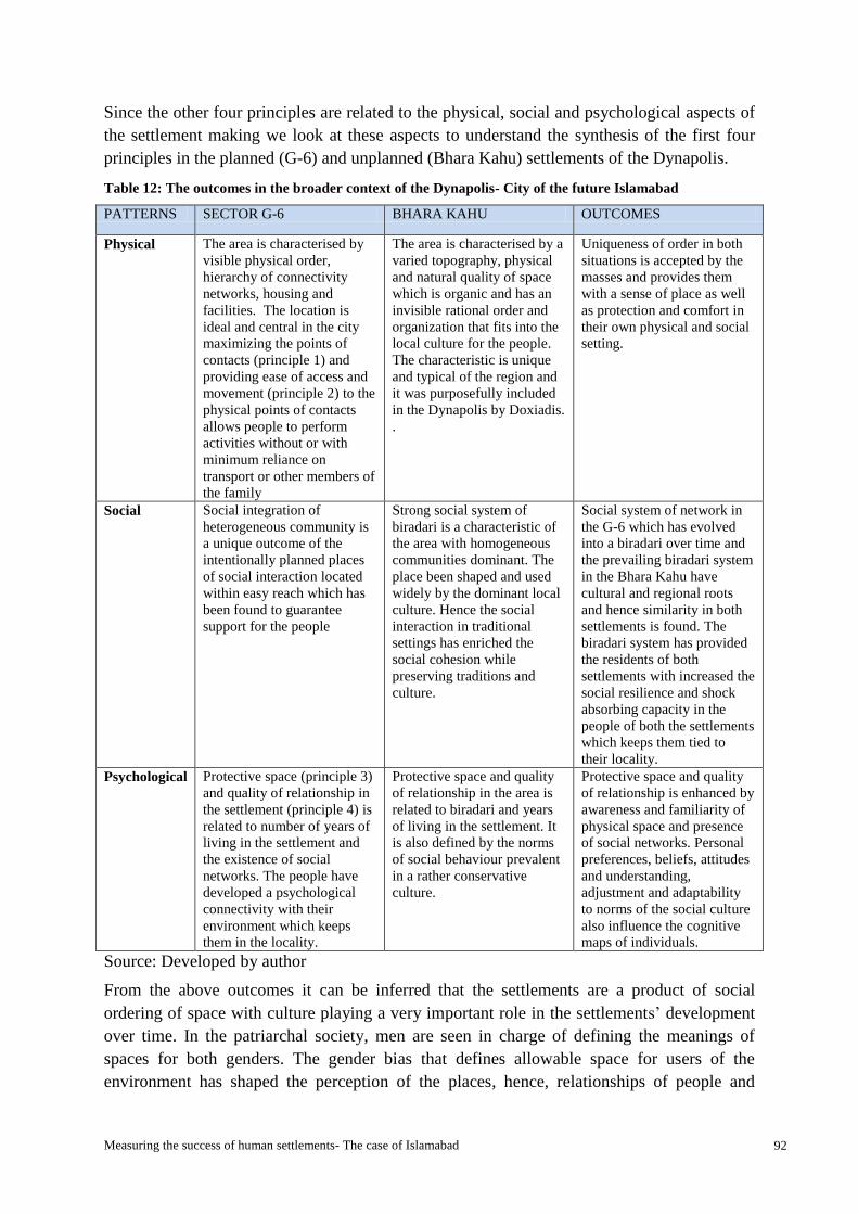
Measuring the success of human settlements- The case of Islamabad 92
Since the other four principles are related to the physical, social and psychological aspects of
the settlement making we look at these aspects to understand the synthesis of the first four
principles in the planned (G-6) and unplanned (Bhara Kahu) settlements of the Dynapolis.
Table 12: The outcomes in the broader context of the Dynapolis- City of the future Islamabad
PATTERNS SECTOR G-6 BHARA KAHU OUTCOMES
Physical The area is characterised by
visible physical order,
hierarchy of connectivity
networks, housing and
facilities. The location is
ideal and central in the city
maximizing the points of
contacts (principle 1) and
providing ease of access and
movement (principle 2) to the
physical points of contacts
allows people to perform
activities without or with
minimum reliance on
transport or other members of
the family
The area is characterised by a
varied topography, physical
and natural quality of space
which is organic and has an
invisible rational order and
organization that fits into the
local culture for the people.
The characteristic is unique
and typical of the region and
it was purposefully included
in the Dynapolis by Doxiadis.
.
Uniqueness of order in both
situations is accepted by the
masses and provides them
with a sense of place as well
as protection and comfort in
their own physical and social
setting.
Social Social integration of
heterogeneous community is
a unique outcome of the
intentionally planned places
of social interaction located
within easy reach which has
been found to guarantee
support for the people
Strong social system of
biradari is a characteristic of
the area with homogeneous
communities dominant. The
place been shaped and used
widely by the dominant local
culture. Hence the social
interaction in traditional
settings has enriched the
social cohesion while
preserving traditions and
culture.
Social system of network in
the G-6 which has evolved
into a biradari over time and
the prevailing biradari system
in the Bhara Kahu have
cultural and regional roots
and hence similarity in both
settlements is found. The
biradari system has provided
the residents of both
settlements with increased the
social resilience and shock
absorbing capacity in the
people of both the settlements
which keeps them tied to
their locality.
Psychological Protective space (principle 3)
and quality of relationship in
the settlement (principle 4) is
related to number of years of
living in the settlement and
the existence of social
networks. The people have
developed a psychological
connectivity with their
environment which keeps
them in the locality.
Protective space and quality
of relationship in the area is
related to biradari and years
of living in the settlement. It
is also defined by the norms
of social behaviour prevalent
in a rather conservative
culture.
Protective space and quality
of relationship is enhanced by
awareness and familiarity of
physical space and presence
of social networks. Personal
preferences, beliefs, attitudes
and understanding,
adjustment and adaptability
to norms of the social culture
also influence the cognitive
maps of individuals.
Source: Developed by author
From the above outcomes it can be inferred that the settlements are a product of social
ordering of space with culture playing a very important role in the settlements’ development
over time. In the patriarchal society, men are seen in charge of defining the meanings of
spaces for both genders. The gender bias that defines allowable space for users of the
environment has shaped the perception of the places, hence, relationships of people and
Measuring the success of human settlements- The case of Islamabad 93
places. Even though sector G-6 was planned considering the gender segregation in settlement
as a cultural requirement and provided exclusive and enclosed spaces for women like the
ladies park, impacts of male chauvinism embedded in culture has strongly affected and
shaped the outcome of space use in the settlement.
4.3.3 Elements that explain the success factors for the G-6 and Bhara Kahu
This section relates to the fourth sub-question:
Which are the different elements that derive from the analysis that explain the success factors
for both planned and unplanned settlements and how do they score against each other when
compared?
The model of Dynapolis and Ekistics:
The research started with the exploration of why and how the model of Dynapolis has
survived through fifty three years and how long can it survive, when the world is turning
away from planning and consider it to be an obsolete practice in today’s age. Doxiadis has
given due importance to time to determine success of human settlements.
The answers to this lay in the humanistic approach to creation of human settlements. The
region has a past with similar exercise in the planning (Harappa in Taxila), and the existence
of a human settlement on similar design proves the test of time for the model.
The research sought to understand the construct of reality in the minds of people of how they
make a sense of the world they live in and the world they see. The theory of Ekistics is taken
as a model and as a tool to help understand reality and it provided a base for the defining
success. According to Doxiadis success is achieved when:
1- Settlements promote happiness and safety. This is achieved when needs of the people
pertaining to the settlements are satisfied; and
2- There is balance between man and machine so there is no conflict between them, by
complying with the five principles of Ekistics
The success of the settlements is thus explored with Doxiadis’ idea that learning about human
settlements can be from the settlements themselves and to understand the human settlements
one must study the spatial morphology, the primary spatial patterns related with human
actions and behaviour and functional and organizational structure that connect both
(Doxiadis, 1968). Hence the indicators of success picked from this definition helped evaluate
the planned and unplanned settlements of the Dynapolis. A simultaneous study of positively
performing settlements (CSIR, 2000) for the analysis of success is also considered to interpret
and get behind the answers from the respondents. This is done because of the high similarity
of concepts and common idea of human welfare.
As settlements are characterised by diversity (CSIR, 2000), and are said to grow in areas of
greatest attraction and least resistance ((Doxiadis, 1968), the residents who belonged to
different socio-economic groups, age groups, education level, tenure of living in the
settlement and gender were asked questions regarding the settlement rating, what were the
greatest attractions, what were positive points of the area and the negative points of the area

Measuring the success of human settlements- The case of Islamabad 94
in the perception of the residents to see the relation of these differences in the society and
satisfaction for a broader community. In order to see what concepts the participants used to
make sense of their worlds, the meanings or significance it has for them, how the people and
the inherent norms, values and rules affected the settlements and their relationships.
“Man always choses places that have greatest attraction and least resistance…”(Doxiadis,
1968, Doxiadis, 1970)
The attraction as already explained in chapter 2 is a very significant variable that corresponds
to different needs of people pertaining to human settlements. People get attracted to places in
a quest to satisfy their physical, social, aesthetics, economic or even unique physical or
sensory experiences and other needs. However, economic attraction (economic feasibility
and affordability), the sense of place, the value of owned land in kanals14
were a few of the
mentioned attractions for the Bhara Kahu area.
Economic attraction:
One attraction is the economic affordability of the area within the Islamabad capital territory.
This is for the people who have migrated and are working in Islamabad. This category also
comprises of people who have moved from G-6 after retirement where they had government
accommodation and otherwise could not afford to own a house in the developed sectors of
zone I.
Accessibility attraction:
Accessibility is an attraction for people to satisfy the physical needs and corresponds to
principle 2 of the ekistics. For the people of Murree who work in Islamabad and people who
have moved from Islamabad sectors Bhara Kahu is regarded as an attractive and ideal
location as it is only at a distance of 39 km from Murree and within the Islamabad Capital
Territory. In the case of G-6 it is the location within the developed zone and close proximity
to the offices and a vibrant city life.
Physical (natural or man- made environment) attraction:
Different elements in the physical environment create a uniqueness associated to that
particular place which becomes attraction for different people. For some people it is the
nature, the landscapes and the country side experience in the Bhara Kahu, while in the case of
G-6 it is the location within the main city and an ordered spatial plan in the developed zone.
Social environment attraction:
Many respondents identified as the social environment of the settlements under consideration
to be the main attraction for them which is the reason they refuse to move from the settlement
to some other place. This remained true for both the planned and the un-planned settlements.
The mix and maximum variation in the sample was picked to understand the needs, assess the
perceived value of spaces and evaluate the elements that are considered important in a
14
Local unit of space equivalent to 500 square yards

Measuring the success of human settlements- The case of Islamabad 95
heterogeneous community in settlements that promote safety, happiness and satisfaction and
ultimately define success of the human settlements.
In answer to question about what was the most appreciated thing in the respective
neighbourhood’s majority of the interviewees from both the settlements replied the social
networks, biradari system and the physical characteristics of their area. The planned
settlement dwellers appreciated the planning, the location, accessibility and the order in the
layout while the settlers of Bhara Kahu admired the vast lands they had with nearness to most
nature reserves.
Satisfaction of needs
Satisfaction here is with respect to people’s psychological state which they mostly associate
with the physical, social and protective space. Satisfaction with respect to the settlement was
also seen to be related with the contentment and conditioning of the people in the
circumstances.
The physical, social and psychological spatial needs addressed in the principles of ekistics
form the criteria for assessment of the two settlements. Hence the incongruity or gap between
the present and the desired situation or consequences in regard to the two groups (the
residents of G-6 and Bhara Kahu) is analysed with the principles.
The assessment for needs in both situations of the G-6 and Bhara Kahu was also made in
order to understand the nature of contacts which makes sense or are relatively important to
the inhabitants of both settlements (Table 13and Chart 4). It was found that the needs of the
people from both settlements are defined differently hence priorities differ. It is seen to have a
relation with the existence, non-existence, awareness and adaptability to the situation.
The research also sought the need assessment of people pertaining to the settlements.
Preferences of close proximity were asked by the residents of both settlements which were in
sharp contrast (Chart 5 and 6).
What would you prefer being near to when deciding on location to live?
Table 13: Need assessment- locational factors
Preference of close proximity to Sector G-6
No. of responses
% Bhara Kahu
No. of responses
%
a) Nature 16 73 17 71
b) Relatives/ friends 16 73 19 79
c) Commercial area 18 82 21 88
d) Places of work 15 68 12 50
e) Places of worship 19 86 22 92
d) Academic institutes 12 55 14 58
f) Healthcare 15 68 18 75
g) Main road 14 64 20 83
Source: Author

Measuring the success of human settlements- The case of Islamabad 96
Chart 4: Need Assessment- locational factors
Source: Author
Chart 5: Need assessment (perceived value of contacts) - G-6
Source: Author

Measuring the success of human settlements- The case of Islamabad 97
Chart 6: Need Assessment (perceived value of contacts) - Bhara Kahu
Source: Author
The analysis of findings also reveals that today’s needs of people are guided mostly by the
conditions created by the overall situation of security, economic crisis, energy crisis, and
political instability in the country. Hence the focus of people is not only on the five principles
in the same order in the human settlements. The people have also been observed to have a lot
of adjustability in different situations.
Another important explanation for the needs is the survival instincts of man. For example,
Maximization of contacts (principle 1) for the new settlers (whether in the case of G-6 in
1960s or in the case of Bhara Kahu at present) is survival instinct based need. Man first tries
to gain awareness of the existence of contacts and then tries to see which ones are suitable for
him being the nearest requiring minimum effort (principle 2). The awareness is further related
to the determination of boundaries for maximization of protective space (principle 3) for self
and for family according to the norms and culture finally to be able to relate (principle 4) to
his choice of living (the settlement). In a question related to the satisfaction in the settlement
posed to the residents of both settlements under consideration through open ended
questionnaires answer was found to be almost equal in both settlements. Table 14 and chart 7
show the results.

Measuring the success of human settlements- The case of Islamabad 98
Question: Are your needs satisfied with the facilities in your settlement?
Table 14: Results of satisfaction query in the planned and unplanned human settlements
Satisfaction with settlement Sector G-6
No. of responses
% Bhara Kahu
No. of responses
%
Yes 18 82 20 83
Neutral 2 9 1 4
No 0 0 3 13
Source: Developed by author
Chart 7: Satisfaction with area and facilities
Source: Developed by author
Happiness
Although a difference in the physical aspect (availability and accessibility to contacts) in need
is a concern brought out by a few respondents but happiness was largely associated with the
fulfilment of social and psychological needs in both settlements. The existence of strong
social ties and networks enhanced the sense of protection, security and support hence sense of
well-being in the settlements which formed a reason to be grounded to the settlement. The
respondents of the survey in answer to an open question regarding their choice of place if
they got an opportunity to settle somewhere replied in straight “no” answers with additional
statements like “I don’t want to go anywhere” and “we are very happy here”. A few
respondents who mentioned localities they would like to go to mention security as the reason.
These respondents belonged to the new settlers who did not have a social network in the area.
Question: If given a choice and opportunity to settle in some other place, would you move out
of the area? If yes, then where would you like to move?

Measuring the success of human settlements- The case of Islamabad 99
Table 15: Respondents ‘preference for relocation
Preference for relocation Sector G-6
No. of responses
% Bhara Kahu
No. of responses
%
Yes 1 5 4 17
Neutral 1 5 1 4
No 18 82 19 79
Source: Developed by author
Chart 8: Respondents ‘preference for relocation
Source: Developed by author
Safety
Safety remains a major concern in both planned and unplanned settlements of the Dynapolis
and is largely associated with awareness and familiarity with the area rather than surveillance
and secondly with the social networks in the area. It was also revealed from the interviews
that the physical organization and order had also a psychological effect on the perception of
safety for the people. The years of living in the settlement combined with the adjustability is
an important factor relating to the comfort level in the settlement. The interviews for this
research showed the comfort to have increased with the passage of time. For example a new
settler in the Bhara Kahu said;
“Yes now that I am much more familiar with the residents and the area I feel rather secure
than I used to feel initially when I came. It is natural to become comfortable when one knows
the surroundings and people…. There was a fear too of the place not known to us…” (Male
respondent BK-2, July 5, 2013)
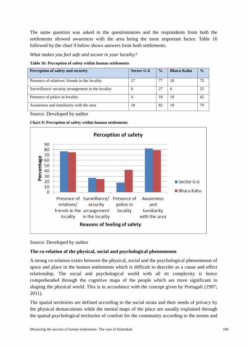
Measuring the success of human settlements- The case of Islamabad 100
The same question was asked in the questionnaires and the respondents from both the
settlements showed awareness with the area being the most important factor. Table 16
followed by the chart 9 below shows answers from both settlements.
What makes you feel safe and secure in your locality?
Table 16: Perception of safety within human settlements
Perception of safety and security Sector G-6 % Bhara Kahu %
Presence of relatives/ friends in the locality 17 77 18 75
Surveillance/ security arrangement in the locality 6 27 6 25
Presence of police in locality 4 18 10 42
Awareness and familiarity with the area 18 82 19 79
Source: Developed by author
Chart 9: Perception of safety within human settlements
Source: Developed by author
The co-relation of the physical, social and psychological phenomenon
A strong co-relation exists between the physical, social and the psychological phenomenon of
space and place in the human settlements which is difficult to describe as a cause and effect
relationship. The social and psychological world with all its complexity is hence
comprehended through the cognitive maps of the people which are more significant in
shaping the physical world. This is in accordance with the concept given by Portugali (1997;
2011).
The spatial territories are defined according to the social strata and their needs of privacy by
the physical demarcations while the mental maps of the place are usually explained through
the spatial-psychological territories of comfort for the community according to the norms and

Measuring the success of human settlements- The case of Islamabad 101
values. For example, the gender segregation in the local culture which made females
uncomfortable going to public parks, felt comfortable in the enclosed and exclusive ladies
park.
The human settlements theory and Doxiadis’ ideas on settlement development are used below
to discuss the situation in the settlements under consideration.
“(He always gives his) structures the form or optimal size…”(Doxiadis, 1968)
The people of Bhara Kahu using their freedom to develop living environments have practiced
for many years planning and dividing their land themselves according to their needs and
interests. This incremental change of patterns guided and influenced by the social and
economic needs which has given the minor shells optimal manageable sizes as per capacity of
the inhabitants and an organic form to the micro settlement.
“He always selects a route (minimum distances, ease of access), which requires the
minimum effort…”(Doxiadis, 1968, Doxiadis, 1970)
People of the Bhara Kahu in zone IV have made smaller cut through walkable routes and
trails as shortcuts called kucha rasta or the pagdandian which gives them ease of access to
the points of contacts like the markets, main roads and inter-connections to different
neighborhoods. Surprisingly according to the locals’ experience and research observation,
these take almost the same amount of time by walking as they take through the use of public
transport.
Balance between man and his man-made environment:
According to the theory of ekistics the settlements will promote happiness and safety hence
satisfaction when a balance is achieved between man and the man-made environment by
complying with the five principles of ekistics.
Since these principles are said to be an extension of biological characteristics of the humans
and humans have always been obedient to these five principles in shaping his settlements, in
a quest to enrich the quality of life hence these were sought and found present in the
unplanned settlement of Bhara Kahu also. The question here arises how to deal with the
problems and the complexities of the not formally planned Dynapolis to upgrade and bring
them at par with the rest of the city (the planned settlements), and even if it should be done
formally.

Measuring the success of human settlements- The case of Islamabad 102
Chapter 5: Conclusions and recommendations
Introduction
The thesis intended to explore and understand the validity of theories and philosophies and
the influencing factors in the formation and transformation of patterns in the planned and
unplanned human settlements through time to understand their dynamics in the case of
Islamabad. The study was carried out to look at the problems and issues arising from certain
patterns of human settlements, and the successes and potentials of the same.
The broader objective of the research was to understand, evaluate and extend the scope of
theory of Ekistics and the concept of the Dynapolis the city of future, which forms the basis
of the city of Islamabad by understanding the urban morphology and the forces that change
patterns in the city of Islamabad to subsequently measure and identify the elements that
determine the success of human settlements in time and to assess whether we are closer to
the sort of knowledge integration that Doxiadis has advocated.
The section gives brief conclusion according to the main research question:
What factors determine the success of human settlement patterns in the context of the
Dynapolis- the city of future- of Islamabad?
5.1 Conclusions
Doxiadis’ model has set the criteria for evaluating reality as economic, social, political,
technological, and cultural and desirability and feasibility. The settlement of Bhara Kahu that
falls in zone IV of Islamabad where Doxiadis deliberately left the settlements to emerge and
grow realizing the importance of the cultural heritage of the area, while the planned
settlements that were given a starting point for unidirectional growth (from NE to SW) ,
forms an interesting correlation in the development of patterns governed by the coexistence
of the planned and the emergent also advocated by the CSIR guidelines for planning and
design of human settlements (2000) and Nabeel Hamdi (2004).
The principles of ekistics gave the reference point for evaluating the physical, social and
psychological needs of people in both the planned (Sector G-6) and unplanned (Bhara Kahu)
settlements. These principles were seen through various indicators like the existence and
frequency of contacts, the ease, modes and time to access, awareness and perception of the
place, physical, social and psychological connectivity influences etc. These help in
comparing the two settlements to measure the success that otherwise seem to be
incomparable.
To say the theory of ekistics and its principles hold a validity that is timeless will not be
wrong. The far sightedness of the theorist and the flexibility in the theory to accommodate the
forces in time is the strongest point of the theory. The practical application in Islamabad has
showed results anticipated 53 years ago. However, in order to measure success, the meanings
people give to places are important consideration as they define the needs and their
satisfaction related to the needs.

Measuring the success of human settlements- The case of Islamabad 103
In the case of G-6, the settlement design (in compliance with the principles of ekistics) has
shaped the behaviour of people who belonged to a heterogeneous community and the success
of the settlement is declared in shaping the social and psychological pattern bringing them
closer to form a biradari thus providing them with a sense of place with which they associate
themselves. Social cohesion has also satisfied their sense of security to a certain extent, which
in turn has resulted in independence for individuals (especially women and children) in
moving around and performing activities.
For a homogenous community, that is dominant in the Bhara Kahu, the place has a meaning
which is defined by the freedom of choice available and practiced by the inhabitants, thus the
settlement is shaped (to suit the inhabitants) by the behaviour of people. The success of the
settlement for the people hence cannot be measured with the availability of contacts
identified in the instrument (which was developed looking at the maximum potential contacts
in the planned settlement) but with the sustenance of the social system of biradari and culture
which was the most important factor satisfying the sense of security and association with the
place. The meanings they associate with the places are far more different and hence an
interpretive analysis helped to evaluate and assess the settlement.
5.3 Lessons Learnt
The lessons learnt from the research in terms of myths falsification and interesting
discoveries.
5.3.1 Myths falsified by research
The research revealed reality of certain insights and myths regarding the planned and
unplanned human settlements.
Myth 1: The apparent pattern, form and order determine the success- planned
settlements are successful compared to the unplanned settlements or vice versa
Although the apparent pattern, form and order have a valid importance in the shaping of the
mental patterns and have been observed and tested through the brief survey, yet they are not
the sole elements that determine the success or failure of human settlements. The
organization of the space is very important and is also highlighted by the residents of the
planned sector G-6, according to whom the irregular pattern of the roads in Bhara Kahu
makes them insecure and infuses a fear of getting lost or becoming a prey to the criminals in
the area. However, these infused perceptions seem relevant for a not so frequent visitor to
Bhara Kahu.
The research showed the quality of built environment which is also dependent on the
governance to be important as well. The residents who were mostly satisfied with the
Doxiadis’ planning of sector G-6, existence and ease of contact with nature, people and
places, complained of the maintenance of facilities provided and issues of governance.
The area of Bhara Kahu as compared to the developed sector of G-6 is assumed to be remote,
by people who do not live in the organic settlement of Bhara Kahu or frequently visit such
places and are unaware of the way of life in the settlement. It is considered a distant and a

Measuring the success of human settlements- The case of Islamabad 104
bewildered part of Islamabad which is not so true. Another perception about the area is the
high criminal incidence and low standard of living in Bhara Kahu. On the contrary it was
found that residents in this area are comfortable and live according to the norms of the area
feeling rather safe within their own territories because of strong social ties in the area. It was
also discovered that these areas have a diverse combination of socio- economic and cultural
groups which enriches the settlement and people preferred to live in that area not only for
economic reasons but also as it is closer to certain facilities like the Murree expressway
(which is a corridor for connectivity to the northern areas of the country), the recreational
spots like Shadra, the Rawal lake and Simly dam and research institutes like the Quaid-e-
Azam University and Pakistan Institute of Economic Development (PIDE). These are more
important to the residents and their perception of satisfaction with the Ekistics principles and
the organization of spaces hence varies.
The study revealed that the organization of spaces (like the irregular, organic plan) does not
necessarily have a causal relationship with the safety issues but it does generate a perception
of unsafe environments. It also showed that these perceptions are based on the awareness
levels and the myths related to the environment by people who generally are distant to these
places.
Bhara Kahu has been socially successful for the local settlers who have been living here
generations and for whom the needs pertaining to the settlement are shaped by themselves
and are thus satisfied. The locals are conditioned in the feudal and biradari system and the
physical patterns have evolved due to local conditions and individual and collective
preferences like sub division of land for the increasing family or income generation.
Myth 2: Planning has failed and emergent and organic settlements guided by self-
organization are the idea of development dominating the twenty first century.
The debate on the planned versus the unplanned human settlements in the past few decades
has been a never ending struggle. Contrary to general perception, it was found that both the
planned and the emergent, organic human settlements and their co-existence like in the case
of Islamabad play a very important role.
The original master plan had clearly defined the functions of the planned and the unplanned
zones of the city based on the potentials of the zones and the idea of a sustainable future for
the city of Islamabad. The city of Islamabad works like an ecosystem with the National park
area serving the city as a backup for provision of water and food needs.
5.3.2 Interesting discoveries
During the research interesting discoveries were made. This section briefly explains the ones
relevant to the study.
Discovery 1: The culture - Development vs. evolution:
The settlements are characterised by contrast in the development (of G-6) and evolution (of
Bhara Kahu) but this feature has not changed the way cultures in both the settlements have
evolved and sustained. The social culture evolved in a unique similarity in both the developed

Measuring the success of human settlements- The case of Islamabad 105
and emergent settlements into a biradari system. It is evident that this particular example
reveals the regional base for the social development of a settlement and is seen to affect the
psychological patterns of the society also in similar fashion. However, due credit is given to
the physical design of the settlement (which comprised heterogeneous community) that aided
the evolution of a culture that is typical of homogeneous communities in the region. The
social system is the most important element for the settlements which predominantly provides
a psychological security to the people.
Both the settlements have strong social bonding within the old settlers in the respective
settlements. It is the way of living of people of the area and a wider culture of humans of
enhancing and maximizing their protective environment (third principle of Ekistics) while
maintaining the maximum contacts (First principle of ekistics). The social network
developing into a biradari system in both the settlements is seen to be a strong element of
maximizing the protective space of the people by giving people sense of protection and
support within their neighbourhoods. This is a visible outcome in both the planned and the
unplanned settlements.
Discovery 2: Definition of needs and chance factors (place, events, time, availability,
capacity, changes in individual preferences etc.):
The second discovery, which is rather complex and needs further research through
behavioural psychology and social sciences, of how the needs (pertaining to the settlements)
are affected and sometimes defined by the chance factors in the contrasting situations of both
the settlements. The survey findings and analysis lead to the conclusion that the people are
conditioned to define the needs according to their exposure, awareness, education and
existence or non-existence of facilities and opportunities. For example, in the sector G-6 the
existence of the children’s library in the past (from 1960- 2005) and its awareness led to most
residents having used this library. However, the non-existence of the library only affected the
previous users of the library who appreciated the facility but with the passage of time got
used to and conditioned to its nonexistence and the culture of libraries perished. However the
new library and reading room constructed in the year 2010 at another location in the same G-
6 sector, remains incomplete and unused to date. The culture of libraries and hence definition
of the need was seen to be non-existent in the Bhara Kahu completely. Similarly the events,
incidents and individual and sometimes collective preferences also contribute to the needs.
Another example from the G-6 sector is the Lal masjid operation in the year 2007 in which
the main mosque was destroyed but rebuilt in 2010 because of people’s personal preferences
and religious obligation which people felt towards it. However, the Children’s library that
was lost due to this mosque’s encroachment was not considered important to be saved. These
are examples of the chance factors shaping the cognitive pattern (shaped by the awareness,
education, place, culture, environment, events, religion and several other features) which in
turn also shape the environment.
The basic needs identified by the five principles of Ekistics remain valid for both the planned
and the unplanned human settlements. The only difference can be to maximize contacts with
preference to certain needs according to the exposure, awareness, education, opportunities
and the prevailing culture.

Measuring the success of human settlements- The case of Islamabad 106
Discovery 3: Environmental behaviour
Role of spatial structure and facilities in citizens’ education, individual, social and
cultural development
Another very important discovery related to the social sciences’ field of environmental
behaviour (i.e. environments shape behaviour) linked to the previous discoveries making a
chain is that the provision of facilities, exposure and provision of access to the same improves
the level of the citizens’ awareness, education and appreciation of the same thereby shaping
culture. The residents of the grid-iron planned sector G-6 were seen to be more aware of the
benefits of the spatial structure (straight roads, hierarchical system of streets and road
network, hierarchical system of the urban and public facilities provision etc. and a fair
distribution of the facilities within easy access) though all did not have a background of
planning or very high education yet their understanding of the environment and appreciation
of the visible order was high which was the result of personal observation and experiences
and believed to have been enhanced through the provision of such a spatial structure which is
not available elsewhere. Hence the grid-iron plan given by Doxiadis is seen to have played a
very important role in educating the citizen.
Reflection of spatial planning contribution can be seen in people’s responses to the layout of
the planned and the unplanned settlements. The grid-iron plan has created awareness and has
developed a sense of physical security by the hierarchy of road network.
The study revealed a lack of direction and physical order in the organic layout of Bhara Kahu
area which has led to a negative perception and fear amongst people living outside the area.
The system has become complicated to such an extent that it is out of control of even the
development authorities.
People of the region (whether the citizens or the development authorities) are not yet trained
and have the capacity to be able to handle the freedom in development bringing a balance
between man and man-made environment. The Doxiadis plan is the only experience people
have had of a grid-iron plan and this has led to the increased awareness of environment,
understanding and developing of needs, civilizing the society. It has also enhanced the
knowledge in the field of planning but this area needs further improvement with respect to
the civic authorities not only focused on implementing the physical plan but also integrating
the local cultural and social values for a greater development of public welfare, enhancing the
awareness and potentials of people and hence a successful (Doxiadis, 1968) and positively
performing (CSIR, 2000) development of the human settlements.
One noteworthy mention related to the culture is the male dominance in both the settlements.
It is already known that the region has a patriarchal system but the way in which both the
settlements showed the space boundaries being defined for women was identical. However,
Doxiadis being aware of the culture in the region provided an exclusive enclosed ladies park
in the sector G-6 which despite of the unspoken norm which does not accept the women
going to parks, has facilitated and encouraged women to use the park and bring small but
important changes in the social culture. Hence planning in this case has seen to have helped
the weaker sex in using their citizens’ rights to use the public space.

Measuring the success of human settlements- The case of Islamabad 107
Initiative for personal, social, cultural and physical development
Another relevant and important discovery related to the human and spatial development in
the human settlements is that the initiative taking capacity of citizens regarding needs in a
settlement is largely affected and altered (diminished or enhanced) by the fulfilment of the
basic needs and the socio-economic conditions of the people hence it affects the intentions,
ambitions and focuses in case of developmental concerns which in turn affects the patterns to
some extent. The people are also seen to have been conditioned in a way that they are highly
dependent on the provision of facilities and services from the government and lack self-
organization and initiative to solve problems or improve the conditions they complain about.
They have great adjustability and adaptability for all conditions (good and bad) and rely on
decisions and actions by the government. People who are not trained to take decisions for
years by living in environments shaped by the governments without them being involved lack
the capacity to take initiative.
The freedom that people of the unplanned and unmonitored settlement of Bhara Kahu enjoy
as compared to the planned sector G-6, shape their own environments by taking decisions in
their personal interests affecting the wider settlement patterns. The people with better
economic conditions have constructed private roads and also a few services for themselves.
The freedom to create their own environments in Bhara Kahu has cultivated a special sense
of place that has sustained for the residents and hence mental maps for an invisible rational
order within visible disorder and a logical protective space.
5.4 Relevance with Literature
The research is linked back to the literature review carried out for the research, the starting
point of which was to plan or not to plan debate, the arguments in favour and against
planning and a middle path advocated by Hamdi (2004). The case study of Islamabad
provided with practical application of two contrasting patterns of settlement (planned and
unplanned) co-existing side by side. Hamdi’s pretext of importance of both structures
(planned and the ones enabled to emerge) and finding a balance between the two has been
practically and deliberately implemented in the master plan of Islamabad by Doxiadis. The
city hence is seen as an eco-system with multiple co-evolving elements as argued by Marshal
(2009).
Marshall’s argument of instincts vs. arguments against planning and relevance to the context
of case study in the human settlements of Islamabad:
The research showed that although settlements can be a product of human instincts (like
spontaneous settlement in the case of Bhara Kahu in Islamabad) the idea is better represented
and expressed through the principles of Ekistics which are based on human needs and
instincts.
This research however challenges Marshall’s (2011) anti planning argument that “a new
modern planned and purpose-built city is not necessarily more attractive, functional or
successful than the other one (traditionally unplanned) ” on the argument that they are
‘perceived’ to be ‘worse’ as they are “anti-humanistic” with “alienating environments, with

Measuring the success of human settlements- The case of Islamabad 108
ugly, brutal concrete jungles, landscapes of barren tarmac, looming slab blocks and gloomy
undercrofts” (Marshall, 2009).
The planned settlement that was represented by the case study of sector G-6 has proved the
argument to be wrong as it is not “perceived” to be in any sense “worse”, “anti- humanistic”
or “alienating environment” by the residents who have lived and experienced the
environment (and whose perceptions were measured through the research) or who have
visited and judged the environment. On the contrary it was found to be attractive in many
ways (already discussed in chapter 4), functional and declared successful by not only the
planners but also the residents who are the most important evaluators of the settlement. The
planning has had profound positive impact on shaping the human behavior and satisfying
human needs and instincts.
The unplanned emergent settlement of Bhara Kahu however has its own merits, attraction,
functionality and perception of success in the minds of the people but cannot be declared
‘worse’ or ‘successful’ with its beautiful natural landscapes admired widely, or its humanistic
evolution (being a product of human instincts) as it is “perceived” to have an alienating
environment for the non-locals in some cases producing insecurity for them.
The geometry and the landscape widely criticized in planning by Marshall (2009, 2011) and
Lynch (1981) and many others for not satisfying human values or playing a noteworthy role
in the contentment of human needs, has on the contrary (in the case of planned sector of G-6)
helped in ease of access to a wider public to suitably located various points of contacts within
the settlement satisfying human needs explained by principle 1 and 2 of the Ekistics.
The concluding remarks on the research related to the literature are best represented by
Mooney, Pile et al (1999) claim that urban plans can be consciously produced and socially
ordered.
The concept of the Dynapolis and the theory of Ekistics have provided the answers to the
missing link between plan or not to plan and to the complexity-cognitive approach to
planning sought by Portugali (2011). It has provided model for the development of human
settlements, the practical illustration of which can be seen with reference to context in more
than 40 countries of the world.
Hence the theory of Ekistics and the concept of Dynapolis is the best representation of ideas
and a practical link between theory and practice.
5.5 Limitations Strength and Weaknesses of Research
The Islamabad city is a combination of the grid-iron planned sectors spanning over an area of
55,000 acres and unplanned zone of 70,000 acres approximately. Sector G-6 is one sector
taken as a sample from the zone 1 to represent the grid-iron planning and assessment of
ekistics principles. The other sectors though have common characteristics particularly the 2 x
2 km square and the concept of markaz (centre) and the sub divisions of the sector, but this
particular sector is somewhat different as the socio-economic and cultural diversity is perhaps
the most significant feature of this sector. Hence the study covers the concepts validity for
different socio- economic groups living in the area. However due to limitation of time and
Measuring the success of human settlements- The case of Islamabad 109
scope different sectors could not be assessed which may show disparity. This view comes up
in the observations of the researcher and the respondents.
The second area which is the emergent settlement of Bhara Kahu is a very conservative area
where women are generally not seen outdoors. This area is difficult to understand and access
without help. The area has a mix of socio economic groups and most settlers who are the
locals have a language not easy to understand.
Secondly, sensitivity due to the previous critical incidents in the area, the presence of
sensitive institutions and the fear and suspicion people carry due to unfavourable past
experiences, limited the data collection (photographs) and hence findings. The analysis had to
be based largely on the interviews conducted during the research as the reliability of the
questionnaires was low with contradictory answers to questions posed differently but aimed
at finding one thing and the triangulation helped see the differences.
However this is another strong point in the research finding that these critical incidents have
affected the population and the patterns. Generally people were not comfortable with
recording of interviews and reluctant to give out written and sometimes oral information. The
general public were highly suspicious for the areas being photographed.
Thirdly, the country is going through a very serious energy crisis and frequent (12- 14 hours)
load shedding and limited access to the internet also posed problems. Recent elections and
bombing, targeted killings followed by strikes brought the city life to a standstill which
wasted time. Accessing files and documents from the archives was a challenge which was
overcome through contacts.
5.6 Recommendations for further research
The Ekistics and the Dynapolis are theories and ideas based on extensive research by
hundreds of competent scientist of the postmodern era. The scope of this study due to the
limitations of time is limited and ideally required more case studies of the deviant and typical
cases in order to understand better the limitations and implications of the theoretical
postulates of Doxiadis. However, two recommendations for further research are suggested.
First, a similar study of all other areas i.e. the developed sectors of zone I and II and the other
areas in zone IV must be carried out at the level defined by Doxiadis Ekistics Logarithmic
scale classification of micro settlement and evaluate the areas with gaps and problems.
Secondly, a detailed study of the institutional and organizational capacity must be carried out
for the CDA and the relevant departments.
Thirdly, the study can be integrated into broader context of the Dynapolis of Islamabad and
decisions for welfare of a greater region.
“Planning of Islamabad and Rawalpindi: What went wrong” (Maria and Imran, 2006,) shows
the CDA had a much stronger capacity and hence the development in Islamabad was
successfully implemented as planned, while the RDA could not. However today situation
seems to be repeating the history in the Islamabad park area where CDA has made land use
revisions which are not in accordance with the Doxiadis vision of the city of future and his

Measuring the success of human settlements- The case of Islamabad 110
planning for a sustainable city. The ICT and CDA have managed so far with two revisions of
master plan reviewed by the Doxiadis Associates and hence have had results that the city has
been considered as a success by the original planners. However the issues of governance and
the lack of understanding of Doxiadis theory and the city plan are major problems which if
not catered for will collapse the system of the Dynapolis. A KAP (knowledge attitude
practice) of the institutions like the CDA study is also recommended.

Measuring the success of human settlements- The case of Islamabad 111
Bibliography
Albrechts, L., 2004. Strategic (spatial) planning re-examined. Environment and Planning B:
Planning and Design, 31 pp. 743-758.
Allmendinger, P., 2009. Chapter 1 What is Theory. Chapter 1 What is Theory. 2009.
Planning theory. London: Palgrave Macmillan. pp. 1-29.
Batty, M., 2008. Very complex systems, very hard problems. Environment and Planning B:
Planning and Design, .
Bogdanou, M. A., 2003. City of the future.
Boonstra, B. and Boelens, L. 2011. Self-organization in urban development: towards a new
perspective on spatial planning. Urban Research and Practice, 4 (2), pp. 99-122.
[Accessed March 7, 2013].
CDA, Master Plan Cell- Planning Wing, 1987. Review of Islamabad Master Plan. 327),
Islamabad, Pakistan: Capital Development Authority.
CSIR, 2000. Volume I- The red book. Volume I- The red book. 2000. Guidelines for human
settlement planning and design. Pretoria: CSIR building and construction technology.
Doxiadis, C. A., 1960a. Islamabad program and plan- DOX-PA 88. Volume 1.
Doxiadis, C. A., 1960b. Islamabad program and plan- DOX-PA 88. Volume 2.
Doxiadis, C. A., 1965. Islamabad. The creation of a new capital
. The Town Planning Review, 36 (1), pp. 1-28. Available at:
http://www.doxiadis.org/page/default.asp?id=34 [Accessed May 5, 2013].
Doxiadis, C. A., 1968. Ekistics- An introduction to the science of human settlements.
Doxiadis, C. A., 1970. Ekistics, the Science of Human Settlements. Science, 170 (3956), pp.
393-404.
Frantzeskakis, J. M., n.d. Islamabad, a town planning example for a sustainable city.
Gerrits, L., 2012. Chapter 4- Being human: coping with complexity. Chapter 4- Being
human: coping with complexity. 2012. Punching clouds- An introduction to the
complexity of public decision-making. USA: Emergent publications. pp. 102-131.
Hamdi, N., 2004. Part 3 Learning practice. Part 3 Learning practice. 2004. Small change:
About the art of practice and the limits of planning in cities. London: Earthscan. pp. 91-
141.

Measuring the success of human settlements- The case of Islamabad 112
Hillier, B., 2012. Studying cities to learn about minds: some possible implications of space
syntax for spatial cognition. Environment and Planning B: Planning and Design, 39 (1),
pp. 12-32.
Jagadisan, S. and Fookes, T. W. 2009. Extending the scope and methodology of ekistics
theory and practice:A research memorandum series. PhD. School of Architecture and
Planning, University of Auckland (UOA), New Zealand.
Lynch, K., 1981. A theory of good city form. pp. 99-102.
Mahsud, A. Z. K., 2007. Representing the state symbolism and ideology in Doxiadis's plan
for Islamabad. The Politics of Making, pp. 61-74.
Mahsud, A. Z. K., 2009. Adjusting/ amending the modern: Doxiadis use of urban design
vocabulary, grammar, syntax and the eclectic local. PhD.
Mahsud, A. Z. K., 2010. Rethinking Doxiadis' Ekistical Urbanism. Grand Plans- Positions
on Modern Architecture and Urbanism, pp. 7-39.
Malik, A., 2003. Post-colonial capitals of South Asia: a critical analysis of Chandigarh,
Dhaka and Islamabad
. Global Built Environment Review, 3 (1), pp. 68-80.
Maria, S. I. and Imran, M., eds., 2006,. Planning of Islamabad and Rawalpindi: what went
wrong? [42nd ISoCaRP Congress]. Istanbul, Turkey, 2006. pp. 1-10.
Marshall, S., City planning, design and evolution concepts. Available at:
http://www.academia.edu/2061339/City_Planning_Design_and_Evolution_Concepts .
Marshall, S., 2009. Cities, design and evolution. USA and Canada: Taylor and Francis Ltd.
Routledge.
Marshall, S., 2011. International perspectives Delta Lecture: Self-Organizing Cities-
Implications for planning. tIP 04|07), Delta metropolis Association, Rotterdam.
Available at: http://www.deltametropool.nl/nl/the_International_Perspectives .
Mooney, G., Pile, S. and Brook, C. 1999. Chapter 8: On orderings and the city. Chapter 8: On
orderings and the city. 1999. Unruly cities. London/ New York: Routledge. pp. 345-367.
Portugali, J., 1997. Self-organizing cities. Futures, 29 (4/5), pp. 353-380.
Portugali, J., 2011. Complexity, cognition and the city: understanding complex systems.
Berlin: Springer-Verlag.
Roy, A., 2009. Why India cannot plan its cities: Informality, insurgence and the idiom of
urbanization. Planning Theory, 8 pp. 76-87.
Turner, A., 1992. Urban planning in the developing world: Lessons from experience .
Habitat International, 16 (2), pp. 113-126.

Measuring the success of human settlements- The case of Islamabad 113
Van den Broeck, J., 2004. Strategic structure planning. In Verschure. UN Habitat, pp. 169-
184. Available at:
http://ww2.unhabitat.org/programmes/agenda21/documents/urban_trialogues/StratStruct
Planning.pdf .
Measuring the success of human settlements- The case of Islamabad 114
Annexes
Annex 1- Literature review
Matrix of theories and concepts-1
Matrix of similarities and differences-2
Annex 2- Operationalization
Annex 3- Schedule for field work
Annex 4- Questions for semi-structured interview of residents
Annex 5- Questions for structured interview of planning experts
Annex 6- Photographs of research area
Annex-7- Tables of findings
Annex-8- Maps and Drawings of research area

Measuring the success of human settlements- The case of Islamabad 115
Doxiadis, C. A. (1968-1970) Marshall, S. (2009-2011) Portugali, J. (1997-2011) Hamdi Nabeel Remarks
Literature 1
Articles/Lect
ures
Ekistics- the science of human
settlements(Doxiadis, 1970)
Self-organizing cities(Marshall, 2011) Self-organizing cities(Portugali,
1997)
(Hamdi, 2004, Hillier,
2012)
Literature 2 City Planning, Design and Evolution
Concepts(Marshall, )
Complexity, Cognition and the
city. Review by Ashley Dhanani
Literature 3
Books
Ekistics book Cities, Design and
Evolution(Marshall, 2009)
Complexity, Cognition and the
city.(Portugali, 2011)
This is The research is seen from three different perspectives. Starting with the ideas of Doxiadis who is the founder of Ekistics theory and also the architect and
planner of the city of Islamabad. The city is still considered one of the best in the country and after more than half a century thrives. And like many other new towns
of its era demands a further look into the future growth to accommodate the current needs while maintaining the city’s unique character, ideas and concepts behind
the design if they still fit in the context, or if they need to be tamed. As Doxiadis has said himself, “We can only learn about the human settlements from the human
settlements themselves.” Ekistics is seen as the integrated approach bringing studies from distinct points of view from various disciplines into a coherent framework.
The study tends to explore the newly projected concepts and ideas through the case study of Islamabad as manifestation of Doxiadis Ekistics theory.
The second idea has been taken from the latest image or trend of the 21st century the ideas of Self-organization and emergence.
The third idea is taken from Nabeel Hamdi who argues that both planned and emergent urban development is required.
Theories Ekistics- the science of human
settlements
Organic & traditional cities-
Self-organizing cities
Self-organizing city
Haken’s synergetic theory and
Prigogine’s dissipative
structures theory.
Key concepts The principles man takes into
account when building his
settlements, as well as the
evolution of human settlements through history in terms of size and
quality.
The target is to build the city of
optimum size, that is, a city which
respects human
dimensions.(Doxiadis, 1970)
Herman Haken’s theory of
Synergetic-
Emphasis on inter relations,
interactions and synergy among
the many parts of the system and
its overall structure and
behaviour.
The phenomenon of collective
behaviour.
Look for changes at the
macroscopic scale.(Portugali,
1997)
Integrated approach and
stressed the need for
nurturing of wisdom, skill
and competencies in
practice
Integration of theories from various Complexity theories CTC- Complexity theories of

Measuring the success of human settlements- The case of Islamabad 116
disciplines cities
Using Henri Benard’s experiment
of heating liquid from below.
The 5 principles of Ekistics:
I. Maximization of man’s
potential contacts with the
elements of nature (such as water
and trees), with other people, and
with the works of man (such as
buildings and roads).
II. Minimization of the
effort required for the
achievement of man's actual and
potential contacts. He always
gives his structures the shape, or
selects the route, that requires the
minimum effort.
III. Optimization of man's
protective space, which means the
selection of such a distance from
other persons, animals, or objects
that he can keep his contacts with
them (first principle) without any
kind of sensory or psychological
discomfort.
IV. Optimization of the
quality of man's relationship with
his environment, which consists of
nature, society, shells (buildings
and houses of all sorts), and
networks (ranging from roads to
telecommunications). This is the
principle that leads to order,
Four pairs of key concepts:
1. City design versus urban
order
1.1 Urban order refers to the
consistency of urban components
and their relationships
1.2 City design refers to the design or
planning of a city in a definite form at
a given point in time, as a finite,
whole unit
2. Corporate versus collective
2.2 A Collective entity is an
aggregate of many individual
components, where each component
has its own purpose that is not
subordinated to purpose of the whole
2.1 A corporate object is a unitary
whole composed of complementary
sub-units.
3. City as organism versus
city as ecosystem
3.2 The city as ecosystem interprets
the city as an organic, collective
entity.
3.1 The city as organism implies that
a city is an organic, corporate whole
4. City development versus
urban evolution
4.2 Urban evolution implies that
The two patterns of the
structure of the city:
1. Material pattern of the
city
2. Cognitive pattern of the
city
Cognitive science
The human subject is presented as
a cognitive being that seeks to
understand the city and
through this process creates the
city. Analogy between pattern
formation and pattern
recognition specifically attractive
to the study of cities. Both are
related to the cognition and brain
functioning.
Individual’s cognitive maps
determine their location and
actions in the city, and thus the
physical structure of the city, and
simultaneously affect the
individual’s cognitive maps of the
city.{{68 Portugali, Juval 1997}}
The debate focuses on the
patterns that is planned
(usually geometric) and
unplanned (mostly
organic). An interesting
feature of the human mind
is creating patterns that
are mostly geometric although it is considered
that the cities are creation
of social and economic
and sometimes political
processes, but in this case
function follows form.
Bill Hillier’s article has
sought to understand this
behaviour of imposing
the geometric order into
the cities, regulating every
function within that
envelope and relations
between objects and
spaces.(Hillier, 2012).
We see the Doxiadis
design of human
settlements in this light
with his explanation of the
design and Portugali’s
material and cognitive
patterns of the cities.

Measuring the success of human settlements- The case of Islamabad 117
physiological and aesthetic, and that
influences architecture and, in many
respects, art.
V. Finally, and this is the
fifth principle, man organizes his
settlements in an attempt to
achieve an optimum synthesis of
the other four principles, and this
optimization is dependent on time
and space, on actual conditions, and
on man's ability to create a
synthesis. (Doxiadis, 1970)
urban change over time is open-
ended. Like an ecosystem, a city is
composed of co-evolving
components.
4.1 City development implies that a
city grows, like an organism,
according to some kind of
developmental programme or life-
cycle (birth, growth, maturity,
death).{{82 Marshall, Stephen}}
Research
Questions
arising from
the literature
review
1. Whether we are closer to the
sort of knowledge integration
that Doxiadis has advocated.
2. What is the fundamental
principle of integration that
ekistics proposes to bring to
the study of human
settlements?
To what extent should cities and
towns be planned? {{69 Marshall,
Stephen 2009}}
Answer lies in the questions:
Where do we want to be?
The need to understand the
urban morphology and the
relationships that change the
patterns.
What is the relation between
the material and the cognitive
patterns of the city?
The resistance to
integration may be
linked not only to the
theoretical frameworks
that have come to
dominate the growth of
knowledge regarding
human settlements, but
also the social practices
associated with the
relevant academic
disciplines. Social and
economic planning, for
example, have
increasingly been
separated from physical
design.
Main
Arguments
Ekistics is the science that is
needed for the development of
human settlements.
Doxiadis advocates sectors as the
constitutive modules of large
settlements that most closely
correspond to the human scale and
balance the dynamic growth of
the centre and of special functions.
In complex settlements sectors
The argument here is that a city is
better regarded as a collective entity.
This implies that city planners should
consider forms of intervention that
allow the creation of urban order –
through individual components and
their relationships – rather than
necessarily attempting to design a city
as a finite whole.(Marshall, )
“a new modern planned and
Self-organization is a general
umbrella for several theoretical
approaches, which agree upon
general principles but different
treatment of systems.
Theories of self-organization
applied to the domain of cities,
a 21st cent. Phenomenon and in
an age of high complexity it can
Importance of both,
structures designed and
that are enabled to
emerge, to think much
larger, more strategic and
find a balance between the
two. There is no perfect
theory, no perfect practice
and no one ever knows it
all. Challenge consensus or
search for truth.(Hamdi,
The controversial plan
or not to plan debate
inspiring the research.
The latest trends which
are anti- planning
cannot undermine the
brilliancy of the
planning science
introduced as ekistics
more than seven decades
ago and bearing

Measuring the success of human settlements- The case of Islamabad 118
would be arranged hierarchically
around higher - order urban centres. purpose-built city is not necessarily
more attractive, functional or
successful than the other one”
help us guide our actions. 2004) practical examples of
living cities in twenty
first century.
Similarities/
additions
We cannot acquire proper
knowledge about our villages,
towns and cities unless we manage
to see the whole range of the man-
made systems within which we
live, from the most primitive to
the most developed ones - that is,
the whole range of human
settlements. (Doxiadis, 1970)
The urban change is more like
evolution than development, and
planners should pay attention to the
mechanisms by which urban
evolution could be steered through a
combination of generative
processes and selective controls.
(Marshall, )
Looking at the cities of the past and
evolution.
To understand what a city
essentially is (Review on
Complexity, cognition and the
city by Ashley Dhanani) and a
model of urban processes applied
as method of modelling the way
city functions and grows through
its informational structure.
Evolution of cities- looking at
cities of the past.
Emphasis on the need to
understand and see the
evolution of the cities.
Understanding the urban
morphology and relationships that
change the patterns
Understanding urban morphology
and linking urban design and
planning practice
The whole range of human
settlements, is a very complex
system of five elements - nature,
man, society, shells (that is,
buildings), and networks.
It is a system of natural, social,
and man-made elements which
can be seen in many ways -
economic, social, political,
technological, and
cultural.(Doxiadis, 1970)
Human settlements are very
complex biological individuals.
The city as a Complex, dynamic and
collective entity,
The acceptance of the existence
of complexity (Portugali, 1997)
Agreement of the
complexity issue and
complex nature of the
city. The role of
complexity in the urban
planning and it’s failure
and success dependence.
Refers to the design and planning of
settlements as “physical
artefacts”.
Terming the cities as “artifacts”,
admitting the creative abilities of
humans and associating this
quality only to humans(Portugali,
2011, Portugali, 1997)
Human settlements have been
created by man’s moving in space
and defining the boundaries of his
Individual decisions will structure
the mega-city. Like in the beehive
this will create a form and structure
The city is evolving, changing
and moving as a consequence of
the movement and actions of
2. What forces affects
the city dynamics?

Measuring the success of human settlements- The case of Islamabad 119
territorial interests and therefore
his settlements for which he created
a physical and institutional
structure.
addressed to all individual needs. individuals, firms etc. that give
rise to the order parameters which
determine the structure of the
city-
All agree that the city or
human settlements are in
constant motion and
growth and it’s an
evolutionary process that
requires us to see the
behaviour of actors
rather humans whether
in a conscious effort or
in the emergent nature
of human settlements.
Ekistics is derived from evolution
and man’s instincts and laws he
always obeys in creation of his
space.
Organic cities- the principles that
work in nature, like beehives- the
product of the individual instincts
of all bees involved.
Looking at the very first city- Neo
Darwinian theory- human
instincts to protect his food,
himself etc.-----
Nature, values and trends
may change but the
biological characteristics
especially the instincts
don’t change. Hence the
ekistics forms the basis of
all developments.
The fourth principle which is the
optimization of quality of man’s
relationship with his environment
consisting of nature, society, shells
and networks; leads to order,
psychological and aesthetics and
influences architecture in many
ways.
Although a master plan may
promise order rather than chaos, it
may be too rigid to have a fixed
physical product at a given time in
the future, but it may be preferable
to have something whose overall
form is not fixed in advance, but
whose components exhibit ordered
relationships, that ensure flexibility
and functionality into the
future.(Marshall, )
Benard’s cells become a source
of order. They are essentially a
reflection of the global situation
of non- equilibrium producing
them.(Portugali, 1997)
Questions arise about the
perceptions and
derivations of order and
their relations with the
existing spatial patterns.
According to Mooney,
(1999) Order or disorder
can also be seen in
multitude of ways and it’s
all about
perception.(Mooney, Pile,
et al., 1999)
Time to determine success as time
helps us learn more and more. P.2,
1970
Gives three evolutionary urban
scenarios partly dependent on the
timescale of the perspective.
There are temporal factors relating
not only to the long timescale- of the
construction of a settlement but also
the way that design, construction and
occupation are overlapping. P.263
(Marshall, 2009)
The time dimension- related to
The whole thing is a matter of
time. Time helps us learn about
control parameters of our cities.
The fourth dimension
where the strictest problems
lie. .(Hamdi, 2004)
Time as an important
consideration and as the
main learning.
This factor can be used
to test the theories and
ideas to measure the
success.

Measuring the success of human settlements- The case of Islamabad 120
predictability and long-sightedness
versus uncertainty and choice.
Old cities admiration and
acceptance of existence of science
of planning.
Old cites admiration- images
related to strong feeling of
stability, civilization, law and
order. Also acceptance of
existence of planning
Differences/
Additions
There is no point in resisting
development;
Try to accommodate technological
evolution and the needs of the
man within the same settlement.
Against a finite design of
settlements. Cities
possessing some kind of
‘organic’ quality that is not
found in designed objects
such as artefacts, machines
or individual buildings.
Refers to them anti-
humanistic (i.e.
“alienating environments,
ugly, brutal concrete
jungles, landscapes of
barren tarmac”
etc.).(Marshall, 2009)
favours emergence
Believes in co-evolution.
The cognition of those who
inhabit the city, requires
“complexity- cognitive
approach to planning”
(Portugali, 2011)
the need to understand
natural scales and limits
Man’s ability to create
synthesis takes us back
to the complexity and
cognitive science. So, it’s
about perception and
cognitive capability of
humans, including the
complexity understanding
and dealing with it?
Uses evolution as a useful paradigm
(as adaptive emergence which
allows increments of design) for
interpreting the complex, dynamic,
collective entity that is the city and
urban change, including the change
arising from urban planning and
design. (P.245)(Marshall, 2009)
The components of evolutionary
paradigm: plans, patterns, codes,
standards and guidelines.
Favours the fourth
dimension, spontaneity of
actions, incremental
building, improvisation,
understanding systems,
networks, people, places,
politics and resources and
reduce reliance on
preponderance and
complete information.
Cities have to be
timeless. They are not
made for specific
lifespans. Hence they
involve farsightedness,
and adjustability.
This does not mean
100% predictability but
acceptance that the
unforeseen and
predictable new forces
entering the game will
change the course and
hence need to be
accommodated than
resisted.
New Forces entering the game
affect the process.
Forces are taken as the human
needs pertaining to settlements
that affect the settlement form.
External forces acting on the
system do not cause determine its
behaviour but instead trigger an
internal and independent
process by which the system
spontaneously SO

Measuring the success of human settlements- The case of Islamabad 121
itself.(Portugali, 1997)
Applying the concept of self-
organization in urban planning
encompasses changes in the present
day planning approach.
Emergence shows we can have
creation of recognizable order even if
there is no design, planning,
forethought or conscious intention.
Individual actions may be conscious
and purposeful but this does not mean
that the emergent effect is
necessarily intended or anticipated.
Patterns emerge from the behavior
of actors following local rules.
It is not the local actors or actions that
are doing the emerging. Emergence
is rather an indirect effect of
individual actions, observed from a
suitably zoomed-out spatial or
temporal scale
(Marshall, 2009)
Doxiadis introduced an Ekistics
Logarithmic scale that is
composed of 15 ekistics units for
explaining different scales of
human settlements. It can be
considered as a basic tool for the
study of synthesis in space, which
is basic characteristic of
morphogenesis of human
settlements.
Marshall introduces ‘Urban
Coding’ as a way to give tools to this
new planning concept. A set of yet
undefined ‘codes’ that leave enough
room for people to act according to
their own interest, but that also have
restriction to not let everything
become a mass. People should be able
to build upon that code. Individual
decisions will structure the mega-
city. Like in the beehive this will
create a form and structure addressed
to all individual needs.

Measuring the success of human settlements- The case of Islamabad 122
Annex 2- Operationalization (Development) OPERATIONALIZATION:
Variables Indicators
URBAN MORPHOLOGY Design or planning of the settlement.
Unplanned?
Planned?
Ill- defined?
Well- defined? Finite?
Character of the urban area Emergent,
Organic
Evolutionary
Developed
ORDER
Visible (Physical)
In both natural and man-made
objects
The consistency, uniformity or regularity of urban components (primary,
secondary, tertiary) and their relationships.
Quality of man’s relationship with his environment consisting of nature,
society, shells and networks- (Fourth principle of Doxiadis- leads to order-
psychological and visual)
Hierarchy of functions
Hierarchy of roads, units etc.
Co-ordination between system of independent activities
Continuity
Visual sequences
Elements of ordering (as landscape, orientation and geometry)
Transition
Invisible (Cognitive, Social,
Psychological)
Invisible order within visible order
Rational order (will of masses)
Social order
Socio-spatial configuration of space defined by relationship of man and
environment , rhythm ( of long periods of steady state during which a system
evolves itself- Portugali, 1997)
PATTERN
Material Pattern
The absolute space (classic
view)
The relative space (modern
period)
(Characteristics- physical, real, material, divided, functional, autonomous,
positional, measurable, typological, ordered and 3D visualized.)
Physical structure ( existence of pattern and hierarchy of urban spaces,
street systems, built fabric, functional and organizational structure, )
Topography
Patterns of movement
Patterns of functions, spaces, solids and voids
Distribution of services and activities
Radial, circular, hexagonal, organic, repetitive,
Functional mix
Accessibility
Connectivity
Cognitive Pattern
The relational space- (not simple
to measure and quantify)
Underlying -(associated with
human activities and behavior)
Instincts?
Pattern formation
Pattern recognition
Mental Maps
(Characteristics- real, informational, virtual, operative, reactive, typological,
tactile with synergy and 4D attributes for decision combinations in dynamic
systems)
Relationships created in time, process.
The creation of space, its designs, planning and functionality within that
creation. (Individual’s perceptions of – order and chaos, organized and
disorganized, rigidity, flexibility, safety, protection, definition of
boundaries of territorial interest, private and public space, determines
their location and actions in the city, and thus the physical structure of the
city, and simultaneously affect the individual’s cognitive maps of the city.
Patterns emerge from the behavior of actors following local rules.
(Marshall, 2009)- Local rules, cultural, social, traditional values, etc.
(feudal pattern of land ownership etc.)
Interaction shock absorbing capacity for socio-spatial
crisis

Measuring the success of human settlements- The case of Islamabad 123
Interdependence
Frequency of socio-spatial crisis,
Intensity of socio-spatial crisis
Space of flow, compatibility with personal vision, spatial understanding and
aesthetic criteria of man. (considered as hypothetical and as model of
knowledge, separately from its emitter and receiver)
Socially constructed, complex in process, space-time convergence
Urban Coding or scale? Mohalla, biradari/ community
FORM Affected by circumstantial forces such as topography, growth
Results from the combination of central, linear and circumstantial forces.
Apparent - Physical
The outer framing of space, the physical form of shells and networks
May be linear, with linear forces
May be curvilinear and in concentric circles, due to centripetal force
Organic, generic, grid
Permitting free, natural expansion/ expansion affecting existing patterns or
not
Unidirectional along an axis? Multi directional?
Balance of solid and void-imbalance or balance of development?
Interlocked or independent layers and levels
Underlying- The outer apparent form may conceal the underlying structure.
Like the grid may conceal the linear or central organization
FORCES
Human needs pertaining to settlements that affect settlement form (the focus
mainly on the social, psychological and the physical).
Can be associated with surfaces and volumes
Interplay of forces comes to rest with balance of intensities and direction.
(Ekistics), Portugali’s socio-spatial stability
Internal forces
(Defined by man’s natural force)
Human scale-space (Anthropometrics)
Human tradition- time (centuries old traditions in the area like- Harappa
etc.)
Dimensions such that the man can reach the center without walking longer
than 10 minutes/ 2000m-
Related to the second principle of Ekistics (minimum effort)
Scale, Distances and dimensions
Conflict or no conflict between man and machine (e.g. No conflict In
grid)
External forces (Defined by machines and affected
by size of the whole) linear, central,
circumstantial forces
(In certain situations external forces acting on a system do not determine its
behavior but trigger an independent process- Portugali, 1997)
Dimensions of the whole (containment and collection of manageable
sizes of urban area), optimal size? Sectors and series
Lines of transportation, Distances, accessibility,
Existing Centers of gravity
Linear (away or towards ) can ne straight or irregular line such as major
roads leads to creation of linear parts
Central ( centripetal or centrifugal)
Circumstantial (topography, greatest attraction and least resistance,
growth, historical etc.)
TIME -The fourth dimension
Urban scenarios related to time
Spectrum of time- past, present, future
Starting point- existing trends, situation
End points- furthest future through assumptions
The time dimension- related to predictability and long-sightedness versus
uncertainty and choice.
As an element in design, time must influence the very basis of its
conception, its formation as well as physical expression.
Urban change in time open ended
CHANCE FACTORS Place, Events, incidents, Occurrences, time, risk
In deterministic nature of reality. Conditions
Changes with individual preferences
Process indicators on implementation competence that are highly influential
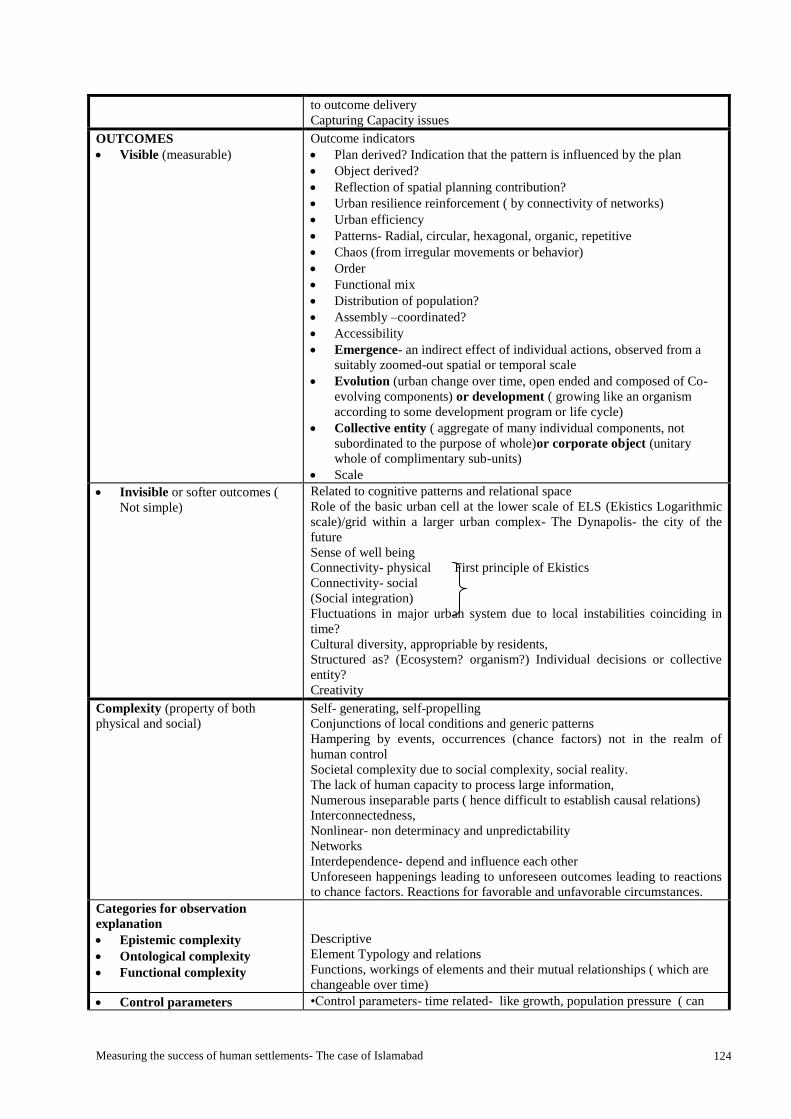
Measuring the success of human settlements- The case of Islamabad 124
to outcome delivery
Capturing Capacity issues
OUTCOMES
Visible (measurable)
Outcome indicators
Plan derived? Indication that the pattern is influenced by the plan
Object derived?
Reflection of spatial planning contribution?
Urban resilience reinforcement ( by connectivity of networks)
Urban efficiency
Patterns- Radial, circular, hexagonal, organic, repetitive
Chaos (from irregular movements or behavior)
Order
Functional mix
Distribution of population?
Assembly –coordinated?
Accessibility
Emergence- an indirect effect of individual actions, observed from a
suitably zoomed-out spatial or temporal scale
Evolution (urban change over time, open ended and composed of Co-
evolving components) or development ( growing like an organism
according to some development program or life cycle)
Collective entity ( aggregate of many individual components, not
subordinated to the purpose of whole)or corporate object (unitary
whole of complimentary sub-units)
Scale
Invisible or softer outcomes (
Not simple)
Related to cognitive patterns and relational space
Role of the basic urban cell at the lower scale of ELS (Ekistics Logarithmic
scale)/grid within a larger urban complex- The Dynapolis- the city of the
future
Sense of well being
Connectivity- physical First principle of Ekistics
Connectivity- social
(Social integration)
Fluctuations in major urban system due to local instabilities coinciding in
time?
Cultural diversity, appropriable by residents,
Structured as? (Ecosystem? organism?) Individual decisions or collective
entity?
Creativity
Complexity (property of both
physical and social)
Self- generating, self-propelling
Conjunctions of local conditions and generic patterns
Hampering by events, occurrences (chance factors) not in the realm of
human control
Societal complexity due to social complexity, social reality.
The lack of human capacity to process large information,
Numerous inseparable parts ( hence difficult to establish causal relations)
Interconnectedness,
Nonlinear- non determinacy and unpredictability
Networks
Interdependence- depend and influence each other
Unforeseen happenings leading to unforeseen outcomes leading to reactions
to chance factors. Reactions for favorable and unfavorable circumstances.
Categories for observation
explanation
Epistemic complexity
Ontological complexity
Functional complexity
Descriptive
Element Typology and relations
Functions, workings of elements and their mutual relationships ( which are
changeable over time)
Control parameters •Control parameters- time related- like growth, population pressure ( can

Measuring the success of human settlements- The case of Islamabad 125
Order parameters
Attention parameters
only be post factum- Portugali, 1997)
•Order parameters
•Attention parameters- five senses of the human. Mind attentiveness for the
generation of information
Four key concepts of Marshall?
For emergence, spontaneous and
organic cities
Four pairs of key concepts:
1.City design versus urban order
1.1 Urban order
1.2 City design
2. Corporate versus collective
2.2 A Collective entity
2.1 A corporate object.
3.City as organism versus city as
ecosystem 3.2 The ecosystem
3.1 The organism
4.City development versus urban
evolution
4.1 City development
4.2 Urban evolution
1.1 to the consistency of urban components and their relationships
1.2 the design or planning of a city in a definite form at a given point in time,
as a finite, whole unit
2.2 an aggregate of many individual components, where each component has
its own purpose that is not subordinated to purpose of the whole
2.1 A unitary whole composed of complementary sub-units
3.2 The city as ecosystem interprets the city as an organic, collective entity.
3.1 The city as organism implies that a city is an organic, corporate whole
4.1 cities grow, like an organism, according to some kind of developmental
program or life-cycle (birth, growth, maturity, death).
4.2 urban changes over time are open-ended. Like an ecosystem, a city is
composed of co-evolving components.
EKISTICS PRINCIPLES
1. Maximization of man’s
potential contacts with the
elements of nature, with other
people, and with the works of
man.
2. Minimization of the effort
required for the achievement
of man's actual and potential
contacts.
3. Optimization of man's
protective space.
4. Optimization of the quality of
man's relationship with his
environment, which consists of
nature, society, shells, and
networks.
5. Finally, man organizes his
settlements in an attempt to
achieve an optimum synthesis
of the other four principles,
and this optimization is
dependent on time.
1.1. The selection of a scale, size and dimension, distance from (water and
trees, buildings and roads, schools, work places, people) that he can
keep the contacts with them.
1.2. Connection of different urban scales/ Ekistics units
1.3. Accessibility and Networks
1.4. Patterns of living
2.1. (He always gives his) structures the shape/ form, or optimal size
2.2. Selection of the route (minimum distances, ease of access), which
requires the minimum effort.
2.3. Have greatest attraction and least resistance.
2.4. Patterns of movement 3.1. The selection of such a distance from other persons, animals, or
objects that contact is maintained (first principle) without any kind of
sensory or psychological discomfort.
3.2. The division or distribution of spaces and territorial boundaries
(material and cognitive). The personal, private, semi private,
semipublic and public etc.
3.3. Socio-spatial configuration of space
4.1. The relations between primary, secondary and tertiary elements as
objects (buildings and houses of all sorts ranging from roads to
telecommunications) and spaces.
4.2. This is the principle that leads to order, physiological and aesthetic,
and that influences architecture and, in many respects, art.
4.3. Arrangement, organization and coordination between systems of
independent functions, activities, services,
5.1. Socio-spatial, temporal, cognitive- complexity approach,
5.2. Functional and organizational structure that joins both- the material
patterns and cognitive patterns
5.3. A synthesis of physical, social and psychological needs in the first four
principles.
5.4. Time line. How have these been synthesized in different periods of time.
5.5. Periods of socio-spatial stability and instability-
5.6. Connectivity ( social, psychological and physical) leads to outcome in
Social and urban resilience
5.7. Increased shock absorbing capacity

Measuring the success of human settlements- The case of Islamabad 126
Annex 3: Time Schedule for field work Table 17: Time schedule for research
S.no TASKS PRIOR WEEK
1
WEEK 2 WEEK 3 WEEK 4
1. Final research proposal submission 10-6-13
2. Development/ improvement of research
instrument (semi-structured interview)
Cross check questions.
Contact list of respondents and reserves
11-6-13
3. Development/ improvement of chapter
2
Parallel
4. Mails and appointments letters for
interviews and secondary/ primary data
collection
12 June
5. Case study protocol prepare 11June
6. Briefing for assistant/ summary
preparation, guide, semi-structured
questions/ printing/ email
11-13
June
7. Logbook/ word files for Atlas Ti
preparation with family and coding
10-6-13
8. Collect secondary data (Archival
records, logs, maps, plans, )
X
9. Organize and Analyse-parallel X
10. Collect primary data (Site visit, survey,
semi structured interviews,
photographs, etc.)
X X X
11. Organize and analyse-parallel X X X
12. Check data and call again X X X
13. Further investigation if required X X X
14. Expert opinion on explanations X X X
15. Check and report thesis supervisor X X X
16. Compile all data and back up X X X X
Source: Author

Measuring the success of human settlements- The case of Islamabad 127
Annex- 4- Questions for semi-structured and in-depth interview Name: _________________
Address: __________________ Interviewer: __________________
Date: __________________ interviewee: __________________
Can you please tell me about the History of the development of the area?
Who were the initial settlers of the area?
When and how long the development took place?
Description of the different phases of development?
Who/ Which parties involved in the initial development of the area?
What were their roles and responsibilities?
Was there government involvement or regulations?
In what stages the government focused more? Why?
Were the communities being involved in the development back then? If yes, in what stages and what
activities?
What were the problems occur during the development?
What are the characteristics and roles of Bhara Kahu (in context of Islamabad)?
What is your opinion about Bhara Kahu back then (initial years of settlement) and now?
Do you see any significant differences besides the changes of the population? Can you name them?
What do you like from Bhara Kahu at that time and now?
What are the principle functions of the town, (whether they are industrial, commercial, marketing or
associated with tourism)? It will examine the pattern, distribution and nature of activities throughout the
zone / area and identify any problem that arise there from such as traffic congestion, lack of open space
and outdated layout (just an idea)
How long you are living in this area?
Do/ did you own land in the original settlement?
Where did your family originally come from?
Do/ did you have other family, friends living in the settlement?
Were there any forests/ lakes from which you can collect resources?
Markets, clinics, recreation facilities etc. in the area?
What problem are you facing?
Are/ were you a member of any social organization?
Are/ were there any NGOs/ political groups active in the area?
What is/ was the level of community interaction in your settlement?
What is/ was your role in the community?
Do/ did you feel safe in the settlement?
Do/ did you encounter problems in your area?
How is the physical design of the area?
What issue you want to be resolved?
What is the big issue in Bhara Kahu, such as commuting, connection with the other areas, security and
safety perhaps?
How does local authority deal with these problems?
Are there any complaints from the community regarding quality of services? If yes, what were they
complaining mostly about?
What is the role of feudalism in your area and what are your recommendations regarding the same?
Is feudal system a benefit or a problem?
If you have to name five good things about the feudal system in your area, what would they be?
If you have to name five bad things about the feudal system in your area, what would they be?
What are the social issues in your town? What are the pros and cons of the same?
Are you satisfied with the infrastructure services provided by the government?
How do you commute daily?
How long distances do you commute on an average?
A description of the social, economic and physical characteristics of the area?
Recommendations if any.

Measuring the success of human settlements- The case of Islamabad 128
Questions according to indicators for Ekistics principles: INDICATORS QUESTIONS
1. Material indicators: physical structure
1.1. The pattern of built fabric
1.2. The organization/ hierarchy of urban
spaces,
1.3. The organization/ hierarchy of street
systems,
1.4. The organization/ hierarchy of
housing units/ different land uses
What is the Present situation of the built fabric in the area?
What is the present situation of organization of urban spaces,
street systems and housing units/ different land uses in the
area?
What was planned for the area?
What changes have occurred in the physical pattern of the
area?
What are the factors responsible for the change in the physical
patterns?
What is the period of change in physical pattern?
What are future plans, predictions? What are they based on?
Ekistics Principle 1:
1. Contact with nature Indicators:
1.1. Existence of nature (parks, lakes,
forest, or open natural areas);
1.2. Frequency of contact with nature.
2. Contact with other people Indicators: 2.1. Existence of public space for social
interaction;
2.2. Frequency of contact with such
places of encounter;
3. Contact with the built environment.
3.1. Existence of markets, schools, places
of worship etc.
3.2. Frequency of contact with these
places
1. Contact with nature Were there in the past/ Are there any play areas for
children and parks and nature reserves in the area?
Do you/ people use these places? Who are mostly the
users of these places?
How many times per week do you visit these places?
2. Contact with other people Where and how do the people normally socialize? (The
women, the men, the elderly)
How often do people socialize?
3. Contact with the built environment What places of need/ facilities (like may be markets or
parks) are there in the area?
How many times per week do you visit these places?
What is the greatest attraction in the area?
Ekistics Principle 2:
1. Effort for Contact with nature
Indicators:
1.1. Distance/ ease of access to nature (parks,
lakes, forest, or natural areas);
1.2. Modes and time to access these places
(walking, public transport, car), etc.
2. Effort for Contact with other people
Indicators: 2.1. Distance/ ease of access to such places of
encounter;
2.2. Modes and time to access these places of
encounter;
3. Effort for Contact with the work of
man.
3.1. The distances/ ease of access to the other
houses, commercial areas, schools,
offices, places of worship etc.
3.2. Modes and time to access these places
1. Effort for Contact with nature
What are the nearest natural areas/ nature reserves, in the
area? What is the distance?
How do you access these areas? What modes of
commutation do you use (like walking, private or public
transport)?
How much time does it take to reach by walking, using
transport?
2. Effort for Contact with other people What are the nearest places of socialization, what is the
distance?
What are the nearest places of play, recreation, what is
the distance?
How do you access these areas? What modes of
commutation do you use (like walking, private or public
transport)?
How much time does it take to reach by walking, using
transport?
3. Effort for Contact with the work of man.
What are the nearest places of commercial areas, schools,
health care, places of worship etc.? At how much
distance?
How do you commute? Are most important places to you
easily accessible by walking or transport?
Which are the most important places to you that you feel
should be nearest?
How much time does it take to reach by walking, using
transport?
Where you would like to go more often? How much time
does it take to walk to the nearest of the most visited

Measuring the success of human settlements- The case of Islamabad 129
areas?
Ekistics Principle 3:
Awareness of the environment
The perception of safe distance
The distribution of the personal, private, and
public space
Awareness of the environment
What was it like when you first moved here? What is the
difference over the years?
What are the main issues or problems in the area?
Do/ did you encounter problems such as drugs,
alcoholism or armed gangs in your area?
The perception of safe distance
Do you feel safe and secure while you are in the
neighborhood? What makes you feel safe & secure in any
environment?
What gives you the sense of security?
Does the area give you a fear of your children getting lost
if they go out alone?
How far can they go alone?
Do you find difficulties in going to market and moving
around the neighborhood?
How often you go out and reasons and places?
The distribution of the personal, private, and public space
What is/ was the level of socialization in your settlement?
(The women, the men, the elderly)
Ekistics Principle 4:
1. Quality of Relationship of man and
nature- indicators:
1.1. The connectivity between elements of
nature and man.
1.2. Influences on (quality) of nature.
1.3. Use of green spaces/ water bodies etc. as
bifurcations or transitional spaces.
1.4. Awareness of surrounding natural areas/
nature reserves etc.
2. Quality of Relationship of man and
society- indicators:
2.1. The social integration and Sense of well-
being.
2.2. Influences on relationship. People’s
perception of them and society ( a part of
society or apart from society)
2.3. Existence of social networks
2.4. Use of social networks
2.5. Awareness of social issues
3. Quality of Relationship of man with
built environment- indicators: 3.1. The physical connectivity
3.2. The Influences on relationship of built
environment and people. (Organization,
the physical quality of urban spaces,
street systems, built fabric etc.)
3.3. User perception of them and the place-
sense of association, ownership,
belongingness
3.4. Awareness of built environment.
Quality of Relationship of man and nature What is the greatest attraction in the area?
What do you think about the nature around you?
What are your feelings when you are amidst nature?
Preference for a view of landscape from locations of
living working?
Have the greens increased or reduced since you know the
place?
What needs to be conserved/ improved in the natural
environment?
Quality of Relationship of man and society How long have you/ your family been living in the
settlement?
Where did your family originally come from?
Do/ did you have other family, friends living in the
settlement?
What is/ was the level of socialization in your settlement?
What activities do you share with neighbors/ community/
within neighborhood?
What is/ was your role in the community?
What is/ was the role of the community in times of
problems/ crisis etc.? Is there leadership or NGOs, CBOs,
who you/ people can turn to for support?
What are the main social issues of the community?
Quality of Relationship of man with built environment How well is the place connected to the surroundings/
different neighborhoods?
Do visitors easily find way to the area?
Does someone visiting for the first time have difficulty
finding the way?
Did you find difficulties in finding the market or your
way back home from someone’s place in your
neighborhood for the first time?
What is/ was better in here as compared to from where
you come from?
What is better over there?
What has improved here (Urban spaces, street systems,
etc.) over the years?

Measuring the success of human settlements- The case of Islamabad 130
What has deteriorated?
Where are/ were you more comfortable/ at home?
Reason? Or which place you consider to be home to you?
Why?
Do you own property here?
Which locations are/ were best here to live and why? Or
which locations have best accessibility to most areas one
would need?
What should/ does one seek when deciding on location?
Near to what?

Measuring the success of human settlements- The case of Islamabad 131
Annex- 5-Interview guide for planners
Respondent: ____________________________________________________________________
Position: _______________________________________________________________________
Department: ____________________________________________________________________
Educational background: ____________________________________________________________
Tenure of present job: _____________________________________________________________
Total work experience: ____________________________________________________________
Date: _____________________________________________
1. Mapping the change in the physical patterns in Islamabad
1.1. What is/ how do you see the present situation of the built fabric/ environment in Islamabad in
general?
1.2. Has the present situation of organization of urban spaces, street systems and housing units/
different land uses in the sector G-6 resulted in outcomes as per Doxiadis’ foresight for the
area and satisfying human needs?
1.3. How do you see the changes in the physical pattern of Islamabad which shows deviation from
the original 1960 plan in terms of their effects (negative or positive)?
1.4. What are the factors responsible for the change in the physical patterns in G-6?
1.5. What are the social, political, economic, cultural, regional or global events and processes that
you think are responsible for the change in the patterns of development or have influenced
the formation and transformation of the planned and unplanned settlements of Islamabad in
time?
1.6. What is/are the period(s) of change in physical pattern? Are there any significant eras that
contributed to the change in patterns?
2. Doxiadis and Islamabad
2.1. What do you think about the Doxiadis plan for the city of Islamabad?
2.2. What do you think are the most important considerations of his plan that can help to maintain the
original context of Dynapolis- the city of the future- Islamabad?
2.3. Can the city of Islamabad still grow linearly and as a unidirectional city as planned? Can the
Dynapolis study still be used to predict the further futures of the city of Islamabad?
2.4. What do you think about the five principles of Ekistics? Is the synthesis of maximum contacts,
minimum effort for achieving the contacts, maximum protective space, and relationship with
environment the thing to focus on in human settlements in context of Islamabad?
2.5. Are these principles or needs satisfied in the planned settlements of Islamabad?
2.6. Do you think these principles form the basis of the unplanned settlements too or let’s say
settlements other than zone 1?
2.7. Where do you think are the gaps/ problems in the case of Islamabad? What can be done about it?
2.8. Do you think the grid of the city design can further be maintained at present situation? Do you
think it should be maintained? How important is it to maintain the grid and control the patterns for
the city of Islamabad?
2.9. The zoning regulations have been revised for zone IV bringing in a lot of functions not in
accordance with the Doxiadis plan? With the changes that have not been reviewed by Doxiadis
associates what patterns do you foresee will follow?
3. Human settlements and their success

Measuring the success of human settlements- The case of Islamabad 132
3.1. What do you think is a successful human settlement? What elements describe the success in
context of Islamabad?
3.2. According to Doxiadis success is when the needs pertaining to the settlements are fulfilled
and humans are happy and satisfied? How can the success of planned and unplanned human
settlements in Islamabad be measured when one is compromising on one thing in one
settlement and on the other in the other settlement? What will then promote happiness and
satisfaction?
3.3. What are the key features or ingredients of a human settlement in order of importance?
3.4. Since the city of Islamabad was formed on the principles of ekistics, should and can the scope
of ekistics be extended and the development still be guided by these principles? Reference to
rethinking Doxiadis’ ekistics 2010?
3.5. Do you think that adjustments need to be made to the philosophy Doxiadis? If yes what
adjustments do you think are in line with the patterns of development Islamabad has seen in
fifty three years?
3.6. Are we closer to the ideal city of Doxiadis- the Dynapolis- from the city of past to the city of
future? Is there a continuum?
3.7. Do you wish to add anything to the interview that you believe is important and missing in the
study?
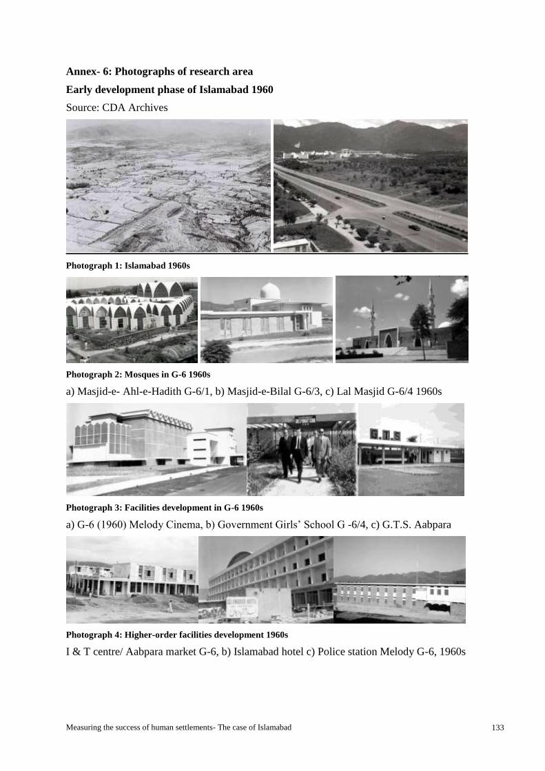
Measuring the success of human settlements- The case of Islamabad 133
Annex- 6: Photographs of research area
Early development phase of Islamabad 1960
Source: CDA Archives
Photograph 1: Islamabad 1960s
Photograph 2: Mosques in G-6 1960s
a) Masjid-e- Ahl-e-Hadith G-6/1, b) Masjid-e-Bilal G-6/3, c) Lal Masjid G-6/4 1960s
Photograph 3: Facilities development in G-6 1960s
a) G-6 (1960) Melody Cinema, b) Government Girls’ School G -6/4, c) G.T.S. Aabpara
Photograph 4: Higher-order facilities development 1960s
I & T centre/ Aabpara market G-6, b) Islamabad hotel c) Police station Melody G-6, 1960s

Measuring the success of human settlements- The case of Islamabad 134
PLANNED HUMAN SETTLEMENT OF G-6- (2013)
Source: Author (2013)
Existence of contacts:
Contact with nature:
Photograph 5: Nature
G-6/4 Storm water nala near Lal masjid used earlier for fishing and relief from heat by
children b) Community Park c) The right of way or green belt (475 feet wide) along the Atta
Turk Avenue and a storm water nala running through.
Contact with works of man:
Photograph 6: Works of man
Markaz G-6- Melody market a) Pakistan Post office b) First four star hotel of Islamabad
(1960s)- Islamabad Hotel, c) First Mosque in G-6- Lal Masjid (Red Mosque) 1966
Photograph 7: Commercial activity at different levels
a & b), Main Aabpara Market I& T centre developed in sixties, c) New Aabpara market G-6-
1 developed in nineties, d) Weekly Itwaar bazaar
Photograph 8: Weekly bazaars and markets G-6

Measuring the success of human settlements- The case of Islamabad 135
a) Informal women sellers occupying pedestrian paths outside Lal Masjid on Sunday b)
Itwaar Bazaar (Sunday market)
Photograph 9: Commercial activity in G-6
a) Small informal hotel and fruit vendors b) CDA allotted kiosk 10’x10’ c) informal eateries
developed at Van stop in Aabpara, d) Café G-6/1 the oldest café in Islamabad
Photograph 10: G-6- Accessibility options
Van stops at various locations Aabpara van adda, pedestrian and motor bike and Bicycle
Bridge connecting G-6 and G-7 on Seventh Avenue.
Photograph 11: G-6 No through traffic streets and pedestrian paths providing inter street connection

Measuring the success of human settlements- The case of Islamabad 136
Photograph 12: Mosques in different sub-sectors of G-6
Photograph 13: Different academic institutes (public and private) in the sector G-6
Photograph 14: Public facilities G-6
a) Polyclinic Hospital b) Capital Hospital c) Police Station
Photograph 15: Water filtration plants and overhead water tanks for the area

Measuring the success of human settlements- The case of Islamabad 137
UNPLANNED HUMAN SETTLEMENT OF BHARA KAHU (2013)
Source: Author (2013)
Existence of contacts:
Contact with nature:
Photograph 16: Views of natural landscape dominant in Bhara Kahu
Contact with works of man:
Photograph 17: Commercial areas and markets Bhara Kahu
a) Stalls along Simly Dam road b) Wednesday bazaar c) Main commercial area along Murree
road
Photograph 18: Main Murree road approach to Bhara Kahu

Measuring the success of human settlements- The case of Islamabad 138
Photograph 19: Street systems- vehicular and pedestrian only streets
Photograph 20: Academic institutes (Public and Private) in the Bhara Kahu
Photograph 21: Public facilities institutions
Bhara Kahu-Government Rural Health centre, Rural Development centre Bhara Kahu

Measuring the success of human settlements- The case of Islamabad 139
Annex-7- Tables of research findings
Source: Author
Table 18: G-6- Frequency of contact
S.No Particulars Very
often
Often Sometimes Rarely Never
1. Nature reserves
a Lakes, Rivers etc. 5 23 14 27 9
b Forests 0 9 18 23 14
c Green area/ Fields 14 14 18 9 14
2. Parks 50 9 18 5 9
3. Places of social interaction
a Within the same street 18 9 9 14 9
b Within the neighbourhood 9 9 14 14 5
c Outside the neighbourhood but within the
same sector/ locality
5 9 14 5 14
d Outside the sector but the same series etc. 0 23 23 14 14
4. Play grounds 32 9 14 18 9
5. Market/ commercial areas 70 14 5 6 5
6. Places of worship 32 5 9 5 9
7. Academic institutes 20 14 5 9 14
8. Healthcare 14 9 18 14 14
9. Offices, banks etc. 18 18 6 5 6
Table 19: Bhara Kahu- Frequency of contact
S.No Particulars Very
often
Often Sometimes Rarely Never
1. Nature reserves
a Lakes, Rivers etc. 17 38 17 4 17
b Forests 17 21 17 4 17
c Green area/ Fields 25 13 8 13 13
2. Parks 46 25 8 8 13
3. Places of social interaction
a Within the same street 8 29 21 4 4
b Within the neighbourhood 21 13 21 4 4
c Outside the neighbourhood but within the
same sector/ locality
17 17 8 13 8
d Outside the sector but the same series etc. 4 13 8 21 8
4. Play grounds 29 33 4 8 25
5. Market/ commercial areas 38 33 17 0 0
6. Places of worship 25 25 17 13 8
7. Academic institutes 17 21 13 17 29
8. Healthcare 8 21 29 17 4
9. Offices, banks etc 13 13 4 4 17

Measuring the success of human settlements- The case of Islamabad 140
Table 20: Needs of people pertaining to settlements- G-6
S. No. Particulars Strongly
agree
Agree Neutral Disagree Strongly
disagree
1 Nature reserves
Lakes 23 18 14 5 9
Forests 14 9 0 27 18
Open green areas 36 18 14 5 5
2 Parks 82 9 0 0 0
3 Places of social interaction
Within the same street 45 23 14 5 0
Within the neighbourhood 0 36 23 9 0
Outside the neighbourhood but
within the same sector/locality
0 36 9 5 9
Outside the sector but the same
series etc.
0 18 9 9 9
4 Play Grounds 45 27 18 0 0
5 Community centre 14 27 9 0 0
6 Markets/ commercial areas 50 23 14 5 0
7 Places of worship 36 18 9 9 0
8 Academic institutes 36 27 5 9 0
9 Library 68 18 14 0 0
10 Healthcare 36 27 23 0 0
11 Work place 32 14 5 9 5
Table 21: Needs of people pertaining to settlements- Bhara Kahu
S. No. Particulars Strongly
agree
Agree Neutral Disagree Strongly
disagree
1 Nature reserves
Lakes 42 25 0 4 4
Forests 38 13 25 4 4
Open green areas 38 21 4 0 8
2 Parks 58 25 4 4 8
3 Places of social interaction
Within the same street 4 8 8 4 0
Within the neighbourhood 4 17 0 8 8
Outside the neighbourhood but
within the same sector/locality
13 13 21 4 4
Outside the sector but the same
series etc.
4 13 21 4 4
4 Play Grounds 42 33 8 4.2 4
5 Community centre 17 21 25 8 0
6 Markets/ commercial areas 33 17 8 4 8
7 Places of worship 42 4 17 25 0
8 Academic institutes 25 21 8 0 4
9 Library 0 21 17 0 0
10 Healthcare 38 25 8 0 17
11 Work place 13 4 8 8 17
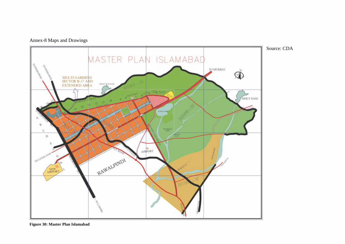
Measuring the success of human settlements- The case of Islamabad 141
Annex-8 Maps and Drawings
Source: CDA
Figure 30: Master Plan Islamabad
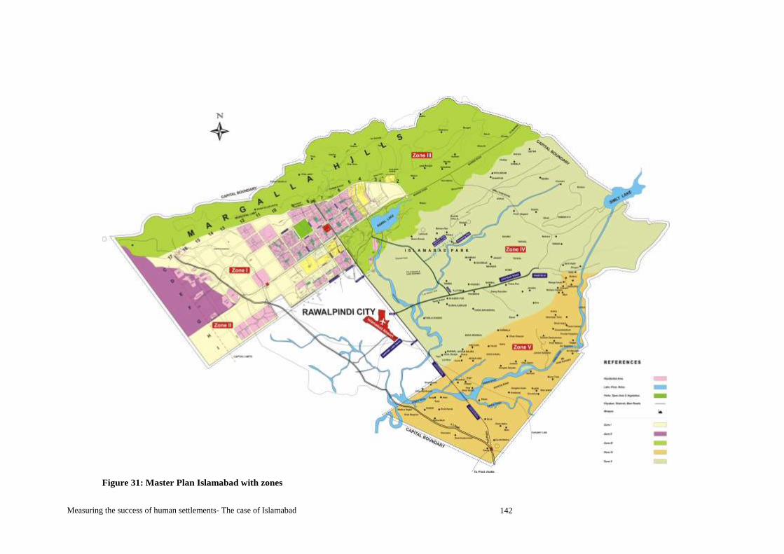
Measuring the success of human settlements- The case of Islamabad 142
Figure 31: Master Plan Islamabad with zones

Measuring the success of human settlements- The case of Islamabad 143
Figure 32: Master Plan for Islamabad Metropolitan Area 1960
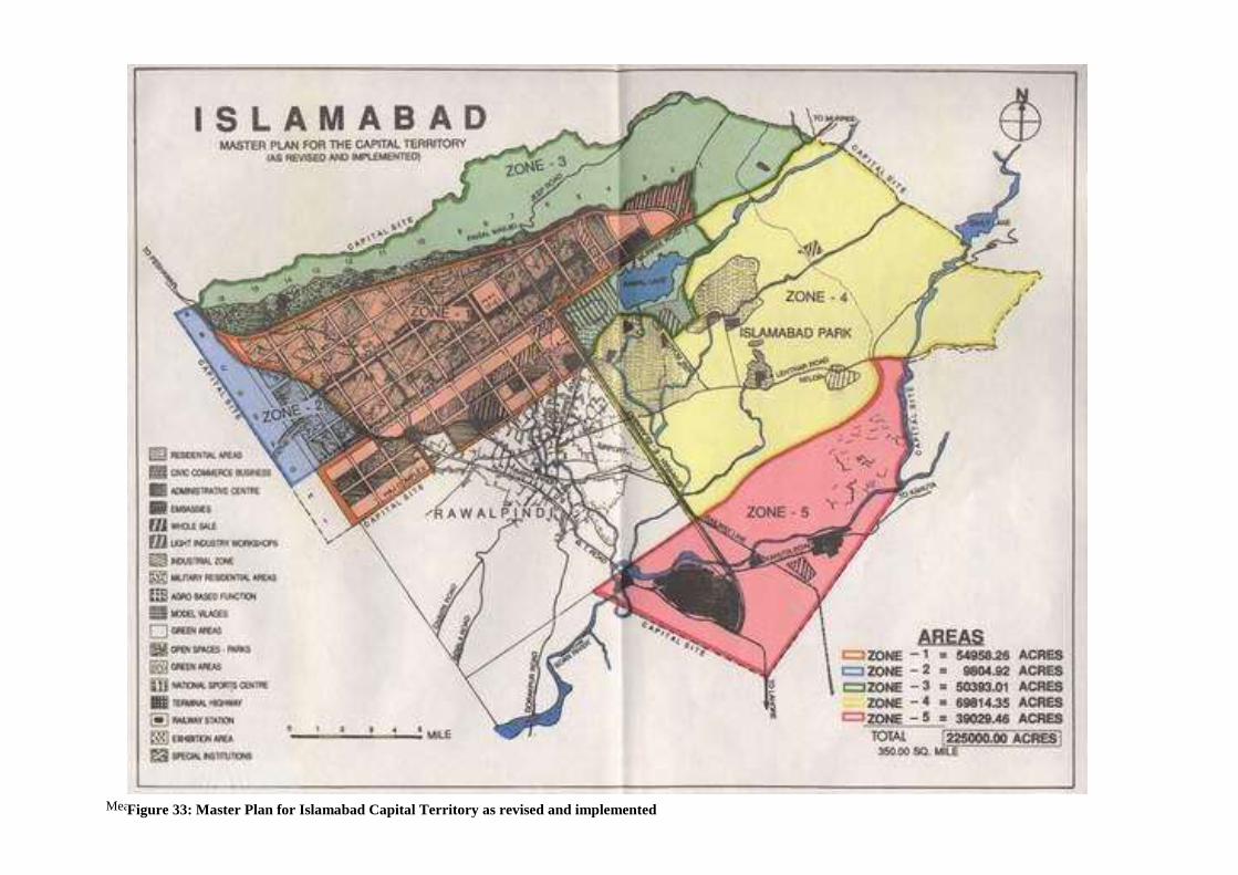
Measuring the success of human settlements- The case of Islamabad 144
Figure 33: Master Plan for Islamabad Capital Territory as revised and implemented

Measuring the success of human settlements- The case of Islamabad 145