mrc council study: national counterparts’ catchup · 7/22/2015 1 mrc council study: national...
TRANSCRIPT

7/22/2015
1
www.mrcmekong.org
MRC Council Study: National Counterparts’
Catchup
1
www.mrcmekong.org

7/22/2015
2
www.mrcmekong.org
Hydrology
Hydraulics
Geomorphology/
Sedimentology
Fish
Water Quality
Vegetation
Invertebrates
Frogs and Reptiles
Affects livelihoods & economies
Birds
Flow is the principle driver.
Changes in volume and timing will affect the system
Depths, velocities and areas inundated will change
Channel shape and sediment will change
Nutrient levels and organic content will be
affected
Amount and location of aquatic and riparian
plants will change
Fisheries will change
Communities change. Food species and
pest species change in abundance
Non-fish fisheries will change
Bird abundances will change
Overa
ll changes in t
he n
atu
re a
nd f
unctionin
g o
f th
e r
iver
ecosyste
m
www.mrcmekong.org
River flow and ecosystem functioning • Lowflows:
– basic seasonal nature of the river;
– more or less wetted habitat;
– different hydraulic and chemical conditions.
• Floods: – general geomorphological character, shape and size of river channel;
– inundate floodplains and backwater areas
– mobilise sediments and deposit silt, nutrients and seeds on floodplains;
– maintain moisture levels in the banks that support the trees and shrubs;
– trigger the emergence of adults of aquatic insects, which provide food for fish, frogs and birds;
– stimulate and provide habitat for spawning in fish
• Flow variability, on a daily, seasonal or annual basis: – acts as a form of natural disturbance – maintains habitat and biological diversity;
– dictates the width of the vegetation belt along the water line, which protects the banks against erosion.

7/22/2015
3
www.mrcmekong.org
Water-resource developments change:
• flow regimes;
• water chemistry;
• sediment and temperature regimes;
• habitats;
• fauna and flora;
• ecosystem services on which people depend.
www.mrcmekong.org
H1
H2
H3
H4
H5a
H5b
H6
H7
H8
H9
H10
H11
H12
H13
H14
H15
H16
S1
P1
Hy1
Hy2
Hy3
Hy4
Hy5
F1
F2
F3
F4
G1
G2
G3
G4
G5
G6
G7
G8
G9
I1
I2
I3
WQ11
WQ12
WQ10
WQ1
WQ2
WQ3
WQ4
WQ7
WQ8
WQ9
WQ5
WQ6
V4
V5
V6
V1
V2
V3

7/22/2015
4
www.mrcmekong.org
• Overwhelmingly complex if all viewed at once
SO
• Divide ecosystem into discipline each with a small set of indicators
• Identify what are the main factors affecting change in each indicator (driving linked indicators)
• Focus on each individual relationship
• Use a model to compute permutations
www.mrcmekong.org
DRIFT
Downstream Response to Imposed Flow Transformation

7/22/2015
5
www.mrcmekong.org
The Council Study
www.mrcmekong.org
Biological Resources Assessment (BioRA)

7/22/2015
6
www.mrcmekong.org
Objective of BioRA To provide clear and comparable information on the impacts of proposed thematic developments on the aquatic resources of main-stem Lower Mekong River, inclusive of the Tonle Sap Great Lake and the Mekong Delta.
www.mrcmekong.org
BioRA Team BioRA Management:
• Dr So Nam, Dr Peter Degan, Dr Cate Brown; Dr Alison Joubert
International and Regional Consultants:
• Geomorph/WQ: Dr Lois Koehnken
• Vegetation: Dr Andrew MacDonald
– Macrophytes (delta): Dr Nguyen Thi Ngoc Anh
– Algae (delta): Ms Duong Thi Hoang Oanh
• Invertebrates: Dr Ian Campbell
• Fish: Dr Ian Cowx, with Dr Kenzo Utsugi (Delta support)
• Mammals and birds: Mr Anthony Stones
• Frogs and reptiles: Dr Hoang Minh Duc
• Tonle Sap processes: Dr Dirk Lamberts
National Counterparts:
Next slide

7/22/2015
7
www.mrcmekong.org
National Counterparts
Country Name Discipline
Cambodia
Geomorphology Toch Sophon
Biodiversity, excl. fish Pich Sereywath
Fish Dr Chea Tharith
Laos PDR
Geomorphology Dr Bounheng Soutichak
Vegetation Thananh Khotpathoom
Fauna, excl. fish Dr Phaivanh Phiapalath
Fish Dr Kaviphone Phouthavong
Thailand Fauna, excl. fish TBD
Fish Chaiwut Grudpun
Viet Nam
Geomorphology Dr Hoang Thanh Tung
Biodiversity, excl. fish Dr Luu Hong Truong
Fish Vu Vi An
www.mrcmekong.org
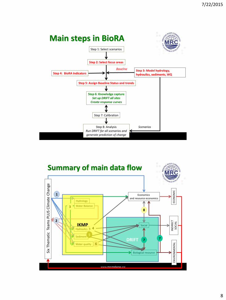
Step 1: Select scenarios
Baseline
Scenarios
Main steps in BioRA
Step 3: Model hydrology, hydraulics, sediments, WQ
Step 5: Assign Baseline Status and trends
Step 6: Knowledge capture Set up DRIFT all sites
Create response curves
Step 7: Calibration
Step 8: Analysis Run DRIFT for all scenarios and generate prediction of change
Step 4: BioRA Indicators
Step 2: Select focus areas
7/22/2015
8
www.mrcmekong.org
Step 1: Select scenarios
Baseline
Scenarios
Main steps in BioRA
Step 3: Model hydrology, hydraulics, sediments, WQ
Step 5: Assign Baseline Status and trends
Step 6: Knowledge capture Set up DRIFT all sites
Create response curves
Step 7: Calibration
Step 8: Analysis Run DRIFT for all scenarios and generate prediction of change
Step 4: BioRA Indicators
Step 2: Select focus areas
www.mrcmekong.org
Hydrology
Water Balance
Hydraulics
Sediment
Water quality
Economics and resource economics
Biological resource
Social
ECO
NO
MIC
IN
DIR
ECT
SOC
IAL
ENV
IRO
NM
ENTA
L
Six
Th
emat
ic T
eam
s P
LUS
Clim
ate
Ch
ange
Summary of main data flow
DRIFT
3
4
5
6
2
1
7 7
8
IKMP

7/22/2015
9
www.mrcmekong.org
BioRA Focus Areas
www.mrcmekong.org
Establish nodes Tier Criteria Description
1 International borders Add node at each international border
2 Hydrological zones Add node at downstream end of each Hydrological Zone
3 Geomorphological zones Add node at downstream end of each Geomorphological Zone
4 Tributaries Add node upstream of each major tributary
5 Conservation hotspots Add node upstream and downstream of conservation hotspots
6 Mainstem fish migration pathways
Add node in mid-point of fish migratory pathways.
7 Inundation bands Add node to represent the lowest extent of each inundation band in Tonle Sap Great Lake
8 Salinity Add nodes at extent of flood and drought salinity intrusion
9 Existing water-resource developments
Add node upstream and downstream of locations of major existing water resource developments, plus navigation and sand mining
10 Planned water-resource developments
Add a node at the upstream limit of major dam infrastructure, mines, towns, agricultural areas, etc.
11 Socio-economic zones Add node at downstream end of each Socio-economic Zone
12 Rationalisation 1. Remove nodes that <10 km (river length) apart. 2. Remove nodes at tributaries unimportant for sediment and fish.

7/22/2015
10
www.mrcmekong.org
BioRA Zones
BioRA Zone 1
BioRA Zone 2
BioRA Zone 3
BioRA Zone 4
BioRA Zone 5
BioRA Zone 8
BioRA Zone 6
BioRA Zone 7
www.mrcmekong.org
BioRA Focus areas
(FAs) FA7
FA8
FA5
FA4
FA3
FA2
FA1
FA6

7/22/2015
11
www.mrcmekong.org
BioRA Indicators
www.mrcmekong.org
Geomorphology indicators
Code Indicator
Erosion Erosion (bank / bed incision)
FineCoarse Dry and wet season bed sediment size
Sandbars Availability of sandy bars, islands and insets
Rockreefs Exposure of rocky reefs
PDepth Bedrock pool depth
Clarity Water clarity

7/22/2015
12
www.mrcmekong.org
Vegetation indicators Code Indicator
CUCover
Channel
Extent of upper bank vegetation cover
CLCover Extent of lower bank vegetation cover
CHerb Extent of herbaceous marsh vegetation
CBioRip Biomass of riparian vegetation
CBioAlg Biomass of algae (planktonic and benthic)
CComm Community structure and species composition
FForest
Floodplain
Extent of flooded forest cover
FHerb Extent of herbaceous marsh vegetation
FBio Biomass of riparian/aquatic cover
FBioBG Biomass of cyanobacteria
FBioAlg Biomass of algae (planktonic and benthic)
RipInv Extent of Invasive riparian plant cover
FloatInv Extent of floating and submerged invasive plant cover
www.mrcmekong.org
Macroinvertebrate indicators Code Indicator
Hept Heptageniid mayflies
Beat Baetid mayflies
Emerge Dry season emergence
Palin Palingeniid mayflies
SnailA Snail abundance
SnailD Diversity of snails
N. aperta Neotricula aperta
Bivalve Bivalves abundance
Poly Polychaet worms
Crust Shrimps and crabs
LitDiv Littoral diversity
LitASPT Littoral ATSP
BenDiv Benthic diversity
BenASPT Benthic ATSP
Zoo Zooplankton abundance
7/22/2015
13
www.mrcmekong.org
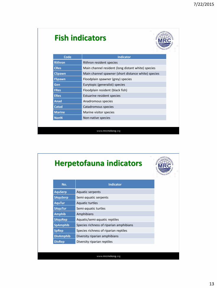
Fish indicators
Code Indicator
Rithron Rithron resident species
CRes Main channel resident (long distant white) species
CSpawn Main channel spawner (short distance white) species
FSpawn Floodplain spawner (grey) species
Gen Eurytopic (generalist) species
FRes Floodplain resident (black fish)
ERes Estuarine resident species
Anad Anadromous species
Catad Catadromous species
Marine Marine visitor species
NonN Non-native species
www.mrcmekong.org
Herpetofauna indicators
No. Indicator
AquSerp Aquatic serpents
SAquSerp Semi-aquatic serpents
AquTur Aquatic turtles
SAquTur Semi-aquatic turtles
Amphib Amphibians
SAquRep Aquatic/semi-aquatic reptiles
SpAmphib Species richness of riparian amphibians
SpRep Species richness of riparian reptiles
DivAmphib Diversity riparian amphibians
DivRep Diversity riparian reptiles

7/22/2015
14
www.mrcmekong.org
Bird and mammal indicators
No. Indicator
CGround
Birds
Medium / large ground-nesting channel species
SeaFV Small non-flocking land bird of seasonally flooded vegetation
TreeWB Tree-nesting large waterbird
CHole Bank-/hole-nesting species
Grambeds Flocking non-aerial passerine of tall graminoid beds
FGround Large ground-nesting species of floodplain wetlands
CForest Channel-using large species which require bank side forest
CRock Natural rocky crevice nester in channels
WoodWater Dense woody vegetation / water interface
Dolphin
Mammals
Irrawaddy dolphin
Otter Otters
Ung Wetland ungulates
www.mrcmekong.org
BARRIERS
Vegetation
Water quality
Geomorphology
Macroinvertebrates
Fish
Herpetofauna
Birds
Mammals
Hydrologic
Hydraulic
Sediments
Mo
de
lle
d t
ime
-se
rie
s f
rom
th
e D
SF
Indicators and Linked Indicators

7/22/2015
15
www.mrcmekong.org
Indicators and Linked Indicators MAR
Do
Dd
Dq
Fo
Fd
Fq
Fv
T2s
Ddv
Fdv
mxiDry
diDry
mxiT1
diT1
mxiWet
diWet
raiDry
raiT1
raiWet
raiT2
CWidth
PDepth
Clarity
Erosion
FineCoarse
Sandbars
Rockreefs
BARRIER
pH
TSS
ALK
SO4
NO32
NH4N
DO
TOTN
PO4P
TOTP
Si
COD
Salinity
Temp
avChV
maxCQ
minCQ
CSS
Slope
Elevation
avFpV
maxFpV
minFpD
Inun2C
InunArea
FpD
SedConc
SedLoad
SedGrain
SedOnset
SedDur
CGround
Grambeds
CRock
WoodWater
SeaFV
CForest
FGround
CHole
TreeWB
CHerb
FloatInv
CUCover
CLCover
RipInv
CBioRip
CBioAlg
ChComm
FComm
FBioAlg
FBioBG
FForest
FHerb
FBiom
Anad
Catad
Marine
NonN
FSpawn
Gen
ERes
Rithron
CRes
CSpawn
FRes
Palin
SnailA
SnailD
LitDiv
Hept
Baet
Emerge
LitASPT
BenASPT
Zoo
BenDiv
Poly
N. aperta
Bivalve
Crust
Otter
Ung
Dolphin
AquSerp
SAquSerp
AquTurt
SAquTurt
Amphib
SAquRep
SpAmphib
SpRep
DivAmphib
DivRep
Hydrologic
Hydraulic
Water quality
Sediments
Geomorphology
Vegetation
Macroinvertebrates
Fish
Herpetofauna
Birds
Mammals
mo
del
led
eco
syst
em
Key
www.mrcmekong.org
Re
sp
on
se c
urv
es f
or
ea
ch
lin
ke
d in
dic
ato
r
Time-series of change
in indicator A
VegetationHydraulics
Macroinvertebrates
Geomorphology
Modelled hydrology time-series
Linked indicators for Indicator A
Depth
Velocity
Temperature
Macroinvert spp.
Marginal vegetation
Sandy banks
Modelled sediment time-series
Modelled water quality time-series
Indicators and Linked Indicators

7/22/2015
16
www.mrcmekong.org
BioRA Status and Trends
www.mrcmekong.org
Status and trends
• Baseline status and trajectory of change at every focus area for: – Geomorphology/Habitats
– Water quality
– Riparian vegetation
– Instream macrophytes
– Algae
– Macroinvertebrates
– Fish
– Birds
– Mammals
– Frogs
– Reptiles
• Current (2015) status and past change for each indicator at every focus area: – Identify main driving forces influencing status
• Past conditions : – 1900; 1950; 1990; 2000; 2007
Area: EROSION Status Abundance as % of 2015
2015 1900 1950 1970 2000
Mekong River in Laos PDR D 50 50 50 60
Mekong River in Laos PDR/Thailand D 50 50 60 70
Mekong River in Cambodia D 50 50 60 70
Tonle Sap River C 50 50 60 70
Tonle Sap Great Lake C 50 50 60 70
Mekong Delta D 50 50 60 70
1. impoundments, which reduce sediment delivery and alter the flow regime;
2. sediment mining, which alters channel morphology and induces bank erosion through steepening;
3. land cover changes, which alter the quantity of sediment delivered to the river;
4. irrigation and other extractions, which alter the flow regime.

7/22/2015
17
www.mrcmekong.org
BioRA Schedule
www.mrcmekong.org
BioRA Schedule
Preparation Meetings: March 2015
Field Visits: March 2015
Status and trends: June 2015
Field Visit 2: July 2015
DSS Set-up – river/TLS: June-July 2015
KCW &Calibration –river/TLS: Sept 2015
KCW – Delta: Sept 2015
Calibration – Delta: November 2015
Specialist Reports: November 2015
Scenario Assessment & Reporting: March/June 2016

7/22/2015
18
www.mrcmekong.org
Knowledge Capture
• Sequential/staggered drafting of Response Curves 1. Geomorphology
2. Biota
• Iterative – Indicators and linked indicators may change
– Motivations for RC must be provided
H1 H2 H3 H4
H5a H5b H6 H7 H8 H9
H10 H11 H12 H13 H14 H15 H16 S1 P1
Hy1 Hy2 Hy3 Hy4 Hy5
F1
F2
F3
F4
G1
G2
G3
G4
G5
G6
G7
G8
G9
I1
I2
I3 WQ11
WQ12
WQ10
WQ1
WQ2
WQ3
WQ4
WQ7
WQ8
WQ9
WQ5
WQ6
V4
V5
V6
V1
V2
V3
-5
-4
-3
-2
-1
0
1
2
0 100 200 300 400
Dry season duration (days)
Se
ve
rity
ra
tin
g in
dic
ati
ng
ch
an
ge
in a
bu
nda
nce
www.mrcmekong.org
Calibration
• Run ‘calibration’ scenarios to assist with calibrating RCs:
– Naturalised scenario
– Extreme scenarios
– Stepped scenarios
– Development and exogenous scenarios
• Workshop(s) in Vientiane
• One-on-one sessions facilitated by Skype/email

7/22/2015
19
www.mrcmekong.org
Specialist Reports
1. Discipline-specific description of study area
2. Indicators:
1. Reasons for selection
2. Description
3. Status and trends
4. Response curve evidence-based motivations
www.mrcmekong.org
Scenario Evaluation and Reporting
• Run scenarios through the DRIFT DSS
• Specialists to review outcomes
• Make adjustments to Response Curves if and where deemed necessary
• Draft the reports:
– Thematic
– Cumulative
• Specialists to review and discipline-specific inputs to reports

7/22/2015
20
www.mrcmekong.org
Role of National Consultants
• Support Lead Consultants:
– Data
– Input on Response Curves
– Motivations
• Ensure understand the process
• Feedback to MCs
www.mrcmekong.org
DELIVERABLES Date
Deliverable 1: Progress Report - Preliminary Indicators and Focus Area Done
Deliverable 2: Progress Report - DSS Set-up 31 July 2015
Deliverable 3: Specialist Reports November 2015
Deliverable 4: Populated and calibrated DRIFT DSS November 2015
Deliverable 5: Thematic Scenario Reports 2016
Deliverable 6: Cumulative Scenario Report 2016

7/22/2015
21
www.mrcmekong.org
Report: DSS Set-up. This will contain, inter alia: Revised BioRA indicator list Links to MRC indicators Anticipated direction of change in BioRA indicators
response to changes in linked indicators Trends and Status assessments Layout of DRIFT DSS for BioRA Reference data sets
– Schedule of follow-up activities – Summary of main issues arising from meetings – Copies of presentations made at meetings
Outputs of OSV July Meetings
www.mrcmekong.org
Thank you