morobe gold and silver project socio-economic impact study · the junction of slate creek and the...
TRANSCRIPT

Morobe Consolidated Goldfields Limited
Morobe Gold and Silver Project
Socio-Economic Impact Study
Volume I Introduction, analysis of social and political risks,
recommendations
Volume II Area study and social mapping
► Volume III Working Papers
March 2001 proof corrections 11 May 2001
document format remediated in Word 2007, 22 August 2010
Author With the assistance of
John Burton Peter Bennett, MCG
In 2001: Morobe Consolidated Goldfields Ngawae Mitio, MCG
In 2010: Australian National University Lengeto Giam, MCG
Wayang Kawa, MCG
Susy Bonnell, Subada Consulting
Jennifer Krimbu, MCG
Boina Yaya, MCG
13-i
CONTENTS
The Working Papers collect together work carried out for CRA and AGF, as well as for the present impact study. Too many informants to mention by name, as well as my colleagues L. Giam and W. Kawa, have supplied the information on which they are based—I acknowledge their great help in putting together this material.
Working Paper No. 1 Hidden Valley: some historical matters to start with (1995)
Working Paper No. 2 Condemned forever to fight? social mapping at Hidden Valley, Morobe Province, PNG (1995)
Working Paper No. 3 Aspects of Biangai society: the solorik system (1996)
Working Paper No. 4 Settlement formation and leadership in the Upper Watut (1996)
Working Paper No. 5 The history of Nauti village, Upper Watut CD, Morobe Province, PNG (1996)
Working Paper No. 6 Early colonial contacts among the Upper Watut and Biangai peoples from 1895 to the First World War (1996)
Working Paper No. 7 The history of the descendants of Mayetao and others in the Upper Watut (2000)
Working Paper No. 8 Preliminary schedule of culturally significant plants in the Upper Watut and Upper Bulolo areas with commentary by Watut and Biangai speakers (1996-2000)
Working Paper No. 9 Peter Taparai and the Kunimaipa alluvial miners at Hidden Valley (2000)
Working Paper No. 10 The Local Land Court case over Hamata, Upper Watut (1997)
Working Paper No. 11 Land ownership in the Upper Watut Valley: issues and outcomes (1998)
Working Paper No. 12 Settlement history of the Southwestern Biangai and catalogue of National Museum site codes (2000)
Working Paper No. 13 First contacts between outsiders and the Watut and Biangai people of the Wau and Bulolo area (2000)

HIDDEN VALLEY: SOME HISTORICAL MATTERS
TO START WITH
HIDDEN VALLEY PROJECT, WORKING PAPER No. 1 prepared for CRA Minerals by JOHN BURTON Pacific Social Mapping 12 Lilley Street CANBERRA ACT 2602 Australia
April 1995 revised 15 November 1995
revised 27 April 1996 revised 13 August 1996 revised 9 October 1997

1-1
Purpose of this discussion A sequence of court cases, culminating in G.C. Lapthorne’s 1987 Provincial Land Court decision on landowner claims to the Hidden Valley prospect area, is notable for its lack of precision in referring to the actual groups of people involved.
The identification of these groups and their members is not simple. The landowners groups are actively engaged in defining and redefining themselves, principally through the use of group histories, for different reasons in the two main landowner areas. Luckily, the magistrate’s lack of precision is not a particular handicap as it allows adequate room for more detailed criteria (i.e. rules) of group membership to be devised, free of fixed determinations given by the magistrate.
The purpose of this working paper is not to do this, but to set out general clarifications of the meaning of the relevant names mentioned, without entering into much of the organisational detail of the groups. This will be done in subsequent papers.
Hidden Valley: what name is that? ‘Hidden Valley’ refers to a prospect area in the headwaters of the Upper Watut River. The CRA exploration camp is the entity now known as Hidden Valley, at 2500m altitude, just below Mt. Naiko, 3250m, and close to the section of the 1943 Bulldog Track known as ‘Summit’. Prospect maps also label one of the terminal creeks as Hidden Valley Creek. Village informants downstream of this say ‘Hidden Valley’ may have been a name first applied by the early gold rush miners; they do not know when it was first applied. (A pre-war water race runs from very close to Hidden Valley into the Edie Creek area approximately along the 2280m contour.)
‘Hidden Valley’ as a prefix to a set of mine area landowners (‘the Hidden Valley landowners’) refers to two, culturally separate groups of people: those of the Watut side and those of the Kolo (Upper Bulolo) River side. The former were referred to in G.C. Lapthorne’s 1987 Provincial Land Court judgment, which ruled on current land ownership arrangements for the prospect, as variously the ‘Nauti people’ or the ‘Nauti clan’ and the latter as jointly the ‘Winima people’ and the ‘Kwembu people’, and more abstractly as part of the Biangai people.
As is obvious to and recognised by all parties mentioned, each of the labels used so far—Watut, Nauti, Winima and Kwembu—sits uneasily on the people it is intended to designate. Let me go though them one by one.
Watut Watut is a geographical term. It is not a tribe or clan. Above Hidden Valley, the ‘Watut River’ is known as Naiko, and lower down as Awei, by those who live along it, and Youli by the Biangai who live across the watershed to the east. Lower down, as it enters the Mumeng area around the junction with the Zenag (Snake) River, the Buang name (for the Watut-Snake Junction, at least) appears to be ‘Ali’. Near CRA’s Wafi prospect another

1-2
name meaning ‘big river’ is heard. ‘Watut’ (or ‘Wotut’) was a name given in German times and may be a version of a name heard between Tsili Tsili and the river’s junction with the Markham River; I do not have more information than this.
At any rate, ‘Watut’, as a label for a culture area, has been transferred to inhabitants of the middle and upper reaches of the river, Hidden Valley being at the extreme head. The ‘Upper Watut’ (the people of the Upper Watut Census Division) are Anga people, and the Anga cultural area extends more or less seamlessly from the Korpera River (known to them as Watui) to Kaintiba and Menyamya. It is a classification of similar people; it does not really designate a ‘group’ in the sense of something that could have spokesmen or leaders, a unity of purpose, or could be convened in a way that a common will could be expressed.
I believe the same thing applies to the concept of ‘Wati-Naiko’, a geographic designator that Watut people can use to distinguish themselves from Anga people living in other districts, Mt Naiko being the 3250m peak at the head of the Upper Watut Valley. The exact range of meanings carried by the prefix wati need more clarification, but it seems to be a helping word traditionally used to distinguish Anga descent groups, as in Wati-Ekuta, Wati-Nautiya, etc.
Prior to WWII, according to the patrol officer H.P. Seale, the villages of the Slate Creek area were known as the ‘Inner Circle’ and the term Kukukuku was applied to the inhabitants. The name came from coastal people,
... but it arose here when the Watut area was first being visited and the locals were heard using the word ‘kauka’, meaning ‘man’ (H.P. Seale, PR, Wau No. 2 of 1949/50).
This is quite true. However, Seale said, the people had since learnt that the Pidgin for crab is kuka and ‘do not like being so described’. Searle counted sixteen villages in this area and said,
It is intended to refer to this group, in future, as the Upper Watut Area (H.P. Seale, PR, Wau No. 2 of 1949/50).
The term ‘Upper Watut’ was used in German times (see Working Paper No. 6), but in modern usage it was reinforced by the decisions of Seale and others to avoid a less appropriate label for the administrative area, and in the absence of a suitable local name to distinguish the Slate (‘Watitapinga’) Creek and Watut Valley villages from their neighbours.1
The Upper Watut area was patrolled before the war, with a police post at Otibanda, and most creeks were worked for gold by European miners beginning with Helmuth Baum (eaten on the Upper Tiveri in Papua in 1931) from about 1926. The police were pulled out in early 1942 and the area did not directly see ground action in the war, but it was arguably left worse off for this as other dislocations seem to have prompted acute food shortages and deaths from malnutrition, according to station correspondence of the late 1940s. (Nearer Wau, war-affected villagers were kept in the care centres and given rations for a period.) Certainly lawlessness reigned for eight years until long-delayed post-war patrols were
1 The junction of Slate Creek and the Watut is Sai, giving the name ‘Sai-Watut’ to a co-operative society
which operated at the old Watut LGC chambers; this place is now called ‘Society’ or ‘Sai-Watut’.

1-3
resumed in November 1949 and the police post re-established at Otibanda.2 There were airstrips at Slate Creek (adjacent to the modern Lutheran station at Mainyanda), ‘Surprise Creek’ (about ½ hour’s walk from Otibanda) and at ‘Rising Sun’, thought to be the ‘Upper Watut Drome’ on some maps.
Nauti The village called Nauti in the Upper Watut area is an identifiable community, but there is no such thing as the ‘Nauti clan’ of the Land Court judgement. After WWII, Nauti village was routinely visited on patrols and is shown on patrol sketch maps as positioned about 2km up ‘Nauti Creek’. However, there is no ‘Nauti Creek’ as such and ‘Naute’, and subsequently ‘Nauti’, was simply a corruption of Nautiya, an ancestral line (see below) whose members were the most important landowners in the area (see Table 1).
Miner’s name Local name Nauti Creek Ikelanda Eloa Creek Ekua, nowadays ‘Yokua’ Leaf Creek Minava Surprise Creek Otibanda Roaring Creek Waikanda
Table 1. Some correspondences between miners' and local creek names (source: various informants)
The present ‘Nauti Aid Post’ is located near the iron road bridge across the Watut (marked as ‘Totomea’ on the topo sheet: this is not where Tontomea village is), whereas the supposed head place of the ‘Nauti’ in the court case is Nauti village, which is some kilometres upstream on the Upper Watut River. The inhabitants of this village are principally a lineage of Ekuta, not Nautiya. Other lineages of Ekuta live at Minava and Akikanda and this was the case in colonial times; for example, in January 1950, H.P. Seale noted that the ‘Naute’ people were closely related to those of ‘Agaganda’ (H.P. Seale, PR, Wau No. 5 of 1949/50).
Groups at Nauti
Within Nauti, the village, various descent group names are represented, such as Nautiya, Ekuta, Titama etc, but these are also represented elsewhere across the Anga region, making it hard to call these ‘clans’ which are, at least in popular usage, supposed to be corporate bodies. However, these Anga versions are not groups with a common political will or any regional concept of unity. Each of them has a tree species associated with it; for example Ekuta is linked with the hamneawa, Titama with feia, and Nautiya with kaiwa. They could be known as ancestral lines. (The people themselves, of course, call them ‘clans’.)
The operative entities here are in fact particular lineages of the ancestral lines, and they are named after their ancestor-founders, that is, after actual men who lived quite recently. An appropriate term is grandfather lines. People do not generally remember back before the
2 One problem was that a former policeman and his henchmen found rifles buried at Otibanda in 1942 by the
departing Australians, and used them to order people about, stealing women from Upper Watut villages whenever they felt like it.

1-4
grandfathers whose names the lines carry; only sometimes do these link up to an earlier ancestor.
The key lines recognised as Hidden Valley landowners on the Watut side are Yatavo, Qavaingo and Yandiamango, the people known to the court as ‘Nauti clan’ or the ‘Nauti people’. This arose in these people’s appeal to the provincial court which led to Lapthorne’s 1987 decision awarding them a share in the Hidden Valley prospect. As a matter of tactics, to present a single case, the people themselves decided to put Nauti forward as the appellants, with the members of these lines from other villages ‘standing behind’ them.3 CRA and the people themselves have have since substituted back the actual Yatavo, Qavaingo and Yandiamango grandfather lines for Lapthorne’s ‘Nauti people’. This includes people living at (at least) Yokua, Tontomea, Waikanda, Minava and Akikanda villages.
Biangai Like Watut and Nauti, the name for the cultural and linguistic group on the eastern side of the Bulolo-Watut Divide, the Biangai, is of colonial origin. The internal group names such as Igulu, Paro, Kayoge and Ruarik were the only ethnic labels used previously. Otherwise the directional terms ngowie, ‘people down below’ and kai buke, ‘headwaters people’, could be used, depending of your standpoint. Thus Biaru people called all Biangai ngowie, and Winima people could say the same of Wandumi; in the other direction, Wandumi could say kai buke of Winima people.
The name Biangai came about when the first ‘Biangai’ contacted by whites were offered salt; when they licked it, they said yom biangai!, meaning ‘very sweet!’.4 In this case, Biangai is a very useful term, as it designates just seven villages sharing a common language and customs. The Biangai are a distinct tribe where ‘the Watut’ are not. The term ‘tribe’ can carry with it a sense of political unity, though evidence of this among the Biangai is equivocal. Biangai villages constantly raided each other prior to contact, and also formed alliances to attack others, but it seems true that if two Biangai groups were at war and were attacked by non-Biangais, they had a sufficient community of interest to form an alliance against the external threat. Obviously what would have happened in warfare is now almost hypothetical,5 but there are significant clues about tribal unity from the colonial period.
3 The designation currently in use that is equivalent to the confusing ‘Nauti people’ is ‘Yakaya’, standing for
Yatavo, (Q/K)avaingo and Yandiamango.
4 Thanks to Wayang for this. On the basis of similar trade-type contacts elsewhere, it is quite likely that the Biangai called out Yom biangai! as a form of request for salt when meeting white men in subsequent early encounters. The Suki of Morehead District called out Suki! Suki!, requesting iron knives, a suki being a bamboo beheading knife. The Chimbu called out Chimbu! Chimbu!, though I’m not sure if we know what this means or even if it was heard correctly.
5 I was given new information by Kwembu informants in August 1996. Internal fighting, they say, was characterised by exact payback. If a death was unavenged, the ‘victorious’ group would live uneasily until they had lost a man (women and children were excluded from internal fighting altogether) themselves; if necessary an elderly man would be sacrificed to achieve a balance. This, of course, sounds incredible—until it is realised that the real enemy were the Watut with whom warfare was unrestricted and with whom the Biangai had no political dealings whatsoever. It was thus vital to settle internal problems in

1-5
Firstly, the Biangai had a Paramount Luluai, Ninga of Kaisenik, for a very lengthy period. This title was rarely given in any province—I have come across the term in New Ireland, but not in the highlands or Papuan lowlands—and only where the local social situation suggested that this single representative would be accepted. It seems clear that, if there was dissent among Biangai from other villages, it was essentially silent during his period in office and that there was a good degree of unity at this time. In respect of Ninga himself, the current village elders who knew him describe him as a despot who got his way with shouting and threats. So to some extent, his rule was a creation of the colonial period. I say ‘to some extent’ because there were plenty of other places in PNG where leaders could have been backed up by the kiaps, but where a stable leadership did not or could not emerge, despotic or otherwise.6
At any rate, substantial reforms of Biangai society and the Biangai way of life seem to have been accomplished during Ninga’s term. These certainly included a rationalisation of the settlement pattern and movement towards engagement in the post-war economy.
None of these things should be underestimated since, as the District Commissioner Horrie Niall added in a note to a 1951 patrol report (G. Smith, PR, Wau No. 5 of 1950/51), the Biangais had been ‘somewhat apathetic ever since they were so harshly treated in the early days of the Goldfields’. After the extraordinary shock of contact with the gold miners, most of their villages were destroyed outright or wrecked during the Wau Campaign of WWII, during which time they alternately fled into the bush or assembled at Wau to be fed on emergency rations, and then, in 1943, had ‘practically built’ the whole of the Wau side of the Bulldog Track (J.D. Carruthers, PR, Wau No. 3 of 1943/44).
These historical details are worth examining because it is very likely that decisions made at the time—by individuals, by groups, and by kiaps in consultation with Ninga and the seven other village luluais—played an important part in the stabilisation of the modern settlement pattern and thus in the current configuration of Kwembu and Winima, the two Biangai landowner villages.
Winima and Kwembu Neither Winima or Kwembu is a clan (as so named among the respondents to the 1987 case) of the Biangai people.
Winima
The name ‘Winima’ arose when the populations of what are now Kwembu and Winima villages were encouraged by the colonial government to move down from their previous ridge-top forts and to census together at a grassy place called Pai Kuzenik (between the U and Pai Creeks just south of the present day Winima). The place was roughly at a point
order to turn outwards and defend against the constant threat of Watut war parties. In the absence of homicide compensation procedures, this unusual recourse was the only solution.
6 The kiaps could have backed a Paramount Luluai in the Upper Watut, for example, but they did not because individual hamlet leaders were too divided. Patrol reports show that in April 1951 the Luluai and Tultul of Kaimanda boasted that the senior of the two was about to be made Paramount Luluai. In fact they were considered troublemakers, not having influence beyond their own lines, and were both arrested!

1-6
where the territories of the constituent Igulu, Paro, Kayoge and Ruarik groups met at a point and the name ‘Winima’ is supposed to have been a corruption of the kiap saying winim man!, i.e. that the number assembled was very great. The settlement at Pai Kuzenik, once lived in by the living elders of Winima, was segregated into group areas (Figure 1). I expect to find structured space like this in the modern villages, and it emphasises that the thing known as ‘Winima’ was, and is, something built up from a set of parts.
Figure 1. Sketch of the first Winima settlement.
Paro
Kayoge
Igulu
Kolo
(Upp
er B
ulolo
Rive
r
Tena
ng C
reek
Wau
Just what is Winima as a legal entity? Who should speak for it? How do you know if a person is a ‘citizen’ of Winima or of some other place? None of these questions have easy answers; the tools of social mapping will hopefully illuminate the points to be considered in due course.
Kwembu
‘Kwembu’ comes from the creek of that name, where its people now live. In pre-contact times, a succession of settlements was inhabited, but I although have not yet visited them, informants’ descriptions suggest that ridge-top sites were preferred and took the form of defensive forts with palisades of wooden and bamboo stakes. (Werewere is the only current Biangai village still in a location of this type.)
Immediately after WWII, patrol sketch maps show Kwembu (so-named) in a position that would appear to be not far from the current hamlet known as Kwembu No. 3. Informants have named two sites in this area: Kolega and Karolem (in the old park area). Confusingly, the maps show Kwembu to the east of Magnetic (Mavung) Creek, whereas Kolega, at least, is some distance to the west of it.
The current site of Kwembu, together with its subsidiary hamlets, Kwembu No. 2 (near the Community School) and Kwembu No. 3, is inhabited by a unitary group, the Ruarik. (A minority of residents are Kayoge, a group traditionally allied to Ruarik.) In this case, then, the village name does coincide with a group name of some historical standing.

1-7
Groups at Kwembu and Winima
What kind of groups are Igulu, Paro, Kayoge and Ruarik, the constitutent parts of Kwembu and Winima? Previous consultants on the Hidden Valley project have found it easy to conclude that they are not orthodox clans (Jackson 1988; Moore 1991:59) but have had some difficulty in going further. Only Mitio (1981:26ff.) has pursued the issue, leaning towards concepts centering around cognatic descent (1988:28).
My inquiries reinforce Mitio’s. The Biangai groups like Igulu, Paro, Kayoge and Ruarik have a primarily land management function and their names appear to originate with places or events, certainly not named ancestors (like Watut grandfather lines). They fall into a class of local organisational arrangements in Papua New Guinea that come under the heading of ‘land communities’; the term for them that I and Biangai discussants have agreed upon is solorik (see Working Paper No. 3).
Why history? Much of the material presented above is historical. Why bother with it? What has the past to do with who gets paid an occupation fee or royalty at a resource project?
Settlement process and history
Among the Biangai, village settlements were fairly stable, to the point of having consistent ‘town planning’ in the layout of the family houses, men’s guard houses, village gates and a defensive stockade. Among the Watut, and the Anga people in general, no villages existed, people living near their gardens in hamlets scattered throughout their territory. Either way, the forces of what we can call settlement process pulled people in different directions at once.
For example, strong leaders are (still) almost always in ‘recruitment mode’ because part of their standing is due to the number of followers they can hold together behind them. In the colonial period their agenda fitted perfectly with the wishes of the kiaps to collect people together. Even so, if gardens are a long way away, garden camps will draw people out of central villages, and permanent new settlements may bud off under younger, emergent leaders. Hikinangowe, near Hamata, is an example of a new settlement (founded 1978) away from the central village, Nauti.
In informants’ accounts in the Watut area, the complexity of these situations is easily reduced to the journey of their ancestor across their country, and his serendipitous decisions at this or that landmark. That he went one way and his brother (or his enemy) went another matters little to the flow of the story—they could have changed places and gone in opposite directions—but it has everything to do with the disposition of landowners in respect of a modern day resource project, a use of history generally recognised by landowners and developers across Papua New Guinea. However, the decision-making processes needed to fairly rule some landowners ‘in’ and some ‘out’ at a particular place will be not resemble the simple travels of the ancestor spoken of in the oral history, and presented as the tru stori bilong mipela by living landowners, it will resemble the complexity of settlement process that living landowners continue, largely unconsciously, to act out today.

1-8
Landowner pre-occupations with history Lest my account above be thought abstract, let us turn to what landowners do when they are given the stage.
A meeting was held at a landowner village. The village members gathered at the village guest house and congregated on the spacious verandah. The mausman appeared equipped with a rolled up map and a folder of handwritten notes. The mausman asked when we should start on their history (‘ol history bilong mipela’) and genealogy study (‘genealogy study’). We said we were not in a rush, it was good to allow plenty of time for everyone to understand what we were about, and it would be better to save it for the evening.
We then ranged over general topics broadening people understanding of the social impacts for four hours and met again indoors in the evening. The mausman brought his map and folder. Again we gave a lengthy caution to avoid private things that might be difficult to say in public, that I was not collecting evidence for court dealings, and so on. The mausman said what he would say was what his father said to him, what his grandfather said to his father, and he would not add anything as others might do elsewhere (‘putim extra i go insait’). He wanted to present it for the record so we could think about it (‘skelim tingting’) when other groups presented their own versions of the area’s history.
In the very late evening the map was unfurled and the movements of the group’s ancestor traced across the landscape. At last, but only after a lot of foundation work, the mausman presented his history.
At this meeting we went to considerable lengths that may sometimes be taken to keep away from the ‘hot’ topic of local group history in order to do other useful work. Actually we wanted to hold a workshop in institutional strengthening, village organisation and leadership, in which the history and genealogy were welcome, indeed necessary, supporting materials. But to the village members, the epic tale of their ancestor was already a full and complete charter for their affairs. In general, the matters of leadership and internal decision-making we raised were almost invisible to them. We started out on the long task to make them more visible.
Fighting with history In the case recounted, we were very deliberate in not jumping into history, a highly contentious issue, in our first minute in the village. We could easily have done so—it was what the villagers wanted and were fully prepared for—but we worked our way for twelve hours before, relenting, we gave them the floor to make a presentation of ol history bilong ol.
The reason for our delaying tactics was of course to avoid appearing to sanction the conclusions of a certain type of history; namely, that the version recounted by a particular person or group is right at the exclusion of all others. The potential for conflict is great if this kind of history is misread and misused. Indeed, the convictions of the owners of any version that theirs is the only one that is ‘true’ carries the implication that the other parties must be liars. Eagerness on the part of the listener to solicit this kind of history, which is no moral crime, may easily been seen as agreement with it and thus to accuse others of being liars, which is.
Ironically, land claimants really are caught lying from time to time (as opposed to accusing others of doing it!):

1-9
Lying in the Land Court [in Enga Province] is now such a common practice that the Court has been forced to accept it as a part of normal Land Court litigation ... oral histories are concocted by one party which show the other has almost no rights, and vice versa (Allen and Giddings 1982:193-194).
More sympathetically, Chris Ballard, a recent researcher in the Southern Highlands, has commented that the Huli are ‘staggeringly honest’ in their presentation of oral histories relating to settlement histories, remembering and reciting extremely long genealogies that match up with one another (C. Ballard, pers. comm.). The answer is that consistency among independent testimonies is the carrier of the kind of historical information on which judgments of ‘truth in court’ can be made not, as informants may prefer, merely the possession and accurate recital of a story.
At any rate, in all areas, landowners have long pursued their disputed claims through litigation, the adversarial style of the courts being perfectly suited to the method of preference which, as I suggest in the heading, can be called ‘fighting with history’.
BIBLIOGRAPHY
ALLEN, B. AND R. GIDDINGS 1982. ‘Land disputes and violence in Enga.’ In B. Carrad, D.A.M. Lea and Kundapen Talyaga (eds.) Enga: foundations for development. Armidale: University of New England
JACKSON, RICHARD A. 1988. The socioeconomic impact of the Hidden Valley gold project. James Cook University of North Queensland, Department of Geography: consultancy report for CRA
MITIO, NGAWAE 1981. Biangai marriage and its relationship to kinship and property: the case of Werewere village, Wau District. Unpublished BA(Hons) subthesis, University of Papua New Guinea, Department of Anthropology and Sociology
MOORE, PHIL 1991. Hidden Valley gold project: landownership and genealogy report. Manana Resources, Greenslopes, Australia: consultancy report for CRA
Patrol reports (National Archives, Port Moresby)
CARRUTHERS, J.D. Wau No. 3 of 1943/44
SEALE, H.P. Wau No. 2 of 1949/50 SEALE, H.P. Wau No. 5 of 1949/50 SMITH, G. Wau No. 5 of 1950/51

CONDEMNED FOREVER TO FIGHT? SOCIAL MAPPING AT HIDDEN VALLEY,
MOROBE PROVINCE, PNG
HIDDEN VALLEY PROJECT, WORKING PAPER No. 2
prepared for CRA Minerals by
JOHN BURTON Pacific Social Mapping 49 Wentworth Avenue CANBERRA ACT 2604 Australia
July 1995 revised 22 March 1996
revised 26 April 1996
revised 13 August 1996

- i -
ACKNOWLEDGMENT
An earlier version of this paper was given as a seminar in the Mining in Melanesia series at the Research School of Pacific and Asian Studies on 10 May 1995. The written draft included the following acknowledgment:
Case material for this paper was obtained during fieldwork as part of a social mapping project commissioned by CRA Minerals (PNG) Pty Ltd in March/April 1995. The paper is given to attract review and criticism; the contents should be treated as ‘ideas under construction’.
Some parts of this paper may have already appeared in project reports for CRA and/or may be included in subsequent ones. I am grateful for permission to make use of them here.

2-1
The start pointing of this seminar is a discussion paper I wrote in October 1994, entitled ‘The Lands Trust concept: a preliminary discussion for landowners and developers’ (Burton 1994).1 It was written for general distribution, but the examples and the application of the principles I discussed were decidedly slanted towards Lihir, the new gold mine in New Ireland Province, where final negotiations were taking place at the time between the Lihir Management Company and the prospect area landowners.
My aim was to propose a consultative model for dealing with land ownership and land-related mine benefits that could be applied at any project with minimal modification. I will not now go into the finer details of this model; however, these are the key pathologies of benefit management that the model was designed to overcome:
developers and governmental sources in PNG make frequent, but ill-defined, reference to landowner ‘clans’, at all projects;
there is an overzealous tendency to view genealogical descent as the sole criterion for establishing the membership of landowner groups;
ignorance of and inattention to local forms of social organisation leads to abuse of the ‘system’ of landowner groups and the phenomena of claim stacking, takeover bids by alternative representatives, and the usurpation of wider group rights by strong individuals acting out of self-interest.
Let me discuss clans, genealogy and leadership before going on to the Hidden Valley case, where, I wish to suggest, the use of the Lands Trust consultative model may be particularly appropriate.
‘Clans’
There is a dominant national ideology in PNG, expressed both in the media and by Melanesianist writers, that Papua New Guinean social forms universally include entities called ‘clans’. ‘Clan’ is an easily grasped concept and applies in a multitude of forms in PNG. However, expressed in its purest—or, alternatively, most naive—form it carries extra ideological baggage, namely (a) a clear division of people into territorial groups, (b) a prominent ideology of unilineal group recruitment, and (c) leaders who, once identified, are the ‘true’ people who can speak for the group as a whole.
Unfortunately the places where at least some of these attributes sit reasonably well are not the ones where mines have been found. The mines are in places like Western Province, where a kaleidoscope of arrangements exist, but generally where institutions of leadership are very weakly developed, Lihir and Bougainville, where there are clans and leaders, but where the territorial model does fit at all, and Porgera, where there are territories and leaders, but a unilineal ideology is absent.
1 Reprinted here as Appendix C.

2-2
Genealogy
Following from the strong desire to identify ‘clans’, there is an overwhelming preference to do this by means of ‘genealogical studies’. Indeed consultancy specifications often include an explicit requirement to carry these out.
Unfortunately, where clan is a relevant concept, it is my experience that the likelihood of clan membership being genealogically reckoned in a pure way is inversely related to the importance of that unit’s political and/or land management functions.
To put terminology to this, clan members who reckon their connection to the group by genealogy are ‘line’ people. The remainder are sister’s children, unrelated people sponsored into the group by existing members, and various others. I called them ‘grey’ people in my discussion paper because of their sometimes shadowy presence.
Leadership
The suite of pathologies I collected as the phenomena of claim stacking, takeover bids by alternative representatives, and the usurpation of wider group rights by individuals are all connected with leadership.
To bash my strawman once more, dominant national ideology (DNI) has it that the Melanesian leader offers wise counsel, stands firm in upholding customary law, and generally supervises the proper way to do things. The latter in turn define ‘humanness’, a constellation of thinking behaviours dominated by correctly servicing your relationships with other people, notably in matters of distribution, and in the exercising of personal rights that affect others.
If these things all worked smoothly, none of the pathologies I have mentioned would arise. In other words, if people ‘thought’ properly they would always maintain excellent relationships with everyone else and the sparks that ignite disputes would never occur.
Of course, this simply does not happen; Papua New Guineans are only human, like everyone else.2
Actually, the ethnographic richness of Papua New Guinea yields not one type of leader (and follower) but many different ones. Various of the qualities of the leader, according to dominant national ideology, are emphasised in some, but not others of these types. The archetypal big-man described for Mount Hagen (e.g. Strathern 1971) is a manager of economic resources and a skilful manipulator of the political ties between groups.3 But is competitive big-manship best suited to the situation where mine employment must be spread fairly among all groups? A chiefly style of leader is emphasised elsewhere, but
2 Here is a kite to fly. It is Western to say ‘to err is human’, to slip from grace. In Melanesianist ideology,
if you do achieve the ultimate qualities of humanness, you do not err in your dealings with others. If you do, there are two likelihoods: (a) your quality of being human has slipped (a Boazi speaker once asked me in perfect seriousness ‘the government, he is a human being like us ... why does he not look after us?’), (b) your ability to ‘think’ properly has been disturbed by somebody else’s actions.
3 I have previously raised the consequent importance of Hagen Central on the national political scene (Burton 1989).

2-3
will his upbringing deliver the egalitarianism expected in the distribution of mine benefits?
My answer is no, not without careful safeguards.
Koranga Creek and Hidden Valley I turn now to the Hidden Valley prospect near Wau in Morobe Province. The area of the proposed mine site has two sets of landowners: the ‘Nauti’, an Anga people of the Upper Watut (Blackwood 1978), and the Biangai of the Kolo River (Mitio 1981), which is known on maps as the Upper Bulolo River.
These two groups came to a somewhat anonymous prominence in 1922, the year in which Park and Nettleton made public the former’s discovery of the Koranga Creek gold field (see e.g. Idriess 1935). It seems unlikely that I will be able to find any living eye-witnesses4 to this event, but informants at Minava and Nauti villages, Upper Watut, gave good accounts of how their fathers encountered the miners and their kaua anga, ‘cloud houses’, at Koranga Creek, namely the miners’ tents.
The first account had a party of Anga travelling via Koranga Creek to the Watui (Korpera) River where they wished to collect a special stone for making tapa cloth beaters to make their bark capes. The men fired their arrows high into the air so as to get them to plunge earthwards from a high angle. A miner shot his gun in the air and they all ran away.
In the second account, the informant’s father and his lineage brothers were fighting a battle with the Biangai at Namie (a few hundred metres from Koranga) when they were interrupted by miners who chased them away. They and the Biangai abandoned this fight when they saw the miners using iron tools. They were interested in getting these things, but whenever they tried to take them they were chased away with gunfire.
This encounter has ramifications which continue to surface today. On 28 March 1995 I sat in the Wau District court house to listen to an appeal on the ‘6000 hectares’ case, the 6000ha. in question being the land enclosing the historical, but still active mining leases at Koranga Creek, Namie Creek and Edie Creek. Various Anga (Upper Watut) appellants were (unsuccessfully) attempting to wrest control off the previous ‘winners’ from the Biangai side. In very real terms, the conflict interrupted in 1922 or thereabouts was still being waged.
This case is extraordinary in many respects. The validity of the first four Edie Creek leases was referred to a Royal Commission (Commonwealth of Australia 1927) over of the wording of the proposed type of
4 New information, August 1996: one Biangai informant born around 1920, though not recalling the
arrival of white miners, certainly remembers gold mining on Koranga Creek, as opposed to Edie Creek. He named the ‘first’ (i.e. the first he had seen) Koranga miner as ‘Siombo’ and the first coffee planter as ‘Wilinda’. I do not recognise the first name; the second is Wilde, a German businessman who bought the Blue Mountain coffee lease from the Administration, which had previously trialled coffee plantings there, presumably in the 1930s. Wilde was briefly interned in WWII before assisting in the survey of reefs in the islands region, which he knew well from pre-war days. He was the maternal grandfather of S. Mayfield, a current Edie Creek lease-holder.

2-4
mining. The application form for one of the four, the ‘Chisholm’ lease, survives to this day; it refers to the Mt Kaindi land (where Edie Creek is) as ‘Crown Land’ with ‘occupiers: none’. On 7 October 1968 the Land Titles Commission granted the ‘land known as about 6000 hectares of Morobe Goldfields District of Morobe’ as an ‘estate in fee simple’ to the Administration. However, it was thereafter revealed that Horrie Niall, the OIC at Wau in 1941, had at that time paid about £100 in war bonds to pay out previous native owners, and the DDA (Department of District Administration) lodged an appeal. In 1973 the Land Titles order was disallowed on the grounds that incorrect procedures had been followed by Niall in 1941—a prescribed form was not used—thus opening the way for continuing court battle of the Biangai and Watut litigants.
The extraordinary aspects of the case are not limited to the apparent absence of native owners prior to the gold rush, or to the peculiar history of the rush itself. In a Supreme Court case in 1973 (Papua New Guinea Law Reports 1973), no particular party was named as claiming the disputed land; no alleged recipients of war bonds in 1941 could be remembered, if this is what Niall paid them with. Niall and his interpreter in 1941, Ninga (see Working Paper No. 1), are the only two persons, in the documentation I have discovered so far, named as having given evidence before the earlier Land Titles Commission. 5
Lest these confused episodes be thought normal for the times, culture contact could be quite different in other parts of Papua New Guinea in the 1920s and 30s. Let me contrast the history of the Morobe Goldfields, where natives were made to keep their distance so that they could be ignored, and when they did not were shot up by parties of armed miners (Biskup et al. 1968:95; Willis 1977), with what I think symbolises the perfect culture contact for the period. This is the instant when Jim Taylor greeted and was greeted by men near Kerowil in the Wahgi Valley in 1933, recorded on film by Mick Leahy. A sequence of three photographs of this is printed in Souter’s New Guinea: the last unknown (1963:opp. p.185) show Taylor walking forward to shake hands with a group of what were probably Danga tribesmen from the Middle Wahgi. They made threatening gestures towards him, then:
Continuing on to meet them I ignored their attitude, and after assuring them by signs, of our peaceful intentions, succeeded in making contact without any trouble (J.L. Taylor PR 6 April 1993).
There are accounts similar in nature to this among the Anga (notably about the prospector Helmuth Baum) and Biangai (see the case of Pilhofer and Flierl in Working Paper No. 6), but the stereotypical meeting with the Morobe groups was that of the violent ambush; an experience survived by Mick Leahy (Leahy 1994:37-38) and J.K. McCarthy (McCarthy 1963:108-109), among others, and not by Clarius and Naylor on the Langamar River, and Baum on the Tiveri River. What was the difference?
The Biangai
The Biangai always lived in villages. These were fortified with bamboo palisades and ideally sited on the high ridges in their area which, to the south and east of Wau, is almost all open grassland. One modern village, Werewere, survives on an original site today. There are six other villages sharing a common language and customs, thus the Biangai are certainly a linguistic tribe, though the question of whether the Biangai are also a political tribe—that is, a group able to mobilise for war or carry out other concerted activities together—is moot.
5 Various papers relating to this case are reprinted in Appendix B.

2-5
Biangai villages constantly raided each other prior to contact, and also formed alliances to attack others. The epitome of the Biangai leader was the naimbiri, who was above all a fearless warrior and collector of heads.6 His ceremonial duties are unknown to me at this stage; informants simply stressing physical strength, ability to evade arrows, and disdain for personal danger. This type of leader is technically known as a ‘great man’ (see discussion in Working Paper No. 4).
It seems true that if two Biangai groups were at war and were attacked by non-Biangais, they had a sufficient community of interest to form an alliance against the external threat. This suggests that rival naimbiri could fight alongside one another, but few longer term bonds other than military truce have come to light. The groups are now linked in marriage, but informants say settlement endogamy was preferred traditionally.
The modern villages each comprise several named groups, such as Igulu, Paro, Kayoge, Ruarik, and so on. Richard Jackson (1988) found it easy to conclude that they are not orthodox clans but both he and others who have considered the problem have had some difficulty in going further. Only Mitio, in his BA Honours sub-thesis, has pursued the issue, leaning towards concepts centering around cognatic descent (1981:26ff.).
Much can now be added to Mitio’s preliminary sketch. The Biangai groups have a primary land management function. Technically, they are corporate (they are ‘groups’, see above), but bilaterally recruited unlike conventional clans. The term I and Biangai discussants adopted for these groups in 1995 is solorik. The properties and functions of the solorik are explored in Working Paper No. 3.
The Watut
The Upper Watut people lived, not in fortified villages, but scattered about in the forest in family hamlets comprising the children and grandchildren of brothers. They practised long fallow swidden (or slash-and-burn) agriculture, and regularly moved into new areas of virgin forest. Traditional leadership did not extend far beyond the small hamlets and was another variant on the ‘great man’ model; the Watut was not an area where tribal chiefs, or traditionally wealthy big-men held sway.
The Watut are organised into ancestral lines or taka, which are dispersed across the district. The taka have an especially clear set of terms which match those I discussed earlier. Line people are kwaika or ‘spear’ people; people on the mother’s side are ka or ‘bilum’ people; a last category are aqa nanga or non-line people who have come to stay in a settlement permanently (see the fuller discussion of ancestral lines in Working Paper No. 4).
As with the Biangai, the taka do not resemble orthodox clans. A notable difference is that in the true clan systems of the highlands, if the ‘spear’ people are automatically full clan members (‘agnates’), the ‘bilum’ people and the anciently attached non-line people commonly merge with them by means of various devices for falsifying genealogy.7 But 6 The Biangai took heads as trophies, which they collected in their ridgetop forts (see Working Paper
No. 6), as opposed to the Watuts, who say they cut off and cooked arms and legs, and threw other body parts away.
7 Barnes (1962) called the most common mechanism cumulative patrifiliation.

2-6
the Watut do not convert non-members into members any similar method; that is, ka and aqa nanga people remain fixed under their own lineage names even though they may well have come to live permanently in a particular village as long ago as the kwaika.
The problem with this is that villages can become stratified into kwaika, who will try to assert themselves as the sole ‘landowners’, and others, whose voice will be silenced. This is inequitable, and certainly contrary to Papua New Guinea’s democratic principles which are meant to extend right down to Local Council and village level (see Working Paper No. 4).
Victims or agents?
Revisionism is a hazardous pursuit, but I shall have another look at the early period. Here is a minimal justification. The Watuts and the Biangai are trapped in a kind of historical bubble fighting over the ownership of Koranga, Namie and Edie Creeks, but how did they become trapped? Which of these scenarios has the better fit?
A. The Watut and Biangai are living out the legacy of violent contact and colonial dispossession on a lawless gold rush frontier.
or...
B. The nature of contact, violent as it was, was shaped and guided by local culture itself, the core institutions of which have remained intact to the present day.
Let me pause to set out the implications. Most post-colonial history stresses the crushing of native rights, thus Scenario A, with the consequent destruction of native culture and society. We justifiably see this in the Mabo case, or in horrific accounts of nineteenth century blackbirding (e.g. Palmer 1871).
But this kind of history comes at a cost. It emphasises the passivity of those contacted as recipients of change; that they were impacted without reacting; that their culture was weak and feeble and yielded before a cataclysm.
This does not sit so well with modern-day descendants. In Australia, Henry Reynolds is notable for his efforts to reverse this view and to show active aboriginal protest and resistance (e.g. 1995). Among the Upper Watut, believe it or not, historiography is also an active pursuit because of all the litigation various groups are involved in. One page of a thick folder of papers shown to me at Akikanda village in March firmly backs Scenario B. The writer asserted that the ‘World Encyclopedia’ placed the Kukukuku (i.e. themselves, the Anga) second only to ‘the Red Indian’ as the world’s fiercest indigenous warriors. Informants told me with some satisfaction a story of Anga men tricking a patrol into a swamp where it was successfully waylaid and all but one of its members killed.8 They saw themselves as victims of the colonial period only in respect of present day court decisions—forced on them because the gold rush excised native land—which had not gone their way. And they believed that if only the true story was told, they would win in the court and would thus finally escape the bonds of history.
8 McCarthy was attacked very close to Akikanda, but this description fits Baum better, or possibly the
decomposing prospectors discovered by McCarthy just before his attack (McCarthy 1963:106).

2-7
As victimology, the version of history given in Scenario A gives no guidance at all for those living in the present. As it has nothing to say about the society of the dispossessed, except that they were victims, how can it?
On the other hand, if only a tenth part of Scenario B is true, this offers the living something important. It says that the nature of society and culture did shape the nature of the contact experience. This is highly relevant if we turn to consider the newest form of culture contact: village-company liaison at a mine.
The Watut and Biangai and enduring liaison at a mine Returning to the starting point, I said I would eventually propose a consultative model as a means of dealing with the problems faced at Hidden Valley. As a first step, let me count up the issues that I have brought into my discussion as topically relevant to the problem. At first sight, they would strike any reader as arbitrary questions of theory—but I hope I have covered them well enough already to show that it is attention to precisely these matters that spells the difference between good and enduring liaison, and the likelihood of an accumulation of misunderstandings and the eventual breakdown of liaison as a whole.
Village life in Papua New Guinea: is it about groups or personal rights?
Anthropologists have alternately thought their job was about ‘the social relations of persons to persons’, ‘the relations between groups’ or ‘the study of social organization as a process by which individuals are associated in groups’—but unfortunately there are huge differences among these.9
Something I identified in Papua New Guinea as ‘dominant national ideology’ (see page 1) has answered this in favour of groups: the newspapers say we must identify clans.
True or false? Among the Upper Watut: false in the terms suggested. Among the Biangai: true, but bilaterally recruited groups are hardly clans.
What should we do? Pay attention to how persons individually obtain rights. Do not wishfully ‘invent’ functions and properties of groups that have not previously existed because it seems easier to deal with them this way.
The ideology of unilineal recruitment?
A well-respected ethnographer wrote not long ago that ‘the debate over the nature of Papua New Guinea [highlands] descent groups has all but extinguished itself’ (A.M. Strathern 1988:53). This is a reference to a 1960s debate about forcing highlands groups to be like the African ones studied by British anthropologists in the 1940s. The argument was all about loose, flexible structures (in Papua New Guinea) as opposed to supposed much more strictly patrilineal ones (in Africa).
9 Points of view taught to generations of undergraduates in the writings of Radcliffe-Brown, Evans-
Pritchard and Rivers.

2-8
If this is so, perhaps someone should tell the Upper Watut and Biangai embattled in litigation today. Neither they, the lawyers they hire to represent them, nor the magistrates who preside over their cases are in the least bit contaminated by the progressive concepts of John Barnes like ‘cumulative patrifiliation’ (see footnote 7)—no, they try to use strict genealogy to fight in courts. They are backed up by this by the dominant national ideology of newspapers and the public statements of national leaders.
Are they correct? Genealogy is important in both the Upper Watut and among the Biangai. But it is only one among a range of principles which actually guide people in their daily lives, conferring rights on them to make a garden, cut a tree, erect a house, and so on. So to argue from genealogy and pass over other rights, resulting in the exclusion of people who legitimately hold them, is not correct.
What should we do? Among the Watut, pay attention to the proportionate rights of kwaika (line), ka and aqa nanga (non-line) people. Among the Biangai, pay attention to the multiple rights of each individual deriving from their membership of solorik groups.
(In respect of litigation, in village meetings I use the metaphor of the man who sets alight his neighbour’s house risks burning his own down. There are no winners in the court room.)
Headmen, big-men or great men?
The dominant national ideology says you must find leaders. But what kinds of leaders will you find in a particular place? The model Melanesian leader who offers wise counsel, who speaks well, represents his line properly, and possesses the other commendable attributes, is an elusive fellow. A cliché for our times might be this: lineage headmen are born in charge, but they can’t manage; big-men are born managers, but compete ruinously to be in charge; and great men may once have been warriors born for battle, but they are neither managers nor in charge.
Among both the Watut and the Biangai, men have put themselves forward who style themselves as ‘the leaders’.
Are these the ‘true leaders’? The Watut and Biangai used to have great men and they may now have village headmen, but this is not enough to deal with the stresses and strains of a mining project. Both sets of landowners are quite likely to allow ‘front men’ to act in dealings with outsiders as if they were representative leaders. Unfortunately, the processes of decision-making are too complex and far-reaching to be made by these artificial delegates. Answer, in short: no.
What should we do? These communities, like many others in Papua New Guinea, need assistance with basic intra-community dispute settling mechanisms before progress can be made with a broader consultative model of collective decision-making. In the meantime, using words like ‘consultation’, ‘representation’ and ‘responsibility’ is a waste of time. A great danger is that the power of assertive men to go pas (‘go first’) and make swift (but resented) decisions, is an easy trap for a developer on a tight budget and a fixed schedule. This is be avoided at all costs.

2-9
The victimology of history
I come to the last great issue. Does the contact history of the Wau area cast the Watut and the Biangai as the victims of history, chased about by the miners’ sutbois, or were they really the heroic actors, and even scriptwriters, of what happened?
I do not want to denigrate the memory of those who were shot and killed. The events at Kaisenik, for example, are extremely unclear, but that there were killings is certain. A simple reading of the contact situation shows that the Biangai everywhere had to endure their gardens being robbed and their people harassed by the early miners’ carriers.
The Watut endured a difficult contact period of their own in the 1930s, when Australian miners moved from Wau to the Upper Watut (e.g. O’Neill 1979). All the mining teams were armed and it seemed few of the prospectors respected the Watut for anything other than their military abilities.
Even if I have read too much into the predispositions of Watut and Biangai society in respect of capabilities for ‘external affairs’, it is highly relevant that the ‘good’ contacts made at various times and places in Papua New Guinea came about through the discovery of an essential way of establishing relationships that fitted in with the society they belonged. In the case of J.L. Taylor, related above, he did not blunder in; he followed a ‘road’.
In that case, the ‘road’ happened to be shells to make exchange, and lucky for Taylor too. What my paper is about is that we are equally challenged today to find other ‘roads’ to allow socially appropriate and orderly dealings to occur with, within, and between societies in other places in Papua New Guinea where the ‘road’ may be quite different. I have suggested that particular, and different styles of leadership and group formation have in the past, and continue today, to shape the interactions of the Watut and Biangai with the outside world and the modern economy. It is my intention that a clear understanding of the dynamics of these societies can provide a solid foundation for building the institutions of leadership and consultation that can make this possible.
BIBLIOGRAPHY
BARNES, JOHN A. 1962. ‘African models in the New Guinea highlands.’ Man 62:5-9 BISKUP, P., B. JINKS AND H. NELSON 1968. A short history of New Guinea. Sydney: Angus and Robertson BURTON, JOHN E. 1989. ‘Tribal structure and rural ballot box counts in Hagen Open’ In M. Oliver (ed.)
Eleksin: the 1987 National Election in Papua New Guinea, Port Moresby: University of Papua New Guinea, pp. 253-284
BURTON JOHN E. 1994. ‘The Lands Trust concept: a preliminary discussion of ideas for landowners and developers’. Pacific Social Mapping discussion paper
BLACKWOOD, BEATRICE. 1950. The technology of a modern stone age people in New Guinea. Oxford: Pitt Rivers Museum.
BLACKWOOD, BEATRICE. 1978. The Kukukuku of the Upper Watut. Oxford: Pitt Rivers Museum. COMMONWEALTH OF AUSTRALIA 1927. Report of the Royal Commission on the Edie Creek (New Guinea)
leases. Canberra: Government Printer GODELIER, MAURICE. 1986. The making of great men: male domination and power among the New
Guinea Baruya. Cambridge: Cambridge University Press

2-10
HERDT, GILBERT. 1987. The Sambia: ritual and gender in Nerw Guinea. New York: Holt, Rinehart and Winston
HOGBIN, H. IAN AND CAMILLA H. WEDGWOOD 1953. ‘Local grouping in Melanesia.’ Oceania 23:241-276, 24:58-76.
IDRIESS, ION. 1934. Gold-dust and ashes. Sydney: Angus and Robertson JACKSON, RICHARD A. 1988. The socioeconomic impact of the Hidden Valley gold project. James Cook
University of North Queensland, Department of Geography: consultancy report for CRA LEAHY, MICHAEL 1994. Exploration into highland New Guinea 1930-1935. Bathurst: Crawford House
Press MCCARTHY J.K. 1963. Patrol into yesterday. My New Guinea years. Melbourne: F.W. Cheshire MEGGITT, MERVYN J. 1965. The lineage system of the Mae-Enga of New Guinea. Edinburgh: Oliver and
Boyd
MITIO, NGAWAE 1981. Biangai marriage and its relationship to kinship and property: the case of Werewere village, Wau District. Unpublished BA(Hons) subthesis, University of Papua New Guinea, Department of Anthropology and Sociology
O’NEILL, JACK 1979. Up from South. A prospector in New Guinea 1931-1937. Melbourne: Oxford University Press
PALMER, GEORGE 1871. Kidnapping in the South Seas. London: Penguin Colonial Facsimilies [1973] PAPUA NEW GUINEA LAW REPORTS 1973. Director of District Administration and others v.
Administration of the Territory of Papua and New Guinea (in re Morobe Goldfields). 1973 PNGLR 71. REYNOLDS, HENRY. 1995. Fate of a free people. Penguin STRATHERN, ANDREW J. 1971. The rope of moka: big-men and ceremonial exchange in Mount Hagen,
New Guinea. Cambridge: Cambridge University Press
STRATHERN, A. MARILYN 1988. The gender of the gift. Berkeley: University of California Press
TAYLOR, JAMES L. 1933. Patrol report of 1993 - Upper Purari Headwaters Area.
WILLIS, IAN. 1977. ‘A New Guinea outrage: the killings at Kaisenik 1926-27.’ J. Morobe Dist. Hist. Soc. 4(1):2-10, 4(2):7-16

ASPECTS OF BIANGAI SOCIETY: THE SOLORIK SYSTEM
HIDDEN VALLEY PROJECT, WORKING PAPER No. 3
prepared for CRA Minerals by
JOHN BURTON Pacific Social Mapping 49 Wentworth Avenue CANBERRA ACT 2604 Australia
March 1996 reprinted with corrections 8 July 1996
revised 14 August 1996
minor revision 27 July 2000

3-1
Section A
The Biangai, a tribe in the ethnic sense of the word, live in seven village communities, Kwembu, Winima, Werewere, Elauru, Biawen, Kaisenik, and Wandumi, each an agglomeration of two to four or so land-holding groups. The Biangai formerly lived in smaller settlement places in defended positions on ridges. The coming of the government has seen larger composite villages on lower-lying flat land become the norm. Today only Werewere occupies a traditional position, though not precisely on the spot of the ‘original’ (or last traditional) settlement.
The traditional Biangai village
Gordon Smith’s description of a traditional Biangai village
Though the Biangai area may have been contacted as early as 1895 (see Working Paper No. 6) and was regularly patrolled from 1943, few early reports gave much detail. But in March and April 1951, the patrol officer Gordon Smith described a traditional settlement, in part of an extended account of the traditional Biangai way of life:
A village was designed as a fort, usually on the top of a kunai spur, or a cleared ridge with a palisade of bamboo 10/12 feet high for the wall; oval in shape with two doors, one at either end of the village, opening directly into the men’s compound, and being cut off from the women’s quarter by a stout palisade of bamboo of similar height to the perimeter wall, with one door leading into the women’s compound. In a small village there was only one door leading into the outside wall and one in the dividing wall between the men and the women’s yard …
Houses were not as now built for one family, but there were houses for the women and children, while their husbands slept in the large community houses, one at either end of the village. The sexes were segregated at night, women retiring to the high-posted houses, climbing up under the eaves where there was an opening fastened with pointed bamboos, and then stepping down three or four steps to the floor; the men doing a similar thing but not worrying about closing the opening … (G. Smith Wau PR 5 of 1950/51)
He appears to have taken this description at Werewere and he wrote of Werewere and Elauru that these were ‘the show pieces of the Biangai group’, perhaps only partly because of his liking for the near traditional condition of these villages, and probably mainly because all kiaps disliked the inadequate hygiene at the newer, non-traditional settlement sites in the valley bottoms.
Very few photographs from the early contact period are known to me. Georg Pilhofer, crossing from the Waria to the Upper Bulolo in 1913 published a picture of the Biaru village of Tururu 1895 (see Working Paper No. 6). Biaru customs appear to have been closely related to those of the Biangai. Tururu occupied a ridge top position and was ringed by a palisade of bamboo. Two rows of houses were lined up inside the palisade and the arrangement of a gate appears to fit the description from Werewere.
What people say today
In an interview I held at Kwembu before discovering Smith’s account, the ideal settlement layout was described to me as shown in Figure 1. The settlement leader was a naimbiri, a fearless fight-leader whose status was due to acknowledgement of his pre-eminence as a warrior. He was the ‘owner’ of the tubu i, ‘law houses’, or wala i, ‘sacred houses’, of the settlement. (I will choose the first term ‘law house’ from now on.) These are the two men’s houses described both by the Kwembu elders and seen in Smith’s account. The men’s business

3-2
conducted in the law house was concealed from women and centred around appropriate behaviour for Biangai men: respecting others in the community, abstaining from theft, staying away from women, and so on. A special feature of the Biangai law house was that men swore by its roof; after making an important declaration they might say i rewe-vek ike (lit: house roof-it watches-over), or something like ‘by this house, what I say is true’.
bamboostockade
two linesof women’s
houses
gate in stockade(closed at night?)
tubu i law houses
Figure 1. Layout of a traditional Biangai settlement (from elders at Kwembu 22 March 1995)
Perhaps the most important point about the traditional settlement is that it was a much smaller and more self-contained entity than the relocated and ‘constructed’ villages we see today. All the elders I have questioned agree that each named group lived in its own fortified camp. Today, of course, the villages are home to three or four named groups; Working Paper No. 1, p. 5, Fig. 1, illustrates the situation at Winima. (I shall substitute the proper terms for ‘named groups’ in a minute.)
The modern village
How does this change affect the ‘governance’ of the modern village? Firstly, the aggregation of small hamlets into bigger villages was perhaps the most common settlement change experienced across rural Papua New Guinea during the period of Australian administration. Alomost all of the interior of New Ireland was abandoned, for example. Of course, some traditional villages, such as Bosset in the Middle Fly area of Western Province, or Mailu, in Central Province, were large, even huge, by modern standards. This reflected the internal organisation of their societies. Some areas do not have ‘villages’ to this day, such as most of Western Highlands, Simbu and Enga: this reflects the nature of their social and agricultural systems. But where small hamlets were given up in favour of the larger villages in colonial times, there has almost always been a hidden shift from single polity (‘political group’) settlements to multi-polity clumpings. Established contexts for men to speak and discuss village affairs were often lost; as a consequence, traditional channels of decision-making were disturbed. This affects the governance of modern villages everywhere.
Example 1. The Society Reform movement on Lihir. To cope with the stresses and strains of movement of Lihir society from subsistence farming to mining, a movement called ‘Society Reform’ has been established. It receives modest support from the mining company in the form of assistance for village patrols and the use of
3-3
meeting rooms. At a meeting I attended in November 1994, its leaders expressed the view that the kiaps had distorted Lihir society by bringing people into central village and selecting a luluai (headman) to look after it. Society Reform proposed to change matters by mobilising the custom leaders for each clan in a village to arrive at decisions which will meet with proper accord. There are typically six to eight clans in a village, none of which has ever ceded its rights to deal with its own land to a central village authority.
Example 2. Porgera kindreds and the right to speak for land. In Porgera, there were no ‘clans’ or ‘villages’, only overlapping networks of relatives or ‘kindreds’ (yame). But villages, or at least ‘rest houses’, were established by the Australians for census purposes. A early company-sponsored census came up with a figure of 11,000 people in the Porgera Valley—twice the expected number at the time. What had happened was that, hearing of the census, individuals moved to put down their names at every census point they had the right to speak for land. The artificial establishment of the village names—Apalaka, Mungalep, Palaipaka, etc—did not mean that people ceded their rights to speak at places other than where the Australians counted them (see Burton 1992).
As in these examples, among the Biangai the move from hilltop forts to large valley floor villages has entailed a substantial shift in the way community affairs can be run. What remains to be understood is how this has affected the way the Biangai make decisions over their lands and resources.
Biangai groups
As I explained above, traditional Biangai settlements were apparently made up of people from only one ‘named group’. Tempting as it is for many people to use the word ‘clan’, these groups operated in a way quite unlike clans as the term is understood in most parts of Papua New Guinea. I will not call them ‘clans’.
Soloriks
At the lowest level, Biangai people trace their descent from the lineage founders of groups the describe as people of ‘one stem’. The idiom in question is that of solo- meaning the stalk, stem, or base of a plant or tree.1 It appears in the relevant terms solorik, ‘firmly rooted stem’ or simply ‘root’, and solora, ‘descendants of one stem’. In context, solorik refers to a named higher-level group such as Kazibu, where the precise genealogical connections between the earliest known ancestors have been forgotten over time, while solora refers to the extended family of one particular man. A solora is therefore a ‘grandfather line’ or, in simple English, a ‘family’.
Mitio (1981:20ff) gives a range of alternatives: solonarik / solo narik, ‘one stalk’, nak ivuri, ‘one household’ (or ‘a man, his wife and their children’), iwi wamenak, ‘one blood’, yeri namek, ‘one lineage/descent’. In these terms, na-, ‘one’, is a common element and is combined with a range of other descriptors. (It should also be noted that Mitio’s terms are in his, Werewere, dialect of the Biangai language.) Kwembu informants give the idiom mereya kangmek, ‘hand go’, meaning that the families of one ancestor spread out from the palm of a hand like the fingers.
The solo-, ‘stem’, idiom, combined with the relevant suffix, seems to be most accepted as referring to the named higher-level groups and most central to primary concepts of Biangai descent. While informants may refer to a solorik as the earliest known ancestor (‘X is our solorik’) it is also clear that the terms more generally means the groups they gavce rise to. From
1 Notice that the German Stamm, ‘tribe’, basically has an identical derivation.

3-4
here on I will use solorik to refer to the named groups, and the ‘solorik system’ for the method of social organisation based on them.
What soloriks may have been like
We have only indirect evidence as to how solid a unit a solorik may have been in the past. On the one hand, soloriks had their own trademark war cries and proclaimed the death of an enemy by raising smoke from a prominent part of their land, to be seen from afar by friend and foe alike. These kinds of clues suggest a picture of the solorik as a territorial, war-fighting unit. But it is unlikely, indeed illogical on the basis of its organisation, that a solorik would have been a independent fighting group, potentially at war with any other. This is because when parents of different soloriks bear children, the two soloriks are not simply connected by a tie of marriage in the common way found across Papua New Guinea, a child of the marriage is likely to be nominated as a full member of each and, if sufficient children survive, any solorik of other close relatives connected to them in the grandparental generation (see below).
What seems most likely is that the Biangai area as a whole was broken up into clusters of intermarrying soloriks each of which fought—or made peace—with the others. For example, the Kayoge and Ruarik were said to have been traditional ‘friends’. The Ruarik themselves comprised three soloriks prior to contact: Kongawe, Simani and Kazibu.
The structure of these clusters does not resemble the internal sectioning of a ‘political’ tribe described elsewhere (e.g. Strathern 1972). Other features of ‘political’ tribes are also absent, such as carefully coordinated, simultaneous pig kills among tribe sections or a ‘political’ style of leadership able to sway tribal opinion into particular courses of action. Also while most sections of such tribes have their membership of it validated by a belief in a common origin, it does not seem that the separate parts of a solorik cluster usually, or even sometimes, share a ideology of descent from a single founder. A vaguer feeling of indefinite co-existence would seem more normal.
Bigger groupings than soloriks
The Biangai make dialectal distinctions among several of the modern villages. An archaic division is that between the Rienggomari, possessing land on the west and south of the Kolo (Upper Bulolo) River and made up of most members of the current Kwembu, Winima, Elauru and Werewere vilages. With land of the east and north of the Kolo River are the Iweng, made up of most members of the current villages Wandumi, Kaisenik and Biawen. The divisions are not exclusive; people classed as Riengomari also live in the Iweng villages and vice versa.
The name ‘Rienggomari’ arose as follows. In the distant past, the people not yet named as Iweng and Rienggomari were fighting. To make good their escape, one party disguised their footprints by marking the ground with stumps of bamboo to make it look as if their tracks were those of pigs. They became known as Rienggomari from rieng, ‘pig’, and gomari, ‘went there’, and split off from Iweng permanently.2
The divisions do not now have any political functions, have not ‘fought as one’ in the recent past, and it is even unclear as to how particular individuals and groups can be identified with Rienggomari and Iweng with certainty. In other words, the divisions are not now ‘sub-tribes’ in
2 It should be said that this story mentions a highly valued element of Biangai warfare, namely the mystical arts of
stealth and concealed movement. Especially great warriors are said not to have been able to actually disappear and appear somewhere else, but to have been able to pasim ai of their enemies so that they could approach and depart unnoticed.

3-5
any political sense (see Working Paper No. 1, footnote 5, for further comments about internal fighting).
Ruarik Kwembu and Biawen
Temeke Paro, Igulu and Kayoge—now called ‘Winima’.
Kairu Werewere and Elauru
Ngowiye Kaisenik and Wandumi
Table 1 The ‘four corners’ of the Biangai, according to Kilimbu Waimolok. Interview with JB, 22nd August 1997.
Other terms are also in use, notably Ngowie, ‘those down below’, and Kaibuka (or Kairu) ‘headwaters people’, (as discussed in Working Paper No. 1, p. 4). Kilimbu Waimolok speaks of the ‘four corners’ of the Biangai with the divisions shown in Table 1.
The modern functions of soloriks
The key residual function of the solorik is without doubt the regulation of access to land. A solorik maps onto a specific area of land—it wholly owns a land estate. This means that—no exceptions have come to light yet—ownership of land is conferred by membership of a solorik and, unless my model of Biangai land ownership is dramatically revised, the concept of individual tenure is absent among the Biangai. This contrasts with some Papua New Guinea systems where individual rights come first and, when aggregated, give the appearance of group control of land. Figure 2 shows the difference between these two modes of ownership, distinguished by the position in the system of the ‘radical’ or ‘root’ title.
In practice, outcomes are similar most of the time because the rights of individuals are ‘encumbered’ by the secondary rights of community members in both arrangements. Nevertheless there are significant differences. In a Mode 1 system, you know where your land is, but you must contribute to group activities to be assured that other members will give you the physical and legal protection to stay on it. This may explain why life in Mode 1 systems, principally located in the highlands, still incorporates ‘military service’ the purpose of which is ultimately to hold the group together and defend it against its neighbours.
In a Mode 2 system, the focus is on establishing the right to belong to a group. This is what you know first; it may be that only later will you have your land pointed out to you. Perhaps the best known Mode 2 system is that of the mataqali of Fiji; all land estates having been surveyed and registered with a titles office since the early part of the century, the onus is on you to prove a connection to a landowning clan, or mataqali. The principal jural complications surround not so much what mataqali do or what they own (which is entrenched in law), as how you know who the members are (e.g. France 1969).
The Biangai solorik system fits Mode 2.

3-6
A hierarchy of principles
The central concept of solorik membership is descent from male lineage founders. In some systems, a single direct method of reckoning is used, such as male-only connections to these founders. But among the Biangai, a hierarchy of principles orders the distribution of people among soloriks. In this hierarchy, the first is used first, if that is disqualified, the second principle is used, then the third, and so on until a valid principle is applicable.
These principles can be referred to as kasimek (lit: ‘ways, roads, principles’) by which people become connected to a solorik. I make a first attempt at documentation in Section B below. As will be seen, Biangai can find their way into particular groups through either their mother or father and hence the system must be described as ‘bilateral’, i.e. ‘two-sided’. However, unlike systems where membership of descent categories on either side may be automatic (and perhaps for different purposes), the Biangai are able to make distinct, and reversible, choices about solorik membership. The correct description of Biangai social organisation is therefore that it is an optional bilateral system.3
Conclusion: the need for formalising the system
The workings of soloriks are regular and orderly. But the system is vulnerable to destabilisation as it stands. In relation to mining benefits from Hidden Valley, two soloriks have been nominated as lead groups at Kwembu and Winima, respectively. These are Simani and Kayoge (people say these groups must go pas, ‘lead’, and the others must sanap baksait, ‘stand behind
3 A term related to bilateral is ‘cognatic’. This refers to the tracing of rights and memberships equally through
males and females. It implies an absence of a patrilineal (or matrilineal) ideology. However, with respect to the Biangai, this is not true; it appears not to be access to the mother’s rights that are acquired, rather to the rights of her father.
Mode 2. Radical title with groups
Mode 1. Radical title with individuals
Individuals existwithin groups
Individuals establish theirmemberships of groups
Groups ‘statistically’own land
Individuals have ‘derived‘rights to land
Individuals have radicaltitle to land parcels
Groups have radicaltitle to land estates
Figure 2. Two modes of land ownership.

3-7
them’). What we do not know is how well in practice this will work out and how the various kinds of mining benefit will map onto the inhabitants of these two villages, and indeed to Biangai living in the other five villages who may have residual rights through genealogical connection to them.
What we should try to do is predict how this will work by modelling alternative patterns of distribution. The crucial benefits are royalties, occupation fees and, possibly, bush compensation. (I assume the other benefits of preferential employment, business development assistance, the awarding of small business contracts, and so on, would be spread outside these villages.) The desired outcome is that people at Kwembu and Winima would get reasonably equal shares of them and that properly connected relatives elsewhere would get their due as well.
I expect bush compensation to be paid to particular families following proper survey of land affected by access roads, power pylons, quarries etc. The solorik system is vulnerable at this point because, as this is compensation for personal loss, current ‘owners’ of land parcels are not normally expected to share their receipts. If they do not, others may try to assert residual claims arising from membership of the same solorik, and members of other soloriks may simply dispute them. Whether they do this or not will depend on a range of factors, a public perception of unfairness in the overall distribution of benefits being one of the most negative.
The developer is not powerless here. There is always some latitude to locate ancillary facilities in such a way as to avoid concentrating bush damage in a few hands. For example, it is rare that a road could not cut to the left of a coffee block instead of to the right, but the difference to the community might be profound. Thus, there is usually room to plan for a degree of predistribution.
Royalties and occupation fees often go into a ‘community chest’ for use on community projects or re-distribution in cash according to some formula. What we do not know here is the extent to which Kwembu and Winima are so cross-cut with solorik memberships that all residents will be able to assert some rights to the income.
The solorik system is vulnerable here, because if the rights are unevenly spread, villagers may attempt to ‘jump into’ the two lead soloriks to get access to cash. This is highly undesirable because the soloriks are needed to function properly for other reasons; distorting them will upset village affairs as a whole.
It would be an excellent turn of affairs if solorik memberships intersect so thoroughly at Kwembu and Winima that no distortion of the existing system is likely. We will know more about this when the genealogical work being carried out by the Kwembu and Winima people among themselves is more complete. We do not yet know what will happen when the blow torch of mining benefits is applied. Symptoms of extreme stress and breakdown at mining projects are typically an inability to repel interlopers, ‘lack of financial accountability’, and a bypassing of the rights of weaker residents in the community (e.g. long-term immigrants, widows, absentees, single parents and adopted children).
The aim of knowing more about the solorik system is to see what ways can be found, as democratically as possible, to strengthen its stability and to help it cope with assaults. This is likely to include drafting a ‘constitution’ and quite formally setting down ways of admitting new members, spelling out their rights, and deleting those deemed to have quit membership. The Land Groups Incorporation Act provides the logical framework for doing this.

3-8
Section B
A first attempt at a set of principles by which people become members of Biangai soloriks
Purpose
The aim is to clarify the principles by which people are accepted as genuine members of solorik land groups. In real life, people may not speak of ‘the law’ or ‘rules’ in verbal way. It may be expected that ‘law’ is done by people who intuitively ‘know’ what the rules are, rather than by talking through a formally codified body of law and interpreting it.
This means that what we can view as ‘law’ starts with historical practices which, when they fall into accepted and repetitive patterns, can be distilled into principles (kasimek). Outside the system, we can examine the principles for inconsistency, then refer any we do uncover back to the ‘law-doers’. The objective of this to assist in stabilising their system, and hopefully render it more competent to fend off the variety of threats that may be expected when a mine proceeds.
(For the nature of these threats, see Burton 1994, reproduced here as Appendix C).
Certainty
Nothing of what follows is certain. It can all be revised.
A debate the Biangai have among themselves (July/August 1996)
Having billed Biangai custom in relation to land as a bilateral kinship system in the provisional version of this paper, I returned to Wau to find that perhaps I had overstated the case for the rights of people who traced their relationships through women. A number of informants were now asserting that ‘real’ rights only came down through men and that things like naming (see below) were there, but they really did not have much substance to them. I began to have doubts about what I had written earlier.
However, there were clear statements in my notebooks such as this one:
Long lo bilong gavman, man i papa. Tasol long lo bilong tumbuna i no olsem. Meri tu i ken papa.
Or …
In the government’s eyes, men are the owners of things. But our custom is not like this. Women can also be the owner’s of things.
And then there is the custom (referred to by Mitio) of koyanga koronge (lit: ‘man woman’) where four generations of difference separate two previously related families and they arrange a marriage to ‘join the ground together’. While this may be rare, and it may not even be possible to find current examples, it would not make sense to talk about it if the principle of bilaterality did not exist.
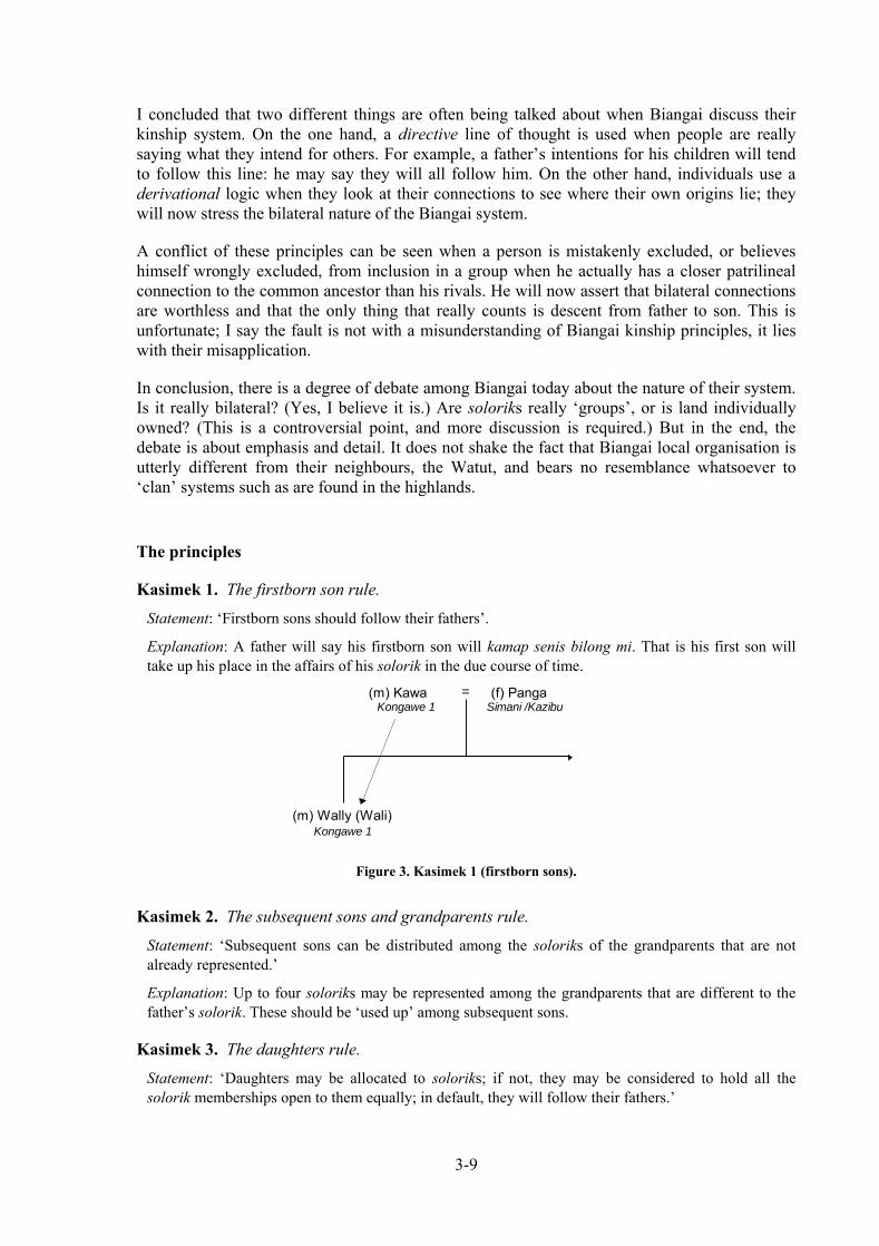
3-9
I concluded that two different things are often being talked about when Biangai discuss their kinship system. On the one hand, a directive line of thought is used when people are really saying what they intend for others. For example, a father’s intentions for his children will tend to follow this line: he may say they will all follow him. On the other hand, individuals use a derivational logic when they look at their connections to see where their own origins lie; they will now stress the bilateral nature of the Biangai system.
A conflict of these principles can be seen when a person is mistakenly excluded, or believes himself wrongly excluded, from inclusion in a group when he actually has a closer patrilineal connection to the common ancestor than his rivals. He will now assert that bilateral connections are worthless and that the only thing that really counts is descent from father to son. This is unfortunate; I say the fault is not with a misunderstanding of Biangai kinship principles, it lies with their misapplication.
In conclusion, there is a degree of debate among Biangai today about the nature of their system. Is it really bilateral? (Yes, I believe it is.) Are soloriks really ‘groups’, or is land individually owned? (This is a controversial point, and more discussion is required.) But in the end, the debate is about emphasis and detail. It does not shake the fact that Biangai local organisation is utterly different from their neighbours, the Watut, and bears no resemblance whatsoever to ‘clan’ systems such as are found in the highlands.
The principles
Kasimek 1. The firstborn son rule.
Statement: ‘Firstborn sons should follow their fathers’.
Explanation: A father will say his firstborn son will kamap senis bilong mi. That is his first son will take up his place in the affairs of his solorik in the due course of time.
= (f) PangaSimani /Kazibu
Kongawe 1
(m) KawaKongawe 1
(m) Wally (Wali)
Figure 3. Kasimek 1 (firstborn sons).
Kasimek 2. The subsequent sons and grandparents rule.
Statement: ‘Subsequent sons can be distributed among the soloriks of the grandparents that are not already represented.’
Explanation: Up to four soloriks may be represented among the grandparents that are different to the father’s solorik. These should be ‘used up’ among subsequent sons.
Kasimek 3. The daughters rule.
Statement: ‘Daughters may be allocated to soloriks; if not, they may be considered to hold all the solorik memberships open to them equally; in default, they will follow their fathers.’

3-10
Explanation: In general, daughters will not ‘speak for’ land in their own right (true or false??), therefore it does not always make sense to think of daughters as being put down for a particular solorik membership as their brothers are. They are quite likely to be considered to jointly belong to the two (or more) soloriks of their parents. If not they will take a default sorolik, namely that of their father.
Whether they do this literally or not, Biangai informants say they ‘cut off’ their daughters on marriage. Married women are certainly expected to follow their husbands in customary matters, gardening rights, and so on. Still, her children are certainly not cut off from other choices that may be available in the grandparental generation. In other words, though a daughter can be disconnected from her parents and brothers at marriage and does not (check required!!) directly inherit a solorik membership to pass on to her children; she acts as a bridge or place-holder between her children and the solorik memberships of her father, mother’s father, and so on.
Kasimek 4. What happens in cases of adoption.
Statement: ‘The rights of children adopted when young, and raised by their adoptive parents, will be as if they were the natural children of these parents. However, adopted children cannot be denied the rights to land or position conferred on them by birth, if they know them.’
Explanation: Adoption is very, very important in Biangai villages (I had not realised this until 1996). Several methods are distinguished by informants, and one other by me.
= =
= =Ego
Figure 4. Erang solorik misamani, ‘give back to your root place’ in adoption.
A traditionally prescribed path of ‘return adoption’ is erang solorik misamani, or ‘give back to your root place’, where a man will return a child (or either sex, but unlikely to be the first boy) to his mother’s people, where his MBS will raise it. A small boy might be sent to his mother’s brother with the admonition kalagi ngevelak-pek uzamane, kabele!, (lit: ‘uncle’s land stay, you go!’), that is ‘go to your uncle’s ground (and secure it)’. An idiom when a girl is returned is kangero yenge ngevelak-peke do (lit: ‘return towards land back’), or ‘give back where the land is’. In this case the girl may be seen as a kind of compensation for her mother, given earlier in marriage in the other direction.
In discussing these kinds of movements, it is clear that more than adoption is in question; in fact the Biangai are running an elaborate system of distributing people across their kinship networks. Many of the rights and implications of such customs remain to be disentangled, not least by the Biangai themselves as they attempt to modernise their economy, mix village with town living, and open up their society to the wider Papua New Guinean community. For instance, there are hints that the failure to make certain kinds of ‘return adoptions’ can block the potential rights of siblings to land and resources on their mother’s side. But how do economic transactions alter things? Can investments in village businesses by salary earners substitute for not giving back children? No-one knows the answers to all these things.
A second kind of adoption, common in many parts of Papua New Guinea and not specific to the Biangai, occurs where a childless couple is given children to raise by the siblings of one or both parents. In the ‘straightest’ case, where a child is transferred between true brothers in a patrilineal clan

3-11
system, there are no implications for land rights, as the biological and adoptive parents share the same land already. But among the Biangai there can be many complications. While it is recognised that the ‘straighter’ the adoption the less complicated things will be in adult life, inevitably the bilateral nature of the Biangai system means that adopted children will have, or will claim to have, more connections to land and resources than they were born with. Evidence that connections to land are being transacted in adoptions is shown by the case of children adopted to bachelors. There would be no point in this if the central purpose was to share child-raising duties. In fact, the objective is to distribute children across the land; it is scarcely thinkable for a man to have no-one to speak for his land when he is gone.
A new form of adoption I identify myself is that of non-Biangai, principally Watut, children. If the child is very young when adopted, it will become a Biangai; if older its rights will be ambiguous. Numerous cases exist where a small child appears in genealogies with the explanation that he or she came to the village as an orphan from some distant part of the Aseki or Kapau Districts. If this was literally true, it would surely be impossible for the child to have sought out its new parents! What seems more likely is that the child in question is from an extended family standing in a client relationship with a Biangai village. This is the case with the Aseki or Kapau ‘Watuts’ who live above Kwembu. As ground rent, they surrender bags of coffee each year to their Kwembu landlords. The adopted children form an additional part of the ‘package of benefits’ they provide; it also includes wives and ‘helping’ labour.
(m) Inane = (f) Sauwaro
(m) Kawa =
Kazibu
(f) PangaSimani /Kazibu
Simani
SimaniKazibu
Kongawe 1
Kongawe 1
Kongawe 1
(m) Wally (Wali) (m) Wayang (Wara)
(m) Wara = (f) Kawia
Kazibu
(f) Kawia
Kazibu
(m) Siwing
Kazibu
(m) Siwing
Kazibu
(m) KawaKazibu
(m) Pabiagare
Figure 5. Doubling up of Kasimek 2 (subsequent sons and grandparents) with Kasimek 5 (namesakes).
Two additional factors explaining the frequency with which this happens is the propensity of Anga people (as discussed in Working Paper No. 4) to settle as clients on other people’s land in their own area, and the extremely poor health conditions they experience there, which certainly provide a ready supply of orphans. So the meeting of two cultures sees one group predisposed to act as clients—with a range of extremely adaptive behaviours to enable them to get on with their hosts—settling with another group inclined to absorb unattached people and distribute land to them. The consequences of this in the long term are not fully known.
Kasimek 5. The namesake (yameng) rule.
Statement: ‘Relatives other than the four grandparents can recruit children into their soloriks. They do this by giving them their own names (‘nomination’). The children thus become namesakes, or yameng, of the nominating right-holders. If higher-ranking Kasimeks have not given the child a solorik, they may be considered to have been recruited into the nominator’s solorik, otherwise the link will lapse.

3-12
Explanation: Higher ranking Kasimeks take precedence. However, it is very likely that the nominator will in fact already share the solorik membership of a grandparent, as in Figure 5. In this case, the namesake rule simply gives a child a double link to the solorik. In later life, he or she will be remined often that the link is owed to the older namesake. In fact, the link is given its main strength by the prior link under Kasimek 2. (It remains to be learned how distantly related nominators can be.)
In Figure 5, three siblings in the same family have namesakes in the grandparental generation. These relationships serve to re-inforce or fix the possible choices open to these children. Notice that Kawia and Siwing have both gone to Kazibu and they could have done this exploiting the links to two Kazibu greatgrandfathers, Pabiagare and Kawa. In fact, they are the namesakes of Kawia and Siwing, a brother and sister pair two generations above them on Kawa’s side. Thus, Kawia and Siwing (living) owe their Kazibu identity to Kawa, not Pabiagare.
Prediction: If the distinct properties of Pabiagare and Kawa can still be distinguished within the lands owned by the Kazibu (i.e. they have not been redistributed), then Siwing the younger will use that part which Kawa handed down to Siwing the elder, and Kawia the younger, or rather her son, will use some other part that is left over.
=
=
[Kongawe 2][Simani]
Biol. parents Simani & Kazibu - he is now primarily in Kongawe 2
Biol. parents Kazibu Kiliwikaizak & Kongawe 2 - he is nowprimarily in Kongawe 2
Biol. parents Kazibu & Simani - she also had a grandmother from Kongawe 2
Biol. parents Simani with a link to Kazibu
All deceased - no descendants
A
B C
Figure 6. Case of adoption to a childless woman with no brothers or sisters with descendants.
The woman, A, inherited Kongawe 2 land; B and C now speak for this land (elder step-brother dead, sister with husband)
Kasimek 6. Land availability (partially investigated)
Prediction: ‘If membership of a solorik available though a Kasimek of higher rank would actually yield little no access to usable land, or would entail the subdivision of land into unacceptably small parcels, then an alternative may be chosen instead.’
Explanation: Higher ranking Kasimeks take precedence. But in all strict systems of inheritance, statistical variation will mean that too many people will be concentrated on some land, while other land remains underused. It is nowadays true that land for coffee growing, or cattle-ranching, or other economic use, is under considerable localised pressure, even though at a district level the land may appear under-utilised. Therefore some men, especially those returning to the village from employment outside Wau, may have no alternative but to pursue other options open to them.
In discussions I have had about land shortage, informants do not immediately agree with me on this. In fact, it may not be at all obvious to villagers that some decisions are taken in the manner I have just described. However, as I discussed on p. 9 above this may be because men are often following a directive logic (what they think others should do) when I ask them about abstract principles. The custom of koyanga koronge (p. 8) where a marriage is arranged to ‘join the

3-13
ground together’ would have no point if the children of such a marriage were not being thought about in advance: in other words, people do think about land availability. I have now found a range of circumstances where land is a primary consideration; one, already mentioned, is where children are adopted to bachelors.
In another case, a childless woman whose four brothers had no descendants adopted four children to pass on the large area of land she was left in control of. The two youngest of her adopted sons are now primary right-holders on her land (see Figure 6).
Primary and secondary membership of soloriks
In the above, and indeed when talking with members of Biangai soloriks, it appears that people are Simani or Kazibu or Kongawe exclusively. In fact this is only a short-cut for saying so-and-so’s primary membership is of this group. He or she will still retain secondary membership of all his other possible groups throughout his lifetime. The key rule distinguishing primary from secondary membership appears to be that a younger brother, B, who is a secondary member must defer to an elder brother, A, who is an primary member. B may attend a meeting of A’s primary solorik and contribute advice, but he should not override A’s opinion. Conversely, A may attend a meeting of B’s primary solorik, but this time he must defer to his younger brother.
I am not sure what rights are open to A and B when they are walking around in the bush of A’s primary and B’s secondary solorik. Presumably A can freely collect bush products that are not considered to be privately owned like cane, wild fruits, and kapuls. Can B do this too? I do not know.
If a man has a reason to change at any time in his life, he can do so. For instance, he might fall out with other solorik members and want to take up with relatives elsewhere. Or he might want to start a business (e.g. cattle, forestry) that requires land of a different type than he currently has at his disposal (e.g. fragmented coffee blocks). In these cases, he will announce his intentions and as long as he has genuine connections (he can demonstrate a kasimek) he must be accepted. Still, in the case of a project where a lot of land would be required, he would have much negotiating to do and could be rebuffed. In principle, this should be seen as a rebuffal by community fiat, not a flat rejection of his rights to the reources of the solorik. Disputation will predictably arise where opposition to planned land use changes can be mis-interpreted as personal attacks rather than matters of group planning.
(m) Inane = (f) SauwaroKazibuKongawe 1
Kongawe 1
(m) Inane
(m) Levi = 1. (f) YamingA Buang,no solorik
(f) MainiKongawe 1
Kongawe 1
Kongawe 1
(m) John (f) MaibuKazibu
(m) BarnabasKazibu
(m) SaroaKazibu
(f) IbiKongawe 1 Kongawe 1
(m) Evanga
= 2. (f) MatuselaA Watut,no solorik
Figure 7. Only two grandparents had soloriks. Children given a provisional distribution following Kasimeks 1-3.

3-14
Complications
Non-Biangai spouses
Not all Biangai spouses have solorik affiliations. This restricts the choices of their children.
In the example of Figure 7, the first eight children are distributed in the ratio 5:3 to the grandfather’s and grandmother’s soloriks. (There are other children by the second wife.)
(m) Mauri or Lingwaku = (f) SusannaKayogeParo
Kayoge
(f) Susan (f) KilaParo
(m) Kaibe = 1. (f) PebiFrom Goroka,
no solorik
Kayoge
will follow
namesake
(m) Rex
(m) Rex (m) GordonKayoge
(m) StevenKayoge
Figure 8. Another example where one spouse is non-Biangai
(m) Mauri or Lingwaku = (f) SusannaKayogeParo
Paro
(m) Lingwaku
(m) Kume = (f) OmengFrom Finschhafen,
no solorik
From Finschhafen,no solorik
(Kiwi)
Kume - a gold
miner sponsored
by Mauri must defer to
primary Paro
right-holders
(m) Rex(Kaibe)
Figure 9. A case of immigrants: Lingwaku’s parents were given use rights by Mauri/Lingwaku senior. He continues these and is a namesake under Kasimek 5, but this is not backed by a true genealogical connection. He has rights but he must defer to other Paro.
Other immigrants
Where a non-Biangai spouse brings a child by a former relationship, a man marries the non-Biangai widow of a fellow Biangai and acquires half-Biangai step-children, or a man sponsors the settlement of a non-Biangai couple in the village, a variety of ad hoc arrangements will probably be made. The immigrants themselves will always have an ambiguous status within the village, but their children may well gain virtually full rights (see Figure 9).

3-15
‘Land logic’
This statements in this section show how a customary system can be systematically described. This is only a start—much more work is required and considerable discussion with village elders. Nevertheless, the fundamental assumption is that custom mirrors other legal systems. That is, reliable statements of various kinds can be made—‘principles’, ‘titles’, ‘contracts’, etc—but not in a way that is instructive enough to cover particular instances, nor sufficient in number to cover every eventuality. Principles, titles, contracts, etc are extended to cases by the ‘logic’ of the system of law. In respect to land, this may be called ‘land logic’.
It is the job of adepts in the system to show how principles apply to each case as it arises. In a customary system, most people know most of the ‘land logic’ most of the time, but difficult cases will either cause dispute, or be resolved with advice from knowledgeable elders. This is little different from a Western legal system.
‘Documentation’ vs. ‘codification’
What has been done is this section should not be mistakenly thought to be a step towards the codification of customary law. Codification implies that the account that exists on paper takes priority over the living system in people’s heads. Customary systems cannot be codified without the ‘custom’ in ‘customary law’ being dropped. The correct description for what has happened is documentation. When we document a system of customary law we do not say that our paper version becomes ‘the law’.
BIBLIOGRAPHY
BURTON, JOHN E. 1992. ‘The Porgera Census Project.’ Research in Melanesia 16:129-156
BURTON JOHN E. 1994. ‘The Lands Trust concept: a preliminary discussion of ideas for landowners and developers’. Pacific Social Mapping discussion paper
FRANCE, PETER 1969. The charter of the land. Custom and colonisation in Fiji. Melbourne: Oxford University Press
MITIO, NGAWAE 1981. Biangai marriage and its relationship to kinship and property: the case of Werewere village, Wau District. Unpublished BA(Hons) subthesis, University of Papua New Guinea, Department of Anthropology and Sociology
STRATHERN, A.J. 1972. One father, one blood. Canberra: Australian National University Press
Patrol reports (National Archives, Port Moresby)
G. Smith, Wau No. 5 of 1950/51

SETTLEMENT FORMATION AND LEADERSHIP IN THE UPPER WATUT
HIDDEN VALLEY PROJECT, WORKING PAPER No. 4
prepared for CRA Minerals by
JOHN BURTON Pacific Social Mapping 49 Wentworth Avenue CANBERRA ACT 2604 Australia
April 1996 minor corrections 27 June 1996
additions December 2000

4-1
The Upper Watut
The people of the Upper Watut, a name deriving from the colonial designation for the Census Division taking in the catchments of the Watitapinga („Slate Creek‟) and Awei („Upper Watut‟) Rivers, are a regional subdivision of the wider Anga cultural and linguistic area which spans adjacent parts of Gulf, Central, Eastern Highlands and Morobe Provinces.
The only previous ethnographic work directly in the Upper Watut is that of Beatrice Blackwood (Blackwood 1950, 1978), who spent approximately seven months in the area in 1936-37, visiting Manki, Nauti, Andorora, Ekua, and Waiganda. The work of the German anthropologist, Hans Fischer (Fischer 1968), among the Jeghuje of the Banir River (to the west of the loop of the Middle Watut) is relevant; his fieldwork consisted of two stays in 1958 and 1965 of eight months and five months respectively.
The Anga are divided into „linguistic tribes‟ such as the Kapau, Baruya, and Simbari known from ethnography (cf. Godelier 1986:Fig. 1; Herdt 1987). The Upper Watut are part of what ethnographers have called the „Kapau‟ linguistic tribe, but in Watut eyes this is incorrect or at least too broad a category. They say Hamtae is their language, after a place of this name near Aseki in the neighbouring Kapau Census Division where Upper Watut ancestors are believed to have originated. This is reflected in the more recent terminology of SIL missionaries. We should say the Watut are part of the „Hamtae people‟ if anything.
The terms „Aseki‟, „Kapau‟, „Iwini‟, etc are in general use among the Watut to distinguish the main geographical groupings of Anga people nearest to them (Figure 1).
Awei R.(„Upper Watut R.‟)Hamtae origin site
somewhere here
Watitapinga Ck.(„Slate Ck.‟)
Kapau R.Kerepa R.
Kabu R.
Indiwi R.
Divei
KerepaIwini
Aseki
Kapau
Watut
(Jeghuje)
Figure 1. Geographical groupings of Anga people adjacent to the Upper Watut area showing presumed dispersal of population from Hamtae.

4-2
Watut patronymics
At the same level as the linguistic tribe are a series of descent categories, taka, that people like to call „clans‟, such as Nautiya, Titama, and Ekuta, and so on (see Table 1). The term „clan‟, though, is unsuitable as it suggest the groups have a direct land management function, or are able to take coordinated political action, which is incorrect.1
Anthropologists have taken little interest in local organisation for several decades so that half-started formal attempts to provide better terminology are long forgotten (e.g. Hogbin and Wedgwood 1953). In the Watut‟s case, taka most resemble surnames („Greens‟, „Browns‟, „Blacks‟ etc) in that families of Nautiya, Titama, and Ekuta can be found anywhere in the Upper Watut. All Nautiya have a vague belief in being descended from a founding Nautiya ancestor (the first „Mr Green‟, etc), but if a modern-day Nautiya (female: Nauti) from one area meets another from a distant place he (she) can assume only distant kinship. Some taka are very common while others are quite rare (Table 1).
Male member Female member Occurrence Ekuta Ekuti Common (42%) Nautiya Nauti Common (15%) Titama Titami Common (19%) Apea Apiei Quite common (11%) Angamdea Angamdi Quite common (7.2% Tausa Tafi Not common (2.4%) Patea (Memyamya: Kapatea) Patei Not common (0.9%) Yaqiana Yaqiani Not common (0.7%) Tanea Tanei Very rare (0.7%) Angapea Angapei Very rare (0.3%
Table 1. Main names of patronymics, taka, in Upper Watut villages. Figures in brackets are percentages of 1384
Watuts have a universal belief in the existence of „twelve clans‟, but none has satisfactorily listed the full twelve for me. Some label the first five in Table 1 as „major clans‟ and the remainder as „minor clans‟. This is borne out by the statistical pattern seen in my genealogies.
I earlier suggested the translation „tree line‟ for taka, as each is associated with a species of tree; for example, Ekuta is linked with hamneawa, Titama with feia, and Nautiya with the kaiwa species. I now think „patronymic‟ is a preferable term. „Ancestral line‟ is also a suitable usage, especially in historical contexts.
Functions of the patronymics
Do the taka have any functions at all? Though kinship between distant Nautiya, say, is weak, it is nonetheless a better relation than none at all. A Nautiya man travelling to a remote settlement can therefore sit down with a previously unknown Nautiya work out the line of connection between them—even if some of the earlier links are indefinite. The same can be done with „bilum‟ people, or ka; that is, the category of people who are sisters‟ children, but the reckoning of connections will generally not go far beyond the close family. A man may be said to
1 In other parts of Papua New Guinea things similar to the Watut taka are called „pisin‟ (e.g. in the Sepik or in
New Ireland). The key difference is that „pisins‟ tend to have an enhanced social organisational, ceremonial and religious-totemic significance not seen in Watut taka.

4-3
„bihainim lek mak bilong tumbuna meri‟ in finding land where his ancestor‟s sister went in marriage, but this is probably the limit of a legitimate connection.
Genealogies are generally a little bit deeper than would be expected in a territorial tribe/clan system, but they are not nearly as deep as among the Huli of Tari or the Ipili of Porgera, who memorise at least a dozen generations in considerable detail.
To answer the question, the patronymics are categories which are the preferred way to organise genealogies. This enables men to find out how they relate to others. Men follow connections of kinship when seeking where to make their houses and gardens. This means that the taka do mediate access to land, but it is an indirect function (see kataknga, below).
Watut patronymics and ‘groups’
In respect of Papua New Guinea village societies, „groups‟ ought to possess two or more of these attributes:
a. its members identify with it and recognise responsibilities to other members;
b. discernible organisational or management functions are active at the group level;
c. rights or properties can be held by the group notionally acting as an autonomous legal person.
People who have the same Watut patronymic do recognise some level of responsibility to others who are distant from them. This extends to giving them shelter and even to allowing them to cultivate a plot of land on request—but it is not clear this is a stronger obligation than to trustworthy strangers unless a much closer link of kinship can be found. There is no obligation at all to rally to the defence of distant members of the patronymic in the manner as true clansmen must do on pain of sanctions, even punishment. On the contrary, in the past, groups who hunted, explored land and fought together would have been drawn from blood relations of different patronymics and would have clashed with other similarly composed groups.
In respect of (b), organisational or land management functions are absent; there are no leadership positions at the patronymic level.
In respect of (c), people do label a piece of land as belonging to „Nautiya‟ or „Ekuta‟, but this is a shortcut for saying that the families who own the land tract are Nautiya or Ekuta. It does not automatically mean that distant members of these descent lines have any say over the land, or are even owed the right of consultation if the resident owners plan a change of usage.
Across the Watut, the important action groups are patrilineal lineages or „grandfather lines‟ who link the descendants of a particular person. If the founder—a known genealogical person—is removed by more than even one generation from living people, he may become described as a heroic figure who journeyed from place to place, naming for the first time and personally taking possession of the landscape features he encountered. Again, this is remarkably different from a true clan system, where genealogically known people are subsumed historically by the clan‟s own history; the clan is assumed to have existed long before they came along and its founder(s) to have lived in a very distant and legendary time.
In summary, the patronymics are not „groups‟ in a way that is meaningful to collective decision-making. In respect of landowner dealings, it is important not to generalise the authority of the leaders of local branches of taka or attribute to the taka greater cohesion than is warranted. They are very loose associations of people.

4-4
The composition of actual communities
Traditionally, Upper Watut people lived scattered about in hamlets in defensive positions in the bush. Informants say settlements were small and made up of members of a single taka. This means that asking someone what was their „place‟, or kataknga, could well be answered with the name of their taka. This easily explains why some settlements and placenames, like Nauti and Ekuti Range, have been written down as the name of the taka, not the place as such.
But in practice all but the smallest settlements acquire a mixed composition over time. The model of settlement formation is as follows. A new camp is established on his own land by one man alone, or perhaps accompanied by his brother. Either he abandons it or close relatives, often in-laws, come and ask him permission to settle with him. The camp grows into a recognisable hamlet. Again, either they abandon it or others come, less closely related to the founder this time, and the hamlet grows into a village. The founder may not, by now, even live here, and the village has a jumble of in-laws, unrelated members of different taka, and nowadays strangers such as evangelists and gold tributers.
An especially strong principle among the Watut, and evidently the Anga generally, is that mother‟s people and sisters‟ people must be „remembered‟. That is, in simple matters like food distributions, shares should be set aside for them, and in more formal dealings, such as when they request land, they must be welcomed and accommodated. Hospitality towards tambus and kandere is, of course, true of all known societies in Papua New Guinea, but elsewhere various sanctions act to limit it where actual settlement is concerned. In some societies, people may gossip and ask „haven‟t these people their own land to go to?‟ or „have these people no roots that they drift about?‟ or some such. In other words, ways are found to see that people do not overstay their welcome. But the Watut do not do this and settlements come to be made up of people with many different kinds of connection to the landowning lineage.
Firstly, people of the landowning lineage are kwaika or „spear‟ people. Then, as I mentioned, people connected to them through sisters or mothers are known as ka or „bilum‟ people. A last category are aqa nanga („together permanently‟) or non-line people who came so long ago they have acquired „citizenship‟ of the place.
One example was of a man (at Akikanda) whose ancestor accompanied the lineage founder on his journey to the present place of settlement. The ancestors descendants did not grow in numbers, and after three or four generations are still only represented by a single family, that of my informant. Although not of the principle landowning lineage, his connection to the land is twofold. In the first place, it derives from the actions of his ancestor in assisting the settlement founder. In the second, various marriages have taken place over time between the two lines, binding them together with links through ka.
As I have mentioned elsewhere, the Watut do not convert non-members of their lineages into members any method of adoption or falsifying genealogies; ka and aqa nanga people remain fixed under their own lineage names even though they may well have come to live in a place as long ago as the kwaika.
Upper Watut settlement pattern: comparison with the Jeghuje, 1958-65
Fischer‟s data from Jeghuje of the Banir River is illustrative. The approximately 230 Jeghuje lived in ten settlements at the time of Fischer‟s two visits in 1958 and 1965 (Table 2).
Case Ancestral line Year Residents

4-5
1. Patje 1958 The Patje owner, his sister and her husband 1965 All the above had died. The son of the sister by another
marriage inherited the land and brought his step-father with him.
2. Jamnaie 1958 The Jamnaie owner, a deceased relative‟s adopted son, and the adopted son‟s previous stepmother and family. The owner later moved elsewhere
1965 - 3. Patje 1958 Two joint land-owning brothers. They died later. 1965 -
4. Jamnaie 1958 Two Iweltje brothers with a probable connection to the land through their grandmother.
1965 - 5. Iweltje 1958 - 1965 The Iweltje landowner and his brother
6. Iweltje 1958 - 1965 The Iweltje landowner, his married son and son-in-law.
7. Kamadeje 1958 - 1965 The Patje inheritor of this land from his Kamadeje mother,
his stepson, and a distant Patje relative. 8. Ighuatje 1958 The Ighuatje owner, 11 eleven families invited by him
from an earlier settlement, and two families of evangelists. 1965 Similar configuration, but the owner has moved to
settlement 10. Church now added. 9. Ighuatje/Jamnaie 1958 Two Jamnaie men and a distant Petje relative. 1965 Large mixed settlement with evangelists and rest-house.
10. Ighuatje 1958 A Kamadeje asked permission to settle on the grounds of his (distant) genealogical connection to an Ighuatje woman. A Patje man joined him, his mother‟s sister‟s son.
1965 The Ighuatje owner of settlement 8 is also the landowner here; he moved here
Table 2. The composition of ten Jeghuje settlements (Fischer 1968:53-60) Note: the lines „Ighuatje‟ and „Patje‟ are probably equivalent to Watut „Equta‟ and „Pate‟.
Fischer (1968:61) makes three points. First, the man who founds a settlement almost always owns the land it stands on. Second, small settlements are likely to contain true brothers or lineage brothers who share a grandfather, and they may be joined by their brothers-in-law. Third, as settlements grow larger, the situation becomes less and less clear-cut; even brothers stop building their houses next to each other and new migrants live mixed together: „wards‟ for each line were not built by the Jeghuje (as is typical of villages, for example, along the Central Province coast).
Settlement and the agricultural system
This pattern of settlement formation and re-formation is quite in line with Anga agriculture based on long fallow swidden (or slash-and-burn) gardens. This system depends on either constant migrations onto virgin land or on resting old gardens for long enough for forest trees to establish a full cover of vegetation after perhaps two or three years of harvesting. In this area, that period is at least 20 years, and it can be as long as 50 years. In either event, a fluid pattern of settlement is least likely to cause deforestation and environmental degradation.
Such a system is in ecological balance in certain conditions. The main requirement is that population is in equilibrium and not concentrated in dense pockets. In the pre-colonial period, it
4-6
may be that most populations were static at some indefinite time in the past, dependent on the ancient Melanesian food crops, including Colocasia taro, yam, and indigenous banana varieties. But in the Anga area today, all of these are now subsidiary crops, if grown at all; the staple is sweet potato, a South American crop, introduced to Papua New Guinea only around three hundred years ago.2
The sweet potato is so deeply embedded in the Anga agricultural system, it is hard to imagine how it would have been without it. But the fact is what is today seemingly „traditional‟, with all the associations this word has with „stability‟ and „ecological sustainability‟, is an illusion. Most thinking now expects sustained population growth following the introduction of the sweet potato, so that the contact period from the early 1900s to the 1950s interrupted the Anga in an expansionary phase.
Various changes must occur with the injection of population growth. Either system failure occurs or an adaptive response is made. Evidence for system failure is seen in the formation of extensive anthropogenic grasslands in the Upper Watut basin adjacent to Watitapinga („Slate‟) Creek, in the Langimar Valley, and around Aseki and Wonenara, for example. The viable adaptive responses are limited to (a) intensification or (b) the removal of excess population through emigration.
In the classic form of intensification described by Boserup (1965) and others, cropping times are shortened and technical innovations made to sustain output. In many parts of the Papua New Guinea highlands, the key innovation was the switch made from swidden gardening (e.g. Clarke 1971), in which the soil is not tilled, to various methods of tillage such as the use of ditched or mounded sweet potato beds (e.g. Waddell 1972). Population densities of up to 200 persons/km2 are reached without too much difficulty using mounding on suitable soils, such as in the Wapenamanda District of Enga province.
But the alternative of removing excess population is possible when uninhabited or lightly populated areas lie beyond the current place of settlement; that is, some or all members of settlements can move into these areas. If this path is taken, the „normal‟ settlement pattern is set on a path of constant expansion. This is the path that the Anga appear to have taken (e.g. Fischer 1968: 425; Godelier 1986:2-4) and the oral histories of individual groups repeatedly speak of movement out from hypothetically more anciently settled places, such as Menyamya, and of course Hamtae, discussed above.
‘Native conservation’ and environmental stability in the Upper Watut Valley
The Upper Watut Valley looks at first sight to be a happy exception to what I have just said; land is plentiful and the settled population is slight. It appears that the 25 km-long valley is a huge environmental reserve and that the symbiosis between human uses and natural biota is stable and resilient to disturbance. It seems just the kind of place where „native conservation‟ has been practiced for centuries, so that the environment is has a culturally in-built protection from disturbance. But this, alas, is an illusion:
2 This „short‟ date assumes introduction following Spanish voyaging to the New World. A „long‟ date of about
1000 years is possible, but usually considered less likely, corresponding to introduction through the Pacific after the Polynesian settlement of Hawaii (B.J. Allen and R.M. Bourke, ANU seminar, May 1996).

4-7
1. The existing settlements are very probably the largest ever seen in this society; the logic of settlement process places them on the brink of fission and thus a new round of emigration and settlement founding.
2. Technological innovation in the form of recently intensified cropping on the same area of land is minimal in the Upper Watut; it did not in the past, and it is unlikely to in the future, occur when virgin land is settled for the first time.
3. No roads penetrate the vastness of the valley today, but this is will change instantly with a decision to mine or, in its absence, if timber concessions are awarded. Roads act as „geographical attractors‟ in many parts of Papua New Guinea, drawing population to them. Road access for mining will automatically bring heavy pressures in favour of timber exploitation.
4. Where road access has already helped establish a new settlement, as at Minava, a circle of bush of some 1-2 km radius immediately comes under heavy impact. If new settlers of either Watut or non-Watut origin establish camps off a road higher up the valley, similarly deforested patches will proliferate rapidly.
The point is that the system is stable only because access to it and the current settlement pattern are configured as they are now. „Native conservation‟ is present but it springs from a low level of opportunity, not a mysterious form of „eco-knowledge‟ somehow stronger in people‟s minds in this rainforest than among people, say, in the degraded grasslands of Aseki or Wau. Once roads are built and access is made possible, the opportunities to disturb the system will be as relentless as they have been in these other places.
The implications of these effects are far-reaching and will need to be explored promptly and thoroughly, for mitigation purposes, as part of the environmental planning process, if a decision to proceed with mining is taken.
Settlement leaders
Leadership in the Upper Watut is problematic and may be in the process of change. Today we see village or hamlet leaders, with a strong bias towards the selection of candidates off the senior branch of the village or hamlet‟s principal lineage. This kind of leader appears to me at the moment not to correspond to any of the Melanesian stereotypes that are well described in the anthropological literature. I will call him a settlement or papa graun leader.3
The same pattern seems to have been encountered by Fischer among the Jeghuje; he devotes no significant passage to a discussion of leadership, but it is clear that his principal informant, Nuklaua, a man about 40 years old in 1965, was just such a papa graun leader. Fischer calls him the starke mann of the group (1968:14), a term better translated as „powerful man‟ than the literal „strong man‟. But he was the landowner of settlements 8 and 10 in Table 2 and was evidently surrounded by his followers at these places.
It is difficult to know how this differed from leadership prior to contact. A substantial literature has built up dealing with a certain kind of Morobe/Eastern Highlands leader, the „great man‟, exemplified by Godelier‟s account of Baruya great men (notably in The making of great men,
3 However, I need to re-read the voluminous literature on leaders quite carefully before being dogmatic about it.
This type of leader seems common enough in Papua New Guinea, but ethnographers covering societies with papa graun leaders seem either to have ignored them or fitted them into some other category.

4-8
1986; see also Godelier and Strathern 1991), the aoulatta, who, he says, gained their status as famous warriors and hunters.
A problem for us is that there is no obvious „work‟ for the great man, so described, in modern Papua New Guinea. After all, how will a famous hunter bring his skills to the conference room in a meeting with a multinational company?
This is not a problem for other kinds of traditional leader. The principal contrast is with traditional „big men‟, notably those of the Western Highlands, who gained their status through manipulating wealth in shells, pigs, and stone axes; „big men‟ have had no difficulty whatsoever in substituting money, cows, votes, cars and so on for the more traditional items of credit and exchange. Theirs were the skills of finance, negotiation and diplomacy—all still good currency, of course.
„Great man‟ societies did not work like this, and do not today. Godelier introduces this type of leader as follows: in a few Melanesian societies there exists a type of man who „can attain the highest prestige and greatest influence ... over others, without demonstrating his ability to accumulate and make the proper use of wealth‟ and then „plainly the Baruya are one of those “few societies”‟ (Godelier 1986:166).
This is true of the Upper Watut in traditional times; the exchange of valuables was quite alien.4 Godelier goes on to describe the sources of men‟s power among the Baruya at great length; they were famous warriors and hunters, adepts at initiations and perhaps magicians. But with the uses for these things swept away with modernisation, the contemporary leader is left without cultural rôle models. Godelier‟s account is limited in what it might tell us of what validates and underwrites the authority of leaders in these societies nowadays.
My short answer is that they are left in a cultural vacuum, wrestling with concepts of power, authority and status that their culture has not dealt with before. There is indirect evidence that the traditional style of Upper Watut leadership was unsuited to the new needs of the colonial period, when patrol officers sought to appoint officials who would bring their people together and work co-operatively at the district level. Luluais and Tultuls were appointed, but no Paramount Luluai stood for the whole census division.
Among the Biangai, a Paramount Luluai served his people for many years. This is not evidence in inself that customary Biangai leaders had greater authority,5 but the fact remains that ambitions to be appointed to the same position were quashed in the Upper Watut. In April 1951 the Luluai of „Kaimanda‟6 was arrested with his Tultul for spreading a rumour that he was about to be made into a Paramount Luluai. When sufficiently aware of the local situation, kiaps did not appoint officials who did not fit with local patterns of leadership, and this appears to have been the case here.
A Local Government Council once existed, but it does not today. Again, I would point to the weak fit of lineage leaders to village-level representation was the underlying cause of the council‟s failure. Let me sketch some of the issues here. 4 At Nauti village, I asked an elderly informant from which group between them and the sea did they acquire the
small cowries that are distinctively worn in Anga traditional dress. His blunt answer was that they used to strip shells from dead Biangais. This was not a trading area.
5 Levi Inani‟s verdict is that the Paramount Luluai was a hated autocrat given power only by the kiap. 6 While „Kaimanda‟ is marked on maps, it is not a place name known to me. It seems likely Kaumanga is referred
to.

4-9
‘Papa graun’ leaders
A provisional list of characteristics for the papa graun leader would appear to be as follows:
1. as a senior man of a lineage (or its head), his authority extends over other co-owners of the land by virtue of his higher genealogical position;
2. as a landowner, his authority extends over the non-owners (ka and aqa nanga, see above) he gives permission to settle, on pain of withdrawal of this privilege;
3. he implicitly offers a safe haven to settlers in return for a duty of allegiance to him;
4. when he lends productive assets, namely tracts of land, to people who do not own them he expects them to defer to him in decision-making;
5. when he lends land he expects to take a proportion of „profits‟ from any activities that make use of it or the resources contained within it.
If (1) and (2) seem acceptable principles, and (3) seems fair enough, the inferred obligations created in respect of (4) and (5) are problematical in a democracy. In modern Papua New Guinea, the basis of local level government is that village leaders elected to be Councillors or Ward Members are fairly drawn from among the villagers. There is an implicit assumption that a village represents „one people‟, a clan say, and that the position of leader is granted by consensus. It is also assumed that people within the village have more or less equal rights to land and resources—that they are more or less equally all „peasant farmers‟. I hope to have shown that this is simply not the case in the Upper Watut. The papa graun leader is a landlord. His mandate is as the first among unequals, and his constituency that of a „pocket borough‟.7
Ways of clearing debt to the papa graun leader
Most relevant to the present day, is the situation of settlers who have been established where they are for so long that the land they were granted has been wholly domesticated by them and reshaped into settlements, and a network of fertile gardens interplanted with their own tree crops. Surely exclusive rights to the „enjoyment‟ of what has be created through hard work must be recognised by the papa graun leader? Will he not by this time accept that the debt created by his original grant has been paid off?
I have no comprehensive answer to this, only snatches of principle that are likely to come into play in various circumstances. Unambiguous ways to clear the debt would traditionally arise under point 3; for example, in the case that settlers came to the aid of their host and one of their number was killed in his defence. This undoubtedly happened in the past, and there may still be circumstances where homicide debts and credits are remembered and taken into consideration.
A satisfactory method of clearing debt all over Melanesia is to give away daughters to one‟s creditors, if this is possible, or to marry sons to them if it is not. In the Upper Watut this would establish connections acting to soften the authority of the sponsor and his people.
Opposite principles are likely to come into play when a sponsor is strongly protective of those he has allowed to settle—perhaps because of an earlier debt to them—but dies before they have fully established themselves or become connected to other members of his group. The sponsor‟s
7 A pocket borough was, before abolition, a town of which the representation in the Westminster parliament was
under the control of one person or family (Oxford English Dictionary).

4-10
kinsmen may well contest his will to grant the land and could then fall into dispute with the settlers, curtail their rights, and try to evict them.
At this stage, I am unable to flesh out these principles with suitable histories. All the discussion points require further investigation.
Conclusions
The formation of settlements in the Upper Watut follows a consistent logic and is shaped by the particularities of social organisation and the agricultural system. The outcome is a type of settlement process quite unlike that seen in adjacent culture areas (notably, among the Biangai of the Upper Bulolo as I have described in other papers).
Settlements begin as small encampments made by close relatives near new gardens. Over time, more distantly connected people request permission to join a growing settlement and its composition comes to be a mixture of lineage people, in-laws and others. Later still, internal arguments, warfare, or the natural death of the principals is likely to have caused large settlements („villages‟) to break up and be abandoned. A new cycle of dispersion and accretion would then begin.
While this allowed a great fluidity of settlement in traditional times, and very probably conferred an adaptive advantage by constantly adjusting population pressure on the rainforest agricultural system, I have identified three areas of incompatibility with modern Papua New Guinean principles of social development.
1. Firstly, the interruption of the system by the „freezing‟ of quite large settlements has resulted in the unequal rights of access to land among the present-day residents. This does not map easily onto assumptions of „village egalitarianism‟ made by the architects of the modern Papua New Guinea system of governance (e.g. Narokobi 1989).
2. Secondly, the outcome of these unequal land rights appears to have the effect of removing secondary landowners from active participation in village decision-making. In pre-contact times, this would have been a temporary state of affairs; in a subsequent cycle of settlement movement those now silent would become active, and those now active, silent. But with the cycle broken, and far-reaching decisions needing to be made immediately, power is dangerously concentrated in the hands of a few.
3. Thirdly, the fluid settlement pattern is extremely sensitive to the presence of geographic „attractors‟ like roads, schools and clinics. At present these are sited along Slate Creek and towards the Watut grasslands, effectively keeping population out of the Upper Watut Valley. But when this situation changes and attractors are created in the valley itself, population will be drawn into it very easily, creating a wildcard environmental impact on this largely pristine forested area.
Each of these points has implications for „best practice‟ dealings with Watut communities in respect of mining. I hope to make appropriate recommendations at some other time.
BIBLIOGRAPHY
BLACKWOOD, BEATRICE 1950. The technology of a modern stone age people in New Guinea. Oxford: Pitt Rivers Museum.

4-11
BLACKWOOD, BEATRICE 1978. The Kukukuku of the Upper Watut. Oxford: Pitt Rivers Museum.
BOSERUP, ESTHER. 1965. The conditions of agricultural growth. London: George Allen and Unwin
CLARKE, WILLIAM C. 1971. Place and people. An ecology of a New Guinea community. Canberra: Australian National University Press
FISHER, HANS 1968. Negwa: eine Papua-Gruppe im Wandel. Munich: Klaus Renner Verlag [„Negwa: a Papuan group in change.‟]
GODELIER, MAURICE 1986. The making of great men: male domination and power among the New Guinea Baruya. Cambridge: Cambridge University Press
GODELIER, MAURICE AND MARILYN STRATHERN 1991. Big men and great men: personifications of power in Melanesia. Cambridge: Cambridge University Press
HERDT, GILBERT 1987. The Sambia: ritual and gender in New Guinea. New York: Holt, Rinehart and Winston
HOGBIN, H. IAN AND CAMILLA H. WEDGWOOD 1953. „Local grouping in Melanesia.‟ Oceania 23:241-276, 24:58-76.
NAROKOBI, BERNARD 1989. Lo bilong yumi yet: law and custom in Melanesia. Suva: Melanesian Institute and Socio-Economic Service and the University of the South Pacific
WADDELL, ERIC W. 1972. The mound builders: agricultural practices, environment and society in the central highlands of New Guinea. Seattle: University of Washington Press. American Ethnological Society Monograph 53.
THE HISTORY OF NAUTI VILLAGE, UPPER WATUT CD,
MOROBE PROVINCE, PNG
HIDDEN VALLEY PROJECT, WORKING PAPER No. 5
prepared for CRA Minerals by
JOHN BURTON Pacific Social Mapping 49 Wentworth Avenue CANBERRA ACT 2604 Australia
April 1996 revised 15 August 1996

5-1
In the 1987 Provincial Lands Court decision handed down by G.C. Lapthorne, 50% of the Hidden Valley prospect was awarded to the party known variously as ‘Nauti clan’ or ‘Nauti village’. The meaning of the word ‘Nauti’ in the context of the court decision is incomplete. The purpose of this paper is to give the background to settlement at Nauti.
Pre-contact times The traditional pattern of settlement across the whole of the area occupied by Anga people was one of scattered hamlets, not villages—‘ol i save go hait long bus’ as one informant put it. This means it is wrong to expect a ‘village’ to have been established permanently on one spot for it to be ‘real’. Typically, settlements would have formed and re-formed on a regular basis drawing people to them who had rights to use land in that area. While people say the mixed-clan settlements seen today are new and that the traditional pattern was for only same-clan settlements, hence the occasional use of clan names for villages, such as ‘Ekuti’ (not now in existence) and ‘Nauti’. As we shall see, this is contradicted in evidence below where men are found staying at their wives’ villages very shortly into the colonial period.
First contact The first known contact, in the account of the senior Nautiya leader, was an party of Germans who arrived on foot and built a wooden platform to get a good view of the Watut Valley. The platform was probably for the purposes of photography, but the behaviour of the explorers is interpreted as follows:
The Germans found it difficult to make contact with the Nautiya because they lived scattered in the bush, but one day they lay in wait until they saw a man coming and they jumped out and held him (‘ol German kirap na holim em’). The man’s name was Hatotao, the eldest of Tainameo’s eleven sons. The Germans gave him some of their things—salt and so on—and showed him what they were. This all happened at the place we now call Nauti.
Hatotao called for all his brothers and their wives and children to come out. Then the Germans asked Hatatao who they were. Hatatao replied in sign language that they were all his children (‘mi lukautim ol dispela pikinini’), he looked after them, and when they were big they would follow him and take over this land (‘sapos ol bikpela bai ol kirap na kisim graun bilong ol’). The Germans asked him how they had come to be there and Hatatao put up his hand and pointed to the west; this is where they had come from (‘Hatatao putim han bilong em I go long West na em soim em olsem; em i kam long dispela hap’).
Then they built a ladder up a tall tree and climbed up and made a platform on top. They looked up to the head of the Watut River and they could see there was no settlement above Nauti; it was big bush. Then they looked back towards Wau and the same thing: there was no settlement this way either. They worked for a while taking pictures and making a map. Over the area they could see there were no signs of people, except smoke coming up from some places nearby.
When the Germans had finished this they asked Hatatao what his name was, and he told them. Then they pointed to his son and asked what his name was. Hatatao said ‘koka’, meaning ‘boy’ in Hamtae language. The Germans wrote this down as Kukukuku, and many people still call us Kukukuku. This name began with Hatatao and this meeting with the Germans.

5-2
The Germans wrote this story down taking one copy to Germany and giving one copy to Hatatao. Unfortunately this was destroyed later when Hatatao’s enemies came and burnt his house down. But by signs, the Germans indicated that Hatatao was the landowner here and they made him the Luluai of the place. They asked what his people were called and he said ‘Nautiya’, so unlike many places named after rock outcrops or rivers, the place name Nauti was taken from the name of the inhabitants (from History of Nautiya clan).
Like many other ‘histories’ (including many of our own), the account is formulaic. That is the central elements of the story are fitted together in a standardised manner (it follows a ‘formula’). The key elements are (i) the meeting with whites (ii) simple greetings in sign language, (iii) the use of the tree-top platform to look out (and no doubt take photographs) across the Upper Watut, (iv) the conferring of Luluai status on Hatatao, and (v) the inference that land title was conferred (or confirmed) by sanction of the colonial power. Although several of these things obviously did place at once, parts may be conflated from several events over a period of initial contact and the inferences of meaning are formulaic additions.
As a example of a formulaic ingredient, it is remarkable luck that the lineage head himself should accidentally be the first to encounter the whites. To the whites, it was not important who was contacted first; their first choice of Luluai would have been the lineage head anyway. But in the Nautiya story-formula, Hatatao is the only candidate who could have made the contact because the formula says historical actions are to be collapsed onto a single ancestor-hero, in this case Hatatao.
Next, the few simple courtesies that can be expressed between strangers with no common language—‘we came this way’, ‘who are you?’, etc—are read by both parties differently. The one central fact of equal present-day relevance to the living story-teller and the non-Nautiya reader is that the whites performed a ‘witnessing event’ in respect of Hatatao and his people. That a tree-top platform should have been built is simply a historical oddity, but the whites could not have given a better ‘witnessing’ sign if they had planned it deliberately. At the same time, the platform was very possibly used for photography, the ultimate witnessing act in Western culture.
Three German expeditions: hits or misses? Who were the Germans? I review the known candidates for early contact in this area in Working Paper No. 6, and it seems that each of the three documented German expeditions missed the Upper Watut. During the last one, in 1914, Hermann Detzner certainly believed he had crossed the main range and arrived at the Upper Watut, a river he should have been aware of from the missionaries who went before him only a year earlier, but it seems he was mistaken and his ‘Watut’ was the Langimar.
On the other hand, at least we know he spent about two months among relatives of Upper Watut people to the south of the Ekuti Range.
So if we cannot yet pin down any ‘Germans’ for Hatatao to see in the Upper Watut, at least we do know they were out and about in this area. (It is not Hatatao’s fault that, for once, it is the remembered history of the whites that is the vaguer.)
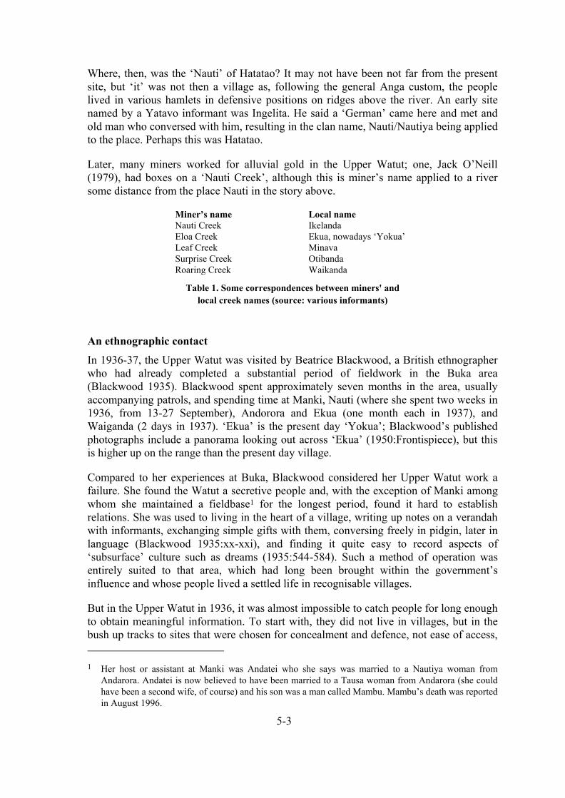
5-3
Where, then, was the ‘Nauti’ of Hatatao? It may not have been not far from the present site, but ‘it’ was not then a village as, following the general Anga custom, the people lived in various hamlets in defensive positions on ridges above the river. An early site named by a Yatavo informant was Ingelita. He said a ‘German’ came here and met and old man who conversed with him, resulting in the clan name, Nauti/Nautiya being applied to the place. Perhaps this was Hatatao.
Later, many miners worked for alluvial gold in the Upper Watut; one, Jack O’Neill (1979), had boxes on a ‘Nauti Creek’, although this is miner’s name applied to a river some distance from the place Nauti in the story above.
Miner’s name Local name Nauti Creek Ikelanda Eloa Creek Ekua, nowadays ‘Yokua’ Leaf Creek Minava Surprise Creek Otibanda Roaring Creek Waikanda
Table 1. Some correspondences between miners' and local creek names (source: various informants)
An ethnographic contact In 1936-37, the Upper Watut was visited by Beatrice Blackwood, a British ethnographer who had already completed a substantial period of fieldwork in the Buka area (Blackwood 1935). Blackwood spent approximately seven months in the area, usually accompanying patrols, and spending time at Manki, Nauti (where she spent two weeks in 1936, from 13-27 September), Andorora and Ekua (one month each in 1937), and Waiganda (2 days in 1937). ‘Ekua’ is the present day ‘Yokua’; Blackwood’s published photographs include a panorama looking out across ‘Ekua’ (1950:Frontispiece), but this is higher up on the range than the present day village.
Compared to her experiences at Buka, Blackwood considered her Upper Watut work a failure. She found the Watut a secretive people and, with the exception of Manki among whom she maintained a fieldbase1 for the longest period, found it hard to establish relations. She was used to living in the heart of a village, writing up notes on a verandah with informants, exchanging simple gifts with them, conversing freely in pidgin, later in language (Blackwood 1935:xx-xxi), and finding it quite easy to record aspects of ‘subsurface’ culture such as dreams (1935:544-584). Such a method of operation was entirely suited to that area, which had long been brought within the government’s influence and whose people lived a settled life in recognisable villages.
But in the Upper Watut in 1936, it was almost impossible to catch people for long enough to obtain meaningful information. To start with, they did not live in villages, but in the bush up tracks to sites that were chosen for concealment and defence, not ease of access, 1 Her host or assistant at Manki was Andatei who she says was married to a Nautiya woman from
Andarora. Andatei is now believed to have been married to a Tausa woman from Andarora (she could have been a second wife, of course) and his son was a man called Mambu. Mambu’s death was reported in August 1996.

5-4
and to which they went before the late afternoon rains. Secondly, in the middle of day most people went out to gardens or hunting areas some distance away and did not want to spend time with her, even if she could have talked to them in some mutually understandable language like pidgin, which was not the case. Lastly, even when at their settlements, the traditional style of housing with a front door, and an interior passage leading to a trapdoor into the windowless interior made it difficult for her to contemplate making extended inquiries as she had done at Buka. This is, of course, assuming it would have been safe for her to be left alone in an uncontrolled area for any length of time, which it was not.
As a result, she switched to making a collection of artefacts and describing the material culture (Blackwood 1950). Only after her death was some sense made of her field notes, photographs and diary, to allow a fragmented account of Upper Watut society (Blackwood 1978) to be made by an ethnographer familiar with a not too dissimilar society in the Goilala District (Hallpike 1977).
Sequel
A new development is that after making limited inquiries, I have found one informant, born around 1928-29, who personally saw Blackwood at Nauti. He describes a misis being carried about on a bet, that is, a chair on poles, and carried across the Watut River on the shoulders of the patrol officer’s carriers. Blackwood’s original materials are kept in the Pitt River’s Museum in Oxford. Considering the implications, it would seem essential to go through them for unpublished photographs of the area and its people, for a fuller description than is contained in either of the two books and the few papers resulting from her visit. (I expect to do this in September 1996.)
A case of panga (sanguma) A case of homicide took place at Sapanda just before WWII involving the Yatavo. The details are on the public record; known men went to a known jail following an investigation by a real patrol officer and the story of their return is public knowledge among present-day Watuts.2
The story is as follows. A Yatavo woman named Pingi was accused of being a panga, or witch, and of killing her child following the usual pattern associated with ‘sanguma’ in many parts of Papua New Guinea.3 Pingi was murdered just before WWII, perhaps in
2 I had earlier warned that this story was still not revealed by those closest to it. This has now been done.
3 Sanguma witches are differentiated from ‘poisin’, sorcery and war magic in that these are essentially the technology for causing action at a distance. Sanguma, on the other hand, runs in families like a defective gene that, while hidden into adulthood, can switch itself on without warning. The phenomenology variously includes the strange behaviour of the witch’s human form (ravenous hunger for meat/unnatural shunning of meat), the appearance and cunning behaviour of animal familiars (e.g. dogs, cats, snakes) and the death of the victim after vital organs have been eaten/removed/filled with foreign objects from the inside, unbeknown to him or her at the time of the attack. In different parts of Papua New Guinea, elements of this basic pattern are added or subtracted.

5-5
1939 or 1940, by her lineage brothers. Patrol reports from this period may exist somewhere, but I have yet to locate them.
Sanguma is given lengthy treatment in the first reports after the war when it was said that Sergeant Anki and the police detachment at Otibanda were ‘obsessed’ with it. The luluai Anianango, of Yauwipo village, was said always to accompany patrols around the Upper Watut to uncover and guard against attacks by witches (H.P. Searle, Wau PR No. 2 of 1949/50). It is clear that panga was meant because the Upper Watut version of sanguma refers to the removal of parts of vital organs and/or the invisible insertion of objects into the body of the victim. The Otibanda police were convinced they had seen curers putting back flesh and removing objects from people. Anianango would appear to have had the gift of hingo hiwau (‘eyes two’), or second sight, which enabled him to see the approach of witches or their familiars, invisible or unrecognisable to others.4
Several Ekuta men at Sapanda were arrested for the killing on Pingi; they were Kawimwo (or ‘Jacob Hangitao’ or ‘Askai’, the father of Peter Askai who gave me the main details of the story), and Qamiawo Nandaiyato (or ‘Tuka’),5 Hamgwindio, Hapangaiwo, Yotiawo, Meawoiyeto (the father of another informant, Timbi Meawoiyeto), and Yapeiko. A court hearing was held at Otibanda with, apparently, a Tekadu man acting as an interpreter. It is not known if all of these men were actually convicted, or, if they were, which were sent to which jails. Hamgwindio is said to have had a bad leg and was returned to the village. Hapangaiwo (said to have been Yatavo’s brother’s son) went to jail somewhere in New Guinea and came back later.
At all events, it is certain that three men, Tuka, Askai, and Yotiawo were taken to Salamaua and sent on to the jail at Kavieng.
What happened to Yapeiko and Meawoiyeto is uncertain. Meawoiyeto’s elderly daughter says her father also went to Kavieng and never returned. Yapeiko may have gone there too; he returned after the war to work at Koranga. An inlaw of the Yatavo, a Tausa man, Titawatawo, was innocent. He was the brother of Kawimwo’s wife. Fearing to be left at Sapanda without friends, he confessed too and also went to jail; he too may have gone to Kavieng.
At this point the war intervened and the prisoners sent to Kavieng were stranded there. According to Peter Askai, based on his father’s account, Tuka stayed out the entire war on the station. Askai was working as a labourer for the Australian forces until their evacuation in early 1942. At this point he could have embarked on the last Australian ship to leave from Kavieng wharf, but he ran away in the night and, separated from his brothers, spent the next three and a half years in various different villages in the Kavieng area, never staying for long in one place. At times he worked for the Japanese as a carrier, but would abscond from them as well. When the war finished he was able to find Tuka but Yotiawo was not seen by either of them again. The two returned to Yangakaklenga, 4 Another point is that Anki would have had good reason to be on guard, as unknown to the kiaps, he had
retrieved weapons hidden at Otibanda and had led a gang that terrorised the Upper Watut in the war years, stealing women and perpetrating whatever crimes they could get away with.
5 Kawimwo and Qamiawo’s fathers were full brothers (and sons of Yatavo).

5-6
their small place near Sapanda, and were greeted and feasted by their relatives who had given them up for dead.
Both men, now with fluent pidgin and a knowledge of the outside world unique in their area, were to play an important part in the future development of their community. First, though, let us turn to what was happening in the Upper Watut while they had been away.
WWII In about 1935 a Police Post was established at Otibanda to look after the Upper Watut. The post was abandoned in 1942 when the Australians fled the area but, unlike Wau where village administration was re-established in 1943, the people were left to their own devices until 1949. The first patrol officer to work there after the war noted that the area had only been administered by a police sergeant for the previous seven years. At this time Nauti had a population of 79 people and it was remarked that,
I was agreeably surprised at the general health of these people (H.P. Searle, Wau PR No. 2 of 1949/50).
In fact, a very considerable amount of disease seems likely to have gripped the area in the 1943-1945 period, in common with the many parts of inland Papua New Guinea that experienced a dysentery epidemic—and it need not have been the only epidemic—starting from about September 1943, at least, in the Kainantu/Bena area (see Burton 1983).
Very considerable hardship was experienced in the war in inland Morobe from many sources. Over-recruiting, difficulties in planting new gardens and the purchase or killing off of virtually all the pigs placed enormous stress on village life. For example, a patrol reported that the Yanta and Hengambu (at Wafi) had lost children to starvation and that malnutrition was rife in the area and all pigs had been lost (J.H.L. Armistead, Wau PR No. 5 of 1943/44).
In August 1944, an outbreak of dysentery occurred among the Piu, who were supplying labour to the Tsili Tsili airstrip (J.H.L. Armistead, Wau PR No. 1 of 1944/45). Two deaths occurred before control was achieved using sulphaguanadine tablets, then being supplied throughout New Guinea.
Dysentery must inevitably have spread to the Upper Watut during 1944, when cases were occurring on a wide front from Kainantu to Porgera. In the Upper Watut, Guyo Sawio described a bikpela sik as killing many people, including the second, third and fourth luluais to be appointed at Nauti.6
The response of the Nautiya in the Nauti area, according to Guyo, was to disband existing settlements and flee into new hamlets in the bush. Even if those escaping did so out for fear of sorcery or panga attacks, rather than infection by a physical agent, this would
6 The last two could not have been appointed if the first of the three died during the 1942-49 inter
regnum. I take it to mean that they succeeded him according to a customary reckoning of seniority. The information came up during a discussion about luluais and I did not pursue medical questions.
5-7
have been an ideal way to bring an epidemic under control. Five years later it would be very unlikely that a patrol officer would find this particularly noteworthy, given the general destruction and social disintegration that had taken place everywhere else during the war.
The new Nauti Of the men who were jailed, only one went back to his own home, namely Titawatawo, the Tausa man who was known to be innocent of the original crime. The remaining four had been ‘punished’ by the government, but in the eyes of the relatives of Pingi, redress may not have been made.
Timbi Meawoiyeto’s father, perhaps now known by some other name than Meawoiyeto, did not come back; perhaps he did go to Kavieng and stayed there where he may even have another family; this remains to be discovered. Yapeiko took a lease out at Koranga Creek. Askai, went for a time to Mainyanda, where some coconuts planted by him are still in existence, but subsequently purchased land at Cliffside (or ‘Blue Point’ or ‘Asikai’) on the Wau-Bulolo road and lived out his life there.
In exactly what order, and for what reasons, the next events took place is still unclear. Informants all agree that the Nautiya headmen had all died in the wartime epidemics. ‘Nauti’ had, in previous incarnations, been located on higher ground towards Manki Ridge; I assume somewhere below the Three Sisters, or Mt Sakananga. However, in Blackwood’s 1936 location map (Blackwood 1950:11), ‘Nauti hamlet’ is located further south adjacent to a distinctive 1912m peak known as Olipanda (‘Mt Oriapanda’); Nauti people grow coffee on the river flat near this place today at Koitnaipu.
Tuka accompanied by other Yatavo people established a new village close to the present settlement of Nauti from 1946-47 (‘the coconut place’), Tuka being appointed the Luluai of ‘Nauti’, that is, over all the inhabitants whether Ekuta or Nautiya. In 1947, Kepas Hangitao’s mother Qopeiweni and her co-wife Matanati both died and were buried at the new place.
There are various ‘roads’ by which the Yatavo may have come to Nauti. Yatavo was married to Yauyamawi, the sister of Tainameo, a well known Nautiya ancestor who, according to Kepas Hangitao was ‘the only man’ (i.e. landowner) on the eastern side of the river and who ‘looked after’ various other lines, such as Apea people, in that area. Tuka’s mother’s sister had also married a Nautiya man, and this man’s son Telamba was alive at the time. This is one ‘road’: that the Yatavo came because they were themselves descended from the Nautiya woman, Yauyamawi, and had strong Nautiya connections.
A second ‘road’ is that the Yatavo may have maintained a satellite settlement at Nauti prior to WWII. Kepas says, in an unrelated story, that while Sapanda and Yokua had ‘places’, before the arrival of whites in the 1920s, Nauti did not; it had no groves of bamboo or breadfruit, for example. Kepas used the general pidgin word ples, not the Watut pidgin expression sit paia, which comes from wa taka, (‘hearth’), but it is clear from the context that Nauti cannot have had a wa taka, a previously established homestead or hamlet where it is today. Nevertheless, it is possible that the present

5-8
population of Nauti came to enlarge and permanently establish its satellite settlement, abandoning its earlier place at Sapanda.
Neither explanation, or ‘road’, says why the Yatavo decided to move to where they are now. Neither sheds light on the disposition of ancient rights in the upper part of the Upper Watut Valley.
Tuka, I believe, would have had to make his intentions known to the District authorities who would themselves have been embarrassed by their inability to mount patrols to any part of the Upper Watut at this time. Recognising his experience outside the area and also knowing of Nauti as a place not regularly patrolled before the war, due to its location away from the main villages in the Otibanda and Slate Creek area, he was made the Luluai of Nauti, even though he was not a Nautiya. By the time of two patrols there in 1949, Tuka was recorded officially as the Luluai of Nauti; there was no Tultul or other official. The patrol officer wrote:
For your information, the NAUTE people are an offshoot of the AGAGANDA natives who were mixed up in the attack on J.K. McCarthy, and I do not wish any recurrence of attacks on parties in the Inner Circle [the 16 villages of the Upper Watut] (H.P. Searle, Wau PR No. 5 of 1949/50).
This refers to the fact that Yatavo and Qavaingo, whose descendants live at Akikanda, were brothers. The attack referred to occurred in 1933 on the divide between Kobakini and Waikanda Creek. It is described by McCarthy (1963:108-109).
The subsequent history of Nauti From 1949 onwards, it is clear that the settlement of Nauti becomes a matter of the consolidation at Nauti of the Yatavo people. Various movements of the main settlement have occurred, though neither Nautiya nor Yatavo informants will differentiate these places by name, the Nautiya because they do not want to allow any name other than ‘Nautiya’ (their wa taka), and the Yatavo because they do not want to allow any perception other that they are well-rooted at Nauti. (On the other hand the present residents would quite like to shift the name from Nauti with its Nautiya associations to ‘Awei Anga’, meaning ‘Watut River village’.)
The movements appear to have been as in Figure 1.
Later, particular known events are the contacts between people from Nauti (led by Tuka who lived into the 1960s and whose grave is at the cemetery Miyanga) and Kunimaipas who came to the area as tributer miners. A notable identity among this group was Peter Iabrai, born around 1927 and who early background led him to speak several languages other than his own (see T.R. Darwen, Wau Sit. Rep. No. 6 of 1972.)
Further details of recent history remain to be filled in.

5-9
3. Presentsettlement Miyanga
[cemetery]
Three Sisters(Mt Sakananga)
MtOlipanda
Watut River
2. Breadfruittree place
1. Coconuttree place
Figure 1. The ‘new Nauti’ from about 1946-47.
Health situation at Nauti: much cause for alarm The health situation at Nauti, as at Yokua and Minava, is appalling. The death rate, as gauged from genealogies, is as high as I have ever experienced in ‘bad’ health areas of Papua New Guinea. Without accurate birthdays (and no systematic census here until the 1960s), quantitative data will be some time in coming. However, consider these points:
1. Four men are said to have been born ‘on the same day’ (it doesn’t matter whether it is exact to the day) around 1949. They were Absalom (an Apea man), Moses (Nautiya), Exodus Papainato, and Peter Askai (both Yatavo). Absalom is alive but with a small family—I have not met him. Moses is dead. Exodus lives with his third wife; his first two wives are dead, as are two of his eight children and his only grandchild born so far. Only Peter lives in a family with no deaths; he lives with his wife, five natural and one adopted children, and he has one grandchild. Only Peter lives in town, at Wau.
2. Of 341 people in my Nauti genealogies (not the same as a census), 24 of 166 children recorded as having been born since about 1975 are dead (14.5%); 33 of 124 of the next generation who have no grandchildren (born between 1950 and 1975) are dead (27%); 37 of 51 people in the grandparental generation (born from about 1920 to 1950) are dead (72.5%). As this includes a few people who live in town, the scope for this data to be improved by restricting the place of residence to the village is slim. At this stage ages-at-death cannot easily be assigned.
3. No child at Nauti, Yokua or Minava (where I visited in July/Aug 1996) does not have a distended stomach. Many are grossly distended, to the point where one boy at Nauti appeared to need a stick to hold himself upright. This symptom betrays swollen spleens and nutritional problems. It is very likely that most children carry untreated worm loads as well.
4. Small babies seen at Yokua and Nauti are visibly underweight, with skinny limbs and pinched thighs and buttocks, compared to healthy babies in town. It is not conceivable that these infants are receiving adequate nutrition.
5. I counted nine women born in the five year bracket 1972-77 in my 1995 survey of Nauti. One died between July 1995 and July 1996, aged 20 years, leaving a

5-10
husband and a daughter. The chances of a 20-year-old American woman dying in a year are about 1 in 1400 (ca. 0.7 deaths/1000). It is difficult to get accurate ‘bad data’ because any health system good enough to report reliable data will have long since lifted community health off the bottom, but in 1966 data, the chances of a 20-year-old Madagascar woman dying in a year were about 1 in 66 (ca. 15 deaths/1000). This was considered the world’s worst reported rate by the UN in 1978 (Palmore and Gardner 1983).
How bad are levels of mortality in the Upper Watut? Twenty-nine of the deaths I recorded in the middle generation in (2) were definitely of married persons, split between 14 males and 15 females. If the population under consideration ranged in age from 18 to 44, spreadsheet calculations using a life table for Americans suggests that 4.5 persons ‘should’ have died in modern health conditions. With the same spreadsheet set to yield 29 deaths, the probability of dying in any one year has to be a factor of 7.2 times higher; for example at age 35, it is 10.9 deaths/1000. While this is less than the world’s worst figure (17.4 deaths/1000 at this age, again for Madagascar), it is poor. To give some idea of equivalence, it is almost the same as the death rate among 60-year-old American women (see Table 2).
Metric Madagascar 1966 Nauti 1995 US women 1969-71 Death rate at 20 yrs / 1000 14.3 5.2 0.72 Death rate at 35 yrs / 1000 17.4 10.9 1.52 Death rate at 60 yrs / 1000 ? 80.1 11.1 Life expectancy rate at 20 ? 54.2 yrs 76.6 yrs Life expectancy rate at 35 ? 57.0 yrs 77.3 yrs
Table 2. Some idea of mortality rates in the Upper Watut, based on a US life table (qx
multiplied by 7.2 to achieve the same number of deaths between ages 18 and 44 as seen at Nauti; data from Palmore and Gardner 1983).
The real shape of a hypothetical Upper Watut life table would not be the same as the US one I have used, but the implications are clear. While the Nauti woman in (2) above was statistically unlucky, she was beset by much higher risk factors than she need have been. Unfortunately, we really don’t know if the figures I have just given are accurate even to the right order of magnitude.
What action to take
I can only note what will not work. There is little point in occasional visits by health teams. Clinical examination of village people is not an easy matter, due to cultural differences, the problems of communicating medical conditions, and the difficulty of using suitable diagnostic equipment in the village. Also, most doctors are able to rely of past diagnoses and pre-existing patient records when making examinations. These are denied the visitor to a Watut village, except in the case of a few mothers who possess clinic cards.
At the same time. there would be only limited benefit in bringing better treatment to villages like Nauti, if environmental conditions and health awareness cannot be improved. Insect-borne diseases are prevalent here, and a campaign to introduce the use of treated bed-nets is essential. More serious still is the low status of women and the low literacy rate, especially among women. How many still undergo village births is

5-11
unknown; all could easily (because of road access) be at Bulolo for deliveries, but ignorance and the inability of women to travel freely to town for antenatal checks, for example, contribute to the risk factors. It is ignorance that sees that babies are not fed correctly and/or have enteric problems, resulting in extreme slowness to put on weight.
The correct approach is to establish a system (a) where health workers can guarantee to visit once a month, (b) a proper system of record keeping can be established, and (c) health extension staff can guarantee to spend whole days each month giving mothers ‘life education’ skills.
This sounds like a prescription for standard health extension. It is not. Female health staff would not find it possible to work in the villages alone. Male staff can be expected to be dragged into frivolous disputes with villagers. Both have to find new strategies for circumventing this.
BIBLIOGRAPHY
BLACKWOOD, B. 1935. Both sides of Buka passage. Oxford: Clarendon Press BLACKWOOD, B. 1950. The technology of a modern stone age people in New Guinea. Oxford: Pitt Rivers
Museum. BLACKWOOD, B. 1978. The Kukukuku of the Upper Watut. Oxford: Pitt Rivers Museum.
BURTON, JOHN E. 1983. ‘A dysentery epidemic in New Guinea and its mortality’. Journal of Pacific History 18(4):236-61
HALLPIKE, C.R. 1977. Bloodshed and vengeance in the Papuan Mountains. Oxford: Clarendon Press MCCARTHY J.K. 1963. Patrol into yesterday. My New Guinea years. Melbourne: F.W. Cheshire PALMORE JAMES A. AND ROBERT W. GARDNER 1983. Measuring mortality, fertility, and natural
increase: a self-teaching guide to elementary measures. Honolulu: East-West Centre SAWEO, GUYO AND JOSHUA SARIS n.d. History of Nautiya clan in the Thainameo family of Nauti Village
(Watut). Typescript (July 1995)
Patrol reports J.H.L. Armistead, Wau PR No. 5 of 1943/44 to Lower and Middle Watut
J.H.L. Armistead, Wau PR No. 1 of 1944/45 to Lower and Middle Watut
H.P. Searle, Wau PR No. 2 of 1949/50 to Upper Watut.
H.P. Searle, Wau PR No. 5 of 1949/50 to Upper Watut.
T.R. Darwen, Wau Situation Report No. 6 of 1972

EARLY COLONIAL CONTACTS AMONG THE UPPER WATUT AND BIANGAI PEOPLES
FROM 1895 TO THE FIRST WORLD WAR
HIDDEN VALLEY PROJECT, WORKING PAPER No. 6
prepared for CRA Minerals by
JOHN BURTON Pacific Social Mapping 49 Wentworth Avenue CANBERRA ACT 2604 Australia
April 1996 Revised 16 August 1996

6-1
Introduction
The gold rush period in the Wau-Bulolo area from 1922 is well documented (e.g. Idriess 1935; Sinclair 1978). However, contacts between the Upper Watut and Biangai peoples and Europeans (even a Mauritian, see below) predate this by nearly a quarter century. At the present time, I only have one pre-gold rush oral historical account, the Nautiya story of Hatatao (Working Paper No. 5), but armed with the more precise information of this paper I expect to be able to elaborate on this, in both areas, with further inquiries.
What is the relevance of accounts of contact?
Contact stories are retold by informants because the episode of contact was a dramatic and memorable event, shocking to people brought up to expect the universe was bounded by a few mountain ranges. Very often people laugh when telling these stories—even where, as in the highlands, they were personally present when first contact occurred. But historically they are important because we can often see the basis of future relationships with outsiders in the nature of the initial meetings with them. One consequence, seen all over Papua New Guinea, is found in the land disputes that plague former colonial towns and out-stations; how these came to end up in public hands is very much tied to the way early contacts occurred. As I have attempted to show already (Working Paper No. 2), this is especially true in the case of the Wau-Bulolo area
The Germans—out of sight for Australian historians?
A number of histories of Papua New Guinea mention the exploits of the early German missionaries and explorers. Few, though, describe what these men did, and where they went, with the lavish attention given to the patrols of the Australian period of administration. I suggest several reasons for this. Firstly, it is possible that the German period has been believed too remote in time to be illustrated by eye-witness accounts or even to be accessible in the oral history of present-day villagers. But, if so, this is simply laziness on the part of historians. I remember being surprised when colleagues returned from fieldwork in the 1980s with an account of the rendition of schoolroom songs in German by an elderly New Irelander—because oral historical work published in Australia scarcely mentioned the German period at all. (Later I too encountered a elderly man who first went to school with German Brothers at Namatanai.)
Secondly, the German period is easily written off as ‘lost’ from a documentary point of view because of the general loss of records in Germany, from bombing, and in New Guinea, from Japanese occupation, during World War II. But is this so? The few German writers working on New Guinea in the 1950s and 60s, such as Fischer and Pilhofer (see below) make no such complaint.
Thirdly, technical or accidental factors may be important. I first looked at Detzner’s book (see below) 15 years ago, but did not delve far into it at the time not because of the language, but because of the difficulty of reading the old script it is printed in. Also, Pilhofer’s patrol report (below) is in a rare journal—perhaps only available in Australia at the National Library—and it may be that this minor accident of accessibility has put some scholars off its trail.
Lastly, I come to the question of whether nationalistic bias has led Australian historical writers to dwell overmuch on an Australian version of the past. I believe that it has in the cases of the three main patrols I relate below. Although all the patrols are adequately known

6-2
about, few details have been extracted and the patrol routes are only vaguely known. Historical chauvinism is evidenced in that the route of only one of the three, the patrol of Pilhofer and Flierl, is usually shown on maps (e.g. Gash and Whittaker 1975:Plates 548, 555) while the longest popular account of the ‘Kukukuku’ or Anga people by an Australian writer of an earlier generation failed to mention any of them even though he read Neuhauss’ history of the German colony (Simpson 1953).
Contact around the edge
Early contacts around the edge of Anga country are reviewed by Fischer (1968:25ff.), beginning with sporadic encounters along the Central Papuan coast in the early 1900s and contacts in the Lakekamu gold field at Nepa from 1909. Nelson (1976: Chaps. 12-13) relates how these contacts were few and far between; there was an Anga village only a day away, but ‘almost no contact’ between its inhabitants and the up to 50 white miners and 500 labourers on the goldfield for the first three years of its existence.
On the other hand, patrols by miners venturing out of Nepa were consistently attacked. Government patrol officers ‘captured’ suspected attackers from time to time and sent them to Port Moresby to learn Motu, but just as often it seemed that they escaped back into the bush, or maintained a ‘stony indifference’ to cooperate with their gaolers cum language teachers (Nelson 1976:246).
While a good deal of emphemeral information is known from this period, it is not thought any of the miners moved far north into inhabited areas, although 12,000 acres around Nepa had been declared as Crown Land (Nelson 1976:198). By 1913 goldfield activity was winding down, and the patrol officer Frederick Chisholm, stationed at Nepa, was instructed by Sir Hubert Murray, the Governor, to turn his attentions to patrolling and finding out about the people. In October 1914, it was doing just this that led Chisholm to come across a camp freshly left by Detzner and Konradt (see below, p. 9).
On the New Guinea side, the German prospectors Oldörp and Dammköhler are known to have ascended the Watut River from the Markham in September 1909. They were attacked and Dammköhler killed, along with 25-30 Middle Watuts (Fischer 1963:11), at Gomarok near Bentseng, according to the missionary Karl Panzer who spent two months there in 1921 and buried the bones still lying about at the attack site (Fischer 1963:15).
Other Germans, notably Andexer, started off up the Watut, but evidently did not go as far as this. Arthur Darling, an American-Australian, as has often been related, then made a secret trip much further upstream with Orokaiva carriers and sutboi in late 1909 (Simpson 1953:24; Nelson 1976:255). He, it is claimed, found gold but was attacked and lost it trying to escape downriver by raft (e.g. Simpson 1953:24-25). Virtually nothing is known of this trip, except that as Darling next headed for the Lakekamu field, his exploits became known to the prospectors there. Simpson says Darling proposed to William ‘Sharkeye’ Park that he and Park should make a second attempt to reach the same area. However, as Darling died in 1911, it may be simple association with Park’s success that led Simpson and others to say that Darling had already reached the Upper Watut or Upper Bulolo. Simpson went so far as to say that Darling’s attackers ‘were probably Nautiya-tribe Kukukukus’ (1953:25). But there is no evidence for this; Simpson was just guessing.
The story is a little more complex than this. In 1912, four of the Lakekamu miners—Crowe, Park, Auerbach and Jimmy Preston—prospected out of the Markham. Auerbach wrote in

6-3
1940 that Preston went back and found Koranga Creek in 1914, but there is no proof of this (Nelson 1976:255-256).
At any rate, Darling and Preston were the last of the pre-World War I prospectors who could have been in the area. By contrast, three officially recognised parties did cross New Guinea through the area of interest to us.
Ehlers and Piering
In 1895 the Germans Otto von Ehlers and his assigned police escort W. Piering crossed New Guinea from the Francisco River to the Lakekamu with forty-three carriers from New Ireland and Buka, and Ehlers’ manservant, a creole from Mauritius (Lett 1935; Souter 1963:79-82). We do not know where they went because, according to those of their carriers who survived, both men were shot on the Lakekamu by their own sutboi.1 The only clues are (a) they rested for three days at a village apparently only four days out from the Francisco River and this was the last village they found on the journey, and (b) once in Papua they struck a westward-flowing tributary of the Lakekamu, then built rafts to descend to the coast.
It seems incredible that they failed to encounter the Biangai after crossing the Kuper Range, which is the implication of not finding villages other than at the start of the expedition. On the other hand, the description may mean that the party rested for three days among the Biangai, perhaps somewhere around Werewere, before making across the range. Without better detail (possibly available in a contemporary German report I have not seen), we cannot say. At any rate, they must have crossed the watershed between Kudjeru and Biaru before meeting their westward flowing river—either the Eloa or the Korpera—about six weeks after starting out. There is no evidence (in the secondary literature) that the party came close to Anga people, though if they found the Eloa, they would have skirted the edge of the country settled by Anga-speakers. Starvation and poor navigation were the patrol’s main problems; it seems likely that few settled areas were encountered where food could have been obtained.
Only twenty survived of the original party to be repatriated to German New Guinea; Ehler’s Mauritian companion, a man named Tschokra, died in the mountains.
Ehlers: the verdict
Ehlers and Piering’s expedition was ill-conceived and badly led. Ehlers lost his compass early on and Piering broke his in a fall. They obviously had little clue about following inhabited areas and consequently ran out of food and became exhausted. That they had ‘industrial troubles’ is sad testament to their ineptitude. Even if they had survived, they probably would not have been able to say where they had been.
Pilhofer and Flierl
In 1913 the Lutherans Georg Pilhofer, the translator of the bible into Kâte and later the historian of the early Lutheran mission (Pilhofer 1961-63), and Leonhardt Flierl made a 46-day patrol from Hercules Bay to the Markham Valley (see Gash and Whittaker 1975:Plates
1 The accused murderers were Bukas named Opia and Ranga. After repatriation to German New Guinea, they
escaped from jail and later killed Kurt von Hagen (as in ‘Mt Hagen’). In their turn they were beheaded by Gaib people near Madang. See Gash and Whittaker (1975:Plate 554).
6-4
548, 555). Pilhofer’s account (Pilhofer 1915) is excellent for the period and is accompanied by detailed maps. Interestingly a geographical error incorrectly led him to believe the patrol had crossed the Upper Watut near the middle of the journey; this may be why it is sometimes said to have been among the first to enter ‘Kukukuku country’
Pilhofer describes the ascent of the Upper Waria as follows:
Nachdem wir noch eine Tagereise talaufwärfs gegangen waren, schlugen wir Nord-westrichtung ein. Auf 2400m Höhe hatten wir die Wasserscheide zwischen Waria und Markham erreicht. Der Abstieg in das Tal erfolgte größenteils in dem Laufe eines Bächleins…
After we had gone another day’s journey up the valley, we struck in a north westerly direction. At 2400m altitude we reached the watershed of the Waria and the Markham. The descent into the valley below mostly followed a small creek …
Am Abend dieses Tages befanden wir uns bei den Wate, die im Quellgebiet des Gleich-namigen Flusses wohnen. Der Wate ist einer der großen südlichlichen Markhamnebenflüsse; er heißt am Mittellauf Wotu und am Unterlauf Wotut (Pilhofer 1915:25).
By evening we found ourselves among the Wate, who live in the headwaters of the river of the same name. The Wate River is one of the biggest southern tributaries of the Markham. It is called ‘Wotu’ in the middle reaches and ‘Wotut’ in the lower course.
Unfortunately, he had only reached the Biaru River, a tributary of the Korpera, which is called Watui by Anga speakers (and Koberai by Biangai, at least in its headwaters, hence ‘Korpera’). He shows on his own map that he had reached the Biaru village of Kasangale (marked as Kasangari2 on the 1:100,000 ‘Biaru’ topographic sheet) where he believed himself to be on a river called the ‘Wate’. As I don’t know what the Biaru call their river at Kasangale, I can only provisionally assume that Pilhofer was attempting to find out where he was and, signing to his hosts, hoped to find out the name of the river. However, it seems likely that they mistook his question and gave their own name for themselves, ‘Wate’ (the Biangai call the Biaru, ‘Ware’ or ‘Were’).
There follows a fairly lengthy description of the party’s reception at Kasangale, the first ‘new’ place encountered on the patrol. Pilhofer comments that the people were not greatly different from the Waria and that their primary subsistence crops were yams and sugarcane. Yams, of course, are scarcely planted in the Upper Watut, where he thought he was. He photographed and marked on his map a village he called ‘Tururu’; it is Taururo and has an alternate name Usini.
In the next section of his, Pilhofer says the party decided against following the river because it seemed to divert too far to the southwest (which was true, and that is where it continues, not back north to the Markham) and then spent three days beating a way through the high country north of Biaru:
Wir hatten den Eindruck eines chaotischen Durcheinanders von Bergen, Bachläufen und Schlucten. Das Wasser floß überall nach W. In diesen Tagen erinnerten wir uns auch daran, daß wir den Reiseweg des im Jahre 1895 auf seiner
We were left the impression of a chaotic jumble of mountains, creeks and ravines. The drainage was generally to the west. In these days we said to ourselves that we must somewhere cross the trail of the unfortunate Ehlers, who perished on
2 Note that another location on the Upper Waria some 18km to the south is also marked ‘Kasangari Nos 1 and
2’.

6-5
Durchquerung verunglüchten Ehlers irgendwo kreuzen würden.
his 1895 trans-New Guinea expedition.
Am Oberlauf des Kaukolo, der wohl der größte Zufluß des Wotut ist, kamen wir wieder in bevölkertes Gebiet. Da wir einige Watemänner als Führer bei uns hatten, so fanden wir wir leicht Eingang bei den Eingeborenen und würden freundlich aufgenommen.
In the headwaters of the Kaukolo, which is the biggest tributary of the Watut, we again came into a populated region. Since we had several of the Wate men as guides, we found an easy introduction among the natives and were received in a friendly manner.
Bei den Wowira—so heißen die dortigen Bewohner—sahen wir mit einer einziger Ausnahme noch dieselbe Dorfanlage, wie wir sie bei den oberen Waria kennen gelernt hatten (Pilhofer 1925:63).
Among the Wowira—as the people there were named—we saw with a few exceptions the same settlement types that we had become acquainted with among the Upper Waria.
The party had now reached the Biangai, among whom it was possible for Biaru guides to pass safely; this would not have been the case if they had now encountered the Watut.
The ‘Wowira’
The ‘Kaukolo’ was the Kai Kolo, or Upper Bulolo River, and, it seems likely, ‘Wowira’ was Ngowiye, the Biaru name for the Biangai, the ‘people down below’. Pilhofer’s map clearly shows a line of three ‘Graßhügelketten’, or ‘grassy hillocks’, just where the river he was following came out at the ‘Kaukolo’. There is no doubt at all that these are the very distinctive knolls at Poureng next to Tenang Creek which lie opposite and just to the south of the present-day Winima. Pilhofer and Flierl emerged exactly here from their trek through the mountains (see Working Paper No. 1, Figure 1).
Due to the good relations he had established, Pilhofer was evidently able to look around a settlement here, probably up on the ridge above Elauru. He was struck by a similarity in burial customs of the Biaru and Biangai:
Die Zusammenhang der Bevölkerung vom Wariaoberlauf bis zum Kaukolo ist auch an einer eigentümlichen durchgehenden Sitte hinsichtlich der Totenbestattungen erkenntbar.
The continuity of the population from the Upper Waria to the Kolo River can be seen in peculiarities of custom in respect of the burial of the dead.
Es befindet sich nämlich in den Dörfern dieser Gegenden immer etliche Rondelle von ¾ m Durchmesser und 2-3 m Höhe, die teils innerhalb der Männerhalle an den Längsseiten entlang, teils außerhalb derselben mittels Stangen und Pandanuslaub errichtet und überdacht sind.
In the villages of this region there are always several round, tower-like constructions, about ¾ m in diameter and 2-3 m high, that are erected on the long side of the men’s houses, partly inside, and partly outside and roofed in between the beams and pandanus thatch.
Es sind dies die Aufbewahrungsstätten der Leichen, die, in Matten gewickelt, dort aufrecht stehend ihren Verwesungsprozeß durchmachen. Ist deselbe beendigt, dann werden die Knochen gesammelt, eingerötelt und in kleinen Kästchen, die an der Innenseite der Hauswände angebracht sind, aufbewahrt.
These are the places where corpses are preserved, wrapped in mats and stood upright to undergo the process of decomposition. When this is complete, then the bones are collected, covered in ochre and placed in little caskets, to be stored inside the house.
Auch zu beiden Seiten des Eingangs zur Halle Also, on both sides of the entrance to the house

6-6
sind solche Kästchen, dir aber meist größere Knochen enthalten. Schädelknochen sahen wir bei den Wate im Inneren eines Hauses auf Eckbrettchen stehen. Bei den Wowira dagegen stand am unteren Ende der Häuserreihe eines hohes Stangengerüst mit weit vorstehended fächerartigem Dach, das zur Aufbewahrung und Ausstellung der Schädelknochen diente.
are similar caskets which mainly hold larger bones. We saw skulls among the Wate stood on corner shelves. Among the Wowira, by contrast, a tall wooden scaffold stood at the end of the line of houses with a protruding fan-shaped roof that served both to store and display the skulls.
Zwei Reihen solcher Knochen samt Unterkiefer und Zähnen hatten, nachdem sie eingerötelt und die Augenhöhlen mit geschliffenen Muschelringen ausgeklebt waren, dort Aufstellung gefunden.
Two rows of skulls, each with lower jaws and teeth, ochred and with polished shell rings stuck into the eye holes, were displayed there.
Außerdem ist erwähnenswert, daß die Männer über der Schambinde noch kleine, handbreit Schnurschürzchen tragen (Pilhofer 1921:63).
In addition, it is noteworthy that the men only wear small string aprons, the width of a hand, over their pubic bands.
Informants confirm the details of Pilhofer’s description. A dead body was bound to a branch with a forked end (kameribu wakta, ‘tree sp. fork’) onto which the chin was wedged. It was then wound in pandanus leaves in a slightly crouched standing position and stood up against the house wall. Only the face was now left looking out. The body fluids would drain into a hole, followed, after decomposition, by the long bones. The skull was eventually removed, ochred and their eye sockets painted, and kept in the sacred ancestral house (haus tambu) the wale i. At feasts the skulls could be brought outside for display, but only by a man of high reputation. Others were forbidden to enter the wale i.
The skulls of enemies, by contrast, were collected and displayed ‘nothing’ in Ficus trees or up on a platform at the edge of the village; the name for this may have been kugu mek. Note that the men’s house, the tubu i (haus boi in one informant’s pidgin) was different. All men and initiated youths could enter and sleep in this house.
Pilhofer’s party walked for a day downstream before entering an unpopulated area. The Kolo River flowed northwest here.
Aber so weit auch in dieser meist mit Gras bedeckten Gegend der Blick reichte, nirgends waren Anzeichen zu entdecken, die auf das Vorhandensein von Dörfern hätten schließen lassen.
But however far we could see across this mostly grass-covered area, nowhere were there visible signs suggestive of the presence of villages.
Wir standen vor einer verantwortungsvollen Entscheidung und mußten uns die Frage vorlegen, ob wir uns in ein so großes menschenleeres Gebiet vorwagen dürften, oder ob es geratener sei, das Gebirge in Osten zu übershreiten und die Küste zuzustreben.
We stood before a decision of heavy responsibility and now had to consider the question of whether we should venture forwards through so sparsely populated an area, or whether it would be wiser to cross over the mountains to the east and make for the coast.
Soweit wir undern Standort feststellen konnten, durften wir annehmen, daß wir im letzteren Falle jenseits des Gebirges in das Quellgebiet des Franziskaflusses kommen würden (Pilhofer 1921:63).
So far as we could fix our position, we could take it that, in the last case, we would come out on the other side of the mountains into the headwaters of the Francisco River.

6-7
It is at first sight puzzling as to how far the party could have travelled down the valley. A day’s walk from roughly Winima for a patrol weighed down with baggage would be somewhere above where Kaisenik is today, and still among habitations. But the description of an unpopulated grass-covered area refers, of course, to the Wau Valley at the time of contact—and the Biangai settlements were now indeed behind him on the ridges. Having no guides to direct them across the mountains, but the course of the river before them pointing towards the Markham, Pilhofer and Flierl continued as they were:
Am ersten Tag konnten wir einen gut ausgetretenen, talabwärts führenden Weg benutzen. Nach einiger Zeit kamen wir an einem Kalkfelsen vorüber, dessen stark herabsickerndes Wasser ringsherum die verschiedensten Tropfsteingebilde erzeugt hatte.
On the first day we were able to follow a well worn track down the valley. After a time we came to a limestone rock from which dripping water had produced various stalagmite formations.
Das in kleinen Becken sich ansammelnde Wasser wird um seines starken Salzgeschmackes willen von den Eingeborenen des Kaukolotals fleißig aufgesucht und als Salzsurrogat verwendet.
The water that had collected in small basins is highly sought after by the natives of the Kolo River by virtue of its strong salty taste and is utilised as a substitute for salt.
This refers to the Wandumi salt source; it is simply called Wizangbek or ‘salt place’ by the Biangai. He marks the ‘Kalkfelsen’ (limestone rock) on his map not far where Wandumi is today.
The party spent a day on a forest track, presumably emerging into grasslands again not far from Pine Tops, then two days walking down the Bulolo Valley:
Unterhalbs des Felsen war die Pfad recht undeutlich und verwachsen. Am nächsten Tag mußten wir ihn, weil er als Jagdpfad ganz von der Richtung ab- und auf die seitliche Berge führte, mit der engen Talschlucht eines Bächleins vertauschen.
Below the rock the path was indistinct and overgrown. On the next day we had to exchange it for the narrow course of a creek, as it turned into a hunting track and led away from our direction up and down the mountainside.
Die andern zwei Tage gingen wir ebenfalls ohne Pfad über grasbedeckte, von Bächen tiefdurchfurchte Höhen und Hügel. Der Abend des vierten Tages brachte wieder eine neue Überraschung, um nicht zu sagen Enttäuschung. Nach Besteigung eines 1000m hohen Grasberges zwecks Orientierung stellten wir fest, daß der Fluß nicht in dem nach N zu sich vor uns ausgebreitenden Tale weiterfließt, sondern im Westen durch das Gebirge bricht.
For the next two days we went likewise without a path over grass covered humps and hills, deeply furrowed with creeks. The evening of the fourth day brought a new surprise, not to say disappointment. On climbing a grassy hill 1000m high with the goal of orienting ourselves, we established that the river did not continue on northwards through the valley broadening out before us, but broke through the mountains to the west.
Das Tal im Norden sandte uns sein Wasser in einem stattlichen, sich in den Kaukolo ergießenden Fluß entgegen. Also noch weiter nach W, nochmals in die Berge! Unsere Lage würde ziemlich ernst geworden sein, wenn nicht ein lichter Punkt aufgetaucht wäre, nämlich Dörfer. Da wo die Fluß sich durch die Berge zwängt, waren wieder Dörfer und Felder zu
The valley to the north came up against another river pouring its water into the Kolo River. So west again, and again into the mountains! Our situation was looking serious once more when a little light emerged, namely villages. There where the river forced through the mountains were villages and gardens to be seen. Now we did not have to relinquish hope, though first we

6-8
sehen. So ganz freilich durften wir uns der Hoffnung und Freude nicht hingeben; denn wir hatten erst noch die nicht ganz leichte Aufgabe zu lösen, uns bei den Bergbewohnern friedlichen Eingang zu verschaffen (Pilhofer 1921:63-64).
had the not completely simple problem to solve of how to gain a friendly welcome among the mountain dwellers.
Now the party was entering the Buang area where Pilhofer heard the name of the river as ‘Pale’. It appears that the junction of the Snake and the Watut (at Sam Sam) is known today as Ali.
From this area they heard that the ‘Wotut’ lay downriver and had two days march through rugged country, with their food running very low, to reach it (1925:65). They built rafts to escape to the Markham, but went only half an hour before entering rapids and being thrown into the water. From the description, there is little doubt their route had already looped to the north and east of any places they might have met Upper Watut people. Their next escapades took place among the people of the Middle Watut (Ballard 1993:6).
Pilhofer and Flierl: the verdict
This patrol deserves considerable accolade for its good preparation, good report, attention to both ethnographic and geographical detail and, above all, for the experienced way the patrol was led among peoples being contacted for the first time. There is no sign of hostility or resort to force of arms. At the point at which we can see Pilhofer and Flierl debating whether to cross unknown mountains without guides or to head along native tracks in search of populated areas, and deciding in favour of the latter, we can say that that they had ‘discovered’ the key to successful patrolling in New Guinea. This lesson was to be ‘lost’ by Jack Hides, who continued to force mountains in the 1930s at great cost to his men (and ultimately to himself), but was relearned and perfected by J.L. Taylor in time for the Hagen patrol on 1933 when, admittedly with some air support, a 100 man column marched with reserve food supplies sufficient only for a day or so. Taylor, and evidently Pilhofer and Flierl, had discovered how to back their own skills in respect of making friendly contact. Histories of the great patrols of the 1930s, though, make no mention of Pilhofer and Flierl’s achievement; in other contexts, it is mentioned only in passing (e.g. Nelson 1976:257).
Pilhofer may have left further materials on his journey than he published; these would be at Neuendettelsau in Germany. A footnote is that the party suffered some losses of material when the raft turned over. Pilhofer remarks that his camera lenses were filled with water; thus he may have lost some films as he only published shots from the Waria side in the 1915 report.
Detzner and Konradt
Finally we come to the problem of Hermann Detzner. This German colonial officer took to the bush for the entire 1914-18 World War, surrendering to the Australian militaries authorities only when he was convinced the war had ended. He wrote a best-selling account of his travels in the interior of New Guinea (‘Four years among cannibals’, Detzner 1921), then admitting in 1932 that his ‘discoveries’ had been made up and resigning from the geographical society which had awarded him a medal (Biskup 1968:21).

6-9
Because his claims as an explorer have been discredited not much interest has been shown in precisely tracing his travels, and his routes are omitted from exploration maps (e.g. Gash and Whittaker 1975).
The outbreak of war found Detzner on border survey work with his sergeant, Konradt, 25 police and 45 carriers, two servants and an interpreter in the high country between Mt Chapman, the Ono River, and Mt Lawson (Biskup 1968:7). Like Pilhofer and Flierl, he then came to Biaru and made friendly contact with the people there. From Biaru he proceeded west, crossing several large rivers (he thought he had crossed the Tiveri but it was almost certainly the Korpera) in uninhabited country, until his Waria scouting party came to him excitedly saying they had caught sight of women armed with bows and arrows. Binoculars, however, revealed bearded men wearing grass skirts and capes—not to put to fine a point on it, these were Anga people at last.
Detzner now correctly reported individual homesteads surrounded by gardens, quite different from the fortified villages he had seen among the Waria and Biaru. Another difference was that the people kept well away from the patrol, dropping their possessions where they lay, instead of surrounding it in a mass, and yelled out from a distance, signing for them to go away. Women and children were kept out of sight completely. The dwellings were large round-houses with steep conical roofs extending a metre and a half over the walls. The floor of woven bamboo was suspended on one metre high posts, with a central fireplace. Beds of carefully weeded sweet potatoes lay adjacent to piggeries so well established Detzner believed himself to be among people of a higher level of civilisation. He called them ‘skirted Papuans’.3
(Apparently the greatest surprise, both to Detzner and his Waria carriers, was that tobacco was not cultivated here, and no one presented with trade tobacco took the slightest interest in it. An Australian patrol officer named Middleton had the same experience in 1920, according to Simpson (1963:19).)
Detzner was in this area for over two months (from 6th September 1914, when he seems to have arrived at the Korpera River, to 11th November 1914), always through areas with the ‘skirted Papuans’, when his previously descriptive narrative abruptly changes into a pompous boasting that he could easily walk to the Sepik if he wanted too—indeed was savouring the conquest of the route in anticipation. This is the moment when one of his carriers, left with several others to rest at a temporary camp, arrived bearing a note from Frederick Chisholm (see above, p. 2) requesting him to surrender at Nepa, five days walk away (Detzner 1921:58; Souter 1963:119; Nelson 1976:225-227).
Where was Detzner in reality? He claimed to have followed the New Guinea-Papua border almost to longitude 145° E, now in southern Simbu. But he was nowhere near this4 and had been sighted by Chisholm on the divide between the ‘Arabi’ (Eloa or, Watut, Ayavi) and Tiveri (or ‘Indiwi’ on some maps) Rivers. He was in Papua at this point (Biskup 1968:8,
3 ‘Rock-Papua’, from German Rock, ‘skirt’, and ‘Papuan’, an inland racial group then thought to be different
from the ‘Melanesians’ of the coast. In linguistics, Papuan and Austronesian have taken the place of these former terms. Anga people speak Papuan languages; Middle Watut and Markham valley people are Austronesian speakers. Note: this is nothing to do with the word ‘Papuan’ for Central Province people (who are Austronesian speakers).
4 Biskup is quite convincing in arguing that Detzner copied the position of ‘Mt Joseph’, his claimed furthest point, from a book called Bilder aus der Südsee, published by H. Schnee in 1904 (Biskup 1968:11).

6-10
fn 16) or very close to the border. Chisholm and his colleague Oldham followed Detzner’s trail up the Tiveri River for a few days before turning back to base.
Detzner marched four days north, constantly among very surprised ‘skirted Papuans’, to the watershed of the range at 2200m, forced a way for two days through tangles of wild bamboo, and emerged into recently burnt-off grasslands at 1900m. Waiting for his column to catch up, he surveyed the valleys before him through fieldglasses:
Nicht lange brauchte ich, als ich das Aufschließen der durch die Gewaltmärsche etwas auseinandergezogenen Kolonnne am Waldrand erwartete, mit dem Feldstecher das vor unseren Augen ausgrebreitete weite Tal abzusuchen, um die Behausungen der Urheber dieser Grasbrände zu finden.
Waiting at the edge of the forest for the column, somewhat extended by the forced march, I did not need long to find the dwellings of the authors of this conflagration, as I swept the broad valley which opened up before our eyes though the fieldglasses.
Eine Reihe kleiner, dürftig gebauter und auf dünnen Pfählen stehender Rundhütten krönte den messerscharfen Rücken des nach Norden abfallenden grasbewachsenen Grates, der etwa zehn Kilometer von uns entfernt war.
A row of small, poorly constructed round-houses on thin posts crowned the razor sharp crest of the grassy ridge running northward some ten kilometres distant from us.
Wir waren in das Quellgebiet des West-Markhams oder Watut, wie er von den Anwohnern genannt wird, eingetreten.
We had entered the headwaters of the West-Markham or Watut, as it is called by those living along it.
Noch am Spätnachmittag rückten wir an eine dicht bei der gesichteten Niederlassung gelegene Graskuppe heran und bezogen Lager.
In the late afternoon we came up to a grassy knoll close by this settlement and made camp.
Auch wir waren längst bemerkt worden and sahen uns bis in die Dunkelheit hinein von Eingeborenenposten scharf beobachtet.
We had been noticed some time earlier, and were keenly observed by native lookouts throughout the night.
Es schien ein kriegslustiges Völklein zu sein, das hier am Oberlauf des Watut hauste; denn als wir am nächsten Morgen in dichtem Nebel etwa zwei Stunden auf einem ostwärts führenden Pfad vorgerückt waren, stießen wir beinahe unmittelbar aus ein häuslein bewaffneter und ihren Kriegsschmuck tragender Männer, die uns bei den am engen Grat entlang laufenden Weg verlegen wollten und uns unter gliederverzerrenden Kampfsprüngen erwarteten (Detzner 1921:64).
It appeared to be a warlike people who lived here in the Upper Watut, for when we had advanced east along a track the next morning for about two hours in thick fog, we came straight on a small group of armed men in full war regalia who wanted to block our way on the narrow trail which ran along a crest and awaited us with a limb-twisting war dance.
Where was he now? From a starting point northwest of Nepa, he could have crossed the mountains above the Langimar Valley, the Watitapinga River (‘Slate Creek’), the Upper Watut, or, as an outside chance, even the Upper Bulolo. To cross to the latter, though, he would have had to have started east of Nepa—where settlements of ‘skirted Papuans’ would not have been found in the density he describes. A more central crossing over the Ekuti Range—the altitude is correct—to the Upper Watut runs up against the problem that Detzner’s description is of a valley with steep grassy ravines entering from east and west, not obviously fitting the Upper Watut, which is a grassy basin flanked by forest. The Langimar does seems a long way away for him to reach in six days from his starting point, but his

6-11
distorted map shows an approach to the Watut almost from due west, from where the Langimar is, and its steep grassy ridges and river flowing 800m below offer a much better fit than elsewhere.
At any rate, when the group of men saw the long line of the patrol emerging from the mist, they fled. Detzner then describes coming to a burning village concluding that tribal fighting was in progress. Deciding not to descend to the river itself, Detzner led his patrol upwards again and camped at a village at 2000m altitude, where he fought with four hundred warriors (1921:67) leaving several dead. Here the villagers appeared to have set fire to their own houses in their flight (he says). The houses here were tiny round houses on posts in the headwaters and larger ones built on the ground in the lower part of the valley
He says he followed a range north between the ‘West-Markham’/Watut and ‘East-Markham’, reaching an area of increasing population after six days. Following the conventional equation of these names with the Watut and Bulolo Rivers, Fischer says Detzner was mistaken; he was between the Langimar and the Watut (Fischer 1963:13). At any rate, the houses were now rectangular with rounded corners and porches, and the people were no longer dressed in grass skirts, but wore belts of woven fibres and decorative bands with pieces of shell or pigs’ teeth. Some wore nothing at all. At 1180m the first coconuts for several months were seen. Detzner was now evidently among south bank Middle Watut people.
As he was exchanging greeting signs with a group of men in this area he was shot at when they suddenly bent to shoot with arrows they had concealed at their feet in the grass. Three of the attackers were killed, one of whom who had a European axe. Ballard (1993:7) thought these were still Anga-speaking Langimar people, but Detzner distinguishes them, saying they were of similar type to people seen in the Waria; in context we can understand he meant they were not ‘skirted Papuans’. Fischer’s interpretation, following three exploratory visits to the area by the missionary Karl Panzer in 1921, was that the attack happened at a place called Rangama (Fischer 1963:14-15).
Soon afterwards Detzner’s party took to rafts and came out into the Markham Valley.
Detzner: the verdict
Detzner was evidently extraordinarily self-contained while on patrol. Apart from the forced march at the end, his account betrays few signs of the hardships normally faced by overland expeditions, and he admits to no anxiety about extracting himself from Papua to the German zone the hardest way possible. It seems certain that, by the standards he set himself, he was a competent patrol leader and that he achieved what he wished to do. In the present context, a fresh examination of his account shows that he was the first outsider to spend a significant amount of time among the eastern Anga people who had kinship connections to the Upper Watut.
However, as an explorer he committed the sin of lying about where he went and, as a government officer, he showed little concerned for the people he travelled amongst, apart from seeing them as resources for his patrol and his government. On the brief chase along the Tiveri, Oldham wrote that his patrol was simply fed out of native gardens and the villages were left in a bad state (Nelson 1976:225). A month later, Chisholm found many of Detzner’s camps on the Upper Oreba or Korpera River. Villagers who had been friendly on a previous visit in 1913 were now nervous and hostile. Chisholm calmed them, but discerned from their signs that Detzner’s party had helped themselves to whatever garden produce they liked without payment (1976:227).

6-12
Surpringly, Detzner’s exploits impressed a number of popular English-speaking writers; among them are Ion Idriess (1933), Lloyd Rhys (1942) and Osmar White (1965). None of them could have compared his claims with reality, and they certainly were in ignorance of his retraction. This is surprising in the last two cases, since reference had been made in Pacific Islands Monthly (Lane 1934).
Outside the anglophone world, rehabilitation has even been attempted in a new French edition (Detzner 1989), his new editor blaming his disgrace on the bias of ‘Australian missionaries’ (Detzner 1989:363 note 24). But the only missionaries who had any contact with him, indeed the only missionaries in the relevant area of Morobe until the 1960s, were German Lutherans. The writer who has dealt in the most detail with his whereabouts is also a German, Fischer, who speaks of Unklarheiten, ‘unclarities’, in Detzner’s reports and maps, and diplomatically states that as he lost his notebooks in the war, he compiled his reports from memory (Fischer 1963:14).
Detzner was alive in Heidelberg in the early 1960s (Souter 1963:123); F.G. Chisholm, his pursuer, was killed in France in 1917 (Nelson 1978:92).
Conclusion
Contact between the Biangai and Upper Watut people and outsiders occurred over a twenty-seven year period preceding the establishment of the Koranga Creek goldfield in 1922. The establishment of the Lakekamu goldfield brought over a thousand miners and labourers to Nepa and into contact with the southernmost Anga people. At this time, Upper Watut men had contacts on the Watui (‘Korpera’) River at Tekadu where they went to collect stones for beating bark capes, as well as relatives to their west in the Aseki area, near to where Detzner’s large patrol party made its forced march in 1914. In both cases, they would have become aware of the passing of whites through these districts long before they were properly encountered at home, in the Koranga-Kaindi area in the 1920s and in the Upper Watut itself in the 1930s.
On the Biangai side, the earliest contact of all in this area is likely to have been that of Otto von Ehlers’ party in 1895. It is certain that the tracks of the patrol would have been picked up by hunters in the Kuper Range, if direct meetings did not occur near settlements.
Later, in 1913, Pilhofer and Flierl passed right through Biangai country, entering the Kolo (‘Upper Bulolo’) Valley near either where Elauru or Werewere stands today, and exitting somewhere near Wandumi. Their patrol was accompanied, at least as far as the head of the valley, by guides from Biaru.
BIBLIOGRAPHY
BALLARD, CHRIS 1993. Babwaf and Piu: a background study. Report to CRA Minerals
BISKUP, PETER 1968. ‘Hermann Detzner: New Guinea’s first coast watcher’.Journal of the Papua and New Guinea society 2(1):5-21
BLACKWOOD, BEATRICE. 1935. Both sides of Buka passage. Oxford: Clarendon Press
BLACKWOOD, BEATRICE. 1950. The technology of a modern stone age people in New Guinea. Oxford: Pitt Rivers Museum.
BLACKWOOD, BEATRICE. 1978. The Kukukuku of the Upper Watut. Oxford: Pitt Rivers Museum.
DETZNER, HERMANN 1921. Vier Jahre unter Kannibalen. Berlin: A. Scherl

6-13
DETZNER, HERMANN 1989. Les Papous du Kaiser. Paris: Éditions du Rocher
FISCHER, HANS 1963. Watut: Notizen zur Kultur eines Melanesierstammes in Nordost-Neuguinea. Braunschweig: Albert Limbag Verlag [‘Watut: notes on the culture of a Melanesian tribe in northeast New Guinea.’]
FISCHER, HANS 1968. Negwa: eine Papua-Gruppe im Wandel. Munich: Klaus Renner Verlag [‘Negwa: a Papuan group in change.’]
IDRIESS, ION. 1935. Gold-dust and ashes. Sydney: Angus and Robertson
JINKS, BRIAN, PETER BISKUP AND HANK NELSON (EDS.) 1973. Readings in New Guinea history. Sydney: Angus and Robertson
LANE, S. 1934. ‘Leahys or Detzner?’ Pacific Islands Monthly 19 June 1934, p. 41 [in Jinks et al. 1973:270-271]
LETT, M. 1935. ‘Across primitive New Guinea in 1935.’ Pacific Islands Monthly 25 June 1935, p. 46 [in Jinks et al. 1973:163-165]
NASH, NOEL AND JUNE WHITTAKER 1975. A pictorial history of New Guinea. Brisbane: Jacaranda Press
NELSON, HANK 1976. Black, white and gold. Goldmining in Papua New Guinea 1878-1930. Canberra: Australian National University Press
NELSON, HANK 1978. ‘Frank Pryke: prospector.’ in James Griffin (ed.) Papua New Guinea portraits. Canberra: Australian National University Press
O’NEILL, JACK 1979. Up from South. A prospector in New Guinea 1931-1937. Melbourne: Oxford University Press
PILHOFER, D. GEORG 1915. ‘Eine Durchquerung Neuguineas vom Waria- zum Markhamfluß.’ Petermanns Mitteilungen 61:21-25, 63-66.
PILHOFER, D. GEORG 1961-63. Die Geschichte der Neuendettelsauer Mission in Neuguinea. Neuendettelsau: Freimund-Verlag. 2 vols.
RHYS, LLOYD 1942. High lights and flights in New Guinea. London: Hodder and Stoughton
SIMPSON, COLIN 1953. Adam with arrows. Sydney: Halstead Press
SINCLAIR, JAMES 1978. Wings of gold. Bathurst: Robert Brown
WHITE, OSMAR 1965. Parliament of a thousand tribes. Sydney

THE HISTORY OF THE DESCENDANTS OF MAYETAO AND OTHERS
IN THE UPPER WATUT
HIDDEN VALLEY WORKING PAPER No. 7
JOHN BURTON Morobe Consolidated Goldfields Ltd Box 80 Wau Morobe Province Papua New Guinea
December 2000 Parts December 1997, March 1999

7-1
Introduction
This is a composite account of the oral history of the descendants and relatives of a man called Mayetao who lived at Aseki in the middle of the nineteenth century. They are Anga-speaking or—in their own designation—Kukukuku1 people and they began a migration into the Upper Watut in the 1870s—and consequently refer to themselves today as ‘Watuts’. Many informants contributed to what I can set down here but the imputed secrecy that often accompanied the recital of particular sections of the whole makes this an unusual collaboration as I will explain below.
The significance of the events is that, by happenstance, three of the principals, men called Yatavo, Qavaingo and Pakieo, had many children: Yatavo had six, Qavaingo as many as twelve, by two wives, and Pakieo had seven, by two wives. This is noteworthy because Watut rates of mortality are extremely high today. Large family sizes are unusual because the average age at death among women is a little over 30 years of age.2
1 Hallpike (1978) looks in detail at the origin of the name ‘Kukukuku’, finding, consistent with the
conventional belief, a Motuan derivation. But Watuts are unaware of this and explain that the first whites to meet them mistook the word kouka, ‘boy, male’ for the name of the whole people and, reduplicating it, came up with ‘Kukukuku’. It has no derogatory sense for Watuts and frequently appears in the names of local associations.
2 Average age at death is a different measure than life expectancy at birth. The figure quoted represents the average age of the 32 deaths among females recorded in five Yakaya (see note below) villages between mid-1995 and mid-2000.
Mayetao b. Abt 1830
=Yatavo b. Abt 1855
Qavaingo b. Abt 1857
= Mambiyamotei [Titama]
Sutao b. Abt 1860
Ingonai b. Abt 1863
Neamnato b. Abt 1837
Tamaipango b. Abt 1840
=Pakieo b. Abt 1860
Yandiyamango b. Abt 1880
?
Yatavo & Qavaingo are the uncles of Yandiyamango
but also the parallel cousins of his father
Yauyamavi b. Abt 1865
Tainameyo b. Abt 1860
his descendants were the Nautiya
who founded Nauti
a Nautiya ancestor
Figure 1. Relationships among key players in the settlement of the Nauti area.

7-2
In turn, these children now have many descendants; ‘Yatavo’ and ‘Qavaingo’ are now the names of lineages of 270 and 393 living persons respectively—these form the first two parts of the people calling themselves by the acronym YAKAYA, and who were the lead parties identifying themselves as ‘Nauti’ in the Hidden Valley court case. Related to them are 456 descendants of Pakieo; this includes 184 descendants of Pakieo’s eldest son, Yandiyamango. ‘Yandiyamango’, the lineage, forms the last part of this group.3
Movements into the Upper Watut
All of those mentioned people were born at places near Aseki in the 1850s, a date we can derive by working back from the known birth dates of some of the over 1000 living descendants and making reasonable assumptions about the spacing of children and the ages of their mothers when they were born.
3 Yakaya = YA(tavo) + KA(vaingo) + YA(diyamango). The man I have spelled as ‘Qavaingo’,
following the New Tribes orthography, has the simpler spelling ‘Kavaingo’ in this acronym.
Mayetao b. Abt 1830
Yatavo b. Abt 1855
Qavaingo b. Abt 1857 Sutao =?
[Nautiya] = 2.Mamatei
b. Abt 1869 [Nautiya]
= 1.Eqamai b. Abt 1859 [Nautiya]
= Mambiyamotei [Titama]
=Yauyamavi
[Nautiya]
Hangitau b. Abt 1880 d. Abt 1932
Kepas b. Abt 1930
(13th child, 2nd wife)
Maxw ell b. 6 Jul 1967
Hatanaito b. Abt 1888 d. Abt 1932
Kipamono b. Abt 1927 (8th child)
Kontreas b. Abt 1950
Tumutungo b. Abt 1906 (4th child)
Qamoiyu b. Abt 1876
Pengo b. Abt 1935 (4th child)
Benson b. 24 Jan 1964
among 242 living desc. of Qavaingo’s 2nd w ife
among 270 living descendants of Yatavo
among 151 living desc. of Qavaingo’s 1st w ife
Hendry b. 15 Apr 1971
Sutao murdered by Yatavo’s inlaws
Qavaingo takes refuge with Titamas
Yatavo commits adultery w ith Sutao’s wife
Figure 2. The sons of Mayetao, simplified version.

7-3
Prior to this time the Upper Watut appears primarily to have been the domain of a group of refugees from the Langimar River, speaking a different language in the Anga family and who are now known as the Manki. The Taiak to the north and various Mumeng groups may also have contested part of the area, but large parts which are now settled had no population and formed a dangerous borderland between ethnic groups. The Biangai to the east collected pandanus and hunted in the headwaters of the Watut River, in some parts of which they had traditional place names,4 and had contact with the Manki on the northwestern part of their range.
The people we now call Watuts were restricted in their areas of settlement to the head of Slate Creek at Kieto (a Nautiya place) and Menhi (a Titama place) and the Kapau headwaters area immediately on the Aseki side of the pass, perhaps in the Kobakini area.
The position of the Titama
The pioneers of this area were, by all accounts, Titima people. Their first established places were in the Menhi area, of which the best known is Yamaini.
Titama informants at Yokua listed some six generations of ancestors who lived at Peisu, near Aseki, then two subsequent generations who lived at Yamaini, before their 1930s 4 For example, Yowili, the Watut River, Kame Guluk, the flat area behind the Hamata prospect and
Wisilin, or Hamata Creek.
Watut name Modern name Comments Namusa Biangai, Biaru,
Kaiwa Blanket term for people with long bows and arrows to the east. Attacked at will/no intercommunication.
Iwisa Manki Non-Hamtai Kukukukus from the Langimar River. Almost exterminated during eastward migration from Aseki.
Ayavi kawo or Ayavi wambio
Tekadu Hamtai speakers ethnically very close to Watuts. Some differences in dress only (e.g. string pulpuls instead of grass ones). Ayavi kawo = ‘owners of the Ayavi River’. Friendly relations allowed Watuts to get tapa beaters from Korpera River.
Wa Taiak, Galawo, Kapin, Sambio
Blanket term for people from Middle Watut, north of Gumi, to Snake River. Driven north by Nautiya men settling at Gumi.
Kwapise Yamap, Buang Blanket term for Mumengs. Attacked if encountered but already kept at a distance by the Biangai.
Table 1. Watut terms for neighbouring peoples.

7-4
luluai, Wauqui or Wakwi, was born just before the turn of the century. The first to live at Yamaini was Nakiyo. Genealogical dating shows that Nakiyo was probably the same age as Yatavo. Nakiyo was Yatavo’s mother’s brother’s son: he was a cross cousin.
Yatavo and Qavaingo flee from Sanggawa
Mayetao lived at Sanggawa, an Ekuta place in the Aseki District. Nearby, on the same mountain were places of the Titama, at Peisu, and of the Nautiya, at Poiyu. Mayetao married a Titama woman, Mambiyamotei, and had three sons, Yatavo, Qavaingo and Sutao. Not long after each of the sons was newly married, Yatavo committed adultery with Sutao’s wife and was found out by Sutao. Sutao assaulted Yatavo, leaving him with an injured arm. Seeking revenge, Yatavo plotted with his Nautiya in-laws at Poiyu. They then came and murdered Sutao.
Mayetao’s place: Sanggawa near here
Tapaiko
Nakiyo at Yamaini nr. Kieto; Yatavo and Qavaingo arrive after about 1880
Aseki
Nakiyo’s origin place: Peisu
Figure 3 Nakiyo and Yatavo and Qavaingo’s origin places and movement out of Kapau River area

7-5
Qavaingo had taken sides with Sutao, standing against the wrong of Yatavo, and now found himself in danger from Sutao’s killers. His mother’s people, who were Titama, felt sorry for him and brought him away from Sanggawa into the Upper Watut. The principals among these were Nakiyo, mentioned above, who lived at Yamaini, and Qaneao, who lived at Menhi. They were Yatavo’s cousins.
Genealogical dating places these events between 1875 and 1880.
Tainameyo
Yatavo’s brother-in-law was Tainameyo, a Nautiya. Tainameyo established himself on the eastern side of the Watut River below Mt Kaindi and Sakananga, or the ‘Three Sisters’. According to Kepas Hangitau, he was ‘the only man on his side’ of the river and he was the first to settle there. All the other people to come into this area were looked after by Tainameyo, while Nauti as we know it today did not yet have a ‘place’, according to Kepas.
After contact, Tainameyo’s descendant, Hatatao, was appointed as luluai at Ingetita, the first real ‘Nauti’ and a purely Nautiya place.
Yandiyamango
Other people came into the area from the Aseki side. Most importantly Yandiyamango, a man closely related to Yatavo and Qavaingo arrived.
Yandiyamango’s first connection to Mayetao family is through his father Pakieo, who is believed to have been a first parallel cousin of Yatavo and Qavaingo. As shown in Figure 1, precisely which of Mayetao’s brothers was Pakieo’s father is not absolutely certain. In 1997 Kontreas came and gave me the information that Pakieo’s father was Neamnato, a brother of Mayetao. In 1999 Maor Mita gave Tamaipango as the father of Pakieo. In Kontreas’ written version5 Tamaipongo [like this] is another brother of Mayetao. Whether it was one or another does not alter the relation of parallel cousin, of course.
Yandiyamango’s second connection to Mayetao family is by marriage. Yatavo, Qavaingo and Sutao had a sister according to Kontreas, called Ingonai, who married Pakieo. Maor Mita originally had another name for Pakieo’s first wife, but he met some other descendants of Pakieo from Aseki in 1999, who told him Angonahai [like this] was the first wife of Pakieo and she was the sister of Qavaingo. Marriage between cousins like this is considered somewhat close but it is permissable in Watut custom.
5 In ‘The Genealogy study of Qavaingo’, put together by Kontreas and his son around 1995.

7-6
Thus it can be said that Yandiyamango was the nephew of Yatavo and Qavaingo, but also—whichever of Mayetao’s brothers was his grandfather—their second parallel cousin (see Figure 1).
Yatavo, Qavaingo and Yandiyamango: later history
Nakiyo and Qaneao, the two Titamas, brought Qavaingo to their place Yamaini then provided him with some land at Meatini, in the same area. Then they put him permanently on some ground at Maseta, in the Akikanda area.
Yatavo had gone to live with his Nautiya inlaws at Poiyu, but they too were making their own places in the Upper Watut: notably at Hikiawa, Gumi and Andarola. Yatavo came with them and first settled at a place near Hikiawa. After a while, some dispute arose between Yatavo and his inlaws and he sought out his brother Qavaingo at Maseta. They settled their differences and Yatavo settled at Yangakaklenga, near Sapanda, and at another place, Hameini.
Yatavo and Qavaingo themselves did not establish settlements further to the east. Yatavo died and his bones are at Yangakaklenga, in the versions of the Yatavo spokesmen, or at Mendua near Aseki, in the versions of the other spokesmen I have consulted. But even his descendants agree that Yatavo never personally came to the land around Nauti.
In Qavaingo’s case, the Titama men Nakiyo and Qaneao took charge of the initiations of his sons, hingo qoiamango (lit: ‘nose-stick pierce’ or sutim nus). Qavaingo died at Maseta and his children moved again to Yangakaklenga then to Hiyamnga, where they built a stocked camp on a mountain spur.
For his part, Yandiyamango allegedly met his end at the hands of his cousins. He saw smoke on the Kwembu side of the Watut-Bulolo Divide and organised a raiding party to attack the Biangai. But some Yatavo and Qavaingo men were jealous of him, and were plotting to kill him. Hangitau—he was the same age as Yandiyamango—shot and killed him on Nemnem ridge where a tanget is said to mark the spot. Yandiyamango’s younger brother Mdaiqeiko found the body with Hangitau mourning nearby, it being implied that the Biangai done the killing. But when Mdaiqeiko examined the arrow it was not a Biangai one.
Others accompany them
Unrelated Equta people came. One was Kiyapaikio, a man 25-30 years younger than Qavaingo whose father Wamakumo lived at Tapaiko in the Aseki area. Kiyapaikio’s

7-7
descendants are koma aka kapmeango (lit: ‘just with us sitting down’) or long-standing co-residents with Qavaingo’s descendants at Akikanda.6
Women from places at Aseki crossed over the range to marry men already living in the Upper Watut. Two sisters of Apea patronymic from Kanakai-maknga near Okainawa, Matanati and Qopeiweni, both married Hangitau Yatavo in the early 1900s. Their relatives settled at Nauti in the 1960s and now make a substantial part of the population at this and nearby villages: Kemavi family, 43 members; Evino family, 40 members; Asena/Nanik family, 23 members; Womaini/Taipo family, 32 members.
The conquest of Manki land
Names all across the Upper Watut characteristically ending in –anda are Manki place names, reflecting both the original settlement of the area by the Manki and the closeness of the Manki to the government in the years after contact (so that patrol officers heard these names first): Waiganda, Sapanda, Otibanda and so on 6 His greatgrandson, Bi, lives at Akikanda today.
Name Patronymic Fate Sutao Equta
(Mayatao) Killed by the Nautiya inlaws of Yatavo, on instructions from Yatavo. He was married but had no children. Date: 1875-1880?
Yandiyamango Equta Yandiyamango was shot and killed, allegedly by Hangitau, on Nemnem ridge where a tanget is said to mark the spot. It was meant to look as if the Biangai had killed him, but the arrow was not a Biangai one. Date: just before 1920?
Qamoiyu, Qavaingo’s 1st son
Equta (Qavaingo)
A Tausa woman called Kamtai was at a creek washing sweet potatoes and was raped. The Tausa came and fought with Yatavo and Qavaingo’s sons. Qamoiyu, , a married man with six children, was killed; this occurred after contact. Date: 1920s
Hatatao Nautiya First luluai at Ingetita, or Nauti. His wife was a Yatavo from Sapanda and he went to visit his inlaws. On the way back they allegedly followed him and killed him at Guindanda Creek. His brothers carried his body back to Nauti where he was buried in the traditional way. Date: early 1930s.
Pingi Equta Killed by Yatavo men after being accused of panga. They were arrested and jailed: see text. Date: about 1939.
Table 2. Watuts killed by each other.

7-8
The eastward migration of Watuts from Aseki was a matter of conquest, not ethnic co-existence or assimilation (except to a minor degree: see stories below). Watuts explain the nature of their grandfathers to conquer new areas of land in terms of personal reputations. If a man travelled some distance to a new place and killed one of the inhabitants there, on hearing of this feat his brother was compelled to match it. So he too went to the same place and killed someone else. This helps to explain why Kukukukus appeared reckless in the face of gunfire after contact. In the highlands, men were organised in a practical way to fight in large groups and they conceded the futility of attacking armed parties immediately. But this was not the Kukukuku way at all. The objective of the seemingly foolhardy Kukukuku attacker was to perform the difficult feat of killing—and up to a point the more difficult it was, the better.
The Manki, so some people explain it, were rather keen cannibals, consuming the whole body of their victims;7 this created a degree of unpopularity, it is alleged, and was why they were driven from their original home in the Langimar Valley in the first place.
Relevant as this or may not have been to their fate, the Watuts were successful in raiding them until there were almost none left, and the remnants remained only houses hidden away in odd places, such a tree house in Ficus near Fire Tower. In this case, the whole family was killed except a boy called Hamguindo. He knew it was matter of time before he was found and killed so he decorated himself with the greens used in cooking, took a bamboo knife and went into a garden where he found Yauyamavi, the sister of Tainameyo, who had settled there (and Yatavo’s wife). He had come to be killed and eaten. She felt sorry for him and told the men to spare his life. His was allowed to live and raised a family later on. Hangitau later named one of his sons Hamguindo.
Another time Hangitau and his brothers attacked a Manki settlement and found that a baby girl had been left behind in a bilum. They took her and raised her to adulthood, gave her a husband and her granddaughter married Guyo.
Early settlements in the Waikanda-Nauti area
Except for Tainameyo’s descendants, who were few in number, the Waikanda area was the easternmost of the main areas of Watut settlement in the early twentieth century. At this time, Watuts went up the valley past where Nauti is today to go hunting. They would make temporary camps and stay for weeks or months and then return to their permanent homes. The special reason for doing this was to trap and smoke possums to give away in brideprice exchanges; the lack of human population in the valley made this an excellent place to find game.
7 Unlike Watuts who ate only the leg and arm meat of people they had killed, and the Biangai who
mainly cut off heads.

7-9
This was still true long after contact, as remarks by a patrol officer visiting Nauti in October 1951 show:
… most of the natives are now living in villages. The exception is NAUTI. It is realised that during initiations ceremonies, it is necessary for the menfolk to spend some time hunting kapuls and this keeps them away from their villages for sometimes weeks, however the NAUTI men have undertaken to help hunt kapuls for every other village that
Name Patronymic Where Tainameyo Nautiya He was the first man to live in the Nauti area.
His main settelement was at Kainapelanga, on Ikelanda Creek.
Hatatao Nautiya Lived at mouth of Poitananda Creek or at Kainapelanga. He fought with Qamoiyu’s sons and had his teeth smashed with a stone. He moved to Ingetita just before kiaps came and made him the luluai. Period: 1920s.
Wiko Nautiya Lived at two places near Fire Tower: (i) Kanangwata, (ii) Qamqamata. He was shot by gold miners.
Hangitau Equta (Yatavo’s 1st son)
After having most of his 13 children at Sapanda, he had two camps near Nauti: one on Matuanga Hipika on the east side of the Watut, and the other at Tawaqa, on the ridge above Nauti, halfway to Ingetita (this is contested by Guyo).
Naino Equta (Yatavo’s 2nd son)
Married Tainameyo’s daughter Kanaweoti and though living at Sapanda he was granted preferential access to hunting land south from Matuanga Hipika.
Saweo Nautiya Lived at Poitananda. Had gardens on east of Watut River at Matuanga. Period: 1920s.
Wauqui Titama Had gardens on Ikelanda Creek. Was captured by a patrol on Minava Creek, near where village is today.
Anteno Equta (Naino’s 1st son)
He actually made gardens on Matuanga Hipika. Period: he was not born until about 1915, thus late 1930s.
Table 3. Men known to have frequented the area beyond Waikanda in the vicinity of Nauti before WWII.

7-10
is having initiations, and consequently their gardens and domestic affairs suffer. They were reprimanded (R.H. Bamford, Bulolo PR 6 of 1951/52).
The Tainameyo-Naino agreement over land above Nauti
As shown in Table 3, a man who became a protégé of Tainameyo in the Nauti area was Naino Yatavo. Naino married Kanaweoti, Tainameyo’s daughter, around 1915. According to Guyo Saweo, Vione Anteno, Naino Qamio and Yateme Yaiyamtao, Tainameyo then allowed him preferential access to hunting over the land to the south of a rough line from Matuanga Ridge to Mutikanda Creek.
As shown above, the hunting of kapuls played an important role in Watut culture. High demand was created by the fact that the most important part of brideprice consisted of bilums filled with smoked kapuls. The responsibility lay with the groom’s mother’s people (inlaws and matrikin) who would expect to make camp in an area of primary bush for several months while they accumulated and preserved the kapuls by smoking them.
Unlike at Menhi and other places at the head of Slate Creek where land for hunting was frequented by many men, the valley of the Upper Watut headwaters was largely virgin bush. Tainameyo not only had no reason to limit the access of others to hunt in here, but as inlaw to Naino’s people he was bound in custom to render assistance.
In piecing together what happened next, the Kepas Hangitau is at variance with Guyo. Kepas says his father Hangitau lived late in his life in the Nauti area and had camps—he does not claim sit paia or permanent places—at Tawaqa and Matuanga Hipika. This was during the 1920s, because Hangitau died shortly after Kepas was born, which was around 1928.
Guyo says that the only Yatavo descendant to make gardens was Vione’s father, Anteno Naino, at Matuanga Hipika, and this cannot have happened until the end of the 1930s, because Anteno was only born around 1915.
A resolution may lie in questioning Kepas further about the status of Hangitau’s ‘camps’. If these were quite temporary—I stress he has never said they were sit paia—he may agree he had never relinquished his permanent home at Sapanda.
The Pingi sanguma case below certainly shows that other Yatavo grandsons, Askai and Qamio, were at Sapanda in the 1930s; it is not until 1946-47 that Qamio and others came to settle with the Nautiya at Nauti.
A source of confusion lies in the way Vione Anteno, Naino Qamio and Yateme Yaiyamtao show the division of land above Nauti among the five extended families that comprise Yatavo’s descendants today. Guyo has certainly endorsed this in the past (for example, at a meeting in Bulolo on 15/2/1998 when J. Tsinoung, Vione, Naino and Yateme were present) . However, his recent emphasis (at Sakananga on 24/10/2000 when

7-11
J. Tsinoung, W. Belapuna and Naino were present) of the grant of preferential access to the land by Tainameyo, rather than an outright gift of it to Naino Yatavo, means that the division was intended to be into hunting areas.
Wiko
Wiko is described as a fierce warrior who wore cassowary bones at his waist and a feather headdress. He first settled at Kanangwata, then at Qamqamata, both near Fire Tower in the 1920s or 30s. He was shot by gold miners and died around 1940. His family son Amko lived at Qamqamata until the war in 1942 when Amko moved them to a safer place at the site of old Nauti village.
Yandiyamango’s walkabout
The relationships between the Yatavos and their Nautiya inlaws is complicated by the movements of others at the same time. Moar Mita gave an account of Yandiyamango’s travels south into the valley from Kausei Creek (at Yokua School) which he used to show what parts are owned by Yandiyamango’s descendants at Minava.
The journey sees Yandiyamango follow Minava Creek upstream, and then go on a circuit of bush places from its across to Pasamanga Hawa, just south of Nauti. Most the of the narrative mentions places in the neighbourhood of Minava and Hamata8 Creeks where the Yandiyamango now have their bush. The journey ends when Yandiyamango cross the Watut and ascends Matuanga Hipika to Mt Kaindi. By implication, Yandiyamango was respecting the edges of the land owned by Tainameyo.
Titama and Qavaingo descendants censused at Ekua in 1937
Further clues as to where particular groups were at the time of contact in the 1920s are provided by the earliest censuses in the Upper Watut. The villages around Otibanda were first censused by K.W.T. Bridge on 6 December 1933, but governmental records do not survive for the period (or have yet to come to light). Luckily, Beatrice Blackwood made a copy of some censuses done at the time of her stay and these survive among her papers.
A patrol officer under Bridge, J.S. Milligan, censused Ekua, now known as Yokua, on 20 March 1937, finding a total of 43 people. The village was in three hamlets, named as Aderoiya, Kobagehea and Kanangama. A photograph of one of these, comprising a group of five houses, was published by Blackwood (1950:Plate 1; 1978:Plate 3.)
8 ‘Hamata’ refers to the red colour of the creek. ‘Hamata’, the prospect in EL497, is another place of the
same name.

7-12
The luluai, the Titama man Wauqui (or Wauquiawo, Milligan: ‘Waweaiyu’) Dipato, his wife Qotamai (‘Wadamai’), his daughter Tiyameti (‘Yemedi’) and son-in-law Qambigo (‘Kambigo’) and other family members are identifiable. The families of two of his sons, Koito (‘Goiyo’) and Angiroka (‘Angidera’) currently reside at Yokua; we included them in our household survey in July 2000.
Two of Qavaingo’s grandsons, Tumotungo (‘Madunga’) Qamoiyu, his wife Qatanameti (‘Kanemenadi’) and son Nanamango (‘Nanamangu’), and Mayo (‘Maiyo’) Qamoiyu and his wife Utenge (‘Odeangi’), are not such easy matches. But their proximity in the order of census gives confidence that the names do fit these people.
A sibling of ‘Nanamangu’ is given as ‘Iwadabu’, unfortunately with no approximate date of birth. Nanamango’s younger brother is the current Qavaingo leader, Pengo Tumotungo. Pengo, however, has said he has no other name.
Interestingly, the name ‘Goiyo’, a boy aged 9 years, is in the Ekua census as well. Guyo Saweo’s grandmother, Ningawatei was a granddaughter of Qavaingo and she married a Titama called Ukukitou. Ukukitou was pressed for land at Menhi, so came to live on his wife’s land at Ekua. Guyo went to live with them as a small boy and says he was about 7 years old when he saw Blackwood. I identify ‘Ingowudi’ as Ningawatei in Milligan’s census. She is shown with two children, an unnamed daughter shown as ‘married at Wandini’ and a nine-year-old daughter named ‘Ka-ago’. I identify the former as Kokoiti, then aged about 14 and in our surveys as married to a Kapau man; and ‘Ka-ago’ as Kako, then a boy aged about 9 years and whose children live around Bulolo today. (Guyo himself is shown as an orphan.)
Ekua has moved and is now called Yokua, but the Qavaingo descendants in the census have remained on the same land during the intervening 63 years.
Yamaipango’s and Aqipango’s descendants censused at Waikanda in 1937
Pakieo’s other sons have living descendants at Akikanda, Kaumanga, Waikanda and elsewhere.
Waikanda was censused by Milligan on 31 March 1937. Not all the 103 names can be matched with living people or their forebears, but the families of three of the children of Yamaipango are identifiable: those of his daughter Paitikanda (‘Badigani’), and his sons Watapaiko (‘Adabaitu’) and Weakungnato (‘Wiagonetto’). Paitikanda was about 42 and was already widowed. One son of Aqipango, Hanaveango (‘Ana-ungo’), and his family are identifiable.
A son of Paitikanda was Engo, then aged 14 and with his name annotated ‘gone to Rabaul 2/37’. Stevie Engo says his father went there with another Watut to train as a medical orderly, but had to be evacuated back to Wau when the volcanic eruption occurred. Tavurvur and Vulcan erupted in May 1937.

7-13
It seems that Yamaipango and Aqipango themselves had already died. The families identified in the Milligan census still live at Waikanda and Kaumanga (adjacent to Yokua).
Travel beyond the Upper Watut
Watuts also began to probe into the Wau Valley and encounter Biangais, while Biangais began to encounter Watuts on their forays into the Watut. This runs counter to the claims in several court cases that the Manki and Biangai knew of each other, but did not know of the Watuts. But the actual names of men from one side killed by the other is convincing evidence that this was not so (Table 4).
Several cases are especially relevant as evidence of the degree of contact—or lack of it—between Biangai and Watut. The Biangai killed a Watut on Nemnem ridge and as he lay dying he called out what they now understand to have been ‘Qavaingo! Qavaingo!’. The primary candidate for this is Pupiyo, Qavaingo’s son, but other evidence puts his place of death in the Kerimenge area. An unnamed grandson of Qavaingo, a Titama, may have been the victim. Given the age of Qavaingo and his children, this can only have occurred just before contact with the gold miners.
Another is Guyo’s account of his grandfather Tainameyo’s death. Tainameyo and his wife were in their house at Kainapelanda, on Ikelanda Creek. They had seen some Biangais standing on a rock in the distance near Manki village. Their dog came in and tried to rub his penis on her. She said, ‘What’s this? Something that’s no good is about happen.’ But no sooner had she said it than the raiding party attacked and killed him, making off with his head. This must have occurred some years after Kanaweoti’s marriage to Naino Yatavo around 1915.
Guyo went to Kwembu once and they jokingly said, ‘yu bihainim het i kam, a?’.
The more extreme Watut claims to land in the Wau-Bulolo area are based on stories of supposedly unhindered travel over the entire Wau Valley, to Kudjeru and so on. But in reality, we learn of the establishment of no settlement places in these areas and there is no mention of camps or rock shelters and the like that could attest to anything more than swift movement at considerable peril to the traveller.
For example, shortly before contact a Wandumi/Paro man called Koboura Rao was killed by Watuts in the vicinity of Harvey Hall Compound at Wau. There are two versions of what happened. In the first, they cut his arm off and carried it away with them. Biangai men chased the killers to Fire Tower and got the arm back. In the second, Biangai men chased the killers to Mt Kaindi and killed a Watut there.
Watuts did have a reason to cross the Divide into the Wau Valley. Good raw material for tapa cloth beaters was only found in a few places. There were axe stones at Tekadu and tapa stones at the Watui (‘Korpera’) River to the east of Tekadu. Following a route

7-14
similar to that followed by the Australians on the original Bulldog ‘mule track’, 9 a party of men from Akikanda (of mixed lines) followed a route starting at the Three Sisters, cutting across to the upper reaches of the Bulolo River and then following tracks across the mountains from there. Apparently they had made one round trip, carrying salt package to give to their hosts at Tekadu and were on setting out on their second one when the first gold miners arrived at Koranga Creek.
9 A Winima-Kudjeru-Tekadu ‘Track’ was used by Allied forces from mid-1942 to mid-1943 prior to the
opening of the ‘Bulldog Road’ across Hidden Valley.

7-15
Name Patronymic Fate Tainameyo Nautiya Ambushed and killed by the Biangai at Kainapelanga on
Ikelanda (or ‘Nauti’) Creek. Year: probably around 1920, after his daughter Kanaweoti’s marriage to Naino Yatavo.
?unnamed Nautiya Killing by the Biangai while looking for eels on Pingemanga (‘Upper Edie’) Creek and had his head cut off. Yandiyamango organised the raid during which he was killed immediately after this (see Table 2). Date: just before 1920?
Pupiyo, 4th son of Qavaingo
Equta (Qavaingo)
Killed by the Biangai either somewhere near the park in what is now Kauli forest or further up Kwembu Creek near Kerimenge. He was in a party that included Titama, Nautiya and Apea men, according to Pengo. Year: not before about 1918.
?unnamed grandson of Qavaingo
Titama Killed by the Biangai on Nemnem ridge. Year: 1920?
?unnamed Apea Killed by the Biangai and thrown into Haukapatainga Creek. Hauka patainga means ‘hauka tree fell-and-blocked’, the species hauka being known to refer to the Apea: thus, ‘an Apea man fell here’.
Eqoiheto of Yamaini
Titama Killed ‘at Wau’, details unknown.
Yawaineto of Yamaini
Titama Killed ‘at Wau’, details unknown.
Hipau of Yamaini
Titama Supposedly killed at Miyangoini, or Banis Donkey, further details unknown.
Hangitau Equta (Yatavo)
Kepas says he was shot fighting with Biangai somewhere above Matuanga and that the arrow came through from his back to his chest. He returned to Tawaqa near Nauti and died of his injuries not long afterwards when Kepas was ‘in his mother’s string bag’. (But Pengo says he has never heard a story about Hangitau being wounded; instead he was ill and died at Akikanda.)
Table 4. Watuts killed by the Biangai. Note: Biangai informants also give details of their own losses at the hands of Watuts Without counting precisely, the number is about the same as they themselves inflicted.

7-16
This long distance travel was not specifically trading, which is not a prominent feature of Watut society, or at least it had not developed into a set of economic relations.10 They simply took gifts to give people at their destination who were related to them by blood—the Yatavo had a sister married at Tekadu—or marriage. They were shown where to get the stones and they came back again.
Gold miners enter the Watut
William Park and others began mining at Koranga Creek in 1922 and until 1926 little alluvial mining was done outside the Wau area and the Wau-Bulolo Gorge. But after the Edie Creek rush in 1926, gold miners unable to find ground to work at Wau crossed into the Watut in search of new finds. The first to do so successfully was Helmuth Baum, who made a camp at Otibanda on Waikanda, or ‘Surprise’, Creek in 1929. He had good relations with the people, and is remembered as having been very close to the people he lived among, unlike other miners or government officers, who came with police and the gun. The descendants of Wauqui Dipato at Yokua say Baum ‘sat down at table’ with him, which is the pan-Melanesian gesture of companionship. His Australian acquaintances like Mick Leahy say exactly the same thing:
Baum himself was unique in his ability to travel around this country with no more equipment than a couple of extra pairs of shorts and shirts. He wore no boots or hat. A couple of natives could easily carry all his food and personal gear and a few more would carry native trade (Leahy 1994:29).
After Baum’s death on the Indiwi River in 1931 (New Guinea Gazette 1934; Leahy 1994:42-44), a government officer, K.W.T. Bridge took over his camp at Otibanda and established a government post there in 1932 (R.D.W. Draffen, Wau PR 1 of 71/72). It had a detachment of police among whose number, according to Biangai sources, were seven Biangai recruits—Sowi Zongeng and Yawa Kongawe of Wandumi, Kilimbu of Kaisenik, Sowi of Biawen, Wawa Kosa of Kwembu, Koini and Koromeng from Winima—as well as general labourers like Ibanga of Kwembu.
Luluais and tultuls were appointed: the luluai for the Otibanda-Ekua area was Wauqui (O’Neill 1972:124-126, and see Milligan’s census above), that for the Nauti area was Hatatao of Nautiya, that for Waikanda an Equta called Uyekipango. The main place of Nauti was called Ingetita; it is on the ridge between Ikelanda Creek and the Watut River. At Sapanda, the tultul was Kai Ham.
At the end of the 1930s, a group of Yatavo men at Sapanda accused a woman called Pingi of panga, or ‘sanguma’, and killed her.11 Kai Ham reported them to Otibanda and the 10 In complete contrast to the developed exchange relations of the Baruya examined by Godelier (1986).
11 She was in different accounts a ‘sister’ of the Yatavo or a Titama woman.

7-17
patrol officer came and arrested them. They were taken to Wau for trial, convicted and sent to Rabaul and Kavieng to serve prison sentences. The war broke out while they were away and the survivors did not return home until 1945.
The returnees, however, did not come back to the places they had left, with the exception of one of them. One reason was that while they had completed the government’s term of punishment, in custom they had not been punished at all. The exception was the Tausa man who was actually innocent of the crime. His brothers-in-law were the real murderers, but he had confessed as well to avoid being separated from them. He was able to return to his home without fear of retribution.
The government’s action in cases like this served two purposes. One was to send the message that killings must cease and the government would assume the role of administering justice. The other was to bring newly contacted men out to places where pidgin was spoken and to show them how Papua New Guineans lived in areas that had been under government control for 50 years. When they returned home they would speak pidgin and spread their knowledge among their own people.
This is precisely what happened. Qamio and Askai took leading roles in their community, Qamio as the luluai of Nauti and Askai as a gold miner at Kaindi.
Unfortunately, in common with the many parts of inland Papua New Guinea, epidemics gripped the area from 1943 until several years after the war and Endamipo and several Nautiya successors all died. An eye-witness of this was the Lutheran missionary Rev. G. Horrolt, who did a tour of the Wau District in 1947, in particular visiting Otibanda:
Name Patronymic Fate Qamio Yatavo Spent WWII under Japanese in Kavieng town
area. Repatriated after the war, he first lived at Akikanda, then went to live with his inlaws at Nauti where he became the luluai.
Askai (or Qawimwo)
Yatavo Spent WWII near Kavieng moving from village to village. Repatriated to Wau after the war and became a gold miner.
Meawoiyeto Yatavo Known to have been in Kavieng during WWII, but was separated from Askai and Qamio and fate unknown.
Yapeiko Equta (related to Yatavo)
Spent WWII at ?. Returned to work at Koranga Creek afterwards.
Titawatawo Tausa He was innocent of the crime but was convicted with his inlaws. Spent WWII at ?. Returned to Sapanda afterwards.
Table 5. The men from Sapanda who were convicted of killing Pingi.

7-18
The same disease as we met in the Biangngai [sic] area was very active here. Men, women and children became victim of it daily. The houses were empty and closed with witchcrafts of all kinds. The villages were deserted. Everybody had taken refuge in the bush (Horrolt 1947, p.4).
While the mortality caused by the epidemics12 was one thing, the social consequences were more lasting for Watuts. The response of the Nautiya was to disperse such that when patrols resumed after the war, the former Nauti population was now down to one or two families.
Qamio returned from Kavieng as a pidgin speaker and went to live at Akikanda.
Conclusion: how Watuts own land, cultural dogma and local politics
This Working Paper merely lists in approximate sequence happenings which show the presence of various Watut ancestors at known places in the Upper Watut area. I do not make any attempt to distil meaning from these things, other than the obvious: that the people named were present in certain places at certain times.
12 Dysentery was throughout the area in 1944. An epidemic of measles struck in mid-1950, followed
immediately afterwards by whooping cough. It is not known at this stage what the sickness seen by Horrolt was.
Figure 4. ‘Police constables with Kukukuku prisoners’. Source: Sinclair 1998:129 This picture dates to the 1930s and almost certainly relates to men arrested at Otibanda, though who they are or what offence they are alleged to have committed is unknown. No informants have yet recognised them.

7-19
Nonetheless, it is this very evidence that must be used to throw light on present-day rights to land, as is required in a Western system of law such as pertains in modern Papua New Guinea.
The main problem is that the absolutism of this kind of factual evidence acts on people in such a way as to create a social ranking, expressed many times by informants as husat i go pas (‘who is first in line’). This contrasts—in some versions of how traditional societies were—with a constantly negotiated indigenous world in which vague boundaries or entitlements to co-residence are not made concrete by demarcation or written agreements. But in the Watut (or Biangai or other Morobe) case, if traditional social arrangements did once enforce negotiation, it is either no longer in evidence today or was a form of ‘negotiation’ backed by force of arms.
Villagers themselves are only too happy to seize on ‘facts’ in the form of items of historical evidence that purport to prove one thing or another.13 But this creates a situation where every utterance is tainted with individual or group agendas and the prospects of greater importance in the recognition of who did what in the past.
Obviously, ownership at Hidden Valley is the focus of current arguments, but monetary gain is not really the central issue. I say this because the nature of benefits that may accrue to the Hidden Valley landowners is not understood in any significant detail by any party.
The main point at issue is political supremacy. Village groups, families and individual have not been forced to acknowledge a fixed ranking before, but land courts and now gold mine prospects are telling people they must do so. Inevitably, every court must tell one disputing party or other that it is unable to possess a piece of land, and its members feel the slight as an affront to the sovereignty of their culture.
The modern demand to stipulate fixed boundaries, and to show land as enclosed as ‘territories’ or ‘parcels’, goes well beyond what Watuts can include in their repertoire of certain knowledge. This contains the locations and ownership of established settlements or ‘places’, kataknga, with permanent hearths, sit paia in Tok Pisin, but not of boundaries in the required sense.
The cultural expectation among the Watut in general, built on a corpus of ancestor stories (Working Paper ##), is that the entitlement of a particular group to land is as a ‘range’ bounded only by the disinclination of its ancestors to have hunted further or vanquished their enemies for another mile. By implication, terra nullius lies beyond the edge of the ‘range’, but if the ancestors had gone there, they would have taken possession of whatever they found there too.
13 There are countless examples in the typescripts, oral testimonies and responses of informants. A
content analysis will attempted in another paper.

7-20
Obviously, a comparison can be made with another system of coloniser’s law, but the point to note for the present is that the adjustment from the concept of ranges to an acknowledgment of boundaries and of the legitimate, prior existence of others is not a simple one to make. It is likely to entail a shift in the nature of what culture leads people to expect concerning the permissibility of owning various kinds of land (just as Australians are going through a similar adjustment today).
Further investigations
In normal circumstances, it would be a straightforward matter to make further investigations, but the chances of obtaining meaningful information to fill this gap within a reasonable time are not great.
For the reasons just outlined, it is not simply a question of conventional oral historical methodology: that is, going to see knowledgeable informants and recording what they have to say.
Every single utterance must be suspected as being tainted by the agenda of the speaker, and has to be screened against competing possibilities and alternative explanations before it can be put to use. Only when evidence is volunteered from several mouths on different occasions can it be assigned a degree of trustworthiness—and this may take a great deal of time if it ever occurs.
BIBLIOGRAPHY
GODELIER, MAURICE 1986. The making of great men: male domination and power among the New Guinea Baruya. Cambridge: Cambridge University Press
NEW GUINEA GAZETTE 1934. ‘In the Supreme Court of the Territory of New Guinea. Probate Jursidiction. In the Will of Hellmuth Baum late of Salamaua in the Territory of New Guinea, Miner, deceased.’ Gazette No. 388, 31 May 1934.
LEAHY, MICHAEL J. 1994. Explorations into highland New Guinea 1930-1935. Bathurst: Crawford House Press
Mission report
Rev. G. Horrolt 1947. Mumeng report for 1947. Lutheran Head Office Archives, Ampo.
Patrol reports and correspondence
J.H.L. Armistead, Wau PR No. 1 of 1944/45 to Lower and Middle Watut R.H. Bamford, Bulolo PR 6 of 1951/52 J.H. Jones, Director of Department of District Services and Native Affairs, in correspondence on
G. Smith, Wau PR 6 of 1951-52

7-21
R.D.W. Draffen, Wau PR 1 of 71/72

PRELIMINARY SCHEDULE OF CULTURALLY SIGNIFICANT PLANTS
IN THE UPPER WATUT AND UPPER BULOLO AREAS WITH COMMENTARY BY
WATUT AND BIANGAI SPEAKERS
species identifications by G. Vatasan
HIDDEN VALLEY WORKING PAPER No. 8
JOHN BURTON Morobe Consolidated Goldfields Ltd Box 80 Wau Morobe Province Papua New Guinea
Work in progress 1996-2000

8-1
INTRODUCTION
The schedule that follows was work in progress during 1996-98 when L. Giam and I were able to walk, in seven stages, almost all sections of the Upper Watut Valley from the head of the river to Nauti village, and in 1999-2000 when I and Kwembu and Winima elders examined the cold Nothofagus bush along the proposed AR4 access route, and the warmer, mid-altitude bush along Kwembu Creek.
The main field visits were:
Date From/to Accompanied by
16/12/1996 ‘Garden Pad’ to old Mais camp.
Kepas HANGITAU, Maxwell KEPAS, Naino QAMIO, Vione ATENO, Esso VIONE, Pari MAIKOPANGO, Fenis PAPAINATO, Yateme YAYAMDAO.
17/12/1996 Old Mais camp to Hikinangowe
Same.
18/12/1996 Heyu to Nauti Same.
7/10/1997 Hamata Camp to Watut River
Kepas HANGITAU, Peter ASKAI.
8/10/1997 Hikinangowe to Wanameto pad, near Heyu.
Kepas HANGITAU and others.
23/2/1998 HV75 to Upper Bulolo camp, down Naiko Tuwe Creek to HV camp.
Kepas HANGITAU, Maxwell KEPAS, Naino QAMIO, Ken KAWAIPANGO, Bawa WEAKUNGNATO, Andrew MERA.
24/2/1998 Bulldog Road to Hamata Kepas HANGITAU, Vione ATENO, Naino QAMIO, Ken KAWAIPANGO, Bawa WEAKUNGNATO, Andrew MERA.
1999 HV75-Bulldog Junction (bad weather closed in, trip abandoned) 1/8/2000 Yalimu Pad-HV75 Levi INANI, Waia WAWA, Kaya NELI, Pawia
GIAMGULING
3/8/2000 Around Wizireng Pad Levi INANI, Waia WAWA, Kaya NELI, Pawia GIAMGULING
19/9/2000 Koukngalang-Kwembu Creek
Jacob YORUWE, Ilau WARA, Levi INANI, Kawa INANI, Wayang KAWA, Waekesa KAWENA, Kuya NANA
In 1996-98, we did not have the benefit of George Vatasan’s species identifications at the time of fieldwork, instead relying on identifications by informants of what species they considered to be important to them, for whatever reason. In 1999-2000, some identifications were available and Vatasan and his colleagues from Unitech were at Wau as part of the MCG’s environmental studies.
8-2
My classification into ‘forest trees’, ‘vines’, ‘Ficus’ etc follows local usage. In each case, my key informants insisted that they had only pointed out species that were useful. For example, among large forest trees we by-passed many species not considered to be useful and, among ground plants, we looked at only a small fraction.
The spelling of Watut and Biangai names follows advice from informants on how to spell particular phonemes. Spellings may be revised later.
The starting point of the list are the separate taxonomies that three different groups have used to identify and classify the same thing: a scientific nomenclature applied during over 30 vegetations studies in the Wau area in the last 50 years, and Watut and Biangai ethnotaxonomies developed over presumably some centuries reaching back into the past. Ideally the three lists should be able to be matched up because it is reasonable assumption that Watut and Biangai ancestors developed these names looking at mostly the same species, and the scientific terms also correctly label the plants of the area.
At the present time, I have only show the easiest correspondences that Vatasan’s team could make in a short time in Wau (in the course of which they had their own work to do). Vatasan’s team collected a large number of leaf and twig sample for identication and I sent a further fifty to the Herbarium at Unitech. The results had not come back at the time of writing.
The immediate purpose of having a comprehensive list is to be able to satisfy both sets of customary owners that their bush has been properly investigated and that, if mine construction proceeds, compensation assessments are based of work that they have participated in themselves.
A longer term purpose is served by having in place a listing that is as accurate as possible so that heritage and conservation values can properly be incorporated in future planning exercises.
Further steps:
• proof-reading of lists with Watut and Biangai informants;
• incorporate more species identifications from Lae Herbarium;
• walk suitable areas with Watut and Biangai informants who can identify the same species at the same time;
• fill gaps in identification & collect more leaf and fruit samples for Lae Herbarium

8-3
FOREST TREES
Code Species Watut name Biangai name Description
Aglaia sp. Yanango Watut: Red heartwood with straight grain. Clean white outer bark, red underbark. ‘No. 1 timber’.
Albizia falcataria Neamqa Watut: Small leaves like needles. Soft wood. Bark used for bush houses. Beat bark into pulp and put into creeks and ponds as a ‘soap’ to make frogs come to the surface so you can catch them.
Araucaria cunninghamii Meka Pai Hoop Pine. Biangai: Pai is classed as the wife of kouk.
Araucaria hunsteinii Pa’a Kouk Klinki Pine. Biangai: 1. Kouk is classed as husband of pai. 2. Use sap for bomboms.
Araucaria hunsteinii Kouk merek Biangai: Klinki Pine variety, use bark for house walls.
Araucaria hunsteinii Kouk rhei Biangai: Klinki Pine variety.
605 Ardisia sp. Yeiye Kongolibu, Sibilik Sibilik, Wilangdongo
Watut: Women use for digging sticks.
Asplenium sp. Koiwa Watut: Forest tree. Leaf used in salt-making.
Bischofia javanica Tanantipata Watut: Giant forest tree like heyu. Scaly brown bark. Hardwood. ‘No. 1 timber’.
Calophyllum sp. Mdia Watut: Big forest tree. Used in house construction and for hunting shelters. Underbark is red.
Casuarina oligodon Yeiwa Highlands casuarina.
Casuarina papuana Maiye Papuan casuarina. Watut: Find grubs in fallen trunk. See yeiwa. ‘No. 1 timber’.
Commersonia bartramii Teqaka Hardwood. Watut: Mushrooms (amno type) invade rotting trunk esp. around Christmas.
712 Dacrycarpus imbricatus Sik Biangai: ‘female’ of Sik krek (Phyllocladus hypophyllus)

8-4
Code Species Watut name Biangai name Description
Dysoxylum sp. Heyu Giant forest tree. Watut: Prefers cold places but some lower. Hardwood. ‘No. 1 timber’. (Plenty near Heyu.)
Elaeocarpus sp. Hauka Tebe Watut: Apea clan’s tree. Cold areas only? Bark has a similar taste to wanqa. ‘No. 1 timber’. Biangai: Fire-making tree—you dry it and make the tongs with it against which the friction of the bamboo fire-making rope causes embers to glow quickly.
Elaeocarpus sp. Hiviya Forest tree. Clean white outer bark. Watut: Find grubs in fallen trunk.
Elaeocarpus sp. Qaiwange Forest tree.
524 Elaeocarpus sp. Keme ngiwa Biangai: Strip bark from 1m seedling and put above fire to harden. Makes an arrow point without further sharpening.
524 Elaeocarpus sp. Kilisisi
524 Elaeocarpus sp. Kilia
Falcalifalium papuana Kaini (but also idenitifed as Libocedrus papuanus, which see
Forest tree of high bush. Biangai: Muruk eats its fruit and hunters put traps around it.
Ficus sublimbata Feia Watut: Titama’s tree
Ficus sp. Kepiya Tree with bunches of brown fruits hanging from the trunk.. Watut: Small/large flying fox, kapuls eat fruit. Cold places only.
Ficus sp. Qopnta Watut: Forest tree. Use bark as a cooking container. See hoqa.
Ficus sp. Tauwa Kemi (likely correspondence)
Watut: Diwai kumu mosong—tree with rough, leaves favoured for cooking. Restricted to warmer places and planted at settlements. Biangai: Diwai kumu mosong—1. Eat leaves. 2. Eat fruit cooked or raw (sweet like sugar). 3. Mothers soften inner bark by chewing and make bilum rope. 4. Watch by it at night to catch kapuls.
627 Ficus sp. Koule
Galbulimima belgraveana
Wanqa Tall forest tree mainly in cold places. Watut: Apea’s clan tree. Eat fruit for sickness. Eat bark with salt as a medicine, it has a very strong taste of quinine. Same family as ‘cincona’ tree. See also hauka. ‘No. 1 timber’.
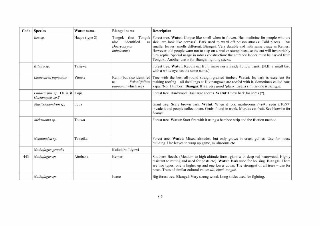
8-5
Code Species Watut name Biangai name Description
Ilex sp. Haqoa (type 2) Tongok (but Tongok also identified as Dacrycarpus imbricatus)
Forest tree. Watut: Corpse-like smell when in flower. Has medicine for people who are sick ‘are look like corpses’. Bark used to ward off poison attacks. Cold places – has smaller leaves, smells different. Biangai: Very durable and with same usage as Kemeri. However, old people warn not to step on a broken stump because the cut will invarariably turn septic. Special usage in tubu i construction: the entrance ladder must be carved from Tongok.. Another use is for Biangai fighting sticks.
Kibara sp. Tangwa Forest tree. Watut: Kapuls eat fruit, make nests inside hollow trunk. (N.B. a small bird with a white eye has the same name.)
Libocedrus papuanus Yienke Kaini (but also idenitifed as Falcalifalium papuana, which see)
Tree with the best all-round straight-grained timber. Watut: Its bark is excellent for making roofing—all dwellings at Hikinangowe are roofed with it. Sometimes called haus kapa. ‘No. 1 timber’. Biangai: It’s a very good ‘plank’ tree, a similar one is sizingik.
Lithocarpus sp. Or is it Castanopsis sp.?
Kopa Forest tree. Hardwood. Has large acorns. Watut: Chew bark for sores (?).
Mastixiodendron sp. Eqoa Giant tree. Scaly brown bark. Watut: When it rots, mushrooms (weika seen 7/10/97) invade it and people collect them. Grubs found in trunk. Muruks eat fruit. See likewise for hemiye.
Melastoma sp. Touwa Forest tree. Watut: Start fire with it using a bamboo strip and the friction method.
Neonauclea sp. Taweika Forest tree. Watut: Mixed altitudes, but only grows in creek gullies. Use for house building. Use leaves to wrap up game, mushrooms etc.
Nothofagus grandis Kuludubu Liyewi
443 Nothofagus sp. Aimbana Kemeri Southern Beech. (Medium to high altitude forest giant with deep red heartwood. Highly resistant to rotting and used for posts etc). Watut: Bark used for housing. Biangai: There are two types; one is higher up and one lower down. The strongest of all trees – use for posts. Trees of similar cultural value: illi, kipei, tongok.
Nothofagus sp. Iwere Big forest tree. Biangai: Very strong wood. Long sticks used for fighting.

8-6
Code Species Watut name Biangai name Description
Nothofagus sp. Kipei Biangai: Forest giant of high bush. Very strong, red heartwood from a long, knot free trunk. High value at sawmill. Dialect name: kepi. Trees of similar cultural value: illi, kemeri, tongok.
Nothofagus sp. Kongaubu
Nothofagus sp. Kolok kolok
Nothofagus sp. Keme kemba Forest tree of high bush. Biangai: see keme varieties under Vaccinium.
Nothofagus sp. Ngavi
Nothofagus sp. Ilygisi
Octamyrtus pleiopetala Wamnahawa Korobu Tree with papery bark. Watut: Birds eat fruit. Biangai: Use for house building.
Phaleria sp. Qoiyango Tall forest tree.
Phyllocladus hypophyllus
Sik krek Biangai: Sik krek is the ‘male’ of Sik (Dacrycarpus imbricatus)
Phyllocladus hypophyllus
Illi Forest giant of high bush. Biangai: Cassowaries eat the fruits and it is favoured by kapuls for nesting. Trees of similar cultural value: kemeri, kipei, tongok.
Phyllocladus sp. Maiya Kaini Forest tree. Watut: Bark is infused to make a red tea which is drunk when someone is sick so that they kisim blut gen.
Piper sp. Kaiwa Daka leaf tree. Watut: Nautiya’s clan tree.
Podocarpus sp. Hatava Forest tree. Watut: Cold/hot place. Straight grain timber like yiengke. Bark used fo house walls.
Prunus sp. Hamneawa Watut: Tree with strong smelling bark. Equta clan’s tree.
Schizomeria sp. Onde Watut: ‘No. 1 timber’. Feed bark to dog for … (?)
Schuurumausia sp. Kemekelelelek No.1 (or kemekalakalak?)
Big tree. Biangai: 1. Use big leaves for bush house, ‘umbrella tree’. 2. Heat leaves on fire and rub on head of baby to give it strength.
Kemekelelelek No.2 Biangai: Different leaves to Kemekelelelek No.1. Use to roll smokes.

8-7
Code Species Watut name Biangai name Description
Sloanea sp. Haqoa (type 1) Forest tree. Watut: Corpse-like smell when in flower. Has medicine for people who are sick ‘are look like corpses’. Bark used to ward off poison attacks. Warm places – has bigger leaves, smells different.
Sterculia sp. Yanantue Forest tree. Watut: Eat small-sized grubs from under bark. Roll leaves with bush tobacco for smokes.
Syzygium sp. Hapaiye ‘No. 1 timber’.
Syzygium sp. Hemiye Giant forest tree that grows at high altitude and in mono-specific stands. Watut: When it rots, mushrooms are collected from the trunk (e.g. weika, hikika). See likewise for eqoa.
Syzygium sp. Parawa Forest tree. Watut: Birds eat fruit.
Syzygium sp. Peiya Forest tree. Watut: Very strong. Use for house building. Mixed cold and warm places.
Syzygium sp. Watuwa 3 types, another is Mana
Tongok Tall forest tree of the high bush with extremely durable heartwood. Watut: Kapuls scratch bark and eat the sap and fresh leaves. Hunters set traps by this tree when the marks are seen. You can feed fresh leaves of tree to tame kapuls when shrub-sized. Biangai: Highly favoured building timber. Trees of similar cultural value: illi, kemeri, kipei.
Terminalia sp. Qambiya Giant forest tree. Two types told apart by leaves. Timber tree, but not as strong as e.g. heyu. Use bark for bush house. Muruks eat fruits.
Trema orientalis Qaka Tall forest tree. Good for houses.
Urtica sp. (?) Pipia Forest tree. Leaf used in salt-making.
709 Vaccinium sp. Tomange *Keme yembu (No.2) Forest tree. Watut: Tree that is dry inside and used to start a fire quickly when out hunting. Biangai: Big tree with red and green leaves.
*Keme kelango Large forest tree. Biangai: 1. It makes strong house posts. 2. Saplings have a usefully forked shape.
*Keme lemeng Forest tree. Biangai: Use stick for planting yams.
*Keme ngiwa Forest tree. Biangai: 1. Make staves for stick fighting. 2. Wood is dry inside, use it as the friction block for starting a fire.
* See also keme ngiwa which is under Elaeocarpus.

8-8
Code Species Watut name Biangai name Description
*Keme uwere Forest tree. Biangai: 1. It’s very strong, use for house posts. 2. Tie up sugar on sticks of it.
Xanthomyrtus sp. Kutitanga Forest tree. Branched needle-like leaves. Watut: ‘No. 1 timber’.
Eqake ?Tree. Watut: Used to make fire tongs.
Hiye Forest trees of the high bush. (Re-check.)
Hoqa Forest tree. Watut: Use bark as a cooking container. See qopnta.
Kanaikia Forest tree. Watut: Big leaf, eaten with traditional salt or haka.
Kanangowa Muveng Forest tree. Watut: Not particularly strong, but splits easily. High bush. Biangai: Use for fences.
Kariato Large forest tree.
Kwoika Forest tree. Watut: Leaf used in salt-making.
Mana Watut: see watuwa.
Matuanga Watut: Tree used for house making.
Munage Forest tree. Watut: Leaf used in salt-making.
Opaituwe Forest tree. Red bud, ribbed leaf. Watut: Medicinal plant – leaves used.
Qimqa Illi (see Phyllocladus hypophyllus)
Tall forest tree with strong timber. High bush.
Wauwa Forest tree. Watut: Leaf used in salt-making.
Weiwa Forest tree. Watut: ‘Very strong’.
Evang (or eveng)
Giant tree of medium altitude bush. Biangai: ‘Canoe tree’, use it to make war shields, kulo rhei.
Imbuli Shortish tree with red flower. Biangai: It attracts the parrots or lories suluwe (‘nus nogut’, ?Papuan Lory) and kaini.
Kaimatu Tree? Biangai: 1. Cover a mumu with leaves. 2. Use leaves to wrap food parcel.
Kame Tree of medium altitude bush. Biangai: It’s a ‘glue tree’, sap is used for binding arrows and kundu drums.

8-9
Code Species Watut name Biangai name Description
Kamelelek (or kemelelek)
Tree of medium altitude bush. Biangai: It’s a ‘glue tree’, red sap is used for binding kundu drums. (Is this the same as kame?)
Kauluveni Tree of medium altitude bush, leaves smell strongly of aniseed. Biangai: 1. Girls put leaves in armband for singsing bilas. 2. Mother ties it to baby’s bilum as a charm.
Kaung Large tree. Biangai: 1. Good timber, use for house posts. 2. Has edible grubs. Similar to wali.
Kazuwik Large tree. Biangai: 1. Shoot birds that are attracted by its fruit. 2. Use for house posts.
Kemeneten gliak Tree of high bush. Biangai: Use for house building.
Kemeyang Short tree at edge of grassland. Biangai: 1. If you chew its fruit and spit, you won’t miss with an arrow. 2. Children make a toy with the fruit.
Castanopsis or Lithocarpus
Kemouli Large tree. Biangai: 1. Wild pigs come and eat the nuts. 2. It’s very strong, use for house building. Kemouli is similar to yogoi, both are classed as ‘Wau oak’.
Kevila Tree of medium altitude bush with giant leaves. Biangai: You ring-bark it and let it die; grubs invade the trunk and you come back, cut it down and eat them.
Komai Tree of high bush. Biangai: There is a vine of same name, komai wilek.
Kongolibu Short tree in grassland. Biangai: Use stick to plant karauka so that the karuka doesn’t grow excessively tall.
Koberanga Tree. Biangai: It has leaves to chew with betelnut, lip daka.
Kong and variety: kong rek
Very straight tree of medium altitude bush, white bark, no branches on its tall trunk. Biangai: 1. Its very straight timber is excellent for house construction. 2. It has edible grubs. 3. Excellent for firewood.
Kuakabela A tree. Biangai: When you are off to fight, drop a leaf and blow on it as it falls; if it lands upside down, the enemy is near; if it land the right way up, it’s safe to walk through the bush.
Kulenangang Tree of medium altitude bush. Biangai: 1. You musn’t cut it because it gives grease to the ground. 2. A grub eats the leaves and you collect and eat them; they are very greasy and have medicinal properties—give to sick people. 3. Soften bark with water and rub on tired legs or when you have muscular pain after hard work..

8-10
Code Species Watut name Biangai name Description
Kulik Tree of high bush a bit like a casuarina. Biangai: Make special digging sticks for planting long yams..
Liewi Tree of medium altitude bush with red heartwood. Biangai: Classed as ‘iron wood’, very strong, use for posts.
Maroa Tree of high bush. Biangai: Use stick made from it to construct a noose trap to tangle muruks and wild pigs.
Molung Tree of medium altitude bush.
Nazuwi Tall tree of medium altitude bush.
Ngane koumu Tree of medium altitude bush. Biangai: Beat leaves and bark and infuse into water. It’s an emetic to drink when you are sick..
Nganziyagoro Tree of high bush. Biangai: kapuls are attracted by its fruit.
Ngiwa Tree of high bush.
Sabi krek Tree of high bush. Biangai: axe handle tree.
Sagoba Tree of medium altitude bush. Biangai: it has painful bark and leaves, but it’s a tree not a salat. If you try to wash your skin after touching it, the pain gets worse. It makes your glands swell up in your groin and armpit.
Samwei Tree of medium altitude bush. Biangai: 1. Classed as ‘Wau cedar’. 2. Bark used a substitute for lime (process in a similar way to salt).
Sauvang Tree of medium altitude bush. Biangai: it’s a diwai salat.
Savuk merik Tree of medium altitude bush. Biangai: Kapuls and humans eat the fruit. Bark can be used to make things.
Sengele Straight growing big tree of medium altitude bush. Biangai: It bears edible fruit prolifically which is collected and cooked in fire or smoked over a fire.
Silani Short tree. Biangai: 1. Use stick to tie up sugar—useful because of its closely spaced branches. 2. Use to display food as a feast—hang things on its branches.
Sinzingik Tree. Biangai: Birds are attracted by the flowers. Same as sizingik?
Sizingik Tree of high bush. Biangai: Similar to kaini. Same as sinzingik?

8-11
Code Species Watut name Biangai name Description
Ubeng Tree of high bush. Biangai: Use for house doors and planks. Very easy to hew.
Wali Large tree. Biangai: 1. Good timber, use for house posts. 2. Has edible grubs. 3. It’s a man’s name. Similar to kaung.
Wiletori Large tree.
Wizangiya (bigger) Sangoropa (smaller)
Mid sized tree in high bush. Biangai: Use sap as a glue in making arrows.
Castanopsis or Lithocarpus
Yogoi Trees of medium altitude bush. Biangai: Use for house building. Yogoi is similar to kemouli, both are classed as ‘Wau oak’
VINES Biangai = wi (bush ropes) & leng (climbing bamboos)
Code Species Watut name Biangai name Description
Duka Vine. Watut: Use as smouldering firestick to carry in the bush when you don’t have matches.
Havamnge Watut: Vine that men avoid because it makes you (magically) sick. Makes your legs feel weak and a magician is required to cure you.
Itititue Thin vine. Watut: Crush and inhale leaves to unblock nose. Strong scent.
Ituka Thin 3mm vine. Watut: Used to bind arrowheads.
Kaiyuka Watut: Used to make rope to whirl bull-roarer (tambaran) at initiations.

8-12
Code Species Watut name Biangai name Description
Kanauke Kabung Watut: Strip the vine and use it for tree-climbing. Biangai: Very strong vine. Can be only 2-3mm diameter but grows to thickness of your wrist. You make a roll a hide it along a path; if you step on it, you will think the journey is short.
Kaiye Kobung inak Vine with thorns. (Or is it a vine-like fern with thorns?) Watut: 1. Medicine. 2. Pull tufts of hair froma newborn baby and attach them to the thorns (to ward off sickness?). Biangai: Make poison fro killing people from this vine.
Petange Vine with thorns. Watut: Birds eat bright red fruit. Bind arrowheads with its cane.
Pititua Vine. Watut: Leaf crushed and inhaled to clear nose.
Qanga Huge vine up to 25 cm diameter on the biggest trees. Watut: Red fruit favoured by birds of paradise (Raggiana at lower altitudes, Stephanie’s Astrapia/Black Sicklebill at higher altitudes). Cut it and drink water from it when sick. It can also be planted as a shrub.
Utitava Thick vine, climbs tall trees. Red bark. Watut: Cut it to find drinkable water. Cut into lengths and take to village to pulp and drink juice as a medicine. Also children swing on it for fun (‘Tarzan vine’).
Wendando Small diameter vine with thorns which winds through undergrowth. Watut: Remove outer skin with thorns to reveal 5mm round cane which is split to weave into bands.
Wango Vine on tall tree. Watut: Leaves eaten by tree kangaroos.
Kelelung Vine. Biangai: 1. Sorcery ingredient. 2. Eat shoots to make you fierce.
Leng kaurua Mambu rop variety.
Leng koulu Thick bush rope with thorns. Biangai: 1. Make belt to hold up men’s malo. 2. Bundle up sugar with it. 3. Use in house building. 4. Use in fencing. 5. Use as a fire thong if you can’t find any bamboo. 6. Use to cover growing bananas so thorns will keep flying foxes away. 7. Pull grubs out of a rotten log with its thorny pangal. 7. Make designs on house post of tubu i men’s house.
Liengai wisale Vine. Biangai: (Lit: ‘pig vine’.) If a wild pig runs away you beat its footprints and say ‘Fa!’, the pig will stop running and you’ll be able to kill it. (‘Me!’ is usual call for pigs. ‘Fa!’ is a special word to confuse a pig or human enemy.)
Mabung Rop nil. Biangai: 1. Sorcery ingredient. 2. Protect sugar from kapuls by winding it round the stem. 3. Push into holes to pull kapuls out.

8-13
Code Species Watut name Biangai name Description
Rongan Tree climbing vine. Biangai: It has big leaves you can use to keep dry from rain.
Yakikitua Wi inak Vine with thorns. Watut: Roll smoke in leaves. Biangai: Feed to dogs before hunting to make them chase kapuls eagerly.
Rhododendron sp. Wi kasase Vine.
Wi kemembu Like rhododendron, pink flower. Biangai: It features in women’s songs.
Wi polu Vine. Biangai: 1. Use in making fences. 2. Use in building houses.
Komai wilek Vine. Biangai: Stephanie’s Astrapia are attracted to the flowers. There is a tree of the same name: komai.
FICUS see also tapa cloth trees/vines
Code Species Watut name Biangai name Description
Iza Wild Ficus. Watut: Use for tapa cloth. Yellow leaf.
Yeitapa Watut: Ficus on big forest trees – general name.
Yeitapa kaiwa Watut: Big Ficus able to strangle the biggest trees, e.g. eqoa.
Yongua Watut: Wild Ficus, but seeds can be planted too. Use for tapa cloth. Red leaf.
PANDANUS Watut = hikia, kanage Biangai = waruwaru
Code Species Watut name Biangai name Description

8-14
Code Species Watut name Biangai name Description
Pandanus conoideus spp.
Hiyaknga Iring Wild marita. Kapul make nests in it. Muruks and birds eat fruit. Watut: Use leaves for roofing, legs for flooring. Biangai: 1. Use leaves for bush housing. 2. Use leaves to wrap wild fowl eggs. 3. Beat the roots to make grass skirts for women.
Pandanus conoideus spp.
Hamanga Watut: General term for marita pandanus. This is not a particular variety.
Pandanus conoideus spp.
Ingawa Wild marita. Watut: Split trunk to make house flooring. Muruks eat fruit.
Pandanus julianetti spp. Hikia Hard karuka pandanus. Watut: Warm place karuka—below Mais only. Nut is cracked with a stone, always planted
Pandanus julianetti spp. Hikia namdaka Watut: Wild hikia variety (check).
Pandanus julianetti spp. Kanage Watut: Cold place karuka—above Mais only. Nut can be cracked with teeth, can be wild or planted (Kunimaipas have planted some).
Pandanus julianetti spp. Manapa Kuwerang Very tall karuka. Round soccer ball like fruit. Reddish colour? Watut: Use leaves for bush housing. Cassowaries eat fruit. Biangai: Eat the fruit and child will grow tall, arrows will not find their mark. If you kill someone you might say ‘It wasn’t me, kuwerang did it’. Women make armbands with it when returning from bush expeditions and put scented leaves in them; people look and admire them. The name is also invoked in some war cries.
Pandanus julianetti spp. Ingauwa Waruwaru Biangai: Waruwaru is the covering term for pandanus, but also for the biggest wild pandanus. Use leaves for bush housing.
Ling Biangai: Similar to waruwaru, a wild marita. 1. Use leaves to wrap bushfowl eggs. 2. Use for building shelters.
PALMS limbum
Code Species Watut name Biangai name Description

8-15
Code Species Watut name Biangai name Description
Enauwa Black palm. Watut: Also known as mauwa.
Ha’a Kazige (likely correspondence)
Palm with red fruit. Watut: 1. Humans chew fruits as if they were kapipi, muruks eat fruits.. 2. Use wood and leaves for houses. 3. Eat new shoots as a bush food. 4. Use fronds to wrap game. Seen as very similar to pauwe. Biangai: 1. It’s a kapipi. 2. Use leaves for bush shelters. 3. Eat shoots in bush as an emergency food.
Havana Palm. Watut: Eat shoots and use wood for houses.
Hauwa Tall palm. Watut: Use trunk for house materials. Fruit hangs from stems like betelnut stems – make into brooms.
Panga Watut: General term for betelnut palms – all types.
Pauwe Watut: 1. Use leaves as mustard. 2. Eat new shoots as a bush food. 2. Use fronds to wrap game. 3. Use wood and leaves for houses. Seen as very similar to ha’a.
Tangonga Palm. Watut: Use leaves for bush shelter. Use wood for axe handles. Muruks eat fruit.
Kunang Palm. Biangai: 1. Make fighting sticks with sharp edges. 2. Split and use for house flooring. 3. Use leaves for bush shelters.
FERNS Biangai = kulei
Code Species Watut name Biangai name Description
Hemahema Fern. Watut: Fern used in cooking.
Kinaiwa Fern. Watut: Edible fern. Warmer places only. Used when out hunting.
Mamka Fern. Watut: Small edible fern on forest floor. Restricted to cold places.
Qenaiwa Fern. Watut: Cooking fern. Very good for eating with marita or pork.
Qoipa Fern. Watut: Cooking fern. Midway between cold and warm places. New fronds are Fern. very good for eating with marita or pork.

8-16
Code Species Watut name Biangai name Description
Takngo Fern. Watut: Small fern used for cooking. Restricted to cold places (above Heyu).
Taqamwo Fern. Watut: Cooking fern, esp. used to cook wild game.
Wamdeka Fern. Watut: Fern with many uses.
Balok Fern. Biangai: Edible fern. Snakes eat it to lubricate their throats (see Biangai usage notes for kobung)
PTERIDOPHYTA Wantaiwa / wandeiwo?
Kobung Small fern with thorns. Watut/Biangai: Forest wallabies eat the shoots. Snakes chew the stem to oil their mouths so they swallow their food easily. Biangai: Edible but most useful for making bush shelters when in the mountains (see also Biangai usage notes for edible fern, balok).
Kulei Fern. Biangai: This is the generic name for ferns, but also one of the types. At the haus boi the man who divides the pork hands out kulei to eat first, then the men eat pork afterwards.
PTERIDOPHYTA Meleprokprok
Ingoro Fern. Biangai: Edible fern.
Karawali Fern. Biangai: Mountain fern.
Yakaka Kasak Fern. Biangai: Strip stem to make woven armbands. You soak the prepared cane in a boggy place overnight to make it turn a black colour.
Kik sinji Fern. Biangai: (kik = ‘bilum’) 1. Edible 2. Rub on bilum string and dye it a red colour.
Levang Fern. Biangai: Mountain fern.
Nayang Fern. Biangai: 1. Not edible, don’t touch it when making gardens or walking in the bush. 2. Use for bedding and house walling.
Nganego Fern. Biangai: Edible fern.
Parok Fern. Biangai: Edible fern.
Yek Fern. Biangai: Edible fern.

8-17
Code Species Watut name Biangai name Description
SHRUBS gorgor
Code Species Watut name Biangai name Description
Aitiawa Kaigowi Gorgor plant. Leaves small like coriander. Only cold places. Watut: Cook with aibika. Similar one is warm places is piyo. Biangai: Good smelling kumu. Cook and eat with rat’s testicles.
Hanguauwa Shrub. Watut: Two types – red and green leaves. Roll leaves with bush tobacco for smokes. (Plenty at Hanguauwa-mnga.)
Hamando Shrub. Like a bonsai tree, it has many branches. Watut: Use as a ladder to climb up and bind bananas.
Hamawanga Shrub? Red/green leaf. Watut: Rub on boys’ heads when they have been beaten in initiations.
Hauyiengke Shrub (of Cordyline size and shape). Watut: Eat shoots. Base of stem has many legs like pandanus. A knotty part under this is made into bird arrows (blunt type, not supsup).
Ikutauwa Watut: Medicinal plant. Eat leaves with salt. Kapuls eat leaves.
Inyanga Shrub. Watut: Use leaves as stopper for bamboo water carrier – makes water taste sweet. Nice smell when crushed.
Kaiwa Shrub. Watut: Wel daka.
Kitapaka Shrub. Broad-leaved in clumps. Watut: Only in swampy places.
Kanange Shrub. Watut: Strong leaf that is difficult to tear. Roll with bush tobacco for smokes.
Kanauwa Kelekelek Shrub about 2m tall. Dark, rough leaves up to 30cm across. Biangai: Use leaves as plates.

8-18
Code Species Watut name Biangai name Description
Kevia Shrub, plate-sized pleaves. Watut: Bark for handle of bilum or rope to climb trees with in bush.
Kumnga Small shrub, large leaves, heavily scented. Watut: Used in cooking to prevent diarrhoea. Restricted to cold places. Eat with gris pik.
Kukiya Shrub like a raspberry bush. Hulis put the burrs on their hair before putting their wigs on. Watut: People used to rub skin of corpse with burrs to remove moisture when drying them.
Mambiya Shrub. Watut: Dry the leaves and heat over a fire until powdered, then eat with salt.
Miyango Shrub with purple stem and purple/green leaves. Watut: Chew stem for toothache. Cook stems in fire and chew with ash to spit on sores. Chewed mixture is deep purple (indigo) in colour.
Mnga Shrub that grows next to creeks. Watut: Birds come in early morning to eat fruit. Frogs climb up inside and you shake the bush to make them fall out. Pulp ?leaves and mix with water – drink to ward of poison attacks. (Plenty at Mnga-manga Creek).
Nambanamba Shrub. Watut: Salt plant.
Piyo Gorgor plant. Leaves small like coriander. Watut: Cook with aibika. Only warm places. Similar one is cold places is aitiawa.
Qiyea Shrub with thorns. Watut: Cut newborn baby’s hair and parcel it in the bark to ward off sickness.
Cordyline sp. Wakiya Watut: General name for Cordylines (many vars.)
Wanameto Shrub. Watut: Fruit and leaves eaten with pork. Plenty at Wanameto Creek.
Wapiwauwa Shrub. Watut: Mash fruit and feed to dog that can’t eat because its stomach is blocked (bel i pas).
Wunamie Cordyline sized shrub. Watut: Eat the leaves and buds.
Yiqota Shrub? Watut: Furry leaf used during fighting as an emetic to cleanse all blood from internal wounds.
Fizibaya Shrub with tiny 6mm leaves. Biangai: Fizibaya come as husband and wife. This is the wife.

8-19
Code Species Watut name Biangai name Description
Fizibaya krek Biangai: Fizibaya come as husband and wife. This is the husband.
Kabu kabuk Shrub (resembles rosemary). Biangai: Grow it next to your house and use it for bilas.
Kaurang Flower-like shrub. Biangai: It has scented leaves and is used for singsing bilas.
Kemiyambu Biangai: ‘No. 1 shrub’. Covers forest floor like a carpet when in flower.
Kilisinzi Biangai: Muruk food, has red dye.
Sibeleng Kumu. Biangai: It’s an edible kumu.
Silang Leafy bush. Biangai: forest wallabies come and eat it.
Singelek Shrub. Biangai: It’s a lip daka.
Uraura Shrub with tiny 3mm leaves.
Yamunei Regrowth.
1. Wizangiya 2. Senge koropa 3. Kaulupeni
Biangai: Three plants which are one species. First one is a high altitude bush. Second one is a lower altitude, has a sap used in making arrows and birds are attracted to its flowers. Third one has a scented leaf that women put around their necks.
GROUND PLANTS AND FLOWERS
Code Species Watut name Biangai name Description
Angapea Ground plant. Like a croton?. Small red and green leaves.
Goinda Small leaved ground plant. Watut: Eat shoots. Small wallaby also eats shoots. Kapuls eat green berries.
Ekapia Wang Red leafed ground plant. Muruks eat it.
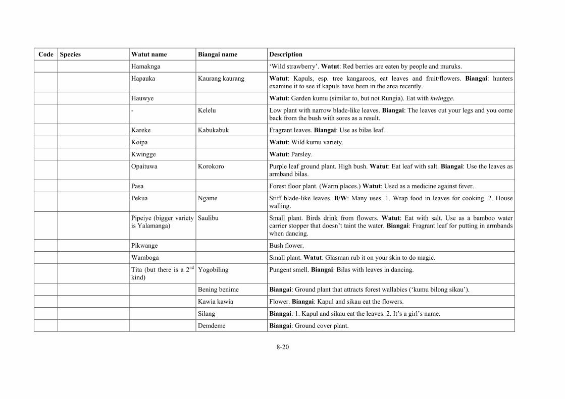
8-20
Code Species Watut name Biangai name Description
Hamaknga ‘Wild strawberry’. Watut: Red berries are eaten by people and muruks.
Hapauka Kaurang kaurang Watut: Kapuls, esp. tree kangaroos, eat leaves and fruit/flowers. Biangai: hunters examine it to see if kapuls have been in the area recently.
Hauwye Watut: Garden kumu (similar to, but not Rungia). Eat with kwingge.
- Kelelu Low plant with narrow blade-like leaves. Biangai: The leaves cut your legs and you come back from the bush with sores as a result.
Kareke Kabukabuk Fragrant leaves. Biangai: Use as bilas leaf.
Koipa Watut: Wild kumu variety.
Kwingge Watut: Parsley.
Opaituwa Korokoro Purple leaf ground plant. High bush. Watut: Eat leaf with salt. Biangai: Use the leaves as armband bilas.
Pasa Forest floor plant. (Warm places.) Watut: Used as a medicine against fever.
Pekua Ngame Stiff blade-like leaves. B/W: Many uses. 1. Wrap food in leaves for cooking. 2. House walling.
Pipeiye (bigger variety is Yalamanga)
Saulibu Small plant. Birds drink from flowers. Watut: Eat with salt. Use as a bamboo water carrier stopper that doesn’t taint the water. Biangai: Fragrant leaf for putting in armbands when dancing.
Pikwange Bush flower.
Wamboga Small plant. Watut: Glasman rub it on your skin to do magic.
Tita (but there is a 2nd kind)
Yogobiling Pungent smell. Biangai: Bilas with leaves in dancing.
Bening benime Biangai: Ground plant that attracts forest wallabies (‘kumu bilong sikau’).
Kawia kawia Flower. Biangai: Kapul and sikau eat the flowers.
Silang Biangai: 1. Kapul and sikau eat the leaves. 2. It’s a girl’s name.
Demdeme Biangai: Ground cover plant.

8-21
Code Species Watut name Biangai name Description
STINGING NETTLES salat
Code Species Watut name Biangai name Description
Avange Watut: Planted stinging nettle.
Dapandue Watut: Planted stinging nettle.
Ititiqoie Watut: Wild stinging nettle.
Liyeqaiewu Watut: Planted stinging nettle. Big leaf, purple underside.
Mainuwa Mid-sized tree with stinging leaves Watut:. Tree kangaroo eats leaves. So strong it blisters your skin if touched.
BAMBOOS (see also vines)
Code Species Watut name Biangai name Description
Nastus sp. Wizilu
Hake Watut: Planted bamboo—general term.
Piye Watut: Cold place bamboo with water inside the nodes.
Qano Watut: A bamboo used for water tubes, cooking, bladed arrow heads.
Tita Watut: Cold place bamboo with water inside the nodes.

8-22
Code Species Watut name Biangai name Description
TAPA CLOTH TREES/VINES
Code Species Watut name Biangai name Description
Kaimba Watut: Tapa cloth tree, planted only. Bark used for making malo (bark capes). Only in warm places, e.g. Matuanga, near Nauti. See waiyo.
Iza Wild Ficus. Watut: Use for tapa cloth. Yellow leaf.
Yongua Wild Ficus. Watut: Seeds can be planted too. Use for tapa cloth. Red leaf. Pulp root and drink as medicine.
Waiyo Watut: Tapa cloth tree, planted only. Bark used for making malo (bark capes). It has a red leaf and makes a red tapa cloth. See kaimba.
OTHERS
Code Species Watut name Biangai name Description
Hameiwa Kuwai (likely correspondence)
Wild breadfruit (wel kapiak). Watut: Use leaves for mumu, eat shoots, fruit. Biangai: 1. Use leaves for mumu, eat shoots. 2. Make bilum rope with inner bark. 3. Children do archery practice with fruits. 4. It’s a girl’s name.
Kateka Orchid. Watut: Women make yellow necklace bands (not woven) with it.
Pangium edule Kaamga Watut: Tree with toxic fruits which are rendered edible by soaking in a pond. In Pidgin: sis.

8-23
Code Species Watut name Biangai name Description
Koivango ?Grass. Watut: Used for women’s skirts.
Mango Watut: Orchid stem dried by women and worn as an ornament. Yellow when dry.
Pinga Elelek (or elelak)
Yellow beard-like moss, ‘Old man’s beard’. Often on Hooped Pines. In Pidgin: ais, or if on ground matres. Watut: It stores water you can drink: carefully pack a bamboo tube with it and take it home to pour over the skin of someone with a fever. Biangai: 1. Has a special cultural use in the haus boi as a decoration with with kapul fur. 2. Cover wild fowl eggs with it before wrapping with a stiff leaf, e.g. ngame, iring, so that they don’t break on the way home. 3. Elelek is felt to make the places where it grows especially cold (after 1997 forest fires, high bush said to be ‘warmer’ because of its absence).
Pueraria sp. Qama Wel yam.
Tava Ginger.
Wengo Wild taro. N.B. two types.
Yava Orchid. Watut: Men make into yellow woven bands.
Kabukabuk Epiphyte. Biangai: It has scented leaves.
Kele kerero Mushroom. Biangai: people eat it.
Kele walangze Mushroom. Biangai: people eat it.

PETER TAPARAI AND THE KUNIMAIPA ALLUVIAL MINERS
AT HIDDEN VALLEY
HIDDEN VALLEY PROJECT, WORKING PAPER No. 9
JOHN BURTON Morobe Consolidated Goldfields Ltd Box 80 Wau Morobe Province Papua New Guinea
December 2000

9-1
Introduction Peter Taparai1 is a Kunimaipa gold miner who worked on an alluvial lease on the Watut River at its junction with Kaveroi Creek near Hidden Valley from 1962 until the mid-1990s. Under Administration policy, small miners were encouraged in alluvial operations from 1957 by the Mining Warden’s Office.
The first local miner to work this stretch of the river was actually James Saro in 1959 or 1960, but he left after complaints from Nauti village leaders.
On 15 February 1963, the Patrol Officer A.R. James (Wau PR 3 of 1962/63) inspected the Kunimaipa workings, his observations about gardens implying that the miners had arrived sometime in 1962 (a letter held in the Wau Mining Office in 1990 gave the date as 15 March 1962).
Hidden Valley. At the present only one party is working here and has only recently established itself. One house of native materials accommodates all the miners.
Gardens. Approximately six acres have been planted and fenced and some plantings are only just commencing to mature.
Population. The party consists of five males from the Goilala Sub-District and two others from Kairuku.
He (Wau PR 5 of 1962/63) revisited Nauti on 30 June 1963:
Alluvial gold is found and mined in the Watut River and many of its tributaries, but the vast majority of the mining is, or would appear to be, done by foreign natives. Numerous Watut natives scratch a bit of gold in their home area but unfortunately they take a back seat in the economic avenue.
Peter Taparai applied for an Extended River or Creek Claim on 6 August 1964 and was issued with a certificate for ERCC1359 on 5 November 1964. This is shown in Figure 1.
The history renewal of this lease is not known and, in common with most alluvial leases, the status had become uncertain by the 1980s when CRA began exploration at Hidden Valley in EL677, a kilometre or so above it.
In the Hidden Valley case of 1987, the magistrate, Geoff Lapthorne, indicated that the land below the EL677/EL497 boundary belonged to Nauti. This included the ground on which the Kuniamaipa miners, including Peter Taparai, were working. A dispute immediately arose between the Nautis and Kuniamaipas.
The Nautis agree to pay Peter Taparai for his support in the case; K400 was paid in April and K1500 in August 1991 on their behalf by HVG as advances on their compensation payments (these are documented payments—we know this was not the total amount).
1 This appears to be his preferred spelling, although he signs his name ‘Peter’ only. Various other
spellings (‘Taprai’, ‘Taplai’, ‘Tapara’, ‘Tabara’ etc) appear in correspondence not written by him.

9-2
The Kunimaipas also fell into dispute with CRA. This was resolved by the company agreeing to pay K18,000 for each of three leases held by them below the exploration area in EL677. This was calculated on the basis of an income of K1800 per year per lease.
The remainder of this paper simply collates some documents relating to the presence in EL677 of Peter Taparai and his people.
Figure 1 Peter Tapalai’s alluvial lease certificate, signed by the Mining Warden, Hec McKenzie, in 1964.

9-3
Upper Watut River
Approx. location of Hidden Valley Camp
Hidden Valley Creek
Kaveroi Creek
Peter Taparai’s lease
Lost Creek
Nosave Creek
Differs here from topo drainage
Approx. line of EL497/677 boundary
Keru Creek
Figure 2 Location of Peter Taparai’s ERCC 1359, and other ERCCS, in relation to Hidden Valley.
In Figure 2, the creeks identified as ‘Lost’ and ‘Nosave’ meet Kaveroi Creek
Warden’s Office name Name during exploration Mary Catherine Creek (also ‘Catherine Mary’)
Hidden Valley Creek
Mary Elizabeth Creek ‘Nosave Creek’ Mary Gabriel Creek ‘Lost Creek’ (Kaveroi Creek) Kaveroi Creek
Table 1 Correspondence between creek names used by Mining Warden and creek names used during Hidden Valley exploration 1985-present.

9-4
Document tendered by Peter Taparai in 1988
SUBJECT: STORY OF UPPER WATUT (HIDDEN VALLEY)
Peter Taprai Kunimaipa Settlement, WARAWAU PO Box 155 Wau Morobe Province 6 Dec 1988
Mi Peter Taprai. Mi laik autim olgeta toktok bilong Upper Watut. Stori i go olsem:
Long 1959 mi kam daun hia long Morobe Province na long Wau. Na mi lukluk raun long olgeta hap long Warawau, Kuranga, Nami, Riva Bulolo, Edie Creek, Wara Muli na Klin Wara long painim gol. Na olgeta hap i occupied o inap pinis. Na mi go bek gen liklik ples bilong mi, we mi stap long en, nem Koemtao. Na long nait mipela i kaikai pinis na lotu pastaim long Papa bilong yumi na mipela i slip. Long sem nait mi driman no long narapela moning mi kirap na katim bus i go long kamap long Bulldog rot, na bihainim rot i go kamap long bikpela tali, nem bilong em SKIN DIWAI. Mi lusim olgeta samting bilong mi na lotu long God Papa na mi tingting; nogut mi abrusim ples we we mi driman long en na mi mas go antap long diwai na mi lukluk raun na mi lukim ples we mi driman long en. Sem taim mi kam daun long diwai na mi kisim olgeta samting bilong mi. Na mi wokabaut i go daun stret long Upper Watut wara.
I first came to Wau in 1959. I tried finding gold at Warawau, Koranga Creek, Namie Creek, the Bulolo River, Edie Creek, Big Wau and Klin Wara. But all these places were already occupied and I went back to my place at Koemtao. One night we ate, said our prayers and went to sleep. In the night I had a dream. I woke up in the morning and started out to go the Bulldog Track by a bush road. I came to a big [tali] at Skin Diwai. I prayed and hoped I would not miss the place I had seen in my dream. I climbed the tree, looked out and saw the place. Then I climbed down, went back to collect my things, and went straight to the Upper Watut River.
Long sem de mi kamautim isi insait long bilum na mi no tingting long malalo, tasol mi kisim spet na kroba na mi kamautim weisan long wara na mi disim gol. Na gol i stap. Mi amamas na kapsaitim gol long emti raba na putim long we mi wokim haus bilong slip. Na mi lotu na mi slip. Long narapela moning mi kirap, kaikai pastaim, mi lotu long Papa God, na mi wokabaut i go bihainim wara i go na mi slip gen long maus baret bilong ol Japan. Na no ken tingting olsem; mi yet i go long dispela patrol. Nogat, mi wantaim sikspela boi bilong mi. Mispela sevenpela man. Na narapela moning long maus baret mipela i go antap bihainim wara i go long namba wan wara karap long en. Em namel long Seiscom na CRA camp. Olgeta boi i go pinis tasol wanpela boi i no kam antap. Na mi go daun gen na mi katim wanpela rop na pasim raun long boros bilong em na pulim em i kam antap. Nem bilong em Guruai. Mipela i bihainim wara i go antap long long hetwara na go kamap long Bulldog rot. Nau mipela i wokim haus na go slip. Narapela moning kirap na lotu pastaim na planim tanget long klostu long rot. Na mipela i bihainim rot i kam kamap long KOEMTAU hia long Warawau. Narapela moning mi kisim gol long raba kontena na kisim i go daun long Mining Office. Mipela i lukim Mr. Mekenji, Mr. Bai na Mr. Jim; na ol i tokim mi olsem: “I gat sampela pipel i stap o nogat?” Na mi tok: “Nogat”. Na ol i tok: “Yu ken go na wok long en. Yu painim gol na kisim i kam long hia na bai mipela i givim yu Mining Lease Identification Card.”
The same day I got my spade and crowbar and dished gold from the gravel in the river bed. I found gold. I was happy and collected it in a container and returned with it to my camp. I prayed and slept. In the morning I got up, ate and prayed to God, and walked up following the river and slept at the ‘Japan baret’. I was not by myself on this patrol. I had six of my boys with me. We were seven altogether. The next day we went up beyond the first waterfall. This is between Seiscom and where CRA is. All the boys got up except one who was stuck. I went down and cut a bush vine, tied it around his chest and pulled him up. His name was Guruai. We followed the river up the headwaters to the Bulldog Track where we made a camp. The next morning we planted tanget at this place, then followed the track back to Koemtau at Warawau. The day after this I brought my plastic bottle of gold to the Mining Office. We saw Mr Mackenzie, Mr Bai and Mr Jim. They asked me if the place where I had found the gold had people living there. I said ‘No.’ They said: ‘You can go and work there. Go and find gold and bring it here for sale and we will issue you with a Mining Lease Identification Card.’
Mipela i katim bikbus long wokim gaden na wokim haus na i stap na taim mipela i go i stap, mipela i no lukim mak bilong ol asples. Tripela yia i go pinis na for long en wanpela lapun man, nem bilong em “OKAMIO” i kam kamap long ples we mipela i stap long en. Em i kam wantaim tupela meri bilong em wantain wanpela brata
We cut virgin forest to make our gardens and we saw no sign of previous inhabitants. Three years went by, and in the fourth year an old man called Qamio visited us. He came with his two wives and ones of his brothers. This was in 1962. He was the

9-5
bilong em. Em long 1962. Em luluai bilong Watut nem Okamio, na tupela indai pinis. Taim mipela i agriment pinis wantain lapun Okamio em i tok orait long mipela i ken sindaun long dispela graun.
luluai of the Watuts [of Nauti village] and he and his brother have since died. We made an agreement with Qamio and he said it was alright for us to settle where we were.
Na mipela i givim lapun Okamio i givim lapun Okamio na ol lain bilong em tripela dog, wanpela tambu long solwara na wanpela kastomeri tit bilong dog. Bihain tok i orait long mipela i ken sindaun long dispela graun. Lapun Okamio kirap na tokim mipela long lo na oda seksin bilong ol tumbuna na em i tok: “Dispela ples em i ples bilong ol masalai; weldok i ken kaikaiim yu. No ken bihainim bus nating nating; na tu no ken katim diwai nating.” Nau na lapun Okamio i kirap na go long Upper Watut. Na taim lapun Okamio indai pinis, ol yangpela bilong em kam kotim mipela wantaim Mr Bob Hisland long 1974 taim em i patrol officer long Wau. Long 1981 dispela ol sem lain putim mipela long kot gen long Lae, taim Mr Birick em District Manager bilong Lae. Na mipela i winim tupela kot. Na kot i tokim mi olsem: “yu ken go na lusim Wau olgeta na go stap olgeta long Upper Watut.”
We gave the old man Qamio and his people three dogs, a rope of tambu shells, and a string of dog’s teeth. Then he said it was alright for us to settle there. Qamio instructed us about ancestral law and said: ‘This place is where masalai live; wild dogs will attack you; don’t wander about in the bush; don’t cut down trees for no reason.’ Qamio went back to his village. When he died, his sons came and took me to court along with Bob Hisland who was the kiap at Wau in 1974. In 1981, the same people took me to court in Lae, at the time Mr Birick was District Manager. But I won both cases. The court said, ‘You can leave Wau altogether and go and stay in the Upper Watut.’
Na mipela i go i stap long Upper Watut i go inap long 27 September 1985. CRA i kamap long Upper Watut na rausim mipela long Upper Watut. Na taim mipela i kam hia long Wara Wau ol i kukim eightpela haus bilong mipela na nain long en i gat olgeta tool i stap na ol marasin bilong gol (mercury) na sampela gol tu i kuk wantaim ol dispela haus. CRA i bin kukim. Dispela nem “Hidden Valley” em i no nem tru bilong dispela graun, nem tru bilong em em Upper Watut. Na CRA i tok Hidden Valley i nogat pipel i stap o wok long en taim ol i kam insait. Tasol mipela ol Kunimaipa i stap long taim pinis na wok longtaim long gol bilong Upper Watut, taim CRA i kam. CRA i rausim mipela ol 500 pipel long Upper Watut na sampela i go nabaut na nau mipela 359 tasol i stap hia long Warawau na Waramuli long Morobe Province.
We lived in the Upper Watut until 27 September 1985. This was when CRA evicted us. When we were at Warawau they burnt down eight houses and a tool shed and we also lost gold and mercury among our belongings. CRA burned the houses down. The name ‘Hidden Valley’ is not the correct name for this place, it is ‘Upper Watut’. CRA said there were no people living here, but we Kunimaipas had been living and mining gold here for a long time before CRA came. CRA got rid of us, and we number 500 people altogether. Some of us have left the area and 359 remain at Warawau and Wara Muli.
This story was told was Mr Peter Taprai na written down by Akoisin Dauai, 29 Nov 1988.
This story was told was Mr Peter Taprai and written down by Akoisin Dauai, 29 Nov 1988.
Document tendered by Peter Taparai in 1990
HEVI BILONG OL KUNIMAIPA PIPEL NA STORI BILONG GRAUN LONG HIDDEN VALLEY
Epril 1990 April 1990
Long yia 1959 mipela painim dispela graun bilong Watut, bihainim prea na bilip bilong mipela long God. Mipela i no bilong hia, mipela i bilong narapela ples tasol long bilip mipela i painim dispela graun. Taim mipela go insait long dispela hap mipela i no painim wanpela mak, mak olsem footprint, o mak bilong faia o mak bilong katim diwai o haus samting; nogat tru.
In 1959 we came to this place on the Upper Watut, following our belief in God and our prayers. We are not from here, but from another place. We came and settled this ground through God’s guidance. When we arrived we did not see signs of habitation such as footprints, fireplaces or signs that trees had been cut down and houses built.
Mipela i painim dispela graun pinis, orait mipela i stat wok After we had worked for four years, the Mines

9-6
inap long for yia pinis, orait Mines i go [katim] o makim graun long 1963. Bihain long 1963 Mines i stretim pinis Lease papa bilong graun na givim mipela na mipela i wok i stap yet.
Department surveyed all the areas of alluvial mining and issued leases. We have been working on our lease since then.
Dispela ples Watut i bin i stap nogut, taim mipela i kamap em i ples kol nogut tru, i gat strongpela win tu na i gat ol wail dog na i gat tripela masala[i] i stap tu long dispela ples.
When we came to the Watut, it was a bad place. It was a place of extreme cold and strong winds. Wild dogs lived there and the place was inhabited by three bush masalai.
Mipela i wok i kam na four pela man bilong mipela i kisim bagarap long dispela ples. Nem bilong ol em: TEIA TOREP, GARIA KATEMU, GOROMAI GARIA na BOTOWAI POMAIHA. Teie Torep em mipela i planim long Watut yet. Ol lain i kisim sik tasol i no dai na orait em Koitamara Laiam, Ambro[se] Korui Peter na Mrs. Vivian Buitai Peter.
We started work and some of us became ill: Garia Katemu, Goromai Garia and Botowai Pomaiha. Teie Torep died and we buried him along the Watut. Others who became sick and recovered were Koitamara Laiam, Ambrose Peter and Mrs. Vivian Buitai Peter.
Taim CRA i kam kamap long Watut long 1985, em i bin tok long baiim mipela long kukim ol haus mipela i save slip no wok gol long en, CRA i laik baiim mipela long K200.00 long wan wan haus. Mi Peter Taparai husat i wanpela lease-holder long Watut i tok nogat, tasol CRA i sakim tok bilong mi na baiim ol haus na kukim.
When CRA started work on the Watut in 1985, they wanted to remove our houses where we live when doing alluvial mining, paying us K200.00 for each house as compensation. As a legal lease-holder, I objected to this, but CRA didn’t listen and had our houses burnt down and paid us out.
Bihain long em CRA i stat long putim dispela drill long Watut. Mipela i no bin givim tok orait long CRA long putim dispela drill. Em i mekim long laik na long tingting bilong em yet. Taim CRA i laik surveim dispela graun em i no bin toksave long mipela, em i mekim laik bilong em yet. Mipela i gat wanpela askim olsem: i gat lo long wanpela man o kampani i ken surveim graun we narapela man o kampani i holim lease pinis long en o nogat? Bikos dispela em graun em mipela i holim pinis lease long planti yia.
After this CRA started drilling [at Hidden Valley]. We didn’t agree to this; CRA went ahead and did it of their own accord. When CRA surveyed their boundaries, they didn’t let us know first. Our question is this: is there a law whereby one party can peg a lease over land already legally leased to someone else? The point is this is the same land we have held a lease over for many years.
Mi Peter Taparai i bin salim pas long CRA tri o fo-pela taim long bai mi go soim mak bilong graun long CRA tasol em i bin sakim tok bilong mi.
I have written to CRA on three or four occasions requesting that I show my lease boundary but I have had no reply.
Wanpela askim bilong i go olsem: I GAT LO SAPOS WANPELA MAN I HOLIM LEASE LONG WANPELA GRAUN PLANTI YIA NA LONG OLGETA YIA NA LONG OLGETA YIA, EM INAP WINEM KAPKAP BILONG DISPELA GIRAUN O NOGAT?
We are now asking whether the holding of a lease without interruption over many years entitles the lease-holder to [the title over] this land or not.
MI PETER TAPARAI Lida bilong ol Kunimaipa na fes gol-maina long Hidden Valley.
Signed, Peter Taparai Leader of the Kunimaipas and first gold-miner at Hidden Valley.
BIBLIOGRAPHY
Patrol reports A.R. James, Wau PR 3 of 1962/63
A.R. James, Wau PR 5 of 1962/63

THE LOCAL LAND COURT CASE OVER HAMATA, UPPER WATUT
HIDDEN VALLEY WORKING PAPER No. 10 prepared for Morobe Consolidated Goldfields by
JOHN BURTON
Pacific Social Mapping 12 Lilley Street, O’Connor CANBERRA ACT 2602 Australia
December 1997 minor corrections April 2000, March 2001

10-2
Introduction
In September and October 1992 six parties were heard in the Local Land Court at Wau in relation to their claims for the ownership of the then RGC-held prospect area of Hamata. The parties were: the Yatavo of Nauti village, the Qavaingo1 of Akikanda village, a Tithama group from Menhi, Kwembu village, part of Winima, and a group from Manki village.
As outlined in the introduction to the case itself, the case was heard while Winima, Kwembu and Manki villages were seeking a Judicial Review of the earlier Provincial Land Court order over Hidden Valley, and were ruled ineligible to enter the Hamata case by Magistrate Gankach. He instructed them to pursue the Judicial Review of Hidden Valley first, then, whatever the outcome, to enter court at a later date over Hamata.
This paper reproduces the court record and adds a commentary based on my investigations in the area in the period 1995-97.
The case would have been heard in pidgin and a court recorder has translated the witnesses’ statements into English for the record. For this reason we may suspect that short comments have been omitted and others misleadingly rendered into English. Nevertheless, the statements ring true to what each party says in interviews today.
The nature of the evidence heard in the case
The evidence of the parties takes three forms, in decreasing order of prominence:
i. recital of place names;
ii. listing of things planted or left in the landscape by ancestors;
iii. oral historical accounts of settlement process.
This would not be controversial if the area in question had been anciently settled by the disputing parties, but this is not the case at all. The evidence I have accumulated from each party since 1995 points to a pioneering of the area by Watut people no earlier than the 1880s or 1890s. This may be considered to have been a form of land conquest. However, any previous use of the land, notably by the Biangai, is irrelevant to this case because of the magistrate’s instruction that Kwembu and Winima villages should stay away pending completion of a Judicial Review of the Hidden Valley decision, underway at the time of the hearing.
In my opinion the recency of Watut use of the disputed area alters the value of the three types of evidence. The recital of place names is useful when the places listed are
1 The spelling of this name is that used by Watuts given literacy training by the Hamtai Bible Church. However, others among them do use the initial ‘K’ spelling.

10-3
expected to be known exclusively and in the finest detail by the rightful owners. But the Hamata court record showed that all the older, knowledgeable witnesses could name the main landscape features, which are only the largest of the rivers, ridges and mountains and which everyone might know after one or two visits. Perhaps this was not apparent to the magistrate, and perhaps the sheer distance of many of them from Hamata was not known to him. Certainly, his court recorder was so unfamiliar with the names that each received a new spelling with the calling of a fresh witness.
The second type of evidence—lists of things each claimant asserted his ancestor had planted or established in the disputed area—is closely tied to this. Each witness is keen to debate where his ancestor had karuka and marita pandanus trees, kapipi, tanget, and planted groves of pitpit, and where he had a titawa or ‘sit paia’ / ‘fire place’ or permanent hearth. Having searched the area quite thoroughly on the ground myself, I can conclusively say none of the ancestors of the claimants established ‘fire places’ in the area of dispute, and none of the things mentioned were ever planted near Hamata. I hasten to add that this does not intrinsically weaken the Watut case as there are many instances in Papua New Guinea of land conquest just prior to colonial contact that have been upheld in the courts (the validation of Yanta/Hengambu claims against those of the previous Piu owners at Wafi is another case). But at Hamata the claimants all acted as if fireplaces, plantings of pandanus and other improvements to the land were very important, and that their own forebears were responsible for them.
That the magistrate was aware of the basic oral history of the groups, and their joint origin in Aseki, is clear from statements made in his decision. However, he indicates that he dismissed this when he found in favour of the Yatavo on the grounds, found in Section 39 of the Land Dispute Settlement Act, that the exercising of current interests over a piece of land must be considered when deciding who to award land to. In doing so, it is not fully clear that he,
i. recognised the considerable distance (about 14km) from Nauti village, where Yatavo, Apea, Nautiya and others live, plant crops and tend coffee gardens, to the disputed area, and its closeness to PA677 (about 2km), where the previous court ruled that the parties had a joint interest—instead, the case reads as if the case was over the ownership of garden land and pandanus orchards at Nauti village itself;
ii. recognised the very short time that has elapsed since the Yatavo have used Nauti as their principal settlement—namely since 1946. While it is true that some Yatavo (among other people) had hamlets in the Nauti area in the 1920s, the majority lived at Sapanda until after WWII.
Both informant accounts and official records agree on this. For example, H.P. Searle, the first patrol officer to visit Nauti after WWII wrote that:
For your information, the NAUTE people are an offshoot of the AGAGANDA natives (H.P. Searle, Wau PR No. 5 of 1949/50).

10-4
This, of course, refers to the Qavaingo who live at Akikanda, the disputing party in this case.
If it was more clear from the judgment that the magistrate had weighed up these things, it is hard to see how he could have dismissed the oral history so lightly, in which separate rights for Yatavo and Qavaingo—the two brothers who founded the patrilines of the claimants, and whose oral history has them commuting between small places in Aseki and Slate Creek—cannot be distinguished.
In particular, of the three key claimants, Kepas and Kontreas were born on Slate Creek at Sapanda and Akikanda respectively, and only Peter may have been born at Nauti. But even this is not certain; he may have been born elsewhere such as Tontomea, where his father lived for a time.
Further, if the magistrate was correct to give full weight to currently exercised interests, why pick the Yatavo to win Hamata—why not the Apea, Nautiya, Tausa and others who also live at Nauti today, or even the Kapau people at Hikiangowe, or Gunimaipas who live below Hidden Valley, much closer to the disputed land? There would seem to be a contradiction here.
Conclusions
The local court decision is vulnerable to challenge of many grounds. The foremost are:
inconsistency in the admission of evidence, as just pointed out;
the instruction to Kwembu, Winima and Manki to leave the court and raise a separate case when their then outstanding Hidden Valley Judicial Review was completed;
the fact that still other parties did not enter the court at all (I do not discuss this here);
the mis-identification of the parties in the final ruling (see below).
The details will be seen in my commentaries2, below.
2 The passages in Arial font are reproductions of the case records, exactly as typed.

10-5
I. Preamble to the court record
In the Land Court Holden at Wau Before: Gankach J LLCM Adhoc Mediators: Micah Kamun Unchy Chero
Disputed Land: “H A M A T A”
Disputed Parties: 1. Nauti Village 2. Susuamie & Narakia Clans of Mangi Village 3. Ekuta Clan of Akikanda Village 4. Tithama Clan of Meni Village 5. Walepelang clan of Winima Village 6. Kwembu Village
Without proceeding to the actual hearing of the dispute the court has to go through each disputing parties to find out if they are eligible to dispute the land in dispute. Prior to the dispute over the land “Hamata” the Provincial Land Court has made the decision on this land giving it 50% to the Nauti and 50% of Hidden Valley to Winima 25% and Kwembu 25%. The Winima sought Judicial Review of the Provincial Land Courts Decision which is still pending.
Now that the Appeal for Judicial Review before the National Court is still pending, the Winimas and the Kwembus are now disputing the “Hamata” land with Nautis.
This leaves the question for the court to rule on whether they can be a party to the dispute and can the court entertain their dispute? After a long deliberation and explanation the court ruled that the Winimas and the Kwembus cannot be a party to the dispute as they will violate the Provincial Land Court Order. They were instructed to persue the matter by applying for Judicial Review of Provincial Land Court Order first and whatever the decision maybe, then they can institute the dispute again.
The second rulings the court made is that the Susami & Narakia clans of Mangi Village be excluded from dispute until the Judicial Review decision is made, because they are a new parties putting in the dispute covering the Hidden Valley and Hamata.
Having made the rulings the court now rules the internal dispute by the Nautis will proceed which form the basis of the dispute now brought before the Local Land Court for hearing.
The internal dispute is within the Ekuta clan by dissatified clan members and between a new disputant Tithama clan of Meni Village.
Case Adj. to 30/9/92 9.00am for trial to begin.
30/9/92 Parties to dispute present. Witnesses indicated by disputing parties. Case opens with Witness form Kavaingo Family of Ekuta Clan, Akikanda Village. Witness 2 from Tithama called. Case adj. to 1/10/92 9am continue hearing.
1/10/92 Appearance of parties as usual. Witness - 2 for Tithama Clan called. Witness for Yatavo Family called and Completed. Case adj. to 30/10/92 at 1.00pm at Lae. All parties advised.

10-6
II. The local court decision
Reproduction of the magistrate’s order REASONS AND DECISION
The dispute over this land “Hamata” is an internal is an dispute between the Yataro Family of Ekuta clan from Nautia Village and Karaingo Family of Ekuta clan from Akikanda Village, and Tithama clan of Meiu Village.
Two family members of the Ekuti clan namely Yataro and Karaingo raised dispute in that Karaingo family should be included in compensation payment pay out from the mining on the land. The other clan Tithama clan to a neighbouring clan who disputed the whole twelve (12) tribes within the Upper Watut are extending to Aseki and Menyama, where their ancesstors originated from should all be included in compensation payment from the land “Hamata”.
Historically the parties to the dispute originated from Aseki. It was during ancestorial inheritance of land through, tribal fight and migration that the parties to dispute settled accordingly in their present places.
Section 39 of the Land Dispute Settlement Act provides for the Court to consider customary interests in relation to land.
The Yataro Family of Ekuta clan from Nautia village who lived near the land has exercise exclusive use and possession of the land. The Karaingo family of Ekuta clan from Akikanda and Tithama clan of Meiu Village are in no way exercising any interest on the land “Hamata” as they were quite distant away.
The fact that their ancestors may have travel through or occupied or hunted or fought on the land does not necessarily prove that the present generations should all have any rights to it without exercising exclusive interest over it.
The party who exercise the interest over the land has the right to it.
Therefore the Court finds that the Ekutia clan of Nautia Village namely Yataro Family has exercise exclusive rights over the land “Hamata”. It is quite true that Karaingo family is of the same clan as Yataro, but they did not exercise exclusive interest over the land in dispute as well as the Tithama clan.
Accordingly the court finds the excluive rights and interest lies with Yataro Family of Ekuti clan from Nauti Village.
COURT ORDER
The exclusive use or posession of the Land “Hamata” is vested on Yataro Family of Ekuti clan in Nautia Village.
Comments
The magistrate refers to a non-existent family ‘Yataro’ of a non-existent clan ‘Ekuti’ of a non-existent village ‘Nautia’.
He also refers to the two losing disputants as the non-existent family ‘Karaingo’ of Akikanda village, and Tithama clan of a non-existent village, ‘Meiu’.
At the very least the order must be re-typed to correctly identify the parties. It seems likely that it is invalid as it stands. (See overpage for correct identifications.)

10-7
III. The Disputing parties—after removal of Biangai and Manki
The case is notable for its mis-identification of ancestral names, places names, and clan/lineage names.
A confusion seen here is that between the village of ‘Nauti’, where Ekuta (or Equta) people live, and the clan/ancestral line name of ‘Nautiya’ (or ‘Nautia’), whose members come under Nauti Census Unit, but who do not live at Nauti village itself (they live at Sakananga, Nauti No. 2 etc).
Also, throughout the case the name ‘Yatavo’ is treated as an ancient clan or tribal name, when it is simply the name of Hangitao’s father, a man who lived perhaps 1860-1910. Yatavo, the group, is therefore the ‘grandfather line’ or ‘small patriline’ that begins with Yatavo, the man.
In court record Interpretation 1. Yatavo Family of Ekuta Clan - Nautia Village
Witnesses: - Peter Askai - Spokesman - Kepas Angtau - Maxwell Kepas - Ken Kawaipango
From Hangitao family of the Yatavo patriline of Ekuta clan at Nauti village:
Peter Askai (son of Jacob Askai Kawimwo Hangitao, deceased), Kepas Hangitao, Maxwell Kepas.
From Apea clan at Nauti village, a man on the mother’s side of Yatavo: Ken Kawaipango.
2. Kavaingo Family of Akikanda Village
Witnesses: - Condreas Kipamono - Spokesman - Bisaiman Kanatanamanato - Henry Condreas - John Condreas
From the Qavaingo patriline at Akikanda village:
Kontreas Kipamono, Hendry Kontreas & John Kontreas.
A supporter: Bisaiman Kanatanamanato.
3. Tithama Clan of Meni Village
Witnesses: - Bawar Yantovo - Spokesman - Yatapsa Kamwoito - Barnabas Atawapo - Yambingtung Taningo
From Tithama clan at Menhi village:
(named persons).

10-8
The annotated transcripts Kontreas KIPAMONO’s evidence ......................................................................................... 8 Hendry KONTREAS’ evidence ............................................................................................ 11 John KONTREAS’ evidence ................................................................................................ 12 Bisaiman KANATANAMANATO’s evidence .................................................................... 14 Bawar YANTOVO’s evidence ............................................................................................ 16 Yatapsa KAMWOITO’s evidence ........................................................................................ 17 Barnabas ATAWAPO’s evidence........................................................................................ 19 Yambingtung TANINGO’s evidence .................................................................................. 21 Peter ASKAI’s evidence ...................................................................................................... 23 Kepas HANGITAO’s evidence ............................................................................................ 25 Maxwell KEPAS’ evidence ................................................................................................. 28 Ken Kawaipango’s evidence ................................................................................................. 30
Kontreas KIPAMONO’s evidence Kontreas Kipamono sworn says, I’m from Kavaingo family, Ekuta clan [??unreadable], Akikanda village.
I support Yatavo and Yandiamango family for the court in Hidden Valley in 1987. We won the case for Hidden Valley land with Nauti against (Kwembu and Winima). The court gave 50% to us ...
Qavaingo, Yatavo and Yandiyamango combined under the name ‘Nauti’ for the purposes of winning the court case. They were jointly awarded a 50% interest in Hidden Valley by Magistrate Lapthorne in the Provincial Court.
… and Yatavo didn’t share it between us and Yandiyamango. When it comes to compensation payment Yatavo family receives it alone, but during the court hearings the three of us combined for it.
Kontreas, the Qavaingo spokesman, and the Yandiyamango spokesman (not a party in this case for some reason) have a general grievance against Yatavo, notably against Peter and Kepas, that they are trying to monopolise benefits from HV, when it was through their joint efforts that the 50% interest was achieved.
The court cover down at Nauti and come up to Hidden Valley.
Actually the HV court only covers PA497.
There are two companies working on the land, CRA at Hidden Valley and RGC at Hamata. During the meeting at Hidden Valley we [?all together] the two company.
(Must refer to a joint meeting at Hidden Valley.)
The reason of dispute is that Yatavo should include me in compensation payment as I helped in court case for Hidden Valley and Hamata.
The land real owner for Hidden Valley and Hamata belong to Kavaingo. Yatavo is in the hands of Kavaingo.
‘Yatavo is in the hands of Qavaingo’ means Qavaingo allowed Yatavo access to the land, in his version of the oral history.
The reason is that Kavaingo settle on the land before and Yatavo family came in, in 1946.
Refers to the movement of Yatavo from Sapanda to Nauti from 1946, as further explained in his answers below and in his son John Kontreas’ evidence later.
It is my land and the ashes of my family still remains. Refers to his ‘sit paia’ or settlement places, see below in answer to first question from Peter Askai.
Question by Peter Askai:

10-9
Q. Where is your block or boundary near my land?
A. Ikanangowe is the ashes of my fireplace, that is the 3rd place inside Nauti village. Nauti is the name given by whiteman. The other place is Heao inside Nauti which is the second village.
Says Hikinangowe and Heyu were Qavaingo places. Probably neither had settlements before contact—or if they did they were very transitory, bearing mind that these places were exposed to Biangai raids.
The other place is Paminga. Paminga is a former settlement on the lower part of Ikelanda Creek.
Q. Are there any member of Kavaingo inside Nauti village?
‘Inside Nauti village’ means ‘in the valley of the Upper Watut’.
A. I do not have any member living there.
Q. Why is then there are three places you mention and no member of Kavaingo family in Nauti?
A. I was inside and you killed a woman and came to the place called Nauti, that’s why I didn’t follow you.
The answer refers to events between about 1940 and 1946, as follows:
Qavaingo had rights in this area dating back to before contact and when the Yatavo house places in the Upper Watut were restricted to Sapanda (in Kontreas’ opinion).
Several Yatavo men, among them Askai and Qamio, later the Luluai of Nauti, accused a woman of sanguma and killed her, perhaps in 1940.
You killed Ananango with no reason … (‘Ananango’=’Yandiamango’.) Yatavo (himself) killed Yandiyamango, the third ancestor in the Nauti triad, on Nemnem ridge, perhaps just before 1920. Yatavo made out that the Biangai were to blame, but the fatal arrow was seen not to be of the Biangai type. This must be a veiled reference to the fact that Yatavo’s guilt has yet to be acknowledged by his descendants.
There may also be a connected reason to explain why the Yandiamango spokesman did not enter the case
… and Pingari … The name of the woman killed in 1940 at Sapanda. This has been given to me variously as ‘Pingi’ and ‘Pinevi’ on other occasions.
… came and settle at Nauti … Out of sequence—see below.
… and went to prison at Salamaua and war came, after you sent to Rabaul …
The perpetrators, including Askai and Qamio, were sent to Salamaua and thence to Kavieng (others may have gone to Rabaul) where they got stranded after the Japanese attack in January 1942. Qamio lived at Kavieng until 1945 while Askai moved around various New Ireland villages.
At the end of the war they were repatriated, but could not go back to Sapanda for fear of revenge killings by the woman’s relatives.
… and came and settle at Nauti. From 1946, Qamio brought Yatavos to Nauti, where his brother-in-law, Telamba, lived.
A Pidgin speaker, Qamio was made Luluai following the wartime deaths of the previous Nautiya Luluai

10-10
together with various other Nautiya clan men.
Q. Is it correct your answers doesn’t cover Hamata?
A. Nauti covers Hamata and Hidden Valley. ‘Nauti’ was so meant when the three groups combined to win an interest in Hidden Valley.
Q. Can you name any features of yours in that land?
A. Yes, Mudikanda river, Mungamanga river, Kamangamanga river, Talcoto river, Hamata river, Kopabio river, Hawai river, up towards Hidden Valley.
From the other side of Hawai, Matuwanga, Yavengmepme river, Autipanda river, Aukepetnanga river, Hatengewe river, Ikanangowe river, Piaimanga river, Neikuya river, these are the streams or rivers.
Now mountains, Tivaino, Hamata, Hawai, Naigo, Otimbanda, Aiyeti, Wau, Yengito ending at Naigo.
Rivers from Ekuti Divide: Mutikanda, Kumungamanga, Teklo, Hamata, Kopakiyo, Awei (=Upper Watut River).
Rivers on the other side of Awei, from Bulolo-Watut Divide: Matuanga, Yavengmepme (not seen by me), Otipanda, Haukapatainga, Hatengiawe, Hikinangowe, ?Piaimanga (not seen by me), Naiko (= head of Upper Watut).
Mountains: ?Tivaino, Hamata, Awei-mnga, Mt Naiko, Otipanda-mnga, Aiyeiti (= Little Wau), Wau, ?Yengito.
Q. Do you have old gardens and pandanus there?
A. If I live in Nauti I would have these things there.
Q. If I haven’t anything on that land would I dispute that land in court?
If it is accepted that his own things do not extend far from Nauti village, he might well do.
The disputed area is many kilometres away from places where people did anything but casual planting before the 1960s.
A. That’s a wrong question, he killed a person and settled there.
Kontreas is attempting to show that the basis of Yatavo settlement at Nauti is that of a group of refugees seeking safety away from the place where they killed someone.
Q. If I didn’t have anything on the land why would I bring dispute to court?
A. Kavaingo planted bread fruit now standing near Community Hall, betelnuts and pandanus on land I mention up to Hamata.
Kapipi is not seen near Hamata. There is very little anciently planted pandanus, and not at Hamata.
No further question.
Question by Bawar:
No questions asked.
Given under my hand this 30/09/92

10-11
Hendry KONTREAS’ evidence Henry Condreas sworn says, I’m from Akikanda village, Kavaingo family, Ekute Clan.
He is Kontreas’s son.
We didn’t put the dispute for nothing, we had a court case over Hidden Valley. During the court case we the three family combined, Yatavo, Kavaingo and Yandiyamango. Later for Hamata, Yatavo Family claimed that they own it alone, so we brought the dispute to court.
I thought that the land Hamata belongs to me too.
That’s all.
Questions by Kontreas.
Q. What did the three families, Yatavo, Kavaingo and Yandiyamango do during the Hidden Valley court?
A. They combined on won the case and then on Hamata we thought all three of us should own Hamata but only Yatavo so we brought the dispute to court.
Obviously there is a grievance in relation to the non-sharing of benefits by Yatavo.
Q. Why did you bring dispute?
A. For us to separate from each other with the share. To get our fair share in Hamata.
Q. Was there anything of yours in Hamata?
A. Rivers are there, I don’t know the names of some of them. But I know Hamata river and further on.
Q. Up until where?
A. Hidden Valley, Bulolo and down Loketo. HV on the south, Bulolo in the centre and Leklu on the north of their territorial range – but these are generalities.
Q. I said within Nauti so up until where?
A. Down … (I forgot as there’s many rivers). (He is too young to know them.)
Questions by Peter Askai:
Q. Are you disputing in court over land or money?
A. Not for money but land.
Q. Can you name the rivers?
A. I can’t, I’m only supporting the evidence of the witness who gave evidence already.
Q. Why do you testify when you don’t know anything in the land?
A. I came to court as we continue [ … ] left us in regard to Hamata land.
No further questions asked.
Questions by Bawa.
No questions asked.
Given under my hand this 30/09/92

10-12
John KONTREAS’ evidence John Condreas sworn says, I’m from Akikanda village, Kavaingo family, Ekute Clan.
He is Kontreas’s son. (Should be Ekuta clan.)
I know that Yatavo, Kavaingo and Yandiyamango have been standing as one group and dispute with our brothers Biangai for the dispute over Hidden Valley.
The court ordered for Biangai to receive 50% and then 50% The sons of Mayato - (1) Yatavo, (2) Kavaingo, (3) Yandiyamango is the son of their sister.
Refers to fact that Yatavo and Qavaingo were brothers while Yandiyamango was related in some other way, believed to be through a woman (who must herself have been Ekuta).
I knew that and thought the three would claim ownership over Hamata. However, Yatavo thought it will be himself so I disagree and dispute it. I would like to know why Yatavo doesn’t want me to be part of Hamata.
Recalling our history, Kavaingo came first to Masata camp at Akikanda.
Qavaingo’s first place at Slate Creek: Masata.
That time his brother Yatavo was up at Aseki side. Yatavo committed adultery with Sutao’s wife of his younger brother. Yatavo conspired with his inlaws at Aseki and Killed Sutao.
This is a concealed part of their history. Yatavo and Qavaingo had a younger brother, Sutao. Yatavo had an affair with Sutao’s wife, Mamatai. Sutao discovered this and attacked Yavato, injuring him. Yatavo was living with his his Nautiya inlaws and their place Puoyu, in Aseki, and he got them to kill Sutao for him.
Kavaingo came and got that land and followed Watut River up.
Qavaingo was on his brother Sutao’s side and took his widow, Mamatai, as his second wife. His life was in danger so he left Aseki and he came to his first place in the Upper Watut, at Masata.
Yatavo came with two Nautia man to place Gumi - Naweo and Kaetapono. I don’t know what happened and his inlaw evict him. He came to Masata to see me at Akikanda.
Now Yatavo himself was forced to leave Puoyu and he took refuge at Gumi, another Nautiya place. Here he again fell into dispute for some reason and came to seek refuge at Masata.
I then gave him second place Yengi Kerenga. Qavaingo installed him at a place nearby called Yangakeklenga.
Yatavo made trouble again Kamtai from Tausa clan - Kambuto (adultry). Tausa came and fought Yatavo and Kavaingo and killed Kwamawio.
Yatavo—it may have been his son, Hangitao—got into trouble again, having adultery with a Tausa man’s wife called Kamtai. The husband’s people came and Kwamawio (or Qaumauyo), Qavaingo’s and Mamatai’s first son, was killed.
Yatavo made trouble again - killed a woman - Pingi. Yatavo went to prison at Salamaua. 1942 Japanese bombed Salamaua prison. They transfer to Rabaul prison.
After contact, perhaps around 1940, about five Yatavo men accused Pingi of sanguma and killed her. The kiap arrested and jailed them. The men spent the war in Kavieng under the Japanese (see Kontreas’s evidence).
After coming back from Rabaul, Anani from Nautia clan told them to keep away from trouble but not. In 1946-7 they moved to the place Nauti, name given by the whiteman, but Paminga is the name.
On their return, a core group of Yatavo families moved to Nauti, which was originally called Paminga. Informants agree this happened in 1946.
Kavaingo did not chase them out but told them to watch over the land as he got it already. What ever our grandfather Mateo have got we must receive equal
The Qavaingo patriline did not chase them to Paminga, but said they could use the land, which may

10-13
share. have been empty but was first claimed by Qavaingo and Yatavo’s father Mayetao. Whatever Mayetao left to all his descendants must be shared equally.
I want to know why Yatavo want to leave me out.
That’s all.
Questions by Kontreas.
Q. Can you tell me the names of mountains, rivers and anything grown there?
A. Only 3 places I can think of that is, Paminga, Heyau, Hikenangue (hot) and Heyau are in cold places.
Two warmer places: Paminga and Heyu.
One colder place: Hikinangowe.
Kavaingo lives in Paminga house garden shelter [ … ] in Hikenangowe and Heyau.
Paminga was a settlement. [?garbled…]
Q. Do you know of anything planted?
A. Yatavo must have cut it down [ … ???]
No further questions.
Questions by Peter Askai.
Q. Is there a family of Kavaingo in Nauti or not?
A. Yes, you are my brother Yatavo now living there under Kavaingo - No.
Yatavo live there, Qavaingo do not.
Q. Would you go back to Aseki if order to do so?
A. That I wouldn’t, but I would have came to Nauti but I thought of my rivers and pandanus etc at Akikanda.
Q. Why weren’t any member of Kavaingo in Nauti?
A. I mentioned it already (above).
Q. Any of garden of present generation in Nauti.
A. Now in generation it is true, No.
Q. Can you name all rivers in order following Watut River.
A. I never travel to that place to know I’m only a witness and my elder ones knows.
No further questions.
Given under my hand this 30/09/92

10-14
Bisaiman KANATANAMANATO’s evidence Bisaiman Kanatanamanato sworn says, I’m from [??unreadable]
He is a supporter of Kontreas.
These are the places where our ancestors came [… unreadable passage …] the ashes of their fire was, that is, Paminga, Heao, [ … ] places. These are their land which they settled. [… ] Ikanangowe, Haukepranga, [ … ] Hamata. These are the rivers they drank and [ … ] mountain Sangananga, [ … ], Olipanda, Naiko.
Places: Paminga, Heyu.
Rivers: Hikinangowe, Haukepatainga, Hamata.
Mountains: Sakananga (= ‘Three Sisters’), Otipanda, Naiko.
This is my short story.
Questions by Kontreas.
Q. Were your ancestors living on Paminga, Eau, Itangangoa, is there fire place or not?
Places: Paminga, Heyu, Hikinangowe.
A. Yes, the fire place (ashes) is still there.
Q. Are there anything like betelnuts, pandanus, “Mareta” in the mountains and near the rivers you called or named them?
No kapipi or marita near Hamata. One Yatavo pandanus (not owned by Hangitao family) at Teklo Hawa, 2km north of Hamata.
A. They have them there.
Q. Can you call which grow where?
A. Pandanus and mareta are in the mountains and near the river.
Too vague.
Q. Who planted them and can you call the name of that person?
A. Kavaingo planted those things.
Q. Were your grandfather in that place?
A. My small one was in that place. Yatavo was the brother of Qavaingo. Witness thinks he was the younger brother, but he was really the elder of the two.
Q. Who is he?
A. Yatavo.
No further question.
Questions by Peter Askai.
Q. Is there anybody from Kavaingo inside Nauti village.
A. Before he was there but now his younger one Yatavo is there in that place.
Q. Why wasn’t Kavaingo not there?
A. He would have lived there but there was trouble there so he went back.
Refers to any one of the disagreements between Yatavo and Qavaingo. One candidate is the killing of Yandiyamango at Nemnem by Yatavo.
Q. When did that trouble happen, ancestors time or “kiap” time?
A. Ancestorial time.

10-15
Q. Why wasn’t Kavaingo returning during “Kiap” time?
A. He would have returned but Yatavo was there already.
Q. Any old gardens and things planted by Kavaingo there?
A. There are.
Q. Which place is first place your ancestors settle?
A. Pamingo. Paminga. Q. Do you see any fire place now existing? A. That was during ancestorial time not now. Q. Is it correct naming of the mountain and rivers aren’t in order?
A. I am only witness, I mixed them. Q. Why did you witness when you don’t know everything in the land?
A. (No answer) No further question asked.
Questions by Bawa.
No questions asked.
Given under my hand this 30/09/92

10-16
Bawar YANTOVO’s evidence Bawar Yantovo says, I’m from Tithama clan, Meni village.
He is a Tithama from Menhi.
The “Hamata” land, my clan disputed in representing the 12 clans within Watut area. Ekuta clan has left out the other clans with Upper Watut, and we would like to know why we were left out in a deal of Hamata land. The land the twelve (12) clan should be benefit from it.
Several documents refer to the ‘twelve clans’ of the Watut area. I know of thirteen names, though I have never encountered members of the last two and they may be subclans of others: Nautiya, Equta, Tithama, Apea, Angamdia, Yaqiana, Pate, Tausa, Wangatea, Angapea, Tanea, Simngapea and Qamqoeta. At any rate, informants always refer to twelve clans.
That’s all.
Questions by Kontreas:
Q. Where were you when we dispute Hidden Valley in court?
A. Tithama was present in court too. Refers to presence of James Saro.
Q. Was it witness from our clan or as disputant?
A. I know that he stood as disputant against you not as witness.
No further question.
Question by Peter:
Q. Why didn’t the 12 clans dispute boundary and not this small area?
A. Company came in and you didn’t include me and other 12 clans.
Q. How many times did you dispute Hamata?
A. Many times outside with no answer.
No further questions.
Given under my hand this 30/09/92

10-17
Yatapsa KAMWOITO’s evidence I’m from [?unreadable] village, [?unreadable] Ekuta Clan.
I think he is a Tithama.
I witness the case as the land Hamata belong to the community inside Upper Watut. I support what the spokesman said for the twelve clans be included in the Hamata land deal. I can tell more stories.
He is a supporter of Bawar.
That’s all.
Questions by Bawa:
Q. How did you know the land belong to Upper Watut Community?
A. It is in the area of twelve clans and all of them should be in, not only one, not only Hamata but Naigo etc.
Refers to Mt Naiko and by implication any other prospects in the valley, notably Hidden Valley.
Q. Why do you want the 12 clan put inside or included in Hamata land?
A. All twelve clans should be included as one and not dispute to benefit all of them.
Q. No further questions.
Questions by Condreas:
Q. Where were you during the dispute for Hidden Valley?
Kontreas wants to show that the witness’ group is discredited by not having put their hand up earlier.
A. I wasn’t present but now I represent the 12 clan.
Q. Which clan are you representing?
A. Nautia, Tithama, Apea, Tafea, Pate, Anamdia, Yakuta, Tania, these are the clans.
Can’t count, but he refers to Nautiya, Tithama, Apea, Tausa, Pate, Angamdia, Equta, Tanea. He has forgotten (at least) Yaqiana, Wangatea, Angapea which are also represented in the Upper Watut.
Q. Do you hunt, use river in that land?
A. We don’t count rivers, house etc. We look at whole area is belong to the 12 clan.
Q. Can you call the rivers and boundary?
A. I can’t count as I include whole [land].
No further questions.
Questions by Peter:
Q. Would [?unreadable]
A. [?unreadable]
Q. How would you fit whole 12 clans in a small piece of land?
Personally, I wouldn’t call PA497 a ‘small piece of land’.
A. We only ask to include whole 12 clan.
Q. Can you name rivers?

10-18
A. I represent whole 12 clans.
Q. How would you be included when you don’t have anything grown there?
See comments on improvements above.
A. I came for the name 12 clan for land.
Q. Whom does consent given for hunting? Means ‘who gives others permission to go hunting in the area?’
A. Yatavo. In cultural terms, this is correct. You must tok skius to go past another village to hunt even if the land is supposedly for common use.
No further questions asked.
Given under my hand this 30/09/92

10-19
Barnabas ATAWAPO’s evidence Barnabas Atawapo sworn says, I’m from Kamanga village, [?unreadable].
He is from Kaumanga near Yokua.
Inside Pate clan I support the twelve (12) clans. The twelve (12) clans are the owners of Hamata. The twelve (12) clans originated from one grandfather. The twelve (12) clans then should share ownership over these land. The grandfather’s name is Umeo. The grandfather [??] the land to here (Wau) and back.
He is from Pate clan. While all clans share a common belief in descent from one (distant) ancestor, each has a different version of the names and segmentation of the descendant groups. I have not heard of Umeo before.
Now that eleven (11) of us are left out and we brought this dispute. We should be together not separated.
That’s all.
Questions by Bawa:
Q. How do you know of these 12 clans owning Hamata land?
A. Grandfather owned it so all twelve clan should own it.
The distant ancestor, whoever he was, did not venture out of the Kaintiba/Aseki area.
Q. Does the twelve clans live in Hamata or elsewhere?
A. Elsewhere too.
Q. Which direction or part?
A. Bulolo River and back.
No further questions.
Questions by Condreas:
Q. Why did you say “Hamata” land is yours?
A. I know that all the clans have only one grandfather who owns that land so all of us should own it.
Q. Can you name the twelve clans?
A. Yes, I can’t call all of them as you knew them. All Watut witnesses hesitate when asked to name the places or names of others. This is a cultural obstacle for them in all court cases. The witness should easily have been able to answer.
Q. Do you place your guard there? That is, ‘Do you have people on the land to show others that you own it?’
A. I can’t name mountains or rivers as the land belong to all of the twelve clans as you know.
No further questions.
Questions by Peter:
Q. If there is exploration in your area would you let the twelve (12) clans into your area?
A. Yes, I would allow.
Q. [?unreadable]
A. [?unreadable]

10-20
Q. [?unreadable], mountain ridge?
A. Yes, I know you take and eat as I do.
Q. Name the place?
A. I know those things are mine.
Q. Do you know names of rivers?
A. The land, rivers, belongs to the twelve (12) clans. I don’t know the names of rivers.
Q. How many valleys in Hamata?
A. I don’t know.
Q. Caves?
A. I couldn’t count.
No further questions asked.
Given under my hand this 30/09/92

10-21
Yambingtung TANINGO’s evidence Yambingtung Taningo sworn says, I’m from Awata village, Wati Nauti clan.
He is from Hawata up Slate Creek. He says ‘Wati-Nautiya’, a fuller way of saying Nautiya clan.
I’m here to witness representing Upper Watut clans. The land Hamata belongs to the whole twelve (12) clans. Among the twelve (12) clans, one claims ownership of Hamata of which the others dispute it and now we are in court. Not only that up to Wati-Naigo to the boundary of the same clans.
‘Wati-Naigo’ is a covering term for all the Upper Watut (i.e. Mt Naiko) groups.
In their marks, some grandfathers were there. There are bamboos, and the land is called Koitoro and the sideline goes down to Bitoro.
Means, some ancestors had particular blocks of land. I do not know the places referred to here.
That’s all.
Questions by Bawar:
Q. How did you know that the twelve (12) clans owns Hamata?
A. The twelve (12) clans believe the land is theirs.
Q. Do the twelve clans owns other land elsewhere apart from Hamata.
A. Boundaries of land extend to where another language speaking people are.
Means, the common land extends to the border with Biangai on the Bulolo-Watut Divide.
Q. Any of the twelve (12) clans in Wau?
A. Many of them live here.
No further questions.
Questions by Condreas:
Q. Was your grandfather living in Hamata? Silly question, as no-one was.
A. I’m referring to ancestors of the twelve (12) clans who own the land and I’m not here to name mountains, rivers etc.
Q. Do you have anything on Hamata land?
A. I can’t count what is in the area or land [as] there is no different language, what our ancestor named is still there.
No further questions.
Questions by Peter:
Q. Why would all the grandfather and now generation [?gather] in one area?
A. Before, before, never there was division [?over land].
Q. Do you have land in or piece of land inside Hamata?
A. I’m not here for [?unreadable].
Q. Would the twelve (12) clan be owners of your piece of land if exploration is done on it?

10-22
A. I can allow them.
Q. Can you name the twelve (12) clans and what they had inside the land in dispute.
A. Yes, Tithama is inside.
Q. Name rivers, mountains etc?
A. I’m not here for clan but whole 12 clans.
Q. Does the twelve (12) clans has anything in the land in dispute?
A. I’m representing twelve (12) clans not one.
Q. Who was there before?
A. No answer. (silent)
No further questions asked.
Given under my hand this 1/10/92

10-23
Peter ASKAI’s evidence I’m from Nautia village, Yatavo family, Ekuta Clan. A serious recording error: the village in question is
‘Nauti’. The ‘Nautia’ are claimants not present in the court.
What I will tell the court now is the story passed on by ancestors down to my grandfathers, fathers and now me. My story will be confine to the land in dispute.
Another recording error: as his testimony shows, the occupation of the land starts with the generation of his grandfather, Yatavo. Any ancestors prior to Yatavo had nothing to do with it.
My grandfather was at Ikanangowe and Heo. Nobody puts him there nor had he ever seen anybody in the land. He saw the footprints of cassowary etc not human beings.
Places: Hikinangowe and Heyu. Hikinangowe was first settled permanently in 1978 while 1943 RAAF air photography is conclusive in showing no sign of clearance at Heyu by this time. These were hunting places only before the dates mentioned, as implied by the land usage encountered by Yatavo.
He named rivers to the side of Bulolo—Aukipranga, Mungawe, Kemowe, Ikanangowe, Ingowe, Atiawang, Kutangga (Bulolo-Watut Divide).
These rivers run from the Bulolo-Watut Divide to the Upper Watut River: Haukapatainga, Mungowe, Kemowe, Hikinangowe, Hingopopue, Aitiawa (=Kaveroi Creek), Kuteknga.
From Ekuti Divide - Moma, Kiminanga, Wanameto, ?Nimanganga, Opakiu, Awaopme, Hamata
These rivers run from the Ekuti Divide to the Upper Watut River: Moma, Kumungumanga, Wanameto, Mngamanga, Kopakiyo, Awaupmea, Hamata.
Names of the mountains from Watut-Bulolo Divide: Mainuwato Mnga, Mwangwe nga, Kiora.
Mountains (‘-mnga’) on Watut-Bulolo Divide: Mainuwato-mnga, probably Mungowe-mnga, Kiola.
Ekuti Divide - Momanga, Angomang nga. Mountains on Ekuti Divide: Moma-mnga, garbled but probably Mngamanga-mnga, a ridge.
There are two caves, one from [=for] shelter and one for flying foxes, Yamda himango, we still use it. Kupakyu is for flying foxes.
The caves are Hiyamda Himango, a rock shelter near Kemowe Creek, and a waterfall overhang halfway up Kopakiyo Creek which is home to a colony of flying foxes..
Pond at the head of Hamata. This is Naiko Pinga, a small lake at the summit of the Bulldog Track.
Valleys are Wanameto Hawa, ?Angowamanga Hawa. Flat places (hawa): Wanameto Hawa, and Hanguauamunga Hawa which is the proposed dam site.
I have more pandanus planted and growing in the land, “Mareta”, betelnuts, “pitpit”, “tanget”, etc. Coffee trees planted as of today.
These things are not located near Hamata. Karuka pandanus (Pandanus julianetti spp.) of the kanage type is found above Hamata, but in tiny quantities sown by birds or planted by Peter Tapalai and other Gunimaipas. Pandanus of the hikia type is found below Hamata, but the first one pointed out as planted by a Yatavo is that of Anteno YATAVO at Teklo Hawa, 2km north of Hikinangowe village. This now belongs to another family at Nauti, not Hangitao family.
Marita pandanus (Pandanus conoideus spp.) orchards are not found higher than Nauti village. Kapipi (not strictly betelnut) is also restricted to the lower part of the valley, well away from Hamata. Ditto pitpit (some

10-24
planted vars. seen on Bulldog Track, not at Hamata) and tanget (Cordyline sp.). There is no coffee grown by Nauti villagers south of Heyu village.
That’s all.
Questions by Kontreas.
Q. How far is Ikanangawe to Hamata? Means Hikinangowe to Hamata.
A. Centre of dispute. Correct. It is less than 2km.
Q. Was that place your ancestor-grandfather’s place?
A. Yes. Answer conceals fact that neither place ever had a taknge or permanent camp/hamlet. Only hunters traversed the area.
Q. Things you mention does anybody apart owns it or only you, like Aseki?
Refers to the fact that Yatavo and his brother Qavaingo (Kontreas’ ancestor) were both born in Aseki at the place Sanggawa.
A. They are all mine and not anybody else.
Q. Do you have any names for pandanus? Kontreas is asking Peter to name a place where he owns kanage or hikia.
A. Yes. (But he is not recorded as naming them.)
Q. Does your grandfather have any other places apart from Ikanangoa and Hoe?
Question refers to Hikinangowe and Heyu. Kontreas is asking if Peter can name any settlements closer to Hamata.
A. I was at that place and when white men came, I have moved to Nauti.
See above—neither place was settled until after WWII.
No further questions asked.
Question by Bawar
Q. Was only your ancestors only occupying that land? Bears in mind that all Watut settlements have several patrilines in them (if there was a settlement nearby), and that many groups claimed to have hunted here.
A. Only my grandfather, no other persons.
Q. Do you only have things in the land in dispute? (That is, are you the only person to own anything here.)
A. Had I known you own anything in the land I would mention but you have nothing.
(Peter is safe, because the questioner does not.)
No further questions asked.
Given under my hand this 01/10/92

10-25
Kepas HANGITAO’s evidence Kepas Angitau sworn says, I’m from Nautia village, Yatavo family, Ekuti clan..
Should be Nauti village and Ekuta clan (‘Ekuti’ is reserved for female members).
My ancestors lived on that land, my father lived on it and now I live on it. My story which I will give will be confined to area in dispute.
‘Ancestors’ is misleading—only the man Yatavo is in question, and Kepas’ father Hangitao. Kepas, however, spent his early childhood at Sapanda, 15km to the northwest.
My grandfather settled at Ikenawe and then to Heo. From ancestors to grandfathers when the white men came they all came together to Nautia village.
(Hikinangowe and Heyu—not settled until after WWII.) After 1922, the date of local contact, Hangitao was indeed living at Matuanga opposite Nauti where he was fatally wounded in a clash with Biangai, but its not clear how many, if any other Yatavo had left Sapanda, their main base. (Again, should be NAUTI village.)
Any body going into the land to hunt gets the consent of my grand fathers, father, now us sons and not from anybody else.
I would like to call the names of the rivers on both sides. Facing the sides from this direction (Wau), Augaipianga, Ngawe, Teamue, Hatengiawe, Tinangoe, Hingoe, Timngayapianga, Aitiyawanga, Kutakgga, that all.
These rivers run from the Bulolo-Watut Divide: Haukapatainga, Mungowe, Kemowe, Hatengiawe, Hikinangowe, Hingo Popue, Timngayapianga (not seen by me), Aitiawa (=Kaveroi Creek), Kuteknga.
On the other side, Moma, Kamngamanga, Wanameto, Mngamanga, Kopanggoyu, Kawaupme, Hamata, that’s all, these are the rivers within the land in dispute.
These rivers run from the Ekuti Divide: Moma, Kumungumanga, Wanameto, Mngamanga, Kopakiyo, Awaupmea, Hamata.
There are three places, Angoava, Wonaemete and Kumnamanga, that’s all.
Places: ?Ango Hawa (garbled), Wanameto, Kumungumanga.
Two mountains, Hamatamnga and Moma that is on the side of the Ekuti Divide.
Mountains on Ekuti Divide: Hamata-mnga, Moma.
On Bulolo Divide - Manuato Minga, MngawwMnga and Kiula Mnga.
Mountains on Bulolo-Watut Divide: Manuweto-mnga, Mungowe-mnga, Kiola-mnga.
No one owns these things except me. Now I found that another clan wants to come in when mining is done on the land without my consent.
Claims exclusive ownership—but nothing is said about the different parts of the land that may be owned by descendents of the five sons of Yatavo to produce offspring. What does ‘I’, ‘me’ etc mean in this context?
That’s all.
Question by Peter
Q. Did someone put Yatavo in that land? Question refers to the Watut histories that play on the invitation by one group for another to seek shelter and safety with it.
A. No.
Q. Who named the rivers? Another group, not present in the court assert that their ancestor named the rivers.
A. Yatavo.
Q. Do you still call these names?

10-26
A. Yes.
Q. Was there dispute prior to arrival of whitemen?
A. No. A interesting answer not further pursued by the court. In fact many histories show that there was constant fighting in this area, and the killing of identifiable people—not Yatavo—took place at named places.
Q. Did RGC ask consent from whom to come in?
A. Yatavo family.
Q. Were there anything on the land?
A. Pandanus etc at Heoe. It is interesting that Kepas is only claiming pandanus at Heyu.
Q. Can you call caves?
A. ???himango where ???(unreadable). Hiyamda Himango.
Q. Any fire places? Refers to titawa or ‘sit paia’, i.e. the hearth of a permanent settlement.
A. Yes. But he does not name any!
No further questions.
Question by Bawar
Q. Was Yatavo originating from that land? The questioner is trying to trip Kepas up by getting him to reveal that Yatavo was born in Aseki.
A. Originate from there. Untrue.
Q. Did someone settle him there? He is trying to get Kepas to say that the Tithama were at Kieto and Menhi and Yatavo had to tok skius to go past them and into the area.
A. He originate from there. Untrue.
No further question.
Question by Kontreas:
Q. Did you come from other place and settle there or originate?
Kontreas is trying to get Kepas to say that Yatavo was born in Aseki.
A. I tell the court my story touches the places of dispute.
He has deflected the question and not answered.

10-27
Q. Can you call the name of Yatavo’s father? This is a vital question as Yatavo and Kontreas’
ancestor, Qavaingo, were sons of the same father. Thus by Kepas calling the name he must tacitly acknowledge their common ancestry. Strangely, getting the right answer, Kontreas does not pursue the obvious line of getting Kepas to contradict himself by asking him where Mayetao’s children were born, i.e. Aseki.
I asked Kepas this question on 25/7/95 and he avoiding answering, though he told me later (I had to leave the page of my notebook blank). Later, still in ignorance of this court exchange, Kontreas asked me who Kepas said was the father of Yatavo. I replied that I had not yet received an answer.
A. Mayetau. Mayetao.
No further questions.
Given under my hand this 01/10/92

10-28
Maxwell KEPAS’ evidence Maxwell Kepas sworn says, I’m from Nautia village, Yatavo family, Ekuta Clan..
NAUTI village.
My story will be confine to the land in dispute. My mother gave birth to me at Nauti. My father showed me the mark of my grand father and other things. He showed me the things of Yatavo family. There were no dispute until prospecting authority went in I saw many dispute arise to the ownership of Hamata.
He was born around 1965.
Each and individual Yatavo family has blocks in Hamata.
This is a statement asserting that land blocks can be discerned in the disputed area, i.e. that the land is not held in common ownership by all the Yatavo families together.
Question by Peter
Q. Did they show you some rivers and name?
A. Bulolo Divide - Aukeplanga, Mngawe, Kemovwe, Atenrewe, Ikanangwe, Ingowe, Tipmanang, and Kutaknga.
Rivers from Bulolo-Watut Divide: Haukapatainga, Mungowe, Kemowe, Hatengiawe, Hikinangowe, Hingo Popue, Tipmanang / Timngayapianga (not seen by me), Kuteknga. (He has forgotten Aitiawa, or Kaveroi Creek, mentioned by his father.)
On the side of the Ekuti Divide: Moma, Kumam nga, Kwanameto, Mimnga, Kwapogeo, Taklo Awapmea, Hamata, Akwaomnga.
Rivers from Ekuti Divide: Moma, Kumungumanga, Wanameto, Mngamanga, Kopakiyo, Teklo, Awaupmea, Hamata, ?Hauwomnga.
Q. Do you know the valleys?
A. Yes, Kimnga manga Hawa, Kwanameto hawa, Hangwamanga hawa.
Flat places along the river: Mngamanga Hawa, Wanameto Hawa, Hangauamanga Hawa.
Q. Ridges? (N.B. ridges should be hipika, not -mnga.) A. Manuato Mnga, Mngawe Mnga, Kiula Mnga, Mana Mnga, Angowa Mnga.
On Bulolo side: Manuweto-mnga, Mungowe-mnga, Kiola-mnga.
On Ekuti Range side: Moma-mnga, Hangauamanga-mnga.
Q. Caves?
A. Yes, Yamdimango and Koloagiu. Hiyamda Himango and Kipakiyo.
Q. Paid? (Thus, but question doesn’t make sense.)
A. Hamata Mnga. (Hamata-mnga — but what was the question.)
Q. Anything planted?
A. Pandanus. As noted above, pandanus planted by Yatavo begins at Teklo Hawa and goes down to Nauti, it is not at Hamata.
No further question.
Question by Bawar:
Q. Was your ancestors originating from [this land]?
A. Originating from there. See above. His father did not originate from this valley.

10-29
Q. Did your grandfather [??unreadable]
A. Yes, [??unreadable] ?
No further questions.
Question by Kontreas:
Q. Can you name the place where your ancestors originate from within the land?
He is trying to get Maxwell to name an origin place which does not exist—the real answer is Sanggawa, Aseki.
A. I don’t know.
Q. What is the name of your great grandfather?
A. Maiyoto. Mayetao, see above.
Q. What is the name of your great grandmother? Kontreas has the name (he says it was Mambiyamo, a Tithama woman from Pesu, Aseki).
A. I’m not clear as a fourth generation. No further questions. Again, Kontreas has ceased questioning at a crucial
time. In Watut culture, it is expected to obvious that the advantage lies with the one who possesses special knowledge about something. (It is not obvious to the court, though.) Unfortunately, it seems he cannot press home his advantage in the court by putting it to the witness that the married couple were indeed from Sanggawa and Pesu, Aseki, because he would relinquish exclusive possession of this knowledge. He has a chance to use it when he takes his turn on the stand (below) but doesn’t.
Given under my hand this 01/10/92

10-30
Ken Kawaipango’s evidence Ken Kawaipango sworn says, I’m from Nauti village, Apea Clan..
His mother’s grandfather was Yatavo (i.e. she is a ‘sister’ of Kepas).
My grandfather is Enoto, Tamepo and now I’m in Nauti place now.
Tamepo was his father Kawaipango’s father’s brother (‘Enoto’=?).
There are two clans inside Nauti, Nautia clan, Ekuta clan, Yatavo.
There are indeed two principal clans: Nautiya, whose name the kiaps took to create the placename ‘Nauti’, and Ekuta, of whom the relevant small patriline is formed of the descendants of Yatavo.
I’m standing behind Yatavo clan over the dispute for the land.
The meaning of this is that Yatavo are his mother’s people.
Heo is the old place of Yatavo in which it has many things in it. I saw them and use it. Pandanus, bamboos, pitpit, tanget, etc.
Heyu is a modern settlement near Nauti. It is not shown on a 1943 RAAF air photograph.
The fireplace of Yatavo is there. Their titawa or ‘sit paia’, that is: their hearth.
The rivers are, from Bulolo Divide, Haukiparanga, Mungawe, Kmove, ?ringkewe, Ikanangowe, Hingowe, Imngoriparanga, Haitiangwanga, Opakeo, Takado, Hawaopmea, Hamata, Hangoamanga, that’s all.
Rivers from Bulolo-Watut Divide: Haukapatainga, Mungowe, Kemowe, Hatengiawe, Hikinangowe, Hingo Popue, ? ?Imngoriparanga (not seen by me), ?Aitiawa (=Kaveroi Creek)
Rivers from Ekuti Divide: Kopakiyo, Teklo, Awaupmea, Hamata, Hanguauamanga
Caves - Yamdiyamango and Kopakeo. Hiyamda Himango and Kipakiyo.
All these things are own by Yatavo, now different clans want to come.
That’s all.
Question by Peter
Q. How did you know of Yatavo clan?
A. My clan regard Yatavo as inlaw. His father married a Yatavo. Intermarriage between Apea and Ekuta is common.
Q. Do you know of anybody disputing that land with Yatavo?
A. No.
Q. Can you name the mountains?
A. Manuweto, Mngawe, Kuila, Angkuamanga Mona. Manuweto, Mungowe, Kiola, Hanguauamanga, Moma.
Q. Were there any block of other people in the dispute land?
A. No. No further questions.
Question by Bawar
Q. Was Yatavo’s grandfather coming [from there or] where did he originate?
We haven’t heard of Yatavo’s grandfather yet. His father, Mayetao, is believed to have lived at Sanggawa, Aseki, and also at Masata up Slate Creek. He died in Aseki.

10-31
Kontreas has compiled an oral history naming Mayetao’s father and his places, but Kepas has not. In Kontreas’ account, two of the places are near Kaintiba and one is near Aseki.
A. He originate there. Untrue.
Q. Where did he come from?
A. Nauti to Hamata. He can’t have done.
No further questions.
Question by Kontreas:
Q. Was Yatavo originate in Nauti or elsewhere. Having heard what the witness has just said, he wants him to confirm it (the real answer is Sanggawa, Aseki).
A. I only tell you of from Nauti to Hamata.
Q. Any caves?
A. I only tell of dispute area for Yatavo. (No-one has mentioned Hamata Hau’ka yet; it’s a flying fox shelter actually on Hamata Creek.)
Q. Who is Yatavo’s father?
A. Maioto. Mayetao.
Q. Didn’t you find anything of Kavaingo? (Kontreas’ ancestor.)
A. No. No further questions. Kontreas fails to capitalise on what he must know are
unsatisfactory answers.
Given under my hand this 01/10/92

LAND OWNERSHIP IN THE UPPER WATUT VALLEY: ISSUES AND OUTCOMES
HIDDEN VALLEY / HAMATA PROJECT, WORKING PAPER No. 11 prepared for Australian Gold Fields by
JOHN BURTON
Pacific Social Mapping 12 Lilley Street, O‟Connor CANBERRA ACT 2602 Australia
February 1998 Updated March 2001

11-1
Introduction
A study of landownership is a mandatory part of the Environmental Plan approvals process. The „deliverable output‟ is expected to be a map of land ownership boundaries in the vicinity of the project and extending away from project facilities to a distance considered safe in that the area of investigation covers all possible easement extensions, indirect garden and forest disturbances, and so on that may arise during the project life.
A number of such maps are in Liaison Department files.
Based on many years of work by AGF Liaison staff, notably by Lengeto Giam, and three years of investigations by me, these maps are now felt to be a defendable representation of land blocks held under customary title over an area of 137 square kilometres of the Upper Watut Valley and reaching downstream to Nauti village some 12km from the Hamata facilities.
Unfortunately, the short-coming is that we are unable to reveal such findings in public.
Jackson says in his Draft SEIS for Australian Gold Fields (January 1998 2nd draft version), „one suspects the publication of any map of “landowners” and their territory will cause a storm of new court actions‟ and then „JB to comment and add here‟ (p. 106 in my copy).
My comment, for the first part, is that I am in complete agreement. For the second part, this paper attempts to show why this is so and what can be done about it.
What is a land study?
A conventional land study is a thorough programme of boundary walking and mapping across a landscape divided into blocks of ownership, which are in turn marked out by natural and artificial features such as ridges, streams, garden ditches, fences, mounds of stones, rows of tanget shrubs and the like.
The owner of each block gives the investigator a boundary tour, the history of the block is written down, the locations of boundary marks mapped by appropriate means, and genealogies are attached which identify the owners, their internal relations, and the connections (or lack of connections) to their neighbours.
Certainly this is what happens where the end result is to be a land parcel map of the type anticipated by the State for identifying compensation and royalty recipients, and therefore expected as part of the Feasibility Study presentations.
A glance at one of our maps immediately reveals two obvious things. First, the ore bodies of Hamata and Hidden Valley are shown as lying on the customary titles of two individuals, which together account for 108 square kilometres of the valley, not the principal Nauti leaders, whose land is elsewhere. Second, the „common interest area‟ of EL677 at Hidden Valley falls into one of the land parcels, but no Biangai parcels are shown at all.
To take Hidden Valley, we have the curious situation that while we, the State and a broad consensus of landowners recognise the, at last count, 991 descendants of the Yatavo,

11-2
Yandiyamango and Qavaingo patrilines, together with some 159 further residents of Nauti village from other families, as „Nauti‟ landowners, the logical conclusion from this particular map is that only the descendants of the present title holder‟s grandfather have rights to Hidden Valley. They number only 32 people.
Up till now only a small annual occupation fee and small amounts of compensation have been paid for the use of the common interest area and on the Watut side this has been disbursed by fixed percentage to the three ancestor groups, and then by further percentage breakdowns to the extended families made up of the descendants of the sons of the three ancestors.1
Shortly, much greater payments in the form of tree clearance, cleared, damaged and lost land compensation will become payable, not to mention royalties from an operating mine. Who on the Watut side should receive each of these: the 1000+ Watut members of the Nakuwi Association, in some modification of the existing formulas, or the 32 people who could independently form into an Incorporated Land Group if they so desired?
This is a very serious problem which stake-holders have not come to grips with yet.
the State, through DMR, Lands Department, and Value-General policies, and colonial precedent, always leans towards its established land investigation procedures: but they have always been based on the assumption that lists of individual right holders can be tied to specific parcels of land.
the landowners, on the other hand, have only a vague knowledge of the different sources of benefit and haven‟t yet considered whether the different ones should be disbursed in different ways; they are still at the stage of thinking „loyalti2 bai kam long mi‟ and are not differentiating the different categories clearly enough.
the developer‟s need for certainty in the documentation of tenement owners makes it difficult to present information about land which we know, and which the owners know but do not speak about publicly because (a) they would dispute among themselves if they did and (b) they do not need debate in order to get on with their daily lives.
These three standpoints are far apart at the present time. They must be brought closer together before all parties are clear about the objectives of mine development negotiations as they relate to land and benefit packages.
Let me examine some fundamentals of the land investigation work around the project.
The cultural background
Reflection shows that certain normative generalisations underpin conventional land studies:
1 The most recent of the sons was born in about 1895. A detailed breakdown of compensation disbursement is available for 2000, and indeed shows the wide distribution across the 991 descendants of the three ancestors and the other Nauti residents. Decision on how to do this were made by village spokesmen and their komitis. This is examined in Volume II of the March 2001 Socio-economic impact study.
2 (Loyalti = „royalty‟.) Royalty is not convincingly distinguished from the other categories.

11-3
1. The district is a homeland. The district in which the land of interest is situated is conceived of as either the homeland of a people from among whom, after many centuries of growth, division, warfare and localised migration, the current owners are drawn or the ancestors of this people migrated to this land so long ago that the prior settlement of any other people is confined to a mythical time.
2. The project lies in a landscape that has clan territories. Any broad tract of land within such a district is broadly accepted as being in the current possession of a set of local groups (e.g. „clans‟), even though oral history may show violent conflict between the groups in the past and the boundaries may be vague or disputed.
3. Leaders have a right to speak for the community’s land. Representation at the community level somehow reflects the right to speak for its common land interests, such that a village leader is either drawn from among the owners of the key land interests or is constrained by customary law to act for those owners.
4. There are family blocks within the clan territory. „Clan‟ territories are further parcellised into family ownership blocks, even though the configuration and titles may be contested, is accepted publicly.
5. We have the freedom to investigate. Investigating the ownership of the great majority of family owned blocks is not a controversial or provocative exercise, even though ownership of a minority might be contested, even vigorously.
We cannot make any of these generalisations in respect of land in the Upper Watut Valley.
Is the Upper Watut Valley anyone’s homeland?
One of the few things everyone is agreed upon is that the Upper Watut Valley is not the homeland of any particular group in the usual sense. Of possible claimants, the current „Watut‟ occupants are in fact the most definite about having migrated and fought their way into the Slate Creek area from about the 1870s, whence they settled the Upper Watut Valley. The homelands and identities of the candidate owners or claimants are as shown in Table 1.
Of the groups and sub-groups listed five have had (some of) their claims tested in court in the area shown in Map 1.
various Biangai representatives against various Watut representatives, with evidence given by Manki witnesses, in the 6000 hectares Local Land Court hearing of November 1980;
the Biangai villages of Kwembu and Winima against a Watut coalition going under the name „Nauti‟ in the Hidden Valley case of 1987, and also against a Biawen claimant in the same case;
a group of Tithama from Menyi village, the Equta patriline of Qavaingo resident at Akikanda village, and the Equta patriline of Yatavo resident at Nauti village in the Hamata case of 1992 (see „The Local Land court case over Hamata, Upper Watut‟, Working Paper No. 10).

11-4
The evidence in these cases makes it clear that the Upper Watut Valley was not homeland for any of the groups who have appeared, even those who won the cases, in the sense discussed above.
Name Origin and current settlement area
Certain groups among the Upper Watut speakers of the Hamtai language (‘Watuts’, ‘Kukukuku’, etc)
Originated in Aseki Sub-District. Expanded into Upper Watut from about 1870s. About a dozen patrinymics are distinguished (the ‘Twelve Clans’) who often live intermixed. The two that are connected to land around Nauti village are: The Hatatao patriline of Nautiya who had founded ‘Nauti’ by the time of contact;
settlement places of more distant Nautiya are at Kieto, Gumi and the villages of Slate Creek.
The Yatavo, Qavaingo and Yandiyamango patrilines of Equta who came from Sanggawa, near Aseki; their key settlement places at contact were Sapanda, Akikanda, Waikanda etc.; they now live at same places and, in the case of Yatavo from 1946, at Nauti.
The Twelve Clans of the Upper Watut
Claimants in the name of the ‘Twelve Clans’ say all the Aseki migrants own the headwaters of the Upper Watut. Notable claimants among them are: The Tithama who came from Pesu, near Aseki; their key settlement places at contact
were Yamaini, Menyi, etc.; now live at same places and at Nauti, Yokua etc. The Tithama say they came first to the places on the pass between Slate Creek and Aseki, and that they gave refuge to particular Equta ancestors and provided them with land.
Apea, Tausa, Kapate and others who more generally claim ownership through the ‘Twelve Clans’ and their close inter-relationships.
The Biangai Long oral history of settlement in and around current village locations and land holdings. In addition, oral histories record foraging journeys north to Baiune, south east to Biaru, north west to Mt Kaindi, and west into the headwaters of the Upper Watut. In mythic time, some association with or migration from coastal groups to the east or south east is present. The Biangai have much in common with the Biaru of the Upper Waria, for example. Among the Biangai:
The Ruarik of Kwembu village claim the headwaters areas of the Upper Watut as a traditional hunting ground they owned before the arrival of the Watut.
The people of Winima village, notably the Kayoge, claim the headwaters areas of the Upper Watut and Upper Bulolo as a traditional hunting ground they owned before the arrival of the Watut.
Members of Biawen village make claims in the Hamata and HV project area based on oral histories competing with those of Kwembu and Winima. Members of Kaisenik and Wandumi villages claim land, and have won court cases, as far north as Baiune and west into land now settled by Watuts in the Bulolo forestry areas.
The Manki Narakia and Ingyeta clans migrated from the Langimar valley north of Aseki at roughly the same time as or a short time before the Watut migrations. Speakers of the tiny Susuami language. Now live near Fire Tower and Sai-Watut near Bulolo. Were reduced in numbers following the arrival of the Aseki groups into the Upper Watut who fought and killed them to take possession of land.
The Kunimaipa gold miners
Alluvial gold miners from the Kunimaipa River in Central Province led by Peter Tapalai who took up leases at ‘Kaveroi Creek’ (a Kunimaipa name), Catherine Creek etc just below Hidden Valley from 1962. Their claim is that the land was empty before them (there was no pandanus planted, wild dogs roamed the area etc) and the Australian Administration encouraged them to settle in what they consider was the vacant upper part of the valley.
Latep, Leklu villages etc
Not fully investigated, but their settlement area north of Bulolo was reduced by Aseki groups migrating into their area who (e.g. Nautiya) fought and killed them to take possession of land. They are distant from the Upper Watut Valley, but still claim ancient possession of some part of the area.
Table 1. Claimants to the Upper Watut Valley by ethnic group.

11-5
This in itself constantly weakens and undermines conventional land investigation work, because the absence of ancient settlements, abandoned gardens, planted trees, boundary markers and all the other traces of settlement means that physical indications of ownership are secondary to competing oral histories (as made obvious in the court records).
Nonetheless, all groups make concessions to one another when their adversary‟s oral historical evidence logically excludes other possibilities. Because of this it is possible to say that compromises do emerge from the negotiated oral history of the land.
A case in point is the 50:50 split of ownership between the Biangai and Watut in the high altitude part of the headwaters at Hidden Valley. Obviously the ancestors of the two groups did not reckon their rights in this way, but the two groups have accepted this negotiated position.
Equally, possible claims of the non-Nautiya and non-Equta members of the „Twelve Clans‟
(see Table 1) of the Manki, and Latep, Leklu and more distant places, even though not tested at court, would be unlikely to succeed in the areas currently proposed for mining. From a negotiating point of view, their positions are weak.3
This leaves a web of disputation in and among six groups of people, all of which make strong claims to parts of the immediate project area (Table 2).
The key problems here come down to the log of unresolved matters following the Hamata court case and their implications for land investigations.
Do clan territories exist in the project area?
A first question to resolve is the matter of whether there might or might not be „clan‟
territories in the project area which might simplify matters.
The answer to this is no. Of the groups named in Table 2, only the Biangai (1) have a form of social organisation in which land holding by descent group (we avoid the use of the word „clan‟ because of the bilateral social organisation) is important. This lends long term stability to land boundaries close to their settlements, but the project area is remote from settlements and this does not apply.
The remaining parties (2-6) are all Watut groups in which a fluid settlement pattern was the norm in traditional times. The entities they themselves call „clans‟ (Equta, Nautiya, etc) are not territorial and are only linked to named places through particular men who own land and establish permanent settlements at them.
3 Nonetheless, there may be exceptions and certain types of secondary claim may have merit. We believe that further descendants of Yatavo exist where a Yatavo patriline husband died and the widow remarried, taking her children to be raised elsewhere in the Upper Watut. We are still investigating.

11-6
Does a village headman have the ‘right to speak’ about the village’s land?
Many more people live in single settlements today than in the past, and the demands of modern Papua New Guinea society expect that a leader or headman represent a much larger group than he would have done traditionally.
At Nauti, and among the Watut generally, the village leader is a „headman‟ (not a „big-man‟ as in many other parts of the country), that is he is the most senior member of the patriline. At Nauti this is Kepas Hangitao, the only surviving grandson of the patriline founder Yatavo.
The problem is, though this kind of leader usually does a perfectly good job as village headman in respect of the functions that the office permits under Watut customary law, the right to speak for land other than that of his own father is not one of them.
In a society where seniority on a genealogy is much less important than political leverage achieved in some other manner, we often see the ownership of key land interests augmenting the political legitimacy of the men who emerge as its leaders. To give a practical illustration, at both Porgera and Lihir the traditional owners of the land directly over the ore bodies are able to assert more political muscle—to be members of key decision-making bodies, to have greater access to business opportunities—than those whose blocks, in the same mining leases, are remote from the ore bodies.
While the political leverage of being a landowner is seen daily in dealings with the company over contracts and employment, it translates poorly to the village level. Otherwise, we might well see the community spokesmen drawn from the descendants of Yatavo‟s later sons
No. Name Elders / spokesmen Claim over what / against whom
1. Kwembu and Winima Levi Inani, Kawa Inani, Wali Kawa, Rex Mauri and many others
Against 2-6 for 50% of both Hamata and HV (originally awarded more than this, but accept 50%).
2. The Hatatao patriline of Nautiya at Nauti
Guyo Saweo With 4 against 3 to lead 50% Watut share of prospects (4 can share with 3, 5 & 6 if so desired).
3. Yatavo - Hangitao family
Kepas Hangitau, Peter Askai
Exclusive claim over Hamata, shared with 1 at HV (as per court cases).
4. Yavato - recipients of land from Naino Yatavo
Wiyone Anteno, Naino Qamio, Yateme Yaitamtao, Pari Maikopango
With 2 to against 3 to lead 50% Watut share of prospects (3, 5 & 6 can receive secondary share).
5. Qavaingo Kontreas Kipamono, Pengo, Benson Pengo
Supported 3 & 4 in HV court, claims Watut share of HV + Hamata
6. Yandiyamango Maori Mita (+ Andrew Mera, Yamaipango supporter)
Supported 3 & 4 in HV court, claims Watut share of HV + Hamata
Table 2. Current claims of six groups over Hidden Valley and Hamata.
11-7
instead of from those of his first son, because they ought to earn political strength by virtue of controlling the community‟s most valuable land assets.
But this has not happened. In fact the senior men have actually enhanced their standing in recent years through taking the lead in the litigation that has won their community a substantial interest in both the Hidden Valley and Hamata prospects from a starting point of zero. The essential point is that those who contributed the most to the collections of money for legal expenses and claim to have worked hardest preparing for the cases consider themselves to be owed proprietary control over the results. These people were the established leaders and happened to be drawn from the senior family; they were not the poorer, less educated owners of the land where the projects are.
At Nauti this belief in proprietary control is in conflict with both (a) the intent and wording of the court decisions and (b) the emerging political4 and economic value of the parts of the land owned by the non-leaders, and an unstable situation has arisen.
Do family parcels exist in the project area?
The foregoing explanation goes a long way to explaining the answer given by informants to this question and that lies at the heart of the dispute between parties (3) and (4) in Table 2.
The descendants of Yatavo‟s later sons are quite clear about the division of the land into family blocks among both themselves and Hangitao family. They say „My ancestor acquired this land like this, and he shared it some of it with his brothers like this. Today my boundaries meet those of this man and this man.‟
But the spokesmen of the senior Hangitao family who see themselves in the position of „clan‟ leaders with wider powers of office, have not admitted publicly the existence of family blocks in the deep forests of the Upper Watut Valley, on one occasion clearly saying „we Yatavo all own this land together‟.
Privately, though, I have been given the concessions that „Hamata is on X‟s ground‟ (PA 16 December 1997), „I used to share RGC compensation payments to X, for his ground, to Y, for his ground, and to Z, for his ground, but after the 1992 Local Court case I did not do this any more‟ (PA 14 February 1998), „you talk straight, each family among us has its own area‟ (KK 24 February 1998), and „yes‟ (KH 24 February 1998).5
This is not public talk. If I was to announce today these and other statements were now incorporated into a land ownership map, they would be denied.
4 The first media release by a landowner or landowner group for some years specifically expressing this factor was run as a news item by the National on 20 February 1998. It was signed by Guyo Saweo (see Table 2).
5 By „yes‟ I mean Kepas Hangitao grudgingly acknowledged the previous statement, made by a man who played an important role supporting him in the Hamata case, but who is also a descendant in his own right of the original recipient of what is called the Tainameyo land grant. He said „yes‟ while obviously thinking of how not to agree too whole-heartedly. It is Kepas‟s position on the matter in the next few weeks that will be crucial to how we can handle the matter in the future.

11-8
It is a task ahead of us is to get these matters publicly discussed and their implications fully understood, both by us—remembering there are pitfalls ahead that I have not set out—and by all the Watut landowning groups.
Can we carry out lands investigations without being provocative?
This is the final assumption of lands work: that we will meet with no methodological impediment when we ask questions about land, granting that there will always be areas of dispute.
This assumption holds good for most parts of Papua New Guinea with well established and cultivated landscapes, whether in the highlands or in coastal or islands areas. As I have said, the density and clarity of boundary markers among gardens makes the task comparatively easy and free from controversy.
But Table 1 and Table 2 make it clear that there is the potential for controversy over every hectare of the Upper Watut (and Upper Bulolo for that matter, when we come to look at it).
It is a golden rule that whatever course of action is taken in community liaison, it must not cause harm or provoke conflict within the community. In the present case, the following actions will (or actually do) provoke instant reactions:
boundary surveys at Hidden Valley with either 1 or 3 without the other; 6 boundary surveys at Hamata with members of groups 1, 2, 5 or 6; publicly descending the Watut River identifying the rivers named in court or shown
on the personal maps of 1, 5 and 6; publishing the boundary map given to us by 4 without getting 3 to admit to it; further public negotiation of benefit packages by 3, to the exclusion of 4; the public extension of business contracts to 3, to the exclusion of 4.
So how do we in fact investigate boundaries and how did I and my colleagues arrive at our information?
6 An outcome of the Compensation Workshop held at the Katherine Lehmann School, Wau, on 18-18 February 1998 was that representatives of the Watut and Biangai groups should go out on separate bush patrols in the common interest area at Hidden Valley to add to our lists of culturally and economically valuable trees. By Monday 23 February six Watut representatives had been put forward and L. Giam and I brought them to the HV75 helipad, whence we walked through the high forest to the head of Hidden Valley Creek and descended to the Hidden Valley camp.
We landed at HV75 because this is a well-known and safe helipad, it is a short distance to the Bulldog Track, and the area around had not suffered from bushfires to the extent seen elsewhere. But this seemingly uncontroversial action caused the half of our party who stayed overnight at the camp to suffer verbal abuse from Biangai employees after we left. The four men were visibly upset when we collected them the next morning, having been accused of straying out of the common interest area to prove to the company that they owned parts of Kwembu and Winima land in the Upper Bulolo area. They defended themselves, saying they came only to identify tree species, as per the instructions of the workshop. This was correct; this was all we did.
The reaction can only be imagined if we had done this without instruction from the wider community.

11-9
The techniques of social mapping are diverse. Still, the first step is always to monitor what people say in the course of discussing general matters, in order to sense what topics are contentious and what are not. The goal is to collect more and more detail, down to a level at which dispute is sensed, and then to back off somewhat so as not to precipitate the dispute itself. Alas, if this rule was applied strictly to the Upper Watut, it would without a doubt result in the abandonment of further inquiries.
But we really do want more detail in order to get on with mining; indeed, as the landowners themselves request. This means we need some way to avoid the danger of provoking disputes while still finding things out. A tested way is to find some other task, valid in its own right, that will enable investigations to be made in much the same places in the landscape as would have to be visited were a formal land investigation to be announced. In the Upper Watut Valley, I have embarked on a serious of bush walks with key landowners to identify tree species and placenames.7
The thinking behind this technique is in three parts. Firstly, even without asking pointed questions about ownership, many complex matters can be unravelled simply by gaining a detailed knowledge of how they are framed. With this in mind, in the course of many walks since December 1996 I have covered the area north to south from the head of the valley to Nauti, and east to west from Hamata to the Bulldog Track for the purpose of collecting tree and placename identifications. There are still some rivers for which I do not have precise names, but my knowledge of the landscape—and hence everyone else‟s knowledge through the master base map—is now very good. Without saying anything or asking anything about ownership, the evidence in the Hamata Local Court case can now be understood and properly evaluated for its inherent political risks (see „The Local Land court case over Hamata, Upper Watut‟, Working Paper No. 10).
Secondly, many issues are automatically aired in the course of walking over the land. Thus, a man asked to „say everything you know about the high bush‟ in an office in Wau will actually say nothing useful at all, but the same man walking in it will recite from a rich corpus of cultural information for many hours at a time. For example, coming to a rock shelter a man will explain many things of vital significance to the pattern of settlement: who used it, why it was used and so on. This is not a contentious thing to do in the bush. In town, things are different. The very issue of the location and names of caves was a significant factor in the outcome of the Hamata case (many more cave names than were mentioned in court are kept secret in case further litigation arises).
Thirdly, the action of showing the landscape to an observer is in itself a cultural performance. People are „doing culture‟ when walking with you. They feel in control of the flow of information and through their participation are helping to bring about the outcomes. For instance, landowners would clearly refuse to sign the Compensation Agreement if lists of tree and useful plant species and their valuations were simply compiled in an appendix by a forestry expert. But by engaging each group to participate in generating the lists, they begin to „own‟ the process of arriving at the agreement to which the lists are only an accessory.
7 This cannot be done by an inexperienced lands officer: no-one should attempt to send staff to do this who have not been trained in, or who do not possess not the special skills for work of this nature.

11-10
Returning later to land investigations, many of the initial barriers to pressing more detailed inquiries fade away when informants realise (a) you have taken the trouble to know a considerable amount and (b) have not obviously fallen for the propaganda traps of their adversaries. At this point, even if there are still barriers to telling you outright, they can still say a lot about ownership using a language of subtle allusions and metaphors, which they know you will now understand.8
Conclusion
Land investigations do not continue in the Upper Watut, so much as efforts by us to gain the endorsement of a version that is informed by detail, but sufficiently abstracted from it to be acceptable to each of the key parties contesting the area.
Our objective is to make such a result the basis of a common property agreement that can be fitted to the benefits that will accrue from mining.
A clear danger is that the precedents and court rulings that govern the actions of each stakeholder—and legislation or regulations that any of them can invoke—may not produce this outcome. Indeed, if each party did what it would normally do by default, such an outcome would be unlikely.
That common property rights exist is obvious. They may be inferred from the fact that the humbler matters of village life continue—gardens are made, houses built, marsupials hunted and so on—with acknowledgment, to be sure, of the people who rights may outrank one‟s own, but without disputation so debilitating that life is impossible.
The task of arriving at an endorsement of an abstracted version not methodologically easy; villagers often thwart us by demanding that we recognise the tiny minutiae of what happened between various ancestors a or more century ago. In other words, they are pulling us towards detail,9 while we must now try to pull them in the opposite direction towards abstraction and the communality of what they are saying.
Non-landowner stakeholders can assist by making sure they do not unwittingly add extra pressure to the process. As Jackson said, we should not rush the publication of over-specific ownership maps prior to beginning negotiations to treat specific areas as common property and we should think innovatively henceforth how to handle land issues from a management point of view.10
8 Although I was not present, a family head from group (4) in Table 2 came into the MCG office on 25 February 1998, to ask if when a man‟s father plants an orange tree and leaves it to him, whether it is correct that after the father‟s death some other men should come and cut it down. The orange tree was of course Hidden Valley, and the allusion was to the dispute between (3) and (4) in Table 2.
9 Any reader who wishes for more detail will find plenty in the other Working Papers (especially Working Paper Nos. 5, 7 and 13 which deal with the early history of the Upper Watut).
10 For example, if we want a MIS (Management Information System) for land we should think how we can implement a front end of this that reflects the intersecting nature of rights: a „smart‟ GIS if that is the way we go.

HIDDEN VALLEY WORKING PAPER No. 12 JOHN BURTON Morobe Consolidated Goldfields Box 80 Wau Morobe Province in conjunction with ALOIS KUASO Papua New Guinea National Museum and Art Gallery
August 2000
SETTLEMENT HISTORY OF THE
SOUTHWESTERN BIANGAI AND CATALOGUE OF
NATIONAL MUSEUM SITE CODES
12-2
This document sets out what is known of the settlement history of the „southwestern Biangai‟ (for definition, see below) and matches this with a list of archaeological site codes registered at the National Museum.
The exercise involves an understanding of Biangai local organisation as well as what happened where in the Biangai past.
I
ABOUT GROUPS AND SETTLEMENTS
Its is a conundrum for the Biangai that:
· All Biangai believe in a shared history and that, ideally speaking, their relatively small, single-language tribe should be as one;
· But individuals and their families are locked in a never-ending struggle to assert claims over history, the movements and deeds of their ancestors, and land.
Rienggomari and Iweng
A primary division of the Biangai is made by the Bulolo River, Kai Kolo1 in Biangai language to create the „Rienggomari‟ and „Iweng‟.
Division What
Western bank and southern headwaters
Rienggomari: Kwembu + Winima villages, and Werewere + Elauru villages.
Eastern bank and northern tributaries.
Iweng: Wandumi, Kaisenik and Biawen villages.
Table 1 Primary division of the Biangai the western bank of the Bulolo River, according to Levi INANI. Source: Kwembu informants, 22nd March 1995.
In the distant past, the people not yet named as Iweng and Rienggomari were fighting. To make good their escape, one party disguised their footprints by marking the ground with stumps of bamboo to make it look as if their tracks were those of pigs. They became known
1 Georg Pilhofer heard this name on his 1913 exploration journey as „Kaukolo‟. The name „Bulolo‟ arose
later, initially as „Piololo‟ or „Biololo‟, probably given to the area by the Kaiwa or other people towards Salamaua.

12-3
as Rienggomari from rieng, „pig‟, and gomari, „went there‟, and split off from Iweng permanently (see Burton 1996).
Kilimbu’s ‘four corners’
„The Biangai‟, Kilimbu Waimolok of Biawen village is wont to say, „have four corners.‟ He said this when Richard Jackson inquired in 1988 and again when I interviewed him in 1997. This is his personal elaboration of the Iweng-Rienggomari division, and not everyone agrees with it (Table 2).
Ruarik Kwembu and Biawen
Temeke Paro, Igulu and Kayoge: now called „Winima‟.
Kairu Werewere and Elauru
Ngowiye2 Kaisenik and Wandumi
Table 2 The ‘four corners’ of the Biangai, according to Kilimbu Waimolok. Interview with JB, 22nd August 1997.
Ruarik, everybody agrees, means „landslide‟: an actual landslide marked the time when the people known by this name split off from other Biangai. However, it can be seen that Kilimbu places Biawen people with Ruarik, whereas following Table 1 it would seem more logical to place them with Ngowie.
As an idiom, Ruarik is meant to mean „like a landslide‟, in that Ruarik warriors will supposedly sweep down on their enemies and brush them aside without resistance.
Levi Inani says „Temeke‟ only refers to the Paro; Waia Wauwa Ngavelak says „Kai Buka‟
(lit: „river headwaters‟) is the better referent for the Winima groups.
A working classification
Neither of the above is an entirely satisfactory way of dividing up the Biangai because not every agrees on the meaning of the names, so for the purposes of this paper I will make a three-way classification as shown in Table 3.
In this paper, I will be dealing only with the „Southwestern‟ Biangai most important to Hidden Valley. In any case, distinguishing structural or historical divisions among the Biangai is really not the way people talk most easily. They discuss history in terms of i kosa, or old settlement sites.
2 Georg Pilhofer identified the Biangai as „Wowira‟, probably a corruption of Ngowiye.

12-4
Levi Inani’s sequence of sites
In December 1994, Levi INANI began by saying the Biangai had „two histories‟, the first in mythological time, the second comprising actual and sequentially occupied village sites (Table 4). His account specifically deals with Biangai of the western bank of the Bulolo River and leads to the present-day Ruarik.
But even these places cannot be connected to identified persons in genealogies. They belong to a period in oral history before events and people begin to be remembered in any distinct way.
While these are culturally important places for the Biangai, we cannot know much about them.
For sites about which much more can be said, we have to turn to the places where the grandparents and parents of living elders lived, and where a handful of those still living were born.
„Southwestern‟ Modern Kwembu and Winima: comprising
traditional names Ruarik, Paro, Igulu and Kayoge
„Northeastern‟ Modern Wandumi, Kaisenik and Biawen villages: the „Iweng‟ and including the contact villages of Kindaga and „Rabaul‟.
„Southeastern‟ Modern Werewere and Elauru. Table 3. Working classification of the Biangai used here.
When/where Explanation
Mythological time The Wau Valley was a lake. It was unblocked and emptied by mythological heroes.
1st site at Lalowere Location on ridge south of Kobiak Creek, just outside 6000ha.
2nd site at Kamowalegaira Location?
3rd site at Ubuleng Location within Wau town.
4th site Kolega Possibly several locations: DPI station, SDA station. But the last Kolega is adjacent to Green Hill.
5th site Karolem Location in park south of Kauri Creek. The name Ruarik was first used here.
Table 4 Sequence of sites used by Ruarik on the western bank of the Bulolo River, according to Levi INANI. Public meeting with JB at Kwembu Community Hall, 2 Dec 1994.

12-5
What traditional settlements looked like
Traditional settlements were considerably smaller than any of the seven contemporary villages and took the form of two rows of women‟s houses inside palisaded enclosures further enclosed by clumps of planted bamboo, as described by a patrol officer in the 1950s (Burton 1996; G. Smith, Wau No. 5 of 1950/51).
Figure 1. ‘Iwaria Village (5,010 feet above sea level), Ono River’. Source: Commonwealth of Australia 1926, Appendix C (patrol of Edward Taylor to Winima via Waria River of September 1924).
I have not yet located a photograph of a complete Biangai settlement from the contact period in the 1920s, but Biaru settlements, examples of which are shown in Figure 1, Figure 2 and Figure 3, are said to have been very similar in layout and construction. The sites, now known as i kosa (lit: „house bones‟) are still easily visible on the ground and the remnants of the planted bamboo clumps which formerly formed a thick barrier around them still remain.
Figure 2. ‘Kembak Village (No. 1), Biaru River’. Source: Commonwealth of Australia 1926, Appendix C (patrol of Edward Taylor to Winima via Waria River of September 1924).

12-6
The process of settlement fission among the Biangai
It proves to be the case that the Biangai constantly broke up the settlements and formed them again elsewhere. Why this occurred is a matter of continuing investigation, but we can at least say that while Biangai adapted readily to almost all aspects of modernisation from the 1950s onwards, community decision-making has not been a great strength. The problem lies somewhere in the „Biangai conundrum‟ I mentioned above.
Figure 3. ‘Kembak Village (No. 2), Biaru River’. Source: Commonwealth of Australia 1926, Appendix C (patrol of Edward Taylor to Winima via Waria River of September 1924).
The sequence of occupation of i kosa proves to be the most important way of examining how the Biangai came to be who and where they are today.
In relation to settlement fission, Levi INANI had this opinion:
The Biangai are one people but have split into smaller groups because of fighting over women (Levi INANI, Kwembu, 25/3/1995).
It may seem obscure to single out a source of disputation that ought to be easily solved, but in fact the Biangai place considerable emphasis on the integrating effects of kinship traced through women. In earlier discussions, (e.g. Mitio 1981, Burton 1996), we have discussed this mainly in terms of trying to understand land rights, but it may be better to look at kinship relations first. I recently asked Levi to clarify what he meant and while he was indeed referring to fights between men trying to possess particular women, a broader view is to examine the kinds of disputes that arise when men contest the meaning of their connections through women. This can again be seen simply as the Biangai having a bilateral system of land rights, and as Levi said on the original occasion:
Long lo bilong gavman, man i papa. Tasol long lo bilong tumbuna i no olsem. Meri tu i ken papa (Levi INANI, Kwembu, 25/3/1995).
Which may be rendered as:
In Western law, inheritance and ownership pass through the hands of men. But our customary law is different. Inheritance and ownership also pass through the hands of women.

12-7
Continued investigation shows that it is not simply of question of women being able to own or inherit in their own right. We see no more women involved in political decision-making than in societies where land rights acquired through women are unimportant, and men descended from a land-owning ancestor through their mothers or grandmothers find themselves in a markedly inferior position to men descended from the same ancestor in an unbroken chain of fathers and sons.
I suggest the importance is to be found in the interpretation of Biangai social organisation as that of a single Biangai people without an internal division into groups. In this view, the reckoning of rights to things is as well as beliefs about which collections of people should live together in villages, is carried out through the analysis of kinship, not fixed groups or „clans‟. The focus is on the criss-crossing of women between families in marriage and the return arrangements for children following a marriage (Mitio 1981; Burton 1996).
Warfare
On another track, ethnographers can sometimes show that settlements were abandoned and rebuilt during periods of warfare. Biangai oral history is full of enmities and killings, and there were incidents serious enough to warrant the flight of settlements; one was when the Simani ancestor Yawa Kaviambu and his sons fled to Werewere from the settlement of Mamoro Sovong (see below).
But many of the movements we actually see were of less than 2km and some were of only 500m—this makes little sense in terms of moving the whole community to safer ground. The next section shows what is presently known of the settlements of the southwestern Biangai in the period before contact that is well-remembered in oral history.
Figure 4. Kelogo Wizi Ngane, an i kosa on Kwembu Creek used around ?1910, with Kwembu elders. (National Museum site codes KMS and KMT)

12-8
II
THE SEQUENCE OF SETTLEMENTS FOR THE
SOUTHWESTERN BIANGAI
A great number of sites came into and went out of use in the southwestern area in the approximately 50 years prior to contact in the 1920s. I have broken these into six phases of occupation during the period between about 1880 and 1938, when the parents of todays Kwembu and Winima people gathered at the first modern „Winima‟ (Table 5).
Only some of the movements can be explained in terms of the destabilisation caused by contact with government patrols and gold miners from 1920 onwards, during Phase 4 in my scheme.
In general they reflect fighting among people who make up individual settlements, and indeed quite a number of incidents describe how men killed people at their own settlements and ran away to seek refuge elsewhere. An example recounted to me at some length runs as follows:
Kagowe Tubageli, was married to a Paro woman, Mero from Parang, and they were staying at Paivu where she had just given birth to their son, Kumbe Yaolasi. One night he killed her kinswoman, Kemi, at Paivu. He escaped to Yamize Creek. Mero brought Kumbe to Ukureng and she and Kagowe Tubageli settled here until, shortly afterwards, Mero died. Her younger sister, Kawiyeribu, now looked after Kumbe Yaolasi.
About five years passed until there was a severe drought. Kagowe Tubageli was careful to keep some kaukau runners moist in the bed of Iyalenge Creek and he now planted out a garden there. He told everyone not to touch his plantings and the kaukau began to grow quite well.
Among the others living at Ukureng at this time, were Kagowe Tubageli‟s relatives, Kumbe and Nabi. Their wives went down to the creek and saw that rats had started eating the kaukau, so they took some. But someone saw them leaving the garden and told the owner. In the afternoon, Kagowe Tubageli was in his house and he shouted across the village plaza, „I told everyone to leave my garden alone but someone has stolen from it!‟
Kumbe and Nabi were in their houses and they shouted back, „What are you saying? Did you see us that you should accuse us?‟.
„Do you want me to explode my magic bamboo?‟, Kagowe Tubageli challenged them. „Do you think you are the only one who knows how to do that?‟ Kumbe and Nabi responded.

12-9
Phase Main period of occupation
Comments
0 See Table 4 for one version of the early sequence.
Time prior to ancestors that connect to genealogies. Sayembu, near Tenang Creek, and Kameremu rangara, above the Winima Community Hall, were two places where Iweng and Ruarik lived together.
1 About 1880-1890. All southwestern Biangai were at Kemeziki sologo prior to a diaspora. Iweng people were no longer with them.
2 About 1890-1910. Ruarik were at Mamoro Sovong; the Simani ancestor Yawa Kaviambu (born in the 1870s) fled from here to Werewere with his sons after a killing. Paro were at Yaumari inside their land. Kayoge and Ruarik were at Yalewangane (Sauli and Walivu, b. in 1860s, lived here). Some Kayoge were later at Ukureng, where a dispute arose when Kumbe Yaolasi was about 5 yrs old. It may have been around 1902-1904. Paivu was in use at this time. Igulu were at Wazepeke & Mizalewe inside their land.
3 About 1910-1920. Kayoge and Ruarik were at Walimu, Koukngalang (leaders: Sauli Tulue, Yarima), Kemewambi Solokora (Mamoro was married here) & Kelogo Wizi Ngane (sons of the Simani ancestor, Koumu, Karungo, Wara and Sok, born in 1880s, were mature adults here). Igulu were at Selawi inside their land.
4 About 1920-1927. Contact period. Patrols to Biangai villages made by Ellis and Lenehan in 1920 and 1922; by Edward Taylor in 1924, S.C. Appleby in 1924 and 1927.
Kayoge and Ruarik were at Kamalagae. A few Ruarik were still at Mamoro Sovong and some at Koukngalang (Kawe YAWA, b. ?1925, accidentally shot his grandfather here with his toy bow and arrow). But the main Ruarik places were Kamtaleng and Yombureng, where Sauli Tulue was made luluai, probably by Edward Taylor or S.C. Appleby in 1924. Paro and others were at Kaubu (Waia Wawa born here), Parang (Susanna Kumbe born here) & Paivu inside Paro land. Igulu were at Ngekelen inside their land.
5 About 1927-1938 Kayoge and Ruarik were at Kamtaleng and were raided by the police on 14 March 1927 when Yawa Paira was arrested. Other Ruarik were at Yombureng and some houses were burnt down here by Yawa Paira on his return from jail in ?1929. Igulu married to Elauru women were at Sulureng on the border between Igulu and Elauru. Formation of „Winima‟ as a village.
6 About 1938-1942 Ruarik, Kayoge, Paro and Igulu lived in a government village at Pai from 1938-42—the first full „Winima‟ village. Elauru and Werewere people built a government village at Raivu sologo near Samuna Aid Post.
7 About 1942-46 Kwembu and Winima people at Simanirang during WWII
Table 5 Sequence of sites used by Ruarik and the Winima groups about 1880-1946. Source: field trips to old settlements—Kelogo Wizi Ngane, 3/3/1999; Kaubu & Parang 4/3/1999; Kemewambi &
Simanirang 5/3/1999; Walimu & Yalewangane, 24/5/1999; Ngekelen, 25/5/1999
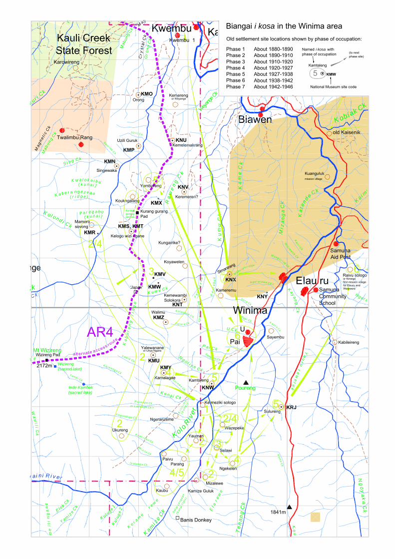
nge
Wey
ange
Ck
Ck Ck
aur i Ck
K o l ond i Ck
Mab
ung
Ck
Wa
wi l i C
k
y ai n i R i v e r
Ka i m
uk
Ka
tend
e C k
Mi z
an
ga
Ck
Wi z im
e l i k Ck
Ka i r i C
k
R ab i Ck
Kam
i ze
Ck
Te
na
ng
Ck
K
Ng
oy
ak
a C
k
K obiak Ck
AR4 Sayembu
Kay
an
g C
k
Yaumari
Parang
Kaubu
Paivu
Ke r a m
e
r e we
E l ek C
k
Y ami z
e Ck
R a z e ng e Ck
Y o wa nd i g e Ck
K omr i z a u Ck
Ko l o R
i ver
Wi z i l e Ck
I y a l e ng e Ck
K e n a i C k
N g o l i y e C k
P a i C k
U Ck
K aur e Ck
Ukureng
So r a Ck
Ka
me
Ck
Ku
mu
Ck
Kamize Guluk
Kemewambi Solokora
Ka
bu
re
ng
r
i dg
e
Y a r er e Ck
K ol a ubuk Ck
Me
r i mu
ng
Ck
K u m u C k
Ka
ur
ab
uk
Ya
vi n
gy
au
Sangami CkY aw i k Ck
Se r ewe Ck Poureng
or L az en g e Ck ?
Ngeranzeme
Kamtaleng
N g e r er ew e Ck ?
M ung u r i ng Ck?
Ki l
i ri m
u
S i n g C k
Sau r i ak C k
Uz i l i Ck
Mab
ung
Ck
Oro
ng
Ck
Ma bu l al i r i d g e
Koukngalang
Yombureng
K a b e r a n g e z e a o
K w a l o k o i b u( k u n a i )
P a r o g a b u( k u n a i )
( r i d g e )
Samuna Community School
Samuna Aid Post
Kabileireng
Ng er a
old Kaisenik
T amb i Ck
K a i w ang a C k
( ku
na
i )
Ra
we
ng
Ck
or Kiriwigefirst mission village for Elauru and Werewere
Kuangulukmission village
Raivu sologo
Sel
a i y
e ng
eg
e
( kun
a i f
lats
)
Sulureng
'Japan'
Koyawelen
Simanirang
Kameremu
Ngekelen
Mizalewe
Selawi
Kum
u C
k
Ka
un
Ya
ur
u r
ew
er
ek
El a
re
we
Kul u
ge 1K
ulug
e 2
me
ili
ng
an
e
k e
Kungairike?
Keremeren?
Singewaka
Kemelemakrang
KemerengOrong
Wazepeke
1
2
4/5
2
2
34
3
4
Ke meziki sologo
2/45
5
6
6
5
7
Kurang gurang rembek
Mt Wizireng
Kaisenik
Biawen
Kwembu
EIau ru
Winima
Pai
U
Twalimbu Rang
KMN
KMO
KMP
KMRKMS, KMT
KMU
KMV
KMW
KMX
KMY
KMZ
KNT
KNU
KNV
KNW
KNX
KNY
Walimu
Uzili Guruk
or Weyange
Kwembu 1M
agne
t ic
Ck
Karowireng
Kauli CreekState Forest
2172m
1841mBanis Donkey
Wizireng Pad
Wizireng (sacred lake)
Inde Kumbek(sacred lake)
Kurang gurang Pad
2
2/4
a lt e rnat e access rout e
KRJ
Yalewananeor Uriya Ngane
Kelogo wizi ngane
Kamalagae
Mamoro sovong
Cr y
st a
l Ck
Mag
Biangai i kosa in the Winima areaOld settlement site locations shown by phase of occupation:
KMW
Named i kosa with phase of occupation
Phase 1Phase 2Phase 3Phase 4Phase 5Phase 6Phase 7
About 1880-1890About 1890-1910About 1910-1920About 1920-1927About 1927-1938About 1938-1942About 1942-1946
5Kamtaleng
National Museum site code
(to next phase site)
12-10
At this point Kagowe Tubageli told Kawiyeribu to take his small son down to a waterfall on Iyalenge Creek and for them both to cover their ears. All three men exploded their magic bamboos, ngere pote (lit: „bamboo goes-bang‟), and they were all killed. Kumbe and Kawiyeribu were saved because they covered their ears as they had been told (given by Susanna KUMBE at Ukureng, 20 April 2000).
Although the point of the account was meant to be the abandonment of Ukureng as a place of settlement as a result of the dispute over the garden and the subsequent magical explosion, this offends the oral history known to others.
Many listeners to this story at Ukureng were angry with it because it purported to deny that their ancestors had also lived at Ukureng—in this version everyone at the settlement is wiped out except Kumbe and Kawiyeribu.
But even without the finale, the story starts almost incidentally with a man killing his wife‟s
relative at the settlement where they were staying, providing the reason for him to flee and set up home elsewhere. But of course, history takes its path and he once again falls into fatal dispute with two men who are described as his „brothers‟ (at least they are close kin). This necessitates another move of settlement for the named survivors (whether or not others remained).
It should be emphasized that the settlements in question were tiny; they were probably occupied by 30-80 people. The repetition of what can be called „wokim rong‟ stories—that is where the central figure does something bad to start a dispute—stands in contrast to the relative scarcity of stories of attacks on settlements by enemies in group warfare.
Settlement pattern during and after the early contact period
Two Lutheran exploration patrols, by G. Pilhofer and L. Flierl (Pilhofer 1915), and by G. Pilhofer and F. Bayer in 1916 (Clune 1951:131), passed through Biangai country prior to more formal contact patrols once Australia had assumed administrative control of New Guinea after WWI.3 In January 1922, brief and hostile contact was made between the government and the inhabitants of a settlement somewhere on the Bulolo River, during an exploratory patrol by George Ellis. Little is known of the route other than that the gold miner William Park sought out Ellis at Lae and copied his map. Such details as we know come from correspondence many years later between the writer Frank Clune and Ellis‟
District Officer, Norman Lenehan (Clune 1951). On a variety of grounds, I now believe Ellis probably bypassed Wau altogether, and encountered Kukukukus or others in the Widipos or Baiune area.
Very soon afterwards, in April 1922, Park and his partner Jack Nettleton entered the Wau Valley and began mining gold at Koranga Creek. They and their supply carriers began to make heavy use of the Bitoi track from Salamaua to Koranga which passed close to the 3 Ngalu MOLUNG, interviewed at Elauru on 22/5/1999, said she was at Kasangari in Biaru when „Piropa‟,
or Pilhofer, and „Wiri‟, or Willy Flierl, another of this missionary family, came up from the Middle Waria. I have not yet determined when this can have occurred.

12-11
Biangai settlements of Kindaga and Lambaura, inhabited by people who now principally live at the modern villages of Wandumi and Kaisenik. When Park and Nettleton were first on the goldfield, relations between them and the Biangais were good and they were able to trade peacefully for food.
Clashes with the miners carriers and further administrative contacts
From 1924, however, the gold field began to attract more miners causing a degree of friction along the track at Kindaga and Lambaura, the name of which was shortened by the miners or carriers to „Rabaul‟.4 On a visit in 1924, the ADO at Salamaua, S.C. Appleby, heard complaints from villagers over the pilfering of sugarcane and sweet potato. The small number of the miners meant that it was still quite easy to re-establish good relations and the villagers received proper payment, which Appleby says they were satisfied with as the recipients began selling food to the miners on a regular basis and working as carriers themselves (Appleby 1927).
Figure 5. Lambaura or ‘Rabaul’ village
Source: Sydney Morning Herald 25 January 1927 (in Australian Archives Series A1/15 Item 27/728)
The record of the government‟s 1924 patrol to the Bulolo Valley is brief (Commonwealth of Australia 1926), but as Appleby‟s 1927 report refers to existing luluais and tultuls and two set of census figures predate his 1927 visit, it is probable that it was in 1924 or 1925 that he conducted the initial census and gave out „hats‟ to village leaders: that is appointing men as luluais and tultuls.
Also reaching Wau in 1924 was Rev. Karl Mailänder who had begun a process of extending the reach of the Lutheran Mission from a base at Erep in the Waria to Biaru, and thence to the Biangai (W. Flierl 1962:143). Informants say the Igulu site of Ngekelen was where they „met the mission‟, and it seems like that this refers to Mailänder‟s trips rather than the earlier 4 Appleby (1927) lumps „Wondomi‟, Pingaleng, Salankora and Lambaura together as „the Rabaul villages‟,
after Lambaura, the largest of them. Pingelim, a name given by the Kaiwa people, was an alternate for Kindaga. Kindaga and Lambaura were probably not far removed from one another. I have not yet traced the identity of Salankora.

12-12
fleeting contacts made by Pilhofer. Mission helpers were settled in Biangai villages; one known to the Winima people was called Yamele. The arrest of the helper at Kaisenik was the subject of a complaint by Senior Flierl in 1927 (see note 8 below).
Things changed from September 1926 when the discovery of Edie Creek was made known. By December 1926, 219 European miners with 1324 Papua New Guinean labourers/carriers were on the gold field and there was now severe disruption to Biangai life for those living at Kindaga and Lambaura. This included continuous thefts from gardens and the killing of pigs.
As the number of white men increased, so did the number of carriers and the depredations to the gardens increased to such an extent that at last the women of Wondomi village went to the house set apart solely for the use of the adult males of the village. Here they abused the men, calling them cowards, saying “You are not men, you are women; if you were men, you would not allow the carriers to treat us as they are doing; you allow them to rob us and our children of the fruits of our labour.” Stripping themselves naked, they threw their pul-puls (grass skirts) into the men‟s house, saying at the same time, “you are not men, you are only women; here are our pul-puls (grass skirts) wear them.” (Appleby 1927:2-3)
Appleby pinpoints the key role of women in inciting men into action. According to Wandumi elders this was done by crying in public and indeed taking off their grass skirts.5 What happened next was that in December 1926, Yanduk of Kaisenik and Yawa PAIRA of Kwembu killed two Waria men crossing Bulolo River. On 10 January 1927, three more carriers were killed. The sequel was a punitive action by miners accompanied by police, as recounted by Idriess (1934), Willis (1977) and Sinclair (1998). My informants say three men were killed along with an old woman who died when her house was set on fire.6
On this patrol, Appleby refers to Winima as a group of villages and to „Duari‟, by which was meant a settlement near Winima occupied by the Ruarik, or Kwembu, people. After previously failing to find anybody at home, he paid a second visit on 10 February 1927:
10/2/27. On arrival at the Winima areas [sic], we found the villages deserted. Some people were located on a spur a mile away from the village. All day was spent in trying to get in touch with them but they could not be induced to come near us. As they appeared to be less defiant than when I first visited them, I decided to erect grass shelters and camp near the river below Duari and try next day.
11/2/27. Some people were sighted on the mountain side above the village of Duari and I was able to get in touch with the Luluai and Tul-tul who returned with me to our camping place. Later on, some more drifted in and in the evening I was able to purchase some sweet potatoes from the womenfolk. The Luluai sent some of his men after the WINIMA people and they brought in the Luluai of WINIMA who camped with us for the night (Appleby 1927:7)
5 Interview with Kawi YANDUK and Nalu WITAREMBU at Wandumi on 14 April 2000. 6 This concurs with Appleby‟s minimal reckoning: three were killed, an old woman was found dead in a
house and a young woman was reported missing and presumed by the Wandumi people to have been shot (1927:10). The names of two of the men were Sali and Kotabi, according to Kawa INANI.

12-13
„Duari‟ was the Phase 5 site of Kamtaleng; informants say this was „Ruarik‟s last place‟
before contact and that some of them were living there when the police came (see Table 5), while the „mountain side above the village of Duari‟ would have been the clear view of the former settlement of Kamalagae. Appleby‟s camp „near the river below Duari‟ must have been close to the junction of Ngoliye Creek and the Bulolo River.
Sauli Tulue („Sauli the Luluai‟) and Kawa Tutul („Kawa the Tultul‟), both of of Kongawe 2, were the first Kwembu village officials; Sauli was probably appointed at Kamtaleng, though informants say „em kisim hat long Mamoro Sovong‟. This refers to the fact that Mamoro Sovong is considered the spiritual hub of the Ruarik, rather than that it was their principal settlement at this time. It may have had a few houses only, and these may not necessarily been precisely at Mamoro Sovong.
Nabe of Paro was the first luluai for Winima. Presumably these are the men Appleby refers to in the passage above.
Ten days later, after visits to Biawen, Kaisenik, Werewere and „Kwaidu‟,7 Appleby returned to Kamtaleng and the Winima area. This time the people had settled back into their daily routine and they helped carry the patrol cargo. On 14 March 1927, Yawa was captured by Appleby‟s police for the killings of the Waria men and it is this that prompts the association of Kamtaleng with a police action.
Gastric trouble set in and I shifted down to the Wau Hospital … on the 31st [of February] the Tul-tul arrived with the man YANDUIK of Wondomi. On the 14th [of March], YAWA was brought in having been apprehended at Duari village (Appleby 1927:9).
Unsupervised police had a reputation for rough treatment, but it seems there was an element of betrayal involved. When the police went to arrest Yanduk at Wandumi, the villagers feared more violence, so they hid his bow and arrows and let the police take him without bloodshed.
The account of how Yawa PAIRA was captured is well-remembered. Kawa and Levi‟s parents were newly married and had a house at Yombureng on Kwembu Creek. The police had their main camp across the river at Kaisenik; a detachment came to Yombureng and „arrested‟ Yawa‟s sisters:
· Kawa and Levi INANI‟s mother, Sauwaro PABIAGARE
· Kawe YAWA‟s mother, Keili WAOROBO
· Waekesa KAWENA‟s adoptive mother, Powine YOKAMAINI
· Ilau WARA‟a adoptive mother, Komae KEMENDE
· Sali, Ngaweo and Ngawasio‟s mother Sabi YANGORI
7 „Kwaidu‟ should be spelled „Kairu‟, an old name for the place where Elauru is now (see Kilimbu‟s „Kairu‟
in Table 2).

12-14
They commandeered Inani and Sauwaro‟s house and put the women inside, but they only kept watch at the front entrance. They sent out word for Yawa to surrender or the women would be taken away to Rabaul to jail or to be married off to the policemen. The next day they marched the women off to the police camp, but Sauwaro had in the mean time managed to escape by digging under the back wall of the house. All this time Yawa was hiding in the Paro settlements near Winima and on about the fourth day he came out to surrender. He was decorated in bush bilas and he declared he had come to give himself up to secure the release of the Ruarik women. He said he was a man and not afraid of going away to jail. Other people came and added to his decoration and the police led him away without a fight.
Yawa returned home a couple of years later retaining some anger at these events and burnt down some of his own people‟s houses at Yombureng as a reprisal. He was known thereafter as „Yawa kalabusbek‟, or „Yawa-who-went-to-jail.
The mission villages
In the years after contact, the ceaselessly shifting pattern of Biangai settlement was broken and all the Biangai left their small ridge-top settlements and came together in a total of perhaps four villages. Helpers from the Finschhafen-based Lutheran Mission were already present in the villages at the time of Appleby‟s patrol; informants say Kâte helpers were sent to Werewere and Yabem ones to the other villages.8
The aggregation of the settlements occurred with the encouragement of both the Mission and of later kiaps, though no patrol reports survive in government holdings to throw light on how this happened.9 The Winima and Kwembu people settled permanently together at Pai, where most Winima people again live today, while Elauru and Werewere settled together at Raivu Sologo. Kaisenik people settled at the Lutheran Mission village and Wandumi people settled.)
Shortly after the establishment of Pai, there was a severe episode of sickness, referred to as yombu wizing (lit: „men all-died‟). This was believed to have been caused when Biaru men came and poisoned the drinking water in U and Kamize Creeks with sap, leaves or bark of the kaugang tree in revenge for killings by Winima and Kwembu people.10
Partly because of this, Pai was abandoned in 1942 and the village moved to Simanirang, on a ridge above Winima. This was a highly fortuitous move because Winima became a staging post for Australian forces in the second half of 1942, during the temporary withdrawal from Wau to Kudjeru.
8 The archival file containing Appleby‟s report also contains a letter of complaint from Johannes („Senior‟)
Flierl concerning the mistaken arrest of a mission helper stationed in the Lambaura area (Flierl 1927). 9 Some patrol reports may survive among the personal papers of their authors; Lutheran archives for this
period, including those at Ampo, Lae, remain largely unexplored. 10 Among those to die was the dokta boi Inani KARUNGO; he was quite young, perhaps about 29 years of
age.

12-15
And it was from out of harm‟s way at Simanirang that Winima and Kwembu people witnessed the Battle of Wau from 27th January 1943 to 9th February 1943. A Mitsubishi Zero was shot down not far from the village and anti-aircraft shells landed in the creek they used for drinking water. However, no-one was injured; indeed no Biangais were killed or injured during the battle.
Settlements after WWII
In 1947, Mauri KAINI and Kawena WAOROBO had an argument and Simanirang split up. The Kwembu people moved first to Uzili Guruk, then to Orong, where they stayed until about 1958-59. Thereafter, houses were gradually built at the present site of Kwembu 1. Kawi YAWA and Kawena WAOROBO pioneered the site and Kawi‟s son, Yawa, b. 26 Aug 1962, was the first child born there.
The Winima people, meanwhile, returned to U and „Winima‟ (the Community Hall area), where they stayed until the late 1990s. Winima has been in the process of relocation back to Pae since 1998, partly due to fears about the stability of the slope above the Community Hall, but also in order to recreate the pre-war village configuration at Pae.
Concluding remarks
The constant fission of the southwestern Biangai settlements between 1880 and 1930 is witness to an absence of the mechanisms social control that act in the „tribal‟11 societies of Melanesia, to unify the Biangai into more permanently co-residential or co-territorial groups. Unlike in some parts of Papua New Guinea, redress and dispute settlement was not obtained by the exchange of wealth items like pigs, shells and axes, or by the exchange of women between clan-like groups.
The archaeological survey and the oral historical investigations together assemble a picture of Biangai settlement as it was in the years leading up to and immediately following contact with patrol officers, missionaries and gold miners.
For the narrower purpose of social impact investigations:
· An immediate observation is that a series of sites is located up the Kwembu Valley across the path of the proposed access road to Hidden Valley. They include seven sites with National Museum registrations and which are protected under national heritage legislation. Vigilance is required to match changes as may occur to the access road design to the requirement to avoid these sites.
· Secondly, an important purpose of the investigative work is to show by example and by involving people that the company is diligent in its obligations to respect the heritage values of its landowner stakeholders. The actual work of visiting the sites and
11 „Tribal‟ here means „organised into political tribes‟.

12-16
conducting interviews about them has involved the participation of about two dozen Biangai elders, both male and female, at different times and places.12
· Lastly, in the longer term it is an aim to build up the cultural materials that can give the Biangai a sense of identity that can help during the period of social change that the Hidden Valley mine may bring. Naturally, all ethnic groups always express anxiety about the loss of culture, but in the Biangai‟s case anxiety is justified as not many under the age of forty years now speak Biangai language on a regular basis. With the loss of language skills, so will follow bush knowledge and oral history in the vernacular.
Investigations are expected to continue as mine planning develops; other kinds of cultural site, such as the mountain tarns noted by Sullivan and Hughes in 1988, may also be expected to be added to the archaeological register.
BIBLIOGRAPHY
APPLEBY, S.C. 1927. Report on the native disturbances, Biololo (Rabaul) area. District Office, Salamaua, 1 June 1927 [National Archives of Australia Series A1/15 Item 27/728]
BURTON, JOHN E. 1996. ‘Aspects of Biangai society: the Solorik system‟. Hidden Valley Working Paper No. 3.
COMMONWEALTH OF AUSTRALIA 1926. Annual Report to the League of Nations on the administration of the Territory of New Guinea 1924-25. Government Printer. (Note: Appendix C. Report by the District Officer for Morobe on the patrols to the Bubu, Ono, and Upper Waria Rivers, and north therefrom to Bialolo River.)
CLUNE, FRANK 1951. Somewhere in New Guinea. Sydney: Angus and Robertson FLIERL, J. 1927. „The tragedy of the Piololo people, as told by the natives‟. Letter to Commissioner
for Native Affairs. FLIERL, REV. WILHELM 1962. New Guinea Ŋic Nâŋâcnao Luther Qâjâpec Miti Gie Fua Ŋeiŋ Ewec
Irec Binaŋ [History of Lutheran Mission New Guinea and the indigenous Lutheran Church (Kâte language)]. Madang: Lutheran Mission Press
IDRIESS, ION L. 1934. Gold-dust and ashes. The romantic story of the New Guinea goldfields. Sydney: Angus and Robertson
JACKSON, RICHARD A. 1988. The socioeconomic impact of the Hidden Valley gold project. James Cook University of North Queensland, Department of Geography: consultancy report for CRA
MITIO, NGAWAE 1981. Biangai marriage and its relationship to kinship and property: the case of Werewere village, Wau District. Unpublished BA(Hons) subthesis, University of Papua New Guinea, Department of Anthropology and Sociology
PILHOFER, D. GEORG 1915. „Eine Durchquerung Neuguineas vom Waria- zum Markhamfluß.‟ Petermanns Mitteilungen 61:21-25, 63-66.
SINCLAIR, JAMES 1998. Golden gateway. Lae and the Province of Morobe. Bathurst: Crawford House Press
SMITH, G. Wau Patrol Report No. 5 of 1950/51 12 Visits to Ngekelen and Walimu, on 24/5/99 and 25/5/99 respectively, involved helicopter lifts of sixteen
villagers on each occasion, plus liaison staff. In addition, other villagers walked up to the sites.

12-17
SULLIVAN, MARJORIE AND PHILIP HUGHES 1988A. Hidden Valley Gold Project. Land use and land resources. Melbourne: Hidden Valley Gold Project, Draft Environmental Plan Appendix 7 and University of Papua New Guinea: Depts. of Geography and Environmental Science
SULLIVAN, MARJORIE AND PHILIP HUGHES 1988B. Hidden Valley Gold Project. Archaeology and material culture. Melbourne: Hidden Valley Gold Project, Draft Environmental Plan Appendix 8 and University of Papua New Guinea: Depts. of Geography and Environmental Science
WILLIS, IAN. 1977. „A New Guinea outrage: the killings at Kaisenik 1926-27.‟ J. Morobe Dist. Hist. Soc. 4(1):2-10, 4(2):7-16

12-18
APPENDIX A
ORAL HISTORICAL AND ARCHAEOLOGICAL LOCALITIES WITH NATIONAL MUSEUM SITE CODES
Sullivan and Hughes conducted land use and archaeological surveys in 1988, registering 22 sites of cultural importance with the Papua New Guinea National Museum. Museum staff gave each site a three letter code starting with „K‟ in the museum‟s site register, where „K‟ is the letter prefix for Morobe Province. Registered sites fall under the protection of Papua New Guinea‟s heritage legislation.
Period Sites What
Prehistoric artefact sites 3 Sites located in the Big Wau-Edie creek area; not reinvestigated.
Settlement sites known from oral history
17 Sites all located in the Kwembu-Winima area; 15 plotted on location map; KMQ omitted.
Settlement sites used after WWII
2 Identified as Orong, Uzuli Guruk. These were sites (called „Kwembu‟) occupied in the 1950s before present-day Kwembu village was established.
Table 6 Sites registered with National Museum by Sullivan and Hughes (1988b).
The sites may have been named at the time of fieldwork, but the names do not appear in the museum catalogue or in the report. A location map purports to show the locations of the sites (Sullivan and Hughes 1988b: Fig. 2) and, in fifteen cases among the oral historical sites, the locations do concur with the more accurate positions that I have established recently (see Map 1).
Unfortunately, the compilers of Sullivan and Hughes‟ location map appear to show the archaeological sites as post-WWII villages and they have also added a cluster of fifteen „former Winima village sites‟ in the Upper Bulolo headwaters that do not exist. I assume these are cartographic errors and will not investigate further. There are inconsistencies between the village location maps in their two reports (1988a:Fig. 2; 1988b:Fig. 2).
KMQ, the „missing‟ oral history site, is located on Kamale Creek about 400m north of Waviye helicopter pad. This may be a genuine site and will be further investigated.
A complete listing description of the sites is given here in Table 10, Table 11 and Table 12 (see also Map 1).
Comparison between Table 5 and the list of National Museum site codes
The correspondence between the i kosa I have investigated recently and the site code list is as shown in Table 7.
12-19
In this document I have concentrated on the oral historical associations of the sites; for practical reasons this precluded more than cursory archaeological mapping. In due course better physical descriptions are required.
These codes are not valid sites: KMQ, KMV, KMW, KMX, KNY. In the absence of documentation, KMT is not needed as a duplicate of KMS. Accordingly, a genuine site is proposed close to the old grid references (Table 8).
Some new sites have been located, notably the complex of sites in the sacred bush area called Mamoro. New codes are needed here (Table 9).
Outstanding tasks
The following remain to be done:
· Clear up uncertainties regarding the codes and sites in Table 8 and check for other sites as may require codes: this is a requirement as four sites lie close to the proposed access road;
Code Place name
KMN Lalibu Kaiwak
KMR Mamoro Sovong
KMS Kelogo Wisi Ngane
KMT Kelogo Wisi Ngane (second site record)
KMU Yalewangane
KMY Kamelagae
KMZ Walimu
KNU Kemelemakrang (but more investigation required).
KNV Keremereng (but more investigation required).
KNT Kemewambi Solokora
KNW Kamtaleng
KNX Simanirang
KRJ Sulureng (code allocated, 1999)
Table 7 Site codes that appear to be valid
Code Old New
KMT Kelogo Wisi Ngane duplicate Koukngalang, approx. 800m to north.
KMQ Kamale Creek Needs more investigation nearby
KMV Above Kwembu Kungairike, but needs more investigation
KMW Above Kwembu Koyawelen, but needs more investigation
KMX On Raweng Creek Yombureng. Contact village of Ruarik, contemporaneous with Kamtaleng. Grid location X = 473198, Y = 9182572, approx. 500m to northwest of location in register.
KNY Near Winima Kameremu
Table 8 Proposed changes

12-20
· Improve the physical descriptions of all the coded sites and add tape and compass sketch maps;
· Augment the site descriptions from aerial photography: locate old coverage and wait for better coverage to become available.
Name Location Description Mamoro X = 472181
Y = 9181496
Sacred site comprising a cave on a cliff and below it a narrow gorge on Kwembu Creek and a water worn stone used for initiations. The stone, Mamoro Kaririyavek, about 3m wide and 4m high. It has holes and boys heads were pushed inside then pulled out and the boys were beaten around the ears. Grid position is location of Mamoro Kaririyavek.
(incomplete)
Table 9 Proposed new inclusions in the register (incomplete)

12-21
CATALOGUE OF SITE CODES
The grid references given at the time were read off the 1:100,000 series topographic map and are „six figure‟ references, that is to the nearest 100m. I have used these to re-locate the sites and match them with sites visited or pointed out during current fieldwork. I now add GPS co-ordinates where I have visited the sites myself, or equivalent map co-ordinates picked off my AutoCAD master map where I have positioned the location in relation to map features. These are both given in the AMG66 co-ordinate system.
Name Code Sullivan
& Hughes location
Valid site?
AMG66 easting
AMG66 northing
Date visited
Cultural associations
Kemewale KNZ 668 874 No Artefact findspot on Hospital Creek behind the Wau golf course.
KOA 699 871 No Artefact findspot in Were Tobule plantation.
KOB 696 850 No Artefact findspot on Big Wau Creek.
Table 10 Prehistoric sites
Name Code Sullivan
& Hughes location
Valid site?
AMG66 easting
AMG66 northing
Date visited
Cultural associations
Orong KMO 730 843 Yes 473000 9184300 - Village site used by Kwembus after Uzili Guruk. In use from about 1948 to 1958 or 1959, after which Kawi YAWA and Kawena WAOROBO started the move to the present site of Kwembu 1 (where the first child, Yawa KAWI, was born in 1962).
Uzili Guruk KMP 731 830 Yes 472999 9183262 - Village site used by Kwembus immediately after they left Simanirang in 1947. In use for one or two years only.
Table 11 Post-WWII sites

12-22
Name Code Sullivan
& Hughes location
Valid site?
AMG66 easting
AMG66 northing
Date visited
Cultural associations
Lalibu Kaiwak KMN 724 829 Yes 472558 9182860 - Alternate name Singewaka. „Lalibu Kaiwak‟ means „bungim ol abus‟. The site was used as a war camp and it had a haus kapul. It was a satellite camp of Mamoro Sovong.
? KMQ 698 788 No Co-ordinates locate site on Kamale Creek near Waviye Prospect, but Sullivan and Hughes map shows no site in this vicinity.
Mamoro Sovong KMR 722 820 Yes 472046 9181664 - Key Ruarik site in use around 1900 and in limited use in 1924. Phase 2 site contemporaneous with Yalewangane.
Kelogo Wisi Ngane KMS 728 816 Yes 472853 9181537 3/3/1999 Site used a few years prior to contact—but not long before as a man called Kawa Saini of Kazibu was killed during its occupation. He was born only around 1900.
Kelogo Wisi Ngane KMT 729 815 Yes 472853 9181537 3/3/1999 Second location at same place.
Yalewangane KMU 732 790 Yes 473294 9179041 Yes Alternate name is Uniya Ngane. Phase 2 site contemporaneous with Mamoro Sovong.
? KMV 733 806 No Co-ordinates do not match an extant site.
? KMW 734 805 No Co-ordinates do not match an extant site.
? KMX 734 822 No Co-ordinates do not match an extant site.
Kamelagae KMY 735 787 Yes 473508 9178683 Yes Phase 4 site used by Kayoge and Ruarik.
Walimu KMZ 736 796 Yes 473549 9179706 Yes Phase 2 site.
Kemewambi Solokora KNT 737 800 Yes 473923 9180161 Yes Phase 3 site. The Simani men Koumu, Karungo, Wara and Sok were mature adults here.
Kemelemakrang KNU 737 833 Yes 473686 9183373 Yes More information required, but this was a village site used before Mamoro Sovong.
Keremereng (or Weyange). KNV 740 823 Yes 473917 9182337 Yes Well-preserved village site surrounded by bamboos and protected under Pinus plantation. More information required, but this was a village site used at the same time as Mamoro Sovong. Alternate name Weyange.
Kamtaleng KNW 745 784 Yes 474476 9178467 Yes Phase 5 site. „Duari‟ (=‟Ruarik‟) village as recorded by S.C. Appleby in 1927. when Sauli Tulue (a mispronunciation of luluai), b. about 1890, was made the first Ruarik luluai here (em i kisim hat) and Kawa Tutul (a mispronunciation of tultul), b. about 1880, was made tultul. Both these men were from the Ruarik section, Kongawe 2. Contemporaneous with Kamtaleng.
Simanirang KNX 746 806 Yes 474837 9180675 Yes Wartime site.
? KNY 756 803 Yes At Winima, but co-ordinates do not match an extant site.
Table 12 Oral historical sites

FIRST CONTACTS BETWEEN OUTSIDERS AND THE WATUT AND BIANGAI PEOPLE OF THE WAU AND BULOLO AREA
HIDDEN VALLEY WORKING PAPER No. 13
JOHN BURTON Morobe Consolidated Goldfields Ltd Box 80 Wau Morobe Province Papua New Guinea
October 2000
13-1
Introduction
I have separated various aspects of Biangai and Watut culture and history into Working Papers on different topics. Three pre-WWI German patrols, that is occurring well before the accepted main period of contact, were dealt with in Working Paper No. 6 for the purpose of meeting the claims of informants in the Otibanda area that the first outsiders they encountered were sent by the German government.
None of these patrols are remembered by any informants I have interviewed.1 The Germany gavman claimed by some Watut groups to have visited their area and appointed particular men as luluais—in their belief, lending weight to specific claims over Hidden Valley—was the solitary prospector Hellmuth Baum, who had alluvial workings on Surprise (= Waikanda) Creek in the late 1920s, well after the discovery of Koranga Creek (see below).
Government contacts begin in earnest
In 1920, the District Officer at Morobe, Norman Linehan, and his deputy, George Ellis, reached the Bulolo River by way of the Francisco River, apparently followed by Kaiwa people whose land they had just travelled through:
Following the patrol was a horde of five hundred camp-followers from the villages on the eastern slopes, who had made the complaint about the loss of pigs and women in raids by the savage t’othersiders (Clune 1951:135).
Facing them on the far bank were,
… about fifteen hundred Kukukukus blocked further progress shouting insults and threats (Clune 1951:135).
At this time, references to people of the mountains are indiscriminate in the use of the blanket term ‘Kukukuku’ (maps even showing the word ‘Kukukuku country’ as far east as Garaina).
‘We couldn’t get near them,’ says Norman, ‘so, after a six-hour chase I gave it up, and sent word to them to come back and collect their wounded. I shall always remember the sight of them, against the setting sun, carrying their shields like Romans of old.’ (Clune 1951:135).
1 Ngalu MOLUNG, interviewed at Elauru on 22/5/1999, said she was at Kasangari in Biaru when
‘Piropa’, or Pilhofer, and ‘Wiri’, or Willy Flierl, another of this missionary family, came up from the Middle Waria. This is a later event and I have not yet determined when it can have occurred.

13-2
The number of ‘fifteen hundred Kukukukus’ is disproportionate with the census figures for the Wau Valley; the first census in 1924 counted only 955 Biangai in total (Table 1). All the same, that large numbers were involved, and the fact that Kaiwa people were following, anxious to straighten out some disputes, suggest that it was indeed the Biangai who were encountered, as opposed to Watuts who might have been expected in smaller parties and with whom the Kaiwa did not have contact, though exactly where the meeting took place is a matter of speculation. Unlike later arrivals, the patrol appeared not to enter the valley by way of the ridge tracks where the Biangai settlements were then located, but by some other route which brought them directly to the Bulolo River.
In January 1922, Ellis led 27 police up the Gadugadu Track from Salamaua to arrive ‘on the Bulolo River at the Kukukuku village of Wau’, where they camped for ten days, then followed the river down to the Watut until a point was reached where it was possible to raft out to the Markham Valley (Clune 1951:139-140). Contact with local people was limited and marked by an attack on the camp during which several ‘Kukukukus’ were killed. Again, we cannot be sure of where the camp was or even whether the ‘Kukukukus’ were Watut, Biangai or even Manki people. For example, if Ellis followed the Francisco and Logui Rivers he may have bypassed the Wau Valley, meeting the Watut instead at Baiune or Widipos.2
Documented at some length by Clune is the exact timing of the arrival of William ‘Shark-Eye’ Park and his partner, Jack Nettleton, at Koranga Creek in April 1922. It was plain that Park had not made the find much earlier than this, because he had only proposed the partnership with Nettleton at the end of 1921, was still scouting the Francisco River at Christmas 1921, and was at Lae to meet Ellis and copy his map after the latter’s return there. At any rate, the Park and Nettleton were definitively the first gold miners to work at Wau.
Discounted earlier discoverers
Earlier candidates for the title of the ‘discoverers of the Morobe Goldfield’ can be discounted. Clune believed that ‘it is indisputable that the authentic discovery of the Big Gold in New Guinea was made … early in September 1909 by Dammköhler and Oldörp’ (1951:113). These two ascended the Watut with packhorses but were attacked and Wilhelm Dammköhler killed by hostile tribesmen. Clune believed this was at Wau itself and ‘Dammköhler’s ghost brooded in loneliness on the slopes of Mount Kaindi’ (1951:118).
2 On 2 October 1922, John Mason, a prospector whose diary Clune had access to, met Jack Nettleton on
the track between Wau and Salamaua. He had with him what Clune calls ‘a fair-dinkum Kukukuku from Wau village’, and this time it is clear that ‘Wau village’ must be Kindaga or a place near to Koranga.
13-3
It was not so. The campsite was at Gomarok near Bentseng, and the missionary Karl Panzer, who spent two months there in 1921, buried bones still lying about on the ground; it is believed 25-30 Middle Watuts were killed (Fischer 1963:11, 15). Clune says their tent ‘faced the river’, and that Oldörp turned their four horses loose, got on a raft and reached the Markham on the third day. You cannot do this from Wau and he must not have known of Panzer’s information.
Similarly, Clune believed that ‘there is not the slighest doubt that Darling … penetrated … to the vicinity of Mount Kaindi’ (1951:121) and found gold there at the beginning of 1910. Others have also entertained this claim (e.g. Simpson 1953:24; Nelson 1976:255). As before, Darling and his party of 20 Orokaivas recruited in Papua were attacked and there were a great many deaths; again, the survivors made their escape by raft but this time came to grief in the Markham where all but Darling himself and three of the remaining Orokaivas were drowned (Clune 1951:122-123; Simpson 1953:24-25).
Clune’s certainty over Darling’s whereabouts is misplaced. Darling was sick with blackwater fever, had five ‘spear’ wounds, and was so enfeebled he contemplated shooting himself if his boss-boy failed to return from trading with a local village (Clune 1951:122). Like their predecessors, the survivors are described as rafting from the attack site; but as already mentioned it is impractical to begin rafting from Wau and there is no mention of the difficulties of carrying a stretcher with Darling on it from the camp to where rafting could begin.
Simpson went so far as to say that Darling’s attackers ‘were probably Nautiya-tribe Kukukukus’ (1953:25). If this was more than a wild guess—Simpson may have known a patrol officer with informants whose stories matched details of the attack on Darling’s camp—the Nautiya had places on the northern side of Slate Creek at Andarola and Gumi and they are known to have spearheaded frontier clashes between Kukukuku and the Taiak, Galawo, Kapin and Sambio people of the Middle Watut. Darling can perhaps be credited with going higher up the Middle Watut than Dammköhler and Oldörp, and even reaching the Bulolo Valley, but not further.
Darling recovered and headed for the Lakekamu field, where his exploits became known to the prospectors there. Simpson says Darling proposed to William Park that he and Park should make a second attempt to reach the same area. This did not happen because Darling died in Townsville in 1911, but in 1912 four of the Lakekamu miners—Crowe, Park, Auerbach and Jimmy Preston—prospected out of the Markham. Auerbach wrote in 1940 that Preston went back and found Koranga Creek in 1914 (Nelson 1976:255-256). However, this is extraordinarily unlikely. If he, or any other of these men had reason to believe there was good gold above the Middle Watut, Park would not have spent the years 1918-20 on the Waria River and 1921 probing the Markham and Francisco Rivers.
Other writers have simply been confused. G.W.L. ‘Kassa’ Townsend, a long-serving administrator, wrote that gold was discovered at Wau ‘in 1913 … by Arthur Darling’ (1968:181)—two years after Darling had already died.

13-4
Wau from 1922
As is well known, Park and Nettleton initially worked in secret. The reason was that it was illegal to do alluvial mining in a ‘native reserve’ and the legislation that would allow it, the Mining Ordinance 1922, had not come into force.
The relations between the two men and the Biangais they encountered were extremely good. Nettleton told Clune that,
We reached the hill overlooking Wau village [Kindaga or Lambaura] three hours after sunset. When the natives saw us they showed fight, but calmed down when they understood that we wanted to be friends. Eventually we got them together around a fire, chewing betelnut and swapping smokes. We traded then for kau-kau (sweet potatoes). After awhile they got more friendly, and they were very helpful to us. They had no steel, wore their hair long and greasy down their backs, and did their cooking in bamboo pockets. They were all cannibals. We made it our business to stop fighting among them—not that it was worrying us any (Clune 1951:155).
This is in complete contrast to the hostile welcomes afforded Dammköhler and Oldörp, Darling, and Linehan and Ellis. It also lends weight to the idea that Linehan and Ellis may have struck the Bulolo Valley further downstream, for if they had clashed with the people encountered by Park and Nettleton just a short time later it is not so easy to see how they could have been befriended so easily.
Two other prospectors, John Mason and Ernie Dover, followed Park and Nettleton’s track to Wau in October 1922, the same month as this part of Morobe was gazetted as a goldfield. The gazettal was in ignorance of their find and was to enable the issuing of Miners’ Rights and the posting of a Mining Warden to Morobe Station to look after the miners then on the Waria River. The gazettal came into effect on 1 January 1923.
On 14 December 1922, C. Levien, the District Officer at Salamaua, accompanied Nettleton to Koranga as he returned from the coast with supplies. As is well known, Levien returned to Morobe and, instead of reporting the discovery of gold, he, Park, Nettleton, Mason and Dover applied for and were issued with the first five Miners’ Rights under the new Ordinance.3 By means of careful deceptions, the warden, Lukin, was not apprised of the find and complained that he had been posted to a backwater where ‘there is practically nothing doing … and I don’t think anything is likely to happen to create a rush’ (Clune 1951:163).
The gold could not be sold until after 1 April 1923, so Levien further distracted Lukin by organising a patrol to the Bubu River at the beginning of 1923 and impressing him how 3 Streets in Wau town are named after these men: Park Street (the Mines Office is on it); Nettleton Street
(along the centre of the MCG housing coumpound); Dover Road (from the old market to the Edie Creek road). Mason left the gold field after six months and had no further involvement.

13-5
dangerous it was to leave the station, something that he did not need to emphasise when he was himself shot and wounded on this patrol. Lukin accepted what he was told and wrote again that ‘I don’t anticipate any great activity this year, as the country is all new, and most of it entirely unexplored and inhabited by cannibals’ (Clune 1951:164).4
At this point we get a tiny ray of light on relations between the miners and the surrounding Biangai and Watut people. On 18 January 1923 two of the ‘friendly natives’, Biangais, were killed by Watuts, according to Mason’s diary entry (Clune 1951:167). Nettleton told Clune,
Two Kanakas were killed just off the Koranga Creek by the Bubwufs, who were on their way to visit us. They were cannibals, and one of the boys had several parts missing when he was found (Clune 1951:167).
The term Puabua refers in Biangai language to Watut people; Mason and Nettleton heard this as ‘Bubwuf’ (not to be confused with ‘Babwaf’, a village in the Middle Watut). As I have few Wandumi or Kaisenik genealogies, I do not know the identity of the victims.
This implies the four miners had continuing good relations with their Biangai neighbours. Levien was still injured, so he sent a patrol to Wau in March 1923 led by George Ellis and Steve Rendle to deal with the ‘Bubwufs’. Ellis and Rendle were met at Lambaura by Nettleton, and were diverted from seeing the still illegal mining at Koranga. Levien’s successor at Morobe, Edward Taylor, later told Clune that,
They hacked their way across Edie Creek to the open country of the Upper Watut—certainly the first Europeans to go there. Ellis then had a box-on with the natives, the Kukukuku people, and returned by the mountain track to Salamaua (Clune 1951:168).
This was the fourth government patrol to Wau, and the first to make contact with the Watut and/or the Manki people in the Upper Watut. Unfortunately, while many Watut informants give oral historical accounts of fighting with what appear to be government patrols, none contain sufficiently precise details to be matched with any of the actual patrols to this date.
4 Idriess devotes two chapters to Levien’s Bubu patrol (1934:63-83), but describes it as a failed attempt
by Levien to locate Park in the Upper Waria-Ono River area—when he had already found Park the previous December. Levien died of meningitis in Melbourne in 1932 (Idriess 1934:279), so there cannot have been a legal reason to conceal this fact.
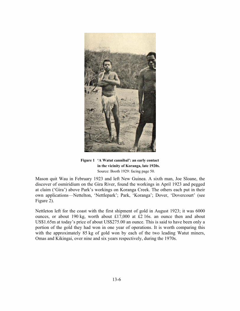
13-6
Mason quit Wau in February 1923 and left New Guinea. A sixth man, Joe Sloane, the discover of osmiridium on the Gira River, found the workings in April 1923 and pegged at claim (‘Gira’) above Park’s workings on Koranga Creek. The others each put in their own applications—Nettelton, ‘Nettlepark’; Park, ‘Koranga’; Dover, ‘Dovercourt’ (see Figure 2).
Nettleton left for the coast with the first shipment of gold in August 1923; it was 6000 ounces, or about 190 kg, worth about £17,000 at £2 16s. an ounce then and about US$1.65m at today’s price of about US$275.00 an ounce. This is said to have been only a portion of the gold they had won in one year of operations. It is worth comparing this with the approximately 85 kg of gold won by each of the two leading Watut miners, Omas and Kikingai, over nine and six years respectively, during the 1970s.
Figure 1 ‘A Watut cannibal’: an early contact in the vicinity of Koranga, late 1920s. Source: Booth 1929: facing page 50.

13-7
Early miners appearing in oral historical accounts
Nettelton, Park, Sloane, Dover and then Levien had the new gold field to themselves for most of 1923 but among the early miners, only the names ‘Masta Pak’, ‘Masta Prik’,
‘Siombo’, ‘Misis Boot’ and ‘Wilinda’ are consistently remembered by Biangai elders.
‘Masta Prik’ would appear to be Frank Pryke, a noted miner who led a government sponsored prospecting expedition up the Tiveri River in 1912, where his party would have made first contact with Hamtai-speaking Kukukukus (Nelson 1978). However, Pryke did not arrive at Wau until late in 1926.
The identity of ‘Siombo’ is unknown. The two candidates would appear to be Joe Sloane, already mentioned, and Frank Chisholm, another of the 1926 arrivals.
‘Misis Boot’ was Doris Regina Booth, on the field from 1924 and whose homestead was in the Bulolo Gorge. Her mark remains in the contemporary place names ‘Misis Boot’, a settlement of mixed ethnic groups at the top end of the gorge, ‘Regina Creek’, a creek
Figure 2. William Park’s application for a mining lease at Koranga Creek.
Source: New Guinea Gazette No. 61, 16 July 1923.

13-8
joining the Bulolo River at Misis Boot, ‘Regina Community School’, a government school adjacent to it, and ‘Cliffside’ which was the name of her homestead, but now is applied further down the gorge (for example ‘Department of Works, Cliffside Depot’).
‘Wilinda’ was Carl Wilde who pioneered coffee planting in the 1930s at Wau.
Individual Watut or Biangai families, or the descendants of labourers who remain at Wau, remember the names of other miners or kampani masta if their fathers worked alongside them. For example, ‘Mr Morni’ was Bill Money, originally a coastal recruiter but on the gold fields from 1924. In one oral historical account, Money is linked with another white man called ‘Soronda’ or ‘Soranda’, but who this was is unknown.
By the end of 1924 less than 20 miners had been to the field, and no more than a dozen remained at one time. Collectively they produced about 200 kg of gold a year. The real rush began in 1926 with the much bigger discoveries on the Upper Edie; in 1928 there were 200 miners and production was about three tonnes a year. After this, it is no longer possible to identify individual stories of contact in the Wau-Koranga-Edie area.
The first written mentions of places in the Wau Valley
On 27 September 1924, at the end of a long patrol to the Bubu, Ono and Upper Waria Rivers, Edward Taylor, the District Officer for Morobe, entered the valley of the ‘Bialolo River’ and,
We descended quickly and reached the Komisae, a creek joining the Bialolo, and, 2 or 3 miles further on, we crossed the Bialolo itself, and arrived at Winima village, a well populated centre situated in grass country similar to the Biaru (Commonwealth of Australia 1926).
This appears to the first mention in print of the name ‘Winima’. The creek referred to is Kamize Creek and the party had descended off the ridge it was travelling on just upstream of Banis Donkey (a WWII staging camp). It is a further 2.5 km from Banis Donkey to the junction of Kamize and the Bulolo River. A few hundred metres beyond that, on the left bank of the Bulolo, was the then extant settlement of Kamtaleng.
Also reaching Wau in 1924 was Rev. Karl Mailänder (he was encountered by Taylor’s patrol at Tamanigosa on the Ono River on 11 September 1924 and indicated that he was going on to the ‘Bialolo’ River), who had begun a process of extending the reach of the Lutheran Mission from a base at Erep in the Waria to Biaru, and thence to the Biangai (W. Flierl 1962:143). Informants say the Igulu site of Ngekelen was where they ‘met the mission’, and it seems like that this refers to Mailänder’s trips rather than the earlier fleeting contacts made by Pilhofer. Mission helpers were settled in Biangai villages; one known to the Winima people was called Yamele.

13-9
It does not appear that a formal line-up census was conducted by Taylor’s party in 1924, as it left Winima the next day and marched to Koranga Creek and the camps of the goldminers. Nevertheless, The Biangai were by this time quite familiar with the presence of Park and others at Koranga, and showed no tendency either to run away or to attack government patrols at this time.
Later, things changed because of the sheer number of miners and carrier passing through the Biangai villages. I have summarised elsewhere the events of late 1926 and early 1927 when the miners clashed with the Kaisenik and Wandumi people, burning down Lambaura village and killing three men and a woman (Working Paper No. 12). As well as relating these events, the subsequent patrol led by S.C. Appleby (1927), gives many insights into where particular settlements were at that time.
There are also references to an earlier visit by Appleby in 1924. It seems probable that it was then that he conducted the initial census and gave out ‘hats’ to village leaders: that is appointing men as luluais and tultuls. Two rounds of census figures are appended to the Annual Reports for the years (Table 1) preceding Appleby’s 1927 patrol.
Figure 3. ‘Iwaria Village (5,010 feet above sea level), Ono River’. Source: Commonwealth of Australia 1926, Appendix C (patrol of
Edward Taylor to Winima via Waria River of September 1924).
Children Adults
‘Bulolo’ M F M F Totals
1924-25 154 83 212 206 655
1925-26 159 93 214 210 676 Table 1 Initial census figures for ‘Bulolo’, or all Biangai villages combined.
Source: Annual Report to the League of Nations, Appendix A, ‘Native population’.

13-10
Susanna Panga of Winima says she was at her mother’s house at the Paro settlement of Parang when a patrol officer passed through the place (she was terrified and held onto her mother’s legs). I suggest this was Appleby in 1927 when she could have been three years old.
The matter of census is of no small account to the identity of the Winima people, as the name ‘Winima’ is said to derive from the length of time (‘a month’) that it took to count the large number of people there: someone said winim man and it was written down as the name of the village. But as we see, the reported census figures combine all the villages in the valley in one total (‘Bulolo’), a practice evident in the totals given for other parts of New Guinea in the Annual Reports in the early 1920s.5
Hidden Valley and the Watut
Because the miners earliest of the gold fields and the syndicates that followed pegged all the good ground at Koranga and Edie Creek, those that came later were forced to explore new areas.
There was a short-lived rush to Hidden Valley early in 1928, when 40 miners from Edie Creek worked, led by by W.H. (‘Bill’) Chapman, worked alluvial ground on ‘Mary Catherine Creek’ (Hidden Valley Creek) and ‘Mary Gabriel Creek’ (Kaveroi Creek). Biangai elders know of the rush, but have few details. They attribute the failure of mining here to the intervention of bush deities which, they say, confused the miners and sent then away (see below).
The first to settle permanently in the Upper Watut was Helmuth Baum, who made a camp at Otibanda on Waikanda, or ‘Surprise’, Creek around 1929. He had good relations with the people, and is remembered as having been very close to the people he lived among, unlike other miners or government officers, who came with police and the gun. He was known to his Watut neighbours as ‘Masta Bom’.6
The descendants of Wauqui Dipato at Yokua say of ‘Masta Bom’ that he ‘sat down at table’ with him, and acted quite unlike other miners or the patrol officers that they met later. His Australian acquaintances like Mick Leahy say exactly the same thing:
5 Immediately adjacent to ‘Bulolo’ in the statistical appendix to the Annual Reports, is ‘Mindiri’, a
principal landowning village of the Ramu plant site, combining most of the villages of what until recently was the Yaganon Census Division. Another thing is that in the 1924-25 volume, the spelling is ‘Bulolo’ in the statistical appendix, but ‘Bialolo’ in the account of the Waria patrol.
6 To the Biangai labourers who worked for him, on the other hand, ‘Masta Pau’ seems better known. The substitution of ‘P’ for ‘B’ by the Biangai also occurred in the case of the missionary known as ‘Masta Paia’, the Rev. Bayer. Note that the ‘Pflugbeil and Baum’ Plantation on the Rai Coast has also been shortened to ‘Bau’ Plantation.

13-11
Baum himself was unique in his ability to travel around this country with no more equipment than a couple of extra pairs of shorts and shirts. He wore no boots or hat. A couple of natives could easily carry all his food and personal gear and a few more would carry native trade (Leahy 1994:29).
He had a partner called Soltwedel, but few details other than this are known of his exploits in the area. A substantial file exists at the Australian Archives (‘New Guinea Expropriated Property Baum, Mr’) dealing with his attempts to recover Bau—formerly ‘Pflugbeil and Baum’—Plantation at Cape Rigney on the Rai Coast, which had been expropriated after WWI (New Guinea Gazette 31 April 1924).
He was definitely on the goldfield in early 1927, and earning sufficient money in 1927 to make the attempt to buy his plantation back, because he petitioned Canberra to allow him to do so, for example writing to the Governor-General on 7 February 1927. Cabinet minutes with marginal comments by Stanley Bruce, the Prime Minister, attest to the level he was able to bring his case. He was supported by Frank Anstey, MHR, who wrote on his behalf to Bruce on 8 June 1927.7
This was to no avail and ultimately Baum set off on one last prospecting expedition through Kukukuku country with Biangai and Buang carriers, and was attacked and eaten on the Indiwi River in 1931 (New Guinea Gazette 1934; Leahy 1994:42-44). The area was known to later patrols as ‘Baum Country’ and ‘Mt Baum’ is a prominent peak in this area on topographic maps.
A government officer, K.W.T. Bridge took over his camp at Otibanda and established a government post there in 1932 (R.D.W. Draffen, Wau PR 1 of 71/72). It was from this post that Bridge, and his patrol officers like J.S. Milligan, looked after the traders and miners who began to work gold on the Watut and its side creeks, like Jimmy Wilson and Jack O’Neill who found gold on Nauti Creek in May 1934:
We went further up the Surprise, then crossed a low divide into a large stream, a tributary of the Watut, called the Nauti. It was big and fast-flowing, and we made slow heavy going, walking in the water and clambering over heavy boulders …
Jim’s boy … went over to the next creek flowing into the Nauti higher up, and got a lovely prospect first dish. I had a twelve-inch sluice-box with me and we soon had it working …
There were good prospects all along the creek next day … In the afternoon two young Kukukuku came into the camp. They carried only bows, no clubs. Later they returned with a young bush pig, killed with one arrow and this I bought. They indicated that they came
7 Anstey had previously visited the gold fields in person and very likely met Baum there; he is shown
with Doris Booth in her account of the Wau gold rush (Booth 1929, plate facing p. 76).
13-12
from Ekuti, a large village high up on the range overlooking the whole grassy Upper Watut. It was plain to see from the drome (O’Neill 1979:108).
This was Ikelanda Creek which joins the Watut at Nauti Bridge, while ‘Ekuti’ was Ekua, a settlement of the descendants of the Equta ancestor, Qavaingo, together with their Titama inlaws, above present day Yokua. It was, according to O’Neill, west of Nauti Creek and ‘above my camp’. He mentions another place:
Another crowd said they were from Atoto, on the other side of the Nauti from me; I didn’t like the look of them (O’Neill 1979:111).
‘Atoto’ refers to Hatatao, the Nautiya headman at Ingetita, the first real ‘Nauti’ village to exist. I locate this on the grassy ridge between Ikelanda and the Watut River (see Working Paper No. 7, Table 3).
In July 1934, O’Neill reported an attack on his sluice boxes to Ken Bridge at Otibanda. Bridge identified the attackers as men from the Kerepa River on the other side of the range, aided by the inhabitants of the village he calls ‘Ekuti’.8 At about this time, some of them had been jailed for stealing kaukau from miners further downstream and selling it to O’Neill and others (O’Neill 1979:119).
O’Neill started work at a new location, on Poitananda Creek near Minava, in November 1934, but was again attacked by men from over the range who this time made off with a shotgun. Bridge was able to get the luluai of Ekua, ‘Awagwi’—Wauqui Dipato (see Working Paper No. 7)—to retrieve it:
Awagwi … persuaded Ken to trust him and to let him go. He collected his fighting men and went over to Kareeba himself, caught the culprits, tied them on poles like pigs and belted hell out of them until they took him to where they had hidden the musket. Awagwi was certainly the ‘big man’ around those parts (O’Neill 1979:126).
In December 1934, Bridge was on leave. His replacement was Murray Edwards.
He left two Kukukuku monkeys with me to help them learn pidgin and pick up our ways; they would then be good as go-betweens and interpreters to communicate with their people. They were a bright pair of lads and soon settled in. They liked to pose as police boys, and no doubt they could be found somewhere in the New Guinea police right now (O’Neill 1979:127).
8 The close links between ‘Ekuti’ and people on the other side of the range may have given rise to the
latter becoming known as the ‘Ekuti Range’.

13-13
A boy called Engo Qemawengatao was recorded as an absentee in the census at Waikanda in March 1937 as ‘Ingo’; he was then aged 14 and had just been sent to Rabaul to train as a doktaboi (see Working Paper No. 7). This is quite easily how he may have started his relationship with the outside world, if indeed he was not actually one of the two boys given to O’Neill.
In August 1936, Beatrice Blackwood arrived from the Pitt Rivers Museum, Oxford, to start ethnographic fieldwork among the Kukukuku. She stayed at Manki village near Otibanda under supervision of Bridge until April 1937, visiting other places as Bridge would permit her—Ekua, Waikanda, Andarola, and Nauti—in her eight months’ stay. Her permission to stay in the area was then revoked after Gee To Sim was attacked by Nautis (Blackwood 1950, 1978).
Attack on Gee To Sim, 1937
On 9 April 1937, a Chinese storekeeper, Gee To Sim, was attacked at Irowat Creek, or Elowa Creek as it is mostly known today. J.S. Milligan’s report has the first clear references to men who must have been Yatavos, because of the reference to their origin at Sapanda:
… tracks of at least four natives [were found] … they had apparently run into the bush in the direction of NAUTI.
The attackers left behind a bark cape, a bundle of bows and arrows, an axe made with a plane blade … and a round stone club.
The police, MOKERA, station interpreter and IGANUN were further questioned and we were further convinced it was the work of these four natives and that they belonged to SIBANDA.
… on Sunday afternoon, I noticed a Kukukuku native coming down the road, from the direction of NAUTI, towards the station. He was accompanied by three other natives and a black dog. All were armed with bows and arrows, axes, plane blade axes and wearing bark cloaks (Milligan 1937).
They were recognised by the policeman called Mokera, and disarmed. Milligan ordered them to put their bark cloaks in a pile while he questioned them, something that would not have been unusual as it was always feared Kukukuku men were hiding stone clubs under them. One of the police added the one that had been left at the attack site. When the men were let go and collected their things, one of them picked it up, but ‘seeing there was one over, immediately disclaimed ownership of it’.
The men were arrested and sent to Wau to be taken to court—unfortunately, no further record of this has come to light.

13-14
Binatang Noya, whose father, Binatang Naku, was one of those working on the Watut leases, told me the attack site was near what is now Yokua school. He is adamant that the storekeeper was killed and eaten, but Milligan’s report refers only to an attack causing a minor injury.
Soltwedel, Zakharov and Beinssen at Winima, 1931
Helmuth Baum’s partner, Soltwedel, linked up with two other miners, Zakharov and Ekkehard Beinssen, and went looking for gold in ‘new’ country outside the Bulolo catchment. First they went up the Snake River into the Buang area; then they heard of gold at a place called ‘Kolun’ over the range to the south of Wau. As described by Rhys (1942), they attempted to recruit carriers at Winima:
At Winnemah more carriers were wanted, but there were none to be had; the people were at war with a neighbouring tribe. Zakharov and Soltwedel pushed on to Kominesek, leaving Beinssen at Winnemah for the duration of the village war. He remained there for five or six days, winning favour by painting the men a blood red colour ready for the coming fray … Rhys (1942:116)
Exactly who the Winima people were fighting is unclear, but by implication it was people from Elauru, Werewere or Biawen, the Winima’s nearest neighbours apart from the Ruarik:
Suddenly the war began. Two miles away from the camp about three hundred natives stood in the line of battle, armed and ready to strike fear into any foe, but the fight appeared to consist mostly of shouting and running, and at nightfall ceased as suddenly as it had begun (1942:116).
Beinssen again attempted to go to the village and recruit carriers and this time they surrounded him. He threatened them with his revolver and let his dog chase them away. In consequence, his chances of doing any recruiting were finished his and camp and stores were now at risk.
The only thing … was to go on to the next village of Quambu for assistance. The Quambus were overjoyed at the prospect of a fight with the Winnemahs, and by forced marches soon arrived on the scene and relieved the siege (1942:117).
Earlier, Appleby had referred to ‘Duari’ or Ruarik; now the term ‘Kwembu’ has come into use. Rhys’s second-hand account is probably not reliable: in particular, not too much should be read into why the Kwembu people were ‘overjoyed’ to help Beinssen. It is possible there was friction between Kwembu and Winima; on the other hand the

13-15
Kwembus’ helpfulness may have been due to an expectation of getting paid in trade goods.
At any rate, Beinssen got away with his stores and met up with Zakharov in the mountains after following a narrow ridge-top track that led south from Winima to a place called ‘Kominsek’. It is not clear whether this was Kudjeru or further afield either towards Tekadu or, alternately, towards Kasangali in the Upper Waria. Soltwedel had gone ahead and now returned to camp excitedly with a tin of gold, saying he had got it from ‘Kolun’. But Zakharov was ill and while they struggled to get him to safety, he died and was buried in the bush.
Where exactly this was is a matter of conjecture. Rhys’s account suggests it was a day’s walk from Garaina, because Baum flew in there, heard the party was in difficulty and hurried to assist. That the location of ‘Kolun’ was considerably further west is suggested by Rhys’s description that Baum and twelve carriers later went back to ‘Kolun’ where they met their deaths. This place is normally understood to have been on the Yaqui River, a tributary of the Indiwi. But like many writers of this period, accuracy with geographical details was not a great strength.
A cannibal meal at Winima
Susanna Panga of Winima tells a story of the body of a white man being discovered in the Upper Bulolo catchment by her father, Kumbe. He noticed a leg sticking up out of the ground, alerted his people and they dug up the body and made a cannibal feast of it. (And as usual with cannibal-eats-whiteman stories, they ate his boots as well.)
This story is an enigma because Kumbe was only born around the turn of the 20th century. Whoever was the victim, he must have died between the arrival of the first miners and the establishment of full administrative control, when such things would have been impossible without attracting attention: 1924-27 is a possible period.
The vagueness of the details surrounding the death of Zakharov make it a faint possibility that this was his body, but Susanna seems clear that the location was on a ridge to the south of Iyalenge Creek, about 3.5 km southwest of modern Winima.
On the other hand, it is often suggested by Biangais that the reason that the rush to Hidden Valley in the 1920s was abandoned was not because of lack of gold (‘if that was the case, why is Aurora still interested in Hidden Valley’) but because powerful bush deities sowed confusion among them and they retreated in disarray.
An actual incident of this nature happened a little later, probably around 1938, and was witnessed by Waia Wawa Naubu. He and Kaia Neli gave this version:
A white man and his carriers came up Kwembu Creek looking for gold. They crossed the ridge and came to the sacred lake at Wizireng. But the lake has magical powers—it can

13-16
move from hollow to hollow, grow and shrink, and it can devour animals and people; it used its power to chase the intruders around in the bush. The labourers all ran away.
The white man had two large dogs. He shot one of the dogs and threw it in the lake. He took off his clothes and boots and threw them into the lake. The lake tasted the dog’s blood and was fooled into thinking it had tasted human blood. It subsided and left the white man alone; in fact, it has not caused any trouble to anyone since.
The man followed the mountain down to where the cemetery is at Winima where he found Yalambio’s pig house, and he crept inside and went to sleep.
The next morning, Yalambio, Kaia Neli’s mother, went to look for her pigs and saw the man’s remaining dog guarding his master asleep inside the pig house. He was completely naked. She called all the village men.
The men came and looked and then they called for a shirt and trousers, dressed him and took him back to Wau. Sara Kisimbi lived at Winima in those days and the white man gave him his dog to keep. It was a huge red dog with a long tail like a cow.
Waia was about 10 years old and saw this all happen.
Again, we have no clue at this stage of the identity of the victim.
The Japanese and the ‘German survey track’
All the war histories dealing with Wau claim that the Japanese had carefully researched the approaches to Wau from archival sources and were able to pass between the Australian forward observation posts at Black Cat and Skin Diwai by way of a previously unknown and disused German survey track. This brought them into the Wau Valley opposite where Kaisenik School stands today on the ridge known as Kurupek-ngane. This is shown on campaign maps as the ‘Jap Track’.
No information concerning this alleged ‘German survey track’ has ever come to light. Informants concur with archival evidence at Lutheran Mission Head Office at Ampo, Lae, that the earliest mission patrols were accompanied by Waria evangelists and entered the Wau Valley from the direction of the Waria and Biaru.
It is an outside possibility that some inland survey work was carried out in connection with the short-lived Huon Gulf prospecting syndicate of the early 1900s. Otherwise, no more can be said until Japanese historians examine their own records.

13-17
Summary
The above constitutes a very partial glimpse of what events happened when in the early days of Administration in the Watut and Bulolo Valleys, with reference to where villages were and how their inhabitants reacted to events.
The main purpose of this exercise is to establish historical fact, where fact exists, and to narrow the scope for assertions at variance to what we know of have factually been the case.
BIBLIOGRAPHY
APPLEBY, S.C. 1927. Report on the native disturbances, Biololo (Rabaul) area. District Office, Salamaua, 1 June 1927 [National Archives of Australia Series A1/15 Item 27/728]
BLACKWOOD, B. 1950. The technology of a modern stone age people in New Guinea. Oxford: Pitt Rivers Museum.
BLACKWOOD, B. 1978. The Kukukuku of the Upper Watut. Oxford: Pitt Rivers Museum. BOOTH, DORIS R. 1929. Mountains, gold and cannibals. COMMONWEALTH OF AUSTRALIA 1926. Annual Report to the League of Nations on the
administration of the Territory of New Guinea 1924-25. Government Printer. (Note: Appendix C. Report by the District Officer for Morobe on the patrols to the Bubu, Ono, and Upper Waria Rivers, and north therefrom to Bialolo River.)
COMMONWEALTH OF AUSTRALIA 1927. Annual Report to the League of Nations on the administration of the Territory of New Guinea 1925-26. Government Printer.
COMMONWEALTH OF AUSTRALIA 1928. Annual Report to the League of Nations on the administration of the Territory of New Guinea 1926-27. Government Printer.
CLUNE, FRANK 1951. Somewhere in New Guinea. Sydney: Angus and Robertson FISCHER, HANS 1963. Watut: Notizen zur Kultur eines Melanesierstammes in Nordost-
Neuguinea. Braunschweig: Albert Limbag Verlag [‘Watut: notes on the culture of a Melanesian tribe in northeast New Guinea.’]
FLIERL, J. 1927. ‘The tragedy of the Piololo people, as told by the natives’. Letter to Commissioner for Native Affairs.
FLIERL, REV. WILHELM 1962. New Guinea Ŋic Nâŋâcnao Luther Qâjâpec Miti Gie Fua Ŋeiŋ Ewec Irec Binaŋ [History of Lutheran Mission New Guinea and the indigenous Lutheran Church (Kâte language)]. Madang: Lutheran Mission Press
IDRIESS, ION L. 1934. Gold-dust and ashes. The romantic story of the New Guinea goldfields. Sydney: Angus and Robertson
LEAHY, MICHAEL J. 1994. Explorations into highland New Guinea 1930-1935. Bathurst: Crawford House Press
NELSON, HANK 1976. Black, white and gold. Canberra: Australian National University Press NELSON, HANK 1978. ‘Frank Pryke: prospector.’ in James Griffin (ed.) Papua New Guinea
portraits. Canberra: Australian National University Press

13-18
NEW GUINEA GAZETTE 1934. ‘In the Supreme Court of the Territory of New Guinea. Probate Jursidiction. In the Will of Hellmuth Baum late of Salamaua in the Territory of New Guinea, Miner, deceased.’ Gazette No. 388, 31 May 1934.
O’NEILL, JACK 1979. Up from South. A prospector in New Guinea 1931-1937. Melbourne: Oxford University Press
PILHOFER, D. GEORG 1915. ‘Eine Durchquerung Neuguineas vom Waria- zum Markhamfluß.’ Petermanns Mitteilungen 61:21-25, 63-66.
PILHOFER, D. GEORG 1961-63. Die Geschichte der Neuendettelsauer Mission in Neuguinea. Neuendettelsau: Freimund-Verlag. 2 vols.
RHYS, LLOYD 1942. High lights and flights in New Guinea. London: Hodder and Stoughton SIMPSON, COLIN 1953. Adam with arrows. Sydney: Halstead Press SINCLAIR, JAMES 1998. Golden gateway. Lae and the Province of Morobe. Bathurst: Crawford
House Press TOWNSEND, G.W.L. 1968. District Officer. From untamed New Guinea to Lake Success, 1921-
46. Sydney: Pacific Publications.
Patrol reports and correspondence
J.S. Milligan 1937. ‘Report of an attack on GEE TO SIM at Irowat Creek, Otibanda Sub-District, during the afternoon of Friday 9th April 1937, and subsequent apprehension of alleged attackers. National Archives of Australia, Series A518/1 Item No. E841/1
R.D.W. Draffen, Wau PR 1 of 71/72