mornington north outline development plan€¦ · mornington north outline development plan page 3...
TRANSCRIPT

Mornington North Outline Development
Plan
September 2011

Mornington North Outline Development Plan Page 2 of 20 Mornington Peninsula Shire – September 2011
Table of Contents
1 – Introduction .......................................................................................................................... 3
2 – Summary of Key Issues and Opportunities .......................................................................... 7
3 – Vision and Objectives Statement ......................................................................................... 9
4 – Land Use Framework ......................................................................................................... 10
5 – Built Form Framework ........................................................................................................ 13
6 – Transport & Infrastructure Framework................................................................................ 15
7 – Implementation: Review of Planning Controls.................................................................... 17
Table of Figures
Figure 1 – Regional Context………………………………………………………………………….. 4
Figure 2 – Local Context………………………………………………………………………………. 5
Figure 3 – Precincts……………………………………………………………………………………. .6
Figure 4 – Land Use Framework…………………………………………………………………… 12
Figure 5 – Built Form Framework…………………………………………………………………… .14
Figure 6 – Transport and Infrastructure Framework……………………………………………… 16
Figure 7 – Proposed Land Zoning…………………………………………………………………… 19
Figure 8 – Proposed Development Overlays……………………………………………………… .20
Prepared by the Strategic Planning Department Mornington Peninsula Shire Council September 2011 ISBN No.:

Mornington North Outline Development Plan Page 3 of 20 Mornington Peninsula Shire – September 2011
1 – Introduction
This Mornington North Outline Development Plan (‘the ODP’) provides a strategic planning policy framework to guide decisions on land use, development, transport and infrastructure in the Mornington North area.
The ODP area is the area shown bordered by the red line on Figures 1 and 2.
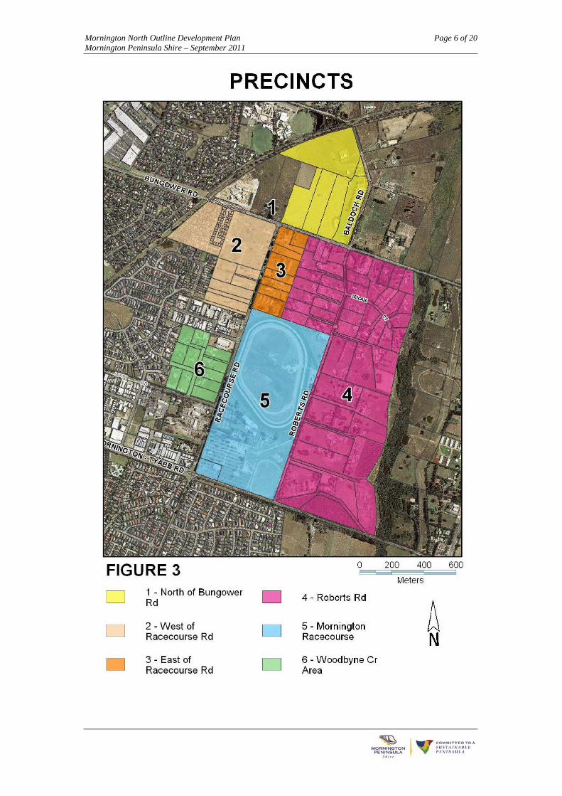
Within the ODP area, a number of precincts are identified. These are shown on Figure 3.
The ODP includes policy statements for both the ODP area as a whole and for the individual precincts. These are supported by various plans (Figures 4 - 8). When read together, the policy statements and plans provide a
comprehensive policy framework for decision-making.
The ODP document structure includes the following:
Summary of Key Issues and Opportunities
Vision and Objectives Statement
Framework Plans for Land Use, Built Form and Transport & Infrastructure
Implementation: Review of Planning Controls
This ODP is informed by the Background Report for the Mornington North Outline Development Plan – May 2009.

Mornington North Outline Development Plan Page 4 of 20 Mornington Peninsula Shire – September 2011

Mornington North Outline Development Plan Page 5 of 20 Mornington Peninsula Shire – September 2011
Mornington North Outline Development Plan Page 6 of 20 Mornington Peninsula Shire – September 2011

Mornington North Outline Development Plan Page 7 of 20 Mornington Peninsula Shire – September 2011
2 – Summary of Key Issues and Opportunities
Land use and development
Council’s Municipal Strategic Statement aims to manage and contain pressures for urban development within the established boundaries of townships on the Peninsula. These boundaries are defined in the Mornington Peninsula Planning Scheme by the Urban Growth Boundary.
A number of townships contain both areas set aside for standard and medium density residential development (identified by the Residential 1 Zone) and for low-density residential (or rural-residential) development (identified by the Low Density Residential Zone). A clear, coherent and sustainable boundary between these zones within townships is required.
From the perspective of the Mornington Township as a whole, the Mornington North area is part of the eastern low-density residential edge of the township.
The land that is now occupied by the St Mitchell Circuit Estate (to the west of the ODP area) was previously part of an extensive industrial zone. At that time, the ODP area logically formed a relatively wide band of low-density residential zoning (compared to the extent of the low-density residential zoning south of Mornington – Tyabb Road), separating the industrial area from the Green Wedge. As the St Mitchell Circuit Estate is now an established residential area, the original rationale for the extent of the low-density residential zoning no longer applies. The desirable extent of low-density development in the area can therefore be reviewed in this changed context.
Mornington North is not a greenfield area. However, it does have some potential for extending urban development opportunities, whilst maintaining a suitable extent of low-density residential area. It is
the last area within the Mornington Township in this position.
The ODP area is facing a range of development pressures. Within the area, planning permits have been issued for two relatively large-scale retirement villages and a primary school. A range of other development proposals have been rejected.
There is a need to establish the extent to which the Mornington North area can accommodate urban growth pressures, whilst maintaining its important role as an area that contributes to the pool of land available for low-density residential development on the Peninsula and to the overall layout of the Mornington Township.
The Mornington Township area is forecast to have increased numbers of persons aged over 50 years and a small decline in the numbers of persons aged less than 50 years.
The forecasted changes in the age structure suggest that the need for new facilities and services will need to be concentrated on the older members of the community.
Given the projected increase in the number of one and two person households, a significant proportion of additional housing should be designed for smaller households.
Opportunities for the ODP area to provide additional housing for the elderly and related health services has been recognised with the approval of two large retirement villages and the approvals for a residential aged care facility and a wellness centre.

Mornington North Outline Development Plan Page 8 of 20 Mornington Peninsula Shire – September 2011
The retirement village developments offer a real contribution to housing diversity in Mornington and provide opportunities for the local community to adjust their accommodation over time within the township – ‘ageing-in-place’. Whilst these developments are not located centrally within the township nor in close proximity to its facilities, their approval recognises that the land required for facilities of this scale in Mornington is limited; in fact largely confined to Mornington North.
Sufficient land has been set aside in the Mornington Township for the projected needs for urban residential development, retail and commercial floor space, community facilities, recreation and open space. Mornington North does not need to provide land for such purposes.
The number of non-industrial uses locating in the Mornington industrial areas that provide services to the wider township may be having an adverse impact on the supply of industrial land in Mornington. The ODP area may be able to provide opportunities to accommodate some such service uses, potentially alleviating some of the pressure on the industrial areas where land has become increasingly scarce.
The ODP area may be able to offer opportunities for educational facilities and health services that cater for the wider Mornington community.
In summary, some parts of the ODP area may be able to address specific demands for retirement living and provide additional development opportunities. However, other sections are suited to provide for low-density living in this location. This approach is intended to respect the existing landscape character of the area that contributes to the sense-of-place of Mornington as a township in a rural setting.
Transport and Infrastructure
Both Bungower Road and Racecourse Road are likely to experience substantial increases in traffic volumes, creating the need for adjustments to these roads and for the introduction of improved traffic management measures.
A number of decisions regarding the upgrading of these roads have been made in the context of existing planning approvals.
There is a need to improve pedestrian and bicycle connections in the ODP area. This has also been addressed in planning approvals.
The Bay Trail/ Rail trail adjacent to the ODP area is expected to be constructed at some stage in the future.
The use of the equestrian trail along Bungower Road and Racecourse Road has reduced over time, and there have been concerns regarding potential safety issues associated with its continued operation alongside increasing traffic volumes.
Public Transport routes are presently remote from the ODP area.
The eastern drainage catchment (generally the area east of Racecourse Road) drains to Balcombe Creek. Outflows are likely to be restricted to current flow rates by on site retarding measures.
There are currently no easements to connect those parts of the lots on the eastern side of Racecourse Road that are located in the eastern catchment, to a drainage system.
The eastern drainage catchment area is not sewered.

Mornington North Outline Development Plan Page 9 of 20 Mornington Peninsula Shire – September 2011
3 – Vision and Objectives Statement
Vision
The vision for Mornington North is that it will be an area that:
Is primarily a low-density residential area that provides:
o A low-density and well-landscaped edge to Mornington that contributes to its sense-of-place as a township in a rural setting.
o A contribution to housing diversity within the Township.
o An interface to the east and north-east that is sensitive to the environmental and landscape values of the Green Wedge
o A ‘home with a country setting’ for the Mornington Racecourse.
o Opportunities for land uses that are complementary to the racecourse.
Includes a clear boundary between the urban residential area and the low-density residential area of the Mornington Township in this location.
Contributes to urban residential development opportunities that provide housing diversity and complement the existing urban residential area to the west.
Objectives: Land use and development
Protect Mornington North’s low-density residential character, where this makes the best contribution to the Township and to strengthen its role as a part of a low-density residential edge for Mornington.
Provide additional housing diversity for the Mornington Township, where the best opportunities for this arise - particularly housing opportunities that enable ageing-in-place.
Ensure the siting and height of buildings reflects the low-density residential character of the area.
Protect the Mornington Racecourse – as a venue for racecourse activities and non-race day activities - from encroachment by noise-sensitive uses or by uses that are otherwise incompatible with the racecourse.
Support racehorse training opportunities and other activities complementary to the Mornington Racecourse, close to the racecourse.
Encourage the design of all development to incorporate Environmentally Sustainable Design principles.
Objectives: Transport and infrastructure
Ensure that the roads cater adequately and safely for the increasing traffic flows and complement the arterial road network of the township. Ensure that shared paths along these roads connect to the wider network of pedestrian/bicycle paths in the township.
Promote the provision of public transport to the area.
Provide for appropriate upgrading of infrastructure to support the proposed increased levels of development, using Environmentally Sustainable Design principles.
Ensure that new development adequately contributes to the provision of infrastructure required for the proper development of the area.
Mornington North Outline Development Plan Page 10 of 20 Mornington Peninsula Shire – September 2011
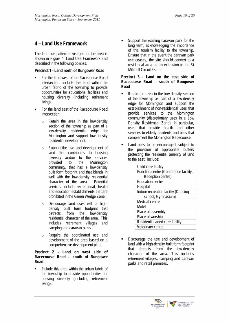
4 – Land Use Framework
The land use pattern envisaged for the area is shown in Figure 4: Land Use Framework and described in the following policies.
Precinct 1 - Land north of Bungower Road
For the land west of the Racecourse Road intersection: include the land within the urban fabric of the township to provide opportunities for educational facilities and housing diversity (including retirement living).
For the land east of the Racecourse Road intersection:
o Retain the area in the low-density section of the township as part of a low-density residential edge for Mornington and support low-density residential development.
o Support the use and development of land that contributes to housing diversity and/or to the services provided to the Mornington community, that has a low-density built form footprint and that blends in well with the low-density residential character of the area. Potential services include recreational, health and education establishments that are prohibited in the Green Wedge Zone.
o Discourage land uses with a high-density built form footprint that detracts from the low-density residential character of the area. This includes retirement villages and camping and caravan parks.
o Require the coordinated use and development of the area based on a comprehensive development plan.
Precinct 2 - Land on west side of Racecourse Road – south of Bungower Road
Include this area within the urban fabric of the township to provide opportunities for housing diversity (including retirement living).
Support the existing caravan park for the long term, acknowledging the importance of this tourism facility to the township. Ensure that in the event the caravan park use ceases, the site should convert to a residential area as an extension to the St Mitchell Circuit Estate.
Precinct 3 - Land on the east side of Racecourse Road – south of Bungower Road
Retain the area in the low-density section of the township as part of a low-density edge for Mornington and support the establishment of non-residential uses that provide services to the Mornington community (discretionary uses in a Low Density Residential Zone); in particular, uses that provide health and other services to elderly residents and uses that complement the Mornington Racecourse.
Land uses to be encouraged, subject to the provision of appropriate buffers protecting the residential amenity of land to the east, include:
Child care facility Function centre (Conference facility,
Reception centre) Education centre Hospital Indoor recreation facility (Dancing
school, Gymnasium) Medical centre Motel Place of assembly Place of worship Residential aged care facility Veterinary centre
Discourage the use and development of land with a high-density built form footprint that detracts from the low-density character of the area. This includes retirement villages, camping and caravan parks and retail premises.

Mornington North Outline Development Plan Page 11 of 20 Mornington Peninsula Shire – September 2011
Precinct 4 - Roberts Road area
Retain the area in the low-density section of the township as part of a low-density residential edge for Mornington and support low-density residential development.
Support the use of land that contributes to racehorse-training opportunities, landscape qualities and the rural-residential landscape setting of the Mornington Racecourse.
Ensure development enhances the environmental and landscape values of Balcombe Creek and environs.
Precinct 5 - Mornington Racecourse
Support the Mornington Racecourse activity for the long term.
Support the use and development of the land for racecourse and complementary (non-racecourse related) activities, subject to the consideration and management of impacts on the residential amenity of surrounding areas.
Require the use and development of land to provide adequate infrastructure to protect the safety and efficiency of adjoining roads.
Precinct 6 - The Woodbyne Crescent/ Albany Way area
Retain the area in the low-density section of the township, to mimimise potential conflicts between residential uses and nearby non-residential uses, including: established industrial uses to the north, the Mornington Racecourse to the east and the transfer station and animal shelter to the south.
Support low-density residential development that complements the housing diversity of the residential area to the west.
Ensure new development maintains adequate setbacks to nearby non-residential uses and minimises potential conflicts between residential uses and nearby non-residential uses.
Ensure new development enhances a well-landscaped low-density character for the precinct, including the provision of landscaped fringes along Watt Road and Racecourse Road.

Mornington North Outline Development Plan Page 12 of 20 Mornington Peninsula Shire – September 2011

Mornington North Outline Development Plan Page 13 of 20 Mornington Peninsula Shire – September 2011
5 – Built Form Framework
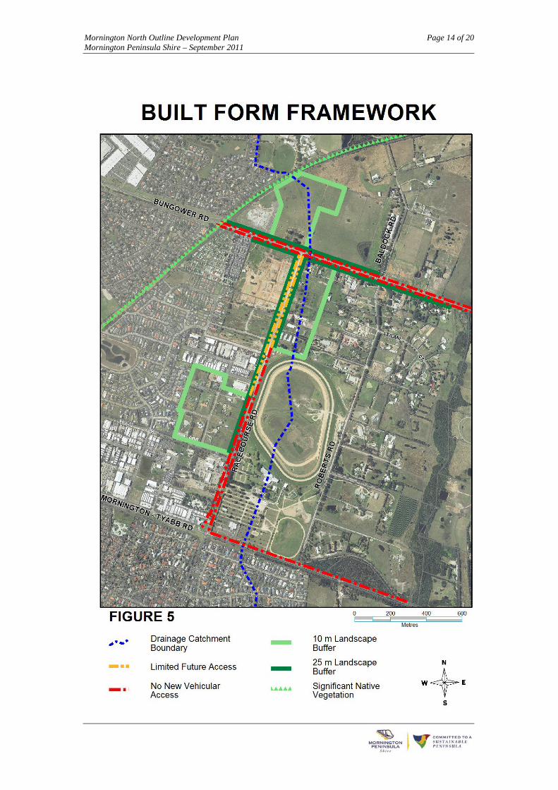
The built form envisaged for the area is shown on Figure 5: Built Form Framework and described in the following policies:
Bungower, Racecourse and Mornington-Tyabb Roads – landscaped setbacks
Development must provide a 25 metre landscaped building setback to support the low-density character of the area and the entrance into Mornington.
The design of vehicular access from adjoining land to these roads must optimise the effect of landscaped building setbacks.
Adjoining land– landscaped setbacks
Development must provide a 10 metre landscaped building setback to rear and side boundaries to support the low-density character of the area and provide a buffer to adjoining residential areas.
Access to roads
Development must not include any new vehicular access points to properties along Bungower Road, Racecourse Road south of Carbine Way and Mornington-Tyabb Road, to protect the safety and efficiency of these roads having regard to the increasing traffic volumes.
Development must only include a minimum of new vehicular access points to the northern section of Racecourse Road, to Baldock Road, to Booker Avenue
and to Watt Road, to protect the safety and efficiency of these roads having regard to the increasing traffic volumes. Some suitable locations are shown in Figure 6,
Railway line
Development of land that abuts the Mornington railway line should enhance this interface and must not have a detrimental impact on the native vegetation of regional and State significance located on the railway reserve. Development must set aside land along the railway line for the Bay Trail where appropriate.
Drainage catchment boundary
Development east of the drainage catchment boundary must provide adequate infrastructure to avoid changes in drainage conditions for adjoining land and any detrimental impact on Balcombe Creek.
Environmentally Sustainable Development
Development must meet the highest possible standards of environmental sustainability; including standards for Energy Management, Water Conservation and Re-use, and Waste Management.
Note:
The Design and Development Overlays under the Mornington Peninsula Planning Scheme that apply to the area adequately restrict building height to a maximum of two storeys.
Mornington North Outline Development Plan Page 14 of 20 Mornington Peninsula Shire – September 2011

Mornington North Outline Development Plan Page 15 of 20 Mornington Peninsula Shire – September 2011
6 – Transport & Infrastructure Framework
The transport and infrastructure provisions envisaged for the area is shown on Figure 6: Transport & Infrastructure Framework and described in the following policies:
Vehicular network
Facilitate Bungower Road ultimately becoming a duplicated main arterial road.
Facilitate Racecourse Road ultimately becoming a dual carriageway with a wide median to enable right-turn lanes – a local arterial road.
Ensure Bungower, Racecourse and Mornington-Tyabb Roads are provided with adequate traffic management measures to enable safe and efficient traffic movements. These should include a roundabout at the major intersections. These measures should also include a range of intersection treatments where these roads connect with local roads (including Baldock Road, Roberts Road and Booker Avenue) and with major access points to adjoining developments.
Development must provide an adequate contribution to the provision of land for road widening, to works required to upgrade Bungower, Racecourse and Mornington-Tyabb Roads and to all required works for intersections.
Development must provide works required in conjunction with its access arrangements to any road.
Development must provide bus stops in strategic locations in anticipation of a
future bus route along Bungower Road and Racecourse Road.
Development must include a permanent local road connection between Racecourse Road and the St Mitchell Circuit Estate.
Note:
The management of traffic speed does not form part of the policy framework of this ODP.
Non-vehicular traffic
Facilitate the development of Bungower Road and Racecourse Road as part of the wider network of shared pathways for Mornington.
Development on both sides of Bungower Road – west of Racecourse Road - and on the west side of Racecourse Road must provide shared pathways along their abuttal with these roads.
Other development along Bungower Road and Racecourse Road should provide footpaths along the frontage of the land that connect to bus stops.
Development abutting the railway may provide a shared path along the railway (part of the Bay Trail).
Equestrian trails should be restricted to Bungower Road and Roberts Road.
The equestrian trail in Racecourse Road should be removed, with the southern section only maintained as long as required to serve Precinct 6 (Woodbyne Crescent area).

Mornington North Outline Development Plan Page 16 of 20 Mornington Peninsula Shire – September 2011

Mornington North Outline Development Plan Page 17 of 20 Mornington Peninsula Shire – September 2011
7 – Implementation: Review of Planning Controls
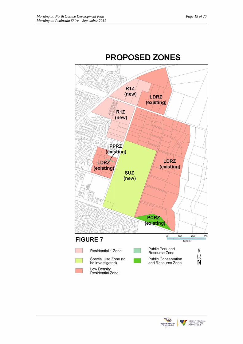
The policies to implement the ODP in terms of changing planning controls are described below and are shown in Figures 7 and 8 .
Mornington North overall
Include a new Local Policy for the Mornington North area in the Mornington Peninsula Planning Scheme that reflects the policy directions of this ODP.
Include this ODP as a Reference Document in the planning scheme.
Precinct 1 - Land north of Bungower Road
Rezone the section generally west of the Racecourse Road intersection to a Residential 1 Zone and remove Design and Development Overlay 7. Apply a Development Plan Overlay to control the use and development of the land in line with this ODP.
Retain the existing low-density residential zoning generally east of the Racecourse Road intersection. Retain the existing Design and Development Overlay (DDO7), unless it can be shown that changing development controls will achieve both the objectives of the ODP and provide a significant net community benefit. Any change must ensure large lots are created along Baldock Road (at least 1 hectare in size) and a public open space contribution of at least 10% of the land.
Apply a Development Plan Overlay to the existing low-density residential zone generally east of the Racecourse Road intersection. This is to ensure coordinated planning for the development of the land and to discourage uses with a built form that is inconsistent with the low-density character of the area, including retirement villages, camping and caravan parks and retail premises.
Precinct 2 - Land on west side of Racecourse Road
Rezone the area to a Residential 1 Zone and remove Design and Development Overlay 6. Apply a Development Plan Overlay to control the use and development of the land in line with this ODP.
Precinct 3 - Land on the east side of Racecourse Road
Retain the existing planning controls for this land.
Include in the new Local Policy, provisions that encourage uses that provide services to the Mornington community in line with this ODP.
Precinct 4 - Roberts Road area
Retain the existing low-density residential zoning. Retain the existing Design and Development Overlay, unless it can be shown that for the land affected by DDO7 changing development controls will achieve both the objectives of the ODP and provide a significant net community benefit. Any change must ensure a minimum lot size of at least 1 hectare.
Include in the new Local Policy, provisions that encourage uses in line with this ODP.
Precinct 5 - Mornington Racecourse
Review the planning controls for the Mornington Racecourse and ‘Steeples’ sites.
Ensure any change to planning controls maintains a balance between the racecourse use and further use and development opportunities, whilst including adequate protection for the amenity of nearby residential land.
Ensure any change to planning controls is subject to the approval of a master plan for the land and to the provision of infrastructure required in conjunction with any additional use and development.

Mornington North Outline Development Plan Page 18 of 20 Mornington Peninsula Shire – September 2011
Precinct 6 - For the Woodbyne Crescent/ Albany Way area
Retain the existing low-density residential zoning.
Retain the existing Design and Development Overlay, unless it can be shown that changing development controls will achieve both the objectives of the ODP and provide a significant net community benefit. Any change must require adequate and well-landscaped setbacks
from land in an industrial zone and from adjoining roads.
Note:
Any change to the zoning of Bungower Road to facilitate the widening of this road falls outside the scope of this ODP.
Mornington North Outline Development Plan Page 19 of 20 Mornington Peninsula Shire – September 2011

Mornington North Outline Development Plan Page 20 of 20 Mornington Peninsula Shire – September 2011