monitoring of bank line erosion of river ganga, malda ... · monitoring of bank line erosion of...
TRANSCRIPT
INTERNATIONAL JOURNAL OF GEOMATICS AND GEOSCIENCES
Volume 3, No 1, 2012
© Copyright by the authors - Licensee IPA- Under Creative Commons license 3.0
Review article ISSN 0976 – 4380
Submitted on May 2012 published on July 2012 239
Monitoring of bank line erosion of River Ganga, Malda District, and West
Bengal: Using RS and GIS compiled with statistical techniques Bhaskar Das
1, Milan Mondal
2, Ajoy Das
3
1- Senior Research Fellow, West Bengal State Council of Science and Technology (DST),
Government of West Bengal
2- Senior Research Fellow, The University of Burdwan, Burdwan-713104,
3- M.Tech (GIS) student, NIIT University, Neemrana, Alwar District, Rajasthan- 301705
ABSTRACT
The creation of regional imbalance, inequalities and differentiation in India, starts with the
physiographic element and ends with economic, and socio-cultural parameters of the
inhabitants/population. An attempt has been made to analyze and report the river bank
erosion due to morphometric changes of the river Ganga ,Malda district making thus portion
a high risk zone. For that physical process namely river bank erosion may affect the
economic and socio-cultural aspects and creates drastic change over the period. Continuous
monitoring and maintenance of these flood induced river bank management are necessary for
the beneficial result. The distressed people demand a holistic and positive approach to tackle
the problem.
Keywords: River Migration, banks failure, paradigm shift, mitigation of disasters,
sustainable water resource management, remedial measures.
1. Introduction
Flood hazards can be regarded as uncontrollable extreme events that disrupt social structure
and impair essential functions which are necessary to support human life system. And the
“Management of fluvial systems’ addresses the everyday conflicts between river dynamics
and human investment in the landscape. The proper foundation of protection, and restoration
of rivers is a geomorphic assessment of the physical condition, sensitivity, and the
adjustment process of discreet stream reaches. The primary benefit of effective riverbank (or
stream bank) stabilization planning helps protect the civilization, assets such as open space,
infrastructure and riparian zone on or near the riverbank as well as the purpose to provide a
clearly defined decision process that will identify a strategy to carry out riverbank
stabilization works along sections of the river and major tributaries. In geonomic orientation
the shifting course of river Ganga is causing large scale disaster in terms of flooding and
bank failure in Malda and Murshidabad Districts, West Bengal, India. River bank
erosion/failure and flooding in these two districts have become a chronic phenomenon since
early’60s and the problem manifested itself to formidable magnitude during the last five
decades.
1.1 Objectives
There are several objective of this assessment. One of them is how the potentially dangerous
applied geomorphologic segments like river shifting, bank erosion display the chronic picture
and associated problem regarding human society in terms of loss of property need a pen
assessment. Another important issue of this study is to get the temporal shift measurement,
Monitoring of bank line erosion of River Ganga, Malda District, and West Bengal: Using RS and GIS
compiled with statistical techniques
Bhaskar Das, Milan Mondal, Ajoy Das
International Journal of Geomatics and Geosciences
Volume 3 Issue 1, 2012 240
engulfment of the village by the river or by the river capture of these blocks. Make a general
outline or future prediction in the forthcoming year like 2020, 2030and 2040 through some
statistical techniques can be regard important objective. Finally the main objective is to
analyze how this region and it’s environ will reach its sustainable development that make
emphatic to find this geomorphic hazard and to cover these voices by proper river
management system of stable future regarding this region economy.
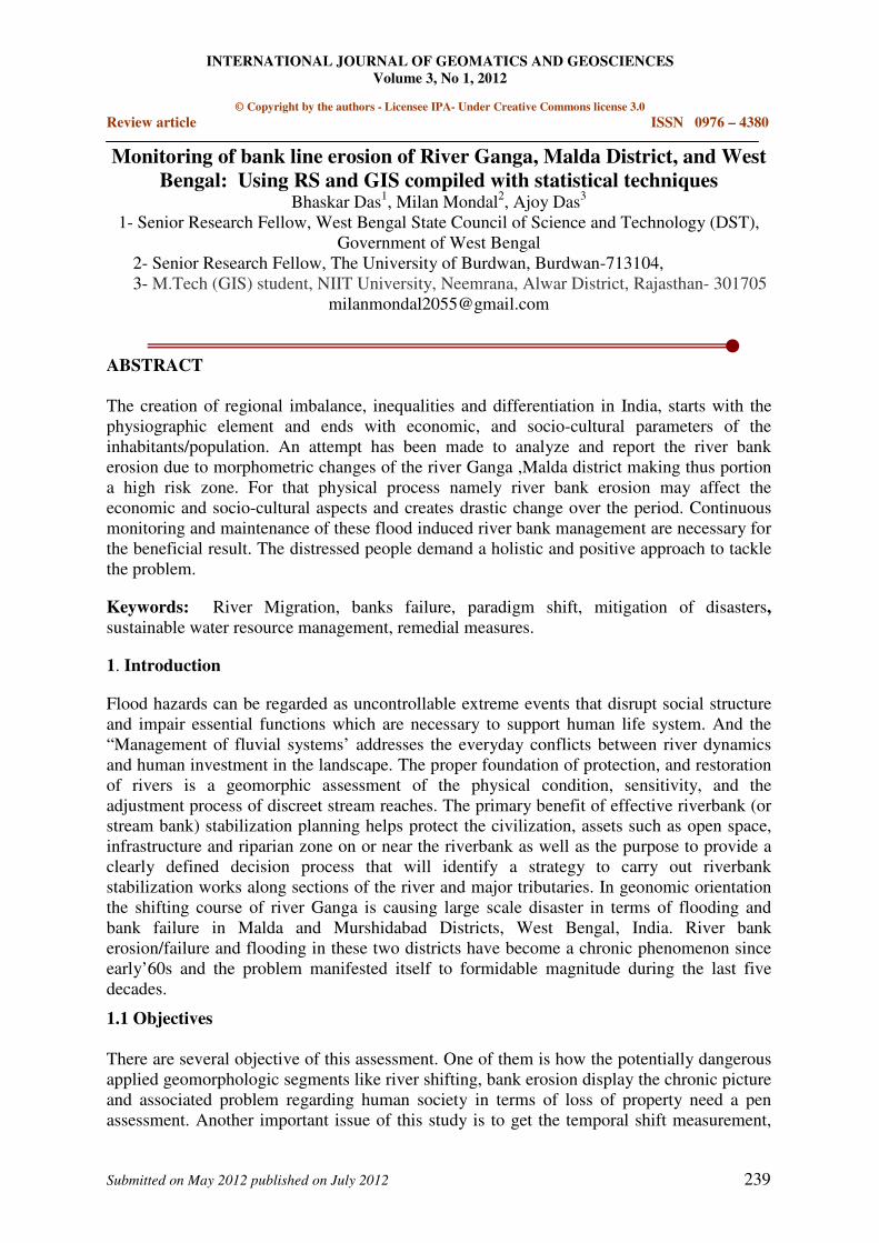
1.2 Study area
For fulfilling the objectives, where the above mentioned problem and phenomenon are very
much chronic and serious, the study area has been selected over a part of Malda district of
West Bengal The main flood affected district under the study area is Malda, which consist of
15 blocks and total area is about 3455.66 sq.km. The most affected block of this natural
hazard are Manikchak, Kaliachak-II&III. These three blocks having a total area of about
approx 450sq.kms which has been reduced to about 340 sq.kms. The geographical extent of
the study area is from 24º 51' N to 25º 14' N and 87º 46' E to 88º 06' E (Figure 1).
Figure 1: Location of the Study Area
2. Literature analysis
A report by the Scientist of Dept. of science & Technology, West Bengal is a study based on
the generation the ‘Baseline’ data on sequential changes of the Ganga Padma/ Ganga –
Bhagirathi-Hooghly river system where delineating the nature and pattern of lateral
migration or oscillation of river in the human time scale, identifying the related
Geomorphological and geological features to conclude on morphogenesis of channel
migration. The root cause of bank failure is the presence of sandwiched fine sand layer on the
bank which cannot prevent the high velocity during the high discharge time. A paper by
Goswami, Sharma and Patgiri (1999) present 1) Alteration of the direction of the flow due to
neck cutoff. 2) Widening of a channel in response to bar development, 3) anabranches
development 4) progressive shifting of meander bends. A report by M.Banerjee on “the
impact of Farakka Barrage on the human fabric” emphasis the problem of the rural
impeverisation and marginalization and response to the situation faced by the human beings
Monitoring of bank line erosion of River Ganga, Malda District, and West Bengal: Using RS and GIS
compiled with statistical techniques
Bhaskar Das, Milan Mondal, Ajoy Das
International Journal of Geomatics and Geosciences
Volume 3 Issue 1, 2012 241
of immediate erosional village areas of Malda districts. A report by CWPRS, Puna (2003)
recommended — The topographic feature of Ganga of Rajmahal in the vicinity of
Panchanandapur area are such that the bed level from right to left bank has a transverse slope
towards left bank. Water depth near the left bank of the order of 30mt. to 35mt. during flood
and 25mt to 30m. during non-monsoon period. Therefore construction of any spur or
revetments is not feasible. Recent development central channel was therefore thought useful
for reducing the attack at Panchanandapur area. To active this channels the alignment and
longitudinal profile of the proposed dredging may be adapted. According to the official
report by Irrigation and Waterways Dept.Govt.of West Bengal there could be number of
reason for the culmination of left swing and initiation of the right swing of main channel.
One of the possible reasons could be the progressive diversion of flow from the main channel.
A particular channel might have dominated over the other in course of time due to its more
favorable orientation and ultimately became the carrier of main flow.
3. Methodology
A systematic methodological principle was followed in this project work. This can be
explaining as follows:
i) Pre-field study: this study area as selected earlier, was identified in corresponding
topo sheet 78M/10 the spatial information have been collected from different Govt. office
like-water & Irrigation Dept, Malda, DST-Kolkata, District Welfare Office, D.L.R.O.,
B.L.R.O. and Block Office, Gram Panchayath office of Malda were also taken in to
considerations.
ii) Field study: Primary data were generated by interviewing people upon property desire
questionnaires through intensive field survey. The study of imperial observation can has been
done very carefully through measurement and analysis process to know the temporal shifting
of river Ganga and existing management structure.
iii) Post-field study: Data & other information made available & generating on the field
were compiled using appropriate software & techniques on the computer. The complied
analyzed data were interpreted appropriately to find out the temporal change detection.
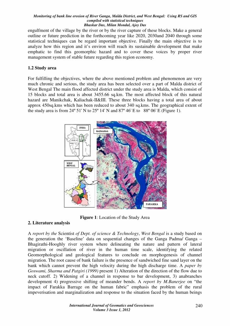
3.1 Change of river bank line through extrapolation method
Figure 2: Change of River Bank line of Ganga
Monitoring of bank line erosion of River Ganga, Malda District, and West Bengal: Using RS and GIS
compiled with statistical techniques
Bhaskar Das, Milan Mondal, Ajoy Das
International Journal of Geomatics and Geosciences
Volume 3 Issue 1, 2012 242
The morphological changes indicate an oscillating nature of the main channel in the reach
between Rajmahal and Farakka. In brief 1936 –37 map shows the river Ganga was flowing
along both banks of midstream island Bhutni. 1948-50 survey shows that the river had a
tendency to shift to the left below Rajmahal to Farakka Since 1967-68 the bank line is
moving east ward. The present state of the river falls within the phase of leftward swing.
During this phase, the left bank between Farakka and Khaskol receded further inside the
country than that of the earlier one (Figure 2).
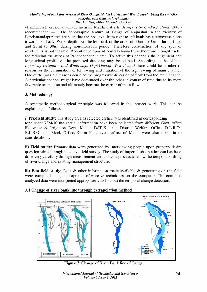
3.2 Change of river embankment line through extrapolation method
3.2.1 For calculation in the year 2009
Method: Simple extrapolation
In h1 calculation X2 & X1 are variables which are changes through the various Cross
sections (Table 1).
Table 1: Calculation using linear extrapolation method
3.2.2 Calculation for the year 2009
3.2.2.1 Linear extrapolation method
Monitoring of bank line erosion of River Ganga, Malda District, and West Bengal: Using RS and GIS
compiled with statistical techniques
Bhaskar Das, Milan Mondal, Ajoy Das
International Journal of Geomatics and Geosciences
Volume 3 Issue 1, 2012 243
h1/h = AD/AE=2009-1977 CQ=CD+DQ=H1+OA
=32/28=8/7 =h1 (932.57) +2297.95=3230.52
h1=(x2-x1)8/7
= (3113.7-2297.5)8/7=932.57
3.2.3 Method: Logarithmic extrapolation
In h1 calculation X2 & X1 are variables which are changes through the various Cross
sections (Table 2).
Table 2: Logarithmic extrapolation (Units in km)
First of all data in respect of cross sectional area were extracted for the year 1977 (from SOI
Toposheet), 2006 & 2009 (from Satellite images). Using linear extrapolation method, data of
2009 were generated synthetically from the data of 1977 & 2005 and compared with that of
image data. It was found that there is gross mismatch in the above mentioned compared data.
Subsequently using Logarithmic extrapolation techniques, data of 2009 were again generated
from the data of 1977 & 2005 and the comparison was made. The logarithmically
extrapolated data of 2009 were found to be very close to that of the satellite image data of
2009. Accordingly Logarithmic extrapolation technique was adopted for future years also
(Table 3 and Figure 3). Up to year 2040 such data were generated synthetically and given in
the following table
Table 3: Future Shifting of River Ganga (Units in meter)
Monitoring of bank line erosion of River Ganga, Malda District, and West Bengal: Using RS and GIS
compiled with statistical techniques
Bhaskar Das, Milan Mondal, Ajoy Das
International Journal of Geomatics and Geosciences
Volume 3 Issue 1, 2012 244
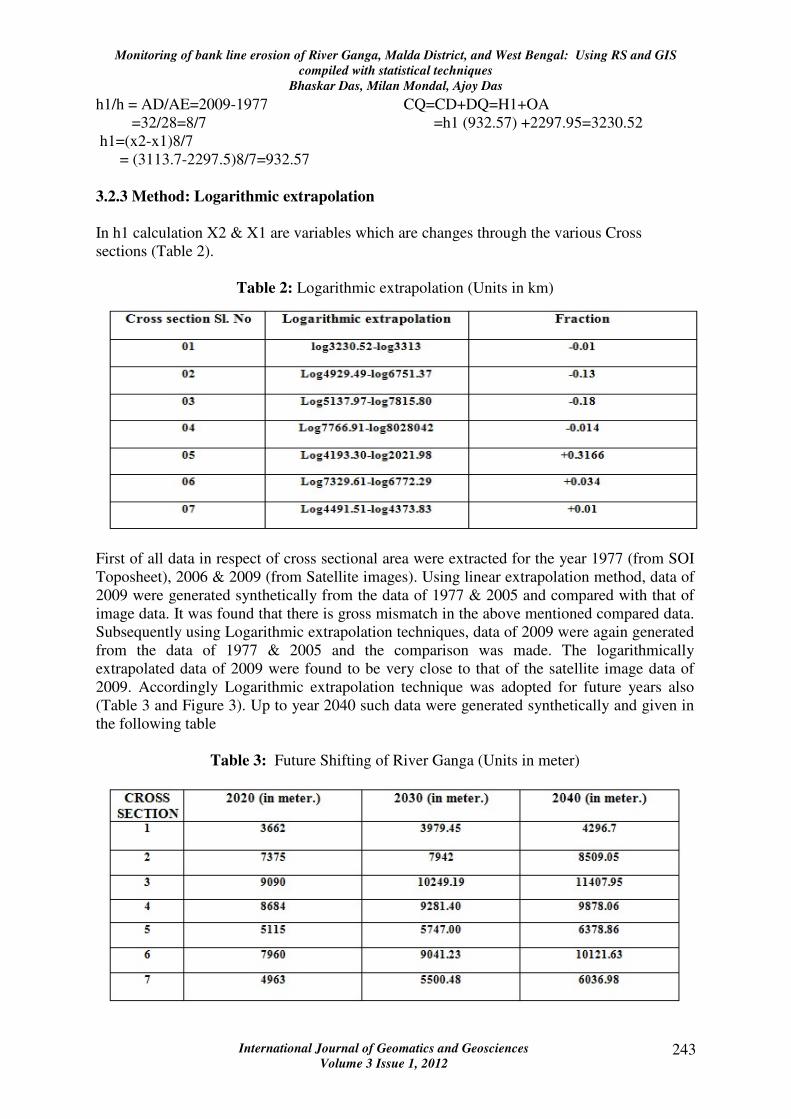
Figure 3: Future Statistical Scenario of Ganga River in 2020, 2030 and 2040
From above statistical calculation and explanation it may be outlined that the channel width
is changing in higher magnitude over time. One cause may be that due to the sedimentation
and high discharge the lateral bank failure become high. The higher channel width
incorporate with the higher island and higher braidedness .So these sample shows very much
correlated along the cross section.
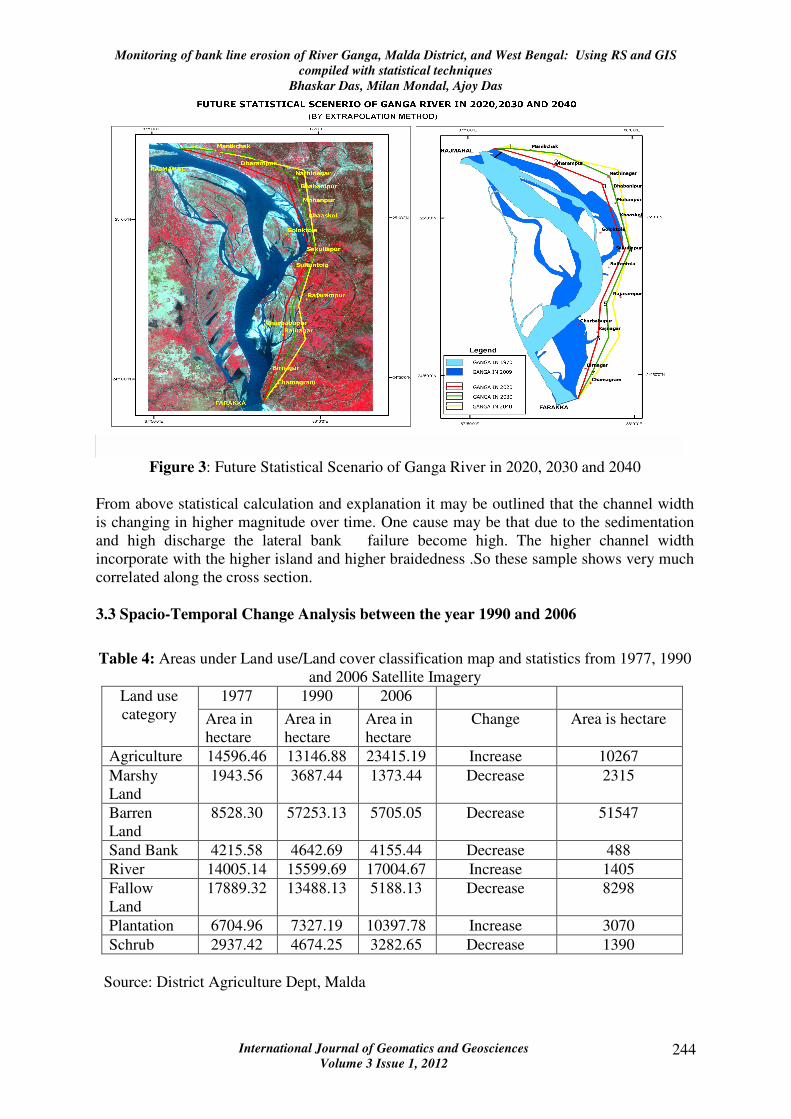
3.3 Spacio-Temporal Change Analysis between the year 1990 and 2006
Table 4: Areas under Land use/Land cover classification map and statistics from 1977, 1990
and 2006 Satellite Imagery
1977 1990 2006 Land use
category Area in
hectare
Area in
hectare
Area in
hectare
Change Area is hectare
Agriculture 14596.46 13146.88 23415.19 Increase 10267
Marshy
Land
1943.56 3687.44 1373.44 Decrease 2315
Barren
Land
8528.30 57253.13 5705.05 Decrease 51547
Sand Bank 4215.58 4642.69 4155.44 Decrease 488
River 14005.14 15599.69 17004.67 Increase 1405
Fallow
Land
17889.32 13488.13 5188.13 Decrease 8298
Plantation 6704.96 7327.19 10397.78 Increase 3070
Schrub 2937.42 4674.25 3282.65 Decrease 1390
Source: District Agriculture Dept, Malda
Monitoring of bank line erosion of River Ganga, Malda District, and West Bengal: Using RS and GIS
compiled with statistical techniques
Bhaskar Das, Milan Mondal, Ajoy Das
International Journal of Geomatics and Geosciences
Volume 3 Issue 1, 2012 245
There are eight land use/land cover training sites have been made on the basis of above
mentioned ground control point and visual signature identification (Table 4). Then maximum
likelihood classifications algorithm has been run. This algorithm reads the signatures set DN
values and give others according to their nearest class values. On the basis of this algorithm
the resultant maps give following data of the land use land cover distribution of an area
covering this region.
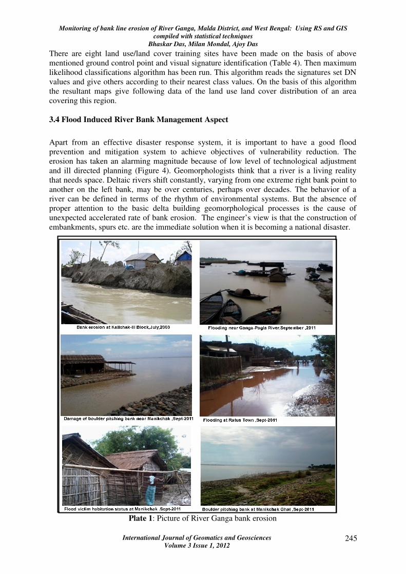
3.4 Flood Induced River Bank Management Aspect
Apart from an effective disaster response system, it is important to have a good flood
prevention and mitigation system to achieve objectives of vulnerability reduction. The
erosion has taken an alarming magnitude because of low level of technological adjustment
and ill directed planning (Figure 4). Geomorphologists think that a river is a living reality
that needs space. Deltaic rivers shift constantly, varying from one extreme right bank point to
another on the left bank, may be over centuries, perhaps over decades. The behavior of a
river can be defined in terms of the rhythm of environmental systems. But the absence of
proper attention to the basic delta building geomorphological processes is the cause of
unexpected accelerated rate of bank erosion. The engineer’s view is that the construction of
embankments, spurs etc. are the immediate solution when it is becoming a national disaster.
Plate 1: Picture of River Ganga bank erosion
Monitoring of bank line erosion of River Ganga, Malda District, and West Bengal: Using RS and GIS
compiled with statistical techniques
Bhaskar Das, Milan Mondal, Ajoy Das
International Journal of Geomatics and Geosciences
Volume 3 Issue 1, 2012 246
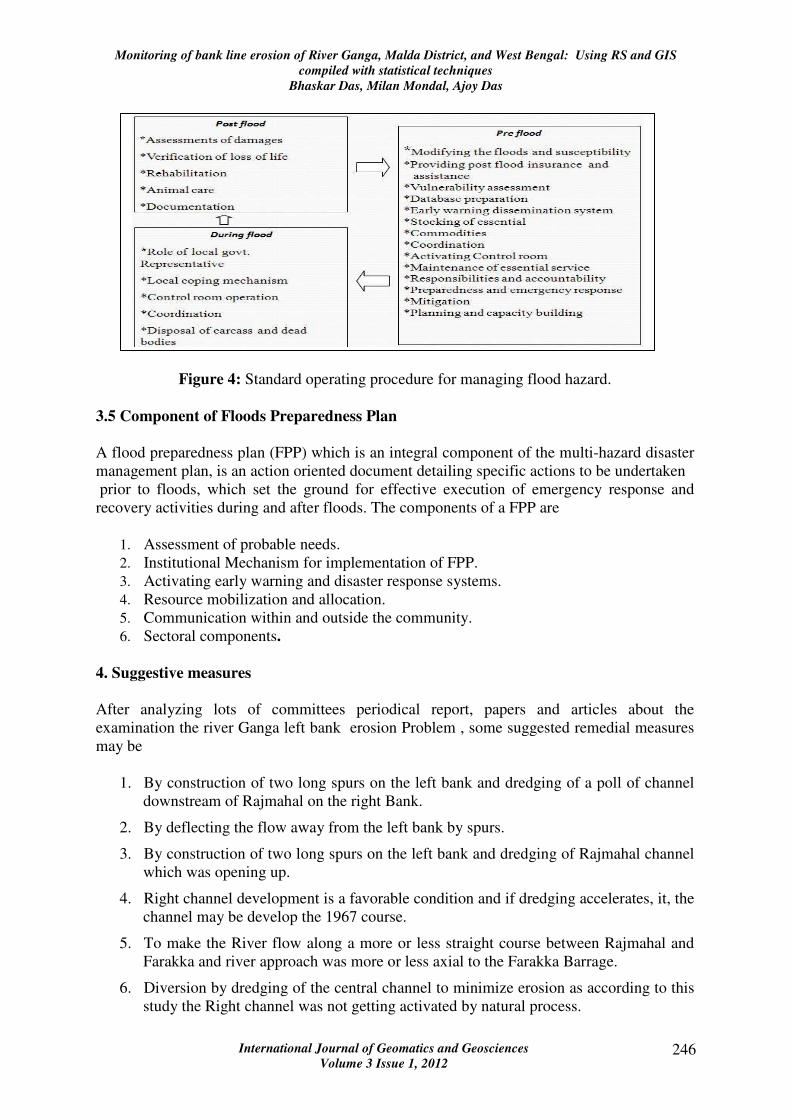
Figure 4: Standard operating procedure for managing flood hazard.
3.5 Component of Floods Preparedness Plan
A flood preparedness plan (FPP) which is an integral component of the multi-hazard disaster
management plan, is an action oriented document detailing specific actions to be undertaken
prior to floods, which set the ground for effective execution of emergency response and
recovery activities during and after floods. The components of a FPP are
1. Assessment of probable needs.
2. Institutional Mechanism for implementation of FPP.
3. Activating early warning and disaster response systems.
4. Resource mobilization and allocation.
5. Communication within and outside the community.
6. Sectoral components.
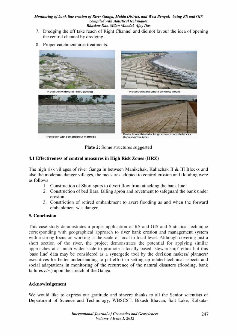
4. Suggestive measures
After analyzing lots of committees periodical report, papers and articles about the
examination the river Ganga left bank erosion Problem , some suggested remedial measures
may be
1. By construction of two long spurs on the left bank and dredging of a poll of channel
downstream of Rajmahal on the right Bank.
2. By deflecting the flow away from the left bank by spurs.
3. By construction of two long spurs on the left bank and dredging of Rajmahal channel
which was opening up.
4. Right channel development is a favorable condition and if dredging accelerates, it, the
channel may be develop the 1967 course.
5. To make the River flow along a more or less straight course between Rajmahal and
Farakka and river approach was more or less axial to the Farakka Barrage.
6. Diversion by dredging of the central channel to minimize erosion as according to this
study the Right channel was not getting activated by natural process.
Monitoring of bank line erosion of River Ganga, Malda District, and West Bengal: Using RS and GIS
compiled with statistical techniques
Bhaskar Das, Milan Mondal, Ajoy Das
International Journal of Geomatics and Geosciences
Volume 3 Issue 1, 2012 247
7. Dredging the off take reach of Right Channel and did not favour the idea of opening
the central channel by dredging.
8. Proper catchment area treatments.
Plate 2: Some structures suggested
4.1 Effectiveness of control measures in High Risk Zones (HRZ)
The high risk villages of river Ganga in between Manikchak, Kaliachak II & III Blocks and
also the moderate danger villages, the measures adopted to control erosion and flooding were
as follows
1. Construction of Short spurs to divert flow from attacking the bank line.
2. Construction of bed Bars, falling apron and revetment to safeguard the bank under
erosion.
3. Constriction of retired embankment to avert flooding as and when the forward
embankment was danger.
5. Conclusion
This case study demonstrates a proper application of RS and GIS and Statistical technique
corresponding with geographical approach to river bank erosion and management system
with a strong focus on working at the scale of local to focal level. Although covering just a
short section of the river, the project demonstrates the potential for applying similar
approaches at a much wider scale to promote a locally based ‘stewardship’ ethos but this
'base line' data may be considered as a synergetic tool by the decision makers/ planners/
executives for better understanding to put effort in setting up related technical aspects and
social adaptations in monitoring of the recurrence of the natural disasters (flooding, bank
failures etc.) upon the stretch of the Ganga.
Acknowledgement
We would like to express our gratitude and sincere thanks to all the Senior scientists of
Department of Science and Technology, WBSCST, Bikash Bhavan, Salt Lake, Kolkata-
Monitoring of bank line erosion of River Ganga, Malda District, and West Bengal: Using RS and GIS
compiled with statistical techniques
Bhaskar Das, Milan Mondal, Ajoy Das
International Journal of Geomatics and Geosciences
Volume 3 Issue 1, 2012 248
700091. Specially thanks to Dr. Dipankar Das (Senior Scientist, DST) for his kind advice,
suggestions and efforts towards preparation of this paper.
6. References
1. Banerjee M. (2003), A report on The impact of Farakka Barrage on human fabric,
Dams, River and People, South Asia network on rivers, dams and people, New Delhi.
2. Banerjee, S.N. & Chakraborty, P. (1983), Some observations on recent trends of
shifting of the Ganga between Rajmahal and Ahiron, Journal of the Geological
Society of India, 24, pp 318-321.
3. Chakraborty.P and Choudhury.S: Ganga Padma River: Bank Failure and changing
Courses- Down the Ages.
4. CWPRS Pune: Technical Report, Hydraulic Model on River Ganga from 1986 to
2005.
5. Das A. et. Al., (2012), Analysis of drainage morphometry and watershed
prioritization in Bandu Watershed, Purulia, West Bengal through Remote Sensing and
GIS technology - A case study, International Journal of Geomatics and Geosciences,
2(4), pp. 1005-1023
6. Das, Ghanashyam (2000), Hydrology and Soil Conservation Engineering, Prentice
Hall of India, New Delhi
7. Ghani M.U (2007), Participatory strategy for Flood Mitigation in East and North east
India.
8. Mukhopadhyay.S and Mukhopadhyay.S., Bank Erosion of River Ganga, Eastern
India –A Threat to Environmental Systems Management.
9. Nath S.K, Roy D and Singh K.K., (2008), Disaster mitigation and management for
West Bengal, India – An appraisal, Current Science, 94(7), pp 858.
10. National Remote Sensing Centre: Landuse/Landcover-50k (2005-06), Department of
Space, Government of India.
11. Ray. S.C. (2004), A study Report on Control of left Bank Erosion of River Ganga
between Rajmahal and Farakka by Irrigation and water ways Dept. Govt. of West
Bengal.
12. Rudra.K. (1996), Problems of river bank erosion along Ganga in Murshidabad district
of W.B., Indian Journal of Geography and Environment, 1, pp 25-32.
13. Rudra.K. The encroaching Ganga and Social conflicts: the case study of west Bengal,
India, Independent Broadcasting Associates, Littleton, MA, pp 40.
14. Seethapathi P.V, Dutta D, and Siva Kumar R., (2008), Hydrology of Small
Watersheds (eds), New Delhi: TERI (The Energy and Resources Institute).