monitoring irrigation water, analysis and database ... · pdf filemonitoring irrigation water,...
TRANSCRIPT
Monitoring irrigation water, analysis and database maintenance for Nahr Ibrahim
J. Harb1 & F. Comair2 1Department of Civil and Environmental Engineering, Notre Dame University Louaizé, Zouk Mosbeh, Lebanon 2Water Energy and Environment Research Center, Notre Dame University Louaizé, Zouk Mosbeh, Lebanon
Abstract
The present irrigation system suffers an uneven distribution of water resources. Originally, attention focused on monitoring the quantity of water allocated to irrigation. With the extensive abuse of pesticides, leaking septic systems and the spread of dumps, water quality deteriorated, rendering it unsuitable. Attention needs to be focused not only on water quantity but also on the quality that meets the minimum acceptable standards for irrigation. In order to design a monitoring system for the country, there is a need to start implementing a pilot plant for monitoring water quality and quantity. In this paper, implementation of a pilot plant for monitoring the water of Nahr Ibrahim is proposed, due to its high relevance for electricity production, the ecosystem, irrigation, potable water, tourism and industry. This program is developed in spite of the political turmoil, economic degradations and administrative constraints the country is experiencing, shifting priorities from water management toward more basic urgent issues. Keywords: monitoring, river, water management, quality, irrigation.
1 Introduction
Irrigation that consumes most of the water resources is best managed by an integrated water monitoring system. This system needs to be designed on the basis of impact monitoring. Traditionally, the monitoring system only covered the amount of water available. With the current practice of flood irrigation, water availability is a great concern to the water authority. The energy consumption
www.witpress.com, ISSN 1743-3541 (on-line)
© 2008 WIT PressWIT Transactions on Ecology and the Environment, Vol 112,
Sustainable Irrigation Management, Technologies and Policies II 143
doi:10.2495/SI080151
associated with this practice represents a serious constraint to the agricultural industry to render its products competitive, while cheaper products from neighboring competition flood the market. Therefore, agriculture is unable to contribute favorably towards positive economic development. The Water, Energy and Environment Research Center (WEERC) at Notre Dame University creates awareness for the need to manage water resources efficiently as a result of the upcoming forecast of the shortage of water availability and quality. Several water resources projects are accompanied by a monitoring system for the availability of water. The Technical Cooperation Project of the FAO Lebanon 3003 does incorporate special attention for water monitoring, analysis and database maintenance. This part of the project includes not only the design of a system to be implemented for the water authorities, but also capacity building through a series of seminars on the topic.
2 Macrolocation and geology of the site of Nahr Ibrahim
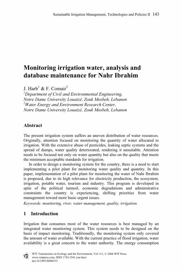
The selection of the area requires the gathering of information such as the extent of the area, the environmental conditions and processes that may affect water quality including human activities. The selection of Nahr Ibrahim as a case study for monitoring is based on the fact that this water course has multiple uses. Meteorological and hydrological information from Nahr Ibrahim allow the assessment of water quantities for hydroelectric production and help in the understanding of biophysical transformations of the river. Information about the water bodies in addition to actual and potential uses of water need to be established accurately, considering the variety of water uses of this river. The geography of the water course system established shows that Nahr Ibrahim falls at the boundary of Kesrwan and Jbeil casa, and comes from the source of the Kafka, also used for potable water. The river basin extends from the coast to the summit of the Lebanese mountains to an altitude of 1800m, covering a surface area of 316.6 km2. The hydrological network of Nahr Ibrahim contains several effluents feeding the main river. The main effluents are:
• Nahr el-Roueiss sourced from Rouaiss, which joins the main river of Nahr Ibrahim near Qartaba
• Ouadi Amsaya and Ouadi Menselit form the upstream part of Nahr Ibrahim
• Ouadi Botrayish joins Nahr Ibrahim to the right of Janneh • Nahr El-Dib and Nahr El-Dahab • Ouaid Ghabour
The stratigraphic model of Nahr Ibrahim extends from the Jurassic to the Miocene. The quaternary is represented by fluvial formations on the coast, landslides and mudflows (Aaqoura mudflow). Basaltic extrusions rise through sediments or are intrusive in the period from the top Jurassic (J5) to the Albien. A complex network of faults extending from the Jurassic is accompanied by some basaltic formations that followed the faults emerging at the surface. The faults and flexures, mainly the ones of Jord Tannourine-Aaquoura play an important hydrogeologic role.
www.witpress.com, ISSN 1743-3541 (on-line)
© 2008 WIT PressWIT Transactions on Ecology and the Environment, Vol 112,
144 Sustainable Irrigation Management, Technologies and Policies II
Figure 1: Nahr Ibrahim river and effluents.
Upstream from the river basin, the Cenomanien plateau occupies the lower part of the horseshoe shape of Jabal Sannine (2600m), and the Qornet el-Salouda (3093m altitude) mountains. Their side slopes are 1850m right of the Afqa source. This horseshoe layout enhances the collection of underground water: on the west part of the horseshoe, the sources of the Afqa and the Roueiss flow, and on the east part the sources of the Yammouneh. The area is formed of 80% of karstifiable zones and the karst is dense and varied. One could find almost everywhere fields of dolines and lapiés, caves and caverns, as witness of the richness of the karstic basin of Nahr Ibrahim. The para-karstic shapes are distinct along the river. The Nahr Ibrahim basin groups a diversity of superficial lands exploited with urban zones, agricultural fields planted with fruit trees, pasture with low vegetation and forestry. The percentage occupation of the land is distributed as follows: 75% forestry, 2% urban zone and the rest is agriculture. Besides, the multiple usage of the water enhances the site and renders it vital for the local economy [1]. Discharge of waste is very frequent and spreads all along the river. The situation has been enhanced for the past ten years as a result of multiple efforts with the local communities, NGOs and environmentalists, to convince local industries to stop their toxic dumping. Maps and aerial photographs provide a good source of information for the monitoring system of
www.witpress.com, ISSN 1743-3541 (on-line)
© 2008 WIT PressWIT Transactions on Ecology and the Environment, Vol 112,
Sustainable Irrigation Management, Technologies and Policies II 145
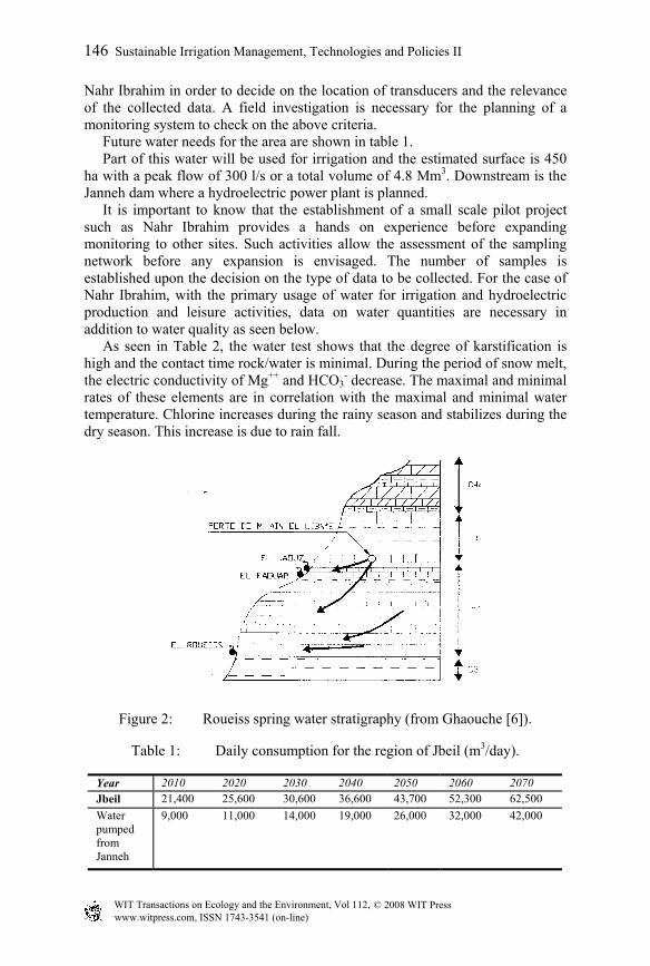
Nahr Ibrahim in order to decide on the location of transducers and the relevance of the collected data. A field investigation is necessary for the planning of a monitoring system to check on the above criteria. Future water needs for the area are shown in table 1. Part of this water will be used for irrigation and the estimated surface is 450 ha with a peak flow of 300 l/s or a total volume of 4.8 Mm3. Downstream is the Janneh dam where a hydroelectric power plant is planned. It is important to know that the establishment of a small scale pilot project such as Nahr Ibrahim provides a hands on experience before expanding monitoring to other sites. Such activities allow the assessment of the sampling network before any expansion is envisaged. The number of samples is established upon the decision on the type of data to be collected. For the case of Nahr Ibrahim, with the primary usage of water for irrigation and hydroelectric production and leisure activities, data on water quantities are necessary in addition to water quality as seen below. As seen in Table 2, the water test shows that the degree of karstification is high and the contact time rock/water is minimal. During the period of snow melt, the electric conductivity of Mg++ and HCO3
- decrease. The maximal and minimal rates of these elements are in correlation with the maximal and minimal water temperature. Chlorine increases during the rainy season and stabilizes during the dry season. This increase is due to rain fall.
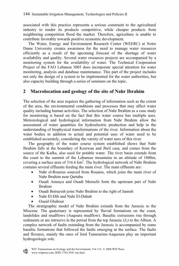
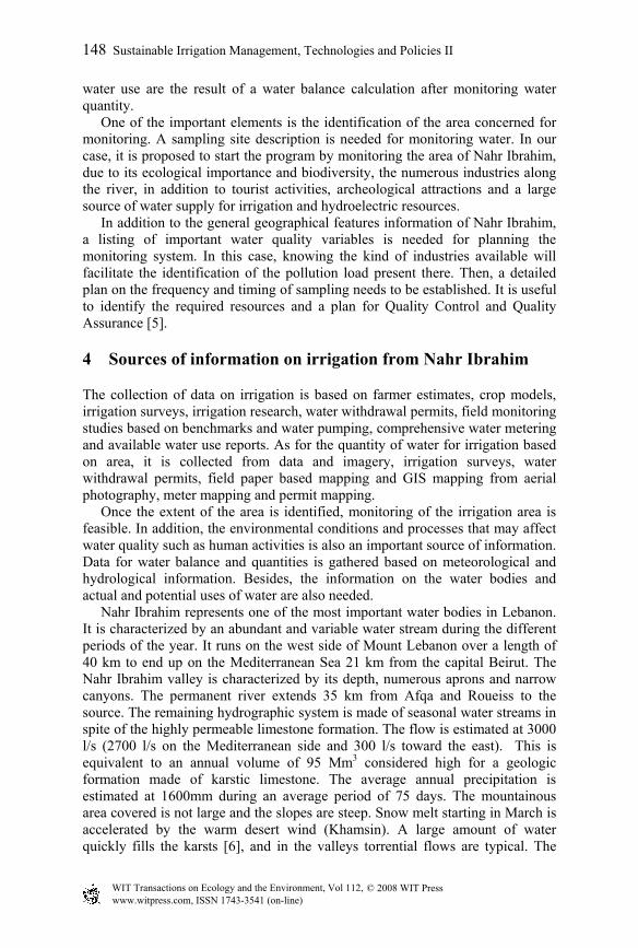
Figure 2: Roueiss spring water stratigraphy (from Ghaouche [6]).
Table 1: Daily consumption for the region of Jbeil (m3/day).
Year 2010 2020 2030 2040 2050 2060 2070 Jbeil 21,400 25,600 30,600 36,600 43,700 52,300 62,500 Water pumped from Janneh
9,000 11,000 14,000 19,000 26,000 32,000 42,000
www.witpress.com, ISSN 1743-3541 (on-line)
© 2008 WIT PressWIT Transactions on Ecology and the Environment, Vol 112,
146 Sustainable Irrigation Management, Technologies and Policies II
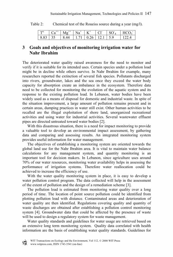
Table 2: Chemical test of the Roueiss source during a year (mg/l).
To Ca++ Mg++ Na+ K+ Cl- SO-4 HCO3
- 8.83 35 8.44 1.71 0.26 12.1 5.9 122.4
3 Goals and objectives of monitoring irrigation water for Nahr Ibrahim
The deteriorated water quality raised awareness for the need to monitor and verify if it is suitable for its intended uses. Certain species under a pollution load might be in decline while others survive. In Nahr Ibrahim for example, many researchers reported the extinction of several fish species. Pollutants discharged into rivers, groundwater, lakes and the sea once they exceed the water body capacity for absorption create an imbalance in the ecosystem. Therefore data need to be collected for monitoring the evolution of the aquatic system and its response to the existing pollution load. In Lebanon, water bodies have been widely used as a means of disposal for domestic and industrial waste. In spite of the situation improvement, a large amount of pollution remains present and in certain areas, dumping practices in water still exist. Other human activities to be recalled are the illegal exploitation of shore land, unorganized recreational activities and using water for industrial activities. Several wastewater effluent pipes are directed untreated toward water bodies [2]. With this disastrous situation, there is a need for impact monitoring to provide a valuable tool to develop an environmental impact assessment, by gathering data and comparing and assessing results. An integrated monitoring system provides useful information for water management. The objectives of establishing a monitoring system are oriented towards the global land use for the Nahr Ibrahim area. It is vital to maintain water balance calculations for any management system, and quantity monitoring is an important tool for decision makers. In Lebanon, since agriculture uses around 70% of our water resources, monitoring water availability helps in assessing the performance of irrigation systems. Therefore water reallocation could be achieved to increase the efficiency of use. With the water quality monitoring system in place, it is easy to develop a water pollution control program. The data collected will help in the assessment of the extent of pollution and the design of a remediation scheme [3]. The pollution load is estimated from monitoring water quality over a long period of time. The location of point source pollution could be identified from plotting pollution load with distance. Contaminated areas and deterioration of water quality are then identified. Regulations covering quality and quantity of waste discharges are obtained after establishing a pollution control monitoring system [4]. Groundwater data that could be affected by the presence of waste will be used to design a regulatory system for waste management. Water quality standards and guidelines for water usage are retrieved based on an extensive long term monitoring system. Quality data correlated with health information are the basis of establishing water quality standards. Guidelines for
www.witpress.com, ISSN 1743-3541 (on-line)
© 2008 WIT PressWIT Transactions on Ecology and the Environment, Vol 112,
Sustainable Irrigation Management, Technologies and Policies II 147
water use are the result of a water balance calculation after monitoring water quantity. One of the important elements is the identification of the area concerned for monitoring. A sampling site description is needed for monitoring water. In our case, it is proposed to start the program by monitoring the area of Nahr Ibrahim, due to its ecological importance and biodiversity, the numerous industries along the river, in addition to tourist activities, archeological attractions and a large source of water supply for irrigation and hydroelectric resources. In addition to the general geographical features information of Nahr Ibrahim, a listing of important water quality variables is needed for planning the monitoring system. In this case, knowing the kind of industries available will facilitate the identification of the pollution load present there. Then, a detailed plan on the frequency and timing of sampling needs to be established. It is useful to identify the required resources and a plan for Quality Control and Quality Assurance [5].
4 Sources of information on irrigation from Nahr Ibrahim
The collection of data on irrigation is based on farmer estimates, crop models, irrigation surveys, irrigation research, water withdrawal permits, field monitoring studies based on benchmarks and water pumping, comprehensive water metering and available water use reports. As for the quantity of water for irrigation based on area, it is collected from data and imagery, irrigation surveys, water withdrawal permits, field paper based mapping and GIS mapping from aerial photography, meter mapping and permit mapping. Once the extent of the area is identified, monitoring of the irrigation area is feasible. In addition, the environmental conditions and processes that may affect water quality such as human activities is also an important source of information. Data for water balance and quantities is gathered based on meteorological and hydrological information. Besides, the information on the water bodies and actual and potential uses of water are also needed. Nahr Ibrahim represents one of the most important water bodies in Lebanon. It is characterized by an abundant and variable water stream during the different periods of the year. It runs on the west side of Mount Lebanon over a length of 40 km to end up on the Mediterranean Sea 21 km from the capital Beirut. The Nahr Ibrahim valley is characterized by its depth, numerous aprons and narrow canyons. The permanent river extends 35 km from Afqa and Roueiss to the source. The remaining hydrographic system is made of seasonal water streams in spite of the highly permeable limestone formation. The flow is estimated at 3000 l/s (2700 l/s on the Mediterranean side and 300 l/s toward the east). This is equivalent to an annual volume of 95 Mm3 considered high for a geologic formation made of karstic limestone. The average annual precipitation is estimated at 1600mm during an average period of 75 days. The mountainous area covered is not large and the slopes are steep. Snow melt starting in March is accelerated by the warm desert wind (Khamsin). A large amount of water quickly fills the karsts [6], and in the valleys torrential flows are typical. The
www.witpress.com, ISSN 1743-3541 (on-line)
© 2008 WIT PressWIT Transactions on Ecology and the Environment, Vol 112,
148 Sustainable Irrigation Management, Technologies and Policies II
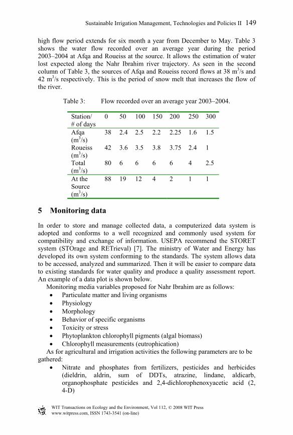
high flow period extends for six month a year from December to May. Table 3 shows the water flow recorded over an average year during the period 2003–2004 at Afqa and Roueiss at the source. It allows the estimation of water lost expected along the Nahr Ibrahim river trajectory. As seen in the second column of Table 3, the sources of Afqa and Roueiss record flows at 38 m3/s and 42 m3/s respectively. This is the period of snow melt that increases the flow of the river.
Table 3: Flow recorded over an average year 2003–2004.
Station/ # of days
0 50 100 150 200 250 300
Afqa (m3/s)
38 2.4 2.5 2.2 2.25 1.6 1.5
Roueiss (m3/s)
42 3.6 3.5 3.8 3.75 2.4 1
Total (m3/s)
80 6 6 6 6 4 2.5
At the Source (m3/s)
88 19 12 4 2 1 1
5 Monitoring data
In order to store and manage collected data, a computerized data system is adopted and conforms to a well recognized and commonly used system for compatibility and exchange of information. USEPA recommend the STORET system (STOrage and RETrieval) [7]. The ministry of Water and Energy has developed its own system conforming to the standards. The system allows data to be accessed, analyzed and summarized. Then it will be easier to compare data to existing standards for water quality and produce a quality assessment report. An example of a data plot is shown below. Monitoring media variables proposed for Nahr Ibrahim are as follows:
• Particulate matter and living organisms • Physiology • Morphology • Behavior of specific organisms • Toxicity or stress • Phytoplankton chlorophyll pigments (algal biomass) • Chlorophyll measurements (eutrophication)
As for agricultural and irrigation activities the following parameters are to be gathered:
• Nitrate and phosphates from fertilizers, pesticides and herbicides (dieldrin, aldrin, sum of DDTs, atrazine, lindane, aldicarb, organophosphate pesticides and 2,4-dichlorophenoxyacetic acid (2, 4-D)
www.witpress.com, ISSN 1743-3541 (on-line)
© 2008 WIT PressWIT Transactions on Ecology and the Environment, Vol 112,
Sustainable Irrigation Management, Technologies and Policies II 149
• Soil permeability: plants adversely affected and livestock poisoned • Agricultural practices influence erosion • TDS, TSS, boron, selenium, sodium, calcium, magnesium and fecal
coliform • Sodium Adsorption Ratio (SAR) [8]
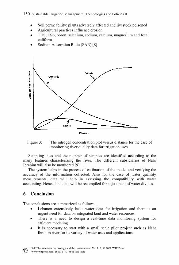
Figure 3: The nitrogen concentration plot versus distance for the case of monitoring river quality data for irrigation uses.
Sampling sites and the number of samples are identified according to the many features characterizing the river. The different subsidiaries of Nahr Ibrahim will also be monitored [9]. The system helps in the process of calibration of the model and verifying the accuracy of the information collected. Also for the case of water quantity measurements, data will help in assessing the compatibility with water accounting. Hence land data will be recompiled for adjustment of water divides.
6 Conclusion
The conclusions are summarized as follows: • Lebanon extensively lacks water data for irrigation and there is an
urgent need for data on integrated land and water resources. • There is a need to design a real-time data monitoring system for
efficient modeling. • It is necessary to start with a small scale pilot project such as Nahr
Ibrahim river for its variety of water uses and applications.
www.witpress.com, ISSN 1743-3541 (on-line)
© 2008 WIT PressWIT Transactions on Ecology and the Environment, Vol 112,
150 Sustainable Irrigation Management, Technologies and Policies II
• There is a need to establish a model calibration with the collection of data.
• The bacteriological tests at the sources of Afqa and Roueiss need to be carried out to monitor a continuously safe water quality at the source.
• In the future one could expand the project and centralize data for the efficiency of water management and dissemination of information.It is important to maintain a strong data base and continuity of measurements for:
Rural economic activities Irrigation Water quality.
• Political turmoil and economic slowdown are constraints with a strong adverse impact on the execution of the project.
• The FAO support for monitoring is vital for the sustainability of the project.
• The activities of the WEERC to establish a real partnership between the public sector, water users associations and NGO’s as well as research coordination with universities, awareness and training will help enhance the monitoring strategy for the country.
References
[1] American Public Health Association (APHA), American Water Works Association (AWWA) and Water Pollution Control Federation (WPCF), Standard Methods for the Examination of Water and Wastewater (Washington, DC, 18th ed, 1992).
[2] J.B. Bartram, Drinking Water Supply Surveillance. Robens Institute, University of Surrey, Guildford, 1990.
[3] D. Chapman, Water Quality Assessments. A Guide to the Use of Biota, Sediments and Water in Environmental Monitoring (London: Chapman & Hall, 2nd Ed, 1996).
[4] Environment Canada, Water Quality Branch, Inland Waters Directorate, Analytical Methods Manual. (Ottawa: Environment Canada, 1981).
[5] ISO, Water Quality Sampling. Part 1: Guidelines on the Design of Sampling Programmes. International Standard ISO 5667-1, International Organization for Standardization, Geneva, 1990.
[6] A. Ghaouche, Etude hydrogéomorphologique et hydrochimiques du bassin amont du Nahr Ibrahim (Mont Liban) Mémoire, (U.L., Beyrouth, 1989)
[7] B. Lloyd, and R. Helmer, 1991 Surveillance of Drinking-Water Quality in Rural Areas. (Area: Longman, Harlow, 1991).
[8] WHO, Guidelines for Drinking-Water Quality. Volume 3, Drinking-Water Quality Control in Small-Community Supplies (Geneva: World Health Organization, 1985).
[9] Khatib & Alami, Etude Hydrogéologique de la vallée de Janneh sur Nahr Ibrahim (Ministère de l’Energie et de l’Eau, République Libanaise, 2002)
www.witpress.com, ISSN 1743-3541 (on-line)
© 2008 WIT PressWIT Transactions on Ecology and the Environment, Vol 112,
Sustainable Irrigation Management, Technologies and Policies II 151