modeling sediment storage behind obstructions in small headwater streams
TRANSCRIPT
Arizona-Nevada Academy of Science
Modeling Sediment Storage behind Obstructions in Small Headwater StreamsAuthor(s): Aregai Tecle, Hilaire A. Bojonell and John G. KingSource: Journal of the Arizona-Nevada Academy of Science, Vol. 33, No. 2 (2001), pp. 83-92Published by: Arizona-Nevada Academy of ScienceStable URL: http://www.jstor.org/stable/40024043 .
Accessed: 15/06/2014 19:15
Your use of the JSTOR archive indicates your acceptance of the Terms & Conditions of Use, available at .http://www.jstor.org/page/info/about/policies/terms.jsp
.JSTOR is a not-for-profit service that helps scholars, researchers, and students discover, use, and build upon a wide range ofcontent in a trusted digital archive. We use information technology and tools to increase productivity and facilitate new formsof scholarship. For more information about JSTOR, please contact [email protected].
.
Arizona-Nevada Academy of Science is collaborating with JSTOR to digitize, preserve and extend access toJournal of the Arizona-Nevada Academy of Science.
http://www.jstor.org
This content downloaded from 195.34.79.228 on Sun, 15 Jun 2014 19:15:21 PMAll use subject to JSTOR Terms and Conditions

Modeling Sediment Storage Behind Obstructions in Small Headwater Streams
Aregai Tecle, School of Forestry. Northern Arizona University. Flagstaff AZ 86011 HiLAlRE A. BOJONELL, National Resource Information System, Water, 4077 Research Way, Corvallis OR 97333, and John G. King, USDA Forest Service, Rocky Mountain Research Station, Forestry Sciences Laboratory, 316 East Myrtle Street, Boise ID 83702
Abstract This paper develops a number of empirical models to describe the relationship of sediment storage in first and
second-order streams to a number of factors related to watershed and channel characteristics. One group of important factors comprises channel obstructions. In the study leading to this paper, sediment storage behind obstructions was measured on eighteen forested, mountainous drainage basins in northwestern Montana. Thirteen of the drainage basins were logged to various degrees while five of them were left undisturbed. The logged drainage basins, which differed from each other in their level and age of harvesting, were used as treatments while the undisturbed drainage basins were used as controls in the study. The objective of the study was to develop models that describe the effect of non- hydrologic factors in sediment accumulation in upland stream channels. Factors such as different steam channel characteristics, level of harvesting, channel and drainage basin slopes, number and diameter of woody debris pieces, and areas of watershed above particular stream reaches were evaluated to determine if they had any significant effect on the amount of sediment stored in first and second-order streams. The models indicate that obstructions and channel characteristics are the major factors that determine the quantity of stored sediment.
Introduction Historically, geomorphologists have studied
both hillslope erosion processes and sediment transport in streams and rivers separately, but only few studies have quantified the link between these two areas. This link is sediment storage along stream channels (Madejl984). Sediment storage in stream channels is an important indicator for the amount of erosion from and the movement of sediment through upland watersheds. The identi- fication of storage sites and quantitative description of the amount of sediment stored in these sites are important steps towards constructing models that describe sediment budget on forested, upland watersheds (Dietrich et al.1982).
Channel-sediment storage is especially important on forested drainage basins because of additional storage potential provided by falling woody debris that serve as obstructions (Megahan 1982). Obstructions from logs and other debris occur naturally in forested drainage basins. The size and frequency of the obstructions, however, may be strongly influenced by disturbances such as logging (Froehlich 1973, Swanson et al. 1976).
An important characteristic of debris-stored sediment is that the storage sites create a buffer system that regulates bed load and water movements through the fluvial system (Dudley et al. 1 998). This has important ramifications for watersheds impacted by land use changes such as timber harvesting or road building (Rice 1999). As the sediment enters the stream channel system from a source, there will be a lag time before the sediment yield or output
downstream increases significantly. However, once the storage sites or obstructions are full, then sedi- ment will be transported more rapidly down the channel through the full storage sites (McDonald et al. 1982).
Previous studies by Beeson and Doyle (1995), Keller and Swanson (1979), Keller and Tally (1979), Mosley (1981), Marston (1982), and Megahan (1982) suggest that woody debris plays a critical role in determining the morphologic and sediment routing characteristics of undisturbed forest stream channels. Since debris accumulations are effective barriers to sediment movement, they are considered as important components of streams draining forested watersheds (Tecle et al. 2001), which generally have high sediment loads, as a result of nearby logging and road building activities (Rice 1999). One of the major differences in sedi- ment routing between streams draining disturbed and undisturbed watersheds is the level of avail- ability of storage space (Benda and Dunne 1987; Tally et al. 1980), which can retain moving sedi- ment. In comparing disturbed and undisturbed watersheds, disturbed stream systems have a greater amount of debris-stored sediment, a condition, which reflects that a greater portion of the original storage compartments might be filled (MacDonald et al. 1982).
This paper examines some important factors that influence sediment storage along reach segments in 18 first- and second-order streams in the Kootenai National Forest in northwest Montana. The specific purpose is to develop models for
Tecle A H. A. Bojonell, and J. G. King. 2001. Modeling Sediment Storage Behind Obstructions in Small HEADWATER STREAMS. JOURNAL OF THE ARIZONA-NEVADA ACADEMY OF SCIENCE 33(2):83-92. © 2001 AREGAI TECLE, HlLAIRE A. Bojonell, and John G. King
This content downloaded from 195.34.79.228 on Sun, 15 Jun 2014 19:15:21 PMAll use subject to JSTOR Terms and Conditions
84 Modeling Sediment Storage Behind Obstructions + Tecle, Bojonell, and King
estimating the volume of stored sediment along reach segments in the streams. Generally, the stored sediment is short-lived and usually considered to be in transit downstream where the amount and residence time of the sediment in the stream channel vary with changes in the behavior of the different factors that affect the in-stream storage and movement of the sediment. The basic model often used to describe the variability of sediment storage along stream channels is the continuity equation (Equation 1) (Megahan and Nowlin 1976):
I + AS = O (1)
Where I = Sediment input AS = Change in channel storage 0= Sediment output
Application of this equation to sediment yield budgeting in forested watersheds is relatively new (Madej 1 984). Only few modeling efforts have been attempted to jointly describe and link hillslope erosion and in-stream sediment transport processes to date (Megahan and Ketcheson 1996).
Developing sediment budget models for forested drainage basins is a complex problem. It may require knowledge of the major factors that account for watershed erosion, in-stream channel sediment storage and movement, and downstream sediment yield. Watershed erosion refers to the amount of material eroded from watershed surfaces, or that eroded from roads and streambanks and delivered to a stream (Ketcheson et al. 1999). Sediment storage refers to sediment deposited in the streambed. The amount of sediment storage per unit stream length increases as one goes upstream towards lower order streams (Megahan and Nowlin 1976). This is because lower-order streams generally have more obstructions, such as woody debris per unit reach area, that can trap and store more sediment (Dudley et al. 1998; Masers et al. 1988). For this reason, it is important to study the factors that affect sediment storage in lower-order streams. Some of these factors are man-induced (Sheridan et al. 1999) while others belong to naturally occurring forest watershed and stream characteristics. Natural factors include vegetation cover, soil type and structure, watershed and stream slopes, stream channel geometry and its roughness. The effects of some of these factors on in-stream sediment storage are presented later as parts of the modeling process. In addition to incorporating the natural and man-induced factors to develop empir- ical models that describe the amount of sediment storage in low-order, headwater streams, the paper evaluates the impacts of two types of vegetation treatments on in-stream sediment storage.
The two treatment types are forest harvesting levels and buffer treatment types. One of the two foci of this paper is to evaluate the effects of these
two treatment types on sediment storage in first- and second-order upland streams. Specifically, appro- priate statistical analyses were performed 1) to find out if differences exist in volume of stored sediment under different buffering treatment types and watershed harvest levels, and 2) to develop models for estimating the volume of stored sediment in first- and second-order headwater stream channels.
Responding to these needs required an elaborate project design. The design includes identifying 18 small, headwater streams that consisted of 5 controls and 13 appropriately treated ones. The treatments consisted of forest harvesting levels and streamside buffering types. To minimize the effect of spatial variability of streams on sediment storage (Campbell 1 986), the study streams were subdivided into small reaches of the same length. With the exception of two shorter ones, each stream consisted of eight reaches for monitoring and data gathering purposes. As Benda and Cundy (1990) and Perkins (1989) pointed out, such site-specific modeling schemes are likely to give the most accurate sediment storage estimates.
All the data gathered were analyzed for two purposes. One of them to determine the effects of the two different treatment types on the amount of sediment stored behind obstructions, and the other one to derive the most appropriate models for estimating the volume of stored sediment. The results of the first indicated significant differences in sediment volumes between different buffer treatment types, while the effects of harvesting levels on the amount of stored sediment was negligible. The modeling effort generated six multivariate and non-linear equations that describe the amount of stored sediment in terms of various stream channel and watershed characteristics.
Study Area and Methods The first step in the project consisted of
selecting 18 first- and second-order headwater streams, and developing a systematic data collection procedure for the particular study. The collected data were statistically analyzed to determine the impacts of three different harvest treatment levels and three streamside-buffering schemes upon the amount of sediment stored in the first and second order stream channels. The harvest treatment levels consisted of 0% (or control), <50% and >50% harvest of the forested watersheds, while the three streamside buffering types consisted of buffered streams in untreated watersheds (or control), and buffered and unbuffered streams in treated watersheds. Here, buffered streams are those in which trees and other vegetation are left intact along their banks to slow down side flow and minimize stream bank erosion, whereas unbuffered streams are those with trees and other vegetation removed from their sides.
This content downloaded from 195.34.79.228 on Sun, 15 Jun 2014 19:15:21 PMAll use subject to JSTOR Terms and Conditions
Modeling Sediment Storage Behind Obstructions + Tecle, Bojonell, and King 85
Study Area The different study watersheds analyzed in this
paper are located within the Kootenai National Forest in the headwaters of the Yaak River basin in northwestern Montana (see Figure 1 in Tecle et al. 2001 in this publication). A general description of the study area including its climate, vegetation and soil cover, and some of its physiographic features as well as descriptions of the average physical characteristics of the different streams considered in the study are provided in Kuennen and Gerhardt (1984) and in Tecle et al. (2001). However, the methods followed to measure and analyze the amounts of sediment stored behind obstructions in the different channel streams are described in detail next.
Measurement and Analysis Measurement and Data Collection
Sediment storage behind obstructions was measured at designated reach segments in each headwater stream under study. Eight reaches were selected and delineated along each stream channel, except in two (streams 51 and 52), in accordance with the sampling scheme of Chesney (1990). The last two streams could accommodate only six and seven reaches, respectively, because they were too short to accommodate eight reaches. In all the streams, the reaches were arranged at regular intervals along the entire length of their respective channel. Each sample reach had 25 m length. The location of the first reach in each stream was 25 m upstream from the mouth of each upland watershed.
Distinctively identifiable obstructions and associated sediment accumulations in the selected
reaches were carefully measured. An obstruction in this study is defined as any material in the channel that causes sediment to accumulate because of discontinuities created in the channel gradient. Different types of materials such as logs greater than 5 cm in diameter, rocks, roots, stumps, twigs, leaves and other debris were considered obstructions (Platts et al. 1983), and subject to measurement. In the case of woody debris, all materials having dimensions greater than 4 cm in diameter and 76 cm in length were counted and the diameter of each piece measured at the center of its length.
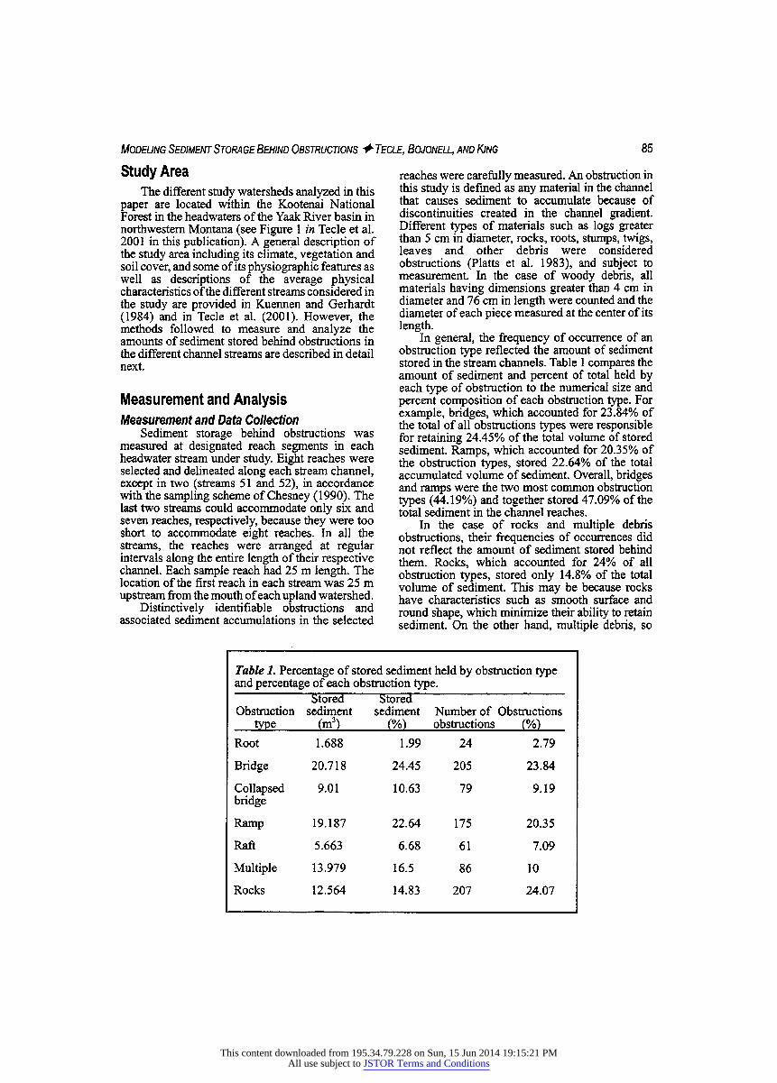
In general, the frequency of occurrence of an obstruction type reflected the amount of sediment stored in the stream channels. Table 1 compares the amount of sediment and percent of total held by each type of obstruction to the numerical size and percent composition of each obstruction type. For example, bridges, which accounted for 23.84% of the total of all obstructions types were responsible for retaining 24.45% of the total volume of stored sediment. Ramps, which accounted for 20.35% of the obstruction types, stored 22.64% of the total accumulated volume of sediment. Overall, bridges and ramps were the two most common obstruction types (44.19%) and together stored 47.09% of the total sediment in the channel reaches.
In the case of rocks and multiple debris obstructions, their frequencies of occurrences did not reflect the amount of sediment stored behind them. Rocks, which accounted for 24% of all obstruction types, stored only 14.8% of the total volume of sediment. This may be because rocks have characteristics such as smooth surface and round shape, which minimize their ability to retain sediment. On the other hand, multiple debris, so
Table 1. Percentage of stored sediment held by obstruction type and percentage of each obstruction type.
StoreH Stored Obstruction sediment sediment Number of Obstructions
type (mf) (%) obstructions (%)
Root 1.688 1.99 24 2.79
Bridge 20.718 24.45 205 23.84
Collapsed 9.01 10.63 79 9.19 bridge
Ramp 19.187 22.64 175 20.35
Raft 5.663 6.68 61 7.09
Multiple 13.979 16.5 86 10
Rocks 12.564 14.83 207 24.07
This content downloaded from 195.34.79.228 on Sun, 15 Jun 2014 19:15:21 PMAll use subject to JSTOR Terms and Conditions

86 Modeling Sediment Storage Behind Obstructions + Tecle, Bojonell, and King
classified when two or more pieces of debris formed an obstruction, accounted for only 10% of the obstructions, but stored 16.5% of the total amount of sediment. This indicates that multiple pieces of debris, which tend to have elongated shapes, are capable of storing larger quantities of sediment than other obstruction types. This is important since a minimum size of sediment deposit was required in the sampling process.
When measuring sediments, sampling was restricted to sediment deposits with the following minimum dimensions: average height, 20 cm; average length, 60 cm; and average width, 30 cm. This is appropriate because in a similar study on headwater streams in central Idaho, Megahan ( 1 982) found that sediment depositions below these mini- mum dimensions only accounted for 11% of the total stored sediment. The height of an accumulation is defined as the difference between a level rod reading taken on the bed at the down-stream side of the obstruction and a rod reading on the sediment deposit immediately upstream from the obstruction. The average of three height measurements was used in this study. As illustrated in Figure 1, the length of an accumulation was the distance from the upstream end of the obstruction to the upstream end of the sediment accumulated behind the obstruction. The average of three lengths was taken. The width of an accumulation was the distance from the left edge of the deposit to the right edge. The width is taken perpendicular to the length of the deposit. Three measurements were taken to obtain the average width of a sediment deposit. Sediment volumes were computed by assuming the deposits to approximate a rectangular wedge in shape (see Fig. 1). Based on such assumption the following equation was used to determine the volume of a sediment deposit behind an obstruction (Platts et al. 1983):
Vsed = (H/2) *L*W [2]
Where: V^ = Volume of sediment per deposit (m3) H = Average height of deposit (m) L = Average length of deposit (m) W = Average width of deposit (m)
Dimensions of stream channel cross-sections were measured using the sag-tape method. These measurements were input into R4-CROSS (Burton et al. 1991), a computer program used by certain regional offices of the U.S. Department of Agriculture, Forest Service to generate channel cross-sectional areas, depths, and wetted perimeters. Channel widths were directly computed from the data sheets, while channel gradients were determined using clinometers. These data were incorporated into the multivariate modeling of the amount of stored sediment.
Figure 1. Measurement of the amount of sediment stored behind an obstruction.
Data Analysis Preliminary analysis of the data collected in the
study showed high variability within a stream. Lumping the reaches and analyzing their character- istics on a watershed basis could result in important loss of needed details. To minimize this type of problem, the data were arranged for analysis on a reach rather than a watershed basis. In that way, each reach could be described using its own unique attributes and treated as a unit, making the collected data to more closely reflect actual field conditions.
A number of methods were used to analyze the sediment data. First, the data were characterized using descriptive statistics. Then, analysis of variance and Tukey's multiple range tests were employed to describe the effects of buffering treatment types and harvesting levels on the amount of in-stream sediment deposits. The volume of stored sediment (in cubic meters per hectare per reach) is expressed in terms of volume per unit watershed area draining into a sampled reach. The standardized volumes in the reaches were then grouped according to treatment type and harvest level for which the average volume of sediment per unit area per reach in each group was determined. For example, since there were 57-buffered reaches, 57 volumes per hectare were summed up and divided by the number of buffered reaches to get the average volume of stored sediment (m3/ha) in a
This content downloaded from 195.34.79.228 on Sun, 15 Jun 2014 19:15:21 PMAll use subject to JSTOR Terms and Conditions
Modeling Sediment Storage Behind Obstructions + Tecle, Bojonell, and King 87
buffered reach. Such a standardization scheme minimizes the effects of the differences in size of the contributing watershed areas upon the volumes of sediment deposited in a reach.
Altogether, there were 141 reaches, with an overall total of 860 sediment deposits, observed during the two years of data collection period. On the average, the volume of each sediment deposit was 0.099 m3, and there was an average of 6.1 deposits with a total average volume of 0.60 1 m3 per reach. The coefficients of variation for the amounts of stored sediment per deposit and per reach were 197.7% and 147.9%, respectively. These values still indicate the presence of a high degree of variability in the volumes of stored sediment in the measured reaches.
Effect of Logging on Sediment Storage The two treatments employed in the study
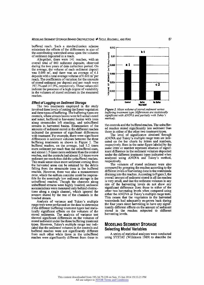
involved three levels of cutting the forest vegetation and three types of buffering. The buffering types are controls, where stream basins were left unharvested and intact, buffered in harvested basins with trees along streamsides left standing, and unbuffered streams in harvested basins. Examination of the amounts of sediment stored in the different reaches indicated the presence of significant differences with treatment. For example, there were significant differences in sediment volumes between the three buffering treatments as shown in Figure 2. The buffered reaches, on the average, had 5.2 times more sediment per reach than the unbuffered ones, and almost 1 .5 times more sediment than the control reaches, and the controls had almost 3.5 times more sediment per reach than did the unbuffered reaches. This made sense since more sediment coming from the harvested areas can be retained by the debris falling from the streamside trees in the buffered reaches. However, there was also a measurement error, which the authors consider could be respons- ible for the seemingly low sediment storage in the unbuffered reaches. Though the channels along unbuffered streams were highly braided, sediment accumulations were measured only behind obstruc- tions along a single channel, which ignored the amount shared by the rest of the channels in the braided stream.
Analysis of variance and Tukey's multiple range tests were performed on the data to determine if the different buffering treatment types had statis- tically significant effects on the volumes of the stored sediments. The analysis of variance test showed significant differences on the volumes of stored sediment under the three buffering treatment types. However, Tukey's multiple range test indi- cated that the sediment volumes in the controls and buffered reaches were not significantly different from each other while those in the unbuffered reaches were significantly different from those in
Figure 2. Mean volume of stored sediment versus buffering treatment type (differences are statistically significant with AN OVA and partially with Tukey's method).
the controls and the buffered reaches. The unbuffer- ed reaches stored significantly less sediment than those in either of the other two treatment types.
The level of significance obtained through ANOVA and Tukey's multiple range tests are indi- cated on the bar charts by letters and numbers, respectively. Bars in the same figure labeled by the same letter or number represent absence of signif- icant difference in the sediment volumes deposited under the different treatment types indicated when analyzed using ANOVA and Tukey's method, respectively.
The volumes of stored sediment were also compared by grouping the reaches according to the different levels of harvesting done in the watersheds draining into the reaches. According to Figure 3, the overall amount of sediment stored in all the reaches is very small, and that the sediment volumes in any one of the harvesting levels do not show any significant difference from those in either of the other two harvesting levels when compared using either the ANOVA or Tukey's multiple range tests. This means that the vegetation in the harvested watersheds had adequately re-grown back during the four years since harvesting to have any signif- icantly different effects on the amount of sediment stored in the reaches subjected to different harvesting levels.
Modeling Sediment Storage Selecting Model Variables
A series of statistical analyses were conducted using SYSTAT (Wilkinson 1989) to describe the
This content downloaded from 195.34.79.228 on Sun, 15 Jun 2014 19:15:21 PMAll use subject to JSTOR Terms and Conditions

88 Modeling Sediment Storage Behind Obstructions + Tecle, Bojonell, and King
Figure 3. Mean volume of stored sediment versus harvest level (differences not statistically significant with either ANOVA or Tukey's method).
volume of sediment stored behind debris in the reaches, in terms of the most important and relevant stream basin characteristics. The particular charac- teristics examined include watershed and channel related parameters, vegetation treatment levels, and size and frequency of woody debris in the stream channels. All together, there were 24 different variables considered for inclusion in the modeling process. However, most of them were eliminated using statistical correlation tests and other empirical procedures as described in the following paragraphs. The functional relationship and some of the independent variables considered during the multiple regression analyses of the problem can be described as:
Vscd = f(OBSD, CHC, Asp, HVST, A, SS, NLOD, NOBS, Age, WSS) [3]
Where V^ = Volume of Sediment OBSD = Diameter of debris causing the
deposit CHC = Channel characteristics [bankful
width (BW), depth (D), cross- sectional area (Xarea), wetted perimeter(Wp)]
Asp = Aspect HVST = Watershed harvesting level above a
reach A = Watershed area above a reach SS = Average reach slope
NLOD = Number of woody debris pieces per reach (total number of pieces of a particular average diameter/reach)
Age = Age of harvest WSS = Watershed slope (%) NOBS = Number of obstructions
Preliminary tests to determine the relationship of the stored sediment to the individual variables revealed that most of the variables did not significantly contribute to the amount of stored sediment. As a result, only eight of the variables that showed to have relatively significant impact on the amount of stored sediment were used in the final model development process. The eight variables are number (NOBS) and mean diameter (OBSD) of obstructions, mean depth (D) and mean cross- sectional area (Xarea) of measured reaches, percent watershed area harvested above each reach (HVST), mean bankfull width (BW) and number of large organic debris (NLOD).
Once the most predictive independent variables were chosen, variable transformations were run to determine if correlation of the linear relationship among variables could be improved or if the model would be better represented as a nonlinear function. These tests aided in ascertaining the form of the multiple regression model selected. Residuals from all regression models were examined for systematic departure from the regression assumptions and appropriate transformations were made where necessary. The results of the statistical analysis are presented next.
Development of Models for Sediment Storage
The initial idea in this study was to develop watershed-based models for estimating the amount of sediment stored behind obstructions in an entire first or second order upland stream channel. Preliminary analysis of the data obtained, however, showed the presence of too much variability from one reach to another within the same stream in a watershed. Under these circumstances, lumping of the different reach characteristics in a watershed could result in loss of important details in the data as pointed out earlier. To minimize this kind of a problem, the models were developed on a reach- rather than on a watershed-basis. In the process, each reach was described using its own unique attributes and treated as a sub watershed in the study. This approach enabled the data to more closely reflect actual field conditions.
As pointed out previously, there were eight reaches measured in each stream except in streams 51 and 52 for a grand total of 141 reaches in the entire study site. However, a preliminary statistical analysis of the data collected from the 141 reaches exhibited the presence of significant outliers. Graphical displays were used to identify the outliers. Once identified, the problem of outliers in the modeling process was minimized by removing four of the reaches with the greatest outliers resulting in a total of 1 37 reaches for use in the final modeling process.
This content downloaded from 195.34.79.228 on Sun, 15 Jun 2014 19:15:21 PMAll use subject to JSTOR Terms and Conditions
Modeling Sediment Storage Behind Obstructions + Tecle, Bojonell, and King 89
In addition to eliminating the channel reaches with significant outliers, the development of sedi- ment storage models also involved reducing the number of variables used in the modeling process. Out of the 24 variables considered initially as potential contributors to the amount of sediment stored in stream channels, only one-third of them were used to develop models. Several of the variables identified such as age of harvest, contri- buting watershed area above each reach, channel slope, and aspect were determined to have little or no significant effect on the amount of stored sedi- ment. Since age of harvest was hypothesized to have an important effect on the amount of sediment stored, particular attempts were made during the modeling process to look at the effects of age of harvest on sediment storage. However, it was found that various parts of a stream basin were harvested at different times. This kind of temporal variation in harvesting has resulted in major differences in vegetation patterns even among stands within the same reach. This made it difficult to attribute certain sediment volumes to specific ages of harvest. Further attempts were made to evaluate the impacts of the weighted averages of the age of harvest upon sediment storage, but these attempts also proved fruitless. As a result, age of harvest was dropped form consideration.
The contributing area above each reach was also thought to be an important factor in estimating the amount of sediment stored in stream channels. However, the effect of this factor on the stored sediment was also found to be not significant (R2 = 0.02). This seems to indicate that it is the immediate or closest sources of sediment rather than those sources located away from the stream that have the greater effects on sediment storage. This may be especially true in forest-covered areas, or in fully re-vegetated previously harvested areas. In such cases, sediment sources such as nearby roads, landslides, or stream bank erosion probably play a greater role than the overall contributing area (Beeson and Doyle 1995; Rice 1999).
Channel slope and aspect were other variables that did not significantly contribute to the stored sediment. Even though small headwater channels such as the ones under study often have steep gradients, the presence of abundant woody debris has a decreasing effect on the overall stream gradient by forming log steps. In these kinds of small streams, effective gradient may prove to be a more important variable than the overall stream gradient in estimating stored sediment. Similar attempts were made to look at the effect of aspect on amount of sediment stored in the stream channels, but no consistent relationship was evident. As a result, channel slope and aspect were also dropped from consideration in constructing the models. This kind of variable elimination process
left only few variables for use in developing the needed models.
Using the remaining variables, several non- linear and multivariate regression models were developed to describe the volume of sediment stored in first- and second-order headwater streams. The developed models are quantitatively described in terms of 2 to 8 of the 24 variables that were considered to contribute to the amount of sediment stored in stream channels (see Table 2). The models are statistically significant (at a < 0.05) with respect to their parameters, and display homogeneous variance in their residuals.
Model Choice The developed models are not equally satis-
factory; some are more preferable than others. Selection of a preferred model may be done by comparing the models developed with each other based on their coefficient of determination. However, it is also important that satisfactory models conform well to the general physical processes involved. A structural comparison of the 6 sediment storage models developed is shown in Table 2. In this list, models 7, 8, and 9 are relatively better fit compared to models 4, 5, and 6 based on their individual RA2 values. However, the first group of models requires more labor-intensive data gather- ing in order to develop. The choice of which model to use then depends on the level of prediction accuracy needed and the availability of adequate time and resources to develop and run the model.
The selected model, in this study, may be used for estimating the volume of sediment stored in a 25 m reach of a first or second-order stream in a forested, upland watershed similar to that of the study site. The amount of stored sediment so deter- mined is expressed in terms of the total sediment volume stored within the reach, and the volume is estimated using the equations (Equations 4 to 9) shown in Table 2. These equations are expressed as functions of two to eight variables.
All the variables in the models presented are positively correlated with the total volume of stored sediment except for average channel cross-sectional area and the number of pieces of large woody debris in the reach, both of which happen to show negative correlations. This phenomenon may be due to the effect of buffers, that is buffered streamsides may yield smaller amounts of sediment (Snyder et al. 1998; Thornton et al. 1997) while providing the stream channels with large amounts of woody debris. Thus, the negative relationship between sediment storage and the number of pieces of large woody debris may be the indirect result of such conditions. The negative relationship between sediment storage and channel cross-sectional area may be partly due to both horizontal spread of the
This content downloaded from 195.34.79.228 on Sun, 15 Jun 2014 19:15:21 PMAll use subject to JSTOR Terms and Conditions

90 Modeling Sediment Storage Behind Obstructions + Tecle, Bojonell, and King
Table 2. Models developed to predict the volume of stored sediment Model SEE RA2 EqnNo.
Vsed = (0.210814 + 0.013390 nobs + 0.01 1937 obsd + 0.001761 nobs*obsd)2 0.38983 .741 [4]
Vsed = (0.058209 + 0.014370 nobs + 0.013062 obsd + 0.001475 nobs*obsd + 0.944244 d)2 0.37604 .761 [5]
Vscd = (0.017121 + 0.016034 nobs + 0.013651 obsd + 0.001394 nobs*obsd + 0.006454 wss*hvst + 0.864377 d)2 0.37192 .768 [6]
Vsed = (0.172723 + 0.019575 nobs + 0.014090 obsd + 0.001026 nobs*obsd - 0.200304 xarea + 1.280632 d + 0.1 16301 bw)2 0.34619 .800 [7]
Vscd = (-0.276451 + 0.019452 nobs + 0.014157 obsd + 0.001066 nobs*obsd - 0.255592 xarea + 1.542261 d + 0.009006 wss*hvst + 0.123910 bw)2 0.33663 .813 [8]
Vscd = (-0.136239 + 0.020001 nobs + 0.010933 obsd + 0.001297 nobs*obsd - 0.263253 xarea + 1.747379 d + 0.006987 wss*hvst -0.005687 nlod + 0.126835 bw)2 0.33015 .821 [91
SEE = Standard error of estimate RA2 = Adjusted coefficient of determination V^ = Total volume of stored sediment (m)3 nobs = Number of obstructions obsd = Mean obstruction diameter (cm) xarea = Mean channel cross-sectional area (m2)
d = Mean channel depth (m) wss = Watershed slope (%) hvst = Area harvested above reach (%) nlod = Number of large organic debris bw = Mean bankfiill width (m)
stored sediment and its easier movement down stream along wider channels. But, it is important to remember that these preliminary conclusions are based on a single year data only, therefore more observations over a lengthy period of time would be needed to ascertain them.
The problem is more complex than it seems; there are many factors, which may jointly but not individually have some significant effect on the amount of stored sediment like the 18 or so var- iables eliminated from consideration in this study. In all of the models developed, the number of obstructions had the largest relative effect on the total volume of stored sediment compared to the other independent variables. Average channel depth and cross-sectional area contributed the second and third largest relative effect on the stored sediment volume, respectively. However, when the cross- sectional area term was omitted from the models (models 4, 5, and 6) in Table 2, the interaction term, number of obstructions times obstruction diameter (NOBS*OBSD), had the second largest relative
effect on the volume of stored sediment The term with the lowest relative effect on the volume of stored sediment was the interaction term watershed slope times area harvested above the reach (WSS*HVST).
Concluding Remarks Several models to predict stored sediment in
headwater streams were developed in this study. The models indicate that obstruction and channel characteristics are the major factors that determine the quantity and location of sediment storage. But, because the ability of the models to estimate the amount of accumulated sediment improves with model complexity, the choice for a particular model depends on the level of prediction needed and the time and resource available to collect all the inputs needed to run it.
The models developed may be used to estimate stored sediment from a knowledge of mostly phys- ical channel characteristics. However, they can also
This content downloaded from 195.34.79.228 on Sun, 15 Jun 2014 19:15:21 PMAll use subject to JSTOR Terms and Conditions

Modeling Sediment Storage Behind Obstructions + Tecle, Bojonell, and King 91
be used with caution for other forest watershed management purposes. For instance, they can be used for sediment and debris load monitoring pur- poses on a year-to-year as well as for estimating sediment budget in upland forested watersheds. The use of these models, however, should be confined to first- or second-order streams in northwestern Montana, with possible extension to northern Idaho, until they are tested for their applicability anywhere else. Because the models developed in this study were based on one-year of data and used harvested areas that were older than four years, these facts should be considered in using the models.
Since the models developed in this study were strictly based on non-hydrologic inputs, it would be interesting to see how the models would behave with hydrological and climate data such as precipi- tation and stream flow. One approach that can be taken is coupling the non-hydrologic models with hydrologically based models like that suggested in Tecle et al. (1990). Such coupling would have a better representation of most of the relevant hydrologic factors and possibly improve the predic- tive capacity of the models developed.
Acknowledgments This research was supported in part by funds provided by the Intermountain Research Station, Forest Service, U.S. Department of Agriculture under a Research Joint Venture Agreement Contract No. INT-92680-RJVA. The authors also extend their appreciation for the extensive support provided in gathering the necessary data by the Hydrology Staff of the Kootenai National Forest, Forest Service, U.S. Department of Agriculture in Libby, MT.
Literature Cited Beeson, C. E., and P. R Doyle. 1995.
Comparison of bank erosion at vegetated and non-vegetated channel beds. Water Resources Bulletin 31(6):983-990.
Benda, L., and T. W. Cundy. 1990. Predicting deposition of debris flows in mountain channels. Canadian Geotechnical Journal 27:409-417.
Benda, L., and T. Dunne. 1987. Sediment routing by debris flows. Pp. 213-223 in R. L. Beschta, T. Blinn, G. E. Grant, G. G. Ice, and F. J. Swanson (eds.), Erosion and sedimentation in the Pacific Rim, IAHS Publication 165.
Burton, T. A., J. Potyondy, and F. Hernandez. 1991. R4 stream channel hydraulics. Boise National Forest. Boise, ID.
Campbell, A. G. 1986. Spatial variability of stored sediment in several steep channels along the front of the San Gabriel Moun-
tains. Pp. 39-44 in J. Vries (ed.), Proceed- ings of the chaparral ecosystem research conference in Santa Barbara, CA, May 16- 17. University of California-Davis, Calif- ornia Water Resources Center Report #62.
Chesney, C. 1990. Spatial extent of channel damage: A report on Part A, Phase One of a headwater channel monitoring program in the Yaak River Basin of the Kootenai National Forest. Unpublished report on file on the Kootenai National Forest.
Dietrich, W. E., T. Dunne, N. F. Humphrey, and L. M. Reid. 1982. Construction of sedi- ment budgets for drainage basins. Pp. 5-23 in Sediment budgets and routing in forested drainage basins. USDA Forest Service General Technical Report PNW-141. Pacific Northwest Forest and Range Experi- ment Station. Portland, OR.
Dudley, S. J., J. C. Fischenich, and S. R. Abt. 1998. Effect of woody debris entrap- ment on flow resistance. Journal of the American Water Resources Association 34(5):1189-1198.
FROEHLICH, H. A. 1973. Natural and man- caused slash in headwater streams. Loggers Handbook, vol. 33, Pacific Logging Cong- ress, Portland, OR. 8p.
KELLER, E. A., and F. J. SWANSON. 1979. Effects of large organic material on channel form and fluvial processes. Earth Surface Processes 4:361-380.
Keller, E. A., and T. Tally. 1979. Effects of large organic debris on channel form and fluvial process in the coastal redwood environment. Pp. 169-197 in D. D. Rhodes and G. P. Williams (eds.), Adjustments on the fluvial system: Proceedings of the Wh annual geomorphology symposium. State University of New York, Binghamton.
Ketcheson, G. L., W. F. Megahan, and J. G. King. 1 999. "Rl -R4" and "BOISED" sediment prediction model tests using forest roads in granitics. Journal of the American Water Resources Association 35(l):83-98.
KUENNEN, L. J., and M. N. GERHARDT. 1984. Kootenai National Forest area land system inventory. USDA Forest Service, Kootenai National Forest, Libby, MT.
MADEJ, M. A. 1984. Recent changes in channel- stored sediment. Technical Report 1 1 . Redwood
National Park, Aracata, CA. MARSTON, R. A. 1982. The geomoiphic signifi-
cance of log steps in forest streams. Annals of the Association of American Geographers 72(l):99-108.
This content downloaded from 195.34.79.228 on Sun, 15 Jun 2014 19:15:21 PMAll use subject to JSTOR Terms and Conditions
92 Modeling Sediment Storage Behind Obstructions + Tecle, Bojonell, and King
Masers, C, R. Tarrant, J. Trappe, and J. FRANKLIN (EDS.). 1988. From the forest to the sea: A story of fallen trees. Geneneral Technical Report PNW-GTR-229. Portland, OR.
McDonald, A., E. A. Keller, and T. Tally. 1982. The role of large organic debris on stream channels draining redwood forests in north- western California. Pp. 226-245 in D. K. Harden, D. C. Marron, and A. McDonald (eds.), Friends of the Pleistocene 1982 Pacific Cell field trip guidebook, Late Cenozoic history and forest geomorphology of Humbold County, California.
MEGAHAN, W. F. 1982. Channel sediment storage behind obstructions in forested drainage basins draining the granitic bedrock of the Idaho batholith. Pp. 1 1 4- 1 2 1 in Sediment budgets and routing in forested drainage basins. USDA Forest Service General Technical Report PNW- 141. Pacific Northwest Forest and Range Experiment Station. Portland, OR.
MEGAHAN, W. F., and G. L. KETCHESON. 1996. Predicting downslope travel of granitic sediments from forest roads in Idaho. Water Resources Bulletin 32:371-382.
MEGAHAN, W. R, and R. A. NOWLIN. 1976. Sediment storage in channels draining small forested watersheds in the mountains of central Idaho. Pp. 1 15-126 in Proceedings of the third federal inter-qgency sedimentation conference, Denver, CO.
MOSLEY, M. P. 1981. The influence of organic debris on channel morphology and bed load transport in a New Zealand forest system. Earth Surface Processes andLandforms 6:571-579.
Perkins, S. J. 1989. Landslide deposits in low- order streams - their erosion rates and effects of channel morphology. Pp. 173-182 In Headwater hydrology, American Water Resources Association publication.
Plaits, W. S., W. F. Megahan, and G. W. MlNSHALL. 1983. Methods for evaluating stream, riparian, and biotic conditions. General Technical Report INT- 138. Intermountain Forest and Range Experiment Station. Ogden, UT. 70 p.
Rice, R. M. 1999. Erosion on logging roads in Redwood Creek, Northwestern California. Journal of the American Water Resources Association 35(5):1171-1182.
Sheridan, J. M., R. Lowrance, and D. D. Bosch. 1999. Management effects on runoff and sediment transport in riparian forest buffers. Transactions of the ASAE 42:55-64.
Snyder, N. J., S. Mostaghimi, d. f. Berry, r. b. Reneau, S. Hong, and P. W. McClellan. 1998. Impact of riparian forest buffers on agricultural nonpoint source pollution. Journal of the American Water Resources Association 34(2):385-395.
SWANSON, F. J., G. W. LlENKAEMPER, and J. R. SEDELL. 1976. History, physical effects, and management implications of large organic debris in western Oregon streams. General Technical Report PNW-56. Pacific Northwest Forest and Range Experiment Station, Portland, OR. 15 p.
Tally, T., A. Macdonald, and E. A. Keller. 1980. The effects of large organic debris on sediment routing in redwood forest streams. Geological Society of America Abstracts with Programs 12:155.
Tecle, A., D. P. Dykstra, W. W. Covington, and L. D. Garret. 1 990. Proposed methodology for soil loss prediction from southwestern forests. Hydrology and Water Resources in Arizona and the Southwest 20:113-129.
Tecle, A., H. A. Bojonell, and J. G. King. 2001. Effect of harvesting headwater forest water- sheds on woody debris and stream channel characteristics. Journal of the Arizona-Nevada Academy of Sciences 33(2):98-112.
Thornton, C. I., S. R. Abt, and W. P. Clary. 1997. Vegetation influence on small stream siltation. Journal of the American Water Resources Association 33(6): 1279-1288.
Wilkinson, L. 1989. SYSTAT, the system for statistics. SYSTAT, Inc., Evanston, IL.
This content downloaded from 195.34.79.228 on Sun, 15 Jun 2014 19:15:21 PMAll use subject to JSTOR Terms and Conditions