mobile robot's map reconstruction based on dsmt andfast-hough self-localization
DESCRIPTION
This paper presents a new tool based on DSmT overcome the shortcoming ofDST[l0][l1], its precision still (Dezert-Smarandache Theory) and fast-Hough self-localization which is applied to autonomous mobile robot's map reconstruction.TRANSCRIPT

Proceedings of the 2007 International Conference on Information AcquisitionJuly 9-11, 2007, Jeju City, Korea
Mobile Robot's Map Reconstruction Basedon DSmT and Fast-Hough Self-Localization
Xinhan Huang, Xinde Li, Zuyu Wu, Min WangDepartment of Control Science and Engineering, Huazhong University of Science and Technology
Wuhan 430074, Chinaxhhuanggmail.hust.edu.cn
Abstract - This paper presents a new tool based on DSmT overcome the shortcoming of DST[l0][l 1], its precision still(Dezert-Smarandache Theory) and fast-Hough self-localization need to be improved further, since it didn't considerwhich is applied to autonomous mobile robot's map redistributing the conflicting mass with PCR rule [12] orreconstruction. Uncertainty from sonar information is fused and other rules, and even didn't yet consider the self localization.managed in rebuilding grid map effectively with DSmT, since In this paper we give a further research on map reconstructionfast-Hough self-localization from laser information overcomessome shortcomings of classical Hough transformation including based on DSmT (i.e. DSmC and PCR5 rules) and Fast-Houghhigh amount of computation and low precision of localization. Self-Localizaton in a statc environment.When a virtual mobile robot evolves in the virtual environment This paper is organized as follows: In section II, Simplewith different outline features, the result can adequately testify review of DSmT. In section III, A model based on DSmTthat the new tool owns better performance to rebuild map. In with sonar information is given. In section IV, A new selfgeneral, this research provides an approach for studying -localization based on Fast-Hough transformation isautonomous navigation of mobile robot or unmanned land proposed. In section V, A simulation experiment is done tovehicle (ULV) in unknown environment, also provides a human- . 'computer interactive interface to manage and manipulate the tersify pormatnc of n tonluinnma reacsrcinrobot remotely. under self localization. At last, a conclusion is reached in
section VI.Index Terms - Map Reconstruction, DSmT, Self-localization, II. REVIEW OF DSMT
Hough transformation.DSmT (Dezert-Smarandache Theory) [7]is a new, general and
I. INTRODUCTION flexible theory of information fusion, which can solve theThe exploration in entirely unknown environment for fusion problems of different tiers including data-tier, feature-intelligent mobile robots has been a popular and important tier and decision-tier. It not only can dispose the staticsubject. Map reconstruction is a very important part in this problem of fusion, but also can dispose the dynamic one. Itsubject. Presently, mainly there are three mapping methods: has a prominent merit that it can deal with the highlygrid map, geometrical feature map and topological map. Grid conflicting information according to Proportional Conflictmap is the most simple and popular method among them. Redistribution rule no. 5 (PCR5)*, which goes backwards onThere are many reports about it, for example, Elfes, and the tracks of the conjunctive rule and only redistributesMoravec (1985) [1] firstly represented the probability of the proportionally the partial conflicting masses to the setsgrid occupied by obstacles with probability theory, which was involved in the conflict by considering the conjunctive normalcalled as occupancy grid method later [2]. It is very popular form of the partial conflict[12].since its simpleness in realization and low amount ofcomputation, while it has low precision in map reconstruction. A Basic ofDSmTGiuseppe Oriolo et al. (1997) [3]firstly proposed a method of 1) Let 0 = {01 , - O, } , here 0 is a frame ofmap reconstruction based on fuzzy logic, which has high discernment, which includes n finite focal elementsprecision in loose environment, while it spends more time in i(i= 1, ... n) . Because the focal element is not preciselythe same environment than that with occupancy grid method. defined and separated, so that no refinement of 0 in a newDaniel Pagac (1996) [4] firstly applied DST [5] to map larger set 0,, of disjoint elementary hypotheses is possible.reconstruction for mobile robots, where Dempster' s refcombinational rule is used to redistribute the belief mass of 2) The hyper-power set De is defined as the set of allgrid occupancy reasonably. However, it has a fatal compositions built from elements of 0 with U and nshortcoming that it can't deal with the highly conflictive 0 generates D® under operators U andn ) operators suchinformation. Weihua Wang et al. (2003) [6] proposed a new hgrid method based on grey system theory, which has a high thatprecision and moderate amount of computation, while its a) A0,01,02,03 ...0OE Ddetecting range is very small. We proposed to apply DSmT[7]to grid map reconstruction in 2006[8][9], though it has * Dezert and Smarandache have proposed 5 versions of proportional conflict
redistribution rules, which become one part of DSmT.
l1-4244-1l220-X/07/$25.OO ©C2007 IEEE 590

b) If A, B e De, then AnBeD® and AUBeD of sonar physical characteristic, metrical data behaves out
c) No other elements belong to D®, except those uncertainty as follows:
obtained)by usgoerulementsa) longb
to D ecethoea) Beside its own error of making, the influence ofobtanedbysin rues ) o b) external environment iS also very great, for example,
3) General belief function and Plausibility function . .i
Let0~O02 0 1 is the general frame of discernment. temperature, humidity, atmospheric pressure and so on.Let ) = (S11 02, 0, I;iS the general frame of discernment. b) Because the sound wave spreads outwards in theFor every evidential source S, let us define a set of map of form of loudspeaker, and there exists a cone-shaped angle, wem(.): De E [O,i] associated to it (abandoning Shafer's model) cannot know the true position of object detected among theby assuming here that the fuzzy/ vague/ relative nature of fan-shaped area, with the enlargement of distance betweenelements 0i (i = 1,2,3 ... n) can be non-exclusive, as well as no sonar and it.refinement of 0 into a new finer exclusive frame of c) The use of lots of sonar sensors will result in
interference each other. For example, when the ith sonar givesdiscernment rf is possible. The mapping m() is called a out detecting wave towards an object of irregular shape, if the
generalized basic belief assignment function (gbbaf), if it angle of incidence is too large, the sonar wave might besatisfies reflected out of the receiving range of the ith sonar sensor or
m(i)= 0 and A m(A)= 1 also might be received by other sonar sensors.EAcDo d) Because sonar sensors utilize the reflection principle
The general belief function and plausibility function are of sound wave, if object absorbs very heavy sound wave, thedefined respectively in almost the same manner as within the sonar sensor might be invalid.DST, i.e.
bel(A) = EBe C m(B) (1) .b() BeD@ BcAPl(A)= Em(B) (2)
BGnA#0,BCDeD
4) Classical (free) DSmT rule of combinationLet Mf (®) is a free model of DSmT, and then the classical Fig.l The sketch of the principle of sonar(free) DSmT rule of combination for k . 2 sources is given as A. Modeling Based on DSmTfollows: Pointing to the characteristics of sonar's measurement, we
mMf (0)(A) - [mi 1 ... JkA) construct a model of uncertain information acquired from gridVA # cDE)DOk (3) map using sonar based on DSmT. Here we suppose there are
Z 7Jmi(Xi) two focal elements in system, that is 0={01,02}, here 01(Xi-...XK)DA i=1 means grid is empty, 02 means occupied, and then we can
get its hyper-power set DO9 =o{, nl o2, oi, ooi1uo2} * EveryB. Proportional Conflict Redistribution Rule get it erower set nd k
0 2,0im2s0 U 0f}hiEveryPCR5 fines the conflicting mass, and just redistribute the grid in environment is scanned k > 2times, each of which ispartial conflicting mass to the elements involved in the partial viewed as source of evidence. Then we may define a set ofconflict, in order to improve the quality of fusion [12]. map aiming to every source of evidence and construct theHere we introduce the PCR5 formula for s 2 sources: generalbasicbeliefassignmentfunctions(gbbaf)asfollows:VX E G/{l}, m(01) is defined as the gbbaf for grid-unoccupied (empty);
mPCR5(X) = mI2(X)± m(02) is defined as the gbbaf for grid-occupied; m(0o n02)Fmh2m2(Y) m(X)2m1(Y) 7 (4) is defined as the gbbaf for holding grid-unoccupied and
Yc+;X} !mI(X)±rM2(y) ±m2(X)±MI(y)4 occupied simultaneous (conflict). m(01 U 02) is defined as
c(X_MY)=b the gbbaf for grid-ignorance due to the restriction of
where, c(X) represents the canonical form of knowledge and experience presently (here referring to theX,M.2(*)corresponds to the conjunctive consensus, i.e. gbbaf for these grids still not scanned presently ), it reflects
X^ in12 (.) corresponds to the conjunctive consensus, i.e. the degree of ignorance of grid-unoccupied or occupied.m12(X) =XI,X2eGml(XI)m2 (x2), and where all denominators The gbbaf of a set of map m(): DE -* [o,i] is constructed by
x1nx2 authors such as the formulae (5) (8) according to sonarare different from zero. If a denominator is zero, that fraction physical characteristics.is discarded. Please see also [10], if s > 2. m(0>)= E(p).E(O)=
*MODELING FOR SONAR GRID INFORMATION F (1-(Ii)2). (I/2) i Rmin <p<R-2£ (5)
Sonar sensors' working principle (shown in Fig. 1) is: 1 O < 0. (0/2producing sheaves of cone-shaped wave, and detecting the L 0 otherwiseobjects by receiving the reflected wave. Due to the restriction
591
m402) =O(p).0) = The basic principle is when mobile robot moves to a certainP. < p<R+e<R.a position, we cluster all scanned points in the detecting range
{ex1{3pPv(p-R)2) 2Aif Oin /2 (6) of laser range finder (0-180 degrees), and classify them into0otherwise subset Si (i E 1,2... ). Supposed that there are n points in the
m(01 n02)= subset S, then compute respectively the slope between every
F fRm ' <R<Ra 7 two points. Setting up a counter, if the slope is in the setting(1- (2(p-(R-2c))/R)2) i Rmin . P-. R X (7) range, we add one on the counter. When finished the statistic
Cote .se_/2 of all points in the subset Si , we classify all points having the0 otherwisem(01 Uo2)= maximum number to support a certain slope into a new
subset S . We can pick up the straight line l i2.)through{tanh (2(p - R)) (1 - ) if 0 < 0 < Ro/2 Hough transformation and then find those points owning the
otherwise sub maximum number and put them into another subset SfI.01_(2a/6 if0< .I642 Also pick up the second straight line until the number to
A=E) =O) X 0 otherwise support a certain slope is lower than the threshold. Thementioned above is the key difference from other Fast
where E(O)= 1- A/2 , O(o)= 2 , E(p)= (-(p/R - 2)2), transformation methods [14]. Then we begin to deal with
0(p) = exp( 3pv (p - R)2), where / is given by (9) (also see another subset S by same way until we finish all pointsref. [1] for justification). scanned in the detecting range of laser. By doing this we not
1 only reduce the complexity and amount of computation, buto0.9 g * ,'\ f/(& /&2) also improve the precision of picking up straight line, as well0.8 in 2 as find smaller features which might be omitted by other0.7 0 Hough transformation methods.0.6
B. Self- localization ofRobot's Pose0.5B.SI-O OIn a static and structured environment, if we don't consider
0.4 ./ *. \ .the small accumulative error and metrical error, then the02.3 coordinate of whole object outline in the environment0.2 x j<j~jjr detected by laser range finder on mobile robot will be0.1 * X consistent completely with the real one in global coordinate
0 0.2 0.5 1 1.5 2 2.5 3 system. In fact, it is impossible because of inaccurate robot's
p(M) pose. So robot's pose must be calibrated. Of course, if mobile
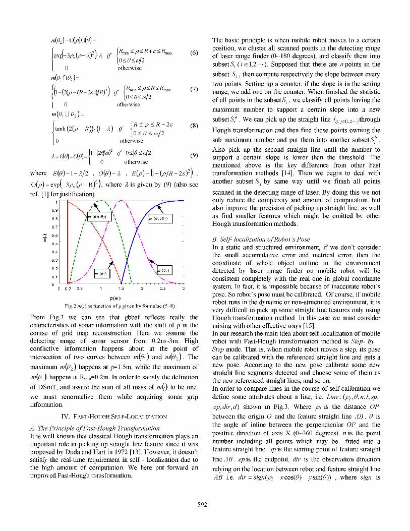
Fig.2 m(.) as function of p given by formulae (5-8) robot runs in the dynamic or non-structured environment, it isvery difficult to pick up some straight line features only using
From Fig.2 we can see that gbbaf reflects really the Hough transformation method. In this case we must considercharacteristics of sonar information with the shift of p in the mixing with other effective ways [15].course of grid map reconstruction. Here we assume the In our research the main idea about self-localization of mobiledetecting range of sonar sensor from 0.2m-3m. High robot with Fast-Hough transformation method is Step- by -conflictive information happens about at the point of Step mode. That is, when mobile robot moves a step, its poseintersection of two curves between m(01) and m(02). The can be calibrated with the referenced straight line and gets amaximum m(02) happens at p=1.5m, while the maximum of new pose. According to the new pose calibrate some new
m(o) happens at Rm. =0.2m. In order to satisfy the definition straight line segments detected and choose some of them asm~ happens atRmin m.In ordrtostisfyhedefnition the new referenced straight lines, and so on.of DSmT, and assure the sum of all mass of m(.) to be one, In order to compare lines in the course of self calibration wewe must renormalize them while acquiring sonar grip define some attributes about a line, i.e. Line: (pl, 0, n, 1, sp,information. ep, dir, d) shown in Fig.3. Where p1 is the distance OP
IV. FAST-HOUGH SELF-LOCALIZATION between the origin 0 and the feature straight line AB . 0 is
A. The Principle ofFast-Hough Transformation the angle of inline between the perpendicular OP and the
It is well known that classical Hough transformation plays an positive direction of axis X (0-360 degrees). n is the pointimportant role in picking up straight line feature since it was number including all points which may be fitted into aproposed by Duda and Hart in 1972 [13]. However, it doesn't feature straight line. sp is the starting point of feature straightsatisfy the real-time requirement in self - localization due to line AB . ep is the endpoint, dir is the observation directionthe high amount of computation. We here put forward an relying on the location between robot and feature straight lineimproved Fast-Hough transformation. AB i.e. dir =sign(p1 - x cos(0) - y sin(0)) , where sign is
592

the Sign function. If robot is nearer the origin than the feature When mobile robot moves along a very long wall which isstraight line, then dir = 1; if robot is farther away from the out of the range of laser, thus the laser range finder can'torigin than the feature straight line AB, then dir = -1; if robot detect the whole wall in one time. In this case, the mergencelied on the feature straight line, then dir = d is the between new line segment and the old one is very necessary.distance between robot and feature straight line. We must justify whether the two line segments are on the
common line according to the similar conditions. The simpleY A way to merge two line segments is shown in Fig.5. To extend
robot the referenced straight line we first project the new detecting\p 4) straight line AB to the relative referenced line EF and then the
robot w\ / two endpoints of projection line segment CD can be reached.odr=-I After a simple sort of four endpoints (C, E, D, F) justify
whether the distance CM is bigger than EM, here M is thedir=l B midpoint of referenced line segment EF. If yes, then we will
APl extend EF to point C, and get the new line segment CF. Inthis course we must consider the process of self calibrationbecause correct pose is the key of merging two line segments.
x
Fig.3 The observation direction for feature line B
In order to justify whether a feature straight line is similar to Aanother one we must propose the following four necessary Dconditions. I---------------
(a) Justify whether the observation direction is consistent. c E M F(b) Whether the intersection angle oftwo feature straight lines Fig.5 The mergence oftwo straight line segments
is smaller than a setting threshold. 2) Self calibration(c) Whether the distance from the endpoint of one line
segment to another feature straight line is smaller than a Suppose the initial localization of mobile robot is correct,setting threshold. then the detecting feature straight lines are taken as the
(d) Justify whether two lines are independent by projecting referenced straight line (generally speaking we choose one orline segment 1 to line segment 2. If the projective line several longer straight lines) and add them into the historicalsegment has a common part with line segment 2 the two list of referenced straight line which is the real outline of theline segments might be not independent. object in the environment theoretically. When robot moves a
bit, get some old feature straight lines near referenced lineswhich might coincide completely or partially with thesereferenced straight lines. Then compute the deviation angle
A. Both lines are similar B. Both lines aren't similar and distance between the new detecting line segment and thecorresponding referenced one and calibrate the robot's pose.At the same time we also get some new feature straight linesand calibrate them according to new pose of robot. At lastchoose new longer straight lines and add them into historicallist of referenced lines, and so on. Thus the robot is able to
C. Both lines aren't similar D. Both lines aren't similar finish the task of self-localization in a perfect environment.Fig.4 Some examples about the similarity between two straight lines V. SIMULATIoN EXPERIMENTS
We give several examples to justify whether a feature straight The experimentline is similar to another one according to the aforementioned s onsistRo simting dthetornomucodtin. Fo exmpe tw fetr.tagtlie riia navigation for Pioneer II Robot with 16 sonar detectors and ainFigi4nA. Thex two feature straight lines aren similarin laser range finder. The map reconstruction with sonar sensorsinFig.4.B .
C hn D becatue Bstaitises condtsion l(d an on the mobile robot is built in a static environment shown indoesn't ,satisf condition(c),dCdoesn't sati Fig.6 using SRIsim simulator supplied by ActivMedia
cdoesn't satisfy condition ( b) sandsc) Company. In general there are some different outlines such asconditin(b)an .d) D.os' aif oniin()ad( circle, rectangle, and triangle. The experiments based on theIn general, there are two main processes in the course of self cimrclerecta and triangle. the nxpriedn e on thelocalization, one is the mergence of line segments and the ipved Fat Hou transformationare ion insourother is calibration of robot's pose which isn't independenteach other. The platform developed using Visual C++ 6.0 and OpenGL is
a client end shown in fig.7 which can connect the server end.1) The mergence ofline segments When the virtual robot runs in the virtual environment the
server end can collect a lot of information from the SRIsim
593

including the location of robot, sensors reading, velocity etc. belief masses and redistribute the conflict mass to the newBy the protocol of TCP/IP the client end can get any basic belief masses.information from the server end. The Pioneer II Robot may 6) Compute the credibility of occupancy bel(02)of somebegin to run at arbitrary location. Suppose the beginning grids which have been fused according to formula (1).location is of 300mm in X direction and 2300mm in Y 7) Update the map of the environment. (Here we set thedirection with 0 degree angle the robot faces to. Using grid second time stamp, its measurement period used in ourmethod and our improved method we get the original experiments is also 100 ins) Whether the mapenvironment and reconstructed map as shown in Fig.6 and reconstruction has been finished? If yes stop the mobileFig.7 respectively. robot and exist. Otherwise go to step 2.
Fig.8 Map reconstruction wit DmT under sel localization
Finally we reconstruct the map shown in the Fig.8 with theFig.6 The static environment in SRIsim simulator new tool. It can be concluded that:
_________________________________1) From the Fig.8 we can see that the new tool has a better
including circle, rectangle, and triangle) than just usingthe method of DSmT[8][9], because of considering the
...................................conflict.....factor....and...redistributing.......the..conflict.....m asses....to.........other basic belief masses according to the PCR5.....2) The restrained spreading arithmetic overcomes te
shortcoming of the global grids which must be reckoned
validity of calculation.3) Due to adopting the self localization based on fast-
Hough transformation, the map built on-line can be
Fig7 Te patormforintllgen pecepio fuionsysemrevised real-time. Moreover, this approach of selfFig7 Te lator fo itelignt ereptonfusonsysemlocalization overcomes the shortcoming of high
To describe the experiment clearly, the main steps of computation amount and low precision of localizationprocedure are given as follows, with classical Hough transformation. Of course this1) Initialize the parameters of robot including initial location, approach also has some limitations including high
movingvelocity, etc.~~~~~~~~~~~~9requirements for environment, a lot of feature straight2) When the robot is running, acquire 16 sonar readings, liened,norlssyamcitubcendoo.
laser reading and get new robot's location and calibrate it 4) The reconstructed map has higher precision with the newwith Fast-Hough transformation described in detail in tool. Shown in Fig.8 we can see that there are still manysection IV. (Here we set the first time stamp, its noises in the map. So we are considering a new toolmeasurement period used in our experiments is 100 ins) coupling with other information filters as a pretreatment to
3) Compute gbbaf of the fan-form area detected by each reduce the noises and improve the quality of map.sonar sensor according to formula (5) to formula (8). VI. CONCLUSION
4) Whether some cells are scanned renewedly by sonarI hspprw olt
sensors (same sonar in deferent location, or different sonar Iutnothispaper lepresent aunewntoo to reostruicteniomapnfosensors, of course, here we suppose each sonar sensor has atnmu oierbtrnigi ttcevrnet

also provides a human-computer interactive interface to [15] F. Fan, D.Ma, Z,Dai. "Mobile Robot Global Localization Based onmanage and manipulate the robot remotely. The mentioned Model Matching in Hough Space". Robot, 2005, 27(1):35A40method of self localization overcomes some shortcomings of [16] A. Martin, C. Osswald. "A new generalization of the proportional
conflict redistribution rule stable in terms of decision", Chapter inclassical Hough transforn. However it is difficult to Applications and Advances ofDSmTfor Information Fusion, edited byovercome the natural shortcoming of needing lots of feature F. Smarandache, J. Dezert, Amer. Res. Press, Rehoboth, 2006,straight lines. So we must mix it with other methods in http://www.gallup.unm.edu/ -smarandache/DSmTbook2.pdf.complex environment. Since the PCR6 fusion rule proposed [17] Dubois D., Prade H., "Representation and com-bination of uncertaintycomplex environment. Since the PCR6 fusion rule proposed with belief functions and possibility measures," Comp. Intell., 1988,
recently by Martin and Osswald [16] has already been shown 4:244-264.in another application more efficient than PCR5 and manyother classical fusion rules (i.e Dempster's rule[5], Dubois &Prade's rule[17], etc). We are carrying out a further researchon DSmC rule coupled with PCR6 and consideringinfornation filters as a pretreatment task in order to reducethe dynamic noises and improve the quality of map.
ACKNOWLEDGMENTS
This work is supported by National Natural ScienceFoundation of China (No.60675028). The authors are gratefulto Dr. Jean Dezert from ONERA/DTIM, Chatillon, Franceand Professor Florentin Smarandache from Department ofmathematics, University of New Mexico, Gallup , USA, fortheir helps and technical supports in DSmT and PCR.
REFERENCES
[1] Elfes, H. Moravec, "High resolution maps from wide angle sonar",IEEE Int ConfRobotics andAutomation, pp. 1 16-121, 1985.
[2] Elfes.Using occupancy grids for mobile robot perception andnavigation. Computer, 1989, 22(6):46-57
[3] G .Oriolo, G. Ulivi, Vendittelli M. "Fuzzy maps: A new tool for mobilerobot perception and planning". Joural of Robotic System1997,14(3): 179-197.
[4] P. Daniel et al. "An evidential approach to probabilistic map-building".in: Proceedings of IEEE Int. Conf. on Robotics and Automation,Minneapolis, Minnesota, April, 1996:745-750
[5] G.. Shafer. "A mathematical theory of evidence. Princeton", N.J:Princeton University Press, 1976
[6] W.Wang et al. "Uncertainty Sensor Information Processing in MapBuilding of Mobile Robot". ACTA AUTOMATICA SINICA2003,29(2):270-274.
[7] F. Smarandache, J. Dezert (Editors), "Applications and Advances ofDSmT for Information Fusion", Amer. Res. Press, Rehoboth, 2004,http://www.gallup.unm.edu/ -smarandache/DSmTbook1.pdf.
[8] Li, X, Huang. M. Wang "Robot Map Reconstruction from SonarSensors and DSmT" Inf. & Sec.: An Int. J., Bulg. Acad. of Sci., Sofia,2006,20: 104-121.
[9] X. Li, X, Huang. M. Wang. "Sonar Grid Map Reconstruction OfMobile Robots Based on DSmT". Information Technology Journal2006. 5(2):267-272.
[10] X. Li, X, Huang et al. "A Comparision of The Effect of Sonar GridMap Reconstruction Based on DSmT and DST". Proceeding ofIEEEWCICA2006. Dalian China. June, 2006,5:4073A4077.
[11] X. Li, X, Huang et al. "A successful application ofDSmT in sonar gridmap building and comparison with DST-based approach" InternationalJournal ofInnovative Computing, Information and Control, 2007, 3(3)in print.
[12] F. Smarandache, J. Dezert, "Information Fusion Based on NewProportional Conflict Redistribution Rules", Proc. of Fusion 2005,July 2005.
[13] R. 0. Duda, P. E. Hart. "Use of the HT to detect lines and curves inpictures". Comm. ACM, 1972, 15: 211V215.
[14] H. Lu, Z. Zheng, "New fast Hough transform for line detection." Computer Applications, 2005, 25(10):2379~23 80.
595