mining records curator arizona geological survey tucson,...
TRANSCRIPT

The following file is part of the
James Doyle Sell Mining Collection
ACCESS STATEMENT
These digitized collections are accessible for purposes of education and research. We have indicated what we know about copyright and rights of privacy, publicity, or trademark. Due to the nature of archival collections, we are not always able to identify this information. We are eager to hear from any rights owners, so that we may obtain accurate information. Upon request, we will remove material from public view while we address a rights issue.
CONSTRAINTS STATEMENT
The Arizona Geological Survey does not claim to control all rights for all materials in its collection. These rights include, but are not limited to: copyright, privacy rights, and cultural protection rights. The User hereby assumes all responsibility for obtaining any rights to use the material in excess of “fair use.”
The Survey makes no intellectual property claims to the products created by individual authors in the manuscript collections, except when the author deeded those rights to the Survey or when those authors were employed by the State of Arizona and created intellectual products as a function of their official duties. The Survey does maintain property rights to the physical and digital representations of the works.
QUALITY STATEMENT
The Arizona Geological Survey is not responsible for the accuracy of the records, information, or opinions that may be contained in the files. The Survey collects, catalogs, and archives data on mineral properties regardless of its views of the veracity or accuracy of those data.
CONTACT INFORMATION Mining Records Curator
Arizona Geological Survey 416 W. Congress St., Suite 100
Tucson, Arizona 85701 520-770-3500
http://www.azgs.az.gov [email protected]
Rom The State Of Afizona
Vol . 9, No. 3 Earth Sciences and Mineral Resources in Arizona September 1979
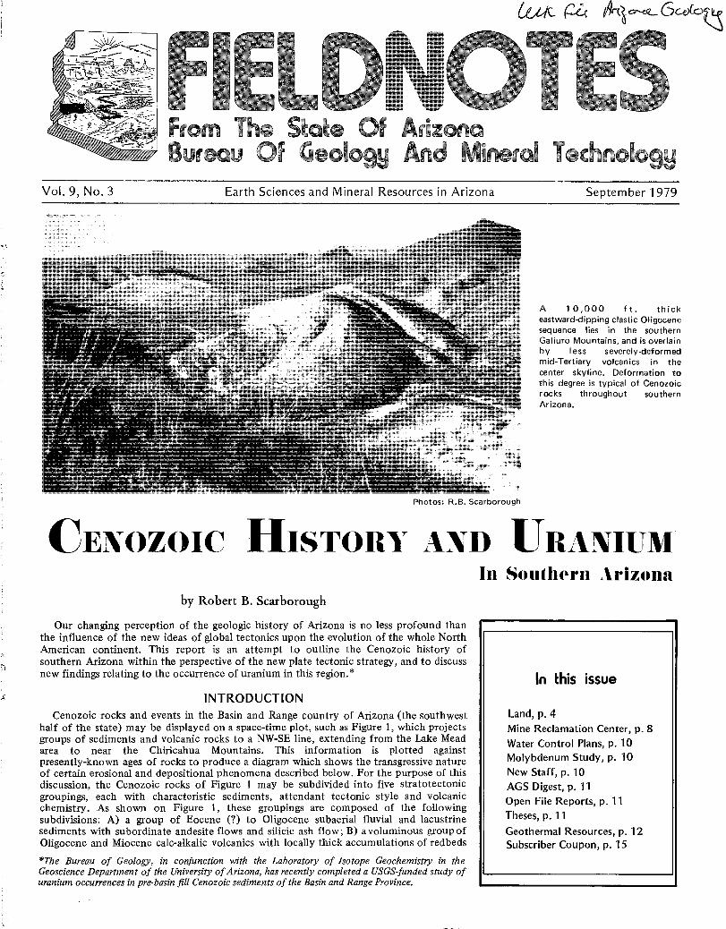
Photos : R .B. Scarborough
A 10,000 ft . thickeastward-dipping clastic Oligocenesequence lies in the southernGaliuro Mountains, and is overlainby less severely-deformedmid-Tertiary volcanics in thecenter skyline . Deformation tothis degree is typical of Cenozoicrocks throughout southernArizona .
CENOZOIC HISTORY A _XD URANIUM
by Robert B . Scarborough
Our changing perception of the geologic history of Arizona is no less profound thanthe influence of the new ideas of global tectonics upon the evolution of the whole NorthAmerican continent . This report is an attempt to outline the Cenozoic history ofsouthern Arizona within the perspective of the new plate tectonic strategy, and to discussnew findings relating to the occurrence of uranium in this region .*
INTRODUCTIONCenozoic rocks and events in the Basin and Range country of Arizona (the southwest
half of the state) may be displayed on a space-time plot, such as Figure 1, which projectsgroups of sediments and volcanic rocks to a NW-SE line, extending from the Lake Meadarea to near the Chiricahua Mountains. This information is plotted againstpresently-known ages of rocks to produce a diagram which shows the transgressive natureof certain erosional and depositional phenomena described below . For the purpose of thisdiscussion, the Cenozoic rocks of Figure 1 may be subdivided into five stratotectonicgroupings, each with characteristic sediments, attendant tectonic style and volcanicchemistry. As shown on Figure 1, these groupings are composed of the followingsubdivisions: A) a group of Eocene (?) to Oligocene subaerial fluvial and lacustrinesediments with subordinate andesite flows and silicic ash flow ; B) avoluminous group ofOligocene and Miocene calc-alkalic volcanics with locally thick accumulations of redbeds
*The Bureau of Geology, in conjunction with the Laboratory of Isotope Geochemistry in theGeoscience Department of the University of Arizona, has recently completed a USGS-funded study ofuranium occurrences in pre-basin fill Cenozoic sediments of the Basin and Range Province.
In Southern Arizona
In this issue
Land, p . 4Mine Reclamation Center, p . 8Water Control Plans, p . 10Molybdenum Study, p . 10New Staff, p . 10AGS Digest, p . 11Open File Reports, p . 11Theses, p . 11Geothermal Resources, p . 12Subscriber Coupon, p . 15

Page 2 Bureau of Geology and Mineral Technology September 1979
Lake head Yuma-, I-Phaenis
MDV
Pleistocene-depsits E
BASIN ~D~F ILL
`~ 5R~_ B
d~
SE
V--€
- - G,CR O
WC
_~ /RA
base ofCenozoic depositionin Arizona Basinand Range country
Figure 1, Cenozoic. NW-SEcross section through ArizonaBasin and Range country withsalient features projected tothe cross section line at rightangles. o-%% denotes transitionfrom high to low Sr isotoperatios in volcanic rocks . Let-
O'-g. ters A-E refer to text . E=Eo-cene; O=Oligocene; M=Mi-ocene; P=Pliocene ; RA=Rillitoandesite, Tucson Mts. ;WC=Whitetail Conglomerate,east central Arizona; G,CR=Galiuro, Chiricahua rhyolites ;PMV=Patsy Mine volcanics ;M'DV=Mt. Davis volcanics ;HB=Hickey basalts; TB=Table-lands basalt, Galiuro Mts . ;SR=Superstition rhyolites ;SBB=San Bernardino basalts ;SB=Sentinel basalts, GilaBend; FB=Fortification basalt,Lake Mead; SPB=Sandy Pointbasalt, Lake Mead .
of diverse petrology ; C) a diverse assemblage of middle to late Miocene fanglornerates,tuffaceous sediments, and basalts, best exposed in the central part of the state ; D) , fluvialand lacustrine sediments with minor basalts which have infilled the basins created by themiddle to late Miocene Basin and Range disturbance ; and E) Pleistocene sedimentaryveneers which cap the basin fill . The most easily tracked dividing line in this scheme isthat which separates the mostly undeformed units D and E from the progressively moredeformed older units . Eberly and Stanley (1978) in an excellent contribution to theCenozoic geology of southwestern Arizona, use this boundary to separate their Group Iand II sediments.
As noted in Figure 1, the boundaries of units A and B become younger to the NW andintersect the base of unit D, thus "pinching out" unit C volcanies and sediments . Therationale for this is based upon the premises that the inception of basaltic volcanism, as
defined below, also becomes younger tothe NW, while the initiation of Basin andRange tectonics and hence basin filling, isa synchronous event statewide .
VOLCANIC STYLESAn apparently fundamental change in
volcanic chemistry forms the timetransgressive boundary between groups Band C of Figure 1, (groups 1 and 2 ofFigure 2) at about 15-13 m .y . ago (Miller,and others, 1977 ; Eberly and Stanley,1978; Keith, 1978) . Before this time,volcanoes spewed forth suites ofcalc-alkalic rocks such as andesites(including the so-called "Turkey Track"andesites) and voluminous silicic ash flowsheets (ignimbrite flare-up of Coney,1976) and related pyroclastics . Theseolder rocks are now assumed by theirhigh Sr isotope composition to representpartial melting from a certain depth rangealong a piece of ocean lithosphere whichwas being subducted beneath thewestward-advancing North Americanplate .
This volcanic style ceased inapproximate coincidence with theinception of the San Andreas transformmargin of the western U .S., whichtriggered an event called the Basin andRange disturbance. The tensional shearstresses of this action literally rippedportions of seven western states apart,and caused such deep fracturing of thecontinental crust so as to allow theupward leakage of upper mantle-derived,low strontium isotope ratio basalticmagmas, which are found in groups, C, D,and E of Figure 1, and are plotted as agegroups 2, 3, and 4 of Figure 2 . Majoreruptive centers of these magmas containonly small amounts of silicicdifferentiates, in strong contrast to theprevious ignimbrite eruptions, and so hintat the name of a "basalt= rhyoliteassociation" for this volcanic style . Thisvolcanism continues to recent timesthroughout the state in a space-timepattern seen in Figure 2.
CENOZOIC HISTORY OF BASINAND RANGE COUNTRY
In Arizona, the Cenozoic Era washeralded in by the Laramide orogeny,which, by its termination at about 50m.y. ago, had left behind such features asnumerous copper-bearing porphyries andpre-existing rocks affected by powerfulENE-WSW compressive tectonics (Coney,1976) .
Eocene - Early Oligocene HistoryDuring Eocene and early Oligocene
time (50-32 m.y.), a very large, perhaps•subcontinental-sized area of the westernU.S. was eroded to what some consider apeneplain in the classic sense (Epis andChapin, 1975) . Very little is known of

Vol . 9, No. 3 Fieldnotes Page 3
this event except that regional evidenceof massive amounts of erosion andsedimentation is suggestive of a largescale, perhaps epeirogenic uplift, onewhose effects perhaps may be seen as,among other things, a still upliftedColorado Plateau . On Arizona's portionof this plateau is found an extantnortheastward-dipping surface of lowrelief that angularly truncates sedimentsas young as Cretaceous, and upon whichrests the pre-28 m.y. old (Peirce andothers, in press) "rim gravels" of McKee(1951). Hence this is identified as anearly Tertiary surface of transport uponwhich the southwestwardly-derived "rimgravels" were shed, perhaps as farnortheastward as the four corners region .In the central Arizona source area forthese sediments, Mesozoic and earlyCenozoic erosion (Peirce and others,1977) has stripped away the entirePhanerozoic cover to expose thePrecambrian in a 50-100 mile-wide,NW-SE elongate swath parallel to theMogollon Rim (Colorado Plateau edge) .This stripped area is referred to loosely asthe Mogollon highland .
This erosion-sedmentation cycle wasfollowed by an erosional and/or faultingepisode which differentially loweredSouthern Arizona beginning in Oligocenetime, the real nature of which is thesubject of continuing debate . Whateverthe event, a Mogollon Rim barrier ofsufficient magnitude was created to act asa northeastward limit of deposition forthe subsequent large mass of Oligoceneand younger deposits .
In southern Arizona, a variety oftectonically disturbed prevolcanicsediments (category A of Figure 1) datefrom early Oligocene time (37-29 m .y .),such as the Whitetail Conglomerate in theGlobe-Winkelman area, some GaliuroMountain redbeds (see photo on page 1),the Sil Murk Formation near Gila Bend(Figure 3), and some redbeds in theYuma area. Since these are pre-volcanic inage, they are distinguished by the absenceof volcanic clasts in their clastic units .Sediments of this age are not recognizednorthwest of the Bill Williams Riverwhere early Miocene materials weredeposited directly upon Precambrianrocks. Lithologies of these sediments arediverse, and include fanglomerates,extensive fluvial overbank (flood plain)deposits, some lacustrine units, and rareaeolian sandstones . Hints of vertical reliefcomparable to southern Arizona todaycome from the inclusion of locallyabundant, spectacular "megabreccia"gravity slide masses into fluvial andlacustrine units. Color of units range fromlight gray to intense red-browns . Includedvolcanics are minor, and consist ofandesite flows and silicic ash flow tuffs .
Figure 3, Cenozoic . Contact offanglomerates over aeoliansandstone beds of the Sil MurkFormation, north of Gila Bend .These Oligocene redbeds weredeposited on Precambriangranites of the Maricopabatholith .
Ignimbrite Flare-UpDuring later Oligocene and earlier Miocene times (30-13 m .y.) massive amounts of
calc-alkalic volcanic rocks were erupted into southern Arizona in the form of andesitesand voluminous ignimbrite sheets (group B of Figure 1, group 1 of Figure 2). Thisvolcanic episode, first termed the "mid-Tertiary orogeny" by Damon (1964) was felt overa large part of the western U .S., and is viewed in plate tectonic terms by some geologists asthe surface expression of the now rapidly foundering Benioff Zone which had previouslyslid under the continental lithosphere during a greatly accelerated, Laramide-aged surgeof continent-ocean collision . Note a distinct younging trend for the inception ofvolcanism going from SE to NW, as seen in Figure 1 .
Figure 4, Cenozoic. In theCave Creek area, a series ofmildly-deformed Miocenebasalts, tuffs and mudstonesare capped by 15 m .y . old"Hickey" basalts .
Figure 2 outlines the seven largest fields of this age in Arizona . Large calderas havebeen hypothesized to exist in the Chiricahua field and the Superstitution field . As a rule,one or more volcanic cycles in each field consist of earlier andesitic flows and laterexplosive and voluminous ignimbrite sheets . Patterns of sedimentation accompanying thisvolcanism suggest local volcanic damming of river systems in and around the majorvolcanic fields and, perhaps, an important cycle of thick, red clastic deposits formingadjacent to the future sites of the central and southeast Arizona metamorphic corecomplexes (Figure 2) . General patterns of stream transport directions for group A and Bsediments suggest flow from the Plateau margin out into the present day Basin and Range
continued on page 14
Figure- 5, Cenozoic. Big SandyValley, northeast of Wikieup,Deformed Miocene mudstonesand limestones in canyonbottom are unconformablyoverlain by conglomeraticbasin fill, here 150 ft . thickand graded to the main trunkstream of the valley in thedistance .
Page 4 Bureau of Geology and Mineral Technology September 1979
by H . Wesley PeircePreface
The following article, assembled by H . Wesley Peirce, is anoutgrowth of informal discussions between members of theBureau staff and colleagues . We would like to share with ourreaders some of our thoughts on a particularly complex topic . Itis not our intention to espouse a hierarchy of subjective values ;we simply hope to present some views gained from ourexperiences with the earth in general and Arizona's land inparticular. If we succeed in conjuring up some provocative imageson land not previously considered by the reader, then quitepossibly we will have contributed a glimmer of insight, a way ofthinking that might be of use when contemplating land-relatedissues .
IntroductionLand is a four letter word so loaded with diverse , subtle
meaning that when we are asked to select from its many valuesand potential uses, it is apt to become an explosive issue . As aterritory , land is often delineated into political units . As astorehouse, it provides sustenance to all living things . As alandscape , it assumes aesthetic connotations . Controversy ariseswhen values are in conflict. The resolution of such conflicts canindeed be a divisive political process. As we will attempt to pointout, all such problems, however resolved, are necessarily tingedwith arbitrariness . Because of this, politics often has more effecton decisions than does objective science .
Recognizing our own limitations and the need to whittle downthis subject to manageable proportions, we propose to emphasizeland as a storehouse of raw materials (including energy ) . Becauseour earth-related professions specifically focus on how Arizona isput together, what it has in it, and how to get it out , we will usethe state to illustrate a point or two that might be of interest .
A Perspective
Arizona is the sixth largest state in the country . Its land area isa common statistic (113,900 sq. mi.) but its volume is not .Technically, can you visualize Arizona's true shape? First, itwould help to figure out where its bottom is . Is Arizona's greatest"land" dimension the radius of the earth? Arizona, considered asa shape having volume, or a three-dimensional piece of land,consists largely of the mysterious region beneath us . One mightask, "What is down there?", while another person might beindifferent to the question . Why is it important to know thesethings? When we begin to view the state's land mass in athree-dimensional manner, we realize that our present reservoir ofknowledge about Arizona is rather limited . As a result, society, tothe extent that it perceives two-dimensional surface values, oftenconducts its land affairs in the dim light of a persistent knowledgevoid . Consequently, many decisions are unavoidablyaccompanied, as already suggested, by some arbitrariness .Recognition and sensitivity to this fact should be a strength andnot a weakness .
An Ecological Imperative
Ecology, an often misused and misunderstood word, is thescience of interrelationships . As such, its totality is not known or
understood by anyone . These interrelationships form a complextotal network which is difficult to conceptualize into patterns .Frustrations arise when we attempt to comprehend the totalecological spectrum Here too, we operate in a knowledge andawareness void. However, it is possible to generalize and, fromthis, gain insights that are absolutely necessary if we are to haveany chance of consciously recognizing the essential factors thatsupport the existence of modern human societies .
Communities are like trees - they have roots that provide thedaily means for survival and growth . These roots, so to speak,always lead back into the land in some respect . It seems clear thatthe further the root is stretched and the more complex the entireroot network, the more vulnerable is the organism . In order toemphasize the point being made, perhaps a question or two willprovide orientation . Can you trace Arizona's energy roots?Phoenix and Tucson's? Yours? Even if you don't know exactlywhere these roots go, you are one step closer to understandingthis concept if you realize that most of these roots terminatesomewhere in the land . Some of our energy roots end severalthousands of feet beneath the land surface and not necessarilyalways on this continent.
Once again, one of the ecological imperatives that we thinkwarrants emphasis is the profound dependence that modernindustrial societies have on raw materials that are ultimatelyderived from the land, especially that part of land that is out ofsight beneath the surface . Ecological question : Why is it notpossible to be an employed lawyer, doctor, teacher, mechanic,truck driver, geologist, mining engineer, metallurgist, etc . withoutabundant and varied utilization of land-derived raw materials?
The Root Concept
Hopefully, we can encourage some of our readers to learn toapply the root analogy at appropriate times . As an example,Charles Park, former Dean of Mineral Sciences at StanfordUniversity, says the following in the preface to his book,Affluence In Jeopardy: "The purpose of the book is to bring tothe attention of intelligent citizens the place of minerals andenergy in a modern industrial economy, pointing -out thelimitations on the supplies and sources of these materials as well asthe absolute necessity to use domestic resources effectvely and todevelop and keep open lines of international trade . Access tosupplies of mineral raw materials, many of which are obtained inisolated and undeveloped corners of the world, is essential to thesurvival of modern civilizations as we 'know it ." Dr. Park isimplying that the roots that maintain the status quo of outsociety, reach into lands both foreign and domestic .
Another example is excerpted from a speech given by J . HughLiedtke, Chairman of the Board, Pennzoil Company, at the 1979annual meeting of shareholders : " . . . Daily we become moredependent upon crude oil supplies from the Middle East andother politically unstable areas . Disruptions of supply from thesepolitically volatile areas, whether through revolution, terroristattack or intervention by countries whose interests are in directconflict with ours, at any moment can cause not simply atightening of supply, less heat and air conditioning, less gasolinefor driving, but a major lack of fuel for our factories, throwingthousands out of work. This is not just the stuff from which
Vol . 9, No. 3 Fieldnotes Page 5
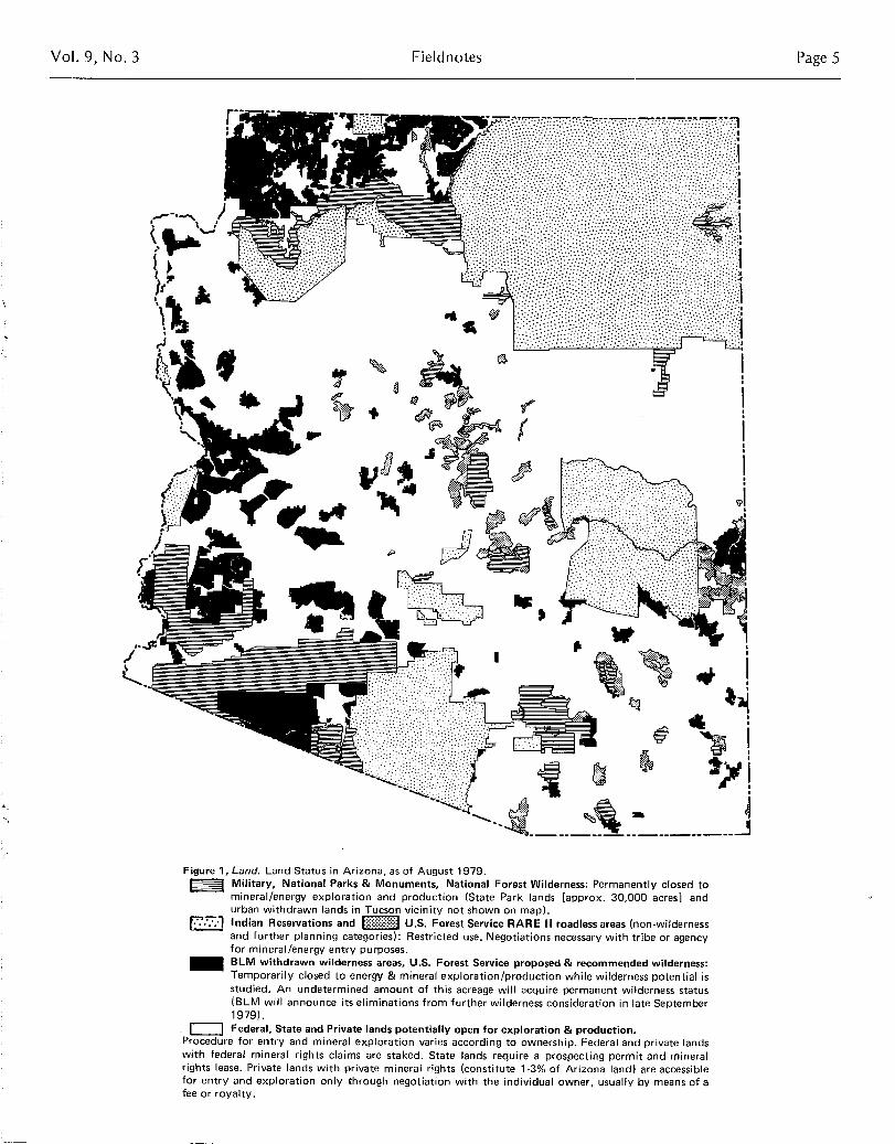
Figure 1, Land. Land Status in Arizona, as of August 1979 .€ Military, National Parks & Monuments, National Forest Wilderness : Permanently closed to
mineral/energy exploration and production (State Park lands [approx . 30,000 acres] andurban withdrawn lands in Tucson vicinity not shown on map) .
~~ Indian Reservations and U .S. Forest Service RARE II roadless areas (non-wildernessand further planning categories) : Restricted use . Negotiations necessary with tribe or agencyfor mineral/energy entry purposes .BLM withdrawn wilderness areas, U.S . Forest Service proposed & recommended wilderness:Temporarily closed to energy & mineral exploration/production while wilderness potential isstudied. An undetermined amount of this acreage will acquire permanent wilderness status(BLM will announce its eliminations from further wilderness consideration in late September1979) .Federal , State and Private lands potentially open for exploration & production .
Procedure for entry and mineral exploration varies according to ownership . Federal and private landswith federal mineral rights claims are staked . State lands require a prospecting permit and mineralrights lease . Private lands with private mineral rights (constitute 1-3% of Arizona land) are accessiblefor entry and exploration only through negotiation with the individual owner, usually by means of afee or royalty .

Page 6 Bureau of Geology and Mineral Technology
economic depressions are made ; it is the stuff of war. I am notattempting to be dramatic or to alarm you . The Secretary ofEnergy is telling this daily to the Congress . So are our militaryleaders. So are others in our industry . . ."Again the analogy ofroots ending beneath foreign lands seems dramaticallyappropriate. if these roots are severely tampered with, then what?Currently, this is the question before several nations, includingthose of Western Europe, Japan and our own : Are you directlyaffected in any way? If you realize that you are, then you canvisualize a strand of the root ending in your own gas tank, theother end perhaps being several thousands of feet below the landsurface of Saudi Arabia, Nigeria, or somewhere in the U .S .
Land, the Storehouse
The domestic land resource strength of the nation is but thesum of the individual strength of the 50 states. Ft is mostimportant to recognize that no two states are alike in theirindigenous land resource base . As a consequence, it takes acooperative effort to make both the parts (states) and the whole(nation) viable . No state is an island capable of independencewithout drastic changes . Today, even our nation could have rapidindependence only if willing to accept associated chaos . This is sobecause of the complexity and extent of the existing internationalroot network. To be independent would mean a totalrestructuring of root patterns such that they be replanted in ourown land. The President's energy plan is an excellent example ofadvocating the shifting of roots . Where will these roots end? Mostprobably, they will end in those states having the appropriate rawmaterials in their three-dimensional land base .
Certain vital raw materials are often concentrated in relativelysmall land volumes . Regarding raw materials, it is the location ofreserves that counts because tomorrow's production must comefrom today's reserves . How far should a nation, or state for thatmatter, look and plan ahead? How far should a raw materialsindustry look ahead? How far should our land planners belooking into the future? If there is concern for the longer rangepicture that surrounds the development of raw material reserves,then some analysis must ensue .
Regarding unusual concentrations of resources, these examplescome to mind : Saudi Arabia and oil, and Arizona and copper .This concentration in Arizona, not fully recognized when the statewas first defined, is so unusual that it has been called a planetaryresource {Fieldnotes, v .2, n .4, p.1}. Copper is Arizona's primemineral resource and unique contribution to the world . Arizona'scopper deposits supplied 62% of the nation's domestic copperproduction in 1978 . Although Arizona consists of 14 counties,the known large copper deposits are restricted to nine counties .Those without known large deposits are the Plateau counties ofNavajo, Apache, and Coconino, as well as the Basin and Rangecounties of Yuma and Maricopa . Less publicized than copper ismolybdenum, a most important coproduct in many copperdeposits of Arizona. Arizona is second only to Colorado inmolybdenum production .
Why is there so much oil in Saudi Arabia and so much copperand molybdenum in Arizona? Some would say that it is moreimportant to know where the deposits are than to know whythey are there . Such logic is fine in the short run, but when theeasily found deposits are gone, what then?
Raw material deposits, in order to be useful at a given time andplace, have unusual physical-chemical attributes and/or a strategiclocation relative to economic factors, such as transportationarteries, water supplies, energy sources, consuming centers, and soon. All earth materials, whether unusual or not, initially have an
September 1979
environment of origin . Deposits, by analogy with the biosphere,occur in geologic habitats peculiar to the material involved .
What is in the land and where it is located has assumed animportance to political and industrial leaders that has increasedwith the growing complexities of industrial societies . Today, itwould take many books to describe how land derived materialsare utilized. It would take many more to describe wheresubstances occur and why they are where they are . Dr . Park statesthe following : " . . .People in the United States are accustomed tothe belief that theirs is a rich and independent country ; yet, ofthe 100 minerals most important to its industries, the UnitedStates possesses within its national boundaries adequate suppliesof only about a dozen . It [the United States] is today [1'968] ahave-not nation where raw materials are concerned ."
Arizona Land
Fundamental to utilizing land are the attendant laws andregulations . Figure 1 is an attempt to depict the various lands inArizona where entry for raw material purposes currently is eitherforbidden or severely restricted . It is estimated that aboutone-half of Arizona's acreage remains relatively open tolegitimate exploration and possible development . The significanceof this in terms of the potential effect on future raw materialsdevelopment cannot be directly evaluated unless some correlationis made between the habitat of various raw materials and thethree-dimensional geologic environments that characterize thewithdrawn or restricted lands . One thing is certain ; the narrowerthe search territory , or jurisdiction , the more it will be inevitablethat opportunities be restrained .
Geologists trained in Arizona geology can appreciate andunderstand the significance of the state's great diversity ofgeologic environments . Environments are interpreted from rockrelationships and, these in turn are the subjects of geologic mapsand diagrams. What controls the locations of the large Arizonacopper deposits ? Why, out of 50 states, should nine counties inArizona have such an unusual amount of copper ? Are theredeposits yet to be discovered in Arizona? Where might they be?
How about energy materials in the lands we call Arizona? Whatcan be said about their positions and potential? There areinteresting distinctions to be made in the ways of looking at eachof the big three : coal, petroleum and uranium . Each involves adifferent habitat and serves to illustrate the absolute controls ofenvironment on what might form and where .
Figure 2 is intended to show the following : 1) the position ofArizona's significant coal reserves in the Plateau region ofnorthern Arizona on the Navajo Indian Reservation, 2) theposition of known oil production in Arizona, again on the NavajoReservation , and 3 ) the position of holes drilled in search ofpetroleum in Arizona . Coal reserves , in order to be exploited bystripping technology , must be relatively close to the surface,within 200 feet or so . In addition, exploitable deposits tend to behorizontally spread out because of the controlling or layeredenvironment in which they formed . In Arizona, exploitable coaldeposits are restricted to one particular age group , the one thatcontains much of the coal known to the Rocky Mountain statesin general . Past geologic mapping in Arizona reveals thedistribution of these particular rocks, which places limits onwhere associated coal might potentially occur . Knowing thesegeologic (land ) limits leads to the conclusion that Arizona'ssignificant coal reserves are restricted to Black Mesa .
Petroleum, on the other hand, is an entirely different matter . Itis exploited , under proper circumstances , from depths greaterthat 20,000 feet . Because of this, in contrast to most coal, the
Vol . 9, No. 3 Fieldnotes Page 7
r.------, - ----€~s
€ ~€.
en Coal bearing rocks• Past or present producer
€ Oil or Gas exploration hole \Oil or Gas producing wells \- -'--"----'
Figure 2, Land. Coal, Oil and Petroleum Reserves .
geologic condition of the earth at considerable depths must bestudied if petroleum potential is to be effectively and fairlyevaluated . Thus far, Arizona rock (land) has yielded only about16 million barrels of oil over a span of 16 years - an amountequivalent to about two days of present crude oil imports .Arizona's 'latest and largest oil field thus far, was discovered in1965 in northeast Arizona at a depth of about 3,500 feet . Figure2 might give the impression that the state has been fairly welltested and found wanting in petroleum potential . How, then,should one explain the present petroleum-based land play, thelargest in Arizona's history, extending across the southern part ofthe state where there has been nothing but dry holes drilledbefore? Although a combination of factors is involved, thegeologic basis is a revolutionary idea, an idea that can be eitherconclusively vindicated or rejected only by deep drilling(Fieldnotes, v. 9 n. 1 p . 10). Likely, only geologists withexperience in the geology of southern Arizona and elsewhere canappreciate fully why it is possible in this day to come up withanything new in this region . All of the previously-drilled holesindicated in Figure 2 in southern Arizona are too shallow to havetested the new model, which is based principally in deep seismictesting, not surface studies . Deep vibratory soundings representtechnological refinement. The expense involved in this play,including the anticipated deep drilling, is made possible only bycurrent petroleum prices . The above leads to a conclusion wellknown to business people - the economic climate changes, andwith it, judgements are altered on where to look for newdiscoveries of raw materials. Opportunities wax and wane andwhen conditions are right, new frontiers are sought, frontiersbeneath the land surface, Today's "waste" may be tomorrow'sore, providing there are ample potential habitats within which to
9
4
Y
.T
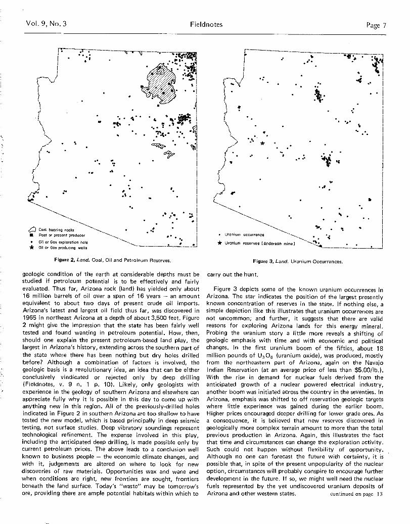
Figure 3, Land. Uranium Occurrences .
carry out the hunt .
Figure 3 depicts some of the known uranium occurrences inArizona. The star indicates the position of the largest presentlyknown concentration of reserves in the state . If nothing else, asimple depiction like this illustrates that uranium occurrences arenot uncommon; and further, it suggests that there are validreasons for exploring Arizona lands for this energy mineral .Probing the uranium story a little more reveals a shifting ofgeologic emphasis with time and with economic and politicalchanges. In the first uranium boom of the fifties, about 18million pounds of U308 (uranium oxide), was produced, mostlyfrom the northeastern part of Arizona, again on the NavajoIndian Reservation (at an average price of less than $5 .00/lb .) .With the rise in demand for nuclear fuels derived from theanticipated growth of a nuclear powered electrical industry,another boom was initiated across the country in the seventies . InArizona, emphasis was shifted to off reservation geologic targetswhere little experience was gained during the earlier boom .Higher prices encouraged deeper drilling for lower grade ores . Asa consequence, it is believed that new reserves discovered ingeologically more complex terrain amount to more than the totalprevious production in Arizona . Again, this illustrates the factthat time and circumstances can change the exploration activity .Such could not happen without flexibility of opportunity .Although no one can forecast the future with certainty, it ispossible that, in spite of the present unpopularity of the nuclearoption, circumstances will probably conspire to encourage furtherdevelopment in the future . If so, we might well need the nuclearfuels represented by the yet undiscovered uranium deposits ofArizona and other western states . continued on page 13
* Uranium reserves ( Anderson mine)
Page 8 Bureau of Geology and Mineral Technology September 1979
Mine Reclamation Centerby Mary Jane Michael
The state of Arizona Mining and Mineral Resources ResearchInstitute (MIM+IRRI) has established the Mine Reclamation Center(MRC) at the University of Arizona. The MRC is located in theArid Lands Information Building where it will provide a focus forUniversity of Arizona research and institutional and servicecompetence in reclaiming arid and semiarid mined lands .
The MRC Advisory Committee to the Director of the MMRRI,Dr. William H. Dresher, consists of Dr . Kennith E. Foster,Director of MRC; Dr. Ervin H. Zube, Director, School ofRenewable Natural Resources and Associate Dean of the Collegeof Agriculture ; Dr. Fred Matter, Assistant Dean of the College ofArchitecture ; Dr. Thomas J . O'Neil, Head of the Department ofMining and Geological Engineering, College of Mines; and Dr .Jack D. Johnson, Director, Office of Arid Lands Studies .
The specific objective of the MRC is to provide a focal pointfor interdisciplinary expertise on the University of Arizonacampus that addresses the problems of mine reclamation in theSouthwest. The depth of research and the technical expertiserepresented by project personnel from various colleges form alarge base of research competence at the University of Arizona .
A number of mine reclamation research programs are presentlyplanned or underway at the University of Arizona . Highlights ofsome of these projects include :
0 Feasibility analysis to determine the potential forreclaiming precious metals from mine dumps prior toinitiation of land reclamation . Contact : Dr. DavidRabb, Bureau of Geology and Mineral Technology .
€ Three-dimensional techniques for mine site modellingas a dynamic representation of pertinent features ofmined areas. Contact: Dr. Fred Matter or Dr.Kenneth Clark, College of Architecture, or Dr .Thomas J. O'Neil, Department of Mining andGeological Engineering .
! Application of water harvesting techniques to coalmine spoils on Black Mesa for farming . Contact : Dr .John Thames. School of Renewable NaturalResources, or Dr. C . Brent Cluff, Water ResourcesResearch Center .
0 Feasibility of using RussianThistle for bioconversion .Contact : Dr . Aden Meinel, Optical Sciences Center,or Mr. NVilliam H . Brooks, Office of Arid LandsStudies .
0 Use of remote sensing data and automated imageanalysis to provide an initial inventory of mines andmine wastes and to provide data to estimatereclamation costs for these areas . Contact: Dr. RobertSchowengerdt, Office of Arid Lands Studies . or Dr .Charles Glass . Department of Mining, and GeologicalEngineering .
The MRC also produces a quarterly literature reporting service,SEAMALERT, and maintains SEAMINFO, a cumulativebibliographic data base of references to mined land reclamationliterature . The SEAMINFOO computer terminals and the editingoffices of SEAMALERT are housed in the Arid LandsInformation Building as is the State of Arizona Bureau of
Geology and Mineral Technology .Computer services available to the MRC also include a data
base of all proposed and ongoing research at the University ofArizona. With the information from this data base the MRC candetermine which research projects and personnel from theUniversity of Arizona are most suited to assist mined landprojects in the southwestern United States .
The MRC, through interdisciplinary cooperation with variousColleges and Departments at the University of Arizona offersexpertise which can :
€ prepare integrated land rehabilitation programs formining operations ;
€ develop monitoring programs in watershedhydrology, meteorology and air quality ;
€ provide impact evaluation of proposed landdisturbances ;
€ conduct research in techniques and methods ofreclamation ;
€- plan alternative development strategies ;
develop land management plans ; and
conduct demonstration projects of innovative landrehabilitation concepts .
Organizations that would like additional information aboutreined land reclamation expertise available at the University ofArizona can contact project personnel directly . Inquiries may alsobe addressed to : Dr. Kennith E. Foster, Mine ReclamationCenter, Arid Lands Information Building, 845 N. Park Avenue,Tucson, Arizona 85719, (602) 626-2086 .
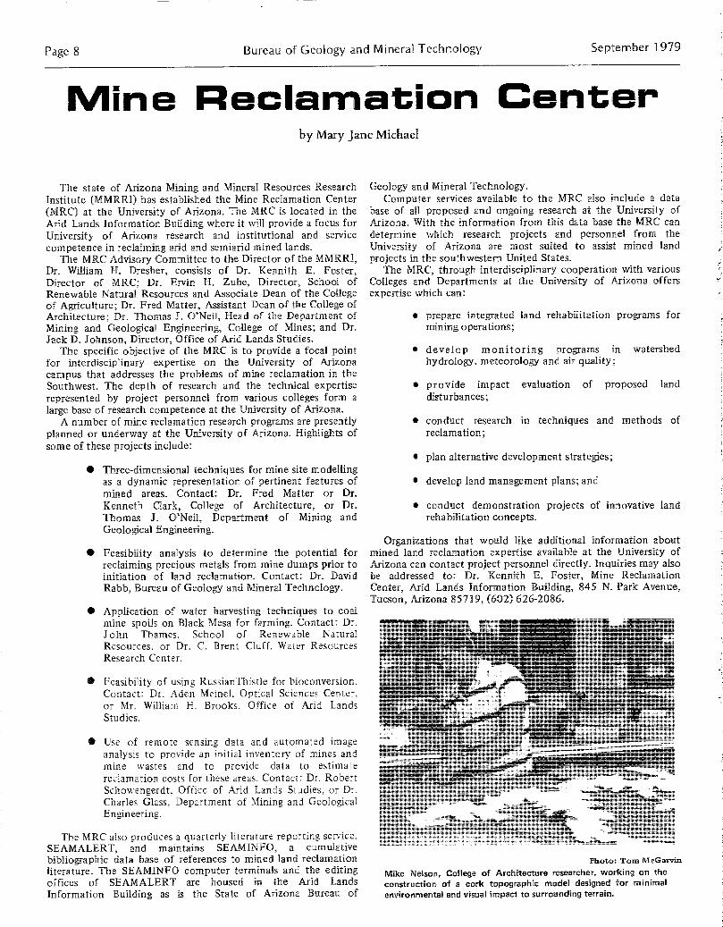
Photo: Tom M eGarvin
Mike Nelson , College of Architecture researcher , working on the
construction of a cork topographic model designed for minimalenvironmental and visual impact to surrounding terrain .

Vol . 9, No. 3 Fieldnotes Page 9
Topographic models of mine dumping patterns and tailing ponds , scaled at 1 :1,000 and constructed of corrugated cardboard by U of ACollege of Architecture researcher . Photos : Mike Stanley

Page 10 Bureau of Geology and Mineral Technology September 1979
7 5
-~, J PLI51F
LOWER PUN D'i{1} '
,GRICLLTUR4L %RE. .
JRCH4R€ ',
{SD N4TER'
14R5'E.STI•.'G ,
0
\\`~\ `ASTER H{R5'ES 1- ARE, \{
\ I
~~ UPPER POND
D11( .1 pal
PIPEII NE
Mine Reclamation Center.U of A, College of Agriculture. Water-harvesting Agro-systemdesigned for mine reclamation at the Black Mesa Mine of thePeabody Coal Company .
WATER CONTROL PLANS ADVANCED
The second in a series of planning sessions of the Technical AdvisoryGroup (TAG) to the Central Arizona Water Control Study was held onJuly 24, 1979 . This study is headed jointly by the Bureau of Reclamationand the Army Corps of Engineers, whose first major goal is to makestrategic decisions regarding both Central Arizona Project (CAP) regulationstorage facilities for the CAP canal and central Arizona flood controlmeasures for the benefit of the Phoenix metropolitan area- These decisionsare to be incorporated into a final environmental impact statement by theSecretary of the Interior in May, 1982 .
Several topics were discussed at the TAG meeting . Two contracts havebeen awarded, one to the Dames and Moore Company for the study ofenvironmental, social and economic impact of the overall project and thesecond to the Natelson Company for a flood control economics study .Several proposed damsites, such as the Tangle Creek on the Verde River,the Coon Bluff and Klondyke Buttes on the Salt River, have beeneliminated from further consideration . Preliminary planning continues on anew Waddell Dam on the Agua Fria, a new Bartlett Dam on the Verde, anenlarged Roosevelt Dam, a new Granite Reef Dam on the Salt and a newButtes Dam on the Gila River . An important study of the overall impact ofthe project, termed "The Future without the Study" has been initiated,which will attempt prediction of events, assuming no action be taken bythis project .
The Bureau of Reclamation and the Army Corps of Engineers, byinitiating involvement in this project at all levels of local management, are"trying to eliminate surprises" when the final ELS is drafted .
Questions, inquiries or subscriptions to the mailing list for informationpamphlets can all be solicited from Marty Rozelle at 271-00915 (Phoenix)or write Manager, Arizona Projects Office, Bureau of Reclamation,Attention: Code-170, 201 N. Central Ave., Suite 2200, Phoenix, Az.85,073 .
Bureau. Initiates Statewide Molybdenum StudyOn April 1, 1979, the Bureau of Geology began a systematic statewide
molybdenum survey. The six-month project is being sponsored by a$15,000 U .S . Geological Survey grant. The purpose of the study directedby Stanley B. Keith is to compile all published and available unpublishedinformation about the occurrence of molybdenum in Arizona for the U .S .Geological Survey Computerized Resources Information Bank (CRIB) .When completed, the study will be incorporated in a Bureau of Geologypublication .
Although Arizona is well known as a major source of world copper, theState's rank in world molybdenum production (third in the world) is notacknowledged. Much new chemical and geological data about Arizonamolybdenum occurrences have accumulated in the last several years . Acomprehensive listing of molybdenum occurrences in the state has not yet
been published . For example, the most recent published statement aboutArizona molybdenum lists 39 molybdenum occurrences (King, 1969,Arizona Bureau of Mines Bull . 180) . To date, Jan Wilt of our GeologicalSurvey Branch has assembled some 300 occurrences in the first five weeksof the Bureau's study . In addition to published information, we wouldgreatly appreciate obtaining any unpublished information, such as thatfrom mining company files or other sources . Anyone who wishes tocontribute such data should contact Jan Wilt at the Geological SurveyBranch .
NEW STAFF
Senior Research MetallurgistThe Bureau of Geology's Mineral Technology Branch has added Douglas
J . Robinson to its staff. Dr . Robinson !swell prepared for the joint positionof Senior Research Metallurgist and Adjunct Associate Professor ofMetallurgical Engineering . He obtained his Bachelor Degree in AppliedSciences (Metallurgy) from the University of British Columbia in 1967and his PhD in Metallurgy from the University of Sheffield, England in1970 .
From 1970 to 1977, Dr . Robinson was employed by Cominco Ltd . inBritish Columbia as a research metallurgist and pilot plant engineer. Duringthe last two years he served as senior process engineer at Air Products andChemicals, Inc., in Greenville, Pennslyvania.
Dr . Robinson's area of responsibility includes coordinatingcommunications and cooperative research between engineers in industry .
Graduate Research Assistant
Marie Slezak has been selected by the Bureau of Geology and MineralTechnology to be Graduate Research Assistant at the Geological SurveyBranch during the 1979 to 1980 fiscal year program .
Marie is currently working on a Master's Degree in EnvironmentalGeology at the U . of A. She plans a career in metropolitan and regionalland use planning .
During her internship with the Bureau, Marie will be developing herthesis proposal on bank erosion in Tucson, to be used as a model inproposed floodplain ordinances in Arizona. Dr. William B . Bull will be theprincipal advisor on this project and Dr. Edgar McCullough and Dr . H .Wesley Peirce will serve as advisors .Editor
Anne Candea has joined the Bureau staff as Editor of technicalpublications .
Prior to her arrival in Arizona last year, Anne coordinated the publicinformation and public relations program at the Cleveland Division of AirPollution Control for five years.
Anne received her B .A. In English and Sociology from Kent StateUniversity (1965) . Currently, she is enrolled in a Master's Program inManagement with the University of Phoenix .
Mine Reclamation Center .U of A, College of Agriculture, Dept. of Renewable NaturalResources. 'Researchers drilling observation wells along a Black Mesastream bed in order to assess the effects of coal mining on the waterquality in shallow aquifers. Photo : U of A College of Agriculture
E
Vol . 9, No . 3
Arizona Geological Society Digest 11 :Porphyry Copper Symposium Proceedings
Fieldnotes
The Arizona Geological Society's most recent Digest, volume XI,contains the proceedings of the Porphyry Copper Symposium held inTucson in March of 1976 . Digest 11 consists of 18 papers which discussthe geology of the following Arizona areas : Safford, Cyprus Johnson,Copper Creek, Cyprus Pima and Sierrita-Esperanza . Other discussed areasinclude Pinos Altos, New Mexico ; Lights Creek, California; MacArthur andCopper Canyon, Nevada ; and La Verde, Michoacan, Mexico . Geophysicalexploration, root zone characteristics, structural reconnaissance,production costs, a Sonoran metallogenic map, Neogene metalogenesis inChiapas, Mexico, and the evolution of porphyry copper exploration in theSouthwest are also covered . Digest 11 also includes nine abstracts of papersgiven at the 1976 porphry copper symposium covering Pilares, Nocozari,Mexico and these locations in Arizona : Kalamazoo, Ray, Vekol Hills,Bagdad, San Xavier, San Xavier North and Twin Buttes .
Digest 11 was edited by Judith P . Jenney and Helen R . Hauck and putinto a new 8'/z by 11 inch format which allows for larger diagrams . Theeditors have produced a very high quality publication which should be onthe "must have" list of all economic and regional geologists .
This publication is available for $7 .00 by mail from the ArizonaGeological Society Publications, P .O. Box 40952, Tucson, Arizona, 85719,and over the counter from the Bureau of Geology and Mineral Technology .
Page 11
OPEN FILE REPORTS
The Bureau announces the publication of a USGS-funded study onuranium favorability in southern Arizona. A Study of Uranium Favor-ability of Cenozoic Sedimentary Rocks, Basin and Range Province, Arizona(Part I) : General Geology and Chronology of Pre-late Miocene CenozoicSedimentary Rocks was compiled by Bureau Geologists , Robert B .Scarborough and Jan Carol Wilt, in conjunction with the Laboratory ofIsotope Geochemistry at the U of A . The 101-page report ( open file report#79-1429) is now available for purchase from the Bureau of Geology for$ 12 .00 (over the counter ) or $14 .00 ( postpaid) .
A synthesis of Arizona's geology and energy resources has been publishedin a recent Interstate Oil Compact Commission Committee Bulletin (Vol .xx, No . 2) . The paper, entitled "Geology of Arizona: Its Energy Resourcesand Potential", was presented in December 1978 by J . Dale Nations,Commissioner of the Arizona Oil and Gas Commission . Dr. Nations is alsoan Associate Professor of Geology at Northern Arizona University inFlagstaff, Arizona.
Also included in the bulletin is an investigation of thermal gradients inshallow wells, by Sal Giardina, Jr., a geologist with the Commission . Thetitle of the study is "Thermal Gradient Anomalies - Southern Arizona ."
Both of these reports are available for review in the Bureau of Geologyand Mineral Technology's Open File .
NAU THESES 1975-1977
Emily C. Bradshaw : MSStructure in the Mazatzal Quartzite,Del Rio, Arizona . 67 p . 1975 .
Thomas M . Daneker: MSSedimentology of the PrecambrianShinumo Sandstone, Grand Canyon,Arizona . 195 p . 1975 .
W. Norman Kent : MSFacies Analysis of the MississippianRedwall Limestone in the Black MesaRegion. 186 p. 1975 .
Thomas D. Light : MSGeology of the Board Creek Area,Yavapai County, Arizona. 62 p . 1975 .
Peter Henry Lufholm : MSThe Geophysical Analysis of the GrayMountain Area, Coconino County,Arizona. 54 p . 1975 .
Randi S. Martinsen : MSGeology of a Part of the East VerdeRiver Canyon, Near Payson, Arizona .117 p . 1975 .
Sandra D . McDonald : MSUse of Geophysical Measurements toAssess Cinder-Aggregate Potential ofVolcanic Cinder Cones . 104 p. 1975 .
Reginald E. Reid : MSGeologic Hazards in a Portion of EastFlagstaff, Coconino County, Arizona .120 p. 1975 .
Kenneth Charles Scott : MSHydrogeologic and GeophysicalAnalysis of Selected Diatremes in theHopi Buttes area, Arizona . 129 p .1975 .
Thomas W. Auld: MSFacies Analysis of the VirginLimestone Member, MoenkopiFormation, Northwest Arizona andSouthwest Utah . 83 p . 1976 .
Gary Clyde Harrison : MSFacies Analysis of the Devonian of theBlack Mesa Basin, Arizona. 57 p .1976 .
William R. Henkle, Jr . : MSGeology and Engineering Geology ofEastern Flagstaff, Coconino County,Arizona. 57 p . 1976 .
David B. Koval : MSStructural Analysis of the Lake MaryField Area with the HydrologicInterpretations, Coconino County,Arizona. 123 p. 1976 .
John Joseph Matthews :Paleozoic Stratigraphy and StructuralGeology of the Wheeler Ridge Area,Northwestern Mohave County,Arizona. 144 p. 1976 .
Ronald Gordon McCain: MSRelationship Between Water Loss fromStream Channels and Gravity andSeismic Measurements : Beaver CreekWatershed 7, Coconino County,Arizona. 101 p. 1976 .
Robert William Pope : MSAn Analysis of the Carbonate Faciesof the Hermosa Formation(Pennsylvanian) of NortheasternArizona. 134 p. 1976 .
Stephen V. Reed: MSStratigraphy and DepositionalEnvironment of the UpperPrecambrian Hakatai Shale, GrandCanyon, Arizona . 163 p. 1976 .
Douglas L. Flynn : MSThe Geology of the Cerro Macho Area,Sonora, Mexico . 62 p . 1977 .
James Carlo Himanga : MSGeology of the Sierra Chiltepins,Sonora, Mexico. 99 p . 1977 .
Charles L. Lane: MSPennsylvanian-Permian Stratigraphy ofWest-Central Arizona . 120 p. 1977 .
James W. Langman: MSThe Shinarump Member of the ChinleFormation in Northern Arizona andSouthern Utah. 106 p. 1977 .
Ralph U. Pugmire: MSThe Geology of Bill WilliamsMountain, Coconino County, Arizona .97 p. 1977 .
0 0 0
ASU THESES
Edward N. Agurkis: MS"Depositional History of thePiankasha Sequence (UpperDevonian), Southern Arizona, andSouthwestern New Mexico." 1977
Randall Groves Updike : Ph.D ."The Geology of the San FranciscoPeaks, Arizona." 1977
Dennis G . Welsch : MS"Environmental Geology of theMcDowell Mountains Area, MaricopaCounty, Arizona : Part II ." 1977
Jeffery V. Holway : MS"Environmental Geology of theParadise Valley Quadrangle, MaricopaCounty, Arizona : Part 1." 1978
Page 12 Bureau of Geology and Mineral Technology
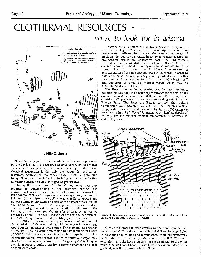
what to look for in ar zonaGEOTHERMAL RESOURCES -
H ,a -pangs .S s> 25'Carcr~.fi ,I.€ y9mm~nnycrtEan~'. Anew[c~2o ,s
Ff2,wm 9,, ~t.~~,~ 05 I'pW 0 , (E~.,pErptl:PP
ao o n^~' ,, f35CC-4 .reO
' 2o,, wntn ttrma gwxhsmr po o0e 2,, 5o,,, 2 .
~, 4
on OnN
by Nile 0 . Jones
Since the early part of the twentieth century, steam producedby the earth's heat has been used to drive generators to produceelectricity . Consequently, there is a tendency to think thatelectrical generation is the only application for geothermalresources. Spurred by the ever-increasing costs of petroleumtoday, there is a concerted effort to bring geothermal and otheralternative energy resources into greater prominence .
The application or use of Arizona's geothermal resourcesrequires an understanding of the geological setting . Theconventional model of a geothermal, field requires a near-surfaceheat source, such as a magma intrusion or igneous point source(Figure 1). Heat from the cooling magma radiates upward andoutward through conductive heating of the adjacent rocks. Faultsand fractures in the bedrock may provide avenues for deepcirculation of groundwaters . Such circulation would result in theheating of the water and the transfer of heat by convectiveprocesses. Should the heated water quickly come to the surface,hot water springs, fumerals and possibly geysers would result .
In addition to these surface phenomena, certain chemicalcharacteristics of the water, along with geophysical observationswould suggest an igneous heat source . For example, the presenceof free hydrogen in escaping steam implies temperatures in excessof 211ft. Certain trace metals might also be interpreted as havingan igneous source, while isotopic ratios of sulfur or oxygen mayalso lead to the same conclusion . Helpful geophysical techniquesinclude microearthquakes, gravity, seismic reflections and heatflow measurements .
Consider for a moment the natural increase of temperaturewith depth. Figure 2 shows this relationship for a suite oftemperature gradients . In practice, the observed or measuredgradients do not form straight, linear relationships because ofgroundwater circulation, convective heat flow and varyingthermal properties of differing lithologies . Nonetheless, theaverage thermal gradient of a region can be represented as astraight line, The shaded area in Figure 2 represents anapproximation of the non-thermal areas in the world. In order toobtain temperatures with power-generating potential within thiszone, one would be required to drill to a depth of at least 6 or 7km, compared to direct-use thermal waters which may beencountered at 2' to 3 km .
The Bureau has conducted studies over the past two years,establishing data that the deeper basins throughout the state haveaverage gradients in excess of 30•C per km . For example, weconsider 37‚C per kin as the average basin-wide gradient for theTucson Basin, This leads the Bureau to infer that boilingtemperatures can routinely be expected at 3 km . We may in turnsuppose that we could produce electricity from 150•C waters (asnow occurs in a Raft River Mountains pilot plant) at depths of2'h to 3 km and regional gradient temperatures of between 45and 55•C per km .
Surface manifestationsTop soil
# Wsil cap
+ +++++++ ++ t + + + + + + + +
+ + t Igneous point source + ' + +'+ + + + + + + + T T
+ + + + + + + + + + ++ + + + + + - t + +
+ + + + + + + + t + +)t++ ++++ ++_1 + +t++++++++-"-I-+f
September 1979
Aquifer area,Convection
- currents
Conductiveheat flow
Figure 1, Geothermal. Igneous point source for geothermal energy in aBasin and Range setting (Armstead, 1978) .
How do we know the temperatures are there and what can wedo with them? We test existing wells and drill exploratory holesto determine the volume and temperature . There are seven wellsin the state that have temperatures of over 10,0 C. With oneexception , all wells have a gradient in excess of the 30•C per lanvalue. One well near Chandler is well over the assumed deep basingradient, as is the occurrence in San Simon .

Vol. 9, No . 3
0
2-
3-
4-
6-
Z:
m 5
~' 0 7
c_ 8-
9-/0
t
12-
13[
/4
15
Field notes Page 13
Assuming no electricity can be produced at these lowertemperatures, the potential application of geothermal power stillremains quite extensive. Figure 3 lists some of the processes thatare already being tried, along with their temperaturerequirements. Additional applications geared to existing Arizonabusiness activities would include : citrus concentration, pumpingof irrigation water, cotton seed oil production, mineral processingand milk pasturization . One application that is currently beingevaluated would be to provide the prison facilities at Safford withgeothermal heating and cooling .
The existence of low to moderate temperature watersthroughout the state allows for a multitude of applications . Indeed,the uses for geothermal energy are limited only by theimagination of those who wish to put it to work .
References
Armstead, H .C .H., 1978, Geothermal Energy, Halsted Press, New York,357 p .
Giardina, S ., and Conley, J .N ., 1978, Thermal Gradient Anomalies inSouthern Arizona : Arizona Oil and Gas Conservation Comm . Report 6 .
Hahman, W .R. and others, 1978, Geothermal Map No . I . Bureau of Geologyand Mineral Technology
Lindal, B€ 1973, Industrial and other applications of geothermal energy,UNESCO, 135 p.
Land continuedFigure 2, Geothermal. Temperature /depth relationships for various Conclusionstemperature gradients ( mean average temperature=20 C) .1=minimum electricity producing temperature for 2% km2=minimum electricity producing temperature for 3 km3=depth required for minimum electricity producing temperature using
37'C/km gradient (Armstead, 1978) .
Ic The versatility of earth heat200 -
90
ISO Evuparation of highly :aocenlrated solutrun.Refrigeration by ammonia absorptionDigestion in paper pulp (Kraft)E
170 Heavy water via Hydrogen sulphide processDrying of diatnmaciom earth
v 160 Drying of fish meal ConventionilDrying of limber power
production150 Alumina via Bayer's pr-
140 Drying farm products at high ,arcsCanning of food
130 Evaporation in sugar refiningExtraction of salts by evaporation and crystalhnuinnFresh water by distillation
120 Most multi-effect evaporation Concentration of saline solution
110 Drying & curing of light aggregate cement slabs
1101 Drying of organic materials, seawecds, grass, vegetables etc .Washing and drying of wool
90 Drying of stock h,hIntense de-icing operations
%0 Space-hurling (buildings & greenhouses)
t 70 Refrigeration (lower temperature limit)
6(1 Animal husbandryGreenhouses by combined space & hotbed heating
511 Mushroom growingBalneology
411 Soil warnnng
l0 Swimming pools, hindcgradutvon . fermentationsWarm water for year-round mining in cold donatesDe-icing
?n Hatching of fish . Fish firming
Figure 3, Geothermal. Approximate temperature requirements ofgeothermal fluids for various applications )Lindal) .
An industrial society consumes vast quantities of a wide varietyof raw materials derived from land . By analogy, such societies aresupplied, like a tree, by a complicated network of roots thatterminate in land, somewhere . Once dependent upon thisnetwork, an organism is easily disrupted when changes occur .Regardless of consumptive rate, even if slowed down by design orshortages, future discoveries of materials will still be needed inorder to provide reserves for purposes of economic planning . Thetendency, as more and more demands are made upon the land forspecific uses, is for exploration to occur and development land todisappear, Increasing land pressures, thus, should inspire anawareness of the need for careful and responsible planning thatrecognizes a hierarchy of land needs, which includes material andenergy substances for the future . Because of the difficulty ofalways knowing what is below us, land decisions necessarily aremade somewhat arbitrarily . Hopefully, a long range perspectiveaccompanied by recognition of the ever present need for rootswill combine to serve the state and nation well .
An adequate land data base should include an inventory thatdepicts surface geologic environments (geologic maps) which, inturn, hold the best key to the potential presence of raw materialsand energy resources habitats. We must continue to strive toacquire a better understanding of the land, all of it, including thatbeneath our feet. Our future depends on it .
References
Keith, Stanley B ., 1979 . The great southwestern Arizona overthrust oil andgas play : Bureau of Geology and Mineral Technology, Fieldnotes, V .9,N.1, p .10 .
Liedtke, J . Hugh, 1979 . Pennzoil company first quarter report, March 31,1979 and report of the annual meeting of shareholders, May 7, 1979,p.18 .
Park, Charles F., Jr ., 1968. Affluence in jeopardy : minerals and thepolitical economy, p .v, 335 .
Titley, Spencer R ., 1972 . Copper mining and Arizona land use planning : ageologist speaks : Bureau of Geology and Mineral Technology, Fieldnotes,v .2, n .4, p .1 .
Temperature •C
50 100 150 200 250 300

Page 14 Bureau of Geology and Mineral Technology
Cenozoic continuedcountry, and also a pattern in southeast Arizona of northwest-directed flow parallel tothe long trend of the present position of the metamorphic core complexes . However, anymass transport linkage of the Oligocene sediments to those of the Claron Formation ofsouthwest Utah (Rowley and others, 1978) must await further studies .
Metamorphic Core ComplexesRecent studies (Davis and Coney, 1979 and GSA memoir volume, in press) have shed
considerable light on the Cenozoic evolution of the "metamorphic core complexes," suchas the southern Santa Catalina Mountains near Tucson or South Mountain near Phoenix .Those core complexes found in Arizona lie in a NW-SE zone parallel to the Mogollonescarpment (Figure 2) and tend to divide the ignimbrite volcanics into the fields shown inFigure 2 . Most of the Arizona complexes apparently share four geologic events : a) severalcontain a core of a middle-Eocene two-mica granite which intruded in an asymmetric,sill-like fashion into the country rock to cause the banding observed in the metamorphiccarapace (gneissic) rocks ; b) a very consistent late Oligocene radiometric "refrigerationage" for many of the core complex rocks, probably related to uplift and cooling of thecomplex; c) particularly well-exposed examples of a "dislocation surface" upon whichunmetamorphosed cover rocks of all ages down to middle Miocene were sometimes tiltedalong listric faults, and were transposed unknown lateral distances, and below whichintense shattering of the metamorphic carapace rocks took place ; and d) the formation oflate stage ENE-WSW arches or elongate domes in most complexes which has played amajor role in giving the exposed complexes their characteristic physiography.
Miocene Volcanism And SedimentsFollowing this main pulse of mid-Tertiary volcanism, true basaltic volcanism and
diversified sedimentation (category C of Figure 1) ensued . The Hickey basalt field ofcentral Arizona north of Phoenix is the most massive volcanic pile of this age in the state .Associated sedimentation ranged from fanglomerates and fluvial deposits in thesoutheastern part of the state to tuffaceous, fluvial and lacustrine deposits throughout thewest-central and northwest parts of the state (Figure 4 and 5) . Indications are that inmany places these depocenters bore little resemblance to the basins of today, which werecreated later by the Basin and Range disturbance - a point of considerable importance inthe section on uranium occurrences .
Figure 6, Cenozoic . Red soildeveloped on Pleistocenegravel-capped basin fill atAllen Flat, southern GaliuroMountains. Many of thesouthern Arizona valleys, suchas here, have not beenbreached by a late Pleistocenestream downcutting event, andthus have retained theiraggrading character .
Miocene TectonicsIn west-central Arizona, recent work has uncovered two prominent yet unexpected
Miocene-aged tectonic events. The dislocational or sliding event(s) noted in conjunctionwith the metamorphic core complexes is now suspected to have produced allochthonousterrains at some distances away from the complexes, with the full regional impact of thisdeformational style yet to be measured. Several earlier workers clearly described localtectonics without grasping the regional implications .
In addition, the regional nature and importance is surfacing of tracts of land whichcontain unidirectionally-tilted Oligocene-Miocene aged sections . Broad NW-SE zonescontaining alternating NE and SW-dipping sections of these sediments were hypothesizedto exist by Rehrig and Heidrick (1976), who suggested that the consistent dip directionsresulted from rotational sliding along listric faults off of NW-SE elongated broad domesof low amplitude which in turn were created by "widespread magmatic or heat ingressinto the crust during Miocene time." The overall picture may be more complex than thismodel because limited field observations suggest that an undescribed Oligocene tiltingevent of a more unknown character was overprinted by a Miocene tilting event . The fate
September 1979
Oligocene event produced tilted andfolded tracts of Oligocene sediments andvolcanics which need further examinationfor correct classification . The Mioceneevent is bracketed between 17 and 12m.y. (Damon and others, 1973). I€accountable by the listric faultmechanism, this event may be geneticallytied very closely to the subsequenthigh-angle Basin and Range block faultingevent (discussed below), since both maybe envisioned as rifting events sponsoredby general ENE-WSW pull apart tectonics .
Basin And Range DisturbanceThe Basin and Range disturbance is
used here in the restricted sense, asdefined by Gilbert in 1875, to apply tothat high-angle faulting episode whichblocked out the essence of thepresent-day Basin and Rangephysiography. It has been suggested(Scarborough and Peirce, 1978 ) that thecareless application of the term "Basinand Range faulting" accounts for theextension of this episode far back intothe Cenozoic, resulting in a forfeiture ofinformation which is valuable tounderstanding Cenozoic tectonics . Atpresent, it appears that the Basin andRange faults are younger that 13 m .y .(Eberly and Stanley, 1978) and may beabout 10 m .y . old in certain locations. Inplaces, however, Basin and Range faultsappear to have close links in space tolistric faults, and it remains to be seenjust how separable these two types offaulting are in time and space . Indeed, thedislocational event, the listric faulting,and the terminal basin-producing eventcaused by high angle block faulting maybe three manifestations of the sameregional crustal-thinning tectonicscommonly thought to have existed in theentire Basin and Range Province inMiocene time .
However, the tectonic importance of afew discrete thrust faults indicatingNE-SW compressive pulses in the Mioceneis not clear. These thrust faults are foundin the Rawhide-Buckskin Mountains(Shackelford, 1976) and in theRay-Superior area (S. Keith, pers .comm.).
Basin FillThe sediments that filled the collapsed
basins created by the Basin and Rangedisturbance is termed basin fill. Recentstudies (Peirce, 1976; Scarborough andPeirce, 1978) suggest the presence in thestate of one or more drainage networkswhich filled upland basins withpredominately clastic sediments, whileother lower elevation basins of therespective networks produced gypsumand finally sodium chloride salt pans,following evaporation of mineral-laden

Vol . 9, No. 3 Fieldnotes Page 15
waters . Examples of evaporite-rich basinsV are in the Picacho and Phoenix areas .
Basin fill thickness in some areas is inexcess of one mile . The Tucson Basin
' contains at least 7,000 feet offine-grained clastic basin fill at the site ofa 1973 Humble stratigraphic test hole .Basin fill deposits, unlike older deposits,are mostly undeformed, are graded to thepresent-day trunk streams of theirrespective valleys (Figure 5) andinvariably exhibit fine-grained,predominately floodplain facies in a zoneparallel to the trunk stream, The Basinand Range faults are usually foundparallel to the mountain fronts, butdisplaced some distance away from themout in the valleys . These buried bedrockshoulders or pediments between thefaults and the mountain fronts attest tothe amount of mountain front retreatsince the beginning of Basin fill time dueto weathering and removal of detritus bythe trunk streams and their tributaries .
Pleistocene
valleys or unexhumed valley surfaces capped by mature, red, Pleistocene soils (Figure 6)URANIUM IN BASIN AND RANGE COUNTRY
In the U.S., 97% of all uranium reserves (exploitable at current conditions) are insedimentary rocks, and 39% of all U .S. reserves are in sediments of Cenozoic age . Most ofthe productive sediments are, however, sandstones of Mesozoic through Eocene age, as insome of the New Mexico and Wyoming deposits .
Past production in Arizona has been almost exclusively limited to the ColoradoPlateau, with a total of 18,000,000 lbs . Of U308 shipped from mines located mostly inMesozoic sediments . The lack of past productivity in the Basin and Range country isperhaps most related to the structural complexity of the region when compared to theColorado Plateau portion of the state . However, with the discovery of major reserves atthe Anderson Mine in western Yavapai county, much exploration interest has focused onthe Basin and Range.
Uranium associations in Cenozoic sediments of Arizona Basin and Range country have aunique flavor and consist mainly of fine grained, lacustrine and paludal shales, mudstones,cherty limestones and uncommon dolomite beds . There is also a recognized association ofuranium with varicolored silica replacement bodies which are at times structurally related .
The sediments of unit A (Figure 1) contain only occasional uranium occurrences whichhave thus far not proven to be attractive for development, primarily because of thescattered, low grade nature of the uraniferous materials and the fact that their state oftectonic deformation precludes inexpensive mining operations . An example of this agegroup is the homoclinal, eastward-dipping Mineta formation of the Rincon Mountains,which contains in its basal arkosic conglomerate, uraniferous shale lenses cropping outdiscontinously over a strike distance of several miles . Other prospects in the northernPlomosa Mountains and north and east of Yuma present similar problems.
Basin fill deposits are capped in most Together, the sediments of units B and C (Figure 1) were deposited during the intensiveareas by a thin veneer of Pleistocene mid-Tertiary volcanic episode. A series of early-middle Miocene fine-grained sediments indeposits . A regional stream downcutting a broad region of central and western Arizona deserve particular interest since they haveepisode initiated late in Pleistocene time acted as geochemical concentrators of uranium . For example, at the Anderson mine ofhas exhumed the valleys containing the western Yavapai county, (now approaching production status, and described by Peirce,most active rivers of the region, but large 1977), uranium is associated with silicified black organic rich shales of early to middleareas of the state contain still-aggrading Miocene age . This area of the Date Creek Basin now contains an estimated 30,000,000
THE BUREAU OF GEOLOGY AND MINERAL TECHNOLOGY is currently updating its mailinglist to survey readers who are interested in receiving Fieldnotes, and
to save costs . Please fill out this coupon and mail to the Bureauof Geology . If this coupon is not returned to the Bureau,
Yourwe will assume you no longer wish to obtain Fieldnotesand your name will be eliminated from the mailing
list . Changes in address can be madedirectly the mailing label Attention,on the e reverse side of
this coupon .
PleaseYES! I WOULD LIKE MY SUBSCRIPTION TO FIELDNOTES CONTINUED .
My occupation is
I enjoy Fieldnotes because
with (employer) .
I would like to see other features in Fieldnotes (suggestions) :
signature
THANK YOU FOR YOUR PROMPT RESPONSE

Page 16 Bureau of Geology and Mineral Technology September 1979
pounds of $50 U308 reserves and abouttwice that amount of probable andpossible uranium resources . Many otherwestern Arizona uraniferous localitieswhich are in sediments now suspected ofbeing this age have had some exploratorydrilling. Examples include the ArtilleryPeaks area 20 miles west of the AndersonMine and the Black Butte area of thewesternmost Vulture Mountains . It ischallenging to uncover new informationon the potential of this area since itappears from facies relationships that theposition of any early-to-middle Miocenedepocenters has been obscured byMiocene tectonism ; hence, the position ofthe present valleys offers few cluesregarding exploration targets . Coarsearkosic redbeds of Oligocene-Miocene agein the region are not uraniferous exceptwhere fault or hydrothermal control isobvious .
Some areas of central and west-centralArizona contain Miocene-aged mixedvolcanic flows, distal tuffs and fluvialsediments (Figure 5) which are capped byHickey basalts, as seen along thePhoenix-Flagstaff freeway around BlackCanyon City. In several areas there areisolated outcrops of lacustrine or paludalsediments, some of which bear a numberof dolomitic units which are variablyuraniferous. Similar lithologies and someage dating control of these outcropssuggest they may have once been acontinous depository for uraniferoussediments. Thus the area assumes someimportance for further studies. Otheruranium occurrences around HorseshoeDam on the Verde River are in Miocenewater-laid tuffs and limestones but appearto be structurally related. Uranium alsooccurs in a Miocene and/or Pliocenelimestone section northeast of LakePleasant along the Agua Fria River . Someexploration has been carried out invarious mudstone and limestone facies ofbasin fill. To date, searches of variousvalleys in the state have resulted in thelocation of low grade and subeconomicdisseminated mineralization .
Several possibilities exist for the sourceof uranium now found in Cenozoicsediments of the Arizona Basin andRange country. A variety of alkali-richigneous rocks in the state displayanomalous uranium values or radio-activity, including some Precambriangranites, some Triassic-Jurassic igneousrocks of southern Arizona, and somehigh-potash Miocene ignimbrites of thecentral and western part of the state .Through weathering, each of these hashad ample opportunity to havecontributed uranium to one or more ofthe described sedimentary deposits. Oncethe uranium is leached from the sourcematerial, it remains mobile in the aqueousenvironment until fixed by geochemicalagents associated with the sediment .
The newly-discovered uranium reservesin Miocene sediments at the AndersonMine have brought considerable attentionto the Basin and Range country assignificant source of this importantcommodity . And certainly the search foruranium has broadened our knowledgeand appreciation of the complexCenozoic geologic history of this region .
References
Coney, P.f ., 1976, "Plate Tectonics and theLaramide Orogeny," New Mexico Geol. Soc.Special Pub . No. . 6, p. 5-10 .
Coney, P.J. and Reynolds, S. J ., 1977,"Cordilleran Benioff Zones," Nature, 270, p .403-405 .
Damon, P.E. and others, 1964, "Correlationand Chronology of Ore Deposits andVolcanic Rocks." Annual report to AEC.U .S. Atomic Energy Commission .
-, 1973, "Geochronology of block faulting andBasin subsidence in Arizona." GSA abstractvolume 5 (7), p. 590.
Davis, G.H. and Coney, P .1 ., 1979, "Geologicdevelopment of the Cordilleran metarnor-phic core complexes," Geology 7, p.120-124.
Eberly L.D. and Stanley T .B., 1978, "CenozoicStratigraphy and Geologic History of South-western Arizona," GSA Bull . 89, p. 921-940.
Epis, R.C. and Chapin, C .E., 1 .9.75, "G€eornor-phic and Tectonic implications of thepost-Laramide, late Eocene erosion surface
in the southern Rocky Mountains," GSAMemoir 144, p . 45-74.
Keith, S.B., 1978, "Paleosubduction geometricsinferred from Cretaceous and Tertiarymagmatic patterns in southwestern NorthAmerica," Geology, 6, p. 516-521 .
McKee, E.D., 1951, "Sedimentary Basins ofArizona and adjoining areas," GSA Bull . 62,p. 481-506€.
Miller, D .G., Lee, G.K., Damon, P .E., andShafiqullah, M., 1977, "Age of Tertiaryvolcanisms and tilt-block faulting in West-Central Arizona." GSA abstract volume 9,(4), p . 466-467 .
Peirce, H.W., "Tectonic significance of Basinand Range thick evaporite deposits ." Ariz .Geol. Soc. Digest 10, p . 325-340.
-, 1977, "Arizona Uranium - the search heatsup." Arizona Bureau of Mines Fieldnotes, 7(1 ), p . 1-4 .
Peirce, H.W., Damon, P .E. and Shafqullah, M .An Oligocene (?) Colorado Plateau edge inArizona. Tectonophysics (in press, v. 61 ) .
Peirce, H .W., and others, 1977, "Uraniumfavorability of Paleozoic Rocks in Mog€ollonRim region, east central Arizona ." Ariz .Bur. of Geol . and Min. Tech ., Circ . 19, 60 p .
Rehrig, W.A. and Heidrick, T .L., 1976,"Regional Tectonic stress during the Lara-mide and Late Tertiary Intrusive Periods,Basin and Range Province, Arizona." Ariz.Geol. Sac. Digest X, p. 205-228 .
Rowley, P.D. and others, 1978, "Age ofstructural differentiation between the Colo-rado Plateaus and Basin and Range Province,southwest Utah," Geology, 6, p . 51-55 .
Scarborough, R-B, and Peirce, H .W., 1978,"Late Cenozoic Basins of Arizona." NewMax. Geol. Soc. Guidebook No . 29, (Landof Cochise), p . 253-259.
Scarborough, R.B. and Wilt, I.0.,1979, Uraniumfavorability of Cenozoic sedimentary rocks :Bur. Geol . open file report 79 - 1429, 101 p .
Shackelford, T.J ., 197.6, Structural geology ofthe Rawhide Mountains, Mohave County,Arizona: Univ . So . California Ph .D . Thesis,176 p.
FieldnotesVol . 9, No. 3 Sept. 1979State of Arizona . . . Governor Bruce BabbittUniversity of Arizona . Pres. John P. SchaeferBureau of Geology and Mineral Technology
Director . . . . . . . . . . William H . DresherState Geologist . . . . . . . Larry D . FellowsEditor . . . . . . . . . . . . . Anne M. Candea
The Bureau of Geology and Mineral Technology is a Division of the University of Arizona, an Equal, Opportunity/ Affirmative Action Employer .
State of Arizona NON-PROFIT ORG .Bureau of Geology and Mineral Technology U.S. POSTAGE845 N.Park Ave. PAIDTucson, AZ 85719 PERMIT NO. 190
(602) 62-6-2733 TUCSON, ARIZONA
1996WILLIAM I KKURTZASARCOP 0 BO 5747TUCSON AZ 857•13

TNew Mexico Geol . Soc . Guidebook , 29th Field Conf., Land of Cochise, 1978
THE TOMBSTONE MINING .DISTRICT 4v315
HISTORY , GEOLOGY AND ORE DEPOSITSB . J . DEVERE, JR .
ASARCO, IncorporatedTucson , Arizona
INTRODUCTIONThe Tombstone mining district, located in a small group of
hills 6 mi north of the San Pedro River and 65 mi southeast ofTucson, Arizona, was one of the rich "bonanza" silver districtsof the late 1800's. Mining commenced in 1878, escalatedrapidly until 1882, and then slowly declined until the lastmine closed in the late 1930's . The total production from1878-1957 amounted to approximately one million tons ofore worth about $39,000,000 ; of that total value, half wasderived from the production during the seven-year period1879-1886 (Wilson, 1962) .
The district has been described in the literature by Blake(1882), Church (1903), Ransome (1920), Butler and others(1938), Gilluly (1956) and Newell (1974) . Of these works,that by Butler and others was the most extensive and detailed .The accompanying geologic map and section (figs . 4, 5) arefrom their publication and have been reproduced withoutmodification .
HISTORYEd Schieffelin discovered silver chlorides and lead carbon-
ates in a quartz vein in the southwestern part of what becamethe Tombstone mining district in the late summer of 1877 . Onthe third of September, 1877, he recorded his "TumbstoneMine" and "Graveyard" claims in Tucson, County of Pima,Arizona Territory (Devere, 1960) . After recording his claims,it took Schieffelin almost a year before he could raise suffi-cient money and convince his brother AI, and Richard Gird, amining engineer, to join him in developing his discovery. Thevein proved to be small and poorly mineralized, so while thedisgruntled Al Schieffelin and Richard Gird attempted tomine, the ever-optimistic Ed Schieffelin prospected further tothe north and east, and in two successive days, discovered thelarge, rich lodes of the Lucky Cuss and Toughnut silver de-posits (Butler and others, 1938) .
With the discovery of the Lucky Cuss and Toughnut lodes,the Tombstone silver boom was born . In rapid succession, thelodes of the Goodenough, Grand Central, Contention, Vizna,Empire and Tranquility mines were discovered . A town,named after Schieffelin's original claim, the Tombstone (fig .1), was established and mills were built on the San Pedro Riverat what became the towns of Charleston, Contention and Fair-bank. The "Arizona Weekly Star" of November 2, 1879,reported that Tombstones' petition for incorporation had beengranted by the Pima County Board of Supervisors . The townboasted a population of 1000-1500, while Charleston, a milltown on the San Pedro River claimed 600-800 inhabitants(Devere, 1960) .
The silver-lead ores were high grade, near surface and easilyextractable. The only problem was the lack of local water formilling; therefore mills were built along the San Pedro Riverand ore was transported the 9 mi at a cost of $3 .50 per ton(Blake, 1882) . That problem was solved in 1881 when water
was encountered at a depth of 520 ft in the Sulphuret mine .With water, the future for mining seemed bright, but the waterthat was thought to be the mines' savior, turned into theirexecutioner. In 1886, the pumps at the Grand Central mineburned, leaving only the Contention mine pumps to handle thewater. Those pumps were inadequate, forcing the suspensionof all mining below the water table . From 1886-1901, miningwas at a low ebb, being carried on largely by lessees .
In 1901, the Grand Central Company, the Tombstone Milland Mining Company and the Contention Company werejoined to form the Tombstone Consolidated Mines Company .With the joining of the three companies, the majority of thelarger mines in the district were consolidated and the decisionwas made to once again pump the water and develop thedeeper ores . The company sunk the four compartment Boomshaft, constructed a new 125 ton per day cyanide mill andreconditioned the old levels in the Grand Central, Contention,Empire, Lucky Cuss, Silver Thread, Toughnut and West Sidemines. By 1906, the Boom shaft had reached the 1000-ft leveland water was being pumped at the rate of 3000 gpm (fig . 2) .
The deeper ores were only partially oxidized, so in the sameyear the cyanide mill was converted and expanded . Usingstamps, slime cones, Wilfley tables and cyanide tanks, the milloperated at a capacity of 225 tons per day (Butler and others,1938). Independent mines reopened and mining at Tombstoneregained some of its old vigor. Silver was selling for 67 centsper ounce, lead at 5 .6 cents per pound and gold at the fixedprice of $20.67 per ounce .
In June 1909 water again dealt Tombstone mining a seriousblow. Due to defective fuel for the boilers, the steam pumpson the 1000-ft level (fig. 3) of the Boom shaft seized andstopped. Eight large steam sinking-pumps were installed, butthey were incapable of handling the water and it rose to the900-ft level . As the water rose the overtaxed boilers ruptured
Figure 1. Grand Central mine surface plant in 7884, with thetown of Tombstone in the background (Macia-Devere collec-tion).

316
almost simultaneously, stopping all pumping. In 1910, a 4,000cubic-foot compressor was installed and the sinking pumpswere run by air. With the air pumps and the installation of newboilers, the submerged pumps were finally recovered anddevelopment on the 1,000-ft level was resumed by the end ofthe year (Butler and others, 1938) .
The cost of defeating the water, pumping 3,500 gpm, thedecreasing silver price and the lack of sufficiently large, high-grade orebodies at depth, finally took their toll . On January11, 1911, pumping stopped and the pumps on the 600, 700,800 and 1,000-ft levels of the Boom shaft were allowed toflood (Butler and others, 1938) . With the flooding of thelower levels, mining by the Tombstone Consolidated MinesCompany ceased, though lessees continued to work the dumpsand search for ore above the water table .
In 1914, Phelps Dodge Corporation, one of the principalcreditors of Tombstone Consolidated Mines Company,acquired all the company's holdings and started mining underthe name of Bunker Hill Mines Company. That company madeno attempt to recover the lost pumps or reopen the lowerworkings. Rather, they concentrated on mining the shallower,lower grade manganese-silver ores in the southern and westernpart of the district . They mined until 1918, when they turnedtheir operations over to lessees .
In 1933, the properties of Bunker Hill Mines Company weretaken over by the Tombstone Development Company, whichattempted to operate the mines via lessees ; their operationscontinued sporadically into the late 1930's.
The Tombstone Extension, a lead-carbonate vein minelocated in the eastern part of the district, opened in 1930 .During 1932-33, the mine was the largest lead producer inArizona (Asarco files). That mine was turned over to lessees inthe mid-1930's and closed in the late 1930's .
Since the Second World War, the Anaconda Company andNewmont Mining Corporation have both examined the districtin some detail; however, neither company was successful indiscovering sufficient ore to justify reopening the mines .
Two mining operations are being conducted in the districtat present. The Escapule Brothers, Charles and Louis, areleaching the dumps from the State of Maine mine and plan tocommence mining and leaching of low-grade underground oresin the near future. The other operation is that of Sierra Min-
DEVERE, J R .
erals, which has during the last few years, been reworking theold mine dumps and recovering silver and gold via a cyanideleach process. The large dump east of Tombstone is the site oftheir current operation .
REGIONAL GEOLOGIC SETTINGThe Tombstone mining district lies along the axis and just
truest of the deepest part of the Sonoran geosyncline . It alsolies within a belt of north-northwest trending mountain rangesthat are separated by broad alluvial-filled valleys and extendfrom the Colorado Plateau in central Arizona, to Sonora, Mex-ico. The region is underlain by a relatively thick blanket ofPaleozoic and Mesozoic sediments .
GEOLOGYRocks of the Tombstone mining district consist of schist,
granite, limestone, dolomite, shale, sandstone and conglomer-ate of Precambrian through Mesozoic age, and younger grano-diorite, tuff, rhyolite sills, plugs and dikes, andesite dikes,valley fill and a basalt plug .
Precambrian rocks, Pinal Schist and granite, are exposed in anorth-south elongate window in younger sediments and vol-canic rocks in the south-central part of the district (fig . 4) .
Overlying Precambrian rocks are 440 ft of Cambrian BolsaQuartzite (Ransome, 1916) and 844 ft of Cambrian AbrigoLimestone (Gilluly, 1956) . Devonian Martin Limestone, 230 ftof alternating limestone and shale, unconformably overlies theAbrigo Limestone (Gilluly, 1956) . The Mississippian is repre-sented by 786 ft of Escabrosa Limestone and dolomite(Gilluly, 1956) .
The Pennsylvanian-Permian Naco Group, first described byRansome during his early work in the Bisbee district, 20 rni tothe southeast (Ransome, 1904), is well exposed in the Tomb-stone Hills. Due to the excellent exposures, Gilluly and hisco-workers (GGilluly, 1956) were able to subdivide the Natointo 999 ft of Horquilla Limestone, 584 ft of limestone, sand-stone and shale in the Earp Formation, 633 ft of Colina Lime-stone and 783 ft of limestone and dolomite in the EpitaphDolomite .
Unconformably above the Naco Group is the CretaceousBisbee Formation (Gilluly, 1956) . The Bisbee Formation atTombstone is not to be confused with the Bisbee Group
Figure 3. Steam pumps on the 1,000-ft level of the Boomshaft near Tombstone about 1906 (Il'1acia-Devere collection) .
Figure 2. Surface boilers for the steam pumps in the Boomshaft near Tombstone about 1904 (illlacia-Devere collection) .

4
TOMBSTONE MINING DISTRICT
EXPLANATION
QUATERNARYAND
LATE TERTIARY~aa~/a..aandLATE CRETACEOOR TERTIARYll Soh effe/!n
gronodoritaCRETACEOUS
~Sha/e, sandstoneQ endq uer/z#/e
i €Limesfone +++ -
++++(si/icified s/ra/e, con- +
m y/omeFa/e and "quecfzifej
UNCONFORMITY y y ~,
CARBONIFEROUSPENNSYLVANIAN + +AND ~PERMIAN ++++
p~ ~1Neco lines/6-MISS!SSIPPIAN + + `+ /
/masfone
DEVONIAN~Ma fb norfh
/imesfone +(\
f
+• i
DISCONFORMITY \
CAMBRIA NAb iyo./inesfone oco
Bo/sa SljUal!'Z%/E
UNCONFORMITY
PRE-CAMBRIAN(? ) +'€' Granodior.fe++
‚ Fau/f
5f Pes ++
+. ucK SUR
.Aj
\':\ : ' -' \ \\\~\\ %\ ~~ \ E /\\ k\\ ~,~1/ERTNRE
W. S 1- 0-
f.x ylNGERSp `~ '~k ` \ \ \ f \ : r \ \ \
\ \ \ \ \ \ TR/BUTEƒ\\ ~\ \ \ \\\ ~NTENr 0 `\ \\ ~ '- \ 5 - ~ ~~ \ ,P~cUMPSkF ~ -~\\\\
y \\~ NN\ \:\ks\ \ \\\\\' ~NAVT+' \\\\\\\\\ \\
\\ \\ \ \\ \ \ \ \ \ \
-- -_ _- -EME L
317
300 0 000 1000 .500 e000 Tf.
Figure 4. Geologic map of Tombstone district, Arizona (from Butler and others, 7938) .

318
(Ransome, 1904 ) in the Mule Mountains to the southeast, asthe Glance Conglomerate , Morita Formation , Mural Limestoneand Cintura Formation do not occur, but their stratigraphicequivalents may be present . It has been suggested that Cre-taceous beds at Tombstone are all younger than the MuralLimestone and "possibly even post-Cintura Formation"(Stoyanow, 1949, p. 30 ). However , Reeside has noted that"although the fossils of the Blue limestone ( in the Bisbee For-mation ) at Tombstone are not precisely identifiable, theyresemble those of the Mural closely" (Gilluly, 1956, p. 77) .While there is little doubt of the Cretaceous age of the BisbeeFormation at Tombstone, direct correlation of stratigraphicunits of the Bisbee Group , as they occur in their type locality,cannot be made. The formation exposed at Tombstone is amuch faulted and metamorphosed sequence of sandstone,shale and limestone that is 3,079 ft thick (Gilluly , 1956). Ofconsiderable importance as far as mineral deposition is con-cerned is the lower 128 ft of the formation , which consists ofthe "Novaculite " unit which contains 60 ft of basal shale andlimey sandstone with localized limestone conglomerate, the"Blue limestone " which is 34 ft thick, 24 ft of shale and a10-ft thick bed of limestone ( Gilluly, 1956) .
Late Cretaceous igneous rocks, the Schieffelin Granodioriteand the Uncle Sam quartz latite tuffs (Butler and others,1938), are exposed in the western and southern part of thedistrict, and dikes of granodiorite are found throughout itscentral part . The granodiorite is a holocrystalline rock with ahypidiomorphic granular texture . It is light gray to grayish-pink and medium -grained, consisting of 35-4-0% plagioclase,15-20% orthoclase , 5-10% quartz , 5-10% green hornblende,3-5% biotite and 1-5% augite with minor amounts of clino-zoisite, zircon , magnetite, sphene and apatite (Newell, 1974) .
Newell (1974 ) describes the Uncle Sam quartz latite tuff asa hypocrystalline rock that is slightly welded and containsash-phenoclasts that are embayed and set in a devitrifiedmatrix. The light yellowish -brown to gray-brown lithic tuff,with moderately well-defined flow structures , contains 40-50%plagioclase, 20-25% quartz , 15-20% orthoclase , and 1-5% bio-tite with traces of magnetite and apatite .
The tuffs have been dated at 71 .9=2.4 m .y . (N ewe] l , 1'974),whereas the granodiorite is 72 m .y . old (Creasey and Kistler,1962). The close relationship of the two rock types, bothspatially and temporally , and the tendency for the tuff to beless mafic and more siliceous than the granodiorite , suggestthat they are differentiates from the same magma.
The granodiorite and tuffs are cut by dikes of hornblendeandesite that are bluish gray to light olive-gray in color . Theyconsist of medium to coarse-grained hornblende phenocrystsand fine-grained plagioclase in a microcrystalline groundmass(Newell, 1974) .
Rhyolite porphyry, dated at 63 m .y. (Creasey and Kistler,1952) occurs as sills, plugs and dikes south and east of themain part of the district . The rock is pinkish gray and made upof medium- to fine-grained phenocrysts in devitrified ground-mass. The texture is hypocrystalline, being typically porphy-ritic aphanitic .
To the north and east of the district , the pediment of theTombstone Hills is covered by Gila Conglomerate . The rockunit, which is probably a fanglomerate , is several hundreds offeet thick , contains boulders up to 3 ft in diameter, as well ascobbles and pebbles, all of which are set in a fine sand matrix .The unit is generally poorly sorted, becoming finer grained andvaguely bedded in its upper part.
DEVERE, J R .
The youngest rock in the area is a basalt plug which intrudesthe Gila Conglomerate on the east side of Walnut Gulch, northof the central part of the district. The elliptically shaped plugis dark gray to greenish black in color, being made up of fine-grained olivine, diopside and enstatite that occur in the inter-stices between felted plagioclase laths (Newell, 1974) .
STRUCTUREThe Tombstone mining district is structurally complex .
Several periods of faulting, with movement along the samestructure, sometimes in different directions, has complicatedthe unravelling of the tectonic history .
Two structural features predominate : the Ajax Hill horstand the Tombstone basin (Butler and others, 1938) . The AjaxHill horse, located mostly south and east of Figure 4, is a 6mil area that is bounded on the west by the north-southtrending Ajax Hill fault, on the north by the east-west trendingPrompter reverse fault, and on the south by the northeast-southwest trending Florquilla Peak fault (Giliuly, 1956) . Tothe east, the boundary is concealed by alluvium . Displacementalong the boundary faults has been significant ; the Ajax Hillfault has brought rocks of the Bisbee Formation, on the west,into contact with Bolsa Quartzite, on the east ; the Prompterfault separates the northern Naco Group limestones fromsouthern Pinal Schist ; while the Horquilla Peak fault hasbrought upper Naco Group limestones on the south to restagainst the Abrigo Limestone on the north .
North of the Ajax Hill horst is the Tombstone basin, whichis shown by the large area of Cretaceous sediments on Figure4. The basin is a broad synclinal warp, the axis of which trendseast-west and plunges gently to the east . The syncline is com-plicated by a series of smaller west-northwest trending, anti-clinal and synclinal folds that were called "rolls" by the earlyminers. To the west the broad syncline and its associatedtighter folds abut and are truncated by the Schieffelin Grano-diorite which is clearly younger than the folding .
Prior to the intrusion of the Schieffelin Granodiorite theTombstone basin was subject to east-west and north-southfaulting. Following the intrusion of the granodiorite, dikes ofsimilar composition were emplaced along many of the pre-existing faults. The basin was then faulted along north-north-east trends, and there was renewed movement along the east-west and north-south faults which brought about the develop-ment of a series of northeast tension fractures . Thereafter, thefaults and the tension fractures were mineralized, with thetension fractures becoming the northeast fissure veins . Follow-ing mineralization, the basin was again disrupted by faultingalong west-northwest and north-northwest trends . Movementalong the newly created and pre-existing faults tilted the basinto the north and northeast .
METAMORPHISMThe intrusion of the Schieffelin Granodiorite and its accom-
panying dikes metamorphosed the rocks in the Tombstonemining district prior to mineralization . Shale and sandstone ofthe Bisbee Formation were converted to hornfels and quartzitewhich fractured well and helped develop the Long continuoustension fractures during the many periods of faulting . Lime-stone of the Bisbee Formation and upper Naco Group wererecrystallized, while the "Novaculite," the basal member ofthe Bisbee Formation, altered to a jasperoid .

TOMBSTONE MINING DISTRICT
ORE DEPOSITIONThe hornfelsic shales played a dual role : they fractured well,
thus providing excellent, confined channel ways for ascendingmineralizing solutions ; and, because they were unshattered andcompetent except in the immediate vicinity of the fissureveins, they formed impermeable caps under which the solu-tions could spread and replace favorable limestone horizons .Since the Bisbee Formation is mostly shale and sandstone thataltered to hornfels and quartzite, much of the ore was con-fined to fissure veins and faults . However, the largest orebodiesoccurred as limestone replacement deposits. Favorable hori-zons for replacement deposits were the "10-foot limestone,"the "Blue limestone" and the "Novaculite," of the lower Bis-bee Formation and the uppermost beds of the Naco Group .
The most favorable loci for ore deposition were where anortheast fissure vein, dike or premineral fault cut a favorablehorizon that had been folded by one of the west-northwest-trending anticlinal flexures. In most cases, the "10-foot" and"Blue" limestones were more tightly folded and fractured thanwere the underlying Naco limestones . These features, togetherwith the fact that the "10-foot" and "Blue" limestones werecapped and bottomed by impermeable hornfelsic shales, madethem the most receptive hosts in the district . Fracturing andpermeability are the greatest where the bends are the sharpest .The folds are not symmetrical, and the sharpest bends may ormay not be at the crest of a fold . In some folds, slip along bedsproduced permeable zones on the limb of the fold, andmineralization often extended for some distance down a limb .
The Silver Thread fold has a flat crest that bends sharplyinto a nearly vertical northeast limb. The bend has intenselyfractured the "Novaculite," and it is continuously mineralizedfor 600 ft between a dike and a northeast fissure vein . The"Blue limestone" on the same roll was replaced by sulfides for400 to 500 ft from the dike (Butler and others, 1938) . The"Blue limestone," where it is cut by a large fissure vein alongthe Sulphuret fold, produced an orebody that was stoped for300 ft ; the stope varies in width from 25 to 100 ft and from 3to 8 ft in height . The ore averaged $70 per ton when it wasmined in 1904-05 (Butler and others, 1938) . Figure 5, takenalong the West Side fissure between the Boss and Sulphuretdikes is a good example of the complexity of folding andlocalization of replacement ores within the district .
Several ore shoots occur in the fisure veins . The Skip-Shaftfissure was mineralized for about 900 ft along strike and for
0
e`SacE pi'0. H H f
9 o ry ~~ ,z/
319
more than 600 ft below the surface . Stratigraphically, thefissure made ore from the Naco Group to about 400 ft abovethe "Blue limestone" in the Bisbee Formation . The fissure wasmost productive along its intersection with the "Blue lime-stone," where the limestone was replaced for some distanceaway from the fissure . Maps of the old workings indicate thefissure was stoped over a width of several feet regardless of therock type . The Arizona Queen fissure on the surface is a shearzone 4 to 5 ft wide . Like the Skip-Shaft fissure, the ArizonaQueen has been most productive where it crossed the "Bluelimestone ." However, in the altered shales the fissure was wellmineralized over a width of 10 to 12 ft, reaching a maximumwidth of 20 ft (Butler and others, 1938) .
In addition to the replacement and fissure vein deposits,several orebodies were formed within the larger faults . Thesedeposits generally occurred at the intersections of faults andfissure veins, particularly where a fissure vein hooked into andparalleled the fault for some distance before continuing in anortheasterly direction . Orebodies so formed were usuallyirregular, erratic and pipelike in shape . The Prompter faultcontained irregular pipelike and tabular orebodies from thesurface to the water level, where mining stopped. In one stopeon the third level of the Prompter mine, approximately 180 ftbelow the surface, the entire fault zone, a width of 30 ft, wasore (Buchard, 1884) .
The bulk of the Tombstone ores have been silver chloridesand lead, zinc and copper carbonates, with the majority occur-ring above the water table that stands at 4,120 ft above sealevel, 450 to 600 ft below the surface . At some time in thepast, the water table must have been lower, as oxidized oreshave been mined from below the water table in the GrandCentral, Lucky Cuss, Bunker Hill and Emerald mines .
There appear to have been at least two phases of mineraliza-tion : an earlier iron, lead, zinc, copper sulfide phase that wasrich in silver and contained significant gold and a later man-ganese-silver phase. The ore related to the sulfide phase ofmineralization contains little manganese and occurred asmasses of pyrite, galena, tetrahedrite and sphalerite with minoramounts of chalcopyrite . The galena is later than the othersulfides as it replaces them, but it does not appear to be asso-ciated with the later manganese-silver mineralization . Galenaand tetrahedrite are both argentiferous as is some of thepyrite . A sample of massive pyrite from the Sulphuret mineassayed 4.18 ounces per ton silver (Butler and others, 1938) .
G O v € ~
B SBA \\
\ Z
Figure 5. Cross-section along West Side fissure, looking northwest (from Butler and others, 1938) .
320
The sulfide ore oxidized to limonite and cerussite that con-tained considerable bromyrite and cerargyrite with minoramounts of smithsonite, malachite, native gold and silver . In afew phases, chalcocite and argentite were found with theoxides.
The later manganese-silver ores occur mostly in the southernand western parts of the district principally in orebodies asso-ciated with the Prompter and Lucky Cuss faults . Most of themanganese occurs as psilomelane; however, a mass of ala-bandite was mined from the 350-ft level of the Lucky Cussmine. The alabandite occurred in a replacement deposit incrystalline Naco limestone adjacent to the Lucky Cuss faultand was surrounded by pyrite, galena and sphalerite, which itin part replaced (Butler and others, 1938) . The manganese oregenerally contained less silver and lead and more copper thanthe oxidized sulfide ores, with the silver content usually beingless than 20 ounces per ton . Typical manganese ore from theDry Hill mine assayed 17 ounces per ton silver, 0 .04 ouncesper ton gold and 0 .17% copper (Butler and others, 1938) .However, some of the manganese ores from the Prompter mineaveraged 35 ounces per ton silver from production in 1883(Buchard, 1884). Ransome (1920) concluded that there waslittle doubt that the manganese-silver deposits occurred, atleast in part, due to the reaction between the carbonate hostrocks and the oxidizing sulfide deposits. However, the muchlower silver and lead, and the higher copper content of themanganese-rich ores compared to the low-manganese sulfideores suggests a separate, distinct phase of mineralization .
Silver was the most economically important meta[ pro-duced, but gold and lead were also significant . The silver togold ratio for ores produced was 6 :1 in dollar value . The dis-
DEVERE, J R .
trict has produced 45,000,000 pounds of lead (Keith, 1973, p .13), an average of approximately 45 pounds of lead per ton ofore mined .
REFERENCES
Blake, W . P., 1882, The geology and veins of Tombstone, Arizona : Am .Inst. Miry . Eng. Trans ., v. 10, p . 334-345 .
Buchard, H . C., 1884, Production of gold and silver in the UnitedStates, 1883 : U .S . Dep . of Treasury, Doc . 604, p . 38-50.
Butler, B . S., Wilson, E . D ., and Rasor, C . A., 1938, Geology and oredeposits of the Tombstone district, Arizona : Arizona Bur. of MinesBull . 143, 114 p .
Church, J . A ., 1903 . The Tombstone Arizona mining district : Am . Inst.Min. Eng. Trans., v. 33, p . 3-37 .
Creasey, S . C., and Kistler, R. W., 1962, Age of some copper-bearingporphyries and other igneous rocks in southeastern Arizona : U .S .Geol. Survey Prof . Paper 450-D, p . 1-5 .
Devere, J . M., 1960, The Tombstone bonanza, 1878-1886 : ArizonaPioneers I-list . Quart., v . 1, p . 16-20 .
Gilluly, James, 1956, General geology of central Cochise County,Arizona : U .S . Geol . Survey Prof. Paper 281, 169 p.
Keith, S . B., 1973, Index of mining properties in Cochise County,Arizona : Arizona Bur. of Mines Bull . 187, 98 p .
Newell, R . A., 1974, Exploration geology and geochemistry of theTombstone-Charleston area, Gachise County, Arizona [Ph .D . disser-tation) : Stanford, Calif., Stanford Univ., 205 p .
Ransome, F. L., 1904, Geology and ore deposits of the Bisbee quad-rangle, Arizona : U .S . Geol . Survey Prof. Paper 21, 167 p .
----, 1916, Some Paleozoic sections in Arizona and their correlation :U.S . Geol . Survey Prof. Paper 98-K, p . 133-166 .
- -, 1920, Deposits of manganese ore in Arizona : U .S . Geol . SurveyBull . 710, p . 96-1€3, p . 113-119 .
Stoyanow, A. A., 19.49, Lower Cretaceous stratigraphy in southeasternArizona : Geol . Soc. of America Memoir 38, 1 .69 p .
Wilson, E . D ., 1962, A resume of the geology of Arizona : Arizona Bur .of Mines, Bull . 171, 109 p.

Js Us KAU 2 23 1967
AMERICAN SMELTING AND REFINING COMPANYTucson Arizona
August 11, 1967
FILE MEMORANDUM
JUL141967
6r /, 11; ,! -/e/,
MR,``~`READ AND RETURN__€
PREPARE ANSWERS -HANDLE-
FILE -A~ INITIALS
CLOUDBURST FORMATIONSAN MANUEL AREAPINAL COUNTY, ARIZONA AUG 1$ 1867
S . C . Creasey and others who have worked out the geologyof the San Manuel area place the Cloudburst formation in theLaramide, yet state that it is post-mineral with respect tothe San Manuel porphyry copper orebody . Creasey (USGS Bull .1218, p . 55) states : "Fragments of the porphyry are commonin the fanglomerates of the Cloudburst Formation, and fragmentsof altered porphyry derieved from the San Manuel ore depositoccur in the Cloudburst Formation southeast of the depositin the area bounded by the San Manuel and Mammoth faults ."
This post-mineral sequence of andesitic clastic andvolcanic materials is an enigma in southern Arizona wherethe Laramide Silver Bell type of andesitic flows and clasticspre-date the emplacement of most of the porphyry copperorebodies . On August 10, Jim Briscoe and I spent the day inthe San Manuel area investigating the character of theCloudburst formation .
In the wash just south of Mammoth Wash (see ATTACHMENT A),Creasey shows a long dike-like sliver of granodiorite porphyry--probably genetically associated with the San Manuel mineralization--faulted into Cloudburst fanglomerate and volcanics . At thepoint noted on ATTACHMENT A, we found a clearly exposedintrusive contact between fanglomerate and granodiorite porphyry .The fault shown by Creasey does not exist at this point, and itseems clear that the "faulted sliver" is, in fact, a dikeintruding the Cloudburst . The fanglomerate is moderatelyaltered in contact with the relatively fresh granodiorite andcontains iron-stained shears parallel the intrusive contact .Further reconnaissance in the locality showed that severalgranodiorite dikes intrude the Cloudburst here, and locallythe Cloudburst materials are altered in contact with thesedikes . No mineralized fragments of porphyry or Oracle granitewere seen outside the alteration in the Cloudburst immediatelyadjacent the dikes .
Excellent exposures of the Cloudburst are found in Tucsonand Cloudburst washes north of the St . Anthony mine . Here,well-indurated and pervasively epidotized clastics and flowsappear to have undergone the aerial metamorphism which surrounds

File Memorandum -2- August 11, 1967
major porphyry copper deposits in the Southwestern UnitedStates . Feldspars are altered and ferromagnesian mineralschloritized . The propylitic alteration (epidote, oc-casional disseminated grains of pyrite) clearly pre-datesthe mid-Tertiary dikes and veins that cut through the area .Briscoe is strongly of the opinion that the Cloudbursthere is very similar to premineral andesitic sequences inthe Picacho Peak and Owl Head Buttes areas . Likewise, Ifeel that this Cloudburst sequence closely resembles thePicacho Peak succession, and is similar to certainportions of the Claflin Ranch-Silver Bell andesite brecciainterval as seen in the Silver Bell Mountains . Certainportions of the Cloudburst in its name-sake wash are alsovery reminiscent of parts of the Fresnal conglomerate asseen above tie Jupiter mine in the Baboquivari Mountains .
A final stop was made in Section 4, of T9S, R16Eover Quintana's Kalamazoo deposit to check an indicatedgranodiorite porphyry-Cloudburst fanglomerate contact .Contact relationships were not clear here, but thefanglomerate appears to be considerably younger than thatseen north of the St . Anthony mine. The matrix is punkyand the fanglomerate overall is crumbly . No epidote orother sign of hydrothermal alteration is present . Possiblegranodiorite porphyry fragments were found midst thevastly predominant Oracle granite detritus .
€ We suggest that the well-indurated Cloudburst seennorth and southeast of the San Manuel mine is, at least inpart, pre-mineral . We also suggest that the fanglomeratein the Kalamazoo area is of much later origin---possiblyPantano-Minetta equivalent . A long traverse up CloudburstWash to the western edge of the area mapped by Creaseywould probably turn up evidence one way or the other .
In discussing this situation with John Kinnison, Ifound that John has previously stated his dissent of theinclusion of the Kalamazoo area fanglomerate within theCloudburst . Kinnison (memo to J . H . Courtright, May 19,1966) refers to this fanglomerate as possible lower Gila .Indeed, even Creasey and Leo Heindl (USGS Bull . 1141-E)cannot agree on a triangle of outcrop just east of RedHill---the former calling it Gila and the latter itCloudburst!
ga" N - LjxfF;;~BARRY N . WATSON
BNW/mcgAttachmentcc : JABriscoe w/attachment

I
l
DIAGNOSTIC CHARACTERISTICS OF THE PALEOZOICFORMATIONS OF SOUTHEASTERN ARIZONA
By
Donald L. BryantDepartment of Geology, University of Arizona
INTRODUCTION
In southeastern Arizona a major portion of thePaleozoic sequence is dominantly limestone. The lime-stones composing the middle and upper part of thissequence are mostly various shades of gray, and inmany localities are so similar that it is sometimes dif-ficult, without detailed examination, to differentiatethem . The purpose of this paper is to outline thosedistinguishing lithologic and faunal aspects of thePaleozoic formations that will permit their identifica-tion in the field, particularly in isolated outcrops . Foreach of the formations, readily accessible localities ofoutcrop and selected references are listed . One generaland indispensable paper which includes names andthicknesses of formations, very brief descriptions ofsome, and an extensive bibliography is "A resumd ofthe geology of Arizona," by E . D . Wilson .
West of Sulphur Spring Valley (Fig. 1) the variousformations are relatively uniform in thickness andlithology . East of Sulphur Spring Valley, however,many of the formations change markedly, and numer-ous formations or notable facies changes appear thatare distinct from those to the west . For simplicity,therefore, the areas to the west of Sulphur SpringValley are designated the western area ; the areas tothe east are designated the eastern area in which arethe Dos Cabezas, Chiricahua, Pedregosa, Peloncillo,Swisshelm and southwestern Guadalupe Mountains,and the Clifton-Morenci district .
CAMBRIAN SYSTEM
Bolsa Quartzite
The basal formation of the Paleozoic sequence isthe Bolsa Quartzite of presumed Middle and, in theeastern area, Late Cambrian Age from which Sabins(1957a, p . 471) reported trilobites and brachiopodsfrom the Chiricahua and Dos Cabezas Mountains ofsoutheastern Arizona . North of the Gila River lingulidbrachiopods of Middle Cambrian Age have been col-lected from what was previously described as Troy
Quartzite (Stoyanow, 1936, p . 475), but is now con-sidered Bolsa. The Troy-Bolsa problem is discussed indetail by Krieger (1961), Shride (1961), and Krierer,(this guidebook). In the Clifton-Morenci district theCoronado Quartzite of Lindgren (1905, p . 59) is wit [,-out doubt equivalent to the Bolsa Quartzite and is sodesignated today .
The Bolsa is typically brown to reddish brown butin many localities parts of the formation are nearlywhite. The formation is generally a resistant quartzite,mostly evenly bedded but locally notably cross-bedded. The thickness ranges from about 400 to 700feet (130-300 m). In the lower part it is more feld-spathic and coarser grained than in the more quartzitic,finer grained upper part. Conglomerate beds are abun-dant, more so in the lower part, and in some localitiesthere are cobbles up to several inches in diameter .
The Bolsa tends to form cliffs or steep rubbly slopeswhich are covered in many places with Agave schottii,the "shin-stabber" . This little agave is widespread butprefers siliceous rocks where it thrives particularly well .
References-Cooper & Silver, 1964 ; Creasey, 1967a& 1967b ; Epis & Gilbert, 1957 ; Gilluly, 1956 ; llayes& Landis, 1965 ; Krieger, 196I ;McClymonds, 1959a& 1959b ; Sabins, 1957a; Stoyanow, 1936 .
Accessible localities-Readily accessible localities insoutheastern Arizona in which the Bolsa can be exam-ined are the following :
Twin Buttes area, Mineral Hill just north of theentrance to the Banner Mining Company officeon Twin Buttes Road (Fig. 2) . (SE'/a SW'/a sec. 35,T. 16 S., R . 12 E ., Twin Buttes 15 'quadrangle) .Colossal Cave area, at the entrance to the PostaQuemada (or Day) ranch, just north of where theroad from Vail to Colossal Cave swings north atthe southeast end of Pistol (or Beacon) Hill (Fig .3). (NE'/4 SE'/4 sec. 7, T. 16 S ., R . 17 E., RinconValley 15 'quadrangle) .Mule Mountains, on US 80 about I mile north ofjunction with State 90, east of the highway andacross the wash (Fig . 4). (SE% SW'/ sec . 16, T .22 S., R. 23 E., Tombstone 15' quadrangle) .Ilelvetia, western slopes of hills north of the old
34 Arizona Geological Society - Guidebook III
ghost town . (C S' sec . 15, T. 18 S., R. 15 E .,Sahuarita 15 'quadrangle) .Courtland, on the road to Pearce just north ofCourtland on both sides of the road . (So. cen .SWI/a sec. 16, T. 19 S., R . 25 E., Pearce 15'quadrangle) .Dragoon Mountains, low hills east of the mouthof Stronghold Canyon (Fig . 6) . (NEl/a sec . 24, T .17 S., R. 23 E., Pearce 15 'quadrangle) .Sulphur Spring Valley, about a mile on the dirtroad off of the Rucker Canyon Road about 4miles east of the turnoff from US 666 . (SWl/4sec. 6, T. 19 S., R . 27 E., Squaretop Hills 15'quadrangle) .Dos Cabezas Mountains, Bolsa extends all alongthe southwest side of State 186 from about 2miles west and 2 miles east of the town of DosCabezas, and crosses the outcrop about 4 milessoutheast of town. (Fig. 12) .Chiricahua Mountains, north end of Blue Moun-tain about 10 miles north of Portal on the roadto San Simon, about 1/2 mile west of road (Fig . 5) .(C WI/2 sec . 20, T. 26 S., *R . 31 E ., Vanar 15'quadrangle) .
Abrigo Formation
The Abrieo Formation includes several units thatwere proposed as formations by Stoyanow (1936,p. 466) which are now considered as members or faciesof the Abrigo . These are the Pima Sandstone, CochiseFormation, Copper Queen Limestone, Rincon Lime-stone, Southern Belle Quartzite, and Peppersauce Can-yon Sandstone .
The Abrigo is of Middle and Late Cambrian Age,lying conformably on the Bolsa . Lithologically theAbrigo contains a heterogeneous assemblage of lime-stone, dolomite, sandstone, siltstone, and shale, typ-ically thin to medium bedded . Colors are bluish,greenish or yellowish gray, commonly weatheringrather dark. Numerous fossils, especially trilobitesand brachiopods, have been collected from the variousunits of the Abrigo, but in most localities fossils arerather scarce . Where completely developed, the Abrigoranges from about 600 to 800 feet (200-270 m) thick .
The most prominent features of the Abrigo thatpermit its ready identification are the alternation ofrelatively thin beds of clastic and carbonate rocks inwhich the bedding is wavy or gnarly, and intraforma-tional flat-pebble or edgewise conglomerates, commonthroughout the formation . The alternation of lessresistant clastic rocks and more resistant carbonaterocks commonly results in a ribbed weathered surface,quite distinct from that yielded by any other forma-tion in the Paleozoic sequence . The Abrigo is a rel-atively non-resistant formation, and with the overlying
Martin Formation, forms topographic lows or saddlesbetween the resistant Bolsa and Escabrosa .
References-Cooper & Silver, 1964 ; Creasey, 1967a& 1967b ; Epis & Gilbert, 1957 ; Gilluly, 1956 ; Hayes& Landis, 1965 ; Krieger, 1961 ; McClymonds, 1959a& 1959b ; Stoyanow, 1936 .
Accessible localities :Colossal Cave area, in the flats a few hundredyards north of the Bolsa outcrops (Fig . 3) .Twin Buttes area, east of the Bolsa in the lowsaddle between the hills (Fig . 2) .Dragoon Mountains, at the entrance to Strong-hold Canyon, overlying the Bolsa to the northeast(Fig. 6). (NW'/a NW%~ sec . 19, T. 17 S., R . 24 E .,Pearce 15 'quadrangle) .Mule Mountains, along the east side of US 80 forabout a mile north of the junction with State 90(Fig . 4) .Bisbee area, in Black Gap just south of Warren onthe road to Bisbee Junction (Fig. 7). (NWl/asec. 26, T . 23 S., R. 24 E., Bisbee 15 'quadrangle) .Santa Catalina Mountains, Peppersauce Wash, afew hundred yards up the wash to the west fromthe Mt . Lemmon Road (Fig . 9). (NW'/a NWl/a sec .28 (unsurv), T. 10 S., R . 16 E ., Mammoth 15'quadrangle .)
CAMBRIAN-ORDOVICIAN SYSTEMS(EASTERN AREA)
Ordovician fossils were recognized many years agoin the Clifton-Morenci district in the "Longfellowlimestones" of Lindgren (1905, p. 62 ; Stoyanow,1936, p. 484) . Much of the Longfellow resembles theAbrigo in color, bedding and composition .
In the western foothills of the Dos Cabezas Moun-tains west of the village of Dos Cabezas there is a longridge of lower and middle Paleozoic rocks . At thislocality the lowest formation of the Paleozoic sequenceis the Bolsa Quartzite and overlying the Bolsa areabout 350 feet (110 m) of limestone, dolomite, andsiltstone. Darton (1925, p. 296) wrote, "The lime-stone beds under the Martin had all the characteristicsof the Abrigo beds at Bisbee, but Ordovician fossilswere found in the upper beds . Most of the limestoneof the formation has slabby bedding, weathers to alight blue gray color and has brown reticulating stemsof a supposed seaweed on many of the bedding planes .In these peculiarities it resembles the El Paso lime-stone of southwestern New Mexico, as well as theAbrigo, Longfellow and Muav limestones."
In the Chiricahua Mountains the formation betweenthe Bolsa Quartzite and the overlying Devonian bedswas assigned to the El Paso Limestone by Sabins(1957a, p. 472). He stated (p . 475), "The El Paso and

1 .
Arizona Geological Society - Guidebook III
the Abrigo formations are lithologically similar andoccupy identical stratigraphic intervals and are prob-ably laterally continuous . The Abrigo is older thanthe El Paso . . .the name El Paso is here extended intoArizona for the rocks of the same age and lithofacies,in preference to using Abrigo limestone which is thesame lithofacies, but is older ." At Blue Mountain theEl Paso is about 450 feet (150 m) and near Portalabout 715 feet (235 m) thick .
In the Swisshelm and Pedregosa Mountains a some-what different sequence of rocks occurs between theBolsa and the overlying Devonian beds. Epis andGilbert (1957, p. 2233) described a measured sectionin the northern Swisshelm Mountains and above theBolsa assigned 390 feet (130 m) of dominantly thinbedded gray limestone and 195 feet (65 m) of dolo-mitic sandstone and sandy dolomite to the Abrigo and460 feet (150 m) of dolomite below and limestoneabove to the El Paso Limestone .
Accessible localities :Chiricaliua Mountains, Blue Mountain, in thesaddle south of the Bolsa Hill (Fig . 5) .Dos Cabezas Mountains, south of State 186, justwest of Dos Cabezas, above the Bolsa to the west(Fig. 12). (SE'/4 SEl/, sec . 31, T. 14 S., R. 27 E .,Dos Cabezas 1 S 'quadrangle) .
DEVONIAN SYSTEM
General
The Devonian rocks of southeastern Arizona areamong the most varied lithologically of any in thePaleozoic sequence . In the western area the Devonianrocks are assigned to the Martin Formation (Martinlimestone of Ransome, 1904, p. 22). In the easternarea the Devonian rocks are assigned to several forma-tions, discussed below .
Wright (1964, p . 12) discussed briefly the arealdistribution and nomenclature of the Devonian ofsoutheastern Arizona. His stratigraphic cross sections(Wright, 1964, Figs . 19 and 20) show clearly the lith-ologic content and diversity, and regional variation ofthese Devonian rocks .
Martin Formation
The Martin Formation is essentially of Late Devon-ian Age and overlies the Abrigo disconformably. Inmost places this contact is apparently conformablebut the time represented by the hiatus extends at leastfrom mid-Ordovician to mid-Devonian .
The Martin is typically about 300 to 450 feet (100-150 m) thick. In areas of low or gentle dip where thelower part of the Paleozoic sequence is reasonably
35
complete the Martin tends to form ledgy slopes belowthe cliff-forming Escabrosa Limestone .
Much of the Martin is gray limestone, but dolomitesand dolomitic limestones are more prevalent in it thanin the Abrigo below or the Escabrosa above . Towardthe north it becomes more sandy and dolomitic. Oneof the features that distinguishes the Martin is theweathering color of many of the beds, a distinctiveyellowish brown tint that once seen and recognized isa diagnostic characteristic .
The Martin is not generally very fossiliferous butusually a few fossils may be found in it. The brachio-pod Atrypa is one genus commonly seen . Smallbranching corals, Coenites (or Cladopora) are not un-common in some areas . More rarely the compactcolonial corals Pachyphyllum and Ilexagonaria arefound .
References-Cooper & Silver, 1964 ; Creasey, 1967a& 1967b ; Gilluly, 1956 ; Hayes & Landis, 1965 ;McClymonds, 1959a & 1959b ; Stoyanow, 1936 ;Wright, 1964 .
Accessible localities :Tivin Buttes area, Mineral Hill, east of the saddleabove the Abrigo (Fig . 2) .Dragoon Mountains, entrance to Stronghold Can-yon, above the Abrigo to the northeast (Fig . 6) .(SW'/a sec. 18, T. 17 S ., R. 24 E., Pearce 15'quadrangle) .Mule Mountains, west of US 80, below theEscabrosa in the ridges north of State 90 (Fig . 4) .Bisbee area, above the Abrigo in Black Gap(Fig . 7) .Santa Catalina Mountains, Peppersauce_ Wash,north of the wash where Mt . Lemmon Roadcrosses it (Fig . 9). (NW'/., sec. 28 (unsurv), T. 10S., R. 16 E., Mammoth 1 S 'quadrangle) .Dos Cabezas Mountains, south of State 186, justwest of Dos Cabezas (Fig . 12) . (SE'/4 SEl/4 sec . 31,T. 14 S., R. 27 E., Dos Cabezas quadrangle) .
Eastern Area Formations
In the extreme southeastern part of Arizona thelithology of the Devonian rocks is not typical of theMartin as it is exposed to the west . Several names havebeen given to rocks of equivalent age in the easternarea. These include Percha Shale, Portal Formation,Swisshelm Formation, and Morenci Shale .
In the Chiricahua Mountains, a sequence of darkfine-grained clastic rocks with lesser amounts of thin-bedded limestones lies between the El Paso and Esca-brosa Formations. In the past these dark, clasticDevonian beds have been assigned to the Percha Shalebut Sabins (1957a, p . 475) noted the differences be-tween these rocks and the type Percha in New Mexico

36
and proposed for them a new name, the Portal Forma-tion. At Blue Mountain, north of Portal, these Devon-ian rocks are about 320 feet (105 m) thick and formthe intermediate slopes between the saddle cut on theweak El Paso Formation and the Escabrosa cliffs above .
Near Morenci, overlying the Longfellow Limestoneare about 175 feet (60 m) of dominantly dark shalesthat Lindgren (1905, p . 66) called the "Morencishales." These rocks are probably assignable to eitherthe Portal Formation or to the Percha Shale of NewMexico .
Farther south in the Pedregosa and Swisshelm Moun-tains the Devonian rocks are of quite different lith-ologies from either the Portal or Martin Formations .Epis, Gilbert and Langenheim (1957, p. 2243) namedthese rocks the Swisshelm Formation . The Swisshelmformation is about 600 feet (200 m) thick in the typearea near Leslie Pass in the southern Swisshelm Moun-tains. It is not notably different from the Martin in itsupper part, but the lower part is markedly different,being composed of weak sandy, shaly and marly bedsthat are not conspicuous in the Martin Formation tothe west .
References-Epis, Gilbert & Langenheim, 1957 ;Sabins, 1957a ; Wright, 1964 ; Zeller, 1965 .
Accessible localities :Chiricahua Mountains, at Blue Mountain thePortal Formation lies above the El Paso on theslopes below the Escabrosa cliff (Fig . 5) .
MISSISSIPPIAN SYSTEM
Escabrosa Limestone
The Escabrosa Limestone is . of Early MississippianAge (Kinderhook and Osage), probably somewhatyounger (Meramec) in its upper part. The contactwith the underlying Martin and the Devonian forma-tions of the eastern area is apparently conformable .The lack of diagnostic fossils of known age range inthe uppermost Devonian and lowermost Escabrosaforces one to consider the possibilities of gradationfrom one into the other, or of a hiatus representinglatest Devonian time, or earliest Mississippian time, orboth. The thickness of the Escabrosa ranges fromabout 600 to 750 feet (200-250 m) .
In the eastern area, Armstrong (1962, p . 1) elevatedthe Escabrosa to group rank and described two newformations within it, Keating below and Hachitaabove, with type sections at Blue Mountain (p . 5) inthe northern Chiricahua Mountains . He consideredthe age range of the Escabrosa Group to be from aboutthe middle of Lower Mississippian (Kinderhook-Osageboundary) to middle Upper Mississippian (throughupper Meramec but not into Chester) .
The Keating Formation is a sequence of calcilutites
Arizona Geological Society - Guidebook III
and encrinites, thin to medium (bedium) bedded, 350to 600 feet (110-200 nl) thick. The Hachita Forma-tion is a massive encrinite ranging from 250 to 350feet (80-110 m) thick, the resistant cliff-forming unit .At present these formation names have not attainedgeneral usage in Arizona .
In the Clifton-Morenci district Lindgren (1905,p. 69) assigned 170 feet (55m) of blue and graylimestone to his new "Modoc limestone." In thenorthern part of the Clifton quadrangle he (p . 72)named "heavy-bedded bluish gray limestones with acharacteristic upper Carboniferous or Pennsylvanianfauna" the Tule Spring Limestone. Stoyanow (1936,p . 511 ) discussed these limestones and considered thatall of the Modoc and the lower 200 feet (65 m) of theTule Spring was equivalent to the Escabrosa . The upper300 feet (100 nl) of the Tule Spring was designatedPennsylvanian .
The Escabrosa is typically a coarse-grained, lightgray to white limestone, commonly containing a veryhigh percentage of crinoidal debris . Bedding is thickto massive, clastic content is very low, and the forma-tion tends to form high steep cliffs . Most of the lime-stone cliffs more than 100 feet high in the mountainsof southeastern Arizona are of either the EscabrosaLimestone or the much younger Permian ConchaLimestone . ;Where even mildly metamorphosed, theEscabrosa alters to a distinctive clean white marble .
Fossils in the Escabrosa are not very abundantexcept for the prevalent crinoidal debris . A few zonesof horn corals may be found in some localities andthe diagnostic colonial coral Lithostrotionella occursin places, as do scattered assemblages of bryozoansand brachiopods, but in general the Escabrosa is lessfosilliferous than most of the younger formations .
The Escabrosa may be overlain by either of threePaleozoic formations. Throughout most of south-eastern Arizona it is overlain disconformably by theHorquilla Limestone or the equivalent Naco Limestonefurther north in Pinal and Gila Counties . In theeastern area, however, the younger Mississippian Para-dise Formation rests on the Escabrosa, probably con-formably. In central Cochise County the black PrinceLimestone, originally designated Upper Mississippian?but now generally considered to be lowermost Pennsyl-vanian, overlies the Escabrosa without structuraldiscordance .
References-Armstrong, 1962 ; Cooper & Silver,1964 ; Creasey, 1967a & 1967b ; Gilluly, 1956 ; Hayes& Landis, 1965 ; McClymonds, 1959a & 1959b ; Sabins,1957a ; Stoyanow, 1936 .
Accessible localities :Colossal Cave, the cave is in the Escabrosa (Fig . 3) .Twin Buttes area, at Mineral Hill the Escabrosarests on the Martin and makes up most of the

Arizona Geological Society - Guidebook III
eastern hill ; and on the northeastern slope of thehigh hill northwest of San Xavier mine (Fig. 2) .(SE% sec . 3, T. 17 S., R. 12 E., Twin Buttes 15'quadrangle) .Dragoon Mountains, at the entrance to Stronghold Canyon the Escabrosa caps the small hillseast of the Martin (Fig . 6). (Cen S1/2 sec. 18, T .17 S., R. 24 E ., Pearce 15 'quadrangle) .Mule Mountains, the Escabrosa caps the largehill and extends to north in the area west ofUS 80, north of State 90 (Fig . 4) .Bisbee area, the Escabrosa caps the hills on eitherside of Black Gap, south of Warren (Fig . 7) .Naco Hills, southernmost tip of the Naco Hills isEscabrosa (Fig . 8). (NEi/.4 sec . 2, T. 23 S., R. 23E. Bisbee 15 ' quadrangle) .Chiricahua Mountains, Blue Mountain, the highridge above the Portal Formation is Escabrosa(Fig. 5) .Santa Catalina Mountains, Peppersauce Wash,north of Mt. Lemmon Road, west of 3 C ranch(Fig. 9) .Dos Cabezas Mountains, both sides of State 186about 2 miles west of Dos Cabezas (Fig . 12) .(SW'/4 sec . 25, T. 14 S ., R . 27 E., Dos Cabezasquadrangle) .
Paradise Formation
The Paradise Formation of Upper Mississippian Age(Meramec-Chester) has its type locality north of Portalin the Chiricahua Mountains . At Blue Mountain theformation is about 150 (50 m) thick and consistsmostly of alternating thin to medium beds of lime-stone and shale, quite varicolored but mostly dark .The weathering color, however, is dominantly yellow-ish brown, so that the formation shows as a topograph-ically weak, yellow band between the dark gray cliffsof Escabrosa below and Horquilla above .
The Paradise is known with certainty in Arizonafrom the mountains of the eastern Area . In NewMexico, however, it crops out over a large part of thesouthwestern portion of the state .
Its yellow weathering color, weak topographic ex-pression, thin-bedded alternations of limestone andshale, and abundant fossils, particularly the screw-shaped bryozoan Archimedes, make it one of themost readily recognizable formations in southeasternArizona .
References-Armstrong, 1962 ; Hernon, 1935 ;Sabins, 1957a ; Stoyanow, 1936 ; Zeller, 1965 .
Accessible locality :Chiricahua Mountains, at Blue Mountain wherethe Paradise occupies the sag between the higher
37
Escabrosa hill to the north and lower Horquillahill to the south (Fig . 5) .
PENNSYLVANIAN SYSTEM
Black Prince Limestone
The Black Prince Limestone crops out in the Gun-nison Hills (type section), Little Dragoon Mountains,Johnny Lyon Hills, and Whetstone Mountains . It hasnot been reported with certainty from any otherlocalities. Originally the Black Prince was assigned aMississippian Age (Gilluly, Cooper and Williams, 1954,p . 13) but with some consideration that it might bePennsylvanian. Later work (Nations, 1963) seems toprove that it is Pennsylvanian and that the Mississippianfossils in it are reworked from the underlying Escabrosaand were incorporated in the formation when thePennsylvanian seas transgressed the old Mississippianerosion surface .
The Black Prince varies in thickness from about 120feet (40 in) in the type locality to as much as 280 feet(90 m) in the Whetstone Mountains (Creasey, 1967) .The formation is dominantly light gray limestone,commonly with a pink tinge. The basal 20 to 30 feet(7-10 m) is red or maroon shale, mottled with greenand containing fragmental chert . Above this, lime-stone is dominant but scattered green-mottled redshale interbeds occur throughout the section . Thesemottled maroon and green shale intercalations areprobably the most distinctive feature of the BlackPrince, as the limestones are not notably differentfrom those of the adjacent Escabrosa and HorquillaFormations .
References-Cooper & Silver, 1964 ; Creasey, 1967b ;Gilluly, 1956 ;, Gilluly, Cooper & Williams, 1954 ;Hayes & Landis, 1965 ; Nations, 1963 .
Accessible locality :No localities of the Black Prince are readily acces-sible. One of the best exposures is on either sideof the Cascabel-Willcox road where it crosses theJohnny Lyon Hills in the low saddle about 8 mileseast of the Redington-Pomerene road (Fig . 16) .(W 1/2 sec . 22, T. 14 S., R.21 E., Dragoon 15'quadrangle) .
Horquilla Limestone
Throughout southeastern Arizona except where theBlack Prince occurs, the Horquilla Limestone is thebasal Pennsylvanian formation . The Horquilla is theNaco Limestone as restricted by Stoyanow (1936,p . 522) and was used in this sense in southern Arizonafor some 20 years before the Horquilla was defined .Just south of Winkelman and north of the Gila

38
River equivalent rocks are still assigned to the NacoFormation .
The Horquilla commonly rests disconformably onthe Escabrosa, or the Black Prince where it occurs, oron the Paradise at some places in the eastern area . TheHorquilla is a light to dark gray, cherty limestone,pinkish gray in many places, and unfortunately, likethe Escabrosa, has many beds made up largely ofcrinoidal debris . The Horquilla contains more inter-beds of red and green mudstone than the Escabrosa .The shales are not commonly exposed as they are non-resistant to erosion and are usually covered in the out-crops. Because of the greater amount of mudstone,the Horquilla tends to form steep, ledgy slopes abovethe more sheer Escabrosa cliffs . The Horquilla rangesin thickness from about 1000 feet (330 m) in theTombstone area to as much as 1600 feet (520 m) inthe Gunnison Hills and Chiricahua Mountains. To thewest the Horquilla thins to less than 600 feet (200 m)in the Waterman Mountains (McClymonds, 1959a,p . 72), whereas to the east it thickens to 3600 feet(1200 m) in the Big Hatchet Mountains of south-western New Mexico (Zeller, 1965, p. 37) .
One of the definitive characteristics that distin-guishes the Horquilla from the Escabrosa is the pres-ence of medium to large fusulinids, which are com-pletely lacking in the Escabrosa . Also the Horquilla isgenerally richer in thegafossils than the Escabrosa andhas a greater variety . The tiny-tubed colonial coral,Chaetetes, occurs only in the Horquilla and BlackPrince where it forms rounded "cabbage-heads" a fewinches to a foot or more in diameter .
References-Bryant, 1955 ; Cooper & Silver, 1964 ;Creasey, 1967b ; Gilluly, 1956 ; Gilluly, Cooper &Williams, 1954; Hayes & Landis, 1965 ; McClymonds,1959a & 1959b ; Sabins, 1957a ; Stoyanow, 1936 .
Accessible localities :Colossal Cave area, south of the Vail Road about1 .3 miles east of the Posta Quemada (Day) Ranch(Fig . 3). (SEl/4 sec . 12, T. 16 S., R . 16 E., RinconValley 15' quadrangle) .Twin Buttes area, southwestern slope of highhill northwest of the San Xavier mine (Fig . 2) .Mule Mountains, westernmost tip, just north ofState 90, 1 .2 miles west of the junction withUS 80 (Fig. 4). (NEl/4 NEl/a sec . 18, T. 22 S .,R. 23 E., Tombstone 15' quadrangle) .Bisbee area, at Black Gap, north of the Escabrosaoutcrops just southeast of the city of Warren(Fig. 7). (SE'/a SE'/a sec. 23, T. 23 S ., R. 24 E .,Bisbee 15' quadrangle) .Chiricahua Mountains, south ridge and slope ofBlue Mountain above the Paradise (Fig. 5). (SEi/4sec. 20, T. 26 S., R. 26 E ., Vanar quadrangle) .Dos Cabezas Mountains, both sides of State 186,
Arizona Geological Society - Guidebook III
about 2 miles west of Dos Cabezas (Fig . 12) .(SE'/4 sec . 26 and NW'/a sec . 36, T . 14 S ., R . 27E., Dos Cabezas 15 'quadrangle) .
PENNSYLVANIAN-PERMIAN SYSTEMS
Earp Formation
The Earp Formation rests conformably on, and isgradational from, the underlying Horquilla. Thisboundary is difficult to establish firmly . In the originaldescription Gilluly, Cooper and Williams (1954, p . 19)wrote, " . . .the base of the Earp is arbitrarily takenwhere the thin shaly limestones and reddish shales be-come dominant over the more massive limestones ofthe Horquilla ." They had previously stated that theone good exposure of the basal part of the Earp in thetype area was on the lower slopes of Earp Hill wherethere appeared to be no erosional or other discordancewith the underlying Horquilia Limestone . Later,Gilluly (1956, p . 39) used the same measured sectionsas in the Gilluly, Cooper and Williams (1954) reportand only paraphrased slightly parts of the descriptionsof the formations. The quotation on p. 39 is exactlythe same as cited above in the earlier paper . On hismap (Pl. 1), however, Gilluly showed the Earp andHorquilla in fault contact . Later work has corrobo-rated this interpretation as it appears that the muchthicker sections of Earp in the Gunnison Hills andWhetstone Mountains contain a sequence of beds inthe lower part that is missing at Earp Hill .
Thus the choice of the boundary between the Earpand Horquilla Formations involves local conditions ofdeposition and later structural events as well as inter-pretation as to where "the thin shaly limestones andreddish shales become dominant ." In spite of theboundary problems, the formation is easy to recog-nize if the sequence is reasonably complete . Fusulinidevidence indicates that the Pennsylvanian-Permianboundary lies a few hundred feet above the base ofthe formation . Fusulinids in the lower part are ofUpper Pennsylvanian (Virgil) Age whereas immediatelyabove these Lower Permian (Wolfcamp) fusulinidsoccur .
The Earp is a formation of extremely varied lith-ology with more clastic beds than in the adjacentformations. Colors are also varied ; the limestones arecommonly pinkish, yellowish or greenish gray, thesandstone white to light gray or light brown, the silt-stones and shales gray, green or red . The clastic rocksare usually calcareous and the limestones are silty orshaly . In the upper part are dolomitic or silty lime-stones that weather orange to reddish brown, in someareas conspicuously . Because of its diverse lithologyand relatively thin bedding, it is one of the less com-petent units in the Paleozoic sequence and seems to

Arizona Geological Society - Guidebook III
have been more strongly sheared, faulted and deformedthan the other more competent formations duringpost-Permian tectonic activity .
In the type area the Earp is about 600 feet (200 m)thick in contrast to the 1000 feet (320 m) or more inthe Gunnison Hills and Whetstone Mountains . In theChiricahua Mountains, however, Sabins (1957a, p.489)assigned more than 2700 feet (900 m) to the Earp . Inthe Big Hatchet Mountains Zeller (1965, p . 48) meas-ured about 1000 feet (320 m) of Earp . The excessivethickness of Earp in the Chiricahua Mountains is notyet adequately explained .
One of the unique features of the Earp is a redchert-pebble conglomerate in the middle part of theformation, commonly several feet thick, that occursin many localities . This conglomerate is a certainmarker for the Earp Formation as no similar unit isknown in any other Paleozoic formation of south-eastern Arizona. In areas where the red chert-pebbleconglomerate has not been noted, gray chert- andlimestone-pebble conglomerates have been recorded atabout the same stratigraphic position . These may beequivalent to the red chert-pebble conglomerate .
Megafossils are not as common in the Earp as inthe Horquilla below and are mostly similar to thosein the Horquilla . In the lower Earp, however, largefusulinids are abundant ; in few places are there morethan 20 or 30 feet of beds without fusulinids, andgenerally the interval is even less . The combinationof thin alternating clastic and calcareous beds occupy-ing slopes or saddles between more resistant lime-stones, the red-chert-pebble conglomerate and theabundant large fusulinids leave no doubt as to recog-nition of the Earp .
References-Bryant, 1955 ; Cooper & Silver, 1964 ;Creasey, 1967b ; Gilluly, 1956 ; Gilluly, Cooper &Williams, 1954 ; Hayes & Landis, 1965 ; McClymonds,1959a & 1959b ; Rea & Bryant (in press) ; Sabins,1957a ; Zeller, 1965 .
Accessible localities :Colossal Cave area, 0 .5 miles east of Posta Que-mada (Day) ranch south of the road from Vail(Fig. 3). (SE'/4 SWI/.4 sec. 7, T. 16 S ., R . 17 E .,Rincon Valley 15' quadrangle) .Tombstone Hills, type area on the south slopesof Earp Hill, north of the Government Drawroad, about 3 miles east of US 80 (Fig . 11) .(N%a S/2 sec. 4, T. 21 S., R . 23 E ., Tombstone15' quadrangle) .Dragoon Mountains, northeastern tip of themountains, on the northwestern slopes, south-west of the Golden Rule mine, south of the roadabout 5 miles east of Dragoon . (NE'/. sec . 27,T. 16 S ., R. 23 E., Cochise 15' quadrangle) .
39
Chiricahua Mountains, southeast tip of highridge 0 .5 miles north-northwest of Portal (Fig .13). (NW'/% sec. 26, T. 26 S., R. 31 E., Portal15' quadrangle) .
PERMIAN SYSTEM
Colina Limestone
The Colina Limestone lies conformably and grad-ationally on the Earp . The Colina is dominantly thickbedded to massive, dark gray to black limestone . Itsage is Lower Permian with some uncertainty as towhether it should be assigned to Wolfcamp or Leonard .Some evidence supports the thesis that it may be ofWolfcamp Age in its lower part, Leonard in its upper .
The lower boundary of the Colina is usually distinctwhere the dark limestones supersede the clastic, vari-colored beds of the Earp . The upper boundary is lesssecure, however, as the dolomitization that distin-guishes the overlying Epitaph from the Colina doesnot maintain the same stratigraphic position . In anumber of places limestones in the upper Colina gradelaterally into dolomites which are indistinguishablefrom the Epitaph. Thus the choice of boundary andhence of thickness is largely dependent on the extentof dolomitization .
Approximate thicknesses reported for the Colina invarious parts of southeastern Arizona are as follows :Tombstone type area, 600 feet (200 m) ; GunnisonHills, 450 feet (150 m), top eroded : Chiricahua Moun-tains, 550 feet (180 in) ; Whetstone Mountains, 200feet (65 m) ; Naco Hills, 495 feet (160 m), top eroded ;Waterman Mountains, 200 feet (65 m) ; isolated hillnortheast of Elfrida, 470 feet (155 m), top eroded ;Big Hatchet Mountains, 500 feet (160 m) . As men-tioned, these variations in thickness may be in partchoice of a boundary based upon the degree of dolo-mitization, but the thinning to the west representedby the 200 feet in the Waterman Mountains, and thethickening to the southeast, 1000 feet in the GuadalupeMountains, may be valid depositional variations . Ifthe thicknesses of the Colina and the Epitaph arecombined, the variation is much more regular anduniform, ranging from 200 feet in the Waterman Moun-tains to the west where no Epitaph is recognized andfaulting is severe, to about 1300 feet (420 m) throughcentral Cochise County to about 2000 feet (650 m) inextreme southeastern Arizona and southwestern NewMexico .
One of the most diagnostic features of the Colinais the very dark gray to black color on a fresh surfaceand the tendency to be much lighter on a weatheredsurface . Another important characteristic is the pres-ence of large gastropods of the genus Omphalotrochuswhich are almost wholly confined to the Colina in
40
southeastern Arizona . These gastropods are commonly2 to 4 inches (5-10 cm) in diameter and may reach 6inches (15 cm) . In isolated outcrops or severely faultedareas the Colina might be mistaken for some parts ofthe Concha or Rainvalley Formations (described be-low) but probably no others .
References -Bryant, 1955 ; Cooper & Silver, 1964 ;Creasey, 1967b ; Gilluly, 1956 ; Gilluly, Cooper &Williams, 1954 ; Hayes & Landis, 1965 ; Sabins, 1957a ;Zeller, 1965 .
Accessible localities :Tombstone Hills, above the Earp on Earp Hill ;southwest of the old Tombstone-Bisbee road justwest of the junction with US 80 about 1 .6 milessouth of Tombstone airfield (Fig . 11) ; southeastfrom above, east across US 80 with Epitaphabove on the north slope of these low hills (Fig .11). (NE'/4 NE% sec. 6, and NW'/4 NW'/a sec 5, T .21 S., R. 23 E., Tombstone 15' quadrangle) .Mule Mountains, west end of Government Butte,east of US 80, 1 .5 miles south of GovernmentDraw road (Fig . 10): (SW'/4 sec. 18, T. 21 S .,R 23 E., Tombstone 15' quadrangle) .Whetstone Mountains, southeast tip of the range,just north of State 82, about 2 .2 miles west ofjunction with State 92 (Fig. 14) . (S'/z NW'/a sec .15, T. 20 S., R. 19 E ., Fort Huachuca 15'quadrangle) .Chiricahua Mountains, 2 miles west of Portal onthe north side of the road to Paradise (Fig . 13) .(NW'/4 NWI/% sec. 27, T. 17 S ., R . 31 E., Portal15' quadrangle) .Gunnison Hills, northwest- tip of Scherrer Ridgesouth of US Interstate 10 about 3 miles east ofJohnson Camp turnoff (Fig . 17). (SE'/a SW'/4 sec .20, T. 15 S., R . 23 . E., Dragoon 15' quadrangle) .
Epitaph Formation
Overlying the Colina Limestone is the EpitaphFormation of probable lower Leonard Age . TheEpitaph was originally defined as the Epitaph Dolomitein the Tombstone type area where the lower 250 feet(80 m) is dolomite and the upper 500 feet (160 m) isalternating limestone , mudstone and dolomite . Inother parts of Arizona , the Epitaph is even morevariable and includes much gypsum in the Empire andWhetstone Mountains and in the Twin Buttes area .The massive lower dolomite member , so prominentnear Tombstone , thins to the west to only about 130feet (40 m) in the eastern Whetstone Mountains(Creasey, 1967b ) and is not recognized west of thislocality. In contrast, to the east in the southeasterncorner of the State, the Epitaph , more than 900 feet(300 m) thick, is dominantly dolomite (Dirks, 1966) .
Arizona Geological Society - Guidebook III
In southwestern New Mexico where 1500 feet (500 m)are recognized, conditions of deposition changedradically as the lower 500 feet (160 m) are interbeddedlimestone, dolomite, sandstone and mudstone withmuch gypsum whereas the upper 1000 feet (320 m)are practically uninterrupted dolomite (Zeller, 1965) .
The Epitaph is relatively unfossiliferous and thefossils found are usually similar to or identical withthe Colina species . One of the most distinctive featuresof the Epitaph dolomites is the abundance of knots,blebs and geodes of quartz and calcite, ranging from afew millimeters to a few centimeters in diameter . Noother formation in the Paleozoic in southeastern Ari-zona has these blebs and geodes in quantity exceptthe Rainvalley Formation which is much higher in thesection. Abundant gypsum in southeastern Arizonais known only from the Epitaph .
References -Bryant, 1955 ; Cooper & Silver, 1964 ;Creasey, 1967b ; Dirks, 1966 ; Gilluly, 1956 ; Gilluly,Cooper & Williams, 1954 ; Kelly, 1966 ; Zeller, 1965 .
Accessible localities :Tombstone Hills, above the Colina on the eastside of US 80 about 1 .6 miles south of Tombstoneairfield (Fig. 11) .Whetstone Mountains, southeast tip of the range,just north of State 82, about 2 .2 miles west ofjunction with State 92 (Fig . 14) . (S'/~ NW 4 sec .15, T. 20 S ., R. 19 E ., Fort Huachuca 15'quadrangle) .
Scherrer Formation
The Permian Scherrer Formation is also of LeonardAge, probably Lower or Middle . In the type area inthe Gunnison Hills it consists of 65 feet (20 m) of redsiltstone at the base, 300 feet (100 m) of white tobrown sandstone with a few limestone beds in thelower part, 160 feet (50 m) of limestone and dolomiticlimestone, and the upper part of 160 feet (50 m) oflight brown to pink sandstone . Although thicknessesmay vary considerably, the sequence is persistentthroughout western Cochise, Pima and Santa CruzCounties. In the eastern area, however, the middlemember pinches out and the formation thins . In theChiricahua Mountains Sabins (1957a, p . 496) reportedabout 50 feet (15 m) of red siltstone and 100 feet(30 in) of quartzitic sandstone . In the Big HatchetMountains of southwestern New Mexico only about20 feet (7 m) of sandstone above the Epitaph are as-signed to the Scherrer .
The lower contact is gradational from the Epitaphbelow, chosen where the uppermost limestones ordolomitic limestones grade into the red siltstones ofthe Scherrer. The upper contact is also gradational,through a zone of calcareous sandstone and sandy
Arizona Geological Society - Guidebook III 41
limestone a few tens of feet thick, into the basal graylimestones of the Concha . Topographically theScherrer tends to form slopes below the cliff-forming,very cherty lower part of the Concha .
The sandstones are mostly of fine to medium grain,well rounded and well sorted . Cross bedding is com-mon. In many places it is an orthoquartzite but thisseems to be a surface phenomenon, so-called "case-hardening." Small brown spots from the oxidation ofan iron mineral, generally occurring as pits or nodes,are characteristic and seem to be diagnostic of theScherrer throughout its area of outcrop .
The siltstone and sandstone members are unfossil-iferous. A few fossils are found in the middle lime-stone member and these are mostly similar to Conchafossils except for the presence of distinctive echinoidspines shaped like a short thick baseball bat . Earlierthese were assigned to the genus Permocidaris whichis now considered synonymous with Archaeocidaris .
References-Bryant, 1955 ; Cooper & Silver, 1964 ;Creasey, 1967b ; Gilluly, 1956 ; Gilluly, Cooper &Williams, 1954 ; Luepke, 1967 ; McClymonds, 1959a& 1959b ; Sabins, 1957a ; Zeller, 1965 .
Accessible localities :Twin Buttes area, saddle north of Helmet Peak,east of Twin Buttes Road (Fig . 2) . (NE'/.4 NE'/4sec . 11, T. 17 S., R. 12 E., Twin Buttes 15'quadrangle) .Gunnison hills, northwest tip of Scherrer Ridge,south of US Interstate 10 about 3 miles east ofJohnson Camp turnoff (Fig . 17) . (SEi/a SW'/.4 sec .20, T. 15 S., R. 23 E., Dragoon 15' quadrangle) .
Concha LimestoneThe Concha Limestone is one of the most prominent
cliff-formers in southeastern Arizona . It is a thick bed-ded to massive, very cherty, very fossiliferous, mediumto dark gray limestone. The lower part is withoutdoubt of Leonard Age, probably later Leonard, butthe upper part may be of Guadalupe Age . Fusulinidsof the genus Parafusulina occur about 3 50 feet (115 m)above the base and these have been variously con-sidered as of latest Leonard or earliest Guadalupe Age .
Throughout southeastern Arizona the Concha hasa thickness of about 500 feet (160 m) . Where it isless, faulting is probably responsible or it has beeneroded . Where it is greater, the measurements probablyinclude beds now assigned to the overlying RainvalleyFormation . The lower contact is gradational fromthe Scherrer below . The upper contact is also grada-tional, chosen where the uniform thick bedded tomassive gray limestones are superseded by thinnerbedded, more varicolored limestones of the Rainvalley .
The Concha has fewer clastic rocks than any otherPaleozoic formation of southeastern Arizona and is
probably the most cherty and most fossiliferous. Thechert is mostly light gray, but it ranges from white to .black, not uncommonly red or brown . It occursgenerally in zones of nodules which may be severalinches thick and as much as two feet long . In places thenodules are so closely packed as to form pseudobeds .
One distinctive 30-foot (10 m) zone occurs abovethe middle of the Concha . In this zone light gray chertthat weathers a notably lighter brown than the otherchert in the Concha composes nearly 50 per cent ofthe interval and in the field was termed the "tan chertzone." It is less resistant to erosion than the adjacentrocks and in several areas marks a break in the cliffs oroccurs in saddles or sags .
The most striking and readily recognizable fossilsof the Concha are the large productid brachiopods,"Dictyoclostus" of authors, now assigned to severalgenera. The large "Dictyoclostus" bassi is particularlyprevalent in the lower cherty cliff-forming part .Another widespread easily recognizable fossil in thispart of the Concha is the sponge, Actinocoelia, whichusually occurs in chert nodules up to several inches indiameter. Also abundant are numerous other brach-iopods, bryozoa, corals, crinoid stems, echinoid platesand spines, gastropods and pelecypods, the latter twomore abundant toward the top .
References-Bryant, 1955 ; Bryant & McClymonds,1961 ; Cooper & Silver, 1964 ; Creasey, 1967b ;Gilluly, 1956 ; Gilluly, Cooper & Williams, 1954 ;McClymonds, 1959a & 1959b ; Sabins, 1957a ; Zeller,1965 .
Accessible localities : _Snyder Hill, upper Concha on west side of hillbelow the Rainvalley, south of State 86 about3 miles west of Kinney Road . (SW'/ NW'/a sec .3, T. 15 S., R. 12 E., San Xavier Mission 15'quadrangle) .Tivin Buttes area, main peak of Helmet Peak,above the Scherrer (Fig . 2) .Mustang Mountains, northern tip of range, southof State 82, 11 miles east of Sonoita (Fig . 15) .(S'/z SWl/.4 sec . 3, T. 20 S., R . 18 E., FortHuachuca 15' quadrangle) .
Rainvalley Formation
Above the Concha is the youngest Permian forma-tion of southeastern Arizona, the Rainvalley . The topof the Rainvalley is at all places an erosion surface,overlain unconformably by Cretaceous beds or byalluvium. Thus the thickness varies greatly with amaximum of about 500 feet (160 m) in the south-eastern Empire Mountains (Total Wreck Ridge) . Mostof the fossils are the same species that are in theConcha and no fusulinids have been found in the

42 Arizona Geological Society - Guidebook III
Rainvalley . Thus the age of the Rainvalley may belate Leonard but is more probably early Guadalupe .
The limestones of the Rainvalley are more vari-colored, thinner bedded, more dolomitic and moresilty than in the Concha. Chert is less abundant, butshows a greater tendency to occur in beds, some asmuch as two feet thick. Most of the chert is gray butin some areas brown, red and purple chert nodulesform pseudobeds in the lower part of the formation .Blebs and geodes of calcite and quartz that resemblethose in the Epitaph are common, particularly in themore dolomitic beds . Some sandstone and siltstonebeds also occur in the Rainvalley whereas none areknown in tile Concha .
The fossils, as mentioned above, belong to the samegenera as those in the Concha . Not enough work hasbeen done on these younger Permian fossils to establishfaunal zones . The specific assignment of many of theforms is uncertain, probably a number are undescribed,and the exact ranges of the known species have notbeen accurately delimited .
References-Bryant, 1955 ; Bryant & McClymonds,1961 ; Creasey, 1967b ; McClymonds, 1959a & 1959b .
Accessible localities :Snyder Hill, Rainvalley on the top and east slopeabove the Concha .Tivin Buttes area, south ridge of Helmet Peak(Fig. 2) .
REFERENCES
Armstrong, A . K ., 1962, Stratigraphy and paleontology of the Mississip-pian System in southwestern New Mexico and adjacent southeasternArizona: New Mexico Bur . Mines & Min . Res. Mem . 9, 99 p .
Bryant, D . L ., 1955, Stratigraphy of the Permian System in southeasternArizona: Univ . Arizona, unpub . Ph . D . thesis, 209 p .
and McClymonds, N . E., 1961, Permian Concha Limestoneand Rainvalley Formation, southeastern Arizona : Amer. Assoc .Petroleum Geologists Bull . v . 45, no . 8, p . 1324-1333 .
Cooper, J . R., 1959, Reconnaissance geologic map of southeasternCochise County, Arizona : U .S . Geol . Survey Min . Inv . Field StudiesMap MF-213 .
, 1960, Reconnaissance map of the WilIcox, Fisher Hills,Cochise, and Dos Cabezas quadrangles, Cochise and Graham Counties,Arizona: U. S . Geol . Survey Min . Inv. Field Studies Map MF-231 .
and Silver, L . T., 1964, Geology and ore deposits of theDragoon Quadrangle, Cochise County, Arizona : U.S . Geol . SurveyProf. Paper 416, 196 p .
Creasey, S. C., 1967a, General geology of the Mammoth Quadrangle,Pinal County, Arizona: U .S. Geol. Survey Bull . 1218, 94 p .
1967b, Geologic map of the Benson Quadrangle, Cochiseand Pima Counties, Arizona: U.S. Geol. Survey Misc . Geol. Inv .Map 1-470 .
Darton, N . H., 1925, A resume of Arizona geology : Arizona Bur .Mines Bull. 119, 298 p .
Dirks, T . N., 1966, The Upper Paleozoic stratigraphy of the QuimbyRanch area , southe7n Guadalupe Canyon Quadrangle, CochiseCounty, Arizona : Univ. Arizona, unpub . M . S . thesis, 79 p .
Epis, R . C., and Gilbert, C . M., 1957, Early Paleozoic strata in south-eastern Arizona: Amer. Assoc . Petroleum Geologists , v . 41, no . 10,p. 2223-2242 .
and Langenheim , R . L., 1957, Upper DevonianSwisshelm Formation of southeastern Arizona: Amer . Assoc .Petroleum Geologists, v . 41, no . 10, p . 2243-2256 .
Gillerman, Elliot , 1958, Geology of the central Peloncillo Mountains,Hidalgo County , New Mexico, and Cochise County, Arizona: NewMexico Bur . Mines & Min . Res . Bull. 57, 152 p .
Gilluly, James , 1956, General geology of central Cochise County,Arizona: U .S. Geol. Survey Prof. Paper 281, 169 p .
Cooper, J. R . and Williams, J . S., 1954, Late Paleozoicstratigraphy of central Cochise County, Arizona : U .S . Geol. SurveyProf. Paper 266, 49 p .
Havenor, Kay and Pye , W. D., 1958, Pennsylvanian paleogeography ofArizona: New Mexico Geol . Soc., Guidebook of the Black MesaBasin, northeastern Arizona, 9th Field Conference, p. 78-81 .
Hayes, P. T . and Landis E . R ., 1964, Geologic map of the southern partof the Mule Mountains , Arizona : U . S . Geol . Survey Misc . Geol . Inv .Map I-418 .
&-, 1965, Paleozoic stratigraphy of the southernpart of the Mule Mountains , Arizona: U .S. Geol. Survey Bull .1201-F, 43 p .
Hernon, R. M ., 1935, The Paradise Formation and its fauna : Jour .Palcont ., v . 9, no . 8, p . 653-696 .
Kelly , R . J ., Jr., 1966, Geology of the Pickhandle Hills, San BernardinoValley, Cochise County, Arizona : Univ. Arizona , unpub . M .S . thesis,52 p .
Kottlowski, F . E., 1960, Summary of Pennsylvanian sections in south-western New Mexico and southeastern Arizona : New Mexico Bu .Mines & Min. Res . Bull. 66, 187 p .
1962, Pennsylvanian rocks of southwestern New M exico andsoutheastern Arizona : in Pennsylvanian System in the United States,C. C . Branson, ed., Amer . Assoc. Petroleum Geologists , Tulsa, Okla .,p . 331-371 .
1963, Paleozoic and Mesozoic strata of southwestern andsouth-central New Mexico : New Mexico Bur . Mines & Min . Res .Bull . 79, 100 p .
Krieger, Medora , 1961, Troy Quartzite (Younger Precambrian) andBolsa and Abrigo Formations (Cambrian), northern Galiuro Moun-tains, southeastern Arizona: U.S . Geol . Survey Prof. Paper 424-C,p. C160-Cl64 .
Layton, D . W ., 1958, Stratigraphy and structure of the southwesternfoothills of the Rincon Mountains , Pima County , Arizona: Univ .Arizona, unpub . M . S . thesis, 87 p .
LeMone, D. V ., 1959, The Devonian stratigraphy of Cochise, Pima,Santa Cruz Counties , Arizona and Hidalgo County, New Mexico :Univ. Arizona unpub . M . S . thesis, 108 p .
Lindgren, Waldemar, 1905, The copper deposits of the Clifton-Morencidistrict , Arizona : U. S. Geol. Survey Prof. Paper 43, 375 p .
Luepke, Gretchen , 1967, Petrology and stratigraphy of the ScherrerFormation (Permian) in Cochise County , Arizona: Univ . Arizona,unpub. M .S . thesis, 52 p .
McClymonds , N. E ., 1.959a, Paleozoic stratigraphy of the WatermanMountains , Pima County, Arizona : Arizona Geol . Soc . Guidebook II,p. 67-76 .
1959b, Precambrian and Paleozoic sedimentary rocks onthe Papago Indian Reservation , Arizona: Arizona Geol . Soc . Guide-book Il, p . 77-84 .
McKee, E. D ., 1947 , Paleozoic seaways in western Arizona : Amer .Assoc. Petroleum Geologists Bull . v . 31 , no . 2, p . 282-292 .
1951 , Sedimentary basins of Arizona and adjoining areas :Geol . Soc . America Bull . v . 62, no . 5, p . 481-506 .
Nations, J . D., 1963, Evidence for a Morrowan Age for the BlackPrince Limestone of southeastern Arizona: Jour . Paleontology,v. 37, no. 6, p. 1252-1264 .
Ransome, F . L ., 1904, The geology and ore deposits of the Bisbeequadrangle , Arizona: U . S . Geol. Survey Prof. Paper 21, 168p .

Arizona Geological Society - Guidebook III
Rea, D.K. and Bryant, D.L., 1968, Permian red chert-pebble con-glomerate in the Earp Formation of southeastern Arizona : Amer .Assoc. Petroleum Geologists Bull . (in press)
Sabins, F . F ., Jr ., 1957a, Stratigraphic relations in the Chiricahua andDos Cabezas Mountains, Arizona : Amer . Assoc . Petroleum GeologistsBull. v . 41, no . 3, p . 466-510 .
, 1957b, Geology of the Cochise Head and western part of theVanar Quadrangles, Arizona : Geol. Soc . America Bull . v . 66, no . 10,p. 1315-1342 .
Shride, A . F ., 1961, Some aspects of Younger Precambrian geology insouthern Arizona : Univ. Arizona, unpub . Ph. D. thesis, 234 p .
43
Stoyanow, A . A ., 1936, Correlation of Arizona Paleozoic formations :Geol. Soc . America Bull . v . 47, no . 4, p . 459-540.
Weidner, M . I ., 1957, Geology of the Beacon Hill-Colossal Cave area,Pima County., Arizona : unpub. M . S . thesis, 34 p .
Wilson, E . D ., 1962, A resumd of the geology of Arizona : Arizona Bur.Mines Bull . 171, 140 p .
Wright, J . J ., 1964, Petrology of the Devonian rocks in eastern Pima andCochise Counties, Arizona : Univ. Arizona, unpub . Ph.D. dissertation,153 p .
Zeller, R. A., 1965, Stratigraphy of the Big Hatchet Mountains, NewMexico: New Mexico Bur. Mines & Min . Res. Mem. 16, 128 p .
Table 1 - SYMBOLS FOR MAPSTg - Tertiary granite Me - Escabrosa & Paradise Fms .Kg - Glance Cg . Ds - Portal Fm .Pr - Rainvalley Fm . Dm - Martin Ls .Pen - Concha Ls . O-Ce - El Paso Ls .Pcs - Concha & Scherrer Fms . €a - Abrigo Fm .Ps - Scherrer Fm . €b - Bolsa Qtzte .Ped - Epitaph Dol . p€r - Rattlesnake Point GranitePepg - Gypsum in Epitaph Dol . d - diabaseIPPe - Earp Fm . g - graniteIPPeh - Earp & Horquilla Fms . qm - quartz monzoniteIPh - Horquilla Ls . gd - granodiorite
17 7 . ~t GREENLEE ImGILA 4tk ~ IR 1~t97 FLORENCE I
D1
le 93 WINKELM_AN i 1 m
I
l
Z 284 CASAGRANDE I
,!~ CLIFTON
30 MI0O• \67 i SAFFORD
/1
I t
I DUNCAN l
t10 17 ORACLE t
1I66 1
PINAL I 1 tPIMA 93 Carolina I 1 a
NIL Mt. Lemmon . IREDINGTON GRAHAM j
SILVER BELL . . . . . . . . . ... .. .. . . ~__ ..~~_~~~n~ _
COCHISE •-sow E`S i CASCASEL r
0
N10 SAtaaoNId~ TUCSON vo WILLCOX . •ad c1 ..~ 4ryN
rRlneea I 1 I66c a aa gMrs I •
666
DOS dtCABEZAS O`
ROBLES JCT. VAIL ‚ColxaalC ONO` • DRAGO
Blue• tove POMERENE Mrn04MINERAL ct
hill HILL - Helmet • Slron5DoIdo
Peak F Pea y1 Empire
9
BENSON o Coon dSELLS TWIN HELVETIAƒo C'13 Mrs . 9
BUTTES PEARCESUNIZONA PORTAL
A I '8jd I RODEO
i 93 O IIE 90 a*"g
COURTLANO at,c, t
r _ . . . . .‚ .. ~~ I 82 TOMBSTONE'
C i s( SANTA CRUZ ELFR1DA e o a,,q
`/2SONOITA $
l o Go.errmantFORTl -
$ • 02d~e o/SJ4 I HVACHUCA a .3 p Q I„af~ Cyo~
x/
I---
c, s•SASaes r -2ƒƒ~ I did SISSEE
I a
p $
•`
Noc I0 5 10 20 30 40 rDtles NOGALES , . I 2 Q WARRE
%AC- =moo ~
Figure 1 - Index Map of Southeastern Arizona

AA
Figure 2 - Twin Buttes Area--Mineral Hilland Helmet Peak
T16S
R 18 !: e/ re son+oro kloiwmertr R 17 E
eb€ Me
I a
Colossald
e bC3 core
12 8Tovan
5600
ca '6~'sroo
Y/ 400 boyeb O Ranch
[Ph ~F,3600
€ + [Ph 7 }
Geology after Layton, Rlneon Valley Quad (%2 V2)196el Waldno,, 1967.
0 1/2 1 miler r 1
Contour Interval 100 Feet
Figure 3 - Colossal Cave Area
2
0
R23E To Tombstone1o' m1 11 /
~eoo 80
7
pd~€ 8 Q /9 CbMe o
\ 4700
aon0 op
€ 90 +' Ph 0 Me + f TO.T 220 ~J . .. ~-JQ r'y 5
~- I
Me caO
\ p c~~ Ph Me1e Is
.5000
t e gry Q
To 81sbeo€ } n + e miGeology otter Glluly, 1956 Tombstone SE 71'Z Quo;
0 1/2 I milea r t
Contour Interval 100 Feet
Figure 4 - Northwestern Mule Mountains

45
R 13 E State 86 1,Er 16m1.
Cb
4600 C b
p pCr
€b 2019 .1000 21~~ g200
Me
5400 oee
a 3
e. Iph g
\Mp
3 30 0 29 28
0 b Portal8 MI.
e P5 3m1a8 Fib
Geology after Sables, 1957b Vanor 15' Quad .(x 21/2)
0 1/2 [miler
Figure 5 -- Chiricahua Mountains-Blue Mountain
R 24E
GAL EN
D = 23OOa S6 22
Ph WA REN
PPh
tie iPh
Ov Me Me5200
Dm
(~ Ca Dtn, , ~s•p0~
1j''~rn~n~u~umuu.r‚'' ya •6
4o .nna 0 €G
27 26 6000
miley2
- Contour interval 200 FeatGeology after Hay" and Landis, 1965
Figure 7 - Bisbee Area, Black Gap
R23E ' R24E
13 8 I8 •
-a
Me •lT o•17 Road pS Goo •a + Dm~d o
•oo~ m €•
0 €b ssm1
R4CP
R80024 qm
4700 ) 9
+Pearce 15' Quad (X2%2 )
0 1t2 Imiler e
Geology otter Gillvly, 1956
Figure 6 - Dragoon Mountains-Entrance toStronghold Canyon
R23E
T
5200 23
•3s O• as
Ph
4900 •t8 8e ~'
"66 VL Me
9~, 0 12 To
p uochuea•y 92 Terraceƒ 3ml
Blab ac 7l/ Quad0 1/2 1 mllo
Contour interval 200 Feet
Figure 8 - Bisbee Area, Naco Hills

46
R16E iOracle r9ml
20(Unsure.) aeO T80 21 22 10
.J 3C RanchMe o
200 4800Dnn ~oRfi
Me ~4
Drn 28(Unsurv .)
-a rsaucal9-,h
4800 4600 273000
02a0 pp0"
_~ Urn Me
29(Unsure.)
oolo9y attar Crsasey , 1907, Camps Uonita 7 1/2 Quad.(9W I/4 MGMmolh 18 ' Quad)
I i2 0 lmlletContour interval 200 Feat
Figure 9 - Northern Catalina Mountains, Peppersauce Wash
t Tombstone R 23 E6 .5 ml
18PC 17
G
45004700
4900!
T21 oS 0 5300-
7 PC
8 /Do-4900
19 J4000
Ph 46W~20
90;
Geology from Giiluip, 19565 n1
Tombstone SE 7 %Z Quad
0t
1/2r
1 miles
Contour Interval 100 Foot
Figure 10 - Mule Mountains, West End ofGovernment Butte
30\'
6
Tombstone- 111 ( o ~: c I
Govornment t RoodDraw Turnoff + Government Draw0.6 ml.
7 8 8 9
1 .2 ml .
Geology after Ollluly, 1956 - Tombstone 7 (' Quad.
112 ' falls
Contour Interval 100 Feet
Figure 11 - Tombstone Area, Earp Hill

47
€Cb R26E R27E
pcp
25 $
Ce •• ~2JoPCP
~~_M1i,.` b 30 29
~14TSO PCP 31 + 32 IS
a Dos Coboz an
435 e
36 Dro / Dm q o
Geology after Cooper, 1960 Dos Cabezas 15' Quad .
0 I/20
1 mile~, t a
Contour Interval 250 Fool
Figure 12 - Dos Cabezas Mountains, Near DosCabezas
RISE
Tg9 5 00 10
Pch O
Ps gop0- PC
4800 PepQ (PPe
• 20Pop s
SomRa17 ml .
82
92
16 y 15 I.6rni .
Geology after Grayboal, 1962 Mustang Fkte . 7 V2 Quad .
0 I milef2 IContour interval 100 Fact
Figure 14 - Southeastern Tip of Whetstone Mountains
R21\
Dm Me \ 4Tg0
o'
t'oo 2214SIACb
Co21IPMb
d
qd pCP M 4 TPM6
aeabalPh
q~
d
Geology after Cooper a Silver, 1964 Dragoon 15' Quad.
Figure 16 - Johnny Lyon Hills
k rR31E
t‚ Pe2 .2 ml.
16 15 14 T27
113+
PCsDs2
22 23 24PCParadise
a0pp MS+ 2.2 mi.^~
L
%0
'Ja 200 M +
28
27 R'Peh 26~l
odRodeopymi .
Portal
Geology after Cooper, 19 59 Portal 16' Quad.p 1/2. r
0t
I dlor
Contour interval 400 Feat
Figure 13 - Chiricahua Mountains, RidgeNorthwest of Portal
sonoko R I8 E 92Il ml.
7 ml.
b
3 T
0o 0Windmill 20p S
~OPC t '~Do
Mustang Mts . 71/Z Quad
0 I/2 1 mile
Contour Interval t00 Feet
Figure 15 - . North End, Mustangmountains
R 23 E
n T15
20 S10
Kg
PC L' PCn
0
Ps
Fte
29 •
Pce
IPM b'\(Ph
Geology attar Dragoon 15 ' Quad.Cooper 6 Sliver, 1964
1/2 I milet-I I.
110 1Figure 17 - Gunnison Hills
Scherrer Ridge

L.
GEOLOGICAL SURVEY RESEARCH 1966
EXOTIC BLOCKS AND COARSE BRECCIASIN MESOZOIC' VOLCANIC ROCKS OF SOUTHEASTERN ARIZONA
By FRANK S. SIMONS, ROBERT B . RAUP, PHILIP T. HAYES,and HARALD DREWES, Denver, Colo .
Abstract.-In the Canelo Hills and the Huachuca, Patago-nia, and Santa Rita -Mountains of southeastern Arizona, thicksequences of Mesozoic volcanic and volcanic-sedimentary rockscontain sizable exotic blocks or coarse sedimentary breccias ofolder rocks. The large blocks were emplaced by dragging orrafting by lava flows, by gravity sliding, or possibly by transportin ash flows. These exotic blocks and coarse breccias, togetherwith conglomerate at several horizons, indicate widespread tec-tonic activity in southeastern Arizona during Mesozoic time .
Exotic blocks or breccias from four ranges aredescribed briefly, and some ideas on Mesozoic paleo-geography of southeastern Arizona are presented . TheCanelo Hills have been studied by Raup, Simons, andHay es, the Huachuca Mountains by Hayes, the Pata-gonia Mountains by Simons, and the Santa RitaMountains by Drewes .
CANELO HILLS
Several mountain ranges in Santa Cruz and CochiseCounties, southeastern Arizona, contain thick volcanicand volcanic-sedimentary sequences of Triassic to Cre-taceous age (fig. 1) . In many places these volcanic-sedimentary sequences contain sizable blocks or coarsesedimentary breccias of older rocks . Maximum dimen-sions of some of the larger blocks are locally meas-urable in thousands of feet . The volcanic rocks aremainly rhyolite, quartz latite, and dacite, but some aretrachyte and trachyandesite . The geologic age of someof the volcanic sequences has been determined by theirrelation to fossiliferous rocks or by isotopic age deter-minations, but the age of others is known only withinbroad limits .The exotic blocks in the Mesozoic rocks commonly
are of upper Paleozoic sedimentary strata but alsoinclude lower Paleozoic sedimentary rocks and Pre-cambrian metamorphic rocks as well as Mesozoic vol-canic material. The large blocks -were emplaced inseveral ways ; some were picked up and dragged byflowing lava or appear to have been rafted on or inlava flows, whereas others are interpreted as gravityslide blocks, some of which may have glided alongmuddy layers in the host rock . The sedimentarybreccias are thick and very coarse but otherwise arel_entiniilar stratiagranihic units that were deposited neara rugged source area .
D12
The Canelo Hills comprise a group of low narrowridges lying between the Huachuca Mountains to theeast and the Patagonia and Santa Rita Mountains tothe west (fig. 1) . They extend from about 6 milesnorth-northeast of Patagonia southeastward for 22miles. The northern half of the Canelo Hills is under-lain by sedimentary rocks of Paleozoic and Mesozoicage and volcanic rocks of Mesozoic and Tertiary age,whereas the southern half consists largely of silicicand intermediate volcanic rocks of Mesozoic andTertiary age.
Northern Canelo Hills
The northern part of the Canelo Hills consists mainlyof Paleozoic sedimentary rocks, mostly limestone, over-lain by Canelo Hills Volcanics of Triassic and Jurassicage (Hayes and others, 1965) . The basal unit of thevolcanic rocks is as much as 2,000 feet thick and ismade up of red beds, tuff, tuffaceous sandstone, con-glomerate, and thin silicic lava flows. At most placesit rests on Permian Concha Limestone and wasdeposited on a surface of moderately high reliefmarked locally by a zone suggestive of a poorly devel-oped regolith. Exotic blocks, probably emplaced bygravity sliding, are abundant in sedimentary rocksnear the base of this unit .
U.S. GEOL. SURVEY PROP. PAPER 550-D. PAGES D12-D22
a :

F
SIMONS, RAUP, HAYES, AND DREWES D13
32€00"
31€30'
FIGURE 1.-Index map of a part of southeastern Arizona, showing location of areas described in the text . 1, northern CaneloHills ; 2, southern Canelo Hills ; 3, Coronado National Memorial, Huachuca Mountains ; 4, American mine area, PatagoniaMountains ; 5, Flux mine area, Patagonia Mountains ; and 6, Josephine Canyon-Montosa Canyon area, Santa Rita Mountains .Index map : A, Dos Cabezas Mountains ; B, Chiricahua Mountains ; C, Dragoon Mountains ; and D, Mule Mountains.
Host rocks for the exotic blocks are mainly con-glomerate and red beds. The conglomerate is largelymassive limestone conglomerate but locally is composedprincipally of clasts of volcanic rock in a tuffaceousmatrix. Interbedded with the conglomerate are thin-bedded tuff and tuffaceous sandstone . The red bedscomprise red mudstone with a few thin and discon-tinuous limy layers and brown medium-grained sand-stone. Volcanic flows and tuff occur locally in thered-bed sequence, indicating that the red beds were
_ deposited during a period of volcanic activity in theregion.
A typical exotic block is a bedding-plane slab lyinggenerally parallel to the layering in the host rocks.Such blocks range in length from a few tens of feetto at least 4,000 feet and in thickness from a few feetto more than 150 feet. Most blocks are limestone ordolomite of Permian age, from either the ConchaLimestone or the Scherrer Formation ; some are quart- 'zite or feldspathic sandstone, also of the Scherrer .
All the blocks are brecciated, but the degree ofbrecciation is not uniform. Distance from possiblesource rocks, where any estimate can be made, or typeof host rock seem to have little influence on the inten-
0 5 10 15 20 25 MILES

D14 STRUCTURAL GEOLOGY
sity of brecciation ; in general, however, brecciationdiminishes toward the centers of blocks, so that thickblocks are less brecciated than thin ones .Breccia fragments of limestone are not everywhere
easily recognized owing to subsequent healing offractures. . In some places, original fragments show up
- because of slight color differences between them andthe healing material. The effect of brecciation on chertand fossils is more evident . Chert nodules, so abundantin the Concha Limestone, are thoroughly shattered andtheir distinctive shapes are destroyed, although thegeneral distribution of chert is little changed . Silici-fled brachiopods are common in chert nodules of theConcha, and in places the only recognizable fossilsremaining in exotic blocks are in fragmented nodules ;unsilicified fossils have been obliterated .Fragments in exotic blocks have been rotated, at
least locally . Evidence of rotation can be seen onlyin fragments of quartzite, -which is laminated, and notin fragments of the unlaminated carbonate rocks .Parting planes generally are intact . Near the base ofone block, fragments in a thin unit of distinctly lami-nated quartzite are oriented at random, indicating coilsiderable rotation on a small scale, but the contactbetween quartzite and the overlying fragmented ear-bonate rock is practically undisturbed. Apparentlythe blocks moved as bodies that were sufficiently coin-petent to preserve gross stratigraphic features, eventhough beds between parting planes were disturbedlocally to a greater extent .
All the exotic blocks whose stratigraphic positionrelative to the underlying Paleozoic bedrock is knownare within 300 feet of the Paleozoic rocks, and mostare within 100 feet or less. Although blocks occurthroughout this interval, within a given area they tendto be concentrated at a particular horizon . Field evi-dence shows clearly that at least some of the blockscould not have reached their present stratigraphic posi-tion as a result of faulting, and it seems likely that allwere emplaced by gravity sliding.Examples of exotic blocks in conglomerate may be
seen north of the Canelo Pass road just east of thepass. Here, large blocks, mainly of Concha Limestone,are enclosed in a unit of massive limestone conglom-erate and volcanic sedimentary rocks. The conglom-erate unit thins abruptly toward the north, suggestingthat it was deposited in a local basin . The blocksappear to be ordinary components of the conglomerate,but one exposure suggests that they may have slid onmuddy layers within the conglomerate . At this place,the basal few feet of an exotic block of Concha Lime-stone is typically brecciated, and the healing material
is red limy mudstone with only sparse roundedgranules and small pebbles of limestone . The mud-stone may represent the surface material on which theblock slid .
Examples of exotic blocks in red beds are commonalong both flanks of a faulted syncline on the east sideof the northern Canelo Hills . Along the east flank,part of which is shown on figure 2A, the relation ofexotic blocks to source rocks is particularly well dis-played ; the exposed source rocks are the lower part ofthe Concha Limestone, and the blocks too are derivedfrom the lower part of that formation. The surfaceon which the red beds were deposited is fairly irregu-lar, with local relief of at least 400 feet . Depressionsin the older terrane were filled in by red beds with athin basal conglomerate and abundant exotic blocks .After the depressions were filled, more blocks wereemplaced sporadically within a narrow stratigraphicinterval.
Southern Canelo Hills
The southern part of the Canelo Hills is made upmainly of rhyolite lava flows more than 1,000 feetthick, overlain by rhyolite welded tuff more than 6,000feet thick (fig. 2B) . These rocks have a general north-west strike, and dip moderately southwest.
Several lenses of upper Paleozoic sedimentary rocks,largely of Permian age, are enclosed in or underlainby rhyolite lava, and other lenses have similar, but notentirely clear, field relations. Two are overlaindirectly by welded tuff . The lenses range in lengthfrom 200 to 3,500 feet and are as much as 750 feet inoutcrop width. Two lenses are at or near the top ofthe lavas, two others are probably near the same strati-graphic position, and another seems to be several hun-dred feet below the top of the lavas. The stratigraphiclocation of other lenses is uncertain. Carbonate rocks,mostly limestone, are dominant in the lenses, butquartzite is present in four of them .
The lenses have several features in common. All arebrecciated ; indeed some are so thoroughly fracturedthat over sizable outcrop areas no fragments morethan 'a few inches across remain unbroken. In somelenses brecciation is most intense near contacts . Ingeneral the lenses are little recrystallized, silicified, orotherwise altered, although the limestone of somelenses is slightly reddened near contacts . The lensesare cut by numerous veinlets of %vliite calcite ; anddolomitic limestone may be divided into various-sizedblocks by irregular septa of lighter colored carbonatewhich is dedolomitized rock. The lenses seem for themost part to be bedding-plane slabs whose bedding is
i
I
1i
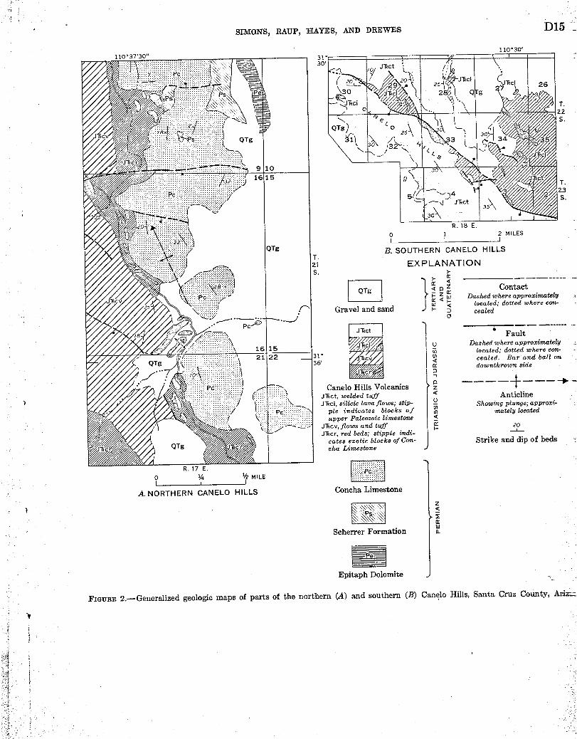
SIMONS, RAUP, HAYES, AND DREWES
30, zo 11 z _ .
110 € 30'
D15
T.22S .
QTg
9 1016115
T .Z3S .
1
R . 18 E .0 1
12 MILES
1
B. SOUTHERN CANELO HILLSr .a EXPLANATIONS .
Ta o za} a
--- -Contact
4 g Q W Dashed where approximatelyW < located; dotted where con-
Gravel and sand cealed0
-~--- ----€JTxct FaultJTicl o Dashed where approximately
n located ; dotted where con-
0T:cv Q cealed. Bar and ball on
36 downthrown side
- -Canelo Hills Volcanics z +JTct, welded tuff a AnticlineJ'kcl, silicic lava flows ; stip- U Showing plunge ; approxi-
ple indicates blocks of N mately locatedupper Paleozoic limestone a_
J'kcv, ,flows and tuff a 20LJlcr, red beds; stipple indi- --- __-
cates exotic blocks of Con- Strike and dip of bedscha Limestone
F777771 1

D16 STRUCTURAL GEOLOGY
- roughly parallel to the enclosing lavas or to nearbywelded tuff . No exposure of a contact between a lensand volcanic rock was found .
In most places, the only rocks associated with thelenses are volcanic . However, one composite blockabout 1,300 feet long consists of two lenses that are incontact at their north ends ; south of the juncture theyare separated by as much as 50 feet of conglomeratecomposed of partly rounded fragments of limestoneand volcanic rock in a matrix of calcarenite .These exotic lenses in volcanic rocks may be inter-
preted as hills of bedrock protruding through thevolcanic material, as slivers along faults, as landslideblocks, or as slabs transported on or within lava flows .Some may indeed be bedrock hills, but such an expla-nation seems unlikely for long and narrow lenses thatcrop out on ridgetops and have steep contacts withthe lavas. No evidence was found that any of thelenses is a fault sliver, although at least one is boundedby a fault along one side. All the lenses are a mile ormore horizontally from the nearest outcrop of what isundoubted prevolcanic bedrock, and several apparentlyare separated by hundreds of feet of lavas from anyunderlying prevolcanic rock. The lenses could havebeen emplaced by landsliding, but some are long thinslabs that might have been noticeably disrupted during
_ landsliding rather than merely brecciated . Two ofthese thin slabs are underlain by an appreciable thick-ness of lava and must have travelled a considerabledistance.
It seems most likely that the lenses were transportedon or in lava flows. At present the nearest outcropsof Paleozoic source rocks are 10 miles west or south-west in the Patagonia Mountains, 5 miles or morenorthwest in the Canelo Hills, and 8 miles northeastin the Huachuca Mountains. The direction from
. which the volcanic rocks came is unknown, so no logicalchoice can be made among these possible source areas .It is possible, of course, that Paleozoic rocks may havebeen exposed somewhere nearby at the time of extru-sion of the lavas ; in that event such extensive transportwould not need to be invoked .
Transportation by lava, although producing consid-erable brecciation, has resulted in little or no alteration
- of the slabs, presumably either because the lava wasalready rather cool at the time the blocks wereentrained, or because the length of time between pick-ing up of the slabs and cooling of the lava was veryshort.
HUACHUCA MOUNTAINS
The Huachuca Mountains are a northwest-trendingrange about 20 miles long in the southwest part ofCochise County (fig . 1) . The mountains are made up
of Precambrian granitic rocks, Paleozoic sedimentaryrocks, a wide variety of Mesozoic sedimentary, volcanic,and intrusive rocks, and subordinate Cenozoic igneousrocks .
In the southern part of the Huachucas, numerousexotic blocks of Paleozoic sedimentary rocks areenclosed in volcanic rocks of Mesozoic age . Some ofthe most instructive examples are in the extreme south-ern part of the range in Coronado National Memorialbetween Joe's Canyon Trail and the Mexican border(fig. 3) . Here there is a well-exposed body of grayish-red trachytic lava, containing large exotic blocks . It isconformably underlain and overlain by thick units ofvery poorly sorted volcanic cobble- to boulder-con-glomerate that is assigned to the Glance Conglom-
€ l 0 0
€I " I 0 1
o < 0' €r ,Joe's Canyona~ ----€It~ --o
Trail L €O T0 1 .kV C
k0\
lol v 4 ~o1€€ 7,~CD l 0 1 L o
/0 / L \
0, L /o/
o/ 0 10 0/0/ < /o/ao
,
0/0
olo 0 cm"0 O0
/10 /
`0/ " L 04 ~ 0/ /' 010 n 0 0/31 /or ,
111 10O/0L -i o 0
o, UNITED STATES- - - MEXICO
0 1000 2000 FEET
EXPLANATION
C, _U)D
Volcanic conglomerate 0W0I-
L J L
L^ 1 Ix
Trachytic flow breccia UContaining exotic limestone blocks;
original bedding indicated
16
Contact Strike and dipof beds
FIGURE 3.-Geologic sketch map of lava flow containingexotic blocks, in Coronado National Memorial,Huachuca Mountains, Cochise County, Ariz. (fig .1, loc . 3) .

7
SIMONS, RAUP, HAYES, AND DREWES
erate of the Bisbee Group of Early Cretaceous age.The upper conglomerate unit contains sparse limestoneclasts as well as volcanic detritus .
The trachyte seems to be a single lava flow about 200feet thick. In most places it is a flow breccia, butbreccia is much more apparent in the upper part, someof which is vesicular. The rock contains as much as20 percent phenocrysts of plagioclase up to 5 mm inlength .
The exotic blocks are as much as 1,500 feet long and200 feet high. All the larger blocks are at or verynear the base of the trachyte (fig. 3) . The blocksreadily identifiable as to origin were derived from thePermian Concha Limestone, the youngest Paleozoicformation recognized in the Huachuca Mountains .Bedding in most of the limestone blocks is readilyapparent, even though the blocks are highly brecciated,and most bedding is subparallel to the containing lavaflow.
Brecciation in the central parts of the larger blocksis not everywhere easily recognized, but close examina-tion generally reveals the limestone to be breeciatedand recemented. Brecciation is most intense near theouter edges of the blocks, where in many places lavafills spaces between breccia fragments . Furthermore,the lava near the blocks contains numerous smallerblocks and fragments of limestone, presumably derivedfrom the larger blocks .
These blocks of Concha Limestone undoubtedly wereshoved or carried along at or near the base of thetrachyte flow and were brecciated during transport .Fragments of limestone that were broken off edges ofthe blocks were set adrift in the flowing lava . _ Whetherthe larger limestone blocks were plucked from bedrockor were landslide blocks picked up by the flow isconjectural.Elsewhere in the southern Huachuca Mountains,
exotic blocks of upper Paleozoic rocks are abundant ina thick and widespread sequence of intermediate vol-canic rocks that are considerably older than thetrachyte flow described above . The older volcanicrocks are dominantly nonwelded lithic tuffs, but somepossible welded tuff and lava have been noted .
Few if any single blocks exceed 1,500 feet in lengthand 300 feet in thickness, but on the steep slopes eastof Miller Peak (fig. 1) the blocks in places are soabundant and so closely spaced as to form masses ofbrecciated limestone, virtually free of volcanic material,that range from about half a mile to more than 1 milein length along strike. The enclosing tuffs are gen-erally so poorly exposed and badly weathered thattheir origin is doubtful . Therefore it is uncertain
D17
whether the exotic blocks were transported by ash flowsor lahars, or both .
PATAGONIA MOUNTAINS
The Patagonia Mountains (fig. 1) extend from nearthe village of Patagonia south-southeastward about 14miles to the Mexican border and beyond for severalmiles into Mexico. They consist of Precambrian,Mesozoic, and Cenozoic igneous rocks and subordinateamounts of Paleozoic and Cretaceous sedimentaryrocks. Exotic lenses and blocks of Paleozoic limestonein younger volcanic terrane crop out in several areas ;the most extensive are near the American mine nearHarshaw Creek (fig . 4A) and in upper Flux Canyon,4-5 miles south of Patagonia (fig . 4B) .
American mine area
The area around the American. mine (fig. 44) isunderlain by rhyolite lava and flow breccia that reston Concha Limestone and the underlying Scherrer For-mation, both of Permian age . The rhyolite is corre-lated tentatively with pre-Lower Cretaceous silicicvolcanic rocks of the central Patagonia Mountainsnorthwest of Washington Camp, which in turn may beequivalent in part to the lower Mesozoic Canelo HillsVoleanics (Hayes and others, 1065) .
The largest limestone occurrence is along and at thewest end of the east-trending ridge north of theAmerican mine . This ridge consists of blocks of brec-ciated limestone and some quartzite enclosed in rhyo-lite. East of Harshaw Creek this limestone-rhyolitecomplex crops out over an area about 1,500 feet longand 700 feet in maximum width ; west of the creek itis very poorly exposed but may extend a distance of1,000 feet or more . Eastward the complex thinsabruptly and passes into limestone conglomerate thatin turn lenses out near the Bender mine about 3,500feet east of Harshaw Creek . The limestone blocks arederived from the Concha Limestone and the quartzitefrom the Scherrer Formation . 'Most of the blocks area few feet across but some are much larger ; the largest,at the base of the ridge just east of Harshaw Creek, isa highly brecciated mass of dark-gray limestone possi-bly 100 feet or more across . The limestone-rhyolitebreccia and conglomerate lie as much as 1,000 feetstratigraphically above the base of the volcanic section,.and the nearest outcrops of possible source rocks forthe limestone fragments are about 1,000 feet south .
A large block of coarse-grained white limestone isexposed in a small gully west of Harshaw Creek andalong the westward prolongation of the breccia northof the American mine. It is about 300 feet long and
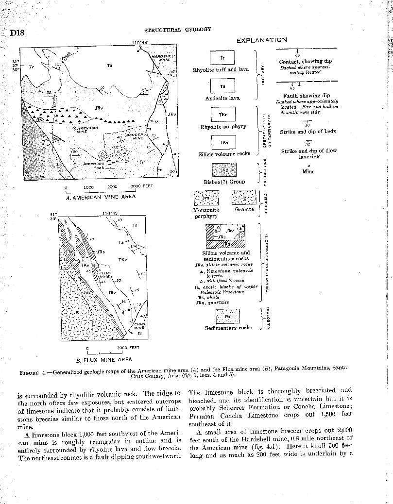
' D18 STRUCTURAL GEOLOGY
110€43' EXPLANATION
NRRMSNELL P1 65
31* ~ MINE Tr
27, ) 34'' Ta i Contact, showing dip
30• Tr y Rhyolite tuff and lava Dashed where appro=i--a m‚tely located
~ w
F gp ~ ~ 65
Andesite lava Fault, showing dip€Dashed where approximately
Z-111 AL _J frv t located . Bar and ball on
J-1i, TKr downthrown side. F
+ r 15 f' x AMERICAN 35'` Rhyolite porphyry a a 30
MINE ---~ 0 it Strike and dip of beds' { BEN X ~o t Q W
601415,: ` i 4~~ MINENE .
. ƒ TKV W F 30
Silicic volcanic rocks Strike and dip of flowlayering
7s l _ . Amencan ao Rr.- t W x
ss Peak [ Kb U Minet ' so` Q
Bisbee (?) Group0 1000 2000 3000 FEET
A.AMERICAN MINE AREA 0N
31' 110€a5 'Monzonite Granite
30, - porphyry J
Tr o .~
~~5 Isa 30 VON
~25 JT"q.f~ Ta~ui/ ~nmJT:q JT:s N~< ~L Silicic volcanic and <rc
' I U ss TKv sedimentary rocksTKv JTev,silicic volcanic rocks a
i 4s // x
Z
FL UX; 25 A, limestone volcanic/, t 1 1 1 ~MINE~ 6recci‚ U45 ~30 o, silicified breccia N
\ -, \ 25 Is, exotic blocks of upper aƒJm JTxv \ Paleozoic limestone
V I / i JTxs, shaleIs `1 /o Jlq, quartzite
92
' o
MHINEF Sedimentary rocks dTr
0 3000 FEET
B. FLUX MINE AREA
FIGURE 4.-Generalized geologic maps of the American mine area (A) and the Flux mine area (B), Patagonia Mountains, SantaCruz County, Ariz . (fig . 1, locs. 4 and 5) .
is surrounded by rhyolitic volcanic rock . The ridge tothe north offers few exposures, but scattered outcropsof limestone indicate that it probably consists of lime-stone breccias similar to those north of the Americanmine.
A limestone block 1,000 feet southwest of the Ameri-can mine is roughly triangular in outline and isentirely surrounded by rhyolite lava and flow breccia .
The northeast contact is a fault dipping southwestward .
The limestone block is thoroughly brecciated andbleached, and its identification is uncertain but it isprobably Scherrer Formation or Concha Limestone ;
Permian Concha Limestone crops out 1,500 feetsoutheast of it .
A small area of limestone breccia crops out 2,000feet south of the Hardshell mine, 0 .8 mile northeast of
the American mine (fig. 4A) . Here a knoll 500 feetlong and as much as 200 feet wide is underlain by a
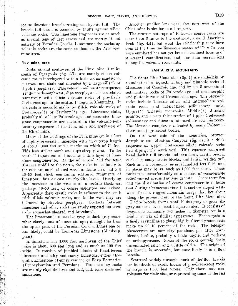
t
a 41
Flux mine areaRocks at and southwest of the Flux mine, 4 miles
south of Patagonia, (fig . 4B), are mainly silicic vol-canic rocks interlayered with a little coarse sandstone,quartzite and shale and intruded by a large sill( ?) ofrhyolite porphyry. This volcanic-sedimentary sequencetrends north-northwest, clips steeply, and is correlatedtentatively with silicic volcanic rocks of pre-EarlyCretaceous acre in the central Patagonia Mountains . It.is overlain unconformably by silicic volcanic rocks ofCretaceous(?) or Tertiary ( ?) age . Limestone slabs,probably all of late Paleozoic age, and associated lime-stone conglomerate are enclosed in the volcanic-sedi-nientary sequence at the Flux mine and northwest ofthe Chief mine .
Many of the workings of the Flux mine are in a lensof highly brecciated limestone with an outcrop lengthof about 1,000 feet and a maximum width of 75 feet .This lens strikes north and dips steeply west . To thesouth it tapers out and becomes a thin lager of linie-stone conglomerate . At the mine road and for somedistance uphill to the north, the rocks immediately tothe east are much-altered green andesite lava and tuft40-50 feet thick containing scattered fragments oflimestone ; farther east are rhyolite lavas. Overlyingthe limestone to the west is an uncertain thickness .perhaps 40-50 feet, of coarse sandstone and arkose .Apparently these elastic rocks interfinger to the southwith silicic volcanic rocks, and to the west they areintruded by rhyolite porphyry. Contacts betweenlimestone and other rocks are rarely exposed but seemto be somewhat sheared and brecciated .
The limestone is a massive gray to dark-gray some-what cherty rock of uncertain age ; it might be fromthe upper part of the Permian Concha Limestone or,less likely, could be Escabrosa Limestone (Mississip-pian) .
A limestone lens 1,000 feet northwest of the Chiefmine is about 600 feet long and as much as 100 feetwide. It consists of jumbled blocks of fossiliferouslimestone and silty and sandy limestone, either Hor-quilla Limestone (Pennsylvanian) or Earp Formation(Pennsylvanian and Permian) . The enclosing rocksare mainly rhyolite lavas and tuff, with some shale andsandstone.
SIMONS, RAUP, HAYES, AND DREWES
coarse limestone breccia resting on rhyolite tuft . Thebreccia-tuff block is bounded by faults against silicicvolcanic rocks. The limestone fragments are as muclias several tens of feet across and are mostly if notentirely of Permian Concha Limestone ; the enclosingvolcanic rocks are the same as those in the Americanmine area .
D19
Another smaller lens 2,000 feet northwest of theChief mine is similar in all respects .
The nearest outcrops of Paleozoic source rocks aremore than 3 miles to the southeast . around AmericanPeak (fig. 4A), but wliat the relationship may leavebeen at the time the limestone masses of Flux Canyonwere emplaced has not yet been determined because ofstructural complications and uncertain correlationsamong the volcanic rock units .
SANTA RITA MOUNTAINS
The Santa Rita Mountains (fig . 1) are underlain byabundant volcanic, sedimentary and plutonic rocks ofMesozoic and Cenozoic age, and by small amounts ofsedimentary rocks of Paleozoic age and metamorphicand platonic rocks of Precambrian age . The Mesozoicrocks include Triassic silicic and intermediate vol-canic rocks and intercalated sedimentary rocks,Upper(?) Triassic monzonite, -Middle(?) Jurassicgranite, and a very thick section of Upper Cretaceoussedimentary and silicic to intermediate volcanic rocks .The Mesozoic complex is intruded by many Paleocene(Laramide) granitoid bodies.On the west. side of the mountains, between
Josephine and Montosa Canyons (fig . 5), is a thicksequence of Upper Cretaceous silicic volcanic rocksthat clips gently southward . This sequence comprisesbasal dacitic tuff breccia and lava flows, dacitic brecciaenclosing many exotic blocks, and latitic welded tuft .Each unit is commonly several hundred feet thick andin places may be as much as 1,000 feet thick. Theserocks rest unconforrnably on a surface of considerablerelief carved across Jurassic granite . Unconformitiesand the distribution of coarse conglomerate indicatethat during Cretaceous time this surface sloped west-ward from a rugged mountain range that lay aboutalong the present crest of the Santa Rita 'Mountains .Dacite. breccia forms small bluish-gray or greenish-
gray outcrops over about 4 square miles . It consists offragments commonly 3-6 inches in diameter, set in afriable matrix of similar appearance . Phenocrysts ina finely crystalline to glassy highly altered grounclmassmake up 20-40 percent of the rock . The feldsparphenocrysts are now clay pseudomorphs after horn-blende, biotite, probably a little augite, and perhapsan orthopyroxene . Some of the rocks contain finelydisseminated silica and a little calcite . The origin ofthe breccia is uncertain, but most likely it is a flowbreccia .
Scattered widely through much of the flow brecciaare hundreds of exotic blocks of pre-Cretaceous rocksas large as 1,000 feett across . Only those most con-spicuous for their size, or representing some of the less

D20
3140
STRUCTURAL GEOLOGY
70 . CLL L G
, LV G ! a j
41 G NS G
t G. V L V V L
gV V G L+++ V o'5 L/VGVt' G Q V
Q - =\ V V \ /
3 G \ ~\ L V V' ' V ,, V'
LLGV G V VG L V V
+ + + + 5+ + + + ++ + + + +
+ + + + + + L+ + + + + V
+ + + + + + V+ + + + + + /\i\
€ L
VQ V
V VGV
V+ V ~1\/-I V V V' I VV G /0 V
+t / VQQS /\l%\ V V VGV VD \ V GV - t0
+ I &V V V G
+ V V L -V G V 15
++ + ~V vv v L v /)1 ~y
+ + L V V G V VG Q V V+ + + V V
10 .~:_ . .
~Q a 25h
G V10
GG V
N~.~I\ o
/ 20
EXPLANATION
Sedimentary and igneous rocks
UNCONFORMITY
Latitic welded tuff and tuff breccia
Dacitic brecciaContaining exotic blocks. Letter indicates
position and type of block :V, volcanic S, red siltstoneG, granite N, gneissL, limestone D, dolomiteQ, quartzite
M
Dacitic tuff breccia and lava flowsV, exotic volcanic block
UNCONFORMITY
Granite
Sedimentary rocks
UNCONFORMITY
Gneiss and granite
Contact
f
FaultDashed where inferred. Bar and ball
on downthrown side
Strike and dip of foliation
uia
w~UwFaw ocZU•
N
0
UI--w
U'a0U
waK
U
aIII\N
7
Z
E
aJwZ
mM4•UWM4
0 1 MILEi
FIGURE 5 .-Geologic map showing distribution of volcanic breccia containing exotic blocks, Santa Rita Mountains, SantaCruz County, Ariz . (fig . 1, loc. 6) .
abundant litholoaies , are shown by letters on figure 5 .The most abundant and generally the largest of theexotic blocks are assorted latite to andesite volcanicrocks derived from Triassic rocks that no;, crop outonly along the crest of the mountains , at least 3 milesto the east. Blocks of Jurassic granite are next in size
and abundance, and blocks of Paleozoic rocks, includ-ing Permian Concha Limestone, Cambrian BolsaQuartzite, and possibly also Permian red siltstone andDevonian dolomite, are scarcer and smaller . Permianrocks are exposed immediately north of the brecciaarea, but the older Paleozoic rocks appear no closer

SIMONS, RAUP, HAYES, AND DREWES
than 5 miles to the northeast. A few large blocks ofTriassic monzonite and some very small blocks of Pre-cambrian gneiss were also identified . The blocks areinternally unshattered, are unoriented, and show nospatial variation in type or size, except that where thebasal unit of the volcanic sequence is absent and thebreccia rests directly on Jurassic granite, abundantsmall granite chips, apparently weathered debris fromthe Early Cretaceous ('?) land surface, are incorporatedin the breccia .In a few places along the bottoms of canyons the
contacts between exotic blocks and breccia matrix arewell exposed, and where the blocks are limestone thecontacts provide considerable information about geo-logic conditions prevailing during emplacement of theblocks. One of several limestone blocks, located inJosephine Canyon just southwest of the fault (betweenthe 3 "G" symbols in fig . 5) is shown in figure 6 . Thevolcanic matrix contains abundant chips of disinte-grated Jurassic granite and some fragments of otherexotic material . The contact between block and hostshows many irregularities, and many tongues of vol-canic material penetrate the limestone for a foot ormore. It seems that when the exotic blocks wereemplaced some of the limestone was dissolved alongcracks and the spaces were filled by the volcanic mate-rial suggesting at least a highly fluid and perhapswarm environment .
Emplacement of the blocks by some sort of flowageis indicated by the widespread distribution of theblocks and the nature of their contacts with the hostbreccia. Movement on or in a volcanic flow is the
0-C-1 7
b
FIGURE 6.-Block of light-gray Paleozoic limestone in dark-graydacitic breccia, Santa Rita Mountains, Santa Cruz County,Ariz. (fig . 1, loc . 6) . Arrows indicate cracks in limestonefrom which limestone has been dissolved and which are filledwith a fine-grained volcanic matrix.
D21
favored explanation, but movement in hot mud flowsis also a possibility . Possible source areas of most ofthe exotic blocks lie to the northeast, suggesting that avolcanic source also lay in that direction, conceivablyin the area now occupied by a Paleocene (Laramide)dioritic pluton . As already mentioned, the Cretaceousland surface sloped westward, so that the requisitegradient was available for westward movement ofthe flow breccia . Some of the little exotic blocks mayhave been ejected from a vent, some, larger exotic blocksmay have been incorporated into the base of thebreccia during flow, and possibly still others fell intothe breccia from adjacent steep slopes .
PALEOGEOGRAPHYDuring the past few years, extensive fieldwork and
radiometric age determinations by members of the U.S .Geological Survey have revealed a tectonically eventfulearly Mesozoic history in much of southeastern Ari-zona. Little information had been available for theinterval between the Early Permian and Late Cre-taceous, although previous workers recognized thatboth plutonic and volcanic rocks had been emplaced inthat interval (Ransome, 1904, p . 84 ; Schrader, 1915,p. 54, 57-60 ; Gilluly, 1956, p. 53-70 ; Sabins, 1957, p .506 ; Cooper and Silver, 1964, p . 71-73) .
The data at hand suggest. at least 2 periods of wide-spread volcanism, one of Late Permian or EarlyTriassic age and one of Late Triassic or Early Jurassicage, as well as 2 periods of plutonism of Late Triassicand Middle Jurassic age, respectively . The productsof the volcanic episodes have been recognized over anarea of 3,000 square miles, including in addition to themountain ranges discussed herein, the Little Dragoonand probably the Dragoon Mountains. These volcanicrocks are separated by regional unconformities fromthe underlying Paleozoic sedimentary rocks and theoverlying Lower Cretaceous rocks . No volcanic rocksof Triassic or Jurassic age have been identified farthereast, in the Mule, Chiricahua, or Dos Cabezas Moun-tains, and in view of the considerable amount of workthat has been done in these ranges it is unlikely thatany are present. We do not know whether their ab-sence is due to erosion or to nondeposition. Little de-tailed geologic mapping has been done immediatelywest of the Santa Rita and Patagonia Mountains, but :_it-will not be surprising if lower Mesozoic volcanic rockseventually are identified in the Pajarito, Atascosa,Tumacacori, San Luis, Las Guijas, or Cerro ColoradoMountains.
The many exotic blocks, some of which probably are : _far travelled, as well as conglomerate at several hori-zons in the volcanic sequences, attest to widespread -

y
D22 STRUCTURAL GEOLOGY
tectonic activity during the early Mesozoic, and the_ region may well have been the source of volcanic ash
and other volcanic debris in the Triassic and Jurassicrocks of northeastern Arizona .
REFERENCES
Cooper, J. R., and Silver, L. T., 1964, Geology and ore depositsof the Dragoon quadrangle, Cochise County, Arizona : U.S.Geol. Survey Prof. Paper 416, 196 p.
Gilluly, James, 1956, General geology of central Cochise County,Arizona : U.S. Geol. Survey Prof. Paper 281, 169 p.
Hayes, P. T., Simons, F . S., and Raup, R . B., 1965, Lower Meso-zoic extrusive rocks in southeastern Arizona-the CaneloHills Volcanics : U.S. Geol. Survey Bulletin 1194-11, 9 p.
Ransome, F. L., 1904, The geology and ore deposits of the Bis-bee quadrangle, Arizona : U.S. Geol. Survey Prof. Paper21, 168 p.
Sabins, F. F., Jr ., 1957, Stratigraphic relations in Chiricahuaand Dos Cabezas Mountains, Arizona : Am. Assoc. Petro-leum Geologists Bulletin, v. 41, no. 3, p. 466-510.
Schrader, F. C., 1915, Mineral deposits of the Santa Rita andPatagonia Mountains, Arizona : U.S. Geol. Survey Bulle-tin 582, 373 p .
i

AMERICAN SMELTING / . ; :D REFINING COMPANYTucson Arizona
( Clay i:; l ~;~4 `RECEIVED
MAY 51975 .
MEMORANDUM TO MR . J . H . C OUR.TRIGHTS. W. u. s. EXPL. V
Sacaton-Santa Cruz ProspectsP reliminary Geologic Map
The preliminary geologic map (aft .) of the subject area shows some form -ational groups not previously used in Company correspondence ; the followingcomments describe their salient features .
Pre-Cambrian Basement :
Pre-Ore Rocks
Pinal Schist . Partly typical of the quartz-sericite schist defined asFinal in other areas . Also here includes banded injection gneiss, granitegneiss, and aplite .
Granite . There are two types undivided on the map . One is "typical"coarse-grained granite with biotite similar to the Mineral Butte graniteat Blackwater (Report, A . G . Blucher) . A second type is coarse-grained,but with less biotite and with large pink feldspar phenocrysts .
Pre-Cambrian and Paleozoic sediments :
The Apache group of shale and quartzite (Younger pre-Cambrian) ismapped undivided.
Paleozoic sediments represent Bolsa quartzite and Devonian-Carboniferouslimestone . Not separated during mapping .
Laramide intrusives :
The Laramide intrusive complex contains many more varieties than areshown ; these have been grouped into four units, each of which comprisesvarieties similar in composition and relative age .
Diorite . The earliest intrusive and/or border phase of Laramide graniteis rich in biotite and locally contains magnetite .
Coolidoe granite . Defined by Blucher (Report, Blackwater and Sacaton) .Equigranular biotite granite which is very uniform in character . The gra-nitic rocks along the west edge of the map which extend from Highway 64north to the Palo Verde mountains may be pre-Cambrian, but they are mostsimilar to Coolidge in appearance . A better correlation of these graniteswill be made when mapping is complete .

l r ' '
Mr . Courtright _,- I , 14, 1yuj+
1.1icro -1r ani te . This rock is like the Coolidge granite but is fine-grained . Included in the categor y for mapping purposes arc pegmatite,,?pi ite, and alaskite --all in small bodies .
Porphyri es . A variety of porphyritic rocks ranging from mafic toacid, with and without quartz , occur as dikes in the mountain ranges .The only larger mass occurs beneath cover in the Sacaton Cu deposit,where it is altered to sericite and clay . There, a monzonite and a da-cite have been recognizes . The monzonite , in the weakly a ltered fringearea , is seen to contain much biotite .
Post-Ore Rocks
( 1) Volcanics .
The volcanic terrain south and .est of Casa Grande is divided into` three units :
Sedim.ents . Conglomerate and grit derived from granite and apachegroup . These rocks are tilted as much as 50€ .
older volcanics . Above the sediments (not always present) are flowsof basalt, andesite and lat'ite . These rocks are faulted and tilted .
Basalt .- The exposed basalt flows are widely scattered erosionalremnants resting on the older volcanics .
(2) Valley conglomerates .
The conglomerates which fill the Casa Grande valley are divisibleinto three units :
Sacaton conglomerate . This unit is known only near the Sacaton Cudeposit . There are no outcrops of similar type . Its character, as deter-mined by drill cores, is that of an unsorted fanglomerate made of graniteand schist/gneiss boulders and grit . The Sacaton conglomerate was depositedagainst steep relief cut on the Sacaton altered zone, and then displacedalong the Basement fault to its present position . Induration is significantand the formation is hard and compact .
Bu rgess Pe a k conglome r at e . A small hill--Burgess Peak--arises justN14 of Casa Grande and is composed of a hard granite-boulder fanglomeratewith hematite cement . Our three holes on the Gila prospect penetratedsimilar conglomerates, and water well drillers' logs indicate that thisformation probably extends southeast along the ridge which appears toseparate the water basins cast and west of Casa Grande . The formationis variable in hardness, but is generally well indurated, although lessso than the Sacaton conglomerate .
I
Mr . Courtright €"3- May 11E, 1964
Gas I i ne congg l om e ra t e . The Gas I i ne conglomerate i s named for a smalloutcrop of conglomerate along the El Paso gas line east of Socaton and drillhole penetrations of the -formation in the same area . The formation appearsto be younger than known faults and is derived from the granitic rocks ofthe Sacaton mountains . It is poorly consolidated and consists of fanylomer-ate and sandy stream deposits . A thick clay layer is presenL east of the .Sacaton deposit, which appears to trend south and taper-out across itswidth of about 2 miles . The Gas line is the aquifer north of Casa Grande .'.,:'here iL is adjacent to the Sacaton deposit it is dry . The aquifer gravelsin the deep basin west of Casa Grande are probably equivalent in Zge, butthey will no doubt contain boulders derived in part from the mountainssouth and west thereof . The outline of the Gas line basin at Sacaton isshown in green on the map .
( 3) Andesite .
€ Dikes of andesite are post -ore but older than the valley conglomerate .
(4) Quaternary .
Alluvium made of poorly consolidated silt and sand is spread out acrossthe Casa Grande valley, reaching a thickness of about 200 feet near theSanta Cruz River .
Dissected alluvial fans flank Table Top mountain, and are made largelyof volcanic rubble .
J EK/ j kcc : JRWojcik w/att .
JEKinnison w/att .File w/att .3 extras w/att .
JOHN .E . KINblISON
1 J
l Y Cy~s'~ . 14Q V`vQ2 S ~5 Q/r•w2<J~~`
S
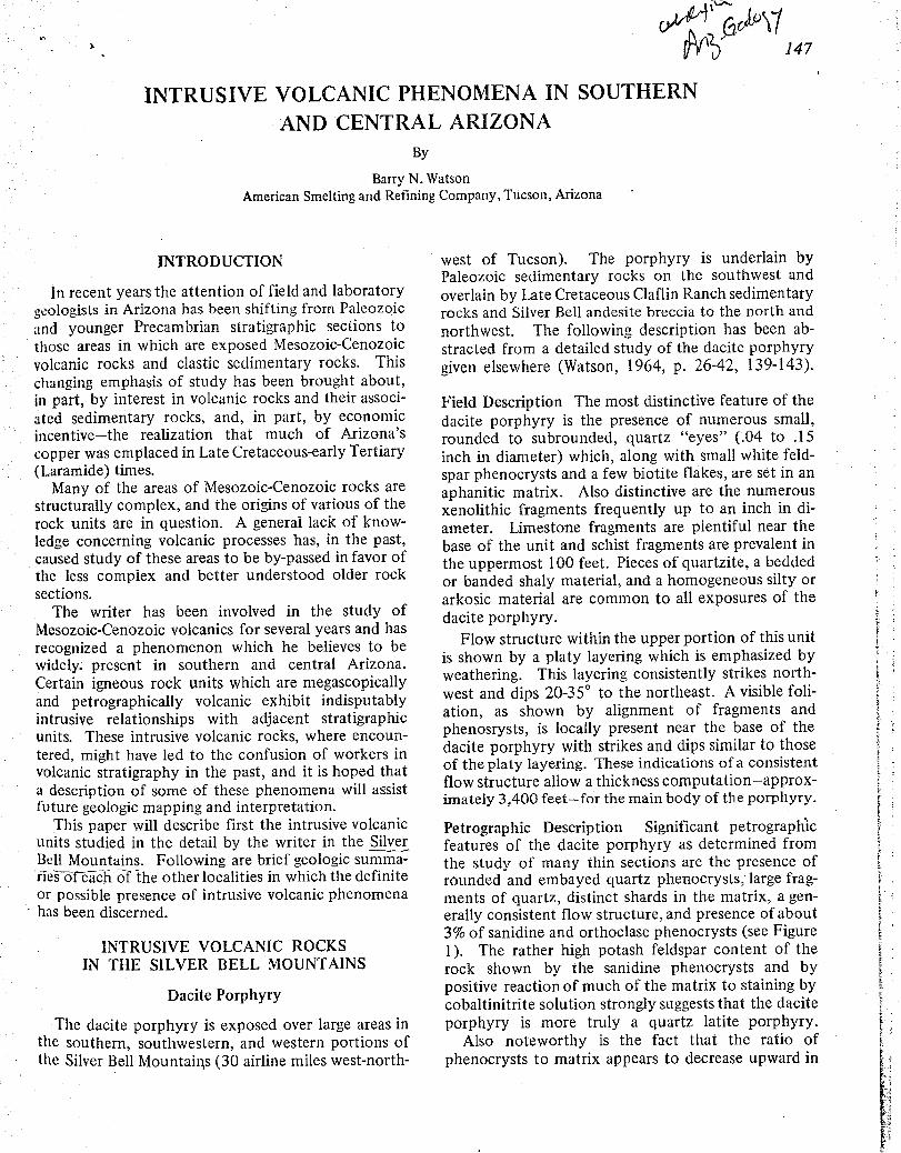
147
INTRUSIVE VOLCANIC PHENOMENA IN SOUTHERNAND CENTRAL ARIZONA
By
Barry N. WatsonAmerican Smelting and Refining Company, Tucson, Arizona
INTRODUCTION
In recent years the attention of field and laboratorygeologists in Arizona has been shifting from Paleozoicand younger Precambrian stratigraphic sections tothose areas in which are exposed Mesozoic-Cenozoicvolcanic rocks and clastic sedimentary rocks. Thischanging emphasis of study has been brought about,in part, by interest in volcanic rocks and their associ-ated sedimentary rocks, and, in part, by economicincentive-the realization that much of Arizona'scopper was emplaced in Late Cretaceous-early Tertiary(Laramide) times.
Many of the areas of Mesozoic-Cenozoic rocks arestructurally complex, and the origins of various of therock units are in question . A general lack of know-ledge concerning volcanic processes has, in the past,caused study of these areas to be by-passed in favor ofthe less complex and better understood older rocksections .
The writer has been involved in the study ofMesozoic-Cenozoic volcanics for several years and hasrecognized a phenomenon which he believes to bewidely. present in southern and central Arizona .Certain igneous rock units which are megascopicallyand petrographically volcanic exhibit indisputablyintrusive relationships with adjacent stratigraphicunits. These intrusive volcanic rocks, where encoun-tered, might have led to the confusion of workers involcanic stratigraphy in the past, and it is hoped thata description of some of these phenomena will assistfuture geologic mapping and interpretation .
This paper will describe first the intrusive volcanicunits studied in the detail by the writer in the Silve rBell Mountains. Following are brief geologic summa-ries ofeach of the other localities in which the definiteor possible presence of intrusive volcanic phenomenahas been discerned .
INTRUSIVE VOLCANIC ROCKSIN THE SILVER BELL MOUNTAINS
Dacite Porphyry
The dacite porphyry is exposed over large areas inthe southern, southwestern, and western portions ofthe Silver Bell Mountains (30 airline miles west-north-
west of Tucson). The porphyry is underlain byPaleozoic sedimentary rocks on the southwest andoverlain by Late Cretaceous Claflin Ranch sedimentaryrocks and Silver Bell andesite breccia to the north andnorthwest. The following description has been ab-stracted from a detailed study of the dacite porphyrygiven elsewhere (Watson, 1964, p . 26-42, 139-143) .
Field Description The most distinctive feature of thedacite porphyry is the presence of numerous small,rounded to subrounded, quartz "eyes" ( .04 to .15inch in diameter) which, along with small white feld-spar phenocrysts and a few biotite flakes, are set in anaphanitic matrix. Also distinctive are the numerousxenolithic fragments frequently up to an inch in di-ameter. Limestone fragments are plentiful near thebase of the unit and schist fragments are prevalent inthe uppermost 100 feet . Pieces of quartzite, a beddedor banded shaly material, and a homogeneous silty orarkosic material are common to all exposures of thedacite porphyry .
Flow structure within the upper portion of this unitis shown by a platy layering which is emphasized byweathering. This layering consistently strikes north-west and dips 20-35€ to the northeast . A visible foli-ation, as shown by alignment of fragments andphenosrysts, is locally present near the base of thedacite porphyry with strikes and dips similar to thoseof the platy layering . These indications of a consistentflow structure allow a thickness computation-approx-imately 3,400 feet-for the main body of the porphyry .
Petrographic Description Significant petrographicfeatures of the dacite porphyry as determined fromthe study of many thin sections are the presence ofrounded and embayed quartz phenocrysts ; large frag-ments of quartz, distinct shards in the matrix, a gen-erally consistent flow structure, and presence of about3% of sanidine and orthoclase phenocrysts (see Figure1). The rather high potash feldspar content of therock shown by the sanidine phenocrysts and bypositive reaction of much of the matrix to staining bycobaltinitrite solution strongly suggests that the daciteporphyry is more truly a quartz latite porphyry .
Also noteworthy is the fact that the ratio ofphenocrysts to matrix appears to decrease upward in
148
ib , ..
} t
Figure 1 - Photomicrograph (crossed nicols) of dacite por-phyry, showing flow structure . Slivers of quartzand a stretched lapillus indicate flow north-southacross the photograph . The volcanic nature of therock is apparent. (W 15 .)
the unit . The quantity of xenoliths however, does notreflect such a distribution. Fragments are most numer-ous near the base of the dacite porphyry, least numer-ous in the central portions, and abundant in the upperportions .
Structural Relationships Mapping of the basal contactof the dacite porphyry (Figure 2a) shows the unit todeeply embay the Paleozoic sedimentary rocks and tointrude them forceably along parallel bedding planeseast of El Tiro pit and north of Oxide pit . In a fewplaces intact beds of -limestone up to 15 feet long areengulfed in porphyry 5 to 10 feet from the contact .In the El Tiro pit area drilling data show that thedacite porphyry invades the Paleozoic strata as dikesand sills .
The dacite is generally overlain by sedimentary rocksof the Claflin Ranch Formation, and the contact be-tween the two units is so gradational that neither field
Arizona Geological Society - Guidebook III
mapping (Figure 2b) nor petrographic study can locateit more closely than 6 feet . Indirect evidence suggeststhat this contact is intrusive, but conclusive evidenceis found in the form of dacite dikes-petrographicallynearly identical to the main body of dacite porphyry-intruding the overlying Claflin Ranch Formation .Assimilation of schist-fragment-bearing Claflin Ranchbeds by dacite porphyry is indicated by the large num-ber of schistose xenoliths in the upper portion of thedacite .
The contact between the dacite porphyry and thelater Silver Bell andesite breccia is erosional .
It is of further interest to note that the 5000-footthickness of Amole-type arkoses described by Clarke(1965) in the West Silver Bell Mountains are absent inthe main Silver Bell range . Both the arkose to the westand the dacite porphyry at Silver Bell occupy the in-terval between Paleozoic units and the Claflin RanchFormation. Local pre-Claflin Ranch erosion in theSilver Bell Mountains can be hypothesized to explainin part, the disappearance of the arkoses .
Interpretation The combined evidence presents apicture of the dacite porphyry as a large sill or lacco-lithic body, with a source of the southwest in the SilverBell porphyry copper fault zone . The main body ofthis sill was generally floored byPaleozoic sedimentaryrocks and roofed by strata of the Claflin RanchFormation .
An explosive history is strongly suggested by thenumerous xenoliths, the large fragments of quartz,and the shards of former glass in the matrix. Thequartz phenocrysts can be interpreted as volcanic, withrounding produced by gas action . The nature of therock is believed to reflect emplacement by fluidization,and the writer visualizes the intrusion of fluidizeddacite porphyry in the manner explained below .
The gas- and fragment-charged dacite porphyry mag-ma (actually quartz latite in composition, suggestinggreater viscosity and more explosive potential) rosealong the Silver Bell fault zone into Paleozoic strata .The higher the porphyry magma ascended, the morethe confining pressure decreased, causing exsolutionof gases and thus lending an explosive and dilativenature to the intrusive material .
Its extension to the southwest blocked by a largebody of alaskite, the dacite porphyry welled up, send-ing small dikes and sills northeastward into the Paleo-zoic limestones, quartzites, and shales . Damp Amole-type Cretaceous (?) sediments were reached and moregas evolved . The magmatic material, expanding con-stantly, spread laterally to the northeast in the weakCretaceous (?) sediments. Dilation occurred, as didthe incorporation of fragments broken by churninggas action .

ilrizona~ Geological Society - Guidebook III
The dacite porphyry probably surfaced in one ormore places, venting gases as it did . Gas also escapedlaterally through the just-formed sill and vertically intooverlying Claflin Ranch sediments . The heat and vaporaltered the immediately overlying quartzofeldspathicclastic sediments, making them somewhat similar inappearance to the intrusive porphyry .
As the intrusive material cooled, differential move-ment within the newly formed sill gave rise to the flowstructures seen in many places and the platy layeringfound in the upper portions. Such a platy parting with-in quartz latite sills is seen also near Pando, Colorado(Tweto, 1951, p. 507) .
UnionHill ( N
7, A"
Porphyry
pit
€ dikon
500 it. 30
Figure 2a - Basal contact of dacite porphyry with Paleozoicstrata just east of El Tiro pit, Silver Bell, Arizona .
N s:anoa a ,: : : . • e- - Porphyry
b~4?--~~oc,4. Porphyry . • , 3s .
24 •fa
••GntI Ranch
• Fo-oti00
p'aDIS v•
30
3 aA .d ..I . Brecci‚
Mon[wunc 0.k. s=tL. v'C ~ I6 +1~ J. I D a p Q
- • v Y ri'-'• le o4 ! T a
1 U 0Z `a O
Donuts Purptry0'
0 500 ft .
Figure 2b - Contact between dacite porphyry and overlyingClaflin Ranch strata in the Silver Bell Mountainsis gradational where not obscured by other struc-ture. Note the dacite dikes cutting the sedimentsat the upper right .
149
Mount Lord Ignimbrite
The Mount Lord Ignimbrite is a quartz latitic pyro-elastic flow breccia which overlies the Silver Bell an-desite breccia and caps the Silver Bell Mountains . Itstrikes generally northwest with an average northeast-erly dip of 30‚-the dip a result of post-depositionalregional tilting . This welded ignimbrite is lithological-ly similar to, and stratigraphically a near time equiv-alent of, the Cat Mountain Rhyolite of the TucsonMountains as described by Kinnison (1958) .
Sill- and dike-like intrusive ignimbrites related tothe main body of the Mount Lord Ignimbrite are foundin stratigraphically lower and older formations . Onesuch sill is described here. A more detailed account ofthese intrusive ignimbrites is given elsewhere (Watson,1964, p. 75-82, 145-148) .
Field Description A sill of ignimbrite with a 200-footmaximum thickness is found several hundred feet be-low the extrusive welded ignimbrite along the daciteporphyry-Silver Bell andesite breccia contact northeastof Oxide pit. Well-developed eutaxitic structure in thecentral and upper portions of this sill indicates somelocally turbulent conditions during the time of em-placement, but a northwest strike and northeast dip ofabout 40‚ represent an average orientation .
Xenoliths are common within the sill, and a peculiartype of andesite porphyry fragment characteristic ofthe extrusive ignimbrite is present . Megascopically theextrusive and intrusive ignimbrites are identical .
Petrographic Description The petrography of the sillignimbrite just northeast of Oxide pit is like that of theextrusive welded ignimbrite with but few exceptions .Closer to the porphyry copper alteration, it is morehighly altered, with epidote partially replacing drawn-out lapilli and volcanic bombs . Devitrification hasprogressed to a greater extent, and a slightly larger per-centage of crystals is present .
Common to both extrusive and intrusive (Figure 3)ignimbrites are the usual petrographic features of anacid vitric-crystal tuff . The crystals, which constituteabout 25 percent of the rock, include quartz (- 15 per-cent, subrounded to angular with many slivers, up to2 mm., embayed and corroded), sanidine (-4 percent,subhedral, .3 to 1 .5 mm ., 2V = 0‚ to 5'), plagioclase(sodic andesine, -5 percent, subhedral, up to 2 .2 mm.,sometimes twinned), and magnetite (--1 percent,euhedral to anhedral, up to .5 mm ., oxidizing) . Theglassy matrix has devitrified .
Xenolithic material constitutes 10-20 percent ofextrusive and intrusive ignimbrite. Numerous brownflattened pumice fragments have devitrified, withfeldspar spherules forming in large quantities. A largeamount of incipiently devitrified brown glass is seen
t
t

-150
under the microscope to be flattened, and nearlyplanar devitrified glass shards are visible .
€r 59i
Figure 3 - Photomicrograph (crossed nicols) form a sill ofintrusive Mount Lord Ignimbrite. Drawn-out lapilligive the rock a strong eutaxitic structure . (X 15 .)
Structural Relationships The geologic setting of theignimbrite sill is shown in Figure 4 . The upper contactof the sill with well-indurated andesite breccia of theSilver Bell Formation is fairly sharp . The basal contactwith dacite porphyry is, in one place, a 30-foot zoneof intrusion breccia, whose character as a breccia isindistinct in the field but recognizable under themicroscope .
The sill tapers in both directions . In a deep gully1,100 feet to the east of the maximum thickness, thesill is but a few-inch thickness of tuffaceous materialalong the andesite breccia-dacite porphyry contact .Some 2,000 feet northwest of the maximum thick-ness, the sill narrows to 25 feet, then gradually steep-ens, becoming a cross-cutting, steeply dipping, 20-footthick feeder dike in dacite porphyry . This feeder dikeshows faint flow structure but contains none of thestretched pumice fragments seen in the sill .
N l ~.
t .
y\ a- J
4 / q1.~r V / rr/ Mount Lord
1 D a o/ r7 D Ignimbrite
77. 7, U:/' 28F
~D , ' ~. . .
t D e Ignim~irite sill D, r _--~
IV P,
. :Alluvium' 72~DU
P 4
r " J/n~ o/,,4--Lote dikes O /p
D A 1`11 4 4Silver Bell Q A~ Q €f / n A cI~l V /C
A i ev Andesite a ANi V 0 Ay
41.~.1 1Q D A {IJ 9
v " tj / a D Breccio _l r-~ o p I v
>" C tJl/ '\6 9 D ~~eL LrJ .r :G't 75'~/<3' 4t 40 v r S ~ ~ Monzonltic dikes
D ~ O1
Ignimbrite
~ ~1 I sill / . (jA v-1.€€€~++
~~ r* V r
Docile Porphyry
Oxide pit€€~€ - ^ r
0 1000 t t
Figure 4 - Structural setting of the sill of intrusive MountLord Ignimbrite just northeast of the Oxide pit .Silver Bell, Arizona .
Interpretation It is not unreasonable to suppose thatthe ignimbritic material in its gas-charged and dilativestate, rising in dike-like vents, could have spreadlaterally along weak planes and contacts in the rock inthe form of sills. Formation of such sills could alsohave occurred toward the end of pyroclastic activityif one or more of the feeder vents were to becomechoked with solidifying ignimbrite, forcing the ma+g-matic and gas-charged material still rising to spreadout beneath the thick ignimbrite sequence alreadydeposited. At Silver Bell these surging intrusiveignimbrites took advantage of flow contacts existingithin the Silver Bell andesite breccia as well as the
Silver Bell breccia-dacite porphyry contact .

+'; irirona Geological Society - Guidebook III
INTRUSIVE VOLCANICSELSEWHERE IN ARIZONA
Described briefly below are examples of intrusivevolcanic phenomena from 8 other mountain ranges insouthern and central Arizona (see also Figure 5) .Most of these examples have been verified in the field ;however, several require additional study in order tosubstantiate them as intrusive volcanics. Furtherinstances of these phenomena, known to exist in the,western Silver Bell and West Silver Bell ranges, willnot be covered here .
TUCSON MOUNTAINS
Piedmontite Hills
In his study of the Piedmontite Hills section of theTucson Mountains Evans B . Mayo (1963) notes that alarge body of ignimbrite has "local steep to verticalcontacts and flow structure . . . . Some parts of thislarge body appear to have been intruded in a sill- or(accolith-like manner into the stratified fragmentalvolcanics. Some of the ignimbrite may have flowedout on the surface, but no convincing evidence of thishas yet been found . . . . Several of the smaller bodies
151
of ignimbrite in the southern part of the hills obvi-ously occupy steep, or vertical, fissures ." (p.73).
The ignimbrite is identified as the tuff member ofthe Recreation Red Beds Formation . The host .rockwhich consists of fragmental volcanics belongs to thevolcanic conglomerate member of the same formation .
Tucson Mountain Chaos
The Tucson Mountain chaos was a name given byJohn E. Kinnison (1958) to a tabular megabrecciawhich overlies Amole Arkose and underlies CatMountain Rhyolite (ignimbrite) along a 14-milelength of the axis of the Tucson Mountains . Kinnisonbelieves that the chaos came about through sedimen-tary processes, utilizing landslides and mudflows tocarry the large blocks included therein .
More recently Mayo (1963, 1966) has suggested afluidized origin for the chaos, and Bikerman (1963)suggested the chaos to be a nuee ardente member ofthe Cat Mountain Rhyolite sequence .. Drewes (personal communication 1966), hasmapped a megabreccia in the Santa Rita Mountainssouth-southeast of Tucson which he refers to as a"chaos." This breccia unit is apparently in the samestratigraphic position as the Tucson Mountain chaos,and Drewes ascribes a landslide block origin to it .Certainly, megabreccias would seem credible in aterrane undergoing volcanic upheaval .
The writer has seen exposures on the south side ofCat Mountain where tuff appears to have flowedaround and cut through boulders within the TucsonMountain chaos. This could be explained as ignim-brites of the Cat Mountain sequence intruding analready formed sedimentary megabreccia either lat-erally or upward from vents, or oozing down into thechaos as the flows poured over the surface . Perhapsan "intrusive volcanic" as herein suggested would helpexplain some of the features of the chaos which ledMayo and Bikerman to volcanic hypotheses of origin .
Little Ajo Mountains
The Little Ajo Mountains are directly southwest ofthe town of Ajo and are of particular interest as theycontain Phelps Dodge's New Cornelia porphyry copperorebody. Reference is made herein to geologic mapsby Gilluly (1946) .
A light-colored tuff intrudes the andesite brecciasof the Upper Cretaceous (?) Concentrator volcanicson the western slopes of Pinnacle Peak (T12S, R6W,Section 28). This intrusive volcanic is clearly visiblefrom the Gibson Arroyo road .
The tuff has dilated a considerable portion of thevolcanic sequence as dikes, sills, and irregular masses .
Figure 5 - Map of Arizona showing locations of intrusivevolcanic exposures discussed in this paper .
152
Clear intrusive contacts with the andesite breccias areabundant. The largest body of this tuff has the ap-parent shape of a laccolith-a massive southeast-striking dike terminates upward as a southeast-dippingsill along a Concentrator bedding horizon . Withinthis stratigraphic unit numerous offshoots of the tuffextend into the surrounding volcanics .
Most of the intrusive volcanic has the appearanceof a fragmental tuff with a siliceous matrix . Flowstructures are seen locally. Two thin sections cutfrom tuff specimens show decidedly volcanic textures.The tuff, quartz latite in composition, has beendevitrified and recrystallized, and fragments of for-eign rocks, quartz and feldspar are plentiful . Weak,superimposed sericitization and kaolinization withincipient iron-staining are reminders of the proximityof the New Cornelia orebody .
Gilluly apparently saw this tuff (p . 5 1) but did notpoint out its intrusive characteristics .
Patagonia Mountains
Tuffs, ignimbrites, and flow-banded rocks with in-trusive relationships occur in the vicinity of the Fluxmine within the Patagonia Mountains, southeast ofthe town of Patagonia. J . H . Courtright has mappedthe surface geology of the Flux area for the AmericanSmelting and Refining Company and has logged corefrom sub-surface exploration.
Courtright's "ribbon rock" or intrusive volcanicsoccur within portions of his Lower Conglomerate,Middle Grits, and Upper Grits-all probable Cretaceoussediments-and within the overlying Laramide ChiefFormation conglomerate . Drilling data and surfacemapping show these volcanic-appearing rocks to becross-cutting in relation to the enclosing sediments .Courtright (personal communication 1966) rules outa megabreccia explanation for this occurrence becauseof the distribution of the ribbon rock throughoutseveral stratigraphic units, and its continuity overconsiderable distances as well as its continuity withenclosing sediments as shown by drill core .
A large number of thin sections cut from theribbon rock all show volcanic textures, ranging fromdevitrified and recrystallized tuff to finely flow-banded latite . Quartz veinlets and sericitic bandsparallel the flow structure attest to the superimposedalteration in the Flux mine vicinity .
A Laramide extrusive volcanic sequence caps thePatagonia Mountains .
Sierrita MountainsThe Sierrita Mountains are located south-southwest
of Tucson and contain several notable porphyrycopper deposits. The southern end of the range iscomposed, in part, of Laramide volcanic units similar
Arizona Geological Society - Guidebook 111
to, and possibly time equivalents of, volcanic forma-tions known at Silver Bell .
Cooper (personal communication 1966) verifies thepresence, on a small scale, of intrusive rocks ofvolcanic appearance in the Sierrita Mountains . J . H .Courtright (personal communication) has noted severallocalities in the southern Sierritas which evince in-trusive volcanic phenomena similar to that known atSilver Bell .
The complex geology at the Esperanza mine of theDuval Corporation has been worked out by Lynch(1965), whose maps indicate a Laramide rhyoliticwelded tuff overlain by andesitic breccias and weldedtuffs . This is the reverse situation of the normal south-ern Arizona Laramide volcanic stratigraphy . Lynch'sgeologic cross-sections suggest a cupola shape for cer-tain occurrences of the rhyolitic welded tuff unit . Inone cross-section a block of Cretaceous quartzite isshown overlying the younger welded tuff. Theseanomalous situations could be explained if the rhyo-litic welded tuff were, at least in part, a near-surfaceintrusive .
Vulture Mountains
The Vulture Mountains southwest of Wickenburgare characterized by Tertiary rhyolitic to andesiticoutpourings over a Precambrian basement . Along theVulture mine road and straddling the line betweenSections 6 and 7, T6N, R5W, a possible vent for bothrhyolitic tuff and andesite is well exposed .
At the surface, the tuff occurs in the form of a thinellipse with a long axis of 1500 feet . Pronounced flowstructure shows a dip of 65€ . Completely surroundingthis tuff is a sheath of andesite which is, in turn, en-closed in Precambrian gneiss . Andesite dikes cut thegneiss outward from the volcanic center . There is nostructural solution for this occurrence other than tocall these volcanic-appearing rocks intrusive.
Big Horn Mountains
Like the neighboring Vulture range, the Big HornMountains south of Aguila are composed of Tertiaryrhyolitic and andesitic volcanic rocks overlying a Pre-cambrian basement. The U. S . mine in the northeastcorner of T4N, R8W lies on the contact of a massivenorth-northwest trending rhyolite dike . Southwest ofthe mine Precambrian schist is criss-crossed by a largenumber of tuffaceous dikes which undoubtedly werefeeder structures for the ignimbrites capping the geo-logic column in the area .
Galiuro Mountains
East of the San Pedro River and around 32030' NLatitude, the abruptly rising western flanks of the

In:ona Geological Society - Guidebook III
t ;skiuro Mountains expose a thick, layered sequencei l'ertiary volcanics . It is not unusual to see an ap-
Y€.trently conformable flow unit suddenly change strat-r,tl}hic horizons . Both basaltic (or andesitic) and
t ; ;\ ulitic sills are present .
Ajo Mountains
The Ajo Mountains northeast of the Organ Pipe" .ttional Monument headquarters also exhibit a thick;,tle of Tertiary flows. Large scale examples of seem-sn '- ly tuffaceous rocks cross-cutting andesitic volcanics.Ire visible from the Ajo Mountain drive .
CONCLUSIONS
Some of the intrusive volcanic rocks described here-in fit in the category of rhyolitic or andesitic dikes - atype of occurrence recognized for many years andwidely excepted as valid . However, some of the des-criptions and suggestions made in this paper imply theexistence of large bodies of intrusive tuffs, ignimbrites,etc .
No doubt terminology is partly responsible for lackof credence in intrusive volcanic phenomena . Termssuch as "tuff," "welded tuff," "ignimbrite," and "vol-canic rock" all were originally coined and are almostexclusively used to refer to igneous extrusive materials .But is it necessary to invent new nomenclature todescribe rocks that are megascopically and petrograph-ically an ignimbrite, or a tuff - just because thesevolcanic-appearing rocks can be shown to be intrusive?The writer has chosen not to do so . Considerationmight, however, be given to the term "sub-volcanic"(not listed in the major science dictionaries) to des-cribe the type of occurrence represented by theseintrusive volcanics.
The fact remains that intrusive volcanics do exist ina number of localities, and that individual rock bodies
153
can be of a rather large scale - as witness the daciteporphyry at Silver Bell. It has become apparent that Jpetrographic and megascopic volcanic textures do notnecessarily qualify a rock as extrusive, and that struc-tural relationships are of the utmost importance .Southern and central Arizona should be favorable forthe, recognition of the sources that fed the volcanicoutpourings as much of the Laramide and later Terti-ary extrusive cover rocks have been eroded away .
Near-surface intrusive volcanic phenomena shouldbe expected in a volcanic province . Dikes and morecircular vents would act as feeders . Certain strati-graphic horizons would, at times, allow easier accessto rising volcanic materials than would very hard orplastic overlying formations - thus sills or laccolithswould form. In a like manner large amounts of gas-charged fluids could be temporarily impounded be-neath a particularly impervious barrier, and the in-trusive volcanic body formed could assume any of avariety of shapes . If a fluidized column vented forthat the surface, the pressure decrease could affect otherportions of the fluidized system, and rising volcanicmaterials might stop and cool in place .
REFERENCES
Bikerman, Michael, 1963, Origin of the Cat Mountain Rhyolite : ArizonaGeol. Soc. Digest, v. 6, p . 83-89 .
Clarke, Craig W., 1965, Geology of the El Tiro Hills, West Silver BellMountains, Pima County, Arizona: Univ. Arizona, M. S . Thesis.
Gilluly, James, 1946, The Ajo mining district, Arizona : U . S . Geol.Survey Prof. Paper 209, 112 p.
Kinnison, John E ., 1958, Geology and ore deposits of the southernsection of the Amole mining district, Tucson Mountains, PimaCounty, Arizona : Univ . Arizona, M . S . Thesis .
Lynch, Dean W., 1965, The geology of the Esperanza mine and vicinity :Univ. Arizona, M . S. Thesis .
Mayo, Evans B., 1963, Volcanic orogeny of the Tucson Mountains (Apreliminary report) : Arizona Geol . Soc . Digest, v .6, p . 61-82 .
, 1966, Preliminary report on a structural study inthe Museum Embayment, Tucson Mountains, Arizona : ArizonaGeol. Soc . Digest, v. 8, p .1-32.
Tweto, Ogden, 1951, Form and structure of sills near Pando, Colorado :Geol. Soc . America Bull., v . 62, p . 507-5 32 .
Watson, Barry N ., 1964, Structure and petrology of the eastern portionof the Silver Bell Mountains, Pima County, Arizona : Univ. Arizona .Ph. D . dissertation .

Geological Society of America Bulletin, v. 86, p. 503-513, 11 figs., April 1975, Doc. no. 50408 .
503

POTASSIC GRANOPHYRE ASSOCIATED WITH PRECAMBRIAN DIABASE, CENTRAL ARIZONA 513
Printed in U.S .A.

~C / tCasa Grande (Ariz .) DISPATCH Monday, April 23, 1973
213/'
TECTONIC MAP OF ARIZONA
To be prepared by M . E . Cooley and others and to be publishedby the AGS (Arizona Geological Society)
Primary sources of information :
1 . All available published and unpublished structural information .
2 . Structural information obtained from ERTS-1 (Earth ResearchTest Satellite-l) imagery .
3 . Structural information obtained from the high altitude U2photographs .
Procedure in preparation of the map :
1 . Compilation of map showing only strike and dip symbols(amount of dip not shown) . Scale 1 :1,000,000 .
2 . Compilation of maps showing known structures and structuresidentified on aerial photographs . Scale 1:1,000,000 and1 :250,000 . One map compiled in 1971 at scale 1 :1,000,000 .
3 . Compilation of maps showing structural information obtainedonly from ERTS-1 imagery . Scale 1:1,000,000 and 1 :250,000 .One map compiled in 1972 at a scale of 1 :1,000,000 .
4 . Final tectonic map to be submitted to AGS will be compiled frominformation contained on the maps listed above .
1 . Orthomosaic of the state prepared from the ERTS-1 imagery .Scale 1 :1,000,000 .
2 . Or, if orthomosaic is not available, from base used for ArizonaHighway Geologic Map published by the AGS . Scale 1 :1,000,000 .
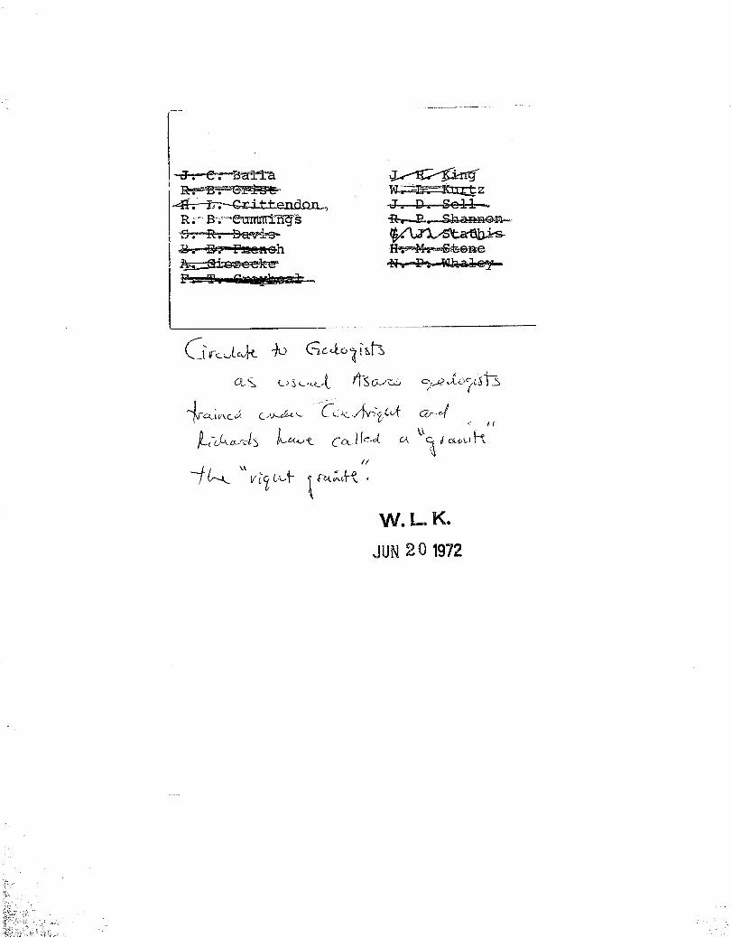
~_tuLJIl
l Li€fUlL6t C
Q-c L`~lLZ-~-~L~
` z
CC,, e~ u ~t dcQti~L~
-~ (--t- vt7 b,~ ~
W.L.. K.
JUN 20 1972

. L. K.
r r s
AMERICAN SMELTING AND REFINING COMPANYTucson Arizona
May 11, 1972
TO: W. L . Kurtz
FROM : J . C . Balla
JUN 2 0 1972
Distinguishing Different AgeIgneous Rocks in the Field
Introduction
One of the questions I was asked to answer by W . E . Saegart as part of mydissertation work was in regard to distinguishing Laramide age igneousrocks from Precambrian age igneous rocks in the field . The question waswhether the criteria used by ASARCO geologists in determining Laramide vs .Precambrian age were valid . Subsequent isotopic dating has shown that, inall but one case, the field determination of age was indeed valid .
Based upon the isotopic dating, it appears possible to distinguish in thefield the correct age of each period of magmatic activity in Arizona, witha partial reservation between the Laramide and Mid-Tertiary .
The following criteria listed for each rock are sufficiently diagnosticthat, in the vast majority of cases, one can feel reasonably confident thatthe age designation is correct . As always, poor outcrops or limited outcropsmay make any designation questionable .
It should also be mentioned that the depth of erosion is quite important .Whether one is looking at the top of a stock or deep into the interior makesa profound difference between the characteristics of each "level" of thestock .
Attached to the report is a series of maps showing "type localities" forthe different age rocks .
Older Precambrian
Madera Diorite and its Equivalents
The isotopic age is approximately 1630 m .y ., but the San Tan Quartz Monzoniteand Table Top Quartz Monzonite (considered to be equivalent to the Madera)yield isotopic ages of 1341 m .y . and 1329 m .y ., respectively .
W . L . Kurtz - 2 - May 11, 1972
This rock varies in composition from a quartz monzonite to a diorite . Itseems to have gradational contacts between these different rock types, in thesame stock . The rock is medium grained, equigranular, non-porphyritic .Epidote is very common, occuring on fracture planes and disseminated(derived from alteration of the mafics) . Biotite has been altered (generally)to chlorite and epidote . Commonly the biotite is "clotty" and appearssheared, as opposed to fresh, shiny books .
The rock intrudes only the Pinal Schist, and may contain numerous xenolithsof Pinal Schist . The rock generally has a crude foliation .
These age rocks occur as small (1000-2000 feet) to medium size (5-10 miles)stocks . The stocks are generally quite elongate .
Oracle - Ruin Granites
This rock yields an isotopic age of 1420 m .y ., although a sample from theSacaton Mountains produced a 1240 m .y . age . This rock is normally called agranite, although compositionally it is a quartz monzonite . These granitesare coarse grained, and porphyritic . A very diagnostic feature are thephenocrysts, which are very large pink K-feldspar . The K-feldspar occursup to 3-4 inches in length . Plagioclase occurs as anhedral to subhedralgrains . Biotite has been altered to chlorite, and is "dotty" in appearance .
The rock is generally non-foliated . It may or may not contain aplite dikes .It also may or may not contain roof pendants of Pinal Schist .
These granites occur as very large batholithic masses . In some cases anentire mountain range may be composed of this rock . The dimensions of thesebatholiths are unknown, but the Oracle batholith appears to be at least50 miles across .
Younger Precambrian
Solitude - Sacaton Granites
These rocks are distinctive, and their Younger Precambrian age is a relativelynew discovery . The Sacaton Granite has an isotopic age of 857 m .y ., and theSolitude Granite has an apparent isotopic age of 800-900 m .y .
These rocks are fine to medium grained, equigranular, non-porphyriticgranites . Particularly diagnostic is the presence of muscovite . Biotitemay also be present, making a "Two-Mica Granite" . So far as known, the rockhas never been found intruding the Apache Group sediments .
The rock occurs as small stocks, with the average dimensions being about amile in diameter .

W . L. Kurtz - 3 - May 11, 1972
Laramide
The Laramide rocks are broken into two general categories, the Graniticstocks and the Quartz Diorite-Diorite stocks .
Granitic Stocks
These rocks range in isotopic age from about 70 m .y . to 52 m .y ., with theolder stocks being in the western part of the State . These rocks range incomposition from a granodiorite to a granite, with most falling in thequartz monzonite-granodiorite range .
These granitic stocks are elongate, composite, epizonal plutons . They mayhave one, two, or three different facies present . The presence or absenceof these different facies is due to the "level" or depth position of thestock that we presently observe, and the magmatic history of the rock . Thecontact zone between these different facies may be sharp (perhaps 10 feet orless) or gradational (hundreds of feet) . It should be emphasized thatdifferent Laramide rocks which are adjacent to each other may only representdifferent facies of the same stock, and that these different facies shouldbe mapped .
These stocks range in size from small stocks (several thousand feet in diam-eter) to very large stocks, occupying 20 square miles or more .
The Laramide age granitic stocks have the widest range of characteristics .There does not appear to be any single characteristic that distinguishesthese rocks from other age rocks .
The rocks are generally equigranular, non-porphyritic . However, in the corezone, or observing a deeply eroded stock (Schultze Granite), large (3"-4" inlength) phenocrysts of K-feldspar or plagioclase may occur . The phenocrystsare generally white, compared to the Precambrian pink K-feldspar phenocrysts .Quartz may occur as rounded phenocrysts, or as interstitial material .
Biotite has long been used by ASARCO geologists as a diagnostic mineral . Ifthe biotite occurred as euhedral, black to blackish green books, it was con-sidered to be diagnostic of a Laramide stock . In general, this criterion isvalid . However, in the core zone of the Laramide stocks, biotite has almostalways been altered to chlorite . Also, fresh, unaltered biotite has beenfound in the Older Precambrian quartz monzonite in the Table Top Mountains .Thus, this particular characteristic must be used with discretion .
The Laramide rocks are generally non-foliated . However, near the contactswith other rocks, the rock may become distinctly foliated . Flow structuresappear to be limited to the Laramide rocks, but occur so infrequently thattheir absence means nothing .

W . L. Kurtz - 4 -
Quartz Diorite - Diorite Stocks
May 11, 1972
These rocks vary in composition from a diorite to a quartz diorite . Theyvary in isotopic age from 70 m .y . to 62 m .y . These rocks are medium grained,equigranular, non-porphyritic . They are not composite stocks .
These rocks seem to generally contain a little sulfide mineralization . Themineralization consists of pyrite, which occurs on fractures and/or disseminated .The pyrite appears to be a late magmatic feature, as opposed to a hydrothermalfeature .
Copper, as chalcopyrite, is associated with the pyrite . Copper values aregenerally quite low, around 500 ppm € 200 ppm . Only two of these stocksapproach being an ore deposit (Chilito, Christmas) . The overall sulfide con-tent is low, less than 2% .
The stocks are generally small, being less than 5000 feet in diameter .
Mid-Tertiary Granitic Stocks
The Mid-Tertiary stocks range from granites to quartz monzonites . They seemto fall into two general "types", those associated with ash flows and ashfalls and calderas, and those not spatially associated with volcanic features .In all probability, the two different types are merely different erosionlevels of the same magmatic events .
The stocks associated with volcanic rocks are quite distinctive . Theserocks, like the Wood Camp Canyon Quartz Monzonite, are generally quartzmonzonite in composition . They are very fine grained, equigranular . Theymay or may not be porphyritic . Phenocrysts, if present, are quartz .Sanidine may be present, and is diagnostic . Rock may be deuterically alteredto clay . Disseminated grains of magnetite and/or pyrite may be common .Mafic mineral, if present, is dark, euhedral, fresh biotite . Miaroliticcavities may be present . The stocks, which are small (2-3 miles in longdimension) may or may not intrude the volcanic pile .
In contrasts to the above are large stocks which have a granitic texture .These stocks , such as the Stronghold Granite (K-Ar age 22 m .y .) are identicalto the Laramide granitic stocks . The only way of determining the age ofthese rocks is by radiometric methods .
John C . Balla
JCB :ladAttach .

APPENDIX I
The following is a list of "type localities" for various rock units . Thefigures are from my dissertation . Thin sections for the rocks are available fromGeorge Stathis . Hand specimens are stored in the basement in a box labeled"John Balla Dissertation Rocks" .
Age of Rock Name of Rock Reference
Older Precambrian Madera Diorite USGS P .P . 342" " San Tan Quartz Monzonite Figure A-5" " Table Top Quartz Monzonite Figure A-6
" Oracle Granite USGS P .P . 471" " Ruin Granite USGS P .P . 342
Younger " Solitude Granite USGS P .P . 342" Sacaton Granite Figure A-il
Laramide Schultze Granite USGS P .P . 342" Core Facies-Granitic Stock Figure A-10
Intermediate Facies-Granitic Stock Figures A-9, A-14Border Facies-Granitic Stock Figure A-13,
sec . 29, T5S, R7EQuartz Diorite-Diorite Stocks USGS GQ-1021
Schmidt, E ., Dissertation',Tortilla Mountains
Mid-Tertiary Wood Camp Quartz Monzonite Figure A-2 ; USGS GQ-128" 11 Stronghold Granite USGS P .P . 281

R . 12 E .
T .
1
S .
44
01
~ 1 Sy
g~T / f~ v r
Figure A-1 . Location of Sample KA 71-1+1
R . 12 E .
T .
i
S .
asoo ~ 111 t~ti) f
` Sr ,I L `-71
a
!13
. . y u r ~ - L s 4_ Q L 7 V I - JG II y 1 G F\M / I --t`f -

120
R . 7 E .
T
3
S .
1572
I, .y uv .,n
83
~I) ~ uI
i I I
u
IIO /II 11
II
II
Figure A - 5 . Location of Sample KA 71-63
R . 2 E .
T.
6
S .
11€ 1rII p R1 I
i!If
IFit II III II I)
71- IIll
2 n11EI
n ti
~/ 5 92
Figure A- 6 . Location of Sample K A 71-75

I,
R . 7 E .
T,
5
S .
Y- 19KA-11-
_
Figure A-9 . Location of Sample KA 71-73
R . 6 E .
T .
5
S .
1,100
r
.KA 71-424 ~
Figure A-10 . Location of Sample KA 71-42

~, y r
I 7. ;
R . 5 E .
T .
5
S .
GtLAy ae )VER 1N_$Y[Al~l -_ $ ?p 'Std!
l A J( / €,f'~
~. X 4 . . .`f `.r4>
- 16y
_/ Vyyy~
-- 1 x X X K x
{t i St+
Figure A- it . Location of Sample .KA 71-70
R . 5 E .
T .
5
S .
6 ii K
h
KA 7I-- '999RRR Se1 ~ n
ulix
' ~b
7 1 23 'J
m 520
( li<9< ~~ WEST VAL VI TA
Figure A-12 . Location of Sample KA 71-69

y~ 1 ~Wv
F B p ru 8> V~i"
AK/.'aT)
.y r h i4 IY60 rY ~
1RpiL a,
1,
kcj/ 505
Figure A-13 . Location of Sample KA 71-65
R . 8 E .
R . 8 E .
T .
4
S .
T.
4
S .
Yep
~Vl/~.J DiY
11~
489
O [^7
8 71-6 ~~
O €Y0
Figure A-14 . Location of Sample KA 71-66
124

&? ZOV~.&.-C Sp'ai i,`~. Tn ~=2._r? ZOV~.
IN, : ?.moo Geol. Boa. 1988
CORRELATION OF SOME POST-LARAMIDE TERTIARYUNITS GLOBE (GILA COUNTY) TO GILA BEND
(MARICOPA COUNTY), ARIZONA
By
James D. SellAmerican Smelting and Refining Company, Tucson, Arizona
GENERAL STATEMENT
Integration of field mapping by various geologistshas resulted in the identification of some correlativeTertiary units along a zone 130 miles in length. Thezone extends from the Globe-Miami area across thealluvial basin at Casa Grande into the Gila Bend area.The rock units are correlated on the basis of rocktype, structural involvement, and sequence, but theyare not necessarily exact time equivalents . This paperdoes not propose that any rock unit completely cover-ed the region from Globe to Gila Bend, nor that similarappearing units in the various areas are necessarilyfrom the same source. The units are post-Laramide(post-early Tertiary) in age.
I wish to thank ASARCO geologists for their writtenand verbal comments and, along with M . E. Cooley,for field checks. American Smelting and RefiningCompany (ASARCO) kindly permitted permission forpublication of the paper .
DIVISIONS
The late Cretaceous-early Tertiary sequence of se-lected localities was reported in a paper by Richardand Courtright (1960) . Summaries of the numerousproblems of Late Mesozoic-Tertiary events involvingsequence and correlations are given by Cooley andDavidson (1963), and Heindl (1962) .
The post-Laramide Tertiary units rest on a wide-spread erosion surface termed the San Xavier surface(Heindl, 1962, p. 13). In this paper the following sixdivisions are proposed for this portion of the Tertiarysequence .
VI Younger basalts
V Tuffs and ignimbrites
Late (?) Miocene-early PlioceneLate Eocene (?) toMiddle Miocene (?)
IV Younger conglomerates)III Older volcanics )II Andesitic volcanics )I Older conglomerates )
69
All divisions are not represented in each area discus-sed ; however, the stratigraphic-structural break repre-senting these divisions has been noted and commentedon by various workers in Cenozoic geology . Field rela-tionships of the rock units and their structural com-plexities indicate that a sequence of depositional-readjustment and volcanic activity was continuous forthe entire time span as covered in this paper. Therelation of structure to deposition, volcanism, anderosion is widely covered in the papers by Cooley andDavidson (1963), and Heindl (1962) . Because of thesecomplexities any of the Tertiary units may be in dep-ositional contact with any Laramide or pre-Laramidesequence .
Unit names in this paper (generally in quotes) arethose given in the various reports and thus are of localusage only. Widespread correlation with named unitselsewhere in Arizona is speculative at this time, andwork is continuing in correlating the Tertiary sequenceof the Basin and Range Province in Arizona .
Division DescriptionI. Older conglomerates. The older conglomerates
are generally tuffaceous and contain large quantitiesof locally derived debris but do not contain fragmentsof extrusive volcanic rocks . The gravels range frompebble to boulder size, angular to rounded, unsortedto poorly sorted. In the eastern area (Superior-Globe-Miami), the conglomerates appear to occupy restrictedbasins whereas westward in the Table Top-Sand Tankarea they were deposited in more widespread sheets .A major unconformity separates the older conglom-erates from the overlying units .
II . Andesitic volcanics. The lower flows of theandesitic volcanics may interfinger with the underlyingconglomerates but the change . occurs rapidly fromdominantly sedimentary rock to dominantly volcanicrock. At the base of the andesitic volcanics are beds,often exhibiting waterlain characteristics, of brown tored-brown cinder and ash beds, and locally in the west-ern area a white pumice bed . Overlying the cindersare non-vesicular light to medium grey andesite flowscharacterized by abundant red specks which are prob-ably iddingsite derived from olivine.

70
The characteristic cinder and ash beds have beenmapped from the Superior area to the Gila Bend areaand constitute a very good marker bed even thoughthey are thin and not present in all outcrops of andes-itic volcanics.
III . Older volcanics. A dark gray , to black ves-icular basalt lies disconformably on the underlyingvolcanic rocks, predominantly andesitic , in the westernpart of the report area . Associated with the basalt is acomplex sequence of andesitic , rhyolitic , and latiticflows and vents . In the Superior-Globe-Miami area, theDivision III unit is a complex of trachyte , rhyolite,glassy lavas , and other flows, which , in Arnett Creekis known to overlie the "red speckled" andesite andthe red-brown cinder-ash beds of Division II . A majorunconformity occurs at the top of the complex Divi-sion III .
IV. Younger conglomerates. The younger con-glomerates appear to occupy very restricted basins andare primarily composed of material from the erodingand reworking of the nearby older volcanic-conglom-erate sequence. Especially characteristic is the abun-dant debris derived from the older volcanics of diversetypes. With the conglomerates are abundant tuff-aceous sandstones, and some mudstones .V. Tuffs and ignimbrites. A vast amount of ash
material, ranging in composition from rhyolitic to dac-itic, and of pastel colors , make up the units of thisdivision. The material is characteristically a weldedtuff or ignimbrite which often has a dense black vitro-phyre layer near the base. The structural complexitiesof the ignimbrites are minor compared to the under-lying units (especially the older volcanic rocks) al-though the ignimbrites are cut by faulting . A minorunconformity separates the units from the overlyingyounger basalts .
VI. Younger basalts. Dense, black basalts overliethe ignimbrite forming material . The basalts are foundas isolated "caps" throughout the region , but are alsofound as widespread , though dissected , sheets .
DESCRIPTION OF AREAS
Five areas, from Globe to Gila Bend, and their se-quence of post-Laramide rock units are discussed inthis section . Figure 1 shows the geographical relation-ship of the areas . Figure 2 is the proposed correlationbetween the six divisions previously described .
Globe-Miami
In the Globe-Miami area the older conglomerateunit of Division I is represented by the Whitetail Con-glomerate which may rest on any of the older rocks .The conglomerate is composed of coarse, bouldery
Arizona Geological Society - Guidebook III
diabase detritus with subordinate amounts of PinalSchist, Apache Group, and Paleozoic limestones . N.P .Peterson (1962, p. 37) writes: ". . . . the lower part iswholly unsorted and unstratified. Higher in the sec-tion crude stratification can be recognized, and lensesof poorly sorted gravel occur that undoubtedly repre-sent temporary stream channels . Approximately theupper 50 feet of the formation is well stratified and iscomposed of layers of dark sand and gravel interbed-ded with layers of white tuffaceous sand ."
The andesitic volcanics, Division II, are not repre-sented in the Globe-Miami area and the older volcanicsof the complex Division III rest directly on the White-tail. The correlation of N. P. Peterson's "Earlier Vol-canics" with Division III is based on Blucher's (1958)and D. W. Peterson's (1962) work in the Superior area .
The Division III unit is a complex assemblage ofbedded tuffs (some of which are waterlain), felsiticand glassy lavas, and perlitic glass . These volcanics areseparated from the overlying volcanics by an "intervalduring which some erosion of the rocks of the firsteruption occurred" (N . P. Peterson, 1962, p . 37) .
This interval of erosion undoubtedly is the intervalrepresented by Division IV, younger conglomerates,but no remnants of any conglomerate have been re-ported .
The Division V, tuffs and ignimbrites, ("Later Vol-canics" of N . P. Peterson, 1962) have a base of whiteto gray crystal-tuff which grades upward into a blackvitrophyre, which in turn is overlain by the massivewelded tuffs or dacite which have a slightly variablelight brownish-gray-orange color .
Superior
The Whitetail Conglomerate (Division I, older con-glomerates) crops out in the Superior quadrangle inseveral places and in Queen Creek within the Thomp-son Arboretum area of the Picketpost quadrangle . TheWhitetail Conglomerate, as described by D . W. Peter-son (1962) is " . . . . fluvial deposits composed ofangular to subangular fragments derived from all olderrocks, mainly from underlying or nearby rocks . Mostfragments are pebble size, some larger. Matrix iscoarse-grained, poorly sorted arkosic to lithic sand-stone, moderately well cemented; bedding planes poor-ly defined or absent ."
Overlying the Whitetail Conglomerate north of Pick-etpost Mountain is the distinctive brown to red-brownash bed which in turn is overlain by a massive blue-black andesite ("Blue Basalt" of Blucher, 1958) withaltered red crystals - probably iddingsite after olivine .These volcanic units represent Division II, andesiticvolcanics, of this paper . In Arnett Creek the ash bedsrest directly on either Pinal Schist or Laramide granite,

71
N
Phoenix
0
MARICOPA COUNTY
SilxMurk
Gila Bend
SAND TANKREGION
GILA COUNTY
r- Globe
Miami 1 ~
.off Superior ` 1I
rcp
SAN TAN- BLACKWATER Ray \ I
AREA POSTEN BUTTE€ AREAOlberg € \
Florence
Coso Grande
TABLE TOPREGION PINAL COUNTY
Double Buttesx
PIMA COUNTY
Tucson
O
SCALE
10 0 to 30 40 0mils
Figure 1 - Location map of south-central Arizona

72
while in the road cuts west of the Arboretum they reston Final Schist and poorly preserved conglomerates .
Blucher and Kinnison in 1960 (Personal Communi-cation) recognized a disconformity separating the Divi-sion II red ash and "Blue Basalt" units from the over-lying complex (Division III) of tuff, spheroidal agglom-erate with perlite, and rhyolite of the Arboretum area .Eastward the units are apparently part of the sequencewhich D. W. Peterson (1962) describes as : "Rhyolite :Lava flows composed of rhyolite and perlitic obsidian .Light to medium-gray rhyolite . . . . generally prominentflow laminations, locally contorted . Perlitic obsidiangenerally forms top or bottom of rhyolite flows . . . .Includes minor deposits of tuff, tuff breccia, and flowsof andesite and trachyte ."
D . W. Peterson (1966) suggests that the tuffs andrhyolites on Picketpost Mountain are younger than thedacite; however previously (1962), he maps and des-cribes the thick rhyolite which underlies the dacitenortheast of Picketpost .
A break suggesting an "unrecognized erosion cycle"(Blucher, Personal Communication) separates the com-plex sequence of Division III from the overlying daciteand welded dacite tuff of Division V . As in the Globedistrict, this interval is represented by Division IV .
The dacite of Division V is described by D . W. Pet-erson (1962) as " . . .ash-flow sheets ; non-welded tuffat the base grades upward to densely welded blackvitrophyre that is overlain by densely welded tuff withcryptocrystalliine groundmass. Progressively upwardfrom the vitrophyre the welding gradually decreases,the amount of crystallization in the groundmass in-creases and the color changes from light brown tomoderate red to very light grey ."
Blackwater-San Tan
ASARCO geologists Blucher and Kinnison conduc-ted the bulk of the mapping in this area and the fol-lowing descriptions are from their reports.
The lowest post-Laramide unit found was termedthe "Yellow Peak conglomerate" for its excellent ex-posure on Yellow Peak northeast of Olberg. This Divi-sion I, older conglomerate , is equivalent in position tothe Whitetail Conglomerate of the Globe -Superior re-gion. The "Yellow Peak" (as reported by Blucher)" . . . .is a poorly sorted, poorly indurated , fluvial de-posit . . . . made up principally of pebbles , cobbles, andboulders of Coolidge granite in a silty matrix." TheCoolidge granite is the report term for the Laramidegranite of the area.
The basal unit of Division II, not everywhere pres-ent, is red-brown cinders and ash beds ("Olberg Beds"of Blucher and Kinnison) which rest directly upon the
Arizona Geological Society - Guidebook III
"Yellow Peak conglomerate" as well as the Laramidegranite. Overlying the red-brown cinders and ash bedsis Blucher's "Blue Basalt" which is seldom amydaloi-dal or vesicular . The basalt weathers to a soft bluish-gray surface. This sequence of cinders and basalt isdirectly correlated with the Division II sequence at theArboretum, Superior, Arizona .
Units composing the complex group of Division III,older volcanics are not exposed in the areas mappedby Blucher and Kinnison, but they may be present inthe volcanic complex of the Malpais Hills to the northand west .
Overlying the "Blue Basalt" is the "Rock Peak con-glomerate" which is assigned to the younger conglom-erates of Division IV. This unit is composed of " . . . .tuffaceous sandstone, siltstone, and conglomeratewhich weathers to a light tan pock-marked surface"(Blucher, private company report) .
The tuffs and ignimbrites of Division V cap RockPeak and Yellow Peak and are exposed in most of thecliffs west of the peaks . This thick sequence of daciticvolcanic rocks is correlated with the dacites to the eastand consists of tan dacite tuff, welded tuff, or tuffagglomerate with a brown to black vitrophyre nearthe base of the series .
The younger basalts (Division VI) cap many of theisolated buttes in the region . They were named the"Walter Butte basalt" by Blucher for exposures onthe butte .
Table Top-Sand Tank
Throughout this region are numerous exposures ofthe older conglomerate - here termed the "AntelopePeak conglomerate" for its excellent exposure on thatpeak in the Antelope Peak quadrangle west of CasaGrande. The Division I conglomerate rests on Pre-cambrian granite at Antelope Peak, on Apache Grouprocks on Table Top Mountain, on Pinal Schist through-out the area, and on Paleozoic limestones and Lara-mide granite south of Freeman Underpass on the CasaGrande-Gila Bend Freeway. Mapping in this area wasconducted by the author. The "Antelope Peak con-glomerate" has a sandy-silty-tuffaceous matrix, oftenwith waterlaid biotite tuff lenses and contains pebblesand boulders of Laramide and older rocks . Some vol-canic porphyry-type pebbles are present in minoramounts but none resemble the overlying volcanics .Boulders of conglomerate similar to the Glance Con-glomerate (Cretaceous) of the Vekol Mountains arealso present .
Division II, andesitic volcanics unit, is composed oftwo distinct units . The lower member, the "Freemanbeds" (exposed in the roadcuts at Freeman Underpass)

rZ`J €Y
DLACKWATERGILA BEND SAND TANK TABLE TOP SAN TAN ARNETT CREEK SUPERIOR SUPERIOR GLOBE- MIAMI(L .A. HeoIdI) (J .D. Sell) (J. D. Sell) (A 13 . Blucher (A .G Blucher (A. G. Blucher) ( D .W. Peterson) (N P. Peterson)
e J.E . IGnnisan) a J.E. Kinrison)X19 miles- ~22 miles' ~ 35rnUes- '30 miiesr '-5 miles,- Same Anon -13 miles-'
\ \lit i iT i R b i lkb W\ T \V Tsv, Volcanic Member
gnr , hyo e m r leV black tro phYre
Rh aliteV y
w
VI
a er,Butte
tuft' ton fullignimbrite It
\ \\ ilD
Docile \
IV ConglomerateTic, Indian
IV Butte(Os1, Coliche
IV cemented Voc eblack docitic vitrophyre V Mossive beds uM
Conglomerate sediments \ to docile lull stratified tufts
younger Volcanics~,\
Rack\
,qI~ Drown rhyulite Docileand/or
Td,Dacite light greyvery t Docile
III Basalt III Tb, unsafe III Tb, Basalt \ IVPeaConk ~ III wpheroirl1 agglomerate \ V welded
D
ci eV moderate red dede
li ilet b dV b black
Tu ,undifferentiated \ Conglomerate1
,',)' IJ
with perlite
\
ociletuff
gh rown ocvitropnyreblock
to~ white b grey crystal-tuffH
-- - III /
- Ton water-loin tuffs "
--
- w-.elded tuff
-
Dacitb welded tuff Tits, Double Buttes Voloanicsdocile tuff
Tov, Older Volconicsra it t ff Blue "Blue \~ r Rhyolite
-
Tr, Rh0olite A Campus of beddedblock vitrophyre -
storm l e99t e u
scoria- agglomerate Basalt Basalt bva flq . of likr
ard lis, felsite andbut,.
IIec d wlde
II red speckled andesite 11 red speckled undisilt II II III VilroPhYre full fullIII lgla
III _ glossy l as, ands
Brownish red ash Ti b, Freeman Beds red cinders and ash~Olberg beds Brownto \ Tuff breccio and flows of
aNesite and trochyfe
gly Per ia glaze
ac tion sandstone s red brown ash red brown ash
Tsm, Sedimentary Member Toc, AntelopeP bblT
T., WhitetailCangbmerate
Tw, WhitetailConglomerate
Tar, WhitetailCoglomerute
Tw, WhitetuilConglomerateI gay boulder conglomerate I peak s, e eI I Yellow Peak
"II I
indurated fonglomerote ; Conglomerate Conglomerate Conglomerate Area-(Arboretumbrick red urkusb sandstone sell)
LARAMIDE AND PRE-LARAMIDE ROCKS
Figure 2 - Proposed correlation of post-Laramide units in central Arizona
VW
74
is composed of brown-red cinders and ash with whitepumice. The upper member, "Double Buttes volcan-ics" (named for the exposures in the Table Top quad-rangle), is composed of purple-gray andesite contain-ing the characteristic altered red crystals, lava scoria .cinders, agglomerate, and sometimes local units ofdacitic tuff.
In the Sand Tank region, the volcanics of DivisionII are mapped as the Sauceda volcanics of Cretaceousage by Wilson et al (1957). As the volcanics overliethe older conglomerates which contain fragments ofLaramide-type rocks, the volcanics must be youngerthan Cretaceous .
The interfingering of the lower conglomerate typeunit with the first phases of extrusive volcanic actionof the Division II units is well demonstrated in expo-sures in the region . However, it is not known whetherthe interfingered conglomerates are merely the resultof erosion and reworking of the main conglomerateunits or whether it reflects the continued inflow fromthe conglomerate source areas. The exposures show,however, that the change from dominantly sedimen-tary processes to dominantly volcanic processes issharp and complete .
Overlying the andesitic volcanics are units of Divi-sion IIl. In the Table Top area, Division III is a basaltsequence of dark glassy basalt and dark andesitic ba-salt; whereas, to the west in the Sand Tank area thebasalt is associated with a complex of andesitic, latitic,and basaltic volcanics interbedded with minor tuffaceous units .
The younger conglomerates of Division IV are poor-ly exposed throughout the region but scattered out-crops of conglomerate containing fragments of all pre-vious volcanic types in the area can be found. Oneexposure is at Indian Butte (Table Top quadrangle)where a tuffaceous, often caliche-cemented, conglom-erate contains numerous fragments of the older val-canics and basalts. Northwest of the Table Top Moun-tains an outcrop of conglomerate containing all typesof voicanics is found underlying a rhyotite ignimbrite .
Capping many isolated buttes, especially north ofthe Freeman Underpass, is a distinctive pinkish rhyo-lite ignimbrite which generally has a basal tan tuff andblack vitrophyre. The tuff, vitrophyre, and rhyoliteignimbrite are assigned to Division V . An unconform-ity separates Division V units from the underlyingunits, and the upper units have been subjected to onlyminor faulting and tilting .
No dense black basalt of the Division VI type wasfound in the area mapped .
Arizona Geological Society -Guidebook III
Southeastern Gila Bend Mountains
The work of Heindl and Armstrong (1963), follow-ing the previous work of Babcock and others (1948),was a rapid reconnaissance of a small part of the southend of the Gila Bend Mountains . Heindl defined anddescribed the "Sil Murk Formation" in this report and,although additional work is needed to definitelyestablish the correlation, the sequence of units theydescribe in this formation resembles the sequence ofunits in the Tertiary section farther east .
The Division I conglomerates are mapped over muchof the Gila Bend area and were named the "Sedimen-tary Member" of the Sil Murk Formation .
The "Volcanic Member" overlies an angular uncon-formity cut on the conglomerate and is sequence inwhich Heindl lists the following, ascending, types :Eolian tuffaceous sandstone, brownish-red ash, blackvitrophyre, and dacitic welded tuff (all Division II) ; afine-grained black basalt {Division III) ; a conglomeratecontaining both gneissic and volcanic rocks (DivisionIV); and a lavender tuff, possibly dacitic (Division V) .
Also found on the northwest side of the area (butnot mentioned by Heindl) is the distinctive pinkrhyolite ignimbrite of Division V, which is underlainby conglomerates having volcanic material and belonging to Division IV .
REFERENCES
Babcock, H . M., Kendall, K . K., and Hem, J . D., 1948, Geology andgroundwater resources of the Gila Bend basin, Nlaricopa County,Arizona : U . S . Geol. Survey, Open-file Report, 27 p .
Blucher, A . G., Jr., 1958, Porphyry copper reconnaissance, Globe-Superior region, Pinal-Gila Counties, Arizona : private ASARCOreport, 12 p .
Cooley, M. E., and Davidson, E. S ., 1963, The Mogollon Highlands -their influence on Mesozoic and Cenozoic erosion and sedimentation :Ariz . Geol. Soc . Digest, v . VI, p . 7-35 .
Heindl, L . A., 1962, Cenozoic geology of Arizona - A 1960 resume :Ariz . Geol. Soc. Digest, v. V, p. 9-24.
Heindl, L. A ., and Armstrong, C . A ., 1963, Geology and ground-waterconditions in the Gila Bend Indian Reservation, Maricopa County,Arizona: U. S. Geol. Survey Water-Supply Paper 1647-A, 48 p .
Peterson, D . W., 1962, Preliminary geologic map of the western part ofthe Superior Quadrangle, Pinal County, Arizona: U. S. Geol. SurveyMineral Investigation Field Study Map, MF-253, 1 sheet .
Peterson, D . W., 1966, The geology of Picketpost Mountain, NortheastPinal County, Arizona : Ariz. Geol. Soc . Digest, v. VIII, p . 159-176 .
Peterson, N. P., 1962, Geology and ore deposits of the Globe-Miamidistrict, Arizona: U. S. Geol. Survey Prof . Paper 342, 151 p.
Richard, K ., and Courtright, J . H., 1960, Some Cretaceous-Tertiaryrelationships in southeastern Arizona and New Mexico : Ariz. Geol.Soc. Digest, v. III, p . 1-7.
Wilson, E. D., Moore, R . T., and Peirce, H. W., 1957, Geologic map ofMaricopa County, Arizona: Arizona Bar. of Mines, I sheet .

FIGURE 21- CORRELATION OF RE BRI FORMATIONS IN CENTRAL; ARIZONA
D. E. LIVI NGSTON, 1969
NORTHEMC
AGEMILLIONS WILSON
YEARS SILVER
GASTIL
1,100
1,300
1,400
MAZATZMAVERIDEADMA
- UNC((OVERL
1,500 RH)
1,600
ePb GF1,650
(IN
1,700- wb RE
1,715
AL
YAE
1 .800-
967
;E
ITZITE
ROUP
NITE
[ORITE ?
V INL SCHIST
(N MAZATZALJNTAINS_
1939a
1964 8 1967
1958
DIAMOND BUTTEQUADRANGLE
GASTIL, 1958SILVER, 1967
SOUTHERN MAZATZALMOUNTAINSSALT RIVER AREA
WILSON, 1939aSILVER, 1968
THIS REPORT
SOUTHERN MAZATZALMOUNTAINS
FOUR PEAKS AREA
WILSON, 19390
THIS REPORT
I SIERRA ANCHA
SHRIDE, 1967
DAMON, ET AL 1962
SILVER, 1960 8 1963
THIS REPORT
WHITE LEDGES
THIS REPORT
PINAL MOUNTAINS
RANSOME, 1903 & 1919
THIS REPORT
TORTILLA MI_
RANSOME, 19SCHMIDT, IS
SILVER, 1967THIS REPOR'
KAr
DIABASE 1'140 DIABASE DIABASE DIABASE DIABA!
U-Pb
1,200
TROY QUARTZITE TROY QUARTZITE TROY QUARTZITE TROY QUARTZITE TROY QUAI
APACHE GROUP APACHE GROUP APACHE GROUP APACHE GROUP APACHE GROUP APACHE C-UNCONFORMITY- -UNCONFORMITY- -UNCONFORMITY- -UNCONFORMITY- -UNCONFORMITY- -UNCONFOI
iSr GRANITESGRANITE AND 1,3 (intrude K-Aro (METAMORPHISM
INTRUSIVE RHYOLITE MAZATZAL 1,380OF PINAL SCHIST)QUARTZITE)
Kor RUIN GRANITER-ArKo RUIN GRANITE RUIN GRF
OXBOW MNTN . RHYOLITE 1,420 1,420%L QUARTZITE HAIGLER FORMATION MAZATZAL QUARTZITE'K SHALE BOARD CABIN FORMATION MAVERICK SHALE HESS CANYON GROUPJ QUARTZITE HOUDEN FORMATIONNFORMITY - - UNCONFORMITY- -UNCONFORMITY---ES RED ROCK T RtrSro (METAM(OL ITE)
RI SSr REDMOND FORMATION
TI 1,500 OF RH
,5I RbSro MADERA DIORITEI 11,540
MADERA C
Rb-SrU_pb GRANODIORITE1,63 FINAL SCHIST R€ r
ANITE NEAR.
6401SUNFLOWER 1,650 ,TRUDES ALDER RHYOI
SERIES ) _ FLO'PING
TROCK RHYOLITfault -
7 FLYING W FORMATIONRb Sr MADERA DIORITE? ,715
HER SERIES ALDER FORMATION 1,730
fault - -fault-1
iER GREENSTONE PRE-ALDER ROCKSCHIST?PINAL
'%" ISOTOPIC AGE DETERMINATION, METHOD AND ERROR LIMITS AS INDICATED1'130