access statement constraints statement …docs.azgs.az.gov/speccoll/2009-01/2009-01-0006.pdf ·...
TRANSCRIPT
The following file is part of the A. F. Budge Mining Ltd. Mining Collection
ACCESS STATEMENT
These digitized collections are accessible for purposes of education and research. We have indicated what we know about copyright and rights of privacy, publicity, or trademark. Due to the nature of archival collections, we are not always able to identify this information. We are eager to hear from any rights owners, so that we may obtain accurate information. Upon request, we will remove material from public view while we address a rights issue.
CONSTRAINTS STATEMENT
The Arizona Geological Survey does not claim to control all rights for all materials in its collection. These rights include, but are not limited to: copyright, privacy rights, and cultural protection rights. The User hereby assumes all responsibility for obtaining any rights to use the material in excess of “fair use.”
The Survey makes no intellectual property claims to the products created by individual authors in the manuscript collections, except when the author deeded those rights to the Survey or when those authors were employed by the State of Arizona and created intellectual products as a function of their official duties. The Survey does maintain property rights to the physical and digital representations of the works.
QUALITY STATEMENT
The Arizona Geological Survey is not responsible for the accuracy of the records, information, or opinions that may be contained in the files. The Survey collects, catalogs, and archives data on mineral properties regardless of its views of the veracity or accuracy of those data.
CONTACT INFORMATION Mining Records Curator
Arizona Geological Survey 416 W. Congress St., Suite 100
Tucson, Arizona 85701 602-771-1601
http://www.azgs.az.gov [email protected]
CO?Jlr~ ,~n,d-in:3
Saddle lllountaz'!Z. #1.
{lood Jiu121ilZ9 Area
To CO?Jlr~ ,~n,d-in:3
Saddle lllountaz'!Z. #1.
{lood Jiu121ilZ9 Area
To
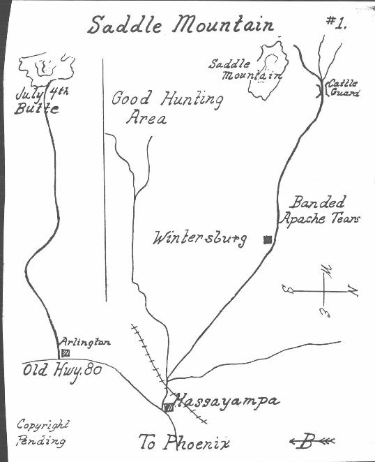
SADDLE MOUNTAIN
This is the most popular trip from. Phoenix. Found here are Desert Roses, Agate of various colors. som~ with opalescence. Finer specimens require climbing to top of north peak. Start early and carry plenty of water with you on hike.
From Phoenix take Highway 80 west to Hassayarnpa, 41 miles. (Just beyond Buckeye stay on old highway). Turn right on good dirt road at 2.7 miles, cross railroad, take left fork and shortly turn right on Saiome Road. At 5.7 miles you com.e to Ghost Town of Wintersburg To left on low mesas Banded Smokey Topaz or Apache Tear s may be found. Continue on to cattle guard at 15.9 miles, turn left and follow road to base of mountain . Or continue on to 17. 9, then turn left 1 mile, thence west about 2.9 miles. Park. This is collecting area ...
JULY 4th BUTT~
Continue on Highway 80 through Hassayampa to Arlington. Turn right at cattle pens to railroad, then another equal distance to July 4th Butte. Soon after crosslng railroad start looking for Agate and Jasper on left, Near the butte Geodes should be found. The large area to right all the way to Saddle good hunting ground and much nice Agate has there.
This is a large area and one could get lost, so stay within sight of your car and be sure to take plenty of water not only to have at your camp but to carry with you on hikes. You should also carry a snake bite k~.t. One in your car a quarter or half mile away is worthless if needed.
.lliack Cany"on Seclion ·1
Sunsel )t,z'n t loo~out Post PSE
3m; '
Jl,6"t- 2~9 .2
/l (.." ~./ 7' J J?h c ~dlJz,1
.lliack Cany"on Seclion ·1
Sunsel )t,z'n t loo~out Post PSE
3m; '
Jl,6"t- 2~9 .2
/l (.." ~./ 7' J J?h c ~dlJz,1
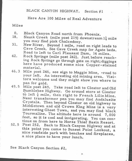
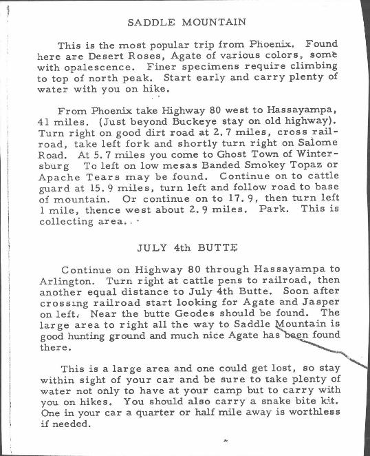
BLACK CANYON HIGHWAY. Section #1
Here Are 100 Miles of Real Adventure
Miles
o. Black Canyon Road north from Phoenix. 18. Skunk Creek (mile post 2.19) downstream Ii mile
you may find pink Chalcedony. 31. New River. Beyond 1 mile, road on right leads to
Cave Creek. See Cave Creek map for Agate beds. Road to left to Carl Pleasant Dam, 14 miles . .
42.. Rock Springs (mile post 242.). Just. before reaching Rock Springs go through gate on right; diggings here have produced some nice Copper-stained material. .
46.3 Mile post 2.46, see sign to Maggie Mine, -road to your left. An interesting old mining area. Visitor s welco.me and they might show you where to pan for gold.
49.5 Mile post 2.49. Take road left to Cleator and Old Bumblebee Highway. Go around store at Cleator to left t mile, then right to French Lilie Mine. Near transformer pen you may find Andalusite Crystals. Then beyond Cleator on old highway to Middletown and old Crown King Mine is a very interesting Ghost Town, and you may find black Tourmaline. The altitude here is around 7,000 feet, so it is cool and invigorating. You can continue on from here to Horse Thief Basin Resort. 52..5 Post 252.. Back to Black Canyon Highway and at this point you come to Sunset Point Lookout, a nice roadside park with benches and fireplaces, a nice place to have your lunch.
See Black Canyon Section #2.,
~ :r - - ---- ~ ' .
;)~Jjl ack Call !l.0/t To Jerome SeC(lOI't e
C().P!lrlght PendinJ
?.s ])ew4 Y tr 7{runlJoll
3.31'1,,:
~ldoJy ~asi/t A'd.
f'A 3 ullse I .JiZlt I Ldd"r~ 09/25"2
4 j) «<.
~ :r - - ---- ~ ' .
;)~Jjl ack Call !l.0/t To Jerome SeC(lOI't e
C().P!lrlght PendinJ
?.s ])ew4 Y tr 7{runlJoll
3.31'1,,:
~ldoJy ~asi/t A'd.
f'A 3 ullse I .JiZlt I Ldd"r~ 09/25"2
4 j) «<.
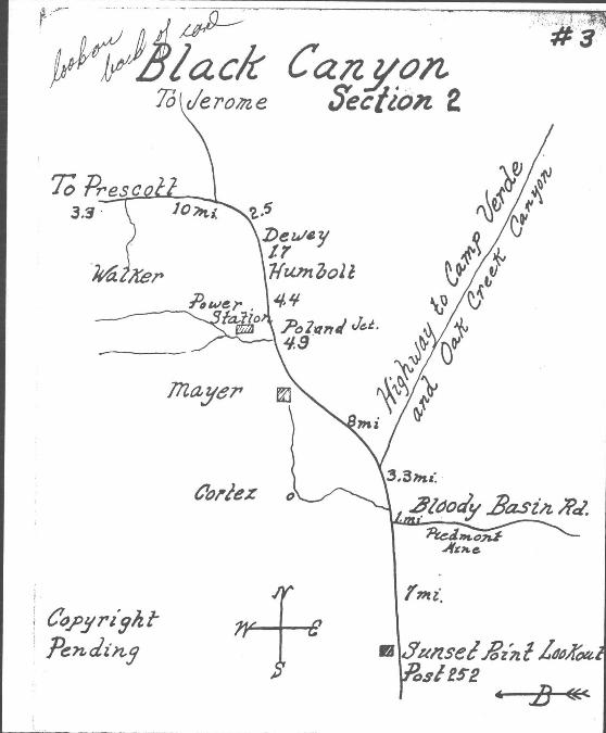
I: BLACK CANYON. Section HZ .
Miles
52.5 Mile Post 252. Start at this Sunset Point Lookout 52.5 miles from Phoenix.
59.5 Bloody Basin Road to your right. In a few miles you corne to old Piedmont Mine - some very nice Copper -stained specimens have been found here. This road continues to Bloody Basin Summit and through to Seven Springs and Cave Creek. A little rocky to summit and then a very steep downgrade into Bloody Basin, a steep but scenic road.
60.5 Road to left to'lCordes. 64. New highway .leads to Verde Valley and Oak Creek. ~Swing left here to Mayer. Near Mayer is where best
Arizona Onyx is found. 77. Poland Junction, turn left, pass power station. As you
enter canyon the road forks, the right or upper road leads to old workings in side of hill and Marcasite can be found,on the old dumps. The lower road goes along the creek and is a good place to pan for Gold. This is an interesting canyon and much time may be spent here.
8!. Interesting old Ghost Town of Humbolt and at 83. miles you reach town of Dewey.
85. Here again, the highway forks. Straight ahead is to Jerome via Mingus Mountain. (Jerome is a Ghost Town complete with Museum and relics on display.) However, swing to your left toward Prescott.
95. Note small sign on your left to Walker. Take this road to end, about 8 miles. Here is the Old Walker Mine and fine Fool's Gold specimens may be picked up. This IS
another Ghost Town and a nice place for a picnic. 99. City of Prescott. A mile high and cool, with Museums
and other points of interest for the visitor. Return to Phoenix may be made via Wickenburg.
This is Truly 100 Miles of Advenhlre for the Rockhound.
#="1 leAVE CP,EEK" SEVEN SPRINGS I . . .
I I
Y"
r· ~ : "'\ . . ' -~I~.
N
s
J.IUMBOL.1 Mr-L. o./< (){} T «" R4DA( r()rN~R.
o CARPENrE~S 1<oCk" SHoP ~ CAv I! eli! E efoC;
To 1>Ho P!...N1'f(
: >:,.'
#="1 leAVE CP,EEK" SEVEN SPRINGS I . . .
I I
Y"
r· ~ : "'\ . . ' -~I~.
N
s
J.IUMBOL.1 Mr-L. o./< (){} T «" R4DA( r()rN~R.
o CARPENrE~S 1<oCk" SHoP ~ CAv I! eli! E efoC;
To 1>Ho P!...N1'f(
: >:,.'
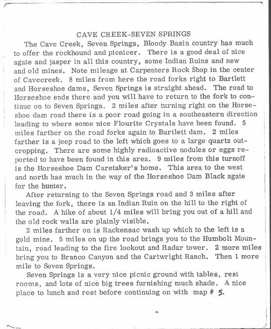
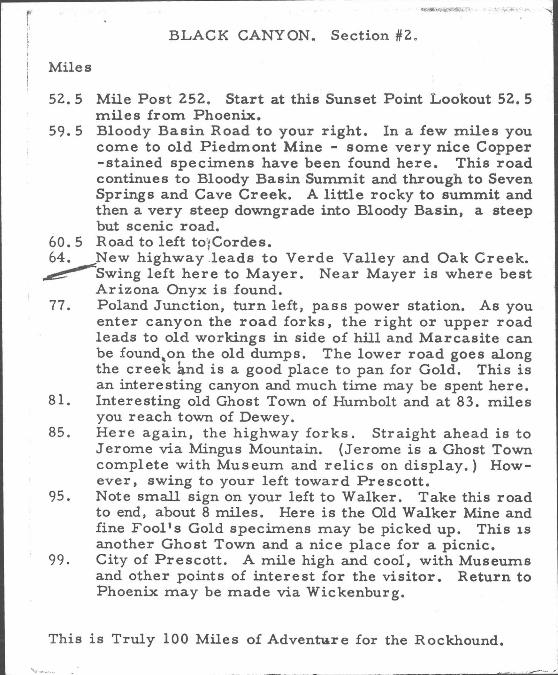
CAVE CREEK-SEVEN SPRINGS The Cave Creek, Seven Springs, Bloody Basin country has much
to offer the rockhound and picnicer. There is a good deal of nice agate and jasper in all this country, some Indian Ruins and new and old mines. Note mileage at Carpenters Rock Shop in the center of Cavecreek. 8 miles from here the road forks right to Bartlett and Horseshoe dams, Seven Springs is straight ahead. The road to Horseshoe ends there and you will have to return to the fork to continue on to Seven Springs. 2 miles after turning right on the Horseshoe dam road there is a poor road going in a southeastern direction leading to where some nice Flourite Crystals have been found. 5 miles farther on the road forks again to Bartlett dam. 2 miles farther is a jeep road to the left which goes to a large-quartz outcropping. There are some highly radioactive nodules or eggs reported to have been found in this area. 9 miles from this turnoff _ is the Horseshoe Dam Caretaker's home. This area to the west and north has much in the way of the Horseshoe DaI? Black agate for the hunter.
After returning to the Seven Springs road and 3 miles after leaving the fork, there is an Indian Ruin on the hill to the right of the road. A hike of about 1/4 miles will bring you out of a hill and the old rock walls are plainly visible.
2 miles farther on is Rackensac wash up which to the left is a gold mine. 5 miles on up the road brings you to the Humbolt Mountain, road leading to the fire lookout and Radar tower. 2 more miles bring you to Branco Canyon and the Cartwright Ranch. Then 1 more mile to Seven Springs.
Seven Springs is a very nice picnic ground with tables, rest room s, and lots of nice big trees furnishing much shade. A nice place to lunch and rest before continuing on with map # S.
, ____________ ~ __ "_J-_ _'
. I #5 SEVEN SPrl.'~G S • A~I'ZONA AGATE MINE.
. I #5 SEVEN SPrl.'~G S • A~I'ZONA AGATE MINE.
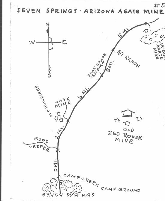
SEVEN SPRINGS-ARIZONA AGATE MINE
The trip from Seven Springs on to the Arizona Agate Mine goes .hrough some of the most rugged country in the State and is real I
~ood hunting ground for the Rockhound. 1 mile froOm the Seven Spring~'\ )icnic grounds is the Camp Creek camp ground. Of particular inter-3st here are the fences, table supports, and rest rooms constructed )f some of the most beautiful red jasper you have ever seen. This jasper was taken out of this area and just needs some hunting to :1uplicate it. 2 miles farther on is a road to the left (west) turning )ff just before you start up a slight rise. Go up this road about 1/2 mile and then start looking on hillside to the west. Some very fine ' jasper of many different shades can be found here and there is what :l.ppears to be an endless supply. After turning to the road, 2 miles more will bring you to the old buildings of an old onyx mine. The mine is up a little canyon about 1/2 mile and can be seen from the road. Shortly after leaving here you will be able to see the buildings . of the 0 ld Red Rover Mine to your Right, and at one place the road , comes close enough for a real ambitious hiker to make his way there.
6 miles from the onyx mine turn off, watch closely in the bank along the road for some low grade obsidion. 3 miles farther on you will come to the gate of the 5/1 Cattle Ranch. If necessary, water is available just through the gate on the right side of the road.
5 miles farther on there is a small, ill-defined road which turns to the right across a dry creek bed which leads to the old buildings of the Arizona Agate Mine. Do' not attempt to go across in most passenger cars, but park on the roadside and walk in about two city blocks. The agate available here is in the old diggings on the north slope of the hillside beyond the buildings, however agate can be found in the hills on both sides of the road and in a large area at this location. We recommend good tires and a good water supply.
__ . _____________________ ...:;.6_----..
CLIFTON A ~E A
--4-~-e.
s
CLIFTON A ~E A
--4-~-e.
s
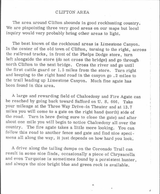
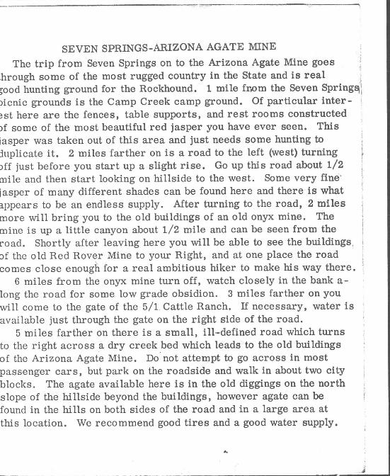
ClJFTON AREA
The area around Clifton abounds in good rockhunting country. We are pinpointing three very good areas on our maps but local inquiry would very probably bring other areas to light.
The best known of the rockhound areas is Limestone Canyon. In the center of the old town of Clifton, turning to the right, across the railroad tracks, in front of the Phelps Dodge store, turn left alongside the store (do not cross the bridge) and go through north Clifton to the next bridge. Cross the river and go until the first cattle guard or 1. 5 miles from the store. Turn right and keeping to the right hand road in the canyon go .2 miles to the trail leading up Limestone Canyon. Much fine agate has been found in this area.
A large and rewarding field of Chalcedony and Fire Agate can be reached by going back toward Safford on U. S. 666. Take your mileage at the Three Way Drive-in Theater and at 13.7 mi les you will come to a gate on the right hand (north) side of the road. Turn in here (being sure to close the gate) and after about one mile you will begin to notice Chalcedony all over the country. The fire agate takes a little more looking. You can fo llow this road to another fence and gate and find nice specimens all along the way, it just depends on how hard you look.
A drive along the tailing dumps on the Coronado Trail can result in some nice finds, occasionally a piece of Chrysacolla and even Turquoise is sometimes found by a persistent hunter, and always the nice bright blue and green rock is available.
yJlCA<:" /£u1' 5
.\ -~ \n
l
yJlCA<:" /£u1' 5
.\ -~ \n
l

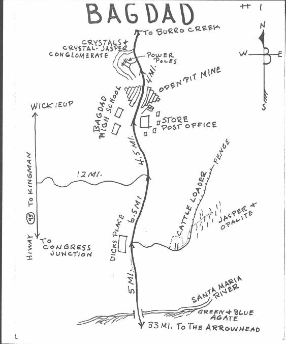
BAGDAD The Bagdad area offers much to the Rockhound who will spend
a little time and effort seeking out the good specimens. The Bagdad road turns north off the Wickenburg, Prescott
hiway-at the Arrowhead service station, 2 miles north of Congress Junction. The country is a constantly changing scene from jagged rock cliffs to rolling mountain ranges. 33 miles from the turnoff you will come to a wide wash and a fairly long bridge. This wash is unmarked and is the Santa Maria River. Dilligent search along the banks and sand bars has turned up specimens of petrified cactus and nice blue and green agate. 5 miles further on you will come to the crossroad. To the left is a little tavern, Dick's Place. You turn right 3 miles to a cattle loader. A fence starts at the right side of the cattle loader and extends in a northernly direction. Fo How along this fence and search in all the area, east, should reward the sharp eyed hunter some nice pieces of jasper, and after returning to the hiway continue on to Bagdad.
Notice the mileage at main shopping center in the middle of town. From this point go straight ahead to the Copper Co.'s open pit. The road goes right through the bottom of the open pit and driving in the pit should be watched carefully as all traffic is on the left hand side of the pit. *"The best way to get through the pit is to ask about the road out to Burro Creek as the roads in the pit change from time to time. Four miles from the shopping center two large power poles in tandem can be seen on the horizon about 300 feet up the hillside to the left. At the poles will be paths going up the hill in both directions.
Search in this area will turn up beautiful Jasper and Crystal Conglomerite which takes a fine polish. Nice Crystals are found here, too.
* Get permission at office to enter Company pit.
# 8 # 8
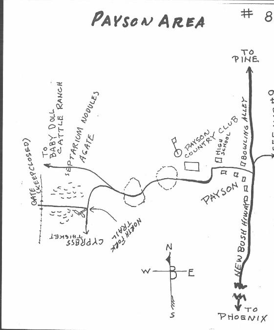
PAYSON AREA This is a hunting area that can be combined with a trip over one
of Arizonas most scenic drives to the pine clad mountains and some of the State's best fishing.
4 miles after crossing the Verde River on the Fort McDowell Indian Reservation a small hill to the left of the road has produced some good desert roses. 4 miles farther on is the turnoff to Saguaro Lake. The area on the north side of the Lake has also been a desert rose hunting spot. 21 miles farther on the Sunflower store and Sycamore creek area offer a nice picnic stop. There are Cinnabar Mines in this area and if the operators are there some good material can be found.
Note mileage at bowling alley in the center of old Payson. Go I west past the high school and on past the Payson Country Club,
continue on this road and after crossing the second ridge at 4.8 miles from bowling alley watch very closely for a road leading off to the left. This road is not"marked, runs parallel to the main road, looks more like just a turn out and is only visible for about 100 feet so again we stress the importance of a close watch to be sure you catch it. .2 miles after turnoff you will come to an old junk car. At. 8 miles you will corne to a sign; North Peak Trail to your right and Cypress thickett straight ahead. Turn on North Peak Trail road and hunt in the area on both sides Of the road from the sign to the fence 1. 5 miles up this road.
There is some nice agate, almost like petrified wood and septarium nodules which make very nice spheres to be found in this area. This is a large field and should provide good hunting for a long time.
To go on from here see map # 9.
Co/'~r&At PendilZ!l (E «< Co/'~r&At PendilZ!l (E «<
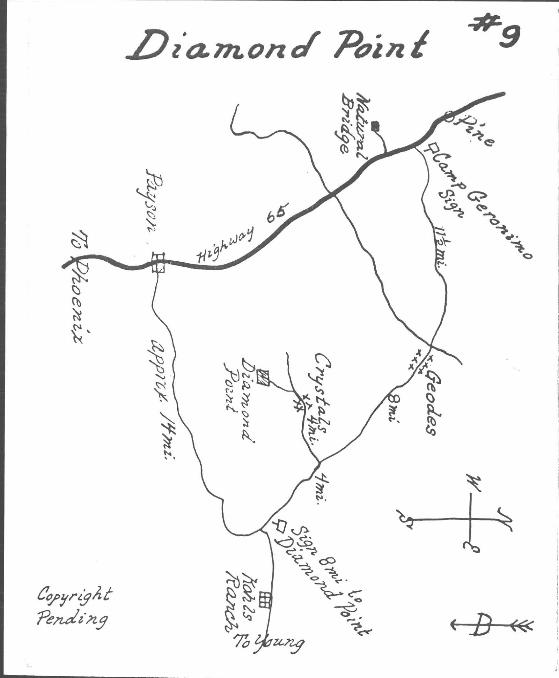
DIAMOND POINT
Here is an intere,sting trip that can be made alone or in conjunction with the Stewart Mountain Dam trip.
Go to P~yson over new Bush Highway, then east 14 miles. (Good fishing beyond Kohl's Ranch.) Note sign to Diamond Point; turn left and follow signs to Lookout at Diamond Point. Best place to hunt for Crystals is near road before last turnoff to Lookout.
Crystals may be found on the surface, but some shallow digging will reveal the best ones.
Return 4 miles to where you turned off and continue left another 8 miles. Here at a point a mile from the
river you will find lots of Geodes. Many are duds, but at times you will come across some with very nice Crystals in them. There are other rocks of interest in this area, also.
You may continue on this road where it joins main highway from Payson to Pine. In doing so you will pas s the road to the New Scout Camp, a place worth visiting.
Back toward Payson you will come to a side road on your right (14 miles from Payson) which leads to Natural Bridge in approximately 3 miles. Near here some very nice Serpentine may be found.
From Kohl's Ranch you could continue to Young and return via Roosevelt Lake or Globe-Miami.
See card #. 11 Jasper.
Apache Trail
on La.Ke
(J~ RoeJtl~ ~
~~~ t1 ~ ~~R..
:--...~
~~tlj
~ ~~. ~ ~
"" ~. ~
CJ;)
~ ~ ~~ >-nI 't "'$
~~ .. fi-I'
c:,~31 r?jllz.i' ~?ldin.3
C'b < B «<
Apache Trail
on La.Ke
(J~ RoeJtl~ ~
~~~ t1 ~ ~~R..
:--...~
~~tlj
~ ~~. ~ ~
"" ~. ~
CJ;)
~ ~ ~~ >-nI 't "'$
~~ .. fi-I'
c:,~31 r?jllz.i' ~?ldin.3
C'b < B «<
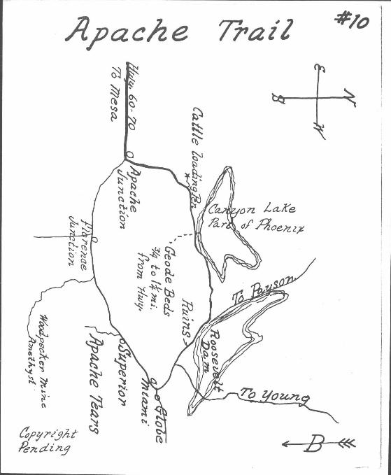
APACHE TRAIL
One of the Inost scenic and interesting trails to those interested in geology or rocks. At every turn of the road you will find different forInations and colors.
When you get your first gliInpse of Canyon Lake (first lake you COIne to) approximately 15 Iniles froIn Apache Junction, stop and back up to flat of hill where you will find a cattle loading corral on your left. Park here. On both sides of highway you can find Desert Roses and should be able to find SOIne SInal! dark brown Geodes.
On alongside the lake you will COIne to Port of Phoenix, where soft drinks and sandwiches Inay be secured and one can go boating.
Across froIn Port of Phoenix about Ii Iniles (hike) beyond second ridge, Geodes Inay be found.
This highway is paved to Port of Phoenix. Good dirt road on to Roosevelt DaIn and Globe. A winding road but very scenic. Stop at lookout points along the way. At Tortilla Flats and other side canyons along creek, Quartz Crystals and Desert Roses Inay be found.
Just beyond Roosevelt Lake on Highway 88, see sign to Tonto National MonuInent. This is an ancient Cliff Dwelling and well worth one's time to stop and see.
Take plenty of water, first aid and snake bite kits on all your trips.
H O(}.5'e veIl lake
Jas/?er 70
f)o7fl
C();-rr- J
fi 1\ e ii t_W---ZValer.she 1Jtalr:o~
~II
in t,tiJ i'l"a.s'A j'rna .8a,Med
Ja..5J'r!J'
H O(}.5'e veIl lake
Jas/?er 70
f)o7fl
C();-rr- J
fi 1\ e ii t_W---ZValer.she 1Jtalr:o~
~II
in t,tiJ i'l"a.s'A j'rna .8a,Med
Ja..5J'r!J'
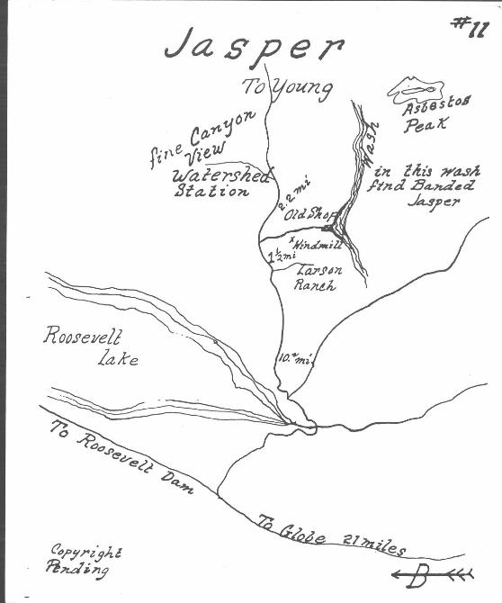
JASPER /
On Highway 88, 21 miles northwest of junction between Miami and Globe, turn right on Young Road. Up this road 14 miles you will come to the Larson Ranch, where Uranium was discovered.
One and a quarter miles on up the road you will see a windmill down in the desert to your right. Go through the gate and continue to the dry creek bed. You will find an old blacksmith shop on the bank.
This is a good hunting ground for beautiful mottled Jasper. Upstream you may find Asbestos, and there is claim that some really fine Jade was found here. At least it is an interesting place to explore and to hunt for rocks.
On up the road 2 miles from the ranch, you will note a rain gauge station on your left. Turn left just beyond this to a grand view of the canyon. Really a sight worth driving miles to see.
This road may be continued on to Young and on to Camp Geronimo and Payson. Not a bad road and one that is surely scenic.
East of Kohl's Ranch is good fishing.
See map #9 for trip to Diamond Point that may be reached from this road 14 miles east of Payson.
Be sure to take plenty of water, first aid and snake bite kits on all trips.
..
~ B tC:( ~ B tC:(
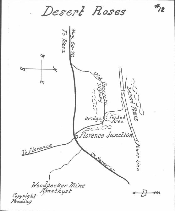
DESERT ROSES
Here is a trip fairly close to Phoenix where Desert Roses may be found.
Take Highway 60-70 east from Mesa; pass Apache Junction on to Florence Junction. Just as you come in sight of the stations at Florence Junction you will see the old cement highway leading off to your left. Take this and in a couple of miles you will come to a bridge in the curve of the road. Beyond this is a fenced area. Just beyond the fence take dirt road along fence a short distance to power line and at power line turn left and follow under power line for approximately i mile. Roses may be found here and to your right in the low hills. Instead of turning off old highway at fence you can continue on and leave your car opposite small hill on your left and hike across wash to same spot.
You can continue on this old highway and it will bring you back onto the main highway toward Mesa.
An interesting highlight may be made to this trip by going up Apache Trail 2 or 3 miles to a side road on your right to "B Bar B" Ranch. Go in and visit Barney Bernard, who has lived here for a great number of years. His stories about the Superstition Mountains are most interesting. You will find him to be a wonderful host.
..
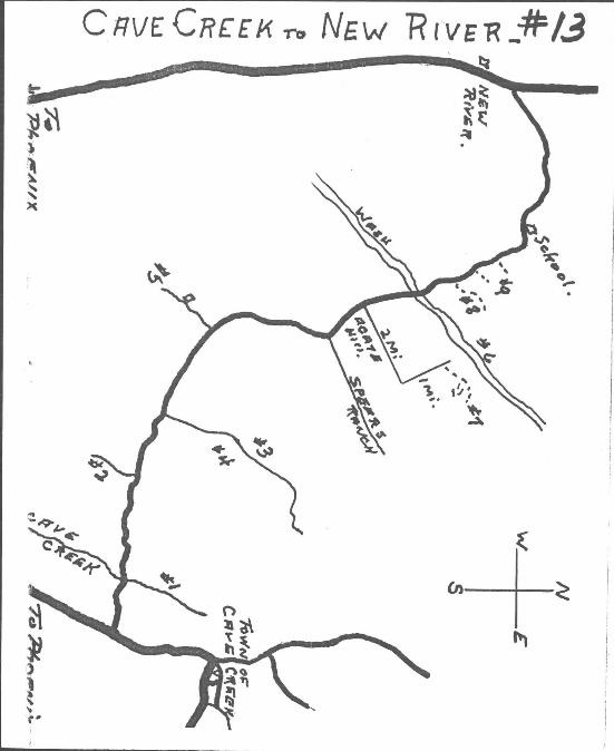
CAVE CREEK to NEW RIVER. ( Agate & Jasper ) Here is 18 miles near Phoenix with much to offer, for
more details than given here stop at Carpenters Rock Shop in Town of Cave Creek.
Enter this cut off road 2 mi. south of Town of Cave· Creek, in Ii mi. come to Cave Creek, turn right up creek ~. mi. park and cross creek for Red Jasper against hill.No.l
Back to main road continue i mi. to left i mi. may be found Indian Pcttery. { No.2)
Another mile on main road come to road on right, up this It mi. (No.3) Red Jasper and Blue Copper stained quartz may be found. To right see old GO JOHN Mine, gold silver and copper were mined there. ( No.4)
On main road another 4 mi. passing under power line is a private road to left, in i mi. is a house, if permission is granted go beyond i mi. for Iron Rock, magnetis.( No.4)
Back to main road, pass under power line again and in a!iother 2 mi. pass Sears Ranch road on right, beyond this 2 mi. come to wide wash, on left is a fine place for a picnic, across road north is agate hill to left Maricopa Agate Beds.
At far edge of this hill find road to your right (there was a street sign reading "Mours Blvd." here) follow this road 2 mi. through layed out subdivision to end of street then left another mile to end of road, across the wash may be seen old Indian Farming area, to right is a small hill, from car to hill may be found brown chalcedony, take hike t. to 3/4 mil around left and beyond hill for white head cheese agate. ( No.6 and No.7 )
Back to main road, in less than a mile note diggings and trails up bar.k to right, follow up a cross wash for scenic agate, note other diggings along bank. ( No.8)
Soon you will come to School and in another 3 miles Black Canyon Road near New Rivero
..
CREEK OLD c Ross IIV c; S
--...... r--E.
@ s
CREEK OLD c Ross IIV c; S
--...... r--E.
@ s
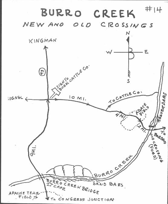
BURRO CREEK The road to Kingman (Hiway 93) is now a good paved road all the
way from Phoenix and leads to some very good collection grounds near and on the two Burro Creek Crossings.
Go to Congress Junction then out the Aguila road to Kingman Cutoff, then north toward the Burro Creek Bridge. The country along here is very interesting and goes through a very large Joshua Tree forest. Note also that the Saguaro and the Juniper grow together among all the queer rock formations. In a area about 2 miles before coming to the bridge is an extensive field of Apache Tears. At the bridge go up and down the sand bars and with diligent searching nice agate of many colors, Chalcedony and Opalite is to be found.
There is a small diner here where cold drinks and sandwiches can be gotten.
Leave here and go north 9 mi les to a sign pointing to the Bogle Cattle Co. Turn right. This is good local gravel road which leads through some really rugged and spectacular scenery. 10 miles from the turnoff is the road to the Cattle Co. Do not turn here but keep to the right. 4 miles farther is an extensive field of agate of all sizes and colors. A little farther on, right along the road, is much blue agate which floureces a nice green. 2 miles farther on is the old Burro Creek Crossing, a nice picnic or camping place with high cottonwoods and much other growths. Be sure to have water as this is a dry camp.
Searching along the sand bars here will also turn up some nice speClmens.
..
HIDDEN CANYON #15
(00- ,0
HIDDEN CANYON #15
(00- ,0
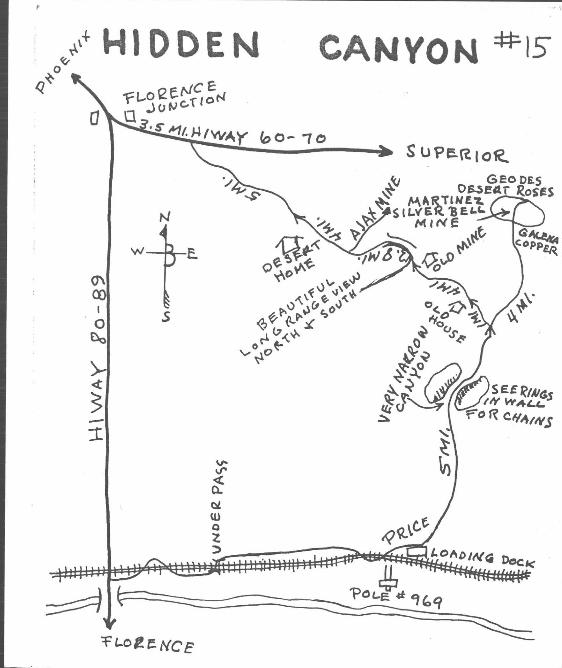
IflDDEN CANYON The Hidden Canyon trip takes you through some of the most spec
tacular Desert Scenery in Arizona, with all the ingredients for adventure you could want. This is truly a trip into the past and present mining in Arizona. There are true hidden canyons which surprise you with their beauty and some spectacular views of the Superstitions to the north and the Santa Ritas to the south.
We think the best way is to go in from the Florence end and come out on the Superior Hiway. Turn left just before going south across the Bridge over the Gila River. Follow along the railroad, going through an underpass and on until you come to a cattle loader, Pole #969, and flag stop called Price. Don't become discouraged before coming to Price. It is there, so just keep going.
Turn left here and in five miles you wi 11 come to a very narrow canyon where hooks in the wall show where chains to block the canyon ' were once connected. One miles farther on will bring you to a Windmi 11 and one mile more another. Keep to the right at all times and in two more miles you will come to the mine operator's house after going through some beautiful tree lined canyons. There is a trail along this section leading to the right, to some old beehive smelters and if you watch closely you might run on to it.
After leaving the mine area come back down the road four miles and turn right up a sandy wash. This road back to Florence Junction is very interesting with many places to explore and it is on this road where you get up quite high and have the beautiful views in all directions.
This is one of our nicest trips and should be undertaken for the scenery alone if ,fdr no other reason.
L
r
-16 l OIJerjl .lJeserc ./lose$
C"~.Y'" ~j.{.f Pe1Jd~x.1 fB««::
r
-16 l OIJerjl .lJeserc ./lose$
C"~.Y'" ~j.{.f Pe1Jd~x.1 fB««::
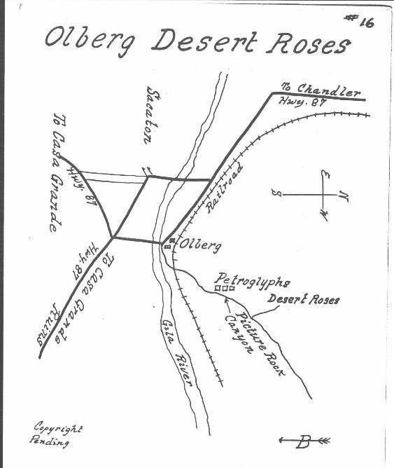
OLBERG - DESER T ROSES
Go through Chandler. Where highway forks beyond Chandler keep to your left on Highway 87 to Olberg. Just before crossing bridge take dirt road to left across railroad.
From highway Z. 3 miles you corne to Picture Rock Canyon. See Petroglyphs on left. At 3.5 miles take trail to left a short distance to Desert Rose beds. This area is also very interesting for its Cactus Forests.
As this is a short trip, one could easily continue on the highway to the Casa Grande Ruins (see your road map). This is the best preserved such dwelling in the southwest. The main building stands 40 feet high. It still was a ruins when first seen by white man some 800 years ago. In the Museum are many artifacts of interest to Rockhounds. See Turquoise used in jewelry, a link between the ancient and the modern .
..
s
-ill 1 71 I
s
-ill 1 71 I
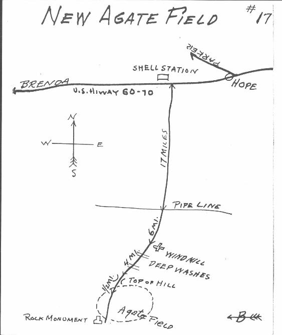
NEW AGATE FIE LD
This area located in 1960 by Martin Koening who has a very interesting Shop at Morristown. Martin is an expert cutter and has many items of great interest in his shop worth your time seeing and he can give you any furthur details you might wish reguarding this trip.
Three miles west of Hope on Hwy. 60-70 you will note a Shell Service Station on the north side of the Hwy., just west of the Station take road to south.
In 17 miles you will cross the Pipe line.
Continue another 6 miles and note windmill on your right.
Continue another 4 miles to top of hill.
1/ 4 mile beyond top of hill you will find a rock monument just before reaching monument you will be in this agate field, it extends a short distance at your right, but to your left extends for quite a distance.
Martin tells that some very fine material has been found on the surface here and with a little digging some really fine material should be found.

.R?~ t1u:!~ t, Jl?PJtu~e7Z1
6.
77z<-a..9o~ .8 c/OI,1t.J 7;.~ at t!oZt'e".ed #€22s
· .:1IC 18
.R?~ t1u:!~ t, Jl?PJtu~e7Z1
6.
77z<-a..9o~ .8 c/OI,1t.J 7;.~ at t!oZt'e".ed #€22s
· .:1IC 18
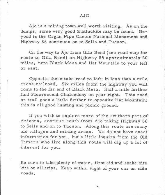
AJO
Ajo is a mining town well worth visiting. As on the dumps, some very good Shattuckite may be, found. Beyond is the Organ Pipe Cactus National Monument and Highway 86 continues on to Sells and Tucson.
On the way to Ajo from Gila Bend (see road map for route to Gila Bend) on Highway 85 approximately 20 mile s, note Blac k Me sa and Hat Mountain to your left or east.
Opposite these take road to left; in less than a mile cross railroad. Six miles from the highway you will come to the far end of Black Mesa. Half a mile further find Fluorescent Chalcedony on your right. This road or trail goe s a little further to opposite Hat Mountain; this is all good hunting and picnic ground.
If you wish to explore more of the southern part oi Arizona, continue south from Ajo taking Highway 86 to Sells and on to Tucson. Along this route are many old villages and mining areas. We do not have exact information for you, but a little inquiry from the Old Timers who liv.e along this route will dig up a lot of intere st for you.
Be sure to take plenty of water. first aid and snake bite kits on all trips. Keep within sight of your car on side roads.
....
.13 an ded Agale near 7U~J'on.
~~ ~
(f,pflri.;lA.& Pe?zdin3
~ ~ ~ ~
·1 'I
.13 an ded Agale near 7U~J'on.
~~ ~
(f,pflri.;lA.& Pe?zdin3
~ ~ ~ ~
·1 'I
~------------------------------------------------------------------~\
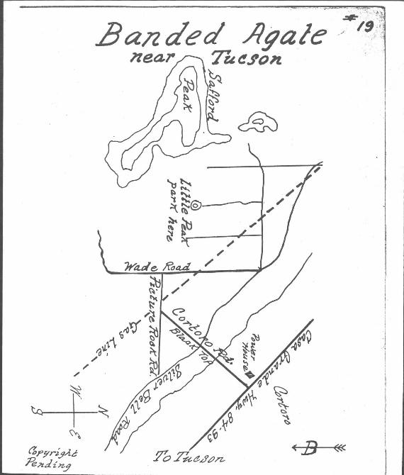
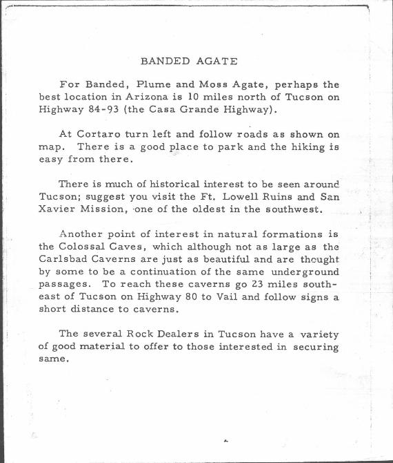
BANDED AGATE
For Banded. Plume and Moss Agate. perhaps the best location in Arizona is 10 miles north of Tucson on Highway 84-93 (the Casa Grande Highway).
At Cortaro turn left and follow roads as shown on map. There is a good place to park and the hiking is easy from there.
There is much of historical interest to be seen arounc. Tucson; suggest you visit the Ft. Lowell Ruins and San Xavier Mission. ·one of the oldest in the southwest.
Another point of interest in natural formations is the Colossal Caves. which although not as large as the Carlsbad Caverns are just as beautiful and are thcught by some to be a continuation of the same underground passages. To reach these caverns go 23 miles southeast of Tucson on Highway 80 to Vail and follow signs a short distance to caverns.
The several Rock Dealers in Tucson have a variety of good mater.ial to offer to those interested in securing same.
, I
I ,
~------------------------------------------------------------------~\
BANDED AGATE
For Banded. Plume and Moss Agate. perhaps the best location in Arizona is 10 miles north of Tucson on Highway 84-93 (the Casa Grande Highway).
At Cortaro turn left and follow roads as shown on map. There is a good place to park and the hiking is easy from there.
There is much of historical interest to be seen arounc. Tucson; suggest you visit the Ft. Lowell Ruins and San Xavier Mission. ·one of the oldest in the southwest.
Another point of interest in natural formations is the Colossal Caves. which although not as large as the Carlsbad Caverns are just as beautiful and are thcught by some to be a continuation of the same underground passages. To reach these caverns go 23 miles southeast of Tucson on Highway 80 to Vail and follow signs a short distance to caverns.
The several Rock Dealers in Tucson have a variety of good mater.ial to offer to those interested in securing same.
, I
I ,
• 'I~ •
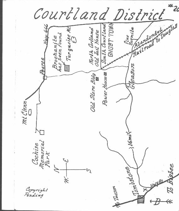
COUR TLAND DISTRICT
Here is very interesting Ghost Town country, where some good specimens can no doubt be found.
From Tombstone, itself a very noted Ghost Town (see Museum and old mining shaft where fabulous amounts of gold were found), go east on dirt road ~6 miles to Gleason. A few miles beyond, after crossing old railroad, turn to your left to an operating mine where the finest'-nf Bornite (Peacock Copper) specimens are to be found.
Come back across the railroad and turn north to the old Ghost Town of Courtland. Note old power house and store on your left. There is North Courtland and South Courtlc;md; the road between leads .to Highway 666 and Chiricahua National Park.
South Courtland is an interesting Ghost Town and in North Courtland you will see the old jailhouse. Just north is working where Brochantite was once found. The"se . old towns have much of interest to offer. Northeast is Turquoise Mountain where Tiffany operated a Turquoise mine in the 1880's. Continuing on north you corne to town of Pearce and join Highway 666. Soon after joining highway and just north of Pearce see sign for road to your left that leads to Cochise Memorial Park, an interesting place worth visiting .when you are so close.
This whole trip is through rugged country and one rich in history of the State and one which offers much in beauty and variety of formation.
See road map for routes back to Tucson or on to Douglas as you may wish.
Take plenty of water, fir st aid and S'nake bite kits.
.,. 1 • 'I~ •
COUR TLAND DISTRICT
Here is very interesting Ghost Town country, where some good specimens can no doubt be found.
From Tombstone, itself a very noted Ghost Town (see Museum and old mining shaft where fabulous amounts of gold were found), go east on dirt road ~6 miles to Gleason. A few miles beyond, after crossing old railroad, turn to your left to an operating mine where the finest'-nf Bornite (Peacock Copper) specimens are to be found.
Come back across the railroad and turn north to the old Ghost Town of Courtland. Note old power house and store on your left. There is North Courtland and South Courtlc;md; the road between leads .to Highway 666 and Chiricahua National Park.
South Courtland is an interesting Ghost Town and in North Courtland you will see the old jailhouse. Just north is working where Brochantite was once found. The"se . old towns have much of interest to offer. Northeast is Turquoise Mountain where Tiffany operated a Turquoise mine in the 1880's. Continuing on north you corne to town of Pearce and join Highway 666. Soon after joining highway and just north of Pearce see sign for road to your left that leads to Cochise Memorial Park, an interesting place worth visiting .when you are so close.
This whole trip is through rugged country and one rich in history of the State and one which offers much in beauty and variety of formation.
See road map for routes back to Tucson or on to Douglas as you may wish.
Take plenty of water, fir st aid and S'nake bite kits.
.,. 1